


To view hi-resolution images of individual city/location maps, click below on specific links

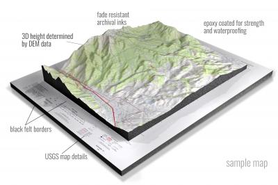
• Raised-relief 3D Height Determined by DEM data
• Fade Resistant Archival Inks
• Epoxy Coated for Strength and Waterproofing
• Ready to Hang with Pre-Installed Hardware (optional)
• Extraordinary 3D Accuracy
• Black Felt Borders
Enrich your office decor or home with a 3D USGS Raised Relief Map. These raised relief maps are not flat. They are three-dimensional, with the height being determined by Digital Elevation Model (DEM) data. Many people struggle with reading 2D satellite maps, but everyone understands 3D raised relief maps. The realism is phenomenal.
This 3D satellite raised relief map is built by combining satellite imagery data from Google Earth, bounding box coordinates from USGS, and DEM data. 3D Printing and 3D CNC routers are used to fabricate the models which make the satellite models extremely accurate. These models are strong - they are coated with epoxy, then finished with a sealer providing a weatherproof matt-finish. These are not meant to be used in direct sunlight.
Abbeville East, Alabama- View hi-resolution image of: Abbeville East, Alabama. Mapping by USGS in 2020 - Longitude/Latitude: -85.25 x -85.125 x 31.625 x 31.5, Grid Size: 7.5 X 7.5 Minute, Map Scale: 1:24000, State List: AL, County List: Henry
Abbeville West, Alabama- View hi-resolution image of: Abbeville West, Alabama. Mapping by USGS in 2020 - Longitude/Latitude: -85.375 x -85.25 x 31.625 x 31.5, Grid Size: 7.5 X 7.5 Minute, Map Scale: 1:24000, State List: AL, County List: Henry
Aberfoil, Alabama- View hi-resolution image of: Aberfoil, Alabama. Mapping by USGS in 2020 - Longitude/Latitude: -85.75 x -85.625 x 32.125 x 32, Grid Size: 7.5 X 7.5 Minute, Map Scale: 1:24000, State List: AL, County List: Bullock
Abernant, Alabama- View hi-resolution image of: Abernant, Alabama. Mapping by USGS in 2020 - Longitude/Latitude: -87.25 x -87.125 x 33.375 x 33.25, Grid Size: 7.5 X 7.5 Minute, Map Scale: 1:24000, State List: AL, County List: Tuscaloosa,Jefferson
Adamsville, Alabama- View hi-resolution image of: Adamsville, Alabama. Mapping by USGS in 2020 - Longitude/Latitude: -87 x -86.875 x 33.625 x 33.5, Grid Size: 7.5 X 7.5 Minute, Map Scale: 1:24000, State List: AL, County List: Jefferson
Addison, Alabama- View hi-resolution image of: Addison, Alabama. Mapping by USGS in 2021 - Longitude/Latitude: -87.25 x -87.125 x 34.25 x 34.125, Grid Size: 7.5 X 7.5 Minute, Map Scale: 1:24000, State List: AL, County List: Winston
Alabaster, Alabama- View hi-resolution image of: Alabaster, Alabama. Mapping by USGS in 2020 - Longitude/Latitude: -86.875 x -86.75 x 33.25 x 33.125, Grid Size: 7.5 X 7.5 Minute, Map Scale: 1:24000, State List: AL, County List: Shelby
Albertville, Alabama- View hi-resolution image of: Albertville, Alabama. Mapping by USGS in 2020 - Longitude/Latitude: -86.25 x -86.125 x 34.375 x 34.25, Grid Size: 7.5 X 7.5 Minute, Map Scale: 1:24000, State List: AL, County List: Marshall
Aldrich, Alabama- View hi-resolution image of: Aldrich, Alabama. Mapping by USGS in 2020 - Longitude/Latitude: -87 x -86.875 x 33.125 x 33, Grid Size: 7.5 X 7.5 Minute, Map Scale: 1:24000, State List: AL, County List: Bibb,Shelby,Chilton
Alexander City, Alabama- View hi-resolution image of: Alexander City, Alabama. Mapping by USGS in 2020 - Longitude/Latitude: -86 x -85.875 x 33 x 32.875, Grid Size: 7.5 X 7.5 Minute, Map Scale: 1:24000, State List: AL, County List: Tallapoosa
Aliceville North, Alabama- View hi-resolution image of: Aliceville North, Alabama. Mapping by USGS in 2020 - Longitude/Latitude: -88.25 x -88.125 x 33.25 x 33.125, Grid Size: 7.5 X 7.5 Minute, Map Scale: 1:24000, State List: AL, County List: Pickens
Aliceville South, Alabama- View hi-resolution image of: Aliceville South, Alabama. Mapping by USGS in 2020 - Longitude/Latitude: -88.25 x -88.125 x 33.125 x 33, Grid Size: 7.5 X 7.5 Minute, Map Scale: 1:24000, State List: AL, County List: Pickens,Greene
Alma, Alabama- View hi-resolution image of: Alma, Alabama. Mapping by USGS in 2020 - Longitude/Latitude: -87.875 x -87.75 x 31.5 x 31.375, Grid Size: 7.5 X 7.5 Minute, Map Scale: 1:24000, State List: AL, County List: Clarke
Almeria, Alabama- View hi-resolution image of: Almeria, Alabama. Mapping by USGS in 2020 - Longitude/Latitude: -85.875 x -85.75 x 32.125 x 32, Grid Size: 7.5 X 7.5 Minute, Map Scale: 1:24000, State List: AL, County List: Bullock
Altoona, Alabama- View hi-resolution image of: Altoona, Alabama. Mapping by USGS in 2020 - Longitude/Latitude: -86.375 x -86.25 x 34.125 x 34, Grid Size: 7.5 X 7.5 Minute, Map Scale: 1:24000, State List: AL, County List: Etowah,Blount,Marshall
Andalusia, Alabama- View hi-resolution image of: Andalusia, Alabama. Mapping by USGS in 2020 - Longitude/Latitude: -86.5 x -86.375 x 31.375 x 31.25, Grid Size: 7.5 X 7.5 Minute, Map Scale: 1:24000, State List: AL, County List: Covington
Anniston, Alabama- View hi-resolution image of: Anniston, Alabama. Mapping by USGS in 2020 - Longitude/Latitude: -85.875 x -85.75 x 33.75 x 33.625, Grid Size: 7.5 X 7.5 Minute, Map Scale: 1:24000, State List: AL, County List: Calhoun
Ansley, Alabama- View hi-resolution image of: Ansley, Alabama. Mapping by USGS in 2020 - Longitude/Latitude: -86.125 x -86 x 32 x 31.875, Grid Size: 7.5 X 7.5 Minute, Map Scale: 1:24000, State List: AL, County List: Pike,Montgomery
Aquilla, Alabama- View hi-resolution image of: Aquilla, Alabama. Mapping by USGS in 2020 - Longitude/Latitude: -88.5 x -88.375 x 31.75 x 31.625, Grid Size: 7.5 X 7.5 Minute, Map Scale: 1:24000, State List: AL,MS, County List: Washington,Choctaw,Wayne
Arab, Alabama- View hi-resolution image of: Arab, Alabama. Mapping by USGS in 2020 - Longitude/Latitude: -86.5 x -86.375 x 34.375 x 34.25, Grid Size: 7.5 X 7.5 Minute, Map Scale: 1:24000, State List: AL, County List: Marshall,Cullman,Blount
Ararat, Alabama- View hi-resolution image of: Ararat, Alabama. Mapping by USGS in 2020 - Longitude/Latitude: -88.25 x -88.125 x 32 x 31.875, Grid Size: 7.5 X 7.5 Minute, Map Scale: 1:24000, State List: AL, County List: Choctaw,Clarke
Ardmore, Alabama- View hi-resolution image of: Ardmore, Alabama. Mapping by USGS in 2020 - Longitude/Latitude: -86.875 x -86.75 x 35 x 34.875, Grid Size: 7.5 X 7.5 Minute, Map Scale: 1:24000, State List: AL,TN, County List: Limestone,Madison,Lincoln,Giles
Argo, Alabama- View hi-resolution image of: Argo, Alabama. Mapping by USGS in 2020 - Longitude/Latitude: -86.625 x -86.5 x 33.75 x 33.625, Grid Size: 7.5 X 7.5 Minute, Map Scale: 1:24000, State List: AL, County List: Jefferson,St. Clair
Ariton, Alabama- View hi-resolution image of: Ariton, Alabama. Mapping by USGS in 2020 - Longitude/Latitude: -85.75 x -85.625 x 31.625 x 31.5, Grid Size: 7.5 X 7.5 Minute, Map Scale: 1:24000, State List: AL, County List: Dale,Barbour,Pike
Arkadelphia, Alabama- View hi-resolution image of: Arkadelphia, Alabama. Mapping by USGS in 2020 - Longitude/Latitude: -87 x -86.875 x 34 x 33.875, Grid Size: 7.5 X 7.5 Minute, Map Scale: 1:24000, State List: AL, County List: Cullman,Blount
Arley, Alabama- View hi-resolution image of: Arley, Alabama. Mapping by USGS in 2021 - Longitude/Latitude: -87.25 x -87.125 x 34.125 x 34, Grid Size: 7.5 X 7.5 Minute, Map Scale: 1:24000, State List: AL, County List: Winston,Walker
Ashford, Alabama- View hi-resolution image of: Ashford, Alabama. Mapping by USGS in 2020 - Longitude/Latitude: -85.25 x -85.125 x 31.25 x 31.125, Grid Size: 7.5 X 7.5 Minute, Map Scale: 1:24000, State List: AL, County List: Houston
Ashville, Alabama- View hi-resolution image of: Ashville, Alabama. Mapping by USGS in 2020 - Longitude/Latitude: -86.375 x -86.25 x 33.875 x 33.75, Grid Size: 7.5 X 7.5 Minute, Map Scale: 1:24000, State List: AL, County List: St. Clair,Blount
Athens, Alabama- View hi-resolution image of: Athens, Alabama. Mapping by USGS in 2020 - Longitude/Latitude: -87 x -86.875 x 34.875 x 34.75, Grid Size: 7.5 X 7.5 Minute, Map Scale: 1:24000, State List: AL, County List: Limestone
Atmore, Alabama- View hi-resolution image of: Atmore, Alabama. Mapping by USGS in 2020 - Longitude/Latitude: -87.5 x -87.375 x 31.125 x 31, Grid Size: 7.5 X 7.5 Minute, Map Scale: 1:24000, State List: AL, County List: Escambia
Auburn, Alabama- View hi-resolution image of: Auburn, Alabama. Mapping by USGS in 2020 - Longitude/Latitude: -85.5 x -85.375 x 32.625 x 32.5, Grid Size: 7.5 X 7.5 Minute, Map Scale: 1:24000, State List: AL, County List: Lee,Macon
Autaugaville, Alabama- View hi-resolution image of: Autaugaville, Alabama. Mapping by USGS in 2020 - Longitude/Latitude: -86.75 x -86.625 x 32.5 x 32.375, Grid Size: 7.5 X 7.5 Minute, Map Scale: 1:24000, State List: AL, County List: Autauga,Lowndes
Baker Hill, Alabama- View hi-resolution image of: Baker Hill, Alabama. Mapping by USGS in 2020 - Longitude/Latitude: -85.375 x -85.25 x 31.875 x 31.75, Grid Size: 7.5 X 7.5 Minute, Map Scale: 1:24000, State List: AL, County List: Barbour
Ballplay, Alabama- View hi-resolution image of: Ballplay, Alabama. Mapping by USGS in 2020 - Longitude/Latitude: -85.875 x -85.75 x 34.125 x 34, Grid Size: 7.5 X 7.5 Minute, Map Scale: 1:24000, State List: AL, County List: Etowah,Cherokee
Banks, Alabama- View hi-resolution image of: Banks, Alabama. Mapping by USGS in 2020 - Longitude/Latitude: -85.875 x -85.75 x 31.875 x 31.75, Grid Size: 7.5 X 7.5 Minute, Map Scale: 1:24000, State List: AL, County List: Pike
Bankston, Alabama- View hi-resolution image of: Bankston, Alabama. Mapping by USGS in 2020 - Longitude/Latitude: -87.75 x -87.625 x 33.75 x 33.625, Grid Size: 7.5 X 7.5 Minute, Map Scale: 1:24000, State List: AL, County List: Fayette
Barachias, Alabama- View hi-resolution image of: Barachias, Alabama. Mapping by USGS in 2020 - Longitude/Latitude: -86.25 x -86.125 x 32.375 x 32.25, Grid Size: 7.5 X 7.5 Minute, Map Scale: 1:24000, State List: AL, County List: Montgomery
Barnett Crossroads, Alabama- View hi-resolution image of: Barnett Crossroads, Alabama. Mapping by USGS in 2020 - Longitude/Latitude: -87.375 x -87.25 x 31.25 x 31.125, Grid Size: 7.5 X 7.5 Minute, Map Scale: 1:24000, State List: AL, County List: Escambia
Barton, Alabama- View hi-resolution image of: Barton, Alabama. Mapping by USGS in 2020 - Longitude/Latitude: -88 x -87.875 x 34.75 x 34.625, Grid Size: 7.5 X 7.5 Minute, Map Scale: 1:24000, State List: AL, County List: Colbert
Bashi, Alabama- View hi-resolution image of: Bashi, Alabama. Mapping by USGS in 2020 - Longitude/Latitude: -87.875 x -87.75 x 32 x 31.875, Grid Size: 7.5 X 7.5 Minute, Map Scale: 1:24000, State List: AL, County List: Clarke,Marengo
Batesville, Alabama- View hi-resolution image of: Batesville, Alabama. Mapping by USGS in 2020 - Longitude/Latitude: -85.375 x -85.25 x 32.125 x 32, Grid Size: 7.5 X 7.5 Minute, Map Scale: 1:24000, State List: AL, County List: Barbour
Bay Minette North, Alabama- View hi-resolution image of: Bay Minette North, Alabama. Mapping by USGS in 2020 - Longitude/Latitude: -87.875 x -87.75 x 31 x 30.875, Grid Size: 7.5 X 7.5 Minute, Map Scale: 1:24000, State List: AL, County List: Baldwin
Bay Minette South, Alabama- View hi-resolution image of: Bay Minette South, Alabama. Mapping by USGS in 2020 - Longitude/Latitude: -87.875 x -87.75 x 30.875 x 30.75, Grid Size: 7.5 X 7.5 Minute, Map Scale: 1:24000, State List: AL, County List: Baldwin
Beatrice, Alabama- View hi-resolution image of: Beatrice, Alabama. Mapping by USGS in 2020 - Longitude/Latitude: -87.25 x -87.125 x 31.75 x 31.625, Grid Size: 7.5 X 7.5 Minute, Map Scale: 1:24000, State List: AL, County List: Monroe,Conecuh
Beaverton, Alabama- View hi-resolution image of: Beaverton, Alabama. Mapping by USGS in 2020 - Longitude/Latitude: -88.125 x -88 x 34 x 33.875, Grid Size: 7.5 X 7.5 Minute, Map Scale: 1:24000, State List: AL, County List: Lamar
Bee Branch, Alabama- View hi-resolution image of: Bee Branch, Alabama. Mapping by USGS in 2021 - Longitude/Latitude: -87.5 x -87.375 x 34.375 x 34.25, Grid Size: 7.5 X 7.5 Minute, Map Scale: 1:24000, State List: AL, County List: Lawrence,Winston
Belk, Alabama- View hi-resolution image of: Belk, Alabama. Mapping by USGS in 2020 - Longitude/Latitude: -88 x -87.875 x 33.75 x 33.625, Grid Size: 7.5 X 7.5 Minute, Map Scale: 1:24000, State List: AL, County List: Fayette,Lamar
Bellamy, Alabama- View hi-resolution image of: Bellamy, Alabama. Mapping by USGS in 2020 - Longitude/Latitude: -88.25 x -88.125 x 32.5 x 32.375, Grid Size: 7.5 X 7.5 Minute, Map Scale: 1:24000, State List: AL, County List: Sumter
Bellefontaine, Alabama- View hi-resolution image of: Bellefontaine, Alabama. Mapping by USGS in 2020 - Longitude/Latitude: -88.125 x -88 x 30.5 x 30.375, Grid Size: 7.5 X 7.5 Minute, Map Scale: 1:24000, State List: AL, County List: Mobile,Baldwin
Belleville, Alabama- View hi-resolution image of: Belleville, Alabama. Mapping by USGS in 2020 - Longitude/Latitude: -87.125 x -87 x 31.5 x 31.375, Grid Size: 7.5 X 7.5 Minute, Map Scale: 1:24000, State List: AL, County List: Conecuh
Bellwood, Alabama- View hi-resolution image of: Bellwood, Alabama. Mapping by USGS in 2020 - Longitude/Latitude: -85.875 x -85.75 x 31.25 x 31.125, Grid Size: 7.5 X 7.5 Minute, Map Scale: 1:24000, State List: AL, County List: Geneva,Coffee,Dale
Benton, Alabama- View hi-resolution image of: Benton, Alabama. Mapping by USGS in 2020 - Longitude/Latitude: -86.875 x -86.75 x 32.375 x 32.25, Grid Size: 7.5 X 7.5 Minute, Map Scale: 1:24000, State List: AL, County List: Lowndes,Dallas,Autauga
Berry, Alabama- View hi-resolution image of: Berry, Alabama. Mapping by USGS in 2020 - Longitude/Latitude: -87.625 x -87.5 x 33.75 x 33.625, Grid Size: 7.5 X 7.5 Minute, Map Scale: 1:24000, State List: AL, County List: Fayette,Walker
Berry SE, Alabama- View hi-resolution image of: Berry SE, Alabama. Mapping by USGS in 2020 - Longitude/Latitude: -87.625 x -87.5 x 33.625 x 33.5, Grid Size: 7.5 X 7.5 Minute, Map Scale: 1:24000, State List: AL, County List: Tuscaloosa,Fayette
Bessemer, Alabama- View hi-resolution image of: Bessemer, Alabama. Mapping by USGS in 2020 - Longitude/Latitude: -87 x -86.875 x 33.5 x 33.375, Grid Size: 7.5 X 7.5 Minute, Map Scale: 1:24000, State List: AL, County List: Jefferson
Bethel, Alabama- View hi-resolution image of: Bethel, Alabama. Mapping by USGS in 2020 - Longitude/Latitude: -87 x -86.875 x 31.75 x 31.625, Grid Size: 7.5 X 7.5 Minute, Map Scale: 1:24000, State List: AL, County List: Conecuh,Butler,Monroe
Beulah, Alabama- View hi-resolution image of: Beulah, Alabama. Mapping by USGS in 2020 - Longitude/Latitude: -85.25 x -85.125 x 32.75 x 32.625, Grid Size: 7.5 X 7.5 Minute, Map Scale: 1:24000, State List: AL,GA, County List: Lee,Chambers,Harris
Bexar, Alabama- View hi-resolution image of: Bexar, Alabama. Mapping by USGS in 2020 - Longitude/Latitude: -88.25 x -88.125 x 34.25 x 34.125, Grid Size: 7.5 X 7.5 Minute, Map Scale: 1:24000, State List: AL,MS, County List: Marion,Itawamba
Bigbee, Alabama- View hi-resolution image of: Bigbee, Alabama. Mapping by USGS in 2020 - Longitude/Latitude: -88.25 x -88.125 x 31.625 x 31.5, Grid Size: 7.5 X 7.5 Minute, Map Scale: 1:24000, State List: AL, County List: Washington
Bilbo Island, Alabama- View hi-resolution image of: Bilbo Island, Alabama. Mapping by USGS in 2020 - Longitude/Latitude: -88 x -87.875 x 31.25 x 31.125, Grid Size: 7.5 X 7.5 Minute, Map Scale: 1:24000, State List: AL, County List: Baldwin,Washington,Clarke,Mobile
Billingsley, Alabama- View hi-resolution image of: Billingsley, Alabama. Mapping by USGS in 2020 - Longitude/Latitude: -86.75 x -86.625 x 32.75 x 32.625, Grid Size: 7.5 X 7.5 Minute, Map Scale: 1:24000, State List: AL, County List: Autauga,Chilton
Birmingham North, Alabama- View hi-resolution image of: Birmingham North, Alabama. Mapping by USGS in 2020 - Longitude/Latitude: -86.875 x -86.75 x 33.625 x 33.5, Grid Size: 7.5 X 7.5 Minute, Map Scale: 1:24000, State List: AL, County List: Jefferson
Birmingham South, Alabama- View hi-resolution image of: Birmingham South, Alabama. Mapping by USGS in 2020 - Longitude/Latitude: -86.875 x -86.75 x 33.5 x 33.375, Grid Size: 7.5 X 7.5 Minute, Map Scale: 1:24000, State List: AL, County List: Jefferson,Shelby
Bishop, Alabama- View hi-resolution image of: Bishop, Alabama. Mapping by USGS in 2020 - Longitude/Latitude: -88.125 x -88 x 34.75 x 34.625, Grid Size: 7.5 X 7.5 Minute, Map Scale: 1:24000, State List: AL,MS, County List: Colbert,Tishomingo
Black Pond, Alabama- View hi-resolution image of: Black Pond, Alabama. Mapping by USGS in 2021 - Longitude/Latitude: -87.375 x -87.25 x 34.125 x 34, Grid Size: 7.5 X 7.5 Minute, Map Scale: 1:24000, State List: AL, County List: Winston
Blackburn, Alabama- View hi-resolution image of: Blackburn, Alabama. Mapping by USGS in 2020 - Longitude/Latitude: -87.75 x -87.625 x 35 x 34.875, Grid Size: 7.5 X 7.5 Minute, Map Scale: 1:24000, State List: AL, County List: Lauderdale
Blacksher, Alabama- View hi-resolution image of: Blacksher, Alabama. Mapping by USGS in 2020 - Longitude/Latitude: -87.75 x -87.625 x 31.25 x 31.125, Grid Size: 7.5 X 7.5 Minute, Map Scale: 1:24000, State List: AL, County List: Baldwin,Monroe
Blackwell Bend, Alabama- View hi-resolution image of: Blackwell Bend, Alabama. Mapping by USGS in 2020 - Longitude/Latitude: -87.125 x -87 x 32.375 x 32.25, Grid Size: 7.5 X 7.5 Minute, Map Scale: 1:24000, State List: AL, County List: Dallas
Bladon Springs, Alabama- View hi-resolution image of: Bladon Springs, Alabama. Mapping by USGS in 2020 - Longitude/Latitude: -88.25 x -88.125 x 31.75 x 31.625, Grid Size: 7.5 X 7.5 Minute, Map Scale: 1:24000, State List: AL, County List: Washington,Choctaw
Bleecker, Alabama- View hi-resolution image of: Bleecker, Alabama. Mapping by USGS in 2020 - Longitude/Latitude: -85.25 x -85.125 x 32.625 x 32.5, Grid Size: 7.5 X 7.5 Minute, Map Scale: 1:24000, State List: AL, County List: Lee
Blount Springs, Alabama- View hi-resolution image of: Blount Springs, Alabama. Mapping by USGS in 2020 - Longitude/Latitude: -86.875 x -86.75 x 34 x 33.875, Grid Size: 7.5 X 7.5 Minute, Map Scale: 1:24000, State List: AL, County List: Blount,Cullman
Blountsville, Alabama- View hi-resolution image of: Blountsville, Alabama. Mapping by USGS in 2020 - Longitude/Latitude: -86.625 x -86.5 x 34.125 x 34, Grid Size: 7.5 X 7.5 Minute, Map Scale: 1:24000, State List: AL, County List: Blount,Cullman
Bluff, Alabama- View hi-resolution image of: Bluff, Alabama. Mapping by USGS in 2020 - Longitude/Latitude: -88 x -87.875 x 33.875 x 33.75, Grid Size: 7.5 X 7.5 Minute, Map Scale: 1:24000, State List: AL, County List: Fayette,Lamar
Bluff Springs, Alabama- View hi-resolution image of: Bluff Springs, Alabama. Mapping by USGS in 2020 - Longitude/Latitude: -86.125 x -86 x 31.625 x 31.5, Grid Size: 7.5 X 7.5 Minute, Map Scale: 1:24000, State List: AL, County List: Coffee,Pike
Boaz, Alabama- View hi-resolution image of: Boaz, Alabama. Mapping by USGS in 2020 - Longitude/Latitude: -86.25 x -86.125 x 34.25 x 34.125, Grid Size: 7.5 X 7.5 Minute, Map Scale: 1:24000, State List: AL, County List: Marshall,Etowah
Boligee, Alabama- View hi-resolution image of: Boligee, Alabama. Mapping by USGS in 2020 - Longitude/Latitude: -88.125 x -88 x 32.875 x 32.75, Grid Size: 7.5 X 7.5 Minute, Map Scale: 1:24000, State List: AL, County List: Greene,Sumter
Bon Secour Bay, Alabama- View hi-resolution image of: Bon Secour Bay, Alabama. Mapping by USGS in 2020 - Longitude/Latitude: -87.875 x -87.75 x 30.375 x 30.25, Grid Size: 7.5 X 7.5 Minute, Map Scale: 1:24000, State List: AL, County List: Baldwin
Borden Springs, Alabama- View hi-resolution image of: Borden Springs, Alabama. Mapping by USGS in 2021 - Longitude/Latitude: -85.5 x -85.375 x 34 x 33.875, Grid Size: 7.5 X 7.5 Minute, Map Scale: 1:24000, State List: AL,GA, County List: Cleburne,Cherokee,Polk,Haralson
Bounds Lake, Alabama- View hi-resolution image of: Bounds Lake, Alabama. Mapping by USGS in 2020 - Longitude/Latitude: -86.75 x -86.625 x 33.25 x 33.125, Grid Size: 7.5 X 7.5 Minute, Map Scale: 1:24000, State List: AL, County List: Shelby
Boyd, Alabama- View hi-resolution image of: Boyd, Alabama. Mapping by USGS in 2020 - Longitude/Latitude: -88.375 x -88.25 x 32.625 x 32.5, Grid Size: 7.5 X 7.5 Minute, Map Scale: 1:24000, State List: AL, County List: Sumter
Bradley, Alabama- View hi-resolution image of: Bradley, Alabama. Mapping by USGS in 2021 - Longitude/Latitude: -86.75 x -86.625 x 31.125 x 31, Grid Size: 7.5 X 7.5 Minute, Map Scale: 1:24000, State List: AL, County List: Covington,Escambia
Braggs, Alabama- View hi-resolution image of: Braggs, Alabama. Mapping by USGS in 2020 - Longitude/Latitude: -86.875 x -86.75 x 32.125 x 32, Grid Size: 7.5 X 7.5 Minute, Map Scale: 1:24000, State List: AL, County List: Lowndes,Wilcox
Brantley, Alabama- View hi-resolution image of: Brantley, Alabama. Mapping by USGS in 2020 - Longitude/Latitude: -86.375 x -86.25 x 31.625 x 31.5, Grid Size: 7.5 X 7.5 Minute, Map Scale: 1:24000, State List: AL, County List: Crenshaw,Covington
Brassell, Alabama- View hi-resolution image of: Brassell, Alabama. Mapping by USGS in 2020 - Longitude/Latitude: -86.125 x -86 x 32.5 x 32.375, Grid Size: 7.5 X 7.5 Minute, Map Scale: 1:24000, State List: AL, County List: Elmore,Montgomery,Macon
Brewersville, Alabama- View hi-resolution image of: Brewersville, Alabama. Mapping by USGS in 2020 - Longitude/Latitude: -88.125 x -88 x 32.625 x 32.5, Grid Size: 7.5 X 7.5 Minute, Map Scale: 1:24000, State List: AL, County List: Sumter,Greene
Brewton North, Alabama- View hi-resolution image of: Brewton North, Alabama. Mapping by USGS in 2020 - Longitude/Latitude: -87.125 x -87 x 31.25 x 31.125, Grid Size: 7.5 X 7.5 Minute, Map Scale: 1:24000, State List: AL, County List: Escambia
Brewton South, Alabama- View hi-resolution image of: Brewton South, Alabama. Mapping by USGS in 2020 - Longitude/Latitude: -87.125 x -87 x 31.125 x 31, Grid Size: 7.5 X 7.5 Minute, Map Scale: 1:24000, State List: AL, County List: Escambia
Bridgehead, Alabama- View hi-resolution image of: Bridgehead, Alabama. Mapping by USGS in 2020 - Longitude/Latitude: -88 x -87.875 x 30.75 x 30.625, Grid Size: 7.5 X 7.5 Minute, Map Scale: 1:24000, State List: AL, County List: Baldwin,Mobile
Bridgeport, Alabama- View hi-resolution image of: Bridgeport, Alabama. Mapping by USGS in 2020 - Longitude/Latitude: -85.75 x -85.625 x 35 x 34.875, Grid Size: 7.5 X 7.5 Minute, Map Scale: 1:24000, State List: AL,TN, County List: Jackson,Marion
Brilliant, Alabama- View hi-resolution image of: Brilliant, Alabama. Mapping by USGS in 2020 - Longitude/Latitude: -87.875 x -87.75 x 34.125 x 34, Grid Size: 7.5 X 7.5 Minute, Map Scale: 1:24000, State List: AL, County List: Marion
Brooklyn, Alabama- View hi-resolution image of: Brooklyn, Alabama. Mapping by USGS in 2020 - Longitude/Latitude: -86.875 x -86.75 x 31.375 x 31.25, Grid Size: 7.5 X 7.5 Minute, Map Scale: 1:24000, State List: AL, County List: Conecuh,Escambia
Brooks, Alabama- View hi-resolution image of: Brooks, Alabama. Mapping by USGS in 2020 - Longitude/Latitude: -86.75 x -86.625 x 31.5 x 31.375, Grid Size: 7.5 X 7.5 Minute, Map Scale: 1:24000, State List: AL, County List: Conecuh,Covington
Brookside, Alabama- View hi-resolution image of: Brookside, Alabama. Mapping by USGS in 2020 - Longitude/Latitude: -87 x -86.875 x 33.75 x 33.625, Grid Size: 7.5 X 7.5 Minute, Map Scale: 1:24000, State List: AL, County List: Jefferson
Brooksville, Alabama- View hi-resolution image of: Brooksville, Alabama. Mapping by USGS in 2020 - Longitude/Latitude: -86.5 x -86.375 x 34.25 x 34.125, Grid Size: 7.5 X 7.5 Minute, Map Scale: 1:24000, State List: AL, County List: Blount,Marshall,Cullman
Brookwood, Alabama- View hi-resolution image of: Brookwood, Alabama. Mapping by USGS in 2020 - Longitude/Latitude: -87.375 x -87.25 x 33.375 x 33.25, Grid Size: 7.5 X 7.5 Minute, Map Scale: 1:24000, State List: AL, County List: Tuscaloosa
Browns, Alabama- View hi-resolution image of: Browns, Alabama. Mapping by USGS in 2020 - Longitude/Latitude: -87.375 x -87.25 x 32.5 x 32.375, Grid Size: 7.5 X 7.5 Minute, Map Scale: 1:24000, State List: AL, County List: Dallas,Perry
Brownville, Alabama- View hi-resolution image of: Brownville, Alabama. Mapping by USGS in 2020 - Longitude/Latitude: -87.875 x -87.75 x 33.5 x 33.375, Grid Size: 7.5 X 7.5 Minute, Map Scale: 1:24000, State List: AL, County List: Tuscaloosa,Pickens
Brundidge, Alabama- View hi-resolution image of: Brundidge, Alabama. Mapping by USGS in 2020 - Longitude/Latitude: -85.875 x -85.75 x 31.75 x 31.625, Grid Size: 7.5 X 7.5 Minute, Map Scale: 1:24000, State List: AL, County List: Pike
Brundidge NW, Alabama- View hi-resolution image of: Brundidge NW, Alabama. Mapping by USGS in 2020 - Longitude/Latitude: -86 x -85.875 x 31.75 x 31.625, Grid Size: 7.5 X 7.5 Minute, Map Scale: 1:24000, State List: AL, County List: Pike
Brundidge SE, Alabama- View hi-resolution image of: Brundidge SE, Alabama. Mapping by USGS in 2020 - Longitude/Latitude: -85.875 x -85.75 x 31.625 x 31.5, Grid Size: 7.5 X 7.5 Minute, Map Scale: 1:24000, State List: AL, County List: Coffee,Dale,Pike
Buck Creek, Alabama- View hi-resolution image of: Buck Creek, Alabama. Mapping by USGS in 2021 - Longitude/Latitude: -87.125 x -87 x 32.75 x 32.625, Grid Size: 7.5 X 7.5 Minute, Map Scale: 1:24000, State List: AL, County List: Perry,Dallas,Chilton
Bullock, Alabama- View hi-resolution image of: Bullock, Alabama. Mapping by USGS in 2020 - Longitude/Latitude: -86.25 x -86.125 x 31.625 x 31.5, Grid Size: 7.5 X 7.5 Minute, Map Scale: 1:24000, State List: AL, County List: Crenshaw,Coffee,Pike
Bulls Gap, Alabama- View hi-resolution image of: Bulls Gap, Alabama. Mapping by USGS in 2021 - Longitude/Latitude: -86.125 x -86 x 33.25 x 33.125, Grid Size: 7.5 X 7.5 Minute, Map Scale: 1:24000, State List: AL, County List: Clay,Talladega
Burchfield Store, Alabama- View hi-resolution image of: Burchfield Store, Alabama. Mapping by USGS in 2020 - Longitude/Latitude: -87.375 x -87.25 x 33.5 x 33.375, Grid Size: 7.5 X 7.5 Minute, Map Scale: 1:24000, State List: AL, County List: Tuscaloosa,Jefferson
Burnsville, Alabama- View hi-resolution image of: Burnsville, Alabama. Mapping by USGS in 2020 - Longitude/Latitude: -87 x -86.875 x 32.5 x 32.375, Grid Size: 7.5 X 7.5 Minute, Map Scale: 1:24000, State List: AL, County List: Dallas,Autauga
Burnt Corn, Alabama- View hi-resolution image of: Burnt Corn, Alabama. Mapping by USGS in 2020 - Longitude/Latitude: -87.25 x -87.125 x 31.625 x 31.5, Grid Size: 7.5 X 7.5 Minute, Map Scale: 1:24000, State List: AL, County List: Monroe,Conecuh
Butler, Alabama- View hi-resolution image of: Butler, Alabama. Mapping by USGS in 2020 - Longitude/Latitude: -88.25 x -88.125 x 32.125 x 32, Grid Size: 7.5 X 7.5 Minute, Map Scale: 1:24000, State List: AL, County List: Choctaw
Buttston, Alabama- View hi-resolution image of: Buttston, Alabama. Mapping by USGS in 2020 - Longitude/Latitude: -85.75 x -85.625 x 33 x 32.875, Grid Size: 7.5 X 7.5 Minute, Map Scale: 1:24000, State List: AL, County List: Tallapoosa
Caddo, Alabama- View hi-resolution image of: Caddo, Alabama. Mapping by USGS in 2020 - Longitude/Latitude: -87.25 x -87.125 x 34.625 x 34.5, Grid Size: 7.5 X 7.5 Minute, Map Scale: 1:24000, State List: AL, County List: Lawrence
Cahaba Heights, Alabama- View hi-resolution image of: Cahaba Heights, Alabama. Mapping by USGS in 2020 - Longitude/Latitude: -86.75 x -86.625 x 33.5 x 33.375, Grid Size: 7.5 X 7.5 Minute, Map Scale: 1:24000, State List: AL, County List: Shelby,Jefferson
Cairo, Alabama- View hi-resolution image of: Cairo, Alabama. Mapping by USGS in 2020 - Longitude/Latitude: -87.25 x -87.125 x 34.875 x 34.75, Grid Size: 7.5 X 7.5 Minute, Map Scale: 1:24000, State List: AL, County List: Limestone,Lauderdale,Lawrence
Calhoun, Alabama- View hi-resolution image of: Calhoun, Alabama. Mapping by USGS in 2020 - Longitude/Latitude: -86.625 x -86.5 x 32.125 x 32, Grid Size: 7.5 X 7.5 Minute, Map Scale: 1:24000, State List: AL, County List: Lowndes
Calvert, Alabama- View hi-resolution image of: Calvert, Alabama. Mapping by USGS in 2020 - Longitude/Latitude: -88.125 x -88 x 31.25 x 31.125, Grid Size: 7.5 X 7.5 Minute, Map Scale: 1:24000, State List: AL, County List: Washington,Mobile
Camden North, Alabama- View hi-resolution image of: Camden North, Alabama. Mapping by USGS in 2020 - Longitude/Latitude: -87.375 x -87.25 x 32.125 x 32, Grid Size: 7.5 X 7.5 Minute, Map Scale: 1:24000, State List: AL, County List: Wilcox,Dallas
Camden South, Alabama- View hi-resolution image of: Camden South, Alabama. Mapping by USGS in 2020 - Longitude/Latitude: -87.375 x -87.25 x 32 x 31.875, Grid Size: 7.5 X 7.5 Minute, Map Scale: 1:24000, State List: AL, County List: Wilcox
Camp Hill, Alabama- View hi-resolution image of: Camp Hill, Alabama. Mapping by USGS in 2020 - Longitude/Latitude: -85.75 x -85.625 x 32.875 x 32.75, Grid Size: 7.5 X 7.5 Minute, Map Scale: 1:24000, State List: AL, County List: Tallapoosa
Camp Hill SE, Alabama- View hi-resolution image of: Camp Hill SE, Alabama. Mapping by USGS in 2020 - Longitude/Latitude: -85.625 x -85.5 x 32.875 x 32.75, Grid Size: 7.5 X 7.5 Minute, Map Scale: 1:24000, State List: AL, County List: Chambers,Tallapoosa
Cantelous, Alabama- View hi-resolution image of: Cantelous, Alabama. Mapping by USGS in 2020 - Longitude/Latitude: -86.5 x -86.375 x 32.375 x 32.25, Grid Size: 7.5 X 7.5 Minute, Map Scale: 1:24000, State List: AL, County List: Montgomery,Lowndes,Autauga
Capshaw, Alabama- View hi-resolution image of: Capshaw, Alabama. Mapping by USGS in 2020 - Longitude/Latitude: -86.875 x -86.75 x 34.875 x 34.75, Grid Size: 7.5 X 7.5 Minute, Map Scale: 1:24000, State List: AL, County List: Limestone,Madison
Carbon Hill, Alabama- View hi-resolution image of: Carbon Hill, Alabama. Mapping by USGS in 2020 - Longitude/Latitude: -87.625 x -87.5 x 34 x 33.875, Grid Size: 7.5 X 7.5 Minute, Map Scale: 1:24000, State List: AL, County List: Walker,Winston
Carlowville, Alabama- View hi-resolution image of: Carlowville, Alabama. Mapping by USGS in 2020 - Longitude/Latitude: -87.125 x -87 x 32.125 x 32, Grid Size: 7.5 X 7.5 Minute, Map Scale: 1:24000, State List: AL, County List: Dallas,Wilcox
Carlton, Alabama- View hi-resolution image of: Carlton, Alabama. Mapping by USGS in 2020 - Longitude/Latitude: -87.875 x -87.75 x 31.375 x 31.25, Grid Size: 7.5 X 7.5 Minute, Map Scale: 1:24000, State List: AL, County List: Clarke,Baldwin,Monroe
Carolina, Alabama- View hi-resolution image of: Carolina, Alabama. Mapping by USGS in 2021 - Longitude/Latitude: -86.625 x -86.5 x 31.25 x 31.125, Grid Size: 7.5 X 7.5 Minute, Map Scale: 1:24000, State List: AL, County List: Covington
Carrollton, Alabama- View hi-resolution image of: Carrollton, Alabama. Mapping by USGS in 2020 - Longitude/Latitude: -88.125 x -88 x 33.375 x 33.25, Grid Size: 7.5 X 7.5 Minute, Map Scale: 1:24000, State List: AL, County List: Pickens
Carrville, Alabama- View hi-resolution image of: Carrville, Alabama. Mapping by USGS in 2020 - Longitude/Latitude: -85.875 x -85.75 x 32.625 x 32.5, Grid Size: 7.5 X 7.5 Minute, Map Scale: 1:24000, State List: AL, County List: Tallapoosa,Macon
Casemore, Alabama- View hi-resolution image of: Casemore, Alabama. Mapping by USGS in 2020 - Longitude/Latitude: -87.75 x -87.625 x 32.625 x 32.5, Grid Size: 7.5 X 7.5 Minute, Map Scale: 1:24000, State List: AL, County List: Hale,Marengo,Greene
Castleberry, Alabama- View hi-resolution image of: Castleberry, Alabama. Mapping by USGS in 2020 - Longitude/Latitude: -87.125 x -87 x 31.375 x 31.25, Grid Size: 7.5 X 7.5 Minute, Map Scale: 1:24000, State List: AL, County List: Conecuh,Escambia
Catherine, Alabama- View hi-resolution image of: Catherine, Alabama. Mapping by USGS in 2020 - Longitude/Latitude: -87.5 x -87.375 x 32.25 x 32.125, Grid Size: 7.5 X 7.5 Minute, Map Scale: 1:24000, State List: AL, County List: Wilcox,Dallas
Cedar Bluff, Alabama- View hi-resolution image of: Cedar Bluff, Alabama. Mapping by USGS in 2020 - Longitude/Latitude: -85.625 x -85.5 x 34.25 x 34.125, Grid Size: 7.5 X 7.5 Minute, Map Scale: 1:24000, State List: AL, County List: Cherokee
Center Grove, Alabama- View hi-resolution image of: Center Grove, Alabama. Mapping by USGS in 2020 - Longitude/Latitude: -86.75 x -86.625 x 34.5 x 34.375, Grid Size: 7.5 X 7.5 Minute, Map Scale: 1:24000, State List: AL, County List: Morgan
Center Hill, Alabama- View hi-resolution image of: Center Hill, Alabama. Mapping by USGS in 2021 - Longitude/Latitude: -87.5 x -87.375 x 35 x 34.875, Grid Size: 7.5 X 7.5 Minute, Map Scale: 1:24000, State List: AL, County List: Lauderdale
Central Mills, Alabama- View hi-resolution image of: Central Mills, Alabama. Mapping by USGS in 2020 - Longitude/Latitude: -87.5 x -87.375 x 32.375 x 32.25, Grid Size: 7.5 X 7.5 Minute, Map Scale: 1:24000, State List: AL, County List: Dallas,Perry,Marengo,Wilcox
Centre, Alabama- View hi-resolution image of: Centre, Alabama. Mapping by USGS in 2020 - Longitude/Latitude: -85.75 x -85.625 x 34.25 x 34.125, Grid Size: 7.5 X 7.5 Minute, Map Scale: 1:24000, State List: AL, County List: Cherokee
Centreville East, Alabama- View hi-resolution image of: Centreville East, Alabama. Mapping by USGS in 2021 - Longitude/Latitude: -87.125 x -87 x 33 x 32.875, Grid Size: 7.5 X 7.5 Minute, Map Scale: 1:24000, State List: AL, County List: Bibb
Centreville West, Alabama- View hi-resolution image of: Centreville West, Alabama. Mapping by USGS in 2021 - Longitude/Latitude: -87.25 x -87.125 x 33 x 32.875, Grid Size: 7.5 X 7.5 Minute, Map Scale: 1:24000, State List: AL, County List: Bibb
Chance, Alabama- View hi-resolution image of: Chance, Alabama. Mapping by USGS in 2020 - Longitude/Latitude: -87.625 x -87.5 x 31.75 x 31.625, Grid Size: 7.5 X 7.5 Minute, Map Scale: 1:24000, State List: AL, County List: Clarke,Monroe
Chatom, Alabama- View hi-resolution image of: Chatom, Alabama. Mapping by USGS in 2020 - Longitude/Latitude: -88.375 x -88.25 x 31.5 x 31.375, Grid Size: 7.5 X 7.5 Minute, Map Scale: 1:24000, State List: AL, County List: Washington
Chavies, Alabama- View hi-resolution image of: Chavies, Alabama. Mapping by USGS in 2020 - Longitude/Latitude: -85.875 x -85.75 x 34.5 x 34.375, Grid Size: 7.5 X 7.5 Minute, Map Scale: 1:24000, State List: AL, County List: DeKalb
Cheaha Mountain, Alabama- View hi-resolution image of: Cheaha Mountain, Alabama. Mapping by USGS in 2021 - Longitude/Latitude: -85.875 x -85.75 x 33.5 x 33.375, Grid Size: 7.5 X 7.5 Minute, Map Scale: 1:24000, State List: AL, County List: Clay,Cleburne,Talladega
Chelsea, Alabama- View hi-resolution image of: Chelsea, Alabama. Mapping by USGS in 2020 - Longitude/Latitude: -86.75 x -86.625 x 33.375 x 33.25, Grid Size: 7.5 X 7.5 Minute, Map Scale: 1:24000, State List: AL, County List: Shelby
Cherokee, Alabama- View hi-resolution image of: Cherokee, Alabama. Mapping by USGS in 2020 - Longitude/Latitude: -88 x -87.875 x 34.875 x 34.75, Grid Size: 7.5 X 7.5 Minute, Map Scale: 1:24000, State List: AL, County List: Colbert,Lauderdale
Chesson, Alabama- View hi-resolution image of: Chesson, Alabama. Mapping by USGS in 2020 - Longitude/Latitude: -86 x -85.875 x 32.375 x 32.25, Grid Size: 7.5 X 7.5 Minute, Map Scale: 1:24000, State List: AL, County List: Macon,Montgomery,Bullock
Chickasaw, Alabama- View hi-resolution image of: Chickasaw, Alabama. Mapping by USGS in 2020 - Longitude/Latitude: -88.125 x -88 x 30.875 x 30.75, Grid Size: 7.5 X 7.5 Minute, Map Scale: 1:24000, State List: AL, County List: Mobile,Baldwin
Childersburg, Alabama- View hi-resolution image of: Childersburg, Alabama. Mapping by USGS in 2020 - Longitude/Latitude: -86.375 x -86.25 x 33.375 x 33.25, Grid Size: 7.5 X 7.5 Minute, Map Scale: 1:24000, State List: AL, County List: Talladega,Shelby
China, Alabama- View hi-resolution image of: China, Alabama. Mapping by USGS in 2020 - Longitude/Latitude: -87.125 x -87 x 31.625 x 31.5, Grid Size: 7.5 X 7.5 Minute, Map Scale: 1:24000, State List: AL, County List: Conecuh
China Grove, Alabama- View hi-resolution image of: China Grove, Alabama. Mapping by USGS in 2020 - Longitude/Latitude: -86 x -85.875 x 32.125 x 32, Grid Size: 7.5 X 7.5 Minute, Map Scale: 1:24000, State List: AL, County List: Bullock,Pike,Montgomery
Choccolocco, Alabama- View hi-resolution image of: Choccolocco, Alabama. Mapping by USGS in 2021 - Longitude/Latitude: -85.75 x -85.625 x 33.75 x 33.625, Grid Size: 7.5 X 7.5 Minute, Map Scale: 1:24000, State List: AL, County List: Calhoun,Cleburne
Chrysler, Alabama- View hi-resolution image of: Chrysler, Alabama. Mapping by USGS in 2020 - Longitude/Latitude: -87.75 x -87.625 x 31.375 x 31.25, Grid Size: 7.5 X 7.5 Minute, Map Scale: 1:24000, State List: AL, County List: Monroe,Baldwin,Clarke
Chunchula, Alabama- View hi-resolution image of: Chunchula, Alabama. Mapping by USGS in 2020 - Longitude/Latitude: -88.25 x -88.125 x 31 x 30.875, Grid Size: 7.5 X 7.5 Minute, Map Scale: 1:24000, State List: AL, County List: Mobile
Citronelle East, Alabama- View hi-resolution image of: Citronelle East, Alabama. Mapping by USGS in 2020 - Longitude/Latitude: -88.25 x -88.125 x 31.125 x 31, Grid Size: 7.5 X 7.5 Minute, Map Scale: 1:24000, State List: AL, County List: Mobile
Citronelle West, Alabama- View hi-resolution image of: Citronelle West, Alabama. Mapping by USGS in 2020 - Longitude/Latitude: -88.375 x -88.25 x 31.125 x 31, Grid Size: 7.5 X 7.5 Minute, Map Scale: 1:24000, State List: AL, County List: Mobile,Washington
Claiborne, Alabama- View hi-resolution image of: Claiborne, Alabama. Mapping by USGS in 2020 - Longitude/Latitude: -87.625 x -87.5 x 31.625 x 31.5, Grid Size: 7.5 X 7.5 Minute, Map Scale: 1:24000, State List: AL, County List: Monroe,Clarke
Clairmont Springs, Alabama- View hi-resolution image of: Clairmont Springs, Alabama. Mapping by USGS in 2021 - Longitude/Latitude: -86 x -85.875 x 33.375 x 33.25, Grid Size: 7.5 X 7.5 Minute, Map Scale: 1:24000, State List: AL, County List: Clay,Talladega
Clanton East, Alabama- View hi-resolution image of: Clanton East, Alabama. Mapping by USGS in 2020 - Longitude/Latitude: -86.625 x -86.5 x 32.875 x 32.75, Grid Size: 7.5 X 7.5 Minute, Map Scale: 1:24000, State List: AL, County List: Chilton
Clanton West, Alabama- View hi-resolution image of: Clanton West, Alabama. Mapping by USGS in 2020 - Longitude/Latitude: -86.75 x -86.625 x 32.875 x 32.75, Grid Size: 7.5 X 7.5 Minute, Map Scale: 1:24000, State List: AL, County List: Chilton
Clarence, Alabama- View hi-resolution image of: Clarence, Alabama. Mapping by USGS in 2020 - Longitude/Latitude: -86.5 x -86.375 x 34.125 x 34, Grid Size: 7.5 X 7.5 Minute, Map Scale: 1:24000, State List: AL, County List: Blount
Claud, Alabama- View hi-resolution image of: Claud, Alabama. Mapping by USGS in 2020 - Longitude/Latitude: -86.125 x -86 x 32.625 x 32.5, Grid Size: 7.5 X 7.5 Minute, Map Scale: 1:24000, State List: AL, County List: Elmore
Clayhatchee, Alabama- View hi-resolution image of: Clayhatchee, Alabama. Mapping by USGS in 2020 - Longitude/Latitude: -85.75 x -85.625 x 31.25 x 31.125, Grid Size: 7.5 X 7.5 Minute, Map Scale: 1:24000, State List: AL, County List: Geneva,Houston,Dale
Clayton North, Alabama- View hi-resolution image of: Clayton North, Alabama. Mapping by USGS in 2020 - Longitude/Latitude: -85.5 x -85.375 x 32 x 31.875, Grid Size: 7.5 X 7.5 Minute, Map Scale: 1:24000, State List: AL, County List: Barbour
Clayton South, Alabama- View hi-resolution image of: Clayton South, Alabama. Mapping by USGS in 2020 - Longitude/Latitude: -85.5 x -85.375 x 31.875 x 31.75, Grid Size: 7.5 X 7.5 Minute, Map Scale: 1:24000, State List: AL, County List: Barbour
Cleveland, Alabama- View hi-resolution image of: Cleveland, Alabama. Mapping by USGS in 2020 - Longitude/Latitude: -86.625 x -86.5 x 34 x 33.875, Grid Size: 7.5 X 7.5 Minute, Map Scale: 1:24000, State List: AL, County List: Blount
Clio, Alabama- View hi-resolution image of: Clio, Alabama. Mapping by USGS in 2020 - Longitude/Latitude: -85.625 x -85.5 x 31.75 x 31.625, Grid Size: 7.5 X 7.5 Minute, Map Scale: 1:24000, State List: AL, County List: Barbour
Clopton, Alabama- View hi-resolution image of: Clopton, Alabama. Mapping by USGS in 2020 - Longitude/Latitude: -85.5 x -85.375 x 31.625 x 31.5, Grid Size: 7.5 X 7.5 Minute, Map Scale: 1:24000, State List: AL, County List: Dale,Henry,Barbour
Coaling, Alabama- View hi-resolution image of: Coaling, Alabama. Mapping by USGS in 2020 - Longitude/Latitude: -87.375 x -87.25 x 33.25 x 33.125, Grid Size: 7.5 X 7.5 Minute, Map Scale: 1:24000, State List: AL, County List: Tuscaloosa,Bibb
Coatopa, Alabama- View hi-resolution image of: Coatopa, Alabama. Mapping by USGS in 2020 - Longitude/Latitude: -88.125 x -88 x 32.5 x 32.375, Grid Size: 7.5 X 7.5 Minute, Map Scale: 1:24000, State List: AL, County List: Sumter,Marengo
Coden, Alabama- View hi-resolution image of: Coden, Alabama. Mapping by USGS in 2020 - Longitude/Latitude: -88.25 x -88.125 x 30.5 x 30.375, Grid Size: 7.5 X 7.5 Minute, Map Scale: 1:24000, State List: AL, County List: Mobile
Coffee Springs, Alabama- View hi-resolution image of: Coffee Springs, Alabama. Mapping by USGS in 2020 - Longitude/Latitude: -86 x -85.875 x 31.25 x 31.125, Grid Size: 7.5 X 7.5 Minute, Map Scale: 1:24000, State List: AL, County List: Geneva,Coffee
Coffeeville, Alabama- View hi-resolution image of: Coffeeville, Alabama. Mapping by USGS in 2020 - Longitude/Latitude: -88.125 x -88 x 31.875 x 31.75, Grid Size: 7.5 X 7.5 Minute, Map Scale: 1:24000, State List: AL, County List: Clarke,Choctaw
Coffeeville Lock And Dam, Alabama- View hi-resolution image of: Coffeeville Lock And Dam, Alabama. Mapping by USGS in 2020 - Longitude/Latitude: -88.25 x -88.125 x 31.875 x 31.75, Grid Size: 7.5 X 7.5 Minute, Map Scale: 1:24000, State List: AL, County List: Choctaw,Clarke
Coker, Alabama- View hi-resolution image of: Coker, Alabama. Mapping by USGS in 2020 - Longitude/Latitude: -87.75 x -87.625 x 33.25 x 33.125, Grid Size: 7.5 X 7.5 Minute, Map Scale: 1:24000, State List: AL, County List: Tuscaloosa
Cold Springs, Alabama- View hi-resolution image of: Cold Springs, Alabama. Mapping by USGS in 2020 - Longitude/Latitude: -87.125 x -87 x 34 x 33.875, Grid Size: 7.5 X 7.5 Minute, Map Scale: 1:24000, State List: AL, County List: Cullman,Walker,Winston
Collirene, Alabama- View hi-resolution image of: Collirene, Alabama. Mapping by USGS in 2020 - Longitude/Latitude: -86.875 x -86.75 x 32.25 x 32.125, Grid Size: 7.5 X 7.5 Minute, Map Scale: 1:24000, State List: AL, County List: Lowndes,Dallas
Columbia, Alabama- View hi-resolution image of: Columbia, Alabama. Mapping by USGS in 2020 - Longitude/Latitude: -85.125 x -85 x 31.375 x 31.25, Grid Size: 7.5 X 7.5 Minute, Map Scale: 1:24000, State List: AL,GA, County List: Houston,Early,Henry
Columbiana, Alabama- View hi-resolution image of: Columbiana, Alabama. Mapping by USGS in 2020 - Longitude/Latitude: -86.625 x -86.5 x 33.25 x 33.125, Grid Size: 7.5 X 7.5 Minute, Map Scale: 1:24000, State List: AL, County List: Shelby,Talladega
Columbus City, Alabama- View hi-resolution image of: Columbus City, Alabama. Mapping by USGS in 2020 - Longitude/Latitude: -86.25 x -86.125 x 34.5 x 34.375, Grid Size: 7.5 X 7.5 Minute, Map Scale: 1:24000, State List: AL, County List: Marshall
Colvin Gap, Alabama- View hi-resolution image of: Colvin Gap, Alabama. Mapping by USGS in 2020 - Longitude/Latitude: -85.875 x -85.75 x 34 x 33.875, Grid Size: 7.5 X 7.5 Minute, Map Scale: 1:24000, State List: AL, County List: Calhoun,Etowah
Comer, Alabama- View hi-resolution image of: Comer, Alabama. Mapping by USGS in 2020 - Longitude/Latitude: -85.5 x -85.375 x 32.125 x 32, Grid Size: 7.5 X 7.5 Minute, Map Scale: 1:24000, State List: AL, County List: Barbour,Bullock
Concord, Alabama- View hi-resolution image of: Concord, Alabama. Mapping by USGS in 2020 - Longitude/Latitude: -87.125 x -87 x 33.5 x 33.375, Grid Size: 7.5 X 7.5 Minute, Map Scale: 1:24000, State List: AL, County List: Jefferson
Cooks Springs, Alabama- View hi-resolution image of: Cooks Springs, Alabama. Mapping by USGS in 2020 - Longitude/Latitude: -86.5 x -86.375 x 33.625 x 33.5, Grid Size: 7.5 X 7.5 Minute, Map Scale: 1:24000, State List: AL, County List: St. Clair,Shelby
Copeland, Alabama- View hi-resolution image of: Copeland, Alabama. Mapping by USGS in 2020 - Longitude/Latitude: -88.5 x -88.375 x 31.625 x 31.5, Grid Size: 7.5 X 7.5 Minute, Map Scale: 1:24000, State List: AL,MS, County List: Washington,Wayne
Cordova, Alabama- View hi-resolution image of: Cordova, Alabama. Mapping by USGS in 2020 - Longitude/Latitude: -87.25 x -87.125 x 33.875 x 33.75, Grid Size: 7.5 X 7.5 Minute, Map Scale: 1:24000, State List: AL, County List: Walker
Cottondale, Alabama- View hi-resolution image of: Cottondale, Alabama. Mapping by USGS in 2020 - Longitude/Latitude: -87.5 x -87.375 x 33.25 x 33.125, Grid Size: 7.5 X 7.5 Minute, Map Scale: 1:24000, State List: AL, County List: Tuscaloosa
Cottonwood, Alabama- View hi-resolution image of: Cottonwood, Alabama. Mapping by USGS in 2020 - Longitude/Latitude: -85.375 x -85.25 x 31.125 x 31, Grid Size: 7.5 X 7.5 Minute, Map Scale: 1:24000, State List: AL,FL, County List: Houston,Jackson
Courtland, Alabama- View hi-resolution image of: Courtland, Alabama. Mapping by USGS in 2020 - Longitude/Latitude: -87.375 x -87.25 x 34.75 x 34.625, Grid Size: 7.5 X 7.5 Minute, Map Scale: 1:24000, State List: AL, County List: Lawrence
Cox Gap, Alabama- View hi-resolution image of: Cox Gap, Alabama. Mapping by USGS in 2020 - Longitude/Latitude: -86.25 x -86.125 x 33.875 x 33.75, Grid Size: 7.5 X 7.5 Minute, Map Scale: 1:24000, State List: AL, County List: St. Clair
Coy, Alabama- View hi-resolution image of: Coy, Alabama. Mapping by USGS in 2020 - Longitude/Latitude: -87.5 x -87.375 x 32 x 31.875, Grid Size: 7.5 X 7.5 Minute, Map Scale: 1:24000, State List: AL, County List: Wilcox
Crane Hill, Alabama- View hi-resolution image of: Crane Hill, Alabama. Mapping by USGS in 2021 - Longitude/Latitude: -87.125 x -87 x 34.125 x 34, Grid Size: 7.5 X 7.5 Minute, Map Scale: 1:24000, State List: AL, County List: Cullman,Winston
Crawford, Alabama- View hi-resolution image of: Crawford, Alabama. Mapping by USGS in 2020 - Longitude/Latitude: -85.25 x -85.125 x 32.5 x 32.375, Grid Size: 7.5 X 7.5 Minute, Map Scale: 1:24000, State List: AL, County List: Russell,Lee
Creek Stand, Alabama- View hi-resolution image of: Creek Stand, Alabama. Mapping by USGS in 2020 - Longitude/Latitude: -85.5 x -85.375 x 32.375 x 32.25, Grid Size: 7.5 X 7.5 Minute, Map Scale: 1:24000, State List: AL, County List: Macon,Russell
Creel, Alabama- View hi-resolution image of: Creel, Alabama. Mapping by USGS in 2020 - Longitude/Latitude: -87 x -86.875 x 33.875 x 33.75, Grid Size: 7.5 X 7.5 Minute, Map Scale: 1:24000, State List: AL, County List: Jefferson,Blount,Walker,Cullman
Creola, Alabama- View hi-resolution image of: Creola, Alabama. Mapping by USGS in 2020 - Longitude/Latitude: -88.125 x -88 x 31 x 30.875, Grid Size: 7.5 X 7.5 Minute, Map Scale: 1:24000, State List: AL, County List: Mobile
Crossville, Alabama- View hi-resolution image of: Crossville, Alabama. Mapping by USGS in 2020 - Longitude/Latitude: -86 x -85.875 x 34.375 x 34.25, Grid Size: 7.5 X 7.5 Minute, Map Scale: 1:24000, State List: AL, County List: DeKalb
Crumptonia, Alabama- View hi-resolution image of: Crumptonia, Alabama. Mapping by USGS in 2020 - Longitude/Latitude: -87.375 x -87.25 x 32.25 x 32.125, Grid Size: 7.5 X 7.5 Minute, Map Scale: 1:24000, State List: AL, County List: Dallas,Wilcox
Cullman, Alabama- View hi-resolution image of: Cullman, Alabama. Mapping by USGS in 2020 - Longitude/Latitude: -86.875 x -86.75 x 34.25 x 34.125, Grid Size: 7.5 X 7.5 Minute, Map Scale: 1:24000, State List: AL, County List: Cullman
Cunningham, Alabama- View hi-resolution image of: Cunningham, Alabama. Mapping by USGS in 2020 - Longitude/Latitude: -88.125 x -88 x 33.25 x 33.125, Grid Size: 7.5 X 7.5 Minute, Map Scale: 1:24000, State List: AL, County List: Pickens
Cusseta, Alabama- View hi-resolution image of: Cusseta, Alabama. Mapping by USGS in 2020 - Longitude/Latitude: -85.375 x -85.25 x 32.875 x 32.75, Grid Size: 7.5 X 7.5 Minute, Map Scale: 1:24000, State List: AL, County List: Chambers
Dadeville, Alabama- View hi-resolution image of: Dadeville, Alabama. Mapping by USGS in 2020 - Longitude/Latitude: -85.875 x -85.75 x 32.875 x 32.75, Grid Size: 7.5 X 7.5 Minute, Map Scale: 1:24000, State List: AL, County List: Tallapoosa
Daleville, Alabama- View hi-resolution image of: Daleville, Alabama. Mapping by USGS in 2020 - Longitude/Latitude: -85.75 x -85.625 x 31.375 x 31.25, Grid Size: 7.5 X 7.5 Minute, Map Scale: 1:24000, State List: AL, County List: Dale,Houston
Damascus, Alabama- View hi-resolution image of: Damascus, Alabama. Mapping by USGS in 2021 - Longitude/Latitude: -86.875 x -86.75 x 31.25 x 31.125, Grid Size: 7.5 X 7.5 Minute, Map Scale: 1:24000, State List: AL, County List: Escambia,Conecuh
Dancy, Alabama- View hi-resolution image of: Dancy, Alabama. Mapping by USGS in 2020 - Longitude/Latitude: -88.375 x -88.25 x 33.125 x 33, Grid Size: 7.5 X 7.5 Minute, Map Scale: 1:24000, State List: AL,MS, County List: Pickens,Noxubee
Danielsville, Alabama- View hi-resolution image of: Danielsville, Alabama. Mapping by USGS in 2020 - Longitude/Latitude: -86.5 x -86.375 x 32 x 31.875, Grid Size: 7.5 X 7.5 Minute, Map Scale: 1:24000, State List: AL, County List: Crenshaw,Butler,Lowndes
Danleys Crossroads, Alabama- View hi-resolution image of: Danleys Crossroads, Alabama. Mapping by USGS in 2020 - Longitude/Latitude: -86.25 x -86.125 x 31.5 x 31.375, Grid Size: 7.5 X 7.5 Minute, Map Scale: 1:24000, State List: AL, County List: Coffee,Covington,Crenshaw
Danville, Alabama- View hi-resolution image of: Danville, Alabama. Mapping by USGS in 2021 - Longitude/Latitude: -87.125 x -87 x 34.5 x 34.375, Grid Size: 7.5 X 7.5 Minute, Map Scale: 1:24000, State List: AL, County List: Morgan,Lawrence
Daphne, Alabama- View hi-resolution image of: Daphne, Alabama. Mapping by USGS in 2020 - Longitude/Latitude: -88 x -87.875 x 30.625 x 30.5, Grid Size: 7.5 X 7.5 Minute, Map Scale: 1:24000, State List: AL, County List: Baldwin,Mobile
Davis Crossroads, Alabama- View hi-resolution image of: Davis Crossroads, Alabama. Mapping by USGS in 2020 - Longitude/Latitude: -86.25 x -86.125 x 32.25 x 32.125, Grid Size: 7.5 X 7.5 Minute, Map Scale: 1:24000, State List: AL, County List: Montgomery
Daviston, Alabama- View hi-resolution image of: Daviston, Alabama. Mapping by USGS in 2020 - Longitude/Latitude: -85.75 x -85.625 x 33.125 x 33, Grid Size: 7.5 X 7.5 Minute, Map Scale: 1:24000, State List: AL, County List: Tallapoosa,Clay,Randolph
Davisville, Alabama- View hi-resolution image of: Davisville, Alabama. Mapping by USGS in 2020 - Longitude/Latitude: -85.75 x -85.625 x 32.375 x 32.25, Grid Size: 7.5 X 7.5 Minute, Map Scale: 1:24000, State List: AL, County List: Macon
Deatsville, Alabama- View hi-resolution image of: Deatsville, Alabama. Mapping by USGS in 2020 - Longitude/Latitude: -86.5 x -86.375 x 32.625 x 32.5, Grid Size: 7.5 X 7.5 Minute, Map Scale: 1:24000, State List: AL, County List: Autauga,Elmore
Decatur, Alabama- View hi-resolution image of: Decatur, Alabama. Mapping by USGS in 2020 - Longitude/Latitude: -87 x -86.875 x 34.625 x 34.5, Grid Size: 7.5 X 7.5 Minute, Map Scale: 1:24000, State List: AL, County List: Morgan,Limestone
Deer Park, Alabama- View hi-resolution image of: Deer Park, Alabama. Mapping by USGS in 2020 - Longitude/Latitude: -88.375 x -88.25 x 31.25 x 31.125, Grid Size: 7.5 X 7.5 Minute, Map Scale: 1:24000, State List: AL, County List: Washington,Mobile
Delta, Alabama- View hi-resolution image of: Delta, Alabama. Mapping by USGS in 2021 - Longitude/Latitude: -85.75 x -85.625 x 33.5 x 33.375, Grid Size: 7.5 X 7.5 Minute, Map Scale: 1:24000, State List: AL, County List: Clay,Randolph,Cleburne
Demopolis, Alabama- View hi-resolution image of: Demopolis, Alabama. Mapping by USGS in 2020 - Longitude/Latitude: -87.875 x -87.75 x 32.625 x 32.5, Grid Size: 7.5 X 7.5 Minute, Map Scale: 1:24000, State List: AL, County List: Greene,Hale,Marengo,Sumter
Detroit, Alabama- View hi-resolution image of: Detroit, Alabama. Mapping by USGS in 2020 - Longitude/Latitude: -88.25 x -88.125 x 34.125 x 34, Grid Size: 7.5 X 7.5 Minute, Map Scale: 1:24000, State List: AL,MS, County List: Marion,Lamar,Monroe,Itawamba
Dexter, Alabama- View hi-resolution image of: Dexter, Alabama. Mapping by USGS in 2020 - Longitude/Latitude: -86.25 x -86.125 x 32.75 x 32.625, Grid Size: 7.5 X 7.5 Minute, Map Scale: 1:24000, State List: AL, County List: Elmore
Dixie, Alabama- View hi-resolution image of: Dixie, Alabama. Mapping by USGS in 2021 - Longitude/Latitude: -86.75 x -86.625 x 31.25 x 31.125, Grid Size: 7.5 X 7.5 Minute, Map Scale: 1:24000, State List: AL, County List: Covington,Escambia,Conecuh
Dogwood Creek, Alabama- View hi-resolution image of: Dogwood Creek, Alabama. Mapping by USGS in 2020 - Longitude/Latitude: -87.75 x -87.625 x 30.875 x 30.75, Grid Size: 7.5 X 7.5 Minute, Map Scale: 1:24000, State List: AL,FL, County List: Baldwin,Escambia
Dora, Alabama- View hi-resolution image of: Dora, Alabama. Mapping by USGS in 2020 - Longitude/Latitude: -87.125 x -87 x 33.75 x 33.625, Grid Size: 7.5 X 7.5 Minute, Map Scale: 1:24000, State List: AL, County List: Walker,Jefferson
Doran Cove, Alabama- View hi-resolution image of: Doran Cove, Alabama. Mapping by USGS in 2020 - Longitude/Latitude: -85.875 x -85.75 x 35 x 34.875, Grid Size: 7.5 X 7.5 Minute, Map Scale: 1:24000, State List: AL,TN, County List: Jackson,Marion,Franklin
Dothan East, Alabama- View hi-resolution image of: Dothan East, Alabama. Mapping by USGS in 2020 - Longitude/Latitude: -85.375 x -85.25 x 31.25 x 31.125, Grid Size: 7.5 X 7.5 Minute, Map Scale: 1:24000, State List: AL, County List: Houston
Dothan West, Alabama- View hi-resolution image of: Dothan West, Alabama. Mapping by USGS in 2020 - Longitude/Latitude: -85.5 x -85.375 x 31.25 x 31.125, Grid Size: 7.5 X 7.5 Minute, Map Scale: 1:24000, State List: AL, County List: Houston,Geneva,Dale
Double Springs, Alabama- View hi-resolution image of: Double Springs, Alabama. Mapping by USGS in 2021 - Longitude/Latitude: -87.5 x -87.375 x 34.25 x 34.125, Grid Size: 7.5 X 7.5 Minute, Map Scale: 1:24000, State List: AL, County List: Winston
Douglas, Alabama- View hi-resolution image of: Douglas, Alabama. Mapping by USGS in 2020 - Longitude/Latitude: -86.375 x -86.25 x 34.25 x 34.125, Grid Size: 7.5 X 7.5 Minute, Map Scale: 1:24000, State List: AL, County List: Marshall,Blount,Etowah
Dozier, Alabama- View hi-resolution image of: Dozier, Alabama. Mapping by USGS in 2020 - Longitude/Latitude: -86.375 x -86.25 x 31.5 x 31.375, Grid Size: 7.5 X 7.5 Minute, Map Scale: 1:24000, State List: AL, County List: Covington,Crenshaw
Dudleyville, Alabama- View hi-resolution image of: Dudleyville, Alabama. Mapping by USGS in 2020 - Longitude/Latitude: -85.625 x -85.5 x 33 x 32.875, Grid Size: 7.5 X 7.5 Minute, Map Scale: 1:24000, State List: AL, County List: Chambers,Tallapoosa
Dugout Valley, Alabama- View hi-resolution image of: Dugout Valley, Alabama. Mapping by USGS in 2020 - Longitude/Latitude: -85.75 x -85.625 x 34.625 x 34.5, Grid Size: 7.5 X 7.5 Minute, Map Scale: 1:24000, State List: AL, County List: DeKalb
Dunaway Mountain, Alabama- View hi-resolution image of: Dunaway Mountain, Alabama. Mapping by USGS in 2020 - Longitude/Latitude: -86.125 x -86 x 34 x 33.875, Grid Size: 7.5 X 7.5 Minute, Map Scale: 1:24000, State List: AL, County List: Etowah,St. Clair
Duncanville, Alabama- View hi-resolution image of: Duncanville, Alabama. Mapping by USGS in 2021 - Longitude/Latitude: -87.5 x -87.375 x 33.125 x 33, Grid Size: 7.5 X 7.5 Minute, Map Scale: 1:24000, State List: AL, County List: Tuscaloosa,Hale,Bibb
Durant Bend, Alabama- View hi-resolution image of: Durant Bend, Alabama. Mapping by USGS in 2020 - Longitude/Latitude: -86.875 x -86.75 x 32.5 x 32.375, Grid Size: 7.5 X 7.5 Minute, Map Scale: 1:24000, State List: AL, County List: Autauga,Dallas,Lowndes
Dutton, Alabama- View hi-resolution image of: Dutton, Alabama. Mapping by USGS in 2020 - Longitude/Latitude: -86 x -85.875 x 34.625 x 34.5, Grid Size: 7.5 X 7.5 Minute, Map Scale: 1:24000, State List: AL, County List: Jackson,DeKalb
Dyas, Alabama- View hi-resolution image of: Dyas, Alabama. Mapping by USGS in 2020 - Longitude/Latitude: -87.75 x -87.625 x 31 x 30.875, Grid Size: 7.5 X 7.5 Minute, Map Scale: 1:24000, State List: AL,FL, County List: Baldwin,Escambia
Earlville, Alabama- View hi-resolution image of: Earlville, Alabama. Mapping by USGS in 2020 - Longitude/Latitude: -88.5 x -88.375 x 31 x 30.875, Grid Size: 7.5 X 7.5 Minute, Map Scale: 1:24000, State List: AL,MS, County List: Mobile,George,Greene
Eastaboga, Alabama- View hi-resolution image of: Eastaboga, Alabama. Mapping by USGS in 2020 - Longitude/Latitude: -86.125 x -86 x 33.625 x 33.5, Grid Size: 7.5 X 7.5 Minute, Map Scale: 1:24000, State List: AL, County List: Talladega,Calhoun
Echo, Alabama- View hi-resolution image of: Echo, Alabama. Mapping by USGS in 2020 - Longitude/Latitude: -85.5 x -85.375 x 31.5 x 31.375, Grid Size: 7.5 X 7.5 Minute, Map Scale: 1:24000, State List: AL, County List: Dale,Henry
Eclectic, Alabama- View hi-resolution image of: Eclectic, Alabama. Mapping by USGS in 2020 - Longitude/Latitude: -86.125 x -86 x 32.75 x 32.625, Grid Size: 7.5 X 7.5 Minute, Map Scale: 1:24000, State List: AL, County List: Elmore
Elamville, Alabama- View hi-resolution image of: Elamville, Alabama. Mapping by USGS in 2020 - Longitude/Latitude: -85.75 x -85.625 x 31.75 x 31.625, Grid Size: 7.5 X 7.5 Minute, Map Scale: 1:24000, State List: AL, County List: Barbour,Pike
Elba, Alabama- View hi-resolution image of: Elba, Alabama. Mapping by USGS in 2020 - Longitude/Latitude: -86.125 x -86 x 31.5 x 31.375, Grid Size: 7.5 X 7.5 Minute, Map Scale: 1:24000, State List: AL, County List: Coffee
Elberta, Alabama- View hi-resolution image of: Elberta, Alabama. Mapping by USGS in 2020 - Longitude/Latitude: -87.625 x -87.5 x 30.5 x 30.375, Grid Size: 7.5 X 7.5 Minute, Map Scale: 1:24000, State List: AL, County List: Baldwin
Elkmont, Alabama- View hi-resolution image of: Elkmont, Alabama. Mapping by USGS in 2020 - Longitude/Latitude: -87 x -86.875 x 35 x 34.875, Grid Size: 7.5 X 7.5 Minute, Map Scale: 1:24000, State List: AL,TN, County List: Limestone,Giles
Ellisville, Alabama- View hi-resolution image of: Ellisville, Alabama. Mapping by USGS in 2020 - Longitude/Latitude: -85.625 x -85.5 x 34.125 x 34, Grid Size: 7.5 X 7.5 Minute, Map Scale: 1:24000, State List: AL, County List: Cherokee
Elm Bluff, Alabama- View hi-resolution image of: Elm Bluff, Alabama. Mapping by USGS in 2020 - Longitude/Latitude: -87.125 x -87 x 32.25 x 32.125, Grid Size: 7.5 X 7.5 Minute, Map Scale: 1:24000, State List: AL, County List: Dallas
Elmore, Alabama- View hi-resolution image of: Elmore, Alabama. Mapping by USGS in 2020 - Longitude/Latitude: -86.375 x -86.25 x 32.625 x 32.5, Grid Size: 7.5 X 7.5 Minute, Map Scale: 1:24000, State List: AL, County List: Elmore,Montgomery
Elrod, Alabama- View hi-resolution image of: Elrod, Alabama. Mapping by USGS in 2020 - Longitude/Latitude: -87.875 x -87.75 x 33.375 x 33.25, Grid Size: 7.5 X 7.5 Minute, Map Scale: 1:24000, State List: AL, County List: Tuscaloosa,Pickens
Elsanor, Alabama- View hi-resolution image of: Elsanor, Alabama. Mapping by USGS in 2020 - Longitude/Latitude: -87.625 x -87.5 x 30.625 x 30.5, Grid Size: 7.5 X 7.5 Minute, Map Scale: 1:24000, State List: AL, County List: Baldwin
Emelle, Alabama- View hi-resolution image of: Emelle, Alabama. Mapping by USGS in 2020 - Longitude/Latitude: -88.375 x -88.25 x 32.75 x 32.625, Grid Size: 7.5 X 7.5 Minute, Map Scale: 1:24000, State List: AL,MS, County List: Sumter,Kemper
Englewood, Alabama- View hi-resolution image of: Englewood, Alabama. Mapping by USGS in 2021 - Longitude/Latitude: -87.625 x -87.5 x 33.125 x 33, Grid Size: 7.5 X 7.5 Minute, Map Scale: 1:24000, State List: AL, County List: Tuscaloosa,Hale
Enterprise, Alabama- View hi-resolution image of: Enterprise, Alabama. Mapping by USGS in 2020 - Longitude/Latitude: -85.875 x -85.75 x 31.375 x 31.25, Grid Size: 7.5 X 7.5 Minute, Map Scale: 1:24000, State List: AL, County List: Coffee,Dale
Enterprise NE, Alabama- View hi-resolution image of: Enterprise NE, Alabama. Mapping by USGS in 2020 - Longitude/Latitude: -85.875 x -85.75 x 31.5 x 31.375, Grid Size: 7.5 X 7.5 Minute, Map Scale: 1:24000, State List: AL, County List: Coffee,Dale
Epes East, Alabama- View hi-resolution image of: Epes East, Alabama. Mapping by USGS in 2020 - Longitude/Latitude: -88.125 x -88 x 32.75 x 32.625, Grid Size: 7.5 X 7.5 Minute, Map Scale: 1:24000, State List: AL, County List: Greene,Sumter
Epes West, Alabama- View hi-resolution image of: Epes West, Alabama. Mapping by USGS in 2020 - Longitude/Latitude: -88.25 x -88.125 x 32.75 x 32.625, Grid Size: 7.5 X 7.5 Minute, Map Scale: 1:24000, State List: AL, County List: Sumter
Equality, Alabama- View hi-resolution image of: Equality, Alabama. Mapping by USGS in 2020 - Longitude/Latitude: -86.125 x -86 x 32.875 x 32.75, Grid Size: 7.5 X 7.5 Minute, Map Scale: 1:24000, State List: AL, County List: Coosa,Tallapoosa,Elmore
Estill Fork, Alabama- View hi-resolution image of: Estill Fork, Alabama. Mapping by USGS in 2020 - Longitude/Latitude: -86.25 x -86.125 x 35 x 34.875, Grid Size: 7.5 X 7.5 Minute, Map Scale: 1:24000, State List: AL,TN, County List: Jackson,Franklin
Ethelsville, Alabama- View hi-resolution image of: Ethelsville, Alabama. Mapping by USGS in 2020 - Longitude/Latitude: -88.25 x -88.125 x 33.5 x 33.375, Grid Size: 7.5 X 7.5 Minute, Map Scale: 1:24000, State List: AL, County List: Pickens
Eufaula North, Alabama- View hi-resolution image of: Eufaula North, Alabama. Mapping by USGS in 2020 - Longitude/Latitude: -85.25 x -85.125 x 32 x 31.875, Grid Size: 7.5 X 7.5 Minute, Map Scale: 1:24000, State List: AL,GA, County List: Barbour,Quitman
Eufaula South, Alabama- View hi-resolution image of: Eufaula South, Alabama. Mapping by USGS in 2020 - Longitude/Latitude: -85.25 x -85.125 x 31.875 x 31.75, Grid Size: 7.5 X 7.5 Minute, Map Scale: 1:24000, State List: AL,GA, County List: Barbour,Quitman,Henry,Clay
Eulaton, Alabama- View hi-resolution image of: Eulaton, Alabama. Mapping by USGS in 2020 - Longitude/Latitude: -86 x -85.875 x 33.75 x 33.625, Grid Size: 7.5 X 7.5 Minute, Map Scale: 1:24000, State List: AL, County List: Calhoun
Eureka, Alabama- View hi-resolution image of: Eureka, Alabama. Mapping by USGS in 2020 - Longitude/Latitude: -86 x -85.875 x 35 x 34.875, Grid Size: 7.5 X 7.5 Minute, Map Scale: 1:24000, State List: AL,TN, County List: Jackson,Franklin
Eutaw, Alabama- View hi-resolution image of: Eutaw, Alabama. Mapping by USGS in 2020 - Longitude/Latitude: -88 x -87.875 x 32.875 x 32.75, Grid Size: 7.5 X 7.5 Minute, Map Scale: 1:24000, State List: AL, County List: Greene
Eva, Alabama- View hi-resolution image of: Eva, Alabama. Mapping by USGS in 2020 - Longitude/Latitude: -86.875 x -86.75 x 34.375 x 34.25, Grid Size: 7.5 X 7.5 Minute, Map Scale: 1:24000, State List: AL, County List: Morgan,Cullman
Evergreen, Alabama- View hi-resolution image of: Evergreen, Alabama. Mapping by USGS in 2020 - Longitude/Latitude: -87 x -86.875 x 31.5 x 31.375, Grid Size: 7.5 X 7.5 Minute, Map Scale: 1:24000, State List: AL, County List: Conecuh
Ewell, Alabama- View hi-resolution image of: Ewell, Alabama. Mapping by USGS in 2020 - Longitude/Latitude: -85.625 x -85.5 x 31.5 x 31.375, Grid Size: 7.5 X 7.5 Minute, Map Scale: 1:24000, State List: AL, County List: Dale
Excel, Alabama- View hi-resolution image of: Excel, Alabama. Mapping by USGS in 2020 - Longitude/Latitude: -87.375 x -87.25 x 31.5 x 31.375, Grid Size: 7.5 X 7.5 Minute, Map Scale: 1:24000, State List: AL, County List: Monroe,Conecuh
Falkville, Alabama- View hi-resolution image of: Falkville, Alabama. Mapping by USGS in 2020 - Longitude/Latitude: -87 x -86.875 x 34.375 x 34.25, Grid Size: 7.5 X 7.5 Minute, Map Scale: 1:24000, State List: AL, County List: Cullman,Morgan
Farley, Alabama- View hi-resolution image of: Farley, Alabama. Mapping by USGS in 2020 - Longitude/Latitude: -86.625 x -86.5 x 34.625 x 34.5, Grid Size: 7.5 X 7.5 Minute, Map Scale: 1:24000, State List: AL, County List: Madison,Morgan,Marshall
Fayette, Alabama- View hi-resolution image of: Fayette, Alabama. Mapping by USGS in 2020 - Longitude/Latitude: -87.875 x -87.75 x 33.75 x 33.625, Grid Size: 7.5 X 7.5 Minute, Map Scale: 1:24000, State List: AL, County List: Fayette
Fernbank, Alabama- View hi-resolution image of: Fernbank, Alabama. Mapping by USGS in 2020 - Longitude/Latitude: -88.25 x -88.125 x 33.625 x 33.5, Grid Size: 7.5 X 7.5 Minute, Map Scale: 1:24000, State List: AL, County List: Lamar,Pickens
Fisk, Alabama- View hi-resolution image of: Fisk, Alabama. Mapping by USGS in 2020 - Longitude/Latitude: -86.625 x -86.5 x 35 x 34.875, Grid Size: 7.5 X 7.5 Minute, Map Scale: 1:24000, State List: AL,TN, County List: Madison,Lincoln
Fitzpatrick, Alabama- View hi-resolution image of: Fitzpatrick, Alabama. Mapping by USGS in 2020 - Longitude/Latitude: -86 x -85.875 x 32.25 x 32.125, Grid Size: 7.5 X 7.5 Minute, Map Scale: 1:24000, State List: AL, County List: Bullock,Montgomery,Macon
Five Points, Alabama- View hi-resolution image of: Five Points, Alabama. Mapping by USGS in 2020 - Longitude/Latitude: -85.375 x -85.25 x 33.125 x 33, Grid Size: 7.5 X 7.5 Minute, Map Scale: 1:24000, State List: AL, County List: Chambers,Randolph
Flag Mountain, Alabama- View hi-resolution image of: Flag Mountain, Alabama. Mapping by USGS in 2020 - Longitude/Latitude: -86.375 x -86.25 x 33 x 32.875, Grid Size: 7.5 X 7.5 Minute, Map Scale: 1:24000, State List: AL, County List: Coosa
Flat Rock, Alabama- View hi-resolution image of: Flat Rock, Alabama. Mapping by USGS in 2020 - Longitude/Latitude: -85.75 x -85.625 x 34.875 x 34.75, Grid Size: 7.5 X 7.5 Minute, Map Scale: 1:24000, State List: AL, County List: Jackson,DeKalb
Flatwood, Alabama- View hi-resolution image of: Flatwood, Alabama. Mapping by USGS in 2020 - Longitude/Latitude: -87.625 x -87.5 x 32.25 x 32.125, Grid Size: 7.5 X 7.5 Minute, Map Scale: 1:24000, State List: AL, County List: Marengo,Wilcox
Flomaton, Alabama- View hi-resolution image of: Flomaton, Alabama. Mapping by USGS in 2020 - Longitude/Latitude: -87.375 x -87.25 x 31.125 x 31, Grid Size: 7.5 X 7.5 Minute, Map Scale: 1:24000, State List: AL, County List: Escambia
Florala, Alabama- View hi-resolution image of: Florala, Alabama. Mapping by USGS in 2020 - Longitude/Latitude: -86.375 x -86.25 x 31.125 x 31, Grid Size: 7.5 X 7.5 Minute, Map Scale: 1:24000, State List: AL, County List: Covington
Florence, Alabama- View hi-resolution image of: Florence, Alabama. Mapping by USGS in 2021 - Longitude/Latitude: -87.75 x -87.625 x 34.875 x 34.75, Grid Size: 7.5 X 7.5 Minute, Map Scale: 1:24000, State List: AL, County List: Lauderdale,Colbert
Flynns Lake, Alabama- View hi-resolution image of: Flynns Lake, Alabama. Mapping by USGS in 2020 - Longitude/Latitude: -87.625 x -87.5 x 31.5 x 31.375, Grid Size: 7.5 X 7.5 Minute, Map Scale: 1:24000, State List: AL, County List: Monroe,Clarke
Foley, Alabama- View hi-resolution image of: Foley, Alabama. Mapping by USGS in 2020 - Longitude/Latitude: -87.75 x -87.625 x 30.5 x 30.375, Grid Size: 7.5 X 7.5 Minute, Map Scale: 1:24000, State List: AL, County List: Baldwin
Forest Home, Alabama- View hi-resolution image of: Forest Home, Alabama. Mapping by USGS in 2020 - Longitude/Latitude: -86.875 x -86.75 x 31.875 x 31.75, Grid Size: 7.5 X 7.5 Minute, Map Scale: 1:24000, State List: AL, County List: Butler
Forester, Alabama- View hi-resolution image of: Forester, Alabama. Mapping by USGS in 2020 - Longitude/Latitude: -86.625 x -86.5 x 32.5 x 32.375, Grid Size: 7.5 X 7.5 Minute, Map Scale: 1:24000, State List: AL, County List: Autauga,Lowndes
Forkland, Alabama- View hi-resolution image of: Forkland, Alabama. Mapping by USGS in 2020 - Longitude/Latitude: -88 x -87.875 x 32.75 x 32.625, Grid Size: 7.5 X 7.5 Minute, Map Scale: 1:24000, State List: AL, County List: Greene,Sumter
Fort Dale, Alabama- View hi-resolution image of: Fort Dale, Alabama. Mapping by USGS in 2020 - Longitude/Latitude: -86.75 x -86.625 x 32 x 31.875, Grid Size: 7.5 X 7.5 Minute, Map Scale: 1:24000, State List: AL, County List: Butler,Lowndes
Fort Deposit, Alabama- View hi-resolution image of: Fort Deposit, Alabama. Mapping by USGS in 2020 - Longitude/Latitude: -86.625 x -86.5 x 32 x 31.875, Grid Size: 7.5 X 7.5 Minute, Map Scale: 1:24000, State List: AL, County List: Butler,Lowndes
Fort Gaines NW, Alabama- View hi-resolution image of: Fort Gaines NW, Alabama. Mapping by USGS in 2020 - Longitude/Latitude: -85.25 x -85.125 x 31.75 x 31.625, Grid Size: 7.5 X 7.5 Minute, Map Scale: 1:24000, State List: AL,GA, County List: Henry,Barbour,Clay
Fort Mitchell, Alabama- View hi-resolution image of: Fort Mitchell, Alabama. Mapping by USGS in 2020 - Longitude/Latitude: -85.125 x -85 x 32.375 x 32.25, Grid Size: 7.5 X 7.5 Minute, Map Scale: 1:24000, State List: AL,GA, County List: Russell,Chattahoochee
Fort Morgan, Alabama- View hi-resolution image of: Fort Morgan, Alabama. Mapping by USGS in 2020 - Longitude/Latitude: -88.125 x -88 x 30.25 x 30.125, Grid Size: 7.5 X 7.5 Minute, Map Scale: 1:24000, State List: AL, County List: Baldwin,Mobile
Fort Morgan NW, Alabama- View hi-resolution image of: Fort Morgan NW, Alabama. Mapping by USGS in 2021 - Longitude/Latitude: -88.25 x -88.125 x 30.25 x 30.125, Grid Size: 7.5 X 7.5 Minute, Map Scale: 1:24000, State List: AL, County List: Mobile
Fort Payne, Alabama- View hi-resolution image of: Fort Payne, Alabama. Mapping by USGS in 2020 - Longitude/Latitude: -85.75 x -85.625 x 34.5 x 34.375, Grid Size: 7.5 X 7.5 Minute, Map Scale: 1:24000, State List: AL, County List: DeKalb,Cherokee
Fosters, Alabama- View hi-resolution image of: Fosters, Alabama. Mapping by USGS in 2020 - Longitude/Latitude: -87.75 x -87.625 x 33.125 x 33, Grid Size: 7.5 X 7.5 Minute, Map Scale: 1:24000, State List: AL, County List: Tuscaloosa,Greene,Hale
Francis Mill, Alabama- View hi-resolution image of: Francis Mill, Alabama. Mapping by USGS in 2020 - Longitude/Latitude: -86.125 x -86 x 33.75 x 33.625, Grid Size: 7.5 X 7.5 Minute, Map Scale: 1:24000, State List: AL, County List: Calhoun,Talladega,St. Clair
Frankfort, Alabama- View hi-resolution image of: Frankfort, Alabama. Mapping by USGS in 2020 - Longitude/Latitude: -87.875 x -87.75 x 34.625 x 34.5, Grid Size: 7.5 X 7.5 Minute, Map Scale: 1:24000, State List: AL, County List: Franklin,Colbert
Franklin, Alabama- View hi-resolution image of: Franklin, Alabama. Mapping by USGS in 2020 - Longitude/Latitude: -87.5 x -87.375 x 31.75 x 31.625, Grid Size: 7.5 X 7.5 Minute, Map Scale: 1:24000, State List: AL, County List: Monroe
Fredonia, Alabama- View hi-resolution image of: Fredonia, Alabama. Mapping by USGS in 2020 - Longitude/Latitude: -85.375 x -85.25 x 33 x 32.875, Grid Size: 7.5 X 7.5 Minute, Map Scale: 1:24000, State List: AL, County List: Chambers
Freemanville, Alabama- View hi-resolution image of: Freemanville, Alabama. Mapping by USGS in 2020 - Longitude/Latitude: -87.625 x -87.5 x 31.125 x 31, Grid Size: 7.5 X 7.5 Minute, Map Scale: 1:24000, State List: AL, County List: Escambia,Baldwin
Frisco City, Alabama- View hi-resolution image of: Frisco City, Alabama. Mapping by USGS in 2020 - Longitude/Latitude: -87.5 x -87.375 x 31.5 x 31.375, Grid Size: 7.5 X 7.5 Minute, Map Scale: 1:24000, State List: AL, County List: Monroe
Frisco City SE, Alabama- View hi-resolution image of: Frisco City SE, Alabama. Mapping by USGS in 2020 - Longitude/Latitude: -87.375 x -87.25 x 31.375 x 31.25, Grid Size: 7.5 X 7.5 Minute, Map Scale: 1:24000, State List: AL, County List: Conecuh,Monroe,Escambia
Fruitdale, Alabama- View hi-resolution image of: Fruitdale, Alabama. Mapping by USGS in 2020 - Longitude/Latitude: -88.5 x -88.375 x 31.375 x 31.25, Grid Size: 7.5 X 7.5 Minute, Map Scale: 1:24000, State List: AL,MS, County List: Washington,Greene
Fruithurst, Alabama- View hi-resolution image of: Fruithurst, Alabama. Mapping by USGS in 2020 - Longitude/Latitude: -85.5 x -85.375 x 33.75 x 33.625, Grid Size: 7.5 X 7.5 Minute, Map Scale: 1:24000, State List: AL, County List: Cleburne
Fullers Crossroads, Alabama- View hi-resolution image of: Fullers Crossroads, Alabama. Mapping by USGS in 2020 - Longitude/Latitude: -86.375 x -86.25 x 31.875 x 31.75, Grid Size: 7.5 X 7.5 Minute, Map Scale: 1:24000, State List: AL, County List: Crenshaw
Fulton East, Alabama- View hi-resolution image of: Fulton East, Alabama. Mapping by USGS in 2020 - Longitude/Latitude: -87.75 x -87.625 x 31.875 x 31.75, Grid Size: 7.5 X 7.5 Minute, Map Scale: 1:24000, State List: AL, County List: Clarke,Wilcox
Fulton West, Alabama- View hi-resolution image of: Fulton West, Alabama. Mapping by USGS in 2020 - Longitude/Latitude: -87.875 x -87.75 x 31.875 x 31.75, Grid Size: 7.5 X 7.5 Minute, Map Scale: 1:24000, State List: AL, County List: Clarke
Fyffe, Alabama- View hi-resolution image of: Fyffe, Alabama. Mapping by USGS in 2020 - Longitude/Latitude: -86 x -85.875 x 34.5 x 34.375, Grid Size: 7.5 X 7.5 Minute, Map Scale: 1:24000, State List: AL, County List: DeKalb,Jackson
Gadsden East, Alabama- View hi-resolution image of: Gadsden East, Alabama. Mapping by USGS in 2020 - Longitude/Latitude: -86 x -85.875 x 34.125 x 34, Grid Size: 7.5 X 7.5 Minute, Map Scale: 1:24000, State List: AL, County List: Etowah
Gadsden West, Alabama- View hi-resolution image of: Gadsden West, Alabama. Mapping by USGS in 2020 - Longitude/Latitude: -86.125 x -86 x 34.125 x 34, Grid Size: 7.5 X 7.5 Minute, Map Scale: 1:24000, State List: AL, County List: Etowah
Gainestown, Alabama- View hi-resolution image of: Gainestown, Alabama. Mapping by USGS in 2020 - Longitude/Latitude: -87.75 x -87.625 x 31.5 x 31.375, Grid Size: 7.5 X 7.5 Minute, Map Scale: 1:24000, State List: AL, County List: Clarke,Monroe
Gainesville, Alabama- View hi-resolution image of: Gainesville, Alabama. Mapping by USGS in 2020 - Longitude/Latitude: -88.25 x -88.125 x 32.875 x 32.75, Grid Size: 7.5 X 7.5 Minute, Map Scale: 1:24000, State List: AL, County List: Sumter,Greene
Gallion, Alabama- View hi-resolution image of: Gallion, Alabama. Mapping by USGS in 2020 - Longitude/Latitude: -87.75 x -87.625 x 32.5 x 32.375, Grid Size: 7.5 X 7.5 Minute, Map Scale: 1:24000, State List: AL, County List: Marengo,Hale
Gantt, Alabama- View hi-resolution image of: Gantt, Alabama. Mapping by USGS in 2020 - Longitude/Latitude: -86.5 x -86.375 x 31.5 x 31.375, Grid Size: 7.5 X 7.5 Minute, Map Scale: 1:24000, State List: AL, County List: Covington,Crenshaw
Garden City, Alabama- View hi-resolution image of: Garden City, Alabama. Mapping by USGS in 2020 - Longitude/Latitude: -86.75 x -86.625 x 34.125 x 34, Grid Size: 7.5 X 7.5 Minute, Map Scale: 1:24000, State List: AL, County List: Blount,Cullman
Gardendale, Alabama- View hi-resolution image of: Gardendale, Alabama. Mapping by USGS in 2020 - Longitude/Latitude: -86.875 x -86.75 x 33.75 x 33.625, Grid Size: 7.5 X 7.5 Minute, Map Scale: 1:24000, State List: AL, County List: Jefferson
Garland, Alabama- View hi-resolution image of: Garland, Alabama. Mapping by USGS in 2020 - Longitude/Latitude: -86.875 x -86.75 x 31.625 x 31.5, Grid Size: 7.5 X 7.5 Minute, Map Scale: 1:24000, State List: AL, County List: Butler,Conecuh
Gaston, Alabama- View hi-resolution image of: Gaston, Alabama. Mapping by USGS in 2020 - Longitude/Latitude: -88.25 x -88.125 x 32.375 x 32.25, Grid Size: 7.5 X 7.5 Minute, Map Scale: 1:24000, State List: AL, County List: Choctaw,Sumter
Gateswood, Alabama- View hi-resolution image of: Gateswood, Alabama. Mapping by USGS in 2020 - Longitude/Latitude: -87.625 x -87.5 x 30.75 x 30.625, Grid Size: 7.5 X 7.5 Minute, Map Scale: 1:24000, State List: AL,FL, County List: Baldwin,Escambia
Gaylesville, Alabama- View hi-resolution image of: Gaylesville, Alabama. Mapping by USGS in 2020 - Longitude/Latitude: -85.625 x -85.5 x 34.375 x 34.25, Grid Size: 7.5 X 7.5 Minute, Map Scale: 1:24000, State List: AL, County List: Cherokee
Geiger, Alabama- View hi-resolution image of: Geiger, Alabama. Mapping by USGS in 2020 - Longitude/Latitude: -88.375 x -88.25 x 32.875 x 32.75, Grid Size: 7.5 X 7.5 Minute, Map Scale: 1:24000, State List: AL,MS, County List: Sumter,Kemper
Geneva East, Alabama- View hi-resolution image of: Geneva East, Alabama. Mapping by USGS in 2020 - Longitude/Latitude: -85.875 x -85.75 x 31.125 x 31, Grid Size: 7.5 X 7.5 Minute, Map Scale: 1:24000, State List: AL, County List: Geneva
Geneva West, Alabama- View hi-resolution image of: Geneva West, Alabama. Mapping by USGS in 2020 - Longitude/Latitude: -86 x -85.875 x 31.125 x 31, Grid Size: 7.5 X 7.5 Minute, Map Scale: 1:24000, State List: AL, County List: Geneva
Georgetown, Alabama- View hi-resolution image of: Georgetown, Alabama. Mapping by USGS in 2020 - Longitude/Latitude: -88.375 x -88.25 x 31 x 30.875, Grid Size: 7.5 X 7.5 Minute, Map Scale: 1:24000, State List: AL, County List: Mobile
Georgiana East, Alabama- View hi-resolution image of: Georgiana East, Alabama. Mapping by USGS in 2020 - Longitude/Latitude: -86.75 x -86.625 x 31.75 x 31.625, Grid Size: 7.5 X 7.5 Minute, Map Scale: 1:24000, State List: AL, County List: Butler
Georgiana West, Alabama- View hi-resolution image of: Georgiana West, Alabama. Mapping by USGS in 2020 - Longitude/Latitude: -86.875 x -86.75 x 31.75 x 31.625, Grid Size: 7.5 X 7.5 Minute, Map Scale: 1:24000, State List: AL, County List: Butler
Gibsonville, Alabama- View hi-resolution image of: Gibsonville, Alabama. Mapping by USGS in 2020 - Longitude/Latitude: -85.875 x -85.75 x 33.25 x 33.125, Grid Size: 7.5 X 7.5 Minute, Map Scale: 1:24000, State List: AL, County List: Clay
Gilmore, Alabama- View hi-resolution image of: Gilmore, Alabama. Mapping by USGS in 2020 - Longitude/Latitude: -87.25 x -87.125 x 33.625 x 33.5, Grid Size: 7.5 X 7.5 Minute, Map Scale: 1:24000, State List: AL, County List: Jefferson,Walker
Gin Creek, Alabama- View hi-resolution image of: Gin Creek, Alabama. Mapping by USGS in 2020 - Longitude/Latitude: -87.75 x -87.625 x 33.5 x 33.375, Grid Size: 7.5 X 7.5 Minute, Map Scale: 1:24000, State List: AL, County List: Tuscaloosa
Ginhouse Island, Alabama- View hi-resolution image of: Ginhouse Island, Alabama. Mapping by USGS in 2020 - Longitude/Latitude: -88 x -87.875 x 31.375 x 31.25, Grid Size: 7.5 X 7.5 Minute, Map Scale: 1:24000, State List: AL, County List: Washington,Clarke
Glen Allen, Alabama- View hi-resolution image of: Glen Allen, Alabama. Mapping by USGS in 2020 - Longitude/Latitude: -87.75 x -87.625 x 34 x 33.875, Grid Size: 7.5 X 7.5 Minute, Map Scale: 1:24000, State List: AL, County List: Marion,Fayette,Walker
Glencoe, Alabama- View hi-resolution image of: Glencoe, Alabama. Mapping by USGS in 2020 - Longitude/Latitude: -86 x -85.875 x 34 x 33.875, Grid Size: 7.5 X 7.5 Minute, Map Scale: 1:24000, State List: AL, County List: Etowah,Calhoun
Glenwood, Alabama- View hi-resolution image of: Glenwood, Alabama. Mapping by USGS in 2020 - Longitude/Latitude: -86.25 x -86.125 x 31.75 x 31.625, Grid Size: 7.5 X 7.5 Minute, Map Scale: 1:24000, State List: AL, County List: Crenshaw,Pike
Gold Mine, Alabama- View hi-resolution image of: Gold Mine, Alabama. Mapping by USGS in 2021 - Longitude/Latitude: -87.75 x -87.625 x 34.125 x 34, Grid Size: 7.5 X 7.5 Minute, Map Scale: 1:24000, State List: AL, County List: Marion,Winston,Walker
Goodman, Alabama- View hi-resolution image of: Goodman, Alabama. Mapping by USGS in 2020 - Longitude/Latitude: -86 x -85.875 x 31.375 x 31.25, Grid Size: 7.5 X 7.5 Minute, Map Scale: 1:24000, State List: AL, County List: Coffee
Goodsprings, Alabama- View hi-resolution image of: Goodsprings, Alabama. Mapping by USGS in 2020 - Longitude/Latitude: -87.25 x -87.125 x 33.75 x 33.625, Grid Size: 7.5 X 7.5 Minute, Map Scale: 1:24000, State List: AL, County List: Walker,Jefferson
Goodwater, Alabama- View hi-resolution image of: Goodwater, Alabama. Mapping by USGS in 2021 - Longitude/Latitude: -86.125 x -86 x 33.125 x 33, Grid Size: 7.5 X 7.5 Minute, Map Scale: 1:24000, State List: AL, County List: Coosa,Clay,Tallapoosa
Gordo, Alabama- View hi-resolution image of: Gordo, Alabama. Mapping by USGS in 2020 - Longitude/Latitude: -88 x -87.875 x 33.375 x 33.25, Grid Size: 7.5 X 7.5 Minute, Map Scale: 1:24000, State List: AL, County List: Pickens
Gordon, Alabama- View hi-resolution image of: Gordon, Alabama. Mapping by USGS in 2020 - Longitude/Latitude: -85.125 x -85 x 31.25 x 31.125, Grid Size: 7.5 X 7.5 Minute, Map Scale: 1:24000, State List: AL,GA, County List: Houston,Early
Gordonsville, Alabama- View hi-resolution image of: Gordonsville, Alabama. Mapping by USGS in 2020 - Longitude/Latitude: -86.75 x -86.625 x 32.25 x 32.125, Grid Size: 7.5 X 7.5 Minute, Map Scale: 1:24000, State List: AL, County List: Lowndes
Goshen, Alabama- View hi-resolution image of: Goshen, Alabama. Mapping by USGS in 2020 - Longitude/Latitude: -86.125 x -86 x 31.75 x 31.625, Grid Size: 7.5 X 7.5 Minute, Map Scale: 1:24000, State List: AL, County List: Pike
Grady, Alabama- View hi-resolution image of: Grady, Alabama. Mapping by USGS in 2020 - Longitude/Latitude: -86.25 x -86.125 x 32 x 31.875, Grid Size: 7.5 X 7.5 Minute, Map Scale: 1:24000, State List: AL, County List: Crenshaw,Pike,Montgomery
Graham, Alabama- View hi-resolution image of: Graham, Alabama. Mapping by USGS in 2020 - Longitude/Latitude: -85.375 x -85.25 x 33.5 x 33.375, Grid Size: 7.5 X 7.5 Minute, Map Scale: 1:24000, State List: AL,GA, County List: Randolph,Carroll,Heard,Cleburne
Grand Bay, Alabama- View hi-resolution image of: Grand Bay, Alabama. Mapping by USGS in 2021 - Longitude/Latitude: -88.375 x -88.25 x 30.5 x 30.375, Grid Size: 7.5 X 7.5 Minute, Map Scale: 1:24000, State List: AL, County List: Mobile
Grand Bay SW, Alabama- View hi-resolution image of: Grand Bay SW, Alabama. Mapping by USGS in 2020 - Longitude/Latitude: -88.5 x -88.375 x 30.375 x 30.25, Grid Size: 7.5 X 7.5 Minute, Map Scale: 1:24000, State List: AL,MS, County List: Mobile,Jackson
Grangeburg, Alabama- View hi-resolution image of: Grangeburg, Alabama. Mapping by USGS in 2020 - Longitude/Latitude: -85.25 x -85.125 x 31.125 x 31, Grid Size: 7.5 X 7.5 Minute, Map Scale: 1:24000, State List: AL,FL, County List: Houston,Jackson
Grant, Alabama- View hi-resolution image of: Grant, Alabama. Mapping by USGS in 2020 - Longitude/Latitude: -86.375 x -86.25 x 34.625 x 34.5, Grid Size: 7.5 X 7.5 Minute, Map Scale: 1:24000, State List: AL, County List: Marshall,Madison,Jackson
Grayson, Alabama- View hi-resolution image of: Grayson, Alabama. Mapping by USGS in 2021 - Longitude/Latitude: -87.375 x -87.25 x 34.375 x 34.25, Grid Size: 7.5 X 7.5 Minute, Map Scale: 1:24000, State List: AL, County List: Lawrence,Winston
Greenbrier, Alabama- View hi-resolution image of: Greenbrier, Alabama. Mapping by USGS in 2020 - Longitude/Latitude: -86.875 x -86.75 x 34.75 x 34.625, Grid Size: 7.5 X 7.5 Minute, Map Scale: 1:24000, State List: AL, County List: Limestone,Madison
Greensboro, Alabama- View hi-resolution image of: Greensboro, Alabama. Mapping by USGS in 2020 - Longitude/Latitude: -87.625 x -87.5 x 32.75 x 32.625, Grid Size: 7.5 X 7.5 Minute, Map Scale: 1:24000, State List: AL, County List: Hale,Perry
Greenville East, Alabama- View hi-resolution image of: Greenville East, Alabama. Mapping by USGS in 2020 - Longitude/Latitude: -86.625 x -86.5 x 31.875 x 31.75, Grid Size: 7.5 X 7.5 Minute, Map Scale: 1:24000, State List: AL, County List: Butler
Greenville West, Alabama- View hi-resolution image of: Greenville West, Alabama. Mapping by USGS in 2020 - Longitude/Latitude: -86.75 x -86.625 x 31.875 x 31.75, Grid Size: 7.5 X 7.5 Minute, Map Scale: 1:24000, State List: AL, County List: Butler
Greenwood, Alabama- View hi-resolution image of: Greenwood, Alabama. Mapping by USGS in 2020 - Longitude/Latitude: -87 x -86.875 x 33.375 x 33.25, Grid Size: 7.5 X 7.5 Minute, Map Scale: 1:24000, State List: AL, County List: Jefferson,Shelby
Grove Hill, Alabama- View hi-resolution image of: Grove Hill, Alabama. Mapping by USGS in 2020 - Longitude/Latitude: -87.875 x -87.75 x 31.75 x 31.625, Grid Size: 7.5 X 7.5 Minute, Map Scale: 1:24000, State List: AL, County List: Clarke
Grove Oak, Alabama- View hi-resolution image of: Grove Oak, Alabama. Mapping by USGS in 2020 - Longitude/Latitude: -86.125 x -86 x 34.5 x 34.375, Grid Size: 7.5 X 7.5 Minute, Map Scale: 1:24000, State List: AL, County List: DeKalb,Marshall,Jackson
Guin, Alabama- View hi-resolution image of: Guin, Alabama. Mapping by USGS in 2020 - Longitude/Latitude: -88 x -87.875 x 34 x 33.875, Grid Size: 7.5 X 7.5 Minute, Map Scale: 1:24000, State List: AL, County List: Lamar,Marion,Fayette
Guinn Cross Roads, Alabama- View hi-resolution image of: Guinn Cross Roads, Alabama. Mapping by USGS in 2020 - Longitude/Latitude: -88 x -87.875 x 34.5 x 34.375, Grid Size: 7.5 X 7.5 Minute, Map Scale: 1:24000, State List: AL, County List: Franklin
Gulf Shores, Alabama- View hi-resolution image of: Gulf Shores, Alabama. Mapping by USGS in 2021 - Longitude/Latitude: -87.75 x -87.625 x 30.375 x 30.25, Grid Size: 7.5 X 7.5 Minute, Map Scale: 1:24000, State List: AL, County List: Baldwin
Gulf Shores OE S, Alabama- View hi-resolution image of: Gulf Shores OE S, Alabama. Mapping by USGS in 2021 - Longitude/Latitude: -87.75 x -87.625 x 30.25 x 30.125, Grid Size: 7.5 X 7.5 Minute, Map Scale: 1:24000, State List: AL, County List: Baldwin
Guntersville, Alabama- View hi-resolution image of: Guntersville, Alabama. Mapping by USGS in 2020 - Longitude/Latitude: -86.375 x -86.25 x 34.375 x 34.25, Grid Size: 7.5 X 7.5 Minute, Map Scale: 1:24000, State List: AL, County List: Marshall
Guntersville Dam, Alabama- View hi-resolution image of: Guntersville Dam, Alabama. Mapping by USGS in 2020 - Longitude/Latitude: -86.5 x -86.375 x 34.5 x 34.375, Grid Size: 7.5 X 7.5 Minute, Map Scale: 1:24000, State List: AL, County List: Marshall,Madison
Hackleburg, Alabama- View hi-resolution image of: Hackleburg, Alabama. Mapping by USGS in 2020 - Longitude/Latitude: -87.875 x -87.75 x 34.375 x 34.25, Grid Size: 7.5 X 7.5 Minute, Map Scale: 1:24000, State List: AL, County List: Marion,Franklin
Hackneyville, Alabama- View hi-resolution image of: Hackneyville, Alabama. Mapping by USGS in 2020 - Longitude/Latitude: -86 x -85.875 x 33.125 x 33, Grid Size: 7.5 X 7.5 Minute, Map Scale: 1:24000, State List: AL, County List: Tallapoosa,Clay
Hacoda, Alabama- View hi-resolution image of: Hacoda, Alabama. Mapping by USGS in 2020 - Longitude/Latitude: -86.25 x -86.125 x 31.125 x 31, Grid Size: 7.5 X 7.5 Minute, Map Scale: 1:24000, State List: AL, County List: Covington,Geneva
Haleburg, Alabama- View hi-resolution image of: Haleburg, Alabama. Mapping by USGS in 2020 - Longitude/Latitude: -85.25 x -85.125 x 31.5 x 31.375, Grid Size: 7.5 X 7.5 Minute, Map Scale: 1:24000, State List: AL, County List: Henry
Haleyville East, Alabama- View hi-resolution image of: Haleyville East, Alabama. Mapping by USGS in 2021 - Longitude/Latitude: -87.625 x -87.5 x 34.25 x 34.125, Grid Size: 7.5 X 7.5 Minute, Map Scale: 1:24000, State List: AL, County List: Winston
Haleyville West, Alabama- View hi-resolution image of: Haleyville West, Alabama. Mapping by USGS in 2021 - Longitude/Latitude: -87.75 x -87.625 x 34.25 x 34.125, Grid Size: 7.5 X 7.5 Minute, Map Scale: 1:24000, State List: AL, County List: Marion,Winston
Halfmile Shoals, Alabama- View hi-resolution image of: Halfmile Shoals, Alabama. Mapping by USGS in 2020 - Longitude/Latitude: -87.125 x -87 x 33.25 x 33.125, Grid Size: 7.5 X 7.5 Minute, Map Scale: 1:24000, State List: AL, County List: Bibb,Shelby,Tuscaloosa,Jefferson
Halltown, Alabama- View hi-resolution image of: Halltown, Alabama. Mapping by USGS in 2020 - Longitude/Latitude: -88.125 x -88 x 34.5 x 34.375, Grid Size: 7.5 X 7.5 Minute, Map Scale: 1:24000, State List: AL, County List: Franklin
Hamilton, Alabama- View hi-resolution image of: Hamilton, Alabama. Mapping by USGS in 2020 - Longitude/Latitude: -88 x -87.875 x 34.25 x 34.125, Grid Size: 7.5 X 7.5 Minute, Map Scale: 1:24000, State List: AL, County List: Marion
Hamilton NE, Alabama- View hi-resolution image of: Hamilton NE, Alabama. Mapping by USGS in 2020 - Longitude/Latitude: -87.875 x -87.75 x 34.25 x 34.125, Grid Size: 7.5 X 7.5 Minute, Map Scale: 1:24000, State List: AL, County List: Marion
Hamilton SW, Alabama- View hi-resolution image of: Hamilton SW, Alabama. Mapping by USGS in 2020 - Longitude/Latitude: -88 x -87.875 x 34.125 x 34, Grid Size: 7.5 X 7.5 Minute, Map Scale: 1:24000, State List: AL, County List: Marion,Lamar
Hanceville, Alabama- View hi-resolution image of: Hanceville, Alabama. Mapping by USGS in 2020 - Longitude/Latitude: -86.875 x -86.75 x 34.125 x 34, Grid Size: 7.5 X 7.5 Minute, Map Scale: 1:24000, State List: AL, County List: Cullman
Hardaway, Alabama- View hi-resolution image of: Hardaway, Alabama. Mapping by USGS in 2020 - Longitude/Latitude: -85.875 x -85.75 x 32.375 x 32.25, Grid Size: 7.5 X 7.5 Minute, Map Scale: 1:24000, State List: AL, County List: Macon,Bullock
Harpersville, Alabama- View hi-resolution image of: Harpersville, Alabama. Mapping by USGS in 2020 - Longitude/Latitude: -86.5 x -86.375 x 33.375 x 33.25, Grid Size: 7.5 X 7.5 Minute, Map Scale: 1:24000, State List: AL, County List: Shelby,Talladega
Harrisburg, Alabama- View hi-resolution image of: Harrisburg, Alabama. Mapping by USGS in 2021 - Longitude/Latitude: -87.25 x -87.125 x 32.875 x 32.75, Grid Size: 7.5 X 7.5 Minute, Map Scale: 1:24000, State List: AL, County List: Perry,Bibb
Hartford, Alabama- View hi-resolution image of: Hartford, Alabama. Mapping by USGS in 2020 - Longitude/Latitude: -85.75 x -85.625 x 31.125 x 31, Grid Size: 7.5 X 7.5 Minute, Map Scale: 1:24000, State List: AL, County List: Geneva
Hartselle, Alabama- View hi-resolution image of: Hartselle, Alabama. Mapping by USGS in 2020 - Longitude/Latitude: -87 x -86.875 x 34.5 x 34.375, Grid Size: 7.5 X 7.5 Minute, Map Scale: 1:24000, State List: AL, County List: Morgan
Hatchechubbee, Alabama- View hi-resolution image of: Hatchechubbee, Alabama. Mapping by USGS in 2020 - Longitude/Latitude: -85.375 x -85.25 x 32.375 x 32.25, Grid Size: 7.5 X 7.5 Minute, Map Scale: 1:24000, State List: AL, County List: Russell
Hatton, Alabama- View hi-resolution image of: Hatton, Alabama. Mapping by USGS in 2020 - Longitude/Latitude: -87.5 x -87.375 x 34.625 x 34.5, Grid Size: 7.5 X 7.5 Minute, Map Scale: 1:24000, State List: AL, County List: Lawrence,Colbert
Hayneville, Alabama- View hi-resolution image of: Hayneville, Alabama. Mapping by USGS in 2020 - Longitude/Latitude: -86.625 x -86.5 x 32.25 x 32.125, Grid Size: 7.5 X 7.5 Minute, Map Scale: 1:24000, State List: AL, County List: Lowndes
Headland, Alabama- View hi-resolution image of: Headland, Alabama. Mapping by USGS in 2020 - Longitude/Latitude: -85.375 x -85.25 x 31.375 x 31.25, Grid Size: 7.5 X 7.5 Minute, Map Scale: 1:24000, State List: AL, County List: Houston,Henry
Heflin, Alabama- View hi-resolution image of: Heflin, Alabama. Mapping by USGS in 2021 - Longitude/Latitude: -85.625 x -85.5 x 33.75 x 33.625, Grid Size: 7.5 X 7.5 Minute, Map Scale: 1:24000, State List: AL, County List: Cleburne
Heiberger, Alabama- View hi-resolution image of: Heiberger, Alabama. Mapping by USGS in 2021 - Longitude/Latitude: -87.375 x -87.25 x 32.875 x 32.75, Grid Size: 7.5 X 7.5 Minute, Map Scale: 1:24000, State List: AL, County List: Perry,Bibb
Helena, Alabama- View hi-resolution image of: Helena, Alabama. Mapping by USGS in 2020 - Longitude/Latitude: -86.875 x -86.75 x 33.375 x 33.25, Grid Size: 7.5 X 7.5 Minute, Map Scale: 1:24000, State List: AL, County List: Shelby,Jefferson
Henagar, Alabama- View hi-resolution image of: Henagar, Alabama. Mapping by USGS in 2020 - Longitude/Latitude: -85.875 x -85.75 x 34.75 x 34.625, Grid Size: 7.5 X 7.5 Minute, Map Scale: 1:24000, State List: AL, County List: Jackson,DeKalb
Henson Springs, Alabama- View hi-resolution image of: Henson Springs, Alabama. Mapping by USGS in 2020 - Longitude/Latitude: -88.125 x -88 x 34.125 x 34, Grid Size: 7.5 X 7.5 Minute, Map Scale: 1:24000, State List: AL, County List: Marion,Lamar
Heron Bay, Alabama- View hi-resolution image of: Heron Bay, Alabama. Mapping by USGS in 2020 - Longitude/Latitude: -88.25 x -88.125 x 30.375 x 30.25, Grid Size: 7.5 X 7.5 Minute, Map Scale: 1:24000, State List: AL, County List: Mobile
Hightogy, Alabama- View hi-resolution image of: Hightogy, Alabama. Mapping by USGS in 2020 - Longitude/Latitude: -88.125 x -88 x 33.75 x 33.625, Grid Size: 7.5 X 7.5 Minute, Map Scale: 1:24000, State List: AL, County List: Lamar
Hightower, Alabama- View hi-resolution image of: Hightower, Alabama. Mapping by USGS in 2020 - Longitude/Latitude: -85.5 x -85.375 x 33.625 x 33.5, Grid Size: 7.5 X 7.5 Minute, Map Scale: 1:24000, State List: AL, County List: Cleburne
Hillsboro, Alabama- View hi-resolution image of: Hillsboro, Alabama. Mapping by USGS in 2020 - Longitude/Latitude: -87.25 x -87.125 x 34.75 x 34.625, Grid Size: 7.5 X 7.5 Minute, Map Scale: 1:24000, State List: AL, County List: Lawrence,Limestone
Hinton, Alabama- View hi-resolution image of: Hinton, Alabama. Mapping by USGS in 2020 - Longitude/Latitude: -88.5 x -88.375 x 32.125 x 32, Grid Size: 7.5 X 7.5 Minute, Map Scale: 1:24000, State List: AL,MS, County List: Choctaw,Clarke
Hodges, Alabama- View hi-resolution image of: Hodges, Alabama. Mapping by USGS in 2020 - Longitude/Latitude: -88 x -87.875 x 34.375 x 34.25, Grid Size: 7.5 X 7.5 Minute, Map Scale: 1:24000, State List: AL, County List: Marion,Franklin
Hogglesville, Alabama- View hi-resolution image of: Hogglesville, Alabama. Mapping by USGS in 2021 - Longitude/Latitude: -87.5 x -87.375 x 32.875 x 32.75, Grid Size: 7.5 X 7.5 Minute, Map Scale: 1:24000, State List: AL, County List: Perry,Hale,Bibb
Hollingers Island, Alabama- View hi-resolution image of: Hollingers Island, Alabama. Mapping by USGS in 2020 - Longitude/Latitude: -88.125 x -88 x 30.625 x 30.5, Grid Size: 7.5 X 7.5 Minute, Map Scale: 1:24000, State List: AL, County List: Mobile,Baldwin
Hollins, Alabama- View hi-resolution image of: Hollins, Alabama. Mapping by USGS in 2021 - Longitude/Latitude: -86.25 x -86.125 x 33.125 x 33, Grid Size: 7.5 X 7.5 Minute, Map Scale: 1:24000, State List: AL, County List: Coosa,Talladega,Clay
Hollis Crossroads, Alabama- View hi-resolution image of: Hollis Crossroads, Alabama. Mapping by USGS in 2021 - Longitude/Latitude: -85.75 x -85.625 x 33.625 x 33.5, Grid Size: 7.5 X 7.5 Minute, Map Scale: 1:24000, State List: AL, County List: Cleburne,Calhoun
Holly Pond, Alabama- View hi-resolution image of: Holly Pond, Alabama. Mapping by USGS in 2020 - Longitude/Latitude: -86.625 x -86.5 x 34.25 x 34.125, Grid Size: 7.5 X 7.5 Minute, Map Scale: 1:24000, State List: AL, County List: Cullman,Blount
Hollytree, Alabama- View hi-resolution image of: Hollytree, Alabama. Mapping by USGS in 2020 - Longitude/Latitude: -86.375 x -86.25 x 34.875 x 34.75, Grid Size: 7.5 X 7.5 Minute, Map Scale: 1:24000, State List: AL, County List: Jackson,Madison
Hollywood, Alabama- View hi-resolution image of: Hollywood, Alabama. Mapping by USGS in 2020 - Longitude/Latitude: -86 x -85.875 x 34.75 x 34.625, Grid Size: 7.5 X 7.5 Minute, Map Scale: 1:24000, State List: AL, County List: Jackson
Holtville, Alabama- View hi-resolution image of: Holtville, Alabama. Mapping by USGS in 2020 - Longitude/Latitude: -86.375 x -86.25 x 32.75 x 32.625, Grid Size: 7.5 X 7.5 Minute, Map Scale: 1:24000, State List: AL, County List: Elmore
Honoraville, Alabama- View hi-resolution image of: Honoraville, Alabama. Mapping by USGS in 2020 - Longitude/Latitude: -86.5 x -86.375 x 31.875 x 31.75, Grid Size: 7.5 X 7.5 Minute, Map Scale: 1:24000, State List: AL, County List: Crenshaw,Butler
Houston, Alabama- View hi-resolution image of: Houston, Alabama. Mapping by USGS in 2021 - Longitude/Latitude: -87.375 x -87.25 x 34.25 x 34.125, Grid Size: 7.5 X 7.5 Minute, Map Scale: 1:24000, State List: AL, County List: Winston
Howard, Alabama- View hi-resolution image of: Howard, Alabama. Mapping by USGS in 2020 - Longitude/Latitude: -87.625 x -87.5 x 33.875 x 33.75, Grid Size: 7.5 X 7.5 Minute, Map Scale: 1:24000, State List: AL, County List: Fayette,Walker
Howe, Alabama- View hi-resolution image of: Howe, Alabama. Mapping by USGS in 2020 - Longitude/Latitude: -85.25 x -85.125 x 32.125 x 32, Grid Size: 7.5 X 7.5 Minute, Map Scale: 1:24000, State List: AL, County List: Barbour,Russell
Howelton, Alabama- View hi-resolution image of: Howelton, Alabama. Mapping by USGS in 2020 - Longitude/Latitude: -86.25 x -86.125 x 34.125 x 34, Grid Size: 7.5 X 7.5 Minute, Map Scale: 1:24000, State List: AL, County List: Etowah
Hubbertville, Alabama- View hi-resolution image of: Hubbertville, Alabama. Mapping by USGS in 2020 - Longitude/Latitude: -87.75 x -87.625 x 33.875 x 33.75, Grid Size: 7.5 X 7.5 Minute, Map Scale: 1:24000, State List: AL, County List: Fayette,Walker
Hulaco, Alabama- View hi-resolution image of: Hulaco, Alabama. Mapping by USGS in 2020 - Longitude/Latitude: -86.625 x -86.5 x 34.375 x 34.25, Grid Size: 7.5 X 7.5 Minute, Map Scale: 1:24000, State List: AL, County List: Cullman,Marshall,Morgan,Blount
Huntsville, Alabama- View hi-resolution image of: Huntsville, Alabama. Mapping by USGS in 2020 - Longitude/Latitude: -86.625 x -86.5 x 34.75 x 34.625, Grid Size: 7.5 X 7.5 Minute, Map Scale: 1:24000, State List: AL, County List: Madison
Hurricane, Alabama- View hi-resolution image of: Hurricane, Alabama. Mapping by USGS in 2020 - Longitude/Latitude: -88 x -87.875 x 30.875 x 30.75, Grid Size: 7.5 X 7.5 Minute, Map Scale: 1:24000, State List: AL, County List: Baldwin,Mobile
Hurtsboro, Alabama- View hi-resolution image of: Hurtsboro, Alabama. Mapping by USGS in 2020 - Longitude/Latitude: -85.5 x -85.375 x 32.25 x 32.125, Grid Size: 7.5 X 7.5 Minute, Map Scale: 1:24000, State List: AL, County List: Bullock,Russell,Macon,Barbour
Huxford, Alabama- View hi-resolution image of: Huxford, Alabama. Mapping by USGS in 2020 - Longitude/Latitude: -87.5 x -87.375 x 31.25 x 31.125, Grid Size: 7.5 X 7.5 Minute, Map Scale: 1:24000, State List: AL, County List: Escambia
Hyatt Gap, Alabama- View hi-resolution image of: Hyatt Gap, Alabama. Mapping by USGS in 2020 - Longitude/Latitude: -86.375 x -86.25 x 34 x 33.875, Grid Size: 7.5 X 7.5 Minute, Map Scale: 1:24000, State List: AL, County List: St. Clair,Blount,Etowah
Hybart, Alabama- View hi-resolution image of: Hybart, Alabama. Mapping by USGS in 2020 - Longitude/Latitude: -87.5 x -87.375 x 31.875 x 31.75, Grid Size: 7.5 X 7.5 Minute, Map Scale: 1:24000, State List: AL, County List: Monroe,Wilcox
Hytop, Alabama- View hi-resolution image of: Hytop, Alabama. Mapping by USGS in 2020 - Longitude/Latitude: -86.125 x -86 x 35 x 34.875, Grid Size: 7.5 X 7.5 Minute, Map Scale: 1:24000, State List: AL,TN, County List: Jackson,Franklin
Ider, Alabama- View hi-resolution image of: Ider, Alabama. Mapping by USGS in 2020 - Longitude/Latitude: -85.75 x -85.625 x 34.75 x 34.625, Grid Size: 7.5 X 7.5 Minute, Map Scale: 1:24000, State List: AL, County List: DeKalb,Jackson
Indian Mountain, Alabama- View hi-resolution image of: Indian Mountain, Alabama. Mapping by USGS in 2020 - Longitude/Latitude: -85.5 x -85.375 x 34.125 x 34, Grid Size: 7.5 X 7.5 Minute, Map Scale: 1:24000, State List: AL,GA, County List: Cherokee,Polk,Floyd
Industry, Alabama- View hi-resolution image of: Industry, Alabama. Mapping by USGS in 2020 - Longitude/Latitude: -86.625 x -86.5 x 31.625 x 31.5, Grid Size: 7.5 X 7.5 Minute, Map Scale: 1:24000, State List: AL, County List: Butler,Covington,Crenshaw
Ingram, Alabama- View hi-resolution image of: Ingram, Alabama. Mapping by USGS in 2021 - Longitude/Latitude: -87.625 x -87.5 x 32.875 x 32.75, Grid Size: 7.5 X 7.5 Minute, Map Scale: 1:24000, State List: AL, County List: Hale
Ino, Alabama- View hi-resolution image of: Ino, Alabama. Mapping by USGS in 2020 - Longitude/Latitude: -86.125 x -86 x 31.375 x 31.25, Grid Size: 7.5 X 7.5 Minute, Map Scale: 1:24000, State List: AL, County List: Coffee
Ironaton, Alabama- View hi-resolution image of: Ironaton, Alabama. Mapping by USGS in 2021 - Longitude/Latitude: -86 x -85.875 x 33.5 x 33.375, Grid Size: 7.5 X 7.5 Minute, Map Scale: 1:24000, State List: AL, County List: Talladega,Clay,Cleburne
Irondale, Alabama- View hi-resolution image of: Irondale, Alabama. Mapping by USGS in 2020 - Longitude/Latitude: -86.75 x -86.625 x 33.625 x 33.5, Grid Size: 7.5 X 7.5 Minute, Map Scale: 1:24000, State List: AL, County List: Jefferson
Isbell, Alabama- View hi-resolution image of: Isbell, Alabama. Mapping by USGS in 2020 - Longitude/Latitude: -87.875 x -87.75 x 34.5 x 34.375, Grid Size: 7.5 X 7.5 Minute, Map Scale: 1:24000, State List: AL, County List: Franklin
Isle aux Herbes, Alabama- View hi-resolution image of: Isle aux Herbes, Alabama. Mapping by USGS in 2020 - Longitude/Latitude: -88.375 x -88.25 x 30.375 x 30.25, Grid Size: 7.5 X 7.5 Minute, Map Scale: 1:24000, State List: AL, County List: Mobile
Isney, Alabama- View hi-resolution image of: Isney, Alabama. Mapping by USGS in 2020 - Longitude/Latitude: -88.5 x -88.375 x 31.875 x 31.75, Grid Size: 7.5 X 7.5 Minute, Map Scale: 1:24000, State List: AL,MS, County List: Choctaw,Wayne
Jachin, Alabama- View hi-resolution image of: Jachin, Alabama. Mapping by USGS in 2020 - Longitude/Latitude: -88.25 x -88.125 x 32.25 x 32.125, Grid Size: 7.5 X 7.5 Minute, Map Scale: 1:24000, State List: AL, County List: Choctaw
Jackson, Alabama- View hi-resolution image of: Jackson, Alabama. Mapping by USGS in 2020 - Longitude/Latitude: -88 x -87.875 x 31.625 x 31.5, Grid Size: 7.5 X 7.5 Minute, Map Scale: 1:24000, State List: AL, County List: Clarke,Washington
Jacksons Gap, Alabama- View hi-resolution image of: Jacksons Gap, Alabama. Mapping by USGS in 2020 - Longitude/Latitude: -85.875 x -85.75 x 33 x 32.875, Grid Size: 7.5 X 7.5 Minute, Map Scale: 1:24000, State List: AL, County List: Tallapoosa
Jacksonville East, Alabama- View hi-resolution image of: Jacksonville East, Alabama. Mapping by USGS in 2021 - Longitude/Latitude: -85.75 x -85.625 x 33.875 x 33.75, Grid Size: 7.5 X 7.5 Minute, Map Scale: 1:24000, State List: AL, County List: Calhoun,Cleburne
Jacksonville West, Alabama- View hi-resolution image of: Jacksonville West, Alabama. Mapping by USGS in 2020 - Longitude/Latitude: -85.875 x -85.75 x 33.875 x 33.75, Grid Size: 7.5 X 7.5 Minute, Map Scale: 1:24000, State List: AL, County List: Calhoun
Jamestown, Alabama- View hi-resolution image of: Jamestown, Alabama. Mapping by USGS in 2020 - Longitude/Latitude: -85.625 x -85.5 x 34.5 x 34.375, Grid Size: 7.5 X 7.5 Minute, Map Scale: 1:24000, State List: AL,GA, County List: Cherokee,DeKalb,Chattooga
Jasper, Alabama- View hi-resolution image of: Jasper, Alabama. Mapping by USGS in 2020 - Longitude/Latitude: -87.375 x -87.25 x 33.875 x 33.75, Grid Size: 7.5 X 7.5 Minute, Map Scale: 1:24000, State List: AL, County List: Walker
Jeff, Alabama- View hi-resolution image of: Jeff, Alabama. Mapping by USGS in 2020 - Longitude/Latitude: -86.75 x -86.625 x 34.875 x 34.75, Grid Size: 7.5 X 7.5 Minute, Map Scale: 1:24000, State List: AL, County List: Madison
Jefferson, Alabama- View hi-resolution image of: Jefferson, Alabama. Mapping by USGS in 2020 - Longitude/Latitude: -88 x -87.875 x 32.5 x 32.375, Grid Size: 7.5 X 7.5 Minute, Map Scale: 1:24000, State List: AL, County List: Marengo,Sumter
Jemison East, Alabama- View hi-resolution image of: Jemison East, Alabama. Mapping by USGS in 2020 - Longitude/Latitude: -86.75 x -86.625 x 33 x 32.875, Grid Size: 7.5 X 7.5 Minute, Map Scale: 1:24000, State List: AL, County List: Chilton
Jemison West, Alabama- View hi-resolution image of: Jemison West, Alabama. Mapping by USGS in 2020 - Longitude/Latitude: -86.875 x -86.75 x 33 x 32.875, Grid Size: 7.5 X 7.5 Minute, Map Scale: 1:24000, State List: AL, County List: Chilton
Jones, Alabama- View hi-resolution image of: Jones, Alabama. Mapping by USGS in 2020 - Longitude/Latitude: -87 x -86.875 x 32.625 x 32.5, Grid Size: 7.5 X 7.5 Minute, Map Scale: 1:24000, State List: AL, County List: Dallas,Autauga
Jones Chapel, Alabama- View hi-resolution image of: Jones Chapel, Alabama. Mapping by USGS in 2021 - Longitude/Latitude: -87.125 x -87 x 34.25 x 34.125, Grid Size: 7.5 X 7.5 Minute, Map Scale: 1:24000, State List: AL, County List: Cullman,Winston
Jones Crossroads, Alabama- View hi-resolution image of: Jones Crossroads, Alabama. Mapping by USGS in 2020 - Longitude/Latitude: -87.125 x -87 x 34.75 x 34.625, Grid Size: 7.5 X 7.5 Minute, Map Scale: 1:24000, State List: AL, County List: Limestone,Morgan,Lawrence
Josie, Alabama- View hi-resolution image of: Josie, Alabama. Mapping by USGS in 2020 - Longitude/Latitude: -85.75 x -85.625 x 31.875 x 31.75, Grid Size: 7.5 X 7.5 Minute, Map Scale: 1:24000, State List: AL, County List: Pike,Barbour
Keener, Alabama- View hi-resolution image of: Keener, Alabama. Mapping by USGS in 2020 - Longitude/Latitude: -86 x -85.875 x 34.25 x 34.125, Grid Size: 7.5 X 7.5 Minute, Map Scale: 1:24000, State List: AL, County List: Etowah,DeKalb
Kellyton, Alabama- View hi-resolution image of: Kellyton, Alabama. Mapping by USGS in 2020 - Longitude/Latitude: -86.125 x -86 x 33 x 32.875, Grid Size: 7.5 X 7.5 Minute, Map Scale: 1:24000, State List: AL, County List: Coosa,Tallapoosa
Kennedy, Alabama- View hi-resolution image of: Kennedy, Alabama. Mapping by USGS in 2020 - Longitude/Latitude: -88 x -87.875 x 33.625 x 33.5, Grid Size: 7.5 X 7.5 Minute, Map Scale: 1:24000, State List: AL, County List: Fayette,Lamar,Pickens
Killen, Alabama- View hi-resolution image of: Killen, Alabama. Mapping by USGS in 2020 - Longitude/Latitude: -87.625 x -87.5 x 34.875 x 34.75, Grid Size: 7.5 X 7.5 Minute, Map Scale: 1:24000, State List: AL, County List: Colbert,Lauderdale
Kimbrough, Alabama- View hi-resolution image of: Kimbrough, Alabama. Mapping by USGS in 2020 - Longitude/Latitude: -87.625 x -87.5 x 32.125 x 32, Grid Size: 7.5 X 7.5 Minute, Map Scale: 1:24000, State List: AL, County List: Wilcox,Marengo
King Cove, Alabama- View hi-resolution image of: King Cove, Alabama. Mapping by USGS in 2020 - Longitude/Latitude: -86.375 x -86.25 x 35 x 34.875, Grid Size: 7.5 X 7.5 Minute, Map Scale: 1:24000, State List: AL,TN, County List: Madison,Jackson,Franklin,Lincoln
Kinlock Spring, Alabama- View hi-resolution image of: Kinlock Spring, Alabama. Mapping by USGS in 2021 - Longitude/Latitude: -87.625 x -87.5 x 34.375 x 34.25, Grid Size: 7.5 X 7.5 Minute, Map Scale: 1:24000, State List: AL, County List: Winston,Franklin,Lawrence
Kinston, Alabama- View hi-resolution image of: Kinston, Alabama. Mapping by USGS in 2020 - Longitude/Latitude: -86.25 x -86.125 x 31.25 x 31.125, Grid Size: 7.5 X 7.5 Minute, Map Scale: 1:24000, State List: AL, County List: Covington,Geneva,Coffee
Kirk, Alabama- View hi-resolution image of: Kirk, Alabama. Mapping by USGS in 2020 - Longitude/Latitude: -88 x -87.875 x 33.25 x 33.125, Grid Size: 7.5 X 7.5 Minute, Map Scale: 1:24000, State List: AL, County List: Pickens,Greene
Knoxville, Alabama- View hi-resolution image of: Knoxville, Alabama. Mapping by USGS in 2020 - Longitude/Latitude: -87.875 x -87.75 x 33 x 32.875, Grid Size: 7.5 X 7.5 Minute, Map Scale: 1:24000, State List: AL, County List: Greene,Hale
Kushla, Alabama- View hi-resolution image of: Kushla, Alabama. Mapping by USGS in 2020 - Longitude/Latitude: -88.25 x -88.125 x 30.875 x 30.75, Grid Size: 7.5 X 7.5 Minute, Map Scale: 1:24000, State List: AL, County List: Mobile
La Place, Alabama- View hi-resolution image of: La Place, Alabama. Mapping by USGS in 2020 - Longitude/Latitude: -85.875 x -85.75 x 32.5 x 32.375, Grid Size: 7.5 X 7.5 Minute, Map Scale: 1:24000, State List: AL, County List: Macon,Tallapoosa,Elmore
Lafayette, Alabama- View hi-resolution image of: Lafayette, Alabama. Mapping by USGS in 2020 - Longitude/Latitude: -85.5 x -85.375 x 33 x 32.875, Grid Size: 7.5 X 7.5 Minute, Map Scale: 1:24000, State List: AL, County List: Chambers
Lake Lurleen, Alabama- View hi-resolution image of: Lake Lurleen, Alabama. Mapping by USGS in 2020 - Longitude/Latitude: -87.75 x -87.625 x 33.375 x 33.25, Grid Size: 7.5 X 7.5 Minute, Map Scale: 1:24000, State List: AL, County List: Tuscaloosa
Lake Nicol, Alabama- View hi-resolution image of: Lake Nicol, Alabama. Mapping by USGS in 2020 - Longitude/Latitude: -87.5 x -87.375 x 33.375 x 33.25, Grid Size: 7.5 X 7.5 Minute, Map Scale: 1:24000, State List: AL, County List: Tuscaloosa
Lake Tuscaloosa North, Alabama- View hi-resolution image of: Lake Tuscaloosa North, Alabama. Mapping by USGS in 2020 - Longitude/Latitude: -87.625 x -87.5 x 33.5 x 33.375, Grid Size: 7.5 X 7.5 Minute, Map Scale: 1:24000, State List: AL, County List: Tuscaloosa
Lake Tuscaloosa South, Alabama- View hi-resolution image of: Lake Tuscaloosa South, Alabama. Mapping by USGS in 2020 - Longitude/Latitude: -87.625 x -87.5 x 33.375 x 33.25, Grid Size: 7.5 X 7.5 Minute, Map Scale: 1:24000, State List: AL, County List: Tuscaloosa
Land, Alabama- View hi-resolution image of: Land, Alabama. Mapping by USGS in 2020 - Longitude/Latitude: -88.375 x -88.25 x 32.125 x 32, Grid Size: 7.5 X 7.5 Minute, Map Scale: 1:24000, State List: AL, County List: Choctaw
Landersville, Alabama- View hi-resolution image of: Landersville, Alabama. Mapping by USGS in 2021 - Longitude/Latitude: -87.5 x -87.375 x 34.5 x 34.375, Grid Size: 7.5 X 7.5 Minute, Map Scale: 1:24000, State List: AL, County List: Lawrence
Lanett North, Alabama- View hi-resolution image of: Lanett North, Alabama. Mapping by USGS in 2020 - Longitude/Latitude: -85.25 x -85.125 x 33 x 32.875, Grid Size: 7.5 X 7.5 Minute, Map Scale: 1:24000, State List: AL,GA, County List: Chambers,Troup
Lanett South, Alabama- View hi-resolution image of: Lanett South, Alabama. Mapping by USGS in 2020 - Longitude/Latitude: -85.25 x -85.125 x 32.875 x 32.75, Grid Size: 7.5 X 7.5 Minute, Map Scale: 1:24000, State List: AL,GA, County List: Chambers,Harris,Troup
Langston, Alabama- View hi-resolution image of: Langston, Alabama. Mapping by USGS in 2020 - Longitude/Latitude: -86.125 x -86 x 34.625 x 34.5, Grid Size: 7.5 X 7.5 Minute, Map Scale: 1:24000, State List: AL, County List: Jackson,Marshall
Laniers, Alabama- View hi-resolution image of: Laniers, Alabama. Mapping by USGS in 2020 - Longitude/Latitude: -86.375 x -86.25 x 33.5 x 33.375, Grid Size: 7.5 X 7.5 Minute, Map Scale: 1:24000, State List: AL, County List: Talladega,St. Clair,Shelby
Lapine, Alabama- View hi-resolution image of: Lapine, Alabama. Mapping by USGS in 2020 - Longitude/Latitude: -86.375 x -86.25 x 32 x 31.875, Grid Size: 7.5 X 7.5 Minute, Map Scale: 1:24000, State List: AL, County List: Crenshaw,Montgomery
Lawrence Cove, Alabama- View hi-resolution image of: Lawrence Cove, Alabama. Mapping by USGS in 2020 - Longitude/Latitude: -86.75 x -86.625 x 34.375 x 34.25, Grid Size: 7.5 X 7.5 Minute, Map Scale: 1:24000, State List: AL, County List: Morgan,Cullman
Lawrenceville, Alabama- View hi-resolution image of: Lawrenceville, Alabama. Mapping by USGS in 2020 - Longitude/Latitude: -85.375 x -85.25 x 31.75 x 31.625, Grid Size: 7.5 X 7.5 Minute, Map Scale: 1:24000, State List: AL, County List: Henry,Barbour
Lay Dam, Alabama- View hi-resolution image of: Lay Dam, Alabama. Mapping by USGS in 2020 - Longitude/Latitude: -86.625 x -86.5 x 33 x 32.875, Grid Size: 7.5 X 7.5 Minute, Map Scale: 1:24000, State List: AL, County List: Chilton,Coosa
Lee Long Bridge, Alabama- View hi-resolution image of: Lee Long Bridge, Alabama. Mapping by USGS in 2020 - Longitude/Latitude: -87.5 x -87.375 x 32.125 x 32, Grid Size: 7.5 X 7.5 Minute, Map Scale: 1:24000, State List: AL, County List: Wilcox
Leeds, Alabama- View hi-resolution image of: Leeds, Alabama. Mapping by USGS in 2020 - Longitude/Latitude: -86.625 x -86.5 x 33.625 x 33.5, Grid Size: 7.5 X 7.5 Minute, Map Scale: 1:24000, State List: AL, County List: Jefferson,St. Clair,Shelby
Leesburg, Alabama- View hi-resolution image of: Leesburg, Alabama. Mapping by USGS in 2020 - Longitude/Latitude: -85.875 x -85.75 x 34.25 x 34.125, Grid Size: 7.5 X 7.5 Minute, Map Scale: 1:24000, State List: AL, County List: Cherokee,Etowah,DeKalb
Leighton, Alabama- View hi-resolution image of: Leighton, Alabama. Mapping by USGS in 2020 - Longitude/Latitude: -87.625 x -87.5 x 34.75 x 34.625, Grid Size: 7.5 X 7.5 Minute, Map Scale: 1:24000, State List: AL, County List: Colbert
Leon, Alabama- View hi-resolution image of: Leon, Alabama. Mapping by USGS in 2020 - Longitude/Latitude: -86.5 x -86.375 x 31.625 x 31.5, Grid Size: 7.5 X 7.5 Minute, Map Scale: 1:24000, State List: AL, County List: Crenshaw,Covington,Butler
Letohatchee, Alabama- View hi-resolution image of: Letohatchee, Alabama. Mapping by USGS in 2020 - Longitude/Latitude: -86.5 x -86.375 x 32.25 x 32.125, Grid Size: 7.5 X 7.5 Minute, Map Scale: 1:24000, State List: AL, County List: Lowndes,Montgomery
Lexington, Alabama- View hi-resolution image of: Lexington, Alabama. Mapping by USGS in 2020 - Longitude/Latitude: -87.375 x -87.25 x 35 x 34.875, Grid Size: 7.5 X 7.5 Minute, Map Scale: 1:24000, State List: AL,TN, County List: Lauderdale,Lawrence
Libertyville, Alabama- View hi-resolution image of: Libertyville, Alabama. Mapping by USGS in 2021 - Longitude/Latitude: -86.5 x -86.375 x 31.25 x 31.125, Grid Size: 7.5 X 7.5 Minute, Map Scale: 1:24000, State List: AL, County List: Covington
Lillian, Alabama- View hi-resolution image of: Lillian, Alabama. Mapping by USGS in 2020 - Longitude/Latitude: -87.5 x -87.375 x 30.5 x 30.375, Grid Size: 7.5 X 7.5 Minute, Map Scale: 1:24000, State List: AL,FL, County List: Baldwin,Escambia
Lim Rock, Alabama- View hi-resolution image of: Lim Rock, Alabama. Mapping by USGS in 2020 - Longitude/Latitude: -86.25 x -86.125 x 34.75 x 34.625, Grid Size: 7.5 X 7.5 Minute, Map Scale: 1:24000, State List: AL, County List: Jackson
Linden, Alabama- View hi-resolution image of: Linden, Alabama. Mapping by USGS in 2020 - Longitude/Latitude: -87.875 x -87.75 x 32.375 x 32.25, Grid Size: 7.5 X 7.5 Minute, Map Scale: 1:24000, State List: AL, County List: Marengo
Lineville East, Alabama- View hi-resolution image of: Lineville East, Alabama. Mapping by USGS in 2020 - Longitude/Latitude: -85.75 x -85.625 x 33.375 x 33.25, Grid Size: 7.5 X 7.5 Minute, Map Scale: 1:24000, State List: AL, County List: Clay,Randolph
Lineville West, Alabama- View hi-resolution image of: Lineville West, Alabama. Mapping by USGS in 2021 - Longitude/Latitude: -85.875 x -85.75 x 33.375 x 33.25, Grid Size: 7.5 X 7.5 Minute, Map Scale: 1:24000, State List: AL, County List: Clay
Lisman, Alabama- View hi-resolution image of: Lisman, Alabama. Mapping by USGS in 2020 - Longitude/Latitude: -88.375 x -88.25 x 32.25 x 32.125, Grid Size: 7.5 X 7.5 Minute, Map Scale: 1:24000, State List: AL, County List: Choctaw
Little Dauphin Island, Alabama- View hi-resolution image of: Little Dauphin Island, Alabama. Mapping by USGS in 2020 - Longitude/Latitude: -88.125 x -88 x 30.375 x 30.25, Grid Size: 7.5 X 7.5 Minute, Map Scale: 1:24000, State List: AL, County List: Mobile,Baldwin
Little Point Clear, Alabama- View hi-resolution image of: Little Point Clear, Alabama. Mapping by USGS in 2020 - Longitude/Latitude: -88 x -87.875 x 30.375 x 30.25, Grid Size: 7.5 X 7.5 Minute, Map Scale: 1:24000, State List: AL, County List: Baldwin
Little River, Alabama- View hi-resolution image of: Little River, Alabama. Mapping by USGS in 2020 - Longitude/Latitude: -85.75 x -85.625 x 34.375 x 34.25, Grid Size: 7.5 X 7.5 Minute, Map Scale: 1:24000, State List: AL, County List: Cherokee,DeKalb
Little Texas, Alabama- View hi-resolution image of: Little Texas, Alabama. Mapping by USGS in 2021 - Longitude/Latitude: -85.625 x -85.5 x 32.5 x 32.375, Grid Size: 7.5 X 7.5 Minute, Map Scale: 1:24000, State List: AL, County List: Macon
Livingston, Alabama- View hi-resolution image of: Livingston, Alabama. Mapping by USGS in 2020 - Longitude/Latitude: -88.25 x -88.125 x 32.625 x 32.5, Grid Size: 7.5 X 7.5 Minute, Map Scale: 1:24000, State List: AL, County List: Sumter
Loachapoka, Alabama- View hi-resolution image of: Loachapoka, Alabama. Mapping by USGS in 2021 - Longitude/Latitude: -85.625 x -85.5 x 32.625 x 32.5, Grid Size: 7.5 X 7.5 Minute, Map Scale: 1:24000, State List: AL, County List: Lee,Macon
Loango, Alabama- View hi-resolution image of: Loango, Alabama. Mapping by USGS in 2020 - Longitude/Latitude: -86.75 x -86.625 x 31.375 x 31.25, Grid Size: 7.5 X 7.5 Minute, Map Scale: 1:24000, State List: AL, County List: Covington,Conecuh
Louisville, Alabama- View hi-resolution image of: Louisville, Alabama. Mapping by USGS in 2020 - Longitude/Latitude: -85.625 x -85.5 x 31.875 x 31.75, Grid Size: 7.5 X 7.5 Minute, Map Scale: 1:24000, State List: AL, County List: Barbour
Lower Peach Tree, Alabama- View hi-resolution image of: Lower Peach Tree, Alabama. Mapping by USGS in 2020 - Longitude/Latitude: -87.625 x -87.5 x 31.875 x 31.75, Grid Size: 7.5 X 7.5 Minute, Map Scale: 1:24000, State List: AL, County List: Clarke,Wilcox,Monroe
Lowndesboro, Alabama- View hi-resolution image of: Lowndesboro, Alabama. Mapping by USGS in 2020 - Longitude/Latitude: -86.625 x -86.5 x 32.375 x 32.25, Grid Size: 7.5 X 7.5 Minute, Map Scale: 1:24000, State List: AL, County List: Lowndes,Autauga
Luverne, Alabama- View hi-resolution image of: Luverne, Alabama. Mapping by USGS in 2020 - Longitude/Latitude: -86.375 x -86.25 x 31.75 x 31.625, Grid Size: 7.5 X 7.5 Minute, Map Scale: 1:24000, State List: AL, County List: Crenshaw
Lyeffion, Alabama- View hi-resolution image of: Lyeffion, Alabama. Mapping by USGS in 2020 - Longitude/Latitude: -87 x -86.875 x 31.625 x 31.5, Grid Size: 7.5 X 7.5 Minute, Map Scale: 1:24000, State List: AL, County List: Conecuh,Butler
Lynn, Alabama- View hi-resolution image of: Lynn, Alabama. Mapping by USGS in 2021 - Longitude/Latitude: -87.625 x -87.5 x 34.125 x 34, Grid Size: 7.5 X 7.5 Minute, Map Scale: 1:24000, State List: AL, County List: Winston,Walker
Madison, Alabama- View hi-resolution image of: Madison, Alabama. Mapping by USGS in 2020 - Longitude/Latitude: -86.75 x -86.625 x 34.75 x 34.625, Grid Size: 7.5 X 7.5 Minute, Map Scale: 1:24000, State List: AL, County List: Madison
Madrid, Alabama- View hi-resolution image of: Madrid, Alabama. Mapping by USGS in 2020 - Longitude/Latitude: -85.5 x -85.375 x 31.125 x 31, Grid Size: 7.5 X 7.5 Minute, Map Scale: 1:24000, State List: AL, County List: Houston,Geneva
Magnolia, Alabama- View hi-resolution image of: Magnolia, Alabama. Mapping by USGS in 2020 - Longitude/Latitude: -87.75 x -87.625 x 32.25 x 32.125, Grid Size: 7.5 X 7.5 Minute, Map Scale: 1:24000, State List: AL, County List: Marengo
Magnolia Springs, Alabama- View hi-resolution image of: Magnolia Springs, Alabama. Mapping by USGS in 2020 - Longitude/Latitude: -87.875 x -87.75 x 30.5 x 30.375, Grid Size: 7.5 X 7.5 Minute, Map Scale: 1:24000, State List: AL, County List: Baldwin
Malvern, Alabama- View hi-resolution image of: Malvern, Alabama. Mapping by USGS in 2020 - Longitude/Latitude: -85.625 x -85.5 x 31.25 x 31.125, Grid Size: 7.5 X 7.5 Minute, Map Scale: 1:24000, State List: AL, County List: Geneva,Houston,Dale
Manchester, Alabama- View hi-resolution image of: Manchester, Alabama. Mapping by USGS in 2021 - Longitude/Latitude: -87.375 x -87.25 x 34 x 33.875, Grid Size: 7.5 X 7.5 Minute, Map Scale: 1:24000, State List: AL, County List: Walker,Winston
Mantua, Alabama- View hi-resolution image of: Mantua, Alabama. Mapping by USGS in 2020 - Longitude/Latitude: -88 x -87.875 x 33.125 x 33, Grid Size: 7.5 X 7.5 Minute, Map Scale: 1:24000, State List: AL, County List: Greene,Pickens
Maplesville East, Alabama- View hi-resolution image of: Maplesville East, Alabama. Mapping by USGS in 2020 - Longitude/Latitude: -86.875 x -86.75 x 32.875 x 32.75, Grid Size: 7.5 X 7.5 Minute, Map Scale: 1:24000, State List: AL, County List: Chilton
Maplesville West, Alabama- View hi-resolution image of: Maplesville West, Alabama. Mapping by USGS in 2021 - Longitude/Latitude: -87 x -86.875 x 32.875 x 32.75, Grid Size: 7.5 X 7.5 Minute, Map Scale: 1:24000, State List: AL, County List: Chilton,Bibb
Marbury, Alabama- View hi-resolution image of: Marbury, Alabama. Mapping by USGS in 2020 - Longitude/Latitude: -86.5 x -86.375 x 32.75 x 32.625, Grid Size: 7.5 X 7.5 Minute, Map Scale: 1:24000, State List: AL, County List: Autauga,Elmore,Chilton
Margerum, Alabama- View hi-resolution image of: Margerum, Alabama. Mapping by USGS in 2020 - Longitude/Latitude: -88.125 x -88 x 34.875 x 34.75, Grid Size: 7.5 X 7.5 Minute, Map Scale: 1:24000, State List: AL,MS, County List: Colbert,Tishomingo
Marion Junction, Alabama- View hi-resolution image of: Marion Junction, Alabama. Mapping by USGS in 2020 - Longitude/Latitude: -87.25 x -87.125 x 32.5 x 32.375, Grid Size: 7.5 X 7.5 Minute, Map Scale: 1:24000, State List: AL, County List: Dallas,Perry
Marion North, Alabama- View hi-resolution image of: Marion North, Alabama. Mapping by USGS in 2021 - Longitude/Latitude: -87.375 x -87.25 x 32.75 x 32.625, Grid Size: 7.5 X 7.5 Minute, Map Scale: 1:24000, State List: AL, County List: Perry
Marion South, Alabama- View hi-resolution image of: Marion South, Alabama. Mapping by USGS in 2020 - Longitude/Latitude: -87.375 x -87.25 x 32.625 x 32.5, Grid Size: 7.5 X 7.5 Minute, Map Scale: 1:24000, State List: AL, County List: Perry
Marvyn, Alabama- View hi-resolution image of: Marvyn, Alabama. Mapping by USGS in 2020 - Longitude/Latitude: -85.375 x -85.25 x 32.5 x 32.375, Grid Size: 7.5 X 7.5 Minute, Map Scale: 1:24000, State List: AL, County List: Russell,Lee
Mason Bend, Alabama- View hi-resolution image of: Mason Bend, Alabama. Mapping by USGS in 2020 - Longitude/Latitude: -87.875 x -87.75 x 32.75 x 32.625, Grid Size: 7.5 X 7.5 Minute, Map Scale: 1:24000, State List: AL, County List: Greene,Hale
Mason Ridge, Alabama- View hi-resolution image of: Mason Ridge, Alabama. Mapping by USGS in 2020 - Longitude/Latitude: -86.875 x -86.75 x 34.625 x 34.5, Grid Size: 7.5 X 7.5 Minute, Map Scale: 1:24000, State List: AL, County List: Morgan,Limestone,Madison
Massey, Alabama- View hi-resolution image of: Massey, Alabama. Mapping by USGS in 2021 - Longitude/Latitude: -87.125 x -87 x 34.375 x 34.25, Grid Size: 7.5 X 7.5 Minute, Map Scale: 1:24000, State List: AL, County List: Cullman,Morgan,Lawrence,Winston
Masterson Mill, Alabama- View hi-resolution image of: Masterson Mill, Alabama. Mapping by USGS in 2020 - Longitude/Latitude: -87.375 x -87.25 x 34.625 x 34.5, Grid Size: 7.5 X 7.5 Minute, Map Scale: 1:24000, State List: AL, County List: Lawrence
Maysville, Alabama- View hi-resolution image of: Maysville, Alabama. Mapping by USGS in 2020 - Longitude/Latitude: -86.5 x -86.375 x 34.875 x 34.75, Grid Size: 7.5 X 7.5 Minute, Map Scale: 1:24000, State List: AL, County List: Madison
McCalla, Alabama- View hi-resolution image of: McCalla, Alabama. Mapping by USGS in 2020 - Longitude/Latitude: -87.125 x -87 x 33.375 x 33.25, Grid Size: 7.5 X 7.5 Minute, Map Scale: 1:24000, State List: AL, County List: Jefferson,Tuscaloosa
McCullough, Alabama- View hi-resolution image of: McCullough, Alabama. Mapping by USGS in 2020 - Longitude/Latitude: -87.625 x -87.5 x 31.25 x 31.125, Grid Size: 7.5 X 7.5 Minute, Map Scale: 1:24000, State List: AL, County List: Escambia,Monroe,Baldwin
McDowell, Alabama- View hi-resolution image of: McDowell, Alabama. Mapping by USGS in 2020 - Longitude/Latitude: -88 x -87.875 x 32.625 x 32.5, Grid Size: 7.5 X 7.5 Minute, Map Scale: 1:24000, State List: AL, County List: Sumter,Greene,Marengo
McEntyre, Alabama- View hi-resolution image of: McEntyre, Alabama. Mapping by USGS in 2020 - Longitude/Latitude: -88 x -87.875 x 31.875 x 31.75, Grid Size: 7.5 X 7.5 Minute, Map Scale: 1:24000, State List: AL, County List: Clarke
McIntosh, Alabama- View hi-resolution image of: McIntosh, Alabama. Mapping by USGS in 2020 - Longitude/Latitude: -88.125 x -88 x 31.375 x 31.25, Grid Size: 7.5 X 7.5 Minute, Map Scale: 1:24000, State List: AL, County List: Washington
McKenzie, Alabama- View hi-resolution image of: McKenzie, Alabama. Mapping by USGS in 2020 - Longitude/Latitude: -86.75 x -86.625 x 31.625 x 31.5, Grid Size: 7.5 X 7.5 Minute, Map Scale: 1:24000, State List: AL, County List: Butler,Covington,Conecuh
McWilliams, Alabama- View hi-resolution image of: McWilliams, Alabama. Mapping by USGS in 2020 - Longitude/Latitude: -87.125 x -87 x 31.875 x 31.75, Grid Size: 7.5 X 7.5 Minute, Map Scale: 1:24000, State List: AL, County List: Monroe,Wilcox
Mellow Valley, Alabama- View hi-resolution image of: Mellow Valley, Alabama. Mapping by USGS in 2020 - Longitude/Latitude: -85.75 x -85.625 x 33.25 x 33.125, Grid Size: 7.5 X 7.5 Minute, Map Scale: 1:24000, State List: AL, County List: Clay,Randolph
Melton, Alabama- View hi-resolution image of: Melton, Alabama. Mapping by USGS in 2020 - Longitude/Latitude: -87.75 x -87.625 x 32.75 x 32.625, Grid Size: 7.5 X 7.5 Minute, Map Scale: 1:24000, State List: AL, County List: Hale,Greene
Melvin, Alabama- View hi-resolution image of: Melvin, Alabama. Mapping by USGS in 2020 - Longitude/Latitude: -88.5 x -88.375 x 32 x 31.875, Grid Size: 7.5 X 7.5 Minute, Map Scale: 1:24000, State List: AL,MS, County List: Choctaw,Clarke,Wayne
Meridianville, Alabama- View hi-resolution image of: Meridianville, Alabama. Mapping by USGS in 2020 - Longitude/Latitude: -86.625 x -86.5 x 34.875 x 34.75, Grid Size: 7.5 X 7.5 Minute, Map Scale: 1:24000, State List: AL, County List: Madison
Mexia, Alabama- View hi-resolution image of: Mexia, Alabama. Mapping by USGS in 2020 - Longitude/Latitude: -87.5 x -87.375 x 31.625 x 31.5, Grid Size: 7.5 X 7.5 Minute, Map Scale: 1:24000, State List: AL, County List: Monroe
Micaville, Alabama- View hi-resolution image of: Micaville, Alabama. Mapping by USGS in 2020 - Longitude/Latitude: -85.625 x -85.5 x 33.5 x 33.375, Grid Size: 7.5 X 7.5 Minute, Map Scale: 1:24000, State List: AL, County List: Randolph,Cleburne
Midland City, Alabama- View hi-resolution image of: Midland City, Alabama. Mapping by USGS in 2020 - Longitude/Latitude: -85.5 x -85.375 x 31.375 x 31.25, Grid Size: 7.5 X 7.5 Minute, Map Scale: 1:24000, State List: AL, County List: Dale,Houston,Henry
Midway, Alabama- View hi-resolution image of: Midway, Alabama. Mapping by USGS in 2020 - Longitude/Latitude: -85.625 x -85.5 x 32.125 x 32, Grid Size: 7.5 X 7.5 Minute, Map Scale: 1:24000, State List: AL, County List: Bullock,Barbour
Miller, Alabama- View hi-resolution image of: Miller, Alabama. Mapping by USGS in 2020 - Longitude/Latitude: -87.875 x -87.75 x 32.25 x 32.125, Grid Size: 7.5 X 7.5 Minute, Map Scale: 1:24000, State List: AL, County List: Marengo
Millerville, Alabama- View hi-resolution image of: Millerville, Alabama. Mapping by USGS in 2021 - Longitude/Latitude: -86 x -85.875 x 33.25 x 33.125, Grid Size: 7.5 X 7.5 Minute, Map Scale: 1:24000, State List: AL, County List: Clay
Millport, Alabama- View hi-resolution image of: Millport, Alabama. Mapping by USGS in 2020 - Longitude/Latitude: -88.125 x -88 x 33.625 x 33.5, Grid Size: 7.5 X 7.5 Minute, Map Scale: 1:24000, State List: AL, County List: Lamar,Pickens
Millport NW, Alabama- View hi-resolution image of: Millport NW, Alabama. Mapping by USGS in 2020 - Longitude/Latitude: -88.25 x -88.125 x 33.75 x 33.625, Grid Size: 7.5 X 7.5 Minute, Map Scale: 1:24000, State List: AL,MS, County List: Lamar,Monroe,Lowndes
Millry North, Alabama- View hi-resolution image of: Millry North, Alabama. Mapping by USGS in 2020 - Longitude/Latitude: -88.375 x -88.25 x 31.75 x 31.625, Grid Size: 7.5 X 7.5 Minute, Map Scale: 1:24000, State List: AL, County List: Washington,Choctaw
Millry South, Alabama- View hi-resolution image of: Millry South, Alabama. Mapping by USGS in 2020 - Longitude/Latitude: -88.375 x -88.25 x 31.625 x 31.5, Grid Size: 7.5 X 7.5 Minute, Map Scale: 1:24000, State List: AL, County List: Washington
Milltown, Alabama- View hi-resolution image of: Milltown, Alabama. Mapping by USGS in 2020 - Longitude/Latitude: -85.5 x -85.375 x 33.125 x 33, Grid Size: 7.5 X 7.5 Minute, Map Scale: 1:24000, State List: AL, County List: Chambers,Randolph
Milton, Alabama- View hi-resolution image of: Milton, Alabama. Mapping by USGS in 2020 - Longitude/Latitude: -86.875 x -86.75 x 32.625 x 32.5, Grid Size: 7.5 X 7.5 Minute, Map Scale: 1:24000, State List: AL, County List: Autauga
Minter, Alabama- View hi-resolution image of: Minter, Alabama. Mapping by USGS in 2020 - Longitude/Latitude: -87 x -86.875 x 32.125 x 32, Grid Size: 7.5 X 7.5 Minute, Map Scale: 1:24000, State List: AL, County List: Wilcox,Dallas,Lowndes
Mitchell Dam, Alabama- View hi-resolution image of: Mitchell Dam, Alabama. Mapping by USGS in 2020 - Longitude/Latitude: -86.5 x -86.375 x 32.875 x 32.75, Grid Size: 7.5 X 7.5 Minute, Map Scale: 1:24000, State List: AL, County List: Chilton,Coosa,Elmore
Mitchell Dam NW, Alabama- View hi-resolution image of: Mitchell Dam NW, Alabama. Mapping by USGS in 2020 - Longitude/Latitude: -86.5 x -86.375 x 33 x 32.875, Grid Size: 7.5 X 7.5 Minute, Map Scale: 1:24000, State List: AL, County List: Coosa,Chilton
Mobile, Alabama- View hi-resolution image of: Mobile, Alabama. Mapping by USGS in 2020 - Longitude/Latitude: -88.125 x -88 x 30.75 x 30.625, Grid Size: 7.5 X 7.5 Minute, Map Scale: 1:24000, State List: AL, County List: Mobile,Baldwin
Monroeville, Alabama- View hi-resolution image of: Monroeville, Alabama. Mapping by USGS in 2020 - Longitude/Latitude: -87.375 x -87.25 x 31.625 x 31.5, Grid Size: 7.5 X 7.5 Minute, Map Scale: 1:24000, State List: AL, County List: Monroe
Montevallo, Alabama- View hi-resolution image of: Montevallo, Alabama. Mapping by USGS in 2020 - Longitude/Latitude: -86.875 x -86.75 x 33.125 x 33, Grid Size: 7.5 X 7.5 Minute, Map Scale: 1:24000, State List: AL, County List: Chilton,Shelby
Montgomery North, Alabama- View hi-resolution image of: Montgomery North, Alabama. Mapping by USGS in 2020 - Longitude/Latitude: -86.375 x -86.25 x 32.5 x 32.375, Grid Size: 7.5 X 7.5 Minute, Map Scale: 1:24000, State List: AL, County List: Montgomery,Elmore
Montgomery South, Alabama- View hi-resolution image of: Montgomery South, Alabama. Mapping by USGS in 2020 - Longitude/Latitude: -86.375 x -86.25 x 32.375 x 32.25, Grid Size: 7.5 X 7.5 Minute, Map Scale: 1:24000, State List: AL, County List: Montgomery
Moodys Crossroads, Alabama- View hi-resolution image of: Moodys Crossroads, Alabama. Mapping by USGS in 2020 - Longitude/Latitude: -86.5 x -86.375 x 31.75 x 31.625, Grid Size: 7.5 X 7.5 Minute, Map Scale: 1:24000, State List: AL, County List: Crenshaw,Butler
Moontown, Alabama- View hi-resolution image of: Moontown, Alabama. Mapping by USGS in 2020 - Longitude/Latitude: -86.5 x -86.375 x 34.75 x 34.625, Grid Size: 7.5 X 7.5 Minute, Map Scale: 1:24000, State List: AL, County List: Madison
Moorefield, Alabama- View hi-resolution image of: Moorefield, Alabama. Mapping by USGS in 2020 - Longitude/Latitude: -85.5 x -85.375 x 32.875 x 32.75, Grid Size: 7.5 X 7.5 Minute, Map Scale: 1:24000, State List: AL, County List: Chambers
Morgan Springs, Alabama- View hi-resolution image of: Morgan Springs, Alabama. Mapping by USGS in 2020 - Longitude/Latitude: -87.5 x -87.375 x 32.75 x 32.625, Grid Size: 7.5 X 7.5 Minute, Map Scale: 1:24000, State List: AL, County List: Perry,Hale
Morvin, Alabama- View hi-resolution image of: Morvin, Alabama. Mapping by USGS in 2020 - Longitude/Latitude: -88 x -87.875 x 32 x 31.875, Grid Size: 7.5 X 7.5 Minute, Map Scale: 1:24000, State List: AL, County List: Clarke,Marengo
Moulton, Alabama- View hi-resolution image of: Moulton, Alabama. Mapping by USGS in 2021 - Longitude/Latitude: -87.375 x -87.25 x 34.5 x 34.375, Grid Size: 7.5 X 7.5 Minute, Map Scale: 1:24000, State List: AL, County List: Lawrence
Moundville East, Alabama- View hi-resolution image of: Moundville East, Alabama. Mapping by USGS in 2021 - Longitude/Latitude: -87.625 x -87.5 x 33 x 32.875, Grid Size: 7.5 X 7.5 Minute, Map Scale: 1:24000, State List: AL, County List: Hale
Moundville West, Alabama- View hi-resolution image of: Moundville West, Alabama. Mapping by USGS in 2020 - Longitude/Latitude: -87.75 x -87.625 x 33 x 32.875, Grid Size: 7.5 X 7.5 Minute, Map Scale: 1:24000, State List: AL, County List: Hale,Greene
Mount Andrew, Alabama- View hi-resolution image of: Mount Andrew, Alabama. Mapping by USGS in 2020 - Longitude/Latitude: -85.625 x -85.5 x 32 x 31.875, Grid Size: 7.5 X 7.5 Minute, Map Scale: 1:24000, State List: AL, County List: Barbour,Bullock
Mount Carmel, Alabama- View hi-resolution image of: Mount Carmel, Alabama. Mapping by USGS in 2020 - Longitude/Latitude: -86.375 x -86.25 x 34.5 x 34.375, Grid Size: 7.5 X 7.5 Minute, Map Scale: 1:24000, State List: AL, County List: Marshall
Mount Meigs, Alabama- View hi-resolution image of: Mount Meigs, Alabama. Mapping by USGS in 2020 - Longitude/Latitude: -86.125 x -86 x 32.375 x 32.25, Grid Size: 7.5 X 7.5 Minute, Map Scale: 1:24000, State List: AL, County List: Montgomery,Macon
Mount Vernon, Alabama- View hi-resolution image of: Mount Vernon, Alabama. Mapping by USGS in 2020 - Longitude/Latitude: -88.125 x -88 x 31.125 x 31, Grid Size: 7.5 X 7.5 Minute, Map Scale: 1:24000, State List: AL, County List: Mobile
Mount Willing, Alabama- View hi-resolution image of: Mount Willing, Alabama. Mapping by USGS in 2020 - Longitude/Latitude: -86.75 x -86.625 x 32.125 x 32, Grid Size: 7.5 X 7.5 Minute, Map Scale: 1:24000, State List: AL, County List: Lowndes
Mud Creek, Alabama- View hi-resolution image of: Mud Creek, Alabama. Mapping by USGS in 2020 - Longitude/Latitude: -86.125 x -86 x 34.875 x 34.75, Grid Size: 7.5 X 7.5 Minute, Map Scale: 1:24000, State List: AL, County List: Jackson
Munford, Alabama- View hi-resolution image of: Munford, Alabama. Mapping by USGS in 2021 - Longitude/Latitude: -86 x -85.875 x 33.625 x 33.5, Grid Size: 7.5 X 7.5 Minute, Map Scale: 1:24000, State List: AL, County List: Talladega,Calhoun
Myrtlewood North, Alabama- View hi-resolution image of: Myrtlewood North, Alabama. Mapping by USGS in 2020 - Longitude/Latitude: -88 x -87.875 x 32.375 x 32.25, Grid Size: 7.5 X 7.5 Minute, Map Scale: 1:24000, State List: AL, County List: Marengo,Sumter,Choctaw
Myrtlewood South, Alabama- View hi-resolution image of: Myrtlewood South, Alabama. Mapping by USGS in 2020 - Longitude/Latitude: -88 x -87.875 x 32.25 x 32.125, Grid Size: 7.5 X 7.5 Minute, Map Scale: 1:24000, State List: AL, County List: Marengo
Nadawah, Alabama- View hi-resolution image of: Nadawah, Alabama. Mapping by USGS in 2020 - Longitude/Latitude: -87.25 x -87.125 x 31.875 x 31.75, Grid Size: 7.5 X 7.5 Minute, Map Scale: 1:24000, State List: AL, County List: Monroe,Wilcox
Nanafalia, Alabama- View hi-resolution image of: Nanafalia, Alabama. Mapping by USGS in 2020 - Longitude/Latitude: -88 x -87.875 x 32.125 x 32, Grid Size: 7.5 X 7.5 Minute, Map Scale: 1:24000, State List: AL, County List: Marengo
Napoleon, Alabama- View hi-resolution image of: Napoleon, Alabama. Mapping by USGS in 2020 - Longitude/Latitude: -85.375 x -85.25 x 33.375 x 33.25, Grid Size: 7.5 X 7.5 Minute, Map Scale: 1:24000, State List: AL,GA, County List: Randolph,Heard
Natchez, Alabama- View hi-resolution image of: Natchez, Alabama. Mapping by USGS in 2020 - Longitude/Latitude: -87.375 x -87.25 x 31.75 x 31.625, Grid Size: 7.5 X 7.5 Minute, Map Scale: 1:24000, State List: AL, County List: Monroe
Nauvoo, Alabama- View hi-resolution image of: Nauvoo, Alabama. Mapping by USGS in 2021 - Longitude/Latitude: -87.5 x -87.375 x 34 x 33.875, Grid Size: 7.5 X 7.5 Minute, Map Scale: 1:24000, State List: AL, County List: Walker,Winston
Nectar, Alabama- View hi-resolution image of: Nectar, Alabama. Mapping by USGS in 2020 - Longitude/Latitude: -86.75 x -86.625 x 34 x 33.875, Grid Size: 7.5 X 7.5 Minute, Map Scale: 1:24000, State List: AL, County List: Blount,Cullman
Needmore, Alabama- View hi-resolution image of: Needmore, Alabama. Mapping by USGS in 2020 - Longitude/Latitude: -86 x -85.875 x 32 x 31.875, Grid Size: 7.5 X 7.5 Minute, Map Scale: 1:24000, State List: AL, County List: Pike,Bullock,Montgomery
New Brockton, Alabama- View hi-resolution image of: New Brockton, Alabama. Mapping by USGS in 2020 - Longitude/Latitude: -86 x -85.875 x 31.5 x 31.375, Grid Size: 7.5 X 7.5 Minute, Map Scale: 1:24000, State List: AL, County List: Coffee
New Hope, Alabama- View hi-resolution image of: New Hope, Alabama. Mapping by USGS in 2020 - Longitude/Latitude: -86.5 x -86.375 x 34.625 x 34.5, Grid Size: 7.5 X 7.5 Minute, Map Scale: 1:24000, State List: AL, County List: Madison,Marshall
New Lexington, Alabama- View hi-resolution image of: New Lexington, Alabama. Mapping by USGS in 2020 - Longitude/Latitude: -87.75 x -87.625 x 33.625 x 33.5, Grid Size: 7.5 X 7.5 Minute, Map Scale: 1:24000, State List: AL, County List: Fayette,Tuscaloosa
New Market, Alabama- View hi-resolution image of: New Market, Alabama. Mapping by USGS in 2020 - Longitude/Latitude: -86.5 x -86.375 x 35 x 34.875, Grid Size: 7.5 X 7.5 Minute, Map Scale: 1:24000, State List: AL,TN, County List: Madison,Lincoln
New Site, Alabama- View hi-resolution image of: New Site, Alabama. Mapping by USGS in 2020 - Longitude/Latitude: -85.875 x -85.75 x 33.125 x 33, Grid Size: 7.5 X 7.5 Minute, Map Scale: 1:24000, State List: AL, County List: Tallapoosa,Clay
Newbern, Alabama- View hi-resolution image of: Newbern, Alabama. Mapping by USGS in 2020 - Longitude/Latitude: -87.625 x -87.5 x 32.625 x 32.5, Grid Size: 7.5 X 7.5 Minute, Map Scale: 1:24000, State List: AL, County List: Hale,Perry
Newburg, Alabama- View hi-resolution image of: Newburg, Alabama. Mapping by USGS in 2021 - Longitude/Latitude: -87.625 x -87.5 x 34.5 x 34.375, Grid Size: 7.5 X 7.5 Minute, Map Scale: 1:24000, State List: AL, County List: Franklin,Lawrence
Newell, Alabama- View hi-resolution image of: Newell, Alabama. Mapping by USGS in 2020 - Longitude/Latitude: -85.5 x -85.375 x 33.5 x 33.375, Grid Size: 7.5 X 7.5 Minute, Map Scale: 1:24000, State List: AL, County List: Randolph,Cleburne
Newsome Sinks, Alabama- View hi-resolution image of: Newsome Sinks, Alabama. Mapping by USGS in 2020 - Longitude/Latitude: -86.625 x -86.5 x 34.5 x 34.375, Grid Size: 7.5 X 7.5 Minute, Map Scale: 1:24000, State List: AL, County List: Marshall,Morgan,Madison
Newtonville, Alabama- View hi-resolution image of: Newtonville, Alabama. Mapping by USGS in 2020 - Longitude/Latitude: -87.875 x -87.75 x 33.625 x 33.5, Grid Size: 7.5 X 7.5 Minute, Map Scale: 1:24000, State List: AL, County List: Fayette,Tuscaloosa,Pickens
Newville, Alabama- View hi-resolution image of: Newville, Alabama. Mapping by USGS in 2020 - Longitude/Latitude: -85.375 x -85.25 x 31.5 x 31.375, Grid Size: 7.5 X 7.5 Minute, Map Scale: 1:24000, State List: AL, County List: Henry
Notasulga, Alabama- View hi-resolution image of: Notasulga, Alabama. Mapping by USGS in 2021 - Longitude/Latitude: -85.75 x -85.625 x 32.625 x 32.5, Grid Size: 7.5 X 7.5 Minute, Map Scale: 1:24000, State List: AL, County List: Macon,Lee,Tallapoosa
Nymph, Alabama- View hi-resolution image of: Nymph, Alabama. Mapping by USGS in 2020 - Longitude/Latitude: -87 x -86.875 x 31.375 x 31.25, Grid Size: 7.5 X 7.5 Minute, Map Scale: 1:24000, State List: AL, County List: Conecuh,Escambia
Oak Grove, Alabama- View hi-resolution image of: Oak Grove, Alabama. Mapping by USGS in 2020 - Longitude/Latitude: -87.25 x -87.125 x 33.5 x 33.375, Grid Size: 7.5 X 7.5 Minute, Map Scale: 1:24000, State List: AL, County List: Jefferson,Tuscaloosa
Oak Hill, Alabama- View hi-resolution image of: Oak Hill, Alabama. Mapping by USGS in 2020 - Longitude/Latitude: -87.125 x -87 x 32 x 31.875, Grid Size: 7.5 X 7.5 Minute, Map Scale: 1:24000, State List: AL, County List: Wilcox
Oak Level, Alabama- View hi-resolution image of: Oak Level, Alabama. Mapping by USGS in 2021 - Longitude/Latitude: -85.5 x -85.375 x 33.875 x 33.75, Grid Size: 7.5 X 7.5 Minute, Map Scale: 1:24000, State List: AL,GA, County List: Cleburne,Haralson
Oakman, Alabama- View hi-resolution image of: Oakman, Alabama. Mapping by USGS in 2020 - Longitude/Latitude: -87.5 x -87.375 x 33.75 x 33.625, Grid Size: 7.5 X 7.5 Minute, Map Scale: 1:24000, State List: AL, County List: Walker,Fayette
Oakmulgee, Alabama- View hi-resolution image of: Oakmulgee, Alabama. Mapping by USGS in 2021 - Longitude/Latitude: -87.125 x -87 x 32.875 x 32.75, Grid Size: 7.5 X 7.5 Minute, Map Scale: 1:24000, State List: AL, County List: Perry,Bibb,Chilton
Oakville, Alabama- View hi-resolution image of: Oakville, Alabama. Mapping by USGS in 2021 - Longitude/Latitude: -87.25 x -87.125 x 34.5 x 34.375, Grid Size: 7.5 X 7.5 Minute, Map Scale: 1:24000, State List: AL, County List: Lawrence
Odenville, Alabama- View hi-resolution image of: Odenville, Alabama. Mapping by USGS in 2020 - Longitude/Latitude: -86.5 x -86.375 x 33.75 x 33.625, Grid Size: 7.5 X 7.5 Minute, Map Scale: 1:24000, State List: AL, County List: St. Clair
Ofelia, Alabama- View hi-resolution image of: Ofelia, Alabama. Mapping by USGS in 2020 - Longitude/Latitude: -85.625 x -85.5 x 33.375 x 33.25, Grid Size: 7.5 X 7.5 Minute, Map Scale: 1:24000, State List: AL, County List: Randolph
Ohatchee, Alabama- View hi-resolution image of: Ohatchee, Alabama. Mapping by USGS in 2020 - Longitude/Latitude: -86.125 x -86 x 33.875 x 33.75, Grid Size: 7.5 X 7.5 Minute, Map Scale: 1:24000, State List: AL, County List: St. Clair,Calhoun,Etowah
Old Bethel, Alabama- View hi-resolution image of: Old Bethel, Alabama. Mapping by USGS in 2020 - Longitude/Latitude: -87.625 x -87.5 x 34.625 x 34.5, Grid Size: 7.5 X 7.5 Minute, Map Scale: 1:24000, State List: AL, County List: Colbert,Franklin,Lawrence
Old Kingston, Alabama- View hi-resolution image of: Old Kingston, Alabama. Mapping by USGS in 2020 - Longitude/Latitude: -86.625 x -86.5 x 32.625 x 32.5, Grid Size: 7.5 X 7.5 Minute, Map Scale: 1:24000, State List: AL, County List: Autauga
Old Spring Hill, Alabama- View hi-resolution image of: Old Spring Hill, Alabama. Mapping by USGS in 2020 - Longitude/Latitude: -87.875 x -87.75 x 32.5 x 32.375, Grid Size: 7.5 X 7.5 Minute, Map Scale: 1:24000, State List: AL, County List: Marengo
Old Town, Alabama- View hi-resolution image of: Old Town, Alabama. Mapping by USGS in 2020 - Longitude/Latitude: -86.875 x -86.75 x 31.5 x 31.375, Grid Size: 7.5 X 7.5 Minute, Map Scale: 1:24000, State List: AL, County List: Conecuh
Oneonta, Alabama- View hi-resolution image of: Oneonta, Alabama. Mapping by USGS in 2020 - Longitude/Latitude: -86.5 x -86.375 x 34 x 33.875, Grid Size: 7.5 X 7.5 Minute, Map Scale: 1:24000, State List: AL, County List: Blount
Onycha, Alabama- View hi-resolution image of: Onycha, Alabama. Mapping by USGS in 2021 - Longitude/Latitude: -86.375 x -86.25 x 31.25 x 31.125, Grid Size: 7.5 X 7.5 Minute, Map Scale: 1:24000, State List: AL, County List: Covington
Opelika East, Alabama- View hi-resolution image of: Opelika East, Alabama. Mapping by USGS in 2020 - Longitude/Latitude: -85.375 x -85.25 x 32.75 x 32.625, Grid Size: 7.5 X 7.5 Minute, Map Scale: 1:24000, State List: AL, County List: Lee,Chambers
Opelika West, Alabama- View hi-resolution image of: Opelika West, Alabama. Mapping by USGS in 2020 - Longitude/Latitude: -85.5 x -85.375 x 32.75 x 32.625, Grid Size: 7.5 X 7.5 Minute, Map Scale: 1:24000, State List: AL, County List: Lee,Chambers
Opp East, Alabama- View hi-resolution image of: Opp East, Alabama. Mapping by USGS in 2020 - Longitude/Latitude: -86.25 x -86.125 x 31.375 x 31.25, Grid Size: 7.5 X 7.5 Minute, Map Scale: 1:24000, State List: AL, County List: Coffee,Covington
Opp West, Alabama- View hi-resolution image of: Opp West, Alabama. Mapping by USGS in 2020 - Longitude/Latitude: -86.375 x -86.25 x 31.375 x 31.25, Grid Size: 7.5 X 7.5 Minute, Map Scale: 1:24000, State List: AL, County List: Covington
Orange Beach, Alabama- View hi-resolution image of: Orange Beach, Alabama. Mapping by USGS in 2021 - Longitude/Latitude: -87.625 x -87.5 x 30.375 x 30.25, Grid Size: 7.5 X 7.5 Minute, Map Scale: 1:24000, State List: AL,FL, County List: Baldwin,Escambia
Orrville, Alabama- View hi-resolution image of: Orrville, Alabama. Mapping by USGS in 2020 - Longitude/Latitude: -87.25 x -87.125 x 32.375 x 32.25, Grid Size: 7.5 X 7.5 Minute, Map Scale: 1:24000, State List: AL, County List: Dallas
Our Town, Alabama- View hi-resolution image of: Our Town, Alabama. Mapping by USGS in 2020 - Longitude/Latitude: -86 x -85.875 x 32.875 x 32.75, Grid Size: 7.5 X 7.5 Minute, Map Scale: 1:24000, State List: AL, County List: Tallapoosa,Elmore,Coosa
Oxford, Alabama- View hi-resolution image of: Oxford, Alabama. Mapping by USGS in 2021 - Longitude/Latitude: -85.875 x -85.75 x 33.625 x 33.5, Grid Size: 7.5 X 7.5 Minute, Map Scale: 1:24000, State List: AL, County List: Talladega,Calhoun,Cleburne
Ozan, Alabama- View hi-resolution image of: Ozan, Alabama. Mapping by USGS in 2020 - Longitude/Latitude: -86.75 x -86.625 x 33.125 x 33, Grid Size: 7.5 X 7.5 Minute, Map Scale: 1:24000, State List: AL, County List: Chilton,Shelby
Ozark, Alabama- View hi-resolution image of: Ozark, Alabama. Mapping by USGS in 2020 - Longitude/Latitude: -85.75 x -85.625 x 31.5 x 31.375, Grid Size: 7.5 X 7.5 Minute, Map Scale: 1:24000, State List: AL, County List: Dale
Paint Rock, Alabama- View hi-resolution image of: Paint Rock, Alabama. Mapping by USGS in 2020 - Longitude/Latitude: -86.375 x -86.25 x 34.75 x 34.625, Grid Size: 7.5 X 7.5 Minute, Map Scale: 1:24000, State List: AL, County List: Jackson,Madison
Painter, Alabama- View hi-resolution image of: Painter, Alabama. Mapping by USGS in 2020 - Longitude/Latitude: -86.125 x -86 x 34.375 x 34.25, Grid Size: 7.5 X 7.5 Minute, Map Scale: 1:24000, State List: AL, County List: DeKalb,Marshall
Palmetto, Alabama- View hi-resolution image of: Palmetto, Alabama. Mapping by USGS in 2020 - Longitude/Latitude: -88 x -87.875 x 33.5 x 33.375, Grid Size: 7.5 X 7.5 Minute, Map Scale: 1:24000, State List: AL, County List: Pickens
Panola, Alabama- View hi-resolution image of: Panola, Alabama. Mapping by USGS in 2020 - Longitude/Latitude: -88.375 x -88.25 x 33 x 32.875, Grid Size: 7.5 X 7.5 Minute, Map Scale: 1:24000, State List: AL,MS, County List: Sumter,Noxubee,Kemper,Pickens
Parker Springs, Alabama- View hi-resolution image of: Parker Springs, Alabama. Mapping by USGS in 2021 - Longitude/Latitude: -86.875 x -86.75 x 31.125 x 31, Grid Size: 7.5 X 7.5 Minute, Map Scale: 1:24000, State List: AL, County List: Escambia
Parkers Crossroads, Alabama- View hi-resolution image of: Parkers Crossroads, Alabama. Mapping by USGS in 2020 - Longitude/Latitude: -85.375 x -85.25 x 32.625 x 32.5, Grid Size: 7.5 X 7.5 Minute, Map Scale: 1:24000, State List: AL, County List: Lee
Parrish, Alabama- View hi-resolution image of: Parrish, Alabama. Mapping by USGS in 2020 - Longitude/Latitude: -87.375 x -87.25 x 33.75 x 33.625, Grid Size: 7.5 X 7.5 Minute, Map Scale: 1:24000, State List: AL, County List: Walker
Payne Lake, Alabama- View hi-resolution image of: Payne Lake, Alabama. Mapping by USGS in 2021 - Longitude/Latitude: -87.5 x -87.375 x 33 x 32.875, Grid Size: 7.5 X 7.5 Minute, Map Scale: 1:24000, State List: AL, County List: Hale,Bibb
Pea Ridge, Alabama- View hi-resolution image of: Pea Ridge, Alabama. Mapping by USGS in 2020 - Longitude/Latitude: -87 x -86.875 x 33.25 x 33.125, Grid Size: 7.5 X 7.5 Minute, Map Scale: 1:24000, State List: AL, County List: Shelby,Bibb,Jefferson
Pearson, Alabama- View hi-resolution image of: Pearson, Alabama. Mapping by USGS in 2021 - Longitude/Latitude: -87.375 x -87.25 x 33.125 x 33, Grid Size: 7.5 X 7.5 Minute, Map Scale: 1:24000, State List: AL, County List: Bibb,Tuscaloosa
Pell City, Alabama- View hi-resolution image of: Pell City, Alabama. Mapping by USGS in 2020 - Longitude/Latitude: -86.375 x -86.25 x 33.625 x 33.5, Grid Size: 7.5 X 7.5 Minute, Map Scale: 1:24000, State List: AL, County List: St. Clair,Talladega
Pennington, Alabama- View hi-resolution image of: Pennington, Alabama. Mapping by USGS in 2020 - Longitude/Latitude: -88.125 x -88 x 32.25 x 32.125, Grid Size: 7.5 X 7.5 Minute, Map Scale: 1:24000, State List: AL, County List: Choctaw,Marengo
Perdido, Alabama- View hi-resolution image of: Perdido, Alabama. Mapping by USGS in 2020 - Longitude/Latitude: -87.75 x -87.625 x 31.125 x 31, Grid Size: 7.5 X 7.5 Minute, Map Scale: 1:24000, State List: AL, County List: Baldwin
Perote, Alabama- View hi-resolution image of: Perote, Alabama. Mapping by USGS in 2020 - Longitude/Latitude: -85.75 x -85.625 x 32 x 31.875, Grid Size: 7.5 X 7.5 Minute, Map Scale: 1:24000, State List: AL, County List: Bullock,Barbour,Pike
Petit Bois Pass, Alabama- View hi-resolution image of: Petit Bois Pass, Alabama. Mapping by USGS in 2020 - Longitude/Latitude: -88.375 x -88.25 x 30.25 x 30.125, Grid Size: 7.5 X 7.5 Minute, Map Scale: 1:24000, State List: AL, County List: Mobile
Petrey, Alabama- View hi-resolution image of: Petrey, Alabama. Mapping by USGS in 2020 - Longitude/Latitude: -86.25 x -86.125 x 31.875 x 31.75, Grid Size: 7.5 X 7.5 Minute, Map Scale: 1:24000, State List: AL, County List: Crenshaw,Pike
Phenix City, Alabama- View hi-resolution image of: Phenix City, Alabama. Mapping by USGS in 2020 - Longitude/Latitude: -85.125 x -85 x 32.5 x 32.375, Grid Size: 7.5 X 7.5 Minute, Map Scale: 1:24000, State List: AL, County List: Russell,Lee
Phil Campbell, Alabama- View hi-resolution image of: Phil Campbell, Alabama. Mapping by USGS in 2020 - Longitude/Latitude: -87.75 x -87.625 x 34.375 x 34.25, Grid Size: 7.5 X 7.5 Minute, Map Scale: 1:24000, State List: AL, County List: Franklin,Marion,Winston
Pickensville, Alabama- View hi-resolution image of: Pickensville, Alabama. Mapping by USGS in 2020 - Longitude/Latitude: -88.375 x -88.25 x 33.25 x 33.125, Grid Size: 7.5 X 7.5 Minute, Map Scale: 1:24000, State List: AL,MS, County List: Pickens,Noxubee
Piedmont, Alabama- View hi-resolution image of: Piedmont, Alabama. Mapping by USGS in 2021 - Longitude/Latitude: -85.625 x -85.5 x 34 x 33.875, Grid Size: 7.5 X 7.5 Minute, Map Scale: 1:24000, State List: AL, County List: Calhoun,Cherokee,Cleburne
Piedmont NW, Alabama- View hi-resolution image of: Piedmont NW, Alabama. Mapping by USGS in 2021 - Longitude/Latitude: -85.75 x -85.625 x 34 x 33.875, Grid Size: 7.5 X 7.5 Minute, Map Scale: 1:24000, State List: AL, County List: Calhoun,Cherokee,Etowah,Cleburne
Piedmont SE, Alabama- View hi-resolution image of: Piedmont SE, Alabama. Mapping by USGS in 2021 - Longitude/Latitude: -85.625 x -85.5 x 33.875 x 33.75, Grid Size: 7.5 X 7.5 Minute, Map Scale: 1:24000, State List: AL, County List: Cleburne,Calhoun
Pigeon Creek, Alabama- View hi-resolution image of: Pigeon Creek, Alabama. Mapping by USGS in 2020 - Longitude/Latitude: -86.625 x -86.5 x 31.75 x 31.625, Grid Size: 7.5 X 7.5 Minute, Map Scale: 1:24000, State List: AL, County List: Butler
Pinckard, Alabama- View hi-resolution image of: Pinckard, Alabama. Mapping by USGS in 2020 - Longitude/Latitude: -85.625 x -85.5 x 31.375 x 31.25, Grid Size: 7.5 X 7.5 Minute, Map Scale: 1:24000, State List: AL, County List: Dale,Houston
Pine Apple North, Alabama- View hi-resolution image of: Pine Apple North, Alabama. Mapping by USGS in 2020 - Longitude/Latitude: -87 x -86.875 x 32 x 31.875, Grid Size: 7.5 X 7.5 Minute, Map Scale: 1:24000, State List: AL, County List: Wilcox,Butler
Pine Apple South, Alabama- View hi-resolution image of: Pine Apple South, Alabama. Mapping by USGS in 2020 - Longitude/Latitude: -87 x -86.875 x 31.875 x 31.75, Grid Size: 7.5 X 7.5 Minute, Map Scale: 1:24000, State List: AL, County List: Monroe,Wilcox,Butler,Conecuh
Pine Beach, Alabama- View hi-resolution image of: Pine Beach, Alabama. Mapping by USGS in 2020 - Longitude/Latitude: -87.875 x -87.75 x 30.25 x 30.125, Grid Size: 7.5 X 7.5 Minute, Map Scale: 1:24000, State List: AL, County List: Baldwin
Pine Hill, Alabama- View hi-resolution image of: Pine Hill, Alabama. Mapping by USGS in 2020 - Longitude/Latitude: -87.625 x -87.5 x 32 x 31.875, Grid Size: 7.5 X 7.5 Minute, Map Scale: 1:24000, State List: AL, County List: Wilcox
Pine Level, Alabama- View hi-resolution image of: Pine Level, Alabama. Mapping by USGS in 2020 - Longitude/Latitude: -86.125 x -86 x 32.125 x 32, Grid Size: 7.5 X 7.5 Minute, Map Scale: 1:24000, State List: AL, County List: Montgomery
Pinson, Alabama- View hi-resolution image of: Pinson, Alabama. Mapping by USGS in 2020 - Longitude/Latitude: -86.75 x -86.625 x 33.75 x 33.625, Grid Size: 7.5 X 7.5 Minute, Map Scale: 1:24000, State List: AL, County List: Jefferson
Pittsview, Alabama- View hi-resolution image of: Pittsview, Alabama. Mapping by USGS in 2020 - Longitude/Latitude: -85.25 x -85.125 x 32.25 x 32.125, Grid Size: 7.5 X 7.5 Minute, Map Scale: 1:24000, State List: AL, County List: Russell,Barbour
Plantersville, Alabama- View hi-resolution image of: Plantersville, Alabama. Mapping by USGS in 2021 - Longitude/Latitude: -87 x -86.875 x 32.75 x 32.625, Grid Size: 7.5 X 7.5 Minute, Map Scale: 1:24000, State List: AL, County List: Chilton,Dallas,Autauga
Pleasant Grove, Alabama- View hi-resolution image of: Pleasant Grove, Alabama. Mapping by USGS in 2020 - Longitude/Latitude: -88 x -87.875 x 34.625 x 34.5, Grid Size: 7.5 X 7.5 Minute, Map Scale: 1:24000, State List: AL, County List: Franklin,Colbert
Pleasant Hill, Alabama- View hi-resolution image of: Pleasant Hill, Alabama. Mapping by USGS in 2020 - Longitude/Latitude: -87 x -86.875 x 32.25 x 32.125, Grid Size: 7.5 X 7.5 Minute, Map Scale: 1:24000, State List: AL, County List: Dallas,Lowndes
Pleasant Ridge, Alabama- View hi-resolution image of: Pleasant Ridge, Alabama. Mapping by USGS in 2020 - Longitude/Latitude: -88.125 x -88 x 33.125 x 33, Grid Size: 7.5 X 7.5 Minute, Map Scale: 1:24000, State List: AL, County List: Pickens,Greene
Pleasant Site, Alabama- View hi-resolution image of: Pleasant Site, Alabama. Mapping by USGS in 2020 - Longitude/Latitude: -88.125 x -88 x 34.625 x 34.5, Grid Size: 7.5 X 7.5 Minute, Map Scale: 1:24000, State List: AL, County List: Franklin,Colbert
Pletcher, Alabama- View hi-resolution image of: Pletcher, Alabama. Mapping by USGS in 2020 - Longitude/Latitude: -86.875 x -86.75 x 32.75 x 32.625, Grid Size: 7.5 X 7.5 Minute, Map Scale: 1:24000, State List: AL, County List: Chilton,Autauga
Point Clear, Alabama- View hi-resolution image of: Point Clear, Alabama. Mapping by USGS in 2020 - Longitude/Latitude: -88 x -87.875 x 30.5 x 30.375, Grid Size: 7.5 X 7.5 Minute, Map Scale: 1:24000, State List: AL, County List: Baldwin
Pollard, Alabama- View hi-resolution image of: Pollard, Alabama. Mapping by USGS in 2020 - Longitude/Latitude: -87.25 x -87.125 x 31.125 x 31, Grid Size: 7.5 X 7.5 Minute, Map Scale: 1:24000, State List: AL, County List: Escambia
Ponders, Alabama- View hi-resolution image of: Ponders, Alabama. Mapping by USGS in 2020 - Longitude/Latitude: -85.875 x -85.75 x 32.75 x 32.625, Grid Size: 7.5 X 7.5 Minute, Map Scale: 1:24000, State List: AL, County List: Tallapoosa
Pondville, Alabama- View hi-resolution image of: Pondville, Alabama. Mapping by USGS in 2021 - Longitude/Latitude: -87.375 x -87.25 x 33 x 32.875, Grid Size: 7.5 X 7.5 Minute, Map Scale: 1:24000, State List: AL, County List: Bibb,Perry
Poplar Springs, Alabama- View hi-resolution image of: Poplar Springs, Alabama. Mapping by USGS in 2021 - Longitude/Latitude: -87.5 x -87.375 x 34.125 x 34, Grid Size: 7.5 X 7.5 Minute, Map Scale: 1:24000, State List: AL, County List: Winston
Porter Gap, Alabama- View hi-resolution image of: Porter Gap, Alabama. Mapping by USGS in 2021 - Longitude/Latitude: -86.125 x -86 x 33.375 x 33.25, Grid Size: 7.5 X 7.5 Minute, Map Scale: 1:24000, State List: AL, County List: Talladega,Clay
Portersville, Alabama- View hi-resolution image of: Portersville, Alabama. Mapping by USGS in 2020 - Longitude/Latitude: -85.875 x -85.75 x 34.375 x 34.25, Grid Size: 7.5 X 7.5 Minute, Map Scale: 1:24000, State List: AL, County List: DeKalb,Cherokee
Prattville, Alabama- View hi-resolution image of: Prattville, Alabama. Mapping by USGS in 2020 - Longitude/Latitude: -86.5 x -86.375 x 32.5 x 32.375, Grid Size: 7.5 X 7.5 Minute, Map Scale: 1:24000, State List: AL, County List: Autauga,Montgomery,Elmore
Prestwick, Alabama- View hi-resolution image of: Prestwick, Alabama. Mapping by USGS in 2020 - Longitude/Latitude: -88 x -87.875 x 31.5 x 31.375, Grid Size: 7.5 X 7.5 Minute, Map Scale: 1:24000, State List: AL, County List: Washington,Clarke
Pride, Alabama- View hi-resolution image of: Pride, Alabama. Mapping by USGS in 2020 - Longitude/Latitude: -87.875 x -87.75 x 34.75 x 34.625, Grid Size: 7.5 X 7.5 Minute, Map Scale: 1:24000, State List: AL, County List: Colbert,Lauderdale
Princeton, Alabama- View hi-resolution image of: Princeton, Alabama. Mapping by USGS in 2020 - Longitude/Latitude: -86.25 x -86.125 x 34.875 x 34.75, Grid Size: 7.5 X 7.5 Minute, Map Scale: 1:24000, State List: AL, County List: Jackson
Pruitton, Alabama- View hi-resolution image of: Pruitton, Alabama. Mapping by USGS in 2020 - Longitude/Latitude: -87.625 x -87.5 x 35 x 34.875, Grid Size: 7.5 X 7.5 Minute, Map Scale: 1:24000, State List: AL, County List: Lauderdale
Putnam, Alabama- View hi-resolution image of: Putnam, Alabama. Mapping by USGS in 2020 - Longitude/Latitude: -88.125 x -88 x 32.125 x 32, Grid Size: 7.5 X 7.5 Minute, Map Scale: 1:24000, State List: AL, County List: Marengo,Choctaw
Ragland, Alabama- View hi-resolution image of: Ragland, Alabama. Mapping by USGS in 2020 - Longitude/Latitude: -86.25 x -86.125 x 33.75 x 33.625, Grid Size: 7.5 X 7.5 Minute, Map Scale: 1:24000, State List: AL, County List: St. Clair,Talladega,Calhoun
Ralph, Alabama- View hi-resolution image of: Ralph, Alabama. Mapping by USGS in 2020 - Longitude/Latitude: -87.875 x -87.75 x 33.125 x 33, Grid Size: 7.5 X 7.5 Minute, Map Scale: 1:24000, State List: AL, County List: Greene,Tuscaloosa
Ramer, Alabama- View hi-resolution image of: Ramer, Alabama. Mapping by USGS in 2020 - Longitude/Latitude: -86.25 x -86.125 x 32.125 x 32, Grid Size: 7.5 X 7.5 Minute, Map Scale: 1:24000, State List: AL, County List: Montgomery
Randolph, Alabama- View hi-resolution image of: Randolph, Alabama. Mapping by USGS in 2021 - Longitude/Latitude: -87 x -86.875 x 33 x 32.875, Grid Size: 7.5 X 7.5 Minute, Map Scale: 1:24000, State List: AL, County List: Bibb,Chilton
Range, Alabama- View hi-resolution image of: Range, Alabama. Mapping by USGS in 2020 - Longitude/Latitude: -87.25 x -87.125 x 31.375 x 31.25, Grid Size: 7.5 X 7.5 Minute, Map Scale: 1:24000, State List: AL, County List: Conecuh,Escambia
Red Bay, Alabama- View hi-resolution image of: Red Bay, Alabama. Mapping by USGS in 2020 - Longitude/Latitude: -88.25 x -88.125 x 34.5 x 34.375, Grid Size: 7.5 X 7.5 Minute, Map Scale: 1:24000, State List: AL,MS, County List: Franklin,Itawamba,Tishomingo
Red Hill, Alabama- View hi-resolution image of: Red Hill, Alabama. Mapping by USGS in 2020 - Longitude/Latitude: -86 x -85.875 x 32.75 x 32.625, Grid Size: 7.5 X 7.5 Minute, Map Scale: 1:24000, State List: AL, County List: Elmore,Tallapoosa
Red Level, Alabama- View hi-resolution image of: Red Level, Alabama. Mapping by USGS in 2020 - Longitude/Latitude: -86.625 x -86.5 x 31.5 x 31.375, Grid Size: 7.5 X 7.5 Minute, Map Scale: 1:24000, State List: AL, County List: Covington
Reform, Alabama- View hi-resolution image of: Reform, Alabama. Mapping by USGS in 2020 - Longitude/Latitude: -88.125 x -88 x 33.5 x 33.375, Grid Size: 7.5 X 7.5 Minute, Map Scale: 1:24000, State List: AL, County List: Pickens
Reform SW, Alabama- View hi-resolution image of: Reform SW, Alabama. Mapping by USGS in 2020 - Longitude/Latitude: -88.25 x -88.125 x 33.375 x 33.25, Grid Size: 7.5 X 7.5 Minute, Map Scale: 1:24000, State List: AL, County List: Pickens
Remlap, Alabama- View hi-resolution image of: Remlap, Alabama. Mapping by USGS in 2020 - Longitude/Latitude: -86.625 x -86.5 x 33.875 x 33.75, Grid Size: 7.5 X 7.5 Minute, Map Scale: 1:24000, State List: AL, County List: Blount,St. Clair,Jefferson
Repton, Alabama- View hi-resolution image of: Repton, Alabama. Mapping by USGS in 2020 - Longitude/Latitude: -87.25 x -87.125 x 31.5 x 31.375, Grid Size: 7.5 X 7.5 Minute, Map Scale: 1:24000, State List: AL, County List: Conecuh,Monroe
Richville, Alabama- View hi-resolution image of: Richville, Alabama. Mapping by USGS in 2020 - Longitude/Latitude: -86.375 x -86.25 x 32.875 x 32.75, Grid Size: 7.5 X 7.5 Minute, Map Scale: 1:24000, State List: AL, County List: Coosa,Elmore,Chilton
Ridgeville, Alabama- View hi-resolution image of: Ridgeville, Alabama. Mapping by USGS in 2020 - Longitude/Latitude: -86.875 x -86.75 x 32 x 31.875, Grid Size: 7.5 X 7.5 Minute, Map Scale: 1:24000, State List: AL, County List: Butler,Lowndes,Wilcox
Ripley, Alabama- View hi-resolution image of: Ripley, Alabama. Mapping by USGS in 2020 - Longitude/Latitude: -87.125 x -87 x 34.875 x 34.75, Grid Size: 7.5 X 7.5 Minute, Map Scale: 1:24000, State List: AL, County List: Limestone
River Falls, Alabama- View hi-resolution image of: River Falls, Alabama. Mapping by USGS in 2020 - Longitude/Latitude: -86.625 x -86.5 x 31.375 x 31.25, Grid Size: 7.5 X 7.5 Minute, Map Scale: 1:24000, State List: AL, County List: Covington
Riverside, Alabama- View hi-resolution image of: Riverside, Alabama. Mapping by USGS in 2020 - Longitude/Latitude: -86.25 x -86.125 x 33.625 x 33.5, Grid Size: 7.5 X 7.5 Minute, Map Scale: 1:24000, State List: AL, County List: Talladega,St. Clair
Roanoke East, Alabama- View hi-resolution image of: Roanoke East, Alabama. Mapping by USGS in 2020 - Longitude/Latitude: -85.375 x -85.25 x 33.25 x 33.125, Grid Size: 7.5 X 7.5 Minute, Map Scale: 1:24000, State List: AL,GA, County List: Randolph,Heard
Roanoke West, Alabama- View hi-resolution image of: Roanoke West, Alabama. Mapping by USGS in 2020 - Longitude/Latitude: -85.5 x -85.375 x 33.25 x 33.125, Grid Size: 7.5 X 7.5 Minute, Map Scale: 1:24000, State List: AL, County List: Randolph
Roba, Alabama- View hi-resolution image of: Roba, Alabama. Mapping by USGS in 2020 - Longitude/Latitude: -85.625 x -85.5 x 32.25 x 32.125, Grid Size: 7.5 X 7.5 Minute, Map Scale: 1:24000, State List: AL, County List: Bullock,Macon
Roberts, Alabama- View hi-resolution image of: Roberts, Alabama. Mapping by USGS in 2020 - Longitude/Latitude: -87 x -86.875 x 31.125 x 31, Grid Size: 7.5 X 7.5 Minute, Map Scale: 1:24000, State List: AL, County List: Escambia
Robertsdale, Alabama- View hi-resolution image of: Robertsdale, Alabama. Mapping by USGS in 2020 - Longitude/Latitude: -87.75 x -87.625 x 30.625 x 30.5, Grid Size: 7.5 X 7.5 Minute, Map Scale: 1:24000, State List: AL, County List: Baldwin
Rockford, Alabama- View hi-resolution image of: Rockford, Alabama. Mapping by USGS in 2020 - Longitude/Latitude: -86.25 x -86.125 x 33 x 32.875, Grid Size: 7.5 X 7.5 Minute, Map Scale: 1:24000, State List: AL, County List: Coosa
Rockford SW, Alabama- View hi-resolution image of: Rockford SW, Alabama. Mapping by USGS in 2020 - Longitude/Latitude: -86.25 x -86.125 x 32.875 x 32.75, Grid Size: 7.5 X 7.5 Minute, Map Scale: 1:24000, State List: AL, County List: Coosa,Elmore
Rodentown, Alabama- View hi-resolution image of: Rodentown, Alabama. Mapping by USGS in 2020 - Longitude/Latitude: -86.125 x -86 x 34.25 x 34.125, Grid Size: 7.5 X 7.5 Minute, Map Scale: 1:24000, State List: AL, County List: Etowah,DeKalb,Marshall
Rogersville, Alabama- View hi-resolution image of: Rogersville, Alabama. Mapping by USGS in 2020 - Longitude/Latitude: -87.375 x -87.25 x 34.875 x 34.75, Grid Size: 7.5 X 7.5 Minute, Map Scale: 1:24000, State List: AL, County List: Lauderdale,Lawrence,Limestone
Romulus, Alabama- View hi-resolution image of: Romulus, Alabama. Mapping by USGS in 2020 - Longitude/Latitude: -87.875 x -87.75 x 33.25 x 33.125, Grid Size: 7.5 X 7.5 Minute, Map Scale: 1:24000, State List: AL, County List: Tuscaloosa,Pickens,Greene
Rosebud, Alabama- View hi-resolution image of: Rosebud, Alabama. Mapping by USGS in 2020 - Longitude/Latitude: -87.25 x -87.125 x 32 x 31.875, Grid Size: 7.5 X 7.5 Minute, Map Scale: 1:24000, State List: AL, County List: Wilcox
Ross Mountain, Alabama- View hi-resolution image of: Ross Mountain, Alabama. Mapping by USGS in 2021 - Longitude/Latitude: -85.625 x -85.5 x 33.625 x 33.5, Grid Size: 7.5 X 7.5 Minute, Map Scale: 1:24000, State List: AL, County List: Cleburne
Russellville, Alabama- View hi-resolution image of: Russellville, Alabama. Mapping by USGS in 2020 - Longitude/Latitude: -87.75 x -87.625 x 34.625 x 34.5, Grid Size: 7.5 X 7.5 Minute, Map Scale: 1:24000, State List: AL, County List: Franklin,Colbert
Rutan, Alabama- View hi-resolution image of: Rutan, Alabama. Mapping by USGS in 2020 - Longitude/Latitude: -88.25 x -88.125 x 31.5 x 31.375, Grid Size: 7.5 X 7.5 Minute, Map Scale: 1:24000, State List: AL, County List: Washington
Rutherford, Alabama- View hi-resolution image of: Rutherford, Alabama. Mapping by USGS in 2020 - Longitude/Latitude: -85.375 x -85.25 x 32.25 x 32.125, Grid Size: 7.5 X 7.5 Minute, Map Scale: 1:24000, State List: AL, County List: Russell,Barbour
Saco, Alabama- View hi-resolution image of: Saco, Alabama. Mapping by USGS in 2020 - Longitude/Latitude: -85.875 x -85.75 x 32 x 31.875, Grid Size: 7.5 X 7.5 Minute, Map Scale: 1:24000, State List: AL, County List: Pike,Bullock
Safford, Alabama- View hi-resolution image of: Safford, Alabama. Mapping by USGS in 2020 - Longitude/Latitude: -87.375 x -87.25 x 32.375 x 32.25, Grid Size: 7.5 X 7.5 Minute, Map Scale: 1:24000, State List: AL, County List: Dallas
Saint Andrews Bay, Alabama- View hi-resolution image of: Saint Andrews Bay, Alabama. Mapping by USGS in 2020 - Longitude/Latitude: -88 x -87.875 x 30.25 x 30.125, Grid Size: 7.5 X 7.5 Minute, Map Scale: 1:24000, State List: AL, County List: Baldwin
Saint Elmo, Alabama- View hi-resolution image of: Saint Elmo, Alabama. Mapping by USGS in 2020 - Longitude/Latitude: -88.375 x -88.25 x 30.625 x 30.5, Grid Size: 7.5 X 7.5 Minute, Map Scale: 1:24000, State List: AL, County List: Mobile
Saint Stephens, Alabama- View hi-resolution image of: Saint Stephens, Alabama. Mapping by USGS in 2020 - Longitude/Latitude: -88.125 x -88 x 31.625 x 31.5, Grid Size: 7.5 X 7.5 Minute, Map Scale: 1:24000, State List: AL, County List: Washington,Clarke
Salem, Alabama- View hi-resolution image of: Salem, Alabama. Mapping by USGS in 2020 - Longitude/Latitude: -87.125 x -87 x 35 x 34.875, Grid Size: 7.5 X 7.5 Minute, Map Scale: 1:24000, State List: AL,TN, County List: Limestone,Giles
Samson, Alabama- View hi-resolution image of: Samson, Alabama. Mapping by USGS in 2020 - Longitude/Latitude: -86.125 x -86 x 31.125 x 31, Grid Size: 7.5 X 7.5 Minute, Map Scale: 1:24000, State List: AL, County List: Geneva
Sandy Ridge, Alabama- View hi-resolution image of: Sandy Ridge, Alabama. Mapping by USGS in 2020 - Longitude/Latitude: -86.5 x -86.375 x 32.125 x 32, Grid Size: 7.5 X 7.5 Minute, Map Scale: 1:24000, State List: AL, County List: Lowndes,Montgomery,Crenshaw
Sardis, Alabama- View hi-resolution image of: Sardis, Alabama. Mapping by USGS in 2020 - Longitude/Latitude: -87 x -86.875 x 32.375 x 32.25, Grid Size: 7.5 X 7.5 Minute, Map Scale: 1:24000, State List: AL, County List: Dallas
Sawyerville, Alabama- View hi-resolution image of: Sawyerville, Alabama. Mapping by USGS in 2020 - Longitude/Latitude: -87.75 x -87.625 x 32.875 x 32.75, Grid Size: 7.5 X 7.5 Minute, Map Scale: 1:24000, State List: AL, County List: Hale
Scott Station, Alabama- View hi-resolution image of: Scott Station, Alabama. Mapping by USGS in 2020 - Longitude/Latitude: -87.5 x -87.375 x 32.625 x 32.5, Grid Size: 7.5 X 7.5 Minute, Map Scale: 1:24000, State List: AL, County List: Perry
Scottsboro, Alabama- View hi-resolution image of: Scottsboro, Alabama. Mapping by USGS in 2020 - Longitude/Latitude: -86.125 x -86 x 34.75 x 34.625, Grid Size: 7.5 X 7.5 Minute, Map Scale: 1:24000, State List: AL, County List: Jackson
Seaboard, Alabama- View hi-resolution image of: Seaboard, Alabama. Mapping by USGS in 2020 - Longitude/Latitude: -88.25 x -88.125 x 31.375 x 31.25, Grid Size: 7.5 X 7.5 Minute, Map Scale: 1:24000, State List: AL, County List: Washington
Seale, Alabama- View hi-resolution image of: Seale, Alabama. Mapping by USGS in 2020 - Longitude/Latitude: -85.25 x -85.125 x 32.375 x 32.25, Grid Size: 7.5 X 7.5 Minute, Map Scale: 1:24000, State List: AL, County List: Russell
Sellers, Alabama- View hi-resolution image of: Sellers, Alabama. Mapping by USGS in 2020 - Longitude/Latitude: -86.375 x -86.25 x 32.125 x 32, Grid Size: 7.5 X 7.5 Minute, Map Scale: 1:24000, State List: AL, County List: Montgomery,Crenshaw
Sellersville, Alabama- View hi-resolution image of: Sellersville, Alabama. Mapping by USGS in 2020 - Longitude/Latitude: -86.125 x -86 x 31.25 x 31.125, Grid Size: 7.5 X 7.5 Minute, Map Scale: 1:24000, State List: AL, County List: Geneva,Coffee
Selma, Alabama- View hi-resolution image of: Selma, Alabama. Mapping by USGS in 2020 - Longitude/Latitude: -87.125 x -87 x 32.5 x 32.375, Grid Size: 7.5 X 7.5 Minute, Map Scale: 1:24000, State List: AL, County List: Dallas,Perry
Seminole, Alabama- View hi-resolution image of: Seminole, Alabama. Mapping by USGS in 2020 - Longitude/Latitude: -87.5 x -87.375 x 30.625 x 30.5, Grid Size: 7.5 X 7.5 Minute, Map Scale: 1:24000, State List: AL,FL, County List: Baldwin,Escambia
Semmes, Alabama- View hi-resolution image of: Semmes, Alabama. Mapping by USGS in 2020 - Longitude/Latitude: -88.375 x -88.25 x 30.875 x 30.75, Grid Size: 7.5 X 7.5 Minute, Map Scale: 1:24000, State List: AL, County List: Mobile
Shelby, Alabama- View hi-resolution image of: Shelby, Alabama. Mapping by USGS in 2020 - Longitude/Latitude: -86.625 x -86.5 x 33.125 x 33, Grid Size: 7.5 X 7.5 Minute, Map Scale: 1:24000, State List: AL, County List: Shelby,Chilton,Coosa
Shipps Creek, Alabama- View hi-resolution image of: Shipps Creek, Alabama. Mapping by USGS in 2020 - Longitude/Latitude: -87 x -86.875 x 31.25 x 31.125, Grid Size: 7.5 X 7.5 Minute, Map Scale: 1:24000, State List: AL, County List: Escambia
Shorter, Alabama- View hi-resolution image of: Shorter, Alabama. Mapping by USGS in 2020 - Longitude/Latitude: -86 x -85.875 x 32.5 x 32.375, Grid Size: 7.5 X 7.5 Minute, Map Scale: 1:24000, State List: AL, County List: Macon,Elmore,Tallapoosa
Shottsville, Alabama- View hi-resolution image of: Shottsville, Alabama. Mapping by USGS in 2020 - Longitude/Latitude: -88.25 x -88.125 x 34.375 x 34.25, Grid Size: 7.5 X 7.5 Minute, Map Scale: 1:24000, State List: AL,MS, County List: Marion,Itawamba,Franklin
Sigma, Alabama- View hi-resolution image of: Sigma, Alabama. Mapping by USGS in 2020 - Longitude/Latitude: -85.25 x -85.125 x 31.375 x 31.25, Grid Size: 7.5 X 7.5 Minute, Map Scale: 1:24000, State List: AL, County List: Houston,Henry
Silas, Alabama- View hi-resolution image of: Silas, Alabama. Mapping by USGS in 2020 - Longitude/Latitude: -88.375 x -88.25 x 31.875 x 31.75, Grid Size: 7.5 X 7.5 Minute, Map Scale: 1:24000, State List: AL, County List: Choctaw
Silverhill, Alabama- View hi-resolution image of: Silverhill, Alabama. Mapping by USGS in 2020 - Longitude/Latitude: -87.875 x -87.75 x 30.625 x 30.5, Grid Size: 7.5 X 7.5 Minute, Map Scale: 1:24000, State List: AL, County List: Baldwin
Simcoe, Alabama- View hi-resolution image of: Simcoe, Alabama. Mapping by USGS in 2020 - Longitude/Latitude: -86.75 x -86.625 x 34.25 x 34.125, Grid Size: 7.5 X 7.5 Minute, Map Scale: 1:24000, State List: AL, County List: Cullman
Sims Chapel, Alabama- View hi-resolution image of: Sims Chapel, Alabama. Mapping by USGS in 2020 - Longitude/Latitude: -88.25 x -88.125 x 31.25 x 31.125, Grid Size: 7.5 X 7.5 Minute, Map Scale: 1:24000, State List: AL, County List: Washington,Mobile
Sinking Creek, Alabama- View hi-resolution image of: Sinking Creek, Alabama. Mapping by USGS in 2020 - Longitude/Latitude: -87.875 x -87.75 x 34.875 x 34.75, Grid Size: 7.5 X 7.5 Minute, Map Scale: 1:24000, State List: AL, County List: Lauderdale,Colbert
Sipsey, Alabama- View hi-resolution image of: Sipsey, Alabama. Mapping by USGS in 2020 - Longitude/Latitude: -87.125 x -87 x 33.875 x 33.75, Grid Size: 7.5 X 7.5 Minute, Map Scale: 1:24000, State List: AL, County List: Walker,Jefferson,Cullman
Skinnerton, Alabama- View hi-resolution image of: Skinnerton, Alabama. Mapping by USGS in 2020 - Longitude/Latitude: -87.125 x -87 x 31.75 x 31.625, Grid Size: 7.5 X 7.5 Minute, Map Scale: 1:24000, State List: AL, County List: Monroe,Conecuh
Skipperville, Alabama- View hi-resolution image of: Skipperville, Alabama. Mapping by USGS in 2020 - Longitude/Latitude: -85.625 x -85.5 x 31.625 x 31.5, Grid Size: 7.5 X 7.5 Minute, Map Scale: 1:24000, State List: AL, County List: Dale,Barbour
Sleeping Giant, Alabama- View hi-resolution image of: Sleeping Giant, Alabama. Mapping by USGS in 2020 - Longitude/Latitude: -86.25 x -86.125 x 33.5 x 33.375, Grid Size: 7.5 X 7.5 Minute, Map Scale: 1:24000, State List: AL, County List: Talladega,St. Clair
Slocomb, Alabama- View hi-resolution image of: Slocomb, Alabama. Mapping by USGS in 2020 - Longitude/Latitude: -85.625 x -85.5 x 31.125 x 31, Grid Size: 7.5 X 7.5 Minute, Map Scale: 1:24000, State List: AL, County List: Geneva
Smiths Station, Alabama- View hi-resolution image of: Smiths Station, Alabama. Mapping by USGS in 2020 - Longitude/Latitude: -85.125 x -85 x 32.625 x 32.5, Grid Size: 7.5 X 7.5 Minute, Map Scale: 1:24000, State List: AL,GA, County List: Lee,Muscogee,Harris,Russell
Snowdoun, Alabama- View hi-resolution image of: Snowdoun, Alabama. Mapping by USGS in 2020 - Longitude/Latitude: -86.375 x -86.25 x 32.25 x 32.125, Grid Size: 7.5 X 7.5 Minute, Map Scale: 1:24000, State List: AL, County List: Montgomery
Society Hill, Alabama- View hi-resolution image of: Society Hill, Alabama. Mapping by USGS in 2020 - Longitude/Latitude: -85.5 x -85.375 x 32.5 x 32.375, Grid Size: 7.5 X 7.5 Minute, Map Scale: 1:24000, State List: AL, County List: Macon,Lee,Russell
Somerville, Alabama- View hi-resolution image of: Somerville, Alabama. Mapping by USGS in 2020 - Longitude/Latitude: -86.875 x -86.75 x 34.5 x 34.375, Grid Size: 7.5 X 7.5 Minute, Map Scale: 1:24000, State List: AL, County List: Morgan
Spring Hill, Alabama- View hi-resolution image of: Spring Hill, Alabama. Mapping by USGS in 2020 - Longitude/Latitude: -88.25 x -88.125 x 30.75 x 30.625, Grid Size: 7.5 X 7.5 Minute, Map Scale: 1:24000, State List: AL, County List: Mobile
Springville, Alabama- View hi-resolution image of: Springville, Alabama. Mapping by USGS in 2020 - Longitude/Latitude: -86.5 x -86.375 x 33.875 x 33.75, Grid Size: 7.5 X 7.5 Minute, Map Scale: 1:24000, State List: AL, County List: St. Clair,Blount
Sprott, Alabama- View hi-resolution image of: Sprott, Alabama. Mapping by USGS in 2021 - Longitude/Latitude: -87.25 x -87.125 x 32.75 x 32.625, Grid Size: 7.5 X 7.5 Minute, Map Scale: 1:24000, State List: AL, County List: Perry
Spruce Pine, Alabama- View hi-resolution image of: Spruce Pine, Alabama. Mapping by USGS in 2020 - Longitude/Latitude: -87.75 x -87.625 x 34.5 x 34.375, Grid Size: 7.5 X 7.5 Minute, Map Scale: 1:24000, State List: AL, County List: Franklin
Stapleton, Alabama- View hi-resolution image of: Stapleton, Alabama. Mapping by USGS in 2020 - Longitude/Latitude: -87.875 x -87.75 x 30.75 x 30.625, Grid Size: 7.5 X 7.5 Minute, Map Scale: 1:24000, State List: AL, County List: Baldwin
Steele, Alabama- View hi-resolution image of: Steele, Alabama. Mapping by USGS in 2020 - Longitude/Latitude: -86.25 x -86.125 x 34 x 33.875, Grid Size: 7.5 X 7.5 Minute, Map Scale: 1:24000, State List: AL, County List: St. Clair,Etowah
Steelwood Lake, Alabama- View hi-resolution image of: Steelwood Lake, Alabama. Mapping by USGS in 2020 - Longitude/Latitude: -87.75 x -87.625 x 30.75 x 30.625, Grid Size: 7.5 X 7.5 Minute, Map Scale: 1:24000, State List: AL, County List: Baldwin
Stevenson, Alabama- View hi-resolution image of: Stevenson, Alabama. Mapping by USGS in 2020 - Longitude/Latitude: -85.875 x -85.75 x 34.875 x 34.75, Grid Size: 7.5 X 7.5 Minute, Map Scale: 1:24000, State List: AL, County List: Jackson
Stiggins Lake, Alabama- View hi-resolution image of: Stiggins Lake, Alabama. Mapping by USGS in 2020 - Longitude/Latitude: -88 x -87.875 x 31.125 x 31, Grid Size: 7.5 X 7.5 Minute, Map Scale: 1:24000, State List: AL, County List: Baldwin,Mobile
Suggsville, Alabama- View hi-resolution image of: Suggsville, Alabama. Mapping by USGS in 2020 - Longitude/Latitude: -87.75 x -87.625 x 31.625 x 31.5, Grid Size: 7.5 X 7.5 Minute, Map Scale: 1:24000, State List: AL, County List: Clarke
Sulligent, Alabama- View hi-resolution image of: Sulligent, Alabama. Mapping by USGS in 2020 - Longitude/Latitude: -88.25 x -88.125 x 34 x 33.875, Grid Size: 7.5 X 7.5 Minute, Map Scale: 1:24000, State List: AL,MS, County List: Lamar,Monroe
Sulligent SW, Alabama- View hi-resolution image of: Sulligent SW, Alabama. Mapping by USGS in 2020 - Longitude/Latitude: -88.25 x -88.125 x 33.875 x 33.75, Grid Size: 7.5 X 7.5 Minute, Map Scale: 1:24000, State List: AL,MS, County List: Lamar,Monroe
Sulphur Springs, Alabama- View hi-resolution image of: Sulphur Springs, Alabama. Mapping by USGS in 2020 - Longitude/Latitude: -85.625 x -85.5 x 34.75 x 34.625, Grid Size: 7.5 X 7.5 Minute, Map Scale: 1:24000, State List: AL,GA, County List: DeKalb,Dade,Walker
Summerfield, Alabama- View hi-resolution image of: Summerfield, Alabama. Mapping by USGS in 2021 - Longitude/Latitude: -87.125 x -87 x 32.625 x 32.5, Grid Size: 7.5 X 7.5 Minute, Map Scale: 1:24000, State List: AL, County List: Dallas,Perry
Sunlight, Alabama- View hi-resolution image of: Sunlight, Alabama. Mapping by USGS in 2021 - Longitude/Latitude: -87.25 x -87.125 x 34 x 33.875, Grid Size: 7.5 X 7.5 Minute, Map Scale: 1:24000, State List: AL, County List: Walker,Winston,Cullman
Surginer, Alabama- View hi-resolution image of: Surginer, Alabama. Mapping by USGS in 2020 - Longitude/Latitude: -87.75 x -87.625 x 32.125 x 32, Grid Size: 7.5 X 7.5 Minute, Map Scale: 1:24000, State List: AL, County List: Marengo,Wilcox
Suttle, Alabama- View hi-resolution image of: Suttle, Alabama. Mapping by USGS in 2020 - Longitude/Latitude: -87.25 x -87.125 x 32.625 x 32.5, Grid Size: 7.5 X 7.5 Minute, Map Scale: 1:24000, State List: AL, County List: Perry
Swearengin, Alabama- View hi-resolution image of: Swearengin, Alabama. Mapping by USGS in 2020 - Longitude/Latitude: -86.25 x -86.125 x 34.625 x 34.5, Grid Size: 7.5 X 7.5 Minute, Map Scale: 1:24000, State List: AL, County List: Marshall,Jackson
Sweet Water, Alabama- View hi-resolution image of: Sweet Water, Alabama. Mapping by USGS in 2020 - Longitude/Latitude: -87.875 x -87.75 x 32.125 x 32, Grid Size: 7.5 X 7.5 Minute, Map Scale: 1:24000, State List: AL, County List: Marengo
Sylacauga East, Alabama- View hi-resolution image of: Sylacauga East, Alabama. Mapping by USGS in 2021 - Longitude/Latitude: -86.25 x -86.125 x 33.25 x 33.125, Grid Size: 7.5 X 7.5 Minute, Map Scale: 1:24000, State List: AL, County List: Talladega,Clay
Sylacauga West, Alabama- View hi-resolution image of: Sylacauga West, Alabama. Mapping by USGS in 2020 - Longitude/Latitude: -86.375 x -86.25 x 33.25 x 33.125, Grid Size: 7.5 X 7.5 Minute, Map Scale: 1:24000, State List: AL, County List: Talladega
Sylvan Springs, Alabama- View hi-resolution image of: Sylvan Springs, Alabama. Mapping by USGS in 2020 - Longitude/Latitude: -87.125 x -87 x 33.625 x 33.5, Grid Size: 7.5 X 7.5 Minute, Map Scale: 1:24000, State List: AL, County List: Jefferson
Sylvania, Alabama- View hi-resolution image of: Sylvania, Alabama. Mapping by USGS in 2020 - Longitude/Latitude: -85.875 x -85.75 x 34.625 x 34.5, Grid Size: 7.5 X 7.5 Minute, Map Scale: 1:24000, State List: AL, County List: DeKalb,Jackson
Talladega, Alabama- View hi-resolution image of: Talladega, Alabama. Mapping by USGS in 2021 - Longitude/Latitude: -86.125 x -86 x 33.5 x 33.375, Grid Size: 7.5 X 7.5 Minute, Map Scale: 1:24000, State List: AL, County List: Talladega
Talladega Springs, Alabama- View hi-resolution image of: Talladega Springs, Alabama. Mapping by USGS in 2020 - Longitude/Latitude: -86.5 x -86.375 x 33.125 x 33, Grid Size: 7.5 X 7.5 Minute, Map Scale: 1:24000, State List: AL, County List: Coosa,Talladega,Shelby
Tallassee, Alabama- View hi-resolution image of: Tallassee, Alabama. Mapping by USGS in 2020 - Longitude/Latitude: -86 x -85.875 x 32.625 x 32.5, Grid Size: 7.5 X 7.5 Minute, Map Scale: 1:24000, State List: AL, County List: Elmore,Tallapoosa
Tanner, Alabama- View hi-resolution image of: Tanner, Alabama. Mapping by USGS in 2020 - Longitude/Latitude: -87 x -86.875 x 34.75 x 34.625, Grid Size: 7.5 X 7.5 Minute, Map Scale: 1:24000, State List: AL, County List: Limestone,Morgan
Tanner Williams, Alabama- View hi-resolution image of: Tanner Williams, Alabama. Mapping by USGS in 2020 - Longitude/Latitude: -88.375 x -88.25 x 30.75 x 30.625, Grid Size: 7.5 X 7.5 Minute, Map Scale: 1:24000, State List: AL, County List: Mobile
Tasso, Alabama- View hi-resolution image of: Tasso, Alabama. Mapping by USGS in 2020 - Longitude/Latitude: -87.25 x -87.125 x 32.25 x 32.125, Grid Size: 7.5 X 7.5 Minute, Map Scale: 1:24000, State List: AL, County List: Dallas
Tattlersville, Alabama- View hi-resolution image of: Tattlersville, Alabama. Mapping by USGS in 2020 - Longitude/Latitude: -88.125 x -88 x 31.75 x 31.625, Grid Size: 7.5 X 7.5 Minute, Map Scale: 1:24000, State List: AL, County List: Clarke,Washington,Choctaw
Teasleys Mill, Alabama- View hi-resolution image of: Teasleys Mill, Alabama. Mapping by USGS in 2020 - Longitude/Latitude: -86.125 x -86 x 32.25 x 32.125, Grid Size: 7.5 X 7.5 Minute, Map Scale: 1:24000, State List: AL, County List: Montgomery
Tensaw, Alabama- View hi-resolution image of: Tensaw, Alabama. Mapping by USGS in 2020 - Longitude/Latitude: -87.875 x -87.75 x 31.25 x 31.125, Grid Size: 7.5 X 7.5 Minute, Map Scale: 1:24000, State List: AL, County List: Baldwin,Clarke
Texasville, Alabama- View hi-resolution image of: Texasville, Alabama. Mapping by USGS in 2020 - Longitude/Latitude: -85.5 x -85.375 x 31.75 x 31.625, Grid Size: 7.5 X 7.5 Minute, Map Scale: 1:24000, State List: AL, County List: Barbour,Henry
The Basin, Alabama- View hi-resolution image of: The Basin, Alabama. Mapping by USGS in 2020 - Longitude/Latitude: -88 x -87.875 x 31 x 30.875, Grid Size: 7.5 X 7.5 Minute, Map Scale: 1:24000, State List: AL, County List: Baldwin,Mobile
Theodore, Alabama- View hi-resolution image of: Theodore, Alabama. Mapping by USGS in 2020 - Longitude/Latitude: -88.25 x -88.125 x 30.625 x 30.5, Grid Size: 7.5 X 7.5 Minute, Map Scale: 1:24000, State List: AL, County List: Mobile
Thomaston East, Alabama- View hi-resolution image of: Thomaston East, Alabama. Mapping by USGS in 2020 - Longitude/Latitude: -87.625 x -87.5 x 32.375 x 32.25, Grid Size: 7.5 X 7.5 Minute, Map Scale: 1:24000, State List: AL, County List: Marengo,Perry,Wilcox
Thomaston West, Alabama- View hi-resolution image of: Thomaston West, Alabama. Mapping by USGS in 2020 - Longitude/Latitude: -87.75 x -87.625 x 32.375 x 32.25, Grid Size: 7.5 X 7.5 Minute, Map Scale: 1:24000, State List: AL, County List: Marengo
Thomasville, Alabama- View hi-resolution image of: Thomasville, Alabama. Mapping by USGS in 2020 - Longitude/Latitude: -87.75 x -87.625 x 32 x 31.875, Grid Size: 7.5 X 7.5 Minute, Map Scale: 1:24000, State List: AL, County List: Clarke,Wilcox,Marengo
Thompson, Alabama- View hi-resolution image of: Thompson, Alabama. Mapping by USGS in 2020 - Longitude/Latitude: -85.875 x -85.75 x 32.25 x 32.125, Grid Size: 7.5 X 7.5 Minute, Map Scale: 1:24000, State List: AL, County List: Bullock,Macon
Thornton, Alabama- View hi-resolution image of: Thornton, Alabama. Mapping by USGS in 2020 - Longitude/Latitude: -85.75 x -85.625 x 32.75 x 32.625, Grid Size: 7.5 X 7.5 Minute, Map Scale: 1:24000, State List: AL, County List: Tallapoosa,Lee
Threet, Alabama- View hi-resolution image of: Threet, Alabama. Mapping by USGS in 2020 - Longitude/Latitude: -87.875 x -87.75 x 35 x 34.875, Grid Size: 7.5 X 7.5 Minute, Map Scale: 1:24000, State List: AL, County List: Lauderdale
Tilden, Alabama- View hi-resolution image of: Tilden, Alabama. Mapping by USGS in 2020 - Longitude/Latitude: -87.25 x -87.125 x 32.125 x 32, Grid Size: 7.5 X 7.5 Minute, Map Scale: 1:24000, State List: AL, County List: Wilcox,Dallas
Toney, Alabama- View hi-resolution image of: Toney, Alabama. Mapping by USGS in 2020 - Longitude/Latitude: -86.75 x -86.625 x 35 x 34.875, Grid Size: 7.5 X 7.5 Minute, Map Scale: 1:24000, State List: AL,TN, County List: Madison,Lincoln
Town Creek, Alabama- View hi-resolution image of: Town Creek, Alabama. Mapping by USGS in 2020 - Longitude/Latitude: -87.5 x -87.375 x 34.75 x 34.625, Grid Size: 7.5 X 7.5 Minute, Map Scale: 1:24000, State List: AL, County List: Lawrence,Colbert
Townley, Alabama- View hi-resolution image of: Townley, Alabama. Mapping by USGS in 2020 - Longitude/Latitude: -87.5 x -87.375 x 33.875 x 33.75, Grid Size: 7.5 X 7.5 Minute, Map Scale: 1:24000, State List: AL, County List: Walker
Toxey, Alabama- View hi-resolution image of: Toxey, Alabama. Mapping by USGS in 2020 - Longitude/Latitude: -88.375 x -88.25 x 32 x 31.875, Grid Size: 7.5 X 7.5 Minute, Map Scale: 1:24000, State List: AL, County List: Choctaw
Trafford, Alabama- View hi-resolution image of: Trafford, Alabama. Mapping by USGS in 2020 - Longitude/Latitude: -86.75 x -86.625 x 33.875 x 33.75, Grid Size: 7.5 X 7.5 Minute, Map Scale: 1:24000, State List: AL, County List: Blount,Jefferson
Triana, Alabama- View hi-resolution image of: Triana, Alabama. Mapping by USGS in 2020 - Longitude/Latitude: -86.75 x -86.625 x 34.625 x 34.5, Grid Size: 7.5 X 7.5 Minute, Map Scale: 1:24000, State List: AL, County List: Morgan,Madison
Trimble, Alabama- View hi-resolution image of: Trimble, Alabama. Mapping by USGS in 2020 - Longitude/Latitude: -87 x -86.875 x 34.125 x 34, Grid Size: 7.5 X 7.5 Minute, Map Scale: 1:24000, State List: AL, County List: Cullman
Trinity, Alabama- View hi-resolution image of: Trinity, Alabama. Mapping by USGS in 2020 - Longitude/Latitude: -87.125 x -87 x 34.625 x 34.5, Grid Size: 7.5 X 7.5 Minute, Map Scale: 1:24000, State List: AL, County List: Morgan,Lawrence
Troy, Alabama- View hi-resolution image of: Troy, Alabama. Mapping by USGS in 2021 - Longitude/Latitude: -86 x -85.875 x 31.875 x 31.75, Grid Size: 7.5 X 7.5 Minute, Map Scale: 1:24000, State List: AL, County List: Pike
Tuscaloosa, Alabama- View hi-resolution image of: Tuscaloosa, Alabama. Mapping by USGS in 2020 - Longitude/Latitude: -87.625 x -87.5 x 33.25 x 33.125, Grid Size: 7.5 X 7.5 Minute, Map Scale: 1:24000, State List: AL, County List: Tuscaloosa
Tuscumbia, Alabama- View hi-resolution image of: Tuscumbia, Alabama. Mapping by USGS in 2020 - Longitude/Latitude: -87.75 x -87.625 x 34.75 x 34.625, Grid Size: 7.5 X 7.5 Minute, Map Scale: 1:24000, State List: AL, County List: Colbert,Lauderdale
Tuskegee, Alabama- View hi-resolution image of: Tuskegee, Alabama. Mapping by USGS in 2021 - Longitude/Latitude: -85.75 x -85.625 x 32.5 x 32.375, Grid Size: 7.5 X 7.5 Minute, Map Scale: 1:24000, State List: AL, County List: Macon
Tutwiler School, Alabama- View hi-resolution image of: Tutwiler School, Alabama. Mapping by USGS in 2020 - Longitude/Latitude: -87.375 x -87.25 x 33.625 x 33.5, Grid Size: 7.5 X 7.5 Minute, Map Scale: 1:24000, State List: AL, County List: Walker,Tuscaloosa,Jefferson
Twin Springs, Alabama- View hi-resolution image of: Twin Springs, Alabama. Mapping by USGS in 2020 - Longitude/Latitude: -85.125 x -85 x 32.125 x 32, Grid Size: 7.5 X 7.5 Minute, Map Scale: 1:24000, State List: AL,GA, County List: Barbour,Stewart,Russell
Union, Alabama- View hi-resolution image of: Union, Alabama. Mapping by USGS in 2020 - Longitude/Latitude: -88 x -87.875 x 33 x 32.875, Grid Size: 7.5 X 7.5 Minute, Map Scale: 1:24000, State List: AL, County List: Greene
Union Hill, Alabama- View hi-resolution image of: Union Hill, Alabama. Mapping by USGS in 2020 - Longitude/Latitude: -87.25 x -87.125 x 35 x 34.875, Grid Size: 7.5 X 7.5 Minute, Map Scale: 1:24000, State List: AL,TN, County List: Limestone,Lauderdale,Giles,Lawrence
Union Springs, Alabama- View hi-resolution image of: Union Springs, Alabama. Mapping by USGS in 2020 - Longitude/Latitude: -85.75 x -85.625 x 32.25 x 32.125, Grid Size: 7.5 X 7.5 Minute, Map Scale: 1:24000, State List: AL, County List: Bullock,Macon
Uniontown East, Alabama- View hi-resolution image of: Uniontown East, Alabama. Mapping by USGS in 2020 - Longitude/Latitude: -87.5 x -87.375 x 32.5 x 32.375, Grid Size: 7.5 X 7.5 Minute, Map Scale: 1:24000, State List: AL, County List: Perry,Dallas
Uniontown West, Alabama- View hi-resolution image of: Uniontown West, Alabama. Mapping by USGS in 2020 - Longitude/Latitude: -87.625 x -87.5 x 32.5 x 32.375, Grid Size: 7.5 X 7.5 Minute, Map Scale: 1:24000, State List: AL, County List: Marengo,Perry,Hale
Upshaw, Alabama- View hi-resolution image of: Upshaw, Alabama. Mapping by USGS in 2021 - Longitude/Latitude: -87.25 x -87.125 x 34.375 x 34.25, Grid Size: 7.5 X 7.5 Minute, Map Scale: 1:24000, State List: AL, County List: Lawrence,Winston
Uriah East, Alabama- View hi-resolution image of: Uriah East, Alabama. Mapping by USGS in 2020 - Longitude/Latitude: -87.5 x -87.375 x 31.375 x 31.25, Grid Size: 7.5 X 7.5 Minute, Map Scale: 1:24000, State List: AL, County List: Monroe,Conecuh,Escambia
Uriah West, Alabama- View hi-resolution image of: Uriah West, Alabama. Mapping by USGS in 2020 - Longitude/Latitude: -87.625 x -87.5 x 31.375 x 31.25, Grid Size: 7.5 X 7.5 Minute, Map Scale: 1:24000, State List: AL, County List: Monroe,Escambia
Valley Head, Alabama- View hi-resolution image of: Valley Head, Alabama. Mapping by USGS in 2020 - Longitude/Latitude: -85.625 x -85.5 x 34.625 x 34.5, Grid Size: 7.5 X 7.5 Minute, Map Scale: 1:24000, State List: AL,GA, County List: DeKalb,Chattooga,Walker,Cherokee,Dade
Vandiver, Alabama- View hi-resolution image of: Vandiver, Alabama. Mapping by USGS in 2020 - Longitude/Latitude: -86.625 x -86.5 x 33.5 x 33.375, Grid Size: 7.5 X 7.5 Minute, Map Scale: 1:24000, State List: AL, County List: Shelby,Jefferson
Vaughn, Alabama- View hi-resolution image of: Vaughn, Alabama. Mapping by USGS in 2020 - Longitude/Latitude: -87.875 x -87.75 x 31.125 x 31, Grid Size: 7.5 X 7.5 Minute, Map Scale: 1:24000, State List: AL, County List: Baldwin
Vernon, Alabama- View hi-resolution image of: Vernon, Alabama. Mapping by USGS in 2020 - Longitude/Latitude: -88.125 x -88 x 33.875 x 33.75, Grid Size: 7.5 X 7.5 Minute, Map Scale: 1:24000, State List: AL, County List: Lamar
Victoria, Alabama- View hi-resolution image of: Victoria, Alabama. Mapping by USGS in 2020 - Longitude/Latitude: -86 x -85.875 x 31.625 x 31.5, Grid Size: 7.5 X 7.5 Minute, Map Scale: 1:24000, State List: AL, County List: Coffee,Pike
Vida, Alabama- View hi-resolution image of: Vida, Alabama. Mapping by USGS in 2020 - Longitude/Latitude: -86.75 x -86.625 x 32.625 x 32.5, Grid Size: 7.5 X 7.5 Minute, Map Scale: 1:24000, State List: AL, County List: Autauga
Vina, Alabama- View hi-resolution image of: Vina, Alabama. Mapping by USGS in 2020 - Longitude/Latitude: -88.125 x -88 x 34.375 x 34.25, Grid Size: 7.5 X 7.5 Minute, Map Scale: 1:24000, State List: AL, County List: Marion,Franklin
Vincent, Alabama- View hi-resolution image of: Vincent, Alabama. Mapping by USGS in 2020 - Longitude/Latitude: -86.5 x -86.375 x 33.5 x 33.375, Grid Size: 7.5 X 7.5 Minute, Map Scale: 1:24000, State List: AL, County List: Shelby,St. Clair,Talladega
Vinegar Bend, Alabama- View hi-resolution image of: Vinegar Bend, Alabama. Mapping by USGS in 2020 - Longitude/Latitude: -88.375 x -88.25 x 31.375 x 31.25, Grid Size: 7.5 X 7.5 Minute, Map Scale: 1:24000, State List: AL, County List: Washington
Vredenburgh, Alabama- View hi-resolution image of: Vredenburgh, Alabama. Mapping by USGS in 2020 - Longitude/Latitude: -87.375 x -87.25 x 31.875 x 31.75, Grid Size: 7.5 X 7.5 Minute, Map Scale: 1:24000, State List: AL, County List: Monroe,Wilcox
Wadley North, Alabama- View hi-resolution image of: Wadley North, Alabama. Mapping by USGS in 2020 - Longitude/Latitude: -85.625 x -85.5 x 33.25 x 33.125, Grid Size: 7.5 X 7.5 Minute, Map Scale: 1:24000, State List: AL, County List: Randolph
Wadley South, Alabama- View hi-resolution image of: Wadley South, Alabama. Mapping by USGS in 2020 - Longitude/Latitude: -85.625 x -85.5 x 33.125 x 33, Grid Size: 7.5 X 7.5 Minute, Map Scale: 1:24000, State List: AL, County List: Chambers,Tallapoosa,Randolph
Wagarville, Alabama- View hi-resolution image of: Wagarville, Alabama. Mapping by USGS in 2020 - Longitude/Latitude: -88.125 x -88 x 31.5 x 31.375, Grid Size: 7.5 X 7.5 Minute, Map Scale: 1:24000, State List: AL, County List: Washington
Walker Springs, Alabama- View hi-resolution image of: Walker Springs, Alabama. Mapping by USGS in 2020 - Longitude/Latitude: -87.875 x -87.75 x 31.625 x 31.5, Grid Size: 7.5 X 7.5 Minute, Map Scale: 1:24000, State List: AL, County List: Clarke
Wallace, Alabama- View hi-resolution image of: Wallace, Alabama. Mapping by USGS in 2020 - Longitude/Latitude: -87.25 x -87.125 x 31.25 x 31.125, Grid Size: 7.5 X 7.5 Minute, Map Scale: 1:24000, State List: AL, County List: Escambia
Wannville, Alabama- View hi-resolution image of: Wannville, Alabama. Mapping by USGS in 2020 - Longitude/Latitude: -86 x -85.875 x 34.875 x 34.75, Grid Size: 7.5 X 7.5 Minute, Map Scale: 1:24000, State List: AL, County List: Jackson
Ward, Alabama- View hi-resolution image of: Ward, Alabama. Mapping by USGS in 2020 - Longitude/Latitude: -88.375 x -88.25 x 32.375 x 32.25, Grid Size: 7.5 X 7.5 Minute, Map Scale: 1:24000, State List: AL, County List: Sumter,Choctaw
Warrior, Alabama- View hi-resolution image of: Warrior, Alabama. Mapping by USGS in 2020 - Longitude/Latitude: -86.875 x -86.75 x 33.875 x 33.75, Grid Size: 7.5 X 7.5 Minute, Map Scale: 1:24000, State List: AL, County List: Jefferson,Blount
Warrior Dam, Alabama- View hi-resolution image of: Warrior Dam, Alabama. Mapping by USGS in 2020 - Longitude/Latitude: -87.875 x -87.75 x 32.875 x 32.75, Grid Size: 7.5 X 7.5 Minute, Map Scale: 1:24000, State List: AL, County List: Hale,Greene
Warriorstand, Alabama- View hi-resolution image of: Warriorstand, Alabama. Mapping by USGS in 2020 - Longitude/Latitude: -85.625 x -85.5 x 32.375 x 32.25, Grid Size: 7.5 X 7.5 Minute, Map Scale: 1:24000, State List: AL, County List: Macon
Warsaw, Alabama- View hi-resolution image of: Warsaw, Alabama. Mapping by USGS in 2020 - Longitude/Latitude: -88.25 x -88.125 x 33 x 32.875, Grid Size: 7.5 X 7.5 Minute, Map Scale: 1:24000, State List: AL, County List: Sumter,Greene,Pickens
Waterloo, Alabama- View hi-resolution image of: Waterloo, Alabama. Mapping by USGS in 2020 - Longitude/Latitude: -88.125 x -88 x 35 x 34.875, Grid Size: 7.5 X 7.5 Minute, Map Scale: 1:24000, State List: AL,MS, County List: Lauderdale,Colbert,Tishomingo
Watkins Bridge, Alabama- View hi-resolution image of: Watkins Bridge, Alabama. Mapping by USGS in 2021 - Longitude/Latitude: -86.5 x -86.375 x 31.125 x 31, Grid Size: 7.5 X 7.5 Minute, Map Scale: 1:24000, State List: AL, County List: Covington
Wattsville, Alabama- View hi-resolution image of: Wattsville, Alabama. Mapping by USGS in 2020 - Longitude/Latitude: -86.375 x -86.25 x 33.75 x 33.625, Grid Size: 7.5 X 7.5 Minute, Map Scale: 1:24000, State List: AL, County List: St. Clair
Waverly, Alabama- View hi-resolution image of: Waverly, Alabama. Mapping by USGS in 2020 - Longitude/Latitude: -85.625 x -85.5 x 32.75 x 32.625, Grid Size: 7.5 X 7.5 Minute, Map Scale: 1:24000, State List: AL, County List: Lee,Chambers,Tallapoosa
Wedowee, Alabama- View hi-resolution image of: Wedowee, Alabama. Mapping by USGS in 2020 - Longitude/Latitude: -85.5 x -85.375 x 33.375 x 33.25, Grid Size: 7.5 X 7.5 Minute, Map Scale: 1:24000, State List: AL, County List: Randolph
Weisner Mountain, Alabama- View hi-resolution image of: Weisner Mountain, Alabama. Mapping by USGS in 2020 - Longitude/Latitude: -85.75 x -85.625 x 34.125 x 34, Grid Size: 7.5 X 7.5 Minute, Map Scale: 1:24000, State List: AL, County List: Cherokee,Etowah
Wellington, Alabama- View hi-resolution image of: Wellington, Alabama. Mapping by USGS in 2020 - Longitude/Latitude: -86 x -85.875 x 33.875 x 33.75, Grid Size: 7.5 X 7.5 Minute, Map Scale: 1:24000, State List: AL, County List: Calhoun,Etowah
Weogufka, Alabama- View hi-resolution image of: Weogufka, Alabama. Mapping by USGS in 2020 - Longitude/Latitude: -86.375 x -86.25 x 33.125 x 33, Grid Size: 7.5 X 7.5 Minute, Map Scale: 1:24000, State List: AL, County List: Coosa,Talladega
West Blocton East, Alabama- View hi-resolution image of: West Blocton East, Alabama. Mapping by USGS in 2020 - Longitude/Latitude: -87.125 x -87 x 33.125 x 33, Grid Size: 7.5 X 7.5 Minute, Map Scale: 1:24000, State List: AL, County List: Bibb
West Blocton West, Alabama- View hi-resolution image of: West Blocton West, Alabama. Mapping by USGS in 2020 - Longitude/Latitude: -87.25 x -87.125 x 33.125 x 33, Grid Size: 7.5 X 7.5 Minute, Map Scale: 1:24000, State List: AL, County List: Bibb
West Greene, Alabama- View hi-resolution image of: West Greene, Alabama. Mapping by USGS in 2020 - Longitude/Latitude: -88.125 x -88 x 33 x 32.875, Grid Size: 7.5 X 7.5 Minute, Map Scale: 1:24000, State List: AL, County List: Greene
West Point, Alabama- View hi-resolution image of: West Point, Alabama. Mapping by USGS in 2020 - Longitude/Latitude: -87 x -86.875 x 34.25 x 34.125, Grid Size: 7.5 X 7.5 Minute, Map Scale: 1:24000, State List: AL, County List: Cullman
Weston, Alabama- View hi-resolution image of: Weston, Alabama. Mapping by USGS in 2020 - Longitude/Latitude: -88.125 x -88 x 34.25 x 34.125, Grid Size: 7.5 X 7.5 Minute, Map Scale: 1:24000, State List: AL, County List: Marion
Westover, Alabama- View hi-resolution image of: Westover, Alabama. Mapping by USGS in 2020 - Longitude/Latitude: -86.625 x -86.5 x 33.375 x 33.25, Grid Size: 7.5 X 7.5 Minute, Map Scale: 1:24000, State List: AL, County List: Shelby
Wetumpka, Alabama- View hi-resolution image of: Wetumpka, Alabama. Mapping by USGS in 2020 - Longitude/Latitude: -86.25 x -86.125 x 32.625 x 32.5, Grid Size: 7.5 X 7.5 Minute, Map Scale: 1:24000, State List: AL, County List: Elmore
Whatley, Alabama- View hi-resolution image of: Whatley, Alabama. Mapping by USGS in 2020 - Longitude/Latitude: -87.75 x -87.625 x 31.75 x 31.625, Grid Size: 7.5 X 7.5 Minute, Map Scale: 1:24000, State List: AL, County List: Clarke
Wheeler Dam, Alabama- View hi-resolution image of: Wheeler Dam, Alabama. Mapping by USGS in 2020 - Longitude/Latitude: -87.5 x -87.375 x 34.875 x 34.75, Grid Size: 7.5 X 7.5 Minute, Map Scale: 1:24000, State List: AL, County List: Lauderdale,Colbert,Lawrence
White City, Alabama- View hi-resolution image of: White City, Alabama. Mapping by USGS in 2020 - Longitude/Latitude: -86.625 x -86.5 x 32.75 x 32.625, Grid Size: 7.5 X 7.5 Minute, Map Scale: 1:24000, State List: AL, County List: Autauga,Chilton
White Hall, Alabama- View hi-resolution image of: White Hall, Alabama. Mapping by USGS in 2020 - Longitude/Latitude: -86.75 x -86.625 x 32.375 x 32.25, Grid Size: 7.5 X 7.5 Minute, Map Scale: 1:24000, State List: AL, County List: Lowndes,Autauga
White Oak, Alabama- View hi-resolution image of: White Oak, Alabama. Mapping by USGS in 2020 - Longitude/Latitude: -85.375 x -85.25 x 32 x 31.875, Grid Size: 7.5 X 7.5 Minute, Map Scale: 1:24000, State List: AL, County List: Barbour
Whitfield, Alabama- View hi-resolution image of: Whitfield, Alabama. Mapping by USGS in 2020 - Longitude/Latitude: -88.125 x -88 x 32.375 x 32.25, Grid Size: 7.5 X 7.5 Minute, Map Scale: 1:24000, State List: AL, County List: Choctaw,Sumter,Marengo
Wiley, Alabama- View hi-resolution image of: Wiley, Alabama. Mapping by USGS in 2020 - Longitude/Latitude: -87.5 x -87.375 x 33.625 x 33.5, Grid Size: 7.5 X 7.5 Minute, Map Scale: 1:24000, State List: AL, County List: Tuscaloosa,Fayette,Walker
Willow Springs, Alabama- View hi-resolution image of: Willow Springs, Alabama. Mapping by USGS in 2020 - Longitude/Latitude: -86.25 x -86.125 x 32.5 x 32.375, Grid Size: 7.5 X 7.5 Minute, Map Scale: 1:24000, State List: AL, County List: Montgomery,Elmore
Wilsonville, Alabama- View hi-resolution image of: Wilsonville, Alabama. Mapping by USGS in 2020 - Longitude/Latitude: -86.5 x -86.375 x 33.25 x 33.125, Grid Size: 7.5 X 7.5 Minute, Map Scale: 1:24000, State List: AL, County List: Talladega,Shelby
Windham Springs, Alabama- View hi-resolution image of: Windham Springs, Alabama. Mapping by USGS in 2020 - Longitude/Latitude: -87.5 x -87.375 x 33.5 x 33.375, Grid Size: 7.5 X 7.5 Minute, Map Scale: 1:24000, State List: AL, County List: Tuscaloosa
Winfield, Alabama- View hi-resolution image of: Winfield, Alabama. Mapping by USGS in 2020 - Longitude/Latitude: -87.875 x -87.75 x 34 x 33.875, Grid Size: 7.5 X 7.5 Minute, Map Scale: 1:24000, State List: AL, County List: Marion,Fayette
Winfield SE, Alabama- View hi-resolution image of: Winfield SE, Alabama. Mapping by USGS in 2020 - Longitude/Latitude: -87.875 x -87.75 x 33.875 x 33.75, Grid Size: 7.5 X 7.5 Minute, Map Scale: 1:24000, State List: AL, County List: Fayette
Wing, Alabama- View hi-resolution image of: Wing, Alabama. Mapping by USGS in 2021 - Longitude/Latitude: -86.625 x -86.5 x 31.125 x 31, Grid Size: 7.5 X 7.5 Minute, Map Scale: 1:24000, State List: AL, County List: Covington
Winn, Alabama- View hi-resolution image of: Winn, Alabama. Mapping by USGS in 2020 - Longitude/Latitude: -88 x -87.875 x 31.75 x 31.625, Grid Size: 7.5 X 7.5 Minute, Map Scale: 1:24000, State List: AL, County List: Clarke
Winterboro, Alabama- View hi-resolution image of: Winterboro, Alabama. Mapping by USGS in 2021 - Longitude/Latitude: -86.25 x -86.125 x 33.375 x 33.25, Grid Size: 7.5 X 7.5 Minute, Map Scale: 1:24000, State List: AL, County List: Talladega
Woods Bluff, Alabama- View hi-resolution image of: Woods Bluff, Alabama. Mapping by USGS in 2020 - Longitude/Latitude: -88.125 x -88 x 32 x 31.875, Grid Size: 7.5 X 7.5 Minute, Map Scale: 1:24000, State List: AL, County List: Clarke,Choctaw,Marengo
Woodstock, Alabama- View hi-resolution image of: Woodstock, Alabama. Mapping by USGS in 2020 - Longitude/Latitude: -87.25 x -87.125 x 33.25 x 33.125, Grid Size: 7.5 X 7.5 Minute, Map Scale: 1:24000, State List: AL, County List: Tuscaloosa,Bibb
Wright, Alabama- View hi-resolution image of: Wright, Alabama. Mapping by USGS in 2020 - Longitude/Latitude: -88 x -87.875 x 35 x 34.875, Grid Size: 7.5 X 7.5 Minute, Map Scale: 1:24000, State List: AL, County List: Lauderdale,Colbert
Yantley, Alabama- View hi-resolution image of: Yantley, Alabama. Mapping by USGS in 2020 - Longitude/Latitude: -88.5 x -88.375 x 32.25 x 32.125, Grid Size: 7.5 X 7.5 Minute, Map Scale: 1:24000, State List: AL,MS, County List: Choctaw,Clarke,Lauderdale
York, Alabama- View hi-resolution image of: York, Alabama. Mapping by USGS in 2020 - Longitude/Latitude: -88.375 x -88.25 x 32.5 x 32.375, Grid Size: 7.5 X 7.5 Minute, Map Scale: 1:24000, State List: AL, County List: Sumter
Youngblood, Alabama- View hi-resolution image of: Youngblood, Alabama. Mapping by USGS in 2020 - Longitude/Latitude: -86.125 x -86 x 31.875 x 31.75, Grid Size: 7.5 X 7.5 Minute, Map Scale: 1:24000, State List: AL, County List: Pike
For large or custom orders, please contact us at 385-206-8700 or email at sales@whiteclouds.com
Superior Quality, Crafted By Hand
Our gallery 3D raised relief topography maps are each crafted by hand. They are professional 3D maps meant to compliment any room.
Our archival inks prevent fading, to preserve as much fine detail as possible over time. A matt finish sealer is applied to the topographical model to provide a waterproof barrier. Black felt matting is applied to the sides of the raised relief model to create a superior looking map. With a choice of a tabletop or wall-hanging model, both are fabricated using materials that provide a quality feel.
Our materials are gallery quality. 3D raised relief models are built with high quality, UV-resistant, environmentally-friendly, fade-resistant, latex archival inks. Our archival inks prevent fading to preserve as much fine detail as possible over time.
Construction:
Built to last with a rugged composite core of 3D printed plastic and a double coated 2-part epoxy hardener. This core is mounted to a 5/8" engineered wood composite of Medium Density Fiberboard (MDF) that is wrapped in vinyl for easy cleaning. The model is extremely strong and very accurate. Finishing of the model is done with a special sealer providing a weatherproof, stain-resistant matt-finish. A flocking is applied to all edges to give a high-end museum quality finish.
Museum-quality edges

Remarkably Strong: Watch a 1-ton truck drive over our topography models
We create our 3D models to scale as accurately as are the original imagery and digital elevation files.
Printers and Ink
We have the latest HP Latex printers and archival ink to produce consistent and quality results. The inks are environment-friendly and reduce fading for up to 200 years according to HP.
If you purchased the tabletop model, there is no installation. For the wall hanging model, hardware comes installed on the 3D raised relief map/topography. The type of hanger depends on the size of the art-piece. It may be a sawtooth hanger or a pre-installed cable bracket system for larger 3D raised relief maps.
Installation is as easy as placing 1 or 2 screws/nails into the wall and then laying the cable or hanger over them. Lastly, tilt the 3D raised relief model until it is level.
Stainless steel cable hangers for larger raised relief models

Sawtooth hangers for smaller raised relief models

WhiteClouds is located in Ogden, Utah. All products are manufactured and shipped from our facilities. Various shipping methods will be used depending on the size of the product and the size of the order. Your shipment will be delivered by standard shipping carriers. Smaller packages will be delivered by USPS or FedEx. Larger and oversize packages will be delivered by UPS Freight or LTL carriers (motor cargo). Shipments may be divided up and delivered in multiple packages. When the package has been shipped, you will receive an email from us with tracking information.
For special shipping considerations, please contact us at 385-206-8700 or email at sales@whiteclouds.com
ORDER CANCELLATION: At WhiteClouds, we have a great team that works hard to fabricate and complete your order by hand, with the highest degree of quality. Once you place your order, our team begins the process of creating your unique canvas wrap.
To cancel your order, you must contact us within 24 hours of placing your order by calling 1-385-206-8700 or email us at support@whiteclouds.com.
Any cancellation requests after the 24-hour period will not be accepted.
DAMAGED ITEMS: Even though WhiteClouds takes great care in preparing items for shipment, occasionally there is damage during shipping. If you receive your order and it is damaged or broken, we will gladly replace your items.
If you receive the wrong canvas, we will gladly replace it at no extra cost to you!
Please report the damage within 24 hours of receiving the item(s) by contacting us at 1-385-206-8700 or email us at support@whiteclouds.com and we will send you a replacement.
To view our Return Policy and Satisfaction Guarantee, click here.
SATISFACTION GUARANTEE: We want you to be 100% satisfied with your purchase so we offer a 30-day money back guarantee. If you don't like your canvas, simply ship it back to us as per our instructions and we will provide you with a full refund.
Contact us at 1-385-206-8700 or email us at support@whiteclouds.com and we will instruct you on how to return your purchase.
Please note that we do not cover the cost of return shipping, it is the responsibility of the customer to cover return shipping costs.
To view our Return Policy and Satisfaction Guarantee, click here.
How long does it take to fabricate a topographical raised relief map? Each topography map is carefully crafted by hand and usually takes 7 - 10 days.
Can WhiteClouds ship to multiple locations? Yes, there may be additional shipping and handling charges. Please contact us to discuss options.
What is the warranty? Whiteclouds topography models are warranted against defects in material and workmanship for 3 full years from the date of shipment. Misuse, neglect or alteration of product is not covered under this warranty. To view our Return Policy and Satisfaction Guarantee, click here.
What if I want a different size topographical model? We can fabricate custom sizes for our topographical maps. Please look at our fabrication services at https://www.whiteclouds.com, call us at 1-385-206-8700, or email us at sales@whiteclouds.com.
What types of organizations are WhiteClouds customers? We work with customers all over the world in many industries, including many Fortune 500 organizations. See some of our customers here.
Do you have a question we didn‘t answer? Don't hesitate to contact us at 1-385-206-8700 or email us at support@whiteclouds.com.