


To view hi-resolution images of individual city/location maps, click below on specific links

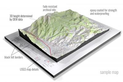
• Raised-relief 3D Height Determined by DEM data
• Fade Resistant Archival Inks
• Epoxy Coated for Strength and Waterproofing
• Ready to Hang with Pre-Installed Hardware (optional)
• Extraordinary 3D Accuracy
• Black Felt Borders
Enrich your office decor or home with a 3D USGS Raised Relief Map. These raised relief maps are not flat. They are three-dimensional, with the height being determined by Digital Elevation Model (DEM) data. Many people struggle with reading 2D satellite maps, but everyone understands 3D raised relief maps. The realism is phenomenal.
This 3D satellite raised relief map is built by combining satellite imagery data from Google Earth, bounding box coordinates from USGS, and DEM data. 3D Printing and 3D CNC routers are used to fabricate the models which make the satellite models extremely accurate. These models are strong - they are coated with epoxy, then finished with a sealer providing a weatherproof matt-finish. These are not meant to be used in direct sunlight.
Abarr, Colorado- View hi-resolution image of: Abarr, Colorado. Mapping by USGS in 2022 - Longitude/Latitude: -102.75 x -102.625 x 39.875 x 39.75, Grid Size: 7.5 X 7.5 Minute, Map Scale: 1:24000, State List: CO, County List: Yuma
Abarr SE, Colorado- View hi-resolution image of: Abarr SE, Colorado. Mapping by USGS in 2022 - Longitude/Latitude: -102.625 x -102.5 x 39.875 x 39.75, Grid Size: 7.5 X 7.5 Minute, Map Scale: 1:24000, State List: CO, County List: Yuma
Abeyta, Colorado- View hi-resolution image of: Abeyta, Colorado. Mapping by USGS in 2022 - Longitude/Latitude: -104.25 x -104.125 x 37.125 x 37, Grid Size: 7.5 X 7.5 Minute, Map Scale: 1:24000, State List: CO, County List: Las Animas
Adams Lake, Colorado- View hi-resolution image of: Adams Lake, Colorado. Mapping by USGS in 2022 - Longitude/Latitude: -107.5 x -107.375 x 39.75 x 39.625, Grid Size: 7.5 X 7.5 Minute, Map Scale: 1:24000, State List: CO, County List: Garfield
Adena, Colorado- View hi-resolution image of: Adena, Colorado. Mapping by USGS in 2022 - Longitude/Latitude: -104 x -103.875 x 40.125 x 40, Grid Size: 7.5 X 7.5 Minute, Map Scale: 1:24000, State List: CO, County List: Morgan,Adams
Adler Creek, Colorado- View hi-resolution image of: Adler Creek, Colorado. Mapping by USGS in 2022 - Longitude/Latitude: -102.625 x -102.5 x 39.75 x 39.625, Grid Size: 7.5 X 7.5 Minute, Map Scale: 1:24000, State List: CO, County List: Yuma
Adobe Springs, Colorado- View hi-resolution image of: Adobe Springs, Colorado. Mapping by USGS in 2022 - Longitude/Latitude: -108 x -107.875 x 40.75 x 40.625, Grid Size: 7.5 X 7.5 Minute, Map Scale: 1:24000, State List: CO, County List: Moffat
Agate, Colorado- View hi-resolution image of: Agate, Colorado. Mapping by USGS in 2022 - Longitude/Latitude: -104 x -103.875 x 39.5 x 39.375, Grid Size: 7.5 X 7.5 Minute, Map Scale: 1:24000, State List: CO, County List: Elbert
Agate Mountain, Colorado- View hi-resolution image of: Agate Mountain, Colorado. Mapping by USGS in 2022 - Longitude/Latitude: -105.875 x -105.75 x 38.875 x 38.75, Grid Size: 7.5 X 7.5 Minute, Map Scale: 1:24000, State List: CO, County List: Park
Aguilar, Colorado- View hi-resolution image of: Aguilar, Colorado. Mapping by USGS in 2022 - Longitude/Latitude: -104.75 x -104.625 x 37.5 x 37.375, Grid Size: 7.5 X 7.5 Minute, Map Scale: 1:24000, State List: CO, County List: Las Animas,Huerfano
Akron, Colorado- View hi-resolution image of: Akron, Colorado. Mapping by USGS in 2022 - Longitude/Latitude: -103.25 x -103.125 x 40.25 x 40.125, Grid Size: 7.5 X 7.5 Minute, Map Scale: 1:24000, State List: CO, County List: Washington
Akron SE, Colorado- View hi-resolution image of: Akron SE, Colorado. Mapping by USGS in 2022 - Longitude/Latitude: -103.125 x -103 x 40.125 x 40, Grid Size: 7.5 X 7.5 Minute, Map Scale: 1:24000, State List: CO, County List: Washington
Akron SW, Colorado- View hi-resolution image of: Akron SW, Colorado. Mapping by USGS in 2022 - Longitude/Latitude: -103.25 x -103.125 x 40.125 x 40, Grid Size: 7.5 X 7.5 Minute, Map Scale: 1:24000, State List: CO, County List: Washington
Alamosa East, Colorado- View hi-resolution image of: Alamosa East, Colorado. Mapping by USGS in 2022 - Longitude/Latitude: -105.875 x -105.75 x 37.5 x 37.375, Grid Size: 7.5 X 7.5 Minute, Map Scale: 1:24000, State List: CO, County List: Alamosa
Alamosa West, Colorado- View hi-resolution image of: Alamosa West, Colorado. Mapping by USGS in 2022 - Longitude/Latitude: -106 x -105.875 x 37.5 x 37.375, Grid Size: 7.5 X 7.5 Minute, Map Scale: 1:24000, State List: CO, County List: Alamosa
Aldrich Gulch, Colorado- View hi-resolution image of: Aldrich Gulch, Colorado. Mapping by USGS in 2022 - Longitude/Latitude: -105.5 x -105.375 x 38.125 x 38, Grid Size: 7.5 X 7.5 Minute, Map Scale: 1:24000, State List: CO, County List: Custer
Alkali Lake, Colorado- View hi-resolution image of: Alkali Lake, Colorado. Mapping by USGS in 2022 - Longitude/Latitude: -102.75 x -102.625 x 38.5 x 38.375, Grid Size: 7.5 X 7.5 Minute, Map Scale: 1:24000, State List: CO, County List: Kiowa
Allenspark, Colorado- View hi-resolution image of: Allenspark, Colorado. Mapping by USGS in 2022 - Longitude/Latitude: -105.625 x -105.5 x 40.25 x 40.125, Grid Size: 7.5 X 7.5 Minute, Map Scale: 1:24000, State List: CO, County List: Boulder
Allison, Colorado- View hi-resolution image of: Allison, Colorado. Mapping by USGS in 2022 - Longitude/Latitude: -107.5 x -107.375 x 37.125 x 37, Grid Size: 7.5 X 7.5 Minute, Map Scale: 1:24000, State List: CO,NM, County List: Archuleta,La Plata,San Juan,Rio Arriba
Alma, Colorado- View hi-resolution image of: Alma, Colorado. Mapping by USGS in 2022 - Longitude/Latitude: -106.125 x -106 x 39.375 x 39.25, Grid Size: 7.5 X 7.5 Minute, Map Scale: 1:24000, State List: CO, County List: Park,Summit
Almont, Colorado- View hi-resolution image of: Almont, Colorado. Mapping by USGS in 2022 - Longitude/Latitude: -106.875 x -106.75 x 38.75 x 38.625, Grid Size: 7.5 X 7.5 Minute, Map Scale: 1:24000, State List: CO, County List: Gunnison
Alpine Plateau, Colorado- View hi-resolution image of: Alpine Plateau, Colorado. Mapping by USGS in 2022 - Longitude/Latitude: -107.375 x -107.25 x 38.25 x 38.125, Grid Size: 7.5 X 7.5 Minute, Map Scale: 1:24000, State List: CO, County List: Gunnison,Hinsdale
Alpine Ranch, Colorado- View hi-resolution image of: Alpine Ranch, Colorado. Mapping by USGS in 2022 - Longitude/Latitude: -102.625 x -102.5 x 39.125 x 39, Grid Size: 7.5 X 7.5 Minute, Map Scale: 1:24000, State List: CO, County List: Kit Carson,Cheyenne
Alpine Ranch NE, Colorado- View hi-resolution image of: Alpine Ranch NE, Colorado. Mapping by USGS in 2022 - Longitude/Latitude: -102.625 x -102.5 x 39.25 x 39.125, Grid Size: 7.5 X 7.5 Minute, Map Scale: 1:24000, State List: CO, County List: Kit Carson
Alpine Ranch NW, Colorado- View hi-resolution image of: Alpine Ranch NW, Colorado. Mapping by USGS in 2022 - Longitude/Latitude: -102.75 x -102.625 x 39.25 x 39.125, Grid Size: 7.5 X 7.5 Minute, Map Scale: 1:24000, State List: CO, County List: Kit Carson
Alpine Ranch SW, Colorado- View hi-resolution image of: Alpine Ranch SW, Colorado. Mapping by USGS in 2022 - Longitude/Latitude: -102.75 x -102.625 x 39.125 x 39, Grid Size: 7.5 X 7.5 Minute, Map Scale: 1:24000, State List: CO, County List: Kit Carson,Cheyenne
Alta Vista, Colorado- View hi-resolution image of: Alta Vista, Colorado. Mapping by USGS in 2022 - Longitude/Latitude: -104.125 x -104 x 39.125 x 39, Grid Size: 7.5 X 7.5 Minute, Map Scale: 1:24000, State List: CO, County List: El Paso,Elbert
Alvin, Colorado- View hi-resolution image of: Alvin, Colorado. Mapping by USGS in 2022 - Longitude/Latitude: -102.125 x -102 x 40.375 x 40.25, Grid Size: 7.5 X 7.5 Minute, Map Scale: 1:24000, State List: CO,NE, County List: Yuma,Dundy,Chase
Alvin NE, Colorado- View hi-resolution image of: Alvin NE, Colorado. Mapping by USGS in 2022 - Longitude/Latitude: -102.125 x -102 x 40.5 x 40.375, Grid Size: 7.5 X 7.5 Minute, Map Scale: 1:24000, State List: CO,NE, County List: Phillips,Chase,Yuma
Alvin NW, Colorado- View hi-resolution image of: Alvin NW, Colorado. Mapping by USGS in 2022 - Longitude/Latitude: -102.25 x -102.125 x 40.5 x 40.375, Grid Size: 7.5 X 7.5 Minute, Map Scale: 1:24000, State List: CO, County List: Phillips,Yuma
Alvin SW, Colorado- View hi-resolution image of: Alvin SW, Colorado. Mapping by USGS in 2022 - Longitude/Latitude: -102.25 x -102.125 x 40.375 x 40.25, Grid Size: 7.5 X 7.5 Minute, Map Scale: 1:24000, State List: CO, County List: Yuma
Amherst, Colorado- View hi-resolution image of: Amherst, Colorado. Mapping by USGS in 2022 - Longitude/Latitude: -102.25 x -102.125 x 40.75 x 40.625, Grid Size: 7.5 X 7.5 Minute, Map Scale: 1:24000, State List: CO, County List: Phillips,Sedgwick
Amherst NE, Colorado- View hi-resolution image of: Amherst NE, Colorado. Mapping by USGS in 2022 - Longitude/Latitude: -102.125 x -102 x 40.75 x 40.625, Grid Size: 7.5 X 7.5 Minute, Map Scale: 1:24000, State List: CO,NE, County List: Phillips,Chase,Perkins,Sedgwick
Amherst SE, Colorado- View hi-resolution image of: Amherst SE, Colorado. Mapping by USGS in 2022 - Longitude/Latitude: -102.125 x -102 x 40.625 x 40.5, Grid Size: 7.5 X 7.5 Minute, Map Scale: 1:24000, State List: CO,NE, County List: Phillips,Chase
Amherst SW, Colorado- View hi-resolution image of: Amherst SW, Colorado. Mapping by USGS in 2022 - Longitude/Latitude: -102.25 x -102.125 x 40.625 x 40.5, Grid Size: 7.5 X 7.5 Minute, Map Scale: 1:24000, State List: CO, County List: Phillips
Anderson Mesa, Colorado- View hi-resolution image of: Anderson Mesa, Colorado. Mapping by USGS in 2022 - Longitude/Latitude: -109 x -108.875 x 38.25 x 38.125, Grid Size: 7.5 X 7.5 Minute, Map Scale: 1:24000, State List: CO, County List: Montrose,San Miguel
Andrix, Colorado- View hi-resolution image of: Andrix, Colorado. Mapping by USGS in 2022 - Longitude/Latitude: -103.25 x -103.125 x 37.375 x 37.25, Grid Size: 7.5 X 7.5 Minute, Map Scale: 1:24000, State List: CO, County List: Las Animas
Antelope Creek East, Colorado- View hi-resolution image of: Antelope Creek East, Colorado. Mapping by USGS in 2022 - Longitude/Latitude: -103.375 x -103.25 x 40 x 39.875, Grid Size: 7.5 X 7.5 Minute, Map Scale: 1:24000, State List: CO, County List: Washington
Antelope Creek SE, Colorado- View hi-resolution image of: Antelope Creek SE, Colorado. Mapping by USGS in 2022 - Longitude/Latitude: -103.375 x -103.25 x 39.875 x 39.75, Grid Size: 7.5 X 7.5 Minute, Map Scale: 1:24000, State List: CO, County List: Washington
Antelope Creek West, Colorado- View hi-resolution image of: Antelope Creek West, Colorado. Mapping by USGS in 2022 - Longitude/Latitude: -103.5 x -103.375 x 40 x 39.875, Grid Size: 7.5 X 7.5 Minute, Map Scale: 1:24000, State List: CO, County List: Washington
Antelope Mesa, Colorado- View hi-resolution image of: Antelope Mesa, Colorado. Mapping by USGS in 2022 - Longitude/Latitude: -104 x -103.875 x 38.375 x 38.25, Grid Size: 7.5 X 7.5 Minute, Map Scale: 1:24000, State List: CO, County List: Crowley
Antelope Reservoir, Colorado- View hi-resolution image of: Antelope Reservoir, Colorado. Mapping by USGS in 2022 - Longitude/Latitude: -104.75 x -104.625 x 40.75 x 40.625, Grid Size: 7.5 X 7.5 Minute, Map Scale: 1:24000, State List: CO, County List: Weld
Antelope Springs, Colorado- View hi-resolution image of: Antelope Springs, Colorado. Mapping by USGS in 2022 - Longitude/Latitude: -103.625 x -103.5 x 40.5 x 40.375, Grid Size: 7.5 X 7.5 Minute, Map Scale: 1:24000, State List: CO, County List: Morgan
Antero Reservoir, Colorado- View hi-resolution image of: Antero Reservoir, Colorado. Mapping by USGS in 2022 - Longitude/Latitude: -106 x -105.875 x 39 x 38.875, Grid Size: 7.5 X 7.5 Minute, Map Scale: 1:24000, State List: CO, County List: Park,Chaffee
Antero Reservoir NE, Colorado- View hi-resolution image of: Antero Reservoir NE, Colorado. Mapping by USGS in 2022 - Longitude/Latitude: -105.875 x -105.75 x 39 x 38.875, Grid Size: 7.5 X 7.5 Minute, Map Scale: 1:24000, State List: CO, County List: Park
Anthracite Range, Colorado- View hi-resolution image of: Anthracite Range, Colorado. Mapping by USGS in 2022 - Longitude/Latitude: -107.25 x -107.125 x 38.875 x 38.75, Grid Size: 7.5 X 7.5 Minute, Map Scale: 1:24000, State List: CO, County List: Gunnison
Anton, Colorado- View hi-resolution image of: Anton, Colorado. Mapping by USGS in 2022 - Longitude/Latitude: -103.25 x -103.125 x 39.75 x 39.625, Grid Size: 7.5 X 7.5 Minute, Map Scale: 1:24000, State List: CO, County List: Washington
Anton SE, Colorado- View hi-resolution image of: Anton SE, Colorado. Mapping by USGS in 2022 - Longitude/Latitude: -103.125 x -103 x 39.625 x 39.5, Grid Size: 7.5 X 7.5 Minute, Map Scale: 1:24000, State List: CO, County List: Kit Carson,Washington
Antone Spring, Colorado- View hi-resolution image of: Antone Spring, Colorado. Mapping by USGS in 2022 - Longitude/Latitude: -108.25 x -108.125 x 38.375 x 38.25, Grid Size: 7.5 X 7.5 Minute, Map Scale: 1:24000, State List: CO, County List: Montrose,Ouray
Antonito, Colorado- View hi-resolution image of: Antonito, Colorado. Mapping by USGS in 2022 - Longitude/Latitude: -106.125 x -106 x 37.125 x 37, Grid Size: 7.5 X 7.5 Minute, Map Scale: 1:24000, State List: CO, County List: Conejos
Anvil Points, Colorado- View hi-resolution image of: Anvil Points, Colorado. Mapping by USGS in 2022 - Longitude/Latitude: -108 x -107.875 x 39.625 x 39.5, Grid Size: 7.5 X 7.5 Minute, Map Scale: 1:24000, State List: CO, County List: Garfield
Apishapa Bridge, Colorado- View hi-resolution image of: Apishapa Bridge, Colorado. Mapping by USGS in 2022 - Longitude/Latitude: -104.125 x -104 x 38 x 37.875, Grid Size: 7.5 X 7.5 Minute, Map Scale: 1:24000, State List: CO, County List: Pueblo,Otero
Arapahoe, Colorado- View hi-resolution image of: Arapahoe, Colorado. Mapping by USGS in 2022 - Longitude/Latitude: -102.25 x -102.125 x 38.875 x 38.75, Grid Size: 7.5 X 7.5 Minute, Map Scale: 1:24000, State List: CO, County List: Cheyenne
Arapahoe NE, Colorado- View hi-resolution image of: Arapahoe NE, Colorado. Mapping by USGS in 2022 - Longitude/Latitude: -102.125 x -102 x 39 x 38.875, Grid Size: 7.5 X 7.5 Minute, Map Scale: 1:24000, State List: CO,KS, County List: Cheyenne,Wallace
Arapahoe NW, Colorado- View hi-resolution image of: Arapahoe NW, Colorado. Mapping by USGS in 2022 - Longitude/Latitude: -102.25 x -102.125 x 39 x 38.875, Grid Size: 7.5 X 7.5 Minute, Map Scale: 1:24000, State List: CO, County List: Cheyenne
Arapahoe SE, Colorado- View hi-resolution image of: Arapahoe SE, Colorado. Mapping by USGS in 2022 - Longitude/Latitude: -102.125 x -102 x 38.875 x 38.75, Grid Size: 7.5 X 7.5 Minute, Map Scale: 1:24000, State List: CO,KS, County List: Cheyenne,Wallace
Archuleta Creek, Colorado- View hi-resolution image of: Archuleta Creek, Colorado. Mapping by USGS in 2022 - Longitude/Latitude: -106.625 x -106.5 x 37.125 x 37, Grid Size: 7.5 X 7.5 Minute, Map Scale: 1:24000, State List: CO, County List: Archuleta,Conejos
Arickaree, Colorado- View hi-resolution image of: Arickaree, Colorado. Mapping by USGS in 2022 - Longitude/Latitude: -103.125 x -103 x 39.75 x 39.625, Grid Size: 7.5 X 7.5 Minute, Map Scale: 1:24000, State List: CO, County List: Washington
Arkansas Mountain, Colorado- View hi-resolution image of: Arkansas Mountain, Colorado. Mapping by USGS in 2022 - Longitude/Latitude: -105.75 x -105.625 x 38.5 x 38.375, Grid Size: 7.5 X 7.5 Minute, Map Scale: 1:24000, State List: CO, County List: Fremont
Arlington, Colorado- View hi-resolution image of: Arlington, Colorado. Mapping by USGS in 2022 - Longitude/Latitude: -103.375 x -103.25 x 38.375 x 38.25, Grid Size: 7.5 X 7.5 Minute, Map Scale: 1:24000, State List: CO, County List: Kiowa,Bent
Arlington NE, Colorado- View hi-resolution image of: Arlington NE, Colorado. Mapping by USGS in 2022 - Longitude/Latitude: -103.375 x -103.25 x 38.5 x 38.375, Grid Size: 7.5 X 7.5 Minute, Map Scale: 1:24000, State List: CO, County List: Kiowa
Armel, Colorado- View hi-resolution image of: Armel, Colorado. Mapping by USGS in 2022 - Longitude/Latitude: -102.125 x -102 x 39.875 x 39.75, Grid Size: 7.5 X 7.5 Minute, Map Scale: 1:24000, State List: CO,KS, County List: Yuma,Cheyenne
Aroya, Colorado- View hi-resolution image of: Aroya, Colorado. Mapping by USGS in 2022 - Longitude/Latitude: -103.25 x -103.125 x 38.875 x 38.75, Grid Size: 7.5 X 7.5 Minute, Map Scale: 1:24000, State List: CO, County List: Lincoln,Cheyenne
Arriba, Colorado- View hi-resolution image of: Arriba, Colorado. Mapping by USGS in 2022 - Longitude/Latitude: -103.375 x -103.25 x 39.375 x 39.25, Grid Size: 7.5 X 7.5 Minute, Map Scale: 1:24000, State List: CO, County List: Lincoln
Arriba NE, Colorado- View hi-resolution image of: Arriba NE, Colorado. Mapping by USGS in 2022 - Longitude/Latitude: -103.375 x -103.25 x 39.5 x 39.375, Grid Size: 7.5 X 7.5 Minute, Map Scale: 1:24000, State List: CO, County List: Lincoln
Arriba NW, Colorado- View hi-resolution image of: Arriba NW, Colorado. Mapping by USGS in 2022 - Longitude/Latitude: -103.5 x -103.375 x 39.5 x 39.375, Grid Size: 7.5 X 7.5 Minute, Map Scale: 1:24000, State List: CO, County List: Lincoln
Arriola, Colorado- View hi-resolution image of: Arriola, Colorado. Mapping by USGS in 2022 - Longitude/Latitude: -108.75 x -108.625 x 37.5 x 37.375, Grid Size: 7.5 X 7.5 Minute, Map Scale: 1:24000, State List: CO, County List: Montezuma
Arsenic Lake, Colorado- View hi-resolution image of: Arsenic Lake, Colorado. Mapping by USGS in 2022 - Longitude/Latitude: -103 x -102.875 x 38.75 x 38.625, Grid Size: 7.5 X 7.5 Minute, Map Scale: 1:24000, State List: CO, County List: Cheyenne
Arsenic Lake SW, Colorado- View hi-resolution image of: Arsenic Lake SW, Colorado. Mapping by USGS in 2022 - Longitude/Latitude: -103 x -102.875 x 38.625 x 38.5, Grid Size: 7.5 X 7.5 Minute, Map Scale: 1:24000, State List: CO, County List: Kiowa,Cheyenne
Arvada, Colorado- View hi-resolution image of: Arvada, Colorado. Mapping by USGS in 2022 - Longitude/Latitude: -105.125 x -105 x 39.875 x 39.75, Grid Size: 7.5 X 7.5 Minute, Map Scale: 1:24000, State List: CO, County List: Jefferson,Adams,Denver
Aspen, Colorado- View hi-resolution image of: Aspen, Colorado. Mapping by USGS in 2022 - Longitude/Latitude: -106.875 x -106.75 x 39.25 x 39.125, Grid Size: 7.5 X 7.5 Minute, Map Scale: 1:24000, State List: CO, County List: Pitkin
Atkinson Creek, Colorado- View hi-resolution image of: Atkinson Creek, Colorado. Mapping by USGS in 2022 - Longitude/Latitude: -108.75 x -108.625 x 38.5 x 38.375, Grid Size: 7.5 X 7.5 Minute, Map Scale: 1:24000, State List: CO, County List: Montrose,Mesa
Atwood, Colorado- View hi-resolution image of: Atwood, Colorado. Mapping by USGS in 2022 - Longitude/Latitude: -103.375 x -103.25 x 40.625 x 40.5, Grid Size: 7.5 X 7.5 Minute, Map Scale: 1:24000, State List: CO, County List: Logan
Atwood NE, Colorado- View hi-resolution image of: Atwood NE, Colorado. Mapping by USGS in 2022 - Longitude/Latitude: -103.375 x -103.25 x 40.75 x 40.625, Grid Size: 7.5 X 7.5 Minute, Map Scale: 1:24000, State List: CO, County List: Logan
Avalo, Colorado- View hi-resolution image of: Avalo, Colorado. Mapping by USGS in 2022 - Longitude/Latitude: -103.75 x -103.625 x 40.875 x 40.75, Grid Size: 7.5 X 7.5 Minute, Map Scale: 1:24000, State List: CO, County List: Weld
Avalo SE, Colorado- View hi-resolution image of: Avalo SE, Colorado. Mapping by USGS in 2022 - Longitude/Latitude: -103.625 x -103.5 x 40.875 x 40.75, Grid Size: 7.5 X 7.5 Minute, Map Scale: 1:24000, State List: CO, County List: Logan,Weld
Avondale, Colorado- View hi-resolution image of: Avondale, Colorado. Mapping by USGS in 2022 - Longitude/Latitude: -104.375 x -104.25 x 38.25 x 38.125, Grid Size: 7.5 X 7.5 Minute, Map Scale: 1:24000, State List: CO, County List: Pueblo
Axial, Colorado- View hi-resolution image of: Axial, Colorado. Mapping by USGS in 2022 - Longitude/Latitude: -107.875 x -107.75 x 40.375 x 40.25, Grid Size: 7.5 X 7.5 Minute, Map Scale: 1:24000, State List: CO, County List: Moffat
Badger Wash, Colorado- View hi-resolution image of: Badger Wash, Colorado. Mapping by USGS in 2022 - Longitude/Latitude: -109 x -108.875 x 39.375 x 39.25, Grid Size: 7.5 X 7.5 Minute, Map Scale: 1:24000, State List: CO, County List: Mesa,Garfield
Badito Cone, Colorado- View hi-resolution image of: Badito Cone, Colorado. Mapping by USGS in 2022 - Longitude/Latitude: -105.125 x -105 x 37.875 x 37.75, Grid Size: 7.5 X 7.5 Minute, Map Scale: 1:24000, State List: CO, County List: Huerfano
Bailey, Colorado- View hi-resolution image of: Bailey, Colorado. Mapping by USGS in 2022 - Longitude/Latitude: -105.5 x -105.375 x 39.5 x 39.375, Grid Size: 7.5 X 7.5 Minute, Map Scale: 1:24000, State List: CO, County List: Park,Jefferson
Baker Draw, Colorado- View hi-resolution image of: Baker Draw, Colorado. Mapping by USGS in 2022 - Longitude/Latitude: -104.5 x -104.375 x 40.75 x 40.625, Grid Size: 7.5 X 7.5 Minute, Map Scale: 1:24000, State List: CO, County List: Weld
Bakers Peak, Colorado- View hi-resolution image of: Bakers Peak, Colorado. Mapping by USGS in 2022 - Longitude/Latitude: -107.5 x -107.375 x 41 x 40.875, Grid Size: 7.5 X 7.5 Minute, Map Scale: 1:24000, State List: CO, County List: Moffat
Bald Mountain, Colorado- View hi-resolution image of: Bald Mountain, Colorado. Mapping by USGS in 2022 - Longitude/Latitude: -108.125 x -108 x 40.75 x 40.625, Grid Size: 7.5 X 7.5 Minute, Map Scale: 1:24000, State List: CO, County List: Moffat
Baldy, Colorado- View hi-resolution image of: Baldy, Colorado. Mapping by USGS in 2022 - Longitude/Latitude: -105.75 x -105.625 x 37.5 x 37.375, Grid Size: 7.5 X 7.5 Minute, Map Scale: 1:24000, State List: CO, County List: Alamosa,Costilla
Baldy Cinco, Colorado- View hi-resolution image of: Baldy Cinco, Colorado. Mapping by USGS in 2022 - Longitude/Latitude: -107.125 x -107 x 38 x 37.875, Grid Size: 7.5 X 7.5 Minute, Map Scale: 1:24000, State List: CO, County List: Mineral,Hinsdale,Saguache
Baldy Mountain, Colorado- View hi-resolution image of: Baldy Mountain, Colorado. Mapping by USGS in 2019 - Longitude/Latitude: -107.5 x -107.375 x 37.375 x 37.25, Grid Size: 7.5 X 7.5 Minute, Map Scale: 1:24000, State List: CO, County List: Archuleta,La Plata
Banta Ridge, Colorado- View hi-resolution image of: Banta Ridge, Colorado. Mapping by USGS in 2022 - Longitude/Latitude: -109 x -108.875 x 40 x 39.875, Grid Size: 7.5 X 7.5 Minute, Map Scale: 1:24000, State List: CO, County List: Rio Blanco
Banty Point, Colorado- View hi-resolution image of: Banty Point, Colorado. Mapping by USGS in 2022 - Longitude/Latitude: -109 x -108.875 x 40.125 x 40, Grid Size: 7.5 X 7.5 Minute, Map Scale: 1:24000, State List: CO, County List: Rio Blanco
Bar J H Ranch, Colorado- View hi-resolution image of: Bar J H Ranch, Colorado. Mapping by USGS in 2022 - Longitude/Latitude: -104.5 x -104.375 x 38.5 x 38.375, Grid Size: 7.5 X 7.5 Minute, Map Scale: 1:24000, State List: CO, County List: Pueblo
Barcus Creek, Colorado- View hi-resolution image of: Barcus Creek, Colorado. Mapping by USGS in 2022 - Longitude/Latitude: -108.5 x -108.375 x 40.125 x 40, Grid Size: 7.5 X 7.5 Minute, Map Scale: 1:24000, State List: CO, County List: Rio Blanco
Barcus Creek SE, Colorado- View hi-resolution image of: Barcus Creek SE, Colorado. Mapping by USGS in 2022 - Longitude/Latitude: -108.375 x -108.25 x 40.125 x 40, Grid Size: 7.5 X 7.5 Minute, Map Scale: 1:24000, State List: CO, County List: Rio Blanco
Barela, Colorado- View hi-resolution image of: Barela, Colorado. Mapping by USGS in 2022 - Longitude/Latitude: -104.375 x -104.25 x 37.125 x 37, Grid Size: 7.5 X 7.5 Minute, Map Scale: 1:24000, State List: CO, County List: Las Animas
Barkelew Draw, Colorado- View hi-resolution image of: Barkelew Draw, Colorado. Mapping by USGS in 2022 - Longitude/Latitude: -108.5 x -108.375 x 38.125 x 38, Grid Size: 7.5 X 7.5 Minute, Map Scale: 1:24000, State List: CO, County List: San Miguel
Barking Dog Spring, Colorado- View hi-resolution image of: Barking Dog Spring, Colorado. Mapping by USGS in 2022 - Longitude/Latitude: -103.875 x -103.75 x 39.5 x 39.375, Grid Size: 7.5 X 7.5 Minute, Map Scale: 1:24000, State List: CO, County List: Elbert
Barnesville, Colorado- View hi-resolution image of: Barnesville, Colorado. Mapping by USGS in 2022 - Longitude/Latitude: -104.5 x -104.375 x 40.5 x 40.375, Grid Size: 7.5 X 7.5 Minute, Map Scale: 1:24000, State List: CO, County List: Weld
Barrel Spring, Colorado- View hi-resolution image of: Barrel Spring, Colorado. Mapping by USGS in 2022 - Longitude/Latitude: -102.5 x -102.375 x 37.875 x 37.75, Grid Size: 7.5 X 7.5 Minute, Map Scale: 1:24000, State List: CO, County List: Prowers
Barrel Springs Draw, Colorado- View hi-resolution image of: Barrel Springs Draw, Colorado. Mapping by USGS in 2022 - Longitude/Latitude: -103.375 x -103.25 x 38.75 x 38.625, Grid Size: 7.5 X 7.5 Minute, Map Scale: 1:24000, State List: CO, County List: Lincoln
Barron Creek, Colorado- View hi-resolution image of: Barron Creek, Colorado. Mapping by USGS in 2022 - Longitude/Latitude: -103.625 x -103.5 x 39.25 x 39.125, Grid Size: 7.5 X 7.5 Minute, Map Scale: 1:24000, State List: CO, County List: Lincoln
Bartlett, Colorado- View hi-resolution image of: Bartlett, Colorado. Mapping by USGS in 2022 - Longitude/Latitude: -102.25 x -102.125 x 37.5 x 37.375, Grid Size: 7.5 X 7.5 Minute, Map Scale: 1:24000, State List: CO, County List: Baca
Basalt, Colorado- View hi-resolution image of: Basalt, Colorado. Mapping by USGS in 2022 - Longitude/Latitude: -107.125 x -107 x 39.375 x 39.25, Grid Size: 7.5 X 7.5 Minute, Map Scale: 1:24000, State List: CO, County List: Pitkin,Eagle,Garfield
Basin, Colorado- View hi-resolution image of: Basin, Colorado. Mapping by USGS in 2022 - Longitude/Latitude: -108.625 x -108.5 x 38.125 x 38, Grid Size: 7.5 X 7.5 Minute, Map Scale: 1:24000, State List: CO, County List: San Miguel
Basin Mountain, Colorado- View hi-resolution image of: Basin Mountain, Colorado. Mapping by USGS in 2022 - Longitude/Latitude: -108 x -107.875 x 37.25 x 37.125, Grid Size: 7.5 X 7.5 Minute, Map Scale: 1:24000, State List: CO, County List: La Plata
Bates Lake, Colorado- View hi-resolution image of: Bates Lake, Colorado. Mapping by USGS in 2022 - Longitude/Latitude: -104.25 x -104.125 x 37.625 x 37.5, Grid Size: 7.5 X 7.5 Minute, Map Scale: 1:24000, State List: CO, County List: Las Animas
Battle Canyon, Colorado- View hi-resolution image of: Battle Canyon, Colorado. Mapping by USGS in 2022 - Longitude/Latitude: -103.75 x -103.625 x 41 x 40.875, Grid Size: 7.5 X 7.5 Minute, Map Scale: 1:24000, State List: CO, County List: Weld
Battle Mountain, Colorado- View hi-resolution image of: Battle Mountain, Colorado. Mapping by USGS in 2022 - Longitude/Latitude: -106.25 x -106.125 x 40 x 39.875, Grid Size: 7.5 X 7.5 Minute, Map Scale: 1:24000, State List: CO, County List: Grand,Summit
Battle Rock, Colorado- View hi-resolution image of: Battle Rock, Colorado. Mapping by USGS in 2022 - Longitude/Latitude: -108.875 x -108.75 x 37.375 x 37.25, Grid Size: 7.5 X 7.5 Minute, Map Scale: 1:24000, State List: CO, County List: Montezuma
Battleship Rock, Colorado- View hi-resolution image of: Battleship Rock, Colorado. Mapping by USGS in 2022 - Longitude/Latitude: -108.875 x -108.75 x 39.125 x 39, Grid Size: 7.5 X 7.5 Minute, Map Scale: 1:24000, State List: CO, County List: Mesa
Baxter Pass, Colorado- View hi-resolution image of: Baxter Pass, Colorado. Mapping by USGS in 2022 - Longitude/Latitude: -109 x -108.875 x 39.625 x 39.5, Grid Size: 7.5 X 7.5 Minute, Map Scale: 1:24000, State List: CO, County List: Garfield
Bayfield, Colorado- View hi-resolution image of: Bayfield, Colorado. Mapping by USGS in 2022 - Longitude/Latitude: -107.625 x -107.5 x 37.25 x 37.125, Grid Size: 7.5 X 7.5 Minute, Map Scale: 1:24000, State List: CO, County List: La Plata
Bear Creek, Colorado- View hi-resolution image of: Bear Creek, Colorado. Mapping by USGS in 2022 - Longitude/Latitude: -105.25 x -105.125 x 38 x 37.875, Grid Size: 7.5 X 7.5 Minute, Map Scale: 1:24000, State List: CO, County List: Huerfano,Custer
Bear Mountain, Colorado- View hi-resolution image of: Bear Mountain, Colorado. Mapping by USGS in 2022 - Longitude/Latitude: -107.375 x -107.25 x 37.5 x 37.375, Grid Size: 7.5 X 7.5 Minute, Map Scale: 1:24000, State List: CO, County List: Hinsdale,Archuleta
Bears Ears Peaks, Colorado- View hi-resolution image of: Bears Ears Peaks, Colorado. Mapping by USGS in 2022 - Longitude/Latitude: -107.25 x -107.125 x 40.875 x 40.75, Grid Size: 7.5 X 7.5 Minute, Map Scale: 1:24000, State List: CO, County List: Routt
Beaty Canyon, Colorado- View hi-resolution image of: Beaty Canyon, Colorado. Mapping by USGS in 2022 - Longitude/Latitude: -103.625 x -103.5 x 37.625 x 37.5, Grid Size: 7.5 X 7.5 Minute, Map Scale: 1:24000, State List: CO, County List: Las Animas
Beaver Basin, Colorado- View hi-resolution image of: Beaver Basin, Colorado. Mapping by USGS in 2022 - Longitude/Latitude: -109 x -108.875 x 41 x 40.875, Grid Size: 7.5 X 7.5 Minute, Map Scale: 1:24000, State List: CO, County List: Moffat
Beaver Creek Reservoir, Colorado- View hi-resolution image of: Beaver Creek Reservoir, Colorado. Mapping by USGS in 2022 - Longitude/Latitude: -106.75 x -106.625 x 37.625 x 37.5, Grid Size: 7.5 X 7.5 Minute, Map Scale: 1:24000, State List: CO, County List: Rio Grande,Mineral
Beaver Park, Colorado- View hi-resolution image of: Beaver Park, Colorado. Mapping by USGS in 2022 - Longitude/Latitude: -108.25 x -108.125 x 38 x 37.875, Grid Size: 7.5 X 7.5 Minute, Map Scale: 1:24000, State List: CO, County List: San Miguel,Dolores
Beck Mountain, Colorado- View hi-resolution image of: Beck Mountain, Colorado. Mapping by USGS in 2022 - Longitude/Latitude: -105.5 x -105.375 x 38 x 37.875, Grid Size: 7.5 X 7.5 Minute, Map Scale: 1:24000, State List: CO, County List: Custer,Huerfano,Saguache
Beckman Lake, Colorado- View hi-resolution image of: Beckman Lake, Colorado. Mapping by USGS in 2022 - Longitude/Latitude: -103.625 x -103.5 x 39 x 38.875, Grid Size: 7.5 X 7.5 Minute, Map Scale: 1:24000, State List: CO, County List: Lincoln
Beckwith Mountain, Colorado- View hi-resolution image of: Beckwith Mountain, Colorado. Mapping by USGS in 2022 - Longitude/Latitude: -105.625 x -105.5 x 38.25 x 38.125, Grid Size: 7.5 X 7.5 Minute, Map Scale: 1:24000, State List: CO, County List: Custer
Beecher Island, Colorado- View hi-resolution image of: Beecher Island, Colorado. Mapping by USGS in 2022 - Longitude/Latitude: -102.25 x -102.125 x 39.875 x 39.75, Grid Size: 7.5 X 7.5 Minute, Map Scale: 1:24000, State List: CO, County List: Yuma
Beecher Island NW, Colorado- View hi-resolution image of: Beecher Island NW, Colorado. Mapping by USGS in 2019 - Longitude/Latitude: -102.25 x -102.125 x 40 x 39.875, Grid Size: 7.5 X 7.5 Minute, Map Scale: 1:24000, State List: CO, County List: Yuma
Bellyache Creek, Colorado- View hi-resolution image of: Bellyache Creek, Colorado. Mapping by USGS in 2022 - Longitude/Latitude: -103.125 x -103 x 39.125 x 39, Grid Size: 7.5 X 7.5 Minute, Map Scale: 1:24000, State List: CO, County List: Kit Carson,Cheyenne
Bennett, Colorado- View hi-resolution image of: Bennett, Colorado. Mapping by USGS in 2022 - Longitude/Latitude: -104.5 x -104.375 x 39.875 x 39.75, Grid Size: 7.5 X 7.5 Minute, Map Scale: 1:24000, State List: CO, County List: Adams
Berthoud, Colorado- View hi-resolution image of: Berthoud, Colorado. Mapping by USGS in 2022 - Longitude/Latitude: -105.125 x -105 x 40.375 x 40.25, Grid Size: 7.5 X 7.5 Minute, Map Scale: 1:24000, State List: CO, County List: Larimer,Weld,Boulder
Berthoud Pass, Colorado- View hi-resolution image of: Berthoud Pass, Colorado. Mapping by USGS in 2022 - Longitude/Latitude: -105.875 x -105.75 x 39.875 x 39.75, Grid Size: 7.5 X 7.5 Minute, Map Scale: 1:24000, State List: CO, County List: Grand,Clear Creek
Bethune, Colorado- View hi-resolution image of: Bethune, Colorado. Mapping by USGS in 2022 - Longitude/Latitude: -102.5 x -102.375 x 39.375 x 39.25, Grid Size: 7.5 X 7.5 Minute, Map Scale: 1:24000, State List: CO, County List: Kit Carson
Beuck Draw, Colorado- View hi-resolution image of: Beuck Draw, Colorado. Mapping by USGS in 2022 - Longitude/Latitude: -104 x -103.875 x 39.375 x 39.25, Grid Size: 7.5 X 7.5 Minute, Map Scale: 1:24000, State List: CO, County List: Elbert
Beulah, Colorado- View hi-resolution image of: Beulah, Colorado. Mapping by USGS in 2022 - Longitude/Latitude: -105 x -104.875 x 38.125 x 38, Grid Size: 7.5 X 7.5 Minute, Map Scale: 1:24000, State List: CO, County List: Pueblo
Beulah NE, Colorado- View hi-resolution image of: Beulah NE, Colorado. Mapping by USGS in 2022 - Longitude/Latitude: -104.875 x -104.75 x 38.25 x 38.125, Grid Size: 7.5 X 7.5 Minute, Map Scale: 1:24000, State List: CO, County List: Pueblo
Beverly Grove, Colorado- View hi-resolution image of: Beverly Grove, Colorado. Mapping by USGS in 2022 - Longitude/Latitude: -102.75 x -102.625 x 40 x 39.875, Grid Size: 7.5 X 7.5 Minute, Map Scale: 1:24000, State List: CO, County List: Yuma
Bieser Creek, Colorado- View hi-resolution image of: Bieser Creek, Colorado. Mapping by USGS in 2022 - Longitude/Latitude: -109 x -108.875 x 39 x 38.875, Grid Size: 7.5 X 7.5 Minute, Map Scale: 1:24000, State List: CO, County List: Mesa
Big Beaver Reservoir, Colorado- View hi-resolution image of: Big Beaver Reservoir, Colorado. Mapping by USGS in 2022 - Longitude/Latitude: -107.75 x -107.625 x 40 x 39.875, Grid Size: 7.5 X 7.5 Minute, Map Scale: 1:24000, State List: CO, County List: Rio Blanco
Big Bucktail Creek, Colorado- View hi-resolution image of: Big Bucktail Creek, Colorado. Mapping by USGS in 2022 - Longitude/Latitude: -108.5 x -108.375 x 38.375 x 38.25, Grid Size: 7.5 X 7.5 Minute, Map Scale: 1:24000, State List: CO, County List: Montrose
Big Bull Mountain, Colorado- View hi-resolution image of: Big Bull Mountain, Colorado. Mapping by USGS in 2022 - Longitude/Latitude: -105.125 x -105 x 38.75 x 38.625, Grid Size: 7.5 X 7.5 Minute, Map Scale: 1:24000, State List: CO, County List: Teller,Fremont
Big Foundation Creek, Colorado- View hi-resolution image of: Big Foundation Creek, Colorado. Mapping by USGS in 2022 - Longitude/Latitude: -108.875 x -108.75 x 39.75 x 39.625, Grid Size: 7.5 X 7.5 Minute, Map Scale: 1:24000, State List: CO, County List: Rio Blanco,Garfield
Big Gulch, Colorado- View hi-resolution image of: Big Gulch, Colorado. Mapping by USGS in 2022 - Longitude/Latitude: -104.375 x -104.25 x 39.375 x 39.25, Grid Size: 7.5 X 7.5 Minute, Map Scale: 1:24000, State List: CO, County List: Elbert
Big Hole Canyon, Colorado- View hi-resolution image of: Big Hole Canyon, Colorado. Mapping by USGS in 2022 - Longitude/Latitude: -103 x -102.875 x 37.125 x 37, Grid Size: 7.5 X 7.5 Minute, Map Scale: 1:24000, State List: CO, County List: Baca
Big Joe Basin, Colorado- View hi-resolution image of: Big Joe Basin, Colorado. Mapping by USGS in 2022 - Longitude/Latitude: -108.875 x -108.75 x 40.875 x 40.75, Grid Size: 7.5 X 7.5 Minute, Map Scale: 1:24000, State List: CO, County List: Moffat
Big Marvine Peak, Colorado- View hi-resolution image of: Big Marvine Peak, Colorado. Mapping by USGS in 2022 - Longitude/Latitude: -107.375 x -107.25 x 40 x 39.875, Grid Size: 7.5 X 7.5 Minute, Map Scale: 1:24000, State List: CO, County List: Garfield,Rio Blanco
Big Mesa, Colorado- View hi-resolution image of: Big Mesa, Colorado. Mapping by USGS in 2022 - Longitude/Latitude: -107.125 x -107 x 38.5 x 38.375, Grid Size: 7.5 X 7.5 Minute, Map Scale: 1:24000, State List: CO, County List: Gunnison,Saguache
Big Narrows, Colorado- View hi-resolution image of: Big Narrows, Colorado. Mapping by USGS in 2022 - Longitude/Latitude: -105.5 x -105.375 x 40.75 x 40.625, Grid Size: 7.5 X 7.5 Minute, Map Scale: 1:24000, State List: CO, County List: Larimer
Big Rock Grange, Colorado- View hi-resolution image of: Big Rock Grange, Colorado. Mapping by USGS in 2022 - Longitude/Latitude: -102.75 x -102.625 x 37.625 x 37.5, Grid Size: 7.5 X 7.5 Minute, Map Scale: 1:24000, State List: CO, County List: Baca
Big Soap Park, Colorado- View hi-resolution image of: Big Soap Park, Colorado. Mapping by USGS in 2022 - Longitude/Latitude: -107.375 x -107.25 x 38.75 x 38.625, Grid Size: 7.5 X 7.5 Minute, Map Scale: 1:24000, State List: CO, County List: Gunnison
Big Spring, Colorado- View hi-resolution image of: Big Spring, Colorado. Mapping by USGS in 2022 - Longitude/Latitude: -102.875 x -102.75 x 39 x 38.875, Grid Size: 7.5 X 7.5 Minute, Map Scale: 1:24000, State List: CO, County List: Cheyenne
Big Spring Creek, Colorado- View hi-resolution image of: Big Spring Creek, Colorado. Mapping by USGS in 2022 - Longitude/Latitude: -103 x -102.875 x 39.125 x 39, Grid Size: 7.5 X 7.5 Minute, Map Scale: 1:24000, State List: CO, County List: Kit Carson,Cheyenne
Big Springs Ranch, Colorado- View hi-resolution image of: Big Springs Ranch, Colorado. Mapping by USGS in 2022 - Longitude/Latitude: -104.375 x -104.25 x 38.875 x 38.75, Grid Size: 7.5 X 7.5 Minute, Map Scale: 1:24000, State List: CO, County List: El Paso
Bighole Butte, Colorado- View hi-resolution image of: Bighole Butte, Colorado. Mapping by USGS in 2022 - Longitude/Latitude: -108 x -107.875 x 41 x 40.875, Grid Size: 7.5 X 7.5 Minute, Map Scale: 1:24000, State List: CO, County List: Moffat
Bijou, Colorado- View hi-resolution image of: Bijou, Colorado. Mapping by USGS in 2022 - Longitude/Latitude: -104.25 x -104.125 x 39.5 x 39.375, Grid Size: 7.5 X 7.5 Minute, Map Scale: 1:24000, State List: CO, County List: Elbert
Bijou Basin, Colorado- View hi-resolution image of: Bijou Basin, Colorado. Mapping by USGS in 2022 - Longitude/Latitude: -104.5 x -104.375 x 39.25 x 39.125, Grid Size: 7.5 X 7.5 Minute, Map Scale: 1:24000, State List: CO, County List: Elbert,El Paso
Bijou SW, Colorado- View hi-resolution image of: Bijou SW, Colorado. Mapping by USGS in 2022 - Longitude/Latitude: -104.25 x -104.125 x 39.375 x 39.25, Grid Size: 7.5 X 7.5 Minute, Map Scale: 1:24000, State List: CO, County List: Elbert
Bishop Ranch, Colorado- View hi-resolution image of: Bishop Ranch, Colorado. Mapping by USGS in 2022 - Longitude/Latitude: -103.25 x -103.125 x 38.25 x 38.125, Grid Size: 7.5 X 7.5 Minute, Map Scale: 1:24000, State List: CO, County List: Bent
Bisonte, Colorado- View hi-resolution image of: Bisonte, Colorado. Mapping by USGS in 2022 - Longitude/Latitude: -102.625 x -102.5 x 37.375 x 37.25, Grid Size: 7.5 X 7.5 Minute, Map Scale: 1:24000, State List: CO, County List: Baca
Black Cabin Gulch, Colorado- View hi-resolution image of: Black Cabin Gulch, Colorado. Mapping by USGS in 2022 - Longitude/Latitude: -108.625 x -108.5 x 39.875 x 39.75, Grid Size: 7.5 X 7.5 Minute, Map Scale: 1:24000, State List: CO, County List: Rio Blanco
Black Forest, Colorado- View hi-resolution image of: Black Forest, Colorado. Mapping by USGS in 2022 - Longitude/Latitude: -104.75 x -104.625 x 39.125 x 39, Grid Size: 7.5 X 7.5 Minute, Map Scale: 1:24000, State List: CO, County List: El Paso
Black Hawk, Colorado- View hi-resolution image of: Black Hawk, Colorado. Mapping by USGS in 2022 - Longitude/Latitude: -105.5 x -105.375 x 39.875 x 39.75, Grid Size: 7.5 X 7.5 Minute, Map Scale: 1:24000, State List: CO, County List: Gilpin,Jefferson,Clear Creek
Black Hills, Colorado- View hi-resolution image of: Black Hills, Colorado. Mapping by USGS in 2022 - Longitude/Latitude: -105 x -104.875 x 37.75 x 37.625, Grid Size: 7.5 X 7.5 Minute, Map Scale: 1:24000, State List: CO, County List: Huerfano
Black Mountain, Colorado- View hi-resolution image of: Black Mountain, Colorado. Mapping by USGS in 2022 - Longitude/Latitude: -105.75 x -105.625 x 38.75 x 38.625, Grid Size: 7.5 X 7.5 Minute, Map Scale: 1:24000, State List: CO, County List: Fremont,Park
Black Ridge, Colorado- View hi-resolution image of: Black Ridge, Colorado. Mapping by USGS in 2022 - Longitude/Latitude: -107.875 x -107.75 x 38.75 x 38.625, Grid Size: 7.5 X 7.5 Minute, Map Scale: 1:24000, State List: CO, County List: Delta,Montrose
Blackhead Peak, Colorado- View hi-resolution image of: Blackhead Peak, Colorado. Mapping by USGS in 2022 - Longitude/Latitude: -106.875 x -106.75 x 37.375 x 37.25, Grid Size: 7.5 X 7.5 Minute, Map Scale: 1:24000, State List: CO, County List: Archuleta
Blacktail Mountain, Colorado- View hi-resolution image of: Blacktail Mountain, Colorado. Mapping by USGS in 2022 - Longitude/Latitude: -106.875 x -106.75 x 40.375 x 40.25, Grid Size: 7.5 X 7.5 Minute, Map Scale: 1:24000, State List: CO, County List: Routt
Blair Mountain, Colorado- View hi-resolution image of: Blair Mountain, Colorado. Mapping by USGS in 2022 - Longitude/Latitude: -107.5 x -107.375 x 39.875 x 39.75, Grid Size: 7.5 X 7.5 Minute, Map Scale: 1:24000, State List: CO, County List: Garfield,Rio Blanco
Blanca, Colorado- View hi-resolution image of: Blanca, Colorado. Mapping by USGS in 2022 - Longitude/Latitude: -105.625 x -105.5 x 37.5 x 37.375, Grid Size: 7.5 X 7.5 Minute, Map Scale: 1:24000, State List: CO, County List: Costilla,Alamosa
Blanca Peak, Colorado- View hi-resolution image of: Blanca Peak, Colorado. Mapping by USGS in 2022 - Longitude/Latitude: -105.5 x -105.375 x 37.625 x 37.5, Grid Size: 7.5 X 7.5 Minute, Map Scale: 1:24000, State List: CO, County List: Costilla,Huerfano,Alamosa
Blanca SE, Colorado- View hi-resolution image of: Blanca SE, Colorado. Mapping by USGS in 2022 - Longitude/Latitude: -105.625 x -105.5 x 37.375 x 37.25, Grid Size: 7.5 X 7.5 Minute, Map Scale: 1:24000, State List: CO, County List: Costilla
Bledsoe Ranch, Colorado- View hi-resolution image of: Bledsoe Ranch, Colorado. Mapping by USGS in 2022 - Longitude/Latitude: -103.25 x -103.125 x 39.125 x 39, Grid Size: 7.5 X 7.5 Minute, Map Scale: 1:24000, State List: CO, County List: Lincoln,Kit Carson,Cheyenne
Bloom, Colorado- View hi-resolution image of: Bloom, Colorado. Mapping by USGS in 2022 - Longitude/Latitude: -104 x -103.875 x 37.75 x 37.625, Grid Size: 7.5 X 7.5 Minute, Map Scale: 1:24000, State List: CO, County List: Otero,Las Animas
Blue Hill, Colorado- View hi-resolution image of: Blue Hill, Colorado. Mapping by USGS in 2022 - Longitude/Latitude: -106.875 x -106.75 x 40 x 39.875, Grid Size: 7.5 X 7.5 Minute, Map Scale: 1:24000, State List: CO, County List: Routt,Eagle
Bluff Spring, Colorado- View hi-resolution image of: Bluff Spring, Colorado. Mapping by USGS in 2022 - Longitude/Latitude: -103.375 x -103.25 x 38.625 x 38.5, Grid Size: 7.5 X 7.5 Minute, Map Scale: 1:24000, State List: CO, County List: Lincoln,Kiowa
Boettcher Lake, Colorado- View hi-resolution image of: Boettcher Lake, Colorado. Mapping by USGS in 2022 - Longitude/Latitude: -106.625 x -106.5 x 40.875 x 40.75, Grid Size: 7.5 X 7.5 Minute, Map Scale: 1:24000, State List: CO, County List: Jackson
Boggy Draw, Colorado- View hi-resolution image of: Boggy Draw, Colorado. Mapping by USGS in 2022 - Longitude/Latitude: -108.5 x -108.375 x 37.625 x 37.5, Grid Size: 7.5 X 7.5 Minute, Map Scale: 1:24000, State List: CO, County List: Montezuma
Bonanza, Colorado- View hi-resolution image of: Bonanza, Colorado. Mapping by USGS in 2022 - Longitude/Latitude: -106.25 x -106.125 x 38.375 x 38.25, Grid Size: 7.5 X 7.5 Minute, Map Scale: 1:24000, State List: CO, County List: Saguache
Bondad Hill, Colorado- View hi-resolution image of: Bondad Hill, Colorado. Mapping by USGS in 2022 - Longitude/Latitude: -107.875 x -107.75 x 37.125 x 37, Grid Size: 7.5 X 7.5 Minute, Map Scale: 1:24000, State List: CO,NM, County List: La Plata,San Juan
Bonny Reservoir North, Colorado- View hi-resolution image of: Bonny Reservoir North, Colorado. Mapping by USGS in 2022 - Longitude/Latitude: -102.25 x -102.125 x 39.75 x 39.625, Grid Size: 7.5 X 7.5 Minute, Map Scale: 1:24000, State List: CO, County List: Yuma
Bonny Reservoir SE, Colorado- View hi-resolution image of: Bonny Reservoir SE, Colorado. Mapping by USGS in 2022 - Longitude/Latitude: -102.125 x -102 x 39.625 x 39.5, Grid Size: 7.5 X 7.5 Minute, Map Scale: 1:24000, State List: CO,KS, County List: Kit Carson,Yuma,Sherman,Cheyenne
Bonny Reservoir South, Colorado- View hi-resolution image of: Bonny Reservoir South, Colorado. Mapping by USGS in 2022 - Longitude/Latitude: -102.25 x -102.125 x 39.625 x 39.5, Grid Size: 7.5 X 7.5 Minute, Map Scale: 1:24000, State List: CO, County List: Kit Carson,Yuma
Boone Hill, Colorado- View hi-resolution image of: Boone Hill, Colorado. Mapping by USGS in 2022 - Longitude/Latitude: -104.25 x -104.125 x 38.375 x 38.25, Grid Size: 7.5 X 7.5 Minute, Map Scale: 1:24000, State List: CO, County List: Pueblo
Boreas Pass, Colorado- View hi-resolution image of: Boreas Pass, Colorado. Mapping by USGS in 2022 - Longitude/Latitude: -106 x -105.875 x 39.5 x 39.375, Grid Size: 7.5 X 7.5 Minute, Map Scale: 1:24000, State List: CO, County List: Summit,Park
Boston Peak, Colorado- View hi-resolution image of: Boston Peak, Colorado. Mapping by USGS in 2022 - Longitude/Latitude: -105.875 x -105.75 x 40.75 x 40.625, Grid Size: 7.5 X 7.5 Minute, Map Scale: 1:24000, State List: CO, County List: Larimer
Bottle Pass, Colorado- View hi-resolution image of: Bottle Pass, Colorado. Mapping by USGS in 2022 - Longitude/Latitude: -106 x -105.875 x 40 x 39.875, Grid Size: 7.5 X 7.5 Minute, Map Scale: 1:24000, State List: CO, County List: Grand
Boulder, Colorado- View hi-resolution image of: Boulder, Colorado. Mapping by USGS in 2022 - Longitude/Latitude: -105.375 x -105.25 x 40.125 x 40, Grid Size: 7.5 X 7.5 Minute, Map Scale: 1:24000, State List: CO, County List: Boulder
Bowdish Canyon, Colorado- View hi-resolution image of: Bowdish Canyon, Colorado. Mapping by USGS in 2022 - Longitude/Latitude: -109 x -108.875 x 37.375 x 37.25, Grid Size: 7.5 X 7.5 Minute, Map Scale: 1:24000, State List: CO, County List: Montezuma
Bowen Mountain, Colorado- View hi-resolution image of: Bowen Mountain, Colorado. Mapping by USGS in 2022 - Longitude/Latitude: -106 x -105.875 x 40.375 x 40.25, Grid Size: 7.5 X 7.5 Minute, Map Scale: 1:24000, State List: CO, County List: Grand,Jackson
Bowers Peak, Colorado- View hi-resolution image of: Bowers Peak, Colorado. Mapping by USGS in 2022 - Longitude/Latitude: -106.625 x -106.5 x 38 x 37.875, Grid Size: 7.5 X 7.5 Minute, Map Scale: 1:24000, State List: CO, County List: Saguache
Bowie, Colorado- View hi-resolution image of: Bowie, Colorado. Mapping by USGS in 2022 - Longitude/Latitude: -107.625 x -107.5 x 39 x 38.875, Grid Size: 7.5 X 7.5 Minute, Map Scale: 1:24000, State List: CO, County List: Delta,Gunnison
Box Ranch, Colorado- View hi-resolution image of: Box Ranch, Colorado. Mapping by USGS in 2022 - Longitude/Latitude: -103.875 x -103.75 x 37.25 x 37.125, Grid Size: 7.5 X 7.5 Minute, Map Scale: 1:24000, State List: CO, County List: Las Animas
Box Springs, Colorado- View hi-resolution image of: Box Springs, Colorado. Mapping by USGS in 2022 - Longitude/Latitude: -103.75 x -103.625 x 38.5 x 38.375, Grid Size: 7.5 X 7.5 Minute, Map Scale: 1:24000, State List: CO, County List: Crowley
Boyero, Colorado- View hi-resolution image of: Boyero, Colorado. Mapping by USGS in 2022 - Longitude/Latitude: -103.375 x -103.25 x 39 x 38.875, Grid Size: 7.5 X 7.5 Minute, Map Scale: 1:24000, State List: CO, County List: Lincoln
Bracewell, Colorado- View hi-resolution image of: Bracewell, Colorado. Mapping by USGS in 2022 - Longitude/Latitude: -104.875 x -104.75 x 40.5 x 40.375, Grid Size: 7.5 X 7.5 Minute, Map Scale: 1:24000, State List: CO, County List: Weld
Brandon, Colorado- View hi-resolution image of: Brandon, Colorado. Mapping by USGS in 2022 - Longitude/Latitude: -102.5 x -102.375 x 38.5 x 38.375, Grid Size: 7.5 X 7.5 Minute, Map Scale: 1:24000, State List: CO, County List: Kiowa
Branson, Colorado- View hi-resolution image of: Branson, Colorado. Mapping by USGS in 2022 - Longitude/Latitude: -104 x -103.875 x 37.125 x 37, Grid Size: 7.5 X 7.5 Minute, Map Scale: 1:24000, State List: CO, County List: Las Animas
Branson SE, Colorado- View hi-resolution image of: Branson SE, Colorado. Mapping by USGS in 2022 - Longitude/Latitude: -103.875 x -103.75 x 37.125 x 37, Grid Size: 7.5 X 7.5 Minute, Map Scale: 1:24000, State List: CO, County List: Las Animas
Breckenridge, Colorado- View hi-resolution image of: Breckenridge, Colorado. Mapping by USGS in 2022 - Longitude/Latitude: -106.125 x -106 x 39.5 x 39.375, Grid Size: 7.5 X 7.5 Minute, Map Scale: 1:24000, State List: CO, County List: Summit,Park
Breeze Mountain, Colorado- View hi-resolution image of: Breeze Mountain, Colorado. Mapping by USGS in 2022 - Longitude/Latitude: -107.5 x -107.375 x 40.5 x 40.375, Grid Size: 7.5 X 7.5 Minute, Map Scale: 1:24000, State List: CO, County List: Moffat,Routt
Briggsdale, Colorado- View hi-resolution image of: Briggsdale, Colorado. Mapping by USGS in 2022 - Longitude/Latitude: -104.375 x -104.25 x 40.75 x 40.625, Grid Size: 7.5 X 7.5 Minute, Map Scale: 1:24000, State List: CO, County List: Weld
Brighton, Colorado- View hi-resolution image of: Brighton, Colorado. Mapping by USGS in 2022 - Longitude/Latitude: -104.875 x -104.75 x 40 x 39.875, Grid Size: 7.5 X 7.5 Minute, Map Scale: 1:24000, State List: CO, County List: Adams
Bristol Head, Colorado- View hi-resolution image of: Bristol Head, Colorado. Mapping by USGS in 2022 - Longitude/Latitude: -107.125 x -107 x 37.875 x 37.75, Grid Size: 7.5 X 7.5 Minute, Map Scale: 1:24000, State List: CO, County List: Mineral
Broken Rib Creek, Colorado- View hi-resolution image of: Broken Rib Creek, Colorado. Mapping by USGS in 2022 - Longitude/Latitude: -107.25 x -107.125 x 39.75 x 39.625, Grid Size: 7.5 X 7.5 Minute, Map Scale: 1:24000, State List: CO, County List: Garfield
Brown Canyon, Colorado- View hi-resolution image of: Brown Canyon, Colorado. Mapping by USGS in 2022 - Longitude/Latitude: -103.375 x -103.25 x 37.625 x 37.5, Grid Size: 7.5 X 7.5 Minute, Map Scale: 1:24000, State List: CO, County List: Las Animas
Brown Sheep Camp, Colorado- View hi-resolution image of: Brown Sheep Camp, Colorado. Mapping by USGS in 2022 - Longitude/Latitude: -104.125 x -104 x 37.5 x 37.375, Grid Size: 7.5 X 7.5 Minute, Map Scale: 1:24000, State List: CO, County List: Las Animas
Brush East, Colorado- View hi-resolution image of: Brush East, Colorado. Mapping by USGS in 2022 - Longitude/Latitude: -103.625 x -103.5 x 40.375 x 40.25, Grid Size: 7.5 X 7.5 Minute, Map Scale: 1:24000, State List: CO, County List: Morgan
Brush West, Colorado- View hi-resolution image of: Brush West, Colorado. Mapping by USGS in 2022 - Longitude/Latitude: -103.75 x -103.625 x 40.375 x 40.25, Grid Size: 7.5 X 7.5 Minute, Map Scale: 1:24000, State List: CO, County List: Morgan
Brushy Point, Colorado- View hi-resolution image of: Brushy Point, Colorado. Mapping by USGS in 2022 - Longitude/Latitude: -108.75 x -108.625 x 39.75 x 39.625, Grid Size: 7.5 X 7.5 Minute, Map Scale: 1:24000, State List: CO, County List: Rio Blanco,Garfield
Buck Canyon, Colorado- View hi-resolution image of: Buck Canyon, Colorado. Mapping by USGS in 2022 - Longitude/Latitude: -103.25 x -103.125 x 37.5 x 37.375, Grid Size: 7.5 X 7.5 Minute, Map Scale: 1:24000, State List: CO, County List: Las Animas
Buck Point, Colorado- View hi-resolution image of: Buck Point, Colorado. Mapping by USGS in 2022 - Longitude/Latitude: -107.375 x -107.25 x 40.875 x 40.75, Grid Size: 7.5 X 7.5 Minute, Map Scale: 1:24000, State List: CO, County List: Moffat,Routt
Buckeye, Colorado- View hi-resolution image of: Buckeye, Colorado. Mapping by USGS in 2022 - Longitude/Latitude: -105.125 x -105 x 40.875 x 40.75, Grid Size: 7.5 X 7.5 Minute, Map Scale: 1:24000, State List: CO, County List: Larimer
Buckeye Reservoir, Colorado- View hi-resolution image of: Buckeye Reservoir, Colorado. Mapping by USGS in 2022 - Longitude/Latitude: -109.125 x -109 x 38.5 x 38.375, Grid Size: 7.5 X 7.5 Minute, Map Scale: 1:24000, State List: CO,UT, County List: Montrose,San Juan,Grand,Mesa
Buckhorn Lakes, Colorado- View hi-resolution image of: Buckhorn Lakes, Colorado. Mapping by USGS in 2022 - Longitude/Latitude: -107.75 x -107.625 x 38.375 x 38.25, Grid Size: 7.5 X 7.5 Minute, Map Scale: 1:24000, State List: CO, County List: Ouray,Montrose,Gunnison
Buckhorn Mountain, Colorado- View hi-resolution image of: Buckhorn Mountain, Colorado. Mapping by USGS in 2022 - Longitude/Latitude: -105.375 x -105.25 x 40.625 x 40.5, Grid Size: 7.5 X 7.5 Minute, Map Scale: 1:24000, State List: CO, County List: Larimer
Buckingham, Colorado- View hi-resolution image of: Buckingham, Colorado. Mapping by USGS in 2022 - Longitude/Latitude: -104 x -103.875 x 40.625 x 40.5, Grid Size: 7.5 X 7.5 Minute, Map Scale: 1:24000, State List: CO, County List: Weld,Morgan
Buckskin Point, Colorado- View hi-resolution image of: Buckskin Point, Colorado. Mapping by USGS in 2022 - Longitude/Latitude: -108.125 x -108 x 40.125 x 40, Grid Size: 7.5 X 7.5 Minute, Map Scale: 1:24000, State List: CO, County List: Rio Blanco
Buena Vista East, Colorado- View hi-resolution image of: Buena Vista East, Colorado. Mapping by USGS in 2022 - Longitude/Latitude: -106.125 x -106 x 38.875 x 38.75, Grid Size: 7.5 X 7.5 Minute, Map Scale: 1:24000, State List: CO, County List: Chaffee
Buena Vista West, Colorado- View hi-resolution image of: Buena Vista West, Colorado. Mapping by USGS in 2022 - Longitude/Latitude: -106.25 x -106.125 x 38.875 x 38.75, Grid Size: 7.5 X 7.5 Minute, Map Scale: 1:24000, State List: CO, County List: Chaffee
Buffalo Pass, Colorado- View hi-resolution image of: Buffalo Pass, Colorado. Mapping by USGS in 2022 - Longitude/Latitude: -106.75 x -106.625 x 40.625 x 40.5, Grid Size: 7.5 X 7.5 Minute, Map Scale: 1:24000, State List: CO, County List: Jackson,Routt
Buffalo Peak, Colorado- View hi-resolution image of: Buffalo Peak, Colorado. Mapping by USGS in 2022 - Longitude/Latitude: -106.375 x -106.25 x 40.5 x 40.375, Grid Size: 7.5 X 7.5 Minute, Map Scale: 1:24000, State List: CO, County List: Jackson
Buffalo Springs Ranch, Colorado- View hi-resolution image of: Buffalo Springs Ranch, Colorado. Mapping by USGS in 2022 - Longitude/Latitude: -103.25 x -103.125 x 40.375 x 40.25, Grid Size: 7.5 X 7.5 Minute, Map Scale: 1:24000, State List: CO, County List: Washington
Buffalo Springs Ranch NE, Colorado- View hi-resolution image of: Buffalo Springs Ranch NE, Colorado. Mapping by USGS in 2022 - Longitude/Latitude: -103.125 x -103 x 40.5 x 40.375, Grid Size: 7.5 X 7.5 Minute, Map Scale: 1:24000, State List: CO, County List: Logan,Washington
Buffalo Springs Ranch NW, Colorado- View hi-resolution image of: Buffalo Springs Ranch NW, Colorado. Mapping by USGS in 2022 - Longitude/Latitude: -103.25 x -103.125 x 40.5 x 40.375, Grid Size: 7.5 X 7.5 Minute, Map Scale: 1:24000, State List: CO, County List: Logan,Washington
Buffalo Springs Ranch SE, Colorado- View hi-resolution image of: Buffalo Springs Ranch SE, Colorado. Mapping by USGS in 2022 - Longitude/Latitude: -103.125 x -103 x 40.375 x 40.25, Grid Size: 7.5 X 7.5 Minute, Map Scale: 1:24000, State List: CO, County List: Washington
Buford, Colorado- View hi-resolution image of: Buford, Colorado. Mapping by USGS in 2022 - Longitude/Latitude: -107.625 x -107.5 x 40 x 39.875, Grid Size: 7.5 X 7.5 Minute, Map Scale: 1:24000, State List: CO, County List: Rio Blanco
Bull Canyon, Colorado- View hi-resolution image of: Bull Canyon, Colorado. Mapping by USGS in 2022 - Longitude/Latitude: -108.875 x -108.75 x 38.25 x 38.125, Grid Size: 7.5 X 7.5 Minute, Map Scale: 1:24000, State List: CO, County List: Montrose,San Miguel
Bull Fork, Colorado- View hi-resolution image of: Bull Fork, Colorado. Mapping by USGS in 2022 - Longitude/Latitude: -108.375 x -108.25 x 39.75 x 39.625, Grid Size: 7.5 X 7.5 Minute, Map Scale: 1:24000, State List: CO, County List: Garfield,Rio Blanco
Bull Mountain, Colorado- View hi-resolution image of: Bull Mountain, Colorado. Mapping by USGS in 2022 - Longitude/Latitude: -107.5 x -107.375 x 39.125 x 39, Grid Size: 7.5 X 7.5 Minute, Map Scale: 1:24000, State List: CO, County List: Gunnison
Burdett, Colorado- View hi-resolution image of: Burdett, Colorado. Mapping by USGS in 2022 - Longitude/Latitude: -103 x -102.875 x 40.375 x 40.25, Grid Size: 7.5 X 7.5 Minute, Map Scale: 1:24000, State List: CO, County List: Washington
Burlington, Colorado- View hi-resolution image of: Burlington, Colorado. Mapping by USGS in 2022 - Longitude/Latitude: -102.375 x -102.25 x 39.375 x 39.25, Grid Size: 7.5 X 7.5 Minute, Map Scale: 1:24000, State List: CO, County List: Kit Carson
Burlington NE, Colorado- View hi-resolution image of: Burlington NE, Colorado. Mapping by USGS in 2022 - Longitude/Latitude: -102.375 x -102.25 x 39.5 x 39.375, Grid Size: 7.5 X 7.5 Minute, Map Scale: 1:24000, State List: CO, County List: Kit Carson
Burns North, Colorado- View hi-resolution image of: Burns North, Colorado. Mapping by USGS in 2022 - Longitude/Latitude: -107 x -106.875 x 40 x 39.875, Grid Size: 7.5 X 7.5 Minute, Map Scale: 1:24000, State List: CO, County List: Routt,Eagle
Burns South, Colorado- View hi-resolution image of: Burns South, Colorado. Mapping by USGS in 2022 - Longitude/Latitude: -107 x -106.875 x 39.875 x 39.75, Grid Size: 7.5 X 7.5 Minute, Map Scale: 1:24000, State List: CO, County List: Eagle
Burnt Cabin Creek, Colorado- View hi-resolution image of: Burnt Cabin Creek, Colorado. Mapping by USGS in 2019 - Longitude/Latitude: -109.125 x -109 x 37.75 x 37.625, Grid Size: 7.5 X 7.5 Minute, Map Scale: 1:24000, State List: CO,UT, County List: Dolores,San Juan
Bushnell Peak, Colorado- View hi-resolution image of: Bushnell Peak, Colorado. Mapping by USGS in 2022 - Longitude/Latitude: -106 x -105.875 x 38.375 x 38.25, Grid Size: 7.5 X 7.5 Minute, Map Scale: 1:24000, State List: CO, County List: Saguache,Fremont
Buttes, Colorado- View hi-resolution image of: Buttes, Colorado. Mapping by USGS in 2022 - Longitude/Latitude: -104.75 x -104.625 x 38.625 x 38.5, Grid Size: 7.5 X 7.5 Minute, Map Scale: 1:24000, State List: CO, County List: El Paso,Pueblo
Byers, Colorado- View hi-resolution image of: Byers, Colorado. Mapping by USGS in 2022 - Longitude/Latitude: -104.25 x -104.125 x 39.75 x 39.625, Grid Size: 7.5 X 7.5 Minute, Map Scale: 1:24000, State List: CO, County List: Arapahoe,Adams
Byers Peak, Colorado- View hi-resolution image of: Byers Peak, Colorado. Mapping by USGS in 2022 - Longitude/Latitude: -106 x -105.875 x 39.875 x 39.75, Grid Size: 7.5 X 7.5 Minute, Map Scale: 1:24000, State List: CO, County List: Grand,Clear Creek
Byers SW, Colorado- View hi-resolution image of: Byers SW, Colorado. Mapping by USGS in 2022 - Longitude/Latitude: -104.25 x -104.125 x 39.625 x 39.5, Grid Size: 7.5 X 7.5 Minute, Map Scale: 1:24000, State List: CO, County List: Arapahoe,Elbert
Cabin Creek, Colorado- View hi-resolution image of: Cabin Creek, Colorado. Mapping by USGS in 2022 - Longitude/Latitude: -106.125 x -106 x 40.25 x 40.125, Grid Size: 7.5 X 7.5 Minute, Map Scale: 1:24000, State List: CO, County List: Grand
Cabin Gulch, Colorado- View hi-resolution image of: Cabin Gulch, Colorado. Mapping by USGS in 2022 - Longitude/Latitude: -104.625 x -104.5 x 39.5 x 39.375, Grid Size: 7.5 X 7.5 Minute, Map Scale: 1:24000, State List: CO, County List: Elbert
Cactus Reservoir, Colorado- View hi-resolution image of: Cactus Reservoir, Colorado. Mapping by USGS in 2022 - Longitude/Latitude: -108.75 x -108.625 x 40.25 x 40.125, Grid Size: 7.5 X 7.5 Minute, Map Scale: 1:24000, State List: CO, County List: Rio Blanco,Moffat
Cahone, Colorado- View hi-resolution image of: Cahone, Colorado. Mapping by USGS in 2022 - Longitude/Latitude: -108.875 x -108.75 x 37.75 x 37.625, Grid Size: 7.5 X 7.5 Minute, Map Scale: 1:24000, State List: CO, County List: Dolores,Montezuma
Calamity Mesa, Colorado- View hi-resolution image of: Calamity Mesa, Colorado. Mapping by USGS in 2022 - Longitude/Latitude: -108.875 x -108.75 x 38.625 x 38.5, Grid Size: 7.5 X 7.5 Minute, Map Scale: 1:24000, State List: CO, County List: Mesa
Calamity Ridge, Colorado- View hi-resolution image of: Calamity Ridge, Colorado. Mapping by USGS in 2022 - Longitude/Latitude: -108.625 x -108.5 x 40.125 x 40, Grid Size: 7.5 X 7.5 Minute, Map Scale: 1:24000, State List: CO, County List: Rio Blanco
Calf Canyon, Colorado- View hi-resolution image of: Calf Canyon, Colorado. Mapping by USGS in 2022 - Longitude/Latitude: -108.75 x -108.625 x 39.625 x 39.5, Grid Size: 7.5 X 7.5 Minute, Map Scale: 1:24000, State List: CO, County List: Garfield
Calhan, Colorado- View hi-resolution image of: Calhan, Colorado. Mapping by USGS in 2022 - Longitude/Latitude: -104.375 x -104.25 x 39.125 x 39, Grid Size: 7.5 X 7.5 Minute, Map Scale: 1:24000, State List: CO, County List: El Paso
Camel Back, Colorado- View hi-resolution image of: Camel Back, Colorado. Mapping by USGS in 2022 - Longitude/Latitude: -108.25 x -108.125 x 38.625 x 38.5, Grid Size: 7.5 X 7.5 Minute, Map Scale: 1:24000, State List: CO, County List: Montrose
Cameo, Colorado- View hi-resolution image of: Cameo, Colorado. Mapping by USGS in 2022 - Longitude/Latitude: -108.375 x -108.25 x 39.25 x 39.125, Grid Size: 7.5 X 7.5 Minute, Map Scale: 1:24000, State List: CO, County List: Mesa
Cameron Mountain, Colorado- View hi-resolution image of: Cameron Mountain, Colorado. Mapping by USGS in 2022 - Longitude/Latitude: -106 x -105.875 x 38.75 x 38.625, Grid Size: 7.5 X 7.5 Minute, Map Scale: 1:24000, State List: CO, County List: Chaffee,Park,Fremont
Campo, Colorado- View hi-resolution image of: Campo, Colorado. Mapping by USGS in 2022 - Longitude/Latitude: -102.625 x -102.5 x 37.125 x 37, Grid Size: 7.5 X 7.5 Minute, Map Scale: 1:24000, State List: CO, County List: Baca
Campo NE, Colorado- View hi-resolution image of: Campo NE, Colorado. Mapping by USGS in 2022 - Longitude/Latitude: -102.625 x -102.5 x 37.25 x 37.125, Grid Size: 7.5 X 7.5 Minute, Map Scale: 1:24000, State List: CO, County List: Baca
Campo NW, Colorado- View hi-resolution image of: Campo NW, Colorado. Mapping by USGS in 2022 - Longitude/Latitude: -102.75 x -102.625 x 37.25 x 37.125, Grid Size: 7.5 X 7.5 Minute, Map Scale: 1:24000, State List: CO, County List: Baca
Campo SW, Colorado- View hi-resolution image of: Campo SW, Colorado. Mapping by USGS in 2019 - Longitude/Latitude: -102.75 x -102.625 x 37.125 x 37, Grid Size: 7.5 X 7.5 Minute, Map Scale: 1:24000, State List: CO, County List: Baca
Cannibal Plateau, Colorado- View hi-resolution image of: Cannibal Plateau, Colorado. Mapping by USGS in 2022 - Longitude/Latitude: -107.25 x -107.125 x 38.125 x 38, Grid Size: 7.5 X 7.5 Minute, Map Scale: 1:24000, State List: CO, County List: Hinsdale
Canon City, Colorado- View hi-resolution image of: Canon City, Colorado. Mapping by USGS in 2022 - Longitude/Latitude: -105.25 x -105.125 x 38.5 x 38.375, Grid Size: 7.5 X 7.5 Minute, Map Scale: 1:24000, State List: CO, County List: Fremont
Canyon of Lodore North, Colorado- View hi-resolution image of: Canyon of Lodore North, Colorado. Mapping by USGS in 2022 - Longitude/Latitude: -109 x -108.875 x 40.75 x 40.625, Grid Size: 7.5 X 7.5 Minute, Map Scale: 1:24000, State List: CO, County List: Moffat
Canyon of Lodore South, Colorado- View hi-resolution image of: Canyon of Lodore South, Colorado. Mapping by USGS in 2022 - Longitude/Latitude: -109 x -108.875 x 40.625 x 40.5, Grid Size: 7.5 X 7.5 Minute, Map Scale: 1:24000, State List: CO, County List: Moffat
Capitol Peak, Colorado- View hi-resolution image of: Capitol Peak, Colorado. Mapping by USGS in 2022 - Longitude/Latitude: -107.125 x -107 x 39.25 x 39.125, Grid Size: 7.5 X 7.5 Minute, Map Scale: 1:24000, State List: CO, County List: Pitkin
Capps Springs, Colorado- View hi-resolution image of: Capps Springs, Colorado. Mapping by USGS in 2022 - Longitude/Latitude: -104.625 x -104.5 x 37.875 x 37.75, Grid Size: 7.5 X 7.5 Minute, Map Scale: 1:24000, State List: CO, County List: Huerfano,Pueblo
Capulin, Colorado- View hi-resolution image of: Capulin, Colorado. Mapping by USGS in 2022 - Longitude/Latitude: -106.125 x -106 x 37.375 x 37.25, Grid Size: 7.5 X 7.5 Minute, Map Scale: 1:24000, State List: CO, County List: Conejos,Alamosa
Carbonate, Colorado- View hi-resolution image of: Carbonate, Colorado. Mapping by USGS in 2022 - Longitude/Latitude: -107.375 x -107.25 x 39.75 x 39.625, Grid Size: 7.5 X 7.5 Minute, Map Scale: 1:24000, State List: CO, County List: Garfield
Carbondale, Colorado- View hi-resolution image of: Carbondale, Colorado. Mapping by USGS in 2022 - Longitude/Latitude: -107.25 x -107.125 x 39.5 x 39.375, Grid Size: 7.5 X 7.5 Minute, Map Scale: 1:24000, State List: CO, County List: Garfield
Carbonera, Colorado- View hi-resolution image of: Carbonera, Colorado. Mapping by USGS in 2022 - Longitude/Latitude: -109 x -108.875 x 39.5 x 39.375, Grid Size: 7.5 X 7.5 Minute, Map Scale: 1:24000, State List: CO, County List: Garfield
Carlton, Colorado- View hi-resolution image of: Carlton, Colorado. Mapping by USGS in 2022 - Longitude/Latitude: -102.5 x -102.375 x 38.125 x 38, Grid Size: 7.5 X 7.5 Minute, Map Scale: 1:24000, State List: CO, County List: Prowers
Carpenter Ridge, Colorado- View hi-resolution image of: Carpenter Ridge, Colorado. Mapping by USGS in 2022 - Longitude/Latitude: -107.25 x -107.125 x 38.5 x 38.375, Grid Size: 7.5 X 7.5 Minute, Map Scale: 1:24000, State List: CO, County List: Gunnison
Carr East, Colorado- View hi-resolution image of: Carr East, Colorado. Mapping by USGS in 2022 - Longitude/Latitude: -104.875 x -104.75 x 41 x 40.875, Grid Size: 7.5 X 7.5 Minute, Map Scale: 1:24000, State List: CO,WY, County List: Weld,Laramie
Carr SW, Colorado- View hi-resolution image of: Carr SW, Colorado. Mapping by USGS in 2022 - Longitude/Latitude: -105 x -104.875 x 40.875 x 40.75, Grid Size: 7.5 X 7.5 Minute, Map Scale: 1:24000, State List: CO, County List: Larimer,Weld
Carr West, Colorado- View hi-resolution image of: Carr West, Colorado. Mapping by USGS in 2022 - Longitude/Latitude: -105 x -104.875 x 41 x 40.875, Grid Size: 7.5 X 7.5 Minute, Map Scale: 1:24000, State List: CO,WY, County List: Larimer,Weld,Laramie
Carracas, Colorado- View hi-resolution image of: Carracas, Colorado. Mapping by USGS in 2022 - Longitude/Latitude: -107.375 x -107.25 x 37.125 x 37, Grid Size: 7.5 X 7.5 Minute, Map Scale: 1:24000, State List: CO,NM, County List: Archuleta,Rio Arriba
Carrizo Mountain, Colorado- View hi-resolution image of: Carrizo Mountain, Colorado. Mapping by USGS in 2022 - Longitude/Latitude: -103.125 x -103 x 37.25 x 37.125, Grid Size: 7.5 X 7.5 Minute, Map Scale: 1:24000, State List: CO, County List: Baca,Las Animas
Carter Lake Reservoir, Colorado- View hi-resolution image of: Carter Lake Reservoir, Colorado. Mapping by USGS in 2022 - Longitude/Latitude: -105.25 x -105.125 x 40.375 x 40.25, Grid Size: 7.5 X 7.5 Minute, Map Scale: 1:24000, State List: CO, County List: Larimer,Boulder
Cascade, Colorado- View hi-resolution image of: Cascade, Colorado. Mapping by USGS in 2022 - Longitude/Latitude: -105 x -104.875 x 39 x 38.875, Grid Size: 7.5 X 7.5 Minute, Map Scale: 1:24000, State List: CO, County List: El Paso
Castle Peak, Colorado- View hi-resolution image of: Castle Peak, Colorado. Mapping by USGS in 2022 - Longitude/Latitude: -106.875 x -106.75 x 39.875 x 39.75, Grid Size: 7.5 X 7.5 Minute, Map Scale: 1:24000, State List: CO, County List: Eagle
Castle Rock Gulch, Colorado- View hi-resolution image of: Castle Rock Gulch, Colorado. Mapping by USGS in 2022 - Longitude/Latitude: -106 x -105.875 x 38.875 x 38.75, Grid Size: 7.5 X 7.5 Minute, Map Scale: 1:24000, State List: CO, County List: Chaffee,Park
Castle Rock North, Colorado- View hi-resolution image of: Castle Rock North, Colorado. Mapping by USGS in 2022 - Longitude/Latitude: -104.875 x -104.75 x 39.5 x 39.375, Grid Size: 7.5 X 7.5 Minute, Map Scale: 1:24000, State List: CO, County List: Douglas
Castle Rock South, Colorado- View hi-resolution image of: Castle Rock South, Colorado. Mapping by USGS in 2022 - Longitude/Latitude: -104.875 x -104.75 x 39.375 x 39.25, Grid Size: 7.5 X 7.5 Minute, Map Scale: 1:24000, State List: CO, County List: Douglas
Casto Reservoir, Colorado- View hi-resolution image of: Casto Reservoir, Colorado. Mapping by USGS in 2022 - Longitude/Latitude: -108.75 x -108.625 x 38.75 x 38.625, Grid Size: 7.5 X 7.5 Minute, Map Scale: 1:24000, State List: CO, County List: Mesa
Castor Gulch, Colorado- View hi-resolution image of: Castor Gulch, Colorado. Mapping by USGS in 2022 - Longitude/Latitude: -107.625 x -107.5 x 40.5 x 40.375, Grid Size: 7.5 X 7.5 Minute, Map Scale: 1:24000, State List: CO, County List: Moffat
Cat Creek, Colorado- View hi-resolution image of: Cat Creek, Colorado. Mapping by USGS in 2022 - Longitude/Latitude: -102.75 x -102.625 x 37.875 x 37.75, Grid Size: 7.5 X 7.5 Minute, Map Scale: 1:24000, State List: CO, County List: Prowers,Bent
Cat Creek NE, Colorado- View hi-resolution image of: Cat Creek NE, Colorado. Mapping by USGS in 2022 - Longitude/Latitude: -102.625 x -102.5 x 38 x 37.875, Grid Size: 7.5 X 7.5 Minute, Map Scale: 1:24000, State List: CO, County List: Prowers
Cat Creek NW, Colorado- View hi-resolution image of: Cat Creek NW, Colorado. Mapping by USGS in 2022 - Longitude/Latitude: -102.75 x -102.625 x 38 x 37.875, Grid Size: 7.5 X 7.5 Minute, Map Scale: 1:24000, State List: CO, County List: Prowers,Bent
Cathedral Peak, Colorado- View hi-resolution image of: Cathedral Peak, Colorado. Mapping by USGS in 2022 - Longitude/Latitude: -107.625 x -107.5 x 38.625 x 38.5, Grid Size: 7.5 X 7.5 Minute, Map Scale: 1:24000, State List: CO, County List: Montrose,Gunnison
Cattle Creek, Colorado- View hi-resolution image of: Cattle Creek, Colorado. Mapping by USGS in 2022 - Longitude/Latitude: -107.375 x -107.25 x 39.5 x 39.375, Grid Size: 7.5 X 7.5 Minute, Map Scale: 1:24000, State List: CO, County List: Garfield
Cattle Gulch, Colorado- View hi-resolution image of: Cattle Gulch, Colorado. Mapping by USGS in 2022 - Longitude/Latitude: -104.125 x -104 x 39.5 x 39.375, Grid Size: 7.5 X 7.5 Minute, Map Scale: 1:24000, State List: CO, County List: Elbert
Cedar Knob, Colorado- View hi-resolution image of: Cedar Knob, Colorado. Mapping by USGS in 2022 - Longitude/Latitude: -108.25 x -108.125 x 40.5 x 40.375, Grid Size: 7.5 X 7.5 Minute, Map Scale: 1:24000, State List: CO, County List: Moffat
Cedaredge, Colorado- View hi-resolution image of: Cedaredge, Colorado. Mapping by USGS in 2022 - Longitude/Latitude: -108 x -107.875 x 39 x 38.875, Grid Size: 7.5 X 7.5 Minute, Map Scale: 1:24000, State List: CO, County List: Delta
Cedarwood, Colorado- View hi-resolution image of: Cedarwood, Colorado. Mapping by USGS in 2022 - Longitude/Latitude: -104.625 x -104.5 x 38 x 37.875, Grid Size: 7.5 X 7.5 Minute, Map Scale: 1:24000, State List: CO, County List: Pueblo,Huerfano
Cement Mountain, Colorado- View hi-resolution image of: Cement Mountain, Colorado. Mapping by USGS in 2022 - Longitude/Latitude: -106.875 x -106.75 x 38.875 x 38.75, Grid Size: 7.5 X 7.5 Minute, Map Scale: 1:24000, State List: CO, County List: Gunnison
Center Mountain, Colorado- View hi-resolution image of: Center Mountain, Colorado. Mapping by USGS in 2022 - Longitude/Latitude: -107.5 x -107.375 x 39.5 x 39.375, Grid Size: 7.5 X 7.5 Minute, Map Scale: 1:24000, State List: CO, County List: Garfield
Center North, Colorado- View hi-resolution image of: Center North, Colorado. Mapping by USGS in 2022 - Longitude/Latitude: -106.125 x -106 x 37.875 x 37.75, Grid Size: 7.5 X 7.5 Minute, Map Scale: 1:24000, State List: CO, County List: Saguache
Center South, Colorado- View hi-resolution image of: Center South, Colorado. Mapping by USGS in 2022 - Longitude/Latitude: -106.125 x -106 x 37.75 x 37.625, Grid Size: 7.5 X 7.5 Minute, Map Scale: 1:24000, State List: CO, County List: Rio Grande,Alamosa,Saguache
Central City, Colorado- View hi-resolution image of: Central City, Colorado. Mapping by USGS in 2022 - Longitude/Latitude: -105.625 x -105.5 x 39.875 x 39.75, Grid Size: 7.5 X 7.5 Minute, Map Scale: 1:24000, State List: CO, County List: Gilpin,Clear Creek
Centro, Colorado- View hi-resolution image of: Centro, Colorado. Mapping by USGS in 2022 - Longitude/Latitude: -106.25 x -106.125 x 37.375 x 37.25, Grid Size: 7.5 X 7.5 Minute, Map Scale: 1:24000, State List: CO, County List: Conejos
Cerro Summit, Colorado- View hi-resolution image of: Cerro Summit, Colorado. Mapping by USGS in 2019 - Longitude/Latitude: -107.75 x -107.625 x 38.5 x 38.375, Grid Size: 7.5 X 7.5 Minute, Map Scale: 1:24000, State List: CO, County List: Montrose
Chair Mountain, Colorado- View hi-resolution image of: Chair Mountain, Colorado. Mapping by USGS in 2022 - Longitude/Latitude: -107.375 x -107.25 x 39.125 x 39, Grid Size: 7.5 X 7.5 Minute, Map Scale: 1:24000, State List: CO, County List: Gunnison,Pitkin
Chalk Bluffs East, Colorado- View hi-resolution image of: Chalk Bluffs East, Colorado. Mapping by USGS in 2019 - Longitude/Latitude: -104.625 x -104.5 x 41 x 40.875, Grid Size: 7.5 X 7.5 Minute, Map Scale: 1:24000, State List: CO, County List: Weld
Chalk Bluffs West, Colorado- View hi-resolution image of: Chalk Bluffs West, Colorado. Mapping by USGS in 2022 - Longitude/Latitude: -104.75 x -104.625 x 41 x 40.875, Grid Size: 7.5 X 7.5 Minute, Map Scale: 1:24000, State List: CO,WY, County List: Weld,Laramie
Chalk Mountain, Colorado- View hi-resolution image of: Chalk Mountain, Colorado. Mapping by USGS in 2022 - Longitude/Latitude: -107.75 x -107.625 x 39.125 x 39, Grid Size: 7.5 X 7.5 Minute, Map Scale: 1:24000, State List: CO, County List: Delta,Mesa
Chama Peak, Colorado- View hi-resolution image of: Chama Peak, Colorado. Mapping by USGS in 2022 - Longitude/Latitude: -106.75 x -106.625 x 37.125 x 37, Grid Size: 7.5 X 7.5 Minute, Map Scale: 1:24000, State List: CO, County List: Archuleta
Chambers Lake, Colorado- View hi-resolution image of: Chambers Lake, Colorado. Mapping by USGS in 2022 - Longitude/Latitude: -105.875 x -105.75 x 40.625 x 40.5, Grid Size: 7.5 X 7.5 Minute, Map Scale: 1:24000, State List: CO, County List: Larimer,Jackson
Champagne Spring, Colorado- View hi-resolution image of: Champagne Spring, Colorado. Mapping by USGS in 2019 - Longitude/Latitude: -109 x -108.875 x 37.75 x 37.625, Grid Size: 7.5 X 7.5 Minute, Map Scale: 1:24000, State List: CO, County List: Dolores,Montezuma
Cheesman Lake, Colorado- View hi-resolution image of: Cheesman Lake, Colorado. Mapping by USGS in 2022 - Longitude/Latitude: -105.375 x -105.25 x 39.25 x 39.125, Grid Size: 7.5 X 7.5 Minute, Map Scale: 1:24000, State List: CO, County List: Jefferson,Douglas,Teller,Park
Cheraw, Colorado- View hi-resolution image of: Cheraw, Colorado. Mapping by USGS in 2022 - Longitude/Latitude: -103.625 x -103.5 x 38.125 x 38, Grid Size: 7.5 X 7.5 Minute, Map Scale: 1:24000, State List: CO, County List: Otero,Crowley
Cherokee Park, Colorado- View hi-resolution image of: Cherokee Park, Colorado. Mapping by USGS in 2022 - Longitude/Latitude: -105.5 x -105.375 x 41 x 40.875, Grid Size: 7.5 X 7.5 Minute, Map Scale: 1:24000, State List: CO,WY, County List: Larimer,Albany
Cherry Canyon, Colorado- View hi-resolution image of: Cherry Canyon, Colorado. Mapping by USGS in 2022 - Longitude/Latitude: -103.5 x -103.375 x 37.375 x 37.25, Grid Size: 7.5 X 7.5 Minute, Map Scale: 1:24000, State List: CO, County List: Las Animas
Cherry Valley School, Colorado- View hi-resolution image of: Cherry Valley School, Colorado. Mapping by USGS in 2022 - Longitude/Latitude: -104.75 x -104.625 x 39.25 x 39.125, Grid Size: 7.5 X 7.5 Minute, Map Scale: 1:24000, State List: CO, County List: Douglas,Elbert,El Paso
Chester, Colorado- View hi-resolution image of: Chester, Colorado. Mapping by USGS in 2022 - Longitude/Latitude: -106.375 x -106.25 x 38.375 x 38.25, Grid Size: 7.5 X 7.5 Minute, Map Scale: 1:24000, State List: CO, County List: Saguache
Cheyenne Mountain, Colorado- View hi-resolution image of: Cheyenne Mountain, Colorado. Mapping by USGS in 2022 - Longitude/Latitude: -104.875 x -104.75 x 38.75 x 38.625, Grid Size: 7.5 X 7.5 Minute, Map Scale: 1:24000, State List: CO, County List: El Paso
Cheyenne Wells, Colorado- View hi-resolution image of: Cheyenne Wells, Colorado. Mapping by USGS in 2022 - Longitude/Latitude: -102.375 x -102.25 x 38.875 x 38.75, Grid Size: 7.5 X 7.5 Minute, Map Scale: 1:24000, State List: CO, County List: Cheyenne
Cheyenne Wells NE, Colorado- View hi-resolution image of: Cheyenne Wells NE, Colorado. Mapping by USGS in 2022 - Longitude/Latitude: -102.375 x -102.25 x 39 x 38.875, Grid Size: 7.5 X 7.5 Minute, Map Scale: 1:24000, State List: CO, County List: Cheyenne
Cheyenne Wells NW, Colorado- View hi-resolution image of: Cheyenne Wells NW, Colorado. Mapping by USGS in 2022 - Longitude/Latitude: -102.5 x -102.375 x 39 x 38.875, Grid Size: 7.5 X 7.5 Minute, Map Scale: 1:24000, State List: CO, County List: Cheyenne
Cheyenne Wells SW, Colorado- View hi-resolution image of: Cheyenne Wells SW, Colorado. Mapping by USGS in 2022 - Longitude/Latitude: -102.5 x -102.375 x 38.875 x 38.75, Grid Size: 7.5 X 7.5 Minute, Map Scale: 1:24000, State List: CO, County List: Cheyenne
Chicos Well, Colorado- View hi-resolution image of: Chicos Well, Colorado. Mapping by USGS in 2022 - Longitude/Latitude: -104.375 x -104.25 x 38.125 x 38, Grid Size: 7.5 X 7.5 Minute, Map Scale: 1:24000, State List: CO, County List: Pueblo
Chimney Canyons, Colorado- View hi-resolution image of: Chimney Canyons, Colorado. Mapping by USGS in 2022 - Longitude/Latitude: -103.5 x -103.375 x 41 x 40.875, Grid Size: 7.5 X 7.5 Minute, Map Scale: 1:24000, State List: CO, County List: Logan
Chimney Rock, Colorado- View hi-resolution image of: Chimney Rock, Colorado. Mapping by USGS in 2022 - Longitude/Latitude: -107.375 x -107.25 x 37.25 x 37.125, Grid Size: 7.5 X 7.5 Minute, Map Scale: 1:24000, State List: CO, County List: Archuleta
Chivington, Colorado- View hi-resolution image of: Chivington, Colorado. Mapping by USGS in 2022 - Longitude/Latitude: -102.625 x -102.5 x 38.5 x 38.375, Grid Size: 7.5 X 7.5 Minute, Map Scale: 1:24000, State List: CO, County List: Kiowa
Chivington SE, Colorado- View hi-resolution image of: Chivington SE, Colorado. Mapping by USGS in 2022 - Longitude/Latitude: -102.625 x -102.5 x 38.375 x 38.25, Grid Size: 7.5 X 7.5 Minute, Map Scale: 1:24000, State List: CO, County List: Kiowa,Prowers
Chris Mountain, Colorado- View hi-resolution image of: Chris Mountain, Colorado. Mapping by USGS in 2022 - Longitude/Latitude: -107.25 x -107.125 x 37.375 x 37.25, Grid Size: 7.5 X 7.5 Minute, Map Scale: 1:24000, State List: CO, County List: Archuleta
Chromo, Colorado- View hi-resolution image of: Chromo, Colorado. Mapping by USGS in 2022 - Longitude/Latitude: -106.875 x -106.75 x 37.125 x 37, Grid Size: 7.5 X 7.5 Minute, Map Scale: 1:24000, State List: CO, County List: Archuleta
Cimarron, Colorado- View hi-resolution image of: Cimarron, Colorado. Mapping by USGS in 2019 - Longitude/Latitude: -107.625 x -107.5 x 38.5 x 38.375, Grid Size: 7.5 X 7.5 Minute, Map Scale: 1:24000, State List: CO, County List: Montrose,Gunnison
Cimarrona Peak, Colorado- View hi-resolution image of: Cimarrona Peak, Colorado. Mapping by USGS in 2019 - Longitude/Latitude: -107.25 x -107.125 x 37.625 x 37.5, Grid Size: 7.5 X 7.5 Minute, Map Scale: 1:24000, State List: CO, County List: Hinsdale,Mineral
Circle Dot Gulch, Colorado- View hi-resolution image of: Circle Dot Gulch, Colorado. Mapping by USGS in 2022 - Longitude/Latitude: -108.25 x -108.125 x 39.625 x 39.5, Grid Size: 7.5 X 7.5 Minute, Map Scale: 1:24000, State List: CO, County List: Garfield
Citadel Plateau, Colorado- View hi-resolution image of: Citadel Plateau, Colorado. Mapping by USGS in 2022 - Longitude/Latitude: -108.25 x -108.125 x 40.375 x 40.25, Grid Size: 7.5 X 7.5 Minute, Map Scale: 1:24000, State List: CO, County List: Moffat
Clark, Colorado- View hi-resolution image of: Clark, Colorado. Mapping by USGS in 2022 - Longitude/Latitude: -107 x -106.875 x 40.75 x 40.625, Grid Size: 7.5 X 7.5 Minute, Map Scale: 1:24000, State List: CO, County List: Routt
Clark Peak, Colorado- View hi-resolution image of: Clark Peak, Colorado. Mapping by USGS in 2022 - Longitude/Latitude: -106 x -105.875 x 40.625 x 40.5, Grid Size: 7.5 X 7.5 Minute, Map Scale: 1:24000, State List: CO, County List: Jackson,Larimer
Clarkville, Colorado- View hi-resolution image of: Clarkville, Colorado. Mapping by USGS in 2022 - Longitude/Latitude: -102.75 x -102.625 x 40.5 x 40.375, Grid Size: 7.5 X 7.5 Minute, Map Scale: 1:24000, State List: CO, County List: Yuma,Logan,Phillips
Clarkville NE, Colorado- View hi-resolution image of: Clarkville NE, Colorado. Mapping by USGS in 2022 - Longitude/Latitude: -102.625 x -102.5 x 40.5 x 40.375, Grid Size: 7.5 X 7.5 Minute, Map Scale: 1:24000, State List: CO, County List: Phillips,Yuma
Clarkville SE, Colorado- View hi-resolution image of: Clarkville SE, Colorado. Mapping by USGS in 2022 - Longitude/Latitude: -102.625 x -102.5 x 40.375 x 40.25, Grid Size: 7.5 X 7.5 Minute, Map Scale: 1:24000, State List: CO, County List: Yuma
Clarkville SW, Colorado- View hi-resolution image of: Clarkville SW, Colorado. Mapping by USGS in 2022 - Longitude/Latitude: -102.75 x -102.625 x 40.375 x 40.25, Grid Size: 7.5 X 7.5 Minute, Map Scale: 1:24000, State List: CO, County List: Yuma
Clay Buttes, Colorado- View hi-resolution image of: Clay Buttes, Colorado. Mapping by USGS in 2022 - Longitude/Latitude: -108.5 x -108.375 x 40.75 x 40.625, Grid Size: 7.5 X 7.5 Minute, Map Scale: 1:24000, State List: CO, County List: Moffat
Clay Ranch, Colorado- View hi-resolution image of: Clay Ranch, Colorado. Mapping by USGS in 2022 - Longitude/Latitude: -103.125 x -103 x 37.75 x 37.625, Grid Size: 7.5 X 7.5 Minute, Map Scale: 1:24000, State List: CO, County List: Bent,Baca,Las Animas
Clifford, Colorado- View hi-resolution image of: Clifford, Colorado. Mapping by USGS in 2022 - Longitude/Latitude: -103.375 x -103.25 x 39.125 x 39, Grid Size: 7.5 X 7.5 Minute, Map Scale: 1:24000, State List: CO, County List: Lincoln
Clifton, Colorado- View hi-resolution image of: Clifton, Colorado. Mapping by USGS in 2022 - Longitude/Latitude: -108.5 x -108.375 x 39.125 x 39, Grid Size: 7.5 X 7.5 Minute, Map Scale: 1:24000, State List: CO, County List: Mesa
Climax, Colorado- View hi-resolution image of: Climax, Colorado. Mapping by USGS in 2022 - Longitude/Latitude: -106.25 x -106.125 x 39.375 x 39.25, Grid Size: 7.5 X 7.5 Minute, Map Scale: 1:24000, State List: CO, County List: Lake,Park,Eagle
Clyde Lake, Colorado- View hi-resolution image of: Clyde Lake, Colorado. Mapping by USGS in 2022 - Longitude/Latitude: -108.25 x -108.125 x 37.75 x 37.625, Grid Size: 7.5 X 7.5 Minute, Map Scale: 1:24000, State List: CO, County List: Dolores,Montezuma
Coal Creek, Colorado- View hi-resolution image of: Coal Creek, Colorado. Mapping by USGS in 2022 - Longitude/Latitude: -104.75 x -104.625 x 39.75 x 39.625, Grid Size: 7.5 X 7.5 Minute, Map Scale: 1:24000, State List: CO, County List: Arapahoe,Adams
Coaldale, Colorado- View hi-resolution image of: Coaldale, Colorado. Mapping by USGS in 2022 - Longitude/Latitude: -105.875 x -105.75 x 38.375 x 38.25, Grid Size: 7.5 X 7.5 Minute, Map Scale: 1:24000, State List: CO, County List: Fremont,Saguache,Custer
Coalmont, Colorado- View hi-resolution image of: Coalmont, Colorado. Mapping by USGS in 2022 - Longitude/Latitude: -106.5 x -106.375 x 40.625 x 40.5, Grid Size: 7.5 X 7.5 Minute, Map Scale: 1:24000, State List: CO, County List: Jackson
Cobb Lake, Colorado- View hi-resolution image of: Cobb Lake, Colorado. Mapping by USGS in 2022 - Longitude/Latitude: -105 x -104.875 x 40.75 x 40.625, Grid Size: 7.5 X 7.5 Minute, Map Scale: 1:24000, State List: CO, County List: Weld,Larimer
Cobert Mesa North, Colorado- View hi-resolution image of: Cobert Mesa North, Colorado. Mapping by USGS in 2022 - Longitude/Latitude: -103.625 x -103.5 x 37.125 x 37, Grid Size: 7.5 X 7.5 Minute, Map Scale: 1:24000, State List: CO, County List: Las Animas
Cochetopa Park, Colorado- View hi-resolution image of: Cochetopa Park, Colorado. Mapping by USGS in 2022 - Longitude/Latitude: -106.75 x -106.625 x 38.25 x 38.125, Grid Size: 7.5 X 7.5 Minute, Map Scale: 1:24000, State List: CO, County List: Saguache
Cockleburr Springs, Colorado- View hi-resolution image of: Cockleburr Springs, Colorado. Mapping by USGS in 2022 - Longitude/Latitude: -104 x -103.875 x 38.625 x 38.5, Grid Size: 7.5 X 7.5 Minute, Map Scale: 1:24000, State List: CO, County List: Lincoln,Crowley
Coffeepot Spring, Colorado- View hi-resolution image of: Coffeepot Spring, Colorado. Mapping by USGS in 2022 - Longitude/Latitude: -108.5 x -108.375 x 41 x 40.875, Grid Size: 7.5 X 7.5 Minute, Map Scale: 1:24000, State List: CO, County List: Moffat
Cold Spring Park, Colorado- View hi-resolution image of: Cold Spring Park, Colorado. Mapping by USGS in 2022 - Longitude/Latitude: -106.875 x -106.75 x 38.25 x 38.125, Grid Size: 7.5 X 7.5 Minute, Map Scale: 1:24000, State List: CO, County List: Saguache
Collbran, Colorado- View hi-resolution image of: Collbran, Colorado. Mapping by USGS in 2022 - Longitude/Latitude: -108 x -107.875 x 39.25 x 39.125, Grid Size: 7.5 X 7.5 Minute, Map Scale: 1:24000, State List: CO, County List: Mesa
Colona, Colorado- View hi-resolution image of: Colona, Colorado. Mapping by USGS in 2022 - Longitude/Latitude: -107.875 x -107.75 x 38.375 x 38.25, Grid Size: 7.5 X 7.5 Minute, Map Scale: 1:24000, State List: CO, County List: Ouray,Montrose
Colony Township NW, Colorado- View hi-resolution image of: Colony Township NW, Colorado. Mapping by USGS in 2022 - Longitude/Latitude: -102.125 x -102 x 38.75 x 38.625, Grid Size: 7.5 X 7.5 Minute, Map Scale: 1:24000, State List: CO,KS, County List: Cheyenne,Greeley,Wallace
Colorado City, Colorado- View hi-resolution image of: Colorado City, Colorado. Mapping by USGS in 2022 - Longitude/Latitude: -104.875 x -104.75 x 38 x 37.875, Grid Size: 7.5 X 7.5 Minute, Map Scale: 1:24000, State List: CO, County List: Pueblo,Huerfano
Colorado National Monument, Colorado- View hi-resolution image of: Colorado National Monument, Colorado. Mapping by USGS in 2019 - Longitude/Latitude: -108.75 x -108.625 x 39.125 x 39, Grid Size: 7.5 X 7.5 Minute, Map Scale: 1:24000, State List: CO, County List: Mesa
Colorado Springs, Colorado- View hi-resolution image of: Colorado Springs, Colorado. Mapping by USGS in 2019 - Longitude/Latitude: -104.875 x -104.75 x 38.875 x 38.75, Grid Size: 7.5 X 7.5 Minute, Map Scale: 1:24000, State List: CO, County List: El Paso
Columbine Pass, Colorado- View hi-resolution image of: Columbine Pass, Colorado. Mapping by USGS in 2022 - Longitude/Latitude: -107.625 x -107.5 x 37.625 x 37.5, Grid Size: 7.5 X 7.5 Minute, Map Scale: 1:24000, State List: CO, County List: La Plata
Comanche Peak, Colorado- View hi-resolution image of: Comanche Peak, Colorado. Mapping by USGS in 2022 - Longitude/Latitude: -105.75 x -105.625 x 40.625 x 40.5, Grid Size: 7.5 X 7.5 Minute, Map Scale: 1:24000, State List: CO, County List: Larimer
Commerce City, Colorado- View hi-resolution image of: Commerce City, Colorado. Mapping by USGS in 2022 - Longitude/Latitude: -105 x -104.875 x 39.875 x 39.75, Grid Size: 7.5 X 7.5 Minute, Map Scale: 1:24000, State List: CO, County List: Adams,Denver
Como, Colorado- View hi-resolution image of: Como, Colorado. Mapping by USGS in 2022 - Longitude/Latitude: -106 x -105.875 x 39.375 x 39.25, Grid Size: 7.5 X 7.5 Minute, Map Scale: 1:24000, State List: CO, County List: Park
Conifer, Colorado- View hi-resolution image of: Conifer, Colorado. Mapping by USGS in 2022 - Longitude/Latitude: -105.375 x -105.25 x 39.625 x 39.5, Grid Size: 7.5 X 7.5 Minute, Map Scale: 1:24000, State List: CO, County List: Jefferson
Cooper Mountain, Colorado- View hi-resolution image of: Cooper Mountain, Colorado. Mapping by USGS in 2022 - Longitude/Latitude: -105.25 x -105.125 x 38.625 x 38.5, Grid Size: 7.5 X 7.5 Minute, Map Scale: 1:24000, State List: CO, County List: Fremont
Cope, Colorado- View hi-resolution image of: Cope, Colorado. Mapping by USGS in 2022 - Longitude/Latitude: -102.875 x -102.75 x 39.75 x 39.625, Grid Size: 7.5 X 7.5 Minute, Map Scale: 1:24000, State List: CO, County List: Washington,Yuma
Cope NW, Colorado- View hi-resolution image of: Cope NW, Colorado. Mapping by USGS in 2022 - Longitude/Latitude: -103 x -102.875 x 39.75 x 39.625, Grid Size: 7.5 X 7.5 Minute, Map Scale: 1:24000, State List: CO, County List: Washington
Cope SE, Colorado- View hi-resolution image of: Cope SE, Colorado. Mapping by USGS in 2022 - Longitude/Latitude: -102.875 x -102.75 x 39.625 x 39.5, Grid Size: 7.5 X 7.5 Minute, Map Scale: 1:24000, State List: CO, County List: Kit Carson,Washington,Yuma
Cope SW, Colorado- View hi-resolution image of: Cope SW, Colorado. Mapping by USGS in 2022 - Longitude/Latitude: -103 x -102.875 x 39.625 x 39.5, Grid Size: 7.5 X 7.5 Minute, Map Scale: 1:24000, State List: CO, County List: Kit Carson,Washington
Copper Mountain, Colorado- View hi-resolution image of: Copper Mountain, Colorado. Mapping by USGS in 2022 - Longitude/Latitude: -106.25 x -106.125 x 39.5 x 39.375, Grid Size: 7.5 X 7.5 Minute, Map Scale: 1:24000, State List: CO, County List: Summit,Eagle,Lake,Park
Corbin Canyon, Colorado- View hi-resolution image of: Corbin Canyon, Colorado. Mapping by USGS in 2022 - Longitude/Latitude: -103.5 x -103.375 x 37.75 x 37.625, Grid Size: 7.5 X 7.5 Minute, Map Scale: 1:24000, State List: CO, County List: Otero,Bent,Las Animas
Corcoran Peak, Colorado- View hi-resolution image of: Corcoran Peak, Colorado. Mapping by USGS in 2022 - Longitude/Latitude: -108.625 x -108.5 x 39.375 x 39.25, Grid Size: 7.5 X 7.5 Minute, Map Scale: 1:24000, State List: CO, County List: Mesa,Garfield
Corcoran Point, Colorado- View hi-resolution image of: Corcoran Point, Colorado. Mapping by USGS in 2022 - Longitude/Latitude: -108.625 x -108.5 x 39.25 x 39.125, Grid Size: 7.5 X 7.5 Minute, Map Scale: 1:24000, State List: CO, County List: Mesa
Cornelia, Colorado- View hi-resolution image of: Cornelia, Colorado. Mapping by USGS in 2022 - Longitude/Latitude: -103.375 x -103.25 x 38.125 x 38, Grid Size: 7.5 X 7.5 Minute, Map Scale: 1:24000, State List: CO, County List: Bent
Cornish, Colorado- View hi-resolution image of: Cornish, Colorado. Mapping by USGS in 2022 - Longitude/Latitude: -104.5 x -104.375 x 40.625 x 40.5, Grid Size: 7.5 X 7.5 Minute, Map Scale: 1:24000, State List: CO, County List: Weld
Corral Bluffs, Colorado- View hi-resolution image of: Corral Bluffs, Colorado. Mapping by USGS in 2022 - Longitude/Latitude: -104.625 x -104.5 x 38.875 x 38.75, Grid Size: 7.5 X 7.5 Minute, Map Scale: 1:24000, State List: CO, County List: El Paso
Corral Peaks, Colorado- View hi-resolution image of: Corral Peaks, Colorado. Mapping by USGS in 2022 - Longitude/Latitude: -106.25 x -106.125 x 40.25 x 40.125, Grid Size: 7.5 X 7.5 Minute, Map Scale: 1:24000, State List: CO, County List: Grand
Cortez, Colorado- View hi-resolution image of: Cortez, Colorado. Mapping by USGS in 2022 - Longitude/Latitude: -108.625 x -108.5 x 37.375 x 37.25, Grid Size: 7.5 X 7.5 Minute, Map Scale: 1:24000, State List: CO, County List: Montezuma
Cotopaxi, Colorado- View hi-resolution image of: Cotopaxi, Colorado. Mapping by USGS in 2022 - Longitude/Latitude: -105.75 x -105.625 x 38.375 x 38.25, Grid Size: 7.5 X 7.5 Minute, Map Scale: 1:24000, State List: CO, County List: Fremont,Custer
Cottonwood Basin, Colorado- View hi-resolution image of: Cottonwood Basin, Colorado. Mapping by USGS in 2022 - Longitude/Latitude: -108.375 x -108.25 x 38.625 x 38.5, Grid Size: 7.5 X 7.5 Minute, Map Scale: 1:24000, State List: CO, County List: Montrose
Cottonwood Pass, Colorado- View hi-resolution image of: Cottonwood Pass, Colorado. Mapping by USGS in 2022 - Longitude/Latitude: -107.125 x -107 x 39.625 x 39.5, Grid Size: 7.5 X 7.5 Minute, Map Scale: 1:24000, State List: CO, County List: Eagle,Garfield
Cottonwood Valley North, Colorado- View hi-resolution image of: Cottonwood Valley North, Colorado. Mapping by USGS in 2022 - Longitude/Latitude: -103.875 x -103.75 x 39.75 x 39.625, Grid Size: 7.5 X 7.5 Minute, Map Scale: 1:24000, State List: CO, County List: Arapahoe,Adams
Cottonwood Valley South, Colorado- View hi-resolution image of: Cottonwood Valley South, Colorado. Mapping by USGS in 2022 - Longitude/Latitude: -103.875 x -103.75 x 39.625 x 39.5, Grid Size: 7.5 X 7.5 Minute, Map Scale: 1:24000, State List: CO, County List: Elbert,Arapahoe
Courthouse Mountain, Colorado- View hi-resolution image of: Courthouse Mountain, Colorado. Mapping by USGS in 2022 - Longitude/Latitude: -107.625 x -107.5 x 38.25 x 38.125, Grid Size: 7.5 X 7.5 Minute, Map Scale: 1:24000, State List: CO, County List: Gunnison,Ouray,Hinsdale
Cover Mountain, Colorado- View hi-resolution image of: Cover Mountain, Colorado. Mapping by USGS in 2022 - Longitude/Latitude: -105.5 x -105.375 x 38.75 x 38.625, Grid Size: 7.5 X 7.5 Minute, Map Scale: 1:24000, State List: CO, County List: Fremont,Park
Cow Creek, Colorado- View hi-resolution image of: Cow Creek, Colorado. Mapping by USGS in 2022 - Longitude/Latitude: -107 x -106.875 x 40.5 x 40.375, Grid Size: 7.5 X 7.5 Minute, Map Scale: 1:24000, State List: CO, County List: Routt
Cowdrey, Colorado- View hi-resolution image of: Cowdrey, Colorado. Mapping by USGS in 2022 - Longitude/Latitude: -106.375 x -106.25 x 40.875 x 40.75, Grid Size: 7.5 X 7.5 Minute, Map Scale: 1:24000, State List: CO, County List: Jackson
Craig, Colorado- View hi-resolution image of: Craig, Colorado. Mapping by USGS in 2022 - Longitude/Latitude: -107.625 x -107.5 x 40.625 x 40.5, Grid Size: 7.5 X 7.5 Minute, Map Scale: 1:24000, State List: CO, County List: Moffat
Craig NE, Colorado- View hi-resolution image of: Craig NE, Colorado. Mapping by USGS in 2022 - Longitude/Latitude: -107.625 x -107.5 x 40.75 x 40.625, Grid Size: 7.5 X 7.5 Minute, Map Scale: 1:24000, State List: CO, County List: Moffat
Craig NW, Colorado- View hi-resolution image of: Craig NW, Colorado. Mapping by USGS in 2022 - Longitude/Latitude: -107.75 x -107.625 x 40.75 x 40.625, Grid Size: 7.5 X 7.5 Minute, Map Scale: 1:24000, State List: CO, County List: Moffat
Crawford, Colorado- View hi-resolution image of: Crawford, Colorado. Mapping by USGS in 2022 - Longitude/Latitude: -107.625 x -107.5 x 38.75 x 38.625, Grid Size: 7.5 X 7.5 Minute, Map Scale: 1:24000, State List: CO, County List: Delta,Montrose,Gunnison
Crazy Mountain, Colorado- View hi-resolution image of: Crazy Mountain, Colorado. Mapping by USGS in 2022 - Longitude/Latitude: -106 x -105.875 x 41 x 40.875, Grid Size: 7.5 X 7.5 Minute, Map Scale: 1:24000, State List: CO,WY, County List: Larimer,Albany
Creager Reservoir, Colorado- View hi-resolution image of: Creager Reservoir, Colorado. Mapping by USGS in 2022 - Longitude/Latitude: -105.375 x -105.25 x 37.875 x 37.75, Grid Size: 7.5 X 7.5 Minute, Map Scale: 1:24000, State List: CO, County List: Huerfano
Creede, Colorado- View hi-resolution image of: Creede, Colorado. Mapping by USGS in 2022 - Longitude/Latitude: -107 x -106.875 x 37.875 x 37.75, Grid Size: 7.5 X 7.5 Minute, Map Scale: 1:24000, State List: CO, County List: Mineral
Crested Butte, Colorado- View hi-resolution image of: Crested Butte, Colorado. Mapping by USGS in 2022 - Longitude/Latitude: -107 x -106.875 x 38.875 x 38.75, Grid Size: 7.5 X 7.5 Minute, Map Scale: 1:24000, State List: CO, County List: Gunnison
Crestone, Colorado- View hi-resolution image of: Crestone, Colorado. Mapping by USGS in 2022 - Longitude/Latitude: -105.75 x -105.625 x 38 x 37.875, Grid Size: 7.5 X 7.5 Minute, Map Scale: 1:24000, State List: CO, County List: Saguache
Crestone Peak, Colorado- View hi-resolution image of: Crestone Peak, Colorado. Mapping by USGS in 2022 - Longitude/Latitude: -105.625 x -105.5 x 38 x 37.875, Grid Size: 7.5 X 7.5 Minute, Map Scale: 1:24000, State List: CO, County List: Saguache,Custer
Cripple Creek North, Colorado- View hi-resolution image of: Cripple Creek North, Colorado. Mapping by USGS in 2022 - Longitude/Latitude: -105.25 x -105.125 x 38.875 x 38.75, Grid Size: 7.5 X 7.5 Minute, Map Scale: 1:24000, State List: CO, County List: Teller
Cripple Creek South, Colorado- View hi-resolution image of: Cripple Creek South, Colorado. Mapping by USGS in 2019 - Longitude/Latitude: -105.25 x -105.125 x 38.75 x 38.625, Grid Size: 7.5 X 7.5 Minute, Map Scale: 1:24000, State List: CO, County List: Teller,Fremont
Crook, Colorado- View hi-resolution image of: Crook, Colorado. Mapping by USGS in 2022 - Longitude/Latitude: -102.875 x -102.75 x 40.875 x 40.75, Grid Size: 7.5 X 7.5 Minute, Map Scale: 1:24000, State List: CO, County List: Logan
Crooked Creek Pass, Colorado- View hi-resolution image of: Crooked Creek Pass, Colorado. Mapping by USGS in 2022 - Longitude/Latitude: -106.75 x -106.625 x 39.5 x 39.375, Grid Size: 7.5 X 7.5 Minute, Map Scale: 1:24000, State List: CO, County List: Eagle
Cross Mountain Canyon, Colorado- View hi-resolution image of: Cross Mountain Canyon, Colorado. Mapping by USGS in 2022 - Longitude/Latitude: -108.375 x -108.25 x 40.5 x 40.375, Grid Size: 7.5 X 7.5 Minute, Map Scale: 1:24000, State List: CO, County List: Moffat
Crystal Creek, Colorado- View hi-resolution image of: Crystal Creek, Colorado. Mapping by USGS in 2022 - Longitude/Latitude: -106.75 x -106.625 x 38.75 x 38.625, Grid Size: 7.5 X 7.5 Minute, Map Scale: 1:24000, State List: CO, County List: Gunnison
Crystal Mountain, Colorado- View hi-resolution image of: Crystal Mountain, Colorado. Mapping by USGS in 2022 - Longitude/Latitude: -105.5 x -105.375 x 40.625 x 40.5, Grid Size: 7.5 X 7.5 Minute, Map Scale: 1:24000, State List: CO, County List: Larimer
Cuchara, Colorado- View hi-resolution image of: Cuchara, Colorado. Mapping by USGS in 2022 - Longitude/Latitude: -105.125 x -105 x 37.5 x 37.375, Grid Size: 7.5 X 7.5 Minute, Map Scale: 1:24000, State List: CO, County List: Huerfano
Cucharas Pass, Colorado- View hi-resolution image of: Cucharas Pass, Colorado. Mapping by USGS in 2022 - Longitude/Latitude: -105.125 x -105 x 37.375 x 37.25, Grid Size: 7.5 X 7.5 Minute, Map Scale: 1:24000, State List: CO, County List: Huerfano,Las Animas
Cucharas Reservoir, Colorado- View hi-resolution image of: Cucharas Reservoir, Colorado. Mapping by USGS in 2022 - Longitude/Latitude: -104.625 x -104.5 x 37.75 x 37.625, Grid Size: 7.5 X 7.5 Minute, Map Scale: 1:24000, State List: CO, County List: Huerfano,Las Animas
Culebra Peak, Colorado- View hi-resolution image of: Culebra Peak, Colorado. Mapping by USGS in 2022 - Longitude/Latitude: -105.25 x -105.125 x 37.125 x 37, Grid Size: 7.5 X 7.5 Minute, Map Scale: 1:24000, State List: CO, County List: Costilla,Las Animas
Cumberland Pass, Colorado- View hi-resolution image of: Cumberland Pass, Colorado. Mapping by USGS in 2022 - Longitude/Latitude: -106.5 x -106.375 x 38.75 x 38.625, Grid Size: 7.5 X 7.5 Minute, Map Scale: 1:24000, State List: CO, County List: Gunnison,Chaffee
Cumbres, Colorado- View hi-resolution image of: Cumbres, Colorado. Mapping by USGS in 2022 - Longitude/Latitude: -106.5 x -106.375 x 37.125 x 37, Grid Size: 7.5 X 7.5 Minute, Map Scale: 1:24000, State List: CO, County List: Conejos,Archuleta
Curecanti Needle, Colorado- View hi-resolution image of: Curecanti Needle, Colorado. Mapping by USGS in 2022 - Longitude/Latitude: -107.5 x -107.375 x 38.5 x 38.375, Grid Size: 7.5 X 7.5 Minute, Map Scale: 1:24000, State List: CO, County List: Gunnison
Curley Peak, Colorado- View hi-resolution image of: Curley Peak, Colorado. Mapping by USGS in 2022 - Longitude/Latitude: -105.375 x -105.25 x 38.375 x 38.25, Grid Size: 7.5 X 7.5 Minute, Map Scale: 1:24000, State List: CO, County List: Fremont,Custer
Cutoff Gulch, Colorado- View hi-resolution image of: Cutoff Gulch, Colorado. Mapping by USGS in 2022 - Longitude/Latitude: -108.25 x -108.125 x 39.75 x 39.625, Grid Size: 7.5 X 7.5 Minute, Map Scale: 1:24000, State List: CO, County List: Garfield,Rio Blanco
Dakan Mountain, Colorado- View hi-resolution image of: Dakan Mountain, Colorado. Mapping by USGS in 2022 - Longitude/Latitude: -105.125 x -105 x 39.25 x 39.125, Grid Size: 7.5 X 7.5 Minute, Map Scale: 1:24000, State List: CO, County List: Douglas,Teller,El Paso
Dalerose Mesa, Colorado- View hi-resolution image of: Dalerose Mesa, Colorado. Mapping by USGS in 2022 - Longitude/Latitude: -103.5 x -103.375 x 37.25 x 37.125, Grid Size: 7.5 X 7.5 Minute, Map Scale: 1:24000, State List: CO, County List: Las Animas
Dallas, Colorado- View hi-resolution image of: Dallas, Colorado. Mapping by USGS in 2022 - Longitude/Latitude: -107.75 x -107.625 x 38.25 x 38.125, Grid Size: 7.5 X 7.5 Minute, Map Scale: 1:24000, State List: CO, County List: Ouray
Davis Mesa, Colorado- View hi-resolution image of: Davis Mesa, Colorado. Mapping by USGS in 2022 - Longitude/Latitude: -108.875 x -108.75 x 38.375 x 38.25, Grid Size: 7.5 X 7.5 Minute, Map Scale: 1:24000, State List: CO, County List: Montrose
Davis Peak, Colorado- View hi-resolution image of: Davis Peak, Colorado. Mapping by USGS in 2022 - Longitude/Latitude: -106.75 x -106.625 x 41 x 40.875, Grid Size: 7.5 X 7.5 Minute, Map Scale: 1:24000, State List: CO, County List: Jackson,Routt
Davis Point, Colorado- View hi-resolution image of: Davis Point, Colorado. Mapping by USGS in 2022 - Longitude/Latitude: -108.25 x -108.125 x 38.5 x 38.375, Grid Size: 7.5 X 7.5 Minute, Map Scale: 1:24000, State List: CO, County List: Montrose
Dawson Butte, Colorado- View hi-resolution image of: Dawson Butte, Colorado. Mapping by USGS in 2022 - Longitude/Latitude: -105 x -104.875 x 39.375 x 39.25, Grid Size: 7.5 X 7.5 Minute, Map Scale: 1:24000, State List: CO, County List: Douglas
Dawson Draw, Colorado- View hi-resolution image of: Dawson Draw, Colorado. Mapping by USGS in 2022 - Longitude/Latitude: -108.75 x -108.625 x 38 x 37.875, Grid Size: 7.5 X 7.5 Minute, Map Scale: 1:24000, State List: CO, County List: San Miguel,Dolores
De Beque, Colorado- View hi-resolution image of: De Beque, Colorado. Mapping by USGS in 2022 - Longitude/Latitude: -108.25 x -108.125 x 39.375 x 39.25, Grid Size: 7.5 X 7.5 Minute, Map Scale: 1:24000, State List: CO, County List: Mesa,Garfield
De Nova, Colorado- View hi-resolution image of: De Nova, Colorado. Mapping by USGS in 2022 - Longitude/Latitude: -103 x -102.875 x 39.875 x 39.75, Grid Size: 7.5 X 7.5 Minute, Map Scale: 1:24000, State List: CO, County List: Washington
De Nova NE, Colorado- View hi-resolution image of: De Nova NE, Colorado. Mapping by USGS in 2022 - Longitude/Latitude: -102.875 x -102.75 x 40 x 39.875, Grid Size: 7.5 X 7.5 Minute, Map Scale: 1:24000, State List: CO, County List: Washington,Yuma
De Nova NW, Colorado- View hi-resolution image of: De Nova NW, Colorado. Mapping by USGS in 2022 - Longitude/Latitude: -103 x -102.875 x 40 x 39.875, Grid Size: 7.5 X 7.5 Minute, Map Scale: 1:24000, State List: CO, County List: Washington
De Nova SE, Colorado- View hi-resolution image of: De Nova SE, Colorado. Mapping by USGS in 2022 - Longitude/Latitude: -102.875 x -102.75 x 39.875 x 39.75, Grid Size: 7.5 X 7.5 Minute, Map Scale: 1:24000, State List: CO, County List: Washington,Yuma
Dead Horse Springs, Colorado- View hi-resolution image of: Dead Horse Springs, Colorado. Mapping by USGS in 2022 - Longitude/Latitude: -103.75 x -103.625 x 40.5 x 40.375, Grid Size: 7.5 X 7.5 Minute, Map Scale: 1:24000, State List: CO, County List: Morgan
Deadman Camp, Colorado- View hi-resolution image of: Deadman Camp, Colorado. Mapping by USGS in 2022 - Longitude/Latitude: -105.875 x -105.75 x 37.875 x 37.75, Grid Size: 7.5 X 7.5 Minute, Map Scale: 1:24000, State List: CO, County List: Saguache,Alamosa
Deadman Camp SW, Colorado- View hi-resolution image of: Deadman Camp SW, Colorado. Mapping by USGS in 2022 - Longitude/Latitude: -106 x -105.875 x 37.875 x 37.75, Grid Size: 7.5 X 7.5 Minute, Map Scale: 1:24000, State List: CO, County List: Saguache
Deadman Park, Colorado- View hi-resolution image of: Deadman Park, Colorado. Mapping by USGS in 2022 - Longitude/Latitude: -105.875 x -105.75 x 40.875 x 40.75, Grid Size: 7.5 X 7.5 Minute, Map Scale: 1:24000, State List: CO, County List: Larimer
Dearfield, Colorado- View hi-resolution image of: Dearfield, Colorado. Mapping by USGS in 2022 - Longitude/Latitude: -104.375 x -104.25 x 40.375 x 40.25, Grid Size: 7.5 X 7.5 Minute, Map Scale: 1:24000, State List: CO, County List: Weld
Deckers, Colorado- View hi-resolution image of: Deckers, Colorado. Mapping by USGS in 2022 - Longitude/Latitude: -105.25 x -105.125 x 39.375 x 39.25, Grid Size: 7.5 X 7.5 Minute, Map Scale: 1:24000, State List: CO, County List: Jefferson,Douglas
Deep Creek Point, Colorado- View hi-resolution image of: Deep Creek Point, Colorado. Mapping by USGS in 2022 - Longitude/Latitude: -107.625 x -107.5 x 39.75 x 39.625, Grid Size: 7.5 X 7.5 Minute, Map Scale: 1:24000, State List: CO, County List: Garfield
Deep Lake, Colorado- View hi-resolution image of: Deep Lake, Colorado. Mapping by USGS in 2022 - Longitude/Latitude: -107.375 x -107.25 x 39.875 x 39.75, Grid Size: 7.5 X 7.5 Minute, Map Scale: 1:24000, State List: CO, County List: Garfield
Deer Peak, Colorado- View hi-resolution image of: Deer Peak, Colorado. Mapping by USGS in 2022 - Longitude/Latitude: -105.25 x -105.125 x 38.125 x 38, Grid Size: 7.5 X 7.5 Minute, Map Scale: 1:24000, State List: CO, County List: Custer,Huerfano
Deer Trail, Colorado- View hi-resolution image of: Deer Trail, Colorado. Mapping by USGS in 2022 - Longitude/Latitude: -104.125 x -104 x 39.625 x 39.5, Grid Size: 7.5 X 7.5 Minute, Map Scale: 1:24000, State List: CO, County List: Arapahoe,Elbert
Del Norte, Colorado- View hi-resolution image of: Del Norte, Colorado. Mapping by USGS in 2022 - Longitude/Latitude: -106.375 x -106.25 x 37.75 x 37.625, Grid Size: 7.5 X 7.5 Minute, Map Scale: 1:24000, State List: CO, County List: Rio Grande,Saguache
Del Norte Peak, Colorado- View hi-resolution image of: Del Norte Peak, Colorado. Mapping by USGS in 2022 - Longitude/Latitude: -106.625 x -106.5 x 37.625 x 37.5, Grid Size: 7.5 X 7.5 Minute, Map Scale: 1:24000, State List: CO, County List: Rio Grande
Delagua, Colorado- View hi-resolution image of: Delagua, Colorado. Mapping by USGS in 2022 - Longitude/Latitude: -104.75 x -104.625 x 37.375 x 37.25, Grid Size: 7.5 X 7.5 Minute, Map Scale: 1:24000, State List: CO, County List: Las Animas
Delaney Butte, Colorado- View hi-resolution image of: Delaney Butte, Colorado. Mapping by USGS in 2022 - Longitude/Latitude: -106.5 x -106.375 x 40.75 x 40.625, Grid Size: 7.5 X 7.5 Minute, Map Scale: 1:24000, State List: CO, County List: Jackson
Delhi, Colorado- View hi-resolution image of: Delhi, Colorado. Mapping by USGS in 2022 - Longitude/Latitude: -104.125 x -104 x 37.75 x 37.625, Grid Size: 7.5 X 7.5 Minute, Map Scale: 1:24000, State List: CO, County List: Las Animas,Otero,Pueblo
Delta, Colorado- View hi-resolution image of: Delta, Colorado. Mapping by USGS in 2022 - Longitude/Latitude: -108.125 x -108 x 38.75 x 38.625, Grid Size: 7.5 X 7.5 Minute, Map Scale: 1:24000, State List: CO, County List: Delta,Montrose
Dennis Canyon, Colorado- View hi-resolution image of: Dennis Canyon, Colorado. Mapping by USGS in 2022 - Longitude/Latitude: -103.375 x -103.25 x 37.125 x 37, Grid Size: 7.5 X 7.5 Minute, Map Scale: 1:24000, State List: CO, County List: Las Animas
Denny Lake, Colorado- View hi-resolution image of: Denny Lake, Colorado. Mapping by USGS in 2022 - Longitude/Latitude: -102.875 x -102.75 x 38 x 37.875, Grid Size: 7.5 X 7.5 Minute, Map Scale: 1:24000, State List: CO, County List: Bent
Denver International Airport, Colorado- View hi-resolution image of: Denver International Airport, Colorado. Mapping by USGS in 2022 - Longitude/Latitude: -104.75 x -104.625 x 39.875 x 39.75, Grid Size: 7.5 X 7.5 Minute, Map Scale: 1:24000, State List: CO, County List: Adams,Denver
Deora, Colorado- View hi-resolution image of: Deora, Colorado. Mapping by USGS in 2022 - Longitude/Latitude: -103 x -102.875 x 37.625 x 37.5, Grid Size: 7.5 X 7.5 Minute, Map Scale: 1:24000, State List: CO, County List: Baca
Desert Gulch, Colorado- View hi-resolution image of: Desert Gulch, Colorado. Mapping by USGS in 2022 - Longitude/Latitude: -108.5 x -108.375 x 39.625 x 39.5, Grid Size: 7.5 X 7.5 Minute, Map Scale: 1:24000, State List: CO, County List: Garfield
Devil Mountain, Colorado- View hi-resolution image of: Devil Mountain, Colorado. Mapping by USGS in 2022 - Longitude/Latitude: -107.375 x -107.25 x 37.375 x 37.25, Grid Size: 7.5 X 7.5 Minute, Map Scale: 1:24000, State List: CO, County List: Archuleta
Devils Causeway, Colorado- View hi-resolution image of: Devils Causeway, Colorado. Mapping by USGS in 2022 - Longitude/Latitude: -107.25 x -107.125 x 40.125 x 40, Grid Size: 7.5 X 7.5 Minute, Map Scale: 1:24000, State List: CO, County List: Garfield,Rio Blanco
Devils Gulch, Colorado- View hi-resolution image of: Devils Gulch, Colorado. Mapping by USGS in 2022 - Longitude/Latitude: -105.375 x -105.25 x 38 x 37.875, Grid Size: 7.5 X 7.5 Minute, Map Scale: 1:24000, State List: CO, County List: Custer,Huerfano
Devils Head, Colorado- View hi-resolution image of: Devils Head, Colorado. Mapping by USGS in 2022 - Longitude/Latitude: -105.125 x -105 x 39.375 x 39.25, Grid Size: 7.5 X 7.5 Minute, Map Scale: 1:24000, State List: CO, County List: Douglas
Devils Hole Gulch, Colorado- View hi-resolution image of: Devils Hole Gulch, Colorado. Mapping by USGS in 2022 - Longitude/Latitude: -108 x -107.875 x 40.25 x 40.125, Grid Size: 7.5 X 7.5 Minute, Map Scale: 1:24000, State List: CO, County List: Rio Blanco,Moffat
Devine, Colorado- View hi-resolution image of: Devine, Colorado. Mapping by USGS in 2022 - Longitude/Latitude: -104.5 x -104.375 x 38.375 x 38.25, Grid Size: 7.5 X 7.5 Minute, Map Scale: 1:24000, State List: CO, County List: Pueblo
Diamond Peak, Colorado- View hi-resolution image of: Diamond Peak, Colorado. Mapping by USGS in 2022 - Longitude/Latitude: -105.625 x -105.5 x 41 x 40.875, Grid Size: 7.5 X 7.5 Minute, Map Scale: 1:24000, State List: CO,WY, County List: Larimer,Albany
Dicks Peak, Colorado- View hi-resolution image of: Dicks Peak, Colorado. Mapping by USGS in 2022 - Longitude/Latitude: -105.75 x -105.625 x 38.875 x 38.75, Grid Size: 7.5 X 7.5 Minute, Map Scale: 1:24000, State List: CO, County List: Park
Dillon, Colorado- View hi-resolution image of: Dillon, Colorado. Mapping by USGS in 2022 - Longitude/Latitude: -106.125 x -106 x 39.75 x 39.625, Grid Size: 7.5 X 7.5 Minute, Map Scale: 1:24000, State List: CO, County List: Summit,Grand
Dinosaur, Colorado- View hi-resolution image of: Dinosaur, Colorado. Mapping by USGS in 2019 - Longitude/Latitude: -109.125 x -109 x 40.25 x 40.125, Grid Size: 7.5 X 7.5 Minute, Map Scale: 1:24000, State List: CO,UT, County List: Moffat,Uintah,Rio Blanco
Dipper Spring, Colorado- View hi-resolution image of: Dipper Spring, Colorado. Mapping by USGS in 2022 - Longitude/Latitude: -103.625 x -103.5 x 41 x 40.875, Grid Size: 7.5 X 7.5 Minute, Map Scale: 1:24000, State List: CO, County List: Logan,Weld
Divide, Colorado- View hi-resolution image of: Divide, Colorado. Mapping by USGS in 2022 - Longitude/Latitude: -105.25 x -105.125 x 39 x 38.875, Grid Size: 7.5 X 7.5 Minute, Map Scale: 1:24000, State List: CO, County List: Teller
Divide Creek, Colorado- View hi-resolution image of: Divide Creek, Colorado. Mapping by USGS in 2022 - Longitude/Latitude: -108.625 x -108.5 x 40.25 x 40.125, Grid Size: 7.5 X 7.5 Minute, Map Scale: 1:24000, State List: CO, County List: Rio Blanco,Moffat
Doe Canyon, Colorado- View hi-resolution image of: Doe Canyon, Colorado. Mapping by USGS in 2022 - Longitude/Latitude: -108.75 x -108.625 x 37.75 x 37.625, Grid Size: 7.5 X 7.5 Minute, Map Scale: 1:24000, State List: CO, County List: Dolores,Montezuma
Dog Mountain, Colorado- View hi-resolution image of: Dog Mountain, Colorado. Mapping by USGS in 2022 - Longitude/Latitude: -106.375 x -106.25 x 37.625 x 37.5, Grid Size: 7.5 X 7.5 Minute, Map Scale: 1:24000, State List: CO, County List: Rio Grande
Dolan Spring, Colorado- View hi-resolution image of: Dolan Spring, Colorado. Mapping by USGS in 2022 - Longitude/Latitude: -104 x -103.875 x 41 x 40.875, Grid Size: 7.5 X 7.5 Minute, Map Scale: 1:24000, State List: CO, County List: Weld
Dolores East, Colorado- View hi-resolution image of: Dolores East, Colorado. Mapping by USGS in 2022 - Longitude/Latitude: -108.5 x -108.375 x 37.5 x 37.375, Grid Size: 7.5 X 7.5 Minute, Map Scale: 1:24000, State List: CO, County List: Montezuma
Dolores Peak, Colorado- View hi-resolution image of: Dolores Peak, Colorado. Mapping by USGS in 2022 - Longitude/Latitude: -108.125 x -108 x 37.875 x 37.75, Grid Size: 7.5 X 7.5 Minute, Map Scale: 1:24000, State List: CO, County List: Dolores,San Miguel
Dolores Point North, Colorado- View hi-resolution image of: Dolores Point North, Colorado. Mapping by USGS in 2022 - Longitude/Latitude: -109.125 x -109 x 38.75 x 38.625, Grid Size: 7.5 X 7.5 Minute, Map Scale: 1:24000, State List: CO,UT, County List: Mesa,Grand
Dolores Point South, Colorado- View hi-resolution image of: Dolores Point South, Colorado. Mapping by USGS in 2022 - Longitude/Latitude: -109.125 x -109 x 38.625 x 38.5, Grid Size: 7.5 X 7.5 Minute, Map Scale: 1:24000, State List: CO,UT, County List: Mesa,Grand
Dolores West, Colorado- View hi-resolution image of: Dolores West, Colorado. Mapping by USGS in 2022 - Longitude/Latitude: -108.625 x -108.5 x 37.5 x 37.375, Grid Size: 7.5 X 7.5 Minute, Map Scale: 1:24000, State List: CO, County List: Montezuma
Dome Peak, Colorado- View hi-resolution image of: Dome Peak, Colorado. Mapping by USGS in 2022 - Longitude/Latitude: -107.125 x -107 x 40 x 39.875, Grid Size: 7.5 X 7.5 Minute, Map Scale: 1:24000, State List: CO, County List: Garfield,Eagle,Routt
Dominguez, Colorado- View hi-resolution image of: Dominguez, Colorado. Mapping by USGS in 2022 - Longitude/Latitude: -108.375 x -108.25 x 38.875 x 38.75, Grid Size: 7.5 X 7.5 Minute, Map Scale: 1:24000, State List: CO, County List: Delta,Mesa
Doss Canyon North, Colorado- View hi-resolution image of: Doss Canyon North, Colorado. Mapping by USGS in 2022 - Longitude/Latitude: -103.875 x -103.75 x 37.5 x 37.375, Grid Size: 7.5 X 7.5 Minute, Map Scale: 1:24000, State List: CO, County List: Las Animas
Doss Canyon South, Colorado- View hi-resolution image of: Doss Canyon South, Colorado. Mapping by USGS in 2022 - Longitude/Latitude: -103.875 x -103.75 x 37.375 x 37.25, Grid Size: 7.5 X 7.5 Minute, Map Scale: 1:24000, State List: CO, County List: Las Animas
Dotsero, Colorado- View hi-resolution image of: Dotsero, Colorado. Mapping by USGS in 2022 - Longitude/Latitude: -107.125 x -107 x 39.75 x 39.625, Grid Size: 7.5 X 7.5 Minute, Map Scale: 1:24000, State List: CO, County List: Eagle,Garfield
Douglas Pass, Colorado- View hi-resolution image of: Douglas Pass, Colorado. Mapping by USGS in 2022 - Longitude/Latitude: -108.875 x -108.75 x 39.625 x 39.5, Grid Size: 7.5 X 7.5 Minute, Map Scale: 1:24000, State List: CO, County List: Garfield
Dove Creek, Colorado- View hi-resolution image of: Dove Creek, Colorado. Mapping by USGS in 2022 - Longitude/Latitude: -109 x -108.875 x 37.875 x 37.75, Grid Size: 7.5 X 7.5 Minute, Map Scale: 1:24000, State List: CO, County List: Dolores
Dover, Colorado- View hi-resolution image of: Dover, Colorado. Mapping by USGS in 2022 - Longitude/Latitude: -104.875 x -104.75 x 40.875 x 40.75, Grid Size: 7.5 X 7.5 Minute, Map Scale: 1:24000, State List: CO, County List: Weld
Doyle Bridge, Colorado- View hi-resolution image of: Doyle Bridge, Colorado. Mapping by USGS in 2022 - Longitude/Latitude: -104.5 x -104.375 x 38.125 x 38, Grid Size: 7.5 X 7.5 Minute, Map Scale: 1:24000, State List: CO, County List: Pueblo
Doyleville, Colorado- View hi-resolution image of: Doyleville, Colorado. Mapping by USGS in 2022 - Longitude/Latitude: -106.625 x -106.5 x 38.5 x 38.375, Grid Size: 7.5 X 7.5 Minute, Map Scale: 1:24000, State List: CO, County List: Gunnison,Saguache
Drake, Colorado- View hi-resolution image of: Drake, Colorado. Mapping by USGS in 2022 - Longitude/Latitude: -105.375 x -105.25 x 40.5 x 40.375, Grid Size: 7.5 X 7.5 Minute, Map Scale: 1:24000, State List: CO, County List: Larimer
Dripping Spring, Colorado- View hi-resolution image of: Dripping Spring, Colorado. Mapping by USGS in 2022 - Longitude/Latitude: -102.875 x -102.75 x 37.875 x 37.75, Grid Size: 7.5 X 7.5 Minute, Map Scale: 1:24000, State List: CO, County List: Bent
Dry Creek, Colorado- View hi-resolution image of: Dry Creek, Colorado. Mapping by USGS in 2022 - Longitude/Latitude: -107.875 x -107.75 x 39 x 38.875, Grid Size: 7.5 X 7.5 Minute, Map Scale: 1:24000, State List: CO, County List: Delta
Dry Creek Basin, Colorado- View hi-resolution image of: Dry Creek Basin, Colorado. Mapping by USGS in 2022 - Longitude/Latitude: -108.125 x -108 x 38.5 x 38.375, Grid Size: 7.5 X 7.5 Minute, Map Scale: 1:24000, State List: CO, County List: Montrose
Dry Gulch, Colorado- View hi-resolution image of: Dry Gulch, Colorado. Mapping by USGS in 2022 - Longitude/Latitude: -103.5 x -103.375 x 39.875 x 39.75, Grid Size: 7.5 X 7.5 Minute, Map Scale: 1:24000, State List: CO, County List: Washington
Dry Lakes, Colorado- View hi-resolution image of: Dry Lakes, Colorado. Mapping by USGS in 2022 - Longitude/Latitude: -105.75 x -105.625 x 37.625 x 37.5, Grid Size: 7.5 X 7.5 Minute, Map Scale: 1:24000, State List: CO, County List: Alamosa
Dunckley, Colorado- View hi-resolution image of: Dunckley, Colorado. Mapping by USGS in 2022 - Longitude/Latitude: -107.25 x -107.125 x 40.375 x 40.25, Grid Size: 7.5 X 7.5 Minute, Map Scale: 1:24000, State List: CO, County List: Routt
Dunckley Pass, Colorado- View hi-resolution image of: Dunckley Pass, Colorado. Mapping by USGS in 2022 - Longitude/Latitude: -107.25 x -107.125 x 40.25 x 40.125, Grid Size: 7.5 X 7.5 Minute, Map Scale: 1:24000, State List: CO, County List: Rio Blanco,Routt
Dunlap Ranch, Colorado- View hi-resolution image of: Dunlap Ranch, Colorado. Mapping by USGS in 2022 - Longitude/Latitude: -102.875 x -102.75 x 38.625 x 38.5, Grid Size: 7.5 X 7.5 Minute, Map Scale: 1:24000, State List: CO, County List: Kiowa,Cheyenne
Durango East, Colorado- View hi-resolution image of: Durango East, Colorado. Mapping by USGS in 2019 - Longitude/Latitude: -107.875 x -107.75 x 37.375 x 37.25, Grid Size: 7.5 X 7.5 Minute, Map Scale: 1:24000, State List: CO, County List: La Plata
Durango West, Colorado- View hi-resolution image of: Durango West, Colorado. Mapping by USGS in 2022 - Longitude/Latitude: -108 x -107.875 x 37.375 x 37.25, Grid Size: 7.5 X 7.5 Minute, Map Scale: 1:24000, State List: CO, County List: La Plata
Durkee Creek NE, Colorado- View hi-resolution image of: Durkee Creek NE, Colorado. Mapping by USGS in 2022 - Longitude/Latitude: -102.125 x -102 x 38 x 37.875, Grid Size: 7.5 X 7.5 Minute, Map Scale: 1:24000, State List: CO,KS, County List: Prowers,Hamilton
Durkee Creek NW, Colorado- View hi-resolution image of: Durkee Creek NW, Colorado. Mapping by USGS in 2022 - Longitude/Latitude: -102.25 x -102.125 x 38 x 37.875, Grid Size: 7.5 X 7.5 Minute, Map Scale: 1:24000, State List: CO, County List: Prowers
Durkee Creek SE, Colorado- View hi-resolution image of: Durkee Creek SE, Colorado. Mapping by USGS in 2022 - Longitude/Latitude: -102.125 x -102 x 37.875 x 37.75, Grid Size: 7.5 X 7.5 Minute, Map Scale: 1:24000, State List: CO,KS, County List: Prowers,Hamilton
Dutch Girl Lake, Colorado- View hi-resolution image of: Dutch Girl Lake, Colorado. Mapping by USGS in 2022 - Longitude/Latitude: -104.25 x -104.125 x 40.625 x 40.5, Grid Size: 7.5 X 7.5 Minute, Map Scale: 1:24000, State List: CO, County List: Weld,Morgan
Eads, Colorado- View hi-resolution image of: Eads, Colorado. Mapping by USGS in 2022 - Longitude/Latitude: -102.875 x -102.75 x 38.5 x 38.375, Grid Size: 7.5 X 7.5 Minute, Map Scale: 1:24000, State List: CO, County List: Kiowa
Eagle, Colorado- View hi-resolution image of: Eagle, Colorado. Mapping by USGS in 2022 - Longitude/Latitude: -106.875 x -106.75 x 39.75 x 39.625, Grid Size: 7.5 X 7.5 Minute, Map Scale: 1:24000, State List: CO, County List: Eagle
Eagle Hill, Colorado- View hi-resolution image of: Eagle Hill, Colorado. Mapping by USGS in 2022 - Longitude/Latitude: -106.25 x -106.125 x 40.875 x 40.75, Grid Size: 7.5 X 7.5 Minute, Map Scale: 1:24000, State List: CO, County List: Jackson,Larimer
Eagle Rock, Colorado- View hi-resolution image of: Eagle Rock, Colorado. Mapping by USGS in 2022 - Longitude/Latitude: -105.75 x -105.625 x 39.25 x 39.125, Grid Size: 7.5 X 7.5 Minute, Map Scale: 1:24000, State List: CO, County List: Park
Eagle Roost, Colorado- View hi-resolution image of: Eagle Roost, Colorado. Mapping by USGS in 2019 - Longitude/Latitude: -106.25 x -106.125 x 39.875 x 39.75, Grid Size: 7.5 X 7.5 Minute, Map Scale: 1:24000, State List: CO, County List: Summit,Grand
Earl, Colorado- View hi-resolution image of: Earl, Colorado. Mapping by USGS in 2022 - Longitude/Latitude: -104.375 x -104.25 x 37.375 x 37.25, Grid Size: 7.5 X 7.5 Minute, Map Scale: 1:24000, State List: CO, County List: Las Animas
East Evacuation Creek, Colorado- View hi-resolution image of: East Evacuation Creek, Colorado. Mapping by USGS in 2022 - Longitude/Latitude: -109 x -108.875 x 39.75 x 39.625, Grid Size: 7.5 X 7.5 Minute, Map Scale: 1:24000, State List: CO, County List: Rio Blanco,Garfield
East of Lewis Lake, Colorado- View hi-resolution image of: East of Lewis Lake, Colorado. Mapping by USGS in 2022 - Longitude/Latitude: -102.75 x -102.625 x 38.75 x 38.625, Grid Size: 7.5 X 7.5 Minute, Map Scale: 1:24000, State List: CO, County List: Cheyenne
East of Rock Creek, Colorado- View hi-resolution image of: East of Rock Creek, Colorado. Mapping by USGS in 2022 - Longitude/Latitude: -102.375 x -102.25 x 39.125 x 39, Grid Size: 7.5 X 7.5 Minute, Map Scale: 1:24000, State List: CO, County List: Kit Carson,Cheyenne
East of Sevenmile Ranch, Colorado- View hi-resolution image of: East of Sevenmile Ranch, Colorado. Mapping by USGS in 2022 - Longitude/Latitude: -103.25 x -103.125 x 39.25 x 39.125, Grid Size: 7.5 X 7.5 Minute, Map Scale: 1:24000, State List: CO, County List: Lincoln,Kit Carson
East Portal, Colorado- View hi-resolution image of: East Portal, Colorado. Mapping by USGS in 2022 - Longitude/Latitude: -105.75 x -105.625 x 40 x 39.875, Grid Size: 7.5 X 7.5 Minute, Map Scale: 1:24000, State List: CO, County List: Grand,Boulder,Gilpin
East Timberlake Creek, Colorado- View hi-resolution image of: East Timberlake Creek, Colorado. Mapping by USGS in 2022 - Longitude/Latitude: -107.75 x -107.625 x 40.875 x 40.75, Grid Size: 7.5 X 7.5 Minute, Map Scale: 1:24000, State List: CO, County List: Moffat
Eastlake, Colorado- View hi-resolution image of: Eastlake, Colorado. Mapping by USGS in 2022 - Longitude/Latitude: -105 x -104.875 x 40 x 39.875, Grid Size: 7.5 X 7.5 Minute, Map Scale: 1:24000, State List: CO, County List: Adams,Broomfield
Eastman Creek SE, Colorado- View hi-resolution image of: Eastman Creek SE, Colorado. Mapping by USGS in 2022 - Longitude/Latitude: -104.625 x -104.5 x 40.875 x 40.75, Grid Size: 7.5 X 7.5 Minute, Map Scale: 1:24000, State List: CO, County List: Weld
Eastman Creek South, Colorado- View hi-resolution image of: Eastman Creek South, Colorado. Mapping by USGS in 2022 - Longitude/Latitude: -104.75 x -104.625 x 40.875 x 40.75, Grid Size: 7.5 X 7.5 Minute, Map Scale: 1:24000, State List: CO, County List: Weld
Easton Gulch, Colorado- View hi-resolution image of: Easton Gulch, Colorado. Mapping by USGS in 2022 - Longitude/Latitude: -108 x -107.875 x 40.375 x 40.25, Grid Size: 7.5 X 7.5 Minute, Map Scale: 1:24000, State List: CO, County List: Moffat
Eastonville, Colorado- View hi-resolution image of: Eastonville, Colorado. Mapping by USGS in 2022 - Longitude/Latitude: -104.625 x -104.5 x 39.125 x 39, Grid Size: 7.5 X 7.5 Minute, Map Scale: 1:24000, State List: CO, County List: El Paso
Eaton, Colorado- View hi-resolution image of: Eaton, Colorado. Mapping by USGS in 2022 - Longitude/Latitude: -104.75 x -104.625 x 40.625 x 40.5, Grid Size: 7.5 X 7.5 Minute, Map Scale: 1:24000, State List: CO, County List: Weld
Eaton Reservoir, Colorado- View hi-resolution image of: Eaton Reservoir, Colorado. Mapping by USGS in 2022 - Longitude/Latitude: -105.75 x -105.625 x 41 x 40.875, Grid Size: 7.5 X 7.5 Minute, Map Scale: 1:24000, State List: CO,WY, County List: Larimer,Albany
Echo, Colorado- View hi-resolution image of: Echo, Colorado. Mapping by USGS in 2022 - Longitude/Latitude: -105.625 x -105.5 x 38.5 x 38.375, Grid Size: 7.5 X 7.5 Minute, Map Scale: 1:24000, State List: CO, County List: Fremont
Eckley, Colorado- View hi-resolution image of: Eckley, Colorado. Mapping by USGS in 2022 - Longitude/Latitude: -102.5 x -102.375 x 40.125 x 40, Grid Size: 7.5 X 7.5 Minute, Map Scale: 1:24000, State List: CO, County List: Yuma
Eckley NE, Colorado- View hi-resolution image of: Eckley NE, Colorado. Mapping by USGS in 2022 - Longitude/Latitude: -102.375 x -102.25 x 40.25 x 40.125, Grid Size: 7.5 X 7.5 Minute, Map Scale: 1:24000, State List: CO, County List: Yuma
Eckley NW, Colorado- View hi-resolution image of: Eckley NW, Colorado. Mapping by USGS in 2022 - Longitude/Latitude: -102.5 x -102.375 x 40.25 x 40.125, Grid Size: 7.5 X 7.5 Minute, Map Scale: 1:24000, State List: CO, County List: Yuma
Edison School, Colorado- View hi-resolution image of: Edison School, Colorado. Mapping by USGS in 2022 - Longitude/Latitude: -104.25 x -104.125 x 38.625 x 38.5, Grid Size: 7.5 X 7.5 Minute, Map Scale: 1:24000, State List: CO, County List: El Paso,Pueblo
Edith, Colorado- View hi-resolution image of: Edith, Colorado. Mapping by USGS in 2022 - Longitude/Latitude: -107 x -106.875 x 37.125 x 37, Grid Size: 7.5 X 7.5 Minute, Map Scale: 1:24000, State List: CO,NM, County List: Archuleta,Rio Arriba
Edler, Colorado- View hi-resolution image of: Edler, Colorado. Mapping by USGS in 2022 - Longitude/Latitude: -102.875 x -102.75 x 37.25 x 37.125, Grid Size: 7.5 X 7.5 Minute, Map Scale: 1:24000, State List: CO, County List: Baca
Edwards, Colorado- View hi-resolution image of: Edwards, Colorado. Mapping by USGS in 2022 - Longitude/Latitude: -106.625 x -106.5 x 39.75 x 39.625, Grid Size: 7.5 X 7.5 Minute, Map Scale: 1:24000, State List: CO, County List: Eagle
Egnar, Colorado- View hi-resolution image of: Egnar, Colorado. Mapping by USGS in 2022 - Longitude/Latitude: -109 x -108.875 x 38 x 37.875, Grid Size: 7.5 X 7.5 Minute, Map Scale: 1:24000, State List: CO, County List: San Miguel,Dolores
El Valle Creek, Colorado- View hi-resolution image of: El Valle Creek, Colorado. Mapping by USGS in 2022 - Longitude/Latitude: -105.25 x -105.125 x 37.25 x 37.125, Grid Size: 7.5 X 7.5 Minute, Map Scale: 1:24000, State List: CO, County List: Costilla,Las Animas
Elba, Colorado- View hi-resolution image of: Elba, Colorado. Mapping by USGS in 2022 - Longitude/Latitude: -103.25 x -103.125 x 40 x 39.875, Grid Size: 7.5 X 7.5 Minute, Map Scale: 1:24000, State List: CO, County List: Washington
Elba NE, Colorado- View hi-resolution image of: Elba NE, Colorado. Mapping by USGS in 2022 - Longitude/Latitude: -103.125 x -103 x 40 x 39.875, Grid Size: 7.5 X 7.5 Minute, Map Scale: 1:24000, State List: CO, County List: Washington
Elba SE, Colorado- View hi-resolution image of: Elba SE, Colorado. Mapping by USGS in 2022 - Longitude/Latitude: -103.125 x -103 x 39.875 x 39.75, Grid Size: 7.5 X 7.5 Minute, Map Scale: 1:24000, State List: CO, County List: Washington
Elba SW, Colorado- View hi-resolution image of: Elba SW, Colorado. Mapping by USGS in 2022 - Longitude/Latitude: -103.25 x -103.125 x 39.875 x 39.75, Grid Size: 7.5 X 7.5 Minute, Map Scale: 1:24000, State List: CO, County List: Washington
Elbert, Colorado- View hi-resolution image of: Elbert, Colorado. Mapping by USGS in 2022 - Longitude/Latitude: -104.625 x -104.5 x 39.25 x 39.125, Grid Size: 7.5 X 7.5 Minute, Map Scale: 1:24000, State List: CO, County List: Elbert,El Paso
Elder, Colorado- View hi-resolution image of: Elder, Colorado. Mapping by USGS in 2022 - Longitude/Latitude: -104 x -103.875 x 38.125 x 38, Grid Size: 7.5 X 7.5 Minute, Map Scale: 1:24000, State List: CO, County List: Otero,Crowley
Eldorado Springs, Colorado- View hi-resolution image of: Eldorado Springs, Colorado. Mapping by USGS in 2022 - Longitude/Latitude: -105.375 x -105.25 x 40 x 39.875, Grid Size: 7.5 X 7.5 Minute, Map Scale: 1:24000, State List: CO, County List: Boulder,Jefferson
Electra Lake, Colorado- View hi-resolution image of: Electra Lake, Colorado. Mapping by USGS in 2022 - Longitude/Latitude: -107.875 x -107.75 x 37.625 x 37.5, Grid Size: 7.5 X 7.5 Minute, Map Scale: 1:24000, State List: CO, County List: La Plata
Electric Mountain, Colorado- View hi-resolution image of: Electric Mountain, Colorado. Mapping by USGS in 2022 - Longitude/Latitude: -107.625 x -107.5 x 39.125 x 39, Grid Size: 7.5 X 7.5 Minute, Map Scale: 1:24000, State List: CO, County List: Delta,Gunnison
Electric Peak, Colorado- View hi-resolution image of: Electric Peak, Colorado. Mapping by USGS in 2022 - Longitude/Latitude: -105.75 x -105.625 x 38.25 x 38.125, Grid Size: 7.5 X 7.5 Minute, Map Scale: 1:24000, State List: CO, County List: Custer,Saguache
Elephant Head Rock, Colorado- View hi-resolution image of: Elephant Head Rock, Colorado. Mapping by USGS in 2022 - Longitude/Latitude: -106.75 x -106.625 x 37.25 x 37.125, Grid Size: 7.5 X 7.5 Minute, Map Scale: 1:24000, State List: CO, County List: Archuleta,Conejos
Elevenmile Canyon, Colorado- View hi-resolution image of: Elevenmile Canyon, Colorado. Mapping by USGS in 2022 - Longitude/Latitude: -105.5 x -105.375 x 39 x 38.875, Grid Size: 7.5 X 7.5 Minute, Map Scale: 1:24000, State List: CO, County List: Park
Elizabeth, Colorado- View hi-resolution image of: Elizabeth, Colorado. Mapping by USGS in 2022 - Longitude/Latitude: -104.625 x -104.5 x 39.375 x 39.25, Grid Size: 7.5 X 7.5 Minute, Map Scale: 1:24000, State List: CO, County List: Elbert
Elk Creek, Colorado- View hi-resolution image of: Elk Creek, Colorado. Mapping by USGS in 2022 - Longitude/Latitude: -108 x -107.875 x 37.625 x 37.5, Grid Size: 7.5 X 7.5 Minute, Map Scale: 1:24000, State List: CO, County List: La Plata,Montezuma
Elk Knob, Colorado- View hi-resolution image of: Elk Knob, Colorado. Mapping by USGS in 2022 - Longitude/Latitude: -107.5 x -107.375 x 39.25 x 39.125, Grid Size: 7.5 X 7.5 Minute, Map Scale: 1:24000, State List: CO, County List: Gunnison,Mesa,Pitkin
Elk Park, Colorado- View hi-resolution image of: Elk Park, Colorado. Mapping by USGS in 2022 - Longitude/Latitude: -106.875 x -106.75 x 38.125 x 38, Grid Size: 7.5 X 7.5 Minute, Map Scale: 1:24000, State List: CO, County List: Saguache
Elk Springs, Colorado- View hi-resolution image of: Elk Springs, Colorado. Mapping by USGS in 2022 - Longitude/Latitude: -108.5 x -108.375 x 40.375 x 40.25, Grid Size: 7.5 X 7.5 Minute, Map Scale: 1:24000, State List: CO, County List: Moffat
Elkhorn, Colorado- View hi-resolution image of: Elkhorn, Colorado. Mapping by USGS in 2019 - Longitude/Latitude: -105.875 x -105.75 x 39.25 x 39.125, Grid Size: 7.5 X 7.5 Minute, Map Scale: 1:24000, State List: CO, County List: Park
Elkhorn Mountain, Colorado- View hi-resolution image of: Elkhorn Mountain, Colorado. Mapping by USGS in 2022 - Longitude/Latitude: -107 x -106.875 x 41 x 40.875, Grid Size: 7.5 X 7.5 Minute, Map Scale: 1:24000, State List: CO, County List: Routt
Ellicott, Colorado- View hi-resolution image of: Ellicott, Colorado. Mapping by USGS in 2022 - Longitude/Latitude: -104.5 x -104.375 x 38.875 x 38.75, Grid Size: 7.5 X 7.5 Minute, Map Scale: 1:24000, State List: CO, County List: El Paso
Elsmere, Colorado- View hi-resolution image of: Elsmere, Colorado. Mapping by USGS in 2022 - Longitude/Latitude: -104.75 x -104.625 x 38.875 x 38.75, Grid Size: 7.5 X 7.5 Minute, Map Scale: 1:24000, State List: CO, County List: El Paso
Elwood Pass, Colorado- View hi-resolution image of: Elwood Pass, Colorado. Mapping by USGS in 2022 - Longitude/Latitude: -106.75 x -106.625 x 37.5 x 37.375, Grid Size: 7.5 X 7.5 Minute, Map Scale: 1:24000, State List: CO, County List: Rio Grande,Mineral,Archuleta,Conejos
Emerald Lake, Colorado- View hi-resolution image of: Emerald Lake, Colorado. Mapping by USGS in 2022 - Longitude/Latitude: -107.5 x -107.375 x 37.625 x 37.5, Grid Size: 7.5 X 7.5 Minute, Map Scale: 1:24000, State List: CO, County List: Hinsdale,La Plata
Empire, Colorado- View hi-resolution image of: Empire, Colorado. Mapping by USGS in 2022 - Longitude/Latitude: -105.75 x -105.625 x 39.875 x 39.75, Grid Size: 7.5 X 7.5 Minute, Map Scale: 1:24000, State List: CO, County List: Clear Creek,Grand,Gilpin
Engineer Mountain, Colorado- View hi-resolution image of: Engineer Mountain, Colorado. Mapping by USGS in 2022 - Longitude/Latitude: -107.875 x -107.75 x 37.75 x 37.625, Grid Size: 7.5 X 7.5 Minute, Map Scale: 1:24000, State List: CO, County List: San Juan,La Plata,Dolores
Englewood, Colorado- View hi-resolution image of: Englewood, Colorado. Mapping by USGS in 2022 - Longitude/Latitude: -105 x -104.875 x 39.75 x 39.625, Grid Size: 7.5 X 7.5 Minute, Map Scale: 1:24000, State List: CO, County List: Denver,Arapahoe,Adams
Erie, Colorado- View hi-resolution image of: Erie, Colorado. Mapping by USGS in 2022 - Longitude/Latitude: -105.125 x -105 x 40.125 x 40, Grid Size: 7.5 X 7.5 Minute, Map Scale: 1:24000, State List: CO, County List: Boulder,Weld,Broomfield
Escalante Forks, Colorado- View hi-resolution image of: Escalante Forks, Colorado. Mapping by USGS in 2022 - Longitude/Latitude: -108.5 x -108.375 x 38.75 x 38.625, Grid Size: 7.5 X 7.5 Minute, Map Scale: 1:24000, State List: CO, County List: Mesa,Delta,Montrose
Estes Park, Colorado- View hi-resolution image of: Estes Park, Colorado. Mapping by USGS in 2022 - Longitude/Latitude: -105.625 x -105.5 x 40.5 x 40.375, Grid Size: 7.5 X 7.5 Minute, Map Scale: 1:24000, State List: CO, County List: Larimer
Eureka Creek North, Colorado- View hi-resolution image of: Eureka Creek North, Colorado. Mapping by USGS in 2022 - Longitude/Latitude: -102.75 x -102.625 x 39 x 38.875, Grid Size: 7.5 X 7.5 Minute, Map Scale: 1:24000, State List: CO, County List: Cheyenne
Eureka Creek South, Colorado- View hi-resolution image of: Eureka Creek South, Colorado. Mapping by USGS in 2022 - Longitude/Latitude: -102.75 x -102.625 x 38.875 x 38.75, Grid Size: 7.5 X 7.5 Minute, Map Scale: 1:24000, State List: CO, County List: Cheyenne
Evergreen, Colorado- View hi-resolution image of: Evergreen, Colorado. Mapping by USGS in 2022 - Longitude/Latitude: -105.375 x -105.25 x 39.75 x 39.625, Grid Size: 7.5 X 7.5 Minute, Map Scale: 1:24000, State List: CO, County List: Jefferson
Fairplay East, Colorado- View hi-resolution image of: Fairplay East, Colorado. Mapping by USGS in 2022 - Longitude/Latitude: -106 x -105.875 x 39.25 x 39.125, Grid Size: 7.5 X 7.5 Minute, Map Scale: 1:24000, State List: CO, County List: Park
Fairplay West, Colorado- View hi-resolution image of: Fairplay West, Colorado. Mapping by USGS in 2022 - Longitude/Latitude: -106.125 x -106 x 39.25 x 39.125, Grid Size: 7.5 X 7.5 Minute, Map Scale: 1:24000, State List: CO, County List: Park
Fairview Peak, Colorado- View hi-resolution image of: Fairview Peak, Colorado. Mapping by USGS in 2022 - Longitude/Latitude: -106.625 x -106.5 x 38.75 x 38.625, Grid Size: 7.5 X 7.5 Minute, Map Scale: 1:24000, State List: CO, County List: Gunnison
Falcon, Colorado- View hi-resolution image of: Falcon, Colorado. Mapping by USGS in 2019 - Longitude/Latitude: -104.625 x -104.5 x 39 x 38.875, Grid Size: 7.5 X 7.5 Minute, Map Scale: 1:24000, State List: CO, County List: El Paso
Falcon NW, Colorado- View hi-resolution image of: Falcon NW, Colorado. Mapping by USGS in 2022 - Longitude/Latitude: -104.75 x -104.625 x 39 x 38.875, Grid Size: 7.5 X 7.5 Minute, Map Scale: 1:24000, State List: CO, County List: El Paso
Fall River Pass, Colorado- View hi-resolution image of: Fall River Pass, Colorado. Mapping by USGS in 2022 - Longitude/Latitude: -105.875 x -105.75 x 40.5 x 40.375, Grid Size: 7.5 X 7.5 Minute, Map Scale: 1:24000, State List: CO, County List: Larimer,Grand,Jackson
Farisita, Colorado- View hi-resolution image of: Farisita, Colorado. Mapping by USGS in 2022 - Longitude/Latitude: -105.125 x -105 x 37.75 x 37.625, Grid Size: 7.5 X 7.5 Minute, Map Scale: 1:24000, State List: CO, County List: Huerfano
Farnum Peak, Colorado- View hi-resolution image of: Farnum Peak, Colorado. Mapping by USGS in 2022 - Longitude/Latitude: -105.625 x -105.5 x 39.25 x 39.125, Grid Size: 7.5 X 7.5 Minute, Map Scale: 1:24000, State List: CO, County List: Park
Farwell Mountain, Colorado- View hi-resolution image of: Farwell Mountain, Colorado. Mapping by USGS in 2022 - Longitude/Latitude: -106.875 x -106.75 x 40.875 x 40.75, Grid Size: 7.5 X 7.5 Minute, Map Scale: 1:24000, State List: CO, County List: Routt
Fawn Creek, Colorado- View hi-resolution image of: Fawn Creek, Colorado. Mapping by USGS in 2022 - Longitude/Latitude: -107.625 x -107.5 x 40.125 x 40, Grid Size: 7.5 X 7.5 Minute, Map Scale: 1:24000, State List: CO, County List: Rio Blanco
Fiddler Peak, Colorado- View hi-resolution image of: Fiddler Peak, Colorado. Mapping by USGS in 2022 - Longitude/Latitude: -102.5 x -102.375 x 40.5 x 40.375, Grid Size: 7.5 X 7.5 Minute, Map Scale: 1:24000, State List: CO, County List: Phillips,Yuma
Figure Four Spring, Colorado- View hi-resolution image of: Figure Four Spring, Colorado. Mapping by USGS in 2022 - Longitude/Latitude: -108.5 x -108.375 x 39.75 x 39.625, Grid Size: 7.5 X 7.5 Minute, Map Scale: 1:24000, State List: CO, County List: Rio Blanco,Garfield
Finger Mesa, Colorado- View hi-resolution image of: Finger Mesa, Colorado. Mapping by USGS in 2022 - Longitude/Latitude: -107.375 x -107.25 x 37.875 x 37.75, Grid Size: 7.5 X 7.5 Minute, Map Scale: 1:24000, State List: CO, County List: Hinsdale
Firstview, Colorado- View hi-resolution image of: Firstview, Colorado. Mapping by USGS in 2022 - Longitude/Latitude: -102.625 x -102.5 x 38.875 x 38.75, Grid Size: 7.5 X 7.5 Minute, Map Scale: 1:24000, State List: CO, County List: Cheyenne
Fish Creek, Colorado- View hi-resolution image of: Fish Creek, Colorado. Mapping by USGS in 2022 - Longitude/Latitude: -108.875 x -108.75 x 38.875 x 38.75, Grid Size: 7.5 X 7.5 Minute, Map Scale: 1:24000, State List: CO, County List: Mesa
Fishers Peak, Colorado- View hi-resolution image of: Fishers Peak, Colorado. Mapping by USGS in 2022 - Longitude/Latitude: -104.5 x -104.375 x 37.125 x 37, Grid Size: 7.5 X 7.5 Minute, Map Scale: 1:24000, State List: CO, County List: Las Animas
Fitzsimons, Colorado- View hi-resolution image of: Fitzsimons, Colorado. Mapping by USGS in 2022 - Longitude/Latitude: -104.875 x -104.75 x 39.75 x 39.625, Grid Size: 7.5 X 7.5 Minute, Map Scale: 1:24000, State List: CO, County List: Arapahoe,Adams,Denver
Flagler, Colorado- View hi-resolution image of: Flagler, Colorado. Mapping by USGS in 2022 - Longitude/Latitude: -103.125 x -103 x 39.375 x 39.25, Grid Size: 7.5 X 7.5 Minute, Map Scale: 1:24000, State List: CO, County List: Kit Carson
Flagler NE, Colorado- View hi-resolution image of: Flagler NE, Colorado. Mapping by USGS in 2022 - Longitude/Latitude: -103.125 x -103 x 39.5 x 39.375, Grid Size: 7.5 X 7.5 Minute, Map Scale: 1:24000, State List: CO, County List: Kit Carson
Flagler NW, Colorado- View hi-resolution image of: Flagler NW, Colorado. Mapping by USGS in 2022 - Longitude/Latitude: -103.25 x -103.125 x 39.5 x 39.375, Grid Size: 7.5 X 7.5 Minute, Map Scale: 1:24000, State List: CO, County List: Lincoln,Kit Carson
Flagler Reservoir, Colorado- View hi-resolution image of: Flagler Reservoir, Colorado. Mapping by USGS in 2022 - Longitude/Latitude: -103 x -102.875 x 39.375 x 39.25, Grid Size: 7.5 X 7.5 Minute, Map Scale: 1:24000, State List: CO, County List: Kit Carson
Flagler SW, Colorado- View hi-resolution image of: Flagler SW, Colorado. Mapping by USGS in 2022 - Longitude/Latitude: -103.25 x -103.125 x 39.375 x 39.25, Grid Size: 7.5 X 7.5 Minute, Map Scale: 1:24000, State List: CO, County List: Lincoln,Kit Carson
Flat Top, Colorado- View hi-resolution image of: Flat Top, Colorado. Mapping by USGS in 2022 - Longitude/Latitude: -107 x -106.875 x 38.75 x 38.625, Grid Size: 7.5 X 7.5 Minute, Map Scale: 1:24000, State List: CO, County List: Gunnison
Flatiron Mountain, Colorado- View hi-resolution image of: Flatiron Mountain, Colorado. Mapping by USGS in 2022 - Longitude/Latitude: -107.625 x -107.5 x 39.375 x 39.25, Grid Size: 7.5 X 7.5 Minute, Map Scale: 1:24000, State List: CO, County List: Mesa,Garfield
Fleming, Colorado- View hi-resolution image of: Fleming, Colorado. Mapping by USGS in 2022 - Longitude/Latitude: -102.875 x -102.75 x 40.75 x 40.625, Grid Size: 7.5 X 7.5 Minute, Map Scale: 1:24000, State List: CO, County List: Logan
Floating W Ranch, Colorado- View hi-resolution image of: Floating W Ranch, Colorado. Mapping by USGS in 2022 - Longitude/Latitude: -102.875 x -102.75 x 37.75 x 37.625, Grid Size: 7.5 X 7.5 Minute, Map Scale: 1:24000, State List: CO, County List: Bent,Baca
Florence, Colorado- View hi-resolution image of: Florence, Colorado. Mapping by USGS in 2022 - Longitude/Latitude: -105.125 x -105 x 38.5 x 38.375, Grid Size: 7.5 X 7.5 Minute, Map Scale: 1:24000, State List: CO, County List: Fremont
Florence SE, Colorado- View hi-resolution image of: Florence SE, Colorado. Mapping by USGS in 2022 - Longitude/Latitude: -105.125 x -105 x 38.375 x 38.25, Grid Size: 7.5 X 7.5 Minute, Map Scale: 1:24000, State List: CO, County List: Fremont,Custer,Pueblo
Floyd Peak, Colorado- View hi-resolution image of: Floyd Peak, Colorado. Mapping by USGS in 2022 - Longitude/Latitude: -106.875 x -106.75 x 40.75 x 40.625, Grid Size: 7.5 X 7.5 Minute, Map Scale: 1:24000, State List: CO, County List: Routt
Fly Creek, Colorado- View hi-resolution image of: Fly Creek, Colorado. Mapping by USGS in 2022 - Longitude/Latitude: -107.375 x -107.25 x 41 x 40.875, Grid Size: 7.5 X 7.5 Minute, Map Scale: 1:24000, State List: CO, County List: Moffat,Routt
Flying A Ranch, Colorado- View hi-resolution image of: Flying A Ranch, Colorado. Mapping by USGS in 2022 - Longitude/Latitude: -104.25 x -104.125 x 38.125 x 38, Grid Size: 7.5 X 7.5 Minute, Map Scale: 1:24000, State List: CO, County List: Pueblo
Fondis, Colorado- View hi-resolution image of: Fondis, Colorado. Mapping by USGS in 2022 - Longitude/Latitude: -104.375 x -104.25 x 39.25 x 39.125, Grid Size: 7.5 X 7.5 Minute, Map Scale: 1:24000, State List: CO, County List: Elbert,El Paso
Forder, Colorado- View hi-resolution image of: Forder, Colorado. Mapping by USGS in 2022 - Longitude/Latitude: -103.75 x -103.625 x 38.75 x 38.625, Grid Size: 7.5 X 7.5 Minute, Map Scale: 1:24000, State List: CO, County List: Lincoln
Forked Gulch, Colorado- View hi-resolution image of: Forked Gulch, Colorado. Mapping by USGS in 2022 - Longitude/Latitude: -108.125 x -108 x 39.625 x 39.5, Grid Size: 7.5 X 7.5 Minute, Map Scale: 1:24000, State List: CO, County List: Garfield
Fort Collins, Colorado- View hi-resolution image of: Fort Collins, Colorado. Mapping by USGS in 2022 - Longitude/Latitude: -105.125 x -105 x 40.625 x 40.5, Grid Size: 7.5 X 7.5 Minute, Map Scale: 1:24000, State List: CO, County List: Larimer
Fort Garland, Colorado- View hi-resolution image of: Fort Garland, Colorado. Mapping by USGS in 2022 - Longitude/Latitude: -105.5 x -105.375 x 37.5 x 37.375, Grid Size: 7.5 X 7.5 Minute, Map Scale: 1:24000, State List: CO, County List: Costilla
Fort Garland SW, Colorado- View hi-resolution image of: Fort Garland SW, Colorado. Mapping by USGS in 2022 - Longitude/Latitude: -105.5 x -105.375 x 37.375 x 37.25, Grid Size: 7.5 X 7.5 Minute, Map Scale: 1:24000, State List: CO, County List: Costilla
Fort Logan, Colorado- View hi-resolution image of: Fort Logan, Colorado. Mapping by USGS in 2022 - Longitude/Latitude: -105.125 x -105 x 39.75 x 39.625, Grid Size: 7.5 X 7.5 Minute, Map Scale: 1:24000, State List: CO, County List: Jefferson,Denver,Arapahoe
Fort Lupton, Colorado- View hi-resolution image of: Fort Lupton, Colorado. Mapping by USGS in 2022 - Longitude/Latitude: -104.875 x -104.75 x 40.125 x 40, Grid Size: 7.5 X 7.5 Minute, Map Scale: 1:24000, State List: CO, County List: Weld,Adams
Fort Morgan, Colorado- View hi-resolution image of: Fort Morgan, Colorado. Mapping by USGS in 2022 - Longitude/Latitude: -103.875 x -103.75 x 40.375 x 40.25, Grid Size: 7.5 X 7.5 Minute, Map Scale: 1:24000, State List: CO, County List: Morgan
Fortification, Colorado- View hi-resolution image of: Fortification, Colorado. Mapping by USGS in 2022 - Longitude/Latitude: -107.625 x -107.5 x 40.875 x 40.75, Grid Size: 7.5 X 7.5 Minute, Map Scale: 1:24000, State List: CO, County List: Moffat
Fortification NE, Colorado- View hi-resolution image of: Fortification NE, Colorado. Mapping by USGS in 2022 - Longitude/Latitude: -107.625 x -107.5 x 41 x 40.875, Grid Size: 7.5 X 7.5 Minute, Map Scale: 1:24000, State List: CO, County List: Moffat
Fosston, Colorado- View hi-resolution image of: Fosston, Colorado. Mapping by USGS in 2022 - Longitude/Latitude: -104.375 x -104.25 x 40.625 x 40.5, Grid Size: 7.5 X 7.5 Minute, Map Scale: 1:24000, State List: CO, County List: Weld
Fountain, Colorado- View hi-resolution image of: Fountain, Colorado. Mapping by USGS in 2022 - Longitude/Latitude: -104.75 x -104.625 x 38.75 x 38.625, Grid Size: 7.5 X 7.5 Minute, Map Scale: 1:24000, State List: CO, County List: El Paso
Fountain NE, Colorado- View hi-resolution image of: Fountain NE, Colorado. Mapping by USGS in 2022 - Longitude/Latitude: -104.625 x -104.5 x 38.75 x 38.625, Grid Size: 7.5 X 7.5 Minute, Map Scale: 1:24000, State List: CO, County List: El Paso
Fountain SE, Colorado- View hi-resolution image of: Fountain SE, Colorado. Mapping by USGS in 2022 - Longitude/Latitude: -104.625 x -104.5 x 38.625 x 38.5, Grid Size: 7.5 X 7.5 Minute, Map Scale: 1:24000, State List: CO, County List: El Paso,Pueblo
Fowler, Colorado- View hi-resolution image of: Fowler, Colorado. Mapping by USGS in 2022 - Longitude/Latitude: -104.125 x -104 x 38.25 x 38.125, Grid Size: 7.5 X 7.5 Minute, Map Scale: 1:24000, State List: CO, County List: Pueblo,Crowley,Otero
Fox Creek, Colorado- View hi-resolution image of: Fox Creek, Colorado. Mapping by USGS in 2022 - Longitude/Latitude: -106.25 x -106.125 x 37.125 x 37, Grid Size: 7.5 X 7.5 Minute, Map Scale: 1:24000, State List: CO, County List: Conejos
Fraser, Colorado- View hi-resolution image of: Fraser, Colorado. Mapping by USGS in 2022 - Longitude/Latitude: -105.875 x -105.75 x 40 x 39.875, Grid Size: 7.5 X 7.5 Minute, Map Scale: 1:24000, State List: CO, County List: Grand
Frederick, Colorado- View hi-resolution image of: Frederick, Colorado. Mapping by USGS in 2022 - Longitude/Latitude: -105 x -104.875 x 40.125 x 40, Grid Size: 7.5 X 7.5 Minute, Map Scale: 1:24000, State List: CO, County List: Weld,Broomfield,Adams
Freeman Reservoir, Colorado- View hi-resolution image of: Freeman Reservoir, Colorado. Mapping by USGS in 2022 - Longitude/Latitude: -107.5 x -107.375 x 40.875 x 40.75, Grid Size: 7.5 X 7.5 Minute, Map Scale: 1:24000, State List: CO, County List: Moffat
Fremont Butte, Colorado- View hi-resolution image of: Fremont Butte, Colorado. Mapping by USGS in 2022 - Longitude/Latitude: -103.375 x -103.25 x 40.25 x 40.125, Grid Size: 7.5 X 7.5 Minute, Map Scale: 1:24000, State List: CO, County List: Washington
Frisco, Colorado- View hi-resolution image of: Frisco, Colorado. Mapping by USGS in 2022 - Longitude/Latitude: -106.125 x -106 x 39.625 x 39.5, Grid Size: 7.5 X 7.5 Minute, Map Scale: 1:24000, State List: CO, County List: Summit
Fruita, Colorado- View hi-resolution image of: Fruita, Colorado. Mapping by USGS in 2022 - Longitude/Latitude: -108.75 x -108.625 x 39.25 x 39.125, Grid Size: 7.5 X 7.5 Minute, Map Scale: 1:24000, State List: CO, County List: Mesa
Fulcher Gulch, Colorado- View hi-resolution image of: Fulcher Gulch, Colorado. Mapping by USGS in 2022 - Longitude/Latitude: -106.25 x -106.125 x 37.5 x 37.375, Grid Size: 7.5 X 7.5 Minute, Map Scale: 1:24000, State List: CO, County List: Rio Grande,Conejos
Fulford, Colorado- View hi-resolution image of: Fulford, Colorado. Mapping by USGS in 2019 - Longitude/Latitude: -106.75 x -106.625 x 39.625 x 39.5, Grid Size: 7.5 X 7.5 Minute, Map Scale: 1:24000, State List: CO, County List: Eagle
Furnish Canyon East, Colorado- View hi-resolution image of: Furnish Canyon East, Colorado. Mapping by USGS in 2022 - Longitude/Latitude: -103.125 x -103 x 37.125 x 37, Grid Size: 7.5 X 7.5 Minute, Map Scale: 1:24000, State List: CO,NM,OK, County List: Baca,Las Animas,Union,Cimarron
Furnish Canyon West, Colorado- View hi-resolution image of: Furnish Canyon West, Colorado. Mapping by USGS in 2022 - Longitude/Latitude: -103.25 x -103.125 x 37.125 x 37, Grid Size: 7.5 X 7.5 Minute, Map Scale: 1:24000, State List: CO,NM, County List: Las Animas,Union
G Spring, Colorado- View hi-resolution image of: G Spring, Colorado. Mapping by USGS in 2022 - Longitude/Latitude: -108.625 x -108.5 x 40.875 x 40.75, Grid Size: 7.5 X 7.5 Minute, Map Scale: 1:24000, State List: CO, County List: Moffat
Galatea, Colorado- View hi-resolution image of: Galatea, Colorado. Mapping by USGS in 2022 - Longitude/Latitude: -103.125 x -103 x 38.625 x 38.5, Grid Size: 7.5 X 7.5 Minute, Map Scale: 1:24000, State List: CO, County List: Kiowa,Cheyenne
Galatea NE, Colorado- View hi-resolution image of: Galatea NE, Colorado. Mapping by USGS in 2022 - Longitude/Latitude: -103.125 x -103 x 38.75 x 38.625, Grid Size: 7.5 X 7.5 Minute, Map Scale: 1:24000, State List: CO, County List: Cheyenne
Galatea SW, Colorado- View hi-resolution image of: Galatea SW, Colorado. Mapping by USGS in 2022 - Longitude/Latitude: -103.25 x -103.125 x 38.625 x 38.5, Grid Size: 7.5 X 7.5 Minute, Map Scale: 1:24000, State List: CO, County List: Lincoln,Kiowa,Cheyenne
Galeton, Colorado- View hi-resolution image of: Galeton, Colorado. Mapping by USGS in 2022 - Longitude/Latitude: -104.625 x -104.5 x 40.625 x 40.5, Grid Size: 7.5 X 7.5 Minute, Map Scale: 1:24000, State List: CO, County List: Weld
Galien, Colorado- View hi-resolution image of: Galien, Colorado. Mapping by USGS in 2022 - Longitude/Latitude: -103.125 x -103 x 40.75 x 40.625, Grid Size: 7.5 X 7.5 Minute, Map Scale: 1:24000, State List: CO, County List: Logan
Garcia, Colorado- View hi-resolution image of: Garcia, Colorado. Mapping by USGS in 2022 - Longitude/Latitude: -105.625 x -105.5 x 37.125 x 37, Grid Size: 7.5 X 7.5 Minute, Map Scale: 1:24000, State List: CO, County List: Costilla
Gardner, Colorado- View hi-resolution image of: Gardner, Colorado. Mapping by USGS in 2022 - Longitude/Latitude: -105.25 x -105.125 x 37.875 x 37.75, Grid Size: 7.5 X 7.5 Minute, Map Scale: 1:24000, State List: CO, County List: Huerfano
Garfield, Colorado- View hi-resolution image of: Garfield, Colorado. Mapping by USGS in 2022 - Longitude/Latitude: -106.375 x -106.25 x 38.625 x 38.5, Grid Size: 7.5 X 7.5 Minute, Map Scale: 1:24000, State List: CO, County List: Chaffee,Gunnison
Garo, Colorado- View hi-resolution image of: Garo, Colorado. Mapping by USGS in 2022 - Longitude/Latitude: -106 x -105.875 x 39.125 x 39, Grid Size: 7.5 X 7.5 Minute, Map Scale: 1:24000, State List: CO, County List: Park
Garvey Canyon, Colorado- View hi-resolution image of: Garvey Canyon, Colorado. Mapping by USGS in 2022 - Longitude/Latitude: -108.75 x -108.625 x 39.5 x 39.375, Grid Size: 7.5 X 7.5 Minute, Map Scale: 1:24000, State List: CO, County List: Garfield
Gary, Colorado- View hi-resolution image of: Gary, Colorado. Mapping by USGS in 2022 - Longitude/Latitude: -103.625 x -103.5 x 40.125 x 40, Grid Size: 7.5 X 7.5 Minute, Map Scale: 1:24000, State List: CO, County List: Morgan,Washington
Gatehook Spring, Colorado- View hi-resolution image of: Gatehook Spring, Colorado. Mapping by USGS in 2022 - Longitude/Latitude: -103.875 x -103.75 x 40.875 x 40.75, Grid Size: 7.5 X 7.5 Minute, Map Scale: 1:24000, State List: CO, County List: Weld
Gateview, Colorado- View hi-resolution image of: Gateview, Colorado. Mapping by USGS in 2022 - Longitude/Latitude: -107.25 x -107.125 x 38.375 x 38.25, Grid Size: 7.5 X 7.5 Minute, Map Scale: 1:24000, State List: CO, County List: Gunnison
Gateway, Colorado- View hi-resolution image of: Gateway, Colorado. Mapping by USGS in 2022 - Longitude/Latitude: -109 x -108.875 x 38.75 x 38.625, Grid Size: 7.5 X 7.5 Minute, Map Scale: 1:24000, State List: CO, County List: Mesa
Gem Village, Colorado- View hi-resolution image of: Gem Village, Colorado. Mapping by USGS in 2022 - Longitude/Latitude: -107.75 x -107.625 x 37.25 x 37.125, Grid Size: 7.5 X 7.5 Minute, Map Scale: 1:24000, State List: CO, County List: La Plata
Genoa East, Colorado- View hi-resolution image of: Genoa East, Colorado. Mapping by USGS in 2022 - Longitude/Latitude: -103.5 x -103.375 x 39.375 x 39.25, Grid Size: 7.5 X 7.5 Minute, Map Scale: 1:24000, State List: CO, County List: Lincoln
Genoa West, Colorado- View hi-resolution image of: Genoa West, Colorado. Mapping by USGS in 2022 - Longitude/Latitude: -103.625 x -103.5 x 39.375 x 39.25, Grid Size: 7.5 X 7.5 Minute, Map Scale: 1:24000, State List: CO, County List: Lincoln
Georgetown, Colorado- View hi-resolution image of: Georgetown, Colorado. Mapping by USGS in 2022 - Longitude/Latitude: -105.75 x -105.625 x 39.75 x 39.625, Grid Size: 7.5 X 7.5 Minute, Map Scale: 1:24000, State List: CO, County List: Clear Creek
Gibson Gulch, Colorado- View hi-resolution image of: Gibson Gulch, Colorado. Mapping by USGS in 2022 - Longitude/Latitude: -107.625 x -107.5 x 39.5 x 39.375, Grid Size: 7.5 X 7.5 Minute, Map Scale: 1:24000, State List: CO, County List: Garfield
Gillam Draw, Colorado- View hi-resolution image of: Gillam Draw, Colorado. Mapping by USGS in 2022 - Longitude/Latitude: -108.75 x -108.625 x 40.125 x 40, Grid Size: 7.5 X 7.5 Minute, Map Scale: 1:24000, State List: CO, County List: Rio Blanco
Gilpin, Colorado- View hi-resolution image of: Gilpin, Colorado. Mapping by USGS in 2022 - Longitude/Latitude: -103.25 x -103.125 x 38 x 37.875, Grid Size: 7.5 X 7.5 Minute, Map Scale: 1:24000, State List: CO, County List: Bent
Glacken Hill, Colorado- View hi-resolution image of: Glacken Hill, Colorado. Mapping by USGS in 2022 - Longitude/Latitude: -103 x -102.875 x 40.5 x 40.375, Grid Size: 7.5 X 7.5 Minute, Map Scale: 1:24000, State List: CO, County List: Logan,Washington
Glade Mountain, Colorado- View hi-resolution image of: Glade Mountain, Colorado. Mapping by USGS in 2022 - Longitude/Latitude: -108.625 x -108.5 x 37.875 x 37.75, Grid Size: 7.5 X 7.5 Minute, Map Scale: 1:24000, State List: CO, County List: Dolores
Glade Park, Colorado- View hi-resolution image of: Glade Park, Colorado. Mapping by USGS in 2022 - Longitude/Latitude: -108.75 x -108.625 x 39 x 38.875, Grid Size: 7.5 X 7.5 Minute, Map Scale: 1:24000, State List: CO, County List: Mesa
Glen Haven, Colorado- View hi-resolution image of: Glen Haven, Colorado. Mapping by USGS in 2022 - Longitude/Latitude: -105.5 x -105.375 x 40.5 x 40.375, Grid Size: 7.5 X 7.5 Minute, Map Scale: 1:24000, State List: CO, County List: Larimer
Glendevey, Colorado- View hi-resolution image of: Glendevey, Colorado. Mapping by USGS in 2022 - Longitude/Latitude: -106 x -105.875 x 40.875 x 40.75, Grid Size: 7.5 X 7.5 Minute, Map Scale: 1:24000, State List: CO, County List: Larimer
Glentivar, Colorado- View hi-resolution image of: Glentivar, Colorado. Mapping by USGS in 2022 - Longitude/Latitude: -105.625 x -105.5 x 39.125 x 39, Grid Size: 7.5 X 7.5 Minute, Map Scale: 1:24000, State List: CO, County List: Park
Glenwood Springs, Colorado- View hi-resolution image of: Glenwood Springs, Colorado. Mapping by USGS in 2022 - Longitude/Latitude: -107.375 x -107.25 x 39.625 x 39.5, Grid Size: 7.5 X 7.5 Minute, Map Scale: 1:24000, State List: CO, County List: Garfield
Goat Butte, Colorado- View hi-resolution image of: Goat Butte, Colorado. Mapping by USGS in 2022 - Longitude/Latitude: -104.625 x -104.5 x 38.125 x 38, Grid Size: 7.5 X 7.5 Minute, Map Scale: 1:24000, State List: CO, County List: Pueblo
Gobblers Knob, Colorado- View hi-resolution image of: Gobblers Knob, Colorado. Mapping by USGS in 2022 - Longitude/Latitude: -102.625 x -102.5 x 37.875 x 37.75, Grid Size: 7.5 X 7.5 Minute, Map Scale: 1:24000, State List: CO, County List: Prowers
Gold Hill, Colorado- View hi-resolution image of: Gold Hill, Colorado. Mapping by USGS in 2022 - Longitude/Latitude: -105.5 x -105.375 x 40.125 x 40, Grid Size: 7.5 X 7.5 Minute, Map Scale: 1:24000, State List: CO, County List: Boulder
Golden, Colorado- View hi-resolution image of: Golden, Colorado. Mapping by USGS in 2022 - Longitude/Latitude: -105.25 x -105.125 x 39.875 x 39.75, Grid Size: 7.5 X 7.5 Minute, Map Scale: 1:24000, State List: CO, County List: Jefferson
Good Point, Colorado- View hi-resolution image of: Good Point, Colorado. Mapping by USGS in 2022 - Longitude/Latitude: -108.375 x -108.25 x 38.75 x 38.625, Grid Size: 7.5 X 7.5 Minute, Map Scale: 1:24000, State List: CO, County List: Delta,Montrose
Gore Mountain, Colorado- View hi-resolution image of: Gore Mountain, Colorado. Mapping by USGS in 2022 - Longitude/Latitude: -106.75 x -106.625 x 40.25 x 40.125, Grid Size: 7.5 X 7.5 Minute, Map Scale: 1:24000, State List: CO, County List: Routt,Grand
Gore Pass, Colorado- View hi-resolution image of: Gore Pass, Colorado. Mapping by USGS in 2022 - Longitude/Latitude: -106.625 x -106.5 x 40.125 x 40, Grid Size: 7.5 X 7.5 Minute, Map Scale: 1:24000, State List: CO, County List: Grand
Goshawk Dam, Colorado- View hi-resolution image of: Goshawk Dam, Colorado. Mapping by USGS in 2022 - Longitude/Latitude: -106.125 x -106 x 37.25 x 37.125, Grid Size: 7.5 X 7.5 Minute, Map Scale: 1:24000, State List: CO, County List: Conejos
Gothic, Colorado- View hi-resolution image of: Gothic, Colorado. Mapping by USGS in 2022 - Longitude/Latitude: -107 x -106.875 x 39 x 38.875, Grid Size: 7.5 X 7.5 Minute, Map Scale: 1:24000, State List: CO, County List: Gunnison,Pitkin
Gould, Colorado- View hi-resolution image of: Gould, Colorado. Mapping by USGS in 2022 - Longitude/Latitude: -106.125 x -106 x 40.625 x 40.5, Grid Size: 7.5 X 7.5 Minute, Map Scale: 1:24000, State List: CO, County List: Jackson
Gould NW, Colorado- View hi-resolution image of: Gould NW, Colorado. Mapping by USGS in 2022 - Longitude/Latitude: -106.25 x -106.125 x 40.75 x 40.625, Grid Size: 7.5 X 7.5 Minute, Map Scale: 1:24000, State List: CO, County List: Jackson
Government Springs, Colorado- View hi-resolution image of: Government Springs, Colorado. Mapping by USGS in 2022 - Longitude/Latitude: -108 x -107.875 x 38.375 x 38.25, Grid Size: 7.5 X 7.5 Minute, Map Scale: 1:24000, State List: CO, County List: Ouray,Montrose
Gowanda, Colorado- View hi-resolution image of: Gowanda, Colorado. Mapping by USGS in 2022 - Longitude/Latitude: -105 x -104.875 x 40.25 x 40.125, Grid Size: 7.5 X 7.5 Minute, Map Scale: 1:24000, State List: CO, County List: Weld
Granada, Colorado- View hi-resolution image of: Granada, Colorado. Mapping by USGS in 2022 - Longitude/Latitude: -102.375 x -102.25 x 38.125 x 38, Grid Size: 7.5 X 7.5 Minute, Map Scale: 1:24000, State List: CO, County List: Prowers
Granada NE, Colorado- View hi-resolution image of: Granada NE, Colorado. Mapping by USGS in 2022 - Longitude/Latitude: -102.375 x -102.25 x 38.25 x 38.125, Grid Size: 7.5 X 7.5 Minute, Map Scale: 1:24000, State List: CO, County List: Prowers
Granada NW, Colorado- View hi-resolution image of: Granada NW, Colorado. Mapping by USGS in 2022 - Longitude/Latitude: -102.5 x -102.375 x 38.25 x 38.125, Grid Size: 7.5 X 7.5 Minute, Map Scale: 1:24000, State List: CO, County List: Prowers
Granby, Colorado- View hi-resolution image of: Granby, Colorado. Mapping by USGS in 2022 - Longitude/Latitude: -106 x -105.875 x 40.125 x 40, Grid Size: 7.5 X 7.5 Minute, Map Scale: 1:24000, State List: CO, County List: Grand
Grand Junction, Colorado- View hi-resolution image of: Grand Junction, Colorado. Mapping by USGS in 2022 - Longitude/Latitude: -108.625 x -108.5 x 39.125 x 39, Grid Size: 7.5 X 7.5 Minute, Map Scale: 1:24000, State List: CO, County List: Mesa
Grand Lake, Colorado- View hi-resolution image of: Grand Lake, Colorado. Mapping by USGS in 2022 - Longitude/Latitude: -105.875 x -105.75 x 40.375 x 40.25, Grid Size: 7.5 X 7.5 Minute, Map Scale: 1:24000, State List: CO, County List: Grand,Larimer
Grand Mesa, Colorado- View hi-resolution image of: Grand Mesa, Colorado. Mapping by USGS in 2022 - Longitude/Latitude: -108 x -107.875 x 39.125 x 39, Grid Size: 7.5 X 7.5 Minute, Map Scale: 1:24000, State List: CO, County List: Mesa,Delta
Grand View Mesa, Colorado- View hi-resolution image of: Grand View Mesa, Colorado. Mapping by USGS in 2022 - Longitude/Latitude: -107.75 x -107.625 x 38.75 x 38.625, Grid Size: 7.5 X 7.5 Minute, Map Scale: 1:24000, State List: CO, County List: Delta,Montrose
Grandview School, Colorado- View hi-resolution image of: Grandview School, Colorado. Mapping by USGS in 2022 - Longitude/Latitude: -104.125 x -104 x 38.5 x 38.375, Grid Size: 7.5 X 7.5 Minute, Map Scale: 1:24000, State List: CO, County List: Pueblo,Crowley
Grandview School SE, Colorado- View hi-resolution image of: Grandview School SE, Colorado. Mapping by USGS in 2022 - Longitude/Latitude: -104.125 x -104 x 38.375 x 38.25, Grid Size: 7.5 X 7.5 Minute, Map Scale: 1:24000, State List: CO, County List: Pueblo,Crowley
Graneros Flats, Colorado- View hi-resolution image of: Graneros Flats, Colorado. Mapping by USGS in 2022 - Longitude/Latitude: -104.75 x -104.625 x 38 x 37.875, Grid Size: 7.5 X 7.5 Minute, Map Scale: 1:24000, State List: CO, County List: Pueblo,Huerfano
Granite, Colorado- View hi-resolution image of: Granite, Colorado. Mapping by USGS in 2022 - Longitude/Latitude: -106.375 x -106.25 x 39.125 x 39, Grid Size: 7.5 X 7.5 Minute, Map Scale: 1:24000, State List: CO, County List: Lake,Chaffee
Granite Lake, Colorado- View hi-resolution image of: Granite Lake, Colorado. Mapping by USGS in 2022 - Longitude/Latitude: -107.375 x -107.25 x 37.625 x 37.5, Grid Size: 7.5 X 7.5 Minute, Map Scale: 1:24000, State List: CO, County List: Hinsdale
Granite Peak, Colorado- View hi-resolution image of: Granite Peak, Colorado. Mapping by USGS in 2022 - Longitude/Latitude: -107.5 x -107.375 x 37.5 x 37.375, Grid Size: 7.5 X 7.5 Minute, Map Scale: 1:24000, State List: CO, County List: Hinsdale,Archuleta,La Plata
Graveyard Gulch, Colorado- View hi-resolution image of: Graveyard Gulch, Colorado. Mapping by USGS in 2022 - Longitude/Latitude: -106.125 x -106 x 38.25 x 38.125, Grid Size: 7.5 X 7.5 Minute, Map Scale: 1:24000, State List: CO, County List: Saguache
Gray Head, Colorado- View hi-resolution image of: Gray Head, Colorado. Mapping by USGS in 2022 - Longitude/Latitude: -108 x -107.875 x 38 x 37.875, Grid Size: 7.5 X 7.5 Minute, Map Scale: 1:24000, State List: CO, County List: San Miguel
Gray Reservoir, Colorado- View hi-resolution image of: Gray Reservoir, Colorado. Mapping by USGS in 2022 - Longitude/Latitude: -107.75 x -107.625 x 39 x 38.875, Grid Size: 7.5 X 7.5 Minute, Map Scale: 1:24000, State List: CO, County List: Delta
Grays Peak, Colorado- View hi-resolution image of: Grays Peak, Colorado. Mapping by USGS in 2022 - Longitude/Latitude: -105.875 x -105.75 x 39.75 x 39.625, Grid Size: 7.5 X 7.5 Minute, Map Scale: 1:24000, State List: CO, County List: Clear Creek,Summit
Greasewood Canyon, Colorado- View hi-resolution image of: Greasewood Canyon, Colorado. Mapping by USGS in 2022 - Longitude/Latitude: -108.5 x -108.375 x 37.125 x 37, Grid Size: 7.5 X 7.5 Minute, Map Scale: 1:24000, State List: CO, County List: Montezuma,La Plata
Greasewood Gulch, Colorado- View hi-resolution image of: Greasewood Gulch, Colorado. Mapping by USGS in 2022 - Longitude/Latitude: -108.25 x -108.125 x 40 x 39.875, Grid Size: 7.5 X 7.5 Minute, Map Scale: 1:24000, State List: CO, County List: Rio Blanco
Greasewood Lake, Colorado- View hi-resolution image of: Greasewood Lake, Colorado. Mapping by USGS in 2022 - Longitude/Latitude: -104.25 x -104.125 x 40.5 x 40.375, Grid Size: 7.5 X 7.5 Minute, Map Scale: 1:24000, State List: CO, County List: Weld,Morgan
Great Divide, Colorado- View hi-resolution image of: Great Divide, Colorado. Mapping by USGS in 2022 - Longitude/Latitude: -107.875 x -107.75 x 40.875 x 40.75, Grid Size: 7.5 X 7.5 Minute, Map Scale: 1:24000, State List: CO, County List: Moffat
Greeley, Colorado- View hi-resolution image of: Greeley, Colorado. Mapping by USGS in 2022 - Longitude/Latitude: -104.75 x -104.625 x 40.5 x 40.375, Grid Size: 7.5 X 7.5 Minute, Map Scale: 1:24000, State List: CO, County List: Weld
Green Mountain, Colorado- View hi-resolution image of: Green Mountain, Colorado. Mapping by USGS in 2022 - Longitude/Latitude: -105.375 x -105.25 x 39.375 x 39.25, Grid Size: 7.5 X 7.5 Minute, Map Scale: 1:24000, State List: CO, County List: Jefferson
Green Ridge, Colorado- View hi-resolution image of: Green Ridge, Colorado. Mapping by USGS in 2022 - Longitude/Latitude: -106.875 x -106.75 x 40.25 x 40.125, Grid Size: 7.5 X 7.5 Minute, Map Scale: 1:24000, State List: CO, County List: Routt
Greenie Mountain, Colorado- View hi-resolution image of: Greenie Mountain, Colorado. Mapping by USGS in 2022 - Longitude/Latitude: -106.375 x -106.25 x 37.5 x 37.375, Grid Size: 7.5 X 7.5 Minute, Map Scale: 1:24000, State List: CO, County List: Rio Grande,Conejos
Greenland, Colorado- View hi-resolution image of: Greenland, Colorado. Mapping by USGS in 2022 - Longitude/Latitude: -104.875 x -104.75 x 39.25 x 39.125, Grid Size: 7.5 X 7.5 Minute, Map Scale: 1:24000, State List: CO, County List: Douglas,El Paso
Greystone, Colorado- View hi-resolution image of: Greystone, Colorado. Mapping by USGS in 2022 - Longitude/Latitude: -108.75 x -108.625 x 40.625 x 40.5, Grid Size: 7.5 X 7.5 Minute, Map Scale: 1:24000, State List: CO, County List: Moffat
Gribble Mountain, Colorado- View hi-resolution image of: Gribble Mountain, Colorado. Mapping by USGS in 2022 - Longitude/Latitude: -105.5 x -105.375 x 38.625 x 38.5, Grid Size: 7.5 X 7.5 Minute, Map Scale: 1:24000, State List: CO, County List: Fremont
Gribbles Park, Colorado- View hi-resolution image of: Gribbles Park, Colorado. Mapping by USGS in 2022 - Longitude/Latitude: -105.875 x -105.75 x 38.75 x 38.625, Grid Size: 7.5 X 7.5 Minute, Map Scale: 1:24000, State List: CO, County List: Fremont,Park
Grizzly Ridge, Colorado- View hi-resolution image of: Grizzly Ridge, Colorado. Mapping by USGS in 2022 - Longitude/Latitude: -107.75 x -107.625 x 38.625 x 38.5, Grid Size: 7.5 X 7.5 Minute, Map Scale: 1:24000, State List: CO, County List: Montrose
Groundhog Mountain, Colorado- View hi-resolution image of: Groundhog Mountain, Colorado. Mapping by USGS in 2022 - Longitude/Latitude: -108.25 x -108.125 x 37.875 x 37.75, Grid Size: 7.5 X 7.5 Minute, Map Scale: 1:24000, State List: CO, County List: Dolores,San Miguel
Groundhog Reservoir, Colorado- View hi-resolution image of: Groundhog Reservoir, Colorado. Mapping by USGS in 2022 - Longitude/Latitude: -108.375 x -108.25 x 37.875 x 37.75, Grid Size: 7.5 X 7.5 Minute, Map Scale: 1:24000, State List: CO, County List: Dolores
Grouse Creek, Colorado- View hi-resolution image of: Grouse Creek, Colorado. Mapping by USGS in 2022 - Longitude/Latitude: -106.625 x -106.5 x 38.125 x 38, Grid Size: 7.5 X 7.5 Minute, Map Scale: 1:24000, State List: CO, County List: Saguache
Grouse Mountain, Colorado- View hi-resolution image of: Grouse Mountain, Colorado. Mapping by USGS in 2022 - Longitude/Latitude: -106.625 x -106.5 x 39.625 x 39.5, Grid Size: 7.5 X 7.5 Minute, Map Scale: 1:24000, State List: CO, County List: Eagle
Grover NE, Colorado- View hi-resolution image of: Grover NE, Colorado. Mapping by USGS in 2022 - Longitude/Latitude: -104.125 x -104 x 41 x 40.875, Grid Size: 7.5 X 7.5 Minute, Map Scale: 1:24000, State List: CO, County List: Weld
Grover North, Colorado- View hi-resolution image of: Grover North, Colorado. Mapping by USGS in 2022 - Longitude/Latitude: -104.25 x -104.125 x 41 x 40.875, Grid Size: 7.5 X 7.5 Minute, Map Scale: 1:24000, State List: CO, County List: Weld
Grover SE, Colorado- View hi-resolution image of: Grover SE, Colorado. Mapping by USGS in 2022 - Longitude/Latitude: -104.125 x -104 x 40.875 x 40.75, Grid Size: 7.5 X 7.5 Minute, Map Scale: 1:24000, State List: CO, County List: Weld
Grover South, Colorado- View hi-resolution image of: Grover South, Colorado. Mapping by USGS in 2022 - Longitude/Latitude: -104.25 x -104.125 x 40.875 x 40.75, Grid Size: 7.5 X 7.5 Minute, Map Scale: 1:24000, State List: CO, County List: Weld
Guffey NW, Colorado- View hi-resolution image of: Guffey NW, Colorado. Mapping by USGS in 2022 - Longitude/Latitude: -105.75 x -105.625 x 39 x 38.875, Grid Size: 7.5 X 7.5 Minute, Map Scale: 1:24000, State List: CO, County List: Park
Gulnare, Colorado- View hi-resolution image of: Gulnare, Colorado. Mapping by USGS in 2022 - Longitude/Latitude: -104.875 x -104.75 x 37.375 x 37.25, Grid Size: 7.5 X 7.5 Minute, Map Scale: 1:24000, State List: CO, County List: Las Animas
Gunnison, Colorado- View hi-resolution image of: Gunnison, Colorado. Mapping by USGS in 2022 - Longitude/Latitude: -107 x -106.875 x 38.625 x 38.5, Grid Size: 7.5 X 7.5 Minute, Map Scale: 1:24000, State List: CO, County List: Gunnison
Gunsight Pass, Colorado- View hi-resolution image of: Gunsight Pass, Colorado. Mapping by USGS in 2022 - Longitude/Latitude: -106.375 x -106.25 x 40.25 x 40.125, Grid Size: 7.5 X 7.5 Minute, Map Scale: 1:24000, State List: CO, County List: Grand
Gurley Canyon, Colorado- View hi-resolution image of: Gurley Canyon, Colorado. Mapping by USGS in 2022 - Longitude/Latitude: -108.25 x -108.125 x 38.125 x 38, Grid Size: 7.5 X 7.5 Minute, Map Scale: 1:24000, State List: CO, County List: San Miguel
Gypsum, Colorado- View hi-resolution image of: Gypsum, Colorado. Mapping by USGS in 2022 - Longitude/Latitude: -107 x -106.875 x 39.75 x 39.625, Grid Size: 7.5 X 7.5 Minute, Map Scale: 1:24000, State List: CO, County List: Eagle
Gypsum Gap, Colorado- View hi-resolution image of: Gypsum Gap, Colorado. Mapping by USGS in 2022 - Longitude/Latitude: -108.75 x -108.625 x 38.125 x 38, Grid Size: 7.5 X 7.5 Minute, Map Scale: 1:24000, State List: CO, County List: San Miguel
Hackamore Ranch, Colorado- View hi-resolution image of: Hackamore Ranch, Colorado. Mapping by USGS in 2022 - Longitude/Latitude: -103.375 x -103.25 x 38 x 37.875, Grid Size: 7.5 X 7.5 Minute, Map Scale: 1:24000, State List: CO, County List: Bent
Hackett Mountain, Colorado- View hi-resolution image of: Hackett Mountain, Colorado. Mapping by USGS in 2022 - Longitude/Latitude: -105.375 x -105.25 x 39.125 x 39, Grid Size: 7.5 X 7.5 Minute, Map Scale: 1:24000, State List: CO, County List: Teller,Park
Hadley, Colorado- View hi-resolution image of: Hadley, Colorado. Mapping by USGS in 2022 - Longitude/Latitude: -103.5 x -103.375 x 38.125 x 38, Grid Size: 7.5 X 7.5 Minute, Map Scale: 1:24000, State List: CO, County List: Otero,Bent
Haegler Ranch, Colorado- View hi-resolution image of: Haegler Ranch, Colorado. Mapping by USGS in 2022 - Longitude/Latitude: -104.5 x -104.375 x 39 x 38.875, Grid Size: 7.5 X 7.5 Minute, Map Scale: 1:24000, State List: CO, County List: El Paso
Hahns Peak, Colorado- View hi-resolution image of: Hahns Peak, Colorado. Mapping by USGS in 2022 - Longitude/Latitude: -107 x -106.875 x 40.875 x 40.75, Grid Size: 7.5 X 7.5 Minute, Map Scale: 1:24000, State List: CO, County List: Routt
Hale Ponds, Colorado- View hi-resolution image of: Hale Ponds, Colorado. Mapping by USGS in 2022 - Longitude/Latitude: -102.125 x -102 x 39.75 x 39.625, Grid Size: 7.5 X 7.5 Minute, Map Scale: 1:24000, State List: CO,KS, County List: Yuma,Cheyenne
Halfmoon Pass, Colorado- View hi-resolution image of: Halfmoon Pass, Colorado. Mapping by USGS in 2022 - Longitude/Latitude: -106.875 x -106.75 x 38 x 37.875, Grid Size: 7.5 X 7.5 Minute, Map Scale: 1:24000, State List: CO, County List: Saguache,Mineral
Hall Gulch, Colorado- View hi-resolution image of: Hall Gulch, Colorado. Mapping by USGS in 2019 - Longitude/Latitude: -105.625 x -105.5 x 38.625 x 38.5, Grid Size: 7.5 X 7.5 Minute, Map Scale: 1:24000, State List: CO, County List: Fremont
Hamilton, Colorado- View hi-resolution image of: Hamilton, Colorado. Mapping by USGS in 2022 - Longitude/Latitude: -107.625 x -107.5 x 40.375 x 40.25, Grid Size: 7.5 X 7.5 Minute, Map Scale: 1:24000, State List: CO, County List: Moffat
Hamm Canyon, Colorado- View hi-resolution image of: Hamm Canyon, Colorado. Mapping by USGS in 2022 - Longitude/Latitude: -108.875 x -108.75 x 38.125 x 38, Grid Size: 7.5 X 7.5 Minute, Map Scale: 1:24000, State List: CO, County List: San Miguel
Hand Springs, Colorado- View hi-resolution image of: Hand Springs, Colorado. Mapping by USGS in 2022 - Longitude/Latitude: -103 x -102.875 x 37.875 x 37.75, Grid Size: 7.5 X 7.5 Minute, Map Scale: 1:24000, State List: CO, County List: Bent
Handies Peak, Colorado- View hi-resolution image of: Handies Peak, Colorado. Mapping by USGS in 2022 - Longitude/Latitude: -107.625 x -107.5 x 38 x 37.875, Grid Size: 7.5 X 7.5 Minute, Map Scale: 1:24000, State List: CO, County List: San Juan,Hinsdale,Ouray
Hanover, Colorado- View hi-resolution image of: Hanover, Colorado. Mapping by USGS in 2022 - Longitude/Latitude: -104.5 x -104.375 x 38.625 x 38.5, Grid Size: 7.5 X 7.5 Minute, Map Scale: 1:24000, State List: CO, County List: El Paso,Pueblo
Hanover NE, Colorado- View hi-resolution image of: Hanover NE, Colorado. Mapping by USGS in 2022 - Longitude/Latitude: -104.375 x -104.25 x 38.75 x 38.625, Grid Size: 7.5 X 7.5 Minute, Map Scale: 1:24000, State List: CO, County List: El Paso
Hanover NW, Colorado- View hi-resolution image of: Hanover NW, Colorado. Mapping by USGS in 2022 - Longitude/Latitude: -104.5 x -104.375 x 38.75 x 38.625, Grid Size: 7.5 X 7.5 Minute, Map Scale: 1:24000, State List: CO, County List: El Paso
Hanover SE, Colorado- View hi-resolution image of: Hanover SE, Colorado. Mapping by USGS in 2022 - Longitude/Latitude: -104.375 x -104.25 x 38.625 x 38.5, Grid Size: 7.5 X 7.5 Minute, Map Scale: 1:24000, State List: CO, County List: El Paso,Pueblo
Harbord, Colorado- View hi-resolution image of: Harbord, Colorado. Mapping by USGS in 2022 - Longitude/Latitude: -102.875 x -102.75 x 37.5 x 37.375, Grid Size: 7.5 X 7.5 Minute, Map Scale: 1:24000, State List: CO, County List: Baca
Hardesty Reservoir, Colorado- View hi-resolution image of: Hardesty Reservoir, Colorado. Mapping by USGS in 2022 - Longitude/Latitude: -104.125 x -104 x 38.125 x 38, Grid Size: 7.5 X 7.5 Minute, Map Scale: 1:24000, State List: CO, County List: Pueblo,Otero
Hardin, Colorado- View hi-resolution image of: Hardin, Colorado. Mapping by USGS in 2022 - Longitude/Latitude: -104.5 x -104.375 x 40.375 x 40.25, Grid Size: 7.5 X 7.5 Minute, Map Scale: 1:24000, State List: CO, County List: Weld
Hardscrabble Mountain, Colorado- View hi-resolution image of: Hardscrabble Mountain, Colorado. Mapping by USGS in 2022 - Longitude/Latitude: -105.25 x -105.125 x 38.25 x 38.125, Grid Size: 7.5 X 7.5 Minute, Map Scale: 1:24000, State List: CO, County List: Custer
Harrence Lake, Colorado- View hi-resolution image of: Harrence Lake, Colorado. Mapping by USGS in 2022 - Longitude/Latitude: -106.125 x -106 x 38 x 37.875, Grid Size: 7.5 X 7.5 Minute, Map Scale: 1:24000, State List: CO, County List: Saguache
Harris Lake, Colorado- View hi-resolution image of: Harris Lake, Colorado. Mapping by USGS in 2022 - Longitude/Latitude: -106.875 x -106.75 x 37.25 x 37.125, Grid Size: 7.5 X 7.5 Minute, Map Scale: 1:24000, State List: CO, County List: Archuleta
Harris Park, Colorado- View hi-resolution image of: Harris Park, Colorado. Mapping by USGS in 2022 - Longitude/Latitude: -105.625 x -105.5 x 39.625 x 39.5, Grid Size: 7.5 X 7.5 Minute, Map Scale: 1:24000, State List: CO, County List: Clear Creek,Park
Hartsel, Colorado- View hi-resolution image of: Hartsel, Colorado. Mapping by USGS in 2022 - Longitude/Latitude: -105.875 x -105.75 x 39.125 x 39, Grid Size: 7.5 X 7.5 Minute, Map Scale: 1:24000, State List: CO, County List: Park
Harvard Lakes, Colorado- View hi-resolution image of: Harvard Lakes, Colorado. Mapping by USGS in 2022 - Longitude/Latitude: -106.25 x -106.125 x 39 x 38.875, Grid Size: 7.5 X 7.5 Minute, Map Scale: 1:24000, State List: CO, County List: Chaffee,Park
Hasser Ranch, Colorado- View hi-resolution image of: Hasser Ranch, Colorado. Mapping by USGS in 2022 - Longitude/Latitude: -102.75 x -102.625 x 37.75 x 37.625, Grid Size: 7.5 X 7.5 Minute, Map Scale: 1:24000, State List: CO, County List: Prowers,Baca,Bent
Hasty, Colorado- View hi-resolution image of: Hasty, Colorado. Mapping by USGS in 2022 - Longitude/Latitude: -103 x -102.875 x 38.125 x 38, Grid Size: 7.5 X 7.5 Minute, Map Scale: 1:24000, State List: CO, County List: Bent
Haswell, Colorado- View hi-resolution image of: Haswell, Colorado. Mapping by USGS in 2022 - Longitude/Latitude: -103.25 x -103.125 x 38.5 x 38.375, Grid Size: 7.5 X 7.5 Minute, Map Scale: 1:24000, State List: CO, County List: Kiowa
Haswell NE, Colorado- View hi-resolution image of: Haswell NE, Colorado. Mapping by USGS in 2022 - Longitude/Latitude: -103.125 x -103 x 38.5 x 38.375, Grid Size: 7.5 X 7.5 Minute, Map Scale: 1:24000, State List: CO, County List: Kiowa
Haswell SE, Colorado- View hi-resolution image of: Haswell SE, Colorado. Mapping by USGS in 2022 - Longitude/Latitude: -103.125 x -103 x 38.375 x 38.25, Grid Size: 7.5 X 7.5 Minute, Map Scale: 1:24000, State List: CO, County List: Kiowa,Bent
Hawkins, Colorado- View hi-resolution image of: Hawkins, Colorado. Mapping by USGS in 2022 - Longitude/Latitude: -103 x -102.875 x 38.5 x 38.375, Grid Size: 7.5 X 7.5 Minute, Map Scale: 1:24000, State List: CO, County List: Kiowa
Hawley, Colorado- View hi-resolution image of: Hawley, Colorado. Mapping by USGS in 2022 - Longitude/Latitude: -103.75 x -103.625 x 38 x 37.875, Grid Size: 7.5 X 7.5 Minute, Map Scale: 1:24000, State List: CO, County List: Otero
Hawxhurst Creek, Colorado- View hi-resolution image of: Hawxhurst Creek, Colorado. Mapping by USGS in 2022 - Longitude/Latitude: -108 x -107.875 x 39.375 x 39.25, Grid Size: 7.5 X 7.5 Minute, Map Scale: 1:24000, State List: CO, County List: Mesa,Garfield
Haxtun East, Colorado- View hi-resolution image of: Haxtun East, Colorado. Mapping by USGS in 2022 - Longitude/Latitude: -102.625 x -102.5 x 40.75 x 40.625, Grid Size: 7.5 X 7.5 Minute, Map Scale: 1:24000, State List: CO, County List: Phillips,Sedgwick
Haxtun SE, Colorado- View hi-resolution image of: Haxtun SE, Colorado. Mapping by USGS in 2022 - Longitude/Latitude: -102.625 x -102.5 x 40.625 x 40.5, Grid Size: 7.5 X 7.5 Minute, Map Scale: 1:24000, State List: CO, County List: Phillips
Haxtun West, Colorado- View hi-resolution image of: Haxtun West, Colorado. Mapping by USGS in 2022 - Longitude/Latitude: -102.75 x -102.625 x 40.75 x 40.625, Grid Size: 7.5 X 7.5 Minute, Map Scale: 1:24000, State List: CO, County List: Logan,Phillips,Sedgwick
Hayden, Colorado- View hi-resolution image of: Hayden, Colorado. Mapping by USGS in 2022 - Longitude/Latitude: -107.375 x -107.25 x 40.5 x 40.375, Grid Size: 7.5 X 7.5 Minute, Map Scale: 1:24000, State List: CO, County List: Routt
Hayden Butte, Colorado- View hi-resolution image of: Hayden Butte, Colorado. Mapping by USGS in 2022 - Longitude/Latitude: -105 x -104.875 x 37.875 x 37.75, Grid Size: 7.5 X 7.5 Minute, Map Scale: 1:24000, State List: CO, County List: Huerfano
Hayden Gulch, Colorado- View hi-resolution image of: Hayden Gulch, Colorado. Mapping by USGS in 2022 - Longitude/Latitude: -107.375 x -107.25 x 40.375 x 40.25, Grid Size: 7.5 X 7.5 Minute, Map Scale: 1:24000, State List: CO, County List: Routt
Hayden Peak, Colorado- View hi-resolution image of: Hayden Peak, Colorado. Mapping by USGS in 2022 - Longitude/Latitude: -106.875 x -106.75 x 39.125 x 39, Grid Size: 7.5 X 7.5 Minute, Map Scale: 1:24000, State List: CO, County List: Pitkin,Gunnison
Haystack Butte, Colorado- View hi-resolution image of: Haystack Butte, Colorado. Mapping by USGS in 2022 - Longitude/Latitude: -103 x -102.875 x 41 x 40.875, Grid Size: 7.5 X 7.5 Minute, Map Scale: 1:24000, State List: CO, County List: Logan
Haystack Gulch, Colorado- View hi-resolution image of: Haystack Gulch, Colorado. Mapping by USGS in 2022 - Longitude/Latitude: -105.5 x -105.375 x 40.875 x 40.75, Grid Size: 7.5 X 7.5 Minute, Map Scale: 1:24000, State List: CO, County List: Larimer
Haystack Rock, Colorado- View hi-resolution image of: Haystack Rock, Colorado. Mapping by USGS in 2022 - Longitude/Latitude: -108.75 x -108.625 x 40.5 x 40.375, Grid Size: 7.5 X 7.5 Minute, Map Scale: 1:24000, State List: CO, County List: Moffat
Heartstrong, Colorado- View hi-resolution image of: Heartstrong, Colorado. Mapping by USGS in 2022 - Longitude/Latitude: -102.625 x -102.5 x 40 x 39.875, Grid Size: 7.5 X 7.5 Minute, Map Scale: 1:24000, State List: CO, County List: Yuma
Hells Canyon, Colorado- View hi-resolution image of: Hells Canyon, Colorado. Mapping by USGS in 2022 - Longitude/Latitude: -109 x -108.875 x 40.5 x 40.375, Grid Size: 7.5 X 7.5 Minute, Map Scale: 1:24000, State List: CO, County List: Moffat
Hells Kitchen, Colorado- View hi-resolution image of: Hells Kitchen, Colorado. Mapping by USGS in 2022 - Longitude/Latitude: -108.125 x -108 x 39 x 38.875, Grid Size: 7.5 X 7.5 Minute, Map Scale: 1:24000, State List: CO, County List: Delta,Mesa
Henderson Ridge, Colorado- View hi-resolution image of: Henderson Ridge, Colorado. Mapping by USGS in 2022 - Longitude/Latitude: -108.625 x -108.5 x 39.625 x 39.5, Grid Size: 7.5 X 7.5 Minute, Map Scale: 1:24000, State List: CO, County List: Garfield
Hereford, Colorado- View hi-resolution image of: Hereford, Colorado. Mapping by USGS in 2022 - Longitude/Latitude: -104.375 x -104.25 x 41 x 40.875, Grid Size: 7.5 X 7.5 Minute, Map Scale: 1:24000, State List: CO, County List: Weld
Hereford NW, Colorado- View hi-resolution image of: Hereford NW, Colorado. Mapping by USGS in 2022 - Longitude/Latitude: -104.5 x -104.375 x 41 x 40.875, Grid Size: 7.5 X 7.5 Minute, Map Scale: 1:24000, State List: CO, County List: Weld
Hereford SE, Colorado- View hi-resolution image of: Hereford SE, Colorado. Mapping by USGS in 2022 - Longitude/Latitude: -104.375 x -104.25 x 40.875 x 40.75, Grid Size: 7.5 X 7.5 Minute, Map Scale: 1:24000, State List: CO, County List: Weld
Herlick Canyon, Colorado- View hi-resolution image of: Herlick Canyon, Colorado. Mapping by USGS in 2022 - Longitude/Latitude: -105 x -104.875 x 37.375 x 37.25, Grid Size: 7.5 X 7.5 Minute, Map Scale: 1:24000, State List: CO, County List: Las Animas,Huerfano
Hermit Lakes, Colorado- View hi-resolution image of: Hermit Lakes, Colorado. Mapping by USGS in 2022 - Longitude/Latitude: -107.25 x -107.125 x 37.875 x 37.75, Grid Size: 7.5 X 7.5 Minute, Map Scale: 1:24000, State List: CO, County List: Hinsdale,Mineral
Hermosa, Colorado- View hi-resolution image of: Hermosa, Colorado. Mapping by USGS in 2022 - Longitude/Latitude: -107.875 x -107.75 x 37.5 x 37.375, Grid Size: 7.5 X 7.5 Minute, Map Scale: 1:24000, State List: CO, County List: La Plata
Hermosa Peak, Colorado- View hi-resolution image of: Hermosa Peak, Colorado. Mapping by USGS in 2022 - Longitude/Latitude: -108 x -107.875 x 37.75 x 37.625, Grid Size: 7.5 X 7.5 Minute, Map Scale: 1:24000, State List: CO, County List: Dolores,San Juan,La Plata,Montezuma
Hesperus, Colorado- View hi-resolution image of: Hesperus, Colorado. Mapping by USGS in 2022 - Longitude/Latitude: -108.125 x -108 x 37.375 x 37.25, Grid Size: 7.5 X 7.5 Minute, Map Scale: 1:24000, State List: CO, County List: La Plata,Montezuma
Hiawatha, Colorado- View hi-resolution image of: Hiawatha, Colorado. Mapping by USGS in 2022 - Longitude/Latitude: -108.625 x -108.5 x 41 x 40.875, Grid Size: 7.5 X 7.5 Minute, Map Scale: 1:24000, State List: CO,WY, County List: Moffat,Sweetwater
Hickey Bridge, Colorado- View hi-resolution image of: Hickey Bridge, Colorado. Mapping by USGS in 2022 - Longitude/Latitude: -106.125 x -106 x 38.125 x 38, Grid Size: 7.5 X 7.5 Minute, Map Scale: 1:24000, State List: CO, County List: Saguache
Hidden Valley Ranch, Colorado- View hi-resolution image of: Hidden Valley Ranch, Colorado. Mapping by USGS in 2022 - Longitude/Latitude: -104.375 x -104.25 x 37.625 x 37.5, Grid Size: 7.5 X 7.5 Minute, Map Scale: 1:24000, State List: CO, County List: Las Animas
Higbee, Colorado- View hi-resolution image of: Higbee, Colorado. Mapping by USGS in 2022 - Longitude/Latitude: -103.5 x -103.375 x 37.875 x 37.75, Grid Size: 7.5 X 7.5 Minute, Map Scale: 1:24000, State List: CO, County List: Otero,Bent
High Park, Colorado- View hi-resolution image of: High Park, Colorado. Mapping by USGS in 2022 - Longitude/Latitude: -105.375 x -105.25 x 38.75 x 38.625, Grid Size: 7.5 X 7.5 Minute, Map Scale: 1:24000, State List: CO, County List: Fremont,Teller,Park
High Rock, Colorado- View hi-resolution image of: High Rock, Colorado. Mapping by USGS in 2022 - Longitude/Latitude: -103 x -102.875 x 38 x 37.875, Grid Size: 7.5 X 7.5 Minute, Map Scale: 1:24000, State List: CO, County List: Bent
Highland Peak, Colorado- View hi-resolution image of: Highland Peak, Colorado. Mapping by USGS in 2022 - Longitude/Latitude: -107 x -106.875 x 39.25 x 39.125, Grid Size: 7.5 X 7.5 Minute, Map Scale: 1:24000, State List: CO, County List: Pitkin
Highlands Church, Colorado- View hi-resolution image of: Highlands Church, Colorado. Mapping by USGS in 2022 - Longitude/Latitude: -104.25 x -104.125 x 38.5 x 38.375, Grid Size: 7.5 X 7.5 Minute, Map Scale: 1:24000, State List: CO, County List: Pueblo
Highlands Ranch, Colorado- View hi-resolution image of: Highlands Ranch, Colorado. Mapping by USGS in 2022 - Longitude/Latitude: -105 x -104.875 x 39.625 x 39.5, Grid Size: 7.5 X 7.5 Minute, Map Scale: 1:24000, State List: CO, County List: Arapahoe,Douglas,Denver
Highline Lake, Colorado- View hi-resolution image of: Highline Lake, Colorado. Mapping by USGS in 2022 - Longitude/Latitude: -108.875 x -108.75 x 39.375 x 39.25, Grid Size: 7.5 X 7.5 Minute, Map Scale: 1:24000, State List: CO, County List: Mesa,Garfield
Hightower Mountain, Colorado- View hi-resolution image of: Hightower Mountain, Colorado. Mapping by USGS in 2022 - Longitude/Latitude: -107.75 x -107.625 x 39.375 x 39.25, Grid Size: 7.5 X 7.5 Minute, Map Scale: 1:24000, State List: CO, County List: Mesa,Garfield
Hillside, Colorado- View hi-resolution image of: Hillside, Colorado. Mapping by USGS in 2022 - Longitude/Latitude: -105.625 x -105.5 x 38.375 x 38.25, Grid Size: 7.5 X 7.5 Minute, Map Scale: 1:24000, State List: CO, County List: Fremont,Custer
Hinman Reservoir, Colorado- View hi-resolution image of: Hinman Reservoir, Colorado. Mapping by USGS in 2022 - Longitude/Latitude: -106.5 x -106.375 x 40.25 x 40.125, Grid Size: 7.5 X 7.5 Minute, Map Scale: 1:24000, State List: CO, County List: Grand
Hobson, Colorado- View hi-resolution image of: Hobson, Colorado. Mapping by USGS in 2022 - Longitude/Latitude: -105 x -104.875 x 38.375 x 38.25, Grid Size: 7.5 X 7.5 Minute, Map Scale: 1:24000, State List: CO, County List: Fremont,Pueblo
Hoehne, Colorado- View hi-resolution image of: Hoehne, Colorado. Mapping by USGS in 2022 - Longitude/Latitude: -104.5 x -104.375 x 37.375 x 37.25, Grid Size: 7.5 X 7.5 Minute, Map Scale: 1:24000, State List: CO, County List: Las Animas
Hog Ranch Canyon, Colorado- View hi-resolution image of: Hog Ranch Canyon, Colorado. Mapping by USGS in 2022 - Longitude/Latitude: -104.5 x -104.375 x 38 x 37.875, Grid Size: 7.5 X 7.5 Minute, Map Scale: 1:24000, State List: CO, County List: Pueblo
Holcolm Hills, Colorado- View hi-resolution image of: Holcolm Hills, Colorado. Mapping by USGS in 2022 - Longitude/Latitude: -104.375 x -104.25 x 39 x 38.875, Grid Size: 7.5 X 7.5 Minute, Map Scale: 1:24000, State List: CO, County List: El Paso
Holly East, Colorado- View hi-resolution image of: Holly East, Colorado. Mapping by USGS in 2022 - Longitude/Latitude: -102.125 x -102 x 38.125 x 38, Grid Size: 7.5 X 7.5 Minute, Map Scale: 1:24000, State List: CO,KS, County List: Prowers,Hamilton
Holly NE, Colorado- View hi-resolution image of: Holly NE, Colorado. Mapping by USGS in 2022 - Longitude/Latitude: -102.125 x -102 x 38.25 x 38.125, Grid Size: 7.5 X 7.5 Minute, Map Scale: 1:24000, State List: CO,KS, County List: Prowers,Hamilton
Holly NW, Colorado- View hi-resolution image of: Holly NW, Colorado. Mapping by USGS in 2022 - Longitude/Latitude: -102.25 x -102.125 x 38.25 x 38.125, Grid Size: 7.5 X 7.5 Minute, Map Scale: 1:24000, State List: CO, County List: Prowers
Holly West, Colorado- View hi-resolution image of: Holly West, Colorado. Mapping by USGS in 2022 - Longitude/Latitude: -102.25 x -102.125 x 38.125 x 38, Grid Size: 7.5 X 7.5 Minute, Map Scale: 1:24000, State List: CO, County List: Prowers
Holtwold Store, Colorado- View hi-resolution image of: Holtwold Store, Colorado. Mapping by USGS in 2022 - Longitude/Latitude: -104.125 x -104 x 39 x 38.875, Grid Size: 7.5 X 7.5 Minute, Map Scale: 1:24000, State List: CO, County List: El Paso,Elbert
Holyoke, Colorado- View hi-resolution image of: Holyoke, Colorado. Mapping by USGS in 2022 - Longitude/Latitude: -102.375 x -102.25 x 40.625 x 40.5, Grid Size: 7.5 X 7.5 Minute, Map Scale: 1:24000, State List: CO, County List: Phillips
Holyoke NE, Colorado- View hi-resolution image of: Holyoke NE, Colorado. Mapping by USGS in 2022 - Longitude/Latitude: -102.375 x -102.25 x 40.75 x 40.625, Grid Size: 7.5 X 7.5 Minute, Map Scale: 1:24000, State List: CO, County List: Phillips,Sedgwick
Holyoke NW, Colorado- View hi-resolution image of: Holyoke NW, Colorado. Mapping by USGS in 2022 - Longitude/Latitude: -102.5 x -102.375 x 40.75 x 40.625, Grid Size: 7.5 X 7.5 Minute, Map Scale: 1:24000, State List: CO, County List: Phillips,Sedgwick
Homelake, Colorado- View hi-resolution image of: Homelake, Colorado. Mapping by USGS in 2022 - Longitude/Latitude: -106.125 x -106 x 37.625 x 37.5, Grid Size: 7.5 X 7.5 Minute, Map Scale: 1:24000, State List: CO, County List: Rio Grande,Alamosa
Homestake Reservoir, Colorado- View hi-resolution image of: Homestake Reservoir, Colorado. Mapping by USGS in 2022 - Longitude/Latitude: -106.5 x -106.375 x 39.375 x 39.25, Grid Size: 7.5 X 7.5 Minute, Map Scale: 1:24000, State List: CO, County List: Lake,Pitkin,Eagle
Hooker Mountain, Colorado- View hi-resolution image of: Hooker Mountain, Colorado. Mapping by USGS in 2022 - Longitude/Latitude: -107.25 x -107.125 x 40.625 x 40.5, Grid Size: 7.5 X 7.5 Minute, Map Scale: 1:24000, State List: CO, County List: Routt
Hooper East, Colorado- View hi-resolution image of: Hooper East, Colorado. Mapping by USGS in 2022 - Longitude/Latitude: -105.875 x -105.75 x 37.75 x 37.625, Grid Size: 7.5 X 7.5 Minute, Map Scale: 1:24000, State List: CO, County List: Alamosa,Saguache
Hooper SE, Colorado- View hi-resolution image of: Hooper SE, Colorado. Mapping by USGS in 2022 - Longitude/Latitude: -105.875 x -105.75 x 37.625 x 37.5, Grid Size: 7.5 X 7.5 Minute, Map Scale: 1:24000, State List: CO, County List: Alamosa
Hooper West, Colorado- View hi-resolution image of: Hooper West, Colorado. Mapping by USGS in 2022 - Longitude/Latitude: -106 x -105.875 x 37.75 x 37.625, Grid Size: 7.5 X 7.5 Minute, Map Scale: 1:24000, State List: CO, County List: Alamosa,Saguache
Hoovers Corner, Colorado- View hi-resolution image of: Hoovers Corner, Colorado. Mapping by USGS in 2022 - Longitude/Latitude: -108.125 x -108 x 38.625 x 38.5, Grid Size: 7.5 X 7.5 Minute, Map Scale: 1:24000, State List: CO, County List: Montrose
Horn Peak, Colorado- View hi-resolution image of: Horn Peak, Colorado. Mapping by USGS in 2022 - Longitude/Latitude: -105.625 x -105.5 x 38.125 x 38, Grid Size: 7.5 X 7.5 Minute, Map Scale: 1:24000, State List: CO, County List: Custer,Saguache
Horse Creek, Colorado- View hi-resolution image of: Horse Creek, Colorado. Mapping by USGS in 2022 - Longitude/Latitude: -104.625 x -104.5 x 40 x 39.875, Grid Size: 7.5 X 7.5 Minute, Map Scale: 1:24000, State List: CO, County List: Adams,Denver
Horse Creek Springs, Colorado- View hi-resolution image of: Horse Creek Springs, Colorado. Mapping by USGS in 2022 - Longitude/Latitude: -102.625 x -102.5 x 37.625 x 37.5, Grid Size: 7.5 X 7.5 Minute, Map Scale: 1:24000, State List: CO, County List: Baca
Horse Gulch, Colorado- View hi-resolution image of: Horse Gulch, Colorado. Mapping by USGS in 2022 - Longitude/Latitude: -107.875 x -107.75 x 40.5 x 40.375, Grid Size: 7.5 X 7.5 Minute, Map Scale: 1:24000, State List: CO, County List: Moffat
Horse Mountain, Colorado- View hi-resolution image of: Horse Mountain, Colorado. Mapping by USGS in 2022 - Longitude/Latitude: -107.875 x -107.75 x 39.75 x 39.625, Grid Size: 7.5 X 7.5 Minute, Map Scale: 1:24000, State List: CO, County List: Garfield
Horse Range Mesa, Colorado- View hi-resolution image of: Horse Range Mesa, Colorado. Mapping by USGS in 2022 - Longitude/Latitude: -109 x -108.875 x 38.125 x 38, Grid Size: 7.5 X 7.5 Minute, Map Scale: 1:24000, State List: CO, County List: San Miguel
Horsefly Peak, Colorado- View hi-resolution image of: Horsefly Peak, Colorado. Mapping by USGS in 2022 - Longitude/Latitude: -108 x -107.875 x 38.25 x 38.125, Grid Size: 7.5 X 7.5 Minute, Map Scale: 1:24000, State List: CO, County List: Ouray,Montrose,San Miguel
Horseshoe Mountain, Colorado- View hi-resolution image of: Horseshoe Mountain, Colorado. Mapping by USGS in 2022 - Longitude/Latitude: -106.5 x -106.375 x 37.625 x 37.5, Grid Size: 7.5 X 7.5 Minute, Map Scale: 1:24000, State List: CO, County List: Rio Grande
Horsetooth Reservoir, Colorado- View hi-resolution image of: Horsetooth Reservoir, Colorado. Mapping by USGS in 2022 - Longitude/Latitude: -105.25 x -105.125 x 40.625 x 40.5, Grid Size: 7.5 X 7.5 Minute, Map Scale: 1:24000, State List: CO, County List: Larimer
Hot Sulphur Springs, Colorado- View hi-resolution image of: Hot Sulphur Springs, Colorado. Mapping by USGS in 2022 - Longitude/Latitude: -106.125 x -106 x 40.125 x 40, Grid Size: 7.5 X 7.5 Minute, Map Scale: 1:24000, State List: CO, County List: Grand
Hotchkiss, Colorado- View hi-resolution image of: Hotchkiss, Colorado. Mapping by USGS in 2022 - Longitude/Latitude: -107.75 x -107.625 x 38.875 x 38.75, Grid Size: 7.5 X 7.5 Minute, Map Scale: 1:24000, State List: CO, County List: Delta
Hotchkiss Reservoir, Colorado- View hi-resolution image of: Hotchkiss Reservoir, Colorado. Mapping by USGS in 2022 - Longitude/Latitude: -108.125 x -108 x 38.25 x 38.125, Grid Size: 7.5 X 7.5 Minute, Map Scale: 1:24000, State List: CO, County List: Montrose,San Miguel,Ouray
Housetop Mountain, Colorado- View hi-resolution image of: Housetop Mountain, Colorado. Mapping by USGS in 2022 - Longitude/Latitude: -108.125 x -108 x 39.375 x 39.25, Grid Size: 7.5 X 7.5 Minute, Map Scale: 1:24000, State List: CO, County List: Mesa,Garfield
Houston Gulch, Colorado- View hi-resolution image of: Houston Gulch, Colorado. Mapping by USGS in 2022 - Longitude/Latitude: -106.75 x -106.625 x 38.5 x 38.375, Grid Size: 7.5 X 7.5 Minute, Map Scale: 1:24000, State List: CO, County List: Gunnison,Saguache
Houston Lakes, Colorado- View hi-resolution image of: Houston Lakes, Colorado. Mapping by USGS in 2022 - Longitude/Latitude: -103.5 x -103.375 x 38.375 x 38.25, Grid Size: 7.5 X 7.5 Minute, Map Scale: 1:24000, State List: CO, County List: Kiowa,Otero,Bent
Howard, Colorado- View hi-resolution image of: Howard, Colorado. Mapping by USGS in 2022 - Longitude/Latitude: -105.875 x -105.75 x 38.5 x 38.375, Grid Size: 7.5 X 7.5 Minute, Map Scale: 1:24000, State List: CO, County List: Fremont
Howard Canyon, Colorado- View hi-resolution image of: Howard Canyon, Colorado. Mapping by USGS in 2022 - Longitude/Latitude: -108.875 x -108.75 x 39.5 x 39.375, Grid Size: 7.5 X 7.5 Minute, Map Scale: 1:24000, State List: CO, County List: Garfield
Howardsville, Colorado- View hi-resolution image of: Howardsville, Colorado. Mapping by USGS in 2022 - Longitude/Latitude: -107.625 x -107.5 x 37.875 x 37.75, Grid Size: 7.5 X 7.5 Minute, Map Scale: 1:24000, State List: CO, County List: San Juan,Hinsdale
Hoyt, Colorado- View hi-resolution image of: Hoyt, Colorado. Mapping by USGS in 2022 - Longitude/Latitude: -104.125 x -104 x 40.125 x 40, Grid Size: 7.5 X 7.5 Minute, Map Scale: 1:24000, State List: CO, County List: Morgan,Adams
Hubbard Lake, Colorado- View hi-resolution image of: Hubbard Lake, Colorado. Mapping by USGS in 2022 - Longitude/Latitude: -103.5 x -103.375 x 38.75 x 38.625, Grid Size: 7.5 X 7.5 Minute, Map Scale: 1:24000, State List: CO, County List: Lincoln
Hudson, Colorado- View hi-resolution image of: Hudson, Colorado. Mapping by USGS in 2022 - Longitude/Latitude: -104.75 x -104.625 x 40.125 x 40, Grid Size: 7.5 X 7.5 Minute, Map Scale: 1:24000, State List: CO, County List: Weld,Adams
Huerfano Butte, Colorado- View hi-resolution image of: Huerfano Butte, Colorado. Mapping by USGS in 2022 - Longitude/Latitude: -104.875 x -104.75 x 37.875 x 37.75, Grid Size: 7.5 X 7.5 Minute, Map Scale: 1:24000, State List: CO, County List: Huerfano
Huey Ranch, Colorado- View hi-resolution image of: Huey Ranch, Colorado. Mapping by USGS in 2022 - Longitude/Latitude: -103.75 x -103.625 x 40.125 x 40, Grid Size: 7.5 X 7.5 Minute, Map Scale: 1:24000, State List: CO, County List: Morgan,Washington,Adams
Hugo, Colorado- View hi-resolution image of: Hugo, Colorado. Mapping by USGS in 2022 - Longitude/Latitude: -103.5 x -103.375 x 39.25 x 39.125, Grid Size: 7.5 X 7.5 Minute, Map Scale: 1:24000, State List: CO, County List: Lincoln
Hugo SW, Colorado- View hi-resolution image of: Hugo SW, Colorado. Mapping by USGS in 2022 - Longitude/Latitude: -103.5 x -103.375 x 39.125 x 39, Grid Size: 7.5 X 7.5 Minute, Map Scale: 1:24000, State List: CO, County List: Lincoln
Humbar Spring, Colorado- View hi-resolution image of: Humbar Spring, Colorado. Mapping by USGS in 2022 - Longitude/Latitude: -103.75 x -103.625 x 37.375 x 37.25, Grid Size: 7.5 X 7.5 Minute, Map Scale: 1:24000, State List: CO, County List: Las Animas
Hunter Mesa, Colorado- View hi-resolution image of: Hunter Mesa, Colorado. Mapping by USGS in 2022 - Longitude/Latitude: -107.75 x -107.625 x 39.5 x 39.375, Grid Size: 7.5 X 7.5 Minute, Map Scale: 1:24000, State List: CO, County List: Garfield
Hyannis Peak, Colorado- View hi-resolution image of: Hyannis Peak, Colorado. Mapping by USGS in 2022 - Longitude/Latitude: -106.375 x -106.25 x 40.375 x 40.25, Grid Size: 7.5 X 7.5 Minute, Map Scale: 1:24000, State List: CO, County List: Grand,Jackson
Hyde, Colorado- View hi-resolution image of: Hyde, Colorado. Mapping by USGS in 2022 - Longitude/Latitude: -102.875 x -102.75 x 40.25 x 40.125, Grid Size: 7.5 X 7.5 Minute, Map Scale: 1:24000, State List: CO, County List: Washington,Yuma
Hygiene, Colorado- View hi-resolution image of: Hygiene, Colorado. Mapping by USGS in 2022 - Longitude/Latitude: -105.25 x -105.125 x 40.25 x 40.125, Grid Size: 7.5 X 7.5 Minute, Map Scale: 1:24000, State List: CO, County List: Boulder
Icehouse Canyon, Colorado- View hi-resolution image of: Icehouse Canyon, Colorado. Mapping by USGS in 2022 - Longitude/Latitude: -103.5 x -103.375 x 37.5 x 37.375, Grid Size: 7.5 X 7.5 Minute, Map Scale: 1:24000, State List: CO, County List: Las Animas
Idaho Springs, Colorado- View hi-resolution image of: Idaho Springs, Colorado. Mapping by USGS in 2019 - Longitude/Latitude: -105.625 x -105.5 x 39.75 x 39.625, Grid Size: 7.5 X 7.5 Minute, Map Scale: 1:24000, State List: CO, County List: Clear Creek
Idalia, Colorado- View hi-resolution image of: Idalia, Colorado. Mapping by USGS in 2022 - Longitude/Latitude: -102.375 x -102.25 x 39.75 x 39.625, Grid Size: 7.5 X 7.5 Minute, Map Scale: 1:24000, State List: CO, County List: Yuma
Idalia SE, Colorado- View hi-resolution image of: Idalia SE, Colorado. Mapping by USGS in 2022 - Longitude/Latitude: -102.375 x -102.25 x 39.625 x 39.5, Grid Size: 7.5 X 7.5 Minute, Map Scale: 1:24000, State List: CO, County List: Kit Carson,Yuma
Idalia SW, Colorado- View hi-resolution image of: Idalia SW, Colorado. Mapping by USGS in 2022 - Longitude/Latitude: -102.5 x -102.375 x 39.625 x 39.5, Grid Size: 7.5 X 7.5 Minute, Map Scale: 1:24000, State List: CO, County List: Kit Carson,Yuma
Ignacio, Colorado- View hi-resolution image of: Ignacio, Colorado. Mapping by USGS in 2022 - Longitude/Latitude: -107.75 x -107.625 x 37.125 x 37, Grid Size: 7.5 X 7.5 Minute, Map Scale: 1:24000, State List: CO,NM, County List: La Plata,San Juan
Iliff, Colorado- View hi-resolution image of: Iliff, Colorado. Mapping by USGS in 2022 - Longitude/Latitude: -103.125 x -103 x 40.875 x 40.75, Grid Size: 7.5 X 7.5 Minute, Map Scale: 1:24000, State List: CO, County List: Logan
Independence Mountain, Colorado- View hi-resolution image of: Independence Mountain, Colorado. Mapping by USGS in 2022 - Longitude/Latitude: -106.5 x -106.375 x 41 x 40.875, Grid Size: 7.5 X 7.5 Minute, Map Scale: 1:24000, State List: CO, County List: Jackson
Independence Pass, Colorado- View hi-resolution image of: Independence Pass, Colorado. Mapping by USGS in 2022 - Longitude/Latitude: -106.625 x -106.5 x 39.125 x 39, Grid Size: 7.5 X 7.5 Minute, Map Scale: 1:24000, State List: CO, County List: Pitkin,Chaffee,Lake,Gunnison
Indian Head, Colorado- View hi-resolution image of: Indian Head, Colorado. Mapping by USGS in 2022 - Longitude/Latitude: -106.5 x -106.375 x 37.75 x 37.625, Grid Size: 7.5 X 7.5 Minute, Map Scale: 1:24000, State List: CO, County List: Rio Grande,Saguache
Indian Hills, Colorado- View hi-resolution image of: Indian Hills, Colorado. Mapping by USGS in 2022 - Longitude/Latitude: -105.25 x -105.125 x 39.625 x 39.5, Grid Size: 7.5 X 7.5 Minute, Map Scale: 1:24000, State List: CO, County List: Jefferson
Indian Point, Colorado- View hi-resolution image of: Indian Point, Colorado. Mapping by USGS in 2022 - Longitude/Latitude: -108.25 x -108.125 x 39 x 38.875, Grid Size: 7.5 X 7.5 Minute, Map Scale: 1:24000, State List: CO, County List: Mesa,Delta
Indian Valley, Colorado- View hi-resolution image of: Indian Valley, Colorado. Mapping by USGS in 2022 - Longitude/Latitude: -108.25 x -108.125 x 40.25 x 40.125, Grid Size: 7.5 X 7.5 Minute, Map Scale: 1:24000, State List: CO, County List: Rio Blanco,Moffat
Indian Water Canyon, Colorado- View hi-resolution image of: Indian Water Canyon, Colorado. Mapping by USGS in 2022 - Longitude/Latitude: -108.625 x -108.5 x 40.5 x 40.375, Grid Size: 7.5 X 7.5 Minute, Map Scale: 1:24000, State List: CO, County List: Moffat
Iris, Colorado- View hi-resolution image of: Iris, Colorado. Mapping by USGS in 2022 - Longitude/Latitude: -106.875 x -106.75 x 38.5 x 38.375, Grid Size: 7.5 X 7.5 Minute, Map Scale: 1:24000, State List: CO, County List: Gunnison,Saguache
Iris NW, Colorado- View hi-resolution image of: Iris NW, Colorado. Mapping by USGS in 2022 - Longitude/Latitude: -107 x -106.875 x 38.5 x 38.375, Grid Size: 7.5 X 7.5 Minute, Map Scale: 1:24000, State List: CO, County List: Gunnison,Saguache
Irish Canyon, Colorado- View hi-resolution image of: Irish Canyon, Colorado. Mapping by USGS in 2022 - Longitude/Latitude: -108.75 x -108.625 x 40.875 x 40.75, Grid Size: 7.5 X 7.5 Minute, Map Scale: 1:24000, State List: CO, County List: Moffat
Iron Mountain, Colorado- View hi-resolution image of: Iron Mountain, Colorado. Mapping by USGS in 2022 - Longitude/Latitude: -105.5 x -105.375 x 38.375 x 38.25, Grid Size: 7.5 X 7.5 Minute, Map Scale: 1:24000, State List: CO, County List: Fremont,Custer
Iron Springs, Colorado- View hi-resolution image of: Iron Springs, Colorado. Mapping by USGS in 2022 - Longitude/Latitude: -107.875 x -107.75 x 40.75 x 40.625, Grid Size: 7.5 X 7.5 Minute, Map Scale: 1:24000, State List: CO, County List: Moffat
Ironton, Colorado- View hi-resolution image of: Ironton, Colorado. Mapping by USGS in 2019 - Longitude/Latitude: -107.75 x -107.625 x 38 x 37.875, Grid Size: 7.5 X 7.5 Minute, Map Scale: 1:24000, State List: CO, County List: Ouray,San Juan,San Miguel
Island Mesa, Colorado- View hi-resolution image of: Island Mesa, Colorado. Mapping by USGS in 2022 - Longitude/Latitude: -108.625 x -108.5 x 39 x 38.875, Grid Size: 7.5 X 7.5 Minute, Map Scale: 1:24000, State List: CO, County List: Mesa
Isolation Peak, Colorado- View hi-resolution image of: Isolation Peak, Colorado. Mapping by USGS in 2022 - Longitude/Latitude: -105.75 x -105.625 x 40.25 x 40.125, Grid Size: 7.5 X 7.5 Minute, Map Scale: 1:24000, State List: CO, County List: Grand,Boulder
Italian Creek, Colorado- View hi-resolution image of: Italian Creek, Colorado. Mapping by USGS in 2022 - Longitude/Latitude: -106.75 x -106.625 x 39 x 38.875, Grid Size: 7.5 X 7.5 Minute, Map Scale: 1:24000, State List: CO, County List: Gunnison
Jack Creek Ranch, Colorado- View hi-resolution image of: Jack Creek Ranch, Colorado. Mapping by USGS in 2022 - Longitude/Latitude: -106.125 x -106 x 40.5 x 40.375, Grid Size: 7.5 X 7.5 Minute, Map Scale: 1:24000, State List: CO, County List: Jackson
Jack Hall Mountain, Colorado- View hi-resolution image of: Jack Hall Mountain, Colorado. Mapping by USGS in 2022 - Longitude/Latitude: -105.875 x -105.75 x 38.625 x 38.5, Grid Size: 7.5 X 7.5 Minute, Map Scale: 1:24000, State List: CO, County List: Fremont
Jack Springs, Colorado- View hi-resolution image of: Jack Springs, Colorado. Mapping by USGS in 2022 - Longitude/Latitude: -108.875 x -108.75 x 40.75 x 40.625, Grid Size: 7.5 X 7.5 Minute, Map Scale: 1:24000, State List: CO, County List: Moffat
Jacks Canyon, Colorado- View hi-resolution image of: Jacks Canyon, Colorado. Mapping by USGS in 2022 - Longitude/Latitude: -108.625 x -108.5 x 38.875 x 38.75, Grid Size: 7.5 X 7.5 Minute, Map Scale: 1:24000, State List: CO, County List: Mesa
Jackson Mountain, Colorado- View hi-resolution image of: Jackson Mountain, Colorado. Mapping by USGS in 2022 - Longitude/Latitude: -107 x -106.875 x 37.375 x 37.25, Grid Size: 7.5 X 7.5 Minute, Map Scale: 1:24000, State List: CO, County List: Archuleta
Jasper, Colorado- View hi-resolution image of: Jasper, Colorado. Mapping by USGS in 2022 - Longitude/Latitude: -106.5 x -106.375 x 37.5 x 37.375, Grid Size: 7.5 X 7.5 Minute, Map Scale: 1:24000, State List: CO, County List: Rio Grande,Conejos
Jefferson, Colorado- View hi-resolution image of: Jefferson, Colorado. Mapping by USGS in 2022 - Longitude/Latitude: -105.875 x -105.75 x 39.5 x 39.375, Grid Size: 7.5 X 7.5 Minute, Map Scale: 1:24000, State List: CO, County List: Park,Summit
Jessup Gulch, Colorado- View hi-resolution image of: Jessup Gulch, Colorado. Mapping by USGS in 2022 - Longitude/Latitude: -108.25 x -108.125 x 39.875 x 39.75, Grid Size: 7.5 X 7.5 Minute, Map Scale: 1:24000, State List: CO, County List: Rio Blanco
Jesus Canyon, Colorado- View hi-resolution image of: Jesus Canyon, Colorado. Mapping by USGS in 2022 - Longitude/Latitude: -103.5 x -103.375 x 37.125 x 37, Grid Size: 7.5 X 7.5 Minute, Map Scale: 1:24000, State List: CO, County List: Las Animas
Joe Davis Hill, Colorado- View hi-resolution image of: Joe Davis Hill, Colorado. Mapping by USGS in 2022 - Longitude/Latitude: -108.875 x -108.75 x 38 x 37.875, Grid Size: 7.5 X 7.5 Minute, Map Scale: 1:24000, State List: CO, County List: San Miguel,Dolores
Joes, Colorado- View hi-resolution image of: Joes, Colorado. Mapping by USGS in 2022 - Longitude/Latitude: -102.75 x -102.625 x 39.75 x 39.625, Grid Size: 7.5 X 7.5 Minute, Map Scale: 1:24000, State List: CO, County List: Yuma
Joes SW, Colorado- View hi-resolution image of: Joes SW, Colorado. Mapping by USGS in 2022 - Longitude/Latitude: -102.75 x -102.625 x 39.625 x 39.5, Grid Size: 7.5 X 7.5 Minute, Map Scale: 1:24000, State List: CO, County List: Kit Carson,Yuma
Johnny Moore Mountain, Colorado- View hi-resolution image of: Johnny Moore Mountain, Colorado. Mapping by USGS in 2022 - Longitude/Latitude: -106.125 x -106 x 40.75 x 40.625, Grid Size: 7.5 X 7.5 Minute, Map Scale: 1:24000, State List: CO, County List: Jackson,Larimer
Johnson Canyon, Colorado- View hi-resolution image of: Johnson Canyon, Colorado. Mapping by USGS in 2022 - Longitude/Latitude: -103.75 x -103.625 x 37.5 x 37.375, Grid Size: 7.5 X 7.5 Minute, Map Scale: 1:24000, State List: CO, County List: Las Animas
Johnstown, Colorado- View hi-resolution image of: Johnstown, Colorado. Mapping by USGS in 2022 - Longitude/Latitude: -105 x -104.875 x 40.375 x 40.25, Grid Size: 7.5 X 7.5 Minute, Map Scale: 1:24000, State List: CO, County List: Weld,Larimer
Jones Hill, Colorado- View hi-resolution image of: Jones Hill, Colorado. Mapping by USGS in 2022 - Longitude/Latitude: -106.125 x -106 x 39.125 x 39, Grid Size: 7.5 X 7.5 Minute, Map Scale: 1:24000, State List: CO, County List: Park
Jones Lake Spring, Colorado- View hi-resolution image of: Jones Lake Spring, Colorado. Mapping by USGS in 2022 - Longitude/Latitude: -104.375 x -104.25 x 37.75 x 37.625, Grid Size: 7.5 X 7.5 Minute, Map Scale: 1:24000, State List: CO, County List: Las Animas
Juanita Arch, Colorado- View hi-resolution image of: Juanita Arch, Colorado. Mapping by USGS in 2022 - Longitude/Latitude: -109 x -108.875 x 38.625 x 38.5, Grid Size: 7.5 X 7.5 Minute, Map Scale: 1:24000, State List: CO, County List: Mesa
Judson Hills, Colorado- View hi-resolution image of: Judson Hills, Colorado. Mapping by USGS in 2022 - Longitude/Latitude: -104 x -103.875 x 40.5 x 40.375, Grid Size: 7.5 X 7.5 Minute, Map Scale: 1:24000, State List: CO, County List: Morgan
Julesburg, Colorado- View hi-resolution image of: Julesburg, Colorado. Mapping by USGS in 2022 - Longitude/Latitude: -102.375 x -102.25 x 41 x 40.875, Grid Size: 7.5 X 7.5 Minute, Map Scale: 1:24000, State List: CO, County List: Sedgwick
Julesburg Reservoir, Colorado- View hi-resolution image of: Julesburg Reservoir, Colorado. Mapping by USGS in 2022 - Longitude/Latitude: -102.75 x -102.625 x 41 x 40.875, Grid Size: 7.5 X 7.5 Minute, Map Scale: 1:24000, State List: CO, County List: Logan,Sedgwick
Julesburg SE, Colorado- View hi-resolution image of: Julesburg SE, Colorado. Mapping by USGS in 2022 - Longitude/Latitude: -102.375 x -102.25 x 40.875 x 40.75, Grid Size: 7.5 X 7.5 Minute, Map Scale: 1:24000, State List: CO, County List: Sedgwick
Julesburg SW, Colorado- View hi-resolution image of: Julesburg SW, Colorado. Mapping by USGS in 2022 - Longitude/Latitude: -102.5 x -102.375 x 40.875 x 40.75, Grid Size: 7.5 X 7.5 Minute, Map Scale: 1:24000, State List: CO, County List: Sedgwick
Junction Butte, Colorado- View hi-resolution image of: Junction Butte, Colorado. Mapping by USGS in 2022 - Longitude/Latitude: -106.375 x -106.25 x 40.125 x 40, Grid Size: 7.5 X 7.5 Minute, Map Scale: 1:24000, State List: CO, County List: Grand
Juniata Reservoir, Colorado- View hi-resolution image of: Juniata Reservoir, Colorado. Mapping by USGS in 2022 - Longitude/Latitude: -108.375 x -108.25 x 39 x 38.875, Grid Size: 7.5 X 7.5 Minute, Map Scale: 1:24000, State List: CO, County List: Mesa
Juniper Hot Springs, Colorado- View hi-resolution image of: Juniper Hot Springs, Colorado. Mapping by USGS in 2022 - Longitude/Latitude: -108 x -107.875 x 40.5 x 40.375, Grid Size: 7.5 X 7.5 Minute, Map Scale: 1:24000, State List: CO, County List: Moffat
Juniper Mountain, Colorado- View hi-resolution image of: Juniper Mountain, Colorado. Mapping by USGS in 2022 - Longitude/Latitude: -108.125 x -108 x 40.5 x 40.375, Grid Size: 7.5 X 7.5 Minute, Map Scale: 1:24000, State List: CO, County List: Moffat
Kanorado NE, Colorado- View hi-resolution image of: Kanorado NE, Colorado. Mapping by USGS in 2022 - Longitude/Latitude: -102.125 x -102 x 39.5 x 39.375, Grid Size: 7.5 X 7.5 Minute, Map Scale: 1:24000, State List: CO,KS, County List: Kit Carson,Sherman
Kanorado NW, Colorado- View hi-resolution image of: Kanorado NW, Colorado. Mapping by USGS in 2022 - Longitude/Latitude: -102.25 x -102.125 x 39.5 x 39.375, Grid Size: 7.5 X 7.5 Minute, Map Scale: 1:24000, State List: CO, County List: Kit Carson
Karval, Colorado- View hi-resolution image of: Karval, Colorado. Mapping by USGS in 2022 - Longitude/Latitude: -103.625 x -103.5 x 38.75 x 38.625, Grid Size: 7.5 X 7.5 Minute, Map Scale: 1:24000, State List: CO, County List: Lincoln
Kassler, Colorado- View hi-resolution image of: Kassler, Colorado. Mapping by USGS in 2019 - Longitude/Latitude: -105.125 x -105 x 39.5 x 39.375, Grid Size: 7.5 X 7.5 Minute, Map Scale: 1:24000, State List: CO, County List: Douglas,Jefferson
Keenesburg, Colorado- View hi-resolution image of: Keenesburg, Colorado. Mapping by USGS in 2022 - Longitude/Latitude: -104.625 x -104.5 x 40.125 x 40, Grid Size: 7.5 X 7.5 Minute, Map Scale: 1:24000, State List: CO, County List: Weld,Adams
Keith Creek, Colorado- View hi-resolution image of: Keith Creek, Colorado. Mapping by USGS in 2022 - Longitude/Latitude: -108.625 x -108.5 x 38.75 x 38.625, Grid Size: 7.5 X 7.5 Minute, Map Scale: 1:24000, State List: CO, County List: Mesa
Kelso Point, Colorado- View hi-resolution image of: Kelso Point, Colorado. Mapping by USGS in 2022 - Longitude/Latitude: -108.5 x -108.375 x 38.625 x 38.5, Grid Size: 7.5 X 7.5 Minute, Map Scale: 1:24000, State List: CO, County List: Mesa,Montrose
Keota, Colorado- View hi-resolution image of: Keota, Colorado. Mapping by USGS in 2022 - Longitude/Latitude: -104.125 x -104 x 40.75 x 40.625, Grid Size: 7.5 X 7.5 Minute, Map Scale: 1:24000, State List: CO, County List: Weld
Keota NW, Colorado- View hi-resolution image of: Keota NW, Colorado. Mapping by USGS in 2022 - Longitude/Latitude: -104.25 x -104.125 x 40.75 x 40.625, Grid Size: 7.5 X 7.5 Minute, Map Scale: 1:24000, State List: CO, County List: Weld
Keota SE, Colorado- View hi-resolution image of: Keota SE, Colorado. Mapping by USGS in 2022 - Longitude/Latitude: -104.125 x -104 x 40.625 x 40.5, Grid Size: 7.5 X 7.5 Minute, Map Scale: 1:24000, State List: CO, County List: Weld,Morgan
Kersey, Colorado- View hi-resolution image of: Kersey, Colorado. Mapping by USGS in 2022 - Longitude/Latitude: -104.625 x -104.5 x 40.5 x 40.375, Grid Size: 7.5 X 7.5 Minute, Map Scale: 1:24000, State List: CO, County List: Weld
Keystone, Colorado- View hi-resolution image of: Keystone, Colorado. Mapping by USGS in 2022 - Longitude/Latitude: -106 x -105.875 x 39.625 x 39.5, Grid Size: 7.5 X 7.5 Minute, Map Scale: 1:24000, State List: CO, County List: Summit
Kim North, Colorado- View hi-resolution image of: Kim North, Colorado. Mapping by USGS in 2022 - Longitude/Latitude: -103.375 x -103.25 x 37.375 x 37.25, Grid Size: 7.5 X 7.5 Minute, Map Scale: 1:24000, State List: CO, County List: Las Animas
Kim South, Colorado- View hi-resolution image of: Kim South, Colorado. Mapping by USGS in 2022 - Longitude/Latitude: -103.375 x -103.25 x 37.25 x 37.125, Grid Size: 7.5 X 7.5 Minute, Map Scale: 1:24000, State List: CO, County List: Las Animas
King Creek, Colorado- View hi-resolution image of: King Creek, Colorado. Mapping by USGS in 2022 - Longitude/Latitude: -106.375 x -106.25 x 40 x 39.875, Grid Size: 7.5 X 7.5 Minute, Map Scale: 1:24000, State List: CO, County List: Grand,Summit
Kings Canyon, Colorado- View hi-resolution image of: Kings Canyon, Colorado. Mapping by USGS in 2022 - Longitude/Latitude: -106.25 x -106.125 x 41 x 40.875, Grid Size: 7.5 X 7.5 Minute, Map Scale: 1:24000, State List: CO,WY, County List: Jackson,Larimer,Albany
Kinikinik, Colorado- View hi-resolution image of: Kinikinik, Colorado. Mapping by USGS in 2022 - Longitude/Latitude: -105.75 x -105.625 x 40.75 x 40.625, Grid Size: 7.5 X 7.5 Minute, Map Scale: 1:24000, State List: CO, County List: Larimer
Kinney Lake, Colorado- View hi-resolution image of: Kinney Lake, Colorado. Mapping by USGS in 2022 - Longitude/Latitude: -103.5 x -103.375 x 39 x 38.875, Grid Size: 7.5 X 7.5 Minute, Map Scale: 1:24000, State List: CO, County List: Lincoln
Kiowa, Colorado- View hi-resolution image of: Kiowa, Colorado. Mapping by USGS in 2022 - Longitude/Latitude: -104.5 x -104.375 x 39.375 x 39.25, Grid Size: 7.5 X 7.5 Minute, Map Scale: 1:24000, State List: CO, County List: Elbert
Kiowa Hill, Colorado- View hi-resolution image of: Kiowa Hill, Colorado. Mapping by USGS in 2022 - Longitude/Latitude: -105.875 x -105.75 x 37.125 x 37, Grid Size: 7.5 X 7.5 Minute, Map Scale: 1:24000, State List: CO, County List: Conejos,Costilla
Kiowa NE, Colorado- View hi-resolution image of: Kiowa NE, Colorado. Mapping by USGS in 2022 - Longitude/Latitude: -104.375 x -104.25 x 39.5 x 39.375, Grid Size: 7.5 X 7.5 Minute, Map Scale: 1:24000, State List: CO, County List: Elbert
Kiowa NW, Colorado- View hi-resolution image of: Kiowa NW, Colorado. Mapping by USGS in 2022 - Longitude/Latitude: -104.5 x -104.375 x 39.5 x 39.375, Grid Size: 7.5 X 7.5 Minute, Map Scale: 1:24000, State List: CO, County List: Elbert
Kirchnavy Butte, Colorado- View hi-resolution image of: Kirchnavy Butte, Colorado. Mapping by USGS in 2022 - Longitude/Latitude: -103.375 x -103.25 x 41 x 40.875, Grid Size: 7.5 X 7.5 Minute, Map Scale: 1:24000, State List: CO, County List: Logan
Kirk, Colorado- View hi-resolution image of: Kirk, Colorado. Mapping by USGS in 2022 - Longitude/Latitude: -102.625 x -102.5 x 39.625 x 39.5, Grid Size: 7.5 X 7.5 Minute, Map Scale: 1:24000, State List: CO, County List: Kit Carson,Yuma
Kit Carson, Colorado- View hi-resolution image of: Kit Carson, Colorado. Mapping by USGS in 2022 - Longitude/Latitude: -102.875 x -102.75 x 38.875 x 38.75, Grid Size: 7.5 X 7.5 Minute, Map Scale: 1:24000, State List: CO, County List: Cheyenne
Kit Carson NW, Colorado- View hi-resolution image of: Kit Carson NW, Colorado. Mapping by USGS in 2022 - Longitude/Latitude: -103 x -102.875 x 39 x 38.875, Grid Size: 7.5 X 7.5 Minute, Map Scale: 1:24000, State List: CO, County List: Cheyenne
Kline, Colorado- View hi-resolution image of: Kline, Colorado. Mapping by USGS in 2022 - Longitude/Latitude: -108.125 x -108 x 37.25 x 37.125, Grid Size: 7.5 X 7.5 Minute, Map Scale: 1:24000, State List: CO, County List: La Plata
Klondike Mine, Colorado- View hi-resolution image of: Klondike Mine, Colorado. Mapping by USGS in 2022 - Longitude/Latitude: -106.25 x -106.125 x 38.25 x 38.125, Grid Size: 7.5 X 7.5 Minute, Map Scale: 1:24000, State List: CO, County List: Saguache
Klug Ranch, Colorado- View hi-resolution image of: Klug Ranch, Colorado. Mapping by USGS in 2022 - Longitude/Latitude: -104.625 x -104.5 x 40.25 x 40.125, Grid Size: 7.5 X 7.5 Minute, Map Scale: 1:24000, State List: CO, County List: Weld
Knife Edge, Colorado- View hi-resolution image of: Knife Edge, Colorado. Mapping by USGS in 2019 - Longitude/Latitude: -107.25 x -107.125 x 37.75 x 37.625, Grid Size: 7.5 X 7.5 Minute, Map Scale: 1:24000, State List: CO, County List: Hinsdale,Mineral
Kremmling, Colorado- View hi-resolution image of: Kremmling, Colorado. Mapping by USGS in 2022 - Longitude/Latitude: -106.5 x -106.375 x 40.125 x 40, Grid Size: 7.5 X 7.5 Minute, Map Scale: 1:24000, State List: CO, County List: Grand
Kreybill, Colorado- View hi-resolution image of: Kreybill, Colorado. Mapping by USGS in 2022 - Longitude/Latitude: -103.125 x -103 x 38.125 x 38, Grid Size: 7.5 X 7.5 Minute, Map Scale: 1:24000, State List: CO, County List: Bent
Kuhns Crossing, Colorado- View hi-resolution image of: Kuhns Crossing, Colorado. Mapping by USGS in 2022 - Longitude/Latitude: -104.125 x -104 x 39.375 x 39.25, Grid Size: 7.5 X 7.5 Minute, Map Scale: 1:24000, State List: CO, County List: Elbert
Kutch, Colorado- View hi-resolution image of: Kutch, Colorado. Mapping by USGS in 2022 - Longitude/Latitude: -103.875 x -103.75 x 39 x 38.875, Grid Size: 7.5 X 7.5 Minute, Map Scale: 1:24000, State List: CO, County List: Elbert
Kutch NW, Colorado- View hi-resolution image of: Kutch NW, Colorado. Mapping by USGS in 2022 - Longitude/Latitude: -104 x -103.875 x 39 x 38.875, Grid Size: 7.5 X 7.5 Minute, Map Scale: 1:24000, State List: CO, County List: Elbert
Kutch SE, Colorado- View hi-resolution image of: Kutch SE, Colorado. Mapping by USGS in 2022 - Longitude/Latitude: -103.875 x -103.75 x 38.875 x 38.75, Grid Size: 7.5 X 7.5 Minute, Map Scale: 1:24000, State List: CO, County List: Lincoln,Elbert
Kutch SW, Colorado- View hi-resolution image of: Kutch SW, Colorado. Mapping by USGS in 2022 - Longitude/Latitude: -104 x -103.875 x 38.875 x 38.75, Grid Size: 7.5 X 7.5 Minute, Map Scale: 1:24000, State List: CO, County List: Lincoln,Elbert
La Garita, Colorado- View hi-resolution image of: La Garita, Colorado. Mapping by USGS in 2022 - Longitude/Latitude: -106.25 x -106.125 x 37.875 x 37.75, Grid Size: 7.5 X 7.5 Minute, Map Scale: 1:24000, State List: CO, County List: Saguache
La Jara, Colorado- View hi-resolution image of: La Jara, Colorado. Mapping by USGS in 2022 - Longitude/Latitude: -106 x -105.875 x 37.375 x 37.25, Grid Size: 7.5 X 7.5 Minute, Map Scale: 1:24000, State List: CO, County List: Conejos,Alamosa
La Jara Canyon, Colorado- View hi-resolution image of: La Jara Canyon, Colorado. Mapping by USGS in 2022 - Longitude/Latitude: -106.375 x -106.25 x 37.25 x 37.125, Grid Size: 7.5 X 7.5 Minute, Map Scale: 1:24000, State List: CO, County List: Conejos
La Junta, Colorado- View hi-resolution image of: La Junta, Colorado. Mapping by USGS in 2022 - Longitude/Latitude: -103.625 x -103.5 x 38 x 37.875, Grid Size: 7.5 X 7.5 Minute, Map Scale: 1:24000, State List: CO, County List: Otero
La Junta SE, Colorado- View hi-resolution image of: La Junta SE, Colorado. Mapping by USGS in 2022 - Longitude/Latitude: -103.625 x -103.5 x 37.875 x 37.75, Grid Size: 7.5 X 7.5 Minute, Map Scale: 1:24000, State List: CO, County List: Otero
La Junta SW, Colorado- View hi-resolution image of: La Junta SW, Colorado. Mapping by USGS in 2022 - Longitude/Latitude: -103.75 x -103.625 x 37.875 x 37.75, Grid Size: 7.5 X 7.5 Minute, Map Scale: 1:24000, State List: CO, County List: Otero
La Plata, Colorado- View hi-resolution image of: La Plata, Colorado. Mapping by USGS in 2022 - Longitude/Latitude: -108.125 x -108 x 37.5 x 37.375, Grid Size: 7.5 X 7.5 Minute, Map Scale: 1:24000, State List: CO, County List: La Plata,Montezuma
La Salle, Colorado- View hi-resolution image of: La Salle, Colorado. Mapping by USGS in 2022 - Longitude/Latitude: -104.75 x -104.625 x 40.375 x 40.25, Grid Size: 7.5 X 7.5 Minute, Map Scale: 1:24000, State List: CO, County List: Weld
La Valley, Colorado- View hi-resolution image of: La Valley, Colorado. Mapping by USGS in 2022 - Longitude/Latitude: -105.375 x -105.25 x 37.125 x 37, Grid Size: 7.5 X 7.5 Minute, Map Scale: 1:24000, State List: CO, County List: Costilla
La Veta, Colorado- View hi-resolution image of: La Veta, Colorado. Mapping by USGS in 2022 - Longitude/Latitude: -105.125 x -105 x 37.625 x 37.5, Grid Size: 7.5 X 7.5 Minute, Map Scale: 1:24000, State List: CO, County List: Huerfano
La Veta Pass, Colorado- View hi-resolution image of: La Veta Pass, Colorado. Mapping by USGS in 2022 - Longitude/Latitude: -105.25 x -105.125 x 37.625 x 37.5, Grid Size: 7.5 X 7.5 Minute, Map Scale: 1:24000, State List: CO, County List: Huerfano,Costilla
Lafayette, Colorado- View hi-resolution image of: Lafayette, Colorado. Mapping by USGS in 2022 - Longitude/Latitude: -105.125 x -105 x 40 x 39.875, Grid Size: 7.5 X 7.5 Minute, Map Scale: 1:24000, State List: CO, County List: Boulder,Broomfield,Adams,Jefferson
Laird, Colorado- View hi-resolution image of: Laird, Colorado. Mapping by USGS in 2022 - Longitude/Latitude: -102.125 x -102 x 40.125 x 40, Grid Size: 7.5 X 7.5 Minute, Map Scale: 1:24000, State List: CO,NE,KS, County List: Yuma,Dundy,Cheyenne
Lake, Colorado- View hi-resolution image of: Lake, Colorado. Mapping by USGS in 2022 - Longitude/Latitude: -103.75 x -103.625 x 39.25 x 39.125, Grid Size: 7.5 X 7.5 Minute, Map Scale: 1:24000, State List: CO, County List: Lincoln,Elbert
Lake Agnes, Colorado- View hi-resolution image of: Lake Agnes, Colorado. Mapping by USGS in 2022 - Longitude/Latitude: -106.625 x -106.5 x 40.375 x 40.25, Grid Size: 7.5 X 7.5 Minute, Map Scale: 1:24000, State List: CO, County List: Grand,Jackson
Lake Albert, Colorado- View hi-resolution image of: Lake Albert, Colorado. Mapping by USGS in 2022 - Longitude/Latitude: -102.25 x -102.125 x 38.625 x 38.5, Grid Size: 7.5 X 7.5 Minute, Map Scale: 1:24000, State List: CO, County List: Kiowa,Cheyenne
Lake Albert NW, Colorado- View hi-resolution image of: Lake Albert NW, Colorado. Mapping by USGS in 2022 - Longitude/Latitude: -102.25 x -102.125 x 38.75 x 38.625, Grid Size: 7.5 X 7.5 Minute, Map Scale: 1:24000, State List: CO, County List: Cheyenne
Lake City, Colorado- View hi-resolution image of: Lake City, Colorado. Mapping by USGS in 2022 - Longitude/Latitude: -107.375 x -107.25 x 38.125 x 38, Grid Size: 7.5 X 7.5 Minute, Map Scale: 1:24000, State List: CO, County List: Hinsdale
Lake Devore, Colorado- View hi-resolution image of: Lake Devore, Colorado. Mapping by USGS in 2022 - Longitude/Latitude: -102.25 x -102.125 x 38.375 x 38.25, Grid Size: 7.5 X 7.5 Minute, Map Scale: 1:24000, State List: CO, County List: Kiowa,Prowers
Lake George, Colorado- View hi-resolution image of: Lake George, Colorado. Mapping by USGS in 2022 - Longitude/Latitude: -105.375 x -105.25 x 39 x 38.875, Grid Size: 7.5 X 7.5 Minute, Map Scale: 1:24000, State List: CO, County List: Teller,Park
Lake Henry, Colorado- View hi-resolution image of: Lake Henry, Colorado. Mapping by USGS in 2022 - Longitude/Latitude: -103.75 x -103.625 x 38.375 x 38.25, Grid Size: 7.5 X 7.5 Minute, Map Scale: 1:24000, State List: CO, County List: Crowley
Lake Humphreys, Colorado- View hi-resolution image of: Lake Humphreys, Colorado. Mapping by USGS in 2022 - Longitude/Latitude: -106.875 x -106.75 x 37.75 x 37.625, Grid Size: 7.5 X 7.5 Minute, Map Scale: 1:24000, State List: CO, County List: Mineral
Lake John, Colorado- View hi-resolution image of: Lake John, Colorado. Mapping by USGS in 2022 - Longitude/Latitude: -106.5 x -106.375 x 40.875 x 40.75, Grid Size: 7.5 X 7.5 Minute, Map Scale: 1:24000, State List: CO, County List: Jackson
Lake Mountain, Colorado- View hi-resolution image of: Lake Mountain, Colorado. Mapping by USGS in 2019 - Longitude/Latitude: -106.5 x -106.375 x 38.125 x 38, Grid Size: 7.5 X 7.5 Minute, Map Scale: 1:24000, State List: CO, County List: Saguache
Lake Mountain NE, Colorado- View hi-resolution image of: Lake Mountain NE, Colorado. Mapping by USGS in 2022 - Longitude/Latitude: -106.375 x -106.25 x 38.25 x 38.125, Grid Size: 7.5 X 7.5 Minute, Map Scale: 1:24000, State List: CO, County List: Saguache
Lake San Cristobal, Colorado- View hi-resolution image of: Lake San Cristobal, Colorado. Mapping by USGS in 2022 - Longitude/Latitude: -107.375 x -107.25 x 38 x 37.875, Grid Size: 7.5 X 7.5 Minute, Map Scale: 1:24000, State List: CO, County List: Hinsdale
Lake SE, Colorado- View hi-resolution image of: Lake SE, Colorado. Mapping by USGS in 2022 - Longitude/Latitude: -103.625 x -103.5 x 39.125 x 39, Grid Size: 7.5 X 7.5 Minute, Map Scale: 1:24000, State List: CO, County List: Lincoln
Lamar East, Colorado- View hi-resolution image of: Lamar East, Colorado. Mapping by USGS in 2022 - Longitude/Latitude: -102.625 x -102.5 x 38.125 x 38, Grid Size: 7.5 X 7.5 Minute, Map Scale: 1:24000, State List: CO, County List: Prowers
Lamar West, Colorado- View hi-resolution image of: Lamar West, Colorado. Mapping by USGS in 2022 - Longitude/Latitude: -102.75 x -102.625 x 38.125 x 38, Grid Size: 7.5 X 7.5 Minute, Map Scale: 1:24000, State List: CO, County List: Prowers,Bent
Lamb, Colorado- View hi-resolution image of: Lamb, Colorado. Mapping by USGS in 2022 - Longitude/Latitude: -103.875 x -103.75 x 40.25 x 40.125, Grid Size: 7.5 X 7.5 Minute, Map Scale: 1:24000, State List: CO, County List: Morgan
Lambing Spring, Colorado- View hi-resolution image of: Lambing Spring, Colorado. Mapping by USGS in 2022 - Longitude/Latitude: -104.125 x -104 x 37.375 x 37.25, Grid Size: 7.5 X 7.5 Minute, Map Scale: 1:24000, State List: CO, County List: Las Animas
Lands End, Colorado- View hi-resolution image of: Lands End, Colorado. Mapping by USGS in 2022 - Longitude/Latitude: -108.25 x -108.125 x 39.125 x 39, Grid Size: 7.5 X 7.5 Minute, Map Scale: 1:24000, State List: CO, County List: Mesa
Landsman Hill, Colorado- View hi-resolution image of: Landsman Hill, Colorado. Mapping by USGS in 2022 - Longitude/Latitude: -102.625 x -102.5 x 39 x 38.875, Grid Size: 7.5 X 7.5 Minute, Map Scale: 1:24000, State List: CO, County List: Cheyenne
Lang Spring, Colorado- View hi-resolution image of: Lang Spring, Colorado. Mapping by USGS in 2022 - Longitude/Latitude: -108.375 x -108.25 x 40.875 x 40.75, Grid Size: 7.5 X 7.5 Minute, Map Scale: 1:24000, State List: CO, County List: Moffat
Laporte, Colorado- View hi-resolution image of: Laporte, Colorado. Mapping by USGS in 2022 - Longitude/Latitude: -105.25 x -105.125 x 40.75 x 40.625, Grid Size: 7.5 X 7.5 Minute, Map Scale: 1:24000, State List: CO, County List: Larimer
Larkspur, Colorado- View hi-resolution image of: Larkspur, Colorado. Mapping by USGS in 2022 - Longitude/Latitude: -105 x -104.875 x 39.25 x 39.125, Grid Size: 7.5 X 7.5 Minute, Map Scale: 1:24000, State List: CO, County List: Douglas,El Paso
Las Animas, Colorado- View hi-resolution image of: Las Animas, Colorado. Mapping by USGS in 2022 - Longitude/Latitude: -103.25 x -103.125 x 38.125 x 38, Grid Size: 7.5 X 7.5 Minute, Map Scale: 1:24000, State List: CO, County List: Bent
Lasauses, Colorado- View hi-resolution image of: Lasauses, Colorado. Mapping by USGS in 2022 - Longitude/Latitude: -105.75 x -105.625 x 37.375 x 37.25, Grid Size: 7.5 X 7.5 Minute, Map Scale: 1:24000, State List: CO, County List: Costilla,Conejos,Alamosa
Lascar, Colorado- View hi-resolution image of: Lascar, Colorado. Mapping by USGS in 2022 - Longitude/Latitude: -104.75 x -104.625 x 37.875 x 37.75, Grid Size: 7.5 X 7.5 Minute, Map Scale: 1:24000, State List: CO, County List: Huerfano
Last Chance, Colorado- View hi-resolution image of: Last Chance, Colorado. Mapping by USGS in 2022 - Longitude/Latitude: -103.625 x -103.5 x 39.75 x 39.625, Grid Size: 7.5 X 7.5 Minute, Map Scale: 1:24000, State List: CO, County List: Washington
Last Chance NW, Colorado- View hi-resolution image of: Last Chance NW, Colorado. Mapping by USGS in 2022 - Longitude/Latitude: -103.75 x -103.625 x 39.75 x 39.625, Grid Size: 7.5 X 7.5 Minute, Map Scale: 1:24000, State List: CO, County List: Washington,Arapahoe,Adams
Last Chance SW, Colorado- View hi-resolution image of: Last Chance SW, Colorado. Mapping by USGS in 2022 - Longitude/Latitude: -103.75 x -103.625 x 39.625 x 39.5, Grid Size: 7.5 X 7.5 Minute, Map Scale: 1:24000, State List: CO, County List: Lincoln,Washington,Arapahoe,Elbert
Laughlin Gulch, Colorado- View hi-resolution image of: Laughlin Gulch, Colorado. Mapping by USGS in 2022 - Longitude/Latitude: -106.375 x -106.25 x 38.125 x 38, Grid Size: 7.5 X 7.5 Minute, Map Scale: 1:24000, State List: CO, County List: Saguache
Lava Creek, Colorado- View hi-resolution image of: Lava Creek, Colorado. Mapping by USGS in 2022 - Longitude/Latitude: -106.625 x -106.5 x 39.875 x 39.75, Grid Size: 7.5 X 7.5 Minute, Map Scale: 1:24000, State List: CO, County List: Eagle
Lay, Colorado- View hi-resolution image of: Lay, Colorado. Mapping by USGS in 2022 - Longitude/Latitude: -108 x -107.875 x 40.625 x 40.5, Grid Size: 7.5 X 7.5 Minute, Map Scale: 1:24000, State List: CO, County List: Moffat
Lay SE, Colorado- View hi-resolution image of: Lay SE, Colorado. Mapping by USGS in 2022 - Longitude/Latitude: -107.875 x -107.75 x 40.625 x 40.5, Grid Size: 7.5 X 7.5 Minute, Map Scale: 1:24000, State List: CO, County List: Moffat
Lazear, Colorado- View hi-resolution image of: Lazear, Colorado. Mapping by USGS in 2022 - Longitude/Latitude: -107.875 x -107.75 x 38.875 x 38.75, Grid Size: 7.5 X 7.5 Minute, Map Scale: 1:24000, State List: CO, County List: Delta
Lazy Y Point, Colorado- View hi-resolution image of: Lazy Y Point, Colorado. Mapping by USGS in 2022 - Longitude/Latitude: -108.875 x -108.75 x 40.375 x 40.25, Grid Size: 7.5 X 7.5 Minute, Map Scale: 1:24000, State List: CO, County List: Moffat
Leader, Colorado- View hi-resolution image of: Leader, Colorado. Mapping by USGS in 2022 - Longitude/Latitude: -104.125 x -104 x 40 x 39.875, Grid Size: 7.5 X 7.5 Minute, Map Scale: 1:24000, State List: CO, County List: Adams
Leader NW, Colorado- View hi-resolution image of: Leader NW, Colorado. Mapping by USGS in 2022 - Longitude/Latitude: -104.25 x -104.125 x 40 x 39.875, Grid Size: 7.5 X 7.5 Minute, Map Scale: 1:24000, State List: CO, County List: Adams
Leader SE, Colorado- View hi-resolution image of: Leader SE, Colorado. Mapping by USGS in 2022 - Longitude/Latitude: -104.125 x -104 x 39.875 x 39.75, Grid Size: 7.5 X 7.5 Minute, Map Scale: 1:24000, State List: CO, County List: Adams
Leader SW, Colorado- View hi-resolution image of: Leader SW, Colorado. Mapping by USGS in 2022 - Longitude/Latitude: -104.25 x -104.125 x 39.875 x 39.75, Grid Size: 7.5 X 7.5 Minute, Map Scale: 1:24000, State List: CO, County List: Adams
Leadville North, Colorado- View hi-resolution image of: Leadville North, Colorado. Mapping by USGS in 2022 - Longitude/Latitude: -106.375 x -106.25 x 39.375 x 39.25, Grid Size: 7.5 X 7.5 Minute, Map Scale: 1:24000, State List: CO, County List: Lake,Eagle
Leadville South, Colorado- View hi-resolution image of: Leadville South, Colorado. Mapping by USGS in 2022 - Longitude/Latitude: -106.375 x -106.25 x 39.25 x 39.125, Grid Size: 7.5 X 7.5 Minute, Map Scale: 1:24000, State List: CO, County List: Lake
Lemon Reservoir, Colorado- View hi-resolution image of: Lemon Reservoir, Colorado. Mapping by USGS in 2022 - Longitude/Latitude: -107.75 x -107.625 x 37.5 x 37.375, Grid Size: 7.5 X 7.5 Minute, Map Scale: 1:24000, State List: CO, County List: La Plata
Leon, Colorado- View hi-resolution image of: Leon, Colorado. Mapping by USGS in 2022 - Longitude/Latitude: -107.125 x -107 x 39.5 x 39.375, Grid Size: 7.5 X 7.5 Minute, Map Scale: 1:24000, State List: CO, County List: Eagle,Garfield
Leon Peak, Colorado- View hi-resolution image of: Leon Peak, Colorado. Mapping by USGS in 2022 - Longitude/Latitude: -107.875 x -107.75 x 39.125 x 39, Grid Size: 7.5 X 7.5 Minute, Map Scale: 1:24000, State List: CO, County List: Delta,Mesa
Leroy, Colorado- View hi-resolution image of: Leroy, Colorado. Mapping by USGS in 2022 - Longitude/Latitude: -103 x -102.875 x 40.625 x 40.5, Grid Size: 7.5 X 7.5 Minute, Map Scale: 1:24000, State List: CO, County List: Logan
Lewis Lake, Colorado- View hi-resolution image of: Lewis Lake, Colorado. Mapping by USGS in 2022 - Longitude/Latitude: -102.875 x -102.75 x 38.75 x 38.625, Grid Size: 7.5 X 7.5 Minute, Map Scale: 1:24000, State List: CO, County List: Cheyenne
Lewis Ranch, Colorado- View hi-resolution image of: Lewis Ranch, Colorado. Mapping by USGS in 2022 - Longitude/Latitude: -103.5 x -103.375 x 38.25 x 38.125, Grid Size: 7.5 X 7.5 Minute, Map Scale: 1:24000, State List: CO, County List: Otero,Bent
Liberty, Colorado- View hi-resolution image of: Liberty, Colorado. Mapping by USGS in 2022 - Longitude/Latitude: -105.625 x -105.5 x 37.875 x 37.75, Grid Size: 7.5 X 7.5 Minute, Map Scale: 1:24000, State List: CO, County List: Saguache,Alamosa
Lime Creek, Colorado- View hi-resolution image of: Lime Creek, Colorado. Mapping by USGS in 2022 - Longitude/Latitude: -106.375 x -106.25 x 38 x 37.875, Grid Size: 7.5 X 7.5 Minute, Map Scale: 1:24000, State List: CO, County List: Saguache
Limestone Hill, Colorado- View hi-resolution image of: Limestone Hill, Colorado. Mapping by USGS in 2022 - Longitude/Latitude: -108.625 x -108.5 x 40.625 x 40.5, Grid Size: 7.5 X 7.5 Minute, Map Scale: 1:24000, State List: CO, County List: Moffat
Limon, Colorado- View hi-resolution image of: Limon, Colorado. Mapping by USGS in 2022 - Longitude/Latitude: -103.75 x -103.625 x 39.375 x 39.25, Grid Size: 7.5 X 7.5 Minute, Map Scale: 1:24000, State List: CO, County List: Lincoln,Elbert
Lindon, Colorado- View hi-resolution image of: Lindon, Colorado. Mapping by USGS in 2022 - Longitude/Latitude: -103.5 x -103.375 x 39.75 x 39.625, Grid Size: 7.5 X 7.5 Minute, Map Scale: 1:24000, State List: CO, County List: Washington
Lindon NE, Colorado- View hi-resolution image of: Lindon NE, Colorado. Mapping by USGS in 2022 - Longitude/Latitude: -103.375 x -103.25 x 39.75 x 39.625, Grid Size: 7.5 X 7.5 Minute, Map Scale: 1:24000, State List: CO, County List: Washington
Lindon SW, Colorado- View hi-resolution image of: Lindon SW, Colorado. Mapping by USGS in 2022 - Longitude/Latitude: -103.5 x -103.375 x 39.625 x 39.5, Grid Size: 7.5 X 7.5 Minute, Map Scale: 1:24000, State List: CO, County List: Lincoln,Washington
Little Cone, Colorado- View hi-resolution image of: Little Cone, Colorado. Mapping by USGS in 2022 - Longitude/Latitude: -108.125 x -108 x 38 x 37.875, Grid Size: 7.5 X 7.5 Minute, Map Scale: 1:24000, State List: CO, County List: San Miguel
Little Dome, Colorado- View hi-resolution image of: Little Dome, Colorado. Mapping by USGS in 2022 - Longitude/Latitude: -104.5 x -104.375 x 37.625 x 37.5, Grid Size: 7.5 X 7.5 Minute, Map Scale: 1:24000, State List: CO, County List: Las Animas
Little Pine Canyon, Colorado- View hi-resolution image of: Little Pine Canyon, Colorado. Mapping by USGS in 2022 - Longitude/Latitude: -104.875 x -104.75 x 37.125 x 37, Grid Size: 7.5 X 7.5 Minute, Map Scale: 1:24000, State List: CO, County List: Las Animas
Little Sheep Mountain, Colorado- View hi-resolution image of: Little Sheep Mountain, Colorado. Mapping by USGS in 2022 - Longitude/Latitude: -105.25 x -105.125 x 37.75 x 37.625, Grid Size: 7.5 X 7.5 Minute, Map Scale: 1:24000, State List: CO, County List: Huerfano,Costilla
Little Soap Park, Colorado- View hi-resolution image of: Little Soap Park, Colorado. Mapping by USGS in 2022 - Longitude/Latitude: -107.375 x -107.25 x 38.625 x 38.5, Grid Size: 7.5 X 7.5 Minute, Map Scale: 1:24000, State List: CO, County List: Gunnison
Littleton, Colorado- View hi-resolution image of: Littleton, Colorado. Mapping by USGS in 2022 - Longitude/Latitude: -105.125 x -105 x 39.625 x 39.5, Grid Size: 7.5 X 7.5 Minute, Map Scale: 1:24000, State List: CO, County List: Jefferson,Douglas,Arapahoe,Denver
Livermore, Colorado- View hi-resolution image of: Livermore, Colorado. Mapping by USGS in 2022 - Longitude/Latitude: -105.25 x -105.125 x 40.875 x 40.75, Grid Size: 7.5 X 7.5 Minute, Map Scale: 1:24000, State List: CO, County List: Larimer
Livermore Mountain, Colorado- View hi-resolution image of: Livermore Mountain, Colorado. Mapping by USGS in 2022 - Longitude/Latitude: -105.375 x -105.25 x 40.875 x 40.75, Grid Size: 7.5 X 7.5 Minute, Map Scale: 1:24000, State List: CO, County List: Larimer
Living Springs, Colorado- View hi-resolution image of: Living Springs, Colorado. Mapping by USGS in 2022 - Longitude/Latitude: -104.375 x -104.25 x 40 x 39.875, Grid Size: 7.5 X 7.5 Minute, Map Scale: 1:24000, State List: CO, County List: Adams
LO 7 Hill, Colorado- View hi-resolution image of: LO 7 Hill, Colorado. Mapping by USGS in 2022 - Longitude/Latitude: -108 x -107.875 x 40 x 39.875, Grid Size: 7.5 X 7.5 Minute, Map Scale: 1:24000, State List: CO, County List: Rio Blanco
Lobatos, Colorado- View hi-resolution image of: Lobatos, Colorado. Mapping by USGS in 2022 - Longitude/Latitude: -106 x -105.875 x 37.125 x 37, Grid Size: 7.5 X 7.5 Minute, Map Scale: 1:24000, State List: CO, County List: Conejos
Lockwood Arroyo, Colorado- View hi-resolution image of: Lockwood Arroyo, Colorado. Mapping by USGS in 2022 - Longitude/Latitude: -104 x -103.875 x 37.625 x 37.5, Grid Size: 7.5 X 7.5 Minute, Map Scale: 1:24000, State List: CO, County List: Las Animas
Lodore School, Colorado- View hi-resolution image of: Lodore School, Colorado. Mapping by USGS in 2022 - Longitude/Latitude: -109 x -108.875 x 40.875 x 40.75, Grid Size: 7.5 X 7.5 Minute, Map Scale: 1:24000, State List: CO, County List: Moffat
Loma Linda, Colorado- View hi-resolution image of: Loma Linda, Colorado. Mapping by USGS in 2022 - Longitude/Latitude: -107.875 x -107.75 x 37.25 x 37.125, Grid Size: 7.5 X 7.5 Minute, Map Scale: 1:24000, State List: CO, County List: La Plata
Lone Cone, Colorado- View hi-resolution image of: Lone Cone, Colorado. Mapping by USGS in 2022 - Longitude/Latitude: -108.375 x -108.25 x 38 x 37.875, Grid Size: 7.5 X 7.5 Minute, Map Scale: 1:24000, State List: CO, County List: San Miguel,Dolores
Lone Mountain, Colorado- View hi-resolution image of: Lone Mountain, Colorado. Mapping by USGS in 2022 - Longitude/Latitude: -108.5 x -108.375 x 40.625 x 40.5, Grid Size: 7.5 X 7.5 Minute, Map Scale: 1:24000, State List: CO, County List: Moffat
Lone Rock, Colorado- View hi-resolution image of: Lone Rock, Colorado. Mapping by USGS in 2022 - Longitude/Latitude: -103 x -102.875 x 37.375 x 37.25, Grid Size: 7.5 X 7.5 Minute, Map Scale: 1:24000, State List: CO, County List: Baca
Lone Star, Colorado- View hi-resolution image of: Lone Star, Colorado. Mapping by USGS in 2022 - Longitude/Latitude: -102.875 x -102.75 x 40.375 x 40.25, Grid Size: 7.5 X 7.5 Minute, Map Scale: 1:24000, State List: CO, County List: Washington,Yuma
Lonetree Canyon, Colorado- View hi-resolution image of: Lonetree Canyon, Colorado. Mapping by USGS in 2022 - Longitude/Latitude: -107.25 x -107.125 x 37.25 x 37.125, Grid Size: 7.5 X 7.5 Minute, Map Scale: 1:24000, State List: CO, County List: Archuleta
Long Creek, Colorado- View hi-resolution image of: Long Creek, Colorado. Mapping by USGS in 2022 - Longitude/Latitude: -103.75 x -103.625 x 39.125 x 39, Grid Size: 7.5 X 7.5 Minute, Map Scale: 1:24000, State List: CO, County List: Lincoln,Elbert
Long Lake, Colorado- View hi-resolution image of: Long Lake, Colorado. Mapping by USGS in 2022 - Longitude/Latitude: -103.25 x -103.125 x 38.375 x 38.25, Grid Size: 7.5 X 7.5 Minute, Map Scale: 1:24000, State List: CO, County List: Kiowa,Bent
Long Mountain, Colorado- View hi-resolution image of: Long Mountain, Colorado. Mapping by USGS in 2022 - Longitude/Latitude: -108 x -107.875 x 37.125 x 37, Grid Size: 7.5 X 7.5 Minute, Map Scale: 1:24000, State List: CO,NM, County List: La Plata,San Juan
Long Point, Colorado- View hi-resolution image of: Long Point, Colorado. Mapping by USGS in 2022 - Longitude/Latitude: -108.375 x -108.25 x 39.5 x 39.375, Grid Size: 7.5 X 7.5 Minute, Map Scale: 1:24000, State List: CO, County List: Garfield
Longmont, Colorado- View hi-resolution image of: Longmont, Colorado. Mapping by USGS in 2022 - Longitude/Latitude: -105.125 x -105 x 40.25 x 40.125, Grid Size: 7.5 X 7.5 Minute, Map Scale: 1:24000, State List: CO, County List: Boulder,Weld
Longs Peak, Colorado- View hi-resolution image of: Longs Peak, Colorado. Mapping by USGS in 2022 - Longitude/Latitude: -105.625 x -105.5 x 40.375 x 40.25, Grid Size: 7.5 X 7.5 Minute, Map Scale: 1:24000, State List: CO, County List: Larimer,Boulder
Lookout Mountain, Colorado- View hi-resolution image of: Lookout Mountain, Colorado. Mapping by USGS in 2022 - Longitude/Latitude: -106.5 x -106.375 x 38 x 37.875, Grid Size: 7.5 X 7.5 Minute, Map Scale: 1:24000, State List: CO, County List: Saguache
Lost Canyon, Colorado- View hi-resolution image of: Lost Canyon, Colorado. Mapping by USGS in 2022 - Longitude/Latitude: -103.5 x -103.375 x 37.625 x 37.5, Grid Size: 7.5 X 7.5 Minute, Map Scale: 1:24000, State List: CO, County List: Las Animas
Lost Lake, Colorado- View hi-resolution image of: Lost Lake, Colorado. Mapping by USGS in 2022 - Longitude/Latitude: -107.5 x -107.375 x 38.375 x 38.25, Grid Size: 7.5 X 7.5 Minute, Map Scale: 1:24000, State List: CO, County List: Gunnison
Lost Park, Colorado- View hi-resolution image of: Lost Park, Colorado. Mapping by USGS in 2022 - Longitude/Latitude: -107.5 x -107.375 x 40.125 x 40, Grid Size: 7.5 X 7.5 Minute, Map Scale: 1:24000, State List: CO, County List: Rio Blanco
Louisville, Colorado- View hi-resolution image of: Louisville, Colorado. Mapping by USGS in 2022 - Longitude/Latitude: -105.25 x -105.125 x 40 x 39.875, Grid Size: 7.5 X 7.5 Minute, Map Scale: 1:24000, State List: CO, County List: Boulder,Jefferson,Broomfield
Loveland, Colorado- View hi-resolution image of: Loveland, Colorado. Mapping by USGS in 2022 - Longitude/Latitude: -105.125 x -105 x 40.5 x 40.375, Grid Size: 7.5 X 7.5 Minute, Map Scale: 1:24000, State List: CO, County List: Larimer
Loveland Pass, Colorado- View hi-resolution image of: Loveland Pass, Colorado. Mapping by USGS in 2022 - Longitude/Latitude: -106 x -105.875 x 39.75 x 39.625, Grid Size: 7.5 X 7.5 Minute, Map Scale: 1:24000, State List: CO, County List: Summit,Grand,Clear Creek
Lubers, Colorado- View hi-resolution image of: Lubers, Colorado. Mapping by USGS in 2022 - Longitude/Latitude: -103 x -102.875 x 38.25 x 38.125, Grid Size: 7.5 X 7.5 Minute, Map Scale: 1:24000, State List: CO, County List: Bent
Ludlow, Colorado- View hi-resolution image of: Ludlow, Colorado. Mapping by USGS in 2022 - Longitude/Latitude: -104.625 x -104.5 x 37.375 x 37.25, Grid Size: 7.5 X 7.5 Minute, Map Scale: 1:24000, State List: CO, County List: Las Animas
Ludwig Mountain, Colorado- View hi-resolution image of: Ludwig Mountain, Colorado. Mapping by USGS in 2022 - Longitude/Latitude: -107.625 x -107.5 x 37.375 x 37.25, Grid Size: 7.5 X 7.5 Minute, Map Scale: 1:24000, State List: CO, County List: La Plata
Lusto Springs, Colorado- View hi-resolution image of: Lusto Springs, Colorado. Mapping by USGS in 2022 - Longitude/Latitude: -103.625 x -103.5 x 39.625 x 39.5, Grid Size: 7.5 X 7.5 Minute, Map Scale: 1:24000, State List: CO, County List: Lincoln,Washington
Lycan, Colorado- View hi-resolution image of: Lycan, Colorado. Mapping by USGS in 2022 - Longitude/Latitude: -102.25 x -102.125 x 37.625 x 37.5, Grid Size: 7.5 X 7.5 Minute, Map Scale: 1:24000, State List: CO, County List: Baca
Lycan NE, Colorado- View hi-resolution image of: Lycan NE, Colorado. Mapping by USGS in 2022 - Longitude/Latitude: -102.125 x -102 x 37.75 x 37.625, Grid Size: 7.5 X 7.5 Minute, Map Scale: 1:24000, State List: CO,KS, County List: Prowers,Stanton,Baca,Hamilton
Lycan SE, Colorado- View hi-resolution image of: Lycan SE, Colorado. Mapping by USGS in 2022 - Longitude/Latitude: -102.125 x -102 x 37.625 x 37.5, Grid Size: 7.5 X 7.5 Minute, Map Scale: 1:24000, State List: CO,KS, County List: Baca,Stanton
Lynx Pass, Colorado- View hi-resolution image of: Lynx Pass, Colorado. Mapping by USGS in 2022 - Longitude/Latitude: -106.75 x -106.625 x 40.125 x 40, Grid Size: 7.5 X 7.5 Minute, Map Scale: 1:24000, State List: CO, County List: Routt,Grand
Lyons, Colorado- View hi-resolution image of: Lyons, Colorado. Mapping by USGS in 2022 - Longitude/Latitude: -105.375 x -105.25 x 40.25 x 40.125, Grid Size: 7.5 X 7.5 Minute, Map Scale: 1:24000, State List: CO, County List: Boulder
M F Mountain, Colorado- View hi-resolution image of: M F Mountain, Colorado. Mapping by USGS in 2022 - Longitude/Latitude: -108.625 x -108.5 x 40.375 x 40.25, Grid Size: 7.5 X 7.5 Minute, Map Scale: 1:24000, State List: CO, County List: Moffat
MacFarlane Reservoir, Colorado- View hi-resolution image of: MacFarlane Reservoir, Colorado. Mapping by USGS in 2022 - Longitude/Latitude: -106.375 x -106.25 x 40.625 x 40.5, Grid Size: 7.5 X 7.5 Minute, Map Scale: 1:24000, State List: CO, County List: Jackson
Mack, Colorado- View hi-resolution image of: Mack, Colorado. Mapping by USGS in 2022 - Longitude/Latitude: -108.875 x -108.75 x 39.25 x 39.125, Grid Size: 7.5 X 7.5 Minute, Map Scale: 1:24000, State List: CO, County List: Mesa
Mad Creek, Colorado- View hi-resolution image of: Mad Creek, Colorado. Mapping by USGS in 2022 - Longitude/Latitude: -107 x -106.875 x 40.625 x 40.5, Grid Size: 7.5 X 7.5 Minute, Map Scale: 1:24000, State List: CO, County List: Routt
Madrid, Colorado- View hi-resolution image of: Madrid, Colorado. Mapping by USGS in 2022 - Longitude/Latitude: -104.75 x -104.625 x 37.25 x 37.125, Grid Size: 7.5 X 7.5 Minute, Map Scale: 1:24000, State List: CO, County List: Las Animas
Manassa, Colorado- View hi-resolution image of: Manassa, Colorado. Mapping by USGS in 2022 - Longitude/Latitude: -106 x -105.875 x 37.25 x 37.125, Grid Size: 7.5 X 7.5 Minute, Map Scale: 1:24000, State List: CO, County List: Conejos
Manassa NE, Colorado- View hi-resolution image of: Manassa NE, Colorado. Mapping by USGS in 2022 - Longitude/Latitude: -105.875 x -105.75 x 37.25 x 37.125, Grid Size: 7.5 X 7.5 Minute, Map Scale: 1:24000, State List: CO, County List: Conejos
Mancos, Colorado- View hi-resolution image of: Mancos, Colorado. Mapping by USGS in 2022 - Longitude/Latitude: -108.375 x -108.25 x 37.375 x 37.25, Grid Size: 7.5 X 7.5 Minute, Map Scale: 1:24000, State List: CO, County List: Montezuma
Manila, Colorado- View hi-resolution image of: Manila, Colorado. Mapping by USGS in 2022 - Longitude/Latitude: -104.625 x -104.5 x 39.875 x 39.75, Grid Size: 7.5 X 7.5 Minute, Map Scale: 1:24000, State List: CO, County List: Adams,Denver
Manitou Springs, Colorado- View hi-resolution image of: Manitou Springs, Colorado. Mapping by USGS in 2022 - Longitude/Latitude: -105 x -104.875 x 38.875 x 38.75, Grid Size: 7.5 X 7.5 Minute, Map Scale: 1:24000, State List: CO, County List: El Paso,Teller
Manzanola, Colorado- View hi-resolution image of: Manzanola, Colorado. Mapping by USGS in 2022 - Longitude/Latitude: -103.875 x -103.75 x 38.125 x 38, Grid Size: 7.5 X 7.5 Minute, Map Scale: 1:24000, State List: CO, County List: Otero,Crowley
Marble, Colorado- View hi-resolution image of: Marble, Colorado. Mapping by USGS in 2022 - Longitude/Latitude: -107.25 x -107.125 x 39.125 x 39, Grid Size: 7.5 X 7.5 Minute, Map Scale: 1:24000, State List: CO, County List: Gunnison,Pitkin
Marcellina Mountain, Colorado- View hi-resolution image of: Marcellina Mountain, Colorado. Mapping by USGS in 2022 - Longitude/Latitude: -107.25 x -107.125 x 39 x 38.875, Grid Size: 7.5 X 7.5 Minute, Map Scale: 1:24000, State List: CO, County List: Gunnison
Maria Reservoir, Colorado- View hi-resolution image of: Maria Reservoir, Colorado. Mapping by USGS in 2022 - Longitude/Latitude: -104.75 x -104.625 x 37.75 x 37.625, Grid Size: 7.5 X 7.5 Minute, Map Scale: 1:24000, State List: CO, County List: Huerfano
Mariano Wash East, Colorado- View hi-resolution image of: Mariano Wash East, Colorado. Mapping by USGS in 2022 - Longitude/Latitude: -108.875 x -108.75 x 37.25 x 37.125, Grid Size: 7.5 X 7.5 Minute, Map Scale: 1:24000, State List: CO, County List: Montezuma
Mariano Wash West, Colorado- View hi-resolution image of: Mariano Wash West, Colorado. Mapping by USGS in 2022 - Longitude/Latitude: -109 x -108.875 x 37.25 x 37.125, Grid Size: 7.5 X 7.5 Minute, Map Scale: 1:24000, State List: CO, County List: Montezuma
Marks Butte, Colorado- View hi-resolution image of: Marks Butte, Colorado. Mapping by USGS in 2022 - Longitude/Latitude: -102.625 x -102.5 x 40.875 x 40.75, Grid Size: 7.5 X 7.5 Minute, Map Scale: 1:24000, State List: CO, County List: Sedgwick
Marmot Peak, Colorado- View hi-resolution image of: Marmot Peak, Colorado. Mapping by USGS in 2022 - Longitude/Latitude: -106.125 x -106 x 39 x 38.875, Grid Size: 7.5 X 7.5 Minute, Map Scale: 1:24000, State List: CO, County List: Chaffee,Park
Maroon Bells, Colorado- View hi-resolution image of: Maroon Bells, Colorado. Mapping by USGS in 2022 - Longitude/Latitude: -107 x -106.875 x 39.125 x 39, Grid Size: 7.5 X 7.5 Minute, Map Scale: 1:24000, State List: CO, County List: Pitkin,Gunnison
Masonville, Colorado- View hi-resolution image of: Masonville, Colorado. Mapping by USGS in 2022 - Longitude/Latitude: -105.25 x -105.125 x 40.5 x 40.375, Grid Size: 7.5 X 7.5 Minute, Map Scale: 1:24000, State List: CO, County List: Larimer
Masters, Colorado- View hi-resolution image of: Masters, Colorado. Mapping by USGS in 2022 - Longitude/Latitude: -104.25 x -104.125 x 40.375 x 40.25, Grid Size: 7.5 X 7.5 Minute, Map Scale: 1:24000, State List: CO, County List: Weld,Morgan
Matchless Mountain, Colorado- View hi-resolution image of: Matchless Mountain, Colorado. Mapping by USGS in 2022 - Longitude/Latitude: -106.75 x -106.625 x 38.875 x 38.75, Grid Size: 7.5 X 7.5 Minute, Map Scale: 1:24000, State List: CO, County List: Gunnison
Matheson, Colorado- View hi-resolution image of: Matheson, Colorado. Mapping by USGS in 2022 - Longitude/Latitude: -104 x -103.875 x 39.25 x 39.125, Grid Size: 7.5 X 7.5 Minute, Map Scale: 1:24000, State List: CO, County List: Elbert
Matheson NE, Colorado- View hi-resolution image of: Matheson NE, Colorado. Mapping by USGS in 2022 - Longitude/Latitude: -103.875 x -103.75 x 39.25 x 39.125, Grid Size: 7.5 X 7.5 Minute, Map Scale: 1:24000, State List: CO, County List: Elbert
Matheson SE, Colorado- View hi-resolution image of: Matheson SE, Colorado. Mapping by USGS in 2022 - Longitude/Latitude: -103.875 x -103.75 x 39.125 x 39, Grid Size: 7.5 X 7.5 Minute, Map Scale: 1:24000, State List: CO, County List: Elbert
Matheson SW, Colorado- View hi-resolution image of: Matheson SW, Colorado. Mapping by USGS in 2022 - Longitude/Latitude: -104 x -103.875 x 39.125 x 39, Grid Size: 7.5 X 7.5 Minute, Map Scale: 1:24000, State List: CO, County List: Elbert
May Valley, Colorado- View hi-resolution image of: May Valley, Colorado. Mapping by USGS in 2022 - Longitude/Latitude: -102.625 x -102.5 x 38.25 x 38.125, Grid Size: 7.5 X 7.5 Minute, Map Scale: 1:24000, State List: CO, County List: Prowers
Maybell, Colorado- View hi-resolution image of: Maybell, Colorado. Mapping by USGS in 2022 - Longitude/Latitude: -108.125 x -108 x 40.625 x 40.5, Grid Size: 7.5 X 7.5 Minute, Map Scale: 1:24000, State List: CO, County List: Moffat
Mayberry Spring, Colorado- View hi-resolution image of: Mayberry Spring, Colorado. Mapping by USGS in 2022 - Longitude/Latitude: -108 x -107.875 x 40.875 x 40.75, Grid Size: 7.5 X 7.5 Minute, Map Scale: 1:24000, State List: CO, County List: Moffat
Maysville, Colorado- View hi-resolution image of: Maysville, Colorado. Mapping by USGS in 2019 - Longitude/Latitude: -106.25 x -106.125 x 38.625 x 38.5, Grid Size: 7.5 X 7.5 Minute, Map Scale: 1:24000, State List: CO, County List: Chaffee
McCarthy Gulch, Colorado- View hi-resolution image of: McCarthy Gulch, Colorado. Mapping by USGS in 2022 - Longitude/Latitude: -108.125 x -108 x 39.75 x 39.625, Grid Size: 7.5 X 7.5 Minute, Map Scale: 1:24000, State List: CO, County List: Garfield,Rio Blanco
McCarty Park, Colorado- View hi-resolution image of: McCarty Park, Colorado. Mapping by USGS in 2022 - Longitude/Latitude: -105.25 x -105.125 x 37.5 x 37.375, Grid Size: 7.5 X 7.5 Minute, Map Scale: 1:24000, State List: CO, County List: Costilla,Huerfano
McClave, Colorado- View hi-resolution image of: McClave, Colorado. Mapping by USGS in 2022 - Longitude/Latitude: -102.875 x -102.75 x 38.25 x 38.125, Grid Size: 7.5 X 7.5 Minute, Map Scale: 1:24000, State List: CO, County List: Bent
McCoy, Colorado- View hi-resolution image of: McCoy, Colorado. Mapping by USGS in 2022 - Longitude/Latitude: -106.75 x -106.625 x 40 x 39.875, Grid Size: 7.5 X 7.5 Minute, Map Scale: 1:24000, State List: CO, County List: Routt,Eagle,Grand
McCurdy Mountain, Colorado- View hi-resolution image of: McCurdy Mountain, Colorado. Mapping by USGS in 2022 - Longitude/Latitude: -105.5 x -105.375 x 39.25 x 39.125, Grid Size: 7.5 X 7.5 Minute, Map Scale: 1:24000, State List: CO, County List: Park,Jefferson
McEndree Ranch, Colorado- View hi-resolution image of: McEndree Ranch, Colorado. Mapping by USGS in 2022 - Longitude/Latitude: -102.875 x -102.75 x 37.625 x 37.5, Grid Size: 7.5 X 7.5 Minute, Map Scale: 1:24000, State List: CO, County List: Baca
McHenrys Peak, Colorado- View hi-resolution image of: McHenrys Peak, Colorado. Mapping by USGS in 2022 - Longitude/Latitude: -105.75 x -105.625 x 40.375 x 40.25, Grid Size: 7.5 X 7.5 Minute, Map Scale: 1:24000, State List: CO, County List: Larimer,Grand,Boulder
McIntosh Mountain, Colorado- View hi-resolution image of: McIntosh Mountain, Colorado. Mapping by USGS in 2022 - Longitude/Latitude: -107.125 x -107 x 38.625 x 38.5, Grid Size: 7.5 X 7.5 Minute, Map Scale: 1:24000, State List: CO, County List: Gunnison
McIntosh Ranch, Colorado- View hi-resolution image of: McIntosh Ranch, Colorado. Mapping by USGS in 2022 - Longitude/Latitude: -103.375 x -103.25 x 38.25 x 38.125, Grid Size: 7.5 X 7.5 Minute, Map Scale: 1:24000, State List: CO, County List: Bent
McInturf Mesa, Colorado- View hi-resolution image of: McInturf Mesa, Colorado. Mapping by USGS in 2022 - Longitude/Latitude: -107.5 x -107.375 x 40.75 x 40.625, Grid Size: 7.5 X 7.5 Minute, Map Scale: 1:24000, State List: CO, County List: Moffat
McIntyre Hills, Colorado- View hi-resolution image of: McIntyre Hills, Colorado. Mapping by USGS in 2022 - Longitude/Latitude: -105.5 x -105.375 x 38.5 x 38.375, Grid Size: 7.5 X 7.5 Minute, Map Scale: 1:24000, State List: CO, County List: Fremont
McKenna Peak, Colorado- View hi-resolution image of: McKenna Peak, Colorado. Mapping by USGS in 2022 - Longitude/Latitude: -108.625 x -108.5 x 38 x 37.875, Grid Size: 7.5 X 7.5 Minute, Map Scale: 1:24000, State List: CO, County List: San Miguel,Dolores
McKenzie Draw, Colorado- View hi-resolution image of: McKenzie Draw, Colorado. Mapping by USGS in 2022 - Longitude/Latitude: -103.5 x -103.375 x 38.875 x 38.75, Grid Size: 7.5 X 7.5 Minute, Map Scale: 1:24000, State List: CO, County List: Lincoln
Meaden Peak, Colorado- View hi-resolution image of: Meaden Peak, Colorado. Mapping by USGS in 2022 - Longitude/Latitude: -107.125 x -107 x 40.875 x 40.75, Grid Size: 7.5 X 7.5 Minute, Map Scale: 1:24000, State List: CO, County List: Routt
Meadow Creek Lake, Colorado- View hi-resolution image of: Meadow Creek Lake, Colorado. Mapping by USGS in 2022 - Longitude/Latitude: -107.625 x -107.5 x 39.875 x 39.75, Grid Size: 7.5 X 7.5 Minute, Map Scale: 1:24000, State List: CO, County List: Garfield,Rio Blanco
Medano Pass, Colorado- View hi-resolution image of: Medano Pass, Colorado. Mapping by USGS in 2022 - Longitude/Latitude: -105.5 x -105.375 x 37.875 x 37.75, Grid Size: 7.5 X 7.5 Minute, Map Scale: 1:24000, State List: CO, County List: Huerfano,Saguache,Alamosa
Medano Ranch, Colorado- View hi-resolution image of: Medano Ranch, Colorado. Mapping by USGS in 2022 - Longitude/Latitude: -105.75 x -105.625 x 37.75 x 37.625, Grid Size: 7.5 X 7.5 Minute, Map Scale: 1:24000, State List: CO, County List: Alamosa
Meeker, Colorado- View hi-resolution image of: Meeker, Colorado. Mapping by USGS in 2022 - Longitude/Latitude: -108 x -107.875 x 40.125 x 40, Grid Size: 7.5 X 7.5 Minute, Map Scale: 1:24000, State List: CO, County List: Rio Blanco
Mellen Hill, Colorado- View hi-resolution image of: Mellen Hill, Colorado. Mapping by USGS in 2022 - Longitude/Latitude: -109 x -108.875 x 40.25 x 40.125, Grid Size: 7.5 X 7.5 Minute, Map Scale: 1:24000, State List: CO, County List: Rio Blanco,Moffat
Meredith, Colorado- View hi-resolution image of: Meredith, Colorado. Mapping by USGS in 2022 - Longitude/Latitude: -106.75 x -106.625 x 39.375 x 39.25, Grid Size: 7.5 X 7.5 Minute, Map Scale: 1:24000, State List: CO, County List: Pitkin,Eagle
Meredith Hill, Colorado- View hi-resolution image of: Meredith Hill, Colorado. Mapping by USGS in 2022 - Longitude/Latitude: -103.625 x -103.5 x 38.25 x 38.125, Grid Size: 7.5 X 7.5 Minute, Map Scale: 1:24000, State List: CO, County List: Crowley,Otero
Meridian Hill, Colorado- View hi-resolution image of: Meridian Hill, Colorado. Mapping by USGS in 2022 - Longitude/Latitude: -105.5 x -105.375 x 39.625 x 39.5, Grid Size: 7.5 X 7.5 Minute, Map Scale: 1:24000, State List: CO, County List: Clear Creek,Park,Jefferson
Merino, Colorado- View hi-resolution image of: Merino, Colorado. Mapping by USGS in 2022 - Longitude/Latitude: -103.375 x -103.25 x 40.5 x 40.375, Grid Size: 7.5 X 7.5 Minute, Map Scale: 1:24000, State List: CO, County List: Logan,Washington
Merino SE, Colorado- View hi-resolution image of: Merino SE, Colorado. Mapping by USGS in 2022 - Longitude/Latitude: -103.375 x -103.25 x 40.375 x 40.25, Grid Size: 7.5 X 7.5 Minute, Map Scale: 1:24000, State List: CO, County List: Washington
Merino SW, Colorado- View hi-resolution image of: Merino SW, Colorado. Mapping by USGS in 2022 - Longitude/Latitude: -103.5 x -103.375 x 40.375 x 40.25, Grid Size: 7.5 X 7.5 Minute, Map Scale: 1:24000, State List: CO, County List: Washington,Morgan
Mesa, Colorado- View hi-resolution image of: Mesa, Colorado. Mapping by USGS in 2022 - Longitude/Latitude: -108.25 x -108.125 x 39.25 x 39.125, Grid Size: 7.5 X 7.5 Minute, Map Scale: 1:24000, State List: CO, County List: Mesa
Mesa Lakes, Colorado- View hi-resolution image of: Mesa Lakes, Colorado. Mapping by USGS in 2022 - Longitude/Latitude: -108.125 x -108 x 39.125 x 39, Grid Size: 7.5 X 7.5 Minute, Map Scale: 1:24000, State List: CO, County List: Mesa,Delta
Mesa Mountain, Colorado- View hi-resolution image of: Mesa Mountain, Colorado. Mapping by USGS in 2022 - Longitude/Latitude: -106.75 x -106.625 x 38 x 37.875, Grid Size: 7.5 X 7.5 Minute, Map Scale: 1:24000, State List: CO, County List: Saguache,Mineral
Mesito Reservoir, Colorado- View hi-resolution image of: Mesito Reservoir, Colorado. Mapping by USGS in 2022 - Longitude/Latitude: -105.75 x -105.625 x 37.25 x 37.125, Grid Size: 7.5 X 7.5 Minute, Map Scale: 1:24000, State List: CO, County List: Costilla,Conejos
Messex, Colorado- View hi-resolution image of: Messex, Colorado. Mapping by USGS in 2022 - Longitude/Latitude: -103.5 x -103.375 x 40.5 x 40.375, Grid Size: 7.5 X 7.5 Minute, Map Scale: 1:24000, State List: CO, County List: Logan,Washington,Morgan
Metz Springs, Colorado- View hi-resolution image of: Metz Springs, Colorado. Mapping by USGS in 2022 - Longitude/Latitude: -103.625 x -103.5 x 38.625 x 38.5, Grid Size: 7.5 X 7.5 Minute, Map Scale: 1:24000, State List: CO, County List: Lincoln,Crowley,Kiowa
Middle Dry Fork, Colorado- View hi-resolution image of: Middle Dry Fork, Colorado. Mapping by USGS in 2022 - Longitude/Latitude: -108.625 x -108.5 x 39.5 x 39.375, Grid Size: 7.5 X 7.5 Minute, Map Scale: 1:24000, State List: CO, County List: Garfield
Midway, Colorado- View hi-resolution image of: Midway, Colorado. Mapping by USGS in 2022 - Longitude/Latitude: -102.25 x -102.125 x 37.25 x 37.125, Grid Size: 7.5 X 7.5 Minute, Map Scale: 1:24000, State List: CO, County List: Baca
Midway NE, Colorado- View hi-resolution image of: Midway NE, Colorado. Mapping by USGS in 2022 - Longitude/Latitude: -102.125 x -102 x 37.25 x 37.125, Grid Size: 7.5 X 7.5 Minute, Map Scale: 1:24000, State List: CO,KS, County List: Baca,Morton
Midway SE, Colorado- View hi-resolution image of: Midway SE, Colorado. Mapping by USGS in 2022 - Longitude/Latitude: -102.125 x -102 x 37.125 x 37, Grid Size: 7.5 X 7.5 Minute, Map Scale: 1:24000, State List: CO,KS, County List: Baca,Morton
Midway SW, Colorado- View hi-resolution image of: Midway SW, Colorado. Mapping by USGS in 2022 - Longitude/Latitude: -102.25 x -102.125 x 37.125 x 37, Grid Size: 7.5 X 7.5 Minute, Map Scale: 1:24000, State List: CO, County List: Baca
Mile High Lakes, Colorado- View hi-resolution image of: Mile High Lakes, Colorado. Mapping by USGS in 2022 - Longitude/Latitude: -104.75 x -104.625 x 40 x 39.875, Grid Size: 7.5 X 7.5 Minute, Map Scale: 1:24000, State List: CO, County List: Adams,Denver
Miller Ranch, Colorado- View hi-resolution image of: Miller Ranch, Colorado. Mapping by USGS in 2022 - Longitude/Latitude: -103.625 x -103.5 x 40.25 x 40.125, Grid Size: 7.5 X 7.5 Minute, Map Scale: 1:24000, State List: CO, County List: Morgan
Milligan Lakes, Colorado- View hi-resolution image of: Milligan Lakes, Colorado. Mapping by USGS in 2022 - Longitude/Latitude: -105.875 x -105.75 x 39.375 x 39.25, Grid Size: 7.5 X 7.5 Minute, Map Scale: 1:24000, State List: CO, County List: Park
Milliken, Colorado- View hi-resolution image of: Milliken, Colorado. Mapping by USGS in 2022 - Longitude/Latitude: -104.875 x -104.75 x 40.375 x 40.25, Grid Size: 7.5 X 7.5 Minute, Map Scale: 1:24000, State List: CO, County List: Weld
Millwood, Colorado- View hi-resolution image of: Millwood, Colorado. Mapping by USGS in 2022 - Longitude/Latitude: -108.375 x -108.25 x 37.5 x 37.375, Grid Size: 7.5 X 7.5 Minute, Map Scale: 1:24000, State List: CO, County List: Montezuma
Milner, Colorado- View hi-resolution image of: Milner, Colorado. Mapping by USGS in 2022 - Longitude/Latitude: -107.125 x -107 x 40.5 x 40.375, Grid Size: 7.5 X 7.5 Minute, Map Scale: 1:24000, State List: CO, County List: Routt
Milton Reservoir, Colorado- View hi-resolution image of: Milton Reservoir, Colorado. Mapping by USGS in 2022 - Longitude/Latitude: -104.75 x -104.625 x 40.25 x 40.125, Grid Size: 7.5 X 7.5 Minute, Map Scale: 1:24000, State List: CO, County List: Weld
Mineral Mountain, Colorado- View hi-resolution image of: Mineral Mountain, Colorado. Mapping by USGS in 2022 - Longitude/Latitude: -107.125 x -107 x 38.125 x 38, Grid Size: 7.5 X 7.5 Minute, Map Scale: 1:24000, State List: CO, County List: Hinsdale,Saguache
Miners Peak, Colorado- View hi-resolution image of: Miners Peak, Colorado. Mapping by USGS in 2022 - Longitude/Latitude: -103.75 x -103.625 x 37.25 x 37.125, Grid Size: 7.5 X 7.5 Minute, Map Scale: 1:24000, State List: CO, County List: Las Animas
Minnesota Pass, Colorado- View hi-resolution image of: Minnesota Pass, Colorado. Mapping by USGS in 2022 - Longitude/Latitude: -107.5 x -107.375 x 38.875 x 38.75, Grid Size: 7.5 X 7.5 Minute, Map Scale: 1:24000, State List: CO, County List: Gunnison
Minturn, Colorado- View hi-resolution image of: Minturn, Colorado. Mapping by USGS in 2022 - Longitude/Latitude: -106.5 x -106.375 x 39.625 x 39.5, Grid Size: 7.5 X 7.5 Minute, Map Scale: 1:24000, State List: CO, County List: Eagle
Mirage, Colorado- View hi-resolution image of: Mirage, Colorado. Mapping by USGS in 2022 - Longitude/Latitude: -105.875 x -105.75 x 38.125 x 38, Grid Size: 7.5 X 7.5 Minute, Map Scale: 1:24000, State List: CO, County List: Saguache
Moccasin Mesa, Colorado- View hi-resolution image of: Moccasin Mesa, Colorado. Mapping by USGS in 2022 - Longitude/Latitude: -108.5 x -108.375 x 37.25 x 37.125, Grid Size: 7.5 X 7.5 Minute, Map Scale: 1:24000, State List: CO, County List: Montezuma
Model, Colorado- View hi-resolution image of: Model, Colorado. Mapping by USGS in 2022 - Longitude/Latitude: -104.25 x -104.125 x 37.375 x 37.25, Grid Size: 7.5 X 7.5 Minute, Map Scale: 1:24000, State List: CO, County List: Las Animas
Moffat North, Colorado- View hi-resolution image of: Moffat North, Colorado. Mapping by USGS in 2022 - Longitude/Latitude: -106 x -105.875 x 38.125 x 38, Grid Size: 7.5 X 7.5 Minute, Map Scale: 1:24000, State List: CO, County List: Saguache
Moffat South, Colorado- View hi-resolution image of: Moffat South, Colorado. Mapping by USGS in 2022 - Longitude/Latitude: -106 x -105.875 x 38 x 37.875, Grid Size: 7.5 X 7.5 Minute, Map Scale: 1:24000, State List: CO, County List: Saguache
Molina, Colorado- View hi-resolution image of: Molina, Colorado. Mapping by USGS in 2022 - Longitude/Latitude: -108.125 x -108 x 39.25 x 39.125, Grid Size: 7.5 X 7.5 Minute, Map Scale: 1:24000, State List: CO, County List: Mesa
Monarch Lake, Colorado- View hi-resolution image of: Monarch Lake, Colorado. Mapping by USGS in 2022 - Longitude/Latitude: -105.75 x -105.625 x 40.125 x 40, Grid Size: 7.5 X 7.5 Minute, Map Scale: 1:24000, State List: CO, County List: Grand,Boulder
Montbello, Colorado- View hi-resolution image of: Montbello, Colorado. Mapping by USGS in 2022 - Longitude/Latitude: -104.875 x -104.75 x 39.875 x 39.75, Grid Size: 7.5 X 7.5 Minute, Map Scale: 1:24000, State List: CO, County List: Adams,Denver
Monte Vista, Colorado- View hi-resolution image of: Monte Vista, Colorado. Mapping by USGS in 2022 - Longitude/Latitude: -106.25 x -106.125 x 37.625 x 37.5, Grid Size: 7.5 X 7.5 Minute, Map Scale: 1:24000, State List: CO, County List: Rio Grande
Montezuma, Colorado- View hi-resolution image of: Montezuma, Colorado. Mapping by USGS in 2022 - Longitude/Latitude: -105.875 x -105.75 x 39.625 x 39.5, Grid Size: 7.5 X 7.5 Minute, Map Scale: 1:24000, State List: CO, County List: Summit,Park,Clear Creek
Montrose East, Colorado- View hi-resolution image of: Montrose East, Colorado. Mapping by USGS in 2022 - Longitude/Latitude: -107.875 x -107.75 x 38.5 x 38.375, Grid Size: 7.5 X 7.5 Minute, Map Scale: 1:24000, State List: CO, County List: Montrose
Montrose West, Colorado- View hi-resolution image of: Montrose West, Colorado. Mapping by USGS in 2022 - Longitude/Latitude: -108 x -107.875 x 38.5 x 38.375, Grid Size: 7.5 X 7.5 Minute, Map Scale: 1:24000, State List: CO, County List: Montrose
Monument, Colorado- View hi-resolution image of: Monument, Colorado. Mapping by USGS in 2022 - Longitude/Latitude: -104.875 x -104.75 x 39.125 x 39, Grid Size: 7.5 X 7.5 Minute, Map Scale: 1:24000, State List: CO, County List: El Paso
Monument Butte, Colorado- View hi-resolution image of: Monument Butte, Colorado. Mapping by USGS in 2022 - Longitude/Latitude: -107.75 x -107.625 x 40.375 x 40.25, Grid Size: 7.5 X 7.5 Minute, Map Scale: 1:24000, State List: CO, County List: Moffat
Monument Hill, Colorado- View hi-resolution image of: Monument Hill, Colorado. Mapping by USGS in 2022 - Longitude/Latitude: -108 x -107.875 x 37.5 x 37.375, Grid Size: 7.5 X 7.5 Minute, Map Scale: 1:24000, State List: CO, County List: La Plata
Mooney Hills, Colorado- View hi-resolution image of: Mooney Hills, Colorado. Mapping by USGS in 2022 - Longitude/Latitude: -104.375 x -104.25 x 37.25 x 37.125, Grid Size: 7.5 X 7.5 Minute, Map Scale: 1:24000, State List: CO, County List: Las Animas
Moore Draw NE, Colorado- View hi-resolution image of: Moore Draw NE, Colorado. Mapping by USGS in 2022 - Longitude/Latitude: -102.375 x -102.25 x 37.25 x 37.125, Grid Size: 7.5 X 7.5 Minute, Map Scale: 1:24000, State List: CO, County List: Baca
Moore Draw NW, Colorado- View hi-resolution image of: Moore Draw NW, Colorado. Mapping by USGS in 2022 - Longitude/Latitude: -102.5 x -102.375 x 37.25 x 37.125, Grid Size: 7.5 X 7.5 Minute, Map Scale: 1:24000, State List: CO, County List: Baca
Moore Draw SE, Colorado- View hi-resolution image of: Moore Draw SE, Colorado. Mapping by USGS in 2022 - Longitude/Latitude: -102.375 x -102.25 x 37.125 x 37, Grid Size: 7.5 X 7.5 Minute, Map Scale: 1:24000, State List: CO, County List: Baca
Moore Draw SW, Colorado- View hi-resolution image of: Moore Draw SW, Colorado. Mapping by USGS in 2022 - Longitude/Latitude: -102.5 x -102.375 x 37.125 x 37, Grid Size: 7.5 X 7.5 Minute, Map Scale: 1:24000, State List: CO, County List: Baca
Moore Mesa, Colorado- View hi-resolution image of: Moore Mesa, Colorado. Mapping by USGS in 2022 - Longitude/Latitude: -108.375 x -108.25 x 38.5 x 38.375, Grid Size: 7.5 X 7.5 Minute, Map Scale: 1:24000, State List: CO, County List: Montrose
Moqui Canyon, Colorado- View hi-resolution image of: Moqui Canyon, Colorado. Mapping by USGS in 2022 - Longitude/Latitude: -108.625 x -108.5 x 37.125 x 37, Grid Size: 7.5 X 7.5 Minute, Map Scale: 1:24000, State List: CO, County List: Montezuma
Mormon Reservoir, Colorado- View hi-resolution image of: Mormon Reservoir, Colorado. Mapping by USGS in 2022 - Longitude/Latitude: -108.25 x -108.125 x 37.25 x 37.125, Grid Size: 7.5 X 7.5 Minute, Map Scale: 1:24000, State List: CO, County List: La Plata,Montezuma
Morrison, Colorado- View hi-resolution image of: Morrison, Colorado. Mapping by USGS in 2022 - Longitude/Latitude: -105.25 x -105.125 x 39.75 x 39.625, Grid Size: 7.5 X 7.5 Minute, Map Scale: 1:24000, State List: CO, County List: Jefferson
Mosca Pass, Colorado- View hi-resolution image of: Mosca Pass, Colorado. Mapping by USGS in 2022 - Longitude/Latitude: -105.5 x -105.375 x 37.75 x 37.625, Grid Size: 7.5 X 7.5 Minute, Map Scale: 1:24000, State List: CO, County List: Huerfano,Alamosa,Costilla
Mount Antero, Colorado- View hi-resolution image of: Mount Antero, Colorado. Mapping by USGS in 2022 - Longitude/Latitude: -106.25 x -106.125 x 38.75 x 38.625, Grid Size: 7.5 X 7.5 Minute, Map Scale: 1:24000, State List: CO, County List: Chaffee
Mount Axtell, Colorado- View hi-resolution image of: Mount Axtell, Colorado. Mapping by USGS in 2022 - Longitude/Latitude: -107.125 x -107 x 38.875 x 38.75, Grid Size: 7.5 X 7.5 Minute, Map Scale: 1:24000, State List: CO, County List: Gunnison
Mount Big Chief, Colorado- View hi-resolution image of: Mount Big Chief, Colorado. Mapping by USGS in 2022 - Longitude/Latitude: -105 x -104.875 x 38.75 x 38.625, Grid Size: 7.5 X 7.5 Minute, Map Scale: 1:24000, State List: CO, County List: El Paso,Teller,Fremont
Mount Blaine, Colorado- View hi-resolution image of: Mount Blaine, Colorado. Mapping by USGS in 2022 - Longitude/Latitude: -108.375 x -108.25 x 39.625 x 39.5, Grid Size: 7.5 X 7.5 Minute, Map Scale: 1:24000, State List: CO, County List: Garfield
Mount Champion, Colorado- View hi-resolution image of: Mount Champion, Colorado. Mapping by USGS in 2022 - Longitude/Latitude: -106.625 x -106.5 x 39.25 x 39.125, Grid Size: 7.5 X 7.5 Minute, Map Scale: 1:24000, State List: CO, County List: Pitkin,Lake
Mount Deception, Colorado- View hi-resolution image of: Mount Deception, Colorado. Mapping by USGS in 2022 - Longitude/Latitude: -105.125 x -105 x 39.125 x 39, Grid Size: 7.5 X 7.5 Minute, Map Scale: 1:24000, State List: CO, County List: Teller,El Paso
Mount Elbert, Colorado- View hi-resolution image of: Mount Elbert, Colorado. Mapping by USGS in 2022 - Longitude/Latitude: -106.5 x -106.375 x 39.125 x 39, Grid Size: 7.5 X 7.5 Minute, Map Scale: 1:24000, State List: CO, County List: Lake,Chaffee
Mount Ethel, Colorado- View hi-resolution image of: Mount Ethel, Colorado. Mapping by USGS in 2022 - Longitude/Latitude: -106.75 x -106.625 x 40.75 x 40.625, Grid Size: 7.5 X 7.5 Minute, Map Scale: 1:24000, State List: CO, County List: Routt,Jackson
Mount Evans, Colorado- View hi-resolution image of: Mount Evans, Colorado. Mapping by USGS in 2022 - Longitude/Latitude: -105.75 x -105.625 x 39.625 x 39.5, Grid Size: 7.5 X 7.5 Minute, Map Scale: 1:24000, State List: CO, County List: Clear Creek,Park
Mount Guero, Colorado- View hi-resolution image of: Mount Guero, Colorado. Mapping by USGS in 2022 - Longitude/Latitude: -107.5 x -107.375 x 38.75 x 38.625, Grid Size: 7.5 X 7.5 Minute, Map Scale: 1:24000, State List: CO, County List: Gunnison
Mount Harris, Colorado- View hi-resolution image of: Mount Harris, Colorado. Mapping by USGS in 2022 - Longitude/Latitude: -107.25 x -107.125 x 40.5 x 40.375, Grid Size: 7.5 X 7.5 Minute, Map Scale: 1:24000, State List: CO, County List: Routt
Mount Harvard, Colorado- View hi-resolution image of: Mount Harvard, Colorado. Mapping by USGS in 2022 - Longitude/Latitude: -106.375 x -106.25 x 39 x 38.875, Grid Size: 7.5 X 7.5 Minute, Map Scale: 1:24000, State List: CO, County List: Chaffee,Gunnison
Mount Hope, Colorado- View hi-resolution image of: Mount Hope, Colorado. Mapping by USGS in 2022 - Longitude/Latitude: -106.875 x -106.75 x 37.625 x 37.5, Grid Size: 7.5 X 7.5 Minute, Map Scale: 1:24000, State List: CO, County List: Mineral
Mount Jackson, Colorado- View hi-resolution image of: Mount Jackson, Colorado. Mapping by USGS in 2022 - Longitude/Latitude: -106.625 x -106.5 x 39.5 x 39.375, Grid Size: 7.5 X 7.5 Minute, Map Scale: 1:24000, State List: CO, County List: Eagle
Mount Logan, Colorado- View hi-resolution image of: Mount Logan, Colorado. Mapping by USGS in 2022 - Longitude/Latitude: -105.75 x -105.625 x 39.5 x 39.375, Grid Size: 7.5 X 7.5 Minute, Map Scale: 1:24000, State List: CO, County List: Park
Mount Massive, Colorado- View hi-resolution image of: Mount Massive, Colorado. Mapping by USGS in 2022 - Longitude/Latitude: -106.5 x -106.375 x 39.25 x 39.125, Grid Size: 7.5 X 7.5 Minute, Map Scale: 1:24000, State List: CO, County List: Lake,Pitkin
Mount of the Holy Cross, Colorado- View hi-resolution image of: Mount of the Holy Cross, Colorado. Mapping by USGS in 2022 - Longitude/Latitude: -106.5 x -106.375 x 39.5 x 39.375, Grid Size: 7.5 X 7.5 Minute, Map Scale: 1:24000, State List: CO, County List: Eagle,Lake
Mount Ouray, Colorado- View hi-resolution image of: Mount Ouray, Colorado. Mapping by USGS in 2022 - Longitude/Latitude: -106.25 x -106.125 x 38.5 x 38.375, Grid Size: 7.5 X 7.5 Minute, Map Scale: 1:24000, State List: CO, County List: Chaffee,Saguache,Gunnison
Mount Pittsburg, Colorado- View hi-resolution image of: Mount Pittsburg, Colorado. Mapping by USGS in 2022 - Longitude/Latitude: -105 x -104.875 x 38.625 x 38.5, Grid Size: 7.5 X 7.5 Minute, Map Scale: 1:24000, State List: CO, County List: Fremont,El Paso,Pueblo
Mount Pleasant School, Colorado- View hi-resolution image of: Mount Pleasant School, Colorado. Mapping by USGS in 2022 - Longitude/Latitude: -106 x -105.875 x 37.625 x 37.5, Grid Size: 7.5 X 7.5 Minute, Map Scale: 1:24000, State List: CO, County List: Alamosa
Mount Powell, Colorado- View hi-resolution image of: Mount Powell, Colorado. Mapping by USGS in 2022 - Longitude/Latitude: -106.375 x -106.25 x 39.875 x 39.75, Grid Size: 7.5 X 7.5 Minute, Map Scale: 1:24000, State List: CO, County List: Summit,Eagle
Mount Richthofen, Colorado- View hi-resolution image of: Mount Richthofen, Colorado. Mapping by USGS in 2022 - Longitude/Latitude: -106 x -105.875 x 40.5 x 40.375, Grid Size: 7.5 X 7.5 Minute, Map Scale: 1:24000, State List: CO, County List: Jackson,Grand
Mount Sherman, Colorado- View hi-resolution image of: Mount Sherman, Colorado. Mapping by USGS in 2022 - Longitude/Latitude: -106.25 x -106.125 x 39.25 x 39.125, Grid Size: 7.5 X 7.5 Minute, Map Scale: 1:24000, State List: CO, County List: Lake,Park
Mount Sneffels, Colorado- View hi-resolution image of: Mount Sneffels, Colorado. Mapping by USGS in 2022 - Longitude/Latitude: -107.875 x -107.75 x 38.125 x 38, Grid Size: 7.5 X 7.5 Minute, Map Scale: 1:24000, State List: CO, County List: Ouray,San Miguel
Mount Sopris, Colorado- View hi-resolution image of: Mount Sopris, Colorado. Mapping by USGS in 2022 - Longitude/Latitude: -107.25 x -107.125 x 39.375 x 39.25, Grid Size: 7.5 X 7.5 Minute, Map Scale: 1:24000, State List: CO, County List: Pitkin,Garfield
Mount Sunflower NE, Colorado- View hi-resolution image of: Mount Sunflower NE, Colorado. Mapping by USGS in 2022 - Longitude/Latitude: -102.125 x -102 x 39.25 x 39.125, Grid Size: 7.5 X 7.5 Minute, Map Scale: 1:24000, State List: CO,KS, County List: Kit Carson,Sherman,Wallace
Mount Sunflower NW, Colorado- View hi-resolution image of: Mount Sunflower NW, Colorado. Mapping by USGS in 2022 - Longitude/Latitude: -102.25 x -102.125 x 39.25 x 39.125, Grid Size: 7.5 X 7.5 Minute, Map Scale: 1:24000, State List: CO, County List: Kit Carson
Mount Sunflower SW, Colorado- View hi-resolution image of: Mount Sunflower SW, Colorado. Mapping by USGS in 2022 - Longitude/Latitude: -102.25 x -102.125 x 39.125 x 39, Grid Size: 7.5 X 7.5 Minute, Map Scale: 1:24000, State List: CO, County List: Kit Carson,Cheyenne
Mount Tyndall, Colorado- View hi-resolution image of: Mount Tyndall, Colorado. Mapping by USGS in 2022 - Longitude/Latitude: -105.375 x -105.25 x 38.25 x 38.125, Grid Size: 7.5 X 7.5 Minute, Map Scale: 1:24000, State List: CO, County List: Custer
Mount Werner, Colorado- View hi-resolution image of: Mount Werner, Colorado. Mapping by USGS in 2022 - Longitude/Latitude: -106.75 x -106.625 x 40.5 x 40.375, Grid Size: 7.5 X 7.5 Minute, Map Scale: 1:24000, State List: CO, County List: Routt,Jackson,Grand
Mount Wilson, Colorado- View hi-resolution image of: Mount Wilson, Colorado. Mapping by USGS in 2022 - Longitude/Latitude: -108 x -107.875 x 37.875 x 37.75, Grid Size: 7.5 X 7.5 Minute, Map Scale: 1:24000, State List: CO, County List: Dolores,San Miguel
Mount Yale, Colorado- View hi-resolution image of: Mount Yale, Colorado. Mapping by USGS in 2022 - Longitude/Latitude: -106.375 x -106.25 x 38.875 x 38.75, Grid Size: 7.5 X 7.5 Minute, Map Scale: 1:24000, State List: CO, County List: Chaffee,Gunnison
Mount Zirkel, Colorado- View hi-resolution image of: Mount Zirkel, Colorado. Mapping by USGS in 2022 - Longitude/Latitude: -106.75 x -106.625 x 40.875 x 40.75, Grid Size: 7.5 X 7.5 Minute, Map Scale: 1:24000, State List: CO, County List: Routt,Jackson
Mountain View Crest, Colorado- View hi-resolution image of: Mountain View Crest, Colorado. Mapping by USGS in 2022 - Longitude/Latitude: -107.75 x -107.625 x 37.625 x 37.5, Grid Size: 7.5 X 7.5 Minute, Map Scale: 1:24000, State List: CO, County List: La Plata
Mud Creek, Colorado- View hi-resolution image of: Mud Creek, Colorado. Mapping by USGS in 2022 - Longitude/Latitude: -108.75 x -108.625 x 37.375 x 37.25, Grid Size: 7.5 X 7.5 Minute, Map Scale: 1:24000, State List: CO, County List: Montezuma
Muldoon Hill, Colorado- View hi-resolution image of: Muldoon Hill, Colorado. Mapping by USGS in 2022 - Longitude/Latitude: -104.875 x -104.75 x 38.125 x 38, Grid Size: 7.5 X 7.5 Minute, Map Scale: 1:24000, State List: CO, County List: Pueblo
Myers Canyon, Colorado- View hi-resolution image of: Myers Canyon, Colorado. Mapping by USGS in 2022 - Longitude/Latitude: -104.375 x -104.25 x 37.875 x 37.75, Grid Size: 7.5 X 7.5 Minute, Map Scale: 1:24000, State List: CO, County List: Pueblo,Las Animas,Huerfano
Narraguinnep Mountain, Colorado- View hi-resolution image of: Narraguinnep Mountain, Colorado. Mapping by USGS in 2022 - Longitude/Latitude: -108.625 x -108.5 x 37.75 x 37.625, Grid Size: 7.5 X 7.5 Minute, Map Scale: 1:24000, State List: CO, County List: Dolores,Montezuma
Nast, Colorado- View hi-resolution image of: Nast, Colorado. Mapping by USGS in 2022 - Longitude/Latitude: -106.625 x -106.5 x 39.375 x 39.25, Grid Size: 7.5 X 7.5 Minute, Map Scale: 1:24000, State List: CO, County List: Pitkin,Eagle,Lake
Nathrop, Colorado- View hi-resolution image of: Nathrop, Colorado. Mapping by USGS in 2022 - Longitude/Latitude: -106.125 x -106 x 38.75 x 38.625, Grid Size: 7.5 X 7.5 Minute, Map Scale: 1:24000, State List: CO, County List: Chaffee
Naturita, Colorado- View hi-resolution image of: Naturita, Colorado. Mapping by USGS in 2022 - Longitude/Latitude: -108.625 x -108.5 x 38.25 x 38.125, Grid Size: 7.5 X 7.5 Minute, Map Scale: 1:24000, State List: CO, County List: Montrose,San Miguel
Naturita NW, Colorado- View hi-resolution image of: Naturita NW, Colorado. Mapping by USGS in 2022 - Longitude/Latitude: -108.75 x -108.625 x 38.25 x 38.125, Grid Size: 7.5 X 7.5 Minute, Map Scale: 1:24000, State List: CO, County List: Montrose,San Miguel
Nederland, Colorado- View hi-resolution image of: Nederland, Colorado. Mapping by USGS in 2022 - Longitude/Latitude: -105.625 x -105.5 x 40 x 39.875, Grid Size: 7.5 X 7.5 Minute, Map Scale: 1:24000, State List: CO, County List: Boulder,Gilpin
Neenoshe Reservoir, Colorado- View hi-resolution image of: Neenoshe Reservoir, Colorado. Mapping by USGS in 2022 - Longitude/Latitude: -102.75 x -102.625 x 38.375 x 38.25, Grid Size: 7.5 X 7.5 Minute, Map Scale: 1:24000, State List: CO, County List: Kiowa,Prowers,Bent
Negro Canyon, Colorado- View hi-resolution image of: Negro Canyon, Colorado. Mapping by USGS in 2022 - Longitude/Latitude: -109 x -108.875 x 37.5 x 37.375, Grid Size: 7.5 X 7.5 Minute, Map Scale: 1:24000, State List: CO, County List: Montezuma
Nepesta, Colorado- View hi-resolution image of: Nepesta, Colorado. Mapping by USGS in 2022 - Longitude/Latitude: -104.25 x -104.125 x 38.25 x 38.125, Grid Size: 7.5 X 7.5 Minute, Map Scale: 1:24000, State List: CO, County List: Pueblo
Nero Hill, Colorado- View hi-resolution image of: Nero Hill, Colorado. Mapping by USGS in 2022 - Longitude/Latitude: -103.875 x -103.75 x 38.375 x 38.25, Grid Size: 7.5 X 7.5 Minute, Map Scale: 1:24000, State List: CO, County List: Crowley
New Castle, Colorado- View hi-resolution image of: New Castle, Colorado. Mapping by USGS in 2022 - Longitude/Latitude: -107.625 x -107.5 x 39.625 x 39.5, Grid Size: 7.5 X 7.5 Minute, Map Scale: 1:24000, State List: CO, County List: Garfield
New Haven, Colorado- View hi-resolution image of: New Haven, Colorado. Mapping by USGS in 2022 - Longitude/Latitude: -102.875 x -102.75 x 40.5 x 40.375, Grid Size: 7.5 X 7.5 Minute, Map Scale: 1:24000, State List: CO, County List: Logan,Washington,Yuma
New York Peak, Colorado- View hi-resolution image of: New York Peak, Colorado. Mapping by USGS in 2022 - Longitude/Latitude: -106.75 x -106.625 x 39.125 x 39, Grid Size: 7.5 X 7.5 Minute, Map Scale: 1:24000, State List: CO, County List: Pitkin,Gunnison
Ninaview, Colorado- View hi-resolution image of: Ninaview, Colorado. Mapping by USGS in 2022 - Longitude/Latitude: -103.25 x -103.125 x 37.75 x 37.625, Grid Size: 7.5 X 7.5 Minute, Map Scale: 1:24000, State List: CO, County List: Bent,Las Animas
Ninemile Gap, Colorado- View hi-resolution image of: Ninemile Gap, Colorado. Mapping by USGS in 2022 - Longitude/Latitude: -107.875 x -107.75 x 40.25 x 40.125, Grid Size: 7.5 X 7.5 Minute, Map Scale: 1:24000, State List: CO, County List: Rio Blanco,Moffat
Ninemile Hill, Colorado- View hi-resolution image of: Ninemile Hill, Colorado. Mapping by USGS in 2022 - Longitude/Latitude: -108.25 x -108.125 x 40.75 x 40.625, Grid Size: 7.5 X 7.5 Minute, Map Scale: 1:24000, State List: CO, County List: Moffat
Ninemile Spring, Colorado- View hi-resolution image of: Ninemile Spring, Colorado. Mapping by USGS in 2022 - Longitude/Latitude: -104 x -103.875 x 38.5 x 38.375, Grid Size: 7.5 X 7.5 Minute, Map Scale: 1:24000, State List: CO, County List: Crowley
Nipple Mountain, Colorado- View hi-resolution image of: Nipple Mountain, Colorado. Mapping by USGS in 2022 - Longitude/Latitude: -108.375 x -108.25 x 37.75 x 37.625, Grid Size: 7.5 X 7.5 Minute, Map Scale: 1:24000, State List: CO, County List: Dolores,Montezuma
Niwot, Colorado- View hi-resolution image of: Niwot, Colorado. Mapping by USGS in 2022 - Longitude/Latitude: -105.25 x -105.125 x 40.125 x 40, Grid Size: 7.5 X 7.5 Minute, Map Scale: 1:24000, State List: CO, County List: Boulder
No Name Ridge, Colorado- View hi-resolution image of: No Name Ridge, Colorado. Mapping by USGS in 2022 - Longitude/Latitude: -108.125 x -108 x 39.875 x 39.75, Grid Size: 7.5 X 7.5 Minute, Map Scale: 1:24000, State List: CO, County List: Rio Blanco
Noonen Reservoir, Colorado- View hi-resolution image of: Noonen Reservoir, Colorado. Mapping by USGS in 2022 - Longitude/Latitude: -104 x -103.875 x 39.75 x 39.625, Grid Size: 7.5 X 7.5 Minute, Map Scale: 1:24000, State List: CO, County List: Arapahoe,Adams
Noonen Reservoir SW, Colorado- View hi-resolution image of: Noonen Reservoir SW, Colorado. Mapping by USGS in 2022 - Longitude/Latitude: -104 x -103.875 x 39.625 x 39.5, Grid Size: 7.5 X 7.5 Minute, Map Scale: 1:24000, State List: CO, County List: Arapahoe,Elbert
North Avondale, Colorado- View hi-resolution image of: North Avondale, Colorado. Mapping by USGS in 2022 - Longitude/Latitude: -104.375 x -104.25 x 38.375 x 38.25, Grid Size: 7.5 X 7.5 Minute, Map Scale: 1:24000, State List: CO, County List: Pueblo
North Avondale NE, Colorado- View hi-resolution image of: North Avondale NE, Colorado. Mapping by USGS in 2022 - Longitude/Latitude: -104.375 x -104.25 x 38.5 x 38.375, Grid Size: 7.5 X 7.5 Minute, Map Scale: 1:24000, State List: CO, County List: Pueblo
North Delta, Colorado- View hi-resolution image of: North Delta, Colorado. Mapping by USGS in 2022 - Longitude/Latitude: -108.125 x -108 x 38.875 x 38.75, Grid Size: 7.5 X 7.5 Minute, Map Scale: 1:24000, State List: CO, County List: Delta
North Mamm Peak, Colorado- View hi-resolution image of: North Mamm Peak, Colorado. Mapping by USGS in 2022 - Longitude/Latitude: -107.875 x -107.75 x 39.5 x 39.375, Grid Size: 7.5 X 7.5 Minute, Map Scale: 1:24000, State List: CO, County List: Garfield
North Mountain, Colorado- View hi-resolution image of: North Mountain, Colorado. Mapping by USGS in 2022 - Longitude/Latitude: -108.5 x -108.375 x 38 x 37.875, Grid Size: 7.5 X 7.5 Minute, Map Scale: 1:24000, State List: CO, County List: San Miguel,Dolores
North of Big Spring, Colorado- View hi-resolution image of: North of Big Spring, Colorado. Mapping by USGS in 2022 - Longitude/Latitude: -102.875 x -102.75 x 39.125 x 39, Grid Size: 7.5 X 7.5 Minute, Map Scale: 1:24000, State List: CO, County List: Kit Carson,Cheyenne
North of Brandon, Colorado- View hi-resolution image of: North of Brandon, Colorado. Mapping by USGS in 2022 - Longitude/Latitude: -102.5 x -102.375 x 38.625 x 38.5, Grid Size: 7.5 X 7.5 Minute, Map Scale: 1:24000, State List: CO, County List: Kiowa,Cheyenne
North of Chivington, Colorado- View hi-resolution image of: North of Chivington, Colorado. Mapping by USGS in 2022 - Longitude/Latitude: -102.625 x -102.5 x 38.625 x 38.5, Grid Size: 7.5 X 7.5 Minute, Map Scale: 1:24000, State List: CO, County List: Kiowa,Cheyenne
North of Sheridan Lake, Colorado- View hi-resolution image of: North of Sheridan Lake, Colorado. Mapping by USGS in 2022 - Longitude/Latitude: -102.375 x -102.25 x 38.625 x 38.5, Grid Size: 7.5 X 7.5 Minute, Map Scale: 1:24000, State List: CO, County List: Kiowa,Cheyenne
North Pass, Colorado- View hi-resolution image of: North Pass, Colorado. Mapping by USGS in 2022 - Longitude/Latitude: -106.625 x -106.5 x 38.25 x 38.125, Grid Size: 7.5 X 7.5 Minute, Map Scale: 1:24000, State List: CO, County List: Saguache
North Plum Creek NE, Colorado- View hi-resolution image of: North Plum Creek NE, Colorado. Mapping by USGS in 2022 - Longitude/Latitude: -102.375 x -102.25 x 38 x 37.875, Grid Size: 7.5 X 7.5 Minute, Map Scale: 1:24000, State List: CO, County List: Prowers
North Plum Creek NW, Colorado- View hi-resolution image of: North Plum Creek NW, Colorado. Mapping by USGS in 2022 - Longitude/Latitude: -102.5 x -102.375 x 38 x 37.875, Grid Size: 7.5 X 7.5 Minute, Map Scale: 1:24000, State List: CO, County List: Prowers
North Plum Creek SE, Colorado- View hi-resolution image of: North Plum Creek SE, Colorado. Mapping by USGS in 2022 - Longitude/Latitude: -102.375 x -102.25 x 37.875 x 37.75, Grid Size: 7.5 X 7.5 Minute, Map Scale: 1:24000, State List: CO, County List: Prowers
North Rattlesnake Butte, Colorado- View hi-resolution image of: North Rattlesnake Butte, Colorado. Mapping by USGS in 2022 - Longitude/Latitude: -104.5 x -104.375 x 37.875 x 37.75, Grid Size: 7.5 X 7.5 Minute, Map Scale: 1:24000, State List: CO, County List: Huerfano,Pueblo,Las Animas
North Sterling Reservoir, Colorado- View hi-resolution image of: North Sterling Reservoir, Colorado. Mapping by USGS in 2022 - Longitude/Latitude: -103.375 x -103.25 x 40.875 x 40.75, Grid Size: 7.5 X 7.5 Minute, Map Scale: 1:24000, State List: CO, County List: Logan
Northdale, Colorado- View hi-resolution image of: Northdale, Colorado. Mapping by USGS in 2022 - Longitude/Latitude: -109.125 x -109 x 37.875 x 37.75, Grid Size: 7.5 X 7.5 Minute, Map Scale: 1:24000, State List: CO,UT, County List: Dolores,San Juan
Northeast Pueblo, Colorado- View hi-resolution image of: Northeast Pueblo, Colorado. Mapping by USGS in 2022 - Longitude/Latitude: -104.625 x -104.5 x 38.375 x 38.25, Grid Size: 7.5 X 7.5 Minute, Map Scale: 1:24000, State List: CO, County List: Pueblo
Northgate, Colorado- View hi-resolution image of: Northgate, Colorado. Mapping by USGS in 2022 - Longitude/Latitude: -106.375 x -106.25 x 41 x 40.875, Grid Size: 7.5 X 7.5 Minute, Map Scale: 1:24000, State List: CO,WY, County List: Jackson,Albany,Carbon
Northwest Pueblo, Colorado- View hi-resolution image of: Northwest Pueblo, Colorado. Mapping by USGS in 2022 - Longitude/Latitude: -104.75 x -104.625 x 38.375 x 38.25, Grid Size: 7.5 X 7.5 Minute, Map Scale: 1:24000, State List: CO, County List: Pueblo
Norwood, Colorado- View hi-resolution image of: Norwood, Colorado. Mapping by USGS in 2022 - Longitude/Latitude: -108.375 x -108.25 x 38.25 x 38.125, Grid Size: 7.5 X 7.5 Minute, Map Scale: 1:24000, State List: CO, County List: Montrose,San Miguel
Nucla, Colorado- View hi-resolution image of: Nucla, Colorado. Mapping by USGS in 2022 - Longitude/Latitude: -108.625 x -108.5 x 38.375 x 38.25, Grid Size: 7.5 X 7.5 Minute, Map Scale: 1:24000, State List: CO, County List: Montrose
Nunn, Colorado- View hi-resolution image of: Nunn, Colorado. Mapping by USGS in 2022 - Longitude/Latitude: -104.875 x -104.75 x 40.75 x 40.625, Grid Size: 7.5 X 7.5 Minute, Map Scale: 1:24000, State List: CO, County List: Weld
O V Mesa, Colorado- View hi-resolution image of: O V Mesa, Colorado. Mapping by USGS in 2022 - Longitude/Latitude: -103.75 x -103.625 x 37.625 x 37.5, Grid Size: 7.5 X 7.5 Minute, Map Scale: 1:24000, State List: CO, County List: Las Animas
Oak Creek, Colorado- View hi-resolution image of: Oak Creek, Colorado. Mapping by USGS in 2022 - Longitude/Latitude: -107 x -106.875 x 40.375 x 40.25, Grid Size: 7.5 X 7.5 Minute, Map Scale: 1:24000, State List: CO, County List: Routt
Oak Hill, Colorado- View hi-resolution image of: Oak Hill, Colorado. Mapping by USGS in 2022 - Longitude/Latitude: -108.375 x -108.25 x 38.125 x 38, Grid Size: 7.5 X 7.5 Minute, Map Scale: 1:24000, State List: CO, County List: San Miguel
Oakbrush Hill, Colorado- View hi-resolution image of: Oakbrush Hill, Colorado. Mapping by USGS in 2019 - Longitude/Latitude: -107.125 x -107 x 37.25 x 37.125, Grid Size: 7.5 X 7.5 Minute, Map Scale: 1:24000, State List: CO, County List: Archuleta
Oakbrush Ridge, Colorado- View hi-resolution image of: Oakbrush Ridge, Colorado. Mapping by USGS in 2022 - Longitude/Latitude: -107.25 x -107.125 x 37.5 x 37.375, Grid Size: 7.5 X 7.5 Minute, Map Scale: 1:24000, State List: CO, County List: Hinsdale,Archuleta,Mineral
Observatory Rock, Colorado- View hi-resolution image of: Observatory Rock, Colorado. Mapping by USGS in 2022 - Longitude/Latitude: -105.75 x -105.625 x 39.375 x 39.25, Grid Size: 7.5 X 7.5 Minute, Map Scale: 1:24000, State List: CO, County List: Park
Oh-be-joyful, Colorado- View hi-resolution image of: Oh-be-joyful, Colorado. Mapping by USGS in 2022 - Longitude/Latitude: -107.125 x -107 x 39 x 38.875, Grid Size: 7.5 X 7.5 Minute, Map Scale: 1:24000, State List: CO, County List: Gunnison
Ojito Peak, Colorado- View hi-resolution image of: Ojito Peak, Colorado. Mapping by USGS in 2022 - Longitude/Latitude: -105.375 x -105.25 x 37.375 x 37.25, Grid Size: 7.5 X 7.5 Minute, Map Scale: 1:24000, State List: CO, County List: Costilla
Olathe, Colorado- View hi-resolution image of: Olathe, Colorado. Mapping by USGS in 2022 - Longitude/Latitude: -108 x -107.875 x 38.625 x 38.5, Grid Size: 7.5 X 7.5 Minute, Map Scale: 1:24000, State List: CO, County List: Montrose
Olathe NW, Colorado- View hi-resolution image of: Olathe NW, Colorado. Mapping by USGS in 2022 - Longitude/Latitude: -108 x -107.875 x 38.75 x 38.625, Grid Size: 7.5 X 7.5 Minute, Map Scale: 1:24000, State List: CO, County List: Delta,Montrose
Old Baldy, Colorado- View hi-resolution image of: Old Baldy, Colorado. Mapping by USGS in 2022 - Longitude/Latitude: -102.5 x -102.375 x 40.375 x 40.25, Grid Size: 7.5 X 7.5 Minute, Map Scale: 1:24000, State List: CO, County List: Yuma
Old Roach, Colorado- View hi-resolution image of: Old Roach, Colorado. Mapping by USGS in 2022 - Longitude/Latitude: -106.125 x -106 x 41 x 40.875, Grid Size: 7.5 X 7.5 Minute, Map Scale: 1:24000, State List: CO,WY, County List: Larimer,Albany
Olney Springs, Colorado- View hi-resolution image of: Olney Springs, Colorado. Mapping by USGS in 2022 - Longitude/Latitude: -104 x -103.875 x 38.25 x 38.125, Grid Size: 7.5 X 7.5 Minute, Map Scale: 1:24000, State List: CO, County List: Crowley,Otero
Omar, Colorado- View hi-resolution image of: Omar, Colorado. Mapping by USGS in 2022 - Longitude/Latitude: -104.25 x -104.125 x 40.25 x 40.125, Grid Size: 7.5 X 7.5 Minute, Map Scale: 1:24000, State List: CO, County List: Weld,Morgan
Ophir, Colorado- View hi-resolution image of: Ophir, Colorado. Mapping by USGS in 2022 - Longitude/Latitude: -107.875 x -107.75 x 37.875 x 37.75, Grid Size: 7.5 X 7.5 Minute, Map Scale: 1:24000, State List: CO, County List: San Miguel,San Juan,Dolores
Orchard, Colorado- View hi-resolution image of: Orchard, Colorado. Mapping by USGS in 2022 - Longitude/Latitude: -104.125 x -104 x 40.375 x 40.25, Grid Size: 7.5 X 7.5 Minute, Map Scale: 1:24000, State List: CO, County List: Morgan
Orchard City, Colorado- View hi-resolution image of: Orchard City, Colorado. Mapping by USGS in 2022 - Longitude/Latitude: -108 x -107.875 x 38.875 x 38.75, Grid Size: 7.5 X 7.5 Minute, Map Scale: 1:24000, State List: CO, County List: Delta
Ordway, Colorado- View hi-resolution image of: Ordway, Colorado. Mapping by USGS in 2022 - Longitude/Latitude: -103.875 x -103.75 x 38.25 x 38.125, Grid Size: 7.5 X 7.5 Minute, Map Scale: 1:24000, State List: CO, County List: Crowley,Otero
Orno Peak, Colorado- View hi-resolution image of: Orno Peak, Colorado. Mapping by USGS in 2022 - Longitude/Latitude: -107.125 x -107 x 40.125 x 40, Grid Size: 7.5 X 7.5 Minute, Map Scale: 1:24000, State List: CO, County List: Garfield,Routt,Rio Blanco
Orphan Butte, Colorado- View hi-resolution image of: Orphan Butte, Colorado. Mapping by USGS in 2022 - Longitude/Latitude: -108.125 x -108 x 37.625 x 37.5, Grid Size: 7.5 X 7.5 Minute, Map Scale: 1:24000, State List: CO, County List: Montezuma,La Plata
Osier, Colorado- View hi-resolution image of: Osier, Colorado. Mapping by USGS in 2022 - Longitude/Latitude: -106.375 x -106.25 x 37.125 x 37, Grid Size: 7.5 X 7.5 Minute, Map Scale: 1:24000, State List: CO, County List: Conejos
Oswald Ranch, Colorado- View hi-resolution image of: Oswald Ranch, Colorado. Mapping by USGS in 2022 - Longitude/Latitude: -102.75 x -102.625 x 38.625 x 38.5, Grid Size: 7.5 X 7.5 Minute, Map Scale: 1:24000, State List: CO, County List: Kiowa,Cheyenne
Otis, Colorado- View hi-resolution image of: Otis, Colorado. Mapping by USGS in 2022 - Longitude/Latitude: -103 x -102.875 x 40.25 x 40.125, Grid Size: 7.5 X 7.5 Minute, Map Scale: 1:24000, State List: CO, County List: Washington
Otis SE, Colorado- View hi-resolution image of: Otis SE, Colorado. Mapping by USGS in 2022 - Longitude/Latitude: -102.875 x -102.75 x 40.125 x 40, Grid Size: 7.5 X 7.5 Minute, Map Scale: 1:24000, State List: CO, County List: Washington,Yuma
Ouray, Colorado- View hi-resolution image of: Ouray, Colorado. Mapping by USGS in 2019 - Longitude/Latitude: -107.75 x -107.625 x 38.125 x 38, Grid Size: 7.5 X 7.5 Minute, Map Scale: 1:24000, State List: CO, County List: Ouray
Ovid, Colorado- View hi-resolution image of: Ovid, Colorado. Mapping by USGS in 2022 - Longitude/Latitude: -102.5 x -102.375 x 41 x 40.875, Grid Size: 7.5 X 7.5 Minute, Map Scale: 1:24000, State List: CO, County List: Sedgwick
Owl Canyon, Colorado- View hi-resolution image of: Owl Canyon, Colorado. Mapping by USGS in 2022 - Longitude/Latitude: -105 x -104.875 x 38.25 x 38.125, Grid Size: 7.5 X 7.5 Minute, Map Scale: 1:24000, State List: CO, County List: Pueblo
Owl Ridge, Colorado- View hi-resolution image of: Owl Ridge, Colorado. Mapping by USGS in 2022 - Longitude/Latitude: -106.25 x -106.125 x 40.625 x 40.5, Grid Size: 7.5 X 7.5 Minute, Map Scale: 1:24000, State List: CO, County List: Jackson
Oyster Lake, Colorado- View hi-resolution image of: Oyster Lake, Colorado. Mapping by USGS in 2022 - Longitude/Latitude: -107.5 x -107.375 x 40 x 39.875, Grid Size: 7.5 X 7.5 Minute, Map Scale: 1:24000, State List: CO, County List: Rio Blanco,Garfield
Packers Gap, Colorado- View hi-resolution image of: Packers Gap, Colorado. Mapping by USGS in 2022 - Longitude/Latitude: -103.75 x -103.625 x 37.75 x 37.625, Grid Size: 7.5 X 7.5 Minute, Map Scale: 1:24000, State List: CO, County List: Otero,Las Animas
Padroni, Colorado- View hi-resolution image of: Padroni, Colorado. Mapping by USGS in 2022 - Longitude/Latitude: -103.25 x -103.125 x 40.875 x 40.75, Grid Size: 7.5 X 7.5 Minute, Map Scale: 1:24000, State List: CO, County List: Logan
Padroni NW, Colorado- View hi-resolution image of: Padroni NW, Colorado. Mapping by USGS in 2022 - Longitude/Latitude: -103.25 x -103.125 x 41 x 40.875, Grid Size: 7.5 X 7.5 Minute, Map Scale: 1:24000, State List: CO, County List: Logan
Pagoda, Colorado- View hi-resolution image of: Pagoda, Colorado. Mapping by USGS in 2022 - Longitude/Latitude: -107.5 x -107.375 x 40.375 x 40.25, Grid Size: 7.5 X 7.5 Minute, Map Scale: 1:24000, State List: CO, County List: Moffat,Routt
Pagoda Peak, Colorado- View hi-resolution image of: Pagoda Peak, Colorado. Mapping by USGS in 2022 - Longitude/Latitude: -107.375 x -107.25 x 40.25 x 40.125, Grid Size: 7.5 X 7.5 Minute, Map Scale: 1:24000, State List: CO, County List: Rio Blanco,Routt
Pagosa Junction, Colorado- View hi-resolution image of: Pagosa Junction, Colorado. Mapping by USGS in 2022 - Longitude/Latitude: -107.25 x -107.125 x 37.125 x 37, Grid Size: 7.5 X 7.5 Minute, Map Scale: 1:24000, State List: CO,NM, County List: Archuleta,Rio Arriba
Pagosa Peak, Colorado- View hi-resolution image of: Pagosa Peak, Colorado. Mapping by USGS in 2022 - Longitude/Latitude: -107.125 x -107 x 37.5 x 37.375, Grid Size: 7.5 X 7.5 Minute, Map Scale: 1:24000, State List: CO, County List: Mineral,Archuleta
Pagosa Springs, Colorado- View hi-resolution image of: Pagosa Springs, Colorado. Mapping by USGS in 2019 - Longitude/Latitude: -107.125 x -107 x 37.375 x 37.25, Grid Size: 7.5 X 7.5 Minute, Map Scale: 1:24000, State List: CO, County List: Archuleta
Pahlone Peak, Colorado- View hi-resolution image of: Pahlone Peak, Colorado. Mapping by USGS in 2022 - Longitude/Latitude: -106.375 x -106.25 x 38.5 x 38.375, Grid Size: 7.5 X 7.5 Minute, Map Scale: 1:24000, State List: CO, County List: Gunnison,Saguache,Chaffee
Painted Canyon, Colorado- View hi-resolution image of: Painted Canyon, Colorado. Mapping by USGS in 2022 - Longitude/Latitude: -104 x -103.875 x 37.375 x 37.25, Grid Size: 7.5 X 7.5 Minute, Map Scale: 1:24000, State List: CO, County List: Las Animas
Palisade, Colorado- View hi-resolution image of: Palisade, Colorado. Mapping by USGS in 2022 - Longitude/Latitude: -108.375 x -108.25 x 39.125 x 39, Grid Size: 7.5 X 7.5 Minute, Map Scale: 1:24000, State List: CO, County List: Mesa
Palmer Lake, Colorado- View hi-resolution image of: Palmer Lake, Colorado. Mapping by USGS in 2022 - Longitude/Latitude: -105 x -104.875 x 39.125 x 39, Grid Size: 7.5 X 7.5 Minute, Map Scale: 1:24000, State List: CO, County List: El Paso
Palomino Mountain, Colorado- View hi-resolution image of: Palomino Mountain, Colorado. Mapping by USGS in 2022 - Longitude/Latitude: -107.125 x -107 x 37.625 x 37.5, Grid Size: 7.5 X 7.5 Minute, Map Scale: 1:24000, State List: CO, County List: Mineral,Hinsdale
Pando, Colorado- View hi-resolution image of: Pando, Colorado. Mapping by USGS in 2022 - Longitude/Latitude: -106.375 x -106.25 x 39.5 x 39.375, Grid Size: 7.5 X 7.5 Minute, Map Scale: 1:24000, State List: CO, County List: Eagle,Summit
Panorama Peak, Colorado- View hi-resolution image of: Panorama Peak, Colorado. Mapping by USGS in 2022 - Longitude/Latitude: -105.5 x -105.375 x 40.375 x 40.25, Grid Size: 7.5 X 7.5 Minute, Map Scale: 1:24000, State List: CO, County List: Larimer,Boulder
Paoli, Colorado- View hi-resolution image of: Paoli, Colorado. Mapping by USGS in 2022 - Longitude/Latitude: -102.5 x -102.375 x 40.625 x 40.5, Grid Size: 7.5 X 7.5 Minute, Map Scale: 1:24000, State List: CO, County List: Phillips
Paonia, Colorado- View hi-resolution image of: Paonia, Colorado. Mapping by USGS in 2022 - Longitude/Latitude: -107.625 x -107.5 x 38.875 x 38.75, Grid Size: 7.5 X 7.5 Minute, Map Scale: 1:24000, State List: CO, County List: Delta,Gunnison
Paonia Reservoir, Colorado- View hi-resolution image of: Paonia Reservoir, Colorado. Mapping by USGS in 2022 - Longitude/Latitude: -107.375 x -107.25 x 39 x 38.875, Grid Size: 7.5 X 7.5 Minute, Map Scale: 1:24000, State List: CO, County List: Gunnison
Parachute, Colorado- View hi-resolution image of: Parachute, Colorado. Mapping by USGS in 2022 - Longitude/Latitude: -108.125 x -108 x 39.5 x 39.375, Grid Size: 7.5 X 7.5 Minute, Map Scale: 1:24000, State List: CO, County List: Garfield
Paradox, Colorado- View hi-resolution image of: Paradox, Colorado. Mapping by USGS in 2022 - Longitude/Latitude: -109 x -108.875 x 38.375 x 38.25, Grid Size: 7.5 X 7.5 Minute, Map Scale: 1:24000, State List: CO, County List: Montrose
Pargin Mountain, Colorado- View hi-resolution image of: Pargin Mountain, Colorado. Mapping by USGS in 2019 - Longitude/Latitude: -107.5 x -107.375 x 37.25 x 37.125, Grid Size: 7.5 X 7.5 Minute, Map Scale: 1:24000, State List: CO, County List: Archuleta,La Plata
Parker, Colorado- View hi-resolution image of: Parker, Colorado. Mapping by USGS in 2022 - Longitude/Latitude: -104.875 x -104.75 x 39.625 x 39.5, Grid Size: 7.5 X 7.5 Minute, Map Scale: 1:24000, State List: CO, County List: Arapahoe,Douglas
Parkview Mountain, Colorado- View hi-resolution image of: Parkview Mountain, Colorado. Mapping by USGS in 2022 - Longitude/Latitude: -106.25 x -106.125 x 40.375 x 40.25, Grid Size: 7.5 X 7.5 Minute, Map Scale: 1:24000, State List: CO, County List: Grand,Jackson
Parlin, Colorado- View hi-resolution image of: Parlin, Colorado. Mapping by USGS in 2022 - Longitude/Latitude: -106.75 x -106.625 x 38.625 x 38.5, Grid Size: 7.5 X 7.5 Minute, Map Scale: 1:24000, State List: CO, County List: Gunnison
Parshall, Colorado- View hi-resolution image of: Parshall, Colorado. Mapping by USGS in 2022 - Longitude/Latitude: -106.25 x -106.125 x 40.125 x 40, Grid Size: 7.5 X 7.5 Minute, Map Scale: 1:24000, State List: CO, County List: Grand
Patterson Crossing, Colorado- View hi-resolution image of: Patterson Crossing, Colorado. Mapping by USGS in 2022 - Longitude/Latitude: -104.25 x -104.125 x 37.25 x 37.125, Grid Size: 7.5 X 7.5 Minute, Map Scale: 1:24000, State List: CO, County List: Las Animas
Pawnee Buttes, Colorado- View hi-resolution image of: Pawnee Buttes, Colorado. Mapping by USGS in 2022 - Longitude/Latitude: -104 x -103.875 x 40.875 x 40.75, Grid Size: 7.5 X 7.5 Minute, Map Scale: 1:24000, State List: CO, County List: Weld
Payne Wash, Colorado- View hi-resolution image of: Payne Wash, Colorado. Mapping by USGS in 2022 - Longitude/Latitude: -108.875 x -108.75 x 39 x 38.875, Grid Size: 7.5 X 7.5 Minute, Map Scale: 1:24000, State List: CO, County List: Mesa
Peace Valley, Colorado- View hi-resolution image of: Peace Valley, Colorado. Mapping by USGS in 2022 - Longitude/Latitude: -103.875 x -103.75 x 38.75 x 38.625, Grid Size: 7.5 X 7.5 Minute, Map Scale: 1:24000, State List: CO, County List: Lincoln
Peace Valley School, Colorado- View hi-resolution image of: Peace Valley School, Colorado. Mapping by USGS in 2022 - Longitude/Latitude: -103.875 x -103.75 x 40.5 x 40.375, Grid Size: 7.5 X 7.5 Minute, Map Scale: 1:24000, State List: CO, County List: Morgan
Pearl, Colorado- View hi-resolution image of: Pearl, Colorado. Mapping by USGS in 2022 - Longitude/Latitude: -106.625 x -106.5 x 41 x 40.875, Grid Size: 7.5 X 7.5 Minute, Map Scale: 1:24000, State List: CO, County List: Jackson
Pearl Pass, Colorado- View hi-resolution image of: Pearl Pass, Colorado. Mapping by USGS in 2022 - Longitude/Latitude: -106.875 x -106.75 x 39 x 38.875, Grid Size: 7.5 X 7.5 Minute, Map Scale: 1:24000, State List: CO, County List: Gunnison,Pitkin
Peck Mesa, Colorado- View hi-resolution image of: Peck Mesa, Colorado. Mapping by USGS in 2022 - Longitude/Latitude: -108.375 x -108.25 x 40.625 x 40.5, Grid Size: 7.5 X 7.5 Minute, Map Scale: 1:24000, State List: CO, County List: Moffat
Peconic, Colorado- View hi-resolution image of: Peconic, Colorado. Mapping by USGS in 2022 - Longitude/Latitude: -102.25 x -102.125 x 39.375 x 39.25, Grid Size: 7.5 X 7.5 Minute, Map Scale: 1:24000, State List: CO, County List: Kit Carson
Peetz, Colorado- View hi-resolution image of: Peetz, Colorado. Mapping by USGS in 2022 - Longitude/Latitude: -103.125 x -103 x 41 x 40.875, Grid Size: 7.5 X 7.5 Minute, Map Scale: 1:24000, State List: CO, County List: Logan
Peoria, Colorado- View hi-resolution image of: Peoria, Colorado. Mapping by USGS in 2022 - Longitude/Latitude: -104.125 x -104 x 39.75 x 39.625, Grid Size: 7.5 X 7.5 Minute, Map Scale: 1:24000, State List: CO, County List: Arapahoe,Adams
Peyton, Colorado- View hi-resolution image of: Peyton, Colorado. Mapping by USGS in 2022 - Longitude/Latitude: -104.5 x -104.375 x 39.125 x 39, Grid Size: 7.5 X 7.5 Minute, Map Scale: 1:24000, State List: CO, County List: El Paso
Phantom Canyon, Colorado- View hi-resolution image of: Phantom Canyon, Colorado. Mapping by USGS in 2022 - Longitude/Latitude: -105.125 x -105 x 38.625 x 38.5, Grid Size: 7.5 X 7.5 Minute, Map Scale: 1:24000, State List: CO, County List: Fremont
Philadelphia Creek, Colorado- View hi-resolution image of: Philadelphia Creek, Colorado. Mapping by USGS in 2022 - Longitude/Latitude: -108.75 x -108.625 x 40 x 39.875, Grid Size: 7.5 X 7.5 Minute, Map Scale: 1:24000, State List: CO, County List: Rio Blanco
Pieplant, Colorado- View hi-resolution image of: Pieplant, Colorado. Mapping by USGS in 2022 - Longitude/Latitude: -106.625 x -106.5 x 39 x 38.875, Grid Size: 7.5 X 7.5 Minute, Map Scale: 1:24000, State List: CO, County List: Gunnison,Chaffee,Pitkin
Pierce Gulch, Colorado- View hi-resolution image of: Pierce Gulch, Colorado. Mapping by USGS in 2022 - Longitude/Latitude: -105 x -104.875 x 38.5 x 38.375, Grid Size: 7.5 X 7.5 Minute, Map Scale: 1:24000, State List: CO, County List: Fremont,Pueblo
Pikes Peak, Colorado- View hi-resolution image of: Pikes Peak, Colorado. Mapping by USGS in 2022 - Longitude/Latitude: -105.125 x -105 x 38.875 x 38.75, Grid Size: 7.5 X 7.5 Minute, Map Scale: 1:24000, State List: CO, County List: Teller,El Paso
Pikes Stockade, Colorado- View hi-resolution image of: Pikes Stockade, Colorado. Mapping by USGS in 2022 - Longitude/Latitude: -105.875 x -105.75 x 37.375 x 37.25, Grid Size: 7.5 X 7.5 Minute, Map Scale: 1:24000, State List: CO, County List: Conejos,Alamosa,Costilla
Pikeview, Colorado- View hi-resolution image of: Pikeview, Colorado. Mapping by USGS in 2019 - Longitude/Latitude: -104.875 x -104.75 x 39 x 38.875, Grid Size: 7.5 X 7.5 Minute, Map Scale: 1:24000, State List: CO, County List: El Paso
Pilot Knob, Colorado- View hi-resolution image of: Pilot Knob, Colorado. Mapping by USGS in 2022 - Longitude/Latitude: -107.125 x -107 x 40.75 x 40.625, Grid Size: 7.5 X 7.5 Minute, Map Scale: 1:24000, State List: CO, County List: Routt
Pine, Colorado- View hi-resolution image of: Pine, Colorado. Mapping by USGS in 2022 - Longitude/Latitude: -105.375 x -105.25 x 39.5 x 39.375, Grid Size: 7.5 X 7.5 Minute, Map Scale: 1:24000, State List: CO, County List: Jefferson
Pine Canyon, Colorado- View hi-resolution image of: Pine Canyon, Colorado. Mapping by USGS in 2022 - Longitude/Latitude: -103.75 x -103.625 x 37.125 x 37, Grid Size: 7.5 X 7.5 Minute, Map Scale: 1:24000, State List: CO, County List: Las Animas
Pine Cone Knob, Colorado- View hi-resolution image of: Pine Cone Knob, Colorado. Mapping by USGS in 2022 - Longitude/Latitude: -106.625 x -106.5 x 37.875 x 37.75, Grid Size: 7.5 X 7.5 Minute, Map Scale: 1:24000, State List: CO, County List: Saguache,Rio Grande
Pine Mountain, Colorado- View hi-resolution image of: Pine Mountain, Colorado. Mapping by USGS in 2022 - Longitude/Latitude: -108.875 x -108.75 x 38.75 x 38.625, Grid Size: 7.5 X 7.5 Minute, Map Scale: 1:24000, State List: CO, County List: Mesa
Pine Ridge, Colorado- View hi-resolution image of: Pine Ridge, Colorado. Mapping by USGS in 2022 - Longitude/Latitude: -107.75 x -107.625 x 40.625 x 40.5, Grid Size: 7.5 X 7.5 Minute, Map Scale: 1:24000, State List: CO, County List: Moffat
Pinewood Lake, Colorado- View hi-resolution image of: Pinewood Lake, Colorado. Mapping by USGS in 2022 - Longitude/Latitude: -105.375 x -105.25 x 40.375 x 40.25, Grid Size: 7.5 X 7.5 Minute, Map Scale: 1:24000, State List: CO, County List: Larimer,Boulder
Piney Creek, Colorado- View hi-resolution image of: Piney Creek, Colorado. Mapping by USGS in 2022 - Longitude/Latitude: -104.75 x -104.625 x 39.625 x 39.5, Grid Size: 7.5 X 7.5 Minute, Map Scale: 1:24000, State List: CO, County List: Arapahoe,Douglas,Elbert
Piney Peak, Colorado- View hi-resolution image of: Piney Peak, Colorado. Mapping by USGS in 2022 - Longitude/Latitude: -106.5 x -106.375 x 39.875 x 39.75, Grid Size: 7.5 X 7.5 Minute, Map Scale: 1:24000, State List: CO, County List: Eagle,Summit
Pingree Park, Colorado- View hi-resolution image of: Pingree Park, Colorado. Mapping by USGS in 2022 - Longitude/Latitude: -105.625 x -105.5 x 40.625 x 40.5, Grid Size: 7.5 X 7.5 Minute, Map Scale: 1:24000, State List: CO, County List: Larimer
Pinkerton Mesa, Colorado- View hi-resolution image of: Pinkerton Mesa, Colorado. Mapping by USGS in 2022 - Longitude/Latitude: -108.125 x -108 x 37.125 x 37, Grid Size: 7.5 X 7.5 Minute, Map Scale: 1:24000, State List: CO,NM, County List: La Plata,San Juan
Pinneo, Colorado- View hi-resolution image of: Pinneo, Colorado. Mapping by USGS in 2022 - Longitude/Latitude: -103.5 x -103.375 x 40.25 x 40.125, Grid Size: 7.5 X 7.5 Minute, Map Scale: 1:24000, State List: CO, County List: Washington,Morgan
Pinneo SE, Colorado- View hi-resolution image of: Pinneo SE, Colorado. Mapping by USGS in 2022 - Longitude/Latitude: -103.375 x -103.25 x 40.125 x 40, Grid Size: 7.5 X 7.5 Minute, Map Scale: 1:24000, State List: CO, County List: Washington
Pinon, Colorado- View hi-resolution image of: Pinon, Colorado. Mapping by USGS in 2022 - Longitude/Latitude: -104.625 x -104.5 x 38.5 x 38.375, Grid Size: 7.5 X 7.5 Minute, Map Scale: 1:24000, State List: CO, County List: Pueblo
Pintada Creek, Colorado- View hi-resolution image of: Pintada Creek, Colorado. Mapping by USGS in 2022 - Longitude/Latitude: -103.25 x -103.125 x 37.25 x 37.125, Grid Size: 7.5 X 7.5 Minute, Map Scale: 1:24000, State List: CO, County List: Las Animas
Pipe Spring, Colorado- View hi-resolution image of: Pipe Spring, Colorado. Mapping by USGS in 2022 - Longitude/Latitude: -103 x -102.875 x 37.75 x 37.625, Grid Size: 7.5 X 7.5 Minute, Map Scale: 1:24000, State List: CO, County List: Bent,Baca
Pitchpine Mountain, Colorado- View hi-resolution image of: Pitchpine Mountain, Colorado. Mapping by USGS in 2022 - Longitude/Latitude: -106.625 x -106.5 x 40.75 x 40.625, Grid Size: 7.5 X 7.5 Minute, Map Scale: 1:24000, State List: CO, County List: Jackson
Pitkin, Colorado- View hi-resolution image of: Pitkin, Colorado. Mapping by USGS in 2022 - Longitude/Latitude: -106.625 x -106.5 x 38.625 x 38.5, Grid Size: 7.5 X 7.5 Minute, Map Scale: 1:24000, State List: CO, County List: Gunnison
Placerville, Colorado- View hi-resolution image of: Placerville, Colorado. Mapping by USGS in 2022 - Longitude/Latitude: -108.125 x -108 x 38.125 x 38, Grid Size: 7.5 X 7.5 Minute, Map Scale: 1:24000, State List: CO, County List: San Miguel
Placita, Colorado- View hi-resolution image of: Placita, Colorado. Mapping by USGS in 2022 - Longitude/Latitude: -107.375 x -107.25 x 39.25 x 39.125, Grid Size: 7.5 X 7.5 Minute, Map Scale: 1:24000, State List: CO, County List: Pitkin,Gunnison
Plains Community, Colorado- View hi-resolution image of: Plains Community, Colorado. Mapping by USGS in 2022 - Longitude/Latitude: -102.375 x -102.25 x 37.75 x 37.625, Grid Size: 7.5 X 7.5 Minute, Map Scale: 1:24000, State List: CO, County List: Prowers,Baca
Platner, Colorado- View hi-resolution image of: Platner, Colorado. Mapping by USGS in 2022 - Longitude/Latitude: -103.125 x -103 x 40.25 x 40.125, Grid Size: 7.5 X 7.5 Minute, Map Scale: 1:24000, State List: CO, County List: Washington
Platoro, Colorado- View hi-resolution image of: Platoro, Colorado. Mapping by USGS in 2022 - Longitude/Latitude: -106.625 x -106.5 x 37.375 x 37.25, Grid Size: 7.5 X 7.5 Minute, Map Scale: 1:24000, State List: CO, County List: Conejos
Platte Canyon, Colorado- View hi-resolution image of: Platte Canyon, Colorado. Mapping by USGS in 2022 - Longitude/Latitude: -105.25 x -105.125 x 39.5 x 39.375, Grid Size: 7.5 X 7.5 Minute, Map Scale: 1:24000, State List: CO, County List: Jefferson,Douglas
Platteville, Colorado- View hi-resolution image of: Platteville, Colorado. Mapping by USGS in 2022 - Longitude/Latitude: -104.875 x -104.75 x 40.25 x 40.125, Grid Size: 7.5 X 7.5 Minute, Map Scale: 1:24000, State List: CO, County List: Weld
Pleasant View, Colorado- View hi-resolution image of: Pleasant View, Colorado. Mapping by USGS in 2022 - Longitude/Latitude: -108.875 x -108.75 x 37.625 x 37.5, Grid Size: 7.5 X 7.5 Minute, Map Scale: 1:24000, State List: CO, County List: Montezuma
Plug Hat Ranch, Colorado- View hi-resolution image of: Plug Hat Ranch, Colorado. Mapping by USGS in 2022 - Longitude/Latitude: -103.25 x -103.125 x 37.625 x 37.5, Grid Size: 7.5 X 7.5 Minute, Map Scale: 1:24000, State List: CO, County List: Las Animas
Plug Hat Rock, Colorado- View hi-resolution image of: Plug Hat Rock, Colorado. Mapping by USGS in 2022 - Longitude/Latitude: -109 x -108.875 x 40.375 x 40.25, Grid Size: 7.5 X 7.5 Minute, Map Scale: 1:24000, State List: CO, County List: Moffat
Plum Canyon, Colorado- View hi-resolution image of: Plum Canyon, Colorado. Mapping by USGS in 2022 - Longitude/Latitude: -103.625 x -103.5 x 37.5 x 37.375, Grid Size: 7.5 X 7.5 Minute, Map Scale: 1:24000, State List: CO, County List: Las Animas
Point Creek, Colorado- View hi-resolution image of: Point Creek, Colorado. Mapping by USGS in 2022 - Longitude/Latitude: -108.25 x -108.125 x 38.875 x 38.75, Grid Size: 7.5 X 7.5 Minute, Map Scale: 1:24000, State List: CO, County List: Delta,Mesa
Point Lookout, Colorado- View hi-resolution image of: Point Lookout, Colorado. Mapping by USGS in 2022 - Longitude/Latitude: -108.5 x -108.375 x 37.375 x 37.25, Grid Size: 7.5 X 7.5 Minute, Map Scale: 1:24000, State List: CO, County List: Montezuma
Point of Rocks, Colorado- View hi-resolution image of: Point of Rocks, Colorado. Mapping by USGS in 2022 - Longitude/Latitude: -104.375 x -104.25 x 40.5 x 40.375, Grid Size: 7.5 X 7.5 Minute, Map Scale: 1:24000, State List: CO, County List: Weld
Poison Draw, Colorado- View hi-resolution image of: Poison Draw, Colorado. Mapping by USGS in 2022 - Longitude/Latitude: -107.375 x -107.25 x 38.375 x 38.25, Grid Size: 7.5 X 7.5 Minute, Map Scale: 1:24000, State List: CO, County List: Gunnison
Poison Springs, Colorado- View hi-resolution image of: Poison Springs, Colorado. Mapping by USGS in 2022 - Longitude/Latitude: -104 x -103.875 x 39.875 x 39.75, Grid Size: 7.5 X 7.5 Minute, Map Scale: 1:24000, State List: CO, County List: Adams
Pole Creek Mountain, Colorado- View hi-resolution image of: Pole Creek Mountain, Colorado. Mapping by USGS in 2022 - Longitude/Latitude: -107.5 x -107.375 x 37.875 x 37.75, Grid Size: 7.5 X 7.5 Minute, Map Scale: 1:24000, State List: CO, County List: Hinsdale,San Juan
Pole Gulch, Colorado- View hi-resolution image of: Pole Gulch, Colorado. Mapping by USGS in 2022 - Longitude/Latitude: -107.75 x -107.625 x 41 x 40.875, Grid Size: 7.5 X 7.5 Minute, Map Scale: 1:24000, State List: CO, County List: Moffat
Poncha Pass, Colorado- View hi-resolution image of: Poncha Pass, Colorado. Mapping by USGS in 2022 - Longitude/Latitude: -106.125 x -106 x 38.5 x 38.375, Grid Size: 7.5 X 7.5 Minute, Map Scale: 1:24000, State List: CO, County List: Saguache,Chaffee,Fremont
Ponderosa Park, Colorado- View hi-resolution image of: Ponderosa Park, Colorado. Mapping by USGS in 2022 - Longitude/Latitude: -104.75 x -104.625 x 39.5 x 39.375, Grid Size: 7.5 X 7.5 Minute, Map Scale: 1:24000, State List: CO, County List: Douglas,Elbert
Pool Table Mountain, Colorado- View hi-resolution image of: Pool Table Mountain, Colorado. Mapping by USGS in 2022 - Longitude/Latitude: -106.75 x -106.625 x 37.875 x 37.75, Grid Size: 7.5 X 7.5 Minute, Map Scale: 1:24000, State List: CO, County List: Mineral,Rio Grande,Saguache
Porter Mountain, Colorado- View hi-resolution image of: Porter Mountain, Colorado. Mapping by USGS in 2022 - Longitude/Latitude: -107.75 x -107.625 x 39.25 x 39.125, Grid Size: 7.5 X 7.5 Minute, Map Scale: 1:24000, State List: CO, County List: Mesa,Delta
Potty Brown Creek, Colorado- View hi-resolution image of: Potty Brown Creek, Colorado. Mapping by USGS in 2022 - Longitude/Latitude: -104 x -103.875 x 40 x 39.875, Grid Size: 7.5 X 7.5 Minute, Map Scale: 1:24000, State List: CO, County List: Adams
Poudre Park, Colorado- View hi-resolution image of: Poudre Park, Colorado. Mapping by USGS in 2022 - Longitude/Latitude: -105.375 x -105.25 x 40.75 x 40.625, Grid Size: 7.5 X 7.5 Minute, Map Scale: 1:24000, State List: CO, County List: Larimer
Powder Wash, Colorado- View hi-resolution image of: Powder Wash, Colorado. Mapping by USGS in 2022 - Longitude/Latitude: -108.375 x -108.25 x 41 x 40.875, Grid Size: 7.5 X 7.5 Minute, Map Scale: 1:24000, State List: CO, County List: Moffat
Powderhorn, Colorado- View hi-resolution image of: Powderhorn, Colorado. Mapping by USGS in 2022 - Longitude/Latitude: -107.125 x -107 x 38.375 x 38.25, Grid Size: 7.5 X 7.5 Minute, Map Scale: 1:24000, State List: CO, County List: Gunnison,Saguache
Powderhorn Lakes, Colorado- View hi-resolution image of: Powderhorn Lakes, Colorado. Mapping by USGS in 2022 - Longitude/Latitude: -107.25 x -107.125 x 38.25 x 38.125, Grid Size: 7.5 X 7.5 Minute, Map Scale: 1:24000, State List: CO, County List: Gunnison,Hinsdale
Price Creek, Colorado- View hi-resolution image of: Price Creek, Colorado. Mapping by USGS in 2022 - Longitude/Latitude: -108.125 x -108 x 40.375 x 40.25, Grid Size: 7.5 X 7.5 Minute, Map Scale: 1:24000, State List: CO, County List: Moffat
Pritchett, Colorado- View hi-resolution image of: Pritchett, Colorado. Mapping by USGS in 2022 - Longitude/Latitude: -102.875 x -102.75 x 37.375 x 37.25, Grid Size: 7.5 X 7.5 Minute, Map Scale: 1:24000, State List: CO, County List: Baca
Pritchett NW, Colorado- View hi-resolution image of: Pritchett NW, Colorado. Mapping by USGS in 2022 - Longitude/Latitude: -103 x -102.875 x 37.5 x 37.375, Grid Size: 7.5 X 7.5 Minute, Map Scale: 1:24000, State List: CO, County List: Baca
Proctor, Colorado- View hi-resolution image of: Proctor, Colorado. Mapping by USGS in 2022 - Longitude/Latitude: -103 x -102.875 x 40.875 x 40.75, Grid Size: 7.5 X 7.5 Minute, Map Scale: 1:24000, State List: CO, County List: Logan
Prospect Valley, Colorado- View hi-resolution image of: Prospect Valley, Colorado. Mapping by USGS in 2022 - Longitude/Latitude: -104.5 x -104.375 x 40.125 x 40, Grid Size: 7.5 X 7.5 Minute, Map Scale: 1:24000, State List: CO, County List: Weld,Adams
Prowers, Colorado- View hi-resolution image of: Prowers, Colorado. Mapping by USGS in 2022 - Longitude/Latitude: -102.875 x -102.75 x 38.125 x 38, Grid Size: 7.5 X 7.5 Minute, Map Scale: 1:24000, State List: CO, County List: Bent
Pryor, Colorado- View hi-resolution image of: Pryor, Colorado. Mapping by USGS in 2022 - Longitude/Latitude: -104.75 x -104.625 x 37.625 x 37.5, Grid Size: 7.5 X 7.5 Minute, Map Scale: 1:24000, State List: CO, County List: Huerfano,Las Animas
Pryor Creek, Colorado- View hi-resolution image of: Pryor Creek, Colorado. Mapping by USGS in 2022 - Longitude/Latitude: -108.125 x -108 x 38.375 x 38.25, Grid Size: 7.5 X 7.5 Minute, Map Scale: 1:24000, State List: CO, County List: Ouray,Montrose
Pryor SE, Colorado- View hi-resolution image of: Pryor SE, Colorado. Mapping by USGS in 2022 - Longitude/Latitude: -104.625 x -104.5 x 37.625 x 37.5, Grid Size: 7.5 X 7.5 Minute, Map Scale: 1:24000, State List: CO, County List: Las Animas,Huerfano
Punkin Center, Colorado- View hi-resolution image of: Punkin Center, Colorado. Mapping by USGS in 2022 - Longitude/Latitude: -103.75 x -103.625 x 38.875 x 38.75, Grid Size: 7.5 X 7.5 Minute, Map Scale: 1:24000, State List: CO, County List: Lincoln,Elbert
Punkin Center NW, Colorado- View hi-resolution image of: Punkin Center NW, Colorado. Mapping by USGS in 2022 - Longitude/Latitude: -103.75 x -103.625 x 39 x 38.875, Grid Size: 7.5 X 7.5 Minute, Map Scale: 1:24000, State List: CO, County List: Lincoln,Elbert
Purcell, Colorado- View hi-resolution image of: Purcell, Colorado. Mapping by USGS in 2022 - Longitude/Latitude: -104.625 x -104.5 x 40.75 x 40.625, Grid Size: 7.5 X 7.5 Minute, Map Scale: 1:24000, State List: CO, County List: Weld
Purgatoire Canyon, Colorado- View hi-resolution image of: Purgatoire Canyon, Colorado. Mapping by USGS in 2022 - Longitude/Latitude: -104.125 x -104 x 37.25 x 37.125, Grid Size: 7.5 X 7.5 Minute, Map Scale: 1:24000, State List: CO, County List: Las Animas
Quaker Mesa, Colorado- View hi-resolution image of: Quaker Mesa, Colorado. Mapping by USGS in 2022 - Longitude/Latitude: -107.5 x -107.375 x 39.375 x 39.25, Grid Size: 7.5 X 7.5 Minute, Map Scale: 1:24000, State List: CO, County List: Mesa,Pitkin,Garfield,Gunnison
Quaker Mountain, Colorado- View hi-resolution image of: Quaker Mountain, Colorado. Mapping by USGS in 2022 - Longitude/Latitude: -107.25 x -107.125 x 40.75 x 40.625, Grid Size: 7.5 X 7.5 Minute, Map Scale: 1:24000, State List: CO, County List: Routt
Rabbit Ears Peak, Colorado- View hi-resolution image of: Rabbit Ears Peak, Colorado. Mapping by USGS in 2022 - Longitude/Latitude: -106.625 x -106.5 x 40.5 x 40.375, Grid Size: 7.5 X 7.5 Minute, Map Scale: 1:24000, State List: CO, County List: Jackson,Grand
Radial Mountain, Colorado- View hi-resolution image of: Radial Mountain, Colorado. Mapping by USGS in 2022 - Longitude/Latitude: -106.125 x -106 x 40.375 x 40.25, Grid Size: 7.5 X 7.5 Minute, Map Scale: 1:24000, State List: CO, County List: Grand,Jackson
Radium, Colorado- View hi-resolution image of: Radium, Colorado. Mapping by USGS in 2022 - Longitude/Latitude: -106.625 x -106.5 x 40 x 39.875, Grid Size: 7.5 X 7.5 Minute, Map Scale: 1:24000, State List: CO, County List: Grand,Eagle
Rago, Colorado- View hi-resolution image of: Rago, Colorado. Mapping by USGS in 2022 - Longitude/Latitude: -103.5 x -103.375 x 40.125 x 40, Grid Size: 7.5 X 7.5 Minute, Map Scale: 1:24000, State List: CO, County List: Washington,Morgan
Ralph White Lake, Colorado- View hi-resolution image of: Ralph White Lake, Colorado. Mapping by USGS in 2022 - Longitude/Latitude: -107.5 x -107.375 x 40.625 x 40.5, Grid Size: 7.5 X 7.5 Minute, Map Scale: 1:24000, State List: CO, County List: Moffat,Routt
Ralston Buttes, Colorado- View hi-resolution image of: Ralston Buttes, Colorado. Mapping by USGS in 2022 - Longitude/Latitude: -105.375 x -105.25 x 39.875 x 39.75, Grid Size: 7.5 X 7.5 Minute, Map Scale: 1:24000, State List: CO, County List: Jefferson
Ramah North, Colorado- View hi-resolution image of: Ramah North, Colorado. Mapping by USGS in 2022 - Longitude/Latitude: -104.25 x -104.125 x 39.25 x 39.125, Grid Size: 7.5 X 7.5 Minute, Map Scale: 1:24000, State List: CO, County List: Elbert,El Paso
Ramah South, Colorado- View hi-resolution image of: Ramah South, Colorado. Mapping by USGS in 2022 - Longitude/Latitude: -104.25 x -104.125 x 39.125 x 39, Grid Size: 7.5 X 7.5 Minute, Map Scale: 1:24000, State List: CO, County List: El Paso
Rampart Hills, Colorado- View hi-resolution image of: Rampart Hills, Colorado. Mapping by USGS in 2022 - Longitude/Latitude: -108.25 x -108.125 x 37.5 x 37.375, Grid Size: 7.5 X 7.5 Minute, Map Scale: 1:24000, State List: CO, County List: Montezuma
Rand, Colorado- View hi-resolution image of: Rand, Colorado. Mapping by USGS in 2022 - Longitude/Latitude: -106.25 x -106.125 x 40.5 x 40.375, Grid Size: 7.5 X 7.5 Minute, Map Scale: 1:24000, State List: CO, County List: Jackson
Rangely, Colorado- View hi-resolution image of: Rangely, Colorado. Mapping by USGS in 2022 - Longitude/Latitude: -108.875 x -108.75 x 40.125 x 40, Grid Size: 7.5 X 7.5 Minute, Map Scale: 1:24000, State List: CO, County List: Rio Blanco
Rangely NE, Colorado- View hi-resolution image of: Rangely NE, Colorado. Mapping by USGS in 2022 - Longitude/Latitude: -108.875 x -108.75 x 40.25 x 40.125, Grid Size: 7.5 X 7.5 Minute, Map Scale: 1:24000, State List: CO, County List: Rio Blanco,Moffat
Rattlesnake Butte, Colorado- View hi-resolution image of: Rattlesnake Butte, Colorado. Mapping by USGS in 2022 - Longitude/Latitude: -107.125 x -107 x 40.375 x 40.25, Grid Size: 7.5 X 7.5 Minute, Map Scale: 1:24000, State List: CO, County List: Routt
Rattlesnake Mesa, Colorado- View hi-resolution image of: Rattlesnake Mesa, Colorado. Mapping by USGS in 2022 - Longitude/Latitude: -107.875 x -107.75 x 40.125 x 40, Grid Size: 7.5 X 7.5 Minute, Map Scale: 1:24000, State List: CO, County List: Rio Blanco
Rawah Lakes, Colorado- View hi-resolution image of: Rawah Lakes, Colorado. Mapping by USGS in 2022 - Longitude/Latitude: -106 x -105.875 x 40.75 x 40.625, Grid Size: 7.5 X 7.5 Minute, Map Scale: 1:24000, State List: CO, County List: Larimer,Jackson
Raymer, Colorado- View hi-resolution image of: Raymer, Colorado. Mapping by USGS in 2022 - Longitude/Latitude: -103.875 x -103.75 x 40.625 x 40.5, Grid Size: 7.5 X 7.5 Minute, Map Scale: 1:24000, State List: CO, County List: Weld,Morgan
Raymer NE, Colorado- View hi-resolution image of: Raymer NE, Colorado. Mapping by USGS in 2022 - Longitude/Latitude: -103.875 x -103.75 x 40.75 x 40.625, Grid Size: 7.5 X 7.5 Minute, Map Scale: 1:24000, State List: CO, County List: Weld
Raymer NW, Colorado- View hi-resolution image of: Raymer NW, Colorado. Mapping by USGS in 2022 - Longitude/Latitude: -104 x -103.875 x 40.75 x 40.625, Grid Size: 7.5 X 7.5 Minute, Map Scale: 1:24000, State List: CO, County List: Weld
Raymond, Colorado- View hi-resolution image of: Raymond, Colorado. Mapping by USGS in 2022 - Longitude/Latitude: -105.5 x -105.375 x 40.25 x 40.125, Grid Size: 7.5 X 7.5 Minute, Map Scale: 1:24000, State List: CO, County List: Boulder
Razor Creek Dome, Colorado- View hi-resolution image of: Razor Creek Dome, Colorado. Mapping by USGS in 2022 - Longitude/Latitude: -106.75 x -106.625 x 38.375 x 38.25, Grid Size: 7.5 X 7.5 Minute, Map Scale: 1:24000, State List: CO, County List: Saguache
Razorback Ridge, Colorado- View hi-resolution image of: Razorback Ridge, Colorado. Mapping by USGS in 2022 - Longitude/Latitude: -108.625 x -108.5 x 39.75 x 39.625, Grid Size: 7.5 X 7.5 Minute, Map Scale: 1:24000, State List: CO, County List: Rio Blanco,Garfield
Reader Lake, Colorado- View hi-resolution image of: Reader Lake, Colorado. Mapping by USGS in 2022 - Longitude/Latitude: -103 x -102.875 x 37.25 x 37.125, Grid Size: 7.5 X 7.5 Minute, Map Scale: 1:24000, State List: CO, County List: Baca
Red Canyon, Colorado- View hi-resolution image of: Red Canyon, Colorado. Mapping by USGS in 2022 - Longitude/Latitude: -108.875 x -108.75 x 38.5 x 38.375, Grid Size: 7.5 X 7.5 Minute, Map Scale: 1:24000, State List: CO, County List: Montrose,Mesa
Red Cliff, Colorado- View hi-resolution image of: Red Cliff, Colorado. Mapping by USGS in 2022 - Longitude/Latitude: -106.375 x -106.25 x 39.625 x 39.5, Grid Size: 7.5 X 7.5 Minute, Map Scale: 1:24000, State List: CO, County List: Eagle,Summit
Red Creek, Colorado- View hi-resolution image of: Red Creek, Colorado. Mapping by USGS in 2022 - Longitude/Latitude: -106.875 x -106.75 x 39.5 x 39.375, Grid Size: 7.5 X 7.5 Minute, Map Scale: 1:24000, State List: CO, County List: Eagle
Red Elephant Point, Colorado- View hi-resolution image of: Red Elephant Point, Colorado. Mapping by USGS in 2022 - Longitude/Latitude: -107.875 x -107.75 x 39.875 x 39.75, Grid Size: 7.5 X 7.5 Minute, Map Scale: 1:24000, State List: CO, County List: Garfield,Rio Blanco
Red Feather Lakes, Colorado- View hi-resolution image of: Red Feather Lakes, Colorado. Mapping by USGS in 2022 - Longitude/Latitude: -105.625 x -105.5 x 40.875 x 40.75, Grid Size: 7.5 X 7.5 Minute, Map Scale: 1:24000, State List: CO, County List: Larimer
Red Horse Gulch, Colorado- View hi-resolution image of: Red Horse Gulch, Colorado. Mapping by USGS in 2022 - Longitude/Latitude: -108.375 x -108.25 x 37.125 x 37, Grid Size: 7.5 X 7.5 Minute, Map Scale: 1:24000, State List: CO, County List: La Plata,Montezuma
Red Mountain, Colorado- View hi-resolution image of: Red Mountain, Colorado. Mapping by USGS in 2022 - Longitude/Latitude: -106.5 x -106.375 x 37.375 x 37.25, Grid Size: 7.5 X 7.5 Minute, Map Scale: 1:24000, State List: CO, County List: Conejos
Red Pinnacle, Colorado- View hi-resolution image of: Red Pinnacle, Colorado. Mapping by USGS in 2022 - Longitude/Latitude: -108.25 x -108.125 x 39.5 x 39.375, Grid Size: 7.5 X 7.5 Minute, Map Scale: 1:24000, State List: CO, County List: Garfield
Red Rock Canyon, Colorado- View hi-resolution image of: Red Rock Canyon, Colorado. Mapping by USGS in 2022 - Longitude/Latitude: -107.875 x -107.75 x 38.625 x 38.5, Grid Size: 7.5 X 7.5 Minute, Map Scale: 1:24000, State List: CO, County List: Montrose
Red Top Ranch, Colorado- View hi-resolution image of: Red Top Ranch, Colorado. Mapping by USGS in 2022 - Longitude/Latitude: -104.375 x -104.25 x 38 x 37.875, Grid Size: 7.5 X 7.5 Minute, Map Scale: 1:24000, State List: CO, County List: Pueblo
Red Wing, Colorado- View hi-resolution image of: Red Wing, Colorado. Mapping by USGS in 2022 - Longitude/Latitude: -105.375 x -105.25 x 37.75 x 37.625, Grid Size: 7.5 X 7.5 Minute, Map Scale: 1:24000, State List: CO, County List: Huerfano,Costilla
Redcloud Peak, Colorado- View hi-resolution image of: Redcloud Peak, Colorado. Mapping by USGS in 2022 - Longitude/Latitude: -107.5 x -107.375 x 38 x 37.875, Grid Size: 7.5 X 7.5 Minute, Map Scale: 1:24000, State List: CO, County List: Hinsdale
Redmesa, Colorado- View hi-resolution image of: Redmesa, Colorado. Mapping by USGS in 2022 - Longitude/Latitude: -108.25 x -108.125 x 37.125 x 37, Grid Size: 7.5 X 7.5 Minute, Map Scale: 1:24000, State List: CO, County List: La Plata
Redstone, Colorado- View hi-resolution image of: Redstone, Colorado. Mapping by USGS in 2022 - Longitude/Latitude: -107.25 x -107.125 x 39.25 x 39.125, Grid Size: 7.5 X 7.5 Minute, Map Scale: 1:24000, State List: CO, County List: Pitkin
Redvale, Colorado- View hi-resolution image of: Redvale, Colorado. Mapping by USGS in 2022 - Longitude/Latitude: -108.5 x -108.375 x 38.25 x 38.125, Grid Size: 7.5 X 7.5 Minute, Map Scale: 1:24000, State List: CO, County List: Montrose,San Miguel
Reiradon Hill, Colorado- View hi-resolution image of: Reiradon Hill, Colorado. Mapping by USGS in 2022 - Longitude/Latitude: -103.125 x -103 x 40.625 x 40.5, Grid Size: 7.5 X 7.5 Minute, Map Scale: 1:24000, State List: CO, County List: Logan
Reno Reservoir, Colorado- View hi-resolution image of: Reno Reservoir, Colorado. Mapping by USGS in 2022 - Longitude/Latitude: -104.5 x -104.375 x 40.875 x 40.75, Grid Size: 7.5 X 7.5 Minute, Map Scale: 1:24000, State List: CO, County List: Weld
Reservoir Draw, Colorado- View hi-resolution image of: Reservoir Draw, Colorado. Mapping by USGS in 2022 - Longitude/Latitude: -108.25 x -108.125 x 41 x 40.875, Grid Size: 7.5 X 7.5 Minute, Map Scale: 1:24000, State List: CO, County List: Moffat
Rice Mountain, Colorado- View hi-resolution image of: Rice Mountain, Colorado. Mapping by USGS in 2022 - Longitude/Latitude: -105.375 x -105.25 x 38.625 x 38.5, Grid Size: 7.5 X 7.5 Minute, Map Scale: 1:24000, State List: CO, County List: Fremont
Rico, Colorado- View hi-resolution image of: Rico, Colorado. Mapping by USGS in 2022 - Longitude/Latitude: -108.125 x -108 x 37.75 x 37.625, Grid Size: 7.5 X 7.5 Minute, Map Scale: 1:24000, State List: CO, County List: Dolores,Montezuma
Ridgway, Colorado- View hi-resolution image of: Ridgway, Colorado. Mapping by USGS in 2022 - Longitude/Latitude: -107.875 x -107.75 x 38.25 x 38.125, Grid Size: 7.5 X 7.5 Minute, Map Scale: 1:24000, State List: CO, County List: Ouray
Rifle, Colorado- View hi-resolution image of: Rifle, Colorado. Mapping by USGS in 2022 - Longitude/Latitude: -107.875 x -107.75 x 39.625 x 39.5, Grid Size: 7.5 X 7.5 Minute, Map Scale: 1:24000, State List: CO, County List: Garfield
Rifle Falls, Colorado- View hi-resolution image of: Rifle Falls, Colorado. Mapping by USGS in 2022 - Longitude/Latitude: -107.75 x -107.625 x 39.75 x 39.625, Grid Size: 7.5 X 7.5 Minute, Map Scale: 1:24000, State List: CO, County List: Garfield
Riley Canyon, Colorado- View hi-resolution image of: Riley Canyon, Colorado. Mapping by USGS in 2022 - Longitude/Latitude: -103.625 x -103.5 x 37.75 x 37.625, Grid Size: 7.5 X 7.5 Minute, Map Scale: 1:24000, State List: CO, County List: Otero,Las Animas
Rio Blanco, Colorado- View hi-resolution image of: Rio Blanco, Colorado. Mapping by USGS in 2022 - Longitude/Latitude: -108 x -107.875 x 39.75 x 39.625, Grid Size: 7.5 X 7.5 Minute, Map Scale: 1:24000, State List: CO, County List: Garfield,Rio Blanco
Rio Grande Pyramid, Colorado- View hi-resolution image of: Rio Grande Pyramid, Colorado. Mapping by USGS in 2022 - Longitude/Latitude: -107.5 x -107.375 x 37.75 x 37.625, Grid Size: 7.5 X 7.5 Minute, Map Scale: 1:24000, State List: CO, County List: Hinsdale,San Juan,La Plata
Ripple Creek, Colorado- View hi-resolution image of: Ripple Creek, Colorado. Mapping by USGS in 2022 - Longitude/Latitude: -107.375 x -107.25 x 40.125 x 40, Grid Size: 7.5 X 7.5 Minute, Map Scale: 1:24000, State List: CO, County List: Rio Blanco,Garfield
Rito Alto Peak, Colorado- View hi-resolution image of: Rito Alto Peak, Colorado. Mapping by USGS in 2022 - Longitude/Latitude: -105.75 x -105.625 x 38.125 x 38, Grid Size: 7.5 X 7.5 Minute, Map Scale: 1:24000, State List: CO, County List: Saguache,Custer
Ritter Arroyo, Colorado- View hi-resolution image of: Ritter Arroyo, Colorado. Mapping by USGS in 2022 - Longitude/Latitude: -105 x -104.875 x 37.625 x 37.5, Grid Size: 7.5 X 7.5 Minute, Map Scale: 1:24000, State List: CO, County List: Huerfano
River Bend, Colorado- View hi-resolution image of: River Bend, Colorado. Mapping by USGS in 2022 - Longitude/Latitude: -103.875 x -103.75 x 39.375 x 39.25, Grid Size: 7.5 X 7.5 Minute, Map Scale: 1:24000, State List: CO, County List: Elbert
Robb, Colorado- View hi-resolution image of: Robb, Colorado. Mapping by USGS in 2022 - Longitude/Latitude: -102.375 x -102.25 x 40.125 x 40, Grid Size: 7.5 X 7.5 Minute, Map Scale: 1:24000, State List: CO, County List: Yuma
Robbers Roost Canyon, Colorado- View hi-resolution image of: Robbers Roost Canyon, Colorado. Mapping by USGS in 2022 - Longitude/Latitude: -103.375 x -103.25 x 37.5 x 37.375, Grid Size: 7.5 X 7.5 Minute, Map Scale: 1:24000, State List: CO, County List: Las Animas
Roc Creek, Colorado- View hi-resolution image of: Roc Creek, Colorado. Mapping by USGS in 2022 - Longitude/Latitude: -109 x -108.875 x 38.5 x 38.375, Grid Size: 7.5 X 7.5 Minute, Map Scale: 1:24000, State List: CO, County List: Montrose,Mesa
Rock Basin, Colorado- View hi-resolution image of: Rock Basin, Colorado. Mapping by USGS in 2022 - Longitude/Latitude: -103.375 x -103.25 x 38.875 x 38.75, Grid Size: 7.5 X 7.5 Minute, Map Scale: 1:24000, State List: CO, County List: Lincoln
Rock Canyon, Colorado- View hi-resolution image of: Rock Canyon, Colorado. Mapping by USGS in 2022 - Longitude/Latitude: -103.375 x -103.25 x 37.75 x 37.625, Grid Size: 7.5 X 7.5 Minute, Map Scale: 1:24000, State List: CO, County List: Bent,Las Animas
Rock Creek, Colorado- View hi-resolution image of: Rock Creek, Colorado. Mapping by USGS in 2022 - Longitude/Latitude: -102.5 x -102.375 x 39.125 x 39, Grid Size: 7.5 X 7.5 Minute, Map Scale: 1:24000, State List: CO, County List: Kit Carson,Cheyenne
Rock Creek Park, Colorado- View hi-resolution image of: Rock Creek Park, Colorado. Mapping by USGS in 2022 - Longitude/Latitude: -107 x -106.875 x 38.25 x 38.125, Grid Size: 7.5 X 7.5 Minute, Map Scale: 1:24000, State List: CO, County List: Saguache
Rock Crossing, Colorado- View hi-resolution image of: Rock Crossing, Colorado. Mapping by USGS in 2022 - Longitude/Latitude: -104 x -103.875 x 37.5 x 37.375, Grid Size: 7.5 X 7.5 Minute, Map Scale: 1:24000, State List: CO, County List: Las Animas
Rock School, Colorado- View hi-resolution image of: Rock School, Colorado. Mapping by USGS in 2022 - Longitude/Latitude: -108.375 x -108.25 x 39.875 x 39.75, Grid Size: 7.5 X 7.5 Minute, Map Scale: 1:24000, State List: CO, County List: Rio Blanco
Rock Spring Gulch, Colorado- View hi-resolution image of: Rock Spring Gulch, Colorado. Mapping by USGS in 2022 - Longitude/Latitude: -107.375 x -107.25 x 40.625 x 40.5, Grid Size: 7.5 X 7.5 Minute, Map Scale: 1:24000, State List: CO, County List: Routt,Moffat
Rockland, Colorado- View hi-resolution image of: Rockland, Colorado. Mapping by USGS in 2022 - Longitude/Latitude: -102.75 x -102.625 x 40.625 x 40.5, Grid Size: 7.5 X 7.5 Minute, Map Scale: 1:24000, State List: CO, County List: Logan,Phillips
Rockvale, Colorado- View hi-resolution image of: Rockvale, Colorado. Mapping by USGS in 2022 - Longitude/Latitude: -105.25 x -105.125 x 38.375 x 38.25, Grid Size: 7.5 X 7.5 Minute, Map Scale: 1:24000, State List: CO, County List: Fremont,Custer
Rocky Ford, Colorado- View hi-resolution image of: Rocky Ford, Colorado. Mapping by USGS in 2022 - Longitude/Latitude: -103.75 x -103.625 x 38.125 x 38, Grid Size: 7.5 X 7.5 Minute, Map Scale: 1:24000, State List: CO, County List: Otero,Crowley
Rocky Peak, Colorado- View hi-resolution image of: Rocky Peak, Colorado. Mapping by USGS in 2022 - Longitude/Latitude: -106.875 x -106.75 x 40.625 x 40.5, Grid Size: 7.5 X 7.5 Minute, Map Scale: 1:24000, State List: CO, County List: Routt
Roggen, Colorado- View hi-resolution image of: Roggen, Colorado. Mapping by USGS in 2022 - Longitude/Latitude: -104.375 x -104.25 x 40.25 x 40.125, Grid Size: 7.5 X 7.5 Minute, Map Scale: 1:24000, State List: CO, County List: Weld
Roper School, Colorado- View hi-resolution image of: Roper School, Colorado. Mapping by USGS in 2022 - Longitude/Latitude: -104.375 x -104.25 x 39.875 x 39.75, Grid Size: 7.5 X 7.5 Minute, Map Scale: 1:24000, State List: CO, County List: Adams
Rose Ranch, Colorado- View hi-resolution image of: Rose Ranch, Colorado. Mapping by USGS in 2022 - Longitude/Latitude: -103 x -102.875 x 38.375 x 38.25, Grid Size: 7.5 X 7.5 Minute, Map Scale: 1:24000, State List: CO, County List: Kiowa,Bent
Rosita, Colorado- View hi-resolution image of: Rosita, Colorado. Mapping by USGS in 2022 - Longitude/Latitude: -105.375 x -105.25 x 38.125 x 38, Grid Size: 7.5 X 7.5 Minute, Map Scale: 1:24000, State List: CO, County List: Custer
Roubideau, Colorado- View hi-resolution image of: Roubideau, Colorado. Mapping by USGS in 2022 - Longitude/Latitude: -108.25 x -108.125 x 38.75 x 38.625, Grid Size: 7.5 X 7.5 Minute, Map Scale: 1:24000, State List: CO, County List: Delta,Montrose
Rough Gulch, Colorado- View hi-resolution image of: Rough Gulch, Colorado. Mapping by USGS in 2022 - Longitude/Latitude: -108.5 x -108.375 x 40.25 x 40.125, Grid Size: 7.5 X 7.5 Minute, Map Scale: 1:24000, State List: CO, County List: Rio Blanco,Moffat
Round Bottom, Colorado- View hi-resolution image of: Round Bottom, Colorado. Mapping by USGS in 2022 - Longitude/Latitude: -107.75 x -107.625 x 40.5 x 40.375, Grid Size: 7.5 X 7.5 Minute, Map Scale: 1:24000, State List: CO, County List: Moffat
Round Butte, Colorado- View hi-resolution image of: Round Butte, Colorado. Mapping by USGS in 2022 - Longitude/Latitude: -105.125 x -105 x 41 x 40.875, Grid Size: 7.5 X 7.5 Minute, Map Scale: 1:24000, State List: CO,WY, County List: Larimer,Laramie
Round Mountain, Colorado- View hi-resolution image of: Round Mountain, Colorado. Mapping by USGS in 2022 - Longitude/Latitude: -108.5 x -108.375 x 39.25 x 39.125, Grid Size: 7.5 X 7.5 Minute, Map Scale: 1:24000, State List: CO, County List: Mesa
Round Top, Colorado- View hi-resolution image of: Round Top, Colorado. Mapping by USGS in 2022 - Longitude/Latitude: -103.75 x -103.625 x 40.25 x 40.125, Grid Size: 7.5 X 7.5 Minute, Map Scale: 1:24000, State List: CO, County List: Morgan
Royal Gorge, Colorado- View hi-resolution image of: Royal Gorge, Colorado. Mapping by USGS in 2022 - Longitude/Latitude: -105.375 x -105.25 x 38.5 x 38.375, Grid Size: 7.5 X 7.5 Minute, Map Scale: 1:24000, State List: CO, County List: Fremont
Ruby Canyon, Colorado- View hi-resolution image of: Ruby Canyon, Colorado. Mapping by USGS in 2022 - Longitude/Latitude: -109 x -108.875 x 39.25 x 39.125, Grid Size: 7.5 X 7.5 Minute, Map Scale: 1:24000, State List: CO, County List: Mesa
Ruby Lee Reservoir, Colorado- View hi-resolution image of: Ruby Lee Reservoir, Colorado. Mapping by USGS in 2022 - Longitude/Latitude: -108.75 x -108.625 x 39.375 x 39.25, Grid Size: 7.5 X 7.5 Minute, Map Scale: 1:24000, State List: CO, County List: Mesa,Garfield
Rudolph Hill, Colorado- View hi-resolution image of: Rudolph Hill, Colorado. Mapping by USGS in 2022 - Longitude/Latitude: -107.125 x -107 x 38.25 x 38.125, Grid Size: 7.5 X 7.5 Minute, Map Scale: 1:24000, State List: CO, County List: Gunnison,Hinsdale,Saguache
Ruedi Reservoir, Colorado- View hi-resolution image of: Ruedi Reservoir, Colorado. Mapping by USGS in 2022 - Longitude/Latitude: -106.875 x -106.75 x 39.375 x 39.25, Grid Size: 7.5 X 7.5 Minute, Map Scale: 1:24000, State List: CO, County List: Pitkin,Eagle
Ruin Canyon, Colorado- View hi-resolution image of: Ruin Canyon, Colorado. Mapping by USGS in 2019 - Longitude/Latitude: -109 x -108.875 x 37.625 x 37.5, Grid Size: 7.5 X 7.5 Minute, Map Scale: 1:24000, State List: CO, County List: Montezuma,Dolores
Rules Hill, Colorado- View hi-resolution image of: Rules Hill, Colorado. Mapping by USGS in 2022 - Longitude/Latitude: -107.75 x -107.625 x 37.375 x 37.25, Grid Size: 7.5 X 7.5 Minute, Map Scale: 1:24000, State List: CO, County List: La Plata
Rulison, Colorado- View hi-resolution image of: Rulison, Colorado. Mapping by USGS in 2022 - Longitude/Latitude: -108 x -107.875 x 39.5 x 39.375, Grid Size: 7.5 X 7.5 Minute, Map Scale: 1:24000, State List: CO, County List: Garfield
Rush, Colorado- View hi-resolution image of: Rush, Colorado. Mapping by USGS in 2022 - Longitude/Latitude: -104.125 x -104 x 38.875 x 38.75, Grid Size: 7.5 X 7.5 Minute, Map Scale: 1:24000, State List: CO, County List: El Paso,Lincoln,Elbert
Rush NW, Colorado- View hi-resolution image of: Rush NW, Colorado. Mapping by USGS in 2022 - Longitude/Latitude: -104.25 x -104.125 x 39 x 38.875, Grid Size: 7.5 X 7.5 Minute, Map Scale: 1:24000, State List: CO, County List: El Paso
Russell, Colorado- View hi-resolution image of: Russell, Colorado. Mapping by USGS in 2022 - Longitude/Latitude: -105.375 x -105.25 x 37.625 x 37.5, Grid Size: 7.5 X 7.5 Minute, Map Scale: 1:24000, State List: CO, County List: Costilla
Russellville Gulch, Colorado- View hi-resolution image of: Russellville Gulch, Colorado. Mapping by USGS in 2022 - Longitude/Latitude: -104.75 x -104.625 x 39.375 x 39.25, Grid Size: 7.5 X 7.5 Minute, Map Scale: 1:24000, State List: CO, County List: Douglas,Elbert
Rustic, Colorado- View hi-resolution image of: Rustic, Colorado. Mapping by USGS in 2022 - Longitude/Latitude: -105.625 x -105.5 x 40.75 x 40.625, Grid Size: 7.5 X 7.5 Minute, Map Scale: 1:24000, State List: CO, County List: Larimer
Rye, Colorado- View hi-resolution image of: Rye, Colorado. Mapping by USGS in 2022 - Longitude/Latitude: -105 x -104.875 x 38 x 37.875, Grid Size: 7.5 X 7.5 Minute, Map Scale: 1:24000, State List: CO, County List: Pueblo,Huerfano
Saddle Mountain, Colorado- View hi-resolution image of: Saddle Mountain, Colorado. Mapping by USGS in 2022 - Longitude/Latitude: -107 x -106.875 x 37.5 x 37.375, Grid Size: 7.5 X 7.5 Minute, Map Scale: 1:24000, State List: CO, County List: Mineral,Archuleta
Saddleback Mountain, Colorado- View hi-resolution image of: Saddleback Mountain, Colorado. Mapping by USGS in 2019 - Longitude/Latitude: -105.5 x -105.375 x 39.75 x 39.625, Grid Size: 7.5 X 7.5 Minute, Map Scale: 1:24000, State List: CO, County List: Clear Creek,Jefferson,Gilpin
Sagebrush Hill, Colorado- View hi-resolution image of: Sagebrush Hill, Colorado. Mapping by USGS in 2022 - Longitude/Latitude: -108.625 x -108.5 x 40 x 39.875, Grid Size: 7.5 X 7.5 Minute, Map Scale: 1:24000, State List: CO, County List: Rio Blanco
Saguache, Colorado- View hi-resolution image of: Saguache, Colorado. Mapping by USGS in 2022 - Longitude/Latitude: -106.25 x -106.125 x 38.125 x 38, Grid Size: 7.5 X 7.5 Minute, Map Scale: 1:24000, State List: CO, County List: Saguache
Saguache Park, Colorado- View hi-resolution image of: Saguache Park, Colorado. Mapping by USGS in 2022 - Longitude/Latitude: -106.75 x -106.625 x 38.125 x 38, Grid Size: 7.5 X 7.5 Minute, Map Scale: 1:24000, State List: CO, County List: Saguache
Saint Charles Peak, Colorado- View hi-resolution image of: Saint Charles Peak, Colorado. Mapping by USGS in 2022 - Longitude/Latitude: -105.125 x -105 x 38.125 x 38, Grid Size: 7.5 X 7.5 Minute, Map Scale: 1:24000, State List: CO, County List: Custer,Pueblo
Saint Elmo, Colorado- View hi-resolution image of: Saint Elmo, Colorado. Mapping by USGS in 2022 - Longitude/Latitude: -106.375 x -106.25 x 38.75 x 38.625, Grid Size: 7.5 X 7.5 Minute, Map Scale: 1:24000, State List: CO, County List: Chaffee
Saint Petersburg, Colorado- View hi-resolution image of: Saint Petersburg, Colorado. Mapping by USGS in 2022 - Longitude/Latitude: -102.875 x -102.75 x 40.625 x 40.5, Grid Size: 7.5 X 7.5 Minute, Map Scale: 1:24000, State List: CO, County List: Logan
Salida East, Colorado- View hi-resolution image of: Salida East, Colorado. Mapping by USGS in 2022 - Longitude/Latitude: -106 x -105.875 x 38.625 x 38.5, Grid Size: 7.5 X 7.5 Minute, Map Scale: 1:24000, State List: CO, County List: Chaffee,Fremont
Salida West, Colorado- View hi-resolution image of: Salida West, Colorado. Mapping by USGS in 2019 - Longitude/Latitude: -106.125 x -106 x 38.625 x 38.5, Grid Size: 7.5 X 7.5 Minute, Map Scale: 1:24000, State List: CO, County List: Chaffee
Sams, Colorado- View hi-resolution image of: Sams, Colorado. Mapping by USGS in 2022 - Longitude/Latitude: -108 x -107.875 x 38.125 x 38, Grid Size: 7.5 X 7.5 Minute, Map Scale: 1:24000, State List: CO, County List: San Miguel,Ouray
San Acacio, Colorado- View hi-resolution image of: San Acacio, Colorado. Mapping by USGS in 2022 - Longitude/Latitude: -105.625 x -105.5 x 37.25 x 37.125, Grid Size: 7.5 X 7.5 Minute, Map Scale: 1:24000, State List: CO, County List: Costilla
San Isabel, Colorado- View hi-resolution image of: San Isabel, Colorado. Mapping by USGS in 2022 - Longitude/Latitude: -105.125 x -105 x 38 x 37.875, Grid Size: 7.5 X 7.5 Minute, Map Scale: 1:24000, State List: CO, County List: Custer,Huerfano,Pueblo
San Luis, Colorado- View hi-resolution image of: San Luis, Colorado. Mapping by USGS in 2022 - Longitude/Latitude: -105.5 x -105.375 x 37.25 x 37.125, Grid Size: 7.5 X 7.5 Minute, Map Scale: 1:24000, State List: CO, County List: Costilla
San Luis Peak, Colorado- View hi-resolution image of: San Luis Peak, Colorado. Mapping by USGS in 2022 - Longitude/Latitude: -107 x -106.875 x 38 x 37.875, Grid Size: 7.5 X 7.5 Minute, Map Scale: 1:24000, State List: CO, County List: Mineral,Saguache
Sanborn Park, Colorado- View hi-resolution image of: Sanborn Park, Colorado. Mapping by USGS in 2022 - Longitude/Latitude: -108.25 x -108.125 x 38.25 x 38.125, Grid Size: 7.5 X 7.5 Minute, Map Scale: 1:24000, State List: CO, County List: Montrose,San Miguel
Sanborn Reservoir, Colorado- View hi-resolution image of: Sanborn Reservoir, Colorado. Mapping by USGS in 2022 - Longitude/Latitude: -104 x -103.875 x 38.75 x 38.625, Grid Size: 7.5 X 7.5 Minute, Map Scale: 1:24000, State List: CO, County List: Lincoln
Sanchez Reservoir, Colorado- View hi-resolution image of: Sanchez Reservoir, Colorado. Mapping by USGS in 2022 - Longitude/Latitude: -105.5 x -105.375 x 37.125 x 37, Grid Size: 7.5 X 7.5 Minute, Map Scale: 1:24000, State List: CO, County List: Costilla
Sand Camp, Colorado- View hi-resolution image of: Sand Camp, Colorado. Mapping by USGS in 2022 - Longitude/Latitude: -105.75 x -105.625 x 37.875 x 37.75, Grid Size: 7.5 X 7.5 Minute, Map Scale: 1:24000, State List: CO, County List: Saguache,Alamosa
Sand Creek Pass, Colorado- View hi-resolution image of: Sand Creek Pass, Colorado. Mapping by USGS in 2022 - Longitude/Latitude: -105.875 x -105.75 x 41 x 40.875, Grid Size: 7.5 X 7.5 Minute, Map Scale: 1:24000, State List: CO,WY, County List: Larimer,Albany
Sand Point, Colorado- View hi-resolution image of: Sand Point, Colorado. Mapping by USGS in 2022 - Longitude/Latitude: -107.125 x -107 x 40.25 x 40.125, Grid Size: 7.5 X 7.5 Minute, Map Scale: 1:24000, State List: CO, County List: Rio Blanco,Routt
Sanders Ranch, Colorado- View hi-resolution image of: Sanders Ranch, Colorado. Mapping by USGS in 2022 - Longitude/Latitude: -103.125 x -103 x 39 x 38.875, Grid Size: 7.5 X 7.5 Minute, Map Scale: 1:24000, State List: CO, County List: Cheyenne
Sanford Hills, Colorado- View hi-resolution image of: Sanford Hills, Colorado. Mapping by USGS in 2022 - Longitude/Latitude: -104.25 x -104.125 x 37.875 x 37.75, Grid Size: 7.5 X 7.5 Minute, Map Scale: 1:24000, State List: CO, County List: Pueblo,Las Animas
Santa Clara, Colorado- View hi-resolution image of: Santa Clara, Colorado. Mapping by USGS in 2022 - Longitude/Latitude: -104.875 x -104.75 x 37.5 x 37.375, Grid Size: 7.5 X 7.5 Minute, Map Scale: 1:24000, State List: CO, County List: Huerfano,Las Animas
Sapinero, Colorado- View hi-resolution image of: Sapinero, Colorado. Mapping by USGS in 2022 - Longitude/Latitude: -107.375 x -107.25 x 38.5 x 38.375, Grid Size: 7.5 X 7.5 Minute, Map Scale: 1:24000, State List: CO, County List: Gunnison
Sargents, Colorado- View hi-resolution image of: Sargents, Colorado. Mapping by USGS in 2022 - Longitude/Latitude: -106.5 x -106.375 x 38.5 x 38.375, Grid Size: 7.5 X 7.5 Minute, Map Scale: 1:24000, State List: CO, County List: Gunnison,Saguache
Sargents Mesa, Colorado- View hi-resolution image of: Sargents Mesa, Colorado. Mapping by USGS in 2022 - Longitude/Latitude: -106.5 x -106.375 x 38.375 x 38.25, Grid Size: 7.5 X 7.5 Minute, Map Scale: 1:24000, State List: CO, County List: Saguache
Sawmill Mountain, Colorado- View hi-resolution image of: Sawmill Mountain, Colorado. Mapping by USGS in 2022 - Longitude/Latitude: -107.75 x -107.625 x 40.125 x 40, Grid Size: 7.5 X 7.5 Minute, Map Scale: 1:24000, State List: CO, County List: Rio Blanco
Sawtooth Mountain, Colorado- View hi-resolution image of: Sawtooth Mountain, Colorado. Mapping by USGS in 2022 - Longitude/Latitude: -106.875 x -106.75 x 38.375 x 38.25, Grid Size: 7.5 X 7.5 Minute, Map Scale: 1:24000, State List: CO, County List: Saguache
Schafer Reservoir, Colorado- View hi-resolution image of: Schafer Reservoir, Colorado. Mapping by USGS in 2022 - Longitude/Latitude: -103.25 x -103.125 x 39 x 38.875, Grid Size: 7.5 X 7.5 Minute, Map Scale: 1:24000, State List: CO, County List: Lincoln,Cheyenne
Schramm, Colorado- View hi-resolution image of: Schramm, Colorado. Mapping by USGS in 2022 - Longitude/Latitude: -102.625 x -102.5 x 40.125 x 40, Grid Size: 7.5 X 7.5 Minute, Map Scale: 1:24000, State List: CO, County List: Yuma
Scott Draw, Colorado- View hi-resolution image of: Scott Draw, Colorado. Mapping by USGS in 2022 - Longitude/Latitude: -103.5 x -103.375 x 38.625 x 38.5, Grid Size: 7.5 X 7.5 Minute, Map Scale: 1:24000, State List: CO, County List: Lincoln,Kiowa
Secret Canyon, Colorado- View hi-resolution image of: Secret Canyon, Colorado. Mapping by USGS in 2022 - Longitude/Latitude: -108.875 x -108.75 x 37.875 x 37.75, Grid Size: 7.5 X 7.5 Minute, Map Scale: 1:24000, State List: CO, County List: Dolores
Sedalia, Colorado- View hi-resolution image of: Sedalia, Colorado. Mapping by USGS in 2022 - Longitude/Latitude: -105 x -104.875 x 39.5 x 39.375, Grid Size: 7.5 X 7.5 Minute, Map Scale: 1:24000, State List: CO, County List: Douglas
Sedgwick, Colorado- View hi-resolution image of: Sedgwick, Colorado. Mapping by USGS in 2022 - Longitude/Latitude: -102.625 x -102.5 x 41 x 40.875, Grid Size: 7.5 X 7.5 Minute, Map Scale: 1:24000, State List: CO, County List: Sedgwick
Segar Mountain, Colorado- View hi-resolution image of: Segar Mountain, Colorado. Mapping by USGS in 2022 - Longitude/Latitude: -108.125 x -108 x 40 x 39.875, Grid Size: 7.5 X 7.5 Minute, Map Scale: 1:24000, State List: CO, County List: Rio Blanco
Seibert, Colorado- View hi-resolution image of: Seibert, Colorado. Mapping by USGS in 2022 - Longitude/Latitude: -102.875 x -102.75 x 39.375 x 39.25, Grid Size: 7.5 X 7.5 Minute, Map Scale: 1:24000, State List: CO, County List: Kit Carson
Seibert NE, Colorado- View hi-resolution image of: Seibert NE, Colorado. Mapping by USGS in 2022 - Longitude/Latitude: -102.875 x -102.75 x 39.5 x 39.375, Grid Size: 7.5 X 7.5 Minute, Map Scale: 1:24000, State List: CO, County List: Kit Carson
Seibert NW, Colorado- View hi-resolution image of: Seibert NW, Colorado. Mapping by USGS in 2022 - Longitude/Latitude: -103 x -102.875 x 39.5 x 39.375, Grid Size: 7.5 X 7.5 Minute, Map Scale: 1:24000, State List: CO, County List: Kit Carson
Sentinel Peak SE, Colorado- View hi-resolution image of: Sentinel Peak SE, Colorado. Mapping by USGS in 2022 - Longitude/Latitude: -108.875 x -108.75 x 37.125 x 37, Grid Size: 7.5 X 7.5 Minute, Map Scale: 1:24000, State List: CO, County List: Montezuma
Sentinel Peak SW, Colorado- View hi-resolution image of: Sentinel Peak SW, Colorado. Mapping by USGS in 2022 - Longitude/Latitude: -109 x -108.875 x 37.125 x 37, Grid Size: 7.5 X 7.5 Minute, Map Scale: 1:24000, State List: CO, County List: Montezuma
Serviceberry Mountain, Colorado- View hi-resolution image of: Serviceberry Mountain, Colorado. Mapping by USGS in 2019 - Longitude/Latitude: -107 x -106.875 x 37.25 x 37.125, Grid Size: 7.5 X 7.5 Minute, Map Scale: 1:24000, State List: CO, County List: Archuleta
Settlement, Colorado- View hi-resolution image of: Settlement, Colorado. Mapping by USGS in 2022 - Longitude/Latitude: -102.5 x -102.375 x 39.5 x 39.375, Grid Size: 7.5 X 7.5 Minute, Map Scale: 1:24000, State List: CO, County List: Kit Carson
Seven Lakes Reservoir, Colorado- View hi-resolution image of: Seven Lakes Reservoir, Colorado. Mapping by USGS in 2022 - Longitude/Latitude: -104.375 x -104.25 x 37.5 x 37.375, Grid Size: 7.5 X 7.5 Minute, Map Scale: 1:24000, State List: CO, County List: Las Animas
Sevenmile Draw, Colorado- View hi-resolution image of: Sevenmile Draw, Colorado. Mapping by USGS in 2022 - Longitude/Latitude: -108.375 x -108.25 x 40.75 x 40.625, Grid Size: 7.5 X 7.5 Minute, Map Scale: 1:24000, State List: CO, County List: Moffat
Sevenmile Plaza, Colorado- View hi-resolution image of: Sevenmile Plaza, Colorado. Mapping by USGS in 2022 - Longitude/Latitude: -106.25 x -106.125 x 37.75 x 37.625, Grid Size: 7.5 X 7.5 Minute, Map Scale: 1:24000, State List: CO, County List: Rio Grande,Saguache
Sevenmile Ranch, Colorado- View hi-resolution image of: Sevenmile Ranch, Colorado. Mapping by USGS in 2022 - Longitude/Latitude: -103.375 x -103.25 x 39.25 x 39.125, Grid Size: 7.5 X 7.5 Minute, Map Scale: 1:24000, State List: CO, County List: Lincoln
Severance, Colorado- View hi-resolution image of: Severance, Colorado. Mapping by USGS in 2022 - Longitude/Latitude: -104.875 x -104.75 x 40.625 x 40.5, Grid Size: 7.5 X 7.5 Minute, Map Scale: 1:24000, State List: CO, County List: Weld
Shadow Mountain, Colorado- View hi-resolution image of: Shadow Mountain, Colorado. Mapping by USGS in 2022 - Longitude/Latitude: -105.875 x -105.75 x 40.25 x 40.125, Grid Size: 7.5 X 7.5 Minute, Map Scale: 1:24000, State List: CO, County List: Grand
Shamrock, Colorado- View hi-resolution image of: Shamrock, Colorado. Mapping by USGS in 2022 - Longitude/Latitude: -103.875 x -103.75 x 40 x 39.875, Grid Size: 7.5 X 7.5 Minute, Map Scale: 1:24000, State List: CO, County List: Adams
Shamrock SE, Colorado- View hi-resolution image of: Shamrock SE, Colorado. Mapping by USGS in 2022 - Longitude/Latitude: -103.875 x -103.75 x 39.875 x 39.75, Grid Size: 7.5 X 7.5 Minute, Map Scale: 1:24000, State List: CO, County List: Adams
Sharp Lake, Colorado- View hi-resolution image of: Sharp Lake, Colorado. Mapping by USGS in 2022 - Longitude/Latitude: -103.75 x -103.625 x 38.625 x 38.5, Grid Size: 7.5 X 7.5 Minute, Map Scale: 1:24000, State List: CO, County List: Lincoln,Crowley
Shaw, Colorado- View hi-resolution image of: Shaw, Colorado. Mapping by USGS in 2022 - Longitude/Latitude: -103.375 x -103.25 x 39.625 x 39.5, Grid Size: 7.5 X 7.5 Minute, Map Scale: 1:24000, State List: CO, County List: Lincoln,Washington
Shawnee, Colorado- View hi-resolution image of: Shawnee, Colorado. Mapping by USGS in 2022 - Longitude/Latitude: -105.625 x -105.5 x 39.5 x 39.375, Grid Size: 7.5 X 7.5 Minute, Map Scale: 1:24000, State List: CO, County List: Park
Sheds Camp, Colorado- View hi-resolution image of: Sheds Camp, Colorado. Mapping by USGS in 2022 - Longitude/Latitude: -105.875 x -105.75 x 38 x 37.875, Grid Size: 7.5 X 7.5 Minute, Map Scale: 1:24000, State List: CO, County List: Saguache
Sheep Canyon, Colorado- View hi-resolution image of: Sheep Canyon, Colorado. Mapping by USGS in 2022 - Longitude/Latitude: -103.875 x -103.75 x 37.75 x 37.625, Grid Size: 7.5 X 7.5 Minute, Map Scale: 1:24000, State List: CO, County List: Otero,Las Animas
Sheep Mountain, Colorado- View hi-resolution image of: Sheep Mountain, Colorado. Mapping by USGS in 2022 - Longitude/Latitude: -107.5 x -107.375 x 38.25 x 38.125, Grid Size: 7.5 X 7.5 Minute, Map Scale: 1:24000, State List: CO, County List: Gunnison,Hinsdale
Sheephead Basin, Colorado- View hi-resolution image of: Sheephead Basin, Colorado. Mapping by USGS in 2022 - Longitude/Latitude: -108.625 x -108.5 x 40.75 x 40.625, Grid Size: 7.5 X 7.5 Minute, Map Scale: 1:24000, State List: CO, County List: Moffat
Sheepherder Springs, Colorado- View hi-resolution image of: Sheepherder Springs, Colorado. Mapping by USGS in 2022 - Longitude/Latitude: -108.5 x -108.375 x 40.875 x 40.75, Grid Size: 7.5 X 7.5 Minute, Map Scale: 1:24000, State List: CO, County List: Moffat
Sheephorn Mountain, Colorado- View hi-resolution image of: Sheephorn Mountain, Colorado. Mapping by USGS in 2022 - Longitude/Latitude: -106.5 x -106.375 x 40 x 39.875, Grid Size: 7.5 X 7.5 Minute, Map Scale: 1:24000, State List: CO, County List: Grand,Eagle,Summit
Sheridan Lake, Colorado- View hi-resolution image of: Sheridan Lake, Colorado. Mapping by USGS in 2022 - Longitude/Latitude: -102.375 x -102.25 x 38.5 x 38.375, Grid Size: 7.5 X 7.5 Minute, Map Scale: 1:24000, State List: CO, County List: Kiowa
Sheridan Lake SE, Colorado- View hi-resolution image of: Sheridan Lake SE, Colorado. Mapping by USGS in 2022 - Longitude/Latitude: -102.375 x -102.25 x 38.375 x 38.25, Grid Size: 7.5 X 7.5 Minute, Map Scale: 1:24000, State List: CO, County List: Kiowa,Prowers
Sheridan Lake SW, Colorado- View hi-resolution image of: Sheridan Lake SW, Colorado. Mapping by USGS in 2022 - Longitude/Latitude: -102.5 x -102.375 x 38.375 x 38.25, Grid Size: 7.5 X 7.5 Minute, Map Scale: 1:24000, State List: CO, County List: Kiowa,Prowers
Shield Mountain, Colorado- View hi-resolution image of: Shield Mountain, Colorado. Mapping by USGS in 2022 - Longitude/Latitude: -107.125 x -107 x 41 x 40.875, Grid Size: 7.5 X 7.5 Minute, Map Scale: 1:24000, State List: CO, County List: Routt
Shipman Mountain, Colorado- View hi-resolution image of: Shipman Mountain, Colorado. Mapping by USGS in 2022 - Longitude/Latitude: -106.125 x -106 x 40.875 x 40.75, Grid Size: 7.5 X 7.5 Minute, Map Scale: 1:24000, State List: CO, County List: Larimer,Jackson
Shoshone, Colorado- View hi-resolution image of: Shoshone, Colorado. Mapping by USGS in 2022 - Longitude/Latitude: -107.25 x -107.125 x 39.625 x 39.5, Grid Size: 7.5 X 7.5 Minute, Map Scale: 1:24000, State List: CO, County List: Garfield
Sieber Canyon, Colorado- View hi-resolution image of: Sieber Canyon, Colorado. Mapping by USGS in 2022 - Longitude/Latitude: -109 x -108.875 x 39.125 x 39, Grid Size: 7.5 X 7.5 Minute, Map Scale: 1:24000, State List: CO, County List: Mesa
Signal Butte, Colorado- View hi-resolution image of: Signal Butte, Colorado. Mapping by USGS in 2022 - Longitude/Latitude: -105.25 x -105.125 x 39.125 x 39, Grid Size: 7.5 X 7.5 Minute, Map Scale: 1:24000, State List: CO, County List: Teller
Signal Peak, Colorado- View hi-resolution image of: Signal Peak, Colorado. Mapping by USGS in 2022 - Longitude/Latitude: -106.875 x -106.75 x 38.625 x 38.5, Grid Size: 7.5 X 7.5 Minute, Map Scale: 1:24000, State List: CO, County List: Gunnison
Silt, Colorado- View hi-resolution image of: Silt, Colorado. Mapping by USGS in 2022 - Longitude/Latitude: -107.75 x -107.625 x 39.625 x 39.5, Grid Size: 7.5 X 7.5 Minute, Map Scale: 1:24000, State List: CO, County List: Garfield
Silverton, Colorado- View hi-resolution image of: Silverton, Colorado. Mapping by USGS in 2022 - Longitude/Latitude: -107.75 x -107.625 x 37.875 x 37.75, Grid Size: 7.5 X 7.5 Minute, Map Scale: 1:24000, State List: CO, County List: San Juan
Simla, Colorado- View hi-resolution image of: Simla, Colorado. Mapping by USGS in 2022 - Longitude/Latitude: -104.125 x -104 x 39.25 x 39.125, Grid Size: 7.5 X 7.5 Minute, Map Scale: 1:24000, State List: CO, County List: Elbert,El Paso
Skull Creek, Colorado- View hi-resolution image of: Skull Creek, Colorado. Mapping by USGS in 2022 - Longitude/Latitude: -108.75 x -108.625 x 40.375 x 40.25, Grid Size: 7.5 X 7.5 Minute, Map Scale: 1:24000, State List: CO, County List: Moffat
Sky Valley Ranch, Colorado- View hi-resolution image of: Sky Valley Ranch, Colorado. Mapping by USGS in 2022 - Longitude/Latitude: -105.75 x -105.625 x 37.125 x 37, Grid Size: 7.5 X 7.5 Minute, Map Scale: 1:24000, State List: CO, County List: Costilla,Conejos
Sleepy Cat Peak, Colorado- View hi-resolution image of: Sleepy Cat Peak, Colorado. Mapping by USGS in 2022 - Longitude/Latitude: -107.625 x -107.5 x 40.25 x 40.125, Grid Size: 7.5 X 7.5 Minute, Map Scale: 1:24000, State List: CO, County List: Rio Blanco,Moffat
Slide Creek, Colorado- View hi-resolution image of: Slide Creek, Colorado. Mapping by USGS in 2022 - Longitude/Latitude: -107.5 x -107.375 x 40.25 x 40.125, Grid Size: 7.5 X 7.5 Minute, Map Scale: 1:24000, State List: CO, County List: Rio Blanco,Moffat,Routt
Slide Mountain, Colorado- View hi-resolution image of: Slide Mountain, Colorado. Mapping by USGS in 2022 - Longitude/Latitude: -107.375 x -107.25 x 40.75 x 40.625, Grid Size: 7.5 X 7.5 Minute, Map Scale: 1:24000, State List: CO, County List: Moffat,Routt
Slumgullion Pass, Colorado- View hi-resolution image of: Slumgullion Pass, Colorado. Mapping by USGS in 2022 - Longitude/Latitude: -107.25 x -107.125 x 38 x 37.875, Grid Size: 7.5 X 7.5 Minute, Map Scale: 1:24000, State List: CO, County List: Hinsdale,Mineral
Smizer Gulch, Colorado- View hi-resolution image of: Smizer Gulch, Colorado. Mapping by USGS in 2022 - Longitude/Latitude: -108.375 x -108.25 x 40.25 x 40.125, Grid Size: 7.5 X 7.5 Minute, Map Scale: 1:24000, State List: CO, County List: Rio Blanco,Moffat
Snipe Mountain, Colorado- View hi-resolution image of: Snipe Mountain, Colorado. Mapping by USGS in 2022 - Longitude/Latitude: -108.625 x -108.5 x 38.625 x 38.5, Grid Size: 7.5 X 7.5 Minute, Map Scale: 1:24000, State List: CO, County List: Mesa
Snowden Lake, Colorado- View hi-resolution image of: Snowden Lake, Colorado. Mapping by USGS in 2022 - Longitude/Latitude: -104.125 x -104 x 37.875 x 37.75, Grid Size: 7.5 X 7.5 Minute, Map Scale: 1:24000, State List: CO, County List: Pueblo,Otero,Las Animas
Snowdon Peak, Colorado- View hi-resolution image of: Snowdon Peak, Colorado. Mapping by USGS in 2022 - Longitude/Latitude: -107.75 x -107.625 x 37.75 x 37.625, Grid Size: 7.5 X 7.5 Minute, Map Scale: 1:24000, State List: CO, County List: San Juan,La Plata
Snowmass Mountain, Colorado- View hi-resolution image of: Snowmass Mountain, Colorado. Mapping by USGS in 2022 - Longitude/Latitude: -107.125 x -107 x 39.125 x 39, Grid Size: 7.5 X 7.5 Minute, Map Scale: 1:24000, State List: CO, County List: Gunnison,Pitkin
Snyder Flats, Colorado- View hi-resolution image of: Snyder Flats, Colorado. Mapping by USGS in 2022 - Longitude/Latitude: -108.75 x -108.625 x 38.875 x 38.75, Grid Size: 7.5 X 7.5 Minute, Map Scale: 1:24000, State List: CO, County List: Mesa
Snyder Lake, Colorado- View hi-resolution image of: Snyder Lake, Colorado. Mapping by USGS in 2022 - Longitude/Latitude: -103 x -102.875 x 40.125 x 40, Grid Size: 7.5 X 7.5 Minute, Map Scale: 1:24000, State List: CO, County List: Washington
Somerset, Colorado- View hi-resolution image of: Somerset, Colorado. Mapping by USGS in 2022 - Longitude/Latitude: -107.5 x -107.375 x 39 x 38.875, Grid Size: 7.5 X 7.5 Minute, Map Scale: 1:24000, State List: CO, County List: Gunnison
Sorrento, Colorado- View hi-resolution image of: Sorrento, Colorado. Mapping by USGS in 2022 - Longitude/Latitude: -103 x -102.875 x 38.875 x 38.75, Grid Size: 7.5 X 7.5 Minute, Map Scale: 1:24000, State List: CO, County List: Cheyenne
South Bald Mountain, Colorado- View hi-resolution image of: South Bald Mountain, Colorado. Mapping by USGS in 2022 - Longitude/Latitude: -105.75 x -105.625 x 40.875 x 40.75, Grid Size: 7.5 X 7.5 Minute, Map Scale: 1:24000, State List: CO, County List: Larimer
South Fork East, Colorado- View hi-resolution image of: South Fork East, Colorado. Mapping by USGS in 2022 - Longitude/Latitude: -106.625 x -106.5 x 37.75 x 37.625, Grid Size: 7.5 X 7.5 Minute, Map Scale: 1:24000, State List: CO, County List: Rio Grande,Saguache
South Fork West, Colorado- View hi-resolution image of: South Fork West, Colorado. Mapping by USGS in 2022 - Longitude/Latitude: -106.75 x -106.625 x 37.75 x 37.625, Grid Size: 7.5 X 7.5 Minute, Map Scale: 1:24000, State List: CO, County List: Rio Grande,Mineral
South Ladder Creek, Colorado- View hi-resolution image of: South Ladder Creek, Colorado. Mapping by USGS in 2022 - Longitude/Latitude: -102.5 x -102.375 x 38.75 x 38.625, Grid Size: 7.5 X 7.5 Minute, Map Scale: 1:24000, State List: CO, County List: Cheyenne
South Mamm Peak, Colorado- View hi-resolution image of: South Mamm Peak, Colorado. Mapping by USGS in 2022 - Longitude/Latitude: -107.875 x -107.75 x 39.375 x 39.25, Grid Size: 7.5 X 7.5 Minute, Map Scale: 1:24000, State List: CO, County List: Mesa,Garfield
South Mountain, Colorado- View hi-resolution image of: South Mountain, Colorado. Mapping by USGS in 2022 - Longitude/Latitude: -108.5 x -108.375 x 37.875 x 37.75, Grid Size: 7.5 X 7.5 Minute, Map Scale: 1:24000, State List: CO, County List: Dolores
South of Bethune, Colorado- View hi-resolution image of: South of Bethune, Colorado. Mapping by USGS in 2022 - Longitude/Latitude: -102.5 x -102.375 x 39.25 x 39.125, Grid Size: 7.5 X 7.5 Minute, Map Scale: 1:24000, State List: CO, County List: Kit Carson
South of Burlington, Colorado- View hi-resolution image of: South of Burlington, Colorado. Mapping by USGS in 2022 - Longitude/Latitude: -102.375 x -102.25 x 39.25 x 39.125, Grid Size: 7.5 X 7.5 Minute, Map Scale: 1:24000, State List: CO, County List: Kit Carson
South of Cheyenne Wells, Colorado- View hi-resolution image of: South of Cheyenne Wells, Colorado. Mapping by USGS in 2022 - Longitude/Latitude: -102.375 x -102.25 x 38.75 x 38.625, Grid Size: 7.5 X 7.5 Minute, Map Scale: 1:24000, State List: CO, County List: Cheyenne
South of Firstview, Colorado- View hi-resolution image of: South of Firstview, Colorado. Mapping by USGS in 2022 - Longitude/Latitude: -102.625 x -102.5 x 38.75 x 38.625, Grid Size: 7.5 X 7.5 Minute, Map Scale: 1:24000, State List: CO, County List: Cheyenne
South of Flagler, Colorado- View hi-resolution image of: South of Flagler, Colorado. Mapping by USGS in 2022 - Longitude/Latitude: -103.125 x -103 x 39.25 x 39.125, Grid Size: 7.5 X 7.5 Minute, Map Scale: 1:24000, State List: CO, County List: Kit Carson
South of Flagler Reservoir, Colorado- View hi-resolution image of: South of Flagler Reservoir, Colorado. Mapping by USGS in 2022 - Longitude/Latitude: -103 x -102.875 x 39.25 x 39.125, Grid Size: 7.5 X 7.5 Minute, Map Scale: 1:24000, State List: CO, County List: Kit Carson
South of Seibert, Colorado- View hi-resolution image of: South of Seibert, Colorado. Mapping by USGS in 2022 - Longitude/Latitude: -102.875 x -102.75 x 39.25 x 39.125, Grid Size: 7.5 X 7.5 Minute, Map Scale: 1:24000, State List: CO, County List: Kit Carson
South Peak, Colorado- View hi-resolution image of: South Peak, Colorado. Mapping by USGS in 2022 - Longitude/Latitude: -106.25 x -106.125 x 39.125 x 39, Grid Size: 7.5 X 7.5 Minute, Map Scale: 1:24000, State List: CO, County List: Park,Lake,Chaffee
South Rattlesnake Butte, Colorado- View hi-resolution image of: South Rattlesnake Butte, Colorado. Mapping by USGS in 2022 - Longitude/Latitude: -104.5 x -104.375 x 37.75 x 37.625, Grid Size: 7.5 X 7.5 Minute, Map Scale: 1:24000, State List: CO, County List: Las Animas,Huerfano
South River Peak, Colorado- View hi-resolution image of: South River Peak, Colorado. Mapping by USGS in 2022 - Longitude/Latitude: -107 x -106.875 x 37.625 x 37.5, Grid Size: 7.5 X 7.5 Minute, Map Scale: 1:24000, State List: CO, County List: Mineral
South Roggen, Colorado- View hi-resolution image of: South Roggen, Colorado. Mapping by USGS in 2022 - Longitude/Latitude: -104.375 x -104.25 x 40.125 x 40, Grid Size: 7.5 X 7.5 Minute, Map Scale: 1:24000, State List: CO, County List: Weld,Adams
Southeast Pueblo, Colorado- View hi-resolution image of: Southeast Pueblo, Colorado. Mapping by USGS in 2022 - Longitude/Latitude: -104.625 x -104.5 x 38.25 x 38.125, Grid Size: 7.5 X 7.5 Minute, Map Scale: 1:24000, State List: CO, County List: Pueblo
Southwest Pueblo, Colorado- View hi-resolution image of: Southwest Pueblo, Colorado. Mapping by USGS in 2022 - Longitude/Latitude: -104.75 x -104.625 x 38.25 x 38.125, Grid Size: 7.5 X 7.5 Minute, Map Scale: 1:24000, State List: CO, County List: Pueblo
Spanish Peaks, Colorado- View hi-resolution image of: Spanish Peaks, Colorado. Mapping by USGS in 2022 - Longitude/Latitude: -105 x -104.875 x 37.5 x 37.375, Grid Size: 7.5 X 7.5 Minute, Map Scale: 1:24000, State List: CO, County List: Huerfano,Las Animas
Spar City, Colorado- View hi-resolution image of: Spar City, Colorado. Mapping by USGS in 2022 - Longitude/Latitude: -107 x -106.875 x 37.75 x 37.625, Grid Size: 7.5 X 7.5 Minute, Map Scale: 1:24000, State List: CO, County List: Mineral
Sparks, Colorado- View hi-resolution image of: Sparks, Colorado. Mapping by USGS in 2022 - Longitude/Latitude: -108.875 x -108.75 x 41 x 40.875, Grid Size: 7.5 X 7.5 Minute, Map Scale: 1:24000, State List: CO, County List: Moffat
Spectacle Lake, Colorado- View hi-resolution image of: Spectacle Lake, Colorado. Mapping by USGS in 2022 - Longitude/Latitude: -106.5 x -106.375 x 37.25 x 37.125, Grid Size: 7.5 X 7.5 Minute, Map Scale: 1:24000, State List: CO, County List: Conejos
Spicer Peak, Colorado- View hi-resolution image of: Spicer Peak, Colorado. Mapping by USGS in 2022 - Longitude/Latitude: -106.5 x -106.375 x 40.5 x 40.375, Grid Size: 7.5 X 7.5 Minute, Map Scale: 1:24000, State List: CO, County List: Jackson,Grand
Spinney Mountain, Colorado- View hi-resolution image of: Spinney Mountain, Colorado. Mapping by USGS in 2022 - Longitude/Latitude: -105.625 x -105.5 x 39 x 38.875, Grid Size: 7.5 X 7.5 Minute, Map Scale: 1:24000, State List: CO, County List: Park
Spring Canyon, Colorado- View hi-resolution image of: Spring Canyon, Colorado. Mapping by USGS in 2022 - Longitude/Latitude: -102.5 x -102.375 x 39.75 x 39.625, Grid Size: 7.5 X 7.5 Minute, Map Scale: 1:24000, State List: CO, County List: Yuma
Spring Hill Creek, Colorado- View hi-resolution image of: Spring Hill Creek, Colorado. Mapping by USGS in 2022 - Longitude/Latitude: -107 x -106.875 x 38.375 x 38.25, Grid Size: 7.5 X 7.5 Minute, Map Scale: 1:24000, State List: CO, County List: Saguache
Springfield East, Colorado- View hi-resolution image of: Springfield East, Colorado. Mapping by USGS in 2022 - Longitude/Latitude: -102.625 x -102.5 x 37.5 x 37.375, Grid Size: 7.5 X 7.5 Minute, Map Scale: 1:24000, State List: CO, County List: Baca
Springfield SW, Colorado- View hi-resolution image of: Springfield SW, Colorado. Mapping by USGS in 2022 - Longitude/Latitude: -102.75 x -102.625 x 37.375 x 37.25, Grid Size: 7.5 X 7.5 Minute, Map Scale: 1:24000, State List: CO, County List: Baca
Springfield West, Colorado- View hi-resolution image of: Springfield West, Colorado. Mapping by USGS in 2022 - Longitude/Latitude: -102.75 x -102.625 x 37.5 x 37.375, Grid Size: 7.5 X 7.5 Minute, Map Scale: 1:24000, State List: CO, County List: Baca
Spruce Mountain, Colorado- View hi-resolution image of: Spruce Mountain, Colorado. Mapping by USGS in 2022 - Longitude/Latitude: -107.625 x -107.5 x 39.25 x 39.125, Grid Size: 7.5 X 7.5 Minute, Map Scale: 1:24000, State List: CO, County List: Mesa,Delta,Gunnison
Square S Ranch, Colorado- View hi-resolution image of: Square S Ranch, Colorado. Mapping by USGS in 2022 - Longitude/Latitude: -108.375 x -108.25 x 40 x 39.875, Grid Size: 7.5 X 7.5 Minute, Map Scale: 1:24000, State List: CO, County List: Rio Blanco
Squirrel Creek, Colorado- View hi-resolution image of: Squirrel Creek, Colorado. Mapping by USGS in 2022 - Longitude/Latitude: -107.125 x -107 x 38.75 x 38.625, Grid Size: 7.5 X 7.5 Minute, Map Scale: 1:24000, State List: CO, County List: Gunnison
Stacy Lakes Draw, Colorado- View hi-resolution image of: Stacy Lakes Draw, Colorado. Mapping by USGS in 2022 - Longitude/Latitude: -103.25 x -103.125 x 38.75 x 38.625, Grid Size: 7.5 X 7.5 Minute, Map Scale: 1:24000, State List: CO, County List: Lincoln,Cheyenne
Stage Canyon, Colorado- View hi-resolution image of: Stage Canyon, Colorado. Mapping by USGS in 2022 - Longitude/Latitude: -103.875 x -103.75 x 37.625 x 37.5, Grid Size: 7.5 X 7.5 Minute, Map Scale: 1:24000, State List: CO, County List: Las Animas
Stanley Gulch, Colorado- View hi-resolution image of: Stanley Gulch, Colorado. Mapping by USGS in 2022 - Longitude/Latitude: -103.625 x -103.5 x 38.875 x 38.75, Grid Size: 7.5 X 7.5 Minute, Map Scale: 1:24000, State List: CO, County List: Lincoln
Starkville, Colorado- View hi-resolution image of: Starkville, Colorado. Mapping by USGS in 2019 - Longitude/Latitude: -104.625 x -104.5 x 37.125 x 37, Grid Size: 7.5 X 7.5 Minute, Map Scale: 1:24000, State List: CO, County List: Las Animas
Starvation Point, Colorado- View hi-resolution image of: Starvation Point, Colorado. Mapping by USGS in 2022 - Longitude/Latitude: -108.5 x -108.375 x 38.5 x 38.375, Grid Size: 7.5 X 7.5 Minute, Map Scale: 1:24000, State List: CO, County List: Montrose,Mesa
State Bridge, Colorado- View hi-resolution image of: State Bridge, Colorado. Mapping by USGS in 2022 - Longitude/Latitude: -106.75 x -106.625 x 39.875 x 39.75, Grid Size: 7.5 X 7.5 Minute, Map Scale: 1:24000, State List: CO, County List: Eagle
Steamboat Springs, Colorado- View hi-resolution image of: Steamboat Springs, Colorado. Mapping by USGS in 2022 - Longitude/Latitude: -106.875 x -106.75 x 40.5 x 40.375, Grid Size: 7.5 X 7.5 Minute, Map Scale: 1:24000, State List: CO, County List: Routt
Steele Hollow, Colorado- View hi-resolution image of: Steele Hollow, Colorado. Mapping by USGS in 2022 - Longitude/Latitude: -104.75 x -104.625 x 38.5 x 38.375, Grid Size: 7.5 X 7.5 Minute, Map Scale: 1:24000, State List: CO, County List: Pueblo
Sterling North, Colorado- View hi-resolution image of: Sterling North, Colorado. Mapping by USGS in 2022 - Longitude/Latitude: -103.25 x -103.125 x 40.75 x 40.625, Grid Size: 7.5 X 7.5 Minute, Map Scale: 1:24000, State List: CO, County List: Logan
Sterling South, Colorado- View hi-resolution image of: Sterling South, Colorado. Mapping by USGS in 2022 - Longitude/Latitude: -103.25 x -103.125 x 40.625 x 40.5, Grid Size: 7.5 X 7.5 Minute, Map Scale: 1:24000, State List: CO, County List: Logan
Stewart Peak, Colorado- View hi-resolution image of: Stewart Peak, Colorado. Mapping by USGS in 2022 - Longitude/Latitude: -107 x -106.875 x 38.125 x 38, Grid Size: 7.5 X 7.5 Minute, Map Scale: 1:24000, State List: CO, County List: Saguache
Stone City, Colorado- View hi-resolution image of: Stone City, Colorado. Mapping by USGS in 2022 - Longitude/Latitude: -104.875 x -104.75 x 38.5 x 38.375, Grid Size: 7.5 X 7.5 Minute, Map Scale: 1:24000, State List: CO, County List: Pueblo
Stoneham, Colorado- View hi-resolution image of: Stoneham, Colorado. Mapping by USGS in 2022 - Longitude/Latitude: -103.75 x -103.625 x 40.625 x 40.5, Grid Size: 7.5 X 7.5 Minute, Map Scale: 1:24000, State List: CO, County List: Weld,Morgan
Stoneham NE, Colorado- View hi-resolution image of: Stoneham NE, Colorado. Mapping by USGS in 2022 - Longitude/Latitude: -103.625 x -103.5 x 40.75 x 40.625, Grid Size: 7.5 X 7.5 Minute, Map Scale: 1:24000, State List: CO, County List: Logan,Weld
Stoneham NW, Colorado- View hi-resolution image of: Stoneham NW, Colorado. Mapping by USGS in 2022 - Longitude/Latitude: -103.75 x -103.625 x 40.75 x 40.625, Grid Size: 7.5 X 7.5 Minute, Map Scale: 1:24000, State List: CO, County List: Weld
Stoneham SE, Colorado- View hi-resolution image of: Stoneham SE, Colorado. Mapping by USGS in 2022 - Longitude/Latitude: -103.625 x -103.5 x 40.625 x 40.5, Grid Size: 7.5 X 7.5 Minute, Map Scale: 1:24000, State List: CO, County List: Logan,Weld,Morgan
Stoner, Colorado- View hi-resolution image of: Stoner, Colorado. Mapping by USGS in 2022 - Longitude/Latitude: -108.375 x -108.25 x 37.625 x 37.5, Grid Size: 7.5 X 7.5 Minute, Map Scale: 1:24000, State List: CO, County List: Montezuma
Stonewall, Colorado- View hi-resolution image of: Stonewall, Colorado. Mapping by USGS in 2022 - Longitude/Latitude: -105.125 x -105 x 37.25 x 37.125, Grid Size: 7.5 X 7.5 Minute, Map Scale: 1:24000, State List: CO, County List: Las Animas
Stonington, Colorado- View hi-resolution image of: Stonington, Colorado. Mapping by USGS in 2022 - Longitude/Latitude: -102.25 x -102.125 x 37.375 x 37.25, Grid Size: 7.5 X 7.5 Minute, Map Scale: 1:24000, State List: CO, County List: Baca
Stonington SE, Colorado- View hi-resolution image of: Stonington SE, Colorado. Mapping by USGS in 2022 - Longitude/Latitude: -102.125 x -102 x 37.375 x 37.25, Grid Size: 7.5 X 7.5 Minute, Map Scale: 1:24000, State List: CO,KS, County List: Baca,Morton
Stony Ridge, Colorado- View hi-resolution image of: Stony Ridge, Colorado. Mapping by USGS in 2022 - Longitude/Latitude: -107.375 x -107.25 x 39.375 x 39.25, Grid Size: 7.5 X 7.5 Minute, Map Scale: 1:24000, State List: CO, County List: Pitkin,Garfield
Storm King Mountain, Colorado- View hi-resolution image of: Storm King Mountain, Colorado. Mapping by USGS in 2022 - Longitude/Latitude: -107.5 x -107.375 x 39.625 x 39.5, Grid Size: 7.5 X 7.5 Minute, Map Scale: 1:24000, State List: CO, County List: Garfield
Storm King Peak, Colorado- View hi-resolution image of: Storm King Peak, Colorado. Mapping by USGS in 2022 - Longitude/Latitude: -107.625 x -107.5 x 37.75 x 37.625, Grid Size: 7.5 X 7.5 Minute, Map Scale: 1:24000, State List: CO, County List: San Juan,La Plata
Strasburg, Colorado- View hi-resolution image of: Strasburg, Colorado. Mapping by USGS in 2022 - Longitude/Latitude: -104.375 x -104.25 x 39.75 x 39.625, Grid Size: 7.5 X 7.5 Minute, Map Scale: 1:24000, State List: CO, County List: Arapahoe,Adams
Strasburg NW, Colorado- View hi-resolution image of: Strasburg NW, Colorado. Mapping by USGS in 2022 - Longitude/Latitude: -104.5 x -104.375 x 39.75 x 39.625, Grid Size: 7.5 X 7.5 Minute, Map Scale: 1:24000, State List: CO, County List: Arapahoe,Adams
Strasburg SE, Colorado- View hi-resolution image of: Strasburg SE, Colorado. Mapping by USGS in 2022 - Longitude/Latitude: -104.375 x -104.25 x 39.625 x 39.5, Grid Size: 7.5 X 7.5 Minute, Map Scale: 1:24000, State List: CO, County List: Arapahoe,Elbert
Strasburg SW, Colorado- View hi-resolution image of: Strasburg SW, Colorado. Mapping by USGS in 2022 - Longitude/Latitude: -104.5 x -104.375 x 39.625 x 39.5, Grid Size: 7.5 X 7.5 Minute, Map Scale: 1:24000, State List: CO, County List: Arapahoe,Elbert
Stratton, Colorado- View hi-resolution image of: Stratton, Colorado. Mapping by USGS in 2022 - Longitude/Latitude: -102.625 x -102.5 x 39.375 x 39.25, Grid Size: 7.5 X 7.5 Minute, Map Scale: 1:24000, State List: CO, County List: Kit Carson
Stratton NW, Colorado- View hi-resolution image of: Stratton NW, Colorado. Mapping by USGS in 2022 - Longitude/Latitude: -102.75 x -102.625 x 39.5 x 39.375, Grid Size: 7.5 X 7.5 Minute, Map Scale: 1:24000, State List: CO, County List: Kit Carson
Strawberry Lake, Colorado- View hi-resolution image of: Strawberry Lake, Colorado. Mapping by USGS in 2022 - Longitude/Latitude: -105.875 x -105.75 x 40.125 x 40, Grid Size: 7.5 X 7.5 Minute, Map Scale: 1:24000, State List: CO, County List: Grand
Stuart, Colorado- View hi-resolution image of: Stuart, Colorado. Mapping by USGS in 2022 - Longitude/Latitude: -102.25 x -102.125 x 38.5 x 38.375, Grid Size: 7.5 X 7.5 Minute, Map Scale: 1:24000, State List: CO, County List: Kiowa
Stuntz Reservoir, Colorado- View hi-resolution image of: Stuntz Reservoir, Colorado. Mapping by USGS in 2022 - Longitude/Latitude: -109.125 x -109 x 40.5 x 40.375, Grid Size: 7.5 X 7.5 Minute, Map Scale: 1:24000, State List: CO,UT, County List: Moffat,Uintah
Sugar City, Colorado- View hi-resolution image of: Sugar City, Colorado. Mapping by USGS in 2022 - Longitude/Latitude: -103.75 x -103.625 x 38.25 x 38.125, Grid Size: 7.5 X 7.5 Minute, Map Scale: 1:24000, State List: CO, County List: Crowley
Sugarloaf Butte, Colorado- View hi-resolution image of: Sugarloaf Butte, Colorado. Mapping by USGS in 2022 - Longitude/Latitude: -108.75 x -108.625 x 41 x 40.875, Grid Size: 7.5 X 7.5 Minute, Map Scale: 1:24000, State List: CO,WY, County List: Moffat,Sweetwater
Sugarloaf Mountain, Colorado- View hi-resolution image of: Sugarloaf Mountain, Colorado. Mapping by USGS in 2022 - Longitude/Latitude: -107.125 x -107 x 39.875 x 39.75, Grid Size: 7.5 X 7.5 Minute, Map Scale: 1:24000, State List: CO, County List: Eagle,Garfield
Suicide Mountain, Colorado- View hi-resolution image of: Suicide Mountain, Colorado. Mapping by USGS in 2022 - Longitude/Latitude: -107 x -106.875 x 39.625 x 39.5, Grid Size: 7.5 X 7.5 Minute, Map Scale: 1:24000, State List: CO, County List: Eagle
Sulphur Mountain, Colorado- View hi-resolution image of: Sulphur Mountain, Colorado. Mapping by USGS in 2022 - Longitude/Latitude: -105.75 x -105.625 x 39.125 x 39, Grid Size: 7.5 X 7.5 Minute, Map Scale: 1:24000, State List: CO, County List: Park
Summit Peak, Colorado- View hi-resolution image of: Summit Peak, Colorado. Mapping by USGS in 2022 - Longitude/Latitude: -106.75 x -106.625 x 37.375 x 37.25, Grid Size: 7.5 X 7.5 Minute, Map Scale: 1:24000, State List: CO, County List: Archuleta,Conejos
Summitville, Colorado- View hi-resolution image of: Summitville, Colorado. Mapping by USGS in 2022 - Longitude/Latitude: -106.625 x -106.5 x 37.5 x 37.375, Grid Size: 7.5 X 7.5 Minute, Map Scale: 1:24000, State List: CO, County List: Rio Grande,Conejos
Sun Valley Ranch, Colorado- View hi-resolution image of: Sun Valley Ranch, Colorado. Mapping by USGS in 2022 - Longitude/Latitude: -104.25 x -104.125 x 37.75 x 37.625, Grid Size: 7.5 X 7.5 Minute, Map Scale: 1:24000, State List: CO, County List: Las Animas
Sunbeam, Colorado- View hi-resolution image of: Sunbeam, Colorado. Mapping by USGS in 2022 - Longitude/Latitude: -108.25 x -108.125 x 40.625 x 40.5, Grid Size: 7.5 X 7.5 Minute, Map Scale: 1:24000, State List: CO, County List: Moffat
Sunken Lake, Colorado- View hi-resolution image of: Sunken Lake, Colorado. Mapping by USGS in 2022 - Longitude/Latitude: -104.125 x -104 x 40.5 x 40.375, Grid Size: 7.5 X 7.5 Minute, Map Scale: 1:24000, State List: CO, County List: Morgan
Sunnydale, Colorado- View hi-resolution image of: Sunnydale, Colorado. Mapping by USGS in 2022 - Longitude/Latitude: -104.5 x -104.375 x 40 x 39.875, Grid Size: 7.5 X 7.5 Minute, Map Scale: 1:24000, State List: CO, County List: Adams
Swallows, Colorado- View hi-resolution image of: Swallows, Colorado. Mapping by USGS in 2022 - Longitude/Latitude: -104.875 x -104.75 x 38.375 x 38.25, Grid Size: 7.5 X 7.5 Minute, Map Scale: 1:24000, State List: CO, County List: Pueblo
Swede Corners, Colorado- View hi-resolution image of: Swede Corners, Colorado. Mapping by USGS in 2022 - Longitude/Latitude: -106.25 x -106.125 x 38 x 37.875, Grid Size: 7.5 X 7.5 Minute, Map Scale: 1:24000, State List: CO, County List: Saguache
Swede Lake, Colorado- View hi-resolution image of: Swede Lake, Colorado. Mapping by USGS in 2022 - Longitude/Latitude: -102.875 x -102.75 x 38.375 x 38.25, Grid Size: 7.5 X 7.5 Minute, Map Scale: 1:24000, State List: CO, County List: Kiowa,Bent
Sweetwater Lake, Colorado- View hi-resolution image of: Sweetwater Lake, Colorado. Mapping by USGS in 2022 - Longitude/Latitude: -107.25 x -107.125 x 39.875 x 39.75, Grid Size: 7.5 X 7.5 Minute, Map Scale: 1:24000, State List: CO, County List: Garfield
Sylvan Reservoir, Colorado- View hi-resolution image of: Sylvan Reservoir, Colorado. Mapping by USGS in 2022 - Longitude/Latitude: -106.125 x -106 x 40 x 39.875, Grid Size: 7.5 X 7.5 Minute, Map Scale: 1:24000, State List: CO, County List: Grand
T Draw, Colorado- View hi-resolution image of: T Draw, Colorado. Mapping by USGS in 2022 - Longitude/Latitude: -103.75 x -103.625 x 39.5 x 39.375, Grid Size: 7.5 X 7.5 Minute, Map Scale: 1:24000, State List: CO, County List: Lincoln,Elbert
Table Mesa, Colorado- View hi-resolution image of: Table Mesa, Colorado. Mapping by USGS in 2022 - Longitude/Latitude: -103.125 x -103 x 37.5 x 37.375, Grid Size: 7.5 X 7.5 Minute, Map Scale: 1:24000, State List: CO, County List: Baca,Las Animas
Table Mountain, Colorado- View hi-resolution image of: Table Mountain, Colorado. Mapping by USGS in 2022 - Longitude/Latitude: -105.25 x -105.125 x 41 x 40.875, Grid Size: 7.5 X 7.5 Minute, Map Scale: 1:24000, State List: CO,WY, County List: Larimer,Laramie
Tamarack Ranch, Colorado- View hi-resolution image of: Tamarack Ranch, Colorado. Mapping by USGS in 2022 - Longitude/Latitude: -102.75 x -102.625 x 40.875 x 40.75, Grid Size: 7.5 X 7.5 Minute, Map Scale: 1:24000, State List: CO, County List: Logan,Sedgwick
Tampa, Colorado- View hi-resolution image of: Tampa, Colorado. Mapping by USGS in 2022 - Longitude/Latitude: -104.5 x -104.375 x 40.25 x 40.125, Grid Size: 7.5 X 7.5 Minute, Map Scale: 1:24000, State List: CO, County List: Weld
Tanks Peak, Colorado- View hi-resolution image of: Tanks Peak, Colorado. Mapping by USGS in 2022 - Longitude/Latitude: -108.875 x -108.75 x 40.5 x 40.375, Grid Size: 7.5 X 7.5 Minute, Map Scale: 1:24000, State List: CO, County List: Moffat
Tanner Mesa, Colorado- View hi-resolution image of: Tanner Mesa, Colorado. Mapping by USGS in 2022 - Longitude/Latitude: -108.75 x -108.625 x 37.125 x 37, Grid Size: 7.5 X 7.5 Minute, Map Scale: 1:24000, State List: CO, County List: Montezuma
Tarryall, Colorado- View hi-resolution image of: Tarryall, Colorado. Mapping by USGS in 2022 - Longitude/Latitude: -105.5 x -105.375 x 39.125 x 39, Grid Size: 7.5 X 7.5 Minute, Map Scale: 1:24000, State List: CO, County List: Park
Taylor Park Reservoir, Colorado- View hi-resolution image of: Taylor Park Reservoir, Colorado. Mapping by USGS in 2022 - Longitude/Latitude: -106.625 x -106.5 x 38.875 x 38.75, Grid Size: 7.5 X 7.5 Minute, Map Scale: 1:24000, State List: CO, County List: Gunnison
Taylor Ranch, Colorado- View hi-resolution image of: Taylor Ranch, Colorado. Mapping by USGS in 2022 - Longitude/Latitude: -105.375 x -105.25 x 37.25 x 37.125, Grid Size: 7.5 X 7.5 Minute, Map Scale: 1:24000, State List: CO, County List: Costilla
Teal Lake, Colorado- View hi-resolution image of: Teal Lake, Colorado. Mapping by USGS in 2022 - Longitude/Latitude: -106.625 x -106.5 x 40.625 x 40.5, Grid Size: 7.5 X 7.5 Minute, Map Scale: 1:24000, State List: CO, County List: Jackson
Telluride, Colorado- View hi-resolution image of: Telluride, Colorado. Mapping by USGS in 2022 - Longitude/Latitude: -107.875 x -107.75 x 38 x 37.875, Grid Size: 7.5 X 7.5 Minute, Map Scale: 1:24000, State List: CO, County List: San Miguel,Ouray,San Juan
Tercio, Colorado- View hi-resolution image of: Tercio, Colorado. Mapping by USGS in 2022 - Longitude/Latitude: -105 x -104.875 x 37.125 x 37, Grid Size: 7.5 X 7.5 Minute, Map Scale: 1:24000, State List: CO, County List: Las Animas
Terrace Reservoir, Colorado- View hi-resolution image of: Terrace Reservoir, Colorado. Mapping by USGS in 2022 - Longitude/Latitude: -106.375 x -106.25 x 37.375 x 37.25, Grid Size: 7.5 X 7.5 Minute, Map Scale: 1:24000, State List: CO, County List: Conejos
Texas Creek, Colorado- View hi-resolution image of: Texas Creek, Colorado. Mapping by USGS in 2022 - Longitude/Latitude: -109 x -108.875 x 39.875 x 39.75, Grid Size: 7.5 X 7.5 Minute, Map Scale: 1:24000, State List: CO, County List: Rio Blanco
Texas Mountain, Colorado- View hi-resolution image of: Texas Mountain, Colorado. Mapping by USGS in 2022 - Longitude/Latitude: -108.875 x -108.75 x 39.875 x 39.75, Grid Size: 7.5 X 7.5 Minute, Map Scale: 1:24000, State List: CO, County List: Rio Blanco
Thatcher, Colorado- View hi-resolution image of: Thatcher, Colorado. Mapping by USGS in 2022 - Longitude/Latitude: -104.125 x -104 x 37.625 x 37.5, Grid Size: 7.5 X 7.5 Minute, Map Scale: 1:24000, State List: CO, County List: Las Animas
The Glade, Colorado- View hi-resolution image of: The Glade, Colorado. Mapping by USGS in 2022 - Longitude/Latitude: -108.75 x -108.625 x 37.875 x 37.75, Grid Size: 7.5 X 7.5 Minute, Map Scale: 1:24000, State List: CO, County List: Dolores
The Hogback, Colorado- View hi-resolution image of: The Hogback, Colorado. Mapping by USGS in 2022 - Longitude/Latitude: -104.625 x -104.5 x 37.5 x 37.375, Grid Size: 7.5 X 7.5 Minute, Map Scale: 1:24000, State List: CO, County List: Las Animas
The Nipple, Colorado- View hi-resolution image of: The Nipple, Colorado. Mapping by USGS in 2022 - Longitude/Latitude: -108.25 x -108.125 x 40.875 x 40.75, Grid Size: 7.5 X 7.5 Minute, Map Scale: 1:24000, State List: CO, County List: Moffat
The Nipple NE, Colorado- View hi-resolution image of: The Nipple NE, Colorado. Mapping by USGS in 2022 - Longitude/Latitude: -108.125 x -108 x 41 x 40.875, Grid Size: 7.5 X 7.5 Minute, Map Scale: 1:24000, State List: CO, County List: Moffat
The Nipple SE, Colorado- View hi-resolution image of: The Nipple SE, Colorado. Mapping by USGS in 2022 - Longitude/Latitude: -108.125 x -108 x 40.875 x 40.75, Grid Size: 7.5 X 7.5 Minute, Map Scale: 1:24000, State List: CO, County List: Moffat
The Pinnacles, Colorado- View hi-resolution image of: The Pinnacles, Colorado. Mapping by USGS in 2022 - Longitude/Latitude: -103.625 x -103.5 x 38.5 x 38.375, Grid Size: 7.5 X 7.5 Minute, Map Scale: 1:24000, State List: CO, County List: Crowley,Kiowa
The Saddle, Colorado- View hi-resolution image of: The Saddle, Colorado. Mapping by USGS in 2022 - Longitude/Latitude: -108.5 x -108.375 x 39.5 x 39.375, Grid Size: 7.5 X 7.5 Minute, Map Scale: 1:24000, State List: CO, County List: Garfield
The Seven Hermits, Colorado- View hi-resolution image of: The Seven Hermits, Colorado. Mapping by USGS in 2022 - Longitude/Latitude: -106.875 x -106.75 x 39.625 x 39.5, Grid Size: 7.5 X 7.5 Minute, Map Scale: 1:24000, State List: CO, County List: Eagle
Thimble Rock, Colorado- View hi-resolution image of: Thimble Rock, Colorado. Mapping by USGS in 2022 - Longitude/Latitude: -106.75 x -106.625 x 39.25 x 39.125, Grid Size: 7.5 X 7.5 Minute, Map Scale: 1:24000, State List: CO, County List: Pitkin
Thirteenmile Creek, Colorado- View hi-resolution image of: Thirteenmile Creek, Colorado. Mapping by USGS in 2022 - Longitude/Latitude: -108 x -107.875 x 39.875 x 39.75, Grid Size: 7.5 X 7.5 Minute, Map Scale: 1:24000, State List: CO, County List: Rio Blanco,Garfield
Thirtynine Mile Mountain, Colorado- View hi-resolution image of: Thirtynine Mile Mountain, Colorado. Mapping by USGS in 2022 - Longitude/Latitude: -105.625 x -105.5 x 38.875 x 38.75, Grid Size: 7.5 X 7.5 Minute, Map Scale: 1:24000, State List: CO, County List: Park
Thirtyone Mile Mountain, Colorado- View hi-resolution image of: Thirtyone Mile Mountain, Colorado. Mapping by USGS in 2022 - Longitude/Latitude: -105.625 x -105.5 x 38.75 x 38.625, Grid Size: 7.5 X 7.5 Minute, Map Scale: 1:24000, State List: CO, County List: Fremont,Park
Thompson Arroyo, Colorado- View hi-resolution image of: Thompson Arroyo, Colorado. Mapping by USGS in 2022 - Longitude/Latitude: -103.5 x -103.375 x 38 x 37.875, Grid Size: 7.5 X 7.5 Minute, Map Scale: 1:24000, State List: CO, County List: Otero,Bent
Thompson Park, Colorado- View hi-resolution image of: Thompson Park, Colorado. Mapping by USGS in 2022 - Longitude/Latitude: -108.25 x -108.125 x 37.375 x 37.25, Grid Size: 7.5 X 7.5 Minute, Map Scale: 1:24000, State List: CO, County List: La Plata,Montezuma
Thornburgh, Colorado- View hi-resolution image of: Thornburgh, Colorado. Mapping by USGS in 2022 - Longitude/Latitude: -107.75 x -107.625 x 40.25 x 40.125, Grid Size: 7.5 X 7.5 Minute, Map Scale: 1:24000, State List: CO, County List: Rio Blanco,Moffat
Thornburgh Gulch, Colorado- View hi-resolution image of: Thornburgh Gulch, Colorado. Mapping by USGS in 2022 - Longitude/Latitude: -107.875 x -107.75 x 41 x 40.875, Grid Size: 7.5 X 7.5 Minute, Map Scale: 1:24000, State List: CO, County List: Moffat
Thurman, Colorado- View hi-resolution image of: Thurman, Colorado. Mapping by USGS in 2022 - Longitude/Latitude: -103.25 x -103.125 x 39.625 x 39.5, Grid Size: 7.5 X 7.5 Minute, Map Scale: 1:24000, State List: CO, County List: Washington,Lincoln,Kit Carson
Tiffany, Colorado- View hi-resolution image of: Tiffany, Colorado. Mapping by USGS in 2022 - Longitude/Latitude: -107.625 x -107.5 x 37.125 x 37, Grid Size: 7.5 X 7.5 Minute, Map Scale: 1:24000, State List: CO,NM, County List: La Plata,San Juan
Timber Mountain, Colorado- View hi-resolution image of: Timber Mountain, Colorado. Mapping by USGS in 2022 - Longitude/Latitude: -104.875 x -104.75 x 38.625 x 38.5, Grid Size: 7.5 X 7.5 Minute, Map Scale: 1:24000, State List: CO, County List: El Paso,Pueblo
Timnath, Colorado- View hi-resolution image of: Timnath, Colorado. Mapping by USGS in 2022 - Longitude/Latitude: -105 x -104.875 x 40.625 x 40.5, Grid Size: 7.5 X 7.5 Minute, Map Scale: 1:24000, State List: CO, County List: Weld,Larimer
Timpas, Colorado- View hi-resolution image of: Timpas, Colorado. Mapping by USGS in 2022 - Longitude/Latitude: -103.875 x -103.75 x 37.875 x 37.75, Grid Size: 7.5 X 7.5 Minute, Map Scale: 1:24000, State List: CO, County List: Otero
Timpas NE, Colorado- View hi-resolution image of: Timpas NE, Colorado. Mapping by USGS in 2022 - Longitude/Latitude: -103.875 x -103.75 x 38 x 37.875, Grid Size: 7.5 X 7.5 Minute, Map Scale: 1:24000, State List: CO, County List: Otero
Timpas NW, Colorado- View hi-resolution image of: Timpas NW, Colorado. Mapping by USGS in 2022 - Longitude/Latitude: -104 x -103.875 x 38 x 37.875, Grid Size: 7.5 X 7.5 Minute, Map Scale: 1:24000, State List: CO, County List: Otero
Timpas SW, Colorado- View hi-resolution image of: Timpas SW, Colorado. Mapping by USGS in 2022 - Longitude/Latitude: -104 x -103.875 x 37.875 x 37.75, Grid Size: 7.5 X 7.5 Minute, Map Scale: 1:24000, State List: CO, County List: Otero
Tincup, Colorado- View hi-resolution image of: Tincup, Colorado. Mapping by USGS in 2022 - Longitude/Latitude: -106.5 x -106.375 x 38.875 x 38.75, Grid Size: 7.5 X 7.5 Minute, Map Scale: 1:24000, State List: CO, County List: Gunnison,Chaffee
Tobe, Colorado- View hi-resolution image of: Tobe, Colorado. Mapping by USGS in 2022 - Longitude/Latitude: -103.625 x -103.5 x 37.25 x 37.125, Grid Size: 7.5 X 7.5 Minute, Map Scale: 1:24000, State List: CO, County List: Las Animas
Todd Point, Colorado- View hi-resolution image of: Todd Point, Colorado. Mapping by USGS in 2022 - Longitude/Latitude: -103.625 x -103.5 x 38.375 x 38.25, Grid Size: 7.5 X 7.5 Minute, Map Scale: 1:24000, State List: CO, County List: Crowley,Kiowa,Otero
Toner Reservoir, Colorado- View hi-resolution image of: Toner Reservoir, Colorado. Mapping by USGS in 2022 - Longitude/Latitude: -107 x -106.875 x 39.5 x 39.375, Grid Size: 7.5 X 7.5 Minute, Map Scale: 1:24000, State List: CO, County List: Eagle
Toonerville, Colorado- View hi-resolution image of: Toonerville, Colorado. Mapping by USGS in 2022 - Longitude/Latitude: -103.25 x -103.125 x 37.875 x 37.75, Grid Size: 7.5 X 7.5 Minute, Map Scale: 1:24000, State List: CO, County List: Bent
Toonerville NE, Colorado- View hi-resolution image of: Toonerville NE, Colorado. Mapping by USGS in 2022 - Longitude/Latitude: -103.125 x -103 x 38 x 37.875, Grid Size: 7.5 X 7.5 Minute, Map Scale: 1:24000, State List: CO, County List: Bent
Toonerville SE, Colorado- View hi-resolution image of: Toonerville SE, Colorado. Mapping by USGS in 2022 - Longitude/Latitude: -103.125 x -103 x 37.875 x 37.75, Grid Size: 7.5 X 7.5 Minute, Map Scale: 1:24000, State List: CO, County List: Bent
Topaz Mountain, Colorado- View hi-resolution image of: Topaz Mountain, Colorado. Mapping by USGS in 2022 - Longitude/Latitude: -105.625 x -105.5 x 39.375 x 39.25, Grid Size: 7.5 X 7.5 Minute, Map Scale: 1:24000, State List: CO, County List: Park
Toponas, Colorado- View hi-resolution image of: Toponas, Colorado. Mapping by USGS in 2022 - Longitude/Latitude: -106.875 x -106.75 x 40.125 x 40, Grid Size: 7.5 X 7.5 Minute, Map Scale: 1:24000, State List: CO, County List: Routt
Torres, Colorado- View hi-resolution image of: Torres, Colorado. Mapping by USGS in 2022 - Longitude/Latitude: -105.125 x -105 x 37.125 x 37, Grid Size: 7.5 X 7.5 Minute, Map Scale: 1:24000, State List: CO, County List: Las Animas
Towaoc, Colorado- View hi-resolution image of: Towaoc, Colorado. Mapping by USGS in 2019 - Longitude/Latitude: -108.75 x -108.625 x 37.25 x 37.125, Grid Size: 7.5 X 7.5 Minute, Map Scale: 1:24000, State List: CO, County List: Montezuma
Towner, Colorado- View hi-resolution image of: Towner, Colorado. Mapping by USGS in 2022 - Longitude/Latitude: -102.125 x -102 x 38.5 x 38.375, Grid Size: 7.5 X 7.5 Minute, Map Scale: 1:24000, State List: CO,KS, County List: Kiowa,Greeley
Towner SE, Colorado- View hi-resolution image of: Towner SE, Colorado. Mapping by USGS in 2022 - Longitude/Latitude: -102.125 x -102 x 38.375 x 38.25, Grid Size: 7.5 X 7.5 Minute, Map Scale: 1:24000, State List: CO,KS, County List: Kiowa,Greeley,Prowers,Hamilton
Trail Canyon, Colorado- View hi-resolution image of: Trail Canyon, Colorado. Mapping by USGS in 2022 - Longitude/Latitude: -108.375 x -108.25 x 37.25 x 37.125, Grid Size: 7.5 X 7.5 Minute, Map Scale: 1:24000, State List: CO, County List: Montezuma,La Plata
Trail Mountain, Colorado- View hi-resolution image of: Trail Mountain, Colorado. Mapping by USGS in 2022 - Longitude/Latitude: -106 x -105.875 x 40.25 x 40.125, Grid Size: 7.5 X 7.5 Minute, Map Scale: 1:24000, State List: CO, County List: Grand
Trail Ridge, Colorado- View hi-resolution image of: Trail Ridge, Colorado. Mapping by USGS in 2022 - Longitude/Latitude: -105.75 x -105.625 x 40.5 x 40.375, Grid Size: 7.5 X 7.5 Minute, Map Scale: 1:24000, State List: CO, County List: Larimer
Trapper, Colorado- View hi-resolution image of: Trapper, Colorado. Mapping by USGS in 2022 - Longitude/Latitude: -107 x -106.875 x 40.125 x 40, Grid Size: 7.5 X 7.5 Minute, Map Scale: 1:24000, State List: CO, County List: Routt
Trappers Lake, Colorado- View hi-resolution image of: Trappers Lake, Colorado. Mapping by USGS in 2022 - Longitude/Latitude: -107.25 x -107.125 x 40 x 39.875, Grid Size: 7.5 X 7.5 Minute, Map Scale: 1:24000, State List: CO, County List: Garfield
Tree Top Ranch, Colorado- View hi-resolution image of: Tree Top Ranch, Colorado. Mapping by USGS in 2022 - Longitude/Latitude: -103.125 x -103 x 38.25 x 38.125, Grid Size: 7.5 X 7.5 Minute, Map Scale: 1:24000, State List: CO, County List: Bent
Trementina Canyon, Colorado- View hi-resolution image of: Trementina Canyon, Colorado. Mapping by USGS in 2022 - Longitude/Latitude: -104 x -103.875 x 37.25 x 37.125, Grid Size: 7.5 X 7.5 Minute, Map Scale: 1:24000, State List: CO, County List: Las Animas
Triangle Mesa, Colorado- View hi-resolution image of: Triangle Mesa, Colorado. Mapping by USGS in 2022 - Longitude/Latitude: -108.5 x -108.375 x 38.875 x 38.75, Grid Size: 7.5 X 7.5 Minute, Map Scale: 1:24000, State List: CO, County List: Mesa,Delta
Triangle Park, Colorado- View hi-resolution image of: Triangle Park, Colorado. Mapping by USGS in 2022 - Longitude/Latitude: -107.75 x -107.625 x 39.875 x 39.75, Grid Size: 7.5 X 7.5 Minute, Map Scale: 1:24000, State List: CO, County List: Garfield,Rio Blanco
Trickle Mountain, Colorado- View hi-resolution image of: Trickle Mountain, Colorado. Mapping by USGS in 2022 - Longitude/Latitude: -106.5 x -106.375 x 38.25 x 38.125, Grid Size: 7.5 X 7.5 Minute, Map Scale: 1:24000, State List: CO, County List: Saguache
Trimble Lake, Colorado- View hi-resolution image of: Trimble Lake, Colorado. Mapping by USGS in 2022 - Longitude/Latitude: -103.5 x -103.375 x 38.5 x 38.375, Grid Size: 7.5 X 7.5 Minute, Map Scale: 1:24000, State List: CO, County List: Kiowa
Trimble Point, Colorado- View hi-resolution image of: Trimble Point, Colorado. Mapping by USGS in 2022 - Longitude/Latitude: -108.625 x -108.5 x 37.625 x 37.5, Grid Size: 7.5 X 7.5 Minute, Map Scale: 1:24000, State List: CO, County List: Montezuma
Trinchera, Colorado- View hi-resolution image of: Trinchera, Colorado. Mapping by USGS in 2022 - Longitude/Latitude: -104.125 x -104 x 37.125 x 37, Grid Size: 7.5 X 7.5 Minute, Map Scale: 1:24000, State List: CO, County List: Las Animas
Trinchera Peak, Colorado- View hi-resolution image of: Trinchera Peak, Colorado. Mapping by USGS in 2022 - Longitude/Latitude: -105.25 x -105.125 x 37.375 x 37.25, Grid Size: 7.5 X 7.5 Minute, Map Scale: 1:24000, State List: CO, County List: Costilla,Huerfano,Las Animas
Trinchera Ranch, Colorado- View hi-resolution image of: Trinchera Ranch, Colorado. Mapping by USGS in 2022 - Longitude/Latitude: -105.375 x -105.25 x 37.5 x 37.375, Grid Size: 7.5 X 7.5 Minute, Map Scale: 1:24000, State List: CO, County List: Costilla
Trinidad East, Colorado- View hi-resolution image of: Trinidad East, Colorado. Mapping by USGS in 2022 - Longitude/Latitude: -104.5 x -104.375 x 37.25 x 37.125, Grid Size: 7.5 X 7.5 Minute, Map Scale: 1:24000, State List: CO, County List: Las Animas
Trinidad West, Colorado- View hi-resolution image of: Trinidad West, Colorado. Mapping by USGS in 2022 - Longitude/Latitude: -104.625 x -104.5 x 37.25 x 37.125, Grid Size: 7.5 X 7.5 Minute, Map Scale: 1:24000, State List: CO, County List: Las Animas
Truckton, Colorado- View hi-resolution image of: Truckton, Colorado. Mapping by USGS in 2022 - Longitude/Latitude: -104.25 x -104.125 x 38.75 x 38.625, Grid Size: 7.5 X 7.5 Minute, Map Scale: 1:24000, State List: CO, County List: El Paso
Truckton NE, Colorado- View hi-resolution image of: Truckton NE, Colorado. Mapping by USGS in 2022 - Longitude/Latitude: -104.125 x -104 x 38.75 x 38.625, Grid Size: 7.5 X 7.5 Minute, Map Scale: 1:24000, State List: CO, County List: El Paso,Lincoln
Truckton SE, Colorado- View hi-resolution image of: Truckton SE, Colorado. Mapping by USGS in 2022 - Longitude/Latitude: -104.125 x -104 x 38.625 x 38.5, Grid Size: 7.5 X 7.5 Minute, Map Scale: 1:24000, State List: CO, County List: El Paso,Lincoln,Pueblo,Crowley
Trujillo, Colorado- View hi-resolution image of: Trujillo, Colorado. Mapping by USGS in 2022 - Longitude/Latitude: -107.125 x -107 x 37.125 x 37, Grid Size: 7.5 X 7.5 Minute, Map Scale: 1:24000, State List: CO,NM, County List: Archuleta,Rio Arriba
Tubs Springs, Colorado- View hi-resolution image of: Tubs Springs, Colorado. Mapping by USGS in 2022 - Longitude/Latitude: -102.875 x -102.75 x 37.125 x 37, Grid Size: 7.5 X 7.5 Minute, Map Scale: 1:24000, State List: CO, County List: Baca
Tumble Mountain, Colorado- View hi-resolution image of: Tumble Mountain, Colorado. Mapping by USGS in 2019 - Longitude/Latitude: -107.25 x -107.125 x 41 x 40.875, Grid Size: 7.5 X 7.5 Minute, Map Scale: 1:24000, State List: CO, County List: Routt
Tungsten, Colorado- View hi-resolution image of: Tungsten, Colorado. Mapping by USGS in 2022 - Longitude/Latitude: -105.5 x -105.375 x 40 x 39.875, Grid Size: 7.5 X 7.5 Minute, Map Scale: 1:24000, State List: CO, County List: Boulder,Gilpin,Jefferson
Turkey Canyon, Colorado- View hi-resolution image of: Turkey Canyon, Colorado. Mapping by USGS in 2022 - Longitude/Latitude: -103.375 x -103.25 x 37.875 x 37.75, Grid Size: 7.5 X 7.5 Minute, Map Scale: 1:24000, State List: CO, County List: Bent
Tuttle, Colorado- View hi-resolution image of: Tuttle, Colorado. Mapping by USGS in 2022 - Longitude/Latitude: -102.625 x -102.5 x 39.5 x 39.375, Grid Size: 7.5 X 7.5 Minute, Map Scale: 1:24000, State List: CO, County List: Kit Carson
Twelvemile Mesa, Colorado- View hi-resolution image of: Twelvemile Mesa, Colorado. Mapping by USGS in 2022 - Longitude/Latitude: -108.5 x -108.375 x 40.5 x 40.375, Grid Size: 7.5 X 7.5 Minute, Map Scale: 1:24000, State List: CO, County List: Moffat
Twin Buttes, Colorado- View hi-resolution image of: Twin Buttes, Colorado. Mapping by USGS in 2022 - Longitude/Latitude: -102.875 x -102.75 x 41 x 40.875, Grid Size: 7.5 X 7.5 Minute, Map Scale: 1:24000, State List: CO, County List: Logan
Twin Mountains, Colorado- View hi-resolution image of: Twin Mountains, Colorado. Mapping by USGS in 2022 - Longitude/Latitude: -106.5 x -106.375 x 37.875 x 37.75, Grid Size: 7.5 X 7.5 Minute, Map Scale: 1:24000, State List: CO, County List: Saguache
Twin Mountains SE, Colorado- View hi-resolution image of: Twin Mountains SE, Colorado. Mapping by USGS in 2022 - Longitude/Latitude: -106.375 x -106.25 x 37.875 x 37.75, Grid Size: 7.5 X 7.5 Minute, Map Scale: 1:24000, State List: CO, County List: Saguache
Twin Peaks, Colorado- View hi-resolution image of: Twin Peaks, Colorado. Mapping by USGS in 2022 - Longitude/Latitude: -105.625 x -105.5 x 37.625 x 37.5, Grid Size: 7.5 X 7.5 Minute, Map Scale: 1:24000, State List: CO, County List: Alamosa,Costilla,Huerfano
Two Butte Springs, Colorado- View hi-resolution image of: Two Butte Springs, Colorado. Mapping by USGS in 2022 - Longitude/Latitude: -102.25 x -102.125 x 37.875 x 37.75, Grid Size: 7.5 X 7.5 Minute, Map Scale: 1:24000, State List: CO, County List: Prowers
Two Buttes, Colorado- View hi-resolution image of: Two Buttes, Colorado. Mapping by USGS in 2022 - Longitude/Latitude: -102.5 x -102.375 x 37.625 x 37.5, Grid Size: 7.5 X 7.5 Minute, Map Scale: 1:24000, State List: CO, County List: Baca
Two Buttes NW, Colorado- View hi-resolution image of: Two Buttes NW, Colorado. Mapping by USGS in 2022 - Longitude/Latitude: -102.5 x -102.375 x 37.75 x 37.625, Grid Size: 7.5 X 7.5 Minute, Map Scale: 1:24000, State List: CO, County List: Prowers,Baca
Two Buttes Reservoir, Colorado- View hi-resolution image of: Two Buttes Reservoir, Colorado. Mapping by USGS in 2022 - Longitude/Latitude: -102.625 x -102.5 x 37.75 x 37.625, Grid Size: 7.5 X 7.5 Minute, Map Scale: 1:24000, State List: CO, County List: Prowers,Baca
Two Buttes SE, Colorado- View hi-resolution image of: Two Buttes SE, Colorado. Mapping by USGS in 2022 - Longitude/Latitude: -102.375 x -102.25 x 37.625 x 37.5, Grid Size: 7.5 X 7.5 Minute, Map Scale: 1:24000, State List: CO, County List: Baca
Two V Basin, Colorado- View hi-resolution image of: Two V Basin, Colorado. Mapping by USGS in 2022 - Longitude/Latitude: -109 x -108.875 x 38.875 x 38.75, Grid Size: 7.5 X 7.5 Minute, Map Scale: 1:24000, State List: CO, County List: Mesa
Tyler Mountain, Colorado- View hi-resolution image of: Tyler Mountain, Colorado. Mapping by USGS in 2022 - Longitude/Latitude: -106.625 x -106.5 x 40.25 x 40.125, Grid Size: 7.5 X 7.5 Minute, Map Scale: 1:24000, State List: CO, County List: Grand
Tyrone, Colorado- View hi-resolution image of: Tyrone, Colorado. Mapping by USGS in 2022 - Longitude/Latitude: -104.25 x -104.125 x 37.5 x 37.375, Grid Size: 7.5 X 7.5 Minute, Map Scale: 1:24000, State List: CO, County List: Las Animas
Uhler Ranch, Colorado- View hi-resolution image of: Uhler Ranch, Colorado. Mapping by USGS in 2022 - Longitude/Latitude: -103 x -102.875 x 40.75 x 40.625, Grid Size: 7.5 X 7.5 Minute, Map Scale: 1:24000, State List: CO, County List: Logan
Uncompahgre Butte, Colorado- View hi-resolution image of: Uncompahgre Butte, Colorado. Mapping by USGS in 2022 - Longitude/Latitude: -108.75 x -108.625 x 38.625 x 38.5, Grid Size: 7.5 X 7.5 Minute, Map Scale: 1:24000, State List: CO, County List: Mesa
Uncompahgre Peak, Colorado- View hi-resolution image of: Uncompahgre Peak, Colorado. Mapping by USGS in 2022 - Longitude/Latitude: -107.5 x -107.375 x 38.125 x 38, Grid Size: 7.5 X 7.5 Minute, Map Scale: 1:24000, State List: CO, County List: Hinsdale
Uravan, Colorado- View hi-resolution image of: Uravan, Colorado. Mapping by USGS in 2022 - Longitude/Latitude: -108.75 x -108.625 x 38.375 x 38.25, Grid Size: 7.5 X 7.5 Minute, Map Scale: 1:24000, State List: CO, County List: Montrose
Ute, Colorado- View hi-resolution image of: Ute, Colorado. Mapping by USGS in 2022 - Longitude/Latitude: -108.375 x -108.25 x 38.375 x 38.25, Grid Size: 7.5 X 7.5 Minute, Map Scale: 1:24000, State List: CO, County List: Montrose
Ute Peak, Colorado- View hi-resolution image of: Ute Peak, Colorado. Mapping by USGS in 2022 - Longitude/Latitude: -106.125 x -106 x 39.875 x 39.75, Grid Size: 7.5 X 7.5 Minute, Map Scale: 1:24000, State List: CO, County List: Grand,Summit
Utleyville, Colorado- View hi-resolution image of: Utleyville, Colorado. Mapping by USGS in 2022 - Longitude/Latitude: -103.125 x -103 x 37.375 x 37.25, Grid Size: 7.5 X 7.5 Minute, Map Scale: 1:24000, State List: CO, County List: Baca,Las Animas
Vail East, Colorado- View hi-resolution image of: Vail East, Colorado. Mapping by USGS in 2022 - Longitude/Latitude: -106.375 x -106.25 x 39.75 x 39.625, Grid Size: 7.5 X 7.5 Minute, Map Scale: 1:24000, State List: CO, County List: Eagle,Summit
Vail Pass, Colorado- View hi-resolution image of: Vail Pass, Colorado. Mapping by USGS in 2022 - Longitude/Latitude: -106.25 x -106.125 x 39.625 x 39.5, Grid Size: 7.5 X 7.5 Minute, Map Scale: 1:24000, State List: CO, County List: Summit,Eagle
Vail West, Colorado- View hi-resolution image of: Vail West, Colorado. Mapping by USGS in 2022 - Longitude/Latitude: -106.5 x -106.375 x 39.75 x 39.625, Grid Size: 7.5 X 7.5 Minute, Map Scale: 1:24000, State List: CO, County List: Eagle
Valdez, Colorado- View hi-resolution image of: Valdez, Colorado. Mapping by USGS in 2022 - Longitude/Latitude: -104.75 x -104.625 x 37.125 x 37, Grid Size: 7.5 X 7.5 Minute, Map Scale: 1:24000, State List: CO, County List: Las Animas
Vallecito Reservoir, Colorado- View hi-resolution image of: Vallecito Reservoir, Colorado. Mapping by USGS in 2022 - Longitude/Latitude: -107.625 x -107.5 x 37.5 x 37.375, Grid Size: 7.5 X 7.5 Minute, Map Scale: 1:24000, State List: CO, County List: La Plata
Vallery, Colorado- View hi-resolution image of: Vallery, Colorado. Mapping by USGS in 2022 - Longitude/Latitude: -104 x -103.875 x 40.25 x 40.125, Grid Size: 7.5 X 7.5 Minute, Map Scale: 1:24000, State List: CO, County List: Morgan
Vallery SE, Colorado- View hi-resolution image of: Vallery SE, Colorado. Mapping by USGS in 2022 - Longitude/Latitude: -103.875 x -103.75 x 40.125 x 40, Grid Size: 7.5 X 7.5 Minute, Map Scale: 1:24000, State List: CO, County List: Morgan,Adams
Valley View Hot Springs, Colorado- View hi-resolution image of: Valley View Hot Springs, Colorado. Mapping by USGS in 2022 - Longitude/Latitude: -105.875 x -105.75 x 38.25 x 38.125, Grid Size: 7.5 X 7.5 Minute, Map Scale: 1:24000, State List: CO, County List: Saguache,Custer
Valley View School, Colorado- View hi-resolution image of: Valley View School, Colorado. Mapping by USGS in 2022 - Longitude/Latitude: -104.625 x -104.5 x 40.375 x 40.25, Grid Size: 7.5 X 7.5 Minute, Map Scale: 1:24000, State List: CO, County List: Weld
Veatch Gulch, Colorado- View hi-resolution image of: Veatch Gulch, Colorado. Mapping by USGS in 2022 - Longitude/Latitude: -107.875 x -107.75 x 40 x 39.875, Grid Size: 7.5 X 7.5 Minute, Map Scale: 1:24000, State List: CO, County List: Rio Blanco
Vega Corral, Colorado- View hi-resolution image of: Vega Corral, Colorado. Mapping by USGS in 2022 - Longitude/Latitude: -104.5 x -104.375 x 37.5 x 37.375, Grid Size: 7.5 X 7.5 Minute, Map Scale: 1:24000, State List: CO, County List: Las Animas
Vega Reservoir, Colorado- View hi-resolution image of: Vega Reservoir, Colorado. Mapping by USGS in 2022 - Longitude/Latitude: -107.875 x -107.75 x 39.25 x 39.125, Grid Size: 7.5 X 7.5 Minute, Map Scale: 1:24000, State List: CO, County List: Mesa
Venango NE, Colorado- View hi-resolution image of: Venango NE, Colorado. Mapping by USGS in 2022 - Longitude/Latitude: -102.125 x -102 x 41 x 40.875, Grid Size: 7.5 X 7.5 Minute, Map Scale: 1:24000, State List: CO,NE, County List: Sedgwick,Perkins
Venango NW, Colorado- View hi-resolution image of: Venango NW, Colorado. Mapping by USGS in 2022 - Longitude/Latitude: -102.25 x -102.125 x 41 x 40.875, Grid Size: 7.5 X 7.5 Minute, Map Scale: 1:24000, State List: CO, County List: Sedgwick
Venango SW, Colorado- View hi-resolution image of: Venango SW, Colorado. Mapping by USGS in 2022 - Longitude/Latitude: -102.25 x -102.125 x 40.875 x 40.75, Grid Size: 7.5 X 7.5 Minute, Map Scale: 1:24000, State List: CO, County List: Sedgwick
Verde School, Colorado- View hi-resolution image of: Verde School, Colorado. Mapping by USGS in 2022 - Longitude/Latitude: -104.75 x -104.625 x 38.125 x 38, Grid Size: 7.5 X 7.5 Minute, Map Scale: 1:24000, State List: CO, County List: Pueblo
Vermillion Mesa, Colorado- View hi-resolution image of: Vermillion Mesa, Colorado. Mapping by USGS in 2022 - Longitude/Latitude: -108.75 x -108.625 x 40.75 x 40.625, Grid Size: 7.5 X 7.5 Minute, Map Scale: 1:24000, State List: CO, County List: Moffat
Vernon, Colorado- View hi-resolution image of: Vernon, Colorado. Mapping by USGS in 2022 - Longitude/Latitude: -102.375 x -102.25 x 40 x 39.875, Grid Size: 7.5 X 7.5 Minute, Map Scale: 1:24000, State List: CO, County List: Yuma
Vernon NW, Colorado- View hi-resolution image of: Vernon NW, Colorado. Mapping by USGS in 2022 - Longitude/Latitude: -102.5 x -102.375 x 40 x 39.875, Grid Size: 7.5 X 7.5 Minute, Map Scale: 1:24000, State List: CO, County List: Yuma
Vernon SW, Colorado- View hi-resolution image of: Vernon SW, Colorado. Mapping by USGS in 2022 - Longitude/Latitude: -102.5 x -102.375 x 39.875 x 39.75, Grid Size: 7.5 X 7.5 Minute, Map Scale: 1:24000, State List: CO, County List: Yuma
Vicente Canyon, Colorado- View hi-resolution image of: Vicente Canyon, Colorado. Mapping by USGS in 2022 - Longitude/Latitude: -106.25 x -106.125 x 37.25 x 37.125, Grid Size: 7.5 X 7.5 Minute, Map Scale: 1:24000, State List: CO, County List: Conejos
Victoria Lake, Colorado- View hi-resolution image of: Victoria Lake, Colorado. Mapping by USGS in 2022 - Longitude/Latitude: -106.625 x -106.5 x 37.25 x 37.125, Grid Size: 7.5 X 7.5 Minute, Map Scale: 1:24000, State List: CO, County List: Conejos,Archuleta
Vigil, Colorado- View hi-resolution image of: Vigil, Colorado. Mapping by USGS in 2022 - Longitude/Latitude: -105 x -104.875 x 37.25 x 37.125, Grid Size: 7.5 X 7.5 Minute, Map Scale: 1:24000, State List: CO, County List: Las Animas
Vilas North, Colorado- View hi-resolution image of: Vilas North, Colorado. Mapping by USGS in 2022 - Longitude/Latitude: -102.5 x -102.375 x 37.5 x 37.375, Grid Size: 7.5 X 7.5 Minute, Map Scale: 1:24000, State List: CO, County List: Baca
Vilas South, Colorado- View hi-resolution image of: Vilas South, Colorado. Mapping by USGS in 2022 - Longitude/Latitude: -102.5 x -102.375 x 37.375 x 37.25, Grid Size: 7.5 X 7.5 Minute, Map Scale: 1:24000, State List: CO, County List: Baca
Villa Grove, Colorado- View hi-resolution image of: Villa Grove, Colorado. Mapping by USGS in 2022 - Longitude/Latitude: -106 x -105.875 x 38.25 x 38.125, Grid Size: 7.5 X 7.5 Minute, Map Scale: 1:24000, State List: CO, County List: Saguache
Villegreen, Colorado- View hi-resolution image of: Villegreen, Colorado. Mapping by USGS in 2022 - Longitude/Latitude: -103.625 x -103.5 x 37.375 x 37.25, Grid Size: 7.5 X 7.5 Minute, Map Scale: 1:24000, State List: CO, County List: Las Animas
Vim School, Colorado- View hi-resolution image of: Vim School, Colorado. Mapping by USGS in 2022 - Longitude/Latitude: -103.875 x -103.75 x 41 x 40.875, Grid Size: 7.5 X 7.5 Minute, Map Scale: 1:24000, State List: CO, County List: Weld
Vineland, Colorado- View hi-resolution image of: Vineland, Colorado. Mapping by USGS in 2022 - Longitude/Latitude: -104.5 x -104.375 x 38.25 x 38.125, Grid Size: 7.5 X 7.5 Minute, Map Scale: 1:24000, State List: CO, County List: Pueblo
Virginia Dale, Colorado- View hi-resolution image of: Virginia Dale, Colorado. Mapping by USGS in 2022 - Longitude/Latitude: -105.375 x -105.25 x 41 x 40.875, Grid Size: 7.5 X 7.5 Minute, Map Scale: 1:24000, State List: CO,WY, County List: Larimer,Albany,Laramie
Vona, Colorado- View hi-resolution image of: Vona, Colorado. Mapping by USGS in 2022 - Longitude/Latitude: -102.75 x -102.625 x 39.375 x 39.25, Grid Size: 7.5 X 7.5 Minute, Map Scale: 1:24000, State List: CO, County List: Kit Carson
Wagon Track Ridge, Colorado- View hi-resolution image of: Wagon Track Ridge, Colorado. Mapping by USGS in 2022 - Longitude/Latitude: -108.375 x -108.25 x 39.375 x 39.25, Grid Size: 7.5 X 7.5 Minute, Map Scale: 1:24000, State List: CO, County List: Mesa,Garfield
Wagon Wheel Gap, Colorado- View hi-resolution image of: Wagon Wheel Gap, Colorado. Mapping by USGS in 2022 - Longitude/Latitude: -106.875 x -106.75 x 37.875 x 37.75, Grid Size: 7.5 X 7.5 Minute, Map Scale: 1:24000, State List: CO, County List: Mineral
Walden, Colorado- View hi-resolution image of: Walden, Colorado. Mapping by USGS in 2022 - Longitude/Latitude: -106.375 x -106.25 x 40.75 x 40.625, Grid Size: 7.5 X 7.5 Minute, Map Scale: 1:24000, State List: CO, County List: Jackson
Walker Canyon, Colorado- View hi-resolution image of: Walker Canyon, Colorado. Mapping by USGS in 2022 - Longitude/Latitude: -103.125 x -103 x 37.625 x 37.5, Grid Size: 7.5 X 7.5 Minute, Map Scale: 1:24000, State List: CO, County List: Baca,Las Animas
Walker Point, Colorado- View hi-resolution image of: Walker Point, Colorado. Mapping by USGS in 2022 - Longitude/Latitude: -103.875 x -103.75 x 38.625 x 38.5, Grid Size: 7.5 X 7.5 Minute, Map Scale: 1:24000, State List: CO, County List: Lincoln,Crowley
Walks Camp Park, Colorado- View hi-resolution image of: Walks Camp Park, Colorado. Mapping by USGS in 2022 - Longitude/Latitude: -103.625 x -103.5 x 39.5 x 39.375, Grid Size: 7.5 X 7.5 Minute, Map Scale: 1:24000, State List: CO, County List: Lincoln
Wallace Ranch, Colorado- View hi-resolution image of: Wallace Ranch, Colorado. Mapping by USGS in 2022 - Longitude/Latitude: -108.25 x -108.125 x 37.625 x 37.5, Grid Size: 7.5 X 7.5 Minute, Map Scale: 1:24000, State List: CO, County List: Montezuma
Walsenburg North, Colorado- View hi-resolution image of: Walsenburg North, Colorado. Mapping by USGS in 2022 - Longitude/Latitude: -104.875 x -104.75 x 37.75 x 37.625, Grid Size: 7.5 X 7.5 Minute, Map Scale: 1:24000, State List: CO, County List: Huerfano
Walsenburg South, Colorado- View hi-resolution image of: Walsenburg South, Colorado. Mapping by USGS in 2022 - Longitude/Latitude: -104.875 x -104.75 x 37.625 x 37.5, Grid Size: 7.5 X 7.5 Minute, Map Scale: 1:24000, State List: CO, County List: Huerfano
Walsh, Colorado- View hi-resolution image of: Walsh, Colorado. Mapping by USGS in 2022 - Longitude/Latitude: -102.375 x -102.25 x 37.5 x 37.375, Grid Size: 7.5 X 7.5 Minute, Map Scale: 1:24000, State List: CO, County List: Baca
Walsh SE, Colorado- View hi-resolution image of: Walsh SE, Colorado. Mapping by USGS in 2022 - Longitude/Latitude: -102.375 x -102.25 x 37.375 x 37.25, Grid Size: 7.5 X 7.5 Minute, Map Scale: 1:24000, State List: CO, County List: Baca
Walton Peak, Colorado- View hi-resolution image of: Walton Peak, Colorado. Mapping by USGS in 2022 - Longitude/Latitude: -106.75 x -106.625 x 40.375 x 40.25, Grid Size: 7.5 X 7.5 Minute, Map Scale: 1:24000, State List: CO, County List: Routt,Grand
Wapiti Peak, Colorado- View hi-resolution image of: Wapiti Peak, Colorado. Mapping by USGS in 2022 - Longitude/Latitude: -108.375 x -108.25 x 40.375 x 40.25, Grid Size: 7.5 X 7.5 Minute, Map Scale: 1:24000, State List: CO, County List: Moffat
Ward, Colorado- View hi-resolution image of: Ward, Colorado. Mapping by USGS in 2022 - Longitude/Latitude: -105.625 x -105.5 x 40.125 x 40, Grid Size: 7.5 X 7.5 Minute, Map Scale: 1:24000, State List: CO, County List: Boulder
Washboard Rock, Colorado- View hi-resolution image of: Washboard Rock, Colorado. Mapping by USGS in 2022 - Longitude/Latitude: -107.625 x -107.5 x 38.375 x 38.25, Grid Size: 7.5 X 7.5 Minute, Map Scale: 1:24000, State List: CO, County List: Montrose,Gunnison,Ouray
Water Canyon, Colorado- View hi-resolution image of: Water Canyon, Colorado. Mapping by USGS in 2022 - Longitude/Latitude: -108.875 x -108.75 x 40 x 39.875, Grid Size: 7.5 X 7.5 Minute, Map Scale: 1:24000, State List: CO, County List: Rio Blanco
Watkins, Colorado- View hi-resolution image of: Watkins, Colorado. Mapping by USGS in 2022 - Longitude/Latitude: -104.625 x -104.5 x 39.75 x 39.625, Grid Size: 7.5 X 7.5 Minute, Map Scale: 1:24000, State List: CO, County List: Arapahoe,Adams
Watkins SE, Colorado- View hi-resolution image of: Watkins SE, Colorado. Mapping by USGS in 2022 - Longitude/Latitude: -104.625 x -104.5 x 39.625 x 39.5, Grid Size: 7.5 X 7.5 Minute, Map Scale: 1:24000, State List: CO, County List: Arapahoe,Elbert
Waugh Mountain, Colorado- View hi-resolution image of: Waugh Mountain, Colorado. Mapping by USGS in 2022 - Longitude/Latitude: -105.75 x -105.625 x 38.625 x 38.5, Grid Size: 7.5 X 7.5 Minute, Map Scale: 1:24000, State List: CO, County List: Fremont
Wauneta, Colorado- View hi-resolution image of: Wauneta, Colorado. Mapping by USGS in 2022 - Longitude/Latitude: -102.375 x -102.25 x 40.375 x 40.25, Grid Size: 7.5 X 7.5 Minute, Map Scale: 1:24000, State List: CO, County List: Yuma
Wauneta NE, Colorado- View hi-resolution image of: Wauneta NE, Colorado. Mapping by USGS in 2022 - Longitude/Latitude: -102.375 x -102.25 x 40.5 x 40.375, Grid Size: 7.5 X 7.5 Minute, Map Scale: 1:24000, State List: CO, County List: Phillips,Yuma
Waverly, Colorado- View hi-resolution image of: Waverly, Colorado. Mapping by USGS in 2022 - Longitude/Latitude: -106.125 x -106 x 37.5 x 37.375, Grid Size: 7.5 X 7.5 Minute, Map Scale: 1:24000, State List: CO, County List: Rio Grande,Alamosa,Conejos
Webb, Colorado- View hi-resolution image of: Webb, Colorado. Mapping by USGS in 2022 - Longitude/Latitude: -102.25 x -102.125 x 37.75 x 37.625, Grid Size: 7.5 X 7.5 Minute, Map Scale: 1:24000, State List: CO, County List: Prowers,Baca
Weldona, Colorado- View hi-resolution image of: Weldona, Colorado. Mapping by USGS in 2022 - Longitude/Latitude: -104 x -103.875 x 40.375 x 40.25, Grid Size: 7.5 X 7.5 Minute, Map Scale: 1:24000, State List: CO, County List: Morgan
Wellington, Colorado- View hi-resolution image of: Wellington, Colorado. Mapping by USGS in 2022 - Longitude/Latitude: -105.125 x -105 x 40.75 x 40.625, Grid Size: 7.5 X 7.5 Minute, Map Scale: 1:24000, State List: CO, County List: Larimer
Wellsville, Colorado- View hi-resolution image of: Wellsville, Colorado. Mapping by USGS in 2022 - Longitude/Latitude: -106 x -105.875 x 38.5 x 38.375, Grid Size: 7.5 X 7.5 Minute, Map Scale: 1:24000, State List: CO, County List: Fremont,Saguache,Chaffee
Weminuche Pass, Colorado- View hi-resolution image of: Weminuche Pass, Colorado. Mapping by USGS in 2019 - Longitude/Latitude: -107.375 x -107.25 x 37.75 x 37.625, Grid Size: 7.5 X 7.5 Minute, Map Scale: 1:24000, State List: CO, County List: Hinsdale
West Baldy, Colorado- View hi-resolution image of: West Baldy, Colorado. Mapping by USGS in 2022 - Longitude/Latitude: -106.625 x -106.5 x 38.375 x 38.25, Grid Size: 7.5 X 7.5 Minute, Map Scale: 1:24000, State List: CO, County List: Saguache
West Beckwith Mountain, Colorado- View hi-resolution image of: West Beckwith Mountain, Colorado. Mapping by USGS in 2022 - Longitude/Latitude: -107.375 x -107.25 x 38.875 x 38.75, Grid Size: 7.5 X 7.5 Minute, Map Scale: 1:24000, State List: CO, County List: Gunnison
West Elk Peak, Colorado- View hi-resolution image of: West Elk Peak, Colorado. Mapping by USGS in 2022 - Longitude/Latitude: -107.25 x -107.125 x 38.75 x 38.625, Grid Size: 7.5 X 7.5 Minute, Map Scale: 1:24000, State List: CO, County List: Gunnison
West Elk Peak SW, Colorado- View hi-resolution image of: West Elk Peak SW, Colorado. Mapping by USGS in 2022 - Longitude/Latitude: -107.25 x -107.125 x 38.625 x 38.5, Grid Size: 7.5 X 7.5 Minute, Map Scale: 1:24000, State List: CO, County List: Gunnison
West Fork Lake, Colorado- View hi-resolution image of: West Fork Lake, Colorado. Mapping by USGS in 2022 - Longitude/Latitude: -106.875 x -106.75 x 41 x 40.875, Grid Size: 7.5 X 7.5 Minute, Map Scale: 1:24000, State List: CO, County List: Jackson,Routt
Westcliffe, Colorado- View hi-resolution image of: Westcliffe, Colorado. Mapping by USGS in 2022 - Longitude/Latitude: -105.5 x -105.375 x 38.25 x 38.125, Grid Size: 7.5 X 7.5 Minute, Map Scale: 1:24000, State List: CO, County List: Custer
Westcreek, Colorado- View hi-resolution image of: Westcreek, Colorado. Mapping by USGS in 2022 - Longitude/Latitude: -105.25 x -105.125 x 39.25 x 39.125, Grid Size: 7.5 X 7.5 Minute, Map Scale: 1:24000, State List: CO, County List: Douglas,Teller,Jefferson
Weston, Colorado- View hi-resolution image of: Weston, Colorado. Mapping by USGS in 2022 - Longitude/Latitude: -104.875 x -104.75 x 37.25 x 37.125, Grid Size: 7.5 X 7.5 Minute, Map Scale: 1:24000, State List: CO, County List: Las Animas
Westplains, Colorado- View hi-resolution image of: Westplains, Colorado. Mapping by USGS in 2022 - Longitude/Latitude: -103.5 x -103.375 x 40.875 x 40.75, Grid Size: 7.5 X 7.5 Minute, Map Scale: 1:24000, State List: CO, County List: Logan
Wetherill Mesa, Colorado- View hi-resolution image of: Wetherill Mesa, Colorado. Mapping by USGS in 2022 - Longitude/Latitude: -108.625 x -108.5 x 37.25 x 37.125, Grid Size: 7.5 X 7.5 Minute, Map Scale: 1:24000, State List: CO, County List: Montezuma
Wetmore, Colorado- View hi-resolution image of: Wetmore, Colorado. Mapping by USGS in 2022 - Longitude/Latitude: -105.125 x -105 x 38.25 x 38.125, Grid Size: 7.5 X 7.5 Minute, Map Scale: 1:24000, State List: CO, County List: Custer,Pueblo
Wetterhorn Peak, Colorado- View hi-resolution image of: Wetterhorn Peak, Colorado. Mapping by USGS in 2022 - Longitude/Latitude: -107.625 x -107.5 x 38.125 x 38, Grid Size: 7.5 X 7.5 Minute, Map Scale: 1:24000, State List: CO, County List: Ouray,Hinsdale
Wetzel Creek, Colorado- View hi-resolution image of: Wetzel Creek, Colorado. Mapping by USGS in 2022 - Longitude/Latitude: -103.75 x -103.625 x 39.875 x 39.75, Grid Size: 7.5 X 7.5 Minute, Map Scale: 1:24000, State List: CO, County List: Washington,Adams
Whale Hill, Colorado- View hi-resolution image of: Whale Hill, Colorado. Mapping by USGS in 2022 - Longitude/Latitude: -106.125 x -106 x 38.375 x 38.25, Grid Size: 7.5 X 7.5 Minute, Map Scale: 1:24000, State List: CO, County List: Saguache
White Coyote Draw, Colorado- View hi-resolution image of: White Coyote Draw, Colorado. Mapping by USGS in 2022 - Longitude/Latitude: -108.75 x -108.625 x 39.875 x 39.75, Grid Size: 7.5 X 7.5 Minute, Map Scale: 1:24000, State List: CO, County List: Rio Blanco
White River City, Colorado- View hi-resolution image of: White River City, Colorado. Mapping by USGS in 2022 - Longitude/Latitude: -108.25 x -108.125 x 40.125 x 40, Grid Size: 7.5 X 7.5 Minute, Map Scale: 1:24000, State List: CO, County List: Rio Blanco
White Rock, Colorado- View hi-resolution image of: White Rock, Colorado. Mapping by USGS in 2022 - Longitude/Latitude: -108.125 x -108 x 40.25 x 40.125, Grid Size: 7.5 X 7.5 Minute, Map Scale: 1:24000, State List: CO, County List: Rio Blanco,Moffat
Whiteley Peak, Colorado- View hi-resolution image of: Whiteley Peak, Colorado. Mapping by USGS in 2022 - Longitude/Latitude: -106.5 x -106.375 x 40.375 x 40.25, Grid Size: 7.5 X 7.5 Minute, Map Scale: 1:24000, State List: CO, County List: Grand,Jackson
Whitepine, Colorado- View hi-resolution image of: Whitepine, Colorado. Mapping by USGS in 2022 - Longitude/Latitude: -106.5 x -106.375 x 38.625 x 38.5, Grid Size: 7.5 X 7.5 Minute, Map Scale: 1:24000, State List: CO, County List: Gunnison,Chaffee
Whitewater, Colorado- View hi-resolution image of: Whitewater, Colorado. Mapping by USGS in 2022 - Longitude/Latitude: -108.5 x -108.375 x 39 x 38.875, Grid Size: 7.5 X 7.5 Minute, Map Scale: 1:24000, State List: CO, County List: Mesa
Wiggins, Colorado- View hi-resolution image of: Wiggins, Colorado. Mapping by USGS in 2022 - Longitude/Latitude: -104.125 x -104 x 40.25 x 40.125, Grid Size: 7.5 X 7.5 Minute, Map Scale: 1:24000, State List: CO, County List: Morgan
Wiggins SW, Colorado- View hi-resolution image of: Wiggins SW, Colorado. Mapping by USGS in 2022 - Longitude/Latitude: -104.25 x -104.125 x 40.125 x 40, Grid Size: 7.5 X 7.5 Minute, Map Scale: 1:24000, State List: CO, County List: Weld,Morgan,Adams
Wild Horse, Colorado- View hi-resolution image of: Wild Horse, Colorado. Mapping by USGS in 2022 - Longitude/Latitude: -103.125 x -103 x 38.875 x 38.75, Grid Size: 7.5 X 7.5 Minute, Map Scale: 1:24000, State List: CO, County List: Cheyenne
Wild Horse Lake, Colorado- View hi-resolution image of: Wild Horse Lake, Colorado. Mapping by USGS in 2022 - Longitude/Latitude: -103.5 x -103.375 x 40.75 x 40.625, Grid Size: 7.5 X 7.5 Minute, Map Scale: 1:24000, State List: CO, County List: Logan
Wildcat Canyon, Colorado- View hi-resolution image of: Wildcat Canyon, Colorado. Mapping by USGS in 2022 - Longitude/Latitude: -102.375 x -102.25 x 39.875 x 39.75, Grid Size: 7.5 X 7.5 Minute, Map Scale: 1:24000, State List: CO, County List: Yuma
Wiley, Colorado- View hi-resolution image of: Wiley, Colorado. Mapping by USGS in 2022 - Longitude/Latitude: -102.75 x -102.625 x 38.25 x 38.125, Grid Size: 7.5 X 7.5 Minute, Map Scale: 1:24000, State List: CO, County List: Prowers,Bent
Willard, Colorado- View hi-resolution image of: Willard, Colorado. Mapping by USGS in 2022 - Longitude/Latitude: -103.5 x -103.375 x 40.625 x 40.5, Grid Size: 7.5 X 7.5 Minute, Map Scale: 1:24000, State List: CO, County List: Logan,Morgan
Willow Creek Ranch, Colorado- View hi-resolution image of: Willow Creek Ranch, Colorado. Mapping by USGS in 2022 - Longitude/Latitude: -102.125 x -102 x 40 x 39.875, Grid Size: 7.5 X 7.5 Minute, Map Scale: 1:24000, State List: CO,KS, County List: Yuma,Cheyenne
Willow Lakes, Colorado- View hi-resolution image of: Willow Lakes, Colorado. Mapping by USGS in 2022 - Longitude/Latitude: -106.25 x -106.125 x 39.75 x 39.625, Grid Size: 7.5 X 7.5 Minute, Map Scale: 1:24000, State List: CO, County List: Summit,Eagle
Willow Spring, Colorado- View hi-resolution image of: Willow Spring, Colorado. Mapping by USGS in 2022 - Longitude/Latitude: -108.5 x -108.375 x 37.75 x 37.625, Grid Size: 7.5 X 7.5 Minute, Map Scale: 1:24000, State List: CO, County List: Dolores,Montezuma
Windmill Lake, Colorado- View hi-resolution image of: Windmill Lake, Colorado. Mapping by USGS in 2022 - Longitude/Latitude: -103.875 x -103.75 x 38.5 x 38.375, Grid Size: 7.5 X 7.5 Minute, Map Scale: 1:24000, State List: CO, County List: Crowley
Windsor, Colorado- View hi-resolution image of: Windsor, Colorado. Mapping by USGS in 2022 - Longitude/Latitude: -105 x -104.875 x 40.5 x 40.375, Grid Size: 7.5 X 7.5 Minute, Map Scale: 1:24000, State List: CO, County List: Weld,Larimer
Windy Peak, Colorado- View hi-resolution image of: Windy Peak, Colorado. Mapping by USGS in 2022 - Longitude/Latitude: -105.5 x -105.375 x 39.375 x 39.25, Grid Size: 7.5 X 7.5 Minute, Map Scale: 1:24000, State List: CO, County List: Park,Jefferson
Windy Point, Colorado- View hi-resolution image of: Windy Point, Colorado. Mapping by USGS in 2022 - Longitude/Latitude: -108.625 x -108.5 x 38.5 x 38.375, Grid Size: 7.5 X 7.5 Minute, Map Scale: 1:24000, State List: CO, County List: Montrose,Mesa
Winfield, Colorado- View hi-resolution image of: Winfield, Colorado. Mapping by USGS in 2022 - Longitude/Latitude: -106.5 x -106.375 x 39 x 38.875, Grid Size: 7.5 X 7.5 Minute, Map Scale: 1:24000, State List: CO, County List: Chaffee,Gunnison
Winter Flats, Colorado- View hi-resolution image of: Winter Flats, Colorado. Mapping by USGS in 2022 - Longitude/Latitude: -108.5 x -108.375 x 39.375 x 39.25, Grid Size: 7.5 X 7.5 Minute, Map Scale: 1:24000, State List: CO, County List: Mesa,Garfield
Witcher Mountain, Colorado- View hi-resolution image of: Witcher Mountain, Colorado. Mapping by USGS in 2022 - Longitude/Latitude: -105.5 x -105.375 x 38.875 x 38.75, Grid Size: 7.5 X 7.5 Minute, Map Scale: 1:24000, State List: CO, County List: Park
Wolcott, Colorado- View hi-resolution image of: Wolcott, Colorado. Mapping by USGS in 2019 - Longitude/Latitude: -106.75 x -106.625 x 39.75 x 39.625, Grid Size: 7.5 X 7.5 Minute, Map Scale: 1:24000, State List: CO, County List: Eagle
Wolf Creek Pass, Colorado- View hi-resolution image of: Wolf Creek Pass, Colorado. Mapping by USGS in 2022 - Longitude/Latitude: -106.875 x -106.75 x 37.5 x 37.375, Grid Size: 7.5 X 7.5 Minute, Map Scale: 1:24000, State List: CO, County List: Mineral,Archuleta
Wolf Mountain, Colorado- View hi-resolution image of: Wolf Mountain, Colorado. Mapping by USGS in 2022 - Longitude/Latitude: -107.125 x -107 x 40.625 x 40.5, Grid Size: 7.5 X 7.5 Minute, Map Scale: 1:24000, State List: CO, County List: Routt
Wolf Ridge, Colorado- View hi-resolution image of: Wolf Ridge, Colorado. Mapping by USGS in 2022 - Longitude/Latitude: -108.5 x -108.375 x 40 x 39.875, Grid Size: 7.5 X 7.5 Minute, Map Scale: 1:24000, State List: CO, County List: Rio Blanco
Woodland Park, Colorado- View hi-resolution image of: Woodland Park, Colorado. Mapping by USGS in 2022 - Longitude/Latitude: -105.125 x -105 x 39 x 38.875, Grid Size: 7.5 X 7.5 Minute, Map Scale: 1:24000, State List: CO, County List: Teller,El Paso
Woodlin School, Colorado- View hi-resolution image of: Woodlin School, Colorado. Mapping by USGS in 2022 - Longitude/Latitude: -103.625 x -103.5 x 39.875 x 39.75, Grid Size: 7.5 X 7.5 Minute, Map Scale: 1:24000, State List: CO, County List: Washington
Woodrow, Colorado- View hi-resolution image of: Woodrow, Colorado. Mapping by USGS in 2022 - Longitude/Latitude: -103.625 x -103.5 x 40 x 39.875, Grid Size: 7.5 X 7.5 Minute, Map Scale: 1:24000, State List: CO, County List: Washington
Woodrow NW, Colorado- View hi-resolution image of: Woodrow NW, Colorado. Mapping by USGS in 2022 - Longitude/Latitude: -103.75 x -103.625 x 40 x 39.875, Grid Size: 7.5 X 7.5 Minute, Map Scale: 1:24000, State List: CO, County List: Washington,Adams
Woods Canyon, Colorado- View hi-resolution image of: Woods Canyon, Colorado. Mapping by USGS in 2022 - Longitude/Latitude: -108.875 x -108.75 x 37.5 x 37.375, Grid Size: 7.5 X 7.5 Minute, Map Scale: 1:24000, State List: CO, County List: Montezuma
Woody Creek, Colorado- View hi-resolution image of: Woody Creek, Colorado. Mapping by USGS in 2022 - Longitude/Latitude: -107 x -106.875 x 39.375 x 39.25, Grid Size: 7.5 X 7.5 Minute, Map Scale: 1:24000, State List: CO, County List: Pitkin,Eagle
Workman Creek, Colorado- View hi-resolution image of: Workman Creek, Colorado. Mapping by USGS in 2022 - Longitude/Latitude: -107.125 x -107 x 37.75 x 37.625, Grid Size: 7.5 X 7.5 Minute, Map Scale: 1:24000, State List: CO, County List: Mineral,Hinsdale
Wray, Colorado- View hi-resolution image of: Wray, Colorado. Mapping by USGS in 2022 - Longitude/Latitude: -102.25 x -102.125 x 40.125 x 40, Grid Size: 7.5 X 7.5 Minute, Map Scale: 1:24000, State List: CO, County List: Yuma
Wray NE, Colorado- View hi-resolution image of: Wray NE, Colorado. Mapping by USGS in 2022 - Longitude/Latitude: -102.125 x -102 x 40.25 x 40.125, Grid Size: 7.5 X 7.5 Minute, Map Scale: 1:24000, State List: CO,NE, County List: Yuma,Dundy
Wray NW, Colorado- View hi-resolution image of: Wray NW, Colorado. Mapping by USGS in 2022 - Longitude/Latitude: -102.25 x -102.125 x 40.25 x 40.125, Grid Size: 7.5 X 7.5 Minute, Map Scale: 1:24000, State List: CO, County List: Yuma
Wrights Reservoir, Colorado- View hi-resolution image of: Wrights Reservoir, Colorado. Mapping by USGS in 2022 - Longitude/Latitude: -105.375 x -105.25 x 38.875 x 38.75, Grid Size: 7.5 X 7.5 Minute, Map Scale: 1:24000, State List: CO, County List: Teller,Park
X Lazy F Ranch, Colorado- View hi-resolution image of: X Lazy F Ranch, Colorado. Mapping by USGS in 2022 - Longitude/Latitude: -107.5 x -107.375 x 38.625 x 38.5, Grid Size: 7.5 X 7.5 Minute, Map Scale: 1:24000, State List: CO, County List: Gunnison
Yampa, Colorado- View hi-resolution image of: Yampa, Colorado. Mapping by USGS in 2022 - Longitude/Latitude: -107 x -106.875 x 40.25 x 40.125, Grid Size: 7.5 X 7.5 Minute, Map Scale: 1:24000, State List: CO, County List: Routt
Yankee Gulch, Colorado- View hi-resolution image of: Yankee Gulch, Colorado. Mapping by USGS in 2022 - Longitude/Latitude: -108.5 x -108.375 x 39.875 x 39.75, Grid Size: 7.5 X 7.5 Minute, Map Scale: 1:24000, State List: CO, County List: Rio Blanco
Yellow Jacket, Colorado- View hi-resolution image of: Yellow Jacket, Colorado. Mapping by USGS in 2022 - Longitude/Latitude: -108.75 x -108.625 x 37.625 x 37.5, Grid Size: 7.5 X 7.5 Minute, Map Scale: 1:24000, State List: CO, County List: Montezuma
Yellowbank Creek, Colorado- View hi-resolution image of: Yellowbank Creek, Colorado. Mapping by USGS in 2022 - Longitude/Latitude: -104.25 x -104.125 x 38 x 37.875, Grid Size: 7.5 X 7.5 Minute, Map Scale: 1:24000, State List: CO, County List: Pueblo
Yoder, Colorado- View hi-resolution image of: Yoder, Colorado. Mapping by USGS in 2022 - Longitude/Latitude: -104.25 x -104.125 x 38.875 x 38.75, Grid Size: 7.5 X 7.5 Minute, Map Scale: 1:24000, State List: CO, County List: El Paso
Yuma NE, Colorado- View hi-resolution image of: Yuma NE, Colorado. Mapping by USGS in 2022 - Longitude/Latitude: -102.625 x -102.5 x 40.25 x 40.125, Grid Size: 7.5 X 7.5 Minute, Map Scale: 1:24000, State List: CO, County List: Yuma
Yuma North, Colorado- View hi-resolution image of: Yuma North, Colorado. Mapping by USGS in 2022 - Longitude/Latitude: -102.75 x -102.625 x 40.25 x 40.125, Grid Size: 7.5 X 7.5 Minute, Map Scale: 1:24000, State List: CO, County List: Yuma
Yuma South, Colorado- View hi-resolution image of: Yuma South, Colorado. Mapping by USGS in 2022 - Longitude/Latitude: -102.75 x -102.625 x 40.125 x 40, Grid Size: 7.5 X 7.5 Minute, Map Scale: 1:24000, State List: CO, County List: Yuma
Zapata Ranch, Colorado- View hi-resolution image of: Zapata Ranch, Colorado. Mapping by USGS in 2022 - Longitude/Latitude: -105.625 x -105.5 x 37.75 x 37.625, Grid Size: 7.5 X 7.5 Minute, Map Scale: 1:24000, State List: CO, County List: Alamosa
Zenobia Peak, Colorado- View hi-resolution image of: Zenobia Peak, Colorado. Mapping by USGS in 2022 - Longitude/Latitude: -108.875 x -108.75 x 40.625 x 40.5, Grid Size: 7.5 X 7.5 Minute, Map Scale: 1:24000, State List: CO, County List: Moffat
For large or custom orders, please contact us at 385-206-8700 or email at sales@whiteclouds.com
Superior Quality, Crafted By Hand
Our gallery 3D raised relief satellite maps are each crafted by hand. They are professional 3D maps meant to compliment any room.
Our archival inks prevent fading, to preserve as much fine detail as possible over time. A matt finish sealer is applied to the satellite model to provide a waterproof barrier. Black felt matting is applied to the sides of the raised relief model to create a superior looking map. With a choice of a tabletop or wall-hanging model, both are fabricated using materials that provide a quality feel.
Our materials are gallery quality. 3D raised relief models are built with high quality, UV-resistant, environmentally-friendly, fade-resistant, latex archival inks. Our archival inks prevent fading to preserve as much fine detail as possible over time.
Construction:
Built to last with a rugged composite core of 3D printed plastic and a double coated 2-part epoxy hardener. This core is mounted to a 5/8" engineered wood composite of Medium Density Fiberboard (MDF) that is wrapped in vinyl for easy cleaning. The model is extremely strong and very accurate. Finishing of the model is done with a special sealer providing a weatherproof, stain-resistant matt-finish. A flocking is applied to all edges to give a high-end museum quality finish.
Museum-quality edges

Remarkably Strong: Watch a 1-ton truck drive over our topography models
We create our 3D models to scale as accurately as are the original imagery and digital elevation files.
Printers and Ink
We have the latest HP Latex printers and archival ink to produce consistent and quality results. The inks are environment-friendly and reduce fading for up to 200 years according to HP.
If you purchased the tabletop model, there is no installation. For the wall hanging model, hardware comes installed on the 3D raised relief map/topography. The type of hanger depends on the size of the art-piece. It may be a sawtooth hanger or a pre-installed cable bracket system for larger 3D raised relief maps.
Installation is as easy as placing 1 or 2 screws/nails into the wall and then laying the cable or hanger over them. Lastly, tilt the 3D raised relief model until it is level.
Stainless steel cable hangers for larger raised relief models

Sawtooth hangers for smaller raised relief models

WhiteClouds is located in Ogden, Utah. All products are manufactured and shipped from our facilities. Various shipping methods will be used depending on the size of the product and the size of the order. Your shipment will be delivered by standard shipping carriers. Smaller packages will be delivered by USPS or FedEx. Larger and oversize packages will be delivered by UPS Freight or LTL carriers (motor cargo). Shipments may be divided up and delivered in multiple packages. When the package has been shipped, you will receive an email from us with tracking information.
For special shipping considerations, please contact us at 385-206-8700 or email at sales@whiteclouds.com
ORDER CANCELLATION: At WhiteClouds, we have a great team that works hard to fabricate and complete your order by hand, with the highest degree of quality. Once you place your order, our team begins the process of creating your unique canvas wrap.
To cancel your order, you must contact us within 24 hours of placing your order by calling 1-385-206-8700 or email us at support@whiteclouds.com.
Any cancellation requests after the 24-hour period will not be accepted.
DAMAGED ITEMS: Even though WhiteClouds takes great care in preparing items for shipment, occasionally there is damage during shipping. If you receive your order and it is damaged or broken, we will gladly replace your items.
If you receive the wrong canvas, we will gladly replace it at no extra cost to you!
Please report the damage within 24 hours of receiving the item(s) by contacting us at 1-385-206-8700 or email us at support@whiteclouds.com and we will send you a replacement.
To view our Return Policy and Satisfaction Guarantee, click here.
SATISFACTION GUARANTEE: We want you to be 100% satisfied with your purchase so we offer a 30-day money back guarantee. If you don't like your canvas, simply ship it back to us as per our instructions and we will provide you with a full refund.
Contact us at 1-385-206-8700 or email us at support@whiteclouds.com and we will instruct you on how to return your purchase.
Please note that we do not cover the cost of return shipping, it is the responsibility of the customer to cover return shipping costs.
To view our Return Policy and Satisfaction Guarantee, click here.
How long does it take to fabricate a topographical raised relief map? Each topography map is carefully crafted by hand and usually takes 7 - 10 days.
Can WhiteClouds ship to multiple locations? Yes, there may be additional shipping and handling charges. Please contact us to discuss options.
What is the warranty? Whiteclouds topography models are warranted against defects in material and workmanship for 3 full years from the date of shipment. Misuse, neglect or alteration of product is not covered under this warranty. To view our Return Policy and Satisfaction Guarantee, click here.
What if I want a different size topographical model? We can fabricate custom sizes for our topographical maps. Please look at our fabrication services at https://www.whiteclouds.com, call us at 1-385-206-8700, or email us at sales@whiteclouds.com.
What types of organizations are WhiteClouds customers? We work with customers all over the world in many industries, including many Fortune 500 organizations. See some of our customers here.
Do you have a question we didn‘t answer? Don't hesitate to contact us at 1-385-206-8700 or email us at support@whiteclouds.com.