


To view hi-resolution images of individual city/location maps, click below on specific links

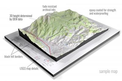
• Raised-relief 3D Height Determined by DEM data
• Fade Resistant Archival Inks
• Epoxy Coated for Strength and Waterproofing
• Ready to Hang with Pre-Installed Hardware (optional)
• Extraordinary 3D Accuracy
• Black Felt Borders
Enrich your office decor or home with a 3D USGS Raised Relief Map. These raised relief maps are not flat. They are three-dimensional, with the height being determined by Digital Elevation Model (DEM) data. Many people struggle with reading 2D satellite maps, but everyone understands 3D raised relief maps. The realism is phenomenal.
This 3D satellite raised relief map is built by combining satellite imagery data from Google Earth, bounding box coordinates from USGS, and DEM data. 3D Printing and 3D CNC routers are used to fabricate the models which make the satellite models extremely accurate. These models are strong - they are coated with epoxy, then finished with a sealer providing a weatherproof matt-finish. These are not meant to be used in direct sunlight.
Airplane Prairie, Florida- View hi-resolution image of: Airplane Prairie, Florida. Mapping by USGS in 2021 - Longitude/Latitude: -81.25 x -81.125 x 26.125 x 26, Grid Size: 7.5 X 7.5 Minute, Map Scale: 1:24000, State List: FL, County List: Collier
Alachua, Florida- View hi-resolution image of: Alachua, Florida. Mapping by USGS in 2021 - Longitude/Latitude: -82.5 x -82.375 x 29.875 x 29.75, Grid Size: 7.5 X 7.5 Minute, Map Scale: 1:24000, State List: FL, County List: Alachua
Alexander Springs, Florida- View hi-resolution image of: Alexander Springs, Florida. Mapping by USGS in 2021 - Longitude/Latitude: -81.625 x -81.5 x 29.125 x 29, Grid Size: 7.5 X 7.5 Minute, Map Scale: 1:24000, State List: FL, County List: Lake,Volusia
Alford, Florida- View hi-resolution image of: Alford, Florida. Mapping by USGS in 2021 - Longitude/Latitude: -85.5 x -85.375 x 30.75 x 30.625, Grid Size: 7.5 X 7.5 Minute, Map Scale: 1:24000, State List: FL, County List: Washington,Jackson
Alford SE, Florida- View hi-resolution image of: Alford SE, Florida. Mapping by USGS in 2021 - Longitude/Latitude: -85.375 x -85.25 x 30.625 x 30.5, Grid Size: 7.5 X 7.5 Minute, Map Scale: 1:24000, State List: FL, County List: Calhoun,Jackson
Allanton, Florida- View hi-resolution image of: Allanton, Florida. Mapping by USGS in 2021 - Longitude/Latitude: -85.5 x -85.375 x 30.125 x 30, Grid Size: 7.5 X 7.5 Minute, Map Scale: 1:24000, State List: FL, County List: Bay,Gulf
Allentown, Florida- View hi-resolution image of: Allentown, Florida. Mapping by USGS in 2021 - Longitude/Latitude: -87.125 x -87 x 30.875 x 30.75, Grid Size: 7.5 X 7.5 Minute, Map Scale: 1:24000, State List: FL, County List: Santa Rosa
Alligator Bay, Florida- View hi-resolution image of: Alligator Bay, Florida. Mapping by USGS in 2021 - Longitude/Latitude: -81.25 x -81.125 x 25.75 x 25.625, Grid Size: 7.5 X 7.5 Minute, Map Scale: 1:24000, State List: FL, County List: Monroe
Altha East, Florida- View hi-resolution image of: Altha East, Florida. Mapping by USGS in 2021 - Longitude/Latitude: -85.125 x -85 x 30.625 x 30.5, Grid Size: 7.5 X 7.5 Minute, Map Scale: 1:24000, State List: FL, County List: Calhoun,Jackson
Altha West, Florida- View hi-resolution image of: Altha West, Florida. Mapping by USGS in 2021 - Longitude/Latitude: -85.25 x -85.125 x 30.625 x 30.5, Grid Size: 7.5 X 7.5 Minute, Map Scale: 1:24000, State List: FL, County List: Calhoun,Jackson
Alturas, Florida- View hi-resolution image of: Alturas, Florida. Mapping by USGS in 2021 - Longitude/Latitude: -81.75 x -81.625 x 27.875 x 27.75, Grid Size: 7.5 X 7.5 Minute, Map Scale: 1:24000, State List: FL, County List: Polk
Alva, Florida- View hi-resolution image of: Alva, Florida. Mapping by USGS in 2021 - Longitude/Latitude: -81.625 x -81.5 x 26.75 x 26.625, Grid Size: 7.5 X 7.5 Minute, Map Scale: 1:24000, State List: FL, County List: Hendry,Lee
Alva SE, Florida- View hi-resolution image of: Alva SE, Florida. Mapping by USGS in 2021 - Longitude/Latitude: -81.625 x -81.5 x 26.625 x 26.5, Grid Size: 7.5 X 7.5 Minute, Map Scale: 1:24000, State List: FL, County List: Lee,Hendry,Collier
Alva SW, Florida- View hi-resolution image of: Alva SW, Florida. Mapping by USGS in 2021 - Longitude/Latitude: -81.75 x -81.625 x 26.625 x 26.5, Grid Size: 7.5 X 7.5 Minute, Map Scale: 1:24000, State List: FL, County List: Lee
Amelia City, Florida- View hi-resolution image of: Amelia City, Florida. Mapping by USGS in 2021 - Longitude/Latitude: -81.5 x -81.375 x 30.625 x 30.5, Grid Size: 7.5 X 7.5 Minute, Map Scale: 1:24000, State List: FL, County List: Nassau,Duval
Andytown, Florida- View hi-resolution image of: Andytown, Florida. Mapping by USGS in 2021 - Longitude/Latitude: -80.5 x -80.375 x 26.25 x 26.125, Grid Size: 7.5 X 7.5 Minute, Map Scale: 1:24000, State List: FL, County List: Broward
Ankona, Florida- View hi-resolution image of: Ankona, Florida. Mapping by USGS in 2021 - Longitude/Latitude: -80.375 x -80.25 x 27.375 x 27.25, Grid Size: 7.5 X 7.5 Minute, Map Scale: 1:24000, State List: FL, County List: St. Lucie,Martin
Anna Maria, Florida- View hi-resolution image of: Anna Maria, Florida. Mapping by USGS in 2021 - Longitude/Latitude: -82.75 x -82.625 x 27.625 x 27.5, Grid Size: 7.5 X 7.5 Minute, Map Scale: 1:24000, State List: FL, County List: Manatee,Hillsborough,Pinellas
Anthony, Florida- View hi-resolution image of: Anthony, Florida. Mapping by USGS in 2021 - Longitude/Latitude: -82.125 x -82 x 29.375 x 29.25, Grid Size: 7.5 X 7.5 Minute, Map Scale: 1:24000, State List: FL, County List: Marion
Apalachicola, Florida- View hi-resolution image of: Apalachicola, Florida. Mapping by USGS in 2021 - Longitude/Latitude: -85 x -84.875 x 29.75 x 29.625, Grid Size: 7.5 X 7.5 Minute, Map Scale: 1:24000, State List: FL, County List: Franklin
Apopka, Florida- View hi-resolution image of: Apopka, Florida. Mapping by USGS in 2021 - Longitude/Latitude: -81.625 x -81.5 x 28.75 x 28.625, Grid Size: 7.5 X 7.5 Minute, Map Scale: 1:24000, State List: FL, County List: Orange
Arcadia, Florida- View hi-resolution image of: Arcadia, Florida. Mapping by USGS in 2021 - Longitude/Latitude: -81.875 x -81.75 x 27.25 x 27.125, Grid Size: 7.5 X 7.5 Minute, Map Scale: 1:24000, State List: FL, County List: DeSoto
Arcadia SE, Florida- View hi-resolution image of: Arcadia SE, Florida. Mapping by USGS in 2021 - Longitude/Latitude: -81.875 x -81.75 x 27.125 x 27, Grid Size: 7.5 X 7.5 Minute, Map Scale: 1:24000, State List: FL, County List: DeSoto,Charlotte
Archer, Florida- View hi-resolution image of: Archer, Florida. Mapping by USGS in 2021 - Longitude/Latitude: -82.625 x -82.5 x 29.625 x 29.5, Grid Size: 7.5 X 7.5 Minute, Map Scale: 1:24000, State List: FL, County List: Alachua,Levy
Ariel, Florida- View hi-resolution image of: Ariel, Florida. Mapping by USGS in 2021 - Longitude/Latitude: -80.875 x -80.75 x 29 x 28.875, Grid Size: 7.5 X 7.5 Minute, Map Scale: 1:24000, State List: FL, County List: Volusia
Aripeka, Florida- View hi-resolution image of: Aripeka, Florida. Mapping by USGS in 2021 - Longitude/Latitude: -82.75 x -82.625 x 28.5 x 28.375, Grid Size: 7.5 X 7.5 Minute, Map Scale: 1:24000, State List: FL, County List: Pasco,Hernando
Arlington, Florida- View hi-resolution image of: Arlington, Florida. Mapping by USGS in 2021 - Longitude/Latitude: -81.625 x -81.5 x 30.375 x 30.25, Grid Size: 7.5 X 7.5 Minute, Map Scale: 1:24000, State List: FL, County List: Duval
Arredondo, Florida- View hi-resolution image of: Arredondo, Florida. Mapping by USGS in 2021 - Longitude/Latitude: -82.5 x -82.375 x 29.625 x 29.5, Grid Size: 7.5 X 7.5 Minute, Map Scale: 1:24000, State List: FL, County List: Alachua
Arsenicker Keys, Florida- View hi-resolution image of: Arsenicker Keys, Florida. Mapping by USGS in 2021 - Longitude/Latitude: -80.375 x -80.25 x 25.5 x 25.375, Grid Size: 7.5 X 7.5 Minute, Map Scale: 1:24000, State List: FL, County List: Miami-Dade
Ashton, Florida- View hi-resolution image of: Ashton, Florida. Mapping by USGS in 2021 - Longitude/Latitude: -81.25 x -81.125 x 28.25 x 28.125, Grid Size: 7.5 X 7.5 Minute, Map Scale: 1:24000, State List: FL, County List: Osceola
Ashville, Florida- View hi-resolution image of: Ashville, Florida. Mapping by USGS in 2021 - Longitude/Latitude: -83.75 x -83.625 x 30.625 x 30.5, Grid Size: 7.5 X 7.5 Minute, Map Scale: 1:24000, State List: FL, County List: Jefferson,Madison
Astatula, Florida- View hi-resolution image of: Astatula, Florida. Mapping by USGS in 2021 - Longitude/Latitude: -81.75 x -81.625 x 28.75 x 28.625, Grid Size: 7.5 X 7.5 Minute, Map Scale: 1:24000, State List: FL, County List: Lake,Orange
Astor, Florida- View hi-resolution image of: Astor, Florida. Mapping by USGS in 2021 - Longitude/Latitude: -81.625 x -81.5 x 29.25 x 29.125, Grid Size: 7.5 X 7.5 Minute, Map Scale: 1:24000, State List: FL, County List: Lake,Volusia
Auburndale, Florida- View hi-resolution image of: Auburndale, Florida. Mapping by USGS in 2021 - Longitude/Latitude: -81.875 x -81.75 x 28.125 x 28, Grid Size: 7.5 X 7.5 Minute, Map Scale: 1:24000, State List: FL, County List: Polk
Aurantia, Florida- View hi-resolution image of: Aurantia, Florida. Mapping by USGS in 2021 - Longitude/Latitude: -81 x -80.875 x 28.75 x 28.625, Grid Size: 7.5 X 7.5 Minute, Map Scale: 1:24000, State List: FL, County List: Brevard,Volusia,Seminole
Avon Park, Florida- View hi-resolution image of: Avon Park, Florida. Mapping by USGS in 2021 - Longitude/Latitude: -81.625 x -81.5 x 27.625 x 27.5, Grid Size: 7.5 X 7.5 Minute, Map Scale: 1:24000, State List: FL, County List: Highlands,Hardee
Babson Park, Florida- View hi-resolution image of: Babson Park, Florida. Mapping by USGS in 2021 - Longitude/Latitude: -81.625 x -81.5 x 27.875 x 27.75, Grid Size: 7.5 X 7.5 Minute, Map Scale: 1:24000, State List: FL, County List: Polk
Baird, Florida- View hi-resolution image of: Baird, Florida. Mapping by USGS in 2021 - Longitude/Latitude: -82 x -81.875 x 27.75 x 27.625, Grid Size: 7.5 X 7.5 Minute, Map Scale: 1:24000, State List: FL, County List: Polk,Hardee
Baker, Florida- View hi-resolution image of: Baker, Florida. Mapping by USGS in 2021 - Longitude/Latitude: -86.75 x -86.625 x 30.875 x 30.75, Grid Size: 7.5 X 7.5 Minute, Map Scale: 1:24000, State List: FL, County List: Okaloosa
Bakersville, Florida- View hi-resolution image of: Bakersville, Florida. Mapping by USGS in 2021 - Longitude/Latitude: -81.5 x -81.375 x 30 x 29.875, Grid Size: 7.5 X 7.5 Minute, Map Scale: 1:24000, State List: FL, County List: St. Johns
Baldwin, Florida- View hi-resolution image of: Baldwin, Florida. Mapping by USGS in 2021 - Longitude/Latitude: -82 x -81.875 x 30.375 x 30.25, Grid Size: 7.5 X 7.5 Minute, Map Scale: 1:24000, State List: FL, County List: Duval,Nassau
Bamboo Key, Florida- View hi-resolution image of: Bamboo Key, Florida. Mapping by USGS in 2021 - Longitude/Latitude: -81.125 x -81 x 24.875 x 24.75, Grid Size: 7.5 X 7.5 Minute, Map Scale: 1:24000, State List: FL, County List: Monroe
Barley Barber Swamp, Florida- View hi-resolution image of: Barley Barber Swamp, Florida. Mapping by USGS in 2021 - Longitude/Latitude: -80.625 x -80.5 x 27.125 x 27, Grid Size: 7.5 X 7.5 Minute, Map Scale: 1:24000, State List: FL, County List: Martin
Barrineau Park, Florida- View hi-resolution image of: Barrineau Park, Florida. Mapping by USGS in 2021 - Longitude/Latitude: -87.5 x -87.375 x 30.75 x 30.625, Grid Size: 7.5 X 7.5 Minute, Map Scale: 1:24000, State List: FL,AL, County List: Escambia,Baldwin
Bartow, Florida- View hi-resolution image of: Bartow, Florida. Mapping by USGS in 2021 - Longitude/Latitude: -81.875 x -81.75 x 28 x 27.875, Grid Size: 7.5 X 7.5 Minute, Map Scale: 1:24000, State List: FL, County List: Polk
Bascom, Florida- View hi-resolution image of: Bascom, Florida. Mapping by USGS in 2021 - Longitude/Latitude: -85.125 x -85 x 31 x 30.875, Grid Size: 7.5 X 7.5 Minute, Map Scale: 1:24000, State List: FL,GA, County List: Jackson,Seminole
Basinger, Florida- View hi-resolution image of: Basinger, Florida. Mapping by USGS in 2021 - Longitude/Latitude: -81.125 x -81 x 27.5 x 27.375, Grid Size: 7.5 X 7.5 Minute, Map Scale: 1:24000, State List: FL, County List: Okeechobee,Highlands
Basinger NW, Florida- View hi-resolution image of: Basinger NW, Florida. Mapping by USGS in 2021 - Longitude/Latitude: -81.25 x -81.125 x 27.5 x 27.375, Grid Size: 7.5 X 7.5 Minute, Map Scale: 1:24000, State List: FL, County List: Highlands,Okeechobee
Basinger SW, Florida- View hi-resolution image of: Basinger SW, Florida. Mapping by USGS in 2021 - Longitude/Latitude: -81.25 x -81.125 x 27.375 x 27.25, Grid Size: 7.5 X 7.5 Minute, Map Scale: 1:24000, State List: FL, County List: Highlands
Bay Keys, Florida- View hi-resolution image of: Bay Keys, Florida. Mapping by USGS in 2021 - Longitude/Latitude: -81.875 x -81.75 x 24.75 x 24.625, Grid Size: 7.5 X 7.5 Minute, Map Scale: 1:24000, State List: FL, County List: Monroe
Bay Lake, Florida- View hi-resolution image of: Bay Lake, Florida. Mapping by USGS in 2021 - Longitude/Latitude: -82 x -81.875 x 28.5 x 28.375, Grid Size: 7.5 X 7.5 Minute, Map Scale: 1:24000, State List: FL, County List: Lake,Sumter
Bay Springs, Florida- View hi-resolution image of: Bay Springs, Florida. Mapping by USGS in 2021 - Longitude/Latitude: -87.5 x -87.375 x 30.875 x 30.75, Grid Size: 7.5 X 7.5 Minute, Map Scale: 1:24000, State List: FL, County List: Escambia
Bayard, Florida- View hi-resolution image of: Bayard, Florida. Mapping by USGS in 2021 - Longitude/Latitude: -81.625 x -81.5 x 30.25 x 30.125, Grid Size: 7.5 X 7.5 Minute, Map Scale: 1:24000, State List: FL, County List: Duval,St. Johns
Bayhead, Florida- View hi-resolution image of: Bayhead, Florida. Mapping by USGS in 2021 - Longitude/Latitude: -85.625 x -85.5 x 30.375 x 30.25, Grid Size: 7.5 X 7.5 Minute, Map Scale: 1:24000, State List: FL, County List: Bay
Bayport, Florida- View hi-resolution image of: Bayport, Florida. Mapping by USGS in 2021 - Longitude/Latitude: -82.75 x -82.625 x 28.625 x 28.5, Grid Size: 7.5 X 7.5 Minute, Map Scale: 1:24000, State List: FL, County List: Hernando
Baywood, Florida- View hi-resolution image of: Baywood, Florida. Mapping by USGS in 2021 - Longitude/Latitude: -81.875 x -81.75 x 29.75 x 29.625, Grid Size: 7.5 X 7.5 Minute, Map Scale: 1:24000, State List: FL, County List: Putnam
Beacon Beach, Florida- View hi-resolution image of: Beacon Beach, Florida. Mapping by USGS in 2021 - Longitude/Latitude: -85.75 x -85.625 x 30.125 x 30, Grid Size: 7.5 X 7.5 Minute, Map Scale: 1:24000, State List: FL, County List: Bay
Beacon Hill, Florida- View hi-resolution image of: Beacon Hill, Florida. Mapping by USGS in 2021 - Longitude/Latitude: -85.5 x -85.375 x 30 x 29.875, Grid Size: 7.5 X 7.5 Minute, Map Scale: 1:24000, State List: FL, County List: Bay,Gulf
Bee Ridge, Florida- View hi-resolution image of: Bee Ridge, Florida. Mapping by USGS in 2021 - Longitude/Latitude: -82.5 x -82.375 x 27.375 x 27.25, Grid Size: 7.5 X 7.5 Minute, Map Scale: 1:24000, State List: FL, County List: Sarasota
Bell, Florida- View hi-resolution image of: Bell, Florida. Mapping by USGS in 2021 - Longitude/Latitude: -82.875 x -82.75 x 29.875 x 29.75, Grid Size: 7.5 X 7.5 Minute, Map Scale: 1:24000, State List: FL, County List: Gilchrist
Belle Glade, Florida- View hi-resolution image of: Belle Glade, Florida. Mapping by USGS in 2021 - Longitude/Latitude: -80.75 x -80.625 x 26.75 x 26.625, Grid Size: 7.5 X 7.5 Minute, Map Scale: 1:24000, State List: FL, County List: Palm Beach
Belle Meade, Florida- View hi-resolution image of: Belle Meade, Florida. Mapping by USGS in 2021 - Longitude/Latitude: -81.75 x -81.625 x 26.125 x 26, Grid Size: 7.5 X 7.5 Minute, Map Scale: 1:24000, State List: FL, County List: Collier
Belle Meade NE, Florida- View hi-resolution image of: Belle Meade NE, Florida. Mapping by USGS in 2021 - Longitude/Latitude: -81.625 x -81.5 x 26.25 x 26.125, Grid Size: 7.5 X 7.5 Minute, Map Scale: 1:24000, State List: FL, County List: Collier
Belle Meade NW, Florida- View hi-resolution image of: Belle Meade NW, Florida. Mapping by USGS in 2021 - Longitude/Latitude: -81.75 x -81.625 x 26.25 x 26.125, Grid Size: 7.5 X 7.5 Minute, Map Scale: 1:24000, State List: FL, County List: Collier
Belle Meade SE, Florida- View hi-resolution image of: Belle Meade SE, Florida. Mapping by USGS in 2021 - Longitude/Latitude: -81.625 x -81.5 x 26.125 x 26, Grid Size: 7.5 X 7.5 Minute, Map Scale: 1:24000, State List: FL, County List: Collier
Belleview, Florida- View hi-resolution image of: Belleview, Florida. Mapping by USGS in 2021 - Longitude/Latitude: -82.125 x -82 x 29.125 x 29, Grid Size: 7.5 X 7.5 Minute, Map Scale: 1:24000, State List: FL, County List: Marion
Bennett, Florida- View hi-resolution image of: Bennett, Florida. Mapping by USGS in 2021 - Longitude/Latitude: -85.625 x -85.5 x 30.5 x 30.375, Grid Size: 7.5 X 7.5 Minute, Map Scale: 1:24000, State List: FL, County List: Bay,Washington
Benton, Florida- View hi-resolution image of: Benton, Florida. Mapping by USGS in 2021 - Longitude/Latitude: -82.75 x -82.625 x 30.5 x 30.375, Grid Size: 7.5 X 7.5 Minute, Map Scale: 1:24000, State List: FL, County List: Hamilton,Columbia
Bereah, Florida- View hi-resolution image of: Bereah, Florida. Mapping by USGS in 2021 - Longitude/Latitude: -81.75 x -81.625 x 27.75 x 27.625, Grid Size: 7.5 X 7.5 Minute, Map Scale: 1:24000, State List: FL, County List: Polk,Hardee
Bermont, Florida- View hi-resolution image of: Bermont, Florida. Mapping by USGS in 2021 - Longitude/Latitude: -81.875 x -81.75 x 27 x 26.875, Grid Size: 7.5 X 7.5 Minute, Map Scale: 1:24000, State List: FL, County List: Charlotte
Beverly, Florida- View hi-resolution image of: Beverly, Florida. Mapping by USGS in 2021 - Longitude/Latitude: -85 x -84.875 x 29.875 x 29.75, Grid Size: 7.5 X 7.5 Minute, Map Scale: 1:24000, State List: FL, County List: Franklin
Beverly Beach, Florida- View hi-resolution image of: Beverly Beach, Florida. Mapping by USGS in 2021 - Longitude/Latitude: -81.25 x -81.125 x 29.625 x 29.5, Grid Size: 7.5 X 7.5 Minute, Map Scale: 1:24000, State List: FL, County List: Flagler
Big Boy Lake, Florida- View hi-resolution image of: Big Boy Lake, Florida. Mapping by USGS in 2021 - Longitude/Latitude: -81.125 x -81 x 25.75 x 25.625, Grid Size: 7.5 X 7.5 Minute, Map Scale: 1:24000, State List: FL, County List: Monroe
Big Gum Swamp, Florida- View hi-resolution image of: Big Gum Swamp, Florida. Mapping by USGS in 2021 - Longitude/Latitude: -82.5 x -82.375 x 30.375 x 30.25, Grid Size: 7.5 X 7.5 Minute, Map Scale: 1:24000, State List: FL, County List: Baker,Columbia
Big Lake, Florida- View hi-resolution image of: Big Lake, Florida. Mapping by USGS in 2021 - Longitude/Latitude: -80.375 x -80.25 x 26.5 x 26.375, Grid Size: 7.5 X 7.5 Minute, Map Scale: 1:24000, State List: FL, County List: Palm Beach
Big Lostmans Bay, Florida- View hi-resolution image of: Big Lostmans Bay, Florida. Mapping by USGS in 2021 - Longitude/Latitude: -81.125 x -81 x 25.625 x 25.5, Grid Size: 7.5 X 7.5 Minute, Map Scale: 1:24000, State List: FL, County List: Monroe
Big Mound North, Florida- View hi-resolution image of: Big Mound North, Florida. Mapping by USGS in 2021 - Longitude/Latitude: -80.5 x -80.375 x 27 x 26.875, Grid Size: 7.5 X 7.5 Minute, Map Scale: 1:24000, State List: FL, County List: Palm Beach,Martin
Big Mound South, Florida- View hi-resolution image of: Big Mound South, Florida. Mapping by USGS in 2021 - Longitude/Latitude: -80.5 x -80.375 x 26.875 x 26.75, Grid Size: 7.5 X 7.5 Minute, Map Scale: 1:24000, State List: FL, County List: Palm Beach
Big Pine Key, Florida- View hi-resolution image of: Big Pine Key, Florida. Mapping by USGS in 2021 - Longitude/Latitude: -81.375 x -81.25 x 24.75 x 24.625, Grid Size: 7.5 X 7.5 Minute, Map Scale: 1:24000, State List: FL, County List: Monroe
Bird Keys, Florida- View hi-resolution image of: Bird Keys, Florida. Mapping by USGS in 2021 - Longitude/Latitude: -82.625 x -82.5 x 27.25 x 27.125, Grid Size: 7.5 X 7.5 Minute, Map Scale: 1:24000, State List: FL, County List: Sarasota
Bithlo, Florida- View hi-resolution image of: Bithlo, Florida. Mapping by USGS in 2021 - Longitude/Latitude: -81.125 x -81 x 28.625 x 28.5, Grid Size: 7.5 X 7.5 Minute, Map Scale: 1:24000, State List: FL, County List: Orange,Seminole
Black Hammock, Florida- View hi-resolution image of: Black Hammock, Florida. Mapping by USGS in 2021 - Longitude/Latitude: -80.75 x -80.625 x 25.625 x 25.5, Grid Size: 7.5 X 7.5 Minute, Map Scale: 1:24000, State List: FL, County List: Miami-Dade
Blackman, Florida- View hi-resolution image of: Blackman, Florida. Mapping by USGS in 2021 - Longitude/Latitude: -86.75 x -86.625 x 31 x 30.875, Grid Size: 7.5 X 7.5 Minute, Map Scale: 1:24000, State List: FL,AL, County List: Okaloosa,Covington,Escambia
Blackwater Sound, Florida- View hi-resolution image of: Blackwater Sound, Florida. Mapping by USGS in 2021 - Longitude/Latitude: -80.5 x -80.375 x 25.25 x 25.125, Grid Size: 7.5 X 7.5 Minute, Map Scale: 1:24000, State List: FL, County List: Miami-Dade,Monroe
Blountstown, Florida- View hi-resolution image of: Blountstown, Florida. Mapping by USGS in 2021 - Longitude/Latitude: -85.125 x -85 x 30.5 x 30.375, Grid Size: 7.5 X 7.5 Minute, Map Scale: 1:24000, State List: FL, County List: Calhoun,Liberty
Bloxham, Florida- View hi-resolution image of: Bloxham, Florida. Mapping by USGS in 2021 - Longitude/Latitude: -84.75 x -84.625 x 30.5 x 30.375, Grid Size: 7.5 X 7.5 Minute, Map Scale: 1:24000, State List: FL, County List: Gadsden,Liberty,Leon
Bluefield, Florida- View hi-resolution image of: Bluefield, Florida. Mapping by USGS in 2021 - Longitude/Latitude: -80.625 x -80.5 x 27.25 x 27.125, Grid Size: 7.5 X 7.5 Minute, Map Scale: 1:24000, State List: FL, County List: Martin,St. Lucie
Boca Chica Key, Florida- View hi-resolution image of: Boca Chica Key, Florida. Mapping by USGS in 2021 - Longitude/Latitude: -81.75 x -81.625 x 24.625 x 24.5, Grid Size: 7.5 X 7.5 Minute, Map Scale: 1:24000, State List: FL, County List: Monroe
Boca Raton, Florida- View hi-resolution image of: Boca Raton, Florida. Mapping by USGS in 2021 - Longitude/Latitude: -80.125 x -80 x 26.375 x 26.25, Grid Size: 7.5 X 7.5 Minute, Map Scale: 1:24000, State List: FL, County List: Broward,Palm Beach
Bokeelia, Florida- View hi-resolution image of: Bokeelia, Florida. Mapping by USGS in 2021 - Longitude/Latitude: -82.25 x -82.125 x 26.75 x 26.625, Grid Size: 7.5 X 7.5 Minute, Map Scale: 1:24000, State List: FL, County List: Lee
Bonifay, Florida- View hi-resolution image of: Bonifay, Florida. Mapping by USGS in 2021 - Longitude/Latitude: -85.75 x -85.625 x 30.875 x 30.75, Grid Size: 7.5 X 7.5 Minute, Map Scale: 1:24000, State List: FL, County List: Holmes,Washington
Bonita Springs, Florida- View hi-resolution image of: Bonita Springs, Florida. Mapping by USGS in 2021 - Longitude/Latitude: -81.875 x -81.75 x 26.375 x 26.25, Grid Size: 7.5 X 7.5 Minute, Map Scale: 1:24000, State List: FL, County List: Collier,Lee
Bostwick, Florida- View hi-resolution image of: Bostwick, Florida. Mapping by USGS in 2021 - Longitude/Latitude: -81.75 x -81.625 x 29.875 x 29.75, Grid Size: 7.5 X 7.5 Minute, Map Scale: 1:24000, State List: FL, County List: Putnam,Clay
Boulogne, Florida- View hi-resolution image of: Boulogne, Florida. Mapping by USGS in 2021 - Longitude/Latitude: -82 x -81.875 x 30.875 x 30.75, Grid Size: 7.5 X 7.5 Minute, Map Scale: 1:24000, State List: FL,GA, County List: Nassau,Charlton,Camden
Bowling Green, Florida- View hi-resolution image of: Bowling Green, Florida. Mapping by USGS in 2021 - Longitude/Latitude: -81.875 x -81.75 x 27.75 x 27.625, Grid Size: 7.5 X 7.5 Minute, Map Scale: 1:24000, State List: FL, County List: Polk,Hardee
Boyd, Florida- View hi-resolution image of: Boyd, Florida. Mapping by USGS in 2021 - Longitude/Latitude: -83.625 x -83.5 x 30.25 x 30.125, Grid Size: 7.5 X 7.5 Minute, Map Scale: 1:24000, State List: FL, County List: Taylor
Bradenton, Florida- View hi-resolution image of: Bradenton, Florida. Mapping by USGS in 2021 - Longitude/Latitude: -82.625 x -82.5 x 27.5 x 27.375, Grid Size: 7.5 X 7.5 Minute, Map Scale: 1:24000, State List: FL, County List: Manatee,Sarasota
Bradenton Beach, Florida- View hi-resolution image of: Bradenton Beach, Florida. Mapping by USGS in 2021 - Longitude/Latitude: -82.75 x -82.625 x 27.5 x 27.375, Grid Size: 7.5 X 7.5 Minute, Map Scale: 1:24000, State List: FL, County List: Manatee,Sarasota
Bradfordville, Florida- View hi-resolution image of: Bradfordville, Florida. Mapping by USGS in 2021 - Longitude/Latitude: -84.25 x -84.125 x 30.625 x 30.5, Grid Size: 7.5 X 7.5 Minute, Map Scale: 1:24000, State List: FL, County List: Leon
Bradley Junction, Florida- View hi-resolution image of: Bradley Junction, Florida. Mapping by USGS in 2021 - Longitude/Latitude: -82 x -81.875 x 27.875 x 27.75, Grid Size: 7.5 X 7.5 Minute, Map Scale: 1:24000, State List: FL, County List: Polk
Bradwell Bay, Florida- View hi-resolution image of: Bradwell Bay, Florida. Mapping by USGS in 2021 - Longitude/Latitude: -84.625 x -84.5 x 30.25 x 30.125, Grid Size: 7.5 X 7.5 Minute, Map Scale: 1:24000, State List: FL, County List: Wakulla
Branchborough, Florida- View hi-resolution image of: Branchborough, Florida. Mapping by USGS in 2021 - Longitude/Latitude: -82.125 x -82 x 28.375 x 28.25, Grid Size: 7.5 X 7.5 Minute, Map Scale: 1:24000, State List: FL, County List: Pasco,Polk,Sumter
Brandon, Florida- View hi-resolution image of: Brandon, Florida. Mapping by USGS in 2021 - Longitude/Latitude: -82.375 x -82.25 x 28 x 27.875, Grid Size: 7.5 X 7.5 Minute, Map Scale: 1:24000, State List: FL, County List: Hillsborough
Branford, Florida- View hi-resolution image of: Branford, Florida. Mapping by USGS in 2021 - Longitude/Latitude: -83 x -82.875 x 30 x 29.875, Grid Size: 7.5 X 7.5 Minute, Map Scale: 1:24000, State List: FL, County List: Lafayette,Suwannee,Gilchrist
Bratt, Florida- View hi-resolution image of: Bratt, Florida. Mapping by USGS in 2021 - Longitude/Latitude: -87.5 x -87.375 x 31 x 30.875, Grid Size: 7.5 X 7.5 Minute, Map Scale: 1:24000, State List: FL,AL, County List: Escambia
Brighton, Florida- View hi-resolution image of: Brighton, Florida. Mapping by USGS in 2021 - Longitude/Latitude: -81.125 x -81 x 27.25 x 27.125, Grid Size: 7.5 X 7.5 Minute, Map Scale: 1:24000, State List: FL, County List: Glades,Highlands
Brighton NW, Florida- View hi-resolution image of: Brighton NW, Florida. Mapping by USGS in 2021 - Longitude/Latitude: -81.25 x -81.125 x 27.25 x 27.125, Grid Size: 7.5 X 7.5 Minute, Map Scale: 1:24000, State List: FL, County List: Highlands,Glades
Brighton SE, Florida- View hi-resolution image of: Brighton SE, Florida. Mapping by USGS in 2021 - Longitude/Latitude: -81.125 x -81 x 27.125 x 27, Grid Size: 7.5 X 7.5 Minute, Map Scale: 1:24000, State List: FL, County List: Glades
Brighton SW, Florida- View hi-resolution image of: Brighton SW, Florida. Mapping by USGS in 2021 - Longitude/Latitude: -81.25 x -81.125 x 27.125 x 27, Grid Size: 7.5 X 7.5 Minute, Map Scale: 1:24000, State List: FL, County List: Glades,Highlands
Bristol, Florida- View hi-resolution image of: Bristol, Florida. Mapping by USGS in 2021 - Longitude/Latitude: -85 x -84.875 x 30.5 x 30.375, Grid Size: 7.5 X 7.5 Minute, Map Scale: 1:24000, State List: FL, County List: Liberty,Calhoun
Broad Branch, Florida- View hi-resolution image of: Broad Branch, Florida. Mapping by USGS in 2021 - Longitude/Latitude: -85.375 x -85.25 x 30.375 x 30.25, Grid Size: 7.5 X 7.5 Minute, Map Scale: 1:24000, State List: FL, County List: Calhoun
Bronson, Florida- View hi-resolution image of: Bronson, Florida. Mapping by USGS in 2021 - Longitude/Latitude: -82.75 x -82.625 x 29.5 x 29.375, Grid Size: 7.5 X 7.5 Minute, Map Scale: 1:24000, State List: FL, County List: Levy
Bronson NE, Florida- View hi-resolution image of: Bronson NE, Florida. Mapping by USGS in 2021 - Longitude/Latitude: -82.625 x -82.5 x 29.5 x 29.375, Grid Size: 7.5 X 7.5 Minute, Map Scale: 1:24000, State List: FL, County List: Levy,Alachua
Bronson SE, Florida- View hi-resolution image of: Bronson SE, Florida. Mapping by USGS in 2021 - Longitude/Latitude: -82.625 x -82.5 x 29.375 x 29.25, Grid Size: 7.5 X 7.5 Minute, Map Scale: 1:24000, State List: FL, County List: Levy
Bronson SW, Florida- View hi-resolution image of: Bronson SW, Florida. Mapping by USGS in 2021 - Longitude/Latitude: -82.75 x -82.625 x 29.375 x 29.25, Grid Size: 7.5 X 7.5 Minute, Map Scale: 1:24000, State List: FL, County List: Levy
Brooker, Florida- View hi-resolution image of: Brooker, Florida. Mapping by USGS in 2021 - Longitude/Latitude: -82.375 x -82.25 x 30 x 29.875, Grid Size: 7.5 X 7.5 Minute, Map Scale: 1:24000, State List: FL, County List: Bradford,Union,Alachua
Brooksville, Florida- View hi-resolution image of: Brooksville, Florida. Mapping by USGS in 2021 - Longitude/Latitude: -82.5 x -82.375 x 28.625 x 28.5, Grid Size: 7.5 X 7.5 Minute, Map Scale: 1:24000, State List: FL, County List: Hernando
Brooksville NW, Florida- View hi-resolution image of: Brooksville NW, Florida. Mapping by USGS in 2021 - Longitude/Latitude: -82.5 x -82.375 x 28.75 x 28.625, Grid Size: 7.5 X 7.5 Minute, Map Scale: 1:24000, State List: FL, County List: Citrus,Hernando
Brooksville SE, Florida- View hi-resolution image of: Brooksville SE, Florida. Mapping by USGS in 2021 - Longitude/Latitude: -82.375 x -82.25 x 28.625 x 28.5, Grid Size: 7.5 X 7.5 Minute, Map Scale: 1:24000, State List: FL, County List: Hernando
Bruce, Florida- View hi-resolution image of: Bruce, Florida. Mapping by USGS in 2021 - Longitude/Latitude: -86 x -85.875 x 30.5 x 30.375, Grid Size: 7.5 X 7.5 Minute, Map Scale: 1:24000, State List: FL, County List: Walton,Washington,Bay
Bryant, Florida- View hi-resolution image of: Bryant, Florida. Mapping by USGS in 2021 - Longitude/Latitude: -80.625 x -80.5 x 26.875 x 26.75, Grid Size: 7.5 X 7.5 Minute, Map Scale: 1:24000, State List: FL, County List: Palm Beach
Bryceville, Florida- View hi-resolution image of: Bryceville, Florida. Mapping by USGS in 2021 - Longitude/Latitude: -82 x -81.875 x 30.5 x 30.375, Grid Size: 7.5 X 7.5 Minute, Map Scale: 1:24000, State List: FL, County List: Nassau,Duval
Buchanan Keys, Florida- View hi-resolution image of: Buchanan Keys, Florida. Mapping by USGS in 2021 - Longitude/Latitude: -80.875 x -80.75 x 25 x 24.875, Grid Size: 7.5 X 7.5 Minute, Map Scale: 1:24000, State List: FL, County List: Monroe
Bunker, Florida- View hi-resolution image of: Bunker, Florida. Mapping by USGS in 2021 - Longitude/Latitude: -86.125 x -86 x 30.5 x 30.375, Grid Size: 7.5 X 7.5 Minute, Map Scale: 1:24000, State List: FL, County List: Walton
Bunnell, Florida- View hi-resolution image of: Bunnell, Florida. Mapping by USGS in 2021 - Longitude/Latitude: -81.375 x -81.25 x 29.5 x 29.375, Grid Size: 7.5 X 7.5 Minute, Map Scale: 1:24000, State List: FL, County List: Flagler
Burns Lake, Florida- View hi-resolution image of: Burns Lake, Florida. Mapping by USGS in 2021 - Longitude/Latitude: -81.25 x -81.125 x 26 x 25.875, Grid Size: 7.5 X 7.5 Minute, Map Scale: 1:24000, State List: FL, County List: Collier
Bushnell, Florida- View hi-resolution image of: Bushnell, Florida. Mapping by USGS in 2021 - Longitude/Latitude: -82.125 x -82 x 28.75 x 28.625, Grid Size: 7.5 X 7.5 Minute, Map Scale: 1:24000, State List: FL, County List: Sumter
California Slough, Florida- View hi-resolution image of: California Slough, Florida. Mapping by USGS in 2021 - Longitude/Latitude: -81 x -80.875 x 26.25 x 26.125, Grid Size: 7.5 X 7.5 Minute, Map Scale: 1:24000, State List: FL, County List: Collier,Broward
Callahan, Florida- View hi-resolution image of: Callahan, Florida. Mapping by USGS in 2021 - Longitude/Latitude: -81.875 x -81.75 x 30.625 x 30.5, Grid Size: 7.5 X 7.5 Minute, Map Scale: 1:24000, State List: FL, County List: Nassau,Duval
Calusa Keys, Florida- View hi-resolution image of: Calusa Keys, Florida. Mapping by USGS in 2021 - Longitude/Latitude: -80.75 x -80.625 x 25.125 x 25, Grid Size: 7.5 X 7.5 Minute, Map Scale: 1:24000, State List: FL, County List: Monroe
Campbellton, Florida- View hi-resolution image of: Campbellton, Florida. Mapping by USGS in 2021 - Longitude/Latitude: -85.5 x -85.375 x 31 x 30.875, Grid Size: 7.5 X 7.5 Minute, Map Scale: 1:24000, State List: FL,AL, County List: Jackson,Houston,Geneva,Holmes
Cantonment, Florida- View hi-resolution image of: Cantonment, Florida. Mapping by USGS in 2021 - Longitude/Latitude: -87.375 x -87.25 x 30.625 x 30.5, Grid Size: 7.5 X 7.5 Minute, Map Scale: 1:24000, State List: FL, County List: Escambia,Santa Rosa
Cape Canaveral, Florida- View hi-resolution image of: Cape Canaveral, Florida. Mapping by USGS in 2021 - Longitude/Latitude: -80.625 x -80.5 x 28.5 x 28.375, Grid Size: 7.5 X 7.5 Minute, Map Scale: 1:24000, State List: FL, County List: Brevard
Cape Romano, Florida- View hi-resolution image of: Cape Romano, Florida. Mapping by USGS in 2021 - Longitude/Latitude: -81.75 x -81.625 x 25.875 x 25.75, Grid Size: 7.5 X 7.5 Minute, Map Scale: 1:24000, State List: FL, County List: Collier
Cape Saint George, Florida- View hi-resolution image of: Cape Saint George, Florida. Mapping by USGS in 2021 - Longitude/Latitude: -85.125 x -85 x 29.625 x 29.5, Grid Size: 7.5 X 7.5 Minute, Map Scale: 1:24000, State List: FL, County List: Franklin
Cape San Blas, Florida- View hi-resolution image of: Cape San Blas, Florida. Mapping by USGS in 2021 - Longitude/Latitude: -85.375 x -85.25 x 29.75 x 29.625, Grid Size: 7.5 X 7.5 Minute, Map Scale: 1:24000, State List: FL, County List: Gulf
Captiva, Florida- View hi-resolution image of: Captiva, Florida. Mapping by USGS in 2021 - Longitude/Latitude: -82.25 x -82.125 x 26.625 x 26.5, Grid Size: 7.5 X 7.5 Minute, Map Scale: 1:24000, State List: FL, County List: Lee
Card Sound, Florida- View hi-resolution image of: Card Sound, Florida. Mapping by USGS in 2021 - Longitude/Latitude: -80.375 x -80.25 x 25.375 x 25.25, Grid Size: 7.5 X 7.5 Minute, Map Scale: 1:24000, State List: FL, County List: Monroe,Miami-Dade
Carrabelle, Florida- View hi-resolution image of: Carrabelle, Florida. Mapping by USGS in 2021 - Longitude/Latitude: -84.75 x -84.625 x 29.875 x 29.75, Grid Size: 7.5 X 7.5 Minute, Map Scale: 1:24000, State List: FL, County List: Franklin
Caryville, Florida- View hi-resolution image of: Caryville, Florida. Mapping by USGS in 2021 - Longitude/Latitude: -85.875 x -85.75 x 30.875 x 30.75, Grid Size: 7.5 X 7.5 Minute, Map Scale: 1:24000, State List: FL, County List: Holmes,Washington
Casselberry, Florida- View hi-resolution image of: Casselberry, Florida. Mapping by USGS in 2021 - Longitude/Latitude: -81.375 x -81.25 x 28.75 x 28.625, Grid Size: 7.5 X 7.5 Minute, Map Scale: 1:24000, State List: FL, County List: Seminole,Orange
Catherine Island, Florida- View hi-resolution image of: Catherine Island, Florida. Mapping by USGS in 2021 - Longitude/Latitude: -81.5 x -81.375 x 26.25 x 26.125, Grid Size: 7.5 X 7.5 Minute, Map Scale: 1:24000, State List: FL, County List: Collier
Cedar Key, Florida- View hi-resolution image of: Cedar Key, Florida. Mapping by USGS in 2021 - Longitude/Latitude: -83.125 x -83 x 29.25 x 29.125, Grid Size: 7.5 X 7.5 Minute, Map Scale: 1:24000, State List: FL, County List: Levy
Center Hill, Florida- View hi-resolution image of: Center Hill, Florida. Mapping by USGS in 2021 - Longitude/Latitude: -82 x -81.875 x 28.75 x 28.625, Grid Size: 7.5 X 7.5 Minute, Map Scale: 1:24000, State List: FL, County List: Lake,Sumter
Century, Florida- View hi-resolution image of: Century, Florida. Mapping by USGS in 2021 - Longitude/Latitude: -87.375 x -87.25 x 31 x 30.875, Grid Size: 7.5 X 7.5 Minute, Map Scale: 1:24000, State List: FL,AL, County List: Escambia,Santa Rosa
Chancy Bay, Florida- View hi-resolution image of: Chancy Bay, Florida. Mapping by USGS in 2021 - Longitude/Latitude: -80.75 x -80.625 x 27.125 x 27, Grid Size: 7.5 X 7.5 Minute, Map Scale: 1:24000, State List: FL, County List: Martin,Okeechobee
Chassahowitzka, Florida- View hi-resolution image of: Chassahowitzka, Florida. Mapping by USGS in 2021 - Longitude/Latitude: -82.625 x -82.5 x 28.75 x 28.625, Grid Size: 7.5 X 7.5 Minute, Map Scale: 1:24000, State List: FL, County List: Hernando,Citrus
Chassahowitzka Bay, Florida- View hi-resolution image of: Chassahowitzka Bay, Florida. Mapping by USGS in 2021 - Longitude/Latitude: -82.75 x -82.625 x 28.75 x 28.625, Grid Size: 7.5 X 7.5 Minute, Map Scale: 1:24000, State List: FL, County List: Hernando,Citrus
Chattahoochee, Florida- View hi-resolution image of: Chattahoochee, Florida. Mapping by USGS in 2021 - Longitude/Latitude: -84.875 x -84.75 x 30.75 x 30.625, Grid Size: 7.5 X 7.5 Minute, Map Scale: 1:24000, State List: FL,GA, County List: Gadsden,Decatur,Jackson,Seminole
Chekika Island, Florida- View hi-resolution image of: Chekika Island, Florida. Mapping by USGS in 2021 - Longitude/Latitude: -80.75 x -80.625 x 25.75 x 25.625, Grid Size: 7.5 X 7.5 Minute, Map Scale: 1:24000, State List: FL, County List: Miami-Dade
Cherry Lake, Florida- View hi-resolution image of: Cherry Lake, Florida. Mapping by USGS in 2021 - Longitude/Latitude: -83.5 x -83.375 x 30.625 x 30.5, Grid Size: 7.5 X 7.5 Minute, Map Scale: 1:24000, State List: FL, County List: Madison
Chiefland, Florida- View hi-resolution image of: Chiefland, Florida. Mapping by USGS in 2021 - Longitude/Latitude: -82.875 x -82.75 x 29.5 x 29.375, Grid Size: 7.5 X 7.5 Minute, Map Scale: 1:24000, State List: FL, County List: Levy
Chiefland SW, Florida- View hi-resolution image of: Chiefland SW, Florida. Mapping by USGS in 2021 - Longitude/Latitude: -83 x -82.875 x 29.375 x 29.25, Grid Size: 7.5 X 7.5 Minute, Map Scale: 1:24000, State List: FL, County List: Levy
Childs, Florida- View hi-resolution image of: Childs, Florida. Mapping by USGS in 2021 - Longitude/Latitude: -81.375 x -81.25 x 27.25 x 27.125, Grid Size: 7.5 X 7.5 Minute, Map Scale: 1:24000, State List: FL, County List: Highlands
Chipley, Florida- View hi-resolution image of: Chipley, Florida. Mapping by USGS in 2021 - Longitude/Latitude: -85.625 x -85.5 x 30.875 x 30.75, Grid Size: 7.5 X 7.5 Minute, Map Scale: 1:24000, State List: FL, County List: Washington,Jackson,Holmes
Choctaw Beach, Florida- View hi-resolution image of: Choctaw Beach, Florida. Mapping by USGS in 2021 - Longitude/Latitude: -86.375 x -86.25 x 30.5 x 30.375, Grid Size: 7.5 X 7.5 Minute, Map Scale: 1:24000, State List: FL, County List: Walton
Chokoloskee, Florida- View hi-resolution image of: Chokoloskee, Florida. Mapping by USGS in 2021 - Longitude/Latitude: -81.375 x -81.25 x 25.875 x 25.75, Grid Size: 7.5 X 7.5 Minute, Map Scale: 1:24000, State List: FL, County List: Collier,Monroe
Chumuckla, Florida- View hi-resolution image of: Chumuckla, Florida. Mapping by USGS in 2021 - Longitude/Latitude: -87.25 x -87.125 x 30.875 x 30.75, Grid Size: 7.5 X 7.5 Minute, Map Scale: 1:24000, State List: FL, County List: Santa Rosa
Citra, Florida- View hi-resolution image of: Citra, Florida. Mapping by USGS in 2021 - Longitude/Latitude: -82.125 x -82 x 29.5 x 29.375, Grid Size: 7.5 X 7.5 Minute, Map Scale: 1:24000, State List: FL, County List: Marion,Alachua,Putnam
Citrus Park, Florida- View hi-resolution image of: Citrus Park, Florida. Mapping by USGS in 2021 - Longitude/Latitude: -82.625 x -82.5 x 28.125 x 28, Grid Size: 7.5 X 7.5 Minute, Map Scale: 1:24000, State List: FL, County List: Hillsborough
Clara, Florida- View hi-resolution image of: Clara, Florida. Mapping by USGS in 2021 - Longitude/Latitude: -83.375 x -83.25 x 29.875 x 29.75, Grid Size: 7.5 X 7.5 Minute, Map Scale: 1:24000, State List: FL, County List: Taylor,Dixie,Lafayette
Clarksville, Florida- View hi-resolution image of: Clarksville, Florida. Mapping by USGS in 2021 - Longitude/Latitude: -85.25 x -85.125 x 30.5 x 30.375, Grid Size: 7.5 X 7.5 Minute, Map Scale: 1:24000, State List: FL, County List: Calhoun
Clay Sink, Florida- View hi-resolution image of: Clay Sink, Florida. Mapping by USGS in 2021 - Longitude/Latitude: -82.125 x -82 x 28.5 x 28.375, Grid Size: 7.5 X 7.5 Minute, Map Scale: 1:24000, State List: FL, County List: Pasco,Sumter,Hernando
Clearwater, Florida- View hi-resolution image of: Clearwater, Florida. Mapping by USGS in 2021 - Longitude/Latitude: -82.875 x -82.75 x 28 x 27.875, Grid Size: 7.5 X 7.5 Minute, Map Scale: 1:24000, State List: FL, County List: Pinellas
Clermont East, Florida- View hi-resolution image of: Clermont East, Florida. Mapping by USGS in 2021 - Longitude/Latitude: -81.75 x -81.625 x 28.625 x 28.5, Grid Size: 7.5 X 7.5 Minute, Map Scale: 1:24000, State List: FL, County List: Lake,Orange
Clermont West, Florida- View hi-resolution image of: Clermont West, Florida. Mapping by USGS in 2021 - Longitude/Latitude: -81.875 x -81.75 x 28.625 x 28.5, Grid Size: 7.5 X 7.5 Minute, Map Scale: 1:24000, State List: FL, County List: Lake
Cleveland, Florida- View hi-resolution image of: Cleveland, Florida. Mapping by USGS in 2021 - Longitude/Latitude: -82 x -81.875 x 27 x 26.875, Grid Size: 7.5 X 7.5 Minute, Map Scale: 1:24000, State List: FL, County List: Charlotte
Clewiston North, Florida- View hi-resolution image of: Clewiston North, Florida. Mapping by USGS in 2021 - Longitude/Latitude: -81 x -80.875 x 26.875 x 26.75, Grid Size: 7.5 X 7.5 Minute, Map Scale: 1:24000, State List: FL, County List: Glades,Hendry,Palm Beach
Clewiston South, Florida- View hi-resolution image of: Clewiston South, Florida. Mapping by USGS in 2021 - Longitude/Latitude: -81 x -80.875 x 26.75 x 26.625, Grid Size: 7.5 X 7.5 Minute, Map Scale: 1:24000, State List: FL, County List: Hendry,Palm Beach
Clive Key, Florida- View hi-resolution image of: Clive Key, Florida. Mapping by USGS in 2021 - Longitude/Latitude: -81 x -80.875 x 25.125 x 25, Grid Size: 7.5 X 7.5 Minute, Map Scale: 1:24000, State List: FL, County List: Monroe
Cobb Rocks, Florida- View hi-resolution image of: Cobb Rocks, Florida. Mapping by USGS in 2021 - Longitude/Latitude: -84.125 x -84 x 30.125 x 30, Grid Size: 7.5 X 7.5 Minute, Map Scale: 1:24000, State List: FL, County List: Jefferson,Wakulla
Cochrans Pass, Florida- View hi-resolution image of: Cochrans Pass, Florida. Mapping by USGS in 2021 - Longitude/Latitude: -81 x -80.875 x 27 x 26.875, Grid Size: 7.5 X 7.5 Minute, Map Scale: 1:24000, State List: FL, County List: Glades,Hendry,Palm Beach,Okeechobee,Martin
Cockroach Bay, Florida- View hi-resolution image of: Cockroach Bay, Florida. Mapping by USGS in 2021 - Longitude/Latitude: -82.625 x -82.5 x 27.75 x 27.625, Grid Size: 7.5 X 7.5 Minute, Map Scale: 1:24000, State List: FL, County List: Hillsborough,Pinellas,Manatee
Cocoa, Florida- View hi-resolution image of: Cocoa, Florida. Mapping by USGS in 2021 - Longitude/Latitude: -80.75 x -80.625 x 28.375 x 28.25, Grid Size: 7.5 X 7.5 Minute, Map Scale: 1:24000, State List: FL, County List: Brevard
Cocoa Beach, Florida- View hi-resolution image of: Cocoa Beach, Florida. Mapping by USGS in 2021 - Longitude/Latitude: -80.625 x -80.5 x 28.375 x 28.25, Grid Size: 7.5 X 7.5 Minute, Map Scale: 1:24000, State List: FL, County List: Brevard
Cody, Florida- View hi-resolution image of: Cody, Florida. Mapping by USGS in 2021 - Longitude/Latitude: -84.125 x -84 x 30.375 x 30.25, Grid Size: 7.5 X 7.5 Minute, Map Scale: 1:24000, State List: FL, County List: Jefferson,Leon,Wakulla
Codys Corner, Florida- View hi-resolution image of: Codys Corner, Florida. Mapping by USGS in 2021 - Longitude/Latitude: -81.375 x -81.25 x 29.375 x 29.25, Grid Size: 7.5 X 7.5 Minute, Map Scale: 1:24000, State List: FL, County List: Flagler,Volusia
Columbia, Florida- View hi-resolution image of: Columbia, Florida. Mapping by USGS in 2021 - Longitude/Latitude: -82.75 x -82.625 x 30.125 x 30, Grid Size: 7.5 X 7.5 Minute, Map Scale: 1:24000, State List: FL, County List: Columbia
Compass Lake, Florida- View hi-resolution image of: Compass Lake, Florida. Mapping by USGS in 2021 - Longitude/Latitude: -85.5 x -85.375 x 30.625 x 30.5, Grid Size: 7.5 X 7.5 Minute, Map Scale: 1:24000, State List: FL, County List: Bay,Washington,Jackson,Calhoun
Content Keys, Florida- View hi-resolution image of: Content Keys, Florida. Mapping by USGS in 2021 - Longitude/Latitude: -81.5 x -81.375 x 24.875 x 24.75, Grid Size: 7.5 X 7.5 Minute, Map Scale: 1:24000, State List: FL, County List: Monroe
Cooks Hammock, Florida- View hi-resolution image of: Cooks Hammock, Florida. Mapping by USGS in 2021 - Longitude/Latitude: -83.375 x -83.25 x 30 x 29.875, Grid Size: 7.5 X 7.5 Minute, Map Scale: 1:24000, State List: FL, County List: Lafayette,Taylor
Cooper City, Florida- View hi-resolution image of: Cooper City, Florida. Mapping by USGS in 2021 - Longitude/Latitude: -80.375 x -80.25 x 26.125 x 26, Grid Size: 7.5 X 7.5 Minute, Map Scale: 1:24000, State List: FL, County List: Broward
Cooper City NE, Florida- View hi-resolution image of: Cooper City NE, Florida. Mapping by USGS in 2021 - Longitude/Latitude: -80.375 x -80.25 x 26.25 x 26.125, Grid Size: 7.5 X 7.5 Minute, Map Scale: 1:24000, State List: FL, County List: Broward
Cooper City SW, Florida- View hi-resolution image of: Cooper City SW, Florida. Mapping by USGS in 2021 - Longitude/Latitude: -80.5 x -80.375 x 26.125 x 26, Grid Size: 7.5 X 7.5 Minute, Map Scale: 1:24000, State List: FL, County List: Broward
Coopertown, Florida- View hi-resolution image of: Coopertown, Florida. Mapping by USGS in 2021 - Longitude/Latitude: -80.625 x -80.5 x 25.875 x 25.75, Grid Size: 7.5 X 7.5 Minute, Map Scale: 1:24000, State List: FL, County List: Miami-Dade
Coral Springs NE, Florida- View hi-resolution image of: Coral Springs NE, Florida. Mapping by USGS in 2021 - Longitude/Latitude: -80.375 x -80.25 x 26.375 x 26.25, Grid Size: 7.5 X 7.5 Minute, Map Scale: 1:24000, State List: FL, County List: Broward,Palm Beach
Corkscrew, Florida- View hi-resolution image of: Corkscrew, Florida. Mapping by USGS in 2021 - Longitude/Latitude: -81.625 x -81.5 x 26.5 x 26.375, Grid Size: 7.5 X 7.5 Minute, Map Scale: 1:24000, State List: FL, County List: Collier,Lee
Corkscrew NW, Florida- View hi-resolution image of: Corkscrew NW, Florida. Mapping by USGS in 2021 - Longitude/Latitude: -81.75 x -81.625 x 26.5 x 26.375, Grid Size: 7.5 X 7.5 Minute, Map Scale: 1:24000, State List: FL, County List: Lee,Collier
Corkscrew SE, Florida- View hi-resolution image of: Corkscrew SE, Florida. Mapping by USGS in 2021 - Longitude/Latitude: -81.625 x -81.5 x 26.375 x 26.25, Grid Size: 7.5 X 7.5 Minute, Map Scale: 1:24000, State List: FL, County List: Collier
Corkscrew SW, Florida- View hi-resolution image of: Corkscrew SW, Florida. Mapping by USGS in 2021 - Longitude/Latitude: -81.75 x -81.625 x 26.375 x 26.25, Grid Size: 7.5 X 7.5 Minute, Map Scale: 1:24000, State List: FL, County List: Collier,Lee
Cotton Plant, Florida- View hi-resolution image of: Cotton Plant, Florida. Mapping by USGS in 2021 - Longitude/Latitude: -82.375 x -82.25 x 29.25 x 29.125, Grid Size: 7.5 X 7.5 Minute, Map Scale: 1:24000, State List: FL, County List: Marion
Cottondale East, Florida- View hi-resolution image of: Cottondale East, Florida. Mapping by USGS in 2021 - Longitude/Latitude: -85.375 x -85.25 x 30.875 x 30.75, Grid Size: 7.5 X 7.5 Minute, Map Scale: 1:24000, State List: FL, County List: Jackson
Cottondale West, Florida- View hi-resolution image of: Cottondale West, Florida. Mapping by USGS in 2021 - Longitude/Latitude: -85.5 x -85.375 x 30.875 x 30.75, Grid Size: 7.5 X 7.5 Minute, Map Scale: 1:24000, State List: FL, County List: Jackson,Washington
Cottrell Key, Florida- View hi-resolution image of: Cottrell Key, Florida. Mapping by USGS in 2021 - Longitude/Latitude: -82 x -81.875 x 24.625 x 24.5, Grid Size: 7.5 X 7.5 Minute, Map Scale: 1:24000, State List: FL, County List: Monroe
Courtenay, Florida- View hi-resolution image of: Courtenay, Florida. Mapping by USGS in 2021 - Longitude/Latitude: -80.75 x -80.625 x 28.5 x 28.375, Grid Size: 7.5 X 7.5 Minute, Map Scale: 1:24000, State List: FL, County List: Brevard
Cow Bone Island, Florida- View hi-resolution image of: Cow Bone Island, Florida. Mapping by USGS in 2021 - Longitude/Latitude: -81.125 x -81 x 26.375 x 26.25, Grid Size: 7.5 X 7.5 Minute, Map Scale: 1:24000, State List: FL, County List: Hendry,Collier
Crawfordville East, Florida- View hi-resolution image of: Crawfordville East, Florida. Mapping by USGS in 2021 - Longitude/Latitude: -84.375 x -84.25 x 30.25 x 30.125, Grid Size: 7.5 X 7.5 Minute, Map Scale: 1:24000, State List: FL, County List: Wakulla
Crawfordville West, Florida- View hi-resolution image of: Crawfordville West, Florida. Mapping by USGS in 2021 - Longitude/Latitude: -84.5 x -84.375 x 30.25 x 30.125, Grid Size: 7.5 X 7.5 Minute, Map Scale: 1:24000, State List: FL, County List: Wakulla
Crawl Key, Florida- View hi-resolution image of: Crawl Key, Florida. Mapping by USGS in 2021 - Longitude/Latitude: -81 x -80.875 x 24.75 x 24.625, Grid Size: 7.5 X 7.5 Minute, Map Scale: 1:24000, State List: FL, County List: Monroe
Crescent City, Florida- View hi-resolution image of: Crescent City, Florida. Mapping by USGS in 2021 - Longitude/Latitude: -81.625 x -81.5 x 29.5 x 29.375, Grid Size: 7.5 X 7.5 Minute, Map Scale: 1:24000, State List: FL, County List: Putnam,Flagler
Crestview North, Florida- View hi-resolution image of: Crestview North, Florida. Mapping by USGS in 2021 - Longitude/Latitude: -86.625 x -86.5 x 30.875 x 30.75, Grid Size: 7.5 X 7.5 Minute, Map Scale: 1:24000, State List: FL, County List: Okaloosa
Crestview South, Florida- View hi-resolution image of: Crestview South, Florida. Mapping by USGS in 2021 - Longitude/Latitude: -86.625 x -86.5 x 30.75 x 30.625, Grid Size: 7.5 X 7.5 Minute, Map Scale: 1:24000, State List: FL, County List: Okaloosa
Crewsville, Florida- View hi-resolution image of: Crewsville, Florida. Mapping by USGS in 2021 - Longitude/Latitude: -81.625 x -81.5 x 27.5 x 27.375, Grid Size: 7.5 X 7.5 Minute, Map Scale: 1:24000, State List: FL, County List: Highlands,Hardee
Crewsville SE, Florida- View hi-resolution image of: Crewsville SE, Florida. Mapping by USGS in 2021 - Longitude/Latitude: -81.625 x -81.5 x 27.375 x 27.25, Grid Size: 7.5 X 7.5 Minute, Map Scale: 1:24000, State List: FL, County List: Highlands,DeSoto,Hardee
Crewsville SW, Florida- View hi-resolution image of: Crewsville SW, Florida. Mapping by USGS in 2021 - Longitude/Latitude: -81.75 x -81.625 x 27.375 x 27.25, Grid Size: 7.5 X 7.5 Minute, Map Scale: 1:24000, State List: FL, County List: DeSoto,Hardee
Crooked Island, Florida- View hi-resolution image of: Crooked Island, Florida. Mapping by USGS in 2021 - Longitude/Latitude: -85.625 x -85.5 x 30 x 29.875, Grid Size: 7.5 X 7.5 Minute, Map Scale: 1:24000, State List: FL, County List: Bay
Crooked Point, Florida- View hi-resolution image of: Crooked Point, Florida. Mapping by USGS in 2021 - Longitude/Latitude: -83.625 x -83.5 x 29.75 x 29.625, Grid Size: 7.5 X 7.5 Minute, Map Scale: 1:24000, State List: FL, County List: Taylor
Cross City East, Florida- View hi-resolution image of: Cross City East, Florida. Mapping by USGS in 2021 - Longitude/Latitude: -83.125 x -83 x 29.75 x 29.625, Grid Size: 7.5 X 7.5 Minute, Map Scale: 1:24000, State List: FL, County List: Dixie
Cross City SW, Florida- View hi-resolution image of: Cross City SW, Florida. Mapping by USGS in 2021 - Longitude/Latitude: -83.25 x -83.125 x 29.625 x 29.5, Grid Size: 7.5 X 7.5 Minute, Map Scale: 1:24000, State List: FL, County List: Dixie
Cross City West, Florida- View hi-resolution image of: Cross City West, Florida. Mapping by USGS in 2021 - Longitude/Latitude: -83.25 x -83.125 x 29.75 x 29.625, Grid Size: 7.5 X 7.5 Minute, Map Scale: 1:24000, State List: FL, County List: Dixie
Crows Nest Hammock, Florida- View hi-resolution image of: Crows Nest Hammock, Florida. Mapping by USGS in 2021 - Longitude/Latitude: -81.25 x -81.125 x 26.5 x 26.375, Grid Size: 7.5 X 7.5 Minute, Map Scale: 1:24000, State List: FL, County List: Hendry
Crystal Lake, Florida- View hi-resolution image of: Crystal Lake, Florida. Mapping by USGS in 2021 - Longitude/Latitude: -85.75 x -85.625 x 30.5 x 30.375, Grid Size: 7.5 X 7.5 Minute, Map Scale: 1:24000, State List: FL, County List: Bay,Washington
Crystal River, Florida- View hi-resolution image of: Crystal River, Florida. Mapping by USGS in 2021 - Longitude/Latitude: -82.625 x -82.5 x 29 x 28.875, Grid Size: 7.5 X 7.5 Minute, Map Scale: 1:24000, State List: FL, County List: Citrus
Custard Apple Hammock, Florida- View hi-resolution image of: Custard Apple Hammock, Florida. Mapping by USGS in 2021 - Longitude/Latitude: -80.75 x -80.625 x 26 x 25.875, Grid Size: 7.5 X 7.5 Minute, Map Scale: 1:24000, State List: FL, County List: Miami-Dade,Broward
Cypress, Florida- View hi-resolution image of: Cypress, Florida. Mapping by USGS in 2021 - Longitude/Latitude: -85.125 x -85 x 30.75 x 30.625, Grid Size: 7.5 X 7.5 Minute, Map Scale: 1:24000, State List: FL, County List: Jackson
Cypress Creek, Florida- View hi-resolution image of: Cypress Creek, Florida. Mapping by USGS in 2021 - Longitude/Latitude: -82.875 x -82.75 x 30.625 x 30.5, Grid Size: 7.5 X 7.5 Minute, Map Scale: 1:24000, State List: FL,GA, County List: Hamilton,Echols
Cypress Lake, Florida- View hi-resolution image of: Cypress Lake, Florida. Mapping by USGS in 2021 - Longitude/Latitude: -81.375 x -81.25 x 28.125 x 28, Grid Size: 7.5 X 7.5 Minute, Map Scale: 1:24000, State List: FL, County List: Osceola,Polk
Dade City, Florida- View hi-resolution image of: Dade City, Florida. Mapping by USGS in 2021 - Longitude/Latitude: -82.25 x -82.125 x 28.375 x 28.25, Grid Size: 7.5 X 7.5 Minute, Map Scale: 1:24000, State List: FL, County List: Pasco
Darlington, Florida- View hi-resolution image of: Darlington, Florida. Mapping by USGS in 2021 - Longitude/Latitude: -86.125 x -86 x 31 x 30.875, Grid Size: 7.5 X 7.5 Minute, Map Scale: 1:24000, State List: FL,AL, County List: Walton,Holmes,Geneva
Davenport, Florida- View hi-resolution image of: Davenport, Florida. Mapping by USGS in 2021 - Longitude/Latitude: -81.625 x -81.5 x 28.25 x 28.125, Grid Size: 7.5 X 7.5 Minute, Map Scale: 1:24000, State List: FL, County List: Polk,Osceola
Day, Florida- View hi-resolution image of: Day, Florida. Mapping by USGS in 2021 - Longitude/Latitude: -83.375 x -83.25 x 30.25 x 30.125, Grid Size: 7.5 X 7.5 Minute, Map Scale: 1:24000, State List: FL, County List: Lafayette,Taylor,Suwannee
Day NW, Florida- View hi-resolution image of: Day NW, Florida. Mapping by USGS in 2021 - Longitude/Latitude: -83.5 x -83.375 x 30.25 x 30.125, Grid Size: 7.5 X 7.5 Minute, Map Scale: 1:24000, State List: FL, County List: Taylor
Day SE, Florida- View hi-resolution image of: Day SE, Florida. Mapping by USGS in 2021 - Longitude/Latitude: -83.375 x -83.25 x 30.125 x 30, Grid Size: 7.5 X 7.5 Minute, Map Scale: 1:24000, State List: FL, County List: Lafayette,Taylor
Daytona Beach, Florida- View hi-resolution image of: Daytona Beach, Florida. Mapping by USGS in 2021 - Longitude/Latitude: -81.125 x -81 x 29.25 x 29.125, Grid Size: 7.5 X 7.5 Minute, Map Scale: 1:24000, State List: FL, County List: Volusia
Daytona Beach NW, Florida- View hi-resolution image of: Daytona Beach NW, Florida. Mapping by USGS in 2021 - Longitude/Latitude: -81.25 x -81.125 x 29.25 x 29.125, Grid Size: 7.5 X 7.5 Minute, Map Scale: 1:24000, State List: FL, County List: Volusia
Daytona Beach SW, Florida- View hi-resolution image of: Daytona Beach SW, Florida. Mapping by USGS in 2021 - Longitude/Latitude: -81.25 x -81.125 x 29.125 x 29, Grid Size: 7.5 X 7.5 Minute, Map Scale: 1:24000, State List: FL, County List: Volusia
De Funiak Springs East, Florida- View hi-resolution image of: De Funiak Springs East, Florida. Mapping by USGS in 2021 - Longitude/Latitude: -86.125 x -86 x 30.75 x 30.625, Grid Size: 7.5 X 7.5 Minute, Map Scale: 1:24000, State List: FL, County List: Walton,Holmes
De Funiak Springs West, Florida- View hi-resolution image of: De Funiak Springs West, Florida. Mapping by USGS in 2021 - Longitude/Latitude: -86.25 x -86.125 x 30.75 x 30.625, Grid Size: 7.5 X 7.5 Minute, Map Scale: 1:24000, State List: FL, County List: Walton
Dead Lakes, Florida- View hi-resolution image of: Dead Lakes, Florida. Mapping by USGS in 2021 - Longitude/Latitude: -85.25 x -85.125 x 30.25 x 30.125, Grid Size: 7.5 X 7.5 Minute, Map Scale: 1:24000, State List: FL, County List: Gulf,Calhoun,Liberty
Deem City, Florida- View hi-resolution image of: Deem City, Florida. Mapping by USGS in 2021 - Longitude/Latitude: -80.625 x -80.5 x 26.375 x 26.25, Grid Size: 7.5 X 7.5 Minute, Map Scale: 1:24000, State List: FL, County List: Broward,Palm Beach
Deep Creek, Florida- View hi-resolution image of: Deep Creek, Florida. Mapping by USGS in 2021 - Longitude/Latitude: -82.625 x -82.5 x 30.375 x 30.25, Grid Size: 7.5 X 7.5 Minute, Map Scale: 1:24000, State List: FL, County List: Columbia
Deep Lake, Florida- View hi-resolution image of: Deep Lake, Florida. Mapping by USGS in 2021 - Longitude/Latitude: -81.375 x -81.25 x 26.125 x 26, Grid Size: 7.5 X 7.5 Minute, Map Scale: 1:24000, State List: FL, County List: Collier
Deep Lake SW, Florida- View hi-resolution image of: Deep Lake SW, Florida. Mapping by USGS in 2021 - Longitude/Latitude: -81.5 x -81.375 x 26.125 x 26, Grid Size: 7.5 X 7.5 Minute, Map Scale: 1:24000, State List: FL, County List: Collier
Deer Park, Florida- View hi-resolution image of: Deer Park, Florida. Mapping by USGS in 2021 - Longitude/Latitude: -81 x -80.875 x 28.125 x 28, Grid Size: 7.5 X 7.5 Minute, Map Scale: 1:24000, State List: FL, County List: Osceola
Deer Park NE, Florida- View hi-resolution image of: Deer Park NE, Florida. Mapping by USGS in 2021 - Longitude/Latitude: -80.875 x -80.75 x 28.25 x 28.125, Grid Size: 7.5 X 7.5 Minute, Map Scale: 1:24000, State List: FL, County List: Brevard,Osceola
Deer Park NW, Florida- View hi-resolution image of: Deer Park NW, Florida. Mapping by USGS in 2021 - Longitude/Latitude: -81 x -80.875 x 28.25 x 28.125, Grid Size: 7.5 X 7.5 Minute, Map Scale: 1:24000, State List: FL, County List: Osceola
Deer Park SE, Florida- View hi-resolution image of: Deer Park SE, Florida. Mapping by USGS in 2021 - Longitude/Latitude: -80.875 x -80.75 x 28.125 x 28, Grid Size: 7.5 X 7.5 Minute, Map Scale: 1:24000, State List: FL, County List: Brevard,Osceola
DeLand, Florida- View hi-resolution image of: DeLand, Florida. Mapping by USGS in 2021 - Longitude/Latitude: -81.375 x -81.25 x 29.125 x 29, Grid Size: 7.5 X 7.5 Minute, Map Scale: 1:24000, State List: FL, County List: Volusia
Dellwood, Florida- View hi-resolution image of: Dellwood, Florida. Mapping by USGS in 2021 - Longitude/Latitude: -85.125 x -85 x 30.875 x 30.75, Grid Size: 7.5 X 7.5 Minute, Map Scale: 1:24000, State List: FL, County List: Jackson
Delray Beach, Florida- View hi-resolution image of: Delray Beach, Florida. Mapping by USGS in 2021 - Longitude/Latitude: -80.125 x -80 x 26.5 x 26.375, Grid Size: 7.5 X 7.5 Minute, Map Scale: 1:24000, State List: FL, County List: Palm Beach
Delta, Florida- View hi-resolution image of: Delta, Florida. Mapping by USGS in 2021 - Longitude/Latitude: -80.25 x -80.125 x 26.875 x 26.75, Grid Size: 7.5 X 7.5 Minute, Map Scale: 1:24000, State List: FL, County List: Palm Beach
Destin, Florida- View hi-resolution image of: Destin, Florida. Mapping by USGS in 2021 - Longitude/Latitude: -86.5 x -86.375 x 30.5 x 30.375, Grid Size: 7.5 X 7.5 Minute, Map Scale: 1:24000, State List: FL, County List: Okaloosa,Walton
Devils Garden Slough, Florida- View hi-resolution image of: Devils Garden Slough, Florida. Mapping by USGS in 2021 - Longitude/Latitude: -81.125 x -81 x 26.625 x 26.5, Grid Size: 7.5 X 7.5 Minute, Map Scale: 1:24000, State List: FL, County List: Hendry
Dinner Island, Florida- View hi-resolution image of: Dinner Island, Florida. Mapping by USGS in 2021 - Longitude/Latitude: -81.5 x -81.375 x 29.625 x 29.5, Grid Size: 7.5 X 7.5 Minute, Map Scale: 1:24000, State List: FL, County List: Flagler,St. Johns
Dinner Island NE, Florida- View hi-resolution image of: Dinner Island NE, Florida. Mapping by USGS in 2021 - Longitude/Latitude: -81.375 x -81.25 x 29.75 x 29.625, Grid Size: 7.5 X 7.5 Minute, Map Scale: 1:24000, State List: FL, County List: St. Johns,Flagler
Dinsmore, Florida- View hi-resolution image of: Dinsmore, Florida. Mapping by USGS in 2021 - Longitude/Latitude: -81.875 x -81.75 x 30.5 x 30.375, Grid Size: 7.5 X 7.5 Minute, Map Scale: 1:24000, State List: FL, County List: Duval,Nassau
Doctors Hammock, Florida- View hi-resolution image of: Doctors Hammock, Florida. Mapping by USGS in 2021 - Longitude/Latitude: -81.25 x -81.125 x 26.375 x 26.25, Grid Size: 7.5 X 7.5 Minute, Map Scale: 1:24000, State List: FL, County List: Hendry,Collier
Dog Island, Florida- View hi-resolution image of: Dog Island, Florida. Mapping by USGS in 2021 - Longitude/Latitude: -84.625 x -84.5 x 29.875 x 29.75, Grid Size: 7.5 X 7.5 Minute, Map Scale: 1:24000, State List: FL, County List: Franklin
Dogtown, Florida- View hi-resolution image of: Dogtown, Florida. Mapping by USGS in 2021 - Longitude/Latitude: -84.625 x -84.5 x 30.75 x 30.625, Grid Size: 7.5 X 7.5 Minute, Map Scale: 1:24000, State List: FL,GA, County List: Gadsden,Decatur
Dorcas, Florida- View hi-resolution image of: Dorcas, Florida. Mapping by USGS in 2021 - Longitude/Latitude: -86.5 x -86.375 x 30.875 x 30.75, Grid Size: 7.5 X 7.5 Minute, Map Scale: 1:24000, State List: FL, County List: Okaloosa,Walton
Dover, Florida- View hi-resolution image of: Dover, Florida. Mapping by USGS in 2021 - Longitude/Latitude: -82.25 x -82.125 x 28 x 27.875, Grid Size: 7.5 X 7.5 Minute, Map Scale: 1:24000, State List: FL, County List: Hillsborough
Dowling Park, Florida- View hi-resolution image of: Dowling Park, Florida. Mapping by USGS in 2021 - Longitude/Latitude: -83.25 x -83.125 x 30.25 x 30.125, Grid Size: 7.5 X 7.5 Minute, Map Scale: 1:24000, State List: FL, County List: Suwannee,Lafayette
Dry Tortugas, Florida- View hi-resolution image of: Dry Tortugas, Florida. Mapping by USGS in 2021 - Longitude/Latitude: -83 x -82.875 x 24.75 x 24.625, Grid Size: 7.5 X 7.5 Minute, Map Scale: 1:24000, State List: FL, County List: Monroe
Dry Tortugas OE E, Florida- View hi-resolution image of: Dry Tortugas OE E, Florida. Mapping by USGS in 2021 - Longitude/Latitude: -82.875 x -82.75 x 24.75 x 24.625, Grid Size: 7.5 X 7.5 Minute, Map Scale: 1:24000, State List: FL, County List: Monroe
Dry Tortugas OE S, Florida- View hi-resolution image of: Dry Tortugas OE S, Florida. Mapping by USGS in 2021 - Longitude/Latitude: -83 x -82.875 x 24.625 x 24.5, Grid Size: 7.5 X 7.5 Minute, Map Scale: 1:24000, State List: FL, County List: Monroe
Dry Tortugas OE SE, Florida- View hi-resolution image of: Dry Tortugas OE SE, Florida. Mapping by USGS in 2021 - Longitude/Latitude: -82.875 x -82.75 x 24.625 x 24.5, Grid Size: 7.5 X 7.5 Minute, Map Scale: 1:24000, State List: FL, County List: Monroe
Duette, Florida- View hi-resolution image of: Duette, Florida. Mapping by USGS in 2021 - Longitude/Latitude: -82.125 x -82 x 27.625 x 27.5, Grid Size: 7.5 X 7.5 Minute, Map Scale: 1:24000, State List: FL, County List: Manatee,Hardee
Duette NE, Florida- View hi-resolution image of: Duette NE, Florida. Mapping by USGS in 2021 - Longitude/Latitude: -82.125 x -82 x 27.75 x 27.625, Grid Size: 7.5 X 7.5 Minute, Map Scale: 1:24000, State List: FL, County List: Hillsborough,Polk,Manatee,Hardee
Dundee, Florida- View hi-resolution image of: Dundee, Florida. Mapping by USGS in 2021 - Longitude/Latitude: -81.625 x -81.5 x 28.125 x 28, Grid Size: 7.5 X 7.5 Minute, Map Scale: 1:24000, State List: FL, County List: Polk
Dunedin, Florida- View hi-resolution image of: Dunedin, Florida. Mapping by USGS in 2021 - Longitude/Latitude: -82.875 x -82.75 x 28.125 x 28, Grid Size: 7.5 X 7.5 Minute, Map Scale: 1:24000, State List: FL, County List: Pinellas
Dunnellon, Florida- View hi-resolution image of: Dunnellon, Florida. Mapping by USGS in 2021 - Longitude/Latitude: -82.5 x -82.375 x 29.125 x 29, Grid Size: 7.5 X 7.5 Minute, Map Scale: 1:24000, State List: FL, County List: Marion,Citrus
Dunnellon SE, Florida- View hi-resolution image of: Dunnellon SE, Florida. Mapping by USGS in 2021 - Longitude/Latitude: -82.375 x -82.25 x 29.125 x 29, Grid Size: 7.5 X 7.5 Minute, Map Scale: 1:24000, State List: FL, County List: Marion,Citrus
Durbin, Florida- View hi-resolution image of: Durbin, Florida. Mapping by USGS in 2021 - Longitude/Latitude: -81.5 x -81.375 x 30.125 x 30, Grid Size: 7.5 X 7.5 Minute, Map Scale: 1:24000, State List: FL, County List: St. Johns,Duval
East Bahia Honda Key, Florida- View hi-resolution image of: East Bahia Honda Key, Florida. Mapping by USGS in 2021 - Longitude/Latitude: -81.25 x -81.125 x 24.875 x 24.75, Grid Size: 7.5 X 7.5 Minute, Map Scale: 1:24000, State List: FL, County List: Monroe
East Bahia Honda Key NE, Florida- View hi-resolution image of: East Bahia Honda Key NE, Florida. Mapping by USGS in 2021 - Longitude/Latitude: -81.125 x -81 x 25 x 24.875, Grid Size: 7.5 X 7.5 Minute, Map Scale: 1:24000, State List: FL, County List: Monroe
East of Deem City, Florida- View hi-resolution image of: East of Deem City, Florida. Mapping by USGS in 2021 - Longitude/Latitude: -80.5 x -80.375 x 26.375 x 26.25, Grid Size: 7.5 X 7.5 Minute, Map Scale: 1:24000, State List: FL, County List: Broward,Palm Beach
East of Gum Slough, Florida- View hi-resolution image of: East of Gum Slough, Florida. Mapping by USGS in 2021 - Longitude/Latitude: -80.625 x -80.5 x 27.625 x 27.5, Grid Size: 7.5 X 7.5 Minute, Map Scale: 1:24000, State List: FL, County List: Indian River,St. Lucie
East of Little Cypress Swamp, Florida- View hi-resolution image of: East of Little Cypress Swamp, Florida. Mapping by USGS in 2021 - Longitude/Latitude: -80.875 x -80.75 x 26.5 x 26.375, Grid Size: 7.5 X 7.5 Minute, Map Scale: 1:24000, State List: FL, County List: Palm Beach
East of Lone Palm Head, Florida- View hi-resolution image of: East of Lone Palm Head, Florida. Mapping by USGS in 2021 - Longitude/Latitude: -80.75 x -80.625 x 26.25 x 26.125, Grid Size: 7.5 X 7.5 Minute, Map Scale: 1:24000, State List: FL, County List: Broward
East Pass, Florida- View hi-resolution image of: East Pass, Florida. Mapping by USGS in 2021 - Longitude/Latitude: -83.125 x -83 x 29.375 x 29.25, Grid Size: 7.5 X 7.5 Minute, Map Scale: 1:24000, State List: FL, County List: Levy,Dixie
Eastport, Florida- View hi-resolution image of: Eastport, Florida. Mapping by USGS in 2021 - Longitude/Latitude: -81.625 x -81.5 x 30.5 x 30.375, Grid Size: 7.5 X 7.5 Minute, Map Scale: 1:24000, State List: FL, County List: Duval
Eau Gallie, Florida- View hi-resolution image of: Eau Gallie, Florida. Mapping by USGS in 2021 - Longitude/Latitude: -80.75 x -80.625 x 28.25 x 28.125, Grid Size: 7.5 X 7.5 Minute, Map Scale: 1:24000, State List: FL, County List: Brevard
Eddy, Florida- View hi-resolution image of: Eddy, Florida. Mapping by USGS in 2021 - Longitude/Latitude: -82.375 x -82.25 x 30.625 x 30.5, Grid Size: 7.5 X 7.5 Minute, Map Scale: 1:24000, State List: FL,GA, County List: Baker,Ware
Eden, Florida- View hi-resolution image of: Eden, Florida. Mapping by USGS in 2021 - Longitude/Latitude: -80.25 x -80.125 x 27.375 x 27.25, Grid Size: 7.5 X 7.5 Minute, Map Scale: 1:24000, State List: FL, County List: St. Lucie,Martin
Edgeville, Florida- View hi-resolution image of: Edgeville, Florida. Mapping by USGS in 2021 - Longitude/Latitude: -82.125 x -82 x 27.375 x 27.25, Grid Size: 7.5 X 7.5 Minute, Map Scale: 1:24000, State List: FL, County List: Manatee,DeSoto,Hardee
Edgewater, Florida- View hi-resolution image of: Edgewater, Florida. Mapping by USGS in 2021 - Longitude/Latitude: -81 x -80.875 x 29 x 28.875, Grid Size: 7.5 X 7.5 Minute, Map Scale: 1:24000, State List: FL, County List: Volusia
Egmont Key, Florida- View hi-resolution image of: Egmont Key, Florida. Mapping by USGS in 2021 - Longitude/Latitude: -82.875 x -82.75 x 27.625 x 27.5, Grid Size: 7.5 X 7.5 Minute, Map Scale: 1:24000, State List: FL, County List: Hillsborough,Manatee
Ehren, Florida- View hi-resolution image of: Ehren, Florida. Mapping by USGS in 2021 - Longitude/Latitude: -82.5 x -82.375 x 28.375 x 28.25, Grid Size: 7.5 X 7.5 Minute, Map Scale: 1:24000, State List: FL, County List: Pasco
El Jobean, Florida- View hi-resolution image of: El Jobean, Florida. Mapping by USGS in 2021 - Longitude/Latitude: -82.25 x -82.125 x 27 x 26.875, Grid Size: 7.5 X 7.5 Minute, Map Scale: 1:24000, State List: FL, County List: Charlotte
Elfers, Florida- View hi-resolution image of: Elfers, Florida. Mapping by USGS in 2021 - Longitude/Latitude: -82.75 x -82.625 x 28.25 x 28.125, Grid Size: 7.5 X 7.5 Minute, Map Scale: 1:24000, State List: FL, County List: Pasco,Pinellas,Hillsborough
Elkton, Florida- View hi-resolution image of: Elkton, Florida. Mapping by USGS in 2021 - Longitude/Latitude: -81.5 x -81.375 x 29.875 x 29.75, Grid Size: 7.5 X 7.5 Minute, Map Scale: 1:24000, State List: FL, County List: St. Johns
Ellaville, Florida- View hi-resolution image of: Ellaville, Florida. Mapping by USGS in 2021 - Longitude/Latitude: -83.25 x -83.125 x 30.5 x 30.375, Grid Size: 7.5 X 7.5 Minute, Map Scale: 1:24000, State List: FL, County List: Hamilton,Madison,Suwannee
Elliott Key, Florida- View hi-resolution image of: Elliott Key, Florida. Mapping by USGS in 2021 - Longitude/Latitude: -80.25 x -80.125 x 25.5 x 25.375, Grid Size: 7.5 X 7.5 Minute, Map Scale: 1:24000, State List: FL, County List: Miami-Dade
Ellisville, Florida- View hi-resolution image of: Ellisville, Florida. Mapping by USGS in 2021 - Longitude/Latitude: -82.625 x -82.5 x 30.125 x 30, Grid Size: 7.5 X 7.5 Minute, Map Scale: 1:24000, State List: FL, County List: Columbia,Union
Eloise, Florida- View hi-resolution image of: Eloise, Florida. Mapping by USGS in 2021 - Longitude/Latitude: -81.75 x -81.625 x 28 x 27.875, Grid Size: 7.5 X 7.5 Minute, Map Scale: 1:24000, State List: FL, County List: Polk
Emeralda Island, Florida- View hi-resolution image of: Emeralda Island, Florida. Mapping by USGS in 2021 - Longitude/Latitude: -81.875 x -81.75 x 29 x 28.875, Grid Size: 7.5 X 7.5 Minute, Map Scale: 1:24000, State List: FL, County List: Lake,Marion
Englewood, Florida- View hi-resolution image of: Englewood, Florida. Mapping by USGS in 2021 - Longitude/Latitude: -82.375 x -82.25 x 27 x 26.875, Grid Size: 7.5 X 7.5 Minute, Map Scale: 1:24000, State List: FL, County List: Charlotte,Sarasota
Englewood NW, Florida- View hi-resolution image of: Englewood NW, Florida. Mapping by USGS in 2021 - Longitude/Latitude: -82.5 x -82.375 x 27 x 26.875, Grid Size: 7.5 X 7.5 Minute, Map Scale: 1:24000, State List: FL, County List: Sarasota,Charlotte
Enon, Florida- View hi-resolution image of: Enon, Florida. Mapping by USGS in 2021 - Longitude/Latitude: -87.625 x -87.5 x 30.875 x 30.75, Grid Size: 7.5 X 7.5 Minute, Map Scale: 1:24000, State List: FL,AL, County List: Escambia,Baldwin
Espanola, Florida- View hi-resolution image of: Espanola, Florida. Mapping by USGS in 2021 - Longitude/Latitude: -81.375 x -81.25 x 29.625 x 29.5, Grid Size: 7.5 X 7.5 Minute, Map Scale: 1:24000, State List: FL, County List: Flagler
Estero, Florida- View hi-resolution image of: Estero, Florida. Mapping by USGS in 2021 - Longitude/Latitude: -81.875 x -81.75 x 26.5 x 26.375, Grid Size: 7.5 X 7.5 Minute, Map Scale: 1:24000, State List: FL, County List: Lee
Estiffanulga, Florida- View hi-resolution image of: Estiffanulga, Florida. Mapping by USGS in 2021 - Longitude/Latitude: -85.125 x -85 x 30.375 x 30.25, Grid Size: 7.5 X 7.5 Minute, Map Scale: 1:24000, State List: FL, County List: Calhoun,Liberty
Esto, Florida- View hi-resolution image of: Esto, Florida. Mapping by USGS in 2021 - Longitude/Latitude: -85.75 x -85.625 x 31 x 30.875, Grid Size: 7.5 X 7.5 Minute, Map Scale: 1:24000, State List: FL,AL, County List: Holmes,Geneva
Eugene, Florida- View hi-resolution image of: Eugene, Florida. Mapping by USGS in 2021 - Longitude/Latitude: -83.125 x -83 x 29.625 x 29.5, Grid Size: 7.5 X 7.5 Minute, Map Scale: 1:24000, State List: FL, County List: Dixie
Eureka Dam, Florida- View hi-resolution image of: Eureka Dam, Florida. Mapping by USGS in 2021 - Longitude/Latitude: -82 x -81.875 x 29.5 x 29.375, Grid Size: 7.5 X 7.5 Minute, Map Scale: 1:24000, State List: FL, County List: Marion
Eustis, Florida- View hi-resolution image of: Eustis, Florida. Mapping by USGS in 2021 - Longitude/Latitude: -81.75 x -81.625 x 28.875 x 28.75, Grid Size: 7.5 X 7.5 Minute, Map Scale: 1:24000, State List: FL, County List: Lake,Orange
Everglades City, Florida- View hi-resolution image of: Everglades City, Florida. Mapping by USGS in 2021 - Longitude/Latitude: -81.5 x -81.375 x 25.875 x 25.75, Grid Size: 7.5 X 7.5 Minute, Map Scale: 1:24000, State List: FL, County List: Collier,Monroe
Fairfield, Florida- View hi-resolution image of: Fairfield, Florida. Mapping by USGS in 2021 - Longitude/Latitude: -82.375 x -82.25 x 29.375 x 29.25, Grid Size: 7.5 X 7.5 Minute, Map Scale: 1:24000, State List: FL, County List: Marion
Fairview, Florida- View hi-resolution image of: Fairview, Florida. Mapping by USGS in 2021 - Longitude/Latitude: -82.625 x -82.5 x 30.5 x 30.375, Grid Size: 7.5 X 7.5 Minute, Map Scale: 1:24000, State List: FL, County List: Columbia
Falmouth, Florida- View hi-resolution image of: Falmouth, Florida. Mapping by USGS in 2021 - Longitude/Latitude: -83.25 x -83.125 x 30.375 x 30.25, Grid Size: 7.5 X 7.5 Minute, Map Scale: 1:24000, State List: FL, County List: Suwannee,Madison,Lafayette
False Cape, Florida- View hi-resolution image of: False Cape, Florida. Mapping by USGS in 2021 - Longitude/Latitude: -80.625 x -80.5 x 28.625 x 28.5, Grid Size: 7.5 X 7.5 Minute, Map Scale: 1:24000, State List: FL, County List: Brevard
Fanning Springs, Florida- View hi-resolution image of: Fanning Springs, Florida. Mapping by USGS in 2021 - Longitude/Latitude: -83 x -82.875 x 29.625 x 29.5, Grid Size: 7.5 X 7.5 Minute, Map Scale: 1:24000, State List: FL, County List: Levy,Dixie,Gilchrist
Fargo SW, Florida- View hi-resolution image of: Fargo SW, Florida. Mapping by USGS in 2021 - Longitude/Latitude: -82.75 x -82.625 x 30.625 x 30.5, Grid Size: 7.5 X 7.5 Minute, Map Scale: 1:24000, State List: FL,GA, County List: Columbia,Hamilton,Echols
Farles Lake, Florida- View hi-resolution image of: Farles Lake, Florida. Mapping by USGS in 2021 - Longitude/Latitude: -81.75 x -81.625 x 29.125 x 29, Grid Size: 7.5 X 7.5 Minute, Map Scale: 1:24000, State List: FL, County List: Marion,Lake
Favoretta, Florida- View hi-resolution image of: Favoretta, Florida. Mapping by USGS in 2021 - Longitude/Latitude: -81.25 x -81.125 x 29.375 x 29.25, Grid Size: 7.5 X 7.5 Minute, Map Scale: 1:24000, State List: FL, County List: Flagler,Volusia
Felda, Florida- View hi-resolution image of: Felda, Florida. Mapping by USGS in 2021 - Longitude/Latitude: -81.5 x -81.375 x 26.625 x 26.5, Grid Size: 7.5 X 7.5 Minute, Map Scale: 1:24000, State List: FL, County List: Hendry,Collier
Felda NE, Florida- View hi-resolution image of: Felda NE, Florida. Mapping by USGS in 2021 - Longitude/Latitude: -81.375 x -81.25 x 26.75 x 26.625, Grid Size: 7.5 X 7.5 Minute, Map Scale: 1:24000, State List: FL, County List: Hendry
Felda SE, Florida- View hi-resolution image of: Felda SE, Florida. Mapping by USGS in 2021 - Longitude/Latitude: -81.375 x -81.25 x 26.625 x 26.5, Grid Size: 7.5 X 7.5 Minute, Map Scale: 1:24000, State List: FL, County List: Hendry,Collier
Fellsmere, Florida- View hi-resolution image of: Fellsmere, Florida. Mapping by USGS in 2021 - Longitude/Latitude: -80.625 x -80.5 x 27.875 x 27.75, Grid Size: 7.5 X 7.5 Minute, Map Scale: 1:24000, State List: FL, County List: Indian River,Brevard
Fellsmere NW, Florida- View hi-resolution image of: Fellsmere NW, Florida. Mapping by USGS in 2021 - Longitude/Latitude: -80.75 x -80.625 x 28 x 27.875, Grid Size: 7.5 X 7.5 Minute, Map Scale: 1:24000, State List: FL, County List: Brevard
Fellsmere SW, Florida- View hi-resolution image of: Fellsmere SW, Florida. Mapping by USGS in 2021 - Longitude/Latitude: -80.75 x -80.625 x 27.875 x 27.75, Grid Size: 7.5 X 7.5 Minute, Map Scale: 1:24000, State List: FL, County List: Indian River,Brevard
Fenholloway, Florida- View hi-resolution image of: Fenholloway, Florida. Mapping by USGS in 2021 - Longitude/Latitude: -83.5 x -83.375 x 30.125 x 30, Grid Size: 7.5 X 7.5 Minute, Map Scale: 1:24000, State List: FL, County List: Taylor
Fernandina Beach, Florida- View hi-resolution image of: Fernandina Beach, Florida. Mapping by USGS in 2021 - Longitude/Latitude: -81.5 x -81.375 x 30.75 x 30.625, Grid Size: 7.5 X 7.5 Minute, Map Scale: 1:24000, State List: FL,GA, County List: Nassau,Camden
Fidelis, Florida- View hi-resolution image of: Fidelis, Florida. Mapping by USGS in 2021 - Longitude/Latitude: -87.125 x -87 x 31 x 30.875, Grid Size: 7.5 X 7.5 Minute, Map Scale: 1:24000, State List: FL,AL, County List: Santa Rosa,Escambia
Fiftone, Florida- View hi-resolution image of: Fiftone, Florida. Mapping by USGS in 2021 - Longitude/Latitude: -82 x -81.875 x 30.25 x 30.125, Grid Size: 7.5 X 7.5 Minute, Map Scale: 1:24000, State List: FL, County List: Clay,Duval
Fiftymile Bend, Florida- View hi-resolution image of: Fiftymile Bend, Florida. Mapping by USGS in 2021 - Longitude/Latitude: -81 x -80.875 x 25.875 x 25.75, Grid Size: 7.5 X 7.5 Minute, Map Scale: 1:24000, State List: FL, County List: Collier,Monroe
Fisheating Bay, Florida- View hi-resolution image of: Fisheating Bay, Florida. Mapping by USGS in 2021 - Longitude/Latitude: -81.125 x -81 x 27 x 26.875, Grid Size: 7.5 X 7.5 Minute, Map Scale: 1:24000, State List: FL, County List: Glades
Fivay Junction, Florida- View hi-resolution image of: Fivay Junction, Florida. Mapping by USGS in 2021 - Longitude/Latitude: -82.625 x -82.5 x 28.375 x 28.25, Grid Size: 7.5 X 7.5 Minute, Map Scale: 1:24000, State List: FL, County List: Pasco
Flagler Beach East, Florida- View hi-resolution image of: Flagler Beach East, Florida. Mapping by USGS in 2021 - Longitude/Latitude: -81.125 x -81 x 29.5 x 29.375, Grid Size: 7.5 X 7.5 Minute, Map Scale: 1:24000, State List: FL, County List: Volusia,Flagler
Flagler Beach West, Florida- View hi-resolution image of: Flagler Beach West, Florida. Mapping by USGS in 2021 - Longitude/Latitude: -81.25 x -81.125 x 29.5 x 29.375, Grid Size: 7.5 X 7.5 Minute, Map Scale: 1:24000, State List: FL, County List: Flagler,Volusia
Flamingo, Florida- View hi-resolution image of: Flamingo, Florida. Mapping by USGS in 2021 - Longitude/Latitude: -81 x -80.875 x 25.25 x 25.125, Grid Size: 7.5 X 7.5 Minute, Map Scale: 1:24000, State List: FL, County List: Monroe
Fleming Island, Florida- View hi-resolution image of: Fleming Island, Florida. Mapping by USGS in 2021 - Longitude/Latitude: -81.75 x -81.625 x 30.125 x 30, Grid Size: 7.5 X 7.5 Minute, Map Scale: 1:24000, State List: FL, County List: Clay,St. Johns,Duval
Flemington, Florida- View hi-resolution image of: Flemington, Florida. Mapping by USGS in 2021 - Longitude/Latitude: -82.375 x -82.25 x 29.5 x 29.375, Grid Size: 7.5 X 7.5 Minute, Map Scale: 1:24000, State List: FL, County List: Marion,Alachua
Floridale, Florida- View hi-resolution image of: Floridale, Florida. Mapping by USGS in 2021 - Longitude/Latitude: -86.875 x -86.75 x 30.75 x 30.625, Grid Size: 7.5 X 7.5 Minute, Map Scale: 1:24000, State List: FL, County List: Santa Rosa,Okaloosa
Forbes Island, Florida- View hi-resolution image of: Forbes Island, Florida. Mapping by USGS in 2021 - Longitude/Latitude: -85.125 x -85 x 30 x 29.875, Grid Size: 7.5 X 7.5 Minute, Map Scale: 1:24000, State List: FL, County List: Gulf,Franklin,Liberty
Forest City, Florida- View hi-resolution image of: Forest City, Florida. Mapping by USGS in 2021 - Longitude/Latitude: -81.5 x -81.375 x 28.75 x 28.625, Grid Size: 7.5 X 7.5 Minute, Map Scale: 1:24000, State List: FL, County List: Orange,Seminole
Fort Barrancas, Florida- View hi-resolution image of: Fort Barrancas, Florida. Mapping by USGS in 2021 - Longitude/Latitude: -87.375 x -87.25 x 30.375 x 30.25, Grid Size: 7.5 X 7.5 Minute, Map Scale: 1:24000, State List: FL, County List: Escambia
Fort Basinger, Florida- View hi-resolution image of: Fort Basinger, Florida. Mapping by USGS in 2021 - Longitude/Latitude: -81.125 x -81 x 27.375 x 27.25, Grid Size: 7.5 X 7.5 Minute, Map Scale: 1:24000, State List: FL, County List: Highlands,Okeechobee
Fort Drum, Florida- View hi-resolution image of: Fort Drum, Florida. Mapping by USGS in 2021 - Longitude/Latitude: -80.875 x -80.75 x 27.625 x 27.5, Grid Size: 7.5 X 7.5 Minute, Map Scale: 1:24000, State List: FL, County List: Okeechobee,Indian River
Fort Drum NE, Florida- View hi-resolution image of: Fort Drum NE, Florida. Mapping by USGS in 2021 - Longitude/Latitude: -80.875 x -80.75 x 27.75 x 27.625, Grid Size: 7.5 X 7.5 Minute, Map Scale: 1:24000, State List: FL, County List: Indian River,Okeechobee,Osceola
Fort Drum NW, Florida- View hi-resolution image of: Fort Drum NW, Florida. Mapping by USGS in 2021 - Longitude/Latitude: -81 x -80.875 x 27.75 x 27.625, Grid Size: 7.5 X 7.5 Minute, Map Scale: 1:24000, State List: FL, County List: Osceola,Okeechobee,Indian River
Fort Drum SW, Florida- View hi-resolution image of: Fort Drum SW, Florida. Mapping by USGS in 2021 - Longitude/Latitude: -81 x -80.875 x 27.625 x 27.5, Grid Size: 7.5 X 7.5 Minute, Map Scale: 1:24000, State List: FL, County List: Okeechobee
Fort Gadsden, Florida- View hi-resolution image of: Fort Gadsden, Florida. Mapping by USGS in 2021 - Longitude/Latitude: -85 x -84.875 x 30 x 29.875, Grid Size: 7.5 X 7.5 Minute, Map Scale: 1:24000, State List: FL, County List: Franklin
Fort Green, Florida- View hi-resolution image of: Fort Green, Florida. Mapping by USGS in 2021 - Longitude/Latitude: -82 x -81.875 x 27.625 x 27.5, Grid Size: 7.5 X 7.5 Minute, Map Scale: 1:24000, State List: FL, County List: Hardee
Fort Kissimmee, Florida- View hi-resolution image of: Fort Kissimmee, Florida. Mapping by USGS in 2021 - Longitude/Latitude: -81.25 x -81.125 x 27.625 x 27.5, Grid Size: 7.5 X 7.5 Minute, Map Scale: 1:24000, State List: FL, County List: Highlands,Okeechobee
Fort Kissimmee NE, Florida- View hi-resolution image of: Fort Kissimmee NE, Florida. Mapping by USGS in 2021 - Longitude/Latitude: -81.125 x -81 x 27.75 x 27.625, Grid Size: 7.5 X 7.5 Minute, Map Scale: 1:24000, State List: FL, County List: Osceola,Okeechobee
Fort Kissimmee NW, Florida- View hi-resolution image of: Fort Kissimmee NW, Florida. Mapping by USGS in 2021 - Longitude/Latitude: -81.25 x -81.125 x 27.75 x 27.625, Grid Size: 7.5 X 7.5 Minute, Map Scale: 1:24000, State List: FL, County List: Polk,Osceola,Highlands,Okeechobee
Fort Kissimmee SE, Florida- View hi-resolution image of: Fort Kissimmee SE, Florida. Mapping by USGS in 2021 - Longitude/Latitude: -81.125 x -81 x 27.625 x 27.5, Grid Size: 7.5 X 7.5 Minute, Map Scale: 1:24000, State List: FL, County List: Okeechobee
Fort Lauderdale North, Florida- View hi-resolution image of: Fort Lauderdale North, Florida. Mapping by USGS in 2021 - Longitude/Latitude: -80.25 x -80.125 x 26.25 x 26.125, Grid Size: 7.5 X 7.5 Minute, Map Scale: 1:24000, State List: FL, County List: Broward
Fort Lauderdale South, Florida- View hi-resolution image of: Fort Lauderdale South, Florida. Mapping by USGS in 2021 - Longitude/Latitude: -80.25 x -80.125 x 26.125 x 26, Grid Size: 7.5 X 7.5 Minute, Map Scale: 1:24000, State List: FL, County List: Broward
Fort Lonesome, Florida- View hi-resolution image of: Fort Lonesome, Florida. Mapping by USGS in 2021 - Longitude/Latitude: -82.25 x -82.125 x 27.75 x 27.625, Grid Size: 7.5 X 7.5 Minute, Map Scale: 1:24000, State List: FL, County List: Hillsborough,Manatee
Fort McCoy, Florida- View hi-resolution image of: Fort McCoy, Florida. Mapping by USGS in 2021 - Longitude/Latitude: -82 x -81.875 x 29.375 x 29.25, Grid Size: 7.5 X 7.5 Minute, Map Scale: 1:24000, State List: FL, County List: Marion
Fort Myers, Florida- View hi-resolution image of: Fort Myers, Florida. Mapping by USGS in 2021 - Longitude/Latitude: -81.875 x -81.75 x 26.75 x 26.625, Grid Size: 7.5 X 7.5 Minute, Map Scale: 1:24000, State List: FL, County List: Lee
Fort Myers Beach, Florida- View hi-resolution image of: Fort Myers Beach, Florida. Mapping by USGS in 2021 - Longitude/Latitude: -82 x -81.875 x 26.5 x 26.375, Grid Size: 7.5 X 7.5 Minute, Map Scale: 1:24000, State List: FL, County List: Lee
Fort Myers NW, Florida- View hi-resolution image of: Fort Myers NW, Florida. Mapping by USGS in 2021 - Longitude/Latitude: -82 x -81.875 x 26.75 x 26.625, Grid Size: 7.5 X 7.5 Minute, Map Scale: 1:24000, State List: FL, County List: Lee
Fort Myers SE, Florida- View hi-resolution image of: Fort Myers SE, Florida. Mapping by USGS in 2021 - Longitude/Latitude: -81.875 x -81.75 x 26.625 x 26.5, Grid Size: 7.5 X 7.5 Minute, Map Scale: 1:24000, State List: FL, County List: Lee
Fort Myers SW, Florida- View hi-resolution image of: Fort Myers SW, Florida. Mapping by USGS in 2021 - Longitude/Latitude: -82 x -81.875 x 26.625 x 26.5, Grid Size: 7.5 X 7.5 Minute, Map Scale: 1:24000, State List: FL, County List: Lee
Fort Ogden, Florida- View hi-resolution image of: Fort Ogden, Florida. Mapping by USGS in 2021 - Longitude/Latitude: -82 x -81.875 x 27.125 x 27, Grid Size: 7.5 X 7.5 Minute, Map Scale: 1:24000, State List: FL, County List: DeSoto,Charlotte
Fort Pierce, Florida- View hi-resolution image of: Fort Pierce, Florida. Mapping by USGS in 2021 - Longitude/Latitude: -80.375 x -80.25 x 27.5 x 27.375, Grid Size: 7.5 X 7.5 Minute, Map Scale: 1:24000, State List: FL, County List: St. Lucie
Fort Pierce NW, Florida- View hi-resolution image of: Fort Pierce NW, Florida. Mapping by USGS in 2021 - Longitude/Latitude: -80.5 x -80.375 x 27.5 x 27.375, Grid Size: 7.5 X 7.5 Minute, Map Scale: 1:24000, State List: FL, County List: St. Lucie
Fort Pierce SW, Florida- View hi-resolution image of: Fort Pierce SW, Florida. Mapping by USGS in 2021 - Longitude/Latitude: -80.5 x -80.375 x 27.375 x 27.25, Grid Size: 7.5 X 7.5 Minute, Map Scale: 1:24000, State List: FL, County List: St. Lucie
Fort Union, Florida- View hi-resolution image of: Fort Union, Florida. Mapping by USGS in 2021 - Longitude/Latitude: -83.125 x -83 x 30.5 x 30.375, Grid Size: 7.5 X 7.5 Minute, Map Scale: 1:24000, State List: FL, County List: Hamilton,Suwannee
Fort Walton Beach, Florida- View hi-resolution image of: Fort Walton Beach, Florida. Mapping by USGS in 2021 - Longitude/Latitude: -86.625 x -86.5 x 30.5 x 30.375, Grid Size: 7.5 X 7.5 Minute, Map Scale: 1:24000, State List: FL, County List: Okaloosa
Fort White, Florida- View hi-resolution image of: Fort White, Florida. Mapping by USGS in 2021 - Longitude/Latitude: -82.75 x -82.625 x 30 x 29.875, Grid Size: 7.5 X 7.5 Minute, Map Scale: 1:24000, State List: FL, County List: Columbia,Gilchrist
Fortymile Bend, Florida- View hi-resolution image of: Fortymile Bend, Florida. Mapping by USGS in 2021 - Longitude/Latitude: -80.875 x -80.75 x 25.875 x 25.75, Grid Size: 7.5 X 7.5 Minute, Map Scale: 1:24000, State List: FL, County List: Miami-Dade,Collier,Monroe
Fountain, Florida- View hi-resolution image of: Fountain, Florida. Mapping by USGS in 2021 - Longitude/Latitude: -85.5 x -85.375 x 30.5 x 30.375, Grid Size: 7.5 X 7.5 Minute, Map Scale: 1:24000, State List: FL, County List: Bay,Calhoun,Washington
Fourmile Lake, Florida- View hi-resolution image of: Fourmile Lake, Florida. Mapping by USGS in 2021 - Longitude/Latitude: -82.875 x -82.75 x 29.75 x 29.625, Grid Size: 7.5 X 7.5 Minute, Map Scale: 1:24000, State List: FL, County List: Gilchrist
Freeport, Florida- View hi-resolution image of: Freeport, Florida. Mapping by USGS in 2021 - Longitude/Latitude: -86.25 x -86.125 x 30.5 x 30.375, Grid Size: 7.5 X 7.5 Minute, Map Scale: 1:24000, State List: FL, County List: Walton
Frink, Florida- View hi-resolution image of: Frink, Florida. Mapping by USGS in 2021 - Longitude/Latitude: -85.25 x -85.125 x 30.375 x 30.25, Grid Size: 7.5 X 7.5 Minute, Map Scale: 1:24000, State List: FL, County List: Calhoun
Frostproof, Florida- View hi-resolution image of: Frostproof, Florida. Mapping by USGS in 2021 - Longitude/Latitude: -81.625 x -81.5 x 27.75 x 27.625, Grid Size: 7.5 X 7.5 Minute, Map Scale: 1:24000, State List: FL, County List: Polk,Highlands,Hardee
Gainesville East, Florida- View hi-resolution image of: Gainesville East, Florida. Mapping by USGS in 2021 - Longitude/Latitude: -82.375 x -82.25 x 29.75 x 29.625, Grid Size: 7.5 X 7.5 Minute, Map Scale: 1:24000, State List: FL, County List: Alachua
Gainesville West, Florida- View hi-resolution image of: Gainesville West, Florida. Mapping by USGS in 2021 - Longitude/Latitude: -82.5 x -82.375 x 29.75 x 29.625, Grid Size: 7.5 X 7.5 Minute, Map Scale: 1:24000, State List: FL, County List: Alachua
Gandy Bridge, Florida- View hi-resolution image of: Gandy Bridge, Florida. Mapping by USGS in 2021 - Longitude/Latitude: -82.625 x -82.5 x 28 x 27.875, Grid Size: 7.5 X 7.5 Minute, Map Scale: 1:24000, State List: FL, County List: Hillsborough,Pinellas
Gap Lake, Florida- View hi-resolution image of: Gap Lake, Florida. Mapping by USGS in 2021 - Longitude/Latitude: -85.625 x -85.5 x 30.625 x 30.5, Grid Size: 7.5 X 7.5 Minute, Map Scale: 1:24000, State List: FL, County List: Washington
Garcon Point, Florida- View hi-resolution image of: Garcon Point, Florida. Mapping by USGS in 2021 - Longitude/Latitude: -87.125 x -87 x 30.5 x 30.375, Grid Size: 7.5 X 7.5 Minute, Map Scale: 1:24000, State List: FL, County List: Santa Rosa,Escambia
Garden Cove, Florida- View hi-resolution image of: Garden Cove, Florida. Mapping by USGS in 2021 - Longitude/Latitude: -80.375 x -80.25 x 25.25 x 25.125, Grid Size: 7.5 X 7.5 Minute, Map Scale: 1:24000, State List: FL, County List: Monroe
Gardner, Florida- View hi-resolution image of: Gardner, Florida. Mapping by USGS in 2021 - Longitude/Latitude: -81.875 x -81.75 x 27.375 x 27.25, Grid Size: 7.5 X 7.5 Minute, Map Scale: 1:24000, State List: FL, County List: DeSoto,Hardee
Gaskin, Florida- View hi-resolution image of: Gaskin, Florida. Mapping by USGS in 2021 - Longitude/Latitude: -86.25 x -86.125 x 31 x 30.875, Grid Size: 7.5 X 7.5 Minute, Map Scale: 1:24000, State List: FL,AL, County List: Walton,Geneva,Covington
Gator Hook Swamp, Florida- View hi-resolution image of: Gator Hook Swamp, Florida. Mapping by USGS in 2021 - Longitude/Latitude: -81.25 x -81.125 x 25.875 x 25.75, Grid Size: 7.5 X 7.5 Minute, Map Scale: 1:24000, State List: FL, County List: Collier,Monroe
Gator Lake, Florida- View hi-resolution image of: Gator Lake, Florida. Mapping by USGS in 2021 - Longitude/Latitude: -80.625 x -80.5 x 26.125 x 26, Grid Size: 7.5 X 7.5 Minute, Map Scale: 1:24000, State List: FL, County List: Broward
Geneva, Florida- View hi-resolution image of: Geneva, Florida. Mapping by USGS in 2021 - Longitude/Latitude: -81.125 x -81 x 28.75 x 28.625, Grid Size: 7.5 X 7.5 Minute, Map Scale: 1:24000, State List: FL, County List: Seminole,Volusia
Genoa, Florida- View hi-resolution image of: Genoa, Florida. Mapping by USGS in 2021 - Longitude/Latitude: -82.875 x -82.75 x 30.5 x 30.375, Grid Size: 7.5 X 7.5 Minute, Map Scale: 1:24000, State List: FL, County List: Hamilton
Gibsonton, Florida- View hi-resolution image of: Gibsonton, Florida. Mapping by USGS in 2021 - Longitude/Latitude: -82.5 x -82.375 x 27.875 x 27.75, Grid Size: 7.5 X 7.5 Minute, Map Scale: 1:24000, State List: FL, County List: Hillsborough
Gilchrist, Florida- View hi-resolution image of: Gilchrist, Florida. Mapping by USGS in 2021 - Longitude/Latitude: -82 x -81.875 x 26.875 x 26.75, Grid Size: 7.5 X 7.5 Minute, Map Scale: 1:24000, State List: FL, County List: Charlotte,Lee
Glades, Florida- View hi-resolution image of: Glades, Florida. Mapping by USGS in 2021 - Longitude/Latitude: -80.5 x -80.375 x 25.375 x 25.25, Grid Size: 7.5 X 7.5 Minute, Map Scale: 1:24000, State List: FL, County List: Miami-Dade,Monroe
Glendale, Florida- View hi-resolution image of: Glendale, Florida. Mapping by USGS in 2021 - Longitude/Latitude: -86.125 x -86 x 30.875 x 30.75, Grid Size: 7.5 X 7.5 Minute, Map Scale: 1:24000, State List: FL, County List: Walton,Holmes
Goddens Strand, Florida- View hi-resolution image of: Goddens Strand, Florida. Mapping by USGS in 2021 - Longitude/Latitude: -81 x -80.875 x 26.375 x 26.25, Grid Size: 7.5 X 7.5 Minute, Map Scale: 1:24000, State List: FL, County List: Hendry,Collier,Broward,Palm Beach
Gold Head Branch, Florida- View hi-resolution image of: Gold Head Branch, Florida. Mapping by USGS in 2021 - Longitude/Latitude: -82 x -81.875 x 29.875 x 29.75, Grid Size: 7.5 X 7.5 Minute, Map Scale: 1:24000, State List: FL, County List: Clay,Putnam
Gomez, Florida- View hi-resolution image of: Gomez, Florida. Mapping by USGS in 2021 - Longitude/Latitude: -80.25 x -80.125 x 27.125 x 27, Grid Size: 7.5 X 7.5 Minute, Map Scale: 1:24000, State List: FL, County List: Martin
Goodno, Florida- View hi-resolution image of: Goodno, Florida. Mapping by USGS in 2021 - Longitude/Latitude: -81.375 x -81.25 x 26.875 x 26.75, Grid Size: 7.5 X 7.5 Minute, Map Scale: 1:24000, State List: FL, County List: Glades,Hendry
Goose Island, Florida- View hi-resolution image of: Goose Island, Florida. Mapping by USGS in 2021 - Longitude/Latitude: -84.875 x -84.75 x 29.75 x 29.625, Grid Size: 7.5 X 7.5 Minute, Map Scale: 1:24000, State List: FL, County List: Franklin
Goulds, Florida- View hi-resolution image of: Goulds, Florida. Mapping by USGS in 2021 - Longitude/Latitude: -80.5 x -80.375 x 25.625 x 25.5, Grid Size: 7.5 X 7.5 Minute, Map Scale: 1:24000, State List: FL, County List: Miami-Dade
Graceville, Florida- View hi-resolution image of: Graceville, Florida. Mapping by USGS in 2021 - Longitude/Latitude: -85.625 x -85.5 x 31 x 30.875, Grid Size: 7.5 X 7.5 Minute, Map Scale: 1:24000, State List: FL,AL, County List: Holmes,Jackson,Geneva
Graham Marsh, Florida- View hi-resolution image of: Graham Marsh, Florida. Mapping by USGS in 2021 - Longitude/Latitude: -81.25 x -81.125 x 26.625 x 26.5, Grid Size: 7.5 X 7.5 Minute, Map Scale: 1:24000, State List: FL, County List: Hendry
Grant, Florida- View hi-resolution image of: Grant, Florida. Mapping by USGS in 2021 - Longitude/Latitude: -80.625 x -80.5 x 28 x 27.875, Grid Size: 7.5 X 7.5 Minute, Map Scale: 1:24000, State List: FL, County List: Brevard
Grassy Key, Florida- View hi-resolution image of: Grassy Key, Florida. Mapping by USGS in 2021 - Longitude/Latitude: -81 x -80.875 x 24.875 x 24.75, Grid Size: 7.5 X 7.5 Minute, Map Scale: 1:24000, State List: FL, County List: Monroe
Grassy Marsh, Florida- View hi-resolution image of: Grassy Marsh, Florida. Mapping by USGS in 2021 - Longitude/Latitude: -81.25 x -81.125 x 26.75 x 26.625, Grid Size: 7.5 X 7.5 Minute, Map Scale: 1:24000, State List: FL, County List: Hendry
Grayton Beach, Florida- View hi-resolution image of: Grayton Beach, Florida. Mapping by USGS in 2021 - Longitude/Latitude: -86.25 x -86.125 x 30.375 x 30.25, Grid Size: 7.5 X 7.5 Minute, Map Scale: 1:24000, State List: FL, County List: Walton
Green Cove Springs, Florida- View hi-resolution image of: Green Cove Springs, Florida. Mapping by USGS in 2021 - Longitude/Latitude: -81.75 x -81.625 x 30 x 29.875, Grid Size: 7.5 X 7.5 Minute, Map Scale: 1:24000, State List: FL, County List: Clay,St. Johns
Green Point, Florida- View hi-resolution image of: Green Point, Florida. Mapping by USGS in 2021 - Longitude/Latitude: -84.875 x -84.75 x 29.875 x 29.75, Grid Size: 7.5 X 7.5 Minute, Map Scale: 1:24000, State List: FL, County List: Franklin
Greenacres City, Florida- View hi-resolution image of: Greenacres City, Florida. Mapping by USGS in 2021 - Longitude/Latitude: -80.25 x -80.125 x 26.625 x 26.5, Grid Size: 7.5 X 7.5 Minute, Map Scale: 1:24000, State List: FL, County List: Palm Beach
Greenville, Florida- View hi-resolution image of: Greenville, Florida. Mapping by USGS in 2021 - Longitude/Latitude: -83.75 x -83.625 x 30.5 x 30.375, Grid Size: 7.5 X 7.5 Minute, Map Scale: 1:24000, State List: FL, County List: Madison,Jefferson
Greenville NE, Florida- View hi-resolution image of: Greenville NE, Florida. Mapping by USGS in 2021 - Longitude/Latitude: -83.625 x -83.5 x 30.5 x 30.375, Grid Size: 7.5 X 7.5 Minute, Map Scale: 1:24000, State List: FL, County List: Madison
Greenville SE, Florida- View hi-resolution image of: Greenville SE, Florida. Mapping by USGS in 2021 - Longitude/Latitude: -83.625 x -83.5 x 30.375 x 30.25, Grid Size: 7.5 X 7.5 Minute, Map Scale: 1:24000, State List: FL, County List: Madison,Taylor
Gretna, Florida- View hi-resolution image of: Gretna, Florida. Mapping by USGS in 2021 - Longitude/Latitude: -84.75 x -84.625 x 30.625 x 30.5, Grid Size: 7.5 X 7.5 Minute, Map Scale: 1:24000, State List: FL, County List: Gadsden
Griffins Corner, Florida- View hi-resolution image of: Griffins Corner, Florida. Mapping by USGS in 2021 - Longitude/Latitude: -81.75 x -81.625 x 27.625 x 27.5, Grid Size: 7.5 X 7.5 Minute, Map Scale: 1:24000, State List: FL, County List: Hardee
Gross, Florida- View hi-resolution image of: Gross, Florida. Mapping by USGS in 2021 - Longitude/Latitude: -81.75 x -81.625 x 30.75 x 30.625, Grid Size: 7.5 X 7.5 Minute, Map Scale: 1:24000, State List: FL,GA, County List: Nassau,Camden
Grossman Hammock, Florida- View hi-resolution image of: Grossman Hammock, Florida. Mapping by USGS in 2021 - Longitude/Latitude: -80.625 x -80.5 x 25.625 x 25.5, Grid Size: 7.5 X 7.5 Minute, Map Scale: 1:24000, State List: FL, County List: Miami-Dade
Gulf Breeze, Florida- View hi-resolution image of: Gulf Breeze, Florida. Mapping by USGS in 2021 - Longitude/Latitude: -87.25 x -87.125 x 30.375 x 30.25, Grid Size: 7.5 X 7.5 Minute, Map Scale: 1:24000, State List: FL, County List: Escambia,Santa Rosa
Gum Lake, Florida- View hi-resolution image of: Gum Lake, Florida. Mapping by USGS in 2021 - Longitude/Latitude: -81.75 x -81.625 x 28.25 x 28.125, Grid Size: 7.5 X 7.5 Minute, Map Scale: 1:24000, State List: FL, County List: Polk
Gum Slough, Florida- View hi-resolution image of: Gum Slough, Florida. Mapping by USGS in 2021 - Longitude/Latitude: -80.75 x -80.625 x 27.625 x 27.5, Grid Size: 7.5 X 7.5 Minute, Map Scale: 1:24000, State List: FL, County List: Indian River,Okeechobee,St. Lucie
Halfmoon Lake, Florida- View hi-resolution image of: Halfmoon Lake, Florida. Mapping by USGS in 2021 - Longitude/Latitude: -81.875 x -81.75 x 29.25 x 29.125, Grid Size: 7.5 X 7.5 Minute, Map Scale: 1:24000, State List: FL, County List: Marion
Hamburg, Florida- View hi-resolution image of: Hamburg, Florida. Mapping by USGS in 2021 - Longitude/Latitude: -83.625 x -83.5 x 30.625 x 30.5, Grid Size: 7.5 X 7.5 Minute, Map Scale: 1:24000, State List: FL, County List: Madison,Jefferson
Hampton Springs, Florida- View hi-resolution image of: Hampton Springs, Florida. Mapping by USGS in 2021 - Longitude/Latitude: -83.75 x -83.625 x 30.125 x 30, Grid Size: 7.5 X 7.5 Minute, Map Scale: 1:24000, State List: FL, County List: Taylor
Harney River, Florida- View hi-resolution image of: Harney River, Florida. Mapping by USGS in 2021 - Longitude/Latitude: -81.125 x -81 x 25.5 x 25.375, Grid Size: 7.5 X 7.5 Minute, Map Scale: 1:24000, State List: FL, County List: Monroe
Harold, Florida- View hi-resolution image of: Harold, Florida. Mapping by USGS in 2021 - Longitude/Latitude: -87 x -86.875 x 30.75 x 30.625, Grid Size: 7.5 X 7.5 Minute, Map Scale: 1:24000, State List: FL, County List: Santa Rosa
Harold SE, Florida- View hi-resolution image of: Harold SE, Florida. Mapping by USGS in 2021 - Longitude/Latitude: -86.875 x -86.75 x 30.625 x 30.5, Grid Size: 7.5 X 7.5 Minute, Map Scale: 1:24000, State List: FL, County List: Santa Rosa,Okaloosa
Hastings, Florida- View hi-resolution image of: Hastings, Florida. Mapping by USGS in 2021 - Longitude/Latitude: -81.625 x -81.5 x 29.75 x 29.625, Grid Size: 7.5 X 7.5 Minute, Map Scale: 1:24000, State List: FL, County List: Putnam,St. Johns
Hatchbend, Florida- View hi-resolution image of: Hatchbend, Florida. Mapping by USGS in 2021 - Longitude/Latitude: -83 x -82.875 x 29.875 x 29.75, Grid Size: 7.5 X 7.5 Minute, Map Scale: 1:24000, State List: FL, County List: Lafayette,Gilchrist,Dixie
Havana North, Florida- View hi-resolution image of: Havana North, Florida. Mapping by USGS in 2021 - Longitude/Latitude: -84.5 x -84.375 x 30.75 x 30.625, Grid Size: 7.5 X 7.5 Minute, Map Scale: 1:24000, State List: FL,GA, County List: Gadsden,Decatur,Grady
Havana South, Florida- View hi-resolution image of: Havana South, Florida. Mapping by USGS in 2021 - Longitude/Latitude: -84.5 x -84.375 x 30.625 x 30.5, Grid Size: 7.5 X 7.5 Minute, Map Scale: 1:24000, State List: FL, County List: Gadsden,Leon
Hawthorne, Florida- View hi-resolution image of: Hawthorne, Florida. Mapping by USGS in 2021 - Longitude/Latitude: -82.125 x -82 x 29.625 x 29.5, Grid Size: 7.5 X 7.5 Minute, Map Scale: 1:24000, State List: FL, County List: Alachua,Putnam,Marion
Hedges, Florida- View hi-resolution image of: Hedges, Florida. Mapping by USGS in 2021 - Longitude/Latitude: -81.625 x -81.5 x 30.625 x 30.5, Grid Size: 7.5 X 7.5 Minute, Map Scale: 1:24000, State List: FL, County List: Nassau,Duval
Hesperides, Florida- View hi-resolution image of: Hesperides, Florida. Mapping by USGS in 2021 - Longitude/Latitude: -81.5 x -81.375 x 28 x 27.875, Grid Size: 7.5 X 7.5 Minute, Map Scale: 1:24000, State List: FL, County List: Polk,Osceola
Hialeah, Florida- View hi-resolution image of: Hialeah, Florida. Mapping by USGS in 2021 - Longitude/Latitude: -80.375 x -80.25 x 25.875 x 25.75, Grid Size: 7.5 X 7.5 Minute, Map Scale: 1:24000, State List: FL, County List: Miami-Dade
Hialeah SW, Florida- View hi-resolution image of: Hialeah SW, Florida. Mapping by USGS in 2021 - Longitude/Latitude: -80.5 x -80.375 x 25.875 x 25.75, Grid Size: 7.5 X 7.5 Minute, Map Scale: 1:24000, State List: FL, County List: Miami-Dade
High Springs, Florida- View hi-resolution image of: High Springs, Florida. Mapping by USGS in 2021 - Longitude/Latitude: -82.625 x -82.5 x 29.875 x 29.75, Grid Size: 7.5 X 7.5 Minute, Map Scale: 1:24000, State List: FL, County List: Alachua,Columbia
High Springs SW, Florida- View hi-resolution image of: High Springs SW, Florida. Mapping by USGS in 2021 - Longitude/Latitude: -82.75 x -82.625 x 29.875 x 29.75, Grid Size: 7.5 X 7.5 Minute, Map Scale: 1:24000, State List: FL, County List: Gilchrist,Columbia,Alachua
Hildreth, Florida- View hi-resolution image of: Hildreth, Florida. Mapping by USGS in 2021 - Longitude/Latitude: -82.875 x -82.75 x 30 x 29.875, Grid Size: 7.5 X 7.5 Minute, Map Scale: 1:24000, State List: FL, County List: Suwannee,Gilchrist,Columbia
Hillcoat, Florida- View hi-resolution image of: Hillcoat, Florida. Mapping by USGS in 2021 - Longitude/Latitude: -83 x -82.875 x 30.5 x 30.375, Grid Size: 7.5 X 7.5 Minute, Map Scale: 1:24000, State List: FL, County List: Hamilton,Suwannee
Hilliard, Florida- View hi-resolution image of: Hilliard, Florida. Mapping by USGS in 2021 - Longitude/Latitude: -82 x -81.875 x 30.75 x 30.625, Grid Size: 7.5 X 7.5 Minute, Map Scale: 1:24000, State List: FL, County List: Nassau
Hilliard NE, Florida- View hi-resolution image of: Hilliard NE, Florida. Mapping by USGS in 2021 - Longitude/Latitude: -81.875 x -81.75 x 30.75 x 30.625, Grid Size: 7.5 X 7.5 Minute, Map Scale: 1:24000, State List: FL, County List: Nassau
Hilliard SW, Florida- View hi-resolution image of: Hilliard SW, Florida. Mapping by USGS in 2021 - Longitude/Latitude: -82 x -81.875 x 30.625 x 30.5, Grid Size: 7.5 X 7.5 Minute, Map Scale: 1:24000, State List: FL, County List: Nassau
Hilliardville, Florida- View hi-resolution image of: Hilliardville, Florida. Mapping by USGS in 2021 - Longitude/Latitude: -84.5 x -84.375 x 30.375 x 30.25, Grid Size: 7.5 X 7.5 Minute, Map Scale: 1:24000, State List: FL, County List: Leon,Wakulla
Hinsons Crossroads, Florida- View hi-resolution image of: Hinsons Crossroads, Florida. Mapping by USGS in 2021 - Longitude/Latitude: -85.875 x -85.75 x 30.75 x 30.625, Grid Size: 7.5 X 7.5 Minute, Map Scale: 1:24000, State List: FL, County List: Washington,Holmes,Walton
Hobbs Crossroads, Florida- View hi-resolution image of: Hobbs Crossroads, Florida. Mapping by USGS in 2021 - Longitude/Latitude: -86 x -85.875 x 31 x 30.875, Grid Size: 7.5 X 7.5 Minute, Map Scale: 1:24000, State List: FL,AL, County List: Holmes,Geneva
Hobe Sound, Florida- View hi-resolution image of: Hobe Sound, Florida. Mapping by USGS in 2021 - Longitude/Latitude: -80.125 x -80 x 27.125 x 27, Grid Size: 7.5 X 7.5 Minute, Map Scale: 1:24000, State List: FL, County List: Martin
Hog Cypress, Florida- View hi-resolution image of: Hog Cypress, Florida. Mapping by USGS in 2021 - Longitude/Latitude: -81.125 x -81 x 26.75 x 26.625, Grid Size: 7.5 X 7.5 Minute, Map Scale: 1:24000, State List: FL, County List: Hendry
Holder, Florida- View hi-resolution image of: Holder, Florida. Mapping by USGS in 2021 - Longitude/Latitude: -82.5 x -82.375 x 29 x 28.875, Grid Size: 7.5 X 7.5 Minute, Map Scale: 1:24000, State List: FL, County List: Citrus
Holley, Florida- View hi-resolution image of: Holley, Florida. Mapping by USGS in 2021 - Longitude/Latitude: -87 x -86.875 x 30.5 x 30.375, Grid Size: 7.5 X 7.5 Minute, Map Scale: 1:24000, State List: FL, County List: Santa Rosa,Escambia
Holopaw, Florida- View hi-resolution image of: Holopaw, Florida. Mapping by USGS in 2021 - Longitude/Latitude: -81.125 x -81 x 28.25 x 28.125, Grid Size: 7.5 X 7.5 Minute, Map Scale: 1:24000, State List: FL, County List: Osceola
Holopaw SE, Florida- View hi-resolution image of: Holopaw SE, Florida. Mapping by USGS in 2021 - Longitude/Latitude: -81.125 x -81 x 28.125 x 28, Grid Size: 7.5 X 7.5 Minute, Map Scale: 1:24000, State List: FL, County List: Osceola
Holopaw SW, Florida- View hi-resolution image of: Holopaw SW, Florida. Mapping by USGS in 2021 - Longitude/Latitude: -81.25 x -81.125 x 28.125 x 28, Grid Size: 7.5 X 7.5 Minute, Map Scale: 1:24000, State List: FL, County List: Osceola
Holt, Florida- View hi-resolution image of: Holt, Florida. Mapping by USGS in 2021 - Longitude/Latitude: -86.75 x -86.625 x 30.75 x 30.625, Grid Size: 7.5 X 7.5 Minute, Map Scale: 1:24000, State List: FL, County List: Okaloosa
Holt SW, Florida- View hi-resolution image of: Holt SW, Florida. Mapping by USGS in 2021 - Longitude/Latitude: -86.75 x -86.625 x 30.625 x 30.5, Grid Size: 7.5 X 7.5 Minute, Map Scale: 1:24000, State List: FL, County List: Okaloosa
Homeland, Florida- View hi-resolution image of: Homeland, Florida. Mapping by USGS in 2021 - Longitude/Latitude: -81.875 x -81.75 x 27.875 x 27.75, Grid Size: 7.5 X 7.5 Minute, Map Scale: 1:24000, State List: FL, County List: Polk
Homestead, Florida- View hi-resolution image of: Homestead, Florida. Mapping by USGS in 2021 - Longitude/Latitude: -80.5 x -80.375 x 25.5 x 25.375, Grid Size: 7.5 X 7.5 Minute, Map Scale: 1:24000, State List: FL, County List: Miami-Dade
Homosassa, Florida- View hi-resolution image of: Homosassa, Florida. Mapping by USGS in 2021 - Longitude/Latitude: -82.625 x -82.5 x 28.875 x 28.75, Grid Size: 7.5 X 7.5 Minute, Map Scale: 1:24000, State List: FL, County List: Citrus
Horseshoe Beach, Florida- View hi-resolution image of: Horseshoe Beach, Florida. Mapping by USGS in 2021 - Longitude/Latitude: -83.375 x -83.25 x 29.5 x 29.375, Grid Size: 7.5 X 7.5 Minute, Map Scale: 1:24000, State List: FL, County List: Dixie
Horseshoe Head, Florida- View hi-resolution image of: Horseshoe Head, Florida. Mapping by USGS in 2021 - Longitude/Latitude: -80.875 x -80.75 x 26.125 x 26, Grid Size: 7.5 X 7.5 Minute, Map Scale: 1:24000, State List: FL, County List: Broward,Collier
Horseshoe Keys, Florida- View hi-resolution image of: Horseshoe Keys, Florida. Mapping by USGS in 2021 - Longitude/Latitude: -81.375 x -81.25 x 24.875 x 24.75, Grid Size: 7.5 X 7.5 Minute, Map Scale: 1:24000, State List: FL, County List: Monroe
Hosford, Florida- View hi-resolution image of: Hosford, Florida. Mapping by USGS in 2021 - Longitude/Latitude: -84.875 x -84.75 x 30.5 x 30.375, Grid Size: 7.5 X 7.5 Minute, Map Scale: 1:24000, State List: FL, County List: Liberty,Gadsden
Howey-in-the-Hills, Florida- View hi-resolution image of: Howey-in-the-Hills, Florida. Mapping by USGS in 2021 - Longitude/Latitude: -81.875 x -81.75 x 28.75 x 28.625, Grid Size: 7.5 X 7.5 Minute, Map Scale: 1:24000, State List: FL, County List: Lake
Hurricane Lake, Florida- View hi-resolution image of: Hurricane Lake, Florida. Mapping by USGS in 2021 - Longitude/Latitude: -86.875 x -86.75 x 31 x 30.875, Grid Size: 7.5 X 7.5 Minute, Map Scale: 1:24000, State List: FL,AL, County List: Santa Rosa,Okaloosa,Escambia
Immokalee, Florida- View hi-resolution image of: Immokalee, Florida. Mapping by USGS in 2021 - Longitude/Latitude: -81.5 x -81.375 x 26.5 x 26.375, Grid Size: 7.5 X 7.5 Minute, Map Scale: 1:24000, State List: FL, County List: Collier
Immokalee NE, Florida- View hi-resolution image of: Immokalee NE, Florida. Mapping by USGS in 2021 - Longitude/Latitude: -81.375 x -81.25 x 26.5 x 26.375, Grid Size: 7.5 X 7.5 Minute, Map Scale: 1:24000, State List: FL, County List: Collier,Hendry
Immokalee SW, Florida- View hi-resolution image of: Immokalee SW, Florida. Mapping by USGS in 2021 - Longitude/Latitude: -81.5 x -81.375 x 26.375 x 26.25, Grid Size: 7.5 X 7.5 Minute, Map Scale: 1:24000, State List: FL, County List: Collier
Indian Camp Creek, Florida- View hi-resolution image of: Indian Camp Creek, Florida. Mapping by USGS in 2021 - Longitude/Latitude: -81 x -80.875 x 25.625 x 25.5, Grid Size: 7.5 X 7.5 Minute, Map Scale: 1:24000, State List: FL, County List: Monroe
Indian Pass, Florida- View hi-resolution image of: Indian Pass, Florida. Mapping by USGS in 2021 - Longitude/Latitude: -85.25 x -85.125 x 29.75 x 29.625, Grid Size: 7.5 X 7.5 Minute, Map Scale: 1:24000, State List: FL, County List: Franklin,Gulf
Indiantown, Florida- View hi-resolution image of: Indiantown, Florida. Mapping by USGS in 2021 - Longitude/Latitude: -80.5 x -80.375 x 27.125 x 27, Grid Size: 7.5 X 7.5 Minute, Map Scale: 1:24000, State List: FL, County List: Martin
Indiantown NW, Florida- View hi-resolution image of: Indiantown NW, Florida. Mapping by USGS in 2021 - Longitude/Latitude: -80.5 x -80.375 x 27.25 x 27.125, Grid Size: 7.5 X 7.5 Minute, Map Scale: 1:24000, State List: FL, County List: Martin,St. Lucie
Indiantown SE, Florida- View hi-resolution image of: Indiantown SE, Florida. Mapping by USGS in 2021 - Longitude/Latitude: -80.375 x -80.25 x 27.125 x 27, Grid Size: 7.5 X 7.5 Minute, Map Scale: 1:24000, State List: FL, County List: Martin
Indrio, Florida- View hi-resolution image of: Indrio, Florida. Mapping by USGS in 2021 - Longitude/Latitude: -80.375 x -80.25 x 27.625 x 27.5, Grid Size: 7.5 X 7.5 Minute, Map Scale: 1:24000, State List: FL, County List: St. Lucie,Indian River
Intercession City, Florida- View hi-resolution image of: Intercession City, Florida. Mapping by USGS in 2021 - Longitude/Latitude: -81.625 x -81.5 x 28.375 x 28.25, Grid Size: 7.5 X 7.5 Minute, Map Scale: 1:24000, State List: FL, County List: Osceola,Orange,Polk
Inverness, Florida- View hi-resolution image of: Inverness, Florida. Mapping by USGS in 2021 - Longitude/Latitude: -82.375 x -82.25 x 28.875 x 28.75, Grid Size: 7.5 X 7.5 Minute, Map Scale: 1:24000, State List: FL, County List: Citrus
Italia, Florida- View hi-resolution image of: Italia, Florida. Mapping by USGS in 2021 - Longitude/Latitude: -81.75 x -81.625 x 30.625 x 30.5, Grid Size: 7.5 X 7.5 Minute, Map Scale: 1:24000, State List: FL, County List: Duval,Nassau
Izagora, Florida- View hi-resolution image of: Izagora, Florida. Mapping by USGS in 2021 - Longitude/Latitude: -85.875 x -85.75 x 31 x 30.875, Grid Size: 7.5 X 7.5 Minute, Map Scale: 1:24000, State List: FL,AL, County List: Holmes,Geneva
Jackson River, Florida- View hi-resolution image of: Jackson River, Florida. Mapping by USGS in 2021 - Longitude/Latitude: -85.125 x -85 x 29.875 x 29.75, Grid Size: 7.5 X 7.5 Minute, Map Scale: 1:24000, State List: FL, County List: Gulf,Franklin
Jacksonville, Florida- View hi-resolution image of: Jacksonville, Florida. Mapping by USGS in 2021 - Longitude/Latitude: -81.75 x -81.625 x 30.375 x 30.25, Grid Size: 7.5 X 7.5 Minute, Map Scale: 1:24000, State List: FL, County List: Duval
Jacksonville Beach, Florida- View hi-resolution image of: Jacksonville Beach, Florida. Mapping by USGS in 2021 - Longitude/Latitude: -81.5 x -81.375 x 30.375 x 30.25, Grid Size: 7.5 X 7.5 Minute, Map Scale: 1:24000, State List: FL, County List: Duval,St. Johns
Jacksonville Heights, Florida- View hi-resolution image of: Jacksonville Heights, Florida. Mapping by USGS in 2021 - Longitude/Latitude: -81.875 x -81.75 x 30.25 x 30.125, Grid Size: 7.5 X 7.5 Minute, Map Scale: 1:24000, State List: FL, County List: Clay,Duval
Jasper, Florida- View hi-resolution image of: Jasper, Florida. Mapping by USGS in 2021 - Longitude/Latitude: -83 x -82.875 x 30.625 x 30.5, Grid Size: 7.5 X 7.5 Minute, Map Scale: 1:24000, State List: FL,GA, County List: Hamilton,Echols
Jay, Florida- View hi-resolution image of: Jay, Florida. Mapping by USGS in 2021 - Longitude/Latitude: -87.25 x -87.125 x 31 x 30.875, Grid Size: 7.5 X 7.5 Minute, Map Scale: 1:24000, State List: FL,AL, County List: Santa Rosa,Escambia
Jena, Florida- View hi-resolution image of: Jena, Florida. Mapping by USGS in 2021 - Longitude/Latitude: -83.375 x -83.25 x 29.75 x 29.625, Grid Size: 7.5 X 7.5 Minute, Map Scale: 1:24000, State List: FL, County List: Dixie,Taylor
Jennings, Florida- View hi-resolution image of: Jennings, Florida. Mapping by USGS in 2021 - Longitude/Latitude: -83.125 x -83 x 30.625 x 30.5, Grid Size: 7.5 X 7.5 Minute, Map Scale: 1:24000, State List: FL,GA, County List: Hamilton,Echols
Jernigans Pond, Florida- View hi-resolution image of: Jernigans Pond, Florida. Mapping by USGS in 2021 - Longitude/Latitude: -80.75 x -80.625 x 27.5 x 27.375, Grid Size: 7.5 X 7.5 Minute, Map Scale: 1:24000, State List: FL, County List: Okeechobee,St. Lucie
Joe Bay, Florida- View hi-resolution image of: Joe Bay, Florida. Mapping by USGS in 2021 - Longitude/Latitude: -80.625 x -80.5 x 25.25 x 25.125, Grid Size: 7.5 X 7.5 Minute, Map Scale: 1:24000, State List: FL, County List: Monroe,Miami-Dade
Johnson Hammock, Florida- View hi-resolution image of: Johnson Hammock, Florida. Mapping by USGS in 2021 - Longitude/Latitude: -83.875 x -83.75 x 30.25 x 30.125, Grid Size: 7.5 X 7.5 Minute, Map Scale: 1:24000, State List: FL, County List: Taylor
Jones Hammock, Florida- View hi-resolution image of: Jones Hammock, Florida. Mapping by USGS in 2021 - Longitude/Latitude: -80.75 x -80.625 x 27.375 x 27.25, Grid Size: 7.5 X 7.5 Minute, Map Scale: 1:24000, State List: FL, County List: Okeechobee,St. Lucie
Juniper Creek, Florida- View hi-resolution image of: Juniper Creek, Florida. Mapping by USGS in 2021 - Longitude/Latitude: -85.375 x -85.25 x 30.5 x 30.375, Grid Size: 7.5 X 7.5 Minute, Map Scale: 1:24000, State List: FL, County List: Calhoun
Juniper Springs, Florida- View hi-resolution image of: Juniper Springs, Florida. Mapping by USGS in 2021 - Longitude/Latitude: -81.75 x -81.625 x 29.25 x 29.125, Grid Size: 7.5 X 7.5 Minute, Map Scale: 1:24000, State List: FL, County List: Marion,Lake,Volusia
Jupiter, Florida- View hi-resolution image of: Jupiter, Florida. Mapping by USGS in 2021 - Longitude/Latitude: -80.125 x -80 x 27 x 26.875, Grid Size: 7.5 X 7.5 Minute, Map Scale: 1:24000, State List: FL, County List: Palm Beach,Martin
Keaton Beach, Florida- View hi-resolution image of: Keaton Beach, Florida. Mapping by USGS in 2021 - Longitude/Latitude: -83.625 x -83.5 x 29.875 x 29.75, Grid Size: 7.5 X 7.5 Minute, Map Scale: 1:24000, State List: FL, County List: Taylor
Keaton Beach OE W, Florida- View hi-resolution image of: Keaton Beach OE W, Florida. Mapping by USGS in 2021 - Longitude/Latitude: -83.75 x -83.625 x 29.875 x 29.75, Grid Size: 7.5 X 7.5 Minute, Map Scale: 1:24000, State List: FL, County List: Taylor
Keentown, Florida- View hi-resolution image of: Keentown, Florida. Mapping by USGS in 2021 - Longitude/Latitude: -82.25 x -82.125 x 27.625 x 27.5, Grid Size: 7.5 X 7.5 Minute, Map Scale: 1:24000, State List: FL, County List: Manatee
Kenansville, Florida- View hi-resolution image of: Kenansville, Florida. Mapping by USGS in 2021 - Longitude/Latitude: -81 x -80.875 x 28 x 27.875, Grid Size: 7.5 X 7.5 Minute, Map Scale: 1:24000, State List: FL, County List: Osceola
Kenansville NE, Florida- View hi-resolution image of: Kenansville NE, Florida. Mapping by USGS in 2021 - Longitude/Latitude: -80.875 x -80.75 x 28 x 27.875, Grid Size: 7.5 X 7.5 Minute, Map Scale: 1:24000, State List: FL, County List: Brevard,Osceola
Kenansville SE, Florida- View hi-resolution image of: Kenansville SE, Florida. Mapping by USGS in 2021 - Longitude/Latitude: -80.875 x -80.75 x 27.875 x 27.75, Grid Size: 7.5 X 7.5 Minute, Map Scale: 1:24000, State List: FL, County List: Indian River,Brevard,Osceola
Kenansville SW, Florida- View hi-resolution image of: Kenansville SW, Florida. Mapping by USGS in 2021 - Longitude/Latitude: -81 x -80.875 x 27.875 x 27.75, Grid Size: 7.5 X 7.5 Minute, Map Scale: 1:24000, State List: FL, County List: Osceola,Indian River
Kennedy Creek, Florida- View hi-resolution image of: Kennedy Creek, Florida. Mapping by USGS in 2021 - Longitude/Latitude: -85.125 x -85 x 30.125 x 30, Grid Size: 7.5 X 7.5 Minute, Map Scale: 1:24000, State List: FL, County List: Liberty,Gulf,Franklin
Keuka, Florida- View hi-resolution image of: Keuka, Florida. Mapping by USGS in 2021 - Longitude/Latitude: -82 x -81.875 x 29.625 x 29.5, Grid Size: 7.5 X 7.5 Minute, Map Scale: 1:24000, State List: FL, County List: Putnam,Marion
Key Biscayne, Florida- View hi-resolution image of: Key Biscayne, Florida. Mapping by USGS in 2021 - Longitude/Latitude: -80.25 x -80.125 x 25.75 x 25.625, Grid Size: 7.5 X 7.5 Minute, Map Scale: 1:24000, State List: FL, County List: Miami-Dade
Key Lois, Florida- View hi-resolution image of: Key Lois, Florida. Mapping by USGS in 2021 - Longitude/Latitude: -81.5 x -81.375 x 24.625 x 24.5, Grid Size: 7.5 X 7.5 Minute, Map Scale: 1:24000, State List: FL, County List: Monroe
Key West, Florida- View hi-resolution image of: Key West, Florida. Mapping by USGS in 2021 - Longitude/Latitude: -81.875 x -81.75 x 24.625 x 24.5, Grid Size: 7.5 X 7.5 Minute, Map Scale: 1:24000, State List: FL, County List: Monroe
Keystone Heights, Florida- View hi-resolution image of: Keystone Heights, Florida. Mapping by USGS in 2021 - Longitude/Latitude: -82.125 x -82 x 29.875 x 29.75, Grid Size: 7.5 X 7.5 Minute, Map Scale: 1:24000, State List: FL, County List: Bradford,Clay,Alachua
Keysville, Florida- View hi-resolution image of: Keysville, Florida. Mapping by USGS in 2021 - Longitude/Latitude: -82.125 x -82 x 27.875 x 27.75, Grid Size: 7.5 X 7.5 Minute, Map Scale: 1:24000, State List: FL, County List: Hillsborough,Polk
Kings Ferry, Florida- View hi-resolution image of: Kings Ferry, Florida. Mapping by USGS in 2021 - Longitude/Latitude: -81.875 x -81.75 x 30.875 x 30.75, Grid Size: 7.5 X 7.5 Minute, Map Scale: 1:24000, State List: FL,GA, County List: Nassau,Camden
Kingsley, Florida- View hi-resolution image of: Kingsley, Florida. Mapping by USGS in 2021 - Longitude/Latitude: -82 x -81.875 x 30 x 29.875, Grid Size: 7.5 X 7.5 Minute, Map Scale: 1:24000, State List: FL, County List: Clay
Kissimmee, Florida- View hi-resolution image of: Kissimmee, Florida. Mapping by USGS in 2021 - Longitude/Latitude: -81.5 x -81.375 x 28.375 x 28.25, Grid Size: 7.5 X 7.5 Minute, Map Scale: 1:24000, State List: FL, County List: Osceola,Orange
Kynesville, Florida- View hi-resolution image of: Kynesville, Florida. Mapping by USGS in 2021 - Longitude/Latitude: -85.375 x -85.25 x 30.75 x 30.625, Grid Size: 7.5 X 7.5 Minute, Map Scale: 1:24000, State List: FL, County List: Jackson
La Belle, Florida- View hi-resolution image of: La Belle, Florida. Mapping by USGS in 2021 - Longitude/Latitude: -81.5 x -81.375 x 26.875 x 26.75, Grid Size: 7.5 X 7.5 Minute, Map Scale: 1:24000, State List: FL, County List: Glades,Hendry
La Belle NW, Florida- View hi-resolution image of: La Belle NW, Florida. Mapping by USGS in 2021 - Longitude/Latitude: -81.5 x -81.375 x 27 x 26.875, Grid Size: 7.5 X 7.5 Minute, Map Scale: 1:24000, State List: FL, County List: Glades
Lacoochee, Florida- View hi-resolution image of: Lacoochee, Florida. Mapping by USGS in 2021 - Longitude/Latitude: -82.25 x -82.125 x 28.5 x 28.375, Grid Size: 7.5 X 7.5 Minute, Map Scale: 1:24000, State List: FL, County List: Pasco,Hernando
Lady Lake, Florida- View hi-resolution image of: Lady Lake, Florida. Mapping by USGS in 2021 - Longitude/Latitude: -82 x -81.875 x 29 x 28.875, Grid Size: 7.5 X 7.5 Minute, Map Scale: 1:24000, State List: FL, County List: Lake,Marion,Sumter
Lafayette, Florida- View hi-resolution image of: Lafayette, Florida. Mapping by USGS in 2021 - Longitude/Latitude: -84.25 x -84.125 x 30.5 x 30.375, Grid Size: 7.5 X 7.5 Minute, Map Scale: 1:24000, State List: FL, County List: Leon
Laguna Beach, Florida- View hi-resolution image of: Laguna Beach, Florida. Mapping by USGS in 2021 - Longitude/Latitude: -86 x -85.875 x 30.25 x 30.125, Grid Size: 7.5 X 7.5 Minute, Map Scale: 1:24000, State List: FL, County List: Bay,Walton
Lake Arbuckle, Florida- View hi-resolution image of: Lake Arbuckle, Florida. Mapping by USGS in 2021 - Longitude/Latitude: -81.5 x -81.375 x 27.75 x 27.625, Grid Size: 7.5 X 7.5 Minute, Map Scale: 1:24000, State List: FL, County List: Polk,Highlands
Lake Arbuckle NE, Florida- View hi-resolution image of: Lake Arbuckle NE, Florida. Mapping by USGS in 2021 - Longitude/Latitude: -81.375 x -81.25 x 27.75 x 27.625, Grid Size: 7.5 X 7.5 Minute, Map Scale: 1:24000, State List: FL, County List: Polk,Highlands
Lake Arbuckle SE, Florida- View hi-resolution image of: Lake Arbuckle SE, Florida. Mapping by USGS in 2021 - Longitude/Latitude: -81.375 x -81.25 x 27.625 x 27.5, Grid Size: 7.5 X 7.5 Minute, Map Scale: 1:24000, State List: FL, County List: Highlands
Lake Arbuckle SW, Florida- View hi-resolution image of: Lake Arbuckle SW, Florida. Mapping by USGS in 2021 - Longitude/Latitude: -81.5 x -81.375 x 27.625 x 27.5, Grid Size: 7.5 X 7.5 Minute, Map Scale: 1:24000, State List: FL, County List: Highlands
Lake Ashby, Florida- View hi-resolution image of: Lake Ashby, Florida. Mapping by USGS in 2021 - Longitude/Latitude: -81.125 x -81 x 29 x 28.875, Grid Size: 7.5 X 7.5 Minute, Map Scale: 1:24000, State List: FL, County List: Volusia
Lake Butler, Florida- View hi-resolution image of: Lake Butler, Florida. Mapping by USGS in 2021 - Longitude/Latitude: -82.375 x -82.25 x 30.125 x 30, Grid Size: 7.5 X 7.5 Minute, Map Scale: 1:24000, State List: FL, County List: Union,Bradford
Lake City East, Florida- View hi-resolution image of: Lake City East, Florida. Mapping by USGS in 2021 - Longitude/Latitude: -82.625 x -82.5 x 30.25 x 30.125, Grid Size: 7.5 X 7.5 Minute, Map Scale: 1:24000, State List: FL, County List: Columbia
Lake City West, Florida- View hi-resolution image of: Lake City West, Florida. Mapping by USGS in 2021 - Longitude/Latitude: -82.75 x -82.625 x 30.25 x 30.125, Grid Size: 7.5 X 7.5 Minute, Map Scale: 1:24000, State List: FL, County List: Columbia
Lake Delancy, Florida- View hi-resolution image of: Lake Delancy, Florida. Mapping by USGS in 2021 - Longitude/Latitude: -81.875 x -81.75 x 29.5 x 29.375, Grid Size: 7.5 X 7.5 Minute, Map Scale: 1:24000, State List: FL, County List: Marion,Putnam
Lake Dias, Florida- View hi-resolution image of: Lake Dias, Florida. Mapping by USGS in 2021 - Longitude/Latitude: -81.375 x -81.25 x 29.25 x 29.125, Grid Size: 7.5 X 7.5 Minute, Map Scale: 1:24000, State List: FL, County List: Volusia
Lake Harbor, Florida- View hi-resolution image of: Lake Harbor, Florida. Mapping by USGS in 2021 - Longitude/Latitude: -80.875 x -80.75 x 26.75 x 26.625, Grid Size: 7.5 X 7.5 Minute, Map Scale: 1:24000, State List: FL, County List: Palm Beach
Lake Harbor SE, Florida- View hi-resolution image of: Lake Harbor SE, Florida. Mapping by USGS in 2021 - Longitude/Latitude: -80.875 x -80.75 x 26.625 x 26.5, Grid Size: 7.5 X 7.5 Minute, Map Scale: 1:24000, State List: FL, County List: Palm Beach
Lake Harbor SW, Florida- View hi-resolution image of: Lake Harbor SW, Florida. Mapping by USGS in 2021 - Longitude/Latitude: -81 x -80.875 x 26.625 x 26.5, Grid Size: 7.5 X 7.5 Minute, Map Scale: 1:24000, State List: FL, County List: Hendry,Palm Beach
Lake Hatchineha, Florida- View hi-resolution image of: Lake Hatchineha, Florida. Mapping by USGS in 2021 - Longitude/Latitude: -81.5 x -81.375 x 28.125 x 28, Grid Size: 7.5 X 7.5 Minute, Map Scale: 1:24000, State List: FL, County List: Polk,Osceola
Lake Helen, Florida- View hi-resolution image of: Lake Helen, Florida. Mapping by USGS in 2021 - Longitude/Latitude: -81.25 x -81.125 x 29 x 28.875, Grid Size: 7.5 X 7.5 Minute, Map Scale: 1:24000, State List: FL, County List: Volusia
Lake Hicpochee, Florida- View hi-resolution image of: Lake Hicpochee, Florida. Mapping by USGS in 2021 - Longitude/Latitude: -81.25 x -81.125 x 26.875 x 26.75, Grid Size: 7.5 X 7.5 Minute, Map Scale: 1:24000, State List: FL, County List: Glades,Hendry
Lake Ingraham East, Florida- View hi-resolution image of: Lake Ingraham East, Florida. Mapping by USGS in 2021 - Longitude/Latitude: -81.125 x -81 x 25.25 x 25.125, Grid Size: 7.5 X 7.5 Minute, Map Scale: 1:24000, State List: FL, County List: Monroe
Lake Ingraham West, Florida- View hi-resolution image of: Lake Ingraham West, Florida. Mapping by USGS in 2021 - Longitude/Latitude: -81.25 x -81.125 x 25.25 x 25.125, Grid Size: 7.5 X 7.5 Minute, Map Scale: 1:24000, State List: FL, County List: Monroe
Lake Jackson, Florida- View hi-resolution image of: Lake Jackson, Florida. Mapping by USGS in 2021 - Longitude/Latitude: -84.375 x -84.25 x 30.625 x 30.5, Grid Size: 7.5 X 7.5 Minute, Map Scale: 1:24000, State List: FL, County List: Leon,Gadsden
Lake Jessamine, Florida- View hi-resolution image of: Lake Jessamine, Florida. Mapping by USGS in 2021 - Longitude/Latitude: -81.5 x -81.375 x 28.5 x 28.375, Grid Size: 7.5 X 7.5 Minute, Map Scale: 1:24000, State List: FL, County List: Orange
Lake June In Winter, Florida- View hi-resolution image of: Lake June In Winter, Florida. Mapping by USGS in 2021 - Longitude/Latitude: -81.5 x -81.375 x 27.375 x 27.25, Grid Size: 7.5 X 7.5 Minute, Map Scale: 1:24000, State List: FL, County List: Highlands
Lake Kerr, Florida- View hi-resolution image of: Lake Kerr, Florida. Mapping by USGS in 2021 - Longitude/Latitude: -81.875 x -81.75 x 29.375 x 29.25, Grid Size: 7.5 X 7.5 Minute, Map Scale: 1:24000, State List: FL, County List: Marion
Lake Louisa, Florida- View hi-resolution image of: Lake Louisa, Florida. Mapping by USGS in 2021 - Longitude/Latitude: -81.75 x -81.625 x 28.5 x 28.375, Grid Size: 7.5 X 7.5 Minute, Map Scale: 1:24000, State List: FL, County List: Lake,Orange
Lake Louisa SW, Florida- View hi-resolution image of: Lake Louisa SW, Florida. Mapping by USGS in 2021 - Longitude/Latitude: -81.75 x -81.625 x 28.375 x 28.25, Grid Size: 7.5 X 7.5 Minute, Map Scale: 1:24000, State List: FL, County List: Polk,Osceola,Lake,Orange
Lake Marian NE, Florida- View hi-resolution image of: Lake Marian NE, Florida. Mapping by USGS in 2021 - Longitude/Latitude: -81.125 x -81 x 28 x 27.875, Grid Size: 7.5 X 7.5 Minute, Map Scale: 1:24000, State List: FL, County List: Osceola
Lake Marian NW, Florida- View hi-resolution image of: Lake Marian NW, Florida. Mapping by USGS in 2021 - Longitude/Latitude: -81.25 x -81.125 x 28 x 27.875, Grid Size: 7.5 X 7.5 Minute, Map Scale: 1:24000, State List: FL, County List: Osceola
Lake Marian SE, Florida- View hi-resolution image of: Lake Marian SE, Florida. Mapping by USGS in 2021 - Longitude/Latitude: -81.125 x -81 x 27.875 x 27.75, Grid Size: 7.5 X 7.5 Minute, Map Scale: 1:24000, State List: FL, County List: Osceola
Lake Marian SW, Florida- View hi-resolution image of: Lake Marian SW, Florida. Mapping by USGS in 2021 - Longitude/Latitude: -81.25 x -81.125 x 27.875 x 27.75, Grid Size: 7.5 X 7.5 Minute, Map Scale: 1:24000, State List: FL, County List: Osceola,Polk
Lake Mary, Florida- View hi-resolution image of: Lake Mary, Florida. Mapping by USGS in 2021 - Longitude/Latitude: -81.875 x -81.75 x 29.125 x 29, Grid Size: 7.5 X 7.5 Minute, Map Scale: 1:24000, State List: FL, County List: Marion
Lake Miccosukee, Florida- View hi-resolution image of: Lake Miccosukee, Florida. Mapping by USGS in 2021 - Longitude/Latitude: -84 x -83.875 x 30.625 x 30.5, Grid Size: 7.5 X 7.5 Minute, Map Scale: 1:24000, State List: FL, County List: Jefferson,Leon
Lake Munson, Florida- View hi-resolution image of: Lake Munson, Florida. Mapping by USGS in 2021 - Longitude/Latitude: -84.375 x -84.25 x 30.375 x 30.25, Grid Size: 7.5 X 7.5 Minute, Map Scale: 1:24000, State List: FL, County List: Leon,Wakulla
Lake Nellie, Florida- View hi-resolution image of: Lake Nellie, Florida. Mapping by USGS in 2021 - Longitude/Latitude: -81.875 x -81.75 x 28.5 x 28.375, Grid Size: 7.5 X 7.5 Minute, Map Scale: 1:24000, State List: FL, County List: Lake
Lake Okeechobee 1 (All Water), Florida- View hi-resolution image of: Lake Okeechobee 1 (All Water), Florida. Mapping by USGS in 2021 - Longitude/Latitude: -80.875 x -80.75 x 27 x 26.875, Grid Size: 7.5 X 7.5 Minute, Map Scale: 1:24000, State List: FL, County List: Palm Beach,Martin,Okeechobee
Lake Okeechobee 2 (All Water), Florida- View hi-resolution image of: Lake Okeechobee 2 (All Water), Florida. Mapping by USGS in 2021 - Longitude/Latitude: -80.875 x -80.75 x 26.875 x 26.75, Grid Size: 7.5 X 7.5 Minute, Map Scale: 1:24000, State List: FL, County List: Palm Beach
Lake Panasoffkee NW, Florida- View hi-resolution image of: Lake Panasoffkee NW, Florida. Mapping by USGS in 2021 - Longitude/Latitude: -82.25 x -82.125 x 29 x 28.875, Grid Size: 7.5 X 7.5 Minute, Map Scale: 1:24000, State List: FL, County List: Sumter,Marion,Citrus
Lake Placid, Florida- View hi-resolution image of: Lake Placid, Florida. Mapping by USGS in 2021 - Longitude/Latitude: -81.375 x -81.25 x 27.375 x 27.25, Grid Size: 7.5 X 7.5 Minute, Map Scale: 1:24000, State List: FL, County List: Highlands
Lake Poinsett, Florida- View hi-resolution image of: Lake Poinsett, Florida. Mapping by USGS in 2021 - Longitude/Latitude: -80.875 x -80.75 x 28.375 x 28.25, Grid Size: 7.5 X 7.5 Minute, Map Scale: 1:24000, State List: FL, County List: Brevard,Osceola,Orange
Lake Poinsett NW, Florida- View hi-resolution image of: Lake Poinsett NW, Florida. Mapping by USGS in 2021 - Longitude/Latitude: -81 x -80.875 x 28.5 x 28.375, Grid Size: 7.5 X 7.5 Minute, Map Scale: 1:24000, State List: FL, County List: Orange,Brevard
Lake Poinsett SW, Florida- View hi-resolution image of: Lake Poinsett SW, Florida. Mapping by USGS in 2021 - Longitude/Latitude: -81 x -80.875 x 28.375 x 28.25, Grid Size: 7.5 X 7.5 Minute, Map Scale: 1:24000, State List: FL, County List: Osceola,Orange,Brevard
Lake Talquin, Florida- View hi-resolution image of: Lake Talquin, Florida. Mapping by USGS in 2021 - Longitude/Latitude: -84.625 x -84.5 x 30.5 x 30.375, Grid Size: 7.5 X 7.5 Minute, Map Scale: 1:24000, State List: FL, County List: Leon,Gadsden
Lake Talquin SE, Florida- View hi-resolution image of: Lake Talquin SE, Florida. Mapping by USGS in 2021 - Longitude/Latitude: -84.625 x -84.5 x 30.375 x 30.25, Grid Size: 7.5 X 7.5 Minute, Map Scale: 1:24000, State List: FL, County List: Leon,Wakulla
Lake Tohopekaliga, Florida- View hi-resolution image of: Lake Tohopekaliga, Florida. Mapping by USGS in 2021 - Longitude/Latitude: -81.5 x -81.375 x 28.25 x 28.125, Grid Size: 7.5 X 7.5 Minute, Map Scale: 1:24000, State List: FL, County List: Osceola,Polk
Lake Wales, Florida- View hi-resolution image of: Lake Wales, Florida. Mapping by USGS in 2021 - Longitude/Latitude: -81.625 x -81.5 x 28 x 27.875, Grid Size: 7.5 X 7.5 Minute, Map Scale: 1:24000, State List: FL, County List: Polk
Lake Weir, Florida- View hi-resolution image of: Lake Weir, Florida. Mapping by USGS in 2021 - Longitude/Latitude: -82 x -81.875 x 29.125 x 29, Grid Size: 7.5 X 7.5 Minute, Map Scale: 1:24000, State List: FL, County List: Marion
Lake Weohyakapka, Florida- View hi-resolution image of: Lake Weohyakapka, Florida. Mapping by USGS in 2021 - Longitude/Latitude: -81.5 x -81.375 x 27.875 x 27.75, Grid Size: 7.5 X 7.5 Minute, Map Scale: 1:24000, State List: FL, County List: Polk
Lake Weohyakapka NE, Florida- View hi-resolution image of: Lake Weohyakapka NE, Florida. Mapping by USGS in 2021 - Longitude/Latitude: -81.375 x -81.25 x 28 x 27.875, Grid Size: 7.5 X 7.5 Minute, Map Scale: 1:24000, State List: FL, County List: Osceola,Polk
Lake Weohyakapka SE, Florida- View hi-resolution image of: Lake Weohyakapka SE, Florida. Mapping by USGS in 2021 - Longitude/Latitude: -81.375 x -81.25 x 27.875 x 27.75, Grid Size: 7.5 X 7.5 Minute, Map Scale: 1:24000, State List: FL, County List: Polk,Osceola
Lake Wimico, Florida- View hi-resolution image of: Lake Wimico, Florida. Mapping by USGS in 2021 - Longitude/Latitude: -85.25 x -85.125 x 29.875 x 29.75, Grid Size: 7.5 X 7.5 Minute, Map Scale: 1:24000, State List: FL, County List: Gulf,Franklin
Lake Woodruff, Florida- View hi-resolution image of: Lake Woodruff, Florida. Mapping by USGS in 2021 - Longitude/Latitude: -81.5 x -81.375 x 29.125 x 29, Grid Size: 7.5 X 7.5 Minute, Map Scale: 1:24000, State List: FL, County List: Volusia,Lake
Lake Worth, Florida- View hi-resolution image of: Lake Worth, Florida. Mapping by USGS in 2021 - Longitude/Latitude: -80.125 x -80 x 26.625 x 26.5, Grid Size: 7.5 X 7.5 Minute, Map Scale: 1:24000, State List: FL, County List: Palm Beach
Lakeland, Florida- View hi-resolution image of: Lakeland, Florida. Mapping by USGS in 2021 - Longitude/Latitude: -82 x -81.875 x 28.125 x 28, Grid Size: 7.5 X 7.5 Minute, Map Scale: 1:24000, State List: FL, County List: Polk
Lakeport, Florida- View hi-resolution image of: Lakeport, Florida. Mapping by USGS in 2021 - Longitude/Latitude: -81.25 x -81.125 x 27 x 26.875, Grid Size: 7.5 X 7.5 Minute, Map Scale: 1:24000, State List: FL, County List: Glades
Lamont, Florida- View hi-resolution image of: Lamont, Florida. Mapping by USGS in 2021 - Longitude/Latitude: -83.875 x -83.75 x 30.5 x 30.375, Grid Size: 7.5 X 7.5 Minute, Map Scale: 1:24000, State List: FL, County List: Jefferson,Madison
Lamont SE, Florida- View hi-resolution image of: Lamont SE, Florida. Mapping by USGS in 2021 - Longitude/Latitude: -83.875 x -83.75 x 30.375 x 30.25, Grid Size: 7.5 X 7.5 Minute, Map Scale: 1:24000, State List: FL, County List: Jefferson,Taylor,Madison
Laurel, Florida- View hi-resolution image of: Laurel, Florida. Mapping by USGS in 2021 - Longitude/Latitude: -82.5 x -82.375 x 27.25 x 27.125, Grid Size: 7.5 X 7.5 Minute, Map Scale: 1:24000, State List: FL, County List: Sarasota
Laurel Hill, Florida- View hi-resolution image of: Laurel Hill, Florida. Mapping by USGS in 2021 - Longitude/Latitude: -86.5 x -86.375 x 31 x 30.875, Grid Size: 7.5 X 7.5 Minute, Map Scale: 1:24000, State List: FL,AL, County List: Okaloosa,Walton,Covington
Lawtey, Florida- View hi-resolution image of: Lawtey, Florida. Mapping by USGS in 2021 - Longitude/Latitude: -82.125 x -82 x 30.125 x 30, Grid Size: 7.5 X 7.5 Minute, Map Scale: 1:24000, State List: FL, County List: Bradford,Clay
Lebanon Station, Florida- View hi-resolution image of: Lebanon Station, Florida. Mapping by USGS in 2021 - Longitude/Latitude: -82.75 x -82.625 x 29.25 x 29.125, Grid Size: 7.5 X 7.5 Minute, Map Scale: 1:24000, State List: FL, County List: Levy
Lecanto, Florida- View hi-resolution image of: Lecanto, Florida. Mapping by USGS in 2021 - Longitude/Latitude: -82.5 x -82.375 x 28.875 x 28.75, Grid Size: 7.5 X 7.5 Minute, Map Scale: 1:24000, State List: FL, County List: Citrus
Lee, Florida- View hi-resolution image of: Lee, Florida. Mapping by USGS in 2021 - Longitude/Latitude: -83.375 x -83.25 x 30.5 x 30.375, Grid Size: 7.5 X 7.5 Minute, Map Scale: 1:24000, State List: FL, County List: Madison
Leesburg East, Florida- View hi-resolution image of: Leesburg East, Florida. Mapping by USGS in 2021 - Longitude/Latitude: -81.875 x -81.75 x 28.875 x 28.75, Grid Size: 7.5 X 7.5 Minute, Map Scale: 1:24000, State List: FL, County List: Lake
Leesburg West, Florida- View hi-resolution image of: Leesburg West, Florida. Mapping by USGS in 2021 - Longitude/Latitude: -82 x -81.875 x 28.875 x 28.75, Grid Size: 7.5 X 7.5 Minute, Map Scale: 1:24000, State List: FL, County List: Lake,Sumter
Liberty, Florida- View hi-resolution image of: Liberty, Florida. Mapping by USGS in 2021 - Longitude/Latitude: -86.25 x -86.125 x 30.875 x 30.75, Grid Size: 7.5 X 7.5 Minute, Map Scale: 1:24000, State List: FL, County List: Walton
Lighthouse Point, Florida- View hi-resolution image of: Lighthouse Point, Florida. Mapping by USGS in 2021 - Longitude/Latitude: -84.375 x -84.25 x 30 x 29.875, Grid Size: 7.5 X 7.5 Minute, Map Scale: 1:24000, State List: FL, County List: Franklin,Wakulla
Limestone, Florida- View hi-resolution image of: Limestone, Florida. Mapping by USGS in 2021 - Longitude/Latitude: -82 x -81.875 x 27.375 x 27.25, Grid Size: 7.5 X 7.5 Minute, Map Scale: 1:24000, State List: FL, County List: DeSoto,Hardee
Lithia, Florida- View hi-resolution image of: Lithia, Florida. Mapping by USGS in 2021 - Longitude/Latitude: -82.25 x -82.125 x 27.875 x 27.75, Grid Size: 7.5 X 7.5 Minute, Map Scale: 1:24000, State List: FL, County List: Hillsborough
Little Cypress Swamp, Florida- View hi-resolution image of: Little Cypress Swamp, Florida. Mapping by USGS in 2021 - Longitude/Latitude: -81 x -80.875 x 26.5 x 26.375, Grid Size: 7.5 X 7.5 Minute, Map Scale: 1:24000, State List: FL, County List: Hendry,Palm Beach
Little Marsh, Florida- View hi-resolution image of: Little Marsh, Florida. Mapping by USGS in 2021 - Longitude/Latitude: -81.25 x -81.125 x 26.25 x 26.125, Grid Size: 7.5 X 7.5 Minute, Map Scale: 1:24000, State List: FL, County List: Collier
Live Oak East, Florida- View hi-resolution image of: Live Oak East, Florida. Mapping by USGS in 2021 - Longitude/Latitude: -83 x -82.875 x 30.375 x 30.25, Grid Size: 7.5 X 7.5 Minute, Map Scale: 1:24000, State List: FL, County List: Suwannee,Hamilton
Live Oak West, Florida- View hi-resolution image of: Live Oak West, Florida. Mapping by USGS in 2021 - Longitude/Latitude: -83.125 x -83 x 30.375 x 30.25, Grid Size: 7.5 X 7.5 Minute, Map Scale: 1:24000, State List: FL, County List: Suwannee
Lloyd, Florida- View hi-resolution image of: Lloyd, Florida. Mapping by USGS in 2021 - Longitude/Latitude: -84.125 x -84 x 30.5 x 30.375, Grid Size: 7.5 X 7.5 Minute, Map Scale: 1:24000, State List: FL, County List: Jefferson,Leon
Lone Palm Head, Florida- View hi-resolution image of: Lone Palm Head, Florida. Mapping by USGS in 2021 - Longitude/Latitude: -80.875 x -80.75 x 26.25 x 26.125, Grid Size: 7.5 X 7.5 Minute, Map Scale: 1:24000, State List: FL, County List: Broward
Long Island, Florida- View hi-resolution image of: Long Island, Florida. Mapping by USGS in 2021 - Longitude/Latitude: -80.75 x -80.625 x 25.875 x 25.75, Grid Size: 7.5 X 7.5 Minute, Map Scale: 1:24000, State List: FL, County List: Miami-Dade
Long Island Marsh NE, Florida- View hi-resolution image of: Long Island Marsh NE, Florida. Mapping by USGS in 2021 - Longitude/Latitude: -81.625 x -81.5 x 27.25 x 27.125, Grid Size: 7.5 X 7.5 Minute, Map Scale: 1:24000, State List: FL, County List: Highlands,DeSoto
Long Island Marsh NW, Florida- View hi-resolution image of: Long Island Marsh NW, Florida. Mapping by USGS in 2021 - Longitude/Latitude: -81.75 x -81.625 x 27.25 x 27.125, Grid Size: 7.5 X 7.5 Minute, Map Scale: 1:24000, State List: FL, County List: DeSoto
Long Island Marsh SE, Florida- View hi-resolution image of: Long Island Marsh SE, Florida. Mapping by USGS in 2021 - Longitude/Latitude: -81.625 x -81.5 x 27.125 x 27, Grid Size: 7.5 X 7.5 Minute, Map Scale: 1:24000, State List: FL, County List: Highlands,DeSoto,Charlotte,Glades
Long Island Marsh SW, Florida- View hi-resolution image of: Long Island Marsh SW, Florida. Mapping by USGS in 2021 - Longitude/Latitude: -81.75 x -81.625 x 27.125 x 27, Grid Size: 7.5 X 7.5 Minute, Map Scale: 1:24000, State List: FL, County List: DeSoto,Charlotte
Long Key, Florida- View hi-resolution image of: Long Key, Florida. Mapping by USGS in 2021 - Longitude/Latitude: -80.875 x -80.75 x 24.875 x 24.75, Grid Size: 7.5 X 7.5 Minute, Map Scale: 1:24000, State List: FL, County List: Monroe
Long Pine Key, Florida- View hi-resolution image of: Long Pine Key, Florida. Mapping by USGS in 2021 - Longitude/Latitude: -80.75 x -80.625 x 25.5 x 25.375, Grid Size: 7.5 X 7.5 Minute, Map Scale: 1:24000, State List: FL, County List: Miami-Dade
Long Point, Florida- View hi-resolution image of: Long Point, Florida. Mapping by USGS in 2021 - Longitude/Latitude: -85.625 x -85.5 x 30.125 x 30, Grid Size: 7.5 X 7.5 Minute, Map Scale: 1:24000, State List: FL, County List: Bay
Lorida, Florida- View hi-resolution image of: Lorida, Florida. Mapping by USGS in 2021 - Longitude/Latitude: -81.375 x -81.25 x 27.5 x 27.375, Grid Size: 7.5 X 7.5 Minute, Map Scale: 1:24000, State List: FL, County List: Highlands
Lorraine, Florida- View hi-resolution image of: Lorraine, Florida. Mapping by USGS in 2021 - Longitude/Latitude: -82.5 x -82.375 x 27.5 x 27.375, Grid Size: 7.5 X 7.5 Minute, Map Scale: 1:24000, State List: FL, County List: Manatee,Sarasota
Lostmans River Ranger Station, Florida- View hi-resolution image of: Lostmans River Ranger Station, Florida. Mapping by USGS in 2021 - Longitude/Latitude: -81.25 x -81.125 x 25.625 x 25.5, Grid Size: 7.5 X 7.5 Minute, Map Scale: 1:24000, State List: FL, County List: Monroe
Lostmans Trail, Florida- View hi-resolution image of: Lostmans Trail, Florida. Mapping by USGS in 2021 - Longitude/Latitude: -81 x -80.875 x 25.75 x 25.625, Grid Size: 7.5 X 7.5 Minute, Map Scale: 1:24000, State List: FL, County List: Monroe
Lower Matecumbe Key, Florida- View hi-resolution image of: Lower Matecumbe Key, Florida. Mapping by USGS in 2021 - Longitude/Latitude: -80.75 x -80.625 x 24.875 x 24.75, Grid Size: 7.5 X 7.5 Minute, Map Scale: 1:24000, State List: FL, County List: Monroe
Lower Myakka Lake, Florida- View hi-resolution image of: Lower Myakka Lake, Florida. Mapping by USGS in 2021 - Longitude/Latitude: -82.375 x -82.25 x 27.25 x 27.125, Grid Size: 7.5 X 7.5 Minute, Map Scale: 1:24000, State List: FL, County List: Sarasota,Manatee
Loxahatchee, Florida- View hi-resolution image of: Loxahatchee, Florida. Mapping by USGS in 2021 - Longitude/Latitude: -80.375 x -80.25 x 26.75 x 26.625, Grid Size: 7.5 X 7.5 Minute, Map Scale: 1:24000, State List: FL, County List: Palm Beach
Loxahatchee NW, Florida- View hi-resolution image of: Loxahatchee NW, Florida. Mapping by USGS in 2021 - Longitude/Latitude: -80.5 x -80.375 x 26.75 x 26.625, Grid Size: 7.5 X 7.5 Minute, Map Scale: 1:24000, State List: FL, County List: Palm Beach
Loxahatchee SE, Florida- View hi-resolution image of: Loxahatchee SE, Florida. Mapping by USGS in 2021 - Longitude/Latitude: -80.375 x -80.25 x 26.625 x 26.5, Grid Size: 7.5 X 7.5 Minute, Map Scale: 1:24000, State List: FL, County List: Palm Beach
Loxahatchee SW, Florida- View hi-resolution image of: Loxahatchee SW, Florida. Mapping by USGS in 2021 - Longitude/Latitude: -80.5 x -80.375 x 26.625 x 26.5, Grid Size: 7.5 X 7.5 Minute, Map Scale: 1:24000, State List: FL, County List: Palm Beach
Lulu, Florida- View hi-resolution image of: Lulu, Florida. Mapping by USGS in 2021 - Longitude/Latitude: -82.5 x -82.375 x 30.125 x 30, Grid Size: 7.5 X 7.5 Minute, Map Scale: 1:24000, State List: FL, County List: Union,Columbia
Lutz, Florida- View hi-resolution image of: Lutz, Florida. Mapping by USGS in 2021 - Longitude/Latitude: -82.5 x -82.375 x 28.25 x 28.125, Grid Size: 7.5 X 7.5 Minute, Map Scale: 1:24000, State List: FL, County List: Pasco,Hillsborough
Lynne, Florida- View hi-resolution image of: Lynne, Florida. Mapping by USGS in 2021 - Longitude/Latitude: -82 x -81.875 x 29.25 x 29.125, Grid Size: 7.5 X 7.5 Minute, Map Scale: 1:24000, State List: FL, County List: Marion
Macclenny East, Florida- View hi-resolution image of: Macclenny East, Florida. Mapping by USGS in 2021 - Longitude/Latitude: -82.125 x -82 x 30.375 x 30.25, Grid Size: 7.5 X 7.5 Minute, Map Scale: 1:24000, State List: FL,GA, County List: Baker,Nassau,Duval,Charlton
Macclenny West, Florida- View hi-resolution image of: Macclenny West, Florida. Mapping by USGS in 2021 - Longitude/Latitude: -82.25 x -82.125 x 30.375 x 30.25, Grid Size: 7.5 X 7.5 Minute, Map Scale: 1:24000, State List: FL,GA, County List: Baker,Charlton
Madeira Bay, Florida- View hi-resolution image of: Madeira Bay, Florida. Mapping by USGS in 2021 - Longitude/Latitude: -80.75 x -80.625 x 25.25 x 25.125, Grid Size: 7.5 X 7.5 Minute, Map Scale: 1:24000, State List: FL, County List: Miami-Dade,Monroe
Madison, Florida- View hi-resolution image of: Madison, Florida. Mapping by USGS in 2021 - Longitude/Latitude: -83.5 x -83.375 x 30.5 x 30.375, Grid Size: 7.5 X 7.5 Minute, Map Scale: 1:24000, State List: FL, County List: Madison
Madison SE, Florida- View hi-resolution image of: Madison SE, Florida. Mapping by USGS in 2021 - Longitude/Latitude: -83.375 x -83.25 x 30.375 x 30.25, Grid Size: 7.5 X 7.5 Minute, Map Scale: 1:24000, State List: FL, County List: Madison,Lafayette,Taylor,Suwannee
Madison SW, Florida- View hi-resolution image of: Madison SW, Florida. Mapping by USGS in 2021 - Longitude/Latitude: -83.5 x -83.375 x 30.375 x 30.25, Grid Size: 7.5 X 7.5 Minute, Map Scale: 1:24000, State List: FL, County List: Madison,Taylor
Mahogany Hammock, Florida- View hi-resolution image of: Mahogany Hammock, Florida. Mapping by USGS in 2021 - Longitude/Latitude: -80.875 x -80.75 x 25.375 x 25.25, Grid Size: 7.5 X 7.5 Minute, Map Scale: 1:24000, State List: FL, County List: Miami-Dade,Monroe
Mallory Swamp NE, Florida- View hi-resolution image of: Mallory Swamp NE, Florida. Mapping by USGS in 2021 - Longitude/Latitude: -83.125 x -83 x 30 x 29.875, Grid Size: 7.5 X 7.5 Minute, Map Scale: 1:24000, State List: FL, County List: Lafayette
Mallory Swamp NW, Florida- View hi-resolution image of: Mallory Swamp NW, Florida. Mapping by USGS in 2021 - Longitude/Latitude: -83.25 x -83.125 x 30 x 29.875, Grid Size: 7.5 X 7.5 Minute, Map Scale: 1:24000, State List: FL, County List: Lafayette
Mallory Swamp SE, Florida- View hi-resolution image of: Mallory Swamp SE, Florida. Mapping by USGS in 2021 - Longitude/Latitude: -83.125 x -83 x 29.875 x 29.75, Grid Size: 7.5 X 7.5 Minute, Map Scale: 1:24000, State List: FL, County List: Dixie,Lafayette
Mallory Swamp SW, Florida- View hi-resolution image of: Mallory Swamp SW, Florida. Mapping by USGS in 2021 - Longitude/Latitude: -83.25 x -83.125 x 29.875 x 29.75, Grid Size: 7.5 X 7.5 Minute, Map Scale: 1:24000, State List: FL, County List: Dixie,Lafayette
Malone, Florida- View hi-resolution image of: Malone, Florida. Mapping by USGS in 2021 - Longitude/Latitude: -85.25 x -85.125 x 31 x 30.875, Grid Size: 7.5 X 7.5 Minute, Map Scale: 1:24000, State List: FL, County List: Jackson
Manatee Springs, Florida- View hi-resolution image of: Manatee Springs, Florida. Mapping by USGS in 2021 - Longitude/Latitude: -83 x -82.875 x 29.5 x 29.375, Grid Size: 7.5 X 7.5 Minute, Map Scale: 1:24000, State List: FL, County List: Levy,Dixie
Manlin Hammock, Florida- View hi-resolution image of: Manlin Hammock, Florida. Mapping by USGS in 2021 - Longitude/Latitude: -83.875 x -83.75 x 30.125 x 30, Grid Size: 7.5 X 7.5 Minute, Map Scale: 1:24000, State List: FL, County List: Taylor
Manning, Florida- View hi-resolution image of: Manning, Florida. Mapping by USGS in 2021 - Longitude/Latitude: -82.25 x -82.125 x 30.25 x 30.125, Grid Size: 7.5 X 7.5 Minute, Map Scale: 1:24000, State List: FL, County List: Baker,Union,Bradford
Marathon, Florida- View hi-resolution image of: Marathon, Florida. Mapping by USGS in 2021 - Longitude/Latitude: -81.125 x -81 x 24.75 x 24.625, Grid Size: 7.5 X 7.5 Minute, Map Scale: 1:24000, State List: FL, County List: Monroe
Marco Island, Florida- View hi-resolution image of: Marco Island, Florida. Mapping by USGS in 2021 - Longitude/Latitude: -81.75 x -81.625 x 26 x 25.875, Grid Size: 7.5 X 7.5 Minute, Map Scale: 1:24000, State List: FL, County List: Collier
Marco Island OE W, Florida- View hi-resolution image of: Marco Island OE W, Florida. Mapping by USGS in 2021 - Longitude/Latitude: -81.875 x -81.75 x 26 x 25.875, Grid Size: 7.5 X 7.5 Minute, Map Scale: 1:24000, State List: FL, County List: Collier
Marcy, Florida- View hi-resolution image of: Marcy, Florida. Mapping by USGS in 2021 - Longitude/Latitude: -80.75 x -80.625 x 27.25 x 27.125, Grid Size: 7.5 X 7.5 Minute, Map Scale: 1:24000, State List: FL, County List: Okeechobee,Martin,St. Lucie
Marianna, Florida- View hi-resolution image of: Marianna, Florida. Mapping by USGS in 2021 - Longitude/Latitude: -85.25 x -85.125 x 30.875 x 30.75, Grid Size: 7.5 X 7.5 Minute, Map Scale: 1:24000, State List: FL, County List: Jackson
Marietta, Florida- View hi-resolution image of: Marietta, Florida. Mapping by USGS in 2021 - Longitude/Latitude: -81.875 x -81.75 x 30.375 x 30.25, Grid Size: 7.5 X 7.5 Minute, Map Scale: 1:24000, State List: FL, County List: Duval
Marquesas Keys East, Florida- View hi-resolution image of: Marquesas Keys East, Florida. Mapping by USGS in 2021 - Longitude/Latitude: -82.125 x -82 x 24.625 x 24.5, Grid Size: 7.5 X 7.5 Minute, Map Scale: 1:24000, State List: FL, County List: Monroe
Marquesas Keys West, Florida- View hi-resolution image of: Marquesas Keys West, Florida. Mapping by USGS in 2021 - Longitude/Latitude: -82.25 x -82.125 x 24.625 x 24.5, Grid Size: 7.5 X 7.5 Minute, Map Scale: 1:24000, State List: FL, County List: Monroe
Mary Esther, Florida- View hi-resolution image of: Mary Esther, Florida. Mapping by USGS in 2021 - Longitude/Latitude: -86.75 x -86.625 x 30.5 x 30.375, Grid Size: 7.5 X 7.5 Minute, Map Scale: 1:24000, State List: FL, County List: Okaloosa
Masaryktown, Florida- View hi-resolution image of: Masaryktown, Florida. Mapping by USGS in 2021 - Longitude/Latitude: -82.5 x -82.375 x 28.5 x 28.375, Grid Size: 7.5 X 7.5 Minute, Map Scale: 1:24000, State List: FL, County List: Hernando,Pasco
Mascotte, Florida- View hi-resolution image of: Mascotte, Florida. Mapping by USGS in 2021 - Longitude/Latitude: -82 x -81.875 x 28.625 x 28.5, Grid Size: 7.5 X 7.5 Minute, Map Scale: 1:24000, State List: FL, County List: Lake,Sumter
Matanzas Inlet, Florida- View hi-resolution image of: Matanzas Inlet, Florida. Mapping by USGS in 2021 - Longitude/Latitude: -81.25 x -81.125 x 29.75 x 29.625, Grid Size: 7.5 X 7.5 Minute, Map Scale: 1:24000, State List: FL, County List: St. Johns,Flagler
Matlacha, Florida- View hi-resolution image of: Matlacha, Florida. Mapping by USGS in 2021 - Longitude/Latitude: -82.125 x -82 x 26.75 x 26.625, Grid Size: 7.5 X 7.5 Minute, Map Scale: 1:24000, State List: FL, County List: Lee
Maxville, Florida- View hi-resolution image of: Maxville, Florida. Mapping by USGS in 2021 - Longitude/Latitude: -82.125 x -82 x 30.25 x 30.125, Grid Size: 7.5 X 7.5 Minute, Map Scale: 1:24000, State List: FL, County List: Baker,Duval,Clay,Bradford
Mayo, Florida- View hi-resolution image of: Mayo, Florida. Mapping by USGS in 2021 - Longitude/Latitude: -83.25 x -83.125 x 30.125 x 30, Grid Size: 7.5 X 7.5 Minute, Map Scale: 1:24000, State List: FL, County List: Lafayette,Suwannee
Mayo NE, Florida- View hi-resolution image of: Mayo NE, Florida. Mapping by USGS in 2021 - Longitude/Latitude: -83.125 x -83 x 30.25 x 30.125, Grid Size: 7.5 X 7.5 Minute, Map Scale: 1:24000, State List: FL, County List: Suwannee
Mayo SE, Florida- View hi-resolution image of: Mayo SE, Florida. Mapping by USGS in 2021 - Longitude/Latitude: -83.125 x -83 x 30.125 x 30, Grid Size: 7.5 X 7.5 Minute, Map Scale: 1:24000, State List: FL, County List: Lafayette,Suwannee
Mayport, Florida- View hi-resolution image of: Mayport, Florida. Mapping by USGS in 2021 - Longitude/Latitude: -81.5 x -81.375 x 30.5 x 30.375, Grid Size: 7.5 X 7.5 Minute, Map Scale: 1:24000, State List: FL, County List: Duval
Maytown, Florida- View hi-resolution image of: Maytown, Florida. Mapping by USGS in 2021 - Longitude/Latitude: -81 x -80.875 x 28.875 x 28.75, Grid Size: 7.5 X 7.5 Minute, Map Scale: 1:24000, State List: FL, County List: Volusia,Brevard
McAlpin, Florida- View hi-resolution image of: McAlpin, Florida. Mapping by USGS in 2021 - Longitude/Latitude: -83 x -82.875 x 30.25 x 30.125, Grid Size: 7.5 X 7.5 Minute, Map Scale: 1:24000, State List: FL, County List: Suwannee
McDavid, Florida- View hi-resolution image of: McDavid, Florida. Mapping by USGS in 2021 - Longitude/Latitude: -87.375 x -87.25 x 30.875 x 30.75, Grid Size: 7.5 X 7.5 Minute, Map Scale: 1:24000, State List: FL, County List: Escambia,Santa Rosa
McIntosh, Florida- View hi-resolution image of: McIntosh, Florida. Mapping by USGS in 2021 - Longitude/Latitude: -82.25 x -82.125 x 29.5 x 29.375, Grid Size: 7.5 X 7.5 Minute, Map Scale: 1:24000, State List: FL, County List: Marion,Alachua
McIntyre, Florida- View hi-resolution image of: McIntyre, Florida. Mapping by USGS in 2021 - Longitude/Latitude: -84.625 x -84.5 x 30 x 29.875, Grid Size: 7.5 X 7.5 Minute, Map Scale: 1:24000, State List: FL, County List: Franklin,Wakulla
McLellan, Florida- View hi-resolution image of: McLellan, Florida. Mapping by USGS in 2021 - Longitude/Latitude: -87 x -86.875 x 31 x 30.875, Grid Size: 7.5 X 7.5 Minute, Map Scale: 1:24000, State List: FL,AL, County List: Santa Rosa,Escambia
Melaleuca Head, Florida- View hi-resolution image of: Melaleuca Head, Florida. Mapping by USGS in 2021 - Longitude/Latitude: -80.75 x -80.625 x 26.125 x 26, Grid Size: 7.5 X 7.5 Minute, Map Scale: 1:24000, State List: FL, County List: Broward
Melbourne East, Florida- View hi-resolution image of: Melbourne East, Florida. Mapping by USGS in 2021 - Longitude/Latitude: -80.625 x -80.5 x 28.125 x 28, Grid Size: 7.5 X 7.5 Minute, Map Scale: 1:24000, State List: FL, County List: Brevard
Melbourne West, Florida- View hi-resolution image of: Melbourne West, Florida. Mapping by USGS in 2021 - Longitude/Latitude: -80.75 x -80.625 x 28.125 x 28, Grid Size: 7.5 X 7.5 Minute, Map Scale: 1:24000, State List: FL, County List: Brevard
Melrose, Florida- View hi-resolution image of: Melrose, Florida. Mapping by USGS in 2021 - Longitude/Latitude: -82.125 x -82 x 29.75 x 29.625, Grid Size: 7.5 X 7.5 Minute, Map Scale: 1:24000, State List: FL, County List: Alachua,Putnam,Clay,Bradford
Miami, Florida- View hi-resolution image of: Miami, Florida. Mapping by USGS in 2021 - Longitude/Latitude: -80.25 x -80.125 x 25.875 x 25.75, Grid Size: 7.5 X 7.5 Minute, Map Scale: 1:24000, State List: FL, County List: Miami-Dade
Miami OE E, Florida- View hi-resolution image of: Miami OE E, Florida. Mapping by USGS in 2021 - Longitude/Latitude: -80.125 x -80 x 25.875 x 25.75, Grid Size: 7.5 X 7.5 Minute, Map Scale: 1:24000, State List: FL, County List: Miami-Dade
Micanopy, Florida- View hi-resolution image of: Micanopy, Florida. Mapping by USGS in 2021 - Longitude/Latitude: -82.375 x -82.25 x 29.625 x 29.5, Grid Size: 7.5 X 7.5 Minute, Map Scale: 1:24000, State List: FL, County List: Alachua
Miccosukee, Florida- View hi-resolution image of: Miccosukee, Florida. Mapping by USGS in 2021 - Longitude/Latitude: -84.125 x -84 x 30.625 x 30.5, Grid Size: 7.5 X 7.5 Minute, Map Scale: 1:24000, State List: FL, County List: Leon,Jefferson
Mickler Landing, Florida- View hi-resolution image of: Mickler Landing, Florida. Mapping by USGS in 2021 - Longitude/Latitude: -81.375 x -81.25 x 30.25 x 30.125, Grid Size: 7.5 X 7.5 Minute, Map Scale: 1:24000, State List: FL, County List: St. Johns
Middleburg, Florida- View hi-resolution image of: Middleburg, Florida. Mapping by USGS in 2021 - Longitude/Latitude: -81.875 x -81.75 x 30.125 x 30, Grid Size: 7.5 X 7.5 Minute, Map Scale: 1:24000, State List: FL, County List: Clay
Middleburg SW, Florida- View hi-resolution image of: Middleburg SW, Florida. Mapping by USGS in 2021 - Longitude/Latitude: -82 x -81.875 x 30.125 x 30, Grid Size: 7.5 X 7.5 Minute, Map Scale: 1:24000, State List: FL, County List: Clay
Midway, Florida- View hi-resolution image of: Midway, Florida. Mapping by USGS in 2021 - Longitude/Latitude: -84.5 x -84.375 x 30.5 x 30.375, Grid Size: 7.5 X 7.5 Minute, Map Scale: 1:24000, State List: FL, County List: Leon,Gadsden
Mikesville, Florida- View hi-resolution image of: Mikesville, Florida. Mapping by USGS in 2021 - Longitude/Latitude: -82.625 x -82.5 x 30 x 29.875, Grid Size: 7.5 X 7.5 Minute, Map Scale: 1:24000, State List: FL, County List: Columbia,Alachua,Union
Miles City, Florida- View hi-resolution image of: Miles City, Florida. Mapping by USGS in 2021 - Longitude/Latitude: -81.375 x -81.25 x 26.25 x 26.125, Grid Size: 7.5 X 7.5 Minute, Map Scale: 1:24000, State List: FL, County List: Collier
Millers Ferry, Florida- View hi-resolution image of: Millers Ferry, Florida. Mapping by USGS in 2021 - Longitude/Latitude: -85.875 x -85.75 x 30.625 x 30.5, Grid Size: 7.5 X 7.5 Minute, Map Scale: 1:24000, State List: FL, County List: Washington,Walton
Milton North, Florida- View hi-resolution image of: Milton North, Florida. Mapping by USGS in 2021 - Longitude/Latitude: -87.125 x -87 x 30.75 x 30.625, Grid Size: 7.5 X 7.5 Minute, Map Scale: 1:24000, State List: FL, County List: Santa Rosa
Milton South, Florida- View hi-resolution image of: Milton South, Florida. Mapping by USGS in 2021 - Longitude/Latitude: -87.125 x -87 x 30.625 x 30.5, Grid Size: 7.5 X 7.5 Minute, Map Scale: 1:24000, State List: FL, County List: Santa Rosa,Escambia
Mims, Florida- View hi-resolution image of: Mims, Florida. Mapping by USGS in 2021 - Longitude/Latitude: -80.875 x -80.75 x 28.75 x 28.625, Grid Size: 7.5 X 7.5 Minute, Map Scale: 1:24000, State List: FL, County List: Brevard
Miramar Beach, Florida- View hi-resolution image of: Miramar Beach, Florida. Mapping by USGS in 2021 - Longitude/Latitude: -86.375 x -86.25 x 30.375 x 30.25, Grid Size: 7.5 X 7.5 Minute, Map Scale: 1:24000, State List: FL, County List: Walton
Molino, Florida- View hi-resolution image of: Molino, Florida. Mapping by USGS in 2021 - Longitude/Latitude: -87.375 x -87.25 x 30.75 x 30.625, Grid Size: 7.5 X 7.5 Minute, Map Scale: 1:24000, State List: FL, County List: Escambia,Santa Rosa
Monroe Station, Florida- View hi-resolution image of: Monroe Station, Florida. Mapping by USGS in 2021 - Longitude/Latitude: -81.125 x -81 x 25.875 x 25.75, Grid Size: 7.5 X 7.5 Minute, Map Scale: 1:24000, State List: FL, County List: Collier,Monroe
Monroe Station NE, Florida- View hi-resolution image of: Monroe Station NE, Florida. Mapping by USGS in 2021 - Longitude/Latitude: -81.125 x -81 x 26 x 25.875, Grid Size: 7.5 X 7.5 Minute, Map Scale: 1:24000, State List: FL, County List: Collier
Monteocha, Florida- View hi-resolution image of: Monteocha, Florida. Mapping by USGS in 2021 - Longitude/Latitude: -82.375 x -82.25 x 29.875 x 29.75, Grid Size: 7.5 X 7.5 Minute, Map Scale: 1:24000, State List: FL, County List: Alachua,Bradford
Monticello, Florida- View hi-resolution image of: Monticello, Florida. Mapping by USGS in 2021 - Longitude/Latitude: -83.875 x -83.75 x 30.625 x 30.5, Grid Size: 7.5 X 7.5 Minute, Map Scale: 1:24000, State List: FL, County List: Jefferson
Monticello NE, Florida- View hi-resolution image of: Monticello NE, Florida. Mapping by USGS in 2021 - Longitude/Latitude: -83.875 x -83.75 x 30.75 x 30.625, Grid Size: 7.5 X 7.5 Minute, Map Scale: 1:24000, State List: FL,GA, County List: Jefferson,Thomas
Moore Haven, Florida- View hi-resolution image of: Moore Haven, Florida. Mapping by USGS in 2021 - Longitude/Latitude: -81.125 x -81 x 26.875 x 26.75, Grid Size: 7.5 X 7.5 Minute, Map Scale: 1:24000, State List: FL, County List: Glades,Hendry
Morriston, Florida- View hi-resolution image of: Morriston, Florida. Mapping by USGS in 2021 - Longitude/Latitude: -82.5 x -82.375 x 29.375 x 29.25, Grid Size: 7.5 X 7.5 Minute, Map Scale: 1:24000, State List: FL, County List: Levy,Marion
Mossy Head, Florida- View hi-resolution image of: Mossy Head, Florida. Mapping by USGS in 2021 - Longitude/Latitude: -86.375 x -86.25 x 30.75 x 30.625, Grid Size: 7.5 X 7.5 Minute, Map Scale: 1:24000, State List: FL, County List: Walton
Mount Pleasant, Florida- View hi-resolution image of: Mount Pleasant, Florida. Mapping by USGS in 2021 - Longitude/Latitude: -84.75 x -84.625 x 30.75 x 30.625, Grid Size: 7.5 X 7.5 Minute, Map Scale: 1:24000, State List: FL,GA, County List: Gadsden,Decatur
Mulberry, Florida- View hi-resolution image of: Mulberry, Florida. Mapping by USGS in 2021 - Longitude/Latitude: -82 x -81.875 x 28 x 27.875, Grid Size: 7.5 X 7.5 Minute, Map Scale: 1:24000, State List: FL, County List: Polk
Munson, Florida- View hi-resolution image of: Munson, Florida. Mapping by USGS in 2021 - Longitude/Latitude: -86.875 x -86.75 x 30.875 x 30.75, Grid Size: 7.5 X 7.5 Minute, Map Scale: 1:24000, State List: FL, County List: Santa Rosa,Okaloosa
Murdock, Florida- View hi-resolution image of: Murdock, Florida. Mapping by USGS in 2021 - Longitude/Latitude: -82.25 x -82.125 x 27.125 x 27, Grid Size: 7.5 X 7.5 Minute, Map Scale: 1:24000, State List: FL, County List: Sarasota,Charlotte
Murdock NE, Florida- View hi-resolution image of: Murdock NE, Florida. Mapping by USGS in 2021 - Longitude/Latitude: -82.125 x -82 x 27.25 x 27.125, Grid Size: 7.5 X 7.5 Minute, Map Scale: 1:24000, State List: FL, County List: DeSoto,Sarasota,Manatee
Murdock NW, Florida- View hi-resolution image of: Murdock NW, Florida. Mapping by USGS in 2021 - Longitude/Latitude: -82.25 x -82.125 x 27.25 x 27.125, Grid Size: 7.5 X 7.5 Minute, Map Scale: 1:24000, State List: FL, County List: Sarasota,Manatee
Murdock SE, Florida- View hi-resolution image of: Murdock SE, Florida. Mapping by USGS in 2021 - Longitude/Latitude: -82.125 x -82 x 27.125 x 27, Grid Size: 7.5 X 7.5 Minute, Map Scale: 1:24000, State List: FL, County List: Sarasota,DeSoto,Charlotte
Myakka City, Florida- View hi-resolution image of: Myakka City, Florida. Mapping by USGS in 2021 - Longitude/Latitude: -82.25 x -82.125 x 27.375 x 27.25, Grid Size: 7.5 X 7.5 Minute, Map Scale: 1:24000, State List: FL, County List: Manatee
Myakka City NW, Florida- View hi-resolution image of: Myakka City NW, Florida. Mapping by USGS in 2021 - Longitude/Latitude: -82.25 x -82.125 x 27.5 x 27.375, Grid Size: 7.5 X 7.5 Minute, Map Scale: 1:24000, State List: FL, County List: Manatee
Myakka Head, Florida- View hi-resolution image of: Myakka Head, Florida. Mapping by USGS in 2021 - Longitude/Latitude: -82.125 x -82 x 27.5 x 27.375, Grid Size: 7.5 X 7.5 Minute, Map Scale: 1:24000, State List: FL, County List: Manatee,Hardee
Myakka River, Florida- View hi-resolution image of: Myakka River, Florida. Mapping by USGS in 2021 - Longitude/Latitude: -82.375 x -82.25 x 27.125 x 27, Grid Size: 7.5 X 7.5 Minute, Map Scale: 1:24000, State List: FL, County List: Sarasota,Charlotte
Naples North, Florida- View hi-resolution image of: Naples North, Florida. Mapping by USGS in 2021 - Longitude/Latitude: -81.875 x -81.75 x 26.25 x 26.125, Grid Size: 7.5 X 7.5 Minute, Map Scale: 1:24000, State List: FL, County List: Collier
Naples South, Florida- View hi-resolution image of: Naples South, Florida. Mapping by USGS in 2021 - Longitude/Latitude: -81.875 x -81.75 x 26.125 x 26, Grid Size: 7.5 X 7.5 Minute, Map Scale: 1:24000, State List: FL, County List: Collier
Narcoossee, Florida- View hi-resolution image of: Narcoossee, Florida. Mapping by USGS in 2021 - Longitude/Latitude: -81.25 x -81.125 x 28.375 x 28.25, Grid Size: 7.5 X 7.5 Minute, Map Scale: 1:24000, State List: FL, County List: Osceola,Orange
Narcoossee NE, Florida- View hi-resolution image of: Narcoossee NE, Florida. Mapping by USGS in 2021 - Longitude/Latitude: -81.125 x -81 x 28.5 x 28.375, Grid Size: 7.5 X 7.5 Minute, Map Scale: 1:24000, State List: FL, County List: Orange
Narcoossee NW, Florida- View hi-resolution image of: Narcoossee NW, Florida. Mapping by USGS in 2021 - Longitude/Latitude: -81.25 x -81.125 x 28.5 x 28.375, Grid Size: 7.5 X 7.5 Minute, Map Scale: 1:24000, State List: FL, County List: Orange
Narcoossee SE, Florida- View hi-resolution image of: Narcoossee SE, Florida. Mapping by USGS in 2021 - Longitude/Latitude: -81.125 x -81 x 28.375 x 28.25, Grid Size: 7.5 X 7.5 Minute, Map Scale: 1:24000, State List: FL, County List: Osceola,Orange
Navarre, Florida- View hi-resolution image of: Navarre, Florida. Mapping by USGS in 2021 - Longitude/Latitude: -86.875 x -86.75 x 30.5 x 30.375, Grid Size: 7.5 X 7.5 Minute, Map Scale: 1:24000, State List: FL, County List: Santa Rosa,Okaloosa
New Harmony, Florida- View hi-resolution image of: New Harmony, Florida. Mapping by USGS in 2021 - Longitude/Latitude: -86.375 x -86.25 x 30.875 x 30.75, Grid Size: 7.5 X 7.5 Minute, Map Scale: 1:24000, State List: FL, County List: Walton
New Inlet, Florida- View hi-resolution image of: New Inlet, Florida. Mapping by USGS in 2021 - Longitude/Latitude: -85 x -84.875 x 29.625 x 29.5, Grid Size: 7.5 X 7.5 Minute, Map Scale: 1:24000, State List: FL, County List: Franklin
New Smyrna Beach, Florida- View hi-resolution image of: New Smyrna Beach, Florida. Mapping by USGS in 2021 - Longitude/Latitude: -81 x -80.875 x 29.125 x 29, Grid Size: 7.5 X 7.5 Minute, Map Scale: 1:24000, State List: FL, County List: Volusia
New Smyrna Beach OE E, Florida- View hi-resolution image of: New Smyrna Beach OE E, Florida. Mapping by USGS in 2021 - Longitude/Latitude: -80.875 x -80.75 x 29.125 x 29, Grid Size: 7.5 X 7.5 Minute, Map Scale: 1:24000, State List: FL, County List: Volusia
Newberry, Florida- View hi-resolution image of: Newberry, Florida. Mapping by USGS in 2021 - Longitude/Latitude: -82.625 x -82.5 x 29.75 x 29.625, Grid Size: 7.5 X 7.5 Minute, Map Scale: 1:24000, State List: FL, County List: Alachua
Newberry SW, Florida- View hi-resolution image of: Newberry SW, Florida. Mapping by USGS in 2021 - Longitude/Latitude: -82.75 x -82.625 x 29.625 x 29.5, Grid Size: 7.5 X 7.5 Minute, Map Scale: 1:24000, State List: FL, County List: Levy,Gilchrist,Alachua
Niceville, Florida- View hi-resolution image of: Niceville, Florida. Mapping by USGS in 2021 - Longitude/Latitude: -86.5 x -86.375 x 30.625 x 30.5, Grid Size: 7.5 X 7.5 Minute, Map Scale: 1:24000, State List: FL, County List: Okaloosa,Walton
Niceville SE, Florida- View hi-resolution image of: Niceville SE, Florida. Mapping by USGS in 2021 - Longitude/Latitude: -86.375 x -86.25 x 30.625 x 30.5, Grid Size: 7.5 X 7.5 Minute, Map Scale: 1:24000, State List: FL, County List: Walton
Nichols, Florida- View hi-resolution image of: Nichols, Florida. Mapping by USGS in 2021 - Longitude/Latitude: -82.125 x -82 x 28 x 27.875, Grid Size: 7.5 X 7.5 Minute, Map Scale: 1:24000, State List: FL, County List: Hillsborough,Polk
Nobleton, Florida- View hi-resolution image of: Nobleton, Florida. Mapping by USGS in 2021 - Longitude/Latitude: -82.375 x -82.25 x 28.75 x 28.625, Grid Size: 7.5 X 7.5 Minute, Map Scale: 1:24000, State List: FL, County List: Citrus,Hernando,Sumter
Nocatee, Florida- View hi-resolution image of: Nocatee, Florida. Mapping by USGS in 2021 - Longitude/Latitude: -82 x -81.875 x 27.25 x 27.125, Grid Size: 7.5 X 7.5 Minute, Map Scale: 1:24000, State List: FL, County List: DeSoto
North Miami, Florida- View hi-resolution image of: North Miami, Florida. Mapping by USGS in 2021 - Longitude/Latitude: -80.25 x -80.125 x 26 x 25.875, Grid Size: 7.5 X 7.5 Minute, Map Scale: 1:24000, State List: FL, County List: Miami-Dade,Broward
North Miami OE E, Florida- View hi-resolution image of: North Miami OE E, Florida. Mapping by USGS in 2021 - Longitude/Latitude: -80.125 x -80 x 26 x 25.875, Grid Size: 7.5 X 7.5 Minute, Map Scale: 1:24000, State List: FL, County List: Miami-Dade,Broward
North of Allanton, Florida- View hi-resolution image of: North of Allanton, Florida. Mapping by USGS in 2021 - Longitude/Latitude: -85.5 x -85.375 x 30.25 x 30.125, Grid Size: 7.5 X 7.5 Minute, Map Scale: 1:24000, State List: FL, County List: Bay,Gulf,Calhoun
North of Bluefield, Florida- View hi-resolution image of: North of Bluefield, Florida. Mapping by USGS in 2021 - Longitude/Latitude: -80.625 x -80.5 x 27.375 x 27.25, Grid Size: 7.5 X 7.5 Minute, Map Scale: 1:24000, State List: FL, County List: St. Lucie
North of Deem City, Florida- View hi-resolution image of: North of Deem City, Florida. Mapping by USGS in 2021 - Longitude/Latitude: -80.625 x -80.5 x 26.5 x 26.375, Grid Size: 7.5 X 7.5 Minute, Map Scale: 1:24000, State List: FL, County List: Palm Beach
North of Fiftymile Bend, Florida- View hi-resolution image of: North of Fiftymile Bend, Florida. Mapping by USGS in 2021 - Longitude/Latitude: -81 x -80.875 x 26 x 25.875, Grid Size: 7.5 X 7.5 Minute, Map Scale: 1:24000, State List: FL, County List: Collier
North of Fortymile Bend, Florida- View hi-resolution image of: North of Fortymile Bend, Florida. Mapping by USGS in 2021 - Longitude/Latitude: -80.875 x -80.75 x 26 x 25.875, Grid Size: 7.5 X 7.5 Minute, Map Scale: 1:24000, State List: FL, County List: Miami-Dade,Broward,Collier
North of Gum Slough, Florida- View hi-resolution image of: North of Gum Slough, Florida. Mapping by USGS in 2021 - Longitude/Latitude: -80.75 x -80.625 x 27.75 x 27.625, Grid Size: 7.5 X 7.5 Minute, Map Scale: 1:24000, State List: FL, County List: Indian River
North of Lone Palm Head, Florida- View hi-resolution image of: North of Lone Palm Head, Florida. Mapping by USGS in 2021 - Longitude/Latitude: -80.875 x -80.75 x 26.375 x 26.25, Grid Size: 7.5 X 7.5 Minute, Map Scale: 1:24000, State List: FL, County List: Broward,Palm Beach
Nutall Rise, Florida- View hi-resolution image of: Nutall Rise, Florida. Mapping by USGS in 2021 - Longitude/Latitude: -84 x -83.875 x 30.25 x 30.125, Grid Size: 7.5 X 7.5 Minute, Map Scale: 1:24000, State List: FL, County List: Jefferson,Taylor
Oak Grove, Florida- View hi-resolution image of: Oak Grove, Florida. Mapping by USGS in 2021 - Longitude/Latitude: -86.625 x -86.5 x 31 x 30.875, Grid Size: 7.5 X 7.5 Minute, Map Scale: 1:24000, State List: FL,AL, County List: Okaloosa,Covington
Oak Hill, Florida- View hi-resolution image of: Oak Hill, Florida. Mapping by USGS in 2021 - Longitude/Latitude: -80.875 x -80.75 x 28.875 x 28.75, Grid Size: 7.5 X 7.5 Minute, Map Scale: 1:24000, State List: FL, County List: Volusia,Brevard
Oakdale, Florida- View hi-resolution image of: Oakdale, Florida. Mapping by USGS in 2021 - Longitude/Latitude: -85.25 x -85.125 x 30.75 x 30.625, Grid Size: 7.5 X 7.5 Minute, Map Scale: 1:24000, State List: FL, County List: Jackson
O'Brien, Florida- View hi-resolution image of: O'Brien, Florida. Mapping by USGS in 2021 - Longitude/Latitude: -83 x -82.875 x 30.125 x 30, Grid Size: 7.5 X 7.5 Minute, Map Scale: 1:24000, State List: FL, County List: Suwannee,Lafayette
O'Brien SE, Florida- View hi-resolution image of: O'Brien SE, Florida. Mapping by USGS in 2021 - Longitude/Latitude: -82.875 x -82.75 x 30.125 x 30, Grid Size: 7.5 X 7.5 Minute, Map Scale: 1:24000, State List: FL, County List: Suwannee,Columbia
Ocala East, Florida- View hi-resolution image of: Ocala East, Florida. Mapping by USGS in 2021 - Longitude/Latitude: -82.125 x -82 x 29.25 x 29.125, Grid Size: 7.5 X 7.5 Minute, Map Scale: 1:24000, State List: FL, County List: Marion
Ocala West, Florida- View hi-resolution image of: Ocala West, Florida. Mapping by USGS in 2021 - Longitude/Latitude: -82.25 x -82.125 x 29.25 x 29.125, Grid Size: 7.5 X 7.5 Minute, Map Scale: 1:24000, State List: FL, County List: Marion
Ochopee, Florida- View hi-resolution image of: Ochopee, Florida. Mapping by USGS in 2021 - Longitude/Latitude: -81.375 x -81.25 x 26 x 25.875, Grid Size: 7.5 X 7.5 Minute, Map Scale: 1:24000, State List: FL, County List: Collier
Octahatchee, Florida- View hi-resolution image of: Octahatchee, Florida. Mapping by USGS in 2021 - Longitude/Latitude: -83.25 x -83.125 x 30.625 x 30.5, Grid Size: 7.5 X 7.5 Minute, Map Scale: 1:24000, State List: FL,GA, County List: Hamilton,Madison,Echols,Lowndes
Odessa, Florida- View hi-resolution image of: Odessa, Florida. Mapping by USGS in 2021 - Longitude/Latitude: -82.625 x -82.5 x 28.25 x 28.125, Grid Size: 7.5 X 7.5 Minute, Map Scale: 1:24000, State List: FL, County List: Pasco,Hillsborough
Okeechobee, Florida- View hi-resolution image of: Okeechobee, Florida. Mapping by USGS in 2021 - Longitude/Latitude: -80.875 x -80.75 x 27.25 x 27.125, Grid Size: 7.5 X 7.5 Minute, Map Scale: 1:24000, State List: FL, County List: Okeechobee,Glades
Okeechobee NW, Florida- View hi-resolution image of: Okeechobee NW, Florida. Mapping by USGS in 2021 - Longitude/Latitude: -81 x -80.875 x 27.25 x 27.125, Grid Size: 7.5 X 7.5 Minute, Map Scale: 1:24000, State List: FL, County List: Glades,Okeechobee,Highlands
Okeechobee SE, Florida- View hi-resolution image of: Okeechobee SE, Florida. Mapping by USGS in 2021 - Longitude/Latitude: -80.875 x -80.75 x 27.125 x 27, Grid Size: 7.5 X 7.5 Minute, Map Scale: 1:24000, State List: FL, County List: Okeechobee,Martin,Glades
Okeechobee SW, Florida- View hi-resolution image of: Okeechobee SW, Florida. Mapping by USGS in 2021 - Longitude/Latitude: -81 x -80.875 x 27.125 x 27, Grid Size: 7.5 X 7.5 Minute, Map Scale: 1:24000, State List: FL, County List: Glades,Okeechobee
Okeelanta, Florida- View hi-resolution image of: Okeelanta, Florida. Mapping by USGS in 2021 - Longitude/Latitude: -80.75 x -80.625 x 26.625 x 26.5, Grid Size: 7.5 X 7.5 Minute, Map Scale: 1:24000, State List: FL, County List: Palm Beach
Okefenokee Slough, Florida- View hi-resolution image of: Okefenokee Slough, Florida. Mapping by USGS in 2021 - Longitude/Latitude: -83.75 x -83.625 x 30 x 29.875, Grid Size: 7.5 X 7.5 Minute, Map Scale: 1:24000, State List: FL, County List: Taylor
Old Myakka, Florida- View hi-resolution image of: Old Myakka, Florida. Mapping by USGS in 2021 - Longitude/Latitude: -82.375 x -82.25 x 27.375 x 27.25, Grid Size: 7.5 X 7.5 Minute, Map Scale: 1:24000, State List: FL, County List: Sarasota,Manatee
Oldsmar, Florida- View hi-resolution image of: Oldsmar, Florida. Mapping by USGS in 2021 - Longitude/Latitude: -82.75 x -82.625 x 28.125 x 28, Grid Size: 7.5 X 7.5 Minute, Map Scale: 1:24000, State List: FL, County List: Pinellas,Hillsborough
Olga, Florida- View hi-resolution image of: Olga, Florida. Mapping by USGS in 2021 - Longitude/Latitude: -81.75 x -81.625 x 26.75 x 26.625, Grid Size: 7.5 X 7.5 Minute, Map Scale: 1:24000, State List: FL, County List: Lee
Olustee, Florida- View hi-resolution image of: Olustee, Florida. Mapping by USGS in 2021 - Longitude/Latitude: -82.5 x -82.375 x 30.25 x 30.125, Grid Size: 7.5 X 7.5 Minute, Map Scale: 1:24000, State List: FL, County List: Baker,Columbia,Union
Ona, Florida- View hi-resolution image of: Ona, Florida. Mapping by USGS in 2021 - Longitude/Latitude: -82 x -81.875 x 27.5 x 27.375, Grid Size: 7.5 X 7.5 Minute, Map Scale: 1:24000, State List: FL, County List: Hardee
Opa-locka, Florida- View hi-resolution image of: Opa-locka, Florida. Mapping by USGS in 2021 - Longitude/Latitude: -80.375 x -80.25 x 26 x 25.875, Grid Size: 7.5 X 7.5 Minute, Map Scale: 1:24000, State List: FL, County List: Miami-Dade,Broward
Orange, Florida- View hi-resolution image of: Orange, Florida. Mapping by USGS in 2021 - Longitude/Latitude: -85.125 x -85 x 30.25 x 30.125, Grid Size: 7.5 X 7.5 Minute, Map Scale: 1:24000, State List: FL, County List: Liberty,Calhoun,Gulf
Orange City, Florida- View hi-resolution image of: Orange City, Florida. Mapping by USGS in 2021 - Longitude/Latitude: -81.375 x -81.25 x 29 x 28.875, Grid Size: 7.5 X 7.5 Minute, Map Scale: 1:24000, State List: FL, County List: Volusia,Lake,Seminole
Orange Heights, Florida- View hi-resolution image of: Orange Heights, Florida. Mapping by USGS in 2021 - Longitude/Latitude: -82.25 x -82.125 x 29.75 x 29.625, Grid Size: 7.5 X 7.5 Minute, Map Scale: 1:24000, State List: FL, County List: Alachua
Orange Park, Florida- View hi-resolution image of: Orange Park, Florida. Mapping by USGS in 2021 - Longitude/Latitude: -81.75 x -81.625 x 30.25 x 30.125, Grid Size: 7.5 X 7.5 Minute, Map Scale: 1:24000, State List: FL, County List: Duval,Clay,St. Johns
Orangedale, Florida- View hi-resolution image of: Orangedale, Florida. Mapping by USGS in 2021 - Longitude/Latitude: -81.625 x -81.5 x 30.125 x 30, Grid Size: 7.5 X 7.5 Minute, Map Scale: 1:24000, State List: FL, County List: St. Johns,Duval
Oriole Beach, Florida- View hi-resolution image of: Oriole Beach, Florida. Mapping by USGS in 2021 - Longitude/Latitude: -87.125 x -87 x 30.375 x 30.25, Grid Size: 7.5 X 7.5 Minute, Map Scale: 1:24000, State List: FL, County List: Escambia,Santa Rosa
Orlando East, Florida- View hi-resolution image of: Orlando East, Florida. Mapping by USGS in 2021 - Longitude/Latitude: -81.375 x -81.25 x 28.625 x 28.5, Grid Size: 7.5 X 7.5 Minute, Map Scale: 1:24000, State List: FL, County List: Orange,Seminole
Orlando West, Florida- View hi-resolution image of: Orlando West, Florida. Mapping by USGS in 2021 - Longitude/Latitude: -81.5 x -81.375 x 28.625 x 28.5, Grid Size: 7.5 X 7.5 Minute, Map Scale: 1:24000, State List: FL, County List: Orange
Ormond Beach, Florida- View hi-resolution image of: Ormond Beach, Florida. Mapping by USGS in 2021 - Longitude/Latitude: -81.125 x -81 x 29.375 x 29.25, Grid Size: 7.5 X 7.5 Minute, Map Scale: 1:24000, State List: FL, County List: Volusia
Orsino, Florida- View hi-resolution image of: Orsino, Florida. Mapping by USGS in 2021 - Longitude/Latitude: -80.75 x -80.625 x 28.625 x 28.5, Grid Size: 7.5 X 7.5 Minute, Map Scale: 1:24000, State List: FL, County List: Brevard
Osceola, Florida- View hi-resolution image of: Osceola, Florida. Mapping by USGS in 2021 - Longitude/Latitude: -81.125 x -81 x 28.875 x 28.75, Grid Size: 7.5 X 7.5 Minute, Map Scale: 1:24000, State List: FL, County List: Volusia,Seminole
Oslo, Florida- View hi-resolution image of: Oslo, Florida. Mapping by USGS in 2021 - Longitude/Latitude: -80.5 x -80.375 x 27.625 x 27.5, Grid Size: 7.5 X 7.5 Minute, Map Scale: 1:24000, State List: FL, County List: Indian River,St. Lucie
Osteen, Florida- View hi-resolution image of: Osteen, Florida. Mapping by USGS in 2021 - Longitude/Latitude: -81.25 x -81.125 x 28.875 x 28.75, Grid Size: 7.5 X 7.5 Minute, Map Scale: 1:24000, State List: FL, County List: Volusia,Seminole
Otter Creek, Florida- View hi-resolution image of: Otter Creek, Florida. Mapping by USGS in 2021 - Longitude/Latitude: -82.875 x -82.75 x 29.375 x 29.25, Grid Size: 7.5 X 7.5 Minute, Map Scale: 1:24000, State List: FL, County List: Levy
Overstreet, Florida- View hi-resolution image of: Overstreet, Florida. Mapping by USGS in 2021 - Longitude/Latitude: -85.375 x -85.25 x 30 x 29.875, Grid Size: 7.5 X 7.5 Minute, Map Scale: 1:24000, State List: FL, County List: Gulf
Oviedo, Florida- View hi-resolution image of: Oviedo, Florida. Mapping by USGS in 2021 - Longitude/Latitude: -81.25 x -81.125 x 28.75 x 28.625, Grid Size: 7.5 X 7.5 Minute, Map Scale: 1:24000, State List: FL, County List: Seminole
Oviedo SW, Florida- View hi-resolution image of: Oviedo SW, Florida. Mapping by USGS in 2021 - Longitude/Latitude: -81.25 x -81.125 x 28.625 x 28.5, Grid Size: 7.5 X 7.5 Minute, Map Scale: 1:24000, State List: FL, County List: Orange,Seminole
Owens Bridge, Florida- View hi-resolution image of: Owens Bridge, Florida. Mapping by USGS in 2021 - Longitude/Latitude: -84.875 x -84.75 x 30.125 x 30, Grid Size: 7.5 X 7.5 Minute, Map Scale: 1:24000, State List: FL, County List: Liberty,Franklin
Oxford, Florida- View hi-resolution image of: Oxford, Florida. Mapping by USGS in 2021 - Longitude/Latitude: -82.125 x -82 x 29 x 28.875, Grid Size: 7.5 X 7.5 Minute, Map Scale: 1:24000, State List: FL, County List: Sumter,Marion
Ozello, Florida- View hi-resolution image of: Ozello, Florida. Mapping by USGS in 2021 - Longitude/Latitude: -82.75 x -82.625 x 28.875 x 28.75, Grid Size: 7.5 X 7.5 Minute, Map Scale: 1:24000, State List: FL, County List: Citrus
Pace, Florida- View hi-resolution image of: Pace, Florida. Mapping by USGS in 2021 - Longitude/Latitude: -87.25 x -87.125 x 30.625 x 30.5, Grid Size: 7.5 X 7.5 Minute, Map Scale: 1:24000, State List: FL, County List: Escambia,Santa Rosa
Pacific Reef, Florida- View hi-resolution image of: Pacific Reef, Florida. Mapping by USGS in 2021 - Longitude/Latitude: -80.25 x -80.125 x 25.375 x 25.25, Grid Size: 7.5 X 7.5 Minute, Map Scale: 1:24000, State List: FL, County List: Miami-Dade,Monroe
Pa-Hay-Okee Lookout Tower, Florida- View hi-resolution image of: Pa-Hay-Okee Lookout Tower, Florida. Mapping by USGS in 2021 - Longitude/Latitude: -80.875 x -80.75 x 25.5 x 25.375, Grid Size: 7.5 X 7.5 Minute, Map Scale: 1:24000, State List: FL, County List: Miami-Dade,Monroe
Pahokee, Florida- View hi-resolution image of: Pahokee, Florida. Mapping by USGS in 2021 - Longitude/Latitude: -80.75 x -80.625 x 26.875 x 26.75, Grid Size: 7.5 X 7.5 Minute, Map Scale: 1:24000, State List: FL, County List: Palm Beach
Paisley, Florida- View hi-resolution image of: Paisley, Florida. Mapping by USGS in 2021 - Longitude/Latitude: -81.625 x -81.5 x 29 x 28.875, Grid Size: 7.5 X 7.5 Minute, Map Scale: 1:24000, State List: FL, County List: Lake
Palatka, Florida- View hi-resolution image of: Palatka, Florida. Mapping by USGS in 2021 - Longitude/Latitude: -81.75 x -81.625 x 29.75 x 29.625, Grid Size: 7.5 X 7.5 Minute, Map Scale: 1:24000, State List: FL, County List: Putnam
Palm Beach, Florida- View hi-resolution image of: Palm Beach, Florida. Mapping by USGS in 2021 - Longitude/Latitude: -80.125 x -80 x 26.75 x 26.625, Grid Size: 7.5 X 7.5 Minute, Map Scale: 1:24000, State List: FL, County List: Palm Beach
Palm Beach Farms, Florida- View hi-resolution image of: Palm Beach Farms, Florida. Mapping by USGS in 2021 - Longitude/Latitude: -80.25 x -80.125 x 26.75 x 26.625, Grid Size: 7.5 X 7.5 Minute, Map Scale: 1:24000, State List: FL, County List: Palm Beach
Palm City, Florida- View hi-resolution image of: Palm City, Florida. Mapping by USGS in 2021 - Longitude/Latitude: -80.375 x -80.25 x 27.25 x 27.125, Grid Size: 7.5 X 7.5 Minute, Map Scale: 1:24000, State List: FL, County List: Martin,St. Lucie
Palm Valley, Florida- View hi-resolution image of: Palm Valley, Florida. Mapping by USGS in 2021 - Longitude/Latitude: -81.5 x -81.375 x 30.25 x 30.125, Grid Size: 7.5 X 7.5 Minute, Map Scale: 1:24000, State List: FL, County List: Duval,St. Johns
Palmdale, Florida- View hi-resolution image of: Palmdale, Florida. Mapping by USGS in 2021 - Longitude/Latitude: -81.375 x -81.25 x 27 x 26.875, Grid Size: 7.5 X 7.5 Minute, Map Scale: 1:24000, State List: FL, County List: Glades
Palmetto, Florida- View hi-resolution image of: Palmetto, Florida. Mapping by USGS in 2021 - Longitude/Latitude: -82.625 x -82.5 x 27.625 x 27.5, Grid Size: 7.5 X 7.5 Minute, Map Scale: 1:24000, State List: FL, County List: Manatee,Hillsborough
Panama City, Florida- View hi-resolution image of: Panama City, Florida. Mapping by USGS in 2021 - Longitude/Latitude: -85.75 x -85.625 x 30.25 x 30.125, Grid Size: 7.5 X 7.5 Minute, Map Scale: 1:24000, State List: FL, County List: Bay
Panama City Beach, Florida- View hi-resolution image of: Panama City Beach, Florida. Mapping by USGS in 2021 - Longitude/Latitude: -85.875 x -85.75 x 30.25 x 30.125, Grid Size: 7.5 X 7.5 Minute, Map Scale: 1:24000, State List: FL, County List: Bay
Panther Key, Florida- View hi-resolution image of: Panther Key, Florida. Mapping by USGS in 2021 - Longitude/Latitude: -81.625 x -81.5 x 25.875 x 25.75, Grid Size: 7.5 X 7.5 Minute, Map Scale: 1:24000, State List: FL, County List: Collier,Monroe
Panther Mound, Florida- View hi-resolution image of: Panther Mound, Florida. Mapping by USGS in 2021 - Longitude/Latitude: -80.875 x -80.75 x 25.625 x 25.5, Grid Size: 7.5 X 7.5 Minute, Map Scale: 1:24000, State List: FL, County List: Miami-Dade,Monroe
Pardon Island, Florida- View hi-resolution image of: Pardon Island, Florida. Mapping by USGS in 2021 - Longitude/Latitude: -80.75 x -80.625 x 28.875 x 28.75, Grid Size: 7.5 X 7.5 Minute, Map Scale: 1:24000, State List: FL, County List: Volusia,Brevard
Parrish, Florida- View hi-resolution image of: Parrish, Florida. Mapping by USGS in 2021 - Longitude/Latitude: -82.5 x -82.375 x 27.625 x 27.5, Grid Size: 7.5 X 7.5 Minute, Map Scale: 1:24000, State List: FL, County List: Manatee
Pass-a-Grille Beach, Florida- View hi-resolution image of: Pass-a-Grille Beach, Florida. Mapping by USGS in 2021 - Longitude/Latitude: -82.75 x -82.625 x 27.75 x 27.625, Grid Size: 7.5 X 7.5 Minute, Map Scale: 1:24000, State List: FL, County List: Pinellas,Hillsborough
Pass-a-Grille Beach OE W, Florida- View hi-resolution image of: Pass-a-Grille Beach OE W, Florida. Mapping by USGS in 2021 - Longitude/Latitude: -82.875 x -82.75 x 27.75 x 27.625, Grid Size: 7.5 X 7.5 Minute, Map Scale: 1:24000, State List: FL, County List: Pinellas,Hillsborough
Pavilion Key, Florida- View hi-resolution image of: Pavilion Key, Florida. Mapping by USGS in 2021 - Longitude/Latitude: -81.375 x -81.25 x 25.75 x 25.625, Grid Size: 7.5 X 7.5 Minute, Map Scale: 1:24000, State List: FL, County List: Monroe
Pavilion Key OE W, Florida- View hi-resolution image of: Pavilion Key OE W, Florida. Mapping by USGS in 2021 - Longitude/Latitude: -81.5 x -81.375 x 25.75 x 25.625, Grid Size: 7.5 X 7.5 Minute, Map Scale: 1:24000, State List: FL, County List: Monroe
Paxton, Florida- View hi-resolution image of: Paxton, Florida. Mapping by USGS in 2021 - Longitude/Latitude: -86.375 x -86.25 x 31 x 30.875, Grid Size: 7.5 X 7.5 Minute, Map Scale: 1:24000, State List: FL,AL, County List: Walton,Covington
Pelican Keys, Florida- View hi-resolution image of: Pelican Keys, Florida. Mapping by USGS in 2021 - Longitude/Latitude: -80.875 x -80.75 x 25.125 x 25, Grid Size: 7.5 X 7.5 Minute, Map Scale: 1:24000, State List: FL, County List: Monroe
Penney Farms, Florida- View hi-resolution image of: Penney Farms, Florida. Mapping by USGS in 2021 - Longitude/Latitude: -81.875 x -81.75 x 30 x 29.875, Grid Size: 7.5 X 7.5 Minute, Map Scale: 1:24000, State List: FL, County List: Clay
Pennsuco, Florida- View hi-resolution image of: Pennsuco, Florida. Mapping by USGS in 2021 - Longitude/Latitude: -80.5 x -80.375 x 26 x 25.875, Grid Size: 7.5 X 7.5 Minute, Map Scale: 1:24000, State List: FL, County List: Miami-Dade,Broward
Pensacola, Florida- View hi-resolution image of: Pensacola, Florida. Mapping by USGS in 2021 - Longitude/Latitude: -87.25 x -87.125 x 30.5 x 30.375, Grid Size: 7.5 X 7.5 Minute, Map Scale: 1:24000, State List: FL, County List: Escambia,Santa Rosa
Perdido Bay, Florida- View hi-resolution image of: Perdido Bay, Florida. Mapping by USGS in 2021 - Longitude/Latitude: -87.5 x -87.375 x 30.375 x 30.25, Grid Size: 7.5 X 7.5 Minute, Map Scale: 1:24000, State List: FL,AL, County List: Escambia,Baldwin
Perrine, Florida- View hi-resolution image of: Perrine, Florida. Mapping by USGS in 2021 - Longitude/Latitude: -80.375 x -80.25 x 25.625 x 25.5, Grid Size: 7.5 X 7.5 Minute, Map Scale: 1:24000, State List: FL, County List: Miami-Dade
Perry, Florida- View hi-resolution image of: Perry, Florida. Mapping by USGS in 2021 - Longitude/Latitude: -83.625 x -83.5 x 30.125 x 30, Grid Size: 7.5 X 7.5 Minute, Map Scale: 1:24000, State List: FL, County List: Taylor
Pickett Bay, Florida- View hi-resolution image of: Pickett Bay, Florida. Mapping by USGS in 2021 - Longitude/Latitude: -84.75 x -84.625 x 30 x 29.875, Grid Size: 7.5 X 7.5 Minute, Map Scale: 1:24000, State List: FL, County List: Franklin
Picolata, Florida- View hi-resolution image of: Picolata, Florida. Mapping by USGS in 2021 - Longitude/Latitude: -81.625 x -81.5 x 30 x 29.875, Grid Size: 7.5 X 7.5 Minute, Map Scale: 1:24000, State List: FL, County List: St. Johns,Clay
Pierson, Florida- View hi-resolution image of: Pierson, Florida. Mapping by USGS in 2021 - Longitude/Latitude: -81.5 x -81.375 x 29.25 x 29.125, Grid Size: 7.5 X 7.5 Minute, Map Scale: 1:24000, State List: FL, County List: Volusia
Pine Castle, Florida- View hi-resolution image of: Pine Castle, Florida. Mapping by USGS in 2021 - Longitude/Latitude: -81.375 x -81.25 x 28.5 x 28.375, Grid Size: 7.5 X 7.5 Minute, Map Scale: 1:24000, State List: FL, County List: Orange
Pine Island Center, Florida- View hi-resolution image of: Pine Island Center, Florida. Mapping by USGS in 2021 - Longitude/Latitude: -82.125 x -82 x 26.625 x 26.5, Grid Size: 7.5 X 7.5 Minute, Map Scale: 1:24000, State List: FL, County List: Lee
Pine Lakes, Florida- View hi-resolution image of: Pine Lakes, Florida. Mapping by USGS in 2021 - Longitude/Latitude: -81.5 x -81.375 x 29 x 28.875, Grid Size: 7.5 X 7.5 Minute, Map Scale: 1:24000, State List: FL, County List: Lake,Volusia
Pinetta, Florida- View hi-resolution image of: Pinetta, Florida. Mapping by USGS in 2021 - Longitude/Latitude: -83.375 x -83.25 x 30.625 x 30.5, Grid Size: 7.5 X 7.5 Minute, Map Scale: 1:24000, State List: FL, County List: Madison,Hamilton
Placida, Florida- View hi-resolution image of: Placida, Florida. Mapping by USGS in 2021 - Longitude/Latitude: -82.375 x -82.25 x 26.875 x 26.75, Grid Size: 7.5 X 7.5 Minute, Map Scale: 1:24000, State List: FL, County List: Charlotte,Lee
Plant City East, Florida- View hi-resolution image of: Plant City East, Florida. Mapping by USGS in 2021 - Longitude/Latitude: -82.125 x -82 x 28.125 x 28, Grid Size: 7.5 X 7.5 Minute, Map Scale: 1:24000, State List: FL, County List: Hillsborough,Polk
Plant City West, Florida- View hi-resolution image of: Plant City West, Florida. Mapping by USGS in 2021 - Longitude/Latitude: -82.25 x -82.125 x 28.125 x 28, Grid Size: 7.5 X 7.5 Minute, Map Scale: 1:24000, State List: FL, County List: Hillsborough
Plantation Key, Florida- View hi-resolution image of: Plantation Key, Florida. Mapping by USGS in 2021 - Longitude/Latitude: -80.625 x -80.5 x 25 x 24.875, Grid Size: 7.5 X 7.5 Minute, Map Scale: 1:24000, State List: FL, County List: Monroe
Plover Key, Florida- View hi-resolution image of: Plover Key, Florida. Mapping by USGS in 2021 - Longitude/Latitude: -81.375 x -81.25 x 25.625 x 25.5, Grid Size: 7.5 X 7.5 Minute, Map Scale: 1:24000, State List: FL, County List: Monroe
Point Washington, Florida- View hi-resolution image of: Point Washington, Florida. Mapping by USGS in 2021 - Longitude/Latitude: -86.125 x -86 x 30.375 x 30.25, Grid Size: 7.5 X 7.5 Minute, Map Scale: 1:24000, State List: FL, County List: Walton
Polk City, Florida- View hi-resolution image of: Polk City, Florida. Mapping by USGS in 2021 - Longitude/Latitude: -81.875 x -81.75 x 28.25 x 28.125, Grid Size: 7.5 X 7.5 Minute, Map Scale: 1:24000, State List: FL, County List: Polk
Pompano Beach, Florida- View hi-resolution image of: Pompano Beach, Florida. Mapping by USGS in 2021 - Longitude/Latitude: -80.125 x -80 x 26.25 x 26.125, Grid Size: 7.5 X 7.5 Minute, Map Scale: 1:24000, State List: FL, County List: Broward
Ponce de Leon, Florida- View hi-resolution image of: Ponce de Leon, Florida. Mapping by USGS in 2021 - Longitude/Latitude: -86 x -85.875 x 30.75 x 30.625, Grid Size: 7.5 X 7.5 Minute, Map Scale: 1:24000, State List: FL, County List: Walton,Holmes,Washington
Poplar Head, Florida- View hi-resolution image of: Poplar Head, Florida. Mapping by USGS in 2021 - Longitude/Latitude: -85.75 x -85.625 x 30.75 x 30.625, Grid Size: 7.5 X 7.5 Minute, Map Scale: 1:24000, State List: FL, County List: Washington,Holmes
Port Boca Grande, Florida- View hi-resolution image of: Port Boca Grande, Florida. Mapping by USGS in 2021 - Longitude/Latitude: -82.375 x -82.25 x 26.75 x 26.625, Grid Size: 7.5 X 7.5 Minute, Map Scale: 1:24000, State List: FL, County List: Lee
Port Everglades, Florida- View hi-resolution image of: Port Everglades, Florida. Mapping by USGS in 2021 - Longitude/Latitude: -80.125 x -80 x 26.125 x 26, Grid Size: 7.5 X 7.5 Minute, Map Scale: 1:24000, State List: FL, County List: Broward
Port Mayaca, Florida- View hi-resolution image of: Port Mayaca, Florida. Mapping by USGS in 2021 - Longitude/Latitude: -80.625 x -80.5 x 27 x 26.875, Grid Size: 7.5 X 7.5 Minute, Map Scale: 1:24000, State List: FL, County List: Palm Beach,Martin
Port Mayaca OE W, Florida- View hi-resolution image of: Port Mayaca OE W, Florida. Mapping by USGS in 2021 - Longitude/Latitude: -80.75 x -80.625 x 27 x 26.875, Grid Size: 7.5 X 7.5 Minute, Map Scale: 1:24000, State List: FL, County List: Martin,Palm Beach
Port Orange, Florida- View hi-resolution image of: Port Orange, Florida. Mapping by USGS in 2021 - Longitude/Latitude: -81 x -80.875 x 29.25 x 29.125, Grid Size: 7.5 X 7.5 Minute, Map Scale: 1:24000, State List: FL, County List: Volusia
Port Richey, Florida- View hi-resolution image of: Port Richey, Florida. Mapping by USGS in 2021 - Longitude/Latitude: -82.75 x -82.625 x 28.375 x 28.25, Grid Size: 7.5 X 7.5 Minute, Map Scale: 1:24000, State List: FL, County List: Pasco
Port Richey NE, Florida- View hi-resolution image of: Port Richey NE, Florida. Mapping by USGS in 2021 - Longitude/Latitude: -82.625 x -82.5 x 28.5 x 28.375, Grid Size: 7.5 X 7.5 Minute, Map Scale: 1:24000, State List: FL, County List: Hernando,Pasco
Port Richey OE W, Florida- View hi-resolution image of: Port Richey OE W, Florida. Mapping by USGS in 2021 - Longitude/Latitude: -82.875 x -82.75 x 28.375 x 28.25, Grid Size: 7.5 X 7.5 Minute, Map Scale: 1:24000, State List: FL, County List: Pasco
Port Saint Joe, Florida- View hi-resolution image of: Port Saint Joe, Florida. Mapping by USGS in 2021 - Longitude/Latitude: -85.375 x -85.25 x 29.875 x 29.75, Grid Size: 7.5 X 7.5 Minute, Map Scale: 1:24000, State List: FL, County List: Gulf
Port Tampa, Florida- View hi-resolution image of: Port Tampa, Florida. Mapping by USGS in 2021 - Longitude/Latitude: -82.625 x -82.5 x 27.875 x 27.75, Grid Size: 7.5 X 7.5 Minute, Map Scale: 1:24000, State List: FL, County List: Hillsborough,Pinellas
Portland, Florida- View hi-resolution image of: Portland, Florida. Mapping by USGS in 2021 - Longitude/Latitude: -86.25 x -86.125 x 30.625 x 30.5, Grid Size: 7.5 X 7.5 Minute, Map Scale: 1:24000, State List: FL, County List: Walton
Poyner, Florida- View hi-resolution image of: Poyner, Florida. Mapping by USGS in 2021 - Longitude/Latitude: -81.875 x -81.75 x 28.375 x 28.25, Grid Size: 7.5 X 7.5 Minute, Map Scale: 1:24000, State List: FL, County List: Polk,Lake
Prosperity, Florida- View hi-resolution image of: Prosperity, Florida. Mapping by USGS in 2021 - Longitude/Latitude: -86 x -85.875 x 30.875 x 30.75, Grid Size: 7.5 X 7.5 Minute, Map Scale: 1:24000, State List: FL, County List: Holmes
Providence, Florida- View hi-resolution image of: Providence, Florida. Mapping by USGS in 2021 - Longitude/Latitude: -82 x -81.875 x 28.25 x 28.125, Grid Size: 7.5 X 7.5 Minute, Map Scale: 1:24000, State List: FL, County List: Polk
Punta Gorda, Florida- View hi-resolution image of: Punta Gorda, Florida. Mapping by USGS in 2021 - Longitude/Latitude: -82.125 x -82 x 27 x 26.875, Grid Size: 7.5 X 7.5 Minute, Map Scale: 1:24000, State List: FL, County List: Charlotte
Punta Gorda SE, Florida- View hi-resolution image of: Punta Gorda SE, Florida. Mapping by USGS in 2021 - Longitude/Latitude: -82.125 x -82 x 26.875 x 26.75, Grid Size: 7.5 X 7.5 Minute, Map Scale: 1:24000, State List: FL, County List: Charlotte,Lee
Punta Gorda SW, Florida- View hi-resolution image of: Punta Gorda SW, Florida. Mapping by USGS in 2021 - Longitude/Latitude: -82.25 x -82.125 x 26.875 x 26.75, Grid Size: 7.5 X 7.5 Minute, Map Scale: 1:24000, State List: FL, County List: Charlotte,Lee
Putnam Hall, Florida- View hi-resolution image of: Putnam Hall, Florida. Mapping by USGS in 2021 - Longitude/Latitude: -82 x -81.875 x 29.75 x 29.625, Grid Size: 7.5 X 7.5 Minute, Map Scale: 1:24000, State List: FL, County List: Putnam,Clay
Queens Bay, Florida- View hi-resolution image of: Queens Bay, Florida. Mapping by USGS in 2021 - Longitude/Latitude: -84.875 x -84.75 x 30.25 x 30.125, Grid Size: 7.5 X 7.5 Minute, Map Scale: 1:24000, State List: FL, County List: Liberty
Quincy, Florida- View hi-resolution image of: Quincy, Florida. Mapping by USGS in 2021 - Longitude/Latitude: -84.625 x -84.5 x 30.625 x 30.5, Grid Size: 7.5 X 7.5 Minute, Map Scale: 1:24000, State List: FL, County List: Gadsden
Raiford, Florida- View hi-resolution image of: Raiford, Florida. Mapping by USGS in 2021 - Longitude/Latitude: -82.25 x -82.125 x 30.125 x 30, Grid Size: 7.5 X 7.5 Minute, Map Scale: 1:24000, State List: FL, County List: Bradford,Union
Red Head, Florida- View hi-resolution image of: Red Head, Florida. Mapping by USGS in 2021 - Longitude/Latitude: -85.875 x -85.75 x 30.5 x 30.375, Grid Size: 7.5 X 7.5 Minute, Map Scale: 1:24000, State List: FL, County List: Bay,Washington,Walton
Red Level, Florida- View hi-resolution image of: Red Level, Florida. Mapping by USGS in 2021 - Longitude/Latitude: -82.75 x -82.625 x 29 x 28.875, Grid Size: 7.5 X 7.5 Minute, Map Scale: 1:24000, State List: FL, County List: Citrus
Redbay, Florida- View hi-resolution image of: Redbay, Florida. Mapping by USGS in 2021 - Longitude/Latitude: -86 x -85.875 x 30.625 x 30.5, Grid Size: 7.5 X 7.5 Minute, Map Scale: 1:24000, State List: FL, County List: Walton,Washington
Reddick, Florida- View hi-resolution image of: Reddick, Florida. Mapping by USGS in 2021 - Longitude/Latitude: -82.25 x -82.125 x 29.375 x 29.25, Grid Size: 7.5 X 7.5 Minute, Map Scale: 1:24000, State List: FL, County List: Marion
Rice Creek, Florida- View hi-resolution image of: Rice Creek, Florida. Mapping by USGS in 2021 - Longitude/Latitude: -81.875 x -81.75 x 29.875 x 29.75, Grid Size: 7.5 X 7.5 Minute, Map Scale: 1:24000, State List: FL, County List: Putnam,Clay
Riomar, Florida- View hi-resolution image of: Riomar, Florida. Mapping by USGS in 2021 - Longitude/Latitude: -80.375 x -80.25 x 27.75 x 27.625, Grid Size: 7.5 X 7.5 Minute, Map Scale: 1:24000, State List: FL, County List: Indian River
Riverdale, Florida- View hi-resolution image of: Riverdale, Florida. Mapping by USGS in 2021 - Longitude/Latitude: -81.625 x -81.5 x 29.875 x 29.75, Grid Size: 7.5 X 7.5 Minute, Map Scale: 1:24000, State List: FL, County List: St. Johns,Putnam,Clay
Riverview, Florida- View hi-resolution image of: Riverview, Florida. Mapping by USGS in 2021 - Longitude/Latitude: -82.375 x -82.25 x 27.875 x 27.75, Grid Size: 7.5 X 7.5 Minute, Map Scale: 1:24000, State List: FL, County List: Hillsborough
Riviera Beach, Florida- View hi-resolution image of: Riviera Beach, Florida. Mapping by USGS in 2021 - Longitude/Latitude: -80.125 x -80 x 26.875 x 26.75, Grid Size: 7.5 X 7.5 Minute, Map Scale: 1:24000, State List: FL, County List: Palm Beach
Rochelle, Florida- View hi-resolution image of: Rochelle, Florida. Mapping by USGS in 2021 - Longitude/Latitude: -82.25 x -82.125 x 29.625 x 29.5, Grid Size: 7.5 X 7.5 Minute, Map Scale: 1:24000, State List: FL, County List: Alachua
Rock Bluff, Florida- View hi-resolution image of: Rock Bluff, Florida. Mapping by USGS in 2021 - Longitude/Latitude: -85 x -84.875 x 30.625 x 30.5, Grid Size: 7.5 X 7.5 Minute, Map Scale: 1:24000, State List: FL, County List: Liberty,Calhoun,Jackson,Gadsden
Rock Harbor, Florida- View hi-resolution image of: Rock Harbor, Florida. Mapping by USGS in 2021 - Longitude/Latitude: -80.5 x -80.375 x 25.125 x 25, Grid Size: 7.5 X 7.5 Minute, Map Scale: 1:24000, State List: FL, County List: Monroe
Rock Hill, Florida- View hi-resolution image of: Rock Hill, Florida. Mapping by USGS in 2021 - Longitude/Latitude: -86.125 x -86 x 30.625 x 30.5, Grid Size: 7.5 X 7.5 Minute, Map Scale: 1:24000, State List: FL, County List: Walton
Rock Islands, Florida- View hi-resolution image of: Rock Islands, Florida. Mapping by USGS in 2021 - Longitude/Latitude: -83.875 x -83.75 x 30 x 29.875, Grid Size: 7.5 X 7.5 Minute, Map Scale: 1:24000, State List: FL, County List: Taylor
Rock Ridge, Florida- View hi-resolution image of: Rock Ridge, Florida. Mapping by USGS in 2021 - Longitude/Latitude: -82 x -81.875 x 28.375 x 28.25, Grid Size: 7.5 X 7.5 Minute, Map Scale: 1:24000, State List: FL, County List: Polk,Sumter,Lake
Rocky Lake Strand, Florida- View hi-resolution image of: Rocky Lake Strand, Florida. Mapping by USGS in 2021 - Longitude/Latitude: -81.125 x -81 x 26.5 x 26.375, Grid Size: 7.5 X 7.5 Minute, Map Scale: 1:24000, State List: FL, County List: Hendry
Rodman, Florida- View hi-resolution image of: Rodman, Florida. Mapping by USGS in 2021 - Longitude/Latitude: -81.875 x -81.75 x 29.625 x 29.5, Grid Size: 7.5 X 7.5 Minute, Map Scale: 1:24000, State List: FL, County List: Putnam,Marion
Romeo, Florida- View hi-resolution image of: Romeo, Florida. Mapping by USGS in 2021 - Longitude/Latitude: -82.5 x -82.375 x 29.25 x 29.125, Grid Size: 7.5 X 7.5 Minute, Map Scale: 1:24000, State List: FL, County List: Marion,Levy
Rood, Florida- View hi-resolution image of: Rood, Florida. Mapping by USGS in 2021 - Longitude/Latitude: -80.25 x -80.125 x 27 x 26.875, Grid Size: 7.5 X 7.5 Minute, Map Scale: 1:24000, State List: FL, County List: Palm Beach,Martin
Royal Palm Hammock, Florida- View hi-resolution image of: Royal Palm Hammock, Florida. Mapping by USGS in 2021 - Longitude/Latitude: -81.625 x -81.5 x 26 x 25.875, Grid Size: 7.5 X 7.5 Minute, Map Scale: 1:24000, State List: FL, County List: Collier
Royal Palm Ranger Station, Florida- View hi-resolution image of: Royal Palm Ranger Station, Florida. Mapping by USGS in 2021 - Longitude/Latitude: -80.625 x -80.5 x 25.5 x 25.375, Grid Size: 7.5 X 7.5 Minute, Map Scale: 1:24000, State List: FL, County List: Miami-Dade
Royal Palm Ranger Station SE, Florida- View hi-resolution image of: Royal Palm Ranger Station SE, Florida. Mapping by USGS in 2021 - Longitude/Latitude: -80.625 x -80.5 x 25.375 x 25.25, Grid Size: 7.5 X 7.5 Minute, Map Scale: 1:24000, State List: FL, County List: Miami-Dade
Ruskin, Florida- View hi-resolution image of: Ruskin, Florida. Mapping by USGS in 2021 - Longitude/Latitude: -82.5 x -82.375 x 27.75 x 27.625, Grid Size: 7.5 X 7.5 Minute, Map Scale: 1:24000, State List: FL, County List: Hillsborough,Manatee
Rutland, Florida- View hi-resolution image of: Rutland, Florida. Mapping by USGS in 2021 - Longitude/Latitude: -82.25 x -82.125 x 28.875 x 28.75, Grid Size: 7.5 X 7.5 Minute, Map Scale: 1:24000, State List: FL, County List: Sumter,Citrus
Rye, Florida- View hi-resolution image of: Rye, Florida. Mapping by USGS in 2021 - Longitude/Latitude: -82.375 x -82.25 x 27.625 x 27.5, Grid Size: 7.5 X 7.5 Minute, Map Scale: 1:24000, State List: FL, County List: Manatee
Saddlebunch Keys, Florida- View hi-resolution image of: Saddlebunch Keys, Florida. Mapping by USGS in 2021 - Longitude/Latitude: -81.625 x -81.5 x 24.625 x 24.5, Grid Size: 7.5 X 7.5 Minute, Map Scale: 1:24000, State List: FL, County List: Monroe
Safety Harbor, Florida- View hi-resolution image of: Safety Harbor, Florida. Mapping by USGS in 2021 - Longitude/Latitude: -82.75 x -82.625 x 28 x 27.875, Grid Size: 7.5 X 7.5 Minute, Map Scale: 1:24000, State List: FL, County List: Pinellas,Hillsborough
Saint Augustine, Florida- View hi-resolution image of: Saint Augustine, Florida. Mapping by USGS in 2021 - Longitude/Latitude: -81.375 x -81.25 x 30 x 29.875, Grid Size: 7.5 X 7.5 Minute, Map Scale: 1:24000, State List: FL, County List: St. Johns
Saint Augustine Beach, Florida- View hi-resolution image of: Saint Augustine Beach, Florida. Mapping by USGS in 2021 - Longitude/Latitude: -81.375 x -81.25 x 29.875 x 29.75, Grid Size: 7.5 X 7.5 Minute, Map Scale: 1:24000, State List: FL, County List: St. Johns
Saint Augustine Beach OE E, Florida- View hi-resolution image of: Saint Augustine Beach OE E, Florida. Mapping by USGS in 2021 - Longitude/Latitude: -81.25 x -81.125 x 29.875 x 29.75, Grid Size: 7.5 X 7.5 Minute, Map Scale: 1:24000, State List: FL, County List: St. Johns
Saint Catherine, Florida- View hi-resolution image of: Saint Catherine, Florida. Mapping by USGS in 2021 - Longitude/Latitude: -82.25 x -82.125 x 28.625 x 28.5, Grid Size: 7.5 X 7.5 Minute, Map Scale: 1:24000, State List: FL, County List: Hernando,Sumter
Saint Cloud North, Florida- View hi-resolution image of: Saint Cloud North, Florida. Mapping by USGS in 2021 - Longitude/Latitude: -81.375 x -81.25 x 28.375 x 28.25, Grid Size: 7.5 X 7.5 Minute, Map Scale: 1:24000, State List: FL, County List: Osceola,Orange
Saint Cloud South, Florida- View hi-resolution image of: Saint Cloud South, Florida. Mapping by USGS in 2021 - Longitude/Latitude: -81.375 x -81.25 x 28.25 x 28.125, Grid Size: 7.5 X 7.5 Minute, Map Scale: 1:24000, State List: FL, County List: Osceola
Saint Johns Marsh South, Florida- View hi-resolution image of: Saint Johns Marsh South, Florida. Mapping by USGS in 2021 - Longitude/Latitude: -80.625 x -80.5 x 27.5 x 27.375, Grid Size: 7.5 X 7.5 Minute, Map Scale: 1:24000, State List: FL, County List: St. Lucie
Saint Johns Park, Florida- View hi-resolution image of: Saint Johns Park, Florida. Mapping by USGS in 2021 - Longitude/Latitude: -81.5 x -81.375 x 29.5 x 29.375, Grid Size: 7.5 X 7.5 Minute, Map Scale: 1:24000, State List: FL, County List: Flagler,Putnam,Volusia
Saint Joseph Peninsula, Florida- View hi-resolution image of: Saint Joseph Peninsula, Florida. Mapping by USGS in 2021 - Longitude/Latitude: -85.5 x -85.375 x 29.75 x 29.625, Grid Size: 7.5 X 7.5 Minute, Map Scale: 1:24000, State List: FL, County List: Gulf
Saint Joseph Point, Florida- View hi-resolution image of: Saint Joseph Point, Florida. Mapping by USGS in 2021 - Longitude/Latitude: -85.5 x -85.375 x 29.875 x 29.75, Grid Size: 7.5 X 7.5 Minute, Map Scale: 1:24000, State List: FL, County List: Gulf
Saint Lucie Inlet, Florida- View hi-resolution image of: Saint Lucie Inlet, Florida. Mapping by USGS in 2021 - Longitude/Latitude: -80.25 x -80.125 x 27.25 x 27.125, Grid Size: 7.5 X 7.5 Minute, Map Scale: 1:24000, State List: FL, County List: Martin
Saint Marks, Florida- View hi-resolution image of: Saint Marks, Florida. Mapping by USGS in 2021 - Longitude/Latitude: -84.25 x -84.125 x 30.25 x 30.125, Grid Size: 7.5 X 7.5 Minute, Map Scale: 1:24000, State List: FL, County List: Wakulla
Saint Marks NE, Florida- View hi-resolution image of: Saint Marks NE, Florida. Mapping by USGS in 2021 - Longitude/Latitude: -84.125 x -84 x 30.25 x 30.125, Grid Size: 7.5 X 7.5 Minute, Map Scale: 1:24000, State List: FL, County List: Jefferson,Wakulla
Saint Petersburg, Florida- View hi-resolution image of: Saint Petersburg, Florida. Mapping by USGS in 2021 - Longitude/Latitude: -82.75 x -82.625 x 27.875 x 27.75, Grid Size: 7.5 X 7.5 Minute, Map Scale: 1:24000, State List: FL, County List: Pinellas
Saint Teresa, Florida- View hi-resolution image of: Saint Teresa, Florida. Mapping by USGS in 2021 - Longitude/Latitude: -84.5 x -84.375 x 30 x 29.875, Grid Size: 7.5 X 7.5 Minute, Map Scale: 1:24000, State List: FL, County List: Franklin,Wakulla
Salem, Florida- View hi-resolution image of: Salem, Florida. Mapping by USGS in 2021 - Longitude/Latitude: -83.5 x -83.375 x 30 x 29.875, Grid Size: 7.5 X 7.5 Minute, Map Scale: 1:24000, State List: FL, County List: Taylor
Salem SW, Florida- View hi-resolution image of: Salem SW, Florida. Mapping by USGS in 2021 - Longitude/Latitude: -83.5 x -83.375 x 29.875 x 29.75, Grid Size: 7.5 X 7.5 Minute, Map Scale: 1:24000, State List: FL, County List: Taylor
Salt Springs, Florida- View hi-resolution image of: Salt Springs, Florida. Mapping by USGS in 2021 - Longitude/Latitude: -81.75 x -81.625 x 29.375 x 29.25, Grid Size: 7.5 X 7.5 Minute, Map Scale: 1:24000, State List: FL, County List: Marion,Volusia,Putnam,Lake
Sampson, Florida- View hi-resolution image of: Sampson, Florida. Mapping by USGS in 2021 - Longitude/Latitude: -82.25 x -82.125 x 30 x 29.875, Grid Size: 7.5 X 7.5 Minute, Map Scale: 1:24000, State List: FL, County List: Bradford
Samsula, Florida- View hi-resolution image of: Samsula, Florida. Mapping by USGS in 2021 - Longitude/Latitude: -81.125 x -81 x 29.125 x 29, Grid Size: 7.5 X 7.5 Minute, Map Scale: 1:24000, State List: FL, County List: Volusia
San Antonio, Florida- View hi-resolution image of: San Antonio, Florida. Mapping by USGS in 2021 - Longitude/Latitude: -82.375 x -82.25 x 28.375 x 28.25, Grid Size: 7.5 X 7.5 Minute, Map Scale: 1:24000, State List: FL, County List: Pasco
San Mateo, Florida- View hi-resolution image of: San Mateo, Florida. Mapping by USGS in 2021 - Longitude/Latitude: -81.625 x -81.5 x 29.625 x 29.5, Grid Size: 7.5 X 7.5 Minute, Map Scale: 1:24000, State List: FL, County List: Putnam,Flagler,St. Johns
Sanborn, Florida- View hi-resolution image of: Sanborn, Florida. Mapping by USGS in 2021 - Longitude/Latitude: -84.625 x -84.5 x 30.125 x 30, Grid Size: 7.5 X 7.5 Minute, Map Scale: 1:24000, State List: FL, County List: Wakulla,Liberty,Franklin
Sanderson North, Florida- View hi-resolution image of: Sanderson North, Florida. Mapping by USGS in 2021 - Longitude/Latitude: -82.375 x -82.25 x 30.375 x 30.25, Grid Size: 7.5 X 7.5 Minute, Map Scale: 1:24000, State List: FL, County List: Baker
Sanderson NW, Florida- View hi-resolution image of: Sanderson NW, Florida. Mapping by USGS in 2021 - Longitude/Latitude: -82.5 x -82.375 x 30.5 x 30.375, Grid Size: 7.5 X 7.5 Minute, Map Scale: 1:24000, State List: FL, County List: Baker,Columbia
Sanderson South, Florida- View hi-resolution image of: Sanderson South, Florida. Mapping by USGS in 2021 - Longitude/Latitude: -82.375 x -82.25 x 30.25 x 30.125, Grid Size: 7.5 X 7.5 Minute, Map Scale: 1:24000, State List: FL, County List: Baker,Union
Sandy Key, Florida- View hi-resolution image of: Sandy Key, Florida. Mapping by USGS in 2021 - Longitude/Latitude: -81.125 x -81 x 25.125 x 25, Grid Size: 7.5 X 7.5 Minute, Map Scale: 1:24000, State List: FL, County List: Monroe
Sanford, Florida- View hi-resolution image of: Sanford, Florida. Mapping by USGS in 2021 - Longitude/Latitude: -81.375 x -81.25 x 28.875 x 28.75, Grid Size: 7.5 X 7.5 Minute, Map Scale: 1:24000, State List: FL, County List: Seminole,Volusia,Lake
Sanford SW, Florida- View hi-resolution image of: Sanford SW, Florida. Mapping by USGS in 2021 - Longitude/Latitude: -81.5 x -81.375 x 28.875 x 28.75, Grid Size: 7.5 X 7.5 Minute, Map Scale: 1:24000, State List: FL, County List: Lake,Seminole,Orange
Sanibel, Florida- View hi-resolution image of: Sanibel, Florida. Mapping by USGS in 2021 - Longitude/Latitude: -82.125 x -82 x 26.5 x 26.375, Grid Size: 7.5 X 7.5 Minute, Map Scale: 1:24000, State List: FL, County List: Lee
Sarasota, Florida- View hi-resolution image of: Sarasota, Florida. Mapping by USGS in 2021 - Longitude/Latitude: -82.625 x -82.5 x 27.375 x 27.25, Grid Size: 7.5 X 7.5 Minute, Map Scale: 1:24000, State List: FL, County List: Sarasota
Sarasota OE W, Florida- View hi-resolution image of: Sarasota OE W, Florida. Mapping by USGS in 2021 - Longitude/Latitude: -82.75 x -82.625 x 27.375 x 27.25, Grid Size: 7.5 X 7.5 Minute, Map Scale: 1:24000, State List: FL, County List: Sarasota
Sargent, Florida- View hi-resolution image of: Sargent, Florida. Mapping by USGS in 2021 - Longitude/Latitude: -82.5 x -82.375 x 30.625 x 30.5, Grid Size: 7.5 X 7.5 Minute, Map Scale: 1:24000, State List: FL,GA, County List: Baker,Columbia,Clinch,Ware
Satsuma, Florida- View hi-resolution image of: Satsuma, Florida. Mapping by USGS in 2021 - Longitude/Latitude: -81.75 x -81.625 x 29.625 x 29.5, Grid Size: 7.5 X 7.5 Minute, Map Scale: 1:24000, State List: FL, County List: Putnam
Sawyer Key, Florida- View hi-resolution image of: Sawyer Key, Florida. Mapping by USGS in 2021 - Longitude/Latitude: -81.625 x -81.5 x 24.875 x 24.75, Grid Size: 7.5 X 7.5 Minute, Map Scale: 1:24000, State List: FL, County List: Monroe
Schooner Bank, Florida- View hi-resolution image of: Schooner Bank, Florida. Mapping by USGS in 2021 - Longitude/Latitude: -81 x -80.875 x 25 x 24.875, Grid Size: 7.5 X 7.5 Minute, Map Scale: 1:24000, State List: FL, County List: Monroe
Seahorse Key, Florida- View hi-resolution image of: Seahorse Key, Florida. Mapping by USGS in 2021 - Longitude/Latitude: -83.125 x -83 x 29.125 x 29, Grid Size: 7.5 X 7.5 Minute, Map Scale: 1:24000, State List: FL, County List: Levy
Sears, Florida- View hi-resolution image of: Sears, Florida. Mapping by USGS in 2021 - Longitude/Latitude: -81.5 x -81.375 x 26.75 x 26.625, Grid Size: 7.5 X 7.5 Minute, Map Scale: 1:24000, State List: FL, County List: Hendry
Sebastian, Florida- View hi-resolution image of: Sebastian, Florida. Mapping by USGS in 2021 - Longitude/Latitude: -80.5 x -80.375 x 27.875 x 27.75, Grid Size: 7.5 X 7.5 Minute, Map Scale: 1:24000, State List: FL, County List: Indian River,Brevard
Sebastian NW, Florida- View hi-resolution image of: Sebastian NW, Florida. Mapping by USGS in 2021 - Longitude/Latitude: -80.5 x -80.375 x 28 x 27.875, Grid Size: 7.5 X 7.5 Minute, Map Scale: 1:24000, State List: FL, County List: Brevard
Sebring, Florida- View hi-resolution image of: Sebring, Florida. Mapping by USGS in 2021 - Longitude/Latitude: -81.5 x -81.375 x 27.5 x 27.375, Grid Size: 7.5 X 7.5 Minute, Map Scale: 1:24000, State List: FL, County List: Highlands
Secotan, Florida- View hi-resolution image of: Secotan, Florida. Mapping by USGS in 2021 - Longitude/Latitude: -83.75 x -83.625 x 30.25 x 30.125, Grid Size: 7.5 X 7.5 Minute, Map Scale: 1:24000, State List: FL, County List: Taylor
Seminole, Florida- View hi-resolution image of: Seminole, Florida. Mapping by USGS in 2021 - Longitude/Latitude: -82.875 x -82.75 x 27.875 x 27.75, Grid Size: 7.5 X 7.5 Minute, Map Scale: 1:24000, State List: FL, County List: Pinellas
Seminole Hills, Florida- View hi-resolution image of: Seminole Hills, Florida. Mapping by USGS in 2021 - Longitude/Latitude: -86 x -85.875 x 30.375 x 30.25, Grid Size: 7.5 X 7.5 Minute, Map Scale: 1:24000, State List: FL, County List: Bay,Walton
Sevenmile Bridge, Florida- View hi-resolution image of: Sevenmile Bridge, Florida. Mapping by USGS in 2021 - Longitude/Latitude: -81.25 x -81.125 x 24.75 x 24.625, Grid Size: 7.5 X 7.5 Minute, Map Scale: 1:24000, State List: FL, County List: Monroe
Seville, Florida- View hi-resolution image of: Seville, Florida. Mapping by USGS in 2021 - Longitude/Latitude: -81.5 x -81.375 x 29.375 x 29.25, Grid Size: 7.5 X 7.5 Minute, Map Scale: 1:24000, State List: FL, County List: Volusia,Flagler,Putnam
Shady, Florida- View hi-resolution image of: Shady, Florida. Mapping by USGS in 2021 - Longitude/Latitude: -82.25 x -82.125 x 29.125 x 29, Grid Size: 7.5 X 7.5 Minute, Map Scale: 1:24000, State List: FL, County List: Marion
Shady Grove, Florida- View hi-resolution image of: Shady Grove, Florida. Mapping by USGS in 2021 - Longitude/Latitude: -83.75 x -83.625 x 30.375 x 30.25, Grid Size: 7.5 X 7.5 Minute, Map Scale: 1:24000, State List: FL, County List: Madison,Taylor
Shark Point, Florida- View hi-resolution image of: Shark Point, Florida. Mapping by USGS in 2021 - Longitude/Latitude: -81.25 x -81.125 x 25.5 x 25.375, Grid Size: 7.5 X 7.5 Minute, Map Scale: 1:24000, State List: FL, County List: Monroe
Shark River Island, Florida- View hi-resolution image of: Shark River Island, Florida. Mapping by USGS in 2021 - Longitude/Latitude: -81.25 x -81.125 x 25.375 x 25.25, Grid Size: 7.5 X 7.5 Minute, Map Scale: 1:24000, State List: FL, County List: Monroe
Shark Valley Lookout Tower, Florida- View hi-resolution image of: Shark Valley Lookout Tower, Florida. Mapping by USGS in 2021 - Longitude/Latitude: -80.875 x -80.75 x 25.75 x 25.625, Grid Size: 7.5 X 7.5 Minute, Map Scale: 1:24000, State List: FL, County List: Miami-Dade,Monroe
Sharpes, Florida- View hi-resolution image of: Sharpes, Florida. Mapping by USGS in 2021 - Longitude/Latitude: -80.875 x -80.75 x 28.5 x 28.375, Grid Size: 7.5 X 7.5 Minute, Map Scale: 1:24000, State List: FL, County List: Brevard,Orange
Shawano, Florida- View hi-resolution image of: Shawano, Florida. Mapping by USGS in 2021 - Longitude/Latitude: -80.625 x -80.5 x 26.625 x 26.5, Grid Size: 7.5 X 7.5 Minute, Map Scale: 1:24000, State List: FL, County List: Palm Beach
Shired Island, Florida- View hi-resolution image of: Shired Island, Florida. Mapping by USGS in 2021 - Longitude/Latitude: -83.25 x -83.125 x 29.5 x 29.375, Grid Size: 7.5 X 7.5 Minute, Map Scale: 1:24000, State List: FL, County List: Dixie
Sills, Florida- View hi-resolution image of: Sills, Florida. Mapping by USGS in 2021 - Longitude/Latitude: -85.375 x -85.25 x 31 x 30.875, Grid Size: 7.5 X 7.5 Minute, Map Scale: 1:24000, State List: FL,AL, County List: Jackson,Houston
Sixmile Bend, Florida- View hi-resolution image of: Sixmile Bend, Florida. Mapping by USGS in 2021 - Longitude/Latitude: -80.625 x -80.5 x 26.75 x 26.625, Grid Size: 7.5 X 7.5 Minute, Map Scale: 1:24000, State List: FL, County List: Palm Beach
Smith Creek, Florida- View hi-resolution image of: Smith Creek, Florida. Mapping by USGS in 2021 - Longitude/Latitude: -84.75 x -84.625 x 30.25 x 30.125, Grid Size: 7.5 X 7.5 Minute, Map Scale: 1:24000, State List: FL, County List: Liberty,Wakulla
Sneads, Florida- View hi-resolution image of: Sneads, Florida. Mapping by USGS in 2021 - Longitude/Latitude: -85 x -84.875 x 30.75 x 30.625, Grid Size: 7.5 X 7.5 Minute, Map Scale: 1:24000, State List: FL,GA, County List: Jackson,Gadsden,Seminole
Snipe Island, Florida- View hi-resolution image of: Snipe Island, Florida. Mapping by USGS in 2021 - Longitude/Latitude: -84 x -83.875 x 30.125 x 30, Grid Size: 7.5 X 7.5 Minute, Map Scale: 1:24000, State List: FL, County List: Taylor,Jefferson
Snipe Keys, Florida- View hi-resolution image of: Snipe Keys, Florida. Mapping by USGS in 2021 - Longitude/Latitude: -81.75 x -81.625 x 24.75 x 24.625, Grid Size: 7.5 X 7.5 Minute, Map Scale: 1:24000, State List: FL, County List: Monroe
Socrum, Florida- View hi-resolution image of: Socrum, Florida. Mapping by USGS in 2021 - Longitude/Latitude: -82.125 x -82 x 28.25 x 28.125, Grid Size: 7.5 X 7.5 Minute, Map Scale: 1:24000, State List: FL, County List: Polk,Hillsborough,Pasco
Soldier Key, Florida- View hi-resolution image of: Soldier Key, Florida. Mapping by USGS in 2021 - Longitude/Latitude: -80.25 x -80.125 x 25.625 x 25.5, Grid Size: 7.5 X 7.5 Minute, Map Scale: 1:24000, State List: FL, County List: Miami-Dade
Sopchoppy, Florida- View hi-resolution image of: Sopchoppy, Florida. Mapping by USGS in 2021 - Longitude/Latitude: -84.5 x -84.375 x 30.125 x 30, Grid Size: 7.5 X 7.5 Minute, Map Scale: 1:24000, State List: FL, County List: Wakulla,Franklin
Sorrento, Florida- View hi-resolution image of: Sorrento, Florida. Mapping by USGS in 2021 - Longitude/Latitude: -81.625 x -81.5 x 28.875 x 28.75, Grid Size: 7.5 X 7.5 Minute, Map Scale: 1:24000, State List: FL, County List: Lake,Orange
South Miami, Florida- View hi-resolution image of: South Miami, Florida. Mapping by USGS in 2021 - Longitude/Latitude: -80.375 x -80.25 x 25.75 x 25.625, Grid Size: 7.5 X 7.5 Minute, Map Scale: 1:24000, State List: FL, County List: Miami-Dade
South Miami NW, Florida- View hi-resolution image of: South Miami NW, Florida. Mapping by USGS in 2021 - Longitude/Latitude: -80.5 x -80.375 x 25.75 x 25.625, Grid Size: 7.5 X 7.5 Minute, Map Scale: 1:24000, State List: FL, County List: Miami-Dade
South of Coopertown, Florida- View hi-resolution image of: South of Coopertown, Florida. Mapping by USGS in 2021 - Longitude/Latitude: -80.625 x -80.5 x 25.75 x 25.625, Grid Size: 7.5 X 7.5 Minute, Map Scale: 1:24000, State List: FL, County List: Miami-Dade
South of Deem City, Florida- View hi-resolution image of: South of Deem City, Florida. Mapping by USGS in 2021 - Longitude/Latitude: -80.625 x -80.5 x 26.25 x 26.125, Grid Size: 7.5 X 7.5 Minute, Map Scale: 1:24000, State List: FL, County List: Broward
South of Fellsmere, Florida- View hi-resolution image of: South of Fellsmere, Florida. Mapping by USGS in 2021 - Longitude/Latitude: -80.625 x -80.5 x 27.75 x 27.625, Grid Size: 7.5 X 7.5 Minute, Map Scale: 1:24000, State List: FL, County List: Indian River
South of Holley, Florida- View hi-resolution image of: South of Holley, Florida. Mapping by USGS in 2021 - Longitude/Latitude: -87 x -86.875 x 30.375 x 30.25, Grid Size: 7.5 X 7.5 Minute, Map Scale: 1:24000, State List: FL, County List: Escambia,Santa Rosa
South of Okeelanta, Florida- View hi-resolution image of: South of Okeelanta, Florida. Mapping by USGS in 2021 - Longitude/Latitude: -80.75 x -80.625 x 26.5 x 26.375, Grid Size: 7.5 X 7.5 Minute, Map Scale: 1:24000, State List: FL, County List: Palm Beach
South Ponte Vedra Beach, Florida- View hi-resolution image of: South Ponte Vedra Beach, Florida. Mapping by USGS in 2021 - Longitude/Latitude: -81.375 x -81.25 x 30.125 x 30, Grid Size: 7.5 X 7.5 Minute, Map Scale: 1:24000, State List: FL, County List: St. Johns
Southport, Florida- View hi-resolution image of: Southport, Florida. Mapping by USGS in 2021 - Longitude/Latitude: -85.75 x -85.625 x 30.375 x 30.25, Grid Size: 7.5 X 7.5 Minute, Map Scale: 1:24000, State List: FL, County List: Bay
Spencer Flats, Florida- View hi-resolution image of: Spencer Flats, Florida. Mapping by USGS in 2021 - Longitude/Latitude: -86.5 x -86.375 x 30.75 x 30.625, Grid Size: 7.5 X 7.5 Minute, Map Scale: 1:24000, State List: FL, County List: Okaloosa,Walton
Sprague Island, Florida- View hi-resolution image of: Sprague Island, Florida. Mapping by USGS in 2021 - Longitude/Latitude: -84.25 x -84.125 x 30.125 x 30, Grid Size: 7.5 X 7.5 Minute, Map Scale: 1:24000, State List: FL, County List: Wakulla
Spring Creek, Florida- View hi-resolution image of: Spring Creek, Florida. Mapping by USGS in 2021 - Longitude/Latitude: -84.375 x -84.25 x 30.125 x 30, Grid Size: 7.5 X 7.5 Minute, Map Scale: 1:24000, State List: FL, County List: Wakulla
Spring Hill, Florida- View hi-resolution image of: Spring Hill, Florida. Mapping by USGS in 2021 - Longitude/Latitude: -87 x -86.875 x 30.875 x 30.75, Grid Size: 7.5 X 7.5 Minute, Map Scale: 1:24000, State List: FL, County List: Santa Rosa
Spring Lake, Florida- View hi-resolution image of: Spring Lake, Florida. Mapping by USGS in 2021 - Longitude/Latitude: -82.375 x -82.25 x 28.5 x 28.375, Grid Size: 7.5 X 7.5 Minute, Map Scale: 1:24000, State List: FL, County List: Hernando,Pasco
Springfield, Florida- View hi-resolution image of: Springfield, Florida. Mapping by USGS in 2021 - Longitude/Latitude: -85.625 x -85.5 x 30.25 x 30.125, Grid Size: 7.5 X 7.5 Minute, Map Scale: 1:24000, State List: FL, County List: Bay
Spuds, Florida- View hi-resolution image of: Spuds, Florida. Mapping by USGS in 2021 - Longitude/Latitude: -81.5 x -81.375 x 29.75 x 29.625, Grid Size: 7.5 X 7.5 Minute, Map Scale: 1:24000, State List: FL, County List: St. Johns,Flagler
Starke, Florida- View hi-resolution image of: Starke, Florida. Mapping by USGS in 2021 - Longitude/Latitude: -82.125 x -82 x 30 x 29.875, Grid Size: 7.5 X 7.5 Minute, Map Scale: 1:24000, State List: FL, County List: Bradford,Clay
Steinhatchee, Florida- View hi-resolution image of: Steinhatchee, Florida. Mapping by USGS in 2021 - Longitude/Latitude: -83.5 x -83.375 x 29.75 x 29.625, Grid Size: 7.5 X 7.5 Minute, Map Scale: 1:24000, State List: FL, County List: Taylor,Dixie
Steinhatchee SE, Florida- View hi-resolution image of: Steinhatchee SE, Florida. Mapping by USGS in 2021 - Longitude/Latitude: -83.375 x -83.25 x 29.625 x 29.5, Grid Size: 7.5 X 7.5 Minute, Map Scale: 1:24000, State List: FL, County List: Dixie
Steinhatchee SW, Florida- View hi-resolution image of: Steinhatchee SW, Florida. Mapping by USGS in 2021 - Longitude/Latitude: -83.5 x -83.375 x 29.625 x 29.5, Grid Size: 7.5 X 7.5 Minute, Map Scale: 1:24000, State List: FL, County List: Dixie
Steinhatchee SW OE S, Florida- View hi-resolution image of: Steinhatchee SW OE S, Florida. Mapping by USGS in 2021 - Longitude/Latitude: -83.5 x -83.375 x 29.5 x 29.375, Grid Size: 7.5 X 7.5 Minute, Map Scale: 1:24000, State List: FL, County List: Lafayette,Dixie
Stokes Ferry, Florida- View hi-resolution image of: Stokes Ferry, Florida. Mapping by USGS in 2021 - Longitude/Latitude: -82.375 x -82.25 x 29 x 28.875, Grid Size: 7.5 X 7.5 Minute, Map Scale: 1:24000, State List: FL, County List: Citrus,Marion,Sumter
Sugar Hill, Florida- View hi-resolution image of: Sugar Hill, Florida. Mapping by USGS in 2021 - Longitude/Latitude: -84.75 x -84.625 x 29.75 x 29.625, Grid Size: 7.5 X 7.5 Minute, Map Scale: 1:24000, State List: FL, County List: Franklin
Sugarloaf Key, Florida- View hi-resolution image of: Sugarloaf Key, Florida. Mapping by USGS in 2021 - Longitude/Latitude: -81.625 x -81.5 x 24.75 x 24.625, Grid Size: 7.5 X 7.5 Minute, Map Scale: 1:24000, State List: FL, County List: Monroe
Sulphur Springs, Florida- View hi-resolution image of: Sulphur Springs, Florida. Mapping by USGS in 2021 - Longitude/Latitude: -82.5 x -82.375 x 28.125 x 28, Grid Size: 7.5 X 7.5 Minute, Map Scale: 1:24000, State List: FL, County List: Hillsborough
Sumatra, Florida- View hi-resolution image of: Sumatra, Florida. Mapping by USGS in 2021 - Longitude/Latitude: -85 x -84.875 x 30.125 x 30, Grid Size: 7.5 X 7.5 Minute, Map Scale: 1:24000, State List: FL, County List: Liberty,Franklin
Summerland Key, Florida- View hi-resolution image of: Summerland Key, Florida. Mapping by USGS in 2021 - Longitude/Latitude: -81.5 x -81.375 x 24.75 x 24.625, Grid Size: 7.5 X 7.5 Minute, Map Scale: 1:24000, State List: FL, County List: Monroe
Sumner, Florida- View hi-resolution image of: Sumner, Florida. Mapping by USGS in 2021 - Longitude/Latitude: -83 x -82.875 x 29.25 x 29.125, Grid Size: 7.5 X 7.5 Minute, Map Scale: 1:24000, State List: FL, County List: Levy
Sunniland, Florida- View hi-resolution image of: Sunniland, Florida. Mapping by USGS in 2021 - Longitude/Latitude: -81.375 x -81.25 x 26.375 x 26.25, Grid Size: 7.5 X 7.5 Minute, Map Scale: 1:24000, State List: FL, County List: Collier,Hendry
Suwannee, Florida- View hi-resolution image of: Suwannee, Florida. Mapping by USGS in 2021 - Longitude/Latitude: -83.25 x -83.125 x 29.375 x 29.25, Grid Size: 7.5 X 7.5 Minute, Map Scale: 1:24000, State List: FL, County List: Dixie,Levy
Sweetwater, Florida- View hi-resolution image of: Sweetwater, Florida. Mapping by USGS in 2021 - Longitude/Latitude: -81.75 x -81.625 x 27.5 x 27.375, Grid Size: 7.5 X 7.5 Minute, Map Scale: 1:24000, State List: FL, County List: Hardee
Sycamore, Florida- View hi-resolution image of: Sycamore, Florida. Mapping by USGS in 2021 - Longitude/Latitude: -84.875 x -84.75 x 30.625 x 30.5, Grid Size: 7.5 X 7.5 Minute, Map Scale: 1:24000, State List: FL, County List: Gadsden,Liberty
Tallahassee, Florida- View hi-resolution image of: Tallahassee, Florida. Mapping by USGS in 2021 - Longitude/Latitude: -84.375 x -84.25 x 30.5 x 30.375, Grid Size: 7.5 X 7.5 Minute, Map Scale: 1:24000, State List: FL, County List: Leon
Tampa, Florida- View hi-resolution image of: Tampa, Florida. Mapping by USGS in 2021 - Longitude/Latitude: -82.5 x -82.375 x 28 x 27.875, Grid Size: 7.5 X 7.5 Minute, Map Scale: 1:24000, State List: FL, County List: Hillsborough
Tarpon Bay, Florida- View hi-resolution image of: Tarpon Bay, Florida. Mapping by USGS in 2021 - Longitude/Latitude: -81 x -80.875 x 25.5 x 25.375, Grid Size: 7.5 X 7.5 Minute, Map Scale: 1:24000, State List: FL, County List: Monroe
Tarpon Springs, Florida- View hi-resolution image of: Tarpon Springs, Florida. Mapping by USGS in 2021 - Longitude/Latitude: -82.875 x -82.75 x 28.25 x 28.125, Grid Size: 7.5 X 7.5 Minute, Map Scale: 1:24000, State List: FL, County List: Pasco,Pinellas
Tates Hell Swamp, Florida- View hi-resolution image of: Tates Hell Swamp, Florida. Mapping by USGS in 2021 - Longitude/Latitude: -84.875 x -84.75 x 30 x 29.875, Grid Size: 7.5 X 7.5 Minute, Map Scale: 1:24000, State List: FL, County List: Franklin
Tavernier, Florida- View hi-resolution image of: Tavernier, Florida. Mapping by USGS in 2021 - Longitude/Latitude: -80.625 x -80.5 x 25.125 x 25, Grid Size: 7.5 X 7.5 Minute, Map Scale: 1:24000, State List: FL, County List: Monroe
Taylor, Florida- View hi-resolution image of: Taylor, Florida. Mapping by USGS in 2021 - Longitude/Latitude: -82.375 x -82.25 x 30.5 x 30.375, Grid Size: 7.5 X 7.5 Minute, Map Scale: 1:24000, State List: FL, County List: Baker
Taylor Creek NE, Florida- View hi-resolution image of: Taylor Creek NE, Florida. Mapping by USGS in 2021 - Longitude/Latitude: -80.875 x -80.75 x 27.5 x 27.375, Grid Size: 7.5 X 7.5 Minute, Map Scale: 1:24000, State List: FL, County List: Okeechobee
Taylor Creek NW, Florida- View hi-resolution image of: Taylor Creek NW, Florida. Mapping by USGS in 2021 - Longitude/Latitude: -81 x -80.875 x 27.5 x 27.375, Grid Size: 7.5 X 7.5 Minute, Map Scale: 1:24000, State List: FL, County List: Okeechobee
Taylor Creek SE, Florida- View hi-resolution image of: Taylor Creek SE, Florida. Mapping by USGS in 2021 - Longitude/Latitude: -80.875 x -80.75 x 27.375 x 27.25, Grid Size: 7.5 X 7.5 Minute, Map Scale: 1:24000, State List: FL, County List: Okeechobee
Taylor Creek SW, Florida- View hi-resolution image of: Taylor Creek SW, Florida. Mapping by USGS in 2021 - Longitude/Latitude: -81 x -80.875 x 27.375 x 27.25, Grid Size: 7.5 X 7.5 Minute, Map Scale: 1:24000, State List: FL, County List: Okeechobee,Highlands
Taylor Slough, Florida- View hi-resolution image of: Taylor Slough, Florida. Mapping by USGS in 2021 - Longitude/Latitude: -80.75 x -80.625 x 25.375 x 25.25, Grid Size: 7.5 X 7.5 Minute, Map Scale: 1:24000, State List: FL, County List: Miami-Dade
Telegraph Swamp, Florida- View hi-resolution image of: Telegraph Swamp, Florida. Mapping by USGS in 2021 - Longitude/Latitude: -81.75 x -81.625 x 26.875 x 26.75, Grid Size: 7.5 X 7.5 Minute, Map Scale: 1:24000, State List: FL, County List: Charlotte,Lee
Telegraph Swamp NE, Florida- View hi-resolution image of: Telegraph Swamp NE, Florida. Mapping by USGS in 2021 - Longitude/Latitude: -81.625 x -81.5 x 27 x 26.875, Grid Size: 7.5 X 7.5 Minute, Map Scale: 1:24000, State List: FL, County List: Glades,Charlotte
Telegraph Swamp NW, Florida- View hi-resolution image of: Telegraph Swamp NW, Florida. Mapping by USGS in 2021 - Longitude/Latitude: -81.75 x -81.625 x 27 x 26.875, Grid Size: 7.5 X 7.5 Minute, Map Scale: 1:24000, State List: FL, County List: Charlotte
Telegraph Swamp SE, Florida- View hi-resolution image of: Telegraph Swamp SE, Florida. Mapping by USGS in 2021 - Longitude/Latitude: -81.625 x -81.5 x 26.875 x 26.75, Grid Size: 7.5 X 7.5 Minute, Map Scale: 1:24000, State List: FL, County List: Charlotte,Glades,Hendry,Lee
Telogia, Florida- View hi-resolution image of: Telogia, Florida. Mapping by USGS in 2021 - Longitude/Latitude: -84.875 x -84.75 x 30.375 x 30.25, Grid Size: 7.5 X 7.5 Minute, Map Scale: 1:24000, State List: FL, County List: Liberty
Tenmile Swamp, Florida- View hi-resolution image of: Tenmile Swamp, Florida. Mapping by USGS in 2021 - Longitude/Latitude: -85.375 x -85.25 x 30.25 x 30.125, Grid Size: 7.5 X 7.5 Minute, Map Scale: 1:24000, State List: FL, County List: Gulf,Calhoun
Thompson Pine Island, Florida- View hi-resolution image of: Thompson Pine Island, Florida. Mapping by USGS in 2021 - Longitude/Latitude: -81.125 x -81 x 26.125 x 26, Grid Size: 7.5 X 7.5 Minute, Map Scale: 1:24000, State List: FL, County List: Collier
Thonotosassa, Florida- View hi-resolution image of: Thonotosassa, Florida. Mapping by USGS in 2021 - Longitude/Latitude: -82.375 x -82.25 x 28.125 x 28, Grid Size: 7.5 X 7.5 Minute, Map Scale: 1:24000, State List: FL, County List: Hillsborough
Thousand Yard Bay, Florida- View hi-resolution image of: Thousand Yard Bay, Florida. Mapping by USGS in 2021 - Longitude/Latitude: -84.75 x -84.625 x 30.125 x 30, Grid Size: 7.5 X 7.5 Minute, Map Scale: 1:24000, State List: FL, County List: Liberty,Franklin,Wakulla
Tidewater, Florida- View hi-resolution image of: Tidewater, Florida. Mapping by USGS in 2021 - Longitude/Latitude: -82.625 x -82.5 x 29.25 x 29.125, Grid Size: 7.5 X 7.5 Minute, Map Scale: 1:24000, State List: FL, County List: Levy,Marion
Titusville, Florida- View hi-resolution image of: Titusville, Florida. Mapping by USGS in 2021 - Longitude/Latitude: -80.875 x -80.75 x 28.625 x 28.5, Grid Size: 7.5 X 7.5 Minute, Map Scale: 1:24000, State List: FL, County List: Brevard
Titusville SW, Florida- View hi-resolution image of: Titusville SW, Florida. Mapping by USGS in 2021 - Longitude/Latitude: -81 x -80.875 x 28.625 x 28.5, Grid Size: 7.5 X 7.5 Minute, Map Scale: 1:24000, State List: FL, County List: Brevard,Orange,Volusia,Seminole
Trenton, Florida- View hi-resolution image of: Trenton, Florida. Mapping by USGS in 2021 - Longitude/Latitude: -82.875 x -82.75 x 29.625 x 29.5, Grid Size: 7.5 X 7.5 Minute, Map Scale: 1:24000, State List: FL, County List: Levy,Gilchrist
Tropic, Florida- View hi-resolution image of: Tropic, Florida. Mapping by USGS in 2021 - Longitude/Latitude: -80.625 x -80.5 x 28.25 x 28.125, Grid Size: 7.5 X 7.5 Minute, Map Scale: 1:24000, State List: FL, County List: Brevard
Trout River, Florida- View hi-resolution image of: Trout River, Florida. Mapping by USGS in 2021 - Longitude/Latitude: -81.75 x -81.625 x 30.5 x 30.375, Grid Size: 7.5 X 7.5 Minute, Map Scale: 1:24000, State List: FL, County List: Duval
Tuckers Corner, Florida- View hi-resolution image of: Tuckers Corner, Florida. Mapping by USGS in 2021 - Longitude/Latitude: -81.875 x -81.75 x 26.875 x 26.75, Grid Size: 7.5 X 7.5 Minute, Map Scale: 1:24000, State List: FL, County List: Charlotte,Lee
Umatilla, Florida- View hi-resolution image of: Umatilla, Florida. Mapping by USGS in 2021 - Longitude/Latitude: -81.75 x -81.625 x 29 x 28.875, Grid Size: 7.5 X 7.5 Minute, Map Scale: 1:24000, State List: FL, County List: Lake,Marion
University Park, Florida- View hi-resolution image of: University Park, Florida. Mapping by USGS in 2021 - Longitude/Latitude: -80.25 x -80.125 x 26.5 x 26.375, Grid Size: 7.5 X 7.5 Minute, Map Scale: 1:24000, State List: FL, County List: Palm Beach
Upper Matecumbe Key, Florida- View hi-resolution image of: Upper Matecumbe Key, Florida. Mapping by USGS in 2021 - Longitude/Latitude: -80.75 x -80.625 x 25 x 24.875, Grid Size: 7.5 X 7.5 Minute, Map Scale: 1:24000, State List: FL, County List: Monroe
Valparaiso, Florida- View hi-resolution image of: Valparaiso, Florida. Mapping by USGS in 2021 - Longitude/Latitude: -86.625 x -86.5 x 30.625 x 30.5, Grid Size: 7.5 X 7.5 Minute, Map Scale: 1:24000, State List: FL, County List: Okaloosa
Venice, Florida- View hi-resolution image of: Venice, Florida. Mapping by USGS in 2021 - Longitude/Latitude: -82.5 x -82.375 x 27.125 x 27, Grid Size: 7.5 X 7.5 Minute, Map Scale: 1:24000, State List: FL, County List: Sarasota
Venus, Florida- View hi-resolution image of: Venus, Florida. Mapping by USGS in 2021 - Longitude/Latitude: -81.375 x -81.25 x 27.125 x 27, Grid Size: 7.5 X 7.5 Minute, Map Scale: 1:24000, State List: FL, County List: Highlands,Glades
Venus NW, Florida- View hi-resolution image of: Venus NW, Florida. Mapping by USGS in 2021 - Longitude/Latitude: -81.5 x -81.375 x 27.25 x 27.125, Grid Size: 7.5 X 7.5 Minute, Map Scale: 1:24000, State List: FL, County List: Highlands
Venus SW, Florida- View hi-resolution image of: Venus SW, Florida. Mapping by USGS in 2021 - Longitude/Latitude: -81.5 x -81.375 x 27.125 x 27, Grid Size: 7.5 X 7.5 Minute, Map Scale: 1:24000, State List: FL, County List: Highlands,Glades
Verna, Florida- View hi-resolution image of: Verna, Florida. Mapping by USGS in 2021 - Longitude/Latitude: -82.375 x -82.25 x 27.5 x 27.375, Grid Size: 7.5 X 7.5 Minute, Map Scale: 1:24000, State List: FL, County List: Manatee,Sarasota
Vernon, Florida- View hi-resolution image of: Vernon, Florida. Mapping by USGS in 2021 - Longitude/Latitude: -85.75 x -85.625 x 30.625 x 30.5, Grid Size: 7.5 X 7.5 Minute, Map Scale: 1:24000, State List: FL, County List: Washington
Vero Beach, Florida- View hi-resolution image of: Vero Beach, Florida. Mapping by USGS in 2021 - Longitude/Latitude: -80.5 x -80.375 x 27.75 x 27.625, Grid Size: 7.5 X 7.5 Minute, Map Scale: 1:24000, State List: FL, County List: Indian River
Vista, Florida- View hi-resolution image of: Vista, Florida. Mapping by USGS in 2021 - Longitude/Latitude: -83.125 x -83 x 29.5 x 29.375, Grid Size: 7.5 X 7.5 Minute, Map Scale: 1:24000, State List: FL, County List: Dixie,Levy
Waccasassa Bay, Florida- View hi-resolution image of: Waccasassa Bay, Florida. Mapping by USGS in 2021 - Longitude/Latitude: -82.875 x -82.75 x 29.25 x 29.125, Grid Size: 7.5 X 7.5 Minute, Map Scale: 1:24000, State List: FL, County List: Levy
Wacissa, Florida- View hi-resolution image of: Wacissa, Florida. Mapping by USGS in 2021 - Longitude/Latitude: -84 x -83.875 x 30.375 x 30.25, Grid Size: 7.5 X 7.5 Minute, Map Scale: 1:24000, State List: FL, County List: Jefferson,Taylor
Wahoo, Florida- View hi-resolution image of: Wahoo, Florida. Mapping by USGS in 2021 - Longitude/Latitude: -82.25 x -82.125 x 28.75 x 28.625, Grid Size: 7.5 X 7.5 Minute, Map Scale: 1:24000, State List: FL, County List: Sumter,Citrus,Hernando
Waldo, Florida- View hi-resolution image of: Waldo, Florida. Mapping by USGS in 2021 - Longitude/Latitude: -82.25 x -82.125 x 29.875 x 29.75, Grid Size: 7.5 X 7.5 Minute, Map Scale: 1:24000, State List: FL, County List: Alachua,Bradford
Wallace, Florida- View hi-resolution image of: Wallace, Florida. Mapping by USGS in 2021 - Longitude/Latitude: -87.25 x -87.125 x 30.75 x 30.625, Grid Size: 7.5 X 7.5 Minute, Map Scale: 1:24000, State List: FL, County List: Santa Rosa
Walnut Hill, Florida- View hi-resolution image of: Walnut Hill, Florida. Mapping by USGS in 2021 - Longitude/Latitude: -87.625 x -87.5 x 31 x 30.875, Grid Size: 7.5 X 7.5 Minute, Map Scale: 1:24000, State List: FL,AL, County List: Escambia,Baldwin
Wannee, Florida- View hi-resolution image of: Wannee, Florida. Mapping by USGS in 2021 - Longitude/Latitude: -83 x -82.875 x 29.75 x 29.625, Grid Size: 7.5 X 7.5 Minute, Map Scale: 1:24000, State List: FL, County List: Gilchrist,Dixie
Ward, Florida- View hi-resolution image of: Ward, Florida. Mapping by USGS in 2021 - Longitude/Latitude: -84.75 x -84.625 x 30.375 x 30.25, Grid Size: 7.5 X 7.5 Minute, Map Scale: 1:24000, State List: FL, County List: Liberty,Wakulla,Leon
Ward Basin, Florida- View hi-resolution image of: Ward Basin, Florida. Mapping by USGS in 2021 - Longitude/Latitude: -87 x -86.875 x 30.625 x 30.5, Grid Size: 7.5 X 7.5 Minute, Map Scale: 1:24000, State List: FL, County List: Santa Rosa
Warrior Swamp, Florida- View hi-resolution image of: Warrior Swamp, Florida. Mapping by USGS in 2021 - Longitude/Latitude: -83.625 x -83.5 x 30 x 29.875, Grid Size: 7.5 X 7.5 Minute, Map Scale: 1:24000, State List: FL, County List: Taylor
Waters Lake, Florida- View hi-resolution image of: Waters Lake, Florida. Mapping by USGS in 2021 - Longitude/Latitude: -82.75 x -82.625 x 29.75 x 29.625, Grid Size: 7.5 X 7.5 Minute, Map Scale: 1:24000, State List: FL, County List: Gilchrist,Alachua
Wauchula, Florida- View hi-resolution image of: Wauchula, Florida. Mapping by USGS in 2021 - Longitude/Latitude: -81.875 x -81.75 x 27.625 x 27.5, Grid Size: 7.5 X 7.5 Minute, Map Scale: 1:24000, State List: FL, County List: Hardee
Waukeenah, Florida- View hi-resolution image of: Waukeenah, Florida. Mapping by USGS in 2021 - Longitude/Latitude: -84 x -83.875 x 30.5 x 30.375, Grid Size: 7.5 X 7.5 Minute, Map Scale: 1:24000, State List: FL, County List: Jefferson
Wausau, Florida- View hi-resolution image of: Wausau, Florida. Mapping by USGS in 2021 - Longitude/Latitude: -85.625 x -85.5 x 30.75 x 30.625, Grid Size: 7.5 X 7.5 Minute, Map Scale: 1:24000, State List: FL, County List: Washington,Holmes
Weavers Station, Florida- View hi-resolution image of: Weavers Station, Florida. Mapping by USGS in 2021 - Longitude/Latitude: -81.5 x -81.375 x 26 x 25.875, Grid Size: 7.5 X 7.5 Minute, Map Scale: 1:24000, State List: FL, County List: Collier
Webster, Florida- View hi-resolution image of: Webster, Florida. Mapping by USGS in 2021 - Longitude/Latitude: -82.125 x -82 x 28.625 x 28.5, Grid Size: 7.5 X 7.5 Minute, Map Scale: 1:24000, State List: FL, County List: Sumter,Hernando
Weeki Wachee Spring, Florida- View hi-resolution image of: Weeki Wachee Spring, Florida. Mapping by USGS in 2021 - Longitude/Latitude: -82.625 x -82.5 x 28.625 x 28.5, Grid Size: 7.5 X 7.5 Minute, Map Scale: 1:24000, State List: FL, County List: Hernando
Welaka, Florida- View hi-resolution image of: Welaka, Florida. Mapping by USGS in 2021 - Longitude/Latitude: -81.75 x -81.625 x 29.5 x 29.375, Grid Size: 7.5 X 7.5 Minute, Map Scale: 1:24000, State List: FL, County List: Putnam,Marion
Welaka SE, Florida- View hi-resolution image of: Welaka SE, Florida. Mapping by USGS in 2021 - Longitude/Latitude: -81.625 x -81.5 x 29.375 x 29.25, Grid Size: 7.5 X 7.5 Minute, Map Scale: 1:24000, State List: FL, County List: Volusia,Putnam
Wellborn, Florida- View hi-resolution image of: Wellborn, Florida. Mapping by USGS in 2021 - Longitude/Latitude: -82.875 x -82.75 x 30.25 x 30.125, Grid Size: 7.5 X 7.5 Minute, Map Scale: 1:24000, State List: FL, County List: Suwannee,Columbia
Wesley Chapel, Florida- View hi-resolution image of: Wesley Chapel, Florida. Mapping by USGS in 2021 - Longitude/Latitude: -82.375 x -82.25 x 28.25 x 28.125, Grid Size: 7.5 X 7.5 Minute, Map Scale: 1:24000, State List: FL, County List: Pasco,Hillsborough
West Bay, Florida- View hi-resolution image of: West Bay, Florida. Mapping by USGS in 2021 - Longitude/Latitude: -85.875 x -85.75 x 30.375 x 30.25, Grid Size: 7.5 X 7.5 Minute, Map Scale: 1:24000, State List: FL, County List: Bay
West Dixie Bend, Florida- View hi-resolution image of: West Dixie Bend, Florida. Mapping by USGS in 2021 - Longitude/Latitude: -80.25 x -80.125 x 26.375 x 26.25, Grid Size: 7.5 X 7.5 Minute, Map Scale: 1:24000, State List: FL, County List: Broward,Palm Beach
West Lake, Florida- View hi-resolution image of: West Lake, Florida. Mapping by USGS in 2021 - Longitude/Latitude: -80.875 x -80.75 x 25.25 x 25.125, Grid Size: 7.5 X 7.5 Minute, Map Scale: 1:24000, State List: FL, County List: Miami-Dade,Monroe
West of Big Lake, Florida- View hi-resolution image of: West of Big Lake, Florida. Mapping by USGS in 2021 - Longitude/Latitude: -80.5 x -80.375 x 26.5 x 26.375, Grid Size: 7.5 X 7.5 Minute, Map Scale: 1:24000, State List: FL, County List: Palm Beach
West of Deem City, Florida- View hi-resolution image of: West of Deem City, Florida. Mapping by USGS in 2021 - Longitude/Latitude: -80.75 x -80.625 x 26.375 x 26.25, Grid Size: 7.5 X 7.5 Minute, Map Scale: 1:24000, State List: FL, County List: Broward,Palm Beach
West of Delta, Florida- View hi-resolution image of: West of Delta, Florida. Mapping by USGS in 2021 - Longitude/Latitude: -80.375 x -80.25 x 26.875 x 26.75, Grid Size: 7.5 X 7.5 Minute, Map Scale: 1:24000, State List: FL, County List: Palm Beach
West of Horseshoe Head, Florida- View hi-resolution image of: West of Horseshoe Head, Florida. Mapping by USGS in 2021 - Longitude/Latitude: -81 x -80.875 x 26.125 x 26, Grid Size: 7.5 X 7.5 Minute, Map Scale: 1:24000, State List: FL, County List: Collier,Broward
West of Pennsuco, Florida- View hi-resolution image of: West of Pennsuco, Florida. Mapping by USGS in 2021 - Longitude/Latitude: -80.625 x -80.5 x 26 x 25.875, Grid Size: 7.5 X 7.5 Minute, Map Scale: 1:24000, State List: FL, County List: Miami-Dade,Broward
West of Rood, Florida- View hi-resolution image of: West of Rood, Florida. Mapping by USGS in 2021 - Longitude/Latitude: -80.375 x -80.25 x 27 x 26.875, Grid Size: 7.5 X 7.5 Minute, Map Scale: 1:24000, State List: FL, County List: Palm Beach,Martin
West Pass, Florida- View hi-resolution image of: West Pass, Florida. Mapping by USGS in 2021 - Longitude/Latitude: -85.125 x -85 x 29.75 x 29.625, Grid Size: 7.5 X 7.5 Minute, Map Scale: 1:24000, State List: FL, County List: Franklin
West Pensacola, Florida- View hi-resolution image of: West Pensacola, Florida. Mapping by USGS in 2021 - Longitude/Latitude: -87.375 x -87.25 x 30.5 x 30.375, Grid Size: 7.5 X 7.5 Minute, Map Scale: 1:24000, State List: FL,AL, County List: Escambia,Baldwin
Wetappo Creek, Florida- View hi-resolution image of: Wetappo Creek, Florida. Mapping by USGS in 2021 - Longitude/Latitude: -85.375 x -85.25 x 30.125 x 30, Grid Size: 7.5 X 7.5 Minute, Map Scale: 1:24000, State List: FL, County List: Gulf
Wewahitchka, Florida- View hi-resolution image of: Wewahitchka, Florida. Mapping by USGS in 2021 - Longitude/Latitude: -85.25 x -85.125 x 30.125 x 30, Grid Size: 7.5 X 7.5 Minute, Map Scale: 1:24000, State List: FL, County List: Gulf,Liberty
Whidden Lake, Florida- View hi-resolution image of: Whidden Lake, Florida. Mapping by USGS in 2021 - Longitude/Latitude: -81.125 x -81 x 26.25 x 26.125, Grid Size: 7.5 X 7.5 Minute, Map Scale: 1:24000, State List: FL, County List: Collier
White City, Florida- View hi-resolution image of: White City, Florida. Mapping by USGS in 2021 - Longitude/Latitude: -85.25 x -85.125 x 30 x 29.875, Grid Size: 7.5 X 7.5 Minute, Map Scale: 1:24000, State List: FL, County List: Gulf
White Springs East, Florida- View hi-resolution image of: White Springs East, Florida. Mapping by USGS in 2021 - Longitude/Latitude: -82.75 x -82.625 x 30.375 x 30.25, Grid Size: 7.5 X 7.5 Minute, Map Scale: 1:24000, State List: FL, County List: Columbia,Hamilton
White Springs West, Florida- View hi-resolution image of: White Springs West, Florida. Mapping by USGS in 2021 - Longitude/Latitude: -82.875 x -82.75 x 30.375 x 30.25, Grid Size: 7.5 X 7.5 Minute, Map Scale: 1:24000, State List: FL, County List: Suwannee,Hamilton,Columbia
Whitewater Bay East, Florida- View hi-resolution image of: Whitewater Bay East, Florida. Mapping by USGS in 2021 - Longitude/Latitude: -81 x -80.875 x 25.375 x 25.25, Grid Size: 7.5 X 7.5 Minute, Map Scale: 1:24000, State List: FL, County List: Monroe
Whitewater Bay West, Florida- View hi-resolution image of: Whitewater Bay West, Florida. Mapping by USGS in 2021 - Longitude/Latitude: -81.125 x -81 x 25.375 x 25.25, Grid Size: 7.5 X 7.5 Minute, Map Scale: 1:24000, State List: FL, County List: Monroe
Wildwood, Florida- View hi-resolution image of: Wildwood, Florida. Mapping by USGS in 2021 - Longitude/Latitude: -82.125 x -82 x 28.875 x 28.75, Grid Size: 7.5 X 7.5 Minute, Map Scale: 1:24000, State List: FL, County List: Sumter
Williston, Florida- View hi-resolution image of: Williston, Florida. Mapping by USGS in 2021 - Longitude/Latitude: -82.5 x -82.375 x 29.5 x 29.375, Grid Size: 7.5 X 7.5 Minute, Map Scale: 1:24000, State List: FL, County List: Levy,Marion,Alachua
Wilma, Florida- View hi-resolution image of: Wilma, Florida. Mapping by USGS in 2021 - Longitude/Latitude: -85 x -84.875 x 30.25 x 30.125, Grid Size: 7.5 X 7.5 Minute, Map Scale: 1:24000, State List: FL, County List: Liberty
Wilson, Florida- View hi-resolution image of: Wilson, Florida. Mapping by USGS in 2021 - Longitude/Latitude: -80.75 x -80.625 x 28.75 x 28.625, Grid Size: 7.5 X 7.5 Minute, Map Scale: 1:24000, State List: FL, County List: Brevard
Wilson OE E, Florida- View hi-resolution image of: Wilson OE E, Florida. Mapping by USGS in 2021 - Longitude/Latitude: -80.625 x -80.5 x 28.75 x 28.625, Grid Size: 7.5 X 7.5 Minute, Map Scale: 1:24000, State List: FL, County List: Brevard
Wimauma, Florida- View hi-resolution image of: Wimauma, Florida. Mapping by USGS in 2021 - Longitude/Latitude: -82.375 x -82.25 x 27.75 x 27.625, Grid Size: 7.5 X 7.5 Minute, Map Scale: 1:24000, State List: FL, County List: Hillsborough,Manatee
Windermere, Florida- View hi-resolution image of: Windermere, Florida. Mapping by USGS in 2021 - Longitude/Latitude: -81.625 x -81.5 x 28.5 x 28.375, Grid Size: 7.5 X 7.5 Minute, Map Scale: 1:24000, State List: FL, County List: Orange
Winter Garden, Florida- View hi-resolution image of: Winter Garden, Florida. Mapping by USGS in 2021 - Longitude/Latitude: -81.625 x -81.5 x 28.625 x 28.5, Grid Size: 7.5 X 7.5 Minute, Map Scale: 1:24000, State List: FL, County List: Orange
Winter Haven, Florida- View hi-resolution image of: Winter Haven, Florida. Mapping by USGS in 2021 - Longitude/Latitude: -81.75 x -81.625 x 28.125 x 28, Grid Size: 7.5 X 7.5 Minute, Map Scale: 1:24000, State List: FL, County List: Polk
Withlacoochee Bay, Florida- View hi-resolution image of: Withlacoochee Bay, Florida. Mapping by USGS in 2021 - Longitude/Latitude: -82.875 x -82.75 x 29.125 x 29, Grid Size: 7.5 X 7.5 Minute, Map Scale: 1:24000, State List: FL, County List: Levy,Citrus
Withlacoochee Bay OE S, Florida- View hi-resolution image of: Withlacoochee Bay OE S, Florida. Mapping by USGS in 2021 - Longitude/Latitude: -82.875 x -82.75 x 29 x 28.875, Grid Size: 7.5 X 7.5 Minute, Map Scale: 1:24000, State List: FL, County List: Citrus,Levy
Woods, Florida- View hi-resolution image of: Woods, Florida. Mapping by USGS in 2021 - Longitude/Latitude: -85 x -84.875 x 30.375 x 30.25, Grid Size: 7.5 X 7.5 Minute, Map Scale: 1:24000, State List: FL, County List: Liberty
Woodville, Florida- View hi-resolution image of: Woodville, Florida. Mapping by USGS in 2021 - Longitude/Latitude: -84.25 x -84.125 x 30.375 x 30.25, Grid Size: 7.5 X 7.5 Minute, Map Scale: 1:24000, State List: FL, County List: Leon,Wakulla
Worthington Springs, Florida- View hi-resolution image of: Worthington Springs, Florida. Mapping by USGS in 2021 - Longitude/Latitude: -82.5 x -82.375 x 30 x 29.875, Grid Size: 7.5 X 7.5 Minute, Map Scale: 1:24000, State List: FL, County List: Union,Alachua,Bradford
Wulfert, Florida- View hi-resolution image of: Wulfert, Florida. Mapping by USGS in 2021 - Longitude/Latitude: -82.25 x -82.125 x 26.5 x 26.375, Grid Size: 7.5 X 7.5 Minute, Map Scale: 1:24000, State List: FL, County List: Lee
Yankeetown, Florida- View hi-resolution image of: Yankeetown, Florida. Mapping by USGS in 2021 - Longitude/Latitude: -82.75 x -82.625 x 29.125 x 29, Grid Size: 7.5 X 7.5 Minute, Map Scale: 1:24000, State List: FL, County List: Levy,Citrus
Yankeetown SE, Florida- View hi-resolution image of: Yankeetown SE, Florida. Mapping by USGS in 2021 - Longitude/Latitude: -82.625 x -82.5 x 29.125 x 29, Grid Size: 7.5 X 7.5 Minute, Map Scale: 1:24000, State List: FL, County List: Levy,Citrus,Marion
Youngstown, Florida- View hi-resolution image of: Youngstown, Florida. Mapping by USGS in 2021 - Longitude/Latitude: -85.5 x -85.375 x 30.375 x 30.25, Grid Size: 7.5 X 7.5 Minute, Map Scale: 1:24000, State List: FL, County List: Bay,Calhoun
Zephyrhills, Florida- View hi-resolution image of: Zephyrhills, Florida. Mapping by USGS in 2021 - Longitude/Latitude: -82.25 x -82.125 x 28.25 x 28.125, Grid Size: 7.5 X 7.5 Minute, Map Scale: 1:24000, State List: FL, County List: Pasco,Hillsborough
Zolfo Springs, Florida- View hi-resolution image of: Zolfo Springs, Florida. Mapping by USGS in 2021 - Longitude/Latitude: -81.875 x -81.75 x 27.5 x 27.375, Grid Size: 7.5 X 7.5 Minute, Map Scale: 1:24000, State List: FL, County List: Hardee
For large or custom orders, please contact us at 385-206-8700 or email at sales@whiteclouds.com
Superior Quality, Crafted By Hand
Our gallery 3D raised relief satellite maps are each crafted by hand. They are professional 3D maps meant to compliment any room.
Our archival inks prevent fading, to preserve as much fine detail as possible over time. A matt finish sealer is applied to the satellite model to provide a waterproof barrier. Black felt matting is applied to the sides of the raised relief model to create a superior looking map. With a choice of a tabletop or wall-hanging model, both are fabricated using materials that provide a quality feel.
Our materials are gallery quality. 3D raised relief models are built with high quality, UV-resistant, environmentally-friendly, fade-resistant, latex archival inks. Our archival inks prevent fading to preserve as much fine detail as possible over time.
Construction:
Built to last with a rugged composite core of 3D printed plastic and a double coated 2-part epoxy hardener. This core is mounted to a 5/8" engineered wood composite of Medium Density Fiberboard (MDF) that is wrapped in vinyl for easy cleaning. The model is extremely strong and very accurate. Finishing of the model is done with a special sealer providing a weatherproof, stain-resistant matt-finish. A flocking is applied to all edges to give a high-end museum quality finish.
Museum-quality edges

Remarkably Strong: Watch a 1-ton truck drive over our topography models
We create our 3D models to scale as accurately as are the original imagery and digital elevation files.
Printers and Ink
We have the latest HP Latex printers and archival ink to produce consistent and quality results. The inks are environment-friendly and reduce fading for up to 200 years according to HP.
If you purchased the tabletop model, there is no installation. For the wall hanging model, hardware comes installed on the 3D raised relief map/topography. The type of hanger depends on the size of the art-piece. It may be a sawtooth hanger or a pre-installed cable bracket system for larger 3D raised relief maps.
Installation is as easy as placing 1 or 2 screws/nails into the wall and then laying the cable or hanger over them. Lastly, tilt the 3D raised relief model until it is level.
Stainless steel cable hangers for larger raised relief models

Sawtooth hangers for smaller raised relief models

WhiteClouds is located in Ogden, Utah. All products are manufactured and shipped from our facilities. Various shipping methods will be used depending on the size of the product and the size of the order. Your shipment will be delivered by standard shipping carriers. Smaller packages will be delivered by USPS or FedEx. Larger and oversize packages will be delivered by UPS Freight or LTL carriers (motor cargo). Shipments may be divided up and delivered in multiple packages. When the package has been shipped, you will receive an email from us with tracking information.
For special shipping considerations, please contact us at 385-206-8700 or email at sales@whiteclouds.com
ORDER CANCELLATION: At WhiteClouds, we have a great team that works hard to fabricate and complete your order by hand, with the highest degree of quality. Once you place your order, our team begins the process of creating your unique canvas wrap.
To cancel your order, you must contact us within 24 hours of placing your order by calling 1-385-206-8700 or email us at support@whiteclouds.com.
Any cancellation requests after the 24-hour period will not be accepted.
DAMAGED ITEMS: Even though WhiteClouds takes great care in preparing items for shipment, occasionally there is damage during shipping. If you receive your order and it is damaged or broken, we will gladly replace your items.
If you receive the wrong canvas, we will gladly replace it at no extra cost to you!
Please report the damage within 24 hours of receiving the item(s) by contacting us at 1-385-206-8700 or email us at support@whiteclouds.com and we will send you a replacement.
To view our Return Policy and Satisfaction Guarantee, click here.
SATISFACTION GUARANTEE: We want you to be 100% satisfied with your purchase so we offer a 30-day money back guarantee. If you don't like your canvas, simply ship it back to us as per our instructions and we will provide you with a full refund.
Contact us at 1-385-206-8700 or email us at support@whiteclouds.com and we will instruct you on how to return your purchase.
Please note that we do not cover the cost of return shipping, it is the responsibility of the customer to cover return shipping costs.
To view our Return Policy and Satisfaction Guarantee, click here.
How long does it take to fabricate a topographical raised relief map? Each topography map is carefully crafted by hand and usually takes 7 - 10 days.
Can WhiteClouds ship to multiple locations? Yes, there may be additional shipping and handling charges. Please contact us to discuss options.
What is the warranty? Whiteclouds topography models are warranted against defects in material and workmanship for 3 full years from the date of shipment. Misuse, neglect or alteration of product is not covered under this warranty. To view our Return Policy and Satisfaction Guarantee, click here.
What if I want a different size topographical model? We can fabricate custom sizes for our topographical maps. Please look at our fabrication services at https://www.whiteclouds.com, call us at 1-385-206-8700, or email us at sales@whiteclouds.com.
What types of organizations are WhiteClouds customers? We work with customers all over the world in many industries, including many Fortune 500 organizations. See some of our customers here.
Do you have a question we didn‘t answer? Don't hesitate to contact us at 1-385-206-8700 or email us at support@whiteclouds.com.