


To view hi-resolution images of individual city/location maps, click below on specific links

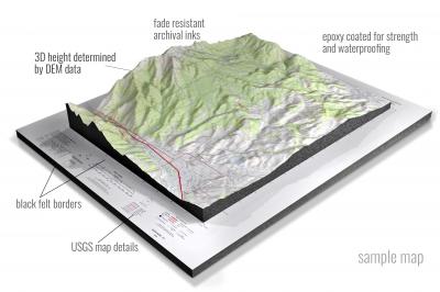
• Raised-relief 3D Height Determined by DEM data
• Fade Resistant Archival Inks
• Epoxy Coated for Strength and Waterproofing
• Ready to Hang with Pre-Installed Hardware (optional)
• Extraordinary 3D Accuracy
• Black Felt Borders
Enrich your office decor or home with a 3D USGS Raised Relief Map. These raised relief maps are not flat. They are three-dimensional, with the height being determined by Digital Elevation Model (DEM) data. Many people struggle with reading 2D satellite maps, but everyone understands 3D raised relief maps. The realism is phenomenal.
This 3D satellite raised relief map is built by combining satellite imagery data from Google Earth, bounding box coordinates from USGS, and DEM data. 3D Printing and 3D CNC routers are used to fabricate the models which make the satellite models extremely accurate. These models are strong - they are coated with epoxy, then finished with a sealer providing a weatherproof matt-finish. These are not meant to be used in direct sunlight.
Abingdon, Illinois- View hi-resolution image of: Abingdon, Illinois. Mapping by USGS in 2021 - Longitude/Latitude: -90.5 x -90.375 x 40.875 x 40.75, Grid Size: 7.5 X 7.5 Minute, Map Scale: 1:24000, State List: IL, County List: Knox,Warren
Adair, Illinois- View hi-resolution image of: Adair, Illinois. Mapping by USGS in 2021 - Longitude/Latitude: -90.5 x -90.375 x 40.5 x 40.375, Grid Size: 7.5 X 7.5 Minute, Map Scale: 1:24000, State List: IL, County List: Fulton,McDonough
Addieville, Illinois- View hi-resolution image of: Addieville, Illinois. Mapping by USGS in 2021 - Longitude/Latitude: -89.5 x -89.375 x 38.5 x 38.375, Grid Size: 7.5 X 7.5 Minute, Map Scale: 1:24000, State List: IL, County List: Washington,Clinton
Akin, Illinois- View hi-resolution image of: Akin, Illinois. Mapping by USGS in 2021 - Longitude/Latitude: -88.75 x -88.625 x 38 x 37.875, Grid Size: 7.5 X 7.5 Minute, Map Scale: 1:24000, State List: IL, County List: Hamilton,Franklin,Saline
Albion North, Illinois- View hi-resolution image of: Albion North, Illinois. Mapping by USGS in 2021 - Longitude/Latitude: -88.125 x -88 x 38.5 x 38.375, Grid Size: 7.5 X 7.5 Minute, Map Scale: 1:24000, State List: IL, County List: Edwards
Albion NW, Illinois- View hi-resolution image of: Albion NW, Illinois. Mapping by USGS in 2021 - Longitude/Latitude: -88.25 x -88.125 x 38.5 x 38.375, Grid Size: 7.5 X 7.5 Minute, Map Scale: 1:24000, State List: IL, County List: Wayne,Edwards
Albion South, Illinois- View hi-resolution image of: Albion South, Illinois. Mapping by USGS in 2021 - Longitude/Latitude: -88.125 x -88 x 38.375 x 38.25, Grid Size: 7.5 X 7.5 Minute, Map Scale: 1:24000, State List: IL, County List: Edwards,White
Aledo East, Illinois- View hi-resolution image of: Aledo East, Illinois. Mapping by USGS in 2021 - Longitude/Latitude: -90.75 x -90.625 x 41.25 x 41.125, Grid Size: 7.5 X 7.5 Minute, Map Scale: 1:24000, State List: IL, County List: Mercer
Aledo West, Illinois- View hi-resolution image of: Aledo West, Illinois. Mapping by USGS in 2021 - Longitude/Latitude: -90.875 x -90.75 x 41.25 x 41.125, Grid Size: 7.5 X 7.5 Minute, Map Scale: 1:24000, State List: IL, County List: Mercer
Alexander, Illinois- View hi-resolution image of: Alexander, Illinois. Mapping by USGS in 2021 - Longitude/Latitude: -90.125 x -90 x 39.75 x 39.625, Grid Size: 7.5 X 7.5 Minute, Map Scale: 1:24000, State List: IL, County List: Morgan
Alexis, Illinois- View hi-resolution image of: Alexis, Illinois. Mapping by USGS in 2021 - Longitude/Latitude: -90.625 x -90.5 x 41.125 x 41, Grid Size: 7.5 X 7.5 Minute, Map Scale: 1:24000, State List: IL, County List: Warren,Mercer
Allerton, Illinois- View hi-resolution image of: Allerton, Illinois. Mapping by USGS in 2021 - Longitude/Latitude: -88 x -87.875 x 40 x 39.875, Grid Size: 7.5 X 7.5 Minute, Map Scale: 1:24000, State List: IL, County List: Vermilion,Champaign,Edgar,Douglas
Alsey, Illinois- View hi-resolution image of: Alsey, Illinois. Mapping by USGS in 2021 - Longitude/Latitude: -90.5 x -90.375 x 39.625 x 39.5, Grid Size: 7.5 X 7.5 Minute, Map Scale: 1:24000, State List: IL, County List: Scott,Greene
Altamont East, Illinois- View hi-resolution image of: Altamont East, Illinois. Mapping by USGS in 2021 - Longitude/Latitude: -88.75 x -88.625 x 39.125 x 39, Grid Size: 7.5 X 7.5 Minute, Map Scale: 1:24000, State List: IL, County List: Effingham
Altamont West, Illinois- View hi-resolution image of: Altamont West, Illinois. Mapping by USGS in 2021 - Longitude/Latitude: -88.875 x -88.75 x 39.125 x 39, Grid Size: 7.5 X 7.5 Minute, Map Scale: 1:24000, State List: IL, County List: Fayette,Effingham
Alton, Illinois- View hi-resolution image of: Alton, Illinois. Mapping by USGS in 2021 - Longitude/Latitude: -90.25 x -90.125 x 39 x 38.875, Grid Size: 7.5 X 7.5 Minute, Map Scale: 1:24000, State List: IL,MO, County List: Madison,St. Charles,Macoupin,Jersey
Amboy, Illinois- View hi-resolution image of: Amboy, Illinois. Mapping by USGS in 2021 - Longitude/Latitude: -89.375 x -89.25 x 41.75 x 41.625, Grid Size: 7.5 X 7.5 Minute, Map Scale: 1:24000, State List: IL, County List: Lee
Ames, Illinois- View hi-resolution image of: Ames, Illinois. Mapping by USGS in 2021 - Longitude/Latitude: -90.125 x -90 x 38.25 x 38.125, Grid Size: 7.5 X 7.5 Minute, Map Scale: 1:24000, State List: IL, County List: Monroe,Randolph
Andalusia, Illinois- View hi-resolution image of: Andalusia, Illinois. Mapping by USGS in 2021 - Longitude/Latitude: -90.75 x -90.625 x 41.5 x 41.375, Grid Size: 7.5 X 7.5 Minute, Map Scale: 1:24000, State List: IL,IA, County List: Rock Island,Scott
Andover, Illinois- View hi-resolution image of: Andover, Illinois. Mapping by USGS in 2021 - Longitude/Latitude: -90.375 x -90.25 x 41.375 x 41.25, Grid Size: 7.5 X 7.5 Minute, Map Scale: 1:24000, State List: IL, County List: Henry
Anna, Illinois- View hi-resolution image of: Anna, Illinois. Mapping by USGS in 2021 - Longitude/Latitude: -89.25 x -89.125 x 37.5 x 37.375, Grid Size: 7.5 X 7.5 Minute, Map Scale: 1:24000, State List: IL, County List: Union
Annapolis, Illinois- View hi-resolution image of: Annapolis, Illinois. Mapping by USGS in 2021 - Longitude/Latitude: -87.875 x -87.75 x 39.25 x 39.125, Grid Size: 7.5 X 7.5 Minute, Map Scale: 1:24000, State List: IL, County List: Clark,Crawford
Annawan, Illinois- View hi-resolution image of: Annawan, Illinois. Mapping by USGS in 2021 - Longitude/Latitude: -90 x -89.875 x 41.5 x 41.375, Grid Size: 7.5 X 7.5 Minute, Map Scale: 1:24000, State List: IL, County List: Henry
Antioch, Illinois- View hi-resolution image of: Antioch, Illinois. Mapping by USGS in 2021 - Longitude/Latitude: -88.125 x -88 x 42.5 x 42.375, Grid Size: 7.5 X 7.5 Minute, Map Scale: 1:24000, State List: IL,WI, County List: Lake,Kenosha
Apple River, Illinois- View hi-resolution image of: Apple River, Illinois. Mapping by USGS in 2021 - Longitude/Latitude: -90.125 x -90 x 42.625 x 42.5, Grid Size: 7.5 X 7.5 Minute, Map Scale: 1:24000, State List: IL,WI, County List: Jo Daviess,Lafayette
Appleton, Illinois- View hi-resolution image of: Appleton, Illinois. Mapping by USGS in 2021 - Longitude/Latitude: -90.25 x -90.125 x 41 x 40.875, Grid Size: 7.5 X 7.5 Minute, Map Scale: 1:24000, State List: IL, County List: Knox
Arcola, Illinois- View hi-resolution image of: Arcola, Illinois. Mapping by USGS in 2021 - Longitude/Latitude: -88.375 x -88.25 x 39.75 x 39.625, Grid Size: 7.5 X 7.5 Minute, Map Scale: 1:24000, State List: IL, County List: Douglas,Coles
Arenzville East, Illinois- View hi-resolution image of: Arenzville East, Illinois. Mapping by USGS in 2021 - Longitude/Latitude: -90.375 x -90.25 x 40 x 39.875, Grid Size: 7.5 X 7.5 Minute, Map Scale: 1:24000, State List: IL, County List: Cass
Arenzville West, Illinois- View hi-resolution image of: Arenzville West, Illinois. Mapping by USGS in 2021 - Longitude/Latitude: -90.5 x -90.375 x 40 x 39.875, Grid Size: 7.5 X 7.5 Minute, Map Scale: 1:24000, State List: IL, County List: Cass,Morgan,Schuyler
Argenta, Illinois- View hi-resolution image of: Argenta, Illinois. Mapping by USGS in 2021 - Longitude/Latitude: -88.875 x -88.75 x 40 x 39.875, Grid Size: 7.5 X 7.5 Minute, Map Scale: 1:24000, State List: IL, County List: Macon
Arlington Heights, Illinois- View hi-resolution image of: Arlington Heights, Illinois. Mapping by USGS in 2021 - Longitude/Latitude: -88 x -87.875 x 42.125 x 42, Grid Size: 7.5 X 7.5 Minute, Map Scale: 1:24000, State List: IL, County List: Cook
Armington, Illinois- View hi-resolution image of: Armington, Illinois. Mapping by USGS in 2021 - Longitude/Latitude: -89.375 x -89.25 x 40.375 x 40.25, Grid Size: 7.5 X 7.5 Minute, Map Scale: 1:24000, State List: IL, County List: Logan,Tazewell,McLean
Arrowsmith, Illinois- View hi-resolution image of: Arrowsmith, Illinois. Mapping by USGS in 2021 - Longitude/Latitude: -88.75 x -88.625 x 40.5 x 40.375, Grid Size: 7.5 X 7.5 Minute, Map Scale: 1:24000, State List: IL, County List: McLean
Arthur, Illinois- View hi-resolution image of: Arthur, Illinois. Mapping by USGS in 2021 - Longitude/Latitude: -88.5 x -88.375 x 39.75 x 39.625, Grid Size: 7.5 X 7.5 Minute, Map Scale: 1:24000, State List: IL, County List: Douglas,Moultrie,Coles
Ashland, Illinois- View hi-resolution image of: Ashland, Illinois. Mapping by USGS in 2021 - Longitude/Latitude: -90.125 x -90 x 40 x 39.875, Grid Size: 7.5 X 7.5 Minute, Map Scale: 1:24000, State List: IL, County List: Cass
Ashley, Illinois- View hi-resolution image of: Ashley, Illinois. Mapping by USGS in 2021 - Longitude/Latitude: -89.25 x -89.125 x 38.375 x 38.25, Grid Size: 7.5 X 7.5 Minute, Map Scale: 1:24000, State List: IL, County List: Washington,Jefferson
Ashmore, Illinois- View hi-resolution image of: Ashmore, Illinois. Mapping by USGS in 2021 - Longitude/Latitude: -88.125 x -88 x 39.625 x 39.5, Grid Size: 7.5 X 7.5 Minute, Map Scale: 1:24000, State List: IL, County List: Coles
Ashton, Illinois- View hi-resolution image of: Ashton, Illinois. Mapping by USGS in 2021 - Longitude/Latitude: -89.25 x -89.125 x 41.875 x 41.75, Grid Size: 7.5 X 7.5 Minute, Map Scale: 1:24000, State List: IL, County List: Lee
Assumption, Illinois- View hi-resolution image of: Assumption, Illinois. Mapping by USGS in 2021 - Longitude/Latitude: -89.125 x -89 x 39.625 x 39.5, Grid Size: 7.5 X 7.5 Minute, Map Scale: 1:24000, State List: IL, County List: Christian,Shelby
Astoria, Illinois- View hi-resolution image of: Astoria, Illinois. Mapping by USGS in 2021 - Longitude/Latitude: -90.375 x -90.25 x 40.25 x 40.125, Grid Size: 7.5 X 7.5 Minute, Map Scale: 1:24000, State List: IL, County List: Fulton,Schuyler,Mason,Cass
Athens, Illinois- View hi-resolution image of: Athens, Illinois. Mapping by USGS in 2021 - Longitude/Latitude: -89.75 x -89.625 x 40 x 39.875, Grid Size: 7.5 X 7.5 Minute, Map Scale: 1:24000, State List: IL, County List: Sangamon,Menard
Athensville, Illinois- View hi-resolution image of: Athensville, Illinois. Mapping by USGS in 2021 - Longitude/Latitude: -90.25 x -90.125 x 39.5 x 39.375, Grid Size: 7.5 X 7.5 Minute, Map Scale: 1:24000, State List: IL, County List: Greene,Macoupin
Atkinson, Illinois- View hi-resolution image of: Atkinson, Illinois. Mapping by USGS in 2021 - Longitude/Latitude: -90.125 x -90 x 41.5 x 41.375, Grid Size: 7.5 X 7.5 Minute, Map Scale: 1:24000, State List: IL, County List: Henry
Atwater, Illinois- View hi-resolution image of: Atwater, Illinois. Mapping by USGS in 2021 - Longitude/Latitude: -89.75 x -89.625 x 39.375 x 39.25, Grid Size: 7.5 X 7.5 Minute, Map Scale: 1:24000, State List: IL, County List: Montgomery,Macoupin
Atwood, Illinois- View hi-resolution image of: Atwood, Illinois. Mapping by USGS in 2021 - Longitude/Latitude: -88.5 x -88.375 x 39.875 x 39.75, Grid Size: 7.5 X 7.5 Minute, Map Scale: 1:24000, State List: IL, County List: Douglas,Piatt,Moultrie
Augusta, Illinois- View hi-resolution image of: Augusta, Illinois. Mapping by USGS in 2021 - Longitude/Latitude: -91 x -90.875 x 40.25 x 40.125, Grid Size: 7.5 X 7.5 Minute, Map Scale: 1:24000, State List: IL, County List: Schuyler,Adams,Hancock
Aurora North, Illinois- View hi-resolution image of: Aurora North, Illinois. Mapping by USGS in 2021 - Longitude/Latitude: -88.375 x -88.25 x 41.875 x 41.75, Grid Size: 7.5 X 7.5 Minute, Map Scale: 1:24000, State List: IL, County List: Kane,DuPage
Aurora South, Illinois- View hi-resolution image of: Aurora South, Illinois. Mapping by USGS in 2021 - Longitude/Latitude: -88.375 x -88.25 x 41.75 x 41.625, Grid Size: 7.5 X 7.5 Minute, Map Scale: 1:24000, State List: IL, County List: Kendall,Kane,Will,DuPage
Ava, Illinois- View hi-resolution image of: Ava, Illinois. Mapping by USGS in 2021 - Longitude/Latitude: -89.5 x -89.375 x 38 x 37.875, Grid Size: 7.5 X 7.5 Minute, Map Scale: 1:24000, State List: IL, County List: Jackson,Perry
Avena, Illinois- View hi-resolution image of: Avena, Illinois. Mapping by USGS in 2021 - Longitude/Latitude: -89 x -88.875 x 39.125 x 39, Grid Size: 7.5 X 7.5 Minute, Map Scale: 1:24000, State List: IL, County List: Fayette
Avon, Illinois- View hi-resolution image of: Avon, Illinois. Mapping by USGS in 2021 - Longitude/Latitude: -90.5 x -90.375 x 40.75 x 40.625, Grid Size: 7.5 X 7.5 Minute, Map Scale: 1:24000, State List: IL, County List: Fulton,Warren,Knox,McDonough
Bald Knob, Illinois- View hi-resolution image of: Bald Knob, Illinois. Mapping by USGS in 2021 - Longitude/Latitude: -89.375 x -89.25 x 39.25 x 39.125, Grid Size: 7.5 X 7.5 Minute, Map Scale: 1:24000, State List: IL, County List: Montgomery,Fayette
Baldwin, Illinois- View hi-resolution image of: Baldwin, Illinois. Mapping by USGS in 2021 - Longitude/Latitude: -89.875 x -89.75 x 38.25 x 38.125, Grid Size: 7.5 X 7.5 Minute, Map Scale: 1:24000, State List: IL, County List: Randolph,St. Clair
Banner, Illinois- View hi-resolution image of: Banner, Illinois. Mapping by USGS in 2021 - Longitude/Latitude: -90 x -89.875 x 40.625 x 40.5, Grid Size: 7.5 X 7.5 Minute, Map Scale: 1:24000, State List: IL, County List: Fulton,Tazewell,Peoria
Bardolph, Illinois- View hi-resolution image of: Bardolph, Illinois. Mapping by USGS in 2021 - Longitude/Latitude: -90.625 x -90.5 x 40.5 x 40.375, Grid Size: 7.5 X 7.5 Minute, Map Scale: 1:24000, State List: IL, County List: McDonough
Barrington, Illinois- View hi-resolution image of: Barrington, Illinois. Mapping by USGS in 2021 - Longitude/Latitude: -88.25 x -88.125 x 42.25 x 42.125, Grid Size: 7.5 X 7.5 Minute, Map Scale: 1:24000, State List: IL, County List: Lake,McHenry,Cook,Kane
Barry, Illinois- View hi-resolution image of: Barry, Illinois. Mapping by USGS in 2021 - Longitude/Latitude: -91.125 x -91 x 39.75 x 39.625, Grid Size: 7.5 X 7.5 Minute, Map Scale: 1:24000, State List: IL, County List: Pike
Bath, Illinois- View hi-resolution image of: Bath, Illinois. Mapping by USGS in 2021 - Longitude/Latitude: -90.25 x -90.125 x 40.25 x 40.125, Grid Size: 7.5 X 7.5 Minute, Map Scale: 1:24000, State List: IL, County List: Mason,Fulton,Schuyler
Baylis, Illinois- View hi-resolution image of: Baylis, Illinois. Mapping by USGS in 2021 - Longitude/Latitude: -91 x -90.875 x 39.75 x 39.625, Grid Size: 7.5 X 7.5 Minute, Map Scale: 1:24000, State List: IL, County List: Pike
Beardstown, Illinois- View hi-resolution image of: Beardstown, Illinois. Mapping by USGS in 2021 - Longitude/Latitude: -90.5 x -90.375 x 40.125 x 40, Grid Size: 7.5 X 7.5 Minute, Map Scale: 1:24000, State List: IL, County List: Schuyler,Cass
Beaucoup, Illinois- View hi-resolution image of: Beaucoup, Illinois. Mapping by USGS in 2021 - Longitude/Latitude: -89.375 x -89.25 x 38.375 x 38.25, Grid Size: 7.5 X 7.5 Minute, Map Scale: 1:24000, State List: IL, County List: Washington
Beaver Creek, Illinois- View hi-resolution image of: Beaver Creek, Illinois. Mapping by USGS in 2021 - Longitude/Latitude: -89.5 x -89.375 x 38.875 x 38.75, Grid Size: 7.5 X 7.5 Minute, Map Scale: 1:24000, State List: IL, County List: Bond
Beaverville, Illinois- View hi-resolution image of: Beaverville, Illinois. Mapping by USGS in 2021 - Longitude/Latitude: -87.75 x -87.625 x 41 x 40.875, Grid Size: 7.5 X 7.5 Minute, Map Scale: 1:24000, State List: IL, County List: Iroquois
Beckemeyer, Illinois- View hi-resolution image of: Beckemeyer, Illinois. Mapping by USGS in 2021 - Longitude/Latitude: -89.5 x -89.375 x 38.625 x 38.5, Grid Size: 7.5 X 7.5 Minute, Map Scale: 1:24000, State List: IL, County List: Clinton
Bedford, Illinois- View hi-resolution image of: Bedford, Illinois. Mapping by USGS in 2021 - Longitude/Latitude: -90.625 x -90.5 x 39.625 x 39.5, Grid Size: 7.5 X 7.5 Minute, Map Scale: 1:24000, State List: IL, County List: Scott,Pike,Greene
Beecher City, Illinois- View hi-resolution image of: Beecher City, Illinois. Mapping by USGS in 2021 - Longitude/Latitude: -88.875 x -88.75 x 39.25 x 39.125, Grid Size: 7.5 X 7.5 Minute, Map Scale: 1:24000, State List: IL, County List: Fayette,Effingham,Shelby
Beecher East, Illinois- View hi-resolution image of: Beecher East, Illinois. Mapping by USGS in 2021 - Longitude/Latitude: -87.625 x -87.5 x 41.375 x 41.25, Grid Size: 7.5 X 7.5 Minute, Map Scale: 1:24000, State List: IL,IN, County List: Will,Kankakee,Lake
Beecher West, Illinois- View hi-resolution image of: Beecher West, Illinois. Mapping by USGS in 2021 - Longitude/Latitude: -87.75 x -87.625 x 41.375 x 41.25, Grid Size: 7.5 X 7.5 Minute, Map Scale: 1:24000, State List: IL, County List: Will,Kankakee
Belle Prairie City, Illinois- View hi-resolution image of: Belle Prairie City, Illinois. Mapping by USGS in 2021 - Longitude/Latitude: -88.625 x -88.5 x 38.25 x 38.125, Grid Size: 7.5 X 7.5 Minute, Map Scale: 1:24000, State List: IL, County List: Hamilton
Bellflower, Illinois- View hi-resolution image of: Bellflower, Illinois. Mapping by USGS in 2021 - Longitude/Latitude: -88.625 x -88.5 x 40.375 x 40.25, Grid Size: 7.5 X 7.5 Minute, Map Scale: 1:24000, State List: IL, County List: McLean,Piatt,De Witt
Belvidere NE, Illinois- View hi-resolution image of: Belvidere NE, Illinois. Mapping by USGS in 2021 - Longitude/Latitude: -88.875 x -88.75 x 42.5 x 42.375, Grid Size: 7.5 X 7.5 Minute, Map Scale: 1:24000, State List: IL,WI, County List: Boone,Rock,Walworth
Belvidere North, Illinois- View hi-resolution image of: Belvidere North, Illinois. Mapping by USGS in 2021 - Longitude/Latitude: -88.875 x -88.75 x 42.375 x 42.25, Grid Size: 7.5 X 7.5 Minute, Map Scale: 1:24000, State List: IL, County List: Boone
Belvidere NW, Illinois- View hi-resolution image of: Belvidere NW, Illinois. Mapping by USGS in 2021 - Longitude/Latitude: -89 x -88.875 x 42.5 x 42.375, Grid Size: 7.5 X 7.5 Minute, Map Scale: 1:24000, State List: IL,WI, County List: Boone,Winnebago,Rock
Belvidere South, Illinois- View hi-resolution image of: Belvidere South, Illinois. Mapping by USGS in 2021 - Longitude/Latitude: -88.875 x -88.75 x 42.25 x 42.125, Grid Size: 7.5 X 7.5 Minute, Map Scale: 1:24000, State List: IL, County List: Boone,DeKalb
Bement, Illinois- View hi-resolution image of: Bement, Illinois. Mapping by USGS in 2021 - Longitude/Latitude: -88.625 x -88.5 x 40 x 39.875, Grid Size: 7.5 X 7.5 Minute, Map Scale: 1:24000, State List: IL, County List: Piatt
Benson, Illinois- View hi-resolution image of: Benson, Illinois. Mapping by USGS in 2021 - Longitude/Latitude: -89.125 x -89 x 40.875 x 40.75, Grid Size: 7.5 X 7.5 Minute, Map Scale: 1:24000, State List: IL, County List: Woodford
Bentley, Illinois- View hi-resolution image of: Bentley, Illinois. Mapping by USGS in 2021 - Longitude/Latitude: -91.125 x -91 x 40.375 x 40.25, Grid Size: 7.5 X 7.5 Minute, Map Scale: 1:24000, State List: IL, County List: Hancock
Berryville, Illinois- View hi-resolution image of: Berryville, Illinois. Mapping by USGS in 2021 - Longitude/Latitude: -88 x -87.875 x 38.625 x 38.5, Grid Size: 7.5 X 7.5 Minute, Map Scale: 1:24000, State List: IL, County List: Wabash,Richland,Edwards,Lawrence
Berwick, Illinois- View hi-resolution image of: Berwick, Illinois. Mapping by USGS in 2021 - Longitude/Latitude: -90.625 x -90.5 x 40.875 x 40.75, Grid Size: 7.5 X 7.5 Minute, Map Scale: 1:24000, State List: IL, County List: Warren
Berwyn, Illinois- View hi-resolution image of: Berwyn, Illinois. Mapping by USGS in 2021 - Longitude/Latitude: -87.875 x -87.75 x 41.875 x 41.75, Grid Size: 7.5 X 7.5 Minute, Map Scale: 1:24000, State List: IL, County List: Cook
Bethalto, Illinois- View hi-resolution image of: Bethalto, Illinois. Mapping by USGS in 2021 - Longitude/Latitude: -90.125 x -90 x 39 x 38.875, Grid Size: 7.5 X 7.5 Minute, Map Scale: 1:24000, State List: IL, County List: Madison,Macoupin
Big Rock, Illinois- View hi-resolution image of: Big Rock, Illinois. Mapping by USGS in 2021 - Longitude/Latitude: -88.625 x -88.5 x 41.875 x 41.75, Grid Size: 7.5 X 7.5 Minute, Map Scale: 1:24000, State List: IL, County List: Kane,DeKalb
Biggs, Illinois- View hi-resolution image of: Biggs, Illinois. Mapping by USGS in 2021 - Longitude/Latitude: -90 x -89.875 x 40.25 x 40.125, Grid Size: 7.5 X 7.5 Minute, Map Scale: 1:24000, State List: IL, County List: Mason,Menard
Bingham, Illinois- View hi-resolution image of: Bingham, Illinois. Mapping by USGS in 2021 - Longitude/Latitude: -89.25 x -89.125 x 39.125 x 39, Grid Size: 7.5 X 7.5 Minute, Map Scale: 1:24000, State List: IL, County List: Fayette
Birds, Illinois- View hi-resolution image of: Birds, Illinois. Mapping by USGS in 2021 - Longitude/Latitude: -87.75 x -87.625 x 38.875 x 38.75, Grid Size: 7.5 X 7.5 Minute, Map Scale: 1:24000, State List: IL, County List: Lawrence,Crawford
Bismarck, Illinois- View hi-resolution image of: Bismarck, Illinois. Mapping by USGS in 2021 - Longitude/Latitude: -87.625 x -87.5 x 40.375 x 40.25, Grid Size: 7.5 X 7.5 Minute, Map Scale: 1:24000, State List: IL,IN, County List: Vermilion,Warren
Blackhawk, Illinois- View hi-resolution image of: Blackhawk, Illinois. Mapping by USGS in 2021 - Longitude/Latitude: -90.25 x -90.125 x 42.25 x 42.125, Grid Size: 7.5 X 7.5 Minute, Map Scale: 1:24000, State List: IL,IA, County List: Carroll,Jo Daviess,Jackson
Blackstone, Illinois- View hi-resolution image of: Blackstone, Illinois. Mapping by USGS in 2021 - Longitude/Latitude: -88.75 x -88.625 x 41.125 x 41, Grid Size: 7.5 X 7.5 Minute, Map Scale: 1:24000, State List: IL, County List: Livingston,LaSalle
Blanchard Island, Illinois- View hi-resolution image of: Blanchard Island, Illinois. Mapping by USGS in 2021 - Longitude/Latitude: -91.125 x -91 x 41.375 x 41.25, Grid Size: 7.5 X 7.5 Minute, Map Scale: 1:24000, State List: IL,IA, County List: Mercer,Louisa,Rock Island,Muscatine
Blandinsville, Illinois- View hi-resolution image of: Blandinsville, Illinois. Mapping by USGS in 2021 - Longitude/Latitude: -90.875 x -90.75 x 40.625 x 40.5, Grid Size: 7.5 X 7.5 Minute, Map Scale: 1:24000, State List: IL, County List: McDonough
Bloomfield, Illinois- View hi-resolution image of: Bloomfield, Illinois. Mapping by USGS in 2021 - Longitude/Latitude: -88.875 x -88.75 x 37.5 x 37.375, Grid Size: 7.5 X 7.5 Minute, Map Scale: 1:24000, State List: IL, County List: Johnson
Bloomington East, Illinois- View hi-resolution image of: Bloomington East, Illinois. Mapping by USGS in 2021 - Longitude/Latitude: -89 x -88.875 x 40.5 x 40.375, Grid Size: 7.5 X 7.5 Minute, Map Scale: 1:24000, State List: IL, County List: McLean
Bloomington West, Illinois- View hi-resolution image of: Bloomington West, Illinois. Mapping by USGS in 2021 - Longitude/Latitude: -89.125 x -89 x 40.5 x 40.375, Grid Size: 7.5 X 7.5 Minute, Map Scale: 1:24000, State List: IL, County List: McLean
Blue Island, Illinois- View hi-resolution image of: Blue Island, Illinois. Mapping by USGS in 2021 - Longitude/Latitude: -87.75 x -87.625 x 41.75 x 41.625, Grid Size: 7.5 X 7.5 Minute, Map Scale: 1:24000, State List: IL, County List: Cook
Bluford, Illinois- View hi-resolution image of: Bluford, Illinois. Mapping by USGS in 2021 - Longitude/Latitude: -88.75 x -88.625 x 38.375 x 38.25, Grid Size: 7.5 X 7.5 Minute, Map Scale: 1:24000, State List: IL, County List: Wayne,Jefferson,Hamilton
Blyton, Illinois- View hi-resolution image of: Blyton, Illinois. Mapping by USGS in 2021 - Longitude/Latitude: -90.375 x -90.25 x 40.625 x 40.5, Grid Size: 7.5 X 7.5 Minute, Map Scale: 1:24000, State List: IL, County List: Fulton
Bondville, Illinois- View hi-resolution image of: Bondville, Illinois. Mapping by USGS in 2021 - Longitude/Latitude: -88.375 x -88.25 x 40.125 x 40, Grid Size: 7.5 X 7.5 Minute, Map Scale: 1:24000, State List: IL, County List: Champaign
Bone Gap, Illinois- View hi-resolution image of: Bone Gap, Illinois. Mapping by USGS in 2021 - Longitude/Latitude: -88 x -87.875 x 38.5 x 38.375, Grid Size: 7.5 X 7.5 Minute, Map Scale: 1:24000, State List: IL, County List: Wabash,Edwards
Bonfield, Illinois- View hi-resolution image of: Bonfield, Illinois. Mapping by USGS in 2021 - Longitude/Latitude: -88.125 x -88 x 41.25 x 41.125, Grid Size: 7.5 X 7.5 Minute, Map Scale: 1:24000, State List: IL, County List: Kankakee,Will
Boone Branch, Illinois- View hi-resolution image of: Boone Branch, Illinois. Mapping by USGS in 2021 - Longitude/Latitude: -89.875 x -89.75 x 42.25 x 42.125, Grid Size: 7.5 X 7.5 Minute, Map Scale: 1:24000, State List: IL, County List: Carroll,Stephenson
Boulder, Illinois- View hi-resolution image of: Boulder, Illinois. Mapping by USGS in 2021 - Longitude/Latitude: -89.25 x -89.125 x 38.75 x 38.625, Grid Size: 7.5 X 7.5 Minute, Map Scale: 1:24000, State List: IL, County List: Clinton,Marion,Fayette
Bourbonnais, Illinois- View hi-resolution image of: Bourbonnais, Illinois. Mapping by USGS in 2021 - Longitude/Latitude: -88 x -87.875 x 41.25 x 41.125, Grid Size: 7.5 X 7.5 Minute, Map Scale: 1:24000, State List: IL, County List: Kankakee
Bowen, Illinois- View hi-resolution image of: Bowen, Illinois. Mapping by USGS in 2021 - Longitude/Latitude: -91.125 x -91 x 40.25 x 40.125, Grid Size: 7.5 X 7.5 Minute, Map Scale: 1:24000, State List: IL, County List: Adams,Hancock
Boyer Creek, Illinois- View hi-resolution image of: Boyer Creek, Illinois. Mapping by USGS in 2021 - Longitude/Latitude: -90.5 x -90.375 x 39.25 x 39.125, Grid Size: 7.5 X 7.5 Minute, Map Scale: 1:24000, State List: IL, County List: Greene,Jersey
Boyleston, Illinois- View hi-resolution image of: Boyleston, Illinois. Mapping by USGS in 2021 - Longitude/Latitude: -88.5 x -88.375 x 38.375 x 38.25, Grid Size: 7.5 X 7.5 Minute, Map Scale: 1:24000, State List: IL, County List: Wayne,Hamilton
Bradford, Illinois- View hi-resolution image of: Bradford, Illinois. Mapping by USGS in 2021 - Longitude/Latitude: -89.75 x -89.625 x 41.25 x 41.125, Grid Size: 7.5 X 7.5 Minute, Map Scale: 1:24000, State List: IL, County List: Stark,Bureau,Marshall
Bradley, Illinois- View hi-resolution image of: Bradley, Illinois. Mapping by USGS in 2021 - Longitude/Latitude: -87.875 x -87.75 x 41.25 x 41.125, Grid Size: 7.5 X 7.5 Minute, Map Scale: 1:24000, State List: IL, County List: Kankakee
Breese, Illinois- View hi-resolution image of: Breese, Illinois. Mapping by USGS in 2021 - Longitude/Latitude: -89.625 x -89.5 x 38.625 x 38.5, Grid Size: 7.5 X 7.5 Minute, Map Scale: 1:24000, State List: IL, County List: Clinton
Brighton, Illinois- View hi-resolution image of: Brighton, Illinois. Mapping by USGS in 2021 - Longitude/Latitude: -90.25 x -90.125 x 39.125 x 39, Grid Size: 7.5 X 7.5 Minute, Map Scale: 1:24000, State List: IL, County List: Jersey,Macoupin,Madison
Broadwell, Illinois- View hi-resolution image of: Broadwell, Illinois. Mapping by USGS in 2021 - Longitude/Latitude: -89.5 x -89.375 x 40.125 x 40, Grid Size: 7.5 X 7.5 Minute, Map Scale: 1:24000, State List: IL, County List: Logan
Brocton, Illinois- View hi-resolution image of: Brocton, Illinois. Mapping by USGS in 2021 - Longitude/Latitude: -88 x -87.875 x 39.75 x 39.625, Grid Size: 7.5 X 7.5 Minute, Map Scale: 1:24000, State List: IL, County List: Edgar,Douglas,Coles
Brookville, Illinois- View hi-resolution image of: Brookville, Illinois. Mapping by USGS in 2021 - Longitude/Latitude: -89.75 x -89.625 x 42.125 x 42, Grid Size: 7.5 X 7.5 Minute, Map Scale: 1:24000, State List: IL, County List: Ogle,Carroll
Broughton, Illinois- View hi-resolution image of: Broughton, Illinois. Mapping by USGS in 2021 - Longitude/Latitude: -88.5 x -88.375 x 38 x 37.875, Grid Size: 7.5 X 7.5 Minute, Map Scale: 1:24000, State List: IL, County List: Hamilton,Saline
Brownfield, Illinois- View hi-resolution image of: Brownfield, Illinois. Mapping by USGS in 2021 - Longitude/Latitude: -88.625 x -88.5 x 37.375 x 37.25, Grid Size: 7.5 X 7.5 Minute, Map Scale: 1:24000, State List: IL,KY, County List: Pope,Livingston,Massac
Brownstown, Illinois- View hi-resolution image of: Brownstown, Illinois. Mapping by USGS in 2021 - Longitude/Latitude: -89 x -88.875 x 39 x 38.875, Grid Size: 7.5 X 7.5 Minute, Map Scale: 1:24000, State List: IL, County List: Fayette
Brussels, Illinois- View hi-resolution image of: Brussels, Illinois. Mapping by USGS in 2021 - Longitude/Latitude: -90.625 x -90.5 x 39 x 38.875, Grid Size: 7.5 X 7.5 Minute, Map Scale: 1:24000, State List: IL,MO, County List: Calhoun,Jersey,St. Charles
Buckingham, Illinois- View hi-resolution image of: Buckingham, Illinois. Mapping by USGS in 2021 - Longitude/Latitude: -88.25 x -88.125 x 41.125 x 41, Grid Size: 7.5 X 7.5 Minute, Map Scale: 1:24000, State List: IL, County List: Kankakee,Grundy,Livingston
Buckley, Illinois- View hi-resolution image of: Buckley, Illinois. Mapping by USGS in 2021 - Longitude/Latitude: -88.125 x -88 x 40.625 x 40.5, Grid Size: 7.5 X 7.5 Minute, Map Scale: 1:24000, State List: IL, County List: Iroquois,Ford
Buckley NW, Illinois- View hi-resolution image of: Buckley NW, Illinois. Mapping by USGS in 2021 - Longitude/Latitude: -88.25 x -88.125 x 40.75 x 40.625, Grid Size: 7.5 X 7.5 Minute, Map Scale: 1:24000, State List: IL, County List: Ford,Livingston,Iroquois
Buda, Illinois- View hi-resolution image of: Buda, Illinois. Mapping by USGS in 2021 - Longitude/Latitude: -89.75 x -89.625 x 41.375 x 41.25, Grid Size: 7.5 X 7.5 Minute, Map Scale: 1:24000, State List: IL, County List: Bureau
Buda NE, Illinois- View hi-resolution image of: Buda NE, Illinois. Mapping by USGS in 2021 - Longitude/Latitude: -89.625 x -89.5 x 41.5 x 41.375, Grid Size: 7.5 X 7.5 Minute, Map Scale: 1:24000, State List: IL, County List: Bureau
Buffalo Prairie, Illinois- View hi-resolution image of: Buffalo Prairie, Illinois. Mapping by USGS in 2021 - Longitude/Latitude: -90.875 x -90.75 x 41.375 x 41.25, Grid Size: 7.5 X 7.5 Minute, Map Scale: 1:24000, State List: IL, County List: Mercer,Rock Island
Bungay, Illinois- View hi-resolution image of: Bungay, Illinois. Mapping by USGS in 2021 - Longitude/Latitude: -88.5 x -88.375 x 38.25 x 38.125, Grid Size: 7.5 X 7.5 Minute, Map Scale: 1:24000, State List: IL, County List: Hamilton
Bunker Hill, Illinois- View hi-resolution image of: Bunker Hill, Illinois. Mapping by USGS in 2021 - Longitude/Latitude: -90 x -89.875 x 39.125 x 39, Grid Size: 7.5 X 7.5 Minute, Map Scale: 1:24000, State List: IL, County List: Macoupin
Burnside, Illinois- View hi-resolution image of: Burnside, Illinois. Mapping by USGS in 2021 - Longitude/Latitude: -91.125 x -91 x 40.625 x 40.5, Grid Size: 7.5 X 7.5 Minute, Map Scale: 1:24000, State List: IL, County List: Hancock
Burnt Prairie, Illinois- View hi-resolution image of: Burnt Prairie, Illinois. Mapping by USGS in 2021 - Longitude/Latitude: -88.375 x -88.25 x 38.375 x 38.25, Grid Size: 7.5 X 7.5 Minute, Map Scale: 1:24000, State List: IL, County List: Wayne,White,Hamilton
Bushnell East, Illinois- View hi-resolution image of: Bushnell East, Illinois. Mapping by USGS in 2021 - Longitude/Latitude: -90.5 x -90.375 x 40.625 x 40.5, Grid Size: 7.5 X 7.5 Minute, Map Scale: 1:24000, State List: IL, County List: Fulton,McDonough
Bushnell West, Illinois- View hi-resolution image of: Bushnell West, Illinois. Mapping by USGS in 2021 - Longitude/Latitude: -90.625 x -90.5 x 40.625 x 40.5, Grid Size: 7.5 X 7.5 Minute, Map Scale: 1:24000, State List: IL, County List: McDonough
Butler, Illinois- View hi-resolution image of: Butler, Illinois. Mapping by USGS in 2021 - Longitude/Latitude: -89.625 x -89.5 x 39.25 x 39.125, Grid Size: 7.5 X 7.5 Minute, Map Scale: 1:24000, State List: IL, County List: Montgomery
Cabery, Illinois- View hi-resolution image of: Cabery, Illinois. Mapping by USGS in 2021 - Longitude/Latitude: -88.25 x -88.125 x 41 x 40.875, Grid Size: 7.5 X 7.5 Minute, Map Scale: 1:24000, State List: IL, County List: Ford,Iroquois,Livingston,Kankakee
Cache, Illinois- View hi-resolution image of: Cache, Illinois. Mapping by USGS in 2021 - Longitude/Latitude: -89.375 x -89.25 x 37.125 x 37, Grid Size: 7.5 X 7.5 Minute, Map Scale: 1:24000, State List: IL,MO, County List: Alexander,Mississippi,Scott,Pulaski
Cadwell, Illinois- View hi-resolution image of: Cadwell, Illinois. Mapping by USGS in 2021 - Longitude/Latitude: -88.625 x -88.5 x 39.75 x 39.625, Grid Size: 7.5 X 7.5 Minute, Map Scale: 1:24000, State List: IL, County List: Moultrie
Cahokia, Illinois- View hi-resolution image of: Cahokia, Illinois. Mapping by USGS in 2021 - Longitude/Latitude: -90.25 x -90.125 x 38.625 x 38.5, Grid Size: 7.5 X 7.5 Minute, Map Scale: 1:24000, State List: IL,MO, County List: St. Clair,St. Louis (city),Monroe
Cairo, Illinois- View hi-resolution image of: Cairo, Illinois. Mapping by USGS in 2021 - Longitude/Latitude: -89.25 x -89.125 x 37.125 x 37, Grid Size: 7.5 X 7.5 Minute, Map Scale: 1:24000, State List: IL,KY,MO, County List: Alexander,Ballard,Pulaski,Mississippi
Caledonia, Illinois- View hi-resolution image of: Caledonia, Illinois. Mapping by USGS in 2021 - Longitude/Latitude: -89 x -88.875 x 42.375 x 42.25, Grid Size: 7.5 X 7.5 Minute, Map Scale: 1:24000, State List: IL, County List: Boone,Winnebago
Calumet City, Illinois- View hi-resolution image of: Calumet City, Illinois. Mapping by USGS in 2021 - Longitude/Latitude: -87.625 x -87.5 x 41.625 x 41.5, Grid Size: 7.5 X 7.5 Minute, Map Scale: 1:24000, State List: IL,IN, County List: Cook,Lake
Cambridge, Illinois- View hi-resolution image of: Cambridge, Illinois. Mapping by USGS in 2021 - Longitude/Latitude: -90.25 x -90.125 x 41.375 x 41.25, Grid Size: 7.5 X 7.5 Minute, Map Scale: 1:24000, State List: IL, County List: Henry
Camden, Illinois- View hi-resolution image of: Camden, Illinois. Mapping by USGS in 2021 - Longitude/Latitude: -90.875 x -90.75 x 40.25 x 40.125, Grid Size: 7.5 X 7.5 Minute, Map Scale: 1:24000, State List: IL, County List: Schuyler
Cameron, Illinois- View hi-resolution image of: Cameron, Illinois. Mapping by USGS in 2021 - Longitude/Latitude: -90.625 x -90.5 x 41 x 40.875, Grid Size: 7.5 X 7.5 Minute, Map Scale: 1:24000, State List: IL, County List: Warren
Camp Point, Illinois- View hi-resolution image of: Camp Point, Illinois. Mapping by USGS in 2021 - Longitude/Latitude: -91.125 x -91 x 40.125 x 40, Grid Size: 7.5 X 7.5 Minute, Map Scale: 1:24000, State List: IL, County List: Adams
Campus, Illinois- View hi-resolution image of: Campus, Illinois. Mapping by USGS in 2021 - Longitude/Latitude: -88.375 x -88.25 x 41.125 x 41, Grid Size: 7.5 X 7.5 Minute, Map Scale: 1:24000, State List: IL, County List: Livingston,Grundy,Kankakee
Canton, Illinois- View hi-resolution image of: Canton, Illinois. Mapping by USGS in 2021 - Longitude/Latitude: -90.125 x -90 x 40.625 x 40.5, Grid Size: 7.5 X 7.5 Minute, Map Scale: 1:24000, State List: IL, County List: Fulton
Capron, Illinois- View hi-resolution image of: Capron, Illinois. Mapping by USGS in 2021 - Longitude/Latitude: -88.75 x -88.625 x 42.5 x 42.375, Grid Size: 7.5 X 7.5 Minute, Map Scale: 1:24000, State List: IL,WI, County List: McHenry,Boone,Walworth
Carbondale, Illinois- View hi-resolution image of: Carbondale, Illinois. Mapping by USGS in 2021 - Longitude/Latitude: -89.25 x -89.125 x 37.75 x 37.625, Grid Size: 7.5 X 7.5 Minute, Map Scale: 1:24000, State List: IL, County List: Jackson,Williamson
Carlinville East, Illinois- View hi-resolution image of: Carlinville East, Illinois. Mapping by USGS in 2021 - Longitude/Latitude: -89.875 x -89.75 x 39.375 x 39.25, Grid Size: 7.5 X 7.5 Minute, Map Scale: 1:24000, State List: IL, County List: Macoupin
Carlinville West, Illinois- View hi-resolution image of: Carlinville West, Illinois. Mapping by USGS in 2021 - Longitude/Latitude: -90 x -89.875 x 39.375 x 39.25, Grid Size: 7.5 X 7.5 Minute, Map Scale: 1:24000, State List: IL, County List: Macoupin
Carlyle, Illinois- View hi-resolution image of: Carlyle, Illinois. Mapping by USGS in 2021 - Longitude/Latitude: -89.375 x -89.25 x 38.625 x 38.5, Grid Size: 7.5 X 7.5 Minute, Map Scale: 1:24000, State List: IL, County List: Clinton,Washington
Carmi, Illinois- View hi-resolution image of: Carmi, Illinois. Mapping by USGS in 2021 - Longitude/Latitude: -88.25 x -88.125 x 38.125 x 38, Grid Size: 7.5 X 7.5 Minute, Map Scale: 1:24000, State List: IL, County List: White
Carrier Mills, Illinois- View hi-resolution image of: Carrier Mills, Illinois. Mapping by USGS in 2021 - Longitude/Latitude: -88.75 x -88.625 x 37.75 x 37.625, Grid Size: 7.5 X 7.5 Minute, Map Scale: 1:24000, State List: IL, County List: Saline,Williamson
Carrollton, Illinois- View hi-resolution image of: Carrollton, Illinois. Mapping by USGS in 2021 - Longitude/Latitude: -90.5 x -90.375 x 39.375 x 39.25, Grid Size: 7.5 X 7.5 Minute, Map Scale: 1:24000, State List: IL, County List: Greene
Carthage East, Illinois- View hi-resolution image of: Carthage East, Illinois. Mapping by USGS in 2021 - Longitude/Latitude: -91.125 x -91 x 40.5 x 40.375, Grid Size: 7.5 X 7.5 Minute, Map Scale: 1:24000, State List: IL, County List: Hancock
Carthage West, Illinois- View hi-resolution image of: Carthage West, Illinois. Mapping by USGS in 2021 - Longitude/Latitude: -91.25 x -91.125 x 40.5 x 40.375, Grid Size: 7.5 X 7.5 Minute, Map Scale: 1:24000, State List: IL, County List: Hancock
Casey, Illinois- View hi-resolution image of: Casey, Illinois. Mapping by USGS in 2021 - Longitude/Latitude: -88 x -87.875 x 39.375 x 39.25, Grid Size: 7.5 X 7.5 Minute, Map Scale: 1:24000, State List: IL, County List: Clark
Castleton, Illinois- View hi-resolution image of: Castleton, Illinois. Mapping by USGS in 2021 - Longitude/Latitude: -89.75 x -89.625 x 41.125 x 41, Grid Size: 7.5 X 7.5 Minute, Map Scale: 1:24000, State List: IL, County List: Stark,Marshall
Cave-in-Rock, Illinois- View hi-resolution image of: Cave-in-Rock, Illinois. Mapping by USGS in 2021 - Longitude/Latitude: -88.25 x -88.125 x 37.5 x 37.375, Grid Size: 7.5 X 7.5 Minute, Map Scale: 1:24000, State List: IL,KY, County List: Hardin,Crittenden
Centerville, Illinois- View hi-resolution image of: Centerville, Illinois. Mapping by USGS in 2021 - Longitude/Latitude: -88.25 x -88.125 x 38.25 x 38.125, Grid Size: 7.5 X 7.5 Minute, Map Scale: 1:24000, State List: IL, County List: White
Centralia East, Illinois- View hi-resolution image of: Centralia East, Illinois. Mapping by USGS in 2021 - Longitude/Latitude: -89.125 x -89 x 38.625 x 38.5, Grid Size: 7.5 X 7.5 Minute, Map Scale: 1:24000, State List: IL, County List: Marion
Centralia West, Illinois- View hi-resolution image of: Centralia West, Illinois. Mapping by USGS in 2021 - Longitude/Latitude: -89.25 x -89.125 x 38.625 x 38.5, Grid Size: 7.5 X 7.5 Minute, Map Scale: 1:24000, State List: IL, County List: Clinton,Marion,Washington
Cerro Gordo, Illinois- View hi-resolution image of: Cerro Gordo, Illinois. Mapping by USGS in 2021 - Longitude/Latitude: -88.75 x -88.625 x 40 x 39.875, Grid Size: 7.5 X 7.5 Minute, Map Scale: 1:24000, State List: IL, County List: Piatt,Macon
Chana, Illinois- View hi-resolution image of: Chana, Illinois. Mapping by USGS in 2021 - Longitude/Latitude: -89.25 x -89.125 x 42 x 41.875, Grid Size: 7.5 X 7.5 Minute, Map Scale: 1:24000, State List: IL, County List: Ogle,Lee
Chandlerville, Illinois- View hi-resolution image of: Chandlerville, Illinois. Mapping by USGS in 2021 - Longitude/Latitude: -90.25 x -90.125 x 40.125 x 40, Grid Size: 7.5 X 7.5 Minute, Map Scale: 1:24000, State List: IL, County List: Cass,Mason
Channahon, Illinois- View hi-resolution image of: Channahon, Illinois. Mapping by USGS in 2021 - Longitude/Latitude: -88.25 x -88.125 x 41.5 x 41.375, Grid Size: 7.5 X 7.5 Minute, Map Scale: 1:24000, State List: IL, County List: Will,Grundy
Chapin, Illinois- View hi-resolution image of: Chapin, Illinois. Mapping by USGS in 2021 - Longitude/Latitude: -90.5 x -90.375 x 39.875 x 39.75, Grid Size: 7.5 X 7.5 Minute, Map Scale: 1:24000, State List: IL, County List: Morgan,Scott,Cass
Charleston North, Illinois- View hi-resolution image of: Charleston North, Illinois. Mapping by USGS in 2021 - Longitude/Latitude: -88.25 x -88.125 x 39.625 x 39.5, Grid Size: 7.5 X 7.5 Minute, Map Scale: 1:24000, State List: IL, County List: Coles
Charleston South, Illinois- View hi-resolution image of: Charleston South, Illinois. Mapping by USGS in 2021 - Longitude/Latitude: -88.25 x -88.125 x 39.5 x 39.375, Grid Size: 7.5 X 7.5 Minute, Map Scale: 1:24000, State List: IL, County List: Coles,Cumberland
Chatham, Illinois- View hi-resolution image of: Chatham, Illinois. Mapping by USGS in 2021 - Longitude/Latitude: -89.75 x -89.625 x 39.75 x 39.625, Grid Size: 7.5 X 7.5 Minute, Map Scale: 1:24000, State List: IL, County List: Sangamon
Chatsworth North, Illinois- View hi-resolution image of: Chatsworth North, Illinois. Mapping by USGS in 2021 - Longitude/Latitude: -88.375 x -88.25 x 40.875 x 40.75, Grid Size: 7.5 X 7.5 Minute, Map Scale: 1:24000, State List: IL, County List: Livingston
Chatsworth South, Illinois- View hi-resolution image of: Chatsworth South, Illinois. Mapping by USGS in 2021 - Longitude/Latitude: -88.375 x -88.25 x 40.75 x 40.625, Grid Size: 7.5 X 7.5 Minute, Map Scale: 1:24000, State List: IL, County List: Livingston
Chauncey, Illinois- View hi-resolution image of: Chauncey, Illinois. Mapping by USGS in 2021 - Longitude/Latitude: -87.875 x -87.75 x 38.875 x 38.75, Grid Size: 7.5 X 7.5 Minute, Map Scale: 1:24000, State List: IL, County List: Lawrence,Crawford
Chenoa, Illinois- View hi-resolution image of: Chenoa, Illinois. Mapping by USGS in 2021 - Longitude/Latitude: -88.75 x -88.625 x 40.75 x 40.625, Grid Size: 7.5 X 7.5 Minute, Map Scale: 1:24000, State List: IL, County List: McLean
Cherry Valley, Illinois- View hi-resolution image of: Cherry Valley, Illinois. Mapping by USGS in 2021 - Longitude/Latitude: -89 x -88.875 x 42.25 x 42.125, Grid Size: 7.5 X 7.5 Minute, Map Scale: 1:24000, State List: IL, County List: Boone,Winnebago,DeKalb,Ogle
Chester, Illinois- View hi-resolution image of: Chester, Illinois. Mapping by USGS in 2021 - Longitude/Latitude: -89.875 x -89.75 x 38 x 37.875, Grid Size: 7.5 X 7.5 Minute, Map Scale: 1:24000, State List: IL,MO, County List: Randolph,Perry
Chestnut, Illinois- View hi-resolution image of: Chestnut, Illinois. Mapping by USGS in 2021 - Longitude/Latitude: -89.25 x -89.125 x 40.125 x 40, Grid Size: 7.5 X 7.5 Minute, Map Scale: 1:24000, State List: IL, County List: Logan,De Witt,Macon
Chicago Loop, Illinois- View hi-resolution image of: Chicago Loop, Illinois. Mapping by USGS in 2021 - Longitude/Latitude: -87.75 x -87.625 x 42 x 41.875, Grid Size: 7.5 X 7.5 Minute, Map Scale: 1:24000, State List: IL, County List: Cook
Chicago Loop OE E, Illinois- View hi-resolution image of: Chicago Loop OE E, Illinois. Mapping by USGS in 2021 - Longitude/Latitude: -87.625 x -87.5 x 42 x 41.875, Grid Size: 7.5 X 7.5 Minute, Map Scale: 1:24000, State List: IL, County List: Cook
Chillicothe, Illinois- View hi-resolution image of: Chillicothe, Illinois. Mapping by USGS in 2021 - Longitude/Latitude: -89.5 x -89.375 x 41 x 40.875, Grid Size: 7.5 X 7.5 Minute, Map Scale: 1:24000, State List: IL, County List: Marshall,Woodford,Peoria
Chrisman, Illinois- View hi-resolution image of: Chrisman, Illinois. Mapping by USGS in 2021 - Longitude/Latitude: -87.75 x -87.625 x 39.875 x 39.75, Grid Size: 7.5 X 7.5 Minute, Map Scale: 1:24000, State List: IL, County List: Edgar
Christopher, Illinois- View hi-resolution image of: Christopher, Illinois. Mapping by USGS in 2021 - Longitude/Latitude: -89.125 x -89 x 38 x 37.875, Grid Size: 7.5 X 7.5 Minute, Map Scale: 1:24000, State List: IL, County List: Franklin
Cisne, Illinois- View hi-resolution image of: Cisne, Illinois. Mapping by USGS in 2021 - Longitude/Latitude: -88.5 x -88.375 x 38.625 x 38.5, Grid Size: 7.5 X 7.5 Minute, Map Scale: 1:24000, State List: IL, County List: Wayne,Clay
Cissna Park, Illinois- View hi-resolution image of: Cissna Park, Illinois. Mapping by USGS in 2021 - Longitude/Latitude: -88 x -87.875 x 40.625 x 40.5, Grid Size: 7.5 X 7.5 Minute, Map Scale: 1:24000, State List: IL, County List: Iroquois
Claremont, Illinois- View hi-resolution image of: Claremont, Illinois. Mapping by USGS in 2021 - Longitude/Latitude: -88 x -87.875 x 38.75 x 38.625, Grid Size: 7.5 X 7.5 Minute, Map Scale: 1:24000, State List: IL, County List: Richland,Lawrence
Clark Center, Illinois- View hi-resolution image of: Clark Center, Illinois. Mapping by USGS in 2021 - Longitude/Latitude: -87.875 x -87.75 x 39.375 x 39.25, Grid Size: 7.5 X 7.5 Minute, Map Scale: 1:24000, State List: IL, County List: Clark
Clarksdale, Illinois- View hi-resolution image of: Clarksdale, Illinois. Mapping by USGS in 2021 - Longitude/Latitude: -89.375 x -89.25 x 39.5 x 39.375, Grid Size: 7.5 X 7.5 Minute, Map Scale: 1:24000, State List: IL, County List: Christian
Clarksville, Illinois- View hi-resolution image of: Clarksville, Illinois. Mapping by USGS in 2021 - Longitude/Latitude: -87.875 x -87.75 x 39.5 x 39.375, Grid Size: 7.5 X 7.5 Minute, Map Scale: 1:24000, State List: IL, County List: Clark,Edgar
Clay City, Illinois- View hi-resolution image of: Clay City, Illinois. Mapping by USGS in 2021 - Longitude/Latitude: -88.375 x -88.25 x 38.75 x 38.625, Grid Size: 7.5 X 7.5 Minute, Map Scale: 1:24000, State List: IL, County List: Clay,Richland
Clayton, Illinois- View hi-resolution image of: Clayton, Illinois. Mapping by USGS in 2021 - Longitude/Latitude: -91 x -90.875 x 40.125 x 40, Grid Size: 7.5 X 7.5 Minute, Map Scale: 1:24000, State List: IL, County List: Adams,Brown,Schuyler
Claytonville, Illinois- View hi-resolution image of: Claytonville, Illinois. Mapping by USGS in 2021 - Longitude/Latitude: -87.875 x -87.75 x 40.625 x 40.5, Grid Size: 7.5 X 7.5 Minute, Map Scale: 1:24000, State List: IL, County List: Iroquois
Clear Lake, Illinois- View hi-resolution image of: Clear Lake, Illinois. Mapping by USGS in 2021 - Longitude/Latitude: -90.375 x -90.25 x 40.125 x 40, Grid Size: 7.5 X 7.5 Minute, Map Scale: 1:24000, State List: IL, County List: Cass,Mason,Schuyler
Clifton, Illinois- View hi-resolution image of: Clifton, Illinois. Mapping by USGS in 2021 - Longitude/Latitude: -88 x -87.875 x 41 x 40.875, Grid Size: 7.5 X 7.5 Minute, Map Scale: 1:24000, State List: IL, County List: Iroquois
Clinton, Illinois- View hi-resolution image of: Clinton, Illinois. Mapping by USGS in 2021 - Longitude/Latitude: -89 x -88.875 x 40.25 x 40.125, Grid Size: 7.5 X 7.5 Minute, Map Scale: 1:24000, State List: IL, County List: De Witt
Coal City, Illinois- View hi-resolution image of: Coal City, Illinois. Mapping by USGS in 2021 - Longitude/Latitude: -88.375 x -88.25 x 41.375 x 41.25, Grid Size: 7.5 X 7.5 Minute, Map Scale: 1:24000, State List: IL, County List: Grundy
Coal Valley, Illinois- View hi-resolution image of: Coal Valley, Illinois. Mapping by USGS in 2021 - Longitude/Latitude: -90.5 x -90.375 x 41.5 x 41.375, Grid Size: 7.5 X 7.5 Minute, Map Scale: 1:24000, State List: IL, County List: Rock Island,Henry
Coatsburg, Illinois- View hi-resolution image of: Coatsburg, Illinois. Mapping by USGS in 2021 - Longitude/Latitude: -91.25 x -91.125 x 40.125 x 40, Grid Size: 7.5 X 7.5 Minute, Map Scale: 1:24000, State List: IL, County List: Adams
Cobden, Illinois- View hi-resolution image of: Cobden, Illinois. Mapping by USGS in 2021 - Longitude/Latitude: -89.375 x -89.25 x 37.625 x 37.5, Grid Size: 7.5 X 7.5 Minute, Map Scale: 1:24000, State List: IL, County List: Union,Jackson
Coffeen, Illinois- View hi-resolution image of: Coffeen, Illinois. Mapping by USGS in 2021 - Longitude/Latitude: -89.5 x -89.375 x 39.125 x 39, Grid Size: 7.5 X 7.5 Minute, Map Scale: 1:24000, State List: IL, County List: Montgomery,Bond
Colchester, Illinois- View hi-resolution image of: Colchester, Illinois. Mapping by USGS in 2021 - Longitude/Latitude: -90.875 x -90.75 x 40.5 x 40.375, Grid Size: 7.5 X 7.5 Minute, Map Scale: 1:24000, State List: IL, County List: McDonough
Colfax, Illinois- View hi-resolution image of: Colfax, Illinois. Mapping by USGS in 2021 - Longitude/Latitude: -88.625 x -88.5 x 40.625 x 40.5, Grid Size: 7.5 X 7.5 Minute, Map Scale: 1:24000, State List: IL, County List: McLean,Livingston
Collinsville, Illinois- View hi-resolution image of: Collinsville, Illinois. Mapping by USGS in 2021 - Longitude/Latitude: -90 x -89.875 x 38.75 x 38.625, Grid Size: 7.5 X 7.5 Minute, Map Scale: 1:24000, State List: IL, County List: Madison,St. Clair
Collison, Illinois- View hi-resolution image of: Collison, Illinois. Mapping by USGS in 2021 - Longitude/Latitude: -87.875 x -87.75 x 40.25 x 40.125, Grid Size: 7.5 X 7.5 Minute, Map Scale: 1:24000, State List: IL, County List: Vermilion
Columbia, Illinois- View hi-resolution image of: Columbia, Illinois. Mapping by USGS in 2021 - Longitude/Latitude: -90.25 x -90.125 x 38.5 x 38.375, Grid Size: 7.5 X 7.5 Minute, Map Scale: 1:24000, State List: IL, County List: Monroe,St. Clair
Columbus, Illinois- View hi-resolution image of: Columbus, Illinois. Mapping by USGS in 2021 - Longitude/Latitude: -91.25 x -91.125 x 40 x 39.875, Grid Size: 7.5 X 7.5 Minute, Map Scale: 1:24000, State List: IL, County List: Adams
Colusa, Illinois- View hi-resolution image of: Colusa, Illinois. Mapping by USGS in 2021 - Longitude/Latitude: -91.25 x -91.125 x 40.625 x 40.5, Grid Size: 7.5 X 7.5 Minute, Map Scale: 1:24000, State List: IL, County List: Hancock
Como, Illinois- View hi-resolution image of: Como, Illinois. Mapping by USGS in 2021 - Longitude/Latitude: -89.875 x -89.75 x 41.875 x 41.75, Grid Size: 7.5 X 7.5 Minute, Map Scale: 1:24000, State List: IL, County List: Whiteside
Compton, Illinois- View hi-resolution image of: Compton, Illinois. Mapping by USGS in 2021 - Longitude/Latitude: -89.125 x -89 x 41.75 x 41.625, Grid Size: 7.5 X 7.5 Minute, Map Scale: 1:24000, State List: IL, County List: Lee,LaSalle
Concord, Illinois- View hi-resolution image of: Concord, Illinois. Mapping by USGS in 2021 - Longitude/Latitude: -90.375 x -90.25 x 39.875 x 39.75, Grid Size: 7.5 X 7.5 Minute, Map Scale: 1:24000, State List: IL, County List: Morgan,Cass,Scott
Cooks Mills, Illinois- View hi-resolution image of: Cooks Mills, Illinois. Mapping by USGS in 2021 - Longitude/Latitude: -88.5 x -88.375 x 39.625 x 39.5, Grid Size: 7.5 X 7.5 Minute, Map Scale: 1:24000, State List: IL, County List: Coles,Moultrie
Cooksville, Illinois- View hi-resolution image of: Cooksville, Illinois. Mapping by USGS in 2021 - Longitude/Latitude: -88.75 x -88.625 x 40.625 x 40.5, Grid Size: 7.5 X 7.5 Minute, Map Scale: 1:24000, State List: IL, County List: McLean
Cooperstown, Illinois- View hi-resolution image of: Cooperstown, Illinois. Mapping by USGS in 2021 - Longitude/Latitude: -90.625 x -90.5 x 40 x 39.875, Grid Size: 7.5 X 7.5 Minute, Map Scale: 1:24000, State List: IL, County List: Brown,Cass,Schuyler,Morgan
Cordova, Illinois- View hi-resolution image of: Cordova, Illinois. Mapping by USGS in 2021 - Longitude/Latitude: -90.375 x -90.25 x 41.75 x 41.625, Grid Size: 7.5 X 7.5 Minute, Map Scale: 1:24000, State List: IL,IA, County List: Rock Island,Scott,Clinton
Cornland, Illinois- View hi-resolution image of: Cornland, Illinois. Mapping by USGS in 2021 - Longitude/Latitude: -89.5 x -89.375 x 40 x 39.875, Grid Size: 7.5 X 7.5 Minute, Map Scale: 1:24000, State List: IL, County List: Logan,Sangamon
Coulterville, Illinois- View hi-resolution image of: Coulterville, Illinois. Mapping by USGS in 2021 - Longitude/Latitude: -89.625 x -89.5 x 38.25 x 38.125, Grid Size: 7.5 X 7.5 Minute, Map Scale: 1:24000, State List: IL, County List: Perry,Washington,Randolph
Crab Orchard, Illinois- View hi-resolution image of: Crab Orchard, Illinois. Mapping by USGS in 2021 - Longitude/Latitude: -88.875 x -88.75 x 37.75 x 37.625, Grid Size: 7.5 X 7.5 Minute, Map Scale: 1:24000, State List: IL, County List: Williamson
Crab Orchard Lake, Illinois- View hi-resolution image of: Crab Orchard Lake, Illinois. Mapping by USGS in 2021 - Longitude/Latitude: -89.125 x -89 x 37.75 x 37.625, Grid Size: 7.5 X 7.5 Minute, Map Scale: 1:24000, State List: IL, County List: Williamson
Creal Springs, Illinois- View hi-resolution image of: Creal Springs, Illinois. Mapping by USGS in 2021 - Longitude/Latitude: -88.875 x -88.75 x 37.625 x 37.5, Grid Size: 7.5 X 7.5 Minute, Map Scale: 1:24000, State List: IL, County List: Johnson,Williamson
Crescent City, Illinois- View hi-resolution image of: Crescent City, Illinois. Mapping by USGS in 2021 - Longitude/Latitude: -87.875 x -87.75 x 40.875 x 40.75, Grid Size: 7.5 X 7.5 Minute, Map Scale: 1:24000, State List: IL, County List: Iroquois
Creston, Illinois- View hi-resolution image of: Creston, Illinois. Mapping by USGS in 2021 - Longitude/Latitude: -89 x -88.875 x 42 x 41.875, Grid Size: 7.5 X 7.5 Minute, Map Scale: 1:24000, State List: IL, County List: DeKalb,Ogle,Lee
Crisp, Illinois- View hi-resolution image of: Crisp, Illinois. Mapping by USGS in 2021 - Longitude/Latitude: -88.625 x -88.5 x 38.5 x 38.375, Grid Size: 7.5 X 7.5 Minute, Map Scale: 1:24000, State List: IL, County List: Wayne
Crossville, Illinois- View hi-resolution image of: Crossville, Illinois. Mapping by USGS in 2021 - Longitude/Latitude: -88.125 x -88 x 38.25 x 38.125, Grid Size: 7.5 X 7.5 Minute, Map Scale: 1:24000, State List: IL, County List: White
Crystal Lake, Illinois- View hi-resolution image of: Crystal Lake, Illinois. Mapping by USGS in 2021 - Longitude/Latitude: -88.375 x -88.25 x 42.25 x 42.125, Grid Size: 7.5 X 7.5 Minute, Map Scale: 1:24000, State List: IL, County List: McHenry,Kane
Cullom, Illinois- View hi-resolution image of: Cullom, Illinois. Mapping by USGS in 2021 - Longitude/Latitude: -88.375 x -88.25 x 41 x 40.875, Grid Size: 7.5 X 7.5 Minute, Map Scale: 1:24000, State List: IL, County List: Livingston
Cypress, Illinois- View hi-resolution image of: Cypress, Illinois. Mapping by USGS in 2021 - Longitude/Latitude: -89.125 x -89 x 37.375 x 37.25, Grid Size: 7.5 X 7.5 Minute, Map Scale: 1:24000, State List: IL, County List: Pulaski,Union,Johnson
Dahlgren, Illinois- View hi-resolution image of: Dahlgren, Illinois. Mapping by USGS in 2021 - Longitude/Latitude: -88.75 x -88.625 x 38.25 x 38.125, Grid Size: 7.5 X 7.5 Minute, Map Scale: 1:24000, State List: IL, County List: Hamilton,Jefferson,Franklin
Dakota, Illinois- View hi-resolution image of: Dakota, Illinois. Mapping by USGS in 2021 - Longitude/Latitude: -89.625 x -89.5 x 42.5 x 42.375, Grid Size: 7.5 X 7.5 Minute, Map Scale: 1:24000, State List: IL, County List: Stephenson
Dallas City, Illinois- View hi-resolution image of: Dallas City, Illinois. Mapping by USGS in 2021 - Longitude/Latitude: -91.25 x -91.125 x 40.75 x 40.625, Grid Size: 7.5 X 7.5 Minute, Map Scale: 1:24000, State List: IL,IA, County List: Hancock,Lee,Des Moines,Henderson
Dalton City, Illinois- View hi-resolution image of: Dalton City, Illinois. Mapping by USGS in 2021 - Longitude/Latitude: -88.875 x -88.75 x 39.75 x 39.625, Grid Size: 7.5 X 7.5 Minute, Map Scale: 1:24000, State List: IL, County List: Moultrie,Macon,Shelby
Dana, Illinois- View hi-resolution image of: Dana, Illinois. Mapping by USGS in 2021 - Longitude/Latitude: -89 x -88.875 x 41 x 40.875, Grid Size: 7.5 X 7.5 Minute, Map Scale: 1:24000, State List: IL, County List: Livingston,LaSalle,Woodford
Danvers, Illinois- View hi-resolution image of: Danvers, Illinois. Mapping by USGS in 2021 - Longitude/Latitude: -89.25 x -89.125 x 40.625 x 40.5, Grid Size: 7.5 X 7.5 Minute, Map Scale: 1:24000, State List: IL, County List: McLean,Woodford
Danville NE, Illinois- View hi-resolution image of: Danville NE, Illinois. Mapping by USGS in 2021 - Longitude/Latitude: -87.625 x -87.5 x 40.25 x 40.125, Grid Size: 7.5 X 7.5 Minute, Map Scale: 1:24000, State List: IL,IN, County List: Vermilion,Warren,Vermillion
Danville NW, Illinois- View hi-resolution image of: Danville NW, Illinois. Mapping by USGS in 2021 - Longitude/Latitude: -87.75 x -87.625 x 40.25 x 40.125, Grid Size: 7.5 X 7.5 Minute, Map Scale: 1:24000, State List: IL, County List: Vermilion
Danville SE, Illinois- View hi-resolution image of: Danville SE, Illinois. Mapping by USGS in 2021 - Longitude/Latitude: -87.625 x -87.5 x 40.125 x 40, Grid Size: 7.5 X 7.5 Minute, Map Scale: 1:24000, State List: IL,IN, County List: Vermilion,Vermillion
Danville SW, Illinois- View hi-resolution image of: Danville SW, Illinois. Mapping by USGS in 2021 - Longitude/Latitude: -87.75 x -87.625 x 40.125 x 40, Grid Size: 7.5 X 7.5 Minute, Map Scale: 1:24000, State List: IL, County List: Vermilion
Darrow, Illinois- View hi-resolution image of: Darrow, Illinois. Mapping by USGS in 2021 - Longitude/Latitude: -87.625 x -87.5 x 40.75 x 40.625, Grid Size: 7.5 X 7.5 Minute, Map Scale: 1:24000, State List: IL,IN, County List: Iroquois,Benton,Newton
Daum, Illinois- View hi-resolution image of: Daum, Illinois. Mapping by USGS in 2021 - Longitude/Latitude: -90.375 x -90.25 x 39.375 x 39.25, Grid Size: 7.5 X 7.5 Minute, Map Scale: 1:24000, State List: IL, County List: Greene
Davis, Illinois- View hi-resolution image of: Davis, Illinois. Mapping by USGS in 2021 - Longitude/Latitude: -89.5 x -89.375 x 42.5 x 42.375, Grid Size: 7.5 X 7.5 Minute, Map Scale: 1:24000, State List: IL, County List: Stephenson,Winnebago
Daysville, Illinois- View hi-resolution image of: Daysville, Illinois. Mapping by USGS in 2021 - Longitude/Latitude: -89.375 x -89.25 x 42 x 41.875, Grid Size: 7.5 X 7.5 Minute, Map Scale: 1:24000, State List: IL, County List: Ogle,Lee
De Soto, Illinois- View hi-resolution image of: De Soto, Illinois. Mapping by USGS in 2021 - Longitude/Latitude: -89.25 x -89.125 x 37.875 x 37.75, Grid Size: 7.5 X 7.5 Minute, Map Scale: 1:24000, State List: IL, County List: Jackson,Williamson,Franklin
De Witt, Illinois- View hi-resolution image of: De Witt, Illinois. Mapping by USGS in 2021 - Longitude/Latitude: -88.875 x -88.75 x 40.25 x 40.125, Grid Size: 7.5 X 7.5 Minute, Map Scale: 1:24000, State List: IL, County List: De Witt
Decatur, Illinois- View hi-resolution image of: Decatur, Illinois. Mapping by USGS in 2021 - Longitude/Latitude: -89 x -88.875 x 39.875 x 39.75, Grid Size: 7.5 X 7.5 Minute, Map Scale: 1:24000, State List: IL, County List: Macon
DeKalb, Illinois- View hi-resolution image of: DeKalb, Illinois. Mapping by USGS in 2021 - Longitude/Latitude: -88.875 x -88.75 x 42 x 41.875, Grid Size: 7.5 X 7.5 Minute, Map Scale: 1:24000, State List: IL, County List: DeKalb
Delavan North, Illinois- View hi-resolution image of: Delavan North, Illinois. Mapping by USGS in 2021 - Longitude/Latitude: -89.625 x -89.5 x 40.5 x 40.375, Grid Size: 7.5 X 7.5 Minute, Map Scale: 1:24000, State List: IL, County List: Tazewell
Delavan South, Illinois- View hi-resolution image of: Delavan South, Illinois. Mapping by USGS in 2021 - Longitude/Latitude: -89.625 x -89.5 x 40.375 x 40.25, Grid Size: 7.5 X 7.5 Minute, Map Scale: 1:24000, State List: IL, County List: Logan,Tazewell,Mason
DeLong, Illinois- View hi-resolution image of: DeLong, Illinois. Mapping by USGS in 2021 - Longitude/Latitude: -90.375 x -90.25 x 40.875 x 40.75, Grid Size: 7.5 X 7.5 Minute, Map Scale: 1:24000, State List: IL, County List: Knox
Dennison, Illinois- View hi-resolution image of: Dennison, Illinois. Mapping by USGS in 2021 - Longitude/Latitude: -87.625 x -87.5 x 39.5 x 39.375, Grid Size: 7.5 X 7.5 Minute, Map Scale: 1:24000, State List: IL,IN, County List: Clark,Vigo,Edgar
Depue, Illinois- View hi-resolution image of: Depue, Illinois. Mapping by USGS in 2021 - Longitude/Latitude: -89.375 x -89.25 x 41.375 x 41.25, Grid Size: 7.5 X 7.5 Minute, Map Scale: 1:24000, State List: IL, County List: Bureau,Putnam
Dieterich, Illinois- View hi-resolution image of: Dieterich, Illinois. Mapping by USGS in 2021 - Longitude/Latitude: -88.5 x -88.375 x 39.125 x 39, Grid Size: 7.5 X 7.5 Minute, Map Scale: 1:24000, State List: IL, County List: Effingham
Divernon, Illinois- View hi-resolution image of: Divernon, Illinois. Mapping by USGS in 2021 - Longitude/Latitude: -89.75 x -89.625 x 39.625 x 39.5, Grid Size: 7.5 X 7.5 Minute, Map Scale: 1:24000, State List: IL, County List: Sangamon,Montgomery,Macoupin
Dixon East, Illinois- View hi-resolution image of: Dixon East, Illinois. Mapping by USGS in 2021 - Longitude/Latitude: -89.5 x -89.375 x 41.875 x 41.75, Grid Size: 7.5 X 7.5 Minute, Map Scale: 1:24000, State List: IL, County List: Lee
Dixon West, Illinois- View hi-resolution image of: Dixon West, Illinois. Mapping by USGS in 2021 - Longitude/Latitude: -89.625 x -89.5 x 41.875 x 41.75, Grid Size: 7.5 X 7.5 Minute, Map Scale: 1:24000, State List: IL, County List: Lee
Doddsville, Illinois- View hi-resolution image of: Doddsville, Illinois. Mapping by USGS in 2021 - Longitude/Latitude: -90.75 x -90.625 x 40.375 x 40.25, Grid Size: 7.5 X 7.5 Minute, Map Scale: 1:24000, State List: IL, County List: McDonough,Schuyler
Dongola, Illinois- View hi-resolution image of: Dongola, Illinois. Mapping by USGS in 2021 - Longitude/Latitude: -89.25 x -89.125 x 37.375 x 37.25, Grid Size: 7.5 X 7.5 Minute, Map Scale: 1:24000, State List: IL, County List: Pulaski,Union,Alexander
Donovan, Illinois- View hi-resolution image of: Donovan, Illinois. Mapping by USGS in 2021 - Longitude/Latitude: -87.625 x -87.5 x 41 x 40.875, Grid Size: 7.5 X 7.5 Minute, Map Scale: 1:24000, State List: IL,IN, County List: Iroquois,Newton
Du Quoin, Illinois- View hi-resolution image of: Du Quoin, Illinois. Mapping by USGS in 2021 - Longitude/Latitude: -89.25 x -89.125 x 38.125 x 38, Grid Size: 7.5 X 7.5 Minute, Map Scale: 1:24000, State List: IL, County List: Perry,Franklin,Jefferson
Duck Island, Illinois- View hi-resolution image of: Duck Island, Illinois. Mapping by USGS in 2021 - Longitude/Latitude: -90 x -89.875 x 40.5 x 40.375, Grid Size: 7.5 X 7.5 Minute, Map Scale: 1:24000, State List: IL, County List: Mason,Fulton,Tazewell
Duncan Mills, Illinois- View hi-resolution image of: Duncan Mills, Illinois. Mapping by USGS in 2021 - Longitude/Latitude: -90.25 x -90.125 x 40.375 x 40.25, Grid Size: 7.5 X 7.5 Minute, Map Scale: 1:24000, State List: IL, County List: Fulton
Dundas, Illinois- View hi-resolution image of: Dundas, Illinois. Mapping by USGS in 2021 - Longitude/Latitude: -88.125 x -88 x 38.875 x 38.75, Grid Size: 7.5 X 7.5 Minute, Map Scale: 1:24000, State List: IL, County List: Richland,Jasper
Dunlap, Illinois- View hi-resolution image of: Dunlap, Illinois. Mapping by USGS in 2021 - Longitude/Latitude: -89.75 x -89.625 x 40.875 x 40.75, Grid Size: 7.5 X 7.5 Minute, Map Scale: 1:24000, State List: IL, County List: Peoria
Durand, Illinois- View hi-resolution image of: Durand, Illinois. Mapping by USGS in 2021 - Longitude/Latitude: -89.375 x -89.25 x 42.5 x 42.375, Grid Size: 7.5 X 7.5 Minute, Map Scale: 1:24000, State List: IL,WI, County List: Winnebago,Rock
Dwight, Illinois- View hi-resolution image of: Dwight, Illinois. Mapping by USGS in 2021 - Longitude/Latitude: -88.5 x -88.375 x 41.125 x 41, Grid Size: 7.5 X 7.5 Minute, Map Scale: 1:24000, State List: IL, County List: Livingston,Grundy
Earlville, Illinois- View hi-resolution image of: Earlville, Illinois. Mapping by USGS in 2021 - Longitude/Latitude: -89 x -88.875 x 41.625 x 41.5, Grid Size: 7.5 X 7.5 Minute, Map Scale: 1:24000, State List: IL, County List: LaSalle
East Lynn, Illinois- View hi-resolution image of: East Lynn, Illinois. Mapping by USGS in 2021 - Longitude/Latitude: -87.875 x -87.75 x 40.5 x 40.375, Grid Size: 7.5 X 7.5 Minute, Map Scale: 1:24000, State List: IL, County List: Vermilion,Iroquois
Easton, Illinois- View hi-resolution image of: Easton, Illinois. Mapping by USGS in 2021 - Longitude/Latitude: -89.875 x -89.75 x 40.25 x 40.125, Grid Size: 7.5 X 7.5 Minute, Map Scale: 1:24000, State List: IL, County List: Mason,Menard
Eberle, Illinois- View hi-resolution image of: Eberle, Illinois. Mapping by USGS in 2021 - Longitude/Latitude: -88.5 x -88.375 x 39 x 38.875, Grid Size: 7.5 X 7.5 Minute, Map Scale: 1:24000, State List: IL, County List: Effingham,Clay
Eddyville, Illinois- View hi-resolution image of: Eddyville, Illinois. Mapping by USGS in 2021 - Longitude/Latitude: -88.625 x -88.5 x 37.625 x 37.5, Grid Size: 7.5 X 7.5 Minute, Map Scale: 1:24000, State List: IL, County List: Pope,Saline
Edelstein, Illinois- View hi-resolution image of: Edelstein, Illinois. Mapping by USGS in 2021 - Longitude/Latitude: -89.75 x -89.625 x 41 x 40.875, Grid Size: 7.5 X 7.5 Minute, Map Scale: 1:24000, State List: IL, County List: Peoria,Stark,Marshall
Edgewood, Illinois- View hi-resolution image of: Edgewood, Illinois. Mapping by USGS in 2021 - Longitude/Latitude: -88.75 x -88.625 x 39 x 38.875, Grid Size: 7.5 X 7.5 Minute, Map Scale: 1:24000, State List: IL, County List: Effingham,Clay,Fayette
Edinburg, Illinois- View hi-resolution image of: Edinburg, Illinois. Mapping by USGS in 2021 - Longitude/Latitude: -89.5 x -89.375 x 39.75 x 39.625, Grid Size: 7.5 X 7.5 Minute, Map Scale: 1:24000, State List: IL, County List: Christian,Sangamon
Edwardsville, Illinois- View hi-resolution image of: Edwardsville, Illinois. Mapping by USGS in 2021 - Longitude/Latitude: -90 x -89.875 x 38.875 x 38.75, Grid Size: 7.5 X 7.5 Minute, Map Scale: 1:24000, State List: IL, County List: Madison
Effingham North, Illinois- View hi-resolution image of: Effingham North, Illinois. Mapping by USGS in 2021 - Longitude/Latitude: -88.625 x -88.5 x 39.25 x 39.125, Grid Size: 7.5 X 7.5 Minute, Map Scale: 1:24000, State List: IL, County List: Effingham,Shelby
Effingham South, Illinois- View hi-resolution image of: Effingham South, Illinois. Mapping by USGS in 2021 - Longitude/Latitude: -88.625 x -88.5 x 39.125 x 39, Grid Size: 7.5 X 7.5 Minute, Map Scale: 1:24000, State List: IL, County List: Effingham
El Paso, Illinois- View hi-resolution image of: El Paso, Illinois. Mapping by USGS in 2021 - Longitude/Latitude: -89.125 x -89 x 40.75 x 40.625, Grid Size: 7.5 X 7.5 Minute, Map Scale: 1:24000, State List: IL, County List: Woodford,McLean
Elburn, Illinois- View hi-resolution image of: Elburn, Illinois. Mapping by USGS in 2021 - Longitude/Latitude: -88.5 x -88.375 x 42 x 41.875, Grid Size: 7.5 X 7.5 Minute, Map Scale: 1:24000, State List: IL, County List: Kane
Eldorado, Illinois- View hi-resolution image of: Eldorado, Illinois. Mapping by USGS in 2021 - Longitude/Latitude: -88.5 x -88.375 x 37.875 x 37.75, Grid Size: 7.5 X 7.5 Minute, Map Scale: 1:24000, State List: IL, County List: Saline
Elgin, Illinois- View hi-resolution image of: Elgin, Illinois. Mapping by USGS in 2021 - Longitude/Latitude: -88.375 x -88.25 x 42.125 x 42, Grid Size: 7.5 X 7.5 Minute, Map Scale: 1:24000, State List: IL, County List: Kane,Cook
Eliza, Illinois- View hi-resolution image of: Eliza, Illinois. Mapping by USGS in 2021 - Longitude/Latitude: -91 x -90.875 x 41.375 x 41.25, Grid Size: 7.5 X 7.5 Minute, Map Scale: 1:24000, State List: IL, County List: Mercer,Rock Island
Elizabeth, Illinois- View hi-resolution image of: Elizabeth, Illinois. Mapping by USGS in 2021 - Longitude/Latitude: -90.25 x -90.125 x 42.375 x 42.25, Grid Size: 7.5 X 7.5 Minute, Map Scale: 1:24000, State List: IL, County List: Jo Daviess
Elizabeth NE, Illinois- View hi-resolution image of: Elizabeth NE, Illinois. Mapping by USGS in 2021 - Longitude/Latitude: -90.125 x -90 x 42.5 x 42.375, Grid Size: 7.5 X 7.5 Minute, Map Scale: 1:24000, State List: IL, County List: Jo Daviess
Elkville, Illinois- View hi-resolution image of: Elkville, Illinois. Mapping by USGS in 2021 - Longitude/Latitude: -89.25 x -89.125 x 38 x 37.875, Grid Size: 7.5 X 7.5 Minute, Map Scale: 1:24000, State List: IL, County List: Jackson,Perry,Franklin
Elmhurst, Illinois- View hi-resolution image of: Elmhurst, Illinois. Mapping by USGS in 2021 - Longitude/Latitude: -88 x -87.875 x 42 x 41.875, Grid Size: 7.5 X 7.5 Minute, Map Scale: 1:24000, State List: IL, County List: DuPage,Cook
Elmira, Illinois- View hi-resolution image of: Elmira, Illinois. Mapping by USGS in 2021 - Longitude/Latitude: -89.875 x -89.75 x 41.25 x 41.125, Grid Size: 7.5 X 7.5 Minute, Map Scale: 1:24000, State List: IL, County List: Stark,Bureau,Henry
Elmwood, Illinois- View hi-resolution image of: Elmwood, Illinois. Mapping by USGS in 2021 - Longitude/Latitude: -90 x -89.875 x 40.875 x 40.75, Grid Size: 7.5 X 7.5 Minute, Map Scale: 1:24000, State List: IL, County List: Peoria,Knox
Elsah, Illinois- View hi-resolution image of: Elsah, Illinois. Mapping by USGS in 2021 - Longitude/Latitude: -90.375 x -90.25 x 39 x 38.875, Grid Size: 7.5 X 7.5 Minute, Map Scale: 1:24000, State List: IL,MO, County List: Jersey,St. Charles,Madison,St. Louis
Elwood, Illinois- View hi-resolution image of: Elwood, Illinois. Mapping by USGS in 2021 - Longitude/Latitude: -88.125 x -88 x 41.5 x 41.375, Grid Size: 7.5 X 7.5 Minute, Map Scale: 1:24000, State List: IL, County List: Will
Emden, Illinois- View hi-resolution image of: Emden, Illinois. Mapping by USGS in 2021 - Longitude/Latitude: -89.5 x -89.375 x 40.375 x 40.25, Grid Size: 7.5 X 7.5 Minute, Map Scale: 1:24000, State List: IL, County List: Logan,Tazewell
Emma, Illinois- View hi-resolution image of: Emma, Illinois. Mapping by USGS in 2021 - Longitude/Latitude: -88.125 x -88 x 38 x 37.875, Grid Size: 7.5 X 7.5 Minute, Map Scale: 1:24000, State List: IL,IN, County List: White,Posey,Gallatin
Enfield, Illinois- View hi-resolution image of: Enfield, Illinois. Mapping by USGS in 2021 - Longitude/Latitude: -88.375 x -88.25 x 38.125 x 38, Grid Size: 7.5 X 7.5 Minute, Map Scale: 1:24000, State List: IL, County List: White,Hamilton
Englewood, Illinois- View hi-resolution image of: Englewood, Illinois. Mapping by USGS in 2021 - Longitude/Latitude: -87.75 x -87.625 x 41.875 x 41.75, Grid Size: 7.5 X 7.5 Minute, Map Scale: 1:24000, State List: IL, County List: Cook
Enterprise, Illinois- View hi-resolution image of: Enterprise, Illinois. Mapping by USGS in 2021 - Longitude/Latitude: -88.375 x -88.25 x 38.625 x 38.5, Grid Size: 7.5 X 7.5 Minute, Map Scale: 1:24000, State List: IL, County List: Wayne,Clay,Richland
Equality, Illinois- View hi-resolution image of: Equality, Illinois. Mapping by USGS in 2021 - Longitude/Latitude: -88.375 x -88.25 x 37.75 x 37.625, Grid Size: 7.5 X 7.5 Minute, Map Scale: 1:24000, State List: IL, County List: Gallatin,Saline
Erie, Illinois- View hi-resolution image of: Erie, Illinois. Mapping by USGS in 2021 - Longitude/Latitude: -90.125 x -90 x 41.75 x 41.625, Grid Size: 7.5 X 7.5 Minute, Map Scale: 1:24000, State List: IL, County List: Whiteside
Erie NW, Illinois- View hi-resolution image of: Erie NW, Illinois. Mapping by USGS in 2021 - Longitude/Latitude: -90.25 x -90.125 x 41.75 x 41.625, Grid Size: 7.5 X 7.5 Minute, Map Scale: 1:24000, State List: IL, County List: Whiteside,Rock Island
Erwin, Illinois- View hi-resolution image of: Erwin, Illinois. Mapping by USGS in 2021 - Longitude/Latitude: -90.75 x -90.625 x 40.25 x 40.125, Grid Size: 7.5 X 7.5 Minute, Map Scale: 1:24000, State List: IL, County List: Schuyler
Essex, Illinois- View hi-resolution image of: Essex, Illinois. Mapping by USGS in 2021 - Longitude/Latitude: -88.25 x -88.125 x 41.25 x 41.125, Grid Size: 7.5 X 7.5 Minute, Map Scale: 1:24000, State List: IL, County List: Kankakee,Will,Grundy
Eureka, Illinois- View hi-resolution image of: Eureka, Illinois. Mapping by USGS in 2021 - Longitude/Latitude: -89.375 x -89.25 x 40.75 x 40.625, Grid Size: 7.5 X 7.5 Minute, Map Scale: 1:24000, State List: IL, County List: Woodford,Tazewell
Evanston, Illinois- View hi-resolution image of: Evanston, Illinois. Mapping by USGS in 2021 - Longitude/Latitude: -87.75 x -87.625 x 42.125 x 42, Grid Size: 7.5 X 7.5 Minute, Map Scale: 1:24000, State List: IL, County List: Cook
Evansville, Illinois- View hi-resolution image of: Evansville, Illinois. Mapping by USGS in 2021 - Longitude/Latitude: -90 x -89.875 x 38.125 x 38, Grid Size: 7.5 X 7.5 Minute, Map Scale: 1:24000, State List: IL, County List: Randolph
Ewing, Illinois- View hi-resolution image of: Ewing, Illinois. Mapping by USGS in 2021 - Longitude/Latitude: -88.875 x -88.75 x 38.125 x 38, Grid Size: 7.5 X 7.5 Minute, Map Scale: 1:24000, State List: IL, County List: Franklin
Fair Haven, Illinois- View hi-resolution image of: Fair Haven, Illinois. Mapping by USGS in 2021 - Longitude/Latitude: -90 x -89.875 x 42 x 41.875, Grid Size: 7.5 X 7.5 Minute, Map Scale: 1:24000, State List: IL, County List: Carroll,Whiteside
Fairbury, Illinois- View hi-resolution image of: Fairbury, Illinois. Mapping by USGS in 2021 - Longitude/Latitude: -88.625 x -88.5 x 40.75 x 40.625, Grid Size: 7.5 X 7.5 Minute, Map Scale: 1:24000, State List: IL, County List: Livingston,McLean
Fairdale, Illinois- View hi-resolution image of: Fairdale, Illinois. Mapping by USGS in 2021 - Longitude/Latitude: -89 x -88.875 x 42.125 x 42, Grid Size: 7.5 X 7.5 Minute, Map Scale: 1:24000, State List: IL, County List: DeKalb,Ogle
Fairfield, Illinois- View hi-resolution image of: Fairfield, Illinois. Mapping by USGS in 2021 - Longitude/Latitude: -88.375 x -88.25 x 38.5 x 38.375, Grid Size: 7.5 X 7.5 Minute, Map Scale: 1:24000, State List: IL, County List: Wayne
Fairman, Illinois- View hi-resolution image of: Fairman, Illinois. Mapping by USGS in 2021 - Longitude/Latitude: -89.125 x -89 x 38.75 x 38.625, Grid Size: 7.5 X 7.5 Minute, Map Scale: 1:24000, State List: IL, County List: Marion
Fairview, Illinois- View hi-resolution image of: Fairview, Illinois. Mapping by USGS in 2021 - Longitude/Latitude: -90.25 x -90.125 x 40.75 x 40.625, Grid Size: 7.5 X 7.5 Minute, Map Scale: 1:24000, State List: IL, County List: Fulton,Knox
Fancher, Illinois- View hi-resolution image of: Fancher, Illinois. Mapping by USGS in 2021 - Longitude/Latitude: -88.875 x -88.75 x 39.375 x 39.25, Grid Size: 7.5 X 7.5 Minute, Map Scale: 1:24000, State List: IL, County List: Shelby
Fandon, Illinois- View hi-resolution image of: Fandon, Illinois. Mapping by USGS in 2021 - Longitude/Latitude: -90.875 x -90.75 x 40.375 x 40.25, Grid Size: 7.5 X 7.5 Minute, Map Scale: 1:24000, State List: IL, County List: McDonough,Schuyler
Farmer City North, Illinois- View hi-resolution image of: Farmer City North, Illinois. Mapping by USGS in 2021 - Longitude/Latitude: -88.75 x -88.625 x 40.375 x 40.25, Grid Size: 7.5 X 7.5 Minute, Map Scale: 1:24000, State List: IL, County List: McLean,De Witt
Farmer City South, Illinois- View hi-resolution image of: Farmer City South, Illinois. Mapping by USGS in 2021 - Longitude/Latitude: -88.75 x -88.625 x 40.25 x 40.125, Grid Size: 7.5 X 7.5 Minute, Map Scale: 1:24000, State List: IL, County List: De Witt,Piatt
Farmersville, Illinois- View hi-resolution image of: Farmersville, Illinois. Mapping by USGS in 2021 - Longitude/Latitude: -89.75 x -89.625 x 39.5 x 39.375, Grid Size: 7.5 X 7.5 Minute, Map Scale: 1:24000, State List: IL, County List: Montgomery,Macoupin
Farmingdale, Illinois- View hi-resolution image of: Farmingdale, Illinois. Mapping by USGS in 2021 - Longitude/Latitude: -89.875 x -89.75 x 39.875 x 39.75, Grid Size: 7.5 X 7.5 Minute, Map Scale: 1:24000, State List: IL, County List: Sangamon
Farmington East, Illinois- View hi-resolution image of: Farmington East, Illinois. Mapping by USGS in 2021 - Longitude/Latitude: -90 x -89.875 x 40.75 x 40.625, Grid Size: 7.5 X 7.5 Minute, Map Scale: 1:24000, State List: IL, County List: Peoria,Fulton,Knox
Farmington West, Illinois- View hi-resolution image of: Farmington West, Illinois. Mapping by USGS in 2021 - Longitude/Latitude: -90.125 x -90 x 40.75 x 40.625, Grid Size: 7.5 X 7.5 Minute, Map Scale: 1:24000, State List: IL, County List: Fulton,Knox
Fiatt, Illinois- View hi-resolution image of: Fiatt, Illinois. Mapping by USGS in 2021 - Longitude/Latitude: -90.25 x -90.125 x 40.625 x 40.5, Grid Size: 7.5 X 7.5 Minute, Map Scale: 1:24000, State List: IL, County List: Fulton
Fillmore, Illinois- View hi-resolution image of: Fillmore, Illinois. Mapping by USGS in 2021 - Longitude/Latitude: -89.375 x -89.25 x 39.125 x 39, Grid Size: 7.5 X 7.5 Minute, Map Scale: 1:24000, State List: IL, County List: Montgomery,Bond,Fayette
Findlay, Illinois- View hi-resolution image of: Findlay, Illinois. Mapping by USGS in 2021 - Longitude/Latitude: -88.875 x -88.75 x 39.625 x 39.5, Grid Size: 7.5 X 7.5 Minute, Map Scale: 1:24000, State List: IL, County List: Shelby,Moultrie
Fisher, Illinois- View hi-resolution image of: Fisher, Illinois. Mapping by USGS in 2021 - Longitude/Latitude: -88.375 x -88.25 x 40.375 x 40.25, Grid Size: 7.5 X 7.5 Minute, Map Scale: 1:24000, State List: IL, County List: Champaign
Fishhook, Illinois- View hi-resolution image of: Fishhook, Illinois. Mapping by USGS in 2021 - Longitude/Latitude: -91 x -90.875 x 39.875 x 39.75, Grid Size: 7.5 X 7.5 Minute, Map Scale: 1:24000, State List: IL, County List: Adams,Pike,Brown
Flanagan North, Illinois- View hi-resolution image of: Flanagan North, Illinois. Mapping by USGS in 2021 - Longitude/Latitude: -88.875 x -88.75 x 41 x 40.875, Grid Size: 7.5 X 7.5 Minute, Map Scale: 1:24000, State List: IL, County List: Livingston
Flanagan South, Illinois- View hi-resolution image of: Flanagan South, Illinois. Mapping by USGS in 2021 - Longitude/Latitude: -88.875 x -88.75 x 40.875 x 40.75, Grid Size: 7.5 X 7.5 Minute, Map Scale: 1:24000, State List: IL, County List: Livingston,McLean
Flanagan SW, Illinois- View hi-resolution image of: Flanagan SW, Illinois. Mapping by USGS in 2021 - Longitude/Latitude: -89 x -88.875 x 40.875 x 40.75, Grid Size: 7.5 X 7.5 Minute, Map Scale: 1:24000, State List: IL, County List: Woodford,Livingston,McLean
Flat Rock, Illinois- View hi-resolution image of: Flat Rock, Illinois. Mapping by USGS in 2021 - Longitude/Latitude: -87.75 x -87.625 x 39 x 38.875, Grid Size: 7.5 X 7.5 Minute, Map Scale: 1:24000, State List: IL, County List: Crawford
Flatville, Illinois- View hi-resolution image of: Flatville, Illinois. Mapping by USGS in 2021 - Longitude/Latitude: -88.125 x -88 x 40.25 x 40.125, Grid Size: 7.5 X 7.5 Minute, Map Scale: 1:24000, State List: IL, County List: Champaign
Flora, Illinois- View hi-resolution image of: Flora, Illinois. Mapping by USGS in 2021 - Longitude/Latitude: -88.5 x -88.375 x 38.75 x 38.625, Grid Size: 7.5 X 7.5 Minute, Map Scale: 1:24000, State List: IL, County List: Clay
Florence, Illinois- View hi-resolution image of: Florence, Illinois. Mapping by USGS in 2021 - Longitude/Latitude: -90.625 x -90.5 x 39.75 x 39.625, Grid Size: 7.5 X 7.5 Minute, Map Scale: 1:24000, State List: IL, County List: Scott,Pike
Florid, Illinois- View hi-resolution image of: Florid, Illinois. Mapping by USGS in 2021 - Longitude/Latitude: -89.375 x -89.25 x 41.25 x 41.125, Grid Size: 7.5 X 7.5 Minute, Map Scale: 1:24000, State List: IL, County List: Putnam,Marshall,Bureau
Foosland, Illinois- View hi-resolution image of: Foosland, Illinois. Mapping by USGS in 2021 - Longitude/Latitude: -88.5 x -88.375 x 40.375 x 40.25, Grid Size: 7.5 X 7.5 Minute, Map Scale: 1:24000, State List: IL, County List: Champaign,McLean,Piatt
Forest City, Illinois- View hi-resolution image of: Forest City, Illinois. Mapping by USGS in 2021 - Longitude/Latitude: -89.875 x -89.75 x 40.375 x 40.25, Grid Size: 7.5 X 7.5 Minute, Map Scale: 1:24000, State List: IL, County List: Mason
Forrest North, Illinois- View hi-resolution image of: Forrest North, Illinois. Mapping by USGS in 2021 - Longitude/Latitude: -88.5 x -88.375 x 40.875 x 40.75, Grid Size: 7.5 X 7.5 Minute, Map Scale: 1:24000, State List: IL, County List: Livingston
Forrest South, Illinois- View hi-resolution image of: Forrest South, Illinois. Mapping by USGS in 2021 - Longitude/Latitude: -88.5 x -88.375 x 40.75 x 40.625, Grid Size: 7.5 X 7.5 Minute, Map Scale: 1:24000, State List: IL, County List: Livingston
Forreston North, Illinois- View hi-resolution image of: Forreston North, Illinois. Mapping by USGS in 2021 - Longitude/Latitude: -89.625 x -89.5 x 42.25 x 42.125, Grid Size: 7.5 X 7.5 Minute, Map Scale: 1:24000, State List: IL, County List: Ogle,Stephenson
Forreston South, Illinois- View hi-resolution image of: Forreston South, Illinois. Mapping by USGS in 2021 - Longitude/Latitude: -89.625 x -89.5 x 42.125 x 42, Grid Size: 7.5 X 7.5 Minute, Map Scale: 1:24000, State List: IL, County List: Ogle
Forsyth, Illinois- View hi-resolution image of: Forsyth, Illinois. Mapping by USGS in 2021 - Longitude/Latitude: -89 x -88.875 x 40 x 39.875, Grid Size: 7.5 X 7.5 Minute, Map Scale: 1:24000, State List: IL, County List: Macon
Fountain Green, Illinois- View hi-resolution image of: Fountain Green, Illinois. Mapping by USGS in 2021 - Longitude/Latitude: -91 x -90.875 x 40.5 x 40.375, Grid Size: 7.5 X 7.5 Minute, Map Scale: 1:24000, State List: IL, County List: Hancock,McDonough
Fox Lake, Illinois- View hi-resolution image of: Fox Lake, Illinois. Mapping by USGS in 2021 - Longitude/Latitude: -88.25 x -88.125 x 42.5 x 42.375, Grid Size: 7.5 X 7.5 Minute, Map Scale: 1:24000, State List: IL,WI, County List: Lake,McHenry,Kenosha
Frankfort, Illinois- View hi-resolution image of: Frankfort, Illinois. Mapping by USGS in 2021 - Longitude/Latitude: -87.875 x -87.75 x 41.5 x 41.375, Grid Size: 7.5 X 7.5 Minute, Map Scale: 1:24000, State List: IL, County List: Will,Cook
Franklin, Illinois- View hi-resolution image of: Franklin, Illinois. Mapping by USGS in 2021 - Longitude/Latitude: -90.125 x -90 x 39.625 x 39.5, Grid Size: 7.5 X 7.5 Minute, Map Scale: 1:24000, State List: IL, County List: Morgan,Macoupin
Franklin Grove, Illinois- View hi-resolution image of: Franklin Grove, Illinois. Mapping by USGS in 2021 - Longitude/Latitude: -89.375 x -89.25 x 41.875 x 41.75, Grid Size: 7.5 X 7.5 Minute, Map Scale: 1:24000, State List: IL, County List: Lee
Freeburg, Illinois- View hi-resolution image of: Freeburg, Illinois. Mapping by USGS in 2021 - Longitude/Latitude: -90 x -89.875 x 38.5 x 38.375, Grid Size: 7.5 X 7.5 Minute, Map Scale: 1:24000, State List: IL, County List: St. Clair
Freeport East, Illinois- View hi-resolution image of: Freeport East, Illinois. Mapping by USGS in 2021 - Longitude/Latitude: -89.625 x -89.5 x 42.375 x 42.25, Grid Size: 7.5 X 7.5 Minute, Map Scale: 1:24000, State List: IL, County List: Stephenson
Freeport West, Illinois- View hi-resolution image of: Freeport West, Illinois. Mapping by USGS in 2021 - Longitude/Latitude: -89.75 x -89.625 x 42.375 x 42.25, Grid Size: 7.5 X 7.5 Minute, Map Scale: 1:24000, State List: IL, County List: Stephenson
French Village, Illinois- View hi-resolution image of: French Village, Illinois. Mapping by USGS in 2021 - Longitude/Latitude: -90.125 x -90 x 38.625 x 38.5, Grid Size: 7.5 X 7.5 Minute, Map Scale: 1:24000, State List: IL, County List: St. Clair
Funks Grove, Illinois- View hi-resolution image of: Funks Grove, Illinois. Mapping by USGS in 2021 - Longitude/Latitude: -89.125 x -89 x 40.375 x 40.25, Grid Size: 7.5 X 7.5 Minute, Map Scale: 1:24000, State List: IL, County List: McLean,De Witt
Galatia, Illinois- View hi-resolution image of: Galatia, Illinois. Mapping by USGS in 2021 - Longitude/Latitude: -88.625 x -88.5 x 37.875 x 37.75, Grid Size: 7.5 X 7.5 Minute, Map Scale: 1:24000, State List: IL, County List: Saline
Galena, Illinois- View hi-resolution image of: Galena, Illinois. Mapping by USGS in 2021 - Longitude/Latitude: -90.5 x -90.375 x 42.5 x 42.375, Grid Size: 7.5 X 7.5 Minute, Map Scale: 1:24000, State List: IL,IA, County List: Jo Daviess,Jackson,Dubuque
Galesburg East, Illinois- View hi-resolution image of: Galesburg East, Illinois. Mapping by USGS in 2021 - Longitude/Latitude: -90.375 x -90.25 x 41 x 40.875, Grid Size: 7.5 X 7.5 Minute, Map Scale: 1:24000, State List: IL, County List: Knox
Galesburg West, Illinois- View hi-resolution image of: Galesburg West, Illinois. Mapping by USGS in 2021 - Longitude/Latitude: -90.5 x -90.375 x 41 x 40.875, Grid Size: 7.5 X 7.5 Minute, Map Scale: 1:24000, State List: IL, County List: Knox,Warren
Galva, Illinois- View hi-resolution image of: Galva, Illinois. Mapping by USGS in 2021 - Longitude/Latitude: -90.125 x -90 x 41.25 x 41.125, Grid Size: 7.5 X 7.5 Minute, Map Scale: 1:24000, State List: IL, County List: Henry,Knox
Garden Prairie, Illinois- View hi-resolution image of: Garden Prairie, Illinois. Mapping by USGS in 2021 - Longitude/Latitude: -88.75 x -88.625 x 42.375 x 42.25, Grid Size: 7.5 X 7.5 Minute, Map Scale: 1:24000, State List: IL, County List: McHenry,Boone
Gardner, Illinois- View hi-resolution image of: Gardner, Illinois. Mapping by USGS in 2021 - Longitude/Latitude: -88.375 x -88.25 x 41.25 x 41.125, Grid Size: 7.5 X 7.5 Minute, Map Scale: 1:24000, State List: IL, County List: Grundy
Geff, Illinois- View hi-resolution image of: Geff, Illinois. Mapping by USGS in 2021 - Longitude/Latitude: -88.5 x -88.375 x 38.5 x 38.375, Grid Size: 7.5 X 7.5 Minute, Map Scale: 1:24000, State List: IL, County List: Wayne
Geneseo, Illinois- View hi-resolution image of: Geneseo, Illinois. Mapping by USGS in 2021 - Longitude/Latitude: -90.25 x -90.125 x 41.5 x 41.375, Grid Size: 7.5 X 7.5 Minute, Map Scale: 1:24000, State List: IL, County List: Henry
Geneva, Illinois- View hi-resolution image of: Geneva, Illinois. Mapping by USGS in 2021 - Longitude/Latitude: -88.375 x -88.25 x 42 x 41.875, Grid Size: 7.5 X 7.5 Minute, Map Scale: 1:24000, State List: IL, County List: Kane,DuPage,Cook
Genoa, Illinois- View hi-resolution image of: Genoa, Illinois. Mapping by USGS in 2021 - Longitude/Latitude: -88.75 x -88.625 x 42.125 x 42, Grid Size: 7.5 X 7.5 Minute, Map Scale: 1:24000, State List: IL, County List: DeKalb
Georgetown, Illinois- View hi-resolution image of: Georgetown, Illinois. Mapping by USGS in 2021 - Longitude/Latitude: -87.75 x -87.625 x 40 x 39.875, Grid Size: 7.5 X 7.5 Minute, Map Scale: 1:24000, State List: IL, County List: Vermilion,Edgar
German Corner, Illinois- View hi-resolution image of: German Corner, Illinois. Mapping by USGS in 2021 - Longitude/Latitude: -90.125 x -90 x 41.375 x 41.25, Grid Size: 7.5 X 7.5 Minute, Map Scale: 1:24000, State List: IL, County List: Henry
German Valley, Illinois- View hi-resolution image of: German Valley, Illinois. Mapping by USGS in 2021 - Longitude/Latitude: -89.5 x -89.375 x 42.25 x 42.125, Grid Size: 7.5 X 7.5 Minute, Map Scale: 1:24000, State List: IL, County List: Ogle,Stephenson,Winnebago
Germantown Hills, Illinois- View hi-resolution image of: Germantown Hills, Illinois. Mapping by USGS in 2021 - Longitude/Latitude: -89.5 x -89.375 x 40.875 x 40.75, Grid Size: 7.5 X 7.5 Minute, Map Scale: 1:24000, State List: IL, County List: Woodford,Peoria
Gibson City East, Illinois- View hi-resolution image of: Gibson City East, Illinois. Mapping by USGS in 2021 - Longitude/Latitude: -88.375 x -88.25 x 40.5 x 40.375, Grid Size: 7.5 X 7.5 Minute, Map Scale: 1:24000, State List: IL, County List: Ford,Champaign
Gibson City West, Illinois- View hi-resolution image of: Gibson City West, Illinois. Mapping by USGS in 2021 - Longitude/Latitude: -88.5 x -88.375 x 40.5 x 40.375, Grid Size: 7.5 X 7.5 Minute, Map Scale: 1:24000, State List: IL, County List: Ford,McLean,Champaign
Gifford, Illinois- View hi-resolution image of: Gifford, Illinois. Mapping by USGS in 2021 - Longitude/Latitude: -88.125 x -88 x 40.375 x 40.25, Grid Size: 7.5 X 7.5 Minute, Map Scale: 1:24000, State List: IL, County List: Champaign
Gillespie North, Illinois- View hi-resolution image of: Gillespie North, Illinois. Mapping by USGS in 2021 - Longitude/Latitude: -89.875 x -89.75 x 39.25 x 39.125, Grid Size: 7.5 X 7.5 Minute, Map Scale: 1:24000, State List: IL, County List: Macoupin
Gillespie South, Illinois- View hi-resolution image of: Gillespie South, Illinois. Mapping by USGS in 2021 - Longitude/Latitude: -89.875 x -89.75 x 39.125 x 39, Grid Size: 7.5 X 7.5 Minute, Map Scale: 1:24000, State List: IL, County List: Macoupin
Gilman, Illinois- View hi-resolution image of: Gilman, Illinois. Mapping by USGS in 2021 - Longitude/Latitude: -88 x -87.875 x 40.875 x 40.75, Grid Size: 7.5 X 7.5 Minute, Map Scale: 1:24000, State List: IL, County List: Iroquois
Gladstone, Illinois- View hi-resolution image of: Gladstone, Illinois. Mapping by USGS in 2021 - Longitude/Latitude: -91 x -90.875 x 40.875 x 40.75, Grid Size: 7.5 X 7.5 Minute, Map Scale: 1:24000, State List: IL, County List: Henderson
Glasford, Illinois- View hi-resolution image of: Glasford, Illinois. Mapping by USGS in 2021 - Longitude/Latitude: -89.875 x -89.75 x 40.625 x 40.5, Grid Size: 7.5 X 7.5 Minute, Map Scale: 1:24000, State List: IL, County List: Peoria,Tazewell,Fulton
Glendale, Illinois- View hi-resolution image of: Glendale, Illinois. Mapping by USGS in 2021 - Longitude/Latitude: -88.75 x -88.625 x 37.5 x 37.375, Grid Size: 7.5 X 7.5 Minute, Map Scale: 1:24000, State List: IL, County List: Pope,Johnson
Golconda, Illinois- View hi-resolution image of: Golconda, Illinois. Mapping by USGS in 2021 - Longitude/Latitude: -88.5 x -88.375 x 37.375 x 37.25, Grid Size: 7.5 X 7.5 Minute, Map Scale: 1:24000, State List: IL,KY, County List: Pope,Livingston
Golden Gate, Illinois- View hi-resolution image of: Golden Gate, Illinois. Mapping by USGS in 2021 - Longitude/Latitude: -88.25 x -88.125 x 38.375 x 38.25, Grid Size: 7.5 X 7.5 Minute, Map Scale: 1:24000, State List: IL, County List: Wayne,Edwards,White
Good Hope, Illinois- View hi-resolution image of: Good Hope, Illinois. Mapping by USGS in 2021 - Longitude/Latitude: -90.75 x -90.625 x 40.625 x 40.5, Grid Size: 7.5 X 7.5 Minute, Map Scale: 1:24000, State List: IL, County List: McDonough
Goreville, Illinois- View hi-resolution image of: Goreville, Illinois. Mapping by USGS in 2021 - Longitude/Latitude: -89 x -88.875 x 37.625 x 37.5, Grid Size: 7.5 X 7.5 Minute, Map Scale: 1:24000, State List: IL, County List: Johnson,Williamson
Gorham, Illinois- View hi-resolution image of: Gorham, Illinois. Mapping by USGS in 2021 - Longitude/Latitude: -89.5 x -89.375 x 37.75 x 37.625, Grid Size: 7.5 X 7.5 Minute, Map Scale: 1:24000, State List: IL, County List: Jackson
Grafton, Illinois- View hi-resolution image of: Grafton, Illinois. Mapping by USGS in 2021 - Longitude/Latitude: -90.5 x -90.375 x 39 x 38.875, Grid Size: 7.5 X 7.5 Minute, Map Scale: 1:24000, State List: IL,MO, County List: Jersey,St. Charles,Calhoun
Grand Detour, Illinois- View hi-resolution image of: Grand Detour, Illinois. Mapping by USGS in 2021 - Longitude/Latitude: -89.5 x -89.375 x 42 x 41.875, Grid Size: 7.5 X 7.5 Minute, Map Scale: 1:24000, State List: IL, County List: Ogle,Lee
Grandview, Illinois- View hi-resolution image of: Grandview, Illinois. Mapping by USGS in 2021 - Longitude/Latitude: -87.875 x -87.75 x 39.625 x 39.5, Grid Size: 7.5 X 7.5 Minute, Map Scale: 1:24000, State List: IL, County List: Edgar
Granite City, Illinois- View hi-resolution image of: Granite City, Illinois. Mapping by USGS in 2021 - Longitude/Latitude: -90.25 x -90.125 x 38.75 x 38.625, Grid Size: 7.5 X 7.5 Minute, Map Scale: 1:24000, State List: IL,MO, County List: Madison,St. Louis (city),St. Clair,St. Louis
Grantfork, Illinois- View hi-resolution image of: Grantfork, Illinois. Mapping by USGS in 2021 - Longitude/Latitude: -89.75 x -89.625 x 38.875 x 38.75, Grid Size: 7.5 X 7.5 Minute, Map Scale: 1:24000, State List: IL, County List: Madison,Bond
Grayslake, Illinois- View hi-resolution image of: Grayslake, Illinois. Mapping by USGS in 2021 - Longitude/Latitude: -88.125 x -88 x 42.375 x 42.25, Grid Size: 7.5 X 7.5 Minute, Map Scale: 1:24000, State List: IL, County List: Lake
Grayville, Illinois- View hi-resolution image of: Grayville, Illinois. Mapping by USGS in 2021 - Longitude/Latitude: -88 x -87.875 x 38.375 x 38.25, Grid Size: 7.5 X 7.5 Minute, Map Scale: 1:24000, State List: IL,IN, County List: Wabash,Edwards,Gibson,White
Green Rock, Illinois- View hi-resolution image of: Green Rock, Illinois. Mapping by USGS in 2021 - Longitude/Latitude: -90.375 x -90.25 x 41.5 x 41.375, Grid Size: 7.5 X 7.5 Minute, Map Scale: 1:24000, State List: IL, County List: Henry,Rock Island
Greenbush, Illinois- View hi-resolution image of: Greenbush, Illinois. Mapping by USGS in 2021 - Longitude/Latitude: -90.625 x -90.5 x 40.75 x 40.625, Grid Size: 7.5 X 7.5 Minute, Map Scale: 1:24000, State List: IL, County List: Warren,McDonough
Greenfield, Illinois- View hi-resolution image of: Greenfield, Illinois. Mapping by USGS in 2021 - Longitude/Latitude: -90.25 x -90.125 x 39.375 x 39.25, Grid Size: 7.5 X 7.5 Minute, Map Scale: 1:24000, State List: IL, County List: Greene,Macoupin,Jersey
Greenup, Illinois- View hi-resolution image of: Greenup, Illinois. Mapping by USGS in 2021 - Longitude/Latitude: -88.25 x -88.125 x 39.25 x 39.125, Grid Size: 7.5 X 7.5 Minute, Map Scale: 1:24000, State List: IL, County List: Cumberland,Jasper
Greenview, Illinois- View hi-resolution image of: Greenview, Illinois. Mapping by USGS in 2021 - Longitude/Latitude: -89.75 x -89.625 x 40.125 x 40, Grid Size: 7.5 X 7.5 Minute, Map Scale: 1:24000, State List: IL, County List: Menard
Greenville, Illinois- View hi-resolution image of: Greenville, Illinois. Mapping by USGS in 2021 - Longitude/Latitude: -89.5 x -89.375 x 39 x 38.875, Grid Size: 7.5 X 7.5 Minute, Map Scale: 1:24000, State List: IL, County List: Bond
Gridley, Illinois- View hi-resolution image of: Gridley, Illinois. Mapping by USGS in 2021 - Longitude/Latitude: -89 x -88.875 x 40.75 x 40.625, Grid Size: 7.5 X 7.5 Minute, Map Scale: 1:24000, State List: IL, County List: McLean,Woodford
Griggsville, Illinois- View hi-resolution image of: Griggsville, Illinois. Mapping by USGS in 2021 - Longitude/Latitude: -90.75 x -90.625 x 39.75 x 39.625, Grid Size: 7.5 X 7.5 Minute, Map Scale: 1:24000, State List: IL, County List: Pike,Scott
Grove City, Illinois- View hi-resolution image of: Grove City, Illinois. Mapping by USGS in 2021 - Longitude/Latitude: -89.375 x -89.25 x 39.75 x 39.625, Grid Size: 7.5 X 7.5 Minute, Map Scale: 1:24000, State List: IL, County List: Christian
Hagarstown, Illinois- View hi-resolution image of: Hagarstown, Illinois. Mapping by USGS in 2021 - Longitude/Latitude: -89.25 x -89.125 x 39 x 38.875, Grid Size: 7.5 X 7.5 Minute, Map Scale: 1:24000, State List: IL, County List: Fayette
Hahnaman, Illinois- View hi-resolution image of: Hahnaman, Illinois. Mapping by USGS in 2021 - Longitude/Latitude: -89.75 x -89.625 x 41.75 x 41.625, Grid Size: 7.5 X 7.5 Minute, Map Scale: 1:24000, State List: IL, County List: Whiteside,Lee
Hamburg, Illinois- View hi-resolution image of: Hamburg, Illinois. Mapping by USGS in 2021 - Longitude/Latitude: -90.75 x -90.625 x 39.25 x 39.125, Grid Size: 7.5 X 7.5 Minute, Map Scale: 1:24000, State List: IL,MO, County List: Calhoun,Lincoln,Pike
Hamilton, Illinois- View hi-resolution image of: Hamilton, Illinois. Mapping by USGS in 2021 - Longitude/Latitude: -91.375 x -91.25 x 40.5 x 40.375, Grid Size: 7.5 X 7.5 Minute, Map Scale: 1:24000, State List: IL,IA, County List: Hancock,Lee
Hammond, Illinois- View hi-resolution image of: Hammond, Illinois. Mapping by USGS in 2021 - Longitude/Latitude: -88.625 x -88.5 x 39.875 x 39.75, Grid Size: 7.5 X 7.5 Minute, Map Scale: 1:24000, State List: IL, County List: Piatt,Moultrie
Hampshire, Illinois- View hi-resolution image of: Hampshire, Illinois. Mapping by USGS in 2021 - Longitude/Latitude: -88.625 x -88.5 x 42.125 x 42, Grid Size: 7.5 X 7.5 Minute, Map Scale: 1:24000, State List: IL, County List: Kane,DeKalb
Hanna City, Illinois- View hi-resolution image of: Hanna City, Illinois. Mapping by USGS in 2021 - Longitude/Latitude: -89.875 x -89.75 x 40.75 x 40.625, Grid Size: 7.5 X 7.5 Minute, Map Scale: 1:24000, State List: IL, County List: Peoria
Hanover, Illinois- View hi-resolution image of: Hanover, Illinois. Mapping by USGS in 2021 - Longitude/Latitude: -90.375 x -90.25 x 42.375 x 42.25, Grid Size: 7.5 X 7.5 Minute, Map Scale: 1:24000, State List: IL, County List: Jo Daviess
Harco, Illinois- View hi-resolution image of: Harco, Illinois. Mapping by USGS in 2021 - Longitude/Latitude: -88.75 x -88.625 x 37.875 x 37.75, Grid Size: 7.5 X 7.5 Minute, Map Scale: 1:24000, State List: IL, County List: Saline,Williamson,Franklin
Hardin, Illinois- View hi-resolution image of: Hardin, Illinois. Mapping by USGS in 2021 - Longitude/Latitude: -90.625 x -90.5 x 39.25 x 39.125, Grid Size: 7.5 X 7.5 Minute, Map Scale: 1:24000, State List: IL, County List: Greene,Jersey,Calhoun
Harmon, Illinois- View hi-resolution image of: Harmon, Illinois. Mapping by USGS in 2021 - Longitude/Latitude: -89.625 x -89.5 x 41.75 x 41.625, Grid Size: 7.5 X 7.5 Minute, Map Scale: 1:24000, State List: IL, County List: Lee
Harmony, Illinois- View hi-resolution image of: Harmony, Illinois. Mapping by USGS in 2021 - Longitude/Latitude: -88.875 x -88.75 x 38.5 x 38.375, Grid Size: 7.5 X 7.5 Minute, Map Scale: 1:24000, State List: IL, County List: Jefferson,Marion
Harrisburg, Illinois- View hi-resolution image of: Harrisburg, Illinois. Mapping by USGS in 2021 - Longitude/Latitude: -88.625 x -88.5 x 37.75 x 37.625, Grid Size: 7.5 X 7.5 Minute, Map Scale: 1:24000, State List: IL, County List: Saline
Harristown, Illinois- View hi-resolution image of: Harristown, Illinois. Mapping by USGS in 2021 - Longitude/Latitude: -89.125 x -89 x 39.875 x 39.75, Grid Size: 7.5 X 7.5 Minute, Map Scale: 1:24000, State List: IL, County List: Macon
Harvard, Illinois- View hi-resolution image of: Harvard, Illinois. Mapping by USGS in 2021 - Longitude/Latitude: -88.625 x -88.5 x 42.5 x 42.375, Grid Size: 7.5 X 7.5 Minute, Map Scale: 1:24000, State List: IL,WI, County List: McHenry,Walworth
Harvey, Illinois- View hi-resolution image of: Harvey, Illinois. Mapping by USGS in 2021 - Longitude/Latitude: -87.75 x -87.625 x 41.625 x 41.5, Grid Size: 7.5 X 7.5 Minute, Map Scale: 1:24000, State List: IL, County List: Cook
Havana, Illinois- View hi-resolution image of: Havana, Illinois. Mapping by USGS in 2021 - Longitude/Latitude: -90.125 x -90 x 40.375 x 40.25, Grid Size: 7.5 X 7.5 Minute, Map Scale: 1:24000, State List: IL, County List: Mason,Fulton
Hazel Dell, Illinois- View hi-resolution image of: Hazel Dell, Illinois. Mapping by USGS in 2021 - Longitude/Latitude: -88.125 x -88 x 39.25 x 39.125, Grid Size: 7.5 X 7.5 Minute, Map Scale: 1:24000, State List: IL, County List: Cumberland,Jasper,Clark
Hazelhurst, Illinois- View hi-resolution image of: Hazelhurst, Illinois. Mapping by USGS in 2021 - Longitude/Latitude: -89.75 x -89.625 x 42 x 41.875, Grid Size: 7.5 X 7.5 Minute, Map Scale: 1:24000, State List: IL, County List: Whiteside,Carroll,Ogle,Lee
Heathsville, Illinois- View hi-resolution image of: Heathsville, Illinois. Mapping by USGS in 2021 - Longitude/Latitude: -87.625 x -87.5 x 39 x 38.875, Grid Size: 7.5 X 7.5 Minute, Map Scale: 1:24000, State List: IL,IN, County List: Crawford,Sullivan,Knox
Hebron, Illinois- View hi-resolution image of: Hebron, Illinois. Mapping by USGS in 2021 - Longitude/Latitude: -88.5 x -88.375 x 42.5 x 42.375, Grid Size: 7.5 X 7.5 Minute, Map Scale: 1:24000, State List: IL,WI, County List: McHenry,Walworth
Henning, Illinois- View hi-resolution image of: Henning, Illinois. Mapping by USGS in 2021 - Longitude/Latitude: -87.75 x -87.625 x 40.375 x 40.25, Grid Size: 7.5 X 7.5 Minute, Map Scale: 1:24000, State List: IL, County List: Vermilion
Henry, Illinois- View hi-resolution image of: Henry, Illinois. Mapping by USGS in 2021 - Longitude/Latitude: -89.375 x -89.25 x 41.125 x 41, Grid Size: 7.5 X 7.5 Minute, Map Scale: 1:24000, State List: IL, County List: Marshall,Putnam
Herod, Illinois- View hi-resolution image of: Herod, Illinois. Mapping by USGS in 2021 - Longitude/Latitude: -88.5 x -88.375 x 37.625 x 37.5, Grid Size: 7.5 X 7.5 Minute, Map Scale: 1:24000, State List: IL, County List: Pope,Hardin,Saline,Gallatin
Herrick, Illinois- View hi-resolution image of: Herrick, Illinois. Mapping by USGS in 2021 - Longitude/Latitude: -89 x -88.875 x 39.25 x 39.125, Grid Size: 7.5 X 7.5 Minute, Map Scale: 1:24000, State List: IL, County List: Fayette,Shelby
Herrin, Illinois- View hi-resolution image of: Herrin, Illinois. Mapping by USGS in 2021 - Longitude/Latitude: -89.125 x -89 x 37.875 x 37.75, Grid Size: 7.5 X 7.5 Minute, Map Scale: 1:24000, State List: IL, County List: Williamson,Franklin
Herscher, Illinois- View hi-resolution image of: Herscher, Illinois. Mapping by USGS in 2021 - Longitude/Latitude: -88.125 x -88 x 41.125 x 41, Grid Size: 7.5 X 7.5 Minute, Map Scale: 1:24000, State List: IL, County List: Kankakee,Iroquois
Hettick, Illinois- View hi-resolution image of: Hettick, Illinois. Mapping by USGS in 2021 - Longitude/Latitude: -90.125 x -90 x 39.375 x 39.25, Grid Size: 7.5 X 7.5 Minute, Map Scale: 1:24000, State List: IL, County List: Macoupin
Heyworth, Illinois- View hi-resolution image of: Heyworth, Illinois. Mapping by USGS in 2021 - Longitude/Latitude: -89 x -88.875 x 40.375 x 40.25, Grid Size: 7.5 X 7.5 Minute, Map Scale: 1:24000, State List: IL, County List: McLean,De Witt
Highland, Illinois- View hi-resolution image of: Highland, Illinois. Mapping by USGS in 2021 - Longitude/Latitude: -89.75 x -89.625 x 38.75 x 38.625, Grid Size: 7.5 X 7.5 Minute, Map Scale: 1:24000, State List: IL, County List: Madison,Clinton,St. Clair
Highland Park, Illinois- View hi-resolution image of: Highland Park, Illinois. Mapping by USGS in 2021 - Longitude/Latitude: -87.875 x -87.75 x 42.25 x 42.125, Grid Size: 7.5 X 7.5 Minute, Map Scale: 1:24000, State List: IL, County List: Lake,Cook
Highland Park OE E, Illinois- View hi-resolution image of: Highland Park OE E, Illinois. Mapping by USGS in 2021 - Longitude/Latitude: -87.75 x -87.625 x 42.25 x 42.125, Grid Size: 7.5 X 7.5 Minute, Map Scale: 1:24000, State List: IL, County List: Lake,Cook
Hillsboro, Illinois- View hi-resolution image of: Hillsboro, Illinois. Mapping by USGS in 2021 - Longitude/Latitude: -89.5 x -89.375 x 39.25 x 39.125, Grid Size: 7.5 X 7.5 Minute, Map Scale: 1:24000, State List: IL, County List: Montgomery
Hillsdale, Illinois- View hi-resolution image of: Hillsdale, Illinois. Mapping by USGS in 2021 - Longitude/Latitude: -90.25 x -90.125 x 41.625 x 41.5, Grid Size: 7.5 X 7.5 Minute, Map Scale: 1:24000, State List: IL, County List: Henry,Rock Island,Whiteside
Hinckley, Illinois- View hi-resolution image of: Hinckley, Illinois. Mapping by USGS in 2021 - Longitude/Latitude: -88.75 x -88.625 x 41.875 x 41.75, Grid Size: 7.5 X 7.5 Minute, Map Scale: 1:24000, State List: IL, County List: DeKalb
Hindsboro, Illinois- View hi-resolution image of: Hindsboro, Illinois. Mapping by USGS in 2021 - Longitude/Latitude: -88.25 x -88.125 x 39.75 x 39.625, Grid Size: 7.5 X 7.5 Minute, Map Scale: 1:24000, State List: IL, County List: Douglas,Coles
Hinsdale, Illinois- View hi-resolution image of: Hinsdale, Illinois. Mapping by USGS in 2021 - Longitude/Latitude: -88 x -87.875 x 41.875 x 41.75, Grid Size: 7.5 X 7.5 Minute, Map Scale: 1:24000, State List: IL, County List: DuPage,Cook
Holder, Illinois- View hi-resolution image of: Holder, Illinois. Mapping by USGS in 2021 - Longitude/Latitude: -88.875 x -88.75 x 40.5 x 40.375, Grid Size: 7.5 X 7.5 Minute, Map Scale: 1:24000, State List: IL, County List: McLean
Homer, Illinois- View hi-resolution image of: Homer, Illinois. Mapping by USGS in 2021 - Longitude/Latitude: -88 x -87.875 x 40.125 x 40, Grid Size: 7.5 X 7.5 Minute, Map Scale: 1:24000, State List: IL, County List: Vermilion,Champaign
Hoopeston, Illinois- View hi-resolution image of: Hoopeston, Illinois. Mapping by USGS in 2021 - Longitude/Latitude: -87.75 x -87.625 x 40.5 x 40.375, Grid Size: 7.5 X 7.5 Minute, Map Scale: 1:24000, State List: IL, County List: Vermilion,Iroquois
Hooppole, Illinois- View hi-resolution image of: Hooppole, Illinois. Mapping by USGS in 2021 - Longitude/Latitude: -90 x -89.875 x 41.625 x 41.5, Grid Size: 7.5 X 7.5 Minute, Map Scale: 1:24000, State List: IL, County List: Henry,Whiteside
Hopedale, Illinois- View hi-resolution image of: Hopedale, Illinois. Mapping by USGS in 2021 - Longitude/Latitude: -89.5 x -89.375 x 40.5 x 40.375, Grid Size: 7.5 X 7.5 Minute, Map Scale: 1:24000, State List: IL, County List: Tazewell
Hord, Illinois- View hi-resolution image of: Hord, Illinois. Mapping by USGS in 2021 - Longitude/Latitude: -88.625 x -88.5 x 39 x 38.875, Grid Size: 7.5 X 7.5 Minute, Map Scale: 1:24000, State List: IL, County List: Effingham,Clay
Hoyleton, Illinois- View hi-resolution image of: Hoyleton, Illinois. Mapping by USGS in 2021 - Longitude/Latitude: -89.375 x -89.25 x 38.5 x 38.375, Grid Size: 7.5 X 7.5 Minute, Map Scale: 1:24000, State List: IL, County List: Washington,Clinton
Hull, Illinois- View hi-resolution image of: Hull, Illinois. Mapping by USGS in 2021 - Longitude/Latitude: -91.25 x -91.125 x 39.75 x 39.625, Grid Size: 7.5 X 7.5 Minute, Map Scale: 1:24000, State List: IL,MO, County List: Pike,Ralls
Humboldt, Illinois- View hi-resolution image of: Humboldt, Illinois. Mapping by USGS in 2021 - Longitude/Latitude: -88.375 x -88.25 x 39.625 x 39.5, Grid Size: 7.5 X 7.5 Minute, Map Scale: 1:24000, State List: IL, County List: Coles
Hume, Illinois- View hi-resolution image of: Hume, Illinois. Mapping by USGS in 2021 - Longitude/Latitude: -87.875 x -87.75 x 39.875 x 39.75, Grid Size: 7.5 X 7.5 Minute, Map Scale: 1:24000, State List: IL, County List: Edgar
Humrick, Illinois- View hi-resolution image of: Humrick, Illinois. Mapping by USGS in 2021 - Longitude/Latitude: -87.625 x -87.5 x 40 x 39.875, Grid Size: 7.5 X 7.5 Minute, Map Scale: 1:24000, State List: IL,IN, County List: Vermilion,Vermillion,Edgar
Huntley, Illinois- View hi-resolution image of: Huntley, Illinois. Mapping by USGS in 2021 - Longitude/Latitude: -88.5 x -88.375 x 42.25 x 42.125, Grid Size: 7.5 X 7.5 Minute, Map Scale: 1:24000, State List: IL, County List: McHenry,Kane
Hutsonville, Illinois- View hi-resolution image of: Hutsonville, Illinois. Mapping by USGS in 2021 - Longitude/Latitude: -87.75 x -87.625 x 39.125 x 39, Grid Size: 7.5 X 7.5 Minute, Map Scale: 1:24000, State List: IL,IN, County List: Crawford,Sullivan
Illiana Heights, Illinois- View hi-resolution image of: Illiana Heights, Illinois. Mapping by USGS in 2021 - Longitude/Latitude: -87.625 x -87.5 x 41.25 x 41.125, Grid Size: 7.5 X 7.5 Minute, Map Scale: 1:24000, State List: IL,IN, County List: Kankakee,Lake,Newton
Illinois City, Illinois- View hi-resolution image of: Illinois City, Illinois. Mapping by USGS in 2021 - Longitude/Latitude: -91 x -90.875 x 41.5 x 41.375, Grid Size: 7.5 X 7.5 Minute, Map Scale: 1:24000, State List: IL,IA, County List: Rock Island,Muscatine
Ina, Illinois- View hi-resolution image of: Ina, Illinois. Mapping by USGS in 2021 - Longitude/Latitude: -89 x -88.875 x 38.25 x 38.125, Grid Size: 7.5 X 7.5 Minute, Map Scale: 1:24000, State List: IL, County List: Jefferson,Franklin
Industry, Illinois- View hi-resolution image of: Industry, Illinois. Mapping by USGS in 2021 - Longitude/Latitude: -90.625 x -90.5 x 40.375 x 40.25, Grid Size: 7.5 X 7.5 Minute, Map Scale: 1:24000, State List: IL, County List: McDonough,Schuyler
Ipava, Illinois- View hi-resolution image of: Ipava, Illinois. Mapping by USGS in 2021 - Longitude/Latitude: -90.375 x -90.25 x 40.375 x 40.25, Grid Size: 7.5 X 7.5 Minute, Map Scale: 1:24000, State List: IL, County List: Fulton
Irvington, Illinois- View hi-resolution image of: Irvington, Illinois. Mapping by USGS in 2021 - Longitude/Latitude: -89.25 x -89.125 x 38.5 x 38.375, Grid Size: 7.5 X 7.5 Minute, Map Scale: 1:24000, State List: IL, County List: Washington,Jefferson,Marion
Iuka, Illinois- View hi-resolution image of: Iuka, Illinois. Mapping by USGS in 2021 - Longitude/Latitude: -88.875 x -88.75 x 38.625 x 38.5, Grid Size: 7.5 X 7.5 Minute, Map Scale: 1:24000, State List: IL, County List: Marion
Ivesdale, Illinois- View hi-resolution image of: Ivesdale, Illinois. Mapping by USGS in 2021 - Longitude/Latitude: -88.5 x -88.375 x 40 x 39.875, Grid Size: 7.5 X 7.5 Minute, Map Scale: 1:24000, State List: IL, County List: Champaign,Piatt,Douglas
Jackson Park, Illinois- View hi-resolution image of: Jackson Park, Illinois. Mapping by USGS in 2021 - Longitude/Latitude: -87.625 x -87.5 x 41.875 x 41.75, Grid Size: 7.5 X 7.5 Minute, Map Scale: 1:24000, State List: IL,IN, County List: Cook,Lake
Jacksonville, Illinois- View hi-resolution image of: Jacksonville, Illinois. Mapping by USGS in 2021 - Longitude/Latitude: -90.25 x -90.125 x 39.75 x 39.625, Grid Size: 7.5 X 7.5 Minute, Map Scale: 1:24000, State List: IL, County List: Morgan
Jerseyville North, Illinois- View hi-resolution image of: Jerseyville North, Illinois. Mapping by USGS in 2021 - Longitude/Latitude: -90.375 x -90.25 x 39.25 x 39.125, Grid Size: 7.5 X 7.5 Minute, Map Scale: 1:24000, State List: IL, County List: Jersey,Greene
Jerseyville South, Illinois- View hi-resolution image of: Jerseyville South, Illinois. Mapping by USGS in 2021 - Longitude/Latitude: -90.375 x -90.25 x 39.125 x 39, Grid Size: 7.5 X 7.5 Minute, Map Scale: 1:24000, State List: IL, County List: Jersey,Madison
Johnsonville, Illinois- View hi-resolution image of: Johnsonville, Illinois. Mapping by USGS in 2021 - Longitude/Latitude: -88.625 x -88.5 x 38.625 x 38.5, Grid Size: 7.5 X 7.5 Minute, Map Scale: 1:24000, State List: IL, County List: Wayne,Clay
Johnston City, Illinois- View hi-resolution image of: Johnston City, Illinois. Mapping by USGS in 2021 - Longitude/Latitude: -89 x -88.875 x 37.875 x 37.75, Grid Size: 7.5 X 7.5 Minute, Map Scale: 1:24000, State List: IL, County List: Williamson,Franklin
Johnstown, Illinois- View hi-resolution image of: Johnstown, Illinois. Mapping by USGS in 2021 - Longitude/Latitude: -88.375 x -88.25 x 39.375 x 39.25, Grid Size: 7.5 X 7.5 Minute, Map Scale: 1:24000, State List: IL, County List: Cumberland,Coles
Joliet, Illinois- View hi-resolution image of: Joliet, Illinois. Mapping by USGS in 2021 - Longitude/Latitude: -88.125 x -88 x 41.625 x 41.5, Grid Size: 7.5 X 7.5 Minute, Map Scale: 1:24000, State List: IL, County List: Will
Jonesboro, Illinois- View hi-resolution image of: Jonesboro, Illinois. Mapping by USGS in 2021 - Longitude/Latitude: -89.375 x -89.25 x 37.5 x 37.375, Grid Size: 7.5 X 7.5 Minute, Map Scale: 1:24000, State List: IL, County List: Union
Joppa, Illinois- View hi-resolution image of: Joppa, Illinois. Mapping by USGS in 2021 - Longitude/Latitude: -88.875 x -88.75 x 37.25 x 37.125, Grid Size: 7.5 X 7.5 Minute, Map Scale: 1:24000, State List: IL,KY, County List: Massac,McCracken
Joy, Illinois- View hi-resolution image of: Joy, Illinois. Mapping by USGS in 2021 - Longitude/Latitude: -91 x -90.875 x 41.25 x 41.125, Grid Size: 7.5 X 7.5 Minute, Map Scale: 1:24000, State List: IL,IA, County List: Mercer,Louisa
Kampsville, Illinois- View hi-resolution image of: Kampsville, Illinois. Mapping by USGS in 2021 - Longitude/Latitude: -90.625 x -90.5 x 39.375 x 39.25, Grid Size: 7.5 X 7.5 Minute, Map Scale: 1:24000, State List: IL, County List: Greene,Calhoun
Kankakee, Illinois- View hi-resolution image of: Kankakee, Illinois. Mapping by USGS in 2021 - Longitude/Latitude: -87.875 x -87.75 x 41.125 x 41, Grid Size: 7.5 X 7.5 Minute, Map Scale: 1:24000, State List: IL, County List: Kankakee,Iroquois
Kansas, Illinois- View hi-resolution image of: Kansas, Illinois. Mapping by USGS in 2021 - Longitude/Latitude: -88 x -87.875 x 39.625 x 39.5, Grid Size: 7.5 X 7.5 Minute, Map Scale: 1:24000, State List: IL, County List: Edgar,Coles
Karbers Ridge, Illinois- View hi-resolution image of: Karbers Ridge, Illinois. Mapping by USGS in 2021 - Longitude/Latitude: -88.375 x -88.25 x 37.625 x 37.5, Grid Size: 7.5 X 7.5 Minute, Map Scale: 1:24000, State List: IL, County List: Hardin,Gallatin,Saline
Karnak, Illinois- View hi-resolution image of: Karnak, Illinois. Mapping by USGS in 2021 - Longitude/Latitude: -89 x -88.875 x 37.375 x 37.25, Grid Size: 7.5 X 7.5 Minute, Map Scale: 1:24000, State List: IL, County List: Johnson,Massac,Pulaski
Kaskaskia, Illinois- View hi-resolution image of: Kaskaskia, Illinois. Mapping by USGS in 2021 - Longitude/Latitude: -90 x -89.875 x 38 x 37.875, Grid Size: 7.5 X 7.5 Minute, Map Scale: 1:24000, State List: IL,MO, County List: Randolph,Ste. Genevieve,Perry
Keensburg, Illinois- View hi-resolution image of: Keensburg, Illinois. Mapping by USGS in 2021 - Longitude/Latitude: -87.875 x -87.75 x 38.375 x 38.25, Grid Size: 7.5 X 7.5 Minute, Map Scale: 1:24000, State List: IL,IN, County List: Wabash,Gibson
Keithsburg, Illinois- View hi-resolution image of: Keithsburg, Illinois. Mapping by USGS in 2021 - Longitude/Latitude: -91 x -90.875 x 41.125 x 41, Grid Size: 7.5 X 7.5 Minute, Map Scale: 1:24000, State List: IL,IA, County List: Henderson,Mercer,Des Moines,Louisa
Kell, Illinois- View hi-resolution image of: Kell, Illinois. Mapping by USGS in 2021 - Longitude/Latitude: -89 x -88.875 x 38.5 x 38.375, Grid Size: 7.5 X 7.5 Minute, Map Scale: 1:24000, State List: IL, County List: Jefferson,Marion
Kellerville, Illinois- View hi-resolution image of: Kellerville, Illinois. Mapping by USGS in 2021 - Longitude/Latitude: -91 x -90.875 x 40 x 39.875, Grid Size: 7.5 X 7.5 Minute, Map Scale: 1:24000, State List: IL, County List: Adams,Brown
Kenney, Illinois- View hi-resolution image of: Kenney, Illinois. Mapping by USGS in 2021 - Longitude/Latitude: -89.125 x -89 x 40.125 x 40, Grid Size: 7.5 X 7.5 Minute, Map Scale: 1:24000, State List: IL, County List: De Witt,Macon
Kent, Illinois- View hi-resolution image of: Kent, Illinois. Mapping by USGS in 2021 - Longitude/Latitude: -90 x -89.875 x 42.375 x 42.25, Grid Size: 7.5 X 7.5 Minute, Map Scale: 1:24000, State List: IL, County List: Jo Daviess,Stephenson
Kewanee North, Illinois- View hi-resolution image of: Kewanee North, Illinois. Mapping by USGS in 2021 - Longitude/Latitude: -90 x -89.875 x 41.375 x 41.25, Grid Size: 7.5 X 7.5 Minute, Map Scale: 1:24000, State List: IL, County List: Henry
Kewanee South, Illinois- View hi-resolution image of: Kewanee South, Illinois. Mapping by USGS in 2021 - Longitude/Latitude: -90 x -89.875 x 41.25 x 41.125, Grid Size: 7.5 X 7.5 Minute, Map Scale: 1:24000, State List: IL, County List: Henry,Stark,Knox
Keyesport, Illinois- View hi-resolution image of: Keyesport, Illinois. Mapping by USGS in 2021 - Longitude/Latitude: -89.375 x -89.25 x 38.75 x 38.625, Grid Size: 7.5 X 7.5 Minute, Map Scale: 1:24000, State List: IL, County List: Clinton,Bond,Fayette
Kilbourne, Illinois- View hi-resolution image of: Kilbourne, Illinois. Mapping by USGS in 2021 - Longitude/Latitude: -90.125 x -90 x 40.25 x 40.125, Grid Size: 7.5 X 7.5 Minute, Map Scale: 1:24000, State List: IL, County List: Mason,Fulton
Kincaid, Illinois- View hi-resolution image of: Kincaid, Illinois. Mapping by USGS in 2021 - Longitude/Latitude: -89.5 x -89.375 x 39.625 x 39.5, Grid Size: 7.5 X 7.5 Minute, Map Scale: 1:24000, State List: IL, County List: Christian
Kings, Illinois- View hi-resolution image of: Kings, Illinois. Mapping by USGS in 2021 - Longitude/Latitude: -89.125 x -89 x 42.125 x 42, Grid Size: 7.5 X 7.5 Minute, Map Scale: 1:24000, State List: IL, County List: Ogle
Kinmundy, Illinois- View hi-resolution image of: Kinmundy, Illinois. Mapping by USGS in 2021 - Longitude/Latitude: -88.875 x -88.75 x 38.875 x 38.75, Grid Size: 7.5 X 7.5 Minute, Map Scale: 1:24000, State List: IL, County List: Marion,Fayette
Kinsman, Illinois- View hi-resolution image of: Kinsman, Illinois. Mapping by USGS in 2021 - Longitude/Latitude: -88.625 x -88.5 x 41.25 x 41.125, Grid Size: 7.5 X 7.5 Minute, Map Scale: 1:24000, State List: IL, County List: Grundy,LaSalle
Kirkland, Illinois- View hi-resolution image of: Kirkland, Illinois. Mapping by USGS in 2021 - Longitude/Latitude: -88.875 x -88.75 x 42.125 x 42, Grid Size: 7.5 X 7.5 Minute, Map Scale: 1:24000, State List: IL, County List: DeKalb
Kirksville, Illinois- View hi-resolution image of: Kirksville, Illinois. Mapping by USGS in 2021 - Longitude/Latitude: -88.75 x -88.625 x 39.625 x 39.5, Grid Size: 7.5 X 7.5 Minute, Map Scale: 1:24000, State List: IL, County List: Moultrie,Shelby
Kirkwood East, Illinois- View hi-resolution image of: Kirkwood East, Illinois. Mapping by USGS in 2021 - Longitude/Latitude: -90.75 x -90.625 x 40.875 x 40.75, Grid Size: 7.5 X 7.5 Minute, Map Scale: 1:24000, State List: IL, County List: Warren
Kirkwood West, Illinois- View hi-resolution image of: Kirkwood West, Illinois. Mapping by USGS in 2021 - Longitude/Latitude: -90.875 x -90.75 x 40.875 x 40.75, Grid Size: 7.5 X 7.5 Minute, Map Scale: 1:24000, State List: IL, County List: Henderson,Warren
Kishwaukee, Illinois- View hi-resolution image of: Kishwaukee, Illinois. Mapping by USGS in 2021 - Longitude/Latitude: -89.25 x -89.125 x 42.25 x 42.125, Grid Size: 7.5 X 7.5 Minute, Map Scale: 1:24000, State List: IL, County List: Winnebago,Ogle
La Harpe, Illinois- View hi-resolution image of: La Harpe, Illinois. Mapping by USGS in 2021 - Longitude/Latitude: -91 x -90.875 x 40.625 x 40.5, Grid Size: 7.5 X 7.5 Minute, Map Scale: 1:24000, State List: IL, County List: Hancock,McDonough
La Hogue, Illinois- View hi-resolution image of: La Hogue, Illinois. Mapping by USGS in 2021 - Longitude/Latitude: -88.125 x -88 x 40.875 x 40.75, Grid Size: 7.5 X 7.5 Minute, Map Scale: 1:24000, State List: IL, County List: Iroquois
La Moille, Illinois- View hi-resolution image of: La Moille, Illinois. Mapping by USGS in 2021 - Longitude/Latitude: -89.375 x -89.25 x 41.625 x 41.5, Grid Size: 7.5 X 7.5 Minute, Map Scale: 1:24000, State List: IL, County List: Bureau,Lee
La Place, Illinois- View hi-resolution image of: La Place, Illinois. Mapping by USGS in 2021 - Longitude/Latitude: -88.75 x -88.625 x 39.875 x 39.75, Grid Size: 7.5 X 7.5 Minute, Map Scale: 1:24000, State List: IL, County List: Piatt,Moultrie,Macon
La Prairie Center, Illinois- View hi-resolution image of: La Prairie Center, Illinois. Mapping by USGS in 2021 - Longitude/Latitude: -89.625 x -89.5 x 41.125 x 41, Grid Size: 7.5 X 7.5 Minute, Map Scale: 1:24000, State List: IL, County List: Marshall
La Rose, Illinois- View hi-resolution image of: La Rose, Illinois. Mapping by USGS in 2021 - Longitude/Latitude: -89.25 x -89.125 x 41 x 40.875, Grid Size: 7.5 X 7.5 Minute, Map Scale: 1:24000, State List: IL, County List: Marshall,Woodford
La Salle, Illinois- View hi-resolution image of: La Salle, Illinois. Mapping by USGS in 2021 - Longitude/Latitude: -89.125 x -89 x 41.375 x 41.25, Grid Size: 7.5 X 7.5 Minute, Map Scale: 1:24000, State List: IL, County List: LaSalle
Lacon, Illinois- View hi-resolution image of: Lacon, Illinois. Mapping by USGS in 2021 - Longitude/Latitude: -89.5 x -89.375 x 41.125 x 41, Grid Size: 7.5 X 7.5 Minute, Map Scale: 1:24000, State List: IL, County List: Marshall
Ladd, Illinois- View hi-resolution image of: Ladd, Illinois. Mapping by USGS in 2021 - Longitude/Latitude: -89.25 x -89.125 x 41.5 x 41.375, Grid Size: 7.5 X 7.5 Minute, Map Scale: 1:24000, State List: IL, County List: Bureau,LaSalle
Lafayette, Illinois- View hi-resolution image of: Lafayette, Illinois. Mapping by USGS in 2021 - Longitude/Latitude: -90 x -89.875 x 41.125 x 41, Grid Size: 7.5 X 7.5 Minute, Map Scale: 1:24000, State List: IL, County List: Stark,Knox
Lake Calumet, Illinois- View hi-resolution image of: Lake Calumet, Illinois. Mapping by USGS in 2021 - Longitude/Latitude: -87.625 x -87.5 x 41.75 x 41.625, Grid Size: 7.5 X 7.5 Minute, Map Scale: 1:24000, State List: IL,IN, County List: Cook,Lake
Lake Fork, Illinois- View hi-resolution image of: Lake Fork, Illinois. Mapping by USGS in 2021 - Longitude/Latitude: -89.375 x -89.25 x 40 x 39.875, Grid Size: 7.5 X 7.5 Minute, Map Scale: 1:24000, State List: IL, County List: Logan,Sangamon
Lake Mount Sterling, Illinois- View hi-resolution image of: Lake Mount Sterling, Illinois. Mapping by USGS in 2021 - Longitude/Latitude: -90.875 x -90.75 x 40.125 x 40, Grid Size: 7.5 X 7.5 Minute, Map Scale: 1:24000, State List: IL, County List: Brown,Schuyler
Lake Zurich, Illinois- View hi-resolution image of: Lake Zurich, Illinois. Mapping by USGS in 2021 - Longitude/Latitude: -88.125 x -88 x 42.25 x 42.125, Grid Size: 7.5 X 7.5 Minute, Map Scale: 1:24000, State List: IL, County List: Lake,Cook
Lakewood, Illinois- View hi-resolution image of: Lakewood, Illinois. Mapping by USGS in 2021 - Longitude/Latitude: -89 x -88.875 x 39.375 x 39.25, Grid Size: 7.5 X 7.5 Minute, Map Scale: 1:24000, State List: IL, County List: Shelby
Lanark, Illinois- View hi-resolution image of: Lanark, Illinois. Mapping by USGS in 2021 - Longitude/Latitude: -89.875 x -89.75 x 42.125 x 42, Grid Size: 7.5 X 7.5 Minute, Map Scale: 1:24000, State List: IL, County List: Carroll
Lancaster, Illinois- View hi-resolution image of: Lancaster, Illinois. Mapping by USGS in 2021 - Longitude/Latitude: -87.875 x -87.75 x 38.625 x 38.5, Grid Size: 7.5 X 7.5 Minute, Map Scale: 1:24000, State List: IL, County List: Wabash,Lawrence
Landes, Illinois- View hi-resolution image of: Landes, Illinois. Mapping by USGS in 2021 - Longitude/Latitude: -88 x -87.875 x 38.875 x 38.75, Grid Size: 7.5 X 7.5 Minute, Map Scale: 1:24000, State List: IL, County List: Richland,Lawrence,Crawford,Jasper
Latham, Illinois- View hi-resolution image of: Latham, Illinois. Mapping by USGS in 2021 - Longitude/Latitude: -89.25 x -89.125 x 40 x 39.875, Grid Size: 7.5 X 7.5 Minute, Map Scale: 1:24000, State List: IL, County List: Logan,Macon,Sangamon
Latona, Illinois- View hi-resolution image of: Latona, Illinois. Mapping by USGS in 2021 - Longitude/Latitude: -88.375 x -88.25 x 39 x 38.875, Grid Size: 7.5 X 7.5 Minute, Map Scale: 1:24000, State List: IL, County List: Jasper,Effingham,Clay
Laura, Illinois- View hi-resolution image of: Laura, Illinois. Mapping by USGS in 2021 - Longitude/Latitude: -90 x -89.875 x 41 x 40.875, Grid Size: 7.5 X 7.5 Minute, Map Scale: 1:24000, State List: IL, County List: Peoria,Stark,Knox
Lawrenceville, Illinois- View hi-resolution image of: Lawrenceville, Illinois. Mapping by USGS in 2021 - Longitude/Latitude: -87.75 x -87.625 x 38.75 x 38.625, Grid Size: 7.5 X 7.5 Minute, Map Scale: 1:24000, State List: IL, County List: Lawrence
Le Roy, Illinois- View hi-resolution image of: Le Roy, Illinois. Mapping by USGS in 2021 - Longitude/Latitude: -88.875 x -88.75 x 40.375 x 40.25, Grid Size: 7.5 X 7.5 Minute, Map Scale: 1:24000, State List: IL, County List: McLean,De Witt
Lebanon, Illinois- View hi-resolution image of: Lebanon, Illinois. Mapping by USGS in 2021 - Longitude/Latitude: -89.875 x -89.75 x 38.625 x 38.5, Grid Size: 7.5 X 7.5 Minute, Map Scale: 1:24000, State List: IL, County List: St. Clair
Lee, Illinois- View hi-resolution image of: Lee, Illinois. Mapping by USGS in 2021 - Longitude/Latitude: -89 x -88.875 x 41.875 x 41.75, Grid Size: 7.5 X 7.5 Minute, Map Scale: 1:24000, State List: IL, County List: DeKalb,Lee
Leesville, Illinois- View hi-resolution image of: Leesville, Illinois. Mapping by USGS in 2021 - Longitude/Latitude: -87.625 x -87.5 x 41.125 x 41, Grid Size: 7.5 X 7.5 Minute, Map Scale: 1:24000, State List: IL,IN, County List: Kankakee,Newton,Iroquois
Leland, Illinois- View hi-resolution image of: Leland, Illinois. Mapping by USGS in 2021 - Longitude/Latitude: -88.875 x -88.75 x 41.625 x 41.5, Grid Size: 7.5 X 7.5 Minute, Map Scale: 1:24000, State List: IL, County List: LaSalle
Lena, Illinois- View hi-resolution image of: Lena, Illinois. Mapping by USGS in 2021 - Longitude/Latitude: -89.875 x -89.75 x 42.5 x 42.375, Grid Size: 7.5 X 7.5 Minute, Map Scale: 1:24000, State List: IL, County List: Stephenson
Leonore, Illinois- View hi-resolution image of: Leonore, Illinois. Mapping by USGS in 2021 - Longitude/Latitude: -89 x -88.875 x 41.25 x 41.125, Grid Size: 7.5 X 7.5 Minute, Map Scale: 1:24000, State List: IL, County List: LaSalle
L'Erable, Illinois- View hi-resolution image of: L'Erable, Illinois. Mapping by USGS in 2021 - Longitude/Latitude: -87.875 x -87.75 x 41 x 40.875, Grid Size: 7.5 X 7.5 Minute, Map Scale: 1:24000, State List: IL, County List: Iroquois
Lewistown, Illinois- View hi-resolution image of: Lewistown, Illinois. Mapping by USGS in 2021 - Longitude/Latitude: -90.25 x -90.125 x 40.5 x 40.375, Grid Size: 7.5 X 7.5 Minute, Map Scale: 1:24000, State List: IL, County List: Fulton
Lexington, Illinois- View hi-resolution image of: Lexington, Illinois. Mapping by USGS in 2021 - Longitude/Latitude: -88.875 x -88.75 x 40.75 x 40.625, Grid Size: 7.5 X 7.5 Minute, Map Scale: 1:24000, State List: IL, County List: McLean
Liberty, Illinois- View hi-resolution image of: Liberty, Illinois. Mapping by USGS in 2021 - Longitude/Latitude: -91.125 x -91 x 40 x 39.875, Grid Size: 7.5 X 7.5 Minute, Map Scale: 1:24000, State List: IL, County List: Adams
Libertyville, Illinois- View hi-resolution image of: Libertyville, Illinois. Mapping by USGS in 2021 - Longitude/Latitude: -88 x -87.875 x 42.375 x 42.25, Grid Size: 7.5 X 7.5 Minute, Map Scale: 1:24000, State List: IL, County List: Lake
Lick Creek, Illinois- View hi-resolution image of: Lick Creek, Illinois. Mapping by USGS in 2021 - Longitude/Latitude: -89.125 x -89 x 37.625 x 37.5, Grid Size: 7.5 X 7.5 Minute, Map Scale: 1:24000, State List: IL, County List: Union,Johnson,Williamson
Lima, Illinois- View hi-resolution image of: Lima, Illinois. Mapping by USGS in 2021 - Longitude/Latitude: -91.5 x -91.375 x 40.25 x 40.125, Grid Size: 7.5 X 7.5 Minute, Map Scale: 1:24000, State List: IL,MO, County List: Adams,Hancock,Lewis,Clark
Lincoln East, Illinois- View hi-resolution image of: Lincoln East, Illinois. Mapping by USGS in 2021 - Longitude/Latitude: -89.375 x -89.25 x 40.25 x 40.125, Grid Size: 7.5 X 7.5 Minute, Map Scale: 1:24000, State List: IL, County List: Logan
Lincoln West, Illinois- View hi-resolution image of: Lincoln West, Illinois. Mapping by USGS in 2021 - Longitude/Latitude: -89.5 x -89.375 x 40.25 x 40.125, Grid Size: 7.5 X 7.5 Minute, Map Scale: 1:24000, State List: IL, County List: Logan
Lisbon, Illinois- View hi-resolution image of: Lisbon, Illinois. Mapping by USGS in 2021 - Longitude/Latitude: -88.5 x -88.375 x 41.5 x 41.375, Grid Size: 7.5 X 7.5 Minute, Map Scale: 1:24000, State List: IL, County List: Grundy,Kendall
Litchfield, Illinois- View hi-resolution image of: Litchfield, Illinois. Mapping by USGS in 2021 - Longitude/Latitude: -89.75 x -89.625 x 39.25 x 39.125, Grid Size: 7.5 X 7.5 Minute, Map Scale: 1:24000, State List: IL, County List: Montgomery,Macoupin
Literberry, Illinois- View hi-resolution image of: Literberry, Illinois. Mapping by USGS in 2021 - Longitude/Latitude: -90.25 x -90.125 x 39.875 x 39.75, Grid Size: 7.5 X 7.5 Minute, Map Scale: 1:24000, State List: IL, County List: Morgan,Cass
Little York, Illinois- View hi-resolution image of: Little York, Illinois. Mapping by USGS in 2021 - Longitude/Latitude: -90.75 x -90.625 x 41.125 x 41, Grid Size: 7.5 X 7.5 Minute, Map Scale: 1:24000, State List: IL, County List: Warren,Mercer
Loami, Illinois- View hi-resolution image of: Loami, Illinois. Mapping by USGS in 2021 - Longitude/Latitude: -89.875 x -89.75 x 39.75 x 39.625, Grid Size: 7.5 X 7.5 Minute, Map Scale: 1:24000, State List: IL, County List: Sangamon
Lomax, Illinois- View hi-resolution image of: Lomax, Illinois. Mapping by USGS in 2021 - Longitude/Latitude: -91.125 x -91 x 40.75 x 40.625, Grid Size: 7.5 X 7.5 Minute, Map Scale: 1:24000, State List: IL,IA, County List: Henderson,Hancock,Des Moines,Lee
Lombard, Illinois- View hi-resolution image of: Lombard, Illinois. Mapping by USGS in 2021 - Longitude/Latitude: -88.125 x -88 x 42 x 41.875, Grid Size: 7.5 X 7.5 Minute, Map Scale: 1:24000, State List: IL, County List: DuPage,Cook
London Mills, Illinois- View hi-resolution image of: London Mills, Illinois. Mapping by USGS in 2021 - Longitude/Latitude: -90.375 x -90.25 x 40.75 x 40.625, Grid Size: 7.5 X 7.5 Minute, Map Scale: 1:24000, State List: IL, County List: Fulton,Knox
Long Creek, Illinois- View hi-resolution image of: Long Creek, Illinois. Mapping by USGS in 2021 - Longitude/Latitude: -88.875 x -88.75 x 39.875 x 39.75, Grid Size: 7.5 X 7.5 Minute, Map Scale: 1:24000, State List: IL, County List: Macon,Moultrie
Long Island, Illinois- View hi-resolution image of: Long Island, Illinois. Mapping by USGS in 2021 - Longitude/Latitude: -91.5 x -91.375 x 40.125 x 40, Grid Size: 7.5 X 7.5 Minute, Map Scale: 1:24000, State List: IL,MO, County List: Adams,Lewis
Long Point, Illinois- View hi-resolution image of: Long Point, Illinois. Mapping by USGS in 2021 - Longitude/Latitude: -89 x -88.875 x 41.125 x 41, Grid Size: 7.5 X 7.5 Minute, Map Scale: 1:24000, State List: IL, County List: LaSalle,Livingston
Longview, Illinois- View hi-resolution image of: Longview, Illinois. Mapping by USGS in 2021 - Longitude/Latitude: -88.125 x -88 x 40 x 39.875, Grid Size: 7.5 X 7.5 Minute, Map Scale: 1:24000, State List: IL, County List: Champaign,Douglas
Loogootee, Illinois- View hi-resolution image of: Loogootee, Illinois. Mapping by USGS in 2021 - Longitude/Latitude: -88.875 x -88.75 x 39 x 38.875, Grid Size: 7.5 X 7.5 Minute, Map Scale: 1:24000, State List: IL, County List: Fayette,Effingham
Loraine, Illinois- View hi-resolution image of: Loraine, Illinois. Mapping by USGS in 2021 - Longitude/Latitude: -91.25 x -91.125 x 40.25 x 40.125, Grid Size: 7.5 X 7.5 Minute, Map Scale: 1:24000, State List: IL, County List: Adams,Hancock
Loran, Illinois- View hi-resolution image of: Loran, Illinois. Mapping by USGS in 2021 - Longitude/Latitude: -90 x -89.875 x 42.25 x 42.125, Grid Size: 7.5 X 7.5 Minute, Map Scale: 1:24000, State List: IL, County List: Carroll,Jo Daviess,Stephenson
Louisville East, Illinois- View hi-resolution image of: Louisville East, Illinois. Mapping by USGS in 2021 - Longitude/Latitude: -88.5 x -88.375 x 38.875 x 38.75, Grid Size: 7.5 X 7.5 Minute, Map Scale: 1:24000, State List: IL, County List: Clay
Louisville West, Illinois- View hi-resolution image of: Louisville West, Illinois. Mapping by USGS in 2021 - Longitude/Latitude: -88.625 x -88.5 x 38.875 x 38.75, Grid Size: 7.5 X 7.5 Minute, Map Scale: 1:24000, State List: IL, County List: Clay
Lovington, Illinois- View hi-resolution image of: Lovington, Illinois. Mapping by USGS in 2021 - Longitude/Latitude: -88.75 x -88.625 x 39.75 x 39.625, Grid Size: 7.5 X 7.5 Minute, Map Scale: 1:24000, State List: IL, County List: Moultrie
Lynnville, Illinois- View hi-resolution image of: Lynnville, Illinois. Mapping by USGS in 2021 - Longitude/Latitude: -90.375 x -90.25 x 39.75 x 39.625, Grid Size: 7.5 X 7.5 Minute, Map Scale: 1:24000, State List: IL, County List: Morgan,Scott
Macedonia, Illinois- View hi-resolution image of: Macedonia, Illinois. Mapping by USGS in 2021 - Longitude/Latitude: -88.75 x -88.625 x 38.125 x 38, Grid Size: 7.5 X 7.5 Minute, Map Scale: 1:24000, State List: IL, County List: Hamilton,Franklin
Mackinaw, Illinois- View hi-resolution image of: Mackinaw, Illinois. Mapping by USGS in 2021 - Longitude/Latitude: -89.375 x -89.25 x 40.625 x 40.5, Grid Size: 7.5 X 7.5 Minute, Map Scale: 1:24000, State List: IL, County List: Tazewell,McLean,Woodford
Macomb, Illinois- View hi-resolution image of: Macomb, Illinois. Mapping by USGS in 2021 - Longitude/Latitude: -90.75 x -90.625 x 40.5 x 40.375, Grid Size: 7.5 X 7.5 Minute, Map Scale: 1:24000, State List: IL, County List: McDonough
Macon East, Illinois- View hi-resolution image of: Macon East, Illinois. Mapping by USGS in 2021 - Longitude/Latitude: -89 x -88.875 x 39.75 x 39.625, Grid Size: 7.5 X 7.5 Minute, Map Scale: 1:24000, State List: IL, County List: Macon,Shelby
Macon West, Illinois- View hi-resolution image of: Macon West, Illinois. Mapping by USGS in 2021 - Longitude/Latitude: -89.125 x -89 x 39.75 x 39.625, Grid Size: 7.5 X 7.5 Minute, Map Scale: 1:24000, State List: IL, County List: Macon,Christian,Shelby
Mahomet, Illinois- View hi-resolution image of: Mahomet, Illinois. Mapping by USGS in 2021 - Longitude/Latitude: -88.5 x -88.375 x 40.25 x 40.125, Grid Size: 7.5 X 7.5 Minute, Map Scale: 1:24000, State List: IL, County List: Champaign,Piatt
Makanda, Illinois- View hi-resolution image of: Makanda, Illinois. Mapping by USGS in 2021 - Longitude/Latitude: -89.25 x -89.125 x 37.625 x 37.5, Grid Size: 7.5 X 7.5 Minute, Map Scale: 1:24000, State List: IL, County List: Union,Jackson,Williamson
Malden, Illinois- View hi-resolution image of: Malden, Illinois. Mapping by USGS in 2021 - Longitude/Latitude: -89.375 x -89.25 x 41.5 x 41.375, Grid Size: 7.5 X 7.5 Minute, Map Scale: 1:24000, State List: IL, County List: Bureau
Manchester, Illinois- View hi-resolution image of: Manchester, Illinois. Mapping by USGS in 2021 - Longitude/Latitude: -90.375 x -90.25 x 39.625 x 39.5, Grid Size: 7.5 X 7.5 Minute, Map Scale: 1:24000, State List: IL, County List: Scott,Morgan,Greene
Manhattan, Illinois- View hi-resolution image of: Manhattan, Illinois. Mapping by USGS in 2021 - Longitude/Latitude: -88 x -87.875 x 41.5 x 41.375, Grid Size: 7.5 X 7.5 Minute, Map Scale: 1:24000, State List: IL, County List: Will
Manito, Illinois- View hi-resolution image of: Manito, Illinois. Mapping by USGS in 2021 - Longitude/Latitude: -89.875 x -89.75 x 40.5 x 40.375, Grid Size: 7.5 X 7.5 Minute, Map Scale: 1:24000, State List: IL, County List: Mason,Tazewell
Manlius, Illinois- View hi-resolution image of: Manlius, Illinois. Mapping by USGS in 2021 - Longitude/Latitude: -89.75 x -89.625 x 41.5 x 41.375, Grid Size: 7.5 X 7.5 Minute, Map Scale: 1:24000, State List: IL, County List: Bureau
Mansfield, Illinois- View hi-resolution image of: Mansfield, Illinois. Mapping by USGS in 2021 - Longitude/Latitude: -88.625 x -88.5 x 40.25 x 40.125, Grid Size: 7.5 X 7.5 Minute, Map Scale: 1:24000, State List: IL, County List: Piatt,De Witt
Maple Park, Illinois- View hi-resolution image of: Maple Park, Illinois. Mapping by USGS in 2021 - Longitude/Latitude: -88.625 x -88.5 x 42 x 41.875, Grid Size: 7.5 X 7.5 Minute, Map Scale: 1:24000, State List: IL, County List: Kane,DeKalb
Maquon, Illinois- View hi-resolution image of: Maquon, Illinois. Mapping by USGS in 2021 - Longitude/Latitude: -90.25 x -90.125 x 40.875 x 40.75, Grid Size: 7.5 X 7.5 Minute, Map Scale: 1:24000, State List: IL, County List: Knox
Marblehead, Illinois- View hi-resolution image of: Marblehead, Illinois. Mapping by USGS in 2021 - Longitude/Latitude: -91.375 x -91.25 x 39.875 x 39.75, Grid Size: 7.5 X 7.5 Minute, Map Scale: 1:24000, State List: IL,MO, County List: Adams,Pike,Marion
Marengo North, Illinois- View hi-resolution image of: Marengo North, Illinois. Mapping by USGS in 2021 - Longitude/Latitude: -88.625 x -88.5 x 42.375 x 42.25, Grid Size: 7.5 X 7.5 Minute, Map Scale: 1:24000, State List: IL, County List: McHenry
Marengo South, Illinois- View hi-resolution image of: Marengo South, Illinois. Mapping by USGS in 2021 - Longitude/Latitude: -88.625 x -88.5 x 42.25 x 42.125, Grid Size: 7.5 X 7.5 Minute, Map Scale: 1:24000, State List: IL, County List: McHenry,Kane,DeKalb
Marine, Illinois- View hi-resolution image of: Marine, Illinois. Mapping by USGS in 2021 - Longitude/Latitude: -89.875 x -89.75 x 38.875 x 38.75, Grid Size: 7.5 X 7.5 Minute, Map Scale: 1:24000, State List: IL, County List: Madison
Marion, Illinois- View hi-resolution image of: Marion, Illinois. Mapping by USGS in 2021 - Longitude/Latitude: -89 x -88.875 x 37.75 x 37.625, Grid Size: 7.5 X 7.5 Minute, Map Scale: 1:24000, State List: IL, County List: Williamson
Maroa, Illinois- View hi-resolution image of: Maroa, Illinois. Mapping by USGS in 2021 - Longitude/Latitude: -89 x -88.875 x 40.125 x 40, Grid Size: 7.5 X 7.5 Minute, Map Scale: 1:24000, State List: IL, County List: De Witt,Macon
Marquette Heights, Illinois- View hi-resolution image of: Marquette Heights, Illinois. Mapping by USGS in 2021 - Longitude/Latitude: -89.625 x -89.5 x 40.625 x 40.5, Grid Size: 7.5 X 7.5 Minute, Map Scale: 1:24000, State List: IL, County List: Tazewell
Marseilles, Illinois- View hi-resolution image of: Marseilles, Illinois. Mapping by USGS in 2021 - Longitude/Latitude: -88.75 x -88.625 x 41.375 x 41.25, Grid Size: 7.5 X 7.5 Minute, Map Scale: 1:24000, State List: IL, County List: LaSalle
Marshall, Illinois- View hi-resolution image of: Marshall, Illinois. Mapping by USGS in 2021 - Longitude/Latitude: -87.75 x -87.625 x 39.5 x 39.375, Grid Size: 7.5 X 7.5 Minute, Map Scale: 1:24000, State List: IL, County List: Clark,Edgar
Mascoutah, Illinois- View hi-resolution image of: Mascoutah, Illinois. Mapping by USGS in 2021 - Longitude/Latitude: -89.875 x -89.75 x 38.5 x 38.375, Grid Size: 7.5 X 7.5 Minute, Map Scale: 1:24000, State List: IL, County List: St. Clair
Mason City, Illinois- View hi-resolution image of: Mason City, Illinois. Mapping by USGS in 2021 - Longitude/Latitude: -89.75 x -89.625 x 40.25 x 40.125, Grid Size: 7.5 X 7.5 Minute, Map Scale: 1:24000, State List: IL, County List: Mason,Menard
Matherville, Illinois- View hi-resolution image of: Matherville, Illinois. Mapping by USGS in 2021 - Longitude/Latitude: -90.625 x -90.5 x 41.375 x 41.25, Grid Size: 7.5 X 7.5 Minute, Map Scale: 1:24000, State List: IL, County List: Mercer,Rock Island
Mattoon East, Illinois- View hi-resolution image of: Mattoon East, Illinois. Mapping by USGS in 2021 - Longitude/Latitude: -88.375 x -88.25 x 39.5 x 39.375, Grid Size: 7.5 X 7.5 Minute, Map Scale: 1:24000, State List: IL, County List: Coles
Mattoon West, Illinois- View hi-resolution image of: Mattoon West, Illinois. Mapping by USGS in 2021 - Longitude/Latitude: -88.5 x -88.375 x 39.5 x 39.375, Grid Size: 7.5 X 7.5 Minute, Map Scale: 1:24000, State List: IL, County List: Coles,Shelby,Moultrie
Maunie, Illinois- View hi-resolution image of: Maunie, Illinois. Mapping by USGS in 2021 - Longitude/Latitude: -88.125 x -88 x 38.125 x 38, Grid Size: 7.5 X 7.5 Minute, Map Scale: 1:24000, State List: IL,IN, County List: White,Posey
Mazon, Illinois- View hi-resolution image of: Mazon, Illinois. Mapping by USGS in 2021 - Longitude/Latitude: -88.5 x -88.375 x 41.25 x 41.125, Grid Size: 7.5 X 7.5 Minute, Map Scale: 1:24000, State List: IL, County List: Grundy
McClure, Illinois- View hi-resolution image of: McClure, Illinois. Mapping by USGS in 2021 - Longitude/Latitude: -89.5 x -89.375 x 37.375 x 37.25, Grid Size: 7.5 X 7.5 Minute, Map Scale: 1:24000, State List: IL,MO, County List: Alexander,Cape Girardeau,Union,Scott
McHenry, Illinois- View hi-resolution image of: McHenry, Illinois. Mapping by USGS in 2021 - Longitude/Latitude: -88.375 x -88.25 x 42.375 x 42.25, Grid Size: 7.5 X 7.5 Minute, Map Scale: 1:24000, State List: IL, County List: McHenry
McLean, Illinois- View hi-resolution image of: McLean, Illinois. Mapping by USGS in 2021 - Longitude/Latitude: -89.25 x -89.125 x 40.375 x 40.25, Grid Size: 7.5 X 7.5 Minute, Map Scale: 1:24000, State List: IL, County List: McLean,Logan,De Witt
McLeansboro, Illinois- View hi-resolution image of: McLeansboro, Illinois. Mapping by USGS in 2021 - Longitude/Latitude: -88.625 x -88.5 x 38.125 x 38, Grid Size: 7.5 X 7.5 Minute, Map Scale: 1:24000, State List: IL, County List: Hamilton
McNabb, Illinois- View hi-resolution image of: McNabb, Illinois. Mapping by USGS in 2021 - Longitude/Latitude: -89.25 x -89.125 x 41.25 x 41.125, Grid Size: 7.5 X 7.5 Minute, Map Scale: 1:24000, State List: IL, County List: Putnam,LaSalle
Mechanicsburg, Illinois- View hi-resolution image of: Mechanicsburg, Illinois. Mapping by USGS in 2021 - Longitude/Latitude: -89.5 x -89.375 x 39.875 x 39.75, Grid Size: 7.5 X 7.5 Minute, Map Scale: 1:24000, State List: IL, County List: Sangamon,Christian
Medora, Illinois- View hi-resolution image of: Medora, Illinois. Mapping by USGS in 2021 - Longitude/Latitude: -90.25 x -90.125 x 39.25 x 39.125, Grid Size: 7.5 X 7.5 Minute, Map Scale: 1:24000, State List: IL, County List: Jersey,Macoupin,Greene
Melvin East, Illinois- View hi-resolution image of: Melvin East, Illinois. Mapping by USGS in 2021 - Longitude/Latitude: -88.25 x -88.125 x 40.625 x 40.5, Grid Size: 7.5 X 7.5 Minute, Map Scale: 1:24000, State List: IL, County List: Ford,Livingston
Melvin West, Illinois- View hi-resolution image of: Melvin West, Illinois. Mapping by USGS in 2021 - Longitude/Latitude: -88.375 x -88.25 x 40.625 x 40.5, Grid Size: 7.5 X 7.5 Minute, Map Scale: 1:24000, State List: IL, County List: Ford,Livingston
Mendon, Illinois- View hi-resolution image of: Mendon, Illinois. Mapping by USGS in 2021 - Longitude/Latitude: -91.375 x -91.25 x 40.125 x 40, Grid Size: 7.5 X 7.5 Minute, Map Scale: 1:24000, State List: IL, County List: Adams
Mendota East, Illinois- View hi-resolution image of: Mendota East, Illinois. Mapping by USGS in 2021 - Longitude/Latitude: -89.125 x -89 x 41.625 x 41.5, Grid Size: 7.5 X 7.5 Minute, Map Scale: 1:24000, State List: IL, County List: LaSalle
Mendota West, Illinois- View hi-resolution image of: Mendota West, Illinois. Mapping by USGS in 2021 - Longitude/Latitude: -89.25 x -89.125 x 41.625 x 41.5, Grid Size: 7.5 X 7.5 Minute, Map Scale: 1:24000, State List: IL, County List: Bureau,LaSalle,Lee
Menominee, Illinois- View hi-resolution image of: Menominee, Illinois. Mapping by USGS in 2021 - Longitude/Latitude: -90.625 x -90.5 x 42.5 x 42.375, Grid Size: 7.5 X 7.5 Minute, Map Scale: 1:24000, State List: IL,IA, County List: Jo Daviess,Dubuque,Jackson
Meredosia, Illinois- View hi-resolution image of: Meredosia, Illinois. Mapping by USGS in 2021 - Longitude/Latitude: -90.625 x -90.5 x 39.875 x 39.75, Grid Size: 7.5 X 7.5 Minute, Map Scale: 1:24000, State List: IL, County List: Morgan,Scott,Pike,Brown
Mermet, Illinois- View hi-resolution image of: Mermet, Illinois. Mapping by USGS in 2021 - Longitude/Latitude: -88.875 x -88.75 x 37.375 x 37.25, Grid Size: 7.5 X 7.5 Minute, Map Scale: 1:24000, State List: IL, County List: Massac,Johnson
Merna, Illinois- View hi-resolution image of: Merna, Illinois. Mapping by USGS in 2021 - Longitude/Latitude: -88.875 x -88.75 x 40.625 x 40.5, Grid Size: 7.5 X 7.5 Minute, Map Scale: 1:24000, State List: IL, County List: McLean
Metamora, Illinois- View hi-resolution image of: Metamora, Illinois. Mapping by USGS in 2021 - Longitude/Latitude: -89.375 x -89.25 x 40.875 x 40.75, Grid Size: 7.5 X 7.5 Minute, Map Scale: 1:24000, State List: IL, County List: Woodford
Metropolis, Illinois- View hi-resolution image of: Metropolis, Illinois. Mapping by USGS in 2021 - Longitude/Latitude: -88.75 x -88.625 x 37.25 x 37.125, Grid Size: 7.5 X 7.5 Minute, Map Scale: 1:24000, State List: IL,KY, County List: Massac,McCracken
Middlesworth, Illinois- View hi-resolution image of: Middlesworth, Illinois. Mapping by USGS in 2021 - Longitude/Latitude: -88.75 x -88.625 x 39.5 x 39.375, Grid Size: 7.5 X 7.5 Minute, Map Scale: 1:24000, State List: IL, County List: Shelby
Middletown, Illinois- View hi-resolution image of: Middletown, Illinois. Mapping by USGS in 2021 - Longitude/Latitude: -89.625 x -89.5 x 40.125 x 40, Grid Size: 7.5 X 7.5 Minute, Map Scale: 1:24000, State List: IL, County List: Logan,Menard,Mason
Milan, Illinois- View hi-resolution image of: Milan, Illinois. Mapping by USGS in 2021 - Longitude/Latitude: -90.625 x -90.5 x 41.5 x 41.375, Grid Size: 7.5 X 7.5 Minute, Map Scale: 1:24000, State List: IL,IA, County List: Rock Island,Scott
Milford, Illinois- View hi-resolution image of: Milford, Illinois. Mapping by USGS in 2021 - Longitude/Latitude: -87.75 x -87.625 x 40.75 x 40.625, Grid Size: 7.5 X 7.5 Minute, Map Scale: 1:24000, State List: IL, County List: Iroquois
Mill Creek, Illinois- View hi-resolution image of: Mill Creek, Illinois. Mapping by USGS in 2021 - Longitude/Latitude: -89.375 x -89.25 x 37.375 x 37.25, Grid Size: 7.5 X 7.5 Minute, Map Scale: 1:24000, State List: IL, County List: Alexander,Union,Pulaski
Milledgeville, Illinois- View hi-resolution image of: Milledgeville, Illinois. Mapping by USGS in 2021 - Longitude/Latitude: -89.875 x -89.75 x 42 x 41.875, Grid Size: 7.5 X 7.5 Minute, Map Scale: 1:24000, State List: IL, County List: Carroll,Whiteside
Millstadt, Illinois- View hi-resolution image of: Millstadt, Illinois. Mapping by USGS in 2021 - Longitude/Latitude: -90.125 x -90 x 38.5 x 38.375, Grid Size: 7.5 X 7.5 Minute, Map Scale: 1:24000, State List: IL, County List: St. Clair,Monroe
Milton, Illinois- View hi-resolution image of: Milton, Illinois. Mapping by USGS in 2021 - Longitude/Latitude: -90.75 x -90.625 x 39.625 x 39.5, Grid Size: 7.5 X 7.5 Minute, Map Scale: 1:24000, State List: IL, County List: Pike
Mineral, Illinois- View hi-resolution image of: Mineral, Illinois. Mapping by USGS in 2021 - Longitude/Latitude: -89.875 x -89.75 x 41.5 x 41.375, Grid Size: 7.5 X 7.5 Minute, Map Scale: 1:24000, State List: IL, County List: Bureau,Henry
Minier, Illinois- View hi-resolution image of: Minier, Illinois. Mapping by USGS in 2021 - Longitude/Latitude: -89.375 x -89.25 x 40.5 x 40.375, Grid Size: 7.5 X 7.5 Minute, Map Scale: 1:24000, State List: IL, County List: Tazewell,McLean
Minonk, Illinois- View hi-resolution image of: Minonk, Illinois. Mapping by USGS in 2021 - Longitude/Latitude: -89.125 x -89 x 41 x 40.875, Grid Size: 7.5 X 7.5 Minute, Map Scale: 1:24000, State List: IL, County List: Woodford,Marshall,LaSalle
Minooka, Illinois- View hi-resolution image of: Minooka, Illinois. Mapping by USGS in 2021 - Longitude/Latitude: -88.375 x -88.25 x 41.5 x 41.375, Grid Size: 7.5 X 7.5 Minute, Map Scale: 1:24000, State List: IL, County List: Grundy,Kendall,Will
Mokena, Illinois- View hi-resolution image of: Mokena, Illinois. Mapping by USGS in 2021 - Longitude/Latitude: -88 x -87.875 x 41.625 x 41.5, Grid Size: 7.5 X 7.5 Minute, Map Scale: 1:24000, State List: IL, County List: Will,Cook
Momence, Illinois- View hi-resolution image of: Momence, Illinois. Mapping by USGS in 2021 - Longitude/Latitude: -87.75 x -87.625 x 41.25 x 41.125, Grid Size: 7.5 X 7.5 Minute, Map Scale: 1:24000, State List: IL, County List: Kankakee
Monks Mound, Illinois- View hi-resolution image of: Monks Mound, Illinois. Mapping by USGS in 2021 - Longitude/Latitude: -90.125 x -90 x 38.75 x 38.625, Grid Size: 7.5 X 7.5 Minute, Map Scale: 1:24000, State List: IL, County List: Madison,St. Clair
Monmouth, Illinois- View hi-resolution image of: Monmouth, Illinois. Mapping by USGS in 2021 - Longitude/Latitude: -90.75 x -90.625 x 41 x 40.875, Grid Size: 7.5 X 7.5 Minute, Map Scale: 1:24000, State List: IL, County List: Warren
Monticello, Illinois- View hi-resolution image of: Monticello, Illinois. Mapping by USGS in 2021 - Longitude/Latitude: -88.625 x -88.5 x 40.125 x 40, Grid Size: 7.5 X 7.5 Minute, Map Scale: 1:24000, State List: IL, County List: Piatt
Moriah, Illinois- View hi-resolution image of: Moriah, Illinois. Mapping by USGS in 2021 - Longitude/Latitude: -88 x -87.875 x 39.25 x 39.125, Grid Size: 7.5 X 7.5 Minute, Map Scale: 1:24000, State List: IL, County List: Clark,Crawford,Jasper
Morris, Illinois- View hi-resolution image of: Morris, Illinois. Mapping by USGS in 2021 - Longitude/Latitude: -88.5 x -88.375 x 41.375 x 41.25, Grid Size: 7.5 X 7.5 Minute, Map Scale: 1:24000, State List: IL, County List: Grundy
Morrison, Illinois- View hi-resolution image of: Morrison, Illinois. Mapping by USGS in 2021 - Longitude/Latitude: -90 x -89.875 x 41.875 x 41.75, Grid Size: 7.5 X 7.5 Minute, Map Scale: 1:24000, State List: IL, County List: Whiteside
Morrisonville, Illinois- View hi-resolution image of: Morrisonville, Illinois. Mapping by USGS in 2021 - Longitude/Latitude: -89.5 x -89.375 x 39.5 x 39.375, Grid Size: 7.5 X 7.5 Minute, Map Scale: 1:24000, State List: IL, County List: Christian
Morton, Illinois- View hi-resolution image of: Morton, Illinois. Mapping by USGS in 2021 - Longitude/Latitude: -89.5 x -89.375 x 40.625 x 40.5, Grid Size: 7.5 X 7.5 Minute, Map Scale: 1:24000, State List: IL, County List: Tazewell
Mount Auburn, Illinois- View hi-resolution image of: Mount Auburn, Illinois. Mapping by USGS in 2021 - Longitude/Latitude: -89.375 x -89.25 x 39.875 x 39.75, Grid Size: 7.5 X 7.5 Minute, Map Scale: 1:24000, State List: IL, County List: Sangamon,Christian
Mount Carmel, Illinois- View hi-resolution image of: Mount Carmel, Illinois. Mapping by USGS in 2021 - Longitude/Latitude: -87.875 x -87.75 x 38.5 x 38.375, Grid Size: 7.5 X 7.5 Minute, Map Scale: 1:24000, State List: IL,IN, County List: Wabash,Gibson,Knox
Mount Carroll, Illinois- View hi-resolution image of: Mount Carroll, Illinois. Mapping by USGS in 2021 - Longitude/Latitude: -90 x -89.875 x 42.125 x 42, Grid Size: 7.5 X 7.5 Minute, Map Scale: 1:24000, State List: IL, County List: Carroll
Mount Erie, Illinois- View hi-resolution image of: Mount Erie, Illinois. Mapping by USGS in 2021 - Longitude/Latitude: -88.25 x -88.125 x 38.625 x 38.5, Grid Size: 7.5 X 7.5 Minute, Map Scale: 1:24000, State List: IL, County List: Wayne,Richland,Edwards,Clay
Mount Morris, Illinois- View hi-resolution image of: Mount Morris, Illinois. Mapping by USGS in 2021 - Longitude/Latitude: -89.5 x -89.375 x 42.125 x 42, Grid Size: 7.5 X 7.5 Minute, Map Scale: 1:24000, State List: IL, County List: Ogle
Mount Olive, Illinois- View hi-resolution image of: Mount Olive, Illinois. Mapping by USGS in 2021 - Longitude/Latitude: -89.75 x -89.625 x 39.125 x 39, Grid Size: 7.5 X 7.5 Minute, Map Scale: 1:24000, State List: IL, County List: Montgomery,Macoupin
Mount Pleasant, Illinois- View hi-resolution image of: Mount Pleasant, Illinois. Mapping by USGS in 2021 - Longitude/Latitude: -89.125 x -89 x 37.5 x 37.375, Grid Size: 7.5 X 7.5 Minute, Map Scale: 1:24000, State List: IL, County List: Union,Johnson
Mount Pulaski, Illinois- View hi-resolution image of: Mount Pulaski, Illinois. Mapping by USGS in 2021 - Longitude/Latitude: -89.375 x -89.25 x 40.125 x 40, Grid Size: 7.5 X 7.5 Minute, Map Scale: 1:24000, State List: IL, County List: Logan
Mount Sterling, Illinois- View hi-resolution image of: Mount Sterling, Illinois. Mapping by USGS in 2021 - Longitude/Latitude: -90.875 x -90.75 x 40 x 39.875, Grid Size: 7.5 X 7.5 Minute, Map Scale: 1:24000, State List: IL, County List: Brown
Mount Vernon, Illinois- View hi-resolution image of: Mount Vernon, Illinois. Mapping by USGS in 2021 - Longitude/Latitude: -89 x -88.875 x 38.375 x 38.25, Grid Size: 7.5 X 7.5 Minute, Map Scale: 1:24000, State List: IL, County List: Jefferson
Mulberry Grove, Illinois- View hi-resolution image of: Mulberry Grove, Illinois. Mapping by USGS in 2021 - Longitude/Latitude: -89.375 x -89.25 x 39 x 38.875, Grid Size: 7.5 X 7.5 Minute, Map Scale: 1:24000, State List: IL, County List: Bond,Fayette
Murdock, Illinois- View hi-resolution image of: Murdock, Illinois. Mapping by USGS in 2021 - Longitude/Latitude: -88.125 x -88 x 39.875 x 39.75, Grid Size: 7.5 X 7.5 Minute, Map Scale: 1:24000, State List: IL, County List: Douglas
Murphysboro, Illinois- View hi-resolution image of: Murphysboro, Illinois. Mapping by USGS in 2021 - Longitude/Latitude: -89.375 x -89.25 x 37.875 x 37.75, Grid Size: 7.5 X 7.5 Minute, Map Scale: 1:24000, State List: IL, County List: Jackson
Naperville, Illinois- View hi-resolution image of: Naperville, Illinois. Mapping by USGS in 2021 - Longitude/Latitude: -88.25 x -88.125 x 41.875 x 41.75, Grid Size: 7.5 X 7.5 Minute, Map Scale: 1:24000, State List: IL, County List: DuPage
Nashville, Illinois- View hi-resolution image of: Nashville, Illinois. Mapping by USGS in 2021 - Longitude/Latitude: -89.5 x -89.375 x 38.375 x 38.25, Grid Size: 7.5 X 7.5 Minute, Map Scale: 1:24000, State List: IL, County List: Washington
Natrona, Illinois- View hi-resolution image of: Natrona, Illinois. Mapping by USGS in 2021 - Longitude/Latitude: -89.75 x -89.625 x 40.375 x 40.25, Grid Size: 7.5 X 7.5 Minute, Map Scale: 1:24000, State List: IL, County List: Mason,Tazewell
Nauvoo, Illinois- View hi-resolution image of: Nauvoo, Illinois. Mapping by USGS in 2021 - Longitude/Latitude: -91.5 x -91.375 x 40.625 x 40.5, Grid Size: 7.5 X 7.5 Minute, Map Scale: 1:24000, State List: IL,IA, County List: Hancock,Lee
Nekoma, Illinois- View hi-resolution image of: Nekoma, Illinois. Mapping by USGS in 2021 - Longitude/Latitude: -90.25 x -90.125 x 41.25 x 41.125, Grid Size: 7.5 X 7.5 Minute, Map Scale: 1:24000, State List: IL, County List: Henry,Knox
Neoga, Illinois- View hi-resolution image of: Neoga, Illinois. Mapping by USGS in 2021 - Longitude/Latitude: -88.5 x -88.375 x 39.375 x 39.25, Grid Size: 7.5 X 7.5 Minute, Map Scale: 1:24000, State List: IL, County List: Cumberland,Shelby,Coles
Neponset, Illinois- View hi-resolution image of: Neponset, Illinois. Mapping by USGS in 2021 - Longitude/Latitude: -89.875 x -89.75 x 41.375 x 41.25, Grid Size: 7.5 X 7.5 Minute, Map Scale: 1:24000, State List: IL, County List: Bureau,Henry
New Athens East, Illinois- View hi-resolution image of: New Athens East, Illinois. Mapping by USGS in 2021 - Longitude/Latitude: -89.875 x -89.75 x 38.375 x 38.25, Grid Size: 7.5 X 7.5 Minute, Map Scale: 1:24000, State List: IL, County List: St. Clair
New Athens West, Illinois- View hi-resolution image of: New Athens West, Illinois. Mapping by USGS in 2021 - Longitude/Latitude: -90 x -89.875 x 38.375 x 38.25, Grid Size: 7.5 X 7.5 Minute, Map Scale: 1:24000, State List: IL, County List: St. Clair,Monroe
New Bedford, Illinois- View hi-resolution image of: New Bedford, Illinois. Mapping by USGS in 2021 - Longitude/Latitude: -89.75 x -89.625 x 41.625 x 41.5, Grid Size: 7.5 X 7.5 Minute, Map Scale: 1:24000, State List: IL, County List: Bureau,Whiteside,Lee
New Berlin, Illinois- View hi-resolution image of: New Berlin, Illinois. Mapping by USGS in 2021 - Longitude/Latitude: -90 x -89.875 x 39.75 x 39.625, Grid Size: 7.5 X 7.5 Minute, Map Scale: 1:24000, State List: IL, County List: Sangamon,Morgan
New City, Illinois- View hi-resolution image of: New City, Illinois. Mapping by USGS in 2021 - Longitude/Latitude: -89.625 x -89.5 x 39.75 x 39.625, Grid Size: 7.5 X 7.5 Minute, Map Scale: 1:24000, State List: IL, County List: Sangamon,Christian
New Douglas, Illinois- View hi-resolution image of: New Douglas, Illinois. Mapping by USGS in 2021 - Longitude/Latitude: -89.75 x -89.625 x 39 x 38.875, Grid Size: 7.5 X 7.5 Minute, Map Scale: 1:24000, State List: IL, County List: Madison,Bond,Montgomery,Macoupin
New Haven, Illinois- View hi-resolution image of: New Haven, Illinois. Mapping by USGS in 2021 - Longitude/Latitude: -88.25 x -88.125 x 38 x 37.875, Grid Size: 7.5 X 7.5 Minute, Map Scale: 1:24000, State List: IL, County List: White,Gallatin
New Haven SW, Illinois- View hi-resolution image of: New Haven SW, Illinois. Mapping by USGS in 2021 - Longitude/Latitude: -88.25 x -88.125 x 37.875 x 37.75, Grid Size: 7.5 X 7.5 Minute, Map Scale: 1:24000, State List: IL, County List: Gallatin
New Holland, Illinois- View hi-resolution image of: New Holland, Illinois. Mapping by USGS in 2021 - Longitude/Latitude: -89.625 x -89.5 x 40.25 x 40.125, Grid Size: 7.5 X 7.5 Minute, Map Scale: 1:24000, State List: IL, County List: Logan,Mason,Menard
New Salem, Illinois- View hi-resolution image of: New Salem, Illinois. Mapping by USGS in 2021 - Longitude/Latitude: -90.875 x -90.75 x 39.75 x 39.625, Grid Size: 7.5 X 7.5 Minute, Map Scale: 1:24000, State List: IL, County List: Pike
New Windsor, Illinois- View hi-resolution image of: New Windsor, Illinois. Mapping by USGS in 2021 - Longitude/Latitude: -90.5 x -90.375 x 41.25 x 41.125, Grid Size: 7.5 X 7.5 Minute, Map Scale: 1:24000, State List: IL, County List: Mercer,Henry,Knox
Newark, Illinois- View hi-resolution image of: Newark, Illinois. Mapping by USGS in 2021 - Longitude/Latitude: -88.625 x -88.5 x 41.625 x 41.5, Grid Size: 7.5 X 7.5 Minute, Map Scale: 1:24000, State List: IL, County List: Kendall,LaSalle
Newman, Illinois- View hi-resolution image of: Newman, Illinois. Mapping by USGS in 2021 - Longitude/Latitude: -88 x -87.875 x 39.875 x 39.75, Grid Size: 7.5 X 7.5 Minute, Map Scale: 1:24000, State List: IL, County List: Edgar,Douglas
Newmansville, Illinois- View hi-resolution image of: Newmansville, Illinois. Mapping by USGS in 2021 - Longitude/Latitude: -90.125 x -90 x 40.125 x 40, Grid Size: 7.5 X 7.5 Minute, Map Scale: 1:24000, State List: IL, County List: Cass,Mason
Newton, Illinois- View hi-resolution image of: Newton, Illinois. Mapping by USGS in 2021 - Longitude/Latitude: -88.25 x -88.125 x 39 x 38.875, Grid Size: 7.5 X 7.5 Minute, Map Scale: 1:24000, State List: IL, County List: Jasper
Niantic, Illinois- View hi-resolution image of: Niantic, Illinois. Mapping by USGS in 2021 - Longitude/Latitude: -89.25 x -89.125 x 39.875 x 39.75, Grid Size: 7.5 X 7.5 Minute, Map Scale: 1:24000, State List: IL, County List: Macon,Christian,Sangamon
Niota, Illinois- View hi-resolution image of: Niota, Illinois. Mapping by USGS in 2021 - Longitude/Latitude: -91.375 x -91.25 x 40.625 x 40.5, Grid Size: 7.5 X 7.5 Minute, Map Scale: 1:24000, State List: IL,IA, County List: Hancock,Lee
Noble, Illinois- View hi-resolution image of: Noble, Illinois. Mapping by USGS in 2021 - Longitude/Latitude: -88.25 x -88.125 x 38.75 x 38.625, Grid Size: 7.5 X 7.5 Minute, Map Scale: 1:24000, State List: IL, County List: Richland
Nokomis, Illinois- View hi-resolution image of: Nokomis, Illinois. Mapping by USGS in 2021 - Longitude/Latitude: -89.375 x -89.25 x 39.375 x 39.25, Grid Size: 7.5 X 7.5 Minute, Map Scale: 1:24000, State List: IL, County List: Montgomery,Christian
Nokomis SW, Illinois- View hi-resolution image of: Nokomis SW, Illinois. Mapping by USGS in 2021 - Longitude/Latitude: -89.5 x -89.375 x 39.375 x 39.25, Grid Size: 7.5 X 7.5 Minute, Map Scale: 1:24000, State List: IL, County List: Montgomery,Christian
Normal East, Illinois- View hi-resolution image of: Normal East, Illinois. Mapping by USGS in 2021 - Longitude/Latitude: -89 x -88.875 x 40.625 x 40.5, Grid Size: 7.5 X 7.5 Minute, Map Scale: 1:24000, State List: IL, County List: McLean
Normal West, Illinois- View hi-resolution image of: Normal West, Illinois. Mapping by USGS in 2021 - Longitude/Latitude: -89.125 x -89 x 40.625 x 40.5, Grid Size: 7.5 X 7.5 Minute, Map Scale: 1:24000, State List: IL, County List: McLean,Woodford
Normantown, Illinois- View hi-resolution image of: Normantown, Illinois. Mapping by USGS in 2021 - Longitude/Latitude: -88.25 x -88.125 x 41.75 x 41.625, Grid Size: 7.5 X 7.5 Minute, Map Scale: 1:24000, State List: IL, County List: Will,DuPage
Norris City, Illinois- View hi-resolution image of: Norris City, Illinois. Mapping by USGS in 2021 - Longitude/Latitude: -88.375 x -88.25 x 38 x 37.875, Grid Size: 7.5 X 7.5 Minute, Map Scale: 1:24000, State List: IL, County List: White,Gallatin,Hamilton,Saline
North Henderson, Illinois- View hi-resolution image of: North Henderson, Illinois. Mapping by USGS in 2021 - Longitude/Latitude: -90.5 x -90.375 x 41.125 x 41, Grid Size: 7.5 X 7.5 Minute, Map Scale: 1:24000, State List: IL, County List: Knox,Warren,Mercer
Northeast Pontiac, Illinois- View hi-resolution image of: Northeast Pontiac, Illinois. Mapping by USGS in 2021 - Longitude/Latitude: -88.625 x -88.5 x 41 x 40.875, Grid Size: 7.5 X 7.5 Minute, Map Scale: 1:24000, State List: IL, County List: Livingston
Northwest Pontiac, Illinois- View hi-resolution image of: Northwest Pontiac, Illinois. Mapping by USGS in 2021 - Longitude/Latitude: -88.75 x -88.625 x 41 x 40.875, Grid Size: 7.5 X 7.5 Minute, Map Scale: 1:24000, State List: IL, County List: Livingston
Nortonville, Illinois- View hi-resolution image of: Nortonville, Illinois. Mapping by USGS in 2021 - Longitude/Latitude: -90.25 x -90.125 x 39.625 x 39.5, Grid Size: 7.5 X 7.5 Minute, Map Scale: 1:24000, State List: IL, County List: Morgan,Greene,Macoupin
Nutwood, Illinois- View hi-resolution image of: Nutwood, Illinois. Mapping by USGS in 2021 - Longitude/Latitude: -90.625 x -90.5 x 39.125 x 39, Grid Size: 7.5 X 7.5 Minute, Map Scale: 1:24000, State List: IL, County List: Jersey,Calhoun,Greene
Oak Hill, Illinois- View hi-resolution image of: Oak Hill, Illinois. Mapping by USGS in 2021 - Longitude/Latitude: -89.875 x -89.75 x 40.875 x 40.75, Grid Size: 7.5 X 7.5 Minute, Map Scale: 1:24000, State List: IL, County List: Peoria
Oakdale, Illinois- View hi-resolution image of: Oakdale, Illinois. Mapping by USGS in 2021 - Longitude/Latitude: -89.625 x -89.5 x 38.375 x 38.25, Grid Size: 7.5 X 7.5 Minute, Map Scale: 1:24000, State List: IL, County List: Washington
Oakford, Illinois- View hi-resolution image of: Oakford, Illinois. Mapping by USGS in 2021 - Longitude/Latitude: -90 x -89.875 x 40.125 x 40, Grid Size: 7.5 X 7.5 Minute, Map Scale: 1:24000, State List: IL, County List: Menard,Cass,Mason
Oakland, Illinois- View hi-resolution image of: Oakland, Illinois. Mapping by USGS in 2021 - Longitude/Latitude: -88.125 x -88 x 39.75 x 39.625, Grid Size: 7.5 X 7.5 Minute, Map Scale: 1:24000, State List: IL, County List: Douglas,Coles
Oakwood, Illinois- View hi-resolution image of: Oakwood, Illinois. Mapping by USGS in 2021 - Longitude/Latitude: -87.875 x -87.75 x 40.125 x 40, Grid Size: 7.5 X 7.5 Minute, Map Scale: 1:24000, State List: IL, County List: Vermilion
Obed, Illinois- View hi-resolution image of: Obed, Illinois. Mapping by USGS in 2021 - Longitude/Latitude: -89 x -88.875 x 39.625 x 39.5, Grid Size: 7.5 X 7.5 Minute, Map Scale: 1:24000, State List: IL, County List: Shelby
Oblong North, Illinois- View hi-resolution image of: Oblong North, Illinois. Mapping by USGS in 2021 - Longitude/Latitude: -88 x -87.875 x 39.125 x 39, Grid Size: 7.5 X 7.5 Minute, Map Scale: 1:24000, State List: IL, County List: Crawford,Jasper
Oblong South, Illinois- View hi-resolution image of: Oblong South, Illinois. Mapping by USGS in 2021 - Longitude/Latitude: -88 x -87.875 x 39 x 38.875, Grid Size: 7.5 X 7.5 Minute, Map Scale: 1:24000, State List: IL, County List: Crawford,Jasper
Oconee, Illinois- View hi-resolution image of: Oconee, Illinois. Mapping by USGS in 2021 - Longitude/Latitude: -89.125 x -89 x 39.375 x 39.25, Grid Size: 7.5 X 7.5 Minute, Map Scale: 1:24000, State List: IL, County List: Shelby,Christian
Odell, Illinois- View hi-resolution image of: Odell, Illinois. Mapping by USGS in 2021 - Longitude/Latitude: -88.625 x -88.5 x 41.125 x 41, Grid Size: 7.5 X 7.5 Minute, Map Scale: 1:24000, State List: IL, County List: Livingston,Grundy,LaSalle
O'Fallon, Illinois- View hi-resolution image of: O'Fallon, Illinois. Mapping by USGS in 2021 - Longitude/Latitude: -90 x -89.875 x 38.625 x 38.5, Grid Size: 7.5 X 7.5 Minute, Map Scale: 1:24000, State List: IL, County List: St. Clair
Ohio, Illinois- View hi-resolution image of: Ohio, Illinois. Mapping by USGS in 2021 - Longitude/Latitude: -89.5 x -89.375 x 41.625 x 41.5, Grid Size: 7.5 X 7.5 Minute, Map Scale: 1:24000, State List: IL, County List: Bureau,Lee
Ohlman, Illinois- View hi-resolution image of: Ohlman, Illinois. Mapping by USGS in 2021 - Longitude/Latitude: -89.25 x -89.125 x 39.375 x 39.25, Grid Size: 7.5 X 7.5 Minute, Map Scale: 1:24000, State List: IL, County List: Montgomery,Christian,Shelby
Okawville, Illinois- View hi-resolution image of: Okawville, Illinois. Mapping by USGS in 2021 - Longitude/Latitude: -89.625 x -89.5 x 38.5 x 38.375, Grid Size: 7.5 X 7.5 Minute, Map Scale: 1:24000, State List: IL, County List: Washington,Clinton
Olmsted, Illinois- View hi-resolution image of: Olmsted, Illinois. Mapping by USGS in 2021 - Longitude/Latitude: -89.125 x -89 x 37.25 x 37.125, Grid Size: 7.5 X 7.5 Minute, Map Scale: 1:24000, State List: IL,KY, County List: Pulaski,Ballard
Olney, Illinois- View hi-resolution image of: Olney, Illinois. Mapping by USGS in 2021 - Longitude/Latitude: -88.125 x -88 x 38.75 x 38.625, Grid Size: 7.5 X 7.5 Minute, Map Scale: 1:24000, State List: IL, County List: Richland
Omega, Illinois- View hi-resolution image of: Omega, Illinois. Mapping by USGS in 2021 - Longitude/Latitude: -88.875 x -88.75 x 38.75 x 38.625, Grid Size: 7.5 X 7.5 Minute, Map Scale: 1:24000, State List: IL, County List: Marion
Onarga East, Illinois- View hi-resolution image of: Onarga East, Illinois. Mapping by USGS in 2021 - Longitude/Latitude: -88 x -87.875 x 40.75 x 40.625, Grid Size: 7.5 X 7.5 Minute, Map Scale: 1:24000, State List: IL, County List: Iroquois
Onarga West, Illinois- View hi-resolution image of: Onarga West, Illinois. Mapping by USGS in 2021 - Longitude/Latitude: -88.125 x -88 x 40.75 x 40.625, Grid Size: 7.5 X 7.5 Minute, Map Scale: 1:24000, State List: IL, County List: Iroquois,Ford
Oneida, Illinois- View hi-resolution image of: Oneida, Illinois. Mapping by USGS in 2021 - Longitude/Latitude: -90.25 x -90.125 x 41.125 x 41, Grid Size: 7.5 X 7.5 Minute, Map Scale: 1:24000, State List: IL, County List: Knox
Opdyke, Illinois- View hi-resolution image of: Opdyke, Illinois. Mapping by USGS in 2021 - Longitude/Latitude: -88.875 x -88.75 x 38.375 x 38.25, Grid Size: 7.5 X 7.5 Minute, Map Scale: 1:24000, State List: IL, County List: Jefferson
Oquawka, Illinois- View hi-resolution image of: Oquawka, Illinois. Mapping by USGS in 2021 - Longitude/Latitude: -91 x -90.875 x 41 x 40.875, Grid Size: 7.5 X 7.5 Minute, Map Scale: 1:24000, State List: IL,IA, County List: Henderson,Des Moines
Orangeville, Illinois- View hi-resolution image of: Orangeville, Illinois. Mapping by USGS in 2021 - Longitude/Latitude: -89.75 x -89.625 x 42.5 x 42.375, Grid Size: 7.5 X 7.5 Minute, Map Scale: 1:24000, State List: IL, County List: Stephenson
Oraville, Illinois- View hi-resolution image of: Oraville, Illinois. Mapping by USGS in 2021 - Longitude/Latitude: -89.5 x -89.375 x 37.875 x 37.75, Grid Size: 7.5 X 7.5 Minute, Map Scale: 1:24000, State List: IL, County List: Jackson
Orchardville, Illinois- View hi-resolution image of: Orchardville, Illinois. Mapping by USGS in 2021 - Longitude/Latitude: -88.75 x -88.625 x 38.625 x 38.5, Grid Size: 7.5 X 7.5 Minute, Map Scale: 1:24000, State List: IL, County List: Wayne,Marion,Clay
Oregon, Illinois- View hi-resolution image of: Oregon, Illinois. Mapping by USGS in 2021 - Longitude/Latitude: -89.375 x -89.25 x 42.125 x 42, Grid Size: 7.5 X 7.5 Minute, Map Scale: 1:24000, State List: IL, County List: Ogle
Orion, Illinois- View hi-resolution image of: Orion, Illinois. Mapping by USGS in 2021 - Longitude/Latitude: -90.5 x -90.375 x 41.375 x 41.25, Grid Size: 7.5 X 7.5 Minute, Map Scale: 1:24000, State List: IL, County List: Henry,Mercer,Rock Island
Oskaloosa, Illinois- View hi-resolution image of: Oskaloosa, Illinois. Mapping by USGS in 2021 - Longitude/Latitude: -88.75 x -88.625 x 38.875 x 38.75, Grid Size: 7.5 X 7.5 Minute, Map Scale: 1:24000, State List: IL, County List: Clay,Marion,Fayette
Ottawa, Illinois- View hi-resolution image of: Ottawa, Illinois. Mapping by USGS in 2021 - Longitude/Latitude: -88.875 x -88.75 x 41.375 x 41.25, Grid Size: 7.5 X 7.5 Minute, Map Scale: 1:24000, State List: IL, County List: LaSalle
Otterville, Illinois- View hi-resolution image of: Otterville, Illinois. Mapping by USGS in 2021 - Longitude/Latitude: -90.5 x -90.375 x 39.125 x 39, Grid Size: 7.5 X 7.5 Minute, Map Scale: 1:24000, State List: IL, County List: Jersey
Owaneco, Illinois- View hi-resolution image of: Owaneco, Illinois. Mapping by USGS in 2021 - Longitude/Latitude: -89.25 x -89.125 x 39.5 x 39.375, Grid Size: 7.5 X 7.5 Minute, Map Scale: 1:24000, State List: IL, County List: Christian
Paderborn, Illinois- View hi-resolution image of: Paderborn, Illinois. Mapping by USGS in 2021 - Longitude/Latitude: -90.125 x -90 x 38.375 x 38.25, Grid Size: 7.5 X 7.5 Minute, Map Scale: 1:24000, State List: IL, County List: Monroe,St. Clair
Paducah NE, Illinois- View hi-resolution image of: Paducah NE, Illinois. Mapping by USGS in 2021 - Longitude/Latitude: -88.625 x -88.5 x 37.25 x 37.125, Grid Size: 7.5 X 7.5 Minute, Map Scale: 1:24000, State List: IL, County List: Massac,Pope
Palatine, Illinois- View hi-resolution image of: Palatine, Illinois. Mapping by USGS in 2021 - Longitude/Latitude: -88.125 x -88 x 42.125 x 42, Grid Size: 7.5 X 7.5 Minute, Map Scale: 1:24000, State List: IL, County List: Cook
Palmyra, Illinois- View hi-resolution image of: Palmyra, Illinois. Mapping by USGS in 2021 - Longitude/Latitude: -90 x -89.875 x 39.5 x 39.375, Grid Size: 7.5 X 7.5 Minute, Map Scale: 1:24000, State List: IL, County List: Macoupin
Palos Park, Illinois- View hi-resolution image of: Palos Park, Illinois. Mapping by USGS in 2021 - Longitude/Latitude: -87.875 x -87.75 x 41.75 x 41.625, Grid Size: 7.5 X 7.5 Minute, Map Scale: 1:24000, State List: IL, County List: Cook
Pana, Illinois- View hi-resolution image of: Pana, Illinois. Mapping by USGS in 2021 - Longitude/Latitude: -89.125 x -89 x 39.5 x 39.375, Grid Size: 7.5 X 7.5 Minute, Map Scale: 1:24000, State List: IL, County List: Christian,Shelby
Paris North, Illinois- View hi-resolution image of: Paris North, Illinois. Mapping by USGS in 2021 - Longitude/Latitude: -87.75 x -87.625 x 39.75 x 39.625, Grid Size: 7.5 X 7.5 Minute, Map Scale: 1:24000, State List: IL, County List: Edgar
Paris South, Illinois- View hi-resolution image of: Paris South, Illinois. Mapping by USGS in 2021 - Longitude/Latitude: -87.75 x -87.625 x 39.625 x 39.5, Grid Size: 7.5 X 7.5 Minute, Map Scale: 1:24000, State List: IL, County List: Edgar
Park Ridge, Illinois- View hi-resolution image of: Park Ridge, Illinois. Mapping by USGS in 2021 - Longitude/Latitude: -87.875 x -87.75 x 42.125 x 42, Grid Size: 7.5 X 7.5 Minute, Map Scale: 1:24000, State List: IL, County List: Cook
Patoka, Illinois- View hi-resolution image of: Patoka, Illinois. Mapping by USGS in 2021 - Longitude/Latitude: -89.125 x -89 x 38.875 x 38.75, Grid Size: 7.5 X 7.5 Minute, Map Scale: 1:24000, State List: IL, County List: Marion,Fayette
Paw Paw, Illinois- View hi-resolution image of: Paw Paw, Illinois. Mapping by USGS in 2021 - Longitude/Latitude: -89 x -88.875 x 41.75 x 41.625, Grid Size: 7.5 X 7.5 Minute, Map Scale: 1:24000, State List: IL, County List: DeKalb,Lee,LaSalle
Pawnee, Illinois- View hi-resolution image of: Pawnee, Illinois. Mapping by USGS in 2021 - Longitude/Latitude: -89.625 x -89.5 x 39.625 x 39.5, Grid Size: 7.5 X 7.5 Minute, Map Scale: 1:24000, State List: IL, County List: Sangamon,Christian,Montgomery
Paxton, Illinois- View hi-resolution image of: Paxton, Illinois. Mapping by USGS in 2021 - Longitude/Latitude: -88.125 x -88 x 40.5 x 40.375, Grid Size: 7.5 X 7.5 Minute, Map Scale: 1:24000, State List: IL, County List: Ford,Champaign,Iroquois
Payson, Illinois- View hi-resolution image of: Payson, Illinois. Mapping by USGS in 2021 - Longitude/Latitude: -91.25 x -91.125 x 39.875 x 39.75, Grid Size: 7.5 X 7.5 Minute, Map Scale: 1:24000, State List: IL, County List: Adams,Pike
Pearl City, Illinois- View hi-resolution image of: Pearl City, Illinois. Mapping by USGS in 2021 - Longitude/Latitude: -89.875 x -89.75 x 42.375 x 42.25, Grid Size: 7.5 X 7.5 Minute, Map Scale: 1:24000, State List: IL, County List: Stephenson
Pearl East, Illinois- View hi-resolution image of: Pearl East, Illinois. Mapping by USGS in 2021 - Longitude/Latitude: -90.625 x -90.5 x 39.5 x 39.375, Grid Size: 7.5 X 7.5 Minute, Map Scale: 1:24000, State List: IL, County List: Greene,Pike,Calhoun
Pearl West, Illinois- View hi-resolution image of: Pearl West, Illinois. Mapping by USGS in 2021 - Longitude/Latitude: -90.75 x -90.625 x 39.5 x 39.375, Grid Size: 7.5 X 7.5 Minute, Map Scale: 1:24000, State List: IL, County List: Pike,Calhoun
Pecatonica, Illinois- View hi-resolution image of: Pecatonica, Illinois. Mapping by USGS in 2021 - Longitude/Latitude: -89.375 x -89.25 x 42.375 x 42.25, Grid Size: 7.5 X 7.5 Minute, Map Scale: 1:24000, State List: IL, County List: Winnebago
Pekin, Illinois- View hi-resolution image of: Pekin, Illinois. Mapping by USGS in 2021 - Longitude/Latitude: -89.75 x -89.625 x 40.625 x 40.5, Grid Size: 7.5 X 7.5 Minute, Map Scale: 1:24000, State List: IL, County List: Tazewell,Peoria
Penfield, Illinois- View hi-resolution image of: Penfield, Illinois. Mapping by USGS in 2021 - Longitude/Latitude: -88 x -87.875 x 40.375 x 40.25, Grid Size: 7.5 X 7.5 Minute, Map Scale: 1:24000, State List: IL, County List: Champaign,Vermilion
Peoria East, Illinois- View hi-resolution image of: Peoria East, Illinois. Mapping by USGS in 2021 - Longitude/Latitude: -89.625 x -89.5 x 40.75 x 40.625, Grid Size: 7.5 X 7.5 Minute, Map Scale: 1:24000, State List: IL, County List: Tazewell,Peoria,Woodford
Peoria West, Illinois- View hi-resolution image of: Peoria West, Illinois. Mapping by USGS in 2021 - Longitude/Latitude: -89.75 x -89.625 x 40.75 x 40.625, Grid Size: 7.5 X 7.5 Minute, Map Scale: 1:24000, State List: IL, County List: Peoria,Tazewell
Peotone, Illinois- View hi-resolution image of: Peotone, Illinois. Mapping by USGS in 2021 - Longitude/Latitude: -87.875 x -87.75 x 41.375 x 41.25, Grid Size: 7.5 X 7.5 Minute, Map Scale: 1:24000, State List: IL, County List: Will,Kankakee
Percy, Illinois- View hi-resolution image of: Percy, Illinois. Mapping by USGS in 2021 - Longitude/Latitude: -89.625 x -89.5 x 38.125 x 38, Grid Size: 7.5 X 7.5 Minute, Map Scale: 1:24000, State List: IL, County List: Perry,Randolph
Perdueville, Illinois- View hi-resolution image of: Perdueville, Illinois. Mapping by USGS in 2021 - Longitude/Latitude: -88.25 x -88.125 x 40.5 x 40.375, Grid Size: 7.5 X 7.5 Minute, Map Scale: 1:24000, State List: IL, County List: Ford,Champaign
Perry East, Illinois- View hi-resolution image of: Perry East, Illinois. Mapping by USGS in 2021 - Longitude/Latitude: -90.75 x -90.625 x 39.875 x 39.75, Grid Size: 7.5 X 7.5 Minute, Map Scale: 1:24000, State List: IL, County List: Pike,Brown
Perry West, Illinois- View hi-resolution image of: Perry West, Illinois. Mapping by USGS in 2021 - Longitude/Latitude: -90.875 x -90.75 x 39.875 x 39.75, Grid Size: 7.5 X 7.5 Minute, Map Scale: 1:24000, State List: IL, County List: Pike,Brown
Petersburg, Illinois- View hi-resolution image of: Petersburg, Illinois. Mapping by USGS in 2021 - Longitude/Latitude: -89.875 x -89.75 x 40.125 x 40, Grid Size: 7.5 X 7.5 Minute, Map Scale: 1:24000, State List: IL, County List: Menard,Mason
Pinckneyville, Illinois- View hi-resolution image of: Pinckneyville, Illinois. Mapping by USGS in 2021 - Longitude/Latitude: -89.5 x -89.375 x 38.125 x 38, Grid Size: 7.5 X 7.5 Minute, Map Scale: 1:24000, State List: IL, County List: Perry
Pingree Grove, Illinois- View hi-resolution image of: Pingree Grove, Illinois. Mapping by USGS in 2021 - Longitude/Latitude: -88.5 x -88.375 x 42.125 x 42, Grid Size: 7.5 X 7.5 Minute, Map Scale: 1:24000, State List: IL, County List: Kane
Piper City, Illinois- View hi-resolution image of: Piper City, Illinois. Mapping by USGS in 2021 - Longitude/Latitude: -88.25 x -88.125 x 40.875 x 40.75, Grid Size: 7.5 X 7.5 Minute, Map Scale: 1:24000, State List: IL, County List: Ford,Livingston,Iroquois
Piper City NE, Illinois- View hi-resolution image of: Piper City NE, Illinois. Mapping by USGS in 2021 - Longitude/Latitude: -88.125 x -88 x 41 x 40.875, Grid Size: 7.5 X 7.5 Minute, Map Scale: 1:24000, State List: IL, County List: Iroquois,Kankakee
Pittsburg, Illinois- View hi-resolution image of: Pittsburg, Illinois. Mapping by USGS in 2021 - Longitude/Latitude: -88.875 x -88.75 x 37.875 x 37.75, Grid Size: 7.5 X 7.5 Minute, Map Scale: 1:24000, State List: IL, County List: Williamson,Franklin
Pittsfield, Illinois- View hi-resolution image of: Pittsfield, Illinois. Mapping by USGS in 2021 - Longitude/Latitude: -90.875 x -90.75 x 39.625 x 39.5, Grid Size: 7.5 X 7.5 Minute, Map Scale: 1:24000, State List: IL, County List: Pike
Plainfield, Illinois- View hi-resolution image of: Plainfield, Illinois. Mapping by USGS in 2021 - Longitude/Latitude: -88.25 x -88.125 x 41.625 x 41.5, Grid Size: 7.5 X 7.5 Minute, Map Scale: 1:24000, State List: IL, County List: Will
Plainview, Illinois- View hi-resolution image of: Plainview, Illinois. Mapping by USGS in 2021 - Longitude/Latitude: -90 x -89.875 x 39.25 x 39.125, Grid Size: 7.5 X 7.5 Minute, Map Scale: 1:24000, State List: IL, County List: Macoupin
Plano, Illinois- View hi-resolution image of: Plano, Illinois. Mapping by USGS in 2021 - Longitude/Latitude: -88.625 x -88.5 x 41.75 x 41.625, Grid Size: 7.5 X 7.5 Minute, Map Scale: 1:24000, State List: IL, County List: Kendall,Kane,DeKalb,LaSalle
Plattville, Illinois- View hi-resolution image of: Plattville, Illinois. Mapping by USGS in 2021 - Longitude/Latitude: -88.5 x -88.375 x 41.625 x 41.5, Grid Size: 7.5 X 7.5 Minute, Map Scale: 1:24000, State List: IL, County List: Kendall
Pleasant Dale Valley, Illinois- View hi-resolution image of: Pleasant Dale Valley, Illinois. Mapping by USGS in 2021 - Longitude/Latitude: -90.75 x -90.625 x 39.375 x 39.25, Grid Size: 7.5 X 7.5 Minute, Map Scale: 1:24000, State List: IL,MO, County List: Calhoun,Pike
Pleasant Hill East, Illinois- View hi-resolution image of: Pleasant Hill East, Illinois. Mapping by USGS in 2021 - Longitude/Latitude: -90.875 x -90.75 x 39.5 x 39.375, Grid Size: 7.5 X 7.5 Minute, Map Scale: 1:24000, State List: IL, County List: Pike,Calhoun
Pleasant Hill West, Illinois- View hi-resolution image of: Pleasant Hill West, Illinois. Mapping by USGS in 2021 - Longitude/Latitude: -91 x -90.875 x 39.5 x 39.375, Grid Size: 7.5 X 7.5 Minute, Map Scale: 1:24000, State List: IL,MO, County List: Pike,Calhoun
Pleasant Mound, Illinois- View hi-resolution image of: Pleasant Mound, Illinois. Mapping by USGS in 2021 - Longitude/Latitude: -89.375 x -89.25 x 38.875 x 38.75, Grid Size: 7.5 X 7.5 Minute, Map Scale: 1:24000, State List: IL, County List: Bond,Fayette
Pleasant Plains, Illinois- View hi-resolution image of: Pleasant Plains, Illinois. Mapping by USGS in 2021 - Longitude/Latitude: -90 x -89.875 x 39.875 x 39.75, Grid Size: 7.5 X 7.5 Minute, Map Scale: 1:24000, State List: IL, County List: Sangamon,Morgan,Cass
Pleasant Valley, Illinois- View hi-resolution image of: Pleasant Valley, Illinois. Mapping by USGS in 2021 - Longitude/Latitude: -90.125 x -90 x 42.25 x 42.125, Grid Size: 7.5 X 7.5 Minute, Map Scale: 1:24000, State List: IL, County List: Carroll,Jo Daviess
Plymouth, Illinois- View hi-resolution image of: Plymouth, Illinois. Mapping by USGS in 2021 - Longitude/Latitude: -91 x -90.875 x 40.375 x 40.25, Grid Size: 7.5 X 7.5 Minute, Map Scale: 1:24000, State List: IL, County List: Hancock,McDonough,Schuyler
Pocahontas, Illinois- View hi-resolution image of: Pocahontas, Illinois. Mapping by USGS in 2021 - Longitude/Latitude: -89.625 x -89.5 x 38.875 x 38.75, Grid Size: 7.5 X 7.5 Minute, Map Scale: 1:24000, State List: IL, County List: Bond,Madison
Polo, Illinois- View hi-resolution image of: Polo, Illinois. Mapping by USGS in 2021 - Longitude/Latitude: -89.625 x -89.5 x 42 x 41.875, Grid Size: 7.5 X 7.5 Minute, Map Scale: 1:24000, State List: IL, County List: Ogle,Lee
Pomona, Illinois- View hi-resolution image of: Pomona, Illinois. Mapping by USGS in 2021 - Longitude/Latitude: -89.375 x -89.25 x 37.75 x 37.625, Grid Size: 7.5 X 7.5 Minute, Map Scale: 1:24000, State List: IL, County List: Jackson
Port Byron, Illinois- View hi-resolution image of: Port Byron, Illinois. Mapping by USGS in 2021 - Longitude/Latitude: -90.375 x -90.25 x 41.625 x 41.5, Grid Size: 7.5 X 7.5 Minute, Map Scale: 1:24000, State List: IL,IA, County List: Rock Island,Henry,Scott
Porterville, Illinois- View hi-resolution image of: Porterville, Illinois. Mapping by USGS in 2021 - Longitude/Latitude: -87.875 x -87.75 x 39.125 x 39, Grid Size: 7.5 X 7.5 Minute, Map Scale: 1:24000, State List: IL, County List: Crawford
Potomac, Illinois- View hi-resolution image of: Potomac, Illinois. Mapping by USGS in 2021 - Longitude/Latitude: -87.875 x -87.75 x 40.375 x 40.25, Grid Size: 7.5 X 7.5 Minute, Map Scale: 1:24000, State List: IL, County List: Vermilion
Prairie Center, Illinois- View hi-resolution image of: Prairie Center, Illinois. Mapping by USGS in 2021 - Longitude/Latitude: -89 x -88.875 x 41.5 x 41.375, Grid Size: 7.5 X 7.5 Minute, Map Scale: 1:24000, State List: IL, County List: LaSalle
Prairie du Rocher, Illinois- View hi-resolution image of: Prairie du Rocher, Illinois. Mapping by USGS in 2021 - Longitude/Latitude: -90.125 x -90 x 38.125 x 38, Grid Size: 7.5 X 7.5 Minute, Map Scale: 1:24000, State List: IL,MO, County List: Randolph,Ste. Genevieve,Monroe
Prairietown, Illinois- View hi-resolution image of: Prairietown, Illinois. Mapping by USGS in 2021 - Longitude/Latitude: -90 x -89.875 x 39 x 38.875, Grid Size: 7.5 X 7.5 Minute, Map Scale: 1:24000, State List: IL, County List: Madison,Macoupin
Prentice, Illinois- View hi-resolution image of: Prentice, Illinois. Mapping by USGS in 2021 - Longitude/Latitude: -90.125 x -90 x 39.875 x 39.75, Grid Size: 7.5 X 7.5 Minute, Map Scale: 1:24000, State List: IL, County List: Morgan,Cass
Princeton North, Illinois- View hi-resolution image of: Princeton North, Illinois. Mapping by USGS in 2021 - Longitude/Latitude: -89.5 x -89.375 x 41.5 x 41.375, Grid Size: 7.5 X 7.5 Minute, Map Scale: 1:24000, State List: IL, County List: Bureau
Princeton South, Illinois- View hi-resolution image of: Princeton South, Illinois. Mapping by USGS in 2021 - Longitude/Latitude: -89.5 x -89.375 x 41.375 x 41.25, Grid Size: 7.5 X 7.5 Minute, Map Scale: 1:24000, State List: IL, County List: Bureau
Princeville, Illinois- View hi-resolution image of: Princeville, Illinois. Mapping by USGS in 2021 - Longitude/Latitude: -89.875 x -89.75 x 41 x 40.875, Grid Size: 7.5 X 7.5 Minute, Map Scale: 1:24000, State List: IL, County List: Peoria,Stark
Prophetstown, Illinois- View hi-resolution image of: Prophetstown, Illinois. Mapping by USGS in 2021 - Longitude/Latitude: -90 x -89.875 x 41.75 x 41.625, Grid Size: 7.5 X 7.5 Minute, Map Scale: 1:24000, State List: IL, County List: Whiteside
Pulaski, Illinois- View hi-resolution image of: Pulaski, Illinois. Mapping by USGS in 2021 - Longitude/Latitude: -89.25 x -89.125 x 37.25 x 37.125, Grid Size: 7.5 X 7.5 Minute, Map Scale: 1:24000, State List: IL, County List: Pulaski,Alexander
Putnam, Illinois- View hi-resolution image of: Putnam, Illinois. Mapping by USGS in 2021 - Longitude/Latitude: -89.5 x -89.375 x 41.25 x 41.125, Grid Size: 7.5 X 7.5 Minute, Map Scale: 1:24000, State List: IL, County List: Putnam,Bureau,Marshall
Pyatts, Illinois- View hi-resolution image of: Pyatts, Illinois. Mapping by USGS in 2021 - Longitude/Latitude: -89.375 x -89.25 x 38.125 x 38, Grid Size: 7.5 X 7.5 Minute, Map Scale: 1:24000, State List: IL, County List: Perry
Quincy East, Illinois- View hi-resolution image of: Quincy East, Illinois. Mapping by USGS in 2021 - Longitude/Latitude: -91.375 x -91.25 x 40 x 39.875, Grid Size: 7.5 X 7.5 Minute, Map Scale: 1:24000, State List: IL, County List: Adams
Quincy West, Illinois- View hi-resolution image of: Quincy West, Illinois. Mapping by USGS in 2021 - Longitude/Latitude: -91.5 x -91.375 x 40 x 39.875, Grid Size: 7.5 X 7.5 Minute, Map Scale: 1:24000, State List: IL,MO, County List: Adams,Marion,Lewis
Raddle, Illinois- View hi-resolution image of: Raddle, Illinois. Mapping by USGS in 2021 - Longitude/Latitude: -89.625 x -89.5 x 37.875 x 37.75, Grid Size: 7.5 X 7.5 Minute, Map Scale: 1:24000, State List: IL, County List: Jackson
Ramsey, Illinois- View hi-resolution image of: Ramsey, Illinois. Mapping by USGS in 2021 - Longitude/Latitude: -89.125 x -89 x 39.25 x 39.125, Grid Size: 7.5 X 7.5 Minute, Map Scale: 1:24000, State List: IL, County List: Fayette,Shelby
Ramsey Lake, Illinois- View hi-resolution image of: Ramsey Lake, Illinois. Mapping by USGS in 2021 - Longitude/Latitude: -89.25 x -89.125 x 39.25 x 39.125, Grid Size: 7.5 X 7.5 Minute, Map Scale: 1:24000, State List: IL, County List: Fayette,Montgomery,Shelby
Rankin, Illinois- View hi-resolution image of: Rankin, Illinois. Mapping by USGS in 2021 - Longitude/Latitude: -88 x -87.875 x 40.5 x 40.375, Grid Size: 7.5 X 7.5 Minute, Map Scale: 1:24000, State List: IL, County List: Vermilion,Ford,Iroquois,Champaign
Ransom, Illinois- View hi-resolution image of: Ransom, Illinois. Mapping by USGS in 2021 - Longitude/Latitude: -88.75 x -88.625 x 41.25 x 41.125, Grid Size: 7.5 X 7.5 Minute, Map Scale: 1:24000, State List: IL, County List: LaSalle
Rantoul, Illinois- View hi-resolution image of: Rantoul, Illinois. Mapping by USGS in 2021 - Longitude/Latitude: -88.25 x -88.125 x 40.375 x 40.25, Grid Size: 7.5 X 7.5 Minute, Map Scale: 1:24000, State List: IL, County List: Champaign
Raritan, Illinois- View hi-resolution image of: Raritan, Illinois. Mapping by USGS in 2021 - Longitude/Latitude: -90.875 x -90.75 x 40.75 x 40.625, Grid Size: 7.5 X 7.5 Minute, Map Scale: 1:24000, State List: IL, County List: Henderson,Warren,McDonough
Ray, Illinois- View hi-resolution image of: Ray, Illinois. Mapping by USGS in 2021 - Longitude/Latitude: -90.5 x -90.375 x 40.25 x 40.125, Grid Size: 7.5 X 7.5 Minute, Map Scale: 1:24000, State List: IL, County List: Schuyler,Fulton
Raymond, Illinois- View hi-resolution image of: Raymond, Illinois. Mapping by USGS in 2021 - Longitude/Latitude: -89.625 x -89.5 x 39.375 x 39.25, Grid Size: 7.5 X 7.5 Minute, Map Scale: 1:24000, State List: IL, County List: Montgomery,Christian
Raymond NE, Illinois- View hi-resolution image of: Raymond NE, Illinois. Mapping by USGS in 2021 - Longitude/Latitude: -89.625 x -89.5 x 39.5 x 39.375, Grid Size: 7.5 X 7.5 Minute, Map Scale: 1:24000, State List: IL, County List: Montgomery,Christian
Red Bud, Illinois- View hi-resolution image of: Red Bud, Illinois. Mapping by USGS in 2021 - Longitude/Latitude: -90 x -89.875 x 38.25 x 38.125, Grid Size: 7.5 X 7.5 Minute, Map Scale: 1:24000, State List: IL, County List: Randolph,Monroe,St. Clair
Redmon, Illinois- View hi-resolution image of: Redmon, Illinois. Mapping by USGS in 2021 - Longitude/Latitude: -87.875 x -87.75 x 39.75 x 39.625, Grid Size: 7.5 X 7.5 Minute, Map Scale: 1:24000, State List: IL, County List: Edgar
Reevesville, Illinois- View hi-resolution image of: Reevesville, Illinois. Mapping by USGS in 2021 - Longitude/Latitude: -88.75 x -88.625 x 37.375 x 37.25, Grid Size: 7.5 X 7.5 Minute, Map Scale: 1:24000, State List: IL, County List: Massac,Pope,Johnson
Renault, Illinois- View hi-resolution image of: Renault, Illinois. Mapping by USGS in 2021 - Longitude/Latitude: -90.25 x -90.125 x 38.25 x 38.125, Grid Size: 7.5 X 7.5 Minute, Map Scale: 1:24000, State List: IL,MO, County List: Monroe,Ste. Genevieve
Rend Lake Dam, Illinois- View hi-resolution image of: Rend Lake Dam, Illinois. Mapping by USGS in 2021 - Longitude/Latitude: -89 x -88.875 x 38.125 x 38, Grid Size: 7.5 X 7.5 Minute, Map Scale: 1:24000, State List: IL, County List: Franklin,Jefferson
Reynolds, Illinois- View hi-resolution image of: Reynolds, Illinois. Mapping by USGS in 2021 - Longitude/Latitude: -90.75 x -90.625 x 41.375 x 41.25, Grid Size: 7.5 X 7.5 Minute, Map Scale: 1:24000, State List: IL, County List: Mercer,Rock Island
Richfield, Illinois- View hi-resolution image of: Richfield, Illinois. Mapping by USGS in 2021 - Longitude/Latitude: -91.125 x -91 x 39.875 x 39.75, Grid Size: 7.5 X 7.5 Minute, Map Scale: 1:24000, State List: IL, County List: Adams,Pike
Richmond, Illinois- View hi-resolution image of: Richmond, Illinois. Mapping by USGS in 2021 - Longitude/Latitude: -88.375 x -88.25 x 42.5 x 42.375, Grid Size: 7.5 X 7.5 Minute, Map Scale: 1:24000, State List: IL,WI, County List: McHenry,Walworth,Kenosha
Ridgway, Illinois- View hi-resolution image of: Ridgway, Illinois. Mapping by USGS in 2021 - Longitude/Latitude: -88.375 x -88.25 x 37.875 x 37.75, Grid Size: 7.5 X 7.5 Minute, Map Scale: 1:24000, State List: IL, County List: Gallatin,Saline
Ridott, Illinois- View hi-resolution image of: Ridott, Illinois. Mapping by USGS in 2021 - Longitude/Latitude: -89.5 x -89.375 x 42.375 x 42.25, Grid Size: 7.5 X 7.5 Minute, Map Scale: 1:24000, State List: IL, County List: Stephenson,Winnebago
Riley, Illinois- View hi-resolution image of: Riley, Illinois. Mapping by USGS in 2021 - Longitude/Latitude: -88.75 x -88.625 x 42.25 x 42.125, Grid Size: 7.5 X 7.5 Minute, Map Scale: 1:24000, State List: IL, County List: McHenry,Boone,DeKalb
Ripley, Illinois- View hi-resolution image of: Ripley, Illinois. Mapping by USGS in 2021 - Longitude/Latitude: -90.75 x -90.625 x 40.125 x 40, Grid Size: 7.5 X 7.5 Minute, Map Scale: 1:24000, State List: IL, County List: Brown,Schuyler
Rising, Illinois- View hi-resolution image of: Rising, Illinois. Mapping by USGS in 2021 - Longitude/Latitude: -88.375 x -88.25 x 40.25 x 40.125, Grid Size: 7.5 X 7.5 Minute, Map Scale: 1:24000, State List: IL, County List: Champaign
River Forest, Illinois- View hi-resolution image of: River Forest, Illinois. Mapping by USGS in 2021 - Longitude/Latitude: -87.875 x -87.75 x 42 x 41.875, Grid Size: 7.5 X 7.5 Minute, Map Scale: 1:24000, State List: IL, County List: Cook
Roanoke, Illinois- View hi-resolution image of: Roanoke, Illinois. Mapping by USGS in 2021 - Longitude/Latitude: -89.25 x -89.125 x 40.875 x 40.75, Grid Size: 7.5 X 7.5 Minute, Map Scale: 1:24000, State List: IL, County List: Woodford
Rochelle, Illinois- View hi-resolution image of: Rochelle, Illinois. Mapping by USGS in 2021 - Longitude/Latitude: -89.125 x -89 x 42 x 41.875, Grid Size: 7.5 X 7.5 Minute, Map Scale: 1:24000, State List: IL, County List: Ogle,Lee
Rockford North, Illinois- View hi-resolution image of: Rockford North, Illinois. Mapping by USGS in 2021 - Longitude/Latitude: -89.125 x -89 x 42.375 x 42.25, Grid Size: 7.5 X 7.5 Minute, Map Scale: 1:24000, State List: IL, County List: Winnebago
Rockford South, Illinois- View hi-resolution image of: Rockford South, Illinois. Mapping by USGS in 2021 - Longitude/Latitude: -89.125 x -89 x 42.25 x 42.125, Grid Size: 7.5 X 7.5 Minute, Map Scale: 1:24000, State List: IL, County List: Winnebago,Ogle
Rockport, Illinois- View hi-resolution image of: Rockport, Illinois. Mapping by USGS in 2021 - Longitude/Latitude: -91.125 x -91 x 39.625 x 39.5, Grid Size: 7.5 X 7.5 Minute, Map Scale: 1:24000, State List: IL,MO, County List: Pike
Rockwood, Illinois- View hi-resolution image of: Rockwood, Illinois. Mapping by USGS in 2021 - Longitude/Latitude: -89.75 x -89.625 x 37.875 x 37.75, Grid Size: 7.5 X 7.5 Minute, Map Scale: 1:24000, State List: IL,MO, County List: Jackson,Perry,Randolph
Rome, Illinois- View hi-resolution image of: Rome, Illinois. Mapping by USGS in 2021 - Longitude/Latitude: -89.625 x -89.5 x 41 x 40.875, Grid Size: 7.5 X 7.5 Minute, Map Scale: 1:24000, State List: IL, County List: Peoria,Marshall
Romeoville, Illinois- View hi-resolution image of: Romeoville, Illinois. Mapping by USGS in 2021 - Longitude/Latitude: -88.125 x -88 x 41.75 x 41.625, Grid Size: 7.5 X 7.5 Minute, Map Scale: 1:24000, State List: IL, County List: Will,DuPage,Cook
Roodhouse East, Illinois- View hi-resolution image of: Roodhouse East, Illinois. Mapping by USGS in 2021 - Longitude/Latitude: -90.375 x -90.25 x 39.5 x 39.375, Grid Size: 7.5 X 7.5 Minute, Map Scale: 1:24000, State List: IL, County List: Greene
Roodhouse West, Illinois- View hi-resolution image of: Roodhouse West, Illinois. Mapping by USGS in 2021 - Longitude/Latitude: -90.5 x -90.375 x 39.5 x 39.375, Grid Size: 7.5 X 7.5 Minute, Map Scale: 1:24000, State List: IL, County List: Greene
Rose Hill, Illinois- View hi-resolution image of: Rose Hill, Illinois. Mapping by USGS in 2021 - Longitude/Latitude: -88.25 x -88.125 x 39.125 x 39, Grid Size: 7.5 X 7.5 Minute, Map Scale: 1:24000, State List: IL, County List: Jasper
Roseville, Illinois- View hi-resolution image of: Roseville, Illinois. Mapping by USGS in 2021 - Longitude/Latitude: -90.75 x -90.625 x 40.75 x 40.625, Grid Size: 7.5 X 7.5 Minute, Map Scale: 1:24000, State List: IL, County List: Warren,McDonough
Rosiclare, Illinois- View hi-resolution image of: Rosiclare, Illinois. Mapping by USGS in 2021 - Longitude/Latitude: -88.375 x -88.25 x 37.5 x 37.375, Grid Size: 7.5 X 7.5 Minute, Map Scale: 1:24000, State List: IL,KY, County List: Hardin,Crittenden,Livingston
Royal, Illinois- View hi-resolution image of: Royal, Illinois. Mapping by USGS in 2021 - Longitude/Latitude: -88 x -87.875 x 40.25 x 40.125, Grid Size: 7.5 X 7.5 Minute, Map Scale: 1:24000, State List: IL, County List: Vermilion,Champaign
Rozetta, Illinois- View hi-resolution image of: Rozetta, Illinois. Mapping by USGS in 2021 - Longitude/Latitude: -90.875 x -90.75 x 41 x 40.875, Grid Size: 7.5 X 7.5 Minute, Map Scale: 1:24000, State List: IL, County List: Henderson,Warren
Rudement, Illinois- View hi-resolution image of: Rudement, Illinois. Mapping by USGS in 2021 - Longitude/Latitude: -88.5 x -88.375 x 37.75 x 37.625, Grid Size: 7.5 X 7.5 Minute, Map Scale: 1:24000, State List: IL, County List: Saline
Rushville North, Illinois- View hi-resolution image of: Rushville North, Illinois. Mapping by USGS in 2021 - Longitude/Latitude: -90.625 x -90.5 x 40.25 x 40.125, Grid Size: 7.5 X 7.5 Minute, Map Scale: 1:24000, State List: IL, County List: Schuyler
Rushville South, Illinois- View hi-resolution image of: Rushville South, Illinois. Mapping by USGS in 2021 - Longitude/Latitude: -90.625 x -90.5 x 40.125 x 40, Grid Size: 7.5 X 7.5 Minute, Map Scale: 1:24000, State List: IL, County List: Schuyler,Brown
Russellville, Illinois- View hi-resolution image of: Russellville, Illinois. Mapping by USGS in 2021 - Longitude/Latitude: -87.625 x -87.5 x 38.875 x 38.75, Grid Size: 7.5 X 7.5 Minute, Map Scale: 1:24000, State List: IL,IN, County List: Lawrence,Knox,Crawford
Sag Bridge, Illinois- View hi-resolution image of: Sag Bridge, Illinois. Mapping by USGS in 2021 - Longitude/Latitude: -88 x -87.875 x 41.75 x 41.625, Grid Size: 7.5 X 7.5 Minute, Map Scale: 1:24000, State List: IL, County List: Cook,DuPage,Will
Sailor Springs, Illinois- View hi-resolution image of: Sailor Springs, Illinois. Mapping by USGS in 2021 - Longitude/Latitude: -88.375 x -88.25 x 38.875 x 38.75, Grid Size: 7.5 X 7.5 Minute, Map Scale: 1:24000, State List: IL, County List: Clay,Jasper,Richland
Saint Anne, Illinois- View hi-resolution image of: Saint Anne, Illinois. Mapping by USGS in 2021 - Longitude/Latitude: -87.75 x -87.625 x 41.125 x 41, Grid Size: 7.5 X 7.5 Minute, Map Scale: 1:24000, State List: IL, County List: Kankakee,Iroquois
Saint David, Illinois- View hi-resolution image of: Saint David, Illinois. Mapping by USGS in 2021 - Longitude/Latitude: -90.125 x -90 x 40.5 x 40.375, Grid Size: 7.5 X 7.5 Minute, Map Scale: 1:24000, State List: IL, County List: Fulton,Mason
Saint Francisville, Illinois- View hi-resolution image of: Saint Francisville, Illinois. Mapping by USGS in 2021 - Longitude/Latitude: -87.75 x -87.625 x 38.625 x 38.5, Grid Size: 7.5 X 7.5 Minute, Map Scale: 1:24000, State List: IL,IN, County List: Wabash,Lawrence,Knox
Saint Jacob, Illinois- View hi-resolution image of: Saint Jacob, Illinois. Mapping by USGS in 2021 - Longitude/Latitude: -89.875 x -89.75 x 38.75 x 38.625, Grid Size: 7.5 X 7.5 Minute, Map Scale: 1:24000, State List: IL, County List: Madison,St. Clair
Saint Joseph, Illinois- View hi-resolution image of: Saint Joseph, Illinois. Mapping by USGS in 2021 - Longitude/Latitude: -88.125 x -88 x 40.125 x 40, Grid Size: 7.5 X 7.5 Minute, Map Scale: 1:24000, State List: IL, County List: Champaign
Saint Libory, Illinois- View hi-resolution image of: Saint Libory, Illinois. Mapping by USGS in 2021 - Longitude/Latitude: -89.75 x -89.625 x 38.375 x 38.25, Grid Size: 7.5 X 7.5 Minute, Map Scale: 1:24000, State List: IL, County List: Washington,St. Clair
Saint Paul, Illinois- View hi-resolution image of: Saint Paul, Illinois. Mapping by USGS in 2021 - Longitude/Latitude: -89 x -88.875 x 38.875 x 38.75, Grid Size: 7.5 X 7.5 Minute, Map Scale: 1:24000, State List: IL, County List: Marion,Fayette
Saint Rose, Illinois- View hi-resolution image of: Saint Rose, Illinois. Mapping by USGS in 2021 - Longitude/Latitude: -89.625 x -89.5 x 38.75 x 38.625, Grid Size: 7.5 X 7.5 Minute, Map Scale: 1:24000, State List: IL, County List: Clinton,Madison,Bond
Sainte Marie, Illinois- View hi-resolution image of: Sainte Marie, Illinois. Mapping by USGS in 2021 - Longitude/Latitude: -88.125 x -88 x 39 x 38.875, Grid Size: 7.5 X 7.5 Minute, Map Scale: 1:24000, State List: IL, County List: Jasper
Salem North, Illinois- View hi-resolution image of: Salem North, Illinois. Mapping by USGS in 2021 - Longitude/Latitude: -89 x -88.875 x 38.75 x 38.625, Grid Size: 7.5 X 7.5 Minute, Map Scale: 1:24000, State List: IL, County List: Marion
Salem South, Illinois- View hi-resolution image of: Salem South, Illinois. Mapping by USGS in 2021 - Longitude/Latitude: -89 x -88.875 x 38.625 x 38.5, Grid Size: 7.5 X 7.5 Minute, Map Scale: 1:24000, State List: IL, County List: Marion
Saline Mines, Illinois- View hi-resolution image of: Saline Mines, Illinois. Mapping by USGS in 2021 - Longitude/Latitude: -88.25 x -88.125 x 37.625 x 37.5, Grid Size: 7.5 X 7.5 Minute, Map Scale: 1:24000, State List: IL,KY, County List: Hardin,Gallatin,Union
Salisbury, Illinois- View hi-resolution image of: Salisbury, Illinois. Mapping by USGS in 2021 - Longitude/Latitude: -89.875 x -89.75 x 40 x 39.875, Grid Size: 7.5 X 7.5 Minute, Map Scale: 1:24000, State List: IL, County List: Menard,Sangamon
Saunemin, Illinois- View hi-resolution image of: Saunemin, Illinois. Mapping by USGS in 2021 - Longitude/Latitude: -88.5 x -88.375 x 41 x 40.875, Grid Size: 7.5 X 7.5 Minute, Map Scale: 1:24000, State List: IL, County List: Livingston
Savanna, Illinois- View hi-resolution image of: Savanna, Illinois. Mapping by USGS in 2021 - Longitude/Latitude: -90.25 x -90.125 x 42.125 x 42, Grid Size: 7.5 X 7.5 Minute, Map Scale: 1:24000, State List: IL,IA, County List: Carroll,Jackson,Clinton
Saybrook, Illinois- View hi-resolution image of: Saybrook, Illinois. Mapping by USGS in 2021 - Longitude/Latitude: -88.625 x -88.5 x 40.5 x 40.375, Grid Size: 7.5 X 7.5 Minute, Map Scale: 1:24000, State List: IL, County List: McLean
Scales Mound East, Illinois- View hi-resolution image of: Scales Mound East, Illinois. Mapping by USGS in 2021 - Longitude/Latitude: -90.25 x -90.125 x 42.5 x 42.375, Grid Size: 7.5 X 7.5 Minute, Map Scale: 1:24000, State List: IL, County List: Jo Daviess
Scales Mound West, Illinois- View hi-resolution image of: Scales Mound West, Illinois. Mapping by USGS in 2021 - Longitude/Latitude: -90.375 x -90.25 x 42.5 x 42.375, Grid Size: 7.5 X 7.5 Minute, Map Scale: 1:24000, State List: IL, County List: Jo Daviess
Scottland, Illinois- View hi-resolution image of: Scottland, Illinois. Mapping by USGS in 2021 - Longitude/Latitude: -87.625 x -87.5 x 39.875 x 39.75, Grid Size: 7.5 X 7.5 Minute, Map Scale: 1:24000, State List: IL,IN, County List: Edgar,Vermillion,Vermilion
Scottville, Illinois- View hi-resolution image of: Scottville, Illinois. Mapping by USGS in 2021 - Longitude/Latitude: -90.125 x -90 x 39.5 x 39.375, Grid Size: 7.5 X 7.5 Minute, Map Scale: 1:24000, State List: IL, County List: Macoupin
Seaton, Illinois- View hi-resolution image of: Seaton, Illinois. Mapping by USGS in 2021 - Longitude/Latitude: -90.875 x -90.75 x 41.125 x 41, Grid Size: 7.5 X 7.5 Minute, Map Scale: 1:24000, State List: IL, County List: Mercer,Henderson,Warren
Secor, Illinois- View hi-resolution image of: Secor, Illinois. Mapping by USGS in 2021 - Longitude/Latitude: -89.25 x -89.125 x 40.75 x 40.625, Grid Size: 7.5 X 7.5 Minute, Map Scale: 1:24000, State List: IL, County List: Woodford
Seneca, Illinois- View hi-resolution image of: Seneca, Illinois. Mapping by USGS in 2021 - Longitude/Latitude: -88.625 x -88.5 x 41.375 x 41.25, Grid Size: 7.5 X 7.5 Minute, Map Scale: 1:24000, State List: IL, County List: Grundy,LaSalle
Serena, Illinois- View hi-resolution image of: Serena, Illinois. Mapping by USGS in 2021 - Longitude/Latitude: -88.75 x -88.625 x 41.5 x 41.375, Grid Size: 7.5 X 7.5 Minute, Map Scale: 1:24000, State List: IL, County List: LaSalle
Sesser, Illinois- View hi-resolution image of: Sesser, Illinois. Mapping by USGS in 2021 - Longitude/Latitude: -89.125 x -89 x 38.125 x 38, Grid Size: 7.5 X 7.5 Minute, Map Scale: 1:24000, State List: IL, County List: Franklin,Perry,Jefferson
Seward, Illinois- View hi-resolution image of: Seward, Illinois. Mapping by USGS in 2021 - Longitude/Latitude: -89.375 x -89.25 x 42.25 x 42.125, Grid Size: 7.5 X 7.5 Minute, Map Scale: 1:24000, State List: IL, County List: Ogle,Winnebago
Seymour, Illinois- View hi-resolution image of: Seymour, Illinois. Mapping by USGS in 2021 - Longitude/Latitude: -88.5 x -88.375 x 40.125 x 40, Grid Size: 7.5 X 7.5 Minute, Map Scale: 1:24000, State List: IL, County List: Champaign,Piatt
Shabbona Grove, Illinois- View hi-resolution image of: Shabbona Grove, Illinois. Mapping by USGS in 2021 - Longitude/Latitude: -88.875 x -88.75 x 41.75 x 41.625, Grid Size: 7.5 X 7.5 Minute, Map Scale: 1:24000, State List: IL, County List: DeKalb,LaSalle
Shannon, Illinois- View hi-resolution image of: Shannon, Illinois. Mapping by USGS in 2021 - Longitude/Latitude: -89.75 x -89.625 x 42.25 x 42.125, Grid Size: 7.5 X 7.5 Minute, Map Scale: 1:24000, State List: IL, County List: Stephenson,Ogle,Carroll
Shawneetown, Illinois- View hi-resolution image of: Shawneetown, Illinois. Mapping by USGS in 2021 - Longitude/Latitude: -88.25 x -88.125 x 37.75 x 37.625, Grid Size: 7.5 X 7.5 Minute, Map Scale: 1:24000, State List: IL,KY, County List: Gallatin,Union
Shelbyville, Illinois- View hi-resolution image of: Shelbyville, Illinois. Mapping by USGS in 2021 - Longitude/Latitude: -88.875 x -88.75 x 39.5 x 39.375, Grid Size: 7.5 X 7.5 Minute, Map Scale: 1:24000, State List: IL, County List: Shelby
Sheldon, Illinois- View hi-resolution image of: Sheldon, Illinois. Mapping by USGS in 2021 - Longitude/Latitude: -87.625 x -87.5 x 40.875 x 40.75, Grid Size: 7.5 X 7.5 Minute, Map Scale: 1:24000, State List: IL,IN, County List: Iroquois,Newton
Sheridan, Illinois- View hi-resolution image of: Sheridan, Illinois. Mapping by USGS in 2021 - Longitude/Latitude: -88.75 x -88.625 x 41.625 x 41.5, Grid Size: 7.5 X 7.5 Minute, Map Scale: 1:24000, State List: IL, County List: LaSalle
Shetlerville, Illinois- View hi-resolution image of: Shetlerville, Illinois. Mapping by USGS in 2021 - Longitude/Latitude: -88.5 x -88.375 x 37.5 x 37.375, Grid Size: 7.5 X 7.5 Minute, Map Scale: 1:24000, State List: IL,KY, County List: Pope,Livingston,Hardin
Shields, Illinois- View hi-resolution image of: Shields, Illinois. Mapping by USGS in 2021 - Longitude/Latitude: -88.75 x -88.625 x 38.5 x 38.375, Grid Size: 7.5 X 7.5 Minute, Map Scale: 1:24000, State List: IL, County List: Wayne,Jefferson,Marion
Shipman, Illinois- View hi-resolution image of: Shipman, Illinois. Mapping by USGS in 2021 - Longitude/Latitude: -90.125 x -90 x 39.125 x 39, Grid Size: 7.5 X 7.5 Minute, Map Scale: 1:24000, State List: IL, County List: Macoupin
Shirland, Illinois- View hi-resolution image of: Shirland, Illinois. Mapping by USGS in 2021 - Longitude/Latitude: -89.25 x -89.125 x 42.5 x 42.375, Grid Size: 7.5 X 7.5 Minute, Map Scale: 1:24000, State List: IL,WI, County List: Winnebago,Rock
Shumway, Illinois- View hi-resolution image of: Shumway, Illinois. Mapping by USGS in 2021 - Longitude/Latitude: -88.75 x -88.625 x 39.25 x 39.125, Grid Size: 7.5 X 7.5 Minute, Map Scale: 1:24000, State List: IL, County List: Effingham,Shelby
Sibley, Illinois- View hi-resolution image of: Sibley, Illinois. Mapping by USGS in 2021 - Longitude/Latitude: -88.5 x -88.375 x 40.625 x 40.5, Grid Size: 7.5 X 7.5 Minute, Map Scale: 1:24000, State List: IL, County List: Ford,McLean,Livingston
Sidell, Illinois- View hi-resolution image of: Sidell, Illinois. Mapping by USGS in 2021 - Longitude/Latitude: -87.875 x -87.75 x 40 x 39.875, Grid Size: 7.5 X 7.5 Minute, Map Scale: 1:24000, State List: IL, County List: Vermilion,Edgar
Silvis, Illinois- View hi-resolution image of: Silvis, Illinois. Mapping by USGS in 2021 - Longitude/Latitude: -90.5 x -90.375 x 41.625 x 41.5, Grid Size: 7.5 X 7.5 Minute, Map Scale: 1:24000, State List: IL,IA, County List: Rock Island,Scott
Smithfield, Illinois- View hi-resolution image of: Smithfield, Illinois. Mapping by USGS in 2021 - Longitude/Latitude: -90.375 x -90.25 x 40.5 x 40.375, Grid Size: 7.5 X 7.5 Minute, Map Scale: 1:24000, State List: IL, County List: Fulton
Snyder, Illinois- View hi-resolution image of: Snyder, Illinois. Mapping by USGS in 2021 - Longitude/Latitude: -87.75 x -87.625 x 39.375 x 39.25, Grid Size: 7.5 X 7.5 Minute, Map Scale: 1:24000, State List: IL, County List: Clark
Somonauk, Illinois- View hi-resolution image of: Somonauk, Illinois. Mapping by USGS in 2021 - Longitude/Latitude: -88.75 x -88.625 x 41.75 x 41.625, Grid Size: 7.5 X 7.5 Minute, Map Scale: 1:24000, State List: IL, County List: DeKalb,LaSalle
Sorento North, Illinois- View hi-resolution image of: Sorento North, Illinois. Mapping by USGS in 2021 - Longitude/Latitude: -89.625 x -89.5 x 39.125 x 39, Grid Size: 7.5 X 7.5 Minute, Map Scale: 1:24000, State List: IL, County List: Montgomery,Bond
Sorento South, Illinois- View hi-resolution image of: Sorento South, Illinois. Mapping by USGS in 2021 - Longitude/Latitude: -89.625 x -89.5 x 39 x 38.875, Grid Size: 7.5 X 7.5 Minute, Map Scale: 1:24000, State List: IL, County List: Bond,Montgomery
South Beloit, Illinois- View hi-resolution image of: South Beloit, Illinois. Mapping by USGS in 2021 - Longitude/Latitude: -89.125 x -89 x 42.5 x 42.375, Grid Size: 7.5 X 7.5 Minute, Map Scale: 1:24000, State List: IL,WI, County List: Winnebago,Rock
South Pekin, Illinois- View hi-resolution image of: South Pekin, Illinois. Mapping by USGS in 2021 - Longitude/Latitude: -89.75 x -89.625 x 40.5 x 40.375, Grid Size: 7.5 X 7.5 Minute, Map Scale: 1:24000, State List: IL, County List: Tazewell,Mason
Southeast Pontiac, Illinois- View hi-resolution image of: Southeast Pontiac, Illinois. Mapping by USGS in 2021 - Longitude/Latitude: -88.625 x -88.5 x 40.875 x 40.75, Grid Size: 7.5 X 7.5 Minute, Map Scale: 1:24000, State List: IL, County List: Livingston,McLean
Southwest Pontiac, Illinois- View hi-resolution image of: Southwest Pontiac, Illinois. Mapping by USGS in 2021 - Longitude/Latitude: -88.75 x -88.625 x 40.875 x 40.75, Grid Size: 7.5 X 7.5 Minute, Map Scale: 1:24000, State List: IL, County List: Livingston,McLean
Spring Bay, Illinois- View hi-resolution image of: Spring Bay, Illinois. Mapping by USGS in 2021 - Longitude/Latitude: -89.625 x -89.5 x 40.875 x 40.75, Grid Size: 7.5 X 7.5 Minute, Map Scale: 1:24000, State List: IL, County List: Peoria,Woodford
Spring Garden, Illinois- View hi-resolution image of: Spring Garden, Illinois. Mapping by USGS in 2021 - Longitude/Latitude: -88.875 x -88.75 x 38.25 x 38.125, Grid Size: 7.5 X 7.5 Minute, Map Scale: 1:24000, State List: IL, County List: Jefferson,Franklin
Spring Hill, Illinois- View hi-resolution image of: Spring Hill, Illinois. Mapping by USGS in 2021 - Longitude/Latitude: -90.125 x -90 x 41.625 x 41.5, Grid Size: 7.5 X 7.5 Minute, Map Scale: 1:24000, State List: IL, County List: Henry,Whiteside
Spring Valley, Illinois- View hi-resolution image of: Spring Valley, Illinois. Mapping by USGS in 2021 - Longitude/Latitude: -89.25 x -89.125 x 41.375 x 41.25, Grid Size: 7.5 X 7.5 Minute, Map Scale: 1:24000, State List: IL, County List: LaSalle,Putnam,Bureau
Springerton, Illinois- View hi-resolution image of: Springerton, Illinois. Mapping by USGS in 2021 - Longitude/Latitude: -88.375 x -88.25 x 38.25 x 38.125, Grid Size: 7.5 X 7.5 Minute, Map Scale: 1:24000, State List: IL, County List: White,Hamilton
Springfield East, Illinois- View hi-resolution image of: Springfield East, Illinois. Mapping by USGS in 2021 - Longitude/Latitude: -89.625 x -89.5 x 39.875 x 39.75, Grid Size: 7.5 X 7.5 Minute, Map Scale: 1:24000, State List: IL, County List: Sangamon
Springfield West, Illinois- View hi-resolution image of: Springfield West, Illinois. Mapping by USGS in 2021 - Longitude/Latitude: -89.75 x -89.625 x 39.875 x 39.75, Grid Size: 7.5 X 7.5 Minute, Map Scale: 1:24000, State List: IL, County List: Sangamon
Stanford, Illinois- View hi-resolution image of: Stanford, Illinois. Mapping by USGS in 2021 - Longitude/Latitude: -89.25 x -89.125 x 40.5 x 40.375, Grid Size: 7.5 X 7.5 Minute, Map Scale: 1:24000, State List: IL, County List: McLean
Starved Rock, Illinois- View hi-resolution image of: Starved Rock, Illinois. Mapping by USGS in 2021 - Longitude/Latitude: -89 x -88.875 x 41.375 x 41.25, Grid Size: 7.5 X 7.5 Minute, Map Scale: 1:24000, State List: IL, County List: LaSalle
Stavanger, Illinois- View hi-resolution image of: Stavanger, Illinois. Mapping by USGS in 2021 - Longitude/Latitude: -88.625 x -88.5 x 41.5 x 41.375, Grid Size: 7.5 X 7.5 Minute, Map Scale: 1:24000, State List: IL, County List: Grundy,Kendall,LaSalle
Steeleville, Illinois- View hi-resolution image of: Steeleville, Illinois. Mapping by USGS in 2021 - Longitude/Latitude: -89.75 x -89.625 x 38.125 x 38, Grid Size: 7.5 X 7.5 Minute, Map Scale: 1:24000, State List: IL, County List: Randolph
Steger, Illinois- View hi-resolution image of: Steger, Illinois. Mapping by USGS in 2021 - Longitude/Latitude: -87.75 x -87.625 x 41.5 x 41.375, Grid Size: 7.5 X 7.5 Minute, Map Scale: 1:24000, State List: IL, County List: Will,Cook
Sterling, Illinois- View hi-resolution image of: Sterling, Illinois. Mapping by USGS in 2021 - Longitude/Latitude: -89.75 x -89.625 x 41.875 x 41.75, Grid Size: 7.5 X 7.5 Minute, Map Scale: 1:24000, State List: IL, County List: Whiteside,Lee
Steward, Illinois- View hi-resolution image of: Steward, Illinois. Mapping by USGS in 2021 - Longitude/Latitude: -89.125 x -89 x 41.875 x 41.75, Grid Size: 7.5 X 7.5 Minute, Map Scale: 1:24000, State List: IL, County List: Lee
Stewardson East, Illinois- View hi-resolution image of: Stewardson East, Illinois. Mapping by USGS in 2021 - Longitude/Latitude: -88.625 x -88.5 x 39.375 x 39.25, Grid Size: 7.5 X 7.5 Minute, Map Scale: 1:24000, State List: IL, County List: Shelby
Stewardson West, Illinois- View hi-resolution image of: Stewardson West, Illinois. Mapping by USGS in 2021 - Longitude/Latitude: -88.75 x -88.625 x 39.375 x 39.25, Grid Size: 7.5 X 7.5 Minute, Map Scale: 1:24000, State List: IL, County List: Shelby
Stillman Valley, Illinois- View hi-resolution image of: Stillman Valley, Illinois. Mapping by USGS in 2021 - Longitude/Latitude: -89.25 x -89.125 x 42.125 x 42, Grid Size: 7.5 X 7.5 Minute, Map Scale: 1:24000, State List: IL, County List: Ogle
Stockland, Illinois- View hi-resolution image of: Stockland, Illinois. Mapping by USGS in 2021 - Longitude/Latitude: -87.625 x -87.5 x 40.625 x 40.5, Grid Size: 7.5 X 7.5 Minute, Map Scale: 1:24000, State List: IL,IN, County List: Iroquois,Benton
Stockton, Illinois- View hi-resolution image of: Stockton, Illinois. Mapping by USGS in 2021 - Longitude/Latitude: -90.125 x -90 x 42.375 x 42.25, Grid Size: 7.5 X 7.5 Minute, Map Scale: 1:24000, State List: IL, County List: Jo Daviess
Stolletown, Illinois- View hi-resolution image of: Stolletown, Illinois. Mapping by USGS in 2021 - Longitude/Latitude: -89.5 x -89.375 x 38.75 x 38.625, Grid Size: 7.5 X 7.5 Minute, Map Scale: 1:24000, State List: IL, County List: Clinton,Bond
Stonefort, Illinois- View hi-resolution image of: Stonefort, Illinois. Mapping by USGS in 2021 - Longitude/Latitude: -88.75 x -88.625 x 37.625 x 37.5, Grid Size: 7.5 X 7.5 Minute, Map Scale: 1:24000, State List: IL, County List: Pope,Johnson,Saline,Williamson
Stonington, Illinois- View hi-resolution image of: Stonington, Illinois. Mapping by USGS in 2021 - Longitude/Latitude: -89.25 x -89.125 x 39.75 x 39.625, Grid Size: 7.5 X 7.5 Minute, Map Scale: 1:24000, State List: IL, County List: Christian,Macon
Stoy, Illinois- View hi-resolution image of: Stoy, Illinois. Mapping by USGS in 2021 - Longitude/Latitude: -87.875 x -87.75 x 39 x 38.875, Grid Size: 7.5 X 7.5 Minute, Map Scale: 1:24000, State List: IL, County List: Crawford
Streamwood, Illinois- View hi-resolution image of: Streamwood, Illinois. Mapping by USGS in 2021 - Longitude/Latitude: -88.25 x -88.125 x 42.125 x 42, Grid Size: 7.5 X 7.5 Minute, Map Scale: 1:24000, State List: IL, County List: Cook,Kane
Streator North, Illinois- View hi-resolution image of: Streator North, Illinois. Mapping by USGS in 2021 - Longitude/Latitude: -88.875 x -88.75 x 41.25 x 41.125, Grid Size: 7.5 X 7.5 Minute, Map Scale: 1:24000, State List: IL, County List: LaSalle
Streator South, Illinois- View hi-resolution image of: Streator South, Illinois. Mapping by USGS in 2021 - Longitude/Latitude: -88.875 x -88.75 x 41.125 x 41, Grid Size: 7.5 X 7.5 Minute, Map Scale: 1:24000, State List: IL, County List: Livingston,LaSalle
Stronghurst, Illinois- View hi-resolution image of: Stronghurst, Illinois. Mapping by USGS in 2021 - Longitude/Latitude: -91 x -90.875 x 40.75 x 40.625, Grid Size: 7.5 X 7.5 Minute, Map Scale: 1:24000, State List: IL, County List: Henderson,Hancock,McDonough
Sublette, Illinois- View hi-resolution image of: Sublette, Illinois. Mapping by USGS in 2021 - Longitude/Latitude: -89.25 x -89.125 x 41.75 x 41.625, Grid Size: 7.5 X 7.5 Minute, Map Scale: 1:24000, State List: IL, County List: Lee,LaSalle
Sugar Grove, Illinois- View hi-resolution image of: Sugar Grove, Illinois. Mapping by USGS in 2021 - Longitude/Latitude: -88.5 x -88.375 x 41.875 x 41.75, Grid Size: 7.5 X 7.5 Minute, Map Scale: 1:24000, State List: IL, County List: Kane
Sullivan, Illinois- View hi-resolution image of: Sullivan, Illinois. Mapping by USGS in 2021 - Longitude/Latitude: -88.625 x -88.5 x 39.625 x 39.5, Grid Size: 7.5 X 7.5 Minute, Map Scale: 1:24000, State List: IL, County List: Moultrie,Shelby
Summer Hill, Illinois- View hi-resolution image of: Summer Hill, Illinois. Mapping by USGS in 2021 - Longitude/Latitude: -91 x -90.875 x 39.625 x 39.5, Grid Size: 7.5 X 7.5 Minute, Map Scale: 1:24000, State List: IL, County List: Pike
Summerville, Illinois- View hi-resolution image of: Summerville, Illinois. Mapping by USGS in 2021 - Longitude/Latitude: -90.125 x -90 x 39.25 x 39.125, Grid Size: 7.5 X 7.5 Minute, Map Scale: 1:24000, State List: IL, County List: Macoupin
Sumner, Illinois- View hi-resolution image of: Sumner, Illinois. Mapping by USGS in 2021 - Longitude/Latitude: -87.875 x -87.75 x 38.75 x 38.625, Grid Size: 7.5 X 7.5 Minute, Map Scale: 1:24000, State List: IL, County List: Lawrence
Sutter, Illinois- View hi-resolution image of: Sutter, Illinois. Mapping by USGS in 2021 - Longitude/Latitude: -91.375 x -91.25 x 40.375 x 40.25, Grid Size: 7.5 X 7.5 Minute, Map Scale: 1:24000, State List: IL, County List: Hancock
Sycamore, Illinois- View hi-resolution image of: Sycamore, Illinois. Mapping by USGS in 2021 - Longitude/Latitude: -88.75 x -88.625 x 42 x 41.875, Grid Size: 7.5 X 7.5 Minute, Map Scale: 1:24000, State List: IL, County List: DeKalb
Symerton, Illinois- View hi-resolution image of: Symerton, Illinois. Mapping by USGS in 2021 - Longitude/Latitude: -88.125 x -88 x 41.375 x 41.25, Grid Size: 7.5 X 7.5 Minute, Map Scale: 1:24000, State List: IL, County List: Will,Kankakee
Tallula, Illinois- View hi-resolution image of: Tallula, Illinois. Mapping by USGS in 2021 - Longitude/Latitude: -90 x -89.875 x 40 x 39.875, Grid Size: 7.5 X 7.5 Minute, Map Scale: 1:24000, State List: IL, County List: Menard,Sangamon,Cass
Tamaroa, Illinois- View hi-resolution image of: Tamaroa, Illinois. Mapping by USGS in 2021 - Longitude/Latitude: -89.25 x -89.125 x 38.25 x 38.125, Grid Size: 7.5 X 7.5 Minute, Map Scale: 1:24000, State List: IL, County List: Perry,Washington,Jefferson
Tamms, Illinois- View hi-resolution image of: Tamms, Illinois. Mapping by USGS in 2021 - Longitude/Latitude: -89.375 x -89.25 x 37.25 x 37.125, Grid Size: 7.5 X 7.5 Minute, Map Scale: 1:24000, State List: IL, County List: Alexander,Pulaski
Tampico, Illinois- View hi-resolution image of: Tampico, Illinois. Mapping by USGS in 2021 - Longitude/Latitude: -89.875 x -89.75 x 41.75 x 41.625, Grid Size: 7.5 X 7.5 Minute, Map Scale: 1:24000, State List: IL, County List: Whiteside
Taylorville, Illinois- View hi-resolution image of: Taylorville, Illinois. Mapping by USGS in 2021 - Longitude/Latitude: -89.375 x -89.25 x 39.625 x 39.5, Grid Size: 7.5 X 7.5 Minute, Map Scale: 1:24000, State List: IL, County List: Christian
Teutopolis, Illinois- View hi-resolution image of: Teutopolis, Illinois. Mapping by USGS in 2021 - Longitude/Latitude: -88.5 x -88.375 x 39.25 x 39.125, Grid Size: 7.5 X 7.5 Minute, Map Scale: 1:24000, State List: IL, County List: Cumberland,Effingham,Shelby
Thackeray, Illinois- View hi-resolution image of: Thackeray, Illinois. Mapping by USGS in 2021 - Longitude/Latitude: -88.5 x -88.375 x 38.125 x 38, Grid Size: 7.5 X 7.5 Minute, Map Scale: 1:24000, State List: IL, County List: Hamilton
Thebes, Illinois- View hi-resolution image of: Thebes, Illinois. Mapping by USGS in 2021 - Longitude/Latitude: -89.5 x -89.375 x 37.25 x 37.125, Grid Size: 7.5 X 7.5 Minute, Map Scale: 1:24000, State List: IL,MO, County List: Alexander,Scott,Cape Girardeau
Thomasboro, Illinois- View hi-resolution image of: Thomasboro, Illinois. Mapping by USGS in 2021 - Longitude/Latitude: -88.25 x -88.125 x 40.25 x 40.125, Grid Size: 7.5 X 7.5 Minute, Map Scale: 1:24000, State List: IL, County List: Champaign
Thompsonville, Illinois- View hi-resolution image of: Thompsonville, Illinois. Mapping by USGS in 2021 - Longitude/Latitude: -88.875 x -88.75 x 38 x 37.875, Grid Size: 7.5 X 7.5 Minute, Map Scale: 1:24000, State List: IL, County List: Franklin
Thomson, Illinois- View hi-resolution image of: Thomson, Illinois. Mapping by USGS in 2021 - Longitude/Latitude: -90.125 x -90 x 42 x 41.875, Grid Size: 7.5 X 7.5 Minute, Map Scale: 1:24000, State List: IL, County List: Carroll,Whiteside
Tilden, Illinois- View hi-resolution image of: Tilden, Illinois. Mapping by USGS in 2021 - Longitude/Latitude: -89.75 x -89.625 x 38.25 x 38.125, Grid Size: 7.5 X 7.5 Minute, Map Scale: 1:24000, State List: IL, County List: Randolph,Washington,St. Clair
Tinley Park, Illinois- View hi-resolution image of: Tinley Park, Illinois. Mapping by USGS in 2021 - Longitude/Latitude: -87.875 x -87.75 x 41.625 x 41.5, Grid Size: 7.5 X 7.5 Minute, Map Scale: 1:24000, State List: IL, County List: Cook,Will
Tioga, Illinois- View hi-resolution image of: Tioga, Illinois. Mapping by USGS in 2021 - Longitude/Latitude: -91.375 x -91.25 x 40.25 x 40.125, Grid Size: 7.5 X 7.5 Minute, Map Scale: 1:24000, State List: IL, County List: Adams,Hancock
Todds Mill, Illinois- View hi-resolution image of: Todds Mill, Illinois. Mapping by USGS in 2021 - Longitude/Latitude: -89.375 x -89.25 x 38.25 x 38.125, Grid Size: 7.5 X 7.5 Minute, Map Scale: 1:24000, State List: IL, County List: Perry,Washington
Toledo, Illinois- View hi-resolution image of: Toledo, Illinois. Mapping by USGS in 2021 - Longitude/Latitude: -88.25 x -88.125 x 39.375 x 39.25, Grid Size: 7.5 X 7.5 Minute, Map Scale: 1:24000, State List: IL, County List: Cumberland,Coles
Tolono, Illinois- View hi-resolution image of: Tolono, Illinois. Mapping by USGS in 2021 - Longitude/Latitude: -88.375 x -88.25 x 40 x 39.875, Grid Size: 7.5 X 7.5 Minute, Map Scale: 1:24000, State List: IL, County List: Champaign,Douglas
Tonica, Illinois- View hi-resolution image of: Tonica, Illinois. Mapping by USGS in 2021 - Longitude/Latitude: -89.125 x -89 x 41.25 x 41.125, Grid Size: 7.5 X 7.5 Minute, Map Scale: 1:24000, State List: IL, County List: LaSalle
Topeka, Illinois- View hi-resolution image of: Topeka, Illinois. Mapping by USGS in 2021 - Longitude/Latitude: -90 x -89.875 x 40.375 x 40.25, Grid Size: 7.5 X 7.5 Minute, Map Scale: 1:24000, State List: IL, County List: Mason
Tower Hill, Illinois- View hi-resolution image of: Tower Hill, Illinois. Mapping by USGS in 2021 - Longitude/Latitude: -89 x -88.875 x 39.5 x 39.375, Grid Size: 7.5 X 7.5 Minute, Map Scale: 1:24000, State List: IL, County List: Shelby
Trenton, Illinois- View hi-resolution image of: Trenton, Illinois. Mapping by USGS in 2021 - Longitude/Latitude: -89.75 x -89.625 x 38.625 x 38.5, Grid Size: 7.5 X 7.5 Minute, Map Scale: 1:24000, State List: IL, County List: Clinton,St. Clair
Troy Grove, Illinois- View hi-resolution image of: Troy Grove, Illinois. Mapping by USGS in 2021 - Longitude/Latitude: -89.125 x -89 x 41.5 x 41.375, Grid Size: 7.5 X 7.5 Minute, Map Scale: 1:24000, State List: IL, County List: LaSalle
Tuscola, Illinois- View hi-resolution image of: Tuscola, Illinois. Mapping by USGS in 2021 - Longitude/Latitude: -88.375 x -88.25 x 39.875 x 39.75, Grid Size: 7.5 X 7.5 Minute, Map Scale: 1:24000, State List: IL, County List: Douglas
Union Center, Illinois- View hi-resolution image of: Union Center, Illinois. Mapping by USGS in 2021 - Longitude/Latitude: -88.125 x -88 x 39.375 x 39.25, Grid Size: 7.5 X 7.5 Minute, Map Scale: 1:24000, State List: IL, County List: Cumberland,Clark
Union Grove, Illinois- View hi-resolution image of: Union Grove, Illinois. Mapping by USGS in 2021 - Longitude/Latitude: -90.125 x -90 x 41.875 x 41.75, Grid Size: 7.5 X 7.5 Minute, Map Scale: 1:24000, State List: IL, County List: Whiteside
Urbana, Illinois- View hi-resolution image of: Urbana, Illinois. Mapping by USGS in 2021 - Longitude/Latitude: -88.25 x -88.125 x 40.125 x 40, Grid Size: 7.5 X 7.5 Minute, Map Scale: 1:24000, State List: IL, County List: Champaign
Valmeyer, Illinois- View hi-resolution image of: Valmeyer, Illinois. Mapping by USGS in 2021 - Longitude/Latitude: -90.375 x -90.25 x 38.375 x 38.25, Grid Size: 7.5 X 7.5 Minute, Map Scale: 1:24000, State List: IL,MO, County List: Monroe,Jefferson
Vandalia, Illinois- View hi-resolution image of: Vandalia, Illinois. Mapping by USGS in 2021 - Longitude/Latitude: -89.125 x -89 x 39 x 38.875, Grid Size: 7.5 X 7.5 Minute, Map Scale: 1:24000, State List: IL, County List: Fayette
Varna, Illinois- View hi-resolution image of: Varna, Illinois. Mapping by USGS in 2021 - Longitude/Latitude: -89.25 x -89.125 x 41.125 x 41, Grid Size: 7.5 X 7.5 Minute, Map Scale: 1:24000, State List: IL, County List: Marshall,Putnam,LaSalle
Venedy, Illinois- View hi-resolution image of: Venedy, Illinois. Mapping by USGS in 2021 - Longitude/Latitude: -89.75 x -89.625 x 38.5 x 38.375, Grid Size: 7.5 X 7.5 Minute, Map Scale: 1:24000, State List: IL, County List: Clinton,St. Clair,Washington
Vera, Illinois- View hi-resolution image of: Vera, Illinois. Mapping by USGS in 2021 - Longitude/Latitude: -89.125 x -89 x 39.125 x 39, Grid Size: 7.5 X 7.5 Minute, Map Scale: 1:24000, State List: IL, County List: Fayette
Vergennes, Illinois- View hi-resolution image of: Vergennes, Illinois. Mapping by USGS in 2021 - Longitude/Latitude: -89.375 x -89.25 x 38 x 37.875, Grid Size: 7.5 X 7.5 Minute, Map Scale: 1:24000, State List: IL, County List: Jackson,Perry
Vermont, Illinois- View hi-resolution image of: Vermont, Illinois. Mapping by USGS in 2021 - Longitude/Latitude: -90.5 x -90.375 x 40.375 x 40.25, Grid Size: 7.5 X 7.5 Minute, Map Scale: 1:24000, State List: IL, County List: Fulton,McDonough,Schuyler
Versailles, Illinois- View hi-resolution image of: Versailles, Illinois. Mapping by USGS in 2021 - Longitude/Latitude: -90.75 x -90.625 x 40 x 39.875, Grid Size: 7.5 X 7.5 Minute, Map Scale: 1:24000, State List: IL, County List: Brown
Victoria, Illinois- View hi-resolution image of: Victoria, Illinois. Mapping by USGS in 2021 - Longitude/Latitude: -90.125 x -90 x 41.125 x 41, Grid Size: 7.5 X 7.5 Minute, Map Scale: 1:24000, State List: IL, County List: Knox
Vienna, Illinois- View hi-resolution image of: Vienna, Illinois. Mapping by USGS in 2021 - Longitude/Latitude: -89 x -88.875 x 37.5 x 37.375, Grid Size: 7.5 X 7.5 Minute, Map Scale: 1:24000, State List: IL, County List: Johnson
Villa Grove, Illinois- View hi-resolution image of: Villa Grove, Illinois. Mapping by USGS in 2021 - Longitude/Latitude: -88.25 x -88.125 x 39.875 x 39.75, Grid Size: 7.5 X 7.5 Minute, Map Scale: 1:24000, State List: IL, County List: Douglas
Villa Grove NW, Illinois- View hi-resolution image of: Villa Grove NW, Illinois. Mapping by USGS in 2021 - Longitude/Latitude: -88.25 x -88.125 x 40 x 39.875, Grid Size: 7.5 X 7.5 Minute, Map Scale: 1:24000, State List: IL, County List: Champaign,Douglas
Viola, Illinois- View hi-resolution image of: Viola, Illinois. Mapping by USGS in 2021 - Longitude/Latitude: -90.625 x -90.5 x 41.25 x 41.125, Grid Size: 7.5 X 7.5 Minute, Map Scale: 1:24000, State List: IL, County List: Mercer
Virden North, Illinois- View hi-resolution image of: Virden North, Illinois. Mapping by USGS in 2021 - Longitude/Latitude: -89.875 x -89.75 x 39.625 x 39.5, Grid Size: 7.5 X 7.5 Minute, Map Scale: 1:24000, State List: IL, County List: Sangamon,Macoupin
Virden South, Illinois- View hi-resolution image of: Virden South, Illinois. Mapping by USGS in 2021 - Longitude/Latitude: -89.875 x -89.75 x 39.5 x 39.375, Grid Size: 7.5 X 7.5 Minute, Map Scale: 1:24000, State List: IL, County List: Macoupin
Virginia, Illinois- View hi-resolution image of: Virginia, Illinois. Mapping by USGS in 2021 - Longitude/Latitude: -90.25 x -90.125 x 40 x 39.875, Grid Size: 7.5 X 7.5 Minute, Map Scale: 1:24000, State List: IL, County List: Cass
Wacker, Illinois- View hi-resolution image of: Wacker, Illinois. Mapping by USGS in 2021 - Longitude/Latitude: -90.125 x -90 x 42.125 x 42, Grid Size: 7.5 X 7.5 Minute, Map Scale: 1:24000, State List: IL, County List: Carroll
Wadsworth, Illinois- View hi-resolution image of: Wadsworth, Illinois. Mapping by USGS in 2021 - Longitude/Latitude: -88 x -87.875 x 42.5 x 42.375, Grid Size: 7.5 X 7.5 Minute, Map Scale: 1:24000, State List: IL,WI, County List: Lake,Kenosha
Wakefield, Illinois- View hi-resolution image of: Wakefield, Illinois. Mapping by USGS in 2021 - Longitude/Latitude: -88.25 x -88.125 x 38.875 x 38.75, Grid Size: 7.5 X 7.5 Minute, Map Scale: 1:24000, State List: IL, County List: Richland,Jasper
Walnut, Illinois- View hi-resolution image of: Walnut, Illinois. Mapping by USGS in 2021 - Longitude/Latitude: -89.625 x -89.5 x 41.625 x 41.5, Grid Size: 7.5 X 7.5 Minute, Map Scale: 1:24000, State List: IL, County List: Bureau,Lee
Walnut Hill, Illinois- View hi-resolution image of: Walnut Hill, Illinois. Mapping by USGS in 2021 - Longitude/Latitude: -89.125 x -89 x 38.5 x 38.375, Grid Size: 7.5 X 7.5 Minute, Map Scale: 1:24000, State List: IL, County List: Jefferson,Marion
Walpole, Illinois- View hi-resolution image of: Walpole, Illinois. Mapping by USGS in 2021 - Longitude/Latitude: -88.625 x -88.5 x 38 x 37.875, Grid Size: 7.5 X 7.5 Minute, Map Scale: 1:24000, State List: IL, County List: Hamilton,Saline
Walsh, Illinois- View hi-resolution image of: Walsh, Illinois. Mapping by USGS in 2021 - Longitude/Latitude: -89.875 x -89.75 x 38.125 x 38, Grid Size: 7.5 X 7.5 Minute, Map Scale: 1:24000, State List: IL, County List: Randolph
Waltersburg, Illinois- View hi-resolution image of: Waltersburg, Illinois. Mapping by USGS in 2021 - Longitude/Latitude: -88.625 x -88.5 x 37.5 x 37.375, Grid Size: 7.5 X 7.5 Minute, Map Scale: 1:24000, State List: IL, County List: Pope
Walton, Illinois- View hi-resolution image of: Walton, Illinois. Mapping by USGS in 2021 - Longitude/Latitude: -89.5 x -89.375 x 41.75 x 41.625, Grid Size: 7.5 X 7.5 Minute, Map Scale: 1:24000, State List: IL, County List: Lee
Waltonville, Illinois- View hi-resolution image of: Waltonville, Illinois. Mapping by USGS in 2021 - Longitude/Latitude: -89.125 x -89 x 38.25 x 38.125, Grid Size: 7.5 X 7.5 Minute, Map Scale: 1:24000, State List: IL, County List: Jefferson,Franklin
Ware, Illinois- View hi-resolution image of: Ware, Illinois. Mapping by USGS in 2021 - Longitude/Latitude: -89.5 x -89.375 x 37.5 x 37.375, Grid Size: 7.5 X 7.5 Minute, Map Scale: 1:24000, State List: IL,MO, County List: Union,Cape Girardeau
Warren, Illinois- View hi-resolution image of: Warren, Illinois. Mapping by USGS in 2021 - Longitude/Latitude: -90 x -89.875 x 42.5 x 42.375, Grid Size: 7.5 X 7.5 Minute, Map Scale: 1:24000, State List: IL, County List: Jo Daviess,Stephenson
Warrensburg, Illinois- View hi-resolution image of: Warrensburg, Illinois. Mapping by USGS in 2021 - Longitude/Latitude: -89.125 x -89 x 40 x 39.875, Grid Size: 7.5 X 7.5 Minute, Map Scale: 1:24000, State List: IL, County List: Macon
Warsaw, Illinois- View hi-resolution image of: Warsaw, Illinois. Mapping by USGS in 2021 - Longitude/Latitude: -91.5 x -91.375 x 40.375 x 40.25, Grid Size: 7.5 X 7.5 Minute, Map Scale: 1:24000, State List: IL,MO, County List: Hancock,Clark
Washburn, Illinois- View hi-resolution image of: Washburn, Illinois. Mapping by USGS in 2021 - Longitude/Latitude: -89.375 x -89.25 x 41 x 40.875, Grid Size: 7.5 X 7.5 Minute, Map Scale: 1:24000, State List: IL, County List: Marshall,Woodford
Washington, Illinois- View hi-resolution image of: Washington, Illinois. Mapping by USGS in 2021 - Longitude/Latitude: -89.5 x -89.375 x 40.75 x 40.625, Grid Size: 7.5 X 7.5 Minute, Map Scale: 1:24000, State List: IL, County List: Tazewell,Woodford
Wataga, Illinois- View hi-resolution image of: Wataga, Illinois. Mapping by USGS in 2021 - Longitude/Latitude: -90.375 x -90.25 x 41.125 x 41, Grid Size: 7.5 X 7.5 Minute, Map Scale: 1:24000, State List: IL, County List: Knox
Waterloo, Illinois- View hi-resolution image of: Waterloo, Illinois. Mapping by USGS in 2021 - Longitude/Latitude: -90.25 x -90.125 x 38.375 x 38.25, Grid Size: 7.5 X 7.5 Minute, Map Scale: 1:24000, State List: IL, County List: Monroe
Waterman, Illinois- View hi-resolution image of: Waterman, Illinois. Mapping by USGS in 2021 - Longitude/Latitude: -88.875 x -88.75 x 41.875 x 41.75, Grid Size: 7.5 X 7.5 Minute, Map Scale: 1:24000, State List: IL, County List: DeKalb
Watseka, Illinois- View hi-resolution image of: Watseka, Illinois. Mapping by USGS in 2021 - Longitude/Latitude: -87.75 x -87.625 x 40.875 x 40.75, Grid Size: 7.5 X 7.5 Minute, Map Scale: 1:24000, State List: IL, County List: Iroquois
Wauconda, Illinois- View hi-resolution image of: Wauconda, Illinois. Mapping by USGS in 2021 - Longitude/Latitude: -88.25 x -88.125 x 42.375 x 42.25, Grid Size: 7.5 X 7.5 Minute, Map Scale: 1:24000, State List: IL, County List: Lake,McHenry
Waukegan, Illinois- View hi-resolution image of: Waukegan, Illinois. Mapping by USGS in 2021 - Longitude/Latitude: -87.875 x -87.75 x 42.375 x 42.25, Grid Size: 7.5 X 7.5 Minute, Map Scale: 1:24000, State List: IL, County List: Lake
Waverly, Illinois- View hi-resolution image of: Waverly, Illinois. Mapping by USGS in 2021 - Longitude/Latitude: -90 x -89.875 x 39.625 x 39.5, Grid Size: 7.5 X 7.5 Minute, Map Scale: 1:24000, State List: IL, County List: Sangamon,Morgan,Macoupin
Wayne City, Illinois- View hi-resolution image of: Wayne City, Illinois. Mapping by USGS in 2021 - Longitude/Latitude: -88.625 x -88.5 x 38.375 x 38.25, Grid Size: 7.5 X 7.5 Minute, Map Scale: 1:24000, State List: IL, County List: Wayne,Hamilton
Waynesville East, Illinois- View hi-resolution image of: Waynesville East, Illinois. Mapping by USGS in 2021 - Longitude/Latitude: -89.125 x -89 x 40.25 x 40.125, Grid Size: 7.5 X 7.5 Minute, Map Scale: 1:24000, State List: IL, County List: De Witt
Waynesville West, Illinois- View hi-resolution image of: Waynesville West, Illinois. Mapping by USGS in 2021 - Longitude/Latitude: -89.25 x -89.125 x 40.25 x 40.125, Grid Size: 7.5 X 7.5 Minute, Map Scale: 1:24000, State List: IL, County List: Logan,De Witt
Wedron, Illinois- View hi-resolution image of: Wedron, Illinois. Mapping by USGS in 2021 - Longitude/Latitude: -88.875 x -88.75 x 41.5 x 41.375, Grid Size: 7.5 X 7.5 Minute, Map Scale: 1:24000, State List: IL, County List: LaSalle
Weldon East, Illinois- View hi-resolution image of: Weldon East, Illinois. Mapping by USGS in 2021 - Longitude/Latitude: -88.75 x -88.625 x 40.125 x 40, Grid Size: 7.5 X 7.5 Minute, Map Scale: 1:24000, State List: IL, County List: Piatt,De Witt,Macon
Weldon West, Illinois- View hi-resolution image of: Weldon West, Illinois. Mapping by USGS in 2021 - Longitude/Latitude: -88.875 x -88.75 x 40.125 x 40, Grid Size: 7.5 X 7.5 Minute, Map Scale: 1:24000, State List: IL, County List: De Witt,Macon
Welge, Illinois- View hi-resolution image of: Welge, Illinois. Mapping by USGS in 2021 - Longitude/Latitude: -89.75 x -89.625 x 38 x 37.875, Grid Size: 7.5 X 7.5 Minute, Map Scale: 1:24000, State List: IL, County List: Randolph,Jackson
Wellington, Illinois- View hi-resolution image of: Wellington, Illinois. Mapping by USGS in 2021 - Longitude/Latitude: -87.75 x -87.625 x 40.625 x 40.5, Grid Size: 7.5 X 7.5 Minute, Map Scale: 1:24000, State List: IL, County List: Iroquois
Wenona, Illinois- View hi-resolution image of: Wenona, Illinois. Mapping by USGS in 2021 - Longitude/Latitude: -89.125 x -89 x 41.125 x 41, Grid Size: 7.5 X 7.5 Minute, Map Scale: 1:24000, State List: IL, County List: LaSalle,Marshall
West Chicago, Illinois- View hi-resolution image of: West Chicago, Illinois. Mapping by USGS in 2021 - Longitude/Latitude: -88.25 x -88.125 x 42 x 41.875, Grid Size: 7.5 X 7.5 Minute, Map Scale: 1:24000, State List: IL, County List: DuPage,Cook
West Frankfort, Illinois- View hi-resolution image of: West Frankfort, Illinois. Mapping by USGS in 2021 - Longitude/Latitude: -89 x -88.875 x 38 x 37.875, Grid Size: 7.5 X 7.5 Minute, Map Scale: 1:24000, State List: IL, County List: Franklin
West Kankakee, Illinois- View hi-resolution image of: West Kankakee, Illinois. Mapping by USGS in 2021 - Longitude/Latitude: -88 x -87.875 x 41.125 x 41, Grid Size: 7.5 X 7.5 Minute, Map Scale: 1:24000, State List: IL, County List: Kankakee,Iroquois
West Point, Illinois- View hi-resolution image of: West Point, Illinois. Mapping by USGS in 2021 - Longitude/Latitude: -91.25 x -91.125 x 40.375 x 40.25, Grid Size: 7.5 X 7.5 Minute, Map Scale: 1:24000, State List: IL, County List: Hancock
West Salem, Illinois- View hi-resolution image of: West Salem, Illinois. Mapping by USGS in 2021 - Longitude/Latitude: -88.125 x -88 x 38.625 x 38.5, Grid Size: 7.5 X 7.5 Minute, Map Scale: 1:24000, State List: IL, County List: Edwards,Richland
West Union, Illinois- View hi-resolution image of: West Union, Illinois. Mapping by USGS in 2021 - Longitude/Latitude: -87.75 x -87.625 x 39.25 x 39.125, Grid Size: 7.5 X 7.5 Minute, Map Scale: 1:24000, State List: IL,IN, County List: Clark,Crawford,Sullivan
Westfield East, Illinois- View hi-resolution image of: Westfield East, Illinois. Mapping by USGS in 2021 - Longitude/Latitude: -88 x -87.875 x 39.5 x 39.375, Grid Size: 7.5 X 7.5 Minute, Map Scale: 1:24000, State List: IL, County List: Clark,Edgar,Coles
Westfield West, Illinois- View hi-resolution image of: Westfield West, Illinois. Mapping by USGS in 2021 - Longitude/Latitude: -88.125 x -88 x 39.5 x 39.375, Grid Size: 7.5 X 7.5 Minute, Map Scale: 1:24000, State List: IL, County List: Coles,Clark,Cumberland
Wheaton, Illinois- View hi-resolution image of: Wheaton, Illinois. Mapping by USGS in 2021 - Longitude/Latitude: -88.125 x -88 x 41.875 x 41.75, Grid Size: 7.5 X 7.5 Minute, Map Scale: 1:24000, State List: IL, County List: DuPage
Wheeler, Illinois- View hi-resolution image of: Wheeler, Illinois. Mapping by USGS in 2021 - Longitude/Latitude: -88.375 x -88.25 x 39.125 x 39, Grid Size: 7.5 X 7.5 Minute, Map Scale: 1:24000, State List: IL, County List: Jasper,Effingham
Wheeling, Illinois- View hi-resolution image of: Wheeling, Illinois. Mapping by USGS in 2021 - Longitude/Latitude: -88 x -87.875 x 42.25 x 42.125, Grid Size: 7.5 X 7.5 Minute, Map Scale: 1:24000, State List: IL, County List: Lake,Cook
Whitefield, Illinois- View hi-resolution image of: Whitefield, Illinois. Mapping by USGS in 2021 - Longitude/Latitude: -89.625 x -89.5 x 41.25 x 41.125, Grid Size: 7.5 X 7.5 Minute, Map Scale: 1:24000, State List: IL, County List: Bureau,Marshall
Wildcat Lake, Illinois- View hi-resolution image of: Wildcat Lake, Illinois. Mapping by USGS in 2021 - Longitude/Latitude: -89.25 x -89.125 x 38.875 x 38.75, Grid Size: 7.5 X 7.5 Minute, Map Scale: 1:24000, State List: IL, County List: Fayette,Marion
Willeys, Illinois- View hi-resolution image of: Willeys, Illinois. Mapping by USGS in 2021 - Longitude/Latitude: -89.25 x -89.125 x 39.625 x 39.5, Grid Size: 7.5 X 7.5 Minute, Map Scale: 1:24000, State List: IL, County List: Christian
Williamsfield, Illinois- View hi-resolution image of: Williamsfield, Illinois. Mapping by USGS in 2021 - Longitude/Latitude: -90.125 x -90 x 41 x 40.875, Grid Size: 7.5 X 7.5 Minute, Map Scale: 1:24000, State List: IL, County List: Knox
Williamsville, Illinois- View hi-resolution image of: Williamsville, Illinois. Mapping by USGS in 2021 - Longitude/Latitude: -89.625 x -89.5 x 40 x 39.875, Grid Size: 7.5 X 7.5 Minute, Map Scale: 1:24000, State List: IL, County List: Sangamon,Logan,Menard
Willisville, Illinois- View hi-resolution image of: Willisville, Illinois. Mapping by USGS in 2021 - Longitude/Latitude: -89.625 x -89.5 x 38 x 37.875, Grid Size: 7.5 X 7.5 Minute, Map Scale: 1:24000, State List: IL, County List: Jackson,Perry,Randolph
Wilmington, Illinois- View hi-resolution image of: Wilmington, Illinois. Mapping by USGS in 2021 - Longitude/Latitude: -88.25 x -88.125 x 41.375 x 41.25, Grid Size: 7.5 X 7.5 Minute, Map Scale: 1:24000, State List: IL, County List: Will,Grundy
Wilton Center, Illinois- View hi-resolution image of: Wilton Center, Illinois. Mapping by USGS in 2021 - Longitude/Latitude: -88 x -87.875 x 41.375 x 41.25, Grid Size: 7.5 X 7.5 Minute, Map Scale: 1:24000, State List: IL, County List: Will,Kankakee
Winchester, Illinois- View hi-resolution image of: Winchester, Illinois. Mapping by USGS in 2021 - Longitude/Latitude: -90.5 x -90.375 x 39.75 x 39.625, Grid Size: 7.5 X 7.5 Minute, Map Scale: 1:24000, State List: IL, County List: Scott
Windsor, Illinois- View hi-resolution image of: Windsor, Illinois. Mapping by USGS in 2021 - Longitude/Latitude: -88.625 x -88.5 x 39.5 x 39.375, Grid Size: 7.5 X 7.5 Minute, Map Scale: 1:24000, State List: IL, County List: Shelby,Moultrie
Winkle, Illinois- View hi-resolution image of: Winkle, Illinois. Mapping by USGS in 2021 - Longitude/Latitude: -89.5 x -89.375 x 38.25 x 38.125, Grid Size: 7.5 X 7.5 Minute, Map Scale: 1:24000, State List: IL, County List: Perry,Washington
Winnebago, Illinois- View hi-resolution image of: Winnebago, Illinois. Mapping by USGS in 2021 - Longitude/Latitude: -89.25 x -89.125 x 42.375 x 42.25, Grid Size: 7.5 X 7.5 Minute, Map Scale: 1:24000, State List: IL, County List: Winnebago
Wolf Lake, Illinois- View hi-resolution image of: Wolf Lake, Illinois. Mapping by USGS in 2021 - Longitude/Latitude: -89.5 x -89.375 x 37.625 x 37.5, Grid Size: 7.5 X 7.5 Minute, Map Scale: 1:24000, State List: IL,MO, County List: Union,Jackson,Perry,Cape Girardeau
Wood River, Illinois- View hi-resolution image of: Wood River, Illinois. Mapping by USGS in 2021 - Longitude/Latitude: -90.125 x -90 x 38.875 x 38.75, Grid Size: 7.5 X 7.5 Minute, Map Scale: 1:24000, State List: IL,MO, County List: Madison,St. Charles,St. Louis
Woodbury, Illinois- View hi-resolution image of: Woodbury, Illinois. Mapping by USGS in 2021 - Longitude/Latitude: -88.375 x -88.25 x 39.25 x 39.125, Grid Size: 7.5 X 7.5 Minute, Map Scale: 1:24000, State List: IL, County List: Cumberland,Jasper,Effingham
Woodhull, Illinois- View hi-resolution image of: Woodhull, Illinois. Mapping by USGS in 2021 - Longitude/Latitude: -90.375 x -90.25 x 41.25 x 41.125, Grid Size: 7.5 X 7.5 Minute, Map Scale: 1:24000, State List: IL, County List: Henry,Knox
Woodlawn, Illinois- View hi-resolution image of: Woodlawn, Illinois. Mapping by USGS in 2021 - Longitude/Latitude: -89.125 x -89 x 38.375 x 38.25, Grid Size: 7.5 X 7.5 Minute, Map Scale: 1:24000, State List: IL, County List: Jefferson
Woodstock, Illinois- View hi-resolution image of: Woodstock, Illinois. Mapping by USGS in 2021 - Longitude/Latitude: -88.5 x -88.375 x 42.375 x 42.25, Grid Size: 7.5 X 7.5 Minute, Map Scale: 1:24000, State List: IL, County List: McHenry
Woodworth, Illinois- View hi-resolution image of: Woodworth, Illinois. Mapping by USGS in 2021 - Longitude/Latitude: -87.875 x -87.75 x 40.75 x 40.625, Grid Size: 7.5 X 7.5 Minute, Map Scale: 1:24000, State List: IL, County List: Iroquois
Worden, Illinois- View hi-resolution image of: Worden, Illinois. Mapping by USGS in 2021 - Longitude/Latitude: -89.875 x -89.75 x 39 x 38.875, Grid Size: 7.5 X 7.5 Minute, Map Scale: 1:24000, State List: IL, County List: Madison,Macoupin
Wyanet, Illinois- View hi-resolution image of: Wyanet, Illinois. Mapping by USGS in 2021 - Longitude/Latitude: -89.625 x -89.5 x 41.375 x 41.25, Grid Size: 7.5 X 7.5 Minute, Map Scale: 1:24000, State List: IL, County List: Bureau
Wyoming, Illinois- View hi-resolution image of: Wyoming, Illinois. Mapping by USGS in 2021 - Longitude/Latitude: -89.875 x -89.75 x 41.125 x 41, Grid Size: 7.5 X 7.5 Minute, Map Scale: 1:24000, State List: IL, County List: Stark
Xenia, Illinois- View hi-resolution image of: Xenia, Illinois. Mapping by USGS in 2021 - Longitude/Latitude: -88.75 x -88.625 x 38.75 x 38.625, Grid Size: 7.5 X 7.5 Minute, Map Scale: 1:24000, State List: IL, County List: Clay,Marion
Xenia NE, Illinois- View hi-resolution image of: Xenia NE, Illinois. Mapping by USGS in 2021 - Longitude/Latitude: -88.625 x -88.5 x 38.75 x 38.625, Grid Size: 7.5 X 7.5 Minute, Map Scale: 1:24000, State List: IL, County List: Clay
Yale, Illinois- View hi-resolution image of: Yale, Illinois. Mapping by USGS in 2021 - Longitude/Latitude: -88.125 x -88 x 39.125 x 39, Grid Size: 7.5 X 7.5 Minute, Map Scale: 1:24000, State List: IL, County List: Jasper
Yates City, Illinois- View hi-resolution image of: Yates City, Illinois. Mapping by USGS in 2021 - Longitude/Latitude: -90.125 x -90 x 40.875 x 40.75, Grid Size: 7.5 X 7.5 Minute, Map Scale: 1:24000, State List: IL, County List: Knox
Yorktown, Illinois- View hi-resolution image of: Yorktown, Illinois. Mapping by USGS in 2021 - Longitude/Latitude: -89.875 x -89.75 x 41.625 x 41.5, Grid Size: 7.5 X 7.5 Minute, Map Scale: 1:24000, State List: IL, County List: Bureau,Whiteside,Henry
Yorkville, Illinois- View hi-resolution image of: Yorkville, Illinois. Mapping by USGS in 2021 - Longitude/Latitude: -88.5 x -88.375 x 41.75 x 41.625, Grid Size: 7.5 X 7.5 Minute, Map Scale: 1:24000, State List: IL, County List: Kendall,Kane
Yorkville SE, Illinois- View hi-resolution image of: Yorkville SE, Illinois. Mapping by USGS in 2021 - Longitude/Latitude: -88.375 x -88.25 x 41.625 x 41.5, Grid Size: 7.5 X 7.5 Minute, Map Scale: 1:24000, State List: IL, County List: Kendall,Will
Zion, Illinois- View hi-resolution image of: Zion, Illinois. Mapping by USGS in 2021 - Longitude/Latitude: -87.875 x -87.75 x 42.5 x 42.375, Grid Size: 7.5 X 7.5 Minute, Map Scale: 1:24000, State List: IL,WI, County List: Lake,Kenosha
For large or custom orders, please contact us at 385-206-8700 or email at sales@whiteclouds.com
Superior Quality, Crafted By Hand
Our gallery 3D raised relief satellite maps are each crafted by hand. They are professional 3D maps meant to compliment any room.
Our archival inks prevent fading, to preserve as much fine detail as possible over time. A matt finish sealer is applied to the satellite model to provide a waterproof barrier. Black felt matting is applied to the sides of the raised relief model to create a superior looking map. With a choice of a tabletop or wall-hanging model, both are fabricated using materials that provide a quality feel.
Our materials are gallery quality. 3D raised relief models are built with high quality, UV-resistant, environmentally-friendly, fade-resistant, latex archival inks. Our archival inks prevent fading to preserve as much fine detail as possible over time.
Construction:
Built to last with a rugged composite core of 3D printed plastic and a double coated 2-part epoxy hardener. This core is mounted to a 5/8" engineered wood composite of Medium Density Fiberboard (MDF) that is wrapped in vinyl for easy cleaning. The model is extremely strong and very accurate. Finishing of the model is done with a special sealer providing a weatherproof, stain-resistant matt-finish. A flocking is applied to all edges to give a high-end museum quality finish.
Museum-quality edges

Remarkably Strong: Watch a 1-ton truck drive over our topography models
We create our 3D models to scale as accurately as are the original imagery and digital elevation files.
Printers and Ink
We have the latest HP Latex printers and archival ink to produce consistent and quality results. The inks are environment-friendly and reduce fading for up to 200 years according to HP.
If you purchased the tabletop model, there is no installation. For the wall hanging model, hardware comes installed on the 3D raised relief map/topography. The type of hanger depends on the size of the art-piece. It may be a sawtooth hanger or a pre-installed cable bracket system for larger 3D raised relief maps.
Installation is as easy as placing 1 or 2 screws/nails into the wall and then laying the cable or hanger over them. Lastly, tilt the 3D raised relief model until it is level.
Stainless steel cable hangers for larger raised relief models

Sawtooth hangers for smaller raised relief models

WhiteClouds is located in Ogden, Utah. All products are manufactured and shipped from our facilities. Various shipping methods will be used depending on the size of the product and the size of the order. Your shipment will be delivered by standard shipping carriers. Smaller packages will be delivered by USPS or FedEx. Larger and oversize packages will be delivered by UPS Freight or LTL carriers (motor cargo). Shipments may be divided up and delivered in multiple packages. When the package has been shipped, you will receive an email from us with tracking information.
For special shipping considerations, please contact us at 385-206-8700 or email at sales@whiteclouds.com
ORDER CANCELLATION: At WhiteClouds, we have a great team that works hard to fabricate and complete your order by hand, with the highest degree of quality. Once you place your order, our team begins the process of creating your unique canvas wrap.
To cancel your order, you must contact us within 24 hours of placing your order by calling 1-385-206-8700 or email us at support@whiteclouds.com.
Any cancellation requests after the 24-hour period will not be accepted.
DAMAGED ITEMS: Even though WhiteClouds takes great care in preparing items for shipment, occasionally there is damage during shipping. If you receive your order and it is damaged or broken, we will gladly replace your items.
If you receive the wrong canvas, we will gladly replace it at no extra cost to you!
Please report the damage within 24 hours of receiving the item(s) by contacting us at 1-385-206-8700 or email us at support@whiteclouds.com and we will send you a replacement.
To view our Return Policy and Satisfaction Guarantee, click here.
SATISFACTION GUARANTEE: We want you to be 100% satisfied with your purchase so we offer a 30-day money back guarantee. If you don't like your canvas, simply ship it back to us as per our instructions and we will provide you with a full refund.
Contact us at 1-385-206-8700 or email us at support@whiteclouds.com and we will instruct you on how to return your purchase.
Please note that we do not cover the cost of return shipping, it is the responsibility of the customer to cover return shipping costs.
To view our Return Policy and Satisfaction Guarantee, click here.
How long does it take to fabricate a topographical raised relief map? Each topography map is carefully crafted by hand and usually takes 7 - 10 days.
Can WhiteClouds ship to multiple locations? Yes, there may be additional shipping and handling charges. Please contact us to discuss options.
What is the warranty? Whiteclouds topography models are warranted against defects in material and workmanship for 3 full years from the date of shipment. Misuse, neglect or alteration of product is not covered under this warranty. To view our Return Policy and Satisfaction Guarantee, click here.
What if I want a different size topographical model? We can fabricate custom sizes for our topographical maps. Please look at our fabrication services at https://www.whiteclouds.com, call us at 1-385-206-8700, or email us at sales@whiteclouds.com.
What types of organizations are WhiteClouds customers? We work with customers all over the world in many industries, including many Fortune 500 organizations. See some of our customers here.
Do you have a question we didn‘t answer? Don't hesitate to contact us at 1-385-206-8700 or email us at support@whiteclouds.com.