


To view hi-resolution images of individual city/location maps, click below on specific links

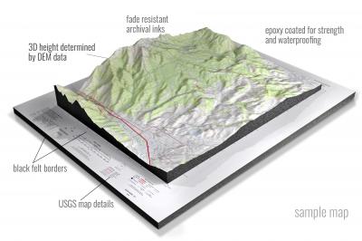
• Raised-relief 3D Height Determined by DEM data
• Fade Resistant Archival Inks
• Epoxy Coated for Strength and Waterproofing
• Ready to Hang with Pre-Installed Hardware (optional)
• Extraordinary 3D Accuracy
• Black Felt Borders
Enrich your office decor or home with a 3D USGS Raised Relief Map. These raised relief maps are not flat. They are three-dimensional, with the height being determined by Digital Elevation Model (DEM) data. Many people struggle with reading 2D satellite maps, but everyone understands 3D raised relief maps. The realism is phenomenal.
This 3D satellite raised relief map is built by combining satellite imagery data from Google Earth, bounding box coordinates from USGS, and DEM data. 3D Printing and 3D CNC routers are used to fabricate the models which make the satellite models extremely accurate. These models are strong - they are coated with epoxy, then finished with a sealer providing a weatherproof matt-finish. These are not meant to be used in direct sunlight.
Abbeville East, Louisiana- View hi-resolution image of: Abbeville East, Louisiana. Mapping by USGS in 2020 - Longitude/Latitude: -92.125 x -92 x 30 x 29.875, Grid Size: 7.5 X 7.5 Minute, Map Scale: 1:24000, State List: LA, County List: Vermilion
Abbeville West, Louisiana- View hi-resolution image of: Abbeville West, Louisiana. Mapping by USGS in 2020 - Longitude/Latitude: -92.25 x -92.125 x 30 x 29.875, Grid Size: 7.5 X 7.5 Minute, Map Scale: 1:24000, State List: LA, County List: Vermilion
Acme, Louisiana- View hi-resolution image of: Acme, Louisiana. Mapping by USGS in 2020 - Longitude/Latitude: -91.875 x -91.75 x 31.375 x 31.25, Grid Size: 7.5 X 7.5 Minute, Map Scale: 1:24000, State List: LA, County List: Concordia,Catahoula,Avoyelles
Ada, Louisiana- View hi-resolution image of: Ada, Louisiana. Mapping by USGS in 2020 - Longitude/Latitude: -93.25 x -93.125 x 32.625 x 32.5, Grid Size: 7.5 X 7.5 Minute, Map Scale: 1:24000, State List: LA, County List: Webster,Bienville,Claiborne
Addis, Louisiana- View hi-resolution image of: Addis, Louisiana. Mapping by USGS in 2020 - Longitude/Latitude: -91.375 x -91.25 x 30.375 x 30.25, Grid Size: 7.5 X 7.5 Minute, Map Scale: 1:24000, State List: LA, County List: Iberville,West Baton Rouge
Afeman, Louisiana- View hi-resolution image of: Afeman, Louisiana. Mapping by USGS in 2020 - Longitude/Latitude: -92.875 x -92.75 x 31.125 x 31, Grid Size: 7.5 X 7.5 Minute, Map Scale: 1:24000, State List: LA, County List: Rapides,Vernon
Aimwell, Louisiana- View hi-resolution image of: Aimwell, Louisiana. Mapping by USGS in 2020 - Longitude/Latitude: -92 x -91.875 x 31.875 x 31.75, Grid Size: 7.5 X 7.5 Minute, Map Scale: 1:24000, State List: LA, County List: Catahoula
Albany, Louisiana- View hi-resolution image of: Albany, Louisiana. Mapping by USGS in 2020 - Longitude/Latitude: -90.625 x -90.5 x 30.625 x 30.5, Grid Size: 7.5 X 7.5 Minute, Map Scale: 1:24000, State List: LA, County List: Tangipahoa,Livingston
Alexandria, Louisiana- View hi-resolution image of: Alexandria, Louisiana. Mapping by USGS in 2021 - Longitude/Latitude: -92.5 x -92.375 x 31.375 x 31.25, Grid Size: 7.5 X 7.5 Minute, Map Scale: 1:24000, State List: LA, County List: Rapides
Allen, Louisiana- View hi-resolution image of: Allen, Louisiana. Mapping by USGS in 2020 - Longitude/Latitude: -93.375 x -93.25 x 31.875 x 31.75, Grid Size: 7.5 X 7.5 Minute, Map Scale: 1:24000, State List: LA, County List: Natchitoches
Alligator Point, Louisiana- View hi-resolution image of: Alligator Point, Louisiana. Mapping by USGS in 2020 - Longitude/Latitude: -89.75 x -89.625 x 30.125 x 30, Grid Size: 7.5 X 7.5 Minute, Map Scale: 1:24000, State List: LA, County List: Orleans,St. Bernard
Aloha, Louisiana- View hi-resolution image of: Aloha, Louisiana. Mapping by USGS in 2020 - Longitude/Latitude: -92.875 x -92.75 x 31.625 x 31.5, Grid Size: 7.5 X 7.5 Minute, Map Scale: 1:24000, State List: LA, County List: Natchitoches,Grant
Amelia, Louisiana- View hi-resolution image of: Amelia, Louisiana. Mapping by USGS in 2020 - Longitude/Latitude: -91.125 x -91 x 29.75 x 29.625, Grid Size: 7.5 X 7.5 Minute, Map Scale: 1:24000, State List: LA, County List: Assumption,Terrebonne,St. Mary,St. Martin,Lafourche
Amite, Louisiana- View hi-resolution image of: Amite, Louisiana. Mapping by USGS in 2020 - Longitude/Latitude: -90.625 x -90.5 x 30.75 x 30.625, Grid Size: 7.5 X 7.5 Minute, Map Scale: 1:24000, State List: LA, County List: Tangipahoa,St. Helena,Livingston
Angie, Louisiana- View hi-resolution image of: Angie, Louisiana. Mapping by USGS in 2020 - Longitude/Latitude: -89.875 x -89.75 x 31 x 30.875, Grid Size: 7.5 X 7.5 Minute, Map Scale: 1:24000, State List: LA,MS, County List: Washington,Pearl River,Marion
Angola, Louisiana- View hi-resolution image of: Angola, Louisiana. Mapping by USGS in 2020 - Longitude/Latitude: -91.625 x -91.5 x 31 x 30.875, Grid Size: 7.5 X 7.5 Minute, Map Scale: 1:24000, State List: LA,MS, County List: West Feliciana,Pointe Coupee,Wilkinson
Arcadia, Louisiana- View hi-resolution image of: Arcadia, Louisiana. Mapping by USGS in 2020 - Longitude/Latitude: -93 x -92.875 x 32.625 x 32.5, Grid Size: 7.5 X 7.5 Minute, Map Scale: 1:24000, State List: LA, County List: Bienville,Claiborne,Lincoln
Arizona, Louisiana- View hi-resolution image of: Arizona, Louisiana. Mapping by USGS in 2020 - Longitude/Latitude: -93 x -92.875 x 32.875 x 32.75, Grid Size: 7.5 X 7.5 Minute, Map Scale: 1:24000, State List: LA, County List: Claiborne
Arnaudville, Louisiana- View hi-resolution image of: Arnaudville, Louisiana. Mapping by USGS in 2020 - Longitude/Latitude: -92 x -91.875 x 30.5 x 30.375, Grid Size: 7.5 X 7.5 Minute, Map Scale: 1:24000, State List: LA, County List: St. Landry,St. Martin
Ashland, Louisiana- View hi-resolution image of: Ashland, Louisiana. Mapping by USGS in 2020 - Longitude/Latitude: -93.125 x -93 x 32.25 x 32.125, Grid Size: 7.5 X 7.5 Minute, Map Scale: 1:24000, State List: LA, County List: Bienville,Natchitoches
Ashly, Louisiana- View hi-resolution image of: Ashly, Louisiana. Mapping by USGS in 2020 - Longitude/Latitude: -91.125 x -91 x 32.5 x 32.375, Grid Size: 7.5 X 7.5 Minute, Map Scale: 1:24000, State List: LA,MS, County List: Madison,Warren
Athens, Louisiana- View hi-resolution image of: Athens, Louisiana. Mapping by USGS in 2020 - Longitude/Latitude: -93.125 x -93 x 32.75 x 32.625, Grid Size: 7.5 X 7.5 Minute, Map Scale: 1:24000, State List: LA, County List: Claiborne
Atlanta, Louisiana- View hi-resolution image of: Atlanta, Louisiana. Mapping by USGS in 2020 - Longitude/Latitude: -92.75 x -92.625 x 31.875 x 31.75, Grid Size: 7.5 X 7.5 Minute, Map Scale: 1:24000, State List: LA, County List: Winn
Ball, Louisiana- View hi-resolution image of: Ball, Louisiana. Mapping by USGS in 2020 - Longitude/Latitude: -92.5 x -92.375 x 31.5 x 31.375, Grid Size: 7.5 X 7.5 Minute, Map Scale: 1:24000, State List: LA, County List: Grant,Rapides
Bancroft, Louisiana- View hi-resolution image of: Bancroft, Louisiana. Mapping by USGS in 2020 - Longitude/Latitude: -93.75 x -93.625 x 30.625 x 30.5, Grid Size: 7.5 X 7.5 Minute, Map Scale: 1:24000, State List: LA,TX, County List: Beauregard,Newton
Barataria, Louisiana- View hi-resolution image of: Barataria, Louisiana. Mapping by USGS in 2020 - Longitude/Latitude: -90.25 x -90.125 x 29.75 x 29.625, Grid Size: 7.5 X 7.5 Minute, Map Scale: 1:24000, State List: LA, County List: Lafourche,Jefferson,St. Charles
Barataria Pass, Louisiana- View hi-resolution image of: Barataria Pass, Louisiana. Mapping by USGS in 2020 - Longitude/Latitude: -90 x -89.875 x 29.375 x 29.25, Grid Size: 7.5 X 7.5 Minute, Map Scale: 1:24000, State List: LA, County List: Jefferson,Plaquemines,Lafourche
Basile, Louisiana- View hi-resolution image of: Basile, Louisiana. Mapping by USGS in 2020 - Longitude/Latitude: -92.625 x -92.5 x 30.5 x 30.375, Grid Size: 7.5 X 7.5 Minute, Map Scale: 1:24000, State List: LA, County List: Acadia,Evangeline,Jefferson Davis,Allen
Baskinton, Louisiana- View hi-resolution image of: Baskinton, Louisiana. Mapping by USGS in 2020 - Longitude/Latitude: -91.75 x -91.625 x 32.375 x 32.25, Grid Size: 7.5 X 7.5 Minute, Map Scale: 1:24000, State List: LA, County List: Franklin,Richland
Bastian Bay, Louisiana- View hi-resolution image of: Bastian Bay, Louisiana. Mapping by USGS in 2020 - Longitude/Latitude: -89.75 x -89.625 x 29.375 x 29.25, Grid Size: 7.5 X 7.5 Minute, Map Scale: 1:24000, State List: LA, County List: Plaquemines
Bastrop, Louisiana- View hi-resolution image of: Bastrop, Louisiana. Mapping by USGS in 2020 - Longitude/Latitude: -92 x -91.875 x 32.875 x 32.75, Grid Size: 7.5 X 7.5 Minute, Map Scale: 1:24000, State List: LA, County List: Morehouse
Batchelor, Louisiana- View hi-resolution image of: Batchelor, Louisiana. Mapping by USGS in 2020 - Longitude/Latitude: -91.75 x -91.625 x 30.875 x 30.75, Grid Size: 7.5 X 7.5 Minute, Map Scale: 1:24000, State List: LA, County List: Pointe Coupee,West Feliciana
Baton Rouge East, Louisiana- View hi-resolution image of: Baton Rouge East, Louisiana. Mapping by USGS in 2020 - Longitude/Latitude: -91.125 x -91 x 30.5 x 30.375, Grid Size: 7.5 X 7.5 Minute, Map Scale: 1:24000, State List: LA, County List: East Baton Rouge
Baton Rouge West, Louisiana- View hi-resolution image of: Baton Rouge West, Louisiana. Mapping by USGS in 2020 - Longitude/Latitude: -91.25 x -91.125 x 30.5 x 30.375, Grid Size: 7.5 X 7.5 Minute, Map Scale: 1:24000, State List: LA, County List: East Baton Rouge,West Baton Rouge
Baxter Bayou, Louisiana- View hi-resolution image of: Baxter Bayou, Louisiana. Mapping by USGS in 2020 - Longitude/Latitude: -91.375 x -91.25 x 32.875 x 32.75, Grid Size: 7.5 X 7.5 Minute, Map Scale: 1:24000, State List: LA, County List: East Carroll,West Carroll
Bay Batiste, Louisiana- View hi-resolution image of: Bay Batiste, Louisiana. Mapping by USGS in 2020 - Longitude/Latitude: -89.875 x -89.75 x 29.5 x 29.375, Grid Size: 7.5 X 7.5 Minute, Map Scale: 1:24000, State List: LA, County List: Plaquemines
Bay Coquette, Louisiana- View hi-resolution image of: Bay Coquette, Louisiana. Mapping by USGS in 2020 - Longitude/Latitude: -89.625 x -89.5 x 29.25 x 29.125, Grid Size: 7.5 X 7.5 Minute, Map Scale: 1:24000, State List: LA, County List: Plaquemines
Bay Courant, Louisiana- View hi-resolution image of: Bay Courant, Louisiana. Mapping by USGS in 2020 - Longitude/Latitude: -90.375 x -90.25 x 29.375 x 29.25, Grid Size: 7.5 X 7.5 Minute, Map Scale: 1:24000, State List: LA, County List: Lafourche
Bay Dosgris, Louisiana- View hi-resolution image of: Bay Dosgris, Louisiana. Mapping by USGS in 2020 - Longitude/Latitude: -90.125 x -90 x 29.5 x 29.375, Grid Size: 7.5 X 7.5 Minute, Map Scale: 1:24000, State List: LA, County List: Lafourche,Jefferson
Bay L'Ours, Louisiana- View hi-resolution image of: Bay L'Ours, Louisiana. Mapping by USGS in 2020 - Longitude/Latitude: -90.25 x -90.125 x 29.625 x 29.5, Grid Size: 7.5 X 7.5 Minute, Map Scale: 1:24000, State List: LA, County List: Lafourche,Jefferson
Bay Ronquille, Louisiana- View hi-resolution image of: Bay Ronquille, Louisiana. Mapping by USGS in 2020 - Longitude/Latitude: -89.875 x -89.75 x 29.375 x 29.25, Grid Size: 7.5 X 7.5 Minute, Map Scale: 1:24000, State List: LA, County List: Plaquemines
Bay Tambour, Louisiana- View hi-resolution image of: Bay Tambour, Louisiana. Mapping by USGS in 2020 - Longitude/Latitude: -90.125 x -90 x 29.375 x 29.25, Grid Size: 7.5 X 7.5 Minute, Map Scale: 1:24000, State List: LA, County List: Lafourche,Jefferson
Bayou Blanc, Louisiana- View hi-resolution image of: Bayou Blanc, Louisiana. Mapping by USGS in 2020 - Longitude/Latitude: -91.875 x -91.75 x 29.625 x 29.5, Grid Size: 7.5 X 7.5 Minute, Map Scale: 1:24000, State List: LA, County List: Iberia
Bayou Boeuf, Louisiana- View hi-resolution image of: Bayou Boeuf, Louisiana. Mapping by USGS in 2020 - Longitude/Latitude: -90.625 x -90.5 x 29.875 x 29.75, Grid Size: 7.5 X 7.5 Minute, Map Scale: 1:24000, State List: LA, County List: Lafourche,St. Charles
Bayou Cocodrie, Louisiana- View hi-resolution image of: Bayou Cocodrie, Louisiana. Mapping by USGS in 2020 - Longitude/Latitude: -91 x -90.875 x 29.625 x 29.5, Grid Size: 7.5 X 7.5 Minute, Map Scale: 1:24000, State List: LA, County List: Terrebonne
Bayou Current, Louisiana- View hi-resolution image of: Bayou Current, Louisiana. Mapping by USGS in 2020 - Longitude/Latitude: -91.875 x -91.75 x 30.875 x 30.75, Grid Size: 7.5 X 7.5 Minute, Map Scale: 1:24000, State List: LA, County List: St. Landry,Pointe Coupee,Avoyelles
Bayou Jack, Louisiana- View hi-resolution image of: Bayou Jack, Louisiana. Mapping by USGS in 2020 - Longitude/Latitude: -92 x -91.875 x 30.875 x 30.75, Grid Size: 7.5 X 7.5 Minute, Map Scale: 1:24000, State List: LA, County List: St. Landry,Avoyelles
Bayou Livrogne, Louisiana- View hi-resolution image of: Bayou Livrogne, Louisiana. Mapping by USGS in 2020 - Longitude/Latitude: -93.125 x -93 x 31.5 x 31.375, Grid Size: 7.5 X 7.5 Minute, Map Scale: 1:24000, State List: LA, County List: Natchitoches
Bayou Lucien, Louisiana- View hi-resolution image of: Bayou Lucien, Louisiana. Mapping by USGS in 2020 - Longitude/Latitude: -92 x -91.875 x 29.625 x 29.5, Grid Size: 7.5 X 7.5 Minute, Map Scale: 1:24000, State List: LA, County List: Iberia,Vermilion
Bayou Pierre Lake, Louisiana- View hi-resolution image of: Bayou Pierre Lake, Louisiana. Mapping by USGS in 2020 - Longitude/Latitude: -93.625 x -93.5 x 32.125 x 32, Grid Size: 7.5 X 7.5 Minute, Map Scale: 1:24000, State List: LA, County List: De Soto,Red River
Bayou Sauveur, Louisiana- View hi-resolution image of: Bayou Sauveur, Louisiana. Mapping by USGS in 2020 - Longitude/Latitude: -90.875 x -90.75 x 29.375 x 29.25, Grid Size: 7.5 X 7.5 Minute, Map Scale: 1:24000, State List: LA, County List: Terrebonne
Bayou Sorrel, Louisiana- View hi-resolution image of: Bayou Sorrel, Louisiana. Mapping by USGS in 2020 - Longitude/Latitude: -91.375 x -91.25 x 30.25 x 30.125, Grid Size: 7.5 X 7.5 Minute, Map Scale: 1:24000, State List: LA, County List: Iberville
Bear Skin, Louisiana- View hi-resolution image of: Bear Skin, Louisiana. Mapping by USGS in 2020 - Longitude/Latitude: -91.625 x -91.5 x 32.75 x 32.625, Grid Size: 7.5 X 7.5 Minute, Map Scale: 1:24000, State List: LA, County List: West Carroll,Richland,Morehouse
Beaver, Louisiana- View hi-resolution image of: Beaver, Louisiana. Mapping by USGS in 2020 - Longitude/Latitude: -92.625 x -92.5 x 30.875 x 30.75, Grid Size: 7.5 X 7.5 Minute, Map Scale: 1:24000, State List: LA, County List: Evangeline,Allen
Bedford, Louisiana- View hi-resolution image of: Bedford, Louisiana. Mapping by USGS in 2020 - Longitude/Latitude: -91.125 x -91 x 32.25 x 32.125, Grid Size: 7.5 X 7.5 Minute, Map Scale: 1:24000, State List: LA,MS, County List: Tensas,Warren,Madison
Bee Bayou, Louisiana- View hi-resolution image of: Bee Bayou, Louisiana. Mapping by USGS in 2020 - Longitude/Latitude: -91.75 x -91.625 x 32.5 x 32.375, Grid Size: 7.5 X 7.5 Minute, Map Scale: 1:24000, State List: LA, County List: Richland,Franklin
Beech Bayou, Louisiana- View hi-resolution image of: Beech Bayou, Louisiana. Mapping by USGS in 2020 - Longitude/Latitude: -93.75 x -93.625 x 31.625 x 31.5, Grid Size: 7.5 X 7.5 Minute, Map Scale: 1:24000, State List: LA,TX, County List: Sabine
Beekman, Louisiana- View hi-resolution image of: Beekman, Louisiana. Mapping by USGS in 2020 - Longitude/Latitude: -92 x -91.875 x 33 x 32.875, Grid Size: 7.5 X 7.5 Minute, Map Scale: 1:24000, State List: LA, County List: Morehouse
Beggs, Louisiana- View hi-resolution image of: Beggs, Louisiana. Mapping by USGS in 2020 - Longitude/Latitude: -92.125 x -92 x 30.75 x 30.625, Grid Size: 7.5 X 7.5 Minute, Map Scale: 1:24000, State List: LA, County List: St. Landry
Belle Chasse, Louisiana- View hi-resolution image of: Belle Chasse, Louisiana. Mapping by USGS in 2020 - Longitude/Latitude: -90 x -89.875 x 29.875 x 29.75, Grid Size: 7.5 X 7.5 Minute, Map Scale: 1:24000, State List: LA, County List: Plaquemines,St. Bernard,Orleans
Belle d'Eau, Louisiana- View hi-resolution image of: Belle d'Eau, Louisiana. Mapping by USGS in 2020 - Longitude/Latitude: -92.25 x -92.125 x 31.125 x 31, Grid Size: 7.5 X 7.5 Minute, Map Scale: 1:24000, State List: LA, County List: Avoyelles,Rapides
Belle Isle, Louisiana- View hi-resolution image of: Belle Isle, Louisiana. Mapping by USGS in 2020 - Longitude/Latitude: -91.5 x -91.375 x 29.625 x 29.5, Grid Size: 7.5 X 7.5 Minute, Map Scale: 1:24000, State List: LA, County List: St. Mary
Belle Pass, Louisiana- View hi-resolution image of: Belle Pass, Louisiana. Mapping by USGS in 2020 - Longitude/Latitude: -90.25 x -90.125 x 29.125 x 29, Grid Size: 7.5 X 7.5 Minute, Map Scale: 1:24000, State List: LA, County List: Lafourche
Belle Rose, Louisiana- View hi-resolution image of: Belle Rose, Louisiana. Mapping by USGS in 2020 - Longitude/Latitude: -91.125 x -91 x 30.125 x 30, Grid Size: 7.5 X 7.5 Minute, Map Scale: 1:24000, State List: LA, County List: Assumption,Ascension,Iberville
Bellwood, Louisiana- View hi-resolution image of: Bellwood, Louisiana. Mapping by USGS in 2020 - Longitude/Latitude: -93.25 x -93.125 x 31.625 x 31.5, Grid Size: 7.5 X 7.5 Minute, Map Scale: 1:24000, State List: LA, County List: Natchitoches,Sabine
Belmont, Louisiana- View hi-resolution image of: Belmont, Louisiana. Mapping by USGS in 2020 - Longitude/Latitude: -93.625 x -93.5 x 31.75 x 31.625, Grid Size: 7.5 X 7.5 Minute, Map Scale: 1:24000, State List: LA, County List: Sabine
Benton, Louisiana- View hi-resolution image of: Benton, Louisiana. Mapping by USGS in 2020 - Longitude/Latitude: -93.75 x -93.625 x 32.75 x 32.625, Grid Size: 7.5 X 7.5 Minute, Map Scale: 1:24000, State List: LA, County List: Bossier
Bernice, Louisiana- View hi-resolution image of: Bernice, Louisiana. Mapping by USGS in 2020 - Longitude/Latitude: -92.75 x -92.625 x 32.875 x 32.75, Grid Size: 7.5 X 7.5 Minute, Map Scale: 1:24000, State List: LA, County List: Union,Claiborne,Lincoln
Bertrandville, Louisiana- View hi-resolution image of: Bertrandville, Louisiana. Mapping by USGS in 2020 - Longitude/Latitude: -90.125 x -90 x 29.875 x 29.75, Grid Size: 7.5 X 7.5 Minute, Map Scale: 1:24000, State List: LA, County List: Jefferson,Plaquemines
Bienville, Louisiana- View hi-resolution image of: Bienville, Louisiana. Mapping by USGS in 2020 - Longitude/Latitude: -93 x -92.875 x 32.375 x 32.25, Grid Size: 7.5 X 7.5 Minute, Map Scale: 1:24000, State List: LA, County List: Bienville
Big Bend, Louisiana- View hi-resolution image of: Big Bend, Louisiana. Mapping by USGS in 2020 - Longitude/Latitude: -91.875 x -91.75 x 31.125 x 31, Grid Size: 7.5 X 7.5 Minute, Map Scale: 1:24000, State List: LA, County List: Avoyelles,Pointe Coupee,West Feliciana
Big Constance Lake, Louisiana- View hi-resolution image of: Big Constance Lake, Louisiana. Mapping by USGS in 2020 - Longitude/Latitude: -92.75 x -92.625 x 29.625 x 29.5, Grid Size: 7.5 X 7.5 Minute, Map Scale: 1:24000, State List: LA, County List: Cameron
Bird Island Point, Louisiana- View hi-resolution image of: Bird Island Point, Louisiana. Mapping by USGS in 2020 - Longitude/Latitude: -92.125 x -92 x 31.625 x 31.5, Grid Size: 7.5 X 7.5 Minute, Map Scale: 1:24000, State List: LA, County List: LaSalle,Catahoula
Birds Creek, Louisiana- View hi-resolution image of: Birds Creek, Louisiana. Mapping by USGS in 2020 - Longitude/Latitude: -93.125 x -93 x 31.125 x 31, Grid Size: 7.5 X 7.5 Minute, Map Scale: 1:24000, State List: LA, County List: Vernon
Black Bay North, Louisiana- View hi-resolution image of: Black Bay North, Louisiana. Mapping by USGS in 2020 - Longitude/Latitude: -89.625 x -89.5 x 29.75 x 29.625, Grid Size: 7.5 X 7.5 Minute, Map Scale: 1:24000, State List: LA, County List: St. Bernard,Plaquemines
Black Bay South, Louisiana- View hi-resolution image of: Black Bay South, Louisiana. Mapping by USGS in 2020 - Longitude/Latitude: -89.625 x -89.5 x 29.625 x 29.5, Grid Size: 7.5 X 7.5 Minute, Map Scale: 1:24000, State List: LA, County List: Plaquemines
Black Lake, Louisiana- View hi-resolution image of: Black Lake, Louisiana. Mapping by USGS in 2020 - Longitude/Latitude: -93.5 x -93.375 x 30.125 x 30, Grid Size: 7.5 X 7.5 Minute, Map Scale: 1:24000, State List: LA, County List: Calcasieu,Cameron
Blackburn, Louisiana- View hi-resolution image of: Blackburn, Louisiana. Mapping by USGS in 2020 - Longitude/Latitude: -93.25 x -93.125 x 32.875 x 32.75, Grid Size: 7.5 X 7.5 Minute, Map Scale: 1:24000, State List: LA, County List: Claiborne,Webster
Blanchard, Louisiana- View hi-resolution image of: Blanchard, Louisiana. Mapping by USGS in 2020 - Longitude/Latitude: -94 x -93.875 x 32.625 x 32.5, Grid Size: 7.5 X 7.5 Minute, Map Scale: 1:24000, State List: LA, County List: Caddo
Blankston, Louisiana- View hi-resolution image of: Blankston, Louisiana. Mapping by USGS in 2020 - Longitude/Latitude: -92.25 x -92.125 x 32.25 x 32.125, Grid Size: 7.5 X 7.5 Minute, Map Scale: 1:24000, State List: LA, County List: Caldwell
Bluff Creek, Louisiana- View hi-resolution image of: Bluff Creek, Louisiana. Mapping by USGS in 2020 - Longitude/Latitude: -91 x -90.875 x 30.875 x 30.75, Grid Size: 7.5 X 7.5 Minute, Map Scale: 1:24000, State List: LA, County List: East Feliciana
Bodcau Lake, Louisiana- View hi-resolution image of: Bodcau Lake, Louisiana. Mapping by USGS in 2020 - Longitude/Latitude: -93.625 x -93.5 x 32.75 x 32.625, Grid Size: 7.5 X 7.5 Minute, Map Scale: 1:24000, State List: LA, County List: Bossier
Bogalusa East, Louisiana- View hi-resolution image of: Bogalusa East, Louisiana. Mapping by USGS in 2020 - Longitude/Latitude: -89.875 x -89.75 x 30.875 x 30.75, Grid Size: 7.5 X 7.5 Minute, Map Scale: 1:24000, State List: LA,MS, County List: Washington,Pearl River
Bogalusa West, Louisiana- View hi-resolution image of: Bogalusa West, Louisiana. Mapping by USGS in 2020 - Longitude/Latitude: -90 x -89.875 x 30.875 x 30.75, Grid Size: 7.5 X 7.5 Minute, Map Scale: 1:24000, State List: LA, County List: Washington
Bond, Louisiana- View hi-resolution image of: Bond, Louisiana. Mapping by USGS in 2020 - Longitude/Latitude: -92.625 x -92.5 x 30.75 x 30.625, Grid Size: 7.5 X 7.5 Minute, Map Scale: 1:24000, State List: LA, County List: Evangeline,Allen
Boneset Creek, Louisiana- View hi-resolution image of: Boneset Creek, Louisiana. Mapping by USGS in 2020 - Longitude/Latitude: -93.25 x -93.125 x 30.875 x 30.75, Grid Size: 7.5 X 7.5 Minute, Map Scale: 1:24000, State List: LA, County List: Beauregard
Bonita, Louisiana- View hi-resolution image of: Bonita, Louisiana. Mapping by USGS in 2020 - Longitude/Latitude: -91.75 x -91.625 x 33 x 32.875, Grid Size: 7.5 X 7.5 Minute, Map Scale: 1:24000, State List: LA, County List: Morehouse
Bonita SW, Louisiana- View hi-resolution image of: Bonita SW, Louisiana. Mapping by USGS in 2020 - Longitude/Latitude: -91.75 x -91.625 x 32.875 x 32.75, Grid Size: 7.5 X 7.5 Minute, Map Scale: 1:24000, State List: LA, County List: Morehouse
Bonnett Carre NE, Louisiana- View hi-resolution image of: Bonnett Carre NE, Louisiana. Mapping by USGS in 2020 - Longitude/Latitude: -90.375 x -90.25 x 30.25 x 30.125, Grid Size: 7.5 X 7.5 Minute, Map Scale: 1:24000, State List: LA, County List: St. John the Baptist,St. Charles,Jefferson,Tangipahoa
Bosco, Louisiana- View hi-resolution image of: Bosco, Louisiana. Mapping by USGS in 2020 - Longitude/Latitude: -92.125 x -92 x 32.375 x 32.25, Grid Size: 7.5 X 7.5 Minute, Map Scale: 1:24000, State List: LA, County List: Ouachita,Caldwell,Richland
Bossier City, Louisiana- View hi-resolution image of: Bossier City, Louisiana. Mapping by USGS in 2020 - Longitude/Latitude: -93.75 x -93.625 x 32.625 x 32.5, Grid Size: 7.5 X 7.5 Minute, Map Scale: 1:24000, State List: LA, County List: Bossier,Caddo
Bossier Point, Louisiana- View hi-resolution image of: Bossier Point, Louisiana. Mapping by USGS in 2020 - Longitude/Latitude: -93.5 x -93.375 x 32.375 x 32.25, Grid Size: 7.5 X 7.5 Minute, Map Scale: 1:24000, State List: LA, County List: Bossier,Bienville,Caddo
Boudreaux Lake, Louisiana- View hi-resolution image of: Boudreaux Lake, Louisiana. Mapping by USGS in 2020 - Longitude/Latitude: -93.125 x -93 x 30 x 29.875, Grid Size: 7.5 X 7.5 Minute, Map Scale: 1:24000, State List: LA, County List: Cameron
Bourg, Louisiana- View hi-resolution image of: Bourg, Louisiana. Mapping by USGS in 2020 - Longitude/Latitude: -90.625 x -90.5 x 29.625 x 29.5, Grid Size: 7.5 X 7.5 Minute, Map Scale: 1:24000, State List: LA, County List: Lafourche,Terrebonne
Boyce, Louisiana- View hi-resolution image of: Boyce, Louisiana. Mapping by USGS in 2021 - Longitude/Latitude: -92.75 x -92.625 x 31.5 x 31.375, Grid Size: 7.5 X 7.5 Minute, Map Scale: 1:24000, State List: LA, County List: Rapides,Grant,Natchitoches
Branch, Louisiana- View hi-resolution image of: Branch, Louisiana. Mapping by USGS in 2020 - Longitude/Latitude: -92.375 x -92.25 x 30.375 x 30.25, Grid Size: 7.5 X 7.5 Minute, Map Scale: 1:24000, State List: LA, County List: Acadia
Breaux Bridge, Louisiana- View hi-resolution image of: Breaux Bridge, Louisiana. Mapping by USGS in 2020 - Longitude/Latitude: -92 x -91.875 x 30.375 x 30.25, Grid Size: 7.5 X 7.5 Minute, Map Scale: 1:24000, State List: LA, County List: St. Martin,Lafayette,St. Landry
Breton Islands, Louisiana- View hi-resolution image of: Breton Islands, Louisiana. Mapping by USGS in 2020 - Longitude/Latitude: -89.25 x -89.125 x 29.5 x 29.375, Grid Size: 7.5 X 7.5 Minute, Map Scale: 1:24000, State List: LA, County List: Plaquemines
Breton Islands SE, Louisiana- View hi-resolution image of: Breton Islands SE, Louisiana. Mapping by USGS in 2020 - Longitude/Latitude: -89.125 x -89 x 29.375 x 29.25, Grid Size: 7.5 X 7.5 Minute, Map Scale: 1:24000, State List: LA, County List: Plaquemines
Brimstone, Louisiana- View hi-resolution image of: Brimstone, Louisiana. Mapping by USGS in 2020 - Longitude/Latitude: -93.5 x -93.375 x 30.375 x 30.25, Grid Size: 7.5 X 7.5 Minute, Map Scale: 1:24000, State List: LA, County List: Calcasieu
Broussard, Louisiana- View hi-resolution image of: Broussard, Louisiana. Mapping by USGS in 2020 - Longitude/Latitude: -92 x -91.875 x 30.25 x 30.125, Grid Size: 7.5 X 7.5 Minute, Map Scale: 1:24000, State List: LA, County List: Lafayette,St. Martin
Browns Lake, Louisiana- View hi-resolution image of: Browns Lake, Louisiana. Mapping by USGS in 2020 - Longitude/Latitude: -93.5 x -93.375 x 30 x 29.875, Grid Size: 7.5 X 7.5 Minute, Map Scale: 1:24000, State List: LA, County List: Cameron
Bryceland, Louisiana- View hi-resolution image of: Bryceland, Louisiana. Mapping by USGS in 2020 - Longitude/Latitude: -93 x -92.875 x 32.5 x 32.375, Grid Size: 7.5 X 7.5 Minute, Map Scale: 1:24000, State List: LA, County List: Bienville,Lincoln
Buckeye, Louisiana- View hi-resolution image of: Buckeye, Louisiana. Mapping by USGS in 2020 - Longitude/Latitude: -92.25 x -92.125 x 31.375 x 31.25, Grid Size: 7.5 X 7.5 Minute, Map Scale: 1:24000, State List: LA, County List: Rapides,Avoyelles
Buckeye NE, Louisiana- View hi-resolution image of: Buckeye NE, Louisiana. Mapping by USGS in 2020 - Longitude/Latitude: -92.125 x -92 x 31.5 x 31.375, Grid Size: 7.5 X 7.5 Minute, Map Scale: 1:24000, State List: LA, County List: LaSalle,Catahoula,Rapides
Buhler, Louisiana- View hi-resolution image of: Buhler, Louisiana. Mapping by USGS in 2020 - Longitude/Latitude: -93.375 x -93.25 x 30.375 x 30.25, Grid Size: 7.5 X 7.5 Minute, Map Scale: 1:24000, State List: LA, County List: Calcasieu
Bunkie, Louisiana- View hi-resolution image of: Bunkie, Louisiana. Mapping by USGS in 2020 - Longitude/Latitude: -92.25 x -92.125 x 31 x 30.875, Grid Size: 7.5 X 7.5 Minute, Map Scale: 1:24000, State List: LA, County List: Avoyelles,Rapides,Evangeline
Buras, Louisiana- View hi-resolution image of: Buras, Louisiana. Mapping by USGS in 2020 - Longitude/Latitude: -89.625 x -89.5 x 29.375 x 29.25, Grid Size: 7.5 X 7.5 Minute, Map Scale: 1:24000, State List: LA, County List: Plaquemines
Burr Ferry, Louisiana- View hi-resolution image of: Burr Ferry, Louisiana. Mapping by USGS in 2020 - Longitude/Latitude: -93.5 x -93.375 x 31.125 x 31, Grid Size: 7.5 X 7.5 Minute, Map Scale: 1:24000, State List: LA, County List: Vernon
Burrwood Bayou East, Louisiana- View hi-resolution image of: Burrwood Bayou East, Louisiana. Mapping by USGS in 2020 - Longitude/Latitude: -89.375 x -89.25 x 29 x 28.875, Grid Size: 7.5 X 7.5 Minute, Map Scale: 1:24000, State List: LA, County List: Plaquemines
Burrwood Bayou West, Louisiana- View hi-resolution image of: Burrwood Bayou West, Louisiana. Mapping by USGS in 2020 - Longitude/Latitude: -89.5 x -89.375 x 29 x 28.875, Grid Size: 7.5 X 7.5 Minute, Map Scale: 1:24000, State List: LA, County List: Plaquemines
Bush, Louisiana- View hi-resolution image of: Bush, Louisiana. Mapping by USGS in 2020 - Longitude/Latitude: -90 x -89.875 x 30.625 x 30.5, Grid Size: 7.5 X 7.5 Minute, Map Scale: 1:24000, State List: LA, County List: St. Tammany
Butte La Rose, Louisiana- View hi-resolution image of: Butte La Rose, Louisiana. Mapping by USGS in 2020 - Longitude/Latitude: -91.75 x -91.625 x 30.375 x 30.25, Grid Size: 7.5 X 7.5 Minute, Map Scale: 1:24000, State List: LA, County List: St. Martin,Iberville
Cadeville, Louisiana- View hi-resolution image of: Cadeville, Louisiana. Mapping by USGS in 2020 - Longitude/Latitude: -92.375 x -92.25 x 32.5 x 32.375, Grid Size: 7.5 X 7.5 Minute, Map Scale: 1:24000, State List: LA, County List: Ouachita
Calhoun, Louisiana- View hi-resolution image of: Calhoun, Louisiana. Mapping by USGS in 2020 - Longitude/Latitude: -92.375 x -92.25 x 32.625 x 32.5, Grid Size: 7.5 X 7.5 Minute, Map Scale: 1:24000, State List: LA, County List: Ouachita,Union
Calumet Island, Louisiana- View hi-resolution image of: Calumet Island, Louisiana. Mapping by USGS in 2020 - Longitude/Latitude: -90.375 x -90.25 x 29.125 x 29, Grid Size: 7.5 X 7.5 Minute, Map Scale: 1:24000, State List: LA, County List: Lafourche
Calvin, Louisiana- View hi-resolution image of: Calvin, Louisiana. Mapping by USGS in 2020 - Longitude/Latitude: -92.875 x -92.75 x 32 x 31.875, Grid Size: 7.5 X 7.5 Minute, Map Scale: 1:24000, State List: LA, County List: Winn,Natchitoches
Cameron, Louisiana- View hi-resolution image of: Cameron, Louisiana. Mapping by USGS in 2020 - Longitude/Latitude: -93.375 x -93.25 x 29.875 x 29.75, Grid Size: 7.5 X 7.5 Minute, Map Scale: 1:24000, State List: LA, County List: Cameron
Cameron Farms, Louisiana- View hi-resolution image of: Cameron Farms, Louisiana. Mapping by USGS in 2020 - Longitude/Latitude: -93.625 x -93.5 x 30.125 x 30, Grid Size: 7.5 X 7.5 Minute, Map Scale: 1:24000, State List: LA, County List: Calcasieu,Cameron
Caminada Pass, Louisiana- View hi-resolution image of: Caminada Pass, Louisiana. Mapping by USGS in 2020 - Longitude/Latitude: -90.125 x -90 x 29.25 x 29.125, Grid Size: 7.5 X 7.5 Minute, Map Scale: 1:24000, State List: LA, County List: Lafourche,Jefferson
Campti, Louisiana- View hi-resolution image of: Campti, Louisiana. Mapping by USGS in 2020 - Longitude/Latitude: -93.125 x -93 x 32 x 31.875, Grid Size: 7.5 X 7.5 Minute, Map Scale: 1:24000, State List: LA, County List: Natchitoches,Red River
Caraway Lake, Louisiana- View hi-resolution image of: Caraway Lake, Louisiana. Mapping by USGS in 2020 - Longitude/Latitude: -91.375 x -91.25 x 32.75 x 32.625, Grid Size: 7.5 X 7.5 Minute, Map Scale: 1:24000, State List: LA, County List: East Carroll,West Carroll
Carencro, Louisiana- View hi-resolution image of: Carencro, Louisiana. Mapping by USGS in 2020 - Longitude/Latitude: -92.125 x -92 x 30.375 x 30.25, Grid Size: 7.5 X 7.5 Minute, Map Scale: 1:24000, State List: LA, County List: Lafayette,St. Landry
Carencro Bayou, Louisiana- View hi-resolution image of: Carencro Bayou, Louisiana. Mapping by USGS in 2020 - Longitude/Latitude: -91.125 x -91 x 29.5 x 29.375, Grid Size: 7.5 X 7.5 Minute, Map Scale: 1:24000, State List: LA, County List: Terrebonne
Carterville, Louisiana- View hi-resolution image of: Carterville, Louisiana. Mapping by USGS in 2020 - Longitude/Latitude: -93.625 x -93.5 x 33 x 32.875, Grid Size: 7.5 X 7.5 Minute, Map Scale: 1:24000, State List: LA, County List: Bossier,Webster
Carville, Louisiana- View hi-resolution image of: Carville, Louisiana. Mapping by USGS in 2020 - Longitude/Latitude: -91.125 x -91 x 30.25 x 30.125, Grid Size: 7.5 X 7.5 Minute, Map Scale: 1:24000, State List: LA, County List: Ascension,Iberville
Cat Island Pass, Louisiana- View hi-resolution image of: Cat Island Pass, Louisiana. Mapping by USGS in 2020 - Longitude/Latitude: -90.625 x -90.5 x 29.125 x 29, Grid Size: 7.5 X 7.5 Minute, Map Scale: 1:24000, State List: LA, County List: Terrebonne
Catahoula, Louisiana- View hi-resolution image of: Catahoula, Louisiana. Mapping by USGS in 2020 - Longitude/Latitude: -91.75 x -91.625 x 30.25 x 30.125, Grid Size: 7.5 X 7.5 Minute, Map Scale: 1:24000, State List: LA, County List: St. Martin
Catahoula Bay, Louisiana- View hi-resolution image of: Catahoula Bay, Louisiana. Mapping by USGS in 2021 - Longitude/Latitude: -90.375 x -90.25 x 29.75 x 29.625, Grid Size: 7.5 X 7.5 Minute, Map Scale: 1:24000, State List: LA, County List: Lafourche,St. Charles
Catfish Lake, Louisiana- View hi-resolution image of: Catfish Lake, Louisiana. Mapping by USGS in 2020 - Longitude/Latitude: -92.875 x -92.75 x 29.875 x 29.75, Grid Size: 7.5 X 7.5 Minute, Map Scale: 1:24000, State List: LA, County List: Cameron
Cecilia, Louisiana- View hi-resolution image of: Cecilia, Louisiana. Mapping by USGS in 2020 - Longitude/Latitude: -91.875 x -91.75 x 30.375 x 30.25, Grid Size: 7.5 X 7.5 Minute, Map Scale: 1:24000, State List: LA, County List: St. Martin
Cedarton, Louisiana- View hi-resolution image of: Cedarton, Louisiana. Mapping by USGS in 2020 - Longitude/Latitude: -92.625 x -92.5 x 32.75 x 32.625, Grid Size: 7.5 X 7.5 Minute, Map Scale: 1:24000, State List: LA, County List: Lincoln,Union
Centerville, Louisiana- View hi-resolution image of: Centerville, Louisiana. Mapping by USGS in 2020 - Longitude/Latitude: -91.5 x -91.375 x 29.875 x 29.75, Grid Size: 7.5 X 7.5 Minute, Map Scale: 1:24000, State List: LA, County List: St. Mary,St. Martin
Centerville NE, Louisiana- View hi-resolution image of: Centerville NE, Louisiana. Mapping by USGS in 2020 - Longitude/Latitude: -91.375 x -91.25 x 30 x 29.875, Grid Size: 7.5 X 7.5 Minute, Map Scale: 1:24000, State List: LA, County List: St. Martin,Iberia,Assumption
Centerville NW, Louisiana- View hi-resolution image of: Centerville NW, Louisiana. Mapping by USGS in 2020 - Longitude/Latitude: -91.5 x -91.375 x 30 x 29.875, Grid Size: 7.5 X 7.5 Minute, Map Scale: 1:24000, State List: LA, County List: St. Mary,Iberia,St. Martin
Central Isles Dernieres, Louisiana- View hi-resolution image of: Central Isles Dernieres, Louisiana. Mapping by USGS in 2020 - Longitude/Latitude: -90.875 x -90.75 x 29.125 x 29, Grid Size: 7.5 X 7.5 Minute, Map Scale: 1:24000, State List: LA, County List: Terrebonne
Chalmette, Louisiana- View hi-resolution image of: Chalmette, Louisiana. Mapping by USGS in 2020 - Longitude/Latitude: -90 x -89.875 x 30 x 29.875, Grid Size: 7.5 X 7.5 Minute, Map Scale: 1:24000, State List: LA, County List: St. Bernard,Orleans,Plaquemines
Chamblee, Louisiana- View hi-resolution image of: Chamblee, Louisiana. Mapping by USGS in 2020 - Longitude/Latitude: -91.375 x -91.25 x 31.875 x 31.75, Grid Size: 7.5 X 7.5 Minute, Map Scale: 1:24000, State List: LA,MS, County List: Tensas,Jefferson,Adams
Chandeleur Light, Louisiana- View hi-resolution image of: Chandeleur Light, Louisiana. Mapping by USGS in 2020 - Longitude/Latitude: -88.875 x -88.75 x 30.125 x 30, Grid Size: 7.5 X 7.5 Minute, Map Scale: 1:24000, State List: LA, County List: St. Bernard
Chandeleur Light OE W, Louisiana- View hi-resolution image of: Chandeleur Light OE W, Louisiana. Mapping by USGS in 2020 - Longitude/Latitude: -89 x -88.875 x 30.125 x 30, Grid Size: 7.5 X 7.5 Minute, Map Scale: 1:24000, State List: LA, County List: St. Bernard
Charenton, Louisiana- View hi-resolution image of: Charenton, Louisiana. Mapping by USGS in 2020 - Longitude/Latitude: -91.625 x -91.5 x 30 x 29.875, Grid Size: 7.5 X 7.5 Minute, Map Scale: 1:24000, State List: LA, County List: St. Mary,Iberia
Chataignier, Louisiana- View hi-resolution image of: Chataignier, Louisiana. Mapping by USGS in 2020 - Longitude/Latitude: -92.375 x -92.25 x 30.625 x 30.5, Grid Size: 7.5 X 7.5 Minute, Map Scale: 1:24000, State List: LA, County List: Evangeline,St. Landry
Chatham, Louisiana- View hi-resolution image of: Chatham, Louisiana. Mapping by USGS in 2020 - Longitude/Latitude: -92.5 x -92.375 x 32.375 x 32.25, Grid Size: 7.5 X 7.5 Minute, Map Scale: 1:24000, State List: LA, County List: Jackson,Ouachita
Chatham SE, Louisiana- View hi-resolution image of: Chatham SE, Louisiana. Mapping by USGS in 2020 - Longitude/Latitude: -92.375 x -92.25 x 32.375 x 32.25, Grid Size: 7.5 X 7.5 Minute, Map Scale: 1:24000, State List: LA, County List: Jackson,Ouachita,Caldwell
Chef Menteur, Louisiana- View hi-resolution image of: Chef Menteur, Louisiana. Mapping by USGS in 2020 - Longitude/Latitude: -89.875 x -89.75 x 30.125 x 30, Grid Size: 7.5 X 7.5 Minute, Map Scale: 1:24000, State List: LA, County List: Orleans,St. Bernard
Cheneyville, Louisiana- View hi-resolution image of: Cheneyville, Louisiana. Mapping by USGS in 2020 - Longitude/Latitude: -92.375 x -92.25 x 31.125 x 31, Grid Size: 7.5 X 7.5 Minute, Map Scale: 1:24000, State List: LA, County List: Rapides
Cheniere au Tigre, Louisiana- View hi-resolution image of: Cheniere au Tigre, Louisiana. Mapping by USGS in 2020 - Longitude/Latitude: -92.25 x -92.125 x 29.625 x 29.5, Grid Size: 7.5 X 7.5 Minute, Map Scale: 1:24000, State List: LA, County List: Vermilion
Chesbrough, Louisiana- View hi-resolution image of: Chesbrough, Louisiana. Mapping by USGS in 2020 - Longitude/Latitude: -90.5 x -90.375 x 30.875 x 30.75, Grid Size: 7.5 X 7.5 Minute, Map Scale: 1:24000, State List: LA, County List: Tangipahoa
Chestnut, Louisiana- View hi-resolution image of: Chestnut, Louisiana. Mapping by USGS in 2020 - Longitude/Latitude: -93.125 x -93 x 32.125 x 32, Grid Size: 7.5 X 7.5 Minute, Map Scale: 1:24000, State List: LA, County List: Natchitoches
Chipola, Louisiana- View hi-resolution image of: Chipola, Louisiana. Mapping by USGS in 2020 - Longitude/Latitude: -90.875 x -90.75 x 31 x 30.875, Grid Size: 7.5 X 7.5 Minute, Map Scale: 1:24000, State List: LA,MS, County List: St. Helena,East Feliciana,Amite
Church Point, Louisiana- View hi-resolution image of: Church Point, Louisiana. Mapping by USGS in 2020 - Longitude/Latitude: -92.25 x -92.125 x 30.5 x 30.375, Grid Size: 7.5 X 7.5 Minute, Map Scale: 1:24000, State List: LA, County List: St. Landry,Acadia
Clark, Louisiana- View hi-resolution image of: Clark, Louisiana. Mapping by USGS in 2020 - Longitude/Latitude: -92.25 x -92.125 x 32.125 x 32, Grid Size: 7.5 X 7.5 Minute, Map Scale: 1:24000, State List: LA, County List: Caldwell
Clark Hollow, Louisiana- View hi-resolution image of: Clark Hollow, Louisiana. Mapping by USGS in 2020 - Longitude/Latitude: -93.625 x -93.5 x 30.5 x 30.375, Grid Size: 7.5 X 7.5 Minute, Map Scale: 1:24000, State List: LA, County List: Beauregard,Calcasieu
Clay, Louisiana- View hi-resolution image of: Clay, Louisiana. Mapping by USGS in 2020 - Longitude/Latitude: -92.75 x -92.625 x 32.5 x 32.375, Grid Size: 7.5 X 7.5 Minute, Map Scale: 1:24000, State List: LA, County List: Jackson,Lincoln
Clear Lake, Louisiana- View hi-resolution image of: Clear Lake, Louisiana. Mapping by USGS in 2020 - Longitude/Latitude: -93.625 x -93.5 x 32.25 x 32.125, Grid Size: 7.5 X 7.5 Minute, Map Scale: 1:24000, State List: LA, County List: De Soto,Red River,Caddo
Clifton, Louisiana- View hi-resolution image of: Clifton, Louisiana. Mapping by USGS in 2020 - Longitude/Latitude: -90.25 x -90.125 x 31 x 30.875, Grid Size: 7.5 X 7.5 Minute, Map Scale: 1:24000, State List: LA, County List: Washington
Clinton, Louisiana- View hi-resolution image of: Clinton, Louisiana. Mapping by USGS in 2020 - Longitude/Latitude: -91.125 x -91 x 30.875 x 30.75, Grid Size: 7.5 X 7.5 Minute, Map Scale: 1:24000, State List: LA, County List: East Feliciana
Cloutierville, Louisiana- View hi-resolution image of: Cloutierville, Louisiana. Mapping by USGS in 2020 - Longitude/Latitude: -93 x -92.875 x 31.625 x 31.5, Grid Size: 7.5 X 7.5 Minute, Map Scale: 1:24000, State List: LA, County List: Natchitoches,Grant
Cocodrie, Louisiana- View hi-resolution image of: Cocodrie, Louisiana. Mapping by USGS in 2020 - Longitude/Latitude: -90.75 x -90.625 x 29.25 x 29.125, Grid Size: 7.5 X 7.5 Minute, Map Scale: 1:24000, State List: LA, County List: Terrebonne
Cocodrie Lake, Louisiana- View hi-resolution image of: Cocodrie Lake, Louisiana. Mapping by USGS in 2020 - Longitude/Latitude: -92.5 x -92.375 x 31 x 30.875, Grid Size: 7.5 X 7.5 Minute, Map Scale: 1:24000, State List: LA, County List: Evangeline,Rapides
Colfax, Louisiana- View hi-resolution image of: Colfax, Louisiana. Mapping by USGS in 2020 - Longitude/Latitude: -92.75 x -92.625 x 31.625 x 31.5, Grid Size: 7.5 X 7.5 Minute, Map Scale: 1:24000, State List: LA, County List: Grant,Natchitoches,Rapides
Collicon Lake, Louisiana- View hi-resolution image of: Collicon Lake, Louisiana. Mapping by USGS in 2020 - Longitude/Latitude: -92.75 x -92.625 x 29.875 x 29.75, Grid Size: 7.5 X 7.5 Minute, Map Scale: 1:24000, State List: LA, County List: Cameron
Collinston East, Louisiana- View hi-resolution image of: Collinston East, Louisiana. Mapping by USGS in 2020 - Longitude/Latitude: -91.875 x -91.75 x 32.75 x 32.625, Grid Size: 7.5 X 7.5 Minute, Map Scale: 1:24000, State List: LA, County List: Morehouse
Collinston West, Louisiana- View hi-resolution image of: Collinston West, Louisiana. Mapping by USGS in 2020 - Longitude/Latitude: -92 x -91.875 x 32.75 x 32.625, Grid Size: 7.5 X 7.5 Minute, Map Scale: 1:24000, State List: LA, County List: Morehouse,Ouachita
Colquitt, Louisiana- View hi-resolution image of: Colquitt, Louisiana. Mapping by USGS in 2020 - Longitude/Latitude: -93 x -92.875 x 33 x 32.875, Grid Size: 7.5 X 7.5 Minute, Map Scale: 1:24000, State List: LA, County List: Claiborne
Columbia, Louisiana- View hi-resolution image of: Columbia, Louisiana. Mapping by USGS in 2020 - Longitude/Latitude: -92.125 x -92 x 32.125 x 32, Grid Size: 7.5 X 7.5 Minute, Map Scale: 1:24000, State List: LA, County List: Caldwell
Comite, Louisiana- View hi-resolution image of: Comite, Louisiana. Mapping by USGS in 2020 - Longitude/Latitude: -91.125 x -91 x 30.625 x 30.5, Grid Size: 7.5 X 7.5 Minute, Map Scale: 1:24000, State List: LA, County List: East Baton Rouge
Como, Louisiana- View hi-resolution image of: Como, Louisiana. Mapping by USGS in 2020 - Longitude/Latitude: -91.625 x -91.5 x 32.125 x 32, Grid Size: 7.5 X 7.5 Minute, Map Scale: 1:24000, State List: LA, County List: Franklin,Tensas
Congo Creek, Louisiana- View hi-resolution image of: Congo Creek, Louisiana. Mapping by USGS in 2020 - Longitude/Latitude: -91.625 x -91.5 x 32.625 x 32.5, Grid Size: 7.5 X 7.5 Minute, Map Scale: 1:24000, State List: LA, County List: Richland,West Carroll
Convent, Louisiana- View hi-resolution image of: Convent, Louisiana. Mapping by USGS in 2020 - Longitude/Latitude: -90.875 x -90.75 x 30.125 x 30, Grid Size: 7.5 X 7.5 Minute, Map Scale: 1:24000, State List: LA, County List: St. James,Ascension
Converse, Louisiana- View hi-resolution image of: Converse, Louisiana. Mapping by USGS in 2020 - Longitude/Latitude: -93.75 x -93.625 x 31.875 x 31.75, Grid Size: 7.5 X 7.5 Minute, Map Scale: 1:24000, State List: LA, County List: Sabine,De Soto
Coochie Brake, Louisiana- View hi-resolution image of: Coochie Brake, Louisiana. Mapping by USGS in 2020 - Longitude/Latitude: -92.875 x -92.75 x 31.875 x 31.75, Grid Size: 7.5 X 7.5 Minute, Map Scale: 1:24000, State List: LA, County List: Winn
Coquille Point, Louisiana- View hi-resolution image of: Coquille Point, Louisiana. Mapping by USGS in 2020 - Longitude/Latitude: -89.5 x -89.375 x 29.5 x 29.375, Grid Size: 7.5 X 7.5 Minute, Map Scale: 1:24000, State List: LA, County List: Plaquemines
Cotton Plant, Louisiana- View hi-resolution image of: Cotton Plant, Louisiana. Mapping by USGS in 2020 - Longitude/Latitude: -92.375 x -92.25 x 32.125 x 32, Grid Size: 7.5 X 7.5 Minute, Map Scale: 1:24000, State List: LA, County List: Winn,Caldwell
Cotton Valley, Louisiana- View hi-resolution image of: Cotton Valley, Louisiana. Mapping by USGS in 2020 - Longitude/Latitude: -93.5 x -93.375 x 32.875 x 32.75, Grid Size: 7.5 X 7.5 Minute, Map Scale: 1:24000, State List: LA, County List: Webster,Bossier
Cottonport, Louisiana- View hi-resolution image of: Cottonport, Louisiana. Mapping by USGS in 2020 - Longitude/Latitude: -92.125 x -92 x 31 x 30.875, Grid Size: 7.5 X 7.5 Minute, Map Scale: 1:24000, State List: LA, County List: Avoyelles
Coup Point, Louisiana- View hi-resolution image of: Coup Point, Louisiana. Mapping by USGS in 2020 - Longitude/Latitude: -93 x -92.875 x 32 x 31.875, Grid Size: 7.5 X 7.5 Minute, Map Scale: 1:24000, State List: LA, County List: Natchitoches,Winn
Coushatta, Louisiana- View hi-resolution image of: Coushatta, Louisiana. Mapping by USGS in 2020 - Longitude/Latitude: -93.375 x -93.25 x 32.125 x 32, Grid Size: 7.5 X 7.5 Minute, Map Scale: 1:24000, State List: LA, County List: Red River
Covington, Louisiana- View hi-resolution image of: Covington, Louisiana. Mapping by USGS in 2020 - Longitude/Latitude: -90.125 x -90 x 30.5 x 30.375, Grid Size: 7.5 X 7.5 Minute, Map Scale: 1:24000, State List: LA, County List: St. Tammany
Covington SW, Louisiana- View hi-resolution image of: Covington SW, Louisiana. Mapping by USGS in 2020 - Longitude/Latitude: -90.25 x -90.125 x 30.375 x 30.25, Grid Size: 7.5 X 7.5 Minute, Map Scale: 1:24000, State List: LA, County List: St. Tammany,Tangipahoa
Cow Bayou, Louisiana- View hi-resolution image of: Cow Bayou, Louisiana. Mapping by USGS in 2020 - Longitude/Latitude: -91.625 x -91.5 x 30.375 x 30.25, Grid Size: 7.5 X 7.5 Minute, Map Scale: 1:24000, State List: LA, County List: Iberville,St. Martin
Cow Island, Louisiana- View hi-resolution image of: Cow Island, Louisiana. Mapping by USGS in 2020 - Longitude/Latitude: -92.875 x -92.75 x 29.75 x 29.625, Grid Size: 7.5 X 7.5 Minute, Map Scale: 1:24000, State List: LA, County List: Cameron
Cow Island OE S, Louisiana- View hi-resolution image of: Cow Island OE S, Louisiana. Mapping by USGS in 2020 - Longitude/Latitude: -92.875 x -92.75 x 29.625 x 29.5, Grid Size: 7.5 X 7.5 Minute, Map Scale: 1:24000, State List: LA, County List: Cameron
Creole, Louisiana- View hi-resolution image of: Creole, Louisiana. Mapping by USGS in 2020 - Longitude/Latitude: -93.125 x -93 x 29.875 x 29.75, Grid Size: 7.5 X 7.5 Minute, Map Scale: 1:24000, State List: LA, County List: Cameron
Crew Lake, Louisiana- View hi-resolution image of: Crew Lake, Louisiana. Mapping by USGS in 2020 - Longitude/Latitude: -92 x -91.875 x 32.5 x 32.375, Grid Size: 7.5 X 7.5 Minute, Map Scale: 1:24000, State List: LA, County List: Richland,Ouachita
Crowley East, Louisiana- View hi-resolution image of: Crowley East, Louisiana. Mapping by USGS in 2020 - Longitude/Latitude: -92.375 x -92.25 x 30.25 x 30.125, Grid Size: 7.5 X 7.5 Minute, Map Scale: 1:24000, State List: LA, County List: Acadia,Vermilion,Lafayette
Crowley West, Louisiana- View hi-resolution image of: Crowley West, Louisiana. Mapping by USGS in 2020 - Longitude/Latitude: -92.5 x -92.375 x 30.25 x 30.125, Grid Size: 7.5 X 7.5 Minute, Map Scale: 1:24000, State List: LA, County List: Acadia
Crowville, Louisiana- View hi-resolution image of: Crowville, Louisiana. Mapping by USGS in 2020 - Longitude/Latitude: -91.625 x -91.5 x 32.25 x 32.125, Grid Size: 7.5 X 7.5 Minute, Map Scale: 1:24000, State List: LA, County List: Franklin,Madison,Tensas
Cullen, Louisiana- View hi-resolution image of: Cullen, Louisiana. Mapping by USGS in 2020 - Longitude/Latitude: -93.5 x -93.375 x 33 x 32.875, Grid Size: 7.5 X 7.5 Minute, Map Scale: 1:24000, State List: LA, County List: Webster,Bossier
Curlew Islands, Louisiana- View hi-resolution image of: Curlew Islands, Louisiana. Mapping by USGS in 2020 - Longitude/Latitude: -89 x -88.875 x 29.75 x 29.625, Grid Size: 7.5 X 7.5 Minute, Map Scale: 1:24000, State List: LA, County List: St. Bernard,Plaquemines
Curlew Islands OE E, Louisiana- View hi-resolution image of: Curlew Islands OE E, Louisiana. Mapping by USGS in 2020 - Longitude/Latitude: -88.875 x -88.75 x 29.75 x 29.625, Grid Size: 7.5 X 7.5 Minute, Map Scale: 1:24000, State List: LA, County List: St. Bernard
Curr Creek, Louisiana- View hi-resolution image of: Curr Creek, Louisiana. Mapping by USGS in 2020 - Longitude/Latitude: -92.625 x -92.5 x 32.375 x 32.25, Grid Size: 7.5 X 7.5 Minute, Map Scale: 1:24000, State List: LA, County List: Jackson
Cut Off, Louisiana- View hi-resolution image of: Cut Off, Louisiana. Mapping by USGS in 2020 - Longitude/Latitude: -90.375 x -90.25 x 29.625 x 29.5, Grid Size: 7.5 X 7.5 Minute, Map Scale: 1:24000, State List: LA, County List: Lafourche
Cypremort Point, Louisiana- View hi-resolution image of: Cypremort Point, Louisiana. Mapping by USGS in 2020 - Longitude/Latitude: -92 x -91.875 x 29.75 x 29.625, Grid Size: 7.5 X 7.5 Minute, Map Scale: 1:24000, State List: LA, County List: Iberia,Vermilion,St. Mary
Danville, Louisiana- View hi-resolution image of: Danville, Louisiana. Mapping by USGS in 2020 - Longitude/Latitude: -92.875 x -92.75 x 32.25 x 32.125, Grid Size: 7.5 X 7.5 Minute, Map Scale: 1:24000, State List: LA, County List: Bienville,Jackson,Winn
De Loutre, Louisiana- View hi-resolution image of: De Loutre, Louisiana. Mapping by USGS in 2020 - Longitude/Latitude: -92.375 x -92.25 x 32.875 x 32.75, Grid Size: 7.5 X 7.5 Minute, Map Scale: 1:24000, State List: LA, County List: Union
Deep Lake, Louisiana- View hi-resolution image of: Deep Lake, Louisiana. Mapping by USGS in 2020 - Longitude/Latitude: -92.75 x -92.625 x 29.75 x 29.625, Grid Size: 7.5 X 7.5 Minute, Map Scale: 1:24000, State List: LA, County List: Cameron
Deer Park, Louisiana- View hi-resolution image of: Deer Park, Louisiana. Mapping by USGS in 2020 - Longitude/Latitude: -91.625 x -91.5 x 31.5 x 31.375, Grid Size: 7.5 X 7.5 Minute, Map Scale: 1:24000, State List: LA,MS, County List: Concordia,Adams
Delacroix, Louisiana- View hi-resolution image of: Delacroix, Louisiana. Mapping by USGS in 2020 - Longitude/Latitude: -89.875 x -89.75 x 29.875 x 29.75, Grid Size: 7.5 X 7.5 Minute, Map Scale: 1:24000, State List: LA, County List: St. Bernard,Plaquemines
Delcambre, Louisiana- View hi-resolution image of: Delcambre, Louisiana. Mapping by USGS in 2020 - Longitude/Latitude: -92 x -91.875 x 30 x 29.875, Grid Size: 7.5 X 7.5 Minute, Map Scale: 1:24000, State List: LA, County List: Iberia,Vermilion
Delhi, Louisiana- View hi-resolution image of: Delhi, Louisiana. Mapping by USGS in 2020 - Longitude/Latitude: -91.5 x -91.375 x 32.5 x 32.375, Grid Size: 7.5 X 7.5 Minute, Map Scale: 1:24000, State List: LA, County List: Madison,Richland,Franklin
Denham Springs, Louisiana- View hi-resolution image of: Denham Springs, Louisiana. Mapping by USGS in 2020 - Longitude/Latitude: -91 x -90.875 x 30.5 x 30.375, Grid Size: 7.5 X 7.5 Minute, Map Scale: 1:24000, State List: LA, County List: Livingston,East Baton Rouge
DeQuincy, Louisiana- View hi-resolution image of: DeQuincy, Louisiana. Mapping by USGS in 2020 - Longitude/Latitude: -93.5 x -93.375 x 30.5 x 30.375, Grid Size: 7.5 X 7.5 Minute, Map Scale: 1:24000, State List: LA, County List: Calcasieu,Beauregard
DeRidder, Louisiana- View hi-resolution image of: DeRidder, Louisiana. Mapping by USGS in 2020 - Longitude/Latitude: -93.375 x -93.25 x 30.875 x 30.75, Grid Size: 7.5 X 7.5 Minute, Map Scale: 1:24000, State List: LA, County List: Beauregard
Des Allemands, Louisiana- View hi-resolution image of: Des Allemands, Louisiana. Mapping by USGS in 2020 - Longitude/Latitude: -90.5 x -90.375 x 29.875 x 29.75, Grid Size: 7.5 X 7.5 Minute, Map Scale: 1:24000, State List: LA, County List: St. Charles,Lafourche
Dixie, Louisiana- View hi-resolution image of: Dixie, Louisiana. Mapping by USGS in 2020 - Longitude/Latitude: -93.875 x -93.75 x 32.75 x 32.625, Grid Size: 7.5 X 7.5 Minute, Map Scale: 1:24000, State List: LA, County List: Caddo,Bossier
Dixon Bay, Louisiana- View hi-resolution image of: Dixon Bay, Louisiana. Mapping by USGS in 2020 - Longitude/Latitude: -89.375 x -89.25 x 29.125 x 29, Grid Size: 7.5 X 7.5 Minute, Map Scale: 1:24000, State List: LA, County List: Plaquemines
Dodson, Louisiana- View hi-resolution image of: Dodson, Louisiana. Mapping by USGS in 2020 - Longitude/Latitude: -92.75 x -92.625 x 32.125 x 32, Grid Size: 7.5 X 7.5 Minute, Map Scale: 1:24000, State List: LA, County List: Winn
Dog Lake, Louisiana- View hi-resolution image of: Dog Lake, Louisiana. Mapping by USGS in 2020 - Longitude/Latitude: -90.875 x -90.75 x 29.25 x 29.125, Grid Size: 7.5 X 7.5 Minute, Map Scale: 1:24000, State List: LA, County List: Terrebonne
Donaldsonville, Louisiana- View hi-resolution image of: Donaldsonville, Louisiana. Mapping by USGS in 2020 - Longitude/Latitude: -91 x -90.875 x 30.125 x 30, Grid Size: 7.5 X 7.5 Minute, Map Scale: 1:24000, State List: LA, County List: St. James,Ascension,Assumption
Door Point, Louisiana- View hi-resolution image of: Door Point, Louisiana. Mapping by USGS in 2020 - Longitude/Latitude: -89.25 x -89.125 x 30.125 x 30, Grid Size: 7.5 X 7.5 Minute, Map Scale: 1:24000, State List: LA, County List: St. Bernard
Dowden Creek, Louisiana- View hi-resolution image of: Dowden Creek, Louisiana. Mapping by USGS in 2020 - Longitude/Latitude: -93.375 x -93.25 x 31.375 x 31.25, Grid Size: 7.5 X 7.5 Minute, Map Scale: 1:24000, State List: LA, County List: Vernon,Sabine
Downsville North, Louisiana- View hi-resolution image of: Downsville North, Louisiana. Mapping by USGS in 2020 - Longitude/Latitude: -92.5 x -92.375 x 32.75 x 32.625, Grid Size: 7.5 X 7.5 Minute, Map Scale: 1:24000, State List: LA, County List: Union,Lincoln
Downsville South, Louisiana- View hi-resolution image of: Downsville South, Louisiana. Mapping by USGS in 2020 - Longitude/Latitude: -92.5 x -92.375 x 32.625 x 32.5, Grid Size: 7.5 X 7.5 Minute, Map Scale: 1:24000, State List: LA, County List: Lincoln,Ouachita,Union
Doyline, Louisiana- View hi-resolution image of: Doyline, Louisiana. Mapping by USGS in 2020 - Longitude/Latitude: -93.5 x -93.375 x 32.625 x 32.5, Grid Size: 7.5 X 7.5 Minute, Map Scale: 1:24000, State List: LA, County List: Webster,Bossier
Dry Creek, Louisiana- View hi-resolution image of: Dry Creek, Louisiana. Mapping by USGS in 2020 - Longitude/Latitude: -93.125 x -93 x 30.75 x 30.625, Grid Size: 7.5 X 7.5 Minute, Map Scale: 1:24000, State List: LA, County List: Beauregard
Dry Prong, Louisiana- View hi-resolution image of: Dry Prong, Louisiana. Mapping by USGS in 2020 - Longitude/Latitude: -92.625 x -92.5 x 31.625 x 31.5, Grid Size: 7.5 X 7.5 Minute, Map Scale: 1:24000, State List: LA, County List: Grant
Dubach, Louisiana- View hi-resolution image of: Dubach, Louisiana. Mapping by USGS in 2020 - Longitude/Latitude: -92.75 x -92.625 x 32.75 x 32.625, Grid Size: 7.5 X 7.5 Minute, Map Scale: 1:24000, State List: LA, County List: Lincoln
Dulac, Louisiana- View hi-resolution image of: Dulac, Louisiana. Mapping by USGS in 2020 - Longitude/Latitude: -90.75 x -90.625 x 29.5 x 29.375, Grid Size: 7.5 X 7.5 Minute, Map Scale: 1:24000, State List: LA, County List: Terrebonne
Dunbarton, Louisiana- View hi-resolution image of: Dunbarton, Louisiana. Mapping by USGS in 2020 - Longitude/Latitude: -91.75 x -91.625 x 31.75 x 31.625, Grid Size: 7.5 X 7.5 Minute, Map Scale: 1:24000, State List: LA, County List: Concordia,Catahoula
Dunn, Louisiana- View hi-resolution image of: Dunn, Louisiana. Mapping by USGS in 2020 - Longitude/Latitude: -91.625 x -91.5 x 32.5 x 32.375, Grid Size: 7.5 X 7.5 Minute, Map Scale: 1:24000, State List: LA, County List: Richland,Franklin
Duralde, Louisiana- View hi-resolution image of: Duralde, Louisiana. Mapping by USGS in 2020 - Longitude/Latitude: -92.625 x -92.5 x 30.625 x 30.5, Grid Size: 7.5 X 7.5 Minute, Map Scale: 1:24000, State List: LA, County List: Evangeline,Allen
Duson, Louisiana- View hi-resolution image of: Duson, Louisiana. Mapping by USGS in 2020 - Longitude/Latitude: -92.25 x -92.125 x 30.25 x 30.125, Grid Size: 7.5 X 7.5 Minute, Map Scale: 1:24000, State List: LA, County List: Lafayette,Acadia,Vermilion
East Bay Junop, Louisiana- View hi-resolution image of: East Bay Junop, Louisiana. Mapping by USGS in 2020 - Longitude/Latitude: -91.125 x -91 x 29.25 x 29.125, Grid Size: 7.5 X 7.5 Minute, Map Scale: 1:24000, State List: LA, County List: Terrebonne
East Point, Louisiana- View hi-resolution image of: East Point, Louisiana. Mapping by USGS in 2020 - Longitude/Latitude: -93.5 x -93.375 x 32.25 x 32.125, Grid Size: 7.5 X 7.5 Minute, Map Scale: 1:24000, State List: LA, County List: Red River,Bossier,Bienville,Caddo
Eastern Isles Dernieres, Louisiana- View hi-resolution image of: Eastern Isles Dernieres, Louisiana. Mapping by USGS in 2020 - Longitude/Latitude: -90.75 x -90.625 x 29.125 x 29, Grid Size: 7.5 X 7.5 Minute, Map Scale: 1:24000, State List: LA, County List: Terrebonne
Eastwood, Louisiana- View hi-resolution image of: Eastwood, Louisiana. Mapping by USGS in 2020 - Longitude/Latitude: -93.625 x -93.5 x 32.625 x 32.5, Grid Size: 7.5 X 7.5 Minute, Map Scale: 1:24000, State List: LA, County List: Bossier
Effie, Louisiana- View hi-resolution image of: Effie, Louisiana. Mapping by USGS in 2020 - Longitude/Latitude: -92.25 x -92.125 x 31.25 x 31.125, Grid Size: 7.5 X 7.5 Minute, Map Scale: 1:24000, State List: LA, County List: Avoyelles,Rapides
Elizabeth, Louisiana- View hi-resolution image of: Elizabeth, Louisiana. Mapping by USGS in 2020 - Longitude/Latitude: -92.875 x -92.75 x 30.875 x 30.75, Grid Size: 7.5 X 7.5 Minute, Map Scale: 1:24000, State List: LA, County List: Allen
Ellerslie, Louisiana- View hi-resolution image of: Ellerslie, Louisiana. Mapping by USGS in 2020 - Longitude/Latitude: -91.625 x -91.5 x 29.75 x 29.625, Grid Size: 7.5 X 7.5 Minute, Map Scale: 1:24000, State List: LA, County List: St. Mary
Elm Grove, Louisiana- View hi-resolution image of: Elm Grove, Louisiana. Mapping by USGS in 2020 - Longitude/Latitude: -93.625 x -93.5 x 32.375 x 32.25, Grid Size: 7.5 X 7.5 Minute, Map Scale: 1:24000, State List: LA, County List: Caddo,Bossier,De Soto
Elm Park, Louisiana- View hi-resolution image of: Elm Park, Louisiana. Mapping by USGS in 2020 - Longitude/Latitude: -91.375 x -91.25 x 30.875 x 30.75, Grid Size: 7.5 X 7.5 Minute, Map Scale: 1:24000, State List: LA, County List: West Feliciana,East Feliciana,Pointe Coupee
Elmer, Louisiana- View hi-resolution image of: Elmer, Louisiana. Mapping by USGS in 2020 - Longitude/Latitude: -92.75 x -92.625 x 31.25 x 31.125, Grid Size: 7.5 X 7.5 Minute, Map Scale: 1:24000, State List: LA, County List: Rapides
Elton, Louisiana- View hi-resolution image of: Elton, Louisiana. Mapping by USGS in 2020 - Longitude/Latitude: -92.75 x -92.625 x 30.5 x 30.375, Grid Size: 7.5 X 7.5 Minute, Map Scale: 1:24000, State List: LA, County List: Jefferson Davis,Allen,Acadia,Evangeline
Empire, Louisiana- View hi-resolution image of: Empire, Louisiana. Mapping by USGS in 2020 - Longitude/Latitude: -89.625 x -89.5 x 29.5 x 29.375, Grid Size: 7.5 X 7.5 Minute, Map Scale: 1:24000, State List: LA, County List: Plaquemines
English Lookout, Louisiana- View hi-resolution image of: English Lookout, Louisiana. Mapping by USGS in 2020 - Longitude/Latitude: -89.625 x -89.5 x 30.25 x 30.125, Grid Size: 7.5 X 7.5 Minute, Map Scale: 1:24000, State List: LA,MS, County List: St. Tammany,Hancock,St. Bernard
Enon, Louisiana- View hi-resolution image of: Enon, Louisiana. Mapping by USGS in 2020 - Longitude/Latitude: -90.125 x -90 x 30.75 x 30.625, Grid Size: 7.5 X 7.5 Minute, Map Scale: 1:24000, State List: LA, County List: Washington,St. Tammany
Enterprise, Louisiana- View hi-resolution image of: Enterprise, Louisiana. Mapping by USGS in 2020 - Longitude/Latitude: -92 x -91.875 x 32 x 31.875, Grid Size: 7.5 X 7.5 Minute, Map Scale: 1:24000, State List: LA, County List: Catahoula,Caldwell,Franklin
Epps, Louisiana- View hi-resolution image of: Epps, Louisiana. Mapping by USGS in 2020 - Longitude/Latitude: -91.5 x -91.375 x 32.625 x 32.5, Grid Size: 7.5 X 7.5 Minute, Map Scale: 1:24000, State List: LA, County List: East Carroll,Madison,Richland,West Carroll
Eros, Louisiana- View hi-resolution image of: Eros, Louisiana. Mapping by USGS in 2020 - Longitude/Latitude: -92.5 x -92.375 x 32.5 x 32.375, Grid Size: 7.5 X 7.5 Minute, Map Scale: 1:24000, State List: LA, County List: Jackson,Ouachita,Lincoln
Erwinville, Louisiana- View hi-resolution image of: Erwinville, Louisiana. Mapping by USGS in 2020 - Longitude/Latitude: -91.5 x -91.375 x 30.625 x 30.5, Grid Size: 7.5 X 7.5 Minute, Map Scale: 1:24000, State List: LA, County List: Pointe Coupee,West Baton Rouge
Eunice North, Louisiana- View hi-resolution image of: Eunice North, Louisiana. Mapping by USGS in 2020 - Longitude/Latitude: -92.5 x -92.375 x 30.625 x 30.5, Grid Size: 7.5 X 7.5 Minute, Map Scale: 1:24000, State List: LA, County List: Evangeline,St. Landry
Eunice South, Louisiana- View hi-resolution image of: Eunice South, Louisiana. Mapping by USGS in 2020 - Longitude/Latitude: -92.5 x -92.375 x 30.5 x 30.375, Grid Size: 7.5 X 7.5 Minute, Map Scale: 1:24000, State List: LA, County List: Acadia,St. Landry,Evangeline
Evangeline, Louisiana- View hi-resolution image of: Evangeline, Louisiana. Mapping by USGS in 2020 - Longitude/Latitude: -92.625 x -92.5 x 30.375 x 30.25, Grid Size: 7.5 X 7.5 Minute, Map Scale: 1:24000, State List: LA, County List: Acadia,Jefferson Davis
Evans, Louisiana- View hi-resolution image of: Evans, Louisiana. Mapping by USGS in 2020 - Longitude/Latitude: -93.625 x -93.5 x 31 x 30.875, Grid Size: 7.5 X 7.5 Minute, Map Scale: 1:24000, State List: LA,TX, County List: Vernon,Newton,Beauregard
Evelyn, Louisiana- View hi-resolution image of: Evelyn, Louisiana. Mapping by USGS in 2020 - Longitude/Latitude: -93.5 x -93.375 x 32 x 31.875, Grid Size: 7.5 X 7.5 Minute, Map Scale: 1:24000, State List: LA, County List: De Soto,Natchitoches,Red River
Extension, Louisiana- View hi-resolution image of: Extension, Louisiana. Mapping by USGS in 2020 - Longitude/Latitude: -91.875 x -91.75 x 32 x 31.875, Grid Size: 7.5 X 7.5 Minute, Map Scale: 1:24000, State List: LA, County List: Franklin,Catahoula
Fairview, Louisiana- View hi-resolution image of: Fairview, Louisiana. Mapping by USGS in 2020 - Longitude/Latitude: -91.625 x -91.5 x 31.375 x 31.25, Grid Size: 7.5 X 7.5 Minute, Map Scale: 1:24000, State List: LA,MS, County List: Concordia,Adams
Fairview Alpha, Louisiana- View hi-resolution image of: Fairview Alpha, Louisiana. Mapping by USGS in 2020 - Longitude/Latitude: -93.25 x -93.125 x 32 x 31.875, Grid Size: 7.5 X 7.5 Minute, Map Scale: 1:24000, State List: LA, County List: Natchitoches,Red River
False Mouth Bayou, Louisiana- View hi-resolution image of: False Mouth Bayou, Louisiana. Mapping by USGS in 2020 - Longitude/Latitude: -89.625 x -89.5 x 30.125 x 30, Grid Size: 7.5 X 7.5 Minute, Map Scale: 1:24000, State List: LA, County List: St. Bernard
Farmerville, Louisiana- View hi-resolution image of: Farmerville, Louisiana. Mapping by USGS in 2020 - Longitude/Latitude: -92.5 x -92.375 x 32.875 x 32.75, Grid Size: 7.5 X 7.5 Minute, Map Scale: 1:24000, State List: LA, County List: Union
Fearman Lake, Louisiana- View hi-resolution image of: Fearman Lake, Louisiana. Mapping by USGS in 2020 - Longitude/Latitude: -92.25 x -92.125 x 29.75 x 29.625, Grid Size: 7.5 X 7.5 Minute, Map Scale: 1:24000, State List: LA, County List: Vermilion
Felps, Louisiana- View hi-resolution image of: Felps, Louisiana. Mapping by USGS in 2020 - Longitude/Latitude: -91 x -90.875 x 31 x 30.875, Grid Size: 7.5 X 7.5 Minute, Map Scale: 1:24000, State List: LA,MS, County List: East Feliciana,Amite
Fenton, Louisiana- View hi-resolution image of: Fenton, Louisiana. Mapping by USGS in 2020 - Longitude/Latitude: -93 x -92.875 x 30.375 x 30.25, Grid Size: 7.5 X 7.5 Minute, Map Scale: 1:24000, State List: LA, County List: Jefferson Davis,Calcasieu
Ferriday North, Louisiana- View hi-resolution image of: Ferriday North, Louisiana. Mapping by USGS in 2020 - Longitude/Latitude: -91.625 x -91.5 x 31.75 x 31.625, Grid Size: 7.5 X 7.5 Minute, Map Scale: 1:24000, State List: LA,MS, County List: Concordia,Catahoula,Adams
Ferriday South, Louisiana- View hi-resolution image of: Ferriday South, Louisiana. Mapping by USGS in 2020 - Longitude/Latitude: -91.625 x -91.5 x 31.625 x 31.5, Grid Size: 7.5 X 7.5 Minute, Map Scale: 1:24000, State List: LA,MS, County List: Concordia,Adams
Fields, Louisiana- View hi-resolution image of: Fields, Louisiana. Mapping by USGS in 2020 - Longitude/Latitude: -93.625 x -93.5 x 30.625 x 30.5, Grid Size: 7.5 X 7.5 Minute, Map Scale: 1:24000, State List: LA, County List: Beauregard
Fish Lake, Louisiana- View hi-resolution image of: Fish Lake, Louisiana. Mapping by USGS in 2020 - Longitude/Latitude: -92.125 x -92 x 33 x 32.875, Grid Size: 7.5 X 7.5 Minute, Map Scale: 1:24000, State List: LA, County List: Morehouse,Union
Fishville, Louisiana- View hi-resolution image of: Fishville, Louisiana. Mapping by USGS in 2020 - Longitude/Latitude: -92.375 x -92.25 x 31.625 x 31.5, Grid Size: 7.5 X 7.5 Minute, Map Scale: 1:24000, State List: LA, County List: Grant,LaSalle
Fiske, Louisiana- View hi-resolution image of: Fiske, Louisiana. Mapping by USGS in 2020 - Longitude/Latitude: -91.5 x -91.375 x 33 x 32.875, Grid Size: 7.5 X 7.5 Minute, Map Scale: 1:24000, State List: LA, County List: West Carroll,Morehouse
Flat Creek, Louisiana- View hi-resolution image of: Flat Creek, Louisiana. Mapping by USGS in 2020 - Longitude/Latitude: -92.5 x -92.375 x 32 x 31.875, Grid Size: 7.5 X 7.5 Minute, Map Scale: 1:24000, State List: LA, County List: Winn
Floating Turf Bayou, Louisiana- View hi-resolution image of: Floating Turf Bayou, Louisiana. Mapping by USGS in 2020 - Longitude/Latitude: -92.625 x -92.5 x 29.75 x 29.625, Grid Size: 7.5 X 7.5 Minute, Map Scale: 1:24000, State List: LA, County List: Vermilion,Cameron
Flora, Louisiana- View hi-resolution image of: Flora, Louisiana. Mapping by USGS in 2020 - Longitude/Latitude: -93.125 x -93 x 31.625 x 31.5, Grid Size: 7.5 X 7.5 Minute, Map Scale: 1:24000, State List: LA, County List: Natchitoches
Florien, Louisiana- View hi-resolution image of: Florien, Louisiana. Mapping by USGS in 2020 - Longitude/Latitude: -93.5 x -93.375 x 31.5 x 31.375, Grid Size: 7.5 X 7.5 Minute, Map Scale: 1:24000, State List: LA, County List: Sabine
Folsom, Louisiana- View hi-resolution image of: Folsom, Louisiana. Mapping by USGS in 2020 - Longitude/Latitude: -90.25 x -90.125 x 30.75 x 30.625, Grid Size: 7.5 X 7.5 Minute, Map Scale: 1:24000, State List: LA, County List: St. Tammany,Washington,Tangipahoa
Fordoche, Louisiana- View hi-resolution image of: Fordoche, Louisiana. Mapping by USGS in 2020 - Longitude/Latitude: -91.625 x -91.5 x 30.625 x 30.5, Grid Size: 7.5 X 7.5 Minute, Map Scale: 1:24000, State List: LA, County List: Pointe Coupee
Forest Hill, Louisiana- View hi-resolution image of: Forest Hill, Louisiana. Mapping by USGS in 2020 - Longitude/Latitude: -92.625 x -92.5 x 31.125 x 31, Grid Size: 7.5 X 7.5 Minute, Map Scale: 1:24000, State List: LA, County List: Rapides
Forked Island, Louisiana- View hi-resolution image of: Forked Island, Louisiana. Mapping by USGS in 2020 - Longitude/Latitude: -92.375 x -92.25 x 29.875 x 29.75, Grid Size: 7.5 X 7.5 Minute, Map Scale: 1:24000, State List: LA, County List: Vermilion
Forked Island NW, Louisiana- View hi-resolution image of: Forked Island NW, Louisiana. Mapping by USGS in 2020 - Longitude/Latitude: -92.5 x -92.375 x 30 x 29.875, Grid Size: 7.5 X 7.5 Minute, Map Scale: 1:24000, State List: LA, County List: Vermilion
Fort Necessity, Louisiana- View hi-resolution image of: Fort Necessity, Louisiana. Mapping by USGS in 2020 - Longitude/Latitude: -91.875 x -91.75 x 32.125 x 32, Grid Size: 7.5 X 7.5 Minute, Map Scale: 1:24000, State List: LA, County List: Franklin,Caldwell
Fort Polk, Louisiana- View hi-resolution image of: Fort Polk, Louisiana. Mapping by USGS in 2020 - Longitude/Latitude: -93.25 x -93.125 x 31.125 x 31, Grid Size: 7.5 X 7.5 Minute, Map Scale: 1:24000, State List: LA, County List: Vernon
Fortune Fork, Louisiana- View hi-resolution image of: Fortune Fork, Louisiana. Mapping by USGS in 2020 - Longitude/Latitude: -91.25 x -91.125 x 32.375 x 32.25, Grid Size: 7.5 X 7.5 Minute, Map Scale: 1:24000, State List: LA, County List: Madison
Foules, Louisiana- View hi-resolution image of: Foules, Louisiana. Mapping by USGS in 2020 - Longitude/Latitude: -91.625 x -91.5 x 31.875 x 31.75, Grid Size: 7.5 X 7.5 Minute, Map Scale: 1:24000, State List: LA, County List: Catahoula,Tensas,Concordia
Fourleague Bay, Louisiana- View hi-resolution image of: Fourleague Bay, Louisiana. Mapping by USGS in 2020 - Longitude/Latitude: -91.25 x -91.125 x 29.375 x 29.25, Grid Size: 7.5 X 7.5 Minute, Map Scale: 1:24000, State List: LA, County List: Terrebonne,St. Mary
F-R Ranch, Louisiana- View hi-resolution image of: F-R Ranch, Louisiana. Mapping by USGS in 2020 - Longitude/Latitude: -93.625 x -93.5 x 30 x 29.875, Grid Size: 7.5 X 7.5 Minute, Map Scale: 1:24000, State List: LA, County List: Cameron
Franklin, Louisiana- View hi-resolution image of: Franklin, Louisiana. Mapping by USGS in 2020 - Longitude/Latitude: -91.625 x -91.5 x 29.875 x 29.75, Grid Size: 7.5 X 7.5 Minute, Map Scale: 1:24000, State List: LA, County List: St. Mary
Franklinton, Louisiana- View hi-resolution image of: Franklinton, Louisiana. Mapping by USGS in 2020 - Longitude/Latitude: -90.25 x -90.125 x 30.875 x 30.75, Grid Size: 7.5 X 7.5 Minute, Map Scale: 1:24000, State List: LA, County List: Washington
Fred, Louisiana- View hi-resolution image of: Fred, Louisiana. Mapping by USGS in 2020 - Longitude/Latitude: -91.125 x -91 x 30.75 x 30.625, Grid Size: 7.5 X 7.5 Minute, Map Scale: 1:24000, State List: LA, County List: East Baton Rouge,East Feliciana
Freemason Island, Louisiana- View hi-resolution image of: Freemason Island, Louisiana. Mapping by USGS in 2020 - Longitude/Latitude: -89 x -88.875 x 29.875 x 29.75, Grid Size: 7.5 X 7.5 Minute, Map Scale: 1:24000, State List: LA, County List: St. Bernard
Freemason Island OE W, Louisiana- View hi-resolution image of: Freemason Island OE W, Louisiana. Mapping by USGS in 2020 - Longitude/Latitude: -89.125 x -89 x 29.875 x 29.75, Grid Size: 7.5 X 7.5 Minute, Map Scale: 1:24000, State List: LA, County List: St. Bernard
French Settlement, Louisiana- View hi-resolution image of: French Settlement, Louisiana. Mapping by USGS in 2020 - Longitude/Latitude: -90.875 x -90.75 x 30.375 x 30.25, Grid Size: 7.5 X 7.5 Minute, Map Scale: 1:24000, State List: LA, County List: Livingston,Ascension
Frogmore, Louisiana- View hi-resolution image of: Frogmore, Louisiana. Mapping by USGS in 2020 - Longitude/Latitude: -91.75 x -91.625 x 31.625 x 31.5, Grid Size: 7.5 X 7.5 Minute, Map Scale: 1:24000, State List: LA, County List: Concordia,Catahoula
Frost, Louisiana- View hi-resolution image of: Frost, Louisiana. Mapping by USGS in 2020 - Longitude/Latitude: -90.75 x -90.625 x 30.5 x 30.375, Grid Size: 7.5 X 7.5 Minute, Map Scale: 1:24000, State List: LA, County List: Livingston
Fryeburg, Louisiana- View hi-resolution image of: Fryeburg, Louisiana. Mapping by USGS in 2020 - Longitude/Latitude: -93.25 x -93.125 x 32.5 x 32.375, Grid Size: 7.5 X 7.5 Minute, Map Scale: 1:24000, State List: LA, County List: Bienville,Webster
Fullerton Lake, Louisiana- View hi-resolution image of: Fullerton Lake, Louisiana. Mapping by USGS in 2020 - Longitude/Latitude: -93 x -92.875 x 31.125 x 31, Grid Size: 7.5 X 7.5 Minute, Map Scale: 1:24000, State List: LA, County List: Vernon
Garden Island Pass, Louisiana- View hi-resolution image of: Garden Island Pass, Louisiana. Mapping by USGS in 2020 - Longitude/Latitude: -89.125 x -89 x 29.125 x 29, Grid Size: 7.5 X 7.5 Minute, Map Scale: 1:24000, State List: LA, County List: Plaquemines
Gardner, Louisiana- View hi-resolution image of: Gardner, Louisiana. Mapping by USGS in 2020 - Longitude/Latitude: -92.75 x -92.625 x 31.375 x 31.25, Grid Size: 7.5 X 7.5 Minute, Map Scale: 1:24000, State List: LA, County List: Rapides
Gaytine, Louisiana- View hi-resolution image of: Gaytine, Louisiana. Mapping by USGS in 2020 - Longitude/Latitude: -93.25 x -93.125 x 30.5 x 30.375, Grid Size: 7.5 X 7.5 Minute, Map Scale: 1:24000, State List: LA, County List: Beauregard,Calcasieu,Allen,Jefferson Davis
Georgetown, Louisiana- View hi-resolution image of: Georgetown, Louisiana. Mapping by USGS in 2020 - Longitude/Latitude: -92.5 x -92.375 x 31.875 x 31.75, Grid Size: 7.5 X 7.5 Minute, Map Scale: 1:24000, State List: LA, County List: Winn,Grant
Gheens, Louisiana- View hi-resolution image of: Gheens, Louisiana. Mapping by USGS in 2020 - Longitude/Latitude: -90.5 x -90.375 x 29.75 x 29.625, Grid Size: 7.5 X 7.5 Minute, Map Scale: 1:24000, State List: LA, County List: Lafourche
Gibsland, Louisiana- View hi-resolution image of: Gibsland, Louisiana. Mapping by USGS in 2020 - Longitude/Latitude: -93.125 x -93 x 32.625 x 32.5, Grid Size: 7.5 X 7.5 Minute, Map Scale: 1:24000, State List: LA, County List: Bienville,Claiborne
Gibson, Louisiana- View hi-resolution image of: Gibson, Louisiana. Mapping by USGS in 2020 - Longitude/Latitude: -91 x -90.875 x 29.75 x 29.625, Grid Size: 7.5 X 7.5 Minute, Map Scale: 1:24000, State List: LA, County List: Terrebonne,Lafourche,Assumption
Gilbert, Louisiana- View hi-resolution image of: Gilbert, Louisiana. Mapping by USGS in 2020 - Longitude/Latitude: -91.75 x -91.625 x 32.125 x 32, Grid Size: 7.5 X 7.5 Minute, Map Scale: 1:24000, State List: LA, County List: Franklin
Gilleyville, Louisiana- View hi-resolution image of: Gilleyville, Louisiana. Mapping by USGS in 2020 - Longitude/Latitude: -92 x -91.875 x 32.375 x 32.25, Grid Size: 7.5 X 7.5 Minute, Map Scale: 1:24000, State List: LA, County List: Richland,Caldwell
Gilliam, Louisiana- View hi-resolution image of: Gilliam, Louisiana. Mapping by USGS in 2020 - Longitude/Latitude: -93.875 x -93.75 x 32.875 x 32.75, Grid Size: 7.5 X 7.5 Minute, Map Scale: 1:24000, State List: LA, County List: Caddo,Bossier
Glenmora, Louisiana- View hi-resolution image of: Glenmora, Louisiana. Mapping by USGS in 2020 - Longitude/Latitude: -92.625 x -92.5 x 31 x 30.875, Grid Size: 7.5 X 7.5 Minute, Map Scale: 1:24000, State List: LA, County List: Rapides,Evangeline,Allen
Gloster, Louisiana- View hi-resolution image of: Gloster, Louisiana. Mapping by USGS in 2020 - Longitude/Latitude: -93.875 x -93.75 x 32.25 x 32.125, Grid Size: 7.5 X 7.5 Minute, Map Scale: 1:24000, State List: LA, County List: De Soto,Caddo
Golden Meadow, Louisiana- View hi-resolution image of: Golden Meadow, Louisiana. Mapping by USGS in 2020 - Longitude/Latitude: -90.375 x -90.25 x 29.5 x 29.375, Grid Size: 7.5 X 7.5 Minute, Map Scale: 1:24000, State List: LA, County List: Lafourche
Golden Meadow Farms, Louisiana- View hi-resolution image of: Golden Meadow Farms, Louisiana. Mapping by USGS in 2020 - Longitude/Latitude: -90.25 x -90.125 x 29.5 x 29.375, Grid Size: 7.5 X 7.5 Minute, Map Scale: 1:24000, State List: LA, County List: Lafourche,Jefferson
Goldonna, Louisiana- View hi-resolution image of: Goldonna, Louisiana. Mapping by USGS in 2020 - Longitude/Latitude: -93 x -92.875 x 32.125 x 32, Grid Size: 7.5 X 7.5 Minute, Map Scale: 1:24000, State List: LA, County List: Natchitoches,Winn
Gonzales, Louisiana- View hi-resolution image of: Gonzales, Louisiana. Mapping by USGS in 2020 - Longitude/Latitude: -91 x -90.875 x 30.25 x 30.125, Grid Size: 7.5 X 7.5 Minute, Map Scale: 1:24000, State List: LA, County List: Ascension
Goodwill, Louisiana- View hi-resolution image of: Goodwill, Louisiana. Mapping by USGS in 2020 - Longitude/Latitude: -91.625 x -91.5 x 32.875 x 32.75, Grid Size: 7.5 X 7.5 Minute, Map Scale: 1:24000, State List: LA, County List: West Carroll,Morehouse
Gordon, Louisiana- View hi-resolution image of: Gordon, Louisiana. Mapping by USGS in 2020 - Longitude/Latitude: -93.375 x -93.25 x 30.5 x 30.375, Grid Size: 7.5 X 7.5 Minute, Map Scale: 1:24000, State List: LA, County List: Beauregard,Calcasieu
Gorum, Louisiana- View hi-resolution image of: Gorum, Louisiana. Mapping by USGS in 2020 - Longitude/Latitude: -93 x -92.875 x 31.5 x 31.375, Grid Size: 7.5 X 7.5 Minute, Map Scale: 1:24000, State List: LA, County List: Natchitoches,Rapides
Grand Bayou, Louisiana- View hi-resolution image of: Grand Bayou, Louisiana. Mapping by USGS in 2020 - Longitude/Latitude: -93.25 x -93.125 x 29.875 x 29.75, Grid Size: 7.5 X 7.5 Minute, Map Scale: 1:24000, State List: LA, County List: Cameron
Grand Bayou du Large, Louisiana- View hi-resolution image of: Grand Bayou du Large, Louisiana. Mapping by USGS in 2020 - Longitude/Latitude: -91 x -90.875 x 29.25 x 29.125, Grid Size: 7.5 X 7.5 Minute, Map Scale: 1:24000, State List: LA, County List: Terrebonne
Grand Cane, Louisiana- View hi-resolution image of: Grand Cane, Louisiana. Mapping by USGS in 2020 - Longitude/Latitude: -93.875 x -93.75 x 32.125 x 32, Grid Size: 7.5 X 7.5 Minute, Map Scale: 1:24000, State List: LA, County List: De Soto
Grand Chenier, Louisiana- View hi-resolution image of: Grand Chenier, Louisiana. Mapping by USGS in 2020 - Longitude/Latitude: -93 x -92.875 x 29.875 x 29.75, Grid Size: 7.5 X 7.5 Minute, Map Scale: 1:24000, State List: LA, County List: Cameron
Grand Gosier Islands, Louisiana- View hi-resolution image of: Grand Gosier Islands, Louisiana. Mapping by USGS in 2020 - Longitude/Latitude: -89.125 x -89 x 29.625 x 29.5, Grid Size: 7.5 X 7.5 Minute, Map Scale: 1:24000, State List: LA, County List: Plaquemines
Grand Gosier Islands OE E, Louisiana- View hi-resolution image of: Grand Gosier Islands OE E, Louisiana. Mapping by USGS in 2020 - Longitude/Latitude: -89 x -88.875 x 29.625 x 29.5, Grid Size: 7.5 X 7.5 Minute, Map Scale: 1:24000, State List: LA, County List: Plaquemines
Grand Isle, Louisiana- View hi-resolution image of: Grand Isle, Louisiana. Mapping by USGS in 2020 - Longitude/Latitude: -90 x -89.875 x 29.25 x 29.125, Grid Size: 7.5 X 7.5 Minute, Map Scale: 1:24000, State List: LA, County List: Jefferson,Plaquemines
Grand River, Louisiana- View hi-resolution image of: Grand River, Louisiana. Mapping by USGS in 2020 - Longitude/Latitude: -91.5 x -91.375 x 30.25 x 30.125, Grid Size: 7.5 X 7.5 Minute, Map Scale: 1:24000, State List: LA, County List: Iberville,St. Martin
Grant, Louisiana- View hi-resolution image of: Grant, Louisiana. Mapping by USGS in 2020 - Longitude/Latitude: -93 x -92.875 x 30.875 x 30.75, Grid Size: 7.5 X 7.5 Minute, Map Scale: 1:24000, State List: LA, County List: Allen,Beauregard
Grassy Lake, Louisiana- View hi-resolution image of: Grassy Lake, Louisiana. Mapping by USGS in 2020 - Longitude/Latitude: -91.125 x -91 x 29.875 x 29.75, Grid Size: 7.5 X 7.5 Minute, Map Scale: 1:24000, State List: LA, County List: Assumption,St. Martin
Gray, Louisiana- View hi-resolution image of: Gray, Louisiana. Mapping by USGS in 2020 - Longitude/Latitude: -90.875 x -90.75 x 29.75 x 29.625, Grid Size: 7.5 X 7.5 Minute, Map Scale: 1:24000, State List: LA, County List: Terrebonne,Lafourche
Green Gables, Louisiana- View hi-resolution image of: Green Gables, Louisiana. Mapping by USGS in 2020 - Longitude/Latitude: -92.375 x -92.25 x 31.5 x 31.375, Grid Size: 7.5 X 7.5 Minute, Map Scale: 1:24000, State List: LA, County List: Rapides,Grant,LaSalle
Greens Bayou, Louisiana- View hi-resolution image of: Greens Bayou, Louisiana. Mapping by USGS in 2020 - Longitude/Latitude: -93.75 x -93.625 x 30 x 29.875, Grid Size: 7.5 X 7.5 Minute, Map Scale: 1:24000, State List: LA, County List: Cameron
Greensburg, Louisiana- View hi-resolution image of: Greensburg, Louisiana. Mapping by USGS in 2020 - Longitude/Latitude: -90.75 x -90.625 x 30.875 x 30.75, Grid Size: 7.5 X 7.5 Minute, Map Scale: 1:24000, State List: LA, County List: St. Helena
Greenwood, Louisiana- View hi-resolution image of: Greenwood, Louisiana. Mapping by USGS in 2020 - Longitude/Latitude: -94 x -93.875 x 32.5 x 32.375, Grid Size: 7.5 X 7.5 Minute, Map Scale: 1:24000, State List: LA, County List: Caddo
Gretna Green, Louisiana- View hi-resolution image of: Gretna Green, Louisiana. Mapping by USGS in 2020 - Longitude/Latitude: -91.5 x -91.375 x 32 x 31.875, Grid Size: 7.5 X 7.5 Minute, Map Scale: 1:24000, State List: LA, County List: Tensas,Franklin
Grosse Tete, Louisiana- View hi-resolution image of: Grosse Tete, Louisiana. Mapping by USGS in 2020 - Longitude/Latitude: -91.5 x -91.375 x 30.5 x 30.375, Grid Size: 7.5 X 7.5 Minute, Map Scale: 1:24000, State List: LA, County List: Iberville,West Baton Rouge,Pointe Coupee
Grosse Tete SW, Louisiana- View hi-resolution image of: Grosse Tete SW, Louisiana. Mapping by USGS in 2020 - Longitude/Latitude: -91.5 x -91.375 x 30.375 x 30.25, Grid Size: 7.5 X 7.5 Minute, Map Scale: 1:24000, State List: LA, County List: Iberville
Gueydan, Louisiana- View hi-resolution image of: Gueydan, Louisiana. Mapping by USGS in 2020 - Longitude/Latitude: -92.625 x -92.5 x 30.125 x 30, Grid Size: 7.5 X 7.5 Minute, Map Scale: 1:24000, State List: LA, County List: Vermilion,Acadia,Cameron,Jefferson Davis
Guy, Louisiana- View hi-resolution image of: Guy, Louisiana. Mapping by USGS in 2020 - Longitude/Latitude: -92.75 x -92.625 x 30.75 x 30.625, Grid Size: 7.5 X 7.5 Minute, Map Scale: 1:24000, State List: LA, County List: Allen
Haaswood, Louisiana- View hi-resolution image of: Haaswood, Louisiana. Mapping by USGS in 2020 - Longitude/Latitude: -89.75 x -89.625 x 30.375 x 30.25, Grid Size: 7.5 X 7.5 Minute, Map Scale: 1:24000, State List: LA,MS, County List: St. Tammany,Hancock
Hackberry, Louisiana- View hi-resolution image of: Hackberry, Louisiana. Mapping by USGS in 2020 - Longitude/Latitude: -93.375 x -93.25 x 30 x 29.875, Grid Size: 7.5 X 7.5 Minute, Map Scale: 1:24000, State List: LA, County List: Cameron
Hackberry Beach, Louisiana- View hi-resolution image of: Hackberry Beach, Louisiana. Mapping by USGS in 2020 - Longitude/Latitude: -93.125 x -93 x 29.75 x 29.625, Grid Size: 7.5 X 7.5 Minute, Map Scale: 1:24000, State List: LA, County List: Cameron
Haddens, Louisiana- View hi-resolution image of: Haddens, Louisiana. Mapping by USGS in 2020 - Longitude/Latitude: -93.625 x -93.5 x 31.25 x 31.125, Grid Size: 7.5 X 7.5 Minute, Map Scale: 1:24000, State List: LA,TX, County List: Vernon,Newton,Sabine
Hahnville, Louisiana- View hi-resolution image of: Hahnville, Louisiana. Mapping by USGS in 2020 - Longitude/Latitude: -90.5 x -90.375 x 30 x 29.875, Grid Size: 7.5 X 7.5 Minute, Map Scale: 1:24000, State List: LA, County List: St. Charles
Haile, Louisiana- View hi-resolution image of: Haile, Louisiana. Mapping by USGS in 2020 - Longitude/Latitude: -92.25 x -92.125 x 32.875 x 32.75, Grid Size: 7.5 X 7.5 Minute, Map Scale: 1:24000, State List: LA, County List: Union
Hall Summit, Louisiana- View hi-resolution image of: Hall Summit, Louisiana. Mapping by USGS in 2020 - Longitude/Latitude: -93.375 x -93.25 x 32.25 x 32.125, Grid Size: 7.5 X 7.5 Minute, Map Scale: 1:24000, State List: LA, County List: Red River,Bienville
Hammock Lake, Louisiana- View hi-resolution image of: Hammock Lake, Louisiana. Mapping by USGS in 2020 - Longitude/Latitude: -91.875 x -91.75 x 29.75 x 29.625, Grid Size: 7.5 X 7.5 Minute, Map Scale: 1:24000, State List: LA, County List: St. Mary,Iberia
Hammond, Louisiana- View hi-resolution image of: Hammond, Louisiana. Mapping by USGS in 2020 - Longitude/Latitude: -90.5 x -90.375 x 30.625 x 30.5, Grid Size: 7.5 X 7.5 Minute, Map Scale: 1:24000, State List: LA, County List: Tangipahoa
Hanna, Louisiana- View hi-resolution image of: Hanna, Louisiana. Mapping by USGS in 2020 - Longitude/Latitude: -93.375 x -93.25 x 32 x 31.875, Grid Size: 7.5 X 7.5 Minute, Map Scale: 1:24000, State List: LA, County List: Red River,Natchitoches,De Soto
Happy Jack, Louisiana- View hi-resolution image of: Happy Jack, Louisiana. Mapping by USGS in 2020 - Longitude/Latitude: -89.75 x -89.625 x 29.625 x 29.5, Grid Size: 7.5 X 7.5 Minute, Map Scale: 1:24000, State List: LA, County List: Plaquemines
Harmon, Louisiana- View hi-resolution image of: Harmon, Louisiana. Mapping by USGS in 2020 - Longitude/Latitude: -93.5 x -93.375 x 32.125 x 32, Grid Size: 7.5 X 7.5 Minute, Map Scale: 1:24000, State List: LA, County List: Red River,De Soto
Harrell Lake, Louisiana- View hi-resolution image of: Harrell Lake, Louisiana. Mapping by USGS in 2020 - Longitude/Latitude: -92.125 x -92 x 32.875 x 32.75, Grid Size: 7.5 X 7.5 Minute, Map Scale: 1:24000, State List: LA, County List: Union,Morehouse
Harrisonburg, Louisiana- View hi-resolution image of: Harrisonburg, Louisiana. Mapping by USGS in 2020 - Longitude/Latitude: -91.875 x -91.75 x 31.875 x 31.75, Grid Size: 7.5 X 7.5 Minute, Map Scale: 1:24000, State List: LA, County List: Catahoula,Franklin
Hatchersville, Louisiana- View hi-resolution image of: Hatchersville, Louisiana. Mapping by USGS in 2020 - Longitude/Latitude: -90.875 x -90.75 x 30.875 x 30.75, Grid Size: 7.5 X 7.5 Minute, Map Scale: 1:24000, State List: LA, County List: St. Helena,East Feliciana
Hathaway, Louisiana- View hi-resolution image of: Hathaway, Louisiana. Mapping by USGS in 2020 - Longitude/Latitude: -92.75 x -92.625 x 30.375 x 30.25, Grid Size: 7.5 X 7.5 Minute, Map Scale: 1:24000, State List: LA, County List: Jefferson Davis,Acadia
Hayes, Louisiana- View hi-resolution image of: Hayes, Louisiana. Mapping by USGS in 2020 - Longitude/Latitude: -93 x -92.875 x 30.125 x 30, Grid Size: 7.5 X 7.5 Minute, Map Scale: 1:24000, State List: LA, County List: Cameron,Jefferson Davis,Calcasieu
Haynesville East, Louisiana- View hi-resolution image of: Haynesville East, Louisiana. Mapping by USGS in 2020 - Longitude/Latitude: -93.125 x -93 x 33 x 32.875, Grid Size: 7.5 X 7.5 Minute, Map Scale: 1:24000, State List: LA, County List: Claiborne
Haynesville West, Louisiana- View hi-resolution image of: Haynesville West, Louisiana. Mapping by USGS in 2020 - Longitude/Latitude: -93.25 x -93.125 x 33 x 32.875, Grid Size: 7.5 X 7.5 Minute, Map Scale: 1:24000, State List: LA, County List: Claiborne,Webster
Hebert, Louisiana- View hi-resolution image of: Hebert, Louisiana. Mapping by USGS in 2020 - Longitude/Latitude: -92 x -91.875 x 32.25 x 32.125, Grid Size: 7.5 X 7.5 Minute, Map Scale: 1:24000, State List: LA, County List: Richland,Caldwell,Franklin
Hebert Lake, Louisiana- View hi-resolution image of: Hebert Lake, Louisiana. Mapping by USGS in 2020 - Longitude/Latitude: -92.125 x -92 x 29.875 x 29.75, Grid Size: 7.5 X 7.5 Minute, Map Scale: 1:24000, State List: LA, County List: Vermilion
Hecker, Louisiana- View hi-resolution image of: Hecker, Louisiana. Mapping by USGS in 2020 - Longitude/Latitude: -93.125 x -93 x 30.375 x 30.25, Grid Size: 7.5 X 7.5 Minute, Map Scale: 1:24000, State List: LA, County List: Calcasieu,Jefferson Davis
Heflin, Louisiana- View hi-resolution image of: Heflin, Louisiana. Mapping by USGS in 2020 - Longitude/Latitude: -93.375 x -93.25 x 32.5 x 32.375, Grid Size: 7.5 X 7.5 Minute, Map Scale: 1:24000, State List: LA, County List: Webster,Bienville,Bossier
Hell Hole Bayou, Louisiana- View hi-resolution image of: Hell Hole Bayou, Louisiana. Mapping by USGS in 2020 - Longitude/Latitude: -92.125 x -92 x 29.625 x 29.5, Grid Size: 7.5 X 7.5 Minute, Map Scale: 1:24000, State List: LA, County List: Vermilion,Iberia
Hickory, Louisiana- View hi-resolution image of: Hickory, Louisiana. Mapping by USGS in 2020 - Longitude/Latitude: -89.875 x -89.75 x 30.5 x 30.375, Grid Size: 7.5 X 7.5 Minute, Map Scale: 1:24000, State List: LA,MS, County List: St. Tammany,Pearl River
Hog Bayou, Louisiana- View hi-resolution image of: Hog Bayou, Louisiana. Mapping by USGS in 2020 - Longitude/Latitude: -93 x -92.875 x 29.75 x 29.625, Grid Size: 7.5 X 7.5 Minute, Map Scale: 1:24000, State List: LA, County List: Cameron
Holden, Louisiana- View hi-resolution image of: Holden, Louisiana. Mapping by USGS in 2020 - Longitude/Latitude: -90.75 x -90.625 x 30.625 x 30.5, Grid Size: 7.5 X 7.5 Minute, Map Scale: 1:24000, State List: LA, County List: Livingston
Hollis Creek, Louisiana- View hi-resolution image of: Hollis Creek, Louisiana. Mapping by USGS in 2020 - Longitude/Latitude: -93.5 x -93.375 x 31.875 x 31.75, Grid Size: 7.5 X 7.5 Minute, Map Scale: 1:24000, State List: LA, County List: Natchitoches,Sabine,De Soto
Holloway, Louisiana- View hi-resolution image of: Holloway, Louisiana. Mapping by USGS in 2020 - Longitude/Latitude: -92.25 x -92.125 x 31.5 x 31.375, Grid Size: 7.5 X 7.5 Minute, Map Scale: 1:24000, State List: LA, County List: Rapides,LaSalle,Grant
Holly, Louisiana- View hi-resolution image of: Holly, Louisiana. Mapping by USGS in 2020 - Longitude/Latitude: -93.75 x -93.625 x 32.25 x 32.125, Grid Size: 7.5 X 7.5 Minute, Map Scale: 1:24000, State List: LA, County List: De Soto
Holly Beach, Louisiana- View hi-resolution image of: Holly Beach, Louisiana. Mapping by USGS in 2020 - Longitude/Latitude: -93.5 x -93.375 x 29.875 x 29.75, Grid Size: 7.5 X 7.5 Minute, Map Scale: 1:24000, State List: LA, County List: Cameron
Holum, Louisiana- View hi-resolution image of: Holum, Louisiana. Mapping by USGS in 2020 - Longitude/Latitude: -92.125 x -92 x 32 x 31.875, Grid Size: 7.5 X 7.5 Minute, Map Scale: 1:24000, State List: LA, County List: Caldwell,LaSalle,Catahoula
Homer, Louisiana- View hi-resolution image of: Homer, Louisiana. Mapping by USGS in 2020 - Longitude/Latitude: -93.125 x -93 x 32.875 x 32.75, Grid Size: 7.5 X 7.5 Minute, Map Scale: 1:24000, State List: LA, County List: Claiborne
Hornbeck, Louisiana- View hi-resolution image of: Hornbeck, Louisiana. Mapping by USGS in 2020 - Longitude/Latitude: -93.5 x -93.375 x 31.375 x 31.25, Grid Size: 7.5 X 7.5 Minute, Map Scale: 1:24000, State List: LA, County List: Sabine,Vernon
Hortman, Louisiana- View hi-resolution image of: Hortman, Louisiana. Mapping by USGS in 2020 - Longitude/Latitude: -93.5 x -93.375 x 32.75 x 32.625, Grid Size: 7.5 X 7.5 Minute, Map Scale: 1:24000, State List: LA, County List: Webster,Bossier
Houma, Louisiana- View hi-resolution image of: Houma, Louisiana. Mapping by USGS in 2020 - Longitude/Latitude: -90.75 x -90.625 x 29.625 x 29.5, Grid Size: 7.5 X 7.5 Minute, Map Scale: 1:24000, State List: LA, County List: Terrebonne,Lafourche
Hudson, Louisiana- View hi-resolution image of: Hudson, Louisiana. Mapping by USGS in 2020 - Longitude/Latitude: -92.625 x -92.5 x 32.125 x 32, Grid Size: 7.5 X 7.5 Minute, Map Scale: 1:24000, State List: LA, County List: Winn
Hughes, Louisiana- View hi-resolution image of: Hughes, Louisiana. Mapping by USGS in 2020 - Longitude/Latitude: -93.75 x -93.625 x 32.875 x 32.75, Grid Size: 7.5 X 7.5 Minute, Map Scale: 1:24000, State List: LA, County List: Bossier
Humphreys, Louisiana- View hi-resolution image of: Humphreys, Louisiana. Mapping by USGS in 2020 - Longitude/Latitude: -90.875 x -90.75 x 29.625 x 29.5, Grid Size: 7.5 X 7.5 Minute, Map Scale: 1:24000, State List: LA, County List: Terrebonne
Hunter, Louisiana- View hi-resolution image of: Hunter, Louisiana. Mapping by USGS in 2020 - Longitude/Latitude: -93.875 x -93.75 x 32 x 31.875, Grid Size: 7.5 X 7.5 Minute, Map Scale: 1:24000, State List: LA, County List: De Soto
Hurricane Branch, Louisiana- View hi-resolution image of: Hurricane Branch, Louisiana. Mapping by USGS in 2020 - Longitude/Latitude: -93.25 x -93.125 x 31 x 30.875, Grid Size: 7.5 X 7.5 Minute, Map Scale: 1:24000, State List: LA, County List: Vernon,Beauregard
Husser, Louisiana- View hi-resolution image of: Husser, Louisiana. Mapping by USGS in 2020 - Longitude/Latitude: -90.375 x -90.25 x 30.75 x 30.625, Grid Size: 7.5 X 7.5 Minute, Map Scale: 1:24000, State List: LA, County List: Tangipahoa,Washington,St. Tammany
Ile Natchitoches, Louisiana- View hi-resolution image of: Ile Natchitoches, Louisiana. Mapping by USGS in 2020 - Longitude/Latitude: -91.875 x -91.75 x 31.25 x 31.125, Grid Size: 7.5 X 7.5 Minute, Map Scale: 1:24000, State List: LA, County List: Avoyelles,Concordia
Indian Beach, Louisiana- View hi-resolution image of: Indian Beach, Louisiana. Mapping by USGS in 2020 - Longitude/Latitude: -90.25 x -90.125 x 30.125 x 30, Grid Size: 7.5 X 7.5 Minute, Map Scale: 1:24000, State List: LA, County List: Jefferson
Indian Lake, Louisiana- View hi-resolution image of: Indian Lake, Louisiana. Mapping by USGS in 2020 - Longitude/Latitude: -91.5 x -91.375 x 32.375 x 32.25, Grid Size: 7.5 X 7.5 Minute, Map Scale: 1:24000, State List: LA, County List: Madison,Franklin
Indian Village, Louisiana- View hi-resolution image of: Indian Village, Louisiana. Mapping by USGS in 2020 - Longitude/Latitude: -93 x -92.875 x 30.5 x 30.375, Grid Size: 7.5 X 7.5 Minute, Map Scale: 1:24000, State List: LA, County List: Jefferson Davis,Allen
Innis, Louisiana- View hi-resolution image of: Innis, Louisiana. Mapping by USGS in 2020 - Longitude/Latitude: -91.75 x -91.625 x 31 x 30.875, Grid Size: 7.5 X 7.5 Minute, Map Scale: 1:24000, State List: LA,MS, County List: Pointe Coupee,West Feliciana,Concordia,Wilkinson
Intracoastal City, Louisiana- View hi-resolution image of: Intracoastal City, Louisiana. Mapping by USGS in 2020 - Longitude/Latitude: -92.25 x -92.125 x 29.875 x 29.75, Grid Size: 7.5 X 7.5 Minute, Map Scale: 1:24000, State List: LA, County List: Vermilion
Iota, Louisiana- View hi-resolution image of: Iota, Louisiana. Mapping by USGS in 2020 - Longitude/Latitude: -92.5 x -92.375 x 30.375 x 30.25, Grid Size: 7.5 X 7.5 Minute, Map Scale: 1:24000, State List: LA, County List: Acadia
Iowa, Louisiana- View hi-resolution image of: Iowa, Louisiana. Mapping by USGS in 2020 - Longitude/Latitude: -93.125 x -93 x 30.25 x 30.125, Grid Size: 7.5 X 7.5 Minute, Map Scale: 1:24000, State List: LA, County List: Calcasieu
Iron Branch, Louisiana- View hi-resolution image of: Iron Branch, Louisiana. Mapping by USGS in 2020 - Longitude/Latitude: -92.875 x -92.75 x 32.125 x 32, Grid Size: 7.5 X 7.5 Minute, Map Scale: 1:24000, State List: LA, County List: Winn
Irwin Lake, Louisiana- View hi-resolution image of: Irwin Lake, Louisiana. Mapping by USGS in 2020 - Longitude/Latitude: -91.875 x -91.75 x 32.625 x 32.5, Grid Size: 7.5 X 7.5 Minute, Map Scale: 1:24000, State List: LA, County List: Morehouse,Richland
Isle au Pitre, Louisiana- View hi-resolution image of: Isle au Pitre, Louisiana. Mapping by USGS in 2020 - Longitude/Latitude: -89.25 x -89.125 x 30.25 x 30.125, Grid Size: 7.5 X 7.5 Minute, Map Scale: 1:24000, State List: LA,MS, County List: St. Bernard,Harrison
Ivan, Louisiana- View hi-resolution image of: Ivan, Louisiana. Mapping by USGS in 2020 - Longitude/Latitude: -93.625 x -93.5 x 32.875 x 32.75, Grid Size: 7.5 X 7.5 Minute, Map Scale: 1:24000, State List: LA, County List: Bossier
Jackass Bay, Louisiana- View hi-resolution image of: Jackass Bay, Louisiana. Mapping by USGS in 2020 - Longitude/Latitude: -91.625 x -91.5 x 30.125 x 30, Grid Size: 7.5 X 7.5 Minute, Map Scale: 1:24000, State List: LA, County List: St. Martin,Iberia
Jacko Bay, Louisiana- View hi-resolution image of: Jacko Bay, Louisiana. Mapping by USGS in 2020 - Longitude/Latitude: -90.5 x -90.375 x 29.25 x 29.125, Grid Size: 7.5 X 7.5 Minute, Map Scale: 1:24000, State List: LA, County List: Terrebonne,Lafourche
Jacks Point Island, Louisiana- View hi-resolution image of: Jacks Point Island, Louisiana. Mapping by USGS in 2020 - Longitude/Latitude: -92.5 x -92.375 x 29.875 x 29.75, Grid Size: 7.5 X 7.5 Minute, Map Scale: 1:24000, State List: LA, County List: Vermilion
Jackson, Louisiana- View hi-resolution image of: Jackson, Louisiana. Mapping by USGS in 2020 - Longitude/Latitude: -91.25 x -91.125 x 30.875 x 30.75, Grid Size: 7.5 X 7.5 Minute, Map Scale: 1:24000, State List: LA, County List: East Feliciana,West Feliciana
Jamestown, Louisiana- View hi-resolution image of: Jamestown, Louisiana. Mapping by USGS in 2020 - Longitude/Latitude: -93.25 x -93.125 x 32.375 x 32.25, Grid Size: 7.5 X 7.5 Minute, Map Scale: 1:24000, State List: LA, County List: Bienville
Jeanerette, Louisiana- View hi-resolution image of: Jeanerette, Louisiana. Mapping by USGS in 2020 - Longitude/Latitude: -91.75 x -91.625 x 30 x 29.875, Grid Size: 7.5 X 7.5 Minute, Map Scale: 1:24000, State List: LA, County List: Iberia,St. Mary
Jena East, Louisiana- View hi-resolution image of: Jena East, Louisiana. Mapping by USGS in 2020 - Longitude/Latitude: -92.125 x -92 x 31.75 x 31.625, Grid Size: 7.5 X 7.5 Minute, Map Scale: 1:24000, State List: LA, County List: LaSalle,Catahoula
Jena West, Louisiana- View hi-resolution image of: Jena West, Louisiana. Mapping by USGS in 2020 - Longitude/Latitude: -92.25 x -92.125 x 31.75 x 31.625, Grid Size: 7.5 X 7.5 Minute, Map Scale: 1:24000, State List: LA, County List: LaSalle
Jennings, Louisiana- View hi-resolution image of: Jennings, Louisiana. Mapping by USGS in 2020 - Longitude/Latitude: -92.75 x -92.625 x 30.25 x 30.125, Grid Size: 7.5 X 7.5 Minute, Map Scale: 1:24000, State List: LA, County List: Jefferson Davis,Acadia
Jericho, Louisiana- View hi-resolution image of: Jericho, Louisiana. Mapping by USGS in 2020 - Longitude/Latitude: -92.875 x -92.75 x 31.375 x 31.25, Grid Size: 7.5 X 7.5 Minute, Map Scale: 1:24000, State List: LA, County List: Rapides,Vernon
Johnson Bayou, Louisiana- View hi-resolution image of: Johnson Bayou, Louisiana. Mapping by USGS in 2020 - Longitude/Latitude: -93.75 x -93.625 x 29.875 x 29.75, Grid Size: 7.5 X 7.5 Minute, Map Scale: 1:24000, State List: LA, County List: Cameron
Jonesboro North, Louisiana- View hi-resolution image of: Jonesboro North, Louisiana. Mapping by USGS in 2020 - Longitude/Latitude: -92.75 x -92.625 x 32.375 x 32.25, Grid Size: 7.5 X 7.5 Minute, Map Scale: 1:24000, State List: LA, County List: Jackson
Jonesboro South, Louisiana- View hi-resolution image of: Jonesboro South, Louisiana. Mapping by USGS in 2020 - Longitude/Latitude: -92.75 x -92.625 x 32.25 x 32.125, Grid Size: 7.5 X 7.5 Minute, Map Scale: 1:24000, State List: LA, County List: Jackson,Winn
Jonesville North, Louisiana- View hi-resolution image of: Jonesville North, Louisiana. Mapping by USGS in 2020 - Longitude/Latitude: -91.875 x -91.75 x 31.75 x 31.625, Grid Size: 7.5 X 7.5 Minute, Map Scale: 1:24000, State List: LA, County List: Catahoula,Concordia
Jonesville South, Louisiana- View hi-resolution image of: Jonesville South, Louisiana. Mapping by USGS in 2020 - Longitude/Latitude: -91.875 x -91.75 x 31.625 x 31.5, Grid Size: 7.5 X 7.5 Minute, Map Scale: 1:24000, State List: LA, County List: Catahoula,Concordia
Kaplan North, Louisiana- View hi-resolution image of: Kaplan North, Louisiana. Mapping by USGS in 2020 - Longitude/Latitude: -92.375 x -92.25 x 30.125 x 30, Grid Size: 7.5 X 7.5 Minute, Map Scale: 1:24000, State List: LA, County List: Vermilion,Acadia
Kaplan South, Louisiana- View hi-resolution image of: Kaplan South, Louisiana. Mapping by USGS in 2020 - Longitude/Latitude: -92.375 x -92.25 x 30 x 29.875, Grid Size: 7.5 X 7.5 Minute, Map Scale: 1:24000, State List: LA, County List: Vermilion
Keatchie, Louisiana- View hi-resolution image of: Keatchie, Louisiana. Mapping by USGS in 2020 - Longitude/Latitude: -94 x -93.875 x 32.25 x 32.125, Grid Size: 7.5 X 7.5 Minute, Map Scale: 1:24000, State List: LA, County List: De Soto,Caddo
Kemper, Louisiana- View hi-resolution image of: Kemper, Louisiana. Mapping by USGS in 2020 - Longitude/Latitude: -91.75 x -91.625 x 29.875 x 29.75, Grid Size: 7.5 X 7.5 Minute, Map Scale: 1:24000, State List: LA, County List: St. Mary,Iberia
Kentwood, Louisiana- View hi-resolution image of: Kentwood, Louisiana. Mapping by USGS in 2020 - Longitude/Latitude: -90.625 x -90.5 x 31 x 30.875, Grid Size: 7.5 X 7.5 Minute, Map Scale: 1:24000, State List: LA,MS, County List: St. Helena,Tangipahoa,Amite,Pike
Kernan, Louisiana- View hi-resolution image of: Kernan, Louisiana. Mapping by USGS in 2020 - Longitude/Latitude: -93.375 x -93.25 x 30.625 x 30.5, Grid Size: 7.5 X 7.5 Minute, Map Scale: 1:24000, State List: LA, County List: Beauregard
Kilbourne, Louisiana- View hi-resolution image of: Kilbourne, Louisiana. Mapping by USGS in 2020 - Longitude/Latitude: -91.375 x -91.25 x 33 x 32.875, Grid Size: 7.5 X 7.5 Minute, Map Scale: 1:24000, State List: LA, County List: West Carroll,East Carroll
Killian, Louisiana- View hi-resolution image of: Killian, Louisiana. Mapping by USGS in 2020 - Longitude/Latitude: -90.625 x -90.5 x 30.375 x 30.25, Grid Size: 7.5 X 7.5 Minute, Map Scale: 1:24000, State List: LA, County List: Livingston,Tangipahoa,St. John the Baptist
Kinder, Louisiana- View hi-resolution image of: Kinder, Louisiana. Mapping by USGS in 2020 - Longitude/Latitude: -92.875 x -92.75 x 30.5 x 30.375, Grid Size: 7.5 X 7.5 Minute, Map Scale: 1:24000, State List: LA, County List: Jefferson Davis,Allen
Kisatchie, Louisiana- View hi-resolution image of: Kisatchie, Louisiana. Mapping by USGS in 2020 - Longitude/Latitude: -93.25 x -93.125 x 31.5 x 31.375, Grid Size: 7.5 X 7.5 Minute, Map Scale: 1:24000, State List: LA, County List: Natchitoches,Sabine
Knight, Louisiana- View hi-resolution image of: Knight, Louisiana. Mapping by USGS in 2020 - Longitude/Latitude: -93.5 x -93.375 x 31 x 30.875, Grid Size: 7.5 X 7.5 Minute, Map Scale: 1:24000, State List: LA, County List: Vernon,Beauregard
Koran, Louisiana- View hi-resolution image of: Koran, Louisiana. Mapping by USGS in 2020 - Longitude/Latitude: -93.5 x -93.375 x 32.5 x 32.375, Grid Size: 7.5 X 7.5 Minute, Map Scale: 1:24000, State List: LA, County List: Bossier,Webster,Bienville
Kraemer, Louisiana- View hi-resolution image of: Kraemer, Louisiana. Mapping by USGS in 2020 - Longitude/Latitude: -90.75 x -90.625 x 29.875 x 29.75, Grid Size: 7.5 X 7.5 Minute, Map Scale: 1:24000, State List: LA, County List: Lafourche
Krotz Springs, Louisiana- View hi-resolution image of: Krotz Springs, Louisiana. Mapping by USGS in 2020 - Longitude/Latitude: -91.875 x -91.75 x 30.625 x 30.5, Grid Size: 7.5 X 7.5 Minute, Map Scale: 1:24000, State List: LA, County List: St. Landry,Pointe Coupee
Kurthwood, Louisiana- View hi-resolution image of: Kurthwood, Louisiana. Mapping by USGS in 2020 - Longitude/Latitude: -93.25 x -93.125 x 31.375 x 31.25, Grid Size: 7.5 X 7.5 Minute, Map Scale: 1:24000, State List: LA, County List: Vernon,Natchitoches,Sabine
La Branche, Louisiana- View hi-resolution image of: La Branche, Louisiana. Mapping by USGS in 2020 - Longitude/Latitude: -90.375 x -90.25 x 30.125 x 30, Grid Size: 7.5 X 7.5 Minute, Map Scale: 1:24000, State List: LA, County List: St. Charles,Jefferson,St. John the Baptist
Laark, Louisiana- View hi-resolution image of: Laark, Louisiana. Mapping by USGS in 2020 - Longitude/Latitude: -91.625 x -91.5 x 33 x 32.875, Grid Size: 7.5 X 7.5 Minute, Map Scale: 1:24000, State List: LA, County List: Morehouse,West Carroll
Labadieville, Louisiana- View hi-resolution image of: Labadieville, Louisiana. Mapping by USGS in 2020 - Longitude/Latitude: -91 x -90.875 x 29.875 x 29.75, Grid Size: 7.5 X 7.5 Minute, Map Scale: 1:24000, State List: LA, County List: Assumption,Lafourche
Lac des Allemands, Louisiana- View hi-resolution image of: Lac des Allemands, Louisiana. Mapping by USGS in 2020 - Longitude/Latitude: -90.625 x -90.5 x 30 x 29.875, Grid Size: 7.5 X 7.5 Minute, Map Scale: 1:24000, State List: LA, County List: St. John the Baptist,St. Charles,Lafourche
Lac Sainte Agnes, Louisiana- View hi-resolution image of: Lac Sainte Agnes, Louisiana. Mapping by USGS in 2020 - Longitude/Latitude: -92 x -91.875 x 31.25 x 31.125, Grid Size: 7.5 X 7.5 Minute, Map Scale: 1:24000, State List: LA, County List: Avoyelles,Catahoula
Lacamp, Louisiana- View hi-resolution image of: Lacamp, Louisiana. Mapping by USGS in 2020 - Longitude/Latitude: -93 x -92.875 x 31.25 x 31.125, Grid Size: 7.5 X 7.5 Minute, Map Scale: 1:24000, State List: LA, County List: Vernon
Lacassine, Louisiana- View hi-resolution image of: Lacassine, Louisiana. Mapping by USGS in 2020 - Longitude/Latitude: -93 x -92.875 x 30.25 x 30.125, Grid Size: 7.5 X 7.5 Minute, Map Scale: 1:24000, State List: LA, County List: Jefferson Davis,Calcasieu
Lacombe, Louisiana- View hi-resolution image of: Lacombe, Louisiana. Mapping by USGS in 2020 - Longitude/Latitude: -90 x -89.875 x 30.375 x 30.25, Grid Size: 7.5 X 7.5 Minute, Map Scale: 1:24000, State List: LA, County List: St. Tammany
Lacour, Louisiana- View hi-resolution image of: Lacour, Louisiana. Mapping by USGS in 2020 - Longitude/Latitude: -91.625 x -91.5 x 30.875 x 30.75, Grid Size: 7.5 X 7.5 Minute, Map Scale: 1:24000, State List: LA, County List: Pointe Coupee,West Feliciana
Lafayette, Louisiana- View hi-resolution image of: Lafayette, Louisiana. Mapping by USGS in 2020 - Longitude/Latitude: -92.125 x -92 x 30.25 x 30.125, Grid Size: 7.5 X 7.5 Minute, Map Scale: 1:24000, State List: LA, County List: Lafayette,Vermilion
Lafitte, Louisiana- View hi-resolution image of: Lafitte, Louisiana. Mapping by USGS in 2020 - Longitude/Latitude: -90.125 x -90 x 29.75 x 29.625, Grid Size: 7.5 X 7.5 Minute, Map Scale: 1:24000, State List: LA, County List: Jefferson,Plaquemines
Lagan, Louisiana- View hi-resolution image of: Lagan, Louisiana. Mapping by USGS in 2020 - Longitude/Latitude: -90.875 x -90.75 x 30 x 29.875, Grid Size: 7.5 X 7.5 Minute, Map Scale: 1:24000, State List: LA, County List: St. James,Lafourche
Lake Arthur, Louisiana- View hi-resolution image of: Lake Arthur, Louisiana. Mapping by USGS in 2020 - Longitude/Latitude: -92.75 x -92.625 x 30.125 x 30, Grid Size: 7.5 X 7.5 Minute, Map Scale: 1:24000, State List: LA, County List: Jefferson Davis,Cameron,Vermilion,Acadia
Lake Athanasio, Louisiana- View hi-resolution image of: Lake Athanasio, Louisiana. Mapping by USGS in 2020 - Longitude/Latitude: -89.5 x -89.375 x 29.75 x 29.625, Grid Size: 7.5 X 7.5 Minute, Map Scale: 1:24000, State List: LA, County List: St. Bernard,Plaquemines
Lake Athanasio OE S, Louisiana- View hi-resolution image of: Lake Athanasio OE S, Louisiana. Mapping by USGS in 2020 - Longitude/Latitude: -89.5 x -89.375 x 29.625 x 29.5, Grid Size: 7.5 X 7.5 Minute, Map Scale: 1:24000, State List: LA, County List: St. Bernard,Plaquemines
Lake Batola, Louisiana- View hi-resolution image of: Lake Batola, Louisiana. Mapping by USGS in 2020 - Longitude/Latitude: -89.875 x -89.75 x 29.75 x 29.625, Grid Size: 7.5 X 7.5 Minute, Map Scale: 1:24000, State List: LA, County List: Plaquemines
Lake Bruin, Louisiana- View hi-resolution image of: Lake Bruin, Louisiana. Mapping by USGS in 2020 - Longitude/Latitude: -91.375 x -91.25 x 32 x 31.875, Grid Size: 7.5 X 7.5 Minute, Map Scale: 1:24000, State List: LA, County List: Tensas
Lake Bully Camp, Louisiana- View hi-resolution image of: Lake Bully Camp, Louisiana. Mapping by USGS in 2020 - Longitude/Latitude: -90.5 x -90.375 x 29.5 x 29.375, Grid Size: 7.5 X 7.5 Minute, Map Scale: 1:24000, State List: LA, County List: Lafourche,Terrebonne
Lake Cataouatche East, Louisiana- View hi-resolution image of: Lake Cataouatche East, Louisiana. Mapping by USGS in 2020 - Longitude/Latitude: -90.25 x -90.125 x 29.875 x 29.75, Grid Size: 7.5 X 7.5 Minute, Map Scale: 1:24000, State List: LA, County List: St. Charles,Jefferson
Lake Cataouatche West, Louisiana- View hi-resolution image of: Lake Cataouatche West, Louisiana. Mapping by USGS in 2020 - Longitude/Latitude: -90.375 x -90.25 x 29.875 x 29.75, Grid Size: 7.5 X 7.5 Minute, Map Scale: 1:24000, State List: LA, County List: St. Charles,Lafourche
Lake Charles, Louisiana- View hi-resolution image of: Lake Charles, Louisiana. Mapping by USGS in 2020 - Longitude/Latitude: -93.25 x -93.125 x 30.25 x 30.125, Grid Size: 7.5 X 7.5 Minute, Map Scale: 1:24000, State List: LA, County List: Calcasieu
Lake Charles SE, Louisiana- View hi-resolution image of: Lake Charles SE, Louisiana. Mapping by USGS in 2020 - Longitude/Latitude: -93.125 x -93 x 30.125 x 30, Grid Size: 7.5 X 7.5 Minute, Map Scale: 1:24000, State List: LA, County List: Calcasieu,Cameron
Lake Charles SW, Louisiana- View hi-resolution image of: Lake Charles SW, Louisiana. Mapping by USGS in 2020 - Longitude/Latitude: -93.25 x -93.125 x 30.125 x 30, Grid Size: 7.5 X 7.5 Minute, Map Scale: 1:24000, State List: LA, County List: Calcasieu,Cameron
Lake Chicot, Louisiana- View hi-resolution image of: Lake Chicot, Louisiana. Mapping by USGS in 2020 - Longitude/Latitude: -91.5 x -91.375 x 30.125 x 30, Grid Size: 7.5 X 7.5 Minute, Map Scale: 1:24000, State List: LA, County List: Iberia,St. Martin,Iberville
Lake Cuatro Caballo, Louisiana- View hi-resolution image of: Lake Cuatro Caballo, Louisiana. Mapping by USGS in 2020 - Longitude/Latitude: -89.75 x -89.625 x 29.75 x 29.625, Grid Size: 7.5 X 7.5 Minute, Map Scale: 1:24000, State List: LA, County List: Plaquemines,St. Bernard
Lake Eloi, Louisiana- View hi-resolution image of: Lake Eloi, Louisiana. Mapping by USGS in 2020 - Longitude/Latitude: -89.5 x -89.375 x 29.875 x 29.75, Grid Size: 7.5 X 7.5 Minute, Map Scale: 1:24000, State List: LA, County List: St. Bernard
Lake Eugenie, Louisiana- View hi-resolution image of: Lake Eugenie, Louisiana. Mapping by USGS in 2020 - Longitude/Latitude: -89.5 x -89.375 x 30 x 29.875, Grid Size: 7.5 X 7.5 Minute, Map Scale: 1:24000, State List: LA, County List: St. Bernard
Lake Felicity, Louisiana- View hi-resolution image of: Lake Felicity, Louisiana. Mapping by USGS in 2020 - Longitude/Latitude: -90.5 x -90.375 x 29.375 x 29.25, Grid Size: 7.5 X 7.5 Minute, Map Scale: 1:24000, State List: LA, County List: Terrebonne,Lafourche
Lake Foursome, Louisiana- View hi-resolution image of: Lake Foursome, Louisiana. Mapping by USGS in 2020 - Longitude/Latitude: -92.875 x -92.75 x 32.75 x 32.625, Grid Size: 7.5 X 7.5 Minute, Map Scale: 1:24000, State List: LA, County List: Lincoln,Claiborne
Lake La Graisse, Louisiana- View hi-resolution image of: Lake La Graisse, Louisiana. Mapping by USGS in 2021 - Longitude/Latitude: -90.625 x -90.5 x 29.25 x 29.125, Grid Size: 7.5 X 7.5 Minute, Map Scale: 1:24000, State List: LA, County List: Terrebonne
Lake Laurier, Louisiana- View hi-resolution image of: Lake Laurier, Louisiana. Mapping by USGS in 2020 - Longitude/Latitude: -90 x -89.875 x 29.625 x 29.5, Grid Size: 7.5 X 7.5 Minute, Map Scale: 1:24000, State List: LA, County List: Plaquemines,Jefferson
Lake Le Bleu, Louisiana- View hi-resolution image of: Lake Le Bleu, Louisiana. Mapping by USGS in 2020 - Longitude/Latitude: -92.625 x -92.5 x 29.875 x 29.75, Grid Size: 7.5 X 7.5 Minute, Map Scale: 1:24000, State List: LA, County List: Vermilion,Cameron
Lake Mechant, Louisiana- View hi-resolution image of: Lake Mechant, Louisiana. Mapping by USGS in 2020 - Longitude/Latitude: -91 x -90.875 x 29.375 x 29.25, Grid Size: 7.5 X 7.5 Minute, Map Scale: 1:24000, State List: LA, County List: Terrebonne
Lake Misere, Louisiana- View hi-resolution image of: Lake Misere, Louisiana. Mapping by USGS in 2020 - Longitude/Latitude: -93 x -92.875 x 30 x 29.875, Grid Size: 7.5 X 7.5 Minute, Map Scale: 1:24000, State List: LA, County List: Cameron
Lake Mongoulois, Louisiana- View hi-resolution image of: Lake Mongoulois, Louisiana. Mapping by USGS in 2020 - Longitude/Latitude: -91.625 x -91.5 x 30.25 x 30.125, Grid Size: 7.5 X 7.5 Minute, Map Scale: 1:24000, State List: LA, County List: St. Martin,Iberville
Lake Penchant, Louisiana- View hi-resolution image of: Lake Penchant, Louisiana. Mapping by USGS in 2020 - Longitude/Latitude: -91 x -90.875 x 29.5 x 29.375, Grid Size: 7.5 X 7.5 Minute, Map Scale: 1:24000, State List: LA, County List: Terrebonne
Lake Point, Louisiana- View hi-resolution image of: Lake Point, Louisiana. Mapping by USGS in 2020 - Longitude/Latitude: -91.75 x -91.625 x 29.625 x 29.5, Grid Size: 7.5 X 7.5 Minute, Map Scale: 1:24000, State List: LA, County List: Iberia,St. Mary
Lake Providence, Louisiana- View hi-resolution image of: Lake Providence, Louisiana. Mapping by USGS in 2020 - Longitude/Latitude: -91.25 x -91.125 x 32.875 x 32.75, Grid Size: 7.5 X 7.5 Minute, Map Scale: 1:24000, State List: LA,MS, County List: East Carroll,Issaquena
Lake Quitman, Louisiana- View hi-resolution image of: Lake Quitman, Louisiana. Mapping by USGS in 2020 - Longitude/Latitude: -90.75 x -90.625 x 29.375 x 29.25, Grid Size: 7.5 X 7.5 Minute, Map Scale: 1:24000, State List: LA, County List: Terrebonne
Lake Salve, Louisiana- View hi-resolution image of: Lake Salve, Louisiana. Mapping by USGS in 2020 - Longitude/Latitude: -91.375 x -91.25 x 29.625 x 29.5, Grid Size: 7.5 X 7.5 Minute, Map Scale: 1:24000, State List: LA, County List: St. Mary,Terrebonne
Lake Tambour, Louisiana- View hi-resolution image of: Lake Tambour, Louisiana. Mapping by USGS in 2020 - Longitude/Latitude: -90.625 x -90.5 x 29.375 x 29.25, Grid Size: 7.5 X 7.5 Minute, Map Scale: 1:24000, State List: LA, County List: Terrebonne
Lake Theriot, Louisiana- View hi-resolution image of: Lake Theriot, Louisiana. Mapping by USGS in 2020 - Longitude/Latitude: -90.875 x -90.75 x 29.5 x 29.375, Grid Size: 7.5 X 7.5 Minute, Map Scale: 1:24000, State List: LA, County List: Terrebonne
Lamar, Louisiana- View hi-resolution image of: Lamar, Louisiana. Mapping by USGS in 2020 - Longitude/Latitude: -91.625 x -91.5 x 32.375 x 32.25, Grid Size: 7.5 X 7.5 Minute, Map Scale: 1:24000, State List: LA, County List: Franklin,Madison
Langston, Louisiana- View hi-resolution image of: Langston, Louisiana. Mapping by USGS in 2020 - Longitude/Latitude: -93.25 x -93.125 x 32.75 x 32.625, Grid Size: 7.5 X 7.5 Minute, Map Scale: 1:24000, State List: LA, County List: Claiborne,Webster
Laplace, Louisiana- View hi-resolution image of: Laplace, Louisiana. Mapping by USGS in 2020 - Longitude/Latitude: -90.5 x -90.375 x 30.125 x 30, Grid Size: 7.5 X 7.5 Minute, Map Scale: 1:24000, State List: LA, County List: St. Charles,St. John the Baptist
Larose, Louisiana- View hi-resolution image of: Larose, Louisiana. Mapping by USGS in 2020 - Longitude/Latitude: -90.5 x -90.375 x 29.625 x 29.5, Grid Size: 7.5 X 7.5 Minute, Map Scale: 1:24000, State List: LA, County List: Lafourche
Larto Lake North, Louisiana- View hi-resolution image of: Larto Lake North, Louisiana. Mapping by USGS in 2020 - Longitude/Latitude: -92 x -91.875 x 31.5 x 31.375, Grid Size: 7.5 X 7.5 Minute, Map Scale: 1:24000, State List: LA, County List: Catahoula
Larto Lake South, Louisiana- View hi-resolution image of: Larto Lake South, Louisiana. Mapping by USGS in 2020 - Longitude/Latitude: -92 x -91.875 x 31.375 x 31.25, Grid Size: 7.5 X 7.5 Minute, Map Scale: 1:24000, State List: LA, County List: Catahoula,Avoyelles
Latania Lake, Louisiana- View hi-resolution image of: Latania Lake, Louisiana. Mapping by USGS in 2020 - Longitude/Latitude: -92.875 x -92.75 x 30 x 29.875, Grid Size: 7.5 X 7.5 Minute, Map Scale: 1:24000, State List: LA, County List: Cameron
Latanier, Louisiana- View hi-resolution image of: Latanier, Louisiana. Mapping by USGS in 2020 - Longitude/Latitude: -92.375 x -92.25 x 31.25 x 31.125, Grid Size: 7.5 X 7.5 Minute, Map Scale: 1:24000, State List: LA, County List: Rapides
Latanier Bayou, Louisiana- View hi-resolution image of: Latanier Bayou, Louisiana. Mapping by USGS in 2020 - Longitude/Latitude: -92.625 x -92.5 x 30 x 29.875, Grid Size: 7.5 X 7.5 Minute, Map Scale: 1:24000, State List: LA, County List: Vermilion,Cameron
Laurel Hill, Louisiana- View hi-resolution image of: Laurel Hill, Louisiana. Mapping by USGS in 2020 - Longitude/Latitude: -91.375 x -91.25 x 31 x 30.875, Grid Size: 7.5 X 7.5 Minute, Map Scale: 1:24000, State List: LA,MS, County List: West Feliciana,Wilkinson
Lawtell, Louisiana- View hi-resolution image of: Lawtell, Louisiana. Mapping by USGS in 2020 - Longitude/Latitude: -92.25 x -92.125 x 30.625 x 30.5, Grid Size: 7.5 X 7.5 Minute, Map Scale: 1:24000, State List: LA, County List: St. Landry,Evangeline
Le Blanc, Louisiana- View hi-resolution image of: Le Blanc, Louisiana. Mapping by USGS in 2020 - Longitude/Latitude: -93 x -92.875 x 30.625 x 30.5, Grid Size: 7.5 X 7.5 Minute, Map Scale: 1:24000, State List: LA, County List: Allen,Beauregard
Lecompte, Louisiana- View hi-resolution image of: Lecompte, Louisiana. Mapping by USGS in 2020 - Longitude/Latitude: -92.5 x -92.375 x 31.125 x 31, Grid Size: 7.5 X 7.5 Minute, Map Scale: 1:24000, State List: LA, County List: Rapides,Evangeline
Leesville, Louisiana- View hi-resolution image of: Leesville, Louisiana. Mapping by USGS in 2020 - Longitude/Latitude: -93.375 x -93.25 x 31.25 x 31.125, Grid Size: 7.5 X 7.5 Minute, Map Scale: 1:24000, State List: LA, County List: Vernon
Leeville, Louisiana- View hi-resolution image of: Leeville, Louisiana. Mapping by USGS in 2020 - Longitude/Latitude: -90.25 x -90.125 x 29.25 x 29.125, Grid Size: 7.5 X 7.5 Minute, Map Scale: 1:24000, State List: LA, County List: Lafourche
Lena, Louisiana- View hi-resolution image of: Lena, Louisiana. Mapping by USGS in 2020 - Longitude/Latitude: -92.875 x -92.75 x 31.5 x 31.375, Grid Size: 7.5 X 7.5 Minute, Map Scale: 1:24000, State List: LA, County List: Rapides,Natchitoches
Lena Lagoon, Louisiana- View hi-resolution image of: Lena Lagoon, Louisiana. Mapping by USGS in 2020 - Longitude/Latitude: -89.625 x -89.5 x 29.875 x 29.75, Grid Size: 7.5 X 7.5 Minute, Map Scale: 1:24000, State List: LA, County List: St. Bernard
Leroy, Louisiana- View hi-resolution image of: Leroy, Louisiana. Mapping by USGS in 2020 - Longitude/Latitude: -92.25 x -92.125 x 30.125 x 30, Grid Size: 7.5 X 7.5 Minute, Map Scale: 1:24000, State List: LA, County List: Vermilion,Lafayette
Leton, Louisiana- View hi-resolution image of: Leton, Louisiana. Mapping by USGS in 2020 - Longitude/Latitude: -93.375 x -93.25 x 32.875 x 32.75, Grid Size: 7.5 X 7.5 Minute, Map Scale: 1:24000, State List: LA, County List: Webster
Libuse, Louisiana- View hi-resolution image of: Libuse, Louisiana. Mapping by USGS in 2021 - Longitude/Latitude: -92.375 x -92.25 x 31.375 x 31.25, Grid Size: 7.5 X 7.5 Minute, Map Scale: 1:24000, State List: LA, County List: Rapides
Liddieville, Louisiana- View hi-resolution image of: Liddieville, Louisiana. Mapping by USGS in 2020 - Longitude/Latitude: -91.875 x -91.75 x 32.25 x 32.125, Grid Size: 7.5 X 7.5 Minute, Map Scale: 1:24000, State List: LA, County List: Franklin,Richland,Caldwell
Lillie, Louisiana- View hi-resolution image of: Lillie, Louisiana. Mapping by USGS in 2020 - Longitude/Latitude: -92.75 x -92.625 x 33 x 32.875, Grid Size: 7.5 X 7.5 Minute, Map Scale: 1:24000, State List: LA, County List: Union,Claiborne
Lisbon, Louisiana- View hi-resolution image of: Lisbon, Louisiana. Mapping by USGS in 2020 - Longitude/Latitude: -92.875 x -92.75 x 32.875 x 32.75, Grid Size: 7.5 X 7.5 Minute, Map Scale: 1:24000, State List: LA, County List: Claiborne,Lincoln
Little Creek, Louisiana- View hi-resolution image of: Little Creek, Louisiana. Mapping by USGS in 2020 - Longitude/Latitude: -92.375 x -92.25 x 31.75 x 31.625, Grid Size: 7.5 X 7.5 Minute, Map Scale: 1:24000, State List: LA, County List: LaSalle,Grant
Little Sandy Creek, Louisiana- View hi-resolution image of: Little Sandy Creek, Louisiana. Mapping by USGS in 2020 - Longitude/Latitude: -93.5 x -93.375 x 31.25 x 31.125, Grid Size: 7.5 X 7.5 Minute, Map Scale: 1:24000, State List: LA, County List: Vernon
Little Woods, Louisiana- View hi-resolution image of: Little Woods, Louisiana. Mapping by USGS in 2020 - Longitude/Latitude: -90 x -89.875 x 30.125 x 30, Grid Size: 7.5 X 7.5 Minute, Map Scale: 1:24000, State List: LA, County List: Orleans,St. Bernard
Liverpool, Louisiana- View hi-resolution image of: Liverpool, Louisiana. Mapping by USGS in 2020 - Longitude/Latitude: -90.75 x -90.625 x 31 x 30.875, Grid Size: 7.5 X 7.5 Minute, Map Scale: 1:24000, State List: LA,MS, County List: St. Helena,Amite
Lobdell, Louisiana- View hi-resolution image of: Lobdell, Louisiana. Mapping by USGS in 2020 - Longitude/Latitude: -91.375 x -91.25 x 30.5 x 30.375, Grid Size: 7.5 X 7.5 Minute, Map Scale: 1:24000, State List: LA, County List: West Baton Rouge,Iberville
Lockhart, Louisiana- View hi-resolution image of: Lockhart, Louisiana. Mapping by USGS in 2020 - Longitude/Latitude: -92.625 x -92.5 x 33.125 x 33, Grid Size: 7.5 X 7.5 Minute, Map Scale: 1:24000, State List: LA,AR, County List: Union
Lockport, Louisiana- View hi-resolution image of: Lockport, Louisiana. Mapping by USGS in 2021 - Longitude/Latitude: -90.625 x -90.5 x 29.75 x 29.625, Grid Size: 7.5 X 7.5 Minute, Map Scale: 1:24000, State List: LA, County List: Lafourche
Logansport East, Louisiana- View hi-resolution image of: Logansport East, Louisiana. Mapping by USGS in 2020 - Longitude/Latitude: -94 x -93.875 x 32 x 31.875, Grid Size: 7.5 X 7.5 Minute, Map Scale: 1:24000, State List: LA,TX, County List: De Soto,Shelby
Logansport West, Louisiana- View hi-resolution image of: Logansport West, Louisiana. Mapping by USGS in 2020 - Longitude/Latitude: -94.125 x -94 x 32 x 31.875, Grid Size: 7.5 X 7.5 Minute, Map Scale: 1:24000, State List: LA,TX, County List: De Soto,Shelby,Panola
Lone Pine, Louisiana- View hi-resolution image of: Lone Pine, Louisiana. Mapping by USGS in 2020 - Longitude/Latitude: -92.375 x -92.25 x 31 x 30.875, Grid Size: 7.5 X 7.5 Minute, Map Scale: 1:24000, State List: LA, County List: Evangeline,Rapides,Avoyelles
Lone Star, Louisiana- View hi-resolution image of: Lone Star, Louisiana. Mapping by USGS in 2020 - Longitude/Latitude: -91.25 x -91.125 x 30.125 x 30, Grid Size: 7.5 X 7.5 Minute, Map Scale: 1:24000, State List: LA, County List: Iberville,Assumption,Iberia
Longstreet, Louisiana- View hi-resolution image of: Longstreet, Louisiana. Mapping by USGS in 2020 - Longitude/Latitude: -94 x -93.875 x 32.125 x 32, Grid Size: 7.5 X 7.5 Minute, Map Scale: 1:24000, State List: LA, County List: De Soto
Longville, Louisiana- View hi-resolution image of: Longville, Louisiana. Mapping by USGS in 2020 - Longitude/Latitude: -93.25 x -93.125 x 30.625 x 30.5, Grid Size: 7.5 X 7.5 Minute, Map Scale: 1:24000, State List: LA, County List: Beauregard,Allen
Loranger, Louisiana- View hi-resolution image of: Loranger, Louisiana. Mapping by USGS in 2020 - Longitude/Latitude: -90.5 x -90.375 x 30.75 x 30.625, Grid Size: 7.5 X 7.5 Minute, Map Scale: 1:24000, State List: LA, County List: Tangipahoa
Loreauville, Louisiana- View hi-resolution image of: Loreauville, Louisiana. Mapping by USGS in 2020 - Longitude/Latitude: -91.75 x -91.625 x 30.125 x 30, Grid Size: 7.5 X 7.5 Minute, Map Scale: 1:24000, State List: LA, County List: Iberia,St. Martin
Loring, Louisiana- View hi-resolution image of: Loring, Louisiana. Mapping by USGS in 2020 - Longitude/Latitude: -93.625 x -93.5 x 31.625 x 31.5, Grid Size: 7.5 X 7.5 Minute, Map Scale: 1:24000, State List: LA, County List: Sabine
Lost Lake, Louisiana- View hi-resolution image of: Lost Lake, Louisiana. Mapping by USGS in 2020 - Longitude/Latitude: -91.125 x -91 x 29.375 x 29.25, Grid Size: 7.5 X 7.5 Minute, Map Scale: 1:24000, State List: LA, County List: Terrebonne
Lottie, Louisiana- View hi-resolution image of: Lottie, Louisiana. Mapping by USGS in 2020 - Longitude/Latitude: -91.75 x -91.625 x 30.625 x 30.5, Grid Size: 7.5 X 7.5 Minute, Map Scale: 1:24000, State List: LA, County List: Pointe Coupee,St. Landry
Lower Sunk Lake, Louisiana- View hi-resolution image of: Lower Sunk Lake, Louisiana. Mapping by USGS in 2020 - Longitude/Latitude: -91.75 x -91.625 x 31.25 x 31.125, Grid Size: 7.5 X 7.5 Minute, Map Scale: 1:24000, State List: LA,MS, County List: Concordia,Avoyelles,Adams,Wilkinson
Lower Vacherie, Louisiana- View hi-resolution image of: Lower Vacherie, Louisiana. Mapping by USGS in 2020 - Longitude/Latitude: -90.75 x -90.625 x 30 x 29.875, Grid Size: 7.5 X 7.5 Minute, Map Scale: 1:24000, State List: LA, County List: St. James,St. John the Baptist,Lafourche
Luling, Louisiana- View hi-resolution image of: Luling, Louisiana. Mapping by USGS in 2020 - Longitude/Latitude: -90.375 x -90.25 x 30 x 29.875, Grid Size: 7.5 X 7.5 Minute, Map Scale: 1:24000, State List: LA, County List: St. Charles,Jefferson
Luna, Louisiana- View hi-resolution image of: Luna, Louisiana. Mapping by USGS in 2020 - Longitude/Latitude: -92.25 x -92.125 x 32.375 x 32.25, Grid Size: 7.5 X 7.5 Minute, Map Scale: 1:24000, State List: LA, County List: Ouachita,Caldwell
Lunita, Louisiana- View hi-resolution image of: Lunita, Louisiana. Mapping by USGS in 2020 - Longitude/Latitude: -93.625 x -93.5 x 30.375 x 30.25, Grid Size: 7.5 X 7.5 Minute, Map Scale: 1:24000, State List: LA, County List: Calcasieu
Lutcher, Louisiana- View hi-resolution image of: Lutcher, Louisiana. Mapping by USGS in 2020 - Longitude/Latitude: -90.75 x -90.625 x 30.125 x 30, Grid Size: 7.5 X 7.5 Minute, Map Scale: 1:24000, State List: LA, County List: St. James,St. John the Baptist
Mach Branch, Louisiana- View hi-resolution image of: Mach Branch, Louisiana. Mapping by USGS in 2020 - Longitude/Latitude: -93.375 x -93.25 x 30.75 x 30.625, Grid Size: 7.5 X 7.5 Minute, Map Scale: 1:24000, State List: LA, County List: Beauregard
Madewood, Louisiana- View hi-resolution image of: Madewood, Louisiana. Mapping by USGS in 2020 - Longitude/Latitude: -91 x -90.875 x 30 x 29.875, Grid Size: 7.5 X 7.5 Minute, Map Scale: 1:24000, State List: LA, County List: Assumption,St. James,Lafourche
Madisonville, Louisiana- View hi-resolution image of: Madisonville, Louisiana. Mapping by USGS in 2020 - Longitude/Latitude: -90.25 x -90.125 x 30.5 x 30.375, Grid Size: 7.5 X 7.5 Minute, Map Scale: 1:24000, State List: LA, County List: St. Tammany,Tangipahoa
Main Pass, Louisiana- View hi-resolution image of: Main Pass, Louisiana. Mapping by USGS in 2020 - Longitude/Latitude: -89.25 x -89.125 x 29.375 x 29.25, Grid Size: 7.5 X 7.5 Minute, Map Scale: 1:24000, State List: LA, County List: Plaquemines
Malheureux Point, Louisiana- View hi-resolution image of: Malheureux Point, Louisiana. Mapping by USGS in 2020 - Longitude/Latitude: -89.5 x -89.375 x 30.125 x 30, Grid Size: 7.5 X 7.5 Minute, Map Scale: 1:24000, State List: LA, County List: St. Bernard
Mallard Bay, Louisiana- View hi-resolution image of: Mallard Bay, Louisiana. Mapping by USGS in 2020 - Longitude/Latitude: -92.75 x -92.625 x 30 x 29.875, Grid Size: 7.5 X 7.5 Minute, Map Scale: 1:24000, State List: LA, County List: Cameron
Mamou, Louisiana- View hi-resolution image of: Mamou, Louisiana. Mapping by USGS in 2020 - Longitude/Latitude: -92.5 x -92.375 x 30.75 x 30.625, Grid Size: 7.5 X 7.5 Minute, Map Scale: 1:24000, State List: LA, County List: Evangeline
Manchac, Louisiana- View hi-resolution image of: Manchac, Louisiana. Mapping by USGS in 2020 - Longitude/Latitude: -90.5 x -90.375 x 30.375 x 30.25, Grid Size: 7.5 X 7.5 Minute, Map Scale: 1:24000, State List: LA, County List: Tangipahoa,Livingston,St. John the Baptist
Mandeville, Louisiana- View hi-resolution image of: Mandeville, Louisiana. Mapping by USGS in 2020 - Longitude/Latitude: -90.125 x -90 x 30.375 x 30.25, Grid Size: 7.5 X 7.5 Minute, Map Scale: 1:24000, State List: LA, County List: St. Tammany
Mangham, Louisiana- View hi-resolution image of: Mangham, Louisiana. Mapping by USGS in 2020 - Longitude/Latitude: -91.875 x -91.75 x 32.375 x 32.25, Grid Size: 7.5 X 7.5 Minute, Map Scale: 1:24000, State List: LA, County List: Richland,Franklin
Manifest, Louisiana- View hi-resolution image of: Manifest, Louisiana. Mapping by USGS in 2020 - Longitude/Latitude: -92 x -91.875 x 31.75 x 31.625, Grid Size: 7.5 X 7.5 Minute, Map Scale: 1:24000, State List: LA, County List: Catahoula
Mansfield, Louisiana- View hi-resolution image of: Mansfield, Louisiana. Mapping by USGS in 2020 - Longitude/Latitude: -93.75 x -93.625 x 32.125 x 32, Grid Size: 7.5 X 7.5 Minute, Map Scale: 1:24000, State List: LA, County List: De Soto
Many, Louisiana- View hi-resolution image of: Many, Louisiana. Mapping by USGS in 2020 - Longitude/Latitude: -93.5 x -93.375 x 31.625 x 31.5, Grid Size: 7.5 X 7.5 Minute, Map Scale: 1:24000, State List: LA, County List: Sabine
Maringouin, Louisiana- View hi-resolution image of: Maringouin, Louisiana. Mapping by USGS in 2020 - Longitude/Latitude: -91.625 x -91.5 x 30.5 x 30.375, Grid Size: 7.5 X 7.5 Minute, Map Scale: 1:24000, State List: LA, County List: Iberville,Pointe Coupee,St. Martin
Maringouin NW, Louisiana- View hi-resolution image of: Maringouin NW, Louisiana. Mapping by USGS in 2020 - Longitude/Latitude: -91.75 x -91.625 x 30.5 x 30.375, Grid Size: 7.5 X 7.5 Minute, Map Scale: 1:24000, State List: LA, County List: St. Martin,Iberville,St. Landry,Pointe Coupee
Marion East, Louisiana- View hi-resolution image of: Marion East, Louisiana. Mapping by USGS in 2020 - Longitude/Latitude: -92.25 x -92.125 x 33 x 32.875, Grid Size: 7.5 X 7.5 Minute, Map Scale: 1:24000, State List: LA, County List: Union
Marion West, Louisiana- View hi-resolution image of: Marion West, Louisiana. Mapping by USGS in 2020 - Longitude/Latitude: -92.375 x -92.25 x 33 x 32.875, Grid Size: 7.5 X 7.5 Minute, Map Scale: 1:24000, State List: LA, County List: Union
Marksville North, Louisiana- View hi-resolution image of: Marksville North, Louisiana. Mapping by USGS in 2020 - Longitude/Latitude: -92.125 x -92 x 31.25 x 31.125, Grid Size: 7.5 X 7.5 Minute, Map Scale: 1:24000, State List: LA, County List: Avoyelles,Catahoula
Marksville South, Louisiana- View hi-resolution image of: Marksville South, Louisiana. Mapping by USGS in 2020 - Longitude/Latitude: -92.125 x -92 x 31.125 x 31, Grid Size: 7.5 X 7.5 Minute, Map Scale: 1:24000, State List: LA, County List: Avoyelles
Marone Point, Louisiana- View hi-resolution image of: Marone Point, Louisiana. Mapping by USGS in 2020 - Longitude/Latitude: -91.75 x -91.625 x 29.75 x 29.625, Grid Size: 7.5 X 7.5 Minute, Map Scale: 1:24000, State List: LA, County List: St. Mary,Iberia
Marsalis, Louisiana- View hi-resolution image of: Marsalis, Louisiana. Mapping by USGS in 2020 - Longitude/Latitude: -93 x -92.875 x 32.75 x 32.625, Grid Size: 7.5 X 7.5 Minute, Map Scale: 1:24000, State List: LA, County List: Claiborne
Martello Castle, Louisiana- View hi-resolution image of: Martello Castle, Louisiana. Mapping by USGS in 2020 - Longitude/Latitude: -89.875 x -89.75 x 30 x 29.875, Grid Size: 7.5 X 7.5 Minute, Map Scale: 1:24000, State List: LA, County List: St. Bernard,Orleans
Marthaville, Louisiana- View hi-resolution image of: Marthaville, Louisiana. Mapping by USGS in 2020 - Longitude/Latitude: -93.5 x -93.375 x 31.75 x 31.625, Grid Size: 7.5 X 7.5 Minute, Map Scale: 1:24000, State List: LA, County List: Sabine,Natchitoches
Martin, Louisiana- View hi-resolution image of: Martin, Louisiana. Mapping by USGS in 2020 - Longitude/Latitude: -93.25 x -93.125 x 32.125 x 32, Grid Size: 7.5 X 7.5 Minute, Map Scale: 1:24000, State List: LA, County List: Red River,Natchitoches
Martinville, Louisiana- View hi-resolution image of: Martinville, Louisiana. Mapping by USGS in 2020 - Longitude/Latitude: -90.25 x -90.125 x 30.625 x 30.5, Grid Size: 7.5 X 7.5 Minute, Map Scale: 1:24000, State List: LA, County List: St. Tammany,Tangipahoa
Mason, Louisiana- View hi-resolution image of: Mason, Louisiana. Mapping by USGS in 2020 - Longitude/Latitude: -92 x -91.875 x 32.125 x 32, Grid Size: 7.5 X 7.5 Minute, Map Scale: 1:24000, State List: LA, County List: Caldwell,Franklin
Mayna, Louisiana- View hi-resolution image of: Mayna, Louisiana. Mapping by USGS in 2020 - Longitude/Latitude: -91.875 x -91.75 x 31.5 x 31.375, Grid Size: 7.5 X 7.5 Minute, Map Scale: 1:24000, State List: LA, County List: Concordia,Catahoula
Melder, Louisiana- View hi-resolution image of: Melder, Louisiana. Mapping by USGS in 2020 - Longitude/Latitude: -92.75 x -92.625 x 31.125 x 31, Grid Size: 7.5 X 7.5 Minute, Map Scale: 1:24000, State List: LA, County List: Rapides
Melville, Louisiana- View hi-resolution image of: Melville, Louisiana. Mapping by USGS in 2020 - Longitude/Latitude: -91.75 x -91.625 x 30.75 x 30.625, Grid Size: 7.5 X 7.5 Minute, Map Scale: 1:24000, State List: LA, County List: Pointe Coupee,St. Landry
Mer Rouge, Louisiana- View hi-resolution image of: Mer Rouge, Louisiana. Mapping by USGS in 2020 - Longitude/Latitude: -91.875 x -91.75 x 32.875 x 32.75, Grid Size: 7.5 X 7.5 Minute, Map Scale: 1:24000, State List: LA, County List: Morehouse
Mermentau, Louisiana- View hi-resolution image of: Mermentau, Louisiana. Mapping by USGS in 2020 - Longitude/Latitude: -92.625 x -92.5 x 30.25 x 30.125, Grid Size: 7.5 X 7.5 Minute, Map Scale: 1:24000, State List: LA, County List: Acadia,Jefferson Davis
Merryville North, Louisiana- View hi-resolution image of: Merryville North, Louisiana. Mapping by USGS in 2020 - Longitude/Latitude: -93.625 x -93.5 x 30.875 x 30.75, Grid Size: 7.5 X 7.5 Minute, Map Scale: 1:24000, State List: LA,TX, County List: Beauregard,Newton,Vernon
Merryville South, Louisiana- View hi-resolution image of: Merryville South, Louisiana. Mapping by USGS in 2020 - Longitude/Latitude: -93.625 x -93.5 x 30.75 x 30.625, Grid Size: 7.5 X 7.5 Minute, Map Scale: 1:24000, State List: LA,TX, County List: Beauregard,Newton
Millikin, Louisiana- View hi-resolution image of: Millikin, Louisiana. Mapping by USGS in 2020 - Longitude/Latitude: -91.25 x -91.125 x 33 x 32.875, Grid Size: 7.5 X 7.5 Minute, Map Scale: 1:24000, State List: LA,MS, County List: East Carroll,Issaquena
Milton, Louisiana- View hi-resolution image of: Milton, Louisiana. Mapping by USGS in 2020 - Longitude/Latitude: -92.125 x -92 x 30.125 x 30, Grid Size: 7.5 X 7.5 Minute, Map Scale: 1:24000, State List: LA, County List: Vermilion,Lafayette
Minden North, Louisiana- View hi-resolution image of: Minden North, Louisiana. Mapping by USGS in 2020 - Longitude/Latitude: -93.375 x -93.25 x 32.75 x 32.625, Grid Size: 7.5 X 7.5 Minute, Map Scale: 1:24000, State List: LA, County List: Webster
Minden South, Louisiana- View hi-resolution image of: Minden South, Louisiana. Mapping by USGS in 2020 - Longitude/Latitude: -93.375 x -93.25 x 32.625 x 32.5, Grid Size: 7.5 X 7.5 Minute, Map Scale: 1:24000, State List: LA, County List: Webster
Mink Bayou, Louisiana- View hi-resolution image of: Mink Bayou, Louisiana. Mapping by USGS in 2020 - Longitude/Latitude: -90.25 x -90.125 x 29.375 x 29.25, Grid Size: 7.5 X 7.5 Minute, Map Scale: 1:24000, State List: LA, County List: Lafourche
Mire, Louisiana- View hi-resolution image of: Mire, Louisiana. Mapping by USGS in 2020 - Longitude/Latitude: -92.25 x -92.125 x 30.375 x 30.25, Grid Size: 7.5 X 7.5 Minute, Map Scale: 1:24000, State List: LA, County List: Acadia,St. Landry,Lafayette
Mitchell Island, Louisiana- View hi-resolution image of: Mitchell Island, Louisiana. Mapping by USGS in 2020 - Longitude/Latitude: -89.25 x -89.125 x 30 x 29.875, Grid Size: 7.5 X 7.5 Minute, Map Scale: 1:24000, State List: LA, County List: St. Bernard
Mittie, Louisiana- View hi-resolution image of: Mittie, Louisiana. Mapping by USGS in 2020 - Longitude/Latitude: -93 x -92.875 x 30.75 x 30.625, Grid Size: 7.5 X 7.5 Minute, Map Scale: 1:24000, State List: LA, County List: Allen,Beauregard
Monroe North, Louisiana- View hi-resolution image of: Monroe North, Louisiana. Mapping by USGS in 2020 - Longitude/Latitude: -92.125 x -92 x 32.625 x 32.5, Grid Size: 7.5 X 7.5 Minute, Map Scale: 1:24000, State List: LA, County List: Ouachita
Monroe South, Louisiana- View hi-resolution image of: Monroe South, Louisiana. Mapping by USGS in 2020 - Longitude/Latitude: -92.125 x -92 x 32.5 x 32.375, Grid Size: 7.5 X 7.5 Minute, Map Scale: 1:24000, State List: LA, County List: Ouachita,Richland
Montegut, Louisiana- View hi-resolution image of: Montegut, Louisiana. Mapping by USGS in 2020 - Longitude/Latitude: -90.625 x -90.5 x 29.5 x 29.375, Grid Size: 7.5 X 7.5 Minute, Map Scale: 1:24000, State List: LA, County List: Terrebonne,Lafourche
Monterey, Louisiana- View hi-resolution image of: Monterey, Louisiana. Mapping by USGS in 2020 - Longitude/Latitude: -91.75 x -91.625 x 31.5 x 31.375, Grid Size: 7.5 X 7.5 Minute, Map Scale: 1:24000, State List: LA, County List: Concordia,Catahoula
Montgomery, Louisiana- View hi-resolution image of: Montgomery, Louisiana. Mapping by USGS in 2020 - Longitude/Latitude: -93 x -92.875 x 31.75 x 31.625, Grid Size: 7.5 X 7.5 Minute, Map Scale: 1:24000, State List: LA, County List: Natchitoches,Grant,Winn
Montpelier, Louisiana- View hi-resolution image of: Montpelier, Louisiana. Mapping by USGS in 2020 - Longitude/Latitude: -90.75 x -90.625 x 30.75 x 30.625, Grid Size: 7.5 X 7.5 Minute, Map Scale: 1:24000, State List: LA, County List: St. Helena,Livingston
Mooringsport, Louisiana- View hi-resolution image of: Mooringsport, Louisiana. Mapping by USGS in 2020 - Longitude/Latitude: -94 x -93.875 x 32.75 x 32.625, Grid Size: 7.5 X 7.5 Minute, Map Scale: 1:24000, State List: LA, County List: Caddo
Moreauville, Louisiana- View hi-resolution image of: Moreauville, Louisiana. Mapping by USGS in 2020 - Longitude/Latitude: -92 x -91.875 x 31.125 x 31, Grid Size: 7.5 X 7.5 Minute, Map Scale: 1:24000, State List: LA, County List: Avoyelles
Morgan City, Louisiana- View hi-resolution image of: Morgan City, Louisiana. Mapping by USGS in 2020 - Longitude/Latitude: -91.25 x -91.125 x 29.75 x 29.625, Grid Size: 7.5 X 7.5 Minute, Map Scale: 1:24000, State List: LA, County List: St. Mary,St. Martin
Morgan City SE, Louisiana- View hi-resolution image of: Morgan City SE, Louisiana. Mapping by USGS in 2020 - Longitude/Latitude: -91.125 x -91 x 29.625 x 29.5, Grid Size: 7.5 X 7.5 Minute, Map Scale: 1:24000, State List: LA, County List: Terrebonne,St. Mary
Morgan City SW, Louisiana- View hi-resolution image of: Morgan City SW, Louisiana. Mapping by USGS in 2020 - Longitude/Latitude: -91.25 x -91.125 x 29.625 x 29.5, Grid Size: 7.5 X 7.5 Minute, Map Scale: 1:24000, State List: LA, County List: Terrebonne,St. Mary
Morgan Harbor, Louisiana- View hi-resolution image of: Morgan Harbor, Louisiana. Mapping by USGS in 2020 - Longitude/Latitude: -89.375 x -89.25 x 29.875 x 29.75, Grid Size: 7.5 X 7.5 Minute, Map Scale: 1:24000, State List: LA, County List: St. Bernard
Morgan Harbor OE E, Louisiana- View hi-resolution image of: Morgan Harbor OE E, Louisiana. Mapping by USGS in 2020 - Longitude/Latitude: -89.25 x -89.125 x 29.875 x 29.75, Grid Size: 7.5 X 7.5 Minute, Map Scale: 1:24000, State List: LA, County List: St. Bernard
Morganza, Louisiana- View hi-resolution image of: Morganza, Louisiana. Mapping by USGS in 2020 - Longitude/Latitude: -91.625 x -91.5 x 30.75 x 30.625, Grid Size: 7.5 X 7.5 Minute, Map Scale: 1:24000, State List: LA, County List: Pointe Coupee,West Feliciana
Morrow, Louisiana- View hi-resolution image of: Morrow, Louisiana. Mapping by USGS in 2020 - Longitude/Latitude: -92.125 x -92 x 30.875 x 30.75, Grid Size: 7.5 X 7.5 Minute, Map Scale: 1:24000, State List: LA, County List: St. Landry,Avoyelles
Moss Bluff, Louisiana- View hi-resolution image of: Moss Bluff, Louisiana. Mapping by USGS in 2020 - Longitude/Latitude: -93.25 x -93.125 x 30.375 x 30.25, Grid Size: 7.5 X 7.5 Minute, Map Scale: 1:24000, State List: LA, County List: Calcasieu
Moss Lake, Louisiana- View hi-resolution image of: Moss Lake, Louisiana. Mapping by USGS in 2020 - Longitude/Latitude: -93.375 x -93.25 x 30.125 x 30, Grid Size: 7.5 X 7.5 Minute, Map Scale: 1:24000, State List: LA, County List: Calcasieu,Cameron
Mound, Louisiana- View hi-resolution image of: Mound, Louisiana. Mapping by USGS in 2020 - Longitude/Latitude: -91.125 x -91 x 32.375 x 32.25, Grid Size: 7.5 X 7.5 Minute, Map Scale: 1:24000, State List: LA,MS, County List: Madison,Warren
Mound Point, Louisiana- View hi-resolution image of: Mound Point, Louisiana. Mapping by USGS in 2020 - Longitude/Latitude: -91.875 x -91.75 x 29.5 x 29.375, Grid Size: 7.5 X 7.5 Minute, Map Scale: 1:24000, State List: LA, County List: Iberia
Mount Airy NE, Louisiana- View hi-resolution image of: Mount Airy NE, Louisiana. Mapping by USGS in 2020 - Longitude/Latitude: -90.625 x -90.5 x 30.25 x 30.125, Grid Size: 7.5 X 7.5 Minute, Map Scale: 1:24000, State List: LA, County List: St. John the Baptist,Livingston
Mount Airy NW, Louisiana- View hi-resolution image of: Mount Airy NW, Louisiana. Mapping by USGS in 2020 - Longitude/Latitude: -90.75 x -90.625 x 30.25 x 30.125, Grid Size: 7.5 X 7.5 Minute, Map Scale: 1:24000, State List: LA, County List: Ascension,Livingston,St. James,St. John the Baptist
Mount Hermon, Louisiana- View hi-resolution image of: Mount Hermon, Louisiana. Mapping by USGS in 2020 - Longitude/Latitude: -90.375 x -90.25 x 31 x 30.875, Grid Size: 7.5 X 7.5 Minute, Map Scale: 1:24000, State List: LA, County List: Washington,Tangipahoa
Mount Olive, Louisiana- View hi-resolution image of: Mount Olive, Louisiana. Mapping by USGS in 2020 - Longitude/Latitude: -92.875 x -92.75 x 32.375 x 32.25, Grid Size: 7.5 X 7.5 Minute, Map Scale: 1:24000, State List: LA, County List: Bienville,Jackson
Mudville, Louisiana- View hi-resolution image of: Mudville, Louisiana. Mapping by USGS in 2020 - Longitude/Latitude: -92.5 x -92.375 x 31.75 x 31.625, Grid Size: 7.5 X 7.5 Minute, Map Scale: 1:24000, State List: LA, County List: Grant
Mulberry Island East, Louisiana- View hi-resolution image of: Mulberry Island East, Louisiana. Mapping by USGS in 2020 - Longitude/Latitude: -92.375 x -92.25 x 29.625 x 29.5, Grid Size: 7.5 X 7.5 Minute, Map Scale: 1:24000, State List: LA, County List: Vermilion
Mulberry Island West, Louisiana- View hi-resolution image of: Mulberry Island West, Louisiana. Mapping by USGS in 2020 - Longitude/Latitude: -92.5 x -92.375 x 29.625 x 29.5, Grid Size: 7.5 X 7.5 Minute, Map Scale: 1:24000, State List: LA, County List: Vermilion
Napoleonville, Louisiana- View hi-resolution image of: Napoleonville, Louisiana. Mapping by USGS in 2020 - Longitude/Latitude: -91.125 x -91 x 30 x 29.875, Grid Size: 7.5 X 7.5 Minute, Map Scale: 1:24000, State List: LA, County List: Assumption
Napoleonville SW, Louisiana- View hi-resolution image of: Napoleonville SW, Louisiana. Mapping by USGS in 2020 - Longitude/Latitude: -91.25 x -91.125 x 29.875 x 29.75, Grid Size: 7.5 X 7.5 Minute, Map Scale: 1:24000, State List: LA, County List: St. Martin,Assumption,St. Mary
Natchitoches North, Louisiana- View hi-resolution image of: Natchitoches North, Louisiana. Mapping by USGS in 2020 - Longitude/Latitude: -93.125 x -93 x 31.875 x 31.75, Grid Size: 7.5 X 7.5 Minute, Map Scale: 1:24000, State List: LA, County List: Natchitoches
Natchitoches South, Louisiana- View hi-resolution image of: Natchitoches South, Louisiana. Mapping by USGS in 2020 - Longitude/Latitude: -93.125 x -93 x 31.75 x 31.625, Grid Size: 7.5 X 7.5 Minute, Map Scale: 1:24000, State List: LA, County List: Natchitoches
Neale, Louisiana- View hi-resolution image of: Neale, Louisiana. Mapping by USGS in 2020 - Longitude/Latitude: -93.5 x -93.375 x 30.875 x 30.75, Grid Size: 7.5 X 7.5 Minute, Map Scale: 1:24000, State List: LA, County List: Beauregard,Vernon
Nebo, Louisiana- View hi-resolution image of: Nebo, Louisiana. Mapping by USGS in 2020 - Longitude/Latitude: -92.25 x -92.125 x 31.625 x 31.5, Grid Size: 7.5 X 7.5 Minute, Map Scale: 1:24000, State List: LA, County List: LaSalle,Grant
Negreet, Louisiana- View hi-resolution image of: Negreet, Louisiana. Mapping by USGS in 2020 - Longitude/Latitude: -93.625 x -93.5 x 31.5 x 31.375, Grid Size: 7.5 X 7.5 Minute, Map Scale: 1:24000, State List: LA, County List: Sabine
New Harbor Islands, Louisiana- View hi-resolution image of: New Harbor Islands, Louisiana. Mapping by USGS in 2020 - Longitude/Latitude: -88.875 x -88.75 x 29.875 x 29.75, Grid Size: 7.5 X 7.5 Minute, Map Scale: 1:24000, State List: LA, County List: St. Bernard
New Iberia North, Louisiana- View hi-resolution image of: New Iberia North, Louisiana. Mapping by USGS in 2020 - Longitude/Latitude: -91.875 x -91.75 x 30.125 x 30, Grid Size: 7.5 X 7.5 Minute, Map Scale: 1:24000, State List: LA, County List: Iberia,St. Martin
New Iberia South, Louisiana- View hi-resolution image of: New Iberia South, Louisiana. Mapping by USGS in 2020 - Longitude/Latitude: -91.875 x -91.75 x 30 x 29.875, Grid Size: 7.5 X 7.5 Minute, Map Scale: 1:24000, State List: LA, County List: Iberia
New Llano, Louisiana- View hi-resolution image of: New Llano, Louisiana. Mapping by USGS in 2020 - Longitude/Latitude: -93.375 x -93.25 x 31.125 x 31, Grid Size: 7.5 X 7.5 Minute, Map Scale: 1:24000, State List: LA, County List: Vernon
New Orleans East, Louisiana- View hi-resolution image of: New Orleans East, Louisiana. Mapping by USGS in 2020 - Longitude/Latitude: -90.125 x -90 x 30 x 29.875, Grid Size: 7.5 X 7.5 Minute, Map Scale: 1:24000, State List: LA, County List: Orleans,Jefferson,Plaquemines,St. Bernard
New Orleans West, Louisiana- View hi-resolution image of: New Orleans West, Louisiana. Mapping by USGS in 2020 - Longitude/Latitude: -90.25 x -90.125 x 30 x 29.875, Grid Size: 7.5 X 7.5 Minute, Map Scale: 1:24000, State List: LA, County List: Jefferson,Orleans,St. Charles
New Roads, Louisiana- View hi-resolution image of: New Roads, Louisiana. Mapping by USGS in 2020 - Longitude/Latitude: -91.5 x -91.375 x 30.75 x 30.625, Grid Size: 7.5 X 7.5 Minute, Map Scale: 1:24000, State List: LA, County List: Pointe Coupee,West Feliciana
Newellton, Louisiana- View hi-resolution image of: Newellton, Louisiana. Mapping by USGS in 2020 - Longitude/Latitude: -91.25 x -91.125 x 32.125 x 32, Grid Size: 7.5 X 7.5 Minute, Map Scale: 1:24000, State List: LA,MS, County List: Tensas,Claiborne
Newlight, Louisiana- View hi-resolution image of: Newlight, Louisiana. Mapping by USGS in 2020 - Longitude/Latitude: -91.5 x -91.375 x 32.125 x 32, Grid Size: 7.5 X 7.5 Minute, Map Scale: 1:24000, State List: LA, County List: Tensas,Franklin
Nickel, Louisiana- View hi-resolution image of: Nickel, Louisiana. Mapping by USGS in 2020 - Longitude/Latitude: -92.125 x -92 x 31.875 x 31.75, Grid Size: 7.5 X 7.5 Minute, Map Scale: 1:24000, State List: LA, County List: LaSalle,Catahoula
North Bend, Louisiana- View hi-resolution image of: North Bend, Louisiana. Mapping by USGS in 2020 - Longitude/Latitude: -91.5 x -91.375 x 29.75 x 29.625, Grid Size: 7.5 X 7.5 Minute, Map Scale: 1:24000, State List: LA, County List: St. Mary
North Highlands, Louisiana- View hi-resolution image of: North Highlands, Louisiana. Mapping by USGS in 2020 - Longitude/Latitude: -93.875 x -93.75 x 32.625 x 32.5, Grid Size: 7.5 X 7.5 Minute, Map Scale: 1:24000, State List: LA, County List: Caddo,Bossier
North Islands, Louisiana- View hi-resolution image of: North Islands, Louisiana. Mapping by USGS in 2020 - Longitude/Latitude: -88.875 x -88.75 x 30 x 29.875, Grid Size: 7.5 X 7.5 Minute, Map Scale: 1:24000, State List: LA, County List: St. Bernard
North Islands OE W, Louisiana- View hi-resolution image of: North Islands OE W, Louisiana. Mapping by USGS in 2020 - Longitude/Latitude: -89 x -88.875 x 30 x 29.875, Grid Size: 7.5 X 7.5 Minute, Map Scale: 1:24000, State List: LA, County List: St. Bernard
North Shore, Louisiana- View hi-resolution image of: North Shore, Louisiana. Mapping by USGS in 2020 - Longitude/Latitude: -89.875 x -89.75 x 30.25 x 30.125, Grid Size: 7.5 X 7.5 Minute, Map Scale: 1:24000, State List: LA, County List: St. Tammany,Orleans
Oak Grove, Louisiana- View hi-resolution image of: Oak Grove, Louisiana. Mapping by USGS in 2020 - Longitude/Latitude: -91.5 x -91.375 x 32.875 x 32.75, Grid Size: 7.5 X 7.5 Minute, Map Scale: 1:24000, State List: LA, County List: West Carroll
Oak Mound Bayou, Louisiana- View hi-resolution image of: Oak Mound Bayou, Louisiana. Mapping by USGS in 2020 - Longitude/Latitude: -89.375 x -89.25 x 30 x 29.875, Grid Size: 7.5 X 7.5 Minute, Map Scale: 1:24000, State List: LA, County List: St. Bernard
Oakdale, Louisiana- View hi-resolution image of: Oakdale, Louisiana. Mapping by USGS in 2020 - Longitude/Latitude: -92.75 x -92.625 x 30.875 x 30.75, Grid Size: 7.5 X 7.5 Minute, Map Scale: 1:24000, State List: LA, County List: Allen
Oakley, Louisiana- View hi-resolution image of: Oakley, Louisiana. Mapping by USGS in 2020 - Longitude/Latitude: -91.625 x -91.5 x 32 x 31.875, Grid Size: 7.5 X 7.5 Minute, Map Scale: 1:24000, State List: LA, County List: Franklin,Tensas,Catahoula
Oberlin, Louisiana- View hi-resolution image of: Oberlin, Louisiana. Mapping by USGS in 2020 - Longitude/Latitude: -92.875 x -92.75 x 30.625 x 30.5, Grid Size: 7.5 X 7.5 Minute, Map Scale: 1:24000, State List: LA, County List: Allen
Olla East, Louisiana- View hi-resolution image of: Olla East, Louisiana. Mapping by USGS in 2020 - Longitude/Latitude: -92.25 x -92.125 x 32 x 31.875, Grid Size: 7.5 X 7.5 Minute, Map Scale: 1:24000, State List: LA, County List: Caldwell,LaSalle
Olla West, Louisiana- View hi-resolution image of: Olla West, Louisiana. Mapping by USGS in 2020 - Longitude/Latitude: -92.375 x -92.25 x 32 x 31.875, Grid Size: 7.5 X 7.5 Minute, Map Scale: 1:24000, State List: LA, County List: Winn,Caldwell,LaSalle
Opelousas, Louisiana- View hi-resolution image of: Opelousas, Louisiana. Mapping by USGS in 2020 - Longitude/Latitude: -92.125 x -92 x 30.625 x 30.5, Grid Size: 7.5 X 7.5 Minute, Map Scale: 1:24000, State List: LA, County List: St. Landry
Oretta, Louisiana- View hi-resolution image of: Oretta, Louisiana. Mapping by USGS in 2020 - Longitude/Latitude: -93.5 x -93.375 x 30.625 x 30.5, Grid Size: 7.5 X 7.5 Minute, Map Scale: 1:24000, State List: LA, County List: Beauregard
Oyster Bayou, Louisiana- View hi-resolution image of: Oyster Bayou, Louisiana. Mapping by USGS in 2020 - Longitude/Latitude: -91.25 x -91.125 x 29.25 x 29.125, Grid Size: 7.5 X 7.5 Minute, Map Scale: 1:24000, State List: LA, County List: Terrebonne
Packton, Louisiana- View hi-resolution image of: Packton, Louisiana. Mapping by USGS in 2020 - Longitude/Latitude: -92.625 x -92.5 x 31.875 x 31.75, Grid Size: 7.5 X 7.5 Minute, Map Scale: 1:24000, State List: LA, County List: Winn,Grant
Palmetto, Louisiana- View hi-resolution image of: Palmetto, Louisiana. Mapping by USGS in 2020 - Longitude/Latitude: -92 x -91.875 x 30.75 x 30.625, Grid Size: 7.5 X 7.5 Minute, Map Scale: 1:24000, State List: LA, County List: St. Landry
Panther Lake, Louisiana- View hi-resolution image of: Panther Lake, Louisiana. Mapping by USGS in 2020 - Longitude/Latitude: -91.375 x -91.25 x 32.625 x 32.5, Grid Size: 7.5 X 7.5 Minute, Map Scale: 1:24000, State List: LA, County List: East Carroll,Madison
Parks, Louisiana- View hi-resolution image of: Parks, Louisiana. Mapping by USGS in 2020 - Longitude/Latitude: -91.875 x -91.75 x 30.25 x 30.125, Grid Size: 7.5 X 7.5 Minute, Map Scale: 1:24000, State List: LA, County List: St. Martin
Pass a Loutre East, Louisiana- View hi-resolution image of: Pass a Loutre East, Louisiana. Mapping by USGS in 2020 - Longitude/Latitude: -89.125 x -89 x 29.25 x 29.125, Grid Size: 7.5 X 7.5 Minute, Map Scale: 1:24000, State List: LA, County List: Plaquemines
Pass a Loutre West, Louisiana- View hi-resolution image of: Pass a Loutre West, Louisiana. Mapping by USGS in 2020 - Longitude/Latitude: -89.25 x -89.125 x 29.25 x 29.125, Grid Size: 7.5 X 7.5 Minute, Map Scale: 1:24000, State List: LA, County List: Plaquemines
Pass du Bois, Louisiana- View hi-resolution image of: Pass du Bois, Louisiana. Mapping by USGS in 2020 - Longitude/Latitude: -89.5 x -89.375 x 29.125 x 29, Grid Size: 7.5 X 7.5 Minute, Map Scale: 1:24000, State List: LA, County List: Plaquemines
Pass Tante Phine, Louisiana- View hi-resolution image of: Pass Tante Phine, Louisiana. Mapping by USGS in 2020 - Longitude/Latitude: -89.5 x -89.375 x 29.25 x 29.125, Grid Size: 7.5 X 7.5 Minute, Map Scale: 1:24000, State List: LA, County List: Plaquemines
Patterson, Louisiana- View hi-resolution image of: Patterson, Louisiana. Mapping by USGS in 2020 - Longitude/Latitude: -91.375 x -91.25 x 29.75 x 29.625, Grid Size: 7.5 X 7.5 Minute, Map Scale: 1:24000, State List: LA, County List: St. Mary
Pawnee, Louisiana- View hi-resolution image of: Pawnee, Louisiana. Mapping by USGS in 2020 - Longitude/Latitude: -92.75 x -92.625 x 31 x 30.875, Grid Size: 7.5 X 7.5 Minute, Map Scale: 1:24000, State List: LA, County List: Rapides,Allen
Peason, Louisiana- View hi-resolution image of: Peason, Louisiana. Mapping by USGS in 2020 - Longitude/Latitude: -93.375 x -93.25 x 31.5 x 31.375, Grid Size: 7.5 X 7.5 Minute, Map Scale: 1:24000, State List: LA, County List: Sabine
Pecan Island, Louisiana- View hi-resolution image of: Pecan Island, Louisiana. Mapping by USGS in 2020 - Longitude/Latitude: -92.5 x -92.375 x 29.75 x 29.625, Grid Size: 7.5 X 7.5 Minute, Map Scale: 1:24000, State List: LA, County List: Vermilion
Pelican, Louisiana- View hi-resolution image of: Pelican, Louisiana. Mapping by USGS in 2020 - Longitude/Latitude: -93.625 x -93.5 x 32 x 31.875, Grid Size: 7.5 X 7.5 Minute, Map Scale: 1:24000, State List: LA, County List: De Soto
Pelican Pass, Louisiana- View hi-resolution image of: Pelican Pass, Louisiana. Mapping by USGS in 2020 - Longitude/Latitude: -90.375 x -90.25 x 29.25 x 29.125, Grid Size: 7.5 X 7.5 Minute, Map Scale: 1:24000, State List: LA, County List: Lafourche
Peveto Beach, Louisiana- View hi-resolution image of: Peveto Beach, Louisiana. Mapping by USGS in 2020 - Longitude/Latitude: -93.625 x -93.5 x 29.875 x 29.75, Grid Size: 7.5 X 7.5 Minute, Map Scale: 1:24000, State List: LA, County List: Cameron
Phoenix, Louisiana- View hi-resolution image of: Phoenix, Louisiana. Mapping by USGS in 2020 - Longitude/Latitude: -90 x -89.875 x 29.75 x 29.625, Grid Size: 7.5 X 7.5 Minute, Map Scale: 1:24000, State List: LA, County List: Plaquemines
Pierre Part, Louisiana- View hi-resolution image of: Pierre Part, Louisiana. Mapping by USGS in 2020 - Longitude/Latitude: -91.25 x -91.125 x 30 x 29.875, Grid Size: 7.5 X 7.5 Minute, Map Scale: 1:24000, State List: LA, County List: Assumption,St. Martin
Pigeon, Louisiana- View hi-resolution image of: Pigeon, Louisiana. Mapping by USGS in 2020 - Longitude/Latitude: -91.375 x -91.25 x 30.125 x 30, Grid Size: 7.5 X 7.5 Minute, Map Scale: 1:24000, State List: LA, County List: Iberia,Iberville,St. Martin,Assumption
Pilottown, Louisiana- View hi-resolution image of: Pilottown, Louisiana. Mapping by USGS in 2020 - Longitude/Latitude: -89.375 x -89.25 x 29.25 x 29.125, Grid Size: 7.5 X 7.5 Minute, Map Scale: 1:24000, State List: LA, County List: Plaquemines
Pine, Louisiana- View hi-resolution image of: Pine, Louisiana. Mapping by USGS in 2020 - Longitude/Latitude: -90.125 x -90 x 31 x 30.875, Grid Size: 7.5 X 7.5 Minute, Map Scale: 1:24000, State List: LA, County List: Washington
Pine Chapel, Louisiana- View hi-resolution image of: Pine Chapel, Louisiana. Mapping by USGS in 2020 - Longitude/Latitude: -92.875 x -92.75 x 30.75 x 30.625, Grid Size: 7.5 X 7.5 Minute, Map Scale: 1:24000, State List: LA, County List: Allen
Pine Grove, Louisiana- View hi-resolution image of: Pine Grove, Louisiana. Mapping by USGS in 2020 - Longitude/Latitude: -90.875 x -90.75 x 30.75 x 30.625, Grid Size: 7.5 X 7.5 Minute, Map Scale: 1:24000, State List: LA, County List: St. Helena,Livingston,East Feliciana,East Baton Rouge
Pine Prairie, Louisiana- View hi-resolution image of: Pine Prairie, Louisiana. Mapping by USGS in 2020 - Longitude/Latitude: -92.5 x -92.375 x 30.875 x 30.75, Grid Size: 7.5 X 7.5 Minute, Map Scale: 1:24000, State List: LA, County List: Evangeline
Pioneer, Louisiana- View hi-resolution image of: Pioneer, Louisiana. Mapping by USGS in 2020 - Longitude/Latitude: -91.5 x -91.375 x 32.75 x 32.625, Grid Size: 7.5 X 7.5 Minute, Map Scale: 1:24000, State List: LA, County List: West Carroll,East Carroll
Pitkin, Louisiana- View hi-resolution image of: Pitkin, Louisiana. Mapping by USGS in 2020 - Longitude/Latitude: -93 x -92.875 x 31 x 30.875, Grid Size: 7.5 X 7.5 Minute, Map Scale: 1:24000, State List: LA, County List: Vernon,Allen,Beauregard
Plain Dealing, Louisiana- View hi-resolution image of: Plain Dealing, Louisiana. Mapping by USGS in 2020 - Longitude/Latitude: -93.75 x -93.625 x 33 x 32.875, Grid Size: 7.5 X 7.5 Minute, Map Scale: 1:24000, State List: LA, County List: Bossier
Plaquemine, Louisiana- View hi-resolution image of: Plaquemine, Louisiana. Mapping by USGS in 2020 - Longitude/Latitude: -91.25 x -91.125 x 30.375 x 30.25, Grid Size: 7.5 X 7.5 Minute, Map Scale: 1:24000, State List: LA, County List: Iberville,East Baton Rouge,West Baton Rouge
Plaucheville, Louisiana- View hi-resolution image of: Plaucheville, Louisiana. Mapping by USGS in 2020 - Longitude/Latitude: -92 x -91.875 x 31 x 30.875, Grid Size: 7.5 X 7.5 Minute, Map Scale: 1:24000, State List: LA, County List: Avoyelles
Pleasant Hill, Louisiana- View hi-resolution image of: Pleasant Hill, Louisiana. Mapping by USGS in 2020 - Longitude/Latitude: -93.625 x -93.5 x 31.875 x 31.75, Grid Size: 7.5 X 7.5 Minute, Map Scale: 1:24000, State List: LA, County List: Sabine,De Soto
Plumb Bayou, Louisiana- View hi-resolution image of: Plumb Bayou, Louisiana. Mapping by USGS in 2020 - Longitude/Latitude: -91.25 x -91.125 x 29.5 x 29.375, Grid Size: 7.5 X 7.5 Minute, Map Scale: 1:24000, State List: LA, County List: Terrebonne,St. Mary
Point, Louisiana- View hi-resolution image of: Point, Louisiana. Mapping by USGS in 2020 - Longitude/Latitude: -92.375 x -92.25 x 32.75 x 32.625, Grid Size: 7.5 X 7.5 Minute, Map Scale: 1:24000, State List: LA, County List: Union
Point au Fer, Louisiana- View hi-resolution image of: Point au Fer, Louisiana. Mapping by USGS in 2020 - Longitude/Latitude: -91.375 x -91.25 x 29.375 x 29.25, Grid Size: 7.5 X 7.5 Minute, Map Scale: 1:24000, State List: LA, County List: Terrebonne,St. Mary
Point au Fer NE, Louisiana- View hi-resolution image of: Point au Fer NE, Louisiana. Mapping by USGS in 2020 - Longitude/Latitude: -91.375 x -91.25 x 29.5 x 29.375, Grid Size: 7.5 X 7.5 Minute, Map Scale: 1:24000, State List: LA, County List: Terrebonne,St. Mary
Point au Fer OE S, Louisiana- View hi-resolution image of: Point au Fer OE S, Louisiana. Mapping by USGS in 2020 - Longitude/Latitude: -91.375 x -91.25 x 29.25 x 29.125, Grid Size: 7.5 X 7.5 Minute, Map Scale: 1:24000, State List: LA, County List: Terrebonne,St. Mary
Point Chevreuil, Louisiana- View hi-resolution image of: Point Chevreuil, Louisiana. Mapping by USGS in 2020 - Longitude/Latitude: -91.625 x -91.5 x 29.625 x 29.5, Grid Size: 7.5 X 7.5 Minute, Map Scale: 1:24000, State List: LA, County List: St. Mary,Iberia
Point Chicot, Louisiana- View hi-resolution image of: Point Chicot, Louisiana. Mapping by USGS in 2020 - Longitude/Latitude: -89.375 x -89.25 x 29.75 x 29.625, Grid Size: 7.5 X 7.5 Minute, Map Scale: 1:24000, State List: LA, County List: St. Bernard,Plaquemines
Point Chicot OE S, Louisiana- View hi-resolution image of: Point Chicot OE S, Louisiana. Mapping by USGS in 2020 - Longitude/Latitude: -89.375 x -89.25 x 29.625 x 29.5, Grid Size: 7.5 X 7.5 Minute, Map Scale: 1:24000, State List: LA, County List: Plaquemines,St. Bernard
Pointe a la Hache, Louisiana- View hi-resolution image of: Pointe a la Hache, Louisiana. Mapping by USGS in 2020 - Longitude/Latitude: -89.875 x -89.75 x 29.625 x 29.5, Grid Size: 7.5 X 7.5 Minute, Map Scale: 1:24000, State List: LA, County List: Plaquemines
Pointe aux Marchettes, Louisiana- View hi-resolution image of: Pointe aux Marchettes, Louisiana. Mapping by USGS in 2020 - Longitude/Latitude: -89.625 x -89.5 x 30 x 29.875, Grid Size: 7.5 X 7.5 Minute, Map Scale: 1:24000, State List: LA, County List: St. Bernard
Pollock, Louisiana- View hi-resolution image of: Pollock, Louisiana. Mapping by USGS in 2020 - Longitude/Latitude: -92.5 x -92.375 x 31.625 x 31.5, Grid Size: 7.5 X 7.5 Minute, Map Scale: 1:24000, State List: LA, County List: Grant,LaSalle
Ponchatoula, Louisiana- View hi-resolution image of: Ponchatoula, Louisiana. Mapping by USGS in 2020 - Longitude/Latitude: -90.5 x -90.375 x 30.5 x 30.375, Grid Size: 7.5 X 7.5 Minute, Map Scale: 1:24000, State List: LA, County List: Tangipahoa,Livingston
Ponchatoula NE, Louisiana- View hi-resolution image of: Ponchatoula NE, Louisiana. Mapping by USGS in 2020 - Longitude/Latitude: -90.375 x -90.25 x 30.5 x 30.375, Grid Size: 7.5 X 7.5 Minute, Map Scale: 1:24000, State List: LA, County List: Tangipahoa
Ponchatoula SE, Louisiana- View hi-resolution image of: Ponchatoula SE, Louisiana. Mapping by USGS in 2020 - Longitude/Latitude: -90.375 x -90.25 x 30.375 x 30.25, Grid Size: 7.5 X 7.5 Minute, Map Scale: 1:24000, State List: LA, County List: Tangipahoa,St. John the Baptist
Port Barre, Louisiana- View hi-resolution image of: Port Barre, Louisiana. Mapping by USGS in 2020 - Longitude/Latitude: -92 x -91.875 x 30.625 x 30.5, Grid Size: 7.5 X 7.5 Minute, Map Scale: 1:24000, State List: LA, County List: St. Landry
Port Hudson, Louisiana- View hi-resolution image of: Port Hudson, Louisiana. Mapping by USGS in 2020 - Longitude/Latitude: -91.375 x -91.25 x 30.75 x 30.625, Grid Size: 7.5 X 7.5 Minute, Map Scale: 1:24000, State List: LA, County List: Pointe Coupee,West Feliciana,East Feliciana,East Baton Rouge,West Baton Rouge
Port Sulphur, Louisiana- View hi-resolution image of: Port Sulphur, Louisiana. Mapping by USGS in 2020 - Longitude/Latitude: -89.75 x -89.625 x 29.5 x 29.375, Grid Size: 7.5 X 7.5 Minute, Map Scale: 1:24000, State List: LA, County List: Plaquemines
Portage, Louisiana- View hi-resolution image of: Portage, Louisiana. Mapping by USGS in 2020 - Longitude/Latitude: -91.875 x -91.75 x 30.5 x 30.375, Grid Size: 7.5 X 7.5 Minute, Map Scale: 1:24000, State List: LA, County List: St. Landry,St. Martin,Pointe Coupee
Powell Point, Louisiana- View hi-resolution image of: Powell Point, Louisiana. Mapping by USGS in 2020 - Longitude/Latitude: -92.125 x -92 x 31.375 x 31.25, Grid Size: 7.5 X 7.5 Minute, Map Scale: 1:24000, State List: LA, County List: Avoyelles,LaSalle,Rapides,Catahoula
Powhatan, Louisiana- View hi-resolution image of: Powhatan, Louisiana. Mapping by USGS in 2020 - Longitude/Latitude: -93.25 x -93.125 x 31.875 x 31.75, Grid Size: 7.5 X 7.5 Minute, Map Scale: 1:24000, State List: LA, County List: Natchitoches
Prairieville, Louisiana- View hi-resolution image of: Prairieville, Louisiana. Mapping by USGS in 2020 - Longitude/Latitude: -91 x -90.875 x 30.375 x 30.25, Grid Size: 7.5 X 7.5 Minute, Map Scale: 1:24000, State List: LA, County List: Ascension,East Baton Rouge,Livingston
Pride, Louisiana- View hi-resolution image of: Pride, Louisiana. Mapping by USGS in 2020 - Longitude/Latitude: -91 x -90.875 x 30.75 x 30.625, Grid Size: 7.5 X 7.5 Minute, Map Scale: 1:24000, State List: LA, County List: East Baton Rouge,East Feliciana,Livingston,St. Helena
Proctor Point, Louisiana- View hi-resolution image of: Proctor Point, Louisiana. Mapping by USGS in 2020 - Longitude/Latitude: -89.75 x -89.625 x 30 x 29.875, Grid Size: 7.5 X 7.5 Minute, Map Scale: 1:24000, State List: LA, County List: St. Bernard
Provencal, Louisiana- View hi-resolution image of: Provencal, Louisiana. Mapping by USGS in 2020 - Longitude/Latitude: -93.25 x -93.125 x 31.75 x 31.625, Grid Size: 7.5 X 7.5 Minute, Map Scale: 1:24000, State List: LA, County List: Natchitoches
Pumpkin Islands, Louisiana- View hi-resolution image of: Pumpkin Islands, Louisiana. Mapping by USGS in 2020 - Longitude/Latitude: -92.375 x -92.25 x 29.75 x 29.625, Grid Size: 7.5 X 7.5 Minute, Map Scale: 1:24000, State List: LA, County List: Vermilion
Rapides, Louisiana- View hi-resolution image of: Rapides, Louisiana. Mapping by USGS in 2020 - Longitude/Latitude: -92.625 x -92.5 x 31.375 x 31.25, Grid Size: 7.5 X 7.5 Minute, Map Scale: 1:24000, State List: LA, County List: Rapides
Rayville, Louisiana- View hi-resolution image of: Rayville, Louisiana. Mapping by USGS in 2020 - Longitude/Latitude: -91.875 x -91.75 x 32.5 x 32.375, Grid Size: 7.5 X 7.5 Minute, Map Scale: 1:24000, State List: LA, County List: Richland
Redfish Point, Louisiana- View hi-resolution image of: Redfish Point, Louisiana. Mapping by USGS in 2020 - Longitude/Latitude: -92.125 x -92 x 29.75 x 29.625, Grid Size: 7.5 X 7.5 Minute, Map Scale: 1:24000, State List: LA, County List: Vermilion
Redhead Branch, Louisiana- View hi-resolution image of: Redhead Branch, Louisiana. Mapping by USGS in 2020 - Longitude/Latitude: -93.25 x -93.125 x 30.75 x 30.625, Grid Size: 7.5 X 7.5 Minute, Map Scale: 1:24000, State List: LA, County List: Beauregard
Reeves, Louisiana- View hi-resolution image of: Reeves, Louisiana. Mapping by USGS in 2020 - Longitude/Latitude: -93.125 x -93 x 30.625 x 30.5, Grid Size: 7.5 X 7.5 Minute, Map Scale: 1:24000, State List: LA, County List: Allen,Beauregard
Reserve, Louisiana- View hi-resolution image of: Reserve, Louisiana. Mapping by USGS in 2020 - Longitude/Latitude: -90.625 x -90.5 x 30.125 x 30, Grid Size: 7.5 X 7.5 Minute, Map Scale: 1:24000, State List: LA, County List: St. John the Baptist,St. Charles
Richard, Louisiana- View hi-resolution image of: Richard, Louisiana. Mapping by USGS in 2020 - Longitude/Latitude: -92.375 x -92.25 x 30.5 x 30.375, Grid Size: 7.5 X 7.5 Minute, Map Scale: 1:24000, State List: LA, County List: Acadia,St. Landry
Rigolets, Louisiana- View hi-resolution image of: Rigolets, Louisiana. Mapping by USGS in 2020 - Longitude/Latitude: -89.75 x -89.625 x 30.25 x 30.125, Grid Size: 7.5 X 7.5 Minute, Map Scale: 1:24000, State List: LA, County List: St. Tammany,Orleans,St. Bernard
Ringgold, Louisiana- View hi-resolution image of: Ringgold, Louisiana. Mapping by USGS in 2020 - Longitude/Latitude: -93.375 x -93.25 x 32.375 x 32.25, Grid Size: 7.5 X 7.5 Minute, Map Scale: 1:24000, State List: LA, County List: Bienville
Riverton, Louisiana- View hi-resolution image of: Riverton, Louisiana. Mapping by USGS in 2020 - Longitude/Latitude: -92.125 x -92 x 32.25 x 32.125, Grid Size: 7.5 X 7.5 Minute, Map Scale: 1:24000, State List: LA, County List: Caldwell,Richland
Robeline, Louisiana- View hi-resolution image of: Robeline, Louisiana. Mapping by USGS in 2020 - Longitude/Latitude: -93.375 x -93.25 x 31.75 x 31.625, Grid Size: 7.5 X 7.5 Minute, Map Scale: 1:24000, State List: LA, County List: Natchitoches,Sabine
Robert, Louisiana- View hi-resolution image of: Robert, Louisiana. Mapping by USGS in 2020 - Longitude/Latitude: -90.375 x -90.25 x 30.625 x 30.5, Grid Size: 7.5 X 7.5 Minute, Map Scale: 1:24000, State List: LA, County List: Tangipahoa,St. Tammany
Rock Hill, Louisiana- View hi-resolution image of: Rock Hill, Louisiana. Mapping by USGS in 2021 - Longitude/Latitude: -92.625 x -92.5 x 31.5 x 31.375, Grid Size: 7.5 X 7.5 Minute, Map Scale: 1:24000, State List: LA, County List: Grant,Rapides
Rocky Branch, Louisiana- View hi-resolution image of: Rocky Branch, Louisiana. Mapping by USGS in 2020 - Longitude/Latitude: -92.25 x -92.125 x 32.75 x 32.625, Grid Size: 7.5 X 7.5 Minute, Map Scale: 1:24000, State List: LA, County List: Union,Ouachita
Rogillioville, Louisiana- View hi-resolution image of: Rogillioville, Louisiana. Mapping by USGS in 2020 - Longitude/Latitude: -91.25 x -91.125 x 31 x 30.875, Grid Size: 7.5 X 7.5 Minute, Map Scale: 1:24000, State List: LA,MS, County List: East Feliciana,West Feliciana,Wilkinson
Rollover Lake, Louisiana- View hi-resolution image of: Rollover Lake, Louisiana. Mapping by USGS in 2020 - Longitude/Latitude: -92.625 x -92.5 x 29.625 x 29.5, Grid Size: 7.5 X 7.5 Minute, Map Scale: 1:24000, State List: LA, County List: Vermilion,Cameron
Roseland, Louisiana- View hi-resolution image of: Roseland, Louisiana. Mapping by USGS in 2020 - Longitude/Latitude: -90.625 x -90.5 x 30.875 x 30.75, Grid Size: 7.5 X 7.5 Minute, Map Scale: 1:24000, State List: LA, County List: Tangipahoa,St. Helena
Rosepine, Louisiana- View hi-resolution image of: Rosepine, Louisiana. Mapping by USGS in 2020 - Longitude/Latitude: -93.375 x -93.25 x 31 x 30.875, Grid Size: 7.5 X 7.5 Minute, Map Scale: 1:24000, State List: LA, County List: Vernon,Beauregard
Roy, Louisiana- View hi-resolution image of: Roy, Louisiana. Mapping by USGS in 2020 - Longitude/Latitude: -93.25 x -93.125 x 32.25 x 32.125, Grid Size: 7.5 X 7.5 Minute, Map Scale: 1:24000, State List: LA, County List: Bienville,Red River,Natchitoches
Ruddock, Louisiana- View hi-resolution image of: Ruddock, Louisiana. Mapping by USGS in 2020 - Longitude/Latitude: -90.5 x -90.375 x 30.25 x 30.125, Grid Size: 7.5 X 7.5 Minute, Map Scale: 1:24000, State List: LA, County List: St. John the Baptist
Ruston East, Louisiana- View hi-resolution image of: Ruston East, Louisiana. Mapping by USGS in 2020 - Longitude/Latitude: -92.625 x -92.5 x 32.625 x 32.5, Grid Size: 7.5 X 7.5 Minute, Map Scale: 1:24000, State List: LA, County List: Lincoln
Ruston West, Louisiana- View hi-resolution image of: Ruston West, Louisiana. Mapping by USGS in 2020 - Longitude/Latitude: -92.75 x -92.625 x 32.625 x 32.5, Grid Size: 7.5 X 7.5 Minute, Map Scale: 1:24000, State List: LA, County List: Lincoln
Sailes, Louisiana- View hi-resolution image of: Sailes, Louisiana. Mapping by USGS in 2020 - Longitude/Latitude: -93.125 x -93 x 32.5 x 32.375, Grid Size: 7.5 X 7.5 Minute, Map Scale: 1:24000, State List: LA, County List: Bienville
Saint Francisville, Louisiana- View hi-resolution image of: Saint Francisville, Louisiana. Mapping by USGS in 2020 - Longitude/Latitude: -91.5 x -91.375 x 30.875 x 30.75, Grid Size: 7.5 X 7.5 Minute, Map Scale: 1:24000, State List: LA, County List: West Feliciana,Pointe Coupee
Saint Gabriel, Louisiana- View hi-resolution image of: Saint Gabriel, Louisiana. Mapping by USGS in 2020 - Longitude/Latitude: -91.125 x -91 x 30.375 x 30.25, Grid Size: 7.5 X 7.5 Minute, Map Scale: 1:24000, State List: LA, County List: Iberville,East Baton Rouge,Ascension
Saint Joseph, Louisiana- View hi-resolution image of: Saint Joseph, Louisiana. Mapping by USGS in 2020 - Longitude/Latitude: -91.25 x -91.125 x 32 x 31.875, Grid Size: 7.5 X 7.5 Minute, Map Scale: 1:24000, State List: LA,MS, County List: Tensas,Claiborne
Saint Landry, Louisiana- View hi-resolution image of: Saint Landry, Louisiana. Mapping by USGS in 2020 - Longitude/Latitude: -92.375 x -92.25 x 30.875 x 30.75, Grid Size: 7.5 X 7.5 Minute, Map Scale: 1:24000, State List: LA, County List: Evangeline
Saint Maurice, Louisiana- View hi-resolution image of: Saint Maurice, Louisiana. Mapping by USGS in 2020 - Longitude/Latitude: -93 x -92.875 x 31.875 x 31.75, Grid Size: 7.5 X 7.5 Minute, Map Scale: 1:24000, State List: LA, County List: Winn,Natchitoches
Saint Tammany, Louisiana- View hi-resolution image of: Saint Tammany, Louisiana. Mapping by USGS in 2020 - Longitude/Latitude: -90 x -89.875 x 30.5 x 30.375, Grid Size: 7.5 X 7.5 Minute, Map Scale: 1:24000, State List: LA, County List: St. Tammany
Saline, Louisiana- View hi-resolution image of: Saline, Louisiana. Mapping by USGS in 2020 - Longitude/Latitude: -93 x -92.875 x 32.25 x 32.125, Grid Size: 7.5 X 7.5 Minute, Map Scale: 1:24000, State List: LA, County List: Bienville,Natchitoches,Winn
Salter Creek, Louisiana- View hi-resolution image of: Salter Creek, Louisiana. Mapping by USGS in 2020 - Longitude/Latitude: -93.75 x -93.625 x 31.5 x 31.375, Grid Size: 7.5 X 7.5 Minute, Map Scale: 1:24000, State List: LA,TX, County List: Sabine
Saranac, Louisiana- View hi-resolution image of: Saranac, Louisiana. Mapping by USGS in 2020 - Longitude/Latitude: -91.375 x -91.25 x 32.125 x 32, Grid Size: 7.5 X 7.5 Minute, Map Scale: 1:24000, State List: LA, County List: Tensas
Satsuma, Louisiana- View hi-resolution image of: Satsuma, Louisiana. Mapping by USGS in 2020 - Longitude/Latitude: -90.875 x -90.75 x 30.625 x 30.5, Grid Size: 7.5 X 7.5 Minute, Map Scale: 1:24000, State List: LA, County List: Livingston
Savage Creek, Louisiana- View hi-resolution image of: Savage Creek, Louisiana. Mapping by USGS in 2020 - Longitude/Latitude: -92.75 x -92.625 x 31.75 x 31.625, Grid Size: 7.5 X 7.5 Minute, Map Scale: 1:24000, State List: LA, County List: Grant,Winn
Savoie, Louisiana- View hi-resolution image of: Savoie, Louisiana. Mapping by USGS in 2020 - Longitude/Latitude: -90.75 x -90.625 x 29.75 x 29.625, Grid Size: 7.5 X 7.5 Minute, Map Scale: 1:24000, State List: LA, County List: Lafourche,Terrebonne
Scotlandville, Louisiana- View hi-resolution image of: Scotlandville, Louisiana. Mapping by USGS in 2020 - Longitude/Latitude: -91.25 x -91.125 x 30.625 x 30.5, Grid Size: 7.5 X 7.5 Minute, Map Scale: 1:24000, State List: LA, County List: East Baton Rouge,West Baton Rouge
Sheridan, Louisiana- View hi-resolution image of: Sheridan, Louisiana. Mapping by USGS in 2020 - Longitude/Latitude: -90.125 x -90 x 30.875 x 30.75, Grid Size: 7.5 X 7.5 Minute, Map Scale: 1:24000, State List: LA, County List: Washington
Shiloh, Louisiana- View hi-resolution image of: Shiloh, Louisiana. Mapping by USGS in 2020 - Longitude/Latitude: -92.625 x -92.5 x 32.875 x 32.75, Grid Size: 7.5 X 7.5 Minute, Map Scale: 1:24000, State List: LA, County List: Union,Lincoln
Shoats Creek, Louisiana- View hi-resolution image of: Shoats Creek, Louisiana. Mapping by USGS in 2020 - Longitude/Latitude: -93.75 x -93.625 x 30.5 x 30.375, Grid Size: 7.5 X 7.5 Minute, Map Scale: 1:24000, State List: LA,TX, County List: Beauregard,Newton,Calcasieu
Shongaloo, Louisiana- View hi-resolution image of: Shongaloo, Louisiana. Mapping by USGS in 2020 - Longitude/Latitude: -93.375 x -93.25 x 33 x 32.875, Grid Size: 7.5 X 7.5 Minute, Map Scale: 1:24000, State List: LA, County List: Webster
Shreveport East, Louisiana- View hi-resolution image of: Shreveport East, Louisiana. Mapping by USGS in 2020 - Longitude/Latitude: -93.75 x -93.625 x 32.5 x 32.375, Grid Size: 7.5 X 7.5 Minute, Map Scale: 1:24000, State List: LA, County List: Caddo,Bossier
Shreveport West, Louisiana- View hi-resolution image of: Shreveport West, Louisiana. Mapping by USGS in 2020 - Longitude/Latitude: -93.875 x -93.75 x 32.5 x 32.375, Grid Size: 7.5 X 7.5 Minute, Map Scale: 1:24000, State List: LA, County List: Caddo
Sicily Island, Louisiana- View hi-resolution image of: Sicily Island, Louisiana. Mapping by USGS in 2020 - Longitude/Latitude: -91.75 x -91.625 x 31.875 x 31.75, Grid Size: 7.5 X 7.5 Minute, Map Scale: 1:24000, State List: LA, County List: Catahoula
Sieper, Louisiana- View hi-resolution image of: Sieper, Louisiana. Mapping by USGS in 2020 - Longitude/Latitude: -92.875 x -92.75 x 31.25 x 31.125, Grid Size: 7.5 X 7.5 Minute, Map Scale: 1:24000, State List: LA, County List: Rapides,Vernon
Sikes, Louisiana- View hi-resolution image of: Sikes, Louisiana. Mapping by USGS in 2020 - Longitude/Latitude: -92.5 x -92.375 x 32.125 x 32, Grid Size: 7.5 X 7.5 Minute, Map Scale: 1:24000, State List: LA, County List: Winn
Simmesport, Louisiana- View hi-resolution image of: Simmesport, Louisiana. Mapping by USGS in 2020 - Longitude/Latitude: -91.875 x -91.75 x 31 x 30.875, Grid Size: 7.5 X 7.5 Minute, Map Scale: 1:24000, State List: LA, County List: Avoyelles,Pointe Coupee
Simpson North, Louisiana- View hi-resolution image of: Simpson North, Louisiana. Mapping by USGS in 2020 - Longitude/Latitude: -93.125 x -93 x 31.375 x 31.25, Grid Size: 7.5 X 7.5 Minute, Map Scale: 1:24000, State List: LA, County List: Vernon,Natchitoches
Simpson South, Louisiana- View hi-resolution image of: Simpson South, Louisiana. Mapping by USGS in 2020 - Longitude/Latitude: -93.125 x -93 x 31.25 x 31.125, Grid Size: 7.5 X 7.5 Minute, Map Scale: 1:24000, State List: LA, County List: Vernon
Simsboro, Louisiana- View hi-resolution image of: Simsboro, Louisiana. Mapping by USGS in 2020 - Longitude/Latitude: -92.875 x -92.75 x 32.625 x 32.5, Grid Size: 7.5 X 7.5 Minute, Map Scale: 1:24000, State List: LA, County List: Lincoln,Claiborne
Singer, Louisiana- View hi-resolution image of: Singer, Louisiana. Mapping by USGS in 2020 - Longitude/Latitude: -93.5 x -93.375 x 30.75 x 30.625, Grid Size: 7.5 X 7.5 Minute, Map Scale: 1:24000, State List: LA, County List: Beauregard
Slagle, Louisiana- View hi-resolution image of: Slagle, Louisiana. Mapping by USGS in 2020 - Longitude/Latitude: -93.25 x -93.125 x 31.25 x 31.125, Grid Size: 7.5 X 7.5 Minute, Map Scale: 1:24000, State List: LA, County List: Vernon
Slidell, Louisiana- View hi-resolution image of: Slidell, Louisiana. Mapping by USGS in 2020 - Longitude/Latitude: -89.875 x -89.75 x 30.375 x 30.25, Grid Size: 7.5 X 7.5 Minute, Map Scale: 1:24000, State List: LA, County List: St. Tammany
Sligo, Louisiana- View hi-resolution image of: Sligo, Louisiana. Mapping by USGS in 2020 - Longitude/Latitude: -93.625 x -93.5 x 32.5 x 32.375, Grid Size: 7.5 X 7.5 Minute, Map Scale: 1:24000, State List: LA, County List: Bossier,Caddo
Slocum, Louisiana- View hi-resolution image of: Slocum, Louisiana. Mapping by USGS in 2020 - Longitude/Latitude: -91.75 x -91.625 x 31.375 x 31.25, Grid Size: 7.5 X 7.5 Minute, Map Scale: 1:24000, State List: LA,MS, County List: Concordia,Adams
Smith Bayou, Louisiana- View hi-resolution image of: Smith Bayou, Louisiana. Mapping by USGS in 2020 - Longitude/Latitude: -93.75 x -93.625 x 29.75 x 29.625, Grid Size: 7.5 X 7.5 Minute, Map Scale: 1:24000, State List: LA, County List: Cameron
Soileau, Louisiana- View hi-resolution image of: Soileau, Louisiana. Mapping by USGS in 2020 - Longitude/Latitude: -92.75 x -92.625 x 30.625 x 30.5, Grid Size: 7.5 X 7.5 Minute, Map Scale: 1:24000, State List: LA, County List: Allen
Somerset, Louisiana- View hi-resolution image of: Somerset, Louisiana. Mapping by USGS in 2020 - Longitude/Latitude: -91.25 x -91.125 x 32.25 x 32.125, Grid Size: 7.5 X 7.5 Minute, Map Scale: 1:24000, State List: LA,MS, County List: Tensas,Warren,Madison
Sondheimer, Louisiana- View hi-resolution image of: Sondheimer, Louisiana. Mapping by USGS in 2020 - Longitude/Latitude: -91.25 x -91.125 x 32.625 x 32.5, Grid Size: 7.5 X 7.5 Minute, Map Scale: 1:24000, State List: LA,MS, County List: East Carroll,Madison,Issaquena
Sorrento, Louisiana- View hi-resolution image of: Sorrento, Louisiana. Mapping by USGS in 2020 - Longitude/Latitude: -90.875 x -90.75 x 30.25 x 30.125, Grid Size: 7.5 X 7.5 Minute, Map Scale: 1:24000, State List: LA, County List: Ascension,St. James,Livingston
South of Belle Isle, Louisiana- View hi-resolution image of: South of Belle Isle, Louisiana. Mapping by USGS in 2020 - Longitude/Latitude: -91.5 x -91.375 x 29.5 x 29.375, Grid Size: 7.5 X 7.5 Minute, Map Scale: 1:24000, State List: LA, County List: St. Mary
South of South Pass, Louisiana- View hi-resolution image of: South of South Pass, Louisiana. Mapping by USGS in 2020 - Longitude/Latitude: -89.25 x -89.125 x 29 x 28.875, Grid Size: 7.5 X 7.5 Minute, Map Scale: 1:24000, State List: LA, County List: Plaquemines
South Pass, Louisiana- View hi-resolution image of: South Pass, Louisiana. Mapping by USGS in 2020 - Longitude/Latitude: -89.25 x -89.125 x 29.125 x 29, Grid Size: 7.5 X 7.5 Minute, Map Scale: 1:24000, State List: LA, County List: Plaquemines
South Point, Louisiana- View hi-resolution image of: South Point, Louisiana. Mapping by USGS in 2020 - Longitude/Latitude: -90 x -89.875 x 30.25 x 30.125, Grid Size: 7.5 X 7.5 Minute, Map Scale: 1:24000, State List: LA, County List: Orleans,St. Tammany
Spanish Fort, Louisiana- View hi-resolution image of: Spanish Fort, Louisiana. Mapping by USGS in 2020 - Longitude/Latitude: -90.125 x -90 x 30.125 x 30, Grid Size: 7.5 X 7.5 Minute, Map Scale: 1:24000, State List: LA, County List: Orleans,Jefferson
Spanish Fort NE, Louisiana- View hi-resolution image of: Spanish Fort NE, Louisiana. Mapping by USGS in 2020 - Longitude/Latitude: -90.125 x -90 x 30.25 x 30.125, Grid Size: 7.5 X 7.5 Minute, Map Scale: 1:24000, State List: LA, County List: St. Tammany,Orleans,Jefferson
Spanish Fort NE OE W, Louisiana- View hi-resolution image of: Spanish Fort NE OE W, Louisiana. Mapping by USGS in 2020 - Longitude/Latitude: -90.25 x -90.125 x 30.25 x 30.125, Grid Size: 7.5 X 7.5 Minute, Map Scale: 1:24000, State List: LA, County List: Jefferson,St. Tammany,Tangipahoa
Sparta, Louisiana- View hi-resolution image of: Sparta, Louisiana. Mapping by USGS in 2020 - Longitude/Latitude: -93.125 x -93 x 32.375 x 32.25, Grid Size: 7.5 X 7.5 Minute, Map Scale: 1:24000, State List: LA, County List: Bienville
Spearsville, Louisiana- View hi-resolution image of: Spearsville, Louisiana. Mapping by USGS in 2020 - Longitude/Latitude: -92.625 x -92.5 x 33 x 32.875, Grid Size: 7.5 X 7.5 Minute, Map Scale: 1:24000, State List: LA, County List: Union
Spokane, Louisiana- View hi-resolution image of: Spokane, Louisiana. Mapping by USGS in 2020 - Longitude/Latitude: -91.5 x -91.375 x 31.75 x 31.625, Grid Size: 7.5 X 7.5 Minute, Map Scale: 1:24000, State List: LA,MS, County List: Concordia,Adams,Tensas
Spring Creek, Louisiana- View hi-resolution image of: Spring Creek, Louisiana. Mapping by USGS in 2020 - Longitude/Latitude: -90.5 x -90.375 x 31 x 30.875, Grid Size: 7.5 X 7.5 Minute, Map Scale: 1:24000, State List: LA,MS, County List: Tangipahoa,Pike
Spring Ridge, Louisiana- View hi-resolution image of: Spring Ridge, Louisiana. Mapping by USGS in 2020 - Longitude/Latitude: -94 x -93.875 x 32.375 x 32.25, Grid Size: 7.5 X 7.5 Minute, Map Scale: 1:24000, State List: LA, County List: Caddo
Springfield, Louisiana- View hi-resolution image of: Springfield, Louisiana. Mapping by USGS in 2020 - Longitude/Latitude: -90.625 x -90.5 x 30.5 x 30.375, Grid Size: 7.5 X 7.5 Minute, Map Scale: 1:24000, State List: LA, County List: Livingston,Tangipahoa
Starks, Louisiana- View hi-resolution image of: Starks, Louisiana. Mapping by USGS in 2020 - Longitude/Latitude: -93.75 x -93.625 x 30.375 x 30.25, Grid Size: 7.5 X 7.5 Minute, Map Scale: 1:24000, State List: LA,TX, County List: Calcasieu,Newton
State Line, Louisiana- View hi-resolution image of: State Line, Louisiana. Mapping by USGS in 2020 - Longitude/Latitude: -90 x -89.875 x 31 x 30.875, Grid Size: 7.5 X 7.5 Minute, Map Scale: 1:24000, State List: LA, County List: Washington
Steep Gully, Louisiana- View hi-resolution image of: Steep Gully, Louisiana. Mapping by USGS in 2020 - Longitude/Latitude: -92.875 x -92.75 x 31 x 30.875, Grid Size: 7.5 X 7.5 Minute, Map Scale: 1:24000, State List: LA, County List: Vernon,Rapides,Allen
Sterlington, Louisiana- View hi-resolution image of: Sterlington, Louisiana. Mapping by USGS in 2020 - Longitude/Latitude: -92.125 x -92 x 32.75 x 32.625, Grid Size: 7.5 X 7.5 Minute, Map Scale: 1:24000, State List: LA, County List: Ouachita,Union,Morehouse
Stonewall, Louisiana- View hi-resolution image of: Stonewall, Louisiana. Mapping by USGS in 2020 - Longitude/Latitude: -93.875 x -93.75 x 32.375 x 32.25, Grid Size: 7.5 X 7.5 Minute, Map Scale: 1:24000, State List: LA, County List: Caddo,De Soto
Sugartown, Louisiana- View hi-resolution image of: Sugartown, Louisiana. Mapping by USGS in 2020 - Longitude/Latitude: -93.125 x -93 x 30.875 x 30.75, Grid Size: 7.5 X 7.5 Minute, Map Scale: 1:24000, State List: LA, County List: Beauregard
Sugrue, Louisiana- View hi-resolution image of: Sugrue, Louisiana. Mapping by USGS in 2020 - Longitude/Latitude: -93.125 x -93 x 31 x 30.875, Grid Size: 7.5 X 7.5 Minute, Map Scale: 1:24000, State List: LA, County List: Vernon,Beauregard
Sulphur, Louisiana- View hi-resolution image of: Sulphur, Louisiana. Mapping by USGS in 2020 - Longitude/Latitude: -93.5 x -93.375 x 30.25 x 30.125, Grid Size: 7.5 X 7.5 Minute, Map Scale: 1:24000, State List: LA, County List: Calcasieu
Summerfield, Louisiana- View hi-resolution image of: Summerfield, Louisiana. Mapping by USGS in 2020 - Longitude/Latitude: -92.875 x -92.75 x 33 x 32.875, Grid Size: 7.5 X 7.5 Minute, Map Scale: 1:24000, State List: LA, County List: Claiborne
Summerville, Louisiana- View hi-resolution image of: Summerville, Louisiana. Mapping by USGS in 2020 - Longitude/Latitude: -92.25 x -92.125 x 31.875 x 31.75, Grid Size: 7.5 X 7.5 Minute, Map Scale: 1:24000, State List: LA, County List: LaSalle
Sun, Louisiana- View hi-resolution image of: Sun, Louisiana. Mapping by USGS in 2020 - Longitude/Latitude: -90 x -89.875 x 30.75 x 30.625, Grid Size: 7.5 X 7.5 Minute, Map Scale: 1:24000, State List: LA, County List: Washington,St. Tammany
Sunset, Louisiana- View hi-resolution image of: Sunset, Louisiana. Mapping by USGS in 2020 - Longitude/Latitude: -92.125 x -92 x 30.5 x 30.375, Grid Size: 7.5 X 7.5 Minute, Map Scale: 1:24000, State List: LA, County List: St. Landry,Lafayette
Swartz, Louisiana- View hi-resolution image of: Swartz, Louisiana. Mapping by USGS in 2020 - Longitude/Latitude: -92 x -91.875 x 32.625 x 32.5, Grid Size: 7.5 X 7.5 Minute, Map Scale: 1:24000, State List: LA, County List: Ouachita,Morehouse,Richland
Swayze Lake, Louisiana- View hi-resolution image of: Swayze Lake, Louisiana. Mapping by USGS in 2020 - Longitude/Latitude: -91.875 x -91.75 x 30.75 x 30.625, Grid Size: 7.5 X 7.5 Minute, Map Scale: 1:24000, State List: LA, County List: St. Landry,Pointe Coupee
Sweet Lake, Louisiana- View hi-resolution image of: Sweet Lake, Louisiana. Mapping by USGS in 2020 - Longitude/Latitude: -93.25 x -93.125 x 30 x 29.875, Grid Size: 7.5 X 7.5 Minute, Map Scale: 1:24000, State List: LA, County List: Cameron
Tallulah, Louisiana- View hi-resolution image of: Tallulah, Louisiana. Mapping by USGS in 2020 - Longitude/Latitude: -91.25 x -91.125 x 32.5 x 32.375, Grid Size: 7.5 X 7.5 Minute, Map Scale: 1:24000, State List: LA, County List: Madison
Tate Cove, Louisiana- View hi-resolution image of: Tate Cove, Louisiana. Mapping by USGS in 2020 - Longitude/Latitude: -92.25 x -92.125 x 30.75 x 30.625, Grid Size: 7.5 X 7.5 Minute, Map Scale: 1:24000, State List: LA, County List: Evangeline,St. Landry
Taylor Pass, Louisiana- View hi-resolution image of: Taylor Pass, Louisiana. Mapping by USGS in 2020 - Longitude/Latitude: -89.375 x -89.25 x 29.5 x 29.375, Grid Size: 7.5 X 7.5 Minute, Map Scale: 1:24000, State List: LA, County List: Plaquemines
Temple, Louisiana- View hi-resolution image of: Temple, Louisiana. Mapping by USGS in 2020 - Longitude/Latitude: -93 x -92.875 x 31.375 x 31.25, Grid Size: 7.5 X 7.5 Minute, Map Scale: 1:24000, State List: LA, County List: Vernon,Rapides,Natchitoches
Tendal, Louisiana- View hi-resolution image of: Tendal, Louisiana. Mapping by USGS in 2020 - Longitude/Latitude: -91.375 x -91.25 x 32.5 x 32.375, Grid Size: 7.5 X 7.5 Minute, Map Scale: 1:24000, State List: LA, County List: Madison
Tensas Bluff, Louisiana- View hi-resolution image of: Tensas Bluff, Louisiana. Mapping by USGS in 2020 - Longitude/Latitude: -91.5 x -91.375 x 32.25 x 32.125, Grid Size: 7.5 X 7.5 Minute, Map Scale: 1:24000, State List: LA, County List: Tensas,Madison,Franklin
Thibodaux, Louisiana- View hi-resolution image of: Thibodaux, Louisiana. Mapping by USGS in 2020 - Longitude/Latitude: -90.875 x -90.75 x 29.875 x 29.75, Grid Size: 7.5 X 7.5 Minute, Map Scale: 1:24000, State List: LA, County List: Lafourche,Terrebonne
Thornwell, Louisiana- View hi-resolution image of: Thornwell, Louisiana. Mapping by USGS in 2020 - Longitude/Latitude: -92.875 x -92.75 x 30.125 x 30, Grid Size: 7.5 X 7.5 Minute, Map Scale: 1:24000, State List: LA, County List: Jefferson Davis,Cameron
Three Bayou Bay, Louisiana- View hi-resolution image of: Three Bayou Bay, Louisiana. Mapping by USGS in 2020 - Longitude/Latitude: -90.125 x -90 x 29.625 x 29.5, Grid Size: 7.5 X 7.5 Minute, Map Scale: 1:24000, State List: LA, County List: Jefferson,Plaquemines
Three Mile Bay, Louisiana- View hi-resolution image of: Three Mile Bay, Louisiana. Mapping by USGS in 2020 - Longitude/Latitude: -89.375 x -89.25 x 30.125 x 30, Grid Size: 7.5 X 7.5 Minute, Map Scale: 1:24000, State List: LA, County List: St. Bernard
Tiger Island, Louisiana- View hi-resolution image of: Tiger Island, Louisiana. Mapping by USGS in 2020 - Longitude/Latitude: -91.375 x -91.25 x 29.875 x 29.75, Grid Size: 7.5 X 7.5 Minute, Map Scale: 1:24000, State List: LA, County List: St. Martin,St. Mary
Tigre Lagoon, Louisiana- View hi-resolution image of: Tigre Lagoon, Louisiana. Mapping by USGS in 2020 - Longitude/Latitude: -92 x -91.875 x 29.875 x 29.75, Grid Size: 7.5 X 7.5 Minute, Map Scale: 1:24000, State List: LA, County List: Iberia,Vermilion
Timbalier Island, Louisiana- View hi-resolution image of: Timbalier Island, Louisiana. Mapping by USGS in 2020 - Longitude/Latitude: -90.5 x -90.375 x 29.125 x 29, Grid Size: 7.5 X 7.5 Minute, Map Scale: 1:24000, State List: LA, County List: Terrebonne,Lafourche
Topsy, Louisiana- View hi-resolution image of: Topsy, Louisiana. Mapping by USGS in 2020 - Longitude/Latitude: -93.125 x -93 x 30.5 x 30.375, Grid Size: 7.5 X 7.5 Minute, Map Scale: 1:24000, State List: LA, County List: Allen,Jefferson Davis,Calcasieu
Toro, Louisiana- View hi-resolution image of: Toro, Louisiana. Mapping by USGS in 2020 - Longitude/Latitude: -93.625 x -93.5 x 31.375 x 31.25, Grid Size: 7.5 X 7.5 Minute, Map Scale: 1:24000, State List: LA,TX, County List: Sabine,Vernon
Transylvania, Louisiana- View hi-resolution image of: Transylvania, Louisiana. Mapping by USGS in 2020 - Longitude/Latitude: -91.25 x -91.125 x 32.75 x 32.625, Grid Size: 7.5 X 7.5 Minute, Map Scale: 1:24000, State List: LA,MS, County List: East Carroll,Issaquena
Trees, Louisiana- View hi-resolution image of: Trees, Louisiana. Mapping by USGS in 2020 - Longitude/Latitude: -94.125 x -94 x 32.875 x 32.75, Grid Size: 7.5 X 7.5 Minute, Map Scale: 1:24000, State List: LA,TX, County List: Caddo,Marion
Trenton, Louisiana- View hi-resolution image of: Trenton, Louisiana. Mapping by USGS in 2020 - Longitude/Latitude: -93.75 x -93.625 x 32 x 31.875, Grid Size: 7.5 X 7.5 Minute, Map Scale: 1:24000, State List: LA, County List: De Soto
Triumph, Louisiana- View hi-resolution image of: Triumph, Louisiana. Mapping by USGS in 2020 - Longitude/Latitude: -89.5 x -89.375 x 29.375 x 29.25, Grid Size: 7.5 X 7.5 Minute, Map Scale: 1:24000, State List: LA, County List: Plaquemines
Truxno, Louisiana- View hi-resolution image of: Truxno, Louisiana. Mapping by USGS in 2020 - Longitude/Latitude: -92.5 x -92.375 x 33 x 32.875, Grid Size: 7.5 X 7.5 Minute, Map Scale: 1:24000, State List: LA, County List: Union
Tullos, Louisiana- View hi-resolution image of: Tullos, Louisiana. Mapping by USGS in 2020 - Longitude/Latitude: -92.375 x -92.25 x 31.875 x 31.75, Grid Size: 7.5 X 7.5 Minute, Map Scale: 1:24000, State List: LA, County List: LaSalle,Winn,Grant
Turnbull Island, Louisiana- View hi-resolution image of: Turnbull Island, Louisiana. Mapping by USGS in 2020 - Longitude/Latitude: -91.75 x -91.625 x 31.125 x 31, Grid Size: 7.5 X 7.5 Minute, Map Scale: 1:24000, State List: LA,MS, County List: Concordia,Avoyelles,West Feliciana,Pointe Coupee,Wilkinson
Twin Oaks, Louisiana- View hi-resolution image of: Twin Oaks, Louisiana. Mapping by USGS in 2020 - Longitude/Latitude: -91.875 x -91.75 x 33 x 32.875, Grid Size: 7.5 X 7.5 Minute, Map Scale: 1:24000, State List: LA, County List: Morehouse
Union Springs, Louisiana- View hi-resolution image of: Union Springs, Louisiana. Mapping by USGS in 2020 - Longitude/Latitude: -93.875 x -93.75 x 31.875 x 31.75, Grid Size: 7.5 X 7.5 Minute, Map Scale: 1:24000, State List: LA,TX, County List: Sabine,De Soto,Shelby
Venice, Louisiana- View hi-resolution image of: Venice, Louisiana. Mapping by USGS in 2020 - Longitude/Latitude: -89.375 x -89.25 x 29.375 x 29.25, Grid Size: 7.5 X 7.5 Minute, Map Scale: 1:24000, State List: LA, County List: Plaquemines
Verda, Louisiana- View hi-resolution image of: Verda, Louisiana. Mapping by USGS in 2020 - Longitude/Latitude: -92.875 x -92.75 x 31.75 x 31.625, Grid Size: 7.5 X 7.5 Minute, Map Scale: 1:24000, State List: LA, County List: Grant,Winn
Vernon, Louisiana- View hi-resolution image of: Vernon, Louisiana. Mapping by USGS in 2020 - Longitude/Latitude: -92.625 x -92.5 x 32.5 x 32.375, Grid Size: 7.5 X 7.5 Minute, Map Scale: 1:24000, State List: LA, County List: Jackson,Lincoln
Ville Platte, Louisiana- View hi-resolution image of: Ville Platte, Louisiana. Mapping by USGS in 2020 - Longitude/Latitude: -92.375 x -92.25 x 30.75 x 30.625, Grid Size: 7.5 X 7.5 Minute, Map Scale: 1:24000, State List: LA, County List: Evangeline
Vinton, Louisiana- View hi-resolution image of: Vinton, Louisiana. Mapping by USGS in 2020 - Longitude/Latitude: -93.625 x -93.5 x 30.25 x 30.125, Grid Size: 7.5 X 7.5 Minute, Map Scale: 1:24000, State List: LA, County List: Calcasieu
Vivian North, Louisiana- View hi-resolution image of: Vivian North, Louisiana. Mapping by USGS in 2020 - Longitude/Latitude: -94 x -93.875 x 33 x 32.875, Grid Size: 7.5 X 7.5 Minute, Map Scale: 1:24000, State List: LA, County List: Caddo
Vivian South, Louisiana- View hi-resolution image of: Vivian South, Louisiana. Mapping by USGS in 2020 - Longitude/Latitude: -94 x -93.875 x 32.875 x 32.75, Grid Size: 7.5 X 7.5 Minute, Map Scale: 1:24000, State List: LA, County List: Caddo
Vixen, Louisiana- View hi-resolution image of: Vixen, Louisiana. Mapping by USGS in 2020 - Longitude/Latitude: -92.375 x -92.25 x 32.25 x 32.125, Grid Size: 7.5 X 7.5 Minute, Map Scale: 1:24000, State List: LA, County List: Caldwell,Jackson,Winn
Vowells Mill, Louisiana- View hi-resolution image of: Vowells Mill, Louisiana. Mapping by USGS in 2020 - Longitude/Latitude: -93.375 x -93.25 x 31.625 x 31.5, Grid Size: 7.5 X 7.5 Minute, Map Scale: 1:24000, State List: LA, County List: Sabine,Natchitoches
Waldheim, Louisiana- View hi-resolution image of: Waldheim, Louisiana. Mapping by USGS in 2020 - Longitude/Latitude: -90.125 x -90 x 30.625 x 30.5, Grid Size: 7.5 X 7.5 Minute, Map Scale: 1:24000, State List: LA, County List: St. Tammany
Walker, Louisiana- View hi-resolution image of: Walker, Louisiana. Mapping by USGS in 2020 - Longitude/Latitude: -90.875 x -90.75 x 30.5 x 30.375, Grid Size: 7.5 X 7.5 Minute, Map Scale: 1:24000, State List: LA, County List: Livingston
Wallace Lake, Louisiana- View hi-resolution image of: Wallace Lake, Louisiana. Mapping by USGS in 2020 - Longitude/Latitude: -93.75 x -93.625 x 32.375 x 32.25, Grid Size: 7.5 X 7.5 Minute, Map Scale: 1:24000, State List: LA, County List: De Soto,Caddo,Bossier
Walls, Louisiana- View hi-resolution image of: Walls, Louisiana. Mapping by USGS in 2020 - Longitude/Latitude: -91.375 x -91.25 x 30.625 x 30.5, Grid Size: 7.5 X 7.5 Minute, Map Scale: 1:24000, State List: LA, County List: West Baton Rouge,East Baton Rouge,Pointe Coupee
Walters, Louisiana- View hi-resolution image of: Walters, Louisiana. Mapping by USGS in 2020 - Longitude/Latitude: -92 x -91.875 x 31.625 x 31.5, Grid Size: 7.5 X 7.5 Minute, Map Scale: 1:24000, State List: LA, County List: Catahoula
Wardview, Louisiana- View hi-resolution image of: Wardview, Louisiana. Mapping by USGS in 2020 - Longitude/Latitude: -93.875 x -93.75 x 33 x 32.875, Grid Size: 7.5 X 7.5 Minute, Map Scale: 1:24000, State List: LA, County List: Bossier,Caddo
Waterproof, Louisiana- View hi-resolution image of: Waterproof, Louisiana. Mapping by USGS in 2020 - Longitude/Latitude: -91.5 x -91.375 x 31.875 x 31.75, Grid Size: 7.5 X 7.5 Minute, Map Scale: 1:24000, State List: LA, County List: Tensas,Concordia
Watson, Louisiana- View hi-resolution image of: Watson, Louisiana. Mapping by USGS in 2020 - Longitude/Latitude: -91 x -90.875 x 30.625 x 30.5, Grid Size: 7.5 X 7.5 Minute, Map Scale: 1:24000, State List: LA, County List: Livingston,East Baton Rouge
Waverly SE, Louisiana- View hi-resolution image of: Waverly SE, Louisiana. Mapping by USGS in 2020 - Longitude/Latitude: -91.375 x -91.25 x 32.375 x 32.25, Grid Size: 7.5 X 7.5 Minute, Map Scale: 1:24000, State List: LA, County List: Madison
Weeks, Louisiana- View hi-resolution image of: Weeks, Louisiana. Mapping by USGS in 2020 - Longitude/Latitude: -91.875 x -91.75 x 29.875 x 29.75, Grid Size: 7.5 X 7.5 Minute, Map Scale: 1:24000, State List: LA, County List: Iberia,St. Mary
Welsh North, Louisiana- View hi-resolution image of: Welsh North, Louisiana. Mapping by USGS in 2020 - Longitude/Latitude: -92.875 x -92.75 x 30.375 x 30.25, Grid Size: 7.5 X 7.5 Minute, Map Scale: 1:24000, State List: LA, County List: Jefferson Davis
Welsh South, Louisiana- View hi-resolution image of: Welsh South, Louisiana. Mapping by USGS in 2020 - Longitude/Latitude: -92.875 x -92.75 x 30.25 x 30.125, Grid Size: 7.5 X 7.5 Minute, Map Scale: 1:24000, State List: LA, County List: Jefferson Davis
West Monroe North, Louisiana- View hi-resolution image of: West Monroe North, Louisiana. Mapping by USGS in 2020 - Longitude/Latitude: -92.25 x -92.125 x 32.625 x 32.5, Grid Size: 7.5 X 7.5 Minute, Map Scale: 1:24000, State List: LA, County List: Ouachita,Union
West Monroe South, Louisiana- View hi-resolution image of: West Monroe South, Louisiana. Mapping by USGS in 2020 - Longitude/Latitude: -92.25 x -92.125 x 32.5 x 32.375, Grid Size: 7.5 X 7.5 Minute, Map Scale: 1:24000, State List: LA, County List: Ouachita
West of Johnson Bayou, Louisiana- View hi-resolution image of: West of Johnson Bayou, Louisiana. Mapping by USGS in 2020 - Longitude/Latitude: -93.875 x -93.75 x 29.875 x 29.75, Grid Size: 7.5 X 7.5 Minute, Map Scale: 1:24000, State List: LA,TX, County List: Cameron,Jefferson,Orange
Western Isles Dernieres, Louisiana- View hi-resolution image of: Western Isles Dernieres, Louisiana. Mapping by USGS in 2020 - Longitude/Latitude: -91 x -90.875 x 29.125 x 29, Grid Size: 7.5 X 7.5 Minute, Map Scale: 1:24000, State List: LA, County List: Terrebonne
Westlake, Louisiana- View hi-resolution image of: Westlake, Louisiana. Mapping by USGS in 2020 - Longitude/Latitude: -93.375 x -93.25 x 30.25 x 30.125, Grid Size: 7.5 X 7.5 Minute, Map Scale: 1:24000, State List: LA, County List: Calcasieu
Weston, Louisiana- View hi-resolution image of: Weston, Louisiana. Mapping by USGS in 2020 - Longitude/Latitude: -92.625 x -92.5 x 32.25 x 32.125, Grid Size: 7.5 X 7.5 Minute, Map Scale: 1:24000, State List: LA, County List: Jackson,Winn
Westwood, Louisiana- View hi-resolution image of: Westwood, Louisiana. Mapping by USGS in 2020 - Longitude/Latitude: -91.375 x -91.25 x 32.25 x 32.125, Grid Size: 7.5 X 7.5 Minute, Map Scale: 1:24000, State List: LA, County List: Tensas,Madison
Weyanoke, Louisiana- View hi-resolution image of: Weyanoke, Louisiana. Mapping by USGS in 2020 - Longitude/Latitude: -91.5 x -91.375 x 31 x 30.875, Grid Size: 7.5 X 7.5 Minute, Map Scale: 1:24000, State List: LA,MS, County List: West Feliciana,Wilkinson
White Castle, Louisiana- View hi-resolution image of: White Castle, Louisiana. Mapping by USGS in 2020 - Longitude/Latitude: -91.25 x -91.125 x 30.25 x 30.125, Grid Size: 7.5 X 7.5 Minute, Map Scale: 1:24000, State List: LA, County List: Iberville
Whitehall, Louisiana- View hi-resolution image of: Whitehall, Louisiana. Mapping by USGS in 2020 - Longitude/Latitude: -90.75 x -90.625 x 30.375 x 30.25, Grid Size: 7.5 X 7.5 Minute, Map Scale: 1:24000, State List: LA, County List: Livingston
Whiteville, Louisiana- View hi-resolution image of: Whiteville, Louisiana. Mapping by USGS in 2020 - Longitude/Latitude: -92.25 x -92.125 x 30.875 x 30.75, Grid Size: 7.5 X 7.5 Minute, Map Scale: 1:24000, State List: LA, County List: St. Landry,Evangeline,Avoyelles
Whitney Island North, Louisiana- View hi-resolution image of: Whitney Island North, Louisiana. Mapping by USGS in 2020 - Longitude/Latitude: -91.75 x -91.625 x 32.75 x 32.625, Grid Size: 7.5 X 7.5 Minute, Map Scale: 1:24000, State List: LA, County List: Morehouse,Richland,West Carroll
Whitney Island South, Louisiana- View hi-resolution image of: Whitney Island South, Louisiana. Mapping by USGS in 2020 - Longitude/Latitude: -91.75 x -91.625 x 32.625 x 32.5, Grid Size: 7.5 X 7.5 Minute, Map Scale: 1:24000, State List: LA, County List: Richland,Morehouse
Wilkinson Bay, Louisiana- View hi-resolution image of: Wilkinson Bay, Louisiana. Mapping by USGS in 2020 - Longitude/Latitude: -90 x -89.875 x 29.5 x 29.375, Grid Size: 7.5 X 7.5 Minute, Map Scale: 1:24000, State List: LA, County List: Plaquemines,Jefferson
Williana, Louisiana- View hi-resolution image of: Williana, Louisiana. Mapping by USGS in 2020 - Longitude/Latitude: -92.625 x -92.5 x 31.75 x 31.625, Grid Size: 7.5 X 7.5 Minute, Map Scale: 1:24000, State List: LA, County List: Grant,Winn
Wilmer, Louisiana- View hi-resolution image of: Wilmer, Louisiana. Mapping by USGS in 2020 - Longitude/Latitude: -90.375 x -90.25 x 30.875 x 30.75, Grid Size: 7.5 X 7.5 Minute, Map Scale: 1:24000, State List: LA, County List: Tangipahoa,Washington
Wilson, Louisiana- View hi-resolution image of: Wilson, Louisiana. Mapping by USGS in 2020 - Longitude/Latitude: -91.125 x -91 x 31 x 30.875, Grid Size: 7.5 X 7.5 Minute, Map Scale: 1:24000, State List: LA,MS, County List: East Feliciana,Wilkinson,Amite
Wilson Creek, Louisiana- View hi-resolution image of: Wilson Creek, Louisiana. Mapping by USGS in 2020 - Longitude/Latitude: -92.875 x -92.75 x 32.5 x 32.375, Grid Size: 7.5 X 7.5 Minute, Map Scale: 1:24000, State List: LA, County List: Bienville,Lincoln,Jackson
Winnfield East, Louisiana- View hi-resolution image of: Winnfield East, Louisiana. Mapping by USGS in 2020 - Longitude/Latitude: -92.625 x -92.5 x 32 x 31.875, Grid Size: 7.5 X 7.5 Minute, Map Scale: 1:24000, State List: LA, County List: Winn
Winnfield West, Louisiana- View hi-resolution image of: Winnfield West, Louisiana. Mapping by USGS in 2020 - Longitude/Latitude: -92.75 x -92.625 x 32 x 31.875, Grid Size: 7.5 X 7.5 Minute, Map Scale: 1:24000, State List: LA, County List: Winn
Winnsboro, Louisiana- View hi-resolution image of: Winnsboro, Louisiana. Mapping by USGS in 2020 - Longitude/Latitude: -91.75 x -91.625 x 32.25 x 32.125, Grid Size: 7.5 X 7.5 Minute, Map Scale: 1:24000, State List: LA, County List: Franklin
Wisner, Louisiana- View hi-resolution image of: Wisner, Louisiana. Mapping by USGS in 2020 - Longitude/Latitude: -91.75 x -91.625 x 32 x 31.875, Grid Size: 7.5 X 7.5 Minute, Map Scale: 1:24000, State List: LA, County List: Franklin,Catahoula
Womack, Louisiana- View hi-resolution image of: Womack, Louisiana. Mapping by USGS in 2020 - Longitude/Latitude: -92.5 x -92.375 x 32.25 x 32.125, Grid Size: 7.5 X 7.5 Minute, Map Scale: 1:24000, State List: LA, County List: Jackson,Winn
Woodworth East, Louisiana- View hi-resolution image of: Woodworth East, Louisiana. Mapping by USGS in 2020 - Longitude/Latitude: -92.5 x -92.375 x 31.25 x 31.125, Grid Size: 7.5 X 7.5 Minute, Map Scale: 1:24000, State List: LA, County List: Rapides
Woodworth West, Louisiana- View hi-resolution image of: Woodworth West, Louisiana. Mapping by USGS in 2020 - Longitude/Latitude: -92.625 x -92.5 x 31.25 x 31.125, Grid Size: 7.5 X 7.5 Minute, Map Scale: 1:24000, State List: LA, County List: Rapides
Wright, Louisiana- View hi-resolution image of: Wright, Louisiana. Mapping by USGS in 2020 - Longitude/Latitude: -92.5 x -92.375 x 30.125 x 30, Grid Size: 7.5 X 7.5 Minute, Map Scale: 1:24000, State List: LA, County List: Vermilion,Acadia
Youngsville, Louisiana- View hi-resolution image of: Youngsville, Louisiana. Mapping by USGS in 2020 - Longitude/Latitude: -92 x -91.875 x 30.125 x 30, Grid Size: 7.5 X 7.5 Minute, Map Scale: 1:24000, State List: LA, County List: Iberia,Lafayette,St. Martin,Vermilion
Yscloskey, Louisiana- View hi-resolution image of: Yscloskey, Louisiana. Mapping by USGS in 2020 - Longitude/Latitude: -89.75 x -89.625 x 29.875 x 29.75, Grid Size: 7.5 X 7.5 Minute, Map Scale: 1:24000, State List: LA, County List: St. Bernard,Plaquemines
Zachary, Louisiana- View hi-resolution image of: Zachary, Louisiana. Mapping by USGS in 2020 - Longitude/Latitude: -91.25 x -91.125 x 30.75 x 30.625, Grid Size: 7.5 X 7.5 Minute, Map Scale: 1:24000, State List: LA, County List: East Baton Rouge,East Feliciana
Zwolle, Louisiana- View hi-resolution image of: Zwolle, Louisiana. Mapping by USGS in 2020 - Longitude/Latitude: -93.75 x -93.625 x 31.75 x 31.625, Grid Size: 7.5 X 7.5 Minute, Map Scale: 1:24000, State List: LA, County List: Sabine
For large or custom orders, please contact us at 385-206-8700 or email at sales@whiteclouds.com
Superior Quality, Crafted By Hand
Our gallery 3D raised relief satellite maps are each crafted by hand. They are professional 3D maps meant to compliment any room.
Our archival inks prevent fading, to preserve as much fine detail as possible over time. A matt finish sealer is applied to the satellite model to provide a waterproof barrier. Black felt matting is applied to the sides of the raised relief model to create a superior looking map. With a choice of a tabletop or wall-hanging model, both are fabricated using materials that provide a quality feel.
Our materials are gallery quality. 3D raised relief models are built with high quality, UV-resistant, environmentally-friendly, fade-resistant, latex archival inks. Our archival inks prevent fading to preserve as much fine detail as possible over time.
Construction:
Built to last with a rugged composite core of 3D printed plastic and a double coated 2-part epoxy hardener. This core is mounted to a 5/8" engineered wood composite of Medium Density Fiberboard (MDF) that is wrapped in vinyl for easy cleaning. The model is extremely strong and very accurate. Finishing of the model is done with a special sealer providing a weatherproof, stain-resistant matt-finish. A flocking is applied to all edges to give a high-end museum quality finish.
Museum-quality edges

Remarkably Strong: Watch a 1-ton truck drive over our topography models
We create our 3D models to scale as accurately as are the original imagery and digital elevation files.
Printers and Ink
We have the latest HP Latex printers and archival ink to produce consistent and quality results. The inks are environment-friendly and reduce fading for up to 200 years according to HP.
If you purchased the tabletop model, there is no installation. For the wall hanging model, hardware comes installed on the 3D raised relief map/topography. The type of hanger depends on the size of the art-piece. It may be a sawtooth hanger or a pre-installed cable bracket system for larger 3D raised relief maps.
Installation is as easy as placing 1 or 2 screws/nails into the wall and then laying the cable or hanger over them. Lastly, tilt the 3D raised relief model until it is level.
Stainless steel cable hangers for larger raised relief models

Sawtooth hangers for smaller raised relief models

WhiteClouds is located in Ogden, Utah. All products are manufactured and shipped from our facilities. Various shipping methods will be used depending on the size of the product and the size of the order. Your shipment will be delivered by standard shipping carriers. Smaller packages will be delivered by USPS or FedEx. Larger and oversize packages will be delivered by UPS Freight or LTL carriers (motor cargo). Shipments may be divided up and delivered in multiple packages. When the package has been shipped, you will receive an email from us with tracking information.
For special shipping considerations, please contact us at 385-206-8700 or email at sales@whiteclouds.com
ORDER CANCELLATION: At WhiteClouds, we have a great team that works hard to fabricate and complete your order by hand, with the highest degree of quality. Once you place your order, our team begins the process of creating your unique canvas wrap.
To cancel your order, you must contact us within 24 hours of placing your order by calling 1-385-206-8700 or email us at support@whiteclouds.com.
Any cancellation requests after the 24-hour period will not be accepted.
DAMAGED ITEMS: Even though WhiteClouds takes great care in preparing items for shipment, occasionally there is damage during shipping. If you receive your order and it is damaged or broken, we will gladly replace your items.
If you receive the wrong canvas, we will gladly replace it at no extra cost to you!
Please report the damage within 24 hours of receiving the item(s) by contacting us at 1-385-206-8700 or email us at support@whiteclouds.com and we will send you a replacement.
To view our Return Policy and Satisfaction Guarantee, click here.
SATISFACTION GUARANTEE: We want you to be 100% satisfied with your purchase so we offer a 30-day money back guarantee. If you don't like your canvas, simply ship it back to us as per our instructions and we will provide you with a full refund.
Contact us at 1-385-206-8700 or email us at support@whiteclouds.com and we will instruct you on how to return your purchase.
Please note that we do not cover the cost of return shipping, it is the responsibility of the customer to cover return shipping costs.
To view our Return Policy and Satisfaction Guarantee, click here.
How long does it take to fabricate a topographical raised relief map? Each topography map is carefully crafted by hand and usually takes 7 - 10 days.
Can WhiteClouds ship to multiple locations? Yes, there may be additional shipping and handling charges. Please contact us to discuss options.
What is the warranty? Whiteclouds topography models are warranted against defects in material and workmanship for 3 full years from the date of shipment. Misuse, neglect or alteration of product is not covered under this warranty. To view our Return Policy and Satisfaction Guarantee, click here.
What if I want a different size topographical model? We can fabricate custom sizes for our topographical maps. Please look at our fabrication services at https://www.whiteclouds.com, call us at 1-385-206-8700, or email us at sales@whiteclouds.com.
What types of organizations are WhiteClouds customers? We work with customers all over the world in many industries, including many Fortune 500 organizations. See some of our customers here.
Do you have a question we didn‘t answer? Don't hesitate to contact us at 1-385-206-8700 or email us at support@whiteclouds.com.