


To view hi-resolution images of individual city/location maps, click below on specific links

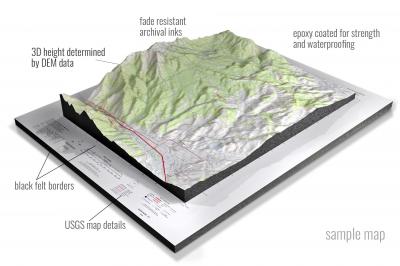
• Raised-relief 3D Height Determined by DEM data
• Fade Resistant Archival Inks
• Epoxy Coated for Strength and Waterproofing
• Ready to Hang with Pre-Installed Hardware (optional)
• Extraordinary 3D Accuracy
• Black Felt Borders
Enrich your office decor or home with a 3D USGS Raised Relief Map. These raised relief maps are not flat. They are three-dimensional, with the height being determined by Digital Elevation Model (DEM) data. Many people struggle with reading 2D satellite maps, but everyone understands 3D raised relief maps. The realism is phenomenal.
This 3D satellite raised relief map is built by combining satellite imagery data from Google Earth, bounding box coordinates from USGS, and DEM data. 3D Printing and 3D CNC routers are used to fabricate the models which make the satellite models extremely accurate. These models are strong - they are coated with epoxy, then finished with a sealer providing a weatherproof matt-finish. These are not meant to be used in direct sunlight.
Ashburnham, Massachusetts- View hi-resolution image of: Ashburnham, Massachusetts. Mapping by USGS in 2021 - Longitude/Latitude: -72 x -71.875 x 42.75 x 42.625, Grid Size: 7.5 X 7.5 Minute, Map Scale: 1:24000, State List: MA,NH, County List: Worcester,Cheshire,Hillsborough,Middlesex
Ashby, Massachusetts- View hi-resolution image of: Ashby, Massachusetts. Mapping by USGS in 2021 - Longitude/Latitude: -71.875 x -71.75 x 42.75 x 42.625, Grid Size: 7.5 X 7.5 Minute, Map Scale: 1:24000, State List: MA,NH, County List: Middlesex,Hillsborough,Worcester
Ashfield, Massachusetts- View hi-resolution image of: Ashfield, Massachusetts. Mapping by USGS in 2021 - Longitude/Latitude: -72.875 x -72.75 x 42.625 x 42.5, Grid Size: 7.5 X 7.5 Minute, Map Scale: 1:24000, State List: MA, County List: Franklin,Hampshire
Ashley Falls, Massachusetts- View hi-resolution image of: Ashley Falls, Massachusetts. Mapping by USGS in 2021 - Longitude/Latitude: -73.375 x -73.25 x 42.125 x 42, Grid Size: 7.5 X 7.5 Minute, Map Scale: 1:24000, State List: MA,CT, County List: Berkshire,Litchfield
Assawompset Pond, Massachusetts- View hi-resolution image of: Assawompset Pond, Massachusetts. Mapping by USGS in 2021 - Longitude/Latitude: -71 x -70.875 x 41.875 x 41.75, Grid Size: 7.5 X 7.5 Minute, Map Scale: 1:24000, State List: MA, County List: Plymouth,Bristol
Assonet, Massachusetts- View hi-resolution image of: Assonet, Massachusetts. Mapping by USGS in 2021 - Longitude/Latitude: -71.125 x -71 x 41.875 x 41.75, Grid Size: 7.5 X 7.5 Minute, Map Scale: 1:24000, State List: MA, County List: Bristol,Plymouth
Athol, Massachusetts- View hi-resolution image of: Athol, Massachusetts. Mapping by USGS in 2021 - Longitude/Latitude: -72.25 x -72.125 x 42.625 x 42.5, Grid Size: 7.5 X 7.5 Minute, Map Scale: 1:24000, State List: MA, County List: Worcester,Franklin
Attleboro, Massachusetts- View hi-resolution image of: Attleboro, Massachusetts. Mapping by USGS in 2021 - Longitude/Latitude: -71.375 x -71.25 x 42 x 41.875, Grid Size: 7.5 X 7.5 Minute, Map Scale: 1:24000, State List: MA,RI, County List: Bristol,Providence,Norfolk
Ayer, Massachusetts- View hi-resolution image of: Ayer, Massachusetts. Mapping by USGS in 2021 - Longitude/Latitude: -71.625 x -71.5 x 42.625 x 42.5, Grid Size: 7.5 X 7.5 Minute, Map Scale: 1:24000, State List: MA, County List: Middlesex,Worcester
Barre, Massachusetts- View hi-resolution image of: Barre, Massachusetts. Mapping by USGS in 2021 - Longitude/Latitude: -72.125 x -72 x 42.5 x 42.375, Grid Size: 7.5 X 7.5 Minute, Map Scale: 1:24000, State List: MA, County List: Worcester
Bash Bish Falls, Massachusetts- View hi-resolution image of: Bash Bish Falls, Massachusetts. Mapping by USGS in 2021 - Longitude/Latitude: -73.5 x -73.375 x 42.125 x 42, Grid Size: 7.5 X 7.5 Minute, Map Scale: 1:24000, State List: MA,CT,NY, County List: Berkshire,Litchfield,Dutchess,Columbia
Becket, Massachusetts- View hi-resolution image of: Becket, Massachusetts. Mapping by USGS in 2021 - Longitude/Latitude: -73.125 x -73 x 42.375 x 42.25, Grid Size: 7.5 X 7.5 Minute, Map Scale: 1:24000, State List: MA, County List: Berkshire,Hampshire,Hampden
Belchertown, Massachusetts- View hi-resolution image of: Belchertown, Massachusetts. Mapping by USGS in 2021 - Longitude/Latitude: -72.5 x -72.375 x 42.375 x 42.25, Grid Size: 7.5 X 7.5 Minute, Map Scale: 1:24000, State List: MA, County List: Hampshire
Bernardston, Massachusetts- View hi-resolution image of: Bernardston, Massachusetts. Mapping by USGS in 2021 - Longitude/Latitude: -72.625 x -72.5 x 42.75 x 42.625, Grid Size: 7.5 X 7.5 Minute, Map Scale: 1:24000, State List: MA,VT, County List: Franklin,Windham
Billerica, Massachusetts- View hi-resolution image of: Billerica, Massachusetts. Mapping by USGS in 2021 - Longitude/Latitude: -71.375 x -71.25 x 42.625 x 42.5, Grid Size: 7.5 X 7.5 Minute, Map Scale: 1:24000, State List: MA, County List: Middlesex
Blackstone, Massachusetts- View hi-resolution image of: Blackstone, Massachusetts. Mapping by USGS in 2021 - Longitude/Latitude: -71.625 x -71.5 x 42.125 x 42, Grid Size: 7.5 X 7.5 Minute, Map Scale: 1:24000, State List: MA,RI, County List: Worcester,Providence,Norfolk
Blandford, Massachusetts- View hi-resolution image of: Blandford, Massachusetts. Mapping by USGS in 2021 - Longitude/Latitude: -73 x -72.875 x 42.25 x 42.125, Grid Size: 7.5 X 7.5 Minute, Map Scale: 1:24000, State List: MA, County List: Hampden,Hampshire
Blue Hills, Massachusetts- View hi-resolution image of: Blue Hills, Massachusetts. Mapping by USGS in 2021 - Longitude/Latitude: -71.125 x -71 x 42.25 x 42.125, Grid Size: 7.5 X 7.5 Minute, Map Scale: 1:24000, State List: MA, County List: Norfolk,Suffolk,Plymouth
Boston North, Massachusetts- View hi-resolution image of: Boston North, Massachusetts. Mapping by USGS in 2021 - Longitude/Latitude: -71.125 x -71 x 42.5 x 42.375, Grid Size: 7.5 X 7.5 Minute, Map Scale: 1:24000, State List: MA, County List: Middlesex,Suffolk,Essex
Boston South, Massachusetts- View hi-resolution image of: Boston South, Massachusetts. Mapping by USGS in 2021 - Longitude/Latitude: -71.125 x -71 x 42.375 x 42.25, Grid Size: 7.5 X 7.5 Minute, Map Scale: 1:24000, State List: MA, County List: Suffolk,Norfolk,Middlesex
Bridgewater, Massachusetts- View hi-resolution image of: Bridgewater, Massachusetts. Mapping by USGS in 2021 - Longitude/Latitude: -71 x -70.875 x 42 x 41.875, Grid Size: 7.5 X 7.5 Minute, Map Scale: 1:24000, State List: MA, County List: Plymouth,Bristol
Brockton, Massachusetts- View hi-resolution image of: Brockton, Massachusetts. Mapping by USGS in 2021 - Longitude/Latitude: -71.125 x -71 x 42.125 x 42, Grid Size: 7.5 X 7.5 Minute, Map Scale: 1:24000, State List: MA, County List: Plymouth,Bristol,Norfolk
Chatham, Massachusetts- View hi-resolution image of: Chatham, Massachusetts. Mapping by USGS in 2021 - Longitude/Latitude: -70 x -69.875 x 41.75 x 41.625, Grid Size: 7.5 X 7.5 Minute, Map Scale: 1:24000, State List: MA, County List: Barnstable
Cheshire, Massachusetts- View hi-resolution image of: Cheshire, Massachusetts. Mapping by USGS in 2021 - Longitude/Latitude: -73.25 x -73.125 x 42.625 x 42.5, Grid Size: 7.5 X 7.5 Minute, Map Scale: 1:24000, State List: MA, County List: Berkshire
Chester, Massachusetts- View hi-resolution image of: Chester, Massachusetts. Mapping by USGS in 2021 - Longitude/Latitude: -73 x -72.875 x 42.375 x 42.25, Grid Size: 7.5 X 7.5 Minute, Map Scale: 1:24000, State List: MA, County List: Hampden,Hampshire
Clinton, Massachusetts- View hi-resolution image of: Clinton, Massachusetts. Mapping by USGS in 2021 - Longitude/Latitude: -71.75 x -71.625 x 42.5 x 42.375, Grid Size: 7.5 X 7.5 Minute, Map Scale: 1:24000, State List: MA, County List: Worcester
Cohasset, Massachusetts- View hi-resolution image of: Cohasset, Massachusetts. Mapping by USGS in 2021 - Longitude/Latitude: -70.875 x -70.75 x 42.25 x 42.125, Grid Size: 7.5 X 7.5 Minute, Map Scale: 1:24000, State List: MA, County List: Plymouth,Norfolk
Colrain, Massachusetts- View hi-resolution image of: Colrain, Massachusetts. Mapping by USGS in 2021 - Longitude/Latitude: -72.75 x -72.625 x 42.75 x 42.625, Grid Size: 7.5 X 7.5 Minute, Map Scale: 1:24000, State List: MA,VT, County List: Franklin,Windham
Concord, Massachusetts- View hi-resolution image of: Concord, Massachusetts. Mapping by USGS in 2021 - Longitude/Latitude: -71.375 x -71.25 x 42.5 x 42.375, Grid Size: 7.5 X 7.5 Minute, Map Scale: 1:24000, State List: MA, County List: Middlesex
Cotuit, Massachusetts- View hi-resolution image of: Cotuit, Massachusetts. Mapping by USGS in 2021 - Longitude/Latitude: -70.5 x -70.375 x 41.625 x 41.5, Grid Size: 7.5 X 7.5 Minute, Map Scale: 1:24000, State List: MA, County List: Barnstable
Cuttyhunk, Massachusetts- View hi-resolution image of: Cuttyhunk, Massachusetts. Mapping by USGS in 2021 - Longitude/Latitude: -71 x -70.875 x 41.5 x 41.375, Grid Size: 7.5 X 7.5 Minute, Map Scale: 1:24000, State List: MA, County List: Dukes,Bristol
Dennis, Massachusetts- View hi-resolution image of: Dennis, Massachusetts. Mapping by USGS in 2021 - Longitude/Latitude: -70.25 x -70.125 x 41.75 x 41.625, Grid Size: 7.5 X 7.5 Minute, Map Scale: 1:24000, State List: MA, County List: Barnstable
Dennis OE N, Massachusetts- View hi-resolution image of: Dennis OE N, Massachusetts. Mapping by USGS in 2021 - Longitude/Latitude: -70.25 x -70.125 x 41.875 x 41.75, Grid Size: 7.5 X 7.5 Minute, Map Scale: 1:24000, State List: MA, County List: Barnstable
Duxbury, Massachusetts- View hi-resolution image of: Duxbury, Massachusetts. Mapping by USGS in 2021 - Longitude/Latitude: -70.75 x -70.625 x 42.125 x 42, Grid Size: 7.5 X 7.5 Minute, Map Scale: 1:24000, State List: MA, County List: Plymouth
Duxbury OE E, Massachusetts- View hi-resolution image of: Duxbury OE E, Massachusetts. Mapping by USGS in 2021 - Longitude/Latitude: -70.625 x -70.5 x 42.125 x 42, Grid Size: 7.5 X 7.5 Minute, Map Scale: 1:24000, State List: MA, County List: Plymouth
East Brookfield, Massachusetts- View hi-resolution image of: East Brookfield, Massachusetts. Mapping by USGS in 2021 - Longitude/Latitude: -72.125 x -72 x 42.25 x 42.125, Grid Size: 7.5 X 7.5 Minute, Map Scale: 1:24000, State List: MA, County List: Worcester
East Lee, Massachusetts- View hi-resolution image of: East Lee, Massachusetts. Mapping by USGS in 2021 - Longitude/Latitude: -73.25 x -73.125 x 42.375 x 42.25, Grid Size: 7.5 X 7.5 Minute, Map Scale: 1:24000, State List: MA, County List: Berkshire
Easthampton, Massachusetts- View hi-resolution image of: Easthampton, Massachusetts. Mapping by USGS in 2021 - Longitude/Latitude: -72.75 x -72.625 x 42.375 x 42.25, Grid Size: 7.5 X 7.5 Minute, Map Scale: 1:24000, State List: MA, County List: Hampshire,Hampden
Edgartown, Massachusetts- View hi-resolution image of: Edgartown, Massachusetts. Mapping by USGS in 2021 - Longitude/Latitude: -70.625 x -70.5 x 41.5 x 41.375, Grid Size: 7.5 X 7.5 Minute, Map Scale: 1:24000, State List: MA, County List: Dukes,Barnstable
Edgartown OE E, Massachusetts- View hi-resolution image of: Edgartown OE E, Massachusetts. Mapping by USGS in 2021 - Longitude/Latitude: -70.5 x -70.375 x 41.5 x 41.375, Grid Size: 7.5 X 7.5 Minute, Map Scale: 1:24000, State List: MA, County List: Dukes
Edgartown OE S, Massachusetts- View hi-resolution image of: Edgartown OE S, Massachusetts. Mapping by USGS in 2021 - Longitude/Latitude: -70.625 x -70.5 x 41.375 x 41.25, Grid Size: 7.5 X 7.5 Minute, Map Scale: 1:24000, State List: MA, County List: Dukes
Edgartown OE SE, Massachusetts- View hi-resolution image of: Edgartown OE SE, Massachusetts. Mapping by USGS in 2021 - Longitude/Latitude: -70.5 x -70.375 x 41.375 x 41.25, Grid Size: 7.5 X 7.5 Minute, Map Scale: 1:24000, State List: MA, County List: Dukes,Nantucket
Egremont, Massachusetts- View hi-resolution image of: Egremont, Massachusetts. Mapping by USGS in 2021 - Longitude/Latitude: -73.5 x -73.375 x 42.25 x 42.125, Grid Size: 7.5 X 7.5 Minute, Map Scale: 1:24000, State List: MA,NY, County List: Berkshire,Columbia
Fall River, Massachusetts- View hi-resolution image of: Fall River, Massachusetts. Mapping by USGS in 2021 - Longitude/Latitude: -71.25 x -71.125 x 41.75 x 41.625, Grid Size: 7.5 X 7.5 Minute, Map Scale: 1:24000, State List: MA,RI, County List: Bristol,Newport
Fall River East, Massachusetts- View hi-resolution image of: Fall River East, Massachusetts. Mapping by USGS in 2021 - Longitude/Latitude: -71.125 x -71 x 41.75 x 41.625, Grid Size: 7.5 X 7.5 Minute, Map Scale: 1:24000, State List: MA, County List: Bristol
Falmouth, Massachusetts- View hi-resolution image of: Falmouth, Massachusetts. Mapping by USGS in 2021 - Longitude/Latitude: -70.625 x -70.5 x 41.625 x 41.5, Grid Size: 7.5 X 7.5 Minute, Map Scale: 1:24000, State List: MA, County List: Barnstable,Dukes
Fitchburg, Massachusetts- View hi-resolution image of: Fitchburg, Massachusetts. Mapping by USGS in 2021 - Longitude/Latitude: -71.875 x -71.75 x 42.625 x 42.5, Grid Size: 7.5 X 7.5 Minute, Map Scale: 1:24000, State List: MA, County List: Worcester
Framingham, Massachusetts- View hi-resolution image of: Framingham, Massachusetts. Mapping by USGS in 2021 - Longitude/Latitude: -71.5 x -71.375 x 42.375 x 42.25, Grid Size: 7.5 X 7.5 Minute, Map Scale: 1:24000, State List: MA, County List: Middlesex,Worcester
Franklin, Massachusetts- View hi-resolution image of: Franklin, Massachusetts. Mapping by USGS in 2021 - Longitude/Latitude: -71.5 x -71.375 x 42.125 x 42, Grid Size: 7.5 X 7.5 Minute, Map Scale: 1:24000, State List: MA,RI, County List: Norfolk,Providence,Worcester
Gardner, Massachusetts- View hi-resolution image of: Gardner, Massachusetts. Mapping by USGS in 2021 - Longitude/Latitude: -72 x -71.875 x 42.625 x 42.5, Grid Size: 7.5 X 7.5 Minute, Map Scale: 1:24000, State List: MA, County List: Worcester
Georgetown, Massachusetts- View hi-resolution image of: Georgetown, Massachusetts. Mapping by USGS in 2021 - Longitude/Latitude: -71 x -70.875 x 42.75 x 42.625, Grid Size: 7.5 X 7.5 Minute, Map Scale: 1:24000, State List: MA, County List: Essex
Gloucester, Massachusetts- View hi-resolution image of: Gloucester, Massachusetts. Mapping by USGS in 2021 - Longitude/Latitude: -70.75 x -70.625 x 42.625 x 42.5, Grid Size: 7.5 X 7.5 Minute, Map Scale: 1:24000, State List: MA, County List: Essex
Gloucester OE N, Massachusetts- View hi-resolution image of: Gloucester OE N, Massachusetts. Mapping by USGS in 2021 - Longitude/Latitude: -70.75 x -70.625 x 42.75 x 42.625, Grid Size: 7.5 X 7.5 Minute, Map Scale: 1:24000, State List: MA, County List: Essex
Goshen, Massachusetts- View hi-resolution image of: Goshen, Massachusetts. Mapping by USGS in 2021 - Longitude/Latitude: -72.875 x -72.75 x 42.5 x 42.375, Grid Size: 7.5 X 7.5 Minute, Map Scale: 1:24000, State List: MA, County List: Hampshire,Franklin
Grafton, Massachusetts- View hi-resolution image of: Grafton, Massachusetts. Mapping by USGS in 2021 - Longitude/Latitude: -71.75 x -71.625 x 42.25 x 42.125, Grid Size: 7.5 X 7.5 Minute, Map Scale: 1:24000, State List: MA, County List: Worcester
Great Barrington, Massachusetts- View hi-resolution image of: Great Barrington, Massachusetts. Mapping by USGS in 2021 - Longitude/Latitude: -73.375 x -73.25 x 42.25 x 42.125, Grid Size: 7.5 X 7.5 Minute, Map Scale: 1:24000, State List: MA, County List: Berkshire
Great Point, Massachusetts- View hi-resolution image of: Great Point, Massachusetts. Mapping by USGS in 2021 - Longitude/Latitude: -70.125 x -70 x 41.5 x 41.375, Grid Size: 7.5 X 7.5 Minute, Map Scale: 1:24000, State List: MA, County List: Nantucket,Barnstable
Great Point OE E, Massachusetts- View hi-resolution image of: Great Point OE E, Massachusetts. Mapping by USGS in 2021 - Longitude/Latitude: -70 x -69.875 x 41.5 x 41.375, Grid Size: 7.5 X 7.5 Minute, Map Scale: 1:24000, State List: MA, County List: Nantucket,Barnstable
Greenfield, Massachusetts- View hi-resolution image of: Greenfield, Massachusetts. Mapping by USGS in 2021 - Longitude/Latitude: -72.625 x -72.5 x 42.625 x 42.5, Grid Size: 7.5 X 7.5 Minute, Map Scale: 1:24000, State List: MA, County List: Franklin
Hampden, Massachusetts- View hi-resolution image of: Hampden, Massachusetts. Mapping by USGS in 2021 - Longitude/Latitude: -72.5 x -72.375 x 42.125 x 42, Grid Size: 7.5 X 7.5 Minute, Map Scale: 1:24000, State List: MA,CT, County List: Hampden,Tolland
Hancock, Massachusetts- View hi-resolution image of: Hancock, Massachusetts. Mapping by USGS in 2021 - Longitude/Latitude: -73.375 x -73.25 x 42.625 x 42.5, Grid Size: 7.5 X 7.5 Minute, Map Scale: 1:24000, State List: MA,NY, County List: Berkshire,Rensselaer,Columbia
Hanover, Massachusetts- View hi-resolution image of: Hanover, Massachusetts. Mapping by USGS in 2021 - Longitude/Latitude: -70.875 x -70.75 x 42.125 x 42, Grid Size: 7.5 X 7.5 Minute, Map Scale: 1:24000, State List: MA, County List: Plymouth
Harwich, Massachusetts- View hi-resolution image of: Harwich, Massachusetts. Mapping by USGS in 2021 - Longitude/Latitude: -70.125 x -70 x 41.75 x 41.625, Grid Size: 7.5 X 7.5 Minute, Map Scale: 1:24000, State List: MA, County List: Barnstable
Haverhill, Massachusetts- View hi-resolution image of: Haverhill, Massachusetts. Mapping by USGS in 2021 - Longitude/Latitude: -71.125 x -71 x 42.875 x 42.75, Grid Size: 7.5 X 7.5 Minute, Map Scale: 1:24000, State List: MA,NH, County List: Essex,Rockingham
Head of Westport, Massachusetts- View hi-resolution image of: Head of Westport, Massachusetts. Mapping by USGS in 2021 - Longitude/Latitude: -71.125 x -71 x 41.625 x 41.5, Grid Size: 7.5 X 7.5 Minute, Map Scale: 1:24000, State List: MA,RI, County List: Bristol,Newport
Head of Westport OE S, Massachusetts- View hi-resolution image of: Head of Westport OE S, Massachusetts. Mapping by USGS in 2021 - Longitude/Latitude: -71.125 x -71 x 41.5 x 41.375, Grid Size: 7.5 X 7.5 Minute, Map Scale: 1:24000, State List: MA,RI, County List: Bristol,Dukes,Newport
Heath, Massachusetts- View hi-resolution image of: Heath, Massachusetts. Mapping by USGS in 2021 - Longitude/Latitude: -72.875 x -72.75 x 42.75 x 42.625, Grid Size: 7.5 X 7.5 Minute, Map Scale: 1:24000, State List: MA,VT, County List: Franklin,Windham
Holliston, Massachusetts- View hi-resolution image of: Holliston, Massachusetts. Mapping by USGS in 2021 - Longitude/Latitude: -71.5 x -71.375 x 42.25 x 42.125, Grid Size: 7.5 X 7.5 Minute, Map Scale: 1:24000, State List: MA, County List: Middlesex,Norfolk,Worcester
Hudson, Massachusetts- View hi-resolution image of: Hudson, Massachusetts. Mapping by USGS in 2021 - Longitude/Latitude: -71.625 x -71.5 x 42.5 x 42.375, Grid Size: 7.5 X 7.5 Minute, Map Scale: 1:24000, State List: MA, County List: Middlesex,Worcester
Hull, Massachusetts- View hi-resolution image of: Hull, Massachusetts. Mapping by USGS in 2021 - Longitude/Latitude: -71 x -70.875 x 42.375 x 42.25, Grid Size: 7.5 X 7.5 Minute, Map Scale: 1:24000, State List: MA, County List: Suffolk,Plymouth,Norfolk
Hyannis, Massachusetts- View hi-resolution image of: Hyannis, Massachusetts. Mapping by USGS in 2021 - Longitude/Latitude: -70.375 x -70.25 x 41.75 x 41.625, Grid Size: 7.5 X 7.5 Minute, Map Scale: 1:24000, State List: MA, County List: Barnstable
Hyannis OE S, Massachusetts- View hi-resolution image of: Hyannis OE S, Massachusetts. Mapping by USGS in 2021 - Longitude/Latitude: -70.375 x -70.25 x 41.625 x 41.5, Grid Size: 7.5 X 7.5 Minute, Map Scale: 1:24000, State List: MA, County List: Barnstable
Ipswich, Massachusetts- View hi-resolution image of: Ipswich, Massachusetts. Mapping by USGS in 2021 - Longitude/Latitude: -70.875 x -70.75 x 42.75 x 42.625, Grid Size: 7.5 X 7.5 Minute, Map Scale: 1:24000, State List: MA, County List: Essex
Lawrence, Massachusetts- View hi-resolution image of: Lawrence, Massachusetts. Mapping by USGS in 2021 - Longitude/Latitude: -71.25 x -71.125 x 42.75 x 42.625, Grid Size: 7.5 X 7.5 Minute, Map Scale: 1:24000, State List: MA,NH, County List: Essex,Middlesex,Rockingham,Hillsborough
Leicester, Massachusetts- View hi-resolution image of: Leicester, Massachusetts. Mapping by USGS in 2021 - Longitude/Latitude: -72 x -71.875 x 42.25 x 42.125, Grid Size: 7.5 X 7.5 Minute, Map Scale: 1:24000, State List: MA, County List: Worcester
Lexington, Massachusetts- View hi-resolution image of: Lexington, Massachusetts. Mapping by USGS in 2021 - Longitude/Latitude: -71.25 x -71.125 x 42.5 x 42.375, Grid Size: 7.5 X 7.5 Minute, Map Scale: 1:24000, State List: MA, County List: Middlesex
Lowell, Massachusetts- View hi-resolution image of: Lowell, Massachusetts. Mapping by USGS in 2021 - Longitude/Latitude: -71.375 x -71.25 x 42.75 x 42.625, Grid Size: 7.5 X 7.5 Minute, Map Scale: 1:24000, State List: MA,NH, County List: Middlesex,Hillsborough,Essex,Rockingham
Ludlow, Massachusetts- View hi-resolution image of: Ludlow, Massachusetts. Mapping by USGS in 2021 - Longitude/Latitude: -72.5 x -72.375 x 42.25 x 42.125, Grid Size: 7.5 X 7.5 Minute, Map Scale: 1:24000, State List: MA, County List: Hampden,Hampshire
Lynn, Massachusetts- View hi-resolution image of: Lynn, Massachusetts. Mapping by USGS in 2021 - Longitude/Latitude: -71 x -70.875 x 42.5 x 42.375, Grid Size: 7.5 X 7.5 Minute, Map Scale: 1:24000, State List: MA, County List: Essex,Suffolk
Manomet, Massachusetts- View hi-resolution image of: Manomet, Massachusetts. Mapping by USGS in 2021 - Longitude/Latitude: -70.625 x -70.5 x 42 x 41.875, Grid Size: 7.5 X 7.5 Minute, Map Scale: 1:24000, State List: MA, County List: Plymouth
Mansfield, Massachusetts- View hi-resolution image of: Mansfield, Massachusetts. Mapping by USGS in 2021 - Longitude/Latitude: -71.25 x -71.125 x 42.125 x 42, Grid Size: 7.5 X 7.5 Minute, Map Scale: 1:24000, State List: MA, County List: Norfolk,Bristol
Marblehead North, Massachusetts- View hi-resolution image of: Marblehead North, Massachusetts. Mapping by USGS in 2021 - Longitude/Latitude: -70.875 x -70.75 x 42.625 x 42.5, Grid Size: 7.5 X 7.5 Minute, Map Scale: 1:24000, State List: MA, County List: Essex
Marblehead South, Massachusetts- View hi-resolution image of: Marblehead South, Massachusetts. Mapping by USGS in 2021 - Longitude/Latitude: -70.875 x -70.75 x 42.5 x 42.375, Grid Size: 7.5 X 7.5 Minute, Map Scale: 1:24000, State List: MA, County List: Essex,Suffolk
Marion, Massachusetts- View hi-resolution image of: Marion, Massachusetts. Mapping by USGS in 2021 - Longitude/Latitude: -70.875 x -70.75 x 41.75 x 41.625, Grid Size: 7.5 X 7.5 Minute, Map Scale: 1:24000, State List: MA, County List: Plymouth,Bristol
Marlborough, Massachusetts- View hi-resolution image of: Marlborough, Massachusetts. Mapping by USGS in 2021 - Longitude/Latitude: -71.625 x -71.5 x 42.375 x 42.25, Grid Size: 7.5 X 7.5 Minute, Map Scale: 1:24000, State List: MA, County List: Worcester,Middlesex
Maynard, Massachusetts- View hi-resolution image of: Maynard, Massachusetts. Mapping by USGS in 2021 - Longitude/Latitude: -71.5 x -71.375 x 42.5 x 42.375, Grid Size: 7.5 X 7.5 Minute, Map Scale: 1:24000, State List: MA, County List: Middlesex
Medfield, Massachusetts- View hi-resolution image of: Medfield, Massachusetts. Mapping by USGS in 2021 - Longitude/Latitude: -71.375 x -71.25 x 42.25 x 42.125, Grid Size: 7.5 X 7.5 Minute, Map Scale: 1:24000, State List: MA, County List: Norfolk,Middlesex
Milford, Massachusetts- View hi-resolution image of: Milford, Massachusetts. Mapping by USGS in 2021 - Longitude/Latitude: -71.625 x -71.5 x 42.25 x 42.125, Grid Size: 7.5 X 7.5 Minute, Map Scale: 1:24000, State List: MA, County List: Worcester,Middlesex
Millers Falls, Massachusetts- View hi-resolution image of: Millers Falls, Massachusetts. Mapping by USGS in 2021 - Longitude/Latitude: -72.5 x -72.375 x 42.625 x 42.5, Grid Size: 7.5 X 7.5 Minute, Map Scale: 1:24000, State List: MA, County List: Franklin
Monomoy Point, Massachusetts- View hi-resolution image of: Monomoy Point, Massachusetts. Mapping by USGS in 2021 - Longitude/Latitude: -70 x -69.875 x 41.625 x 41.5, Grid Size: 7.5 X 7.5 Minute, Map Scale: 1:24000, State List: MA, County List: Barnstable
Monomoy Point OE W, Massachusetts- View hi-resolution image of: Monomoy Point OE W, Massachusetts. Mapping by USGS in 2021 - Longitude/Latitude: -70.125 x -70 x 41.625 x 41.5, Grid Size: 7.5 X 7.5 Minute, Map Scale: 1:24000, State List: MA, County List: Barnstable
Monson, Massachusetts- View hi-resolution image of: Monson, Massachusetts. Mapping by USGS in 2021 - Longitude/Latitude: -72.375 x -72.25 x 42.125 x 42, Grid Size: 7.5 X 7.5 Minute, Map Scale: 1:24000, State List: MA,CT, County List: Hampden,Tolland
Monterey, Massachusetts- View hi-resolution image of: Monterey, Massachusetts. Mapping by USGS in 2021 - Longitude/Latitude: -73.25 x -73.125 x 42.25 x 42.125, Grid Size: 7.5 X 7.5 Minute, Map Scale: 1:24000, State List: MA, County List: Berkshire
Mount Grace, Massachusetts- View hi-resolution image of: Mount Grace, Massachusetts. Mapping by USGS in 2021 - Longitude/Latitude: -72.375 x -72.25 x 42.75 x 42.625, Grid Size: 7.5 X 7.5 Minute, Map Scale: 1:24000, State List: MA,NH, County List: Franklin,Cheshire,Worcester
Mount Holyoke, Massachusetts- View hi-resolution image of: Mount Holyoke, Massachusetts. Mapping by USGS in 2021 - Longitude/Latitude: -72.625 x -72.5 x 42.375 x 42.25, Grid Size: 7.5 X 7.5 Minute, Map Scale: 1:24000, State List: MA, County List: Hampshire,Hampden
Mount Toby, Massachusetts- View hi-resolution image of: Mount Toby, Massachusetts. Mapping by USGS in 2021 - Longitude/Latitude: -72.625 x -72.5 x 42.5 x 42.375, Grid Size: 7.5 X 7.5 Minute, Map Scale: 1:24000, State List: MA, County List: Franklin,Hampshire
Mount Tom, Massachusetts- View hi-resolution image of: Mount Tom, Massachusetts. Mapping by USGS in 2021 - Longitude/Latitude: -72.75 x -72.625 x 42.25 x 42.125, Grid Size: 7.5 X 7.5 Minute, Map Scale: 1:24000, State List: MA, County List: Hampden,Hampshire
Nantasket Beach, Massachusetts- View hi-resolution image of: Nantasket Beach, Massachusetts. Mapping by USGS in 2021 - Longitude/Latitude: -70.875 x -70.75 x 42.375 x 42.25, Grid Size: 7.5 X 7.5 Minute, Map Scale: 1:24000, State List: MA, County List: Plymouth,Norfolk,Suffolk
Nantucket, Massachusetts- View hi-resolution image of: Nantucket, Massachusetts. Mapping by USGS in 2021 - Longitude/Latitude: -70.25 x -70.125 x 41.375 x 41.25, Grid Size: 7.5 X 7.5 Minute, Map Scale: 1:24000, State List: MA, County List: Nantucket
Nantucket OE S, Massachusetts- View hi-resolution image of: Nantucket OE S, Massachusetts. Mapping by USGS in 2021 - Longitude/Latitude: -70.25 x -70.125 x 41.25 x 41.125, Grid Size: 7.5 X 7.5 Minute, Map Scale: 1:24000, State List: MA, County List: Nantucket
Natick, Massachusetts- View hi-resolution image of: Natick, Massachusetts. Mapping by USGS in 2021 - Longitude/Latitude: -71.375 x -71.25 x 42.375 x 42.25, Grid Size: 7.5 X 7.5 Minute, Map Scale: 1:24000, State List: MA, County List: Middlesex,Norfolk
Naushon Island, Massachusetts- View hi-resolution image of: Naushon Island, Massachusetts. Mapping by USGS in 2021 - Longitude/Latitude: -70.875 x -70.75 x 41.5 x 41.375, Grid Size: 7.5 X 7.5 Minute, Map Scale: 1:24000, State List: MA, County List: Dukes
New Bedford North, Massachusetts- View hi-resolution image of: New Bedford North, Massachusetts. Mapping by USGS in 2021 - Longitude/Latitude: -71 x -70.875 x 41.75 x 41.625, Grid Size: 7.5 X 7.5 Minute, Map Scale: 1:24000, State List: MA, County List: Bristol,Plymouth
New Bedford South, Massachusetts- View hi-resolution image of: New Bedford South, Massachusetts. Mapping by USGS in 2021 - Longitude/Latitude: -71 x -70.875 x 41.625 x 41.5, Grid Size: 7.5 X 7.5 Minute, Map Scale: 1:24000, State List: MA, County List: Bristol,Dukes
Newburyport East, Massachusetts- View hi-resolution image of: Newburyport East, Massachusetts. Mapping by USGS in 2021 - Longitude/Latitude: -70.875 x -70.75 x 42.875 x 42.75, Grid Size: 7.5 X 7.5 Minute, Map Scale: 1:24000, State List: MA,NH, County List: Essex,Rockingham
Newburyport West, Massachusetts- View hi-resolution image of: Newburyport West, Massachusetts. Mapping by USGS in 2021 - Longitude/Latitude: -71 x -70.875 x 42.875 x 42.75, Grid Size: 7.5 X 7.5 Minute, Map Scale: 1:24000, State List: MA,NH, County List: Essex,Rockingham
Newton, Massachusetts- View hi-resolution image of: Newton, Massachusetts. Mapping by USGS in 2021 - Longitude/Latitude: -71.25 x -71.125 x 42.375 x 42.25, Grid Size: 7.5 X 7.5 Minute, Map Scale: 1:24000, State List: MA, County List: Middlesex,Norfolk,Suffolk
North Adams, Massachusetts- View hi-resolution image of: North Adams, Massachusetts. Mapping by USGS in 2021 - Longitude/Latitude: -73.125 x -73 x 42.75 x 42.625, Grid Size: 7.5 X 7.5 Minute, Map Scale: 1:24000, State List: MA,VT, County List: Berkshire,Bennington,Franklin
North Brookfield, Massachusetts- View hi-resolution image of: North Brookfield, Massachusetts. Mapping by USGS in 2021 - Longitude/Latitude: -72.125 x -72 x 42.375 x 42.25, Grid Size: 7.5 X 7.5 Minute, Map Scale: 1:24000, State List: MA, County List: Worcester
North Truro, Massachusetts- View hi-resolution image of: North Truro, Massachusetts. Mapping by USGS in 2021 - Longitude/Latitude: -70.125 x -70 x 42.125 x 42, Grid Size: 7.5 X 7.5 Minute, Map Scale: 1:24000, State List: MA, County List: Barnstable
Northfield, Massachusetts- View hi-resolution image of: Northfield, Massachusetts. Mapping by USGS in 2021 - Longitude/Latitude: -72.5 x -72.375 x 42.75 x 42.625, Grid Size: 7.5 X 7.5 Minute, Map Scale: 1:24000, State List: MA,NH,VT, County List: Franklin,Cheshire,Windham
Norton, Massachusetts- View hi-resolution image of: Norton, Massachusetts. Mapping by USGS in 2021 - Longitude/Latitude: -71.25 x -71.125 x 42 x 41.875, Grid Size: 7.5 X 7.5 Minute, Map Scale: 1:24000, State List: MA, County List: Bristol
Norwood, Massachusetts- View hi-resolution image of: Norwood, Massachusetts. Mapping by USGS in 2021 - Longitude/Latitude: -71.25 x -71.125 x 42.25 x 42.125, Grid Size: 7.5 X 7.5 Minute, Map Scale: 1:24000, State List: MA, County List: Norfolk,Suffolk
Onset, Massachusetts- View hi-resolution image of: Onset, Massachusetts. Mapping by USGS in 2021 - Longitude/Latitude: -70.75 x -70.625 x 41.75 x 41.625, Grid Size: 7.5 X 7.5 Minute, Map Scale: 1:24000, State List: MA, County List: Plymouth,Barnstable
Orange, Massachusetts- View hi-resolution image of: Orange, Massachusetts. Mapping by USGS in 2021 - Longitude/Latitude: -72.375 x -72.25 x 42.625 x 42.5, Grid Size: 7.5 X 7.5 Minute, Map Scale: 1:24000, State List: MA, County List: Franklin,Worcester
Orleans, Massachusetts- View hi-resolution image of: Orleans, Massachusetts. Mapping by USGS in 2021 - Longitude/Latitude: -70 x -69.875 x 41.875 x 41.75, Grid Size: 7.5 X 7.5 Minute, Map Scale: 1:24000, State List: MA, County List: Barnstable
Orleans OE W, Massachusetts- View hi-resolution image of: Orleans OE W, Massachusetts. Mapping by USGS in 2021 - Longitude/Latitude: -70.125 x -70 x 41.875 x 41.75, Grid Size: 7.5 X 7.5 Minute, Map Scale: 1:24000, State List: MA, County List: Barnstable
Otis, Massachusetts- View hi-resolution image of: Otis, Massachusetts. Mapping by USGS in 2021 - Longitude/Latitude: -73.125 x -73 x 42.25 x 42.125, Grid Size: 7.5 X 7.5 Minute, Map Scale: 1:24000, State List: MA, County List: Berkshire,Hampden
Oxford, Massachusetts- View hi-resolution image of: Oxford, Massachusetts. Mapping by USGS in 2021 - Longitude/Latitude: -71.875 x -71.75 x 42.125 x 42, Grid Size: 7.5 X 7.5 Minute, Map Scale: 1:24000, State List: MA,CT,RI, County List: Worcester,Windham,Providence
Palmer, Massachusetts- View hi-resolution image of: Palmer, Massachusetts. Mapping by USGS in 2021 - Longitude/Latitude: -72.375 x -72.25 x 42.25 x 42.125, Grid Size: 7.5 X 7.5 Minute, Map Scale: 1:24000, State List: MA, County List: Hampden,Hampshire,Worcester
Paxton, Massachusetts- View hi-resolution image of: Paxton, Massachusetts. Mapping by USGS in 2021 - Longitude/Latitude: -72 x -71.875 x 42.375 x 42.25, Grid Size: 7.5 X 7.5 Minute, Map Scale: 1:24000, State List: MA, County List: Worcester
Pepperell, Massachusetts- View hi-resolution image of: Pepperell, Massachusetts. Mapping by USGS in 2021 - Longitude/Latitude: -71.625 x -71.5 x 42.75 x 42.625, Grid Size: 7.5 X 7.5 Minute, Map Scale: 1:24000, State List: MA,NH, County List: Middlesex,Hillsborough
Peru, Massachusetts- View hi-resolution image of: Peru, Massachusetts. Mapping by USGS in 2021 - Longitude/Latitude: -73.125 x -73 x 42.5 x 42.375, Grid Size: 7.5 X 7.5 Minute, Map Scale: 1:24000, State List: MA, County List: Berkshire,Hampshire
Petersham, Massachusetts- View hi-resolution image of: Petersham, Massachusetts. Mapping by USGS in 2021 - Longitude/Latitude: -72.25 x -72.125 x 42.5 x 42.375, Grid Size: 7.5 X 7.5 Minute, Map Scale: 1:24000, State List: MA, County List: Worcester
Pittsfield East, Massachusetts- View hi-resolution image of: Pittsfield East, Massachusetts. Mapping by USGS in 2021 - Longitude/Latitude: -73.25 x -73.125 x 42.5 x 42.375, Grid Size: 7.5 X 7.5 Minute, Map Scale: 1:24000, State List: MA, County List: Berkshire
Pittsfield West, Massachusetts- View hi-resolution image of: Pittsfield West, Massachusetts. Mapping by USGS in 2021 - Longitude/Latitude: -73.375 x -73.25 x 42.5 x 42.375, Grid Size: 7.5 X 7.5 Minute, Map Scale: 1:24000, State List: MA,NY, County List: Berkshire,Columbia
Plainfield, Massachusetts- View hi-resolution image of: Plainfield, Massachusetts. Mapping by USGS in 2021 - Longitude/Latitude: -73 x -72.875 x 42.625 x 42.5, Grid Size: 7.5 X 7.5 Minute, Map Scale: 1:24000, State List: MA, County List: Franklin,Hampshire,Berkshire
Plymouth, Massachusetts- View hi-resolution image of: Plymouth, Massachusetts. Mapping by USGS in 2021 - Longitude/Latitude: -70.75 x -70.625 x 42 x 41.875, Grid Size: 7.5 X 7.5 Minute, Map Scale: 1:24000, State List: MA, County List: Plymouth
Plympton, Massachusetts- View hi-resolution image of: Plympton, Massachusetts. Mapping by USGS in 2021 - Longitude/Latitude: -70.875 x -70.75 x 42 x 41.875, Grid Size: 7.5 X 7.5 Minute, Map Scale: 1:24000, State List: MA, County List: Plymouth
Pocasset, Massachusetts- View hi-resolution image of: Pocasset, Massachusetts. Mapping by USGS in 2021 - Longitude/Latitude: -70.625 x -70.5 x 41.75 x 41.625, Grid Size: 7.5 X 7.5 Minute, Map Scale: 1:24000, State List: MA, County List: Barnstable,Plymouth
Provincetown, Massachusetts- View hi-resolution image of: Provincetown, Massachusetts. Mapping by USGS in 2021 - Longitude/Latitude: -70.25 x -70.125 x 42.125 x 42, Grid Size: 7.5 X 7.5 Minute, Map Scale: 1:24000, State List: MA, County List: Barnstable
Provincetown OE W, Massachusetts- View hi-resolution image of: Provincetown OE W, Massachusetts. Mapping by USGS in 2021 - Longitude/Latitude: -70.375 x -70.25 x 42.125 x 42, Grid Size: 7.5 X 7.5 Minute, Map Scale: 1:24000, State List: MA, County List: Barnstable,Plymouth
Quabbin Reservoir, Massachusetts- View hi-resolution image of: Quabbin Reservoir, Massachusetts. Mapping by USGS in 2021 - Longitude/Latitude: -72.375 x -72.25 x 42.5 x 42.375, Grid Size: 7.5 X 7.5 Minute, Map Scale: 1:24000, State List: MA, County List: Franklin,Worcester,Hampshire
Reading, Massachusetts- View hi-resolution image of: Reading, Massachusetts. Mapping by USGS in 2021 - Longitude/Latitude: -71.125 x -71 x 42.625 x 42.5, Grid Size: 7.5 X 7.5 Minute, Map Scale: 1:24000, State List: MA, County List: Essex,Middlesex
Rockport, Massachusetts- View hi-resolution image of: Rockport, Massachusetts. Mapping by USGS in 2021 - Longitude/Latitude: -70.625 x -70.5 x 42.75 x 42.625, Grid Size: 7.5 X 7.5 Minute, Map Scale: 1:24000, State List: MA, County List: Essex
Rockport OE S, Massachusetts- View hi-resolution image of: Rockport OE S, Massachusetts. Mapping by USGS in 2021 - Longitude/Latitude: -70.625 x -70.5 x 42.625 x 42.5, Grid Size: 7.5 X 7.5 Minute, Map Scale: 1:24000, State List: MA, County List: Essex
Rowe, Massachusetts- View hi-resolution image of: Rowe, Massachusetts. Mapping by USGS in 2021 - Longitude/Latitude: -73 x -72.875 x 42.75 x 42.625, Grid Size: 7.5 X 7.5 Minute, Map Scale: 1:24000, State List: MA,VT, County List: Franklin,Berkshire,Bennington,Windham
Royalston, Massachusetts- View hi-resolution image of: Royalston, Massachusetts. Mapping by USGS in 2021 - Longitude/Latitude: -72.25 x -72.125 x 42.75 x 42.625, Grid Size: 7.5 X 7.5 Minute, Map Scale: 1:24000, State List: MA,NH, County List: Worcester,Cheshire,Franklin
Sagamore, Massachusetts- View hi-resolution image of: Sagamore, Massachusetts. Mapping by USGS in 2021 - Longitude/Latitude: -70.625 x -70.5 x 41.875 x 41.75, Grid Size: 7.5 X 7.5 Minute, Map Scale: 1:24000, State List: MA, County List: Plymouth,Barnstable
Salem, Massachusetts- View hi-resolution image of: Salem, Massachusetts. Mapping by USGS in 2021 - Longitude/Latitude: -71 x -70.875 x 42.625 x 42.5, Grid Size: 7.5 X 7.5 Minute, Map Scale: 1:24000, State List: MA, County List: Essex
Sandwich, Massachusetts- View hi-resolution image of: Sandwich, Massachusetts. Mapping by USGS in 2021 - Longitude/Latitude: -70.5 x -70.375 x 41.75 x 41.625, Grid Size: 7.5 X 7.5 Minute, Map Scale: 1:24000, State List: MA, County List: Barnstable
Sandwich OE N, Massachusetts- View hi-resolution image of: Sandwich OE N, Massachusetts. Mapping by USGS in 2021 - Longitude/Latitude: -70.5 x -70.375 x 41.875 x 41.75, Grid Size: 7.5 X 7.5 Minute, Map Scale: 1:24000, State List: MA, County List: Barnstable,Plymouth
Scituate, Massachusetts- View hi-resolution image of: Scituate, Massachusetts. Mapping by USGS in 2021 - Longitude/Latitude: -70.75 x -70.625 x 42.25 x 42.125, Grid Size: 7.5 X 7.5 Minute, Map Scale: 1:24000, State List: MA, County List: Plymouth
Sconticut Neck, Massachusetts- View hi-resolution image of: Sconticut Neck, Massachusetts. Mapping by USGS in 2021 - Longitude/Latitude: -70.875 x -70.75 x 41.625 x 41.5, Grid Size: 7.5 X 7.5 Minute, Map Scale: 1:24000, State List: MA, County List: Bristol,Dukes,Plymouth,Barnstable
Shelburne Falls, Massachusetts- View hi-resolution image of: Shelburne Falls, Massachusetts. Mapping by USGS in 2021 - Longitude/Latitude: -72.75 x -72.625 x 42.625 x 42.5, Grid Size: 7.5 X 7.5 Minute, Map Scale: 1:24000, State List: MA, County List: Franklin
Shirley, Massachusetts- View hi-resolution image of: Shirley, Massachusetts. Mapping by USGS in 2021 - Longitude/Latitude: -71.75 x -71.625 x 42.625 x 42.5, Grid Size: 7.5 X 7.5 Minute, Map Scale: 1:24000, State List: MA, County List: Worcester,Middlesex
Shrewsbury, Massachusetts- View hi-resolution image of: Shrewsbury, Massachusetts. Mapping by USGS in 2021 - Longitude/Latitude: -71.75 x -71.625 x 42.375 x 42.25, Grid Size: 7.5 X 7.5 Minute, Map Scale: 1:24000, State List: MA, County List: Worcester,Middlesex
Shutesbury, Massachusetts- View hi-resolution image of: Shutesbury, Massachusetts. Mapping by USGS in 2021 - Longitude/Latitude: -72.5 x -72.375 x 42.5 x 42.375, Grid Size: 7.5 X 7.5 Minute, Map Scale: 1:24000, State List: MA, County List: Franklin,Hampshire
Siasconset, Massachusetts- View hi-resolution image of: Siasconset, Massachusetts. Mapping by USGS in 2021 - Longitude/Latitude: -70.125 x -70 x 41.375 x 41.25, Grid Size: 7.5 X 7.5 Minute, Map Scale: 1:24000, State List: MA, County List: Nantucket
Siasconset OE E, Massachusetts- View hi-resolution image of: Siasconset OE E, Massachusetts. Mapping by USGS in 2021 - Longitude/Latitude: -70 x -69.875 x 41.375 x 41.25, Grid Size: 7.5 X 7.5 Minute, Map Scale: 1:24000, State List: MA, County List: Nantucket
Siasconset OE S, Massachusetts- View hi-resolution image of: Siasconset OE S, Massachusetts. Mapping by USGS in 2021 - Longitude/Latitude: -70.125 x -70 x 41.25 x 41.125, Grid Size: 7.5 X 7.5 Minute, Map Scale: 1:24000, State List: MA, County List: Nantucket
Siasconset OE SE, Massachusetts- View hi-resolution image of: Siasconset OE SE, Massachusetts. Mapping by USGS in 2021 - Longitude/Latitude: -70 x -69.875 x 41.25 x 41.125, Grid Size: 7.5 X 7.5 Minute, Map Scale: 1:24000, State List: MA, County List: Nantucket
Snipatuit Pond, Massachusetts- View hi-resolution image of: Snipatuit Pond, Massachusetts. Mapping by USGS in 2021 - Longitude/Latitude: -70.875 x -70.75 x 41.875 x 41.75, Grid Size: 7.5 X 7.5 Minute, Map Scale: 1:24000, State List: MA, County List: Plymouth
Somerset, Massachusetts- View hi-resolution image of: Somerset, Massachusetts. Mapping by USGS in 2021 - Longitude/Latitude: -71.25 x -71.125 x 41.875 x 41.75, Grid Size: 7.5 X 7.5 Minute, Map Scale: 1:24000, State List: MA, County List: Bristol
South Groveland, Massachusetts- View hi-resolution image of: South Groveland, Massachusetts. Mapping by USGS in 2021 - Longitude/Latitude: -71.125 x -71 x 42.75 x 42.625, Grid Size: 7.5 X 7.5 Minute, Map Scale: 1:24000, State List: MA, County List: Essex
South Sandisfield, Massachusetts- View hi-resolution image of: South Sandisfield, Massachusetts. Mapping by USGS in 2021 - Longitude/Latitude: -73.25 x -73.125 x 42.125 x 42, Grid Size: 7.5 X 7.5 Minute, Map Scale: 1:24000, State List: MA,CT, County List: Berkshire,Litchfield
Southbridge, Massachusetts- View hi-resolution image of: Southbridge, Massachusetts. Mapping by USGS in 2021 - Longitude/Latitude: -72.125 x -72 x 42.125 x 42, Grid Size: 7.5 X 7.5 Minute, Map Scale: 1:24000, State List: MA,CT, County List: Worcester,Windham,Tolland
Southwick, Massachusetts- View hi-resolution image of: Southwick, Massachusetts. Mapping by USGS in 2021 - Longitude/Latitude: -72.875 x -72.75 x 42.125 x 42, Grid Size: 7.5 X 7.5 Minute, Map Scale: 1:24000, State List: MA,CT, County List: Hampden,Hartford
Springfield North, Massachusetts- View hi-resolution image of: Springfield North, Massachusetts. Mapping by USGS in 2021 - Longitude/Latitude: -72.625 x -72.5 x 42.25 x 42.125, Grid Size: 7.5 X 7.5 Minute, Map Scale: 1:24000, State List: MA, County List: Hampden,Hampshire
Springfield South, Massachusetts- View hi-resolution image of: Springfield South, Massachusetts. Mapping by USGS in 2021 - Longitude/Latitude: -72.625 x -72.5 x 42.125 x 42, Grid Size: 7.5 X 7.5 Minute, Map Scale: 1:24000, State List: MA,CT, County List: Hampden,Hartford,Tolland
Squibnocket, Massachusetts- View hi-resolution image of: Squibnocket, Massachusetts. Mapping by USGS in 2021 - Longitude/Latitude: -70.875 x -70.75 x 41.375 x 41.25, Grid Size: 7.5 X 7.5 Minute, Map Scale: 1:24000, State List: MA, County List: Dukes
Squibnocket OE S, Massachusetts- View hi-resolution image of: Squibnocket OE S, Massachusetts. Mapping by USGS in 2021 - Longitude/Latitude: -70.875 x -70.75 x 41.25 x 41.125, Grid Size: 7.5 X 7.5 Minute, Map Scale: 1:24000, State List: MA, County List: Dukes
State Line, Massachusetts- View hi-resolution image of: State Line, Massachusetts. Mapping by USGS in 2021 - Longitude/Latitude: -73.5 x -73.375 x 42.375 x 42.25, Grid Size: 7.5 X 7.5 Minute, Map Scale: 1:24000, State List: MA,NY, County List: Berkshire,Columbia
Sterling, Massachusetts- View hi-resolution image of: Sterling, Massachusetts. Mapping by USGS in 2021 - Longitude/Latitude: -71.875 x -71.75 x 42.5 x 42.375, Grid Size: 7.5 X 7.5 Minute, Map Scale: 1:24000, State List: MA, County List: Worcester
Stockbridge, Massachusetts- View hi-resolution image of: Stockbridge, Massachusetts. Mapping by USGS in 2021 - Longitude/Latitude: -73.375 x -73.25 x 42.375 x 42.25, Grid Size: 7.5 X 7.5 Minute, Map Scale: 1:24000, State List: MA, County List: Berkshire
Taunton, Massachusetts- View hi-resolution image of: Taunton, Massachusetts. Mapping by USGS in 2021 - Longitude/Latitude: -71.125 x -71 x 42 x 41.875, Grid Size: 7.5 X 7.5 Minute, Map Scale: 1:24000, State List: MA, County List: Bristol,Plymouth
Templeton, Massachusetts- View hi-resolution image of: Templeton, Massachusetts. Mapping by USGS in 2021 - Longitude/Latitude: -72.125 x -72 x 42.625 x 42.5, Grid Size: 7.5 X 7.5 Minute, Map Scale: 1:24000, State List: MA, County List: Worcester
Tisbury Great Pond, Massachusetts- View hi-resolution image of: Tisbury Great Pond, Massachusetts. Mapping by USGS in 2021 - Longitude/Latitude: -70.75 x -70.625 x 41.375 x 41.25, Grid Size: 7.5 X 7.5 Minute, Map Scale: 1:24000, State List: MA, County List: Dukes
Tolland Center, Massachusetts- View hi-resolution image of: Tolland Center, Massachusetts. Mapping by USGS in 2021 - Longitude/Latitude: -73.125 x -73 x 42.125 x 42, Grid Size: 7.5 X 7.5 Minute, Map Scale: 1:24000, State List: MA,CT, County List: Berkshire,Hampden,Litchfield,Hartford
Townsend, Massachusetts- View hi-resolution image of: Townsend, Massachusetts. Mapping by USGS in 2021 - Longitude/Latitude: -71.75 x -71.625 x 42.75 x 42.625, Grid Size: 7.5 X 7.5 Minute, Map Scale: 1:24000, State List: MA,NH, County List: Middlesex,Hillsborough,Worcester
Tuckernuck Island, Massachusetts- View hi-resolution image of: Tuckernuck Island, Massachusetts. Mapping by USGS in 2021 - Longitude/Latitude: -70.375 x -70.25 x 41.375 x 41.25, Grid Size: 7.5 X 7.5 Minute, Map Scale: 1:24000, State List: MA, County List: Nantucket,Dukes
Uxbridge, Massachusetts- View hi-resolution image of: Uxbridge, Massachusetts. Mapping by USGS in 2021 - Longitude/Latitude: -71.75 x -71.625 x 42.125 x 42, Grid Size: 7.5 X 7.5 Minute, Map Scale: 1:24000, State List: MA,RI, County List: Worcester,Providence
Vineyard Haven, Massachusetts- View hi-resolution image of: Vineyard Haven, Massachusetts. Mapping by USGS in 2021 - Longitude/Latitude: -70.75 x -70.625 x 41.5 x 41.375, Grid Size: 7.5 X 7.5 Minute, Map Scale: 1:24000, State List: MA, County List: Dukes,Barnstable
Wachusett Mountain, Massachusetts- View hi-resolution image of: Wachusett Mountain, Massachusetts. Mapping by USGS in 2021 - Longitude/Latitude: -72 x -71.875 x 42.5 x 42.375, Grid Size: 7.5 X 7.5 Minute, Map Scale: 1:24000, State List: MA, County List: Worcester
Wales, Massachusetts- View hi-resolution image of: Wales, Massachusetts. Mapping by USGS in 2021 - Longitude/Latitude: -72.25 x -72.125 x 42.125 x 42, Grid Size: 7.5 X 7.5 Minute, Map Scale: 1:24000, State List: MA,CT, County List: Hampden,Tolland,Worcester
Ware, Massachusetts- View hi-resolution image of: Ware, Massachusetts. Mapping by USGS in 2021 - Longitude/Latitude: -72.25 x -72.125 x 42.375 x 42.25, Grid Size: 7.5 X 7.5 Minute, Map Scale: 1:24000, State List: MA, County List: Worcester,Hampshire
Wareham, Massachusetts- View hi-resolution image of: Wareham, Massachusetts. Mapping by USGS in 2021 - Longitude/Latitude: -70.75 x -70.625 x 41.875 x 41.75, Grid Size: 7.5 X 7.5 Minute, Map Scale: 1:24000, State List: MA, County List: Plymouth,Barnstable
Warren, Massachusetts- View hi-resolution image of: Warren, Massachusetts. Mapping by USGS in 2021 - Longitude/Latitude: -72.25 x -72.125 x 42.25 x 42.125, Grid Size: 7.5 X 7.5 Minute, Map Scale: 1:24000, State List: MA, County List: Worcester,Hampden,Hampshire
Webster, Massachusetts- View hi-resolution image of: Webster, Massachusetts. Mapping by USGS in 2021 - Longitude/Latitude: -72 x -71.875 x 42.125 x 42, Grid Size: 7.5 X 7.5 Minute, Map Scale: 1:24000, State List: MA,CT, County List: Worcester,Windham
Wellfleet, Massachusetts- View hi-resolution image of: Wellfleet, Massachusetts. Mapping by USGS in 2021 - Longitude/Latitude: -70.125 x -70 x 42 x 41.875, Grid Size: 7.5 X 7.5 Minute, Map Scale: 1:24000, State List: MA, County List: Barnstable
Wellfleet OE E, Massachusetts- View hi-resolution image of: Wellfleet OE E, Massachusetts. Mapping by USGS in 2021 - Longitude/Latitude: -70 x -69.875 x 42 x 41.875, Grid Size: 7.5 X 7.5 Minute, Map Scale: 1:24000, State List: MA, County List: Barnstable
West Granville, Massachusetts- View hi-resolution image of: West Granville, Massachusetts. Mapping by USGS in 2021 - Longitude/Latitude: -73 x -72.875 x 42.125 x 42, Grid Size: 7.5 X 7.5 Minute, Map Scale: 1:24000, State List: MA,CT, County List: Hampden,Hartford
West Springfield, Massachusetts- View hi-resolution image of: West Springfield, Massachusetts. Mapping by USGS in 2021 - Longitude/Latitude: -72.75 x -72.625 x 42.125 x 42, Grid Size: 7.5 X 7.5 Minute, Map Scale: 1:24000, State List: MA,CT, County List: Hampden,Hartford
Westford, Massachusetts- View hi-resolution image of: Westford, Massachusetts. Mapping by USGS in 2021 - Longitude/Latitude: -71.5 x -71.375 x 42.625 x 42.5, Grid Size: 7.5 X 7.5 Minute, Map Scale: 1:24000, State List: MA, County List: Middlesex
Westhampton, Massachusetts- View hi-resolution image of: Westhampton, Massachusetts. Mapping by USGS in 2021 - Longitude/Latitude: -72.875 x -72.75 x 42.375 x 42.25, Grid Size: 7.5 X 7.5 Minute, Map Scale: 1:24000, State List: MA, County List: Hampshire
Weymouth, Massachusetts- View hi-resolution image of: Weymouth, Massachusetts. Mapping by USGS in 2021 - Longitude/Latitude: -71 x -70.875 x 42.25 x 42.125, Grid Size: 7.5 X 7.5 Minute, Map Scale: 1:24000, State List: MA, County List: Norfolk,Plymouth
Whitman, Massachusetts- View hi-resolution image of: Whitman, Massachusetts. Mapping by USGS in 2021 - Longitude/Latitude: -71 x -70.875 x 42.125 x 42, Grid Size: 7.5 X 7.5 Minute, Map Scale: 1:24000, State List: MA, County List: Plymouth
Williamsburg, Massachusetts- View hi-resolution image of: Williamsburg, Massachusetts. Mapping by USGS in 2021 - Longitude/Latitude: -72.75 x -72.625 x 42.5 x 42.375, Grid Size: 7.5 X 7.5 Minute, Map Scale: 1:24000, State List: MA, County List: Franklin,Hampshire
Williamstown, Massachusetts- View hi-resolution image of: Williamstown, Massachusetts. Mapping by USGS in 2021 - Longitude/Latitude: -73.25 x -73.125 x 42.75 x 42.625, Grid Size: 7.5 X 7.5 Minute, Map Scale: 1:24000, State List: MA,VT, County List: Berkshire,Bennington
Wilmington, Massachusetts- View hi-resolution image of: Wilmington, Massachusetts. Mapping by USGS in 2021 - Longitude/Latitude: -71.25 x -71.125 x 42.625 x 42.5, Grid Size: 7.5 X 7.5 Minute, Map Scale: 1:24000, State List: MA, County List: Middlesex,Essex
Winchendon, Massachusetts- View hi-resolution image of: Winchendon, Massachusetts. Mapping by USGS in 2021 - Longitude/Latitude: -72.125 x -72 x 42.75 x 42.625, Grid Size: 7.5 X 7.5 Minute, Map Scale: 1:24000, State List: MA,NH, County List: Worcester,Cheshire
Windsor, Massachusetts- View hi-resolution image of: Windsor, Massachusetts. Mapping by USGS in 2021 - Longitude/Latitude: -73.125 x -73 x 42.625 x 42.5, Grid Size: 7.5 X 7.5 Minute, Map Scale: 1:24000, State List: MA, County List: Berkshire
Winsor Dam, Massachusetts- View hi-resolution image of: Winsor Dam, Massachusetts. Mapping by USGS in 2021 - Longitude/Latitude: -72.375 x -72.25 x 42.375 x 42.25, Grid Size: 7.5 X 7.5 Minute, Map Scale: 1:24000, State List: MA, County List: Hampshire,Worcester,Franklin
Woods Hole, Massachusetts- View hi-resolution image of: Woods Hole, Massachusetts. Mapping by USGS in 2021 - Longitude/Latitude: -70.75 x -70.625 x 41.625 x 41.5, Grid Size: 7.5 X 7.5 Minute, Map Scale: 1:24000, State List: MA, County List: Barnstable,Dukes,Plymouth
Worcester North, Massachusetts- View hi-resolution image of: Worcester North, Massachusetts. Mapping by USGS in 2021 - Longitude/Latitude: -71.875 x -71.75 x 42.375 x 42.25, Grid Size: 7.5 X 7.5 Minute, Map Scale: 1:24000, State List: MA, County List: Worcester
Worcester South, Massachusetts- View hi-resolution image of: Worcester South, Massachusetts. Mapping by USGS in 2021 - Longitude/Latitude: -71.875 x -71.75 x 42.25 x 42.125, Grid Size: 7.5 X 7.5 Minute, Map Scale: 1:24000, State List: MA, County List: Worcester
Woronoco, Massachusetts- View hi-resolution image of: Woronoco, Massachusetts. Mapping by USGS in 2021 - Longitude/Latitude: -72.875 x -72.75 x 42.25 x 42.125, Grid Size: 7.5 X 7.5 Minute, Map Scale: 1:24000, State List: MA, County List: Hampden,Hampshire
Worthington, Massachusetts- View hi-resolution image of: Worthington, Massachusetts. Mapping by USGS in 2021 - Longitude/Latitude: -73 x -72.875 x 42.5 x 42.375, Grid Size: 7.5 X 7.5 Minute, Map Scale: 1:24000, State List: MA, County List: Hampshire,Berkshire
Wrentham, Massachusetts- View hi-resolution image of: Wrentham, Massachusetts. Mapping by USGS in 2021 - Longitude/Latitude: -71.375 x -71.25 x 42.125 x 42, Grid Size: 7.5 X 7.5 Minute, Map Scale: 1:24000, State List: MA, County List: Norfolk,Bristol
For large or custom orders, please contact us at 385-206-8700 or email at sales@whiteclouds.com
Superior Quality, Crafted By Hand
Our gallery 3D raised relief satellite maps are each crafted by hand. They are professional 3D maps meant to compliment any room.
Our archival inks prevent fading, to preserve as much fine detail as possible over time. A matt finish sealer is applied to the satellite model to provide a waterproof barrier. Black felt matting is applied to the sides of the raised relief model to create a superior looking map. With a choice of a tabletop or wall-hanging model, both are fabricated using materials that provide a quality feel.
Our materials are gallery quality. 3D raised relief models are built with high quality, UV-resistant, environmentally-friendly, fade-resistant, latex archival inks. Our archival inks prevent fading to preserve as much fine detail as possible over time.
Construction:
Built to last with a rugged composite core of 3D printed plastic and a double coated 2-part epoxy hardener. This core is mounted to a 5/8" engineered wood composite of Medium Density Fiberboard (MDF) that is wrapped in vinyl for easy cleaning. The model is extremely strong and very accurate. Finishing of the model is done with a special sealer providing a weatherproof, stain-resistant matt-finish. A flocking is applied to all edges to give a high-end museum quality finish.
Museum-quality edges

Remarkably Strong: Watch a 1-ton truck drive over our topography models
We create our 3D models to scale as accurately as are the original imagery and digital elevation files.
Printers and Ink
We have the latest HP Latex printers and archival ink to produce consistent and quality results. The inks are environment-friendly and reduce fading for up to 200 years according to HP.
If you purchased the tabletop model, there is no installation. For the wall hanging model, hardware comes installed on the 3D raised relief map/topography. The type of hanger depends on the size of the art-piece. It may be a sawtooth hanger or a pre-installed cable bracket system for larger 3D raised relief maps.
Installation is as easy as placing 1 or 2 screws/nails into the wall and then laying the cable or hanger over them. Lastly, tilt the 3D raised relief model until it is level.
Stainless steel cable hangers for larger raised relief models

Sawtooth hangers for smaller raised relief models

WhiteClouds is located in Ogden, Utah. All products are manufactured and shipped from our facilities. Various shipping methods will be used depending on the size of the product and the size of the order. Your shipment will be delivered by standard shipping carriers. Smaller packages will be delivered by USPS or FedEx. Larger and oversize packages will be delivered by UPS Freight or LTL carriers (motor cargo). Shipments may be divided up and delivered in multiple packages. When the package has been shipped, you will receive an email from us with tracking information.
For special shipping considerations, please contact us at 385-206-8700 or email at sales@whiteclouds.com
ORDER CANCELLATION: At WhiteClouds, we have a great team that works hard to fabricate and complete your order by hand, with the highest degree of quality. Once you place your order, our team begins the process of creating your unique canvas wrap.
To cancel your order, you must contact us within 24 hours of placing your order by calling 1-385-206-8700 or email us at support@whiteclouds.com.
Any cancellation requests after the 24-hour period will not be accepted.
DAMAGED ITEMS: Even though WhiteClouds takes great care in preparing items for shipment, occasionally there is damage during shipping. If you receive your order and it is damaged or broken, we will gladly replace your items.
If you receive the wrong canvas, we will gladly replace it at no extra cost to you!
Please report the damage within 24 hours of receiving the item(s) by contacting us at 1-385-206-8700 or email us at support@whiteclouds.com and we will send you a replacement.
To view our Return Policy and Satisfaction Guarantee, click here.
SATISFACTION GUARANTEE: We want you to be 100% satisfied with your purchase so we offer a 30-day money back guarantee. If you don't like your canvas, simply ship it back to us as per our instructions and we will provide you with a full refund.
Contact us at 1-385-206-8700 or email us at support@whiteclouds.com and we will instruct you on how to return your purchase.
Please note that we do not cover the cost of return shipping, it is the responsibility of the customer to cover return shipping costs.
To view our Return Policy and Satisfaction Guarantee, click here.
How long does it take to fabricate a topographical raised relief map? Each topography map is carefully crafted by hand and usually takes 7 - 10 days.
Can WhiteClouds ship to multiple locations? Yes, there may be additional shipping and handling charges. Please contact us to discuss options.
What is the warranty? Whiteclouds topography models are warranted against defects in material and workmanship for 3 full years from the date of shipment. Misuse, neglect or alteration of product is not covered under this warranty. To view our Return Policy and Satisfaction Guarantee, click here.
What if I want a different size topographical model? We can fabricate custom sizes for our topographical maps. Please look at our fabrication services at https://www.whiteclouds.com, call us at 1-385-206-8700, or email us at sales@whiteclouds.com.
What types of organizations are WhiteClouds customers? We work with customers all over the world in many industries, including many Fortune 500 organizations. See some of our customers here.
Do you have a question we didn‘t answer? Don't hesitate to contact us at 1-385-206-8700 or email us at support@whiteclouds.com.