


To view hi-resolution images of individual city/location maps, click below on specific links

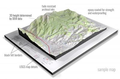
• Raised-relief 3D Height Determined by DEM data
• Fade Resistant Archival Inks
• Epoxy Coated for Strength and Waterproofing
• Ready to Hang with Pre-Installed Hardware (optional)
• Extraordinary 3D Accuracy
• Black Felt Borders
Enrich your office decor or home with a 3D USGS Raised Relief Map. These raised relief maps are not flat. They are three-dimensional, with the height being determined by Digital Elevation Model (DEM) data. Many people struggle with reading 2D satellite maps, but everyone understands 3D raised relief maps. The realism is phenomenal.
This 3D satellite raised relief map is built by combining satellite imagery data from Google Earth, bounding box coordinates from USGS, and DEM data. 3D Printing and 3D CNC routers are used to fabricate the models which make the satellite models extremely accurate. These models are strong - they are coated with epoxy, then finished with a sealer providing a weatherproof matt-finish. These are not meant to be used in direct sunlight.
Acorn Ridge, Missouri- View hi-resolution image of: Acorn Ridge, Missouri. Mapping by USGS in 2021 - Longitude/Latitude: -90.125 x -90 x 37 x 36.875, Grid Size: 7.5 X 7.5 Minute, Map Scale: 1:24000, State List: MO, County List: Stoddard
Adrian, Missouri- View hi-resolution image of: Adrian, Missouri. Mapping by USGS in 2021 - Longitude/Latitude: -94.375 x -94.25 x 38.5 x 38.375, Grid Size: 7.5 X 7.5 Minute, Map Scale: 1:24000, State List: MO, County List: Bates,Cass
Advance, Missouri- View hi-resolution image of: Advance, Missouri. Mapping by USGS in 2021 - Longitude/Latitude: -90 x -89.875 x 37.125 x 37, Grid Size: 7.5 X 7.5 Minute, Map Scale: 1:24000, State List: MO, County List: Stoddard,Bollinger
Agency, Missouri- View hi-resolution image of: Agency, Missouri. Mapping by USGS in 2021 - Longitude/Latitude: -94.75 x -94.625 x 39.75 x 39.625, Grid Size: 7.5 X 7.5 Minute, Map Scale: 1:24000, State List: MO, County List: Buchanan
Akron, Missouri- View hi-resolution image of: Akron, Missouri. Mapping by USGS in 2021 - Longitude/Latitude: -93.875 x -93.75 x 40.625 x 40.5, Grid Size: 7.5 X 7.5 Minute, Map Scale: 1:24000, State List: MO,IA, County List: Harrison,Decatur,Mercer
Alanthus Grove, Missouri- View hi-resolution image of: Alanthus Grove, Missouri. Mapping by USGS in 2021 - Longitude/Latitude: -94.625 x -94.5 x 40.375 x 40.25, Grid Size: 7.5 X 7.5 Minute, Map Scale: 1:24000, State List: MO, County List: Gentry,Nodaway
Albany North, Missouri- View hi-resolution image of: Albany North, Missouri. Mapping by USGS in 2021 - Longitude/Latitude: -94.375 x -94.25 x 40.375 x 40.25, Grid Size: 7.5 X 7.5 Minute, Map Scale: 1:24000, State List: MO, County List: Gentry
Albany South, Missouri- View hi-resolution image of: Albany South, Missouri. Mapping by USGS in 2021 - Longitude/Latitude: -94.375 x -94.25 x 40.25 x 40.125, Grid Size: 7.5 X 7.5 Minute, Map Scale: 1:24000, State List: MO, County List: Gentry
Aldrich, Missouri- View hi-resolution image of: Aldrich, Missouri. Mapping by USGS in 2021 - Longitude/Latitude: -93.625 x -93.5 x 37.625 x 37.5, Grid Size: 7.5 X 7.5 Minute, Map Scale: 1:24000, State List: MO, County List: Polk,Dade,Cedar
Allbright, Missouri- View hi-resolution image of: Allbright, Missouri. Mapping by USGS in 2021 - Longitude/Latitude: -90.25 x -90.125 x 37.375 x 37.25, Grid Size: 7.5 X 7.5 Minute, Map Scale: 1:24000, State List: MO, County List: Bollinger,Madison,Wayne
Allendale, Missouri- View hi-resolution image of: Allendale, Missouri. Mapping by USGS in 2021 - Longitude/Latitude: -94.375 x -94.25 x 40.5 x 40.375, Grid Size: 7.5 X 7.5 Minute, Map Scale: 1:24000, State List: MO, County List: Worth,Gentry
Alley Spring, Missouri- View hi-resolution image of: Alley Spring, Missouri. Mapping by USGS in 2021 - Longitude/Latitude: -91.5 x -91.375 x 37.25 x 37.125, Grid Size: 7.5 X 7.5 Minute, Map Scale: 1:24000, State List: MO, County List: Shannon
Alma, Missouri- View hi-resolution image of: Alma, Missouri. Mapping by USGS in 2021 - Longitude/Latitude: -93.625 x -93.5 x 39.125 x 39, Grid Size: 7.5 X 7.5 Minute, Map Scale: 1:24000, State List: MO, County List: Lafayette
Altamont, Missouri- View hi-resolution image of: Altamont, Missouri. Mapping by USGS in 2021 - Longitude/Latitude: -94.125 x -94 x 40 x 39.875, Grid Size: 7.5 X 7.5 Minute, Map Scale: 1:24000, State List: MO, County List: Daviess
Altenburg, Missouri- View hi-resolution image of: Altenburg, Missouri. Mapping by USGS in 2021 - Longitude/Latitude: -89.625 x -89.5 x 37.75 x 37.625, Grid Size: 7.5 X 7.5 Minute, Map Scale: 1:24000, State List: MO,IL, County List: Perry,Jackson
Alton, Missouri- View hi-resolution image of: Alton, Missouri. Mapping by USGS in 2021 - Longitude/Latitude: -91.5 x -91.375 x 36.75 x 36.625, Grid Size: 7.5 X 7.5 Minute, Map Scale: 1:24000, State List: MO, County List: Oregon
Amazonia, Missouri- View hi-resolution image of: Amazonia, Missouri. Mapping by USGS in 2021 - Longitude/Latitude: -95 x -94.875 x 40 x 39.875, Grid Size: 7.5 X 7.5 Minute, Map Scale: 1:24000, State List: MO,KS, County List: Andrew,Doniphan,Holt
Americus, Missouri- View hi-resolution image of: Americus, Missouri. Mapping by USGS in 2021 - Longitude/Latitude: -91.625 x -91.5 x 38.875 x 38.75, Grid Size: 7.5 X 7.5 Minute, Map Scale: 1:24000, State List: MO, County List: Montgomery
Amity, Missouri- View hi-resolution image of: Amity, Missouri. Mapping by USGS in 2021 - Longitude/Latitude: -94.5 x -94.375 x 39.875 x 39.75, Grid Size: 7.5 X 7.5 Minute, Map Scale: 1:24000, State List: MO, County List: DeKalb
Amoret, Missouri- View hi-resolution image of: Amoret, Missouri. Mapping by USGS in 2021 - Longitude/Latitude: -94.625 x -94.5 x 38.375 x 38.25, Grid Size: 7.5 X 7.5 Minute, Map Scale: 1:24000, State List: MO,KS, County List: Bates,Linn
Anderson, Missouri- View hi-resolution image of: Anderson, Missouri. Mapping by USGS in 2021 - Longitude/Latitude: -94.5 x -94.375 x 36.75 x 36.625, Grid Size: 7.5 X 7.5 Minute, Map Scale: 1:24000, State List: MO, County List: McDonald
Annada, Missouri- View hi-resolution image of: Annada, Missouri. Mapping by USGS in 2021 - Longitude/Latitude: -90.875 x -90.75 x 39.375 x 39.25, Grid Size: 7.5 X 7.5 Minute, Map Scale: 1:24000, State List: MO,IL, County List: Pike,Calhoun
Anniston, Missouri- View hi-resolution image of: Anniston, Missouri. Mapping by USGS in 2021 - Longitude/Latitude: -89.375 x -89.25 x 36.875 x 36.75, Grid Size: 7.5 X 7.5 Minute, Map Scale: 1:24000, State List: MO, County List: Mississippi
Anson, Missouri- View hi-resolution image of: Anson, Missouri. Mapping by USGS in 2021 - Longitude/Latitude: -91.875 x -91.75 x 40.625 x 40.5, Grid Size: 7.5 X 7.5 Minute, Map Scale: 1:24000, State List: MO,IA, County List: Clark,Van Buren
Anthonies Mill, Missouri- View hi-resolution image of: Anthonies Mill, Missouri. Mapping by USGS in 2021 - Longitude/Latitude: -91.125 x -91 x 38.125 x 38, Grid Size: 7.5 X 7.5 Minute, Map Scale: 1:24000, State List: MO, County List: Washington,Crawford
Anutt, Missouri- View hi-resolution image of: Anutt, Missouri. Mapping by USGS in 2021 - Longitude/Latitude: -91.75 x -91.625 x 37.75 x 37.625, Grid Size: 7.5 X 7.5 Minute, Map Scale: 1:24000, State List: MO, County List: Dent
Appleton City, Missouri- View hi-resolution image of: Appleton City, Missouri. Mapping by USGS in 2021 - Longitude/Latitude: -94.125 x -94 x 38.25 x 38.125, Grid Size: 7.5 X 7.5 Minute, Map Scale: 1:24000, State List: MO, County List: Bates,St. Clair,Henry
Arbela, Missouri- View hi-resolution image of: Arbela, Missouri. Mapping by USGS in 2021 - Longitude/Latitude: -92.125 x -92 x 40.5 x 40.375, Grid Size: 7.5 X 7.5 Minute, Map Scale: 1:24000, State List: MO, County List: Scotland
Arbyrd, Missouri- View hi-resolution image of: Arbyrd, Missouri. Mapping by USGS in 2021 - Longitude/Latitude: -90.25 x -90.125 x 36.125 x 36, Grid Size: 7.5 X 7.5 Minute, Map Scale: 1:24000, State List: MO, County List: Dunklin
Argo, Missouri- View hi-resolution image of: Argo, Missouri. Mapping by USGS in 2021 - Longitude/Latitude: -91.375 x -91.25 x 38.25 x 38.125, Grid Size: 7.5 X 7.5 Minute, Map Scale: 1:24000, State List: MO, County List: Crawford,Franklin,Gasconade
Argyle, Missouri- View hi-resolution image of: Argyle, Missouri. Mapping by USGS in 2021 - Longitude/Latitude: -92.125 x -92 x 38.375 x 38.25, Grid Size: 7.5 X 7.5 Minute, Map Scale: 1:24000, State List: MO, County List: Osage,Maries
Arley, Missouri- View hi-resolution image of: Arley, Missouri. Mapping by USGS in 2021 - Longitude/Latitude: -94.5 x -94.375 x 39.5 x 39.375, Grid Size: 7.5 X 7.5 Minute, Map Scale: 1:24000, State List: MO, County List: Clay,Clinton
Armstrong, Missouri- View hi-resolution image of: Armstrong, Missouri. Mapping by USGS in 2021 - Longitude/Latitude: -92.75 x -92.625 x 39.375 x 39.25, Grid Size: 7.5 X 7.5 Minute, Map Scale: 1:24000, State List: MO, County List: Howard,Randolph,Chariton
Arnica, Missouri- View hi-resolution image of: Arnica, Missouri. Mapping by USGS in 2021 - Longitude/Latitude: -93.75 x -93.625 x 37.875 x 37.75, Grid Size: 7.5 X 7.5 Minute, Map Scale: 1:24000, State List: MO, County List: Cedar,St. Clair,Polk
Arrow Rock, Missouri- View hi-resolution image of: Arrow Rock, Missouri. Mapping by USGS in 2021 - Longitude/Latitude: -93 x -92.875 x 39.125 x 39, Grid Size: 7.5 X 7.5 Minute, Map Scale: 1:24000, State List: MO, County List: Howard,Saline,Cooper
Asbury, Missouri- View hi-resolution image of: Asbury, Missouri. Mapping by USGS in 2021 - Longitude/Latitude: -94.625 x -94.5 x 37.375 x 37.25, Grid Size: 7.5 X 7.5 Minute, Map Scale: 1:24000, State List: MO,KS, County List: Jasper,Barton,Cherokee,Crawford
Ash Grove, Missouri- View hi-resolution image of: Ash Grove, Missouri. Mapping by USGS in 2021 - Longitude/Latitude: -93.625 x -93.5 x 37.375 x 37.25, Grid Size: 7.5 X 7.5 Minute, Map Scale: 1:24000, State List: MO, County List: Greene,Lawrence,Dade
Ashburn, Missouri- View hi-resolution image of: Ashburn, Missouri. Mapping by USGS in 2021 - Longitude/Latitude: -91.25 x -91.125 x 39.625 x 39.5, Grid Size: 7.5 X 7.5 Minute, Map Scale: 1:24000, State List: MO,IL, County List: Pike,Ralls
Ashland, Missouri- View hi-resolution image of: Ashland, Missouri. Mapping by USGS in 2021 - Longitude/Latitude: -92.375 x -92.25 x 38.875 x 38.75, Grid Size: 7.5 X 7.5 Minute, Map Scale: 1:24000, State List: MO, County List: Boone
Atlanta, Missouri- View hi-resolution image of: Atlanta, Missouri. Mapping by USGS in 2021 - Longitude/Latitude: -92.5 x -92.375 x 40 x 39.875, Grid Size: 7.5 X 7.5 Minute, Map Scale: 1:24000, State List: MO, County List: Macon
Auburn, Missouri- View hi-resolution image of: Auburn, Missouri. Mapping by USGS in 2021 - Longitude/Latitude: -91 x -90.875 x 39.25 x 39.125, Grid Size: 7.5 X 7.5 Minute, Map Scale: 1:24000, State List: MO, County List: Lincoln,Pike
Aurora, Missouri- View hi-resolution image of: Aurora, Missouri. Mapping by USGS in 2021 - Longitude/Latitude: -93.75 x -93.625 x 37 x 36.875, Grid Size: 7.5 X 7.5 Minute, Map Scale: 1:24000, State List: MO, County List: Lawrence,Barry
Austin, Missouri- View hi-resolution image of: Austin, Missouri. Mapping by USGS in 2021 - Longitude/Latitude: -94.375 x -94.25 x 38.625 x 38.5, Grid Size: 7.5 X 7.5 Minute, Map Scale: 1:24000, State List: MO, County List: Cass
Auxvasse, Missouri- View hi-resolution image of: Auxvasse, Missouri. Mapping by USGS in 2021 - Longitude/Latitude: -92 x -91.875 x 39.125 x 39, Grid Size: 7.5 X 7.5 Minute, Map Scale: 1:24000, State List: MO, County List: Callaway,Audrain
Ava, Missouri- View hi-resolution image of: Ava, Missouri. Mapping by USGS in 2021 - Longitude/Latitude: -92.75 x -92.625 x 37 x 36.875, Grid Size: 7.5 X 7.5 Minute, Map Scale: 1:24000, State List: MO, County List: Douglas
Avalon, Missouri- View hi-resolution image of: Avalon, Missouri. Mapping by USGS in 2021 - Longitude/Latitude: -93.5 x -93.375 x 39.75 x 39.625, Grid Size: 7.5 X 7.5 Minute, Map Scale: 1:24000, State List: MO, County List: Livingston
Avilla, Missouri- View hi-resolution image of: Avilla, Missouri. Mapping by USGS in 2021 - Longitude/Latitude: -94.25 x -94.125 x 37.25 x 37.125, Grid Size: 7.5 X 7.5 Minute, Map Scale: 1:24000, State List: MO, County List: Jasper
Axtell, Missouri- View hi-resolution image of: Axtell, Missouri. Mapping by USGS in 2021 - Longitude/Latitude: -92.5 x -92.375 x 39.875 x 39.75, Grid Size: 7.5 X 7.5 Minute, Map Scale: 1:24000, State List: MO, County List: Macon
Azen, Missouri- View hi-resolution image of: Azen, Missouri. Mapping by USGS in 2021 - Longitude/Latitude: -92.125 x -92 x 40.625 x 40.5, Grid Size: 7.5 X 7.5 Minute, Map Scale: 1:24000, State List: MO,IA, County List: Scotland,Van Buren
Bagnell, Missouri- View hi-resolution image of: Bagnell, Missouri. Mapping by USGS in 2021 - Longitude/Latitude: -92.625 x -92.5 x 38.25 x 38.125, Grid Size: 7.5 X 7.5 Minute, Map Scale: 1:24000, State List: MO, County List: Miller,Camden
Bahner, Missouri- View hi-resolution image of: Bahner, Missouri. Mapping by USGS in 2021 - Longitude/Latitude: -93.25 x -93.125 x 38.625 x 38.5, Grid Size: 7.5 X 7.5 Minute, Map Scale: 1:24000, State List: MO, County List: Pettis,Benton
Bakersfield, Missouri- View hi-resolution image of: Bakersfield, Missouri. Mapping by USGS in 2021 - Longitude/Latitude: -92.25 x -92.125 x 36.625 x 36.5, Grid Size: 7.5 X 7.5 Minute, Map Scale: 1:24000, State List: MO, County List: Ozark
Bancroft, Missouri- View hi-resolution image of: Bancroft, Missouri. Mapping by USGS in 2021 - Longitude/Latitude: -93.875 x -93.75 x 40.125 x 40, Grid Size: 7.5 X 7.5 Minute, Map Scale: 1:24000, State List: MO, County List: Daviess,Grundy
Banner, Missouri- View hi-resolution image of: Banner, Missouri. Mapping by USGS in 2021 - Longitude/Latitude: -90.875 x -90.75 x 37.75 x 37.625, Grid Size: 7.5 X 7.5 Minute, Map Scale: 1:24000, State List: MO, County List: Iron,Washington
Bardley, Missouri- View hi-resolution image of: Bardley, Missouri. Mapping by USGS in 2021 - Longitude/Latitude: -91.125 x -91 x 36.75 x 36.625, Grid Size: 7.5 X 7.5 Minute, Map Scale: 1:24000, State List: MO, County List: Ripley,Oregon
Barnard, Missouri- View hi-resolution image of: Barnard, Missouri. Mapping by USGS in 2021 - Longitude/Latitude: -94.875 x -94.75 x 40.25 x 40.125, Grid Size: 7.5 X 7.5 Minute, Map Scale: 1:24000, State List: MO, County List: Nodaway,Andrew
Barnesville, Missouri- View hi-resolution image of: Barnesville, Missouri. Mapping by USGS in 2021 - Longitude/Latitude: -92.625 x -92.5 x 40 x 39.875, Grid Size: 7.5 X 7.5 Minute, Map Scale: 1:24000, State List: MO, County List: Macon
Barnett, Missouri- View hi-resolution image of: Barnett, Missouri. Mapping by USGS in 2021 - Longitude/Latitude: -92.75 x -92.625 x 38.5 x 38.375, Grid Size: 7.5 X 7.5 Minute, Map Scale: 1:24000, State List: MO, County List: Morgan,Moniteau,Miller
Barnumton, Missouri- View hi-resolution image of: Barnumton, Missouri. Mapping by USGS in 2021 - Longitude/Latitude: -93 x -92.875 x 38.125 x 38, Grid Size: 7.5 X 7.5 Minute, Map Scale: 1:24000, State List: MO, County List: Camden
Bartlett, Missouri- View hi-resolution image of: Bartlett, Missouri. Mapping by USGS in 2021 - Longitude/Latitude: -91.5 x -91.375 x 37.125 x 37, Grid Size: 7.5 X 7.5 Minute, Map Scale: 1:24000, State List: MO, County List: Shannon
Bassville, Missouri- View hi-resolution image of: Bassville, Missouri. Mapping by USGS in 2021 - Longitude/Latitude: -93.25 x -93.125 x 37.375 x 37.25, Grid Size: 7.5 X 7.5 Minute, Map Scale: 1:24000, State List: MO, County List: Greene
Bates City, Missouri- View hi-resolution image of: Bates City, Missouri. Mapping by USGS in 2021 - Longitude/Latitude: -94.125 x -94 x 39.125 x 39, Grid Size: 7.5 X 7.5 Minute, Map Scale: 1:24000, State List: MO, County List: Lafayette,Jackson
Bayouville, Missouri- View hi-resolution image of: Bayouville, Missouri. Mapping by USGS in 2021 - Longitude/Latitude: -89.375 x -89.25 x 36.75 x 36.625, Grid Size: 7.5 X 7.5 Minute, Map Scale: 1:24000, State List: MO,KY, County List: Mississippi,New Madrid,Fulton
Beach, Missouri- View hi-resolution image of: Beach, Missouri. Mapping by USGS in 2021 - Longitude/Latitude: -93 x -92.875 x 37.5 x 37.375, Grid Size: 7.5 X 7.5 Minute, Map Scale: 1:24000, State List: MO, County List: Webster,Dallas
Beaman, Missouri- View hi-resolution image of: Beaman, Missouri. Mapping by USGS in 2021 - Longitude/Latitude: -93.25 x -93.125 x 38.875 x 38.75, Grid Size: 7.5 X 7.5 Minute, Map Scale: 1:24000, State List: MO, County List: Pettis
Bearcreek, Missouri- View hi-resolution image of: Bearcreek, Missouri. Mapping by USGS in 2021 - Longitude/Latitude: -93.75 x -93.625 x 37.75 x 37.625, Grid Size: 7.5 X 7.5 Minute, Map Scale: 1:24000, State List: MO, County List: Cedar,Polk
Bedford SW, Missouri- View hi-resolution image of: Bedford SW, Missouri. Mapping by USGS in 2021 - Longitude/Latitude: -94.75 x -94.625 x 40.625 x 40.5, Grid Size: 7.5 X 7.5 Minute, Map Scale: 1:24000, State List: MO,IA, County List: Nodaway,Taylor,Worth
Belews Creek, Missouri- View hi-resolution image of: Belews Creek, Missouri. Mapping by USGS in 2021 - Longitude/Latitude: -90.625 x -90.5 x 38.375 x 38.25, Grid Size: 7.5 X 7.5 Minute, Map Scale: 1:24000, State List: MO, County List: Jefferson
Belgique, Missouri- View hi-resolution image of: Belgique, Missouri. Mapping by USGS in 2021 - Longitude/Latitude: -89.875 x -89.75 x 37.875 x 37.75, Grid Size: 7.5 X 7.5 Minute, Map Scale: 1:24000, State List: MO,IL, County List: Perry,Randolph
Belgrade, Missouri- View hi-resolution image of: Belgrade, Missouri. Mapping by USGS in 2021 - Longitude/Latitude: -90.875 x -90.75 x 37.875 x 37.75, Grid Size: 7.5 X 7.5 Minute, Map Scale: 1:24000, State List: MO, County List: Washington
Bell City, Missouri- View hi-resolution image of: Bell City, Missouri. Mapping by USGS in 2021 - Longitude/Latitude: -89.875 x -89.75 x 37.125 x 37, Grid Size: 7.5 X 7.5 Minute, Map Scale: 1:24000, State List: MO, County List: Stoddard,Scott
Bellamy, Missouri- View hi-resolution image of: Bellamy, Missouri. Mapping by USGS in 2021 - Longitude/Latitude: -94.25 x -94.125 x 37.75 x 37.625, Grid Size: 7.5 X 7.5 Minute, Map Scale: 1:24000, State List: MO, County List: Vernon,Barton
Belle, Missouri- View hi-resolution image of: Belle, Missouri. Mapping by USGS in 2021 - Longitude/Latitude: -91.75 x -91.625 x 38.375 x 38.25, Grid Size: 7.5 X 7.5 Minute, Map Scale: 1:24000, State List: MO, County List: Osage,Maries,Gasconade
Bellflower North, Missouri- View hi-resolution image of: Bellflower North, Missouri. Mapping by USGS in 2021 - Longitude/Latitude: -91.375 x -91.25 x 39.125 x 39, Grid Size: 7.5 X 7.5 Minute, Map Scale: 1:24000, State List: MO, County List: Montgomery,Lincoln
Bellflower South, Missouri- View hi-resolution image of: Bellflower South, Missouri. Mapping by USGS in 2021 - Longitude/Latitude: -91.375 x -91.25 x 39 x 38.875, Grid Size: 7.5 X 7.5 Minute, Map Scale: 1:24000, State List: MO, County List: Montgomery,Warren,Lincoln
Belton, Missouri- View hi-resolution image of: Belton, Missouri. Mapping by USGS in 2021 - Longitude/Latitude: -94.625 x -94.5 x 38.875 x 38.75, Grid Size: 7.5 X 7.5 Minute, Map Scale: 1:24000, State List: MO,KS, County List: Cass,Jackson,Johnson
Benjamin, Missouri- View hi-resolution image of: Benjamin, Missouri. Mapping by USGS in 2021 - Longitude/Latitude: -91.75 x -91.625 x 40.25 x 40.125, Grid Size: 7.5 X 7.5 Minute, Map Scale: 1:24000, State List: MO, County List: Lewis
Bennett Springs, Missouri- View hi-resolution image of: Bennett Springs, Missouri. Mapping by USGS in 2021 - Longitude/Latitude: -92.875 x -92.75 x 37.75 x 37.625, Grid Size: 7.5 X 7.5 Minute, Map Scale: 1:24000, State List: MO, County List: Laclede,Dallas
Berger, Missouri- View hi-resolution image of: Berger, Missouri. Mapping by USGS in 2021 - Longitude/Latitude: -91.375 x -91.25 x 38.75 x 38.625, Grid Size: 7.5 X 7.5 Minute, Map Scale: 1:24000, State List: MO, County List: Franklin,Warren,Gasconade
Berlin, Missouri- View hi-resolution image of: Berlin, Missouri. Mapping by USGS in 2021 - Longitude/Latitude: -94.375 x -94.25 x 40.125 x 40, Grid Size: 7.5 X 7.5 Minute, Map Scale: 1:24000, State List: MO, County List: Gentry,DeKalb
Bernie, Missouri- View hi-resolution image of: Bernie, Missouri. Mapping by USGS in 2021 - Longitude/Latitude: -90 x -89.875 x 36.75 x 36.625, Grid Size: 7.5 X 7.5 Minute, Map Scale: 1:24000, State List: MO, County List: Stoddard,New Madrid,Dunklin
Berryman, Missouri- View hi-resolution image of: Berryman, Missouri. Mapping by USGS in 2021 - Longitude/Latitude: -91.125 x -91 x 38 x 37.875, Grid Size: 7.5 X 7.5 Minute, Map Scale: 1:24000, State List: MO, County List: Washington,Crawford
Bertrand, Missouri- View hi-resolution image of: Bertrand, Missouri. Mapping by USGS in 2021 - Longitude/Latitude: -89.5 x -89.375 x 37 x 36.875, Grid Size: 7.5 X 7.5 Minute, Map Scale: 1:24000, State List: MO, County List: Mississippi,Scott
Bethany, Missouri- View hi-resolution image of: Bethany, Missouri. Mapping by USGS in 2021 - Longitude/Latitude: -94.125 x -94 x 40.375 x 40.25, Grid Size: 7.5 X 7.5 Minute, Map Scale: 1:24000, State List: MO, County List: Harrison
Bethel, Missouri- View hi-resolution image of: Bethel, Missouri. Mapping by USGS in 2021 - Longitude/Latitude: -92.125 x -92 x 40 x 39.875, Grid Size: 7.5 X 7.5 Minute, Map Scale: 1:24000, State List: MO, County List: Shelby,Knox
Bethpage, Missouri- View hi-resolution image of: Bethpage, Missouri. Mapping by USGS in 2021 - Longitude/Latitude: -94.25 x -94.125 x 36.75 x 36.625, Grid Size: 7.5 X 7.5 Minute, Map Scale: 1:24000, State List: MO, County List: McDonald,Newton
Beulah, Missouri- View hi-resolution image of: Beulah, Missouri. Mapping by USGS in 2021 - Longitude/Latitude: -92 x -91.875 x 37.625 x 37.5, Grid Size: 7.5 X 7.5 Minute, Map Scale: 1:24000, State List: MO, County List: Texas,Phelps
Bevier North, Missouri- View hi-resolution image of: Bevier North, Missouri. Mapping by USGS in 2021 - Longitude/Latitude: -92.625 x -92.5 x 39.875 x 39.75, Grid Size: 7.5 X 7.5 Minute, Map Scale: 1:24000, State List: MO, County List: Macon
Bevier South, Missouri- View hi-resolution image of: Bevier South, Missouri. Mapping by USGS in 2021 - Longitude/Latitude: -92.625 x -92.5 x 39.75 x 39.625, Grid Size: 7.5 X 7.5 Minute, Map Scale: 1:24000, State List: MO, County List: Macon
Bible Grove, Missouri- View hi-resolution image of: Bible Grove, Missouri. Mapping by USGS in 2021 - Longitude/Latitude: -92.375 x -92.25 x 40.375 x 40.25, Grid Size: 7.5 X 7.5 Minute, Map Scale: 1:24000, State List: MO, County List: Scotland,Knox,Adair,Schuyler
Big Bend, Missouri- View hi-resolution image of: Big Bend, Missouri. Mapping by USGS in 2021 - Longitude/Latitude: -92.125 x -92 x 38.125 x 38, Grid Size: 7.5 X 7.5 Minute, Map Scale: 1:24000, State List: MO, County List: Maries,Pulaski,Phelps
Big Lake, Missouri- View hi-resolution image of: Big Lake, Missouri. Mapping by USGS in 2021 - Longitude/Latitude: -95.375 x -95.25 x 40.125 x 40, Grid Size: 7.5 X 7.5 Minute, Map Scale: 1:24000, State List: MO,NE,KS, County List: Holt,Richardson,Brown
Big Piney, Missouri- View hi-resolution image of: Big Piney, Missouri. Mapping by USGS in 2021 - Longitude/Latitude: -92.125 x -92 x 37.75 x 37.625, Grid Size: 7.5 X 7.5 Minute, Map Scale: 1:24000, State List: MO, County List: Pulaski,Phelps
Big Spring, Missouri- View hi-resolution image of: Big Spring, Missouri. Mapping by USGS in 2021 - Longitude/Latitude: -91 x -90.875 x 37 x 36.875, Grid Size: 7.5 X 7.5 Minute, Map Scale: 1:24000, State List: MO, County List: Carter
Billings, Missouri- View hi-resolution image of: Billings, Missouri. Mapping by USGS in 2021 - Longitude/Latitude: -93.625 x -93.5 x 37.125 x 37, Grid Size: 7.5 X 7.5 Minute, Map Scale: 1:24000, State List: MO, County List: Christian,Greene,Lawrence
Billingsville, Missouri- View hi-resolution image of: Billingsville, Missouri. Mapping by USGS in 2021 - Longitude/Latitude: -92.875 x -92.75 x 39 x 38.875, Grid Size: 7.5 X 7.5 Minute, Map Scale: 1:24000, State List: MO, County List: Cooper,Howard
Billmore, Missouri- View hi-resolution image of: Billmore, Missouri. Mapping by USGS in 2021 - Longitude/Latitude: -91.25 x -91.125 x 36.625 x 36.5, Grid Size: 7.5 X 7.5 Minute, Map Scale: 1:24000, State List: MO, County List: Oregon,Ripley
Birch Tree, Missouri- View hi-resolution image of: Birch Tree, Missouri. Mapping by USGS in 2021 - Longitude/Latitude: -91.5 x -91.375 x 37 x 36.875, Grid Size: 7.5 X 7.5 Minute, Map Scale: 1:24000, State List: MO, County List: Shannon,Oregon
Blackburn, Missouri- View hi-resolution image of: Blackburn, Missouri. Mapping by USGS in 2021 - Longitude/Latitude: -93.5 x -93.375 x 39.125 x 39, Grid Size: 7.5 X 7.5 Minute, Map Scale: 1:24000, State List: MO, County List: Saline,Lafayette
Blairstown, Missouri- View hi-resolution image of: Blairstown, Missouri. Mapping by USGS in 2021 - Longitude/Latitude: -94 x -93.875 x 38.625 x 38.5, Grid Size: 7.5 X 7.5 Minute, Map Scale: 1:24000, State List: MO, County List: Henry,Johnson
Blockton SE, Missouri- View hi-resolution image of: Blockton SE, Missouri. Mapping by USGS in 2021 - Longitude/Latitude: -94.375 x -94.25 x 40.625 x 40.5, Grid Size: 7.5 X 7.5 Minute, Map Scale: 1:24000, State List: MO,IA, County List: Worth,Ringgold
Bloodland, Missouri- View hi-resolution image of: Bloodland, Missouri. Mapping by USGS in 2021 - Longitude/Latitude: -92.25 x -92.125 x 37.75 x 37.625, Grid Size: 7.5 X 7.5 Minute, Map Scale: 1:24000, State List: MO, County List: Pulaski,Laclede
Bloomfield, Missouri- View hi-resolution image of: Bloomfield, Missouri. Mapping by USGS in 2021 - Longitude/Latitude: -90 x -89.875 x 37 x 36.875, Grid Size: 7.5 X 7.5 Minute, Map Scale: 1:24000, State List: MO, County List: Stoddard
Bloomsdale, Missouri- View hi-resolution image of: Bloomsdale, Missouri. Mapping by USGS in 2021 - Longitude/Latitude: -90.25 x -90.125 x 38.125 x 38, Grid Size: 7.5 X 7.5 Minute, Map Scale: 1:24000, State List: MO,IL, County List: Ste. Genevieve,Monroe,Randolph,Jefferson
Blue Springs, Missouri- View hi-resolution image of: Blue Springs, Missouri. Mapping by USGS in 2021 - Longitude/Latitude: -94.375 x -94.25 x 39.125 x 39, Grid Size: 7.5 X 7.5 Minute, Map Scale: 1:24000, State List: MO, County List: Jackson
Boekerton, Missouri- View hi-resolution image of: Boekerton, Missouri. Mapping by USGS in 2021 - Longitude/Latitude: -89.875 x -89.75 x 36.5 x 36.375, Grid Size: 7.5 X 7.5 Minute, Map Scale: 1:24000, State List: MO, County List: New Madrid,Pemiscot
Bogard, Missouri- View hi-resolution image of: Bogard, Missouri. Mapping by USGS in 2021 - Longitude/Latitude: -93.625 x -93.5 x 39.5 x 39.375, Grid Size: 7.5 X 7.5 Minute, Map Scale: 1:24000, State List: MO, County List: Carroll
Bolckow, Missouri- View hi-resolution image of: Bolckow, Missouri. Mapping by USGS in 2021 - Longitude/Latitude: -94.875 x -94.75 x 40.125 x 40, Grid Size: 7.5 X 7.5 Minute, Map Scale: 1:24000, State List: MO, County List: Andrew
Bolckow NW, Missouri- View hi-resolution image of: Bolckow NW, Missouri. Mapping by USGS in 2021 - Longitude/Latitude: -95 x -94.875 x 40.25 x 40.125, Grid Size: 7.5 X 7.5 Minute, Map Scale: 1:24000, State List: MO, County List: Nodaway,Andrew
Bolivar, Missouri- View hi-resolution image of: Bolivar, Missouri. Mapping by USGS in 2021 - Longitude/Latitude: -93.5 x -93.375 x 37.625 x 37.5, Grid Size: 7.5 X 7.5 Minute, Map Scale: 1:24000, State List: MO, County List: Polk
Bollinger Creek, Missouri- View hi-resolution image of: Bollinger Creek, Missouri. Mapping by USGS in 2021 - Longitude/Latitude: -93 x -92.875 x 38.25 x 38.125, Grid Size: 7.5 X 7.5 Minute, Map Scale: 1:24000, State List: MO, County List: Camden,Morgan
Bona, Missouri- View hi-resolution image of: Bona, Missouri. Mapping by USGS in 2021 - Longitude/Latitude: -93.75 x -93.625 x 37.625 x 37.5, Grid Size: 7.5 X 7.5 Minute, Map Scale: 1:24000, State List: MO, County List: Dade,Cedar
Bonne Terre, Missouri- View hi-resolution image of: Bonne Terre, Missouri. Mapping by USGS in 2021 - Longitude/Latitude: -90.625 x -90.5 x 38 x 37.875, Grid Size: 7.5 X 7.5 Minute, Map Scale: 1:24000, State List: MO, County List: St. Francois
Boonville, Missouri- View hi-resolution image of: Boonville, Missouri. Mapping by USGS in 2021 - Longitude/Latitude: -92.75 x -92.625 x 39 x 38.875, Grid Size: 7.5 X 7.5 Minute, Map Scale: 1:24000, State List: MO, County List: Cooper,Howard
Bosworth, Missouri- View hi-resolution image of: Bosworth, Missouri. Mapping by USGS in 2021 - Longitude/Latitude: -93.375 x -93.25 x 39.5 x 39.375, Grid Size: 7.5 X 7.5 Minute, Map Scale: 1:24000, State List: MO, County List: Carroll,Chariton
Bowling Green, Missouri- View hi-resolution image of: Bowling Green, Missouri. Mapping by USGS in 2021 - Longitude/Latitude: -91.25 x -91.125 x 39.375 x 39.25, Grid Size: 7.5 X 7.5 Minute, Map Scale: 1:24000, State List: MO, County List: Pike
Boylers Mill, Missouri- View hi-resolution image of: Boylers Mill, Missouri. Mapping by USGS in 2021 - Longitude/Latitude: -93.125 x -93 x 38.375 x 38.25, Grid Size: 7.5 X 7.5 Minute, Map Scale: 1:24000, State List: MO, County List: Morgan,Benton,Camden
Bradleyville, Missouri- View hi-resolution image of: Bradleyville, Missouri. Mapping by USGS in 2021 - Longitude/Latitude: -93 x -92.875 x 36.875 x 36.75, Grid Size: 7.5 X 7.5 Minute, Map Scale: 1:24000, State List: MO, County List: Taney,Christian,Douglas
Bragg City, Missouri- View hi-resolution image of: Bragg City, Missouri. Mapping by USGS in 2021 - Longitude/Latitude: -90 x -89.875 x 36.375 x 36.25, Grid Size: 7.5 X 7.5 Minute, Map Scale: 1:24000, State List: MO, County List: Pemiscot,Dunklin
Branch, Missouri- View hi-resolution image of: Branch, Missouri. Mapping by USGS in 2021 - Longitude/Latitude: -93.125 x -93 x 38 x 37.875, Grid Size: 7.5 X 7.5 Minute, Map Scale: 1:24000, State List: MO, County List: Camden,Hickory,Dallas
Brandsville, Missouri- View hi-resolution image of: Brandsville, Missouri. Mapping by USGS in 2021 - Longitude/Latitude: -91.75 x -91.625 x 36.75 x 36.625, Grid Size: 7.5 X 7.5 Minute, Map Scale: 1:24000, State List: MO, County List: Howell,Oregon
Branson, Missouri- View hi-resolution image of: Branson, Missouri. Mapping by USGS in 2021 - Longitude/Latitude: -93.25 x -93.125 x 36.75 x 36.625, Grid Size: 7.5 X 7.5 Minute, Map Scale: 1:24000, State List: MO, County List: Taney
Brashear, Missouri- View hi-resolution image of: Brashear, Missouri. Mapping by USGS in 2021 - Longitude/Latitude: -92.5 x -92.375 x 40.25 x 40.125, Grid Size: 7.5 X 7.5 Minute, Map Scale: 1:24000, State List: MO, County List: Adair
Braymer, Missouri- View hi-resolution image of: Braymer, Missouri. Mapping by USGS in 2021 - Longitude/Latitude: -93.875 x -93.75 x 39.625 x 39.5, Grid Size: 7.5 X 7.5 Minute, Map Scale: 1:24000, State List: MO, County List: Caldwell,Ray,Carroll,Livingston
Brays, Missouri- View hi-resolution image of: Brays, Missouri. Mapping by USGS in 2021 - Longitude/Latitude: -92.25 x -92.125 x 38.125 x 38, Grid Size: 7.5 X 7.5 Minute, Map Scale: 1:24000, State List: MO, County List: Miller,Maries,Pulaski
Brazito, Missouri- View hi-resolution image of: Brazito, Missouri. Mapping by USGS in 2021 - Longitude/Latitude: -92.375 x -92.25 x 38.5 x 38.375, Grid Size: 7.5 X 7.5 Minute, Map Scale: 1:24000, State List: MO, County List: Cole
Breckenridge, Missouri- View hi-resolution image of: Breckenridge, Missouri. Mapping by USGS in 2021 - Longitude/Latitude: -93.875 x -93.75 x 39.875 x 39.75, Grid Size: 7.5 X 7.5 Minute, Map Scale: 1:24000, State List: MO, County List: Daviess,Caldwell,Livingston
Briar, Missouri- View hi-resolution image of: Briar, Missouri. Mapping by USGS in 2021 - Longitude/Latitude: -91 x -90.875 x 36.75 x 36.625, Grid Size: 7.5 X 7.5 Minute, Map Scale: 1:24000, State List: MO, County List: Ripley
Brimson, Missouri- View hi-resolution image of: Brimson, Missouri. Mapping by USGS in 2021 - Longitude/Latitude: -93.75 x -93.625 x 40.25 x 40.125, Grid Size: 7.5 X 7.5 Minute, Map Scale: 1:24000, State List: MO, County List: Grundy
Brinktown, Missouri- View hi-resolution image of: Brinktown, Missouri. Mapping by USGS in 2021 - Longitude/Latitude: -92.125 x -92 x 38.25 x 38.125, Grid Size: 7.5 X 7.5 Minute, Map Scale: 1:24000, State List: MO, County List: Maries
Brock, Missouri- View hi-resolution image of: Brock, Missouri. Mapping by USGS in 2021 - Longitude/Latitude: -92.25 x -92.125 x 40.625 x 40.5, Grid Size: 7.5 X 7.5 Minute, Map Scale: 1:24000, State List: MO,IA, County List: Scotland,Davis,Van Buren
Bronaugh, Missouri- View hi-resolution image of: Bronaugh, Missouri. Mapping by USGS in 2021 - Longitude/Latitude: -94.5 x -94.375 x 37.75 x 37.625, Grid Size: 7.5 X 7.5 Minute, Map Scale: 1:24000, State List: MO, County List: Vernon,Barton
Brookfield, Missouri- View hi-resolution image of: Brookfield, Missouri. Mapping by USGS in 2021 - Longitude/Latitude: -93.125 x -93 x 39.875 x 39.75, Grid Size: 7.5 X 7.5 Minute, Map Scale: 1:24000, State List: MO, County List: Linn
Brookline, Missouri- View hi-resolution image of: Brookline, Missouri. Mapping by USGS in 2021 - Longitude/Latitude: -93.5 x -93.375 x 37.25 x 37.125, Grid Size: 7.5 X 7.5 Minute, Map Scale: 1:24000, State List: MO, County List: Greene
Brooklyn, Missouri- View hi-resolution image of: Brooklyn, Missouri. Mapping by USGS in 2021 - Longitude/Latitude: -94.125 x -94 x 40.5 x 40.375, Grid Size: 7.5 X 7.5 Minute, Map Scale: 1:24000, State List: MO, County List: Harrison
Broseley, Missouri- View hi-resolution image of: Broseley, Missouri. Mapping by USGS in 2021 - Longitude/Latitude: -90.25 x -90.125 x 36.75 x 36.625, Grid Size: 7.5 X 7.5 Minute, Map Scale: 1:24000, State List: MO, County List: Butler,Stoddard,Dunklin
Brownbranch, Missouri- View hi-resolution image of: Brownbranch, Missouri. Mapping by USGS in 2021 - Longitude/Latitude: -92.875 x -92.75 x 36.875 x 36.75, Grid Size: 7.5 X 7.5 Minute, Map Scale: 1:24000, State List: MO, County List: Douglas,Taney,Ozark
Brownfield, Missouri- View hi-resolution image of: Brownfield, Missouri. Mapping by USGS in 2021 - Longitude/Latitude: -92.375 x -92.25 x 37.75 x 37.625, Grid Size: 7.5 X 7.5 Minute, Map Scale: 1:24000, State List: MO, County List: Pulaski,Laclede
Browning, Missouri- View hi-resolution image of: Browning, Missouri. Mapping by USGS in 2021 - Longitude/Latitude: -93.25 x -93.125 x 40.125 x 40, Grid Size: 7.5 X 7.5 Minute, Map Scale: 1:24000, State List: MO, County List: Sullivan,Linn
Browns, Missouri- View hi-resolution image of: Browns, Missouri. Mapping by USGS in 2021 - Longitude/Latitude: -92.375 x -92.25 x 39.125 x 39, Grid Size: 7.5 X 7.5 Minute, Map Scale: 1:24000, State List: MO, County List: Boone
Brumley, Missouri- View hi-resolution image of: Brumley, Missouri. Mapping by USGS in 2021 - Longitude/Latitude: -92.5 x -92.375 x 38.125 x 38, Grid Size: 7.5 X 7.5 Minute, Map Scale: 1:24000, State List: MO, County List: Miller,Camden,Pulaski
Bruner, Missouri- View hi-resolution image of: Bruner, Missouri. Mapping by USGS in 2021 - Longitude/Latitude: -93 x -92.875 x 37.125 x 37, Grid Size: 7.5 X 7.5 Minute, Map Scale: 1:24000, State List: MO, County List: Christian,Webster,Douglas
Brunot, Missouri- View hi-resolution image of: Brunot, Missouri. Mapping by USGS in 2021 - Longitude/Latitude: -90.625 x -90.5 x 37.375 x 37.25, Grid Size: 7.5 X 7.5 Minute, Map Scale: 1:24000, State List: MO, County List: Iron,Wayne,Madison
Brunswick East, Missouri- View hi-resolution image of: Brunswick East, Missouri. Mapping by USGS in 2021 - Longitude/Latitude: -93.125 x -93 x 39.5 x 39.375, Grid Size: 7.5 X 7.5 Minute, Map Scale: 1:24000, State List: MO, County List: Chariton,Carroll,Saline
Brunswick West, Missouri- View hi-resolution image of: Brunswick West, Missouri. Mapping by USGS in 2021 - Longitude/Latitude: -93.25 x -93.125 x 39.5 x 39.375, Grid Size: 7.5 X 7.5 Minute, Map Scale: 1:24000, State List: MO, County List: Chariton,Carroll,Saline
Brush Creek, Missouri- View hi-resolution image of: Brush Creek, Missouri. Mapping by USGS in 2021 - Longitude/Latitude: -92.75 x -92.625 x 37.625 x 37.5, Grid Size: 7.5 X 7.5 Minute, Map Scale: 1:24000, State List: MO, County List: Laclede
Brushyknob, Missouri- View hi-resolution image of: Brushyknob, Missouri. Mapping by USGS in 2021 - Longitude/Latitude: -92.5 x -92.375 x 37 x 36.875, Grid Size: 7.5 X 7.5 Minute, Map Scale: 1:24000, State List: MO, County List: Douglas
Bucklin, Missouri- View hi-resolution image of: Bucklin, Missouri. Mapping by USGS in 2021 - Longitude/Latitude: -93 x -92.875 x 39.875 x 39.75, Grid Size: 7.5 X 7.5 Minute, Map Scale: 1:24000, State List: MO, County List: Linn
Bucklin NW, Missouri- View hi-resolution image of: Bucklin NW, Missouri. Mapping by USGS in 2021 - Longitude/Latitude: -93 x -92.875 x 40 x 39.875, Grid Size: 7.5 X 7.5 Minute, Map Scale: 1:24000, State List: MO, County List: Linn
Buckner, Missouri- View hi-resolution image of: Buckner, Missouri. Mapping by USGS in 2021 - Longitude/Latitude: -94.25 x -94.125 x 39.25 x 39.125, Grid Size: 7.5 X 7.5 Minute, Map Scale: 1:24000, State List: MO, County List: Jackson,Ray,Clay
Bucyrus, Missouri- View hi-resolution image of: Bucyrus, Missouri. Mapping by USGS in 2021 - Longitude/Latitude: -92.125 x -92 x 37.375 x 37.25, Grid Size: 7.5 X 7.5 Minute, Map Scale: 1:24000, State List: MO, County List: Texas
Buell, Missouri- View hi-resolution image of: Buell, Missouri. Mapping by USGS in 2021 - Longitude/Latitude: -91.5 x -91.375 x 39.125 x 39, Grid Size: 7.5 X 7.5 Minute, Map Scale: 1:24000, State List: MO, County List: Montgomery
Buffalo, Missouri- View hi-resolution image of: Buffalo, Missouri. Mapping by USGS in 2021 - Longitude/Latitude: -93.125 x -93 x 37.75 x 37.625, Grid Size: 7.5 X 7.5 Minute, Map Scale: 1:24000, State List: MO, County List: Dallas
Buffalo NW, Missouri- View hi-resolution image of: Buffalo NW, Missouri. Mapping by USGS in 2021 - Longitude/Latitude: -93.25 x -93.125 x 37.75 x 37.625, Grid Size: 7.5 X 7.5 Minute, Map Scale: 1:24000, State List: MO, County List: Polk,Dallas
Bunceton, Missouri- View hi-resolution image of: Bunceton, Missouri. Mapping by USGS in 2021 - Longitude/Latitude: -92.875 x -92.75 x 38.875 x 38.75, Grid Size: 7.5 X 7.5 Minute, Map Scale: 1:24000, State List: MO, County List: Cooper
Bunker, Missouri- View hi-resolution image of: Bunker, Missouri. Mapping by USGS in 2021 - Longitude/Latitude: -91.25 x -91.125 x 37.5 x 37.375, Grid Size: 7.5 X 7.5 Minute, Map Scale: 1:24000, State List: MO, County List: Reynolds,Dent,Shannon
Bunker Hill, Missouri- View hi-resolution image of: Bunker Hill, Missouri. Mapping by USGS in 2021 - Longitude/Latitude: -92.5 x -92.375 x 40.625 x 40.5, Grid Size: 7.5 X 7.5 Minute, Map Scale: 1:24000, State List: MO,IA, County List: Schuyler,Davis
Burfordville, Missouri- View hi-resolution image of: Burfordville, Missouri. Mapping by USGS in 2021 - Longitude/Latitude: -89.875 x -89.75 x 37.375 x 37.25, Grid Size: 7.5 X 7.5 Minute, Map Scale: 1:24000, State List: MO, County List: Cape Girardeau,Bollinger
Burksville, Missouri- View hi-resolution image of: Burksville, Missouri. Mapping by USGS in 2021 - Longitude/Latitude: -92 x -91.875 x 39.875 x 39.75, Grid Size: 7.5 X 7.5 Minute, Map Scale: 1:24000, State List: MO, County List: Shelby
Burlington Junction, Missouri- View hi-resolution image of: Burlington Junction, Missouri. Mapping by USGS in 2021 - Longitude/Latitude: -95.125 x -95 x 40.5 x 40.375, Grid Size: 7.5 X 7.5 Minute, Map Scale: 1:24000, State List: MO, County List: Nodaway
Burton, Missouri- View hi-resolution image of: Burton, Missouri. Mapping by USGS in 2021 - Longitude/Latitude: -92.625 x -92.5 x 39.25 x 39.125, Grid Size: 7.5 X 7.5 Minute, Map Scale: 1:24000, State List: MO, County List: Howard
Burtville, Missouri- View hi-resolution image of: Burtville, Missouri. Mapping by USGS in 2021 - Longitude/Latitude: -93.625 x -93.5 x 38.75 x 38.625, Grid Size: 7.5 X 7.5 Minute, Map Scale: 1:24000, State List: MO, County List: Johnson,Pettis
Butler, Missouri- View hi-resolution image of: Butler, Missouri. Mapping by USGS in 2021 - Longitude/Latitude: -94.375 x -94.25 x 38.375 x 38.25, Grid Size: 7.5 X 7.5 Minute, Map Scale: 1:24000, State List: MO, County List: Bates
Butler South, Missouri- View hi-resolution image of: Butler South, Missouri. Mapping by USGS in 2021 - Longitude/Latitude: -94.375 x -94.25 x 38.25 x 38.125, Grid Size: 7.5 X 7.5 Minute, Map Scale: 1:24000, State List: MO, County List: Bates
Bynumville, Missouri- View hi-resolution image of: Bynumville, Missouri. Mapping by USGS in 2021 - Longitude/Latitude: -92.875 x -92.75 x 39.625 x 39.5, Grid Size: 7.5 X 7.5 Minute, Map Scale: 1:24000, State List: MO, County List: Chariton
Cabool NE, Missouri- View hi-resolution image of: Cabool NE, Missouri. Mapping by USGS in 2021 - Longitude/Latitude: -92.125 x -92 x 37.25 x 37.125, Grid Size: 7.5 X 7.5 Minute, Map Scale: 1:24000, State List: MO, County List: Texas
Cabool NW, Missouri- View hi-resolution image of: Cabool NW, Missouri. Mapping by USGS in 2021 - Longitude/Latitude: -92.25 x -92.125 x 37.25 x 37.125, Grid Size: 7.5 X 7.5 Minute, Map Scale: 1:24000, State List: MO, County List: Texas,Wright
Cabool SE, Missouri- View hi-resolution image of: Cabool SE, Missouri. Mapping by USGS in 2021 - Longitude/Latitude: -92.125 x -92 x 37.125 x 37, Grid Size: 7.5 X 7.5 Minute, Map Scale: 1:24000, State List: MO, County List: Texas,Howell,Douglas
Cabool SW, Missouri- View hi-resolution image of: Cabool SW, Missouri. Mapping by USGS in 2021 - Longitude/Latitude: -92.25 x -92.125 x 37.125 x 37, Grid Size: 7.5 X 7.5 Minute, Map Scale: 1:24000, State List: MO, County List: Texas,Douglas,Wright
Cainsville, Missouri- View hi-resolution image of: Cainsville, Missouri. Mapping by USGS in 2021 - Longitude/Latitude: -93.875 x -93.75 x 40.5 x 40.375, Grid Size: 7.5 X 7.5 Minute, Map Scale: 1:24000, State List: MO, County List: Harrison,Mercer
Calhoun East, Missouri- View hi-resolution image of: Calhoun East, Missouri. Mapping by USGS in 2021 - Longitude/Latitude: -93.625 x -93.5 x 38.5 x 38.375, Grid Size: 7.5 X 7.5 Minute, Map Scale: 1:24000, State List: MO, County List: Henry,Benton
Calhoun West, Missouri- View hi-resolution image of: Calhoun West, Missouri. Mapping by USGS in 2021 - Longitude/Latitude: -93.75 x -93.625 x 38.5 x 38.375, Grid Size: 7.5 X 7.5 Minute, Map Scale: 1:24000, State List: MO, County List: Henry
California North, Missouri- View hi-resolution image of: California North, Missouri. Mapping by USGS in 2021 - Longitude/Latitude: -92.625 x -92.5 x 38.75 x 38.625, Grid Size: 7.5 X 7.5 Minute, Map Scale: 1:24000, State List: MO, County List: Moniteau,Cooper
California South, Missouri- View hi-resolution image of: California South, Missouri. Mapping by USGS in 2021 - Longitude/Latitude: -92.625 x -92.5 x 38.625 x 38.5, Grid Size: 7.5 X 7.5 Minute, Map Scale: 1:24000, State List: MO, County List: Moniteau
Calwood, Missouri- View hi-resolution image of: Calwood, Missouri. Mapping by USGS in 2021 - Longitude/Latitude: -91.875 x -91.75 x 39 x 38.875, Grid Size: 7.5 X 7.5 Minute, Map Scale: 1:24000, State List: MO, County List: Callaway
Cambridge, Missouri- View hi-resolution image of: Cambridge, Missouri. Mapping by USGS in 2021 - Longitude/Latitude: -93 x -92.875 x 39.375 x 39.25, Grid Size: 7.5 X 7.5 Minute, Map Scale: 1:24000, State List: MO, County List: Chariton,Saline
Camden, Missouri- View hi-resolution image of: Camden, Missouri. Mapping by USGS in 2021 - Longitude/Latitude: -94.125 x -94 x 39.25 x 39.125, Grid Size: 7.5 X 7.5 Minute, Map Scale: 1:24000, State List: MO, County List: Ray,Lafayette,Jackson
Camden Point, Missouri- View hi-resolution image of: Camden Point, Missouri. Mapping by USGS in 2021 - Longitude/Latitude: -94.75 x -94.625 x 39.5 x 39.375, Grid Size: 7.5 X 7.5 Minute, Map Scale: 1:24000, State List: MO, County List: Platte
Camdenton, Missouri- View hi-resolution image of: Camdenton, Missouri. Mapping by USGS in 2021 - Longitude/Latitude: -92.75 x -92.625 x 38.125 x 38, Grid Size: 7.5 X 7.5 Minute, Map Scale: 1:24000, State List: MO, County List: Camden
Cameron East, Missouri- View hi-resolution image of: Cameron East, Missouri. Mapping by USGS in 2021 - Longitude/Latitude: -94.25 x -94.125 x 39.75 x 39.625, Grid Size: 7.5 X 7.5 Minute, Map Scale: 1:24000, State List: MO, County List: Caldwell,Clinton,DeKalb
Cameron West, Missouri- View hi-resolution image of: Cameron West, Missouri. Mapping by USGS in 2021 - Longitude/Latitude: -94.375 x -94.25 x 39.75 x 39.625, Grid Size: 7.5 X 7.5 Minute, Map Scale: 1:24000, State List: MO, County List: Clinton,DeKalb
Campbell, Missouri- View hi-resolution image of: Campbell, Missouri. Mapping by USGS in 2021 - Longitude/Latitude: -90.125 x -90 x 36.5 x 36.375, Grid Size: 7.5 X 7.5 Minute, Map Scale: 1:24000, State List: MO,AR, County List: Dunklin,Clay
Canton, Missouri- View hi-resolution image of: Canton, Missouri. Mapping by USGS in 2021 - Longitude/Latitude: -91.625 x -91.5 x 40.25 x 40.125, Grid Size: 7.5 X 7.5 Minute, Map Scale: 1:24000, State List: MO,IL, County List: Lewis,Adams,Hancock,Clark
Cape Fair, Missouri- View hi-resolution image of: Cape Fair, Missouri. Mapping by USGS in 2021 - Longitude/Latitude: -93.625 x -93.5 x 36.75 x 36.625, Grid Size: 7.5 X 7.5 Minute, Map Scale: 1:24000, State List: MO, County List: Stone,Barry
Cape Girardeau, Missouri- View hi-resolution image of: Cape Girardeau, Missouri. Mapping by USGS in 2021 - Longitude/Latitude: -89.625 x -89.5 x 37.375 x 37.25, Grid Size: 7.5 X 7.5 Minute, Map Scale: 1:24000, State List: MO,IL, County List: Cape Girardeau,Alexander
Cape Girardeau NE, Missouri- View hi-resolution image of: Cape Girardeau NE, Missouri. Mapping by USGS in 2021 - Longitude/Latitude: -89.625 x -89.5 x 37.5 x 37.375, Grid Size: 7.5 X 7.5 Minute, Map Scale: 1:24000, State List: MO, County List: Cape Girardeau
Caplinger Mills, Missouri- View hi-resolution image of: Caplinger Mills, Missouri. Mapping by USGS in 2021 - Longitude/Latitude: -93.875 x -93.75 x 37.875 x 37.75, Grid Size: 7.5 X 7.5 Minute, Map Scale: 1:24000, State List: MO, County List: Cedar,St. Clair
Cardwell, Missouri- View hi-resolution image of: Cardwell, Missouri. Mapping by USGS in 2021 - Longitude/Latitude: -90.375 x -90.25 x 36.125 x 36, Grid Size: 7.5 X 7.5 Minute, Map Scale: 1:24000, State List: MO,AR, County List: Dunklin,Greene
Carl Junction, Missouri- View hi-resolution image of: Carl Junction, Missouri. Mapping by USGS in 2021 - Longitude/Latitude: -94.625 x -94.5 x 37.25 x 37.125, Grid Size: 7.5 X 7.5 Minute, Map Scale: 1:24000, State List: MO,KS, County List: Jasper,Cherokee
Carrollton East, Missouri- View hi-resolution image of: Carrollton East, Missouri. Mapping by USGS in 2021 - Longitude/Latitude: -93.5 x -93.375 x 39.375 x 39.25, Grid Size: 7.5 X 7.5 Minute, Map Scale: 1:24000, State List: MO, County List: Carroll,Saline,Lafayette
Carrollton West, Missouri- View hi-resolution image of: Carrollton West, Missouri. Mapping by USGS in 2021 - Longitude/Latitude: -93.625 x -93.5 x 39.375 x 39.25, Grid Size: 7.5 X 7.5 Minute, Map Scale: 1:24000, State List: MO, County List: Carroll
Carthage, Missouri- View hi-resolution image of: Carthage, Missouri. Mapping by USGS in 2021 - Longitude/Latitude: -94.375 x -94.25 x 37.25 x 37.125, Grid Size: 7.5 X 7.5 Minute, Map Scale: 1:24000, State List: MO, County List: Jasper
Caruthersville, Missouri- View hi-resolution image of: Caruthersville, Missouri. Mapping by USGS in 2021 - Longitude/Latitude: -89.75 x -89.625 x 36.25 x 36.125, Grid Size: 7.5 X 7.5 Minute, Map Scale: 1:24000, State List: MO,TN, County List: Pemiscot,Lake,Dyer
Cascade, Missouri- View hi-resolution image of: Cascade, Missouri. Mapping by USGS in 2021 - Longitude/Latitude: -90.375 x -90.25 x 37.375 x 37.25, Grid Size: 7.5 X 7.5 Minute, Map Scale: 1:24000, State List: MO, County List: Madison,Wayne
Cassville, Missouri- View hi-resolution image of: Cassville, Missouri. Mapping by USGS in 2021 - Longitude/Latitude: -93.875 x -93.75 x 36.75 x 36.625, Grid Size: 7.5 X 7.5 Minute, Map Scale: 1:24000, State List: MO, County List: Barry
Catron, Missouri- View hi-resolution image of: Catron, Missouri. Mapping by USGS in 2021 - Longitude/Latitude: -89.75 x -89.625 x 36.625 x 36.5, Grid Size: 7.5 X 7.5 Minute, Map Scale: 1:24000, State List: MO, County List: New Madrid
Caulfield, Missouri- View hi-resolution image of: Caulfield, Missouri. Mapping by USGS in 2021 - Longitude/Latitude: -92.125 x -92 x 36.625 x 36.5, Grid Size: 7.5 X 7.5 Minute, Map Scale: 1:24000, State List: MO, County List: Howell,Ozark
Cedar Gap, Missouri- View hi-resolution image of: Cedar Gap, Missouri. Mapping by USGS in 2021 - Longitude/Latitude: -92.75 x -92.625 x 37.125 x 37, Grid Size: 7.5 X 7.5 Minute, Map Scale: 1:24000, State List: MO, County List: Douglas,Webster,Wright
Cedar Hill, Missouri- View hi-resolution image of: Cedar Hill, Missouri. Mapping by USGS in 2021 - Longitude/Latitude: -90.75 x -90.625 x 38.375 x 38.25, Grid Size: 7.5 X 7.5 Minute, Map Scale: 1:24000, State List: MO, County List: Jefferson,Franklin
Cedar Vista, Missouri- View hi-resolution image of: Cedar Vista, Missouri. Mapping by USGS in 2021 - Longitude/Latitude: -93.375 x -93.25 x 37.625 x 37.5, Grid Size: 7.5 X 7.5 Minute, Map Scale: 1:24000, State List: MO, County List: Polk
Cedargrove, Missouri- View hi-resolution image of: Cedargrove, Missouri. Mapping by USGS in 2021 - Longitude/Latitude: -91.625 x -91.5 x 37.5 x 37.375, Grid Size: 7.5 X 7.5 Minute, Map Scale: 1:24000, State List: MO, County List: Dent,Shannon
Cedarville, Missouri- View hi-resolution image of: Cedarville, Missouri. Mapping by USGS in 2021 - Longitude/Latitude: -94 x -93.875 x 37.625 x 37.5, Grid Size: 7.5 X 7.5 Minute, Map Scale: 1:24000, State List: MO, County List: Dade,Cedar
Center, Missouri- View hi-resolution image of: Center, Missouri. Mapping by USGS in 2021 - Longitude/Latitude: -91.625 x -91.5 x 39.625 x 39.5, Grid Size: 7.5 X 7.5 Minute, Map Scale: 1:24000, State List: MO, County List: Ralls
Centertown NW, Missouri- View hi-resolution image of: Centertown NW, Missouri. Mapping by USGS in 2021 - Longitude/Latitude: -92.5 x -92.375 x 38.75 x 38.625, Grid Size: 7.5 X 7.5 Minute, Map Scale: 1:24000, State List: MO, County List: Moniteau,Cole,Boone
Centerview, Missouri- View hi-resolution image of: Centerview, Missouri. Mapping by USGS in 2021 - Longitude/Latitude: -93.875 x -93.75 x 38.75 x 38.625, Grid Size: 7.5 X 7.5 Minute, Map Scale: 1:24000, State List: MO, County List: Johnson
Centerville, Missouri- View hi-resolution image of: Centerville, Missouri. Mapping by USGS in 2021 - Longitude/Latitude: -91 x -90.875 x 37.5 x 37.375, Grid Size: 7.5 X 7.5 Minute, Map Scale: 1:24000, State List: MO, County List: Reynolds
Centralia, Missouri- View hi-resolution image of: Centralia, Missouri. Mapping by USGS in 2021 - Longitude/Latitude: -92.25 x -92.125 x 39.25 x 39.125, Grid Size: 7.5 X 7.5 Minute, Map Scale: 1:24000, State List: MO, County List: Boone,Audrain
Centralia NE, Missouri- View hi-resolution image of: Centralia NE, Missouri. Mapping by USGS in 2021 - Longitude/Latitude: -92.125 x -92 x 39.25 x 39.125, Grid Size: 7.5 X 7.5 Minute, Map Scale: 1:24000, State List: MO, County List: Audrain,Boone
Chadwick, Missouri- View hi-resolution image of: Chadwick, Missouri. Mapping by USGS in 2021 - Longitude/Latitude: -93.125 x -93 x 37 x 36.875, Grid Size: 7.5 X 7.5 Minute, Map Scale: 1:24000, State List: MO, County List: Christian
Chaffee, Missouri- View hi-resolution image of: Chaffee, Missouri. Mapping by USGS in 2021 - Longitude/Latitude: -89.75 x -89.625 x 37.25 x 37.125, Grid Size: 7.5 X 7.5 Minute, Map Scale: 1:24000, State List: MO, County List: Cape Girardeau,Scott
Chapel Hill, Missouri- View hi-resolution image of: Chapel Hill, Missouri. Mapping by USGS in 2021 - Longitude/Latitude: -94.125 x -94 x 39 x 38.875, Grid Size: 7.5 X 7.5 Minute, Map Scale: 1:24000, State List: MO, County List: Lafayette,Johnson,Jackson
Charity, Missouri- View hi-resolution image of: Charity, Missouri. Mapping by USGS in 2021 - Longitude/Latitude: -93.125 x -93 x 37.625 x 37.5, Grid Size: 7.5 X 7.5 Minute, Map Scale: 1:24000, State List: MO, County List: Dallas
Charleston, Missouri- View hi-resolution image of: Charleston, Missouri. Mapping by USGS in 2021 - Longitude/Latitude: -89.375 x -89.25 x 37 x 36.875, Grid Size: 7.5 X 7.5 Minute, Map Scale: 1:24000, State List: MO,IL, County List: Mississippi,Alexander,Scott
Charter Oak, Missouri- View hi-resolution image of: Charter Oak, Missouri. Mapping by USGS in 2021 - Longitude/Latitude: -89.75 x -89.625 x 36.75 x 36.625, Grid Size: 7.5 X 7.5 Minute, Map Scale: 1:24000, State List: MO, County List: New Madrid,Stoddard
Cherokee Pass, Missouri- View hi-resolution image of: Cherokee Pass, Missouri. Mapping by USGS in 2021 - Longitude/Latitude: -90.375 x -90.25 x 37.5 x 37.375, Grid Size: 7.5 X 7.5 Minute, Map Scale: 1:24000, State List: MO, County List: Madison
Cherryville, Missouri- View hi-resolution image of: Cherryville, Missouri. Mapping by USGS in 2021 - Longitude/Latitude: -91.375 x -91.25 x 37.875 x 37.75, Grid Size: 7.5 X 7.5 Minute, Map Scale: 1:24000, State List: MO, County List: Crawford,Dent
Chesapeake, Missouri- View hi-resolution image of: Chesapeake, Missouri. Mapping by USGS in 2021 - Longitude/Latitude: -93.75 x -93.625 x 37.125 x 37, Grid Size: 7.5 X 7.5 Minute, Map Scale: 1:24000, State List: MO, County List: Lawrence
Chesterfield, Missouri- View hi-resolution image of: Chesterfield, Missouri. Mapping by USGS in 2021 - Longitude/Latitude: -90.625 x -90.5 x 38.75 x 38.625, Grid Size: 7.5 X 7.5 Minute, Map Scale: 1:24000, State List: MO, County List: St. Louis,St. Charles
Chilhowee, Missouri- View hi-resolution image of: Chilhowee, Missouri. Mapping by USGS in 2021 - Longitude/Latitude: -93.875 x -93.75 x 38.625 x 38.5, Grid Size: 7.5 X 7.5 Minute, Map Scale: 1:24000, State List: MO, County List: Johnson,Henry
Chillicothe, Missouri- View hi-resolution image of: Chillicothe, Missouri. Mapping by USGS in 2021 - Longitude/Latitude: -93.625 x -93.5 x 39.875 x 39.75, Grid Size: 7.5 X 7.5 Minute, Map Scale: 1:24000, State List: MO, County List: Livingston
Chula, Missouri- View hi-resolution image of: Chula, Missouri. Mapping by USGS in 2021 - Longitude/Latitude: -93.5 x -93.375 x 40 x 39.875, Grid Size: 7.5 X 7.5 Minute, Map Scale: 1:24000, State List: MO, County List: Livingston,Grundy
Clarence, Missouri- View hi-resolution image of: Clarence, Missouri. Mapping by USGS in 2021 - Longitude/Latitude: -92.375 x -92.25 x 39.75 x 39.625, Grid Size: 7.5 X 7.5 Minute, Map Scale: 1:24000, State List: MO, County List: Macon,Shelby
Clarence Cannon Dam, Missouri- View hi-resolution image of: Clarence Cannon Dam, Missouri. Mapping by USGS in 2021 - Longitude/Latitude: -91.75 x -91.625 x 39.625 x 39.5, Grid Size: 7.5 X 7.5 Minute, Map Scale: 1:24000, State List: MO, County List: Ralls,Monroe
Clark, Missouri- View hi-resolution image of: Clark, Missouri. Mapping by USGS in 2021 - Longitude/Latitude: -92.375 x -92.25 x 39.375 x 39.25, Grid Size: 7.5 X 7.5 Minute, Map Scale: 1:24000, State List: MO, County List: Randolph,Audrain,Monroe
Clarksburg, Missouri- View hi-resolution image of: Clarksburg, Missouri. Mapping by USGS in 2021 - Longitude/Latitude: -92.75 x -92.625 x 38.75 x 38.625, Grid Size: 7.5 X 7.5 Minute, Map Scale: 1:24000, State List: MO, County List: Cooper,Moniteau
Clarksdale, Missouri- View hi-resolution image of: Clarksdale, Missouri. Mapping by USGS in 2021 - Longitude/Latitude: -94.625 x -94.5 x 39.875 x 39.75, Grid Size: 7.5 X 7.5 Minute, Map Scale: 1:24000, State List: MO, County List: DeKalb,Buchanan,Andrew
Clarksville, Missouri- View hi-resolution image of: Clarksville, Missouri. Mapping by USGS in 2021 - Longitude/Latitude: -91 x -90.875 x 39.375 x 39.25, Grid Size: 7.5 X 7.5 Minute, Map Scale: 1:24000, State List: MO,IL, County List: Pike,Calhoun
Clayton, Missouri- View hi-resolution image of: Clayton, Missouri. Mapping by USGS in 2021 - Longitude/Latitude: -90.375 x -90.25 x 38.75 x 38.625, Grid Size: 7.5 X 7.5 Minute, Map Scale: 1:24000, State List: MO, County List: St. Louis,St. Louis (city)
Clear Springs, Missouri- View hi-resolution image of: Clear Springs, Missouri. Mapping by USGS in 2021 - Longitude/Latitude: -91.875 x -91.75 x 37.125 x 37, Grid Size: 7.5 X 7.5 Minute, Map Scale: 1:24000, State List: MO, County List: Texas,Howell
Clearmont, Missouri- View hi-resolution image of: Clearmont, Missouri. Mapping by USGS in 2021 - Longitude/Latitude: -95.125 x -95 x 40.625 x 40.5, Grid Size: 7.5 X 7.5 Minute, Map Scale: 1:24000, State List: MO,IA, County List: Nodaway,Page
Clearwater Dam, Missouri- View hi-resolution image of: Clearwater Dam, Missouri. Mapping by USGS in 2021 - Longitude/Latitude: -90.875 x -90.75 x 37.25 x 37.125, Grid Size: 7.5 X 7.5 Minute, Map Scale: 1:24000, State List: MO, County List: Reynolds,Wayne
Cleopatra, Missouri- View hi-resolution image of: Cleopatra, Missouri. Mapping by USGS in 2021 - Longitude/Latitude: -93.5 x -93.375 x 40.625 x 40.5, Grid Size: 7.5 X 7.5 Minute, Map Scale: 1:24000, State List: MO,IA, County List: Mercer,Wayne,Putnam
Clifton City, Missouri- View hi-resolution image of: Clifton City, Missouri. Mapping by USGS in 2021 - Longitude/Latitude: -93.125 x -93 x 38.875 x 38.75, Grid Size: 7.5 X 7.5 Minute, Map Scale: 1:24000, State List: MO, County List: Pettis,Cooper
Clifton Hill, Missouri- View hi-resolution image of: Clifton Hill, Missouri. Mapping by USGS in 2021 - Longitude/Latitude: -92.75 x -92.625 x 39.5 x 39.375, Grid Size: 7.5 X 7.5 Minute, Map Scale: 1:24000, State List: MO, County List: Randolph,Chariton
Climax Springs, Missouri- View hi-resolution image of: Climax Springs, Missouri. Mapping by USGS in 2021 - Longitude/Latitude: -93.125 x -93 x 38.125 x 38, Grid Size: 7.5 X 7.5 Minute, Map Scale: 1:24000, State List: MO, County List: Camden,Benton,Hickory
Clines Island, Missouri- View hi-resolution image of: Clines Island, Missouri. Mapping by USGS in 2021 - Longitude/Latitude: -89.875 x -89.75 x 37 x 36.875, Grid Size: 7.5 X 7.5 Minute, Map Scale: 1:24000, State List: MO, County List: Stoddard
Clinton North, Missouri- View hi-resolution image of: Clinton North, Missouri. Mapping by USGS in 2021 - Longitude/Latitude: -93.875 x -93.75 x 38.5 x 38.375, Grid Size: 7.5 X 7.5 Minute, Map Scale: 1:24000, State List: MO, County List: Henry
Clinton South, Missouri- View hi-resolution image of: Clinton South, Missouri. Mapping by USGS in 2021 - Longitude/Latitude: -93.875 x -93.75 x 38.375 x 38.25, Grid Size: 7.5 X 7.5 Minute, Map Scale: 1:24000, State List: MO, County List: Henry
Cliquot, Missouri- View hi-resolution image of: Cliquot, Missouri. Mapping by USGS in 2021 - Longitude/Latitude: -93.5 x -93.375 x 37.75 x 37.625, Grid Size: 7.5 X 7.5 Minute, Map Scale: 1:24000, State List: MO, County List: Polk
Coatsville, Missouri- View hi-resolution image of: Coatsville, Missouri. Mapping by USGS in 2021 - Longitude/Latitude: -92.75 x -92.625 x 40.625 x 40.5, Grid Size: 7.5 X 7.5 Minute, Map Scale: 1:24000, State List: MO,IA, County List: Schuyler,Putnam,Appanoose,Davis
Coffey, Missouri- View hi-resolution image of: Coffey, Missouri. Mapping by USGS in 2021 - Longitude/Latitude: -94.125 x -94 x 40.125 x 40, Grid Size: 7.5 X 7.5 Minute, Map Scale: 1:24000, State List: MO, County List: Daviess
Coffman, Missouri- View hi-resolution image of: Coffman, Missouri. Mapping by USGS in 2021 - Longitude/Latitude: -90.25 x -90.125 x 37.875 x 37.75, Grid Size: 7.5 X 7.5 Minute, Map Scale: 1:24000, State List: MO, County List: Ste. Genevieve
Coldwater, Missouri- View hi-resolution image of: Coldwater, Missouri. Mapping by USGS in 2021 - Longitude/Latitude: -90.5 x -90.375 x 37.375 x 37.25, Grid Size: 7.5 X 7.5 Minute, Map Scale: 1:24000, State List: MO, County List: Madison,Wayne
Cole Camp, Missouri- View hi-resolution image of: Cole Camp, Missouri. Mapping by USGS in 2021 - Longitude/Latitude: -93.25 x -93.125 x 38.5 x 38.375, Grid Size: 7.5 X 7.5 Minute, Map Scale: 1:24000, State List: MO, County List: Benton
College Mound, Missouri- View hi-resolution image of: College Mound, Missouri. Mapping by USGS in 2021 - Longitude/Latitude: -92.625 x -92.5 x 39.625 x 39.5, Grid Size: 7.5 X 7.5 Minute, Map Scale: 1:24000, State List: MO, County List: Randolph,Macon
Coloma, Missouri- View hi-resolution image of: Coloma, Missouri. Mapping by USGS in 2021 - Longitude/Latitude: -93.625 x -93.5 x 39.625 x 39.5, Grid Size: 7.5 X 7.5 Minute, Map Scale: 1:24000, State List: MO, County List: Carroll,Livingston
Colony, Missouri- View hi-resolution image of: Colony, Missouri. Mapping by USGS in 2021 - Longitude/Latitude: -92 x -91.875 x 40.375 x 40.25, Grid Size: 7.5 X 7.5 Minute, Map Scale: 1:24000, State List: MO, County List: Clark,Scotland,Knox,Lewis
Columbia, Missouri- View hi-resolution image of: Columbia, Missouri. Mapping by USGS in 2021 - Longitude/Latitude: -92.375 x -92.25 x 39 x 38.875, Grid Size: 7.5 X 7.5 Minute, Map Scale: 1:24000, State List: MO, County List: Boone
Columbia Bottom, Missouri- View hi-resolution image of: Columbia Bottom, Missouri. Mapping by USGS in 2021 - Longitude/Latitude: -90.25 x -90.125 x 38.875 x 38.75, Grid Size: 7.5 X 7.5 Minute, Map Scale: 1:24000, State List: MO,IL, County List: St. Louis,St. Charles,Madison,St. Louis (city)
Competition, Missouri- View hi-resolution image of: Competition, Missouri. Mapping by USGS in 2021 - Longitude/Latitude: -92.5 x -92.375 x 37.5 x 37.375, Grid Size: 7.5 X 7.5 Minute, Map Scale: 1:24000, State List: MO, County List: Wright,Laclede
Concordia, Missouri- View hi-resolution image of: Concordia, Missouri. Mapping by USGS in 2021 - Longitude/Latitude: -93.625 x -93.5 x 39 x 38.875, Grid Size: 7.5 X 7.5 Minute, Map Scale: 1:24000, State List: MO, County List: Lafayette,Johnson
Connelsville, Missouri- View hi-resolution image of: Connelsville, Missouri. Mapping by USGS in 2021 - Longitude/Latitude: -92.75 x -92.625 x 40.375 x 40.25, Grid Size: 7.5 X 7.5 Minute, Map Scale: 1:24000, State List: MO, County List: Adair,Putnam,Schuyler
Conns Creek, Missouri- View hi-resolution image of: Conns Creek, Missouri. Mapping by USGS in 2021 - Longitude/Latitude: -92.5 x -92.375 x 38 x 37.875, Grid Size: 7.5 X 7.5 Minute, Map Scale: 1:24000, State List: MO, County List: Camden,Pulaski
Cook Station, Missouri- View hi-resolution image of: Cook Station, Missouri. Mapping by USGS in 2021 - Longitude/Latitude: -91.5 x -91.375 x 37.875 x 37.75, Grid Size: 7.5 X 7.5 Minute, Map Scale: 1:24000, State List: MO, County List: Crawford,Dent
Cooper Hill, Missouri- View hi-resolution image of: Cooper Hill, Missouri. Mapping by USGS in 2021 - Longitude/Latitude: -91.75 x -91.625 x 38.5 x 38.375, Grid Size: 7.5 X 7.5 Minute, Map Scale: 1:24000, State List: MO, County List: Osage,Gasconade
Cornelia, Missouri- View hi-resolution image of: Cornelia, Missouri. Mapping by USGS in 2021 - Longitude/Latitude: -93.75 x -93.625 x 38.75 x 38.625, Grid Size: 7.5 X 7.5 Minute, Map Scale: 1:24000, State List: MO, County List: Johnson
Corning, Missouri- View hi-resolution image of: Corning, Missouri. Mapping by USGS in 2021 - Longitude/Latitude: -95.5 x -95.375 x 40.25 x 40.125, Grid Size: 7.5 X 7.5 Minute, Map Scale: 1:24000, State List: MO,NE, County List: Holt,Richardson
Corridon, Missouri- View hi-resolution image of: Corridon, Missouri. Mapping by USGS in 2021 - Longitude/Latitude: -91.125 x -91 x 37.5 x 37.375, Grid Size: 7.5 X 7.5 Minute, Map Scale: 1:24000, State List: MO, County List: Reynolds
Corridon SE, Missouri- View hi-resolution image of: Corridon SE, Missouri. Mapping by USGS in 2021 - Longitude/Latitude: -91.125 x -91 x 37.375 x 37.25, Grid Size: 7.5 X 7.5 Minute, Map Scale: 1:24000, State List: MO, County List: Reynolds,Shannon
Cosby, Missouri- View hi-resolution image of: Cosby, Missouri. Mapping by USGS in 2021 - Longitude/Latitude: -94.75 x -94.625 x 39.875 x 39.75, Grid Size: 7.5 X 7.5 Minute, Map Scale: 1:24000, State List: MO, County List: Buchanan,Andrew
Cottonwood Point, Missouri- View hi-resolution image of: Cottonwood Point, Missouri. Mapping by USGS in 2021 - Longitude/Latitude: -89.75 x -89.625 x 36.125 x 36, Grid Size: 7.5 X 7.5 Minute, Map Scale: 1:24000, State List: MO,TN,AR, County List: Pemiscot,Dyer,Mississippi
Couch, Missouri- View hi-resolution image of: Couch, Missouri. Mapping by USGS in 2021 - Longitude/Latitude: -91.5 x -91.375 x 36.625 x 36.5, Grid Size: 7.5 X 7.5 Minute, Map Scale: 1:24000, State List: MO, County List: Oregon
Courtois, Missouri- View hi-resolution image of: Courtois, Missouri. Mapping by USGS in 2021 - Longitude/Latitude: -91.125 x -91 x 37.875 x 37.75, Grid Size: 7.5 X 7.5 Minute, Map Scale: 1:24000, State List: MO, County List: Washington,Crawford
Cowgill, Missouri- View hi-resolution image of: Cowgill, Missouri. Mapping by USGS in 2021 - Longitude/Latitude: -94 x -93.875 x 39.625 x 39.5, Grid Size: 7.5 X 7.5 Minute, Map Scale: 1:24000, State List: MO, County List: Caldwell,Ray
Craig, Missouri- View hi-resolution image of: Craig, Missouri. Mapping by USGS in 2021 - Longitude/Latitude: -95.375 x -95.25 x 40.25 x 40.125, Grid Size: 7.5 X 7.5 Minute, Map Scale: 1:24000, State List: MO, County List: Holt
Crane, Missouri- View hi-resolution image of: Crane, Missouri. Mapping by USGS in 2021 - Longitude/Latitude: -93.625 x -93.5 x 37 x 36.875, Grid Size: 7.5 X 7.5 Minute, Map Scale: 1:24000, State List: MO, County List: Stone,Lawrence,Barry,Christian
Creighton, Missouri- View hi-resolution image of: Creighton, Missouri. Mapping by USGS in 2021 - Longitude/Latitude: -94.125 x -94 x 38.5 x 38.375, Grid Size: 7.5 X 7.5 Minute, Map Scale: 1:24000, State List: MO, County List: Henry,Bates,Cass
Creve Coeur, Missouri- View hi-resolution image of: Creve Coeur, Missouri. Mapping by USGS in 2021 - Longitude/Latitude: -90.5 x -90.375 x 38.75 x 38.625, Grid Size: 7.5 X 7.5 Minute, Map Scale: 1:24000, State List: MO, County List: St. Louis,St. Charles
Crisp, Missouri- View hi-resolution image of: Crisp, Missouri. Mapping by USGS in 2021 - Longitude/Latitude: -93.875 x -93.75 x 37.625 x 37.5, Grid Size: 7.5 X 7.5 Minute, Map Scale: 1:24000, State List: MO, County List: Dade,Cedar
Crocker, Missouri- View hi-resolution image of: Crocker, Missouri. Mapping by USGS in 2021 - Longitude/Latitude: -92.375 x -92.25 x 38 x 37.875, Grid Size: 7.5 X 7.5 Minute, Map Scale: 1:24000, State List: MO, County List: Pulaski
Crockerville, Missouri- View hi-resolution image of: Crockerville, Missouri. Mapping by USGS in 2021 - Longitude/Latitude: -93.125 x -93 x 38.5 x 38.375, Grid Size: 7.5 X 7.5 Minute, Map Scale: 1:24000, State List: MO, County List: Morgan,Benton
Cross Timbers, Missouri- View hi-resolution image of: Cross Timbers, Missouri. Mapping by USGS in 2021 - Longitude/Latitude: -93.25 x -93.125 x 38.125 x 38, Grid Size: 7.5 X 7.5 Minute, Map Scale: 1:24000, State List: MO, County List: Hickory,Benton
Crosstown, Missouri- View hi-resolution image of: Crosstown, Missouri. Mapping by USGS in 2021 - Longitude/Latitude: -89.75 x -89.625 x 37.75 x 37.625, Grid Size: 7.5 X 7.5 Minute, Map Scale: 1:24000, State List: MO,IL, County List: Perry,Jackson
Cuba, Missouri- View hi-resolution image of: Cuba, Missouri. Mapping by USGS in 2021 - Longitude/Latitude: -91.5 x -91.375 x 38.125 x 38, Grid Size: 7.5 X 7.5 Minute, Map Scale: 1:24000, State List: MO, County List: Crawford
Cureall NW, Missouri- View hi-resolution image of: Cureall NW, Missouri. Mapping by USGS in 2021 - Longitude/Latitude: -92.25 x -92.125 x 36.75 x 36.625, Grid Size: 7.5 X 7.5 Minute, Map Scale: 1:24000, State List: MO, County List: Ozark
Curryville, Missouri- View hi-resolution image of: Curryville, Missouri. Mapping by USGS in 2021 - Longitude/Latitude: -91.375 x -91.25 x 39.375 x 39.25, Grid Size: 7.5 X 7.5 Minute, Map Scale: 1:24000, State List: MO, County List: Pike
Cyclone Hollow, Missouri- View hi-resolution image of: Cyclone Hollow, Missouri. Mapping by USGS in 2021 - Longitude/Latitude: -91 x -90.875 x 38.25 x 38.125, Grid Size: 7.5 X 7.5 Minute, Map Scale: 1:24000, State List: MO, County List: Washington,Franklin
Cyrene, Missouri- View hi-resolution image of: Cyrene, Missouri. Mapping by USGS in 2021 - Longitude/Latitude: -91.125 x -91 x 39.375 x 39.25, Grid Size: 7.5 X 7.5 Minute, Map Scale: 1:24000, State List: MO, County List: Pike
Dadeville, Missouri- View hi-resolution image of: Dadeville, Missouri. Mapping by USGS in 2021 - Longitude/Latitude: -93.75 x -93.625 x 37.5 x 37.375, Grid Size: 7.5 X 7.5 Minute, Map Scale: 1:24000, State List: MO, County List: Dade
Danby, Missouri- View hi-resolution image of: Danby, Missouri. Mapping by USGS in 2021 - Longitude/Latitude: -90.375 x -90.25 x 38.125 x 38, Grid Size: 7.5 X 7.5 Minute, Map Scale: 1:24000, State List: MO, County List: Ste. Genevieve,Jefferson,St. Francois
Darien, Missouri- View hi-resolution image of: Darien, Missouri. Mapping by USGS in 2021 - Longitude/Latitude: -91.625 x -91.5 x 37.625 x 37.5, Grid Size: 7.5 X 7.5 Minute, Map Scale: 1:24000, State List: MO, County List: Dent
Darlington, Missouri- View hi-resolution image of: Darlington, Missouri. Mapping by USGS in 2021 - Longitude/Latitude: -94.5 x -94.375 x 40.25 x 40.125, Grid Size: 7.5 X 7.5 Minute, Map Scale: 1:24000, State List: MO, County List: Gentry
Davisville, Missouri- View hi-resolution image of: Davisville, Missouri. Mapping by USGS in 2021 - Longitude/Latitude: -91.25 x -91.125 x 37.875 x 37.75, Grid Size: 7.5 X 7.5 Minute, Map Scale: 1:24000, State List: MO, County List: Crawford
Dawson, Missouri- View hi-resolution image of: Dawson, Missouri. Mapping by USGS in 2021 - Longitude/Latitude: -92.375 x -92.25 x 37.375 x 37.25, Grid Size: 7.5 X 7.5 Minute, Map Scale: 1:24000, State List: MO, County List: Wright,Texas
Day, Missouri- View hi-resolution image of: Day, Missouri. Mapping by USGS in 2021 - Longitude/Latitude: -93.25 x -93.125 x 36.875 x 36.75, Grid Size: 7.5 X 7.5 Minute, Map Scale: 1:24000, State List: MO, County List: Taney,Christian
Dayton, Missouri- View hi-resolution image of: Dayton, Missouri. Mapping by USGS in 2021 - Longitude/Latitude: -94.25 x -94.125 x 38.5 x 38.375, Grid Size: 7.5 X 7.5 Minute, Map Scale: 1:24000, State List: MO, County List: Bates,Cass
De Kalb, Missouri- View hi-resolution image of: De Kalb, Missouri. Mapping by USGS in 2021 - Longitude/Latitude: -95 x -94.875 x 39.625 x 39.5, Grid Size: 7.5 X 7.5 Minute, Map Scale: 1:24000, State List: MO, County List: Buchanan,Platte
De Soto, Missouri- View hi-resolution image of: De Soto, Missouri. Mapping by USGS in 2021 - Longitude/Latitude: -90.625 x -90.5 x 38.25 x 38.125, Grid Size: 7.5 X 7.5 Minute, Map Scale: 1:24000, State List: MO, County List: Jefferson
Dearborn, Missouri- View hi-resolution image of: Dearborn, Missouri. Mapping by USGS in 2021 - Longitude/Latitude: -94.875 x -94.75 x 39.625 x 39.5, Grid Size: 7.5 X 7.5 Minute, Map Scale: 1:24000, State List: MO, County List: Buchanan,Platte
Decaturville, Missouri- View hi-resolution image of: Decaturville, Missouri. Mapping by USGS in 2021 - Longitude/Latitude: -92.75 x -92.625 x 38 x 37.875, Grid Size: 7.5 X 7.5 Minute, Map Scale: 1:24000, State List: MO, County List: Camden,Laclede
Dederick, Missouri- View hi-resolution image of: Dederick, Missouri. Mapping by USGS in 2021 - Longitude/Latitude: -94.25 x -94.125 x 37.875 x 37.75, Grid Size: 7.5 X 7.5 Minute, Map Scale: 1:24000, State List: MO, County List: Vernon
Deer Ridge, Missouri- View hi-resolution image of: Deer Ridge, Missouri. Mapping by USGS in 2021 - Longitude/Latitude: -92 x -91.875 x 40.25 x 40.125, Grid Size: 7.5 X 7.5 Minute, Map Scale: 1:24000, State List: MO, County List: Lewis,Knox
Deerfield, Missouri- View hi-resolution image of: Deerfield, Missouri. Mapping by USGS in 2021 - Longitude/Latitude: -94.625 x -94.5 x 37.875 x 37.75, Grid Size: 7.5 X 7.5 Minute, Map Scale: 1:24000, State List: MO,KS, County List: Vernon,Bourbon
Deering, Missouri- View hi-resolution image of: Deering, Missouri. Mapping by USGS in 2021 - Longitude/Latitude: -90 x -89.875 x 36.25 x 36.125, Grid Size: 7.5 X 7.5 Minute, Map Scale: 1:24000, State List: MO, County List: Pemiscot,Dunklin
Defiance, Missouri- View hi-resolution image of: Defiance, Missouri. Mapping by USGS in 2021 - Longitude/Latitude: -90.875 x -90.75 x 38.75 x 38.625, Grid Size: 7.5 X 7.5 Minute, Map Scale: 1:24000, State List: MO, County List: St. Charles,Franklin
Denton, Missouri- View hi-resolution image of: Denton, Missouri. Mapping by USGS in 2021 - Longitude/Latitude: -90 x -89.875 x 36.125 x 36, Grid Size: 7.5 X 7.5 Minute, Map Scale: 1:24000, State List: MO, County List: Pemiscot,Dunklin
Des Arc, Missouri- View hi-resolution image of: Des Arc, Missouri. Mapping by USGS in 2021 - Longitude/Latitude: -90.75 x -90.625 x 37.375 x 37.25, Grid Size: 7.5 X 7.5 Minute, Map Scale: 1:24000, State List: MO, County List: Iron,Wayne,Reynolds
Des Arc NE, Missouri- View hi-resolution image of: Des Arc NE, Missouri. Mapping by USGS in 2021 - Longitude/Latitude: -90.625 x -90.5 x 37.5 x 37.375, Grid Size: 7.5 X 7.5 Minute, Map Scale: 1:24000, State List: MO, County List: Iron,Madison
Devils Elbow, Missouri- View hi-resolution image of: Devils Elbow, Missouri. Mapping by USGS in 2021 - Longitude/Latitude: -92.125 x -92 x 37.875 x 37.75, Grid Size: 7.5 X 7.5 Minute, Map Scale: 1:24000, State List: MO, County List: Pulaski,Phelps
Dexter, Missouri- View hi-resolution image of: Dexter, Missouri. Mapping by USGS in 2021 - Longitude/Latitude: -90 x -89.875 x 36.875 x 36.75, Grid Size: 7.5 X 7.5 Minute, Map Scale: 1:24000, State List: MO, County List: Stoddard
Dillon, Missouri- View hi-resolution image of: Dillon, Missouri. Mapping by USGS in 2021 - Longitude/Latitude: -91.75 x -91.625 x 38 x 37.875, Grid Size: 7.5 X 7.5 Minute, Map Scale: 1:24000, State List: MO, County List: Phelps
Dissen, Missouri- View hi-resolution image of: Dissen, Missouri. Mapping by USGS in 2021 - Longitude/Latitude: -91.375 x -91.25 x 38.625 x 38.5, Grid Size: 7.5 X 7.5 Minute, Map Scale: 1:24000, State List: MO, County List: Franklin,Gasconade
Dixon, Missouri- View hi-resolution image of: Dixon, Missouri. Mapping by USGS in 2021 - Longitude/Latitude: -92.125 x -92 x 38 x 37.875, Grid Size: 7.5 X 7.5 Minute, Map Scale: 1:24000, State List: MO, County List: Pulaski,Phelps
Dogwood, Missouri- View hi-resolution image of: Dogwood, Missouri. Mapping by USGS in 2021 - Longitude/Latitude: -92.875 x -92.75 x 37.125 x 37, Grid Size: 7.5 X 7.5 Minute, Map Scale: 1:24000, State List: MO, County List: Douglas,Webster
Dongola, Missouri- View hi-resolution image of: Dongola, Missouri. Mapping by USGS in 2021 - Longitude/Latitude: -90 x -89.875 x 37.25 x 37.125, Grid Size: 7.5 X 7.5 Minute, Map Scale: 1:24000, State List: MO, County List: Bollinger,Stoddard
Doniphan North, Missouri- View hi-resolution image of: Doniphan North, Missouri. Mapping by USGS in 2021 - Longitude/Latitude: -90.875 x -90.75 x 36.75 x 36.625, Grid Size: 7.5 X 7.5 Minute, Map Scale: 1:24000, State List: MO, County List: Ripley
Doniphan South, Missouri- View hi-resolution image of: Doniphan South, Missouri. Mapping by USGS in 2021 - Longitude/Latitude: -90.875 x -90.75 x 36.625 x 36.5, Grid Size: 7.5 X 7.5 Minute, Map Scale: 1:24000, State List: MO, County List: Ripley
Dora, Missouri- View hi-resolution image of: Dora, Missouri. Mapping by USGS in 2021 - Longitude/Latitude: -92.25 x -92.125 x 36.875 x 36.75, Grid Size: 7.5 X 7.5 Minute, Map Scale: 1:24000, State List: MO, County List: Douglas,Ozark
Doss, Missouri- View hi-resolution image of: Doss, Missouri. Mapping by USGS in 2021 - Longitude/Latitude: -91.5 x -91.375 x 37.625 x 37.5, Grid Size: 7.5 X 7.5 Minute, Map Scale: 1:24000, State List: MO, County List: Dent
Dotham, Missouri- View hi-resolution image of: Dotham, Missouri. Mapping by USGS in 2021 - Longitude/Latitude: -95.25 x -95.125 x 40.375 x 40.25, Grid Size: 7.5 X 7.5 Minute, Map Scale: 1:24000, State List: MO, County List: Atchison,Nodaway,Holt
Dover, Missouri- View hi-resolution image of: Dover, Missouri. Mapping by USGS in 2021 - Longitude/Latitude: -93.75 x -93.625 x 39.25 x 39.125, Grid Size: 7.5 X 7.5 Minute, Map Scale: 1:24000, State List: MO, County List: Lafayette,Carroll
Downing, Missouri- View hi-resolution image of: Downing, Missouri. Mapping by USGS in 2021 - Longitude/Latitude: -92.375 x -92.25 x 40.5 x 40.375, Grid Size: 7.5 X 7.5 Minute, Map Scale: 1:24000, State List: MO, County List: Scotland,Schuyler
Downing NW, Missouri- View hi-resolution image of: Downing NW, Missouri. Mapping by USGS in 2021 - Longitude/Latitude: -92.5 x -92.375 x 40.5 x 40.375, Grid Size: 7.5 X 7.5 Minute, Map Scale: 1:24000, State List: MO, County List: Schuyler
Drew, Missouri- View hi-resolution image of: Drew, Missouri. Mapping by USGS in 2021 - Longitude/Latitude: -92.5 x -92.375 x 37.625 x 37.5, Grid Size: 7.5 X 7.5 Minute, Map Scale: 1:24000, State List: MO, County List: Laclede
Drexel, Missouri- View hi-resolution image of: Drexel, Missouri. Mapping by USGS in 2021 - Longitude/Latitude: -94.625 x -94.5 x 38.5 x 38.375, Grid Size: 7.5 X 7.5 Minute, Map Scale: 1:24000, State List: MO,KS, County List: Bates,Cass,Miami,Linn
Drynob, Missouri- View hi-resolution image of: Drynob, Missouri. Mapping by USGS in 2021 - Longitude/Latitude: -92.5 x -92.375 x 37.75 x 37.625, Grid Size: 7.5 X 7.5 Minute, Map Scale: 1:24000, State List: MO, County List: Laclede,Pulaski
Dudenville, Missouri- View hi-resolution image of: Dudenville, Missouri. Mapping by USGS in 2021 - Longitude/Latitude: -94.125 x -94 x 37.375 x 37.25, Grid Size: 7.5 X 7.5 Minute, Map Scale: 1:24000, State List: MO, County List: Dade,Jasper,Lawrence,Barton
Dudley, Missouri- View hi-resolution image of: Dudley, Missouri. Mapping by USGS in 2021 - Longitude/Latitude: -90.125 x -90 x 36.875 x 36.75, Grid Size: 7.5 X 7.5 Minute, Map Scale: 1:24000, State List: MO, County List: Stoddard
Duncan, Missouri- View hi-resolution image of: Duncan, Missouri. Mapping by USGS in 2021 - Longitude/Latitude: -92.75 x -92.625 x 37.375 x 37.25, Grid Size: 7.5 X 7.5 Minute, Map Scale: 1:24000, State List: MO, County List: Wright,Webster
Duncans Bridge, Missouri- View hi-resolution image of: Duncans Bridge, Missouri. Mapping by USGS in 2021 - Longitude/Latitude: -92.375 x -92.25 x 39.625 x 39.5, Grid Size: 7.5 X 7.5 Minute, Map Scale: 1:24000, State List: MO, County List: Randolph,Monroe,Macon,Shelby
Durham, Missouri- View hi-resolution image of: Durham, Missouri. Mapping by USGS in 2021 - Longitude/Latitude: -91.75 x -91.625 x 40 x 39.875, Grid Size: 7.5 X 7.5 Minute, Map Scale: 1:24000, State List: MO, County List: Marion,Lewis
Dyestone Mountain, Missouri- View hi-resolution image of: Dyestone Mountain, Missouri. Mapping by USGS in 2021 - Longitude/Latitude: -92.125 x -92 x 37 x 36.875, Grid Size: 7.5 X 7.5 Minute, Map Scale: 1:24000, State List: MO, County List: Howell,Douglas
Eagle Rock, Missouri- View hi-resolution image of: Eagle Rock, Missouri. Mapping by USGS in 2021 - Longitude/Latitude: -93.875 x -93.75 x 36.625 x 36.5, Grid Size: 7.5 X 7.5 Minute, Map Scale: 1:24000, State List: MO, County List: Barry
Eagleville, Missouri- View hi-resolution image of: Eagleville, Missouri. Mapping by USGS in 2021 - Longitude/Latitude: -94 x -93.875 x 40.5 x 40.375, Grid Size: 7.5 X 7.5 Minute, Map Scale: 1:24000, State List: MO, County List: Harrison
East Lynne, Missouri- View hi-resolution image of: East Lynne, Missouri. Mapping by USGS in 2021 - Longitude/Latitude: -94.25 x -94.125 x 38.75 x 38.625, Grid Size: 7.5 X 7.5 Minute, Map Scale: 1:24000, State List: MO, County List: Cass,Johnson
East Prairie, Missouri- View hi-resolution image of: East Prairie, Missouri. Mapping by USGS in 2021 - Longitude/Latitude: -89.5 x -89.375 x 36.875 x 36.75, Grid Size: 7.5 X 7.5 Minute, Map Scale: 1:24000, State List: MO, County List: Mississippi,New Madrid
Ebenezer, Missouri- View hi-resolution image of: Ebenezer, Missouri. Mapping by USGS in 2021 - Longitude/Latitude: -93.375 x -93.25 x 37.375 x 37.25, Grid Size: 7.5 X 7.5 Minute, Map Scale: 1:24000, State List: MO, County List: Greene
Ebo, Missouri- View hi-resolution image of: Ebo, Missouri. Mapping by USGS in 2021 - Longitude/Latitude: -91 x -90.875 x 38.125 x 38, Grid Size: 7.5 X 7.5 Minute, Map Scale: 1:24000, State List: MO, County List: Washington
Edgar Springs, Missouri- View hi-resolution image of: Edgar Springs, Missouri. Mapping by USGS in 2021 - Longitude/Latitude: -91.875 x -91.75 x 37.75 x 37.625, Grid Size: 7.5 X 7.5 Minute, Map Scale: 1:24000, State List: MO, County List: Dent,Phelps
Edgehill, Missouri- View hi-resolution image of: Edgehill, Missouri. Mapping by USGS in 2021 - Longitude/Latitude: -91 x -90.875 x 37.625 x 37.5, Grid Size: 7.5 X 7.5 Minute, Map Scale: 1:24000, State List: MO, County List: Reynolds,Iron
Edgerton, Missouri- View hi-resolution image of: Edgerton, Missouri. Mapping by USGS in 2021 - Longitude/Latitude: -94.75 x -94.625 x 39.625 x 39.5, Grid Size: 7.5 X 7.5 Minute, Map Scale: 1:24000, State List: MO, County List: Buchanan,Platte
Edina, Missouri- View hi-resolution image of: Edina, Missouri. Mapping by USGS in 2021 - Longitude/Latitude: -92.25 x -92.125 x 40.25 x 40.125, Grid Size: 7.5 X 7.5 Minute, Map Scale: 1:24000, State List: MO, County List: Knox
Edina SE, Missouri- View hi-resolution image of: Edina SE, Missouri. Mapping by USGS in 2021 - Longitude/Latitude: -92.125 x -92 x 40.125 x 40, Grid Size: 7.5 X 7.5 Minute, Map Scale: 1:24000, State List: MO, County List: Knox
Edwards, Missouri- View hi-resolution image of: Edwards, Missouri. Mapping by USGS in 2021 - Longitude/Latitude: -93.25 x -93.125 x 38.25 x 38.125, Grid Size: 7.5 X 7.5 Minute, Map Scale: 1:24000, State List: MO, County List: Benton
El Dorado Springs North, Missouri- View hi-resolution image of: El Dorado Springs North, Missouri. Mapping by USGS in 2021 - Longitude/Latitude: -94.125 x -94 x 38 x 37.875, Grid Size: 7.5 X 7.5 Minute, Map Scale: 1:24000, State List: MO, County List: St. Clair,Vernon,Cedar
El Dorado Springs South, Missouri- View hi-resolution image of: El Dorado Springs South, Missouri. Mapping by USGS in 2021 - Longitude/Latitude: -94.125 x -94 x 37.875 x 37.75, Grid Size: 7.5 X 7.5 Minute, Map Scale: 1:24000, State List: MO, County List: Cedar,Vernon
Eldon, Missouri- View hi-resolution image of: Eldon, Missouri. Mapping by USGS in 2021 - Longitude/Latitude: -92.625 x -92.5 x 38.375 x 38.25, Grid Size: 7.5 X 7.5 Minute, Map Scale: 1:24000, State List: MO, County List: Miller
Eldridge East, Missouri- View hi-resolution image of: Eldridge East, Missouri. Mapping by USGS in 2021 - Longitude/Latitude: -92.75 x -92.625 x 37.875 x 37.75, Grid Size: 7.5 X 7.5 Minute, Map Scale: 1:24000, State List: MO, County List: Laclede
Eldridge West, Missouri- View hi-resolution image of: Eldridge West, Missouri. Mapping by USGS in 2021 - Longitude/Latitude: -92.875 x -92.75 x 37.875 x 37.75, Grid Size: 7.5 X 7.5 Minute, Map Scale: 1:24000, State List: MO, County List: Laclede,Dallas
Elk Creek, Missouri- View hi-resolution image of: Elk Creek, Missouri. Mapping by USGS in 2021 - Longitude/Latitude: -92 x -91.875 x 37.25 x 37.125, Grid Size: 7.5 X 7.5 Minute, Map Scale: 1:24000, State List: MO, County List: Texas
Elkland, Missouri- View hi-resolution image of: Elkland, Missouri. Mapping by USGS in 2021 - Longitude/Latitude: -93.125 x -93 x 37.5 x 37.375, Grid Size: 7.5 X 7.5 Minute, Map Scale: 1:24000, State List: MO, County List: Webster,Dallas,Greene
Elkton, Missouri- View hi-resolution image of: Elkton, Missouri. Mapping by USGS in 2021 - Longitude/Latitude: -93.5 x -93.375 x 37.875 x 37.75, Grid Size: 7.5 X 7.5 Minute, Map Scale: 1:24000, State List: MO, County List: Hickory,Polk
Ellington, Missouri- View hi-resolution image of: Ellington, Missouri. Mapping by USGS in 2021 - Longitude/Latitude: -91 x -90.875 x 37.25 x 37.125, Grid Size: 7.5 X 7.5 Minute, Map Scale: 1:24000, State List: MO, County List: Reynolds
Ellington SE, Missouri- View hi-resolution image of: Ellington SE, Missouri. Mapping by USGS in 2021 - Longitude/Latitude: -90.875 x -90.75 x 37.125 x 37, Grid Size: 7.5 X 7.5 Minute, Map Scale: 1:24000, State List: MO, County List: Carter,Reynolds,Wayne
Ellsinore, Missouri- View hi-resolution image of: Ellsinore, Missouri. Mapping by USGS in 2021 - Longitude/Latitude: -90.75 x -90.625 x 37 x 36.875, Grid Size: 7.5 X 7.5 Minute, Map Scale: 1:24000, State List: MO, County List: Carter,Wayne,Butler
Elm, Missouri- View hi-resolution image of: Elm, Missouri. Mapping by USGS in 2021 - Longitude/Latitude: -94.125 x -94 x 38.875 x 38.75, Grid Size: 7.5 X 7.5 Minute, Map Scale: 1:24000, State List: MO, County List: Johnson,Jackson,Cass
Elmer, Missouri- View hi-resolution image of: Elmer, Missouri. Mapping by USGS in 2021 - Longitude/Latitude: -92.75 x -92.625 x 40 x 39.875, Grid Size: 7.5 X 7.5 Minute, Map Scale: 1:24000, State List: MO, County List: Macon
Elmira, Missouri- View hi-resolution image of: Elmira, Missouri. Mapping by USGS in 2021 - Longitude/Latitude: -94.25 x -94.125 x 39.625 x 39.5, Grid Size: 7.5 X 7.5 Minute, Map Scale: 1:24000, State List: MO, County List: Caldwell,Clinton,Ray
Elsberry, Missouri- View hi-resolution image of: Elsberry, Missouri. Mapping by USGS in 2021 - Longitude/Latitude: -90.875 x -90.75 x 39.25 x 39.125, Grid Size: 7.5 X 7.5 Minute, Map Scale: 1:24000, State List: MO, County List: Lincoln,Pike
Elsey, Missouri- View hi-resolution image of: Elsey, Missouri. Mapping by USGS in 2021 - Longitude/Latitude: -93.625 x -93.5 x 36.875 x 36.75, Grid Size: 7.5 X 7.5 Minute, Map Scale: 1:24000, State List: MO, County List: Stone,Barry
Emden, Missouri- View hi-resolution image of: Emden, Missouri. Mapping by USGS in 2021 - Longitude/Latitude: -91.875 x -91.75 x 39.875 x 39.75, Grid Size: 7.5 X 7.5 Minute, Map Scale: 1:24000, State List: MO, County List: Marion,Shelby
Eminence, Missouri- View hi-resolution image of: Eminence, Missouri. Mapping by USGS in 2021 - Longitude/Latitude: -91.375 x -91.25 x 37.25 x 37.125, Grid Size: 7.5 X 7.5 Minute, Map Scale: 1:24000, State List: MO, County List: Shannon
Enon, Missouri- View hi-resolution image of: Enon, Missouri. Mapping by USGS in 2021 - Longitude/Latitude: -92.5 x -92.375 x 38.5 x 38.375, Grid Size: 7.5 X 7.5 Minute, Map Scale: 1:24000, State List: MO, County List: Cole,Miller,Moniteau
Eolia, Missouri- View hi-resolution image of: Eolia, Missouri. Mapping by USGS in 2021 - Longitude/Latitude: -91.125 x -91 x 39.25 x 39.125, Grid Size: 7.5 X 7.5 Minute, Map Scale: 1:24000, State List: MO, County List: Lincoln,Pike
Essex, Missouri- View hi-resolution image of: Essex, Missouri. Mapping by USGS in 2021 - Longitude/Latitude: -89.875 x -89.75 x 36.875 x 36.75, Grid Size: 7.5 X 7.5 Minute, Map Scale: 1:24000, State List: MO, County List: Stoddard
Eugene, Missouri- View hi-resolution image of: Eugene, Missouri. Mapping by USGS in 2021 - Longitude/Latitude: -92.5 x -92.375 x 38.375 x 38.25, Grid Size: 7.5 X 7.5 Minute, Map Scale: 1:24000, State List: MO, County List: Miller,Cole
Eunice, Missouri- View hi-resolution image of: Eunice, Missouri. Mapping by USGS in 2021 - Longitude/Latitude: -91.875 x -91.75 x 37.25 x 37.125, Grid Size: 7.5 X 7.5 Minute, Map Scale: 1:24000, State List: MO, County List: Texas
Eureka, Missouri- View hi-resolution image of: Eureka, Missouri. Mapping by USGS in 2021 - Longitude/Latitude: -90.75 x -90.625 x 38.625 x 38.5, Grid Size: 7.5 X 7.5 Minute, Map Scale: 1:24000, State List: MO, County List: St. Louis,Franklin
Everett, Missouri- View hi-resolution image of: Everett, Missouri. Mapping by USGS in 2021 - Longitude/Latitude: -94.5 x -94.375 x 38.625 x 38.5, Grid Size: 7.5 X 7.5 Minute, Map Scale: 1:24000, State List: MO, County List: Cass
Eversonville, Missouri- View hi-resolution image of: Eversonville, Missouri. Mapping by USGS in 2021 - Longitude/Latitude: -93.375 x -93.25 x 40 x 39.875, Grid Size: 7.5 X 7.5 Minute, Map Scale: 1:24000, State List: MO, County List: Linn,Livingston,Grundy
Everton, Missouri- View hi-resolution image of: Everton, Missouri. Mapping by USGS in 2021 - Longitude/Latitude: -93.75 x -93.625 x 37.375 x 37.25, Grid Size: 7.5 X 7.5 Minute, Map Scale: 1:24000, State List: MO, County List: Dade,Lawrence,Greene
Excelsior Springs, Missouri- View hi-resolution image of: Excelsior Springs, Missouri. Mapping by USGS in 2021 - Longitude/Latitude: -94.25 x -94.125 x 39.375 x 39.25, Grid Size: 7.5 X 7.5 Minute, Map Scale: 1:24000, State List: MO, County List: Ray,Clay
Exchange, Missouri- View hi-resolution image of: Exchange, Missouri. Mapping by USGS in 2021 - Longitude/Latitude: -91.125 x -91 x 37.25 x 37.125, Grid Size: 7.5 X 7.5 Minute, Map Scale: 1:24000, State List: MO, County List: Reynolds,Shannon
Exeter, Missouri- View hi-resolution image of: Exeter, Missouri. Mapping by USGS in 2021 - Longitude/Latitude: -94 x -93.875 x 36.75 x 36.625, Grid Size: 7.5 X 7.5 Minute, Map Scale: 1:24000, State List: MO, County List: Barry
Fair Grove, Missouri- View hi-resolution image of: Fair Grove, Missouri. Mapping by USGS in 2021 - Longitude/Latitude: -93.25 x -93.125 x 37.5 x 37.375, Grid Size: 7.5 X 7.5 Minute, Map Scale: 1:24000, State List: MO, County List: Polk,Greene,Dallas
Fair Play, Missouri- View hi-resolution image of: Fair Play, Missouri. Mapping by USGS in 2021 - Longitude/Latitude: -93.625 x -93.5 x 37.75 x 37.625, Grid Size: 7.5 X 7.5 Minute, Map Scale: 1:24000, State List: MO, County List: Polk,Cedar
Fairdealing, Missouri- View hi-resolution image of: Fairdealing, Missouri. Mapping by USGS in 2021 - Longitude/Latitude: -90.625 x -90.5 x 36.75 x 36.625, Grid Size: 7.5 X 7.5 Minute, Map Scale: 1:24000, State List: MO, County List: Butler,Ripley
Fairfax, Missouri- View hi-resolution image of: Fairfax, Missouri. Mapping by USGS in 2021 - Longitude/Latitude: -95.5 x -95.375 x 40.375 x 40.25, Grid Size: 7.5 X 7.5 Minute, Map Scale: 1:24000, State List: MO, County List: Atchison,Holt
Farber, Missouri- View hi-resolution image of: Farber, Missouri. Mapping by USGS in 2021 - Longitude/Latitude: -91.625 x -91.5 x 39.375 x 39.25, Grid Size: 7.5 X 7.5 Minute, Map Scale: 1:24000, State List: MO, County List: Audrain,Ralls
Farmers City, Missouri- View hi-resolution image of: Farmers City, Missouri. Mapping by USGS in 2021 - Longitude/Latitude: -95.5 x -95.375 x 40.625 x 40.5, Grid Size: 7.5 X 7.5 Minute, Map Scale: 1:24000, State List: MO,IA, County List: Atchison,Fremont
Farmersville, Missouri- View hi-resolution image of: Farmersville, Missouri. Mapping by USGS in 2021 - Longitude/Latitude: -93.625 x -93.5 x 40 x 39.875, Grid Size: 7.5 X 7.5 Minute, Map Scale: 1:24000, State List: MO, County List: Livingston,Grundy
Farmington, Missouri- View hi-resolution image of: Farmington, Missouri. Mapping by USGS in 2021 - Longitude/Latitude: -90.5 x -90.375 x 37.875 x 37.75, Grid Size: 7.5 X 7.5 Minute, Map Scale: 1:24000, State List: MO, County List: St. Francois,Ste. Genevieve
Fayette, Missouri- View hi-resolution image of: Fayette, Missouri. Mapping by USGS in 2021 - Longitude/Latitude: -92.75 x -92.625 x 39.25 x 39.125, Grid Size: 7.5 X 7.5 Minute, Map Scale: 1:24000, State List: MO, County List: Howard
Fayetteville, Missouri- View hi-resolution image of: Fayetteville, Missouri. Mapping by USGS in 2021 - Longitude/Latitude: -93.875 x -93.75 x 39 x 38.875, Grid Size: 7.5 X 7.5 Minute, Map Scale: 1:24000, State List: MO, County List: Lafayette,Johnson
Ferrelview, Missouri- View hi-resolution image of: Ferrelview, Missouri. Mapping by USGS in 2021 - Longitude/Latitude: -94.75 x -94.625 x 39.375 x 39.25, Grid Size: 7.5 X 7.5 Minute, Map Scale: 1:24000, State List: MO, County List: Platte
Festus, Missouri- View hi-resolution image of: Festus, Missouri. Mapping by USGS in 2021 - Longitude/Latitude: -90.5 x -90.375 x 38.25 x 38.125, Grid Size: 7.5 X 7.5 Minute, Map Scale: 1:24000, State List: MO, County List: Jefferson
Fidelity, Missouri- View hi-resolution image of: Fidelity, Missouri. Mapping by USGS in 2021 - Longitude/Latitude: -94.375 x -94.25 x 37.125 x 37, Grid Size: 7.5 X 7.5 Minute, Map Scale: 1:24000, State List: MO, County List: Jasper,Newton
Filley, Missouri- View hi-resolution image of: Filley, Missouri. Mapping by USGS in 2021 - Longitude/Latitude: -94 x -93.875 x 37.875 x 37.75, Grid Size: 7.5 X 7.5 Minute, Map Scale: 1:24000, State List: MO, County List: Cedar
Fillmore, Missouri- View hi-resolution image of: Fillmore, Missouri. Mapping by USGS in 2021 - Longitude/Latitude: -95 x -94.875 x 40.125 x 40, Grid Size: 7.5 X 7.5 Minute, Map Scale: 1:24000, State List: MO, County List: Andrew
Fisk, Missouri- View hi-resolution image of: Fisk, Missouri. Mapping by USGS in 2021 - Longitude/Latitude: -90.25 x -90.125 x 36.875 x 36.75, Grid Size: 7.5 X 7.5 Minute, Map Scale: 1:24000, State List: MO, County List: Stoddard,Butler
Flat, Missouri- View hi-resolution image of: Flat, Missouri. Mapping by USGS in 2021 - Longitude/Latitude: -92 x -91.875 x 37.75 x 37.625, Grid Size: 7.5 X 7.5 Minute, Map Scale: 1:24000, State List: MO, County List: Phelps
Flat Creek, Missouri- View hi-resolution image of: Flat Creek, Missouri. Mapping by USGS in 2021 - Longitude/Latitude: -93.875 x -93.75 x 39.75 x 39.625, Grid Size: 7.5 X 7.5 Minute, Map Scale: 1:24000, State List: MO, County List: Caldwell,Livingston
Flat River, Missouri- View hi-resolution image of: Flat River, Missouri. Mapping by USGS in 2021 - Longitude/Latitude: -90.625 x -90.5 x 37.875 x 37.75, Grid Size: 7.5 X 7.5 Minute, Map Scale: 1:24000, State List: MO, County List: St. Francois
Flatwoods, Missouri- View hi-resolution image of: Flatwoods, Missouri. Mapping by USGS in 2021 - Longitude/Latitude: -90.75 x -90.625 x 36.75 x 36.625, Grid Size: 7.5 X 7.5 Minute, Map Scale: 1:24000, State List: MO, County List: Ripley,Butler
Fletcher, Missouri- View hi-resolution image of: Fletcher, Missouri. Mapping by USGS in 2021 - Longitude/Latitude: -90.75 x -90.625 x 38.25 x 38.125, Grid Size: 7.5 X 7.5 Minute, Map Scale: 1:24000, State List: MO, County List: Jefferson,Washington
Florence, Missouri- View hi-resolution image of: Florence, Missouri. Mapping by USGS in 2021 - Longitude/Latitude: -93 x -92.875 x 38.625 x 38.5, Grid Size: 7.5 X 7.5 Minute, Map Scale: 1:24000, State List: MO, County List: Morgan
Florida, Missouri- View hi-resolution image of: Florida, Missouri. Mapping by USGS in 2021 - Longitude/Latitude: -91.875 x -91.75 x 39.5 x 39.375, Grid Size: 7.5 X 7.5 Minute, Map Scale: 1:24000, State List: MO, County List: Monroe
Florissant, Missouri- View hi-resolution image of: Florissant, Missouri. Mapping by USGS in 2021 - Longitude/Latitude: -90.375 x -90.25 x 38.875 x 38.75, Grid Size: 7.5 X 7.5 Minute, Map Scale: 1:24000, State List: MO, County List: St. Louis,St. Charles
Foley, Missouri- View hi-resolution image of: Foley, Missouri. Mapping by USGS in 2021 - Longitude/Latitude: -90.75 x -90.625 x 39.125 x 39, Grid Size: 7.5 X 7.5 Minute, Map Scale: 1:24000, State List: MO,IL, County List: Lincoln,Calhoun
Forbes, Missouri- View hi-resolution image of: Forbes, Missouri. Mapping by USGS in 2021 - Longitude/Latitude: -95.125 x -95 x 40 x 39.875, Grid Size: 7.5 X 7.5 Minute, Map Scale: 1:24000, State List: MO,KS, County List: Holt,Doniphan,Andrew
Ford City, Missouri- View hi-resolution image of: Ford City, Missouri. Mapping by USGS in 2021 - Longitude/Latitude: -94.5 x -94.375 x 40.125 x 40, Grid Size: 7.5 X 7.5 Minute, Map Scale: 1:24000, State List: MO, County List: Gentry,DeKalb
Fordham, Missouri- View hi-resolution image of: Fordham, Missouri. Mapping by USGS in 2021 - Longitude/Latitude: -94.375 x -94.25 x 39.875 x 39.75, Grid Size: 7.5 X 7.5 Minute, Map Scale: 1:24000, State List: MO, County List: DeKalb
Fordland, Missouri- View hi-resolution image of: Fordland, Missouri. Mapping by USGS in 2021 - Longitude/Latitude: -93 x -92.875 x 37.25 x 37.125, Grid Size: 7.5 X 7.5 Minute, Map Scale: 1:24000, State List: MO, County List: Webster
Forest Green, Missouri- View hi-resolution image of: Forest Green, Missouri. Mapping by USGS in 2021 - Longitude/Latitude: -92.875 x -92.75 x 39.375 x 39.25, Grid Size: 7.5 X 7.5 Minute, Map Scale: 1:24000, State List: MO, County List: Chariton,Howard
Foristell, Missouri- View hi-resolution image of: Foristell, Missouri. Mapping by USGS in 2021 - Longitude/Latitude: -91 x -90.875 x 38.875 x 38.75, Grid Size: 7.5 X 7.5 Minute, Map Scale: 1:24000, State List: MO, County List: St. Charles,Warren,Lincoln
Forsyth, Missouri- View hi-resolution image of: Forsyth, Missouri. Mapping by USGS in 2021 - Longitude/Latitude: -93.125 x -93 x 36.75 x 36.625, Grid Size: 7.5 X 7.5 Minute, Map Scale: 1:24000, State List: MO, County List: Taney
Fortuna, Missouri- View hi-resolution image of: Fortuna, Missouri. Mapping by USGS in 2021 - Longitude/Latitude: -92.875 x -92.75 x 38.625 x 38.5, Grid Size: 7.5 X 7.5 Minute, Map Scale: 1:24000, State List: MO, County List: Morgan,Moniteau
Fountain Grove, Missouri- View hi-resolution image of: Fountain Grove, Missouri. Mapping by USGS in 2021 - Longitude/Latitude: -93.375 x -93.25 x 39.75 x 39.625, Grid Size: 7.5 X 7.5 Minute, Map Scale: 1:24000, State List: MO, County List: Livingston,Linn,Chariton
Frankford, Missouri- View hi-resolution image of: Frankford, Missouri. Mapping by USGS in 2021 - Longitude/Latitude: -91.375 x -91.25 x 39.5 x 39.375, Grid Size: 7.5 X 7.5 Minute, Map Scale: 1:24000, State List: MO, County List: Pike,Ralls
Franklin, Missouri- View hi-resolution image of: Franklin, Missouri. Mapping by USGS in 2021 - Longitude/Latitude: -92.875 x -92.75 x 39.125 x 39, Grid Size: 7.5 X 7.5 Minute, Map Scale: 1:24000, State List: MO, County List: Howard
Fredericksburg, Missouri- View hi-resolution image of: Fredericksburg, Missouri. Mapping by USGS in 2021 - Longitude/Latitude: -91.75 x -91.625 x 38.625 x 38.5, Grid Size: 7.5 X 7.5 Minute, Map Scale: 1:24000, State List: MO, County List: Osage,Gasconade
Fredericktown, Missouri- View hi-resolution image of: Fredericktown, Missouri. Mapping by USGS in 2021 - Longitude/Latitude: -90.375 x -90.25 x 37.625 x 37.5, Grid Size: 7.5 X 7.5 Minute, Map Scale: 1:24000, State List: MO, County List: Madison
Freeburg, Missouri- View hi-resolution image of: Freeburg, Missouri. Mapping by USGS in 2021 - Longitude/Latitude: -92 x -91.875 x 38.375 x 38.25, Grid Size: 7.5 X 7.5 Minute, Map Scale: 1:24000, State List: MO, County List: Osage,Maries
Freeman, Missouri- View hi-resolution image of: Freeman, Missouri. Mapping by USGS in 2021 - Longitude/Latitude: -94.625 x -94.5 x 38.625 x 38.5, Grid Size: 7.5 X 7.5 Minute, Map Scale: 1:24000, State List: MO,KS, County List: Cass,Miami
Fremont, Missouri- View hi-resolution image of: Fremont, Missouri. Mapping by USGS in 2021 - Longitude/Latitude: -91.25 x -91.125 x 37 x 36.875, Grid Size: 7.5 X 7.5 Minute, Map Scale: 1:24000, State List: MO, County List: Carter,Shannon,Oregon
French Village, Missouri- View hi-resolution image of: French Village, Missouri. Mapping by USGS in 2021 - Longitude/Latitude: -90.5 x -90.375 x 38 x 37.875, Grid Size: 7.5 X 7.5 Minute, Map Scale: 1:24000, State List: MO, County List: St. Francois,Ste. Genevieve
Friedheim, Missouri- View hi-resolution image of: Friedheim, Missouri. Mapping by USGS in 2021 - Longitude/Latitude: -89.875 x -89.75 x 37.625 x 37.5, Grid Size: 7.5 X 7.5 Minute, Map Scale: 1:24000, State List: MO, County List: Cape Girardeau,Perry,Bollinger
Fristoe, Missouri- View hi-resolution image of: Fristoe, Missouri. Mapping by USGS in 2021 - Longitude/Latitude: -93.375 x -93.25 x 38.125 x 38, Grid Size: 7.5 X 7.5 Minute, Map Scale: 1:24000, State List: MO, County List: Hickory,Benton
Fulton, Missouri- View hi-resolution image of: Fulton, Missouri. Mapping by USGS in 2021 - Longitude/Latitude: -92 x -91.875 x 38.875 x 38.75, Grid Size: 7.5 X 7.5 Minute, Map Scale: 1:24000, State List: MO, County List: Callaway
Fuson, Missouri- View hi-resolution image of: Fuson, Missouri. Mapping by USGS in 2021 - Longitude/Latitude: -92.5 x -92.375 x 37.375 x 37.25, Grid Size: 7.5 X 7.5 Minute, Map Scale: 1:24000, State List: MO, County List: Wright
Gaines, Missouri- View hi-resolution image of: Gaines, Missouri. Mapping by USGS in 2021 - Longitude/Latitude: -93.75 x -93.625 x 38.375 x 38.25, Grid Size: 7.5 X 7.5 Minute, Map Scale: 1:24000, State List: MO, County List: Henry
Gainesville, Missouri- View hi-resolution image of: Gainesville, Missouri. Mapping by USGS in 2021 - Longitude/Latitude: -92.5 x -92.375 x 36.625 x 36.5, Grid Size: 7.5 X 7.5 Minute, Map Scale: 1:24000, State List: MO, County List: Ozark
Gainesville NW, Missouri- View hi-resolution image of: Gainesville NW, Missouri. Mapping by USGS in 2021 - Longitude/Latitude: -92.5 x -92.375 x 36.75 x 36.625, Grid Size: 7.5 X 7.5 Minute, Map Scale: 1:24000, State List: MO, County List: Ozark
Galena, Missouri- View hi-resolution image of: Galena, Missouri. Mapping by USGS in 2021 - Longitude/Latitude: -93.5 x -93.375 x 36.875 x 36.75, Grid Size: 7.5 X 7.5 Minute, Map Scale: 1:24000, State List: MO, County List: Stone
Gallatin, Missouri- View hi-resolution image of: Gallatin, Missouri. Mapping by USGS in 2021 - Longitude/Latitude: -94 x -93.875 x 40 x 39.875, Grid Size: 7.5 X 7.5 Minute, Map Scale: 1:24000, State List: MO, County List: Daviess
Galloway, Missouri- View hi-resolution image of: Galloway, Missouri. Mapping by USGS in 2021 - Longitude/Latitude: -93.25 x -93.125 x 37.25 x 37.125, Grid Size: 7.5 X 7.5 Minute, Map Scale: 1:24000, State List: MO, County List: Greene
Galt, Missouri- View hi-resolution image of: Galt, Missouri. Mapping by USGS in 2021 - Longitude/Latitude: -93.5 x -93.375 x 40.25 x 40.125, Grid Size: 7.5 X 7.5 Minute, Map Scale: 1:24000, State List: MO, County List: Grundy
Garber, Missouri- View hi-resolution image of: Garber, Missouri. Mapping by USGS in 2021 - Longitude/Latitude: -93.375 x -93.25 x 36.75 x 36.625, Grid Size: 7.5 X 7.5 Minute, Map Scale: 1:24000, State List: MO, County List: Taney,Stone
Garden City, Missouri- View hi-resolution image of: Garden City, Missouri. Mapping by USGS in 2021 - Longitude/Latitude: -94.25 x -94.125 x 38.625 x 38.5, Grid Size: 7.5 X 7.5 Minute, Map Scale: 1:24000, State List: MO, County List: Cass
Gardner, Missouri- View hi-resolution image of: Gardner, Missouri. Mapping by USGS in 2021 - Longitude/Latitude: -94 x -93.875 x 40.375 x 40.25, Grid Size: 7.5 X 7.5 Minute, Map Scale: 1:24000, State List: MO, County List: Harrison
Garrison, Missouri- View hi-resolution image of: Garrison, Missouri. Mapping by USGS in 2021 - Longitude/Latitude: -93.125 x -93 x 36.875 x 36.75, Grid Size: 7.5 X 7.5 Minute, Map Scale: 1:24000, State List: MO, County List: Christian,Taney
Garwood, Missouri- View hi-resolution image of: Garwood, Missouri. Mapping by USGS in 2021 - Longitude/Latitude: -91 x -90.875 x 37.125 x 37, Grid Size: 7.5 X 7.5 Minute, Map Scale: 1:24000, State List: MO, County List: Carter,Reynolds
Gasconade, Missouri- View hi-resolution image of: Gasconade, Missouri. Mapping by USGS in 2021 - Longitude/Latitude: -91.625 x -91.5 x 38.75 x 38.625, Grid Size: 7.5 X 7.5 Minute, Map Scale: 1:24000, State List: MO, County List: Montgomery,Gasconade
Gatewood, Missouri- View hi-resolution image of: Gatewood, Missouri. Mapping by USGS in 2021 - Longitude/Latitude: -91.125 x -91 x 36.625 x 36.5, Grid Size: 7.5 X 7.5 Minute, Map Scale: 1:24000, State List: MO, County List: Ripley,Oregon
Gentry, Missouri- View hi-resolution image of: Gentry, Missouri. Mapping by USGS in 2021 - Longitude/Latitude: -94.5 x -94.375 x 40.375 x 40.25, Grid Size: 7.5 X 7.5 Minute, Map Scale: 1:24000, State List: MO, County List: Gentry
Gentryville, Missouri- View hi-resolution image of: Gentryville, Missouri. Mapping by USGS in 2021 - Longitude/Latitude: -92.375 x -92.25 x 36.875 x 36.75, Grid Size: 7.5 X 7.5 Minute, Map Scale: 1:24000, State List: MO, County List: Douglas,Ozark
Gerald, Missouri- View hi-resolution image of: Gerald, Missouri. Mapping by USGS in 2021 - Longitude/Latitude: -91.375 x -91.25 x 38.5 x 38.375, Grid Size: 7.5 X 7.5 Minute, Map Scale: 1:24000, State List: MO, County List: Franklin,Gasconade
Gideon, Missouri- View hi-resolution image of: Gideon, Missouri. Mapping by USGS in 2021 - Longitude/Latitude: -90 x -89.875 x 36.5 x 36.375, Grid Size: 7.5 X 7.5 Minute, Map Scale: 1:24000, State List: MO, County List: New Madrid,Dunklin,Pemiscot
Gifford, Missouri- View hi-resolution image of: Gifford, Missouri. Mapping by USGS in 2021 - Longitude/Latitude: -92.75 x -92.625 x 40.125 x 40, Grid Size: 7.5 X 7.5 Minute, Map Scale: 1:24000, State List: MO, County List: Adair,Macon
Gilman City East, Missouri- View hi-resolution image of: Gilman City East, Missouri. Mapping by USGS in 2021 - Longitude/Latitude: -93.875 x -93.75 x 40.25 x 40.125, Grid Size: 7.5 X 7.5 Minute, Map Scale: 1:24000, State List: MO, County List: Harrison,Grundy,Daviess
Gilman City West, Missouri- View hi-resolution image of: Gilman City West, Missouri. Mapping by USGS in 2021 - Longitude/Latitude: -94 x -93.875 x 40.25 x 40.125, Grid Size: 7.5 X 7.5 Minute, Map Scale: 1:24000, State List: MO, County List: Harrison,Daviess
Gipsy, Missouri- View hi-resolution image of: Gipsy, Missouri. Mapping by USGS in 2021 - Longitude/Latitude: -90.25 x -90.125 x 37.25 x 37.125, Grid Size: 7.5 X 7.5 Minute, Map Scale: 1:24000, State List: MO, County List: Bollinger,Wayne
Gladden, Missouri- View hi-resolution image of: Gladden, Missouri. Mapping by USGS in 2021 - Longitude/Latitude: -91.5 x -91.375 x 37.5 x 37.375, Grid Size: 7.5 X 7.5 Minute, Map Scale: 1:24000, State List: MO, County List: Dent,Shannon
Glasgow, Missouri- View hi-resolution image of: Glasgow, Missouri. Mapping by USGS in 2021 - Longitude/Latitude: -92.875 x -92.75 x 39.25 x 39.125, Grid Size: 7.5 X 7.5 Minute, Map Scale: 1:24000, State List: MO, County List: Howard,Saline,Chariton
Glenallen, Missouri- View hi-resolution image of: Glenallen, Missouri. Mapping by USGS in 2021 - Longitude/Latitude: -90.125 x -90 x 37.375 x 37.25, Grid Size: 7.5 X 7.5 Minute, Map Scale: 1:24000, State List: MO, County List: Bollinger
Glennonville, Missouri- View hi-resolution image of: Glennonville, Missouri. Mapping by USGS in 2021 - Longitude/Latitude: -90.25 x -90.125 x 36.625 x 36.5, Grid Size: 7.5 X 7.5 Minute, Map Scale: 1:24000, State List: MO, County List: Dunklin,Butler
Glover, Missouri- View hi-resolution image of: Glover, Missouri. Mapping by USGS in 2021 - Longitude/Latitude: -90.75 x -90.625 x 37.5 x 37.375, Grid Size: 7.5 X 7.5 Minute, Map Scale: 1:24000, State List: MO, County List: Iron
Goerlisch Ridge, Missouri- View hi-resolution image of: Goerlisch Ridge, Missouri. Mapping by USGS in 2021 - Longitude/Latitude: -91.625 x -91.5 x 38.5 x 38.375, Grid Size: 7.5 X 7.5 Minute, Map Scale: 1:24000, State List: MO, County List: Gasconade
Golden, Missouri- View hi-resolution image of: Golden, Missouri. Mapping by USGS in 2021 - Longitude/Latitude: -93.75 x -93.625 x 36.625 x 36.5, Grid Size: 7.5 X 7.5 Minute, Map Scale: 1:24000, State List: MO, County List: Barry
Golden City, Missouri- View hi-resolution image of: Golden City, Missouri. Mapping by USGS in 2021 - Longitude/Latitude: -94.125 x -94 x 37.5 x 37.375, Grid Size: 7.5 X 7.5 Minute, Map Scale: 1:24000, State List: MO, County List: Dade,Barton
Goodhope, Missouri- View hi-resolution image of: Goodhope, Missouri. Mapping by USGS in 2021 - Longitude/Latitude: -92.875 x -92.75 x 37 x 36.875, Grid Size: 7.5 X 7.5 Minute, Map Scale: 1:24000, State List: MO, County List: Douglas
Gordonville, Missouri- View hi-resolution image of: Gordonville, Missouri. Mapping by USGS in 2021 - Longitude/Latitude: -89.75 x -89.625 x 37.375 x 37.25, Grid Size: 7.5 X 7.5 Minute, Map Scale: 1:24000, State List: MO, County List: Cape Girardeau
Goshen, Missouri- View hi-resolution image of: Goshen, Missouri. Mapping by USGS in 2021 - Longitude/Latitude: -93.75 x -93.625 x 40.5 x 40.375, Grid Size: 7.5 X 7.5 Minute, Map Scale: 1:24000, State List: MO, County List: Mercer
Goss, Missouri- View hi-resolution image of: Goss, Missouri. Mapping by USGS in 2021 - Longitude/Latitude: -92 x -91.875 x 39.625 x 39.5, Grid Size: 7.5 X 7.5 Minute, Map Scale: 1:24000, State List: MO, County List: Monroe
Gower, Missouri- View hi-resolution image of: Gower, Missouri. Mapping by USGS in 2021 - Longitude/Latitude: -94.625 x -94.5 x 39.625 x 39.5, Grid Size: 7.5 X 7.5 Minute, Map Scale: 1:24000, State List: MO, County List: Clinton,Buchanan,Platte
Granby, Missouri- View hi-resolution image of: Granby, Missouri. Mapping by USGS in 2021 - Longitude/Latitude: -94.375 x -94.25 x 37 x 36.875, Grid Size: 7.5 X 7.5 Minute, Map Scale: 1:24000, State List: MO, County List: Newton
Grand Pass, Missouri- View hi-resolution image of: Grand Pass, Missouri. Mapping by USGS in 2021 - Longitude/Latitude: -93.5 x -93.375 x 39.25 x 39.125, Grid Size: 7.5 X 7.5 Minute, Map Scale: 1:24000, State List: MO, County List: Saline,Lafayette,Carroll
Grandin, Missouri- View hi-resolution image of: Grandin, Missouri. Mapping by USGS in 2021 - Longitude/Latitude: -90.875 x -90.75 x 36.875 x 36.75, Grid Size: 7.5 X 7.5 Minute, Map Scale: 1:24000, State List: MO, County List: Carter,Ripley
Grandin SW, Missouri- View hi-resolution image of: Grandin SW, Missouri. Mapping by USGS in 2021 - Longitude/Latitude: -91 x -90.875 x 36.875 x 36.75, Grid Size: 7.5 X 7.5 Minute, Map Scale: 1:24000, State List: MO, County List: Ripley,Carter
Grandview, Missouri- View hi-resolution image of: Grandview, Missouri. Mapping by USGS in 2021 - Longitude/Latitude: -94.625 x -94.5 x 39 x 38.875, Grid Size: 7.5 X 7.5 Minute, Map Scale: 1:24000, State List: MO,KS, County List: Jackson,Johnson
Graniteville, Missouri- View hi-resolution image of: Graniteville, Missouri. Mapping by USGS in 2021 - Longitude/Latitude: -90.75 x -90.625 x 37.75 x 37.625, Grid Size: 7.5 X 7.5 Minute, Map Scale: 1:24000, State List: MO, County List: Iron,St. Francois,Washington
Grant City, Missouri- View hi-resolution image of: Grant City, Missouri. Mapping by USGS in 2021 - Longitude/Latitude: -94.5 x -94.375 x 40.5 x 40.375, Grid Size: 7.5 X 7.5 Minute, Map Scale: 1:24000, State List: MO, County List: Worth,Gentry
Granville, Missouri- View hi-resolution image of: Granville, Missouri. Mapping by USGS in 2021 - Longitude/Latitude: -92.125 x -92 x 39.625 x 39.5, Grid Size: 7.5 X 7.5 Minute, Map Scale: 1:24000, State List: MO, County List: Monroe
Gravois Mills, Missouri- View hi-resolution image of: Gravois Mills, Missouri. Mapping by USGS in 2021 - Longitude/Latitude: -92.875 x -92.75 x 38.375 x 38.25, Grid Size: 7.5 X 7.5 Minute, Map Scale: 1:24000, State List: MO, County List: Morgan
Gray Summit, Missouri- View hi-resolution image of: Gray Summit, Missouri. Mapping by USGS in 2021 - Longitude/Latitude: -90.875 x -90.75 x 38.5 x 38.375, Grid Size: 7.5 X 7.5 Minute, Map Scale: 1:24000, State List: MO, County List: Franklin
Graysville, Missouri- View hi-resolution image of: Graysville, Missouri. Mapping by USGS in 2021 - Longitude/Latitude: -92.875 x -92.75 x 40.5 x 40.375, Grid Size: 7.5 X 7.5 Minute, Map Scale: 1:24000, State List: MO, County List: Putnam,Sullivan
Greeley, Missouri- View hi-resolution image of: Greeley, Missouri. Mapping by USGS in 2021 - Longitude/Latitude: -91.25 x -91.125 x 37.625 x 37.5, Grid Size: 7.5 X 7.5 Minute, Map Scale: 1:24000, State List: MO, County List: Reynolds,Dent,Iron
Green Bay Terrace, Missouri- View hi-resolution image of: Green Bay Terrace, Missouri. Mapping by USGS in 2021 - Longitude/Latitude: -92.875 x -92.75 x 38.125 x 38, Grid Size: 7.5 X 7.5 Minute, Map Scale: 1:24000, State List: MO, County List: Camden
Green City, Missouri- View hi-resolution image of: Green City, Missouri. Mapping by USGS in 2021 - Longitude/Latitude: -93 x -92.875 x 40.375 x 40.25, Grid Size: 7.5 X 7.5 Minute, Map Scale: 1:24000, State List: MO, County List: Sullivan
Green Ridge North, Missouri- View hi-resolution image of: Green Ridge North, Missouri. Mapping by USGS in 2021 - Longitude/Latitude: -93.5 x -93.375 x 38.75 x 38.625, Grid Size: 7.5 X 7.5 Minute, Map Scale: 1:24000, State List: MO, County List: Pettis
Green Ridge South, Missouri- View hi-resolution image of: Green Ridge South, Missouri. Mapping by USGS in 2021 - Longitude/Latitude: -93.5 x -93.375 x 38.625 x 38.5, Grid Size: 7.5 X 7.5 Minute, Map Scale: 1:24000, State List: MO, County List: Pettis,Benton
Greenfield, Missouri- View hi-resolution image of: Greenfield, Missouri. Mapping by USGS in 2021 - Longitude/Latitude: -93.875 x -93.75 x 37.5 x 37.375, Grid Size: 7.5 X 7.5 Minute, Map Scale: 1:24000, State List: MO, County List: Dade
Greensburg, Missouri- View hi-resolution image of: Greensburg, Missouri. Mapping by USGS in 2021 - Longitude/Latitude: -92.25 x -92.125 x 40.375 x 40.25, Grid Size: 7.5 X 7.5 Minute, Map Scale: 1:24000, State List: MO, County List: Scotland,Knox
Greentop, Missouri- View hi-resolution image of: Greentop, Missouri. Mapping by USGS in 2021 - Longitude/Latitude: -92.625 x -92.5 x 40.375 x 40.25, Grid Size: 7.5 X 7.5 Minute, Map Scale: 1:24000, State List: MO, County List: Adair,Schuyler
Greenville, Missouri- View hi-resolution image of: Greenville, Missouri. Mapping by USGS in 2021 - Longitude/Latitude: -90.5 x -90.375 x 37.25 x 37.125, Grid Size: 7.5 X 7.5 Minute, Map Scale: 1:24000, State List: MO, County List: Wayne
Greenville SW, Missouri- View hi-resolution image of: Greenville SW, Missouri. Mapping by USGS in 2021 - Longitude/Latitude: -90.5 x -90.375 x 37.125 x 37, Grid Size: 7.5 X 7.5 Minute, Map Scale: 1:24000, State List: MO, County List: Wayne
Greer, Missouri- View hi-resolution image of: Greer, Missouri. Mapping by USGS in 2021 - Longitude/Latitude: -91.375 x -91.25 x 36.875 x 36.75, Grid Size: 7.5 X 7.5 Minute, Map Scale: 1:24000, State List: MO, County List: Oregon
Grovespring, Missouri- View hi-resolution image of: Grovespring, Missouri. Mapping by USGS in 2021 - Longitude/Latitude: -92.625 x -92.5 x 37.5 x 37.375, Grid Size: 7.5 X 7.5 Minute, Map Scale: 1:24000, State List: MO, County List: Wright,Laclede
Guilford, Missouri- View hi-resolution image of: Guilford, Missouri. Mapping by USGS in 2021 - Longitude/Latitude: -94.75 x -94.625 x 40.25 x 40.125, Grid Size: 7.5 X 7.5 Minute, Map Scale: 1:24000, State List: MO, County List: Nodaway,Andrew
Guthrie, Missouri- View hi-resolution image of: Guthrie, Missouri. Mapping by USGS in 2021 - Longitude/Latitude: -92.125 x -92 x 38.875 x 38.75, Grid Size: 7.5 X 7.5 Minute, Map Scale: 1:24000, State List: MO, County List: Callaway
Hagers Grove, Missouri- View hi-resolution image of: Hagers Grove, Missouri. Mapping by USGS in 2021 - Longitude/Latitude: -92.25 x -92.125 x 39.875 x 39.75, Grid Size: 7.5 X 7.5 Minute, Map Scale: 1:24000, State List: MO, County List: Shelby
Hahatonka, Missouri- View hi-resolution image of: Hahatonka, Missouri. Mapping by USGS in 2021 - Longitude/Latitude: -92.875 x -92.75 x 38 x 37.875, Grid Size: 7.5 X 7.5 Minute, Map Scale: 1:24000, State List: MO, County List: Camden,Laclede,Dallas
Hale, Missouri- View hi-resolution image of: Hale, Missouri. Mapping by USGS in 2021 - Longitude/Latitude: -93.375 x -93.25 x 39.625 x 39.5, Grid Size: 7.5 X 7.5 Minute, Map Scale: 1:24000, State List: MO, County List: Carroll,Chariton,Livingston
Half Rock, Missouri- View hi-resolution image of: Half Rock, Missouri. Mapping by USGS in 2021 - Longitude/Latitude: -93.5 x -93.375 x 40.375 x 40.25, Grid Size: 7.5 X 7.5 Minute, Map Scale: 1:24000, State List: MO, County List: Mercer,Grundy
Halfway, Missouri- View hi-resolution image of: Halfway, Missouri. Mapping by USGS in 2021 - Longitude/Latitude: -93.25 x -93.125 x 37.625 x 37.5, Grid Size: 7.5 X 7.5 Minute, Map Scale: 1:24000, State List: MO, County List: Polk,Dallas
Halifax, Missouri- View hi-resolution image of: Halifax, Missouri. Mapping by USGS in 2021 - Longitude/Latitude: -90.5 x -90.375 x 38.125 x 38, Grid Size: 7.5 X 7.5 Minute, Map Scale: 1:24000, State List: MO, County List: Jefferson,St. Francois,Ste. Genevieve
Halls, Missouri- View hi-resolution image of: Halls, Missouri. Mapping by USGS in 2021 - Longitude/Latitude: -95 x -94.875 x 39.75 x 39.625, Grid Size: 7.5 X 7.5 Minute, Map Scale: 1:24000, State List: MO,KS, County List: Buchanan,Doniphan
Hallsville, Missouri- View hi-resolution image of: Hallsville, Missouri. Mapping by USGS in 2021 - Longitude/Latitude: -92.25 x -92.125 x 39.125 x 39, Grid Size: 7.5 X 7.5 Minute, Map Scale: 1:24000, State List: MO, County List: Boone,Callaway
Halltown, Missouri- View hi-resolution image of: Halltown, Missouri. Mapping by USGS in 2021 - Longitude/Latitude: -93.75 x -93.625 x 37.25 x 37.125, Grid Size: 7.5 X 7.5 Minute, Map Scale: 1:24000, State List: MO, County List: Lawrence
Halltown NE, Missouri- View hi-resolution image of: Halltown NE, Missouri. Mapping by USGS in 2021 - Longitude/Latitude: -93.625 x -93.5 x 37.25 x 37.125, Grid Size: 7.5 X 7.5 Minute, Map Scale: 1:24000, State List: MO, County List: Greene,Lawrence
Hamilton East, Missouri- View hi-resolution image of: Hamilton East, Missouri. Mapping by USGS in 2021 - Longitude/Latitude: -94 x -93.875 x 39.75 x 39.625, Grid Size: 7.5 X 7.5 Minute, Map Scale: 1:24000, State List: MO, County List: Caldwell
Hamilton West, Missouri- View hi-resolution image of: Hamilton West, Missouri. Mapping by USGS in 2021 - Longitude/Latitude: -94.125 x -94 x 39.75 x 39.625, Grid Size: 7.5 X 7.5 Minute, Map Scale: 1:24000, State List: MO, County List: Caldwell
Hancock, Missouri- View hi-resolution image of: Hancock, Missouri. Mapping by USGS in 2021 - Longitude/Latitude: -92.25 x -92.125 x 38 x 37.875, Grid Size: 7.5 X 7.5 Minute, Map Scale: 1:24000, State List: MO, County List: Pulaski
Handy, Missouri- View hi-resolution image of: Handy, Missouri. Mapping by USGS in 2021 - Longitude/Latitude: -91.125 x -91 x 36.875 x 36.75, Grid Size: 7.5 X 7.5 Minute, Map Scale: 1:24000, State List: MO, County List: Ripley,Carter,Oregon
Hanleyville, Missouri- View hi-resolution image of: Hanleyville, Missouri. Mapping by USGS in 2021 - Longitude/Latitude: -90.375 x -90.25 x 36.75 x 36.625, Grid Size: 7.5 X 7.5 Minute, Map Scale: 1:24000, State List: MO, County List: Butler
Hannibal East, Missouri- View hi-resolution image of: Hannibal East, Missouri. Mapping by USGS in 2021 - Longitude/Latitude: -91.375 x -91.25 x 39.75 x 39.625, Grid Size: 7.5 X 7.5 Minute, Map Scale: 1:24000, State List: MO,IL, County List: Ralls,Pike,Marion
Hannibal SE, Missouri- View hi-resolution image of: Hannibal SE, Missouri. Mapping by USGS in 2021 - Longitude/Latitude: -91.375 x -91.25 x 39.625 x 39.5, Grid Size: 7.5 X 7.5 Minute, Map Scale: 1:24000, State List: MO, County List: Ralls,Pike
Hannibal West, Missouri- View hi-resolution image of: Hannibal West, Missouri. Mapping by USGS in 2021 - Longitude/Latitude: -91.5 x -91.375 x 39.75 x 39.625, Grid Size: 7.5 X 7.5 Minute, Map Scale: 1:24000, State List: MO, County List: Marion,Ralls
Hardin, Missouri- View hi-resolution image of: Hardin, Missouri. Mapping by USGS in 2021 - Longitude/Latitude: -93.875 x -93.75 x 39.375 x 39.25, Grid Size: 7.5 X 7.5 Minute, Map Scale: 1:24000, State List: MO, County List: Ray,Carroll
Harris, Missouri- View hi-resolution image of: Harris, Missouri. Mapping by USGS in 2021 - Longitude/Latitude: -93.375 x -93.25 x 40.375 x 40.25, Grid Size: 7.5 X 7.5 Minute, Map Scale: 1:24000, State List: MO, County List: Sullivan,Mercer,Grundy
Harrisburg, Missouri- View hi-resolution image of: Harrisburg, Missouri. Mapping by USGS in 2021 - Longitude/Latitude: -92.5 x -92.375 x 39.25 x 39.125, Grid Size: 7.5 X 7.5 Minute, Map Scale: 1:24000, State List: MO, County List: Boone,Howard,Randolph
Harrisonville, Missouri- View hi-resolution image of: Harrisonville, Missouri. Mapping by USGS in 2021 - Longitude/Latitude: -94.375 x -94.25 x 38.75 x 38.625, Grid Size: 7.5 X 7.5 Minute, Map Scale: 1:24000, State List: MO, County List: Cass
Hartsburg, Missouri- View hi-resolution image of: Hartsburg, Missouri. Mapping by USGS in 2021 - Longitude/Latitude: -92.375 x -92.25 x 38.75 x 38.625, Grid Size: 7.5 X 7.5 Minute, Map Scale: 1:24000, State List: MO, County List: Boone,Cole
Hartshorn, Missouri- View hi-resolution image of: Hartshorn, Missouri. Mapping by USGS in 2021 - Longitude/Latitude: -91.75 x -91.625 x 37.375 x 37.25, Grid Size: 7.5 X 7.5 Minute, Map Scale: 1:24000, State List: MO, County List: Texas,Shannon
Hartville, Missouri- View hi-resolution image of: Hartville, Missouri. Mapping by USGS in 2021 - Longitude/Latitude: -92.625 x -92.5 x 37.375 x 37.25, Grid Size: 7.5 X 7.5 Minute, Map Scale: 1:24000, State List: MO, County List: Wright
Hartwell, Missouri- View hi-resolution image of: Hartwell, Missouri. Mapping by USGS in 2021 - Longitude/Latitude: -94 x -93.875 x 38.5 x 38.375, Grid Size: 7.5 X 7.5 Minute, Map Scale: 1:24000, State List: MO, County List: Henry
Harviell, Missouri- View hi-resolution image of: Harviell, Missouri. Mapping by USGS in 2021 - Longitude/Latitude: -90.5 x -90.375 x 36.75 x 36.625, Grid Size: 7.5 X 7.5 Minute, Map Scale: 1:24000, State List: MO, County List: Butler
Harwood, Missouri- View hi-resolution image of: Harwood, Missouri. Mapping by USGS in 2021 - Longitude/Latitude: -94.25 x -94.125 x 38 x 37.875, Grid Size: 7.5 X 7.5 Minute, Map Scale: 1:24000, State List: MO, County List: Vernon
Hatfield, Missouri- View hi-resolution image of: Hatfield, Missouri. Mapping by USGS in 2021 - Longitude/Latitude: -94.25 x -94.125 x 40.625 x 40.5, Grid Size: 7.5 X 7.5 Minute, Map Scale: 1:24000, State List: MO,IA, County List: Harrison,Ringgold,Worth
Hatton, Missouri- View hi-resolution image of: Hatton, Missouri. Mapping by USGS in 2021 - Longitude/Latitude: -92.125 x -92 x 39.125 x 39, Grid Size: 7.5 X 7.5 Minute, Map Scale: 1:24000, State List: MO, County List: Callaway,Audrain,Boone
Hawk Point, Missouri- View hi-resolution image of: Hawk Point, Missouri. Mapping by USGS in 2021 - Longitude/Latitude: -91.25 x -91.125 x 39 x 38.875, Grid Size: 7.5 X 7.5 Minute, Map Scale: 1:24000, State List: MO, County List: Warren,Lincoln
Hayti Heights, Missouri- View hi-resolution image of: Hayti Heights, Missouri. Mapping by USGS in 2021 - Longitude/Latitude: -89.875 x -89.75 x 36.25 x 36.125, Grid Size: 7.5 X 7.5 Minute, Map Scale: 1:24000, State List: MO, County List: Pemiscot
Helena, Missouri- View hi-resolution image of: Helena, Missouri. Mapping by USGS in 2021 - Longitude/Latitude: -94.75 x -94.625 x 40 x 39.875, Grid Size: 7.5 X 7.5 Minute, Map Scale: 1:24000, State List: MO, County List: Andrew
Hemple, Missouri- View hi-resolution image of: Hemple, Missouri. Mapping by USGS in 2021 - Longitude/Latitude: -94.625 x -94.5 x 39.75 x 39.625, Grid Size: 7.5 X 7.5 Minute, Map Scale: 1:24000, State List: MO, County List: Clinton,Buchanan,DeKalb
Henderson Mound, Missouri- View hi-resolution image of: Henderson Mound, Missouri. Mapping by USGS in 2021 - Longitude/Latitude: -89.5 x -89.375 x 36.75 x 36.625, Grid Size: 7.5 X 7.5 Minute, Map Scale: 1:24000, State List: MO, County List: New Madrid,Mississippi
Hendrickson, Missouri- View hi-resolution image of: Hendrickson, Missouri. Mapping by USGS in 2021 - Longitude/Latitude: -90.5 x -90.375 x 37 x 36.875, Grid Size: 7.5 X 7.5 Minute, Map Scale: 1:24000, State List: MO, County List: Wayne,Butler
Herculaneum, Missouri- View hi-resolution image of: Herculaneum, Missouri. Mapping by USGS in 2021 - Longitude/Latitude: -90.5 x -90.375 x 38.375 x 38.25, Grid Size: 7.5 X 7.5 Minute, Map Scale: 1:24000, State List: MO, County List: Jefferson
Hermann, Missouri- View hi-resolution image of: Hermann, Missouri. Mapping by USGS in 2021 - Longitude/Latitude: -91.5 x -91.375 x 38.75 x 38.625, Grid Size: 7.5 X 7.5 Minute, Map Scale: 1:24000, State List: MO, County List: Gasconade,Montgomery,Warren
Hermitage, Missouri- View hi-resolution image of: Hermitage, Missouri. Mapping by USGS in 2021 - Longitude/Latitude: -93.375 x -93.25 x 38 x 37.875, Grid Size: 7.5 X 7.5 Minute, Map Scale: 1:24000, State List: MO, County List: Hickory
Higbee, Missouri- View hi-resolution image of: Higbee, Missouri. Mapping by USGS in 2021 - Longitude/Latitude: -92.625 x -92.5 x 39.375 x 39.25, Grid Size: 7.5 X 7.5 Minute, Map Scale: 1:24000, State List: MO, County List: Randolph,Howard
Higdon, Missouri- View hi-resolution image of: Higdon, Missouri. Mapping by USGS in 2021 - Longitude/Latitude: -90.25 x -90.125 x 37.625 x 37.5, Grid Size: 7.5 X 7.5 Minute, Map Scale: 1:24000, State List: MO, County List: Madison,Bollinger,Perry
Higginsville, Missouri- View hi-resolution image of: Higginsville, Missouri. Mapping by USGS in 2021 - Longitude/Latitude: -93.75 x -93.625 x 39.125 x 39, Grid Size: 7.5 X 7.5 Minute, Map Scale: 1:24000, State List: MO, County List: Lafayette
High Gate, Missouri- View hi-resolution image of: High Gate, Missouri. Mapping by USGS in 2021 - Longitude/Latitude: -91.75 x -91.625 x 38.25 x 38.125, Grid Size: 7.5 X 7.5 Minute, Map Scale: 1:24000, State List: MO, County List: Maries,Gasconade,Phelps
High Prairie, Missouri- View hi-resolution image of: High Prairie, Missouri. Mapping by USGS in 2021 - Longitude/Latitude: -92.875 x -92.75 x 37.375 x 37.25, Grid Size: 7.5 X 7.5 Minute, Map Scale: 1:24000, State List: MO, County List: Webster
Highlandville, Missouri- View hi-resolution image of: Highlandville, Missouri. Mapping by USGS in 2021 - Longitude/Latitude: -93.375 x -93.25 x 37 x 36.875, Grid Size: 7.5 X 7.5 Minute, Map Scale: 1:24000, State List: MO, County List: Christian,Stone
Hilda, Missouri- View hi-resolution image of: Hilda, Missouri. Mapping by USGS in 2021 - Longitude/Latitude: -93 x -92.875 x 36.75 x 36.625, Grid Size: 7.5 X 7.5 Minute, Map Scale: 1:24000, State List: MO, County List: Taney
Hilldale, Missouri- View hi-resolution image of: Hilldale, Missouri. Mapping by USGS in 2021 - Longitude/Latitude: -92.625 x -92.5 x 39.125 x 39, Grid Size: 7.5 X 7.5 Minute, Map Scale: 1:24000, State List: MO, County List: Howard,Boone
Hills Store, Missouri- View hi-resolution image of: Hills Store, Missouri. Mapping by USGS in 2021 - Longitude/Latitude: -89.875 x -89.75 x 36.75 x 36.625, Grid Size: 7.5 X 7.5 Minute, Map Scale: 1:24000, State List: MO, County List: Stoddard,New Madrid
Hogan Hollow, Missouri- View hi-resolution image of: Hogan Hollow, Missouri. Mapping by USGS in 2021 - Longitude/Latitude: -90.75 x -90.625 x 36.875 x 36.75, Grid Size: 7.5 X 7.5 Minute, Map Scale: 1:24000, State List: MO, County List: Ripley,Carter,Butler
Holden, Missouri- View hi-resolution image of: Holden, Missouri. Mapping by USGS in 2021 - Longitude/Latitude: -94 x -93.875 x 38.75 x 38.625, Grid Size: 7.5 X 7.5 Minute, Map Scale: 1:24000, State List: MO, County List: Johnson
Hollister, Missouri- View hi-resolution image of: Hollister, Missouri. Mapping by USGS in 2021 - Longitude/Latitude: -93.25 x -93.125 x 36.625 x 36.5, Grid Size: 7.5 X 7.5 Minute, Map Scale: 1:24000, State List: MO, County List: Taney
Holt, Missouri- View hi-resolution image of: Holt, Missouri. Mapping by USGS in 2021 - Longitude/Latitude: -94.375 x -94.25 x 39.5 x 39.375, Grid Size: 7.5 X 7.5 Minute, Map Scale: 1:24000, State List: MO, County List: Clay,Clinton
Hopkins, Missouri- View hi-resolution image of: Hopkins, Missouri. Mapping by USGS in 2021 - Longitude/Latitude: -94.875 x -94.75 x 40.625 x 40.5, Grid Size: 7.5 X 7.5 Minute, Map Scale: 1:24000, State List: MO,IA, County List: Nodaway,Taylor
Hopkins SW, Missouri- View hi-resolution image of: Hopkins SW, Missouri. Mapping by USGS in 2021 - Longitude/Latitude: -95 x -94.875 x 40.625 x 40.5, Grid Size: 7.5 X 7.5 Minute, Map Scale: 1:24000, State List: MO,IA, County List: Nodaway,Page,Taylor
Hornersville, Missouri- View hi-resolution image of: Hornersville, Missouri. Mapping by USGS in 2021 - Longitude/Latitude: -90.125 x -90 x 36.125 x 36, Grid Size: 7.5 X 7.5 Minute, Map Scale: 1:24000, State List: MO, County List: Dunklin
Horton, Missouri- View hi-resolution image of: Horton, Missouri. Mapping by USGS in 2021 - Longitude/Latitude: -94.375 x -94.25 x 38 x 37.875, Grid Size: 7.5 X 7.5 Minute, Map Scale: 1:24000, State List: MO, County List: Vernon
House Springs, Missouri- View hi-resolution image of: House Springs, Missouri. Mapping by USGS in 2021 - Longitude/Latitude: -90.625 x -90.5 x 38.5 x 38.375, Grid Size: 7.5 X 7.5 Minute, Map Scale: 1:24000, State List: MO, County List: Jefferson,St. Louis
Houston, Missouri- View hi-resolution image of: Houston, Missouri. Mapping by USGS in 2021 - Longitude/Latitude: -92 x -91.875 x 37.375 x 37.25, Grid Size: 7.5 X 7.5 Minute, Map Scale: 1:24000, State List: MO, County List: Texas
Houstonia, Missouri- View hi-resolution image of: Houstonia, Missouri. Mapping by USGS in 2021 - Longitude/Latitude: -93.375 x -93.25 x 39 x 38.875, Grid Size: 7.5 X 7.5 Minute, Map Scale: 1:24000, State List: MO, County List: Saline,Pettis
Howes Mill Spring, Missouri- View hi-resolution image of: Howes Mill Spring, Missouri. Mapping by USGS in 2021 - Longitude/Latitude: -91.375 x -91.25 x 37.75 x 37.625, Grid Size: 7.5 X 7.5 Minute, Map Scale: 1:24000, State List: MO, County List: Dent,Crawford
Hubbard Lake, Missouri- View hi-resolution image of: Hubbard Lake, Missouri. Mapping by USGS in 2021 - Longitude/Latitude: -89.5 x -89.375 x 36.625 x 36.5, Grid Size: 7.5 X 7.5 Minute, Map Scale: 1:24000, State List: MO,KY,TN, County List: New Madrid,Fulton,Lake
Huggins, Missouri- View hi-resolution image of: Huggins, Missouri. Mapping by USGS in 2021 - Longitude/Latitude: -92.25 x -92.125 x 37.375 x 37.25, Grid Size: 7.5 X 7.5 Minute, Map Scale: 1:24000, State List: MO, County List: Texas,Wright
Hughesville, Missouri- View hi-resolution image of: Hughesville, Missouri. Mapping by USGS in 2021 - Longitude/Latitude: -93.375 x -93.25 x 38.875 x 38.75, Grid Size: 7.5 X 7.5 Minute, Map Scale: 1:24000, State List: MO, County List: Pettis
Humansville, Missouri- View hi-resolution image of: Humansville, Missouri. Mapping by USGS in 2021 - Longitude/Latitude: -93.625 x -93.5 x 37.875 x 37.75, Grid Size: 7.5 X 7.5 Minute, Map Scale: 1:24000, State List: MO, County List: Polk,Hickory,St. Clair
Hume, Missouri- View hi-resolution image of: Hume, Missouri. Mapping by USGS in 2021 - Longitude/Latitude: -94.625 x -94.5 x 38.125 x 38, Grid Size: 7.5 X 7.5 Minute, Map Scale: 1:24000, State List: MO,KS, County List: Bates,Vernon,Linn,Bourbon
Hunnewell, Missouri- View hi-resolution image of: Hunnewell, Missouri. Mapping by USGS in 2021 - Longitude/Latitude: -91.875 x -91.75 x 39.75 x 39.625, Grid Size: 7.5 X 7.5 Minute, Map Scale: 1:24000, State List: MO, County List: Marion,Monroe,Shelby
Hunter, Missouri- View hi-resolution image of: Hunter, Missouri. Mapping by USGS in 2021 - Longitude/Latitude: -90.875 x -90.75 x 37 x 36.875, Grid Size: 7.5 X 7.5 Minute, Map Scale: 1:24000, State List: MO, County List: Carter
Huntsdale, Missouri- View hi-resolution image of: Huntsdale, Missouri. Mapping by USGS in 2021 - Longitude/Latitude: -92.5 x -92.375 x 39 x 38.875, Grid Size: 7.5 X 7.5 Minute, Map Scale: 1:24000, State List: MO, County List: Boone,Moniteau,Cooper
Huntsville, Missouri- View hi-resolution image of: Huntsville, Missouri. Mapping by USGS in 2021 - Longitude/Latitude: -92.625 x -92.5 x 39.5 x 39.375, Grid Size: 7.5 X 7.5 Minute, Map Scale: 1:24000, State List: MO, County List: Randolph
Hurdland, Missouri- View hi-resolution image of: Hurdland, Missouri. Mapping by USGS in 2021 - Longitude/Latitude: -92.375 x -92.25 x 40.25 x 40.125, Grid Size: 7.5 X 7.5 Minute, Map Scale: 1:24000, State List: MO, County List: Knox,Adair
Hurley, Missouri- View hi-resolution image of: Hurley, Missouri. Mapping by USGS in 2021 - Longitude/Latitude: -93.5 x -93.375 x 37 x 36.875, Grid Size: 7.5 X 7.5 Minute, Map Scale: 1:24000, State List: MO, County List: Stone,Christian
Hurricane, Missouri- View hi-resolution image of: Hurricane, Missouri. Mapping by USGS in 2021 - Longitude/Latitude: -90.125 x -90 x 37.5 x 37.375, Grid Size: 7.5 X 7.5 Minute, Map Scale: 1:24000, State List: MO, County List: Bollinger
Hutchison, Missouri- View hi-resolution image of: Hutchison, Missouri. Mapping by USGS in 2021 - Longitude/Latitude: -91.75 x -91.625 x 39.375 x 39.25, Grid Size: 7.5 X 7.5 Minute, Map Scale: 1:24000, State List: MO, County List: Audrain,Ralls,Monroe
Huzzah, Missouri- View hi-resolution image of: Huzzah, Missouri. Mapping by USGS in 2021 - Longitude/Latitude: -91.25 x -91.125 x 38 x 37.875, Grid Size: 7.5 X 7.5 Minute, Map Scale: 1:24000, State List: MO, County List: Crawford
Iantha, Missouri- View hi-resolution image of: Iantha, Missouri. Mapping by USGS in 2021 - Longitude/Latitude: -94.5 x -94.375 x 37.625 x 37.5, Grid Size: 7.5 X 7.5 Minute, Map Scale: 1:24000, State List: MO, County List: Barton
Iberia, Missouri- View hi-resolution image of: Iberia, Missouri. Mapping by USGS in 2021 - Longitude/Latitude: -92.375 x -92.25 x 38.125 x 38, Grid Size: 7.5 X 7.5 Minute, Map Scale: 1:24000, State List: MO, County List: Miller,Pulaski
Iconium, Missouri- View hi-resolution image of: Iconium, Missouri. Mapping by USGS in 2021 - Longitude/Latitude: -93.625 x -93.5 x 38.125 x 38, Grid Size: 7.5 X 7.5 Minute, Map Scale: 1:24000, State List: MO, County List: St. Clair,Hickory,Benton
Independence, Missouri- View hi-resolution image of: Independence, Missouri. Mapping by USGS in 2021 - Longitude/Latitude: -94.5 x -94.375 x 39.125 x 39, Grid Size: 7.5 X 7.5 Minute, Map Scale: 1:24000, State List: MO, County List: Jackson,Clay
Indian Grove, Missouri- View hi-resolution image of: Indian Grove, Missouri. Mapping by USGS in 2021 - Longitude/Latitude: -93.125 x -93 x 39.625 x 39.5, Grid Size: 7.5 X 7.5 Minute, Map Scale: 1:24000, State List: MO, County List: Chariton
Indian Springs, Missouri- View hi-resolution image of: Indian Springs, Missouri. Mapping by USGS in 2021 - Longitude/Latitude: -91.5 x -91.375 x 38 x 37.875, Grid Size: 7.5 X 7.5 Minute, Map Scale: 1:24000, State List: MO, County List: Crawford
Ionia, Missouri- View hi-resolution image of: Ionia, Missouri. Mapping by USGS in 2021 - Longitude/Latitude: -93.375 x -93.25 x 38.625 x 38.5, Grid Size: 7.5 X 7.5 Minute, Map Scale: 1:24000, State List: MO, County List: Pettis,Benton
Iron Mountain Lake, Missouri- View hi-resolution image of: Iron Mountain Lake, Missouri. Mapping by USGS in 2021 - Longitude/Latitude: -90.625 x -90.5 x 37.75 x 37.625, Grid Size: 7.5 X 7.5 Minute, Map Scale: 1:24000, State List: MO, County List: St. Francois,Iron,Madison
Irondale, Missouri- View hi-resolution image of: Irondale, Missouri. Mapping by USGS in 2021 - Longitude/Latitude: -90.75 x -90.625 x 37.875 x 37.75, Grid Size: 7.5 X 7.5 Minute, Map Scale: 1:24000, State List: MO, County List: Washington,St. Francois
Ironton, Missouri- View hi-resolution image of: Ironton, Missouri. Mapping by USGS in 2021 - Longitude/Latitude: -90.75 x -90.625 x 37.625 x 37.5, Grid Size: 7.5 X 7.5 Minute, Map Scale: 1:24000, State List: MO, County List: Iron
Isabella, Missouri- View hi-resolution image of: Isabella, Missouri. Mapping by USGS in 2021 - Longitude/Latitude: -92.625 x -92.5 x 36.625 x 36.5, Grid Size: 7.5 X 7.5 Minute, Map Scale: 1:24000, State List: MO, County List: Ozark
Jacket, Missouri- View hi-resolution image of: Jacket, Missouri. Mapping by USGS in 2021 - Longitude/Latitude: -94.125 x -94 x 36.625 x 36.5, Grid Size: 7.5 X 7.5 Minute, Map Scale: 1:24000, State List: MO, County List: Barry,McDonald
Jackson, Missouri- View hi-resolution image of: Jackson, Missouri. Mapping by USGS in 2021 - Longitude/Latitude: -89.75 x -89.625 x 37.5 x 37.375, Grid Size: 7.5 X 7.5 Minute, Map Scale: 1:24000, State List: MO, County List: Cape Girardeau
Jacksonville, Missouri- View hi-resolution image of: Jacksonville, Missouri. Mapping by USGS in 2021 - Longitude/Latitude: -92.5 x -92.375 x 39.625 x 39.5, Grid Size: 7.5 X 7.5 Minute, Map Scale: 1:24000, State List: MO, County List: Randolph,Macon
Jam Up Cave, Missouri- View hi-resolution image of: Jam Up Cave, Missouri. Mapping by USGS in 2021 - Longitude/Latitude: -91.625 x -91.5 x 37.125 x 37, Grid Size: 7.5 X 7.5 Minute, Map Scale: 1:24000, State List: MO, County List: Shannon
Jameson, Missouri- View hi-resolution image of: Jameson, Missouri. Mapping by USGS in 2021 - Longitude/Latitude: -94 x -93.875 x 40.125 x 40, Grid Size: 7.5 X 7.5 Minute, Map Scale: 1:24000, State List: MO, County List: Daviess
Jamesport, Missouri- View hi-resolution image of: Jamesport, Missouri. Mapping by USGS in 2021 - Longitude/Latitude: -93.875 x -93.75 x 40 x 39.875, Grid Size: 7.5 X 7.5 Minute, Map Scale: 1:24000, State List: MO, County List: Daviess,Livingston,Grundy
Jamestown, Missouri- View hi-resolution image of: Jamestown, Missouri. Mapping by USGS in 2021 - Longitude/Latitude: -92.5 x -92.375 x 38.875 x 38.75, Grid Size: 7.5 X 7.5 Minute, Map Scale: 1:24000, State List: MO, County List: Moniteau,Boone
Jane, Missouri- View hi-resolution image of: Jane, Missouri. Mapping by USGS in 2021 - Longitude/Latitude: -94.375 x -94.25 x 36.625 x 36.5, Grid Size: 7.5 X 7.5 Minute, Map Scale: 1:24000, State List: MO, County List: McDonald
Jasper, Missouri- View hi-resolution image of: Jasper, Missouri. Mapping by USGS in 2021 - Longitude/Latitude: -94.375 x -94.25 x 37.375 x 37.25, Grid Size: 7.5 X 7.5 Minute, Map Scale: 1:24000, State List: MO, County List: Jasper,Barton
Jefferson City, Missouri- View hi-resolution image of: Jefferson City, Missouri. Mapping by USGS in 2021 - Longitude/Latitude: -92.25 x -92.125 x 38.625 x 38.5, Grid Size: 7.5 X 7.5 Minute, Map Scale: 1:24000, State List: MO, County List: Cole,Callaway
Jefferson City NW, Missouri- View hi-resolution image of: Jefferson City NW, Missouri. Mapping by USGS in 2021 - Longitude/Latitude: -92.25 x -92.125 x 38.75 x 38.625, Grid Size: 7.5 X 7.5 Minute, Map Scale: 1:24000, State List: MO, County List: Callaway,Boone,Cole
Jenkins, Missouri- View hi-resolution image of: Jenkins, Missouri. Mapping by USGS in 2021 - Longitude/Latitude: -93.75 x -93.625 x 36.875 x 36.75, Grid Size: 7.5 X 7.5 Minute, Map Scale: 1:24000, State List: MO, County List: Barry
Jerico Springs, Missouri- View hi-resolution image of: Jerico Springs, Missouri. Mapping by USGS in 2021 - Longitude/Latitude: -94.125 x -94 x 37.625 x 37.5, Grid Size: 7.5 X 7.5 Minute, Map Scale: 1:24000, State List: MO, County List: Dade,Barton,Cedar
Johnson Mountain, Missouri- View hi-resolution image of: Johnson Mountain, Missouri. Mapping by USGS in 2021 - Longitude/Latitude: -91 x -90.875 x 37.75 x 37.625, Grid Size: 7.5 X 7.5 Minute, Map Scale: 1:24000, State List: MO, County List: Iron,Washington
Johnson Shut-Ins, Missouri- View hi-resolution image of: Johnson Shut-Ins, Missouri. Mapping by USGS in 2021 - Longitude/Latitude: -90.875 x -90.75 x 37.625 x 37.5, Grid Size: 7.5 X 7.5 Minute, Map Scale: 1:24000, State List: MO, County List: Reynolds,Iron
Johnstown, Missouri- View hi-resolution image of: Johnstown, Missouri. Mapping by USGS in 2021 - Longitude/Latitude: -94.125 x -94 x 38.375 x 38.25, Grid Size: 7.5 X 7.5 Minute, Map Scale: 1:24000, State List: MO, County List: Henry,Bates
Jonesburg, Missouri- View hi-resolution image of: Jonesburg, Missouri. Mapping by USGS in 2021 - Longitude/Latitude: -91.375 x -91.25 x 38.875 x 38.75, Grid Size: 7.5 X 7.5 Minute, Map Scale: 1:24000, State List: MO, County List: Warren,Montgomery
Joplin East, Missouri- View hi-resolution image of: Joplin East, Missouri. Mapping by USGS in 2021 - Longitude/Latitude: -94.5 x -94.375 x 37.125 x 37, Grid Size: 7.5 X 7.5 Minute, Map Scale: 1:24000, State List: MO, County List: Jasper,Newton
Joplin West, Missouri- View hi-resolution image of: Joplin West, Missouri. Mapping by USGS in 2021 - Longitude/Latitude: -94.625 x -94.5 x 37.125 x 37, Grid Size: 7.5 X 7.5 Minute, Map Scale: 1:24000, State List: MO,KS, County List: Jasper,Newton,Cherokee
Kahoka, Missouri- View hi-resolution image of: Kahoka, Missouri. Mapping by USGS in 2021 - Longitude/Latitude: -91.75 x -91.625 x 40.5 x 40.375, Grid Size: 7.5 X 7.5 Minute, Map Scale: 1:24000, State List: MO, County List: Clark
Kahoka SE, Missouri- View hi-resolution image of: Kahoka SE, Missouri. Mapping by USGS in 2021 - Longitude/Latitude: -91.625 x -91.5 x 40.375 x 40.25, Grid Size: 7.5 X 7.5 Minute, Map Scale: 1:24000, State List: MO, County List: Clark,Lewis
Kaintuck Hollow, Missouri- View hi-resolution image of: Kaintuck Hollow, Missouri. Mapping by USGS in 2021 - Longitude/Latitude: -92 x -91.875 x 37.875 x 37.75, Grid Size: 7.5 X 7.5 Minute, Map Scale: 1:24000, State List: MO, County List: Phelps
Kampville, Missouri- View hi-resolution image of: Kampville, Missouri. Mapping by USGS in 2021 - Longitude/Latitude: -90.625 x -90.5 x 38.875 x 38.75, Grid Size: 7.5 X 7.5 Minute, Map Scale: 1:24000, State List: MO,IL, County List: St. Charles,Calhoun
Kansas City, Missouri- View hi-resolution image of: Kansas City, Missouri. Mapping by USGS in 2021 - Longitude/Latitude: -94.625 x -94.5 x 39.125 x 39, Grid Size: 7.5 X 7.5 Minute, Map Scale: 1:24000, State List: MO,KS, County List: Jackson,Wyandotte,Johnson,Clay
Kearney, Missouri- View hi-resolution image of: Kearney, Missouri. Mapping by USGS in 2021 - Longitude/Latitude: -94.375 x -94.25 x 39.375 x 39.25, Grid Size: 7.5 X 7.5 Minute, Map Scale: 1:24000, State List: MO, County List: Clay
Kearney SW, Missouri- View hi-resolution image of: Kearney SW, Missouri. Mapping by USGS in 2021 - Longitude/Latitude: -94.5 x -94.375 x 39.375 x 39.25, Grid Size: 7.5 X 7.5 Minute, Map Scale: 1:24000, State List: MO, County List: Clay
Keltner, Missouri- View hi-resolution image of: Keltner, Missouri. Mapping by USGS in 2021 - Longitude/Latitude: -93 x -92.875 x 37 x 36.875, Grid Size: 7.5 X 7.5 Minute, Map Scale: 1:24000, State List: MO, County List: Christian,Douglas
Kennett North, Missouri- View hi-resolution image of: Kennett North, Missouri. Mapping by USGS in 2021 - Longitude/Latitude: -90.125 x -90 x 36.375 x 36.25, Grid Size: 7.5 X 7.5 Minute, Map Scale: 1:24000, State List: MO,AR, County List: Dunklin,Clay
Kennett South, Missouri- View hi-resolution image of: Kennett South, Missouri. Mapping by USGS in 2021 - Longitude/Latitude: -90.125 x -90 x 36.25 x 36.125, Grid Size: 7.5 X 7.5 Minute, Map Scale: 1:24000, State List: MO,AR, County List: Dunklin,Clay
Kenoma, Missouri- View hi-resolution image of: Kenoma, Missouri. Mapping by USGS in 2021 - Longitude/Latitude: -94.25 x -94.125 x 37.5 x 37.375, Grid Size: 7.5 X 7.5 Minute, Map Scale: 1:24000, State List: MO, County List: Barton
Kewanee, Missouri- View hi-resolution image of: Kewanee, Missouri. Mapping by USGS in 2021 - Longitude/Latitude: -89.625 x -89.5 x 36.75 x 36.625, Grid Size: 7.5 X 7.5 Minute, Map Scale: 1:24000, State List: MO, County List: New Madrid
Keytesville, Missouri- View hi-resolution image of: Keytesville, Missouri. Mapping by USGS in 2021 - Longitude/Latitude: -93 x -92.875 x 39.5 x 39.375, Grid Size: 7.5 X 7.5 Minute, Map Scale: 1:24000, State List: MO, County List: Chariton
Kidder, Missouri- View hi-resolution image of: Kidder, Missouri. Mapping by USGS in 2021 - Longitude/Latitude: -94.125 x -94 x 39.875 x 39.75, Grid Size: 7.5 X 7.5 Minute, Map Scale: 1:24000, State List: MO, County List: Daviess,Caldwell
Kilwinning, Missouri- View hi-resolution image of: Kilwinning, Missouri. Mapping by USGS in 2021 - Longitude/Latitude: -92.375 x -92.25 x 40.625 x 40.5, Grid Size: 7.5 X 7.5 Minute, Map Scale: 1:24000, State List: MO,IA, County List: Scotland,Davis,Schuyler
Kimsey Creek, Missouri- View hi-resolution image of: Kimsey Creek, Missouri. Mapping by USGS in 2021 - Longitude/Latitude: -95.25 x -95.125 x 40.125 x 40, Grid Size: 7.5 X 7.5 Minute, Map Scale: 1:24000, State List: MO, County List: Holt
King City, Missouri- View hi-resolution image of: King City, Missouri. Mapping by USGS in 2021 - Longitude/Latitude: -94.625 x -94.5 x 40.125 x 40, Grid Size: 7.5 X 7.5 Minute, Map Scale: 1:24000, State List: MO, County List: Gentry,DeKalb,Andrew
Kingdom City, Missouri- View hi-resolution image of: Kingdom City, Missouri. Mapping by USGS in 2021 - Longitude/Latitude: -92 x -91.875 x 39 x 38.875, Grid Size: 7.5 X 7.5 Minute, Map Scale: 1:24000, State List: MO, County List: Callaway
Kings Point, Missouri- View hi-resolution image of: Kings Point, Missouri. Mapping by USGS in 2021 - Longitude/Latitude: -94 x -93.875 x 37.375 x 37.25, Grid Size: 7.5 X 7.5 Minute, Map Scale: 1:24000, State List: MO, County List: Dade,Lawrence
Kingsville, Missouri- View hi-resolution image of: Kingsville, Missouri. Mapping by USGS in 2021 - Longitude/Latitude: -94.125 x -94 x 38.75 x 38.625, Grid Size: 7.5 X 7.5 Minute, Map Scale: 1:24000, State List: MO, County List: Johnson,Cass
Kirksville, Missouri- View hi-resolution image of: Kirksville, Missouri. Mapping by USGS in 2021 - Longitude/Latitude: -92.625 x -92.5 x 40.25 x 40.125, Grid Size: 7.5 X 7.5 Minute, Map Scale: 1:24000, State List: MO, County List: Adair
Kirkwood, Missouri- View hi-resolution image of: Kirkwood, Missouri. Mapping by USGS in 2021 - Longitude/Latitude: -90.5 x -90.375 x 38.625 x 38.5, Grid Size: 7.5 X 7.5 Minute, Map Scale: 1:24000, State List: MO, County List: St. Louis,Jefferson
Knob Lick, Missouri- View hi-resolution image of: Knob Lick, Missouri. Mapping by USGS in 2021 - Longitude/Latitude: -90.375 x -90.25 x 37.75 x 37.625, Grid Size: 7.5 X 7.5 Minute, Map Scale: 1:24000, State List: MO, County List: St. Francois,Madison,Ste. Genevieve
Knob Noster, Missouri- View hi-resolution image of: Knob Noster, Missouri. Mapping by USGS in 2021 - Longitude/Latitude: -93.625 x -93.5 x 38.875 x 38.75, Grid Size: 7.5 X 7.5 Minute, Map Scale: 1:24000, State List: MO, County List: Johnson,Pettis
Knob Noster NW, Missouri- View hi-resolution image of: Knob Noster NW, Missouri. Mapping by USGS in 2021 - Longitude/Latitude: -93.75 x -93.625 x 39 x 38.875, Grid Size: 7.5 X 7.5 Minute, Map Scale: 1:24000, State List: MO, County List: Lafayette,Johnson
Knobby, Missouri- View hi-resolution image of: Knobby, Missouri. Mapping by USGS in 2021 - Longitude/Latitude: -93.125 x -93 x 38.25 x 38.125, Grid Size: 7.5 X 7.5 Minute, Map Scale: 1:24000, State List: MO, County List: Camden,Benton,Morgan
Knox City, Missouri- View hi-resolution image of: Knox City, Missouri. Mapping by USGS in 2021 - Longitude/Latitude: -92.125 x -92 x 40.25 x 40.125, Grid Size: 7.5 X 7.5 Minute, Map Scale: 1:24000, State List: MO, County List: Knox
Knoxville, Missouri- View hi-resolution image of: Knoxville, Missouri. Mapping by USGS in 2021 - Longitude/Latitude: -94.125 x -94 x 39.5 x 39.375, Grid Size: 7.5 X 7.5 Minute, Map Scale: 1:24000, State List: MO, County List: Ray
Koshkonong, Missouri- View hi-resolution image of: Koshkonong, Missouri. Mapping by USGS in 2021 - Longitude/Latitude: -91.75 x -91.625 x 36.625 x 36.5, Grid Size: 7.5 X 7.5 Minute, Map Scale: 1:24000, State List: MO, County List: Howell,Oregon
La Belle, Missouri- View hi-resolution image of: La Belle, Missouri. Mapping by USGS in 2021 - Longitude/Latitude: -92 x -91.875 x 40.125 x 40, Grid Size: 7.5 X 7.5 Minute, Map Scale: 1:24000, State List: MO, County List: Lewis,Knox
La Grange, Missouri- View hi-resolution image of: La Grange, Missouri. Mapping by USGS in 2021 - Longitude/Latitude: -91.625 x -91.5 x 40.125 x 40, Grid Size: 7.5 X 7.5 Minute, Map Scale: 1:24000, State List: MO,IL, County List: Lewis,Adams
La Monte, Missouri- View hi-resolution image of: La Monte, Missouri. Mapping by USGS in 2021 - Longitude/Latitude: -93.5 x -93.375 x 38.875 x 38.75, Grid Size: 7.5 X 7.5 Minute, Map Scale: 1:24000, State List: MO, County List: Pettis,Johnson
La Plata, Missouri- View hi-resolution image of: La Plata, Missouri. Mapping by USGS in 2021 - Longitude/Latitude: -92.5 x -92.375 x 40.125 x 40, Grid Size: 7.5 X 7.5 Minute, Map Scale: 1:24000, State List: MO, County List: Adair,Macon
La Russell, Missouri- View hi-resolution image of: La Russell, Missouri. Mapping by USGS in 2021 - Longitude/Latitude: -94.125 x -94 x 37.25 x 37.125, Grid Size: 7.5 X 7.5 Minute, Map Scale: 1:24000, State List: MO, County List: Jasper,Lawrence
Labadie, Missouri- View hi-resolution image of: Labadie, Missouri. Mapping by USGS in 2021 - Longitude/Latitude: -90.875 x -90.75 x 38.625 x 38.5, Grid Size: 7.5 X 7.5 Minute, Map Scale: 1:24000, State List: MO, County List: Franklin,St. Charles
Laclede, Missouri- View hi-resolution image of: Laclede, Missouri. Mapping by USGS in 2021 - Longitude/Latitude: -93.25 x -93.125 x 39.875 x 39.75, Grid Size: 7.5 X 7.5 Minute, Map Scale: 1:24000, State List: MO, County List: Linn
Laddonia, Missouri- View hi-resolution image of: Laddonia, Missouri. Mapping by USGS in 2021 - Longitude/Latitude: -91.75 x -91.625 x 39.25 x 39.125, Grid Size: 7.5 X 7.5 Minute, Map Scale: 1:24000, State List: MO, County List: Audrain,Montgomery
Lagonda, Missouri- View hi-resolution image of: Lagonda, Missouri. Mapping by USGS in 2021 - Longitude/Latitude: -92.75 x -92.625 x 39.75 x 39.625, Grid Size: 7.5 X 7.5 Minute, Map Scale: 1:24000, State List: MO, County List: Macon,Chariton
Lake Jacomo, Missouri- View hi-resolution image of: Lake Jacomo, Missouri. Mapping by USGS in 2021 - Longitude/Latitude: -94.375 x -94.25 x 39 x 38.875, Grid Size: 7.5 X 7.5 Minute, Map Scale: 1:24000, State List: MO, County List: Jackson
Lake Killarney, Missouri- View hi-resolution image of: Lake Killarney, Missouri. Mapping by USGS in 2021 - Longitude/Latitude: -90.625 x -90.5 x 37.625 x 37.5, Grid Size: 7.5 X 7.5 Minute, Map Scale: 1:24000, State List: MO, County List: Iron,Madison
Lake Ozark, Missouri- View hi-resolution image of: Lake Ozark, Missouri. Mapping by USGS in 2021 - Longitude/Latitude: -92.75 x -92.625 x 38.25 x 38.125, Grid Size: 7.5 X 7.5 Minute, Map Scale: 1:24000, State List: MO, County List: Camden,Miller,Morgan
Lake Thunderhead, Missouri- View hi-resolution image of: Lake Thunderhead, Missouri. Mapping by USGS in 2021 - Longitude/Latitude: -93.125 x -93 x 40.625 x 40.5, Grid Size: 7.5 X 7.5 Minute, Map Scale: 1:24000, State List: MO,IA, County List: Putnam,Appanoose,Wayne
Lakenan, Missouri- View hi-resolution image of: Lakenan, Missouri. Mapping by USGS in 2021 - Longitude/Latitude: -92 x -91.875 x 39.75 x 39.625, Grid Size: 7.5 X 7.5 Minute, Map Scale: 1:24000, State List: MO, County List: Shelby,Monroe
Lakeview Heights, Missouri- View hi-resolution image of: Lakeview Heights, Missouri. Mapping by USGS in 2021 - Longitude/Latitude: -93.25 x -93.125 x 38.375 x 38.25, Grid Size: 7.5 X 7.5 Minute, Map Scale: 1:24000, State List: MO, County List: Benton
Lamar North, Missouri- View hi-resolution image of: Lamar North, Missouri. Mapping by USGS in 2021 - Longitude/Latitude: -94.375 x -94.25 x 37.625 x 37.5, Grid Size: 7.5 X 7.5 Minute, Map Scale: 1:24000, State List: MO, County List: Barton
Lamar South, Missouri- View hi-resolution image of: Lamar South, Missouri. Mapping by USGS in 2021 - Longitude/Latitude: -94.375 x -94.25 x 37.5 x 37.375, Grid Size: 7.5 X 7.5 Minute, Map Scale: 1:24000, State List: MO, County List: Barton
Lampe, Missouri- View hi-resolution image of: Lampe, Missouri. Mapping by USGS in 2021 - Longitude/Latitude: -93.5 x -93.375 x 36.625 x 36.5, Grid Size: 7.5 X 7.5 Minute, Map Scale: 1:24000, State List: MO, County List: Stone
Lancaster, Missouri- View hi-resolution image of: Lancaster, Missouri. Mapping by USGS in 2021 - Longitude/Latitude: -92.625 x -92.5 x 40.625 x 40.5, Grid Size: 7.5 X 7.5 Minute, Map Scale: 1:24000, State List: MO,IA, County List: Schuyler,Davis
Langdon, Missouri- View hi-resolution image of: Langdon, Missouri. Mapping by USGS in 2021 - Longitude/Latitude: -95.625 x -95.5 x 40.375 x 40.25, Grid Size: 7.5 X 7.5 Minute, Map Scale: 1:24000, State List: MO,NE, County List: Atchison,Nemaha,Richardson,Holt
Lanton, Missouri- View hi-resolution image of: Lanton, Missouri. Mapping by USGS in 2021 - Longitude/Latitude: -91.875 x -91.75 x 36.625 x 36.5, Grid Size: 7.5 X 7.5 Minute, Map Scale: 1:24000, State List: MO, County List: Howell
Laredo, Missouri- View hi-resolution image of: Laredo, Missouri. Mapping by USGS in 2021 - Longitude/Latitude: -93.5 x -93.375 x 40.125 x 40, Grid Size: 7.5 X 7.5 Minute, Map Scale: 1:24000, State List: MO, County List: Grundy
Latham, Missouri- View hi-resolution image of: Latham, Missouri. Mapping by USGS in 2021 - Longitude/Latitude: -92.75 x -92.625 x 38.625 x 38.5, Grid Size: 7.5 X 7.5 Minute, Map Scale: 1:24000, State List: MO, County List: Moniteau,Morgan
Lathrop, Missouri- View hi-resolution image of: Lathrop, Missouri. Mapping by USGS in 2021 - Longitude/Latitude: -94.375 x -94.25 x 39.625 x 39.5, Grid Size: 7.5 X 7.5 Minute, Map Scale: 1:24000, State List: MO, County List: Clinton
Lawrenceton, Missouri- View hi-resolution image of: Lawrenceton, Missouri. Mapping by USGS in 2021 - Longitude/Latitude: -90.375 x -90.25 x 38 x 37.875, Grid Size: 7.5 X 7.5 Minute, Map Scale: 1:24000, State List: MO, County List: Ste. Genevieve,St. Francois
Lawson, Missouri- View hi-resolution image of: Lawson, Missouri. Mapping by USGS in 2021 - Longitude/Latitude: -94.25 x -94.125 x 39.5 x 39.375, Grid Size: 7.5 X 7.5 Minute, Map Scale: 1:24000, State List: MO, County List: Ray,Clay,Clinton
Leadmine, Missouri- View hi-resolution image of: Leadmine, Missouri. Mapping by USGS in 2021 - Longitude/Latitude: -93 x -92.875 x 37.875 x 37.75, Grid Size: 7.5 X 7.5 Minute, Map Scale: 1:24000, State List: MO, County List: Dallas
Leasburg, Missouri- View hi-resolution image of: Leasburg, Missouri. Mapping by USGS in 2021 - Longitude/Latitude: -91.375 x -91.25 x 38.125 x 38, Grid Size: 7.5 X 7.5 Minute, Map Scale: 1:24000, State List: MO, County List: Crawford
Lebanon, Missouri- View hi-resolution image of: Lebanon, Missouri. Mapping by USGS in 2021 - Longitude/Latitude: -92.75 x -92.625 x 37.75 x 37.625, Grid Size: 7.5 X 7.5 Minute, Map Scale: 1:24000, State List: MO, County List: Laclede
Lecoma, Missouri- View hi-resolution image of: Lecoma, Missouri. Mapping by USGS in 2021 - Longitude/Latitude: -91.75 x -91.625 x 37.875 x 37.75, Grid Size: 7.5 X 7.5 Minute, Map Scale: 1:24000, State List: MO, County List: Phelps,Dent
Lees Summit, Missouri- View hi-resolution image of: Lees Summit, Missouri. Mapping by USGS in 2021 - Longitude/Latitude: -94.5 x -94.375 x 39 x 38.875, Grid Size: 7.5 X 7.5 Minute, Map Scale: 1:24000, State List: MO, County List: Jackson
Leesville, Missouri- View hi-resolution image of: Leesville, Missouri. Mapping by USGS in 2021 - Longitude/Latitude: -93.625 x -93.5 x 38.375 x 38.25, Grid Size: 7.5 X 7.5 Minute, Map Scale: 1:24000, State List: MO, County List: Henry,Benton
Leeton, Missouri- View hi-resolution image of: Leeton, Missouri. Mapping by USGS in 2021 - Longitude/Latitude: -93.75 x -93.625 x 38.625 x 38.5, Grid Size: 7.5 X 7.5 Minute, Map Scale: 1:24000, State List: MO, County List: Johnson,Henry
Lentner, Missouri- View hi-resolution image of: Lentner, Missouri. Mapping by USGS in 2021 - Longitude/Latitude: -92.25 x -92.125 x 39.75 x 39.625, Grid Size: 7.5 X 7.5 Minute, Map Scale: 1:24000, State List: MO, County List: Shelby,Monroe
Leonard, Missouri- View hi-resolution image of: Leonard, Missouri. Mapping by USGS in 2021 - Longitude/Latitude: -92.25 x -92.125 x 40 x 39.875, Grid Size: 7.5 X 7.5 Minute, Map Scale: 1:24000, State List: MO, County List: Shelby,Knox
Leslie, Missouri- View hi-resolution image of: Leslie, Missouri. Mapping by USGS in 2021 - Longitude/Latitude: -91.25 x -91.125 x 38.5 x 38.375, Grid Size: 7.5 X 7.5 Minute, Map Scale: 1:24000, State List: MO, County List: Franklin
Lesterville, Missouri- View hi-resolution image of: Lesterville, Missouri. Mapping by USGS in 2021 - Longitude/Latitude: -90.875 x -90.75 x 37.5 x 37.375, Grid Size: 7.5 X 7.5 Minute, Map Scale: 1:24000, State List: MO, County List: Reynolds,Iron
Lesterville SE, Missouri- View hi-resolution image of: Lesterville SE, Missouri. Mapping by USGS in 2021 - Longitude/Latitude: -90.875 x -90.75 x 37.375 x 37.25, Grid Size: 7.5 X 7.5 Minute, Map Scale: 1:24000, State List: MO, County List: Reynolds,Iron
Lewis Hollow, Missouri- View hi-resolution image of: Lewis Hollow, Missouri. Mapping by USGS in 2021 - Longitude/Latitude: -91.625 x -91.5 x 37.375 x 37.25, Grid Size: 7.5 X 7.5 Minute, Map Scale: 1:24000, State List: MO, County List: Shannon
Lewistown, Missouri- View hi-resolution image of: Lewistown, Missouri. Mapping by USGS in 2021 - Longitude/Latitude: -91.875 x -91.75 x 40.125 x 40, Grid Size: 7.5 X 7.5 Minute, Map Scale: 1:24000, State List: MO, County List: Lewis
Lexington East, Missouri- View hi-resolution image of: Lexington East, Missouri. Mapping by USGS in 2021 - Longitude/Latitude: -93.875 x -93.75 x 39.25 x 39.125, Grid Size: 7.5 X 7.5 Minute, Map Scale: 1:24000, State List: MO, County List: Lafayette,Ray,Carroll
Lexington West, Missouri- View hi-resolution image of: Lexington West, Missouri. Mapping by USGS in 2021 - Longitude/Latitude: -94 x -93.875 x 39.25 x 39.125, Grid Size: 7.5 X 7.5 Minute, Map Scale: 1:24000, State List: MO, County List: Ray,Lafayette
Liberal, Missouri- View hi-resolution image of: Liberal, Missouri. Mapping by USGS in 2021 - Longitude/Latitude: -94.625 x -94.5 x 37.625 x 37.5, Grid Size: 7.5 X 7.5 Minute, Map Scale: 1:24000, State List: MO,KS, County List: Barton,Crawford
Liberty, Missouri- View hi-resolution image of: Liberty, Missouri. Mapping by USGS in 2021 - Longitude/Latitude: -94.5 x -94.375 x 39.25 x 39.125, Grid Size: 7.5 X 7.5 Minute, Map Scale: 1:24000, State List: MO, County List: Clay,Jackson
Licking, Missouri- View hi-resolution image of: Licking, Missouri. Mapping by USGS in 2021 - Longitude/Latitude: -91.875 x -91.75 x 37.5 x 37.375, Grid Size: 7.5 X 7.5 Minute, Map Scale: 1:24000, State List: MO, County List: Texas,Dent
Lincoln, Missouri- View hi-resolution image of: Lincoln, Missouri. Mapping by USGS in 2021 - Longitude/Latitude: -93.375 x -93.25 x 38.5 x 38.375, Grid Size: 7.5 X 7.5 Minute, Map Scale: 1:24000, State List: MO, County List: Benton
Lincoln NW, Missouri- View hi-resolution image of: Lincoln NW, Missouri. Mapping by USGS in 2021 - Longitude/Latitude: -93.5 x -93.375 x 38.5 x 38.375, Grid Size: 7.5 X 7.5 Minute, Map Scale: 1:24000, State List: MO, County List: Benton
Lincoln SE, Missouri- View hi-resolution image of: Lincoln SE, Missouri. Mapping by USGS in 2021 - Longitude/Latitude: -93.375 x -93.25 x 38.375 x 38.25, Grid Size: 7.5 X 7.5 Minute, Map Scale: 1:24000, State List: MO, County List: Benton
Lindley, Missouri- View hi-resolution image of: Lindley, Missouri. Mapping by USGS in 2021 - Longitude/Latitude: -93.375 x -93.25 x 40.125 x 40, Grid Size: 7.5 X 7.5 Minute, Map Scale: 1:24000, State List: MO, County List: Sullivan,Linn,Grundy
Linn, Missouri- View hi-resolution image of: Linn, Missouri. Mapping by USGS in 2021 - Longitude/Latitude: -91.875 x -91.75 x 38.5 x 38.375, Grid Size: 7.5 X 7.5 Minute, Map Scale: 1:24000, State List: MO, County List: Osage
Linneus, Missouri- View hi-resolution image of: Linneus, Missouri. Mapping by USGS in 2021 - Longitude/Latitude: -93.25 x -93.125 x 40 x 39.875, Grid Size: 7.5 X 7.5 Minute, Map Scale: 1:24000, State List: MO, County List: Linn
Lithium, Missouri- View hi-resolution image of: Lithium, Missouri. Mapping by USGS in 2021 - Longitude/Latitude: -90 x -89.875 x 37.875 x 37.75, Grid Size: 7.5 X 7.5 Minute, Map Scale: 1:24000, State List: MO,IL, County List: Perry,Ste. Genevieve,Randolph
Livonia, Missouri- View hi-resolution image of: Livonia, Missouri. Mapping by USGS in 2021 - Longitude/Latitude: -92.75 x -92.625 x 40.5 x 40.375, Grid Size: 7.5 X 7.5 Minute, Map Scale: 1:24000, State List: MO, County List: Schuyler,Putnam
Lockwood, Missouri- View hi-resolution image of: Lockwood, Missouri. Mapping by USGS in 2021 - Longitude/Latitude: -94 x -93.875 x 37.5 x 37.375, Grid Size: 7.5 X 7.5 Minute, Map Scale: 1:24000, State List: MO, County List: Dade
Locust Hill, Missouri- View hi-resolution image of: Locust Hill, Missouri. Mapping by USGS in 2021 - Longitude/Latitude: -92.375 x -92.25 x 40.125 x 40, Grid Size: 7.5 X 7.5 Minute, Map Scale: 1:24000, State List: MO, County List: Knox,Adair,Macon
Loggers Lake, Missouri- View hi-resolution image of: Loggers Lake, Missouri. Mapping by USGS in 2021 - Longitude/Latitude: -91.375 x -91.25 x 37.5 x 37.375, Grid Size: 7.5 X 7.5 Minute, Map Scale: 1:24000, State List: MO, County List: Dent,Shannon
Lohman, Missouri- View hi-resolution image of: Lohman, Missouri. Mapping by USGS in 2021 - Longitude/Latitude: -92.375 x -92.25 x 38.625 x 38.5, Grid Size: 7.5 X 7.5 Minute, Map Scale: 1:24000, State List: MO, County List: Cole
Lone Elm, Missouri- View hi-resolution image of: Lone Elm, Missouri. Mapping by USGS in 2021 - Longitude/Latitude: -92.75 x -92.625 x 38.875 x 38.75, Grid Size: 7.5 X 7.5 Minute, Map Scale: 1:24000, State List: MO, County List: Cooper
Lonedell, Missouri- View hi-resolution image of: Lonedell, Missouri. Mapping by USGS in 2021 - Longitude/Latitude: -90.875 x -90.75 x 38.375 x 38.25, Grid Size: 7.5 X 7.5 Minute, Map Scale: 1:24000, State List: MO, County List: Franklin,Jefferson
Long Lane, Missouri- View hi-resolution image of: Long Lane, Missouri. Mapping by USGS in 2021 - Longitude/Latitude: -93 x -92.875 x 37.625 x 37.5, Grid Size: 7.5 X 7.5 Minute, Map Scale: 1:24000, State List: MO, County List: Dallas
Longwood, Missouri- View hi-resolution image of: Longwood, Missouri. Mapping by USGS in 2021 - Longitude/Latitude: -93.25 x -93.125 x 39 x 38.875, Grid Size: 7.5 X 7.5 Minute, Map Scale: 1:24000, State List: MO, County List: Saline,Pettis
Loose Creek, Missouri- View hi-resolution image of: Loose Creek, Missouri. Mapping by USGS in 2021 - Longitude/Latitude: -92 x -91.875 x 38.625 x 38.5, Grid Size: 7.5 X 7.5 Minute, Map Scale: 1:24000, State List: MO, County List: Osage,Callaway
Louisiana, Missouri- View hi-resolution image of: Louisiana, Missouri. Mapping by USGS in 2021 - Longitude/Latitude: -91.125 x -91 x 39.5 x 39.375, Grid Size: 7.5 X 7.5 Minute, Map Scale: 1:24000, State List: MO,IL, County List: Pike
Louisville, Missouri- View hi-resolution image of: Louisville, Missouri. Mapping by USGS in 2021 - Longitude/Latitude: -91.25 x -91.125 x 39.25 x 39.125, Grid Size: 7.5 X 7.5 Minute, Map Scale: 1:24000, State List: MO, County List: Pike,Lincoln
Low Wassie, Missouri- View hi-resolution image of: Low Wassie, Missouri. Mapping by USGS in 2021 - Longitude/Latitude: -91.375 x -91.25 x 37 x 36.875, Grid Size: 7.5 X 7.5 Minute, Map Scale: 1:24000, State List: MO, County List: Shannon,Oregon
Lowndes, Missouri- View hi-resolution image of: Lowndes, Missouri. Mapping by USGS in 2021 - Longitude/Latitude: -90.375 x -90.25 x 37.25 x 37.125, Grid Size: 7.5 X 7.5 Minute, Map Scale: 1:24000, State List: MO, County List: Wayne
Lowry City, Missouri- View hi-resolution image of: Lowry City, Missouri. Mapping by USGS in 2021 - Longitude/Latitude: -93.75 x -93.625 x 38.25 x 38.125, Grid Size: 7.5 X 7.5 Minute, Map Scale: 1:24000, State List: MO, County List: St. Clair,Henry
Lucerne, Missouri- View hi-resolution image of: Lucerne, Missouri. Mapping by USGS in 2021 - Longitude/Latitude: -93.375 x -93.25 x 40.5 x 40.375, Grid Size: 7.5 X 7.5 Minute, Map Scale: 1:24000, State List: MO, County List: Putnam,Sullivan,Mercer
Luckett Ridge, Missouri- View hi-resolution image of: Luckett Ridge, Missouri. Mapping by USGS in 2021 - Longitude/Latitude: -90.875 x -90.75 x 39.125 x 39, Grid Size: 7.5 X 7.5 Minute, Map Scale: 1:24000, State List: MO, County List: Lincoln
Luystown, Missouri- View hi-resolution image of: Luystown, Missouri. Mapping by USGS in 2021 - Longitude/Latitude: -91.875 x -91.75 x 38.625 x 38.5, Grid Size: 7.5 X 7.5 Minute, Map Scale: 1:24000, State List: MO, County List: Osage
Macks Creek, Missouri- View hi-resolution image of: Macks Creek, Missouri. Mapping by USGS in 2021 - Longitude/Latitude: -93 x -92.875 x 38 x 37.875, Grid Size: 7.5 X 7.5 Minute, Map Scale: 1:24000, State List: MO, County List: Camden,Dallas
Macon, Missouri- View hi-resolution image of: Macon, Missouri. Mapping by USGS in 2021 - Longitude/Latitude: -92.5 x -92.375 x 39.75 x 39.625, Grid Size: 7.5 X 7.5 Minute, Map Scale: 1:24000, State List: MO, County List: Macon
Madison, Missouri- View hi-resolution image of: Madison, Missouri. Mapping by USGS in 2021 - Longitude/Latitude: -92.25 x -92.125 x 39.5 x 39.375, Grid Size: 7.5 X 7.5 Minute, Map Scale: 1:24000, State List: MO, County List: Monroe
Main City, Missouri- View hi-resolution image of: Main City, Missouri. Mapping by USGS in 2021 - Longitude/Latitude: -94.5 x -94.375 x 38.5 x 38.375, Grid Size: 7.5 X 7.5 Minute, Map Scale: 1:24000, State List: MO, County List: Bates,Cass
Maitland, Missouri- View hi-resolution image of: Maitland, Missouri. Mapping by USGS in 2021 - Longitude/Latitude: -95.125 x -95 x 40.25 x 40.125, Grid Size: 7.5 X 7.5 Minute, Map Scale: 1:24000, State List: MO, County List: Nodaway,Holt,Andrew
Malden, Missouri- View hi-resolution image of: Malden, Missouri. Mapping by USGS in 2021 - Longitude/Latitude: -90 x -89.875 x 36.625 x 36.5, Grid Size: 7.5 X 7.5 Minute, Map Scale: 1:24000, State List: MO, County List: New Madrid,Dunklin
Malta Bend, Missouri- View hi-resolution image of: Malta Bend, Missouri. Mapping by USGS in 2021 - Longitude/Latitude: -93.375 x -93.25 x 39.25 x 39.125, Grid Size: 7.5 X 7.5 Minute, Map Scale: 1:24000, State List: MO, County List: Saline,Carroll
Manchester, Missouri- View hi-resolution image of: Manchester, Missouri. Mapping by USGS in 2021 - Longitude/Latitude: -90.625 x -90.5 x 38.625 x 38.5, Grid Size: 7.5 X 7.5 Minute, Map Scale: 1:24000, State List: MO, County List: St. Louis,Jefferson
Manes, Missouri- View hi-resolution image of: Manes, Missouri. Mapping by USGS in 2021 - Longitude/Latitude: -92.375 x -92.25 x 37.5 x 37.375, Grid Size: 7.5 X 7.5 Minute, Map Scale: 1:24000, State List: MO, County List: Wright,Laclede,Texas
Mansfield, Missouri- View hi-resolution image of: Mansfield, Missouri. Mapping by USGS in 2021 - Longitude/Latitude: -92.625 x -92.5 x 37.125 x 37, Grid Size: 7.5 X 7.5 Minute, Map Scale: 1:24000, State List: MO, County List: Douglas,Wright
Mansfield NE, Missouri- View hi-resolution image of: Mansfield NE, Missouri. Mapping by USGS in 2021 - Longitude/Latitude: -92.625 x -92.5 x 37.25 x 37.125, Grid Size: 7.5 X 7.5 Minute, Map Scale: 1:24000, State List: MO, County List: Wright
Mansfield NW, Missouri- View hi-resolution image of: Mansfield NW, Missouri. Mapping by USGS in 2021 - Longitude/Latitude: -92.75 x -92.625 x 37.25 x 37.125, Grid Size: 7.5 X 7.5 Minute, Map Scale: 1:24000, State List: MO, County List: Webster,Wright
Many Springs, Missouri- View hi-resolution image of: Many Springs, Missouri. Mapping by USGS in 2021 - Longitude/Latitude: -91.375 x -91.25 x 36.75 x 36.625, Grid Size: 7.5 X 7.5 Minute, Map Scale: 1:24000, State List: MO, County List: Oregon
Maple Grove, Missouri- View hi-resolution image of: Maple Grove, Missouri. Mapping by USGS in 2021 - Longitude/Latitude: -94.25 x -94.125 x 37.375 x 37.25, Grid Size: 7.5 X 7.5 Minute, Map Scale: 1:24000, State List: MO, County List: Jasper,Barton
Maples, Missouri- View hi-resolution image of: Maples, Missouri. Mapping by USGS in 2021 - Longitude/Latitude: -91.875 x -91.75 x 37.625 x 37.5, Grid Size: 7.5 X 7.5 Minute, Map Scale: 1:24000, State List: MO, County List: Texas,Dent,Phelps
Maramec Spring, Missouri- View hi-resolution image of: Maramec Spring, Missouri. Mapping by USGS in 2021 - Longitude/Latitude: -91.625 x -91.5 x 38 x 37.875, Grid Size: 7.5 X 7.5 Minute, Map Scale: 1:24000, State List: MO, County List: Phelps,Crawford
Marble Hill, Missouri- View hi-resolution image of: Marble Hill, Missouri. Mapping by USGS in 2021 - Longitude/Latitude: -90 x -89.875 x 37.375 x 37.25, Grid Size: 7.5 X 7.5 Minute, Map Scale: 1:24000, State List: MO, County List: Bollinger
Marceline, Missouri- View hi-resolution image of: Marceline, Missouri. Mapping by USGS in 2021 - Longitude/Latitude: -93 x -92.875 x 39.75 x 39.625, Grid Size: 7.5 X 7.5 Minute, Map Scale: 1:24000, State List: MO, County List: Chariton,Linn
Marquand, Missouri- View hi-resolution image of: Marquand, Missouri. Mapping by USGS in 2021 - Longitude/Latitude: -90.25 x -90.125 x 37.5 x 37.375, Grid Size: 7.5 X 7.5 Minute, Map Scale: 1:24000, State List: MO, County List: Madison,Bollinger
Marshall North, Missouri- View hi-resolution image of: Marshall North, Missouri. Mapping by USGS in 2021 - Longitude/Latitude: -93.25 x -93.125 x 39.25 x 39.125, Grid Size: 7.5 X 7.5 Minute, Map Scale: 1:24000, State List: MO, County List: Saline
Marshall South, Missouri- View hi-resolution image of: Marshall South, Missouri. Mapping by USGS in 2021 - Longitude/Latitude: -93.25 x -93.125 x 39.125 x 39, Grid Size: 7.5 X 7.5 Minute, Map Scale: 1:24000, State List: MO, County List: Saline
Marshfield, Missouri- View hi-resolution image of: Marshfield, Missouri. Mapping by USGS in 2021 - Longitude/Latitude: -93 x -92.875 x 37.375 x 37.25, Grid Size: 7.5 X 7.5 Minute, Map Scale: 1:24000, State List: MO, County List: Webster
Marthasville, Missouri- View hi-resolution image of: Marthasville, Missouri. Mapping by USGS in 2021 - Longitude/Latitude: -91.125 x -91 x 38.75 x 38.625, Grid Size: 7.5 X 7.5 Minute, Map Scale: 1:24000, State List: MO, County List: Warren
Martinsburg, Missouri- View hi-resolution image of: Martinsburg, Missouri. Mapping by USGS in 2021 - Longitude/Latitude: -91.75 x -91.625 x 39.125 x 39, Grid Size: 7.5 X 7.5 Minute, Map Scale: 1:24000, State List: MO, County List: Audrain,Callaway,Montgomery
Maryknoll, Missouri- View hi-resolution image of: Maryknoll, Missouri. Mapping by USGS in 2021 - Longitude/Latitude: -90.875 x -90.75 x 39 x 38.875, Grid Size: 7.5 X 7.5 Minute, Map Scale: 1:24000, State List: MO, County List: Lincoln,St. Charles
Maryville East, Missouri- View hi-resolution image of: Maryville East, Missouri. Mapping by USGS in 2021 - Longitude/Latitude: -94.875 x -94.75 x 40.375 x 40.25, Grid Size: 7.5 X 7.5 Minute, Map Scale: 1:24000, State List: MO, County List: Nodaway
Maryville West, Missouri- View hi-resolution image of: Maryville West, Missouri. Mapping by USGS in 2021 - Longitude/Latitude: -95 x -94.875 x 40.375 x 40.25, Grid Size: 7.5 X 7.5 Minute, Map Scale: 1:24000, State List: MO, County List: Nodaway
Matkins, Missouri- View hi-resolution image of: Matkins, Missouri. Mapping by USGS in 2021 - Longitude/Latitude: -94.25 x -94.125 x 40.25 x 40.125, Grid Size: 7.5 X 7.5 Minute, Map Scale: 1:24000, State List: MO, County List: Harrison,Gentry,Daviess
Maxville, Missouri- View hi-resolution image of: Maxville, Missouri. Mapping by USGS in 2021 - Longitude/Latitude: -90.5 x -90.375 x 38.5 x 38.375, Grid Size: 7.5 X 7.5 Minute, Map Scale: 1:24000, State List: MO, County List: Jefferson,St. Louis
Maysville, Missouri- View hi-resolution image of: Maysville, Missouri. Mapping by USGS in 2021 - Longitude/Latitude: -94.375 x -94.25 x 40 x 39.875, Grid Size: 7.5 X 7.5 Minute, Map Scale: 1:24000, State List: MO, County List: DeKalb
Mayview, Missouri- View hi-resolution image of: Mayview, Missouri. Mapping by USGS in 2021 - Longitude/Latitude: -93.875 x -93.75 x 39.125 x 39, Grid Size: 7.5 X 7.5 Minute, Map Scale: 1:24000, State List: MO, County List: Lafayette
Maywood, Missouri- View hi-resolution image of: Maywood, Missouri. Mapping by USGS in 2021 - Longitude/Latitude: -91.625 x -91.5 x 40 x 39.875, Grid Size: 7.5 X 7.5 Minute, Map Scale: 1:24000, State List: MO, County List: Marion,Lewis
McDowell, Missouri- View hi-resolution image of: McDowell, Missouri. Mapping by USGS in 2021 - Longitude/Latitude: -93.875 x -93.75 x 36.875 x 36.75, Grid Size: 7.5 X 7.5 Minute, Map Scale: 1:24000, State List: MO, County List: Barry
McElroy Creek, Missouri- View hi-resolution image of: McElroy Creek, Missouri. Mapping by USGS in 2021 - Longitude/Latitude: -95.625 x -95.5 x 40.625 x 40.5, Grid Size: 7.5 X 7.5 Minute, Map Scale: 1:24000, State List: MO,IA, County List: Atchison,Fremont
McFall, Missouri- View hi-resolution image of: McFall, Missouri. Mapping by USGS in 2021 - Longitude/Latitude: -94.25 x -94.125 x 40.125 x 40, Grid Size: 7.5 X 7.5 Minute, Map Scale: 1:24000, State List: MO, County List: Daviess,Gentry,DeKalb
McGee, Missouri- View hi-resolution image of: McGee, Missouri. Mapping by USGS in 2021 - Longitude/Latitude: -90.25 x -90.125 x 37.125 x 37, Grid Size: 7.5 X 7.5 Minute, Map Scale: 1:24000, State List: MO, County List: Wayne,Bollinger,Stoddard
McNatt, Missouri- View hi-resolution image of: McNatt, Missouri. Mapping by USGS in 2021 - Longitude/Latitude: -94.375 x -94.25 x 36.75 x 36.625, Grid Size: 7.5 X 7.5 Minute, Map Scale: 1:24000, State List: MO, County List: McDonald
Meadville, Missouri- View hi-resolution image of: Meadville, Missouri. Mapping by USGS in 2021 - Longitude/Latitude: -93.375 x -93.25 x 39.875 x 39.75, Grid Size: 7.5 X 7.5 Minute, Map Scale: 1:24000, State List: MO, County List: Linn,Livingston
Medill, Missouri- View hi-resolution image of: Medill, Missouri. Mapping by USGS in 2021 - Longitude/Latitude: -91.875 x -91.75 x 40.5 x 40.375, Grid Size: 7.5 X 7.5 Minute, Map Scale: 1:24000, State List: MO, County List: Clark
Memphis, Missouri- View hi-resolution image of: Memphis, Missouri. Mapping by USGS in 2021 - Longitude/Latitude: -92.25 x -92.125 x 40.5 x 40.375, Grid Size: 7.5 X 7.5 Minute, Map Scale: 1:24000, State List: MO, County List: Scotland
Mendon, Missouri- View hi-resolution image of: Mendon, Missouri. Mapping by USGS in 2021 - Longitude/Latitude: -93.25 x -93.125 x 39.625 x 39.5, Grid Size: 7.5 X 7.5 Minute, Map Scale: 1:24000, State List: MO, County List: Chariton
Mendota, Missouri- View hi-resolution image of: Mendota, Missouri. Mapping by USGS in 2021 - Longitude/Latitude: -93 x -92.875 x 40.625 x 40.5, Grid Size: 7.5 X 7.5 Minute, Map Scale: 1:24000, State List: MO,IA, County List: Putnam,Appanoose
Meramec State Park, Missouri- View hi-resolution image of: Meramec State Park, Missouri. Mapping by USGS in 2021 - Longitude/Latitude: -91.125 x -91 x 38.25 x 38.125, Grid Size: 7.5 X 7.5 Minute, Map Scale: 1:24000, State List: MO, County List: Washington,Franklin,Crawford
Meta, Missouri- View hi-resolution image of: Meta, Missouri. Mapping by USGS in 2021 - Longitude/Latitude: -92.25 x -92.125 x 38.375 x 38.25, Grid Size: 7.5 X 7.5 Minute, Map Scale: 1:24000, State List: MO, County List: Osage,Miller,Maries,Cole
Metz, Missouri- View hi-resolution image of: Metz, Missouri. Mapping by USGS in 2021 - Longitude/Latitude: -94.5 x -94.375 x 38 x 37.875, Grid Size: 7.5 X 7.5 Minute, Map Scale: 1:24000, State List: MO, County List: Vernon
Mexico East, Missouri- View hi-resolution image of: Mexico East, Missouri. Mapping by USGS in 2021 - Longitude/Latitude: -91.875 x -91.75 x 39.25 x 39.125, Grid Size: 7.5 X 7.5 Minute, Map Scale: 1:24000, State List: MO, County List: Audrain
Mexico SE, Missouri- View hi-resolution image of: Mexico SE, Missouri. Mapping by USGS in 2021 - Longitude/Latitude: -91.875 x -91.75 x 39.125 x 39, Grid Size: 7.5 X 7.5 Minute, Map Scale: 1:24000, State List: MO, County List: Callaway,Audrain
Mexico West, Missouri- View hi-resolution image of: Mexico West, Missouri. Mapping by USGS in 2021 - Longitude/Latitude: -92 x -91.875 x 39.25 x 39.125, Grid Size: 7.5 X 7.5 Minute, Map Scale: 1:24000, State List: MO, County List: Audrain
Miami, Missouri- View hi-resolution image of: Miami, Missouri. Mapping by USGS in 2021 - Longitude/Latitude: -93.25 x -93.125 x 39.375 x 39.25, Grid Size: 7.5 X 7.5 Minute, Map Scale: 1:24000, State List: MO, County List: Saline,Carroll
Miami Station, Missouri- View hi-resolution image of: Miami Station, Missouri. Mapping by USGS in 2021 - Longitude/Latitude: -93.375 x -93.25 x 39.375 x 39.25, Grid Size: 7.5 X 7.5 Minute, Map Scale: 1:24000, State List: MO, County List: Carroll,Saline
Middle Grove, Missouri- View hi-resolution image of: Middle Grove, Missouri. Mapping by USGS in 2021 - Longitude/Latitude: -92.375 x -92.25 x 39.5 x 39.375, Grid Size: 7.5 X 7.5 Minute, Map Scale: 1:24000, State List: MO, County List: Randolph,Monroe
Middletown, Missouri- View hi-resolution image of: Middletown, Missouri. Mapping by USGS in 2021 - Longitude/Latitude: -91.5 x -91.375 x 39.25 x 39.125, Grid Size: 7.5 X 7.5 Minute, Map Scale: 1:24000, State List: MO, County List: Audrain,Pike,Montgomery
Midridge, Missouri- View hi-resolution image of: Midridge, Missouri. Mapping by USGS in 2021 - Longitude/Latitude: -91.25 x -91.125 x 37.375 x 37.25, Grid Size: 7.5 X 7.5 Minute, Map Scale: 1:24000, State List: MO, County List: Shannon,Reynolds
Mike, Missouri- View hi-resolution image of: Mike, Missouri. Mapping by USGS in 2021 - Longitude/Latitude: -93 x -92.875 x 39.625 x 39.5, Grid Size: 7.5 X 7.5 Minute, Map Scale: 1:24000, State List: MO, County List: Chariton
Milan East, Missouri- View hi-resolution image of: Milan East, Missouri. Mapping by USGS in 2021 - Longitude/Latitude: -93.125 x -93 x 40.25 x 40.125, Grid Size: 7.5 X 7.5 Minute, Map Scale: 1:24000, State List: MO, County List: Sullivan
Milan SE, Missouri- View hi-resolution image of: Milan SE, Missouri. Mapping by USGS in 2021 - Longitude/Latitude: -93.125 x -93 x 40.125 x 40, Grid Size: 7.5 X 7.5 Minute, Map Scale: 1:24000, State List: MO, County List: Sullivan,Linn
Milan West, Missouri- View hi-resolution image of: Milan West, Missouri. Mapping by USGS in 2021 - Longitude/Latitude: -93.25 x -93.125 x 40.25 x 40.125, Grid Size: 7.5 X 7.5 Minute, Map Scale: 1:24000, State List: MO, County List: Sullivan
Milford, Missouri- View hi-resolution image of: Milford, Missouri. Mapping by USGS in 2021 - Longitude/Latitude: -94.25 x -94.125 x 37.625 x 37.5, Grid Size: 7.5 X 7.5 Minute, Map Scale: 1:24000, State List: MO, County List: Barton
Mill Grove, Missouri- View hi-resolution image of: Mill Grove, Missouri. Mapping by USGS in 2021 - Longitude/Latitude: -93.625 x -93.5 x 40.375 x 40.25, Grid Size: 7.5 X 7.5 Minute, Map Scale: 1:24000, State List: MO, County List: Mercer,Grundy
Mill Spring, Missouri- View hi-resolution image of: Mill Spring, Missouri. Mapping by USGS in 2021 - Longitude/Latitude: -90.75 x -90.625 x 37.125 x 37, Grid Size: 7.5 X 7.5 Minute, Map Scale: 1:24000, State List: MO, County List: Wayne,Carter
Millard, Missouri- View hi-resolution image of: Millard, Missouri. Mapping by USGS in 2021 - Longitude/Latitude: -92.625 x -92.5 x 40.125 x 40, Grid Size: 7.5 X 7.5 Minute, Map Scale: 1:24000, State List: MO, County List: Adair,Macon
Miller, Missouri- View hi-resolution image of: Miller, Missouri. Mapping by USGS in 2021 - Longitude/Latitude: -93.875 x -93.75 x 37.25 x 37.125, Grid Size: 7.5 X 7.5 Minute, Map Scale: 1:24000, State List: MO, County List: Lawrence
Millersburg, Missouri- View hi-resolution image of: Millersburg, Missouri. Mapping by USGS in 2021 - Longitude/Latitude: -92.25 x -92.125 x 39 x 38.875, Grid Size: 7.5 X 7.5 Minute, Map Scale: 1:24000, State List: MO, County List: Boone,Callaway
Millersburg NE, Missouri- View hi-resolution image of: Millersburg NE, Missouri. Mapping by USGS in 2021 - Longitude/Latitude: -92.125 x -92 x 39 x 38.875, Grid Size: 7.5 X 7.5 Minute, Map Scale: 1:24000, State List: MO, County List: Callaway
Millersburg SW, Missouri- View hi-resolution image of: Millersburg SW, Missouri. Mapping by USGS in 2021 - Longitude/Latitude: -92.25 x -92.125 x 38.875 x 38.75, Grid Size: 7.5 X 7.5 Minute, Map Scale: 1:24000, State List: MO, County List: Boone,Callaway
Millersville, Missouri- View hi-resolution image of: Millersville, Missouri. Mapping by USGS in 2021 - Longitude/Latitude: -89.875 x -89.75 x 37.5 x 37.375, Grid Size: 7.5 X 7.5 Minute, Map Scale: 1:24000, State List: MO, County List: Cape Girardeau,Bollinger
Millville, Missouri- View hi-resolution image of: Millville, Missouri. Mapping by USGS in 2021 - Longitude/Latitude: -94 x -93.875 x 39.5 x 39.375, Grid Size: 7.5 X 7.5 Minute, Map Scale: 1:24000, State List: MO, County List: Ray
Mincy, Missouri- View hi-resolution image of: Mincy, Missouri. Mapping by USGS in 2021 - Longitude/Latitude: -93.125 x -93 x 36.625 x 36.5, Grid Size: 7.5 X 7.5 Minute, Map Scale: 1:24000, State List: MO, County List: Taney
Mindenmines, Missouri- View hi-resolution image of: Mindenmines, Missouri. Mapping by USGS in 2021 - Longitude/Latitude: -94.625 x -94.5 x 37.5 x 37.375, Grid Size: 7.5 X 7.5 Minute, Map Scale: 1:24000, State List: MO,KS, County List: Barton,Crawford
Mineral Point, Missouri- View hi-resolution image of: Mineral Point, Missouri. Mapping by USGS in 2021 - Longitude/Latitude: -90.75 x -90.625 x 38 x 37.875, Grid Size: 7.5 X 7.5 Minute, Map Scale: 1:24000, State List: MO, County List: Washington,St. Francois
Minnith, Missouri- View hi-resolution image of: Minnith, Missouri. Mapping by USGS in 2021 - Longitude/Latitude: -90.125 x -90 x 37.875 x 37.75, Grid Size: 7.5 X 7.5 Minute, Map Scale: 1:24000, State List: MO, County List: Ste. Genevieve,Perry
Missouri City, Missouri- View hi-resolution image of: Missouri City, Missouri. Mapping by USGS in 2021 - Longitude/Latitude: -94.375 x -94.25 x 39.25 x 39.125, Grid Size: 7.5 X 7.5 Minute, Map Scale: 1:24000, State List: MO, County List: Jackson,Clay
Mitchellville, Missouri- View hi-resolution image of: Mitchellville, Missouri. Mapping by USGS in 2021 - Longitude/Latitude: -94.125 x -94 x 40.25 x 40.125, Grid Size: 7.5 X 7.5 Minute, Map Scale: 1:24000, State List: MO, County List: Harrison,Daviess
Moberly, Missouri- View hi-resolution image of: Moberly, Missouri. Mapping by USGS in 2021 - Longitude/Latitude: -92.5 x -92.375 x 39.5 x 39.375, Grid Size: 7.5 X 7.5 Minute, Map Scale: 1:24000, State List: MO, County List: Randolph
Modena, Missouri- View hi-resolution image of: Modena, Missouri. Mapping by USGS in 2021 - Longitude/Latitude: -93.75 x -93.625 x 40.375 x 40.25, Grid Size: 7.5 X 7.5 Minute, Map Scale: 1:24000, State List: MO, County List: Mercer,Grundy
Mokane East, Missouri- View hi-resolution image of: Mokane East, Missouri. Mapping by USGS in 2021 - Longitude/Latitude: -91.875 x -91.75 x 38.75 x 38.625, Grid Size: 7.5 X 7.5 Minute, Map Scale: 1:24000, State List: MO, County List: Callaway,Osage
Mokane West, Missouri- View hi-resolution image of: Mokane West, Missouri. Mapping by USGS in 2021 - Longitude/Latitude: -92 x -91.875 x 38.75 x 38.625, Grid Size: 7.5 X 7.5 Minute, Map Scale: 1:24000, State List: MO, County List: Callaway,Osage
Molino, Missouri- View hi-resolution image of: Molino, Missouri. Mapping by USGS in 2021 - Longitude/Latitude: -92 x -91.875 x 39.375 x 39.25, Grid Size: 7.5 X 7.5 Minute, Map Scale: 1:24000, State List: MO, County List: Audrain,Monroe
Monegaw Springs, Missouri- View hi-resolution image of: Monegaw Springs, Missouri. Mapping by USGS in 2021 - Longitude/Latitude: -93.875 x -93.75 x 38.125 x 38, Grid Size: 7.5 X 7.5 Minute, Map Scale: 1:24000, State List: MO, County List: St. Clair
Monegaw Springs NW, Missouri- View hi-resolution image of: Monegaw Springs NW, Missouri. Mapping by USGS in 2021 - Longitude/Latitude: -94 x -93.875 x 38.25 x 38.125, Grid Size: 7.5 X 7.5 Minute, Map Scale: 1:24000, State List: MO, County List: St. Clair,Henry
Monett, Missouri- View hi-resolution image of: Monett, Missouri. Mapping by USGS in 2021 - Longitude/Latitude: -94 x -93.875 x 37 x 36.875, Grid Size: 7.5 X 7.5 Minute, Map Scale: 1:24000, State List: MO, County List: Lawrence,Barry
Monroe City, Missouri- View hi-resolution image of: Monroe City, Missouri. Mapping by USGS in 2021 - Longitude/Latitude: -91.75 x -91.625 x 39.75 x 39.625, Grid Size: 7.5 X 7.5 Minute, Map Scale: 1:24000, State List: MO, County List: Marion,Ralls,Monroe
Montauk, Missouri- View hi-resolution image of: Montauk, Missouri. Mapping by USGS in 2021 - Longitude/Latitude: -91.75 x -91.625 x 37.5 x 37.375, Grid Size: 7.5 X 7.5 Minute, Map Scale: 1:24000, State List: MO, County List: Dent,Texas,Shannon
Montevallo, Missouri- View hi-resolution image of: Montevallo, Missouri. Mapping by USGS in 2021 - Longitude/Latitude: -94.125 x -94 x 37.75 x 37.625, Grid Size: 7.5 X 7.5 Minute, Map Scale: 1:24000, State List: MO, County List: Cedar,Vernon,Barton
Montgomery City, Missouri- View hi-resolution image of: Montgomery City, Missouri. Mapping by USGS in 2021 - Longitude/Latitude: -91.625 x -91.5 x 39 x 38.875, Grid Size: 7.5 X 7.5 Minute, Map Scale: 1:24000, State List: MO, County List: Montgomery
Monticello, Missouri- View hi-resolution image of: Monticello, Missouri. Mapping by USGS in 2021 - Longitude/Latitude: -91.75 x -91.625 x 40.125 x 40, Grid Size: 7.5 X 7.5 Minute, Map Scale: 1:24000, State List: MO, County List: Lewis
Montier, Missouri- View hi-resolution image of: Montier, Missouri. Mapping by USGS in 2021 - Longitude/Latitude: -91.625 x -91.5 x 37 x 36.875, Grid Size: 7.5 X 7.5 Minute, Map Scale: 1:24000, State List: MO, County List: Shannon,Oregon
Montreal, Missouri- View hi-resolution image of: Montreal, Missouri. Mapping by USGS in 2021 - Longitude/Latitude: -92.625 x -92.5 x 38 x 37.875, Grid Size: 7.5 X 7.5 Minute, Map Scale: 1:24000, State List: MO, County List: Camden,Laclede
Montrose, Missouri- View hi-resolution image of: Montrose, Missouri. Mapping by USGS in 2021 - Longitude/Latitude: -94 x -93.875 x 38.375 x 38.25, Grid Size: 7.5 X 7.5 Minute, Map Scale: 1:24000, State List: MO, County List: Henry
Moody, Missouri- View hi-resolution image of: Moody, Missouri. Mapping by USGS in 2021 - Longitude/Latitude: -92 x -91.875 x 36.625 x 36.5, Grid Size: 7.5 X 7.5 Minute, Map Scale: 1:24000, State List: MO, County List: Howell
Morehouse, Missouri- View hi-resolution image of: Morehouse, Missouri. Mapping by USGS in 2021 - Longitude/Latitude: -89.75 x -89.625 x 36.875 x 36.75, Grid Size: 7.5 X 7.5 Minute, Map Scale: 1:24000, State List: MO, County List: New Madrid,Stoddard,Scott
Morley, Missouri- View hi-resolution image of: Morley, Missouri. Mapping by USGS in 2021 - Longitude/Latitude: -89.625 x -89.5 x 37.125 x 37, Grid Size: 7.5 X 7.5 Minute, Map Scale: 1:24000, State List: MO, County List: Scott
Morrison, Missouri- View hi-resolution image of: Morrison, Missouri. Mapping by USGS in 2021 - Longitude/Latitude: -91.75 x -91.625 x 38.75 x 38.625, Grid Size: 7.5 X 7.5 Minute, Map Scale: 1:24000, State List: MO, County List: Osage,Callaway,Gasconade,Montgomery
Morrisville, Missouri- View hi-resolution image of: Morrisville, Missouri. Mapping by USGS in 2021 - Longitude/Latitude: -93.5 x -93.375 x 37.5 x 37.375, Grid Size: 7.5 X 7.5 Minute, Map Scale: 1:24000, State List: MO, County List: Polk,Greene
Moselle, Missouri- View hi-resolution image of: Moselle, Missouri. Mapping by USGS in 2021 - Longitude/Latitude: -91 x -90.875 x 38.5 x 38.375, Grid Size: 7.5 X 7.5 Minute, Map Scale: 1:24000, State List: MO, County List: Franklin
Mound City, Missouri- View hi-resolution image of: Mound City, Missouri. Mapping by USGS in 2021 - Longitude/Latitude: -95.25 x -95.125 x 40.25 x 40.125, Grid Size: 7.5 X 7.5 Minute, Map Scale: 1:24000, State List: MO, County List: Holt
Moundville, Missouri- View hi-resolution image of: Moundville, Missouri. Mapping by USGS in 2021 - Longitude/Latitude: -94.5 x -94.375 x 37.875 x 37.75, Grid Size: 7.5 X 7.5 Minute, Map Scale: 1:24000, State List: MO, County List: Vernon
Mount Moriah, Missouri- View hi-resolution image of: Mount Moriah, Missouri. Mapping by USGS in 2021 - Longitude/Latitude: -93.875 x -93.75 x 40.375 x 40.25, Grid Size: 7.5 X 7.5 Minute, Map Scale: 1:24000, State List: MO, County List: Harrison,Mercer,Grundy
Mount Vernon, Missouri- View hi-resolution image of: Mount Vernon, Missouri. Mapping by USGS in 2021 - Longitude/Latitude: -93.875 x -93.75 x 37.125 x 37, Grid Size: 7.5 X 7.5 Minute, Map Scale: 1:24000, State List: MO, County List: Lawrence
Mountain Grove North, Missouri- View hi-resolution image of: Mountain Grove North, Missouri. Mapping by USGS in 2021 - Longitude/Latitude: -92.375 x -92.25 x 37.25 x 37.125, Grid Size: 7.5 X 7.5 Minute, Map Scale: 1:24000, State List: MO, County List: Wright
Mountain Grove South, Missouri- View hi-resolution image of: Mountain Grove South, Missouri. Mapping by USGS in 2021 - Longitude/Latitude: -92.375 x -92.25 x 37.125 x 37, Grid Size: 7.5 X 7.5 Minute, Map Scale: 1:24000, State List: MO, County List: Douglas,Wright,Texas
Mountain View, Missouri- View hi-resolution image of: Mountain View, Missouri. Mapping by USGS in 2021 - Longitude/Latitude: -91.75 x -91.625 x 37 x 36.875, Grid Size: 7.5 X 7.5 Minute, Map Scale: 1:24000, State List: MO, County List: Howell,Shannon,Oregon
Myrtle, Missouri- View hi-resolution image of: Myrtle, Missouri. Mapping by USGS in 2021 - Longitude/Latitude: -91.375 x -91.25 x 36.625 x 36.5, Grid Size: 7.5 X 7.5 Minute, Map Scale: 1:24000, State List: MO, County List: Oregon
Mystic, Missouri- View hi-resolution image of: Mystic, Missouri. Mapping by USGS in 2021 - Longitude/Latitude: -93 x -92.875 x 40.25 x 40.125, Grid Size: 7.5 X 7.5 Minute, Map Scale: 1:24000, State List: MO, County List: Sullivan
Nagogami Lodge, Missouri- View hi-resolution image of: Nagogami Lodge, Missouri. Mapping by USGS in 2021 - Longitude/Latitude: -92 x -91.875 x 38.125 x 38, Grid Size: 7.5 X 7.5 Minute, Map Scale: 1:24000, State List: MO, County List: Maries,Phelps
Napton, Missouri- View hi-resolution image of: Napton, Missouri. Mapping by USGS in 2021 - Longitude/Latitude: -93.125 x -93 x 39.125 x 39, Grid Size: 7.5 X 7.5 Minute, Map Scale: 1:24000, State List: MO, County List: Saline,Cooper
Nashua, Missouri- View hi-resolution image of: Nashua, Missouri. Mapping by USGS in 2021 - Longitude/Latitude: -94.625 x -94.5 x 39.375 x 39.25, Grid Size: 7.5 X 7.5 Minute, Map Scale: 1:24000, State List: MO, County List: Clay,Platte
Nashville, Missouri- View hi-resolution image of: Nashville, Missouri. Mapping by USGS in 2021 - Longitude/Latitude: -94.5 x -94.375 x 37.5 x 37.375, Grid Size: 7.5 X 7.5 Minute, Map Scale: 1:24000, State List: MO, County List: Barton
Naylor, Missouri- View hi-resolution image of: Naylor, Missouri. Mapping by USGS in 2021 - Longitude/Latitude: -90.625 x -90.5 x 36.625 x 36.5, Grid Size: 7.5 X 7.5 Minute, Map Scale: 1:24000, State List: MO, County List: Butler,Ripley
Neck City, Missouri- View hi-resolution image of: Neck City, Missouri. Mapping by USGS in 2021 - Longitude/Latitude: -94.5 x -94.375 x 37.375 x 37.25, Grid Size: 7.5 X 7.5 Minute, Map Scale: 1:24000, State List: MO, County List: Jasper,Barton
Neelys Landing, Missouri- View hi-resolution image of: Neelys Landing, Missouri. Mapping by USGS in 2021 - Longitude/Latitude: -89.625 x -89.5 x 37.625 x 37.5, Grid Size: 7.5 X 7.5 Minute, Map Scale: 1:24000, State List: MO,IL, County List: Cape Girardeau,Perry,Union,Jackson
Neeper, Missouri- View hi-resolution image of: Neeper, Missouri. Mapping by USGS in 2021 - Longitude/Latitude: -91.875 x -91.75 x 40.375 x 40.25, Grid Size: 7.5 X 7.5 Minute, Map Scale: 1:24000, State List: MO, County List: Clark,Lewis
Nelson, Missouri- View hi-resolution image of: Nelson, Missouri. Mapping by USGS in 2021 - Longitude/Latitude: -93.125 x -93 x 39 x 38.875, Grid Size: 7.5 X 7.5 Minute, Map Scale: 1:24000, State List: MO, County List: Cooper,Saline,Pettis
Nelsonville, Missouri- View hi-resolution image of: Nelsonville, Missouri. Mapping by USGS in 2021 - Longitude/Latitude: -91.875 x -91.75 x 40 x 39.875, Grid Size: 7.5 X 7.5 Minute, Map Scale: 1:24000, State List: MO, County List: Marion,Lewis,Shelby
Neosho East, Missouri- View hi-resolution image of: Neosho East, Missouri. Mapping by USGS in 2021 - Longitude/Latitude: -94.375 x -94.25 x 36.875 x 36.75, Grid Size: 7.5 X 7.5 Minute, Map Scale: 1:24000, State List: MO, County List: Newton,McDonald
Neosho West, Missouri- View hi-resolution image of: Neosho West, Missouri. Mapping by USGS in 2021 - Longitude/Latitude: -94.5 x -94.375 x 36.875 x 36.75, Grid Size: 7.5 X 7.5 Minute, Map Scale: 1:24000, State List: MO, County List: Newton,McDonald
Nettleton, Missouri- View hi-resolution image of: Nettleton, Missouri. Mapping by USGS in 2021 - Longitude/Latitude: -94 x -93.875 x 39.875 x 39.75, Grid Size: 7.5 X 7.5 Minute, Map Scale: 1:24000, State List: MO, County List: Daviess,Caldwell
Nevada, Missouri- View hi-resolution image of: Nevada, Missouri. Mapping by USGS in 2021 - Longitude/Latitude: -94.375 x -94.25 x 37.875 x 37.75, Grid Size: 7.5 X 7.5 Minute, Map Scale: 1:24000, State List: MO, County List: Vernon
New Bloomfield, Missouri- View hi-resolution image of: New Bloomfield, Missouri. Mapping by USGS in 2021 - Longitude/Latitude: -92.125 x -92 x 38.75 x 38.625, Grid Size: 7.5 X 7.5 Minute, Map Scale: 1:24000, State List: MO, County List: Callaway
New Boston, Missouri- View hi-resolution image of: New Boston, Missouri. Mapping by USGS in 2021 - Longitude/Latitude: -92.875 x -92.75 x 40 x 39.875, Grid Size: 7.5 X 7.5 Minute, Map Scale: 1:24000, State List: MO, County List: Macon,Linn
New Cambria East, Missouri- View hi-resolution image of: New Cambria East, Missouri. Mapping by USGS in 2021 - Longitude/Latitude: -92.75 x -92.625 x 39.875 x 39.75, Grid Size: 7.5 X 7.5 Minute, Map Scale: 1:24000, State List: MO, County List: Macon
New Cambria West, Missouri- View hi-resolution image of: New Cambria West, Missouri. Mapping by USGS in 2021 - Longitude/Latitude: -92.875 x -92.75 x 39.875 x 39.75, Grid Size: 7.5 X 7.5 Minute, Map Scale: 1:24000, State List: MO, County List: Macon,Linn
New Florence, Missouri- View hi-resolution image of: New Florence, Missouri. Mapping by USGS in 2021 - Longitude/Latitude: -91.5 x -91.375 x 39 x 38.875, Grid Size: 7.5 X 7.5 Minute, Map Scale: 1:24000, State List: MO, County List: Montgomery
New Frankfort, Missouri- View hi-resolution image of: New Frankfort, Missouri. Mapping by USGS in 2021 - Longitude/Latitude: -93.125 x -93 x 39.375 x 39.25, Grid Size: 7.5 X 7.5 Minute, Map Scale: 1:24000, State List: MO, County List: Saline,Chariton
New Franklin, Missouri- View hi-resolution image of: New Franklin, Missouri. Mapping by USGS in 2021 - Longitude/Latitude: -92.75 x -92.625 x 39.125 x 39, Grid Size: 7.5 X 7.5 Minute, Map Scale: 1:24000, State List: MO, County List: Howard
New Hampton, Missouri- View hi-resolution image of: New Hampton, Missouri. Mapping by USGS in 2021 - Longitude/Latitude: -94.25 x -94.125 x 40.375 x 40.25, Grid Size: 7.5 X 7.5 Minute, Map Scale: 1:24000, State List: MO, County List: Harrison,Gentry
New Hartford, Missouri- View hi-resolution image of: New Hartford, Missouri. Mapping by USGS in 2021 - Longitude/Latitude: -91.375 x -91.25 x 39.25 x 39.125, Grid Size: 7.5 X 7.5 Minute, Map Scale: 1:24000, State List: MO, County List: Pike,Montgomery,Lincoln
New Haven, Missouri- View hi-resolution image of: New Haven, Missouri. Mapping by USGS in 2021 - Longitude/Latitude: -91.25 x -91.125 x 38.625 x 38.5, Grid Size: 7.5 X 7.5 Minute, Map Scale: 1:24000, State List: MO, County List: Franklin,Warren
New Home, Missouri- View hi-resolution image of: New Home, Missouri. Mapping by USGS in 2021 - Longitude/Latitude: -94.5 x -94.375 x 38.25 x 38.125, Grid Size: 7.5 X 7.5 Minute, Map Scale: 1:24000, State List: MO, County List: Bates
New London, Missouri- View hi-resolution image of: New London, Missouri. Mapping by USGS in 2021 - Longitude/Latitude: -91.5 x -91.375 x 39.625 x 39.5, Grid Size: 7.5 X 7.5 Minute, Map Scale: 1:24000, State List: MO, County List: Ralls
New Madrid, Missouri- View hi-resolution image of: New Madrid, Missouri. Mapping by USGS in 2021 - Longitude/Latitude: -89.625 x -89.5 x 36.625 x 36.5, Grid Size: 7.5 X 7.5 Minute, Map Scale: 1:24000, State List: MO,KY, County List: New Madrid,Fulton
New Melle, Missouri- View hi-resolution image of: New Melle, Missouri. Mapping by USGS in 2021 - Longitude/Latitude: -91 x -90.875 x 38.75 x 38.625, Grid Size: 7.5 X 7.5 Minute, Map Scale: 1:24000, State List: MO, County List: St. Charles,Warren
New Point, Missouri- View hi-resolution image of: New Point, Missouri. Mapping by USGS in 2021 - Longitude/Latitude: -95.125 x -95 x 40.125 x 40, Grid Size: 7.5 X 7.5 Minute, Map Scale: 1:24000, State List: MO, County List: Holt,Andrew
Newark, Missouri- View hi-resolution image of: Newark, Missouri. Mapping by USGS in 2021 - Longitude/Latitude: -92 x -91.875 x 40 x 39.875, Grid Size: 7.5 X 7.5 Minute, Map Scale: 1:24000, State List: MO, County List: Shelby,Lewis,Knox
Newburg, Missouri- View hi-resolution image of: Newburg, Missouri. Mapping by USGS in 2021 - Longitude/Latitude: -92 x -91.875 x 38 x 37.875, Grid Size: 7.5 X 7.5 Minute, Map Scale: 1:24000, State List: MO, County List: Phelps
Newtonia, Missouri- View hi-resolution image of: Newtonia, Missouri. Mapping by USGS in 2021 - Longitude/Latitude: -94.25 x -94.125 x 37 x 36.875, Grid Size: 7.5 X 7.5 Minute, Map Scale: 1:24000, State List: MO, County List: Newton
Niangua, Missouri- View hi-resolution image of: Niangua, Missouri. Mapping by USGS in 2021 - Longitude/Latitude: -92.875 x -92.75 x 37.5 x 37.375, Grid Size: 7.5 X 7.5 Minute, Map Scale: 1:24000, State List: MO, County List: Webster,Laclede,Dallas
Nichols Knob, Missouri- View hi-resolution image of: Nichols Knob, Missouri. Mapping by USGS in 2021 - Longitude/Latitude: -92.25 x -92.125 x 37 x 36.875, Grid Size: 7.5 X 7.5 Minute, Map Scale: 1:24000, State List: MO, County List: Douglas
Nind, Missouri- View hi-resolution image of: Nind, Missouri. Mapping by USGS in 2021 - Longitude/Latitude: -92.875 x -92.75 x 40.125 x 40, Grid Size: 7.5 X 7.5 Minute, Map Scale: 1:24000, State List: MO, County List: Adair,Macon,Sullivan,Linn
Ninnescah Park, Missouri- View hi-resolution image of: Ninnescah Park, Missouri. Mapping by USGS in 2021 - Longitude/Latitude: -93.625 x -93.5 x 38.25 x 38.125, Grid Size: 7.5 X 7.5 Minute, Map Scale: 1:24000, State List: MO, County List: St. Clair,Henry,Benton
Nixa, Missouri- View hi-resolution image of: Nixa, Missouri. Mapping by USGS in 2021 - Longitude/Latitude: -93.375 x -93.25 x 37.125 x 37, Grid Size: 7.5 X 7.5 Minute, Map Scale: 1:24000, State List: MO, County List: Christian,Greene
Noel, Missouri- View hi-resolution image of: Noel, Missouri. Mapping by USGS in 2021 - Longitude/Latitude: -94.5 x -94.375 x 36.625 x 36.5, Grid Size: 7.5 X 7.5 Minute, Map Scale: 1:24000, State List: MO, County List: McDonald
Norborne, Missouri- View hi-resolution image of: Norborne, Missouri. Mapping by USGS in 2021 - Longitude/Latitude: -93.75 x -93.625 x 39.375 x 39.25, Grid Size: 7.5 X 7.5 Minute, Map Scale: 1:24000, State List: MO, County List: Carroll
North Kansas City, Missouri- View hi-resolution image of: North Kansas City, Missouri. Mapping by USGS in 2021 - Longitude/Latitude: -94.625 x -94.5 x 39.25 x 39.125, Grid Size: 7.5 X 7.5 Minute, Map Scale: 1:24000, State List: MO,KS, County List: Clay,Platte,Wyandotte,Jackson
Norwood, Missouri- View hi-resolution image of: Norwood, Missouri. Mapping by USGS in 2021 - Longitude/Latitude: -92.5 x -92.375 x 37.125 x 37, Grid Size: 7.5 X 7.5 Minute, Map Scale: 1:24000, State List: MO, County List: Douglas,Wright
Novelty, Missouri- View hi-resolution image of: Novelty, Missouri. Mapping by USGS in 2021 - Longitude/Latitude: -92.25 x -92.125 x 40.125 x 40, Grid Size: 7.5 X 7.5 Minute, Map Scale: 1:24000, State List: MO, County List: Knox
Novinger, Missouri- View hi-resolution image of: Novinger, Missouri. Mapping by USGS in 2021 - Longitude/Latitude: -92.75 x -92.625 x 40.25 x 40.125, Grid Size: 7.5 X 7.5 Minute, Map Scale: 1:24000, State List: MO, County List: Adair
Oak Grove, Missouri- View hi-resolution image of: Oak Grove, Missouri. Mapping by USGS in 2021 - Longitude/Latitude: -94.25 x -94.125 x 39.125 x 39, Grid Size: 7.5 X 7.5 Minute, Map Scale: 1:24000, State List: MO, County List: Jackson
Oak Grove Heights, Missouri- View hi-resolution image of: Oak Grove Heights, Missouri. Mapping by USGS in 2021 - Longitude/Latitude: -93.125 x -93 x 37.25 x 37.125, Grid Size: 7.5 X 7.5 Minute, Map Scale: 1:24000, State List: MO, County List: Webster,Greene
Oak Hill, Missouri- View hi-resolution image of: Oak Hill, Missouri. Mapping by USGS in 2021 - Longitude/Latitude: -91.5 x -91.375 x 38.25 x 38.125, Grid Size: 7.5 X 7.5 Minute, Map Scale: 1:24000, State List: MO, County List: Crawford,Gasconade
Oak Ridge, Missouri- View hi-resolution image of: Oak Ridge, Missouri. Mapping by USGS in 2021 - Longitude/Latitude: -89.75 x -89.625 x 37.625 x 37.5, Grid Size: 7.5 X 7.5 Minute, Map Scale: 1:24000, State List: MO, County List: Cape Girardeau,Perry
Oakland, Missouri- View hi-resolution image of: Oakland, Missouri. Mapping by USGS in 2021 - Longitude/Latitude: -92.625 x -92.5 x 37.75 x 37.625, Grid Size: 7.5 X 7.5 Minute, Map Scale: 1:24000, State List: MO, County List: Laclede
Oakville, Missouri- View hi-resolution image of: Oakville, Missouri. Mapping by USGS in 2021 - Longitude/Latitude: -90.375 x -90.25 x 38.5 x 38.375, Grid Size: 7.5 X 7.5 Minute, Map Scale: 1:24000, State List: MO,IL, County List: St. Louis,Monroe,Jefferson
Oates, Missouri- View hi-resolution image of: Oates, Missouri. Mapping by USGS in 2021 - Longitude/Latitude: -91.125 x -91 x 37.625 x 37.5, Grid Size: 7.5 X 7.5 Minute, Map Scale: 1:24000, State List: MO, County List: Reynolds,Iron
Odessa North, Missouri- View hi-resolution image of: Odessa North, Missouri. Mapping by USGS in 2021 - Longitude/Latitude: -94 x -93.875 x 39.125 x 39, Grid Size: 7.5 X 7.5 Minute, Map Scale: 1:24000, State List: MO, County List: Lafayette
Odessa South, Missouri- View hi-resolution image of: Odessa South, Missouri. Mapping by USGS in 2021 - Longitude/Latitude: -94 x -93.875 x 39 x 38.875, Grid Size: 7.5 X 7.5 Minute, Map Scale: 1:24000, State List: MO, County List: Lafayette,Johnson
O'Fallon, Missouri- View hi-resolution image of: O'Fallon, Missouri. Mapping by USGS in 2021 - Longitude/Latitude: -90.75 x -90.625 x 38.875 x 38.75, Grid Size: 7.5 X 7.5 Minute, Map Scale: 1:24000, State List: MO, County List: St. Charles
Oglesville, Missouri- View hi-resolution image of: Oglesville, Missouri. Mapping by USGS in 2021 - Longitude/Latitude: -90.375 x -90.25 x 36.625 x 36.5, Grid Size: 7.5 X 7.5 Minute, Map Scale: 1:24000, State List: MO, County List: Butler
Ohio, Missouri- View hi-resolution image of: Ohio, Missouri. Mapping by USGS in 2021 - Longitude/Latitude: -93.875 x -93.75 x 38.25 x 38.125, Grid Size: 7.5 X 7.5 Minute, Map Scale: 1:24000, State List: MO, County List: St. Clair,Henry
Okete, Missouri- View hi-resolution image of: Okete, Missouri. Mapping by USGS in 2021 - Longitude/Latitude: -91 x -90.875 x 39.125 x 39, Grid Size: 7.5 X 7.5 Minute, Map Scale: 1:24000, State List: MO, County List: Lincoln
Old Mines, Missouri- View hi-resolution image of: Old Mines, Missouri. Mapping by USGS in 2021 - Longitude/Latitude: -90.875 x -90.75 x 38.125 x 38, Grid Size: 7.5 X 7.5 Minute, Map Scale: 1:24000, State List: MO, County List: Washington
Olean, Missouri- View hi-resolution image of: Olean, Missouri. Mapping by USGS in 2021 - Longitude/Latitude: -92.625 x -92.5 x 38.5 x 38.375, Grid Size: 7.5 X 7.5 Minute, Map Scale: 1:24000, State List: MO, County List: Moniteau,Miller
Omaha, Missouri- View hi-resolution image of: Omaha, Missouri. Mapping by USGS in 2021 - Longitude/Latitude: -92.875 x -92.75 x 40.625 x 40.5, Grid Size: 7.5 X 7.5 Minute, Map Scale: 1:24000, State List: MO,IA, County List: Putnam,Appanoose
Onondaga Cave, Missouri- View hi-resolution image of: Onondaga Cave, Missouri. Mapping by USGS in 2021 - Longitude/Latitude: -91.25 x -91.125 x 38.125 x 38, Grid Size: 7.5 X 7.5 Minute, Map Scale: 1:24000, State List: MO, County List: Crawford
Oran, Missouri- View hi-resolution image of: Oran, Missouri. Mapping by USGS in 2021 - Longitude/Latitude: -89.75 x -89.625 x 37.125 x 37, Grid Size: 7.5 X 7.5 Minute, Map Scale: 1:24000, State List: MO, County List: Scott,Stoddard
Oregon, Missouri- View hi-resolution image of: Oregon, Missouri. Mapping by USGS in 2021 - Longitude/Latitude: -95.25 x -95.125 x 40 x 39.875, Grid Size: 7.5 X 7.5 Minute, Map Scale: 1:24000, State List: MO,KS, County List: Holt,Doniphan
Osage City, Missouri- View hi-resolution image of: Osage City, Missouri. Mapping by USGS in 2021 - Longitude/Latitude: -92.125 x -92 x 38.625 x 38.5, Grid Size: 7.5 X 7.5 Minute, Map Scale: 1:24000, State List: MO, County List: Callaway,Cole,Osage
Osceola, Missouri- View hi-resolution image of: Osceola, Missouri. Mapping by USGS in 2021 - Longitude/Latitude: -93.75 x -93.625 x 38.125 x 38, Grid Size: 7.5 X 7.5 Minute, Map Scale: 1:24000, State List: MO, County List: St. Clair
Osgood, Missouri- View hi-resolution image of: Osgood, Missouri. Mapping by USGS in 2021 - Longitude/Latitude: -93.375 x -93.25 x 40.25 x 40.125, Grid Size: 7.5 X 7.5 Minute, Map Scale: 1:24000, State List: MO, County List: Sullivan,Grundy
Otterville East, Missouri- View hi-resolution image of: Otterville East, Missouri. Mapping by USGS in 2021 - Longitude/Latitude: -93 x -92.875 x 38.75 x 38.625, Grid Size: 7.5 X 7.5 Minute, Map Scale: 1:24000, State List: MO, County List: Morgan,Cooper
Otterville West, Missouri- View hi-resolution image of: Otterville West, Missouri. Mapping by USGS in 2021 - Longitude/Latitude: -93.125 x -93 x 38.75 x 38.625, Grid Size: 7.5 X 7.5 Minute, Map Scale: 1:24000, State List: MO, County List: Pettis,Morgan,Cooper
Owens, Missouri- View hi-resolution image of: Owens, Missouri. Mapping by USGS in 2021 - Longitude/Latitude: -92.5 x -92.375 x 37.25 x 37.125, Grid Size: 7.5 X 7.5 Minute, Map Scale: 1:24000, State List: MO, County List: Wright
Owensville East, Missouri- View hi-resolution image of: Owensville East, Missouri. Mapping by USGS in 2021 - Longitude/Latitude: -91.5 x -91.375 x 38.375 x 38.25, Grid Size: 7.5 X 7.5 Minute, Map Scale: 1:24000, State List: MO, County List: Gasconade
Owensville West, Missouri- View hi-resolution image of: Owensville West, Missouri. Mapping by USGS in 2021 - Longitude/Latitude: -91.625 x -91.5 x 38.375 x 38.25, Grid Size: 7.5 X 7.5 Minute, Map Scale: 1:24000, State List: MO, County List: Gasconade
Oxly, Missouri- View hi-resolution image of: Oxly, Missouri. Mapping by USGS in 2021 - Longitude/Latitude: -90.75 x -90.625 x 36.625 x 36.5, Grid Size: 7.5 X 7.5 Minute, Map Scale: 1:24000, State List: MO, County List: Ripley
Ozark, Missouri- View hi-resolution image of: Ozark, Missouri. Mapping by USGS in 2021 - Longitude/Latitude: -93.25 x -93.125 x 37.125 x 37, Grid Size: 7.5 X 7.5 Minute, Map Scale: 1:24000, State List: MO, County List: Christian,Greene
Ozark Springs, Missouri- View hi-resolution image of: Ozark Springs, Missouri. Mapping by USGS in 2021 - Longitude/Latitude: -92.375 x -92.25 x 37.875 x 37.75, Grid Size: 7.5 X 7.5 Minute, Map Scale: 1:24000, State List: MO, County List: Pulaski
Pacific, Missouri- View hi-resolution image of: Pacific, Missouri. Mapping by USGS in 2021 - Longitude/Latitude: -90.75 x -90.625 x 38.5 x 38.375, Grid Size: 7.5 X 7.5 Minute, Map Scale: 1:24000, State List: MO, County List: Jefferson,St. Louis,Franklin
Palmer, Missouri- View hi-resolution image of: Palmer, Missouri. Mapping by USGS in 2021 - Longitude/Latitude: -91 x -90.875 x 37.875 x 37.75, Grid Size: 7.5 X 7.5 Minute, Map Scale: 1:24000, State List: MO, County List: Washington
Palmyra, Missouri- View hi-resolution image of: Palmyra, Missouri. Mapping by USGS in 2021 - Longitude/Latitude: -91.625 x -91.5 x 39.875 x 39.75, Grid Size: 7.5 X 7.5 Minute, Map Scale: 1:24000, State List: MO, County List: Marion
Papinville, Missouri- View hi-resolution image of: Papinville, Missouri. Mapping by USGS in 2021 - Longitude/Latitude: -94.25 x -94.125 x 38.125 x 38, Grid Size: 7.5 X 7.5 Minute, Map Scale: 1:24000, State List: MO, County List: Bates,Vernon
Paris East, Missouri- View hi-resolution image of: Paris East, Missouri. Mapping by USGS in 2021 - Longitude/Latitude: -92 x -91.875 x 39.5 x 39.375, Grid Size: 7.5 X 7.5 Minute, Map Scale: 1:24000, State List: MO, County List: Monroe
Paris West, Missouri- View hi-resolution image of: Paris West, Missouri. Mapping by USGS in 2021 - Longitude/Latitude: -92.125 x -92 x 39.5 x 39.375, Grid Size: 7.5 X 7.5 Minute, Map Scale: 1:24000, State List: MO, County List: Monroe
Parker Lake, Missouri- View hi-resolution image of: Parker Lake, Missouri. Mapping by USGS in 2021 - Longitude/Latitude: -90.125 x -90 x 37.75 x 37.625, Grid Size: 7.5 X 7.5 Minute, Map Scale: 1:24000, State List: MO, County List: Perry,Ste. Genevieve,St. Francois
Parkville, Missouri- View hi-resolution image of: Parkville, Missouri. Mapping by USGS in 2021 - Longitude/Latitude: -94.75 x -94.625 x 39.25 x 39.125, Grid Size: 7.5 X 7.5 Minute, Map Scale: 1:24000, State List: MO,KS, County List: Platte,Wyandotte
Parma, Missouri- View hi-resolution image of: Parma, Missouri. Mapping by USGS in 2021 - Longitude/Latitude: -89.875 x -89.75 x 36.625 x 36.5, Grid Size: 7.5 X 7.5 Minute, Map Scale: 1:24000, State List: MO, County List: New Madrid
Parnell East, Missouri- View hi-resolution image of: Parnell East, Missouri. Mapping by USGS in 2021 - Longitude/Latitude: -94.625 x -94.5 x 40.5 x 40.375, Grid Size: 7.5 X 7.5 Minute, Map Scale: 1:24000, State List: MO, County List: Worth,Nodaway,Gentry
Parnell West, Missouri- View hi-resolution image of: Parnell West, Missouri. Mapping by USGS in 2021 - Longitude/Latitude: -94.75 x -94.625 x 40.5 x 40.375, Grid Size: 7.5 X 7.5 Minute, Map Scale: 1:24000, State List: MO, County List: Nodaway,Worth
Patterson, Missouri- View hi-resolution image of: Patterson, Missouri. Mapping by USGS in 2021 - Longitude/Latitude: -90.625 x -90.5 x 37.25 x 37.125, Grid Size: 7.5 X 7.5 Minute, Map Scale: 1:24000, State List: MO, County List: Wayne
Patton, Missouri- View hi-resolution image of: Patton, Missouri. Mapping by USGS in 2021 - Longitude/Latitude: -90.125 x -90 x 37.625 x 37.5, Grid Size: 7.5 X 7.5 Minute, Map Scale: 1:24000, State List: MO, County List: Bollinger,Perry
Pawnee, Missouri- View hi-resolution image of: Pawnee, Missouri. Mapping by USGS in 2021 - Longitude/Latitude: -94.125 x -94 x 40.625 x 40.5, Grid Size: 7.5 X 7.5 Minute, Map Scale: 1:24000, State List: MO,IA, County List: Harrison,Ringgold,Decatur
Paydown, Missouri- View hi-resolution image of: Paydown, Missouri. Mapping by USGS in 2021 - Longitude/Latitude: -91.875 x -91.75 x 38.25 x 38.125, Grid Size: 7.5 X 7.5 Minute, Map Scale: 1:24000, State List: MO, County List: Maries
Peace Valley, Missouri- View hi-resolution image of: Peace Valley, Missouri. Mapping by USGS in 2021 - Longitude/Latitude: -91.75 x -91.625 x 36.875 x 36.75, Grid Size: 7.5 X 7.5 Minute, Map Scale: 1:24000, State List: MO, County List: Howell,Oregon
Peculiar, Missouri- View hi-resolution image of: Peculiar, Missouri. Mapping by USGS in 2021 - Longitude/Latitude: -94.5 x -94.375 x 38.75 x 38.625, Grid Size: 7.5 X 7.5 Minute, Map Scale: 1:24000, State List: MO, County List: Cass
Perrin, Missouri- View hi-resolution image of: Perrin, Missouri. Mapping by USGS in 2021 - Longitude/Latitude: -94.5 x -94.375 x 39.75 x 39.625, Grid Size: 7.5 X 7.5 Minute, Map Scale: 1:24000, State List: MO, County List: Clinton,DeKalb
Perry, Missouri- View hi-resolution image of: Perry, Missouri. Mapping by USGS in 2021 - Longitude/Latitude: -91.75 x -91.625 x 39.5 x 39.375, Grid Size: 7.5 X 7.5 Minute, Map Scale: 1:24000, State List: MO, County List: Ralls,Monroe
Perry NE, Missouri- View hi-resolution image of: Perry NE, Missouri. Mapping by USGS in 2021 - Longitude/Latitude: -91.625 x -91.5 x 39.5 x 39.375, Grid Size: 7.5 X 7.5 Minute, Map Scale: 1:24000, State List: MO, County List: Ralls
Perryville East, Missouri- View hi-resolution image of: Perryville East, Missouri. Mapping by USGS in 2021 - Longitude/Latitude: -89.875 x -89.75 x 37.75 x 37.625, Grid Size: 7.5 X 7.5 Minute, Map Scale: 1:24000, State List: MO, County List: Perry
Perryville West, Missouri- View hi-resolution image of: Perryville West, Missouri. Mapping by USGS in 2021 - Longitude/Latitude: -90 x -89.875 x 37.75 x 37.625, Grid Size: 7.5 X 7.5 Minute, Map Scale: 1:24000, State List: MO, County List: Perry
Pershing, Missouri- View hi-resolution image of: Pershing, Missouri. Mapping by USGS in 2021 - Longitude/Latitude: -91.625 x -91.5 x 38.625 x 38.5, Grid Size: 7.5 X 7.5 Minute, Map Scale: 1:24000, State List: MO, County List: Gasconade
Philadelphia, Missouri- View hi-resolution image of: Philadelphia, Missouri. Mapping by USGS in 2021 - Longitude/Latitude: -91.75 x -91.625 x 39.875 x 39.75, Grid Size: 7.5 X 7.5 Minute, Map Scale: 1:24000, State List: MO, County List: Marion
Phillipsburg, Missouri- View hi-resolution image of: Phillipsburg, Missouri. Mapping by USGS in 2021 - Longitude/Latitude: -92.875 x -92.75 x 37.625 x 37.5, Grid Size: 7.5 X 7.5 Minute, Map Scale: 1:24000, State List: MO, County List: Laclede,Dallas
Pickering, Missouri- View hi-resolution image of: Pickering, Missouri. Mapping by USGS in 2021 - Longitude/Latitude: -94.875 x -94.75 x 40.5 x 40.375, Grid Size: 7.5 X 7.5 Minute, Map Scale: 1:24000, State List: MO, County List: Nodaway
Piedmont, Missouri- View hi-resolution image of: Piedmont, Missouri. Mapping by USGS in 2021 - Longitude/Latitude: -90.75 x -90.625 x 37.25 x 37.125, Grid Size: 7.5 X 7.5 Minute, Map Scale: 1:24000, State List: MO, County List: Wayne,Reynolds
Piedmont Hollow, Missouri- View hi-resolution image of: Piedmont Hollow, Missouri. Mapping by USGS in 2021 - Longitude/Latitude: -91.5 x -91.375 x 36.875 x 36.75, Grid Size: 7.5 X 7.5 Minute, Map Scale: 1:24000, State List: MO, County List: Oregon
Piedmont SE, Missouri- View hi-resolution image of: Piedmont SE, Missouri. Mapping by USGS in 2021 - Longitude/Latitude: -90.625 x -90.5 x 37.125 x 37, Grid Size: 7.5 X 7.5 Minute, Map Scale: 1:24000, State List: MO, County List: Wayne
Pierce City, Missouri- View hi-resolution image of: Pierce City, Missouri. Mapping by USGS in 2021 - Longitude/Latitude: -94.125 x -94 x 37 x 36.875, Grid Size: 7.5 X 7.5 Minute, Map Scale: 1:24000, State List: MO, County List: Newton,Lawrence,Barry
Pilot Grove North, Missouri- View hi-resolution image of: Pilot Grove North, Missouri. Mapping by USGS in 2021 - Longitude/Latitude: -93 x -92.875 x 39 x 38.875, Grid Size: 7.5 X 7.5 Minute, Map Scale: 1:24000, State List: MO, County List: Cooper,Howard
Pilot Grove South, Missouri- View hi-resolution image of: Pilot Grove South, Missouri. Mapping by USGS in 2021 - Longitude/Latitude: -93 x -92.875 x 38.875 x 38.75, Grid Size: 7.5 X 7.5 Minute, Map Scale: 1:24000, State List: MO, County List: Cooper
Pine Crest, Missouri- View hi-resolution image of: Pine Crest, Missouri. Mapping by USGS in 2021 - Longitude/Latitude: -91.75 x -91.625 x 37.125 x 37, Grid Size: 7.5 X 7.5 Minute, Map Scale: 1:24000, State List: MO, County List: Texas,Howell,Shannon
Pinnacle Lake, Missouri- View hi-resolution image of: Pinnacle Lake, Missouri. Mapping by USGS in 2021 - Longitude/Latitude: -91.5 x -91.375 x 38.875 x 38.75, Grid Size: 7.5 X 7.5 Minute, Map Scale: 1:24000, State List: MO, County List: Montgomery,Warren
Pittsville, Missouri- View hi-resolution image of: Pittsville, Missouri. Mapping by USGS in 2021 - Longitude/Latitude: -94 x -93.875 x 38.875 x 38.75, Grid Size: 7.5 X 7.5 Minute, Map Scale: 1:24000, State List: MO, County List: Johnson
Platte City, Missouri- View hi-resolution image of: Platte City, Missouri. Mapping by USGS in 2021 - Longitude/Latitude: -94.875 x -94.75 x 39.375 x 39.25, Grid Size: 7.5 X 7.5 Minute, Map Scale: 1:24000, State List: MO,KS, County List: Platte,Leavenworth
Plattsburg, Missouri- View hi-resolution image of: Plattsburg, Missouri. Mapping by USGS in 2021 - Longitude/Latitude: -94.5 x -94.375 x 39.625 x 39.5, Grid Size: 7.5 X 7.5 Minute, Map Scale: 1:24000, State List: MO, County List: Clinton
Pleasant Gap, Missouri- View hi-resolution image of: Pleasant Gap, Missouri. Mapping by USGS in 2021 - Longitude/Latitude: -94.25 x -94.125 x 38.25 x 38.125, Grid Size: 7.5 X 7.5 Minute, Map Scale: 1:24000, State List: MO, County List: Bates
Pleasant Hill, Missouri- View hi-resolution image of: Pleasant Hill, Missouri. Mapping by USGS in 2021 - Longitude/Latitude: -94.375 x -94.25 x 38.875 x 38.75, Grid Size: 7.5 X 7.5 Minute, Map Scale: 1:24000, State List: MO, County List: Cass,Jackson
Pleasant Hope, Missouri- View hi-resolution image of: Pleasant Hope, Missouri. Mapping by USGS in 2021 - Longitude/Latitude: -93.375 x -93.25 x 37.5 x 37.375, Grid Size: 7.5 X 7.5 Minute, Map Scale: 1:24000, State List: MO, County List: Polk,Greene
Plymouth, Missouri- View hi-resolution image of: Plymouth, Missouri. Mapping by USGS in 2021 - Longitude/Latitude: -93.75 x -93.625 x 39.625 x 39.5, Grid Size: 7.5 X 7.5 Minute, Map Scale: 1:24000, State List: MO, County List: Carroll,Livingston
Point Pleasant, Missouri- View hi-resolution image of: Point Pleasant, Missouri. Mapping by USGS in 2021 - Longitude/Latitude: -89.625 x -89.5 x 36.5 x 36.375, Grid Size: 7.5 X 7.5 Minute, Map Scale: 1:24000, State List: MO,TN,KY, County List: New Madrid,Lake,Pemiscot,Fulton
Polk, Missouri- View hi-resolution image of: Polk, Missouri. Mapping by USGS in 2021 - Longitude/Latitude: -93.375 x -93.25 x 37.75 x 37.625, Grid Size: 7.5 X 7.5 Minute, Map Scale: 1:24000, State List: MO, County List: Polk
Pollock, Missouri- View hi-resolution image of: Pollock, Missouri. Mapping by USGS in 2021 - Longitude/Latitude: -93.125 x -93 x 40.375 x 40.25, Grid Size: 7.5 X 7.5 Minute, Map Scale: 1:24000, State List: MO, County List: Sullivan
Pollock NW, Missouri- View hi-resolution image of: Pollock NW, Missouri. Mapping by USGS in 2021 - Longitude/Latitude: -93.25 x -93.125 x 40.5 x 40.375, Grid Size: 7.5 X 7.5 Minute, Map Scale: 1:24000, State List: MO, County List: Putnam,Sullivan
Pollock SW, Missouri- View hi-resolution image of: Pollock SW, Missouri. Mapping by USGS in 2021 - Longitude/Latitude: -93.25 x -93.125 x 40.375 x 40.25, Grid Size: 7.5 X 7.5 Minute, Map Scale: 1:24000, State List: MO, County List: Sullivan
Polo, Missouri- View hi-resolution image of: Polo, Missouri. Mapping by USGS in 2021 - Longitude/Latitude: -94.125 x -94 x 39.625 x 39.5, Grid Size: 7.5 X 7.5 Minute, Map Scale: 1:24000, State List: MO, County List: Caldwell,Ray
Pomona, Missouri- View hi-resolution image of: Pomona, Missouri. Mapping by USGS in 2021 - Longitude/Latitude: -92 x -91.875 x 36.875 x 36.75, Grid Size: 7.5 X 7.5 Minute, Map Scale: 1:24000, State List: MO, County List: Howell
Poplar Bluff, Missouri- View hi-resolution image of: Poplar Bluff, Missouri. Mapping by USGS in 2021 - Longitude/Latitude: -90.5 x -90.375 x 36.875 x 36.75, Grid Size: 7.5 X 7.5 Minute, Map Scale: 1:24000, State List: MO, County List: Butler
Portageville, Missouri- View hi-resolution image of: Portageville, Missouri. Mapping by USGS in 2021 - Longitude/Latitude: -89.75 x -89.625 x 36.5 x 36.375, Grid Size: 7.5 X 7.5 Minute, Map Scale: 1:24000, State List: MO, County List: New Madrid,Pemiscot
Potosi, Missouri- View hi-resolution image of: Potosi, Missouri. Mapping by USGS in 2021 - Longitude/Latitude: -90.875 x -90.75 x 38 x 37.875, Grid Size: 7.5 X 7.5 Minute, Map Scale: 1:24000, State List: MO, County List: Washington
Pottersville, Missouri- View hi-resolution image of: Pottersville, Missouri. Mapping by USGS in 2021 - Longitude/Latitude: -92.125 x -92 x 36.75 x 36.625, Grid Size: 7.5 X 7.5 Minute, Map Scale: 1:24000, State List: MO, County List: Howell,Ozark
Powder Mill Ferry, Missouri- View hi-resolution image of: Powder Mill Ferry, Missouri. Mapping by USGS in 2021 - Longitude/Latitude: -91.25 x -91.125 x 37.25 x 37.125, Grid Size: 7.5 X 7.5 Minute, Map Scale: 1:24000, State List: MO, County List: Shannon,Reynolds
Powe, Missouri- View hi-resolution image of: Powe, Missouri. Mapping by USGS in 2021 - Longitude/Latitude: -90.125 x -90 x 36.75 x 36.625, Grid Size: 7.5 X 7.5 Minute, Map Scale: 1:24000, State List: MO, County List: Stoddard,Dunklin
Powell, Missouri- View hi-resolution image of: Powell, Missouri. Mapping by USGS in 2021 - Longitude/Latitude: -94.25 x -94.125 x 36.625 x 36.5, Grid Size: 7.5 X 7.5 Minute, Map Scale: 1:24000, State List: MO, County List: McDonald
Powersville, Missouri- View hi-resolution image of: Powersville, Missouri. Mapping by USGS in 2021 - Longitude/Latitude: -93.375 x -93.25 x 40.625 x 40.5, Grid Size: 7.5 X 7.5 Minute, Map Scale: 1:24000, State List: MO,IA, County List: Putnam,Wayne,Mercer
Poynor, Missouri- View hi-resolution image of: Poynor, Missouri. Mapping by USGS in 2021 - Longitude/Latitude: -91 x -90.875 x 36.625 x 36.5, Grid Size: 7.5 X 7.5 Minute, Map Scale: 1:24000, State List: MO, County List: Ripley
Prairie Hill, Missouri- View hi-resolution image of: Prairie Hill, Missouri. Mapping by USGS in 2021 - Longitude/Latitude: -92.75 x -92.625 x 39.625 x 39.5, Grid Size: 7.5 X 7.5 Minute, Map Scale: 1:24000, State List: MO, County List: Randolph,Chariton,Macon
Prairie Home, Missouri- View hi-resolution image of: Prairie Home, Missouri. Mapping by USGS in 2021 - Longitude/Latitude: -92.625 x -92.5 x 38.875 x 38.75, Grid Size: 7.5 X 7.5 Minute, Map Scale: 1:24000, State List: MO, County List: Cooper,Moniteau
Prescott, Missouri- View hi-resolution image of: Prescott, Missouri. Mapping by USGS in 2021 - Longitude/Latitude: -92 x -91.875 x 37.5 x 37.375, Grid Size: 7.5 X 7.5 Minute, Map Scale: 1:24000, State List: MO, County List: Texas
Preston, Missouri- View hi-resolution image of: Preston, Missouri. Mapping by USGS in 2021 - Longitude/Latitude: -93.25 x -93.125 x 38 x 37.875, Grid Size: 7.5 X 7.5 Minute, Map Scale: 1:24000, State List: MO, County List: Hickory,Dallas
Princeton, Missouri- View hi-resolution image of: Princeton, Missouri. Mapping by USGS in 2021 - Longitude/Latitude: -93.625 x -93.5 x 40.5 x 40.375, Grid Size: 7.5 X 7.5 Minute, Map Scale: 1:24000, State List: MO, County List: Mercer
Proctor Creek, Missouri- View hi-resolution image of: Proctor Creek, Missouri. Mapping by USGS in 2021 - Longitude/Latitude: -93 x -92.875 x 38.375 x 38.25, Grid Size: 7.5 X 7.5 Minute, Map Scale: 1:24000, State List: MO, County List: Morgan
Protem, Missouri- View hi-resolution image of: Protem, Missouri. Mapping by USGS in 2021 - Longitude/Latitude: -92.875 x -92.75 x 36.625 x 36.5, Grid Size: 7.5 X 7.5 Minute, Map Scale: 1:24000, State List: MO, County List: Taney,Ozark
Protem NE, Missouri- View hi-resolution image of: Protem NE, Missouri. Mapping by USGS in 2021 - Longitude/Latitude: -92.875 x -92.75 x 36.75 x 36.625, Grid Size: 7.5 X 7.5 Minute, Map Scale: 1:24000, State List: MO, County List: Taney,Ozark
Protem SW, Missouri- View hi-resolution image of: Protem SW, Missouri. Mapping by USGS in 2021 - Longitude/Latitude: -93 x -92.875 x 36.625 x 36.5, Grid Size: 7.5 X 7.5 Minute, Map Scale: 1:24000, State List: MO, County List: Taney
Purdy, Missouri- View hi-resolution image of: Purdy, Missouri. Mapping by USGS in 2021 - Longitude/Latitude: -94 x -93.875 x 36.875 x 36.75, Grid Size: 7.5 X 7.5 Minute, Map Scale: 1:24000, State List: MO, County List: Barry
Pure Air, Missouri- View hi-resolution image of: Pure Air, Missouri. Mapping by USGS in 2021 - Longitude/Latitude: -92.875 x -92.75 x 40.25 x 40.125, Grid Size: 7.5 X 7.5 Minute, Map Scale: 1:24000, State List: MO, County List: Adair,Sullivan
Puxico, Missouri- View hi-resolution image of: Puxico, Missouri. Mapping by USGS in 2021 - Longitude/Latitude: -90.25 x -90.125 x 37 x 36.875, Grid Size: 7.5 X 7.5 Minute, Map Scale: 1:24000, State List: MO, County List: Stoddard,Wayne,Butler
Pyrmont, Missouri- View hi-resolution image of: Pyrmont, Missouri. Mapping by USGS in 2021 - Longitude/Latitude: -93.125 x -93 x 38.625 x 38.5, Grid Size: 7.5 X 7.5 Minute, Map Scale: 1:24000, State List: MO, County List: Morgan,Pettis,Benton
Queen City, Missouri- View hi-resolution image of: Queen City, Missouri. Mapping by USGS in 2021 - Longitude/Latitude: -92.625 x -92.5 x 40.5 x 40.375, Grid Size: 7.5 X 7.5 Minute, Map Scale: 1:24000, State List: MO, County List: Schuyler
Quick City, Missouri- View hi-resolution image of: Quick City, Missouri. Mapping by USGS in 2021 - Longitude/Latitude: -94.125 x -94 x 38.625 x 38.5, Grid Size: 7.5 X 7.5 Minute, Map Scale: 1:24000, State List: MO, County List: Johnson,Cass,Henry
Quincy, Missouri- View hi-resolution image of: Quincy, Missouri. Mapping by USGS in 2021 - Longitude/Latitude: -93.5 x -93.375 x 38.125 x 38, Grid Size: 7.5 X 7.5 Minute, Map Scale: 1:24000, State List: MO, County List: Hickory,Benton
Quincy SW, Missouri- View hi-resolution image of: Quincy SW, Missouri. Mapping by USGS in 2021 - Longitude/Latitude: -91.5 x -91.375 x 39.875 x 39.75, Grid Size: 7.5 X 7.5 Minute, Map Scale: 1:24000, State List: MO,IL, County List: Marion,Adams
Racine, Missouri- View hi-resolution image of: Racine, Missouri. Mapping by USGS in 2021 - Longitude/Latitude: -94.625 x -94.5 x 37 x 36.875, Grid Size: 7.5 X 7.5 Minute, Map Scale: 1:24000, State List: MO,OK,KS, County List: Newton,Ottawa,Cherokee
Rader, Missouri- View hi-resolution image of: Rader, Missouri. Mapping by USGS in 2021 - Longitude/Latitude: -92.75 x -92.625 x 37.5 x 37.375, Grid Size: 7.5 X 7.5 Minute, Map Scale: 1:24000, State List: MO, County List: Wright,Webster,Laclede
Ravanna, Missouri- View hi-resolution image of: Ravanna, Missouri. Mapping by USGS in 2021 - Longitude/Latitude: -93.5 x -93.375 x 40.5 x 40.375, Grid Size: 7.5 X 7.5 Minute, Map Scale: 1:24000, State List: MO, County List: Mercer
Ravenwood, Missouri- View hi-resolution image of: Ravenwood, Missouri. Mapping by USGS in 2021 - Longitude/Latitude: -94.75 x -94.625 x 40.375 x 40.25, Grid Size: 7.5 X 7.5 Minute, Map Scale: 1:24000, State List: MO, County List: Nodaway
Raymondville, Missouri- View hi-resolution image of: Raymondville, Missouri. Mapping by USGS in 2021 - Longitude/Latitude: -91.875 x -91.75 x 37.375 x 37.25, Grid Size: 7.5 X 7.5 Minute, Map Scale: 1:24000, State List: MO, County List: Texas
Raymore, Missouri- View hi-resolution image of: Raymore, Missouri. Mapping by USGS in 2021 - Longitude/Latitude: -94.5 x -94.375 x 38.875 x 38.75, Grid Size: 7.5 X 7.5 Minute, Map Scale: 1:24000, State List: MO, County List: Cass,Jackson
Rayville, Missouri- View hi-resolution image of: Rayville, Missouri. Mapping by USGS in 2021 - Longitude/Latitude: -94.125 x -94 x 39.375 x 39.25, Grid Size: 7.5 X 7.5 Minute, Map Scale: 1:24000, State List: MO, County List: Ray
Readsville, Missouri- View hi-resolution image of: Readsville, Missouri. Mapping by USGS in 2021 - Longitude/Latitude: -91.75 x -91.625 x 38.875 x 38.75, Grid Size: 7.5 X 7.5 Minute, Map Scale: 1:24000, State List: MO, County List: Callaway,Montgomery
Redbird, Missouri- View hi-resolution image of: Redbird, Missouri. Mapping by USGS in 2021 - Longitude/Latitude: -91.625 x -91.5 x 38.25 x 38.125, Grid Size: 7.5 X 7.5 Minute, Map Scale: 1:24000, State List: MO, County List: Gasconade,Phelps,Crawford
Redford, Missouri- View hi-resolution image of: Redford, Missouri. Mapping by USGS in 2021 - Longitude/Latitude: -91 x -90.875 x 37.375 x 37.25, Grid Size: 7.5 X 7.5 Minute, Map Scale: 1:24000, State List: MO, County List: Reynolds
Redman, Missouri- View hi-resolution image of: Redman, Missouri. Mapping by USGS in 2021 - Longitude/Latitude: -92.375 x -92.25 x 39.875 x 39.75, Grid Size: 7.5 X 7.5 Minute, Map Scale: 1:24000, State List: MO, County List: Macon,Shelby
Reeds, Missouri- View hi-resolution image of: Reeds, Missouri. Mapping by USGS in 2021 - Longitude/Latitude: -94.25 x -94.125 x 37.125 x 37, Grid Size: 7.5 X 7.5 Minute, Map Scale: 1:24000, State List: MO, County List: Jasper,Newton
Reeds Spring, Missouri- View hi-resolution image of: Reeds Spring, Missouri. Mapping by USGS in 2021 - Longitude/Latitude: -93.5 x -93.375 x 36.75 x 36.625, Grid Size: 7.5 X 7.5 Minute, Map Scale: 1:24000, State List: MO, County List: Stone
Reform, Missouri- View hi-resolution image of: Reform, Missouri. Mapping by USGS in 2021 - Longitude/Latitude: -91.875 x -91.75 x 38.875 x 38.75, Grid Size: 7.5 X 7.5 Minute, Map Scale: 1:24000, State List: MO, County List: Callaway
Renick, Missouri- View hi-resolution image of: Renick, Missouri. Mapping by USGS in 2021 - Longitude/Latitude: -92.5 x -92.375 x 39.375 x 39.25, Grid Size: 7.5 X 7.5 Minute, Map Scale: 1:24000, State List: MO, County List: Randolph,Howard
Rensselaer, Missouri- View hi-resolution image of: Rensselaer, Missouri. Mapping by USGS in 2021 - Longitude/Latitude: -91.625 x -91.5 x 39.75 x 39.625, Grid Size: 7.5 X 7.5 Minute, Map Scale: 1:24000, State List: MO, County List: Marion,Ralls
Republic, Missouri- View hi-resolution image of: Republic, Missouri. Mapping by USGS in 2021 - Longitude/Latitude: -93.5 x -93.375 x 37.125 x 37, Grid Size: 7.5 X 7.5 Minute, Map Scale: 1:24000, State List: MO, County List: Christian,Greene
Rescue, Missouri- View hi-resolution image of: Rescue, Missouri. Mapping by USGS in 2021 - Longitude/Latitude: -94 x -93.875 x 37.25 x 37.125, Grid Size: 7.5 X 7.5 Minute, Map Scale: 1:24000, State List: MO, County List: Lawrence
Rhodes Mountain, Missouri- View hi-resolution image of: Rhodes Mountain, Missouri. Mapping by USGS in 2021 - Longitude/Latitude: -90.5 x -90.375 x 37.625 x 37.5, Grid Size: 7.5 X 7.5 Minute, Map Scale: 1:24000, State List: MO, County List: Madison
Rhyse, Missouri- View hi-resolution image of: Rhyse, Missouri. Mapping by USGS in 2021 - Longitude/Latitude: -91.75 x -91.625 x 37.625 x 37.5, Grid Size: 7.5 X 7.5 Minute, Map Scale: 1:24000, State List: MO, County List: Dent
Rich Hill, Missouri- View hi-resolution image of: Rich Hill, Missouri. Mapping by USGS in 2021 - Longitude/Latitude: -94.375 x -94.25 x 38.125 x 38, Grid Size: 7.5 X 7.5 Minute, Map Scale: 1:24000, State List: MO, County List: Bates,Vernon
Richards, Missouri- View hi-resolution image of: Richards, Missouri. Mapping by USGS in 2021 - Longitude/Latitude: -94.625 x -94.5 x 38 x 37.875, Grid Size: 7.5 X 7.5 Minute, Map Scale: 1:24000, State List: MO,KS, County List: Vernon,Bourbon
Richland, Missouri- View hi-resolution image of: Richland, Missouri. Mapping by USGS in 2021 - Longitude/Latitude: -92.5 x -92.375 x 37.875 x 37.75, Grid Size: 7.5 X 7.5 Minute, Map Scale: 1:24000, State List: MO, County List: Laclede,Pulaski,Camden
Richmond, Missouri- View hi-resolution image of: Richmond, Missouri. Mapping by USGS in 2021 - Longitude/Latitude: -94 x -93.875 x 39.375 x 39.25, Grid Size: 7.5 X 7.5 Minute, Map Scale: 1:24000, State List: MO, County List: Ray
Richwoods, Missouri- View hi-resolution image of: Richwoods, Missouri. Mapping by USGS in 2021 - Longitude/Latitude: -90.875 x -90.75 x 38.25 x 38.125, Grid Size: 7.5 X 7.5 Minute, Map Scale: 1:24000, State List: MO, County List: Washington,Franklin,Jefferson
Riverton, Missouri- View hi-resolution image of: Riverton, Missouri. Mapping by USGS in 2021 - Longitude/Latitude: -91.25 x -91.125 x 36.75 x 36.625, Grid Size: 7.5 X 7.5 Minute, Map Scale: 1:24000, State List: MO, County List: Oregon
Roads, Missouri- View hi-resolution image of: Roads, Missouri. Mapping by USGS in 2021 - Longitude/Latitude: -93.75 x -93.625 x 39.5 x 39.375, Grid Size: 7.5 X 7.5 Minute, Map Scale: 1:24000, State List: MO, County List: Carroll
Roby, Missouri- View hi-resolution image of: Roby, Missouri. Mapping by USGS in 2021 - Longitude/Latitude: -92.25 x -92.125 x 37.625 x 37.5, Grid Size: 7.5 X 7.5 Minute, Map Scale: 1:24000, State List: MO, County List: Texas,Pulaski,Laclede
Rocheport, Missouri- View hi-resolution image of: Rocheport, Missouri. Mapping by USGS in 2021 - Longitude/Latitude: -92.625 x -92.5 x 39 x 38.875, Grid Size: 7.5 X 7.5 Minute, Map Scale: 1:24000, State List: MO, County List: Cooper,Boone,Howard,Moniteau
Rock Pile Mountain, Missouri- View hi-resolution image of: Rock Pile Mountain, Missouri. Mapping by USGS in 2021 - Longitude/Latitude: -90.5 x -90.375 x 37.5 x 37.375, Grid Size: 7.5 X 7.5 Minute, Map Scale: 1:24000, State List: MO, County List: Madison
Rock Port, Missouri- View hi-resolution image of: Rock Port, Missouri. Mapping by USGS in 2021 - Longitude/Latitude: -95.625 x -95.5 x 40.5 x 40.375, Grid Size: 7.5 X 7.5 Minute, Map Scale: 1:24000, State List: MO, County List: Atchison
Rockbridge, Missouri- View hi-resolution image of: Rockbridge, Missouri. Mapping by USGS in 2021 - Longitude/Latitude: -92.5 x -92.375 x 36.875 x 36.75, Grid Size: 7.5 X 7.5 Minute, Map Scale: 1:24000, State List: MO, County List: Douglas,Ozark
Rockville, Missouri- View hi-resolution image of: Rockville, Missouri. Mapping by USGS in 2021 - Longitude/Latitude: -94.125 x -94 x 38.125 x 38, Grid Size: 7.5 X 7.5 Minute, Map Scale: 1:24000, State List: MO, County List: St. Clair,Bates,Vernon
Rocky Comfort, Missouri- View hi-resolution image of: Rocky Comfort, Missouri. Mapping by USGS in 2021 - Longitude/Latitude: -94.125 x -94 x 36.75 x 36.625, Grid Size: 7.5 X 7.5 Minute, Map Scale: 1:24000, State List: MO, County List: Barry,McDonald,Newton
Rocky Mount, Missouri- View hi-resolution image of: Rocky Mount, Missouri. Mapping by USGS in 2021 - Longitude/Latitude: -92.75 x -92.625 x 38.375 x 38.25, Grid Size: 7.5 X 7.5 Minute, Map Scale: 1:24000, State List: MO, County List: Morgan,Miller
Rogersville, Missouri- View hi-resolution image of: Rogersville, Missouri. Mapping by USGS in 2021 - Longitude/Latitude: -93.125 x -93 x 37.125 x 37, Grid Size: 7.5 X 7.5 Minute, Map Scale: 1:24000, State List: MO, County List: Christian,Webster,Greene
Rolla, Missouri- View hi-resolution image of: Rolla, Missouri. Mapping by USGS in 2021 - Longitude/Latitude: -91.875 x -91.75 x 38 x 37.875, Grid Size: 7.5 X 7.5 Minute, Map Scale: 1:24000, State List: MO, County List: Phelps
Rombauer, Missouri- View hi-resolution image of: Rombauer, Missouri. Mapping by USGS in 2021 - Longitude/Latitude: -90.375 x -90.25 x 36.875 x 36.75, Grid Size: 7.5 X 7.5 Minute, Map Scale: 1:24000, State List: MO, County List: Butler,Stoddard
Rosati, Missouri- View hi-resolution image of: Rosati, Missouri. Mapping by USGS in 2021 - Longitude/Latitude: -91.625 x -91.5 x 38.125 x 38, Grid Size: 7.5 X 7.5 Minute, Map Scale: 1:24000, State List: MO, County List: Phelps,Crawford
Roscoe, Missouri- View hi-resolution image of: Roscoe, Missouri. Mapping by USGS in 2021 - Longitude/Latitude: -93.875 x -93.75 x 38 x 37.875, Grid Size: 7.5 X 7.5 Minute, Map Scale: 1:24000, State List: MO, County List: St. Clair,Cedar
Rosebud, Missouri- View hi-resolution image of: Rosebud, Missouri. Mapping by USGS in 2021 - Longitude/Latitude: -91.5 x -91.375 x 38.5 x 38.375, Grid Size: 7.5 X 7.5 Minute, Map Scale: 1:24000, State List: MO, County List: Gasconade
Rothville, Missouri- View hi-resolution image of: Rothville, Missouri. Mapping by USGS in 2021 - Longitude/Latitude: -93.125 x -93 x 39.75 x 39.625, Grid Size: 7.5 X 7.5 Minute, Map Scale: 1:24000, State List: MO, County List: Chariton,Linn
Roubidoux, Missouri- View hi-resolution image of: Roubidoux, Missouri. Mapping by USGS in 2021 - Longitude/Latitude: -92.25 x -92.125 x 37.5 x 37.375, Grid Size: 7.5 X 7.5 Minute, Map Scale: 1:24000, State List: MO, County List: Texas
Round Spring, Missouri- View hi-resolution image of: Round Spring, Missouri. Mapping by USGS in 2021 - Longitude/Latitude: -91.5 x -91.375 x 37.375 x 37.25, Grid Size: 7.5 X 7.5 Minute, Map Scale: 1:24000, State List: MO, County List: Shannon
Rover, Missouri- View hi-resolution image of: Rover, Missouri. Mapping by USGS in 2021 - Longitude/Latitude: -91.625 x -91.5 x 36.75 x 36.625, Grid Size: 7.5 X 7.5 Minute, Map Scale: 1:24000, State List: MO, County List: Oregon
Rowena, Missouri- View hi-resolution image of: Rowena, Missouri. Mapping by USGS in 2021 - Longitude/Latitude: -92.125 x -92 x 39.375 x 39.25, Grid Size: 7.5 X 7.5 Minute, Map Scale: 1:24000, State List: MO, County List: Audrain,Monroe
Russ, Missouri- View hi-resolution image of: Russ, Missouri. Mapping by USGS in 2021 - Longitude/Latitude: -92.625 x -92.5 x 37.625 x 37.5, Grid Size: 7.5 X 7.5 Minute, Map Scale: 1:24000, State List: MO, County List: Laclede
Russellville, Missouri- View hi-resolution image of: Russellville, Missouri. Mapping by USGS in 2021 - Longitude/Latitude: -92.5 x -92.375 x 38.625 x 38.5, Grid Size: 7.5 X 7.5 Minute, Map Scale: 1:24000, State List: MO, County List: Cole,Moniteau
Rutledge, Missouri- View hi-resolution image of: Rutledge, Missouri. Mapping by USGS in 2021 - Longitude/Latitude: -92.125 x -92 x 40.375 x 40.25, Grid Size: 7.5 X 7.5 Minute, Map Scale: 1:24000, State List: MO, County List: Scotland,Knox
Safe, Missouri- View hi-resolution image of: Safe, Missouri. Mapping by USGS in 2021 - Longitude/Latitude: -91.75 x -91.625 x 38.125 x 38, Grid Size: 7.5 X 7.5 Minute, Map Scale: 1:24000, State List: MO, County List: Maries,Phelps
Saint Anthony, Missouri- View hi-resolution image of: Saint Anthony, Missouri. Mapping by USGS in 2021 - Longitude/Latitude: -92.375 x -92.25 x 38.25 x 38.125, Grid Size: 7.5 X 7.5 Minute, Map Scale: 1:24000, State List: MO, County List: Miller
Saint Charles, Missouri- View hi-resolution image of: Saint Charles, Missouri. Mapping by USGS in 2021 - Longitude/Latitude: -90.5 x -90.375 x 38.875 x 38.75, Grid Size: 7.5 X 7.5 Minute, Map Scale: 1:24000, State List: MO, County List: St. Louis,St. Charles
Saint Clair, Missouri- View hi-resolution image of: Saint Clair, Missouri. Mapping by USGS in 2021 - Longitude/Latitude: -91 x -90.875 x 38.375 x 38.25, Grid Size: 7.5 X 7.5 Minute, Map Scale: 1:24000, State List: MO, County List: Franklin
Saint Elizabeth, Missouri- View hi-resolution image of: Saint Elizabeth, Missouri. Mapping by USGS in 2021 - Longitude/Latitude: -92.375 x -92.25 x 38.375 x 38.25, Grid Size: 7.5 X 7.5 Minute, Map Scale: 1:24000, State List: MO, County List: Miller,Cole
Saint John, Missouri- View hi-resolution image of: Saint John, Missouri. Mapping by USGS in 2021 - Longitude/Latitude: -93.25 x -93.125 x 40.625 x 40.5, Grid Size: 7.5 X 7.5 Minute, Map Scale: 1:24000, State List: MO,IA, County List: Putnam,Wayne
Saint Joseph North, Missouri- View hi-resolution image of: Saint Joseph North, Missouri. Mapping by USGS in 2021 - Longitude/Latitude: -94.875 x -94.75 x 39.875 x 39.75, Grid Size: 7.5 X 7.5 Minute, Map Scale: 1:24000, State List: MO,KS, County List: Buchanan,Andrew,Doniphan
Saint Joseph South, Missouri- View hi-resolution image of: Saint Joseph South, Missouri. Mapping by USGS in 2021 - Longitude/Latitude: -94.875 x -94.75 x 39.75 x 39.625, Grid Size: 7.5 X 7.5 Minute, Map Scale: 1:24000, State List: MO,KS, County List: Buchanan,Doniphan
Saint Patrick, Missouri- View hi-resolution image of: Saint Patrick, Missouri. Mapping by USGS in 2021 - Longitude/Latitude: -91.75 x -91.625 x 40.375 x 40.25, Grid Size: 7.5 X 7.5 Minute, Map Scale: 1:24000, State List: MO, County List: Clark,Lewis
Sainte Genevieve, Missouri- View hi-resolution image of: Sainte Genevieve, Missouri. Mapping by USGS in 2021 - Longitude/Latitude: -90.125 x -90 x 38 x 37.875, Grid Size: 7.5 X 7.5 Minute, Map Scale: 1:24000, State List: MO,IL, County List: Ste. Genevieve,Randolph
Salem, Missouri- View hi-resolution image of: Salem, Missouri. Mapping by USGS in 2021 - Longitude/Latitude: -91.625 x -91.5 x 37.75 x 37.625, Grid Size: 7.5 X 7.5 Minute, Map Scale: 1:24000, State List: MO, County List: Dent
Saline City, Missouri- View hi-resolution image of: Saline City, Missouri. Mapping by USGS in 2021 - Longitude/Latitude: -93 x -92.875 x 39.25 x 39.125, Grid Size: 7.5 X 7.5 Minute, Map Scale: 1:24000, State List: MO, County List: Saline,Howard,Chariton
Salisbury, Missouri- View hi-resolution image of: Salisbury, Missouri. Mapping by USGS in 2021 - Longitude/Latitude: -92.875 x -92.75 x 39.5 x 39.375, Grid Size: 7.5 X 7.5 Minute, Map Scale: 1:24000, State List: MO, County List: Chariton
Sampsel, Missouri- View hi-resolution image of: Sampsel, Missouri. Mapping by USGS in 2021 - Longitude/Latitude: -93.75 x -93.625 x 39.875 x 39.75, Grid Size: 7.5 X 7.5 Minute, Map Scale: 1:24000, State List: MO, County List: Livingston
Santa Fe, Missouri- View hi-resolution image of: Santa Fe, Missouri. Mapping by USGS in 2021 - Longitude/Latitude: -91.875 x -91.75 x 39.375 x 39.25, Grid Size: 7.5 X 7.5 Minute, Map Scale: 1:24000, State List: MO, County List: Audrain,Monroe
Sarcoxie, Missouri- View hi-resolution image of: Sarcoxie, Missouri. Mapping by USGS in 2021 - Longitude/Latitude: -94.125 x -94 x 37.125 x 37, Grid Size: 7.5 X 7.5 Minute, Map Scale: 1:24000, State List: MO, County List: Lawrence,Jasper,Newton
Savannah, Missouri- View hi-resolution image of: Savannah, Missouri. Mapping by USGS in 2021 - Longitude/Latitude: -94.875 x -94.75 x 40 x 39.875, Grid Size: 7.5 X 7.5 Minute, Map Scale: 1:24000, State List: MO, County List: Andrew
Scopus, Missouri- View hi-resolution image of: Scopus, Missouri. Mapping by USGS in 2021 - Longitude/Latitude: -90 x -89.875 x 37.5 x 37.375, Grid Size: 7.5 X 7.5 Minute, Map Scale: 1:24000, State List: MO, County List: Bollinger
Scott City, Missouri- View hi-resolution image of: Scott City, Missouri. Mapping by USGS in 2021 - Longitude/Latitude: -89.625 x -89.5 x 37.25 x 37.125, Grid Size: 7.5 X 7.5 Minute, Map Scale: 1:24000, State List: MO, County List: Scott,Cape Girardeau
Seaton, Missouri- View hi-resolution image of: Seaton, Missouri. Mapping by USGS in 2021 - Longitude/Latitude: -91.625 x -91.5 x 37.875 x 37.75, Grid Size: 7.5 X 7.5 Minute, Map Scale: 1:24000, State List: MO, County List: Phelps,Dent,Crawford
Sedalia East, Missouri- View hi-resolution image of: Sedalia East, Missouri. Mapping by USGS in 2021 - Longitude/Latitude: -93.25 x -93.125 x 38.75 x 38.625, Grid Size: 7.5 X 7.5 Minute, Map Scale: 1:24000, State List: MO, County List: Pettis
Sedalia West, Missouri- View hi-resolution image of: Sedalia West, Missouri. Mapping by USGS in 2021 - Longitude/Latitude: -93.375 x -93.25 x 38.75 x 38.625, Grid Size: 7.5 X 7.5 Minute, Map Scale: 1:24000, State List: MO, County List: Pettis
Sedgewickville, Missouri- View hi-resolution image of: Sedgewickville, Missouri. Mapping by USGS in 2021 - Longitude/Latitude: -90 x -89.875 x 37.625 x 37.5, Grid Size: 7.5 X 7.5 Minute, Map Scale: 1:24000, State List: MO, County List: Bollinger,Perry
Seligman, Missouri- View hi-resolution image of: Seligman, Missouri. Mapping by USGS in 2021 - Longitude/Latitude: -94 x -93.875 x 36.625 x 36.5, Grid Size: 7.5 X 7.5 Minute, Map Scale: 1:24000, State List: MO, County List: Barry
Selma, Missouri- View hi-resolution image of: Selma, Missouri. Mapping by USGS in 2021 - Longitude/Latitude: -90.375 x -90.25 x 38.25 x 38.125, Grid Size: 7.5 X 7.5 Minute, Map Scale: 1:24000, State List: MO,IL, County List: Jefferson,Monroe,Ste. Genevieve
Selmore, Missouri- View hi-resolution image of: Selmore, Missouri. Mapping by USGS in 2021 - Longitude/Latitude: -93.25 x -93.125 x 37 x 36.875, Grid Size: 7.5 X 7.5 Minute, Map Scale: 1:24000, State List: MO, County List: Christian
Senath, Missouri- View hi-resolution image of: Senath, Missouri. Mapping by USGS in 2021 - Longitude/Latitude: -90.25 x -90.125 x 36.25 x 36.125, Grid Size: 7.5 X 7.5 Minute, Map Scale: 1:24000, State List: MO,AR, County List: Dunklin,Clay,Greene
Seneca, Missouri- View hi-resolution image of: Seneca, Missouri. Mapping by USGS in 2021 - Longitude/Latitude: -94.625 x -94.5 x 36.875 x 36.75, Grid Size: 7.5 X 7.5 Minute, Map Scale: 1:24000, State List: MO,OK, County List: Newton,McDonald,Ottawa
Sentinel, Missouri- View hi-resolution image of: Sentinel, Missouri. Mapping by USGS in 2021 - Longitude/Latitude: -93.375 x -93.25 x 37.875 x 37.75, Grid Size: 7.5 X 7.5 Minute, Map Scale: 1:24000, State List: MO, County List: Hickory,Polk
Seymour, Missouri- View hi-resolution image of: Seymour, Missouri. Mapping by USGS in 2021 - Longitude/Latitude: -92.875 x -92.75 x 37.25 x 37.125, Grid Size: 7.5 X 7.5 Minute, Map Scale: 1:24000, State List: MO, County List: Webster
Shackleford, Missouri- View hi-resolution image of: Shackleford, Missouri. Mapping by USGS in 2021 - Longitude/Latitude: -93.375 x -93.25 x 39.125 x 39, Grid Size: 7.5 X 7.5 Minute, Map Scale: 1:24000, State List: MO, County List: Saline
Shawnee Bend, Missouri- View hi-resolution image of: Shawnee Bend, Missouri. Mapping by USGS in 2021 - Longitude/Latitude: -93.5 x -93.375 x 38.375 x 38.25, Grid Size: 7.5 X 7.5 Minute, Map Scale: 1:24000, State List: MO, County List: Benton
Shearwood, Missouri- View hi-resolution image of: Shearwood, Missouri. Mapping by USGS in 2021 - Longitude/Latitude: -93.75 x -93.625 x 40 x 39.875, Grid Size: 7.5 X 7.5 Minute, Map Scale: 1:24000, State List: MO, County List: Livingston,Grundy
Shelbina, Missouri- View hi-resolution image of: Shelbina, Missouri. Mapping by USGS in 2021 - Longitude/Latitude: -92.125 x -92 x 39.75 x 39.625, Grid Size: 7.5 X 7.5 Minute, Map Scale: 1:24000, State List: MO, County List: Shelby,Monroe
Shelby, Missouri- View hi-resolution image of: Shelby, Missouri. Mapping by USGS in 2021 - Longitude/Latitude: -93.125 x -93 x 40 x 39.875, Grid Size: 7.5 X 7.5 Minute, Map Scale: 1:24000, State List: MO, County List: Linn
Shelbyville, Missouri- View hi-resolution image of: Shelbyville, Missouri. Mapping by USGS in 2021 - Longitude/Latitude: -92.125 x -92 x 39.875 x 39.75, Grid Size: 7.5 X 7.5 Minute, Map Scale: 1:24000, State List: MO, County List: Shelby
Sheldon, Missouri- View hi-resolution image of: Sheldon, Missouri. Mapping by USGS in 2021 - Longitude/Latitude: -94.375 x -94.25 x 37.75 x 37.625, Grid Size: 7.5 X 7.5 Minute, Map Scale: 1:24000, State List: MO, County List: Vernon,Barton
Shell Knob, Missouri- View hi-resolution image of: Shell Knob, Missouri. Mapping by USGS in 2021 - Longitude/Latitude: -93.75 x -93.625 x 36.75 x 36.625, Grid Size: 7.5 X 7.5 Minute, Map Scale: 1:24000, State List: MO, County List: Barry
Sheridan, Missouri- View hi-resolution image of: Sheridan, Missouri. Mapping by USGS in 2021 - Longitude/Latitude: -94.625 x -94.5 x 40.625 x 40.5, Grid Size: 7.5 X 7.5 Minute, Map Scale: 1:24000, State List: MO,IA, County List: Worth,Taylor
Shirley, Missouri- View hi-resolution image of: Shirley, Missouri. Mapping by USGS in 2021 - Longitude/Latitude: -91 x -90.875 x 38 x 37.875, Grid Size: 7.5 X 7.5 Minute, Map Scale: 1:24000, State List: MO, County List: Washington
Shook, Missouri- View hi-resolution image of: Shook, Missouri. Mapping by USGS in 2021 - Longitude/Latitude: -90.375 x -90.25 x 37.125 x 37, Grid Size: 7.5 X 7.5 Minute, Map Scale: 1:24000, State List: MO, County List: Wayne
Short Bend, Missouri- View hi-resolution image of: Short Bend, Missouri. Mapping by USGS in 2021 - Longitude/Latitude: -91.5 x -91.375 x 37.75 x 37.625, Grid Size: 7.5 X 7.5 Minute, Map Scale: 1:24000, State List: MO, County List: Dent
Sikeston North, Missouri- View hi-resolution image of: Sikeston North, Missouri. Mapping by USGS in 2021 - Longitude/Latitude: -89.625 x -89.5 x 37 x 36.875, Grid Size: 7.5 X 7.5 Minute, Map Scale: 1:24000, State List: MO, County List: Scott,Mississippi
Sikeston South, Missouri- View hi-resolution image of: Sikeston South, Missouri. Mapping by USGS in 2021 - Longitude/Latitude: -89.625 x -89.5 x 36.875 x 36.75, Grid Size: 7.5 X 7.5 Minute, Map Scale: 1:24000, State List: MO, County List: New Madrid,Scott,Mississippi
Silex, Missouri- View hi-resolution image of: Silex, Missouri. Mapping by USGS in 2021 - Longitude/Latitude: -91.125 x -91 x 39.125 x 39, Grid Size: 7.5 X 7.5 Minute, Map Scale: 1:24000, State List: MO, County List: Lincoln
Siloam Springs, Missouri- View hi-resolution image of: Siloam Springs, Missouri. Mapping by USGS in 2021 - Longitude/Latitude: -92.125 x -92 x 36.875 x 36.75, Grid Size: 7.5 X 7.5 Minute, Map Scale: 1:24000, State List: MO, County List: Howell,Douglas,Ozark
Skidmore, Missouri- View hi-resolution image of: Skidmore, Missouri. Mapping by USGS in 2021 - Longitude/Latitude: -95.125 x -95 x 40.375 x 40.25, Grid Size: 7.5 X 7.5 Minute, Map Scale: 1:24000, State List: MO, County List: Nodaway,Holt
Skidmore NW, Missouri- View hi-resolution image of: Skidmore NW, Missouri. Mapping by USGS in 2021 - Longitude/Latitude: -95.25 x -95.125 x 40.5 x 40.375, Grid Size: 7.5 X 7.5 Minute, Map Scale: 1:24000, State List: MO, County List: Nodaway,Atchison
Slabtown Spring, Missouri- View hi-resolution image of: Slabtown Spring, Missouri. Mapping by USGS in 2021 - Longitude/Latitude: -92.125 x -92 x 37.625 x 37.5, Grid Size: 7.5 X 7.5 Minute, Map Scale: 1:24000, State List: MO, County List: Texas,Pulaski,Phelps
Slater, Missouri- View hi-resolution image of: Slater, Missouri. Mapping by USGS in 2021 - Longitude/Latitude: -93.125 x -93 x 39.25 x 39.125, Grid Size: 7.5 X 7.5 Minute, Map Scale: 1:24000, State List: MO, County List: Saline
Smallett, Missouri- View hi-resolution image of: Smallett, Missouri. Mapping by USGS in 2021 - Longitude/Latitude: -92.75 x -92.625 x 36.875 x 36.75, Grid Size: 7.5 X 7.5 Minute, Map Scale: 1:24000, State List: MO, County List: Douglas,Ozark
Smithville, Missouri- View hi-resolution image of: Smithville, Missouri. Mapping by USGS in 2021 - Longitude/Latitude: -94.625 x -94.5 x 39.5 x 39.375, Grid Size: 7.5 X 7.5 Minute, Map Scale: 1:24000, State List: MO, County List: Clay,Clinton,Platte
South Fork, Missouri- View hi-resolution image of: South Fork, Missouri. Mapping by USGS in 2021 - Longitude/Latitude: -92 x -91.875 x 36.75 x 36.625, Grid Size: 7.5 X 7.5 Minute, Map Scale: 1:24000, State List: MO, County List: Howell
South Greenfield, Missouri- View hi-resolution image of: South Greenfield, Missouri. Mapping by USGS in 2021 - Longitude/Latitude: -93.875 x -93.75 x 37.375 x 37.25, Grid Size: 7.5 X 7.5 Minute, Map Scale: 1:24000, State List: MO, County List: Dade,Lawrence
South West City, Missouri- View hi-resolution image of: South West City, Missouri. Mapping by USGS in 2021 - Longitude/Latitude: -94.625 x -94.5 x 36.625 x 36.5, Grid Size: 7.5 X 7.5 Minute, Map Scale: 1:24000, State List: MO,OK, County List: McDonald,Delaware
Spencerburg, Missouri- View hi-resolution image of: Spencerburg, Missouri. Mapping by USGS in 2021 - Longitude/Latitude: -91.5 x -91.375 x 39.5 x 39.375, Grid Size: 7.5 X 7.5 Minute, Map Scale: 1:24000, State List: MO, County List: Pike,Ralls
Spickard, Missouri- View hi-resolution image of: Spickard, Missouri. Mapping by USGS in 2021 - Longitude/Latitude: -93.625 x -93.5 x 40.25 x 40.125, Grid Size: 7.5 X 7.5 Minute, Map Scale: 1:24000, State List: MO, County List: Grundy
Spokane, Missouri- View hi-resolution image of: Spokane, Missouri. Mapping by USGS in 2021 - Longitude/Latitude: -93.375 x -93.25 x 36.875 x 36.75, Grid Size: 7.5 X 7.5 Minute, Map Scale: 1:24000, State List: MO, County List: Christian,Stone,Taney
Sprague, Missouri- View hi-resolution image of: Sprague, Missouri. Mapping by USGS in 2021 - Longitude/Latitude: -94.5 x -94.375 x 38.125 x 38, Grid Size: 7.5 X 7.5 Minute, Map Scale: 1:24000, State List: MO, County List: Bates,Vernon
Spring Bluff, Missouri- View hi-resolution image of: Spring Bluff, Missouri. Mapping by USGS in 2021 - Longitude/Latitude: -91.25 x -91.125 x 38.375 x 38.25, Grid Size: 7.5 X 7.5 Minute, Map Scale: 1:24000, State List: MO, County List: Franklin
Springfield, Missouri- View hi-resolution image of: Springfield, Missouri. Mapping by USGS in 2021 - Longitude/Latitude: -93.375 x -93.25 x 37.25 x 37.125, Grid Size: 7.5 X 7.5 Minute, Map Scale: 1:24000, State List: MO, County List: Greene
Sprott, Missouri- View hi-resolution image of: Sprott, Missouri. Mapping by USGS in 2021 - Longitude/Latitude: -90.375 x -90.25 x 37.875 x 37.75, Grid Size: 7.5 X 7.5 Minute, Map Scale: 1:24000, State List: MO, County List: Ste. Genevieve,St. Francois
Spruce, Missouri- View hi-resolution image of: Spruce, Missouri. Mapping by USGS in 2021 - Longitude/Latitude: -94.25 x -94.125 x 38.375 x 38.25, Grid Size: 7.5 X 7.5 Minute, Map Scale: 1:24000, State List: MO, County List: Bates
Stahl, Missouri- View hi-resolution image of: Stahl, Missouri. Mapping by USGS in 2021 - Longitude/Latitude: -92.875 x -92.75 x 40.375 x 40.25, Grid Size: 7.5 X 7.5 Minute, Map Scale: 1:24000, State List: MO, County List: Adair,Putnam,Sullivan
Stanberry, Missouri- View hi-resolution image of: Stanberry, Missouri. Mapping by USGS in 2021 - Longitude/Latitude: -94.625 x -94.5 x 40.25 x 40.125, Grid Size: 7.5 X 7.5 Minute, Map Scale: 1:24000, State List: MO, County List: Gentry,Nodaway,Andrew
Standish, Missouri- View hi-resolution image of: Standish, Missouri. Mapping by USGS in 2021 - Longitude/Latitude: -93.5 x -93.375 x 39.5 x 39.375, Grid Size: 7.5 X 7.5 Minute, Map Scale: 1:24000, State List: MO, County List: Carroll
Stanley, Missouri- View hi-resolution image of: Stanley, Missouri. Mapping by USGS in 2021 - Longitude/Latitude: -89.75 x -89.625 x 36.375 x 36.25, Grid Size: 7.5 X 7.5 Minute, Map Scale: 1:24000, State List: MO,TN, County List: Pemiscot,Lake
Stanton, Missouri- View hi-resolution image of: Stanton, Missouri. Mapping by USGS in 2021 - Longitude/Latitude: -91.125 x -91 x 38.375 x 38.25, Grid Size: 7.5 X 7.5 Minute, Map Scale: 1:24000, State List: MO, County List: Franklin
Steele, Missouri- View hi-resolution image of: Steele, Missouri. Mapping by USGS in 2021 - Longitude/Latitude: -89.875 x -89.75 x 36.125 x 36, Grid Size: 7.5 X 7.5 Minute, Map Scale: 1:24000, State List: MO,AR, County List: Pemiscot,Mississippi
Steelville, Missouri- View hi-resolution image of: Steelville, Missouri. Mapping by USGS in 2021 - Longitude/Latitude: -91.375 x -91.25 x 38 x 37.875, Grid Size: 7.5 X 7.5 Minute, Map Scale: 1:24000, State List: MO, County List: Crawford
Stegall Mountain, Missouri- View hi-resolution image of: Stegall Mountain, Missouri. Mapping by USGS in 2021 - Longitude/Latitude: -91.25 x -91.125 x 37.125 x 37, Grid Size: 7.5 X 7.5 Minute, Map Scale: 1:24000, State List: MO, County List: Carter,Shannon
Stella, Missouri- View hi-resolution image of: Stella, Missouri. Mapping by USGS in 2021 - Longitude/Latitude: -94.25 x -94.125 x 36.875 x 36.75, Grid Size: 7.5 X 7.5 Minute, Map Scale: 1:24000, State List: MO, County List: Newton,McDonald
Stet, Missouri- View hi-resolution image of: Stet, Missouri. Mapping by USGS in 2021 - Longitude/Latitude: -93.875 x -93.75 x 39.5 x 39.375, Grid Size: 7.5 X 7.5 Minute, Map Scale: 1:24000, State List: MO, County List: Ray,Carroll
Stockton, Missouri- View hi-resolution image of: Stockton, Missouri. Mapping by USGS in 2021 - Longitude/Latitude: -93.875 x -93.75 x 37.75 x 37.625, Grid Size: 7.5 X 7.5 Minute, Map Scale: 1:24000, State List: MO, County List: Cedar
Stone Hill, Missouri- View hi-resolution image of: Stone Hill, Missouri. Mapping by USGS in 2021 - Longitude/Latitude: -91.375 x -91.25 x 37.625 x 37.5, Grid Size: 7.5 X 7.5 Minute, Map Scale: 1:24000, State List: MO, County List: Dent,Reynolds
Stotts City, Missouri- View hi-resolution image of: Stotts City, Missouri. Mapping by USGS in 2021 - Longitude/Latitude: -94 x -93.875 x 37.125 x 37, Grid Size: 7.5 X 7.5 Minute, Map Scale: 1:24000, State List: MO, County List: Lawrence
Stoutland, Missouri- View hi-resolution image of: Stoutland, Missouri. Mapping by USGS in 2021 - Longitude/Latitude: -92.625 x -92.5 x 37.875 x 37.75, Grid Size: 7.5 X 7.5 Minute, Map Scale: 1:24000, State List: MO, County List: Laclede,Camden
Stoutsville, Missouri- View hi-resolution image of: Stoutsville, Missouri. Mapping by USGS in 2021 - Longitude/Latitude: -91.875 x -91.75 x 39.625 x 39.5, Grid Size: 7.5 X 7.5 Minute, Map Scale: 1:24000, State List: MO, County List: Monroe
Stover, Missouri- View hi-resolution image of: Stover, Missouri. Mapping by USGS in 2021 - Longitude/Latitude: -93 x -92.875 x 38.5 x 38.375, Grid Size: 7.5 X 7.5 Minute, Map Scale: 1:24000, State List: MO, County List: Morgan
Strafford, Missouri- View hi-resolution image of: Strafford, Missouri. Mapping by USGS in 2021 - Longitude/Latitude: -93.125 x -93 x 37.375 x 37.25, Grid Size: 7.5 X 7.5 Minute, Map Scale: 1:24000, State List: MO, County List: Webster,Greene
Strain, Missouri- View hi-resolution image of: Strain, Missouri. Mapping by USGS in 2021 - Longitude/Latitude: -91.375 x -91.25 x 38.375 x 38.25, Grid Size: 7.5 X 7.5 Minute, Map Scale: 1:24000, State List: MO, County List: Franklin,Gasconade
Strasburg, Missouri- View hi-resolution image of: Strasburg, Missouri. Mapping by USGS in 2021 - Longitude/Latitude: -94.25 x -94.125 x 38.875 x 38.75, Grid Size: 7.5 X 7.5 Minute, Map Scale: 1:24000, State List: MO, County List: Cass,Jackson
Stringtown, Missouri- View hi-resolution image of: Stringtown, Missouri. Mapping by USGS in 2021 - Longitude/Latitude: -90.625 x -90.5 x 36.875 x 36.75, Grid Size: 7.5 X 7.5 Minute, Map Scale: 1:24000, State List: MO, County List: Butler
Sturdivant, Missouri- View hi-resolution image of: Sturdivant, Missouri. Mapping by USGS in 2021 - Longitude/Latitude: -90.125 x -90 x 37.125 x 37, Grid Size: 7.5 X 7.5 Minute, Map Scale: 1:24000, State List: MO, County List: Bollinger,Stoddard,Wayne
Sturgeon, Missouri- View hi-resolution image of: Sturgeon, Missouri. Mapping by USGS in 2021 - Longitude/Latitude: -92.375 x -92.25 x 39.25 x 39.125, Grid Size: 7.5 X 7.5 Minute, Map Scale: 1:24000, State List: MO, County List: Boone,Audrain,Randolph
Sturgeon SW, Missouri- View hi-resolution image of: Sturgeon SW, Missouri. Mapping by USGS in 2021 - Longitude/Latitude: -92.5 x -92.375 x 39.125 x 39, Grid Size: 7.5 X 7.5 Minute, Map Scale: 1:24000, State List: MO, County List: Boone,Howard
Success, Missouri- View hi-resolution image of: Success, Missouri. Mapping by USGS in 2021 - Longitude/Latitude: -92.125 x -92 x 37.5 x 37.375, Grid Size: 7.5 X 7.5 Minute, Map Scale: 1:24000, State List: MO, County List: Texas
Sue City, Missouri- View hi-resolution image of: Sue City, Missouri. Mapping by USGS in 2021 - Longitude/Latitude: -92.375 x -92.25 x 40 x 39.875, Grid Size: 7.5 X 7.5 Minute, Map Scale: 1:24000, State List: MO, County List: Macon,Knox,Shelby
Sullivan, Missouri- View hi-resolution image of: Sullivan, Missouri. Mapping by USGS in 2021 - Longitude/Latitude: -91.25 x -91.125 x 38.25 x 38.125, Grid Size: 7.5 X 7.5 Minute, Map Scale: 1:24000, State List: MO, County List: Crawford,Franklin
Summerfield, Missouri- View hi-resolution image of: Summerfield, Missouri. Mapping by USGS in 2021 - Longitude/Latitude: -91.875 x -91.75 x 38.375 x 38.25, Grid Size: 7.5 X 7.5 Minute, Map Scale: 1:24000, State List: MO, County List: Osage,Maries
Summersville, Missouri- View hi-resolution image of: Summersville, Missouri. Mapping by USGS in 2021 - Longitude/Latitude: -91.75 x -91.625 x 37.25 x 37.125, Grid Size: 7.5 X 7.5 Minute, Map Scale: 1:24000, State List: MO, County List: Texas,Shannon
Summersville NE, Missouri- View hi-resolution image of: Summersville NE, Missouri. Mapping by USGS in 2021 - Longitude/Latitude: -91.625 x -91.5 x 37.25 x 37.125, Grid Size: 7.5 X 7.5 Minute, Map Scale: 1:24000, State List: MO, County List: Shannon
Sumner, Missouri- View hi-resolution image of: Sumner, Missouri. Mapping by USGS in 2021 - Longitude/Latitude: -93.25 x -93.125 x 39.75 x 39.625, Grid Size: 7.5 X 7.5 Minute, Map Scale: 1:24000, State List: MO, County List: Chariton,Linn
Sunrise Beach, Missouri- View hi-resolution image of: Sunrise Beach, Missouri. Mapping by USGS in 2021 - Longitude/Latitude: -92.875 x -92.75 x 38.25 x 38.125, Grid Size: 7.5 X 7.5 Minute, Map Scale: 1:24000, State List: MO, County List: Camden,Morgan
Sweden, Missouri- View hi-resolution image of: Sweden, Missouri. Mapping by USGS in 2021 - Longitude/Latitude: -92.625 x -92.5 x 37 x 36.875, Grid Size: 7.5 X 7.5 Minute, Map Scale: 1:24000, State List: MO, County List: Douglas
Sweet Springs, Missouri- View hi-resolution image of: Sweet Springs, Missouri. Mapping by USGS in 2021 - Longitude/Latitude: -93.5 x -93.375 x 39 x 38.875, Grid Size: 7.5 X 7.5 Minute, Map Scale: 1:24000, State List: MO, County List: Pettis,Saline,Lafayette,Johnson
Swiss, Missouri- View hi-resolution image of: Swiss, Missouri. Mapping by USGS in 2021 - Longitude/Latitude: -91.5 x -91.375 x 38.625 x 38.5, Grid Size: 7.5 X 7.5 Minute, Map Scale: 1:24000, State List: MO, County List: Gasconade
Sycamore, Missouri- View hi-resolution image of: Sycamore, Missouri. Mapping by USGS in 2021 - Longitude/Latitude: -92.375 x -92.25 x 36.75 x 36.625, Grid Size: 7.5 X 7.5 Minute, Map Scale: 1:24000, State List: MO, County List: Ozark
Taberville, Missouri- View hi-resolution image of: Taberville, Missouri. Mapping by USGS in 2021 - Longitude/Latitude: -94 x -93.875 x 38.125 x 38, Grid Size: 7.5 X 7.5 Minute, Map Scale: 1:24000, State List: MO, County List: St. Clair
Table Rock Dam, Missouri- View hi-resolution image of: Table Rock Dam, Missouri. Mapping by USGS in 2021 - Longitude/Latitude: -93.375 x -93.25 x 36.625 x 36.5, Grid Size: 7.5 X 7.5 Minute, Map Scale: 1:24000, State List: MO, County List: Taney,Stone
Tarkio East, Missouri- View hi-resolution image of: Tarkio East, Missouri. Mapping by USGS in 2021 - Longitude/Latitude: -95.375 x -95.25 x 40.5 x 40.375, Grid Size: 7.5 X 7.5 Minute, Map Scale: 1:24000, State List: MO, County List: Atchison
Tarkio SE, Missouri- View hi-resolution image of: Tarkio SE, Missouri. Mapping by USGS in 2021 - Longitude/Latitude: -95.375 x -95.25 x 40.375 x 40.25, Grid Size: 7.5 X 7.5 Minute, Map Scale: 1:24000, State List: MO, County List: Atchison,Holt
Tarkio West, Missouri- View hi-resolution image of: Tarkio West, Missouri. Mapping by USGS in 2021 - Longitude/Latitude: -95.5 x -95.375 x 40.5 x 40.375, Grid Size: 7.5 X 7.5 Minute, Map Scale: 1:24000, State List: MO, County List: Atchison
Tarsney Lakes, Missouri- View hi-resolution image of: Tarsney Lakes, Missouri. Mapping by USGS in 2021 - Longitude/Latitude: -94.25 x -94.125 x 39 x 38.875, Grid Size: 7.5 X 7.5 Minute, Map Scale: 1:24000, State List: MO, County List: Jackson
Thayer, Missouri- View hi-resolution image of: Thayer, Missouri. Mapping by USGS in 2021 - Longitude/Latitude: -91.625 x -91.5 x 36.625 x 36.5, Grid Size: 7.5 X 7.5 Minute, Map Scale: 1:24000, State List: MO, County List: Oregon
The Sinks, Missouri- View hi-resolution image of: The Sinks, Missouri. Mapping by USGS in 2021 - Longitude/Latitude: -91.375 x -91.25 x 37.375 x 37.25, Grid Size: 7.5 X 7.5 Minute, Map Scale: 1:24000, State List: MO, County List: Shannon
Thebes SW, Missouri- View hi-resolution image of: Thebes SW, Missouri. Mapping by USGS in 2021 - Longitude/Latitude: -89.5 x -89.375 x 37.125 x 37, Grid Size: 7.5 X 7.5 Minute, Map Scale: 1:24000, State List: MO,IL, County List: Scott,Alexander
Theodosia, Missouri- View hi-resolution image of: Theodosia, Missouri. Mapping by USGS in 2021 - Longitude/Latitude: -92.75 x -92.625 x 36.625 x 36.5, Grid Size: 7.5 X 7.5 Minute, Map Scale: 1:24000, State List: MO, County List: Ozark
Thomasville, Missouri- View hi-resolution image of: Thomasville, Missouri. Mapping by USGS in 2021 - Longitude/Latitude: -91.625 x -91.5 x 36.875 x 36.75, Grid Size: 7.5 X 7.5 Minute, Map Scale: 1:24000, State List: MO, County List: Oregon
Thornfield, Missouri- View hi-resolution image of: Thornfield, Missouri. Mapping by USGS in 2021 - Longitude/Latitude: -92.75 x -92.625 x 36.75 x 36.625, Grid Size: 7.5 X 7.5 Minute, Map Scale: 1:24000, State List: MO, County List: Ozark
Tiff, Missouri- View hi-resolution image of: Tiff, Missouri. Mapping by USGS in 2021 - Longitude/Latitude: -90.75 x -90.625 x 38.125 x 38, Grid Size: 7.5 X 7.5 Minute, Map Scale: 1:24000, State List: MO, County List: Washington,Jefferson,St. Francois
Tiff City, Missouri- View hi-resolution image of: Tiff City, Missouri. Mapping by USGS in 2021 - Longitude/Latitude: -94.625 x -94.5 x 36.75 x 36.625, Grid Size: 7.5 X 7.5 Minute, Map Scale: 1:24000, State List: MO,OK, County List: McDonald,Ottawa,Delaware
Tiffin, Missouri- View hi-resolution image of: Tiffin, Missouri. Mapping by USGS in 2021 - Longitude/Latitude: -94 x -93.875 x 38 x 37.875, Grid Size: 7.5 X 7.5 Minute, Map Scale: 1:24000, State List: MO, County List: St. Clair,Cedar
Tina, Missouri- View hi-resolution image of: Tina, Missouri. Mapping by USGS in 2021 - Longitude/Latitude: -93.5 x -93.375 x 39.625 x 39.5, Grid Size: 7.5 X 7.5 Minute, Map Scale: 1:24000, State List: MO, County List: Carroll,Livingston
Tipton, Missouri- View hi-resolution image of: Tipton, Missouri. Mapping by USGS in 2021 - Longitude/Latitude: -92.875 x -92.75 x 38.75 x 38.625, Grid Size: 7.5 X 7.5 Minute, Map Scale: 1:24000, State List: MO, County List: Cooper,Moniteau,Morgan
Tipton Ford, Missouri- View hi-resolution image of: Tipton Ford, Missouri. Mapping by USGS in 2021 - Longitude/Latitude: -94.5 x -94.375 x 37 x 36.875, Grid Size: 7.5 X 7.5 Minute, Map Scale: 1:24000, State List: MO, County List: Newton
Toronto, Missouri- View hi-resolution image of: Toronto, Missouri. Mapping by USGS in 2021 - Longitude/Latitude: -92.625 x -92.5 x 38.125 x 38, Grid Size: 7.5 X 7.5 Minute, Map Scale: 1:24000, State List: MO, County List: Camden,Miller
Tracy, Missouri- View hi-resolution image of: Tracy, Missouri. Mapping by USGS in 2021 - Longitude/Latitude: -94.875 x -94.75 x 39.5 x 39.375, Grid Size: 7.5 X 7.5 Minute, Map Scale: 1:24000, State List: MO, County List: Platte
Trask, Missouri- View hi-resolution image of: Trask, Missouri. Mapping by USGS in 2021 - Longitude/Latitude: -91.875 x -91.75 x 37 x 36.875, Grid Size: 7.5 X 7.5 Minute, Map Scale: 1:24000, State List: MO, County List: Howell
Treloar, Missouri- View hi-resolution image of: Treloar, Missouri. Mapping by USGS in 2021 - Longitude/Latitude: -91.25 x -91.125 x 38.75 x 38.625, Grid Size: 7.5 X 7.5 Minute, Map Scale: 1:24000, State List: MO, County List: Warren,Franklin
Trenton East, Missouri- View hi-resolution image of: Trenton East, Missouri. Mapping by USGS in 2021 - Longitude/Latitude: -93.625 x -93.5 x 40.125 x 40, Grid Size: 7.5 X 7.5 Minute, Map Scale: 1:24000, State List: MO, County List: Grundy
Trenton West, Missouri- View hi-resolution image of: Trenton West, Missouri. Mapping by USGS in 2021 - Longitude/Latitude: -93.75 x -93.625 x 40.125 x 40, Grid Size: 7.5 X 7.5 Minute, Map Scale: 1:24000, State List: MO, County List: Grundy
Troy, Missouri- View hi-resolution image of: Troy, Missouri. Mapping by USGS in 2021 - Longitude/Latitude: -91 x -90.875 x 39 x 38.875, Grid Size: 7.5 X 7.5 Minute, Map Scale: 1:24000, State List: MO, County List: Lincoln,St. Charles
Truxton, Missouri- View hi-resolution image of: Truxton, Missouri. Mapping by USGS in 2021 - Longitude/Latitude: -91.25 x -91.125 x 39.125 x 39, Grid Size: 7.5 X 7.5 Minute, Map Scale: 1:24000, State List: MO, County List: Lincoln
Tulip, Missouri- View hi-resolution image of: Tulip, Missouri. Mapping by USGS in 2021 - Longitude/Latitude: -92.25 x -92.125 x 39.375 x 39.25, Grid Size: 7.5 X 7.5 Minute, Map Scale: 1:24000, State List: MO, County List: Audrain,Monroe
Tunas, Missouri- View hi-resolution image of: Tunas, Missouri. Mapping by USGS in 2021 - Longitude/Latitude: -93.125 x -93 x 37.875 x 37.75, Grid Size: 7.5 X 7.5 Minute, Map Scale: 1:24000, State List: MO, County List: Dallas
Tuscumbia, Missouri- View hi-resolution image of: Tuscumbia, Missouri. Mapping by USGS in 2021 - Longitude/Latitude: -92.5 x -92.375 x 38.25 x 38.125, Grid Size: 7.5 X 7.5 Minute, Map Scale: 1:24000, State List: MO, County List: Miller
Udall, Missouri- View hi-resolution image of: Udall, Missouri. Mapping by USGS in 2021 - Longitude/Latitude: -92.375 x -92.25 x 36.625 x 36.5, Grid Size: 7.5 X 7.5 Minute, Map Scale: 1:24000, State List: MO, County List: Ozark
Union, Missouri- View hi-resolution image of: Union, Missouri. Mapping by USGS in 2021 - Longitude/Latitude: -91.125 x -91 x 38.5 x 38.375, Grid Size: 7.5 X 7.5 Minute, Map Scale: 1:24000, State List: MO, County List: Franklin
Union Star, Missouri- View hi-resolution image of: Union Star, Missouri. Mapping by USGS in 2021 - Longitude/Latitude: -94.625 x -94.5 x 40 x 39.875, Grid Size: 7.5 X 7.5 Minute, Map Scale: 1:24000, State List: MO, County List: DeKalb,Andrew
Unionville East, Missouri- View hi-resolution image of: Unionville East, Missouri. Mapping by USGS in 2021 - Longitude/Latitude: -93 x -92.875 x 40.5 x 40.375, Grid Size: 7.5 X 7.5 Minute, Map Scale: 1:24000, State List: MO, County List: Putnam,Sullivan
Unionville West, Missouri- View hi-resolution image of: Unionville West, Missouri. Mapping by USGS in 2021 - Longitude/Latitude: -93.125 x -93 x 40.5 x 40.375, Grid Size: 7.5 X 7.5 Minute, Map Scale: 1:24000, State List: MO, County List: Putnam,Sullivan
Urbana, Missouri- View hi-resolution image of: Urbana, Missouri. Mapping by USGS in 2021 - Longitude/Latitude: -93.25 x -93.125 x 37.875 x 37.75, Grid Size: 7.5 X 7.5 Minute, Map Scale: 1:24000, State List: MO, County List: Dallas,Hickory,Polk
Utica East, Missouri- View hi-resolution image of: Utica East, Missouri. Mapping by USGS in 2021 - Longitude/Latitude: -93.625 x -93.5 x 39.75 x 39.625, Grid Size: 7.5 X 7.5 Minute, Map Scale: 1:24000, State List: MO, County List: Livingston
Utica West, Missouri- View hi-resolution image of: Utica West, Missouri. Mapping by USGS in 2021 - Longitude/Latitude: -93.75 x -93.625 x 39.75 x 39.625, Grid Size: 7.5 X 7.5 Minute, Map Scale: 1:24000, State List: MO, County List: Livingston
Valley Ridge, Missouri- View hi-resolution image of: Valley Ridge, Missouri. Mapping by USGS in 2021 - Longitude/Latitude: -90.125 x -90 x 36.625 x 36.5, Grid Size: 7.5 X 7.5 Minute, Map Scale: 1:24000, State List: MO, County List: Dunklin
Van Buren North, Missouri- View hi-resolution image of: Van Buren North, Missouri. Mapping by USGS in 2021 - Longitude/Latitude: -91.125 x -91 x 37.125 x 37, Grid Size: 7.5 X 7.5 Minute, Map Scale: 1:24000, State List: MO, County List: Carter,Shannon,Reynolds
Van Buren South, Missouri- View hi-resolution image of: Van Buren South, Missouri. Mapping by USGS in 2021 - Longitude/Latitude: -91.125 x -91 x 37 x 36.875, Grid Size: 7.5 X 7.5 Minute, Map Scale: 1:24000, State List: MO, County List: Carter
Van Cleve, Missouri- View hi-resolution image of: Van Cleve, Missouri. Mapping by USGS in 2021 - Longitude/Latitude: -92.25 x -92.125 x 38.25 x 38.125, Grid Size: 7.5 X 7.5 Minute, Map Scale: 1:24000, State List: MO, County List: Maries,Miller
Vandalia, Missouri- View hi-resolution image of: Vandalia, Missouri. Mapping by USGS in 2021 - Longitude/Latitude: -91.5 x -91.375 x 39.375 x 39.25, Grid Size: 7.5 X 7.5 Minute, Map Scale: 1:24000, State List: MO, County List: Pike,Audrain,Ralls
Vandalia Lake, Missouri- View hi-resolution image of: Vandalia Lake, Missouri. Mapping by USGS in 2021 - Longitude/Latitude: -91.625 x -91.5 x 39.25 x 39.125, Grid Size: 7.5 X 7.5 Minute, Map Scale: 1:24000, State List: MO, County List: Audrain,Montgomery
Vanduser, Missouri- View hi-resolution image of: Vanduser, Missouri. Mapping by USGS in 2021 - Longitude/Latitude: -89.75 x -89.625 x 37 x 36.875, Grid Size: 7.5 X 7.5 Minute, Map Scale: 1:24000, State List: MO, County List: Scott,Stoddard
Vanzant, Missouri- View hi-resolution image of: Vanzant, Missouri. Mapping by USGS in 2021 - Longitude/Latitude: -92.375 x -92.25 x 37 x 36.875, Grid Size: 7.5 X 7.5 Minute, Map Scale: 1:24000, State List: MO, County List: Douglas
Vastus, Missouri- View hi-resolution image of: Vastus, Missouri. Mapping by USGS in 2021 - Longitude/Latitude: -90.5 x -90.375 x 36.625 x 36.5, Grid Size: 7.5 X 7.5 Minute, Map Scale: 1:24000, State List: MO, County List: Butler
Vera, Missouri- View hi-resolution image of: Vera, Missouri. Mapping by USGS in 2021 - Longitude/Latitude: -91.25 x -91.125 x 39.5 x 39.375, Grid Size: 7.5 X 7.5 Minute, Map Scale: 1:24000, State List: MO, County List: Pike
Verona, Missouri- View hi-resolution image of: Verona, Missouri. Mapping by USGS in 2021 - Longitude/Latitude: -93.875 x -93.75 x 37 x 36.875, Grid Size: 7.5 X 7.5 Minute, Map Scale: 1:24000, State List: MO, County List: Lawrence,Barry
Versailles, Missouri- View hi-resolution image of: Versailles, Missouri. Mapping by USGS in 2021 - Longitude/Latitude: -92.875 x -92.75 x 38.5 x 38.375, Grid Size: 7.5 X 7.5 Minute, Map Scale: 1:24000, State List: MO, County List: Morgan
Viburnum East, Missouri- View hi-resolution image of: Viburnum East, Missouri. Mapping by USGS in 2021 - Longitude/Latitude: -91.125 x -91 x 37.75 x 37.625, Grid Size: 7.5 X 7.5 Minute, Map Scale: 1:24000, State List: MO, County List: Iron,Washington,Crawford
Viburnum West, Missouri- View hi-resolution image of: Viburnum West, Missouri. Mapping by USGS in 2021 - Longitude/Latitude: -91.25 x -91.125 x 37.75 x 37.625, Grid Size: 7.5 X 7.5 Minute, Map Scale: 1:24000, State List: MO, County List: Dent,Crawford,Iron
Vichy, Missouri- View hi-resolution image of: Vichy, Missouri. Mapping by USGS in 2021 - Longitude/Latitude: -91.875 x -91.75 x 38.125 x 38, Grid Size: 7.5 X 7.5 Minute, Map Scale: 1:24000, State List: MO, County List: Maries,Phelps
Vienna, Missouri- View hi-resolution image of: Vienna, Missouri. Mapping by USGS in 2021 - Longitude/Latitude: -92 x -91.875 x 38.25 x 38.125, Grid Size: 7.5 X 7.5 Minute, Map Scale: 1:24000, State List: MO, County List: Maries
Vineland, Missouri- View hi-resolution image of: Vineland, Missouri. Mapping by USGS in 2021 - Longitude/Latitude: -90.625 x -90.5 x 38.125 x 38, Grid Size: 7.5 X 7.5 Minute, Map Scale: 1:24000, State List: MO, County List: Jefferson,St. Francois
Viola, Missouri- View hi-resolution image of: Viola, Missouri. Mapping by USGS in 2021 - Longitude/Latitude: -93.625 x -93.5 x 36.625 x 36.5, Grid Size: 7.5 X 7.5 Minute, Map Scale: 1:24000, State List: MO, County List: Stone,Barry
Virginia, Missouri- View hi-resolution image of: Virginia, Missouri. Mapping by USGS in 2021 - Longitude/Latitude: -94.5 x -94.375 x 38.375 x 38.25, Grid Size: 7.5 X 7.5 Minute, Map Scale: 1:24000, State List: MO, County List: Bates
Vista, Missouri- View hi-resolution image of: Vista, Missouri. Mapping by USGS in 2021 - Longitude/Latitude: -93.75 x -93.625 x 38 x 37.875, Grid Size: 7.5 X 7.5 Minute, Map Scale: 1:24000, State List: MO, County List: St. Clair
Wachita Mountain, Missouri- View hi-resolution image of: Wachita Mountain, Missouri. Mapping by USGS in 2021 - Longitude/Latitude: -90.5 x -90.375 x 37.75 x 37.625, Grid Size: 7.5 X 7.5 Minute, Map Scale: 1:24000, State List: MO, County List: St. Francois,Madison
Wagoner, Missouri- View hi-resolution image of: Wagoner, Missouri. Mapping by USGS in 2021 - Longitude/Latitude: -94 x -93.875 x 37.75 x 37.625, Grid Size: 7.5 X 7.5 Minute, Map Scale: 1:24000, State List: MO, County List: Cedar
Walnut Grove, Missouri- View hi-resolution image of: Walnut Grove, Missouri. Mapping by USGS in 2021 - Longitude/Latitude: -93.625 x -93.5 x 37.5 x 37.375, Grid Size: 7.5 X 7.5 Minute, Map Scale: 1:24000, State List: MO, County List: Polk,Greene,Dade
Wappapello, Missouri- View hi-resolution image of: Wappapello, Missouri. Mapping by USGS in 2021 - Longitude/Latitude: -90.375 x -90.25 x 37 x 36.875, Grid Size: 7.5 X 7.5 Minute, Map Scale: 1:24000, State List: MO, County List: Wayne,Butler,Stoddard
Wardell, Missouri- View hi-resolution image of: Wardell, Missouri. Mapping by USGS in 2021 - Longitude/Latitude: -89.875 x -89.75 x 36.375 x 36.25, Grid Size: 7.5 X 7.5 Minute, Map Scale: 1:24000, State List: MO, County List: Pemiscot
Wardsville, Missouri- View hi-resolution image of: Wardsville, Missouri. Mapping by USGS in 2021 - Longitude/Latitude: -92.25 x -92.125 x 38.5 x 38.375, Grid Size: 7.5 X 7.5 Minute, Map Scale: 1:24000, State List: MO, County List: Cole,Osage
Warrensburg East, Missouri- View hi-resolution image of: Warrensburg East, Missouri. Mapping by USGS in 2021 - Longitude/Latitude: -93.75 x -93.625 x 38.875 x 38.75, Grid Size: 7.5 X 7.5 Minute, Map Scale: 1:24000, State List: MO, County List: Johnson
Warrensburg West, Missouri- View hi-resolution image of: Warrensburg West, Missouri. Mapping by USGS in 2021 - Longitude/Latitude: -93.875 x -93.75 x 38.875 x 38.75, Grid Size: 7.5 X 7.5 Minute, Map Scale: 1:24000, State List: MO, County List: Johnson
Warrenton, Missouri- View hi-resolution image of: Warrenton, Missouri. Mapping by USGS in 2021 - Longitude/Latitude: -91.25 x -91.125 x 38.875 x 38.75, Grid Size: 7.5 X 7.5 Minute, Map Scale: 1:24000, State List: MO, County List: Warren
Warrenton NE, Missouri- View hi-resolution image of: Warrenton NE, Missouri. Mapping by USGS in 2021 - Longitude/Latitude: -91.125 x -91 x 39 x 38.875, Grid Size: 7.5 X 7.5 Minute, Map Scale: 1:24000, State List: MO, County List: Lincoln,Warren
Warsaw East, Missouri- View hi-resolution image of: Warsaw East, Missouri. Mapping by USGS in 2021 - Longitude/Latitude: -93.375 x -93.25 x 38.25 x 38.125, Grid Size: 7.5 X 7.5 Minute, Map Scale: 1:24000, State List: MO, County List: Benton
Warsaw West, Missouri- View hi-resolution image of: Warsaw West, Missouri. Mapping by USGS in 2021 - Longitude/Latitude: -93.5 x -93.375 x 38.25 x 38.125, Grid Size: 7.5 X 7.5 Minute, Map Scale: 1:24000, State List: MO, County List: Benton,St. Clair
Washington Center, Missouri- View hi-resolution image of: Washington Center, Missouri. Mapping by USGS in 2021 - Longitude/Latitude: -94.25 x -94.125 x 40.5 x 40.375, Grid Size: 7.5 X 7.5 Minute, Map Scale: 1:24000, State List: MO, County List: Harrison,Worth,Gentry
Washington East, Missouri- View hi-resolution image of: Washington East, Missouri. Mapping by USGS in 2021 - Longitude/Latitude: -91 x -90.875 x 38.625 x 38.5, Grid Size: 7.5 X 7.5 Minute, Map Scale: 1:24000, State List: MO, County List: St. Charles,Franklin,Warren
Washington West, Missouri- View hi-resolution image of: Washington West, Missouri. Mapping by USGS in 2021 - Longitude/Latitude: -91.125 x -91 x 38.625 x 38.5, Grid Size: 7.5 X 7.5 Minute, Map Scale: 1:24000, State List: MO, County List: Franklin,Warren
Wasola, Missouri- View hi-resolution image of: Wasola, Missouri. Mapping by USGS in 2021 - Longitude/Latitude: -92.625 x -92.5 x 36.875 x 36.75, Grid Size: 7.5 X 7.5 Minute, Map Scale: 1:24000, State List: MO, County List: Douglas,Ozark
Waverly, Missouri- View hi-resolution image of: Waverly, Missouri. Mapping by USGS in 2021 - Longitude/Latitude: -93.625 x -93.5 x 39.25 x 39.125, Grid Size: 7.5 X 7.5 Minute, Map Scale: 1:24000, State List: MO, County List: Lafayette,Carroll
Wayland, Missouri- View hi-resolution image of: Wayland, Missouri. Mapping by USGS in 2021 - Longitude/Latitude: -91.625 x -91.5 x 40.5 x 40.375, Grid Size: 7.5 X 7.5 Minute, Map Scale: 1:24000, State List: MO,IA, County List: Clark,Lee
Waynesville, Missouri- View hi-resolution image of: Waynesville, Missouri. Mapping by USGS in 2021 - Longitude/Latitude: -92.25 x -92.125 x 37.875 x 37.75, Grid Size: 7.5 X 7.5 Minute, Map Scale: 1:24000, State List: MO, County List: Pulaski
Weatherby, Missouri- View hi-resolution image of: Weatherby, Missouri. Mapping by USGS in 2021 - Longitude/Latitude: -94.25 x -94.125 x 40 x 39.875, Grid Size: 7.5 X 7.5 Minute, Map Scale: 1:24000, State List: MO, County List: Daviess,DeKalb
Weaubleau, Missouri- View hi-resolution image of: Weaubleau, Missouri. Mapping by USGS in 2021 - Longitude/Latitude: -93.625 x -93.5 x 38 x 37.875, Grid Size: 7.5 X 7.5 Minute, Map Scale: 1:24000, State List: MO, County List: St. Clair,Hickory
Webb City, Missouri- View hi-resolution image of: Webb City, Missouri. Mapping by USGS in 2021 - Longitude/Latitude: -94.5 x -94.375 x 37.25 x 37.125, Grid Size: 7.5 X 7.5 Minute, Map Scale: 1:24000, State List: MO, County List: Jasper
Webster Groves, Missouri- View hi-resolution image of: Webster Groves, Missouri. Mapping by USGS in 2021 - Longitude/Latitude: -90.375 x -90.25 x 38.625 x 38.5, Grid Size: 7.5 X 7.5 Minute, Map Scale: 1:24000, State List: MO,IL, County List: St. Louis,St. Louis (city),Monroe,St. Clair
Weingarten, Missouri- View hi-resolution image of: Weingarten, Missouri. Mapping by USGS in 2021 - Longitude/Latitude: -90.25 x -90.125 x 38 x 37.875, Grid Size: 7.5 X 7.5 Minute, Map Scale: 1:24000, State List: MO, County List: Ste. Genevieve
Weldon Spring, Missouri- View hi-resolution image of: Weldon Spring, Missouri. Mapping by USGS in 2021 - Longitude/Latitude: -90.75 x -90.625 x 38.75 x 38.625, Grid Size: 7.5 X 7.5 Minute, Map Scale: 1:24000, State List: MO, County List: St. Charles,St. Louis,Franklin
Wellsville, Missouri- View hi-resolution image of: Wellsville, Missouri. Mapping by USGS in 2021 - Longitude/Latitude: -91.625 x -91.5 x 39.125 x 39, Grid Size: 7.5 X 7.5 Minute, Map Scale: 1:24000, State List: MO, County List: Montgomery
Wentzville, Missouri- View hi-resolution image of: Wentzville, Missouri. Mapping by USGS in 2021 - Longitude/Latitude: -90.875 x -90.75 x 38.875 x 38.75, Grid Size: 7.5 X 7.5 Minute, Map Scale: 1:24000, State List: MO, County List: St. Charles
West Line, Missouri- View hi-resolution image of: West Line, Missouri. Mapping by USGS in 2021 - Longitude/Latitude: -94.625 x -94.5 x 38.75 x 38.625, Grid Size: 7.5 X 7.5 Minute, Map Scale: 1:24000, State List: MO,KS, County List: Cass,Miami,Johnson
West Plains, Missouri- View hi-resolution image of: West Plains, Missouri. Mapping by USGS in 2021 - Longitude/Latitude: -91.875 x -91.75 x 36.75 x 36.625, Grid Size: 7.5 X 7.5 Minute, Map Scale: 1:24000, State List: MO, County List: Howell
Westboro, Missouri- View hi-resolution image of: Westboro, Missouri. Mapping by USGS in 2021 - Longitude/Latitude: -95.375 x -95.25 x 40.625 x 40.5, Grid Size: 7.5 X 7.5 Minute, Map Scale: 1:24000, State List: MO,IA, County List: Atchison,Page,Fremont
Weston, Missouri- View hi-resolution image of: Weston, Missouri. Mapping by USGS in 2021 - Longitude/Latitude: -95 x -94.875 x 39.5 x 39.375, Grid Size: 7.5 X 7.5 Minute, Map Scale: 1:24000, State List: MO,KS, County List: Platte,Leavenworth,Atchison
Westphalia East, Missouri- View hi-resolution image of: Westphalia East, Missouri. Mapping by USGS in 2021 - Longitude/Latitude: -92 x -91.875 x 38.5 x 38.375, Grid Size: 7.5 X 7.5 Minute, Map Scale: 1:24000, State List: MO, County List: Osage
Westphalia West, Missouri- View hi-resolution image of: Westphalia West, Missouri. Mapping by USGS in 2021 - Longitude/Latitude: -92.125 x -92 x 38.5 x 38.375, Grid Size: 7.5 X 7.5 Minute, Map Scale: 1:24000, State List: MO, County List: Osage,Cole
Wheatland, Missouri- View hi-resolution image of: Wheatland, Missouri. Mapping by USGS in 2021 - Longitude/Latitude: -93.5 x -93.375 x 38 x 37.875, Grid Size: 7.5 X 7.5 Minute, Map Scale: 1:24000, State List: MO, County List: Hickory
Wheaton, Missouri- View hi-resolution image of: Wheaton, Missouri. Mapping by USGS in 2021 - Longitude/Latitude: -94.125 x -94 x 36.875 x 36.75, Grid Size: 7.5 X 7.5 Minute, Map Scale: 1:24000, State List: MO, County List: Barry,Newton
Wheeling, Missouri- View hi-resolution image of: Wheeling, Missouri. Mapping by USGS in 2021 - Longitude/Latitude: -93.5 x -93.375 x 39.875 x 39.75, Grid Size: 7.5 X 7.5 Minute, Map Scale: 1:24000, State List: MO, County List: Livingston
White Church, Missouri- View hi-resolution image of: White Church, Missouri. Mapping by USGS in 2021 - Longitude/Latitude: -91.875 x -91.75 x 36.875 x 36.75, Grid Size: 7.5 X 7.5 Minute, Map Scale: 1:24000, State List: MO, County List: Howell
Whitesville, Missouri- View hi-resolution image of: Whitesville, Missouri. Mapping by USGS in 2021 - Longitude/Latitude: -94.75 x -94.625 x 40.125 x 40, Grid Size: 7.5 X 7.5 Minute, Map Scale: 1:24000, State List: MO, County List: Andrew
Whitewater, Missouri- View hi-resolution image of: Whitewater, Missouri. Mapping by USGS in 2021 - Longitude/Latitude: -89.875 x -89.75 x 37.25 x 37.125, Grid Size: 7.5 X 7.5 Minute, Map Scale: 1:24000, State List: MO, County List: Cape Girardeau,Bollinger,Scott,Stoddard
Wickliffe SW, Missouri- View hi-resolution image of: Wickliffe SW, Missouri. Mapping by USGS in 2021 - Longitude/Latitude: -89.25 x -89.125 x 36.875 x 36.75, Grid Size: 7.5 X 7.5 Minute, Map Scale: 1:24000, State List: MO,KY, County List: Mississippi,Carlisle,Hickman
Wien, Missouri- View hi-resolution image of: Wien, Missouri. Mapping by USGS in 2021 - Longitude/Latitude: -92.875 x -92.75 x 39.75 x 39.625, Grid Size: 7.5 X 7.5 Minute, Map Scale: 1:24000, State List: MO, County List: Chariton,Macon,Linn
Wilcox, Missouri- View hi-resolution image of: Wilcox, Missouri. Mapping by USGS in 2021 - Longitude/Latitude: -95 x -94.875 x 40.5 x 40.375, Grid Size: 7.5 X 7.5 Minute, Map Scale: 1:24000, State List: MO, County List: Nodaway
Wilderness, Missouri- View hi-resolution image of: Wilderness, Missouri. Mapping by USGS in 2021 - Longitude/Latitude: -91.25 x -91.125 x 36.875 x 36.75, Grid Size: 7.5 X 7.5 Minute, Map Scale: 1:24000, State List: MO, County List: Oregon,Carter
Willard, Missouri- View hi-resolution image of: Willard, Missouri. Mapping by USGS in 2021 - Longitude/Latitude: -93.5 x -93.375 x 37.375 x 37.25, Grid Size: 7.5 X 7.5 Minute, Map Scale: 1:24000, State List: MO, County List: Greene
Willhoit, Missouri- View hi-resolution image of: Willhoit, Missouri. Mapping by USGS in 2021 - Longitude/Latitude: -92.625 x -92.5 x 36.75 x 36.625, Grid Size: 7.5 X 7.5 Minute, Map Scale: 1:24000, State List: MO, County List: Ozark
Williamsburg, Missouri- View hi-resolution image of: Williamsburg, Missouri. Mapping by USGS in 2021 - Longitude/Latitude: -91.75 x -91.625 x 39 x 38.875, Grid Size: 7.5 X 7.5 Minute, Map Scale: 1:24000, State List: MO, County List: Callaway,Montgomery
Williamstown, Missouri- View hi-resolution image of: Williamstown, Missouri. Mapping by USGS in 2021 - Longitude/Latitude: -91.875 x -91.75 x 40.25 x 40.125, Grid Size: 7.5 X 7.5 Minute, Map Scale: 1:24000, State List: MO, County List: Lewis
Williamsville, Missouri- View hi-resolution image of: Williamsville, Missouri. Mapping by USGS in 2021 - Longitude/Latitude: -90.625 x -90.5 x 37 x 36.875, Grid Size: 7.5 X 7.5 Minute, Map Scale: 1:24000, State List: MO, County List: Wayne,Butler
Willmathsville, Missouri- View hi-resolution image of: Willmathsville, Missouri. Mapping by USGS in 2021 - Longitude/Latitude: -92.5 x -92.375 x 40.375 x 40.25, Grid Size: 7.5 X 7.5 Minute, Map Scale: 1:24000, State List: MO, County List: Adair,Schuyler
Willow Springs North, Missouri- View hi-resolution image of: Willow Springs North, Missouri. Mapping by USGS in 2021 - Longitude/Latitude: -92 x -91.875 x 37.125 x 37, Grid Size: 7.5 X 7.5 Minute, Map Scale: 1:24000, State List: MO, County List: Texas,Howell
Willow Springs South, Missouri- View hi-resolution image of: Willow Springs South, Missouri. Mapping by USGS in 2021 - Longitude/Latitude: -92 x -91.875 x 37 x 36.875, Grid Size: 7.5 X 7.5 Minute, Map Scale: 1:24000, State List: MO, County List: Howell
Windsor, Missouri- View hi-resolution image of: Windsor, Missouri. Mapping by USGS in 2021 - Longitude/Latitude: -93.625 x -93.5 x 38.625 x 38.5, Grid Size: 7.5 X 7.5 Minute, Map Scale: 1:24000, State List: MO, County List: Johnson,Henry,Pettis,Benton
Windyville, Missouri- View hi-resolution image of: Windyville, Missouri. Mapping by USGS in 2021 - Longitude/Latitude: -93 x -92.875 x 37.75 x 37.625, Grid Size: 7.5 X 7.5 Minute, Map Scale: 1:24000, State List: MO, County List: Dallas
Winfield, Missouri- View hi-resolution image of: Winfield, Missouri. Mapping by USGS in 2021 - Longitude/Latitude: -90.75 x -90.625 x 39 x 38.875, Grid Size: 7.5 X 7.5 Minute, Map Scale: 1:24000, State List: MO,IL, County List: Lincoln,St. Charles,Calhoun
Winigan, Missouri- View hi-resolution image of: Winigan, Missouri. Mapping by USGS in 2021 - Longitude/Latitude: -93 x -92.875 x 40.125 x 40, Grid Size: 7.5 X 7.5 Minute, Map Scale: 1:24000, State List: MO, County List: Sullivan,Linn
Winnipeg, Missouri- View hi-resolution image of: Winnipeg, Missouri. Mapping by USGS in 2021 - Longitude/Latitude: -92.375 x -92.25 x 37.625 x 37.5, Grid Size: 7.5 X 7.5 Minute, Map Scale: 1:24000, State List: MO, County List: Laclede,Texas
Winona, Missouri- View hi-resolution image of: Winona, Missouri. Mapping by USGS in 2021 - Longitude/Latitude: -91.375 x -91.25 x 37.125 x 37, Grid Size: 7.5 X 7.5 Minute, Map Scale: 1:24000, State List: MO, County List: Shannon
Winston, Missouri- View hi-resolution image of: Winston, Missouri. Mapping by USGS in 2021 - Longitude/Latitude: -94.25 x -94.125 x 39.875 x 39.75, Grid Size: 7.5 X 7.5 Minute, Map Scale: 1:24000, State List: MO, County List: Daviess,DeKalb,Caldwell
Wolf Island, Missouri- View hi-resolution image of: Wolf Island, Missouri. Mapping by USGS in 2021 - Longitude/Latitude: -89.25 x -89.125 x 36.75 x 36.625, Grid Size: 7.5 X 7.5 Minute, Map Scale: 1:24000, State List: MO,KY, County List: Mississippi,Hickman,Fulton
Womack, Missouri- View hi-resolution image of: Womack, Missouri. Mapping by USGS in 2021 - Longitude/Latitude: -90.25 x -90.125 x 37.75 x 37.625, Grid Size: 7.5 X 7.5 Minute, Map Scale: 1:24000, State List: MO, County List: Ste. Genevieve,St. Francois,Madison,Perry
Wood, Missouri- View hi-resolution image of: Wood, Missouri. Mapping by USGS in 2021 - Longitude/Latitude: -94.5 x -94.375 x 40 x 39.875, Grid Size: 7.5 X 7.5 Minute, Map Scale: 1:24000, State List: MO, County List: DeKalb
Woodlawn, Missouri- View hi-resolution image of: Woodlawn, Missouri. Mapping by USGS in 2021 - Longitude/Latitude: -92.25 x -92.125 x 39.625 x 39.5, Grid Size: 7.5 X 7.5 Minute, Map Scale: 1:24000, State List: MO, County List: Monroe,Shelby
Worland, Missouri- View hi-resolution image of: Worland, Missouri. Mapping by USGS in 2021 - Longitude/Latitude: -94.625 x -94.5 x 38.25 x 38.125, Grid Size: 7.5 X 7.5 Minute, Map Scale: 1:24000, State List: MO,KS, County List: Bates,Linn
Wright City, Missouri- View hi-resolution image of: Wright City, Missouri. Mapping by USGS in 2021 - Longitude/Latitude: -91.125 x -91 x 38.875 x 38.75, Grid Size: 7.5 X 7.5 Minute, Map Scale: 1:24000, State List: MO, County List: Warren,Lincoln
Wyaconda, Missouri- View hi-resolution image of: Wyaconda, Missouri. Mapping by USGS in 2021 - Longitude/Latitude: -92 x -91.875 x 40.5 x 40.375, Grid Size: 7.5 X 7.5 Minute, Map Scale: 1:24000, State List: MO, County List: Clark,Scotland
Wyatt, Missouri- View hi-resolution image of: Wyatt, Missouri. Mapping by USGS in 2021 - Longitude/Latitude: -89.25 x -89.125 x 37 x 36.875, Grid Size: 7.5 X 7.5 Minute, Map Scale: 1:24000, State List: MO,IL,KY, County List: Mississippi,Alexander,Ballard,Carlisle
Yancy Mills, Missouri- View hi-resolution image of: Yancy Mills, Missouri. Mapping by USGS in 2021 - Longitude/Latitude: -91.875 x -91.75 x 37.875 x 37.75, Grid Size: 7.5 X 7.5 Minute, Map Scale: 1:24000, State List: MO, County List: Phelps,Dent
Zalma, Missouri- View hi-resolution image of: Zalma, Missouri. Mapping by USGS in 2021 - Longitude/Latitude: -90.125 x -90 x 37.25 x 37.125, Grid Size: 7.5 X 7.5 Minute, Map Scale: 1:24000, State List: MO, County List: Bollinger
For large or custom orders, please contact us at 385-206-8700 or email at sales@whiteclouds.com
Superior Quality, Crafted By Hand
Our gallery 3D raised relief satellite maps are each crafted by hand. They are professional 3D maps meant to compliment any room.
Our archival inks prevent fading, to preserve as much fine detail as possible over time. A matt finish sealer is applied to the satellite model to provide a waterproof barrier. Black felt matting is applied to the sides of the raised relief model to create a superior looking map. With a choice of a tabletop or wall-hanging model, both are fabricated using materials that provide a quality feel.
Our materials are gallery quality. 3D raised relief models are built with high quality, UV-resistant, environmentally-friendly, fade-resistant, latex archival inks. Our archival inks prevent fading to preserve as much fine detail as possible over time.
Construction:
Built to last with a rugged composite core of 3D printed plastic and a double coated 2-part epoxy hardener. This core is mounted to a 5/8" engineered wood composite of Medium Density Fiberboard (MDF) that is wrapped in vinyl for easy cleaning. The model is extremely strong and very accurate. Finishing of the model is done with a special sealer providing a weatherproof, stain-resistant matt-finish. A flocking is applied to all edges to give a high-end museum quality finish.
Museum-quality edges

Remarkably Strong: Watch a 1-ton truck drive over our topography models
We create our 3D models to scale as accurately as are the original imagery and digital elevation files.
Printers and Ink
We have the latest HP Latex printers and archival ink to produce consistent and quality results. The inks are environment-friendly and reduce fading for up to 200 years according to HP.
If you purchased the tabletop model, there is no installation. For the wall hanging model, hardware comes installed on the 3D raised relief map/topography. The type of hanger depends on the size of the art-piece. It may be a sawtooth hanger or a pre-installed cable bracket system for larger 3D raised relief maps.
Installation is as easy as placing 1 or 2 screws/nails into the wall and then laying the cable or hanger over them. Lastly, tilt the 3D raised relief model until it is level.
Stainless steel cable hangers for larger raised relief models

Sawtooth hangers for smaller raised relief models

WhiteClouds is located in Ogden, Utah. All products are manufactured and shipped from our facilities. Various shipping methods will be used depending on the size of the product and the size of the order. Your shipment will be delivered by standard shipping carriers. Smaller packages will be delivered by USPS or FedEx. Larger and oversize packages will be delivered by UPS Freight or LTL carriers (motor cargo). Shipments may be divided up and delivered in multiple packages. When the package has been shipped, you will receive an email from us with tracking information.
For special shipping considerations, please contact us at 385-206-8700 or email at sales@whiteclouds.com
ORDER CANCELLATION: At WhiteClouds, we have a great team that works hard to fabricate and complete your order by hand, with the highest degree of quality. Once you place your order, our team begins the process of creating your unique canvas wrap.
To cancel your order, you must contact us within 24 hours of placing your order by calling 1-385-206-8700 or email us at support@whiteclouds.com.
Any cancellation requests after the 24-hour period will not be accepted.
DAMAGED ITEMS: Even though WhiteClouds takes great care in preparing items for shipment, occasionally there is damage during shipping. If you receive your order and it is damaged or broken, we will gladly replace your items.
If you receive the wrong canvas, we will gladly replace it at no extra cost to you!
Please report the damage within 24 hours of receiving the item(s) by contacting us at 1-385-206-8700 or email us at support@whiteclouds.com and we will send you a replacement.
To view our Return Policy and Satisfaction Guarantee, click here.
SATISFACTION GUARANTEE: We want you to be 100% satisfied with your purchase so we offer a 30-day money back guarantee. If you don't like your canvas, simply ship it back to us as per our instructions and we will provide you with a full refund.
Contact us at 1-385-206-8700 or email us at support@whiteclouds.com and we will instruct you on how to return your purchase.
Please note that we do not cover the cost of return shipping, it is the responsibility of the customer to cover return shipping costs.
To view our Return Policy and Satisfaction Guarantee, click here.
How long does it take to fabricate a topographical raised relief map? Each topography map is carefully crafted by hand and usually takes 7 - 10 days.
Can WhiteClouds ship to multiple locations? Yes, there may be additional shipping and handling charges. Please contact us to discuss options.
What is the warranty? Whiteclouds topography models are warranted against defects in material and workmanship for 3 full years from the date of shipment. Misuse, neglect or alteration of product is not covered under this warranty. To view our Return Policy and Satisfaction Guarantee, click here.
What if I want a different size topographical model? We can fabricate custom sizes for our topographical maps. Please look at our fabrication services at https://www.whiteclouds.com, call us at 1-385-206-8700, or email us at sales@whiteclouds.com.
What types of organizations are WhiteClouds customers? We work with customers all over the world in many industries, including many Fortune 500 organizations. See some of our customers here.
Do you have a question we didn‘t answer? Don't hesitate to contact us at 1-385-206-8700 or email us at support@whiteclouds.com.