


To view hi-resolution images of individual city/location maps, click below on specific links

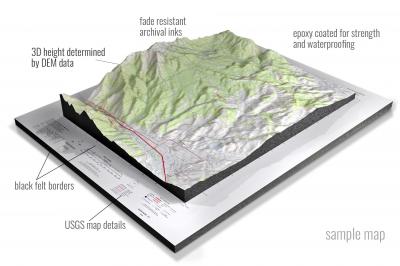
• Raised-relief 3D Height Determined by DEM data
• Fade Resistant Archival Inks
• Epoxy Coated for Strength and Waterproofing
• Ready to Hang with Pre-Installed Hardware (optional)
• Extraordinary 3D Accuracy
• Black Felt Borders
Enrich your office decor or home with a 3D USGS Raised Relief Map. These raised relief maps are not flat. They are three-dimensional, with the height being determined by Digital Elevation Model (DEM) data. Many people struggle with reading 2D satellite maps, but everyone understands 3D raised relief maps. The realism is phenomenal.
This 3D satellite raised relief map is built by combining satellite imagery data from Google Earth, bounding box coordinates from USGS, and DEM data. 3D Printing and 3D CNC routers are used to fabricate the models which make the satellite models extremely accurate. These models are strong - they are coated with epoxy, then finished with a sealer providing a weatherproof matt-finish. These are not meant to be used in direct sunlight.
Adams, New York- View hi-resolution image of: Adams, New York. Mapping by USGS in 2019 - Longitude/Latitude: -76.125 x -76 x 43.875 x 43.75, Grid Size: 7.5 X 7.5 Minute, Map Scale: 1:24000, State List: NY, County List: Jefferson
Addison, New York- View hi-resolution image of: Addison, New York. Mapping by USGS in 2019 - Longitude/Latitude: -77.25 x -77.125 x 42.125 x 42, Grid Size: 7.5 X 7.5 Minute, Map Scale: 1:24000, State List: NY, County List: Steuben
Afton, New York- View hi-resolution image of: Afton, New York. Mapping by USGS in 2019 - Longitude/Latitude: -75.625 x -75.5 x 42.25 x 42.125, Grid Size: 7.5 X 7.5 Minute, Map Scale: 1:24000, State List: NY, County List: Broome,Chenango
Akron, New York- View hi-resolution image of: Akron, New York. Mapping by USGS in 2019 - Longitude/Latitude: -78.5 x -78.375 x 43.125 x 43, Grid Size: 7.5 X 7.5 Minute, Map Scale: 1:24000, State List: NY, County List: Genesee,Erie,Niagara
Albany, New York- View hi-resolution image of: Albany, New York. Mapping by USGS in 2019 - Longitude/Latitude: -73.875 x -73.75 x 42.75 x 42.625, Grid Size: 7.5 X 7.5 Minute, Map Scale: 1:24000, State List: NY, County List: Albany,Rensselaer
Albert Marsh, New York- View hi-resolution image of: Albert Marsh, New York. Mapping by USGS in 2019 - Longitude/Latitude: -75 x -74.875 x 44.5 x 44.375, Grid Size: 7.5 X 7.5 Minute, Map Scale: 1:24000, State List: NY, County List: St. Lawrence
Albion, New York- View hi-resolution image of: Albion, New York. Mapping by USGS in 2019 - Longitude/Latitude: -78.25 x -78.125 x 43.25 x 43.125, Grid Size: 7.5 X 7.5 Minute, Map Scale: 1:24000, State List: NY, County List: Orleans,Genesee
Alcove, New York- View hi-resolution image of: Alcove, New York. Mapping by USGS in 2019 - Longitude/Latitude: -74 x -73.875 x 42.5 x 42.375, Grid Size: 7.5 X 7.5 Minute, Map Scale: 1:24000, State List: NY, County List: Greene,Albany
Alder Brook, New York- View hi-resolution image of: Alder Brook, New York. Mapping by USGS in 2019 - Longitude/Latitude: -74 x -73.875 x 44.625 x 44.5, Grid Size: 7.5 X 7.5 Minute, Map Scale: 1:24000, State List: NY, County List: Franklin,Clinton
Alexander, New York- View hi-resolution image of: Alexander, New York. Mapping by USGS in 2019 - Longitude/Latitude: -78.375 x -78.25 x 43 x 42.875, Grid Size: 7.5 X 7.5 Minute, Map Scale: 1:24000, State List: NY, County List: Genesee
Alexandria Bay, New York- View hi-resolution image of: Alexandria Bay, New York. Mapping by USGS in 2019 - Longitude/Latitude: -76 x -75.875 x 44.375 x 44.25, Grid Size: 7.5 X 7.5 Minute, Map Scale: 1:24000, State List: NY,ON, County List: Jefferson
Alfred, New York- View hi-resolution image of: Alfred, New York. Mapping by USGS in 2019 - Longitude/Latitude: -77.875 x -77.75 x 42.375 x 42.25, Grid Size: 7.5 X 7.5 Minute, Map Scale: 1:24000, State List: NY, County List: Allegany
Allentown, New York- View hi-resolution image of: Allentown, New York. Mapping by USGS in 2019 - Longitude/Latitude: -78.125 x -78 x 42.125 x 42, Grid Size: 7.5 X 7.5 Minute, Map Scale: 1:24000, State List: NY,PA, County List: Allegany,Potter
Alpine, New York- View hi-resolution image of: Alpine, New York. Mapping by USGS in 2019 - Longitude/Latitude: -76.75 x -76.625 x 42.375 x 42.25, Grid Size: 7.5 X 7.5 Minute, Map Scale: 1:24000, State List: NY, County List: Schuyler,Tompkins,Chemung
Altamont, New York- View hi-resolution image of: Altamont, New York. Mapping by USGS in 2019 - Longitude/Latitude: -74.125 x -74 x 42.75 x 42.625, Grid Size: 7.5 X 7.5 Minute, Map Scale: 1:24000, State List: NY, County List: Albany,Schenectady
Altona, New York- View hi-resolution image of: Altona, New York. Mapping by USGS in 2019 - Longitude/Latitude: -73.75 x -73.625 x 45 x 44.875, Grid Size: 7.5 X 7.5 Minute, Map Scale: 1:24000, State List: NY, County List: Clinton
Altona OE N, New York- View hi-resolution image of: Altona OE N, New York. Mapping by USGS in 2019 - Longitude/Latitude: -73.75 x -73.625 x 45.125 x 45, Grid Size: 7.5 X 7.5 Minute, Map Scale: 1:24000, State List: NY,QC, County List: Clinton
Amenia, New York- View hi-resolution image of: Amenia, New York. Mapping by USGS in 2019 - Longitude/Latitude: -73.625 x -73.5 x 41.875 x 41.75, Grid Size: 7.5 X 7.5 Minute, Map Scale: 1:24000, State List: NY,CT, County List: Dutchess,Litchfield
Amityville, New York- View hi-resolution image of: Amityville, New York. Mapping by USGS in 2019 - Longitude/Latitude: -73.5 x -73.375 x 40.75 x 40.625, Grid Size: 7.5 X 7.5 Minute, Map Scale: 1:24000, State List: NY, County List: Nassau,Suffolk
Ampersand Lake, New York- View hi-resolution image of: Ampersand Lake, New York. Mapping by USGS in 2019 - Longitude/Latitude: -74.25 x -74.125 x 44.25 x 44.125, Grid Size: 7.5 X 7.5 Minute, Map Scale: 1:24000, State List: NY, County List: Franklin,Essex
Amsterdam, New York- View hi-resolution image of: Amsterdam, New York. Mapping by USGS in 2019 - Longitude/Latitude: -74.25 x -74.125 x 43 x 42.875, Grid Size: 7.5 X 7.5 Minute, Map Scale: 1:24000, State List: NY, County List: Montgomery,Fulton,Schenectady
Ancram, New York- View hi-resolution image of: Ancram, New York. Mapping by USGS in 2019 - Longitude/Latitude: -73.75 x -73.625 x 42.125 x 42, Grid Size: 7.5 X 7.5 Minute, Map Scale: 1:24000, State List: NY, County List: Columbia,Dutchess
Andes, New York- View hi-resolution image of: Andes, New York. Mapping by USGS in 2019 - Longitude/Latitude: -74.875 x -74.75 x 42.25 x 42.125, Grid Size: 7.5 X 7.5 Minute, Map Scale: 1:24000, State List: NY, County List: Delaware
Andover, New York- View hi-resolution image of: Andover, New York. Mapping by USGS in 2019 - Longitude/Latitude: -77.875 x -77.75 x 42.25 x 42.125, Grid Size: 7.5 X 7.5 Minute, Map Scale: 1:24000, State List: NY, County List: Allegany
Angelica, New York- View hi-resolution image of: Angelica, New York. Mapping by USGS in 2019 - Longitude/Latitude: -78.125 x -78 x 42.375 x 42.25, Grid Size: 7.5 X 7.5 Minute, Map Scale: 1:24000, State List: NY, County List: Allegany
Angola, New York- View hi-resolution image of: Angola, New York. Mapping by USGS in 2019 - Longitude/Latitude: -79.125 x -79 x 42.75 x 42.625, Grid Size: 7.5 X 7.5 Minute, Map Scale: 1:24000, State List: NY, County List: Erie
Antwerp, New York- View hi-resolution image of: Antwerp, New York. Mapping by USGS in 2019 - Longitude/Latitude: -75.625 x -75.5 x 44.25 x 44.125, Grid Size: 7.5 X 7.5 Minute, Map Scale: 1:24000, State List: NY, County List: Jefferson,Lewis,St. Lawrence
Apalachin, New York- View hi-resolution image of: Apalachin, New York. Mapping by USGS in 2019 - Longitude/Latitude: -76.25 x -76.125 x 42.125 x 42, Grid Size: 7.5 X 7.5 Minute, Map Scale: 1:24000, State List: NY, County List: Tioga
Arcade, New York- View hi-resolution image of: Arcade, New York. Mapping by USGS in 2019 - Longitude/Latitude: -78.5 x -78.375 x 42.625 x 42.5, Grid Size: 7.5 X 7.5 Minute, Map Scale: 1:24000, State List: NY, County List: Wyoming,Erie,Cattaraugus
Arena, New York- View hi-resolution image of: Arena, New York. Mapping by USGS in 2019 - Longitude/Latitude: -74.75 x -74.625 x 42.125 x 42, Grid Size: 7.5 X 7.5 Minute, Map Scale: 1:24000, State List: NY, County List: Ulster,Delaware,Sullivan
Arkport, New York- View hi-resolution image of: Arkport, New York. Mapping by USGS in 2019 - Longitude/Latitude: -77.75 x -77.625 x 42.5 x 42.375, Grid Size: 7.5 X 7.5 Minute, Map Scale: 1:24000, State List: NY, County List: Steuben,Allegany,Livingston
Arthur Kill, New York- View hi-resolution image of: Arthur Kill, New York. Mapping by USGS in 2019 - Longitude/Latitude: -74.25 x -74.125 x 40.625 x 40.5, Grid Size: 7.5 X 7.5 Minute, Map Scale: 1:24000, State List: NY,NJ, County List: Richmond,Middlesex,Union
Ashford, New York- View hi-resolution image of: Ashford, New York. Mapping by USGS in 2019 - Longitude/Latitude: -78.625 x -78.5 x 42.375 x 42.25, Grid Size: 7.5 X 7.5 Minute, Map Scale: 1:24000, State List: NY, County List: Cattaraugus
Ashford Hollow, New York- View hi-resolution image of: Ashford Hollow, New York. Mapping by USGS in 2019 - Longitude/Latitude: -78.75 x -78.625 x 42.5 x 42.375, Grid Size: 7.5 X 7.5 Minute, Map Scale: 1:24000, State List: NY, County List: Cattaraugus,Erie
Ashland, New York- View hi-resolution image of: Ashland, New York. Mapping by USGS in 2019 - Longitude/Latitude: -74.375 x -74.25 x 42.375 x 42.25, Grid Size: 7.5 X 7.5 Minute, Map Scale: 1:24000, State List: NY, County List: Greene,Schoharie
Ashokan, New York- View hi-resolution image of: Ashokan, New York. Mapping by USGS in 2019 - Longitude/Latitude: -74.25 x -74.125 x 42 x 41.875, Grid Size: 7.5 X 7.5 Minute, Map Scale: 1:24000, State List: NY, County List: Ulster
Ashwood, New York- View hi-resolution image of: Ashwood, New York. Mapping by USGS in 2019 - Longitude/Latitude: -78.375 x -78.25 x 43.375 x 43.25, Grid Size: 7.5 X 7.5 Minute, Map Scale: 1:24000, State List: NY, County List: Orleans
Ashwood OE N, New York- View hi-resolution image of: Ashwood OE N, New York. Mapping by USGS in 2019 - Longitude/Latitude: -78.375 x -78.25 x 43.5 x 43.375, Grid Size: 7.5 X 7.5 Minute, Map Scale: 1:24000, State List: NY, County List: Orleans
Attica, New York- View hi-resolution image of: Attica, New York. Mapping by USGS in 2019 - Longitude/Latitude: -78.375 x -78.25 x 42.875 x 42.75, Grid Size: 7.5 X 7.5 Minute, Map Scale: 1:24000, State List: NY, County List: Wyoming,Genesee
Au Sable Forks, New York- View hi-resolution image of: Au Sable Forks, New York. Mapping by USGS in 2019 - Longitude/Latitude: -73.75 x -73.625 x 44.5 x 44.375, Grid Size: 7.5 X 7.5 Minute, Map Scale: 1:24000, State List: NY, County List: Essex,Clinton
Auburn, New York- View hi-resolution image of: Auburn, New York. Mapping by USGS in 2019 - Longitude/Latitude: -76.625 x -76.5 x 43 x 42.875, Grid Size: 7.5 X 7.5 Minute, Map Scale: 1:24000, State List: NY, County List: Cayuga
Augerhole Falls, New York- View hi-resolution image of: Augerhole Falls, New York. Mapping by USGS in 2019 - Longitude/Latitude: -74.625 x -74.5 x 44.5 x 44.375, Grid Size: 7.5 X 7.5 Minute, Map Scale: 1:24000, State List: NY, County List: Franklin,St. Lawrence
Averill Park, New York- View hi-resolution image of: Averill Park, New York. Mapping by USGS in 2019 - Longitude/Latitude: -73.625 x -73.5 x 42.75 x 42.625, Grid Size: 7.5 X 7.5 Minute, Map Scale: 1:24000, State List: NY, County List: Rensselaer
Avoca, New York- View hi-resolution image of: Avoca, New York. Mapping by USGS in 2019 - Longitude/Latitude: -77.5 x -77.375 x 42.5 x 42.375, Grid Size: 7.5 X 7.5 Minute, Map Scale: 1:24000, State List: NY, County List: Steuben
Bad Luck Mountain, New York- View hi-resolution image of: Bad Luck Mountain, New York. Mapping by USGS in 2019 - Longitude/Latitude: -74.25 x -74.125 x 43.875 x 43.75, Grid Size: 7.5 X 7.5 Minute, Map Scale: 1:24000, State List: NY, County List: Hamilton,Essex
Bakers Mills, New York- View hi-resolution image of: Bakers Mills, New York. Mapping by USGS in 2019 - Longitude/Latitude: -74.125 x -74 x 43.625 x 43.5, Grid Size: 7.5 X 7.5 Minute, Map Scale: 1:24000, State List: NY, County List: Warren
Baldwinsville, New York- View hi-resolution image of: Baldwinsville, New York. Mapping by USGS in 2019 - Longitude/Latitude: -76.375 x -76.25 x 43.25 x 43.125, Grid Size: 7.5 X 7.5 Minute, Map Scale: 1:24000, State List: NY, County List: Onondaga,Oswego
Bangor, New York- View hi-resolution image of: Bangor, New York. Mapping by USGS in 2019 - Longitude/Latitude: -74.5 x -74.375 x 44.875 x 44.75, Grid Size: 7.5 X 7.5 Minute, Map Scale: 1:24000, State List: NY, County List: Franklin
Barker, New York- View hi-resolution image of: Barker, New York. Mapping by USGS in 2019 - Longitude/Latitude: -78.625 x -78.5 x 43.375 x 43.25, Grid Size: 7.5 X 7.5 Minute, Map Scale: 1:24000, State List: NY, County List: Niagara
Barnes Corners, New York- View hi-resolution image of: Barnes Corners, New York. Mapping by USGS in 2019 - Longitude/Latitude: -75.875 x -75.75 x 43.875 x 43.75, Grid Size: 7.5 X 7.5 Minute, Map Scale: 1:24000, State List: NY, County List: Lewis,Jefferson
Barnhart Island, New York- View hi-resolution image of: Barnhart Island, New York. Mapping by USGS in 2016 - Longitude/Latitude: -74.875 x -74.75 x 45.125 x 45, Grid Size: 7.5 X 7.5 Minute, Map Scale: 1:24000, State List: NY,ON, County List: St. Lawrence
Barton, New York- View hi-resolution image of: Barton, New York. Mapping by USGS in 2019 - Longitude/Latitude: -76.5 x -76.375 x 42.125 x 42, Grid Size: 7.5 X 7.5 Minute, Map Scale: 1:24000, State List: NY, County List: Tioga
Batavia North, New York- View hi-resolution image of: Batavia North, New York. Mapping by USGS in 2019 - Longitude/Latitude: -78.25 x -78.125 x 43.125 x 43, Grid Size: 7.5 X 7.5 Minute, Map Scale: 1:24000, State List: NY, County List: Genesee
Batavia South, New York- View hi-resolution image of: Batavia South, New York. Mapping by USGS in 2019 - Longitude/Latitude: -78.25 x -78.125 x 43 x 42.875, Grid Size: 7.5 X 7.5 Minute, Map Scale: 1:24000, State List: NY, County List: Genesee
Bath, New York- View hi-resolution image of: Bath, New York. Mapping by USGS in 2019 - Longitude/Latitude: -77.375 x -77.25 x 42.375 x 42.25, Grid Size: 7.5 X 7.5 Minute, Map Scale: 1:24000, State List: NY, County List: Steuben
Bay Pond, New York- View hi-resolution image of: Bay Pond, New York. Mapping by USGS in 2019 - Longitude/Latitude: -74.5 x -74.375 x 44.5 x 44.375, Grid Size: 7.5 X 7.5 Minute, Map Scale: 1:24000, State List: NY, County List: Franklin
Bay Shore East, New York- View hi-resolution image of: Bay Shore East, New York. Mapping by USGS in 2019 - Longitude/Latitude: -73.25 x -73.125 x 40.75 x 40.625, Grid Size: 7.5 X 7.5 Minute, Map Scale: 1:24000, State List: NY, County List: Suffolk
Bay Shore East OE S, New York- View hi-resolution image of: Bay Shore East OE S, New York. Mapping by USGS in 2019 - Longitude/Latitude: -73.25 x -73.125 x 40.625 x 40.5, Grid Size: 7.5 X 7.5 Minute, Map Scale: 1:24000, State List: NY, County List: Suffolk
Bay Shore West, New York- View hi-resolution image of: Bay Shore West, New York. Mapping by USGS in 2019 - Longitude/Latitude: -73.375 x -73.25 x 40.75 x 40.625, Grid Size: 7.5 X 7.5 Minute, Map Scale: 1:24000, State List: NY, County List: Suffolk
Bay Shore West OE S, New York- View hi-resolution image of: Bay Shore West OE S, New York. Mapping by USGS in 2019 - Longitude/Latitude: -73.375 x -73.25 x 40.625 x 40.5, Grid Size: 7.5 X 7.5 Minute, Map Scale: 1:24000, State List: NY, County List: Suffolk
Bayville, New York- View hi-resolution image of: Bayville, New York. Mapping by USGS in 2019 - Longitude/Latitude: -73.625 x -73.5 x 41 x 40.875, Grid Size: 7.5 X 7.5 Minute, Map Scale: 1:24000, State List: NY,CT, County List: Nassau,Fairfield,Westchester
Bearsville, New York- View hi-resolution image of: Bearsville, New York. Mapping by USGS in 2019 - Longitude/Latitude: -74.25 x -74.125 x 42.125 x 42, Grid Size: 7.5 X 7.5 Minute, Map Scale: 1:24000, State List: NY, County List: Ulster,Greene
Beaver Dams, New York- View hi-resolution image of: Beaver Dams, New York. Mapping by USGS in 2019 - Longitude/Latitude: -77 x -76.875 x 42.375 x 42.25, Grid Size: 7.5 X 7.5 Minute, Map Scale: 1:24000, State List: NY, County List: Schuyler,Chemung,Steuben
Beaver River, New York- View hi-resolution image of: Beaver River, New York. Mapping by USGS in 2019 - Longitude/Latitude: -75 x -74.875 x 44 x 43.875, Grid Size: 7.5 X 7.5 Minute, Map Scale: 1:24000, State List: NY, County List: Herkimer
Beekmantown, New York- View hi-resolution image of: Beekmantown, New York. Mapping by USGS in 2019 - Longitude/Latitude: -73.5 x -73.375 x 44.875 x 44.75, Grid Size: 7.5 X 7.5 Minute, Map Scale: 1:24000, State List: NY,VT, County List: Clinton,Grand Isle
Belden, New York- View hi-resolution image of: Belden, New York. Mapping by USGS in 2019 - Longitude/Latitude: -75.75 x -75.625 x 42.25 x 42.125, Grid Size: 7.5 X 7.5 Minute, Map Scale: 1:24000, State List: NY, County List: Broome,Chenango
Belfort, New York- View hi-resolution image of: Belfort, New York. Mapping by USGS in 2019 - Longitude/Latitude: -75.375 x -75.25 x 44 x 43.875, Grid Size: 7.5 X 7.5 Minute, Map Scale: 1:24000, State List: NY, County List: Lewis
Bellport, New York- View hi-resolution image of: Bellport, New York. Mapping by USGS in 2019 - Longitude/Latitude: -73 x -72.875 x 40.875 x 40.75, Grid Size: 7.5 X 7.5 Minute, Map Scale: 1:24000, State List: NY, County List: Suffolk
Belmont, New York- View hi-resolution image of: Belmont, New York. Mapping by USGS in 2019 - Longitude/Latitude: -78.125 x -78 x 42.25 x 42.125, Grid Size: 7.5 X 7.5 Minute, Map Scale: 1:24000, State List: NY, County List: Allegany
Berlin, New York- View hi-resolution image of: Berlin, New York. Mapping by USGS in 2019 - Longitude/Latitude: -73.375 x -73.25 x 42.75 x 42.625, Grid Size: 7.5 X 7.5 Minute, Map Scale: 1:24000, State List: NY,MA,VT, County List: Rensselaer,Berkshire,Bennington
Big Flats, New York- View hi-resolution image of: Big Flats, New York. Mapping by USGS in 2019 - Longitude/Latitude: -77 x -76.875 x 42.25 x 42.125, Grid Size: 7.5 X 7.5 Minute, Map Scale: 1:24000, State List: NY, County List: Chemung,Steuben
Big Moose, New York- View hi-resolution image of: Big Moose, New York. Mapping by USGS in 2019 - Longitude/Latitude: -75 x -74.875 x 43.875 x 43.75, Grid Size: 7.5 X 7.5 Minute, Map Scale: 1:24000, State List: NY, County List: Herkimer
Bigelow, New York- View hi-resolution image of: Bigelow, New York. Mapping by USGS in 2019 - Longitude/Latitude: -75.375 x -75.25 x 44.5 x 44.375, Grid Size: 7.5 X 7.5 Minute, Map Scale: 1:24000, State List: NY, County List: St. Lawrence
Binghamton East, New York- View hi-resolution image of: Binghamton East, New York. Mapping by USGS in 2019 - Longitude/Latitude: -75.875 x -75.75 x 42.125 x 42, Grid Size: 7.5 X 7.5 Minute, Map Scale: 1:24000, State List: NY, County List: Broome
Binghamton West, New York- View hi-resolution image of: Binghamton West, New York. Mapping by USGS in 2019 - Longitude/Latitude: -76 x -75.875 x 42.125 x 42, Grid Size: 7.5 X 7.5 Minute, Map Scale: 1:24000, State List: NY, County List: Broome
Birdsall, New York- View hi-resolution image of: Birdsall, New York. Mapping by USGS in 2019 - Longitude/Latitude: -78 x -77.875 x 42.5 x 42.375, Grid Size: 7.5 X 7.5 Minute, Map Scale: 1:24000, State List: NY, County List: Allegany
Bisby Lakes, New York- View hi-resolution image of: Bisby Lakes, New York. Mapping by USGS in 2019 - Longitude/Latitude: -75 x -74.875 x 43.625 x 43.5, Grid Size: 7.5 X 7.5 Minute, Map Scale: 1:24000, State List: NY, County List: Herkimer
Black Creek, New York- View hi-resolution image of: Black Creek, New York. Mapping by USGS in 2019 - Longitude/Latitude: -78.25 x -78.125 x 42.375 x 42.25, Grid Size: 7.5 X 7.5 Minute, Map Scale: 1:24000, State List: NY, County List: Allegany
Black Creek Lake, New York- View hi-resolution image of: Black Creek Lake, New York. Mapping by USGS in 2019 - Longitude/Latitude: -75 x -74.875 x 43.5 x 43.375, Grid Size: 7.5 X 7.5 Minute, Map Scale: 1:24000, State List: NY, County List: Herkimer
Black River, New York- View hi-resolution image of: Black River, New York. Mapping by USGS in 2019 - Longitude/Latitude: -75.875 x -75.75 x 44.125 x 44, Grid Size: 7.5 X 7.5 Minute, Map Scale: 1:24000, State List: NY, County List: Jefferson
Bliss, New York- View hi-resolution image of: Bliss, New York. Mapping by USGS in 2019 - Longitude/Latitude: -78.375 x -78.25 x 42.625 x 42.5, Grid Size: 7.5 X 7.5 Minute, Map Scale: 1:24000, State List: NY, County List: Wyoming,Cattaraugus,Allegany
Bloomingdale, New York- View hi-resolution image of: Bloomingdale, New York. Mapping by USGS in 2019 - Longitude/Latitude: -74.125 x -74 x 44.5 x 44.375, Grid Size: 7.5 X 7.5 Minute, Map Scale: 1:24000, State List: NY, County List: Franklin,Essex
Bloomville, New York- View hi-resolution image of: Bloomville, New York. Mapping by USGS in 2019 - Longitude/Latitude: -74.875 x -74.75 x 42.375 x 42.25, Grid Size: 7.5 X 7.5 Minute, Map Scale: 1:24000, State List: NY, County List: Delaware
Blue Mountain Lake, New York- View hi-resolution image of: Blue Mountain Lake, New York. Mapping by USGS in 2019 - Longitude/Latitude: -74.5 x -74.375 x 43.875 x 43.75, Grid Size: 7.5 X 7.5 Minute, Map Scale: 1:24000, State List: NY, County List: Hamilton
Blue Ridge, New York- View hi-resolution image of: Blue Ridge, New York. Mapping by USGS in 2019 - Longitude/Latitude: -73.875 x -73.75 x 44 x 43.875, Grid Size: 7.5 X 7.5 Minute, Map Scale: 1:24000, State List: NY, County List: Essex
Bolivar, New York- View hi-resolution image of: Bolivar, New York. Mapping by USGS in 2019 - Longitude/Latitude: -78.25 x -78.125 x 42.125 x 42, Grid Size: 7.5 X 7.5 Minute, Map Scale: 1:24000, State List: NY,PA, County List: Allegany,Potter
Bolton Landing, New York- View hi-resolution image of: Bolton Landing, New York. Mapping by USGS in 2019 - Longitude/Latitude: -73.75 x -73.625 x 43.625 x 43.5, Grid Size: 7.5 X 7.5 Minute, Map Scale: 1:24000, State List: NY, County List: Warren,Washington
Bombay, New York- View hi-resolution image of: Bombay, New York. Mapping by USGS in 2019 - Longitude/Latitude: -74.625 x -74.5 x 45 x 44.875, Grid Size: 7.5 X 7.5 Minute, Map Scale: 1:24000, State List: NY, County List: Franklin
Boonville, New York- View hi-resolution image of: Boonville, New York. Mapping by USGS in 2019 - Longitude/Latitude: -75.375 x -75.25 x 43.5 x 43.375, Grid Size: 7.5 X 7.5 Minute, Map Scale: 1:24000, State List: NY, County List: Oneida,Lewis
Borden, New York- View hi-resolution image of: Borden, New York. Mapping by USGS in 2019 - Longitude/Latitude: -77.375 x -77.25 x 42.125 x 42, Grid Size: 7.5 X 7.5 Minute, Map Scale: 1:24000, State List: NY, County List: Steuben
Boylston Center, New York- View hi-resolution image of: Boylston Center, New York. Mapping by USGS in 2019 - Longitude/Latitude: -76 x -75.875 x 43.75 x 43.625, Grid Size: 7.5 X 7.5 Minute, Map Scale: 1:24000, State List: NY, County List: Oswego,Jefferson
Braddock Heights, New York- View hi-resolution image of: Braddock Heights, New York. Mapping by USGS in 2019 - Longitude/Latitude: -77.75 x -77.625 x 43.375 x 43.25, Grid Size: 7.5 X 7.5 Minute, Map Scale: 1:24000, State List: NY, County List: Monroe
Bradford, New York- View hi-resolution image of: Bradford, New York. Mapping by USGS in 2019 - Longitude/Latitude: -77.125 x -77 x 42.375 x 42.25, Grid Size: 7.5 X 7.5 Minute, Map Scale: 1:24000, State List: NY, County List: Schuyler,Steuben
Brainardsville, New York- View hi-resolution image of: Brainardsville, New York. Mapping by USGS in 2019 - Longitude/Latitude: -74.125 x -74 x 44.875 x 44.75, Grid Size: 7.5 X 7.5 Minute, Map Scale: 1:24000, State List: NY, County List: Franklin,Clinton
Brandreth Lake, New York- View hi-resolution image of: Brandreth Lake, New York. Mapping by USGS in 2019 - Longitude/Latitude: -74.75 x -74.625 x 44 x 43.875, Grid Size: 7.5 X 7.5 Minute, Map Scale: 1:24000, State List: NY, County List: Hamilton
Brant Lake, New York- View hi-resolution image of: Brant Lake, New York. Mapping by USGS in 2019 - Longitude/Latitude: -73.75 x -73.625 x 43.75 x 43.625, Grid Size: 7.5 X 7.5 Minute, Map Scale: 1:24000, State List: NY, County List: Warren
Brantingham, New York- View hi-resolution image of: Brantingham, New York. Mapping by USGS in 2019 - Longitude/Latitude: -75.375 x -75.25 x 43.75 x 43.625, Grid Size: 7.5 X 7.5 Minute, Map Scale: 1:24000, State List: NY, County List: Lewis
Brasher Falls, New York- View hi-resolution image of: Brasher Falls, New York. Mapping by USGS in 2019 - Longitude/Latitude: -74.875 x -74.75 x 44.875 x 44.75, Grid Size: 7.5 X 7.5 Minute, Map Scale: 1:24000, State List: NY, County List: St. Lawrence
Breakabeen, New York- View hi-resolution image of: Breakabeen, New York. Mapping by USGS in 2019 - Longitude/Latitude: -74.5 x -74.375 x 42.625 x 42.5, Grid Size: 7.5 X 7.5 Minute, Map Scale: 1:24000, State List: NY, County List: Schoharie
Brewerton, New York- View hi-resolution image of: Brewerton, New York. Mapping by USGS in 2019 - Longitude/Latitude: -76.25 x -76.125 x 43.25 x 43.125, Grid Size: 7.5 X 7.5 Minute, Map Scale: 1:24000, State List: NY, County List: Onondaga,Oswego
Brewster, New York- View hi-resolution image of: Brewster, New York. Mapping by USGS in 2019 - Longitude/Latitude: -73.625 x -73.5 x 41.5 x 41.375, Grid Size: 7.5 X 7.5 Minute, Map Scale: 1:24000, State List: NY,CT, County List: Putnam,Fairfield
Brisben, New York- View hi-resolution image of: Brisben, New York. Mapping by USGS in 2019 - Longitude/Latitude: -75.75 x -75.625 x 42.375 x 42.25, Grid Size: 7.5 X 7.5 Minute, Map Scale: 1:24000, State List: NY, County List: Chenango
Bristol Center, New York- View hi-resolution image of: Bristol Center, New York. Mapping by USGS in 2019 - Longitude/Latitude: -77.5 x -77.375 x 42.875 x 42.75, Grid Size: 7.5 X 7.5 Minute, Map Scale: 1:24000, State List: NY, County List: Ontario
Bristol Springs, New York- View hi-resolution image of: Bristol Springs, New York. Mapping by USGS in 2019 - Longitude/Latitude: -77.5 x -77.375 x 42.75 x 42.625, Grid Size: 7.5 X 7.5 Minute, Map Scale: 1:24000, State List: NY, County List: Ontario,Livingston
Broadalbin, New York- View hi-resolution image of: Broadalbin, New York. Mapping by USGS in 2019 - Longitude/Latitude: -74.25 x -74.125 x 43.125 x 43, Grid Size: 7.5 X 7.5 Minute, Map Scale: 1:24000, State List: NY, County List: Fulton
Brockport, New York- View hi-resolution image of: Brockport, New York. Mapping by USGS in 2019 - Longitude/Latitude: -78 x -77.875 x 43.25 x 43.125, Grid Size: 7.5 X 7.5 Minute, Map Scale: 1:24000, State List: NY, County List: Monroe,Genesee,Orleans
Brocton, New York- View hi-resolution image of: Brocton, New York. Mapping by USGS in 2019 - Longitude/Latitude: -79.5 x -79.375 x 42.5 x 42.375, Grid Size: 7.5 X 7.5 Minute, Map Scale: 1:24000, State List: NY, County List: Chautauqua
Brookfield, New York- View hi-resolution image of: Brookfield, New York. Mapping by USGS in 2019 - Longitude/Latitude: -75.375 x -75.25 x 42.875 x 42.75, Grid Size: 7.5 X 7.5 Minute, Map Scale: 1:24000, State List: NY, County List: Madison,Otsego,Oneida
Brooklyn, New York- View hi-resolution image of: Brooklyn, New York. Mapping by USGS in 2019 - Longitude/Latitude: -74 x -73.875 x 40.75 x 40.625, Grid Size: 7.5 X 7.5 Minute, Map Scale: 1:24000, State List: NY, County List: Kings,Queens,New York
Brother Ponds, New York- View hi-resolution image of: Brother Ponds, New York. Mapping by USGS in 2019 - Longitude/Latitude: -74.875 x -74.75 x 44.375 x 44.25, Grid Size: 7.5 X 7.5 Minute, Map Scale: 1:24000, State List: NY, County List: St. Lawrence
Brownville, New York- View hi-resolution image of: Brownville, New York. Mapping by USGS in 2019 - Longitude/Latitude: -76 x -75.875 x 44.125 x 44, Grid Size: 7.5 X 7.5 Minute, Map Scale: 1:24000, State List: NY, County List: Jefferson
Brushton, New York- View hi-resolution image of: Brushton, New York. Mapping by USGS in 2019 - Longitude/Latitude: -74.625 x -74.5 x 44.875 x 44.75, Grid Size: 7.5 X 7.5 Minute, Map Scale: 1:24000, State List: NY, County List: Franklin,St. Lawrence
Buffalo NE, New York- View hi-resolution image of: Buffalo NE, New York. Mapping by USGS in 2019 - Longitude/Latitude: -78.875 x -78.75 x 43 x 42.875, Grid Size: 7.5 X 7.5 Minute, Map Scale: 1:24000, State List: NY, County List: Erie
Buffalo NW, New York- View hi-resolution image of: Buffalo NW, New York. Mapping by USGS in 2019 - Longitude/Latitude: -79 x -78.875 x 43 x 42.875, Grid Size: 7.5 X 7.5 Minute, Map Scale: 1:24000, State List: NY,ON, County List: Erie
Buffalo NW OE W, New York- View hi-resolution image of: Buffalo NW OE W, New York. Mapping by USGS in 2019 - Longitude/Latitude: -79.125 x -79 x 43 x 42.875, Grid Size: 7.5 X 7.5 Minute, Map Scale: 1:24000, State List: NY,ON, County List: Erie
Buffalo SE, New York- View hi-resolution image of: Buffalo SE, New York. Mapping by USGS in 2019 - Longitude/Latitude: -78.875 x -78.75 x 42.875 x 42.75, Grid Size: 7.5 X 7.5 Minute, Map Scale: 1:24000, State List: NY, County List: Erie
Buffalo SE OE W, New York- View hi-resolution image of: Buffalo SE OE W, New York. Mapping by USGS in 2019 - Longitude/Latitude: -79 x -78.875 x 42.875 x 42.75, Grid Size: 7.5 X 7.5 Minute, Map Scale: 1:24000, State List: NY,ON, County List: Erie
Bullhead Mountain, New York- View hi-resolution image of: Bullhead Mountain, New York. Mapping by USGS in 2019 - Longitude/Latitude: -74.25 x -74.125 x 43.75 x 43.625, Grid Size: 7.5 X 7.5 Minute, Map Scale: 1:24000, State List: NY, County List: Warren,Hamilton
Burdett, New York- View hi-resolution image of: Burdett, New York. Mapping by USGS in 2019 - Longitude/Latitude: -76.875 x -76.75 x 42.5 x 42.375, Grid Size: 7.5 X 7.5 Minute, Map Scale: 1:24000, State List: NY, County List: Schuyler
Burke, New York- View hi-resolution image of: Burke, New York. Mapping by USGS in 2019 - Longitude/Latitude: -74.25 x -74.125 x 45 x 44.875, Grid Size: 7.5 X 7.5 Minute, Map Scale: 1:24000, State List: NY,QC, County List: Franklin
Burnt Hills, New York- View hi-resolution image of: Burnt Hills, New York. Mapping by USGS in 2019 - Longitude/Latitude: -74 x -73.875 x 43 x 42.875, Grid Size: 7.5 X 7.5 Minute, Map Scale: 1:24000, State List: NY, County List: Saratoga,Schenectady
Byron, New York- View hi-resolution image of: Byron, New York. Mapping by USGS in 2019 - Longitude/Latitude: -78.125 x -78 x 43.125 x 43, Grid Size: 7.5 X 7.5 Minute, Map Scale: 1:24000, State List: NY, County List: Genesee
Caledonia, New York- View hi-resolution image of: Caledonia, New York. Mapping by USGS in 2019 - Longitude/Latitude: -77.875 x -77.75 x 43 x 42.875, Grid Size: 7.5 X 7.5 Minute, Map Scale: 1:24000, State List: NY, County List: Livingston,Monroe
Callicoon, New York- View hi-resolution image of: Callicoon, New York. Mapping by USGS in 2019 - Longitude/Latitude: -75.125 x -75 x 41.875 x 41.75, Grid Size: 7.5 X 7.5 Minute, Map Scale: 1:24000, State List: NY,PA, County List: Sullivan,Wayne,Delaware
Cambria, New York- View hi-resolution image of: Cambria, New York. Mapping by USGS in 2019 - Longitude/Latitude: -78.875 x -78.75 x 43.25 x 43.125, Grid Size: 7.5 X 7.5 Minute, Map Scale: 1:24000, State List: NY, County List: Niagara
Cambridge, New York- View hi-resolution image of: Cambridge, New York. Mapping by USGS in 2019 - Longitude/Latitude: -73.5 x -73.375 x 43.125 x 43, Grid Size: 7.5 X 7.5 Minute, Map Scale: 1:24000, State List: NY, County List: Washington
Camden East, New York- View hi-resolution image of: Camden East, New York. Mapping by USGS in 2019 - Longitude/Latitude: -75.75 x -75.625 x 43.375 x 43.25, Grid Size: 7.5 X 7.5 Minute, Map Scale: 1:24000, State List: NY, County List: Oneida
Camden West, New York- View hi-resolution image of: Camden West, New York. Mapping by USGS in 2019 - Longitude/Latitude: -75.875 x -75.75 x 43.375 x 43.25, Grid Size: 7.5 X 7.5 Minute, Map Scale: 1:24000, State List: NY, County List: Oneida,Oswego
Cameron, New York- View hi-resolution image of: Cameron, New York. Mapping by USGS in 2019 - Longitude/Latitude: -77.5 x -77.375 x 42.25 x 42.125, Grid Size: 7.5 X 7.5 Minute, Map Scale: 1:24000, State List: NY, County List: Steuben
Camillus, New York- View hi-resolution image of: Camillus, New York. Mapping by USGS in 2019 - Longitude/Latitude: -76.375 x -76.25 x 43.125 x 43, Grid Size: 7.5 X 7.5 Minute, Map Scale: 1:24000, State List: NY, County List: Onondaga
Campbell, New York- View hi-resolution image of: Campbell, New York. Mapping by USGS in 2019 - Longitude/Latitude: -77.25 x -77.125 x 42.25 x 42.125, Grid Size: 7.5 X 7.5 Minute, Map Scale: 1:24000, State List: NY, County List: Steuben
Canaan, New York- View hi-resolution image of: Canaan, New York. Mapping by USGS in 2019 - Longitude/Latitude: -73.5 x -73.375 x 42.5 x 42.375, Grid Size: 7.5 X 7.5 Minute, Map Scale: 1:24000, State List: NY,MA, County List: Columbia,Berkshire,Rensselaer
Canada Lake, New York- View hi-resolution image of: Canada Lake, New York. Mapping by USGS in 2019 - Longitude/Latitude: -74.625 x -74.5 x 43.25 x 43.125, Grid Size: 7.5 X 7.5 Minute, Map Scale: 1:24000, State List: NY, County List: Fulton,Hamilton
Canajoharie, New York- View hi-resolution image of: Canajoharie, New York. Mapping by USGS in 2019 - Longitude/Latitude: -74.625 x -74.5 x 43 x 42.875, Grid Size: 7.5 X 7.5 Minute, Map Scale: 1:24000, State List: NY, County List: Montgomery,Fulton
Canandaigua, New York- View hi-resolution image of: Canandaigua, New York. Mapping by USGS in 2019 - Longitude/Latitude: -77.375 x -77.25 x 43 x 42.875, Grid Size: 7.5 X 7.5 Minute, Map Scale: 1:24000, State List: NY, County List: Ontario
Canandaigua Lake, New York- View hi-resolution image of: Canandaigua Lake, New York. Mapping by USGS in 2019 - Longitude/Latitude: -77.375 x -77.25 x 42.875 x 42.75, Grid Size: 7.5 X 7.5 Minute, Map Scale: 1:24000, State List: NY, County List: Ontario,Yates
Canaseraga, New York- View hi-resolution image of: Canaseraga, New York. Mapping by USGS in 2019 - Longitude/Latitude: -77.875 x -77.75 x 42.5 x 42.375, Grid Size: 7.5 X 7.5 Minute, Map Scale: 1:24000, State List: NY, County List: Allegany,Livingston
Canastota, New York- View hi-resolution image of: Canastota, New York. Mapping by USGS in 2019 - Longitude/Latitude: -75.875 x -75.75 x 43.125 x 43, Grid Size: 7.5 X 7.5 Minute, Map Scale: 1:24000, State List: NY, County List: Madison
Candor, New York- View hi-resolution image of: Candor, New York. Mapping by USGS in 2019 - Longitude/Latitude: -76.375 x -76.25 x 42.25 x 42.125, Grid Size: 7.5 X 7.5 Minute, Map Scale: 1:24000, State List: NY, County List: Tioga
Canisteo, New York- View hi-resolution image of: Canisteo, New York. Mapping by USGS in 2019 - Longitude/Latitude: -77.625 x -77.5 x 42.375 x 42.25, Grid Size: 7.5 X 7.5 Minute, Map Scale: 1:24000, State List: NY, County List: Steuben
Cannonsville Reservoir, New York- View hi-resolution image of: Cannonsville Reservoir, New York. Mapping by USGS in 2019 - Longitude/Latitude: -75.375 x -75.25 x 42.125 x 42, Grid Size: 7.5 X 7.5 Minute, Map Scale: 1:24000, State List: NY, County List: Delaware,Broome
Canton, New York- View hi-resolution image of: Canton, New York. Mapping by USGS in 2019 - Longitude/Latitude: -75.25 x -75.125 x 44.625 x 44.5, Grid Size: 7.5 X 7.5 Minute, Map Scale: 1:24000, State List: NY, County List: St. Lawrence
Cape Vincent North, New York- View hi-resolution image of: Cape Vincent North, New York. Mapping by USGS in 2019 - Longitude/Latitude: -76.375 x -76.25 x 44.25 x 44.125, Grid Size: 7.5 X 7.5 Minute, Map Scale: 1:24000, State List: NY,ON, County List: Jefferson
Cape Vincent South, New York- View hi-resolution image of: Cape Vincent South, New York. Mapping by USGS in 2019 - Longitude/Latitude: -76.375 x -76.25 x 44.125 x 44, Grid Size: 7.5 X 7.5 Minute, Map Scale: 1:24000, State List: NY, County List: Jefferson
Cape Vincent South OE W, New York- View hi-resolution image of: Cape Vincent South OE W, New York. Mapping by USGS in 2019 - Longitude/Latitude: -76.5 x -76.375 x 44.125 x 44, Grid Size: 7.5 X 7.5 Minute, Map Scale: 1:24000, State List: NY,ON, County List: Jefferson
Carlisle, New York- View hi-resolution image of: Carlisle, New York. Mapping by USGS in 2019 - Longitude/Latitude: -74.5 x -74.375 x 42.875 x 42.75, Grid Size: 7.5 X 7.5 Minute, Map Scale: 1:24000, State List: NY, County List: Montgomery,Schoharie
Caroga Lake, New York- View hi-resolution image of: Caroga Lake, New York. Mapping by USGS in 2019 - Longitude/Latitude: -74.5 x -74.375 x 43.25 x 43.125, Grid Size: 7.5 X 7.5 Minute, Map Scale: 1:24000, State List: NY, County List: Fulton,Hamilton
Carry Falls Reservoir, New York- View hi-resolution image of: Carry Falls Reservoir, New York. Mapping by USGS in 2019 - Longitude/Latitude: -74.75 x -74.625 x 44.5 x 44.375, Grid Size: 7.5 X 7.5 Minute, Map Scale: 1:24000, State List: NY, County List: St. Lawrence
Carthage, New York- View hi-resolution image of: Carthage, New York. Mapping by USGS in 2019 - Longitude/Latitude: -75.625 x -75.5 x 44 x 43.875, Grid Size: 7.5 X 7.5 Minute, Map Scale: 1:24000, State List: NY, County List: Lewis,Jefferson
Cassadaga, New York- View hi-resolution image of: Cassadaga, New York. Mapping by USGS in 2019 - Longitude/Latitude: -79.375 x -79.25 x 42.375 x 42.25, Grid Size: 7.5 X 7.5 Minute, Map Scale: 1:24000, State List: NY, County List: Chautauqua
Cassville, New York- View hi-resolution image of: Cassville, New York. Mapping by USGS in 2019 - Longitude/Latitude: -75.375 x -75.25 x 43 x 42.875, Grid Size: 7.5 X 7.5 Minute, Map Scale: 1:24000, State List: NY, County List: Oneida
Castile, New York- View hi-resolution image of: Castile, New York. Mapping by USGS in 2019 - Longitude/Latitude: -78.125 x -78 x 42.75 x 42.625, Grid Size: 7.5 X 7.5 Minute, Map Scale: 1:24000, State List: NY, County List: Wyoming
Castle Creek, New York- View hi-resolution image of: Castle Creek, New York. Mapping by USGS in 2019 - Longitude/Latitude: -76 x -75.875 x 42.25 x 42.125, Grid Size: 7.5 X 7.5 Minute, Map Scale: 1:24000, State List: NY, County List: Broome
Cathead Mountain, New York- View hi-resolution image of: Cathead Mountain, New York. Mapping by USGS in 2019 - Longitude/Latitude: -74.375 x -74.25 x 43.375 x 43.25, Grid Size: 7.5 X 7.5 Minute, Map Scale: 1:24000, State List: NY, County List: Hamilton
Cato, New York- View hi-resolution image of: Cato, New York. Mapping by USGS in 2019 - Longitude/Latitude: -76.625 x -76.5 x 43.25 x 43.125, Grid Size: 7.5 X 7.5 Minute, Map Scale: 1:24000, State List: NY, County List: Cayuga
Caton, New York- View hi-resolution image of: Caton, New York. Mapping by USGS in 2019 - Longitude/Latitude: -77.125 x -77 x 42.125 x 42, Grid Size: 7.5 X 7.5 Minute, Map Scale: 1:24000, State List: NY,PA, County List: Steuben,Tioga
Cattaraugus, New York- View hi-resolution image of: Cattaraugus, New York. Mapping by USGS in 2019 - Longitude/Latitude: -78.875 x -78.75 x 42.375 x 42.25, Grid Size: 7.5 X 7.5 Minute, Map Scale: 1:24000, State List: NY, County List: Cattaraugus
Cayuga, New York- View hi-resolution image of: Cayuga, New York. Mapping by USGS in 2019 - Longitude/Latitude: -76.75 x -76.625 x 43 x 42.875, Grid Size: 7.5 X 7.5 Minute, Map Scale: 1:24000, State List: NY, County List: Cayuga,Seneca
Cazenovia, New York- View hi-resolution image of: Cazenovia, New York. Mapping by USGS in 2019 - Longitude/Latitude: -75.875 x -75.75 x 43 x 42.875, Grid Size: 7.5 X 7.5 Minute, Map Scale: 1:24000, State List: NY, County List: Madison
Cementon, New York- View hi-resolution image of: Cementon, New York. Mapping by USGS in 2019 - Longitude/Latitude: -74 x -73.875 x 42.25 x 42.125, Grid Size: 7.5 X 7.5 Minute, Map Scale: 1:24000, State List: NY, County List: Greene,Ulster,Columbia
Central Islip, New York- View hi-resolution image of: Central Islip, New York. Mapping by USGS in 2019 - Longitude/Latitude: -73.25 x -73.125 x 40.875 x 40.75, Grid Size: 7.5 X 7.5 Minute, Map Scale: 1:24000, State List: NY, County List: Suffolk
Central Park, New York- View hi-resolution image of: Central Park, New York. Mapping by USGS in 2019 - Longitude/Latitude: -74 x -73.875 x 40.875 x 40.75, Grid Size: 7.5 X 7.5 Minute, Map Scale: 1:24000, State List: NY,NJ, County List: New York,Bronx,Bergen,Queens,Hudson
Central Square, New York- View hi-resolution image of: Central Square, New York. Mapping by USGS in 2019 - Longitude/Latitude: -76.25 x -76.125 x 43.375 x 43.25, Grid Size: 7.5 X 7.5 Minute, Map Scale: 1:24000, State List: NY, County List: Oswego,Onondaga
Champlain, New York- View hi-resolution image of: Champlain, New York. Mapping by USGS in 2019 - Longitude/Latitude: -73.5 x -73.375 x 45 x 44.875, Grid Size: 7.5 X 7.5 Minute, Map Scale: 1:24000, State List: NY, County List: Clinton
Champlain OE N, New York- View hi-resolution image of: Champlain OE N, New York. Mapping by USGS in 2019 - Longitude/Latitude: -73.5 x -73.375 x 45.125 x 45, Grid Size: 7.5 X 7.5 Minute, Map Scale: 1:24000, State List: NY,QC, County List: Clinton
Charlotteville, New York- View hi-resolution image of: Charlotteville, New York. Mapping by USGS in 2019 - Longitude/Latitude: -74.75 x -74.625 x 42.625 x 42.5, Grid Size: 7.5 X 7.5 Minute, Map Scale: 1:24000, State List: NY, County List: Otsego,Schoharie,Delaware
Chase Mills, New York- View hi-resolution image of: Chase Mills, New York. Mapping by USGS in 2019 - Longitude/Latitude: -75.125 x -75 x 44.875 x 44.75, Grid Size: 7.5 X 7.5 Minute, Map Scale: 1:24000, State List: NY, County List: St. Lawrence
Chasm Falls, New York- View hi-resolution image of: Chasm Falls, New York. Mapping by USGS in 2019 - Longitude/Latitude: -74.25 x -74.125 x 44.875 x 44.75, Grid Size: 7.5 X 7.5 Minute, Map Scale: 1:24000, State List: NY, County List: Franklin
Chateaugay, New York- View hi-resolution image of: Chateaugay, New York. Mapping by USGS in 2019 - Longitude/Latitude: -74.125 x -74 x 45 x 44.875, Grid Size: 7.5 X 7.5 Minute, Map Scale: 1:24000, State List: NY,QC, County List: Franklin,Clinton
Chatham, New York- View hi-resolution image of: Chatham, New York. Mapping by USGS in 2019 - Longitude/Latitude: -73.625 x -73.5 x 42.375 x 42.25, Grid Size: 7.5 X 7.5 Minute, Map Scale: 1:24000, State List: NY, County List: Columbia
Chaumont, New York- View hi-resolution image of: Chaumont, New York. Mapping by USGS in 2019 - Longitude/Latitude: -76.25 x -76.125 x 44.125 x 44, Grid Size: 7.5 X 7.5 Minute, Map Scale: 1:24000, State List: NY, County List: Jefferson
Chautauqua, New York- View hi-resolution image of: Chautauqua, New York. Mapping by USGS in 2019 - Longitude/Latitude: -79.5 x -79.375 x 42.25 x 42.125, Grid Size: 7.5 X 7.5 Minute, Map Scale: 1:24000, State List: NY, County List: Chautauqua
Chenango Forks, New York- View hi-resolution image of: Chenango Forks, New York. Mapping by USGS in 2019 - Longitude/Latitude: -75.875 x -75.75 x 42.25 x 42.125, Grid Size: 7.5 X 7.5 Minute, Map Scale: 1:24000, State List: NY, County List: Broome,Chenango
Cheney Pond, New York- View hi-resolution image of: Cheney Pond, New York. Mapping by USGS in 2019 - Longitude/Latitude: -74 x -73.875 x 44 x 43.875, Grid Size: 7.5 X 7.5 Minute, Map Scale: 1:24000, State List: NY, County List: Essex
Cherry Creek, New York- View hi-resolution image of: Cherry Creek, New York. Mapping by USGS in 2019 - Longitude/Latitude: -79.125 x -79 x 42.375 x 42.25, Grid Size: 7.5 X 7.5 Minute, Map Scale: 1:24000, State List: NY, County List: Chautauqua,Cattaraugus
Chestertown, New York- View hi-resolution image of: Chestertown, New York. Mapping by USGS in 2019 - Longitude/Latitude: -73.875 x -73.75 x 43.75 x 43.625, Grid Size: 7.5 X 7.5 Minute, Map Scale: 1:24000, State List: NY, County List: Warren
Childwold, New York- View hi-resolution image of: Childwold, New York. Mapping by USGS in 2019 - Longitude/Latitude: -74.75 x -74.625 x 44.375 x 44.25, Grid Size: 7.5 X 7.5 Minute, Map Scale: 1:24000, State List: NY, County List: St. Lawrence
Chippewa Bay, New York- View hi-resolution image of: Chippewa Bay, New York. Mapping by USGS in 2019 - Longitude/Latitude: -75.875 x -75.75 x 44.5 x 44.375, Grid Size: 7.5 X 7.5 Minute, Map Scale: 1:24000, State List: NY,ON, County List: St. Lawrence,Jefferson
Churchville, New York- View hi-resolution image of: Churchville, New York. Mapping by USGS in 2019 - Longitude/Latitude: -78 x -77.875 x 43.125 x 43, Grid Size: 7.5 X 7.5 Minute, Map Scale: 1:24000, State List: NY, County List: Genesee,Monroe
Churubusco, New York- View hi-resolution image of: Churubusco, New York. Mapping by USGS in 2019 - Longitude/Latitude: -74 x -73.875 x 45 x 44.875, Grid Size: 7.5 X 7.5 Minute, Map Scale: 1:24000, State List: NY,QC, County List: Clinton
Churubusco OE N, New York- View hi-resolution image of: Churubusco OE N, New York. Mapping by USGS in 2019 - Longitude/Latitude: -74 x -73.875 x 45.125 x 45, Grid Size: 7.5 X 7.5 Minute, Map Scale: 1:24000, State List: NY,QC, County List: Clinton
Cicero, New York- View hi-resolution image of: Cicero, New York. Mapping by USGS in 2019 - Longitude/Latitude: -76.125 x -76 x 43.25 x 43.125, Grid Size: 7.5 X 7.5 Minute, Map Scale: 1:24000, State List: NY, County List: Onondaga,Oswego
Cincinnatus, New York- View hi-resolution image of: Cincinnatus, New York. Mapping by USGS in 2019 - Longitude/Latitude: -76 x -75.875 x 42.625 x 42.5, Grid Size: 7.5 X 7.5 Minute, Map Scale: 1:24000, State List: NY, County List: Cortland,Chenango
Clarence, New York- View hi-resolution image of: Clarence, New York. Mapping by USGS in 2019 - Longitude/Latitude: -78.625 x -78.5 x 43 x 42.875, Grid Size: 7.5 X 7.5 Minute, Map Scale: 1:24000, State List: NY, County List: Erie
Clarence Center, New York- View hi-resolution image of: Clarence Center, New York. Mapping by USGS in 2019 - Longitude/Latitude: -78.75 x -78.625 x 43.125 x 43, Grid Size: 7.5 X 7.5 Minute, Map Scale: 1:24000, State List: NY, County List: Erie,Niagara
Clarksville, New York- View hi-resolution image of: Clarksville, New York. Mapping by USGS in 2019 - Longitude/Latitude: -74 x -73.875 x 42.625 x 42.5, Grid Size: 7.5 X 7.5 Minute, Map Scale: 1:24000, State List: NY, County List: Albany
Claryville, New York- View hi-resolution image of: Claryville, New York. Mapping by USGS in 2019 - Longitude/Latitude: -74.625 x -74.5 x 42 x 41.875, Grid Size: 7.5 X 7.5 Minute, Map Scale: 1:24000, State List: NY, County List: Ulster,Sullivan
Claverack, New York- View hi-resolution image of: Claverack, New York. Mapping by USGS in 2019 - Longitude/Latitude: -73.75 x -73.625 x 42.25 x 42.125, Grid Size: 7.5 X 7.5 Minute, Map Scale: 1:24000, State List: NY, County List: Columbia
Clayton, New York- View hi-resolution image of: Clayton, New York. Mapping by USGS in 2019 - Longitude/Latitude: -76.125 x -76 x 44.25 x 44.125, Grid Size: 7.5 X 7.5 Minute, Map Scale: 1:24000, State List: NY, County List: Jefferson
Clermont, New York- View hi-resolution image of: Clermont, New York. Mapping by USGS in 2019 - Longitude/Latitude: -73.875 x -73.75 x 42.125 x 42, Grid Size: 7.5 X 7.5 Minute, Map Scale: 1:24000, State List: NY, County List: Columbia,Dutchess
Cleveland, New York- View hi-resolution image of: Cleveland, New York. Mapping by USGS in 2019 - Longitude/Latitude: -76 x -75.875 x 43.25 x 43.125, Grid Size: 7.5 X 7.5 Minute, Map Scale: 1:24000, State List: NY, County List: Oswego,Madison,Onondaga,Oneida
Clifton, New York- View hi-resolution image of: Clifton, New York. Mapping by USGS in 2019 - Longitude/Latitude: -77.875 x -77.75 x 43.125 x 43, Grid Size: 7.5 X 7.5 Minute, Map Scale: 1:24000, State List: NY, County List: Monroe
Clifton Springs, New York- View hi-resolution image of: Clifton Springs, New York. Mapping by USGS in 2019 - Longitude/Latitude: -77.25 x -77.125 x 43 x 42.875, Grid Size: 7.5 X 7.5 Minute, Map Scale: 1:24000, State List: NY, County List: Ontario
Clinton, New York- View hi-resolution image of: Clinton, New York. Mapping by USGS in 2019 - Longitude/Latitude: -75.5 x -75.375 x 43.125 x 43, Grid Size: 7.5 X 7.5 Minute, Map Scale: 1:24000, State List: NY, County List: Oneida
Clintondale, New York- View hi-resolution image of: Clintondale, New York. Mapping by USGS in 2019 - Longitude/Latitude: -74.125 x -74 x 41.75 x 41.625, Grid Size: 7.5 X 7.5 Minute, Map Scale: 1:24000, State List: NY, County List: Ulster
Clintonville, New York- View hi-resolution image of: Clintonville, New York. Mapping by USGS in 2019 - Longitude/Latitude: -73.625 x -73.5 x 44.5 x 44.375, Grid Size: 7.5 X 7.5 Minute, Map Scale: 1:24000, State List: NY, County List: Essex,Clinton
Clymer, New York- View hi-resolution image of: Clymer, New York. Mapping by USGS in 2019 - Longitude/Latitude: -79.75 x -79.625 x 42.125 x 42, Grid Size: 7.5 X 7.5 Minute, Map Scale: 1:24000, State List: NY, County List: Chautauqua
Cobleskill, New York- View hi-resolution image of: Cobleskill, New York. Mapping by USGS in 2019 - Longitude/Latitude: -74.5 x -74.375 x 42.75 x 42.625, Grid Size: 7.5 X 7.5 Minute, Map Scale: 1:24000, State List: NY, County List: Schoharie
Colden, New York- View hi-resolution image of: Colden, New York. Mapping by USGS in 2019 - Longitude/Latitude: -78.75 x -78.625 x 42.75 x 42.625, Grid Size: 7.5 X 7.5 Minute, Map Scale: 1:24000, State List: NY, County List: Erie
Collins Center, New York- View hi-resolution image of: Collins Center, New York. Mapping by USGS in 2019 - Longitude/Latitude: -78.875 x -78.75 x 42.5 x 42.375, Grid Size: 7.5 X 7.5 Minute, Map Scale: 1:24000, State List: NY, County List: Cattaraugus,Erie
Colton, New York- View hi-resolution image of: Colton, New York. Mapping by USGS in 2019 - Longitude/Latitude: -75 x -74.875 x 44.625 x 44.5, Grid Size: 7.5 X 7.5 Minute, Map Scale: 1:24000, State List: NY, County List: St. Lawrence
Conesus, New York- View hi-resolution image of: Conesus, New York. Mapping by USGS in 2019 - Longitude/Latitude: -77.75 x -77.625 x 42.75 x 42.625, Grid Size: 7.5 X 7.5 Minute, Map Scale: 1:24000, State List: NY, County List: Livingston
Coney Island, New York- View hi-resolution image of: Coney Island, New York. Mapping by USGS in 2019 - Longitude/Latitude: -74 x -73.875 x 40.625 x 40.5, Grid Size: 7.5 X 7.5 Minute, Map Scale: 1:24000, State List: NY,NJ, County List: Kings,Queens,Monmouth
Conklingville, New York- View hi-resolution image of: Conklingville, New York. Mapping by USGS in 2019 - Longitude/Latitude: -74 x -73.875 x 43.375 x 43.25, Grid Size: 7.5 X 7.5 Minute, Map Scale: 1:24000, State List: NY, County List: Saratoga,Warren
Constable, New York- View hi-resolution image of: Constable, New York. Mapping by USGS in 2019 - Longitude/Latitude: -74.375 x -74.25 x 45 x 44.875, Grid Size: 7.5 X 7.5 Minute, Map Scale: 1:24000, State List: NY,QC, County List: Franklin
Constableville, New York- View hi-resolution image of: Constableville, New York. Mapping by USGS in 2019 - Longitude/Latitude: -75.5 x -75.375 x 43.625 x 43.5, Grid Size: 7.5 X 7.5 Minute, Map Scale: 1:24000, State List: NY, County List: Lewis
Cooperstown, New York- View hi-resolution image of: Cooperstown, New York. Mapping by USGS in 2019 - Longitude/Latitude: -75 x -74.875 x 42.75 x 42.625, Grid Size: 7.5 X 7.5 Minute, Map Scale: 1:24000, State List: NY, County List: Otsego
Copake, New York- View hi-resolution image of: Copake, New York. Mapping by USGS in 2019 - Longitude/Latitude: -73.625 x -73.5 x 42.125 x 42, Grid Size: 7.5 X 7.5 Minute, Map Scale: 1:24000, State List: NY,MA, County List: Columbia,Dutchess,Berkshire
Copenhagen, New York- View hi-resolution image of: Copenhagen, New York. Mapping by USGS in 2019 - Longitude/Latitude: -75.75 x -75.625 x 44 x 43.875, Grid Size: 7.5 X 7.5 Minute, Map Scale: 1:24000, State List: NY, County List: Jefferson,Lewis
Copper Lake, New York- View hi-resolution image of: Copper Lake, New York. Mapping by USGS in 2019 - Longitude/Latitude: -75.25 x -75.125 x 43.75 x 43.625, Grid Size: 7.5 X 7.5 Minute, Map Scale: 1:24000, State List: NY, County List: Lewis,Herkimer
Corbett, New York- View hi-resolution image of: Corbett, New York. Mapping by USGS in 2019 - Longitude/Latitude: -75.125 x -75 x 42.125 x 42, Grid Size: 7.5 X 7.5 Minute, Map Scale: 1:24000, State List: NY, County List: Delaware
Corfu, New York- View hi-resolution image of: Corfu, New York. Mapping by USGS in 2019 - Longitude/Latitude: -78.5 x -78.375 x 43 x 42.875, Grid Size: 7.5 X 7.5 Minute, Map Scale: 1:24000, State List: NY, County List: Genesee,Erie
Corinth, New York- View hi-resolution image of: Corinth, New York. Mapping by USGS in 2019 - Longitude/Latitude: -73.875 x -73.75 x 43.25 x 43.125, Grid Size: 7.5 X 7.5 Minute, Map Scale: 1:24000, State List: NY, County List: Saratoga,Warren
Corning, New York- View hi-resolution image of: Corning, New York. Mapping by USGS in 2019 - Longitude/Latitude: -77.125 x -77 x 42.25 x 42.125, Grid Size: 7.5 X 7.5 Minute, Map Scale: 1:24000, State List: NY, County List: Steuben
Cornwall-on-Hudson, New York- View hi-resolution image of: Cornwall-on-Hudson, New York. Mapping by USGS in 2019 - Longitude/Latitude: -74.125 x -74 x 41.5 x 41.375, Grid Size: 7.5 X 7.5 Minute, Map Scale: 1:24000, State List: NY, County List: Orange,Dutchess
Cortland, New York- View hi-resolution image of: Cortland, New York. Mapping by USGS in 2019 - Longitude/Latitude: -76.25 x -76.125 x 42.625 x 42.5, Grid Size: 7.5 X 7.5 Minute, Map Scale: 1:24000, State List: NY, County List: Cortland
Cossayuna, New York- View hi-resolution image of: Cossayuna, New York. Mapping by USGS in 2019 - Longitude/Latitude: -73.5 x -73.375 x 43.25 x 43.125, Grid Size: 7.5 X 7.5 Minute, Map Scale: 1:24000, State List: NY, County List: Washington
Cowlesville, New York- View hi-resolution image of: Cowlesville, New York. Mapping by USGS in 2019 - Longitude/Latitude: -78.5 x -78.375 x 42.875 x 42.75, Grid Size: 7.5 X 7.5 Minute, Map Scale: 1:24000, State List: NY, County List: Wyoming,Erie,Genesee
Cranberry Lake, New York- View hi-resolution image of: Cranberry Lake, New York. Mapping by USGS in 2019 - Longitude/Latitude: -74.875 x -74.75 x 44.25 x 44.125, Grid Size: 7.5 X 7.5 Minute, Map Scale: 1:24000, State List: NY, County List: St. Lawrence
Croghan, New York- View hi-resolution image of: Croghan, New York. Mapping by USGS in 2019 - Longitude/Latitude: -75.5 x -75.375 x 44 x 43.875, Grid Size: 7.5 X 7.5 Minute, Map Scale: 1:24000, State List: NY, County List: Lewis
Croton Falls, New York- View hi-resolution image of: Croton Falls, New York. Mapping by USGS in 2019 - Longitude/Latitude: -73.75 x -73.625 x 41.375 x 41.25, Grid Size: 7.5 X 7.5 Minute, Map Scale: 1:24000, State List: NY, County List: Westchester,Putnam
Crown Point, New York- View hi-resolution image of: Crown Point, New York. Mapping by USGS in 2019 - Longitude/Latitude: -73.5 x -73.375 x 44 x 43.875, Grid Size: 7.5 X 7.5 Minute, Map Scale: 1:24000, State List: NY,VT, County List: Essex,Addison
Crystal Dale, New York- View hi-resolution image of: Crystal Dale, New York. Mapping by USGS in 2019 - Longitude/Latitude: -75.375 x -75.25 x 43.875 x 43.75, Grid Size: 7.5 X 7.5 Minute, Map Scale: 1:24000, State List: NY, County List: Lewis
Cuba, New York- View hi-resolution image of: Cuba, New York. Mapping by USGS in 2019 - Longitude/Latitude: -78.375 x -78.25 x 42.25 x 42.125, Grid Size: 7.5 X 7.5 Minute, Map Scale: 1:24000, State List: NY, County List: Cattaraugus,Allegany
Cuyler, New York- View hi-resolution image of: Cuyler, New York. Mapping by USGS in 2019 - Longitude/Latitude: -76 x -75.875 x 42.75 x 42.625, Grid Size: 7.5 X 7.5 Minute, Map Scale: 1:24000, State List: NY, County List: Cortland,Chenango,Madison
Dale, New York- View hi-resolution image of: Dale, New York. Mapping by USGS in 2019 - Longitude/Latitude: -78.25 x -78.125 x 42.875 x 42.75, Grid Size: 7.5 X 7.5 Minute, Map Scale: 1:24000, State List: NY, County List: Wyoming,Genesee
Dannemora, New York- View hi-resolution image of: Dannemora, New York. Mapping by USGS in 2019 - Longitude/Latitude: -73.75 x -73.625 x 44.75 x 44.625, Grid Size: 7.5 X 7.5 Minute, Map Scale: 1:24000, State List: NY, County List: Clinton
Dansville, New York- View hi-resolution image of: Dansville, New York. Mapping by USGS in 2019 - Longitude/Latitude: -77.75 x -77.625 x 42.625 x 42.5, Grid Size: 7.5 X 7.5 Minute, Map Scale: 1:24000, State List: NY, County List: Livingston,Steuben
Davenport, New York- View hi-resolution image of: Davenport, New York. Mapping by USGS in 2019 - Longitude/Latitude: -74.875 x -74.75 x 42.5 x 42.375, Grid Size: 7.5 X 7.5 Minute, Map Scale: 1:24000, State List: NY, County List: Delaware,Otsego
Debar Mountain, New York- View hi-resolution image of: Debar Mountain, New York. Mapping by USGS in 2019 - Longitude/Latitude: -74.25 x -74.125 x 44.625 x 44.5, Grid Size: 7.5 X 7.5 Minute, Map Scale: 1:24000, State List: NY, County List: Franklin
Deerland, New York- View hi-resolution image of: Deerland, New York. Mapping by USGS in 2019 - Longitude/Latitude: -74.5 x -74.375 x 44 x 43.875, Grid Size: 7.5 X 7.5 Minute, Map Scale: 1:24000, State List: NY, County List: Hamilton
Deferiet, New York- View hi-resolution image of: Deferiet, New York. Mapping by USGS in 2019 - Longitude/Latitude: -75.75 x -75.625 x 44.125 x 44, Grid Size: 7.5 X 7.5 Minute, Map Scale: 1:24000, State List: NY, County List: Jefferson
Degrasse, New York- View hi-resolution image of: Degrasse, New York. Mapping by USGS in 2019 - Longitude/Latitude: -75.125 x -75 x 44.375 x 44.25, Grid Size: 7.5 X 7.5 Minute, Map Scale: 1:24000, State List: NY, County List: St. Lawrence
Delevan, New York- View hi-resolution image of: Delevan, New York. Mapping by USGS in 2019 - Longitude/Latitude: -78.5 x -78.375 x 42.5 x 42.375, Grid Size: 7.5 X 7.5 Minute, Map Scale: 1:24000, State List: NY, County List: Cattaraugus
Delhi, New York- View hi-resolution image of: Delhi, New York. Mapping by USGS in 2019 - Longitude/Latitude: -75 x -74.875 x 42.375 x 42.25, Grid Size: 7.5 X 7.5 Minute, Map Scale: 1:24000, State List: NY, County List: Delaware
Delmar, New York- View hi-resolution image of: Delmar, New York. Mapping by USGS in 2019 - Longitude/Latitude: -73.875 x -73.75 x 42.625 x 42.5, Grid Size: 7.5 X 7.5 Minute, Map Scale: 1:24000, State List: NY, County List: Albany,Rensselaer
Deposit, New York- View hi-resolution image of: Deposit, New York. Mapping by USGS in 2019 - Longitude/Latitude: -75.5 x -75.375 x 42.125 x 42, Grid Size: 7.5 X 7.5 Minute, Map Scale: 1:24000, State List: NY, County List: Broome,Delaware
Derrick, New York- View hi-resolution image of: Derrick, New York. Mapping by USGS in 2019 - Longitude/Latitude: -74.5 x -74.375 x 44.375 x 44.25, Grid Size: 7.5 X 7.5 Minute, Map Scale: 1:24000, State List: NY, County List: Franklin
DeRuyter, New York- View hi-resolution image of: DeRuyter, New York. Mapping by USGS in 2019 - Longitude/Latitude: -76 x -75.875 x 42.875 x 42.75, Grid Size: 7.5 X 7.5 Minute, Map Scale: 1:24000, State List: NY, County List: Onondaga,Cortland,Madison
Dexter, New York- View hi-resolution image of: Dexter, New York. Mapping by USGS in 2019 - Longitude/Latitude: -76.125 x -76 x 44.125 x 44, Grid Size: 7.5 X 7.5 Minute, Map Scale: 1:24000, State List: NY, County List: Jefferson
Dix Mountain, New York- View hi-resolution image of: Dix Mountain, New York. Mapping by USGS in 2019 - Longitude/Latitude: -73.875 x -73.75 x 44.125 x 44, Grid Size: 7.5 X 7.5 Minute, Map Scale: 1:24000, State List: NY, County List: Essex
Dover Plains, New York- View hi-resolution image of: Dover Plains, New York. Mapping by USGS in 2019 - Longitude/Latitude: -73.625 x -73.5 x 41.75 x 41.625, Grid Size: 7.5 X 7.5 Minute, Map Scale: 1:24000, State List: NY,CT, County List: Dutchess,Litchfield,Fairfield
Downsville, New York- View hi-resolution image of: Downsville, New York. Mapping by USGS in 2019 - Longitude/Latitude: -75 x -74.875 x 42.125 x 42, Grid Size: 7.5 X 7.5 Minute, Map Scale: 1:24000, State List: NY, County List: Delaware
Dresden, New York- View hi-resolution image of: Dresden, New York. Mapping by USGS in 2019 - Longitude/Latitude: -77 x -76.875 x 42.75 x 42.625, Grid Size: 7.5 X 7.5 Minute, Map Scale: 1:24000, State List: NY, County List: Yates,Seneca
Dryden, New York- View hi-resolution image of: Dryden, New York. Mapping by USGS in 2019 - Longitude/Latitude: -76.375 x -76.25 x 42.5 x 42.375, Grid Size: 7.5 X 7.5 Minute, Map Scale: 1:24000, State List: NY, County List: Tompkins,Tioga,Cortland
Duanesburg, New York- View hi-resolution image of: Duanesburg, New York. Mapping by USGS in 2019 - Longitude/Latitude: -74.25 x -74.125 x 42.875 x 42.75, Grid Size: 7.5 X 7.5 Minute, Map Scale: 1:24000, State List: NY, County List: Schenectady,Montgomery,Schoharie
Dugway, New York- View hi-resolution image of: Dugway, New York. Mapping by USGS in 2019 - Longitude/Latitude: -76.125 x -76 x 43.5 x 43.375, Grid Size: 7.5 X 7.5 Minute, Map Scale: 1:24000, State List: NY, County List: Oswego
Dun Brook Mountain, New York- View hi-resolution image of: Dun Brook Mountain, New York. Mapping by USGS in 2019 - Longitude/Latitude: -74.375 x -74.25 x 44 x 43.875, Grid Size: 7.5 X 7.5 Minute, Map Scale: 1:24000, State List: NY, County List: Hamilton,Essex
Dundee, New York- View hi-resolution image of: Dundee, New York. Mapping by USGS in 2019 - Longitude/Latitude: -77 x -76.875 x 42.625 x 42.5, Grid Size: 7.5 X 7.5 Minute, Map Scale: 1:24000, State List: NY, County List: Yates,Seneca,Schuyler
Dunkirk, New York- View hi-resolution image of: Dunkirk, New York. Mapping by USGS in 2019 - Longitude/Latitude: -79.375 x -79.25 x 42.5 x 42.375, Grid Size: 7.5 X 7.5 Minute, Map Scale: 1:24000, State List: NY, County List: Chautauqua
Durham, New York- View hi-resolution image of: Durham, New York. Mapping by USGS in 2019 - Longitude/Latitude: -74.25 x -74.125 x 42.5 x 42.375, Grid Size: 7.5 X 7.5 Minute, Map Scale: 1:24000, State List: NY, County List: Albany,Greene,Schoharie
Dutton Mountain, New York- View hi-resolution image of: Dutton Mountain, New York. Mapping by USGS in 2019 - Longitude/Latitude: -74.125 x -74 x 43.875 x 43.75, Grid Size: 7.5 X 7.5 Minute, Map Scale: 1:24000, State List: NY, County List: Essex,Hamilton,Warren
Eagle Bay, New York- View hi-resolution image of: Eagle Bay, New York. Mapping by USGS in 2019 - Longitude/Latitude: -74.875 x -74.75 x 43.875 x 43.75, Grid Size: 7.5 X 7.5 Minute, Map Scale: 1:24000, State List: NY, County List: Hamilton,Herkimer
Eagle Bridge, New York- View hi-resolution image of: Eagle Bridge, New York. Mapping by USGS in 2019 - Longitude/Latitude: -73.5 x -73.375 x 43 x 42.875, Grid Size: 7.5 X 7.5 Minute, Map Scale: 1:24000, State List: NY, County List: Rensselaer,Washington
Eagle Lake, New York- View hi-resolution image of: Eagle Lake, New York. Mapping by USGS in 2019 - Longitude/Latitude: -73.625 x -73.5 x 44 x 43.875, Grid Size: 7.5 X 7.5 Minute, Map Scale: 1:24000, State List: NY, County List: Essex
Earlville, New York- View hi-resolution image of: Earlville, New York. Mapping by USGS in 2019 - Longitude/Latitude: -75.625 x -75.5 x 42.75 x 42.625, Grid Size: 7.5 X 7.5 Minute, Map Scale: 1:24000, State List: NY, County List: Chenango,Madison
East Aurora, New York- View hi-resolution image of: East Aurora, New York. Mapping by USGS in 2019 - Longitude/Latitude: -78.625 x -78.5 x 42.875 x 42.75, Grid Size: 7.5 X 7.5 Minute, Map Scale: 1:24000, State List: NY, County List: Erie
East Chatham, New York- View hi-resolution image of: East Chatham, New York. Mapping by USGS in 2019 - Longitude/Latitude: -73.625 x -73.5 x 42.5 x 42.375, Grid Size: 7.5 X 7.5 Minute, Map Scale: 1:24000, State List: NY, County List: Columbia,Rensselaer
East Greenbush, New York- View hi-resolution image of: East Greenbush, New York. Mapping by USGS in 2019 - Longitude/Latitude: -73.75 x -73.625 x 42.625 x 42.5, Grid Size: 7.5 X 7.5 Minute, Map Scale: 1:24000, State List: NY, County List: Rensselaer
East Hampton, New York- View hi-resolution image of: East Hampton, New York. Mapping by USGS in 2019 - Longitude/Latitude: -72.25 x -72.125 x 41 x 40.875, Grid Size: 7.5 X 7.5 Minute, Map Scale: 1:24000, State List: NY, County List: Suffolk
East Pharsalia, New York- View hi-resolution image of: East Pharsalia, New York. Mapping by USGS in 2019 - Longitude/Latitude: -75.75 x -75.625 x 42.625 x 42.5, Grid Size: 7.5 X 7.5 Minute, Map Scale: 1:24000, State List: NY, County List: Chenango
East Springfield, New York- View hi-resolution image of: East Springfield, New York. Mapping by USGS in 2019 - Longitude/Latitude: -74.875 x -74.75 x 42.875 x 42.75, Grid Size: 7.5 X 7.5 Minute, Map Scale: 1:24000, State List: NY, County List: Otsego,Herkimer,Montgomery
Eastport, New York- View hi-resolution image of: Eastport, New York. Mapping by USGS in 2019 - Longitude/Latitude: -72.75 x -72.625 x 40.875 x 40.75, Grid Size: 7.5 X 7.5 Minute, Map Scale: 1:24000, State List: NY, County List: Suffolk
Eden, New York- View hi-resolution image of: Eden, New York. Mapping by USGS in 2019 - Longitude/Latitude: -79 x -78.875 x 42.75 x 42.625, Grid Size: 7.5 X 7.5 Minute, Map Scale: 1:24000, State List: NY, County List: Erie
Edinburg, New York- View hi-resolution image of: Edinburg, New York. Mapping by USGS in 2019 - Longitude/Latitude: -74.125 x -74 x 43.25 x 43.125, Grid Size: 7.5 X 7.5 Minute, Map Scale: 1:24000, State List: NY, County List: Saratoga,Fulton
Edmeston, New York- View hi-resolution image of: Edmeston, New York. Mapping by USGS in 2019 - Longitude/Latitude: -75.25 x -75.125 x 42.75 x 42.625, Grid Size: 7.5 X 7.5 Minute, Map Scale: 1:24000, State List: NY, County List: Otsego
Edwards, New York- View hi-resolution image of: Edwards, New York. Mapping by USGS in 2019 - Longitude/Latitude: -75.375 x -75.25 x 44.375 x 44.25, Grid Size: 7.5 X 7.5 Minute, Map Scale: 1:24000, State List: NY, County List: St. Lawrence
Edwardsville, New York- View hi-resolution image of: Edwardsville, New York. Mapping by USGS in 2019 - Longitude/Latitude: -75.625 x -75.5 x 44.625 x 44.5, Grid Size: 7.5 X 7.5 Minute, Map Scale: 1:24000, State List: NY, County List: St. Lawrence
Eldred, New York- View hi-resolution image of: Eldred, New York. Mapping by USGS in 2019 - Longitude/Latitude: -75 x -74.875 x 41.625 x 41.5, Grid Size: 7.5 X 7.5 Minute, Map Scale: 1:24000, State List: NY,PA, County List: Sullivan,Pike
Elizabethtown, New York- View hi-resolution image of: Elizabethtown, New York. Mapping by USGS in 2019 - Longitude/Latitude: -73.625 x -73.5 x 44.25 x 44.125, Grid Size: 7.5 X 7.5 Minute, Map Scale: 1:24000, State List: NY, County List: Essex
Ellenburg Center, New York- View hi-resolution image of: Ellenburg Center, New York. Mapping by USGS in 2019 - Longitude/Latitude: -74 x -73.875 x 44.875 x 44.75, Grid Size: 7.5 X 7.5 Minute, Map Scale: 1:24000, State List: NY, County List: Clinton,Franklin
Ellenburg Depot, New York- View hi-resolution image of: Ellenburg Depot, New York. Mapping by USGS in 2019 - Longitude/Latitude: -73.875 x -73.75 x 45 x 44.875, Grid Size: 7.5 X 7.5 Minute, Map Scale: 1:24000, State List: NY, County List: Clinton
Ellenburg Depot OE N, New York- View hi-resolution image of: Ellenburg Depot OE N, New York. Mapping by USGS in 2019 - Longitude/Latitude: -73.875 x -73.75 x 45.125 x 45, Grid Size: 7.5 X 7.5 Minute, Map Scale: 1:24000, State List: NY,QC, County List: Clinton
Ellenburg Mountain, New York- View hi-resolution image of: Ellenburg Mountain, New York. Mapping by USGS in 2019 - Longitude/Latitude: -73.875 x -73.75 x 44.875 x 44.75, Grid Size: 7.5 X 7.5 Minute, Map Scale: 1:24000, State List: NY, County List: Clinton
Ellenville, New York- View hi-resolution image of: Ellenville, New York. Mapping by USGS in 2019 - Longitude/Latitude: -74.5 x -74.375 x 41.75 x 41.625, Grid Size: 7.5 X 7.5 Minute, Map Scale: 1:24000, State List: NY, County List: Ulster,Sullivan
Ellery Center, New York- View hi-resolution image of: Ellery Center, New York. Mapping by USGS in 2019 - Longitude/Latitude: -79.375 x -79.25 x 42.25 x 42.125, Grid Size: 7.5 X 7.5 Minute, Map Scale: 1:24000, State List: NY, County List: Chautauqua
Ellicottville, New York- View hi-resolution image of: Ellicottville, New York. Mapping by USGS in 2019 - Longitude/Latitude: -78.75 x -78.625 x 42.375 x 42.25, Grid Size: 7.5 X 7.5 Minute, Map Scale: 1:24000, State List: NY, County List: Cattaraugus
Ellisburg, New York- View hi-resolution image of: Ellisburg, New York. Mapping by USGS in 2019 - Longitude/Latitude: -76.25 x -76.125 x 43.75 x 43.625, Grid Size: 7.5 X 7.5 Minute, Map Scale: 1:24000, State List: NY, County List: Jefferson,Oswego
Elmira, New York- View hi-resolution image of: Elmira, New York. Mapping by USGS in 2019 - Longitude/Latitude: -76.875 x -76.75 x 42.125 x 42, Grid Size: 7.5 X 7.5 Minute, Map Scale: 1:24000, State List: NY,PA, County List: Chemung,Bradford
Endicott, New York- View hi-resolution image of: Endicott, New York. Mapping by USGS in 2019 - Longitude/Latitude: -76.125 x -76 x 42.125 x 42, Grid Size: 7.5 X 7.5 Minute, Map Scale: 1:24000, State List: NY, County List: Broome,Tioga
Erieville, New York- View hi-resolution image of: Erieville, New York. Mapping by USGS in 2019 - Longitude/Latitude: -75.875 x -75.75 x 42.875 x 42.75, Grid Size: 7.5 X 7.5 Minute, Map Scale: 1:24000, State List: NY, County List: Madison
Erin, New York- View hi-resolution image of: Erin, New York. Mapping by USGS in 2019 - Longitude/Latitude: -76.75 x -76.625 x 42.25 x 42.125, Grid Size: 7.5 X 7.5 Minute, Map Scale: 1:24000, State List: NY, County List: Chemung,Schuyler
Esperance, New York- View hi-resolution image of: Esperance, New York. Mapping by USGS in 2019 - Longitude/Latitude: -74.375 x -74.25 x 42.875 x 42.75, Grid Size: 7.5 X 7.5 Minute, Map Scale: 1:24000, State List: NY, County List: Montgomery,Schoharie,Schenectady
Fair Haven, New York- View hi-resolution image of: Fair Haven, New York. Mapping by USGS in 2019 - Longitude/Latitude: -76.75 x -76.625 x 43.375 x 43.25, Grid Size: 7.5 X 7.5 Minute, Map Scale: 1:24000, State List: NY, County List: Cayuga,Wayne
Fairport, New York- View hi-resolution image of: Fairport, New York. Mapping by USGS in 2019 - Longitude/Latitude: -77.5 x -77.375 x 43.125 x 43, Grid Size: 7.5 X 7.5 Minute, Map Scale: 1:24000, State List: NY, County List: Monroe,Ontario
Far Rockaway, New York- View hi-resolution image of: Far Rockaway, New York. Mapping by USGS in 2019 - Longitude/Latitude: -73.875 x -73.75 x 40.625 x 40.5, Grid Size: 7.5 X 7.5 Minute, Map Scale: 1:24000, State List: NY, County List: Queens,Kings,Nassau
Farnham, New York- View hi-resolution image of: Farnham, New York. Mapping by USGS in 2019 - Longitude/Latitude: -79.125 x -79 x 42.625 x 42.5, Grid Size: 7.5 X 7.5 Minute, Map Scale: 1:24000, State List: NY, County List: Erie,Chautauqua,Cattaraugus
Fillmore, New York- View hi-resolution image of: Fillmore, New York. Mapping by USGS in 2019 - Longitude/Latitude: -78.125 x -78 x 42.5 x 42.375, Grid Size: 7.5 X 7.5 Minute, Map Scale: 1:24000, State List: NY, County List: Allegany
Fine, New York- View hi-resolution image of: Fine, New York. Mapping by USGS in 2019 - Longitude/Latitude: -75.25 x -75.125 x 44.25 x 44.125, Grid Size: 7.5 X 7.5 Minute, Map Scale: 1:24000, State List: NY, County List: St. Lawrence,Lewis
Fishs Eddy, New York- View hi-resolution image of: Fishs Eddy, New York. Mapping by USGS in 2019 - Longitude/Latitude: -75.25 x -75.125 x 42 x 41.875, Grid Size: 7.5 X 7.5 Minute, Map Scale: 1:24000, State List: NY, County List: Delaware
Five Ponds, New York- View hi-resolution image of: Five Ponds, New York. Mapping by USGS in 2019 - Longitude/Latitude: -75 x -74.875 x 44.125 x 44, Grid Size: 7.5 X 7.5 Minute, Map Scale: 1:24000, State List: NY, County List: St. Lawrence,Herkimer
Fleischmanns, New York- View hi-resolution image of: Fleischmanns, New York. Mapping by USGS in 2019 - Longitude/Latitude: -74.625 x -74.5 x 42.25 x 42.125, Grid Size: 7.5 X 7.5 Minute, Map Scale: 1:24000, State List: NY, County List: Delaware,Greene,Ulster
Florence, New York- View hi-resolution image of: Florence, New York. Mapping by USGS in 2019 - Longitude/Latitude: -75.75 x -75.625 x 43.5 x 43.375, Grid Size: 7.5 X 7.5 Minute, Map Scale: 1:24000, State List: NY, County List: Oneida,Lewis
Flushing, New York- View hi-resolution image of: Flushing, New York. Mapping by USGS in 2019 - Longitude/Latitude: -73.875 x -73.75 x 40.875 x 40.75, Grid Size: 7.5 X 7.5 Minute, Map Scale: 1:24000, State List: NY, County List: Queens,Bronx,Nassau,Westchester
Forestport, New York- View hi-resolution image of: Forestport, New York. Mapping by USGS in 2019 - Longitude/Latitude: -75.25 x -75.125 x 43.5 x 43.375, Grid Size: 7.5 X 7.5 Minute, Map Scale: 1:24000, State List: NY, County List: Oneida
Forestville, New York- View hi-resolution image of: Forestville, New York. Mapping by USGS in 2019 - Longitude/Latitude: -79.25 x -79.125 x 42.5 x 42.375, Grid Size: 7.5 X 7.5 Minute, Map Scale: 1:24000, State List: NY, County List: Chautauqua
Forked Lake, New York- View hi-resolution image of: Forked Lake, New York. Mapping by USGS in 2019 - Longitude/Latitude: -74.625 x -74.5 x 44 x 43.875, Grid Size: 7.5 X 7.5 Minute, Map Scale: 1:24000, State List: NY, County List: Hamilton
Fort Ann, New York- View hi-resolution image of: Fort Ann, New York. Mapping by USGS in 2019 - Longitude/Latitude: -73.5 x -73.375 x 43.5 x 43.375, Grid Size: 7.5 X 7.5 Minute, Map Scale: 1:24000, State List: NY, County List: Washington
Fort Covington, New York- View hi-resolution image of: Fort Covington, New York. Mapping by USGS in 2019 - Longitude/Latitude: -74.5 x -74.375 x 45 x 44.875, Grid Size: 7.5 X 7.5 Minute, Map Scale: 1:24000, State List: NY,QC, County List: Franklin
Fort Miller, New York- View hi-resolution image of: Fort Miller, New York. Mapping by USGS in 2019 - Longitude/Latitude: -73.625 x -73.5 x 43.25 x 43.125, Grid Size: 7.5 X 7.5 Minute, Map Scale: 1:24000, State List: NY, County List: Washington,Saratoga
Fort Niagara, New York- View hi-resolution image of: Fort Niagara, New York. Mapping by USGS in 2019 - Longitude/Latitude: -79.125 x -79 x 43.375 x 43.25, Grid Size: 7.5 X 7.5 Minute, Map Scale: 1:24000, State List: NY,ON, County List: Niagara
Fort Plain, New York- View hi-resolution image of: Fort Plain, New York. Mapping by USGS in 2019 - Longitude/Latitude: -74.75 x -74.625 x 43 x 42.875, Grid Size: 7.5 X 7.5 Minute, Map Scale: 1:24000, State List: NY, County List: Montgomery,Herkimer
Franklin, New York- View hi-resolution image of: Franklin, New York. Mapping by USGS in 2019 - Longitude/Latitude: -75.25 x -75.125 x 42.375 x 42.25, Grid Size: 7.5 X 7.5 Minute, Map Scale: 1:24000, State List: NY, County List: Delaware,Otsego
Franklin Falls, New York- View hi-resolution image of: Franklin Falls, New York. Mapping by USGS in 2019 - Longitude/Latitude: -74 x -73.875 x 44.5 x 44.375, Grid Size: 7.5 X 7.5 Minute, Map Scale: 1:24000, State List: NY, County List: Franklin,Essex,Clinton
Franklinville, New York- View hi-resolution image of: Franklinville, New York. Mapping by USGS in 2019 - Longitude/Latitude: -78.5 x -78.375 x 42.375 x 42.25, Grid Size: 7.5 X 7.5 Minute, Map Scale: 1:24000, State List: NY, County List: Cattaraugus
Freedom, New York- View hi-resolution image of: Freedom, New York. Mapping by USGS in 2019 - Longitude/Latitude: -78.375 x -78.25 x 42.5 x 42.375, Grid Size: 7.5 X 7.5 Minute, Map Scale: 1:24000, State List: NY, County List: Cattaraugus,Allegany
Freehold, New York- View hi-resolution image of: Freehold, New York. Mapping by USGS in 2019 - Longitude/Latitude: -74.125 x -74 x 42.375 x 42.25, Grid Size: 7.5 X 7.5 Minute, Map Scale: 1:24000, State List: NY, County List: Greene
Freeport, New York- View hi-resolution image of: Freeport, New York. Mapping by USGS in 2019 - Longitude/Latitude: -73.625 x -73.5 x 40.75 x 40.625, Grid Size: 7.5 X 7.5 Minute, Map Scale: 1:24000, State List: NY, County List: Nassau
Friendship, New York- View hi-resolution image of: Friendship, New York. Mapping by USGS in 2019 - Longitude/Latitude: -78.25 x -78.125 x 42.25 x 42.125, Grid Size: 7.5 X 7.5 Minute, Map Scale: 1:24000, State List: NY, County List: Allegany
Fulton, New York- View hi-resolution image of: Fulton, New York. Mapping by USGS in 2019 - Longitude/Latitude: -76.5 x -76.375 x 43.375 x 43.25, Grid Size: 7.5 X 7.5 Minute, Map Scale: 1:24000, State List: NY, County List: Oswego,Cayuga
Furnaceville, New York- View hi-resolution image of: Furnaceville, New York. Mapping by USGS in 2019 - Longitude/Latitude: -77.375 x -77.25 x 43.375 x 43.25, Grid Size: 7.5 X 7.5 Minute, Map Scale: 1:24000, State List: NY, County List: Wayne,Monroe
Gabriels, New York- View hi-resolution image of: Gabriels, New York. Mapping by USGS in 2019 - Longitude/Latitude: -74.25 x -74.125 x 44.5 x 44.375, Grid Size: 7.5 X 7.5 Minute, Map Scale: 1:24000, State List: NY, County List: Franklin,Essex
Galloo Island, New York- View hi-resolution image of: Galloo Island, New York. Mapping by USGS in 2019 - Longitude/Latitude: -76.5 x -76.375 x 44 x 43.875, Grid Size: 7.5 X 7.5 Minute, Map Scale: 1:24000, State List: NY, County List: Jefferson
Gallupville, New York- View hi-resolution image of: Gallupville, New York. Mapping by USGS in 2019 - Longitude/Latitude: -74.25 x -74.125 x 42.75 x 42.625, Grid Size: 7.5 X 7.5 Minute, Map Scale: 1:24000, State List: NY, County List: Schoharie,Albany,Schenectady
Galway, New York- View hi-resolution image of: Galway, New York. Mapping by USGS in 2019 - Longitude/Latitude: -74.125 x -74 x 43.125 x 43, Grid Size: 7.5 X 7.5 Minute, Map Scale: 1:24000, State List: NY, County List: Saratoga,Fulton
Gansevoort, New York- View hi-resolution image of: Gansevoort, New York. Mapping by USGS in 2019 - Longitude/Latitude: -73.75 x -73.625 x 43.25 x 43.125, Grid Size: 7.5 X 7.5 Minute, Map Scale: 1:24000, State List: NY, County List: Saratoga,Warren
Gardiner, New York- View hi-resolution image of: Gardiner, New York. Mapping by USGS in 2019 - Longitude/Latitude: -74.25 x -74.125 x 41.75 x 41.625, Grid Size: 7.5 X 7.5 Minute, Map Scale: 1:24000, State List: NY, County List: Ulster
Gardiners Island East, New York- View hi-resolution image of: Gardiners Island East, New York. Mapping by USGS in 2019 - Longitude/Latitude: -72.125 x -72 x 41.125 x 41, Grid Size: 7.5 X 7.5 Minute, Map Scale: 1:24000, State List: NY, County List: Suffolk
Gardiners Island West, New York- View hi-resolution image of: Gardiners Island West, New York. Mapping by USGS in 2019 - Longitude/Latitude: -72.25 x -72.125 x 41.125 x 41, Grid Size: 7.5 X 7.5 Minute, Map Scale: 1:24000, State List: NY, County List: Suffolk
Gasport, New York- View hi-resolution image of: Gasport, New York. Mapping by USGS in 2019 - Longitude/Latitude: -78.625 x -78.5 x 43.25 x 43.125, Grid Size: 7.5 X 7.5 Minute, Map Scale: 1:24000, State List: NY, County List: Niagara
Geneseo, New York- View hi-resolution image of: Geneseo, New York. Mapping by USGS in 2019 - Longitude/Latitude: -77.875 x -77.75 x 42.875 x 42.75, Grid Size: 7.5 X 7.5 Minute, Map Scale: 1:24000, State List: NY, County List: Livingston
Geneva North, New York- View hi-resolution image of: Geneva North, New York. Mapping by USGS in 2019 - Longitude/Latitude: -77 x -76.875 x 43 x 42.875, Grid Size: 7.5 X 7.5 Minute, Map Scale: 1:24000, State List: NY, County List: Seneca,Ontario
Geneva South, New York- View hi-resolution image of: Geneva South, New York. Mapping by USGS in 2019 - Longitude/Latitude: -77 x -76.875 x 42.875 x 42.75, Grid Size: 7.5 X 7.5 Minute, Map Scale: 1:24000, State List: NY, County List: Seneca,Ontario,Yates
Genoa, New York- View hi-resolution image of: Genoa, New York. Mapping by USGS in 2019 - Longitude/Latitude: -76.625 x -76.5 x 42.75 x 42.625, Grid Size: 7.5 X 7.5 Minute, Map Scale: 1:24000, State List: NY, County List: Cayuga,Tompkins
Gerry, New York- View hi-resolution image of: Gerry, New York. Mapping by USGS in 2019 - Longitude/Latitude: -79.25 x -79.125 x 42.25 x 42.125, Grid Size: 7.5 X 7.5 Minute, Map Scale: 1:24000, State List: NY, County List: Chautauqua
Gilbertsville, New York- View hi-resolution image of: Gilbertsville, New York. Mapping by USGS in 2019 - Longitude/Latitude: -75.375 x -75.25 x 42.5 x 42.375, Grid Size: 7.5 X 7.5 Minute, Map Scale: 1:24000, State List: NY, County List: Otsego,Chenango
Gilboa, New York- View hi-resolution image of: Gilboa, New York. Mapping by USGS in 2019 - Longitude/Latitude: -74.5 x -74.375 x 42.5 x 42.375, Grid Size: 7.5 X 7.5 Minute, Map Scale: 1:24000, State List: NY, County List: Schoharie,Delaware
Glenfield, New York- View hi-resolution image of: Glenfield, New York. Mapping by USGS in 2019 - Longitude/Latitude: -75.5 x -75.375 x 43.75 x 43.625, Grid Size: 7.5 X 7.5 Minute, Map Scale: 1:24000, State List: NY, County List: Lewis
Glens Falls, New York- View hi-resolution image of: Glens Falls, New York. Mapping by USGS in 2019 - Longitude/Latitude: -73.75 x -73.625 x 43.375 x 43.25, Grid Size: 7.5 X 7.5 Minute, Map Scale: 1:24000, State List: NY, County List: Warren,Saratoga
Gloversville, New York- View hi-resolution image of: Gloversville, New York. Mapping by USGS in 2019 - Longitude/Latitude: -74.375 x -74.25 x 43.125 x 43, Grid Size: 7.5 X 7.5 Minute, Map Scale: 1:24000, State List: NY, County List: Fulton
Gore Mountain, New York- View hi-resolution image of: Gore Mountain, New York. Mapping by USGS in 2019 - Longitude/Latitude: -74.125 x -74 x 43.75 x 43.625, Grid Size: 7.5 X 7.5 Minute, Map Scale: 1:24000, State List: NY, County List: Warren,Hamilton,Essex
Goshen, New York- View hi-resolution image of: Goshen, New York. Mapping by USGS in 2019 - Longitude/Latitude: -74.375 x -74.25 x 41.5 x 41.375, Grid Size: 7.5 X 7.5 Minute, Map Scale: 1:24000, State List: NY, County List: Orange
Gouverneur, New York- View hi-resolution image of: Gouverneur, New York. Mapping by USGS in 2019 - Longitude/Latitude: -75.5 x -75.375 x 44.375 x 44.25, Grid Size: 7.5 X 7.5 Minute, Map Scale: 1:24000, State List: NY, County List: St. Lawrence
Gowanda, New York- View hi-resolution image of: Gowanda, New York. Mapping by USGS in 2019 - Longitude/Latitude: -79 x -78.875 x 42.5 x 42.375, Grid Size: 7.5 X 7.5 Minute, Map Scale: 1:24000, State List: NY, County List: Cattaraugus,Erie
Grafton, New York- View hi-resolution image of: Grafton, New York. Mapping by USGS in 2019 - Longitude/Latitude: -73.5 x -73.375 x 42.875 x 42.75, Grid Size: 7.5 X 7.5 Minute, Map Scale: 1:24000, State List: NY, County List: Rensselaer
Grahamsville, New York- View hi-resolution image of: Grahamsville, New York. Mapping by USGS in 2019 - Longitude/Latitude: -74.625 x -74.5 x 41.875 x 41.75, Grid Size: 7.5 X 7.5 Minute, Map Scale: 1:24000, State List: NY, County List: Sullivan,Ulster
Grampus Lake, New York- View hi-resolution image of: Grampus Lake, New York. Mapping by USGS in 2019 - Longitude/Latitude: -74.5 x -74.375 x 44.125 x 44, Grid Size: 7.5 X 7.5 Minute, Map Scale: 1:24000, State List: NY, County List: Hamilton,Franklin
Granville, New York- View hi-resolution image of: Granville, New York. Mapping by USGS in 2019 - Longitude/Latitude: -73.375 x -73.25 x 43.5 x 43.375, Grid Size: 7.5 X 7.5 Minute, Map Scale: 1:24000, State List: NY,VT, County List: Washington,Rutland
Graphite, New York- View hi-resolution image of: Graphite, New York. Mapping by USGS in 2019 - Longitude/Latitude: -73.625 x -73.5 x 43.875 x 43.75, Grid Size: 7.5 X 7.5 Minute, Map Scale: 1:24000, State List: NY, County List: Essex,Warren
Greene, New York- View hi-resolution image of: Greene, New York. Mapping by USGS in 2019 - Longitude/Latitude: -75.875 x -75.75 x 42.375 x 42.25, Grid Size: 7.5 X 7.5 Minute, Map Scale: 1:24000, State List: NY, County List: Chenango,Broome
Greenlawn, New York- View hi-resolution image of: Greenlawn, New York. Mapping by USGS in 2019 - Longitude/Latitude: -73.375 x -73.25 x 40.875 x 40.75, Grid Size: 7.5 X 7.5 Minute, Map Scale: 1:24000, State List: NY, County List: Suffolk
Greenport, New York- View hi-resolution image of: Greenport, New York. Mapping by USGS in 2019 - Longitude/Latitude: -72.375 x -72.25 x 41.125 x 41, Grid Size: 7.5 X 7.5 Minute, Map Scale: 1:24000, State List: NY, County List: Suffolk
Greenville, New York- View hi-resolution image of: Greenville, New York. Mapping by USGS in 2019 - Longitude/Latitude: -74.125 x -74 x 42.5 x 42.375, Grid Size: 7.5 X 7.5 Minute, Map Scale: 1:24000, State List: NY, County List: Albany,Greene
Greenwood, New York- View hi-resolution image of: Greenwood, New York. Mapping by USGS in 2019 - Longitude/Latitude: -77.75 x -77.625 x 42.25 x 42.125, Grid Size: 7.5 X 7.5 Minute, Map Scale: 1:24000, State List: NY, County List: Steuben,Allegany
Greenwood Lake, New York- View hi-resolution image of: Greenwood Lake, New York. Mapping by USGS in 2019 - Longitude/Latitude: -74.375 x -74.25 x 41.25 x 41.125, Grid Size: 7.5 X 7.5 Minute, Map Scale: 1:24000, State List: NY,NJ, County List: Orange,Passaic,Sussex
Griffin, New York- View hi-resolution image of: Griffin, New York. Mapping by USGS in 2019 - Longitude/Latitude: -74.25 x -74.125 x 43.5 x 43.375, Grid Size: 7.5 X 7.5 Minute, Map Scale: 1:24000, State List: NY, County List: Hamilton,Warren
Grindstone Island, New York- View hi-resolution image of: Grindstone Island, New York. Mapping by USGS in 2016 - Longitude/Latitude: -76.25 x -76.125 x 44.375 x 44.25, Grid Size: 7.5 X 7.5 Minute, Map Scale: 1:24000, State List: NY,ON, County List: Jefferson
Groton, New York- View hi-resolution image of: Groton, New York. Mapping by USGS in 2019 - Longitude/Latitude: -76.375 x -76.25 x 42.625 x 42.5, Grid Size: 7.5 X 7.5 Minute, Map Scale: 1:24000, State List: NY, County List: Tompkins,Cortland,Cayuga
Guilford, New York- View hi-resolution image of: Guilford, New York. Mapping by USGS in 2019 - Longitude/Latitude: -75.5 x -75.375 x 42.5 x 42.375, Grid Size: 7.5 X 7.5 Minute, Map Scale: 1:24000, State List: NY, County List: Chenango,Otsego
Gulf Summit, New York- View hi-resolution image of: Gulf Summit, New York. Mapping by USGS in 2019 - Longitude/Latitude: -75.625 x -75.5 x 42.125 x 42, Grid Size: 7.5 X 7.5 Minute, Map Scale: 1:24000, State List: NY, County List: Broome
Hamburg, New York- View hi-resolution image of: Hamburg, New York. Mapping by USGS in 2019 - Longitude/Latitude: -78.875 x -78.75 x 42.75 x 42.625, Grid Size: 7.5 X 7.5 Minute, Map Scale: 1:24000, State List: NY, County List: Erie
Hamden, New York- View hi-resolution image of: Hamden, New York. Mapping by USGS in 2019 - Longitude/Latitude: -75 x -74.875 x 42.25 x 42.125, Grid Size: 7.5 X 7.5 Minute, Map Scale: 1:24000, State List: NY, County List: Delaware
Hamilton, New York- View hi-resolution image of: Hamilton, New York. Mapping by USGS in 2019 - Longitude/Latitude: -75.625 x -75.5 x 42.875 x 42.75, Grid Size: 7.5 X 7.5 Minute, Map Scale: 1:24000, State List: NY, County List: Madison
Hamlet, New York- View hi-resolution image of: Hamlet, New York. Mapping by USGS in 2019 - Longitude/Latitude: -79.25 x -79.125 x 42.375 x 42.25, Grid Size: 7.5 X 7.5 Minute, Map Scale: 1:24000, State List: NY, County List: Chautauqua
Hamlin, New York- View hi-resolution image of: Hamlin, New York. Mapping by USGS in 2019 - Longitude/Latitude: -78 x -77.875 x 43.375 x 43.25, Grid Size: 7.5 X 7.5 Minute, Map Scale: 1:24000, State List: NY, County List: Monroe,Orleans
Hammond, New York- View hi-resolution image of: Hammond, New York. Mapping by USGS in 2019 - Longitude/Latitude: -75.75 x -75.625 x 44.5 x 44.375, Grid Size: 7.5 X 7.5 Minute, Map Scale: 1:24000, State List: NY, County List: St. Lawrence
Hammondsport, New York- View hi-resolution image of: Hammondsport, New York. Mapping by USGS in 2019 - Longitude/Latitude: -77.25 x -77.125 x 42.5 x 42.375, Grid Size: 7.5 X 7.5 Minute, Map Scale: 1:24000, State List: NY, County List: Steuben,Yates
Hancock, New York- View hi-resolution image of: Hancock, New York. Mapping by USGS in 2019 - Longitude/Latitude: -75.375 x -75.25 x 42 x 41.875, Grid Size: 7.5 X 7.5 Minute, Map Scale: 1:24000, State List: NY,PA, County List: Delaware,Wayne,Broome
Hannibal, New York- View hi-resolution image of: Hannibal, New York. Mapping by USGS in 2019 - Longitude/Latitude: -76.625 x -76.5 x 43.375 x 43.25, Grid Size: 7.5 X 7.5 Minute, Map Scale: 1:24000, State List: NY, County List: Oswego,Cayuga
Harford, New York- View hi-resolution image of: Harford, New York. Mapping by USGS in 2019 - Longitude/Latitude: -76.25 x -76.125 x 42.5 x 42.375, Grid Size: 7.5 X 7.5 Minute, Map Scale: 1:24000, State List: NY, County List: Cortland,Tioga,Broome
Harpersfield, New York- View hi-resolution image of: Harpersfield, New York. Mapping by USGS in 2019 - Longitude/Latitude: -74.75 x -74.625 x 42.5 x 42.375, Grid Size: 7.5 X 7.5 Minute, Map Scale: 1:24000, State List: NY, County List: Delaware,Schoharie
Harrisburg, New York- View hi-resolution image of: Harrisburg, New York. Mapping by USGS in 2019 - Longitude/Latitude: -74.125 x -74 x 43.5 x 43.375, Grid Size: 7.5 X 7.5 Minute, Map Scale: 1:24000, State List: NY, County List: Warren,Saratoga
Harrisville, New York- View hi-resolution image of: Harrisville, New York. Mapping by USGS in 2019 - Longitude/Latitude: -75.375 x -75.25 x 44.25 x 44.125, Grid Size: 7.5 X 7.5 Minute, Map Scale: 1:24000, State List: NY, County List: St. Lawrence,Lewis
Hartfield, New York- View hi-resolution image of: Hartfield, New York. Mapping by USGS in 2019 - Longitude/Latitude: -79.5 x -79.375 x 42.375 x 42.25, Grid Size: 7.5 X 7.5 Minute, Map Scale: 1:24000, State List: NY, County List: Chautauqua
Hartford, New York- View hi-resolution image of: Hartford, New York. Mapping by USGS in 2019 - Longitude/Latitude: -73.5 x -73.375 x 43.375 x 43.25, Grid Size: 7.5 X 7.5 Minute, Map Scale: 1:24000, State List: NY, County List: Washington
Hartwick, New York- View hi-resolution image of: Hartwick, New York. Mapping by USGS in 2019 - Longitude/Latitude: -75.125 x -75 x 42.75 x 42.625, Grid Size: 7.5 X 7.5 Minute, Map Scale: 1:24000, State List: NY, County List: Otsego
Hartwood, New York- View hi-resolution image of: Hartwood, New York. Mapping by USGS in 2019 - Longitude/Latitude: -74.75 x -74.625 x 41.625 x 41.5, Grid Size: 7.5 X 7.5 Minute, Map Scale: 1:24000, State List: NY, County List: Sullivan
Haskinville, New York- View hi-resolution image of: Haskinville, New York. Mapping by USGS in 2019 - Longitude/Latitude: -77.625 x -77.5 x 42.5 x 42.375, Grid Size: 7.5 X 7.5 Minute, Map Scale: 1:24000, State List: NY, County List: Steuben
Haverstraw, New York- View hi-resolution image of: Haverstraw, New York. Mapping by USGS in 2019 - Longitude/Latitude: -74 x -73.875 x 41.25 x 41.125, Grid Size: 7.5 X 7.5 Minute, Map Scale: 1:24000, State List: NY, County List: Rockland,Westchester
Henderson, New York- View hi-resolution image of: Henderson, New York. Mapping by USGS in 2019 - Longitude/Latitude: -76.25 x -76.125 x 43.875 x 43.75, Grid Size: 7.5 X 7.5 Minute, Map Scale: 1:24000, State List: NY, County List: Jefferson
Henderson Bay, New York- View hi-resolution image of: Henderson Bay, New York. Mapping by USGS in 2019 - Longitude/Latitude: -76.25 x -76.125 x 44 x 43.875, Grid Size: 7.5 X 7.5 Minute, Map Scale: 1:24000, State List: NY, County List: Jefferson
Hensonville, New York- View hi-resolution image of: Hensonville, New York. Mapping by USGS in 2019 - Longitude/Latitude: -74.25 x -74.125 x 42.375 x 42.25, Grid Size: 7.5 X 7.5 Minute, Map Scale: 1:24000, State List: NY, County List: Greene
Herkimer, New York- View hi-resolution image of: Herkimer, New York. Mapping by USGS in 2019 - Longitude/Latitude: -75 x -74.875 x 43.125 x 43, Grid Size: 7.5 X 7.5 Minute, Map Scale: 1:24000, State List: NY, County List: Herkimer
Hermon, New York- View hi-resolution image of: Hermon, New York. Mapping by USGS in 2019 - Longitude/Latitude: -75.25 x -75.125 x 44.5 x 44.375, Grid Size: 7.5 X 7.5 Minute, Map Scale: 1:24000, State List: NY, County List: St. Lawrence
Heuvelton, New York- View hi-resolution image of: Heuvelton, New York. Mapping by USGS in 2019 - Longitude/Latitude: -75.5 x -75.375 x 44.625 x 44.5, Grid Size: 7.5 X 7.5 Minute, Map Scale: 1:24000, State List: NY, County List: St. Lawrence
Hicksville, New York- View hi-resolution image of: Hicksville, New York. Mapping by USGS in 2019 - Longitude/Latitude: -73.625 x -73.5 x 40.875 x 40.75, Grid Size: 7.5 X 7.5 Minute, Map Scale: 1:24000, State List: NY, County List: Nassau
High Market, New York- View hi-resolution image of: High Market, New York. Mapping by USGS in 2019 - Longitude/Latitude: -75.625 x -75.5 x 43.625 x 43.5, Grid Size: 7.5 X 7.5 Minute, Map Scale: 1:24000, State List: NY, County List: Lewis
Highland Lake, New York- View hi-resolution image of: Highland Lake, New York. Mapping by USGS in 2019 - Longitude/Latitude: -74.875 x -74.75 x 41.625 x 41.5, Grid Size: 7.5 X 7.5 Minute, Map Scale: 1:24000, State List: NY, County List: Sullivan
Hillsdale, New York- View hi-resolution image of: Hillsdale, New York. Mapping by USGS in 2019 - Longitude/Latitude: -73.625 x -73.5 x 42.25 x 42.125, Grid Size: 7.5 X 7.5 Minute, Map Scale: 1:24000, State List: NY, County List: Columbia
Hilton, New York- View hi-resolution image of: Hilton, New York. Mapping by USGS in 2019 - Longitude/Latitude: -77.875 x -77.75 x 43.375 x 43.25, Grid Size: 7.5 X 7.5 Minute, Map Scale: 1:24000, State List: NY, County List: Monroe
Hinckley, New York- View hi-resolution image of: Hinckley, New York. Mapping by USGS in 2019 - Longitude/Latitude: -75.125 x -75 x 43.375 x 43.25, Grid Size: 7.5 X 7.5 Minute, Map Scale: 1:24000, State List: NY, County List: Herkimer,Oneida
Hinsdale, New York- View hi-resolution image of: Hinsdale, New York. Mapping by USGS in 2019 - Longitude/Latitude: -78.5 x -78.375 x 42.25 x 42.125, Grid Size: 7.5 X 7.5 Minute, Map Scale: 1:24000, State List: NY, County List: Cattaraugus
Hobart, New York- View hi-resolution image of: Hobart, New York. Mapping by USGS in 2019 - Longitude/Latitude: -74.75 x -74.625 x 42.375 x 42.25, Grid Size: 7.5 X 7.5 Minute, Map Scale: 1:24000, State List: NY, County List: Delaware
Hoffmeister, New York- View hi-resolution image of: Hoffmeister, New York. Mapping by USGS in 2019 - Longitude/Latitude: -74.75 x -74.625 x 43.5 x 43.375, Grid Size: 7.5 X 7.5 Minute, Map Scale: 1:24000, State List: NY, County List: Hamilton
Hogansburg, New York- View hi-resolution image of: Hogansburg, New York. Mapping by USGS in 2019 - Longitude/Latitude: -74.75 x -74.625 x 45 x 44.875, Grid Size: 7.5 X 7.5 Minute, Map Scale: 1:24000, State List: NY, County List: St. Lawrence,Franklin
Hogansburg OE N, New York- View hi-resolution image of: Hogansburg OE N, New York. Mapping by USGS in 2019 - Longitude/Latitude: -74.75 x -74.625 x 45.125 x 45, Grid Size: 7.5 X 7.5 Minute, Map Scale: 1:24000, State List: NY,ON,QC, County List: Franklin
Holland, New York- View hi-resolution image of: Holland, New York. Mapping by USGS in 2019 - Longitude/Latitude: -78.625 x -78.5 x 42.75 x 42.625, Grid Size: 7.5 X 7.5 Minute, Map Scale: 1:24000, State List: NY, County List: Erie
Holley, New York- View hi-resolution image of: Holley, New York. Mapping by USGS in 2019 - Longitude/Latitude: -78.125 x -78 x 43.25 x 43.125, Grid Size: 7.5 X 7.5 Minute, Map Scale: 1:24000, State List: NY, County List: Orleans,Genesee
Holmesville, New York- View hi-resolution image of: Holmesville, New York. Mapping by USGS in 2019 - Longitude/Latitude: -75.5 x -75.375 x 42.625 x 42.5, Grid Size: 7.5 X 7.5 Minute, Map Scale: 1:24000, State List: NY, County List: Chenango,Otsego
Homer, New York- View hi-resolution image of: Homer, New York. Mapping by USGS in 2019 - Longitude/Latitude: -76.25 x -76.125 x 42.75 x 42.625, Grid Size: 7.5 X 7.5 Minute, Map Scale: 1:24000, State List: NY, County List: Cortland
Honeoye, New York- View hi-resolution image of: Honeoye, New York. Mapping by USGS in 2019 - Longitude/Latitude: -77.625 x -77.5 x 42.875 x 42.75, Grid Size: 7.5 X 7.5 Minute, Map Scale: 1:24000, State List: NY, County List: Ontario,Livingston
Honeoye Falls, New York- View hi-resolution image of: Honeoye Falls, New York. Mapping by USGS in 2019 - Longitude/Latitude: -77.625 x -77.5 x 43 x 42.875, Grid Size: 7.5 X 7.5 Minute, Map Scale: 1:24000, State List: NY, County List: Monroe,Livingston,Ontario
Honnedaga Lake, New York- View hi-resolution image of: Honnedaga Lake, New York. Mapping by USGS in 2019 - Longitude/Latitude: -74.875 x -74.75 x 43.625 x 43.5, Grid Size: 7.5 X 7.5 Minute, Map Scale: 1:24000, State List: NY, County List: Herkimer,Hamilton
Hoosick Falls, New York- View hi-resolution image of: Hoosick Falls, New York. Mapping by USGS in 2019 - Longitude/Latitude: -73.375 x -73.25 x 43 x 42.875, Grid Size: 7.5 X 7.5 Minute, Map Scale: 1:24000, State List: NY,VT, County List: Rensselaer,Washington,Bennington
Hope Falls, New York- View hi-resolution image of: Hope Falls, New York. Mapping by USGS in 2019 - Longitude/Latitude: -74.25 x -74.125 x 43.375 x 43.25, Grid Size: 7.5 X 7.5 Minute, Map Scale: 1:24000, State List: NY, County List: Hamilton,Saratoga,Fulton,Warren
Hopewell Junction, New York- View hi-resolution image of: Hopewell Junction, New York. Mapping by USGS in 2019 - Longitude/Latitude: -73.875 x -73.75 x 41.625 x 41.5, Grid Size: 7.5 X 7.5 Minute, Map Scale: 1:24000, State List: NY, County List: Dutchess,Putnam
Hornell, New York- View hi-resolution image of: Hornell, New York. Mapping by USGS in 2019 - Longitude/Latitude: -77.75 x -77.625 x 42.375 x 42.25, Grid Size: 7.5 X 7.5 Minute, Map Scale: 1:24000, State List: NY, County List: Steuben,Allegany
Horseheads, New York- View hi-resolution image of: Horseheads, New York. Mapping by USGS in 2019 - Longitude/Latitude: -76.875 x -76.75 x 42.25 x 42.125, Grid Size: 7.5 X 7.5 Minute, Map Scale: 1:24000, State List: NY, County List: Chemung
Horton, New York- View hi-resolution image of: Horton, New York. Mapping by USGS in 2019 - Longitude/Latitude: -75.125 x -75 x 42 x 41.875, Grid Size: 7.5 X 7.5 Minute, Map Scale: 1:24000, State List: NY, County List: Delaware,Sullivan
Houghton, New York- View hi-resolution image of: Houghton, New York. Mapping by USGS in 2019 - Longitude/Latitude: -78.25 x -78.125 x 42.5 x 42.375, Grid Size: 7.5 X 7.5 Minute, Map Scale: 1:24000, State List: NY, County List: Allegany
Howells Point, New York- View hi-resolution image of: Howells Point, New York. Mapping by USGS in 2019 - Longitude/Latitude: -73 x -72.875 x 40.75 x 40.625, Grid Size: 7.5 X 7.5 Minute, Map Scale: 1:24000, State List: NY, County List: Suffolk
Hubbardsville, New York- View hi-resolution image of: Hubbardsville, New York. Mapping by USGS in 2019 - Longitude/Latitude: -75.5 x -75.375 x 42.875 x 42.75, Grid Size: 7.5 X 7.5 Minute, Map Scale: 1:24000, State List: NY, County List: Madison,Oneida
Hudson Falls, New York- View hi-resolution image of: Hudson Falls, New York. Mapping by USGS in 2019 - Longitude/Latitude: -73.625 x -73.5 x 43.375 x 43.25, Grid Size: 7.5 X 7.5 Minute, Map Scale: 1:24000, State List: NY, County List: Washington,Saratoga,Warren
Hudson North, New York- View hi-resolution image of: Hudson North, New York. Mapping by USGS in 2019 - Longitude/Latitude: -73.875 x -73.75 x 42.375 x 42.25, Grid Size: 7.5 X 7.5 Minute, Map Scale: 1:24000, State List: NY, County List: Greene,Columbia
Hudson South, New York- View hi-resolution image of: Hudson South, New York. Mapping by USGS in 2019 - Longitude/Latitude: -73.875 x -73.75 x 42.25 x 42.125, Grid Size: 7.5 X 7.5 Minute, Map Scale: 1:24000, State List: NY, County List: Columbia,Greene
Humphrey, New York- View hi-resolution image of: Humphrey, New York. Mapping by USGS in 2019 - Longitude/Latitude: -78.625 x -78.5 x 42.25 x 42.125, Grid Size: 7.5 X 7.5 Minute, Map Scale: 1:24000, State List: NY, County List: Cattaraugus
Hunter, New York- View hi-resolution image of: Hunter, New York. Mapping by USGS in 2019 - Longitude/Latitude: -74.25 x -74.125 x 42.25 x 42.125, Grid Size: 7.5 X 7.5 Minute, Map Scale: 1:24000, State List: NY, County List: Greene
Huntington, New York- View hi-resolution image of: Huntington, New York. Mapping by USGS in 2019 - Longitude/Latitude: -73.5 x -73.375 x 40.875 x 40.75, Grid Size: 7.5 X 7.5 Minute, Map Scale: 1:24000, State List: NY, County List: Suffolk,Nassau
Hyde Park, New York- View hi-resolution image of: Hyde Park, New York. Mapping by USGS in 2019 - Longitude/Latitude: -74 x -73.875 x 41.875 x 41.75, Grid Size: 7.5 X 7.5 Minute, Map Scale: 1:24000, State List: NY, County List: Dutchess,Ulster
Ilion, New York- View hi-resolution image of: Ilion, New York. Mapping by USGS in 2019 - Longitude/Latitude: -75.125 x -75 x 43.125 x 43, Grid Size: 7.5 X 7.5 Minute, Map Scale: 1:24000, State List: NY, County List: Herkimer
Indian Lake, New York- View hi-resolution image of: Indian Lake, New York. Mapping by USGS in 2019 - Longitude/Latitude: -74.375 x -74.25 x 43.75 x 43.625, Grid Size: 7.5 X 7.5 Minute, Map Scale: 1:24000, State List: NY, County List: Hamilton
Ithaca East, New York- View hi-resolution image of: Ithaca East, New York. Mapping by USGS in 2019 - Longitude/Latitude: -76.5 x -76.375 x 42.5 x 42.375, Grid Size: 7.5 X 7.5 Minute, Map Scale: 1:24000, State List: NY, County List: Tompkins
Ithaca West, New York- View hi-resolution image of: Ithaca West, New York. Mapping by USGS in 2019 - Longitude/Latitude: -76.625 x -76.5 x 42.5 x 42.375, Grid Size: 7.5 X 7.5 Minute, Map Scale: 1:24000, State List: NY, County List: Tompkins
Ivory, New York- View hi-resolution image of: Ivory, New York. Mapping by USGS in 2019 - Longitude/Latitude: -79.125 x -79 x 42.125 x 42, Grid Size: 7.5 X 7.5 Minute, Map Scale: 1:24000, State List: NY, County List: Chautauqua,Cattaraugus
Jackson Summit, New York- View hi-resolution image of: Jackson Summit, New York. Mapping by USGS in 2019 - Longitude/Latitude: -74.375 x -74.25 x 43.25 x 43.125, Grid Size: 7.5 X 7.5 Minute, Map Scale: 1:24000, State List: NY, County List: Fulton,Hamilton
Jamaica, New York- View hi-resolution image of: Jamaica, New York. Mapping by USGS in 2019 - Longitude/Latitude: -73.875 x -73.75 x 40.75 x 40.625, Grid Size: 7.5 X 7.5 Minute, Map Scale: 1:24000, State List: NY, County List: Queens,Kings,Nassau
Jamestown, New York- View hi-resolution image of: Jamestown, New York. Mapping by USGS in 2019 - Longitude/Latitude: -79.25 x -79.125 x 42.125 x 42, Grid Size: 7.5 X 7.5 Minute, Map Scale: 1:24000, State List: NY, County List: Chautauqua
Jamesville, New York- View hi-resolution image of: Jamesville, New York. Mapping by USGS in 2019 - Longitude/Latitude: -76.125 x -76 x 43 x 42.875, Grid Size: 7.5 X 7.5 Minute, Map Scale: 1:24000, State List: NY, County List: Onondaga
Jay Mountain, New York- View hi-resolution image of: Jay Mountain, New York. Mapping by USGS in 2019 - Longitude/Latitude: -73.75 x -73.625 x 44.375 x 44.25, Grid Size: 7.5 X 7.5 Minute, Map Scale: 1:24000, State List: NY, County List: Essex
Jeffersonville, New York- View hi-resolution image of: Jeffersonville, New York. Mapping by USGS in 2019 - Longitude/Latitude: -75 x -74.875 x 41.875 x 41.75, Grid Size: 7.5 X 7.5 Minute, Map Scale: 1:24000, State List: NY, County List: Sullivan
Jericho, New York- View hi-resolution image of: Jericho, New York. Mapping by USGS in 2019 - Longitude/Latitude: -73.75 x -73.625 x 44.875 x 44.75, Grid Size: 7.5 X 7.5 Minute, Map Scale: 1:24000, State List: NY, County List: Clinton
Jerseyfield Lake, New York- View hi-resolution image of: Jerseyfield Lake, New York. Mapping by USGS in 2019 - Longitude/Latitude: -74.875 x -74.75 x 43.375 x 43.25, Grid Size: 7.5 X 7.5 Minute, Map Scale: 1:24000, State List: NY, County List: Herkimer,Hamilton
Jewell, New York- View hi-resolution image of: Jewell, New York. Mapping by USGS in 2019 - Longitude/Latitude: -75.875 x -75.75 x 43.25 x 43.125, Grid Size: 7.5 X 7.5 Minute, Map Scale: 1:24000, State List: NY, County List: Oneida,Madison,Oswego
Johnsburg, New York- View hi-resolution image of: Johnsburg, New York. Mapping by USGS in 2019 - Longitude/Latitude: -74 x -73.875 x 43.625 x 43.5, Grid Size: 7.5 X 7.5 Minute, Map Scale: 1:24000, State List: NY, County List: Warren
Johnsonburg, New York- View hi-resolution image of: Johnsonburg, New York. Mapping by USGS in 2019 - Longitude/Latitude: -78.375 x -78.25 x 42.75 x 42.625, Grid Size: 7.5 X 7.5 Minute, Map Scale: 1:24000, State List: NY, County List: Wyoming
Jones Inlet, New York- View hi-resolution image of: Jones Inlet, New York. Mapping by USGS in 2019 - Longitude/Latitude: -73.625 x -73.5 x 40.625 x 40.5, Grid Size: 7.5 X 7.5 Minute, Map Scale: 1:24000, State List: NY, County List: Nassau
Jordan, New York- View hi-resolution image of: Jordan, New York. Mapping by USGS in 2019 - Longitude/Latitude: -76.5 x -76.375 x 43.125 x 43, Grid Size: 7.5 X 7.5 Minute, Map Scale: 1:24000, State List: NY, County List: Onondaga,Cayuga
Jordanville, New York- View hi-resolution image of: Jordanville, New York. Mapping by USGS in 2019 - Longitude/Latitude: -75 x -74.875 x 43 x 42.875, Grid Size: 7.5 X 7.5 Minute, Map Scale: 1:24000, State List: NY, County List: Herkimer,Otsego
Kaaterskill Clove, New York- View hi-resolution image of: Kaaterskill Clove, New York. Mapping by USGS in 2019 - Longitude/Latitude: -74.125 x -74 x 42.25 x 42.125, Grid Size: 7.5 X 7.5 Minute, Map Scale: 1:24000, State List: NY, County List: Greene,Ulster
Keene, New York- View hi-resolution image of: Keene, New York. Mapping by USGS in 2019 - Longitude/Latitude: -73.875 x -73.75 x 44.375 x 44.25, Grid Size: 7.5 X 7.5 Minute, Map Scale: 1:24000, State List: NY, County List: Essex
Keene Valley, New York- View hi-resolution image of: Keene Valley, New York. Mapping by USGS in 2019 - Longitude/Latitude: -73.875 x -73.75 x 44.25 x 44.125, Grid Size: 7.5 X 7.5 Minute, Map Scale: 1:24000, State List: NY, County List: Essex
Keeseville, New York- View hi-resolution image of: Keeseville, New York. Mapping by USGS in 2019 - Longitude/Latitude: -73.5 x -73.375 x 44.625 x 44.5, Grid Size: 7.5 X 7.5 Minute, Map Scale: 1:24000, State List: NY,VT, County List: Clinton,Essex,Grand Isle
Kempshall Mountain, New York- View hi-resolution image of: Kempshall Mountain, New York. Mapping by USGS in 2019 - Longitude/Latitude: -74.375 x -74.25 x 44.125 x 44, Grid Size: 7.5 X 7.5 Minute, Map Scale: 1:24000, State List: NY, County List: Hamilton,Essex,Franklin
Kendall, New York- View hi-resolution image of: Kendall, New York. Mapping by USGS in 2019 - Longitude/Latitude: -78.125 x -78 x 43.375 x 43.25, Grid Size: 7.5 X 7.5 Minute, Map Scale: 1:24000, State List: NY, County List: Orleans
Kendall OE N, New York- View hi-resolution image of: Kendall OE N, New York. Mapping by USGS in 2019 - Longitude/Latitude: -78.125 x -78 x 43.5 x 43.375, Grid Size: 7.5 X 7.5 Minute, Map Scale: 1:24000, State List: NY, County List: Orleans
Kennedy, New York- View hi-resolution image of: Kennedy, New York. Mapping by USGS in 2019 - Longitude/Latitude: -79.125 x -79 x 42.25 x 42.125, Grid Size: 7.5 X 7.5 Minute, Map Scale: 1:24000, State List: NY, County List: Chautauqua,Cattaraugus
Kent, New York- View hi-resolution image of: Kent, New York. Mapping by USGS in 2019 - Longitude/Latitude: -78.25 x -78.125 x 43.375 x 43.25, Grid Size: 7.5 X 7.5 Minute, Map Scale: 1:24000, State List: NY, County List: Orleans
Kent OE N, New York- View hi-resolution image of: Kent OE N, New York. Mapping by USGS in 2019 - Longitude/Latitude: -78.25 x -78.125 x 43.5 x 43.375, Grid Size: 7.5 X 7.5 Minute, Map Scale: 1:24000, State List: NY, County List: Orleans
Kerhonkson, New York- View hi-resolution image of: Kerhonkson, New York. Mapping by USGS in 2019 - Longitude/Latitude: -74.375 x -74.25 x 41.875 x 41.75, Grid Size: 7.5 X 7.5 Minute, Map Scale: 1:24000, State List: NY, County List: Ulster
Keuka Park, New York- View hi-resolution image of: Keuka Park, New York. Mapping by USGS in 2019 - Longitude/Latitude: -77.125 x -77 x 42.625 x 42.5, Grid Size: 7.5 X 7.5 Minute, Map Scale: 1:24000, State List: NY, County List: Yates,Steuben
Kinderhook, New York- View hi-resolution image of: Kinderhook, New York. Mapping by USGS in 2019 - Longitude/Latitude: -73.75 x -73.625 x 42.5 x 42.375, Grid Size: 7.5 X 7.5 Minute, Map Scale: 1:24000, State List: NY, County List: Columbia,Rensselaer
Kingston East, New York- View hi-resolution image of: Kingston East, New York. Mapping by USGS in 2019 - Longitude/Latitude: -74 x -73.875 x 42 x 41.875, Grid Size: 7.5 X 7.5 Minute, Map Scale: 1:24000, State List: NY, County List: Dutchess,Ulster
Kingston West, New York- View hi-resolution image of: Kingston West, New York. Mapping by USGS in 2019 - Longitude/Latitude: -74.125 x -74 x 42 x 41.875, Grid Size: 7.5 X 7.5 Minute, Map Scale: 1:24000, State List: NY, County List: Ulster
Knapp Creek, New York- View hi-resolution image of: Knapp Creek, New York. Mapping by USGS in 2019 - Longitude/Latitude: -78.625 x -78.5 x 42.125 x 42, Grid Size: 7.5 X 7.5 Minute, Map Scale: 1:24000, State List: NY, County List: Cattaraugus
Knowlesville, New York- View hi-resolution image of: Knowlesville, New York. Mapping by USGS in 2019 - Longitude/Latitude: -78.375 x -78.25 x 43.25 x 43.125, Grid Size: 7.5 X 7.5 Minute, Map Scale: 1:24000, State List: NY, County List: Orleans,Genesee
Kunjamuk River, New York- View hi-resolution image of: Kunjamuk River, New York. Mapping by USGS in 2019 - Longitude/Latitude: -74.375 x -74.25 x 43.625 x 43.5, Grid Size: 7.5 X 7.5 Minute, Map Scale: 1:24000, State List: NY, County List: Hamilton
La Fargeville, New York- View hi-resolution image of: La Fargeville, New York. Mapping by USGS in 2019 - Longitude/Latitude: -76 x -75.875 x 44.25 x 44.125, Grid Size: 7.5 X 7.5 Minute, Map Scale: 1:24000, State List: NY, County List: Jefferson
Lake Bonaparte, New York- View hi-resolution image of: Lake Bonaparte, New York. Mapping by USGS in 2019 - Longitude/Latitude: -75.5 x -75.375 x 44.25 x 44.125, Grid Size: 7.5 X 7.5 Minute, Map Scale: 1:24000, State List: NY, County List: Lewis,St. Lawrence,Jefferson
Lake Carmel, New York- View hi-resolution image of: Lake Carmel, New York. Mapping by USGS in 2019 - Longitude/Latitude: -73.75 x -73.625 x 41.5 x 41.375, Grid Size: 7.5 X 7.5 Minute, Map Scale: 1:24000, State List: NY, County List: Putnam
Lake George, New York- View hi-resolution image of: Lake George, New York. Mapping by USGS in 2019 - Longitude/Latitude: -73.75 x -73.625 x 43.5 x 43.375, Grid Size: 7.5 X 7.5 Minute, Map Scale: 1:24000, State List: NY, County List: Warren,Washington
Lake Huntington, New York- View hi-resolution image of: Lake Huntington, New York. Mapping by USGS in 2019 - Longitude/Latitude: -75 x -74.875 x 41.75 x 41.625, Grid Size: 7.5 X 7.5 Minute, Map Scale: 1:24000, State List: NY, County List: Sullivan
Lake Luzerne, New York- View hi-resolution image of: Lake Luzerne, New York. Mapping by USGS in 2019 - Longitude/Latitude: -73.875 x -73.75 x 43.375 x 43.25, Grid Size: 7.5 X 7.5 Minute, Map Scale: 1:24000, State List: NY, County List: Warren,Saratoga
Lake Ozonia, New York- View hi-resolution image of: Lake Ozonia, New York. Mapping by USGS in 2019 - Longitude/Latitude: -74.625 x -74.5 x 44.625 x 44.5, Grid Size: 7.5 X 7.5 Minute, Map Scale: 1:24000, State List: NY, County List: Franklin,St. Lawrence
Lake Placid, New York- View hi-resolution image of: Lake Placid, New York. Mapping by USGS in 2019 - Longitude/Latitude: -74 x -73.875 x 44.375 x 44.25, Grid Size: 7.5 X 7.5 Minute, Map Scale: 1:24000, State List: NY, County List: Essex
Lake Pleasant, New York- View hi-resolution image of: Lake Pleasant, New York. Mapping by USGS in 2019 - Longitude/Latitude: -74.5 x -74.375 x 43.5 x 43.375, Grid Size: 7.5 X 7.5 Minute, Map Scale: 1:24000, State List: NY, County List: Hamilton
Lake Titus, New York- View hi-resolution image of: Lake Titus, New York. Mapping by USGS in 2019 - Longitude/Latitude: -74.375 x -74.25 x 44.75 x 44.625, Grid Size: 7.5 X 7.5 Minute, Map Scale: 1:24000, State List: NY, County List: Franklin
Lakewood, New York- View hi-resolution image of: Lakewood, New York. Mapping by USGS in 2019 - Longitude/Latitude: -79.375 x -79.25 x 42.125 x 42, Grid Size: 7.5 X 7.5 Minute, Map Scale: 1:24000, State List: NY, County List: Chautauqua
Lancaster, New York- View hi-resolution image of: Lancaster, New York. Mapping by USGS in 2019 - Longitude/Latitude: -78.75 x -78.625 x 43 x 42.875, Grid Size: 7.5 X 7.5 Minute, Map Scale: 1:24000, State List: NY, County List: Erie
Langford, New York- View hi-resolution image of: Langford, New York. Mapping by USGS in 2019 - Longitude/Latitude: -78.875 x -78.75 x 42.625 x 42.5, Grid Size: 7.5 X 7.5 Minute, Map Scale: 1:24000, State List: NY, County List: Erie
Lassellsville, New York- View hi-resolution image of: Lassellsville, New York. Mapping by USGS in 2019 - Longitude/Latitude: -74.625 x -74.5 x 43.125 x 43, Grid Size: 7.5 X 7.5 Minute, Map Scale: 1:24000, State List: NY, County List: Fulton,Montgomery
Lawrence, New York- View hi-resolution image of: Lawrence, New York. Mapping by USGS in 2019 - Longitude/Latitude: -73.75 x -73.625 x 40.625 x 40.5, Grid Size: 7.5 X 7.5 Minute, Map Scale: 1:24000, State List: NY, County List: Nassau,Queens
Le Roy, New York- View hi-resolution image of: Le Roy, New York. Mapping by USGS in 2019 - Longitude/Latitude: -78 x -77.875 x 43 x 42.875, Grid Size: 7.5 X 7.5 Minute, Map Scale: 1:24000, State List: NY, County List: Genesee,Livingston,Monroe
Lee Center, New York- View hi-resolution image of: Lee Center, New York. Mapping by USGS in 2019 - Longitude/Latitude: -75.625 x -75.5 x 43.375 x 43.25, Grid Size: 7.5 X 7.5 Minute, Map Scale: 1:24000, State List: NY, County List: Oneida
Leeds, New York- View hi-resolution image of: Leeds, New York. Mapping by USGS in 2019 - Longitude/Latitude: -74 x -73.875 x 42.375 x 42.25, Grid Size: 7.5 X 7.5 Minute, Map Scale: 1:24000, State List: NY, County List: Greene
Leicester, New York- View hi-resolution image of: Leicester, New York. Mapping by USGS in 2019 - Longitude/Latitude: -78 x -77.875 x 42.875 x 42.75, Grid Size: 7.5 X 7.5 Minute, Map Scale: 1:24000, State List: NY, County List: Livingston,Wyoming,Genesee
Lewbeach, New York- View hi-resolution image of: Lewbeach, New York. Mapping by USGS in 2019 - Longitude/Latitude: -74.875 x -74.75 x 42.125 x 42, Grid Size: 7.5 X 7.5 Minute, Map Scale: 1:24000, State List: NY, County List: Delaware,Sullivan,Ulster
Lewis, New York- View hi-resolution image of: Lewis, New York. Mapping by USGS in 2019 - Longitude/Latitude: -73.625 x -73.5 x 44.375 x 44.25, Grid Size: 7.5 X 7.5 Minute, Map Scale: 1:24000, State List: NY, County List: Essex
Lewiston, New York- View hi-resolution image of: Lewiston, New York. Mapping by USGS in 2019 - Longitude/Latitude: -79.125 x -79 x 43.25 x 43.125, Grid Size: 7.5 X 7.5 Minute, Map Scale: 1:24000, State List: NY,ON, County List: Niagara
Lexington, New York- View hi-resolution image of: Lexington, New York. Mapping by USGS in 2019 - Longitude/Latitude: -74.375 x -74.25 x 42.25 x 42.125, Grid Size: 7.5 X 7.5 Minute, Map Scale: 1:24000, State List: NY, County List: Greene,Ulster
Liberty East, New York- View hi-resolution image of: Liberty East, New York. Mapping by USGS in 2019 - Longitude/Latitude: -74.75 x -74.625 x 41.875 x 41.75, Grid Size: 7.5 X 7.5 Minute, Map Scale: 1:24000, State List: NY, County List: Sullivan
Liberty West, New York- View hi-resolution image of: Liberty West, New York. Mapping by USGS in 2019 - Longitude/Latitude: -74.875 x -74.75 x 41.875 x 41.75, Grid Size: 7.5 X 7.5 Minute, Map Scale: 1:24000, State List: NY, County List: Sullivan
Limekiln Lake, New York- View hi-resolution image of: Limekiln Lake, New York. Mapping by USGS in 2019 - Longitude/Latitude: -74.875 x -74.75 x 43.75 x 43.625, Grid Size: 7.5 X 7.5 Minute, Map Scale: 1:24000, State List: NY, County List: Herkimer,Hamilton
Limestone, New York- View hi-resolution image of: Limestone, New York. Mapping by USGS in 2019 - Longitude/Latitude: -78.75 x -78.625 x 42.125 x 42, Grid Size: 7.5 X 7.5 Minute, Map Scale: 1:24000, State List: NY, County List: Cattaraugus
Lisbon, New York- View hi-resolution image of: Lisbon, New York. Mapping by USGS in 2019 - Longitude/Latitude: -75.375 x -75.25 x 44.75 x 44.625, Grid Size: 7.5 X 7.5 Minute, Map Scale: 1:24000, State List: NY, County List: St. Lawrence
Lisle, New York- View hi-resolution image of: Lisle, New York. Mapping by USGS in 2019 - Longitude/Latitude: -76.125 x -76 x 42.375 x 42.25, Grid Size: 7.5 X 7.5 Minute, Map Scale: 1:24000, State List: NY, County List: Broome,Tioga
Little Falls, New York- View hi-resolution image of: Little Falls, New York. Mapping by USGS in 2019 - Longitude/Latitude: -74.875 x -74.75 x 43.125 x 43, Grid Size: 7.5 X 7.5 Minute, Map Scale: 1:24000, State List: NY, County List: Herkimer,Fulton,Montgomery
Little Tupper Lake, New York- View hi-resolution image of: Little Tupper Lake, New York. Mapping by USGS in 2019 - Longitude/Latitude: -74.625 x -74.5 x 44.125 x 44, Grid Size: 7.5 X 7.5 Minute, Map Scale: 1:24000, State List: NY, County List: Hamilton,St. Lawrence,Franklin
Little Valley, New York- View hi-resolution image of: Little Valley, New York. Mapping by USGS in 2019 - Longitude/Latitude: -78.875 x -78.75 x 42.25 x 42.125, Grid Size: 7.5 X 7.5 Minute, Map Scale: 1:24000, State List: NY, County List: Cattaraugus
Livingston Manor, New York- View hi-resolution image of: Livingston Manor, New York. Mapping by USGS in 2019 - Longitude/Latitude: -74.875 x -74.75 x 42 x 41.875, Grid Size: 7.5 X 7.5 Minute, Map Scale: 1:24000, State List: NY, County List: Sullivan,Delaware
Livingstonville, New York- View hi-resolution image of: Livingstonville, New York. Mapping by USGS in 2019 - Longitude/Latitude: -74.375 x -74.25 x 42.5 x 42.375, Grid Size: 7.5 X 7.5 Minute, Map Scale: 1:24000, State List: NY, County List: Schoharie,Albany,Greene
Livonia, New York- View hi-resolution image of: Livonia, New York. Mapping by USGS in 2019 - Longitude/Latitude: -77.75 x -77.625 x 42.875 x 42.75, Grid Size: 7.5 X 7.5 Minute, Map Scale: 1:24000, State List: NY, County List: Livingston
Lloyd Harbor, New York- View hi-resolution image of: Lloyd Harbor, New York. Mapping by USGS in 2019 - Longitude/Latitude: -73.5 x -73.375 x 41 x 40.875, Grid Size: 7.5 X 7.5 Minute, Map Scale: 1:24000, State List: NY,CT, County List: Suffolk,Nassau,Fairfield
Lockport, New York- View hi-resolution image of: Lockport, New York. Mapping by USGS in 2019 - Longitude/Latitude: -78.75 x -78.625 x 43.25 x 43.125, Grid Size: 7.5 X 7.5 Minute, Map Scale: 1:24000, State List: NY, County List: Niagara
Lodi, New York- View hi-resolution image of: Lodi, New York. Mapping by USGS in 2019 - Longitude/Latitude: -76.875 x -76.75 x 42.625 x 42.5, Grid Size: 7.5 X 7.5 Minute, Map Scale: 1:24000, State List: NY, County List: Seneca,Schuyler
Long Eddy, New York- View hi-resolution image of: Long Eddy, New York. Mapping by USGS in 2019 - Longitude/Latitude: -75.25 x -75.125 x 41.875 x 41.75, Grid Size: 7.5 X 7.5 Minute, Map Scale: 1:24000, State List: NY,PA, County List: Delaware,Wayne,Sullivan
Long Tom Mountain, New York- View hi-resolution image of: Long Tom Mountain, New York. Mapping by USGS in 2019 - Longitude/Latitude: -74.75 x -74.625 x 44.25 x 44.125, Grid Size: 7.5 X 7.5 Minute, Map Scale: 1:24000, State List: NY, County List: St. Lawrence
Loon Lake, New York- View hi-resolution image of: Loon Lake, New York. Mapping by USGS in 2019 - Longitude/Latitude: -74.125 x -74 x 44.625 x 44.5, Grid Size: 7.5 X 7.5 Minute, Map Scale: 1:24000, State List: NY, County List: Franklin
Louisville, New York- View hi-resolution image of: Louisville, New York. Mapping by USGS in 2019 - Longitude/Latitude: -75.125 x -75 x 45 x 44.875, Grid Size: 7.5 X 7.5 Minute, Map Scale: 1:24000, State List: NY,ON, County List: St. Lawrence
Lowville, New York- View hi-resolution image of: Lowville, New York. Mapping by USGS in 2019 - Longitude/Latitude: -75.5 x -75.375 x 43.875 x 43.75, Grid Size: 7.5 X 7.5 Minute, Map Scale: 1:24000, State List: NY, County List: Lewis
Ludlowville, New York- View hi-resolution image of: Ludlowville, New York. Mapping by USGS in 2019 - Longitude/Latitude: -76.625 x -76.5 x 42.625 x 42.5, Grid Size: 7.5 X 7.5 Minute, Map Scale: 1:24000, State List: NY, County List: Tompkins,Seneca,Cayuga
Lynbrook, New York- View hi-resolution image of: Lynbrook, New York. Mapping by USGS in 2019 - Longitude/Latitude: -73.75 x -73.625 x 40.75 x 40.625, Grid Size: 7.5 X 7.5 Minute, Map Scale: 1:24000, State List: NY, County List: Nassau,Queens
Lyndonville, New York- View hi-resolution image of: Lyndonville, New York. Mapping by USGS in 2019 - Longitude/Latitude: -78.5 x -78.375 x 43.375 x 43.25, Grid Size: 7.5 X 7.5 Minute, Map Scale: 1:24000, State List: NY, County List: Orleans,Niagara
Lyndonville OE N, New York- View hi-resolution image of: Lyndonville OE N, New York. Mapping by USGS in 2019 - Longitude/Latitude: -78.5 x -78.375 x 43.5 x 43.375, Grid Size: 7.5 X 7.5 Minute, Map Scale: 1:24000, State List: NY, County List: Niagara,Orleans
Lyon Mountain, New York- View hi-resolution image of: Lyon Mountain, New York. Mapping by USGS in 2019 - Longitude/Latitude: -74 x -73.875 x 44.75 x 44.625, Grid Size: 7.5 X 7.5 Minute, Map Scale: 1:24000, State List: NY, County List: Clinton,Franklin
Lyons, New York- View hi-resolution image of: Lyons, New York. Mapping by USGS in 2019 - Longitude/Latitude: -77 x -76.875 x 43.125 x 43, Grid Size: 7.5 X 7.5 Minute, Map Scale: 1:24000, State List: NY, County List: Wayne,Seneca,Ontario
Lysander, New York- View hi-resolution image of: Lysander, New York. Mapping by USGS in 2019 - Longitude/Latitude: -76.5 x -76.375 x 43.25 x 43.125, Grid Size: 7.5 X 7.5 Minute, Map Scale: 1:24000, State List: NY, County List: Onondaga,Cayuga,Oswego
Macedon, New York- View hi-resolution image of: Macedon, New York. Mapping by USGS in 2019 - Longitude/Latitude: -77.375 x -77.25 x 43.125 x 43, Grid Size: 7.5 X 7.5 Minute, Map Scale: 1:24000, State List: NY, County List: Wayne,Ontario,Monroe
Maine, New York- View hi-resolution image of: Maine, New York. Mapping by USGS in 2019 - Longitude/Latitude: -76.125 x -76 x 42.25 x 42.125, Grid Size: 7.5 X 7.5 Minute, Map Scale: 1:24000, State List: NY, County List: Broome,Tioga
Mallory, New York- View hi-resolution image of: Mallory, New York. Mapping by USGS in 2019 - Longitude/Latitude: -76.125 x -76 x 43.375 x 43.25, Grid Size: 7.5 X 7.5 Minute, Map Scale: 1:24000, State List: NY, County List: Oswego
Malone, New York- View hi-resolution image of: Malone, New York. Mapping by USGS in 2019 - Longitude/Latitude: -74.375 x -74.25 x 44.875 x 44.75, Grid Size: 7.5 X 7.5 Minute, Map Scale: 1:24000, State List: NY, County List: Franklin
Mamaroneck, New York- View hi-resolution image of: Mamaroneck, New York. Mapping by USGS in 2019 - Longitude/Latitude: -73.75 x -73.625 x 41 x 40.875, Grid Size: 7.5 X 7.5 Minute, Map Scale: 1:24000, State List: NY,CT, County List: Westchester,Nassau,Fairfield
Manlius, New York- View hi-resolution image of: Manlius, New York. Mapping by USGS in 2019 - Longitude/Latitude: -76 x -75.875 x 43.125 x 43, Grid Size: 7.5 X 7.5 Minute, Map Scale: 1:24000, State List: NY, County List: Onondaga,Madison
Marathon, New York- View hi-resolution image of: Marathon, New York. Mapping by USGS in 2019 - Longitude/Latitude: -76.125 x -76 x 42.5 x 42.375, Grid Size: 7.5 X 7.5 Minute, Map Scale: 1:24000, State List: NY, County List: Cortland,Broome,Tioga
Marcellus, New York- View hi-resolution image of: Marcellus, New York. Mapping by USGS in 2019 - Longitude/Latitude: -76.375 x -76.25 x 43 x 42.875, Grid Size: 7.5 X 7.5 Minute, Map Scale: 1:24000, State List: NY, County List: Onondaga
Margaretville, New York- View hi-resolution image of: Margaretville, New York. Mapping by USGS in 2019 - Longitude/Latitude: -74.75 x -74.625 x 42.25 x 42.125, Grid Size: 7.5 X 7.5 Minute, Map Scale: 1:24000, State List: NY, County List: Delaware
Massena, New York- View hi-resolution image of: Massena, New York. Mapping by USGS in 2019 - Longitude/Latitude: -75 x -74.875 x 45 x 44.875, Grid Size: 7.5 X 7.5 Minute, Map Scale: 1:24000, State List: NY,ON, County List: St. Lawrence
Massena OE N, New York- View hi-resolution image of: Massena OE N, New York. Mapping by USGS in 2019 - Longitude/Latitude: -75 x -74.875 x 45.125 x 45, Grid Size: 7.5 X 7.5 Minute, Map Scale: 1:24000, State List: NY,ON, County List: St. Lawrence
Mattituck, New York- View hi-resolution image of: Mattituck, New York. Mapping by USGS in 2019 - Longitude/Latitude: -72.625 x -72.5 x 41 x 40.875, Grid Size: 7.5 X 7.5 Minute, Map Scale: 1:24000, State List: NY, County List: Suffolk
Mattituck Hills, New York- View hi-resolution image of: Mattituck Hills, New York. Mapping by USGS in 2019 - Longitude/Latitude: -72.625 x -72.5 x 41.125 x 41, Grid Size: 7.5 X 7.5 Minute, Map Scale: 1:24000, State List: NY, County List: Suffolk
Maybrook, New York- View hi-resolution image of: Maybrook, New York. Mapping by USGS in 2019 - Longitude/Latitude: -74.25 x -74.125 x 41.5 x 41.375, Grid Size: 7.5 X 7.5 Minute, Map Scale: 1:24000, State List: NY, County List: Orange
McGraw, New York- View hi-resolution image of: McGraw, New York. Mapping by USGS in 2019 - Longitude/Latitude: -76.125 x -76 x 42.625 x 42.5, Grid Size: 7.5 X 7.5 Minute, Map Scale: 1:24000, State List: NY, County List: Cortland
McKeever, New York- View hi-resolution image of: McKeever, New York. Mapping by USGS in 2019 - Longitude/Latitude: -75.125 x -75 x 43.625 x 43.5, Grid Size: 7.5 X 7.5 Minute, Map Scale: 1:24000, State List: NY, County List: Herkimer,Oneida,Lewis
McKenzie Mountain, New York- View hi-resolution image of: McKenzie Mountain, New York. Mapping by USGS in 2019 - Longitude/Latitude: -74.125 x -74 x 44.375 x 44.25, Grid Size: 7.5 X 7.5 Minute, Map Scale: 1:24000, State List: NY, County List: Essex,Franklin
Meacham Lake, New York- View hi-resolution image of: Meacham Lake, New York. Mapping by USGS in 2019 - Longitude/Latitude: -74.375 x -74.25 x 44.625 x 44.5, Grid Size: 7.5 X 7.5 Minute, Map Scale: 1:24000, State List: NY, County List: Franklin
Mechanicville, New York- View hi-resolution image of: Mechanicville, New York. Mapping by USGS in 2019 - Longitude/Latitude: -73.75 x -73.625 x 43 x 42.875, Grid Size: 7.5 X 7.5 Minute, Map Scale: 1:24000, State List: NY, County List: Saratoga,Rensselaer,Washington
Mecklenburg, New York- View hi-resolution image of: Mecklenburg, New York. Mapping by USGS in 2019 - Longitude/Latitude: -76.75 x -76.625 x 42.5 x 42.375, Grid Size: 7.5 X 7.5 Minute, Map Scale: 1:24000, State List: NY, County List: Tompkins,Schuyler
Medina, New York- View hi-resolution image of: Medina, New York. Mapping by USGS in 2019 - Longitude/Latitude: -78.5 x -78.375 x 43.25 x 43.125, Grid Size: 7.5 X 7.5 Minute, Map Scale: 1:24000, State List: NY, County List: Orleans,Niagara,Genesee
Meno, New York- View hi-resolution image of: Meno, New York. Mapping by USGS in 2019 - Longitude/Latitude: -74.5 x -74.375 x 44.625 x 44.5, Grid Size: 7.5 X 7.5 Minute, Map Scale: 1:24000, State List: NY, County List: Franklin
Mexico, New York- View hi-resolution image of: Mexico, New York. Mapping by USGS in 2019 - Longitude/Latitude: -76.25 x -76.125 x 43.5 x 43.375, Grid Size: 7.5 X 7.5 Minute, Map Scale: 1:24000, State List: NY, County List: Oswego
Middle Grove, New York- View hi-resolution image of: Middle Grove, New York. Mapping by USGS in 2019 - Longitude/Latitude: -74 x -73.875 x 43.125 x 43, Grid Size: 7.5 X 7.5 Minute, Map Scale: 1:24000, State List: NY, County List: Saratoga
Middle Island, New York- View hi-resolution image of: Middle Island, New York. Mapping by USGS in 2019 - Longitude/Latitude: -73 x -72.875 x 41 x 40.875, Grid Size: 7.5 X 7.5 Minute, Map Scale: 1:24000, State List: NY, County List: Suffolk
Middleburgh, New York- View hi-resolution image of: Middleburgh, New York. Mapping by USGS in 2019 - Longitude/Latitude: -74.375 x -74.25 x 42.625 x 42.5, Grid Size: 7.5 X 7.5 Minute, Map Scale: 1:24000, State List: NY, County List: Schoharie
Middlesex, New York- View hi-resolution image of: Middlesex, New York. Mapping by USGS in 2019 - Longitude/Latitude: -77.375 x -77.25 x 42.75 x 42.625, Grid Size: 7.5 X 7.5 Minute, Map Scale: 1:24000, State List: NY, County List: Yates,Ontario
Middletown, New York- View hi-resolution image of: Middletown, New York. Mapping by USGS in 2019 - Longitude/Latitude: -74.5 x -74.375 x 41.5 x 41.375, Grid Size: 7.5 X 7.5 Minute, Map Scale: 1:24000, State List: NY, County List: Orange
Middleville, New York- View hi-resolution image of: Middleville, New York. Mapping by USGS in 2019 - Longitude/Latitude: -75 x -74.875 x 43.25 x 43.125, Grid Size: 7.5 X 7.5 Minute, Map Scale: 1:24000, State List: NY, County List: Herkimer
Milford, New York- View hi-resolution image of: Milford, New York. Mapping by USGS in 2019 - Longitude/Latitude: -75 x -74.875 x 42.625 x 42.5, Grid Size: 7.5 X 7.5 Minute, Map Scale: 1:24000, State List: NY, County List: Otsego
Millbrook, New York- View hi-resolution image of: Millbrook, New York. Mapping by USGS in 2019 - Longitude/Latitude: -73.75 x -73.625 x 41.875 x 41.75, Grid Size: 7.5 X 7.5 Minute, Map Scale: 1:24000, State List: NY, County List: Dutchess
Millers Mills, New York- View hi-resolution image of: Millers Mills, New York. Mapping by USGS in 2019 - Longitude/Latitude: -75.125 x -75 x 43 x 42.875, Grid Size: 7.5 X 7.5 Minute, Map Scale: 1:24000, State List: NY, County List: Herkimer,Otsego
Millerton, New York- View hi-resolution image of: Millerton, New York. Mapping by USGS in 2019 - Longitude/Latitude: -73.625 x -73.5 x 42 x 41.875, Grid Size: 7.5 X 7.5 Minute, Map Scale: 1:24000, State List: NY,CT, County List: Dutchess,Columbia,Litchfield
Minerva, New York- View hi-resolution image of: Minerva, New York. Mapping by USGS in 2019 - Longitude/Latitude: -74 x -73.875 x 43.875 x 43.75, Grid Size: 7.5 X 7.5 Minute, Map Scale: 1:24000, State List: NY, County List: Essex,Warren
Moffitsville, New York- View hi-resolution image of: Moffitsville, New York. Mapping by USGS in 2019 - Longitude/Latitude: -73.875 x -73.75 x 44.75 x 44.625, Grid Size: 7.5 X 7.5 Minute, Map Scale: 1:24000, State List: NY, County List: Clinton
Mohegan Lake, New York- View hi-resolution image of: Mohegan Lake, New York. Mapping by USGS in 2019 - Longitude/Latitude: -73.875 x -73.75 x 41.375 x 41.25, Grid Size: 7.5 X 7.5 Minute, Map Scale: 1:24000, State List: NY, County List: Westchester,Putnam
Mohonk Lake, New York- View hi-resolution image of: Mohonk Lake, New York. Mapping by USGS in 2019 - Longitude/Latitude: -74.25 x -74.125 x 41.875 x 41.75, Grid Size: 7.5 X 7.5 Minute, Map Scale: 1:24000, State List: NY, County List: Ulster
Monroe, New York- View hi-resolution image of: Monroe, New York. Mapping by USGS in 2019 - Longitude/Latitude: -74.25 x -74.125 x 41.375 x 41.25, Grid Size: 7.5 X 7.5 Minute, Map Scale: 1:24000, State List: NY, County List: Orange
Montauk Point, New York- View hi-resolution image of: Montauk Point, New York. Mapping by USGS in 2019 - Longitude/Latitude: -72 x -71.875 x 41.125 x 41, Grid Size: 7.5 X 7.5 Minute, Map Scale: 1:24000, State List: NY, County List: Suffolk
Montauk Point OE E, New York- View hi-resolution image of: Montauk Point OE E, New York. Mapping by USGS in 2019 - Longitude/Latitude: -71.875 x -71.75 x 41.125 x 41, Grid Size: 7.5 X 7.5 Minute, Map Scale: 1:24000, State List: NY, County List: Suffolk
Montezuma, New York- View hi-resolution image of: Montezuma, New York. Mapping by USGS in 2019 - Longitude/Latitude: -76.75 x -76.625 x 43.125 x 43, Grid Size: 7.5 X 7.5 Minute, Map Scale: 1:24000, State List: NY, County List: Cayuga,Wayne,Seneca
Monticello, New York- View hi-resolution image of: Monticello, New York. Mapping by USGS in 2019 - Longitude/Latitude: -74.75 x -74.625 x 41.75 x 41.625, Grid Size: 7.5 X 7.5 Minute, Map Scale: 1:24000, State List: NY, County List: Sullivan
Montour Falls, New York- View hi-resolution image of: Montour Falls, New York. Mapping by USGS in 2019 - Longitude/Latitude: -76.875 x -76.75 x 42.375 x 42.25, Grid Size: 7.5 X 7.5 Minute, Map Scale: 1:24000, State List: NY, County List: Schuyler,Chemung
Mooers, New York- View hi-resolution image of: Mooers, New York. Mapping by USGS in 2019 - Longitude/Latitude: -73.625 x -73.5 x 45 x 44.875, Grid Size: 7.5 X 7.5 Minute, Map Scale: 1:24000, State List: NY, County List: Clinton
Mooers OE N, New York- View hi-resolution image of: Mooers OE N, New York. Mapping by USGS in 2019 - Longitude/Latitude: -73.625 x -73.5 x 45.125 x 45, Grid Size: 7.5 X 7.5 Minute, Map Scale: 1:24000, State List: NY,QC, County List: Clinton
Moravia, New York- View hi-resolution image of: Moravia, New York. Mapping by USGS in 2019 - Longitude/Latitude: -76.5 x -76.375 x 42.75 x 42.625, Grid Size: 7.5 X 7.5 Minute, Map Scale: 1:24000, State List: NY, County List: Cayuga,Tompkins
Morehouse Lake, New York- View hi-resolution image of: Morehouse Lake, New York. Mapping by USGS in 2019 - Longitude/Latitude: -74.75 x -74.625 x 43.375 x 43.25, Grid Size: 7.5 X 7.5 Minute, Map Scale: 1:24000, State List: NY, County List: Hamilton,Fulton,Herkimer
Morehouseville, New York- View hi-resolution image of: Morehouseville, New York. Mapping by USGS in 2019 - Longitude/Latitude: -74.875 x -74.75 x 43.5 x 43.375, Grid Size: 7.5 X 7.5 Minute, Map Scale: 1:24000, State List: NY, County List: Herkimer,Hamilton
Moriches, New York- View hi-resolution image of: Moriches, New York. Mapping by USGS in 2019 - Longitude/Latitude: -72.875 x -72.75 x 40.875 x 40.75, Grid Size: 7.5 X 7.5 Minute, Map Scale: 1:24000, State List: NY, County List: Suffolk
Morley, New York- View hi-resolution image of: Morley, New York. Mapping by USGS in 2019 - Longitude/Latitude: -75.25 x -75.125 x 44.75 x 44.625, Grid Size: 7.5 X 7.5 Minute, Map Scale: 1:24000, State List: NY, County List: St. Lawrence
Morris, New York- View hi-resolution image of: Morris, New York. Mapping by USGS in 2019 - Longitude/Latitude: -75.25 x -75.125 x 42.625 x 42.5, Grid Size: 7.5 X 7.5 Minute, Map Scale: 1:24000, State List: NY, County List: Otsego
Morrisonville, New York- View hi-resolution image of: Morrisonville, New York. Mapping by USGS in 2019 - Longitude/Latitude: -73.625 x -73.5 x 44.75 x 44.625, Grid Size: 7.5 X 7.5 Minute, Map Scale: 1:24000, State List: NY, County List: Clinton
Morristown, New York- View hi-resolution image of: Morristown, New York. Mapping by USGS in 2019 - Longitude/Latitude: -75.75 x -75.625 x 44.625 x 44.5, Grid Size: 7.5 X 7.5 Minute, Map Scale: 1:24000, State List: NY,ON, County List: St. Lawrence
Morristown OE W, New York- View hi-resolution image of: Morristown OE W, New York. Mapping by USGS in 2019 - Longitude/Latitude: -75.875 x -75.75 x 44.625 x 44.5, Grid Size: 7.5 X 7.5 Minute, Map Scale: 1:24000, State List: NY,ON, County List: St. Lawrence
Morrisville, New York- View hi-resolution image of: Morrisville, New York. Mapping by USGS in 2019 - Longitude/Latitude: -75.75 x -75.625 x 43 x 42.875, Grid Size: 7.5 X 7.5 Minute, Map Scale: 1:24000, State List: NY, County List: Madison
Mount Adams, New York- View hi-resolution image of: Mount Adams, New York. Mapping by USGS in 2019 - Longitude/Latitude: -74.125 x -74 x 44.125 x 44, Grid Size: 7.5 X 7.5 Minute, Map Scale: 1:24000, State List: NY, County List: Essex
Mount Kisco, New York- View hi-resolution image of: Mount Kisco, New York. Mapping by USGS in 2019 - Longitude/Latitude: -73.75 x -73.625 x 41.25 x 41.125, Grid Size: 7.5 X 7.5 Minute, Map Scale: 1:24000, State List: NY,CT, County List: Westchester,Fairfield
Mount Marcy, New York- View hi-resolution image of: Mount Marcy, New York. Mapping by USGS in 2019 - Longitude/Latitude: -74 x -73.875 x 44.125 x 44, Grid Size: 7.5 X 7.5 Minute, Map Scale: 1:24000, State List: NY, County List: Essex
Mount Matumbla, New York- View hi-resolution image of: Mount Matumbla, New York. Mapping by USGS in 2019 - Longitude/Latitude: -74.625 x -74.5 x 44.375 x 44.25, Grid Size: 7.5 X 7.5 Minute, Map Scale: 1:24000, State List: NY, County List: St. Lawrence,Franklin
Mount Morris, New York- View hi-resolution image of: Mount Morris, New York. Mapping by USGS in 2019 - Longitude/Latitude: -78 x -77.875 x 42.75 x 42.625, Grid Size: 7.5 X 7.5 Minute, Map Scale: 1:24000, State List: NY, County List: Livingston,Wyoming
Mount Tom, New York- View hi-resolution image of: Mount Tom, New York. Mapping by USGS in 2019 - Longitude/Latitude: -74.75 x -74.625 x 43.75 x 43.625, Grid Size: 7.5 X 7.5 Minute, Map Scale: 1:24000, State List: NY, County List: Hamilton
Mount Vernon, New York- View hi-resolution image of: Mount Vernon, New York. Mapping by USGS in 2019 - Longitude/Latitude: -73.875 x -73.75 x 41 x 40.875, Grid Size: 7.5 X 7.5 Minute, Map Scale: 1:24000, State List: NY, County List: Westchester,Bronx
Mount Vision, New York- View hi-resolution image of: Mount Vision, New York. Mapping by USGS in 2019 - Longitude/Latitude: -75.125 x -75 x 42.625 x 42.5, Grid Size: 7.5 X 7.5 Minute, Map Scale: 1:24000, State List: NY, County List: Otsego
Munnsville, New York- View hi-resolution image of: Munnsville, New York. Mapping by USGS in 2019 - Longitude/Latitude: -75.625 x -75.5 x 43 x 42.875, Grid Size: 7.5 X 7.5 Minute, Map Scale: 1:24000, State List: NY, County List: Madison,Oneida
Murphy Islands, New York- View hi-resolution image of: Murphy Islands, New York. Mapping by USGS in 2016 - Longitude/Latitude: -75.25 x -75.125 x 45 x 44.875, Grid Size: 7.5 X 7.5 Minute, Map Scale: 1:24000, State List: NY,ON, County List: St. Lawrence
Muskellunge Lake, New York- View hi-resolution image of: Muskellunge Lake, New York. Mapping by USGS in 2019 - Longitude/Latitude: -75.75 x -75.625 x 44.375 x 44.25, Grid Size: 7.5 X 7.5 Minute, Map Scale: 1:24000, State List: NY, County List: Jefferson,St. Lawrence
Napanoch, New York- View hi-resolution image of: Napanoch, New York. Mapping by USGS in 2019 - Longitude/Latitude: -74.375 x -74.25 x 41.75 x 41.625, Grid Size: 7.5 X 7.5 Minute, Map Scale: 1:24000, State List: NY, County List: Ulster,Orange
Napeague Beach, New York- View hi-resolution image of: Napeague Beach, New York. Mapping by USGS in 2019 - Longitude/Latitude: -72.125 x -72 x 41 x 40.875, Grid Size: 7.5 X 7.5 Minute, Map Scale: 1:24000, State List: NY, County List: Suffolk
Naples, New York- View hi-resolution image of: Naples, New York. Mapping by USGS in 2019 - Longitude/Latitude: -77.5 x -77.375 x 42.625 x 42.5, Grid Size: 7.5 X 7.5 Minute, Map Scale: 1:24000, State List: NY, County List: Steuben,Ontario,Livingston
Narrowsburg, New York- View hi-resolution image of: Narrowsburg, New York. Mapping by USGS in 2019 - Longitude/Latitude: -75.125 x -75 x 41.625 x 41.5, Grid Size: 7.5 X 7.5 Minute, Map Scale: 1:24000, State List: NY,PA, County List: Sullivan,Pike,Wayne
Nassau, New York- View hi-resolution image of: Nassau, New York. Mapping by USGS in 2019 - Longitude/Latitude: -73.625 x -73.5 x 42.625 x 42.5, Grid Size: 7.5 X 7.5 Minute, Map Scale: 1:24000, State List: NY, County List: Rensselaer
Natural Bridge, New York- View hi-resolution image of: Natural Bridge, New York. Mapping by USGS in 2019 - Longitude/Latitude: -75.5 x -75.375 x 44.125 x 44, Grid Size: 7.5 X 7.5 Minute, Map Scale: 1:24000, State List: NY, County List: Lewis,Jefferson
Natural Dam, New York- View hi-resolution image of: Natural Dam, New York. Mapping by USGS in 2019 - Longitude/Latitude: -75.625 x -75.5 x 44.375 x 44.25, Grid Size: 7.5 X 7.5 Minute, Map Scale: 1:24000, State List: NY, County List: St. Lawrence,Jefferson
Nehasane Lake, New York- View hi-resolution image of: Nehasane Lake, New York. Mapping by USGS in 2019 - Longitude/Latitude: -74.875 x -74.75 x 44 x 43.875, Grid Size: 7.5 X 7.5 Minute, Map Scale: 1:24000, State List: NY, County List: Hamilton,Herkimer
New Albion, New York- View hi-resolution image of: New Albion, New York. Mapping by USGS in 2019 - Longitude/Latitude: -79 x -78.875 x 42.375 x 42.25, Grid Size: 7.5 X 7.5 Minute, Map Scale: 1:24000, State List: NY, County List: Cattaraugus
New Berlin North, New York- View hi-resolution image of: New Berlin North, New York. Mapping by USGS in 2019 - Longitude/Latitude: -75.375 x -75.25 x 42.75 x 42.625, Grid Size: 7.5 X 7.5 Minute, Map Scale: 1:24000, State List: NY, County List: Chenango,Otsego,Madison
New Berlin South, New York- View hi-resolution image of: New Berlin South, New York. Mapping by USGS in 2019 - Longitude/Latitude: -75.375 x -75.25 x 42.625 x 42.5, Grid Size: 7.5 X 7.5 Minute, Map Scale: 1:24000, State List: NY, County List: Otsego,Chenango
New Boston, New York- View hi-resolution image of: New Boston, New York. Mapping by USGS in 2019 - Longitude/Latitude: -75.75 x -75.625 x 43.875 x 43.75, Grid Size: 7.5 X 7.5 Minute, Map Scale: 1:24000, State List: NY, County List: Lewis
New Haven, New York- View hi-resolution image of: New Haven, New York. Mapping by USGS in 2019 - Longitude/Latitude: -76.375 x -76.25 x 43.5 x 43.375, Grid Size: 7.5 X 7.5 Minute, Map Scale: 1:24000, State List: NY, County List: Oswego
Newark, New York- View hi-resolution image of: Newark, New York. Mapping by USGS in 2019 - Longitude/Latitude: -77.125 x -77 x 43.125 x 43, Grid Size: 7.5 X 7.5 Minute, Map Scale: 1:24000, State List: NY, County List: Wayne,Ontario
Newark Valley, New York- View hi-resolution image of: Newark Valley, New York. Mapping by USGS in 2019 - Longitude/Latitude: -76.25 x -76.125 x 42.25 x 42.125, Grid Size: 7.5 X 7.5 Minute, Map Scale: 1:24000, State List: NY, County List: Tioga
Newburgh, New York- View hi-resolution image of: Newburgh, New York. Mapping by USGS in 2019 - Longitude/Latitude: -74.125 x -74 x 41.625 x 41.5, Grid Size: 7.5 X 7.5 Minute, Map Scale: 1:24000, State List: NY, County List: Orange,Ulster
Newcomb, New York- View hi-resolution image of: Newcomb, New York. Mapping by USGS in 2019 - Longitude/Latitude: -74.25 x -74.125 x 44 x 43.875, Grid Size: 7.5 X 7.5 Minute, Map Scale: 1:24000, State List: NY, County List: Essex
Newfane, New York- View hi-resolution image of: Newfane, New York. Mapping by USGS in 2019 - Longitude/Latitude: -78.75 x -78.625 x 43.375 x 43.25, Grid Size: 7.5 X 7.5 Minute, Map Scale: 1:24000, State List: NY, County List: Niagara
Newport, New York- View hi-resolution image of: Newport, New York. Mapping by USGS in 2019 - Longitude/Latitude: -75.125 x -75 x 43.25 x 43.125, Grid Size: 7.5 X 7.5 Minute, Map Scale: 1:24000, State List: NY, County List: Herkimer,Oneida
Newton Falls, New York- View hi-resolution image of: Newton Falls, New York. Mapping by USGS in 2019 - Longitude/Latitude: -75 x -74.875 x 44.25 x 44.125, Grid Size: 7.5 X 7.5 Minute, Map Scale: 1:24000, State List: NY, County List: St. Lawrence
Niagara Falls, New York- View hi-resolution image of: Niagara Falls, New York. Mapping by USGS in 2019 - Longitude/Latitude: -79.125 x -79 x 43.125 x 43, Grid Size: 7.5 X 7.5 Minute, Map Scale: 1:24000, State List: NY,ON, County List: Niagara,Erie
Nicholville, New York- View hi-resolution image of: Nicholville, New York. Mapping by USGS in 2019 - Longitude/Latitude: -74.75 x -74.625 x 44.75 x 44.625, Grid Size: 7.5 X 7.5 Minute, Map Scale: 1:24000, State List: NY, County List: St. Lawrence
Ninemile Point, New York- View hi-resolution image of: Ninemile Point, New York. Mapping by USGS in 2019 - Longitude/Latitude: -77.5 x -77.375 x 43.375 x 43.25, Grid Size: 7.5 X 7.5 Minute, Map Scale: 1:24000, State List: NY, County List: Monroe,Wayne
Niskayuna, New York- View hi-resolution image of: Niskayuna, New York. Mapping by USGS in 2019 - Longitude/Latitude: -73.875 x -73.75 x 42.875 x 42.75, Grid Size: 7.5 X 7.5 Minute, Map Scale: 1:24000, State List: NY, County List: Saratoga,Albany,Schenectady
Norfolk, New York- View hi-resolution image of: Norfolk, New York. Mapping by USGS in 2019 - Longitude/Latitude: -75 x -74.875 x 44.875 x 44.75, Grid Size: 7.5 X 7.5 Minute, Map Scale: 1:24000, State List: NY, County List: St. Lawrence
North Clymer, New York- View hi-resolution image of: North Clymer, New York. Mapping by USGS in 2019 - Longitude/Latitude: -79.625 x -79.5 x 42.125 x 42, Grid Size: 7.5 X 7.5 Minute, Map Scale: 1:24000, State List: NY, County List: Chautauqua
North Collins, New York- View hi-resolution image of: North Collins, New York. Mapping by USGS in 2019 - Longitude/Latitude: -79 x -78.875 x 42.625 x 42.5, Grid Size: 7.5 X 7.5 Minute, Map Scale: 1:24000, State List: NY, County List: Erie,Cattaraugus
North Creek, New York- View hi-resolution image of: North Creek, New York. Mapping by USGS in 2019 - Longitude/Latitude: -74 x -73.875 x 43.75 x 43.625, Grid Size: 7.5 X 7.5 Minute, Map Scale: 1:24000, State List: NY, County List: Warren
North Elba, New York- View hi-resolution image of: North Elba, New York. Mapping by USGS in 2019 - Longitude/Latitude: -74 x -73.875 x 44.25 x 44.125, Grid Size: 7.5 X 7.5 Minute, Map Scale: 1:24000, State List: NY, County List: Essex
North Lawrence, New York- View hi-resolution image of: North Lawrence, New York. Mapping by USGS in 2019 - Longitude/Latitude: -74.75 x -74.625 x 44.875 x 44.75, Grid Size: 7.5 X 7.5 Minute, Map Scale: 1:24000, State List: NY, County List: St. Lawrence,Franklin
North of Dunkirk, New York- View hi-resolution image of: North of Dunkirk, New York. Mapping by USGS in 2019 - Longitude/Latitude: -79.375 x -79.25 x 42.625 x 42.5, Grid Size: 7.5 X 7.5 Minute, Map Scale: 1:24000, State List: NY, County List: Chautauqua
North Osceola, New York- View hi-resolution image of: North Osceola, New York. Mapping by USGS in 2019 - Longitude/Latitude: -75.75 x -75.625 x 43.625 x 43.5, Grid Size: 7.5 X 7.5 Minute, Map Scale: 1:24000, State List: NY, County List: Lewis
North Sanford, New York- View hi-resolution image of: North Sanford, New York. Mapping by USGS in 2019 - Longitude/Latitude: -75.5 x -75.375 x 42.25 x 42.125, Grid Size: 7.5 X 7.5 Minute, Map Scale: 1:24000, State List: NY, County List: Delaware,Broome,Chenango
North Western, New York- View hi-resolution image of: North Western, New York. Mapping by USGS in 2019 - Longitude/Latitude: -75.375 x -75.25 x 43.375 x 43.25, Grid Size: 7.5 X 7.5 Minute, Map Scale: 1:24000, State List: NY, County List: Oneida
North Wilmurt, New York- View hi-resolution image of: North Wilmurt, New York. Mapping by USGS in 2019 - Longitude/Latitude: -75.125 x -75 x 43.5 x 43.375, Grid Size: 7.5 X 7.5 Minute, Map Scale: 1:24000, State List: NY, County List: Herkimer,Oneida
North Wilna, New York- View hi-resolution image of: North Wilna, New York. Mapping by USGS in 2019 - Longitude/Latitude: -75.625 x -75.5 x 44.125 x 44, Grid Size: 7.5 X 7.5 Minute, Map Scale: 1:24000, State List: NY, County List: Jefferson,Lewis
North Wolcott, New York- View hi-resolution image of: North Wolcott, New York. Mapping by USGS in 2019 - Longitude/Latitude: -76.875 x -76.75 x 43.375 x 43.25, Grid Size: 7.5 X 7.5 Minute, Map Scale: 1:24000, State List: NY, County List: Wayne
Northport, New York- View hi-resolution image of: Northport, New York. Mapping by USGS in 2019 - Longitude/Latitude: -73.375 x -73.25 x 41 x 40.875, Grid Size: 7.5 X 7.5 Minute, Map Scale: 1:24000, State List: NY, County List: Suffolk
Northville, New York- View hi-resolution image of: Northville, New York. Mapping by USGS in 2019 - Longitude/Latitude: -74.25 x -74.125 x 43.25 x 43.125, Grid Size: 7.5 X 7.5 Minute, Map Scale: 1:24000, State List: NY, County List: Fulton,Hamilton,Saratoga
Norwich, New York- View hi-resolution image of: Norwich, New York. Mapping by USGS in 2019 - Longitude/Latitude: -75.625 x -75.5 x 42.625 x 42.5, Grid Size: 7.5 X 7.5 Minute, Map Scale: 1:24000, State List: NY, County List: Chenango
Number Four, New York- View hi-resolution image of: Number Four, New York. Mapping by USGS in 2019 - Longitude/Latitude: -75.25 x -75.125 x 43.875 x 43.75, Grid Size: 7.5 X 7.5 Minute, Map Scale: 1:24000, State List: NY, County List: Lewis,Herkimer
Nunda, New York- View hi-resolution image of: Nunda, New York. Mapping by USGS in 2019 - Longitude/Latitude: -78 x -77.875 x 42.625 x 42.5, Grid Size: 7.5 X 7.5 Minute, Map Scale: 1:24000, State List: NY, County List: Livingston,Allegany,Wyoming
Nyack, New York- View hi-resolution image of: Nyack, New York. Mapping by USGS in 2019 - Longitude/Latitude: -74 x -73.875 x 41.125 x 41, Grid Size: 7.5 X 7.5 Minute, Map Scale: 1:24000, State List: NY,NJ, County List: Rockland,Westchester,Bergen
Oakfield, New York- View hi-resolution image of: Oakfield, New York. Mapping by USGS in 2019 - Longitude/Latitude: -78.375 x -78.25 x 43.125 x 43, Grid Size: 7.5 X 7.5 Minute, Map Scale: 1:24000, State List: NY, County List: Genesee
Ogdensburg East, New York- View hi-resolution image of: Ogdensburg East, New York. Mapping by USGS in 2019 - Longitude/Latitude: -75.5 x -75.375 x 44.75 x 44.625, Grid Size: 7.5 X 7.5 Minute, Map Scale: 1:24000, State List: NY,ON, County List: St. Lawrence
Ogdensburg West, New York- View hi-resolution image of: Ogdensburg West, New York. Mapping by USGS in 2019 - Longitude/Latitude: -75.625 x -75.5 x 44.75 x 44.625, Grid Size: 7.5 X 7.5 Minute, Map Scale: 1:24000, State List: NY,ON, County List: St. Lawrence
Ohio, New York- View hi-resolution image of: Ohio, New York. Mapping by USGS in 2019 - Longitude/Latitude: -75 x -74.875 x 43.375 x 43.25, Grid Size: 7.5 X 7.5 Minute, Map Scale: 1:24000, State List: NY, County List: Herkimer
Ohmer Mountain, New York- View hi-resolution image of: Ohmer Mountain, New York. Mapping by USGS in 2019 - Longitude/Latitude: -74.125 x -74 x 43.375 x 43.25, Grid Size: 7.5 X 7.5 Minute, Map Scale: 1:24000, State List: NY, County List: Saratoga,Warren
Old Forge, New York- View hi-resolution image of: Old Forge, New York. Mapping by USGS in 2019 - Longitude/Latitude: -75 x -74.875 x 43.75 x 43.625, Grid Size: 7.5 X 7.5 Minute, Map Scale: 1:24000, State List: NY, County List: Herkimer
Olean, New York- View hi-resolution image of: Olean, New York. Mapping by USGS in 2019 - Longitude/Latitude: -78.5 x -78.375 x 42.125 x 42, Grid Size: 7.5 X 7.5 Minute, Map Scale: 1:24000, State List: NY, County List: Cattaraugus
Oneida, New York- View hi-resolution image of: Oneida, New York. Mapping by USGS in 2019 - Longitude/Latitude: -75.75 x -75.625 x 43.125 x 43, Grid Size: 7.5 X 7.5 Minute, Map Scale: 1:24000, State List: NY, County List: Madison,Oneida
Oneonta, New York- View hi-resolution image of: Oneonta, New York. Mapping by USGS in 2019 - Longitude/Latitude: -75.125 x -75 x 42.5 x 42.375, Grid Size: 7.5 X 7.5 Minute, Map Scale: 1:24000, State List: NY, County List: Otsego,Delaware
Ontario, New York- View hi-resolution image of: Ontario, New York. Mapping by USGS in 2019 - Longitude/Latitude: -77.375 x -77.25 x 43.25 x 43.125, Grid Size: 7.5 X 7.5 Minute, Map Scale: 1:24000, State List: NY, County List: Wayne,Monroe
Oppenheim, New York- View hi-resolution image of: Oppenheim, New York. Mapping by USGS in 2019 - Longitude/Latitude: -74.75 x -74.625 x 43.125 x 43, Grid Size: 7.5 X 7.5 Minute, Map Scale: 1:24000, State List: NY, County List: Fulton,Montgomery,Herkimer
Oran, New York- View hi-resolution image of: Oran, New York. Mapping by USGS in 2019 - Longitude/Latitude: -76 x -75.875 x 43 x 42.875, Grid Size: 7.5 X 7.5 Minute, Map Scale: 1:24000, State List: NY, County List: Onondaga,Madison
Orchard Park, New York- View hi-resolution image of: Orchard Park, New York. Mapping by USGS in 2019 - Longitude/Latitude: -78.75 x -78.625 x 42.875 x 42.75, Grid Size: 7.5 X 7.5 Minute, Map Scale: 1:24000, State List: NY, County List: Erie
Orient, New York- View hi-resolution image of: Orient, New York. Mapping by USGS in 2019 - Longitude/Latitude: -72.375 x -72.25 x 41.25 x 41.125, Grid Size: 7.5 X 7.5 Minute, Map Scale: 1:24000, State List: NY,CT, County List: Suffolk,New London,Middlesex
Oriskany, New York- View hi-resolution image of: Oriskany, New York. Mapping by USGS in 2019 - Longitude/Latitude: -75.375 x -75.25 x 43.25 x 43.125, Grid Size: 7.5 X 7.5 Minute, Map Scale: 1:24000, State List: NY, County List: Oneida
Oriskany Falls, New York- View hi-resolution image of: Oriskany Falls, New York. Mapping by USGS in 2019 - Longitude/Latitude: -75.5 x -75.375 x 43 x 42.875, Grid Size: 7.5 X 7.5 Minute, Map Scale: 1:24000, State List: NY, County List: Oneida,Madison
Orwell, New York- View hi-resolution image of: Orwell, New York. Mapping by USGS in 2019 - Longitude/Latitude: -76 x -75.875 x 43.625 x 43.5, Grid Size: 7.5 X 7.5 Minute, Map Scale: 1:24000, State List: NY, County List: Oswego
Oscawana Lake, New York- View hi-resolution image of: Oscawana Lake, New York. Mapping by USGS in 2019 - Longitude/Latitude: -73.875 x -73.75 x 41.5 x 41.375, Grid Size: 7.5 X 7.5 Minute, Map Scale: 1:24000, State List: NY, County List: Putnam,Dutchess
Ossian, New York- View hi-resolution image of: Ossian, New York. Mapping by USGS in 2019 - Longitude/Latitude: -77.875 x -77.75 x 42.625 x 42.5, Grid Size: 7.5 X 7.5 Minute, Map Scale: 1:24000, State List: NY, County List: Livingston,Allegany
Ossining, New York- View hi-resolution image of: Ossining, New York. Mapping by USGS in 2019 - Longitude/Latitude: -73.875 x -73.75 x 41.25 x 41.125, Grid Size: 7.5 X 7.5 Minute, Map Scale: 1:24000, State List: NY, County List: Westchester
Oswegatchie, New York- View hi-resolution image of: Oswegatchie, New York. Mapping by USGS in 2019 - Longitude/Latitude: -75.125 x -75 x 44.25 x 44.125, Grid Size: 7.5 X 7.5 Minute, Map Scale: 1:24000, State List: NY, County List: St. Lawrence
Oswegatchie SE, New York- View hi-resolution image of: Oswegatchie SE, New York. Mapping by USGS in 2019 - Longitude/Latitude: -75.125 x -75 x 44.125 x 44, Grid Size: 7.5 X 7.5 Minute, Map Scale: 1:24000, State List: NY, County List: St. Lawrence,Herkimer
Oswegatchie SW, New York- View hi-resolution image of: Oswegatchie SW, New York. Mapping by USGS in 2019 - Longitude/Latitude: -75.25 x -75.125 x 44.125 x 44, Grid Size: 7.5 X 7.5 Minute, Map Scale: 1:24000, State List: NY, County List: Lewis,Herkimer,St. Lawrence
Oswego East, New York- View hi-resolution image of: Oswego East, New York. Mapping by USGS in 2019 - Longitude/Latitude: -76.5 x -76.375 x 43.5 x 43.375, Grid Size: 7.5 X 7.5 Minute, Map Scale: 1:24000, State List: NY, County List: Oswego
Oswego West, New York- View hi-resolution image of: Oswego West, New York. Mapping by USGS in 2019 - Longitude/Latitude: -76.625 x -76.5 x 43.5 x 43.375, Grid Size: 7.5 X 7.5 Minute, Map Scale: 1:24000, State List: NY, County List: Oswego,Cayuga
Otego, New York- View hi-resolution image of: Otego, New York. Mapping by USGS in 2019 - Longitude/Latitude: -75.25 x -75.125 x 42.5 x 42.375, Grid Size: 7.5 X 7.5 Minute, Map Scale: 1:24000, State List: NY, County List: Otsego,Delaware
Otisco Valley, New York- View hi-resolution image of: Otisco Valley, New York. Mapping by USGS in 2019 - Longitude/Latitude: -76.25 x -76.125 x 42.875 x 42.75, Grid Size: 7.5 X 7.5 Minute, Map Scale: 1:24000, State List: NY, County List: Onondaga,Cortland
Otisville, New York- View hi-resolution image of: Otisville, New York. Mapping by USGS in 2019 - Longitude/Latitude: -74.625 x -74.5 x 41.5 x 41.375, Grid Size: 7.5 X 7.5 Minute, Map Scale: 1:24000, State List: NY, County List: Orange,Sullivan
Otselic, New York- View hi-resolution image of: Otselic, New York. Mapping by USGS in 2019 - Longitude/Latitude: -75.75 x -75.625 x 42.75 x 42.625, Grid Size: 7.5 X 7.5 Minute, Map Scale: 1:24000, State List: NY, County List: Chenango,Madison
Ovid, New York- View hi-resolution image of: Ovid, New York. Mapping by USGS in 2019 - Longitude/Latitude: -76.875 x -76.75 x 42.75 x 42.625, Grid Size: 7.5 X 7.5 Minute, Map Scale: 1:24000, State List: NY, County List: Seneca
Owasco, New York- View hi-resolution image of: Owasco, New York. Mapping by USGS in 2019 - Longitude/Latitude: -76.5 x -76.375 x 42.875 x 42.75, Grid Size: 7.5 X 7.5 Minute, Map Scale: 1:24000, State List: NY, County List: Cayuga,Onondaga
Owego, New York- View hi-resolution image of: Owego, New York. Mapping by USGS in 2019 - Longitude/Latitude: -76.375 x -76.25 x 42.125 x 42, Grid Size: 7.5 X 7.5 Minute, Map Scale: 1:24000, State List: NY, County List: Tioga
Owls Head, New York- View hi-resolution image of: Owls Head, New York. Mapping by USGS in 2019 - Longitude/Latitude: -74.25 x -74.125 x 44.75 x 44.625, Grid Size: 7.5 X 7.5 Minute, Map Scale: 1:24000, State List: NY, County List: Franklin
Oxford, New York- View hi-resolution image of: Oxford, New York. Mapping by USGS in 2019 - Longitude/Latitude: -75.625 x -75.5 x 42.5 x 42.375, Grid Size: 7.5 X 7.5 Minute, Map Scale: 1:24000, State List: NY, County List: Chenango
Page, New York- View hi-resolution image of: Page, New York. Mapping by USGS in 2019 - Longitude/Latitude: -75.625 x -75.5 x 43.75 x 43.625, Grid Size: 7.5 X 7.5 Minute, Map Scale: 1:24000, State List: NY, County List: Lewis
Page Mountain, New York- View hi-resolution image of: Page Mountain, New York. Mapping by USGS in 2019 - Longitude/Latitude: -74.5 x -74.375 x 43.625 x 43.5, Grid Size: 7.5 X 7.5 Minute, Map Scale: 1:24000, State List: NY, County List: Hamilton
Palmyra, New York- View hi-resolution image of: Palmyra, New York. Mapping by USGS in 2019 - Longitude/Latitude: -77.25 x -77.125 x 43.125 x 43, Grid Size: 7.5 X 7.5 Minute, Map Scale: 1:24000, State List: NY, County List: Wayne,Ontario
Panama, New York- View hi-resolution image of: Panama, New York. Mapping by USGS in 2019 - Longitude/Latitude: -79.5 x -79.375 x 42.125 x 42, Grid Size: 7.5 X 7.5 Minute, Map Scale: 1:24000, State List: NY, County List: Chautauqua
Panther Lake, New York- View hi-resolution image of: Panther Lake, New York. Mapping by USGS in 2019 - Longitude/Latitude: -76 x -75.875 x 43.375 x 43.25, Grid Size: 7.5 X 7.5 Minute, Map Scale: 1:24000, State List: NY, County List: Oswego,Oneida
Paradox Lake, New York- View hi-resolution image of: Paradox Lake, New York. Mapping by USGS in 2019 - Longitude/Latitude: -73.75 x -73.625 x 44 x 43.875, Grid Size: 7.5 X 7.5 Minute, Map Scale: 1:24000, State List: NY, County List: Essex
Parishville, New York- View hi-resolution image of: Parishville, New York. Mapping by USGS in 2019 - Longitude/Latitude: -74.875 x -74.75 x 44.75 x 44.625, Grid Size: 7.5 X 7.5 Minute, Map Scale: 1:24000, State List: NY, County List: St. Lawrence
Patchogue, New York- View hi-resolution image of: Patchogue, New York. Mapping by USGS in 2019 - Longitude/Latitude: -73.125 x -73 x 40.875 x 40.75, Grid Size: 7.5 X 7.5 Minute, Map Scale: 1:24000, State List: NY, County List: Suffolk
Pattersonville, New York- View hi-resolution image of: Pattersonville, New York. Mapping by USGS in 2019 - Longitude/Latitude: -74.125 x -74 x 43 x 42.875, Grid Size: 7.5 X 7.5 Minute, Map Scale: 1:24000, State List: NY, County List: Schenectady,Saratoga,Montgomery,Fulton
Pattersquash Island, New York- View hi-resolution image of: Pattersquash Island, New York. Mapping by USGS in 2019 - Longitude/Latitude: -72.875 x -72.75 x 40.75 x 40.625, Grid Size: 7.5 X 7.5 Minute, Map Scale: 1:24000, State List: NY, County List: Suffolk
Pawling, New York- View hi-resolution image of: Pawling, New York. Mapping by USGS in 2019 - Longitude/Latitude: -73.625 x -73.5 x 41.625 x 41.5, Grid Size: 7.5 X 7.5 Minute, Map Scale: 1:24000, State List: NY,CT, County List: Dutchess,Fairfield,Putnam
Peach Lake, New York- View hi-resolution image of: Peach Lake, New York. Mapping by USGS in 2019 - Longitude/Latitude: -73.625 x -73.5 x 41.375 x 41.25, Grid Size: 7.5 X 7.5 Minute, Map Scale: 1:24000, State List: NY,CT, County List: Westchester,Fairfield,Putnam
Peasleeville, New York- View hi-resolution image of: Peasleeville, New York. Mapping by USGS in 2019 - Longitude/Latitude: -73.75 x -73.625 x 44.625 x 44.5, Grid Size: 7.5 X 7.5 Minute, Map Scale: 1:24000, State List: NY, County List: Clinton
Peck Lake, New York- View hi-resolution image of: Peck Lake, New York. Mapping by USGS in 2019 - Longitude/Latitude: -74.5 x -74.375 x 43.125 x 43, Grid Size: 7.5 X 7.5 Minute, Map Scale: 1:24000, State List: NY, County List: Fulton
Peekamoose Mountain, New York- View hi-resolution image of: Peekamoose Mountain, New York. Mapping by USGS in 2019 - Longitude/Latitude: -74.5 x -74.375 x 42 x 41.875, Grid Size: 7.5 X 7.5 Minute, Map Scale: 1:24000, State List: NY, County List: Ulster,Sullivan
Peekskill, New York- View hi-resolution image of: Peekskill, New York. Mapping by USGS in 2019 - Longitude/Latitude: -74 x -73.875 x 41.375 x 41.25, Grid Size: 7.5 X 7.5 Minute, Map Scale: 1:24000, State List: NY, County List: Westchester,Putnam,Rockland,Orange
Penn Yan, New York- View hi-resolution image of: Penn Yan, New York. Mapping by USGS in 2019 - Longitude/Latitude: -77.125 x -77 x 42.75 x 42.625, Grid Size: 7.5 X 7.5 Minute, Map Scale: 1:24000, State List: NY, County List: Yates
Pennellville, New York- View hi-resolution image of: Pennellville, New York. Mapping by USGS in 2019 - Longitude/Latitude: -76.375 x -76.25 x 43.375 x 43.25, Grid Size: 7.5 X 7.5 Minute, Map Scale: 1:24000, State List: NY, County List: Oswego
Perrysburg, New York- View hi-resolution image of: Perrysburg, New York. Mapping by USGS in 2019 - Longitude/Latitude: -79.125 x -79 x 42.5 x 42.375, Grid Size: 7.5 X 7.5 Minute, Map Scale: 1:24000, State List: NY, County List: Chautauqua,Cattaraugus
Peru, New York- View hi-resolution image of: Peru, New York. Mapping by USGS in 2019 - Longitude/Latitude: -73.625 x -73.5 x 44.625 x 44.5, Grid Size: 7.5 X 7.5 Minute, Map Scale: 1:24000, State List: NY, County List: Clinton
Pharaoh Mountain, New York- View hi-resolution image of: Pharaoh Mountain, New York. Mapping by USGS in 2019 - Longitude/Latitude: -73.75 x -73.625 x 43.875 x 43.75, Grid Size: 7.5 X 7.5 Minute, Map Scale: 1:24000, State List: NY, County List: Essex,Warren
Phelps, New York- View hi-resolution image of: Phelps, New York. Mapping by USGS in 2019 - Longitude/Latitude: -77.125 x -77 x 43 x 42.875, Grid Size: 7.5 X 7.5 Minute, Map Scale: 1:24000, State List: NY, County List: Ontario
Philadelphia, New York- View hi-resolution image of: Philadelphia, New York. Mapping by USGS in 2019 - Longitude/Latitude: -75.75 x -75.625 x 44.25 x 44.125, Grid Size: 7.5 X 7.5 Minute, Map Scale: 1:24000, State List: NY, County List: Jefferson
Phoenicia, New York- View hi-resolution image of: Phoenicia, New York. Mapping by USGS in 2019 - Longitude/Latitude: -74.375 x -74.25 x 42.125 x 42, Grid Size: 7.5 X 7.5 Minute, Map Scale: 1:24000, State List: NY, County List: Ulster,Greene
Piercefield, New York- View hi-resolution image of: Piercefield, New York. Mapping by USGS in 2019 - Longitude/Latitude: -74.625 x -74.5 x 44.25 x 44.125, Grid Size: 7.5 X 7.5 Minute, Map Scale: 1:24000, State List: NY, County List: St. Lawrence,Franklin
Pierrepont, New York- View hi-resolution image of: Pierrepont, New York. Mapping by USGS in 2019 - Longitude/Latitude: -75.125 x -75 x 44.625 x 44.5, Grid Size: 7.5 X 7.5 Minute, Map Scale: 1:24000, State List: NY, County List: St. Lawrence
Pike, New York- View hi-resolution image of: Pike, New York. Mapping by USGS in 2019 - Longitude/Latitude: -78.25 x -78.125 x 42.625 x 42.5, Grid Size: 7.5 X 7.5 Minute, Map Scale: 1:24000, State List: NY, County List: Wyoming,Allegany
Pine Bush, New York- View hi-resolution image of: Pine Bush, New York. Mapping by USGS in 2019 - Longitude/Latitude: -74.375 x -74.25 x 41.625 x 41.5, Grid Size: 7.5 X 7.5 Minute, Map Scale: 1:24000, State List: NY, County List: Orange,Ulster,Sullivan
Pine Island, New York- View hi-resolution image of: Pine Island, New York. Mapping by USGS in 2019 - Longitude/Latitude: -74.5 x -74.375 x 41.375 x 41.25, Grid Size: 7.5 X 7.5 Minute, Map Scale: 1:24000, State List: NY,NJ, County List: Orange,Sussex
Pine Plains, New York- View hi-resolution image of: Pine Plains, New York. Mapping by USGS in 2019 - Longitude/Latitude: -73.75 x -73.625 x 42 x 41.875, Grid Size: 7.5 X 7.5 Minute, Map Scale: 1:24000, State List: NY, County List: Dutchess,Columbia
Piseco Lake, New York- View hi-resolution image of: Piseco Lake, New York. Mapping by USGS in 2019 - Longitude/Latitude: -74.625 x -74.5 x 43.5 x 43.375, Grid Size: 7.5 X 7.5 Minute, Map Scale: 1:24000, State List: NY, County List: Hamilton
Pitcher, New York- View hi-resolution image of: Pitcher, New York. Mapping by USGS in 2019 - Longitude/Latitude: -75.875 x -75.75 x 42.625 x 42.5, Grid Size: 7.5 X 7.5 Minute, Map Scale: 1:24000, State List: NY, County List: Chenango,Cortland
Pittsford, New York- View hi-resolution image of: Pittsford, New York. Mapping by USGS in 2019 - Longitude/Latitude: -77.625 x -77.5 x 43.125 x 43, Grid Size: 7.5 X 7.5 Minute, Map Scale: 1:24000, State List: NY, County List: Monroe
Plattsburgh, New York- View hi-resolution image of: Plattsburgh, New York. Mapping by USGS in 2019 - Longitude/Latitude: -73.5 x -73.375 x 44.75 x 44.625, Grid Size: 7.5 X 7.5 Minute, Map Scale: 1:24000, State List: NY,VT, County List: Clinton,Grand Isle
Pleasant Valley, New York- View hi-resolution image of: Pleasant Valley, New York. Mapping by USGS in 2019 - Longitude/Latitude: -73.875 x -73.75 x 41.75 x 41.625, Grid Size: 7.5 X 7.5 Minute, Map Scale: 1:24000, State List: NY, County List: Dutchess
Plum Island, New York- View hi-resolution image of: Plum Island, New York. Mapping by USGS in 2019 - Longitude/Latitude: -72.25 x -72.125 x 41.25 x 41.125, Grid Size: 7.5 X 7.5 Minute, Map Scale: 1:24000, State List: NY,CT, County List: Suffolk,New London
Plum Island OE E, New York- View hi-resolution image of: Plum Island OE E, New York. Mapping by USGS in 2019 - Longitude/Latitude: -72.125 x -72 x 41.25 x 41.125, Grid Size: 7.5 X 7.5 Minute, Map Scale: 1:24000, State List: NY, County List: Suffolk
Point Peninsula, New York- View hi-resolution image of: Point Peninsula, New York. Mapping by USGS in 2019 - Longitude/Latitude: -76.375 x -76.25 x 44 x 43.875, Grid Size: 7.5 X 7.5 Minute, Map Scale: 1:24000, State List: NY, County List: Jefferson
Point Rock, New York- View hi-resolution image of: Point Rock, New York. Mapping by USGS in 2019 - Longitude/Latitude: -75.625 x -75.5 x 43.5 x 43.375, Grid Size: 7.5 X 7.5 Minute, Map Scale: 1:24000, State List: NY, County List: Lewis,Oneida
Pond Eddy, New York- View hi-resolution image of: Pond Eddy, New York. Mapping by USGS in 2019 - Longitude/Latitude: -74.875 x -74.75 x 41.5 x 41.375, Grid Size: 7.5 X 7.5 Minute, Map Scale: 1:24000, State List: NY,PA, County List: Sullivan,Pike,Orange
Pope Mills, New York- View hi-resolution image of: Pope Mills, New York. Mapping by USGS in 2019 - Longitude/Latitude: -75.625 x -75.5 x 44.5 x 44.375, Grid Size: 7.5 X 7.5 Minute, Map Scale: 1:24000, State List: NY, County List: St. Lawrence
Popolopen Lake, New York- View hi-resolution image of: Popolopen Lake, New York. Mapping by USGS in 2019 - Longitude/Latitude: -74.125 x -74 x 41.375 x 41.25, Grid Size: 7.5 X 7.5 Minute, Map Scale: 1:24000, State List: NY, County List: Orange,Rockland
Port Douglass, New York- View hi-resolution image of: Port Douglass, New York. Mapping by USGS in 2019 - Longitude/Latitude: -73.5 x -73.375 x 44.5 x 44.375, Grid Size: 7.5 X 7.5 Minute, Map Scale: 1:24000, State List: NY, County List: Essex,Clinton
Port Henry, New York- View hi-resolution image of: Port Henry, New York. Mapping by USGS in 2019 - Longitude/Latitude: -73.5 x -73.375 x 44.125 x 44, Grid Size: 7.5 X 7.5 Minute, Map Scale: 1:24000, State List: NY,VT, County List: Essex,Addison
Port Jefferson, New York- View hi-resolution image of: Port Jefferson, New York. Mapping by USGS in 2019 - Longitude/Latitude: -73.125 x -73 x 41 x 40.875, Grid Size: 7.5 X 7.5 Minute, Map Scale: 1:24000, State List: NY, County List: Suffolk
Port Jervis North, New York- View hi-resolution image of: Port Jervis North, New York. Mapping by USGS in 2019 - Longitude/Latitude: -74.75 x -74.625 x 41.5 x 41.375, Grid Size: 7.5 X 7.5 Minute, Map Scale: 1:24000, State List: NY,PA, County List: Orange,Pike,Sullivan
Port Jervis South, New York- View hi-resolution image of: Port Jervis South, New York. Mapping by USGS in 2019 - Longitude/Latitude: -74.75 x -74.625 x 41.375 x 41.25, Grid Size: 7.5 X 7.5 Minute, Map Scale: 1:24000, State List: NY,NJ,PA, County List: Orange,Sussex,Pike
Port Leyden, New York- View hi-resolution image of: Port Leyden, New York. Mapping by USGS in 2019 - Longitude/Latitude: -75.375 x -75.25 x 43.625 x 43.5, Grid Size: 7.5 X 7.5 Minute, Map Scale: 1:24000, State List: NY, County List: Lewis,Oneida
Portageville, New York- View hi-resolution image of: Portageville, New York. Mapping by USGS in 2019 - Longitude/Latitude: -78.125 x -78 x 42.625 x 42.5, Grid Size: 7.5 X 7.5 Minute, Map Scale: 1:24000, State List: NY, County List: Wyoming,Livingston,Allegany
Porter Corners, New York- View hi-resolution image of: Porter Corners, New York. Mapping by USGS in 2019 - Longitude/Latitude: -74 x -73.875 x 43.25 x 43.125, Grid Size: 7.5 X 7.5 Minute, Map Scale: 1:24000, State List: NY, County List: Saratoga
Portville, New York- View hi-resolution image of: Portville, New York. Mapping by USGS in 2019 - Longitude/Latitude: -78.375 x -78.25 x 42.125 x 42, Grid Size: 7.5 X 7.5 Minute, Map Scale: 1:24000, State List: NY, County List: Cattaraugus,Allegany
Potsdam, New York- View hi-resolution image of: Potsdam, New York. Mapping by USGS in 2019 - Longitude/Latitude: -75 x -74.875 x 44.75 x 44.625, Grid Size: 7.5 X 7.5 Minute, Map Scale: 1:24000, State List: NY, County List: St. Lawrence
Potter, New York- View hi-resolution image of: Potter, New York. Mapping by USGS in 2019 - Longitude/Latitude: -77.25 x -77.125 x 42.75 x 42.625, Grid Size: 7.5 X 7.5 Minute, Map Scale: 1:24000, State List: NY, County List: Yates
Poughkeepsie, New York- View hi-resolution image of: Poughkeepsie, New York. Mapping by USGS in 2019 - Longitude/Latitude: -74 x -73.875 x 41.75 x 41.625, Grid Size: 7.5 X 7.5 Minute, Map Scale: 1:24000, State List: NY, County List: Dutchess,Ulster
Poughquag, New York- View hi-resolution image of: Poughquag, New York. Mapping by USGS in 2019 - Longitude/Latitude: -73.75 x -73.625 x 41.625 x 41.5, Grid Size: 7.5 X 7.5 Minute, Map Scale: 1:24000, State List: NY, County List: Dutchess,Putnam
Pound Ridge, New York- View hi-resolution image of: Pound Ridge, New York. Mapping by USGS in 2019 - Longitude/Latitude: -73.625 x -73.5 x 41.25 x 41.125, Grid Size: 7.5 X 7.5 Minute, Map Scale: 1:24000, State List: NY,CT, County List: Westchester,Fairfield
Prattsburg, New York- View hi-resolution image of: Prattsburg, New York. Mapping by USGS in 2019 - Longitude/Latitude: -77.375 x -77.25 x 42.625 x 42.5, Grid Size: 7.5 X 7.5 Minute, Map Scale: 1:24000, State List: NY, County List: Steuben,Yates,Ontario
Prattsville, New York- View hi-resolution image of: Prattsville, New York. Mapping by USGS in 2019 - Longitude/Latitude: -74.5 x -74.375 x 42.375 x 42.25, Grid Size: 7.5 X 7.5 Minute, Map Scale: 1:24000, State List: NY, County List: Greene,Delaware,Schoharie
Pulaski, New York- View hi-resolution image of: Pulaski, New York. Mapping by USGS in 2019 - Longitude/Latitude: -76.25 x -76.125 x 43.625 x 43.5, Grid Size: 7.5 X 7.5 Minute, Map Scale: 1:24000, State List: NY, County List: Oswego
Pulteney, New York- View hi-resolution image of: Pulteney, New York. Mapping by USGS in 2019 - Longitude/Latitude: -77.25 x -77.125 x 42.625 x 42.5, Grid Size: 7.5 X 7.5 Minute, Map Scale: 1:24000, State List: NY, County List: Steuben,Yates
Pultneyville, New York- View hi-resolution image of: Pultneyville, New York. Mapping by USGS in 2019 - Longitude/Latitude: -77.25 x -77.125 x 43.375 x 43.25, Grid Size: 7.5 X 7.5 Minute, Map Scale: 1:24000, State List: NY, County List: Wayne
Putnam, New York- View hi-resolution image of: Putnam, New York. Mapping by USGS in 2019 - Longitude/Latitude: -73.5 x -73.375 x 43.75 x 43.625, Grid Size: 7.5 X 7.5 Minute, Map Scale: 1:24000, State List: NY,VT, County List: Washington,Rutland,Warren
Putnam Mountain, New York- View hi-resolution image of: Putnam Mountain, New York. Mapping by USGS in 2019 - Longitude/Latitude: -73.625 x -73.5 x 43.5 x 43.375, Grid Size: 7.5 X 7.5 Minute, Map Scale: 1:24000, State List: NY, County List: Washington,Warren
Quaker Springs, New York- View hi-resolution image of: Quaker Springs, New York. Mapping by USGS in 2019 - Longitude/Latitude: -73.75 x -73.625 x 43.125 x 43, Grid Size: 7.5 X 7.5 Minute, Map Scale: 1:24000, State List: NY, County List: Saratoga
Quogue, New York- View hi-resolution image of: Quogue, New York. Mapping by USGS in 2019 - Longitude/Latitude: -72.625 x -72.5 x 40.875 x 40.75, Grid Size: 7.5 X 7.5 Minute, Map Scale: 1:24000, State List: NY, County List: Suffolk
Ragged Lake, New York- View hi-resolution image of: Ragged Lake, New York. Mapping by USGS in 2019 - Longitude/Latitude: -74.125 x -74 x 44.75 x 44.625, Grid Size: 7.5 X 7.5 Minute, Map Scale: 1:24000, State List: NY, County List: Franklin
Rainbow Falls, New York- View hi-resolution image of: Rainbow Falls, New York. Mapping by USGS in 2019 - Longitude/Latitude: -74.875 x -74.75 x 44.625 x 44.5, Grid Size: 7.5 X 7.5 Minute, Map Scale: 1:24000, State List: NY, County List: St. Lawrence
Randall, New York- View hi-resolution image of: Randall, New York. Mapping by USGS in 2019 - Longitude/Latitude: -74.5 x -74.375 x 43 x 42.875, Grid Size: 7.5 X 7.5 Minute, Map Scale: 1:24000, State List: NY, County List: Montgomery,Fulton
Randolph, New York- View hi-resolution image of: Randolph, New York. Mapping by USGS in 2019 - Longitude/Latitude: -79 x -78.875 x 42.25 x 42.125, Grid Size: 7.5 X 7.5 Minute, Map Scale: 1:24000, State List: NY, County List: Cattaraugus
Ransomville, New York- View hi-resolution image of: Ransomville, New York. Mapping by USGS in 2019 - Longitude/Latitude: -79 x -78.875 x 43.25 x 43.125, Grid Size: 7.5 X 7.5 Minute, Map Scale: 1:24000, State List: NY, County List: Niagara
Raquette Lake, New York- View hi-resolution image of: Raquette Lake, New York. Mapping by USGS in 2019 - Longitude/Latitude: -74.75 x -74.625 x 43.875 x 43.75, Grid Size: 7.5 X 7.5 Minute, Map Scale: 1:24000, State List: NY, County List: Hamilton
Raquette River, New York- View hi-resolution image of: Raquette River, New York. Mapping by USGS in 2019 - Longitude/Latitude: -74.875 x -74.75 x 45 x 44.875, Grid Size: 7.5 X 7.5 Minute, Map Scale: 1:24000, State List: NY, County List: St. Lawrence
Rathbone, New York- View hi-resolution image of: Rathbone, New York. Mapping by USGS in 2019 - Longitude/Latitude: -77.375 x -77.25 x 42.25 x 42.125, Grid Size: 7.5 X 7.5 Minute, Map Scale: 1:24000, State List: NY, County List: Steuben
Ravena, New York- View hi-resolution image of: Ravena, New York. Mapping by USGS in 2019 - Longitude/Latitude: -73.875 x -73.75 x 42.5 x 42.375, Grid Size: 7.5 X 7.5 Minute, Map Scale: 1:24000, State List: NY, County List: Greene,Albany,Columbia,Rensselaer
Rawson, New York- View hi-resolution image of: Rawson, New York. Mapping by USGS in 2019 - Longitude/Latitude: -78.375 x -78.25 x 42.375 x 42.25, Grid Size: 7.5 X 7.5 Minute, Map Scale: 1:24000, State List: NY, County List: Cattaraugus,Allegany
Readburn, New York- View hi-resolution image of: Readburn, New York. Mapping by USGS in 2019 - Longitude/Latitude: -75.25 x -75.125 x 42.125 x 42, Grid Size: 7.5 X 7.5 Minute, Map Scale: 1:24000, State List: NY, County List: Delaware
Reading Center, New York- View hi-resolution image of: Reading Center, New York. Mapping by USGS in 2019 - Longitude/Latitude: -77 x -76.875 x 42.5 x 42.375, Grid Size: 7.5 X 7.5 Minute, Map Scale: 1:24000, State List: NY, County List: Schuyler,Yates
Red House, New York- View hi-resolution image of: Red House, New York. Mapping by USGS in 2019 - Longitude/Latitude: -78.875 x -78.75 x 42.125 x 42, Grid Size: 7.5 X 7.5 Minute, Map Scale: 1:24000, State List: NY, County List: Cattaraugus
Red Mills, New York- View hi-resolution image of: Red Mills, New York. Mapping by USGS in 2019 - Longitude/Latitude: -75.5 x -75.375 x 44.875 x 44.75, Grid Size: 7.5 X 7.5 Minute, Map Scale: 1:24000, State List: NY,ON, County List: St. Lawrence
Redfield, New York- View hi-resolution image of: Redfield, New York. Mapping by USGS in 2019 - Longitude/Latitude: -75.875 x -75.75 x 43.625 x 43.5, Grid Size: 7.5 X 7.5 Minute, Map Scale: 1:24000, State List: NY, County List: Oswego,Lewis
Redford, New York- View hi-resolution image of: Redford, New York. Mapping by USGS in 2019 - Longitude/Latitude: -73.875 x -73.75 x 44.625 x 44.5, Grid Size: 7.5 X 7.5 Minute, Map Scale: 1:24000, State List: NY, County List: Clinton
Redwood, New York- View hi-resolution image of: Redwood, New York. Mapping by USGS in 2019 - Longitude/Latitude: -75.875 x -75.75 x 44.375 x 44.25, Grid Size: 7.5 X 7.5 Minute, Map Scale: 1:24000, State List: NY, County List: Jefferson,St. Lawrence
Remington Corners, New York- View hi-resolution image of: Remington Corners, New York. Mapping by USGS in 2019 - Longitude/Latitude: -75.375 x -75.25 x 44.125 x 44, Grid Size: 7.5 X 7.5 Minute, Map Scale: 1:24000, State List: NY, County List: Lewis
Remsen, New York- View hi-resolution image of: Remsen, New York. Mapping by USGS in 2019 - Longitude/Latitude: -75.25 x -75.125 x 43.375 x 43.25, Grid Size: 7.5 X 7.5 Minute, Map Scale: 1:24000, State List: NY, County List: Oneida,Herkimer
Rensselaer Falls, New York- View hi-resolution image of: Rensselaer Falls, New York. Mapping by USGS in 2019 - Longitude/Latitude: -75.375 x -75.25 x 44.625 x 44.5, Grid Size: 7.5 X 7.5 Minute, Map Scale: 1:24000, State List: NY, County List: St. Lawrence
Rensselaerville, New York- View hi-resolution image of: Rensselaerville, New York. Mapping by USGS in 2019 - Longitude/Latitude: -74.25 x -74.125 x 42.625 x 42.5, Grid Size: 7.5 X 7.5 Minute, Map Scale: 1:24000, State List: NY, County List: Albany,Schoharie
Rexville, New York- View hi-resolution image of: Rexville, New York. Mapping by USGS in 2019 - Longitude/Latitude: -77.75 x -77.625 x 42.125 x 42, Grid Size: 7.5 X 7.5 Minute, Map Scale: 1:24000, State List: NY, County List: Steuben,Allegany
Rheims, New York- View hi-resolution image of: Rheims, New York. Mapping by USGS in 2019 - Longitude/Latitude: -77.375 x -77.25 x 42.5 x 42.375, Grid Size: 7.5 X 7.5 Minute, Map Scale: 1:24000, State List: NY, County List: Steuben
Richfield Springs, New York- View hi-resolution image of: Richfield Springs, New York. Mapping by USGS in 2019 - Longitude/Latitude: -75 x -74.875 x 42.875 x 42.75, Grid Size: 7.5 X 7.5 Minute, Map Scale: 1:24000, State List: NY, County List: Otsego,Herkimer
Richford, New York- View hi-resolution image of: Richford, New York. Mapping by USGS in 2019 - Longitude/Latitude: -76.25 x -76.125 x 42.375 x 42.25, Grid Size: 7.5 X 7.5 Minute, Map Scale: 1:24000, State List: NY, County List: Tioga,Tompkins
Richland, New York- View hi-resolution image of: Richland, New York. Mapping by USGS in 2019 - Longitude/Latitude: -76.125 x -76 x 43.625 x 43.5, Grid Size: 7.5 X 7.5 Minute, Map Scale: 1:24000, State List: NY, County List: Oswego
Richmondville, New York- View hi-resolution image of: Richmondville, New York. Mapping by USGS in 2019 - Longitude/Latitude: -74.625 x -74.5 x 42.75 x 42.625, Grid Size: 7.5 X 7.5 Minute, Map Scale: 1:24000, State List: NY, County List: Schoharie
Richville, New York- View hi-resolution image of: Richville, New York. Mapping by USGS in 2019 - Longitude/Latitude: -75.5 x -75.375 x 44.5 x 44.375, Grid Size: 7.5 X 7.5 Minute, Map Scale: 1:24000, State List: NY, County List: St. Lawrence
Ripley, New York- View hi-resolution image of: Ripley, New York. Mapping by USGS in 2019 - Longitude/Latitude: -79.75 x -79.625 x 42.375 x 42.25, Grid Size: 7.5 X 7.5 Minute, Map Scale: 1:24000, State List: NY, County List: Chautauqua
Riverhead, New York- View hi-resolution image of: Riverhead, New York. Mapping by USGS in 2019 - Longitude/Latitude: -72.75 x -72.625 x 41 x 40.875, Grid Size: 7.5 X 7.5 Minute, Map Scale: 1:24000, State List: NY, County List: Suffolk
Rochester East, New York- View hi-resolution image of: Rochester East, New York. Mapping by USGS in 2019 - Longitude/Latitude: -77.625 x -77.5 x 43.25 x 43.125, Grid Size: 7.5 X 7.5 Minute, Map Scale: 1:24000, State List: NY, County List: Monroe
Rochester East OE N, New York- View hi-resolution image of: Rochester East OE N, New York. Mapping by USGS in 2019 - Longitude/Latitude: -77.625 x -77.5 x 43.375 x 43.25, Grid Size: 7.5 X 7.5 Minute, Map Scale: 1:24000, State List: NY, County List: Monroe
Rochester West, New York- View hi-resolution image of: Rochester West, New York. Mapping by USGS in 2019 - Longitude/Latitude: -77.75 x -77.625 x 43.25 x 43.125, Grid Size: 7.5 X 7.5 Minute, Map Scale: 1:24000, State List: NY, County List: Monroe
Rock City, New York- View hi-resolution image of: Rock City, New York. Mapping by USGS in 2019 - Longitude/Latitude: -73.875 x -73.75 x 42 x 41.875, Grid Size: 7.5 X 7.5 Minute, Map Scale: 1:24000, State List: NY, County List: Dutchess
Rock Lake, New York- View hi-resolution image of: Rock Lake, New York. Mapping by USGS in 2019 - Longitude/Latitude: -74.375 x -74.25 x 43.875 x 43.75, Grid Size: 7.5 X 7.5 Minute, Map Scale: 1:24000, State List: NY, County List: Hamilton,Essex
Rockport, New York- View hi-resolution image of: Rockport, New York. Mapping by USGS in 2019 - Longitude/Latitude: -76 x -75.875 x 44.5 x 44.375, Grid Size: 7.5 X 7.5 Minute, Map Scale: 1:24000, State List: NY,ON, County List: Jefferson
Rocky Peak Ridge, New York- View hi-resolution image of: Rocky Peak Ridge, New York. Mapping by USGS in 2019 - Longitude/Latitude: -73.75 x -73.625 x 44.25 x 44.125, Grid Size: 7.5 X 7.5 Minute, Map Scale: 1:24000, State List: NY, County List: Essex
Rodman, New York- View hi-resolution image of: Rodman, New York. Mapping by USGS in 2019 - Longitude/Latitude: -76 x -75.875 x 43.875 x 43.75, Grid Size: 7.5 X 7.5 Minute, Map Scale: 1:24000, State List: NY, County List: Jefferson
Rome, New York- View hi-resolution image of: Rome, New York. Mapping by USGS in 2019 - Longitude/Latitude: -75.5 x -75.375 x 43.25 x 43.125, Grid Size: 7.5 X 7.5 Minute, Map Scale: 1:24000, State List: NY, County List: Oneida
Romulus, New York- View hi-resolution image of: Romulus, New York. Mapping by USGS in 2019 - Longitude/Latitude: -76.875 x -76.75 x 42.875 x 42.75, Grid Size: 7.5 X 7.5 Minute, Map Scale: 1:24000, State List: NY, County List: Seneca
Rondout Reservoir, New York- View hi-resolution image of: Rondout Reservoir, New York. Mapping by USGS in 2019 - Longitude/Latitude: -74.5 x -74.375 x 41.875 x 41.75, Grid Size: 7.5 X 7.5 Minute, Map Scale: 1:24000, State List: NY, County List: Ulster,Sullivan
Roscoe, New York- View hi-resolution image of: Roscoe, New York. Mapping by USGS in 2019 - Longitude/Latitude: -75 x -74.875 x 42 x 41.875, Grid Size: 7.5 X 7.5 Minute, Map Scale: 1:24000, State List: NY, County List: Sullivan,Delaware
Rose, New York- View hi-resolution image of: Rose, New York. Mapping by USGS in 2019 - Longitude/Latitude: -77 x -76.875 x 43.25 x 43.125, Grid Size: 7.5 X 7.5 Minute, Map Scale: 1:24000, State List: NY, County List: Wayne
Rosendale, New York- View hi-resolution image of: Rosendale, New York. Mapping by USGS in 2019 - Longitude/Latitude: -74.125 x -74 x 41.875 x 41.75, Grid Size: 7.5 X 7.5 Minute, Map Scale: 1:24000, State List: NY, County List: Ulster
Rotterdam Junction, New York- View hi-resolution image of: Rotterdam Junction, New York. Mapping by USGS in 2019 - Longitude/Latitude: -74.125 x -74 x 42.875 x 42.75, Grid Size: 7.5 X 7.5 Minute, Map Scale: 1:24000, State List: NY, County List: Schenectady,Albany
Round Lake, New York- View hi-resolution image of: Round Lake, New York. Mapping by USGS in 2019 - Longitude/Latitude: -73.875 x -73.75 x 43 x 42.875, Grid Size: 7.5 X 7.5 Minute, Map Scale: 1:24000, State List: NY, County List: Saratoga
Rouses Point, New York- View hi-resolution image of: Rouses Point, New York. Mapping by USGS in 2019 - Longitude/Latitude: -73.375 x -73.25 x 45 x 44.875, Grid Size: 7.5 X 7.5 Minute, Map Scale: 1:24000, State List: NY,VT, County List: Clinton,Grand Isle
Roxbury, New York- View hi-resolution image of: Roxbury, New York. Mapping by USGS in 2019 - Longitude/Latitude: -74.625 x -74.5 x 42.375 x 42.25, Grid Size: 7.5 X 7.5 Minute, Map Scale: 1:24000, State List: NY, County List: Delaware,Greene
Rush, New York- View hi-resolution image of: Rush, New York. Mapping by USGS in 2019 - Longitude/Latitude: -77.75 x -77.625 x 43 x 42.875, Grid Size: 7.5 X 7.5 Minute, Map Scale: 1:24000, State List: NY, County List: Livingston,Monroe
Rushville, New York- View hi-resolution image of: Rushville, New York. Mapping by USGS in 2019 - Longitude/Latitude: -77.25 x -77.125 x 42.875 x 42.75, Grid Size: 7.5 X 7.5 Minute, Map Scale: 1:24000, State List: NY, County List: Ontario,Yates
Rutland Center, New York- View hi-resolution image of: Rutland Center, New York. Mapping by USGS in 2019 - Longitude/Latitude: -75.875 x -75.75 x 44 x 43.875, Grid Size: 7.5 X 7.5 Minute, Map Scale: 1:24000, State List: NY, County List: Jefferson,Lewis
Sabattis, New York- View hi-resolution image of: Sabattis, New York. Mapping by USGS in 2019 - Longitude/Latitude: -74.75 x -74.625 x 44.125 x 44, Grid Size: 7.5 X 7.5 Minute, Map Scale: 1:24000, State List: NY, County List: Hamilton,St. Lawrence
Sackets Harbor, New York- View hi-resolution image of: Sackets Harbor, New York. Mapping by USGS in 2019 - Longitude/Latitude: -76.125 x -76 x 44 x 43.875, Grid Size: 7.5 X 7.5 Minute, Map Scale: 1:24000, State List: NY, County List: Jefferson
Sag Harbor, New York- View hi-resolution image of: Sag Harbor, New York. Mapping by USGS in 2019 - Longitude/Latitude: -72.375 x -72.25 x 41 x 40.875, Grid Size: 7.5 X 7.5 Minute, Map Scale: 1:24000, State List: NY, County List: Suffolk
Sag Harbor OE S, New York- View hi-resolution image of: Sag Harbor OE S, New York. Mapping by USGS in 2019 - Longitude/Latitude: -72.375 x -72.25 x 40.875 x 40.75, Grid Size: 7.5 X 7.5 Minute, Map Scale: 1:24000, State List: NY, County List: Suffolk
Saint James, New York- View hi-resolution image of: Saint James, New York. Mapping by USGS in 2019 - Longitude/Latitude: -73.25 x -73.125 x 41 x 40.875, Grid Size: 7.5 X 7.5 Minute, Map Scale: 1:24000, State List: NY, County List: Suffolk
Saint Lawrence, New York- View hi-resolution image of: Saint Lawrence, New York. Mapping by USGS in 2019 - Longitude/Latitude: -76.25 x -76.125 x 44.25 x 44.125, Grid Size: 7.5 X 7.5 Minute, Map Scale: 1:24000, State List: NY,ON, County List: Jefferson
Saint Regis Falls, New York- View hi-resolution image of: Saint Regis Falls, New York. Mapping by USGS in 2019 - Longitude/Latitude: -74.625 x -74.5 x 44.75 x 44.625, Grid Size: 7.5 X 7.5 Minute, Map Scale: 1:24000, State List: NY, County List: Franklin,St. Lawrence
Saint Regis Mountain, New York- View hi-resolution image of: Saint Regis Mountain, New York. Mapping by USGS in 2019 - Longitude/Latitude: -74.375 x -74.25 x 44.5 x 44.375, Grid Size: 7.5 X 7.5 Minute, Map Scale: 1:24000, State List: NY, County List: Franklin
Salamanca, New York- View hi-resolution image of: Salamanca, New York. Mapping by USGS in 2019 - Longitude/Latitude: -78.75 x -78.625 x 42.25 x 42.125, Grid Size: 7.5 X 7.5 Minute, Map Scale: 1:24000, State List: NY, County List: Cattaraugus
Salem, New York- View hi-resolution image of: Salem, New York. Mapping by USGS in 2019 - Longitude/Latitude: -73.375 x -73.25 x 43.25 x 43.125, Grid Size: 7.5 X 7.5 Minute, Map Scale: 1:24000, State List: NY,VT, County List: Washington,Bennington
Salisbury, New York- View hi-resolution image of: Salisbury, New York. Mapping by USGS in 2019 - Longitude/Latitude: -74.875 x -74.75 x 43.25 x 43.125, Grid Size: 7.5 X 7.5 Minute, Map Scale: 1:24000, State List: NY, County List: Herkimer
Salmon Creek, New York- View hi-resolution image of: Salmon Creek, New York. Mapping by USGS in 2019 - Longitude/Latitude: -77.125 x -77 x 43.375 x 43.25, Grid Size: 7.5 X 7.5 Minute, Map Scale: 1:24000, State List: NY, County List: Wayne
Salt Point, New York- View hi-resolution image of: Salt Point, New York. Mapping by USGS in 2019 - Longitude/Latitude: -73.875 x -73.75 x 41.875 x 41.75, Grid Size: 7.5 X 7.5 Minute, Map Scale: 1:24000, State List: NY, County List: Dutchess
Sandy Creek, New York- View hi-resolution image of: Sandy Creek, New York. Mapping by USGS in 2019 - Longitude/Latitude: -76.125 x -76 x 43.75 x 43.625, Grid Size: 7.5 X 7.5 Minute, Map Scale: 1:24000, State List: NY, County List: Jefferson,Oswego
Santa Clara, New York- View hi-resolution image of: Santa Clara, New York. Mapping by USGS in 2019 - Longitude/Latitude: -74.5 x -74.375 x 44.75 x 44.625, Grid Size: 7.5 X 7.5 Minute, Map Scale: 1:24000, State List: NY, County List: Franklin
Santanoni Peak, New York- View hi-resolution image of: Santanoni Peak, New York. Mapping by USGS in 2019 - Longitude/Latitude: -74.25 x -74.125 x 44.125 x 44, Grid Size: 7.5 X 7.5 Minute, Map Scale: 1:24000, State List: NY, County List: Essex,Franklin
Saranac Lake, New York- View hi-resolution image of: Saranac Lake, New York. Mapping by USGS in 2019 - Longitude/Latitude: -74.25 x -74.125 x 44.375 x 44.25, Grid Size: 7.5 X 7.5 Minute, Map Scale: 1:24000, State List: NY, County List: Franklin,Essex
Saratoga Springs, New York- View hi-resolution image of: Saratoga Springs, New York. Mapping by USGS in 2019 - Longitude/Latitude: -73.875 x -73.75 x 43.125 x 43, Grid Size: 7.5 X 7.5 Minute, Map Scale: 1:24000, State List: NY, County List: Saratoga
Sardinia, New York- View hi-resolution image of: Sardinia, New York. Mapping by USGS in 2019 - Longitude/Latitude: -78.625 x -78.5 x 42.625 x 42.5, Grid Size: 7.5 X 7.5 Minute, Map Scale: 1:24000, State List: NY, County List: Erie,Cattaraugus
Sargent Ponds, New York- View hi-resolution image of: Sargent Ponds, New York. Mapping by USGS in 2019 - Longitude/Latitude: -74.625 x -74.5 x 43.875 x 43.75, Grid Size: 7.5 X 7.5 Minute, Map Scale: 1:24000, State List: NY, County List: Hamilton
Saugerties, New York- View hi-resolution image of: Saugerties, New York. Mapping by USGS in 2019 - Longitude/Latitude: -74 x -73.875 x 42.125 x 42, Grid Size: 7.5 X 7.5 Minute, Map Scale: 1:24000, State List: NY, County List: Ulster,Dutchess,Columbia
Savannah, New York- View hi-resolution image of: Savannah, New York. Mapping by USGS in 2019 - Longitude/Latitude: -76.875 x -76.75 x 43.125 x 43, Grid Size: 7.5 X 7.5 Minute, Map Scale: 1:24000, State List: NY, County List: Wayne,Seneca
Savona, New York- View hi-resolution image of: Savona, New York. Mapping by USGS in 2019 - Longitude/Latitude: -77.25 x -77.125 x 42.375 x 42.25, Grid Size: 7.5 X 7.5 Minute, Map Scale: 1:24000, State List: NY, County List: Steuben
Sayville, New York- View hi-resolution image of: Sayville, New York. Mapping by USGS in 2019 - Longitude/Latitude: -73.125 x -73 x 40.75 x 40.625, Grid Size: 7.5 X 7.5 Minute, Map Scale: 1:24000, State List: NY, County List: Suffolk
Schaghticoke, New York- View hi-resolution image of: Schaghticoke, New York. Mapping by USGS in 2019 - Longitude/Latitude: -73.625 x -73.5 x 43 x 42.875, Grid Size: 7.5 X 7.5 Minute, Map Scale: 1:24000, State List: NY, County List: Rensselaer,Washington,Saratoga
Schenectady, New York- View hi-resolution image of: Schenectady, New York. Mapping by USGS in 2019 - Longitude/Latitude: -74 x -73.875 x 42.875 x 42.75, Grid Size: 7.5 X 7.5 Minute, Map Scale: 1:24000, State List: NY, County List: Schenectady,Albany,Saratoga
Schenevus, New York- View hi-resolution image of: Schenevus, New York. Mapping by USGS in 2019 - Longitude/Latitude: -74.875 x -74.75 x 42.625 x 42.5, Grid Size: 7.5 X 7.5 Minute, Map Scale: 1:24000, State List: NY, County List: Otsego,Delaware
Schoharie, New York- View hi-resolution image of: Schoharie, New York. Mapping by USGS in 2019 - Longitude/Latitude: -74.375 x -74.25 x 42.75 x 42.625, Grid Size: 7.5 X 7.5 Minute, Map Scale: 1:24000, State List: NY, County List: Schoharie,Schenectady
Schroon Lake, New York- View hi-resolution image of: Schroon Lake, New York. Mapping by USGS in 2019 - Longitude/Latitude: -73.875 x -73.75 x 43.875 x 43.75, Grid Size: 7.5 X 7.5 Minute, Map Scale: 1:24000, State List: NY, County List: Essex,Warren
Schuyler Lake, New York- View hi-resolution image of: Schuyler Lake, New York. Mapping by USGS in 2019 - Longitude/Latitude: -75.125 x -75 x 42.875 x 42.75, Grid Size: 7.5 X 7.5 Minute, Map Scale: 1:24000, State List: NY, County List: Otsego,Herkimer
Schuylerville, New York- View hi-resolution image of: Schuylerville, New York. Mapping by USGS in 2019 - Longitude/Latitude: -73.625 x -73.5 x 43.125 x 43, Grid Size: 7.5 X 7.5 Minute, Map Scale: 1:24000, State List: NY, County List: Washington,Saratoga
Scipio Center, New York- View hi-resolution image of: Scipio Center, New York. Mapping by USGS in 2019 - Longitude/Latitude: -76.625 x -76.5 x 42.875 x 42.75, Grid Size: 7.5 X 7.5 Minute, Map Scale: 1:24000, State List: NY, County List: Cayuga
Sea Cliff, New York- View hi-resolution image of: Sea Cliff, New York. Mapping by USGS in 2019 - Longitude/Latitude: -73.75 x -73.625 x 40.875 x 40.75, Grid Size: 7.5 X 7.5 Minute, Map Scale: 1:24000, State List: NY, County List: Nassau,Queens,Westchester,Bronx
Seager, New York- View hi-resolution image of: Seager, New York. Mapping by USGS in 2019 - Longitude/Latitude: -74.625 x -74.5 x 42.125 x 42, Grid Size: 7.5 X 7.5 Minute, Map Scale: 1:24000, State List: NY, County List: Ulster,Delaware
Sears Pond, New York- View hi-resolution image of: Sears Pond, New York. Mapping by USGS in 2019 - Longitude/Latitude: -75.75 x -75.625 x 43.75 x 43.625, Grid Size: 7.5 X 7.5 Minute, Map Scale: 1:24000, State List: NY, County List: Lewis
Seeley Creek, New York- View hi-resolution image of: Seeley Creek, New York. Mapping by USGS in 2019 - Longitude/Latitude: -77 x -76.875 x 42.125 x 42, Grid Size: 7.5 X 7.5 Minute, Map Scale: 1:24000, State List: NY,PA, County List: Chemung,Steuben,Tioga,Bradford
Sempronius, New York- View hi-resolution image of: Sempronius, New York. Mapping by USGS in 2019 - Longitude/Latitude: -76.375 x -76.25 x 42.75 x 42.625, Grid Size: 7.5 X 7.5 Minute, Map Scale: 1:24000, State List: NY, County List: Cayuga,Cortland
Seneca Falls, New York- View hi-resolution image of: Seneca Falls, New York. Mapping by USGS in 2019 - Longitude/Latitude: -76.875 x -76.75 x 43 x 42.875, Grid Size: 7.5 X 7.5 Minute, Map Scale: 1:24000, State List: NY, County List: Seneca
Shandaken, New York- View hi-resolution image of: Shandaken, New York. Mapping by USGS in 2019 - Longitude/Latitude: -74.5 x -74.375 x 42.125 x 42, Grid Size: 7.5 X 7.5 Minute, Map Scale: 1:24000, State List: NY, County List: Ulster
Sharon Springs, New York- View hi-resolution image of: Sharon Springs, New York. Mapping by USGS in 2019 - Longitude/Latitude: -74.625 x -74.5 x 42.875 x 42.75, Grid Size: 7.5 X 7.5 Minute, Map Scale: 1:24000, State List: NY, County List: Montgomery,Schoharie
Sheldrake, New York- View hi-resolution image of: Sheldrake, New York. Mapping by USGS in 2019 - Longitude/Latitude: -76.75 x -76.625 x 42.75 x 42.625, Grid Size: 7.5 X 7.5 Minute, Map Scale: 1:24000, State List: NY, County List: Cayuga,Seneca
Shelving Rock, New York- View hi-resolution image of: Shelving Rock, New York. Mapping by USGS in 2019 - Longitude/Latitude: -73.625 x -73.5 x 43.625 x 43.5, Grid Size: 7.5 X 7.5 Minute, Map Scale: 1:24000, State List: NY, County List: Washington,Warren
Sherburne, New York- View hi-resolution image of: Sherburne, New York. Mapping by USGS in 2019 - Longitude/Latitude: -75.5 x -75.375 x 42.75 x 42.625, Grid Size: 7.5 X 7.5 Minute, Map Scale: 1:24000, State List: NY, County List: Chenango,Madison
Sherman, New York- View hi-resolution image of: Sherman, New York. Mapping by USGS in 2019 - Longitude/Latitude: -79.625 x -79.5 x 42.25 x 42.125, Grid Size: 7.5 X 7.5 Minute, Map Scale: 1:24000, State List: NY, County List: Chautauqua
Shinnecock Inlet, New York- View hi-resolution image of: Shinnecock Inlet, New York. Mapping by USGS in 2019 - Longitude/Latitude: -72.5 x -72.375 x 40.875 x 40.75, Grid Size: 7.5 X 7.5 Minute, Map Scale: 1:24000, State List: NY, County List: Suffolk
Shushan, New York- View hi-resolution image of: Shushan, New York. Mapping by USGS in 2019 - Longitude/Latitude: -73.375 x -73.25 x 43.125 x 43, Grid Size: 7.5 X 7.5 Minute, Map Scale: 1:24000, State List: NY,VT, County List: Washington,Bennington
Sidney, New York- View hi-resolution image of: Sidney, New York. Mapping by USGS in 2019 - Longitude/Latitude: -75.5 x -75.375 x 42.375 x 42.25, Grid Size: 7.5 X 7.5 Minute, Map Scale: 1:24000, State List: NY, County List: Chenango,Delaware,Otsego
Silver Bay, New York- View hi-resolution image of: Silver Bay, New York. Mapping by USGS in 2019 - Longitude/Latitude: -73.625 x -73.5 x 43.75 x 43.625, Grid Size: 7.5 X 7.5 Minute, Map Scale: 1:24000, State List: NY, County List: Warren,Washington
Silver Creek, New York- View hi-resolution image of: Silver Creek, New York. Mapping by USGS in 2019 - Longitude/Latitude: -79.25 x -79.125 x 42.625 x 42.5, Grid Size: 7.5 X 7.5 Minute, Map Scale: 1:24000, State List: NY, County List: Chautauqua,Erie
Sixmile Creek, New York- View hi-resolution image of: Sixmile Creek, New York. Mapping by USGS in 2019 - Longitude/Latitude: -79 x -78.875 x 43.375 x 43.25, Grid Size: 7.5 X 7.5 Minute, Map Scale: 1:24000, State List: NY, County List: Niagara
Skaneateles, New York- View hi-resolution image of: Skaneateles, New York. Mapping by USGS in 2019 - Longitude/Latitude: -76.5 x -76.375 x 43 x 42.875, Grid Size: 7.5 X 7.5 Minute, Map Scale: 1:24000, State List: NY, County List: Onondaga,Cayuga
Sloatsburg, New York- View hi-resolution image of: Sloatsburg, New York. Mapping by USGS in 2019 - Longitude/Latitude: -74.25 x -74.125 x 41.25 x 41.125, Grid Size: 7.5 X 7.5 Minute, Map Scale: 1:24000, State List: NY,NJ, County List: Orange,Rockland,Passaic,Bergen
Smithville Flats, New York- View hi-resolution image of: Smithville Flats, New York. Mapping by USGS in 2019 - Longitude/Latitude: -75.875 x -75.75 x 42.5 x 42.375, Grid Size: 7.5 X 7.5 Minute, Map Scale: 1:24000, State List: NY, County List: Chenango,Cortland,Broome
Snowy Mountain, New York- View hi-resolution image of: Snowy Mountain, New York. Mapping by USGS in 2019 - Longitude/Latitude: -74.5 x -74.375 x 43.75 x 43.625, Grid Size: 7.5 X 7.5 Minute, Map Scale: 1:24000, State List: NY, County List: Hamilton
Sodus, New York- View hi-resolution image of: Sodus, New York. Mapping by USGS in 2019 - Longitude/Latitude: -77.125 x -77 x 43.25 x 43.125, Grid Size: 7.5 X 7.5 Minute, Map Scale: 1:24000, State List: NY, County List: Wayne
Sodus Point, New York- View hi-resolution image of: Sodus Point, New York. Mapping by USGS in 2019 - Longitude/Latitude: -77 x -76.875 x 43.375 x 43.25, Grid Size: 7.5 X 7.5 Minute, Map Scale: 1:24000, State List: NY, County List: Wayne
Soft Maple Reservoir, New York- View hi-resolution image of: Soft Maple Reservoir, New York. Mapping by USGS in 2019 - Longitude/Latitude: -75.25 x -75.125 x 44 x 43.875, Grid Size: 7.5 X 7.5 Minute, Map Scale: 1:24000, State List: NY, County List: Lewis,Herkimer
Sonyea, New York- View hi-resolution image of: Sonyea, New York. Mapping by USGS in 2019 - Longitude/Latitude: -77.875 x -77.75 x 42.75 x 42.625, Grid Size: 7.5 X 7.5 Minute, Map Scale: 1:24000, State List: NY, County List: Livingston
South Canisteo, New York- View hi-resolution image of: South Canisteo, New York. Mapping by USGS in 2019 - Longitude/Latitude: -77.625 x -77.5 x 42.25 x 42.125, Grid Size: 7.5 X 7.5 Minute, Map Scale: 1:24000, State List: NY, County List: Steuben
South Edwards, New York- View hi-resolution image of: South Edwards, New York. Mapping by USGS in 2019 - Longitude/Latitude: -75.25 x -75.125 x 44.375 x 44.25, Grid Size: 7.5 X 7.5 Minute, Map Scale: 1:24000, State List: NY, County List: St. Lawrence
South Onondaga, New York- View hi-resolution image of: South Onondaga, New York. Mapping by USGS in 2019 - Longitude/Latitude: -76.25 x -76.125 x 43 x 42.875, Grid Size: 7.5 X 7.5 Minute, Map Scale: 1:24000, State List: NY, County List: Onondaga
South Otselic, New York- View hi-resolution image of: South Otselic, New York. Mapping by USGS in 2019 - Longitude/Latitude: -75.875 x -75.75 x 42.75 x 42.625, Grid Size: 7.5 X 7.5 Minute, Map Scale: 1:24000, State List: NY, County List: Chenango,Madison
South Pond Mountain, New York- View hi-resolution image of: South Pond Mountain, New York. Mapping by USGS in 2019 - Longitude/Latitude: -74.25 x -74.125 x 43.625 x 43.5, Grid Size: 7.5 X 7.5 Minute, Map Scale: 1:24000, State List: NY, County List: Warren,Hamilton
South Ripley, New York- View hi-resolution image of: South Ripley, New York. Mapping by USGS in 2019 - Longitude/Latitude: -79.75 x -79.625 x 42.25 x 42.125, Grid Size: 7.5 X 7.5 Minute, Map Scale: 1:24000, State List: NY, County List: Chautauqua
South Trenton, New York- View hi-resolution image of: South Trenton, New York. Mapping by USGS in 2019 - Longitude/Latitude: -75.25 x -75.125 x 43.25 x 43.125, Grid Size: 7.5 X 7.5 Minute, Map Scale: 1:24000, State List: NY, County List: Oneida,Herkimer
South Valley, New York- View hi-resolution image of: South Valley, New York. Mapping by USGS in 2019 - Longitude/Latitude: -74.75 x -74.625 x 42.75 x 42.625, Grid Size: 7.5 X 7.5 Minute, Map Scale: 1:24000, State List: NY, County List: Otsego,Schoharie
Southampton, New York- View hi-resolution image of: Southampton, New York. Mapping by USGS in 2019 - Longitude/Latitude: -72.5 x -72.375 x 41 x 40.875, Grid Size: 7.5 X 7.5 Minute, Map Scale: 1:24000, State List: NY, County List: Suffolk
Southold, New York- View hi-resolution image of: Southold, New York. Mapping by USGS in 2019 - Longitude/Latitude: -72.5 x -72.375 x 41.125 x 41, Grid Size: 7.5 X 7.5 Minute, Map Scale: 1:24000, State List: NY, County List: Suffolk
Spafford, New York- View hi-resolution image of: Spafford, New York. Mapping by USGS in 2019 - Longitude/Latitude: -76.375 x -76.25 x 42.875 x 42.75, Grid Size: 7.5 X 7.5 Minute, Map Scale: 1:24000, State List: NY, County List: Cayuga,Onondaga,Cortland
Sparrowhawk Point, New York- View hi-resolution image of: Sparrowhawk Point, New York. Mapping by USGS in 2019 - Longitude/Latitude: -75.375 x -75.25 x 44.875 x 44.75, Grid Size: 7.5 X 7.5 Minute, Map Scale: 1:24000, State List: NY,ON, County List: St. Lawrence
Speedsville, New York- View hi-resolution image of: Speedsville, New York. Mapping by USGS in 2019 - Longitude/Latitude: -76.375 x -76.25 x 42.375 x 42.25, Grid Size: 7.5 X 7.5 Minute, Map Scale: 1:24000, State List: NY, County List: Tompkins,Tioga
Spencer, New York- View hi-resolution image of: Spencer, New York. Mapping by USGS in 2019 - Longitude/Latitude: -76.5 x -76.375 x 42.25 x 42.125, Grid Size: 7.5 X 7.5 Minute, Map Scale: 1:24000, State List: NY, County List: Tioga
Spencerport, New York- View hi-resolution image of: Spencerport, New York. Mapping by USGS in 2019 - Longitude/Latitude: -77.875 x -77.75 x 43.25 x 43.125, Grid Size: 7.5 X 7.5 Minute, Map Scale: 1:24000, State List: NY, County List: Monroe
Springville, New York- View hi-resolution image of: Springville, New York. Mapping by USGS in 2019 - Longitude/Latitude: -78.75 x -78.625 x 42.625 x 42.5, Grid Size: 7.5 X 7.5 Minute, Map Scale: 1:24000, State List: NY, County List: Erie,Cattaraugus
Springwater, New York- View hi-resolution image of: Springwater, New York. Mapping by USGS in 2019 - Longitude/Latitude: -77.625 x -77.5 x 42.75 x 42.625, Grid Size: 7.5 X 7.5 Minute, Map Scale: 1:24000, State List: NY, County List: Ontario,Livingston
Sprout Brook, New York- View hi-resolution image of: Sprout Brook, New York. Mapping by USGS in 2019 - Longitude/Latitude: -74.75 x -74.625 x 42.875 x 42.75, Grid Size: 7.5 X 7.5 Minute, Map Scale: 1:24000, State List: NY, County List: Otsego,Montgomery,Schoharie
Spruce Lake, New York- View hi-resolution image of: Spruce Lake, New York. Mapping by USGS in 2019 - Longitude/Latitude: -74.625 x -74.5 x 43.625 x 43.5, Grid Size: 7.5 X 7.5 Minute, Map Scale: 1:24000, State List: NY, County List: Hamilton
Spruce Lake Mountain, New York- View hi-resolution image of: Spruce Lake Mountain, New York. Mapping by USGS in 2019 - Longitude/Latitude: -74.75 x -74.625 x 43.625 x 43.5, Grid Size: 7.5 X 7.5 Minute, Map Scale: 1:24000, State List: NY, County List: Hamilton
Stafford, New York- View hi-resolution image of: Stafford, New York. Mapping by USGS in 2019 - Longitude/Latitude: -78.125 x -78 x 43 x 42.875, Grid Size: 7.5 X 7.5 Minute, Map Scale: 1:24000, State List: NY, County List: Genesee
Stamford, New York- View hi-resolution image of: Stamford, New York. Mapping by USGS in 2019 - Longitude/Latitude: -74.625 x -74.5 x 42.5 x 42.375, Grid Size: 7.5 X 7.5 Minute, Map Scale: 1:24000, State List: NY, County List: Schoharie,Delaware
Stanley, New York- View hi-resolution image of: Stanley, New York. Mapping by USGS in 2019 - Longitude/Latitude: -77.125 x -77 x 42.875 x 42.75, Grid Size: 7.5 X 7.5 Minute, Map Scale: 1:24000, State List: NY, County List: Ontario,Yates
Stark, New York- View hi-resolution image of: Stark, New York. Mapping by USGS in 2019 - Longitude/Latitude: -74.875 x -74.75 x 44.5 x 44.375, Grid Size: 7.5 X 7.5 Minute, Map Scale: 1:24000, State List: NY, County List: St. Lawrence
Steamburg, New York- View hi-resolution image of: Steamburg, New York. Mapping by USGS in 2019 - Longitude/Latitude: -79 x -78.875 x 42.125 x 42, Grid Size: 7.5 X 7.5 Minute, Map Scale: 1:24000, State List: NY, County List: Cattaraugus
Stephentown Center, New York- View hi-resolution image of: Stephentown Center, New York. Mapping by USGS in 2019 - Longitude/Latitude: -73.5 x -73.375 x 42.625 x 42.5, Grid Size: 7.5 X 7.5 Minute, Map Scale: 1:24000, State List: NY, County List: Rensselaer,Columbia
Stillwater, New York- View hi-resolution image of: Stillwater, New York. Mapping by USGS in 2019 - Longitude/Latitude: -75.125 x -75 x 44 x 43.875, Grid Size: 7.5 X 7.5 Minute, Map Scale: 1:24000, State List: NY, County List: Herkimer
Stillwater Mountain, New York- View hi-resolution image of: Stillwater Mountain, New York. Mapping by USGS in 2019 - Longitude/Latitude: -75.125 x -75 x 43.875 x 43.75, Grid Size: 7.5 X 7.5 Minute, Map Scale: 1:24000, State List: NY, County List: Herkimer
Stony Creek, New York- View hi-resolution image of: Stony Creek, New York. Mapping by USGS in 2019 - Longitude/Latitude: -74 x -73.875 x 43.5 x 43.375, Grid Size: 7.5 X 7.5 Minute, Map Scale: 1:24000, State List: NY, County List: Warren,Saratoga
Stony Creek Mountain, New York- View hi-resolution image of: Stony Creek Mountain, New York. Mapping by USGS in 2019 - Longitude/Latitude: -74.375 x -74.25 x 44.25 x 44.125, Grid Size: 7.5 X 7.5 Minute, Map Scale: 1:24000, State List: NY, County List: Franklin
Stony Point, New York- View hi-resolution image of: Stony Point, New York. Mapping by USGS in 2019 - Longitude/Latitude: -76.375 x -76.25 x 43.875 x 43.75, Grid Size: 7.5 X 7.5 Minute, Map Scale: 1:24000, State List: NY, County List: Jefferson
Stottville, New York- View hi-resolution image of: Stottville, New York. Mapping by USGS in 2019 - Longitude/Latitude: -73.75 x -73.625 x 42.375 x 42.25, Grid Size: 7.5 X 7.5 Minute, Map Scale: 1:24000, State List: NY, County List: Columbia
Stratford, New York- View hi-resolution image of: Stratford, New York. Mapping by USGS in 2019 - Longitude/Latitude: -74.75 x -74.625 x 43.25 x 43.125, Grid Size: 7.5 X 7.5 Minute, Map Scale: 1:24000, State List: NY, County List: Fulton,Herkimer
Street Mountain, New York- View hi-resolution image of: Street Mountain, New York. Mapping by USGS in 2019 - Longitude/Latitude: -74.125 x -74 x 44.25 x 44.125, Grid Size: 7.5 X 7.5 Minute, Map Scale: 1:24000, State List: NY, County List: Essex,Franklin
Strykersville, New York- View hi-resolution image of: Strykersville, New York. Mapping by USGS in 2019 - Longitude/Latitude: -78.5 x -78.375 x 42.75 x 42.625, Grid Size: 7.5 X 7.5 Minute, Map Scale: 1:24000, State List: NY, County List: Wyoming,Erie
Summit, New York- View hi-resolution image of: Summit, New York. Mapping by USGS in 2019 - Longitude/Latitude: -74.625 x -74.5 x 42.625 x 42.5, Grid Size: 7.5 X 7.5 Minute, Map Scale: 1:24000, State List: NY, County List: Schoharie
Sylvan Beach, New York- View hi-resolution image of: Sylvan Beach, New York. Mapping by USGS in 2019 - Longitude/Latitude: -75.75 x -75.625 x 43.25 x 43.125, Grid Size: 7.5 X 7.5 Minute, Map Scale: 1:24000, State List: NY, County List: Oneida,Madison
Sylvan Falls, New York- View hi-resolution image of: Sylvan Falls, New York. Mapping by USGS in 2019 - Longitude/Latitude: -74.75 x -74.625 x 44.625 x 44.5, Grid Size: 7.5 X 7.5 Minute, Map Scale: 1:24000, State List: NY, County List: St. Lawrence
Syracuse East, New York- View hi-resolution image of: Syracuse East, New York. Mapping by USGS in 2019 - Longitude/Latitude: -76.125 x -76 x 43.125 x 43, Grid Size: 7.5 X 7.5 Minute, Map Scale: 1:24000, State List: NY, County List: Onondaga
Syracuse West, New York- View hi-resolution image of: Syracuse West, New York. Mapping by USGS in 2019 - Longitude/Latitude: -76.25 x -76.125 x 43.125 x 43, Grid Size: 7.5 X 7.5 Minute, Map Scale: 1:24000, State List: NY, County List: Onondaga
Taborton, New York- View hi-resolution image of: Taborton, New York. Mapping by USGS in 2019 - Longitude/Latitude: -73.5 x -73.375 x 42.75 x 42.625, Grid Size: 7.5 X 7.5 Minute, Map Scale: 1:24000, State List: NY, County List: Rensselaer
Texas, New York- View hi-resolution image of: Texas, New York. Mapping by USGS in 2019 - Longitude/Latitude: -76.375 x -76.25 x 43.625 x 43.5, Grid Size: 7.5 X 7.5 Minute, Map Scale: 1:24000, State List: NY, County List: Oswego
The Glen, New York- View hi-resolution image of: The Glen, New York. Mapping by USGS in 2019 - Longitude/Latitude: -73.875 x -73.75 x 43.625 x 43.5, Grid Size: 7.5 X 7.5 Minute, Map Scale: 1:24000, State List: NY, County List: Warren
The Narrows, New York- View hi-resolution image of: The Narrows, New York. Mapping by USGS in 2019 - Longitude/Latitude: -74.125 x -74 x 40.625 x 40.5, Grid Size: 7.5 X 7.5 Minute, Map Scale: 1:24000, State List: NY,NJ, County List: Richmond,Kings,Queens,Monmouth
Thendara, New York- View hi-resolution image of: Thendara, New York. Mapping by USGS in 2019 - Longitude/Latitude: -75.125 x -75 x 43.75 x 43.625, Grid Size: 7.5 X 7.5 Minute, Map Scale: 1:24000, State List: NY, County List: Herkimer,Lewis
Theresa, New York- View hi-resolution image of: Theresa, New York. Mapping by USGS in 2019 - Longitude/Latitude: -75.875 x -75.75 x 44.25 x 44.125, Grid Size: 7.5 X 7.5 Minute, Map Scale: 1:24000, State List: NY, County List: Jefferson
Thiells, New York- View hi-resolution image of: Thiells, New York. Mapping by USGS in 2019 - Longitude/Latitude: -74.125 x -74 x 41.25 x 41.125, Grid Size: 7.5 X 7.5 Minute, Map Scale: 1:24000, State List: NY, County List: Rockland,Orange
Thorn Hill, New York- View hi-resolution image of: Thorn Hill, New York. Mapping by USGS in 2019 - Longitude/Latitude: -73.375 x -73.25 x 43.625 x 43.5, Grid Size: 7.5 X 7.5 Minute, Map Scale: 1:24000, State List: NY,VT, County List: Washington,Rutland
Thousand Island Park, New York- View hi-resolution image of: Thousand Island Park, New York. Mapping by USGS in 2019 - Longitude/Latitude: -76.125 x -76 x 44.375 x 44.25, Grid Size: 7.5 X 7.5 Minute, Map Scale: 1:24000, State List: NY,ON, County List: Jefferson
Ticonderoga, New York- View hi-resolution image of: Ticonderoga, New York. Mapping by USGS in 2019 - Longitude/Latitude: -73.5 x -73.375 x 43.875 x 43.75, Grid Size: 7.5 X 7.5 Minute, Map Scale: 1:24000, State List: NY,VT, County List: Essex,Washington,Warren,Addison
Tomany Mountain, New York- View hi-resolution image of: Tomany Mountain, New York. Mapping by USGS in 2019 - Longitude/Latitude: -74.625 x -74.5 x 43.375 x 43.25, Grid Size: 7.5 X 7.5 Minute, Map Scale: 1:24000, State List: NY, County List: Hamilton,Fulton
Tomhannock, New York- View hi-resolution image of: Tomhannock, New York. Mapping by USGS in 2019 - Longitude/Latitude: -73.625 x -73.5 x 42.875 x 42.75, Grid Size: 7.5 X 7.5 Minute, Map Scale: 1:24000, State List: NY, County List: Rensselaer
Tonawanda East, New York- View hi-resolution image of: Tonawanda East, New York. Mapping by USGS in 2019 - Longitude/Latitude: -78.875 x -78.75 x 43.125 x 43, Grid Size: 7.5 X 7.5 Minute, Map Scale: 1:24000, State List: NY, County List: Niagara,Erie
Tonawanda West, New York- View hi-resolution image of: Tonawanda West, New York. Mapping by USGS in 2019 - Longitude/Latitude: -79 x -78.875 x 43.125 x 43, Grid Size: 7.5 X 7.5 Minute, Map Scale: 1:24000, State List: NY, County List: Niagara,Erie
Tooley Pond, New York- View hi-resolution image of: Tooley Pond, New York. Mapping by USGS in 2019 - Longitude/Latitude: -75 x -74.875 x 44.375 x 44.25, Grid Size: 7.5 X 7.5 Minute, Map Scale: 1:24000, State List: NY, County List: St. Lawrence
Towlesville, New York- View hi-resolution image of: Towlesville, New York. Mapping by USGS in 2019 - Longitude/Latitude: -77.5 x -77.375 x 42.375 x 42.25, Grid Size: 7.5 X 7.5 Minute, Map Scale: 1:24000, State List: NY, County List: Steuben
Treadwell, New York- View hi-resolution image of: Treadwell, New York. Mapping by USGS in 2019 - Longitude/Latitude: -75.125 x -75 x 42.375 x 42.25, Grid Size: 7.5 X 7.5 Minute, Map Scale: 1:24000, State List: NY, County List: Delaware
Tribes Hill, New York- View hi-resolution image of: Tribes Hill, New York. Mapping by USGS in 2019 - Longitude/Latitude: -74.375 x -74.25 x 43 x 42.875, Grid Size: 7.5 X 7.5 Minute, Map Scale: 1:24000, State List: NY, County List: Montgomery,Fulton
Troupsburg, New York- View hi-resolution image of: Troupsburg, New York. Mapping by USGS in 2019 - Longitude/Latitude: -77.625 x -77.5 x 42.125 x 42, Grid Size: 7.5 X 7.5 Minute, Map Scale: 1:24000, State List: NY,PA, County List: Steuben,Tioga
Trout Creek, New York- View hi-resolution image of: Trout Creek, New York. Mapping by USGS in 2019 - Longitude/Latitude: -75.375 x -75.25 x 42.25 x 42.125, Grid Size: 7.5 X 7.5 Minute, Map Scale: 1:24000, State List: NY, County List: Delaware
Troy North, New York- View hi-resolution image of: Troy North, New York. Mapping by USGS in 2019 - Longitude/Latitude: -73.75 x -73.625 x 42.875 x 42.75, Grid Size: 7.5 X 7.5 Minute, Map Scale: 1:24000, State List: NY, County List: Saratoga,Rensselaer,Albany
Troy South, New York- View hi-resolution image of: Troy South, New York. Mapping by USGS in 2019 - Longitude/Latitude: -73.75 x -73.625 x 42.75 x 42.625, Grid Size: 7.5 X 7.5 Minute, Map Scale: 1:24000, State List: NY, County List: Rensselaer,Albany
Trumansburg, New York- View hi-resolution image of: Trumansburg, New York. Mapping by USGS in 2019 - Longitude/Latitude: -76.75 x -76.625 x 42.625 x 42.5, Grid Size: 7.5 X 7.5 Minute, Map Scale: 1:24000, State List: NY, County List: Seneca,Tompkins,Schuyler,Cayuga
Truxton, New York- View hi-resolution image of: Truxton, New York. Mapping by USGS in 2019 - Longitude/Latitude: -76.125 x -76 x 42.75 x 42.625, Grid Size: 7.5 X 7.5 Minute, Map Scale: 1:24000, State List: NY, County List: Cortland
Tully, New York- View hi-resolution image of: Tully, New York. Mapping by USGS in 2019 - Longitude/Latitude: -76.125 x -76 x 42.875 x 42.75, Grid Size: 7.5 X 7.5 Minute, Map Scale: 1:24000, State List: NY, County List: Onondaga,Cortland
Tupper Lake, New York- View hi-resolution image of: Tupper Lake, New York. Mapping by USGS in 2019 - Longitude/Latitude: -74.5 x -74.375 x 44.25 x 44.125, Grid Size: 7.5 X 7.5 Minute, Map Scale: 1:24000, State List: NY, County List: Franklin
Tyner, New York- View hi-resolution image of: Tyner, New York. Mapping by USGS in 2019 - Longitude/Latitude: -75.75 x -75.625 x 42.5 x 42.375, Grid Size: 7.5 X 7.5 Minute, Map Scale: 1:24000, State List: NY, County List: Chenango
Unadilla, New York- View hi-resolution image of: Unadilla, New York. Mapping by USGS in 2019 - Longitude/Latitude: -75.375 x -75.25 x 42.375 x 42.25, Grid Size: 7.5 X 7.5 Minute, Map Scale: 1:24000, State List: NY, County List: Delaware,Otsego
Unadilla Forks, New York- View hi-resolution image of: Unadilla Forks, New York. Mapping by USGS in 2019 - Longitude/Latitude: -75.25 x -75.125 x 42.875 x 42.75, Grid Size: 7.5 X 7.5 Minute, Map Scale: 1:24000, State List: NY, County List: Otsego,Herkimer,Madison,Oneida
Underwood, New York- View hi-resolution image of: Underwood, New York. Mapping by USGS in 2019 - Longitude/Latitude: -73.75 x -73.625 x 44.125 x 44, Grid Size: 7.5 X 7.5 Minute, Map Scale: 1:24000, State List: NY, County List: Essex
Union Springs, New York- View hi-resolution image of: Union Springs, New York. Mapping by USGS in 2019 - Longitude/Latitude: -76.75 x -76.625 x 42.875 x 42.75, Grid Size: 7.5 X 7.5 Minute, Map Scale: 1:24000, State List: NY, County List: Cayuga,Seneca
Unionville, New York- View hi-resolution image of: Unionville, New York. Mapping by USGS in 2019 - Longitude/Latitude: -74.625 x -74.5 x 41.375 x 41.25, Grid Size: 7.5 X 7.5 Minute, Map Scale: 1:24000, State List: NY,NJ, County List: Orange,Sussex
Upper Saranac Lake, New York- View hi-resolution image of: Upper Saranac Lake, New York. Mapping by USGS in 2019 - Longitude/Latitude: -74.375 x -74.25 x 44.375 x 44.25, Grid Size: 7.5 X 7.5 Minute, Map Scale: 1:24000, State List: NY, County List: Franklin
Utica East, New York- View hi-resolution image of: Utica East, New York. Mapping by USGS in 2019 - Longitude/Latitude: -75.25 x -75.125 x 43.125 x 43, Grid Size: 7.5 X 7.5 Minute, Map Scale: 1:24000, State List: NY, County List: Herkimer,Oneida
Utica West, New York- View hi-resolution image of: Utica West, New York. Mapping by USGS in 2019 - Longitude/Latitude: -75.375 x -75.25 x 43.125 x 43, Grid Size: 7.5 X 7.5 Minute, Map Scale: 1:24000, State List: NY, County List: Oneida
Van Etten, New York- View hi-resolution image of: Van Etten, New York. Mapping by USGS in 2019 - Longitude/Latitude: -76.625 x -76.5 x 42.25 x 42.125, Grid Size: 7.5 X 7.5 Minute, Map Scale: 1:24000, State List: NY, County List: Chemung,Tioga,Schuyler
Van Hornesville, New York- View hi-resolution image of: Van Hornesville, New York. Mapping by USGS in 2019 - Longitude/Latitude: -74.875 x -74.75 x 43 x 42.875, Grid Size: 7.5 X 7.5 Minute, Map Scale: 1:24000, State List: NY, County List: Herkimer,Otsego,Montgomery
Vanderwhacker Mountain, New York- View hi-resolution image of: Vanderwhacker Mountain, New York. Mapping by USGS in 2019 - Longitude/Latitude: -74.125 x -74 x 44 x 43.875, Grid Size: 7.5 X 7.5 Minute, Map Scale: 1:24000, State List: NY, County List: Essex
Verbank, New York- View hi-resolution image of: Verbank, New York. Mapping by USGS in 2019 - Longitude/Latitude: -73.75 x -73.625 x 41.75 x 41.625, Grid Size: 7.5 X 7.5 Minute, Map Scale: 1:24000, State List: NY, County List: Dutchess
Vernon, New York- View hi-resolution image of: Vernon, New York. Mapping by USGS in 2019 - Longitude/Latitude: -75.625 x -75.5 x 43.125 x 43, Grid Size: 7.5 X 7.5 Minute, Map Scale: 1:24000, State List: NY, County List: Oneida,Madison
Verona, New York- View hi-resolution image of: Verona, New York. Mapping by USGS in 2019 - Longitude/Latitude: -75.625 x -75.5 x 43.25 x 43.125, Grid Size: 7.5 X 7.5 Minute, Map Scale: 1:24000, State List: NY, County List: Oneida
Victor, New York- View hi-resolution image of: Victor, New York. Mapping by USGS in 2019 - Longitude/Latitude: -77.5 x -77.375 x 43 x 42.875, Grid Size: 7.5 X 7.5 Minute, Map Scale: 1:24000, State List: NY, County List: Ontario,Monroe
Victory, New York- View hi-resolution image of: Victory, New York. Mapping by USGS in 2019 - Longitude/Latitude: -76.75 x -76.625 x 43.25 x 43.125, Grid Size: 7.5 X 7.5 Minute, Map Scale: 1:24000, State List: NY, County List: Cayuga,Wayne
Voorheesville, New York- View hi-resolution image of: Voorheesville, New York. Mapping by USGS in 2019 - Longitude/Latitude: -74 x -73.875 x 42.75 x 42.625, Grid Size: 7.5 X 7.5 Minute, Map Scale: 1:24000, State List: NY, County List: Albany
Waddington, New York- View hi-resolution image of: Waddington, New York. Mapping by USGS in 2019 - Longitude/Latitude: -75.25 x -75.125 x 44.875 x 44.75, Grid Size: 7.5 X 7.5 Minute, Map Scale: 1:24000, State List: NY,ON, County List: St. Lawrence
Wading River, New York- View hi-resolution image of: Wading River, New York. Mapping by USGS in 2019 - Longitude/Latitude: -72.875 x -72.75 x 41 x 40.875, Grid Size: 7.5 X 7.5 Minute, Map Scale: 1:24000, State List: NY, County List: Suffolk
Wakely Mountain, New York- View hi-resolution image of: Wakely Mountain, New York. Mapping by USGS in 2019 - Longitude/Latitude: -74.625 x -74.5 x 43.75 x 43.625, Grid Size: 7.5 X 7.5 Minute, Map Scale: 1:24000, State List: NY, County List: Hamilton
Walden, New York- View hi-resolution image of: Walden, New York. Mapping by USGS in 2019 - Longitude/Latitude: -74.25 x -74.125 x 41.625 x 41.5, Grid Size: 7.5 X 7.5 Minute, Map Scale: 1:24000, State List: NY, County List: Orange,Ulster
Walton East, New York- View hi-resolution image of: Walton East, New York. Mapping by USGS in 2019 - Longitude/Latitude: -75.125 x -75 x 42.25 x 42.125, Grid Size: 7.5 X 7.5 Minute, Map Scale: 1:24000, State List: NY, County List: Delaware
Walton West, New York- View hi-resolution image of: Walton West, New York. Mapping by USGS in 2019 - Longitude/Latitude: -75.25 x -75.125 x 42.25 x 42.125, Grid Size: 7.5 X 7.5 Minute, Map Scale: 1:24000, State List: NY, County List: Delaware
Wappingers Falls, New York- View hi-resolution image of: Wappingers Falls, New York. Mapping by USGS in 2019 - Longitude/Latitude: -74 x -73.875 x 41.625 x 41.5, Grid Size: 7.5 X 7.5 Minute, Map Scale: 1:24000, State List: NY, County List: Dutchess,Ulster,Orange
Warrensburg, New York- View hi-resolution image of: Warrensburg, New York. Mapping by USGS in 2019 - Longitude/Latitude: -73.875 x -73.75 x 43.5 x 43.375, Grid Size: 7.5 X 7.5 Minute, Map Scale: 1:24000, State List: NY, County List: Warren,Saratoga
Warsaw, New York- View hi-resolution image of: Warsaw, New York. Mapping by USGS in 2019 - Longitude/Latitude: -78.25 x -78.125 x 42.75 x 42.625, Grid Size: 7.5 X 7.5 Minute, Map Scale: 1:24000, State List: NY, County List: Wyoming
Warwick, New York- View hi-resolution image of: Warwick, New York. Mapping by USGS in 2019 - Longitude/Latitude: -74.375 x -74.25 x 41.375 x 41.25, Grid Size: 7.5 X 7.5 Minute, Map Scale: 1:24000, State List: NY, County List: Orange
Watertown, New York- View hi-resolution image of: Watertown, New York. Mapping by USGS in 2019 - Longitude/Latitude: -76 x -75.875 x 44 x 43.875, Grid Size: 7.5 X 7.5 Minute, Map Scale: 1:24000, State List: NY, County List: Jefferson
Waverly, New York- View hi-resolution image of: Waverly, New York. Mapping by USGS in 2019 - Longitude/Latitude: -76.625 x -76.5 x 42.125 x 42, Grid Size: 7.5 X 7.5 Minute, Map Scale: 1:24000, State List: NY,PA, County List: Chemung,Tioga,Bradford
Wayland, New York- View hi-resolution image of: Wayland, New York. Mapping by USGS in 2019 - Longitude/Latitude: -77.625 x -77.5 x 42.625 x 42.5, Grid Size: 7.5 X 7.5 Minute, Map Scale: 1:24000, State List: NY, County List: Steuben,Livingston
Wayne, New York- View hi-resolution image of: Wayne, New York. Mapping by USGS in 2019 - Longitude/Latitude: -77.125 x -77 x 42.5 x 42.375, Grid Size: 7.5 X 7.5 Minute, Map Scale: 1:24000, State List: NY, County List: Schuyler,Steuben,Yates
Webster, New York- View hi-resolution image of: Webster, New York. Mapping by USGS in 2019 - Longitude/Latitude: -77.5 x -77.375 x 43.25 x 43.125, Grid Size: 7.5 X 7.5 Minute, Map Scale: 1:24000, State List: NY, County List: Monroe,Wayne
Weedsport, New York- View hi-resolution image of: Weedsport, New York. Mapping by USGS in 2019 - Longitude/Latitude: -76.625 x -76.5 x 43.125 x 43, Grid Size: 7.5 X 7.5 Minute, Map Scale: 1:24000, State List: NY, County List: Cayuga
Wells, New York- View hi-resolution image of: Wells, New York. Mapping by USGS in 2019 - Longitude/Latitude: -74.375 x -74.25 x 43.5 x 43.375, Grid Size: 7.5 X 7.5 Minute, Map Scale: 1:24000, State List: NY, County List: Hamilton
Wellsburg, New York- View hi-resolution image of: Wellsburg, New York. Mapping by USGS in 2019 - Longitude/Latitude: -76.75 x -76.625 x 42.125 x 42, Grid Size: 7.5 X 7.5 Minute, Map Scale: 1:24000, State List: NY,PA, County List: Chemung,Bradford
Wellsville North, New York- View hi-resolution image of: Wellsville North, New York. Mapping by USGS in 2019 - Longitude/Latitude: -78 x -77.875 x 42.25 x 42.125, Grid Size: 7.5 X 7.5 Minute, Map Scale: 1:24000, State List: NY, County List: Allegany
Wellsville South, New York- View hi-resolution image of: Wellsville South, New York. Mapping by USGS in 2019 - Longitude/Latitude: -78 x -77.875 x 42.125 x 42, Grid Size: 7.5 X 7.5 Minute, Map Scale: 1:24000, State List: NY, County List: Allegany
West Almond, New York- View hi-resolution image of: West Almond, New York. Mapping by USGS in 2019 - Longitude/Latitude: -78 x -77.875 x 42.375 x 42.25, Grid Size: 7.5 X 7.5 Minute, Map Scale: 1:24000, State List: NY, County List: Allegany
West Bainbridge, New York- View hi-resolution image of: West Bainbridge, New York. Mapping by USGS in 2019 - Longitude/Latitude: -75.625 x -75.5 x 42.375 x 42.25, Grid Size: 7.5 X 7.5 Minute, Map Scale: 1:24000, State List: NY, County List: Chenango
West Chazy, New York- View hi-resolution image of: West Chazy, New York. Mapping by USGS in 2019 - Longitude/Latitude: -73.625 x -73.5 x 44.875 x 44.75, Grid Size: 7.5 X 7.5 Minute, Map Scale: 1:24000, State List: NY, County List: Clinton
West Danby, New York- View hi-resolution image of: West Danby, New York. Mapping by USGS in 2019 - Longitude/Latitude: -76.625 x -76.5 x 42.375 x 42.25, Grid Size: 7.5 X 7.5 Minute, Map Scale: 1:24000, State List: NY, County List: Tompkins,Chemung,Tioga,Schuyler
West Davenport, New York- View hi-resolution image of: West Davenport, New York. Mapping by USGS in 2019 - Longitude/Latitude: -75 x -74.875 x 42.5 x 42.375, Grid Size: 7.5 X 7.5 Minute, Map Scale: 1:24000, State List: NY, County List: Delaware,Otsego
West Eaton, New York- View hi-resolution image of: West Eaton, New York. Mapping by USGS in 2019 - Longitude/Latitude: -75.75 x -75.625 x 42.875 x 42.75, Grid Size: 7.5 X 7.5 Minute, Map Scale: 1:24000, State List: NY, County List: Madison
West Gilgo Beach, New York- View hi-resolution image of: West Gilgo Beach, New York. Mapping by USGS in 2019 - Longitude/Latitude: -73.5 x -73.375 x 40.625 x 40.5, Grid Size: 7.5 X 7.5 Minute, Map Scale: 1:24000, State List: NY, County List: Nassau,Suffolk
West Groton, New York- View hi-resolution image of: West Groton, New York. Mapping by USGS in 2019 - Longitude/Latitude: -76.5 x -76.375 x 42.625 x 42.5, Grid Size: 7.5 X 7.5 Minute, Map Scale: 1:24000, State List: NY, County List: Tompkins,Cayuga
West Henrietta, New York- View hi-resolution image of: West Henrietta, New York. Mapping by USGS in 2019 - Longitude/Latitude: -77.75 x -77.625 x 43.125 x 43, Grid Size: 7.5 X 7.5 Minute, Map Scale: 1:24000, State List: NY, County List: Monroe
West Kill, New York- View hi-resolution image of: West Kill, New York. Mapping by USGS in 2019 - Longitude/Latitude: -74.5 x -74.375 x 42.25 x 42.125, Grid Size: 7.5 X 7.5 Minute, Map Scale: 1:24000, State List: NY, County List: Greene,Ulster,Delaware
West Leyden, New York- View hi-resolution image of: West Leyden, New York. Mapping by USGS in 2019 - Longitude/Latitude: -75.5 x -75.375 x 43.5 x 43.375, Grid Size: 7.5 X 7.5 Minute, Map Scale: 1:24000, State List: NY, County List: Oneida,Lewis
West Lowville, New York- View hi-resolution image of: West Lowville, New York. Mapping by USGS in 2019 - Longitude/Latitude: -75.625 x -75.5 x 43.875 x 43.75, Grid Size: 7.5 X 7.5 Minute, Map Scale: 1:24000, State List: NY, County List: Lewis
West Ninemile Point, New York- View hi-resolution image of: West Ninemile Point, New York. Mapping by USGS in 2019 - Longitude/Latitude: -76.75 x -76.625 x 43.5 x 43.375, Grid Size: 7.5 X 7.5 Minute, Map Scale: 1:24000, State List: NY, County List: Cayuga,Wayne,Oswego
West of Texas, New York- View hi-resolution image of: West of Texas, New York. Mapping by USGS in 2019 - Longitude/Latitude: -76.5 x -76.375 x 43.625 x 43.5, Grid Size: 7.5 X 7.5 Minute, Map Scale: 1:24000, State List: NY, County List: Oswego
West Pierrepont, New York- View hi-resolution image of: West Pierrepont, New York. Mapping by USGS in 2019 - Longitude/Latitude: -75.125 x -75 x 44.5 x 44.375, Grid Size: 7.5 X 7.5 Minute, Map Scale: 1:24000, State List: NY, County List: St. Lawrence
West Point, New York- View hi-resolution image of: West Point, New York. Mapping by USGS in 2019 - Longitude/Latitude: -74 x -73.875 x 41.5 x 41.375, Grid Size: 7.5 X 7.5 Minute, Map Scale: 1:24000, State List: NY, County List: Putnam,Dutchess,Orange
West Potsdam, New York- View hi-resolution image of: West Potsdam, New York. Mapping by USGS in 2019 - Longitude/Latitude: -75.125 x -75 x 44.75 x 44.625, Grid Size: 7.5 X 7.5 Minute, Map Scale: 1:24000, State List: NY, County List: St. Lawrence
West Shokan, New York- View hi-resolution image of: West Shokan, New York. Mapping by USGS in 2019 - Longitude/Latitude: -74.375 x -74.25 x 42 x 41.875, Grid Size: 7.5 X 7.5 Minute, Map Scale: 1:24000, State List: NY, County List: Ulster
West Valley, New York- View hi-resolution image of: West Valley, New York. Mapping by USGS in 2019 - Longitude/Latitude: -78.625 x -78.5 x 42.5 x 42.375, Grid Size: 7.5 X 7.5 Minute, Map Scale: 1:24000, State List: NY, County List: Cattaraugus
West Winfield, New York- View hi-resolution image of: West Winfield, New York. Mapping by USGS in 2019 - Longitude/Latitude: -75.25 x -75.125 x 43 x 42.875, Grid Size: 7.5 X 7.5 Minute, Map Scale: 1:24000, State List: NY, County List: Herkimer,Oneida,Otsego
Westdale, New York- View hi-resolution image of: Westdale, New York. Mapping by USGS in 2019 - Longitude/Latitude: -75.875 x -75.75 x 43.5 x 43.375, Grid Size: 7.5 X 7.5 Minute, Map Scale: 1:24000, State List: NY, County List: Oneida,Oswego,Lewis
Westerlo, New York- View hi-resolution image of: Westerlo, New York. Mapping by USGS in 2019 - Longitude/Latitude: -74.125 x -74 x 42.625 x 42.5, Grid Size: 7.5 X 7.5 Minute, Map Scale: 1:24000, State List: NY, County List: Albany
Westernville, New York- View hi-resolution image of: Westernville, New York. Mapping by USGS in 2019 - Longitude/Latitude: -75.5 x -75.375 x 43.375 x 43.25, Grid Size: 7.5 X 7.5 Minute, Map Scale: 1:24000, State List: NY, County List: Oneida
Westfield, New York- View hi-resolution image of: Westfield, New York. Mapping by USGS in 2019 - Longitude/Latitude: -79.625 x -79.5 x 42.375 x 42.25, Grid Size: 7.5 X 7.5 Minute, Map Scale: 1:24000, State List: NY, County List: Chautauqua
Westfield OE N, New York- View hi-resolution image of: Westfield OE N, New York. Mapping by USGS in 2019 - Longitude/Latitude: -79.625 x -79.5 x 42.5 x 42.375, Grid Size: 7.5 X 7.5 Minute, Map Scale: 1:24000, State List: NY, County List: Chautauqua
Westford, New York- View hi-resolution image of: Westford, New York. Mapping by USGS in 2019 - Longitude/Latitude: -74.875 x -74.75 x 42.75 x 42.625, Grid Size: 7.5 X 7.5 Minute, Map Scale: 1:24000, State List: NY, County List: Otsego
Westport, New York- View hi-resolution image of: Westport, New York. Mapping by USGS in 2019 - Longitude/Latitude: -73.5 x -73.375 x 44.25 x 44.125, Grid Size: 7.5 X 7.5 Minute, Map Scale: 1:24000, State List: NY,VT, County List: Essex,Addison
White Lake, New York- View hi-resolution image of: White Lake, New York. Mapping by USGS in 2019 - Longitude/Latitude: -74.875 x -74.75 x 41.75 x 41.625, Grid Size: 7.5 X 7.5 Minute, Map Scale: 1:24000, State List: NY, County List: Sullivan
White Plains, New York- View hi-resolution image of: White Plains, New York. Mapping by USGS in 2019 - Longitude/Latitude: -73.875 x -73.75 x 41.125 x 41, Grid Size: 7.5 X 7.5 Minute, Map Scale: 1:24000, State List: NY, County List: Westchester
Whitehall, New York- View hi-resolution image of: Whitehall, New York. Mapping by USGS in 2019 - Longitude/Latitude: -73.5 x -73.375 x 43.625 x 43.5, Grid Size: 7.5 X 7.5 Minute, Map Scale: 1:24000, State List: NY,VT, County List: Washington,Rutland
Whitehouse, New York- View hi-resolution image of: Whitehouse, New York. Mapping by USGS in 2019 - Longitude/Latitude: -74.5 x -74.375 x 43.375 x 43.25, Grid Size: 7.5 X 7.5 Minute, Map Scale: 1:24000, State List: NY, County List: Hamilton
Whitesville, New York- View hi-resolution image of: Whitesville, New York. Mapping by USGS in 2019 - Longitude/Latitude: -77.875 x -77.75 x 42.125 x 42, Grid Size: 7.5 X 7.5 Minute, Map Scale: 1:24000, State List: NY, County List: Allegany
Whitney Point, New York- View hi-resolution image of: Whitney Point, New York. Mapping by USGS in 2019 - Longitude/Latitude: -76 x -75.875 x 42.375 x 42.25, Grid Size: 7.5 X 7.5 Minute, Map Scale: 1:24000, State List: NY, County List: Broome
Willet, New York- View hi-resolution image of: Willet, New York. Mapping by USGS in 2019 - Longitude/Latitude: -76 x -75.875 x 42.5 x 42.375, Grid Size: 7.5 X 7.5 Minute, Map Scale: 1:24000, State List: NY, County List: Cortland,Broome
Williamson, New York- View hi-resolution image of: Williamson, New York. Mapping by USGS in 2019 - Longitude/Latitude: -77.25 x -77.125 x 43.25 x 43.125, Grid Size: 7.5 X 7.5 Minute, Map Scale: 1:24000, State List: NY, County List: Wayne
Williamstown, New York- View hi-resolution image of: Williamstown, New York. Mapping by USGS in 2019 - Longitude/Latitude: -76 x -75.875 x 43.5 x 43.375, Grid Size: 7.5 X 7.5 Minute, Map Scale: 1:24000, State List: NY, County List: Oswego
Willowemoc, New York- View hi-resolution image of: Willowemoc, New York. Mapping by USGS in 2019 - Longitude/Latitude: -74.75 x -74.625 x 42 x 41.875, Grid Size: 7.5 X 7.5 Minute, Map Scale: 1:24000, State List: NY, County List: Sullivan,Ulster
Willsboro, New York- View hi-resolution image of: Willsboro, New York. Mapping by USGS in 2019 - Longitude/Latitude: -73.5 x -73.375 x 44.375 x 44.25, Grid Size: 7.5 X 7.5 Minute, Map Scale: 1:24000, State List: NY, County List: Essex
Willseyville, New York- View hi-resolution image of: Willseyville, New York. Mapping by USGS in 2019 - Longitude/Latitude: -76.5 x -76.375 x 42.375 x 42.25, Grid Size: 7.5 X 7.5 Minute, Map Scale: 1:24000, State List: NY, County List: Tompkins,Tioga
Wilmington, New York- View hi-resolution image of: Wilmington, New York. Mapping by USGS in 2019 - Longitude/Latitude: -73.875 x -73.75 x 44.5 x 44.375, Grid Size: 7.5 X 7.5 Minute, Map Scale: 1:24000, State List: NY, County List: Clinton,Essex
Wilson, New York- View hi-resolution image of: Wilson, New York. Mapping by USGS in 2019 - Longitude/Latitude: -78.875 x -78.75 x 43.375 x 43.25, Grid Size: 7.5 X 7.5 Minute, Map Scale: 1:24000, State List: NY, County List: Niagara
Windsor, New York- View hi-resolution image of: Windsor, New York. Mapping by USGS in 2019 - Longitude/Latitude: -75.75 x -75.625 x 42.125 x 42, Grid Size: 7.5 X 7.5 Minute, Map Scale: 1:24000, State List: NY, County List: Broome
Witherbee, New York- View hi-resolution image of: Witherbee, New York. Mapping by USGS in 2019 - Longitude/Latitude: -73.625 x -73.5 x 44.125 x 44, Grid Size: 7.5 X 7.5 Minute, Map Scale: 1:24000, State List: NY, County List: Essex
Wolcott, New York- View hi-resolution image of: Wolcott, New York. Mapping by USGS in 2019 - Longitude/Latitude: -76.875 x -76.75 x 43.25 x 43.125, Grid Size: 7.5 X 7.5 Minute, Map Scale: 1:24000, State List: NY, County List: Wayne
Wolcottsville, New York- View hi-resolution image of: Wolcottsville, New York. Mapping by USGS in 2019 - Longitude/Latitude: -78.625 x -78.5 x 43.125 x 43, Grid Size: 7.5 X 7.5 Minute, Map Scale: 1:24000, State List: NY, County List: Erie,Niagara
Wolf Mountain, New York- View hi-resolution image of: Wolf Mountain, New York. Mapping by USGS in 2019 - Longitude/Latitude: -74.875 x -74.75 x 44.125 x 44, Grid Size: 7.5 X 7.5 Minute, Map Scale: 1:24000, State List: NY, County List: Hamilton,St. Lawrence,Herkimer
Woodgate, New York- View hi-resolution image of: Woodgate, New York. Mapping by USGS in 2019 - Longitude/Latitude: -75.25 x -75.125 x 43.625 x 43.5, Grid Size: 7.5 X 7.5 Minute, Map Scale: 1:24000, State List: NY, County List: Oneida,Lewis
Woodhull, New York- View hi-resolution image of: Woodhull, New York. Mapping by USGS in 2019 - Longitude/Latitude: -77.5 x -77.375 x 42.125 x 42, Grid Size: 7.5 X 7.5 Minute, Map Scale: 1:24000, State List: NY,PA, County List: Steuben,Tioga
Woodridge, New York- View hi-resolution image of: Woodridge, New York. Mapping by USGS in 2019 - Longitude/Latitude: -74.625 x -74.5 x 41.75 x 41.625, Grid Size: 7.5 X 7.5 Minute, Map Scale: 1:24000, State List: NY, County List: Sullivan,Ulster
Woodstock, New York- View hi-resolution image of: Woodstock, New York. Mapping by USGS in 2019 - Longitude/Latitude: -74.125 x -74 x 42.125 x 42, Grid Size: 7.5 X 7.5 Minute, Map Scale: 1:24000, State List: NY, County List: Ulster,Greene
Worth Center, New York- View hi-resolution image of: Worth Center, New York. Mapping by USGS in 2019 - Longitude/Latitude: -75.875 x -75.75 x 43.75 x 43.625, Grid Size: 7.5 X 7.5 Minute, Map Scale: 1:24000, State List: NY, County List: Oswego,Jefferson,Lewis
Wurtsboro, New York- View hi-resolution image of: Wurtsboro, New York. Mapping by USGS in 2019 - Longitude/Latitude: -74.5 x -74.375 x 41.625 x 41.5, Grid Size: 7.5 X 7.5 Minute, Map Scale: 1:24000, State List: NY, County List: Sullivan,Orange,Ulster
Wyoming, New York- View hi-resolution image of: Wyoming, New York. Mapping by USGS in 2019 - Longitude/Latitude: -78.125 x -78 x 42.875 x 42.75, Grid Size: 7.5 X 7.5 Minute, Map Scale: 1:24000, State List: NY, County List: Wyoming,Genesee
Yankee Lake, New York- View hi-resolution image of: Yankee Lake, New York. Mapping by USGS in 2019 - Longitude/Latitude: -74.625 x -74.5 x 41.625 x 41.5, Grid Size: 7.5 X 7.5 Minute, Map Scale: 1:24000, State List: NY, County List: Sullivan,Orange
Yonkers, New York- View hi-resolution image of: Yonkers, New York. Mapping by USGS in 2019 - Longitude/Latitude: -74 x -73.875 x 41 x 40.875, Grid Size: 7.5 X 7.5 Minute, Map Scale: 1:24000, State List: NY,NJ, County List: Westchester,Bergen,Bronx,New York,Rockland
For large or custom orders, please contact us at 385-206-8700 or email at sales@whiteclouds.com
Superior Quality, Crafted By Hand
Our gallery 3D raised relief satellite maps are each crafted by hand. They are professional 3D maps meant to compliment any room.
Our archival inks prevent fading, to preserve as much fine detail as possible over time. A matt finish sealer is applied to the satellite model to provide a waterproof barrier. Black felt matting is applied to the sides of the raised relief model to create a superior looking map. With a choice of a tabletop or wall-hanging model, both are fabricated using materials that provide a quality feel.
Our materials are gallery quality. 3D raised relief models are built with high quality, UV-resistant, environmentally-friendly, fade-resistant, latex archival inks. Our archival inks prevent fading to preserve as much fine detail as possible over time.
Construction:
Built to last with a rugged composite core of 3D printed plastic and a double coated 2-part epoxy hardener. This core is mounted to a 5/8" engineered wood composite of Medium Density Fiberboard (MDF) that is wrapped in vinyl for easy cleaning. The model is extremely strong and very accurate. Finishing of the model is done with a special sealer providing a weatherproof, stain-resistant matt-finish. A flocking is applied to all edges to give a high-end museum quality finish.
Museum-quality edges

Remarkably Strong: Watch a 1-ton truck drive over our topography models
We create our 3D models to scale as accurately as are the original imagery and digital elevation files.
Printers and Ink
We have the latest HP Latex printers and archival ink to produce consistent and quality results. The inks are environment-friendly and reduce fading for up to 200 years according to HP.
If you purchased the tabletop model, there is no installation. For the wall hanging model, hardware comes installed on the 3D raised relief map/topography. The type of hanger depends on the size of the art-piece. It may be a sawtooth hanger or a pre-installed cable bracket system for larger 3D raised relief maps.
Installation is as easy as placing 1 or 2 screws/nails into the wall and then laying the cable or hanger over them. Lastly, tilt the 3D raised relief model until it is level.
Stainless steel cable hangers for larger raised relief models

Sawtooth hangers for smaller raised relief models

WhiteClouds is located in Ogden, Utah. All products are manufactured and shipped from our facilities. Various shipping methods will be used depending on the size of the product and the size of the order. Your shipment will be delivered by standard shipping carriers. Smaller packages will be delivered by USPS or FedEx. Larger and oversize packages will be delivered by UPS Freight or LTL carriers (motor cargo). Shipments may be divided up and delivered in multiple packages. When the package has been shipped, you will receive an email from us with tracking information.
For special shipping considerations, please contact us at 385-206-8700 or email at sales@whiteclouds.com
ORDER CANCELLATION: At WhiteClouds, we have a great team that works hard to fabricate and complete your order by hand, with the highest degree of quality. Once you place your order, our team begins the process of creating your unique canvas wrap.
To cancel your order, you must contact us within 24 hours of placing your order by calling 1-385-206-8700 or email us at support@whiteclouds.com.
Any cancellation requests after the 24-hour period will not be accepted.
DAMAGED ITEMS: Even though WhiteClouds takes great care in preparing items for shipment, occasionally there is damage during shipping. If you receive your order and it is damaged or broken, we will gladly replace your items.
If you receive the wrong canvas, we will gladly replace it at no extra cost to you!
Please report the damage within 24 hours of receiving the item(s) by contacting us at 1-385-206-8700 or email us at support@whiteclouds.com and we will send you a replacement.
To view our Return Policy and Satisfaction Guarantee, click here.
SATISFACTION GUARANTEE: We want you to be 100% satisfied with your purchase so we offer a 30-day money back guarantee. If you don't like your canvas, simply ship it back to us as per our instructions and we will provide you with a full refund.
Contact us at 1-385-206-8700 or email us at support@whiteclouds.com and we will instruct you on how to return your purchase.
Please note that we do not cover the cost of return shipping, it is the responsibility of the customer to cover return shipping costs.
To view our Return Policy and Satisfaction Guarantee, click here.
How long does it take to fabricate a topographical raised relief map? Each topography map is carefully crafted by hand and usually takes 7 - 10 days.
Can WhiteClouds ship to multiple locations? Yes, there may be additional shipping and handling charges. Please contact us to discuss options.
What is the warranty? Whiteclouds topography models are warranted against defects in material and workmanship for 3 full years from the date of shipment. Misuse, neglect or alteration of product is not covered under this warranty. To view our Return Policy and Satisfaction Guarantee, click here.
What if I want a different size topographical model? We can fabricate custom sizes for our topographical maps. Please look at our fabrication services at https://www.whiteclouds.com, call us at 1-385-206-8700, or email us at sales@whiteclouds.com.
What types of organizations are WhiteClouds customers? We work with customers all over the world in many industries, including many Fortune 500 organizations. See some of our customers here.
Do you have a question we didn‘t answer? Don't hesitate to contact us at 1-385-206-8700 or email us at support@whiteclouds.com.