


To view hi-resolution images of individual city/location maps, click below on specific links

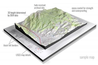
• Raised-relief 3D Height Determined by DEM data
• Fade Resistant Archival Inks
• Epoxy Coated for Strength and Waterproofing
• Ready to Hang with Pre-Installed Hardware (optional)
• Extraordinary 3D Accuracy
• Black Felt Borders
Enrich your office decor or home with a 3D USGS Raised Relief Map. These raised relief maps are not flat. They are three-dimensional, with the height being determined by Digital Elevation Model (DEM) data. Many people struggle with reading 2D satellite maps, but everyone understands 3D raised relief maps. The realism is phenomenal.
This 3D satellite raised relief map is built by combining satellite imagery data from Google Earth, bounding box coordinates from USGS, and DEM data. 3D Printing and 3D CNC routers are used to fabricate the models which make the satellite models extremely accurate. These models are strong - they are coated with epoxy, then finished with a sealer providing a weatherproof matt-finish. These are not meant to be used in direct sunlight.
Abbottsburg, North Carolina- View hi-resolution image of: Abbottsburg, North Carolina. Mapping by USGS in 2022 - Longitude/Latitude: -78.75 x -78.625 x 34.625 x 34.5, Grid Size: 7.5 X 7.5 Minute, Map Scale: 1:24000, State List: NC, County List: Bladen
Acme, North Carolina- View hi-resolution image of: Acme, North Carolina. Mapping by USGS in 2019 - Longitude/Latitude: -78.25 x -78.125 x 34.375 x 34.25, Grid Size: 7.5 X 7.5 Minute, Map Scale: 1:24000, State List: NC, County List: Brunswick,Columbus,Pender
Advance, North Carolina- View hi-resolution image of: Advance, North Carolina. Mapping by USGS in 2019 - Longitude/Latitude: -80.5 x -80.375 x 36 x 35.875, Grid Size: 7.5 X 7.5 Minute, Map Scale: 1:24000, State List: NC, County List: Davie,Forsyth,Davidson
Afton, North Carolina- View hi-resolution image of: Afton, North Carolina. Mapping by USGS in 2019 - Longitude/Latitude: -78.25 x -78.125 x 36.375 x 36.25, Grid Size: 7.5 X 7.5 Minute, Map Scale: 1:24000, State List: NC, County List: Warren,Franklin
Ahoskie, North Carolina- View hi-resolution image of: Ahoskie, North Carolina. Mapping by USGS in 2022 - Longitude/Latitude: -77 x -76.875 x 36.375 x 36.25, Grid Size: 7.5 X 7.5 Minute, Map Scale: 1:24000, State List: NC, County List: Hertford
Alarka, North Carolina- View hi-resolution image of: Alarka, North Carolina. Mapping by USGS in 2019 - Longitude/Latitude: -83.5 x -83.375 x 35.375 x 35.25, Grid Size: 7.5 X 7.5 Minute, Map Scale: 1:24000, State List: NC, County List: Swain,Macon
Albemarle, North Carolina- View hi-resolution image of: Albemarle, North Carolina. Mapping by USGS in 2019 - Longitude/Latitude: -80.25 x -80.125 x 35.375 x 35.25, Grid Size: 7.5 X 7.5 Minute, Map Scale: 1:24000, State List: NC, County List: Stanly
Albertson, North Carolina- View hi-resolution image of: Albertson, North Carolina. Mapping by USGS in 2019 - Longitude/Latitude: -77.875 x -77.75 x 35.125 x 35, Grid Size: 7.5 X 7.5 Minute, Map Scale: 1:24000, State List: NC, County List: Duplin,Lenoir
Ammon, North Carolina- View hi-resolution image of: Ammon, North Carolina. Mapping by USGS in 2022 - Longitude/Latitude: -78.625 x -78.5 x 34.875 x 34.75, Grid Size: 7.5 X 7.5 Minute, Map Scale: 1:24000, State List: NC, County List: Bladen,Cumberland,Sampson
Anderson, North Carolina- View hi-resolution image of: Anderson, North Carolina. Mapping by USGS in 2019 - Longitude/Latitude: -79.375 x -79.25 x 36.375 x 36.25, Grid Size: 7.5 X 7.5 Minute, Map Scale: 1:24000, State List: NC, County List: Caswell
Anderson Creek, North Carolina- View hi-resolution image of: Anderson Creek, North Carolina. Mapping by USGS in 2019 - Longitude/Latitude: -79 x -78.875 x 35.375 x 35.25, Grid Size: 7.5 X 7.5 Minute, Map Scale: 1:24000, State List: NC, County List: Harnett
Andrews, North Carolina- View hi-resolution image of: Andrews, North Carolina. Mapping by USGS in 2019 - Longitude/Latitude: -83.875 x -83.75 x 35.25 x 35.125, Grid Size: 7.5 X 7.5 Minute, Map Scale: 1:24000, State List: NC, County List: Cherokee,Clay,Graham
Angier, North Carolina- View hi-resolution image of: Angier, North Carolina. Mapping by USGS in 2019 - Longitude/Latitude: -78.75 x -78.625 x 35.625 x 35.5, Grid Size: 7.5 X 7.5 Minute, Map Scale: 1:24000, State List: NC, County List: Wake,Johnston,Harnett
Ansonville, North Carolina- View hi-resolution image of: Ansonville, North Carolina. Mapping by USGS in 2019 - Longitude/Latitude: -80.125 x -80 x 35.125 x 35, Grid Size: 7.5 X 7.5 Minute, Map Scale: 1:24000, State List: NC, County List: Anson,Richmond
Apex, North Carolina- View hi-resolution image of: Apex, North Carolina. Mapping by USGS in 2019 - Longitude/Latitude: -78.875 x -78.75 x 35.75 x 35.625, Grid Size: 7.5 X 7.5 Minute, Map Scale: 1:24000, State List: NC, County List: Wake
Aquadale, North Carolina- View hi-resolution image of: Aquadale, North Carolina. Mapping by USGS in 2019 - Longitude/Latitude: -80.25 x -80.125 x 35.25 x 35.125, Grid Size: 7.5 X 7.5 Minute, Map Scale: 1:24000, State List: NC, County List: Stanly,Anson
Arapahoe, North Carolina- View hi-resolution image of: Arapahoe, North Carolina. Mapping by USGS in 2019 - Longitude/Latitude: -76.875 x -76.75 x 35.125 x 35, Grid Size: 7.5 X 7.5 Minute, Map Scale: 1:24000, State List: NC, County List: Pamlico
Asheboro, North Carolina- View hi-resolution image of: Asheboro, North Carolina. Mapping by USGS in 2019 - Longitude/Latitude: -79.875 x -79.75 x 35.75 x 35.625, Grid Size: 7.5 X 7.5 Minute, Map Scale: 1:24000, State List: NC, County List: Randolph
Asheville, North Carolina- View hi-resolution image of: Asheville, North Carolina. Mapping by USGS in 2019 - Longitude/Latitude: -82.625 x -82.5 x 35.625 x 35.5, Grid Size: 7.5 X 7.5 Minute, Map Scale: 1:24000, State List: NC, County List: Buncombe
Ashford, North Carolina- View hi-resolution image of: Ashford, North Carolina. Mapping by USGS in 2019 - Longitude/Latitude: -82 x -81.875 x 35.875 x 35.75, Grid Size: 7.5 X 7.5 Minute, Map Scale: 1:24000, State List: NC, County List: Burke,McDowell,Mitchell
Askin, North Carolina- View hi-resolution image of: Askin, North Carolina. Mapping by USGS in 2019 - Longitude/Latitude: -77.125 x -77 x 35.25 x 35.125, Grid Size: 7.5 X 7.5 Minute, Map Scale: 1:24000, State List: NC, County List: Craven
Atkinson, North Carolina- View hi-resolution image of: Atkinson, North Carolina. Mapping by USGS in 2022 - Longitude/Latitude: -78.25 x -78.125 x 34.625 x 34.5, Grid Size: 7.5 X 7.5 Minute, Map Scale: 1:24000, State List: NC, County List: Pender,Sampson,Bladen
Atlantic, North Carolina- View hi-resolution image of: Atlantic, North Carolina. Mapping by USGS in 2022 - Longitude/Latitude: -76.375 x -76.25 x 35 x 34.875, Grid Size: 7.5 X 7.5 Minute, Map Scale: 1:24000, State List: NC, County List: Carteret
Aulander, North Carolina- View hi-resolution image of: Aulander, North Carolina. Mapping by USGS in 2019 - Longitude/Latitude: -77.125 x -77 x 36.25 x 36.125, Grid Size: 7.5 X 7.5 Minute, Map Scale: 1:24000, State List: NC, County List: Bertie,Hertford
Aurelian Springs, North Carolina- View hi-resolution image of: Aurelian Springs, North Carolina. Mapping by USGS in 2022 - Longitude/Latitude: -77.875 x -77.75 x 36.375 x 36.25, Grid Size: 7.5 X 7.5 Minute, Map Scale: 1:24000, State List: NC, County List: Halifax
Aurora, North Carolina- View hi-resolution image of: Aurora, North Carolina. Mapping by USGS in 2019 - Longitude/Latitude: -76.875 x -76.75 x 35.375 x 35.25, Grid Size: 7.5 X 7.5 Minute, Map Scale: 1:24000, State List: NC, County List: Beaufort
Autryville, North Carolina- View hi-resolution image of: Autryville, North Carolina. Mapping by USGS in 2019 - Longitude/Latitude: -78.75 x -78.625 x 35 x 34.875, Grid Size: 7.5 X 7.5 Minute, Map Scale: 1:24000, State List: NC, County List: Cumberland,Sampson
Ayden, North Carolina- View hi-resolution image of: Ayden, North Carolina. Mapping by USGS in 2019 - Longitude/Latitude: -77.5 x -77.375 x 35.5 x 35.375, Grid Size: 7.5 X 7.5 Minute, Map Scale: 1:24000, State List: NC, County List: Pitt,Lenoir,Greene
Ayersville, North Carolina- View hi-resolution image of: Ayersville, North Carolina. Mapping by USGS in 2019 - Longitude/Latitude: -80.125 x -80 x 36.5 x 36.375, Grid Size: 7.5 X 7.5 Minute, Map Scale: 1:24000, State List: NC, County List: Stokes,Rockingham
Badin, North Carolina- View hi-resolution image of: Badin, North Carolina. Mapping by USGS in 2019 - Longitude/Latitude: -80.125 x -80 x 35.5 x 35.375, Grid Size: 7.5 X 7.5 Minute, Map Scale: 1:24000, State List: NC, County List: Montgomery,Stanly
Bailey, North Carolina- View hi-resolution image of: Bailey, North Carolina. Mapping by USGS in 2019 - Longitude/Latitude: -78.125 x -78 x 35.875 x 35.75, Grid Size: 7.5 X 7.5 Minute, Map Scale: 1:24000, State List: NC, County List: Nash,Wilson
Bakers, North Carolina- View hi-resolution image of: Bakers, North Carolina. Mapping by USGS in 2019 - Longitude/Latitude: -80.625 x -80.5 x 35.125 x 35, Grid Size: 7.5 X 7.5 Minute, Map Scale: 1:24000, State List: NC, County List: Union
Bakersville, North Carolina- View hi-resolution image of: Bakersville, North Carolina. Mapping by USGS in 2019 - Longitude/Latitude: -82.25 x -82.125 x 36.125 x 36, Grid Size: 7.5 X 7.5 Minute, Map Scale: 1:24000, State List: NC,TN, County List: Mitchell,Yancey,Carter
Bald Creek, North Carolina- View hi-resolution image of: Bald Creek, North Carolina. Mapping by USGS in 2019 - Longitude/Latitude: -82.5 x -82.375 x 36 x 35.875, Grid Size: 7.5 X 7.5 Minute, Map Scale: 1:24000, State List: NC,TN, County List: Yancey,Madison,Unicoi
Baldwin Gap, North Carolina- View hi-resolution image of: Baldwin Gap, North Carolina. Mapping by USGS in 2019 - Longitude/Latitude: -81.75 x -81.625 x 36.5 x 36.375, Grid Size: 7.5 X 7.5 Minute, Map Scale: 1:24000, State List: NC,TN, County List: Ashe,Johnson,Watauga
Banoak, North Carolina- View hi-resolution image of: Banoak, North Carolina. Mapping by USGS in 2019 - Longitude/Latitude: -81.5 x -81.375 x 35.625 x 35.5, Grid Size: 7.5 X 7.5 Minute, Map Scale: 1:24000, State List: NC, County List: Lincoln,Catawba,Burke,Cleveland
Barco, North Carolina- View hi-resolution image of: Barco, North Carolina. Mapping by USGS in 2019 - Longitude/Latitude: -76 x -75.875 x 36.5 x 36.375, Grid Size: 7.5 X 7.5 Minute, Map Scale: 1:24000, State List: NC, County List: Currituck
Barnardsville, North Carolina- View hi-resolution image of: Barnardsville, North Carolina. Mapping by USGS in 2019 - Longitude/Latitude: -82.5 x -82.375 x 35.875 x 35.75, Grid Size: 7.5 X 7.5 Minute, Map Scale: 1:24000, State List: NC, County List: Buncombe,Madison,Yancey
Bat Cave, North Carolina- View hi-resolution image of: Bat Cave, North Carolina. Mapping by USGS in 2019 - Longitude/Latitude: -82.375 x -82.25 x 35.5 x 35.375, Grid Size: 7.5 X 7.5 Minute, Map Scale: 1:24000, State List: NC, County List: Henderson,Buncombe,Rutherford,Polk
Bath, North Carolina- View hi-resolution image of: Bath, North Carolina. Mapping by USGS in 2019 - Longitude/Latitude: -76.875 x -76.75 x 35.5 x 35.375, Grid Size: 7.5 X 7.5 Minute, Map Scale: 1:24000, State List: NC, County List: Beaufort
Bayboro, North Carolina- View hi-resolution image of: Bayboro, North Carolina. Mapping by USGS in 2019 - Longitude/Latitude: -76.875 x -76.75 x 35.25 x 35.125, Grid Size: 7.5 X 7.5 Minute, Map Scale: 1:24000, State List: NC, County List: Pamlico,Beaufort
Bayleaf, North Carolina- View hi-resolution image of: Bayleaf, North Carolina. Mapping by USGS in 2019 - Longitude/Latitude: -78.75 x -78.625 x 36 x 35.875, Grid Size: 7.5 X 7.5 Minute, Map Scale: 1:24000, State List: NC, County List: Wake,Durham
Bear Creek, North Carolina- View hi-resolution image of: Bear Creek, North Carolina. Mapping by USGS in 2019 - Longitude/Latitude: -79.5 x -79.375 x 35.625 x 35.5, Grid Size: 7.5 X 7.5 Minute, Map Scale: 1:24000, State List: NC, County List: Chatham,Moore
Bearskin, North Carolina- View hi-resolution image of: Bearskin, North Carolina. Mapping by USGS in 2019 - Longitude/Latitude: -78.5 x -78.375 x 35.125 x 35, Grid Size: 7.5 X 7.5 Minute, Map Scale: 1:24000, State List: NC, County List: Sampson
Beaufort, North Carolina- View hi-resolution image of: Beaufort, North Carolina. Mapping by USGS in 2022 - Longitude/Latitude: -76.75 x -76.625 x 34.75 x 34.625, Grid Size: 7.5 X 7.5 Minute, Map Scale: 1:24000, State List: NC, County List: Carteret
Belews Creek, North Carolina- View hi-resolution image of: Belews Creek, North Carolina. Mapping by USGS in 2019 - Longitude/Latitude: -80.125 x -80 x 36.25 x 36.125, Grid Size: 7.5 X 7.5 Minute, Map Scale: 1:24000, State List: NC, County List: Forsyth,Guilford
Belews Lake, North Carolina- View hi-resolution image of: Belews Lake, North Carolina. Mapping by USGS in 2019 - Longitude/Latitude: -80.125 x -80 x 36.375 x 36.25, Grid Size: 7.5 X 7.5 Minute, Map Scale: 1:24000, State List: NC, County List: Stokes,Rockingham,Forsyth,Guilford
Belhaven, North Carolina- View hi-resolution image of: Belhaven, North Carolina. Mapping by USGS in 2019 - Longitude/Latitude: -76.625 x -76.5 x 35.625 x 35.5, Grid Size: 7.5 X 7.5 Minute, Map Scale: 1:24000, State List: NC, County List: Beaufort,Hyde
Belmont, North Carolina- View hi-resolution image of: Belmont, North Carolina. Mapping by USGS in 2019 - Longitude/Latitude: -81.125 x -81 x 35.25 x 35.125, Grid Size: 7.5 X 7.5 Minute, Map Scale: 1:24000, State List: NC,SC, County List: Gaston,York,Mecklenburg
Benn Knob, North Carolina- View hi-resolution image of: Benn Knob, North Carolina. Mapping by USGS in 2019 - Longitude/Latitude: -81.75 x -81.625 x 35.625 x 35.5, Grid Size: 7.5 X 7.5 Minute, Map Scale: 1:24000, State List: NC, County List: Cleveland,Burke,Rutherford
Bennett, North Carolina- View hi-resolution image of: Bennett, North Carolina. Mapping by USGS in 2019 - Longitude/Latitude: -79.625 x -79.5 x 35.625 x 35.5, Grid Size: 7.5 X 7.5 Minute, Map Scale: 1:24000, State List: NC, County List: Randolph,Chatham,Moore
Benson, North Carolina- View hi-resolution image of: Benson, North Carolina. Mapping by USGS in 2019 - Longitude/Latitude: -78.625 x -78.5 x 35.5 x 35.375, Grid Size: 7.5 X 7.5 Minute, Map Scale: 1:24000, State List: NC, County List: Johnston,Harnett
Berea, North Carolina- View hi-resolution image of: Berea, North Carolina. Mapping by USGS in 2019 - Longitude/Latitude: -78.75 x -78.625 x 36.375 x 36.25, Grid Size: 7.5 X 7.5 Minute, Map Scale: 1:24000, State List: NC, County List: Granville
Bessemer City, North Carolina- View hi-resolution image of: Bessemer City, North Carolina. Mapping by USGS in 2019 - Longitude/Latitude: -81.375 x -81.25 x 35.375 x 35.25, Grid Size: 7.5 X 7.5 Minute, Map Scale: 1:24000, State List: NC, County List: Gaston,Cleveland
Bethany, North Carolina- View hi-resolution image of: Bethany, North Carolina. Mapping by USGS in 2019 - Longitude/Latitude: -79.875 x -79.75 x 36.375 x 36.25, Grid Size: 7.5 X 7.5 Minute, Map Scale: 1:24000, State List: NC, County List: Rockingham,Guilford
Bethlehem, North Carolina- View hi-resolution image of: Bethlehem, North Carolina. Mapping by USGS in 2019 - Longitude/Latitude: -81.375 x -81.25 x 35.875 x 35.75, Grid Size: 7.5 X 7.5 Minute, Map Scale: 1:24000, State List: NC, County List: Alexander,Catawba,Caldwell,Burke
Beulaville, North Carolina- View hi-resolution image of: Beulaville, North Carolina. Mapping by USGS in 2019 - Longitude/Latitude: -77.875 x -77.75 x 35 x 34.875, Grid Size: 7.5 X 7.5 Minute, Map Scale: 1:24000, State List: NC, County List: Duplin
Big Ridge, North Carolina- View hi-resolution image of: Big Ridge, North Carolina. Mapping by USGS in 2019 - Longitude/Latitude: -83.125 x -83 x 35.25 x 35.125, Grid Size: 7.5 X 7.5 Minute, Map Scale: 1:24000, State List: NC, County List: Jackson
Biscoe, North Carolina- View hi-resolution image of: Biscoe, North Carolina. Mapping by USGS in 2019 - Longitude/Latitude: -79.875 x -79.75 x 35.375 x 35.25, Grid Size: 7.5 X 7.5 Minute, Map Scale: 1:24000, State List: NC, County List: Montgomery
Black Mountain, North Carolina- View hi-resolution image of: Black Mountain, North Carolina. Mapping by USGS in 2019 - Longitude/Latitude: -82.375 x -82.25 x 35.625 x 35.5, Grid Size: 7.5 X 7.5 Minute, Map Scale: 1:24000, State List: NC, County List: Buncombe,McDowell,Henderson
Bladenboro, North Carolina- View hi-resolution image of: Bladenboro, North Carolina. Mapping by USGS in 2022 - Longitude/Latitude: -78.875 x -78.75 x 34.625 x 34.5, Grid Size: 7.5 X 7.5 Minute, Map Scale: 1:24000, State List: NC, County List: Bladen,Robeson
Blounts Bay, North Carolina- View hi-resolution image of: Blounts Bay, North Carolina. Mapping by USGS in 2019 - Longitude/Latitude: -77 x -76.875 x 35.5 x 35.375, Grid Size: 7.5 X 7.5 Minute, Map Scale: 1:24000, State List: NC, County List: Beaufort
Bluff Point, North Carolina- View hi-resolution image of: Bluff Point, North Carolina. Mapping by USGS in 2019 - Longitude/Latitude: -76.25 x -76.125 x 35.375 x 35.25, Grid Size: 7.5 X 7.5 Minute, Map Scale: 1:24000, State List: NC, County List: Hyde
Boiling Springs North, North Carolina- View hi-resolution image of: Boiling Springs North, North Carolina. Mapping by USGS in 2019 - Longitude/Latitude: -81.75 x -81.625 x 35.375 x 35.25, Grid Size: 7.5 X 7.5 Minute, Map Scale: 1:24000, State List: NC, County List: Cleveland,Rutherford
Boiling Springs South, North Carolina- View hi-resolution image of: Boiling Springs South, North Carolina. Mapping by USGS in 2019 - Longitude/Latitude: -81.75 x -81.625 x 35.25 x 35.125, Grid Size: 7.5 X 7.5 Minute, Map Scale: 1:24000, State List: NC,SC, County List: Cleveland,Cherokee,Rutherford
Bolivia, North Carolina- View hi-resolution image of: Bolivia, North Carolina. Mapping by USGS in 2019 - Longitude/Latitude: -78.25 x -78.125 x 34.125 x 34, Grid Size: 7.5 X 7.5 Minute, Map Scale: 1:24000, State List: NC, County List: Brunswick
Bonnetsville, North Carolina- View hi-resolution image of: Bonnetsville, North Carolina. Mapping by USGS in 2022 - Longitude/Latitude: -78.5 x -78.375 x 35 x 34.875, Grid Size: 7.5 X 7.5 Minute, Map Scale: 1:24000, State List: NC, County List: Sampson
Boomer, North Carolina- View hi-resolution image of: Boomer, North Carolina. Mapping by USGS in 2019 - Longitude/Latitude: -81.375 x -81.25 x 36.125 x 36, Grid Size: 7.5 X 7.5 Minute, Map Scale: 1:24000, State List: NC, County List: Wilkes,Caldwell,Alexander
Boone, North Carolina- View hi-resolution image of: Boone, North Carolina. Mapping by USGS in 2019 - Longitude/Latitude: -81.75 x -81.625 x 36.25 x 36.125, Grid Size: 7.5 X 7.5 Minute, Map Scale: 1:24000, State List: NC, County List: Watauga
Boones Crossroads, North Carolina- View hi-resolution image of: Boones Crossroads, North Carolina. Mapping by USGS in 2019 - Longitude/Latitude: -77.5 x -77.375 x 36.375 x 36.25, Grid Size: 7.5 X 7.5 Minute, Map Scale: 1:24000, State List: NC, County List: Northampton,Halifax
Bottom, North Carolina- View hi-resolution image of: Bottom, North Carolina. Mapping by USGS in 2019 - Longitude/Latitude: -80.875 x -80.75 x 36.5 x 36.375, Grid Size: 7.5 X 7.5 Minute, Map Scale: 1:24000, State List: NC, County List: Surry
Brevard, North Carolina- View hi-resolution image of: Brevard, North Carolina. Mapping by USGS in 2019 - Longitude/Latitude: -82.75 x -82.625 x 35.25 x 35.125, Grid Size: 7.5 X 7.5 Minute, Map Scale: 1:24000, State List: NC,SC, County List: Transylvania,Greenville
Broad Creek, North Carolina- View hi-resolution image of: Broad Creek, North Carolina. Mapping by USGS in 2019 - Longitude/Latitude: -76.625 x -76.5 x 35.125 x 35, Grid Size: 7.5 X 7.5 Minute, Map Scale: 1:24000, State List: NC, County List: Carteret,Pamlico
Broadway, North Carolina- View hi-resolution image of: Broadway, North Carolina. Mapping by USGS in 2019 - Longitude/Latitude: -79.125 x -79 x 35.5 x 35.375, Grid Size: 7.5 X 7.5 Minute, Map Scale: 1:24000, State List: NC, County List: Lee,Harnett
Brooks Crossroads, North Carolina- View hi-resolution image of: Brooks Crossroads, North Carolina. Mapping by USGS in 2019 - Longitude/Latitude: -80.875 x -80.75 x 36.125 x 36, Grid Size: 7.5 X 7.5 Minute, Map Scale: 1:24000, State List: NC, County List: Yadkin,Iredell
Browns Inlet, North Carolina- View hi-resolution image of: Browns Inlet, North Carolina. Mapping by USGS in 2019 - Longitude/Latitude: -77.25 x -77.125 x 34.625 x 34.5, Grid Size: 7.5 X 7.5 Minute, Map Scale: 1:24000, State List: NC, County List: Onslow
Browns Summit, North Carolina- View hi-resolution image of: Browns Summit, North Carolina. Mapping by USGS in 2019 - Longitude/Latitude: -79.75 x -79.625 x 36.25 x 36.125, Grid Size: 7.5 X 7.5 Minute, Map Scale: 1:24000, State List: NC, County List: Guilford,Rockingham
Bryson City, North Carolina- View hi-resolution image of: Bryson City, North Carolina. Mapping by USGS in 2019 - Longitude/Latitude: -83.5 x -83.375 x 35.5 x 35.375, Grid Size: 7.5 X 7.5 Minute, Map Scale: 1:24000, State List: NC, County List: Swain
Buffalo City, North Carolina- View hi-resolution image of: Buffalo City, North Carolina. Mapping by USGS in 2019 - Longitude/Latitude: -76 x -75.875 x 35.875 x 35.75, Grid Size: 7.5 X 7.5 Minute, Map Scale: 1:24000, State List: NC, County List: Dare
Buffalo Cove, North Carolina- View hi-resolution image of: Buffalo Cove, North Carolina. Mapping by USGS in 2019 - Longitude/Latitude: -81.625 x -81.5 x 36.125 x 36, Grid Size: 7.5 X 7.5 Minute, Map Scale: 1:24000, State List: NC, County List: Caldwell,Wilkes,Watauga
Bunches Bald, North Carolina- View hi-resolution image of: Bunches Bald, North Carolina. Mapping by USGS in 2019 - Longitude/Latitude: -83.25 x -83.125 x 35.625 x 35.5, Grid Size: 7.5 X 7.5 Minute, Map Scale: 1:24000, State List: NC, County List: Swain,Haywood,Jackson
Bunn East, North Carolina- View hi-resolution image of: Bunn East, North Carolina. Mapping by USGS in 2019 - Longitude/Latitude: -78.25 x -78.125 x 36 x 35.875, Grid Size: 7.5 X 7.5 Minute, Map Scale: 1:24000, State List: NC, County List: Franklin,Nash
Bunn West, North Carolina- View hi-resolution image of: Bunn West, North Carolina. Mapping by USGS in 2019 - Longitude/Latitude: -78.375 x -78.25 x 36 x 35.875, Grid Size: 7.5 X 7.5 Minute, Map Scale: 1:24000, State List: NC, County List: Franklin,Wake
Bunnlevel, North Carolina- View hi-resolution image of: Bunnlevel, North Carolina. Mapping by USGS in 2019 - Longitude/Latitude: -78.875 x -78.75 x 35.375 x 35.25, Grid Size: 7.5 X 7.5 Minute, Map Scale: 1:24000, State List: NC, County List: Harnett,Cumberland
Bunyan, North Carolina- View hi-resolution image of: Bunyan, North Carolina. Mapping by USGS in 2022 - Longitude/Latitude: -77 x -76.875 x 35.625 x 35.5, Grid Size: 7.5 X 7.5 Minute, Map Scale: 1:24000, State List: NC, County List: Beaufort
Burgaw, North Carolina- View hi-resolution image of: Burgaw, North Carolina. Mapping by USGS in 2022 - Longitude/Latitude: -78 x -77.875 x 34.625 x 34.5, Grid Size: 7.5 X 7.5 Minute, Map Scale: 1:24000, State List: NC, County List: Pender
Burlington, North Carolina- View hi-resolution image of: Burlington, North Carolina. Mapping by USGS in 2019 - Longitude/Latitude: -79.5 x -79.375 x 36.125 x 36, Grid Size: 7.5 X 7.5 Minute, Map Scale: 1:24000, State List: NC, County List: Alamance
Burlington NE, North Carolina- View hi-resolution image of: Burlington NE, North Carolina. Mapping by USGS in 2019 - Longitude/Latitude: -79.375 x -79.25 x 36.25 x 36.125, Grid Size: 7.5 X 7.5 Minute, Map Scale: 1:24000, State List: NC, County List: Alamance,Orange,Caswell
Burnsville, North Carolina- View hi-resolution image of: Burnsville, North Carolina. Mapping by USGS in 2019 - Longitude/Latitude: -82.375 x -82.25 x 36 x 35.875, Grid Size: 7.5 X 7.5 Minute, Map Scale: 1:24000, State List: NC, County List: Yancey,Mitchell
Buxton, North Carolina- View hi-resolution image of: Buxton, North Carolina. Mapping by USGS in 2019 - Longitude/Latitude: -75.625 x -75.5 x 35.375 x 35.25, Grid Size: 7.5 X 7.5 Minute, Map Scale: 1:24000, State List: NC, County List: Dare
Buxton OE E, North Carolina- View hi-resolution image of: Buxton OE E, North Carolina. Mapping by USGS in 2022 - Longitude/Latitude: -75.5 x -75.375 x 35.375 x 35.25, Grid Size: 7.5 X 7.5 Minute, Map Scale: 1:24000, State List: NC, County List: Dare
Bynum, North Carolina- View hi-resolution image of: Bynum, North Carolina. Mapping by USGS in 2019 - Longitude/Latitude: -79.25 x -79.125 x 35.875 x 35.75, Grid Size: 7.5 X 7.5 Minute, Map Scale: 1:24000, State List: NC, County List: Chatham,Orange,Alamance
Calabash, North Carolina- View hi-resolution image of: Calabash, North Carolina. Mapping by USGS in 2022 - Longitude/Latitude: -78.625 x -78.5 x 34 x 33.875, Grid Size: 7.5 X 7.5 Minute, Map Scale: 1:24000, State List: NC,SC, County List: Brunswick,Horry,Columbus
Calahaln, North Carolina- View hi-resolution image of: Calahaln, North Carolina. Mapping by USGS in 2019 - Longitude/Latitude: -80.75 x -80.625 x 36 x 35.875, Grid Size: 7.5 X 7.5 Minute, Map Scale: 1:24000, State List: NC, County List: Davie,Iredell
Caldwell, North Carolina- View hi-resolution image of: Caldwell, North Carolina. Mapping by USGS in 2019 - Longitude/Latitude: -79.125 x -79 x 36.25 x 36.125, Grid Size: 7.5 X 7.5 Minute, Map Scale: 1:24000, State List: NC, County List: Orange,Person
Camden Point, North Carolina- View hi-resolution image of: Camden Point, North Carolina. Mapping by USGS in 2019 - Longitude/Latitude: -76 x -75.875 x 36.25 x 36.125, Grid Size: 7.5 X 7.5 Minute, Map Scale: 1:24000, State List: NC, County List: Camden,Currituck
Camp Lejeune, North Carolina- View hi-resolution image of: Camp Lejeune, North Carolina. Mapping by USGS in 2019 - Longitude/Latitude: -77.375 x -77.25 x 34.75 x 34.625, Grid Size: 7.5 X 7.5 Minute, Map Scale: 1:24000, State List: NC, County List: Onslow
Candor, North Carolina- View hi-resolution image of: Candor, North Carolina. Mapping by USGS in 2019 - Longitude/Latitude: -79.75 x -79.625 x 35.375 x 35.25, Grid Size: 7.5 X 7.5 Minute, Map Scale: 1:24000, State List: NC, County List: Moore,Montgomery
Canton, North Carolina- View hi-resolution image of: Canton, North Carolina. Mapping by USGS in 2019 - Longitude/Latitude: -82.875 x -82.75 x 35.625 x 35.5, Grid Size: 7.5 X 7.5 Minute, Map Scale: 1:24000, State List: NC, County List: Haywood,Buncombe
Cape Fear, North Carolina- View hi-resolution image of: Cape Fear, North Carolina. Mapping by USGS in 2019 - Longitude/Latitude: -78 x -77.875 x 33.875 x 33.75, Grid Size: 7.5 X 7.5 Minute, Map Scale: 1:24000, State List: NC, County List: Brunswick,New Hanover
Cape Fear OE W, North Carolina- View hi-resolution image of: Cape Fear OE W, North Carolina. Mapping by USGS in 2022 - Longitude/Latitude: -78.125 x -78 x 33.875 x 33.75, Grid Size: 7.5 X 7.5 Minute, Map Scale: 1:24000, State List: NC, County List: Brunswick
Cape Hatteras, North Carolina- View hi-resolution image of: Cape Hatteras, North Carolina. Mapping by USGS in 2019 - Longitude/Latitude: -75.625 x -75.5 x 35.25 x 35.125, Grid Size: 7.5 X 7.5 Minute, Map Scale: 1:24000, State List: NC, County List: Dare
Cape Lookout, North Carolina- View hi-resolution image of: Cape Lookout, North Carolina. Mapping by USGS in 2022 - Longitude/Latitude: -76.625 x -76.5 x 34.625 x 34.5, Grid Size: 7.5 X 7.5 Minute, Map Scale: 1:24000, State List: NC, County List: Carteret
Carolina Beach, North Carolina- View hi-resolution image of: Carolina Beach, North Carolina. Mapping by USGS in 2019 - Longitude/Latitude: -78 x -77.875 x 34.125 x 34, Grid Size: 7.5 X 7.5 Minute, Map Scale: 1:24000, State List: NC, County List: Brunswick,New Hanover
Carolina Beach OE E, North Carolina- View hi-resolution image of: Carolina Beach OE E, North Carolina. Mapping by USGS in 2022 - Longitude/Latitude: -77.875 x -77.75 x 34.125 x 34, Grid Size: 7.5 X 7.5 Minute, Map Scale: 1:24000, State List: NC, County List: New Hanover
Carthage, North Carolina- View hi-resolution image of: Carthage, North Carolina. Mapping by USGS in 2019 - Longitude/Latitude: -79.5 x -79.375 x 35.375 x 35.25, Grid Size: 7.5 X 7.5 Minute, Map Scale: 1:24000, State List: NC, County List: Moore
Carvers Gap, North Carolina- View hi-resolution image of: Carvers Gap, North Carolina. Mapping by USGS in 2019 - Longitude/Latitude: -82.125 x -82 x 36.125 x 36, Grid Size: 7.5 X 7.5 Minute, Map Scale: 1:24000, State List: NC,TN, County List: Avery,Mitchell,Carter
Cary, North Carolina- View hi-resolution image of: Cary, North Carolina. Mapping by USGS in 2019 - Longitude/Latitude: -78.875 x -78.75 x 35.875 x 35.75, Grid Size: 7.5 X 7.5 Minute, Map Scale: 1:24000, State List: NC, County List: Wake,Durham
Casar, North Carolina- View hi-resolution image of: Casar, North Carolina. Mapping by USGS in 2019 - Longitude/Latitude: -81.625 x -81.5 x 35.625 x 35.5, Grid Size: 7.5 X 7.5 Minute, Map Scale: 1:24000, State List: NC, County List: Cleveland,Burke,Lincoln,Catawba
Cashiers, North Carolina- View hi-resolution image of: Cashiers, North Carolina. Mapping by USGS in 2019 - Longitude/Latitude: -83.125 x -83 x 35.125 x 35, Grid Size: 7.5 X 7.5 Minute, Map Scale: 1:24000, State List: NC,SC,GA, County List: Jackson,Transylvania,Oconee,Macon,Rabun
Castalia, North Carolina- View hi-resolution image of: Castalia, North Carolina. Mapping by USGS in 2019 - Longitude/Latitude: -78.125 x -78 x 36.125 x 36, Grid Size: 7.5 X 7.5 Minute, Map Scale: 1:24000, State List: NC, County List: Nash,Franklin
Castle Hayne, North Carolina- View hi-resolution image of: Castle Hayne, North Carolina. Mapping by USGS in 2019 - Longitude/Latitude: -78 x -77.875 x 34.375 x 34.25, Grid Size: 7.5 X 7.5 Minute, Map Scale: 1:24000, State List: NC, County List: New Hanover,Pender,Brunswick
Catawba, North Carolina- View hi-resolution image of: Catawba, North Carolina. Mapping by USGS in 2019 - Longitude/Latitude: -81.125 x -81 x 35.75 x 35.625, Grid Size: 7.5 X 7.5 Minute, Map Scale: 1:24000, State List: NC, County List: Catawba,Iredell
Catfish Lake, North Carolina- View hi-resolution image of: Catfish Lake, North Carolina. Mapping by USGS in 2019 - Longitude/Latitude: -77.125 x -77 x 35 x 34.875, Grid Size: 7.5 X 7.5 Minute, Map Scale: 1:24000, State List: NC, County List: Craven,Jones
Catherine Lake, North Carolina- View hi-resolution image of: Catherine Lake, North Carolina. Mapping by USGS in 2022 - Longitude/Latitude: -77.625 x -77.5 x 34.875 x 34.75, Grid Size: 7.5 X 7.5 Minute, Map Scale: 1:24000, State List: NC, County List: Onslow
Cedar Creek, North Carolina- View hi-resolution image of: Cedar Creek, North Carolina. Mapping by USGS in 2019 - Longitude/Latitude: -78.875 x -78.75 x 35 x 34.875, Grid Size: 7.5 X 7.5 Minute, Map Scale: 1:24000, State List: NC, County List: Cumberland
Cedar Grove, North Carolina- View hi-resolution image of: Cedar Grove, North Carolina. Mapping by USGS in 2019 - Longitude/Latitude: -79.25 x -79.125 x 36.25 x 36.125, Grid Size: 7.5 X 7.5 Minute, Map Scale: 1:24000, State List: NC, County List: Orange,Caswell,Person
Celo, North Carolina- View hi-resolution image of: Celo, North Carolina. Mapping by USGS in 2019 - Longitude/Latitude: -82.25 x -82.125 x 35.875 x 35.75, Grid Size: 7.5 X 7.5 Minute, Map Scale: 1:24000, State List: NC, County List: Yancey,McDowell,Mitchell
Center Hill, North Carolina- View hi-resolution image of: Center Hill, North Carolina. Mapping by USGS in 2022 - Longitude/Latitude: -76.625 x -76.5 x 36.25 x 36.125, Grid Size: 7.5 X 7.5 Minute, Map Scale: 1:24000, State List: NC, County List: Perquimans,Chowan
Centerville, North Carolina- View hi-resolution image of: Centerville, North Carolina. Mapping by USGS in 2019 - Longitude/Latitude: -78.125 x -78 x 36.25 x 36.125, Grid Size: 7.5 X 7.5 Minute, Map Scale: 1:24000, State List: NC, County List: Franklin,Warren,Nash,Halifax
Central, North Carolina- View hi-resolution image of: Central, North Carolina. Mapping by USGS in 2019 - Longitude/Latitude: -81 x -80.875 x 36 x 35.875, Grid Size: 7.5 X 7.5 Minute, Map Scale: 1:24000, State List: NC, County List: Iredell
Cerro Gordo, North Carolina- View hi-resolution image of: Cerro Gordo, North Carolina. Mapping by USGS in 2022 - Longitude/Latitude: -79 x -78.875 x 34.375 x 34.25, Grid Size: 7.5 X 7.5 Minute, Map Scale: 1:24000, State List: NC, County List: Columbus
Chadbourn, North Carolina- View hi-resolution image of: Chadbourn, North Carolina. Mapping by USGS in 2022 - Longitude/Latitude: -78.875 x -78.75 x 34.375 x 34.25, Grid Size: 7.5 X 7.5 Minute, Map Scale: 1:24000, State List: NC, County List: Columbus
Chadbourn NE, North Carolina- View hi-resolution image of: Chadbourn NE, North Carolina. Mapping by USGS in 2022 - Longitude/Latitude: -78.875 x -78.75 x 34.5 x 34.375, Grid Size: 7.5 X 7.5 Minute, Map Scale: 1:24000, State List: NC, County List: Columbus,Bladen,Robeson
Chapanoke, North Carolina- View hi-resolution image of: Chapanoke, North Carolina. Mapping by USGS in 2022 - Longitude/Latitude: -76.5 x -76.375 x 36.375 x 36.25, Grid Size: 7.5 X 7.5 Minute, Map Scale: 1:24000, State List: NC, County List: Perquimans,Pasquotank,Gates
Chapel Hill, North Carolina- View hi-resolution image of: Chapel Hill, North Carolina. Mapping by USGS in 2019 - Longitude/Latitude: -79.125 x -79 x 36 x 35.875, Grid Size: 7.5 X 7.5 Minute, Map Scale: 1:24000, State List: NC, County List: Orange,Durham
Charity, North Carolina- View hi-resolution image of: Charity, North Carolina. Mapping by USGS in 2022 - Longitude/Latitude: -78 x -77.875 x 34.875 x 34.75, Grid Size: 7.5 X 7.5 Minute, Map Scale: 1:24000, State List: NC, County List: Duplin
Charlotte East, North Carolina- View hi-resolution image of: Charlotte East, North Carolina. Mapping by USGS in 2019 - Longitude/Latitude: -80.875 x -80.75 x 35.25 x 35.125, Grid Size: 7.5 X 7.5 Minute, Map Scale: 1:24000, State List: NC, County List: Mecklenburg
Charlotte West, North Carolina- View hi-resolution image of: Charlotte West, North Carolina. Mapping by USGS in 2019 - Longitude/Latitude: -81 x -80.875 x 35.25 x 35.125, Grid Size: 7.5 X 7.5 Minute, Map Scale: 1:24000, State List: NC, County List: Mecklenburg
Cherry Grove, North Carolina- View hi-resolution image of: Cherry Grove, North Carolina. Mapping by USGS in 2019 - Longitude/Latitude: -79.5 x -79.375 x 36.375 x 36.25, Grid Size: 7.5 X 7.5 Minute, Map Scale: 1:24000, State List: NC, County List: Caswell
Cherry Point, North Carolina- View hi-resolution image of: Cherry Point, North Carolina. Mapping by USGS in 2019 - Longitude/Latitude: -76.875 x -76.75 x 35 x 34.875, Grid Size: 7.5 X 7.5 Minute, Map Scale: 1:24000, State List: NC, County List: Craven,Pamlico
Cherryville, North Carolina- View hi-resolution image of: Cherryville, North Carolina. Mapping by USGS in 2019 - Longitude/Latitude: -81.5 x -81.375 x 35.5 x 35.375, Grid Size: 7.5 X 7.5 Minute, Map Scale: 1:24000, State List: NC, County List: Lincoln,Cleveland,Gaston
Chestnut Mountain, North Carolina- View hi-resolution image of: Chestnut Mountain, North Carolina. Mapping by USGS in 2019 - Longitude/Latitude: -81.875 x -81.75 x 36 x 35.875, Grid Size: 7.5 X 7.5 Minute, Map Scale: 1:24000, State List: NC, County List: Burke,Caldwell,Avery
China Grove, North Carolina- View hi-resolution image of: China Grove, North Carolina. Mapping by USGS in 2019 - Longitude/Latitude: -80.625 x -80.5 x 35.625 x 35.5, Grid Size: 7.5 X 7.5 Minute, Map Scale: 1:24000, State List: NC, County List: Rowan,Cabarrus
Chinquapin, North Carolina- View hi-resolution image of: Chinquapin, North Carolina. Mapping by USGS in 2022 - Longitude/Latitude: -77.875 x -77.75 x 34.875 x 34.75, Grid Size: 7.5 X 7.5 Minute, Map Scale: 1:24000, State List: NC, County List: Duplin
Churchland, North Carolina- View hi-resolution image of: Churchland, North Carolina. Mapping by USGS in 2019 - Longitude/Latitude: -80.5 x -80.375 x 35.875 x 35.75, Grid Size: 7.5 X 7.5 Minute, Map Scale: 1:24000, State List: NC, County List: Davidson,Davie,Rowan
Clarkton, North Carolina- View hi-resolution image of: Clarkton, North Carolina. Mapping by USGS in 2022 - Longitude/Latitude: -78.75 x -78.625 x 34.5 x 34.375, Grid Size: 7.5 X 7.5 Minute, Map Scale: 1:24000, State List: NC, County List: Columbus,Bladen
Clayton, North Carolina- View hi-resolution image of: Clayton, North Carolina. Mapping by USGS in 2019 - Longitude/Latitude: -78.5 x -78.375 x 35.75 x 35.625, Grid Size: 7.5 X 7.5 Minute, Map Scale: 1:24000, State List: NC, County List: Johnston,Wake
Clemmons, North Carolina- View hi-resolution image of: Clemmons, North Carolina. Mapping by USGS in 2019 - Longitude/Latitude: -80.5 x -80.375 x 36.125 x 36, Grid Size: 7.5 X 7.5 Minute, Map Scale: 1:24000, State List: NC, County List: Forsyth,Davie,Yadkin
Cleveland, North Carolina- View hi-resolution image of: Cleveland, North Carolina. Mapping by USGS in 2019 - Longitude/Latitude: -80.75 x -80.625 x 35.75 x 35.625, Grid Size: 7.5 X 7.5 Minute, Map Scale: 1:24000, State List: NC, County List: Rowan,Iredell
Clifdale, North Carolina- View hi-resolution image of: Clifdale, North Carolina. Mapping by USGS in 2019 - Longitude/Latitude: -79.125 x -79 x 35.125 x 35, Grid Size: 7.5 X 7.5 Minute, Map Scale: 1:24000, State List: NC, County List: Cumberland,Hoke
Cliffield Mountain, North Carolina- View hi-resolution image of: Cliffield Mountain, North Carolina. Mapping by USGS in 2019 - Longitude/Latitude: -82.375 x -82.25 x 35.375 x 35.25, Grid Size: 7.5 X 7.5 Minute, Map Scale: 1:24000, State List: NC, County List: Polk,Henderson
Climax, North Carolina- View hi-resolution image of: Climax, North Carolina. Mapping by USGS in 2019 - Longitude/Latitude: -79.75 x -79.625 x 36 x 35.875, Grid Size: 7.5 X 7.5 Minute, Map Scale: 1:24000, State List: NC, County List: Guilford,Randolph
Clingmans Dome, North Carolina- View hi-resolution image of: Clingmans Dome, North Carolina. Mapping by USGS in 2019 - Longitude/Latitude: -83.5 x -83.375 x 35.625 x 35.5, Grid Size: 7.5 X 7.5 Minute, Map Scale: 1:24000, State List: NC,TN, County List: Swain,Sevier
Clinton North, North Carolina- View hi-resolution image of: Clinton North, North Carolina. Mapping by USGS in 2019 - Longitude/Latitude: -78.375 x -78.25 x 35.125 x 35, Grid Size: 7.5 X 7.5 Minute, Map Scale: 1:24000, State List: NC, County List: Sampson
Clinton South, North Carolina- View hi-resolution image of: Clinton South, North Carolina. Mapping by USGS in 2019 - Longitude/Latitude: -78.375 x -78.25 x 35 x 34.875, Grid Size: 7.5 X 7.5 Minute, Map Scale: 1:24000, State List: NC, County List: Sampson
Clyde, North Carolina- View hi-resolution image of: Clyde, North Carolina. Mapping by USGS in 2019 - Longitude/Latitude: -83 x -82.875 x 35.625 x 35.5, Grid Size: 7.5 X 7.5 Minute, Map Scale: 1:24000, State List: NC, County List: Haywood
Coats, North Carolina- View hi-resolution image of: Coats, North Carolina. Mapping by USGS in 2019 - Longitude/Latitude: -78.75 x -78.625 x 35.5 x 35.375, Grid Size: 7.5 X 7.5 Minute, Map Scale: 1:24000, State List: NC, County List: Harnett,Johnston
Coinjock, North Carolina- View hi-resolution image of: Coinjock, North Carolina. Mapping by USGS in 2019 - Longitude/Latitude: -76 x -75.875 x 36.375 x 36.25, Grid Size: 7.5 X 7.5 Minute, Map Scale: 1:24000, State List: NC, County List: Currituck,Camden
Cokesbury, North Carolina- View hi-resolution image of: Cokesbury, North Carolina. Mapping by USGS in 2019 - Longitude/Latitude: -79 x -78.875 x 35.625 x 35.5, Grid Size: 7.5 X 7.5 Minute, Map Scale: 1:24000, State List: NC, County List: Harnett,Chatham,Wake,Lee
Colerain, North Carolina- View hi-resolution image of: Colerain, North Carolina. Mapping by USGS in 2022 - Longitude/Latitude: -76.875 x -76.75 x 36.25 x 36.125, Grid Size: 7.5 X 7.5 Minute, Map Scale: 1:24000, State List: NC, County List: Bertie,Hertford
Coleridge, North Carolina- View hi-resolution image of: Coleridge, North Carolina. Mapping by USGS in 2019 - Longitude/Latitude: -79.625 x -79.5 x 35.75 x 35.625, Grid Size: 7.5 X 7.5 Minute, Map Scale: 1:24000, State List: NC, County List: Randolph,Chatham
Collettsville, North Carolina- View hi-resolution image of: Collettsville, North Carolina. Mapping by USGS in 2019 - Longitude/Latitude: -81.75 x -81.625 x 36 x 35.875, Grid Size: 7.5 X 7.5 Minute, Map Scale: 1:24000, State List: NC, County List: Caldwell,Burke
Colon, North Carolina- View hi-resolution image of: Colon, North Carolina. Mapping by USGS in 2019 - Longitude/Latitude: -79.25 x -79.125 x 35.625 x 35.5, Grid Size: 7.5 X 7.5 Minute, Map Scale: 1:24000, State List: NC, County List: Lee,Chatham
Columbia East, North Carolina- View hi-resolution image of: Columbia East, North Carolina. Mapping by USGS in 2019 - Longitude/Latitude: -76.25 x -76.125 x 36 x 35.875, Grid Size: 7.5 X 7.5 Minute, Map Scale: 1:24000, State List: NC, County List: Tyrrell
Columbia West, North Carolina- View hi-resolution image of: Columbia West, North Carolina. Mapping by USGS in 2019 - Longitude/Latitude: -76.375 x -76.25 x 36 x 35.875, Grid Size: 7.5 X 7.5 Minute, Map Scale: 1:24000, State List: NC, County List: Tyrrell,Washington
Comfort, North Carolina- View hi-resolution image of: Comfort, North Carolina. Mapping by USGS in 2019 - Longitude/Latitude: -77.625 x -77.5 x 35.125 x 35, Grid Size: 7.5 X 7.5 Minute, Map Scale: 1:24000, State List: NC, County List: Jones,Lenoir
Concord, North Carolina- View hi-resolution image of: Concord, North Carolina. Mapping by USGS in 2019 - Longitude/Latitude: -80.625 x -80.5 x 35.5 x 35.375, Grid Size: 7.5 X 7.5 Minute, Map Scale: 1:24000, State List: NC, County List: Cabarrus
Concord SE, North Carolina- View hi-resolution image of: Concord SE, North Carolina. Mapping by USGS in 2019 - Longitude/Latitude: -80.625 x -80.5 x 35.375 x 35.25, Grid Size: 7.5 X 7.5 Minute, Map Scale: 1:24000, State List: NC, County List: Cabarrus
Conetoe, North Carolina- View hi-resolution image of: Conetoe, North Carolina. Mapping by USGS in 2019 - Longitude/Latitude: -77.5 x -77.375 x 35.875 x 35.75, Grid Size: 7.5 X 7.5 Minute, Map Scale: 1:24000, State List: NC, County List: Edgecombe,Pitt
Conway, North Carolina- View hi-resolution image of: Conway, North Carolina. Mapping by USGS in 2019 - Longitude/Latitude: -77.25 x -77.125 x 36.5 x 36.375, Grid Size: 7.5 X 7.5 Minute, Map Scale: 1:24000, State List: NC, County List: Northampton,Hertford
Cool Springs, North Carolina- View hi-resolution image of: Cool Springs, North Carolina. Mapping by USGS in 2019 - Longitude/Latitude: -80.75 x -80.625 x 35.875 x 35.75, Grid Size: 7.5 X 7.5 Minute, Map Scale: 1:24000, State List: NC, County List: Rowan,Iredell,Davie
Cooleemee, North Carolina- View hi-resolution image of: Cooleemee, North Carolina. Mapping by USGS in 2019 - Longitude/Latitude: -80.625 x -80.5 x 35.875 x 35.75, Grid Size: 7.5 X 7.5 Minute, Map Scale: 1:24000, State List: NC, County List: Davie,Rowan
Copeland, North Carolina- View hi-resolution image of: Copeland, North Carolina. Mapping by USGS in 2019 - Longitude/Latitude: -80.75 x -80.625 x 36.375 x 36.25, Grid Size: 7.5 X 7.5 Minute, Map Scale: 1:24000, State List: NC, County List: Surry,Yadkin
Corapeake, North Carolina- View hi-resolution image of: Corapeake, North Carolina. Mapping by USGS in 2022 - Longitude/Latitude: -76.625 x -76.5 x 36.625 x 36.5, Grid Size: 7.5 X 7.5 Minute, Map Scale: 1:24000, State List: NC,VA, County List: Gates,Suffolk (city),Camden
Corbin Knob, North Carolina- View hi-resolution image of: Corbin Knob, North Carolina. Mapping by USGS in 2019 - Longitude/Latitude: -83.375 x -83.25 x 35.25 x 35.125, Grid Size: 7.5 X 7.5 Minute, Map Scale: 1:24000, State List: NC, County List: Macon,Jackson
Core Creek, North Carolina- View hi-resolution image of: Core Creek, North Carolina. Mapping by USGS in 2022 - Longitude/Latitude: -76.75 x -76.625 x 34.875 x 34.75, Grid Size: 7.5 X 7.5 Minute, Map Scale: 1:24000, State List: NC, County List: Carteret,Craven
Cornelius, North Carolina- View hi-resolution image of: Cornelius, North Carolina. Mapping by USGS in 2019 - Longitude/Latitude: -80.875 x -80.75 x 35.5 x 35.375, Grid Size: 7.5 X 7.5 Minute, Map Scale: 1:24000, State List: NC, County List: Mecklenburg,Cabarrus
Corolla, North Carolina- View hi-resolution image of: Corolla, North Carolina. Mapping by USGS in 2019 - Longitude/Latitude: -75.875 x -75.75 x 36.5 x 36.375, Grid Size: 7.5 X 7.5 Minute, Map Scale: 1:24000, State List: NC, County List: Currituck
Costin, North Carolina- View hi-resolution image of: Costin, North Carolina. Mapping by USGS in 2022 - Longitude/Latitude: -78.125 x -78 x 34.625 x 34.5, Grid Size: 7.5 X 7.5 Minute, Map Scale: 1:24000, State List: NC, County List: Pender
Council, North Carolina- View hi-resolution image of: Council, North Carolina. Mapping by USGS in 2019 - Longitude/Latitude: -78.5 x -78.375 x 34.5 x 34.375, Grid Size: 7.5 X 7.5 Minute, Map Scale: 1:24000, State List: NC, County List: Bladen,Columbus
Cove City, North Carolina- View hi-resolution image of: Cove City, North Carolina. Mapping by USGS in 2019 - Longitude/Latitude: -77.375 x -77.25 x 35.25 x 35.125, Grid Size: 7.5 X 7.5 Minute, Map Scale: 1:24000, State List: NC, County List: Craven,Jones
Cove Creek Gap, North Carolina- View hi-resolution image of: Cove Creek Gap, North Carolina. Mapping by USGS in 2019 - Longitude/Latitude: -83.125 x -83 x 35.75 x 35.625, Grid Size: 7.5 X 7.5 Minute, Map Scale: 1:24000, State List: NC, County List: Haywood
Craggy Pinnacle, North Carolina- View hi-resolution image of: Craggy Pinnacle, North Carolina. Mapping by USGS in 2019 - Longitude/Latitude: -82.5 x -82.375 x 35.75 x 35.625, Grid Size: 7.5 X 7.5 Minute, Map Scale: 1:24000, State List: NC, County List: Buncombe
Creedmoor, North Carolina- View hi-resolution image of: Creedmoor, North Carolina. Mapping by USGS in 2019 - Longitude/Latitude: -78.75 x -78.625 x 36.125 x 36, Grid Size: 7.5 X 7.5 Minute, Map Scale: 1:24000, State List: NC, County List: Granville,Wake,Durham
Creswell, North Carolina- View hi-resolution image of: Creswell, North Carolina. Mapping by USGS in 2019 - Longitude/Latitude: -76.5 x -76.375 x 35.875 x 35.75, Grid Size: 7.5 X 7.5 Minute, Map Scale: 1:24000, State List: NC, County List: Washington,Tyrrell
Creswell SE, North Carolina- View hi-resolution image of: Creswell SE, North Carolina. Mapping by USGS in 2019 - Longitude/Latitude: -76.375 x -76.25 x 35.875 x 35.75, Grid Size: 7.5 X 7.5 Minute, Map Scale: 1:24000, State List: NC, County List: Tyrrell,Washington
Cruso, North Carolina- View hi-resolution image of: Cruso, North Carolina. Mapping by USGS in 2019 - Longitude/Latitude: -82.875 x -82.75 x 35.5 x 35.375, Grid Size: 7.5 X 7.5 Minute, Map Scale: 1:24000, State List: NC, County List: Haywood,Buncombe,Transylvania
Crutchfield Crossroads, North Carolina- View hi-resolution image of: Crutchfield Crossroads, North Carolina. Mapping by USGS in 2019 - Longitude/Latitude: -79.5 x -79.375 x 35.875 x 35.75, Grid Size: 7.5 X 7.5 Minute, Map Scale: 1:24000, State List: NC, County List: Chatham,Alamance
Culberson, North Carolina- View hi-resolution image of: Culberson, North Carolina. Mapping by USGS in 2019 - Longitude/Latitude: -84.25 x -84.125 x 35 x 34.875, Grid Size: 7.5 X 7.5 Minute, Map Scale: 1:24000, State List: NC,GA, County List: Cherokee,Fannin,Union
Cumberland Knob, North Carolina- View hi-resolution image of: Cumberland Knob, North Carolina. Mapping by USGS in 2019 - Longitude/Latitude: -81 x -80.875 x 36.625 x 36.5, Grid Size: 7.5 X 7.5 Minute, Map Scale: 1:24000, State List: NC,VA, County List: Alleghany,Grayson,Surry,Carroll
Currie, North Carolina- View hi-resolution image of: Currie, North Carolina. Mapping by USGS in 2019 - Longitude/Latitude: -78.125 x -78 x 34.5 x 34.375, Grid Size: 7.5 X 7.5 Minute, Map Scale: 1:24000, State List: NC, County List: Pender
Currituck, North Carolina- View hi-resolution image of: Currituck, North Carolina. Mapping by USGS in 2022 - Longitude/Latitude: -76.125 x -76 x 36.5 x 36.375, Grid Size: 7.5 X 7.5 Minute, Map Scale: 1:24000, State List: NC, County List: Currituck
Danbury, North Carolina- View hi-resolution image of: Danbury, North Carolina. Mapping by USGS in 2019 - Longitude/Latitude: -80.25 x -80.125 x 36.5 x 36.375, Grid Size: 7.5 X 7.5 Minute, Map Scale: 1:24000, State List: NC, County List: Stokes
Darlington, North Carolina- View hi-resolution image of: Darlington, North Carolina. Mapping by USGS in 2022 - Longitude/Latitude: -77.75 x -77.625 x 36.375 x 36.25, Grid Size: 7.5 X 7.5 Minute, Map Scale: 1:24000, State List: NC, County List: Halifax
Davis, North Carolina- View hi-resolution image of: Davis, North Carolina. Mapping by USGS in 2019 - Longitude/Latitude: -76.5 x -76.375 x 34.875 x 34.75, Grid Size: 7.5 X 7.5 Minute, Map Scale: 1:24000, State List: NC, County List: Carteret
Dawson Crossroads, North Carolina- View hi-resolution image of: Dawson Crossroads, North Carolina. Mapping by USGS in 2022 - Longitude/Latitude: -77.625 x -77.5 x 36.25 x 36.125, Grid Size: 7.5 X 7.5 Minute, Map Scale: 1:24000, State List: NC, County List: Halifax
Deep Gap, North Carolina- View hi-resolution image of: Deep Gap, North Carolina. Mapping by USGS in 2019 - Longitude/Latitude: -81.625 x -81.5 x 36.25 x 36.125, Grid Size: 7.5 X 7.5 Minute, Map Scale: 1:24000, State List: NC, County List: Watauga,Wilkes,Ashe
Deep Run, North Carolina- View hi-resolution image of: Deep Run, North Carolina. Mapping by USGS in 2019 - Longitude/Latitude: -77.75 x -77.625 x 35.25 x 35.125, Grid Size: 7.5 X 7.5 Minute, Map Scale: 1:24000, State List: NC, County List: Lenoir
Dellwood, North Carolina- View hi-resolution image of: Dellwood, North Carolina. Mapping by USGS in 2019 - Longitude/Latitude: -83.125 x -83 x 35.625 x 35.5, Grid Size: 7.5 X 7.5 Minute, Map Scale: 1:24000, State List: NC, County List: Haywood
Delway, North Carolina- View hi-resolution image of: Delway, North Carolina. Mapping by USGS in 2022 - Longitude/Latitude: -78.25 x -78.125 x 34.875 x 34.75, Grid Size: 7.5 X 7.5 Minute, Map Scale: 1:24000, State List: NC, County List: Sampson,Duplin
Denton, North Carolina- View hi-resolution image of: Denton, North Carolina. Mapping by USGS in 2019 - Longitude/Latitude: -80.125 x -80 x 35.75 x 35.625, Grid Size: 7.5 X 7.5 Minute, Map Scale: 1:24000, State List: NC, County List: Davidson,Randolph
Denver, North Carolina- View hi-resolution image of: Denver, North Carolina. Mapping by USGS in 2019 - Longitude/Latitude: -81.125 x -81 x 35.625 x 35.5, Grid Size: 7.5 X 7.5 Minute, Map Scale: 1:24000, State List: NC, County List: Catawba,Lincoln
Derita, North Carolina- View hi-resolution image of: Derita, North Carolina. Mapping by USGS in 2019 - Longitude/Latitude: -80.875 x -80.75 x 35.375 x 35.25, Grid Size: 7.5 X 7.5 Minute, Map Scale: 1:24000, State List: NC, County List: Mecklenburg
Diggs, North Carolina- View hi-resolution image of: Diggs, North Carolina. Mapping by USGS in 2022 - Longitude/Latitude: -79.875 x -79.75 x 34.875 x 34.75, Grid Size: 7.5 X 7.5 Minute, Map Scale: 1:24000, State List: NC,SC, County List: Richmond,Marlboro,Anson
Dobbersville, North Carolina- View hi-resolution image of: Dobbersville, North Carolina. Mapping by USGS in 2019 - Longitude/Latitude: -78.25 x -78.125 x 35.25 x 35.125, Grid Size: 7.5 X 7.5 Minute, Map Scale: 1:24000, State List: NC, County List: Sampson,Wayne,Duplin
Dobson, North Carolina- View hi-resolution image of: Dobson, North Carolina. Mapping by USGS in 2019 - Longitude/Latitude: -80.75 x -80.625 x 36.5 x 36.375, Grid Size: 7.5 X 7.5 Minute, Map Scale: 1:24000, State List: NC, County List: Surry
Dover, North Carolina- View hi-resolution image of: Dover, North Carolina. Mapping by USGS in 2019 - Longitude/Latitude: -77.5 x -77.375 x 35.25 x 35.125, Grid Size: 7.5 X 7.5 Minute, Map Scale: 1:24000, State List: NC, County List: Jones,Craven,Lenoir
Drake, North Carolina- View hi-resolution image of: Drake, North Carolina. Mapping by USGS in 2019 - Longitude/Latitude: -77.875 x -77.75 x 36.125 x 36, Grid Size: 7.5 X 7.5 Minute, Map Scale: 1:24000, State List: NC, County List: Nash,Edgecombe
Draughn, North Carolina- View hi-resolution image of: Draughn, North Carolina. Mapping by USGS in 2019 - Longitude/Latitude: -77.625 x -77.5 x 36.125 x 36, Grid Size: 7.5 X 7.5 Minute, Map Scale: 1:24000, State List: NC, County List: Edgecombe,Halifax
Drexel, North Carolina- View hi-resolution image of: Drexel, North Carolina. Mapping by USGS in 2019 - Longitude/Latitude: -81.625 x -81.5 x 35.875 x 35.75, Grid Size: 7.5 X 7.5 Minute, Map Scale: 1:24000, State List: NC, County List: Caldwell,Burke
Duart, North Carolina- View hi-resolution image of: Duart, North Carolina. Mapping by USGS in 2022 - Longitude/Latitude: -78.875 x -78.75 x 34.875 x 34.75, Grid Size: 7.5 X 7.5 Minute, Map Scale: 1:24000, State List: NC, County List: Bladen,Cumberland,Robeson
Dublin, North Carolina- View hi-resolution image of: Dublin, North Carolina. Mapping by USGS in 2022 - Longitude/Latitude: -78.75 x -78.625 x 34.75 x 34.625, Grid Size: 7.5 X 7.5 Minute, Map Scale: 1:24000, State List: NC, County List: Bladen
Dunn, North Carolina- View hi-resolution image of: Dunn, North Carolina. Mapping by USGS in 2019 - Longitude/Latitude: -78.625 x -78.5 x 35.375 x 35.25, Grid Size: 7.5 X 7.5 Minute, Map Scale: 1:24000, State List: NC, County List: Harnett,Sampson,Johnston
Dunsmore Mountain, North Carolina- View hi-resolution image of: Dunsmore Mountain, North Carolina. Mapping by USGS in 2019 - Longitude/Latitude: -82.75 x -82.625 x 35.5 x 35.375, Grid Size: 7.5 X 7.5 Minute, Map Scale: 1:24000, State List: NC, County List: Buncombe,Henderson,Transylvania,Haywood
Dysartsville, North Carolina- View hi-resolution image of: Dysartsville, North Carolina. Mapping by USGS in 2019 - Longitude/Latitude: -81.875 x -81.75 x 35.625 x 35.5, Grid Size: 7.5 X 7.5 Minute, Map Scale: 1:24000, State List: NC, County List: Rutherford,McDowell,Burke
East Bend, North Carolina- View hi-resolution image of: East Bend, North Carolina. Mapping by USGS in 2019 - Longitude/Latitude: -80.625 x -80.5 x 36.25 x 36.125, Grid Size: 7.5 X 7.5 Minute, Map Scale: 1:24000, State List: NC, County List: Yadkin
East Lake, North Carolina- View hi-resolution image of: East Lake, North Carolina. Mapping by USGS in 2022 - Longitude/Latitude: -76 x -75.875 x 36 x 35.875, Grid Size: 7.5 X 7.5 Minute, Map Scale: 1:24000, State List: NC, County List: Dare,Tyrrell
East Lake SE, North Carolina- View hi-resolution image of: East Lake SE, North Carolina. Mapping by USGS in 2019 - Longitude/Latitude: -75.875 x -75.75 x 35.875 x 35.75, Grid Size: 7.5 X 7.5 Minute, Map Scale: 1:24000, State List: NC, County List: Dare
Eastatoe Gap, North Carolina- View hi-resolution image of: Eastatoe Gap, North Carolina. Mapping by USGS in 2019 - Longitude/Latitude: -82.875 x -82.75 x 35.125 x 35, Grid Size: 7.5 X 7.5 Minute, Map Scale: 1:24000, State List: NC,SC, County List: Transylvania,Pickens,Greenville
Edenhouse, North Carolina- View hi-resolution image of: Edenhouse, North Carolina. Mapping by USGS in 2022 - Longitude/Latitude: -76.75 x -76.625 x 36.125 x 36, Grid Size: 7.5 X 7.5 Minute, Map Scale: 1:24000, State List: NC, County List: Chowan,Bertie
Edenton, North Carolina- View hi-resolution image of: Edenton, North Carolina. Mapping by USGS in 2022 - Longitude/Latitude: -76.625 x -76.5 x 36.125 x 36, Grid Size: 7.5 X 7.5 Minute, Map Scale: 1:24000, State List: NC, County List: Chowan,Perquimans
Edmondson, North Carolina- View hi-resolution image of: Edmondson, North Carolina. Mapping by USGS in 2019 - Longitude/Latitude: -78.625 x -78.5 x 35.625 x 35.5, Grid Size: 7.5 X 7.5 Minute, Map Scale: 1:24000, State List: NC, County List: Johnston,Wake
Edward, North Carolina- View hi-resolution image of: Edward, North Carolina. Mapping by USGS in 2019 - Longitude/Latitude: -77 x -76.875 x 35.375 x 35.25, Grid Size: 7.5 X 7.5 Minute, Map Scale: 1:24000, State List: NC, County List: Beaufort,Craven,Pamlico
Efland, North Carolina- View hi-resolution image of: Efland, North Carolina. Mapping by USGS in 2019 - Longitude/Latitude: -79.25 x -79.125 x 36.125 x 36, Grid Size: 7.5 X 7.5 Minute, Map Scale: 1:24000, State List: NC, County List: Orange
Eleazer, North Carolina- View hi-resolution image of: Eleazer, North Carolina. Mapping by USGS in 2019 - Longitude/Latitude: -80 x -79.875 x 35.625 x 35.5, Grid Size: 7.5 X 7.5 Minute, Map Scale: 1:24000, State List: NC, County List: Randolph,Montgomery
Elizabeth City, North Carolina- View hi-resolution image of: Elizabeth City, North Carolina. Mapping by USGS in 2022 - Longitude/Latitude: -76.25 x -76.125 x 36.375 x 36.25, Grid Size: 7.5 X 7.5 Minute, Map Scale: 1:24000, State List: NC, County List: Camden,Pasquotank,Currituck
Elizabethtown North, North Carolina- View hi-resolution image of: Elizabethtown North, North Carolina. Mapping by USGS in 2022 - Longitude/Latitude: -78.625 x -78.5 x 34.75 x 34.625, Grid Size: 7.5 X 7.5 Minute, Map Scale: 1:24000, State List: NC, County List: Bladen
Elizabethtown South, North Carolina- View hi-resolution image of: Elizabethtown South, North Carolina. Mapping by USGS in 2022 - Longitude/Latitude: -78.625 x -78.5 x 34.625 x 34.5, Grid Size: 7.5 X 7.5 Minute, Map Scale: 1:24000, State List: NC, County List: Bladen
Elk Park, North Carolina- View hi-resolution image of: Elk Park, North Carolina. Mapping by USGS in 2019 - Longitude/Latitude: -82 x -81.875 x 36.25 x 36.125, Grid Size: 7.5 X 7.5 Minute, Map Scale: 1:24000, State List: NC,TN, County List: Avery,Carter,Watauga
Elkin North, North Carolina- View hi-resolution image of: Elkin North, North Carolina. Mapping by USGS in 2019 - Longitude/Latitude: -80.875 x -80.75 x 36.375 x 36.25, Grid Size: 7.5 X 7.5 Minute, Map Scale: 1:24000, State List: NC, County List: Surry,Yadkin,Wilkes
Elkin South, North Carolina- View hi-resolution image of: Elkin South, North Carolina. Mapping by USGS in 2019 - Longitude/Latitude: -80.875 x -80.75 x 36.25 x 36.125, Grid Size: 7.5 X 7.5 Minute, Map Scale: 1:24000, State List: NC, County List: Yadkin,Surry,Wilkes
Ellendale, North Carolina- View hi-resolution image of: Ellendale, North Carolina. Mapping by USGS in 2019 - Longitude/Latitude: -81.375 x -81.25 x 36 x 35.875, Grid Size: 7.5 X 7.5 Minute, Map Scale: 1:24000, State List: NC, County List: Alexander,Caldwell,Wilkes
Ellerbe, North Carolina- View hi-resolution image of: Ellerbe, North Carolina. Mapping by USGS in 2019 - Longitude/Latitude: -79.875 x -79.75 x 35.125 x 35, Grid Size: 7.5 X 7.5 Minute, Map Scale: 1:24000, State List: NC, County List: Richmond
Ellisboro, North Carolina- View hi-resolution image of: Ellisboro, North Carolina. Mapping by USGS in 2019 - Longitude/Latitude: -80 x -79.875 x 36.375 x 36.25, Grid Size: 7.5 X 7.5 Minute, Map Scale: 1:24000, State List: NC, County List: Rockingham,Guilford
Elm City, North Carolina- View hi-resolution image of: Elm City, North Carolina. Mapping by USGS in 2019 - Longitude/Latitude: -77.875 x -77.75 x 35.875 x 35.75, Grid Size: 7.5 X 7.5 Minute, Map Scale: 1:24000, State List: NC, County List: Wilson,Edgecombe,Nash
Emerson, North Carolina- View hi-resolution image of: Emerson, North Carolina. Mapping by USGS in 2022 - Longitude/Latitude: -78.625 x -78.5 x 34.5 x 34.375, Grid Size: 7.5 X 7.5 Minute, Map Scale: 1:24000, State List: NC, County List: Bladen,Columbus
Enfield, North Carolina- View hi-resolution image of: Enfield, North Carolina. Mapping by USGS in 2019 - Longitude/Latitude: -77.75 x -77.625 x 36.25 x 36.125, Grid Size: 7.5 X 7.5 Minute, Map Scale: 1:24000, State List: NC, County List: Halifax,Edgecombe,Nash
Engelhard East, North Carolina- View hi-resolution image of: Engelhard East, North Carolina. Mapping by USGS in 2019 - Longitude/Latitude: -76 x -75.875 x 35.625 x 35.5, Grid Size: 7.5 X 7.5 Minute, Map Scale: 1:24000, State List: NC, County List: Hyde,Dare
Engelhard NE, North Carolina- View hi-resolution image of: Engelhard NE, North Carolina. Mapping by USGS in 2019 - Longitude/Latitude: -75.875 x -75.75 x 35.75 x 35.625, Grid Size: 7.5 X 7.5 Minute, Map Scale: 1:24000, State List: NC, County List: Dare
Engelhard NW, North Carolina- View hi-resolution image of: Engelhard NW, North Carolina. Mapping by USGS in 2019 - Longitude/Latitude: -76 x -75.875 x 35.75 x 35.625, Grid Size: 7.5 X 7.5 Minute, Map Scale: 1:24000, State List: NC, County List: Dare,Hyde
Engelhard West, North Carolina- View hi-resolution image of: Engelhard West, North Carolina. Mapping by USGS in 2019 - Longitude/Latitude: -76.125 x -76 x 35.625 x 35.5, Grid Size: 7.5 X 7.5 Minute, Map Scale: 1:24000, State List: NC, County List: Hyde
Enka, North Carolina- View hi-resolution image of: Enka, North Carolina. Mapping by USGS in 2019 - Longitude/Latitude: -82.75 x -82.625 x 35.625 x 35.5, Grid Size: 7.5 X 7.5 Minute, Map Scale: 1:24000, State List: NC, County List: Buncombe
Enochville, North Carolina- View hi-resolution image of: Enochville, North Carolina. Mapping by USGS in 2019 - Longitude/Latitude: -80.75 x -80.625 x 35.625 x 35.5, Grid Size: 7.5 X 7.5 Minute, Map Scale: 1:24000, State List: NC, County List: Rowan,Cabarrus,Iredell
Erect, North Carolina- View hi-resolution image of: Erect, North Carolina. Mapping by USGS in 2019 - Longitude/Latitude: -79.75 x -79.625 x 35.625 x 35.5, Grid Size: 7.5 X 7.5 Minute, Map Scale: 1:24000, State List: NC, County List: Randolph,Moore
Ernul, North Carolina- View hi-resolution image of: Ernul, North Carolina. Mapping by USGS in 2019 - Longitude/Latitude: -77.125 x -77 x 35.375 x 35.25, Grid Size: 7.5 X 7.5 Minute, Map Scale: 1:24000, State List: NC, County List: Craven,Beaufort
Erwin, North Carolina- View hi-resolution image of: Erwin, North Carolina. Mapping by USGS in 2019 - Longitude/Latitude: -78.75 x -78.625 x 35.375 x 35.25, Grid Size: 7.5 X 7.5 Minute, Map Scale: 1:24000, State List: NC, County List: Harnett,Cumberland
Essex, North Carolina- View hi-resolution image of: Essex, North Carolina. Mapping by USGS in 2019 - Longitude/Latitude: -78 x -77.875 x 36.25 x 36.125, Grid Size: 7.5 X 7.5 Minute, Map Scale: 1:24000, State List: NC, County List: Halifax,Nash,Warren
Evergreen, North Carolina- View hi-resolution image of: Evergreen, North Carolina. Mapping by USGS in 2019 - Longitude/Latitude: -79 x -78.875 x 34.5 x 34.375, Grid Size: 7.5 X 7.5 Minute, Map Scale: 1:24000, State List: NC, County List: Columbus,Robeson
Exum, North Carolina- View hi-resolution image of: Exum, North Carolina. Mapping by USGS in 2022 - Longitude/Latitude: -78.5 x -78.375 x 34.125 x 34, Grid Size: 7.5 X 7.5 Minute, Map Scale: 1:24000, State List: NC, County List: Brunswick
Fair Bluff, North Carolina- View hi-resolution image of: Fair Bluff, North Carolina. Mapping by USGS in 2022 - Longitude/Latitude: -79.125 x -79 x 34.375 x 34.25, Grid Size: 7.5 X 7.5 Minute, Map Scale: 1:24000, State List: NC,SC, County List: Robeson,Columbus,Horry,Dillon
Fair Grove, North Carolina- View hi-resolution image of: Fair Grove, North Carolina. Mapping by USGS in 2019 - Longitude/Latitude: -80.125 x -80 x 35.875 x 35.75, Grid Size: 7.5 X 7.5 Minute, Map Scale: 1:24000, State List: NC, County List: Davidson,Randolph
Fairfield, North Carolina- View hi-resolution image of: Fairfield, North Carolina. Mapping by USGS in 2019 - Longitude/Latitude: -76.25 x -76.125 x 35.625 x 35.5, Grid Size: 7.5 X 7.5 Minute, Map Scale: 1:24000, State List: NC, County List: Hyde,Tyrrell
Fairfield NE, North Carolina- View hi-resolution image of: Fairfield NE, North Carolina. Mapping by USGS in 2019 - Longitude/Latitude: -76.125 x -76 x 35.75 x 35.625, Grid Size: 7.5 X 7.5 Minute, Map Scale: 1:24000, State List: NC, County List: Tyrrell,Hyde,Dare
Fairfield NW, North Carolina- View hi-resolution image of: Fairfield NW, North Carolina. Mapping by USGS in 2019 - Longitude/Latitude: -76.25 x -76.125 x 35.75 x 35.625, Grid Size: 7.5 X 7.5 Minute, Map Scale: 1:24000, State List: NC, County List: Tyrrell,Hyde
Fairmont, North Carolina- View hi-resolution image of: Fairmont, North Carolina. Mapping by USGS in 2019 - Longitude/Latitude: -79.125 x -79 x 34.5 x 34.375, Grid Size: 7.5 X 7.5 Minute, Map Scale: 1:24000, State List: NC, County List: Robeson,Columbus
Faison, North Carolina- View hi-resolution image of: Faison, North Carolina. Mapping by USGS in 2019 - Longitude/Latitude: -78.25 x -78.125 x 35.125 x 35, Grid Size: 7.5 X 7.5 Minute, Map Scale: 1:24000, State List: NC, County List: Sampson,Duplin
Falkland, North Carolina- View hi-resolution image of: Falkland, North Carolina. Mapping by USGS in 2019 - Longitude/Latitude: -77.625 x -77.5 x 35.75 x 35.625, Grid Size: 7.5 X 7.5 Minute, Map Scale: 1:24000, State List: NC, County List: Pitt,Edgecombe
Falling Creek, North Carolina- View hi-resolution image of: Falling Creek, North Carolina. Mapping by USGS in 2019 - Longitude/Latitude: -77.75 x -77.625 x 35.375 x 35.25, Grid Size: 7.5 X 7.5 Minute, Map Scale: 1:24000, State List: NC, County List: Lenoir,Greene
Farmer, North Carolina- View hi-resolution image of: Farmer, North Carolina. Mapping by USGS in 2019 - Longitude/Latitude: -80 x -79.875 x 35.75 x 35.625, Grid Size: 7.5 X 7.5 Minute, Map Scale: 1:24000, State List: NC, County List: Randolph
Farmington, North Carolina- View hi-resolution image of: Farmington, North Carolina. Mapping by USGS in 2019 - Longitude/Latitude: -80.625 x -80.5 x 36.125 x 36, Grid Size: 7.5 X 7.5 Minute, Map Scale: 1:24000, State List: NC, County List: Yadkin,Davie,Forsyth
Farmlife, North Carolina- View hi-resolution image of: Farmlife, North Carolina. Mapping by USGS in 2022 - Longitude/Latitude: -77 x -76.875 x 35.75 x 35.625, Grid Size: 7.5 X 7.5 Minute, Map Scale: 1:24000, State List: NC, County List: Martin,Beaufort
Farmville, North Carolina- View hi-resolution image of: Farmville, North Carolina. Mapping by USGS in 2019 - Longitude/Latitude: -77.625 x -77.5 x 35.625 x 35.5, Grid Size: 7.5 X 7.5 Minute, Map Scale: 1:24000, State List: NC, County List: Pitt,Greene
Farrington, North Carolina- View hi-resolution image of: Farrington, North Carolina. Mapping by USGS in 2019 - Longitude/Latitude: -79.125 x -79 x 35.875 x 35.75, Grid Size: 7.5 X 7.5 Minute, Map Scale: 1:24000, State List: NC, County List: Chatham,Orange,Durham
Fayetteville, North Carolina- View hi-resolution image of: Fayetteville, North Carolina. Mapping by USGS in 2019 - Longitude/Latitude: -79 x -78.875 x 35.125 x 35, Grid Size: 7.5 X 7.5 Minute, Map Scale: 1:24000, State List: NC, County List: Cumberland
Fines Creek, North Carolina- View hi-resolution image of: Fines Creek, North Carolina. Mapping by USGS in 2019 - Longitude/Latitude: -83 x -82.875 x 35.75 x 35.625, Grid Size: 7.5 X 7.5 Minute, Map Scale: 1:24000, State List: NC, County List: Haywood,Madison,Buncombe
Flowers, North Carolina- View hi-resolution image of: Flowers, North Carolina. Mapping by USGS in 2019 - Longitude/Latitude: -78.375 x -78.25 x 35.75 x 35.625, Grid Size: 7.5 X 7.5 Minute, Map Scale: 1:24000, State List: NC, County List: Johnston
Folkstone, North Carolina- View hi-resolution image of: Folkstone, North Carolina. Mapping by USGS in 2019 - Longitude/Latitude: -77.625 x -77.5 x 34.625 x 34.5, Grid Size: 7.5 X 7.5 Minute, Map Scale: 1:24000, State List: NC, County List: Onslow,Pender
Fontana Dam, North Carolina- View hi-resolution image of: Fontana Dam, North Carolina. Mapping by USGS in 2019 - Longitude/Latitude: -83.875 x -83.75 x 35.5 x 35.375, Grid Size: 7.5 X 7.5 Minute, Map Scale: 1:24000, State List: NC, County List: Graham,Swain
Forest City, North Carolina- View hi-resolution image of: Forest City, North Carolina. Mapping by USGS in 2019 - Longitude/Latitude: -81.875 x -81.75 x 35.375 x 35.25, Grid Size: 7.5 X 7.5 Minute, Map Scale: 1:24000, State List: NC, County List: Rutherford
Fort Barnwell, North Carolina- View hi-resolution image of: Fort Barnwell, North Carolina. Mapping by USGS in 2019 - Longitude/Latitude: -77.375 x -77.25 x 35.375 x 35.25, Grid Size: 7.5 X 7.5 Minute, Map Scale: 1:24000, State List: NC, County List: Craven,Pitt
Fort Landing, North Carolina- View hi-resolution image of: Fort Landing, North Carolina. Mapping by USGS in 2019 - Longitude/Latitude: -76.125 x -76 x 36 x 35.875, Grid Size: 7.5 X 7.5 Minute, Map Scale: 1:24000, State List: NC, County List: Tyrrell,Dare
Fountain, North Carolina- View hi-resolution image of: Fountain, North Carolina. Mapping by USGS in 2019 - Longitude/Latitude: -77.75 x -77.625 x 35.75 x 35.625, Grid Size: 7.5 X 7.5 Minute, Map Scale: 1:24000, State List: NC, County List: Wilson,Edgecombe,Pitt,Greene
Four Oaks, North Carolina- View hi-resolution image of: Four Oaks, North Carolina. Mapping by USGS in 2019 - Longitude/Latitude: -78.5 x -78.375 x 35.5 x 35.375, Grid Size: 7.5 X 7.5 Minute, Map Scale: 1:24000, State List: NC, County List: Johnston
Four Oaks NE, North Carolina- View hi-resolution image of: Four Oaks NE, North Carolina. Mapping by USGS in 2019 - Longitude/Latitude: -78.375 x -78.25 x 35.5 x 35.375, Grid Size: 7.5 X 7.5 Minute, Map Scale: 1:24000, State List: NC, County List: Johnston
Franklin, North Carolina- View hi-resolution image of: Franklin, North Carolina. Mapping by USGS in 2019 - Longitude/Latitude: -83.5 x -83.375 x 35.25 x 35.125, Grid Size: 7.5 X 7.5 Minute, Map Scale: 1:24000, State List: NC, County List: Macon
Franklinton, North Carolina- View hi-resolution image of: Franklinton, North Carolina. Mapping by USGS in 2019 - Longitude/Latitude: -78.5 x -78.375 x 36.125 x 36, Grid Size: 7.5 X 7.5 Minute, Map Scale: 1:24000, State List: NC, County List: Franklin,Wake
Freeland, North Carolina- View hi-resolution image of: Freeland, North Carolina. Mapping by USGS in 2022 - Longitude/Latitude: -78.625 x -78.5 x 34.125 x 34, Grid Size: 7.5 X 7.5 Minute, Map Scale: 1:24000, State List: NC, County List: Brunswick,Columbus
Freeman, North Carolina- View hi-resolution image of: Freeman, North Carolina. Mapping by USGS in 2022 - Longitude/Latitude: -78.375 x -78.25 x 34.375 x 34.25, Grid Size: 7.5 X 7.5 Minute, Map Scale: 1:24000, State List: NC, County List: Columbus,Bladen
Fremont, North Carolina- View hi-resolution image of: Fremont, North Carolina. Mapping by USGS in 2019 - Longitude/Latitude: -78 x -77.875 x 35.625 x 35.5, Grid Size: 7.5 X 7.5 Minute, Map Scale: 1:24000, State List: NC, County List: Wayne,Wilson
Frog Pond, North Carolina- View hi-resolution image of: Frog Pond, North Carolina. Mapping by USGS in 2019 - Longitude/Latitude: -80.375 x -80.25 x 35.375 x 35.25, Grid Size: 7.5 X 7.5 Minute, Map Scale: 1:24000, State List: NC, County List: Stanly
Fruitland, North Carolina- View hi-resolution image of: Fruitland, North Carolina. Mapping by USGS in 2019 - Longitude/Latitude: -82.5 x -82.375 x 35.5 x 35.375, Grid Size: 7.5 X 7.5 Minute, Map Scale: 1:24000, State List: NC, County List: Henderson,Buncombe
Frying Pan, North Carolina- View hi-resolution image of: Frying Pan, North Carolina. Mapping by USGS in 2019 - Longitude/Latitude: -76.125 x -76 x 35.875 x 35.75, Grid Size: 7.5 X 7.5 Minute, Map Scale: 1:24000, State List: NC, County List: Tyrrell,Dare
Funston, North Carolina- View hi-resolution image of: Funston, North Carolina. Mapping by USGS in 2019 - Longitude/Latitude: -78.125 x -78 x 34.125 x 34, Grid Size: 7.5 X 7.5 Minute, Map Scale: 1:24000, State List: NC, County List: Brunswick
Fuquay-Varina, North Carolina- View hi-resolution image of: Fuquay-Varina, North Carolina. Mapping by USGS in 2019 - Longitude/Latitude: -78.875 x -78.75 x 35.625 x 35.5, Grid Size: 7.5 X 7.5 Minute, Map Scale: 1:24000, State List: NC, County List: Wake,Harnett
Gaddysville, North Carolina- View hi-resolution image of: Gaddysville, North Carolina. Mapping by USGS in 2019 - Longitude/Latitude: -79.25 x -79.125 x 34.5 x 34.375, Grid Size: 7.5 X 7.5 Minute, Map Scale: 1:24000, State List: NC,SC, County List: Robeson,Dillon
Galatia, North Carolina- View hi-resolution image of: Galatia, North Carolina. Mapping by USGS in 2019 - Longitude/Latitude: -77.375 x -77.25 x 36.5 x 36.375, Grid Size: 7.5 X 7.5 Minute, Map Scale: 1:24000, State List: NC, County List: Northampton
Gardnerville, North Carolina- View hi-resolution image of: Gardnerville, North Carolina. Mapping by USGS in 2019 - Longitude/Latitude: -77.375 x -77.25 x 35.5 x 35.375, Grid Size: 7.5 X 7.5 Minute, Map Scale: 1:24000, State List: NC, County List: Pitt,Craven
Garland, North Carolina- View hi-resolution image of: Garland, North Carolina. Mapping by USGS in 2022 - Longitude/Latitude: -78.5 x -78.375 x 34.875 x 34.75, Grid Size: 7.5 X 7.5 Minute, Map Scale: 1:24000, State List: NC, County List: Sampson,Bladen,Cumberland
Garner, North Carolina- View hi-resolution image of: Garner, North Carolina. Mapping by USGS in 2019 - Longitude/Latitude: -78.625 x -78.5 x 35.75 x 35.625, Grid Size: 7.5 X 7.5 Minute, Map Scale: 1:24000, State List: NC, County List: Wake,Johnston
Gastonia North, North Carolina- View hi-resolution image of: Gastonia North, North Carolina. Mapping by USGS in 2019 - Longitude/Latitude: -81.25 x -81.125 x 35.375 x 35.25, Grid Size: 7.5 X 7.5 Minute, Map Scale: 1:24000, State List: NC, County List: Gaston
Gastonia South, North Carolina- View hi-resolution image of: Gastonia South, North Carolina. Mapping by USGS in 2019 - Longitude/Latitude: -81.25 x -81.125 x 35.25 x 35.125, Grid Size: 7.5 X 7.5 Minute, Map Scale: 1:24000, State List: NC,SC, County List: Gaston,York
Gates, North Carolina- View hi-resolution image of: Gates, North Carolina. Mapping by USGS in 2022 - Longitude/Latitude: -76.875 x -76.75 x 36.625 x 36.5, Grid Size: 7.5 X 7.5 Minute, Map Scale: 1:24000, State List: NC,VA, County List: Gates,Suffolk (city)
Gatesville, North Carolina- View hi-resolution image of: Gatesville, North Carolina. Mapping by USGS in 2022 - Longitude/Latitude: -76.875 x -76.75 x 36.5 x 36.375, Grid Size: 7.5 X 7.5 Minute, Map Scale: 1:24000, State List: NC, County List: Gates,Hertford
Ghio, North Carolina- View hi-resolution image of: Ghio, North Carolina. Mapping by USGS in 2022 - Longitude/Latitude: -79.75 x -79.625 x 34.875 x 34.75, Grid Size: 7.5 X 7.5 Minute, Map Scale: 1:24000, State List: NC,SC, County List: Richmond,Marlboro,Scotland
Gibson, North Carolina- View hi-resolution image of: Gibson, North Carolina. Mapping by USGS in 2022 - Longitude/Latitude: -79.625 x -79.5 x 34.875 x 34.75, Grid Size: 7.5 X 7.5 Minute, Map Scale: 1:24000, State List: NC,SC, County List: Scotland,Richmond,Marlboro
Gibsonville, North Carolina- View hi-resolution image of: Gibsonville, North Carolina. Mapping by USGS in 2019 - Longitude/Latitude: -79.625 x -79.5 x 36.125 x 36, Grid Size: 7.5 X 7.5 Minute, Map Scale: 1:24000, State List: NC, County List: Guilford,Alamance
Gilreath, North Carolina- View hi-resolution image of: Gilreath, North Carolina. Mapping by USGS in 2019 - Longitude/Latitude: -81.125 x -81 x 36.125 x 36, Grid Size: 7.5 X 7.5 Minute, Map Scale: 1:24000, State List: NC, County List: Wilkes,Alexander,Iredell
Glade Valley, North Carolina- View hi-resolution image of: Glade Valley, North Carolina. Mapping by USGS in 2019 - Longitude/Latitude: -81.125 x -81 x 36.5 x 36.375, Grid Size: 7.5 X 7.5 Minute, Map Scale: 1:24000, State List: NC, County List: Alleghany,Wilkes
Glen Alpine, North Carolina- View hi-resolution image of: Glen Alpine, North Carolina. Mapping by USGS in 2019 - Longitude/Latitude: -81.875 x -81.75 x 35.75 x 35.625, Grid Size: 7.5 X 7.5 Minute, Map Scale: 1:24000, State List: NC, County List: Burke,McDowell
Glendale Springs, North Carolina- View hi-resolution image of: Glendale Springs, North Carolina. Mapping by USGS in 2019 - Longitude/Latitude: -81.5 x -81.375 x 36.375 x 36.25, Grid Size: 7.5 X 7.5 Minute, Map Scale: 1:24000, State List: NC, County List: Ashe,Wilkes
Glenola, North Carolina- View hi-resolution image of: Glenola, North Carolina. Mapping by USGS in 2019 - Longitude/Latitude: -80 x -79.875 x 35.875 x 35.75, Grid Size: 7.5 X 7.5 Minute, Map Scale: 1:24000, State List: NC, County List: Randolph
Glenville, North Carolina- View hi-resolution image of: Glenville, North Carolina. Mapping by USGS in 2019 - Longitude/Latitude: -83.25 x -83.125 x 35.25 x 35.125, Grid Size: 7.5 X 7.5 Minute, Map Scale: 1:24000, State List: NC, County List: Jackson,Macon
Glenwood, North Carolina- View hi-resolution image of: Glenwood, North Carolina. Mapping by USGS in 2019 - Longitude/Latitude: -82 x -81.875 x 35.625 x 35.5, Grid Size: 7.5 X 7.5 Minute, Map Scale: 1:24000, State List: NC, County List: McDowell,Rutherford
Globe, North Carolina- View hi-resolution image of: Globe, North Carolina. Mapping by USGS in 2019 - Longitude/Latitude: -81.75 x -81.625 x 36.125 x 36, Grid Size: 7.5 X 7.5 Minute, Map Scale: 1:24000, State List: NC, County List: Caldwell,Watauga,Avery
Gold Hill, North Carolina- View hi-resolution image of: Gold Hill, North Carolina. Mapping by USGS in 2019 - Longitude/Latitude: -80.375 x -80.25 x 35.625 x 35.5, Grid Size: 7.5 X 7.5 Minute, Map Scale: 1:24000, State List: NC, County List: Rowan,Cabarrus,Stanly,Davidson
Gold Sand, North Carolina- View hi-resolution image of: Gold Sand, North Carolina. Mapping by USGS in 2019 - Longitude/Latitude: -78.25 x -78.125 x 36.25 x 36.125, Grid Size: 7.5 X 7.5 Minute, Map Scale: 1:24000, State List: NC, County List: Franklin,Warren
Goldston, North Carolina- View hi-resolution image of: Goldston, North Carolina. Mapping by USGS in 2019 - Longitude/Latitude: -79.375 x -79.25 x 35.625 x 35.5, Grid Size: 7.5 X 7.5 Minute, Map Scale: 1:24000, State List: NC, County List: Chatham,Lee,Moore
Grandfather Mountain, North Carolina- View hi-resolution image of: Grandfather Mountain, North Carolina. Mapping by USGS in 2019 - Longitude/Latitude: -81.875 x -81.75 x 36.125 x 36, Grid Size: 7.5 X 7.5 Minute, Map Scale: 1:24000, State List: NC, County List: Avery,Caldwell,Watauga
Grandin, North Carolina- View hi-resolution image of: Grandin, North Carolina. Mapping by USGS in 2019 - Longitude/Latitude: -81.5 x -81.375 x 36.125 x 36, Grid Size: 7.5 X 7.5 Minute, Map Scale: 1:24000, State List: NC, County List: Caldwell,Wilkes
Granite Falls, North Carolina- View hi-resolution image of: Granite Falls, North Carolina. Mapping by USGS in 2019 - Longitude/Latitude: -81.5 x -81.375 x 35.875 x 35.75, Grid Size: 7.5 X 7.5 Minute, Map Scale: 1:24000, State List: NC, County List: Caldwell,Burke,Catawba
Grantham, North Carolina- View hi-resolution image of: Grantham, North Carolina. Mapping by USGS in 2019 - Longitude/Latitude: -78.25 x -78.125 x 35.375 x 35.25, Grid Size: 7.5 X 7.5 Minute, Map Scale: 1:24000, State List: NC, County List: Wayne,Johnston
Grassy Creek, North Carolina- View hi-resolution image of: Grassy Creek, North Carolina. Mapping by USGS in 2019 - Longitude/Latitude: -81.5 x -81.375 x 36.625 x 36.5, Grid Size: 7.5 X 7.5 Minute, Map Scale: 1:24000, State List: NC,VA, County List: Ashe,Grayson
Grays Chapel, North Carolina- View hi-resolution image of: Grays Chapel, North Carolina. Mapping by USGS in 2019 - Longitude/Latitude: -79.75 x -79.625 x 35.875 x 35.75, Grid Size: 7.5 X 7.5 Minute, Map Scale: 1:24000, State List: NC, County List: Randolph
Grayson, North Carolina- View hi-resolution image of: Grayson, North Carolina. Mapping by USGS in 2019 - Longitude/Latitude: -81.75 x -81.625 x 36.625 x 36.5, Grid Size: 7.5 X 7.5 Minute, Map Scale: 1:24000, State List: NC,TN,VA, County List: Ashe,Johnson,Washington,Grayson
Great Island, North Carolina- View hi-resolution image of: Great Island, North Carolina. Mapping by USGS in 2019 - Longitude/Latitude: -76.375 x -76.25 x 35.375 x 35.25, Grid Size: 7.5 X 7.5 Minute, Map Scale: 1:24000, State List: NC, County List: Hyde,Pamlico
Green Island, North Carolina- View hi-resolution image of: Green Island, North Carolina. Mapping by USGS in 2019 - Longitude/Latitude: -75.875 x -75.75 x 35.25 x 35.125, Grid Size: 7.5 X 7.5 Minute, Map Scale: 1:24000, State List: NC, County List: Hyde,Dare
Green Level, North Carolina- View hi-resolution image of: Green Level, North Carolina. Mapping by USGS in 2019 - Longitude/Latitude: -79 x -78.875 x 35.875 x 35.75, Grid Size: 7.5 X 7.5 Minute, Map Scale: 1:24000, State List: NC, County List: Chatham,Wake,Durham
Greens Creek, North Carolina- View hi-resolution image of: Greens Creek, North Carolina. Mapping by USGS in 2019 - Longitude/Latitude: -83.375 x -83.25 x 35.375 x 35.25, Grid Size: 7.5 X 7.5 Minute, Map Scale: 1:24000, State List: NC, County List: Jackson,Macon,Swain
Greensboro, North Carolina- View hi-resolution image of: Greensboro, North Carolina. Mapping by USGS in 2019 - Longitude/Latitude: -79.875 x -79.75 x 36.125 x 36, Grid Size: 7.5 X 7.5 Minute, Map Scale: 1:24000, State List: NC, County List: Guilford
Greenville NE, North Carolina- View hi-resolution image of: Greenville NE, North Carolina. Mapping by USGS in 2019 - Longitude/Latitude: -77.375 x -77.25 x 35.75 x 35.625, Grid Size: 7.5 X 7.5 Minute, Map Scale: 1:24000, State List: NC, County List: Pitt
Greenville NW, North Carolina- View hi-resolution image of: Greenville NW, North Carolina. Mapping by USGS in 2019 - Longitude/Latitude: -77.5 x -77.375 x 35.75 x 35.625, Grid Size: 7.5 X 7.5 Minute, Map Scale: 1:24000, State List: NC, County List: Pitt
Greenville SE, North Carolina- View hi-resolution image of: Greenville SE, North Carolina. Mapping by USGS in 2019 - Longitude/Latitude: -77.375 x -77.25 x 35.625 x 35.5, Grid Size: 7.5 X 7.5 Minute, Map Scale: 1:24000, State List: NC, County List: Pitt
Greenville SW, North Carolina- View hi-resolution image of: Greenville SW, North Carolina. Mapping by USGS in 2019 - Longitude/Latitude: -77.5 x -77.375 x 35.625 x 35.5, Grid Size: 7.5 X 7.5 Minute, Map Scale: 1:24000, State List: NC, County List: Pitt
Grifton, North Carolina- View hi-resolution image of: Grifton, North Carolina. Mapping by USGS in 2019 - Longitude/Latitude: -77.5 x -77.375 x 35.375 x 35.25, Grid Size: 7.5 X 7.5 Minute, Map Scale: 1:24000, State List: NC, County List: Lenoir,Craven,Pitt
Grimesland, North Carolina- View hi-resolution image of: Grimesland, North Carolina. Mapping by USGS in 2019 - Longitude/Latitude: -77.25 x -77.125 x 35.625 x 35.5, Grid Size: 7.5 X 7.5 Minute, Map Scale: 1:24000, State List: NC, County List: Pitt,Beaufort
Grissom, North Carolina- View hi-resolution image of: Grissom, North Carolina. Mapping by USGS in 2019 - Longitude/Latitude: -78.625 x -78.5 x 36.125 x 36, Grid Size: 7.5 X 7.5 Minute, Map Scale: 1:24000, State List: NC, County List: Granville,Franklin,Wake
Grist Mountain, North Carolina- View hi-resolution image of: Grist Mountain, North Carolina. Mapping by USGS in 2019 - Longitude/Latitude: -80.25 x -80.125 x 35.75 x 35.625, Grid Size: 7.5 X 7.5 Minute, Map Scale: 1:24000, State List: NC, County List: Davidson
Grover, North Carolina- View hi-resolution image of: Grover, North Carolina. Mapping by USGS in 2019 - Longitude/Latitude: -81.5 x -81.375 x 35.25 x 35.125, Grid Size: 7.5 X 7.5 Minute, Map Scale: 1:24000, State List: NC,SC, County List: Cleveland,Cherokee,York
Guilford, North Carolina- View hi-resolution image of: Guilford, North Carolina. Mapping by USGS in 2019 - Longitude/Latitude: -80 x -79.875 x 36.125 x 36, Grid Size: 7.5 X 7.5 Minute, Map Scale: 1:24000, State List: NC, County List: Guilford
Gull Island, North Carolina- View hi-resolution image of: Gull Island, North Carolina. Mapping by USGS in 2019 - Longitude/Latitude: -75.625 x -75.5 x 35.5 x 35.375, Grid Size: 7.5 X 7.5 Minute, Map Scale: 1:24000, State List: NC, County List: Dare
Hackney, North Carolina- View hi-resolution image of: Hackney, North Carolina. Mapping by USGS in 2019 - Longitude/Latitude: -77.125 x -77 x 35.5 x 35.375, Grid Size: 7.5 X 7.5 Minute, Map Scale: 1:24000, State List: NC, County List: Beaufort,Craven
Hadnot Creek, North Carolina- View hi-resolution image of: Hadnot Creek, North Carolina. Mapping by USGS in 2019 - Longitude/Latitude: -77.125 x -77 x 34.875 x 34.75, Grid Size: 7.5 X 7.5 Minute, Map Scale: 1:24000, State List: NC, County List: Carteret,Craven,Jones
Halifax, North Carolina- View hi-resolution image of: Halifax, North Carolina. Mapping by USGS in 2019 - Longitude/Latitude: -77.625 x -77.5 x 36.375 x 36.25, Grid Size: 7.5 X 7.5 Minute, Map Scale: 1:24000, State List: NC, County List: Halifax,Northampton
Hamilton, North Carolina- View hi-resolution image of: Hamilton, North Carolina. Mapping by USGS in 2019 - Longitude/Latitude: -77.25 x -77.125 x 36 x 35.875, Grid Size: 7.5 X 7.5 Minute, Map Scale: 1:24000, State List: NC, County List: Martin,Bertie
Hamlet, North Carolina- View hi-resolution image of: Hamlet, North Carolina. Mapping by USGS in 2019 - Longitude/Latitude: -79.75 x -79.625 x 35 x 34.875, Grid Size: 7.5 X 7.5 Minute, Map Scale: 1:24000, State List: NC, County List: Richmond
Hampstead, North Carolina- View hi-resolution image of: Hampstead, North Carolina. Mapping by USGS in 2019 - Longitude/Latitude: -77.75 x -77.625 x 34.375 x 34.25, Grid Size: 7.5 X 7.5 Minute, Map Scale: 1:24000, State List: NC, County List: Pender,New Hanover
Hampstead OE E, North Carolina- View hi-resolution image of: Hampstead OE E, North Carolina. Mapping by USGS in 2022 - Longitude/Latitude: -77.625 x -77.5 x 34.375 x 34.25, Grid Size: 7.5 X 7.5 Minute, Map Scale: 1:24000, State List: NC, County List: Pender
Handy, North Carolina- View hi-resolution image of: Handy, North Carolina. Mapping by USGS in 2019 - Longitude/Latitude: -80.125 x -80 x 35.625 x 35.5, Grid Size: 7.5 X 7.5 Minute, Map Scale: 1:24000, State List: NC, County List: Davidson,Randolph,Montgomery
Hanging Rock, North Carolina- View hi-resolution image of: Hanging Rock, North Carolina. Mapping by USGS in 2019 - Longitude/Latitude: -80.375 x -80.25 x 36.5 x 36.375, Grid Size: 7.5 X 7.5 Minute, Map Scale: 1:24000, State List: NC, County List: Stokes
Harkers Island, North Carolina- View hi-resolution image of: Harkers Island, North Carolina. Mapping by USGS in 2022 - Longitude/Latitude: -76.625 x -76.5 x 34.75 x 34.625, Grid Size: 7.5 X 7.5 Minute, Map Scale: 1:24000, State List: NC, County List: Carteret
Harmony, North Carolina- View hi-resolution image of: Harmony, North Carolina. Mapping by USGS in 2019 - Longitude/Latitude: -80.875 x -80.75 x 36 x 35.875, Grid Size: 7.5 X 7.5 Minute, Map Scale: 1:24000, State List: NC, County List: Iredell
Harrells, North Carolina- View hi-resolution image of: Harrells, North Carolina. Mapping by USGS in 2022 - Longitude/Latitude: -78.25 x -78.125 x 34.75 x 34.625, Grid Size: 7.5 X 7.5 Minute, Map Scale: 1:24000, State List: NC, County List: Sampson,Pender,Duplin
Harrellsville, North Carolina- View hi-resolution image of: Harrellsville, North Carolina. Mapping by USGS in 2022 - Longitude/Latitude: -76.875 x -76.75 x 36.375 x 36.25, Grid Size: 7.5 X 7.5 Minute, Map Scale: 1:24000, State List: NC, County List: Hertford,Gates
Harrisburg, North Carolina- View hi-resolution image of: Harrisburg, North Carolina. Mapping by USGS in 2019 - Longitude/Latitude: -80.75 x -80.625 x 35.375 x 35.25, Grid Size: 7.5 X 7.5 Minute, Map Scale: 1:24000, State List: NC, County List: Mecklenburg,Cabarrus
Harrisville, North Carolina- View hi-resolution image of: Harrisville, North Carolina. Mapping by USGS in 2019 - Longitude/Latitude: -79.875 x -79.75 x 35.25 x 35.125, Grid Size: 7.5 X 7.5 Minute, Map Scale: 1:24000, State List: NC, County List: Montgomery,Richmond
Hartsease, North Carolina- View hi-resolution image of: Hartsease, North Carolina. Mapping by USGS in 2019 - Longitude/Latitude: -77.75 x -77.625 x 36 x 35.875, Grid Size: 7.5 X 7.5 Minute, Map Scale: 1:24000, State List: NC, County List: Edgecombe
Harvey Neck, North Carolina- View hi-resolution image of: Harvey Neck, North Carolina. Mapping by USGS in 2022 - Longitude/Latitude: -76.375 x -76.25 x 36.125 x 36, Grid Size: 7.5 X 7.5 Minute, Map Scale: 1:24000, State List: NC, County List: Perquimans,Tyrrell,Washington
Hatteras, North Carolina- View hi-resolution image of: Hatteras, North Carolina. Mapping by USGS in 2022 - Longitude/Latitude: -75.75 x -75.625 x 35.25 x 35.125, Grid Size: 7.5 X 7.5 Minute, Map Scale: 1:24000, State List: NC, County List: Dare,Hyde
Hatteras OE N, North Carolina- View hi-resolution image of: Hatteras OE N, North Carolina. Mapping by USGS in 2022 - Longitude/Latitude: -75.75 x -75.625 x 35.375 x 35.25, Grid Size: 7.5 X 7.5 Minute, Map Scale: 1:24000, State List: NC, County List: Dare
Havelock, North Carolina- View hi-resolution image of: Havelock, North Carolina. Mapping by USGS in 2019 - Longitude/Latitude: -77 x -76.875 x 35 x 34.875, Grid Size: 7.5 X 7.5 Minute, Map Scale: 1:24000, State List: NC, County List: Craven,Pamlico
Haws Run, North Carolina- View hi-resolution image of: Haws Run, North Carolina. Mapping by USGS in 2022 - Longitude/Latitude: -77.625 x -77.5 x 34.75 x 34.625, Grid Size: 7.5 X 7.5 Minute, Map Scale: 1:24000, State List: NC, County List: Onslow
Hayesville, North Carolina- View hi-resolution image of: Hayesville, North Carolina. Mapping by USGS in 2019 - Longitude/Latitude: -83.875 x -83.75 x 35.125 x 35, Grid Size: 7.5 X 7.5 Minute, Map Scale: 1:24000, State List: NC, County List: Clay,Cherokee
Hazelwood, North Carolina- View hi-resolution image of: Hazelwood, North Carolina. Mapping by USGS in 2019 - Longitude/Latitude: -83.125 x -83 x 35.5 x 35.375, Grid Size: 7.5 X 7.5 Minute, Map Scale: 1:24000, State List: NC, County List: Haywood,Jackson
Henderson, North Carolina- View hi-resolution image of: Henderson, North Carolina. Mapping by USGS in 2019 - Longitude/Latitude: -78.5 x -78.375 x 36.375 x 36.25, Grid Size: 7.5 X 7.5 Minute, Map Scale: 1:24000, State List: NC, County List: Vance
Hendersonville, North Carolina- View hi-resolution image of: Hendersonville, North Carolina. Mapping by USGS in 2019 - Longitude/Latitude: -82.5 x -82.375 x 35.375 x 35.25, Grid Size: 7.5 X 7.5 Minute, Map Scale: 1:24000, State List: NC, County List: Henderson
Hertford, North Carolina- View hi-resolution image of: Hertford, North Carolina. Mapping by USGS in 2022 - Longitude/Latitude: -76.5 x -76.375 x 36.25 x 36.125, Grid Size: 7.5 X 7.5 Minute, Map Scale: 1:24000, State List: NC, County List: Perquimans
Hewitt, North Carolina- View hi-resolution image of: Hewitt, North Carolina. Mapping by USGS in 2019 - Longitude/Latitude: -83.75 x -83.625 x 35.375 x 35.25, Grid Size: 7.5 X 7.5 Minute, Map Scale: 1:24000, State List: NC, County List: Graham,Swain,Macon,Cherokee
Hickory, North Carolina- View hi-resolution image of: Hickory, North Carolina. Mapping by USGS in 2019 - Longitude/Latitude: -81.375 x -81.25 x 35.75 x 35.625, Grid Size: 7.5 X 7.5 Minute, Map Scale: 1:24000, State List: NC, County List: Catawba
Hiddenite, North Carolina- View hi-resolution image of: Hiddenite, North Carolina. Mapping by USGS in 2019 - Longitude/Latitude: -81.125 x -81 x 36 x 35.875, Grid Size: 7.5 X 7.5 Minute, Map Scale: 1:24000, State List: NC, County List: Alexander,Iredell
High Point East, North Carolina- View hi-resolution image of: High Point East, North Carolina. Mapping by USGS in 2019 - Longitude/Latitude: -80 x -79.875 x 36 x 35.875, Grid Size: 7.5 X 7.5 Minute, Map Scale: 1:24000, State List: NC, County List: Guilford,Randolph
High Point West, North Carolina- View hi-resolution image of: High Point West, North Carolina. Mapping by USGS in 2019 - Longitude/Latitude: -80.125 x -80 x 36 x 35.875, Grid Size: 7.5 X 7.5 Minute, Map Scale: 1:24000, State List: NC, County List: Davidson,Guilford,Randolph
High Rock, North Carolina- View hi-resolution image of: High Rock, North Carolina. Mapping by USGS in 2019 - Longitude/Latitude: -80.25 x -80.125 x 35.625 x 35.5, Grid Size: 7.5 X 7.5 Minute, Map Scale: 1:24000, State List: NC, County List: Davidson,Rowan,Montgomery,Stanly
Highlands, North Carolina- View hi-resolution image of: Highlands, North Carolina. Mapping by USGS in 2019 - Longitude/Latitude: -83.25 x -83.125 x 35.125 x 35, Grid Size: 7.5 X 7.5 Minute, Map Scale: 1:24000, State List: NC,GA, County List: Macon,Jackson,Rabun
Hillsborough, North Carolina- View hi-resolution image of: Hillsborough, North Carolina. Mapping by USGS in 2019 - Longitude/Latitude: -79.125 x -79 x 36.125 x 36, Grid Size: 7.5 X 7.5 Minute, Map Scale: 1:24000, State List: NC, County List: Orange
Hobbsville, North Carolina- View hi-resolution image of: Hobbsville, North Carolina. Mapping by USGS in 2022 - Longitude/Latitude: -76.625 x -76.5 x 36.375 x 36.25, Grid Size: 7.5 X 7.5 Minute, Map Scale: 1:24000, State List: NC, County List: Perquimans,Chowan,Gates
Hobgood, North Carolina- View hi-resolution image of: Hobgood, North Carolina. Mapping by USGS in 2022 - Longitude/Latitude: -77.5 x -77.375 x 36.125 x 36, Grid Size: 7.5 X 7.5 Minute, Map Scale: 1:24000, State List: NC, County List: Halifax,Edgecombe,Martin
Hoffman, North Carolina- View hi-resolution image of: Hoffman, North Carolina. Mapping by USGS in 2019 - Longitude/Latitude: -79.625 x -79.5 x 35.125 x 35, Grid Size: 7.5 X 7.5 Minute, Map Scale: 1:24000, State List: NC, County List: Richmond,Moore,Scotland
Hoke, North Carolina- View hi-resolution image of: Hoke, North Carolina. Mapping by USGS in 2022 - Longitude/Latitude: -76.875 x -76.75 x 35.75 x 35.625, Grid Size: 7.5 X 7.5 Minute, Map Scale: 1:24000, State List: NC, County List: Beaufort,Washington,Martin
Holden Beach, North Carolina- View hi-resolution image of: Holden Beach, North Carolina. Mapping by USGS in 2022 - Longitude/Latitude: -78.375 x -78.25 x 34 x 33.875, Grid Size: 7.5 X 7.5 Minute, Map Scale: 1:24000, State List: NC, County List: Brunswick
Hollister, North Carolina- View hi-resolution image of: Hollister, North Carolina. Mapping by USGS in 2019 - Longitude/Latitude: -78 x -77.875 x 36.375 x 36.25, Grid Size: 7.5 X 7.5 Minute, Map Scale: 1:24000, State List: NC, County List: Halifax,Warren
Holly Ridge, North Carolina- View hi-resolution image of: Holly Ridge, North Carolina. Mapping by USGS in 2019 - Longitude/Latitude: -77.625 x -77.5 x 34.5 x 34.375, Grid Size: 7.5 X 7.5 Minute, Map Scale: 1:24000, State List: NC, County List: Pender,Onslow
Honey Island, North Carolina- View hi-resolution image of: Honey Island, North Carolina. Mapping by USGS in 2019 - Longitude/Latitude: -78.375 x -78.25 x 34.25 x 34.125, Grid Size: 7.5 X 7.5 Minute, Map Scale: 1:24000, State List: NC, County List: Brunswick,Columbus
Hookerton, North Carolina- View hi-resolution image of: Hookerton, North Carolina. Mapping by USGS in 2019 - Longitude/Latitude: -77.625 x -77.5 x 35.5 x 35.375, Grid Size: 7.5 X 7.5 Minute, Map Scale: 1:24000, State List: NC, County List: Greene,Lenoir,Pitt
Hope Mills, North Carolina- View hi-resolution image of: Hope Mills, North Carolina. Mapping by USGS in 2019 - Longitude/Latitude: -79 x -78.875 x 35 x 34.875, Grid Size: 7.5 X 7.5 Minute, Map Scale: 1:24000, State List: NC, County List: Cumberland,Robeson
Horse Gap, North Carolina- View hi-resolution image of: Horse Gap, North Carolina. Mapping by USGS in 2019 - Longitude/Latitude: -81.375 x -81.25 x 36.375 x 36.25, Grid Size: 7.5 X 7.5 Minute, Map Scale: 1:24000, State List: NC, County List: Wilkes,Ashe,Alleghany
Horse Shoe, North Carolina- View hi-resolution image of: Horse Shoe, North Carolina. Mapping by USGS in 2019 - Longitude/Latitude: -82.625 x -82.5 x 35.375 x 35.25, Grid Size: 7.5 X 7.5 Minute, Map Scale: 1:24000, State List: NC, County List: Henderson,Transylvania
Horsepen Point, North Carolina- View hi-resolution image of: Horsepen Point, North Carolina. Mapping by USGS in 2019 - Longitude/Latitude: -76.5 x -76.375 x 34.75 x 34.625, Grid Size: 7.5 X 7.5 Minute, Map Scale: 1:24000, State List: NC, County List: Carteret
Hot Springs, North Carolina- View hi-resolution image of: Hot Springs, North Carolina. Mapping by USGS in 2019 - Longitude/Latitude: -82.875 x -82.75 x 36 x 35.875, Grid Size: 7.5 X 7.5 Minute, Map Scale: 1:24000, State List: NC,TN, County List: Madison,Greene
Howard Reef, North Carolina- View hi-resolution image of: Howard Reef, North Carolina. Mapping by USGS in 2022 - Longitude/Latitude: -76 x -75.875 x 35.25 x 35.125, Grid Size: 7.5 X 7.5 Minute, Map Scale: 1:24000, State List: NC, County List: Hyde
Hubert, North Carolina- View hi-resolution image of: Hubert, North Carolina. Mapping by USGS in 2019 - Longitude/Latitude: -77.25 x -77.125 x 34.75 x 34.625, Grid Size: 7.5 X 7.5 Minute, Map Scale: 1:24000, State List: NC, County List: Onslow,Carteret
Huntdale, North Carolina- View hi-resolution image of: Huntdale, North Carolina. Mapping by USGS in 2019 - Longitude/Latitude: -82.375 x -82.25 x 36.125 x 36, Grid Size: 7.5 X 7.5 Minute, Map Scale: 1:24000, State List: NC,TN, County List: Mitchell,Yancey,Unicoi
Hurdle Mills, North Carolina- View hi-resolution image of: Hurdle Mills, North Carolina. Mapping by USGS in 2019 - Longitude/Latitude: -79.125 x -79 x 36.375 x 36.25, Grid Size: 7.5 X 7.5 Minute, Map Scale: 1:24000, State List: NC, County List: Person
Inez, North Carolina- View hi-resolution image of: Inez, North Carolina. Mapping by USGS in 2019 - Longitude/Latitude: -78.125 x -78 x 36.375 x 36.25, Grid Size: 7.5 X 7.5 Minute, Map Scale: 1:24000, State List: NC, County List: Warren
Ingleside, North Carolina- View hi-resolution image of: Ingleside, North Carolina. Mapping by USGS in 2019 - Longitude/Latitude: -78.375 x -78.25 x 36.25 x 36.125, Grid Size: 7.5 X 7.5 Minute, Map Scale: 1:24000, State List: NC, County List: Franklin,Vance
Ingold, North Carolina- View hi-resolution image of: Ingold, North Carolina. Mapping by USGS in 2022 - Longitude/Latitude: -78.375 x -78.25 x 34.875 x 34.75, Grid Size: 7.5 X 7.5 Minute, Map Scale: 1:24000, State List: NC, County List: Sampson
Jackson, North Carolina- View hi-resolution image of: Jackson, North Carolina. Mapping by USGS in 2022 - Longitude/Latitude: -77.5 x -77.375 x 36.5 x 36.375, Grid Size: 7.5 X 7.5 Minute, Map Scale: 1:24000, State List: NC, County List: Northampton
Jacksonville NE, North Carolina- View hi-resolution image of: Jacksonville NE, North Carolina. Mapping by USGS in 2019 - Longitude/Latitude: -77.375 x -77.25 x 35 x 34.875, Grid Size: 7.5 X 7.5 Minute, Map Scale: 1:24000, State List: NC, County List: Jones,Onslow
Jacksonville North, North Carolina- View hi-resolution image of: Jacksonville North, North Carolina. Mapping by USGS in 2019 - Longitude/Latitude: -77.5 x -77.375 x 34.875 x 34.75, Grid Size: 7.5 X 7.5 Minute, Map Scale: 1:24000, State List: NC, County List: Onslow
Jacksonville NW, North Carolina- View hi-resolution image of: Jacksonville NW, North Carolina. Mapping by USGS in 2022 - Longitude/Latitude: -77.5 x -77.375 x 35 x 34.875, Grid Size: 7.5 X 7.5 Minute, Map Scale: 1:24000, State List: NC, County List: Onslow,Jones
Jacksonville South, North Carolina- View hi-resolution image of: Jacksonville South, North Carolina. Mapping by USGS in 2019 - Longitude/Latitude: -77.5 x -77.375 x 34.75 x 34.625, Grid Size: 7.5 X 7.5 Minute, Map Scale: 1:24000, State List: NC, County List: Onslow
Jamesville, North Carolina- View hi-resolution image of: Jamesville, North Carolina. Mapping by USGS in 2021 - Longitude/Latitude: -77 x -76.875 x 35.875 x 35.75, Grid Size: 7.5 X 7.5 Minute, Map Scale: 1:24000, State List: NC, County List: Martin,Bertie
Jarvisburg, North Carolina- View hi-resolution image of: Jarvisburg, North Carolina. Mapping by USGS in 2019 - Longitude/Latitude: -75.875 x -75.75 x 36.25 x 36.125, Grid Size: 7.5 X 7.5 Minute, Map Scale: 1:24000, State List: NC, County List: Currituck,Dare
Jason, North Carolina- View hi-resolution image of: Jason, North Carolina. Mapping by USGS in 2019 - Longitude/Latitude: -77.875 x -77.75 x 35.5 x 35.375, Grid Size: 7.5 X 7.5 Minute, Map Scale: 1:24000, State List: NC, County List: Greene,Wayne
Jasper, North Carolina- View hi-resolution image of: Jasper, North Carolina. Mapping by USGS in 2019 - Longitude/Latitude: -77.25 x -77.125 x 35.25 x 35.125, Grid Size: 7.5 X 7.5 Minute, Map Scale: 1:24000, State List: NC, County List: Craven
Jefferson, North Carolina- View hi-resolution image of: Jefferson, North Carolina. Mapping by USGS in 2019 - Longitude/Latitude: -81.5 x -81.375 x 36.5 x 36.375, Grid Size: 7.5 X 7.5 Minute, Map Scale: 1:24000, State List: NC, County List: Ashe
Jerome, North Carolina- View hi-resolution image of: Jerome, North Carolina. Mapping by USGS in 2019 - Longitude/Latitude: -78.75 x -78.625 x 34.875 x 34.75, Grid Size: 7.5 X 7.5 Minute, Map Scale: 1:24000, State List: NC, County List: Bladen,Cumberland
Johns, North Carolina- View hi-resolution image of: Johns, North Carolina. Mapping by USGS in 2019 - Longitude/Latitude: -79.5 x -79.375 x 34.75 x 34.625, Grid Size: 7.5 X 7.5 Minute, Map Scale: 1:24000, State List: NC,SC, County List: Scotland,Robeson,Marlboro
Jones Bay, North Carolina- View hi-resolution image of: Jones Bay, North Carolina. Mapping by USGS in 2019 - Longitude/Latitude: -76.625 x -76.5 x 35.25 x 35.125, Grid Size: 7.5 X 7.5 Minute, Map Scale: 1:24000, State List: NC, County List: Pamlico
Juniper Creek, North Carolina- View hi-resolution image of: Juniper Creek, North Carolina. Mapping by USGS in 2019 - Longitude/Latitude: -78.5 x -78.375 x 34.25 x 34.125, Grid Size: 7.5 X 7.5 Minute, Map Scale: 1:24000, State List: NC, County List: Columbus,Brunswick
Justice, North Carolina- View hi-resolution image of: Justice, North Carolina. Mapping by USGS in 2019 - Longitude/Latitude: -78.25 x -78.125 x 36.125 x 36, Grid Size: 7.5 X 7.5 Minute, Map Scale: 1:24000, State List: NC, County List: Franklin,Nash
Kannapolis, North Carolina- View hi-resolution image of: Kannapolis, North Carolina. Mapping by USGS in 2019 - Longitude/Latitude: -80.75 x -80.625 x 35.5 x 35.375, Grid Size: 7.5 X 7.5 Minute, Map Scale: 1:24000, State List: NC, County List: Cabarrus,Mecklenburg
Kelford, North Carolina- View hi-resolution image of: Kelford, North Carolina. Mapping by USGS in 2021 - Longitude/Latitude: -77.25 x -77.125 x 36.25 x 36.125, Grid Size: 7.5 X 7.5 Minute, Map Scale: 1:24000, State List: NC, County List: Bertie,Northampton,Hertford
Kellum, North Carolina- View hi-resolution image of: Kellum, North Carolina. Mapping by USGS in 2019 - Longitude/Latitude: -77.375 x -77.25 x 34.875 x 34.75, Grid Size: 7.5 X 7.5 Minute, Map Scale: 1:24000, State List: NC, County List: Onslow
Kelly, North Carolina- View hi-resolution image of: Kelly, North Carolina. Mapping by USGS in 2022 - Longitude/Latitude: -78.375 x -78.25 x 34.5 x 34.375, Grid Size: 7.5 X 7.5 Minute, Map Scale: 1:24000, State List: NC, County List: Bladen,Columbus,Pender
Kenansville, North Carolina- View hi-resolution image of: Kenansville, North Carolina. Mapping by USGS in 2019 - Longitude/Latitude: -78 x -77.875 x 35 x 34.875, Grid Size: 7.5 X 7.5 Minute, Map Scale: 1:24000, State List: NC, County List: Duplin
Kenly East, North Carolina- View hi-resolution image of: Kenly East, North Carolina. Mapping by USGS in 2019 - Longitude/Latitude: -78.125 x -78 x 35.625 x 35.5, Grid Size: 7.5 X 7.5 Minute, Map Scale: 1:24000, State List: NC, County List: Wayne,Wilson,Johnston
Kenly West, North Carolina- View hi-resolution image of: Kenly West, North Carolina. Mapping by USGS in 2019 - Longitude/Latitude: -78.25 x -78.125 x 35.625 x 35.5, Grid Size: 7.5 X 7.5 Minute, Map Scale: 1:24000, State List: NC, County List: Johnston,Wilson
Kernersville, North Carolina- View hi-resolution image of: Kernersville, North Carolina. Mapping by USGS in 2019 - Longitude/Latitude: -80.125 x -80 x 36.125 x 36, Grid Size: 7.5 X 7.5 Minute, Map Scale: 1:24000, State List: NC, County List: Forsyth,Guilford,Davidson
Kimesville, North Carolina- View hi-resolution image of: Kimesville, North Carolina. Mapping by USGS in 2019 - Longitude/Latitude: -79.625 x -79.5 x 36 x 35.875, Grid Size: 7.5 X 7.5 Minute, Map Scale: 1:24000, State List: NC, County List: Guilford,Alamance,Randolph
King, North Carolina- View hi-resolution image of: King, North Carolina. Mapping by USGS in 2019 - Longitude/Latitude: -80.375 x -80.25 x 36.375 x 36.25, Grid Size: 7.5 X 7.5 Minute, Map Scale: 1:24000, State List: NC, County List: Stokes,Forsyth
Kings Creek, North Carolina- View hi-resolution image of: Kings Creek, North Carolina. Mapping by USGS in 2019 - Longitude/Latitude: -81.5 x -81.375 x 36 x 35.875, Grid Size: 7.5 X 7.5 Minute, Map Scale: 1:24000, State List: NC, County List: Caldwell
Kings Mountain, North Carolina- View hi-resolution image of: Kings Mountain, North Carolina. Mapping by USGS in 2019 - Longitude/Latitude: -81.375 x -81.25 x 35.25 x 35.125, Grid Size: 7.5 X 7.5 Minute, Map Scale: 1:24000, State List: NC,SC, County List: Gaston,York,Cleveland,Cherokee
Kinston, North Carolina- View hi-resolution image of: Kinston, North Carolina. Mapping by USGS in 2019 - Longitude/Latitude: -77.625 x -77.5 x 35.375 x 35.25, Grid Size: 7.5 X 7.5 Minute, Map Scale: 1:24000, State List: NC, County List: Lenoir,Greene
Kittrell, North Carolina- View hi-resolution image of: Kittrell, North Carolina. Mapping by USGS in 2019 - Longitude/Latitude: -78.5 x -78.375 x 36.25 x 36.125, Grid Size: 7.5 X 7.5 Minute, Map Scale: 1:24000, State List: NC, County List: Vance,Franklin,Granville
Kitty Hawk, North Carolina- View hi-resolution image of: Kitty Hawk, North Carolina. Mapping by USGS in 2019 - Longitude/Latitude: -75.75 x -75.625 x 36.125 x 36, Grid Size: 7.5 X 7.5 Minute, Map Scale: 1:24000, State List: NC, County List: Dare
Knightdale, North Carolina- View hi-resolution image of: Knightdale, North Carolina. Mapping by USGS in 2019 - Longitude/Latitude: -78.5 x -78.375 x 35.875 x 35.75, Grid Size: 7.5 X 7.5 Minute, Map Scale: 1:24000, State List: NC, County List: Wake,Johnston
Knotts Island, North Carolina- View hi-resolution image of: Knotts Island, North Carolina. Mapping by USGS in 2019 - Longitude/Latitude: -76 x -75.875 x 36.625 x 36.5, Grid Size: 7.5 X 7.5 Minute, Map Scale: 1:24000, State List: NC,VA, County List: Currituck,Virginia Beach (city)
Knotts Island OE E, North Carolina- View hi-resolution image of: Knotts Island OE E, North Carolina. Mapping by USGS in 2019 - Longitude/Latitude: -75.875 x -75.75 x 36.625 x 36.5, Grid Size: 7.5 X 7.5 Minute, Map Scale: 1:24000, State List: NC,VA, County List: Currituck,Virginia Beach (city)
Kure Beach, North Carolina- View hi-resolution image of: Kure Beach, North Carolina. Mapping by USGS in 2019 - Longitude/Latitude: -78 x -77.875 x 34 x 33.875, Grid Size: 7.5 X 7.5 Minute, Map Scale: 1:24000, State List: NC, County List: Brunswick,New Hanover
La Grange, North Carolina- View hi-resolution image of: La Grange, North Carolina. Mapping by USGS in 2019 - Longitude/Latitude: -77.875 x -77.75 x 35.375 x 35.25, Grid Size: 7.5 X 7.5 Minute, Map Scale: 1:24000, State List: NC, County List: Lenoir,Wayne,Greene
Lake Brandt, North Carolina- View hi-resolution image of: Lake Brandt, North Carolina. Mapping by USGS in 2019 - Longitude/Latitude: -79.875 x -79.75 x 36.25 x 36.125, Grid Size: 7.5 X 7.5 Minute, Map Scale: 1:24000, State List: NC, County List: Guilford,Rockingham
Lake Burlington, North Carolina- View hi-resolution image of: Lake Burlington, North Carolina. Mapping by USGS in 2019 - Longitude/Latitude: -79.5 x -79.375 x 36.25 x 36.125, Grid Size: 7.5 X 7.5 Minute, Map Scale: 1:24000, State List: NC, County List: Alamance,Caswell
Lake Lure, North Carolina- View hi-resolution image of: Lake Lure, North Carolina. Mapping by USGS in 2019 - Longitude/Latitude: -82.25 x -82.125 x 35.5 x 35.375, Grid Size: 7.5 X 7.5 Minute, Map Scale: 1:24000, State List: NC, County List: Rutherford,Polk,Buncombe
Lake Michie, North Carolina- View hi-resolution image of: Lake Michie, North Carolina. Mapping by USGS in 2019 - Longitude/Latitude: -78.875 x -78.75 x 36.25 x 36.125, Grid Size: 7.5 X 7.5 Minute, Map Scale: 1:24000, State List: NC, County List: Granville,Durham,Person
Lake Norman North, North Carolina- View hi-resolution image of: Lake Norman North, North Carolina. Mapping by USGS in 2019 - Longitude/Latitude: -81 x -80.875 x 35.625 x 35.5, Grid Size: 7.5 X 7.5 Minute, Map Scale: 1:24000, State List: NC, County List: Iredell,Catawba,Lincoln,Mecklenburg
Lake Norman South, North Carolina- View hi-resolution image of: Lake Norman South, North Carolina. Mapping by USGS in 2019 - Longitude/Latitude: -81 x -80.875 x 35.5 x 35.375, Grid Size: 7.5 X 7.5 Minute, Map Scale: 1:24000, State List: NC, County List: Mecklenburg,Lincoln,Gaston,Iredell
Lake Toxaway, North Carolina- View hi-resolution image of: Lake Toxaway, North Carolina. Mapping by USGS in 2019 - Longitude/Latitude: -83 x -82.875 x 35.25 x 35.125, Grid Size: 7.5 X 7.5 Minute, Map Scale: 1:24000, State List: NC, County List: Transylvania,Jackson
Lake Waccamaw East, North Carolina- View hi-resolution image of: Lake Waccamaw East, North Carolina. Mapping by USGS in 2019 - Longitude/Latitude: -78.5 x -78.375 x 34.375 x 34.25, Grid Size: 7.5 X 7.5 Minute, Map Scale: 1:24000, State List: NC, County List: Columbus,Bladen
Lake Waccamaw West, North Carolina- View hi-resolution image of: Lake Waccamaw West, North Carolina. Mapping by USGS in 2019 - Longitude/Latitude: -78.625 x -78.5 x 34.375 x 34.25, Grid Size: 7.5 X 7.5 Minute, Map Scale: 1:24000, State List: NC, County List: Columbus
Lake Wheeler, North Carolina- View hi-resolution image of: Lake Wheeler, North Carolina. Mapping by USGS in 2019 - Longitude/Latitude: -78.75 x -78.625 x 35.75 x 35.625, Grid Size: 7.5 X 7.5 Minute, Map Scale: 1:24000, State List: NC, County List: Wake
Lambs Corner, North Carolina- View hi-resolution image of: Lambs Corner, North Carolina. Mapping by USGS in 2022 - Longitude/Latitude: -76.25 x -76.125 x 36.5 x 36.375, Grid Size: 7.5 X 7.5 Minute, Map Scale: 1:24000, State List: NC, County List: Camden,Currituck
Laurel Springs, North Carolina- View hi-resolution image of: Laurel Springs, North Carolina. Mapping by USGS in 2019 - Longitude/Latitude: -81.375 x -81.25 x 36.5 x 36.375, Grid Size: 7.5 X 7.5 Minute, Map Scale: 1:24000, State List: NC, County List: Ashe,Alleghany,Wilkes
Laurinburg, North Carolina- View hi-resolution image of: Laurinburg, North Carolina. Mapping by USGS in 2022 - Longitude/Latitude: -79.5 x -79.375 x 34.875 x 34.75, Grid Size: 7.5 X 7.5 Minute, Map Scale: 1:24000, State List: NC, County List: Scotland
Lawndale, North Carolina- View hi-resolution image of: Lawndale, North Carolina. Mapping by USGS in 2019 - Longitude/Latitude: -81.625 x -81.5 x 35.5 x 35.375, Grid Size: 7.5 X 7.5 Minute, Map Scale: 1:24000, State List: NC, County List: Cleveland
Leasburg, North Carolina- View hi-resolution image of: Leasburg, North Carolina. Mapping by USGS in 2019 - Longitude/Latitude: -79.25 x -79.125 x 36.5 x 36.375, Grid Size: 7.5 X 7.5 Minute, Map Scale: 1:24000, State List: NC, County List: Caswell,Person
Leggetts Crossroads, North Carolina- View hi-resolution image of: Leggetts Crossroads, North Carolina. Mapping by USGS in 2019 - Longitude/Latitude: -77.25 x -77.125 x 35.75 x 35.625, Grid Size: 7.5 X 7.5 Minute, Map Scale: 1:24000, State List: NC, County List: Pitt,Beaufort,Martin
Leicester, North Carolina- View hi-resolution image of: Leicester, North Carolina. Mapping by USGS in 2019 - Longitude/Latitude: -82.75 x -82.625 x 35.75 x 35.625, Grid Size: 7.5 X 7.5 Minute, Map Scale: 1:24000, State List: NC, County List: Buncombe,Madison
Leland, North Carolina- View hi-resolution image of: Leland, North Carolina. Mapping by USGS in 2019 - Longitude/Latitude: -78.125 x -78 x 34.375 x 34.25, Grid Size: 7.5 X 7.5 Minute, Map Scale: 1:24000, State List: NC, County List: Brunswick,Pender,New Hanover
Lemon Gap, North Carolina- View hi-resolution image of: Lemon Gap, North Carolina. Mapping by USGS in 2019 - Longitude/Latitude: -83 x -82.875 x 35.875 x 35.75, Grid Size: 7.5 X 7.5 Minute, Map Scale: 1:24000, State List: NC,TN, County List: Madison,Cocke,Haywood
Lenoir, North Carolina- View hi-resolution image of: Lenoir, North Carolina. Mapping by USGS in 2019 - Longitude/Latitude: -81.625 x -81.5 x 36 x 35.875, Grid Size: 7.5 X 7.5 Minute, Map Scale: 1:24000, State List: NC, County List: Caldwell
Leonards Point, North Carolina- View hi-resolution image of: Leonards Point, North Carolina. Mapping by USGS in 2019 - Longitude/Latitude: -76.5 x -76.375 x 36 x 35.875, Grid Size: 7.5 X 7.5 Minute, Map Scale: 1:24000, State List: NC, County List: Washington,Chowan,Tyrrell
Lewis Swamp, North Carolina- View hi-resolution image of: Lewis Swamp, North Carolina. Mapping by USGS in 2022 - Longitude/Latitude: -78.25 x -78.125 x 34.25 x 34.125, Grid Size: 7.5 X 7.5 Minute, Map Scale: 1:24000, State List: NC, County List: Brunswick,Columbus
Lewiston Woodville, North Carolina- View hi-resolution image of: Lewiston Woodville, North Carolina. Mapping by USGS in 2022 - Longitude/Latitude: -77.25 x -77.125 x 36.125 x 36, Grid Size: 7.5 X 7.5 Minute, Map Scale: 1:24000, State List: NC, County List: Bertie,Martin,Halifax
Lexington East, North Carolina- View hi-resolution image of: Lexington East, North Carolina. Mapping by USGS in 2019 - Longitude/Latitude: -80.25 x -80.125 x 35.875 x 35.75, Grid Size: 7.5 X 7.5 Minute, Map Scale: 1:24000, State List: NC, County List: Davidson
Lexington West, North Carolina- View hi-resolution image of: Lexington West, North Carolina. Mapping by USGS in 2019 - Longitude/Latitude: -80.375 x -80.25 x 35.875 x 35.75, Grid Size: 7.5 X 7.5 Minute, Map Scale: 1:24000, State List: NC, County List: Davidson
Liberty, North Carolina- View hi-resolution image of: Liberty, North Carolina. Mapping by USGS in 2019 - Longitude/Latitude: -79.625 x -79.5 x 35.875 x 35.75, Grid Size: 7.5 X 7.5 Minute, Map Scale: 1:24000, State List: NC, County List: Randolph,Chatham,Alamance
Lilesville, North Carolina- View hi-resolution image of: Lilesville, North Carolina. Mapping by USGS in 2019 - Longitude/Latitude: -80 x -79.875 x 35 x 34.875, Grid Size: 7.5 X 7.5 Minute, Map Scale: 1:24000, State List: NC, County List: Anson,Richmond
Lillington, North Carolina- View hi-resolution image of: Lillington, North Carolina. Mapping by USGS in 2019 - Longitude/Latitude: -78.875 x -78.75 x 35.5 x 35.375, Grid Size: 7.5 X 7.5 Minute, Map Scale: 1:24000, State List: NC, County List: Harnett
Lincolnton East, North Carolina- View hi-resolution image of: Lincolnton East, North Carolina. Mapping by USGS in 2019 - Longitude/Latitude: -81.25 x -81.125 x 35.5 x 35.375, Grid Size: 7.5 X 7.5 Minute, Map Scale: 1:24000, State List: NC, County List: Lincoln,Gaston
Lincolnton West, North Carolina- View hi-resolution image of: Lincolnton West, North Carolina. Mapping by USGS in 2019 - Longitude/Latitude: -81.375 x -81.25 x 35.5 x 35.375, Grid Size: 7.5 X 7.5 Minute, Map Scale: 1:24000, State List: NC, County List: Lincoln,Gaston
Linville Falls, North Carolina- View hi-resolution image of: Linville Falls, North Carolina. Mapping by USGS in 2019 - Longitude/Latitude: -82 x -81.875 x 36 x 35.875, Grid Size: 7.5 X 7.5 Minute, Map Scale: 1:24000, State List: NC, County List: Avery,Burke,McDowell,Mitchell
Little Fishing Point, North Carolina- View hi-resolution image of: Little Fishing Point, North Carolina. Mapping by USGS in 2019 - Longitude/Latitude: -76.5 x -76.375 x 35.25 x 35.125, Grid Size: 7.5 X 7.5 Minute, Map Scale: 1:24000, State List: NC, County List: Pamlico,Carteret
Little Kinnakeet, North Carolina- View hi-resolution image of: Little Kinnakeet, North Carolina. Mapping by USGS in 2022 - Longitude/Latitude: -75.5 x -75.375 x 35.5 x 35.375, Grid Size: 7.5 X 7.5 Minute, Map Scale: 1:24000, State List: NC, County List: Dare
Little Switzerland, North Carolina- View hi-resolution image of: Little Switzerland, North Carolina. Mapping by USGS in 2019 - Longitude/Latitude: -82.125 x -82 x 35.875 x 35.75, Grid Size: 7.5 X 7.5 Minute, Map Scale: 1:24000, State List: NC, County List: McDowell,Mitchell
Littleton, North Carolina- View hi-resolution image of: Littleton, North Carolina. Mapping by USGS in 2019 - Longitude/Latitude: -78 x -77.875 x 36.5 x 36.375, Grid Size: 7.5 X 7.5 Minute, Map Scale: 1:24000, State List: NC, County List: Warren,Halifax
Lobelia, North Carolina- View hi-resolution image of: Lobelia, North Carolina. Mapping by USGS in 2019 - Longitude/Latitude: -79.25 x -79.125 x 35.25 x 35.125, Grid Size: 7.5 X 7.5 Minute, Map Scale: 1:24000, State List: NC, County List: Hoke,Moore,Harnett
Lockwoods Folly, North Carolina- View hi-resolution image of: Lockwoods Folly, North Carolina. Mapping by USGS in 2022 - Longitude/Latitude: -78.25 x -78.125 x 34 x 33.875, Grid Size: 7.5 X 7.5 Minute, Map Scale: 1:24000, State List: NC, County List: Brunswick
Locust, North Carolina- View hi-resolution image of: Locust, North Carolina. Mapping by USGS in 2019 - Longitude/Latitude: -80.5 x -80.375 x 35.375 x 35.25, Grid Size: 7.5 X 7.5 Minute, Map Scale: 1:24000, State List: NC, County List: Cabarrus,Stanly
Lone Hickory, North Carolina- View hi-resolution image of: Lone Hickory, North Carolina. Mapping by USGS in 2019 - Longitude/Latitude: -80.75 x -80.625 x 36.125 x 36, Grid Size: 7.5 X 7.5 Minute, Map Scale: 1:24000, State List: NC, County List: Yadkin,Davie,Iredell
Long Bay, North Carolina- View hi-resolution image of: Long Bay, North Carolina. Mapping by USGS in 2019 - Longitude/Latitude: -76.5 x -76.375 x 35 x 34.875, Grid Size: 7.5 X 7.5 Minute, Map Scale: 1:24000, State List: NC, County List: Carteret
Long Shoal Point, North Carolina- View hi-resolution image of: Long Shoal Point, North Carolina. Mapping by USGS in 2022 - Longitude/Latitude: -75.875 x -75.75 x 35.625 x 35.5, Grid Size: 7.5 X 7.5 Minute, Map Scale: 1:24000, State List: NC, County List: Dare,Hyde
Long Shoal Point OE E, North Carolina- View hi-resolution image of: Long Shoal Point OE E, North Carolina. Mapping by USGS in 2022 - Longitude/Latitude: -75.75 x -75.625 x 35.625 x 35.5, Grid Size: 7.5 X 7.5 Minute, Map Scale: 1:24000, State List: NC, County List: Dare
Longview, North Carolina- View hi-resolution image of: Longview, North Carolina. Mapping by USGS in 2019 - Longitude/Latitude: -81.5 x -81.375 x 35.75 x 35.625, Grid Size: 7.5 X 7.5 Minute, Map Scale: 1:24000, State List: NC, County List: Burke,Catawba
Louisburg, North Carolina- View hi-resolution image of: Louisburg, North Carolina. Mapping by USGS in 2019 - Longitude/Latitude: -78.375 x -78.25 x 36.125 x 36, Grid Size: 7.5 X 7.5 Minute, Map Scale: 1:24000, State List: NC, County List: Franklin
Lovejoy, North Carolina- View hi-resolution image of: Lovejoy, North Carolina. Mapping by USGS in 2019 - Longitude/Latitude: -80 x -79.875 x 35.5 x 35.375, Grid Size: 7.5 X 7.5 Minute, Map Scale: 1:24000, State List: NC, County List: Montgomery
Lowesville, North Carolina- View hi-resolution image of: Lowesville, North Carolina. Mapping by USGS in 2019 - Longitude/Latitude: -81.125 x -81 x 35.5 x 35.375, Grid Size: 7.5 X 7.5 Minute, Map Scale: 1:24000, State List: NC, County List: Lincoln,Gaston
Lowland, North Carolina- View hi-resolution image of: Lowland, North Carolina. Mapping by USGS in 2019 - Longitude/Latitude: -76.625 x -76.5 x 35.375 x 35.25, Grid Size: 7.5 X 7.5 Minute, Map Scale: 1:24000, State List: NC, County List: Pamlico,Beaufort,Hyde
Lucama, North Carolina- View hi-resolution image of: Lucama, North Carolina. Mapping by USGS in 2019 - Longitude/Latitude: -78.125 x -78 x 35.75 x 35.625, Grid Size: 7.5 X 7.5 Minute, Map Scale: 1:24000, State List: NC, County List: Wilson
Luftee Knob, North Carolina- View hi-resolution image of: Luftee Knob, North Carolina. Mapping by USGS in 2019 - Longitude/Latitude: -83.25 x -83.125 x 35.75 x 35.625, Grid Size: 7.5 X 7.5 Minute, Map Scale: 1:24000, State List: NC,TN, County List: Haywood,Swain,Cocke
Lyman, North Carolina- View hi-resolution image of: Lyman, North Carolina. Mapping by USGS in 2022 - Longitude/Latitude: -77.75 x -77.625 x 34.875 x 34.75, Grid Size: 7.5 X 7.5 Minute, Map Scale: 1:24000, State List: NC, County List: Duplin,Onslow
Lynchs Corner, North Carolina- View hi-resolution image of: Lynchs Corner, North Carolina. Mapping by USGS in 2022 - Longitude/Latitude: -76.5 x -76.375 x 36.5 x 36.375, Grid Size: 7.5 X 7.5 Minute, Map Scale: 1:24000, State List: NC, County List: Pasquotank,Camden,Gates,Perquimans
Macon, North Carolina- View hi-resolution image of: Macon, North Carolina. Mapping by USGS in 2019 - Longitude/Latitude: -78.125 x -78 x 36.5 x 36.375, Grid Size: 7.5 X 7.5 Minute, Map Scale: 1:24000, State List: NC, County List: Warren
Maiden, North Carolina- View hi-resolution image of: Maiden, North Carolina. Mapping by USGS in 2019 - Longitude/Latitude: -81.25 x -81.125 x 35.625 x 35.5, Grid Size: 7.5 X 7.5 Minute, Map Scale: 1:24000, State List: NC, County List: Catawba,Lincoln
Mamers, North Carolina- View hi-resolution image of: Mamers, North Carolina. Mapping by USGS in 2019 - Longitude/Latitude: -79 x -78.875 x 35.5 x 35.375, Grid Size: 7.5 X 7.5 Minute, Map Scale: 1:24000, State List: NC, County List: Harnett,Lee
Manchester, North Carolina- View hi-resolution image of: Manchester, North Carolina. Mapping by USGS in 2019 - Longitude/Latitude: -79 x -78.875 x 35.25 x 35.125, Grid Size: 7.5 X 7.5 Minute, Map Scale: 1:24000, State List: NC, County List: Cumberland,Harnett
Mangum, North Carolina- View hi-resolution image of: Mangum, North Carolina. Mapping by USGS in 2019 - Longitude/Latitude: -80 x -79.875 x 35.125 x 35, Grid Size: 7.5 X 7.5 Minute, Map Scale: 1:24000, State List: NC, County List: Anson,Richmond
Manns Harbor, North Carolina- View hi-resolution image of: Manns Harbor, North Carolina. Mapping by USGS in 2019 - Longitude/Latitude: -75.875 x -75.75 x 36 x 35.875, Grid Size: 7.5 X 7.5 Minute, Map Scale: 1:24000, State List: NC, County List: Dare
Mansfield, North Carolina- View hi-resolution image of: Mansfield, North Carolina. Mapping by USGS in 2019 - Longitude/Latitude: -76.875 x -76.75 x 34.75 x 34.625, Grid Size: 7.5 X 7.5 Minute, Map Scale: 1:24000, State List: NC, County List: Carteret
Manteo, North Carolina- View hi-resolution image of: Manteo, North Carolina. Mapping by USGS in 2019 - Longitude/Latitude: -75.75 x -75.625 x 36 x 35.875, Grid Size: 7.5 X 7.5 Minute, Map Scale: 1:24000, State List: NC, County List: Dare
Maple Hill, North Carolina- View hi-resolution image of: Maple Hill, North Carolina. Mapping by USGS in 2022 - Longitude/Latitude: -77.75 x -77.625 x 34.75 x 34.625, Grid Size: 7.5 X 7.5 Minute, Map Scale: 1:24000, State List: NC, County List: Pender,Onslow,Duplin
Maple Hill SW, North Carolina- View hi-resolution image of: Maple Hill SW, North Carolina. Mapping by USGS in 2019 - Longitude/Latitude: -77.75 x -77.625 x 34.625 x 34.5, Grid Size: 7.5 X 7.5 Minute, Map Scale: 1:24000, State List: NC, County List: Pender,Onslow
Maple Springs, North Carolina- View hi-resolution image of: Maple Springs, North Carolina. Mapping by USGS in 2019 - Longitude/Latitude: -81.5 x -81.375 x 36.25 x 36.125, Grid Size: 7.5 X 7.5 Minute, Map Scale: 1:24000, State List: NC, County List: Wilkes,Watauga,Ashe
Marble, North Carolina- View hi-resolution image of: Marble, North Carolina. Mapping by USGS in 2019 - Longitude/Latitude: -84 x -83.875 x 35.25 x 35.125, Grid Size: 7.5 X 7.5 Minute, Map Scale: 1:24000, State List: NC, County List: Cherokee,Graham
Margarettsville, North Carolina- View hi-resolution image of: Margarettsville, North Carolina. Mapping by USGS in 2019 - Longitude/Latitude: -77.375 x -77.25 x 36.625 x 36.5, Grid Size: 7.5 X 7.5 Minute, Map Scale: 1:24000, State List: NC,VA, County List: Northampton,Southampton,Greensville
Marion East, North Carolina- View hi-resolution image of: Marion East, North Carolina. Mapping by USGS in 2019 - Longitude/Latitude: -82 x -81.875 x 35.75 x 35.625, Grid Size: 7.5 X 7.5 Minute, Map Scale: 1:24000, State List: NC, County List: McDowell,Burke
Marion West, North Carolina- View hi-resolution image of: Marion West, North Carolina. Mapping by USGS in 2019 - Longitude/Latitude: -82.125 x -82 x 35.75 x 35.625, Grid Size: 7.5 X 7.5 Minute, Map Scale: 1:24000, State List: NC, County List: McDowell
Mars Hill, North Carolina- View hi-resolution image of: Mars Hill, North Carolina. Mapping by USGS in 2019 - Longitude/Latitude: -82.625 x -82.5 x 35.875 x 35.75, Grid Size: 7.5 X 7.5 Minute, Map Scale: 1:24000, State List: NC, County List: Madison,Buncombe
Marshall, North Carolina- View hi-resolution image of: Marshall, North Carolina. Mapping by USGS in 2019 - Longitude/Latitude: -82.75 x -82.625 x 35.875 x 35.75, Grid Size: 7.5 X 7.5 Minute, Map Scale: 1:24000, State List: NC, County List: Madison,Buncombe
Marshville, North Carolina- View hi-resolution image of: Marshville, North Carolina. Mapping by USGS in 2022 - Longitude/Latitude: -80.375 x -80.25 x 35 x 34.875, Grid Size: 7.5 X 7.5 Minute, Map Scale: 1:24000, State List: NC, County List: Union,Anson
Marston, North Carolina- View hi-resolution image of: Marston, North Carolina. Mapping by USGS in 2022 - Longitude/Latitude: -79.625 x -79.5 x 35 x 34.875, Grid Size: 7.5 X 7.5 Minute, Map Scale: 1:24000, State List: NC, County List: Scotland,Richmond
Martin Point, North Carolina- View hi-resolution image of: Martin Point, North Carolina. Mapping by USGS in 2019 - Longitude/Latitude: -75.75 x -75.625 x 36.25 x 36.125, Grid Size: 7.5 X 7.5 Minute, Map Scale: 1:24000, State List: NC, County List: Dare,Currituck
Masontown, North Carolina- View hi-resolution image of: Masontown, North Carolina. Mapping by USGS in 2022 - Longitude/Latitude: -77 x -76.875 x 34.875 x 34.75, Grid Size: 7.5 X 7.5 Minute, Map Scale: 1:24000, State List: NC, County List: Carteret,Craven
Matthews, North Carolina- View hi-resolution image of: Matthews, North Carolina. Mapping by USGS in 2019 - Longitude/Latitude: -80.75 x -80.625 x 35.125 x 35, Grid Size: 7.5 X 7.5 Minute, Map Scale: 1:24000, State List: NC, County List: Union,Mecklenburg
Maxton, North Carolina- View hi-resolution image of: Maxton, North Carolina. Mapping by USGS in 2022 - Longitude/Latitude: -79.375 x -79.25 x 34.75 x 34.625, Grid Size: 7.5 X 7.5 Minute, Map Scale: 1:24000, State List: NC, County List: Robeson,Scotland
Mayodan, North Carolina- View hi-resolution image of: Mayodan, North Carolina. Mapping by USGS in 2019 - Longitude/Latitude: -80 x -79.875 x 36.5 x 36.375, Grid Size: 7.5 X 7.5 Minute, Map Scale: 1:24000, State List: NC, County List: Rockingham
Maysville, North Carolina- View hi-resolution image of: Maysville, North Carolina. Mapping by USGS in 2019 - Longitude/Latitude: -77.25 x -77.125 x 35 x 34.875, Grid Size: 7.5 X 7.5 Minute, Map Scale: 1:24000, State List: NC, County List: Jones,Onslow
McCain, North Carolina- View hi-resolution image of: McCain, North Carolina. Mapping by USGS in 2019 - Longitude/Latitude: -79.375 x -79.25 x 35.125 x 35, Grid Size: 7.5 X 7.5 Minute, Map Scale: 1:24000, State List: NC, County List: Hoke,Moore
McDaniel Bald, North Carolina- View hi-resolution image of: McDaniel Bald, North Carolina. Mapping by USGS in 2019 - Longitude/Latitude: -84.125 x -84 x 35.25 x 35.125, Grid Size: 7.5 X 7.5 Minute, Map Scale: 1:24000, State List: NC,TN, County List: Cherokee,Graham,Monroe
McDonald, North Carolina- View hi-resolution image of: McDonald, North Carolina. Mapping by USGS in 2022 - Longitude/Latitude: -79.25 x -79.125 x 34.625 x 34.5, Grid Size: 7.5 X 7.5 Minute, Map Scale: 1:24000, State List: NC, County List: Robeson
McGrady, North Carolina- View hi-resolution image of: McGrady, North Carolina. Mapping by USGS in 2019 - Longitude/Latitude: -81.25 x -81.125 x 36.375 x 36.25, Grid Size: 7.5 X 7.5 Minute, Map Scale: 1:24000, State List: NC, County List: Wilkes,Alleghany,Ashe
McLeansville, North Carolina- View hi-resolution image of: McLeansville, North Carolina. Mapping by USGS in 2019 - Longitude/Latitude: -79.75 x -79.625 x 36.125 x 36, Grid Size: 7.5 X 7.5 Minute, Map Scale: 1:24000, State List: NC, County List: Guilford
Mebane, North Carolina- View hi-resolution image of: Mebane, North Carolina. Mapping by USGS in 2019 - Longitude/Latitude: -79.375 x -79.25 x 36.125 x 36, Grid Size: 7.5 X 7.5 Minute, Map Scale: 1:24000, State List: NC, County List: Alamance,Orange
Merchants Millpond, North Carolina- View hi-resolution image of: Merchants Millpond, North Carolina. Mapping by USGS in 2022 - Longitude/Latitude: -76.75 x -76.625 x 36.5 x 36.375, Grid Size: 7.5 X 7.5 Minute, Map Scale: 1:24000, State List: NC, County List: Gates
Merrimon, North Carolina- View hi-resolution image of: Merrimon, North Carolina. Mapping by USGS in 2019 - Longitude/Latitude: -76.75 x -76.625 x 35 x 34.875, Grid Size: 7.5 X 7.5 Minute, Map Scale: 1:24000, State List: NC, County List: Craven,Carteret,Pamlico
Merry Hill, North Carolina- View hi-resolution image of: Merry Hill, North Carolina. Mapping by USGS in 2022 - Longitude/Latitude: -76.875 x -76.75 x 36.125 x 36, Grid Size: 7.5 X 7.5 Minute, Map Scale: 1:24000, State List: NC, County List: Bertie
Merry Oaks, North Carolina- View hi-resolution image of: Merry Oaks, North Carolina. Mapping by USGS in 2019 - Longitude/Latitude: -79.125 x -79 x 35.75 x 35.625, Grid Size: 7.5 X 7.5 Minute, Map Scale: 1:24000, State List: NC, County List: Chatham,Lee
Micaville, North Carolina- View hi-resolution image of: Micaville, North Carolina. Mapping by USGS in 2019 - Longitude/Latitude: -82.25 x -82.125 x 36 x 35.875, Grid Size: 7.5 X 7.5 Minute, Map Scale: 1:24000, State List: NC, County List: Yancey,Mitchell
Middleburg, North Carolina- View hi-resolution image of: Middleburg, North Carolina. Mapping by USGS in 2019 - Longitude/Latitude: -78.375 x -78.25 x 36.5 x 36.375, Grid Size: 7.5 X 7.5 Minute, Map Scale: 1:24000, State List: NC, County List: Vance,Warren
Middlesex, North Carolina- View hi-resolution image of: Middlesex, North Carolina. Mapping by USGS in 2019 - Longitude/Latitude: -78.25 x -78.125 x 35.875 x 35.75, Grid Size: 7.5 X 7.5 Minute, Map Scale: 1:24000, State List: NC, County List: Nash,Franklin,Johnston,Wilson
Middletown, North Carolina- View hi-resolution image of: Middletown, North Carolina. Mapping by USGS in 2019 - Longitude/Latitude: -76.125 x -76 x 35.5 x 35.375, Grid Size: 7.5 X 7.5 Minute, Map Scale: 1:24000, State List: NC, County List: Hyde
Middletown Anchorage, North Carolina- View hi-resolution image of: Middletown Anchorage, North Carolina. Mapping by USGS in 2022 - Longitude/Latitude: -76 x -75.875 x 35.5 x 35.375, Grid Size: 7.5 X 7.5 Minute, Map Scale: 1:24000, State List: NC, County List: Hyde
Middletown OE S, North Carolina- View hi-resolution image of: Middletown OE S, North Carolina. Mapping by USGS in 2019 - Longitude/Latitude: -76.125 x -76 x 35.375 x 35.25, Grid Size: 7.5 X 7.5 Minute, Map Scale: 1:24000, State List: NC, County List: Hyde
Midland, North Carolina- View hi-resolution image of: Midland, North Carolina. Mapping by USGS in 2019 - Longitude/Latitude: -80.625 x -80.5 x 35.25 x 35.125, Grid Size: 7.5 X 7.5 Minute, Map Scale: 1:24000, State List: NC, County List: Union,Cabarrus,Mecklenburg,Stanly
Midway, North Carolina- View hi-resolution image of: Midway, North Carolina. Mapping by USGS in 2019 - Longitude/Latitude: -80.25 x -80.125 x 36 x 35.875, Grid Size: 7.5 X 7.5 Minute, Map Scale: 1:24000, State List: NC, County List: Davidson,Forsyth
Mill Spring, North Carolina- View hi-resolution image of: Mill Spring, North Carolina. Mapping by USGS in 2019 - Longitude/Latitude: -82.25 x -82.125 x 35.375 x 35.25, Grid Size: 7.5 X 7.5 Minute, Map Scale: 1:24000, State List: NC, County List: Polk
Millersville, North Carolina- View hi-resolution image of: Millersville, North Carolina. Mapping by USGS in 2019 - Longitude/Latitude: -81.25 x -81.125 x 35.875 x 35.75, Grid Size: 7.5 X 7.5 Minute, Map Scale: 1:24000, State List: NC, County List: Catawba,Alexander
Millstone Lake, North Carolina- View hi-resolution image of: Millstone Lake, North Carolina. Mapping by USGS in 2019 - Longitude/Latitude: -79.75 x -79.625 x 35.125 x 35, Grid Size: 7.5 X 7.5 Minute, Map Scale: 1:24000, State List: NC, County List: Richmond
Milton, North Carolina- View hi-resolution image of: Milton, North Carolina. Mapping by USGS in 2019 - Longitude/Latitude: -79.25 x -79.125 x 36.625 x 36.5, Grid Size: 7.5 X 7.5 Minute, Map Scale: 1:24000, State List: NC,VA, County List: Caswell,Halifax,Pittsylvania,Person
Mingo, North Carolina- View hi-resolution image of: Mingo, North Carolina. Mapping by USGS in 2019 - Longitude/Latitude: -78.625 x -78.5 x 35.25 x 35.125, Grid Size: 7.5 X 7.5 Minute, Map Scale: 1:24000, State List: NC, County List: Sampson,Cumberland,Harnett
Mint Hill, North Carolina- View hi-resolution image of: Mint Hill, North Carolina. Mapping by USGS in 2019 - Longitude/Latitude: -80.75 x -80.625 x 35.25 x 35.125, Grid Size: 7.5 X 7.5 Minute, Map Scale: 1:24000, State List: NC, County List: Mecklenburg,Union,Cabarrus
Mintonsville, North Carolina- View hi-resolution image of: Mintonsville, North Carolina. Mapping by USGS in 2022 - Longitude/Latitude: -76.75 x -76.625 x 36.375 x 36.25, Grid Size: 7.5 X 7.5 Minute, Map Scale: 1:24000, State List: NC, County List: Gates,Chowan,Hertford
Mocksville, North Carolina- View hi-resolution image of: Mocksville, North Carolina. Mapping by USGS in 2019 - Longitude/Latitude: -80.625 x -80.5 x 36 x 35.875, Grid Size: 7.5 X 7.5 Minute, Map Scale: 1:24000, State List: NC, County List: Davie
Moffitt Hill, North Carolina- View hi-resolution image of: Moffitt Hill, North Carolina. Mapping by USGS in 2019 - Longitude/Latitude: -82.25 x -82.125 x 35.625 x 35.5, Grid Size: 7.5 X 7.5 Minute, Map Scale: 1:24000, State List: NC, County List: McDowell,Rutherford,Buncombe
Moncure, North Carolina- View hi-resolution image of: Moncure, North Carolina. Mapping by USGS in 2019 - Longitude/Latitude: -79.125 x -79 x 35.625 x 35.5, Grid Size: 7.5 X 7.5 Minute, Map Scale: 1:24000, State List: NC, County List: Lee,Chatham
Monroe, North Carolina- View hi-resolution image of: Monroe, North Carolina. Mapping by USGS in 2019 - Longitude/Latitude: -80.625 x -80.5 x 35 x 34.875, Grid Size: 7.5 X 7.5 Minute, Map Scale: 1:24000, State List: NC, County List: Union
Montreat, North Carolina- View hi-resolution image of: Montreat, North Carolina. Mapping by USGS in 2019 - Longitude/Latitude: -82.375 x -82.25 x 35.75 x 35.625, Grid Size: 7.5 X 7.5 Minute, Map Scale: 1:24000, State List: NC, County List: Buncombe,McDowell,Yancey
Mooresville, North Carolina- View hi-resolution image of: Mooresville, North Carolina. Mapping by USGS in 2019 - Longitude/Latitude: -80.875 x -80.75 x 35.625 x 35.5, Grid Size: 7.5 X 7.5 Minute, Map Scale: 1:24000, State List: NC, County List: Iredell,Mecklenburg,Cabarrus,Rowan
Mooretown, North Carolina- View hi-resolution image of: Mooretown, North Carolina. Mapping by USGS in 2019 - Longitude/Latitude: -77.875 x -77.75 x 34.5 x 34.375, Grid Size: 7.5 X 7.5 Minute, Map Scale: 1:24000, State List: NC, County List: Pender,New Hanover
Moravian Falls, North Carolina- View hi-resolution image of: Moravian Falls, North Carolina. Mapping by USGS in 2019 - Longitude/Latitude: -81.25 x -81.125 x 36.125 x 36, Grid Size: 7.5 X 7.5 Minute, Map Scale: 1:24000, State List: NC, County List: Wilkes,Alexander
Morganton North, North Carolina- View hi-resolution image of: Morganton North, North Carolina. Mapping by USGS in 2019 - Longitude/Latitude: -81.75 x -81.625 x 35.875 x 35.75, Grid Size: 7.5 X 7.5 Minute, Map Scale: 1:24000, State List: NC, County List: Burke,Caldwell
Morganton South, North Carolina- View hi-resolution image of: Morganton South, North Carolina. Mapping by USGS in 2019 - Longitude/Latitude: -81.75 x -81.625 x 35.75 x 35.625, Grid Size: 7.5 X 7.5 Minute, Map Scale: 1:24000, State List: NC, County List: Burke
Moriah, North Carolina- View hi-resolution image of: Moriah, North Carolina. Mapping by USGS in 2019 - Longitude/Latitude: -78.875 x -78.75 x 36.375 x 36.25, Grid Size: 7.5 X 7.5 Minute, Map Scale: 1:24000, State List: NC, County List: Person,Granville
Morrow Mountain, North Carolina- View hi-resolution image of: Morrow Mountain, North Carolina. Mapping by USGS in 2019 - Longitude/Latitude: -80.125 x -80 x 35.375 x 35.25, Grid Size: 7.5 X 7.5 Minute, Map Scale: 1:24000, State List: NC, County List: Montgomery,Stanly
Morven East, North Carolina- View hi-resolution image of: Morven East, North Carolina. Mapping by USGS in 2019 - Longitude/Latitude: -80 x -79.875 x 34.875 x 34.75, Grid Size: 7.5 X 7.5 Minute, Map Scale: 1:24000, State List: NC,SC, County List: Anson,Chesterfield,Marlboro,Richmond
Morven West, North Carolina- View hi-resolution image of: Morven West, North Carolina. Mapping by USGS in 2019 - Longitude/Latitude: -80.125 x -80 x 34.875 x 34.75, Grid Size: 7.5 X 7.5 Minute, Map Scale: 1:24000, State List: NC,SC, County List: Anson,Chesterfield
Mossey Islands, North Carolina- View hi-resolution image of: Mossey Islands, North Carolina. Mapping by USGS in 2019 - Longitude/Latitude: -75.875 x -75.75 x 36.375 x 36.25, Grid Size: 7.5 X 7.5 Minute, Map Scale: 1:24000, State List: NC, County List: Currituck
Mount Airy North, North Carolina- View hi-resolution image of: Mount Airy North, North Carolina. Mapping by USGS in 2019 - Longitude/Latitude: -80.625 x -80.5 x 36.625 x 36.5, Grid Size: 7.5 X 7.5 Minute, Map Scale: 1:24000, State List: NC,VA, County List: Surry,Patrick,Carroll
Mount Airy South, North Carolina- View hi-resolution image of: Mount Airy South, North Carolina. Mapping by USGS in 2019 - Longitude/Latitude: -80.625 x -80.5 x 36.5 x 36.375, Grid Size: 7.5 X 7.5 Minute, Map Scale: 1:24000, State List: NC, County List: Surry
Mount Gilead East, North Carolina- View hi-resolution image of: Mount Gilead East, North Carolina. Mapping by USGS in 2019 - Longitude/Latitude: -80 x -79.875 x 35.25 x 35.125, Grid Size: 7.5 X 7.5 Minute, Map Scale: 1:24000, State List: NC, County List: Montgomery,Richmond
Mount Gilead West, North Carolina- View hi-resolution image of: Mount Gilead West, North Carolina. Mapping by USGS in 2019 - Longitude/Latitude: -80.125 x -80 x 35.25 x 35.125, Grid Size: 7.5 X 7.5 Minute, Map Scale: 1:24000, State List: NC, County List: Montgomery,Stanly,Anson,Richmond
Mount Holly, North Carolina- View hi-resolution image of: Mount Holly, North Carolina. Mapping by USGS in 2019 - Longitude/Latitude: -81.125 x -81 x 35.375 x 35.25, Grid Size: 7.5 X 7.5 Minute, Map Scale: 1:24000, State List: NC, County List: Gaston,Mecklenburg
Mount Mitchell, North Carolina- View hi-resolution image of: Mount Mitchell, North Carolina. Mapping by USGS in 2019 - Longitude/Latitude: -82.375 x -82.25 x 35.875 x 35.75, Grid Size: 7.5 X 7.5 Minute, Map Scale: 1:24000, State List: NC, County List: Yancey,Buncombe
Mount Olive, North Carolina- View hi-resolution image of: Mount Olive, North Carolina. Mapping by USGS in 2019 - Longitude/Latitude: -78.125 x -78 x 35.25 x 35.125, Grid Size: 7.5 X 7.5 Minute, Map Scale: 1:24000, State List: NC, County List: Wayne,Duplin
Mount Pleasant, North Carolina- View hi-resolution image of: Mount Pleasant, North Carolina. Mapping by USGS in 2019 - Longitude/Latitude: -80.5 x -80.375 x 35.5 x 35.375, Grid Size: 7.5 X 7.5 Minute, Map Scale: 1:24000, State List: NC, County List: Cabarrus,Stanly
Mountain Island Lake, North Carolina- View hi-resolution image of: Mountain Island Lake, North Carolina. Mapping by USGS in 2019 - Longitude/Latitude: -81 x -80.875 x 35.375 x 35.25, Grid Size: 7.5 X 7.5 Minute, Map Scale: 1:24000, State List: NC, County List: Mecklenburg,Gaston
Moyock, North Carolina- View hi-resolution image of: Moyock, North Carolina. Mapping by USGS in 2022 - Longitude/Latitude: -76.25 x -76.125 x 36.625 x 36.5, Grid Size: 7.5 X 7.5 Minute, Map Scale: 1:24000, State List: NC,VA, County List: Currituck,Chesapeake (city)
Murchisontown, North Carolina- View hi-resolution image of: Murchisontown, North Carolina. Mapping by USGS in 2019 - Longitude/Latitude: -79.25 x -79.125 x 35.375 x 35.25, Grid Size: 7.5 X 7.5 Minute, Map Scale: 1:24000, State List: NC, County List: Harnett,Lee,Moore
Murfreesboro, North Carolina- View hi-resolution image of: Murfreesboro, North Carolina. Mapping by USGS in 2019 - Longitude/Latitude: -77.125 x -77 x 36.5 x 36.375, Grid Size: 7.5 X 7.5 Minute, Map Scale: 1:24000, State List: NC, County List: Hertford,Northampton
Murphy, North Carolina- View hi-resolution image of: Murphy, North Carolina. Mapping by USGS in 2019 - Longitude/Latitude: -84.125 x -84 x 35.125 x 35, Grid Size: 7.5 X 7.5 Minute, Map Scale: 1:24000, State List: NC, County List: Cherokee
Nakina, North Carolina- View hi-resolution image of: Nakina, North Carolina. Mapping by USGS in 2022 - Longitude/Latitude: -78.75 x -78.625 x 34.25 x 34.125, Grid Size: 7.5 X 7.5 Minute, Map Scale: 1:24000, State List: NC, County List: Columbus
Nashville, North Carolina- View hi-resolution image of: Nashville, North Carolina. Mapping by USGS in 2019 - Longitude/Latitude: -78 x -77.875 x 36 x 35.875, Grid Size: 7.5 X 7.5 Minute, Map Scale: 1:24000, State List: NC, County List: Nash
New Bern, North Carolina- View hi-resolution image of: New Bern, North Carolina. Mapping by USGS in 2019 - Longitude/Latitude: -77.125 x -77 x 35.125 x 35, Grid Size: 7.5 X 7.5 Minute, Map Scale: 1:24000, State List: NC, County List: Craven,Jones
New Hill, North Carolina- View hi-resolution image of: New Hill, North Carolina. Mapping by USGS in 2019 - Longitude/Latitude: -79 x -78.875 x 35.75 x 35.625, Grid Size: 7.5 X 7.5 Minute, Map Scale: 1:24000, State List: NC, County List: Wake,Chatham
New Holland, North Carolina- View hi-resolution image of: New Holland, North Carolina. Mapping by USGS in 2019 - Longitude/Latitude: -76.25 x -76.125 x 35.5 x 35.375, Grid Size: 7.5 X 7.5 Minute, Map Scale: 1:24000, State List: NC, County List: Hyde
New Lake, North Carolina- View hi-resolution image of: New Lake, North Carolina. Mapping by USGS in 2019 - Longitude/Latitude: -76.375 x -76.25 x 35.75 x 35.625, Grid Size: 7.5 X 7.5 Minute, Map Scale: 1:24000, State List: NC, County List: Tyrrell,Hyde
New Lake NW, North Carolina- View hi-resolution image of: New Lake NW, North Carolina. Mapping by USGS in 2019 - Longitude/Latitude: -76.5 x -76.375 x 35.75 x 35.625, Grid Size: 7.5 X 7.5 Minute, Map Scale: 1:24000, State List: NC, County List: Hyde,Washington,Tyrrell
New Lake SE, North Carolina- View hi-resolution image of: New Lake SE, North Carolina. Mapping by USGS in 2019 - Longitude/Latitude: -76.375 x -76.25 x 35.625 x 35.5, Grid Size: 7.5 X 7.5 Minute, Map Scale: 1:24000, State List: NC, County List: Hyde,Tyrrell
New London, North Carolina- View hi-resolution image of: New London, North Carolina. Mapping by USGS in 2019 - Longitude/Latitude: -80.25 x -80.125 x 35.5 x 35.375, Grid Size: 7.5 X 7.5 Minute, Map Scale: 1:24000, State List: NC, County List: Stanly,Montgomery
New River Inlet, North Carolina- View hi-resolution image of: New River Inlet, North Carolina. Mapping by USGS in 2019 - Longitude/Latitude: -77.375 x -77.25 x 34.625 x 34.5, Grid Size: 7.5 X 7.5 Minute, Map Scale: 1:24000, State List: NC, County List: Onslow
Newland, North Carolina- View hi-resolution image of: Newland, North Carolina. Mapping by USGS in 2019 - Longitude/Latitude: -82 x -81.875 x 36.125 x 36, Grid Size: 7.5 X 7.5 Minute, Map Scale: 1:24000, State List: NC, County List: Avery,Burke
Newport, North Carolina- View hi-resolution image of: Newport, North Carolina. Mapping by USGS in 2019 - Longitude/Latitude: -76.875 x -76.75 x 34.875 x 34.75, Grid Size: 7.5 X 7.5 Minute, Map Scale: 1:24000, State List: NC, County List: Carteret,Craven
Newton, North Carolina- View hi-resolution image of: Newton, North Carolina. Mapping by USGS in 2019 - Longitude/Latitude: -81.25 x -81.125 x 35.75 x 35.625, Grid Size: 7.5 X 7.5 Minute, Map Scale: 1:24000, State List: NC, County List: Catawba
Newton Grove North, North Carolina- View hi-resolution image of: Newton Grove North, North Carolina. Mapping by USGS in 2019 - Longitude/Latitude: -78.375 x -78.25 x 35.375 x 35.25, Grid Size: 7.5 X 7.5 Minute, Map Scale: 1:24000, State List: NC, County List: Johnston,Wayne,Sampson
Newton Grove South, North Carolina- View hi-resolution image of: Newton Grove South, North Carolina. Mapping by USGS in 2019 - Longitude/Latitude: -78.375 x -78.25 x 35.25 x 35.125, Grid Size: 7.5 X 7.5 Minute, Map Scale: 1:24000, State List: NC, County List: Sampson,Wayne
Niagara, North Carolina- View hi-resolution image of: Niagara, North Carolina. Mapping by USGS in 2019 - Longitude/Latitude: -79.375 x -79.25 x 35.25 x 35.125, Grid Size: 7.5 X 7.5 Minute, Map Scale: 1:24000, State List: NC, County List: Moore,Hoke
Nicholson Creek, North Carolina- View hi-resolution image of: Nicholson Creek, North Carolina. Mapping by USGS in 2019 - Longitude/Latitude: -79.25 x -79.125 x 35.125 x 35, Grid Size: 7.5 X 7.5 Minute, Map Scale: 1:24000, State List: NC, County List: Hoke
Nixonton, North Carolina- View hi-resolution image of: Nixonton, North Carolina. Mapping by USGS in 2022 - Longitude/Latitude: -76.375 x -76.25 x 36.25 x 36.125, Grid Size: 7.5 X 7.5 Minute, Map Scale: 1:24000, State List: NC, County List: Perquimans,Pasquotank
Noland Creek, North Carolina- View hi-resolution image of: Noland Creek, North Carolina. Mapping by USGS in 2019 - Longitude/Latitude: -83.625 x -83.5 x 35.5 x 35.375, Grid Size: 7.5 X 7.5 Minute, Map Scale: 1:24000, State List: NC, County List: Swain,Graham
Norfleet, North Carolina- View hi-resolution image of: Norfleet, North Carolina. Mapping by USGS in 2021 - Longitude/Latitude: -77.375 x -77.25 x 36.25 x 36.125, Grid Size: 7.5 X 7.5 Minute, Map Scale: 1:24000, State List: NC, County List: Northampton,Halifax,Bertie
Norman, North Carolina- View hi-resolution image of: Norman, North Carolina. Mapping by USGS in 2019 - Longitude/Latitude: -79.75 x -79.625 x 35.25 x 35.125, Grid Size: 7.5 X 7.5 Minute, Map Scale: 1:24000, State List: NC, County List: Montgomery,Richmond,Moore
North Bay, North Carolina- View hi-resolution image of: North Bay, North Carolina. Mapping by USGS in 2019 - Longitude/Latitude: -76.375 x -76.25 x 35.125 x 35, Grid Size: 7.5 X 7.5 Minute, Map Scale: 1:24000, State List: NC, County List: Carteret
Northeast Durham, North Carolina- View hi-resolution image of: Northeast Durham, North Carolina. Mapping by USGS in 2019 - Longitude/Latitude: -78.875 x -78.75 x 36.125 x 36, Grid Size: 7.5 X 7.5 Minute, Map Scale: 1:24000, State List: NC, County List: Durham,Granville,Wake
Northeast Eden, North Carolina- View hi-resolution image of: Northeast Eden, North Carolina. Mapping by USGS in 2019 - Longitude/Latitude: -79.75 x -79.625 x 36.625 x 36.5, Grid Size: 7.5 X 7.5 Minute, Map Scale: 1:24000, State List: NC,VA, County List: Rockingham,Pittsylvania,Henry
Northeast Goldsboro, North Carolina- View hi-resolution image of: Northeast Goldsboro, North Carolina. Mapping by USGS in 2019 - Longitude/Latitude: -78 x -77.875 x 35.5 x 35.375, Grid Size: 7.5 X 7.5 Minute, Map Scale: 1:24000, State List: NC, County List: Wayne
Northeast Lumberton, North Carolina- View hi-resolution image of: Northeast Lumberton, North Carolina. Mapping by USGS in 2022 - Longitude/Latitude: -79 x -78.875 x 34.75 x 34.625, Grid Size: 7.5 X 7.5 Minute, Map Scale: 1:24000, State List: NC, County List: Robeson
Northwest Durham, North Carolina- View hi-resolution image of: Northwest Durham, North Carolina. Mapping by USGS in 2019 - Longitude/Latitude: -79 x -78.875 x 36.125 x 36, Grid Size: 7.5 X 7.5 Minute, Map Scale: 1:24000, State List: NC, County List: Durham,Orange
Northwest Eden, North Carolina- View hi-resolution image of: Northwest Eden, North Carolina. Mapping by USGS in 2019 - Longitude/Latitude: -79.875 x -79.75 x 36.625 x 36.5, Grid Size: 7.5 X 7.5 Minute, Map Scale: 1:24000, State List: NC,VA, County List: Rockingham,Henry
Northwest Goldsboro, North Carolina- View hi-resolution image of: Northwest Goldsboro, North Carolina. Mapping by USGS in 2019 - Longitude/Latitude: -78.125 x -78 x 35.5 x 35.375, Grid Size: 7.5 X 7.5 Minute, Map Scale: 1:24000, State List: NC, County List: Wayne,Johnston
Northwest Lumberton, North Carolina- View hi-resolution image of: Northwest Lumberton, North Carolina. Mapping by USGS in 2022 - Longitude/Latitude: -79.125 x -79 x 34.75 x 34.625, Grid Size: 7.5 X 7.5 Minute, Map Scale: 1:24000, State List: NC, County List: Robeson
Oak City, North Carolina- View hi-resolution image of: Oak City, North Carolina. Mapping by USGS in 2019 - Longitude/Latitude: -77.375 x -77.25 x 36 x 35.875, Grid Size: 7.5 X 7.5 Minute, Map Scale: 1:24000, State List: NC, County List: Martin,Edgecombe
Oak Hill, North Carolina- View hi-resolution image of: Oak Hill, North Carolina. Mapping by USGS in 2019 - Longitude/Latitude: -81.875 x -81.75 x 35.875 x 35.75, Grid Size: 7.5 X 7.5 Minute, Map Scale: 1:24000, State List: NC, County List: Burke
Oakboro, North Carolina- View hi-resolution image of: Oakboro, North Carolina. Mapping by USGS in 2019 - Longitude/Latitude: -80.375 x -80.25 x 35.25 x 35.125, Grid Size: 7.5 X 7.5 Minute, Map Scale: 1:24000, State List: NC, County List: Stanly,Union,Anson
Ocracoke, North Carolina- View hi-resolution image of: Ocracoke, North Carolina. Mapping by USGS in 2019 - Longitude/Latitude: -76 x -75.875 x 35.125 x 35, Grid Size: 7.5 X 7.5 Minute, Map Scale: 1:24000, State List: NC, County List: Hyde
Old Dock, North Carolina- View hi-resolution image of: Old Dock, North Carolina. Mapping by USGS in 2022 - Longitude/Latitude: -78.625 x -78.5 x 34.25 x 34.125, Grid Size: 7.5 X 7.5 Minute, Map Scale: 1:24000, State List: NC, County List: Columbus,Brunswick
Old Ford, North Carolina- View hi-resolution image of: Old Ford, North Carolina. Mapping by USGS in 2019 - Longitude/Latitude: -77.125 x -77 x 35.75 x 35.625, Grid Size: 7.5 X 7.5 Minute, Map Scale: 1:24000, State List: NC, County List: Beaufort,Martin
Old Fort, North Carolina- View hi-resolution image of: Old Fort, North Carolina. Mapping by USGS in 2019 - Longitude/Latitude: -82.25 x -82.125 x 35.75 x 35.625, Grid Size: 7.5 X 7.5 Minute, Map Scale: 1:24000, State List: NC, County List: McDowell,Yancey
Old Sparta, North Carolina- View hi-resolution image of: Old Sparta, North Carolina. Mapping by USGS in 2019 - Longitude/Latitude: -77.625 x -77.5 x 35.875 x 35.75, Grid Size: 7.5 X 7.5 Minute, Map Scale: 1:24000, State List: NC, County List: Edgecombe,Pitt
Olive Branch, North Carolina- View hi-resolution image of: Olive Branch, North Carolina. Mapping by USGS in 2019 - Longitude/Latitude: -80.375 x -80.25 x 35.125 x 35, Grid Size: 7.5 X 7.5 Minute, Map Scale: 1:24000, State List: NC, County List: Union,Anson
Olive Hill, North Carolina- View hi-resolution image of: Olive Hill, North Carolina. Mapping by USGS in 2019 - Longitude/Latitude: -79.125 x -79 x 36.5 x 36.375, Grid Size: 7.5 X 7.5 Minute, Map Scale: 1:24000, State List: NC, County List: Person
Olivia, North Carolina- View hi-resolution image of: Olivia, North Carolina. Mapping by USGS in 2019 - Longitude/Latitude: -79.125 x -79 x 35.375 x 35.25, Grid Size: 7.5 X 7.5 Minute, Map Scale: 1:24000, State List: NC, County List: Harnett,Lee
Oregon Inlet, North Carolina- View hi-resolution image of: Oregon Inlet, North Carolina. Mapping by USGS in 2022 - Longitude/Latitude: -75.625 x -75.5 x 35.875 x 35.75, Grid Size: 7.5 X 7.5 Minute, Map Scale: 1:24000, State List: NC, County List: Dare
Oriental, North Carolina- View hi-resolution image of: Oriental, North Carolina. Mapping by USGS in 2019 - Longitude/Latitude: -76.75 x -76.625 x 35.125 x 35, Grid Size: 7.5 X 7.5 Minute, Map Scale: 1:24000, State List: NC, County List: Pamlico,Carteret
Osbornville, North Carolina- View hi-resolution image of: Osbornville, North Carolina. Mapping by USGS in 2019 - Longitude/Latitude: -81 x -80.875 x 36.125 x 36, Grid Size: 7.5 X 7.5 Minute, Map Scale: 1:24000, State List: NC, County List: Wilkes,Iredell,Yadkin
Ossipee, North Carolina- View hi-resolution image of: Ossipee, North Carolina. Mapping by USGS in 2019 - Longitude/Latitude: -79.625 x -79.5 x 36.25 x 36.125, Grid Size: 7.5 X 7.5 Minute, Map Scale: 1:24000, State List: NC, County List: Guilford,Alamance,Rockingham,Caswell
Oteen, North Carolina- View hi-resolution image of: Oteen, North Carolina. Mapping by USGS in 2019 - Longitude/Latitude: -82.5 x -82.375 x 35.625 x 35.5, Grid Size: 7.5 X 7.5 Minute, Map Scale: 1:24000, State List: NC, County List: Buncombe
Overhills, North Carolina- View hi-resolution image of: Overhills, North Carolina. Mapping by USGS in 2019 - Longitude/Latitude: -79.125 x -79 x 35.25 x 35.125, Grid Size: 7.5 X 7.5 Minute, Map Scale: 1:24000, State List: NC, County List: Cumberland,Harnett,Hoke,Moore
Oxford, North Carolina- View hi-resolution image of: Oxford, North Carolina. Mapping by USGS in 2019 - Longitude/Latitude: -78.625 x -78.5 x 36.375 x 36.25, Grid Size: 7.5 X 7.5 Minute, Map Scale: 1:24000, State List: NC, County List: Granville,Vance
Paint Rock, North Carolina- View hi-resolution image of: Paint Rock, North Carolina. Mapping by USGS in 2019 - Longitude/Latitude: -83 x -82.875 x 36 x 35.875, Grid Size: 7.5 X 7.5 Minute, Map Scale: 1:24000, State List: NC,TN, County List: Madison,Cocke,Greene
Palmyra, North Carolina- View hi-resolution image of: Palmyra, North Carolina. Mapping by USGS in 2021 - Longitude/Latitude: -77.375 x -77.25 x 36.125 x 36, Grid Size: 7.5 X 7.5 Minute, Map Scale: 1:24000, State List: NC, County List: Halifax,Martin,Bertie
Pamlico Beach, North Carolina- View hi-resolution image of: Pamlico Beach, North Carolina. Mapping by USGS in 2019 - Longitude/Latitude: -76.625 x -76.5 x 35.5 x 35.375, Grid Size: 7.5 X 7.5 Minute, Map Scale: 1:24000, State List: NC, County List: Hyde,Beaufort
Pamlico Point, North Carolina- View hi-resolution image of: Pamlico Point, North Carolina. Mapping by USGS in 2019 - Longitude/Latitude: -76.5 x -76.375 x 35.375 x 35.25, Grid Size: 7.5 X 7.5 Minute, Map Scale: 1:24000, State List: NC, County List: Hyde,Pamlico
Pantego, North Carolina- View hi-resolution image of: Pantego, North Carolina. Mapping by USGS in 2019 - Longitude/Latitude: -76.75 x -76.625 x 35.625 x 35.5, Grid Size: 7.5 X 7.5 Minute, Map Scale: 1:24000, State List: NC, County List: Beaufort
Park, North Carolina- View hi-resolution image of: Park, North Carolina. Mapping by USGS in 2019 - Longitude/Latitude: -81.625 x -81.5 x 36.625 x 36.5, Grid Size: 7.5 X 7.5 Minute, Map Scale: 1:24000, State List: NC,VA, County List: Ashe,Grayson,Washington
Park Spring, North Carolina- View hi-resolution image of: Park Spring, North Carolina. Mapping by USGS in 2019 - Longitude/Latitude: -79.5 x -79.375 x 36.5 x 36.375, Grid Size: 7.5 X 7.5 Minute, Map Scale: 1:24000, State List: NC, County List: Caswell
Parkton, North Carolina- View hi-resolution image of: Parkton, North Carolina. Mapping by USGS in 2019 - Longitude/Latitude: -79.125 x -79 x 35 x 34.875, Grid Size: 7.5 X 7.5 Minute, Map Scale: 1:24000, State List: NC, County List: Hoke,Robeson,Cumberland
Pasquotank, North Carolina- View hi-resolution image of: Pasquotank, North Carolina. Mapping by USGS in 2022 - Longitude/Latitude: -76.375 x -76.25 x 36.375 x 36.25, Grid Size: 7.5 X 7.5 Minute, Map Scale: 1:24000, State List: NC, County List: Pasquotank,Camden,Perquimans
Pea Island, North Carolina- View hi-resolution image of: Pea Island, North Carolina. Mapping by USGS in 2019 - Longitude/Latitude: -75.5 x -75.375 x 35.75 x 35.625, Grid Size: 7.5 X 7.5 Minute, Map Scale: 1:24000, State List: NC, County List: Dare
Pea Island OE W, North Carolina- View hi-resolution image of: Pea Island OE W, North Carolina. Mapping by USGS in 2019 - Longitude/Latitude: -75.625 x -75.5 x 35.75 x 35.625, Grid Size: 7.5 X 7.5 Minute, Map Scale: 1:24000, State List: NC, County List: Dare
Pea Ridge, North Carolina- View hi-resolution image of: Pea Ridge, North Carolina. Mapping by USGS in 2019 - Longitude/Latitude: -82.125 x -82 x 35.375 x 35.25, Grid Size: 7.5 X 7.5 Minute, Map Scale: 1:24000, State List: NC, County List: Polk,Rutherford
Peachtree, North Carolina- View hi-resolution image of: Peachtree, North Carolina. Mapping by USGS in 2019 - Longitude/Latitude: -84 x -83.875 x 35.125 x 35, Grid Size: 7.5 X 7.5 Minute, Map Scale: 1:24000, State List: NC, County List: Cherokee,Clay
Peacocks Crossroads, North Carolina- View hi-resolution image of: Peacocks Crossroads, North Carolina. Mapping by USGS in 2019 - Longitude/Latitude: -78.5 x -78.375 x 35.375 x 35.25, Grid Size: 7.5 X 7.5 Minute, Map Scale: 1:24000, State List: NC, County List: Johnston,Sampson
Pembroke, North Carolina- View hi-resolution image of: Pembroke, North Carolina. Mapping by USGS in 2019 - Longitude/Latitude: -79.25 x -79.125 x 34.75 x 34.625, Grid Size: 7.5 X 7.5 Minute, Map Scale: 1:24000, State List: NC, County List: Robeson
Persimmon Creek, North Carolina- View hi-resolution image of: Persimmon Creek, North Carolina. Mapping by USGS in 2019 - Longitude/Latitude: -84.25 x -84.125 x 35.125 x 35, Grid Size: 7.5 X 7.5 Minute, Map Scale: 1:24000, State List: NC, County List: Cherokee
Phillips Crossroads, North Carolina- View hi-resolution image of: Phillips Crossroads, North Carolina. Mapping by USGS in 2019 - Longitude/Latitude: -77.5 x -77.375 x 35.125 x 35, Grid Size: 7.5 X 7.5 Minute, Map Scale: 1:24000, State List: NC, County List: Jones
Pike Road, North Carolina- View hi-resolution image of: Pike Road, North Carolina. Mapping by USGS in 2019 - Longitude/Latitude: -76.75 x -76.625 x 35.75 x 35.625, Grid Size: 7.5 X 7.5 Minute, Map Scale: 1:24000, State List: NC, County List: Beaufort,Washington,Hyde
Pilot Mountain, North Carolina- View hi-resolution image of: Pilot Mountain, North Carolina. Mapping by USGS in 2019 - Longitude/Latitude: -80.5 x -80.375 x 36.5 x 36.375, Grid Size: 7.5 X 7.5 Minute, Map Scale: 1:24000, State List: NC, County List: Stokes,Surry
Pin Hook, North Carolina- View hi-resolution image of: Pin Hook, North Carolina. Mapping by USGS in 2022 - Longitude/Latitude: -77.875 x -77.75 x 34.75 x 34.625, Grid Size: 7.5 X 7.5 Minute, Map Scale: 1:24000, State List: NC, County List: Pender,Duplin
Pinebluff, North Carolina- View hi-resolution image of: Pinebluff, North Carolina. Mapping by USGS in 2019 - Longitude/Latitude: -79.5 x -79.375 x 35.125 x 35, Grid Size: 7.5 X 7.5 Minute, Map Scale: 1:24000, State List: NC, County List: Moore,Hoke,Scotland,Richmond
Pinetops, North Carolina- View hi-resolution image of: Pinetops, North Carolina. Mapping by USGS in 2019 - Longitude/Latitude: -77.75 x -77.625 x 35.875 x 35.75, Grid Size: 7.5 X 7.5 Minute, Map Scale: 1:24000, State List: NC, County List: Edgecombe,Wilson
Pinetown, North Carolina- View hi-resolution image of: Pinetown, North Carolina. Mapping by USGS in 2019 - Longitude/Latitude: -76.875 x -76.75 x 35.625 x 35.5, Grid Size: 7.5 X 7.5 Minute, Map Scale: 1:24000, State List: NC, County List: Beaufort
Pink Hill, North Carolina- View hi-resolution image of: Pink Hill, North Carolina. Mapping by USGS in 2019 - Longitude/Latitude: -77.75 x -77.625 x 35.125 x 35, Grid Size: 7.5 X 7.5 Minute, Map Scale: 1:24000, State List: NC, County List: Lenoir,Jones,Duplin
Pinnacle, North Carolina- View hi-resolution image of: Pinnacle, North Carolina. Mapping by USGS in 2019 - Longitude/Latitude: -80.5 x -80.375 x 36.375 x 36.25, Grid Size: 7.5 X 7.5 Minute, Map Scale: 1:24000, State List: NC, County List: Stokes,Surry,Forsyth,Yadkin
Pireway, North Carolina- View hi-resolution image of: Pireway, North Carolina. Mapping by USGS in 2022 - Longitude/Latitude: -78.75 x -78.625 x 34.125 x 34, Grid Size: 7.5 X 7.5 Minute, Map Scale: 1:24000, State List: NC,SC, County List: Columbus,Horry,Brunswick
Pisgah Forest, North Carolina- View hi-resolution image of: Pisgah Forest, North Carolina. Mapping by USGS in 2019 - Longitude/Latitude: -82.75 x -82.625 x 35.375 x 35.25, Grid Size: 7.5 X 7.5 Minute, Map Scale: 1:24000, State List: NC, County List: Transylvania,Henderson
Pittsboro, North Carolina- View hi-resolution image of: Pittsboro, North Carolina. Mapping by USGS in 2019 - Longitude/Latitude: -79.25 x -79.125 x 35.75 x 35.625, Grid Size: 7.5 X 7.5 Minute, Map Scale: 1:24000, State List: NC, County List: Chatham
Pleasant Garden, North Carolina- View hi-resolution image of: Pleasant Garden, North Carolina. Mapping by USGS in 2019 - Longitude/Latitude: -79.875 x -79.75 x 36 x 35.875, Grid Size: 7.5 X 7.5 Minute, Map Scale: 1:24000, State List: NC, County List: Guilford,Randolph
Plymouth East, North Carolina- View hi-resolution image of: Plymouth East, North Carolina. Mapping by USGS in 2022 - Longitude/Latitude: -76.75 x -76.625 x 35.875 x 35.75, Grid Size: 7.5 X 7.5 Minute, Map Scale: 1:24000, State List: NC, County List: Washington,Bertie
Plymouth West, North Carolina- View hi-resolution image of: Plymouth West, North Carolina. Mapping by USGS in 2019 - Longitude/Latitude: -76.875 x -76.75 x 35.875 x 35.75, Grid Size: 7.5 X 7.5 Minute, Map Scale: 1:24000, State List: NC, County List: Martin,Washington,Bertie
Point Caswell, North Carolina- View hi-resolution image of: Point Caswell, North Carolina. Mapping by USGS in 2022 - Longitude/Latitude: -78.25 x -78.125 x 34.5 x 34.375, Grid Size: 7.5 X 7.5 Minute, Map Scale: 1:24000, State List: NC, County List: Pender,Bladen,Columbus
Point Harbor, North Carolina- View hi-resolution image of: Point Harbor, North Carolina. Mapping by USGS in 2019 - Longitude/Latitude: -75.875 x -75.75 x 36.125 x 36, Grid Size: 7.5 X 7.5 Minute, Map Scale: 1:24000, State List: NC, County List: Currituck,Dare,Tyrrell
Point of Marsh, North Carolina- View hi-resolution image of: Point of Marsh, North Carolina. Mapping by USGS in 2019 - Longitude/Latitude: -76.5 x -76.375 x 35.125 x 35, Grid Size: 7.5 X 7.5 Minute, Map Scale: 1:24000, State List: NC, County List: Carteret,Pamlico
Polkton, North Carolina- View hi-resolution image of: Polkton, North Carolina. Mapping by USGS in 2019 - Longitude/Latitude: -80.25 x -80.125 x 35.125 x 35, Grid Size: 7.5 X 7.5 Minute, Map Scale: 1:24000, State List: NC, County List: Anson
Polkville, North Carolina- View hi-resolution image of: Polkville, North Carolina. Mapping by USGS in 2019 - Longitude/Latitude: -81.75 x -81.625 x 35.5 x 35.375, Grid Size: 7.5 X 7.5 Minute, Map Scale: 1:24000, State List: NC, County List: Cleveland,Rutherford
Pollocksville, North Carolina- View hi-resolution image of: Pollocksville, North Carolina. Mapping by USGS in 2019 - Longitude/Latitude: -77.25 x -77.125 x 35.125 x 35, Grid Size: 7.5 X 7.5 Minute, Map Scale: 1:24000, State List: NC, County List: Jones,Craven
Ponzer, North Carolina- View hi-resolution image of: Ponzer, North Carolina. Mapping by USGS in 2019 - Longitude/Latitude: -76.5 x -76.375 x 35.625 x 35.5, Grid Size: 7.5 X 7.5 Minute, Map Scale: 1:24000, State List: NC, County List: Hyde,Beaufort
Portsmouth, North Carolina- View hi-resolution image of: Portsmouth, North Carolina. Mapping by USGS in 2019 - Longitude/Latitude: -76.125 x -76 x 35.125 x 35, Grid Size: 7.5 X 7.5 Minute, Map Scale: 1:24000, State List: NC, County List: Carteret,Hyde
Potters Hill, North Carolina- View hi-resolution image of: Potters Hill, North Carolina. Mapping by USGS in 2022 - Longitude/Latitude: -77.75 x -77.625 x 35 x 34.875, Grid Size: 7.5 X 7.5 Minute, Map Scale: 1:24000, State List: NC, County List: Duplin,Onslow,Jones
Powellsville, North Carolina- View hi-resolution image of: Powellsville, North Carolina. Mapping by USGS in 2022 - Longitude/Latitude: -77 x -76.875 x 36.25 x 36.125, Grid Size: 7.5 X 7.5 Minute, Map Scale: 1:24000, State List: NC, County List: Bertie,Hertford
Powhatan, North Carolina- View hi-resolution image of: Powhatan, North Carolina. Mapping by USGS in 2019 - Longitude/Latitude: -78.5 x -78.375 x 35.625 x 35.5, Grid Size: 7.5 X 7.5 Minute, Map Scale: 1:24000, State List: NC, County List: Johnston
Prentiss, North Carolina- View hi-resolution image of: Prentiss, North Carolina. Mapping by USGS in 2019 - Longitude/Latitude: -83.5 x -83.375 x 35.125 x 35, Grid Size: 7.5 X 7.5 Minute, Map Scale: 1:24000, State List: NC, County List: Macon,Clay
Price, North Carolina- View hi-resolution image of: Price, North Carolina. Mapping by USGS in 2019 - Longitude/Latitude: -80 x -79.875 x 36.625 x 36.5, Grid Size: 7.5 X 7.5 Minute, Map Scale: 1:24000, State List: NC,VA, County List: Rockingham,Henry
Princeton, North Carolina- View hi-resolution image of: Princeton, North Carolina. Mapping by USGS in 2019 - Longitude/Latitude: -78.25 x -78.125 x 35.5 x 35.375, Grid Size: 7.5 X 7.5 Minute, Map Scale: 1:24000, State List: NC, County List: Johnston,Wayne
Pungo Lake, North Carolina- View hi-resolution image of: Pungo Lake, North Carolina. Mapping by USGS in 2019 - Longitude/Latitude: -76.625 x -76.5 x 35.75 x 35.625, Grid Size: 7.5 X 7.5 Minute, Map Scale: 1:24000, State List: NC, County List: Hyde,Washington,Beaufort
Purlear, North Carolina- View hi-resolution image of: Purlear, North Carolina. Mapping by USGS in 2019 - Longitude/Latitude: -81.375 x -81.25 x 36.25 x 36.125, Grid Size: 7.5 X 7.5 Minute, Map Scale: 1:24000, State List: NC, County List: Wilkes
Putnam, North Carolina- View hi-resolution image of: Putnam, North Carolina. Mapping by USGS in 2019 - Longitude/Latitude: -79.5 x -79.375 x 35.5 x 35.375, Grid Size: 7.5 X 7.5 Minute, Map Scale: 1:24000, State List: NC, County List: Moore
Quitsna, North Carolina- View hi-resolution image of: Quitsna, North Carolina. Mapping by USGS in 2019 - Longitude/Latitude: -77.125 x -77 x 36 x 35.875, Grid Size: 7.5 X 7.5 Minute, Map Scale: 1:24000, State List: NC, County List: Bertie,Martin
Raeford, North Carolina- View hi-resolution image of: Raeford, North Carolina. Mapping by USGS in 2022 - Longitude/Latitude: -79.25 x -79.125 x 35 x 34.875, Grid Size: 7.5 X 7.5 Minute, Map Scale: 1:24000, State List: NC, County List: Hoke,Robeson
Rainbow Springs, North Carolina- View hi-resolution image of: Rainbow Springs, North Carolina. Mapping by USGS in 2019 - Longitude/Latitude: -83.625 x -83.5 x 35.125 x 35, Grid Size: 7.5 X 7.5 Minute, Map Scale: 1:24000, State List: NC, County List: Macon,Clay
Raleigh East, North Carolina- View hi-resolution image of: Raleigh East, North Carolina. Mapping by USGS in 2019 - Longitude/Latitude: -78.625 x -78.5 x 35.875 x 35.75, Grid Size: 7.5 X 7.5 Minute, Map Scale: 1:24000, State List: NC, County List: Wake
Raleigh West, North Carolina- View hi-resolution image of: Raleigh West, North Carolina. Mapping by USGS in 2019 - Longitude/Latitude: -78.75 x -78.625 x 35.875 x 35.75, Grid Size: 7.5 X 7.5 Minute, Map Scale: 1:24000, State List: NC, County List: Wake
Ramseur, North Carolina- View hi-resolution image of: Ramseur, North Carolina. Mapping by USGS in 2019 - Longitude/Latitude: -79.75 x -79.625 x 35.75 x 35.625, Grid Size: 7.5 X 7.5 Minute, Map Scale: 1:24000, State List: NC, County List: Randolph
Randleman, North Carolina- View hi-resolution image of: Randleman, North Carolina. Mapping by USGS in 2019 - Longitude/Latitude: -79.875 x -79.75 x 35.875 x 35.75, Grid Size: 7.5 X 7.5 Minute, Map Scale: 1:24000, State List: NC, County List: Randolph
Ransomville, North Carolina- View hi-resolution image of: Ransomville, North Carolina. Mapping by USGS in 2019 - Longitude/Latitude: -76.75 x -76.625 x 35.5 x 35.375, Grid Size: 7.5 X 7.5 Minute, Map Scale: 1:24000, State List: NC, County List: Beaufort
Red Oak, North Carolina- View hi-resolution image of: Red Oak, North Carolina. Mapping by USGS in 2022 - Longitude/Latitude: -78 x -77.875 x 36.125 x 36, Grid Size: 7.5 X 7.5 Minute, Map Scale: 1:24000, State List: NC, County List: Nash
Red Springs, North Carolina- View hi-resolution image of: Red Springs, North Carolina. Mapping by USGS in 2022 - Longitude/Latitude: -79.25 x -79.125 x 34.875 x 34.75, Grid Size: 7.5 X 7.5 Minute, Map Scale: 1:24000, State List: NC, County List: Robeson,Hoke
Reelsboro, North Carolina- View hi-resolution image of: Reelsboro, North Carolina. Mapping by USGS in 2019 - Longitude/Latitude: -77 x -76.875 x 35.25 x 35.125, Grid Size: 7.5 X 7.5 Minute, Map Scale: 1:24000, State List: NC, County List: Pamlico,Craven,Beaufort
Reepsville, North Carolina- View hi-resolution image of: Reepsville, North Carolina. Mapping by USGS in 2019 - Longitude/Latitude: -81.375 x -81.25 x 35.625 x 35.5, Grid Size: 7.5 X 7.5 Minute, Map Scale: 1:24000, State List: NC, County List: Catawba,Lincoln
Reid, North Carolina- View hi-resolution image of: Reid, North Carolina. Mapping by USGS in 2019 - Longitude/Latitude: -83 x -82.875 x 35.125 x 35, Grid Size: 7.5 X 7.5 Minute, Map Scale: 1:24000, State List: NC,SC, County List: Transylvania,Oconee,Pickens,Jackson
Reidsville, North Carolina- View hi-resolution image of: Reidsville, North Carolina. Mapping by USGS in 2019 - Longitude/Latitude: -79.75 x -79.625 x 36.375 x 36.25, Grid Size: 7.5 X 7.5 Minute, Map Scale: 1:24000, State List: NC, County List: Rockingham
Rennert, North Carolina- View hi-resolution image of: Rennert, North Carolina. Mapping by USGS in 2022 - Longitude/Latitude: -79.125 x -79 x 34.875 x 34.75, Grid Size: 7.5 X 7.5 Minute, Map Scale: 1:24000, State List: NC, County List: Robeson
Republican, North Carolina- View hi-resolution image of: Republican, North Carolina. Mapping by USGS in 2022 - Longitude/Latitude: -77.125 x -77 x 36.125 x 36, Grid Size: 7.5 X 7.5 Minute, Map Scale: 1:24000, State List: NC, County List: Bertie
Rich Square, North Carolina- View hi-resolution image of: Rich Square, North Carolina. Mapping by USGS in 2019 - Longitude/Latitude: -77.375 x -77.25 x 36.375 x 36.25, Grid Size: 7.5 X 7.5 Minute, Map Scale: 1:24000, State List: NC, County List: Northampton
Richfield, North Carolina- View hi-resolution image of: Richfield, North Carolina. Mapping by USGS in 2019 - Longitude/Latitude: -80.375 x -80.25 x 35.5 x 35.375, Grid Size: 7.5 X 7.5 Minute, Map Scale: 1:24000, State List: NC, County List: Stanly,Cabarrus
Richlands, North Carolina- View hi-resolution image of: Richlands, North Carolina. Mapping by USGS in 2022 - Longitude/Latitude: -77.625 x -77.5 x 35 x 34.875, Grid Size: 7.5 X 7.5 Minute, Map Scale: 1:24000, State List: NC, County List: Onslow,Jones
Ridgeville, North Carolina- View hi-resolution image of: Ridgeville, North Carolina. Mapping by USGS in 2019 - Longitude/Latitude: -79.25 x -79.125 x 36.375 x 36.25, Grid Size: 7.5 X 7.5 Minute, Map Scale: 1:24000, State List: NC, County List: Caswell,Person
Ringwood, North Carolina- View hi-resolution image of: Ringwood, North Carolina. Mapping by USGS in 2019 - Longitude/Latitude: -77.875 x -77.75 x 36.25 x 36.125, Grid Size: 7.5 X 7.5 Minute, Map Scale: 1:24000, State List: NC, County List: Halifax,Nash
Rivermont, North Carolina- View hi-resolution image of: Rivermont, North Carolina. Mapping by USGS in 2019 - Longitude/Latitude: -77.625 x -77.5 x 35.25 x 35.125, Grid Size: 7.5 X 7.5 Minute, Map Scale: 1:24000, State List: NC, County List: Lenoir,Jones
Roanoke Island NE, North Carolina- View hi-resolution image of: Roanoke Island NE, North Carolina. Mapping by USGS in 2019 - Longitude/Latitude: -75.625 x -75.5 x 36 x 35.875, Grid Size: 7.5 X 7.5 Minute, Map Scale: 1:24000, State List: NC, County List: Dare
Roanoke Rapids, North Carolina- View hi-resolution image of: Roanoke Rapids, North Carolina. Mapping by USGS in 2019 - Longitude/Latitude: -77.75 x -77.625 x 36.5 x 36.375, Grid Size: 7.5 X 7.5 Minute, Map Scale: 1:24000, State List: NC, County List: Halifax,Northampton
Roaring Gap, North Carolina- View hi-resolution image of: Roaring Gap, North Carolina. Mapping by USGS in 2019 - Longitude/Latitude: -81 x -80.875 x 36.5 x 36.375, Grid Size: 7.5 X 7.5 Minute, Map Scale: 1:24000, State List: NC, County List: Surry,Alleghany,Wilkes
Roaring River, North Carolina- View hi-resolution image of: Roaring River, North Carolina. Mapping by USGS in 2019 - Longitude/Latitude: -81.125 x -81 x 36.25 x 36.125, Grid Size: 7.5 X 7.5 Minute, Map Scale: 1:24000, State List: NC, County List: Wilkes
Robbins, North Carolina- View hi-resolution image of: Robbins, North Carolina. Mapping by USGS in 2019 - Longitude/Latitude: -79.625 x -79.5 x 35.5 x 35.375, Grid Size: 7.5 X 7.5 Minute, Map Scale: 1:24000, State List: NC, County List: Moore
Robbinsville, North Carolina- View hi-resolution image of: Robbinsville, North Carolina. Mapping by USGS in 2019 - Longitude/Latitude: -83.875 x -83.75 x 35.375 x 35.25, Grid Size: 7.5 X 7.5 Minute, Map Scale: 1:24000, State List: NC, County List: Graham,Cherokee
Robersonville East, North Carolina- View hi-resolution image of: Robersonville East, North Carolina. Mapping by USGS in 2019 - Longitude/Latitude: -77.25 x -77.125 x 35.875 x 35.75, Grid Size: 7.5 X 7.5 Minute, Map Scale: 1:24000, State List: NC, County List: Martin,Pitt
Robersonville West, North Carolina- View hi-resolution image of: Robersonville West, North Carolina. Mapping by USGS in 2019 - Longitude/Latitude: -77.375 x -77.25 x 35.875 x 35.75, Grid Size: 7.5 X 7.5 Minute, Map Scale: 1:24000, State List: NC, County List: Pitt,Martin,Edgecombe
Rockingham, North Carolina- View hi-resolution image of: Rockingham, North Carolina. Mapping by USGS in 2019 - Longitude/Latitude: -79.875 x -79.75 x 35 x 34.875, Grid Size: 7.5 X 7.5 Minute, Map Scale: 1:24000, State List: NC, County List: Richmond,Anson
Rockwell, North Carolina- View hi-resolution image of: Rockwell, North Carolina. Mapping by USGS in 2019 - Longitude/Latitude: -80.5 x -80.375 x 35.625 x 35.5, Grid Size: 7.5 X 7.5 Minute, Map Scale: 1:24000, State List: NC, County List: Rowan,Cabarrus
Rocky Mount, North Carolina- View hi-resolution image of: Rocky Mount, North Carolina. Mapping by USGS in 2019 - Longitude/Latitude: -77.875 x -77.75 x 36 x 35.875, Grid Size: 7.5 X 7.5 Minute, Map Scale: 1:24000, State List: NC, County List: Nash,Edgecombe
Rocky Point, North Carolina- View hi-resolution image of: Rocky Point, North Carolina. Mapping by USGS in 2019 - Longitude/Latitude: -78 x -77.875 x 34.5 x 34.375, Grid Size: 7.5 X 7.5 Minute, Map Scale: 1:24000, State List: NC, County List: Pender,New Hanover
Rodanthe, North Carolina- View hi-resolution image of: Rodanthe, North Carolina. Mapping by USGS in 2019 - Longitude/Latitude: -75.5 x -75.375 x 35.625 x 35.5, Grid Size: 7.5 X 7.5 Minute, Map Scale: 1:24000, State List: NC, County List: Dare
Rodanthe OE W, North Carolina- View hi-resolution image of: Rodanthe OE W, North Carolina. Mapping by USGS in 2019 - Longitude/Latitude: -75.625 x -75.5 x 35.625 x 35.5, Grid Size: 7.5 X 7.5 Minute, Map Scale: 1:24000, State List: NC, County List: Dare
Rolesville, North Carolina- View hi-resolution image of: Rolesville, North Carolina. Mapping by USGS in 2019 - Longitude/Latitude: -78.5 x -78.375 x 36 x 35.875, Grid Size: 7.5 X 7.5 Minute, Map Scale: 1:24000, State List: NC, County List: Wake,Franklin
Ronda, North Carolina- View hi-resolution image of: Ronda, North Carolina. Mapping by USGS in 2019 - Longitude/Latitude: -81 x -80.875 x 36.25 x 36.125, Grid Size: 7.5 X 7.5 Minute, Map Scale: 1:24000, State List: NC, County List: Wilkes,Yadkin
Roper North, North Carolina- View hi-resolution image of: Roper North, North Carolina. Mapping by USGS in 2019 - Longitude/Latitude: -76.625 x -76.5 x 36 x 35.875, Grid Size: 7.5 X 7.5 Minute, Map Scale: 1:24000, State List: NC, County List: Washington,Chowan,Bertie
Roper South, North Carolina- View hi-resolution image of: Roper South, North Carolina. Mapping by USGS in 2019 - Longitude/Latitude: -76.625 x -76.5 x 35.875 x 35.75, Grid Size: 7.5 X 7.5 Minute, Map Scale: 1:24000, State List: NC, County List: Washington
Rose Hill, North Carolina- View hi-resolution image of: Rose Hill, North Carolina. Mapping by USGS in 2019 - Longitude/Latitude: -78.125 x -78 x 34.875 x 34.75, Grid Size: 7.5 X 7.5 Minute, Map Scale: 1:24000, State List: NC, County List: Duplin
Roseboro, North Carolina- View hi-resolution image of: Roseboro, North Carolina. Mapping by USGS in 2019 - Longitude/Latitude: -78.625 x -78.5 x 35 x 34.875, Grid Size: 7.5 X 7.5 Minute, Map Scale: 1:24000, State List: NC, County List: Sampson,Cumberland
Rosman, North Carolina- View hi-resolution image of: Rosman, North Carolina. Mapping by USGS in 2019 - Longitude/Latitude: -82.875 x -82.75 x 35.25 x 35.125, Grid Size: 7.5 X 7.5 Minute, Map Scale: 1:24000, State List: NC, County List: Transylvania
Rougemont, North Carolina- View hi-resolution image of: Rougemont, North Carolina. Mapping by USGS in 2019 - Longitude/Latitude: -79 x -78.875 x 36.25 x 36.125, Grid Size: 7.5 X 7.5 Minute, Map Scale: 1:24000, State List: NC, County List: Durham,Orange,Person
Rowan, North Carolina- View hi-resolution image of: Rowan, North Carolina. Mapping by USGS in 2022 - Longitude/Latitude: -78.375 x -78.25 x 34.625 x 34.5, Grid Size: 7.5 X 7.5 Minute, Map Scale: 1:24000, State List: NC, County List: Bladen,Sampson,Pender
Rowan Mills, North Carolina- View hi-resolution image of: Rowan Mills, North Carolina. Mapping by USGS in 2019 - Longitude/Latitude: -80.625 x -80.5 x 35.75 x 35.625, Grid Size: 7.5 X 7.5 Minute, Map Scale: 1:24000, State List: NC, County List: Rowan
Rowland, North Carolina- View hi-resolution image of: Rowland, North Carolina. Mapping by USGS in 2022 - Longitude/Latitude: -79.375 x -79.25 x 34.625 x 34.5, Grid Size: 7.5 X 7.5 Minute, Map Scale: 1:24000, State List: NC,SC, County List: Robeson,Dillon
Roxboro, North Carolina- View hi-resolution image of: Roxboro, North Carolina. Mapping by USGS in 2019 - Longitude/Latitude: -79 x -78.875 x 36.5 x 36.375, Grid Size: 7.5 X 7.5 Minute, Map Scale: 1:24000, State List: NC, County List: Person
Ruffin, North Carolina- View hi-resolution image of: Ruffin, North Carolina. Mapping by USGS in 2019 - Longitude/Latitude: -79.625 x -79.5 x 36.5 x 36.375, Grid Size: 7.5 X 7.5 Minute, Map Scale: 1:24000, State List: NC, County List: Rockingham,Caswell
Rural Hall, North Carolina- View hi-resolution image of: Rural Hall, North Carolina. Mapping by USGS in 2019 - Longitude/Latitude: -80.375 x -80.25 x 36.25 x 36.125, Grid Size: 7.5 X 7.5 Minute, Map Scale: 1:24000, State List: NC, County List: Forsyth
Russellville, North Carolina- View hi-resolution image of: Russellville, North Carolina. Mapping by USGS in 2019 - Longitude/Latitude: -80.25 x -80.125 x 35 x 34.875, Grid Size: 7.5 X 7.5 Minute, Map Scale: 1:24000, State List: NC, County List: Anson
Rutherfordton North, North Carolina- View hi-resolution image of: Rutherfordton North, North Carolina. Mapping by USGS in 2019 - Longitude/Latitude: -82 x -81.875 x 35.5 x 35.375, Grid Size: 7.5 X 7.5 Minute, Map Scale: 1:24000, State List: NC, County List: Rutherford
Rutherfordton South, North Carolina- View hi-resolution image of: Rutherfordton South, North Carolina. Mapping by USGS in 2019 - Longitude/Latitude: -82 x -81.875 x 35.375 x 35.25, Grid Size: 7.5 X 7.5 Minute, Map Scale: 1:24000, State List: NC, County List: Rutherford,Polk
Saint Pauls, North Carolina- View hi-resolution image of: Saint Pauls, North Carolina. Mapping by USGS in 2019 - Longitude/Latitude: -79 x -78.875 x 34.875 x 34.75, Grid Size: 7.5 X 7.5 Minute, Map Scale: 1:24000, State List: NC, County List: Robeson,Cumberland,Bladen
Salemburg, North Carolina- View hi-resolution image of: Salemburg, North Carolina. Mapping by USGS in 2019 - Longitude/Latitude: -78.625 x -78.5 x 35.125 x 35, Grid Size: 7.5 X 7.5 Minute, Map Scale: 1:24000, State List: NC, County List: Sampson
Salisbury, North Carolina- View hi-resolution image of: Salisbury, North Carolina. Mapping by USGS in 2019 - Longitude/Latitude: -80.5 x -80.375 x 35.75 x 35.625, Grid Size: 7.5 X 7.5 Minute, Map Scale: 1:24000, State List: NC, County List: Rowan,Davidson,Davie
Salter Path, North Carolina- View hi-resolution image of: Salter Path, North Carolina. Mapping by USGS in 2019 - Longitude/Latitude: -77 x -76.875 x 34.75 x 34.625, Grid Size: 7.5 X 7.5 Minute, Map Scale: 1:24000, State List: NC, County List: Carteret
Saluda, North Carolina- View hi-resolution image of: Saluda, North Carolina. Mapping by USGS in 2019 - Longitude/Latitude: -82.375 x -82.25 x 35.25 x 35.125, Grid Size: 7.5 X 7.5 Minute, Map Scale: 1:24000, State List: NC,SC, County List: Polk,Greenville,Henderson
Sam Knob, North Carolina- View hi-resolution image of: Sam Knob, North Carolina. Mapping by USGS in 2019 - Longitude/Latitude: -83 x -82.875 x 35.375 x 35.25, Grid Size: 7.5 X 7.5 Minute, Map Scale: 1:24000, State List: NC, County List: Haywood,Jackson,Transylvania
Sams Gap, North Carolina- View hi-resolution image of: Sams Gap, North Carolina. Mapping by USGS in 2019 - Longitude/Latitude: -82.625 x -82.5 x 36 x 35.875, Grid Size: 7.5 X 7.5 Minute, Map Scale: 1:24000, State List: NC,TN, County List: Madison,Unicoi,Yancey
Sandymush, North Carolina- View hi-resolution image of: Sandymush, North Carolina. Mapping by USGS in 2019 - Longitude/Latitude: -82.875 x -82.75 x 35.75 x 35.625, Grid Size: 7.5 X 7.5 Minute, Map Scale: 1:24000, State List: NC, County List: Buncombe,Madison,Haywood
Sanford, North Carolina- View hi-resolution image of: Sanford, North Carolina. Mapping by USGS in 2019 - Longitude/Latitude: -79.25 x -79.125 x 35.5 x 35.375, Grid Size: 7.5 X 7.5 Minute, Map Scale: 1:24000, State List: NC, County List: Lee
Santeetlah Creek, North Carolina- View hi-resolution image of: Santeetlah Creek, North Carolina. Mapping by USGS in 2019 - Longitude/Latitude: -84 x -83.875 x 35.375 x 35.25, Grid Size: 7.5 X 7.5 Minute, Map Scale: 1:24000, State List: NC, County List: Graham
Saratoga, North Carolina- View hi-resolution image of: Saratoga, North Carolina. Mapping by USGS in 2019 - Longitude/Latitude: -77.875 x -77.75 x 35.75 x 35.625, Grid Size: 7.5 X 7.5 Minute, Map Scale: 1:24000, State List: NC, County List: Wilson
Satterwhite, North Carolina- View hi-resolution image of: Satterwhite, North Carolina. Mapping by USGS in 2019 - Longitude/Latitude: -78.75 x -78.625 x 36.5 x 36.375, Grid Size: 7.5 X 7.5 Minute, Map Scale: 1:24000, State List: NC, County List: Granville
Saxapahaw, North Carolina- View hi-resolution image of: Saxapahaw, North Carolina. Mapping by USGS in 2019 - Longitude/Latitude: -79.375 x -79.25 x 36 x 35.875, Grid Size: 7.5 X 7.5 Minute, Map Scale: 1:24000, State List: NC, County List: Alamance,Orange
Scaly Mountain, North Carolina- View hi-resolution image of: Scaly Mountain, North Carolina. Mapping by USGS in 2019 - Longitude/Latitude: -83.375 x -83.25 x 35.125 x 35, Grid Size: 7.5 X 7.5 Minute, Map Scale: 1:24000, State List: NC, County List: Macon
Scotia, North Carolina- View hi-resolution image of: Scotia, North Carolina. Mapping by USGS in 2022 - Longitude/Latitude: -76.25 x -76.125 x 35.875 x 35.75, Grid Size: 7.5 X 7.5 Minute, Map Scale: 1:24000, State List: NC, County List: Tyrrell
Scotland Neck, North Carolina- View hi-resolution image of: Scotland Neck, North Carolina. Mapping by USGS in 2019 - Longitude/Latitude: -77.5 x -77.375 x 36.25 x 36.125, Grid Size: 7.5 X 7.5 Minute, Map Scale: 1:24000, State List: NC, County List: Halifax,Northampton
Scotts Hill, North Carolina- View hi-resolution image of: Scotts Hill, North Carolina. Mapping by USGS in 2019 - Longitude/Latitude: -77.875 x -77.75 x 34.375 x 34.25, Grid Size: 7.5 X 7.5 Minute, Map Scale: 1:24000, State List: NC, County List: New Hanover,Pender
Scranton, North Carolina- View hi-resolution image of: Scranton, North Carolina. Mapping by USGS in 2019 - Longitude/Latitude: -76.5 x -76.375 x 35.5 x 35.375, Grid Size: 7.5 X 7.5 Minute, Map Scale: 1:24000, State List: NC, County List: Hyde
Seagrove, North Carolina- View hi-resolution image of: Seagrove, North Carolina. Mapping by USGS in 2019 - Longitude/Latitude: -79.875 x -79.75 x 35.625 x 35.5, Grid Size: 7.5 X 7.5 Minute, Map Scale: 1:24000, State List: NC, County List: Randolph,Montgomery,Moore
Selma, North Carolina- View hi-resolution image of: Selma, North Carolina. Mapping by USGS in 2019 - Longitude/Latitude: -78.375 x -78.25 x 35.625 x 35.5, Grid Size: 7.5 X 7.5 Minute, Map Scale: 1:24000, State List: NC, County List: Johnston
Seven Springs, North Carolina- View hi-resolution image of: Seven Springs, North Carolina. Mapping by USGS in 2019 - Longitude/Latitude: -77.875 x -77.75 x 35.25 x 35.125, Grid Size: 7.5 X 7.5 Minute, Map Scale: 1:24000, State List: NC, County List: Lenoir,Duplin,Wayne
Shallotte, North Carolina- View hi-resolution image of: Shallotte, North Carolina. Mapping by USGS in 2022 - Longitude/Latitude: -78.5 x -78.375 x 34 x 33.875, Grid Size: 7.5 X 7.5 Minute, Map Scale: 1:24000, State List: NC, County List: Brunswick
Shallotte OE S, North Carolina- View hi-resolution image of: Shallotte OE S, North Carolina. Mapping by USGS in 2022 - Longitude/Latitude: -78.5 x -78.375 x 33.875 x 33.75, Grid Size: 7.5 X 7.5 Minute, Map Scale: 1:24000, State List: NC,SC, County List: Brunswick,Horry
Shelby, North Carolina- View hi-resolution image of: Shelby, North Carolina. Mapping by USGS in 2019 - Longitude/Latitude: -81.625 x -81.5 x 35.375 x 35.25, Grid Size: 7.5 X 7.5 Minute, Map Scale: 1:24000, State List: NC, County List: Cleveland
Shepherds, North Carolina- View hi-resolution image of: Shepherds, North Carolina. Mapping by USGS in 2019 - Longitude/Latitude: -80.875 x -80.75 x 35.75 x 35.625, Grid Size: 7.5 X 7.5 Minute, Map Scale: 1:24000, State List: NC, County List: Iredell,Rowan
Sherwood, North Carolina- View hi-resolution image of: Sherwood, North Carolina. Mapping by USGS in 2019 - Longitude/Latitude: -81.875 x -81.75 x 36.375 x 36.25, Grid Size: 7.5 X 7.5 Minute, Map Scale: 1:24000, State List: NC,TN, County List: Watauga,Johnson
Shiloh, North Carolina- View hi-resolution image of: Shiloh, North Carolina. Mapping by USGS in 2022 - Longitude/Latitude: -76.125 x -76 x 36.375 x 36.25, Grid Size: 7.5 X 7.5 Minute, Map Scale: 1:24000, State List: NC, County List: Camden,Currituck,Pasquotank
Shingle Hollow, North Carolina- View hi-resolution image of: Shingle Hollow, North Carolina. Mapping by USGS in 2019 - Longitude/Latitude: -82.125 x -82 x 35.5 x 35.375, Grid Size: 7.5 X 7.5 Minute, Map Scale: 1:24000, State List: NC, County List: Rutherford,Polk
Shining Rock, North Carolina- View hi-resolution image of: Shining Rock, North Carolina. Mapping by USGS in 2019 - Longitude/Latitude: -82.875 x -82.75 x 35.375 x 35.25, Grid Size: 7.5 X 7.5 Minute, Map Scale: 1:24000, State List: NC, County List: Transylvania,Haywood
Shooting Creek, North Carolina- View hi-resolution image of: Shooting Creek, North Carolina. Mapping by USGS in 2019 - Longitude/Latitude: -83.75 x -83.625 x 35.125 x 35, Grid Size: 7.5 X 7.5 Minute, Map Scale: 1:24000, State List: NC, County List: Clay,Macon
Siler City, North Carolina- View hi-resolution image of: Siler City, North Carolina. Mapping by USGS in 2019 - Longitude/Latitude: -79.5 x -79.375 x 35.75 x 35.625, Grid Size: 7.5 X 7.5 Minute, Map Scale: 1:24000, State List: NC, County List: Chatham
Siler City NE, North Carolina- View hi-resolution image of: Siler City NE, North Carolina. Mapping by USGS in 2019 - Longitude/Latitude: -79.375 x -79.25 x 35.75 x 35.625, Grid Size: 7.5 X 7.5 Minute, Map Scale: 1:24000, State List: NC, County List: Chatham
Silers Bald, North Carolina- View hi-resolution image of: Silers Bald, North Carolina. Mapping by USGS in 2019 - Longitude/Latitude: -83.625 x -83.5 x 35.625 x 35.5, Grid Size: 7.5 X 7.5 Minute, Map Scale: 1:24000, State List: NC,TN, County List: Swain,Sevier
Silk Hope, North Carolina- View hi-resolution image of: Silk Hope, North Carolina. Mapping by USGS in 2019 - Longitude/Latitude: -79.375 x -79.25 x 35.875 x 35.75, Grid Size: 7.5 X 7.5 Minute, Map Scale: 1:24000, State List: NC, County List: Chatham,Alamance
Siloam, North Carolina- View hi-resolution image of: Siloam, North Carolina. Mapping by USGS in 2019 - Longitude/Latitude: -80.625 x -80.5 x 36.375 x 36.25, Grid Size: 7.5 X 7.5 Minute, Map Scale: 1:24000, State List: NC, County List: Surry,Yadkin
Silver Hill, North Carolina- View hi-resolution image of: Silver Hill, North Carolina. Mapping by USGS in 2022 - Longitude/Latitude: -79.5 x -79.375 x 35 x 34.875, Grid Size: 7.5 X 7.5 Minute, Map Scale: 1:24000, State List: NC, County List: Scotland,Hoke
Singletary Lake, North Carolina- View hi-resolution image of: Singletary Lake, North Carolina. Mapping by USGS in 2022 - Longitude/Latitude: -78.5 x -78.375 x 34.625 x 34.5, Grid Size: 7.5 X 7.5 Minute, Map Scale: 1:24000, State List: NC, County List: Bladen
Skyland, North Carolina- View hi-resolution image of: Skyland, North Carolina. Mapping by USGS in 2019 - Longitude/Latitude: -82.625 x -82.5 x 35.5 x 35.375, Grid Size: 7.5 X 7.5 Minute, Map Scale: 1:24000, State List: NC, County List: Henderson,Buncombe
Slocomb, North Carolina- View hi-resolution image of: Slocomb, North Carolina. Mapping by USGS in 2019 - Longitude/Latitude: -78.875 x -78.75 x 35.25 x 35.125, Grid Size: 7.5 X 7.5 Minute, Map Scale: 1:24000, State List: NC, County List: Cumberland,Harnett
Smokemont, North Carolina- View hi-resolution image of: Smokemont, North Carolina. Mapping by USGS in 2019 - Longitude/Latitude: -83.375 x -83.25 x 35.625 x 35.5, Grid Size: 7.5 X 7.5 Minute, Map Scale: 1:24000, State List: NC, County List: Swain,Jackson
Sneads Ferry, North Carolina- View hi-resolution image of: Sneads Ferry, North Carolina. Mapping by USGS in 2019 - Longitude/Latitude: -77.5 x -77.375 x 34.625 x 34.5, Grid Size: 7.5 X 7.5 Minute, Map Scale: 1:24000, State List: NC, County List: Onslow
Snow Camp, North Carolina- View hi-resolution image of: Snow Camp, North Carolina. Mapping by USGS in 2019 - Longitude/Latitude: -79.5 x -79.375 x 36 x 35.875, Grid Size: 7.5 X 7.5 Minute, Map Scale: 1:24000, State List: NC, County List: Alamance
Snow Hill, North Carolina- View hi-resolution image of: Snow Hill, North Carolina. Mapping by USGS in 2019 - Longitude/Latitude: -77.75 x -77.625 x 35.5 x 35.375, Grid Size: 7.5 X 7.5 Minute, Map Scale: 1:24000, State List: NC, County List: Greene,Lenoir
South Creek, North Carolina- View hi-resolution image of: South Creek, North Carolina. Mapping by USGS in 2019 - Longitude/Latitude: -76.75 x -76.625 x 35.375 x 35.25, Grid Size: 7.5 X 7.5 Minute, Map Scale: 1:24000, State List: NC, County List: Beaufort,Pamlico
South Mills, North Carolina- View hi-resolution image of: South Mills, North Carolina. Mapping by USGS in 2022 - Longitude/Latitude: -76.375 x -76.25 x 36.5 x 36.375, Grid Size: 7.5 X 7.5 Minute, Map Scale: 1:24000, State List: NC, County List: Camden,Pasquotank,Currituck
South River, North Carolina- View hi-resolution image of: South River, North Carolina. Mapping by USGS in 2019 - Longitude/Latitude: -76.625 x -76.5 x 35 x 34.875, Grid Size: 7.5 X 7.5 Minute, Map Scale: 1:24000, State List: NC, County List: Carteret
Southeast Durham, North Carolina- View hi-resolution image of: Southeast Durham, North Carolina. Mapping by USGS in 2019 - Longitude/Latitude: -78.875 x -78.75 x 36 x 35.875, Grid Size: 7.5 X 7.5 Minute, Map Scale: 1:24000, State List: NC, County List: Durham,Wake
Southeast Eden, North Carolina- View hi-resolution image of: Southeast Eden, North Carolina. Mapping by USGS in 2019 - Longitude/Latitude: -79.75 x -79.625 x 36.5 x 36.375, Grid Size: 7.5 X 7.5 Minute, Map Scale: 1:24000, State List: NC, County List: Rockingham
Southeast Goldsboro, North Carolina- View hi-resolution image of: Southeast Goldsboro, North Carolina. Mapping by USGS in 2019 - Longitude/Latitude: -78 x -77.875 x 35.375 x 35.25, Grid Size: 7.5 X 7.5 Minute, Map Scale: 1:24000, State List: NC, County List: Wayne
Southeast Lumberton, North Carolina- View hi-resolution image of: Southeast Lumberton, North Carolina. Mapping by USGS in 2022 - Longitude/Latitude: -79 x -78.875 x 34.625 x 34.5, Grid Size: 7.5 X 7.5 Minute, Map Scale: 1:24000, State List: NC, County List: Robeson
Southern Pines, North Carolina- View hi-resolution image of: Southern Pines, North Carolina. Mapping by USGS in 2019 - Longitude/Latitude: -79.5 x -79.375 x 35.25 x 35.125, Grid Size: 7.5 X 7.5 Minute, Map Scale: 1:24000, State List: NC, County List: Moore
Southmont, North Carolina- View hi-resolution image of: Southmont, North Carolina. Mapping by USGS in 2019 - Longitude/Latitude: -80.375 x -80.25 x 35.75 x 35.625, Grid Size: 7.5 X 7.5 Minute, Map Scale: 1:24000, State List: NC, County List: Davidson,Rowan
Southport, North Carolina- View hi-resolution image of: Southport, North Carolina. Mapping by USGS in 2022 - Longitude/Latitude: -78.125 x -78 x 34 x 33.875, Grid Size: 7.5 X 7.5 Minute, Map Scale: 1:24000, State List: NC, County List: Brunswick
Southwest Durham, North Carolina- View hi-resolution image of: Southwest Durham, North Carolina. Mapping by USGS in 2019 - Longitude/Latitude: -79 x -78.875 x 36 x 35.875, Grid Size: 7.5 X 7.5 Minute, Map Scale: 1:24000, State List: NC, County List: Durham,Orange
Southwest Eden, North Carolina- View hi-resolution image of: Southwest Eden, North Carolina. Mapping by USGS in 2019 - Longitude/Latitude: -79.875 x -79.75 x 36.5 x 36.375, Grid Size: 7.5 X 7.5 Minute, Map Scale: 1:24000, State List: NC, County List: Rockingham
Southwest Goldsboro, North Carolina- View hi-resolution image of: Southwest Goldsboro, North Carolina. Mapping by USGS in 2019 - Longitude/Latitude: -78.125 x -78 x 35.375 x 35.25, Grid Size: 7.5 X 7.5 Minute, Map Scale: 1:24000, State List: NC, County List: Wayne
Southwest Lumberton, North Carolina- View hi-resolution image of: Southwest Lumberton, North Carolina. Mapping by USGS in 2019 - Longitude/Latitude: -79.125 x -79 x 34.625 x 34.5, Grid Size: 7.5 X 7.5 Minute, Map Scale: 1:24000, State List: NC, County List: Robeson
Sparta East, North Carolina- View hi-resolution image of: Sparta East, North Carolina. Mapping by USGS in 2019 - Longitude/Latitude: -81.125 x -81 x 36.625 x 36.5, Grid Size: 7.5 X 7.5 Minute, Map Scale: 1:24000, State List: NC,VA, County List: Alleghany,Grayson
Sparta West, North Carolina- View hi-resolution image of: Sparta West, North Carolina. Mapping by USGS in 2019 - Longitude/Latitude: -81.25 x -81.125 x 36.625 x 36.5, Grid Size: 7.5 X 7.5 Minute, Map Scale: 1:24000, State List: NC,VA, County List: Alleghany,Grayson
Speed, North Carolina- View hi-resolution image of: Speed, North Carolina. Mapping by USGS in 2019 - Longitude/Latitude: -77.5 x -77.375 x 36 x 35.875, Grid Size: 7.5 X 7.5 Minute, Map Scale: 1:24000, State List: NC, County List: Edgecombe,Martin
Spicer Bay, North Carolina- View hi-resolution image of: Spicer Bay, North Carolina. Mapping by USGS in 2019 - Longitude/Latitude: -77.5 x -77.375 x 34.5 x 34.375, Grid Size: 7.5 X 7.5 Minute, Map Scale: 1:24000, State List: NC, County List: Onslow,Pender
Spies, North Carolina- View hi-resolution image of: Spies, North Carolina. Mapping by USGS in 2019 - Longitude/Latitude: -79.75 x -79.625 x 35.5 x 35.375, Grid Size: 7.5 X 7.5 Minute, Map Scale: 1:24000, State List: NC, County List: Moore,Montgomery
Spring Creek, North Carolina- View hi-resolution image of: Spring Creek, North Carolina. Mapping by USGS in 2019 - Longitude/Latitude: -82.875 x -82.75 x 35.875 x 35.75, Grid Size: 7.5 X 7.5 Minute, Map Scale: 1:24000, State List: NC, County List: Madison
Spring Hope, North Carolina- View hi-resolution image of: Spring Hope, North Carolina. Mapping by USGS in 2019 - Longitude/Latitude: -78.125 x -78 x 36 x 35.875, Grid Size: 7.5 X 7.5 Minute, Map Scale: 1:24000, State List: NC, County List: Nash
Spruce Pine, North Carolina- View hi-resolution image of: Spruce Pine, North Carolina. Mapping by USGS in 2019 - Longitude/Latitude: -82.125 x -82 x 36 x 35.875, Grid Size: 7.5 X 7.5 Minute, Map Scale: 1:24000, State List: NC, County List: Mitchell,Avery,McDowell
Stag Park, North Carolina- View hi-resolution image of: Stag Park, North Carolina. Mapping by USGS in 2019 - Longitude/Latitude: -77.875 x -77.75 x 34.625 x 34.5, Grid Size: 7.5 X 7.5 Minute, Map Scale: 1:24000, State List: NC, County List: Pender
Stancils Chapel, North Carolina- View hi-resolution image of: Stancils Chapel, North Carolina. Mapping by USGS in 2019 - Longitude/Latitude: -78.25 x -78.125 x 35.75 x 35.625, Grid Size: 7.5 X 7.5 Minute, Map Scale: 1:24000, State List: NC, County List: Johnston,Wilson,Nash
Stanfield, North Carolina- View hi-resolution image of: Stanfield, North Carolina. Mapping by USGS in 2019 - Longitude/Latitude: -80.5 x -80.375 x 35.25 x 35.125, Grid Size: 7.5 X 7.5 Minute, Map Scale: 1:24000, State List: NC, County List: Stanly,Union,Cabarrus
Stantonsburg, North Carolina- View hi-resolution image of: Stantonsburg, North Carolina. Mapping by USGS in 2019 - Longitude/Latitude: -77.875 x -77.75 x 35.625 x 35.5, Grid Size: 7.5 X 7.5 Minute, Map Scale: 1:24000, State List: NC, County List: Greene,Wayne,Wilson
Star, North Carolina- View hi-resolution image of: Star, North Carolina. Mapping by USGS in 2019 - Longitude/Latitude: -79.875 x -79.75 x 35.5 x 35.375, Grid Size: 7.5 X 7.5 Minute, Map Scale: 1:24000, State List: NC, County List: Montgomery,Moore
Statesville East, North Carolina- View hi-resolution image of: Statesville East, North Carolina. Mapping by USGS in 2019 - Longitude/Latitude: -80.875 x -80.75 x 35.875 x 35.75, Grid Size: 7.5 X 7.5 Minute, Map Scale: 1:24000, State List: NC, County List: Iredell
Statesville West, North Carolina- View hi-resolution image of: Statesville West, North Carolina. Mapping by USGS in 2019 - Longitude/Latitude: -81 x -80.875 x 35.875 x 35.75, Grid Size: 7.5 X 7.5 Minute, Map Scale: 1:24000, State List: NC, County List: Iredell
Stedman, North Carolina- View hi-resolution image of: Stedman, North Carolina. Mapping by USGS in 2019 - Longitude/Latitude: -78.75 x -78.625 x 35.125 x 35, Grid Size: 7.5 X 7.5 Minute, Map Scale: 1:24000, State List: NC, County List: Cumberland,Sampson
Stella, North Carolina- View hi-resolution image of: Stella, North Carolina. Mapping by USGS in 2019 - Longitude/Latitude: -77.25 x -77.125 x 34.875 x 34.75, Grid Size: 7.5 X 7.5 Minute, Map Scale: 1:24000, State List: NC, County List: Onslow,Jones,Carteret
Stem, North Carolina- View hi-resolution image of: Stem, North Carolina. Mapping by USGS in 2019 - Longitude/Latitude: -78.75 x -78.625 x 36.25 x 36.125, Grid Size: 7.5 X 7.5 Minute, Map Scale: 1:24000, State List: NC, County List: Granville
Stevenson Point, North Carolina- View hi-resolution image of: Stevenson Point, North Carolina. Mapping by USGS in 2022 - Longitude/Latitude: -76.25 x -76.125 x 36.125 x 36, Grid Size: 7.5 X 7.5 Minute, Map Scale: 1:24000, State List: NC, County List: Perquimans,Tyrrell,Pasquotank
Stony Point, North Carolina- View hi-resolution image of: Stony Point, North Carolina. Mapping by USGS in 2019 - Longitude/Latitude: -81.125 x -81 x 35.875 x 35.75, Grid Size: 7.5 X 7.5 Minute, Map Scale: 1:24000, State List: NC, County List: Iredell,Alexander,Catawba
Stovall, North Carolina- View hi-resolution image of: Stovall, North Carolina. Mapping by USGS in 2019 - Longitude/Latitude: -78.625 x -78.5 x 36.5 x 36.375, Grid Size: 7.5 X 7.5 Minute, Map Scale: 1:24000, State List: NC, County List: Granville,Vance
Stumpy Point, North Carolina- View hi-resolution image of: Stumpy Point, North Carolina. Mapping by USGS in 2022 - Longitude/Latitude: -75.75 x -75.625 x 35.75 x 35.625, Grid Size: 7.5 X 7.5 Minute, Map Scale: 1:24000, State List: NC, County List: Dare
Styron Bay, North Carolina- View hi-resolution image of: Styron Bay, North Carolina. Mapping by USGS in 2022 - Longitude/Latitude: -76.375 x -76.25 x 34.875 x 34.75, Grid Size: 7.5 X 7.5 Minute, Map Scale: 1:24000, State List: NC, County List: Carteret
Sugar Hill, North Carolina- View hi-resolution image of: Sugar Hill, North Carolina. Mapping by USGS in 2019 - Longitude/Latitude: -82.125 x -82 x 35.625 x 35.5, Grid Size: 7.5 X 7.5 Minute, Map Scale: 1:24000, State List: NC, County List: McDowell,Rutherford
Summerfield, North Carolina- View hi-resolution image of: Summerfield, North Carolina. Mapping by USGS in 2019 - Longitude/Latitude: -80 x -79.875 x 36.25 x 36.125, Grid Size: 7.5 X 7.5 Minute, Map Scale: 1:24000, State List: NC, County List: Guilford
Summerlins Crossroads, North Carolina- View hi-resolution image of: Summerlins Crossroads, North Carolina. Mapping by USGS in 2019 - Longitude/Latitude: -78 x -77.875 x 35.125 x 35, Grid Size: 7.5 X 7.5 Minute, Map Scale: 1:24000, State List: NC, County List: Duplin
Sunbury, North Carolina- View hi-resolution image of: Sunbury, North Carolina. Mapping by USGS in 2022 - Longitude/Latitude: -76.625 x -76.5 x 36.5 x 36.375, Grid Size: 7.5 X 7.5 Minute, Map Scale: 1:24000, State List: NC, County List: Gates
Sunshine, North Carolina- View hi-resolution image of: Sunshine, North Carolina. Mapping by USGS in 2019 - Longitude/Latitude: -81.875 x -81.75 x 35.5 x 35.375, Grid Size: 7.5 X 7.5 Minute, Map Scale: 1:24000, State List: NC, County List: Rutherford
Supply, North Carolina- View hi-resolution image of: Supply, North Carolina. Mapping by USGS in 2022 - Longitude/Latitude: -78.375 x -78.25 x 34.125 x 34, Grid Size: 7.5 X 7.5 Minute, Map Scale: 1:24000, State List: NC, County List: Brunswick
Swanquarter, North Carolina- View hi-resolution image of: Swanquarter, North Carolina. Mapping by USGS in 2019 - Longitude/Latitude: -76.375 x -76.25 x 35.5 x 35.375, Grid Size: 7.5 X 7.5 Minute, Map Scale: 1:24000, State List: NC, County List: Hyde
Swansboro, North Carolina- View hi-resolution image of: Swansboro, North Carolina. Mapping by USGS in 2019 - Longitude/Latitude: -77.125 x -77 x 34.75 x 34.625, Grid Size: 7.5 X 7.5 Minute, Map Scale: 1:24000, State List: NC, County List: Carteret,Onslow
Sylva North, North Carolina- View hi-resolution image of: Sylva North, North Carolina. Mapping by USGS in 2019 - Longitude/Latitude: -83.25 x -83.125 x 35.5 x 35.375, Grid Size: 7.5 X 7.5 Minute, Map Scale: 1:24000, State List: NC, County List: Jackson,Haywood
Sylva South, North Carolina- View hi-resolution image of: Sylva South, North Carolina. Mapping by USGS in 2019 - Longitude/Latitude: -83.25 x -83.125 x 35.375 x 35.25, Grid Size: 7.5 X 7.5 Minute, Map Scale: 1:24000, State List: NC, County List: Jackson
Tabor City East, North Carolina- View hi-resolution image of: Tabor City East, North Carolina. Mapping by USGS in 2022 - Longitude/Latitude: -78.875 x -78.75 x 34.25 x 34.125, Grid Size: 7.5 X 7.5 Minute, Map Scale: 1:24000, State List: NC,SC, County List: Columbus,Horry
Tabor City West, North Carolina- View hi-resolution image of: Tabor City West, North Carolina. Mapping by USGS in 2022 - Longitude/Latitude: -79 x -78.875 x 34.25 x 34.125, Grid Size: 7.5 X 7.5 Minute, Map Scale: 1:24000, State List: NC,SC, County List: Columbus,Horry
Tapoco, North Carolina- View hi-resolution image of: Tapoco, North Carolina. Mapping by USGS in 2019 - Longitude/Latitude: -84 x -83.875 x 35.5 x 35.375, Grid Size: 7.5 X 7.5 Minute, Map Scale: 1:24000, State List: NC,TN, County List: Graham,Monroe,Swain,Blount
Tar Heel, North Carolina- View hi-resolution image of: Tar Heel, North Carolina. Mapping by USGS in 2019 - Longitude/Latitude: -78.875 x -78.75 x 34.75 x 34.625, Grid Size: 7.5 X 7.5 Minute, Map Scale: 1:24000, State List: NC, County List: Bladen,Robeson
Tarboro, North Carolina- View hi-resolution image of: Tarboro, North Carolina. Mapping by USGS in 2019 - Longitude/Latitude: -77.625 x -77.5 x 36 x 35.875, Grid Size: 7.5 X 7.5 Minute, Map Scale: 1:24000, State List: NC, County List: Edgecombe
Taylorsville, North Carolina- View hi-resolution image of: Taylorsville, North Carolina. Mapping by USGS in 2019 - Longitude/Latitude: -81.25 x -81.125 x 36 x 35.875, Grid Size: 7.5 X 7.5 Minute, Map Scale: 1:24000, State List: NC, County List: Alexander
Thelma, North Carolina- View hi-resolution image of: Thelma, North Carolina. Mapping by USGS in 2019 - Longitude/Latitude: -77.875 x -77.75 x 36.5 x 36.375, Grid Size: 7.5 X 7.5 Minute, Map Scale: 1:24000, State List: NC, County List: Halifax,Northampton
Thunderhead Mountain, North Carolina- View hi-resolution image of: Thunderhead Mountain, North Carolina. Mapping by USGS in 2019 - Longitude/Latitude: -83.75 x -83.625 x 35.625 x 35.5, Grid Size: 7.5 X 7.5 Minute, Map Scale: 1:24000, State List: NC,TN, County List: Swain,Blount,Sevier
Thurmond, North Carolina- View hi-resolution image of: Thurmond, North Carolina. Mapping by USGS in 2019 - Longitude/Latitude: -81 x -80.875 x 36.375 x 36.25, Grid Size: 7.5 X 7.5 Minute, Map Scale: 1:24000, State List: NC, County List: Wilkes,Surry
Timberlake, North Carolina- View hi-resolution image of: Timberlake, North Carolina. Mapping by USGS in 2019 - Longitude/Latitude: -79 x -78.875 x 36.375 x 36.25, Grid Size: 7.5 X 7.5 Minute, Map Scale: 1:24000, State List: NC, County List: Person
Timothy, North Carolina- View hi-resolution image of: Timothy, North Carolina. Mapping by USGS in 2019 - Longitude/Latitude: -78.5 x -78.375 x 35.25 x 35.125, Grid Size: 7.5 X 7.5 Minute, Map Scale: 1:24000, State List: NC, County List: Sampson
Todd, North Carolina- View hi-resolution image of: Todd, North Carolina. Mapping by USGS in 2019 - Longitude/Latitude: -81.625 x -81.5 x 36.375 x 36.25, Grid Size: 7.5 X 7.5 Minute, Map Scale: 1:24000, State List: NC, County List: Ashe,Watauga
Tomahawk, North Carolina- View hi-resolution image of: Tomahawk, North Carolina. Mapping by USGS in 2019 - Longitude/Latitude: -78.375 x -78.25 x 34.75 x 34.625, Grid Size: 7.5 X 7.5 Minute, Map Scale: 1:24000, State List: NC, County List: Sampson,Bladen
Topsail, North Carolina- View hi-resolution image of: Topsail, North Carolina. Mapping by USGS in 2019 - Longitude/Latitude: -77.75 x -77.625 x 34.5 x 34.375, Grid Size: 7.5 X 7.5 Minute, Map Scale: 1:24000, State List: NC, County List: Pender
Topton, North Carolina- View hi-resolution image of: Topton, North Carolina. Mapping by USGS in 2019 - Longitude/Latitude: -83.75 x -83.625 x 35.25 x 35.125, Grid Size: 7.5 X 7.5 Minute, Map Scale: 1:24000, State List: NC, County List: Macon,Cherokee,Clay,Graham
Townsville, North Carolina- View hi-resolution image of: Townsville, North Carolina. Mapping by USGS in 2019 - Longitude/Latitude: -78.5 x -78.375 x 36.5 x 36.375, Grid Size: 7.5 X 7.5 Minute, Map Scale: 1:24000, State List: NC, County List: Vance
Traphill, North Carolina- View hi-resolution image of: Traphill, North Carolina. Mapping by USGS in 2019 - Longitude/Latitude: -81.125 x -81 x 36.375 x 36.25, Grid Size: 7.5 X 7.5 Minute, Map Scale: 1:24000, State List: NC, County List: Wilkes,Alleghany
Trenton, North Carolina- View hi-resolution image of: Trenton, North Carolina. Mapping by USGS in 2019 - Longitude/Latitude: -77.375 x -77.25 x 35.125 x 35, Grid Size: 7.5 X 7.5 Minute, Map Scale: 1:24000, State List: NC, County List: Jones,Craven
Triple Springs, North Carolina- View hi-resolution image of: Triple Springs, North Carolina. Mapping by USGS in 2019 - Longitude/Latitude: -78.875 x -78.75 x 36.5 x 36.375, Grid Size: 7.5 X 7.5 Minute, Map Scale: 1:24000, State List: NC, County List: Person,Granville
Troutman, North Carolina- View hi-resolution image of: Troutman, North Carolina. Mapping by USGS in 2019 - Longitude/Latitude: -81 x -80.875 x 35.75 x 35.625, Grid Size: 7.5 X 7.5 Minute, Map Scale: 1:24000, State List: NC, County List: Iredell,Catawba
Troy, North Carolina- View hi-resolution image of: Troy, North Carolina. Mapping by USGS in 2019 - Longitude/Latitude: -80 x -79.875 x 35.375 x 35.25, Grid Size: 7.5 X 7.5 Minute, Map Scale: 1:24000, State List: NC, County List: Montgomery
Tuckasegee, North Carolina- View hi-resolution image of: Tuckasegee, North Carolina. Mapping by USGS in 2019 - Longitude/Latitude: -83.125 x -83 x 35.375 x 35.25, Grid Size: 7.5 X 7.5 Minute, Map Scale: 1:24000, State List: NC, County List: Jackson,Haywood
Tungsten, North Carolina- View hi-resolution image of: Tungsten, North Carolina. Mapping by USGS in 2019 - Longitude/Latitude: -78.5 x -78.375 x 36.625 x 36.5, Grid Size: 7.5 X 7.5 Minute, Map Scale: 1:24000, State List: NC,VA, County List: Vance,Mecklenburg,Granville
Turkey, North Carolina- View hi-resolution image of: Turkey, North Carolina. Mapping by USGS in 2019 - Longitude/Latitude: -78.25 x -78.125 x 35 x 34.875, Grid Size: 7.5 X 7.5 Minute, Map Scale: 1:24000, State List: NC, County List: Sampson,Duplin
Tuskeegee, North Carolina- View hi-resolution image of: Tuskeegee, North Carolina. Mapping by USGS in 2019 - Longitude/Latitude: -83.75 x -83.625 x 35.5 x 35.375, Grid Size: 7.5 X 7.5 Minute, Map Scale: 1:24000, State List: NC, County List: Swain,Graham
Unaka, North Carolina- View hi-resolution image of: Unaka, North Carolina. Mapping by USGS in 2019 - Longitude/Latitude: -84.25 x -84.125 x 35.25 x 35.125, Grid Size: 7.5 X 7.5 Minute, Map Scale: 1:24000, State List: NC,TN, County List: Cherokee,Monroe
Union, North Carolina- View hi-resolution image of: Union, North Carolina. Mapping by USGS in 2019 - Longitude/Latitude: -77.125 x -77 x 36.375 x 36.25, Grid Size: 7.5 X 7.5 Minute, Map Scale: 1:24000, State List: NC, County List: Hertford
Upper Broad Creek, North Carolina- View hi-resolution image of: Upper Broad Creek, North Carolina. Mapping by USGS in 2019 - Longitude/Latitude: -77 x -76.875 x 35.125 x 35, Grid Size: 7.5 X 7.5 Minute, Map Scale: 1:24000, State List: NC, County List: Pamlico,Craven
Valdese, North Carolina- View hi-resolution image of: Valdese, North Carolina. Mapping by USGS in 2019 - Longitude/Latitude: -81.625 x -81.5 x 35.75 x 35.625, Grid Size: 7.5 X 7.5 Minute, Map Scale: 1:24000, State List: NC, County List: Burke
Valhalla, North Carolina- View hi-resolution image of: Valhalla, North Carolina. Mapping by USGS in 2022 - Longitude/Latitude: -76.75 x -76.625 x 36.25 x 36.125, Grid Size: 7.5 X 7.5 Minute, Map Scale: 1:24000, State List: NC, County List: Chowan,Bertie,Hertford
Valle Crucis, North Carolina- View hi-resolution image of: Valle Crucis, North Carolina. Mapping by USGS in 2019 - Longitude/Latitude: -81.875 x -81.75 x 36.25 x 36.125, Grid Size: 7.5 X 7.5 Minute, Map Scale: 1:24000, State List: NC, County List: Watauga,Avery
Vanceboro, North Carolina- View hi-resolution image of: Vanceboro, North Carolina. Mapping by USGS in 2019 - Longitude/Latitude: -77.25 x -77.125 x 35.375 x 35.25, Grid Size: 7.5 X 7.5 Minute, Map Scale: 1:24000, State List: NC, County List: Craven,Pitt
Vandemere, North Carolina- View hi-resolution image of: Vandemere, North Carolina. Mapping by USGS in 2019 - Longitude/Latitude: -76.75 x -76.625 x 35.25 x 35.125, Grid Size: 7.5 X 7.5 Minute, Map Scale: 1:24000, State List: NC, County List: Pamlico,Beaufort
Vander, North Carolina- View hi-resolution image of: Vander, North Carolina. Mapping by USGS in 2019 - Longitude/Latitude: -78.875 x -78.75 x 35.125 x 35, Grid Size: 7.5 X 7.5 Minute, Map Scale: 1:24000, State List: NC, County List: Cumberland
Vass, North Carolina- View hi-resolution image of: Vass, North Carolina. Mapping by USGS in 2019 - Longitude/Latitude: -79.375 x -79.25 x 35.375 x 35.25, Grid Size: 7.5 X 7.5 Minute, Map Scale: 1:24000, State List: NC, County List: Moore,Lee
Vicksboro, North Carolina- View hi-resolution image of: Vicksboro, North Carolina. Mapping by USGS in 2019 - Longitude/Latitude: -78.375 x -78.25 x 36.375 x 36.25, Grid Size: 7.5 X 7.5 Minute, Map Scale: 1:24000, State List: NC, County List: Vance,Warren,Franklin
Vienna, North Carolina- View hi-resolution image of: Vienna, North Carolina. Mapping by USGS in 2019 - Longitude/Latitude: -80.5 x -80.375 x 36.25 x 36.125, Grid Size: 7.5 X 7.5 Minute, Map Scale: 1:24000, State List: NC, County List: Forsyth,Yadkin,Surry
Waco, North Carolina- View hi-resolution image of: Waco, North Carolina. Mapping by USGS in 2019 - Longitude/Latitude: -81.5 x -81.375 x 35.375 x 35.25, Grid Size: 7.5 X 7.5 Minute, Map Scale: 1:24000, State List: NC, County List: Cleveland,Gaston
Wade, North Carolina- View hi-resolution image of: Wade, North Carolina. Mapping by USGS in 2019 - Longitude/Latitude: -78.75 x -78.625 x 35.25 x 35.125, Grid Size: 7.5 X 7.5 Minute, Map Scale: 1:24000, State List: NC, County List: Cumberland,Sampson,Harnett
Wade Point, North Carolina- View hi-resolution image of: Wade Point, North Carolina. Mapping by USGS in 2022 - Longitude/Latitude: -76.125 x -76 x 36.25 x 36.125, Grid Size: 7.5 X 7.5 Minute, Map Scale: 1:24000, State List: NC, County List: Camden,Pasquotank
Wadesboro, North Carolina- View hi-resolution image of: Wadesboro, North Carolina. Mapping by USGS in 2019 - Longitude/Latitude: -80.125 x -80 x 35 x 34.875, Grid Size: 7.5 X 7.5 Minute, Map Scale: 1:24000, State List: NC, County List: Anson
Wagram, North Carolina- View hi-resolution image of: Wagram, North Carolina. Mapping by USGS in 2019 - Longitude/Latitude: -79.375 x -79.25 x 35 x 34.875, Grid Size: 7.5 X 7.5 Minute, Map Scale: 1:24000, State List: NC, County List: Hoke,Scotland
Wainwright Island, North Carolina- View hi-resolution image of: Wainwright Island, North Carolina. Mapping by USGS in 2022 - Longitude/Latitude: -76.25 x -76.125 x 35 x 34.875, Grid Size: 7.5 X 7.5 Minute, Map Scale: 1:24000, State List: NC, County List: Carteret
Wainwright Island OE N, North Carolina- View hi-resolution image of: Wainwright Island OE N, North Carolina. Mapping by USGS in 2019 - Longitude/Latitude: -76.25 x -76.125 x 35.125 x 35, Grid Size: 7.5 X 7.5 Minute, Map Scale: 1:24000, State List: NC, County List: Carteret
Wake Forest, North Carolina- View hi-resolution image of: Wake Forest, North Carolina. Mapping by USGS in 2019 - Longitude/Latitude: -78.625 x -78.5 x 36 x 35.875, Grid Size: 7.5 X 7.5 Minute, Map Scale: 1:24000, State List: NC, County List: Wake
Wakulla, North Carolina- View hi-resolution image of: Wakulla, North Carolina. Mapping by USGS in 2019 - Longitude/Latitude: -79.375 x -79.25 x 34.875 x 34.75, Grid Size: 7.5 X 7.5 Minute, Map Scale: 1:24000, State List: NC, County List: Robeson,Scotland,Hoke
Walkertown, North Carolina- View hi-resolution image of: Walkertown, North Carolina. Mapping by USGS in 2019 - Longitude/Latitude: -80.25 x -80.125 x 36.25 x 36.125, Grid Size: 7.5 X 7.5 Minute, Map Scale: 1:24000, State List: NC, County List: Forsyth
Wallace East, North Carolina- View hi-resolution image of: Wallace East, North Carolina. Mapping by USGS in 2019 - Longitude/Latitude: -78 x -77.875 x 34.75 x 34.625, Grid Size: 7.5 X 7.5 Minute, Map Scale: 1:24000, State List: NC, County List: Pender,Duplin
Wallace West, North Carolina- View hi-resolution image of: Wallace West, North Carolina. Mapping by USGS in 2022 - Longitude/Latitude: -78.125 x -78 x 34.75 x 34.625, Grid Size: 7.5 X 7.5 Minute, Map Scale: 1:24000, State List: NC, County List: Pender,Duplin,Sampson
Walnut Cove, North Carolina- View hi-resolution image of: Walnut Cove, North Carolina. Mapping by USGS in 2019 - Longitude/Latitude: -80.25 x -80.125 x 36.375 x 36.25, Grid Size: 7.5 X 7.5 Minute, Map Scale: 1:24000, State List: NC, County List: Stokes,Forsyth
Walstonburg, North Carolina- View hi-resolution image of: Walstonburg, North Carolina. Mapping by USGS in 2019 - Longitude/Latitude: -77.75 x -77.625 x 35.625 x 35.5, Grid Size: 7.5 X 7.5 Minute, Map Scale: 1:24000, State List: NC, County List: Greene,Pitt,Wilson
Wanchese, North Carolina- View hi-resolution image of: Wanchese, North Carolina. Mapping by USGS in 2022 - Longitude/Latitude: -75.75 x -75.625 x 35.875 x 35.75, Grid Size: 7.5 X 7.5 Minute, Map Scale: 1:24000, State List: NC, County List: Dare
Warrensville, North Carolina- View hi-resolution image of: Warrensville, North Carolina. Mapping by USGS in 2019 - Longitude/Latitude: -81.625 x -81.5 x 36.5 x 36.375, Grid Size: 7.5 X 7.5 Minute, Map Scale: 1:24000, State List: NC, County List: Ashe
Warrenton, North Carolina- View hi-resolution image of: Warrenton, North Carolina. Mapping by USGS in 2019 - Longitude/Latitude: -78.25 x -78.125 x 36.5 x 36.375, Grid Size: 7.5 X 7.5 Minute, Map Scale: 1:24000, State List: NC, County List: Warren
Warsaw North, North Carolina- View hi-resolution image of: Warsaw North, North Carolina. Mapping by USGS in 2019 - Longitude/Latitude: -78.125 x -78 x 35.125 x 35, Grid Size: 7.5 X 7.5 Minute, Map Scale: 1:24000, State List: NC, County List: Duplin
Warsaw South, North Carolina- View hi-resolution image of: Warsaw South, North Carolina. Mapping by USGS in 2022 - Longitude/Latitude: -78.125 x -78 x 35 x 34.875, Grid Size: 7.5 X 7.5 Minute, Map Scale: 1:24000, State List: NC, County List: Duplin
Washington, North Carolina- View hi-resolution image of: Washington, North Carolina. Mapping by USGS in 2019 - Longitude/Latitude: -77.125 x -77 x 35.625 x 35.5, Grid Size: 7.5 X 7.5 Minute, Map Scale: 1:24000, State List: NC, County List: Beaufort,Pitt
Waterville, North Carolina- View hi-resolution image of: Waterville, North Carolina. Mapping by USGS in 2019 - Longitude/Latitude: -83.125 x -83 x 35.875 x 35.75, Grid Size: 7.5 X 7.5 Minute, Map Scale: 1:24000, State List: NC,TN, County List: Haywood,Cocke
Watson, North Carolina- View hi-resolution image of: Watson, North Carolina. Mapping by USGS in 2019 - Longitude/Latitude: -80.5 x -80.375 x 35.125 x 35, Grid Size: 7.5 X 7.5 Minute, Map Scale: 1:24000, State List: NC, County List: Union
Waxhaw, North Carolina- View hi-resolution image of: Waxhaw, North Carolina. Mapping by USGS in 2022 - Longitude/Latitude: -80.75 x -80.625 x 35 x 34.875, Grid Size: 7.5 X 7.5 Minute, Map Scale: 1:24000, State List: NC, County List: Union
Wayah Bald, North Carolina- View hi-resolution image of: Wayah Bald, North Carolina. Mapping by USGS in 2019 - Longitude/Latitude: -83.625 x -83.5 x 35.25 x 35.125, Grid Size: 7.5 X 7.5 Minute, Map Scale: 1:24000, State List: NC, County List: Macon,Clay
Waynesville, North Carolina- View hi-resolution image of: Waynesville, North Carolina. Mapping by USGS in 2019 - Longitude/Latitude: -83 x -82.875 x 35.5 x 35.375, Grid Size: 7.5 X 7.5 Minute, Map Scale: 1:24000, State List: NC, County List: Haywood
Weaverville, North Carolina- View hi-resolution image of: Weaverville, North Carolina. Mapping by USGS in 2019 - Longitude/Latitude: -82.625 x -82.5 x 35.75 x 35.625, Grid Size: 7.5 X 7.5 Minute, Map Scale: 1:24000, State List: NC, County List: Buncombe
Weddington, North Carolina- View hi-resolution image of: Weddington, North Carolina. Mapping by USGS in 2019 - Longitude/Latitude: -80.875 x -80.75 x 35.125 x 35, Grid Size: 7.5 X 7.5 Minute, Map Scale: 1:24000, State List: NC,SC, County List: Mecklenburg,Union,Lancaster
Weeksville, North Carolina- View hi-resolution image of: Weeksville, North Carolina. Mapping by USGS in 2022 - Longitude/Latitude: -76.25 x -76.125 x 36.25 x 36.125, Grid Size: 7.5 X 7.5 Minute, Map Scale: 1:24000, State List: NC, County List: Pasquotank,Perquimans
Welcome, North Carolina- View hi-resolution image of: Welcome, North Carolina. Mapping by USGS in 2019 - Longitude/Latitude: -80.375 x -80.25 x 36 x 35.875, Grid Size: 7.5 X 7.5 Minute, Map Scale: 1:24000, State List: NC, County List: Davidson,Forsyth,Davie
Weldon, North Carolina- View hi-resolution image of: Weldon, North Carolina. Mapping by USGS in 2019 - Longitude/Latitude: -77.625 x -77.5 x 36.5 x 36.375, Grid Size: 7.5 X 7.5 Minute, Map Scale: 1:24000, State List: NC, County List: Northampton,Halifax
Wesser, North Carolina- View hi-resolution image of: Wesser, North Carolina. Mapping by USGS in 2019 - Longitude/Latitude: -83.625 x -83.5 x 35.375 x 35.25, Grid Size: 7.5 X 7.5 Minute, Map Scale: 1:24000, State List: NC, County List: Swain,Macon,Graham
West End, North Carolina- View hi-resolution image of: West End, North Carolina. Mapping by USGS in 2019 - Longitude/Latitude: -79.625 x -79.5 x 35.25 x 35.125, Grid Size: 7.5 X 7.5 Minute, Map Scale: 1:24000, State List: NC, County List: Moore,Richmond,Montgomery
Westover, North Carolina- View hi-resolution image of: Westover, North Carolina. Mapping by USGS in 2019 - Longitude/Latitude: -76.75 x -76.625 x 36 x 35.875, Grid Size: 7.5 X 7.5 Minute, Map Scale: 1:24000, State List: NC, County List: Washington,Bertie,Chowan
Whitakers, North Carolina- View hi-resolution image of: Whitakers, North Carolina. Mapping by USGS in 2019 - Longitude/Latitude: -77.75 x -77.625 x 36.125 x 36, Grid Size: 7.5 X 7.5 Minute, Map Scale: 1:24000, State List: NC, County List: Edgecombe,Nash,Halifax
White Cross, North Carolina- View hi-resolution image of: White Cross, North Carolina. Mapping by USGS in 2019 - Longitude/Latitude: -79.25 x -79.125 x 36 x 35.875, Grid Size: 7.5 X 7.5 Minute, Map Scale: 1:24000, State List: NC, County List: Orange,Chatham,Alamance
White Hill, North Carolina- View hi-resolution image of: White Hill, North Carolina. Mapping by USGS in 2019 - Longitude/Latitude: -79.375 x -79.25 x 35.5 x 35.375, Grid Size: 7.5 X 7.5 Minute, Map Scale: 1:24000, State List: NC, County List: Lee,Moore
White Lake, North Carolina- View hi-resolution image of: White Lake, North Carolina. Mapping by USGS in 2019 - Longitude/Latitude: -78.5 x -78.375 x 34.75 x 34.625, Grid Size: 7.5 X 7.5 Minute, Map Scale: 1:24000, State List: NC, County List: Bladen,Sampson
White Rock, North Carolina- View hi-resolution image of: White Rock, North Carolina. Mapping by USGS in 2019 - Longitude/Latitude: -82.75 x -82.625 x 36 x 35.875, Grid Size: 7.5 X 7.5 Minute, Map Scale: 1:24000, State List: NC, County List: Madison
Whitehead, North Carolina- View hi-resolution image of: Whitehead, North Carolina. Mapping by USGS in 2019 - Longitude/Latitude: -81.25 x -81.125 x 36.5 x 36.375, Grid Size: 7.5 X 7.5 Minute, Map Scale: 1:24000, State List: NC, County List: Alleghany,Wilkes,Ashe
Whiteville, North Carolina- View hi-resolution image of: Whiteville, North Carolina. Mapping by USGS in 2022 - Longitude/Latitude: -78.75 x -78.625 x 34.375 x 34.25, Grid Size: 7.5 X 7.5 Minute, Map Scale: 1:24000, State List: NC, County List: Columbus
Whittier, North Carolina- View hi-resolution image of: Whittier, North Carolina. Mapping by USGS in 2019 - Longitude/Latitude: -83.375 x -83.25 x 35.5 x 35.375, Grid Size: 7.5 X 7.5 Minute, Map Scale: 1:24000, State List: NC, County List: Jackson,Swain
Wilkesboro, North Carolina- View hi-resolution image of: Wilkesboro, North Carolina. Mapping by USGS in 2019 - Longitude/Latitude: -81.25 x -81.125 x 36.25 x 36.125, Grid Size: 7.5 X 7.5 Minute, Map Scale: 1:24000, State List: NC, County List: Wilkes
Williams, North Carolina- View hi-resolution image of: Williams, North Carolina. Mapping by USGS in 2019 - Longitude/Latitude: -78 x -77.875 x 35.25 x 35.125, Grid Size: 7.5 X 7.5 Minute, Map Scale: 1:24000, State List: NC, County List: Wayne,Duplin
Williamsburg, North Carolina- View hi-resolution image of: Williamsburg, North Carolina. Mapping by USGS in 2019 - Longitude/Latitude: -79.625 x -79.5 x 36.375 x 36.25, Grid Size: 7.5 X 7.5 Minute, Map Scale: 1:24000, State List: NC, County List: Rockingham,Caswell
Williamston, North Carolina- View hi-resolution image of: Williamston, North Carolina. Mapping by USGS in 2019 - Longitude/Latitude: -77.125 x -77 x 35.875 x 35.75, Grid Size: 7.5 X 7.5 Minute, Map Scale: 1:24000, State List: NC, County List: Martin,Bertie
Williston, North Carolina- View hi-resolution image of: Williston, North Carolina. Mapping by USGS in 2019 - Longitude/Latitude: -76.625 x -76.5 x 34.875 x 34.75, Grid Size: 7.5 X 7.5 Minute, Map Scale: 1:24000, State List: NC, County List: Carteret
Wilmar, North Carolina- View hi-resolution image of: Wilmar, North Carolina. Mapping by USGS in 2019 - Longitude/Latitude: -77.25 x -77.125 x 35.5 x 35.375, Grid Size: 7.5 X 7.5 Minute, Map Scale: 1:24000, State List: NC, County List: Pitt,Beaufort,Craven
Wilmington, North Carolina- View hi-resolution image of: Wilmington, North Carolina. Mapping by USGS in 2019 - Longitude/Latitude: -78 x -77.875 x 34.25 x 34.125, Grid Size: 7.5 X 7.5 Minute, Map Scale: 1:24000, State List: NC, County List: New Hanover,Brunswick
Wilson, North Carolina- View hi-resolution image of: Wilson, North Carolina. Mapping by USGS in 2019 - Longitude/Latitude: -78 x -77.875 x 35.75 x 35.625, Grid Size: 7.5 X 7.5 Minute, Map Scale: 1:24000, State List: NC, County List: Wilson
Wilton, North Carolina- View hi-resolution image of: Wilton, North Carolina. Mapping by USGS in 2019 - Longitude/Latitude: -78.625 x -78.5 x 36.25 x 36.125, Grid Size: 7.5 X 7.5 Minute, Map Scale: 1:24000, State List: NC, County List: Granville,Vance,Franklin
Windsor North, North Carolina- View hi-resolution image of: Windsor North, North Carolina. Mapping by USGS in 2022 - Longitude/Latitude: -77 x -76.875 x 36.125 x 36, Grid Size: 7.5 X 7.5 Minute, Map Scale: 1:24000, State List: NC, County List: Bertie
Windsor South, North Carolina- View hi-resolution image of: Windsor South, North Carolina. Mapping by USGS in 2021 - Longitude/Latitude: -77 x -76.875 x 36 x 35.875, Grid Size: 7.5 X 7.5 Minute, Map Scale: 1:24000, State List: NC, County List: Bertie,Martin
Wingate, North Carolina- View hi-resolution image of: Wingate, North Carolina. Mapping by USGS in 2019 - Longitude/Latitude: -80.5 x -80.375 x 35 x 34.875, Grid Size: 7.5 X 7.5 Minute, Map Scale: 1:24000, State List: NC, County List: Union
Winnabow, North Carolina- View hi-resolution image of: Winnabow, North Carolina. Mapping by USGS in 2019 - Longitude/Latitude: -78.125 x -78 x 34.25 x 34.125, Grid Size: 7.5 X 7.5 Minute, Map Scale: 1:24000, State List: NC, County List: Brunswick
Winstead Crossroads, North Carolina- View hi-resolution image of: Winstead Crossroads, North Carolina. Mapping by USGS in 2019 - Longitude/Latitude: -78 x -77.875 x 35.875 x 35.75, Grid Size: 7.5 X 7.5 Minute, Map Scale: 1:24000, State List: NC, County List: Wilson,Nash
Winston-Salem East, North Carolina- View hi-resolution image of: Winston-Salem East, North Carolina. Mapping by USGS in 2019 - Longitude/Latitude: -80.25 x -80.125 x 36.125 x 36, Grid Size: 7.5 X 7.5 Minute, Map Scale: 1:24000, State List: NC, County List: Forsyth,Davidson
Winston-Salem West, North Carolina- View hi-resolution image of: Winston-Salem West, North Carolina. Mapping by USGS in 2019 - Longitude/Latitude: -80.375 x -80.25 x 36.125 x 36, Grid Size: 7.5 X 7.5 Minute, Map Scale: 1:24000, State List: NC, County List: Forsyth
Winton, North Carolina- View hi-resolution image of: Winton, North Carolina. Mapping by USGS in 2022 - Longitude/Latitude: -77 x -76.875 x 36.5 x 36.375, Grid Size: 7.5 X 7.5 Minute, Map Scale: 1:24000, State List: NC, County List: Hertford,Gates
Woodard, North Carolina- View hi-resolution image of: Woodard, North Carolina. Mapping by USGS in 2019 - Longitude/Latitude: -76.875 x -76.75 x 36 x 35.875, Grid Size: 7.5 X 7.5 Minute, Map Scale: 1:24000, State List: NC, County List: Bertie,Martin
Woodland, North Carolina- View hi-resolution image of: Woodland, North Carolina. Mapping by USGS in 2019 - Longitude/Latitude: -77.25 x -77.125 x 36.375 x 36.25, Grid Size: 7.5 X 7.5 Minute, Map Scale: 1:24000, State List: NC, County List: Northampton,Hertford
Wrightsville Beach, North Carolina- View hi-resolution image of: Wrightsville Beach, North Carolina. Mapping by USGS in 2019 - Longitude/Latitude: -77.875 x -77.75 x 34.25 x 34.125, Grid Size: 7.5 X 7.5 Minute, Map Scale: 1:24000, State List: NC, County List: New Hanover
Yadkinville, North Carolina- View hi-resolution image of: Yadkinville, North Carolina. Mapping by USGS in 2019 - Longitude/Latitude: -80.75 x -80.625 x 36.25 x 36.125, Grid Size: 7.5 X 7.5 Minute, Map Scale: 1:24000, State List: NC, County List: Yadkin
Yanceyville, North Carolina- View hi-resolution image of: Yanceyville, North Carolina. Mapping by USGS in 2019 - Longitude/Latitude: -79.375 x -79.25 x 36.5 x 36.375, Grid Size: 7.5 X 7.5 Minute, Map Scale: 1:24000, State List: NC, County List: Caswell
Yeopim River, North Carolina- View hi-resolution image of: Yeopim River, North Carolina. Mapping by USGS in 2022 - Longitude/Latitude: -76.5 x -76.375 x 36.125 x 36, Grid Size: 7.5 X 7.5 Minute, Map Scale: 1:24000, State List: NC, County List: Perquimans,Chowan,Washington
Zebulon, North Carolina- View hi-resolution image of: Zebulon, North Carolina. Mapping by USGS in 2019 - Longitude/Latitude: -78.375 x -78.25 x 35.875 x 35.75, Grid Size: 7.5 X 7.5 Minute, Map Scale: 1:24000, State List: NC, County List: Wake,Johnston,Franklin,Nash
Zion Grove, North Carolina- View hi-resolution image of: Zion Grove, North Carolina. Mapping by USGS in 2019 - Longitude/Latitude: -79.625 x -79.5 x 35.375 x 35.25, Grid Size: 7.5 X 7.5 Minute, Map Scale: 1:24000, State List: NC, County List: Moore
Zirconia, North Carolina- View hi-resolution image of: Zirconia, North Carolina. Mapping by USGS in 2019 - Longitude/Latitude: -82.5 x -82.375 x 35.25 x 35.125, Grid Size: 7.5 X 7.5 Minute, Map Scale: 1:24000, State List: NC,SC, County List: Henderson,Greenville
For large or custom orders, please contact us at 385-206-8700 or email at sales@whiteclouds.com
Superior Quality, Crafted By Hand
Our gallery 3D raised relief satellite maps are each crafted by hand. They are professional 3D maps meant to compliment any room.
Our archival inks prevent fading, to preserve as much fine detail as possible over time. A matt finish sealer is applied to the satellite model to provide a waterproof barrier. Black felt matting is applied to the sides of the raised relief model to create a superior looking map. With a choice of a tabletop or wall-hanging model, both are fabricated using materials that provide a quality feel.
Our materials are gallery quality. 3D raised relief models are built with high quality, UV-resistant, environmentally-friendly, fade-resistant, latex archival inks. Our archival inks prevent fading to preserve as much fine detail as possible over time.
Construction:
Built to last with a rugged composite core of 3D printed plastic and a double coated 2-part epoxy hardener. This core is mounted to a 5/8" engineered wood composite of Medium Density Fiberboard (MDF) that is wrapped in vinyl for easy cleaning. The model is extremely strong and very accurate. Finishing of the model is done with a special sealer providing a weatherproof, stain-resistant matt-finish. A flocking is applied to all edges to give a high-end museum quality finish.
Museum-quality edges

Remarkably Strong: Watch a 1-ton truck drive over our topography models
We create our 3D models to scale as accurately as are the original imagery and digital elevation files.
Printers and Ink
We have the latest HP Latex printers and archival ink to produce consistent and quality results. The inks are environment-friendly and reduce fading for up to 200 years according to HP.
If you purchased the tabletop model, there is no installation. For the wall hanging model, hardware comes installed on the 3D raised relief map/topography. The type of hanger depends on the size of the art-piece. It may be a sawtooth hanger or a pre-installed cable bracket system for larger 3D raised relief maps.
Installation is as easy as placing 1 or 2 screws/nails into the wall and then laying the cable or hanger over them. Lastly, tilt the 3D raised relief model until it is level.
Stainless steel cable hangers for larger raised relief models

Sawtooth hangers for smaller raised relief models

WhiteClouds is located in Ogden, Utah. All products are manufactured and shipped from our facilities. Various shipping methods will be used depending on the size of the product and the size of the order. Your shipment will be delivered by standard shipping carriers. Smaller packages will be delivered by USPS or FedEx. Larger and oversize packages will be delivered by UPS Freight or LTL carriers (motor cargo). Shipments may be divided up and delivered in multiple packages. When the package has been shipped, you will receive an email from us with tracking information.
For special shipping considerations, please contact us at 385-206-8700 or email at sales@whiteclouds.com
ORDER CANCELLATION: At WhiteClouds, we have a great team that works hard to fabricate and complete your order by hand, with the highest degree of quality. Once you place your order, our team begins the process of creating your unique canvas wrap.
To cancel your order, you must contact us within 24 hours of placing your order by calling 1-385-206-8700 or email us at support@whiteclouds.com.
Any cancellation requests after the 24-hour period will not be accepted.
DAMAGED ITEMS: Even though WhiteClouds takes great care in preparing items for shipment, occasionally there is damage during shipping. If you receive your order and it is damaged or broken, we will gladly replace your items.
If you receive the wrong canvas, we will gladly replace it at no extra cost to you!
Please report the damage within 24 hours of receiving the item(s) by contacting us at 1-385-206-8700 or email us at support@whiteclouds.com and we will send you a replacement.
To view our Return Policy and Satisfaction Guarantee, click here.
SATISFACTION GUARANTEE: We want you to be 100% satisfied with your purchase so we offer a 30-day money back guarantee. If you don't like your canvas, simply ship it back to us as per our instructions and we will provide you with a full refund.
Contact us at 1-385-206-8700 or email us at support@whiteclouds.com and we will instruct you on how to return your purchase.
Please note that we do not cover the cost of return shipping, it is the responsibility of the customer to cover return shipping costs.
To view our Return Policy and Satisfaction Guarantee, click here.
How long does it take to fabricate a topographical raised relief map? Each topography map is carefully crafted by hand and usually takes 7 - 10 days.
Can WhiteClouds ship to multiple locations? Yes, there may be additional shipping and handling charges. Please contact us to discuss options.
What is the warranty? Whiteclouds topography models are warranted against defects in material and workmanship for 3 full years from the date of shipment. Misuse, neglect or alteration of product is not covered under this warranty. To view our Return Policy and Satisfaction Guarantee, click here.
What if I want a different size topographical model? We can fabricate custom sizes for our topographical maps. Please look at our fabrication services at https://www.whiteclouds.com, call us at 1-385-206-8700, or email us at sales@whiteclouds.com.
What types of organizations are WhiteClouds customers? We work with customers all over the world in many industries, including many Fortune 500 organizations. See some of our customers here.
Do you have a question we didn‘t answer? Don't hesitate to contact us at 1-385-206-8700 or email us at support@whiteclouds.com.