


To view hi-resolution images of individual city/location maps, click below on specific links

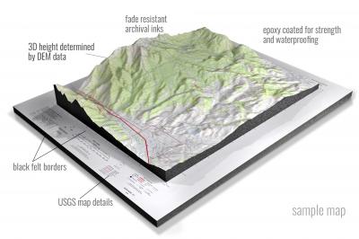
• Raised-relief 3D Height Determined by DEM data
• Fade Resistant Archival Inks
• Epoxy Coated for Strength and Waterproofing
• Ready to Hang with Pre-Installed Hardware (optional)
• Extraordinary 3D Accuracy
• Black Felt Borders
Enrich your office decor or home with a 3D USGS Raised Relief Map. These raised relief maps are not flat. They are three-dimensional, with the height being determined by Digital Elevation Model (DEM) data. Many people struggle with reading 2D satellite maps, but everyone understands 3D raised relief maps. The realism is phenomenal.
This 3D satellite raised relief map is built by combining satellite imagery data from Google Earth, bounding box coordinates from USGS, and DEM data. 3D Printing and 3D CNC routers are used to fabricate the models which make the satellite models extremely accurate. These models are strong - they are coated with epoxy, then finished with a sealer providing a weatherproof matt-finish. These are not meant to be used in direct sunlight.
Abbotsford, Wisconsin- View hi-resolution image of: Abbotsford, Wisconsin. Mapping by USGS in 2022 - Longitude/Latitude: -90.375 x -90.25 x 45 x 44.875, Grid Size: 7.5 X 7.5 Minute, Map Scale: 1:24000, State List: WI, County List: Clark,Marathon
Abrams, Wisconsin- View hi-resolution image of: Abrams, Wisconsin. Mapping by USGS in 2022 - Longitude/Latitude: -88.125 x -88 x 44.875 x 44.75, Grid Size: 7.5 X 7.5 Minute, Map Scale: 1:24000, State List: WI, County List: Oconto
Adams, Wisconsin- View hi-resolution image of: Adams, Wisconsin. Mapping by USGS in 2022 - Longitude/Latitude: -89.875 x -89.75 x 44 x 43.875, Grid Size: 7.5 X 7.5 Minute, Map Scale: 1:24000, State List: WI, County List: Adams
Albany, Wisconsin- View hi-resolution image of: Albany, Wisconsin. Mapping by USGS in 2022 - Longitude/Latitude: -89.5 x -89.375 x 42.75 x 42.625, Grid Size: 7.5 X 7.5 Minute, Map Scale: 1:24000, State List: WI, County List: Green
Albertville, Wisconsin- View hi-resolution image of: Albertville, Wisconsin. Mapping by USGS in 2022 - Longitude/Latitude: -91.625 x -91.5 x 45 x 44.875, Grid Size: 7.5 X 7.5 Minute, Map Scale: 1:24000, State List: WI, County List: Chippewa
Alderwood Lake, Wisconsin- View hi-resolution image of: Alderwood Lake, Wisconsin. Mapping by USGS in 2022 - Longitude/Latitude: -90.75 x -90.625 x 44.125 x 44, Grid Size: 7.5 X 7.5 Minute, Map Scale: 1:24000, State List: WI, County List: Monroe
Alexander Lake, Wisconsin- View hi-resolution image of: Alexander Lake, Wisconsin. Mapping by USGS in 2022 - Longitude/Latitude: -89.875 x -89.75 x 45.25 x 45.125, Grid Size: 7.5 X 7.5 Minute, Map Scale: 1:24000, State List: WI, County List: Lincoln
Algoma, Wisconsin- View hi-resolution image of: Algoma, Wisconsin. Mapping by USGS in 2022 - Longitude/Latitude: -87.5 x -87.375 x 44.625 x 44.5, Grid Size: 7.5 X 7.5 Minute, Map Scale: 1:24000, State List: WI, County List: Kewaunee
Algoma NE, Wisconsin- View hi-resolution image of: Algoma NE, Wisconsin. Mapping by USGS in 2022 - Longitude/Latitude: -87.375 x -87.25 x 44.75 x 44.625, Grid Size: 7.5 X 7.5 Minute, Map Scale: 1:24000, State List: WI, County List: Door,Kewaunee
Allenton, Wisconsin- View hi-resolution image of: Allenton, Wisconsin. Mapping by USGS in 2022 - Longitude/Latitude: -88.375 x -88.25 x 43.5 x 43.375, Grid Size: 7.5 X 7.5 Minute, Map Scale: 1:24000, State List: WI, County List: Washington
Alma, Wisconsin- View hi-resolution image of: Alma, Wisconsin. Mapping by USGS in 2022 - Longitude/Latitude: -92 x -91.875 x 44.375 x 44.25, Grid Size: 7.5 X 7.5 Minute, Map Scale: 1:24000, State List: WI,MN, County List: Buffalo,Wabasha
Alma Center, Wisconsin- View hi-resolution image of: Alma Center, Wisconsin. Mapping by USGS in 2022 - Longitude/Latitude: -91 x -90.875 x 44.5 x 44.375, Grid Size: 7.5 X 7.5 Minute, Map Scale: 1:24000, State List: WI, County List: Jackson
Almena, Wisconsin- View hi-resolution image of: Almena, Wisconsin. Mapping by USGS in 2022 - Longitude/Latitude: -92.125 x -92 x 45.5 x 45.375, Grid Size: 7.5 X 7.5 Minute, Map Scale: 1:24000, State List: WI, County List: Barron
Almond, Wisconsin- View hi-resolution image of: Almond, Wisconsin. Mapping by USGS in 2022 - Longitude/Latitude: -89.5 x -89.375 x 44.375 x 44.25, Grid Size: 7.5 X 7.5 Minute, Map Scale: 1:24000, State List: WI, County List: Portage
Alvin, Wisconsin- View hi-resolution image of: Alvin, Wisconsin. Mapping by USGS in 2022 - Longitude/Latitude: -88.875 x -88.75 x 46 x 45.875, Grid Size: 7.5 X 7.5 Minute, Map Scale: 1:24000, State List: WI, County List: Forest
Alvin NW, Wisconsin- View hi-resolution image of: Alvin NW, Wisconsin. Mapping by USGS in 2022 - Longitude/Latitude: -89 x -88.875 x 46 x 45.875, Grid Size: 7.5 X 7.5 Minute, Map Scale: 1:24000, State List: WI, County List: Forest,Vilas
Alvin SE, Wisconsin- View hi-resolution image of: Alvin SE, Wisconsin. Mapping by USGS in 2022 - Longitude/Latitude: -88.875 x -88.75 x 45.875 x 45.75, Grid Size: 7.5 X 7.5 Minute, Map Scale: 1:24000, State List: WI, County List: Forest
Alvin SW, Wisconsin- View hi-resolution image of: Alvin SW, Wisconsin. Mapping by USGS in 2022 - Longitude/Latitude: -89 x -88.875 x 45.875 x 45.75, Grid Size: 7.5 X 7.5 Minute, Map Scale: 1:24000, State List: WI, County List: Forest
Amberg, Wisconsin- View hi-resolution image of: Amberg, Wisconsin. Mapping by USGS in 2022 - Longitude/Latitude: -88 x -87.875 x 45.625 x 45.5, Grid Size: 7.5 X 7.5 Minute, Map Scale: 1:24000, State List: WI, County List: Marinette
Amery, Wisconsin- View hi-resolution image of: Amery, Wisconsin. Mapping by USGS in 2022 - Longitude/Latitude: -92.375 x -92.25 x 45.375 x 45.25, Grid Size: 7.5 X 7.5 Minute, Map Scale: 1:24000, State List: WI, County List: Polk
Amherst, Wisconsin- View hi-resolution image of: Amherst, Wisconsin. Mapping by USGS in 2022 - Longitude/Latitude: -89.375 x -89.25 x 44.5 x 44.375, Grid Size: 7.5 X 7.5 Minute, Map Scale: 1:24000, State List: WI, County List: Portage
Amnicon Lake, Wisconsin- View hi-resolution image of: Amnicon Lake, Wisconsin. Mapping by USGS in 2022 - Longitude/Latitude: -92.125 x -92 x 46.5 x 46.375, Grid Size: 7.5 X 7.5 Minute, Map Scale: 1:24000, State List: WI, County List: Douglas
Amnicon Point, Wisconsin- View hi-resolution image of: Amnicon Point, Wisconsin. Mapping by USGS in 2022 - Longitude/Latitude: -90.625 x -90.5 x 46.875 x 46.75, Grid Size: 7.5 X 7.5 Minute, Map Scale: 1:24000, State List: WI, County List: Ashland
Aniwa, Wisconsin- View hi-resolution image of: Aniwa, Wisconsin. Mapping by USGS in 2022 - Longitude/Latitude: -89.25 x -89.125 x 45.125 x 45, Grid Size: 7.5 X 7.5 Minute, Map Scale: 1:24000, State List: WI, County List: Langlade,Marathon,Shawano
Antigo, Wisconsin- View hi-resolution image of: Antigo, Wisconsin. Mapping by USGS in 2022 - Longitude/Latitude: -89.25 x -89.125 x 45.25 x 45.125, Grid Size: 7.5 X 7.5 Minute, Map Scale: 1:24000, State List: WI, County List: Langlade
Anvil Lake, Wisconsin- View hi-resolution image of: Anvil Lake, Wisconsin. Mapping by USGS in 2022 - Longitude/Latitude: -89.125 x -89 x 46 x 45.875, Grid Size: 7.5 X 7.5 Minute, Map Scale: 1:24000, State List: WI, County List: Vilas,Forest,Oneida
Appleton, Wisconsin- View hi-resolution image of: Appleton, Wisconsin. Mapping by USGS in 2022 - Longitude/Latitude: -88.5 x -88.375 x 44.375 x 44.25, Grid Size: 7.5 X 7.5 Minute, Map Scale: 1:24000, State List: WI, County List: Outagamie
Arena, Wisconsin- View hi-resolution image of: Arena, Wisconsin. Mapping by USGS in 2022 - Longitude/Latitude: -90 x -89.875 x 43.25 x 43.125, Grid Size: 7.5 X 7.5 Minute, Map Scale: 1:24000, State List: WI, County List: Iowa,Sauk
Argonne, Wisconsin- View hi-resolution image of: Argonne, Wisconsin. Mapping by USGS in 2022 - Longitude/Latitude: -89 x -88.875 x 45.75 x 45.625, Grid Size: 7.5 X 7.5 Minute, Map Scale: 1:24000, State List: WI, County List: Forest
Argyle, Wisconsin- View hi-resolution image of: Argyle, Wisconsin. Mapping by USGS in 2022 - Longitude/Latitude: -89.875 x -89.75 x 42.75 x 42.625, Grid Size: 7.5 X 7.5 Minute, Map Scale: 1:24000, State List: WI, County List: Green,Lafayette
Arkansaw, Wisconsin- View hi-resolution image of: Arkansaw, Wisconsin. Mapping by USGS in 2022 - Longitude/Latitude: -92.125 x -92 x 44.75 x 44.625, Grid Size: 7.5 X 7.5 Minute, Map Scale: 1:24000, State List: WI, County List: Dunn,Pepin
Arkdale, Wisconsin- View hi-resolution image of: Arkdale, Wisconsin. Mapping by USGS in 2022 - Longitude/Latitude: -90 x -89.875 x 44.125 x 44, Grid Size: 7.5 X 7.5 Minute, Map Scale: 1:24000, State List: WI, County List: Adams,Juneau
Arkdale NE, Wisconsin- View hi-resolution image of: Arkdale NE, Wisconsin. Mapping by USGS in 2022 - Longitude/Latitude: -89.875 x -89.75 x 44.25 x 44.125, Grid Size: 7.5 X 7.5 Minute, Map Scale: 1:24000, State List: WI, County List: Adams,Wood
Arkdale NW, Wisconsin- View hi-resolution image of: Arkdale NW, Wisconsin. Mapping by USGS in 2022 - Longitude/Latitude: -90 x -89.875 x 44.25 x 44.125, Grid Size: 7.5 X 7.5 Minute, Map Scale: 1:24000, State List: WI, County List: Juneau,Adams,Wood
Arland, Wisconsin- View hi-resolution image of: Arland, Wisconsin. Mapping by USGS in 2022 - Longitude/Latitude: -92.125 x -92 x 45.375 x 45.25, Grid Size: 7.5 X 7.5 Minute, Map Scale: 1:24000, State List: WI, County List: Barron
Arlington, Wisconsin- View hi-resolution image of: Arlington, Wisconsin. Mapping by USGS in 2022 - Longitude/Latitude: -89.5 x -89.375 x 43.375 x 43.25, Grid Size: 7.5 X 7.5 Minute, Map Scale: 1:24000, State List: WI, County List: Columbia,Dane
Armstrong Creek, Wisconsin- View hi-resolution image of: Armstrong Creek, Wisconsin. Mapping by USGS in 2022 - Longitude/Latitude: -88.5 x -88.375 x 45.75 x 45.625, Grid Size: 7.5 X 7.5 Minute, Map Scale: 1:24000, State List: WI, County List: Forest,Marinette,Florence
Arnott, Wisconsin- View hi-resolution image of: Arnott, Wisconsin. Mapping by USGS in 2022 - Longitude/Latitude: -89.5 x -89.375 x 44.5 x 44.375, Grid Size: 7.5 X 7.5 Minute, Map Scale: 1:24000, State List: WI, County List: Portage
Arpin, Wisconsin- View hi-resolution image of: Arpin, Wisconsin. Mapping by USGS in 2022 - Longitude/Latitude: -90.125 x -90 x 44.625 x 44.5, Grid Size: 7.5 X 7.5 Minute, Map Scale: 1:24000, State List: WI, County List: Wood
Ashland East, Wisconsin- View hi-resolution image of: Ashland East, Wisconsin. Mapping by USGS in 2022 - Longitude/Latitude: -90.875 x -90.75 x 46.625 x 46.5, Grid Size: 7.5 X 7.5 Minute, Map Scale: 1:24000, State List: WI, County List: Ashland
Ashland West, Wisconsin- View hi-resolution image of: Ashland West, Wisconsin. Mapping by USGS in 2022 - Longitude/Latitude: -91 x -90.875 x 46.625 x 46.5, Grid Size: 7.5 X 7.5 Minute, Map Scale: 1:24000, State List: WI, County List: Bayfield,Ashland
Astico, Wisconsin- View hi-resolution image of: Astico, Wisconsin. Mapping by USGS in 2022 - Longitude/Latitude: -89 x -88.875 x 43.375 x 43.25, Grid Size: 7.5 X 7.5 Minute, Map Scale: 1:24000, State List: WI, County List: Dodge
Athelstane, Wisconsin- View hi-resolution image of: Athelstane, Wisconsin. Mapping by USGS in 2022 - Longitude/Latitude: -88.125 x -88 x 45.5 x 45.375, Grid Size: 7.5 X 7.5 Minute, Map Scale: 1:24000, State List: WI, County List: Marinette
Athens, Wisconsin- View hi-resolution image of: Athens, Wisconsin. Mapping by USGS in 2022 - Longitude/Latitude: -90.125 x -90 x 45.125 x 45, Grid Size: 7.5 X 7.5 Minute, Map Scale: 1:24000, State List: WI, County List: Marathon,Taylor,Lincoln
Attica, Wisconsin- View hi-resolution image of: Attica, Wisconsin. Mapping by USGS in 2022 - Longitude/Latitude: -89.5 x -89.375 x 42.875 x 42.75, Grid Size: 7.5 X 7.5 Minute, Map Scale: 1:24000, State List: WI, County List: Green,Dane
Augusta East, Wisconsin- View hi-resolution image of: Augusta East, Wisconsin. Mapping by USGS in 2022 - Longitude/Latitude: -91.125 x -91 x 44.75 x 44.625, Grid Size: 7.5 X 7.5 Minute, Map Scale: 1:24000, State List: WI, County List: Eau Claire
Augusta West, Wisconsin- View hi-resolution image of: Augusta West, Wisconsin. Mapping by USGS in 2022 - Longitude/Latitude: -91.25 x -91.125 x 44.75 x 44.625, Grid Size: 7.5 X 7.5 Minute, Map Scale: 1:24000, State List: WI, County List: Eau Claire
Augustine Lake, Wisconsin- View hi-resolution image of: Augustine Lake, Wisconsin. Mapping by USGS in 2022 - Longitude/Latitude: -90.5 x -90.375 x 46.25 x 46.125, Grid Size: 7.5 X 7.5 Minute, Map Scale: 1:24000, State List: WI, County List: Ashland,Iron
Auroraville, Wisconsin- View hi-resolution image of: Auroraville, Wisconsin. Mapping by USGS in 2022 - Longitude/Latitude: -89 x -88.875 x 44.125 x 44, Grid Size: 7.5 X 7.5 Minute, Map Scale: 1:24000, State List: WI, County List: Waushara,Winnebago
Avalanche, Wisconsin- View hi-resolution image of: Avalanche, Wisconsin. Mapping by USGS in 2022 - Longitude/Latitude: -90.875 x -90.75 x 43.625 x 43.5, Grid Size: 7.5 X 7.5 Minute, Map Scale: 1:24000, State List: WI, County List: Vernon
Avalon, Wisconsin- View hi-resolution image of: Avalon, Wisconsin. Mapping by USGS in 2022 - Longitude/Latitude: -88.875 x -88.75 x 42.75 x 42.625, Grid Size: 7.5 X 7.5 Minute, Map Scale: 1:24000, State List: WI, County List: Rock,Walworth
Avoca, Wisconsin- View hi-resolution image of: Avoca, Wisconsin. Mapping by USGS in 2022 - Longitude/Latitude: -90.375 x -90.25 x 43.25 x 43.125, Grid Size: 7.5 X 7.5 Minute, Map Scale: 1:24000, State List: WI, County List: Iowa,Richland
Babbs Island, Wisconsin- View hi-resolution image of: Babbs Island, Wisconsin. Mapping by USGS in 2022 - Longitude/Latitude: -90.875 x -90.75 x 45.875 x 45.75, Grid Size: 7.5 X 7.5 Minute, Map Scale: 1:24000, State List: WI, County List: Sawyer
Babcock, Wisconsin- View hi-resolution image of: Babcock, Wisconsin. Mapping by USGS in 2022 - Longitude/Latitude: -90.125 x -90 x 44.375 x 44.25, Grid Size: 7.5 X 7.5 Minute, Map Scale: 1:24000, State List: WI, County List: Wood
Baileys Harbor East, Wisconsin- View hi-resolution image of: Baileys Harbor East, Wisconsin. Mapping by USGS in 2022 - Longitude/Latitude: -87.125 x -87 x 45.125 x 45, Grid Size: 7.5 X 7.5 Minute, Map Scale: 1:24000, State List: WI, County List: Door
Baileys Harbor West, Wisconsin- View hi-resolution image of: Baileys Harbor West, Wisconsin. Mapping by USGS in 2022 - Longitude/Latitude: -87.25 x -87.125 x 45.125 x 45, Grid Size: 7.5 X 7.5 Minute, Map Scale: 1:24000, State List: WI, County List: Door
Baldwin East, Wisconsin- View hi-resolution image of: Baldwin East, Wisconsin. Mapping by USGS in 2022 - Longitude/Latitude: -92.375 x -92.25 x 45 x 44.875, Grid Size: 7.5 X 7.5 Minute, Map Scale: 1:24000, State List: WI, County List: St. Croix
Baldwin West, Wisconsin- View hi-resolution image of: Baldwin West, Wisconsin. Mapping by USGS in 2022 - Longitude/Latitude: -92.5 x -92.375 x 45 x 44.875, Grid Size: 7.5 X 7.5 Minute, Map Scale: 1:24000, State List: WI, County List: St. Croix
Balsam Lake, Wisconsin- View hi-resolution image of: Balsam Lake, Wisconsin. Mapping by USGS in 2022 - Longitude/Latitude: -92.5 x -92.375 x 45.5 x 45.375, Grid Size: 7.5 X 7.5 Minute, Map Scale: 1:24000, State List: WI, County List: Polk
Bancroft, Wisconsin- View hi-resolution image of: Bancroft, Wisconsin. Mapping by USGS in 2022 - Longitude/Latitude: -89.625 x -89.5 x 44.375 x 44.25, Grid Size: 7.5 X 7.5 Minute, Map Scale: 1:24000, State List: WI, County List: Portage
Bangor, Wisconsin- View hi-resolution image of: Bangor, Wisconsin. Mapping by USGS in 2022 - Longitude/Latitude: -91 x -90.875 x 44 x 43.875, Grid Size: 7.5 X 7.5 Minute, Map Scale: 1:24000, State List: WI, County List: La Crosse,Monroe
Baraboo, Wisconsin- View hi-resolution image of: Baraboo, Wisconsin. Mapping by USGS in 2022 - Longitude/Latitude: -89.75 x -89.625 x 43.5 x 43.375, Grid Size: 7.5 X 7.5 Minute, Map Scale: 1:24000, State List: WI, County List: Sauk
Bark Bay, Wisconsin- View hi-resolution image of: Bark Bay, Wisconsin. Mapping by USGS in 2022 - Longitude/Latitude: -91.25 x -91.125 x 46.875 x 46.75, Grid Size: 7.5 X 7.5 Minute, Map Scale: 1:24000, State List: WI, County List: Bayfield
Bark Bay OE N, Wisconsin- View hi-resolution image of: Bark Bay OE N, Wisconsin. Mapping by USGS in 2022 - Longitude/Latitude: -91.25 x -91.125 x 47 x 46.875, Grid Size: 7.5 X 7.5 Minute, Map Scale: 1:24000, State List: WI, County List: Bayfield
Barker Lake, Wisconsin- View hi-resolution image of: Barker Lake, Wisconsin. Mapping by USGS in 2022 - Longitude/Latitude: -91.125 x -91 x 46 x 45.875, Grid Size: 7.5 X 7.5 Minute, Map Scale: 1:24000, State List: WI, County List: Sawyer
Barneveld, Wisconsin- View hi-resolution image of: Barneveld, Wisconsin. Mapping by USGS in 2022 - Longitude/Latitude: -90 x -89.875 x 43.125 x 43, Grid Size: 7.5 X 7.5 Minute, Map Scale: 1:24000, State List: WI, County List: Iowa
Barron, Wisconsin- View hi-resolution image of: Barron, Wisconsin. Mapping by USGS in 2022 - Longitude/Latitude: -91.875 x -91.75 x 45.5 x 45.375, Grid Size: 7.5 X 7.5 Minute, Map Scale: 1:24000, State List: WI, County List: Barron
Batavia, Wisconsin- View hi-resolution image of: Batavia, Wisconsin. Mapping by USGS in 2022 - Longitude/Latitude: -88.125 x -88 x 43.625 x 43.5, Grid Size: 7.5 X 7.5 Minute, Map Scale: 1:24000, State List: WI, County List: Sheboygan,Washington,Ozaukee
Bavaria, Wisconsin- View hi-resolution image of: Bavaria, Wisconsin. Mapping by USGS in 2022 - Longitude/Latitude: -89.375 x -89.25 x 45.375 x 45.25, Grid Size: 7.5 X 7.5 Minute, Map Scale: 1:24000, State List: WI, County List: Langlade
Bay City, Wisconsin- View hi-resolution image of: Bay City, Wisconsin. Mapping by USGS in 2022 - Longitude/Latitude: -92.5 x -92.375 x 44.625 x 44.5, Grid Size: 7.5 X 7.5 Minute, Map Scale: 1:24000, State List: WI,MN, County List: Pierce,Goodhue
Bayfield, Wisconsin- View hi-resolution image of: Bayfield, Wisconsin. Mapping by USGS in 2022 - Longitude/Latitude: -90.875 x -90.75 x 46.875 x 46.75, Grid Size: 7.5 X 7.5 Minute, Map Scale: 1:24000, State List: WI, County List: Bayfield,Ashland
Bean Lake, Wisconsin- View hi-resolution image of: Bean Lake, Wisconsin. Mapping by USGS in 2022 - Longitude/Latitude: -91.625 x -91.5 x 46 x 45.875, Grid Size: 7.5 X 7.5 Minute, Map Scale: 1:24000, State List: WI, County List: Washburn,Sawyer
Bear Creek, Wisconsin- View hi-resolution image of: Bear Creek, Wisconsin. Mapping by USGS in 2022 - Longitude/Latitude: -88.75 x -88.625 x 44.625 x 44.5, Grid Size: 7.5 X 7.5 Minute, Map Scale: 1:24000, State List: WI, County List: Outagamie,Waupaca
Bear Island, Wisconsin- View hi-resolution image of: Bear Island, Wisconsin. Mapping by USGS in 2022 - Longitude/Latitude: -90.875 x -90.75 x 47.125 x 47, Grid Size: 7.5 X 7.5 Minute, Map Scale: 1:24000, State List: WI, County List: Ashland,Bayfield
Bear Valley, Wisconsin- View hi-resolution image of: Bear Valley, Wisconsin. Mapping by USGS in 2022 - Longitude/Latitude: -90.25 x -90.125 x 43.375 x 43.25, Grid Size: 7.5 X 7.5 Minute, Map Scale: 1:24000, State List: WI, County List: Sauk,Richland
Beaver Dam, Wisconsin- View hi-resolution image of: Beaver Dam, Wisconsin. Mapping by USGS in 2022 - Longitude/Latitude: -88.875 x -88.75 x 43.5 x 43.375, Grid Size: 7.5 X 7.5 Minute, Map Scale: 1:24000, State List: WI, County List: Dodge
Becky Creek, Wisconsin- View hi-resolution image of: Becky Creek, Wisconsin. Mapping by USGS in 2022 - Longitude/Latitude: -91.375 x -91.25 x 45.625 x 45.5, Grid Size: 7.5 X 7.5 Minute, Map Scale: 1:24000, State List: WI, County List: Rusk
Beetown, Wisconsin- View hi-resolution image of: Beetown, Wisconsin. Mapping by USGS in 2022 - Longitude/Latitude: -91 x -90.875 x 42.875 x 42.75, Grid Size: 7.5 X 7.5 Minute, Map Scale: 1:24000, State List: WI, County List: Grant
Belleville, Wisconsin- View hi-resolution image of: Belleville, Wisconsin. Mapping by USGS in 2022 - Longitude/Latitude: -89.625 x -89.5 x 42.875 x 42.75, Grid Size: 7.5 X 7.5 Minute, Map Scale: 1:24000, State List: WI, County List: Green,Dane
Bellevue, Wisconsin- View hi-resolution image of: Bellevue, Wisconsin. Mapping by USGS in 2022 - Longitude/Latitude: -88 x -87.875 x 44.5 x 44.375, Grid Size: 7.5 X 7.5 Minute, Map Scale: 1:24000, State List: WI, County List: Brown
Bellinger, Wisconsin- View hi-resolution image of: Bellinger, Wisconsin. Mapping by USGS in 2022 - Longitude/Latitude: -90.875 x -90.75 x 45.125 x 45, Grid Size: 7.5 X 7.5 Minute, Map Scale: 1:24000, State List: WI, County List: Taylor,Clark
Belmont, Wisconsin- View hi-resolution image of: Belmont, Wisconsin. Mapping by USGS in 2022 - Longitude/Latitude: -90.375 x -90.25 x 42.75 x 42.625, Grid Size: 7.5 X 7.5 Minute, Map Scale: 1:24000, State List: WI, County List: Lafayette
Beloit, Wisconsin- View hi-resolution image of: Beloit, Wisconsin. Mapping by USGS in 2022 - Longitude/Latitude: -89.125 x -89 x 42.625 x 42.5, Grid Size: 7.5 X 7.5 Minute, Map Scale: 1:24000, State List: WI, County List: Rock
Bennett, Wisconsin- View hi-resolution image of: Bennett, Wisconsin. Mapping by USGS in 2022 - Longitude/Latitude: -91.875 x -91.75 x 46.5 x 46.375, Grid Size: 7.5 X 7.5 Minute, Map Scale: 1:24000, State List: WI, County List: Douglas
Berlin, Wisconsin- View hi-resolution image of: Berlin, Wisconsin. Mapping by USGS in 2022 - Longitude/Latitude: -89 x -88.875 x 44 x 43.875, Grid Size: 7.5 X 7.5 Minute, Map Scale: 1:24000, State List: WI, County List: Green Lake,Waushara,Winnebago,Fond du Lac
Berry Lake, Wisconsin- View hi-resolution image of: Berry Lake, Wisconsin. Mapping by USGS in 2022 - Longitude/Latitude: -88.5 x -88.375 x 45 x 44.875, Grid Size: 7.5 X 7.5 Minute, Map Scale: 1:24000, State List: WI, County List: Oconto,Menominee
Bevent, Wisconsin- View hi-resolution image of: Bevent, Wisconsin. Mapping by USGS in 2022 - Longitude/Latitude: -89.5 x -89.375 x 44.875 x 44.75, Grid Size: 7.5 X 7.5 Minute, Map Scale: 1:24000, State List: WI, County List: Marathon
Big Briens Lake, Wisconsin- View hi-resolution image of: Big Briens Lake, Wisconsin. Mapping by USGS in 2022 - Longitude/Latitude: -90.25 x -90.125 x 45.625 x 45.5, Grid Size: 7.5 X 7.5 Minute, Map Scale: 1:24000, State List: WI, County List: Price
Big Eau Pleine Reservoir, Wisconsin- View hi-resolution image of: Big Eau Pleine Reservoir, Wisconsin. Mapping by USGS in 2022 - Longitude/Latitude: -89.875 x -89.75 x 44.75 x 44.625, Grid Size: 7.5 X 7.5 Minute, Map Scale: 1:24000, State List: WI, County List: Marathon,Portage,Wood
Big Falls, Wisconsin- View hi-resolution image of: Big Falls, Wisconsin. Mapping by USGS in 2022 - Longitude/Latitude: -89.125 x -89 x 44.625 x 44.5, Grid Size: 7.5 X 7.5 Minute, Map Scale: 1:24000, State List: WI, County List: Waupaca
Big Falls Dam, Wisconsin- View hi-resolution image of: Big Falls Dam, Wisconsin. Mapping by USGS in 2022 - Longitude/Latitude: -91 x -90.875 x 45.625 x 45.5, Grid Size: 7.5 X 7.5 Minute, Map Scale: 1:24000, State List: WI, County List: Rusk
Big Round Lake, Wisconsin- View hi-resolution image of: Big Round Lake, Wisconsin. Mapping by USGS in 2022 - Longitude/Latitude: -92.375 x -92.25 x 45.625 x 45.5, Grid Size: 7.5 X 7.5 Minute, Map Scale: 1:24000, State List: WI, County List: Polk
Big Spring, Wisconsin- View hi-resolution image of: Big Spring, Wisconsin. Mapping by USGS in 2022 - Longitude/Latitude: -89.75 x -89.625 x 43.75 x 43.625, Grid Size: 7.5 X 7.5 Minute, Map Scale: 1:24000, State List: WI, County List: Adams,Columbia
Birch Island Lake, Wisconsin- View hi-resolution image of: Birch Island Lake, Wisconsin. Mapping by USGS in 2022 - Longitude/Latitude: -92.25 x -92.125 x 46 x 45.875, Grid Size: 7.5 X 7.5 Minute, Map Scale: 1:24000, State List: WI, County List: Burnett
Birchwood, Wisconsin- View hi-resolution image of: Birchwood, Wisconsin. Mapping by USGS in 2022 - Longitude/Latitude: -91.625 x -91.5 x 45.75 x 45.625, Grid Size: 7.5 X 7.5 Minute, Map Scale: 1:24000, State List: WI, County List: Washburn,Sawyer,Barron,Rusk
Birnamwood, Wisconsin- View hi-resolution image of: Birnamwood, Wisconsin. Mapping by USGS in 2022 - Longitude/Latitude: -89.25 x -89.125 x 45 x 44.875, Grid Size: 7.5 X 7.5 Minute, Map Scale: 1:24000, State List: WI, County List: Shawano,Marathon
Black Brook, Wisconsin- View hi-resolution image of: Black Brook, Wisconsin. Mapping by USGS in 2022 - Longitude/Latitude: -89.375 x -89.25 x 45.25 x 45.125, Grid Size: 7.5 X 7.5 Minute, Map Scale: 1:24000, State List: WI, County List: Langlade
Black Creek, Wisconsin- View hi-resolution image of: Black Creek, Wisconsin. Mapping by USGS in 2022 - Longitude/Latitude: -88.5 x -88.375 x 44.5 x 44.375, Grid Size: 7.5 X 7.5 Minute, Map Scale: 1:24000, State List: WI, County List: Outagamie
Black Earth, Wisconsin- View hi-resolution image of: Black Earth, Wisconsin. Mapping by USGS in 2022 - Longitude/Latitude: -89.75 x -89.625 x 43.25 x 43.125, Grid Size: 7.5 X 7.5 Minute, Map Scale: 1:24000, State List: WI, County List: Dane,Sauk
Black Hawk, Wisconsin- View hi-resolution image of: Black Hawk, Wisconsin. Mapping by USGS in 2022 - Longitude/Latitude: -90 x -89.875 x 43.375 x 43.25, Grid Size: 7.5 X 7.5 Minute, Map Scale: 1:24000, State List: WI, County List: Sauk
Black Lake, Wisconsin- View hi-resolution image of: Black Lake, Wisconsin. Mapping by USGS in 2022 - Longitude/Latitude: -92.375 x -92.25 x 46.375 x 46.25, Grid Size: 7.5 X 7.5 Minute, Map Scale: 1:24000, State List: WI,MN, County List: Douglas,Pine
Black Oak Lake, Wisconsin- View hi-resolution image of: Black Oak Lake, Wisconsin. Mapping by USGS in 2022 - Longitude/Latitude: -89.375 x -89.25 x 46.25 x 46.125, Grid Size: 7.5 X 7.5 Minute, Map Scale: 1:24000, State List: WI,MI, County List: Vilas,Gogebic
Black River Falls, Wisconsin- View hi-resolution image of: Black River Falls, Wisconsin. Mapping by USGS in 2022 - Longitude/Latitude: -90.875 x -90.75 x 44.375 x 44.25, Grid Size: 7.5 X 7.5 Minute, Map Scale: 1:24000, State List: WI, County List: Jackson
Blackwell, Wisconsin- View hi-resolution image of: Blackwell, Wisconsin. Mapping by USGS in 2022 - Longitude/Latitude: -88.625 x -88.5 x 45.625 x 45.5, Grid Size: 7.5 X 7.5 Minute, Map Scale: 1:24000, State List: WI, County List: Forest
Blaine, Wisconsin- View hi-resolution image of: Blaine, Wisconsin. Mapping by USGS in 2022 - Longitude/Latitude: -89.375 x -89.25 x 44.375 x 44.25, Grid Size: 7.5 X 7.5 Minute, Map Scale: 1:24000, State List: WI, County List: Portage
Blaine Creek, Wisconsin- View hi-resolution image of: Blaine Creek, Wisconsin. Mapping by USGS in 2022 - Longitude/Latitude: -91.5 x -91.375 x 46.75 x 46.625, Grid Size: 7.5 X 7.5 Minute, Map Scale: 1:24000, State List: WI, County List: Bayfield
Blair, Wisconsin- View hi-resolution image of: Blair, Wisconsin. Mapping by USGS in 2022 - Longitude/Latitude: -91.25 x -91.125 x 44.375 x 44.25, Grid Size: 7.5 X 7.5 Minute, Map Scale: 1:24000, State List: WI, County List: Trempealeau,Jackson
Blaisdell Lake, Wisconsin- View hi-resolution image of: Blaisdell Lake, Wisconsin. Mapping by USGS in 2022 - Longitude/Latitude: -91 x -90.875 x 46 x 45.875, Grid Size: 7.5 X 7.5 Minute, Map Scale: 1:24000, State List: WI, County List: Sawyer,Ashland
Blanchardville, Wisconsin- View hi-resolution image of: Blanchardville, Wisconsin. Mapping by USGS in 2022 - Longitude/Latitude: -89.875 x -89.75 x 42.875 x 42.75, Grid Size: 7.5 X 7.5 Minute, Map Scale: 1:24000, State List: WI, County List: Green,Lafayette,Iowa,Dane
Blockhouse Lake, Wisconsin- View hi-resolution image of: Blockhouse Lake, Wisconsin. Mapping by USGS in 2022 - Longitude/Latitude: -90.375 x -90.25 x 46 x 45.875, Grid Size: 7.5 X 7.5 Minute, Map Scale: 1:24000, State List: WI, County List: Price,Ashland,Iron
Bloomer, Wisconsin- View hi-resolution image of: Bloomer, Wisconsin. Mapping by USGS in 2022 - Longitude/Latitude: -91.5 x -91.375 x 45.125 x 45, Grid Size: 7.5 X 7.5 Minute, Map Scale: 1:24000, State List: WI, County List: Chippewa
Bloomington, Wisconsin- View hi-resolution image of: Bloomington, Wisconsin. Mapping by USGS in 2022 - Longitude/Latitude: -91 x -90.875 x 43 x 42.875, Grid Size: 7.5 X 7.5 Minute, Map Scale: 1:24000, State List: WI, County List: Grant
Bloomville, Wisconsin- View hi-resolution image of: Bloomville, Wisconsin. Mapping by USGS in 2022 - Longitude/Latitude: -89.625 x -89.5 x 45.375 x 45.25, Grid Size: 7.5 X 7.5 Minute, Map Scale: 1:24000, State List: WI, County List: Lincoln
Blue Mounds, Wisconsin- View hi-resolution image of: Blue Mounds, Wisconsin. Mapping by USGS in 2022 - Longitude/Latitude: -89.875 x -89.75 x 43.125 x 43, Grid Size: 7.5 X 7.5 Minute, Map Scale: 1:24000, State List: WI, County List: Dane,Iowa
Blue River, Wisconsin- View hi-resolution image of: Blue River, Wisconsin. Mapping by USGS in 2022 - Longitude/Latitude: -90.625 x -90.5 x 43.25 x 43.125, Grid Size: 7.5 X 7.5 Minute, Map Scale: 1:24000, State List: WI, County List: Grant,Richland
Boaz, Wisconsin- View hi-resolution image of: Boaz, Wisconsin. Mapping by USGS in 2022 - Longitude/Latitude: -90.625 x -90.5 x 43.375 x 43.25, Grid Size: 7.5 X 7.5 Minute, Map Scale: 1:24000, State List: WI, County List: Richland
Bob Lake, Wisconsin- View hi-resolution image of: Bob Lake, Wisconsin. Mapping by USGS in 2022 - Longitude/Latitude: -91.375 x -91.25 x 45.25 x 45.125, Grid Size: 7.5 X 7.5 Minute, Map Scale: 1:24000, State List: WI, County List: Chippewa
Bonduel, Wisconsin- View hi-resolution image of: Bonduel, Wisconsin. Mapping by USGS in 2022 - Longitude/Latitude: -88.5 x -88.375 x 44.75 x 44.625, Grid Size: 7.5 X 7.5 Minute, Map Scale: 1:24000, State List: WI, County List: Shawano
Borea, Wisconsin- View hi-resolution image of: Borea, Wisconsin. Mapping by USGS in 2022 - Longitude/Latitude: -92.25 x -92.125 x 46.625 x 46.5, Grid Size: 7.5 X 7.5 Minute, Map Scale: 1:24000, State List: WI, County List: Douglas
Boscobel, Wisconsin- View hi-resolution image of: Boscobel, Wisconsin. Mapping by USGS in 2022 - Longitude/Latitude: -90.75 x -90.625 x 43.25 x 43.125, Grid Size: 7.5 X 7.5 Minute, Map Scale: 1:24000, State List: WI, County List: Crawford,Grant,Richland
Boulder Junction, Wisconsin- View hi-resolution image of: Boulder Junction, Wisconsin. Mapping by USGS in 2022 - Longitude/Latitude: -89.75 x -89.625 x 46.125 x 46, Grid Size: 7.5 X 7.5 Minute, Map Scale: 1:24000, State List: WI, County List: Vilas
Bowler, Wisconsin- View hi-resolution image of: Bowler, Wisconsin. Mapping by USGS in 2022 - Longitude/Latitude: -89 x -88.875 x 44.875 x 44.75, Grid Size: 7.5 X 7.5 Minute, Map Scale: 1:24000, State List: WI, County List: Shawano
Boyceville, Wisconsin- View hi-resolution image of: Boyceville, Wisconsin. Mapping by USGS in 2022 - Longitude/Latitude: -92.125 x -92 x 45.125 x 45, Grid Size: 7.5 X 7.5 Minute, Map Scale: 1:24000, State List: WI, County List: Dunn
Boyd, Wisconsin- View hi-resolution image of: Boyd, Wisconsin. Mapping by USGS in 2022 - Longitude/Latitude: -91.125 x -91 x 45 x 44.875, Grid Size: 7.5 X 7.5 Minute, Map Scale: 1:24000, State List: WI, County List: Chippewa
Brackett, Wisconsin- View hi-resolution image of: Brackett, Wisconsin. Mapping by USGS in 2022 - Longitude/Latitude: -91.375 x -91.25 x 44.75 x 44.625, Grid Size: 7.5 X 7.5 Minute, Map Scale: 1:24000, State List: WI, County List: Eau Claire
Bradley, Wisconsin- View hi-resolution image of: Bradley, Wisconsin. Mapping by USGS in 2022 - Longitude/Latitude: -89.875 x -89.75 x 45.625 x 45.5, Grid Size: 7.5 X 7.5 Minute, Map Scale: 1:24000, State List: WI, County List: Oneida,Lincoln
Brandon, Wisconsin- View hi-resolution image of: Brandon, Wisconsin. Mapping by USGS in 2022 - Longitude/Latitude: -88.875 x -88.75 x 43.75 x 43.625, Grid Size: 7.5 X 7.5 Minute, Map Scale: 1:24000, State List: WI, County List: Fond du Lac,Dodge
Brantwood, Wisconsin- View hi-resolution image of: Brantwood, Wisconsin. Mapping by USGS in 2022 - Longitude/Latitude: -90.125 x -90 x 45.625 x 45.5, Grid Size: 7.5 X 7.5 Minute, Map Scale: 1:24000, State List: WI, County List: Price,Oneida,Lincoln
Breed, Wisconsin- View hi-resolution image of: Breed, Wisconsin. Mapping by USGS in 2022 - Longitude/Latitude: -88.5 x -88.375 x 45.125 x 45, Grid Size: 7.5 X 7.5 Minute, Map Scale: 1:24000, State List: WI, County List: Oconto,Menominee
Bridgeport, Wisconsin- View hi-resolution image of: Bridgeport, Wisconsin. Mapping by USGS in 2022 - Longitude/Latitude: -91.125 x -91 x 43.125 x 43, Grid Size: 7.5 X 7.5 Minute, Map Scale: 1:24000, State List: WI, County List: Crawford,Grant
Briggsville, Wisconsin- View hi-resolution image of: Briggsville, Wisconsin. Mapping by USGS in 2022 - Longitude/Latitude: -89.625 x -89.5 x 43.75 x 43.625, Grid Size: 7.5 X 7.5 Minute, Map Scale: 1:24000, State List: WI, County List: Marquette,Adams,Columbia
Brillion, Wisconsin- View hi-resolution image of: Brillion, Wisconsin. Mapping by USGS in 2022 - Longitude/Latitude: -88.125 x -88 x 44.25 x 44.125, Grid Size: 7.5 X 7.5 Minute, Map Scale: 1:24000, State List: WI, County List: Calumet,Manitowoc,Brown
Brodhead East, Wisconsin- View hi-resolution image of: Brodhead East, Wisconsin. Mapping by USGS in 2022 - Longitude/Latitude: -89.375 x -89.25 x 42.625 x 42.5, Grid Size: 7.5 X 7.5 Minute, Map Scale: 1:24000, State List: WI,IL, County List: Rock,Green,Winnebago
Brodhead West, Wisconsin- View hi-resolution image of: Brodhead West, Wisconsin. Mapping by USGS in 2022 - Longitude/Latitude: -89.5 x -89.375 x 42.625 x 42.5, Grid Size: 7.5 X 7.5 Minute, Map Scale: 1:24000, State List: WI,IL, County List: Green,Stephenson,Winnebago
Brodtville, Wisconsin- View hi-resolution image of: Brodtville, Wisconsin. Mapping by USGS in 2022 - Longitude/Latitude: -91.125 x -91 x 43 x 42.875, Grid Size: 7.5 X 7.5 Minute, Map Scale: 1:24000, State List: WI,IA, County List: Grant,Clayton,Crawford
Brokaw, Wisconsin- View hi-resolution image of: Brokaw, Wisconsin. Mapping by USGS in 2022 - Longitude/Latitude: -89.75 x -89.625 x 45.125 x 45, Grid Size: 7.5 X 7.5 Minute, Map Scale: 1:24000, State List: WI, County List: Marathon,Lincoln
Brooks, Wisconsin- View hi-resolution image of: Brooks, Wisconsin. Mapping by USGS in 2022 - Longitude/Latitude: -89.75 x -89.625 x 43.875 x 43.75, Grid Size: 7.5 X 7.5 Minute, Map Scale: 1:24000, State List: WI, County List: Adams
Brothertown, Wisconsin- View hi-resolution image of: Brothertown, Wisconsin. Mapping by USGS in 2022 - Longitude/Latitude: -88.375 x -88.25 x 44 x 43.875, Grid Size: 7.5 X 7.5 Minute, Map Scale: 1:24000, State List: WI, County List: Fond du Lac,Calumet
Browntown, Wisconsin- View hi-resolution image of: Browntown, Wisconsin. Mapping by USGS in 2022 - Longitude/Latitude: -89.875 x -89.75 x 42.625 x 42.5, Grid Size: 7.5 X 7.5 Minute, Map Scale: 1:24000, State List: WI,IL, County List: Green,Lafayette,Stephenson
Bruce, Wisconsin- View hi-resolution image of: Bruce, Wisconsin. Mapping by USGS in 2022 - Longitude/Latitude: -91.375 x -91.25 x 45.5 x 45.375, Grid Size: 7.5 X 7.5 Minute, Map Scale: 1:24000, State List: WI, County List: Rusk
Brule, Wisconsin- View hi-resolution image of: Brule, Wisconsin. Mapping by USGS in 2022 - Longitude/Latitude: -91.625 x -91.5 x 46.625 x 46.5, Grid Size: 7.5 X 7.5 Minute, Map Scale: 1:24000, State List: WI, County List: Douglas,Bayfield
Brussels, Wisconsin- View hi-resolution image of: Brussels, Wisconsin. Mapping by USGS in 2022 - Longitude/Latitude: -87.625 x -87.5 x 44.75 x 44.625, Grid Size: 7.5 X 7.5 Minute, Map Scale: 1:24000, State List: WI, County List: Door,Kewaunee
Bryant, Wisconsin- View hi-resolution image of: Bryant, Wisconsin. Mapping by USGS in 2022 - Longitude/Latitude: -89.125 x -89 x 45.25 x 45.125, Grid Size: 7.5 X 7.5 Minute, Map Scale: 1:24000, State List: WI, County List: Langlade
Buckety Creek, Wisconsin- View hi-resolution image of: Buckety Creek, Wisconsin. Mapping by USGS in 2022 - Longitude/Latitude: -92 x -91.875 x 46.375 x 46.25, Grid Size: 7.5 X 7.5 Minute, Map Scale: 1:24000, State List: WI, County List: Douglas
Buckhorn Corner, Wisconsin- View hi-resolution image of: Buckhorn Corner, Wisconsin. Mapping by USGS in 2022 - Longitude/Latitude: -88.875 x -88.75 x 43.625 x 43.5, Grid Size: 7.5 X 7.5 Minute, Map Scale: 1:24000, State List: WI, County List: Dodge
Bucks Lake, Wisconsin- View hi-resolution image of: Bucks Lake, Wisconsin. Mapping by USGS in 2022 - Longitude/Latitude: -91.5 x -91.375 x 45.625 x 45.5, Grid Size: 7.5 X 7.5 Minute, Map Scale: 1:24000, State List: WI, County List: Rusk
Burlington, Wisconsin- View hi-resolution image of: Burlington, Wisconsin. Mapping by USGS in 2022 - Longitude/Latitude: -88.375 x -88.25 x 42.75 x 42.625, Grid Size: 7.5 X 7.5 Minute, Map Scale: 1:24000, State List: WI, County List: Walworth,Racine
Burney Lake, Wisconsin- View hi-resolution image of: Burney Lake, Wisconsin. Mapping by USGS in 2022 - Longitude/Latitude: -89 x -88.875 x 45 x 44.875, Grid Size: 7.5 X 7.5 Minute, Map Scale: 1:24000, State List: WI, County List: Shawano,Menominee
Burrows Lake, Wisconsin- View hi-resolution image of: Burrows Lake, Wisconsin. Mapping by USGS in 2022 - Longitude/Latitude: -89.875 x -89.75 x 45.75 x 45.625, Grid Size: 7.5 X 7.5 Minute, Map Scale: 1:24000, State List: WI, County List: Oneida
Busseyville, Wisconsin- View hi-resolution image of: Busseyville, Wisconsin. Mapping by USGS in 2022 - Longitude/Latitude: -89 x -88.875 x 43 x 42.875, Grid Size: 7.5 X 7.5 Minute, Map Scale: 1:24000, State List: WI, County List: Jefferson
Butternut, Wisconsin- View hi-resolution image of: Butternut, Wisconsin. Mapping by USGS in 2022 - Longitude/Latitude: -90.5 x -90.375 x 46.125 x 46, Grid Size: 7.5 X 7.5 Minute, Map Scale: 1:24000, State List: WI, County List: Ashland
Butternut Lake, Wisconsin- View hi-resolution image of: Butternut Lake, Wisconsin. Mapping by USGS in 2022 - Longitude/Latitude: -90.625 x -90.5 x 46 x 45.875, Grid Size: 7.5 X 7.5 Minute, Map Scale: 1:24000, State List: WI, County List: Price,Ashland
Byron, Wisconsin- View hi-resolution image of: Byron, Wisconsin. Mapping by USGS in 2022 - Longitude/Latitude: -88.5 x -88.375 x 43.75 x 43.625, Grid Size: 7.5 X 7.5 Minute, Map Scale: 1:24000, State List: WI, County List: Fond du Lac,Dodge
Cable, Wisconsin- View hi-resolution image of: Cable, Wisconsin. Mapping by USGS in 2022 - Longitude/Latitude: -91.375 x -91.25 x 46.25 x 46.125, Grid Size: 7.5 X 7.5 Minute, Map Scale: 1:24000, State List: WI, County List: Bayfield,Sawyer
Cadott, Wisconsin- View hi-resolution image of: Cadott, Wisconsin. Mapping by USGS in 2022 - Longitude/Latitude: -91.25 x -91.125 x 45 x 44.875, Grid Size: 7.5 X 7.5 Minute, Map Scale: 1:24000, State List: WI, County List: Chippewa
Calamine, Wisconsin- View hi-resolution image of: Calamine, Wisconsin. Mapping by USGS in 2022 - Longitude/Latitude: -90.25 x -90.125 x 42.75 x 42.625, Grid Size: 7.5 X 7.5 Minute, Map Scale: 1:24000, State List: WI, County List: Lafayette
Camp Douglas, Wisconsin- View hi-resolution image of: Camp Douglas, Wisconsin. Mapping by USGS in 2022 - Longitude/Latitude: -90.375 x -90.25 x 44 x 43.875, Grid Size: 7.5 X 7.5 Minute, Map Scale: 1:24000, State List: WI, County List: Monroe,Juneau
Campbellsport, Wisconsin- View hi-resolution image of: Campbellsport, Wisconsin. Mapping by USGS in 2022 - Longitude/Latitude: -88.375 x -88.25 x 43.625 x 43.5, Grid Size: 7.5 X 7.5 Minute, Map Scale: 1:24000, State List: WI, County List: Fond du Lac,Washington
Cascade, Wisconsin- View hi-resolution image of: Cascade, Wisconsin. Mapping by USGS in 2022 - Longitude/Latitude: -88.125 x -88 x 43.75 x 43.625, Grid Size: 7.5 X 7.5 Minute, Map Scale: 1:24000, State List: WI, County List: Sheboygan
Casco, Wisconsin- View hi-resolution image of: Casco, Wisconsin. Mapping by USGS in 2022 - Longitude/Latitude: -87.625 x -87.5 x 44.625 x 44.5, Grid Size: 7.5 X 7.5 Minute, Map Scale: 1:24000, State List: WI, County List: Kewaunee
Cassville, Wisconsin- View hi-resolution image of: Cassville, Wisconsin. Mapping by USGS in 2022 - Longitude/Latitude: -91 x -90.875 x 42.75 x 42.625, Grid Size: 7.5 X 7.5 Minute, Map Scale: 1:24000, State List: WI,IA, County List: Grant,Clayton,Dubuque
Castle Rock, Wisconsin- View hi-resolution image of: Castle Rock, Wisconsin. Mapping by USGS in 2022 - Longitude/Latitude: -90.625 x -90.5 x 43.125 x 43, Grid Size: 7.5 X 7.5 Minute, Map Scale: 1:24000, State List: WI, County List: Grant
Cat Island, Wisconsin- View hi-resolution image of: Cat Island, Wisconsin. Mapping by USGS in 2022 - Longitude/Latitude: -90.625 x -90.5 x 47.125 x 47, Grid Size: 7.5 X 7.5 Minute, Map Scale: 1:24000, State List: WI, County List: Ashland
Cataract, Wisconsin- View hi-resolution image of: Cataract, Wisconsin. Mapping by USGS in 2022 - Longitude/Latitude: -90.875 x -90.75 x 44.125 x 44, Grid Size: 7.5 X 7.5 Minute, Map Scale: 1:24000, State List: WI, County List: Monroe
Cecil, Wisconsin- View hi-resolution image of: Cecil, Wisconsin. Mapping by USGS in 2022 - Longitude/Latitude: -88.5 x -88.375 x 44.875 x 44.75, Grid Size: 7.5 X 7.5 Minute, Map Scale: 1:24000, State List: WI, County List: Shawano,Oconto,Menominee
Cedar, Wisconsin- View hi-resolution image of: Cedar, Wisconsin. Mapping by USGS in 2022 - Longitude/Latitude: -90.625 x -90.5 x 46.625 x 46.5, Grid Size: 7.5 X 7.5 Minute, Map Scale: 1:24000, State List: WI, County List: Ashland,Iron
Cedar Grove, Wisconsin- View hi-resolution image of: Cedar Grove, Wisconsin. Mapping by USGS in 2022 - Longitude/Latitude: -87.875 x -87.75 x 43.625 x 43.5, Grid Size: 7.5 X 7.5 Minute, Map Scale: 1:24000, State List: WI, County List: Sheboygan,Ozaukee
Cedarburg, Wisconsin- View hi-resolution image of: Cedarburg, Wisconsin. Mapping by USGS in 2022 - Longitude/Latitude: -88 x -87.875 x 43.375 x 43.25, Grid Size: 7.5 X 7.5 Minute, Map Scale: 1:24000, State List: WI, County List: Ozaukee
Cedarburg OE E, Wisconsin- View hi-resolution image of: Cedarburg OE E, Wisconsin. Mapping by USGS in 2022 - Longitude/Latitude: -87.875 x -87.75 x 43.375 x 43.25, Grid Size: 7.5 X 7.5 Minute, Map Scale: 1:24000, State List: WI, County List: Ozaukee
Centuria, Wisconsin- View hi-resolution image of: Centuria, Wisconsin. Mapping by USGS in 2022 - Longitude/Latitude: -92.625 x -92.5 x 45.5 x 45.375, Grid Size: 7.5 X 7.5 Minute, Map Scale: 1:24000, State List: WI, County List: Polk
Chain Lake, Wisconsin- View hi-resolution image of: Chain Lake, Wisconsin. Mapping by USGS in 2022 - Longitude/Latitude: -91.5 x -91.375 x 45.375 x 45.25, Grid Size: 7.5 X 7.5 Minute, Map Scale: 1:24000, State List: WI, County List: Rusk,Chippewa
Chambers Island, Wisconsin- View hi-resolution image of: Chambers Island, Wisconsin. Mapping by USGS in 2022 - Longitude/Latitude: -87.375 x -87.25 x 45.25 x 45.125, Grid Size: 7.5 X 7.5 Minute, Map Scale: 1:24000, State List: WI,MI, County List: Door,Menominee
Chambers Island NW, Wisconsin- View hi-resolution image of: Chambers Island NW, Wisconsin. Mapping by USGS in 2022 - Longitude/Latitude: -87.5 x -87.375 x 45.25 x 45.125, Grid Size: 7.5 X 7.5 Minute, Map Scale: 1:24000, State List: WI,MI, County List: Door,Menominee
Chequamegon Point, Wisconsin- View hi-resolution image of: Chequamegon Point, Wisconsin. Mapping by USGS in 2022 - Longitude/Latitude: -90.75 x -90.625 x 46.75 x 46.625, Grid Size: 7.5 X 7.5 Minute, Map Scale: 1:24000, State List: WI, County List: Ashland
Chetek, Wisconsin- View hi-resolution image of: Chetek, Wisconsin. Mapping by USGS in 2022 - Longitude/Latitude: -91.75 x -91.625 x 45.375 x 45.25, Grid Size: 7.5 X 7.5 Minute, Map Scale: 1:24000, State List: WI, County List: Barron
Chief Lake, Wisconsin- View hi-resolution image of: Chief Lake, Wisconsin. Mapping by USGS in 2022 - Longitude/Latitude: -91.375 x -91.25 x 46 x 45.875, Grid Size: 7.5 X 7.5 Minute, Map Scale: 1:24000, State List: WI, County List: Sawyer
Chilton, Wisconsin- View hi-resolution image of: Chilton, Wisconsin. Mapping by USGS in 2022 - Longitude/Latitude: -88.25 x -88.125 x 44.125 x 44, Grid Size: 7.5 X 7.5 Minute, Map Scale: 1:24000, State List: WI, County List: Calumet
Chippewa Falls, Wisconsin- View hi-resolution image of: Chippewa Falls, Wisconsin. Mapping by USGS in 2022 - Longitude/Latitude: -91.5 x -91.375 x 45 x 44.875, Grid Size: 7.5 X 7.5 Minute, Map Scale: 1:24000, State List: WI, County List: Chippewa
Chittamo, Wisconsin- View hi-resolution image of: Chittamo, Wisconsin. Mapping by USGS in 2022 - Longitude/Latitude: -91.75 x -91.625 x 46.25 x 46.125, Grid Size: 7.5 X 7.5 Minute, Map Scale: 1:24000, State List: WI, County List: Douglas,Washburn
Chittamo NE, Wisconsin- View hi-resolution image of: Chittamo NE, Wisconsin. Mapping by USGS in 2022 - Longitude/Latitude: -91.625 x -91.5 x 46.25 x 46.125, Grid Size: 7.5 X 7.5 Minute, Map Scale: 1:24000, State List: WI, County List: Douglas,Bayfield,Washburn,Sawyer
City Point, Wisconsin- View hi-resolution image of: City Point, Wisconsin. Mapping by USGS in 2022 - Longitude/Latitude: -90.375 x -90.25 x 44.375 x 44.25, Grid Size: 7.5 X 7.5 Minute, Map Scale: 1:24000, State List: WI, County List: Wood,Jackson
City Point NE, Wisconsin- View hi-resolution image of: City Point NE, Wisconsin. Mapping by USGS in 2022 - Longitude/Latitude: -90.375 x -90.25 x 44.5 x 44.375, Grid Size: 7.5 X 7.5 Minute, Map Scale: 1:24000, State List: WI, County List: Wood,Clark,Jackson
City Point NW, Wisconsin- View hi-resolution image of: City Point NW, Wisconsin. Mapping by USGS in 2022 - Longitude/Latitude: -90.5 x -90.375 x 44.5 x 44.375, Grid Size: 7.5 X 7.5 Minute, Map Scale: 1:24000, State List: WI, County List: Clark,Jackson
City Rock, Wisconsin- View hi-resolution image of: City Rock, Wisconsin. Mapping by USGS in 2022 - Longitude/Latitude: -90.75 x -90.625 x 44 x 43.875, Grid Size: 7.5 X 7.5 Minute, Map Scale: 1:24000, State List: WI, County List: Monroe
Clam Falls, Wisconsin- View hi-resolution image of: Clam Falls, Wisconsin. Mapping by USGS in 2022 - Longitude/Latitude: -92.375 x -92.25 x 45.75 x 45.625, Grid Size: 7.5 X 7.5 Minute, Map Scale: 1:24000, State List: WI, County List: Polk,Burnett
Clam Lake, Wisconsin- View hi-resolution image of: Clam Lake, Wisconsin. Mapping by USGS in 2022 - Longitude/Latitude: -91 x -90.875 x 46.25 x 46.125, Grid Size: 7.5 X 7.5 Minute, Map Scale: 1:24000, State List: WI, County List: Bayfield,Ashland,Sawyer
Clam Lake NE, Wisconsin- View hi-resolution image of: Clam Lake NE, Wisconsin. Mapping by USGS in 2022 - Longitude/Latitude: -90.875 x -90.75 x 46.25 x 46.125, Grid Size: 7.5 X 7.5 Minute, Map Scale: 1:24000, State List: WI, County List: Ashland
Clam Lake SE, Wisconsin- View hi-resolution image of: Clam Lake SE, Wisconsin. Mapping by USGS in 2022 - Longitude/Latitude: -90.875 x -90.75 x 46.125 x 46, Grid Size: 7.5 X 7.5 Minute, Map Scale: 1:24000, State List: WI, County List: Ashland
Clam Lake SW, Wisconsin- View hi-resolution image of: Clam Lake SW, Wisconsin. Mapping by USGS in 2022 - Longitude/Latitude: -91 x -90.875 x 46.125 x 46, Grid Size: 7.5 X 7.5 Minute, Map Scale: 1:24000, State List: WI, County List: Sawyer,Ashland
Clarks Mills, Wisconsin- View hi-resolution image of: Clarks Mills, Wisconsin. Mapping by USGS in 2022 - Longitude/Latitude: -87.875 x -87.75 x 44.125 x 44, Grid Size: 7.5 X 7.5 Minute, Map Scale: 1:24000, State List: WI, County List: Manitowoc
Clayton, Wisconsin- View hi-resolution image of: Clayton, Wisconsin. Mapping by USGS in 2022 - Longitude/Latitude: -92.25 x -92.125 x 45.375 x 45.25, Grid Size: 7.5 X 7.5 Minute, Map Scale: 1:24000, State List: WI, County List: Polk,Barron
Cleghorn, Wisconsin- View hi-resolution image of: Cleghorn, Wisconsin. Mapping by USGS in 2022 - Longitude/Latitude: -91.5 x -91.375 x 44.75 x 44.625, Grid Size: 7.5 X 7.5 Minute, Map Scale: 1:24000, State List: WI, County List: Eau Claire
Cleveland East, Wisconsin- View hi-resolution image of: Cleveland East, Wisconsin. Mapping by USGS in 2022 - Longitude/Latitude: -87.75 x -87.625 x 44 x 43.875, Grid Size: 7.5 X 7.5 Minute, Map Scale: 1:24000, State List: WI, County List: Manitowoc,Sheboygan
Cleveland West, Wisconsin- View hi-resolution image of: Cleveland West, Wisconsin. Mapping by USGS in 2022 - Longitude/Latitude: -87.875 x -87.75 x 44 x 43.875, Grid Size: 7.5 X 7.5 Minute, Map Scale: 1:24000, State List: WI, County List: Manitowoc,Sheboygan
Clinton, Wisconsin- View hi-resolution image of: Clinton, Wisconsin. Mapping by USGS in 2022 - Longitude/Latitude: -88.875 x -88.75 x 42.625 x 42.5, Grid Size: 7.5 X 7.5 Minute, Map Scale: 1:24000, State List: WI, County List: Rock,Walworth
Clintonville North, Wisconsin- View hi-resolution image of: Clintonville North, Wisconsin. Mapping by USGS in 2022 - Longitude/Latitude: -88.875 x -88.75 x 44.75 x 44.625, Grid Size: 7.5 X 7.5 Minute, Map Scale: 1:24000, State List: WI, County List: Shawano,Waupaca
Clintonville South, Wisconsin- View hi-resolution image of: Clintonville South, Wisconsin. Mapping by USGS in 2022 - Longitude/Latitude: -88.875 x -88.75 x 44.625 x 44.5, Grid Size: 7.5 X 7.5 Minute, Map Scale: 1:24000, State List: WI, County List: Waupaca
Cloverland, Wisconsin- View hi-resolution image of: Cloverland, Wisconsin. Mapping by USGS in 2022 - Longitude/Latitude: -91.75 x -91.625 x 46.75 x 46.625, Grid Size: 7.5 X 7.5 Minute, Map Scale: 1:24000, State List: WI, County List: Douglas
Clyde, Wisconsin- View hi-resolution image of: Clyde, Wisconsin. Mapping by USGS in 2022 - Longitude/Latitude: -90.25 x -90.125 x 43.125 x 43, Grid Size: 7.5 X 7.5 Minute, Map Scale: 1:24000, State List: WI, County List: Iowa
Clyman, Wisconsin- View hi-resolution image of: Clyman, Wisconsin. Mapping by USGS in 2022 - Longitude/Latitude: -88.75 x -88.625 x 43.375 x 43.25, Grid Size: 7.5 X 7.5 Minute, Map Scale: 1:24000, State List: WI, County List: Dodge
Cochrane, Wisconsin- View hi-resolution image of: Cochrane, Wisconsin. Mapping by USGS in 2022 - Longitude/Latitude: -91.875 x -91.75 x 44.25 x 44.125, Grid Size: 7.5 X 7.5 Minute, Map Scale: 1:24000, State List: WI,MN, County List: Buffalo,Winona,Wabasha
Coffee Creek, Wisconsin- View hi-resolution image of: Coffee Creek, Wisconsin. Mapping by USGS in 2022 - Longitude/Latitude: -89.875 x -89.75 x 45.5 x 45.375, Grid Size: 7.5 X 7.5 Minute, Map Scale: 1:24000, State List: WI, County List: Lincoln
Colburn, Wisconsin- View hi-resolution image of: Colburn, Wisconsin. Mapping by USGS in 2022 - Longitude/Latitude: -91.125 x -91 x 45.125 x 45, Grid Size: 7.5 X 7.5 Minute, Map Scale: 1:24000, State List: WI, County List: Chippewa
Coleman, Wisconsin- View hi-resolution image of: Coleman, Wisconsin. Mapping by USGS in 2022 - Longitude/Latitude: -88.125 x -88 x 45.125 x 45, Grid Size: 7.5 X 7.5 Minute, Map Scale: 1:24000, State List: WI, County List: Marinette,Oconto
Coleman Lake, Wisconsin- View hi-resolution image of: Coleman Lake, Wisconsin. Mapping by USGS in 2022 - Longitude/Latitude: -88.375 x -88.25 x 45.625 x 45.5, Grid Size: 7.5 X 7.5 Minute, Map Scale: 1:24000, State List: WI, County List: Marinette
Colfax North, Wisconsin- View hi-resolution image of: Colfax North, Wisconsin. Mapping by USGS in 2022 - Longitude/Latitude: -91.75 x -91.625 x 45.125 x 45, Grid Size: 7.5 X 7.5 Minute, Map Scale: 1:24000, State List: WI, County List: Dunn,Chippewa
Colfax South, Wisconsin- View hi-resolution image of: Colfax South, Wisconsin. Mapping by USGS in 2022 - Longitude/Latitude: -91.75 x -91.625 x 45 x 44.875, Grid Size: 7.5 X 7.5 Minute, Map Scale: 1:24000, State List: WI, County List: Dunn,Chippewa
Coloma, Wisconsin- View hi-resolution image of: Coloma, Wisconsin. Mapping by USGS in 2022 - Longitude/Latitude: -89.625 x -89.5 x 44.125 x 44, Grid Size: 7.5 X 7.5 Minute, Map Scale: 1:24000, State List: WI, County List: Waushara,Adams
Coloma NW, Wisconsin- View hi-resolution image of: Coloma NW, Wisconsin. Mapping by USGS in 2022 - Longitude/Latitude: -89.75 x -89.625 x 44.25 x 44.125, Grid Size: 7.5 X 7.5 Minute, Map Scale: 1:24000, State List: WI, County List: Adams,Portage,Wood
Coloma SW, Wisconsin- View hi-resolution image of: Coloma SW, Wisconsin. Mapping by USGS in 2022 - Longitude/Latitude: -89.75 x -89.625 x 44.125 x 44, Grid Size: 7.5 X 7.5 Minute, Map Scale: 1:24000, State List: WI, County List: Adams
Columbia, Wisconsin- View hi-resolution image of: Columbia, Wisconsin. Mapping by USGS in 2022 - Longitude/Latitude: -90.75 x -90.625 x 44.625 x 44.5, Grid Size: 7.5 X 7.5 Minute, Map Scale: 1:24000, State List: WI, County List: Clark
Columbus, Wisconsin- View hi-resolution image of: Columbus, Wisconsin. Mapping by USGS in 2022 - Longitude/Latitude: -89.125 x -89 x 43.375 x 43.25, Grid Size: 7.5 X 7.5 Minute, Map Scale: 1:24000, State List: WI, County List: Columbia,Dane,Dodge
Como Creek, Wisconsin- View hi-resolution image of: Como Creek, Wisconsin. Mapping by USGS in 2022 - Longitude/Latitude: -91.625 x -91.5 x 45.125 x 45, Grid Size: 7.5 X 7.5 Minute, Map Scale: 1:24000, State List: WI, County List: Chippewa
Connorsville, Wisconsin- View hi-resolution image of: Connorsville, Wisconsin. Mapping by USGS in 2022 - Longitude/Latitude: -92.125 x -92 x 45.25 x 45.125, Grid Size: 7.5 X 7.5 Minute, Map Scale: 1:24000, State List: WI, County List: Dunn,Barron
Cooksville, Wisconsin- View hi-resolution image of: Cooksville, Wisconsin. Mapping by USGS in 2022 - Longitude/Latitude: -89.25 x -89.125 x 42.875 x 42.75, Grid Size: 7.5 X 7.5 Minute, Map Scale: 1:24000, State List: WI, County List: Rock,Dane
Coon Valley, Wisconsin- View hi-resolution image of: Coon Valley, Wisconsin. Mapping by USGS in 2022 - Longitude/Latitude: -91.125 x -91 x 43.75 x 43.625, Grid Size: 7.5 X 7.5 Minute, Map Scale: 1:24000, State List: WI, County List: Vernon,La Crosse
Corinth, Wisconsin- View hi-resolution image of: Corinth, Wisconsin. Mapping by USGS in 2022 - Longitude/Latitude: -90.25 x -90.125 x 45.125 x 45, Grid Size: 7.5 X 7.5 Minute, Map Scale: 1:24000, State List: WI, County List: Marathon,Taylor
Cornell, Wisconsin- View hi-resolution image of: Cornell, Wisconsin. Mapping by USGS in 2022 - Longitude/Latitude: -91.25 x -91.125 x 45.25 x 45.125, Grid Size: 7.5 X 7.5 Minute, Map Scale: 1:24000, State List: WI, County List: Chippewa
Cornucopia, Wisconsin- View hi-resolution image of: Cornucopia, Wisconsin. Mapping by USGS in 2022 - Longitude/Latitude: -91.125 x -91 x 46.875 x 46.75, Grid Size: 7.5 X 7.5 Minute, Map Scale: 1:24000, State List: WI, County List: Bayfield
Cottage Grove, Wisconsin- View hi-resolution image of: Cottage Grove, Wisconsin. Mapping by USGS in 2022 - Longitude/Latitude: -89.25 x -89.125 x 43.125 x 43, Grid Size: 7.5 X 7.5 Minute, Map Scale: 1:24000, State List: WI, County List: Dane
Couderay, Wisconsin- View hi-resolution image of: Couderay, Wisconsin. Mapping by USGS in 2022 - Longitude/Latitude: -91.375 x -91.25 x 45.875 x 45.75, Grid Size: 7.5 X 7.5 Minute, Map Scale: 1:24000, State List: WI, County List: Sawyer
Cranberry Lake, Wisconsin- View hi-resolution image of: Cranberry Lake, Wisconsin. Mapping by USGS in 2022 - Longitude/Latitude: -90.375 x -90.25 x 45.75 x 45.625, Grid Size: 7.5 X 7.5 Minute, Map Scale: 1:24000, State List: WI, County List: Price
Crandon, Wisconsin- View hi-resolution image of: Crandon, Wisconsin. Mapping by USGS in 2022 - Longitude/Latitude: -89 x -88.875 x 45.625 x 45.5, Grid Size: 7.5 X 7.5 Minute, Map Scale: 1:24000, State List: WI, County List: Forest
Crandon NE, Wisconsin- View hi-resolution image of: Crandon NE, Wisconsin. Mapping by USGS in 2022 - Longitude/Latitude: -88.875 x -88.75 x 45.75 x 45.625, Grid Size: 7.5 X 7.5 Minute, Map Scale: 1:24000, State List: WI, County List: Forest
Crane, Wisconsin- View hi-resolution image of: Crane, Wisconsin. Mapping by USGS in 2022 - Longitude/Latitude: -91.25 x -91.125 x 45.625 x 45.5, Grid Size: 7.5 X 7.5 Minute, Map Scale: 1:24000, State List: WI, County List: Rusk
Cream, Wisconsin- View hi-resolution image of: Cream, Wisconsin. Mapping by USGS in 2022 - Longitude/Latitude: -91.875 x -91.75 x 44.375 x 44.25, Grid Size: 7.5 X 7.5 Minute, Map Scale: 1:24000, State List: WI, County List: Buffalo
Crescent, Wisconsin- View hi-resolution image of: Crescent, Wisconsin. Mapping by USGS in 2022 - Longitude/Latitude: -91.25 x -91.125 x 45.125 x 45, Grid Size: 7.5 X 7.5 Minute, Map Scale: 1:24000, State List: WI, County List: Chippewa
Crivitz, Wisconsin- View hi-resolution image of: Crivitz, Wisconsin. Mapping by USGS in 2022 - Longitude/Latitude: -88.125 x -88 x 45.25 x 45.125, Grid Size: 7.5 X 7.5 Minute, Map Scale: 1:24000, State List: WI, County List: Marinette
Cross Plains, Wisconsin- View hi-resolution image of: Cross Plains, Wisconsin. Mapping by USGS in 2022 - Longitude/Latitude: -89.75 x -89.625 x 43.125 x 43, Grid Size: 7.5 X 7.5 Minute, Map Scale: 1:24000, State List: WI, County List: Dane
Crowley Ridge, Wisconsin- View hi-resolution image of: Crowley Ridge, Wisconsin. Mapping by USGS in 2022 - Longitude/Latitude: -91 x -90.875 x 43.25 x 43.125, Grid Size: 7.5 X 7.5 Minute, Map Scale: 1:24000, State List: WI, County List: Crawford
Cuba City, Wisconsin- View hi-resolution image of: Cuba City, Wisconsin. Mapping by USGS in 2022 - Longitude/Latitude: -90.5 x -90.375 x 42.625 x 42.5, Grid Size: 7.5 X 7.5 Minute, Map Scale: 1:24000, State List: WI,IL, County List: Grant,Lafayette,Jo Daviess
Cumberland, Wisconsin- View hi-resolution image of: Cumberland, Wisconsin. Mapping by USGS in 2022 - Longitude/Latitude: -92.125 x -92 x 45.625 x 45.5, Grid Size: 7.5 X 7.5 Minute, Map Scale: 1:24000, State List: WI, County List: Barron
Curtiss, Wisconsin- View hi-resolution image of: Curtiss, Wisconsin. Mapping by USGS in 2022 - Longitude/Latitude: -90.5 x -90.375 x 45 x 44.875, Grid Size: 7.5 X 7.5 Minute, Map Scale: 1:24000, State List: WI, County List: Clark
Cushing, Wisconsin- View hi-resolution image of: Cushing, Wisconsin. Mapping by USGS in 2022 - Longitude/Latitude: -92.75 x -92.625 x 45.625 x 45.5, Grid Size: 7.5 X 7.5 Minute, Map Scale: 1:24000, State List: WI,MN, County List: Polk,Chisago
Cutler, Wisconsin- View hi-resolution image of: Cutler, Wisconsin. Mapping by USGS in 2022 - Longitude/Latitude: -90.25 x -90.125 x 44.125 x 44, Grid Size: 7.5 X 7.5 Minute, Map Scale: 1:24000, State List: WI, County List: Juneau
Dairyland, Wisconsin- View hi-resolution image of: Dairyland, Wisconsin. Mapping by USGS in 2022 - Longitude/Latitude: -92.25 x -92.125 x 46.25 x 46.125, Grid Size: 7.5 X 7.5 Minute, Map Scale: 1:24000, State List: WI, County List: Douglas,Burnett
Daleyville, Wisconsin- View hi-resolution image of: Daleyville, Wisconsin. Mapping by USGS in 2022 - Longitude/Latitude: -89.875 x -89.75 x 43 x 42.875, Grid Size: 7.5 X 7.5 Minute, Map Scale: 1:24000, State List: WI, County List: Dane,Iowa
Dallas, Wisconsin- View hi-resolution image of: Dallas, Wisconsin. Mapping by USGS in 2022 - Longitude/Latitude: -91.875 x -91.75 x 45.375 x 45.25, Grid Size: 7.5 X 7.5 Minute, Map Scale: 1:24000, State List: WI, County List: Barron
Dam Lake, Wisconsin- View hi-resolution image of: Dam Lake, Wisconsin. Mapping by USGS in 2022 - Longitude/Latitude: -89.5 x -89.375 x 45.875 x 45.75, Grid Size: 7.5 X 7.5 Minute, Map Scale: 1:24000, State List: WI, County List: Oneida
Danbury East, Wisconsin- View hi-resolution image of: Danbury East, Wisconsin. Mapping by USGS in 2022 - Longitude/Latitude: -92.375 x -92.25 x 46.125 x 46, Grid Size: 7.5 X 7.5 Minute, Map Scale: 1:24000, State List: WI,MN, County List: Burnett,Pine
Danbury West, Wisconsin- View hi-resolution image of: Danbury West, Wisconsin. Mapping by USGS in 2022 - Longitude/Latitude: -92.5 x -92.375 x 46.125 x 46, Grid Size: 7.5 X 7.5 Minute, Map Scale: 1:24000, State List: WI,MN, County List: Burnett,Pine
Dancy, Wisconsin- View hi-resolution image of: Dancy, Wisconsin. Mapping by USGS in 2022 - Longitude/Latitude: -89.75 x -89.625 x 44.75 x 44.625, Grid Size: 7.5 X 7.5 Minute, Map Scale: 1:24000, State List: WI, County List: Marathon,Portage
Darlington, Wisconsin- View hi-resolution image of: Darlington, Wisconsin. Mapping by USGS in 2022 - Longitude/Latitude: -90.125 x -90 x 42.75 x 42.625, Grid Size: 7.5 X 7.5 Minute, Map Scale: 1:24000, State List: WI, County List: Lafayette
De Forest, Wisconsin- View hi-resolution image of: De Forest, Wisconsin. Mapping by USGS in 2022 - Longitude/Latitude: -89.375 x -89.25 x 43.25 x 43.125, Grid Size: 7.5 X 7.5 Minute, Map Scale: 1:24000, State List: WI, County List: Dane
De Pere, Wisconsin- View hi-resolution image of: De Pere, Wisconsin. Mapping by USGS in 2022 - Longitude/Latitude: -88.125 x -88 x 44.5 x 44.375, Grid Size: 7.5 X 7.5 Minute, Map Scale: 1:24000, State List: WI, County List: Brown
De Soto, Wisconsin- View hi-resolution image of: De Soto, Wisconsin. Mapping by USGS in 2022 - Longitude/Latitude: -91.25 x -91.125 x 43.5 x 43.375, Grid Size: 7.5 X 7.5 Minute, Map Scale: 1:24000, State List: WI,IA, County List: Vernon,Allamakee,Crawford
Deer Park, Wisconsin- View hi-resolution image of: Deer Park, Wisconsin. Mapping by USGS in 2022 - Longitude/Latitude: -92.5 x -92.375 x 45.25 x 45.125, Grid Size: 7.5 X 7.5 Minute, Map Scale: 1:24000, State List: WI, County List: St. Croix,Polk
Deerfield, Wisconsin- View hi-resolution image of: Deerfield, Wisconsin. Mapping by USGS in 2022 - Longitude/Latitude: -89.125 x -89 x 43.125 x 43, Grid Size: 7.5 X 7.5 Minute, Map Scale: 1:24000, State List: WI, County List: Dane,Jefferson
Delavan, Wisconsin- View hi-resolution image of: Delavan, Wisconsin. Mapping by USGS in 2022 - Longitude/Latitude: -88.75 x -88.625 x 42.75 x 42.625, Grid Size: 7.5 X 7.5 Minute, Map Scale: 1:24000, State List: WI, County List: Walworth
Dell, Wisconsin- View hi-resolution image of: Dell, Wisconsin. Mapping by USGS in 2022 - Longitude/Latitude: -90.75 x -90.625 x 43.75 x 43.625, Grid Size: 7.5 X 7.5 Minute, Map Scale: 1:24000, State List: WI, County List: Vernon,Monroe
Dellwood, Wisconsin- View hi-resolution image of: Dellwood, Wisconsin. Mapping by USGS in 2022 - Longitude/Latitude: -90 x -89.875 x 44 x 43.875, Grid Size: 7.5 X 7.5 Minute, Map Scale: 1:24000, State List: WI, County List: Adams,Juneau
Delta, Wisconsin- View hi-resolution image of: Delta, Wisconsin. Mapping by USGS in 2022 - Longitude/Latitude: -91.375 x -91.25 x 46.5 x 46.375, Grid Size: 7.5 X 7.5 Minute, Map Scale: 1:24000, State List: WI, County List: Bayfield
Denmark, Wisconsin- View hi-resolution image of: Denmark, Wisconsin. Mapping by USGS in 2022 - Longitude/Latitude: -87.875 x -87.75 x 44.375 x 44.25, Grid Size: 7.5 X 7.5 Minute, Map Scale: 1:24000, State List: WI, County List: Manitowoc,Brown,Kewaunee
Dewey Marsh, Wisconsin- View hi-resolution image of: Dewey Marsh, Wisconsin. Mapping by USGS in 2022 - Longitude/Latitude: -89.625 x -89.5 x 44.75 x 44.625, Grid Size: 7.5 X 7.5 Minute, Map Scale: 1:24000, State List: WI, County List: Marathon,Portage
Diamond Bluff East, Wisconsin- View hi-resolution image of: Diamond Bluff East, Wisconsin. Mapping by USGS in 2022 - Longitude/Latitude: -92.625 x -92.5 x 44.75 x 44.625, Grid Size: 7.5 X 7.5 Minute, Map Scale: 1:24000, State List: WI,MN, County List: Pierce,Goodhue
Diamond Bluff West, Wisconsin- View hi-resolution image of: Diamond Bluff West, Wisconsin. Mapping by USGS in 2022 - Longitude/Latitude: -92.75 x -92.625 x 44.75 x 44.625, Grid Size: 7.5 X 7.5 Minute, Map Scale: 1:24000, State List: WI,MN, County List: Pierce,Goodhue,Dakota
Diamond Lake, Wisconsin- View hi-resolution image of: Diamond Lake, Wisconsin. Mapping by USGS in 2022 - Longitude/Latitude: -91.25 x -91.125 x 46.375 x 46.25, Grid Size: 7.5 X 7.5 Minute, Map Scale: 1:24000, State List: WI, County List: Bayfield
Dickeyville, Wisconsin- View hi-resolution image of: Dickeyville, Wisconsin. Mapping by USGS in 2022 - Longitude/Latitude: -90.625 x -90.5 x 42.75 x 42.625, Grid Size: 7.5 X 7.5 Minute, Map Scale: 1:24000, State List: WI, County List: Grant
Dodge, Wisconsin- View hi-resolution image of: Dodge, Wisconsin. Mapping by USGS in 2022 - Longitude/Latitude: -91.625 x -91.5 x 44.25 x 44.125, Grid Size: 7.5 X 7.5 Minute, Map Scale: 1:24000, State List: WI, County List: Trempealeau,Buffalo
Dodgeville, Wisconsin- View hi-resolution image of: Dodgeville, Wisconsin. Mapping by USGS in 2022 - Longitude/Latitude: -90.25 x -90.125 x 43 x 42.875, Grid Size: 7.5 X 7.5 Minute, Map Scale: 1:24000, State List: WI, County List: Iowa
Doering, Wisconsin- View hi-resolution image of: Doering, Wisconsin. Mapping by USGS in 2022 - Longitude/Latitude: -89.5 x -89.375 x 45.25 x 45.125, Grid Size: 7.5 X 7.5 Minute, Map Scale: 1:24000, State List: WI, County List: Lincoln,Langlade
Dorrity Creek, Wisconsin- View hi-resolution image of: Dorrity Creek, Wisconsin. Mapping by USGS in 2022 - Longitude/Latitude: -92 x -91.875 x 45.375 x 45.25, Grid Size: 7.5 X 7.5 Minute, Map Scale: 1:24000, State List: WI, County List: Barron
Dover, Wisconsin- View hi-resolution image of: Dover, Wisconsin. Mapping by USGS in 2022 - Longitude/Latitude: -90.25 x -90.125 x 45.75 x 45.625, Grid Size: 7.5 X 7.5 Minute, Map Scale: 1:24000, State List: WI, County List: Price
Drummond, Wisconsin- View hi-resolution image of: Drummond, Wisconsin. Mapping by USGS in 2022 - Longitude/Latitude: -91.375 x -91.25 x 46.375 x 46.25, Grid Size: 7.5 X 7.5 Minute, Map Scale: 1:24000, State List: WI, County List: Bayfield
Drummond NW, Wisconsin- View hi-resolution image of: Drummond NW, Wisconsin. Mapping by USGS in 2022 - Longitude/Latitude: -91.5 x -91.375 x 46.5 x 46.375, Grid Size: 7.5 X 7.5 Minute, Map Scale: 1:24000, State List: WI, County List: Bayfield
Dunbar, Wisconsin- View hi-resolution image of: Dunbar, Wisconsin. Mapping by USGS in 2022 - Longitude/Latitude: -88.25 x -88.125 x 45.75 x 45.625, Grid Size: 7.5 X 7.5 Minute, Map Scale: 1:24000, State List: WI, County List: Marinette,Florence
Dunbar NE, Wisconsin- View hi-resolution image of: Dunbar NE, Wisconsin. Mapping by USGS in 2022 - Longitude/Latitude: -88.125 x -88 x 45.75 x 45.625, Grid Size: 7.5 X 7.5 Minute, Map Scale: 1:24000, State List: WI, County List: Marinette,Florence
Dundee, Wisconsin- View hi-resolution image of: Dundee, Wisconsin. Mapping by USGS in 2022 - Longitude/Latitude: -88.25 x -88.125 x 43.75 x 43.625, Grid Size: 7.5 X 7.5 Minute, Map Scale: 1:24000, State List: WI, County List: Fond du Lac,Sheboygan
Dunn Lake, Wisconsin- View hi-resolution image of: Dunn Lake, Wisconsin. Mapping by USGS in 2022 - Longitude/Latitude: -92 x -91.875 x 46 x 45.875, Grid Size: 7.5 X 7.5 Minute, Map Scale: 1:24000, State List: WI, County List: Washburn
Durand North, Wisconsin- View hi-resolution image of: Durand North, Wisconsin. Mapping by USGS in 2022 - Longitude/Latitude: -92 x -91.875 x 44.75 x 44.625, Grid Size: 7.5 X 7.5 Minute, Map Scale: 1:24000, State List: WI, County List: Dunn,Pepin
Durand South, Wisconsin- View hi-resolution image of: Durand South, Wisconsin. Mapping by USGS in 2022 - Longitude/Latitude: -92 x -91.875 x 44.625 x 44.5, Grid Size: 7.5 X 7.5 Minute, Map Scale: 1:24000, State List: WI, County List: Buffalo,Pepin
Durwards Glen, Wisconsin- View hi-resolution image of: Durwards Glen, Wisconsin. Mapping by USGS in 2022 - Longitude/Latitude: -89.625 x -89.5 x 43.5 x 43.375, Grid Size: 7.5 X 7.5 Minute, Map Scale: 1:24000, State List: WI, County List: Columbia,Sauk
Dyckesville, Wisconsin- View hi-resolution image of: Dyckesville, Wisconsin. Mapping by USGS in 2022 - Longitude/Latitude: -87.875 x -87.75 x 44.75 x 44.625, Grid Size: 7.5 X 7.5 Minute, Map Scale: 1:24000, State List: WI, County List: Brown,Oconto,Door,Kewaunee
Eagle, Wisconsin- View hi-resolution image of: Eagle, Wisconsin. Mapping by USGS in 2022 - Longitude/Latitude: -88.5 x -88.375 x 43 x 42.875, Grid Size: 7.5 X 7.5 Minute, Map Scale: 1:24000, State List: WI, County List: Waukesha
Eagle River East, Wisconsin- View hi-resolution image of: Eagle River East, Wisconsin. Mapping by USGS in 2022 - Longitude/Latitude: -89.25 x -89.125 x 46 x 45.875, Grid Size: 7.5 X 7.5 Minute, Map Scale: 1:24000, State List: WI, County List: Vilas,Oneida
Eagle River West, Wisconsin- View hi-resolution image of: Eagle River West, Wisconsin. Mapping by USGS in 2022 - Longitude/Latitude: -89.375 x -89.25 x 46 x 45.875, Grid Size: 7.5 X 7.5 Minute, Map Scale: 1:24000, State List: WI, County List: Vilas,Oneida
East Troy, Wisconsin- View hi-resolution image of: East Troy, Wisconsin. Mapping by USGS in 2022 - Longitude/Latitude: -88.5 x -88.375 x 42.875 x 42.75, Grid Size: 7.5 X 7.5 Minute, Map Scale: 1:24000, State List: WI, County List: Walworth,Waukesha
Eastman, Wisconsin- View hi-resolution image of: Eastman, Wisconsin. Mapping by USGS in 2022 - Longitude/Latitude: -91.125 x -91 x 43.25 x 43.125, Grid Size: 7.5 X 7.5 Minute, Map Scale: 1:24000, State List: WI,IA, County List: Crawford,Allamakee
Easton, Wisconsin- View hi-resolution image of: Easton, Wisconsin. Mapping by USGS in 2022 - Longitude/Latitude: -89.875 x -89.75 x 43.875 x 43.75, Grid Size: 7.5 X 7.5 Minute, Map Scale: 1:24000, State List: WI, County List: Adams,Juneau
Eau Claire East, Wisconsin- View hi-resolution image of: Eau Claire East, Wisconsin. Mapping by USGS in 2022 - Longitude/Latitude: -91.5 x -91.375 x 44.875 x 44.75, Grid Size: 7.5 X 7.5 Minute, Map Scale: 1:24000, State List: WI, County List: Eau Claire,Chippewa
Eau Claire West, Wisconsin- View hi-resolution image of: Eau Claire West, Wisconsin. Mapping by USGS in 2022 - Longitude/Latitude: -91.625 x -91.5 x 44.875 x 44.75, Grid Size: 7.5 X 7.5 Minute, Map Scale: 1:24000, State List: WI, County List: Eau Claire,Chippewa
Eden, Wisconsin- View hi-resolution image of: Eden, Wisconsin. Mapping by USGS in 2022 - Longitude/Latitude: -88.375 x -88.25 x 43.75 x 43.625, Grid Size: 7.5 X 7.5 Minute, Map Scale: 1:24000, State List: WI, County List: Fond du Lac
Edgar, Wisconsin- View hi-resolution image of: Edgar, Wisconsin. Mapping by USGS in 2022 - Longitude/Latitude: -90 x -89.875 x 45 x 44.875, Grid Size: 7.5 X 7.5 Minute, Map Scale: 1:24000, State List: WI, County List: Marathon
Edgerton, Wisconsin- View hi-resolution image of: Edgerton, Wisconsin. Mapping by USGS in 2022 - Longitude/Latitude: -89.125 x -89 x 42.875 x 42.75, Grid Size: 7.5 X 7.5 Minute, Map Scale: 1:24000, State List: WI, County List: Rock,Dane,Jefferson
Edgewater, Wisconsin- View hi-resolution image of: Edgewater, Wisconsin. Mapping by USGS in 2022 - Longitude/Latitude: -91.5 x -91.375 x 45.75 x 45.625, Grid Size: 7.5 X 7.5 Minute, Map Scale: 1:24000, State List: WI, County List: Sawyer,Rusk
Egg Harbor, Wisconsin- View hi-resolution image of: Egg Harbor, Wisconsin. Mapping by USGS in 2022 - Longitude/Latitude: -87.375 x -87.25 x 45.125 x 45, Grid Size: 7.5 X 7.5 Minute, Map Scale: 1:24000, State List: WI, County List: Door
El Paso, Wisconsin- View hi-resolution image of: El Paso, Wisconsin. Mapping by USGS in 2022 - Longitude/Latitude: -92.375 x -92.25 x 44.875 x 44.75, Grid Size: 7.5 X 7.5 Minute, Map Scale: 1:24000, State List: WI, County List: Pierce,St. Croix
Elcho, Wisconsin- View hi-resolution image of: Elcho, Wisconsin. Mapping by USGS in 2022 - Longitude/Latitude: -89.25 x -89.125 x 45.5 x 45.375, Grid Size: 7.5 X 7.5 Minute, Map Scale: 1:24000, State List: WI, County List: Langlade,Oneida
Eldorado, Wisconsin- View hi-resolution image of: Eldorado, Wisconsin. Mapping by USGS in 2022 - Longitude/Latitude: -88.625 x -88.5 x 43.875 x 43.75, Grid Size: 7.5 X 7.5 Minute, Map Scale: 1:24000, State List: WI, County List: Fond du Lac
Elk Creek, Wisconsin- View hi-resolution image of: Elk Creek, Wisconsin. Mapping by USGS in 2022 - Longitude/Latitude: -91.5 x -91.375 x 44.5 x 44.375, Grid Size: 7.5 X 7.5 Minute, Map Scale: 1:24000, State List: WI, County List: Trempealeau
Elk Creek Lake, Wisconsin- View hi-resolution image of: Elk Creek Lake, Wisconsin. Mapping by USGS in 2022 - Longitude/Latitude: -91.75 x -91.625 x 44.875 x 44.75, Grid Size: 7.5 X 7.5 Minute, Map Scale: 1:24000, State List: WI, County List: Dunn,Eau Claire,Chippewa
Elkhart Lake, Wisconsin- View hi-resolution image of: Elkhart Lake, Wisconsin. Mapping by USGS in 2022 - Longitude/Latitude: -88.125 x -88 x 43.875 x 43.75, Grid Size: 7.5 X 7.5 Minute, Map Scale: 1:24000, State List: WI, County List: Sheboygan
Elkhorn, Wisconsin- View hi-resolution image of: Elkhorn, Wisconsin. Mapping by USGS in 2022 - Longitude/Latitude: -88.625 x -88.5 x 42.75 x 42.625, Grid Size: 7.5 X 7.5 Minute, Map Scale: 1:24000, State List: WI, County List: Walworth
Ella, Wisconsin- View hi-resolution image of: Ella, Wisconsin. Mapping by USGS in 2022 - Longitude/Latitude: -92.125 x -92 x 44.625 x 44.5, Grid Size: 7.5 X 7.5 Minute, Map Scale: 1:24000, State List: WI, County List: Pepin,Buffalo
Ellenboro, Wisconsin- View hi-resolution image of: Ellenboro, Wisconsin. Mapping by USGS in 2022 - Longitude/Latitude: -90.625 x -90.5 x 42.875 x 42.75, Grid Size: 7.5 X 7.5 Minute, Map Scale: 1:24000, State List: WI, County List: Grant
Ellison Bay, Wisconsin- View hi-resolution image of: Ellison Bay, Wisconsin. Mapping by USGS in 2022 - Longitude/Latitude: -87.125 x -87 x 45.375 x 45.25, Grid Size: 7.5 X 7.5 Minute, Map Scale: 1:24000, State List: WI, County List: Door
Ellison Lake, Wisconsin- View hi-resolution image of: Ellison Lake, Wisconsin. Mapping by USGS in 2022 - Longitude/Latitude: -91.625 x -91.5 x 46.375 x 46.25, Grid Size: 7.5 X 7.5 Minute, Map Scale: 1:24000, State List: WI, County List: Douglas,Bayfield
Ellsworth, Wisconsin- View hi-resolution image of: Ellsworth, Wisconsin. Mapping by USGS in 2022 - Longitude/Latitude: -92.5 x -92.375 x 44.75 x 44.625, Grid Size: 7.5 X 7.5 Minute, Map Scale: 1:24000, State List: WI, County List: Pierce
Embarrass, Wisconsin- View hi-resolution image of: Embarrass, Wisconsin. Mapping by USGS in 2022 - Longitude/Latitude: -88.75 x -88.625 x 44.75 x 44.625, Grid Size: 7.5 X 7.5 Minute, Map Scale: 1:24000, State List: WI, County List: Shawano,Waupaca
Emerald, Wisconsin- View hi-resolution image of: Emerald, Wisconsin. Mapping by USGS in 2022 - Longitude/Latitude: -92.375 x -92.25 x 45.125 x 45, Grid Size: 7.5 X 7.5 Minute, Map Scale: 1:24000, State List: WI, County List: St. Croix
Empire Swamp, Wisconsin- View hi-resolution image of: Empire Swamp, Wisconsin. Mapping by USGS in 2022 - Longitude/Latitude: -92.125 x -92 x 46.375 x 46.25, Grid Size: 7.5 X 7.5 Minute, Map Scale: 1:24000, State List: WI, County List: Douglas
Endeavor, Wisconsin- View hi-resolution image of: Endeavor, Wisconsin. Mapping by USGS in 2022 - Longitude/Latitude: -89.5 x -89.375 x 43.75 x 43.625, Grid Size: 7.5 X 7.5 Minute, Map Scale: 1:24000, State List: WI, County List: Marquette,Columbia
Enterprise, Wisconsin- View hi-resolution image of: Enterprise, Wisconsin. Mapping by USGS in 2022 - Longitude/Latitude: -89.375 x -89.25 x 45.5 x 45.375, Grid Size: 7.5 X 7.5 Minute, Map Scale: 1:24000, State List: WI, County List: Langlade,Oneida
Ephraim, Wisconsin- View hi-resolution image of: Ephraim, Wisconsin. Mapping by USGS in 2022 - Longitude/Latitude: -87.25 x -87.125 x 45.25 x 45.125, Grid Size: 7.5 X 7.5 Minute, Map Scale: 1:24000, State List: WI, County List: Door
Esofea, Wisconsin- View hi-resolution image of: Esofea, Wisconsin. Mapping by USGS in 2022 - Longitude/Latitude: -91 x -90.875 x 43.75 x 43.625, Grid Size: 7.5 X 7.5 Minute, Map Scale: 1:24000, State List: WI, County List: Vernon,La Crosse,Monroe
Ettrick, Wisconsin- View hi-resolution image of: Ettrick, Wisconsin. Mapping by USGS in 2022 - Longitude/Latitude: -91.375 x -91.25 x 44.25 x 44.125, Grid Size: 7.5 X 7.5 Minute, Map Scale: 1:24000, State List: WI, County List: Trempealeau
Eureka, Wisconsin- View hi-resolution image of: Eureka, Wisconsin. Mapping by USGS in 2022 - Longitude/Latitude: -88.875 x -88.75 x 44.125 x 44, Grid Size: 7.5 X 7.5 Minute, Map Scale: 1:24000, State List: WI, County List: Winnebago
Evansville, Wisconsin- View hi-resolution image of: Evansville, Wisconsin. Mapping by USGS in 2022 - Longitude/Latitude: -89.375 x -89.25 x 42.875 x 42.75, Grid Size: 7.5 X 7.5 Minute, Map Scale: 1:24000, State List: WI, County List: Rock,Dane,Green
Exeland, Wisconsin- View hi-resolution image of: Exeland, Wisconsin. Mapping by USGS in 2022 - Longitude/Latitude: -91.25 x -91.125 x 45.75 x 45.625, Grid Size: 7.5 X 7.5 Minute, Map Scale: 1:24000, State List: WI, County List: Sawyer,Rusk
Exeland SE, Wisconsin- View hi-resolution image of: Exeland SE, Wisconsin. Mapping by USGS in 2022 - Longitude/Latitude: -91.125 x -91 x 45.625 x 45.5, Grid Size: 7.5 X 7.5 Minute, Map Scale: 1:24000, State List: WI, County List: Rusk
Fahrney Point, Wisconsin- View hi-resolution image of: Fahrney Point, Wisconsin. Mapping by USGS in 2022 - Longitude/Latitude: -88.5 x -88.375 x 44 x 43.875, Grid Size: 7.5 X 7.5 Minute, Map Scale: 1:24000, State List: WI, County List: Winnebago,Fond du Lac,Calumet
Fairburn, Wisconsin- View hi-resolution image of: Fairburn, Wisconsin. Mapping by USGS in 2022 - Longitude/Latitude: -89.125 x -89 x 44 x 43.875, Grid Size: 7.5 X 7.5 Minute, Map Scale: 1:24000, State List: WI, County List: Green Lake,Waushara
Fairchild, Wisconsin- View hi-resolution image of: Fairchild, Wisconsin. Mapping by USGS in 2022 - Longitude/Latitude: -91 x -90.875 x 44.625 x 44.5, Grid Size: 7.5 X 7.5 Minute, Map Scale: 1:24000, State List: WI, County List: Jackson,Clark,Eau Claire
Fall Creek, Wisconsin- View hi-resolution image of: Fall Creek, Wisconsin. Mapping by USGS in 2022 - Longitude/Latitude: -91.375 x -91.25 x 44.875 x 44.75, Grid Size: 7.5 X 7.5 Minute, Map Scale: 1:24000, State List: WI, County List: Eau Claire,Chippewa
Fall River, Wisconsin- View hi-resolution image of: Fall River, Wisconsin. Mapping by USGS in 2022 - Longitude/Latitude: -89.125 x -89 x 43.5 x 43.375, Grid Size: 7.5 X 7.5 Minute, Map Scale: 1:24000, State List: WI, County List: Columbia,Dodge
Falls City, Wisconsin- View hi-resolution image of: Falls City, Wisconsin. Mapping by USGS in 2022 - Longitude/Latitude: -91.875 x -91.75 x 44.875 x 44.75, Grid Size: 7.5 X 7.5 Minute, Map Scale: 1:24000, State List: WI, County List: Dunn
Falun, Wisconsin- View hi-resolution image of: Falun, Wisconsin. Mapping by USGS in 2022 - Longitude/Latitude: -92.625 x -92.5 x 45.875 x 45.75, Grid Size: 7.5 X 7.5 Minute, Map Scale: 1:24000, State List: WI, County List: Burnett
Fence Lake, Wisconsin- View hi-resolution image of: Fence Lake, Wisconsin. Mapping by USGS in 2022 - Longitude/Latitude: -89.875 x -89.75 x 46 x 45.875, Grid Size: 7.5 X 7.5 Minute, Map Scale: 1:24000, State List: WI, County List: Vilas,Oneida
Fennimore, Wisconsin- View hi-resolution image of: Fennimore, Wisconsin. Mapping by USGS in 2022 - Longitude/Latitude: -90.75 x -90.625 x 43 x 42.875, Grid Size: 7.5 X 7.5 Minute, Map Scale: 1:24000, State List: WI, County List: Grant
Ferryville, Wisconsin- View hi-resolution image of: Ferryville, Wisconsin. Mapping by USGS in 2022 - Longitude/Latitude: -91.125 x -91 x 43.375 x 43.25, Grid Size: 7.5 X 7.5 Minute, Map Scale: 1:24000, State List: WI,IA, County List: Crawford,Allamakee
Finley, Wisconsin- View hi-resolution image of: Finley, Wisconsin. Mapping by USGS in 2022 - Longitude/Latitude: -90.25 x -90.125 x 44.25 x 44.125, Grid Size: 7.5 X 7.5 Minute, Map Scale: 1:24000, State List: WI, County List: Juneau,Wood
Fireside Lakes, Wisconsin- View hi-resolution image of: Fireside Lakes, Wisconsin. Mapping by USGS in 2022 - Longitude/Latitude: -91.375 x -91.25 x 45.375 x 45.25, Grid Size: 7.5 X 7.5 Minute, Map Scale: 1:24000, State List: WI, County List: Rusk,Chippewa
Five Corners, Wisconsin- View hi-resolution image of: Five Corners, Wisconsin. Mapping by USGS in 2022 - Longitude/Latitude: -88.125 x -88 x 43.375 x 43.25, Grid Size: 7.5 X 7.5 Minute, Map Scale: 1:24000, State List: WI, County List: Washington,Ozaukee
Flambeau Ridge, Wisconsin- View hi-resolution image of: Flambeau Ridge, Wisconsin. Mapping by USGS in 2022 - Longitude/Latitude: -91.25 x -91.125 x 45.375 x 45.25, Grid Size: 7.5 X 7.5 Minute, Map Scale: 1:24000, State List: WI, County List: Rusk,Chippewa
Florence East, Wisconsin- View hi-resolution image of: Florence East, Wisconsin. Mapping by USGS in 2022 - Longitude/Latitude: -88.25 x -88.125 x 46 x 45.875, Grid Size: 7.5 X 7.5 Minute, Map Scale: 1:24000, State List: WI,MI, County List: Florence,Iron
Florence SE, Wisconsin- View hi-resolution image of: Florence SE, Wisconsin. Mapping by USGS in 2022 - Longitude/Latitude: -88.375 x -88.25 x 45.875 x 45.75, Grid Size: 7.5 X 7.5 Minute, Map Scale: 1:24000, State List: WI, County List: Florence
Florence SW, Wisconsin- View hi-resolution image of: Florence SW, Wisconsin. Mapping by USGS in 2022 - Longitude/Latitude: -88.5 x -88.375 x 45.875 x 45.75, Grid Size: 7.5 X 7.5 Minute, Map Scale: 1:24000, State List: WI, County List: Florence
Florence West, Wisconsin- View hi-resolution image of: Florence West, Wisconsin. Mapping by USGS in 2022 - Longitude/Latitude: -88.375 x -88.25 x 46 x 45.875, Grid Size: 7.5 X 7.5 Minute, Map Scale: 1:24000, State List: WI,MI, County List: Florence,Iron
Fond du Lac, Wisconsin- View hi-resolution image of: Fond du Lac, Wisconsin. Mapping by USGS in 2022 - Longitude/Latitude: -88.5 x -88.375 x 43.875 x 43.75, Grid Size: 7.5 X 7.5 Minute, Map Scale: 1:24000, State List: WI, County List: Fond du Lac
Footville, Wisconsin- View hi-resolution image of: Footville, Wisconsin. Mapping by USGS in 2022 - Longitude/Latitude: -89.25 x -89.125 x 42.75 x 42.625, Grid Size: 7.5 X 7.5 Minute, Map Scale: 1:24000, State List: WI, County List: Rock
Forest, Wisconsin- View hi-resolution image of: Forest, Wisconsin. Mapping by USGS in 2022 - Longitude/Latitude: -92.375 x -92.25 x 45.25 x 45.125, Grid Size: 7.5 X 7.5 Minute, Map Scale: 1:24000, State List: WI, County List: St. Croix,Polk
Forestville, Wisconsin- View hi-resolution image of: Forestville, Wisconsin. Mapping by USGS in 2022 - Longitude/Latitude: -87.5 x -87.375 x 44.75 x 44.625, Grid Size: 7.5 X 7.5 Minute, Map Scale: 1:24000, State List: WI, County List: Door,Kewaunee
Fort Atkinson, Wisconsin- View hi-resolution image of: Fort Atkinson, Wisconsin. Mapping by USGS in 2022 - Longitude/Latitude: -88.875 x -88.75 x 43 x 42.875, Grid Size: 7.5 X 7.5 Minute, Map Scale: 1:24000, State List: WI, County List: Jefferson
Fountain City, Wisconsin- View hi-resolution image of: Fountain City, Wisconsin. Mapping by USGS in 2022 - Longitude/Latitude: -91.75 x -91.625 x 44.25 x 44.125, Grid Size: 7.5 X 7.5 Minute, Map Scale: 1:24000, State List: WI,MN, County List: Buffalo,Winona
Four Corners, Wisconsin- View hi-resolution image of: Four Corners, Wisconsin. Mapping by USGS in 2022 - Longitude/Latitude: -91 x -90.875 x 44.125 x 44, Grid Size: 7.5 X 7.5 Minute, Map Scale: 1:24000, State List: WI, County List: Monroe,La Crosse,Jackson
Fox Lake, Wisconsin- View hi-resolution image of: Fox Lake, Wisconsin. Mapping by USGS in 2022 - Longitude/Latitude: -89 x -88.875 x 43.625 x 43.5, Grid Size: 7.5 X 7.5 Minute, Map Scale: 1:24000, State List: WI, County List: Dodge
Foxboro, Wisconsin- View hi-resolution image of: Foxboro, Wisconsin. Mapping by USGS in 2022 - Longitude/Latitude: -92.375 x -92.25 x 46.5 x 46.375, Grid Size: 7.5 X 7.5 Minute, Map Scale: 1:24000, State List: WI,MN, County List: Douglas,Carlton,Pine
Franklin, Wisconsin- View hi-resolution image of: Franklin, Wisconsin. Mapping by USGS in 2022 - Longitude/Latitude: -88 x -87.875 x 43.875 x 43.75, Grid Size: 7.5 X 7.5 Minute, Map Scale: 1:24000, State List: WI, County List: Sheboygan
Franksville, Wisconsin- View hi-resolution image of: Franksville, Wisconsin. Mapping by USGS in 2022 - Longitude/Latitude: -88 x -87.875 x 42.875 x 42.75, Grid Size: 7.5 X 7.5 Minute, Map Scale: 1:24000, State List: WI, County List: Racine,Milwaukee
Fredenberg Lake, Wisconsin- View hi-resolution image of: Fredenberg Lake, Wisconsin. Mapping by USGS in 2022 - Longitude/Latitude: -88.625 x -88.5 x 45.125 x 45, Grid Size: 7.5 X 7.5 Minute, Map Scale: 1:24000, State List: WI, County List: Menominee,Oconto
Frederic, Wisconsin- View hi-resolution image of: Frederic, Wisconsin. Mapping by USGS in 2022 - Longitude/Latitude: -92.5 x -92.375 x 45.75 x 45.625, Grid Size: 7.5 X 7.5 Minute, Map Scale: 1:24000, State List: WI, County List: Polk,Burnett
Freedom, Wisconsin- View hi-resolution image of: Freedom, Wisconsin. Mapping by USGS in 2022 - Longitude/Latitude: -88.375 x -88.25 x 44.5 x 44.375, Grid Size: 7.5 X 7.5 Minute, Map Scale: 1:24000, State List: WI, County List: Outagamie
Frog Lake, Wisconsin- View hi-resolution image of: Frog Lake, Wisconsin. Mapping by USGS in 2022 - Longitude/Latitude: -92.125 x -92 x 46.125 x 46, Grid Size: 7.5 X 7.5 Minute, Map Scale: 1:24000, State List: WI, County List: Burnett,Washburn
Fromm Lookout Tower, Wisconsin- View hi-resolution image of: Fromm Lookout Tower, Wisconsin. Mapping by USGS in 2022 - Longitude/Latitude: -90 x -89.875 x 45.25 x 45.125, Grid Size: 7.5 X 7.5 Minute, Map Scale: 1:24000, State List: WI, County List: Lincoln
Galesville, Wisconsin- View hi-resolution image of: Galesville, Wisconsin. Mapping by USGS in 2022 - Longitude/Latitude: -91.375 x -91.25 x 44.125 x 44, Grid Size: 7.5 X 7.5 Minute, Map Scale: 1:24000, State List: WI, County List: Trempealeau,La Crosse
Gates Lake, Wisconsin- View hi-resolution image of: Gates Lake, Wisconsin. Mapping by USGS in 2022 - Longitude/Latitude: -90.375 x -90.25 x 45.875 x 45.75, Grid Size: 7.5 X 7.5 Minute, Map Scale: 1:24000, State List: WI, County List: Price
Gays Mills, Wisconsin- View hi-resolution image of: Gays Mills, Wisconsin. Mapping by USGS in 2022 - Longitude/Latitude: -90.875 x -90.75 x 43.375 x 43.25, Grid Size: 7.5 X 7.5 Minute, Map Scale: 1:24000, State List: WI, County List: Crawford
Genesee, Wisconsin- View hi-resolution image of: Genesee, Wisconsin. Mapping by USGS in 2022 - Longitude/Latitude: -88.375 x -88.25 x 43 x 42.875, Grid Size: 7.5 X 7.5 Minute, Map Scale: 1:24000, State List: WI, County List: Waukesha
Genoa, Wisconsin- View hi-resolution image of: Genoa, Wisconsin. Mapping by USGS in 2022 - Longitude/Latitude: -91.25 x -91.125 x 43.625 x 43.5, Grid Size: 7.5 X 7.5 Minute, Map Scale: 1:24000, State List: WI,MN,IA, County List: Vernon,Houston,Allamakee
Genoa City, Wisconsin- View hi-resolution image of: Genoa City, Wisconsin. Mapping by USGS in 2022 - Longitude/Latitude: -88.375 x -88.25 x 42.625 x 42.5, Grid Size: 7.5 X 7.5 Minute, Map Scale: 1:24000, State List: WI, County List: Walworth,Kenosha,Racine
George Lake, Wisconsin- View hi-resolution image of: George Lake, Wisconsin. Mapping by USGS in 2022 - Longitude/Latitude: -89.375 x -89.25 x 45.625 x 45.5, Grid Size: 7.5 X 7.5 Minute, Map Scale: 1:24000, State List: WI, County List: Oneida
Germania, Wisconsin- View hi-resolution image of: Germania, Wisconsin. Mapping by USGS in 2022 - Longitude/Latitude: -89.375 x -89.25 x 44 x 43.875, Grid Size: 7.5 X 7.5 Minute, Map Scale: 1:24000, State List: WI, County List: Marquette,Waushara
Gillett, Wisconsin- View hi-resolution image of: Gillett, Wisconsin. Mapping by USGS in 2022 - Longitude/Latitude: -88.375 x -88.25 x 45 x 44.875, Grid Size: 7.5 X 7.5 Minute, Map Scale: 1:24000, State List: WI, County List: Oconto
Gillingham, Wisconsin- View hi-resolution image of: Gillingham, Wisconsin. Mapping by USGS in 2022 - Longitude/Latitude: -90.5 x -90.375 x 43.5 x 43.375, Grid Size: 7.5 X 7.5 Minute, Map Scale: 1:24000, State List: WI, County List: Richland
Gilman, Wisconsin- View hi-resolution image of: Gilman, Wisconsin. Mapping by USGS in 2022 - Longitude/Latitude: -90.875 x -90.75 x 45.25 x 45.125, Grid Size: 7.5 X 7.5 Minute, Map Scale: 1:24000, State List: WI, County List: Taylor
Gilmanton, Wisconsin- View hi-resolution image of: Gilmanton, Wisconsin. Mapping by USGS in 2022 - Longitude/Latitude: -91.75 x -91.625 x 44.5 x 44.375, Grid Size: 7.5 X 7.5 Minute, Map Scale: 1:24000, State List: WI, County List: Buffalo
Gleason, Wisconsin- View hi-resolution image of: Gleason, Wisconsin. Mapping by USGS in 2022 - Longitude/Latitude: -89.5 x -89.375 x 45.375 x 45.25, Grid Size: 7.5 X 7.5 Minute, Map Scale: 1:24000, State List: WI, County List: Lincoln,Langlade
Glenwood City, Wisconsin- View hi-resolution image of: Glenwood City, Wisconsin. Mapping by USGS in 2022 - Longitude/Latitude: -92.25 x -92.125 x 45.125 x 45, Grid Size: 7.5 X 7.5 Minute, Map Scale: 1:24000, State List: WI, County List: St. Croix,Dunn
Glidden, Wisconsin- View hi-resolution image of: Glidden, Wisconsin. Mapping by USGS in 2022 - Longitude/Latitude: -90.625 x -90.5 x 46.25 x 46.125, Grid Size: 7.5 X 7.5 Minute, Map Scale: 1:24000, State List: WI, County List: Ashland,Iron
Goodman, Wisconsin- View hi-resolution image of: Goodman, Wisconsin. Mapping by USGS in 2022 - Longitude/Latitude: -88.375 x -88.25 x 45.75 x 45.625, Grid Size: 7.5 X 7.5 Minute, Map Scale: 1:24000, State List: WI, County List: Marinette,Florence
Goodman SW, Wisconsin- View hi-resolution image of: Goodman SW, Wisconsin. Mapping by USGS in 2022 - Longitude/Latitude: -88.5 x -88.375 x 45.625 x 45.5, Grid Size: 7.5 X 7.5 Minute, Map Scale: 1:24000, State List: WI, County List: Forest,Marinette
Goodrich, Wisconsin- View hi-resolution image of: Goodrich, Wisconsin. Mapping by USGS in 2022 - Longitude/Latitude: -90.125 x -90 x 45.25 x 45.125, Grid Size: 7.5 X 7.5 Minute, Map Scale: 1:24000, State List: WI, County List: Taylor,Lincoln
Gordon, Wisconsin- View hi-resolution image of: Gordon, Wisconsin. Mapping by USGS in 2022 - Longitude/Latitude: -91.875 x -91.75 x 46.25 x 46.125, Grid Size: 7.5 X 7.5 Minute, Map Scale: 1:24000, State List: WI, County List: Douglas,Washburn
Grand Marsh, Wisconsin- View hi-resolution image of: Grand Marsh, Wisconsin. Mapping by USGS in 2022 - Longitude/Latitude: -89.75 x -89.625 x 44 x 43.875, Grid Size: 7.5 X 7.5 Minute, Map Scale: 1:24000, State List: WI, County List: Adams
Grand View, Wisconsin- View hi-resolution image of: Grand View, Wisconsin. Mapping by USGS in 2022 - Longitude/Latitude: -91.125 x -91 x 46.375 x 46.25, Grid Size: 7.5 X 7.5 Minute, Map Scale: 1:24000, State List: WI, County List: Bayfield
Grandfather Falls, Wisconsin- View hi-resolution image of: Grandfather Falls, Wisconsin. Mapping by USGS in 2022 - Longitude/Latitude: -89.875 x -89.75 x 45.375 x 45.25, Grid Size: 7.5 X 7.5 Minute, Map Scale: 1:24000, State List: WI, County List: Lincoln
Grandview NW, Wisconsin- View hi-resolution image of: Grandview NW, Wisconsin. Mapping by USGS in 2022 - Longitude/Latitude: -91.25 x -91.125 x 46.5 x 46.375, Grid Size: 7.5 X 7.5 Minute, Map Scale: 1:24000, State List: WI, County List: Bayfield
Granton, Wisconsin- View hi-resolution image of: Granton, Wisconsin. Mapping by USGS in 2022 - Longitude/Latitude: -90.5 x -90.375 x 44.625 x 44.5, Grid Size: 7.5 X 7.5 Minute, Map Scale: 1:24000, State List: WI, County List: Clark
Grantsburg, Wisconsin- View hi-resolution image of: Grantsburg, Wisconsin. Mapping by USGS in 2022 - Longitude/Latitude: -92.75 x -92.625 x 45.875 x 45.75, Grid Size: 7.5 X 7.5 Minute, Map Scale: 1:24000, State List: WI,MN, County List: Burnett,Pine
Graytown, Wisconsin- View hi-resolution image of: Graytown, Wisconsin. Mapping by USGS in 2022 - Longitude/Latitude: -92.25 x -92.125 x 45.25 x 45.125, Grid Size: 7.5 X 7.5 Minute, Map Scale: 1:24000, State List: WI, County List: St. Croix,Polk,Dunn,Barron
Green Bay (All Water), Wisconsin- View hi-resolution image of: Green Bay (All Water), Wisconsin. Mapping by USGS in 2018 - Longitude/Latitude: -87.625 x -87.5 x 45 x 44.875, Grid Size: 7.5 X 7.5 Minute, Map Scale: 1:24000, State List: WI, County List: Marinette,Door
Green Bay East, Wisconsin- View hi-resolution image of: Green Bay East, Wisconsin. Mapping by USGS in 2022 - Longitude/Latitude: -88 x -87.875 x 44.625 x 44.5, Grid Size: 7.5 X 7.5 Minute, Map Scale: 1:24000, State List: WI, County List: Brown
Green Bay West, Wisconsin- View hi-resolution image of: Green Bay West, Wisconsin. Mapping by USGS in 2022 - Longitude/Latitude: -88.125 x -88 x 44.625 x 44.5, Grid Size: 7.5 X 7.5 Minute, Map Scale: 1:24000, State List: WI, County List: Brown
Green Island, Wisconsin- View hi-resolution image of: Green Island, Wisconsin. Mapping by USGS in 2022 - Longitude/Latitude: -87.5 x -87.375 x 45.125 x 45, Grid Size: 7.5 X 7.5 Minute, Map Scale: 1:24000, State List: WI,MI, County List: Door,Marinette,Menominee
Green Lake, Wisconsin- View hi-resolution image of: Green Lake, Wisconsin. Mapping by USGS in 2022 - Longitude/Latitude: -89 x -88.875 x 43.875 x 43.75, Grid Size: 7.5 X 7.5 Minute, Map Scale: 1:24000, State List: WI, County List: Green Lake,Fond du Lac
Greendale, Wisconsin- View hi-resolution image of: Greendale, Wisconsin. Mapping by USGS in 2022 - Longitude/Latitude: -88 x -87.875 x 43 x 42.875, Grid Size: 7.5 X 7.5 Minute, Map Scale: 1:24000, State List: WI, County List: Milwaukee
Greenleaf, Wisconsin- View hi-resolution image of: Greenleaf, Wisconsin. Mapping by USGS in 2022 - Longitude/Latitude: -88.125 x -88 x 44.375 x 44.25, Grid Size: 7.5 X 7.5 Minute, Map Scale: 1:24000, State List: WI, County List: Brown
Greenville, Wisconsin- View hi-resolution image of: Greenville, Wisconsin. Mapping by USGS in 2022 - Longitude/Latitude: -88.625 x -88.5 x 44.375 x 44.25, Grid Size: 7.5 X 7.5 Minute, Map Scale: 1:24000, State List: WI, County List: Outagamie
Greenwood, Wisconsin- View hi-resolution image of: Greenwood, Wisconsin. Mapping by USGS in 2022 - Longitude/Latitude: -90.625 x -90.5 x 44.875 x 44.75, Grid Size: 7.5 X 7.5 Minute, Map Scale: 1:24000, State List: WI, County List: Clark
Gresham, Wisconsin- View hi-resolution image of: Gresham, Wisconsin. Mapping by USGS in 2022 - Longitude/Latitude: -88.875 x -88.75 x 44.875 x 44.75, Grid Size: 7.5 X 7.5 Minute, Map Scale: 1:24000, State List: WI, County List: Shawano
Gurney, Wisconsin- View hi-resolution image of: Gurney, Wisconsin. Mapping by USGS in 2022 - Longitude/Latitude: -90.625 x -90.5 x 46.5 x 46.375, Grid Size: 7.5 X 7.5 Minute, Map Scale: 1:24000, State List: WI, County List: Ashland,Iron
Halder, Wisconsin- View hi-resolution image of: Halder, Wisconsin. Mapping by USGS in 2022 - Longitude/Latitude: -89.875 x -89.75 x 44.875 x 44.75, Grid Size: 7.5 X 7.5 Minute, Map Scale: 1:24000, State List: WI, County List: Marathon
Hales Corners, Wisconsin- View hi-resolution image of: Hales Corners, Wisconsin. Mapping by USGS in 2022 - Longitude/Latitude: -88.125 x -88 x 43 x 42.875, Grid Size: 7.5 X 7.5 Minute, Map Scale: 1:24000, State List: WI, County List: Waukesha,Milwaukee
Hamburg, Wisconsin- View hi-resolution image of: Hamburg, Wisconsin. Mapping by USGS in 2022 - Longitude/Latitude: -90 x -89.875 x 45.125 x 45, Grid Size: 7.5 X 7.5 Minute, Map Scale: 1:24000, State List: WI, County List: Marathon,Lincoln
Hancock, Wisconsin- View hi-resolution image of: Hancock, Wisconsin. Mapping by USGS in 2022 - Longitude/Latitude: -89.625 x -89.5 x 44.25 x 44.125, Grid Size: 7.5 X 7.5 Minute, Map Scale: 1:24000, State List: WI, County List: Waushara,Adams,Portage
Harmony, Wisconsin- View hi-resolution image of: Harmony, Wisconsin. Mapping by USGS in 2022 - Longitude/Latitude: -87.875 x -87.75 x 45.125 x 45, Grid Size: 7.5 X 7.5 Minute, Map Scale: 1:24000, State List: WI, County List: Marinette
Harris Lake, Wisconsin- View hi-resolution image of: Harris Lake, Wisconsin. Mapping by USGS in 2022 - Longitude/Latitude: -89.875 x -89.75 x 46.375 x 46.25, Grid Size: 7.5 X 7.5 Minute, Map Scale: 1:24000, State List: WI,MI, County List: Vilas,Gogebic
Harrison, Wisconsin- View hi-resolution image of: Harrison, Wisconsin. Mapping by USGS in 2022 - Longitude/Latitude: -89.625 x -89.5 x 45.5 x 45.375, Grid Size: 7.5 X 7.5 Minute, Map Scale: 1:24000, State List: WI, County List: Lincoln
Harshaw, Wisconsin- View hi-resolution image of: Harshaw, Wisconsin. Mapping by USGS in 2022 - Longitude/Latitude: -89.75 x -89.625 x 45.75 x 45.625, Grid Size: 7.5 X 7.5 Minute, Map Scale: 1:24000, State List: WI, County List: Oneida
Hart Lake, Wisconsin- View hi-resolution image of: Hart Lake, Wisconsin. Mapping by USGS in 2022 - Longitude/Latitude: -91.375 x -91.25 x 46.625 x 46.5, Grid Size: 7.5 X 7.5 Minute, Map Scale: 1:24000, State List: WI, County List: Bayfield
Hartford East, Wisconsin- View hi-resolution image of: Hartford East, Wisconsin. Mapping by USGS in 2022 - Longitude/Latitude: -88.375 x -88.25 x 43.375 x 43.25, Grid Size: 7.5 X 7.5 Minute, Map Scale: 1:24000, State List: WI, County List: Washington
Hartford West, Wisconsin- View hi-resolution image of: Hartford West, Wisconsin. Mapping by USGS in 2022 - Longitude/Latitude: -88.5 x -88.375 x 43.375 x 43.25, Grid Size: 7.5 X 7.5 Minute, Map Scale: 1:24000, State List: WI, County List: Dodge,Washington
Hartland, Wisconsin- View hi-resolution image of: Hartland, Wisconsin. Mapping by USGS in 2022 - Longitude/Latitude: -88.375 x -88.25 x 43.125 x 43, Grid Size: 7.5 X 7.5 Minute, Map Scale: 1:24000, State List: WI, County List: Waukesha
Hatfield, Wisconsin- View hi-resolution image of: Hatfield, Wisconsin. Mapping by USGS in 2022 - Longitude/Latitude: -90.75 x -90.625 x 44.5 x 44.375, Grid Size: 7.5 X 7.5 Minute, Map Scale: 1:24000, State List: WI, County List: Clark,Jackson
Hatfield NE, Wisconsin- View hi-resolution image of: Hatfield NE, Wisconsin. Mapping by USGS in 2022 - Longitude/Latitude: -90.625 x -90.5 x 44.5 x 44.375, Grid Size: 7.5 X 7.5 Minute, Map Scale: 1:24000, State List: WI, County List: Clark,Jackson
Hatfield SE, Wisconsin- View hi-resolution image of: Hatfield SE, Wisconsin. Mapping by USGS in 2022 - Longitude/Latitude: -90.625 x -90.5 x 44.375 x 44.25, Grid Size: 7.5 X 7.5 Minute, Map Scale: 1:24000, State List: WI, County List: Jackson
Hatfield SW, Wisconsin- View hi-resolution image of: Hatfield SW, Wisconsin. Mapping by USGS in 2022 - Longitude/Latitude: -90.75 x -90.625 x 44.375 x 44.25, Grid Size: 7.5 X 7.5 Minute, Map Scale: 1:24000, State List: WI, County List: Jackson
Hatley, Wisconsin- View hi-resolution image of: Hatley, Wisconsin. Mapping by USGS in 2022 - Longitude/Latitude: -89.375 x -89.25 x 45 x 44.875, Grid Size: 7.5 X 7.5 Minute, Map Scale: 1:24000, State List: WI, County List: Marathon
Hauer, Wisconsin- View hi-resolution image of: Hauer, Wisconsin. Mapping by USGS in 2022 - Longitude/Latitude: -91.5 x -91.375 x 45.875 x 45.75, Grid Size: 7.5 X 7.5 Minute, Map Scale: 1:24000, State List: WI, County List: Sawyer
Haugen, Wisconsin- View hi-resolution image of: Haugen, Wisconsin. Mapping by USGS in 2022 - Longitude/Latitude: -91.875 x -91.75 x 45.625 x 45.5, Grid Size: 7.5 X 7.5 Minute, Map Scale: 1:24000, State List: WI, County List: Barron
Hawkins, Wisconsin- View hi-resolution image of: Hawkins, Wisconsin. Mapping by USGS in 2022 - Longitude/Latitude: -90.75 x -90.625 x 45.625 x 45.5, Grid Size: 7.5 X 7.5 Minute, Map Scale: 1:24000, State List: WI, County List: Rusk,Price
Hay Creek Flowage, Wisconsin- View hi-resolution image of: Hay Creek Flowage, Wisconsin. Mapping by USGS in 2022 - Longitude/Latitude: -90.375 x -90.25 x 46.125 x 46, Grid Size: 7.5 X 7.5 Minute, Map Scale: 1:24000, State List: WI, County List: Ashland,Iron
Hayward, Wisconsin- View hi-resolution image of: Hayward, Wisconsin. Mapping by USGS in 2022 - Longitude/Latitude: -91.5 x -91.375 x 46.125 x 46, Grid Size: 7.5 X 7.5 Minute, Map Scale: 1:24000, State List: WI, County List: Sawyer
Hazelhurst, Wisconsin- View hi-resolution image of: Hazelhurst, Wisconsin. Mapping by USGS in 2022 - Longitude/Latitude: -89.75 x -89.625 x 45.875 x 45.75, Grid Size: 7.5 X 7.5 Minute, Map Scale: 1:24000, State List: WI, County List: Oneida
Heafford Junction, Wisconsin- View hi-resolution image of: Heafford Junction, Wisconsin. Mapping by USGS in 2022 - Longitude/Latitude: -89.75 x -89.625 x 45.625 x 45.5, Grid Size: 7.5 X 7.5 Minute, Map Scale: 1:24000, State List: WI, County List: Oneida,Lincoln
Hegg, Wisconsin- View hi-resolution image of: Hegg, Wisconsin. Mapping by USGS in 2022 - Longitude/Latitude: -91.25 x -91.125 x 44.25 x 44.125, Grid Size: 7.5 X 7.5 Minute, Map Scale: 1:24000, State List: WI, County List: Trempealeau,Jackson
Helenville, Wisconsin- View hi-resolution image of: Helenville, Wisconsin. Mapping by USGS in 2022 - Longitude/Latitude: -88.75 x -88.625 x 43.125 x 43, Grid Size: 7.5 X 7.5 Minute, Map Scale: 1:24000, State List: WI, County List: Jefferson
Herbster, Wisconsin- View hi-resolution image of: Herbster, Wisconsin. Mapping by USGS in 2022 - Longitude/Latitude: -91.375 x -91.25 x 46.875 x 46.75, Grid Size: 7.5 X 7.5 Minute, Map Scale: 1:24000, State List: WI, County List: Bayfield
Hertel, Wisconsin- View hi-resolution image of: Hertel, Wisconsin. Mapping by USGS in 2022 - Longitude/Latitude: -92.25 x -92.125 x 45.875 x 45.75, Grid Size: 7.5 X 7.5 Minute, Map Scale: 1:24000, State List: WI, County List: Burnett
Hewitt, Wisconsin- View hi-resolution image of: Hewitt, Wisconsin. Mapping by USGS in 2022 - Longitude/Latitude: -90.125 x -90 x 44.75 x 44.625, Grid Size: 7.5 X 7.5 Minute, Map Scale: 1:24000, State List: WI, County List: Marathon,Wood
Hickory Corners, Wisconsin- View hi-resolution image of: Hickory Corners, Wisconsin. Mapping by USGS in 2022 - Longitude/Latitude: -88.375 x -88.25 x 45.125 x 45, Grid Size: 7.5 X 7.5 Minute, Map Scale: 1:24000, State List: WI, County List: Oconto
High Bridge, Wisconsin- View hi-resolution image of: High Bridge, Wisconsin. Mapping by USGS in 2022 - Longitude/Latitude: -90.75 x -90.625 x 46.5 x 46.375, Grid Size: 7.5 X 7.5 Minute, Map Scale: 1:24000, State List: WI, County List: Ashland
High Falls Reservoir, Wisconsin- View hi-resolution image of: High Falls Reservoir, Wisconsin. Mapping by USGS in 2022 - Longitude/Latitude: -88.25 x -88.125 x 45.375 x 45.25, Grid Size: 7.5 X 7.5 Minute, Map Scale: 1:24000, State List: WI, County List: Marinette
Highland East, Wisconsin- View hi-resolution image of: Highland East, Wisconsin. Mapping by USGS in 2022 - Longitude/Latitude: -90.375 x -90.25 x 43.125 x 43, Grid Size: 7.5 X 7.5 Minute, Map Scale: 1:24000, State List: WI, County List: Iowa
Highland West, Wisconsin- View hi-resolution image of: Highland West, Wisconsin. Mapping by USGS in 2022 - Longitude/Latitude: -90.5 x -90.375 x 43.125 x 43, Grid Size: 7.5 X 7.5 Minute, Map Scale: 1:24000, State List: WI, County List: Grant,Iowa
Hilbert, Wisconsin- View hi-resolution image of: Hilbert, Wisconsin. Mapping by USGS in 2022 - Longitude/Latitude: -88.25 x -88.125 x 44.25 x 44.125, Grid Size: 7.5 X 7.5 Minute, Map Scale: 1:24000, State List: WI, County List: Calumet,Brown,Outagamie
Hillsboro, Wisconsin- View hi-resolution image of: Hillsboro, Wisconsin. Mapping by USGS in 2022 - Longitude/Latitude: -90.375 x -90.25 x 43.75 x 43.625, Grid Size: 7.5 X 7.5 Minute, Map Scale: 1:24000, State List: WI, County List: Juneau,Vernon,Monroe,Sauk
Hixton, Wisconsin- View hi-resolution image of: Hixton, Wisconsin. Mapping by USGS in 2022 - Longitude/Latitude: -91.125 x -91 x 44.5 x 44.375, Grid Size: 7.5 X 7.5 Minute, Map Scale: 1:24000, State List: WI, County List: Jackson
Hogarty, Wisconsin- View hi-resolution image of: Hogarty, Wisconsin. Mapping by USGS in 2022 - Longitude/Latitude: -89.375 x -89.25 x 45.125 x 45, Grid Size: 7.5 X 7.5 Minute, Map Scale: 1:24000, State List: WI, County List: Marathon,Langlade
Hogsback Creek, Wisconsin- View hi-resolution image of: Hogsback Creek, Wisconsin. Mapping by USGS in 2022 - Longitude/Latitude: -91.125 x -91 x 45.75 x 45.625, Grid Size: 7.5 X 7.5 Minute, Map Scale: 1:24000, State List: WI, County List: Sawyer,Rusk
Holcombe, Wisconsin- View hi-resolution image of: Holcombe, Wisconsin. Mapping by USGS in 2022 - Longitude/Latitude: -91.125 x -91 x 45.25 x 45.125, Grid Size: 7.5 X 7.5 Minute, Map Scale: 1:24000, State List: WI, County List: Chippewa
Hollandale, Wisconsin- View hi-resolution image of: Hollandale, Wisconsin. Mapping by USGS in 2022 - Longitude/Latitude: -90 x -89.875 x 43 x 42.875, Grid Size: 7.5 X 7.5 Minute, Map Scale: 1:24000, State List: WI, County List: Iowa
Holmen, Wisconsin- View hi-resolution image of: Holmen, Wisconsin. Mapping by USGS in 2022 - Longitude/Latitude: -91.375 x -91.25 x 44 x 43.875, Grid Size: 7.5 X 7.5 Minute, Map Scale: 1:24000, State List: WI,MN, County List: La Crosse,Winona,Trempealeau
Honey Island, Wisconsin- View hi-resolution image of: Honey Island, Wisconsin. Mapping by USGS in 2022 - Longitude/Latitude: -90 x -89.875 x 44.75 x 44.625, Grid Size: 7.5 X 7.5 Minute, Map Scale: 1:24000, State List: WI, County List: Marathon,Wood
Horicon, Wisconsin- View hi-resolution image of: Horicon, Wisconsin. Mapping by USGS in 2022 - Longitude/Latitude: -88.75 x -88.625 x 43.5 x 43.375, Grid Size: 7.5 X 7.5 Minute, Map Scale: 1:24000, State List: WI, County List: Dodge
Horse Creek, Wisconsin- View hi-resolution image of: Horse Creek, Wisconsin. Mapping by USGS in 2022 - Longitude/Latitude: -91 x -90.875 x 44.75 x 44.625, Grid Size: 7.5 X 7.5 Minute, Map Scale: 1:24000, State List: WI, County List: Eau Claire,Clark
Horseshoe Lake, Wisconsin- View hi-resolution image of: Horseshoe Lake, Wisconsin. Mapping by USGS in 2022 - Longitude/Latitude: -92 x -91.875 x 46.125 x 46, Grid Size: 7.5 X 7.5 Minute, Map Scale: 1:24000, State List: WI, County List: Washburn
Hortonville, Wisconsin- View hi-resolution image of: Hortonville, Wisconsin. Mapping by USGS in 2022 - Longitude/Latitude: -88.75 x -88.625 x 44.375 x 44.25, Grid Size: 7.5 X 7.5 Minute, Map Scale: 1:24000, State List: WI, County List: Outagamie,Waupaca
Howards Grove, Wisconsin- View hi-resolution image of: Howards Grove, Wisconsin. Mapping by USGS in 2022 - Longitude/Latitude: -87.875 x -87.75 x 43.875 x 43.75, Grid Size: 7.5 X 7.5 Minute, Map Scale: 1:24000, State List: WI, County List: Sheboygan
Hudson, Wisconsin- View hi-resolution image of: Hudson, Wisconsin. Mapping by USGS in 2022 - Longitude/Latitude: -92.875 x -92.75 x 45 x 44.875, Grid Size: 7.5 X 7.5 Minute, Map Scale: 1:24000, State List: WI,MN, County List: St. Croix,Washington
Huron, Wisconsin- View hi-resolution image of: Huron, Wisconsin. Mapping by USGS in 2022 - Longitude/Latitude: -91 x -90.875 x 45.125 x 45, Grid Size: 7.5 X 7.5 Minute, Map Scale: 1:24000, State List: WI, County List: Chippewa,Taylor,Clark
Hurricane, Wisconsin- View hi-resolution image of: Hurricane, Wisconsin. Mapping by USGS in 2022 - Longitude/Latitude: -90.875 x -90.75 x 42.875 x 42.75, Grid Size: 7.5 X 7.5 Minute, Map Scale: 1:24000, State List: WI, County List: Grant
Hustisford, Wisconsin- View hi-resolution image of: Hustisford, Wisconsin. Mapping by USGS in 2022 - Longitude/Latitude: -88.625 x -88.5 x 43.375 x 43.25, Grid Size: 7.5 X 7.5 Minute, Map Scale: 1:24000, State List: WI, County List: Dodge
Idlewild, Wisconsin- View hi-resolution image of: Idlewild, Wisconsin. Mapping by USGS in 2022 - Longitude/Latitude: -87.5 x -87.375 x 45 x 44.875, Grid Size: 7.5 X 7.5 Minute, Map Scale: 1:24000, State List: WI, County List: Door,Marinette
Independence, Wisconsin- View hi-resolution image of: Independence, Wisconsin. Mapping by USGS in 2022 - Longitude/Latitude: -91.5 x -91.375 x 44.375 x 44.25, Grid Size: 7.5 X 7.5 Minute, Map Scale: 1:24000, State List: WI, County List: Trempealeau
Indian Creek, Wisconsin- View hi-resolution image of: Indian Creek, Wisconsin. Mapping by USGS in 2022 - Longitude/Latitude: -92.25 x -92.125 x 45.75 x 45.625, Grid Size: 7.5 X 7.5 Minute, Map Scale: 1:24000, State List: WI, County List: Polk,Burnett,Barron
Indian Point, Wisconsin- View hi-resolution image of: Indian Point, Wisconsin. Mapping by USGS in 2022 - Longitude/Latitude: -88.5 x -88.375 x 44.125 x 44, Grid Size: 7.5 X 7.5 Minute, Map Scale: 1:24000, State List: WI, County List: Winnebago,Calumet
Ingram, Wisconsin- View hi-resolution image of: Ingram, Wisconsin. Mapping by USGS in 2022 - Longitude/Latitude: -90.875 x -90.75 x 45.625 x 45.5, Grid Size: 7.5 X 7.5 Minute, Map Scale: 1:24000, State List: WI, County List: Rusk
Ingram NE, Wisconsin- View hi-resolution image of: Ingram NE, Wisconsin. Mapping by USGS in 2022 - Longitude/Latitude: -90.875 x -90.75 x 45.75 x 45.625, Grid Size: 7.5 X 7.5 Minute, Map Scale: 1:24000, State List: WI, County List: Sawyer,Rusk
Ingram NW, Wisconsin- View hi-resolution image of: Ingram NW, Wisconsin. Mapping by USGS in 2022 - Longitude/Latitude: -91 x -90.875 x 45.75 x 45.625, Grid Size: 7.5 X 7.5 Minute, Map Scale: 1:24000, State List: WI, County List: Sawyer,Rusk
Ino, Wisconsin- View hi-resolution image of: Ino, Wisconsin. Mapping by USGS in 2022 - Longitude/Latitude: -91.25 x -91.125 x 46.625 x 46.5, Grid Size: 7.5 X 7.5 Minute, Map Scale: 1:24000, State List: WI, County List: Bayfield
Institute, Wisconsin- View hi-resolution image of: Institute, Wisconsin. Mapping by USGS in 2022 - Longitude/Latitude: -87.375 x -87.25 x 45 x 44.875, Grid Size: 7.5 X 7.5 Minute, Map Scale: 1:24000, State List: WI, County List: Door
Iola, Wisconsin- View hi-resolution image of: Iola, Wisconsin. Mapping by USGS in 2022 - Longitude/Latitude: -89.25 x -89.125 x 44.625 x 44.5, Grid Size: 7.5 X 7.5 Minute, Map Scale: 1:24000, State List: WI, County List: Waupaca,Portage
Irma, Wisconsin- View hi-resolution image of: Irma, Wisconsin. Mapping by USGS in 2022 - Longitude/Latitude: -89.75 x -89.625 x 45.375 x 45.25, Grid Size: 7.5 X 7.5 Minute, Map Scale: 1:24000, State List: WI, County List: Lincoln
Iron Belt, Wisconsin- View hi-resolution image of: Iron Belt, Wisconsin. Mapping by USGS in 2022 - Longitude/Latitude: -90.375 x -90.25 x 46.5 x 46.375, Grid Size: 7.5 X 7.5 Minute, Map Scale: 1:24000, State List: WI, County List: Iron
Iron Lake, Wisconsin- View hi-resolution image of: Iron Lake, Wisconsin. Mapping by USGS in 2022 - Longitude/Latitude: -91.5 x -91.375 x 46.625 x 46.5, Grid Size: 7.5 X 7.5 Minute, Map Scale: 1:24000, State List: WI, County List: Bayfield
Iron Lake NE, Wisconsin- View hi-resolution image of: Iron Lake NE, Wisconsin. Mapping by USGS in 2022 - Longitude/Latitude: -91.375 x -91.25 x 46.75 x 46.625, Grid Size: 7.5 X 7.5 Minute, Map Scale: 1:24000, State List: WI, County List: Bayfield
Iron Mountain SW, Wisconsin- View hi-resolution image of: Iron Mountain SW, Wisconsin. Mapping by USGS in 2022 - Longitude/Latitude: -88.25 x -88.125 x 45.875 x 45.75, Grid Size: 7.5 X 7.5 Minute, Map Scale: 1:24000, State List: WI,MI, County List: Florence,Dickinson
Island Lake, Wisconsin- View hi-resolution image of: Island Lake, Wisconsin. Mapping by USGS in 2022 - Longitude/Latitude: -91.625 x -91.5 x 46.5 x 46.375, Grid Size: 7.5 X 7.5 Minute, Map Scale: 1:24000, State List: WI, County List: Douglas,Bayfield
Ixonia, Wisconsin- View hi-resolution image of: Ixonia, Wisconsin. Mapping by USGS in 2022 - Longitude/Latitude: -88.625 x -88.5 x 43.25 x 43.125, Grid Size: 7.5 X 7.5 Minute, Map Scale: 1:24000, State List: WI, County List: Jefferson,Dodge,Waukesha
Jackson, Wisconsin- View hi-resolution image of: Jackson, Wisconsin. Mapping by USGS in 2022 - Longitude/Latitude: -88.25 x -88.125 x 43.375 x 43.25, Grid Size: 7.5 X 7.5 Minute, Map Scale: 1:24000, State List: WI, County List: Washington
Jacksonport, Wisconsin- View hi-resolution image of: Jacksonport, Wisconsin. Mapping by USGS in 2022 - Longitude/Latitude: -87.25 x -87.125 x 45 x 44.875, Grid Size: 7.5 X 7.5 Minute, Map Scale: 1:24000, State List: WI, County List: Door
Jacksonport SW, Wisconsin- View hi-resolution image of: Jacksonport SW, Wisconsin. Mapping by USGS in 2022 - Longitude/Latitude: -87.25 x -87.125 x 44.875 x 44.75, Grid Size: 7.5 X 7.5 Minute, Map Scale: 1:24000, State List: WI, County List: Door
Janesville East, Wisconsin- View hi-resolution image of: Janesville East, Wisconsin. Mapping by USGS in 2022 - Longitude/Latitude: -89 x -88.875 x 42.75 x 42.625, Grid Size: 7.5 X 7.5 Minute, Map Scale: 1:24000, State List: WI, County List: Rock
Janesville West, Wisconsin- View hi-resolution image of: Janesville West, Wisconsin. Mapping by USGS in 2022 - Longitude/Latitude: -89.125 x -89 x 42.75 x 42.625, Grid Size: 7.5 X 7.5 Minute, Map Scale: 1:24000, State List: WI, County List: Rock
Jefferson, Wisconsin- View hi-resolution image of: Jefferson, Wisconsin. Mapping by USGS in 2022 - Longitude/Latitude: -88.875 x -88.75 x 43.125 x 43, Grid Size: 7.5 X 7.5 Minute, Map Scale: 1:24000, State List: WI, County List: Jefferson
Jewett, Wisconsin- View hi-resolution image of: Jewett, Wisconsin. Mapping by USGS in 2022 - Longitude/Latitude: -92.5 x -92.375 x 45.125 x 45, Grid Size: 7.5 X 7.5 Minute, Map Scale: 1:24000, State List: WI, County List: St. Croix
Jim Falls, Wisconsin- View hi-resolution image of: Jim Falls, Wisconsin. Mapping by USGS in 2022 - Longitude/Latitude: -91.375 x -91.25 x 45.125 x 45, Grid Size: 7.5 X 7.5 Minute, Map Scale: 1:24000, State List: WI, County List: Chippewa
Jonesdale, Wisconsin- View hi-resolution image of: Jonesdale, Wisconsin. Mapping by USGS in 2022 - Longitude/Latitude: -90.125 x -90 x 43 x 42.875, Grid Size: 7.5 X 7.5 Minute, Map Scale: 1:24000, State List: WI, County List: Iowa
Juda, Wisconsin- View hi-resolution image of: Juda, Wisconsin. Mapping by USGS in 2022 - Longitude/Latitude: -89.625 x -89.5 x 42.625 x 42.5, Grid Size: 7.5 X 7.5 Minute, Map Scale: 1:24000, State List: WI,IL, County List: Green,Stephenson
Julia Lake, Wisconsin- View hi-resolution image of: Julia Lake, Wisconsin. Mapping by USGS in 2022 - Longitude/Latitude: -89.125 x -89 x 45.875 x 45.75, Grid Size: 7.5 X 7.5 Minute, Map Scale: 1:24000, State List: WI, County List: Oneida,Forest
Jump River, Wisconsin- View hi-resolution image of: Jump River, Wisconsin. Mapping by USGS in 2022 - Longitude/Latitude: -90.875 x -90.75 x 45.375 x 45.25, Grid Size: 7.5 X 7.5 Minute, Map Scale: 1:24000, State List: WI, County List: Taylor
Jump River Fire Tower, Wisconsin- View hi-resolution image of: Jump River Fire Tower, Wisconsin. Mapping by USGS in 2022 - Longitude/Latitude: -90.625 x -90.5 x 45.375 x 45.25, Grid Size: 7.5 X 7.5 Minute, Map Scale: 1:24000, State List: WI, County List: Taylor
Jump River Fire Tower NE, Wisconsin- View hi-resolution image of: Jump River Fire Tower NE, Wisconsin. Mapping by USGS in 2022 - Longitude/Latitude: -90.625 x -90.5 x 45.5 x 45.375, Grid Size: 7.5 X 7.5 Minute, Map Scale: 1:24000, State List: WI, County List: Price,Taylor
Jump River Fire Tower NW, Wisconsin- View hi-resolution image of: Jump River Fire Tower NW, Wisconsin. Mapping by USGS in 2022 - Longitude/Latitude: -90.75 x -90.625 x 45.5 x 45.375, Grid Size: 7.5 X 7.5 Minute, Map Scale: 1:24000, State List: WI, County List: Rusk,Price,Taylor
Jump River Fire Tower SW, Wisconsin- View hi-resolution image of: Jump River Fire Tower SW, Wisconsin. Mapping by USGS in 2022 - Longitude/Latitude: -90.75 x -90.625 x 45.375 x 45.25, Grid Size: 7.5 X 7.5 Minute, Map Scale: 1:24000, State List: WI, County List: Taylor
Junction City, Wisconsin- View hi-resolution image of: Junction City, Wisconsin. Mapping by USGS in 2022 - Longitude/Latitude: -89.875 x -89.75 x 44.625 x 44.5, Grid Size: 7.5 X 7.5 Minute, Map Scale: 1:24000, State List: WI, County List: Portage,Wood
Kalinke, Wisconsin- View hi-resolution image of: Kalinke, Wisconsin. Mapping by USGS in 2022 - Longitude/Latitude: -89.5 x -89.375 x 45.125 x 45, Grid Size: 7.5 X 7.5 Minute, Map Scale: 1:24000, State List: WI, County List: Marathon,Lincoln,Langlade
Kaukauna, Wisconsin- View hi-resolution image of: Kaukauna, Wisconsin. Mapping by USGS in 2022 - Longitude/Latitude: -88.375 x -88.25 x 44.375 x 44.25, Grid Size: 7.5 X 7.5 Minute, Map Scale: 1:24000, State List: WI, County List: Outagamie
Kellner, Wisconsin- View hi-resolution image of: Kellner, Wisconsin. Mapping by USGS in 2022 - Longitude/Latitude: -89.75 x -89.625 x 44.375 x 44.25, Grid Size: 7.5 X 7.5 Minute, Map Scale: 1:24000, State List: WI, County List: Portage,Wood
Kelly, Wisconsin- View hi-resolution image of: Kelly, Wisconsin. Mapping by USGS in 2022 - Longitude/Latitude: -90.125 x -90 x 44 x 43.875, Grid Size: 7.5 X 7.5 Minute, Map Scale: 1:24000, State List: WI, County List: Juneau
Kelly Lake, Wisconsin- View hi-resolution image of: Kelly Lake, Wisconsin. Mapping by USGS in 2022 - Longitude/Latitude: -88.25 x -88.125 x 45.125 x 45, Grid Size: 7.5 X 7.5 Minute, Map Scale: 1:24000, State List: WI, County List: Oconto,Marinette
Kempster, Wisconsin- View hi-resolution image of: Kempster, Wisconsin. Mapping by USGS in 2022 - Longitude/Latitude: -89.25 x -89.125 x 45.375 x 45.25, Grid Size: 7.5 X 7.5 Minute, Map Scale: 1:24000, State List: WI, County List: Langlade
Kendall East, Wisconsin- View hi-resolution image of: Kendall East, Wisconsin. Mapping by USGS in 2022 - Longitude/Latitude: -90.375 x -90.25 x 43.875 x 43.75, Grid Size: 7.5 X 7.5 Minute, Map Scale: 1:24000, State List: WI, County List: Monroe,Juneau
Kendall West, Wisconsin- View hi-resolution image of: Kendall West, Wisconsin. Mapping by USGS in 2022 - Longitude/Latitude: -90.5 x -90.375 x 43.875 x 43.75, Grid Size: 7.5 X 7.5 Minute, Map Scale: 1:24000, State List: WI, County List: Monroe
Kennan, Wisconsin- View hi-resolution image of: Kennan, Wisconsin. Mapping by USGS in 2022 - Longitude/Latitude: -90.625 x -90.5 x 45.625 x 45.5, Grid Size: 7.5 X 7.5 Minute, Map Scale: 1:24000, State List: WI, County List: Price
Kennan NW, Wisconsin- View hi-resolution image of: Kennan NW, Wisconsin. Mapping by USGS in 2022 - Longitude/Latitude: -90.75 x -90.625 x 45.75 x 45.625, Grid Size: 7.5 X 7.5 Minute, Map Scale: 1:24000, State List: WI, County List: Sawyer,Price,Rusk
Kennedy, Wisconsin- View hi-resolution image of: Kennedy, Wisconsin. Mapping by USGS in 2022 - Longitude/Latitude: -90.75 x -90.625 x 46 x 45.875, Grid Size: 7.5 X 7.5 Minute, Map Scale: 1:24000, State List: WI, County List: Sawyer,Price,Ashland
Kenosha, Wisconsin- View hi-resolution image of: Kenosha, Wisconsin. Mapping by USGS in 2022 - Longitude/Latitude: -87.875 x -87.75 x 42.625 x 42.5, Grid Size: 7.5 X 7.5 Minute, Map Scale: 1:24000, State List: WI, County List: Kenosha
Keshena, Wisconsin- View hi-resolution image of: Keshena, Wisconsin. Mapping by USGS in 2022 - Longitude/Latitude: -88.75 x -88.625 x 45 x 44.875, Grid Size: 7.5 X 7.5 Minute, Map Scale: 1:24000, State List: WI, County List: Menominee,Shawano
Kewaskum, Wisconsin- View hi-resolution image of: Kewaskum, Wisconsin. Mapping by USGS in 2022 - Longitude/Latitude: -88.25 x -88.125 x 43.625 x 43.5, Grid Size: 7.5 X 7.5 Minute, Map Scale: 1:24000, State List: WI, County List: Fond du Lac,Washington,Sheboygan
Kewaunee, Wisconsin- View hi-resolution image of: Kewaunee, Wisconsin. Mapping by USGS in 2022 - Longitude/Latitude: -87.625 x -87.5 x 44.5 x 44.375, Grid Size: 7.5 X 7.5 Minute, Map Scale: 1:24000, State List: WI, County List: Kewaunee
Kewaunee OE E, Wisconsin- View hi-resolution image of: Kewaunee OE E, Wisconsin. Mapping by USGS in 2022 - Longitude/Latitude: -87.5 x -87.375 x 44.5 x 44.375, Grid Size: 7.5 X 7.5 Minute, Map Scale: 1:24000, State List: WI, County List: Kewaunee
Kiel, Wisconsin- View hi-resolution image of: Kiel, Wisconsin. Mapping by USGS in 2022 - Longitude/Latitude: -88.125 x -88 x 44 x 43.875, Grid Size: 7.5 X 7.5 Minute, Map Scale: 1:24000, State List: WI, County List: Calumet,Manitowoc,Sheboygan
Kieler, Wisconsin- View hi-resolution image of: Kieler, Wisconsin. Mapping by USGS in 2022 - Longitude/Latitude: -90.625 x -90.5 x 42.625 x 42.5, Grid Size: 7.5 X 7.5 Minute, Map Scale: 1:24000, State List: WI,IL, County List: Grant,Jo Daviess
King, Wisconsin- View hi-resolution image of: King, Wisconsin. Mapping by USGS in 2022 - Longitude/Latitude: -89.25 x -89.125 x 44.375 x 44.25, Grid Size: 7.5 X 7.5 Minute, Map Scale: 1:24000, State List: WI, County List: Waupaca,Portage
Knapp, Wisconsin- View hi-resolution image of: Knapp, Wisconsin. Mapping by USGS in 2022 - Longitude/Latitude: -92.125 x -92 x 45 x 44.875, Grid Size: 7.5 X 7.5 Minute, Map Scale: 1:24000, State List: WI, County List: Dunn
Krakow, Wisconsin- View hi-resolution image of: Krakow, Wisconsin. Mapping by USGS in 2022 - Longitude/Latitude: -88.375 x -88.25 x 44.875 x 44.75, Grid Size: 7.5 X 7.5 Minute, Map Scale: 1:24000, State List: WI, County List: Shawano,Oconto
La Crosse, Wisconsin- View hi-resolution image of: La Crosse, Wisconsin. Mapping by USGS in 2022 - Longitude/Latitude: -91.25 x -91.125 x 43.875 x 43.75, Grid Size: 7.5 X 7.5 Minute, Map Scale: 1:24000, State List: WI,MN, County List: La Crosse,Houston
La Farge, Wisconsin- View hi-resolution image of: La Farge, Wisconsin. Mapping by USGS in 2022 - Longitude/Latitude: -90.75 x -90.625 x 43.625 x 43.5, Grid Size: 7.5 X 7.5 Minute, Map Scale: 1:24000, State List: WI, County List: Vernon,Richland
La Valle, Wisconsin- View hi-resolution image of: La Valle, Wisconsin. Mapping by USGS in 2022 - Longitude/Latitude: -90.25 x -90.125 x 43.625 x 43.5, Grid Size: 7.5 X 7.5 Minute, Map Scale: 1:24000, State List: WI, County List: Sauk,Richland
Lac du Flambeau, Wisconsin- View hi-resolution image of: Lac du Flambeau, Wisconsin. Mapping by USGS in 2022 - Longitude/Latitude: -90 x -89.875 x 46 x 45.875, Grid Size: 7.5 X 7.5 Minute, Map Scale: 1:24000, State List: WI, County List: Vilas,Oneida,Iron
Lac du Flambeau SW, Wisconsin- View hi-resolution image of: Lac du Flambeau SW, Wisconsin. Mapping by USGS in 2022 - Longitude/Latitude: -90 x -89.875 x 45.875 x 45.75, Grid Size: 7.5 X 7.5 Minute, Map Scale: 1:24000, State List: WI, County List: Oneida
Lac Sault Dore, Wisconsin- View hi-resolution image of: Lac Sault Dore, Wisconsin. Mapping by USGS in 2022 - Longitude/Latitude: -90.625 x -90.5 x 45.75 x 45.625, Grid Size: 7.5 X 7.5 Minute, Map Scale: 1:24000, State List: WI, County List: Price
Ladysmith, Wisconsin- View hi-resolution image of: Ladysmith, Wisconsin. Mapping by USGS in 2022 - Longitude/Latitude: -91.125 x -91 x 45.5 x 45.375, Grid Size: 7.5 X 7.5 Minute, Map Scale: 1:24000, State List: WI, County List: Rusk
Ladysmith SE, Wisconsin- View hi-resolution image of: Ladysmith SE, Wisconsin. Mapping by USGS in 2022 - Longitude/Latitude: -91.125 x -91 x 45.375 x 45.25, Grid Size: 7.5 X 7.5 Minute, Map Scale: 1:24000, State List: WI, County List: Rusk,Chippewa
Lake Dexter, Wisconsin- View hi-resolution image of: Lake Dexter, Wisconsin. Mapping by USGS in 2022 - Longitude/Latitude: -90.125 x -90 x 44.5 x 44.375, Grid Size: 7.5 X 7.5 Minute, Map Scale: 1:24000, State List: WI, County List: Wood
Lake Eau Claire East, Wisconsin- View hi-resolution image of: Lake Eau Claire East, Wisconsin. Mapping by USGS in 2022 - Longitude/Latitude: -91.125 x -91 x 44.875 x 44.75, Grid Size: 7.5 X 7.5 Minute, Map Scale: 1:24000, State List: WI, County List: Eau Claire,Chippewa
Lake Eau Claire West, Wisconsin- View hi-resolution image of: Lake Eau Claire West, Wisconsin. Mapping by USGS in 2022 - Longitude/Latitude: -91.25 x -91.125 x 44.875 x 44.75, Grid Size: 7.5 X 7.5 Minute, Map Scale: 1:24000, State List: WI, County List: Eau Claire,Chippewa
Lake Evelyn, Wisconsin- View hi-resolution image of: Lake Evelyn, Wisconsin. Mapping by USGS in 2022 - Longitude/Latitude: -90.125 x -90 x 46.375 x 46.25, Grid Size: 7.5 X 7.5 Minute, Map Scale: 1:24000, State List: WI,MI, County List: Iron,Gogebic
Lake Geneva, Wisconsin- View hi-resolution image of: Lake Geneva, Wisconsin. Mapping by USGS in 2022 - Longitude/Latitude: -88.5 x -88.375 x 42.625 x 42.5, Grid Size: 7.5 X 7.5 Minute, Map Scale: 1:24000, State List: WI, County List: Walworth
Lake Gordon, Wisconsin- View hi-resolution image of: Lake Gordon, Wisconsin. Mapping by USGS in 2022 - Longitude/Latitude: -88.625 x -88.5 x 45.75 x 45.625, Grid Size: 7.5 X 7.5 Minute, Map Scale: 1:24000, State List: WI, County List: Forest,Florence
Lake Julia, Wisconsin- View hi-resolution image of: Lake Julia, Wisconsin. Mapping by USGS in 2022 - Longitude/Latitude: -89.5 x -89.375 x 45.625 x 45.5, Grid Size: 7.5 X 7.5 Minute, Map Scale: 1:24000, State List: WI, County List: Oneida,Lincoln
Lake Lucerne, Wisconsin- View hi-resolution image of: Lake Lucerne, Wisconsin. Mapping by USGS in 2022 - Longitude/Latitude: -88.875 x -88.75 x 45.625 x 45.5, Grid Size: 7.5 X 7.5 Minute, Map Scale: 1:24000, State List: WI, County List: Forest
Lake Manakiki, Wisconsin- View hi-resolution image of: Lake Manakiki, Wisconsin. Mapping by USGS in 2022 - Longitude/Latitude: -90.25 x -90.125 x 44.625 x 44.5, Grid Size: 7.5 X 7.5 Minute, Map Scale: 1:24000, State List: WI, County List: Wood
Lake Mills, Wisconsin- View hi-resolution image of: Lake Mills, Wisconsin. Mapping by USGS in 2022 - Longitude/Latitude: -89 x -88.875 x 43.125 x 43, Grid Size: 7.5 X 7.5 Minute, Map Scale: 1:24000, State List: WI, County List: Jefferson
Lake Minnesuing, Wisconsin- View hi-resolution image of: Lake Minnesuing, Wisconsin. Mapping by USGS in 2022 - Longitude/Latitude: -91.75 x -91.625 x 46.5 x 46.375, Grid Size: 7.5 X 7.5 Minute, Map Scale: 1:24000, State List: WI, County List: Douglas
Lake Nebagamon, Wisconsin- View hi-resolution image of: Lake Nebagamon, Wisconsin. Mapping by USGS in 2022 - Longitude/Latitude: -91.75 x -91.625 x 46.625 x 46.5, Grid Size: 7.5 X 7.5 Minute, Map Scale: 1:24000, State List: WI, County List: Douglas
Lake of the Falls, Wisconsin- View hi-resolution image of: Lake of the Falls, Wisconsin. Mapping by USGS in 2022 - Longitude/Latitude: -90.25 x -90.125 x 46.25 x 46.125, Grid Size: 7.5 X 7.5 Minute, Map Scale: 1:24000, State List: WI, County List: Iron
Lake Poygan, Wisconsin- View hi-resolution image of: Lake Poygan, Wisconsin. Mapping by USGS in 2022 - Longitude/Latitude: -88.875 x -88.75 x 44.25 x 44.125, Grid Size: 7.5 X 7.5 Minute, Map Scale: 1:24000, State List: WI, County List: Winnebago,Waupaca
Lake Six, Wisconsin- View hi-resolution image of: Lake Six, Wisconsin. Mapping by USGS in 2022 - Longitude/Latitude: -90.375 x -90.25 x 46.25 x 46.125, Grid Size: 7.5 X 7.5 Minute, Map Scale: 1:24000, State List: WI, County List: Iron,Ashland
Lake Tahkodah, Wisconsin- View hi-resolution image of: Lake Tahkodah, Wisconsin. Mapping by USGS in 2022 - Longitude/Latitude: -91.25 x -91.125 x 46.25 x 46.125, Grid Size: 7.5 X 7.5 Minute, Map Scale: 1:24000, State List: WI, County List: Bayfield,Sawyer
Lake Tomahawk, Wisconsin- View hi-resolution image of: Lake Tomahawk, Wisconsin. Mapping by USGS in 2022 - Longitude/Latitude: -89.625 x -89.5 x 45.875 x 45.75, Grid Size: 7.5 X 7.5 Minute, Map Scale: 1:24000, State List: WI, County List: Oneida
Lake Winter, Wisconsin- View hi-resolution image of: Lake Winter, Wisconsin. Mapping by USGS in 2022 - Longitude/Latitude: -91 x -90.875 x 45.875 x 45.75, Grid Size: 7.5 X 7.5 Minute, Map Scale: 1:24000, State List: WI, County List: Sawyer
Lake Wissota, Wisconsin- View hi-resolution image of: Lake Wissota, Wisconsin. Mapping by USGS in 2022 - Longitude/Latitude: -91.375 x -91.25 x 45 x 44.875, Grid Size: 7.5 X 7.5 Minute, Map Scale: 1:24000, State List: WI, County List: Chippewa
Lancaster, Wisconsin- View hi-resolution image of: Lancaster, Wisconsin. Mapping by USGS in 2022 - Longitude/Latitude: -90.75 x -90.625 x 42.875 x 42.75, Grid Size: 7.5 X 7.5 Minute, Map Scale: 1:24000, State List: WI, County List: Grant
Land O' Lakes, Wisconsin- View hi-resolution image of: Land O' Lakes, Wisconsin. Mapping by USGS in 2022 - Longitude/Latitude: -89.25 x -89.125 x 46.25 x 46.125, Grid Size: 7.5 X 7.5 Minute, Map Scale: 1:24000, State List: WI,MI, County List: Vilas,Gogebic
Langlade, Wisconsin- View hi-resolution image of: Langlade, Wisconsin. Mapping by USGS in 2022 - Longitude/Latitude: -88.75 x -88.625 x 45.25 x 45.125, Grid Size: 7.5 X 7.5 Minute, Map Scale: 1:24000, State List: WI, County List: Langlade,Oconto
Laona, Wisconsin- View hi-resolution image of: Laona, Wisconsin. Mapping by USGS in 2022 - Longitude/Latitude: -88.75 x -88.625 x 45.625 x 45.5, Grid Size: 7.5 X 7.5 Minute, Map Scale: 1:24000, State List: WI, County List: Forest
Larrabee, Wisconsin- View hi-resolution image of: Larrabee, Wisconsin. Mapping by USGS in 2022 - Longitude/Latitude: -87.75 x -87.625 x 44.375 x 44.25, Grid Size: 7.5 X 7.5 Minute, Map Scale: 1:24000, State List: WI, County List: Manitowoc,Kewaunee
Leeman, Wisconsin- View hi-resolution image of: Leeman, Wisconsin. Mapping by USGS in 2022 - Longitude/Latitude: -88.625 x -88.5 x 44.625 x 44.5, Grid Size: 7.5 X 7.5 Minute, Map Scale: 1:24000, State List: WI, County List: Outagamie,Shawano,Waupaca
Legend Lake, Wisconsin- View hi-resolution image of: Legend Lake, Wisconsin. Mapping by USGS in 2022 - Longitude/Latitude: -88.625 x -88.5 x 45 x 44.875, Grid Size: 7.5 X 7.5 Minute, Map Scale: 1:24000, State List: WI, County List: Menominee
Lehman Lake, Wisconsin- View hi-resolution image of: Lehman Lake, Wisconsin. Mapping by USGS in 2022 - Longitude/Latitude: -88.25 x -88.125 x 45.5 x 45.375, Grid Size: 7.5 X 7.5 Minute, Map Scale: 1:24000, State List: WI, County List: Marinette
Lena, Wisconsin- View hi-resolution image of: Lena, Wisconsin. Mapping by USGS in 2022 - Longitude/Latitude: -88.125 x -88 x 45 x 44.875, Grid Size: 7.5 X 7.5 Minute, Map Scale: 1:24000, State List: WI, County List: Oconto
Lewiston, Wisconsin- View hi-resolution image of: Lewiston, Wisconsin. Mapping by USGS in 2022 - Longitude/Latitude: -89.75 x -89.625 x 43.625 x 43.5, Grid Size: 7.5 X 7.5 Minute, Map Scale: 1:24000, State List: WI, County List: Sauk,Columbia
Lily, Wisconsin- View hi-resolution image of: Lily, Wisconsin. Mapping by USGS in 2022 - Longitude/Latitude: -88.875 x -88.75 x 45.375 x 45.25, Grid Size: 7.5 X 7.5 Minute, Map Scale: 1:24000, State List: WI, County List: Langlade
Lima Center, Wisconsin- View hi-resolution image of: Lima Center, Wisconsin. Mapping by USGS in 2022 - Longitude/Latitude: -88.875 x -88.75 x 42.875 x 42.75, Grid Size: 7.5 X 7.5 Minute, Map Scale: 1:24000, State List: WI, County List: Rock,Jefferson,Walworth
Lime Ridge, Wisconsin- View hi-resolution image of: Lime Ridge, Wisconsin. Mapping by USGS in 2022 - Longitude/Latitude: -90.25 x -90.125 x 43.5 x 43.375, Grid Size: 7.5 X 7.5 Minute, Map Scale: 1:24000, State List: WI, County List: Sauk,Richland
Linden, Wisconsin- View hi-resolution image of: Linden, Wisconsin. Mapping by USGS in 2022 - Longitude/Latitude: -90.375 x -90.25 x 43 x 42.875, Grid Size: 7.5 X 7.5 Minute, Map Scale: 1:24000, State List: WI, County List: Iowa
Lindsey, Wisconsin- View hi-resolution image of: Lindsey, Wisconsin. Mapping by USGS in 2022 - Longitude/Latitude: -90.375 x -90.25 x 44.625 x 44.5, Grid Size: 7.5 X 7.5 Minute, Map Scale: 1:24000, State List: WI, County List: Wood,Clark
Little Chicago, Wisconsin- View hi-resolution image of: Little Chicago, Wisconsin. Mapping by USGS in 2022 - Longitude/Latitude: -89.875 x -89.75 x 45.125 x 45, Grid Size: 7.5 X 7.5 Minute, Map Scale: 1:24000, State List: WI, County List: Marathon,Lincoln
Little Prairie, Wisconsin- View hi-resolution image of: Little Prairie, Wisconsin. Mapping by USGS in 2022 - Longitude/Latitude: -88.625 x -88.5 x 42.875 x 42.75, Grid Size: 7.5 X 7.5 Minute, Map Scale: 1:24000, State List: WI, County List: Walworth,Jefferson,Waukesha
Little Rose, Wisconsin- View hi-resolution image of: Little Rose, Wisconsin. Mapping by USGS in 2022 - Longitude/Latitude: -90.25 x -90.125 x 44.875 x 44.75, Grid Size: 7.5 X 7.5 Minute, Map Scale: 1:24000, State List: WI, County List: Marathon
Little Sturgeon, Wisconsin- View hi-resolution image of: Little Sturgeon, Wisconsin. Mapping by USGS in 2022 - Longitude/Latitude: -87.625 x -87.5 x 44.875 x 44.75, Grid Size: 7.5 X 7.5 Minute, Map Scale: 1:24000, State List: WI, County List: Door
Little Sturgeon SW, Wisconsin- View hi-resolution image of: Little Sturgeon SW, Wisconsin. Mapping by USGS in 2022 - Longitude/Latitude: -87.75 x -87.625 x 44.875 x 44.75, Grid Size: 7.5 X 7.5 Minute, Map Scale: 1:24000, State List: WI, County List: Door,Marinette
Little Tail Point, Wisconsin- View hi-resolution image of: Little Tail Point, Wisconsin. Mapping by USGS in 2022 - Longitude/Latitude: -88 x -87.875 x 44.75 x 44.625, Grid Size: 7.5 X 7.5 Minute, Map Scale: 1:24000, State List: WI, County List: Oconto,Brown
Lodi, Wisconsin- View hi-resolution image of: Lodi, Wisconsin. Mapping by USGS in 2022 - Longitude/Latitude: -89.625 x -89.5 x 43.375 x 43.25, Grid Size: 7.5 X 7.5 Minute, Map Scale: 1:24000, State List: WI, County List: Columbia,Dane,Sauk
Loganville, Wisconsin- View hi-resolution image of: Loganville, Wisconsin. Mapping by USGS in 2022 - Longitude/Latitude: -90.125 x -90 x 43.5 x 43.375, Grid Size: 7.5 X 7.5 Minute, Map Scale: 1:24000, State List: WI, County List: Sauk
Lombard, Wisconsin- View hi-resolution image of: Lombard, Wisconsin. Mapping by USGS in 2022 - Longitude/Latitude: -90.75 x -90.625 x 45 x 44.875, Grid Size: 7.5 X 7.5 Minute, Map Scale: 1:24000, State List: WI, County List: Clark
Lomira, Wisconsin- View hi-resolution image of: Lomira, Wisconsin. Mapping by USGS in 2022 - Longitude/Latitude: -88.5 x -88.375 x 43.625 x 43.5, Grid Size: 7.5 X 7.5 Minute, Map Scale: 1:24000, State List: WI, County List: Dodge,Fond du Lac,Washington
Lone Rock, Wisconsin- View hi-resolution image of: Lone Rock, Wisconsin. Mapping by USGS in 2022 - Longitude/Latitude: -90.25 x -90.125 x 43.25 x 43.125, Grid Size: 7.5 X 7.5 Minute, Map Scale: 1:24000, State List: WI, County List: Iowa,Sauk,Richland
Long Hollow, Wisconsin- View hi-resolution image of: Long Hollow, Wisconsin. Mapping by USGS in 2022 - Longitude/Latitude: -90.75 x -90.625 x 43.125 x 43, Grid Size: 7.5 X 7.5 Minute, Map Scale: 1:24000, State List: WI, County List: Grant,Crawford
Long Island, Wisconsin- View hi-resolution image of: Long Island, Wisconsin. Mapping by USGS in 2022 - Longitude/Latitude: -90.875 x -90.75 x 46.75 x 46.625, Grid Size: 7.5 X 7.5 Minute, Map Scale: 1:24000, State List: WI, County List: Bayfield,Ashland
Long Lake, Wisconsin- View hi-resolution image of: Long Lake, Wisconsin. Mapping by USGS in 2022 - Longitude/Latitude: -88.75 x -88.625 x 45.875 x 45.75, Grid Size: 7.5 X 7.5 Minute, Map Scale: 1:24000, State List: WI, County List: Forest,Florence
Long Lake NE, Wisconsin- View hi-resolution image of: Long Lake NE, Wisconsin. Mapping by USGS in 2022 - Longitude/Latitude: -88.625 x -88.5 x 46 x 45.875, Grid Size: 7.5 X 7.5 Minute, Map Scale: 1:24000, State List: WI,MI, County List: Florence,Iron
Long Lake SE, Wisconsin- View hi-resolution image of: Long Lake SE, Wisconsin. Mapping by USGS in 2022 - Longitude/Latitude: -88.625 x -88.5 x 45.875 x 45.75, Grid Size: 7.5 X 7.5 Minute, Map Scale: 1:24000, State List: WI, County List: Florence
Lookout, Wisconsin- View hi-resolution image of: Lookout, Wisconsin. Mapping by USGS in 2022 - Longitude/Latitude: -91.625 x -91.5 x 44.5 x 44.375, Grid Size: 7.5 X 7.5 Minute, Map Scale: 1:24000, State List: WI, County List: Buffalo,Trempealeau
Loomis, Wisconsin- View hi-resolution image of: Loomis, Wisconsin. Mapping by USGS in 2022 - Longitude/Latitude: -88 x -87.875 x 45.25 x 45.125, Grid Size: 7.5 X 7.5 Minute, Map Scale: 1:24000, State List: WI, County List: Marinette
Loretta, Wisconsin- View hi-resolution image of: Loretta, Wisconsin. Mapping by USGS in 2022 - Longitude/Latitude: -90.875 x -90.75 x 46 x 45.875, Grid Size: 7.5 X 7.5 Minute, Map Scale: 1:24000, State List: WI, County List: Sawyer,Ashland
Lost Lake, Wisconsin- View hi-resolution image of: Lost Lake, Wisconsin. Mapping by USGS in 2022 - Longitude/Latitude: -89 x -88.875 x 43.5 x 43.375, Grid Size: 7.5 X 7.5 Minute, Map Scale: 1:24000, State List: WI, County List: Dodge
Lower Vermillion Lake, Wisconsin- View hi-resolution image of: Lower Vermillion Lake, Wisconsin. Mapping by USGS in 2022 - Longitude/Latitude: -92 x -91.875 x 45.625 x 45.5, Grid Size: 7.5 X 7.5 Minute, Map Scale: 1:24000, State List: WI, County List: Barron
Loyal East, Wisconsin- View hi-resolution image of: Loyal East, Wisconsin. Mapping by USGS in 2022 - Longitude/Latitude: -90.5 x -90.375 x 44.75 x 44.625, Grid Size: 7.5 X 7.5 Minute, Map Scale: 1:24000, State List: WI, County List: Clark
Loyal West, Wisconsin- View hi-resolution image of: Loyal West, Wisconsin. Mapping by USGS in 2022 - Longitude/Latitude: -90.625 x -90.5 x 44.75 x 44.625, Grid Size: 7.5 X 7.5 Minute, Map Scale: 1:24000, State List: WI, County List: Clark
Lublin, Wisconsin- View hi-resolution image of: Lublin, Wisconsin. Mapping by USGS in 2022 - Longitude/Latitude: -90.75 x -90.625 x 45.125 x 45, Grid Size: 7.5 X 7.5 Minute, Map Scale: 1:24000, State List: WI, County List: Taylor,Clark
Lublin NW, Wisconsin- View hi-resolution image of: Lublin NW, Wisconsin. Mapping by USGS in 2022 - Longitude/Latitude: -90.75 x -90.625 x 45.25 x 45.125, Grid Size: 7.5 X 7.5 Minute, Map Scale: 1:24000, State List: WI, County List: Taylor
Lublin SE, Wisconsin- View hi-resolution image of: Lublin SE, Wisconsin. Mapping by USGS in 2022 - Longitude/Latitude: -90.625 x -90.5 x 45.125 x 45, Grid Size: 7.5 X 7.5 Minute, Map Scale: 1:24000, State List: WI, County List: Taylor,Clark
Luck, Wisconsin- View hi-resolution image of: Luck, Wisconsin. Mapping by USGS in 2022 - Longitude/Latitude: -92.5 x -92.375 x 45.625 x 45.5, Grid Size: 7.5 X 7.5 Minute, Map Scale: 1:24000, State List: WI, County List: Polk
Lugerville, Wisconsin- View hi-resolution image of: Lugerville, Wisconsin. Mapping by USGS in 2022 - Longitude/Latitude: -90.625 x -90.5 x 45.875 x 45.75, Grid Size: 7.5 X 7.5 Minute, Map Scale: 1:24000, State List: WI, County List: Price
Lunds, Wisconsin- View hi-resolution image of: Lunds, Wisconsin. Mapping by USGS in 2022 - Longitude/Latitude: -88.625 x -88.5 x 44.75 x 44.625, Grid Size: 7.5 X 7.5 Minute, Map Scale: 1:24000, State List: WI, County List: Shawano,Waupaca
Luxemburg, Wisconsin- View hi-resolution image of: Luxemburg, Wisconsin. Mapping by USGS in 2022 - Longitude/Latitude: -87.75 x -87.625 x 44.625 x 44.5, Grid Size: 7.5 X 7.5 Minute, Map Scale: 1:24000, State List: WI, County List: Kewaunee
Lyman Lake, Wisconsin- View hi-resolution image of: Lyman Lake, Wisconsin. Mapping by USGS in 2022 - Longitude/Latitude: -92 x -91.875 x 46.5 x 46.375, Grid Size: 7.5 X 7.5 Minute, Map Scale: 1:24000, State List: WI, County List: Douglas
Lyndon Station, Wisconsin- View hi-resolution image of: Lyndon Station, Wisconsin. Mapping by USGS in 2022 - Longitude/Latitude: -90 x -89.875 x 43.75 x 43.625, Grid Size: 7.5 X 7.5 Minute, Map Scale: 1:24000, State List: WI, County List: Juneau,Sauk
Madeline Island, Wisconsin- View hi-resolution image of: Madeline Island, Wisconsin. Mapping by USGS in 2022 - Longitude/Latitude: -90.75 x -90.625 x 46.875 x 46.75, Grid Size: 7.5 X 7.5 Minute, Map Scale: 1:24000, State List: WI, County List: Ashland
Madison East, Wisconsin- View hi-resolution image of: Madison East, Wisconsin. Mapping by USGS in 2022 - Longitude/Latitude: -89.375 x -89.25 x 43.125 x 43, Grid Size: 7.5 X 7.5 Minute, Map Scale: 1:24000, State List: WI, County List: Dane
Madison West, Wisconsin- View hi-resolution image of: Madison West, Wisconsin. Mapping by USGS in 2022 - Longitude/Latitude: -89.5 x -89.375 x 43.125 x 43, Grid Size: 7.5 X 7.5 Minute, Map Scale: 1:24000, State List: WI, County List: Dane
Maiden Rock, Wisconsin- View hi-resolution image of: Maiden Rock, Wisconsin. Mapping by USGS in 2022 - Longitude/Latitude: -92.375 x -92.25 x 44.625 x 44.5, Grid Size: 7.5 X 7.5 Minute, Map Scale: 1:24000, State List: WI,MN, County List: Pierce,Goodhue,Pepin
Manawa, Wisconsin- View hi-resolution image of: Manawa, Wisconsin. Mapping by USGS in 2022 - Longitude/Latitude: -89 x -88.875 x 44.5 x 44.375, Grid Size: 7.5 X 7.5 Minute, Map Scale: 1:24000, State List: WI, County List: Waupaca
Manchester, Wisconsin- View hi-resolution image of: Manchester, Wisconsin. Mapping by USGS in 2022 - Longitude/Latitude: -89.125 x -89 x 43.75 x 43.625, Grid Size: 7.5 X 7.5 Minute, Map Scale: 1:24000, State List: WI, County List: Green Lake,Columbia,Dodge
Manitowish Lake, Wisconsin- View hi-resolution image of: Manitowish Lake, Wisconsin. Mapping by USGS in 2022 - Longitude/Latitude: -89.875 x -89.75 x 46.125 x 46, Grid Size: 7.5 X 7.5 Minute, Map Scale: 1:24000, State List: WI, County List: Vilas
Manitowoc, Wisconsin- View hi-resolution image of: Manitowoc, Wisconsin. Mapping by USGS in 2022 - Longitude/Latitude: -87.75 x -87.625 x 44.125 x 44, Grid Size: 7.5 X 7.5 Minute, Map Scale: 1:24000, State List: WI, County List: Manitowoc
Marathon, Wisconsin- View hi-resolution image of: Marathon, Wisconsin. Mapping by USGS in 2022 - Longitude/Latitude: -89.875 x -89.75 x 45 x 44.875, Grid Size: 7.5 X 7.5 Minute, Map Scale: 1:24000, State List: WI, County List: Marathon
Marathon SW, Wisconsin- View hi-resolution image of: Marathon SW, Wisconsin. Mapping by USGS in 2022 - Longitude/Latitude: -90 x -89.875 x 44.875 x 44.75, Grid Size: 7.5 X 7.5 Minute, Map Scale: 1:24000, State List: WI, County List: Marathon
Marengo, Wisconsin- View hi-resolution image of: Marengo, Wisconsin. Mapping by USGS in 2022 - Longitude/Latitude: -90.875 x -90.75 x 46.5 x 46.375, Grid Size: 7.5 X 7.5 Minute, Map Scale: 1:24000, State List: WI, County List: Ashland
Marengo Lake, Wisconsin- View hi-resolution image of: Marengo Lake, Wisconsin. Mapping by USGS in 2022 - Longitude/Latitude: -91 x -90.875 x 46.375 x 46.25, Grid Size: 7.5 X 7.5 Minute, Map Scale: 1:24000, State List: WI, County List: Bayfield,Ashland
Marinette East, Wisconsin- View hi-resolution image of: Marinette East, Wisconsin. Mapping by USGS in 2022 - Longitude/Latitude: -87.625 x -87.5 x 45.125 x 45, Grid Size: 7.5 X 7.5 Minute, Map Scale: 1:24000, State List: WI,MI, County List: Marinette,Menominee,Door
Marinette West, Wisconsin- View hi-resolution image of: Marinette West, Wisconsin. Mapping by USGS in 2022 - Longitude/Latitude: -87.75 x -87.625 x 45.125 x 45, Grid Size: 7.5 X 7.5 Minute, Map Scale: 1:24000, State List: WI,MI, County List: Marinette,Menominee
Marion, Wisconsin- View hi-resolution image of: Marion, Wisconsin. Mapping by USGS in 2022 - Longitude/Latitude: -89 x -88.875 x 44.75 x 44.625, Grid Size: 7.5 X 7.5 Minute, Map Scale: 1:24000, State List: WI, County List: Shawano,Waupaca
Markesan, Wisconsin- View hi-resolution image of: Markesan, Wisconsin. Mapping by USGS in 2022 - Longitude/Latitude: -89 x -88.875 x 43.75 x 43.625, Grid Size: 7.5 X 7.5 Minute, Map Scale: 1:24000, State List: WI, County List: Green Lake,Fond du Lac,Dodge
Markton, Wisconsin- View hi-resolution image of: Markton, Wisconsin. Mapping by USGS in 2022 - Longitude/Latitude: -88.75 x -88.625 x 45.125 x 45, Grid Size: 7.5 X 7.5 Minute, Map Scale: 1:24000, State List: WI, County List: Menominee,Langlade,Oconto
Marquette, Wisconsin- View hi-resolution image of: Marquette, Wisconsin. Mapping by USGS in 2022 - Longitude/Latitude: -89.25 x -89.125 x 43.75 x 43.625, Grid Size: 7.5 X 7.5 Minute, Map Scale: 1:24000, State List: WI, County List: Green Lake,Columbia,Marquette
Marshall, Wisconsin- View hi-resolution image of: Marshall, Wisconsin. Mapping by USGS in 2022 - Longitude/Latitude: -89.125 x -89 x 43.25 x 43.125, Grid Size: 7.5 X 7.5 Minute, Map Scale: 1:24000, State List: WI, County List: Dane,Jefferson,Dodge
Marshfield, Wisconsin- View hi-resolution image of: Marshfield, Wisconsin. Mapping by USGS in 2022 - Longitude/Latitude: -90.25 x -90.125 x 44.75 x 44.625, Grid Size: 7.5 X 7.5 Minute, Map Scale: 1:24000, State List: WI, County List: Marathon,Wood
Marsh-Miller Lake, Wisconsin- View hi-resolution image of: Marsh-Miller Lake, Wisconsin. Mapping by USGS in 2022 - Longitude/Latitude: -91.5 x -91.375 x 45.25 x 45.125, Grid Size: 7.5 X 7.5 Minute, Map Scale: 1:24000, State List: WI, County List: Chippewa
Martell, Wisconsin- View hi-resolution image of: Martell, Wisconsin. Mapping by USGS in 2022 - Longitude/Latitude: -92.5 x -92.375 x 44.875 x 44.75, Grid Size: 7.5 X 7.5 Minute, Map Scale: 1:24000, State List: WI, County List: Pierce,St. Croix
Marytown, Wisconsin- View hi-resolution image of: Marytown, Wisconsin. Mapping by USGS in 2022 - Longitude/Latitude: -88.25 x -88.125 x 44 x 43.875, Grid Size: 7.5 X 7.5 Minute, Map Scale: 1:24000, State List: WI, County List: Calumet,Fond du Lac,Sheboygan
Mason, Wisconsin- View hi-resolution image of: Mason, Wisconsin. Mapping by USGS in 2022 - Longitude/Latitude: -91.125 x -91 x 46.5 x 46.375, Grid Size: 7.5 X 7.5 Minute, Map Scale: 1:24000, State List: WI, County List: Bayfield
Mather, Wisconsin- View hi-resolution image of: Mather, Wisconsin. Mapping by USGS in 2022 - Longitude/Latitude: -90.375 x -90.25 x 44.25 x 44.125, Grid Size: 7.5 X 7.5 Minute, Map Scale: 1:24000, State List: WI, County List: Juneau,Jackson,Monroe,Wood
Mattoon, Wisconsin- View hi-resolution image of: Mattoon, Wisconsin. Mapping by USGS in 2022 - Longitude/Latitude: -89.125 x -89 x 45.125 x 45, Grid Size: 7.5 X 7.5 Minute, Map Scale: 1:24000, State List: WI, County List: Langlade,Shawano
Mauston, Wisconsin- View hi-resolution image of: Mauston, Wisconsin. Mapping by USGS in 2022 - Longitude/Latitude: -90.125 x -90 x 43.875 x 43.75, Grid Size: 7.5 X 7.5 Minute, Map Scale: 1:24000, State List: WI, County List: Juneau
Mawikwe Bay, Wisconsin- View hi-resolution image of: Mawikwe Bay, Wisconsin. Mapping by USGS in 2022 - Longitude/Latitude: -91.125 x -91 x 47 x 46.875, Grid Size: 7.5 X 7.5 Minute, Map Scale: 1:24000, State List: WI, County List: Bayfield
Mayville North, Wisconsin- View hi-resolution image of: Mayville North, Wisconsin. Mapping by USGS in 2022 - Longitude/Latitude: -88.625 x -88.5 x 43.625 x 43.5, Grid Size: 7.5 X 7.5 Minute, Map Scale: 1:24000, State List: WI, County List: Dodge
Mayville South, Wisconsin- View hi-resolution image of: Mayville South, Wisconsin. Mapping by USGS in 2022 - Longitude/Latitude: -88.625 x -88.5 x 43.5 x 43.375, Grid Size: 7.5 X 7.5 Minute, Map Scale: 1:24000, State List: WI, County List: Dodge
Mazomanie, Wisconsin- View hi-resolution image of: Mazomanie, Wisconsin. Mapping by USGS in 2022 - Longitude/Latitude: -89.875 x -89.75 x 43.25 x 43.125, Grid Size: 7.5 X 7.5 Minute, Map Scale: 1:24000, State List: WI, County List: Dane,Sauk,Iowa
McAllister, Wisconsin- View hi-resolution image of: McAllister, Wisconsin. Mapping by USGS in 2022 - Longitude/Latitude: -87.75 x -87.625 x 45.375 x 45.25, Grid Size: 7.5 X 7.5 Minute, Map Scale: 1:24000, State List: WI,MI, County List: Marinette,Menominee
McCaslin Mountain, Wisconsin- View hi-resolution image of: McCaslin Mountain, Wisconsin. Mapping by USGS in 2022 - Longitude/Latitude: -88.5 x -88.375 x 45.5 x 45.375, Grid Size: 7.5 X 7.5 Minute, Map Scale: 1:24000, State List: WI, County List: Forest,Marinette,Oconto
McKenzie Lake, Wisconsin- View hi-resolution image of: McKenzie Lake, Wisconsin. Mapping by USGS in 2022 - Longitude/Latitude: -92.125 x -92 x 46 x 45.875, Grid Size: 7.5 X 7.5 Minute, Map Scale: 1:24000, State List: WI, County List: Burnett,Washburn
McKinley, Wisconsin- View hi-resolution image of: McKinley, Wisconsin. Mapping by USGS in 2022 - Longitude/Latitude: -92.25 x -92.125 x 45.625 x 45.5, Grid Size: 7.5 X 7.5 Minute, Map Scale: 1:24000, State List: WI, County List: Polk,Barron
McNaughton, Wisconsin- View hi-resolution image of: McNaughton, Wisconsin. Mapping by USGS in 2022 - Longitude/Latitude: -89.625 x -89.5 x 45.75 x 45.625, Grid Size: 7.5 X 7.5 Minute, Map Scale: 1:24000, State List: WI, County List: Oneida
Mead Lake East, Wisconsin- View hi-resolution image of: Mead Lake East, Wisconsin. Mapping by USGS in 2022 - Longitude/Latitude: -90.75 x -90.625 x 44.875 x 44.75, Grid Size: 7.5 X 7.5 Minute, Map Scale: 1:24000, State List: WI, County List: Clark
Mead Lake West, Wisconsin- View hi-resolution image of: Mead Lake West, Wisconsin. Mapping by USGS in 2022 - Longitude/Latitude: -90.875 x -90.75 x 44.875 x 44.75, Grid Size: 7.5 X 7.5 Minute, Map Scale: 1:24000, State List: WI, County List: Clark
Medford, Wisconsin- View hi-resolution image of: Medford, Wisconsin. Mapping by USGS in 2022 - Longitude/Latitude: -90.375 x -90.25 x 45.25 x 45.125, Grid Size: 7.5 X 7.5 Minute, Map Scale: 1:24000, State List: WI, County List: Taylor
Medford NW, Wisconsin- View hi-resolution image of: Medford NW, Wisconsin. Mapping by USGS in 2022 - Longitude/Latitude: -90.5 x -90.375 x 45.25 x 45.125, Grid Size: 7.5 X 7.5 Minute, Map Scale: 1:24000, State List: WI, County List: Taylor
Medford SW, Wisconsin- View hi-resolution image of: Medford SW, Wisconsin. Mapping by USGS in 2022 - Longitude/Latitude: -90.5 x -90.375 x 45.125 x 45, Grid Size: 7.5 X 7.5 Minute, Map Scale: 1:24000, State List: WI, County List: Taylor,Clark
Meehan, Wisconsin- View hi-resolution image of: Meehan, Wisconsin. Mapping by USGS in 2022 - Longitude/Latitude: -89.75 x -89.625 x 44.5 x 44.375, Grid Size: 7.5 X 7.5 Minute, Map Scale: 1:24000, State List: WI, County List: Portage,Wood
Mellen, Wisconsin- View hi-resolution image of: Mellen, Wisconsin. Mapping by USGS in 2022 - Longitude/Latitude: -90.75 x -90.625 x 46.375 x 46.25, Grid Size: 7.5 X 7.5 Minute, Map Scale: 1:24000, State List: WI, County List: Ashland
Melrose, Wisconsin- View hi-resolution image of: Melrose, Wisconsin. Mapping by USGS in 2022 - Longitude/Latitude: -91 x -90.875 x 44.25 x 44.125, Grid Size: 7.5 X 7.5 Minute, Map Scale: 1:24000, State List: WI, County List: Jackson,Monroe
Melvina, Wisconsin- View hi-resolution image of: Melvina, Wisconsin. Mapping by USGS in 2022 - Longitude/Latitude: -90.875 x -90.75 x 43.875 x 43.75, Grid Size: 7.5 X 7.5 Minute, Map Scale: 1:24000, State List: WI, County List: Monroe
Menomonee Falls, Wisconsin- View hi-resolution image of: Menomonee Falls, Wisconsin. Mapping by USGS in 2022 - Longitude/Latitude: -88.125 x -88 x 43.25 x 43.125, Grid Size: 7.5 X 7.5 Minute, Map Scale: 1:24000, State List: WI, County List: Waukesha,Milwaukee,Ozaukee,Washington
Menomonie North, Wisconsin- View hi-resolution image of: Menomonie North, Wisconsin. Mapping by USGS in 2022 - Longitude/Latitude: -92 x -91.875 x 45 x 44.875, Grid Size: 7.5 X 7.5 Minute, Map Scale: 1:24000, State List: WI, County List: Dunn
Menomonie South, Wisconsin- View hi-resolution image of: Menomonie South, Wisconsin. Mapping by USGS in 2022 - Longitude/Latitude: -92 x -91.875 x 44.875 x 44.75, Grid Size: 7.5 X 7.5 Minute, Map Scale: 1:24000, State List: WI, County List: Dunn
Mercer, Wisconsin- View hi-resolution image of: Mercer, Wisconsin. Mapping by USGS in 2022 - Longitude/Latitude: -90.125 x -90 x 46.25 x 46.125, Grid Size: 7.5 X 7.5 Minute, Map Scale: 1:24000, State List: WI, County List: Iron
Mercer Lake, Wisconsin- View hi-resolution image of: Mercer Lake, Wisconsin. Mapping by USGS in 2022 - Longitude/Latitude: -89.875 x -89.75 x 45.875 x 45.75, Grid Size: 7.5 X 7.5 Minute, Map Scale: 1:24000, State List: WI, County List: Oneida
Meridean, Wisconsin- View hi-resolution image of: Meridean, Wisconsin. Mapping by USGS in 2022 - Longitude/Latitude: -91.875 x -91.75 x 44.75 x 44.625, Grid Size: 7.5 X 7.5 Minute, Map Scale: 1:24000, State List: WI, County List: Dunn,Pepin
Merrill, Wisconsin- View hi-resolution image of: Merrill, Wisconsin. Mapping by USGS in 2022 - Longitude/Latitude: -89.75 x -89.625 x 45.25 x 45.125, Grid Size: 7.5 X 7.5 Minute, Map Scale: 1:24000, State List: WI, County List: Lincoln
Merrillan, Wisconsin- View hi-resolution image of: Merrillan, Wisconsin. Mapping by USGS in 2022 - Longitude/Latitude: -90.875 x -90.75 x 44.5 x 44.375, Grid Size: 7.5 X 7.5 Minute, Map Scale: 1:24000, State List: WI, County List: Jackson,Clark
Merton, Wisconsin- View hi-resolution image of: Merton, Wisconsin. Mapping by USGS in 2022 - Longitude/Latitude: -88.375 x -88.25 x 43.25 x 43.125, Grid Size: 7.5 X 7.5 Minute, Map Scale: 1:24000, State List: WI, County List: Waukesha,Washington
Metzger Lake, Wisconsin- View hi-resolution image of: Metzger Lake, Wisconsin. Mapping by USGS in 2022 - Longitude/Latitude: -91.75 x -91.625 x 46.375 x 46.25, Grid Size: 7.5 X 7.5 Minute, Map Scale: 1:24000, State List: WI, County List: Douglas
Michigan Island, Wisconsin- View hi-resolution image of: Michigan Island, Wisconsin. Mapping by USGS in 2022 - Longitude/Latitude: -90.5 x -90.375 x 47 x 46.875, Grid Size: 7.5 X 7.5 Minute, Map Scale: 1:24000, State List: WI, County List: Ashland
Michigan Island OE S, Wisconsin- View hi-resolution image of: Michigan Island OE S, Wisconsin. Mapping by USGS in 2022 - Longitude/Latitude: -90.5 x -90.375 x 46.875 x 46.75, Grid Size: 7.5 X 7.5 Minute, Map Scale: 1:24000, State List: WI, County List: Ashland,Iron
Middle Ridge, Wisconsin- View hi-resolution image of: Middle Ridge, Wisconsin. Mapping by USGS in 2022 - Longitude/Latitude: -91 x -90.875 x 43.875 x 43.75, Grid Size: 7.5 X 7.5 Minute, Map Scale: 1:24000, State List: WI, County List: La Crosse,Monroe
Middleton, Wisconsin- View hi-resolution image of: Middleton, Wisconsin. Mapping by USGS in 2022 - Longitude/Latitude: -89.625 x -89.5 x 43.125 x 43, Grid Size: 7.5 X 7.5 Minute, Map Scale: 1:24000, State List: WI, County List: Dane
Mifflin, Wisconsin- View hi-resolution image of: Mifflin, Wisconsin. Mapping by USGS in 2022 - Longitude/Latitude: -90.375 x -90.25 x 42.875 x 42.75, Grid Size: 7.5 X 7.5 Minute, Map Scale: 1:24000, State List: WI, County List: Lafayette,Iowa
Mikana, Wisconsin- View hi-resolution image of: Mikana, Wisconsin. Mapping by USGS in 2022 - Longitude/Latitude: -91.625 x -91.5 x 45.625 x 45.5, Grid Size: 7.5 X 7.5 Minute, Map Scale: 1:24000, State List: WI, County List: Barron,Rusk
Milan, Wisconsin- View hi-resolution image of: Milan, Wisconsin. Mapping by USGS in 2022 - Longitude/Latitude: -90.25 x -90.125 x 45 x 44.875, Grid Size: 7.5 X 7.5 Minute, Map Scale: 1:24000, State List: WI, County List: Marathon
Millston, Wisconsin- View hi-resolution image of: Millston, Wisconsin. Mapping by USGS in 2022 - Longitude/Latitude: -90.75 x -90.625 x 44.25 x 44.125, Grid Size: 7.5 X 7.5 Minute, Map Scale: 1:24000, State List: WI, County List: Jackson,Monroe
Milltown, Wisconsin- View hi-resolution image of: Milltown, Wisconsin. Mapping by USGS in 2022 - Longitude/Latitude: -92.625 x -92.5 x 45.625 x 45.5, Grid Size: 7.5 X 7.5 Minute, Map Scale: 1:24000, State List: WI, County List: Polk
Milton, Wisconsin- View hi-resolution image of: Milton, Wisconsin. Mapping by USGS in 2022 - Longitude/Latitude: -89 x -88.875 x 42.875 x 42.75, Grid Size: 7.5 X 7.5 Minute, Map Scale: 1:24000, State List: WI, County List: Rock,Jefferson
Milwaukee, Wisconsin- View hi-resolution image of: Milwaukee, Wisconsin. Mapping by USGS in 2022 - Longitude/Latitude: -88 x -87.875 x 43.125 x 43, Grid Size: 7.5 X 7.5 Minute, Map Scale: 1:24000, State List: WI, County List: Milwaukee
Milwaukee OE E, Wisconsin- View hi-resolution image of: Milwaukee OE E, Wisconsin. Mapping by USGS in 2022 - Longitude/Latitude: -87.875 x -87.75 x 43.125 x 43, Grid Size: 7.5 X 7.5 Minute, Map Scale: 1:24000, State List: WI, County List: Milwaukee
Mineral Lake, Wisconsin- View hi-resolution image of: Mineral Lake, Wisconsin. Mapping by USGS in 2022 - Longitude/Latitude: -90.875 x -90.75 x 46.375 x 46.25, Grid Size: 7.5 X 7.5 Minute, Map Scale: 1:24000, State List: WI, County List: Ashland
Mineral Point, Wisconsin- View hi-resolution image of: Mineral Point, Wisconsin. Mapping by USGS in 2022 - Longitude/Latitude: -90.25 x -90.125 x 42.875 x 42.75, Grid Size: 7.5 X 7.5 Minute, Map Scale: 1:24000, State List: WI, County List: Lafayette,Iowa
Minong, Wisconsin- View hi-resolution image of: Minong, Wisconsin. Mapping by USGS in 2022 - Longitude/Latitude: -91.875 x -91.75 x 46.125 x 46, Grid Size: 7.5 X 7.5 Minute, Map Scale: 1:24000, State List: WI, County List: Washburn
Minong Flowage, Wisconsin- View hi-resolution image of: Minong Flowage, Wisconsin. Mapping by USGS in 2022 - Longitude/Latitude: -92 x -91.875 x 46.25 x 46.125, Grid Size: 7.5 X 7.5 Minute, Map Scale: 1:24000, State List: WI, County List: Douglas,Washburn
Miscauno Island, Wisconsin- View hi-resolution image of: Miscauno Island, Wisconsin. Mapping by USGS in 2022 - Longitude/Latitude: -87.875 x -87.75 x 45.625 x 45.5, Grid Size: 7.5 X 7.5 Minute, Map Scale: 1:24000, State List: WI,MI, County List: Marinette,Menominee
Mishicot, Wisconsin- View hi-resolution image of: Mishicot, Wisconsin. Mapping by USGS in 2022 - Longitude/Latitude: -87.75 x -87.625 x 44.25 x 44.125, Grid Size: 7.5 X 7.5 Minute, Map Scale: 1:24000, State List: WI, County List: Manitowoc
Mission Lake, Wisconsin- View hi-resolution image of: Mission Lake, Wisconsin. Mapping by USGS in 2022 - Longitude/Latitude: -89.375 x -89.25 x 44.875 x 44.75, Grid Size: 7.5 X 7.5 Minute, Map Scale: 1:24000, State List: WI, County List: Marathon
Modena, Wisconsin- View hi-resolution image of: Modena, Wisconsin. Mapping by USGS in 2022 - Longitude/Latitude: -91.875 x -91.75 x 44.5 x 44.375, Grid Size: 7.5 X 7.5 Minute, Map Scale: 1:24000, State List: WI, County List: Buffalo
Moen Lake, Wisconsin- View hi-resolution image of: Moen Lake, Wisconsin. Mapping by USGS in 2022 - Longitude/Latitude: -89.375 x -89.25 x 45.75 x 45.625, Grid Size: 7.5 X 7.5 Minute, Map Scale: 1:24000, State List: WI, County List: Oneida
Mole Lake, Wisconsin- View hi-resolution image of: Mole Lake, Wisconsin. Mapping by USGS in 2022 - Longitude/Latitude: -89 x -88.875 x 45.5 x 45.375, Grid Size: 7.5 X 7.5 Minute, Map Scale: 1:24000, State List: WI, County List: Forest,Langlade
Mondeaux Dam, Wisconsin- View hi-resolution image of: Mondeaux Dam, Wisconsin. Mapping by USGS in 2022 - Longitude/Latitude: -90.5 x -90.375 x 45.375 x 45.25, Grid Size: 7.5 X 7.5 Minute, Map Scale: 1:24000, State List: WI, County List: Taylor
Mondovi, Wisconsin- View hi-resolution image of: Mondovi, Wisconsin. Mapping by USGS in 2022 - Longitude/Latitude: -91.75 x -91.625 x 44.625 x 44.5, Grid Size: 7.5 X 7.5 Minute, Map Scale: 1:24000, State List: WI, County List: Buffalo,Pepin,Eau Claire
Mondovi NE, Wisconsin- View hi-resolution image of: Mondovi NE, Wisconsin. Mapping by USGS in 2022 - Longitude/Latitude: -91.625 x -91.5 x 44.75 x 44.625, Grid Size: 7.5 X 7.5 Minute, Map Scale: 1:24000, State List: WI, County List: Eau Claire
Monico, Wisconsin- View hi-resolution image of: Monico, Wisconsin. Mapping by USGS in 2022 - Longitude/Latitude: -89.25 x -89.125 x 45.625 x 45.5, Grid Size: 7.5 X 7.5 Minute, Map Scale: 1:24000, State List: WI, County List: Oneida
Monico NE, Wisconsin- View hi-resolution image of: Monico NE, Wisconsin. Mapping by USGS in 2022 - Longitude/Latitude: -89.125 x -89 x 45.75 x 45.625, Grid Size: 7.5 X 7.5 Minute, Map Scale: 1:24000, State List: WI, County List: Oneida,Forest
Monroe, Wisconsin- View hi-resolution image of: Monroe, Wisconsin. Mapping by USGS in 2022 - Longitude/Latitude: -89.75 x -89.625 x 42.625 x 42.5, Grid Size: 7.5 X 7.5 Minute, Map Scale: 1:24000, State List: WI,IL, County List: Green,Stephenson
Monroe NW, Wisconsin- View hi-resolution image of: Monroe NW, Wisconsin. Mapping by USGS in 2022 - Longitude/Latitude: -89.75 x -89.625 x 42.75 x 42.625, Grid Size: 7.5 X 7.5 Minute, Map Scale: 1:24000, State List: WI, County List: Green
Monson Lake, Wisconsin- View hi-resolution image of: Monson Lake, Wisconsin. Mapping by USGS in 2022 - Longitude/Latitude: -92.625 x -92.5 x 46 x 45.875, Grid Size: 7.5 X 7.5 Minute, Map Scale: 1:24000, State List: WI,MN, County List: Burnett,Pine
Montello, Wisconsin- View hi-resolution image of: Montello, Wisconsin. Mapping by USGS in 2022 - Longitude/Latitude: -89.375 x -89.25 x 43.875 x 43.75, Grid Size: 7.5 X 7.5 Minute, Map Scale: 1:24000, State List: WI, County List: Marquette
Montfort, Wisconsin- View hi-resolution image of: Montfort, Wisconsin. Mapping by USGS in 2022 - Longitude/Latitude: -90.5 x -90.375 x 43 x 42.875, Grid Size: 7.5 X 7.5 Minute, Map Scale: 1:24000, State List: WI, County List: Grant,Iowa
Monticello, Wisconsin- View hi-resolution image of: Monticello, Wisconsin. Mapping by USGS in 2022 - Longitude/Latitude: -89.625 x -89.5 x 42.75 x 42.625, Grid Size: 7.5 X 7.5 Minute, Map Scale: 1:24000, State List: WI, County List: Green
Moose Ear Lake, Wisconsin- View hi-resolution image of: Moose Ear Lake, Wisconsin. Mapping by USGS in 2022 - Longitude/Latitude: -91.625 x -91.5 x 45.375 x 45.25, Grid Size: 7.5 X 7.5 Minute, Map Scale: 1:24000, State List: WI, County List: Barron,Rusk,Chippewa
Moose Junction, Wisconsin- View hi-resolution image of: Moose Junction, Wisconsin. Mapping by USGS in 2022 - Longitude/Latitude: -92.25 x -92.125 x 46.375 x 46.25, Grid Size: 7.5 X 7.5 Minute, Map Scale: 1:24000, State List: WI, County List: Douglas
Moose Lake, Wisconsin- View hi-resolution image of: Moose Lake, Wisconsin. Mapping by USGS in 2022 - Longitude/Latitude: -91.125 x -91 x 46.125 x 46, Grid Size: 7.5 X 7.5 Minute, Map Scale: 1:24000, State List: WI, County List: Sawyer
Moquah, Wisconsin- View hi-resolution image of: Moquah, Wisconsin. Mapping by USGS in 2022 - Longitude/Latitude: -91.125 x -91 x 46.625 x 46.5, Grid Size: 7.5 X 7.5 Minute, Map Scale: 1:24000, State List: WI, County List: Bayfield
Moquah NW, Wisconsin- View hi-resolution image of: Moquah NW, Wisconsin. Mapping by USGS in 2022 - Longitude/Latitude: -91.25 x -91.125 x 46.75 x 46.625, Grid Size: 7.5 X 7.5 Minute, Map Scale: 1:24000, State List: WI, County List: Bayfield
Morrison, Wisconsin- View hi-resolution image of: Morrison, Wisconsin. Mapping by USGS in 2022 - Longitude/Latitude: -88 x -87.875 x 44.375 x 44.25, Grid Size: 7.5 X 7.5 Minute, Map Scale: 1:24000, State List: WI, County List: Brown,Manitowoc
Morrisonville, Wisconsin- View hi-resolution image of: Morrisonville, Wisconsin. Mapping by USGS in 2022 - Longitude/Latitude: -89.375 x -89.25 x 43.375 x 43.25, Grid Size: 7.5 X 7.5 Minute, Map Scale: 1:24000, State List: WI, County List: Columbia,Dane
Morse, Wisconsin- View hi-resolution image of: Morse, Wisconsin. Mapping by USGS in 2022 - Longitude/Latitude: -90.75 x -90.625 x 46.25 x 46.125, Grid Size: 7.5 X 7.5 Minute, Map Scale: 1:24000, State List: WI, County List: Ashland
Mosinee, Wisconsin- View hi-resolution image of: Mosinee, Wisconsin. Mapping by USGS in 2022 - Longitude/Latitude: -89.75 x -89.625 x 44.875 x 44.75, Grid Size: 7.5 X 7.5 Minute, Map Scale: 1:24000, State List: WI, County List: Marathon
Mount Ashwabay, Wisconsin- View hi-resolution image of: Mount Ashwabay, Wisconsin. Mapping by USGS in 2022 - Longitude/Latitude: -91 x -90.875 x 46.875 x 46.75, Grid Size: 7.5 X 7.5 Minute, Map Scale: 1:24000, State List: WI, County List: Bayfield
Mount Hope, Wisconsin- View hi-resolution image of: Mount Hope, Wisconsin. Mapping by USGS in 2022 - Longitude/Latitude: -90.875 x -90.75 x 43 x 42.875, Grid Size: 7.5 X 7.5 Minute, Map Scale: 1:24000, State List: WI, County List: Grant
Mount Sterling, Wisconsin- View hi-resolution image of: Mount Sterling, Wisconsin. Mapping by USGS in 2022 - Longitude/Latitude: -91 x -90.875 x 43.375 x 43.25, Grid Size: 7.5 X 7.5 Minute, Map Scale: 1:24000, State List: WI, County List: Crawford
Mount Tom, Wisconsin- View hi-resolution image of: Mount Tom, Wisconsin. Mapping by USGS in 2022 - Longitude/Latitude: -88.125 x -88 x 45.375 x 45.25, Grid Size: 7.5 X 7.5 Minute, Map Scale: 1:24000, State List: WI, County List: Marinette
Mount Valhalla, Wisconsin- View hi-resolution image of: Mount Valhalla, Wisconsin. Mapping by USGS in 2022 - Longitude/Latitude: -91.125 x -91 x 46.75 x 46.625, Grid Size: 7.5 X 7.5 Minute, Map Scale: 1:24000, State List: WI, County List: Bayfield
Mount Vernon, Wisconsin- View hi-resolution image of: Mount Vernon, Wisconsin. Mapping by USGS in 2022 - Longitude/Latitude: -89.75 x -89.625 x 43 x 42.875, Grid Size: 7.5 X 7.5 Minute, Map Scale: 1:24000, State List: WI, County List: Dane
Mount Whittlesey, Wisconsin- View hi-resolution image of: Mount Whittlesey, Wisconsin. Mapping by USGS in 2022 - Longitude/Latitude: -90.625 x -90.5 x 46.375 x 46.25, Grid Size: 7.5 X 7.5 Minute, Map Scale: 1:24000, State List: WI, County List: Ashland,Iron
Mount Zion, Wisconsin- View hi-resolution image of: Mount Zion, Wisconsin. Mapping by USGS in 2022 - Longitude/Latitude: -90.75 x -90.625 x 43.375 x 43.25, Grid Size: 7.5 X 7.5 Minute, Map Scale: 1:24000, State List: WI, County List: Crawford,Richland
Mountain, Wisconsin- View hi-resolution image of: Mountain, Wisconsin. Mapping by USGS in 2022 - Longitude/Latitude: -88.5 x -88.375 x 45.25 x 45.125, Grid Size: 7.5 X 7.5 Minute, Map Scale: 1:24000, State List: WI, County List: Oconto
Mukwonago, Wisconsin- View hi-resolution image of: Mukwonago, Wisconsin. Mapping by USGS in 2022 - Longitude/Latitude: -88.375 x -88.25 x 42.875 x 42.75, Grid Size: 7.5 X 7.5 Minute, Map Scale: 1:24000, State List: WI, County List: Walworth,Racine,Waukesha
Muscoda, Wisconsin- View hi-resolution image of: Muscoda, Wisconsin. Mapping by USGS in 2022 - Longitude/Latitude: -90.5 x -90.375 x 43.25 x 43.125, Grid Size: 7.5 X 7.5 Minute, Map Scale: 1:24000, State List: WI, County List: Richland,Grant,Iowa
Muskego, Wisconsin- View hi-resolution image of: Muskego, Wisconsin. Mapping by USGS in 2022 - Longitude/Latitude: -88.25 x -88.125 x 43 x 42.875, Grid Size: 7.5 X 7.5 Minute, Map Scale: 1:24000, State List: WI, County List: Waukesha
Namekagon Lake, Wisconsin- View hi-resolution image of: Namekagon Lake, Wisconsin. Mapping by USGS in 2022 - Longitude/Latitude: -91.125 x -91 x 46.25 x 46.125, Grid Size: 7.5 X 7.5 Minute, Map Scale: 1:24000, State List: WI, County List: Bayfield,Sawyer
Namur, Wisconsin- View hi-resolution image of: Namur, Wisconsin. Mapping by USGS in 2022 - Longitude/Latitude: -87.75 x -87.625 x 44.75 x 44.625, Grid Size: 7.5 X 7.5 Minute, Map Scale: 1:24000, State List: WI, County List: Door,Kewaunee
Nashville, Wisconsin- View hi-resolution image of: Nashville, Wisconsin. Mapping by USGS in 2022 - Longitude/Latitude: -89.125 x -89 x 45.625 x 45.5, Grid Size: 7.5 X 7.5 Minute, Map Scale: 1:24000, State List: WI, County List: Oneida,Forest
Natzke Camp, Wisconsin- View hi-resolution image of: Natzke Camp, Wisconsin. Mapping by USGS in 2022 - Longitude/Latitude: -90 x -89.875 x 45.375 x 45.25, Grid Size: 7.5 X 7.5 Minute, Map Scale: 1:24000, State List: WI, County List: Lincoln
Necedah, Wisconsin- View hi-resolution image of: Necedah, Wisconsin. Mapping by USGS in 2022 - Longitude/Latitude: -90.125 x -90 x 44.125 x 44, Grid Size: 7.5 X 7.5 Minute, Map Scale: 1:24000, State List: WI, County List: Juneau,Adams
Neenah, Wisconsin- View hi-resolution image of: Neenah, Wisconsin. Mapping by USGS in 2022 - Longitude/Latitude: -88.5 x -88.375 x 44.25 x 44.125, Grid Size: 7.5 X 7.5 Minute, Map Scale: 1:24000, State List: WI, County List: Winnebago,Calumet,Outagamie
Neillsville, Wisconsin- View hi-resolution image of: Neillsville, Wisconsin. Mapping by USGS in 2022 - Longitude/Latitude: -90.625 x -90.5 x 44.625 x 44.5, Grid Size: 7.5 X 7.5 Minute, Map Scale: 1:24000, State List: WI, County List: Clark
Nekoosa, Wisconsin- View hi-resolution image of: Nekoosa, Wisconsin. Mapping by USGS in 2022 - Longitude/Latitude: -90 x -89.875 x 44.375 x 44.25, Grid Size: 7.5 X 7.5 Minute, Map Scale: 1:24000, State List: WI, County List: Wood
Nenno, Wisconsin- View hi-resolution image of: Nenno, Wisconsin. Mapping by USGS in 2022 - Longitude/Latitude: -88.5 x -88.375 x 43.5 x 43.375, Grid Size: 7.5 X 7.5 Minute, Map Scale: 1:24000, State List: WI, County List: Dodge,Washington
Neopit, Wisconsin- View hi-resolution image of: Neopit, Wisconsin. Mapping by USGS in 2022 - Longitude/Latitude: -88.875 x -88.75 x 45 x 44.875, Grid Size: 7.5 X 7.5 Minute, Map Scale: 1:24000, State List: WI, County List: Shawano,Menominee
Nerike Hill, Wisconsin- View hi-resolution image of: Nerike Hill, Wisconsin. Mapping by USGS in 2022 - Longitude/Latitude: -92.25 x -92.125 x 44.625 x 44.5, Grid Size: 7.5 X 7.5 Minute, Map Scale: 1:24000, State List: WI, County List: Pierce,Pepin
Neshkoro, Wisconsin- View hi-resolution image of: Neshkoro, Wisconsin. Mapping by USGS in 2022 - Longitude/Latitude: -89.25 x -89.125 x 44 x 43.875, Grid Size: 7.5 X 7.5 Minute, Map Scale: 1:24000, State List: WI, County List: Marquette,Green Lake,Waushara
New Auburn, Wisconsin- View hi-resolution image of: New Auburn, Wisconsin. Mapping by USGS in 2022 - Longitude/Latitude: -91.625 x -91.5 x 45.25 x 45.125, Grid Size: 7.5 X 7.5 Minute, Map Scale: 1:24000, State List: WI, County List: Chippewa,Barron
New Diggings, Wisconsin- View hi-resolution image of: New Diggings, Wisconsin. Mapping by USGS in 2022 - Longitude/Latitude: -90.375 x -90.25 x 42.625 x 42.5, Grid Size: 7.5 X 7.5 Minute, Map Scale: 1:24000, State List: WI,IL, County List: Lafayette,Jo Daviess
New Franken, Wisconsin- View hi-resolution image of: New Franken, Wisconsin. Mapping by USGS in 2022 - Longitude/Latitude: -87.875 x -87.75 x 44.625 x 44.5, Grid Size: 7.5 X 7.5 Minute, Map Scale: 1:24000, State List: WI, County List: Brown,Kewaunee
New Glarus, Wisconsin- View hi-resolution image of: New Glarus, Wisconsin. Mapping by USGS in 2022 - Longitude/Latitude: -89.75 x -89.625 x 42.875 x 42.75, Grid Size: 7.5 X 7.5 Minute, Map Scale: 1:24000, State List: WI, County List: Green,Dane
New Hope, Wisconsin- View hi-resolution image of: New Hope, Wisconsin. Mapping by USGS in 2022 - Longitude/Latitude: -89.375 x -89.25 x 44.625 x 44.5, Grid Size: 7.5 X 7.5 Minute, Map Scale: 1:24000, State List: WI, County List: Portage
New Lisbon North, Wisconsin- View hi-resolution image of: New Lisbon North, Wisconsin. Mapping by USGS in 2022 - Longitude/Latitude: -90.25 x -90.125 x 44 x 43.875, Grid Size: 7.5 X 7.5 Minute, Map Scale: 1:24000, State List: WI, County List: Juneau
New Lisbon South, Wisconsin- View hi-resolution image of: New Lisbon South, Wisconsin. Mapping by USGS in 2022 - Longitude/Latitude: -90.25 x -90.125 x 43.875 x 43.75, Grid Size: 7.5 X 7.5 Minute, Map Scale: 1:24000, State List: WI, County List: Juneau
New London, Wisconsin- View hi-resolution image of: New London, Wisconsin. Mapping by USGS in 2022 - Longitude/Latitude: -88.75 x -88.625 x 44.5 x 44.375, Grid Size: 7.5 X 7.5 Minute, Map Scale: 1:24000, State List: WI, County List: Outagamie,Waupaca
New Miner, Wisconsin- View hi-resolution image of: New Miner, Wisconsin. Mapping by USGS in 2022 - Longitude/Latitude: -90.125 x -90 x 44.25 x 44.125, Grid Size: 7.5 X 7.5 Minute, Map Scale: 1:24000, State List: WI, County List: Juneau,Wood
New Post, Wisconsin- View hi-resolution image of: New Post, Wisconsin. Mapping by USGS in 2022 - Longitude/Latitude: -91.25 x -91.125 x 46 x 45.875, Grid Size: 7.5 X 7.5 Minute, Map Scale: 1:24000, State List: WI, County List: Sawyer
New Richmond North, Wisconsin- View hi-resolution image of: New Richmond North, Wisconsin. Mapping by USGS in 2022 - Longitude/Latitude: -92.625 x -92.5 x 45.25 x 45.125, Grid Size: 7.5 X 7.5 Minute, Map Scale: 1:24000, State List: WI, County List: St. Croix,Polk
New Richmond South, Wisconsin- View hi-resolution image of: New Richmond South, Wisconsin. Mapping by USGS in 2022 - Longitude/Latitude: -92.625 x -92.5 x 45.125 x 45, Grid Size: 7.5 X 7.5 Minute, Map Scale: 1:24000, State List: WI, County List: St. Croix
Newald, Wisconsin- View hi-resolution image of: Newald, Wisconsin. Mapping by USGS in 2022 - Longitude/Latitude: -88.75 x -88.625 x 45.75 x 45.625, Grid Size: 7.5 X 7.5 Minute, Map Scale: 1:24000, State List: WI, County List: Forest,Florence
Newark, Wisconsin- View hi-resolution image of: Newark, Wisconsin. Mapping by USGS in 2022 - Longitude/Latitude: -89.25 x -89.125 x 42.625 x 42.5, Grid Size: 7.5 X 7.5 Minute, Map Scale: 1:24000, State List: WI, County List: Rock
Newburg, Wisconsin- View hi-resolution image of: Newburg, Wisconsin. Mapping by USGS in 2022 - Longitude/Latitude: -88.125 x -88 x 43.5 x 43.375, Grid Size: 7.5 X 7.5 Minute, Map Scale: 1:24000, State List: WI, County List: Washington,Ozaukee
Newton, Wisconsin- View hi-resolution image of: Newton, Wisconsin. Mapping by USGS in 2022 - Longitude/Latitude: -91.125 x -91 x 43.625 x 43.5, Grid Size: 7.5 X 7.5 Minute, Map Scale: 1:24000, State List: WI, County List: Vernon
Nichols, Wisconsin- View hi-resolution image of: Nichols, Wisconsin. Mapping by USGS in 2022 - Longitude/Latitude: -88.5 x -88.375 x 44.625 x 44.5, Grid Size: 7.5 X 7.5 Minute, Map Scale: 1:24000, State List: WI, County List: Outagamie,Shawano
Nobleton, Wisconsin- View hi-resolution image of: Nobleton, Wisconsin. Mapping by USGS in 2022 - Longitude/Latitude: -91.75 x -91.625 x 45.75 x 45.625, Grid Size: 7.5 X 7.5 Minute, Map Scale: 1:24000, State List: WI, County List: Washburn,Barron
North Bend, Wisconsin- View hi-resolution image of: North Bend, Wisconsin. Mapping by USGS in 2022 - Longitude/Latitude: -91.125 x -91 x 44.125 x 44, Grid Size: 7.5 X 7.5 Minute, Map Scale: 1:24000, State List: WI, County List: La Crosse,Jackson
North Bend NE, Wisconsin- View hi-resolution image of: North Bend NE, Wisconsin. Mapping by USGS in 2022 - Longitude/Latitude: -91.125 x -91 x 44.25 x 44.125, Grid Size: 7.5 X 7.5 Minute, Map Scale: 1:24000, State List: WI, County List: Jackson
North Bristol, Wisconsin- View hi-resolution image of: North Bristol, Wisconsin. Mapping by USGS in 2022 - Longitude/Latitude: -89.25 x -89.125 x 43.375 x 43.25, Grid Size: 7.5 X 7.5 Minute, Map Scale: 1:24000, State List: WI, County List: Columbia,Dane
North Cape, Wisconsin- View hi-resolution image of: North Cape, Wisconsin. Mapping by USGS in 2022 - Longitude/Latitude: -88.125 x -88 x 42.875 x 42.75, Grid Size: 7.5 X 7.5 Minute, Map Scale: 1:24000, State List: WI, County List: Racine,Milwaukee,Waukesha
North Freedom, Wisconsin- View hi-resolution image of: North Freedom, Wisconsin. Mapping by USGS in 2022 - Longitude/Latitude: -89.875 x -89.75 x 43.5 x 43.375, Grid Size: 7.5 X 7.5 Minute, Map Scale: 1:24000, State List: WI, County List: Sauk
Northline, Wisconsin- View hi-resolution image of: Northline, Wisconsin. Mapping by USGS in 2022 - Longitude/Latitude: -92.75 x -92.625 x 45 x 44.875, Grid Size: 7.5 X 7.5 Minute, Map Scale: 1:24000, State List: WI, County List: St. Croix
Northport, Wisconsin- View hi-resolution image of: Northport, Wisconsin. Mapping by USGS in 2022 - Longitude/Latitude: -88.875 x -88.75 x 44.5 x 44.375, Grid Size: 7.5 X 7.5 Minute, Map Scale: 1:24000, State List: WI, County List: Waupaca
Norton, Wisconsin- View hi-resolution image of: Norton, Wisconsin. Mapping by USGS in 2022 - Longitude/Latitude: -91.875 x -91.75 x 45.125 x 45, Grid Size: 7.5 X 7.5 Minute, Map Scale: 1:24000, State List: WI, County List: Dunn
Nutterville, Wisconsin- View hi-resolution image of: Nutterville, Wisconsin. Mapping by USGS in 2022 - Longitude/Latitude: -89.625 x -89.5 x 45.125 x 45, Grid Size: 7.5 X 7.5 Minute, Map Scale: 1:24000, State List: WI, County List: Marathon,Lincoln
Nye, Wisconsin- View hi-resolution image of: Nye, Wisconsin. Mapping by USGS in 2022 - Longitude/Latitude: -92.625 x -92.5 x 45.375 x 45.25, Grid Size: 7.5 X 7.5 Minute, Map Scale: 1:24000, State List: WI, County List: Polk
Oak Island, Wisconsin- View hi-resolution image of: Oak Island, Wisconsin. Mapping by USGS in 2022 - Longitude/Latitude: -90.75 x -90.625 x 47 x 46.875, Grid Size: 7.5 X 7.5 Minute, Map Scale: 1:24000, State List: WI, County List: Ashland,Bayfield
Oakdale, Wisconsin- View hi-resolution image of: Oakdale, Wisconsin. Mapping by USGS in 2022 - Longitude/Latitude: -90.5 x -90.375 x 44 x 43.875, Grid Size: 7.5 X 7.5 Minute, Map Scale: 1:24000, State List: WI, County List: Monroe
Oakfield, Wisconsin- View hi-resolution image of: Oakfield, Wisconsin. Mapping by USGS in 2022 - Longitude/Latitude: -88.625 x -88.5 x 43.75 x 43.625, Grid Size: 7.5 X 7.5 Minute, Map Scale: 1:24000, State List: WI, County List: Fond du Lac,Dodge
Observatory Hill, Wisconsin- View hi-resolution image of: Observatory Hill, Wisconsin. Mapping by USGS in 2022 - Longitude/Latitude: -89.375 x -89.25 x 43.75 x 43.625, Grid Size: 7.5 X 7.5 Minute, Map Scale: 1:24000, State List: WI, County List: Marquette,Columbia
Oconomowoc East, Wisconsin- View hi-resolution image of: Oconomowoc East, Wisconsin. Mapping by USGS in 2022 - Longitude/Latitude: -88.5 x -88.375 x 43.125 x 43, Grid Size: 7.5 X 7.5 Minute, Map Scale: 1:24000, State List: WI, County List: Waukesha
Oconomowoc West, Wisconsin- View hi-resolution image of: Oconomowoc West, Wisconsin. Mapping by USGS in 2022 - Longitude/Latitude: -88.625 x -88.5 x 43.125 x 43, Grid Size: 7.5 X 7.5 Minute, Map Scale: 1:24000, State List: WI, County List: Jefferson,Waukesha
Oconto East, Wisconsin- View hi-resolution image of: Oconto East, Wisconsin. Mapping by USGS in 2022 - Longitude/Latitude: -87.875 x -87.75 x 45 x 44.875, Grid Size: 7.5 X 7.5 Minute, Map Scale: 1:24000, State List: WI, County List: Oconto,Marinette
Oconto Falls North, Wisconsin- View hi-resolution image of: Oconto Falls North, Wisconsin. Mapping by USGS in 2022 - Longitude/Latitude: -88.25 x -88.125 x 45 x 44.875, Grid Size: 7.5 X 7.5 Minute, Map Scale: 1:24000, State List: WI, County List: Oconto
Oconto Falls South, Wisconsin- View hi-resolution image of: Oconto Falls South, Wisconsin. Mapping by USGS in 2022 - Longitude/Latitude: -88.25 x -88.125 x 44.875 x 44.75, Grid Size: 7.5 X 7.5 Minute, Map Scale: 1:24000, State List: WI, County List: Oconto,Shawano
Oconto SE, Wisconsin- View hi-resolution image of: Oconto SE, Wisconsin. Mapping by USGS in 2022 - Longitude/Latitude: -87.875 x -87.75 x 44.875 x 44.75, Grid Size: 7.5 X 7.5 Minute, Map Scale: 1:24000, State List: WI, County List: Oconto,Marinette,Door
Oconto West, Wisconsin- View hi-resolution image of: Oconto West, Wisconsin. Mapping by USGS in 2022 - Longitude/Latitude: -88 x -87.875 x 45 x 44.875, Grid Size: 7.5 X 7.5 Minute, Map Scale: 1:24000, State List: WI, County List: Oconto,Marinette
Odanah, Wisconsin- View hi-resolution image of: Odanah, Wisconsin. Mapping by USGS in 2022 - Longitude/Latitude: -90.75 x -90.625 x 46.625 x 46.5, Grid Size: 7.5 X 7.5 Minute, Map Scale: 1:24000, State List: WI, County List: Ashland
Ogdensburg, Wisconsin- View hi-resolution image of: Ogdensburg, Wisconsin. Mapping by USGS in 2022 - Longitude/Latitude: -89.125 x -89 x 44.5 x 44.375, Grid Size: 7.5 X 7.5 Minute, Map Scale: 1:24000, State List: WI, County List: Waupaca
Ogema, Wisconsin- View hi-resolution image of: Ogema, Wisconsin. Mapping by USGS in 2022 - Longitude/Latitude: -90.375 x -90.25 x 45.5 x 45.375, Grid Size: 7.5 X 7.5 Minute, Map Scale: 1:24000, State List: WI, County List: Price,Taylor
Ogema NW, Wisconsin- View hi-resolution image of: Ogema NW, Wisconsin. Mapping by USGS in 2022 - Longitude/Latitude: -90.5 x -90.375 x 45.5 x 45.375, Grid Size: 7.5 X 7.5 Minute, Map Scale: 1:24000, State List: WI, County List: Price,Taylor
Omro, Wisconsin- View hi-resolution image of: Omro, Wisconsin. Mapping by USGS in 2022 - Longitude/Latitude: -88.75 x -88.625 x 44.125 x 44, Grid Size: 7.5 X 7.5 Minute, Map Scale: 1:24000, State List: WI, County List: Winnebago
Onalaska, Wisconsin- View hi-resolution image of: Onalaska, Wisconsin. Mapping by USGS in 2022 - Longitude/Latitude: -91.25 x -91.125 x 44 x 43.875, Grid Size: 7.5 X 7.5 Minute, Map Scale: 1:24000, State List: WI, County List: La Crosse
Oneida North, Wisconsin- View hi-resolution image of: Oneida North, Wisconsin. Mapping by USGS in 2022 - Longitude/Latitude: -88.25 x -88.125 x 44.625 x 44.5, Grid Size: 7.5 X 7.5 Minute, Map Scale: 1:24000, State List: WI, County List: Brown,Outagamie,Shawano
Oneida South, Wisconsin- View hi-resolution image of: Oneida South, Wisconsin. Mapping by USGS in 2022 - Longitude/Latitude: -88.25 x -88.125 x 44.5 x 44.375, Grid Size: 7.5 X 7.5 Minute, Map Scale: 1:24000, State List: WI, County List: Brown,Outagamie
Ontario, Wisconsin- View hi-resolution image of: Ontario, Wisconsin. Mapping by USGS in 2022 - Longitude/Latitude: -90.625 x -90.5 x 43.75 x 43.625, Grid Size: 7.5 X 7.5 Minute, Map Scale: 1:24000, State List: WI, County List: Vernon,Monroe
Oregon, Wisconsin- View hi-resolution image of: Oregon, Wisconsin. Mapping by USGS in 2022 - Longitude/Latitude: -89.5 x -89.375 x 43 x 42.875, Grid Size: 7.5 X 7.5 Minute, Map Scale: 1:24000, State List: WI, County List: Dane
Orfordville, Wisconsin- View hi-resolution image of: Orfordville, Wisconsin. Mapping by USGS in 2022 - Longitude/Latitude: -89.375 x -89.25 x 42.75 x 42.625, Grid Size: 7.5 X 7.5 Minute, Map Scale: 1:24000, State List: WI, County List: Rock,Green
Oronto Bay, Wisconsin- View hi-resolution image of: Oronto Bay, Wisconsin. Mapping by USGS in 2022 - Longitude/Latitude: -90.5 x -90.375 x 46.625 x 46.5, Grid Size: 7.5 X 7.5 Minute, Map Scale: 1:24000, State List: WI,MI, County List: Iron,Gogebic
Osceola, Wisconsin- View hi-resolution image of: Osceola, Wisconsin. Mapping by USGS in 2022 - Longitude/Latitude: -92.75 x -92.625 x 45.375 x 45.25, Grid Size: 7.5 X 7.5 Minute, Map Scale: 1:24000, State List: WI,MN, County List: Polk,Chisago,Washington
Oshkosh, Wisconsin- View hi-resolution image of: Oshkosh, Wisconsin. Mapping by USGS in 2022 - Longitude/Latitude: -88.625 x -88.5 x 44.125 x 44, Grid Size: 7.5 X 7.5 Minute, Map Scale: 1:24000, State List: WI, County List: Winnebago
Oshkosh NE, Wisconsin- View hi-resolution image of: Oshkosh NE, Wisconsin. Mapping by USGS in 2022 - Longitude/Latitude: -88.625 x -88.5 x 44.25 x 44.125, Grid Size: 7.5 X 7.5 Minute, Map Scale: 1:24000, State List: WI, County List: Winnebago,Outagamie
Oshkosh NW, Wisconsin- View hi-resolution image of: Oshkosh NW, Wisconsin. Mapping by USGS in 2022 - Longitude/Latitude: -88.75 x -88.625 x 44.25 x 44.125, Grid Size: 7.5 X 7.5 Minute, Map Scale: 1:24000, State List: WI, County List: Winnebago,Outagamie,Waupaca
Osseo, Wisconsin- View hi-resolution image of: Osseo, Wisconsin. Mapping by USGS in 2022 - Longitude/Latitude: -91.25 x -91.125 x 44.625 x 44.5, Grid Size: 7.5 X 7.5 Minute, Map Scale: 1:24000, State List: WI, County List: Trempealeau,Jackson,Eau Claire
Otter Lake, Wisconsin- View hi-resolution image of: Otter Lake, Wisconsin. Mapping by USGS in 2022 - Longitude/Latitude: -88.625 x -88.5 x 45.5 x 45.375, Grid Size: 7.5 X 7.5 Minute, Map Scale: 1:24000, State List: WI, County List: Forest,Oconto
Oulu, Wisconsin- View hi-resolution image of: Oulu, Wisconsin. Mapping by USGS in 2022 - Longitude/Latitude: -91.625 x -91.5 x 46.75 x 46.625, Grid Size: 7.5 X 7.5 Minute, Map Scale: 1:24000, State List: WI, County List: Douglas,Bayfield
Oulu OE N, Wisconsin- View hi-resolution image of: Oulu OE N, Wisconsin. Mapping by USGS in 2022 - Longitude/Latitude: -91.625 x -91.5 x 46.875 x 46.75, Grid Size: 7.5 X 7.5 Minute, Map Scale: 1:24000, State List: WI,MN, County List: Douglas,Bayfield,Lake
Outer Island, Wisconsin- View hi-resolution image of: Outer Island, Wisconsin. Mapping by USGS in 2022 - Longitude/Latitude: -90.5 x -90.375 x 47.125 x 47, Grid Size: 7.5 X 7.5 Minute, Map Scale: 1:24000, State List: WI, County List: Ashland
Owen, Wisconsin- View hi-resolution image of: Owen, Wisconsin. Mapping by USGS in 2022 - Longitude/Latitude: -90.625 x -90.5 x 45 x 44.875, Grid Size: 7.5 X 7.5 Minute, Map Scale: 1:24000, State List: WI, County List: Clark
Oxbo, Wisconsin- View hi-resolution image of: Oxbo, Wisconsin. Mapping by USGS in 2022 - Longitude/Latitude: -90.75 x -90.625 x 45.875 x 45.75, Grid Size: 7.5 X 7.5 Minute, Map Scale: 1:24000, State List: WI, County List: Sawyer,Price
Oxford, Wisconsin- View hi-resolution image of: Oxford, Wisconsin. Mapping by USGS in 2022 - Longitude/Latitude: -89.625 x -89.5 x 43.875 x 43.75, Grid Size: 7.5 X 7.5 Minute, Map Scale: 1:24000, State List: WI, County List: Marquette,Adams
Packwaukee, Wisconsin- View hi-resolution image of: Packwaukee, Wisconsin. Mapping by USGS in 2022 - Longitude/Latitude: -89.5 x -89.375 x 43.875 x 43.75, Grid Size: 7.5 X 7.5 Minute, Map Scale: 1:24000, State List: WI, County List: Marquette
Paddock Lake, Wisconsin- View hi-resolution image of: Paddock Lake, Wisconsin. Mapping by USGS in 2022 - Longitude/Latitude: -88.125 x -88 x 42.625 x 42.5, Grid Size: 7.5 X 7.5 Minute, Map Scale: 1:24000, State List: WI, County List: Kenosha
Palmyra, Wisconsin- View hi-resolution image of: Palmyra, Wisconsin. Mapping by USGS in 2022 - Longitude/Latitude: -88.625 x -88.5 x 43 x 42.875, Grid Size: 7.5 X 7.5 Minute, Map Scale: 1:24000, State List: WI, County List: Jefferson,Waukesha
Papoose Lake, Wisconsin- View hi-resolution image of: Papoose Lake, Wisconsin. Mapping by USGS in 2022 - Longitude/Latitude: -89.875 x -89.75 x 46.25 x 46.125, Grid Size: 7.5 X 7.5 Minute, Map Scale: 1:24000, State List: WI, County List: Vilas
Pardeeville, Wisconsin- View hi-resolution image of: Pardeeville, Wisconsin. Mapping by USGS in 2022 - Longitude/Latitude: -89.375 x -89.25 x 43.625 x 43.5, Grid Size: 7.5 X 7.5 Minute, Map Scale: 1:24000, State List: WI, County List: Columbia
Park Falls, Wisconsin- View hi-resolution image of: Park Falls, Wisconsin. Mapping by USGS in 2022 - Longitude/Latitude: -90.5 x -90.375 x 46 x 45.875, Grid Size: 7.5 X 7.5 Minute, Map Scale: 1:24000, State List: WI, County List: Price,Ashland
Parkland, Wisconsin- View hi-resolution image of: Parkland, Wisconsin. Mapping by USGS in 2022 - Longitude/Latitude: -92 x -91.875 x 46.75 x 46.625, Grid Size: 7.5 X 7.5 Minute, Map Scale: 1:24000, State List: WI,MN, County List: Douglas,St. Louis
Parrish, Wisconsin- View hi-resolution image of: Parrish, Wisconsin. Mapping by USGS in 2022 - Longitude/Latitude: -89.5 x -89.375 x 45.5 x 45.375, Grid Size: 7.5 X 7.5 Minute, Map Scale: 1:24000, State List: WI, County List: Lincoln,Langlade,Oneida
Patzau, Wisconsin- View hi-resolution image of: Patzau, Wisconsin. Mapping by USGS in 2022 - Longitude/Latitude: -92.25 x -92.125 x 46.5 x 46.375, Grid Size: 7.5 X 7.5 Minute, Map Scale: 1:24000, State List: WI, County List: Douglas
Pearson, Wisconsin- View hi-resolution image of: Pearson, Wisconsin. Mapping by USGS in 2022 - Longitude/Latitude: -89.125 x -89 x 45.375 x 45.25, Grid Size: 7.5 X 7.5 Minute, Map Scale: 1:24000, State List: WI, County List: Langlade
Peeksville, Wisconsin- View hi-resolution image of: Peeksville, Wisconsin. Mapping by USGS in 2022 - Longitude/Latitude: -90.625 x -90.5 x 46.125 x 46, Grid Size: 7.5 X 7.5 Minute, Map Scale: 1:24000, State List: WI, County List: Ashland
Pembine, Wisconsin- View hi-resolution image of: Pembine, Wisconsin. Mapping by USGS in 2022 - Longitude/Latitude: -88 x -87.875 x 45.75 x 45.625, Grid Size: 7.5 X 7.5 Minute, Map Scale: 1:24000, State List: WI, County List: Marinette
Pennington, Wisconsin- View hi-resolution image of: Pennington, Wisconsin. Mapping by USGS in 2022 - Longitude/Latitude: -90.5 x -90.375 x 45.625 x 45.5, Grid Size: 7.5 X 7.5 Minute, Map Scale: 1:24000, State List: WI, County List: Price
Pensaukee, Wisconsin- View hi-resolution image of: Pensaukee, Wisconsin. Mapping by USGS in 2022 - Longitude/Latitude: -88 x -87.875 x 44.875 x 44.75, Grid Size: 7.5 X 7.5 Minute, Map Scale: 1:24000, State List: WI, County List: Oconto
Pepin, Wisconsin- View hi-resolution image of: Pepin, Wisconsin. Mapping by USGS in 2022 - Longitude/Latitude: -92.25 x -92.125 x 44.5 x 44.375, Grid Size: 7.5 X 7.5 Minute, Map Scale: 1:24000, State List: WI,MN, County List: Pepin,Wabasha,Goodhue
Peplin, Wisconsin- View hi-resolution image of: Peplin, Wisconsin. Mapping by USGS in 2022 - Longitude/Latitude: -89.625 x -89.5 x 44.875 x 44.75, Grid Size: 7.5 X 7.5 Minute, Map Scale: 1:24000, State List: WI, County List: Marathon
Perkinstown, Wisconsin- View hi-resolution image of: Perkinstown, Wisconsin. Mapping by USGS in 2022 - Longitude/Latitude: -90.625 x -90.5 x 45.25 x 45.125, Grid Size: 7.5 X 7.5 Minute, Map Scale: 1:24000, State List: WI, County List: Taylor
Perote Lake, Wisconsin- View hi-resolution image of: Perote Lake, Wisconsin. Mapping by USGS in 2022 - Longitude/Latitude: -88.875 x -88.75 x 45.125 x 45, Grid Size: 7.5 X 7.5 Minute, Map Scale: 1:24000, State List: WI, County List: Menominee,Langlade
Peshtigo Harbor, Wisconsin- View hi-resolution image of: Peshtigo Harbor, Wisconsin. Mapping by USGS in 2022 - Longitude/Latitude: -87.75 x -87.625 x 45 x 44.875, Grid Size: 7.5 X 7.5 Minute, Map Scale: 1:24000, State List: WI, County List: Marinette,Door
Phelps, Wisconsin- View hi-resolution image of: Phelps, Wisconsin. Mapping by USGS in 2022 - Longitude/Latitude: -89.125 x -89 x 46.125 x 46, Grid Size: 7.5 X 7.5 Minute, Map Scale: 1:24000, State List: WI,MI, County List: Vilas,Gogebic
Phillips, Wisconsin- View hi-resolution image of: Phillips, Wisconsin. Mapping by USGS in 2022 - Longitude/Latitude: -90.5 x -90.375 x 45.75 x 45.625, Grid Size: 7.5 X 7.5 Minute, Map Scale: 1:24000, State List: WI, County List: Price
Pickerel, Wisconsin- View hi-resolution image of: Pickerel, Wisconsin. Mapping by USGS in 2022 - Longitude/Latitude: -89 x -88.875 x 45.375 x 45.25, Grid Size: 7.5 X 7.5 Minute, Map Scale: 1:24000, State List: WI, County List: Langlade
Pickett, Wisconsin- View hi-resolution image of: Pickett, Wisconsin. Mapping by USGS in 2022 - Longitude/Latitude: -88.75 x -88.625 x 44 x 43.875, Grid Size: 7.5 X 7.5 Minute, Map Scale: 1:24000, State List: WI, County List: Winnebago,Fond du Lac
Pier Lake, Wisconsin- View hi-resolution image of: Pier Lake, Wisconsin. Mapping by USGS in 2022 - Longitude/Latitude: -90 x -89.875 x 45.75 x 45.625, Grid Size: 7.5 X 7.5 Minute, Map Scale: 1:24000, State List: WI, County List: Oneida
Pigeon Falls, Wisconsin- View hi-resolution image of: Pigeon Falls, Wisconsin. Mapping by USGS in 2022 - Longitude/Latitude: -91.25 x -91.125 x 44.5 x 44.375, Grid Size: 7.5 X 7.5 Minute, Map Scale: 1:24000, State List: WI, County List: Trempealeau,Jackson
Pike Lake, Wisconsin- View hi-resolution image of: Pike Lake, Wisconsin. Mapping by USGS in 2022 - Longitude/Latitude: -90.125 x -90 x 46 x 45.875, Grid Size: 7.5 X 7.5 Minute, Map Scale: 1:24000, State List: WI, County List: Price,Vilas,Iron,Oneida
Pike Lake NW, Wisconsin- View hi-resolution image of: Pike Lake NW, Wisconsin. Mapping by USGS in 2022 - Longitude/Latitude: -90.25 x -90.125 x 46 x 45.875, Grid Size: 7.5 X 7.5 Minute, Map Scale: 1:24000, State List: WI, County List: Price,Iron
Pike Lake SE, Wisconsin- View hi-resolution image of: Pike Lake SE, Wisconsin. Mapping by USGS in 2022 - Longitude/Latitude: -90.125 x -90 x 45.875 x 45.75, Grid Size: 7.5 X 7.5 Minute, Map Scale: 1:24000, State List: WI, County List: Price,Oneida
Pike Lake SW, Wisconsin- View hi-resolution image of: Pike Lake SW, Wisconsin. Mapping by USGS in 2022 - Longitude/Latitude: -90.25 x -90.125 x 45.875 x 45.75, Grid Size: 7.5 X 7.5 Minute, Map Scale: 1:24000, State List: WI, County List: Price
Pine Dells, Wisconsin- View hi-resolution image of: Pine Dells, Wisconsin. Mapping by USGS in 2022 - Longitude/Latitude: -89.625 x -89.5 x 45.25 x 45.125, Grid Size: 7.5 X 7.5 Minute, Map Scale: 1:24000, State List: WI, County List: Lincoln
Pine Island, Wisconsin- View hi-resolution image of: Pine Island, Wisconsin. Mapping by USGS in 2022 - Longitude/Latitude: -89.625 x -89.5 x 43.625 x 43.5, Grid Size: 7.5 X 7.5 Minute, Map Scale: 1:24000, State List: WI, County List: Columbia,Sauk
Pine Lake, Wisconsin- View hi-resolution image of: Pine Lake, Wisconsin. Mapping by USGS in 2022 - Longitude/Latitude: -90.25 x -90.125 x 46.375 x 46.25, Grid Size: 7.5 X 7.5 Minute, Map Scale: 1:24000, State List: WI,MI, County List: Iron,Gogebic
Pioneer Lake, Wisconsin- View hi-resolution image of: Pioneer Lake, Wisconsin. Mapping by USGS in 2022 - Longitude/Latitude: -89.25 x -89.125 x 46.125 x 46, Grid Size: 7.5 X 7.5 Minute, Map Scale: 1:24000, State List: WI, County List: Vilas
Pittsville, Wisconsin- View hi-resolution image of: Pittsville, Wisconsin. Mapping by USGS in 2022 - Longitude/Latitude: -90.25 x -90.125 x 44.5 x 44.375, Grid Size: 7.5 X 7.5 Minute, Map Scale: 1:24000, State List: WI, County List: Wood
Plain, Wisconsin- View hi-resolution image of: Plain, Wisconsin. Mapping by USGS in 2022 - Longitude/Latitude: -90.125 x -90 x 43.375 x 43.25, Grid Size: 7.5 X 7.5 Minute, Map Scale: 1:24000, State List: WI, County List: Sauk
Plainfield, Wisconsin- View hi-resolution image of: Plainfield, Wisconsin. Mapping by USGS in 2022 - Longitude/Latitude: -89.5 x -89.375 x 44.25 x 44.125, Grid Size: 7.5 X 7.5 Minute, Map Scale: 1:24000, State List: WI, County List: Waushara,Portage
Platteville, Wisconsin- View hi-resolution image of: Platteville, Wisconsin. Mapping by USGS in 2022 - Longitude/Latitude: -90.5 x -90.375 x 42.75 x 42.625, Grid Size: 7.5 X 7.5 Minute, Map Scale: 1:24000, State List: WI, County List: Grant,Lafayette
Pleasant Prairie, Wisconsin- View hi-resolution image of: Pleasant Prairie, Wisconsin. Mapping by USGS in 2022 - Longitude/Latitude: -88 x -87.875 x 42.625 x 42.5, Grid Size: 7.5 X 7.5 Minute, Map Scale: 1:24000, State List: WI, County List: Kenosha
Pleasant Ridge, Wisconsin- View hi-resolution image of: Pleasant Ridge, Wisconsin. Mapping by USGS in 2022 - Longitude/Latitude: -90.125 x -90 x 43.125 x 43, Grid Size: 7.5 X 7.5 Minute, Map Scale: 1:24000, State List: WI, County List: Iowa
Pleasantville, Wisconsin- View hi-resolution image of: Pleasantville, Wisconsin. Mapping by USGS in 2022 - Longitude/Latitude: -91.375 x -91.25 x 44.5 x 44.375, Grid Size: 7.5 X 7.5 Minute, Map Scale: 1:24000, State List: WI, County List: Trempealeau
Plum City, Wisconsin- View hi-resolution image of: Plum City, Wisconsin. Mapping by USGS in 2022 - Longitude/Latitude: -92.25 x -92.125 x 44.75 x 44.625, Grid Size: 7.5 X 7.5 Minute, Map Scale: 1:24000, State List: WI, County List: Pierce,Dunn,Pepin
Plymouth South, Wisconsin- View hi-resolution image of: Plymouth South, Wisconsin. Mapping by USGS in 2022 - Longitude/Latitude: -88 x -87.875 x 43.75 x 43.625, Grid Size: 7.5 X 7.5 Minute, Map Scale: 1:24000, State List: WI, County List: Sheboygan
Poland, Wisconsin- View hi-resolution image of: Poland, Wisconsin. Mapping by USGS in 2022 - Longitude/Latitude: -87.875 x -87.75 x 44.5 x 44.375, Grid Size: 7.5 X 7.5 Minute, Map Scale: 1:24000, State List: WI, County List: Brown,Kewaunee
Polar, Wisconsin- View hi-resolution image of: Polar, Wisconsin. Mapping by USGS in 2022 - Longitude/Latitude: -89 x -88.875 x 45.25 x 45.125, Grid Size: 7.5 X 7.5 Minute, Map Scale: 1:24000, State List: WI, County List: Langlade
Polonia, Wisconsin- View hi-resolution image of: Polonia, Wisconsin. Mapping by USGS in 2022 - Longitude/Latitude: -89.5 x -89.375 x 44.625 x 44.5, Grid Size: 7.5 X 7.5 Minute, Map Scale: 1:24000, State List: WI, County List: Portage
Poplar, Wisconsin- View hi-resolution image of: Poplar, Wisconsin. Mapping by USGS in 2022 - Longitude/Latitude: -91.875 x -91.75 x 46.625 x 46.5, Grid Size: 7.5 X 7.5 Minute, Map Scale: 1:24000, State List: WI, County List: Douglas
Poplar NE, Wisconsin- View hi-resolution image of: Poplar NE, Wisconsin. Mapping by USGS in 2022 - Longitude/Latitude: -91.875 x -91.75 x 46.75 x 46.625, Grid Size: 7.5 X 7.5 Minute, Map Scale: 1:24000, State List: WI, County List: Douglas
Poquettes Lake, Wisconsin- View hi-resolution image of: Poquettes Lake, Wisconsin. Mapping by USGS in 2022 - Longitude/Latitude: -92.125 x -92 x 45.875 x 45.75, Grid Size: 7.5 X 7.5 Minute, Map Scale: 1:24000, State List: WI, County List: Burnett,Washburn
Port Washington East, Wisconsin- View hi-resolution image of: Port Washington East, Wisconsin. Mapping by USGS in 2022 - Longitude/Latitude: -87.875 x -87.75 x 43.5 x 43.375, Grid Size: 7.5 X 7.5 Minute, Map Scale: 1:24000, State List: WI, County List: Ozaukee
Port Washington West, Wisconsin- View hi-resolution image of: Port Washington West, Wisconsin. Mapping by USGS in 2022 - Longitude/Latitude: -88 x -87.875 x 43.5 x 43.375, Grid Size: 7.5 X 7.5 Minute, Map Scale: 1:24000, State List: WI, County List: Ozaukee
Port Wing, Wisconsin- View hi-resolution image of: Port Wing, Wisconsin. Mapping by USGS in 2022 - Longitude/Latitude: -91.5 x -91.375 x 46.875 x 46.75, Grid Size: 7.5 X 7.5 Minute, Map Scale: 1:24000, State List: WI, County List: Bayfield
Portage, Wisconsin- View hi-resolution image of: Portage, Wisconsin. Mapping by USGS in 2022 - Longitude/Latitude: -89.5 x -89.375 x 43.625 x 43.5, Grid Size: 7.5 X 7.5 Minute, Map Scale: 1:24000, State List: WI, County List: Columbia
Porterfield, Wisconsin- View hi-resolution image of: Porterfield, Wisconsin. Mapping by USGS in 2022 - Longitude/Latitude: -87.875 x -87.75 x 45.25 x 45.125, Grid Size: 7.5 X 7.5 Minute, Map Scale: 1:24000, State List: WI, County List: Marinette
Porterfield SW, Wisconsin- View hi-resolution image of: Porterfield SW, Wisconsin. Mapping by USGS in 2022 - Longitude/Latitude: -88 x -87.875 x 45.125 x 45, Grid Size: 7.5 X 7.5 Minute, Map Scale: 1:24000, State List: WI, County List: Marinette,Oconto
Poskin, Wisconsin- View hi-resolution image of: Poskin, Wisconsin. Mapping by USGS in 2022 - Longitude/Latitude: -92 x -91.875 x 45.5 x 45.375, Grid Size: 7.5 X 7.5 Minute, Map Scale: 1:24000, State List: WI, County List: Barron
Post Lake, Wisconsin- View hi-resolution image of: Post Lake, Wisconsin. Mapping by USGS in 2022 - Longitude/Latitude: -89.125 x -89 x 45.5 x 45.375, Grid Size: 7.5 X 7.5 Minute, Map Scale: 1:24000, State List: WI, County List: Langlade,Oneida,Forest
Potato Hill, Wisconsin- View hi-resolution image of: Potato Hill, Wisconsin. Mapping by USGS in 2022 - Longitude/Latitude: -90.125 x -90 x 43.75 x 43.625, Grid Size: 7.5 X 7.5 Minute, Map Scale: 1:24000, State List: WI, County List: Juneau,Sauk
Potato Lake, Wisconsin- View hi-resolution image of: Potato Lake, Wisconsin. Mapping by USGS in 2022 - Longitude/Latitude: -91.75 x -91.625 x 45.875 x 45.75, Grid Size: 7.5 X 7.5 Minute, Map Scale: 1:24000, State List: WI, County List: Washburn
Potosi, Wisconsin- View hi-resolution image of: Potosi, Wisconsin. Mapping by USGS in 2022 - Longitude/Latitude: -90.75 x -90.625 x 42.75 x 42.625, Grid Size: 7.5 X 7.5 Minute, Map Scale: 1:24000, State List: WI,IA, County List: Grant,Dubuque
Potter, Wisconsin- View hi-resolution image of: Potter, Wisconsin. Mapping by USGS in 2022 - Longitude/Latitude: -88.125 x -88 x 44.125 x 44, Grid Size: 7.5 X 7.5 Minute, Map Scale: 1:24000, State List: WI, County List: Calumet,Manitowoc
Powell, Wisconsin- View hi-resolution image of: Powell, Wisconsin. Mapping by USGS in 2022 - Longitude/Latitude: -90 x -89.875 x 46.125 x 46, Grid Size: 7.5 X 7.5 Minute, Map Scale: 1:24000, State List: WI, County List: Iron,Vilas
Poy Sippi, Wisconsin- View hi-resolution image of: Poy Sippi, Wisconsin. Mapping by USGS in 2022 - Longitude/Latitude: -89 x -88.875 x 44.25 x 44.125, Grid Size: 7.5 X 7.5 Minute, Map Scale: 1:24000, State List: WI, County List: Waushara,Winnebago,Waupaca
Poynette, Wisconsin- View hi-resolution image of: Poynette, Wisconsin. Mapping by USGS in 2022 - Longitude/Latitude: -89.5 x -89.375 x 43.5 x 43.375, Grid Size: 7.5 X 7.5 Minute, Map Scale: 1:24000, State List: WI, County List: Columbia
Prairie du Chien, Wisconsin- View hi-resolution image of: Prairie du Chien, Wisconsin. Mapping by USGS in 2022 - Longitude/Latitude: -91.25 x -91.125 x 43.125 x 43, Grid Size: 7.5 X 7.5 Minute, Map Scale: 1:24000, State List: WI,IA, County List: Crawford,Clayton,Allamakee
Prentice, Wisconsin- View hi-resolution image of: Prentice, Wisconsin. Mapping by USGS in 2022 - Longitude/Latitude: -90.375 x -90.25 x 45.625 x 45.5, Grid Size: 7.5 X 7.5 Minute, Map Scale: 1:24000, State List: WI, County List: Price
Prescott, Wisconsin- View hi-resolution image of: Prescott, Wisconsin. Mapping by USGS in 2022 - Longitude/Latitude: -92.875 x -92.75 x 44.875 x 44.75, Grid Size: 7.5 X 7.5 Minute, Map Scale: 1:24000, State List: WI,MN, County List: Pierce,Washington,St. Croix,Dakota
Presque Isle, Wisconsin- View hi-resolution image of: Presque Isle, Wisconsin. Mapping by USGS in 2022 - Longitude/Latitude: -89.75 x -89.625 x 46.25 x 46.125, Grid Size: 7.5 X 7.5 Minute, Map Scale: 1:24000, State List: WI,MI, County List: Vilas,Gogebic
Price, Wisconsin- View hi-resolution image of: Price, Wisconsin. Mapping by USGS in 2022 - Longitude/Latitude: -91.125 x -91 x 44.625 x 44.5, Grid Size: 7.5 X 7.5 Minute, Map Scale: 1:24000, State List: WI, County List: Jackson,Eau Claire
Priest Lake, Wisconsin- View hi-resolution image of: Priest Lake, Wisconsin. Mapping by USGS in 2022 - Longitude/Latitude: -90.5 x -90.375 x 45.875 x 45.75, Grid Size: 7.5 X 7.5 Minute, Map Scale: 1:24000, State List: WI, County List: Price
Princeton East, Wisconsin- View hi-resolution image of: Princeton East, Wisconsin. Mapping by USGS in 2022 - Longitude/Latitude: -89.125 x -89 x 43.875 x 43.75, Grid Size: 7.5 X 7.5 Minute, Map Scale: 1:24000, State List: WI, County List: Green Lake
Princeton West, Wisconsin- View hi-resolution image of: Princeton West, Wisconsin. Mapping by USGS in 2022 - Longitude/Latitude: -89.25 x -89.125 x 43.875 x 43.75, Grid Size: 7.5 X 7.5 Minute, Map Scale: 1:24000, State List: WI, County List: Green Lake,Marquette
Pulaski, Wisconsin- View hi-resolution image of: Pulaski, Wisconsin. Mapping by USGS in 2022 - Longitude/Latitude: -88.25 x -88.125 x 44.75 x 44.625, Grid Size: 7.5 X 7.5 Minute, Map Scale: 1:24000, State List: WI, County List: Oconto,Brown,Shawano
Quail Point Flowage, Wisconsin- View hi-resolution image of: Quail Point Flowage, Wisconsin. Mapping by USGS in 2022 - Longitude/Latitude: -90.25 x -90.125 x 44.375 x 44.25, Grid Size: 7.5 X 7.5 Minute, Map Scale: 1:24000, State List: WI, County List: Wood
Racine North, Wisconsin- View hi-resolution image of: Racine North, Wisconsin. Mapping by USGS in 2022 - Longitude/Latitude: -87.875 x -87.75 x 42.875 x 42.75, Grid Size: 7.5 X 7.5 Minute, Map Scale: 1:24000, State List: WI, County List: Racine,Milwaukee
Racine South, Wisconsin- View hi-resolution image of: Racine South, Wisconsin. Mapping by USGS in 2022 - Longitude/Latitude: -87.875 x -87.75 x 42.75 x 42.625, Grid Size: 7.5 X 7.5 Minute, Map Scale: 1:24000, State List: WI, County List: Racine,Kenosha
Radisson, Wisconsin- View hi-resolution image of: Radisson, Wisconsin. Mapping by USGS in 2022 - Longitude/Latitude: -91.25 x -91.125 x 45.875 x 45.75, Grid Size: 7.5 X 7.5 Minute, Map Scale: 1:24000, State List: WI, County List: Sawyer
Randall, Wisconsin- View hi-resolution image of: Randall, Wisconsin. Mapping by USGS in 2022 - Longitude/Latitude: -92.875 x -92.75 x 45.75 x 45.625, Grid Size: 7.5 X 7.5 Minute, Map Scale: 1:24000, State List: WI,MN, County List: Burnett,Polk,Pine,Chisago
Randolph, Wisconsin- View hi-resolution image of: Randolph, Wisconsin. Mapping by USGS in 2022 - Longitude/Latitude: -89.125 x -89 x 43.625 x 43.5, Grid Size: 7.5 X 7.5 Minute, Map Scale: 1:24000, State List: WI, County List: Columbia,Dodge
Random Lake, Wisconsin- View hi-resolution image of: Random Lake, Wisconsin. Mapping by USGS in 2022 - Longitude/Latitude: -88 x -87.875 x 43.625 x 43.5, Grid Size: 7.5 X 7.5 Minute, Map Scale: 1:24000, State List: WI, County List: Sheboygan,Ozaukee
Range, Wisconsin- View hi-resolution image of: Range, Wisconsin. Mapping by USGS in 2022 - Longitude/Latitude: -92.375 x -92.25 x 45.5 x 45.375, Grid Size: 7.5 X 7.5 Minute, Map Scale: 1:24000, State List: WI, County List: Polk
Readfield, Wisconsin- View hi-resolution image of: Readfield, Wisconsin. Mapping by USGS in 2022 - Longitude/Latitude: -88.875 x -88.75 x 44.375 x 44.25, Grid Size: 7.5 X 7.5 Minute, Map Scale: 1:24000, State List: WI, County List: Waupaca
Readstown, Wisconsin- View hi-resolution image of: Readstown, Wisconsin. Mapping by USGS in 2022 - Longitude/Latitude: -90.875 x -90.75 x 43.5 x 43.375, Grid Size: 7.5 X 7.5 Minute, Map Scale: 1:24000, State List: WI, County List: Vernon,Crawford
Redgranite, Wisconsin- View hi-resolution image of: Redgranite, Wisconsin. Mapping by USGS in 2022 - Longitude/Latitude: -89.125 x -89 x 44.125 x 44, Grid Size: 7.5 X 7.5 Minute, Map Scale: 1:24000, State List: WI, County List: Waushara
Reedsburg East, Wisconsin- View hi-resolution image of: Reedsburg East, Wisconsin. Mapping by USGS in 2022 - Longitude/Latitude: -90 x -89.875 x 43.625 x 43.5, Grid Size: 7.5 X 7.5 Minute, Map Scale: 1:24000, State List: WI, County List: Sauk
Reedsburg West, Wisconsin- View hi-resolution image of: Reedsburg West, Wisconsin. Mapping by USGS in 2022 - Longitude/Latitude: -90.125 x -90 x 43.625 x 43.5, Grid Size: 7.5 X 7.5 Minute, Map Scale: 1:24000, State List: WI, County List: Sauk
Reedsville, Wisconsin- View hi-resolution image of: Reedsville, Wisconsin. Mapping by USGS in 2022 - Longitude/Latitude: -88 x -87.875 x 44.25 x 44.125, Grid Size: 7.5 X 7.5 Minute, Map Scale: 1:24000, State List: WI, County List: Manitowoc,Brown
Reeseville, Wisconsin- View hi-resolution image of: Reeseville, Wisconsin. Mapping by USGS in 2022 - Longitude/Latitude: -88.875 x -88.75 x 43.375 x 43.25, Grid Size: 7.5 X 7.5 Minute, Map Scale: 1:24000, State List: WI, County List: Dodge
Regina, Wisconsin- View hi-resolution image of: Regina, Wisconsin. Mapping by USGS in 2022 - Longitude/Latitude: -89.125 x -89 x 45 x 44.875, Grid Size: 7.5 X 7.5 Minute, Map Scale: 1:24000, State List: WI, County List: Shawano
Reserve, Wisconsin- View hi-resolution image of: Reserve, Wisconsin. Mapping by USGS in 2022 - Longitude/Latitude: -91.5 x -91.375 x 46 x 45.875, Grid Size: 7.5 X 7.5 Minute, Map Scale: 1:24000, State List: WI, County List: Sawyer
Reservoir Pond, Wisconsin- View hi-resolution image of: Reservoir Pond, Wisconsin. Mapping by USGS in 2022 - Longitude/Latitude: -88.75 x -88.625 x 45.375 x 45.25, Grid Size: 7.5 X 7.5 Minute, Map Scale: 1:24000, State List: WI, County List: Langlade,Oconto
Retreat, Wisconsin- View hi-resolution image of: Retreat, Wisconsin. Mapping by USGS in 2022 - Longitude/Latitude: -91.125 x -91 x 43.5 x 43.375, Grid Size: 7.5 X 7.5 Minute, Map Scale: 1:24000, State List: WI, County List: Vernon,Crawford
Rewey, Wisconsin- View hi-resolution image of: Rewey, Wisconsin. Mapping by USGS in 2022 - Longitude/Latitude: -90.5 x -90.375 x 42.875 x 42.75, Grid Size: 7.5 X 7.5 Minute, Map Scale: 1:24000, State List: WI, County List: Grant,Lafayette,Iowa
Rhinelander, Wisconsin- View hi-resolution image of: Rhinelander, Wisconsin. Mapping by USGS in 2022 - Longitude/Latitude: -89.5 x -89.375 x 45.75 x 45.625, Grid Size: 7.5 X 7.5 Minute, Map Scale: 1:24000, State List: WI, County List: Oneida
Rib Lake, Wisconsin- View hi-resolution image of: Rib Lake, Wisconsin. Mapping by USGS in 2022 - Longitude/Latitude: -90.25 x -90.125 x 45.375 x 45.25, Grid Size: 7.5 X 7.5 Minute, Map Scale: 1:24000, State List: WI, County List: Taylor
Rib River Lookout Tower, Wisconsin- View hi-resolution image of: Rib River Lookout Tower, Wisconsin. Mapping by USGS in 2022 - Longitude/Latitude: -90.25 x -90.125 x 45.25 x 45.125, Grid Size: 7.5 X 7.5 Minute, Map Scale: 1:24000, State List: WI, County List: Taylor
Rice Lake North, Wisconsin- View hi-resolution image of: Rice Lake North, Wisconsin. Mapping by USGS in 2022 - Longitude/Latitude: -91.75 x -91.625 x 45.625 x 45.5, Grid Size: 7.5 X 7.5 Minute, Map Scale: 1:24000, State List: WI, County List: Barron
Rice Lake South, Wisconsin- View hi-resolution image of: Rice Lake South, Wisconsin. Mapping by USGS in 2022 - Longitude/Latitude: -91.75 x -91.625 x 45.5 x 45.375, Grid Size: 7.5 X 7.5 Minute, Map Scale: 1:24000, State List: WI, County List: Barron
Richford, Wisconsin- View hi-resolution image of: Richford, Wisconsin. Mapping by USGS in 2022 - Longitude/Latitude: -89.5 x -89.375 x 44.125 x 44, Grid Size: 7.5 X 7.5 Minute, Map Scale: 1:24000, State List: WI, County List: Waushara
Richland Center, Wisconsin- View hi-resolution image of: Richland Center, Wisconsin. Mapping by USGS in 2022 - Longitude/Latitude: -90.5 x -90.375 x 43.375 x 43.25, Grid Size: 7.5 X 7.5 Minute, Map Scale: 1:24000, State List: WI, County List: Richland
Richwood, Wisconsin- View hi-resolution image of: Richwood, Wisconsin. Mapping by USGS in 2022 - Longitude/Latitude: -88.875 x -88.75 x 43.25 x 43.125, Grid Size: 7.5 X 7.5 Minute, Map Scale: 1:24000, State List: WI, County List: Jefferson,Dodge
Ridgeland, Wisconsin- View hi-resolution image of: Ridgeland, Wisconsin. Mapping by USGS in 2022 - Longitude/Latitude: -92 x -91.875 x 45.25 x 45.125, Grid Size: 7.5 X 7.5 Minute, Map Scale: 1:24000, State List: WI, County List: Dunn,Barron
Ridgeland NE, Wisconsin- View hi-resolution image of: Ridgeland NE, Wisconsin. Mapping by USGS in 2022 - Longitude/Latitude: -91.875 x -91.75 x 45.25 x 45.125, Grid Size: 7.5 X 7.5 Minute, Map Scale: 1:24000, State List: WI, County List: Dunn,Barron
Ringle, Wisconsin- View hi-resolution image of: Ringle, Wisconsin. Mapping by USGS in 2022 - Longitude/Latitude: -89.5 x -89.375 x 45 x 44.875, Grid Size: 7.5 X 7.5 Minute, Map Scale: 1:24000, State List: WI, County List: Marathon
Rio, Wisconsin- View hi-resolution image of: Rio, Wisconsin. Mapping by USGS in 2022 - Longitude/Latitude: -89.25 x -89.125 x 43.5 x 43.375, Grid Size: 7.5 X 7.5 Minute, Map Scale: 1:24000, State List: WI, County List: Columbia
Riplinger, Wisconsin- View hi-resolution image of: Riplinger, Wisconsin. Mapping by USGS in 2022 - Longitude/Latitude: -90.5 x -90.375 x 44.875 x 44.75, Grid Size: 7.5 X 7.5 Minute, Map Scale: 1:24000, State List: WI, County List: Clark
Ripon, Wisconsin- View hi-resolution image of: Ripon, Wisconsin. Mapping by USGS in 2022 - Longitude/Latitude: -88.875 x -88.75 x 43.875 x 43.75, Grid Size: 7.5 X 7.5 Minute, Map Scale: 1:24000, State List: WI, County List: Fond du Lac
Rising Sun, Wisconsin- View hi-resolution image of: Rising Sun, Wisconsin. Mapping by USGS in 2022 - Longitude/Latitude: -91 x -90.875 x 43.5 x 43.375, Grid Size: 7.5 X 7.5 Minute, Map Scale: 1:24000, State List: WI, County List: Vernon,Crawford
River Falls East, Wisconsin- View hi-resolution image of: River Falls East, Wisconsin. Mapping by USGS in 2022 - Longitude/Latitude: -92.625 x -92.5 x 44.875 x 44.75, Grid Size: 7.5 X 7.5 Minute, Map Scale: 1:24000, State List: WI, County List: Pierce,St. Croix
River Falls West, Wisconsin- View hi-resolution image of: River Falls West, Wisconsin. Mapping by USGS in 2022 - Longitude/Latitude: -92.75 x -92.625 x 44.875 x 44.75, Grid Size: 7.5 X 7.5 Minute, Map Scale: 1:24000, State List: WI, County List: Pierce,St. Croix
Roaring Rapids, Wisconsin- View hi-resolution image of: Roaring Rapids, Wisconsin. Mapping by USGS in 2022 - Longitude/Latitude: -88.375 x -88.25 x 45.5 x 45.375, Grid Size: 7.5 X 7.5 Minute, Map Scale: 1:24000, State List: WI, County List: Marinette,Oconto
Roberts, Wisconsin- View hi-resolution image of: Roberts, Wisconsin. Mapping by USGS in 2022 - Longitude/Latitude: -92.625 x -92.5 x 45 x 44.875, Grid Size: 7.5 X 7.5 Minute, Map Scale: 1:24000, State List: WI, County List: St. Croix
Roberts Lake, Wisconsin- View hi-resolution image of: Roberts Lake, Wisconsin. Mapping by USGS in 2022 - Longitude/Latitude: -88.875 x -88.75 x 45.5 x 45.375, Grid Size: 7.5 X 7.5 Minute, Map Scale: 1:24000, State List: WI, County List: Forest,Langlade
Roche A Cri, Wisconsin- View hi-resolution image of: Roche A Cri, Wisconsin. Mapping by USGS in 2022 - Longitude/Latitude: -89.875 x -89.75 x 44.125 x 44, Grid Size: 7.5 X 7.5 Minute, Map Scale: 1:24000, State List: WI, County List: Adams
Rochester, Wisconsin- View hi-resolution image of: Rochester, Wisconsin. Mapping by USGS in 2022 - Longitude/Latitude: -88.25 x -88.125 x 42.75 x 42.625, Grid Size: 7.5 X 7.5 Minute, Map Scale: 1:24000, State List: WI, County List: Racine,Kenosha
Rock Dam Lake, Wisconsin- View hi-resolution image of: Rock Dam Lake, Wisconsin. Mapping by USGS in 2022 - Longitude/Latitude: -90.875 x -90.75 x 44.75 x 44.625, Grid Size: 7.5 X 7.5 Minute, Map Scale: 1:24000, State List: WI, County List: Clark
Rock Falls, Wisconsin- View hi-resolution image of: Rock Falls, Wisconsin. Mapping by USGS in 2022 - Longitude/Latitude: -91.75 x -91.625 x 44.75 x 44.625, Grid Size: 7.5 X 7.5 Minute, Map Scale: 1:24000, State List: WI, County List: Dunn,Pepin,Eau Claire
Rock Springs, Wisconsin- View hi-resolution image of: Rock Springs, Wisconsin. Mapping by USGS in 2022 - Longitude/Latitude: -90 x -89.875 x 43.5 x 43.375, Grid Size: 7.5 X 7.5 Minute, Map Scale: 1:24000, State List: WI, County List: Sauk
Rockbridge, Wisconsin- View hi-resolution image of: Rockbridge, Wisconsin. Mapping by USGS in 2022 - Longitude/Latitude: -90.375 x -90.25 x 43.5 x 43.375, Grid Size: 7.5 X 7.5 Minute, Map Scale: 1:24000, State List: WI, County List: Richland
Rockdale, Wisconsin- View hi-resolution image of: Rockdale, Wisconsin. Mapping by USGS in 2022 - Longitude/Latitude: -89.125 x -89 x 43 x 42.875, Grid Size: 7.5 X 7.5 Minute, Map Scale: 1:24000, State List: WI, County List: Dane,Jefferson
Rocky Island, Wisconsin- View hi-resolution image of: Rocky Island, Wisconsin. Mapping by USGS in 2022 - Longitude/Latitude: -90.75 x -90.625 x 47.125 x 47, Grid Size: 7.5 X 7.5 Minute, Map Scale: 1:24000, State List: WI, County List: Ashland
Rocky Run, Wisconsin- View hi-resolution image of: Rocky Run, Wisconsin. Mapping by USGS in 2022 - Longitude/Latitude: -89.75 x -89.625 x 44.625 x 44.5, Grid Size: 7.5 X 7.5 Minute, Map Scale: 1:24000, State List: WI, County List: Portage,Wood
Rome, Wisconsin- View hi-resolution image of: Rome, Wisconsin. Mapping by USGS in 2022 - Longitude/Latitude: -88.75 x -88.625 x 43 x 42.875, Grid Size: 7.5 X 7.5 Minute, Map Scale: 1:24000, State List: WI, County List: Jefferson
Rosendale, Wisconsin- View hi-resolution image of: Rosendale, Wisconsin. Mapping by USGS in 2022 - Longitude/Latitude: -88.75 x -88.625 x 43.875 x 43.75, Grid Size: 7.5 X 7.5 Minute, Map Scale: 1:24000, State List: WI, County List: Fond du Lac
Rosholt, Wisconsin- View hi-resolution image of: Rosholt, Wisconsin. Mapping by USGS in 2022 - Longitude/Latitude: -89.375 x -89.25 x 44.75 x 44.625, Grid Size: 7.5 X 7.5 Minute, Map Scale: 1:24000, State List: WI, County List: Marathon,Portage
Rosholt NW, Wisconsin- View hi-resolution image of: Rosholt NW, Wisconsin. Mapping by USGS in 2022 - Longitude/Latitude: -89.5 x -89.375 x 44.75 x 44.625, Grid Size: 7.5 X 7.5 Minute, Map Scale: 1:24000, State List: WI, County List: Marathon,Portage
Rossman Creek, Wisconsin- View hi-resolution image of: Rossman Creek, Wisconsin. Mapping by USGS in 2022 - Longitude/Latitude: -91.625 x -91.5 x 44.625 x 44.5, Grid Size: 7.5 X 7.5 Minute, Map Scale: 1:24000, State List: WI, County List: Buffalo,Eau Claire,Trempealeau
Round Bluff, Wisconsin- View hi-resolution image of: Round Bluff, Wisconsin. Mapping by USGS in 2022 - Longitude/Latitude: -90 x -89.875 x 43.875 x 43.75, Grid Size: 7.5 X 7.5 Minute, Map Scale: 1:24000, State List: WI, County List: Juneau,Adams
Ruby, Wisconsin- View hi-resolution image of: Ruby, Wisconsin. Mapping by USGS in 2022 - Longitude/Latitude: -91 x -90.875 x 45.25 x 45.125, Grid Size: 7.5 X 7.5 Minute, Map Scale: 1:24000, State List: WI, County List: Chippewa,Taylor
Rush Lake, Wisconsin- View hi-resolution image of: Rush Lake, Wisconsin. Mapping by USGS in 2022 - Longitude/Latitude: -88.875 x -88.75 x 44 x 43.875, Grid Size: 7.5 X 7.5 Minute, Map Scale: 1:24000, State List: WI, County List: Winnebago,Fond du Lac
Rusk, Wisconsin- View hi-resolution image of: Rusk, Wisconsin. Mapping by USGS in 2022 - Longitude/Latitude: -91.875 x -91.75 x 45 x 44.875, Grid Size: 7.5 X 7.5 Minute, Map Scale: 1:24000, State List: WI, County List: Dunn
Rutland, Wisconsin- View hi-resolution image of: Rutland, Wisconsin. Mapping by USGS in 2022 - Longitude/Latitude: -89.375 x -89.25 x 43 x 42.875, Grid Size: 7.5 X 7.5 Minute, Map Scale: 1:24000, State List: WI, County List: Dane
Sabin, Wisconsin- View hi-resolution image of: Sabin, Wisconsin. Mapping by USGS in 2022 - Longitude/Latitude: -90.625 x -90.5 x 43.5 x 43.375, Grid Size: 7.5 X 7.5 Minute, Map Scale: 1:24000, State List: WI, County List: Richland
Saint Cloud, Wisconsin- View hi-resolution image of: Saint Cloud, Wisconsin. Mapping by USGS in 2022 - Longitude/Latitude: -88.25 x -88.125 x 43.875 x 43.75, Grid Size: 7.5 X 7.5 Minute, Map Scale: 1:24000, State List: WI, County List: Fond du Lac,Sheboygan
Saint Croix Dalles, Wisconsin- View hi-resolution image of: Saint Croix Dalles, Wisconsin. Mapping by USGS in 2022 - Longitude/Latitude: -92.75 x -92.625 x 45.5 x 45.375, Grid Size: 7.5 X 7.5 Minute, Map Scale: 1:24000, State List: WI,MN, County List: Polk,Chisago
Saint Germain, Wisconsin- View hi-resolution image of: Saint Germain, Wisconsin. Mapping by USGS in 2022 - Longitude/Latitude: -89.5 x -89.375 x 46 x 45.875, Grid Size: 7.5 X 7.5 Minute, Map Scale: 1:24000, State List: WI, County List: Vilas,Oneida
Saint Joseph, Wisconsin- View hi-resolution image of: Saint Joseph, Wisconsin. Mapping by USGS in 2022 - Longitude/Latitude: -91.125 x -91 x 43.875 x 43.75, Grid Size: 7.5 X 7.5 Minute, Map Scale: 1:24000, State List: WI, County List: La Crosse
Saint Marys, Wisconsin- View hi-resolution image of: Saint Marys, Wisconsin. Mapping by USGS in 2022 - Longitude/Latitude: -90.75 x -90.625 x 43.875 x 43.75, Grid Size: 7.5 X 7.5 Minute, Map Scale: 1:24000, State List: WI, County List: Monroe
Saint Peter, Wisconsin- View hi-resolution image of: Saint Peter, Wisconsin. Mapping by USGS in 2022 - Longitude/Latitude: -88.375 x -88.25 x 43.875 x 43.75, Grid Size: 7.5 X 7.5 Minute, Map Scale: 1:24000, State List: WI, County List: Fond du Lac
Sanborn, Wisconsin- View hi-resolution image of: Sanborn, Wisconsin. Mapping by USGS in 2022 - Longitude/Latitude: -91 x -90.875 x 46.5 x 46.375, Grid Size: 7.5 X 7.5 Minute, Map Scale: 1:24000, State List: WI, County List: Bayfield,Ashland
Sand Creek, Wisconsin- View hi-resolution image of: Sand Creek, Wisconsin. Mapping by USGS in 2022 - Longitude/Latitude: -91.75 x -91.625 x 45.25 x 45.125, Grid Size: 7.5 X 7.5 Minute, Map Scale: 1:24000, State List: WI, County List: Dunn,Barron,Chippewa
Sand Island, Wisconsin- View hi-resolution image of: Sand Island, Wisconsin. Mapping by USGS in 2022 - Longitude/Latitude: -91 x -90.875 x 47 x 46.875, Grid Size: 7.5 X 7.5 Minute, Map Scale: 1:24000, State List: WI, County List: Bayfield
Sand Island OE N, Wisconsin- View hi-resolution image of: Sand Island OE N, Wisconsin. Mapping by USGS in 2022 - Longitude/Latitude: -91 x -90.875 x 47.125 x 47, Grid Size: 7.5 X 7.5 Minute, Map Scale: 1:24000, State List: WI, County List: Bayfield
Sand Spring Creek, Wisconsin- View hi-resolution image of: Sand Spring Creek, Wisconsin. Mapping by USGS in 2022 - Longitude/Latitude: -89.25 x -89.125 x 43.625 x 43.5, Grid Size: 7.5 X 7.5 Minute, Map Scale: 1:24000, State List: WI, County List: Columbia
Sarona, Wisconsin- View hi-resolution image of: Sarona, Wisconsin. Mapping by USGS in 2022 - Longitude/Latitude: -91.875 x -91.75 x 45.75 x 45.625, Grid Size: 7.5 X 7.5 Minute, Map Scale: 1:24000, State List: WI, County List: Washburn,Barron
Sauk City, Wisconsin- View hi-resolution image of: Sauk City, Wisconsin. Mapping by USGS in 2022 - Longitude/Latitude: -89.75 x -89.625 x 43.375 x 43.25, Grid Size: 7.5 X 7.5 Minute, Map Scale: 1:24000, State List: WI, County List: Columbia,Sauk,Dane
Sauk Prairie, Wisconsin- View hi-resolution image of: Sauk Prairie, Wisconsin. Mapping by USGS in 2022 - Longitude/Latitude: -89.875 x -89.75 x 43.375 x 43.25, Grid Size: 7.5 X 7.5 Minute, Map Scale: 1:24000, State List: WI, County List: Sauk
Saxeville, Wisconsin- View hi-resolution image of: Saxeville, Wisconsin. Mapping by USGS in 2022 - Longitude/Latitude: -89.125 x -89 x 44.25 x 44.125, Grid Size: 7.5 X 7.5 Minute, Map Scale: 1:24000, State List: WI, County List: Waushara,Waupaca
Saxon, Wisconsin- View hi-resolution image of: Saxon, Wisconsin. Mapping by USGS in 2022 - Longitude/Latitude: -90.5 x -90.375 x 46.5 x 46.375, Grid Size: 7.5 X 7.5 Minute, Map Scale: 1:24000, State List: WI, County List: Iron
Sayner, Wisconsin- View hi-resolution image of: Sayner, Wisconsin. Mapping by USGS in 2022 - Longitude/Latitude: -89.625 x -89.5 x 46 x 45.875, Grid Size: 7.5 X 7.5 Minute, Map Scale: 1:24000, State List: WI, County List: Vilas,Oneida
Scandinavia, Wisconsin- View hi-resolution image of: Scandinavia, Wisconsin. Mapping by USGS in 2022 - Longitude/Latitude: -89.25 x -89.125 x 44.5 x 44.375, Grid Size: 7.5 X 7.5 Minute, Map Scale: 1:24000, State List: WI, County List: Waupaca,Portage
School Hill, Wisconsin- View hi-resolution image of: School Hill, Wisconsin. Mapping by USGS in 2022 - Longitude/Latitude: -88 x -87.875 x 44 x 43.875, Grid Size: 7.5 X 7.5 Minute, Map Scale: 1:24000, State List: WI, County List: Manitowoc,Sheboygan
Scovils Lake, Wisconsin- View hi-resolution image of: Scovils Lake, Wisconsin. Mapping by USGS in 2022 - Longitude/Latitude: -92.125 x -92 x 46.25 x 46.125, Grid Size: 7.5 X 7.5 Minute, Map Scale: 1:24000, State List: WI, County List: Douglas,Burnett,Washburn
Seeley, Wisconsin- View hi-resolution image of: Seeley, Wisconsin. Mapping by USGS in 2022 - Longitude/Latitude: -91.375 x -91.25 x 46.125 x 46, Grid Size: 7.5 X 7.5 Minute, Map Scale: 1:24000, State List: WI, County List: Sawyer
Sextonville, Wisconsin- View hi-resolution image of: Sextonville, Wisconsin. Mapping by USGS in 2022 - Longitude/Latitude: -90.375 x -90.25 x 43.375 x 43.25, Grid Size: 7.5 X 7.5 Minute, Map Scale: 1:24000, State List: WI, County List: Richland
Seymour, Wisconsin- View hi-resolution image of: Seymour, Wisconsin. Mapping by USGS in 2022 - Longitude/Latitude: -88.375 x -88.25 x 44.625 x 44.5, Grid Size: 7.5 X 7.5 Minute, Map Scale: 1:24000, State List: WI, County List: Outagamie,Shawano
Shadow Lake, Wisconsin- View hi-resolution image of: Shadow Lake, Wisconsin. Mapping by USGS in 2022 - Longitude/Latitude: -88.625 x -88.5 x 45.25 x 45.125, Grid Size: 7.5 X 7.5 Minute, Map Scale: 1:24000, State List: WI, County List: Oconto
Shamrock, Wisconsin- View hi-resolution image of: Shamrock, Wisconsin. Mapping by USGS in 2022 - Longitude/Latitude: -90.875 x -90.75 x 44.25 x 44.125, Grid Size: 7.5 X 7.5 Minute, Map Scale: 1:24000, State List: WI, County List: Jackson,Monroe
Shanagolden, Wisconsin- View hi-resolution image of: Shanagolden, Wisconsin. Mapping by USGS in 2022 - Longitude/Latitude: -90.75 x -90.625 x 46.125 x 46, Grid Size: 7.5 X 7.5 Minute, Map Scale: 1:24000, State List: WI, County List: Ashland
Sharon, Wisconsin- View hi-resolution image of: Sharon, Wisconsin. Mapping by USGS in 2022 - Longitude/Latitude: -88.75 x -88.625 x 42.625 x 42.5, Grid Size: 7.5 X 7.5 Minute, Map Scale: 1:24000, State List: WI, County List: Walworth
Shawano, Wisconsin- View hi-resolution image of: Shawano, Wisconsin. Mapping by USGS in 2022 - Longitude/Latitude: -88.625 x -88.5 x 44.875 x 44.75, Grid Size: 7.5 X 7.5 Minute, Map Scale: 1:24000, State List: WI, County List: Shawano,Menominee
Shay Lake, Wisconsin- View hi-resolution image of: Shay Lake, Wisconsin. Mapping by USGS in 2022 - Longitude/Latitude: -88.375 x -88.25 x 45.25 x 45.125, Grid Size: 7.5 X 7.5 Minute, Map Scale: 1:24000, State List: WI, County List: Oconto,Marinette
Sheboygan Falls, Wisconsin- View hi-resolution image of: Sheboygan Falls, Wisconsin. Mapping by USGS in 2022 - Longitude/Latitude: -87.875 x -87.75 x 43.75 x 43.625, Grid Size: 7.5 X 7.5 Minute, Map Scale: 1:24000, State List: WI, County List: Sheboygan
Sheboygan North, Wisconsin- View hi-resolution image of: Sheboygan North, Wisconsin. Mapping by USGS in 2022 - Longitude/Latitude: -87.75 x -87.625 x 43.875 x 43.75, Grid Size: 7.5 X 7.5 Minute, Map Scale: 1:24000, State List: WI, County List: Sheboygan
Sheboygan South, Wisconsin- View hi-resolution image of: Sheboygan South, Wisconsin. Mapping by USGS in 2022 - Longitude/Latitude: -87.75 x -87.625 x 43.75 x 43.625, Grid Size: 7.5 X 7.5 Minute, Map Scale: 1:24000, State List: WI, County List: Sheboygan
Sheboygan South OE S, Wisconsin- View hi-resolution image of: Sheboygan South OE S, Wisconsin. Mapping by USGS in 2022 - Longitude/Latitude: -87.75 x -87.625 x 43.625 x 43.5, Grid Size: 7.5 X 7.5 Minute, Map Scale: 1:24000, State List: WI, County List: Sheboygan,Ozaukee
Sheldon, Wisconsin- View hi-resolution image of: Sheldon, Wisconsin. Mapping by USGS in 2022 - Longitude/Latitude: -91 x -90.875 x 45.375 x 45.25, Grid Size: 7.5 X 7.5 Minute, Map Scale: 1:24000, State List: WI, County List: Taylor,Rusk,Chippewa
Sheldon NE, Wisconsin- View hi-resolution image of: Sheldon NE, Wisconsin. Mapping by USGS in 2022 - Longitude/Latitude: -90.875 x -90.75 x 45.5 x 45.375, Grid Size: 7.5 X 7.5 Minute, Map Scale: 1:24000, State List: WI, County List: Rusk,Taylor
Shell Lake, Wisconsin- View hi-resolution image of: Shell Lake, Wisconsin. Mapping by USGS in 2022 - Longitude/Latitude: -92 x -91.875 x 45.75 x 45.625, Grid Size: 7.5 X 7.5 Minute, Map Scale: 1:24000, State List: WI, County List: Washburn,Barron
Shennington, Wisconsin- View hi-resolution image of: Shennington, Wisconsin. Mapping by USGS in 2022 - Longitude/Latitude: -90.375 x -90.25 x 44.125 x 44, Grid Size: 7.5 X 7.5 Minute, Map Scale: 1:24000, State List: WI, County List: Juneau,Monroe
Shepley, Wisconsin- View hi-resolution image of: Shepley, Wisconsin. Mapping by USGS in 2022 - Longitude/Latitude: -89.125 x -89 x 44.875 x 44.75, Grid Size: 7.5 X 7.5 Minute, Map Scale: 1:24000, State List: WI, County List: Shawano
Sherry, Wisconsin- View hi-resolution image of: Sherry, Wisconsin. Mapping by USGS in 2022 - Longitude/Latitude: -90 x -89.875 x 44.625 x 44.5, Grid Size: 7.5 X 7.5 Minute, Map Scale: 1:24000, State List: WI, County List: Wood
Sherwood, Wisconsin- View hi-resolution image of: Sherwood, Wisconsin. Mapping by USGS in 2022 - Longitude/Latitude: -88.375 x -88.25 x 44.25 x 44.125, Grid Size: 7.5 X 7.5 Minute, Map Scale: 1:24000, State List: WI, County List: Calumet,Outagamie
Shiocton, Wisconsin- View hi-resolution image of: Shiocton, Wisconsin. Mapping by USGS in 2022 - Longitude/Latitude: -88.625 x -88.5 x 44.5 x 44.375, Grid Size: 7.5 X 7.5 Minute, Map Scale: 1:24000, State List: WI, County List: Outagamie
Shopiere, Wisconsin- View hi-resolution image of: Shopiere, Wisconsin. Mapping by USGS in 2022 - Longitude/Latitude: -89 x -88.875 x 42.625 x 42.5, Grid Size: 7.5 X 7.5 Minute, Map Scale: 1:24000, State List: WI, County List: Rock
Shullsburg, Wisconsin- View hi-resolution image of: Shullsburg, Wisconsin. Mapping by USGS in 2022 - Longitude/Latitude: -90.25 x -90.125 x 42.625 x 42.5, Grid Size: 7.5 X 7.5 Minute, Map Scale: 1:24000, State List: WI,IL, County List: Lafayette,Jo Daviess
Silver Lake, Wisconsin- View hi-resolution image of: Silver Lake, Wisconsin. Mapping by USGS in 2022 - Longitude/Latitude: -88.25 x -88.125 x 42.625 x 42.5, Grid Size: 7.5 X 7.5 Minute, Map Scale: 1:24000, State List: WI, County List: Kenosha,Racine
Simes Creek, Wisconsin- View hi-resolution image of: Simes Creek, Wisconsin. Mapping by USGS in 2022 - Longitude/Latitude: -91 x -90.875 x 44.875 x 44.75, Grid Size: 7.5 X 7.5 Minute, Map Scale: 1:24000, State List: WI, County List: Eau Claire,Clark,Chippewa
Siren East, Wisconsin- View hi-resolution image of: Siren East, Wisconsin. Mapping by USGS in 2022 - Longitude/Latitude: -92.375 x -92.25 x 45.875 x 45.75, Grid Size: 7.5 X 7.5 Minute, Map Scale: 1:24000, State List: WI, County List: Burnett
Siren West, Wisconsin- View hi-resolution image of: Siren West, Wisconsin. Mapping by USGS in 2022 - Longitude/Latitude: -92.5 x -92.375 x 45.875 x 45.75, Grid Size: 7.5 X 7.5 Minute, Map Scale: 1:24000, State List: WI, County List: Burnett
Sister Bay, Wisconsin- View hi-resolution image of: Sister Bay, Wisconsin. Mapping by USGS in 2022 - Longitude/Latitude: -87.125 x -87 x 45.25 x 45.125, Grid Size: 7.5 X 7.5 Minute, Map Scale: 1:24000, State List: WI, County List: Door
Solon Springs, Wisconsin- View hi-resolution image of: Solon Springs, Wisconsin. Mapping by USGS in 2022 - Longitude/Latitude: -91.875 x -91.75 x 46.375 x 46.25, Grid Size: 7.5 X 7.5 Minute, Map Scale: 1:24000, State List: WI, County List: Douglas
Somerset North, Wisconsin- View hi-resolution image of: Somerset North, Wisconsin. Mapping by USGS in 2022 - Longitude/Latitude: -92.75 x -92.625 x 45.25 x 45.125, Grid Size: 7.5 X 7.5 Minute, Map Scale: 1:24000, State List: WI,MN, County List: St. Croix,Polk,Washington
Somerset South, Wisconsin- View hi-resolution image of: Somerset South, Wisconsin. Mapping by USGS in 2022 - Longitude/Latitude: -92.75 x -92.625 x 45.125 x 45, Grid Size: 7.5 X 7.5 Minute, Map Scale: 1:24000, State List: WI,MN, County List: St. Croix,Washington
South Milwaukee, Wisconsin- View hi-resolution image of: South Milwaukee, Wisconsin. Mapping by USGS in 2022 - Longitude/Latitude: -87.875 x -87.75 x 43 x 42.875, Grid Size: 7.5 X 7.5 Minute, Map Scale: 1:24000, State List: WI, County List: Milwaukee
South Range, Wisconsin- View hi-resolution image of: South Range, Wisconsin. Mapping by USGS in 2022 - Longitude/Latitude: -92 x -91.875 x 46.625 x 46.5, Grid Size: 7.5 X 7.5 Minute, Map Scale: 1:24000, State List: WI, County List: Douglas
South Wayne, Wisconsin- View hi-resolution image of: South Wayne, Wisconsin. Mapping by USGS in 2022 - Longitude/Latitude: -90 x -89.875 x 42.625 x 42.5, Grid Size: 7.5 X 7.5 Minute, Map Scale: 1:24000, State List: WI,IL, County List: Lafayette,Jo Daviess,Stephenson
Sparta, Wisconsin- View hi-resolution image of: Sparta, Wisconsin. Mapping by USGS in 2022 - Longitude/Latitude: -90.875 x -90.75 x 44 x 43.875, Grid Size: 7.5 X 7.5 Minute, Map Scale: 1:24000, State List: WI, County List: Monroe
Spaulding, Wisconsin- View hi-resolution image of: Spaulding, Wisconsin. Mapping by USGS in 2022 - Longitude/Latitude: -90.5 x -90.375 x 44.375 x 44.25, Grid Size: 7.5 X 7.5 Minute, Map Scale: 1:24000, State List: WI, County List: Jackson
Spencer North, Wisconsin- View hi-resolution image of: Spencer North, Wisconsin. Mapping by USGS in 2022 - Longitude/Latitude: -90.375 x -90.25 x 44.875 x 44.75, Grid Size: 7.5 X 7.5 Minute, Map Scale: 1:24000, State List: WI, County List: Clark,Marathon
Spencer South, Wisconsin- View hi-resolution image of: Spencer South, Wisconsin. Mapping by USGS in 2022 - Longitude/Latitude: -90.375 x -90.25 x 44.75 x 44.625, Grid Size: 7.5 X 7.5 Minute, Map Scale: 1:24000, State List: WI, County List: Clark,Marathon,Wood
Spider Island, Wisconsin- View hi-resolution image of: Spider Island, Wisconsin. Mapping by USGS in 2022 - Longitude/Latitude: -87 x -86.875 x 45.25 x 45.125, Grid Size: 7.5 X 7.5 Minute, Map Scale: 1:24000, State List: WI, County List: Door
Spider Lake, Wisconsin- View hi-resolution image of: Spider Lake, Wisconsin. Mapping by USGS in 2022 - Longitude/Latitude: -91.25 x -91.125 x 46.125 x 46, Grid Size: 7.5 X 7.5 Minute, Map Scale: 1:24000, State List: WI, County List: Sawyer
Spirit, Wisconsin- View hi-resolution image of: Spirit, Wisconsin. Mapping by USGS in 2022 - Longitude/Latitude: -90.125 x -90 x 45.5 x 45.375, Grid Size: 7.5 X 7.5 Minute, Map Scale: 1:24000, State List: WI, County List: Price,Lincoln,Taylor
Spirit Falls, Wisconsin- View hi-resolution image of: Spirit Falls, Wisconsin. Mapping by USGS in 2022 - Longitude/Latitude: -90 x -89.875 x 45.5 x 45.375, Grid Size: 7.5 X 7.5 Minute, Map Scale: 1:24000, State List: WI, County List: Lincoln
Spooner, Wisconsin- View hi-resolution image of: Spooner, Wisconsin. Mapping by USGS in 2022 - Longitude/Latitude: -92 x -91.875 x 45.875 x 45.75, Grid Size: 7.5 X 7.5 Minute, Map Scale: 1:24000, State List: WI, County List: Washburn
Spooner Lake, Wisconsin- View hi-resolution image of: Spooner Lake, Wisconsin. Mapping by USGS in 2022 - Longitude/Latitude: -91.875 x -91.75 x 45.875 x 45.75, Grid Size: 7.5 X 7.5 Minute, Map Scale: 1:24000, State List: WI, County List: Washburn
Spring Green, Wisconsin- View hi-resolution image of: Spring Green, Wisconsin. Mapping by USGS in 2022 - Longitude/Latitude: -90.125 x -90 x 43.25 x 43.125, Grid Size: 7.5 X 7.5 Minute, Map Scale: 1:24000, State List: WI, County List: Sauk,Iowa
Spring Lake, Wisconsin- View hi-resolution image of: Spring Lake, Wisconsin. Mapping by USGS in 2022 - Longitude/Latitude: -89.25 x -89.125 x 44.125 x 44, Grid Size: 7.5 X 7.5 Minute, Map Scale: 1:24000, State List: WI, County List: Waushara
Spring Valley, Wisconsin- View hi-resolution image of: Spring Valley, Wisconsin. Mapping by USGS in 2022 - Longitude/Latitude: -92.25 x -92.125 x 44.875 x 44.75, Grid Size: 7.5 X 7.5 Minute, Map Scale: 1:24000, State List: WI, County List: Pierce,St. Croix,Dunn
Springbrook, Wisconsin- View hi-resolution image of: Springbrook, Wisconsin. Mapping by USGS in 2022 - Longitude/Latitude: -91.75 x -91.625 x 46 x 45.875, Grid Size: 7.5 X 7.5 Minute, Map Scale: 1:24000, State List: WI, County List: Washburn
Springfield, Wisconsin- View hi-resolution image of: Springfield, Wisconsin. Mapping by USGS in 2022 - Longitude/Latitude: -88.5 x -88.375 x 42.75 x 42.625, Grid Size: 7.5 X 7.5 Minute, Map Scale: 1:24000, State List: WI, County List: Walworth
Springfield Corners, Wisconsin- View hi-resolution image of: Springfield Corners, Wisconsin. Mapping by USGS in 2022 - Longitude/Latitude: -89.625 x -89.5 x 43.25 x 43.125, Grid Size: 7.5 X 7.5 Minute, Map Scale: 1:24000, State List: WI, County List: Dane
Stanberry East, Wisconsin- View hi-resolution image of: Stanberry East, Wisconsin. Mapping by USGS in 2022 - Longitude/Latitude: -91.625 x -91.5 x 46.125 x 46, Grid Size: 7.5 X 7.5 Minute, Map Scale: 1:24000, State List: WI, County List: Washburn,Sawyer
Stanberry West, Wisconsin- View hi-resolution image of: Stanberry West, Wisconsin. Mapping by USGS in 2022 - Longitude/Latitude: -91.75 x -91.625 x 46.125 x 46, Grid Size: 7.5 X 7.5 Minute, Map Scale: 1:24000, State List: WI, County List: Washburn
Stangelville, Wisconsin- View hi-resolution image of: Stangelville, Wisconsin. Mapping by USGS in 2022 - Longitude/Latitude: -87.75 x -87.625 x 44.5 x 44.375, Grid Size: 7.5 X 7.5 Minute, Map Scale: 1:24000, State List: WI, County List: Kewaunee
Stanley, Wisconsin- View hi-resolution image of: Stanley, Wisconsin. Mapping by USGS in 2022 - Longitude/Latitude: -91 x -90.875 x 45 x 44.875, Grid Size: 7.5 X 7.5 Minute, Map Scale: 1:24000, State List: WI, County List: Chippewa,Clark
Star Lake, Wisconsin- View hi-resolution image of: Star Lake, Wisconsin. Mapping by USGS in 2022 - Longitude/Latitude: -89.5 x -89.375 x 46.125 x 46, Grid Size: 7.5 X 7.5 Minute, Map Scale: 1:24000, State List: WI, County List: Vilas
Starks, Wisconsin- View hi-resolution image of: Starks, Wisconsin. Mapping by USGS in 2022 - Longitude/Latitude: -89.25 x -89.125 x 45.75 x 45.625, Grid Size: 7.5 X 7.5 Minute, Map Scale: 1:24000, State List: WI, County List: Oneida
Stenulson Coulee, Wisconsin- View hi-resolution image of: Stenulson Coulee, Wisconsin. Mapping by USGS in 2022 - Longitude/Latitude: -91 x -90.875 x 44.375 x 44.25, Grid Size: 7.5 X 7.5 Minute, Map Scale: 1:24000, State List: WI, County List: Jackson
Stetsonville, Wisconsin- View hi-resolution image of: Stetsonville, Wisconsin. Mapping by USGS in 2022 - Longitude/Latitude: -90.375 x -90.25 x 45.125 x 45, Grid Size: 7.5 X 7.5 Minute, Map Scale: 1:24000, State List: WI, County List: Taylor,Marathon,Clark
Steuben, Wisconsin- View hi-resolution image of: Steuben, Wisconsin. Mapping by USGS in 2022 - Longitude/Latitude: -90.875 x -90.75 x 43.25 x 43.125, Grid Size: 7.5 X 7.5 Minute, Map Scale: 1:24000, State List: WI, County List: Crawford
Stevens Point, Wisconsin- View hi-resolution image of: Stevens Point, Wisconsin. Mapping by USGS in 2022 - Longitude/Latitude: -89.625 x -89.5 x 44.625 x 44.5, Grid Size: 7.5 X 7.5 Minute, Map Scale: 1:24000, State List: WI, County List: Portage
Stevenstown, Wisconsin- View hi-resolution image of: Stevenstown, Wisconsin. Mapping by USGS in 2022 - Longitude/Latitude: -91.25 x -91.125 x 44.125 x 44, Grid Size: 7.5 X 7.5 Minute, Map Scale: 1:24000, State List: WI, County List: La Crosse,Trempealeau,Jackson
Stitzer, Wisconsin- View hi-resolution image of: Stitzer, Wisconsin. Mapping by USGS in 2022 - Longitude/Latitude: -90.625 x -90.5 x 43 x 42.875, Grid Size: 7.5 X 7.5 Minute, Map Scale: 1:24000, State List: WI, County List: Grant
Stockbridge, Wisconsin- View hi-resolution image of: Stockbridge, Wisconsin. Mapping by USGS in 2022 - Longitude/Latitude: -88.375 x -88.25 x 44.125 x 44, Grid Size: 7.5 X 7.5 Minute, Map Scale: 1:24000, State List: WI, County List: Calumet
Stockton Island, Wisconsin- View hi-resolution image of: Stockton Island, Wisconsin. Mapping by USGS in 2022 - Longitude/Latitude: -90.625 x -90.5 x 47 x 46.875, Grid Size: 7.5 X 7.5 Minute, Map Scale: 1:24000, State List: WI, County List: Ashland
Stoddard, Wisconsin- View hi-resolution image of: Stoddard, Wisconsin. Mapping by USGS in 2022 - Longitude/Latitude: -91.25 x -91.125 x 43.75 x 43.625, Grid Size: 7.5 X 7.5 Minute, Map Scale: 1:24000, State List: WI, County List: Vernon,La Crosse
Stone Lake, Wisconsin- View hi-resolution image of: Stone Lake, Wisconsin. Mapping by USGS in 2022 - Longitude/Latitude: -91.625 x -91.5 x 45.875 x 45.75, Grid Size: 7.5 X 7.5 Minute, Map Scale: 1:24000, State List: WI, County List: Washburn,Sawyer
Stonebank, Wisconsin- View hi-resolution image of: Stonebank, Wisconsin. Mapping by USGS in 2022 - Longitude/Latitude: -88.5 x -88.375 x 43.25 x 43.125, Grid Size: 7.5 X 7.5 Minute, Map Scale: 1:24000, State List: WI, County List: Waukesha,Dodge,Washington
Stormy Lake, Wisconsin- View hi-resolution image of: Stormy Lake, Wisconsin. Mapping by USGS in 2022 - Longitude/Latitude: -89.375 x -89.25 x 46.125 x 46, Grid Size: 7.5 X 7.5 Minute, Map Scale: 1:24000, State List: WI, County List: Vilas
Stoughton, Wisconsin- View hi-resolution image of: Stoughton, Wisconsin. Mapping by USGS in 2022 - Longitude/Latitude: -89.25 x -89.125 x 43 x 42.875, Grid Size: 7.5 X 7.5 Minute, Map Scale: 1:24000, State List: WI, County List: Dane
Stratford, Wisconsin- View hi-resolution image of: Stratford, Wisconsin. Mapping by USGS in 2022 - Longitude/Latitude: -90.125 x -90 x 44.875 x 44.75, Grid Size: 7.5 X 7.5 Minute, Map Scale: 1:24000, State List: WI, County List: Marathon
Strickland, Wisconsin- View hi-resolution image of: Strickland, Wisconsin. Mapping by USGS in 2022 - Longitude/Latitude: -91.625 x -91.5 x 45.5 x 45.375, Grid Size: 7.5 X 7.5 Minute, Map Scale: 1:24000, State List: WI, County List: Barron,Rusk
Strum, Wisconsin- View hi-resolution image of: Strum, Wisconsin. Mapping by USGS in 2022 - Longitude/Latitude: -91.5 x -91.375 x 44.625 x 44.5, Grid Size: 7.5 X 7.5 Minute, Map Scale: 1:24000, State List: WI, County List: Trempealeau,Eau Claire
Strum SE, Wisconsin- View hi-resolution image of: Strum SE, Wisconsin. Mapping by USGS in 2022 - Longitude/Latitude: -91.375 x -91.25 x 44.625 x 44.5, Grid Size: 7.5 X 7.5 Minute, Map Scale: 1:24000, State List: WI, County List: Trempealeau,Eau Claire
Sturgeon Bay East, Wisconsin- View hi-resolution image of: Sturgeon Bay East, Wisconsin. Mapping by USGS in 2022 - Longitude/Latitude: -87.375 x -87.25 x 44.875 x 44.75, Grid Size: 7.5 X 7.5 Minute, Map Scale: 1:24000, State List: WI, County List: Door
Sturgeon Bay West, Wisconsin- View hi-resolution image of: Sturgeon Bay West, Wisconsin. Mapping by USGS in 2022 - Longitude/Latitude: -87.5 x -87.375 x 44.875 x 44.75, Grid Size: 7.5 X 7.5 Minute, Map Scale: 1:24000, State List: WI, County List: Door
Sturtevant, Wisconsin- View hi-resolution image of: Sturtevant, Wisconsin. Mapping by USGS in 2022 - Longitude/Latitude: -88 x -87.875 x 42.75 x 42.625, Grid Size: 7.5 X 7.5 Minute, Map Scale: 1:24000, State List: WI, County List: Racine,Kenosha
Suamico, Wisconsin- View hi-resolution image of: Suamico, Wisconsin. Mapping by USGS in 2022 - Longitude/Latitude: -88.125 x -88 x 44.75 x 44.625, Grid Size: 7.5 X 7.5 Minute, Map Scale: 1:24000, State List: WI, County List: Oconto,Brown
Sugar Camp, Wisconsin- View hi-resolution image of: Sugar Camp, Wisconsin. Mapping by USGS in 2022 - Longitude/Latitude: -89.375 x -89.25 x 45.875 x 45.75, Grid Size: 7.5 X 7.5 Minute, Map Scale: 1:24000, State List: WI, County List: Oneida,Vilas
Sugar Grove, Wisconsin- View hi-resolution image of: Sugar Grove, Wisconsin. Mapping by USGS in 2022 - Longitude/Latitude: -90.75 x -90.625 x 43.5 x 43.375, Grid Size: 7.5 X 7.5 Minute, Map Scale: 1:24000, State List: WI, County List: Vernon,Richland,Crawford
Sun Prairie, Wisconsin- View hi-resolution image of: Sun Prairie, Wisconsin. Mapping by USGS in 2022 - Longitude/Latitude: -89.25 x -89.125 x 43.25 x 43.125, Grid Size: 7.5 X 7.5 Minute, Map Scale: 1:24000, State List: WI, County List: Dane
Sunnyside, Wisconsin- View hi-resolution image of: Sunnyside, Wisconsin. Mapping by USGS in 2022 - Longitude/Latitude: -92.125 x -92 x 46.625 x 46.5, Grid Size: 7.5 X 7.5 Minute, Map Scale: 1:24000, State List: WI, County List: Douglas
Superior, Wisconsin- View hi-resolution image of: Superior, Wisconsin. Mapping by USGS in 2022 - Longitude/Latitude: -92.125 x -92 x 46.75 x 46.625, Grid Size: 7.5 X 7.5 Minute, Map Scale: 1:24000, State List: WI,MN, County List: Douglas,St. Louis
Sussex, Wisconsin- View hi-resolution image of: Sussex, Wisconsin. Mapping by USGS in 2022 - Longitude/Latitude: -88.25 x -88.125 x 43.25 x 43.125, Grid Size: 7.5 X 7.5 Minute, Map Scale: 1:24000, State List: WI, County List: Waukesha,Washington
Swinns Valley, Wisconsin- View hi-resolution image of: Swinns Valley, Wisconsin. Mapping by USGS in 2022 - Longitude/Latitude: -91.625 x -91.5 x 44.375 x 44.25, Grid Size: 7.5 X 7.5 Minute, Map Scale: 1:24000, State List: WI, County List: Buffalo,Trempealeau
Symco, Wisconsin- View hi-resolution image of: Symco, Wisconsin. Mapping by USGS in 2022 - Longitude/Latitude: -89 x -88.875 x 44.625 x 44.5, Grid Size: 7.5 X 7.5 Minute, Map Scale: 1:24000, State List: WI, County List: Waupaca
Tamarack, Wisconsin- View hi-resolution image of: Tamarack, Wisconsin. Mapping by USGS in 2022 - Longitude/Latitude: -91.5 x -91.375 x 44.25 x 44.125, Grid Size: 7.5 X 7.5 Minute, Map Scale: 1:24000, State List: WI, County List: Trempealeau
Tarrant, Wisconsin- View hi-resolution image of: Tarrant, Wisconsin. Mapping by USGS in 2022 - Longitude/Latitude: -91.875 x -91.75 x 44.625 x 44.5, Grid Size: 7.5 X 7.5 Minute, Map Scale: 1:24000, State List: WI, County List: Buffalo,Pepin
Taylor, Wisconsin- View hi-resolution image of: Taylor, Wisconsin. Mapping by USGS in 2022 - Longitude/Latitude: -91.125 x -91 x 44.375 x 44.25, Grid Size: 7.5 X 7.5 Minute, Map Scale: 1:24000, State List: WI, County List: Jackson
Tenderfoot Lake, Wisconsin- View hi-resolution image of: Tenderfoot Lake, Wisconsin. Mapping by USGS in 2022 - Longitude/Latitude: -89.625 x -89.5 x 46.25 x 46.125, Grid Size: 7.5 X 7.5 Minute, Map Scale: 1:24000, State List: WI,MI, County List: Vilas,Gogebic
Thiensville, Wisconsin- View hi-resolution image of: Thiensville, Wisconsin. Mapping by USGS in 2022 - Longitude/Latitude: -88 x -87.875 x 43.25 x 43.125, Grid Size: 7.5 X 7.5 Minute, Map Scale: 1:24000, State List: WI, County List: Milwaukee,Ozaukee
Thornapple, Wisconsin- View hi-resolution image of: Thornapple, Wisconsin. Mapping by USGS in 2022 - Longitude/Latitude: -91.25 x -91.125 x 45.5 x 45.375, Grid Size: 7.5 X 7.5 Minute, Map Scale: 1:24000, State List: WI, County List: Rusk
Thornton, Wisconsin- View hi-resolution image of: Thornton, Wisconsin. Mapping by USGS in 2022 - Longitude/Latitude: -88.75 x -88.625 x 44.875 x 44.75, Grid Size: 7.5 X 7.5 Minute, Map Scale: 1:24000, State List: WI, County List: Shawano,Menominee
Thorp, Wisconsin- View hi-resolution image of: Thorp, Wisconsin. Mapping by USGS in 2022 - Longitude/Latitude: -90.875 x -90.75 x 45 x 44.875, Grid Size: 7.5 X 7.5 Minute, Map Scale: 1:24000, State List: WI, County List: Clark
Three Lakes, Wisconsin- View hi-resolution image of: Three Lakes, Wisconsin. Mapping by USGS in 2022 - Longitude/Latitude: -89.25 x -89.125 x 45.875 x 45.75, Grid Size: 7.5 X 7.5 Minute, Map Scale: 1:24000, State List: WI, County List: Oneida,Vilas
Thunder Creek, Wisconsin- View hi-resolution image of: Thunder Creek, Wisconsin. Mapping by USGS in 2022 - Longitude/Latitude: -90.125 x -90 x 45.75 x 45.625, Grid Size: 7.5 X 7.5 Minute, Map Scale: 1:24000, State List: WI, County List: Price,Oneida
Thunder Mountain, Wisconsin- View hi-resolution image of: Thunder Mountain, Wisconsin. Mapping by USGS in 2022 - Longitude/Latitude: -88.375 x -88.25 x 45.375 x 45.25, Grid Size: 7.5 X 7.5 Minute, Map Scale: 1:24000, State List: WI, County List: Oconto,Marinette
Tigerton, Wisconsin- View hi-resolution image of: Tigerton, Wisconsin. Mapping by USGS in 2022 - Longitude/Latitude: -89.125 x -89 x 44.75 x 44.625, Grid Size: 7.5 X 7.5 Minute, Map Scale: 1:24000, State List: WI, County List: Shawano,Waupaca
Tigerton NW, Wisconsin- View hi-resolution image of: Tigerton NW, Wisconsin. Mapping by USGS in 2022 - Longitude/Latitude: -89.25 x -89.125 x 44.75 x 44.625, Grid Size: 7.5 X 7.5 Minute, Map Scale: 1:24000, State List: WI, County List: Shawano,Waupaca,Marathon,Portage
Timberland, Wisconsin- View hi-resolution image of: Timberland, Wisconsin. Mapping by USGS in 2022 - Longitude/Latitude: -92.125 x -92 x 45.75 x 45.625, Grid Size: 7.5 X 7.5 Minute, Map Scale: 1:24000, State List: WI, County List: Burnett,Washburn,Barron
Timms Hill, Wisconsin- View hi-resolution image of: Timms Hill, Wisconsin. Mapping by USGS in 2022 - Longitude/Latitude: -90.25 x -90.125 x 45.5 x 45.375, Grid Size: 7.5 X 7.5 Minute, Map Scale: 1:24000, State List: WI, County List: Price,Taylor
Tipler, Wisconsin- View hi-resolution image of: Tipler, Wisconsin. Mapping by USGS in 2022 - Longitude/Latitude: -88.75 x -88.625 x 46 x 45.875, Grid Size: 7.5 X 7.5 Minute, Map Scale: 1:24000, State List: WI,MI, County List: Forest,Florence,Iron
Tomah, Wisconsin- View hi-resolution image of: Tomah, Wisconsin. Mapping by USGS in 2022 - Longitude/Latitude: -90.625 x -90.5 x 44 x 43.875, Grid Size: 7.5 X 7.5 Minute, Map Scale: 1:24000, State List: WI, County List: Monroe
Tomahawk, Wisconsin- View hi-resolution image of: Tomahawk, Wisconsin. Mapping by USGS in 2022 - Longitude/Latitude: -89.75 x -89.625 x 45.5 x 45.375, Grid Size: 7.5 X 7.5 Minute, Map Scale: 1:24000, State List: WI, County List: Lincoln
Tony, Wisconsin- View hi-resolution image of: Tony, Wisconsin. Mapping by USGS in 2022 - Longitude/Latitude: -91 x -90.875 x 45.5 x 45.375, Grid Size: 7.5 X 7.5 Minute, Map Scale: 1:24000, State List: WI, County List: Rusk,Taylor
Totagatic Lake, Wisconsin- View hi-resolution image of: Totagatic Lake, Wisconsin. Mapping by USGS in 2022 - Longitude/Latitude: -91.5 x -91.375 x 46.25 x 46.125, Grid Size: 7.5 X 7.5 Minute, Map Scale: 1:24000, State List: WI, County List: Bayfield,Sawyer
Town Corner Lake, Wisconsin- View hi-resolution image of: Town Corner Lake, Wisconsin. Mapping by USGS in 2022 - Longitude/Latitude: -88.125 x -88 x 45.625 x 45.5, Grid Size: 7.5 X 7.5 Minute, Map Scale: 1:24000, State List: WI, County List: Marinette
Townsend, Wisconsin- View hi-resolution image of: Townsend, Wisconsin. Mapping by USGS in 2022 - Longitude/Latitude: -88.625 x -88.5 x 45.375 x 45.25, Grid Size: 7.5 X 7.5 Minute, Map Scale: 1:24000, State List: WI, County List: Oconto
Trade Lake, Wisconsin- View hi-resolution image of: Trade Lake, Wisconsin. Mapping by USGS in 2022 - Longitude/Latitude: -92.625 x -92.5 x 45.75 x 45.625, Grid Size: 7.5 X 7.5 Minute, Map Scale: 1:24000, State List: WI, County List: Burnett,Polk
Trade River, Wisconsin- View hi-resolution image of: Trade River, Wisconsin. Mapping by USGS in 2022 - Longitude/Latitude: -92.75 x -92.625 x 45.75 x 45.625, Grid Size: 7.5 X 7.5 Minute, Map Scale: 1:24000, State List: WI, County List: Burnett,Polk
Trego, Wisconsin- View hi-resolution image of: Trego, Wisconsin. Mapping by USGS in 2022 - Longitude/Latitude: -91.875 x -91.75 x 46 x 45.875, Grid Size: 7.5 X 7.5 Minute, Map Scale: 1:24000, State List: WI, County List: Washburn
Trempealeau, Wisconsin- View hi-resolution image of: Trempealeau, Wisconsin. Mapping by USGS in 2022 - Longitude/Latitude: -91.5 x -91.375 x 44.125 x 44, Grid Size: 7.5 X 7.5 Minute, Map Scale: 1:24000, State List: WI,MN, County List: Trempealeau,Winona
Tripoli, Wisconsin- View hi-resolution image of: Tripoli, Wisconsin. Mapping by USGS in 2022 - Longitude/Latitude: -90 x -89.875 x 45.625 x 45.5, Grid Size: 7.5 X 7.5 Minute, Map Scale: 1:24000, State List: WI, County List: Oneida,Lincoln
Trippville, Wisconsin- View hi-resolution image of: Trippville, Wisconsin. Mapping by USGS in 2022 - Longitude/Latitude: -90.5 x -90.375 x 43.75 x 43.625, Grid Size: 7.5 X 7.5 Minute, Map Scale: 1:24000, State List: WI, County List: Vernon,Monroe
Tunnel City, Wisconsin- View hi-resolution image of: Tunnel City, Wisconsin. Mapping by USGS in 2022 - Longitude/Latitude: -90.625 x -90.5 x 44.125 x 44, Grid Size: 7.5 X 7.5 Minute, Map Scale: 1:24000, State List: WI, County List: Monroe
Turntable Creek, Wisconsin- View hi-resolution image of: Turntable Creek, Wisconsin. Mapping by USGS in 2022 - Longitude/Latitude: -90.375 x -90.25 x 46.375 x 46.25, Grid Size: 7.5 X 7.5 Minute, Map Scale: 1:24000, State List: WI, County List: Iron
Turtle Lake, Wisconsin- View hi-resolution image of: Turtle Lake, Wisconsin. Mapping by USGS in 2022 - Longitude/Latitude: -92.25 x -92.125 x 45.5 x 45.375, Grid Size: 7.5 X 7.5 Minute, Map Scale: 1:24000, State List: WI, County List: Polk,Barron
Turtle-Flambeau Flowage, Wisconsin- View hi-resolution image of: Turtle-Flambeau Flowage, Wisconsin. Mapping by USGS in 2022 - Longitude/Latitude: -90.25 x -90.125 x 46.125 x 46, Grid Size: 7.5 X 7.5 Minute, Map Scale: 1:24000, State List: WI, County List: Iron
Twelvefoot Falls, Wisconsin- View hi-resolution image of: Twelvefoot Falls, Wisconsin. Mapping by USGS in 2022 - Longitude/Latitude: -88.25 x -88.125 x 45.625 x 45.5, Grid Size: 7.5 X 7.5 Minute, Map Scale: 1:24000, State List: WI, County List: Marinette
Two Creeks, Wisconsin- View hi-resolution image of: Two Creeks, Wisconsin. Mapping by USGS in 2022 - Longitude/Latitude: -87.625 x -87.5 x 44.375 x 44.25, Grid Size: 7.5 X 7.5 Minute, Map Scale: 1:24000, State List: WI, County List: Manitowoc,Kewaunee
Two Rivers, Wisconsin- View hi-resolution image of: Two Rivers, Wisconsin. Mapping by USGS in 2022 - Longitude/Latitude: -87.625 x -87.5 x 44.25 x 44.125, Grid Size: 7.5 X 7.5 Minute, Map Scale: 1:24000, State List: WI, County List: Manitowoc
Two Rivers OE S, Wisconsin- View hi-resolution image of: Two Rivers OE S, Wisconsin. Mapping by USGS in 2022 - Longitude/Latitude: -87.625 x -87.5 x 44.125 x 44, Grid Size: 7.5 X 7.5 Minute, Map Scale: 1:24000, State List: WI, County List: Manitowoc
Union Grove, Wisconsin- View hi-resolution image of: Union Grove, Wisconsin. Mapping by USGS in 2022 - Longitude/Latitude: -88.125 x -88 x 42.75 x 42.625, Grid Size: 7.5 X 7.5 Minute, Map Scale: 1:24000, State List: WI, County List: Racine,Kenosha
Upper Eau Claire Lake, Wisconsin- View hi-resolution image of: Upper Eau Claire Lake, Wisconsin. Mapping by USGS in 2022 - Longitude/Latitude: -91.5 x -91.375 x 46.375 x 46.25, Grid Size: 7.5 X 7.5 Minute, Map Scale: 1:24000, State List: WI, County List: Bayfield
Upson, Wisconsin- View hi-resolution image of: Upson, Wisconsin. Mapping by USGS in 2022 - Longitude/Latitude: -90.5 x -90.375 x 46.375 x 46.25, Grid Size: 7.5 X 7.5 Minute, Map Scale: 1:24000, State List: WI, County List: Iron
Urne, Wisconsin- View hi-resolution image of: Urne, Wisconsin. Mapping by USGS in 2022 - Longitude/Latitude: -92 x -91.875 x 44.5 x 44.375, Grid Size: 7.5 X 7.5 Minute, Map Scale: 1:24000, State List: WI, County List: Buffalo
Valders, Wisconsin- View hi-resolution image of: Valders, Wisconsin. Mapping by USGS in 2022 - Longitude/Latitude: -88 x -87.875 x 44.125 x 44, Grid Size: 7.5 X 7.5 Minute, Map Scale: 1:24000, State List: WI, County List: Manitowoc
Valton, Wisconsin- View hi-resolution image of: Valton, Wisconsin. Mapping by USGS in 2022 - Longitude/Latitude: -90.375 x -90.25 x 43.625 x 43.5, Grid Size: 7.5 X 7.5 Minute, Map Scale: 1:24000, State List: WI, County List: Richland,Vernon,Sauk
Van Dyne, Wisconsin- View hi-resolution image of: Van Dyne, Wisconsin. Mapping by USGS in 2022 - Longitude/Latitude: -88.625 x -88.5 x 44 x 43.875, Grid Size: 7.5 X 7.5 Minute, Map Scale: 1:24000, State List: WI, County List: Winnebago,Fond du Lac
Verona, Wisconsin- View hi-resolution image of: Verona, Wisconsin. Mapping by USGS in 2022 - Longitude/Latitude: -89.625 x -89.5 x 43 x 42.875, Grid Size: 7.5 X 7.5 Minute, Map Scale: 1:24000, State List: WI, County List: Dane
Vesper, Wisconsin- View hi-resolution image of: Vesper, Wisconsin. Mapping by USGS in 2022 - Longitude/Latitude: -90 x -89.875 x 44.5 x 44.375, Grid Size: 7.5 X 7.5 Minute, Map Scale: 1:24000, State List: WI, County List: Wood
Viroqua, Wisconsin- View hi-resolution image of: Viroqua, Wisconsin. Mapping by USGS in 2022 - Longitude/Latitude: -91 x -90.875 x 43.625 x 43.5, Grid Size: 7.5 X 7.5 Minute, Map Scale: 1:24000, State List: WI, County List: Vernon
Wabeno, Wisconsin- View hi-resolution image of: Wabeno, Wisconsin. Mapping by USGS in 2022 - Longitude/Latitude: -88.75 x -88.625 x 45.5 x 45.375, Grid Size: 7.5 X 7.5 Minute, Map Scale: 1:24000, State List: WI, County List: Forest,Langlade,Oconto
Waldwick, Wisconsin- View hi-resolution image of: Waldwick, Wisconsin. Mapping by USGS in 2022 - Longitude/Latitude: -90.125 x -90 x 42.875 x 42.75, Grid Size: 7.5 X 7.5 Minute, Map Scale: 1:24000, State List: WI, County List: Iowa,Lafayette
Walworth, Wisconsin- View hi-resolution image of: Walworth, Wisconsin. Mapping by USGS in 2022 - Longitude/Latitude: -88.625 x -88.5 x 42.625 x 42.5, Grid Size: 7.5 X 7.5 Minute, Map Scale: 1:24000, State List: WI, County List: Walworth
Wapogasset Lake, Wisconsin- View hi-resolution image of: Wapogasset Lake, Wisconsin. Mapping by USGS in 2022 - Longitude/Latitude: -92.5 x -92.375 x 45.375 x 45.25, Grid Size: 7.5 X 7.5 Minute, Map Scale: 1:24000, State List: WI, County List: Polk
Warrens East, Wisconsin- View hi-resolution image of: Warrens East, Wisconsin. Mapping by USGS in 2022 - Longitude/Latitude: -90.5 x -90.375 x 44.25 x 44.125, Grid Size: 7.5 X 7.5 Minute, Map Scale: 1:24000, State List: WI, County List: Jackson,Monroe
Warrens West, Wisconsin- View hi-resolution image of: Warrens West, Wisconsin. Mapping by USGS in 2022 - Longitude/Latitude: -90.625 x -90.5 x 44.25 x 44.125, Grid Size: 7.5 X 7.5 Minute, Map Scale: 1:24000, State List: WI, County List: Jackson,Monroe
Washburn, Wisconsin- View hi-resolution image of: Washburn, Wisconsin. Mapping by USGS in 2022 - Longitude/Latitude: -91 x -90.875 x 46.75 x 46.625, Grid Size: 7.5 X 7.5 Minute, Map Scale: 1:24000, State List: WI, County List: Bayfield,Ashland
Washington Island NE, Wisconsin- View hi-resolution image of: Washington Island NE, Wisconsin. Mapping by USGS in 2022 - Longitude/Latitude: -86.875 x -86.75 x 45.5 x 45.375, Grid Size: 7.5 X 7.5 Minute, Map Scale: 1:24000, State List: WI,MI, County List: Door,Delta
Washington Island NW, Wisconsin- View hi-resolution image of: Washington Island NW, Wisconsin. Mapping by USGS in 2022 - Longitude/Latitude: -87 x -86.875 x 45.5 x 45.375, Grid Size: 7.5 X 7.5 Minute, Map Scale: 1:24000, State List: WI,MI, County List: Door,Delta
Washington Island SE, Wisconsin- View hi-resolution image of: Washington Island SE, Wisconsin. Mapping by USGS in 2022 - Longitude/Latitude: -86.875 x -86.75 x 45.375 x 45.25, Grid Size: 7.5 X 7.5 Minute, Map Scale: 1:24000, State List: WI, County List: Door
Washington Island SW, Wisconsin- View hi-resolution image of: Washington Island SW, Wisconsin. Mapping by USGS in 2022 - Longitude/Latitude: -87 x -86.875 x 45.375 x 45.25, Grid Size: 7.5 X 7.5 Minute, Map Scale: 1:24000, State List: WI, County List: Door
Waterford, Wisconsin- View hi-resolution image of: Waterford, Wisconsin. Mapping by USGS in 2022 - Longitude/Latitude: -88.25 x -88.125 x 42.875 x 42.75, Grid Size: 7.5 X 7.5 Minute, Map Scale: 1:24000, State List: WI, County List: Racine,Waukesha
Waterloo, Wisconsin- View hi-resolution image of: Waterloo, Wisconsin. Mapping by USGS in 2022 - Longitude/Latitude: -89 x -88.875 x 43.25 x 43.125, Grid Size: 7.5 X 7.5 Minute, Map Scale: 1:24000, State List: WI, County List: Jefferson,Dodge
Watertown, Wisconsin- View hi-resolution image of: Watertown, Wisconsin. Mapping by USGS in 2022 - Longitude/Latitude: -88.75 x -88.625 x 43.25 x 43.125, Grid Size: 7.5 X 7.5 Minute, Map Scale: 1:24000, State List: WI, County List: Jefferson,Dodge
Waukesha, Wisconsin- View hi-resolution image of: Waukesha, Wisconsin. Mapping by USGS in 2022 - Longitude/Latitude: -88.25 x -88.125 x 43.125 x 43, Grid Size: 7.5 X 7.5 Minute, Map Scale: 1:24000, State List: WI, County List: Waukesha
Waumandee, Wisconsin- View hi-resolution image of: Waumandee, Wisconsin. Mapping by USGS in 2022 - Longitude/Latitude: -91.75 x -91.625 x 44.375 x 44.25, Grid Size: 7.5 X 7.5 Minute, Map Scale: 1:24000, State List: WI, County List: Buffalo
Waunakee, Wisconsin- View hi-resolution image of: Waunakee, Wisconsin. Mapping by USGS in 2022 - Longitude/Latitude: -89.5 x -89.375 x 43.25 x 43.125, Grid Size: 7.5 X 7.5 Minute, Map Scale: 1:24000, State List: WI, County List: Dane
Waupaca, Wisconsin- View hi-resolution image of: Waupaca, Wisconsin. Mapping by USGS in 2022 - Longitude/Latitude: -89.125 x -89 x 44.375 x 44.25, Grid Size: 7.5 X 7.5 Minute, Map Scale: 1:24000, State List: WI, County List: Waupaca
Waupun North, Wisconsin- View hi-resolution image of: Waupun North, Wisconsin. Mapping by USGS in 2022 - Longitude/Latitude: -88.75 x -88.625 x 43.75 x 43.625, Grid Size: 7.5 X 7.5 Minute, Map Scale: 1:24000, State List: WI, County List: Fond du Lac,Dodge
Waupun South, Wisconsin- View hi-resolution image of: Waupun South, Wisconsin. Mapping by USGS in 2022 - Longitude/Latitude: -88.75 x -88.625 x 43.625 x 43.5, Grid Size: 7.5 X 7.5 Minute, Map Scale: 1:24000, State List: WI, County List: Dodge
Wausau East, Wisconsin- View hi-resolution image of: Wausau East, Wisconsin. Mapping by USGS in 2022 - Longitude/Latitude: -89.625 x -89.5 x 45 x 44.875, Grid Size: 7.5 X 7.5 Minute, Map Scale: 1:24000, State List: WI, County List: Marathon
Wausau West, Wisconsin- View hi-resolution image of: Wausau West, Wisconsin. Mapping by USGS in 2022 - Longitude/Latitude: -89.75 x -89.625 x 45 x 44.875, Grid Size: 7.5 X 7.5 Minute, Map Scale: 1:24000, State List: WI, County List: Marathon
Wausaukee North, Wisconsin- View hi-resolution image of: Wausaukee North, Wisconsin. Mapping by USGS in 2022 - Longitude/Latitude: -88 x -87.875 x 45.5 x 45.375, Grid Size: 7.5 X 7.5 Minute, Map Scale: 1:24000, State List: WI,MI, County List: Marinette,Menominee
Wausaukee South, Wisconsin- View hi-resolution image of: Wausaukee South, Wisconsin. Mapping by USGS in 2022 - Longitude/Latitude: -88 x -87.875 x 45.375 x 45.25, Grid Size: 7.5 X 7.5 Minute, Map Scale: 1:24000, State List: WI,MI, County List: Marinette,Menominee
Wautoma, Wisconsin- View hi-resolution image of: Wautoma, Wisconsin. Mapping by USGS in 2022 - Longitude/Latitude: -89.375 x -89.25 x 44.125 x 44, Grid Size: 7.5 X 7.5 Minute, Map Scale: 1:24000, State List: WI, County List: Waushara
Wautoma NE, Wisconsin- View hi-resolution image of: Wautoma NE, Wisconsin. Mapping by USGS in 2022 - Longitude/Latitude: -89.375 x -89.25 x 44.25 x 44.125, Grid Size: 7.5 X 7.5 Minute, Map Scale: 1:24000, State List: WI, County List: Waushara,Portage
Wauwatosa, Wisconsin- View hi-resolution image of: Wauwatosa, Wisconsin. Mapping by USGS in 2022 - Longitude/Latitude: -88.125 x -88 x 43.125 x 43, Grid Size: 7.5 X 7.5 Minute, Map Scale: 1:24000, State List: WI, County List: Waukesha,Milwaukee
Wauzeka East, Wisconsin- View hi-resolution image of: Wauzeka East, Wisconsin. Mapping by USGS in 2022 - Longitude/Latitude: -90.875 x -90.75 x 43.125 x 43, Grid Size: 7.5 X 7.5 Minute, Map Scale: 1:24000, State List: WI, County List: Grant,Crawford
Wauzeka West, Wisconsin- View hi-resolution image of: Wauzeka West, Wisconsin. Mapping by USGS in 2022 - Longitude/Latitude: -91 x -90.875 x 43.125 x 43, Grid Size: 7.5 X 7.5 Minute, Map Scale: 1:24000, State List: WI, County List: Crawford,Grant
Waverly, Wisconsin- View hi-resolution image of: Waverly, Wisconsin. Mapping by USGS in 2022 - Longitude/Latitude: -92.375 x -92.25 x 44.75 x 44.625, Grid Size: 7.5 X 7.5 Minute, Map Scale: 1:24000, State List: WI, County List: Pierce
Webb Lake, Wisconsin- View hi-resolution image of: Webb Lake, Wisconsin. Mapping by USGS in 2022 - Longitude/Latitude: -92.25 x -92.125 x 46.125 x 46, Grid Size: 7.5 X 7.5 Minute, Map Scale: 1:24000, State List: WI, County List: Burnett
Webster, Wisconsin- View hi-resolution image of: Webster, Wisconsin. Mapping by USGS in 2022 - Longitude/Latitude: -92.375 x -92.25 x 46 x 45.875, Grid Size: 7.5 X 7.5 Minute, Map Scale: 1:24000, State List: WI, County List: Burnett
Weirgor, Wisconsin- View hi-resolution image of: Weirgor, Wisconsin. Mapping by USGS in 2022 - Longitude/Latitude: -91.375 x -91.25 x 45.75 x 45.625, Grid Size: 7.5 X 7.5 Minute, Map Scale: 1:24000, State List: WI, County List: Sawyer,Rusk
West Bend, Wisconsin- View hi-resolution image of: West Bend, Wisconsin. Mapping by USGS in 2022 - Longitude/Latitude: -88.25 x -88.125 x 43.5 x 43.375, Grid Size: 7.5 X 7.5 Minute, Map Scale: 1:24000, State List: WI, County List: Washington
West Lima, Wisconsin- View hi-resolution image of: West Lima, Wisconsin. Mapping by USGS in 2022 - Longitude/Latitude: -90.625 x -90.5 x 43.625 x 43.5, Grid Size: 7.5 X 7.5 Minute, Map Scale: 1:24000, State List: WI, County List: Vernon,Richland
West Salem, Wisconsin- View hi-resolution image of: West Salem, Wisconsin. Mapping by USGS in 2022 - Longitude/Latitude: -91.125 x -91 x 44 x 43.875, Grid Size: 7.5 X 7.5 Minute, Map Scale: 1:24000, State List: WI, County List: La Crosse
Westboro, Wisconsin- View hi-resolution image of: Westboro, Wisconsin. Mapping by USGS in 2022 - Longitude/Latitude: -90.375 x -90.25 x 45.375 x 45.25, Grid Size: 7.5 X 7.5 Minute, Map Scale: 1:24000, State List: WI, County List: Taylor
Westby, Wisconsin- View hi-resolution image of: Westby, Wisconsin. Mapping by USGS in 2022 - Longitude/Latitude: -90.875 x -90.75 x 43.75 x 43.625, Grid Size: 7.5 X 7.5 Minute, Map Scale: 1:24000, State List: WI, County List: Vernon,Monroe
Westfield East, Wisconsin- View hi-resolution image of: Westfield East, Wisconsin. Mapping by USGS in 2022 - Longitude/Latitude: -89.5 x -89.375 x 44 x 43.875, Grid Size: 7.5 X 7.5 Minute, Map Scale: 1:24000, State List: WI, County List: Marquette,Waushara
Westfield West, Wisconsin- View hi-resolution image of: Westfield West, Wisconsin. Mapping by USGS in 2022 - Longitude/Latitude: -89.625 x -89.5 x 44 x 43.875, Grid Size: 7.5 X 7.5 Minute, Map Scale: 1:24000, State List: WI, County List: Marquette,Adams,Waushara
Weston, Wisconsin- View hi-resolution image of: Weston, Wisconsin. Mapping by USGS in 2022 - Longitude/Latitude: -92.125 x -92 x 44.875 x 44.75, Grid Size: 7.5 X 7.5 Minute, Map Scale: 1:24000, State List: WI, County List: Dunn
Weyauwega, Wisconsin- View hi-resolution image of: Weyauwega, Wisconsin. Mapping by USGS in 2022 - Longitude/Latitude: -89 x -88.875 x 44.375 x 44.25, Grid Size: 7.5 X 7.5 Minute, Map Scale: 1:24000, State List: WI, County List: Waupaca
Weyerhaeuser, Wisconsin- View hi-resolution image of: Weyerhaeuser, Wisconsin. Mapping by USGS in 2022 - Longitude/Latitude: -91.5 x -91.375 x 45.5 x 45.375, Grid Size: 7.5 X 7.5 Minute, Map Scale: 1:24000, State List: WI, County List: Rusk
Wheeler, Wisconsin- View hi-resolution image of: Wheeler, Wisconsin. Mapping by USGS in 2022 - Longitude/Latitude: -92 x -91.875 x 45.125 x 45, Grid Size: 7.5 X 7.5 Minute, Map Scale: 1:24000, State List: WI, County List: Dunn
Wheeler Lake, Wisconsin- View hi-resolution image of: Wheeler Lake, Wisconsin. Mapping by USGS in 2022 - Longitude/Latitude: -88.5 x -88.375 x 45.375 x 45.25, Grid Size: 7.5 X 7.5 Minute, Map Scale: 1:24000, State List: WI, County List: Oconto
White Lake, Wisconsin- View hi-resolution image of: White Lake, Wisconsin. Mapping by USGS in 2022 - Longitude/Latitude: -88.875 x -88.75 x 45.25 x 45.125, Grid Size: 7.5 X 7.5 Minute, Map Scale: 1:24000, State List: WI, County List: Langlade
White Potato Lake, Wisconsin- View hi-resolution image of: White Potato Lake, Wisconsin. Mapping by USGS in 2022 - Longitude/Latitude: -88.25 x -88.125 x 45.25 x 45.125, Grid Size: 7.5 X 7.5 Minute, Map Scale: 1:24000, State List: WI, County List: Marinette,Oconto
White Sand Lake, Wisconsin- View hi-resolution image of: White Sand Lake, Wisconsin. Mapping by USGS in 2022 - Longitude/Latitude: -89.625 x -89.5 x 46.125 x 46, Grid Size: 7.5 X 7.5 Minute, Map Scale: 1:24000, State List: WI, County List: Vilas
Whitehall, Wisconsin- View hi-resolution image of: Whitehall, Wisconsin. Mapping by USGS in 2022 - Longitude/Latitude: -91.375 x -91.25 x 44.375 x 44.25, Grid Size: 7.5 X 7.5 Minute, Map Scale: 1:24000, State List: WI, County List: Trempealeau
Whitelaw, Wisconsin- View hi-resolution image of: Whitelaw, Wisconsin. Mapping by USGS in 2022 - Longitude/Latitude: -87.875 x -87.75 x 44.25 x 44.125, Grid Size: 7.5 X 7.5 Minute, Map Scale: 1:24000, State List: WI, County List: Manitowoc
Whitewater, Wisconsin- View hi-resolution image of: Whitewater, Wisconsin. Mapping by USGS in 2022 - Longitude/Latitude: -88.75 x -88.625 x 42.875 x 42.75, Grid Size: 7.5 X 7.5 Minute, Map Scale: 1:24000, State List: WI, County List: Walworth,Jefferson
Whiting, Wisconsin- View hi-resolution image of: Whiting, Wisconsin. Mapping by USGS in 2022 - Longitude/Latitude: -89.625 x -89.5 x 44.5 x 44.375, Grid Size: 7.5 X 7.5 Minute, Map Scale: 1:24000, State List: WI, County List: Portage
Wien, Wisconsin- View hi-resolution image of: Wien, Wisconsin. Mapping by USGS in 2022 - Longitude/Latitude: -90.125 x -90 x 45 x 44.875, Grid Size: 7.5 X 7.5 Minute, Map Scale: 1:24000, State List: WI, County List: Marathon
Wild Rose, Wisconsin- View hi-resolution image of: Wild Rose, Wisconsin. Mapping by USGS in 2022 - Longitude/Latitude: -89.25 x -89.125 x 44.25 x 44.125, Grid Size: 7.5 X 7.5 Minute, Map Scale: 1:24000, State List: WI, County List: Waushara,Waupaca,Portage
Wildcat Mound, Wisconsin- View hi-resolution image of: Wildcat Mound, Wisconsin. Mapping by USGS in 2022 - Longitude/Latitude: -90.875 x -90.75 x 44.625 x 44.5, Grid Size: 7.5 X 7.5 Minute, Map Scale: 1:24000, State List: WI, County List: Clark,Jackson
Willard, Wisconsin- View hi-resolution image of: Willard, Wisconsin. Mapping by USGS in 2022 - Longitude/Latitude: -90.75 x -90.625 x 44.75 x 44.625, Grid Size: 7.5 X 7.5 Minute, Map Scale: 1:24000, State List: WI, County List: Clark
Wilson, Wisconsin- View hi-resolution image of: Wilson, Wisconsin. Mapping by USGS in 2022 - Longitude/Latitude: -92.25 x -92.125 x 45 x 44.875, Grid Size: 7.5 X 7.5 Minute, Map Scale: 1:24000, State List: WI, County List: St. Croix,Dunn
Wilson Lake, Wisconsin- View hi-resolution image of: Wilson Lake, Wisconsin. Mapping by USGS in 2022 - Longitude/Latitude: -90.125 x -90 x 46.125 x 46, Grid Size: 7.5 X 7.5 Minute, Map Scale: 1:24000, State List: WI, County List: Iron
Wilton, Wisconsin- View hi-resolution image of: Wilton, Wisconsin. Mapping by USGS in 2022 - Longitude/Latitude: -90.625 x -90.5 x 43.875 x 43.75, Grid Size: 7.5 X 7.5 Minute, Map Scale: 1:24000, State List: WI, County List: Monroe
Winchester, Wisconsin- View hi-resolution image of: Winchester, Wisconsin. Mapping by USGS in 2022 - Longitude/Latitude: -90 x -89.875 x 46.25 x 46.125, Grid Size: 7.5 X 7.5 Minute, Map Scale: 1:24000, State List: WI, County List: Iron,Vilas
Winter, Wisconsin- View hi-resolution image of: Winter, Wisconsin. Mapping by USGS in 2022 - Longitude/Latitude: -91.125 x -91 x 45.875 x 45.75, Grid Size: 7.5 X 7.5 Minute, Map Scale: 1:24000, State List: WI, County List: Sawyer
Wiota, Wisconsin- View hi-resolution image of: Wiota, Wisconsin. Mapping by USGS in 2022 - Longitude/Latitude: -90 x -89.875 x 42.75 x 42.625, Grid Size: 7.5 X 7.5 Minute, Map Scale: 1:24000, State List: WI, County List: Lafayette
Wisconsin Dells North, Wisconsin- View hi-resolution image of: Wisconsin Dells North, Wisconsin. Mapping by USGS in 2022 - Longitude/Latitude: -89.875 x -89.75 x 43.75 x 43.625, Grid Size: 7.5 X 7.5 Minute, Map Scale: 1:24000, State List: WI, County List: Adams,Juneau,Sauk,Columbia
Wisconsin Dells South, Wisconsin- View hi-resolution image of: Wisconsin Dells South, Wisconsin. Mapping by USGS in 2022 - Longitude/Latitude: -89.875 x -89.75 x 43.625 x 43.5, Grid Size: 7.5 X 7.5 Minute, Map Scale: 1:24000, State List: WI, County List: Sauk,Columbia
Wisconsin Rapids North, Wisconsin- View hi-resolution image of: Wisconsin Rapids North, Wisconsin. Mapping by USGS in 2022 - Longitude/Latitude: -89.875 x -89.75 x 44.5 x 44.375, Grid Size: 7.5 X 7.5 Minute, Map Scale: 1:24000, State List: WI, County List: Wood
Wisconsin Rapids South, Wisconsin- View hi-resolution image of: Wisconsin Rapids South, Wisconsin. Mapping by USGS in 2022 - Longitude/Latitude: -89.875 x -89.75 x 44.375 x 44.25, Grid Size: 7.5 X 7.5 Minute, Map Scale: 1:24000, State List: WI, County List: Wood
Wittenberg, Wisconsin- View hi-resolution image of: Wittenberg, Wisconsin. Mapping by USGS in 2022 - Longitude/Latitude: -89.25 x -89.125 x 44.875 x 44.75, Grid Size: 7.5 X 7.5 Minute, Map Scale: 1:24000, State List: WI, County List: Shawano,Marathon
Wonewoc, Wisconsin- View hi-resolution image of: Wonewoc, Wisconsin. Mapping by USGS in 2022 - Longitude/Latitude: -90.25 x -90.125 x 43.75 x 43.625, Grid Size: 7.5 X 7.5 Minute, Map Scale: 1:24000, State List: WI, County List: Juneau,Sauk
Wood Lake, Wisconsin- View hi-resolution image of: Wood Lake, Wisconsin. Mapping by USGS in 2022 - Longitude/Latitude: -90.125 x -90 x 45.375 x 45.25, Grid Size: 7.5 X 7.5 Minute, Map Scale: 1:24000, State List: WI, County List: Taylor,Lincoln
Woodboro, Wisconsin- View hi-resolution image of: Woodboro, Wisconsin. Mapping by USGS in 2022 - Longitude/Latitude: -89.625 x -89.5 x 45.625 x 45.5, Grid Size: 7.5 X 7.5 Minute, Map Scale: 1:24000, State List: WI, County List: Oneida,Lincoln
Woodruff, Wisconsin- View hi-resolution image of: Woodruff, Wisconsin. Mapping by USGS in 2022 - Longitude/Latitude: -89.75 x -89.625 x 46 x 45.875, Grid Size: 7.5 X 7.5 Minute, Map Scale: 1:24000, State List: WI, County List: Vilas,Oneida
Wrightstown, Wisconsin- View hi-resolution image of: Wrightstown, Wisconsin. Mapping by USGS in 2022 - Longitude/Latitude: -88.25 x -88.125 x 44.375 x 44.25, Grid Size: 7.5 X 7.5 Minute, Map Scale: 1:24000, State List: WI, County List: Outagamie,Brown
Wyeville, Wisconsin- View hi-resolution image of: Wyeville, Wisconsin. Mapping by USGS in 2022 - Longitude/Latitude: -90.5 x -90.375 x 44.125 x 44, Grid Size: 7.5 X 7.5 Minute, Map Scale: 1:24000, State List: WI, County List: Monroe
Wyocena, Wisconsin- View hi-resolution image of: Wyocena, Wisconsin. Mapping by USGS in 2022 - Longitude/Latitude: -89.375 x -89.25 x 43.5 x 43.375, Grid Size: 7.5 X 7.5 Minute, Map Scale: 1:24000, State List: WI, County List: Columbia
Yellow Lake, Wisconsin- View hi-resolution image of: Yellow Lake, Wisconsin. Mapping by USGS in 2022 - Longitude/Latitude: -92.5 x -92.375 x 46 x 45.875, Grid Size: 7.5 X 7.5 Minute, Map Scale: 1:24000, State List: WI,MN, County List: Burnett,Pine
Yellowstone Lake, Wisconsin- View hi-resolution image of: Yellowstone Lake, Wisconsin. Mapping by USGS in 2022 - Longitude/Latitude: -90 x -89.875 x 42.875 x 42.75, Grid Size: 7.5 X 7.5 Minute, Map Scale: 1:24000, State List: WI, County List: Iowa,Lafayette
York Island, Wisconsin- View hi-resolution image of: York Island, Wisconsin. Mapping by USGS in 2022 - Longitude/Latitude: -90.875 x -90.75 x 47 x 46.875, Grid Size: 7.5 X 7.5 Minute, Map Scale: 1:24000, State List: WI, County List: Bayfield,Ashland
Yuba, Wisconsin- View hi-resolution image of: Yuba, Wisconsin. Mapping by USGS in 2022 - Longitude/Latitude: -90.5 x -90.375 x 43.625 x 43.5, Grid Size: 7.5 X 7.5 Minute, Map Scale: 1:24000, State List: WI, County List: Vernon,Richland
Zachow, Wisconsin- View hi-resolution image of: Zachow, Wisconsin. Mapping by USGS in 2022 - Longitude/Latitude: -88.375 x -88.25 x 44.75 x 44.625, Grid Size: 7.5 X 7.5 Minute, Map Scale: 1:24000, State List: WI, County List: Shawano,Brown
Zoar, Wisconsin- View hi-resolution image of: Zoar, Wisconsin. Mapping by USGS in 2022 - Longitude/Latitude: -89 x -88.875 x 45.125 x 45, Grid Size: 7.5 X 7.5 Minute, Map Scale: 1:24000, State List: WI, County List: Menominee,Langlade,Shawano
For large or custom orders, please contact us at 385-206-8700 or email at sales@whiteclouds.com
Superior Quality, Crafted By Hand
Our gallery 3D raised relief satellite maps are each crafted by hand. They are professional 3D maps meant to compliment any room.
Our archival inks prevent fading, to preserve as much fine detail as possible over time. A matt finish sealer is applied to the satellite model to provide a waterproof barrier. Black felt matting is applied to the sides of the raised relief model to create a superior looking map. With a choice of a tabletop or wall-hanging model, both are fabricated using materials that provide a quality feel.
Our materials are gallery quality. 3D raised relief models are built with high quality, UV-resistant, environmentally-friendly, fade-resistant, latex archival inks. Our archival inks prevent fading to preserve as much fine detail as possible over time.
Construction:
Built to last with a rugged composite core of 3D printed plastic and a double coated 2-part epoxy hardener. This core is mounted to a 5/8" engineered wood composite of Medium Density Fiberboard (MDF) that is wrapped in vinyl for easy cleaning. The model is extremely strong and very accurate. Finishing of the model is done with a special sealer providing a weatherproof, stain-resistant matt-finish. A flocking is applied to all edges to give a high-end museum quality finish.
Museum-quality edges

Remarkably Strong: Watch a 1-ton truck drive over our topography models
We create our 3D models to scale as accurately as are the original imagery and digital elevation files.
Printers and Ink
We have the latest HP Latex printers and archival ink to produce consistent and quality results. The inks are environment-friendly and reduce fading for up to 200 years according to HP.
If you purchased the tabletop model, there is no installation. For the wall hanging model, hardware comes installed on the 3D raised relief map/topography. The type of hanger depends on the size of the art-piece. It may be a sawtooth hanger or a pre-installed cable bracket system for larger 3D raised relief maps.
Installation is as easy as placing 1 or 2 screws/nails into the wall and then laying the cable or hanger over them. Lastly, tilt the 3D raised relief model until it is level.
Stainless steel cable hangers for larger raised relief models

Sawtooth hangers for smaller raised relief models

WhiteClouds is located in Ogden, Utah. All products are manufactured and shipped from our facilities. Various shipping methods will be used depending on the size of the product and the size of the order. Your shipment will be delivered by standard shipping carriers. Smaller packages will be delivered by USPS or FedEx. Larger and oversize packages will be delivered by UPS Freight or LTL carriers (motor cargo). Shipments may be divided up and delivered in multiple packages. When the package has been shipped, you will receive an email from us with tracking information.
For special shipping considerations, please contact us at 385-206-8700 or email at sales@whiteclouds.com
ORDER CANCELLATION: At WhiteClouds, we have a great team that works hard to fabricate and complete your order by hand, with the highest degree of quality. Once you place your order, our team begins the process of creating your unique canvas wrap.
To cancel your order, you must contact us within 24 hours of placing your order by calling 1-385-206-8700 or email us at support@whiteclouds.com.
Any cancellation requests after the 24-hour period will not be accepted.
DAMAGED ITEMS: Even though WhiteClouds takes great care in preparing items for shipment, occasionally there is damage during shipping. If you receive your order and it is damaged or broken, we will gladly replace your items.
If you receive the wrong canvas, we will gladly replace it at no extra cost to you!
Please report the damage within 24 hours of receiving the item(s) by contacting us at 1-385-206-8700 or email us at support@whiteclouds.com and we will send you a replacement.
To view our Return Policy and Satisfaction Guarantee, click here.
SATISFACTION GUARANTEE: We want you to be 100% satisfied with your purchase so we offer a 30-day money back guarantee. If you don't like your canvas, simply ship it back to us as per our instructions and we will provide you with a full refund.
Contact us at 1-385-206-8700 or email us at support@whiteclouds.com and we will instruct you on how to return your purchase.
Please note that we do not cover the cost of return shipping, it is the responsibility of the customer to cover return shipping costs.
To view our Return Policy and Satisfaction Guarantee, click here.
How long does it take to fabricate a topographical raised relief map? Each topography map is carefully crafted by hand and usually takes 7 - 10 days.
Can WhiteClouds ship to multiple locations? Yes, there may be additional shipping and handling charges. Please contact us to discuss options.
What is the warranty? Whiteclouds topography models are warranted against defects in material and workmanship for 3 full years from the date of shipment. Misuse, neglect or alteration of product is not covered under this warranty. To view our Return Policy and Satisfaction Guarantee, click here.
What if I want a different size topographical model? We can fabricate custom sizes for our topographical maps. Please look at our fabrication services at https://www.whiteclouds.com, call us at 1-385-206-8700, or email us at sales@whiteclouds.com.
What types of organizations are WhiteClouds customers? We work with customers all over the world in many industries, including many Fortune 500 organizations. See some of our customers here.
Do you have a question we didn‘t answer? Don't hesitate to contact us at 1-385-206-8700 or email us at support@whiteclouds.com.