


To view satellite imagery and bounding box footprint of individual city/location maps, click below on specific links

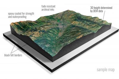
• Raised-relief 3D Height Determined by DEM data
• Fade Resistant Archival Inks
• Epoxy Coated for Strength and Waterproofing
• Ready to Hang with Pre-Installed Hardware (optional)
• Extraordinary 3D Accuracy
• Black Felt Borders
Enrich your office decor or home with a 3D Satellite Raised Relief Map. These raised relief maps are not flat. They are three-dimensional, with the height being determined by Digital Elevation Model (DEM) data. Many people struggle with reading 2D satellite maps, but everyone understands 3D raised relief maps. The realism is phenomenal.
This 3D satellite raised relief map is built by combining satellite imagery data from Google Earth, bounding box coordinates from USGS, and DEM data. 3D Printing and 3D CNC routers are used to fabricate the models which make the satellite models extremely accurate. These models are strong - they are coated with epoxy, then finished with a sealer providing a weatherproof matt-finish. These are not meant to be used in direct sunlight.
Adak B-1 NW, Alaska- Map Components- Imagery: Satellite of Adak B-1 NW, Alaska. Bounding Box: Footprint of Adak B-1 NW, Alaska at Longitude/Latitude Coordinates (-176.3333333 x -176.1666667 x 51.75 x 51.625).
Adak B-2 NE, Alaska- Map Components- Imagery: Satellite of Adak B-2 NE, Alaska. Bounding Box: Footprint of Adak B-2 NE, Alaska at Longitude/Latitude Coordinates (-176.5 x -176.3333333 x 51.75 x 51.625).
Adak B-2 NW, Alaska- Map Components- Imagery: Satellite of Adak B-2 NW, Alaska. Bounding Box: Footprint of Adak B-2 NW, Alaska at Longitude/Latitude Coordinates (-176.6666667 x -176.5 x 51.75 x 51.625).
Adak B-3 NE, Alaska- Map Components- Imagery: Satellite of Adak B-3 NE, Alaska. Bounding Box: Footprint of Adak B-3 NE, Alaska at Longitude/Latitude Coordinates (-176.8333333 x -176.6666667 x 51.75 x 51.625).
Adak B-3 NW, Alaska- Map Components- Imagery: Satellite of Adak B-3 NW, Alaska. Bounding Box: Footprint of Adak B-3 NW, Alaska at Longitude/Latitude Coordinates (-177 x -176.8333333 x 51.75 x 51.625).
Adak B-3 SE, Alaska- Map Components- Imagery: Satellite of Adak B-3 SE, Alaska. Bounding Box: Footprint of Adak B-3 SE, Alaska at Longitude/Latitude Coordinates (-176.8333333 x -176.6666667 x 51.625 x 51.5).
Adak B-3 SW, Alaska- Map Components- Imagery: Satellite of Adak B-3 SW, Alaska. Bounding Box: Footprint of Adak B-3 SW, Alaska at Longitude/Latitude Coordinates (-177 x -176.8333333 x 51.625 x 51.5).
Adak B-4 NE, Alaska- Map Components- Imagery: Satellite of Adak B-4 NE, Alaska. Bounding Box: Footprint of Adak B-4 NE, Alaska at Longitude/Latitude Coordinates (-177.1666667 x -177 x 51.75 x 51.625).
Adak B-4 NW, Alaska- Map Components- Imagery: Satellite of Adak B-4 NW, Alaska. Bounding Box: Footprint of Adak B-4 NW, Alaska at Longitude/Latitude Coordinates (-177.3333333 x -177.1666667 x 51.75 x 51.625).
Adak B-5 NE, Alaska- Map Components- Imagery: Satellite of Adak B-5 NE, Alaska. Bounding Box: Footprint of Adak B-5 NE, Alaska at Longitude/Latitude Coordinates (-177.5 x -177.3333333 x 51.75 x 51.625).
Adak B-5 NW, Alaska- Map Components- Imagery: Satellite of Adak B-5 NW, Alaska. Bounding Box: Footprint of Adak B-5 NW, Alaska at Longitude/Latitude Coordinates (-177.6666667 x -177.5 x 51.75 x 51.625).
Adak B-6 NE, Alaska- Map Components- Imagery: Satellite of Adak B-6 NE, Alaska. Bounding Box: Footprint of Adak B-6 NE, Alaska at Longitude/Latitude Coordinates (-177.8333333 x -177.6666667 x 51.75 x 51.625).
Adak B-6 NW, Alaska- Map Components- Imagery: Satellite of Adak B-6 NW, Alaska. Bounding Box: Footprint of Adak B-6 NW, Alaska at Longitude/Latitude Coordinates (-178 x -177.8333333 x 51.75 x 51.625).
Adak B-6 SW, Alaska- Map Components- Imagery: Satellite of Adak B-6 SW, Alaska. Bounding Box: Footprint of Adak B-6 SW, Alaska at Longitude/Latitude Coordinates (-178 x -177.8333333 x 51.625 x 51.5).
Adak C-1 NE, Alaska- Map Components- Imagery: Satellite of Adak C-1 NE, Alaska. Bounding Box: Footprint of Adak C-1 NE, Alaska at Longitude/Latitude Coordinates (-176.1666667 x -176 x 52 x 51.875).
Adak C-1 NW, Alaska- Map Components- Imagery: Satellite of Adak C-1 NW, Alaska. Bounding Box: Footprint of Adak C-1 NW, Alaska at Longitude/Latitude Coordinates (-176.3333333 x -176.1666667 x 52 x 51.875).
Adak C-1 SE, Alaska- Map Components- Imagery: Satellite of Adak C-1 SE, Alaska. Bounding Box: Footprint of Adak C-1 SE, Alaska at Longitude/Latitude Coordinates (-176.1666667 x -176 x 51.875 x 51.75).
Adak C-1 SW, Alaska- Map Components- Imagery: Satellite of Adak C-1 SW, Alaska. Bounding Box: Footprint of Adak C-1 SW, Alaska at Longitude/Latitude Coordinates (-176.3333333 x -176.1666667 x 51.875 x 51.75).
Adak C-2 NW, Alaska- Map Components- Imagery: Satellite of Adak C-2 NW, Alaska. Bounding Box: Footprint of Adak C-2 NW, Alaska at Longitude/Latitude Coordinates (-176.6666667 x -176.5 x 52 x 51.875).
Adak C-2 OE N SW, Alaska- Map Components- Imagery: Satellite of Adak C-2 OE N SW, Alaska. Bounding Box: Footprint of Adak C-2 OE N SW, Alaska at Longitude/Latitude Coordinates (-176.6666667 x -176.5 x 52.125 x 52).
Adak C-2 SE, Alaska- Map Components- Imagery: Satellite of Adak C-2 SE, Alaska. Bounding Box: Footprint of Adak C-2 SE, Alaska at Longitude/Latitude Coordinates (-176.5 x -176.3333333 x 51.875 x 51.75).
Adak C-2 SW, Alaska- Map Components- Imagery: Satellite of Adak C-2 SW, Alaska. Bounding Box: Footprint of Adak C-2 SW, Alaska at Longitude/Latitude Coordinates (-176.6666667 x -176.5 x 51.875 x 51.75).
Adak C-3 NE, Alaska- Map Components- Imagery: Satellite of Adak C-3 NE, Alaska. Bounding Box: Footprint of Adak C-3 NE, Alaska at Longitude/Latitude Coordinates (-176.8333333 x -176.6666667 x 52 x 51.875).
Adak C-3 SE, Alaska- Map Components- Imagery: Satellite of Adak C-3 SE, Alaska. Bounding Box: Footprint of Adak C-3 SE, Alaska at Longitude/Latitude Coordinates (-176.8333333 x -176.6666667 x 51.875 x 51.75).
Adak C-3 SW, Alaska- Map Components- Imagery: Satellite of Adak C-3 SW, Alaska. Bounding Box: Footprint of Adak C-3 SW, Alaska at Longitude/Latitude Coordinates (-177 x -176.8333333 x 51.875 x 51.75).
Adak C-4 NE, Alaska- Map Components- Imagery: Satellite of Adak C-4 NE, Alaska. Bounding Box: Footprint of Adak C-4 NE, Alaska at Longitude/Latitude Coordinates (-177.1666667 x -177 x 52 x 51.875).
Adak C-4 NW, Alaska- Map Components- Imagery: Satellite of Adak C-4 NW, Alaska. Bounding Box: Footprint of Adak C-4 NW, Alaska at Longitude/Latitude Coordinates (-177.3333333 x -177.1666667 x 52 x 51.875).
Adak C-4 SE, Alaska- Map Components- Imagery: Satellite of Adak C-4 SE, Alaska. Bounding Box: Footprint of Adak C-4 SE, Alaska at Longitude/Latitude Coordinates (-177.1666667 x -177 x 51.875 x 51.75).
Adak C-4 SW, Alaska- Map Components- Imagery: Satellite of Adak C-4 SW, Alaska. Bounding Box: Footprint of Adak C-4 SW, Alaska at Longitude/Latitude Coordinates (-177.3333333 x -177.1666667 x 51.875 x 51.75).
Adak C-5 NE, Alaska- Map Components- Imagery: Satellite of Adak C-5 NE, Alaska. Bounding Box: Footprint of Adak C-5 NE, Alaska at Longitude/Latitude Coordinates (-177.5 x -177.3333333 x 52 x 51.875).
Adak C-5 SE, Alaska- Map Components- Imagery: Satellite of Adak C-5 SE, Alaska. Bounding Box: Footprint of Adak C-5 SE, Alaska at Longitude/Latitude Coordinates (-177.5 x -177.3333333 x 51.875 x 51.75).
Adak C-5 SW, Alaska- Map Components- Imagery: Satellite of Adak C-5 SW, Alaska. Bounding Box: Footprint of Adak C-5 SW, Alaska at Longitude/Latitude Coordinates (-177.6666667 x -177.5 x 51.875 x 51.75).
Adak C-6 NW, Alaska- Map Components- Imagery: Satellite of Adak C-6 NW, Alaska. Bounding Box: Footprint of Adak C-6 NW, Alaska at Longitude/Latitude Coordinates (-178 x -177.8333333 x 52 x 51.875).
Adak C-6 SE, Alaska- Map Components- Imagery: Satellite of Adak C-6 SE, Alaska. Bounding Box: Footprint of Adak C-6 SE, Alaska at Longitude/Latitude Coordinates (-177.8333333 x -177.6666667 x 51.875 x 51.75).
Adak C-6 SW, Alaska- Map Components- Imagery: Satellite of Adak C-6 SW, Alaska. Bounding Box: Footprint of Adak C-6 SW, Alaska at Longitude/Latitude Coordinates (-178 x -177.8333333 x 51.875 x 51.75).
Adak D-1 NW, Alaska- Map Components- Imagery: Satellite of Adak D-1 NW, Alaska. Bounding Box: Footprint of Adak D-1 NW, Alaska at Longitude/Latitude Coordinates (-176.3333333 x -176.1666667 x 52.25 x 52.125).
Adak D-1 SE, Alaska- Map Components- Imagery: Satellite of Adak D-1 SE, Alaska. Bounding Box: Footprint of Adak D-1 SE, Alaska at Longitude/Latitude Coordinates (-176.1666667 x -176 x 52.125 x 52).
Adak D-1 SW, Alaska- Map Components- Imagery: Satellite of Adak D-1 SW, Alaska. Bounding Box: Footprint of Adak D-1 SW, Alaska at Longitude/Latitude Coordinates (-176.3333333 x -176.1666667 x 52.125 x 52).
Afognak A-0 NE, Alaska- Map Components- Imagery: Satellite of Afognak A-0 NE, Alaska. Bounding Box: Footprint of Afognak A-0 NE, Alaska at Longitude/Latitude Coordinates (-151.8333333 x -151.6666667 x 58.25 x 58.125).
Afognak A-0 NW, Alaska- Map Components- Imagery: Satellite of Afognak A-0 NW, Alaska. Bounding Box: Footprint of Afognak A-0 NW, Alaska at Longitude/Latitude Coordinates (-152 x -151.8333333 x 58.25 x 58.125).
Afognak A-1 NE, Alaska- Map Components- Imagery: Satellite of Afognak A-1 NE, Alaska. Bounding Box: Footprint of Afognak A-1 NE, Alaska at Longitude/Latitude Coordinates (-152.1666667 x -152 x 58.25 x 58.125).
Afognak A-1 NW, Alaska- Map Components- Imagery: Satellite of Afognak A-1 NW, Alaska. Bounding Box: Footprint of Afognak A-1 NW, Alaska at Longitude/Latitude Coordinates (-152.3333333 x -152.1666667 x 58.25 x 58.125).
Afognak A-1 SW, Alaska- Map Components- Imagery: Satellite of Afognak A-1 SW, Alaska. Bounding Box: Footprint of Afognak A-1 SW, Alaska at Longitude/Latitude Coordinates (-152.3333333 x -152.1666667 x 58.125 x 58).
Afognak A-2 NE, Alaska- Map Components- Imagery: Satellite of Afognak A-2 NE, Alaska. Bounding Box: Footprint of Afognak A-2 NE, Alaska at Longitude/Latitude Coordinates (-152.5 x -152.3333333 x 58.25 x 58.125).
Afognak A-2 NW, Alaska- Map Components- Imagery: Satellite of Afognak A-2 NW, Alaska. Bounding Box: Footprint of Afognak A-2 NW, Alaska at Longitude/Latitude Coordinates (-152.6666667 x -152.5 x 58.25 x 58.125).
Afognak A-2 SE, Alaska- Map Components- Imagery: Satellite of Afognak A-2 SE, Alaska. Bounding Box: Footprint of Afognak A-2 SE, Alaska at Longitude/Latitude Coordinates (-152.5 x -152.3333333 x 58.125 x 58).
Afognak A-2 SW, Alaska- Map Components- Imagery: Satellite of Afognak A-2 SW, Alaska. Bounding Box: Footprint of Afognak A-2 SW, Alaska at Longitude/Latitude Coordinates (-152.6666667 x -152.5 x 58.125 x 58).
Afognak A-3 NE, Alaska- Map Components- Imagery: Satellite of Afognak A-3 NE, Alaska. Bounding Box: Footprint of Afognak A-3 NE, Alaska at Longitude/Latitude Coordinates (-152.8333333 x -152.6666667 x 58.25 x 58.125).
Afognak A-3 NW, Alaska- Map Components- Imagery: Satellite of Afognak A-3 NW, Alaska. Bounding Box: Footprint of Afognak A-3 NW, Alaska at Longitude/Latitude Coordinates (-153 x -152.8333333 x 58.25 x 58.125).
Afognak A-3 SE, Alaska- Map Components- Imagery: Satellite of Afognak A-3 SE, Alaska. Bounding Box: Footprint of Afognak A-3 SE, Alaska at Longitude/Latitude Coordinates (-152.8333333 x -152.6666667 x 58.125 x 58).
Afognak A-3 SW, Alaska- Map Components- Imagery: Satellite of Afognak A-3 SW, Alaska. Bounding Box: Footprint of Afognak A-3 SW, Alaska at Longitude/Latitude Coordinates (-153 x -152.8333333 x 58.125 x 58).
Afognak A-4 NE, Alaska- Map Components- Imagery: Satellite of Afognak A-4 NE, Alaska. Bounding Box: Footprint of Afognak A-4 NE, Alaska at Longitude/Latitude Coordinates (-153.1666667 x -153 x 58.25 x 58.125).
Afognak A-4 NW, Alaska- Map Components- Imagery: Satellite of Afognak A-4 NW, Alaska. Bounding Box: Footprint of Afognak A-4 NW, Alaska at Longitude/Latitude Coordinates (-153.3333333 x -153.1666667 x 58.25 x 58.125).
Afognak A-4 SE, Alaska- Map Components- Imagery: Satellite of Afognak A-4 SE, Alaska. Bounding Box: Footprint of Afognak A-4 SE, Alaska at Longitude/Latitude Coordinates (-153.1666667 x -153 x 58.125 x 58).
Afognak A-4 SW, Alaska- Map Components- Imagery: Satellite of Afognak A-4 SW, Alaska. Bounding Box: Footprint of Afognak A-4 SW, Alaska at Longitude/Latitude Coordinates (-153.3333333 x -153.1666667 x 58.125 x 58).
Afognak A-5 SE, Alaska- Map Components- Imagery: Satellite of Afognak A-5 SE, Alaska. Bounding Box: Footprint of Afognak A-5 SE, Alaska at Longitude/Latitude Coordinates (-153.5 x -153.3333333 x 58.125 x 58).
Afognak B-0 SE, Alaska- Map Components- Imagery: Satellite of Afognak B-0 SE, Alaska. Bounding Box: Footprint of Afognak B-0 SE, Alaska at Longitude/Latitude Coordinates (-151.8333333 x -151.6666667 x 58.375 x 58.25).
Afognak B-0 SW, Alaska- Map Components- Imagery: Satellite of Afognak B-0 SW, Alaska. Bounding Box: Footprint of Afognak B-0 SW, Alaska at Longitude/Latitude Coordinates (-152 x -151.8333333 x 58.375 x 58.25).
Afognak B-1 NE, Alaska- Map Components- Imagery: Satellite of Afognak B-1 NE, Alaska. Bounding Box: Footprint of Afognak B-1 NE, Alaska at Longitude/Latitude Coordinates (-152.1666667 x -152 x 58.5 x 58.375).
Afognak B-1 NW, Alaska- Map Components- Imagery: Satellite of Afognak B-1 NW, Alaska. Bounding Box: Footprint of Afognak B-1 NW, Alaska at Longitude/Latitude Coordinates (-152.3333333 x -152.1666667 x 58.5 x 58.375).
Afognak B-1 SE, Alaska- Map Components- Imagery: Satellite of Afognak B-1 SE, Alaska. Bounding Box: Footprint of Afognak B-1 SE, Alaska at Longitude/Latitude Coordinates (-152.1666667 x -152 x 58.375 x 58.25).
Afognak B-1 SW, Alaska- Map Components- Imagery: Satellite of Afognak B-1 SW, Alaska. Bounding Box: Footprint of Afognak B-1 SW, Alaska at Longitude/Latitude Coordinates (-152.3333333 x -152.1666667 x 58.375 x 58.25).
Afognak B-2 NE, Alaska- Map Components- Imagery: Satellite of Afognak B-2 NE, Alaska. Bounding Box: Footprint of Afognak B-2 NE, Alaska at Longitude/Latitude Coordinates (-152.5 x -152.3333333 x 58.5 x 58.375).
Afognak B-2 NW, Alaska- Map Components- Imagery: Satellite of Afognak B-2 NW, Alaska. Bounding Box: Footprint of Afognak B-2 NW, Alaska at Longitude/Latitude Coordinates (-152.6666667 x -152.5 x 58.5 x 58.375).
Afognak B-2 SE, Alaska- Map Components- Imagery: Satellite of Afognak B-2 SE, Alaska. Bounding Box: Footprint of Afognak B-2 SE, Alaska at Longitude/Latitude Coordinates (-152.5 x -152.3333333 x 58.375 x 58.25).
Afognak B-2 SW, Alaska- Map Components- Imagery: Satellite of Afognak B-2 SW, Alaska. Bounding Box: Footprint of Afognak B-2 SW, Alaska at Longitude/Latitude Coordinates (-152.6666667 x -152.5 x 58.375 x 58.25).
Afognak B-3 NE, Alaska- Map Components- Imagery: Satellite of Afognak B-3 NE, Alaska. Bounding Box: Footprint of Afognak B-3 NE, Alaska at Longitude/Latitude Coordinates (-152.8333333 x -152.6666667 x 58.5 x 58.375).
Afognak B-3 NW, Alaska- Map Components- Imagery: Satellite of Afognak B-3 NW, Alaska. Bounding Box: Footprint of Afognak B-3 NW, Alaska at Longitude/Latitude Coordinates (-153 x -152.8333333 x 58.5 x 58.375).
Afognak B-3 SE, Alaska- Map Components- Imagery: Satellite of Afognak B-3 SE, Alaska. Bounding Box: Footprint of Afognak B-3 SE, Alaska at Longitude/Latitude Coordinates (-152.8333333 x -152.6666667 x 58.375 x 58.25).
Afognak B-3 SW, Alaska- Map Components- Imagery: Satellite of Afognak B-3 SW, Alaska. Bounding Box: Footprint of Afognak B-3 SW, Alaska at Longitude/Latitude Coordinates (-153 x -152.8333333 x 58.375 x 58.25).
Afognak B-4 SE, Alaska- Map Components- Imagery: Satellite of Afognak B-4 SE, Alaska. Bounding Box: Footprint of Afognak B-4 SE, Alaska at Longitude/Latitude Coordinates (-153.1666667 x -153 x 58.375 x 58.25).
Afognak C-1 NW, Alaska- Map Components- Imagery: Satellite of Afognak C-1 NW, Alaska. Bounding Box: Footprint of Afognak C-1 NW, Alaska at Longitude/Latitude Coordinates (-152.3333333 x -152.1666667 x 58.75 x 58.625).
Afognak C-1 SE, Alaska- Map Components- Imagery: Satellite of Afognak C-1 SE, Alaska. Bounding Box: Footprint of Afognak C-1 SE, Alaska at Longitude/Latitude Coordinates (-152.1666667 x -152 x 58.625 x 58.5).
Afognak C-1 SW, Alaska- Map Components- Imagery: Satellite of Afognak C-1 SW, Alaska. Bounding Box: Footprint of Afognak C-1 SW, Alaska at Longitude/Latitude Coordinates (-152.3333333 x -152.1666667 x 58.625 x 58.5).
Afognak C-2 NE, Alaska- Map Components- Imagery: Satellite of Afognak C-2 NE, Alaska. Bounding Box: Footprint of Afognak C-2 NE, Alaska at Longitude/Latitude Coordinates (-152.5 x -152.3333333 x 58.75 x 58.625).
Afognak C-2 NW, Alaska- Map Components- Imagery: Satellite of Afognak C-2 NW, Alaska. Bounding Box: Footprint of Afognak C-2 NW, Alaska at Longitude/Latitude Coordinates (-152.6666667 x -152.5 x 58.75 x 58.625).
Afognak C-2 SE, Alaska- Map Components- Imagery: Satellite of Afognak C-2 SE, Alaska. Bounding Box: Footprint of Afognak C-2 SE, Alaska at Longitude/Latitude Coordinates (-152.5 x -152.3333333 x 58.625 x 58.5).
Afognak C-2 SW, Alaska- Map Components- Imagery: Satellite of Afognak C-2 SW, Alaska. Bounding Box: Footprint of Afognak C-2 SW, Alaska at Longitude/Latitude Coordinates (-152.6666667 x -152.5 x 58.625 x 58.5).
Afognak C-3 SE, Alaska- Map Components- Imagery: Satellite of Afognak C-3 SE, Alaska. Bounding Box: Footprint of Afognak C-3 SE, Alaska at Longitude/Latitude Coordinates (-152.8333333 x -152.6666667 x 58.625 x 58.5).
Afognak C-5 NE, Alaska- Map Components- Imagery: Satellite of Afognak C-5 NE, Alaska. Bounding Box: Footprint of Afognak C-5 NE, Alaska at Longitude/Latitude Coordinates (-153.5 x -153.3333333 x 58.75 x 58.625).
Afognak C-5 NW, Alaska- Map Components- Imagery: Satellite of Afognak C-5 NW, Alaska. Bounding Box: Footprint of Afognak C-5 NW, Alaska at Longitude/Latitude Coordinates (-153.6666667 x -153.5 x 58.75 x 58.625).
Afognak C-5 SW, Alaska- Map Components- Imagery: Satellite of Afognak C-5 SW, Alaska. Bounding Box: Footprint of Afognak C-5 SW, Alaska at Longitude/Latitude Coordinates (-153.6666667 x -153.5 x 58.625 x 58.5).
Afognak C-6 NE, Alaska- Map Components- Imagery: Satellite of Afognak C-6 NE, Alaska. Bounding Box: Footprint of Afognak C-6 NE, Alaska at Longitude/Latitude Coordinates (-153.8333333 x -153.6666667 x 58.75 x 58.625).
Afognak C-6 NW, Alaska- Map Components- Imagery: Satellite of Afognak C-6 NW, Alaska. Bounding Box: Footprint of Afognak C-6 NW, Alaska at Longitude/Latitude Coordinates (-154 x -153.8333333 x 58.75 x 58.625).
Afognak C-6 SE, Alaska- Map Components- Imagery: Satellite of Afognak C-6 SE, Alaska. Bounding Box: Footprint of Afognak C-6 SE, Alaska at Longitude/Latitude Coordinates (-153.8333333 x -153.6666667 x 58.625 x 58.5).
Afognak C-6 SW, Alaska- Map Components- Imagery: Satellite of Afognak C-6 SW, Alaska. Bounding Box: Footprint of Afognak C-6 SW, Alaska at Longitude/Latitude Coordinates (-154 x -153.8333333 x 58.625 x 58.5).
Afognak D-1 NE, Alaska- Map Components- Imagery: Satellite of Afognak D-1 NE, Alaska. Bounding Box: Footprint of Afognak D-1 NE, Alaska at Longitude/Latitude Coordinates (-152.1666667 x -152 x 59 x 58.875).
Afognak D-1 NW, Alaska- Map Components- Imagery: Satellite of Afognak D-1 NW, Alaska. Bounding Box: Footprint of Afognak D-1 NW, Alaska at Longitude/Latitude Coordinates (-152.3333333 x -152.1666667 x 59 x 58.875).
Afognak D-1 OE E NW, Alaska- Map Components- Imagery: Satellite of Afognak D-1 OE E NW, Alaska. Bounding Box: Footprint of Afognak D-1 OE E NW, Alaska at Longitude/Latitude Coordinates (-152 x -151.8333333 x 59 x 58.875).
Afognak D-1 OE W NE, Alaska- Map Components- Imagery: Satellite of Afognak D-1 OE W NE, Alaska. Bounding Box: Footprint of Afognak D-1 OE W NE, Alaska at Longitude/Latitude Coordinates (-152.5 x -152.3333333 x 59 x 58.875).
Afognak D-4 NW, Alaska- Map Components- Imagery: Satellite of Afognak D-4 NW, Alaska. Bounding Box: Footprint of Afognak D-4 NW, Alaska at Longitude/Latitude Coordinates (-153.3333333 x -153.1666667 x 59 x 58.875).
Afognak D-4 SW, Alaska- Map Components- Imagery: Satellite of Afognak D-4 SW, Alaska. Bounding Box: Footprint of Afognak D-4 SW, Alaska at Longitude/Latitude Coordinates (-153.3333333 x -153.1666667 x 58.875 x 58.75).
Afognak D-5 NE, Alaska- Map Components- Imagery: Satellite of Afognak D-5 NE, Alaska. Bounding Box: Footprint of Afognak D-5 NE, Alaska at Longitude/Latitude Coordinates (-153.5 x -153.3333333 x 59 x 58.875).
Afognak D-5 NW, Alaska- Map Components- Imagery: Satellite of Afognak D-5 NW, Alaska. Bounding Box: Footprint of Afognak D-5 NW, Alaska at Longitude/Latitude Coordinates (-153.6666667 x -153.5 x 59 x 58.875).
Afognak D-5 SE, Alaska- Map Components- Imagery: Satellite of Afognak D-5 SE, Alaska. Bounding Box: Footprint of Afognak D-5 SE, Alaska at Longitude/Latitude Coordinates (-153.5 x -153.3333333 x 58.875 x 58.75).
Afognak D-5 SW, Alaska- Map Components- Imagery: Satellite of Afognak D-5 SW, Alaska. Bounding Box: Footprint of Afognak D-5 SW, Alaska at Longitude/Latitude Coordinates (-153.6666667 x -153.5 x 58.875 x 58.75).
Afognak D-6 NE, Alaska- Map Components- Imagery: Satellite of Afognak D-6 NE, Alaska. Bounding Box: Footprint of Afognak D-6 NE, Alaska at Longitude/Latitude Coordinates (-153.8333333 x -153.6666667 x 59 x 58.875).
Afognak D-6 NW, Alaska- Map Components- Imagery: Satellite of Afognak D-6 NW, Alaska. Bounding Box: Footprint of Afognak D-6 NW, Alaska at Longitude/Latitude Coordinates (-154 x -153.8333333 x 59 x 58.875).
Afognak D-6 SE, Alaska- Map Components- Imagery: Satellite of Afognak D-6 SE, Alaska. Bounding Box: Footprint of Afognak D-6 SE, Alaska at Longitude/Latitude Coordinates (-153.8333333 x -153.6666667 x 58.875 x 58.75).
Afognak D-6 SW, Alaska- Map Components- Imagery: Satellite of Afognak D-6 SW, Alaska. Bounding Box: Footprint of Afognak D-6 SW, Alaska at Longitude/Latitude Coordinates (-154 x -153.8333333 x 58.875 x 58.75).
Ambler River A-1 NE, Alaska- Map Components- Imagery: Satellite of Ambler River A-1 NE, Alaska. Bounding Box: Footprint of Ambler River A-1 NE, Alaska at Longitude/Latitude Coordinates (-156.25 x -156 x 67.25 x 67.125).
Ambler River A-1 NW, Alaska- Map Components- Imagery: Satellite of Ambler River A-1 NW, Alaska. Bounding Box: Footprint of Ambler River A-1 NW, Alaska at Longitude/Latitude Coordinates (-156.5 x -156.25 x 67.25 x 67.125).
Ambler River A-1 SE, Alaska- Map Components- Imagery: Satellite of Ambler River A-1 SE, Alaska. Bounding Box: Footprint of Ambler River A-1 SE, Alaska at Longitude/Latitude Coordinates (-156.25 x -156 x 67.125 x 67).
Ambler River A-1 SW, Alaska- Map Components- Imagery: Satellite of Ambler River A-1 SW, Alaska. Bounding Box: Footprint of Ambler River A-1 SW, Alaska at Longitude/Latitude Coordinates (-156.5 x -156.25 x 67.125 x 67).
Ambler River A-2 NE, Alaska- Map Components- Imagery: Satellite of Ambler River A-2 NE, Alaska. Bounding Box: Footprint of Ambler River A-2 NE, Alaska at Longitude/Latitude Coordinates (-156.75 x -156.5 x 67.25 x 67.125).
Ambler River A-2 NW, Alaska- Map Components- Imagery: Satellite of Ambler River A-2 NW, Alaska. Bounding Box: Footprint of Ambler River A-2 NW, Alaska at Longitude/Latitude Coordinates (-157 x -156.75 x 67.25 x 67.125).
Ambler River A-2 SE, Alaska- Map Components- Imagery: Satellite of Ambler River A-2 SE, Alaska. Bounding Box: Footprint of Ambler River A-2 SE, Alaska at Longitude/Latitude Coordinates (-156.75 x -156.5 x 67.125 x 67).
Ambler River A-2 SW, Alaska- Map Components- Imagery: Satellite of Ambler River A-2 SW, Alaska. Bounding Box: Footprint of Ambler River A-2 SW, Alaska at Longitude/Latitude Coordinates (-157 x -156.75 x 67.125 x 67).
Ambler River A-3 NE, Alaska- Map Components- Imagery: Satellite of Ambler River A-3 NE, Alaska. Bounding Box: Footprint of Ambler River A-3 NE, Alaska at Longitude/Latitude Coordinates (-157.25 x -157 x 67.25 x 67.125).
Ambler River A-3 NW, Alaska- Map Components- Imagery: Satellite of Ambler River A-3 NW, Alaska. Bounding Box: Footprint of Ambler River A-3 NW, Alaska at Longitude/Latitude Coordinates (-157.5 x -157.25 x 67.25 x 67.125).
Ambler River A-3 SE, Alaska- Map Components- Imagery: Satellite of Ambler River A-3 SE, Alaska. Bounding Box: Footprint of Ambler River A-3 SE, Alaska at Longitude/Latitude Coordinates (-157.25 x -157 x 67.125 x 67).
Ambler River A-3 SW, Alaska- Map Components- Imagery: Satellite of Ambler River A-3 SW, Alaska. Bounding Box: Footprint of Ambler River A-3 SW, Alaska at Longitude/Latitude Coordinates (-157.5 x -157.25 x 67.125 x 67).
Ambler River A-4 NE, Alaska- Map Components- Imagery: Satellite of Ambler River A-4 NE, Alaska. Bounding Box: Footprint of Ambler River A-4 NE, Alaska at Longitude/Latitude Coordinates (-157.75 x -157.5 x 67.25 x 67.125).
Ambler River A-4 NW, Alaska- Map Components- Imagery: Satellite of Ambler River A-4 NW, Alaska. Bounding Box: Footprint of Ambler River A-4 NW, Alaska at Longitude/Latitude Coordinates (-158 x -157.75 x 67.25 x 67.125).
Ambler River A-4 SE, Alaska- Map Components- Imagery: Satellite of Ambler River A-4 SE, Alaska. Bounding Box: Footprint of Ambler River A-4 SE, Alaska at Longitude/Latitude Coordinates (-157.75 x -157.5 x 67.125 x 67).
Ambler River A-4 SW, Alaska- Map Components- Imagery: Satellite of Ambler River A-4 SW, Alaska. Bounding Box: Footprint of Ambler River A-4 SW, Alaska at Longitude/Latitude Coordinates (-158 x -157.75 x 67.125 x 67).
Ambler River A-5 NE, Alaska- Map Components- Imagery: Satellite of Ambler River A-5 NE, Alaska. Bounding Box: Footprint of Ambler River A-5 NE, Alaska at Longitude/Latitude Coordinates (-158.25 x -158 x 67.25 x 67.125).
Ambler River A-5 NW, Alaska- Map Components- Imagery: Satellite of Ambler River A-5 NW, Alaska. Bounding Box: Footprint of Ambler River A-5 NW, Alaska at Longitude/Latitude Coordinates (-158.5 x -158.25 x 67.25 x 67.125).
Ambler River A-5 SE, Alaska- Map Components- Imagery: Satellite of Ambler River A-5 SE, Alaska. Bounding Box: Footprint of Ambler River A-5 SE, Alaska at Longitude/Latitude Coordinates (-158.25 x -158 x 67.125 x 67).
Ambler River A-5 SW, Alaska- Map Components- Imagery: Satellite of Ambler River A-5 SW, Alaska. Bounding Box: Footprint of Ambler River A-5 SW, Alaska at Longitude/Latitude Coordinates (-158.5 x -158.25 x 67.125 x 67).
Ambler River A-6 NE, Alaska- Map Components- Imagery: Satellite of Ambler River A-6 NE, Alaska. Bounding Box: Footprint of Ambler River A-6 NE, Alaska at Longitude/Latitude Coordinates (-158.75 x -158.5 x 67.25 x 67.125).
Ambler River A-6 NW, Alaska- Map Components- Imagery: Satellite of Ambler River A-6 NW, Alaska. Bounding Box: Footprint of Ambler River A-6 NW, Alaska at Longitude/Latitude Coordinates (-159 x -158.75 x 67.25 x 67.125).
Ambler River A-6 SE, Alaska- Map Components- Imagery: Satellite of Ambler River A-6 SE, Alaska. Bounding Box: Footprint of Ambler River A-6 SE, Alaska at Longitude/Latitude Coordinates (-158.75 x -158.5 x 67.125 x 67).
Ambler River A-6 SW, Alaska- Map Components- Imagery: Satellite of Ambler River A-6 SW, Alaska. Bounding Box: Footprint of Ambler River A-6 SW, Alaska at Longitude/Latitude Coordinates (-159 x -158.75 x 67.125 x 67).
Ambler River B-1 NE, Alaska- Map Components- Imagery: Satellite of Ambler River B-1 NE, Alaska. Bounding Box: Footprint of Ambler River B-1 NE, Alaska at Longitude/Latitude Coordinates (-156.25 x -156 x 67.5 x 67.375).
Ambler River B-1 NW, Alaska- Map Components- Imagery: Satellite of Ambler River B-1 NW, Alaska. Bounding Box: Footprint of Ambler River B-1 NW, Alaska at Longitude/Latitude Coordinates (-156.5 x -156.25 x 67.5 x 67.375).
Ambler River B-1 SE, Alaska- Map Components- Imagery: Satellite of Ambler River B-1 SE, Alaska. Bounding Box: Footprint of Ambler River B-1 SE, Alaska at Longitude/Latitude Coordinates (-156.25 x -156 x 67.375 x 67.25).
Ambler River B-1 SW, Alaska- Map Components- Imagery: Satellite of Ambler River B-1 SW, Alaska. Bounding Box: Footprint of Ambler River B-1 SW, Alaska at Longitude/Latitude Coordinates (-156.5 x -156.25 x 67.375 x 67.25).
Ambler River B-2 NE, Alaska- Map Components- Imagery: Satellite of Ambler River B-2 NE, Alaska. Bounding Box: Footprint of Ambler River B-2 NE, Alaska at Longitude/Latitude Coordinates (-156.75 x -156.5 x 67.5 x 67.375).
Ambler River B-2 NW, Alaska- Map Components- Imagery: Satellite of Ambler River B-2 NW, Alaska. Bounding Box: Footprint of Ambler River B-2 NW, Alaska at Longitude/Latitude Coordinates (-157 x -156.75 x 67.5 x 67.375).
Ambler River B-2 SE, Alaska- Map Components- Imagery: Satellite of Ambler River B-2 SE, Alaska. Bounding Box: Footprint of Ambler River B-2 SE, Alaska at Longitude/Latitude Coordinates (-156.75 x -156.5 x 67.375 x 67.25).
Ambler River B-2 SW, Alaska- Map Components- Imagery: Satellite of Ambler River B-2 SW, Alaska. Bounding Box: Footprint of Ambler River B-2 SW, Alaska at Longitude/Latitude Coordinates (-157 x -156.75 x 67.375 x 67.25).
Ambler River B-3 NE, Alaska- Map Components- Imagery: Satellite of Ambler River B-3 NE, Alaska. Bounding Box: Footprint of Ambler River B-3 NE, Alaska at Longitude/Latitude Coordinates (-157.25 x -157 x 67.5 x 67.375).
Ambler River B-3 NW, Alaska- Map Components- Imagery: Satellite of Ambler River B-3 NW, Alaska. Bounding Box: Footprint of Ambler River B-3 NW, Alaska at Longitude/Latitude Coordinates (-157.5 x -157.25 x 67.5 x 67.375).
Ambler River B-3 SE, Alaska- Map Components- Imagery: Satellite of Ambler River B-3 SE, Alaska. Bounding Box: Footprint of Ambler River B-3 SE, Alaska at Longitude/Latitude Coordinates (-157.25 x -157 x 67.375 x 67.25).
Ambler River B-3 SW, Alaska- Map Components- Imagery: Satellite of Ambler River B-3 SW, Alaska. Bounding Box: Footprint of Ambler River B-3 SW, Alaska at Longitude/Latitude Coordinates (-157.5 x -157.25 x 67.375 x 67.25).
Ambler River B-4 NE, Alaska- Map Components- Imagery: Satellite of Ambler River B-4 NE, Alaska. Bounding Box: Footprint of Ambler River B-4 NE, Alaska at Longitude/Latitude Coordinates (-157.75 x -157.5 x 67.5 x 67.375).
Ambler River B-4 NW, Alaska- Map Components- Imagery: Satellite of Ambler River B-4 NW, Alaska. Bounding Box: Footprint of Ambler River B-4 NW, Alaska at Longitude/Latitude Coordinates (-158 x -157.75 x 67.5 x 67.375).
Ambler River B-4 SE, Alaska- Map Components- Imagery: Satellite of Ambler River B-4 SE, Alaska. Bounding Box: Footprint of Ambler River B-4 SE, Alaska at Longitude/Latitude Coordinates (-157.75 x -157.5 x 67.375 x 67.25).
Ambler River B-4 SW, Alaska- Map Components- Imagery: Satellite of Ambler River B-4 SW, Alaska. Bounding Box: Footprint of Ambler River B-4 SW, Alaska at Longitude/Latitude Coordinates (-158 x -157.75 x 67.375 x 67.25).
Ambler River B-5 NE, Alaska- Map Components- Imagery: Satellite of Ambler River B-5 NE, Alaska. Bounding Box: Footprint of Ambler River B-5 NE, Alaska at Longitude/Latitude Coordinates (-158.25 x -158 x 67.5 x 67.375).
Ambler River B-5 NW, Alaska- Map Components- Imagery: Satellite of Ambler River B-5 NW, Alaska. Bounding Box: Footprint of Ambler River B-5 NW, Alaska at Longitude/Latitude Coordinates (-158.5 x -158.25 x 67.5 x 67.375).
Ambler River B-5 SE, Alaska- Map Components- Imagery: Satellite of Ambler River B-5 SE, Alaska. Bounding Box: Footprint of Ambler River B-5 SE, Alaska at Longitude/Latitude Coordinates (-158.25 x -158 x 67.375 x 67.25).
Ambler River B-5 SW, Alaska- Map Components- Imagery: Satellite of Ambler River B-5 SW, Alaska. Bounding Box: Footprint of Ambler River B-5 SW, Alaska at Longitude/Latitude Coordinates (-158.5 x -158.25 x 67.375 x 67.25).
Ambler River B-6 NE, Alaska- Map Components- Imagery: Satellite of Ambler River B-6 NE, Alaska. Bounding Box: Footprint of Ambler River B-6 NE, Alaska at Longitude/Latitude Coordinates (-158.75 x -158.5 x 67.5 x 67.375).
Ambler River B-6 NW, Alaska- Map Components- Imagery: Satellite of Ambler River B-6 NW, Alaska. Bounding Box: Footprint of Ambler River B-6 NW, Alaska at Longitude/Latitude Coordinates (-159 x -158.75 x 67.5 x 67.375).
Ambler River B-6 SE, Alaska- Map Components- Imagery: Satellite of Ambler River B-6 SE, Alaska. Bounding Box: Footprint of Ambler River B-6 SE, Alaska at Longitude/Latitude Coordinates (-158.75 x -158.5 x 67.375 x 67.25).
Ambler River B-6 SW, Alaska- Map Components- Imagery: Satellite of Ambler River B-6 SW, Alaska. Bounding Box: Footprint of Ambler River B-6 SW, Alaska at Longitude/Latitude Coordinates (-159 x -158.75 x 67.375 x 67.25).
Ambler River C-1 NE, Alaska- Map Components- Imagery: Satellite of Ambler River C-1 NE, Alaska. Bounding Box: Footprint of Ambler River C-1 NE, Alaska at Longitude/Latitude Coordinates (-156.25 x -156 x 67.75 x 67.625).
Ambler River C-1 NW, Alaska- Map Components- Imagery: Satellite of Ambler River C-1 NW, Alaska. Bounding Box: Footprint of Ambler River C-1 NW, Alaska at Longitude/Latitude Coordinates (-156.5 x -156.25 x 67.75 x 67.625).
Ambler River C-1 SE, Alaska- Map Components- Imagery: Satellite of Ambler River C-1 SE, Alaska. Bounding Box: Footprint of Ambler River C-1 SE, Alaska at Longitude/Latitude Coordinates (-156.25 x -156 x 67.625 x 67.5).
Ambler River C-1 SW, Alaska- Map Components- Imagery: Satellite of Ambler River C-1 SW, Alaska. Bounding Box: Footprint of Ambler River C-1 SW, Alaska at Longitude/Latitude Coordinates (-156.5 x -156.25 x 67.625 x 67.5).
Ambler River C-2 NE, Alaska- Map Components- Imagery: Satellite of Ambler River C-2 NE, Alaska. Bounding Box: Footprint of Ambler River C-2 NE, Alaska at Longitude/Latitude Coordinates (-156.75 x -156.5 x 67.75 x 67.625).
Ambler River C-2 NW, Alaska- Map Components- Imagery: Satellite of Ambler River C-2 NW, Alaska. Bounding Box: Footprint of Ambler River C-2 NW, Alaska at Longitude/Latitude Coordinates (-157 x -156.75 x 67.75 x 67.625).
Ambler River C-2 SE, Alaska- Map Components- Imagery: Satellite of Ambler River C-2 SE, Alaska. Bounding Box: Footprint of Ambler River C-2 SE, Alaska at Longitude/Latitude Coordinates (-156.75 x -156.5 x 67.625 x 67.5).
Ambler River C-2 SW, Alaska- Map Components- Imagery: Satellite of Ambler River C-2 SW, Alaska. Bounding Box: Footprint of Ambler River C-2 SW, Alaska at Longitude/Latitude Coordinates (-157 x -156.75 x 67.625 x 67.5).
Ambler River C-3 NE, Alaska- Map Components- Imagery: Satellite of Ambler River C-3 NE, Alaska. Bounding Box: Footprint of Ambler River C-3 NE, Alaska at Longitude/Latitude Coordinates (-157.25 x -157 x 67.75 x 67.625).
Ambler River C-3 NW, Alaska- Map Components- Imagery: Satellite of Ambler River C-3 NW, Alaska. Bounding Box: Footprint of Ambler River C-3 NW, Alaska at Longitude/Latitude Coordinates (-157.5 x -157.25 x 67.75 x 67.625).
Ambler River C-3 SE, Alaska- Map Components- Imagery: Satellite of Ambler River C-3 SE, Alaska. Bounding Box: Footprint of Ambler River C-3 SE, Alaska at Longitude/Latitude Coordinates (-157.25 x -157 x 67.625 x 67.5).
Ambler River C-3 SW, Alaska- Map Components- Imagery: Satellite of Ambler River C-3 SW, Alaska. Bounding Box: Footprint of Ambler River C-3 SW, Alaska at Longitude/Latitude Coordinates (-157.5 x -157.25 x 67.625 x 67.5).
Ambler River C-4 NE, Alaska- Map Components- Imagery: Satellite of Ambler River C-4 NE, Alaska. Bounding Box: Footprint of Ambler River C-4 NE, Alaska at Longitude/Latitude Coordinates (-157.75 x -157.5 x 67.75 x 67.625).
Ambler River C-4 NW, Alaska- Map Components- Imagery: Satellite of Ambler River C-4 NW, Alaska. Bounding Box: Footprint of Ambler River C-4 NW, Alaska at Longitude/Latitude Coordinates (-158 x -157.75 x 67.75 x 67.625).
Ambler River C-4 SE, Alaska- Map Components- Imagery: Satellite of Ambler River C-4 SE, Alaska. Bounding Box: Footprint of Ambler River C-4 SE, Alaska at Longitude/Latitude Coordinates (-157.75 x -157.5 x 67.625 x 67.5).
Ambler River C-4 SW, Alaska- Map Components- Imagery: Satellite of Ambler River C-4 SW, Alaska. Bounding Box: Footprint of Ambler River C-4 SW, Alaska at Longitude/Latitude Coordinates (-158 x -157.75 x 67.625 x 67.5).
Ambler River C-5 NE, Alaska- Map Components- Imagery: Satellite of Ambler River C-5 NE, Alaska. Bounding Box: Footprint of Ambler River C-5 NE, Alaska at Longitude/Latitude Coordinates (-158.25 x -158 x 67.75 x 67.625).
Ambler River C-5 NW, Alaska- Map Components- Imagery: Satellite of Ambler River C-5 NW, Alaska. Bounding Box: Footprint of Ambler River C-5 NW, Alaska at Longitude/Latitude Coordinates (-158.5 x -158.25 x 67.75 x 67.625).
Ambler River C-5 SE, Alaska- Map Components- Imagery: Satellite of Ambler River C-5 SE, Alaska. Bounding Box: Footprint of Ambler River C-5 SE, Alaska at Longitude/Latitude Coordinates (-158.25 x -158 x 67.625 x 67.5).
Ambler River C-5 SW, Alaska- Map Components- Imagery: Satellite of Ambler River C-5 SW, Alaska. Bounding Box: Footprint of Ambler River C-5 SW, Alaska at Longitude/Latitude Coordinates (-158.5 x -158.25 x 67.625 x 67.5).
Ambler River C-6 NE, Alaska- Map Components- Imagery: Satellite of Ambler River C-6 NE, Alaska. Bounding Box: Footprint of Ambler River C-6 NE, Alaska at Longitude/Latitude Coordinates (-158.75 x -158.5 x 67.75 x 67.625).
Ambler River C-6 NW, Alaska- Map Components- Imagery: Satellite of Ambler River C-6 NW, Alaska. Bounding Box: Footprint of Ambler River C-6 NW, Alaska at Longitude/Latitude Coordinates (-159 x -158.75 x 67.75 x 67.625).
Ambler River C-6 SE, Alaska- Map Components- Imagery: Satellite of Ambler River C-6 SE, Alaska. Bounding Box: Footprint of Ambler River C-6 SE, Alaska at Longitude/Latitude Coordinates (-158.75 x -158.5 x 67.625 x 67.5).
Ambler River C-6 SW, Alaska- Map Components- Imagery: Satellite of Ambler River C-6 SW, Alaska. Bounding Box: Footprint of Ambler River C-6 SW, Alaska at Longitude/Latitude Coordinates (-159 x -158.75 x 67.625 x 67.5).
Ambler River D-1 NE, Alaska- Map Components- Imagery: Satellite of Ambler River D-1 NE, Alaska. Bounding Box: Footprint of Ambler River D-1 NE, Alaska at Longitude/Latitude Coordinates (-156.25 x -156 x 68 x 67.875).
Ambler River D-1 NW, Alaska- Map Components- Imagery: Satellite of Ambler River D-1 NW, Alaska. Bounding Box: Footprint of Ambler River D-1 NW, Alaska at Longitude/Latitude Coordinates (-156.5 x -156.25 x 68 x 67.875).
Ambler River D-1 SE, Alaska- Map Components- Imagery: Satellite of Ambler River D-1 SE, Alaska. Bounding Box: Footprint of Ambler River D-1 SE, Alaska at Longitude/Latitude Coordinates (-156.25 x -156 x 67.875 x 67.75).
Ambler River D-1 SW, Alaska- Map Components- Imagery: Satellite of Ambler River D-1 SW, Alaska. Bounding Box: Footprint of Ambler River D-1 SW, Alaska at Longitude/Latitude Coordinates (-156.5 x -156.25 x 67.875 x 67.75).
Ambler River D-2 NE, Alaska- Map Components- Imagery: Satellite of Ambler River D-2 NE, Alaska. Bounding Box: Footprint of Ambler River D-2 NE, Alaska at Longitude/Latitude Coordinates (-156.75 x -156.5 x 68 x 67.875).
Ambler River D-2 NW, Alaska- Map Components- Imagery: Satellite of Ambler River D-2 NW, Alaska. Bounding Box: Footprint of Ambler River D-2 NW, Alaska at Longitude/Latitude Coordinates (-157 x -156.75 x 68 x 67.875).
Ambler River D-2 SE, Alaska- Map Components- Imagery: Satellite of Ambler River D-2 SE, Alaska. Bounding Box: Footprint of Ambler River D-2 SE, Alaska at Longitude/Latitude Coordinates (-156.75 x -156.5 x 67.875 x 67.75).
Ambler River D-2 SW, Alaska- Map Components- Imagery: Satellite of Ambler River D-2 SW, Alaska. Bounding Box: Footprint of Ambler River D-2 SW, Alaska at Longitude/Latitude Coordinates (-157 x -156.75 x 67.875 x 67.75).
Ambler River D-3 NE, Alaska- Map Components- Imagery: Satellite of Ambler River D-3 NE, Alaska. Bounding Box: Footprint of Ambler River D-3 NE, Alaska at Longitude/Latitude Coordinates (-157.25 x -157 x 68 x 67.875).
Ambler River D-3 NW, Alaska- Map Components- Imagery: Satellite of Ambler River D-3 NW, Alaska. Bounding Box: Footprint of Ambler River D-3 NW, Alaska at Longitude/Latitude Coordinates (-157.5 x -157.25 x 68 x 67.875).
Ambler River D-3 SE, Alaska- Map Components- Imagery: Satellite of Ambler River D-3 SE, Alaska. Bounding Box: Footprint of Ambler River D-3 SE, Alaska at Longitude/Latitude Coordinates (-157.25 x -157 x 67.875 x 67.75).
Ambler River D-3 SW, Alaska- Map Components- Imagery: Satellite of Ambler River D-3 SW, Alaska. Bounding Box: Footprint of Ambler River D-3 SW, Alaska at Longitude/Latitude Coordinates (-157.5 x -157.25 x 67.875 x 67.75).
Ambler River D-4 NE, Alaska- Map Components- Imagery: Satellite of Ambler River D-4 NE, Alaska. Bounding Box: Footprint of Ambler River D-4 NE, Alaska at Longitude/Latitude Coordinates (-157.75 x -157.5 x 68 x 67.875).
Ambler River D-4 NW, Alaska- Map Components- Imagery: Satellite of Ambler River D-4 NW, Alaska. Bounding Box: Footprint of Ambler River D-4 NW, Alaska at Longitude/Latitude Coordinates (-158 x -157.75 x 68 x 67.875).
Ambler River D-4 SE, Alaska- Map Components- Imagery: Satellite of Ambler River D-4 SE, Alaska. Bounding Box: Footprint of Ambler River D-4 SE, Alaska at Longitude/Latitude Coordinates (-157.75 x -157.5 x 67.875 x 67.75).
Ambler River D-4 SW, Alaska- Map Components- Imagery: Satellite of Ambler River D-4 SW, Alaska. Bounding Box: Footprint of Ambler River D-4 SW, Alaska at Longitude/Latitude Coordinates (-158 x -157.75 x 67.875 x 67.75).
Ambler River D-5 NE, Alaska- Map Components- Imagery: Satellite of Ambler River D-5 NE, Alaska. Bounding Box: Footprint of Ambler River D-5 NE, Alaska at Longitude/Latitude Coordinates (-158.25 x -158 x 68 x 67.875).
Ambler River D-5 NW, Alaska- Map Components- Imagery: Satellite of Ambler River D-5 NW, Alaska. Bounding Box: Footprint of Ambler River D-5 NW, Alaska at Longitude/Latitude Coordinates (-158.5 x -158.25 x 68 x 67.875).
Ambler River D-5 SE, Alaska- Map Components- Imagery: Satellite of Ambler River D-5 SE, Alaska. Bounding Box: Footprint of Ambler River D-5 SE, Alaska at Longitude/Latitude Coordinates (-158.25 x -158 x 67.875 x 67.75).
Ambler River D-5 SW, Alaska- Map Components- Imagery: Satellite of Ambler River D-5 SW, Alaska. Bounding Box: Footprint of Ambler River D-5 SW, Alaska at Longitude/Latitude Coordinates (-158.5 x -158.25 x 67.875 x 67.75).
Ambler River D-6 NE, Alaska- Map Components- Imagery: Satellite of Ambler River D-6 NE, Alaska. Bounding Box: Footprint of Ambler River D-6 NE, Alaska at Longitude/Latitude Coordinates (-158.75 x -158.5 x 68 x 67.875).
Ambler River D-6 NW, Alaska- Map Components- Imagery: Satellite of Ambler River D-6 NW, Alaska. Bounding Box: Footprint of Ambler River D-6 NW, Alaska at Longitude/Latitude Coordinates (-159 x -158.75 x 68 x 67.875).
Ambler River D-6 SE, Alaska- Map Components- Imagery: Satellite of Ambler River D-6 SE, Alaska. Bounding Box: Footprint of Ambler River D-6 SE, Alaska at Longitude/Latitude Coordinates (-158.75 x -158.5 x 67.875 x 67.75).
Ambler River D-6 SW, Alaska- Map Components- Imagery: Satellite of Ambler River D-6 SW, Alaska. Bounding Box: Footprint of Ambler River D-6 SW, Alaska at Longitude/Latitude Coordinates (-159 x -158.75 x 67.875 x 67.75).
Amukta B-4 NW, Alaska- Map Components- Imagery: Satellite of Amukta B-4 NW, Alaska. Bounding Box: Footprint of Amukta B-4 NW, Alaska at Longitude/Latitude Coordinates (-171.3333333 x -171.1666667 x 52.5 x 52.375).
Amukta C-1 NE, Alaska- Map Components- Imagery: Satellite of Amukta C-1 NE, Alaska. Bounding Box: Footprint of Amukta C-1 NE, Alaska at Longitude/Latitude Coordinates (-170.1666667 x -170 x 52.75 x 52.625).
Amukta C-1 NW, Alaska- Map Components- Imagery: Satellite of Amukta C-1 NW, Alaska. Bounding Box: Footprint of Amukta C-1 NW, Alaska at Longitude/Latitude Coordinates (-170.3333333 x -170.1666667 x 52.75 x 52.625).
Amukta C-2 NW, Alaska- Map Components- Imagery: Satellite of Amukta C-2 NW, Alaska. Bounding Box: Footprint of Amukta C-2 NW, Alaska at Longitude/Latitude Coordinates (-170.6666667 x -170.5 x 52.75 x 52.625).
Amukta C-2 SW, Alaska- Map Components- Imagery: Satellite of Amukta C-2 SW, Alaska. Bounding Box: Footprint of Amukta C-2 SW, Alaska at Longitude/Latitude Coordinates (-170.6666667 x -170.5 x 52.625 x 52.5).
Amukta C-3 NE, Alaska- Map Components- Imagery: Satellite of Amukta C-3 NE, Alaska. Bounding Box: Footprint of Amukta C-3 NE, Alaska at Longitude/Latitude Coordinates (-170.8333333 x -170.6666667 x 52.75 x 52.625).
Amukta C-3 SE, Alaska- Map Components- Imagery: Satellite of Amukta C-3 SE, Alaska. Bounding Box: Footprint of Amukta C-3 SE, Alaska at Longitude/Latitude Coordinates (-170.8333333 x -170.6666667 x 52.625 x 52.5).
Amukta C-3 SW, Alaska- Map Components- Imagery: Satellite of Amukta C-3 SW, Alaska. Bounding Box: Footprint of Amukta C-3 SW, Alaska at Longitude/Latitude Coordinates (-171 x -170.8333333 x 52.625 x 52.5).
Amukta C-4 SE, Alaska- Map Components- Imagery: Satellite of Amukta C-4 SE, Alaska. Bounding Box: Footprint of Amukta C-4 SE, Alaska at Longitude/Latitude Coordinates (-171.1666667 x -171 x 52.625 x 52.5).
Amukta C-4 SW, Alaska- Map Components- Imagery: Satellite of Amukta C-4 SW, Alaska. Bounding Box: Footprint of Amukta C-4 SW, Alaska at Longitude/Latitude Coordinates (-171.3333333 x -171.1666667 x 52.625 x 52.5).
Amukta D-1 NE, Alaska- Map Components- Imagery: Satellite of Amukta D-1 NE, Alaska. Bounding Box: Footprint of Amukta D-1 NE, Alaska at Longitude/Latitude Coordinates (-170.1666667 x -170 x 53 x 52.875).
Amukta D-1 SE, Alaska- Map Components- Imagery: Satellite of Amukta D-1 SE, Alaska. Bounding Box: Footprint of Amukta D-1 SE, Alaska at Longitude/Latitude Coordinates (-170.1666667 x -170 x 52.875 x 52.75).
Amukta D-1 SW, Alaska- Map Components- Imagery: Satellite of Amukta D-1 SW, Alaska. Bounding Box: Footprint of Amukta D-1 SW, Alaska at Longitude/Latitude Coordinates (-170.3333333 x -170.1666667 x 52.875 x 52.75).
Anchorage A-1 NE, Alaska- Map Components- Imagery: Satellite of Anchorage A-1 NE, Alaska. Bounding Box: Footprint of Anchorage A-1 NE, Alaska at Longitude/Latitude Coordinates (-147.1875 x -147 x 61.25 x 61.125).
Anchorage A-1 NW, Alaska- Map Components- Imagery: Satellite of Anchorage A-1 NW, Alaska. Bounding Box: Footprint of Anchorage A-1 NW, Alaska at Longitude/Latitude Coordinates (-147.375 x -147.1875 x 61.25 x 61.125).
Anchorage A-1 SE, Alaska- Map Components- Imagery: Satellite of Anchorage A-1 SE, Alaska. Bounding Box: Footprint of Anchorage A-1 SE, Alaska at Longitude/Latitude Coordinates (-147.1875 x -147 x 61.125 x 61).
Anchorage A-1 SW, Alaska- Map Components- Imagery: Satellite of Anchorage A-1 SW, Alaska. Bounding Box: Footprint of Anchorage A-1 SW, Alaska at Longitude/Latitude Coordinates (-147.375 x -147.1875 x 61.125 x 61).
Anchorage A-2 NE, Alaska- Map Components- Imagery: Satellite of Anchorage A-2 NE, Alaska. Bounding Box: Footprint of Anchorage A-2 NE, Alaska at Longitude/Latitude Coordinates (-147.5625 x -147.375 x 61.25 x 61.125).
Anchorage A-2 NW, Alaska- Map Components- Imagery: Satellite of Anchorage A-2 NW, Alaska. Bounding Box: Footprint of Anchorage A-2 NW, Alaska at Longitude/Latitude Coordinates (-147.75 x -147.5625 x 61.25 x 61.125).
Anchorage A-2 SE, Alaska- Map Components- Imagery: Satellite of Anchorage A-2 SE, Alaska. Bounding Box: Footprint of Anchorage A-2 SE, Alaska at Longitude/Latitude Coordinates (-147.5625 x -147.375 x 61.125 x 61).
Anchorage A-2 SW, Alaska- Map Components- Imagery: Satellite of Anchorage A-2 SW, Alaska. Bounding Box: Footprint of Anchorage A-2 SW, Alaska at Longitude/Latitude Coordinates (-147.75 x -147.5625 x 61.125 x 61).
Anchorage A-3 NE, Alaska- Map Components- Imagery: Satellite of Anchorage A-3 NE, Alaska. Bounding Box: Footprint of Anchorage A-3 NE, Alaska at Longitude/Latitude Coordinates (-147.9375 x -147.75 x 61.25 x 61.125).
Anchorage A-3 NW, Alaska- Map Components- Imagery: Satellite of Anchorage A-3 NW, Alaska. Bounding Box: Footprint of Anchorage A-3 NW, Alaska at Longitude/Latitude Coordinates (-148.125 x -147.9375 x 61.25 x 61.125).
Anchorage A-3 SE, Alaska- Map Components- Imagery: Satellite of Anchorage A-3 SE, Alaska. Bounding Box: Footprint of Anchorage A-3 SE, Alaska at Longitude/Latitude Coordinates (-147.9375 x -147.75 x 61.125 x 61).
Anchorage A-3 SW, Alaska- Map Components- Imagery: Satellite of Anchorage A-3 SW, Alaska. Bounding Box: Footprint of Anchorage A-3 SW, Alaska at Longitude/Latitude Coordinates (-148.125 x -147.9375 x 61.125 x 61).
Anchorage A-4 NE, Alaska- Map Components- Imagery: Satellite of Anchorage A-4 NE, Alaska. Bounding Box: Footprint of Anchorage A-4 NE, Alaska at Longitude/Latitude Coordinates (-148.3125 x -148.125 x 61.25 x 61.125).
Anchorage A-4 NW, Alaska- Map Components- Imagery: Satellite of Anchorage A-4 NW, Alaska. Bounding Box: Footprint of Anchorage A-4 NW, Alaska at Longitude/Latitude Coordinates (-148.5 x -148.3125 x 61.25 x 61.125).
Anchorage A-4 SE, Alaska- Map Components- Imagery: Satellite of Anchorage A-4 SE, Alaska. Bounding Box: Footprint of Anchorage A-4 SE, Alaska at Longitude/Latitude Coordinates (-148.3125 x -148.125 x 61.125 x 61).
Anchorage A-4 SW, Alaska- Map Components- Imagery: Satellite of Anchorage A-4 SW, Alaska. Bounding Box: Footprint of Anchorage A-4 SW, Alaska at Longitude/Latitude Coordinates (-148.5 x -148.3125 x 61.125 x 61).
Anchorage A-5 NE, Alaska- Map Components- Imagery: Satellite of Anchorage A-5 NE, Alaska. Bounding Box: Footprint of Anchorage A-5 NE, Alaska at Longitude/Latitude Coordinates (-148.6875 x -148.5 x 61.25 x 61.125).
Anchorage A-5 NW, Alaska- Map Components- Imagery: Satellite of Anchorage A-5 NW, Alaska. Bounding Box: Footprint of Anchorage A-5 NW, Alaska at Longitude/Latitude Coordinates (-148.875 x -148.6875 x 61.25 x 61.125).
Anchorage A-5 SE, Alaska- Map Components- Imagery: Satellite of Anchorage A-5 SE, Alaska. Bounding Box: Footprint of Anchorage A-5 SE, Alaska at Longitude/Latitude Coordinates (-148.6875 x -148.5 x 61.125 x 61).
Anchorage A-5 SW, Alaska- Map Components- Imagery: Satellite of Anchorage A-5 SW, Alaska. Bounding Box: Footprint of Anchorage A-5 SW, Alaska at Longitude/Latitude Coordinates (-148.875 x -148.6875 x 61.125 x 61).
Anchorage A-6 NE, Alaska- Map Components- Imagery: Satellite of Anchorage A-6 NE, Alaska. Bounding Box: Footprint of Anchorage A-6 NE, Alaska at Longitude/Latitude Coordinates (-149.0625 x -148.875 x 61.25 x 61.125).
Anchorage A-6 NW, Alaska- Map Components- Imagery: Satellite of Anchorage A-6 NW, Alaska. Bounding Box: Footprint of Anchorage A-6 NW, Alaska at Longitude/Latitude Coordinates (-149.25 x -149.0625 x 61.25 x 61.125).
Anchorage A-6 SE, Alaska- Map Components- Imagery: Satellite of Anchorage A-6 SE, Alaska. Bounding Box: Footprint of Anchorage A-6 SE, Alaska at Longitude/Latitude Coordinates (-149.0625 x -148.875 x 61.125 x 61).
Anchorage A-6 SW, Alaska- Map Components- Imagery: Satellite of Anchorage A-6 SW, Alaska. Bounding Box: Footprint of Anchorage A-6 SW, Alaska at Longitude/Latitude Coordinates (-149.25 x -149.0625 x 61.125 x 61).
Anchorage A-7 NE, Alaska- Map Components- Imagery: Satellite of Anchorage A-7 NE, Alaska. Bounding Box: Footprint of Anchorage A-7 NE, Alaska at Longitude/Latitude Coordinates (-149.4375 x -149.25 x 61.25 x 61.125).
Anchorage A-7 NW, Alaska- Map Components- Imagery: Satellite of Anchorage A-7 NW, Alaska. Bounding Box: Footprint of Anchorage A-7 NW, Alaska at Longitude/Latitude Coordinates (-149.625 x -149.4375 x 61.25 x 61.125).
Anchorage A-7 SE, Alaska- Map Components- Imagery: Satellite of Anchorage A-7 SE, Alaska. Bounding Box: Footprint of Anchorage A-7 SE, Alaska at Longitude/Latitude Coordinates (-149.4375 x -149.25 x 61.125 x 61).
Anchorage A-7 SW, Alaska- Map Components- Imagery: Satellite of Anchorage A-7 SW, Alaska. Bounding Box: Footprint of Anchorage A-7 SW, Alaska at Longitude/Latitude Coordinates (-149.625 x -149.4375 x 61.125 x 61).
Anchorage A-8 NE, Alaska- Map Components- Imagery: Satellite of Anchorage A-8 NE, Alaska. Bounding Box: Footprint of Anchorage A-8 NE, Alaska at Longitude/Latitude Coordinates (-149.8125 x -149.625 x 61.25 x 61.125).
Anchorage A-8 NW, Alaska- Map Components- Imagery: Satellite of Anchorage A-8 NW, Alaska. Bounding Box: Footprint of Anchorage A-8 NW, Alaska at Longitude/Latitude Coordinates (-150 x -149.8125 x 61.25 x 61.125).
Anchorage A-8 SE, Alaska- Map Components- Imagery: Satellite of Anchorage A-8 SE, Alaska. Bounding Box: Footprint of Anchorage A-8 SE, Alaska at Longitude/Latitude Coordinates (-149.8125 x -149.625 x 61.125 x 61).
Anchorage A-8 SW, Alaska- Map Components- Imagery: Satellite of Anchorage A-8 SW, Alaska. Bounding Box: Footprint of Anchorage A-8 SW, Alaska at Longitude/Latitude Coordinates (-150 x -149.8125 x 61.125 x 61).
Anchorage B-1 NE, Alaska- Map Components- Imagery: Satellite of Anchorage B-1 NE, Alaska. Bounding Box: Footprint of Anchorage B-1 NE, Alaska at Longitude/Latitude Coordinates (-147.1875 x -147 x 61.5 x 61.375).
Anchorage B-1 NW, Alaska- Map Components- Imagery: Satellite of Anchorage B-1 NW, Alaska. Bounding Box: Footprint of Anchorage B-1 NW, Alaska at Longitude/Latitude Coordinates (-147.375 x -147.1875 x 61.5 x 61.375).
Anchorage B-1 SE, Alaska- Map Components- Imagery: Satellite of Anchorage B-1 SE, Alaska. Bounding Box: Footprint of Anchorage B-1 SE, Alaska at Longitude/Latitude Coordinates (-147.1875 x -147 x 61.375 x 61.25).
Anchorage B-1 SW, Alaska- Map Components- Imagery: Satellite of Anchorage B-1 SW, Alaska. Bounding Box: Footprint of Anchorage B-1 SW, Alaska at Longitude/Latitude Coordinates (-147.375 x -147.1875 x 61.375 x 61.25).
Anchorage B-2 NE, Alaska- Map Components- Imagery: Satellite of Anchorage B-2 NE, Alaska. Bounding Box: Footprint of Anchorage B-2 NE, Alaska at Longitude/Latitude Coordinates (-147.5625 x -147.375 x 61.5 x 61.375).
Anchorage B-2 NW, Alaska- Map Components- Imagery: Satellite of Anchorage B-2 NW, Alaska. Bounding Box: Footprint of Anchorage B-2 NW, Alaska at Longitude/Latitude Coordinates (-147.75 x -147.5625 x 61.5 x 61.375).
Anchorage B-2 SE, Alaska- Map Components- Imagery: Satellite of Anchorage B-2 SE, Alaska. Bounding Box: Footprint of Anchorage B-2 SE, Alaska at Longitude/Latitude Coordinates (-147.5625 x -147.375 x 61.375 x 61.25).
Anchorage B-2 SW, Alaska- Map Components- Imagery: Satellite of Anchorage B-2 SW, Alaska. Bounding Box: Footprint of Anchorage B-2 SW, Alaska at Longitude/Latitude Coordinates (-147.75 x -147.5625 x 61.375 x 61.25).
Anchorage B-3 NE, Alaska- Map Components- Imagery: Satellite of Anchorage B-3 NE, Alaska. Bounding Box: Footprint of Anchorage B-3 NE, Alaska at Longitude/Latitude Coordinates (-147.9375 x -147.75 x 61.5 x 61.375).
Anchorage B-3 NW, Alaska- Map Components- Imagery: Satellite of Anchorage B-3 NW, Alaska. Bounding Box: Footprint of Anchorage B-3 NW, Alaska at Longitude/Latitude Coordinates (-148.125 x -147.9375 x 61.5 x 61.375).
Anchorage B-3 SE, Alaska- Map Components- Imagery: Satellite of Anchorage B-3 SE, Alaska. Bounding Box: Footprint of Anchorage B-3 SE, Alaska at Longitude/Latitude Coordinates (-147.9375 x -147.75 x 61.375 x 61.25).
Anchorage B-3 SW, Alaska- Map Components- Imagery: Satellite of Anchorage B-3 SW, Alaska. Bounding Box: Footprint of Anchorage B-3 SW, Alaska at Longitude/Latitude Coordinates (-148.125 x -147.9375 x 61.375 x 61.25).
Anchorage B-4 NE, Alaska- Map Components- Imagery: Satellite of Anchorage B-4 NE, Alaska. Bounding Box: Footprint of Anchorage B-4 NE, Alaska at Longitude/Latitude Coordinates (-148.3125 x -148.125 x 61.5 x 61.375).
Anchorage B-4 NW, Alaska- Map Components- Imagery: Satellite of Anchorage B-4 NW, Alaska. Bounding Box: Footprint of Anchorage B-4 NW, Alaska at Longitude/Latitude Coordinates (-148.5 x -148.3125 x 61.5 x 61.375).
Anchorage B-4 SE, Alaska- Map Components- Imagery: Satellite of Anchorage B-4 SE, Alaska. Bounding Box: Footprint of Anchorage B-4 SE, Alaska at Longitude/Latitude Coordinates (-148.3125 x -148.125 x 61.375 x 61.25).
Anchorage B-4 SW, Alaska- Map Components- Imagery: Satellite of Anchorage B-4 SW, Alaska. Bounding Box: Footprint of Anchorage B-4 SW, Alaska at Longitude/Latitude Coordinates (-148.5 x -148.3125 x 61.375 x 61.25).
Anchorage B-5 NE, Alaska- Map Components- Imagery: Satellite of Anchorage B-5 NE, Alaska. Bounding Box: Footprint of Anchorage B-5 NE, Alaska at Longitude/Latitude Coordinates (-148.6875 x -148.5 x 61.5 x 61.375).
Anchorage B-5 NW, Alaska- Map Components- Imagery: Satellite of Anchorage B-5 NW, Alaska. Bounding Box: Footprint of Anchorage B-5 NW, Alaska at Longitude/Latitude Coordinates (-148.875 x -148.6875 x 61.5 x 61.375).
Anchorage B-5 SE, Alaska- Map Components- Imagery: Satellite of Anchorage B-5 SE, Alaska. Bounding Box: Footprint of Anchorage B-5 SE, Alaska at Longitude/Latitude Coordinates (-148.6875 x -148.5 x 61.375 x 61.25).
Anchorage B-5 SW, Alaska- Map Components- Imagery: Satellite of Anchorage B-5 SW, Alaska. Bounding Box: Footprint of Anchorage B-5 SW, Alaska at Longitude/Latitude Coordinates (-148.875 x -148.6875 x 61.375 x 61.25).
Anchorage B-6 NE, Alaska- Map Components- Imagery: Satellite of Anchorage B-6 NE, Alaska. Bounding Box: Footprint of Anchorage B-6 NE, Alaska at Longitude/Latitude Coordinates (-149.0625 x -148.875 x 61.5 x 61.375).
Anchorage B-6 NW, Alaska- Map Components- Imagery: Satellite of Anchorage B-6 NW, Alaska. Bounding Box: Footprint of Anchorage B-6 NW, Alaska at Longitude/Latitude Coordinates (-149.25 x -149.0625 x 61.5 x 61.375).
Anchorage B-6 SE, Alaska- Map Components- Imagery: Satellite of Anchorage B-6 SE, Alaska. Bounding Box: Footprint of Anchorage B-6 SE, Alaska at Longitude/Latitude Coordinates (-149.0625 x -148.875 x 61.375 x 61.25).
Anchorage B-6 SW, Alaska- Map Components- Imagery: Satellite of Anchorage B-6 SW, Alaska. Bounding Box: Footprint of Anchorage B-6 SW, Alaska at Longitude/Latitude Coordinates (-149.25 x -149.0625 x 61.375 x 61.25).
Anchorage B-7 NE, Alaska- Map Components- Imagery: Satellite of Anchorage B-7 NE, Alaska. Bounding Box: Footprint of Anchorage B-7 NE, Alaska at Longitude/Latitude Coordinates (-149.4375 x -149.25 x 61.5 x 61.375).
Anchorage B-7 NW, Alaska- Map Components- Imagery: Satellite of Anchorage B-7 NW, Alaska. Bounding Box: Footprint of Anchorage B-7 NW, Alaska at Longitude/Latitude Coordinates (-149.625 x -149.4375 x 61.5 x 61.375).
Anchorage B-7 SE, Alaska- Map Components- Imagery: Satellite of Anchorage B-7 SE, Alaska. Bounding Box: Footprint of Anchorage B-7 SE, Alaska at Longitude/Latitude Coordinates (-149.4375 x -149.25 x 61.375 x 61.25).
Anchorage B-7 SW, Alaska- Map Components- Imagery: Satellite of Anchorage B-7 SW, Alaska. Bounding Box: Footprint of Anchorage B-7 SW, Alaska at Longitude/Latitude Coordinates (-149.625 x -149.4375 x 61.375 x 61.25).
Anchorage B-8 NE, Alaska- Map Components- Imagery: Satellite of Anchorage B-8 NE, Alaska. Bounding Box: Footprint of Anchorage B-8 NE, Alaska at Longitude/Latitude Coordinates (-149.8125 x -149.625 x 61.5 x 61.375).
Anchorage B-8 NW, Alaska- Map Components- Imagery: Satellite of Anchorage B-8 NW, Alaska. Bounding Box: Footprint of Anchorage B-8 NW, Alaska at Longitude/Latitude Coordinates (-150 x -149.8125 x 61.5 x 61.375).
Anchorage B-8 SE, Alaska- Map Components- Imagery: Satellite of Anchorage B-8 SE, Alaska. Bounding Box: Footprint of Anchorage B-8 SE, Alaska at Longitude/Latitude Coordinates (-149.8125 x -149.625 x 61.375 x 61.25).
Anchorage B-8 SW, Alaska- Map Components- Imagery: Satellite of Anchorage B-8 SW, Alaska. Bounding Box: Footprint of Anchorage B-8 SW, Alaska at Longitude/Latitude Coordinates (-150 x -149.8125 x 61.375 x 61.25).
Anchorage C-1 NE, Alaska- Map Components- Imagery: Satellite of Anchorage C-1 NE, Alaska. Bounding Box: Footprint of Anchorage C-1 NE, Alaska at Longitude/Latitude Coordinates (-147.1875 x -147 x 61.75 x 61.625).
Anchorage C-1 NW, Alaska- Map Components- Imagery: Satellite of Anchorage C-1 NW, Alaska. Bounding Box: Footprint of Anchorage C-1 NW, Alaska at Longitude/Latitude Coordinates (-147.375 x -147.1875 x 61.75 x 61.625).
Anchorage C-1 SE, Alaska- Map Components- Imagery: Satellite of Anchorage C-1 SE, Alaska. Bounding Box: Footprint of Anchorage C-1 SE, Alaska at Longitude/Latitude Coordinates (-147.1875 x -147 x 61.625 x 61.5).
Anchorage C-1 SW, Alaska- Map Components- Imagery: Satellite of Anchorage C-1 SW, Alaska. Bounding Box: Footprint of Anchorage C-1 SW, Alaska at Longitude/Latitude Coordinates (-147.375 x -147.1875 x 61.625 x 61.5).
Anchorage C-2 NE, Alaska- Map Components- Imagery: Satellite of Anchorage C-2 NE, Alaska. Bounding Box: Footprint of Anchorage C-2 NE, Alaska at Longitude/Latitude Coordinates (-147.5625 x -147.375 x 61.75 x 61.625).
Anchorage C-2 NW, Alaska- Map Components- Imagery: Satellite of Anchorage C-2 NW, Alaska. Bounding Box: Footprint of Anchorage C-2 NW, Alaska at Longitude/Latitude Coordinates (-147.75 x -147.5625 x 61.75 x 61.625).
Anchorage C-2 SE, Alaska- Map Components- Imagery: Satellite of Anchorage C-2 SE, Alaska. Bounding Box: Footprint of Anchorage C-2 SE, Alaska at Longitude/Latitude Coordinates (-147.5625 x -147.375 x 61.625 x 61.5).
Anchorage C-2 SW, Alaska- Map Components- Imagery: Satellite of Anchorage C-2 SW, Alaska. Bounding Box: Footprint of Anchorage C-2 SW, Alaska at Longitude/Latitude Coordinates (-147.75 x -147.5625 x 61.625 x 61.5).
Anchorage C-3 NE, Alaska- Map Components- Imagery: Satellite of Anchorage C-3 NE, Alaska. Bounding Box: Footprint of Anchorage C-3 NE, Alaska at Longitude/Latitude Coordinates (-147.9375 x -147.75 x 61.75 x 61.625).
Anchorage C-3 NW, Alaska- Map Components- Imagery: Satellite of Anchorage C-3 NW, Alaska. Bounding Box: Footprint of Anchorage C-3 NW, Alaska at Longitude/Latitude Coordinates (-148.125 x -147.9375 x 61.75 x 61.625).
Anchorage C-3 SE, Alaska- Map Components- Imagery: Satellite of Anchorage C-3 SE, Alaska. Bounding Box: Footprint of Anchorage C-3 SE, Alaska at Longitude/Latitude Coordinates (-147.9375 x -147.75 x 61.625 x 61.5).
Anchorage C-3 SW, Alaska- Map Components- Imagery: Satellite of Anchorage C-3 SW, Alaska. Bounding Box: Footprint of Anchorage C-3 SW, Alaska at Longitude/Latitude Coordinates (-148.125 x -147.9375 x 61.625 x 61.5).
Anchorage C-4 NE, Alaska- Map Components- Imagery: Satellite of Anchorage C-4 NE, Alaska. Bounding Box: Footprint of Anchorage C-4 NE, Alaska at Longitude/Latitude Coordinates (-148.3125 x -148.125 x 61.75 x 61.625).
Anchorage C-4 NW, Alaska- Map Components- Imagery: Satellite of Anchorage C-4 NW, Alaska. Bounding Box: Footprint of Anchorage C-4 NW, Alaska at Longitude/Latitude Coordinates (-148.5 x -148.3125 x 61.75 x 61.625).
Anchorage C-4 SE, Alaska- Map Components- Imagery: Satellite of Anchorage C-4 SE, Alaska. Bounding Box: Footprint of Anchorage C-4 SE, Alaska at Longitude/Latitude Coordinates (-148.3125 x -148.125 x 61.625 x 61.5).
Anchorage C-4 SW, Alaska- Map Components- Imagery: Satellite of Anchorage C-4 SW, Alaska. Bounding Box: Footprint of Anchorage C-4 SW, Alaska at Longitude/Latitude Coordinates (-148.5 x -148.3125 x 61.625 x 61.5).
Anchorage C-5 NE, Alaska- Map Components- Imagery: Satellite of Anchorage C-5 NE, Alaska. Bounding Box: Footprint of Anchorage C-5 NE, Alaska at Longitude/Latitude Coordinates (-148.6875 x -148.5 x 61.75 x 61.625).
Anchorage C-5 NW, Alaska- Map Components- Imagery: Satellite of Anchorage C-5 NW, Alaska. Bounding Box: Footprint of Anchorage C-5 NW, Alaska at Longitude/Latitude Coordinates (-148.875 x -148.6875 x 61.75 x 61.625).
Anchorage C-5 SE, Alaska- Map Components- Imagery: Satellite of Anchorage C-5 SE, Alaska. Bounding Box: Footprint of Anchorage C-5 SE, Alaska at Longitude/Latitude Coordinates (-148.6875 x -148.5 x 61.625 x 61.5).
Anchorage C-5 SW, Alaska- Map Components- Imagery: Satellite of Anchorage C-5 SW, Alaska. Bounding Box: Footprint of Anchorage C-5 SW, Alaska at Longitude/Latitude Coordinates (-148.875 x -148.6875 x 61.625 x 61.5).
Anchorage C-6 NE, Alaska- Map Components- Imagery: Satellite of Anchorage C-6 NE, Alaska. Bounding Box: Footprint of Anchorage C-6 NE, Alaska at Longitude/Latitude Coordinates (-149.0625 x -148.875 x 61.75 x 61.625).
Anchorage C-6 NW, Alaska- Map Components- Imagery: Satellite of Anchorage C-6 NW, Alaska. Bounding Box: Footprint of Anchorage C-6 NW, Alaska at Longitude/Latitude Coordinates (-149.25 x -149.0625 x 61.75 x 61.625).
Anchorage C-6 SE, Alaska- Map Components- Imagery: Satellite of Anchorage C-6 SE, Alaska. Bounding Box: Footprint of Anchorage C-6 SE, Alaska at Longitude/Latitude Coordinates (-149.0625 x -148.875 x 61.625 x 61.5).
Anchorage C-6 SW, Alaska- Map Components- Imagery: Satellite of Anchorage C-6 SW, Alaska. Bounding Box: Footprint of Anchorage C-6 SW, Alaska at Longitude/Latitude Coordinates (-149.25 x -149.0625 x 61.625 x 61.5).
Anchorage C-7 NE, Alaska- Map Components- Imagery: Satellite of Anchorage C-7 NE, Alaska. Bounding Box: Footprint of Anchorage C-7 NE, Alaska at Longitude/Latitude Coordinates (-149.4375 x -149.25 x 61.75 x 61.625).
Anchorage C-7 NW, Alaska- Map Components- Imagery: Satellite of Anchorage C-7 NW, Alaska. Bounding Box: Footprint of Anchorage C-7 NW, Alaska at Longitude/Latitude Coordinates (-149.625 x -149.4375 x 61.75 x 61.625).
Anchorage C-7 SE, Alaska- Map Components- Imagery: Satellite of Anchorage C-7 SE, Alaska. Bounding Box: Footprint of Anchorage C-7 SE, Alaska at Longitude/Latitude Coordinates (-149.4375 x -149.25 x 61.625 x 61.5).
Anchorage C-7 SW, Alaska- Map Components- Imagery: Satellite of Anchorage C-7 SW, Alaska. Bounding Box: Footprint of Anchorage C-7 SW, Alaska at Longitude/Latitude Coordinates (-149.625 x -149.4375 x 61.625 x 61.5).
Anchorage C-8 NE, Alaska- Map Components- Imagery: Satellite of Anchorage C-8 NE, Alaska. Bounding Box: Footprint of Anchorage C-8 NE, Alaska at Longitude/Latitude Coordinates (-149.8125 x -149.625 x 61.75 x 61.625).
Anchorage C-8 NW, Alaska- Map Components- Imagery: Satellite of Anchorage C-8 NW, Alaska. Bounding Box: Footprint of Anchorage C-8 NW, Alaska at Longitude/Latitude Coordinates (-150 x -149.8125 x 61.75 x 61.625).
Anchorage C-8 SE, Alaska- Map Components- Imagery: Satellite of Anchorage C-8 SE, Alaska. Bounding Box: Footprint of Anchorage C-8 SE, Alaska at Longitude/Latitude Coordinates (-149.8125 x -149.625 x 61.625 x 61.5).
Anchorage C-8 SW, Alaska- Map Components- Imagery: Satellite of Anchorage C-8 SW, Alaska. Bounding Box: Footprint of Anchorage C-8 SW, Alaska at Longitude/Latitude Coordinates (-150 x -149.8125 x 61.625 x 61.5).
Anchorage D-1 NE, Alaska- Map Components- Imagery: Satellite of Anchorage D-1 NE, Alaska. Bounding Box: Footprint of Anchorage D-1 NE, Alaska at Longitude/Latitude Coordinates (-147.1875 x -147 x 62 x 61.875).
Anchorage D-1 NW, Alaska- Map Components- Imagery: Satellite of Anchorage D-1 NW, Alaska. Bounding Box: Footprint of Anchorage D-1 NW, Alaska at Longitude/Latitude Coordinates (-147.375 x -147.1875 x 62 x 61.875).
Anchorage D-1 SE, Alaska- Map Components- Imagery: Satellite of Anchorage D-1 SE, Alaska. Bounding Box: Footprint of Anchorage D-1 SE, Alaska at Longitude/Latitude Coordinates (-147.1875 x -147 x 61.875 x 61.75).
Anchorage D-1 SW, Alaska- Map Components- Imagery: Satellite of Anchorage D-1 SW, Alaska. Bounding Box: Footprint of Anchorage D-1 SW, Alaska at Longitude/Latitude Coordinates (-147.375 x -147.1875 x 61.875 x 61.75).
Anchorage D-2 NE, Alaska- Map Components- Imagery: Satellite of Anchorage D-2 NE, Alaska. Bounding Box: Footprint of Anchorage D-2 NE, Alaska at Longitude/Latitude Coordinates (-147.5625 x -147.375 x 62 x 61.875).
Anchorage D-2 NW, Alaska- Map Components- Imagery: Satellite of Anchorage D-2 NW, Alaska. Bounding Box: Footprint of Anchorage D-2 NW, Alaska at Longitude/Latitude Coordinates (-147.75 x -147.5625 x 62 x 61.875).
Anchorage D-2 SE, Alaska- Map Components- Imagery: Satellite of Anchorage D-2 SE, Alaska. Bounding Box: Footprint of Anchorage D-2 SE, Alaska at Longitude/Latitude Coordinates (-147.5625 x -147.375 x 61.875 x 61.75).
Anchorage D-2 SW, Alaska- Map Components- Imagery: Satellite of Anchorage D-2 SW, Alaska. Bounding Box: Footprint of Anchorage D-2 SW, Alaska at Longitude/Latitude Coordinates (-147.75 x -147.5625 x 61.875 x 61.75).
Anchorage D-3 NE, Alaska- Map Components- Imagery: Satellite of Anchorage D-3 NE, Alaska. Bounding Box: Footprint of Anchorage D-3 NE, Alaska at Longitude/Latitude Coordinates (-147.9375 x -147.75 x 62 x 61.875).
Anchorage D-3 NW, Alaska- Map Components- Imagery: Satellite of Anchorage D-3 NW, Alaska. Bounding Box: Footprint of Anchorage D-3 NW, Alaska at Longitude/Latitude Coordinates (-148.125 x -147.9375 x 62 x 61.875).
Anchorage D-3 SE, Alaska- Map Components- Imagery: Satellite of Anchorage D-3 SE, Alaska. Bounding Box: Footprint of Anchorage D-3 SE, Alaska at Longitude/Latitude Coordinates (-147.9375 x -147.75 x 61.875 x 61.75).
Anchorage D-3 SW, Alaska- Map Components- Imagery: Satellite of Anchorage D-3 SW, Alaska. Bounding Box: Footprint of Anchorage D-3 SW, Alaska at Longitude/Latitude Coordinates (-148.125 x -147.9375 x 61.875 x 61.75).
Anchorage D-4 NE, Alaska- Map Components- Imagery: Satellite of Anchorage D-4 NE, Alaska. Bounding Box: Footprint of Anchorage D-4 NE, Alaska at Longitude/Latitude Coordinates (-148.3125 x -148.125 x 62 x 61.875).
Anchorage D-4 NW, Alaska- Map Components- Imagery: Satellite of Anchorage D-4 NW, Alaska. Bounding Box: Footprint of Anchorage D-4 NW, Alaska at Longitude/Latitude Coordinates (-148.5 x -148.3125 x 62 x 61.875).
Anchorage D-4 SE, Alaska- Map Components- Imagery: Satellite of Anchorage D-4 SE, Alaska. Bounding Box: Footprint of Anchorage D-4 SE, Alaska at Longitude/Latitude Coordinates (-148.3125 x -148.125 x 61.875 x 61.75).
Anchorage D-4 SW, Alaska- Map Components- Imagery: Satellite of Anchorage D-4 SW, Alaska. Bounding Box: Footprint of Anchorage D-4 SW, Alaska at Longitude/Latitude Coordinates (-148.5 x -148.3125 x 61.875 x 61.75).
Anchorage D-5 NE, Alaska- Map Components- Imagery: Satellite of Anchorage D-5 NE, Alaska. Bounding Box: Footprint of Anchorage D-5 NE, Alaska at Longitude/Latitude Coordinates (-148.6875 x -148.5 x 62 x 61.875).
Anchorage D-5 NW, Alaska- Map Components- Imagery: Satellite of Anchorage D-5 NW, Alaska. Bounding Box: Footprint of Anchorage D-5 NW, Alaska at Longitude/Latitude Coordinates (-148.875 x -148.6875 x 62 x 61.875).
Anchorage D-5 SE, Alaska- Map Components- Imagery: Satellite of Anchorage D-5 SE, Alaska. Bounding Box: Footprint of Anchorage D-5 SE, Alaska at Longitude/Latitude Coordinates (-148.6875 x -148.5 x 61.875 x 61.75).
Anchorage D-5 SW, Alaska- Map Components- Imagery: Satellite of Anchorage D-5 SW, Alaska. Bounding Box: Footprint of Anchorage D-5 SW, Alaska at Longitude/Latitude Coordinates (-148.875 x -148.6875 x 61.875 x 61.75).
Anchorage D-6 NE, Alaska- Map Components- Imagery: Satellite of Anchorage D-6 NE, Alaska. Bounding Box: Footprint of Anchorage D-6 NE, Alaska at Longitude/Latitude Coordinates (-149.0625 x -148.875 x 62 x 61.875).
Anchorage D-6 NW, Alaska- Map Components- Imagery: Satellite of Anchorage D-6 NW, Alaska. Bounding Box: Footprint of Anchorage D-6 NW, Alaska at Longitude/Latitude Coordinates (-149.25 x -149.0625 x 62 x 61.875).
Anchorage D-6 SE, Alaska- Map Components- Imagery: Satellite of Anchorage D-6 SE, Alaska. Bounding Box: Footprint of Anchorage D-6 SE, Alaska at Longitude/Latitude Coordinates (-149.0625 x -148.875 x 61.875 x 61.75).
Anchorage D-6 SW, Alaska- Map Components- Imagery: Satellite of Anchorage D-6 SW, Alaska. Bounding Box: Footprint of Anchorage D-6 SW, Alaska at Longitude/Latitude Coordinates (-149.25 x -149.0625 x 61.875 x 61.75).
Anchorage D-7 NE, Alaska- Map Components- Imagery: Satellite of Anchorage D-7 NE, Alaska. Bounding Box: Footprint of Anchorage D-7 NE, Alaska at Longitude/Latitude Coordinates (-149.4375 x -149.25 x 62 x 61.875).
Anchorage D-7 NW, Alaska- Map Components- Imagery: Satellite of Anchorage D-7 NW, Alaska. Bounding Box: Footprint of Anchorage D-7 NW, Alaska at Longitude/Latitude Coordinates (-149.625 x -149.4375 x 62 x 61.875).
Anchorage D-7 SE, Alaska- Map Components- Imagery: Satellite of Anchorage D-7 SE, Alaska. Bounding Box: Footprint of Anchorage D-7 SE, Alaska at Longitude/Latitude Coordinates (-149.4375 x -149.25 x 61.875 x 61.75).
Anchorage D-7 SW, Alaska- Map Components- Imagery: Satellite of Anchorage D-7 SW, Alaska. Bounding Box: Footprint of Anchorage D-7 SW, Alaska at Longitude/Latitude Coordinates (-149.625 x -149.4375 x 61.875 x 61.75).
Anchorage D-8 NE, Alaska- Map Components- Imagery: Satellite of Anchorage D-8 NE, Alaska. Bounding Box: Footprint of Anchorage D-8 NE, Alaska at Longitude/Latitude Coordinates (-149.8125 x -149.625 x 62 x 61.875).
Anchorage D-8 NW, Alaska- Map Components- Imagery: Satellite of Anchorage D-8 NW, Alaska. Bounding Box: Footprint of Anchorage D-8 NW, Alaska at Longitude/Latitude Coordinates (-150 x -149.8125 x 62 x 61.875).
Anchorage D-8 SE, Alaska- Map Components- Imagery: Satellite of Anchorage D-8 SE, Alaska. Bounding Box: Footprint of Anchorage D-8 SE, Alaska at Longitude/Latitude Coordinates (-149.8125 x -149.625 x 61.875 x 61.75).
Anchorage D-8 SW, Alaska- Map Components- Imagery: Satellite of Anchorage D-8 SW, Alaska. Bounding Box: Footprint of Anchorage D-8 SW, Alaska at Longitude/Latitude Coordinates (-150 x -149.8125 x 61.875 x 61.75).
Arctic A-1 NE, Alaska- Map Components- Imagery: Satellite of Arctic A-1 NE, Alaska. Bounding Box: Footprint of Arctic A-1 NE, Alaska at Longitude/Latitude Coordinates (-144.3 x -144 x 68.25 x 68.125).
Arctic A-1 NW, Alaska- Map Components- Imagery: Satellite of Arctic A-1 NW, Alaska. Bounding Box: Footprint of Arctic A-1 NW, Alaska at Longitude/Latitude Coordinates (-144.6 x -144.3 x 68.25 x 68.125).
Arctic A-1 SE, Alaska- Map Components- Imagery: Satellite of Arctic A-1 SE, Alaska. Bounding Box: Footprint of Arctic A-1 SE, Alaska at Longitude/Latitude Coordinates (-144.3 x -144 x 68.125 x 68).
Arctic A-1 SW, Alaska- Map Components- Imagery: Satellite of Arctic A-1 SW, Alaska. Bounding Box: Footprint of Arctic A-1 SW, Alaska at Longitude/Latitude Coordinates (-144.6 x -144.3 x 68.125 x 68).
Arctic A-2 NE, Alaska- Map Components- Imagery: Satellite of Arctic A-2 NE, Alaska. Bounding Box: Footprint of Arctic A-2 NE, Alaska at Longitude/Latitude Coordinates (-144.9 x -144.6 x 68.25 x 68.125).
Arctic A-2 NW, Alaska- Map Components- Imagery: Satellite of Arctic A-2 NW, Alaska. Bounding Box: Footprint of Arctic A-2 NW, Alaska at Longitude/Latitude Coordinates (-145.2 x -144.9 x 68.25 x 68.125).
Arctic A-2 SE, Alaska- Map Components- Imagery: Satellite of Arctic A-2 SE, Alaska. Bounding Box: Footprint of Arctic A-2 SE, Alaska at Longitude/Latitude Coordinates (-144.9 x -144.6 x 68.125 x 68).
Arctic A-2 SW, Alaska- Map Components- Imagery: Satellite of Arctic A-2 SW, Alaska. Bounding Box: Footprint of Arctic A-2 SW, Alaska at Longitude/Latitude Coordinates (-145.2 x -144.9 x 68.125 x 68).
Arctic A-3 NE, Alaska- Map Components- Imagery: Satellite of Arctic A-3 NE, Alaska. Bounding Box: Footprint of Arctic A-3 NE, Alaska at Longitude/Latitude Coordinates (-145.5 x -145.2 x 68.25 x 68.125).
Arctic A-3 NW, Alaska- Map Components- Imagery: Satellite of Arctic A-3 NW, Alaska. Bounding Box: Footprint of Arctic A-3 NW, Alaska at Longitude/Latitude Coordinates (-145.8 x -145.5 x 68.25 x 68.125).
Arctic A-3 SE, Alaska- Map Components- Imagery: Satellite of Arctic A-3 SE, Alaska. Bounding Box: Footprint of Arctic A-3 SE, Alaska at Longitude/Latitude Coordinates (-145.5 x -145.2 x 68.125 x 68).
Arctic A-3 SW, Alaska- Map Components- Imagery: Satellite of Arctic A-3 SW, Alaska. Bounding Box: Footprint of Arctic A-3 SW, Alaska at Longitude/Latitude Coordinates (-145.8 x -145.5 x 68.125 x 68).
Arctic A-4 NE, Alaska- Map Components- Imagery: Satellite of Arctic A-4 NE, Alaska. Bounding Box: Footprint of Arctic A-4 NE, Alaska at Longitude/Latitude Coordinates (-146.1 x -145.8 x 68.25 x 68.125).
Arctic A-4 NW, Alaska- Map Components- Imagery: Satellite of Arctic A-4 NW, Alaska. Bounding Box: Footprint of Arctic A-4 NW, Alaska at Longitude/Latitude Coordinates (-146.4 x -146.1 x 68.25 x 68.125).
Arctic A-4 SE, Alaska- Map Components- Imagery: Satellite of Arctic A-4 SE, Alaska. Bounding Box: Footprint of Arctic A-4 SE, Alaska at Longitude/Latitude Coordinates (-146.1 x -145.8 x 68.125 x 68).
Arctic A-4 SW, Alaska- Map Components- Imagery: Satellite of Arctic A-4 SW, Alaska. Bounding Box: Footprint of Arctic A-4 SW, Alaska at Longitude/Latitude Coordinates (-146.4 x -146.1 x 68.125 x 68).
Arctic A-5 NE, Alaska- Map Components- Imagery: Satellite of Arctic A-5 NE, Alaska. Bounding Box: Footprint of Arctic A-5 NE, Alaska at Longitude/Latitude Coordinates (-146.7 x -146.4 x 68.25 x 68.125).
Arctic A-5 NW, Alaska- Map Components- Imagery: Satellite of Arctic A-5 NW, Alaska. Bounding Box: Footprint of Arctic A-5 NW, Alaska at Longitude/Latitude Coordinates (-147 x -146.7 x 68.25 x 68.125).
Arctic A-5 SE, Alaska- Map Components- Imagery: Satellite of Arctic A-5 SE, Alaska. Bounding Box: Footprint of Arctic A-5 SE, Alaska at Longitude/Latitude Coordinates (-146.7 x -146.4 x 68.125 x 68).
Arctic A-5 SW, Alaska- Map Components- Imagery: Satellite of Arctic A-5 SW, Alaska. Bounding Box: Footprint of Arctic A-5 SW, Alaska at Longitude/Latitude Coordinates (-147 x -146.7 x 68.125 x 68).
Arctic B-1 NE, Alaska- Map Components- Imagery: Satellite of Arctic B-1 NE, Alaska. Bounding Box: Footprint of Arctic B-1 NE, Alaska at Longitude/Latitude Coordinates (-144.3 x -144 x 68.5 x 68.375).
Arctic B-1 NW, Alaska- Map Components- Imagery: Satellite of Arctic B-1 NW, Alaska. Bounding Box: Footprint of Arctic B-1 NW, Alaska at Longitude/Latitude Coordinates (-144.6 x -144.3 x 68.5 x 68.375).
Arctic B-1 SE, Alaska- Map Components- Imagery: Satellite of Arctic B-1 SE, Alaska. Bounding Box: Footprint of Arctic B-1 SE, Alaska at Longitude/Latitude Coordinates (-144.3 x -144 x 68.375 x 68.25).
Arctic B-1 SW, Alaska- Map Components- Imagery: Satellite of Arctic B-1 SW, Alaska. Bounding Box: Footprint of Arctic B-1 SW, Alaska at Longitude/Latitude Coordinates (-144.6 x -144.3 x 68.375 x 68.25).
Arctic B-2 NE, Alaska- Map Components- Imagery: Satellite of Arctic B-2 NE, Alaska. Bounding Box: Footprint of Arctic B-2 NE, Alaska at Longitude/Latitude Coordinates (-144.9 x -144.6 x 68.5 x 68.375).
Arctic B-2 NW, Alaska- Map Components- Imagery: Satellite of Arctic B-2 NW, Alaska. Bounding Box: Footprint of Arctic B-2 NW, Alaska at Longitude/Latitude Coordinates (-145.2 x -144.9 x 68.5 x 68.375).
Arctic B-2 SE, Alaska- Map Components- Imagery: Satellite of Arctic B-2 SE, Alaska. Bounding Box: Footprint of Arctic B-2 SE, Alaska at Longitude/Latitude Coordinates (-144.9 x -144.6 x 68.375 x 68.25).
Arctic B-2 SW, Alaska- Map Components- Imagery: Satellite of Arctic B-2 SW, Alaska. Bounding Box: Footprint of Arctic B-2 SW, Alaska at Longitude/Latitude Coordinates (-145.2 x -144.9 x 68.375 x 68.25).
Arctic B-3 NE, Alaska- Map Components- Imagery: Satellite of Arctic B-3 NE, Alaska. Bounding Box: Footprint of Arctic B-3 NE, Alaska at Longitude/Latitude Coordinates (-145.5 x -145.2 x 68.5 x 68.375).
Arctic B-3 NW, Alaska- Map Components- Imagery: Satellite of Arctic B-3 NW, Alaska. Bounding Box: Footprint of Arctic B-3 NW, Alaska at Longitude/Latitude Coordinates (-145.8 x -145.5 x 68.5 x 68.375).
Arctic B-3 SE, Alaska- Map Components- Imagery: Satellite of Arctic B-3 SE, Alaska. Bounding Box: Footprint of Arctic B-3 SE, Alaska at Longitude/Latitude Coordinates (-145.5 x -145.2 x 68.375 x 68.25).
Arctic B-3 SW, Alaska- Map Components- Imagery: Satellite of Arctic B-3 SW, Alaska. Bounding Box: Footprint of Arctic B-3 SW, Alaska at Longitude/Latitude Coordinates (-145.8 x -145.5 x 68.375 x 68.25).
Arctic B-4 NE, Alaska- Map Components- Imagery: Satellite of Arctic B-4 NE, Alaska. Bounding Box: Footprint of Arctic B-4 NE, Alaska at Longitude/Latitude Coordinates (-146.1 x -145.8 x 68.5 x 68.375).
Arctic B-4 NW, Alaska- Map Components- Imagery: Satellite of Arctic B-4 NW, Alaska. Bounding Box: Footprint of Arctic B-4 NW, Alaska at Longitude/Latitude Coordinates (-146.4 x -146.1 x 68.5 x 68.375).
Arctic B-4 SE, Alaska- Map Components- Imagery: Satellite of Arctic B-4 SE, Alaska. Bounding Box: Footprint of Arctic B-4 SE, Alaska at Longitude/Latitude Coordinates (-146.1 x -145.8 x 68.375 x 68.25).
Arctic B-4 SW, Alaska- Map Components- Imagery: Satellite of Arctic B-4 SW, Alaska. Bounding Box: Footprint of Arctic B-4 SW, Alaska at Longitude/Latitude Coordinates (-146.4 x -146.1 x 68.375 x 68.25).
Arctic B-5 NE, Alaska- Map Components- Imagery: Satellite of Arctic B-5 NE, Alaska. Bounding Box: Footprint of Arctic B-5 NE, Alaska at Longitude/Latitude Coordinates (-146.7 x -146.4 x 68.5 x 68.375).
Arctic B-5 NW, Alaska- Map Components- Imagery: Satellite of Arctic B-5 NW, Alaska. Bounding Box: Footprint of Arctic B-5 NW, Alaska at Longitude/Latitude Coordinates (-147 x -146.7 x 68.5 x 68.375).
Arctic B-5 SE, Alaska- Map Components- Imagery: Satellite of Arctic B-5 SE, Alaska. Bounding Box: Footprint of Arctic B-5 SE, Alaska at Longitude/Latitude Coordinates (-146.7 x -146.4 x 68.375 x 68.25).
Arctic B-5 SW, Alaska- Map Components- Imagery: Satellite of Arctic B-5 SW, Alaska. Bounding Box: Footprint of Arctic B-5 SW, Alaska at Longitude/Latitude Coordinates (-147 x -146.7 x 68.375 x 68.25).
Arctic C-1 NE, Alaska- Map Components- Imagery: Satellite of Arctic C-1 NE, Alaska. Bounding Box: Footprint of Arctic C-1 NE, Alaska at Longitude/Latitude Coordinates (-144.3 x -144 x 68.75 x 68.625).
Arctic C-1 NW, Alaska- Map Components- Imagery: Satellite of Arctic C-1 NW, Alaska. Bounding Box: Footprint of Arctic C-1 NW, Alaska at Longitude/Latitude Coordinates (-144.6 x -144.3 x 68.75 x 68.625).
Arctic C-1 SE, Alaska- Map Components- Imagery: Satellite of Arctic C-1 SE, Alaska. Bounding Box: Footprint of Arctic C-1 SE, Alaska at Longitude/Latitude Coordinates (-144.3 x -144 x 68.625 x 68.5).
Arctic C-1 SW, Alaska- Map Components- Imagery: Satellite of Arctic C-1 SW, Alaska. Bounding Box: Footprint of Arctic C-1 SW, Alaska at Longitude/Latitude Coordinates (-144.6 x -144.3 x 68.625 x 68.5).
Arctic C-2 NE, Alaska- Map Components- Imagery: Satellite of Arctic C-2 NE, Alaska. Bounding Box: Footprint of Arctic C-2 NE, Alaska at Longitude/Latitude Coordinates (-144.9 x -144.6 x 68.75 x 68.625).
Arctic C-2 NW, Alaska- Map Components- Imagery: Satellite of Arctic C-2 NW, Alaska. Bounding Box: Footprint of Arctic C-2 NW, Alaska at Longitude/Latitude Coordinates (-145.2 x -144.9 x 68.75 x 68.625).
Arctic C-2 SE, Alaska- Map Components- Imagery: Satellite of Arctic C-2 SE, Alaska. Bounding Box: Footprint of Arctic C-2 SE, Alaska at Longitude/Latitude Coordinates (-144.9 x -144.6 x 68.625 x 68.5).
Arctic C-2 SW, Alaska- Map Components- Imagery: Satellite of Arctic C-2 SW, Alaska. Bounding Box: Footprint of Arctic C-2 SW, Alaska at Longitude/Latitude Coordinates (-145.2 x -144.9 x 68.625 x 68.5).
Arctic C-3 NE, Alaska- Map Components- Imagery: Satellite of Arctic C-3 NE, Alaska. Bounding Box: Footprint of Arctic C-3 NE, Alaska at Longitude/Latitude Coordinates (-145.5 x -145.2 x 68.75 x 68.625).
Arctic C-3 NW, Alaska- Map Components- Imagery: Satellite of Arctic C-3 NW, Alaska. Bounding Box: Footprint of Arctic C-3 NW, Alaska at Longitude/Latitude Coordinates (-145.8 x -145.5 x 68.75 x 68.625).
Arctic C-3 SE, Alaska- Map Components- Imagery: Satellite of Arctic C-3 SE, Alaska. Bounding Box: Footprint of Arctic C-3 SE, Alaska at Longitude/Latitude Coordinates (-145.5 x -145.2 x 68.625 x 68.5).
Arctic C-3 SW, Alaska- Map Components- Imagery: Satellite of Arctic C-3 SW, Alaska. Bounding Box: Footprint of Arctic C-3 SW, Alaska at Longitude/Latitude Coordinates (-145.8 x -145.5 x 68.625 x 68.5).
Arctic C-4 NE, Alaska- Map Components- Imagery: Satellite of Arctic C-4 NE, Alaska. Bounding Box: Footprint of Arctic C-4 NE, Alaska at Longitude/Latitude Coordinates (-146.1 x -145.8 x 68.75 x 68.625).
Arctic C-4 NW, Alaska- Map Components- Imagery: Satellite of Arctic C-4 NW, Alaska. Bounding Box: Footprint of Arctic C-4 NW, Alaska at Longitude/Latitude Coordinates (-146.4 x -146.1 x 68.75 x 68.625).
Arctic C-4 SE, Alaska- Map Components- Imagery: Satellite of Arctic C-4 SE, Alaska. Bounding Box: Footprint of Arctic C-4 SE, Alaska at Longitude/Latitude Coordinates (-146.1 x -145.8 x 68.625 x 68.5).
Arctic C-4 SW, Alaska- Map Components- Imagery: Satellite of Arctic C-4 SW, Alaska. Bounding Box: Footprint of Arctic C-4 SW, Alaska at Longitude/Latitude Coordinates (-146.4 x -146.1 x 68.625 x 68.5).
Arctic C-5 NE, Alaska- Map Components- Imagery: Satellite of Arctic C-5 NE, Alaska. Bounding Box: Footprint of Arctic C-5 NE, Alaska at Longitude/Latitude Coordinates (-146.7 x -146.4 x 68.75 x 68.625).
Arctic C-5 NW, Alaska- Map Components- Imagery: Satellite of Arctic C-5 NW, Alaska. Bounding Box: Footprint of Arctic C-5 NW, Alaska at Longitude/Latitude Coordinates (-147 x -146.7 x 68.75 x 68.625).
Arctic C-5 SE, Alaska- Map Components- Imagery: Satellite of Arctic C-5 SE, Alaska. Bounding Box: Footprint of Arctic C-5 SE, Alaska at Longitude/Latitude Coordinates (-146.7 x -146.4 x 68.625 x 68.5).
Arctic C-5 SW, Alaska- Map Components- Imagery: Satellite of Arctic C-5 SW, Alaska. Bounding Box: Footprint of Arctic C-5 SW, Alaska at Longitude/Latitude Coordinates (-147 x -146.7 x 68.625 x 68.5).
Arctic D-1 NE, Alaska- Map Components- Imagery: Satellite of Arctic D-1 NE, Alaska. Bounding Box: Footprint of Arctic D-1 NE, Alaska at Longitude/Latitude Coordinates (-144.3 x -144 x 69 x 68.875).
Arctic D-1 NW, Alaska- Map Components- Imagery: Satellite of Arctic D-1 NW, Alaska. Bounding Box: Footprint of Arctic D-1 NW, Alaska at Longitude/Latitude Coordinates (-144.6 x -144.3 x 69 x 68.875).
Arctic D-1 SE, Alaska- Map Components- Imagery: Satellite of Arctic D-1 SE, Alaska. Bounding Box: Footprint of Arctic D-1 SE, Alaska at Longitude/Latitude Coordinates (-144.3 x -144 x 68.875 x 68.75).
Arctic D-1 SW, Alaska- Map Components- Imagery: Satellite of Arctic D-1 SW, Alaska. Bounding Box: Footprint of Arctic D-1 SW, Alaska at Longitude/Latitude Coordinates (-144.6 x -144.3 x 68.875 x 68.75).
Arctic D-2 NE, Alaska- Map Components- Imagery: Satellite of Arctic D-2 NE, Alaska. Bounding Box: Footprint of Arctic D-2 NE, Alaska at Longitude/Latitude Coordinates (-144.9 x -144.6 x 69 x 68.875).
Arctic D-2 NW, Alaska- Map Components- Imagery: Satellite of Arctic D-2 NW, Alaska. Bounding Box: Footprint of Arctic D-2 NW, Alaska at Longitude/Latitude Coordinates (-145.2 x -144.9 x 69 x 68.875).
Arctic D-2 SE, Alaska- Map Components- Imagery: Satellite of Arctic D-2 SE, Alaska. Bounding Box: Footprint of Arctic D-2 SE, Alaska at Longitude/Latitude Coordinates (-144.9 x -144.6 x 68.875 x 68.75).
Arctic D-2 SW, Alaska- Map Components- Imagery: Satellite of Arctic D-2 SW, Alaska. Bounding Box: Footprint of Arctic D-2 SW, Alaska at Longitude/Latitude Coordinates (-145.2 x -144.9 x 68.875 x 68.75).
Arctic D-3 NE, Alaska- Map Components- Imagery: Satellite of Arctic D-3 NE, Alaska. Bounding Box: Footprint of Arctic D-3 NE, Alaska at Longitude/Latitude Coordinates (-145.5 x -145.2 x 69 x 68.875).
Arctic D-3 NW, Alaska- Map Components- Imagery: Satellite of Arctic D-3 NW, Alaska. Bounding Box: Footprint of Arctic D-3 NW, Alaska at Longitude/Latitude Coordinates (-145.8 x -145.5 x 69 x 68.875).
Arctic D-3 SE, Alaska- Map Components- Imagery: Satellite of Arctic D-3 SE, Alaska. Bounding Box: Footprint of Arctic D-3 SE, Alaska at Longitude/Latitude Coordinates (-145.5 x -145.2 x 68.875 x 68.75).
Arctic D-3 SW, Alaska- Map Components- Imagery: Satellite of Arctic D-3 SW, Alaska. Bounding Box: Footprint of Arctic D-3 SW, Alaska at Longitude/Latitude Coordinates (-145.8 x -145.5 x 68.875 x 68.75).
Arctic D-4 NE, Alaska- Map Components- Imagery: Satellite of Arctic D-4 NE, Alaska. Bounding Box: Footprint of Arctic D-4 NE, Alaska at Longitude/Latitude Coordinates (-146.1 x -145.8 x 69 x 68.875).
Arctic D-4 NW, Alaska- Map Components- Imagery: Satellite of Arctic D-4 NW, Alaska. Bounding Box: Footprint of Arctic D-4 NW, Alaska at Longitude/Latitude Coordinates (-146.4 x -146.1 x 69 x 68.875).
Arctic D-4 SE, Alaska- Map Components- Imagery: Satellite of Arctic D-4 SE, Alaska. Bounding Box: Footprint of Arctic D-4 SE, Alaska at Longitude/Latitude Coordinates (-146.1 x -145.8 x 68.875 x 68.75).
Arctic D-4 SW, Alaska- Map Components- Imagery: Satellite of Arctic D-4 SW, Alaska. Bounding Box: Footprint of Arctic D-4 SW, Alaska at Longitude/Latitude Coordinates (-146.4 x -146.1 x 68.875 x 68.75).
Arctic D-5 NE, Alaska- Map Components- Imagery: Satellite of Arctic D-5 NE, Alaska. Bounding Box: Footprint of Arctic D-5 NE, Alaska at Longitude/Latitude Coordinates (-146.7 x -146.4 x 69 x 68.875).
Arctic D-5 NW, Alaska- Map Components- Imagery: Satellite of Arctic D-5 NW, Alaska. Bounding Box: Footprint of Arctic D-5 NW, Alaska at Longitude/Latitude Coordinates (-147 x -146.7 x 69 x 68.875).
Arctic D-5 SE, Alaska- Map Components- Imagery: Satellite of Arctic D-5 SE, Alaska. Bounding Box: Footprint of Arctic D-5 SE, Alaska at Longitude/Latitude Coordinates (-146.7 x -146.4 x 68.875 x 68.75).
Arctic D-5 SW, Alaska- Map Components- Imagery: Satellite of Arctic D-5 SW, Alaska. Bounding Box: Footprint of Arctic D-5 SW, Alaska at Longitude/Latitude Coordinates (-147 x -146.7 x 68.875 x 68.75).
Atka B-5 NE, Alaska- Map Components- Imagery: Satellite of Atka B-5 NE, Alaska. Bounding Box: Footprint of Atka B-5 NE, Alaska at Longitude/Latitude Coordinates (-175.5 x -175.3333333 x 52 x 51.875).
Atka B-5 NW, Alaska- Map Components- Imagery: Satellite of Atka B-5 NW, Alaska. Bounding Box: Footprint of Atka B-5 NW, Alaska at Longitude/Latitude Coordinates (-175.6666667 x -175.5 x 52 x 51.875).
Atka B-6 NE, Alaska- Map Components- Imagery: Satellite of Atka B-6 NE, Alaska. Bounding Box: Footprint of Atka B-6 NE, Alaska at Longitude/Latitude Coordinates (-175.8333333 x -175.6666667 x 52 x 51.875).
Atka B-6 NW, Alaska- Map Components- Imagery: Satellite of Atka B-6 NW, Alaska. Bounding Box: Footprint of Atka B-6 NW, Alaska at Longitude/Latitude Coordinates (-176 x -175.8333333 x 52 x 51.875).
Atka B-6 SW, Alaska- Map Components- Imagery: Satellite of Atka B-6 SW, Alaska. Bounding Box: Footprint of Atka B-6 SW, Alaska at Longitude/Latitude Coordinates (-176 x -175.8333333 x 51.875 x 51.75).
Atka C-1 NE, Alaska- Map Components- Imagery: Satellite of Atka C-1 NE, Alaska. Bounding Box: Footprint of Atka C-1 NE, Alaska at Longitude/Latitude Coordinates (-174.1666667 x -174 x 52.25 x 52.125).
Atka C-1 NW, Alaska- Map Components- Imagery: Satellite of Atka C-1 NW, Alaska. Bounding Box: Footprint of Atka C-1 NW, Alaska at Longitude/Latitude Coordinates (-174.3333333 x -174.1666667 x 52.25 x 52.125).
Atka C-1 SE, Alaska- Map Components- Imagery: Satellite of Atka C-1 SE, Alaska. Bounding Box: Footprint of Atka C-1 SE, Alaska at Longitude/Latitude Coordinates (-174.1666667 x -174 x 52.125 x 52).
Atka C-1 SW, Alaska- Map Components- Imagery: Satellite of Atka C-1 SW, Alaska. Bounding Box: Footprint of Atka C-1 SW, Alaska at Longitude/Latitude Coordinates (-174.3333333 x -174.1666667 x 52.125 x 52).
Atka C-2 NE, Alaska- Map Components- Imagery: Satellite of Atka C-2 NE, Alaska. Bounding Box: Footprint of Atka C-2 NE, Alaska at Longitude/Latitude Coordinates (-174.5 x -174.3333333 x 52.25 x 52.125).
Atka C-2 NW, Alaska- Map Components- Imagery: Satellite of Atka C-2 NW, Alaska. Bounding Box: Footprint of Atka C-2 NW, Alaska at Longitude/Latitude Coordinates (-174.6666667 x -174.5 x 52.25 x 52.125).
Atka C-2 SE, Alaska- Map Components- Imagery: Satellite of Atka C-2 SE, Alaska. Bounding Box: Footprint of Atka C-2 SE, Alaska at Longitude/Latitude Coordinates (-174.5 x -174.3333333 x 52.125 x 52).
Atka C-2 SW, Alaska- Map Components- Imagery: Satellite of Atka C-2 SW, Alaska. Bounding Box: Footprint of Atka C-2 SW, Alaska at Longitude/Latitude Coordinates (-174.6666667 x -174.5 x 52.125 x 52).
Atka C-3 SE, Alaska- Map Components- Imagery: Satellite of Atka C-3 SE, Alaska. Bounding Box: Footprint of Atka C-3 SE, Alaska at Longitude/Latitude Coordinates (-174.8333333 x -174.6666667 x 52.125 x 52).
Atka C-3 SW, Alaska- Map Components- Imagery: Satellite of Atka C-3 SW, Alaska. Bounding Box: Footprint of Atka C-3 SW, Alaska at Longitude/Latitude Coordinates (-175 x -174.8333333 x 52.125 x 52).
Atka C-4 SE, Alaska- Map Components- Imagery: Satellite of Atka C-4 SE, Alaska. Bounding Box: Footprint of Atka C-4 SE, Alaska at Longitude/Latitude Coordinates (-175.1666667 x -175 x 52.125 x 52).
Atka C-4 SW, Alaska- Map Components- Imagery: Satellite of Atka C-4 SW, Alaska. Bounding Box: Footprint of Atka C-4 SW, Alaska at Longitude/Latitude Coordinates (-175.3333333 x -175.1666667 x 52.125 x 52).
Atka C-5 NE, Alaska- Map Components- Imagery: Satellite of Atka C-5 NE, Alaska. Bounding Box: Footprint of Atka C-5 NE, Alaska at Longitude/Latitude Coordinates (-175.5 x -175.3333333 x 52.25 x 52.125).
Atka C-5 NW, Alaska- Map Components- Imagery: Satellite of Atka C-5 NW, Alaska. Bounding Box: Footprint of Atka C-5 NW, Alaska at Longitude/Latitude Coordinates (-175.6666667 x -175.5 x 52.25 x 52.125).
Atka C-5 SE, Alaska- Map Components- Imagery: Satellite of Atka C-5 SE, Alaska. Bounding Box: Footprint of Atka C-5 SE, Alaska at Longitude/Latitude Coordinates (-175.5 x -175.3333333 x 52.125 x 52).
Atka C-6 SW, Alaska- Map Components- Imagery: Satellite of Atka C-6 SW, Alaska. Bounding Box: Footprint of Atka C-6 SW, Alaska at Longitude/Latitude Coordinates (-176 x -175.8333333 x 52.125 x 52).
Atka D-1 NE, Alaska- Map Components- Imagery: Satellite of Atka D-1 NE, Alaska. Bounding Box: Footprint of Atka D-1 NE, Alaska at Longitude/Latitude Coordinates (-174.1666667 x -174 x 52.5 x 52.375).
Atka D-1 NW, Alaska- Map Components- Imagery: Satellite of Atka D-1 NW, Alaska. Bounding Box: Footprint of Atka D-1 NW, Alaska at Longitude/Latitude Coordinates (-174.3333333 x -174.1666667 x 52.5 x 52.375).
Atka D-1 SE, Alaska- Map Components- Imagery: Satellite of Atka D-1 SE, Alaska. Bounding Box: Footprint of Atka D-1 SE, Alaska at Longitude/Latitude Coordinates (-174.1666667 x -174 x 52.375 x 52.25).
Atka D-1 SW, Alaska- Map Components- Imagery: Satellite of Atka D-1 SW, Alaska. Bounding Box: Footprint of Atka D-1 SW, Alaska at Longitude/Latitude Coordinates (-174.3333333 x -174.1666667 x 52.375 x 52.25).
Atka D-2 NE, Alaska- Map Components- Imagery: Satellite of Atka D-2 NE, Alaska. Bounding Box: Footprint of Atka D-2 NE, Alaska at Longitude/Latitude Coordinates (-174.5 x -174.3333333 x 52.5 x 52.375).
Atka D-2 SE, Alaska- Map Components- Imagery: Satellite of Atka D-2 SE, Alaska. Bounding Box: Footprint of Atka D-2 SE, Alaska at Longitude/Latitude Coordinates (-174.5 x -174.3333333 x 52.375 x 52.25).
Atlin A-7 NW, Alaska- Map Components- Imagery: Satellite of Atlin A-7 NW, Alaska. Bounding Box: Footprint of Atlin A-7 NW, Alaska at Longitude/Latitude Coordinates (-134.625 x -134.4375 x 59.25 x 59.125).
Atlin A-7 SE, Alaska- Map Components- Imagery: Satellite of Atlin A-7 SE, Alaska. Bounding Box: Footprint of Atlin A-7 SE, Alaska at Longitude/Latitude Coordinates (-134.4375 x -134.25 x 59.125 x 59).
Atlin A-7 SW, Alaska- Map Components- Imagery: Satellite of Atlin A-7 SW, Alaska. Bounding Box: Footprint of Atlin A-7 SW, Alaska at Longitude/Latitude Coordinates (-134.625 x -134.4375 x 59.125 x 59).
Atlin A-8 NE, Alaska- Map Components- Imagery: Satellite of Atlin A-8 NE, Alaska. Bounding Box: Footprint of Atlin A-8 NE, Alaska at Longitude/Latitude Coordinates (-134.8125 x -134.625 x 59.25 x 59.125).
Atlin A-8 NW, Alaska- Map Components- Imagery: Satellite of Atlin A-8 NW, Alaska. Bounding Box: Footprint of Atlin A-8 NW, Alaska at Longitude/Latitude Coordinates (-135 x -134.8125 x 59.25 x 59.125).
Atlin A-8 SE, Alaska- Map Components- Imagery: Satellite of Atlin A-8 SE, Alaska. Bounding Box: Footprint of Atlin A-8 SE, Alaska at Longitude/Latitude Coordinates (-134.8125 x -134.625 x 59.125 x 59).
Atlin A-8 SW, Alaska- Map Components- Imagery: Satellite of Atlin A-8 SW, Alaska. Bounding Box: Footprint of Atlin A-8 SW, Alaska at Longitude/Latitude Coordinates (-135 x -134.8125 x 59.125 x 59).
Atlin B-8 NW, Alaska- Map Components- Imagery: Satellite of Atlin B-8 NW, Alaska. Bounding Box: Footprint of Atlin B-8 NW, Alaska at Longitude/Latitude Coordinates (-135 x -134.8125 x 59.5 x 59.375).
Atlin B-8 SE, Alaska- Map Components- Imagery: Satellite of Atlin B-8 SE, Alaska. Bounding Box: Footprint of Atlin B-8 SE, Alaska at Longitude/Latitude Coordinates (-134.8125 x -134.625 x 59.375 x 59.25).
Atlin B-8 SW, Alaska- Map Components- Imagery: Satellite of Atlin B-8 SW, Alaska. Bounding Box: Footprint of Atlin B-8 SW, Alaska at Longitude/Latitude Coordinates (-135 x -134.8125 x 59.375 x 59.25).
Attu A-1 NW, Alaska- Map Components- Imagery: Satellite of Attu A-1 NW, Alaska. Bounding Box: Footprint of Attu A-1 NW, Alaska at Longitude/Latitude Coordinates (173.6666667 x 173.8333333 x 52.5 x 52.375).
Attu A-1 SW, Alaska- Map Components- Imagery: Satellite of Attu A-1 SW, Alaska. Bounding Box: Footprint of Attu A-1 SW, Alaska at Longitude/Latitude Coordinates (173.6666667 x 173.8333333 x 52.375 x 52.25).
Attu A-2 NE, Alaska- Map Components- Imagery: Satellite of Attu A-2 NE, Alaska. Bounding Box: Footprint of Attu A-2 NE, Alaska at Longitude/Latitude Coordinates (173.5 x 173.6666667 x 52.5 x 52.375).
Attu A-2 NW, Alaska- Map Components- Imagery: Satellite of Attu A-2 NW, Alaska. Bounding Box: Footprint of Attu A-2 NW, Alaska at Longitude/Latitude Coordinates (173.3333333 x 173.5 x 52.5 x 52.375).
Attu A-2 SE, Alaska- Map Components- Imagery: Satellite of Attu A-2 SE, Alaska. Bounding Box: Footprint of Attu A-2 SE, Alaska at Longitude/Latitude Coordinates (173.5 x 173.6666667 x 52.375 x 52.25).
Attu A-2 SW, Alaska- Map Components- Imagery: Satellite of Attu A-2 SW, Alaska. Bounding Box: Footprint of Attu A-2 SW, Alaska at Longitude/Latitude Coordinates (173.3333333 x 173.5 x 52.375 x 52.25).
Attu B-0 NW, Alaska- Map Components- Imagery: Satellite of Attu B-0 NW, Alaska. Bounding Box: Footprint of Attu B-0 NW, Alaska at Longitude/Latitude Coordinates (174 x 174.1666667 x 52.75 x 52.625).
Attu B-1 NE, Alaska- Map Components- Imagery: Satellite of Attu B-1 NE, Alaska. Bounding Box: Footprint of Attu B-1 NE, Alaska at Longitude/Latitude Coordinates (173.8333333 x 174 x 52.75 x 52.625).
Attu B-1 SW, Alaska- Map Components- Imagery: Satellite of Attu B-1 SW, Alaska. Bounding Box: Footprint of Attu B-1 SW, Alaska at Longitude/Latitude Coordinates (173.6666667 x 173.8333333 x 52.625 x 52.5).
Attu B-2 SE, Alaska- Map Components- Imagery: Satellite of Attu B-2 SE, Alaska. Bounding Box: Footprint of Attu B-2 SE, Alaska at Longitude/Latitude Coordinates (173.5 x 173.6666667 x 52.625 x 52.5).
Attu C-0 SW, Alaska- Map Components- Imagery: Satellite of Attu C-0 SW, Alaska. Bounding Box: Footprint of Attu C-0 SW, Alaska at Longitude/Latitude Coordinates (174 x 174.1666667 x 52.875 x 52.75).
Attu C-1 SE, Alaska- Map Components- Imagery: Satellite of Attu C-1 SE, Alaska. Bounding Box: Footprint of Attu C-1 SE, Alaska at Longitude/Latitude Coordinates (173.8333333 x 174 x 52.875 x 52.75).
Attu C-2 NW, Alaska- Map Components- Imagery: Satellite of Attu C-2 NW, Alaska. Bounding Box: Footprint of Attu C-2 NW, Alaska at Longitude/Latitude Coordinates (173.3333333 x 173.5 x 53 x 52.875).
Attu C-2 SW, Alaska- Map Components- Imagery: Satellite of Attu C-2 SW, Alaska. Bounding Box: Footprint of Attu C-2 SW, Alaska at Longitude/Latitude Coordinates (173.3333333 x 173.5 x 52.875 x 52.75).
Attu C-3 NE, Alaska- Map Components- Imagery: Satellite of Attu C-3 NE, Alaska. Bounding Box: Footprint of Attu C-3 NE, Alaska at Longitude/Latitude Coordinates (173.1666667 x 173.3333333 x 53 x 52.875).
Attu C-3 NW, Alaska- Map Components- Imagery: Satellite of Attu C-3 NW, Alaska. Bounding Box: Footprint of Attu C-3 NW, Alaska at Longitude/Latitude Coordinates (173 x 173.1666667 x 53 x 52.875).
Attu C-3 OE N SE, Alaska- Map Components- Imagery: Satellite of Attu C-3 OE N SE, Alaska. Bounding Box: Footprint of Attu C-3 OE N SE, Alaska at Longitude/Latitude Coordinates (173.1666667 x 173.3333333 x 53.125 x 53).
Attu C-3 OE N SW, Alaska- Map Components- Imagery: Satellite of Attu C-3 OE N SW, Alaska. Bounding Box: Footprint of Attu C-3 OE N SW, Alaska at Longitude/Latitude Coordinates (173 x 173.1666667 x 53.125 x 53).
Attu C-3 SE, Alaska- Map Components- Imagery: Satellite of Attu C-3 SE, Alaska. Bounding Box: Footprint of Attu C-3 SE, Alaska at Longitude/Latitude Coordinates (173.1666667 x 173.3333333 x 52.875 x 52.75).
Attu C-3 SW, Alaska- Map Components- Imagery: Satellite of Attu C-3 SW, Alaska. Bounding Box: Footprint of Attu C-3 SW, Alaska at Longitude/Latitude Coordinates (173 x 173.1666667 x 52.875 x 52.75).
Attu C-4 NE, Alaska- Map Components- Imagery: Satellite of Attu C-4 NE, Alaska. Bounding Box: Footprint of Attu C-4 NE, Alaska at Longitude/Latitude Coordinates (172.8333333 x 173 x 53 x 52.875).
Attu C-4 NW, Alaska- Map Components- Imagery: Satellite of Attu C-4 NW, Alaska. Bounding Box: Footprint of Attu C-4 NW, Alaska at Longitude/Latitude Coordinates (172.6666667 x 172.8333333 x 53 x 52.875).
Attu C-4 SE, Alaska- Map Components- Imagery: Satellite of Attu C-4 SE, Alaska. Bounding Box: Footprint of Attu C-4 SE, Alaska at Longitude/Latitude Coordinates (172.8333333 x 173 x 52.875 x 52.75).
Attu C-4 SW, Alaska- Map Components- Imagery: Satellite of Attu C-4 SW, Alaska. Bounding Box: Footprint of Attu C-4 SW, Alaska at Longitude/Latitude Coordinates (172.6666667 x 172.8333333 x 52.875 x 52.75).
Attu C-5 NE, Alaska- Map Components- Imagery: Satellite of Attu C-5 NE, Alaska. Bounding Box: Footprint of Attu C-5 NE, Alaska at Longitude/Latitude Coordinates (172.5 x 172.6666667 x 53 x 52.875).
Attu C-5 NW, Alaska- Map Components- Imagery: Satellite of Attu C-5 NW, Alaska. Bounding Box: Footprint of Attu C-5 NW, Alaska at Longitude/Latitude Coordinates (172.3333333 x 172.5 x 53 x 52.875).
Attu C-5 SE, Alaska- Map Components- Imagery: Satellite of Attu C-5 SE, Alaska. Bounding Box: Footprint of Attu C-5 SE, Alaska at Longitude/Latitude Coordinates (172.5 x 172.6666667 x 52.875 x 52.75).
Attu D-4 SE, Alaska- Map Components- Imagery: Satellite of Attu D-4 SE, Alaska. Bounding Box: Footprint of Attu D-4 SE, Alaska at Longitude/Latitude Coordinates (172.8333333 x 173 x 53.125 x 53).
Attu D-4 SW, Alaska- Map Components- Imagery: Satellite of Attu D-4 SW, Alaska. Bounding Box: Footprint of Attu D-4 SW, Alaska at Longitude/Latitude Coordinates (172.6666667 x 172.8333333 x 53.125 x 53).
Attu D-5 SE, Alaska- Map Components- Imagery: Satellite of Attu D-5 SE, Alaska. Bounding Box: Footprint of Attu D-5 SE, Alaska at Longitude/Latitude Coordinates (172.5 x 172.6666667 x 53.125 x 53).
Baird Inlet A-1 NE, Alaska- Map Components- Imagery: Satellite of Baird Inlet A-1 NE, Alaska. Bounding Box: Footprint of Baird Inlet A-1 NE, Alaska at Longitude/Latitude Coordinates (-162.1875 x -162 x 60.25 x 60.125).
Baird Inlet A-1 NW, Alaska- Map Components- Imagery: Satellite of Baird Inlet A-1 NW, Alaska. Bounding Box: Footprint of Baird Inlet A-1 NW, Alaska at Longitude/Latitude Coordinates (-162.375 x -162.1875 x 60.25 x 60.125).
Baird Inlet A-1 SE, Alaska- Map Components- Imagery: Satellite of Baird Inlet A-1 SE, Alaska. Bounding Box: Footprint of Baird Inlet A-1 SE, Alaska at Longitude/Latitude Coordinates (-162.1875 x -162 x 60.125 x 60).
Baird Inlet A-1 SW, Alaska- Map Components- Imagery: Satellite of Baird Inlet A-1 SW, Alaska. Bounding Box: Footprint of Baird Inlet A-1 SW, Alaska at Longitude/Latitude Coordinates (-162.375 x -162.1875 x 60.125 x 60).
Baird Inlet A-2 NE, Alaska- Map Components- Imagery: Satellite of Baird Inlet A-2 NE, Alaska. Bounding Box: Footprint of Baird Inlet A-2 NE, Alaska at Longitude/Latitude Coordinates (-162.5625 x -162.375 x 60.25 x 60.125).
Baird Inlet A-2 NW, Alaska- Map Components- Imagery: Satellite of Baird Inlet A-2 NW, Alaska. Bounding Box: Footprint of Baird Inlet A-2 NW, Alaska at Longitude/Latitude Coordinates (-162.75 x -162.5625 x 60.25 x 60.125).
Baird Inlet A-2 SE, Alaska- Map Components- Imagery: Satellite of Baird Inlet A-2 SE, Alaska. Bounding Box: Footprint of Baird Inlet A-2 SE, Alaska at Longitude/Latitude Coordinates (-162.5625 x -162.375 x 60.125 x 60).
Baird Inlet A-2 SW, Alaska- Map Components- Imagery: Satellite of Baird Inlet A-2 SW, Alaska. Bounding Box: Footprint of Baird Inlet A-2 SW, Alaska at Longitude/Latitude Coordinates (-162.75 x -162.5625 x 60.125 x 60).
Baird Inlet A-3 NE, Alaska- Map Components- Imagery: Satellite of Baird Inlet A-3 NE, Alaska. Bounding Box: Footprint of Baird Inlet A-3 NE, Alaska at Longitude/Latitude Coordinates (-162.9375 x -162.75 x 60.25 x 60.125).
Baird Inlet A-3 NW, Alaska- Map Components- Imagery: Satellite of Baird Inlet A-3 NW, Alaska. Bounding Box: Footprint of Baird Inlet A-3 NW, Alaska at Longitude/Latitude Coordinates (-163.125 x -162.9375 x 60.25 x 60.125).
Baird Inlet A-3 SE, Alaska- Map Components- Imagery: Satellite of Baird Inlet A-3 SE, Alaska. Bounding Box: Footprint of Baird Inlet A-3 SE, Alaska at Longitude/Latitude Coordinates (-162.9375 x -162.75 x 60.125 x 60).
Baird Inlet A-3 SW, Alaska- Map Components- Imagery: Satellite of Baird Inlet A-3 SW, Alaska. Bounding Box: Footprint of Baird Inlet A-3 SW, Alaska at Longitude/Latitude Coordinates (-163.125 x -162.9375 x 60.125 x 60).
Baird Inlet A-4 NE, Alaska- Map Components- Imagery: Satellite of Baird Inlet A-4 NE, Alaska. Bounding Box: Footprint of Baird Inlet A-4 NE, Alaska at Longitude/Latitude Coordinates (-163.3125 x -163.125 x 60.25 x 60.125).
Baird Inlet A-4 NW, Alaska- Map Components- Imagery: Satellite of Baird Inlet A-4 NW, Alaska. Bounding Box: Footprint of Baird Inlet A-4 NW, Alaska at Longitude/Latitude Coordinates (-163.5 x -163.3125 x 60.25 x 60.125).
Baird Inlet A-4 SE, Alaska- Map Components- Imagery: Satellite of Baird Inlet A-4 SE, Alaska. Bounding Box: Footprint of Baird Inlet A-4 SE, Alaska at Longitude/Latitude Coordinates (-163.3125 x -163.125 x 60.125 x 60).
Baird Inlet A-4 SW, Alaska- Map Components- Imagery: Satellite of Baird Inlet A-4 SW, Alaska. Bounding Box: Footprint of Baird Inlet A-4 SW, Alaska at Longitude/Latitude Coordinates (-163.5 x -163.3125 x 60.125 x 60).
Baird Inlet A-5 NE, Alaska- Map Components- Imagery: Satellite of Baird Inlet A-5 NE, Alaska. Bounding Box: Footprint of Baird Inlet A-5 NE, Alaska at Longitude/Latitude Coordinates (-163.6875 x -163.5 x 60.25 x 60.125).
Baird Inlet A-5 NW, Alaska- Map Components- Imagery: Satellite of Baird Inlet A-5 NW, Alaska. Bounding Box: Footprint of Baird Inlet A-5 NW, Alaska at Longitude/Latitude Coordinates (-163.875 x -163.6875 x 60.25 x 60.125).
Baird Inlet A-5 SE, Alaska- Map Components- Imagery: Satellite of Baird Inlet A-5 SE, Alaska. Bounding Box: Footprint of Baird Inlet A-5 SE, Alaska at Longitude/Latitude Coordinates (-163.6875 x -163.5 x 60.125 x 60).
Baird Inlet A-5 SW, Alaska- Map Components- Imagery: Satellite of Baird Inlet A-5 SW, Alaska. Bounding Box: Footprint of Baird Inlet A-5 SW, Alaska at Longitude/Latitude Coordinates (-163.875 x -163.6875 x 60.125 x 60).
Baird Inlet A-6 NE, Alaska- Map Components- Imagery: Satellite of Baird Inlet A-6 NE, Alaska. Bounding Box: Footprint of Baird Inlet A-6 NE, Alaska at Longitude/Latitude Coordinates (-164.0625 x -163.875 x 60.25 x 60.125).
Baird Inlet A-6 NW, Alaska- Map Components- Imagery: Satellite of Baird Inlet A-6 NW, Alaska. Bounding Box: Footprint of Baird Inlet A-6 NW, Alaska at Longitude/Latitude Coordinates (-164.25 x -164.0625 x 60.25 x 60.125).
Baird Inlet A-6 SE, Alaska- Map Components- Imagery: Satellite of Baird Inlet A-6 SE, Alaska. Bounding Box: Footprint of Baird Inlet A-6 SE, Alaska at Longitude/Latitude Coordinates (-164.0625 x -163.875 x 60.125 x 60).
Baird Inlet A-6 SW, Alaska- Map Components- Imagery: Satellite of Baird Inlet A-6 SW, Alaska. Bounding Box: Footprint of Baird Inlet A-6 SW, Alaska at Longitude/Latitude Coordinates (-164.25 x -164.0625 x 60.125 x 60).
Baird Inlet A-7 NE, Alaska- Map Components- Imagery: Satellite of Baird Inlet A-7 NE, Alaska. Bounding Box: Footprint of Baird Inlet A-7 NE, Alaska at Longitude/Latitude Coordinates (-164.4375 x -164.25 x 60.25 x 60.125).
Baird Inlet A-7 NW, Alaska- Map Components- Imagery: Satellite of Baird Inlet A-7 NW, Alaska. Bounding Box: Footprint of Baird Inlet A-7 NW, Alaska at Longitude/Latitude Coordinates (-164.625 x -164.4375 x 60.25 x 60.125).
Baird Inlet A-7 OE W NE, Alaska- Map Components- Imagery: Satellite of Baird Inlet A-7 OE W NE, Alaska. Bounding Box: Footprint of Baird Inlet A-7 OE W NE, Alaska at Longitude/Latitude Coordinates (-164.8125 x -164.625 x 60.25 x 60.125).
Baird Inlet A-7 SE, Alaska- Map Components- Imagery: Satellite of Baird Inlet A-7 SE, Alaska. Bounding Box: Footprint of Baird Inlet A-7 SE, Alaska at Longitude/Latitude Coordinates (-164.4375 x -164.25 x 60.125 x 60).
Baird Inlet B-1 NE, Alaska- Map Components- Imagery: Satellite of Baird Inlet B-1 NE, Alaska. Bounding Box: Footprint of Baird Inlet B-1 NE, Alaska at Longitude/Latitude Coordinates (-162.1875 x -162 x 60.5 x 60.375).
Baird Inlet B-1 NW, Alaska- Map Components- Imagery: Satellite of Baird Inlet B-1 NW, Alaska. Bounding Box: Footprint of Baird Inlet B-1 NW, Alaska at Longitude/Latitude Coordinates (-162.375 x -162.1875 x 60.5 x 60.375).
Baird Inlet B-1 SE, Alaska- Map Components- Imagery: Satellite of Baird Inlet B-1 SE, Alaska. Bounding Box: Footprint of Baird Inlet B-1 SE, Alaska at Longitude/Latitude Coordinates (-162.1875 x -162 x 60.375 x 60.25).
Baird Inlet B-1 SW, Alaska- Map Components- Imagery: Satellite of Baird Inlet B-1 SW, Alaska. Bounding Box: Footprint of Baird Inlet B-1 SW, Alaska at Longitude/Latitude Coordinates (-162.375 x -162.1875 x 60.375 x 60.25).
Baird Inlet B-2 NE, Alaska- Map Components- Imagery: Satellite of Baird Inlet B-2 NE, Alaska. Bounding Box: Footprint of Baird Inlet B-2 NE, Alaska at Longitude/Latitude Coordinates (-162.5625 x -162.375 x 60.5 x 60.375).
Baird Inlet B-2 NW, Alaska- Map Components- Imagery: Satellite of Baird Inlet B-2 NW, Alaska. Bounding Box: Footprint of Baird Inlet B-2 NW, Alaska at Longitude/Latitude Coordinates (-162.75 x -162.5625 x 60.5 x 60.375).
Baird Inlet B-2 SE, Alaska- Map Components- Imagery: Satellite of Baird Inlet B-2 SE, Alaska. Bounding Box: Footprint of Baird Inlet B-2 SE, Alaska at Longitude/Latitude Coordinates (-162.5625 x -162.375 x 60.375 x 60.25).
Baird Inlet B-2 SW, Alaska- Map Components- Imagery: Satellite of Baird Inlet B-2 SW, Alaska. Bounding Box: Footprint of Baird Inlet B-2 SW, Alaska at Longitude/Latitude Coordinates (-162.75 x -162.5625 x 60.375 x 60.25).
Baird Inlet B-3 NE, Alaska- Map Components- Imagery: Satellite of Baird Inlet B-3 NE, Alaska. Bounding Box: Footprint of Baird Inlet B-3 NE, Alaska at Longitude/Latitude Coordinates (-162.9375 x -162.75 x 60.5 x 60.375).
Baird Inlet B-3 NW, Alaska- Map Components- Imagery: Satellite of Baird Inlet B-3 NW, Alaska. Bounding Box: Footprint of Baird Inlet B-3 NW, Alaska at Longitude/Latitude Coordinates (-163.125 x -162.9375 x 60.5 x 60.375).
Baird Inlet B-3 SE, Alaska- Map Components- Imagery: Satellite of Baird Inlet B-3 SE, Alaska. Bounding Box: Footprint of Baird Inlet B-3 SE, Alaska at Longitude/Latitude Coordinates (-162.9375 x -162.75 x 60.375 x 60.25).
Baird Inlet B-3 SW, Alaska- Map Components- Imagery: Satellite of Baird Inlet B-3 SW, Alaska. Bounding Box: Footprint of Baird Inlet B-3 SW, Alaska at Longitude/Latitude Coordinates (-163.125 x -162.9375 x 60.375 x 60.25).
Baird Inlet B-4 NE, Alaska- Map Components- Imagery: Satellite of Baird Inlet B-4 NE, Alaska. Bounding Box: Footprint of Baird Inlet B-4 NE, Alaska at Longitude/Latitude Coordinates (-163.3125 x -163.125 x 60.5 x 60.375).
Baird Inlet B-4 NW, Alaska- Map Components- Imagery: Satellite of Baird Inlet B-4 NW, Alaska. Bounding Box: Footprint of Baird Inlet B-4 NW, Alaska at Longitude/Latitude Coordinates (-163.5 x -163.3125 x 60.5 x 60.375).
Baird Inlet B-4 SE, Alaska- Map Components- Imagery: Satellite of Baird Inlet B-4 SE, Alaska. Bounding Box: Footprint of Baird Inlet B-4 SE, Alaska at Longitude/Latitude Coordinates (-163.3125 x -163.125 x 60.375 x 60.25).
Baird Inlet B-4 SW, Alaska- Map Components- Imagery: Satellite of Baird Inlet B-4 SW, Alaska. Bounding Box: Footprint of Baird Inlet B-4 SW, Alaska at Longitude/Latitude Coordinates (-163.5 x -163.3125 x 60.375 x 60.25).
Baird Inlet B-5 NE, Alaska- Map Components- Imagery: Satellite of Baird Inlet B-5 NE, Alaska. Bounding Box: Footprint of Baird Inlet B-5 NE, Alaska at Longitude/Latitude Coordinates (-163.6875 x -163.5 x 60.5 x 60.375).
Baird Inlet B-5 NW, Alaska- Map Components- Imagery: Satellite of Baird Inlet B-5 NW, Alaska. Bounding Box: Footprint of Baird Inlet B-5 NW, Alaska at Longitude/Latitude Coordinates (-163.875 x -163.6875 x 60.5 x 60.375).
Baird Inlet B-5 SE, Alaska- Map Components- Imagery: Satellite of Baird Inlet B-5 SE, Alaska. Bounding Box: Footprint of Baird Inlet B-5 SE, Alaska at Longitude/Latitude Coordinates (-163.6875 x -163.5 x 60.375 x 60.25).
Baird Inlet B-5 SW, Alaska- Map Components- Imagery: Satellite of Baird Inlet B-5 SW, Alaska. Bounding Box: Footprint of Baird Inlet B-5 SW, Alaska at Longitude/Latitude Coordinates (-163.875 x -163.6875 x 60.375 x 60.25).
Baird Inlet B-6 NE, Alaska- Map Components- Imagery: Satellite of Baird Inlet B-6 NE, Alaska. Bounding Box: Footprint of Baird Inlet B-6 NE, Alaska at Longitude/Latitude Coordinates (-164.0625 x -163.875 x 60.5 x 60.375).
Baird Inlet B-6 NW, Alaska- Map Components- Imagery: Satellite of Baird Inlet B-6 NW, Alaska. Bounding Box: Footprint of Baird Inlet B-6 NW, Alaska at Longitude/Latitude Coordinates (-164.25 x -164.0625 x 60.5 x 60.375).
Baird Inlet B-6 SE, Alaska- Map Components- Imagery: Satellite of Baird Inlet B-6 SE, Alaska. Bounding Box: Footprint of Baird Inlet B-6 SE, Alaska at Longitude/Latitude Coordinates (-164.0625 x -163.875 x 60.375 x 60.25).
Baird Inlet B-6 SW, Alaska- Map Components- Imagery: Satellite of Baird Inlet B-6 SW, Alaska. Bounding Box: Footprint of Baird Inlet B-6 SW, Alaska at Longitude/Latitude Coordinates (-164.25 x -164.0625 x 60.375 x 60.25).
Baird Inlet B-7 NE, Alaska- Map Components- Imagery: Satellite of Baird Inlet B-7 NE, Alaska. Bounding Box: Footprint of Baird Inlet B-7 NE, Alaska at Longitude/Latitude Coordinates (-164.4375 x -164.25 x 60.5 x 60.375).
Baird Inlet B-7 NW, Alaska- Map Components- Imagery: Satellite of Baird Inlet B-7 NW, Alaska. Bounding Box: Footprint of Baird Inlet B-7 NW, Alaska at Longitude/Latitude Coordinates (-164.625 x -164.4375 x 60.5 x 60.375).
Baird Inlet B-7 SE, Alaska- Map Components- Imagery: Satellite of Baird Inlet B-7 SE, Alaska. Bounding Box: Footprint of Baird Inlet B-7 SE, Alaska at Longitude/Latitude Coordinates (-164.4375 x -164.25 x 60.375 x 60.25).
Baird Inlet B-7 SW, Alaska- Map Components- Imagery: Satellite of Baird Inlet B-7 SW, Alaska. Bounding Box: Footprint of Baird Inlet B-7 SW, Alaska at Longitude/Latitude Coordinates (-164.625 x -164.4375 x 60.375 x 60.25).
Baird Inlet B-8 NE, Alaska- Map Components- Imagery: Satellite of Baird Inlet B-8 NE, Alaska. Bounding Box: Footprint of Baird Inlet B-8 NE, Alaska at Longitude/Latitude Coordinates (-164.8125 x -164.625 x 60.5 x 60.375).
Baird Inlet B-8 NW, Alaska- Map Components- Imagery: Satellite of Baird Inlet B-8 NW, Alaska. Bounding Box: Footprint of Baird Inlet B-8 NW, Alaska at Longitude/Latitude Coordinates (-165 x -164.8125 x 60.5 x 60.375).
Baird Inlet B-8 SE, Alaska- Map Components- Imagery: Satellite of Baird Inlet B-8 SE, Alaska. Bounding Box: Footprint of Baird Inlet B-8 SE, Alaska at Longitude/Latitude Coordinates (-164.8125 x -164.625 x 60.375 x 60.25).
Baird Inlet B-8 SW, Alaska- Map Components- Imagery: Satellite of Baird Inlet B-8 SW, Alaska. Bounding Box: Footprint of Baird Inlet B-8 SW, Alaska at Longitude/Latitude Coordinates (-165 x -164.8125 x 60.375 x 60.25).
Baird Inlet C-1 NE, Alaska- Map Components- Imagery: Satellite of Baird Inlet C-1 NE, Alaska. Bounding Box: Footprint of Baird Inlet C-1 NE, Alaska at Longitude/Latitude Coordinates (-162.1875 x -162 x 60.75 x 60.625).
Baird Inlet C-1 NW, Alaska- Map Components- Imagery: Satellite of Baird Inlet C-1 NW, Alaska. Bounding Box: Footprint of Baird Inlet C-1 NW, Alaska at Longitude/Latitude Coordinates (-162.375 x -162.1875 x 60.75 x 60.625).
Baird Inlet C-1 SE, Alaska- Map Components- Imagery: Satellite of Baird Inlet C-1 SE, Alaska. Bounding Box: Footprint of Baird Inlet C-1 SE, Alaska at Longitude/Latitude Coordinates (-162.1875 x -162 x 60.625 x 60.5).
Baird Inlet C-1 SW, Alaska- Map Components- Imagery: Satellite of Baird Inlet C-1 SW, Alaska. Bounding Box: Footprint of Baird Inlet C-1 SW, Alaska at Longitude/Latitude Coordinates (-162.375 x -162.1875 x 60.625 x 60.5).
Baird Inlet C-2 NE, Alaska- Map Components- Imagery: Satellite of Baird Inlet C-2 NE, Alaska. Bounding Box: Footprint of Baird Inlet C-2 NE, Alaska at Longitude/Latitude Coordinates (-162.5625 x -162.375 x 60.75 x 60.625).
Baird Inlet C-2 NW, Alaska- Map Components- Imagery: Satellite of Baird Inlet C-2 NW, Alaska. Bounding Box: Footprint of Baird Inlet C-2 NW, Alaska at Longitude/Latitude Coordinates (-162.75 x -162.5625 x 60.75 x 60.625).
Baird Inlet C-2 SE, Alaska- Map Components- Imagery: Satellite of Baird Inlet C-2 SE, Alaska. Bounding Box: Footprint of Baird Inlet C-2 SE, Alaska at Longitude/Latitude Coordinates (-162.5625 x -162.375 x 60.625 x 60.5).
Baird Inlet C-2 SW, Alaska- Map Components- Imagery: Satellite of Baird Inlet C-2 SW, Alaska. Bounding Box: Footprint of Baird Inlet C-2 SW, Alaska at Longitude/Latitude Coordinates (-162.75 x -162.5625 x 60.625 x 60.5).
Baird Inlet C-3 NE, Alaska- Map Components- Imagery: Satellite of Baird Inlet C-3 NE, Alaska. Bounding Box: Footprint of Baird Inlet C-3 NE, Alaska at Longitude/Latitude Coordinates (-162.9375 x -162.75 x 60.75 x 60.625).
Baird Inlet C-3 NW, Alaska- Map Components- Imagery: Satellite of Baird Inlet C-3 NW, Alaska. Bounding Box: Footprint of Baird Inlet C-3 NW, Alaska at Longitude/Latitude Coordinates (-163.125 x -162.9375 x 60.75 x 60.625).
Baird Inlet C-3 SE, Alaska- Map Components- Imagery: Satellite of Baird Inlet C-3 SE, Alaska. Bounding Box: Footprint of Baird Inlet C-3 SE, Alaska at Longitude/Latitude Coordinates (-162.9375 x -162.75 x 60.625 x 60.5).
Baird Inlet C-3 SW, Alaska- Map Components- Imagery: Satellite of Baird Inlet C-3 SW, Alaska. Bounding Box: Footprint of Baird Inlet C-3 SW, Alaska at Longitude/Latitude Coordinates (-163.125 x -162.9375 x 60.625 x 60.5).
Baird Inlet C-4 NE, Alaska- Map Components- Imagery: Satellite of Baird Inlet C-4 NE, Alaska. Bounding Box: Footprint of Baird Inlet C-4 NE, Alaska at Longitude/Latitude Coordinates (-163.3125 x -163.125 x 60.75 x 60.625).
Baird Inlet C-4 NW, Alaska- Map Components- Imagery: Satellite of Baird Inlet C-4 NW, Alaska. Bounding Box: Footprint of Baird Inlet C-4 NW, Alaska at Longitude/Latitude Coordinates (-163.5 x -163.3125 x 60.75 x 60.625).
Baird Inlet C-4 SE, Alaska- Map Components- Imagery: Satellite of Baird Inlet C-4 SE, Alaska. Bounding Box: Footprint of Baird Inlet C-4 SE, Alaska at Longitude/Latitude Coordinates (-163.3125 x -163.125 x 60.625 x 60.5).
Baird Inlet C-4 SW, Alaska- Map Components- Imagery: Satellite of Baird Inlet C-4 SW, Alaska. Bounding Box: Footprint of Baird Inlet C-4 SW, Alaska at Longitude/Latitude Coordinates (-163.5 x -163.3125 x 60.625 x 60.5).
Baird Inlet C-5 NE, Alaska- Map Components- Imagery: Satellite of Baird Inlet C-5 NE, Alaska. Bounding Box: Footprint of Baird Inlet C-5 NE, Alaska at Longitude/Latitude Coordinates (-163.6875 x -163.5 x 60.75 x 60.625).
Baird Inlet C-5 NW, Alaska- Map Components- Imagery: Satellite of Baird Inlet C-5 NW, Alaska. Bounding Box: Footprint of Baird Inlet C-5 NW, Alaska at Longitude/Latitude Coordinates (-163.875 x -163.6875 x 60.75 x 60.625).
Baird Inlet C-5 SE, Alaska- Map Components- Imagery: Satellite of Baird Inlet C-5 SE, Alaska. Bounding Box: Footprint of Baird Inlet C-5 SE, Alaska at Longitude/Latitude Coordinates (-163.6875 x -163.5 x 60.625 x 60.5).
Baird Inlet C-5 SW, Alaska- Map Components- Imagery: Satellite of Baird Inlet C-5 SW, Alaska. Bounding Box: Footprint of Baird Inlet C-5 SW, Alaska at Longitude/Latitude Coordinates (-163.875 x -163.6875 x 60.625 x 60.5).
Baird Inlet C-6 NE, Alaska- Map Components- Imagery: Satellite of Baird Inlet C-6 NE, Alaska. Bounding Box: Footprint of Baird Inlet C-6 NE, Alaska at Longitude/Latitude Coordinates (-164.0625 x -163.875 x 60.75 x 60.625).
Baird Inlet C-6 NW, Alaska- Map Components- Imagery: Satellite of Baird Inlet C-6 NW, Alaska. Bounding Box: Footprint of Baird Inlet C-6 NW, Alaska at Longitude/Latitude Coordinates (-164.25 x -164.0625 x 60.75 x 60.625).
Baird Inlet C-6 SE, Alaska- Map Components- Imagery: Satellite of Baird Inlet C-6 SE, Alaska. Bounding Box: Footprint of Baird Inlet C-6 SE, Alaska at Longitude/Latitude Coordinates (-164.0625 x -163.875 x 60.625 x 60.5).
Baird Inlet C-6 SW, Alaska- Map Components- Imagery: Satellite of Baird Inlet C-6 SW, Alaska. Bounding Box: Footprint of Baird Inlet C-6 SW, Alaska at Longitude/Latitude Coordinates (-164.25 x -164.0625 x 60.625 x 60.5).
Baird Inlet C-7 NE, Alaska- Map Components- Imagery: Satellite of Baird Inlet C-7 NE, Alaska. Bounding Box: Footprint of Baird Inlet C-7 NE, Alaska at Longitude/Latitude Coordinates (-164.4375 x -164.25 x 60.75 x 60.625).
Baird Inlet C-7 NW, Alaska- Map Components- Imagery: Satellite of Baird Inlet C-7 NW, Alaska. Bounding Box: Footprint of Baird Inlet C-7 NW, Alaska at Longitude/Latitude Coordinates (-164.625 x -164.4375 x 60.75 x 60.625).
Baird Inlet C-7 SE, Alaska- Map Components- Imagery: Satellite of Baird Inlet C-7 SE, Alaska. Bounding Box: Footprint of Baird Inlet C-7 SE, Alaska at Longitude/Latitude Coordinates (-164.4375 x -164.25 x 60.625 x 60.5).
Baird Inlet C-7 SW, Alaska- Map Components- Imagery: Satellite of Baird Inlet C-7 SW, Alaska. Bounding Box: Footprint of Baird Inlet C-7 SW, Alaska at Longitude/Latitude Coordinates (-164.625 x -164.4375 x 60.625 x 60.5).
Baird Inlet C-8 NE, Alaska- Map Components- Imagery: Satellite of Baird Inlet C-8 NE, Alaska. Bounding Box: Footprint of Baird Inlet C-8 NE, Alaska at Longitude/Latitude Coordinates (-164.8125 x -164.625 x 60.75 x 60.625).
Baird Inlet C-8 NW, Alaska- Map Components- Imagery: Satellite of Baird Inlet C-8 NW, Alaska. Bounding Box: Footprint of Baird Inlet C-8 NW, Alaska at Longitude/Latitude Coordinates (-165 x -164.8125 x 60.75 x 60.625).
Baird Inlet C-8 SE, Alaska- Map Components- Imagery: Satellite of Baird Inlet C-8 SE, Alaska. Bounding Box: Footprint of Baird Inlet C-8 SE, Alaska at Longitude/Latitude Coordinates (-164.8125 x -164.625 x 60.625 x 60.5).
Baird Inlet C-8 SW, Alaska- Map Components- Imagery: Satellite of Baird Inlet C-8 SW, Alaska. Bounding Box: Footprint of Baird Inlet C-8 SW, Alaska at Longitude/Latitude Coordinates (-165 x -164.8125 x 60.625 x 60.5).
Baird Inlet D-1 NE, Alaska- Map Components- Imagery: Satellite of Baird Inlet D-1 NE, Alaska. Bounding Box: Footprint of Baird Inlet D-1 NE, Alaska at Longitude/Latitude Coordinates (-162.1875 x -162 x 61 x 60.875).
Baird Inlet D-1 NW, Alaska- Map Components- Imagery: Satellite of Baird Inlet D-1 NW, Alaska. Bounding Box: Footprint of Baird Inlet D-1 NW, Alaska at Longitude/Latitude Coordinates (-162.375 x -162.1875 x 61 x 60.875).
Baird Inlet D-1 SE, Alaska- Map Components- Imagery: Satellite of Baird Inlet D-1 SE, Alaska. Bounding Box: Footprint of Baird Inlet D-1 SE, Alaska at Longitude/Latitude Coordinates (-162.1875 x -162 x 60.875 x 60.75).
Baird Inlet D-1 SW, Alaska- Map Components- Imagery: Satellite of Baird Inlet D-1 SW, Alaska. Bounding Box: Footprint of Baird Inlet D-1 SW, Alaska at Longitude/Latitude Coordinates (-162.375 x -162.1875 x 60.875 x 60.75).
Baird Inlet D-2 NE, Alaska- Map Components- Imagery: Satellite of Baird Inlet D-2 NE, Alaska. Bounding Box: Footprint of Baird Inlet D-2 NE, Alaska at Longitude/Latitude Coordinates (-162.5625 x -162.375 x 61 x 60.875).
Baird Inlet D-2 NW, Alaska- Map Components- Imagery: Satellite of Baird Inlet D-2 NW, Alaska. Bounding Box: Footprint of Baird Inlet D-2 NW, Alaska at Longitude/Latitude Coordinates (-162.75 x -162.5625 x 61 x 60.875).
Baird Inlet D-2 SE, Alaska- Map Components- Imagery: Satellite of Baird Inlet D-2 SE, Alaska. Bounding Box: Footprint of Baird Inlet D-2 SE, Alaska at Longitude/Latitude Coordinates (-162.5625 x -162.375 x 60.875 x 60.75).
Baird Inlet D-2 SW, Alaska- Map Components- Imagery: Satellite of Baird Inlet D-2 SW, Alaska. Bounding Box: Footprint of Baird Inlet D-2 SW, Alaska at Longitude/Latitude Coordinates (-162.75 x -162.5625 x 60.875 x 60.75).
Baird Inlet D-3 NE, Alaska- Map Components- Imagery: Satellite of Baird Inlet D-3 NE, Alaska. Bounding Box: Footprint of Baird Inlet D-3 NE, Alaska at Longitude/Latitude Coordinates (-162.9375 x -162.75 x 61 x 60.875).
Baird Inlet D-3 NW, Alaska- Map Components- Imagery: Satellite of Baird Inlet D-3 NW, Alaska. Bounding Box: Footprint of Baird Inlet D-3 NW, Alaska at Longitude/Latitude Coordinates (-163.125 x -162.9375 x 61 x 60.875).
Baird Inlet D-3 SE, Alaska- Map Components- Imagery: Satellite of Baird Inlet D-3 SE, Alaska. Bounding Box: Footprint of Baird Inlet D-3 SE, Alaska at Longitude/Latitude Coordinates (-162.9375 x -162.75 x 60.875 x 60.75).
Baird Inlet D-3 SW, Alaska- Map Components- Imagery: Satellite of Baird Inlet D-3 SW, Alaska. Bounding Box: Footprint of Baird Inlet D-3 SW, Alaska at Longitude/Latitude Coordinates (-163.125 x -162.9375 x 60.875 x 60.75).
Baird Inlet D-4 NE, Alaska- Map Components- Imagery: Satellite of Baird Inlet D-4 NE, Alaska. Bounding Box: Footprint of Baird Inlet D-4 NE, Alaska at Longitude/Latitude Coordinates (-163.3125 x -163.125 x 61 x 60.875).
Baird Inlet D-4 NW, Alaska- Map Components- Imagery: Satellite of Baird Inlet D-4 NW, Alaska. Bounding Box: Footprint of Baird Inlet D-4 NW, Alaska at Longitude/Latitude Coordinates (-163.5 x -163.3125 x 61 x 60.875).
Baird Inlet D-4 SE, Alaska- Map Components- Imagery: Satellite of Baird Inlet D-4 SE, Alaska. Bounding Box: Footprint of Baird Inlet D-4 SE, Alaska at Longitude/Latitude Coordinates (-163.3125 x -163.125 x 60.875 x 60.75).
Baird Inlet D-4 SW, Alaska- Map Components- Imagery: Satellite of Baird Inlet D-4 SW, Alaska. Bounding Box: Footprint of Baird Inlet D-4 SW, Alaska at Longitude/Latitude Coordinates (-163.5 x -163.3125 x 60.875 x 60.75).
Baird Inlet D-5 NE, Alaska- Map Components- Imagery: Satellite of Baird Inlet D-5 NE, Alaska. Bounding Box: Footprint of Baird Inlet D-5 NE, Alaska at Longitude/Latitude Coordinates (-163.6875 x -163.5 x 61 x 60.875).
Baird Inlet D-5 NW, Alaska- Map Components- Imagery: Satellite of Baird Inlet D-5 NW, Alaska. Bounding Box: Footprint of Baird Inlet D-5 NW, Alaska at Longitude/Latitude Coordinates (-163.875 x -163.6875 x 61 x 60.875).
Baird Inlet D-5 SE, Alaska- Map Components- Imagery: Satellite of Baird Inlet D-5 SE, Alaska. Bounding Box: Footprint of Baird Inlet D-5 SE, Alaska at Longitude/Latitude Coordinates (-163.6875 x -163.5 x 60.875 x 60.75).
Baird Inlet D-5 SW, Alaska- Map Components- Imagery: Satellite of Baird Inlet D-5 SW, Alaska. Bounding Box: Footprint of Baird Inlet D-5 SW, Alaska at Longitude/Latitude Coordinates (-163.875 x -163.6875 x 60.875 x 60.75).
Baird Inlet D-6 NE, Alaska- Map Components- Imagery: Satellite of Baird Inlet D-6 NE, Alaska. Bounding Box: Footprint of Baird Inlet D-6 NE, Alaska at Longitude/Latitude Coordinates (-164.0625 x -163.875 x 61 x 60.875).
Baird Inlet D-6 NW, Alaska- Map Components- Imagery: Satellite of Baird Inlet D-6 NW, Alaska. Bounding Box: Footprint of Baird Inlet D-6 NW, Alaska at Longitude/Latitude Coordinates (-164.25 x -164.0625 x 61 x 60.875).
Baird Inlet D-6 SE, Alaska- Map Components- Imagery: Satellite of Baird Inlet D-6 SE, Alaska. Bounding Box: Footprint of Baird Inlet D-6 SE, Alaska at Longitude/Latitude Coordinates (-164.0625 x -163.875 x 60.875 x 60.75).
Baird Inlet D-6 SW, Alaska- Map Components- Imagery: Satellite of Baird Inlet D-6 SW, Alaska. Bounding Box: Footprint of Baird Inlet D-6 SW, Alaska at Longitude/Latitude Coordinates (-164.25 x -164.0625 x 60.875 x 60.75).
Baird Inlet D-7 NE, Alaska- Map Components- Imagery: Satellite of Baird Inlet D-7 NE, Alaska. Bounding Box: Footprint of Baird Inlet D-7 NE, Alaska at Longitude/Latitude Coordinates (-164.4375 x -164.25 x 61 x 60.875).
Baird Inlet D-7 NW, Alaska- Map Components- Imagery: Satellite of Baird Inlet D-7 NW, Alaska. Bounding Box: Footprint of Baird Inlet D-7 NW, Alaska at Longitude/Latitude Coordinates (-164.625 x -164.4375 x 61 x 60.875).
Baird Inlet D-7 SE, Alaska- Map Components- Imagery: Satellite of Baird Inlet D-7 SE, Alaska. Bounding Box: Footprint of Baird Inlet D-7 SE, Alaska at Longitude/Latitude Coordinates (-164.4375 x -164.25 x 60.875 x 60.75).
Baird Inlet D-7 SW, Alaska- Map Components- Imagery: Satellite of Baird Inlet D-7 SW, Alaska. Bounding Box: Footprint of Baird Inlet D-7 SW, Alaska at Longitude/Latitude Coordinates (-164.625 x -164.4375 x 60.875 x 60.75).
Baird Inlet D-8 NE, Alaska- Map Components- Imagery: Satellite of Baird Inlet D-8 NE, Alaska. Bounding Box: Footprint of Baird Inlet D-8 NE, Alaska at Longitude/Latitude Coordinates (-164.8125 x -164.625 x 61 x 60.875).
Baird Inlet D-8 NW, Alaska- Map Components- Imagery: Satellite of Baird Inlet D-8 NW, Alaska. Bounding Box: Footprint of Baird Inlet D-8 NW, Alaska at Longitude/Latitude Coordinates (-165 x -164.8125 x 61 x 60.875).
Baird Inlet D-8 SE, Alaska- Map Components- Imagery: Satellite of Baird Inlet D-8 SE, Alaska. Bounding Box: Footprint of Baird Inlet D-8 SE, Alaska at Longitude/Latitude Coordinates (-164.8125 x -164.625 x 60.875 x 60.75).
Baird Inlet D-8 SW, Alaska- Map Components- Imagery: Satellite of Baird Inlet D-8 SW, Alaska. Bounding Box: Footprint of Baird Inlet D-8 SW, Alaska at Longitude/Latitude Coordinates (-165 x -164.8125 x 60.875 x 60.75).
Baird Mountains A-1 NE, Alaska- Map Components- Imagery: Satellite of Baird Mountains A-1 NE, Alaska. Bounding Box: Footprint of Baird Mountains A-1 NE, Alaska at Longitude/Latitude Coordinates (-159.25 x -159 x 67.25 x 67.125).
Baird Mountains A-1 NW, Alaska- Map Components- Imagery: Satellite of Baird Mountains A-1 NW, Alaska. Bounding Box: Footprint of Baird Mountains A-1 NW, Alaska at Longitude/Latitude Coordinates (-159.5 x -159.25 x 67.25 x 67.125).
Baird Mountains A-1 SE, Alaska- Map Components- Imagery: Satellite of Baird Mountains A-1 SE, Alaska. Bounding Box: Footprint of Baird Mountains A-1 SE, Alaska at Longitude/Latitude Coordinates (-159.25 x -159 x 67.125 x 67).
Baird Mountains A-1 SW, Alaska- Map Components- Imagery: Satellite of Baird Mountains A-1 SW, Alaska. Bounding Box: Footprint of Baird Mountains A-1 SW, Alaska at Longitude/Latitude Coordinates (-159.5 x -159.25 x 67.125 x 67).
Baird Mountains A-2 NE, Alaska- Map Components- Imagery: Satellite of Baird Mountains A-2 NE, Alaska. Bounding Box: Footprint of Baird Mountains A-2 NE, Alaska at Longitude/Latitude Coordinates (-159.75 x -159.5 x 67.25 x 67.125).
Baird Mountains A-2 NW, Alaska- Map Components- Imagery: Satellite of Baird Mountains A-2 NW, Alaska. Bounding Box: Footprint of Baird Mountains A-2 NW, Alaska at Longitude/Latitude Coordinates (-160 x -159.75 x 67.25 x 67.125).
Baird Mountains A-2 SE, Alaska- Map Components- Imagery: Satellite of Baird Mountains A-2 SE, Alaska. Bounding Box: Footprint of Baird Mountains A-2 SE, Alaska at Longitude/Latitude Coordinates (-159.75 x -159.5 x 67.125 x 67).
Baird Mountains A-2 SW, Alaska- Map Components- Imagery: Satellite of Baird Mountains A-2 SW, Alaska. Bounding Box: Footprint of Baird Mountains A-2 SW, Alaska at Longitude/Latitude Coordinates (-160 x -159.75 x 67.125 x 67).
Baird Mountains A-3 NE, Alaska- Map Components- Imagery: Satellite of Baird Mountains A-3 NE, Alaska. Bounding Box: Footprint of Baird Mountains A-3 NE, Alaska at Longitude/Latitude Coordinates (-160.25 x -160 x 67.25 x 67.125).
Baird Mountains A-3 NW, Alaska- Map Components- Imagery: Satellite of Baird Mountains A-3 NW, Alaska. Bounding Box: Footprint of Baird Mountains A-3 NW, Alaska at Longitude/Latitude Coordinates (-160.5 x -160.25 x 67.25 x 67.125).
Baird Mountains A-3 SE, Alaska- Map Components- Imagery: Satellite of Baird Mountains A-3 SE, Alaska. Bounding Box: Footprint of Baird Mountains A-3 SE, Alaska at Longitude/Latitude Coordinates (-160.25 x -160 x 67.125 x 67).
Baird Mountains A-3 SW, Alaska- Map Components- Imagery: Satellite of Baird Mountains A-3 SW, Alaska. Bounding Box: Footprint of Baird Mountains A-3 SW, Alaska at Longitude/Latitude Coordinates (-160.5 x -160.25 x 67.125 x 67).
Baird Mountains A-4 NE, Alaska- Map Components- Imagery: Satellite of Baird Mountains A-4 NE, Alaska. Bounding Box: Footprint of Baird Mountains A-4 NE, Alaska at Longitude/Latitude Coordinates (-160.75 x -160.5 x 67.25 x 67.125).
Baird Mountains A-4 NW, Alaska- Map Components- Imagery: Satellite of Baird Mountains A-4 NW, Alaska. Bounding Box: Footprint of Baird Mountains A-4 NW, Alaska at Longitude/Latitude Coordinates (-161 x -160.75 x 67.25 x 67.125).
Baird Mountains A-4 SE, Alaska- Map Components- Imagery: Satellite of Baird Mountains A-4 SE, Alaska. Bounding Box: Footprint of Baird Mountains A-4 SE, Alaska at Longitude/Latitude Coordinates (-160.75 x -160.5 x 67.125 x 67).
Baird Mountains A-4 SW, Alaska- Map Components- Imagery: Satellite of Baird Mountains A-4 SW, Alaska. Bounding Box: Footprint of Baird Mountains A-4 SW, Alaska at Longitude/Latitude Coordinates (-161 x -160.75 x 67.125 x 67).
Baird Mountains A-5 NE, Alaska- Map Components- Imagery: Satellite of Baird Mountains A-5 NE, Alaska. Bounding Box: Footprint of Baird Mountains A-5 NE, Alaska at Longitude/Latitude Coordinates (-161.25 x -161 x 67.25 x 67.125).
Baird Mountains A-5 NW, Alaska- Map Components- Imagery: Satellite of Baird Mountains A-5 NW, Alaska. Bounding Box: Footprint of Baird Mountains A-5 NW, Alaska at Longitude/Latitude Coordinates (-161.5 x -161.25 x 67.25 x 67.125).
Baird Mountains A-5 SE, Alaska- Map Components- Imagery: Satellite of Baird Mountains A-5 SE, Alaska. Bounding Box: Footprint of Baird Mountains A-5 SE, Alaska at Longitude/Latitude Coordinates (-161.25 x -161 x 67.125 x 67).
Baird Mountains A-5 SW, Alaska- Map Components- Imagery: Satellite of Baird Mountains A-5 SW, Alaska. Bounding Box: Footprint of Baird Mountains A-5 SW, Alaska at Longitude/Latitude Coordinates (-161.5 x -161.25 x 67.125 x 67).
Baird Mountains A-6 NE, Alaska- Map Components- Imagery: Satellite of Baird Mountains A-6 NE, Alaska. Bounding Box: Footprint of Baird Mountains A-6 NE, Alaska at Longitude/Latitude Coordinates (-161.75 x -161.5 x 67.25 x 67.125).
Baird Mountains A-6 NW, Alaska- Map Components- Imagery: Satellite of Baird Mountains A-6 NW, Alaska. Bounding Box: Footprint of Baird Mountains A-6 NW, Alaska at Longitude/Latitude Coordinates (-162 x -161.75 x 67.25 x 67.125).
Baird Mountains A-6 SE, Alaska- Map Components- Imagery: Satellite of Baird Mountains A-6 SE, Alaska. Bounding Box: Footprint of Baird Mountains A-6 SE, Alaska at Longitude/Latitude Coordinates (-161.75 x -161.5 x 67.125 x 67).
Baird Mountains A-6 SW, Alaska- Map Components- Imagery: Satellite of Baird Mountains A-6 SW, Alaska. Bounding Box: Footprint of Baird Mountains A-6 SW, Alaska at Longitude/Latitude Coordinates (-162 x -161.75 x 67.125 x 67).
Baird Mountains B-1 NE, Alaska- Map Components- Imagery: Satellite of Baird Mountains B-1 NE, Alaska. Bounding Box: Footprint of Baird Mountains B-1 NE, Alaska at Longitude/Latitude Coordinates (-159.25 x -159 x 67.5 x 67.375).
Baird Mountains B-1 NW, Alaska- Map Components- Imagery: Satellite of Baird Mountains B-1 NW, Alaska. Bounding Box: Footprint of Baird Mountains B-1 NW, Alaska at Longitude/Latitude Coordinates (-159.5 x -159.25 x 67.5 x 67.375).
Baird Mountains B-1 SE, Alaska- Map Components- Imagery: Satellite of Baird Mountains B-1 SE, Alaska. Bounding Box: Footprint of Baird Mountains B-1 SE, Alaska at Longitude/Latitude Coordinates (-159.25 x -159 x 67.375 x 67.25).
Baird Mountains B-1 SW, Alaska- Map Components- Imagery: Satellite of Baird Mountains B-1 SW, Alaska. Bounding Box: Footprint of Baird Mountains B-1 SW, Alaska at Longitude/Latitude Coordinates (-159.5 x -159.25 x 67.375 x 67.25).
Baird Mountains B-2 NE, Alaska- Map Components- Imagery: Satellite of Baird Mountains B-2 NE, Alaska. Bounding Box: Footprint of Baird Mountains B-2 NE, Alaska at Longitude/Latitude Coordinates (-159.75 x -159.5 x 67.5 x 67.375).
Baird Mountains B-2 NW, Alaska- Map Components- Imagery: Satellite of Baird Mountains B-2 NW, Alaska. Bounding Box: Footprint of Baird Mountains B-2 NW, Alaska at Longitude/Latitude Coordinates (-160 x -159.75 x 67.5 x 67.375).
Baird Mountains B-2 SE, Alaska- Map Components- Imagery: Satellite of Baird Mountains B-2 SE, Alaska. Bounding Box: Footprint of Baird Mountains B-2 SE, Alaska at Longitude/Latitude Coordinates (-159.75 x -159.5 x 67.375 x 67.25).
Baird Mountains B-2 SW, Alaska- Map Components- Imagery: Satellite of Baird Mountains B-2 SW, Alaska. Bounding Box: Footprint of Baird Mountains B-2 SW, Alaska at Longitude/Latitude Coordinates (-160 x -159.75 x 67.375 x 67.25).
Baird Mountains B-3 NE, Alaska- Map Components- Imagery: Satellite of Baird Mountains B-3 NE, Alaska. Bounding Box: Footprint of Baird Mountains B-3 NE, Alaska at Longitude/Latitude Coordinates (-160.25 x -160 x 67.5 x 67.375).
Baird Mountains B-3 NW, Alaska- Map Components- Imagery: Satellite of Baird Mountains B-3 NW, Alaska. Bounding Box: Footprint of Baird Mountains B-3 NW, Alaska at Longitude/Latitude Coordinates (-160.5 x -160.25 x 67.5 x 67.375).
Baird Mountains B-3 SE, Alaska- Map Components- Imagery: Satellite of Baird Mountains B-3 SE, Alaska. Bounding Box: Footprint of Baird Mountains B-3 SE, Alaska at Longitude/Latitude Coordinates (-160.25 x -160 x 67.375 x 67.25).
Baird Mountains B-3 SW, Alaska- Map Components- Imagery: Satellite of Baird Mountains B-3 SW, Alaska. Bounding Box: Footprint of Baird Mountains B-3 SW, Alaska at Longitude/Latitude Coordinates (-160.5 x -160.25 x 67.375 x 67.25).
Baird Mountains B-4 NE, Alaska- Map Components- Imagery: Satellite of Baird Mountains B-4 NE, Alaska. Bounding Box: Footprint of Baird Mountains B-4 NE, Alaska at Longitude/Latitude Coordinates (-160.75 x -160.5 x 67.5 x 67.375).
Baird Mountains B-4 NW, Alaska- Map Components- Imagery: Satellite of Baird Mountains B-4 NW, Alaska. Bounding Box: Footprint of Baird Mountains B-4 NW, Alaska at Longitude/Latitude Coordinates (-161 x -160.75 x 67.5 x 67.375).
Baird Mountains B-4 SE, Alaska- Map Components- Imagery: Satellite of Baird Mountains B-4 SE, Alaska. Bounding Box: Footprint of Baird Mountains B-4 SE, Alaska at Longitude/Latitude Coordinates (-160.75 x -160.5 x 67.375 x 67.25).
Baird Mountains B-4 SW, Alaska- Map Components- Imagery: Satellite of Baird Mountains B-4 SW, Alaska. Bounding Box: Footprint of Baird Mountains B-4 SW, Alaska at Longitude/Latitude Coordinates (-161 x -160.75 x 67.375 x 67.25).
Baird Mountains B-5 NE, Alaska- Map Components- Imagery: Satellite of Baird Mountains B-5 NE, Alaska. Bounding Box: Footprint of Baird Mountains B-5 NE, Alaska at Longitude/Latitude Coordinates (-161.25 x -161 x 67.5 x 67.375).
Baird Mountains B-5 NW, Alaska- Map Components- Imagery: Satellite of Baird Mountains B-5 NW, Alaska. Bounding Box: Footprint of Baird Mountains B-5 NW, Alaska at Longitude/Latitude Coordinates (-161.5 x -161.25 x 67.5 x 67.375).
Baird Mountains B-5 SE, Alaska- Map Components- Imagery: Satellite of Baird Mountains B-5 SE, Alaska. Bounding Box: Footprint of Baird Mountains B-5 SE, Alaska at Longitude/Latitude Coordinates (-161.25 x -161 x 67.375 x 67.25).
Baird Mountains B-5 SW, Alaska- Map Components- Imagery: Satellite of Baird Mountains B-5 SW, Alaska. Bounding Box: Footprint of Baird Mountains B-5 SW, Alaska at Longitude/Latitude Coordinates (-161.5 x -161.25 x 67.375 x 67.25).
Baird Mountains B-6 NE, Alaska- Map Components- Imagery: Satellite of Baird Mountains B-6 NE, Alaska. Bounding Box: Footprint of Baird Mountains B-6 NE, Alaska at Longitude/Latitude Coordinates (-161.75 x -161.5 x 67.5 x 67.375).
Baird Mountains B-6 NW, Alaska- Map Components- Imagery: Satellite of Baird Mountains B-6 NW, Alaska. Bounding Box: Footprint of Baird Mountains B-6 NW, Alaska at Longitude/Latitude Coordinates (-162 x -161.75 x 67.5 x 67.375).
Baird Mountains B-6 SE, Alaska- Map Components- Imagery: Satellite of Baird Mountains B-6 SE, Alaska. Bounding Box: Footprint of Baird Mountains B-6 SE, Alaska at Longitude/Latitude Coordinates (-161.75 x -161.5 x 67.375 x 67.25).
Baird Mountains B-6 SW, Alaska- Map Components- Imagery: Satellite of Baird Mountains B-6 SW, Alaska. Bounding Box: Footprint of Baird Mountains B-6 SW, Alaska at Longitude/Latitude Coordinates (-162 x -161.75 x 67.375 x 67.25).
Baird Mountains C-1 NE, Alaska- Map Components- Imagery: Satellite of Baird Mountains C-1 NE, Alaska. Bounding Box: Footprint of Baird Mountains C-1 NE, Alaska at Longitude/Latitude Coordinates (-159.25 x -159 x 67.75 x 67.625).
Baird Mountains C-1 NW, Alaska- Map Components- Imagery: Satellite of Baird Mountains C-1 NW, Alaska. Bounding Box: Footprint of Baird Mountains C-1 NW, Alaska at Longitude/Latitude Coordinates (-159.5 x -159.25 x 67.75 x 67.625).
Baird Mountains C-1 SE, Alaska- Map Components- Imagery: Satellite of Baird Mountains C-1 SE, Alaska. Bounding Box: Footprint of Baird Mountains C-1 SE, Alaska at Longitude/Latitude Coordinates (-159.25 x -159 x 67.625 x 67.5).
Baird Mountains C-1 SW, Alaska- Map Components- Imagery: Satellite of Baird Mountains C-1 SW, Alaska. Bounding Box: Footprint of Baird Mountains C-1 SW, Alaska at Longitude/Latitude Coordinates (-159.5 x -159.25 x 67.625 x 67.5).
Baird Mountains C-2 NE, Alaska- Map Components- Imagery: Satellite of Baird Mountains C-2 NE, Alaska. Bounding Box: Footprint of Baird Mountains C-2 NE, Alaska at Longitude/Latitude Coordinates (-159.75 x -159.5 x 67.75 x 67.625).
Baird Mountains C-2 NW, Alaska- Map Components- Imagery: Satellite of Baird Mountains C-2 NW, Alaska. Bounding Box: Footprint of Baird Mountains C-2 NW, Alaska at Longitude/Latitude Coordinates (-160 x -159.75 x 67.75 x 67.625).
Baird Mountains C-2 SE, Alaska- Map Components- Imagery: Satellite of Baird Mountains C-2 SE, Alaska. Bounding Box: Footprint of Baird Mountains C-2 SE, Alaska at Longitude/Latitude Coordinates (-159.75 x -159.5 x 67.625 x 67.5).
Baird Mountains C-2 SW, Alaska- Map Components- Imagery: Satellite of Baird Mountains C-2 SW, Alaska. Bounding Box: Footprint of Baird Mountains C-2 SW, Alaska at Longitude/Latitude Coordinates (-160 x -159.75 x 67.625 x 67.5).
Baird Mountains C-3 NE, Alaska- Map Components- Imagery: Satellite of Baird Mountains C-3 NE, Alaska. Bounding Box: Footprint of Baird Mountains C-3 NE, Alaska at Longitude/Latitude Coordinates (-160.25 x -160 x 67.75 x 67.625).
Baird Mountains C-3 NW, Alaska- Map Components- Imagery: Satellite of Baird Mountains C-3 NW, Alaska. Bounding Box: Footprint of Baird Mountains C-3 NW, Alaska at Longitude/Latitude Coordinates (-160.5 x -160.25 x 67.75 x 67.625).
Baird Mountains C-3 SE, Alaska- Map Components- Imagery: Satellite of Baird Mountains C-3 SE, Alaska. Bounding Box: Footprint of Baird Mountains C-3 SE, Alaska at Longitude/Latitude Coordinates (-160.25 x -160 x 67.625 x 67.5).
Baird Mountains C-3 SW, Alaska- Map Components- Imagery: Satellite of Baird Mountains C-3 SW, Alaska. Bounding Box: Footprint of Baird Mountains C-3 SW, Alaska at Longitude/Latitude Coordinates (-160.5 x -160.25 x 67.625 x 67.5).
Baird Mountains C-4 NE, Alaska- Map Components- Imagery: Satellite of Baird Mountains C-4 NE, Alaska. Bounding Box: Footprint of Baird Mountains C-4 NE, Alaska at Longitude/Latitude Coordinates (-160.75 x -160.5 x 67.75 x 67.625).
Baird Mountains C-4 NW, Alaska- Map Components- Imagery: Satellite of Baird Mountains C-4 NW, Alaska. Bounding Box: Footprint of Baird Mountains C-4 NW, Alaska at Longitude/Latitude Coordinates (-161 x -160.75 x 67.75 x 67.625).
Baird Mountains C-4 SE, Alaska- Map Components- Imagery: Satellite of Baird Mountains C-4 SE, Alaska. Bounding Box: Footprint of Baird Mountains C-4 SE, Alaska at Longitude/Latitude Coordinates (-160.75 x -160.5 x 67.625 x 67.5).
Baird Mountains C-4 SW, Alaska- Map Components- Imagery: Satellite of Baird Mountains C-4 SW, Alaska. Bounding Box: Footprint of Baird Mountains C-4 SW, Alaska at Longitude/Latitude Coordinates (-161 x -160.75 x 67.625 x 67.5).
Baird Mountains C-5 NE, Alaska- Map Components- Imagery: Satellite of Baird Mountains C-5 NE, Alaska. Bounding Box: Footprint of Baird Mountains C-5 NE, Alaska at Longitude/Latitude Coordinates (-161.25 x -161 x 67.75 x 67.625).
Baird Mountains C-5 NW, Alaska- Map Components- Imagery: Satellite of Baird Mountains C-5 NW, Alaska. Bounding Box: Footprint of Baird Mountains C-5 NW, Alaska at Longitude/Latitude Coordinates (-161.5 x -161.25 x 67.75 x 67.625).
Baird Mountains C-5 SE, Alaska- Map Components- Imagery: Satellite of Baird Mountains C-5 SE, Alaska. Bounding Box: Footprint of Baird Mountains C-5 SE, Alaska at Longitude/Latitude Coordinates (-161.25 x -161 x 67.625 x 67.5).
Baird Mountains C-5 SW, Alaska- Map Components- Imagery: Satellite of Baird Mountains C-5 SW, Alaska. Bounding Box: Footprint of Baird Mountains C-5 SW, Alaska at Longitude/Latitude Coordinates (-161.5 x -161.25 x 67.625 x 67.5).
Baird Mountains C-6 NE, Alaska- Map Components- Imagery: Satellite of Baird Mountains C-6 NE, Alaska. Bounding Box: Footprint of Baird Mountains C-6 NE, Alaska at Longitude/Latitude Coordinates (-161.75 x -161.5 x 67.75 x 67.625).
Baird Mountains C-6 NW, Alaska- Map Components- Imagery: Satellite of Baird Mountains C-6 NW, Alaska. Bounding Box: Footprint of Baird Mountains C-6 NW, Alaska at Longitude/Latitude Coordinates (-162 x -161.75 x 67.75 x 67.625).
Baird Mountains C-6 SE, Alaska- Map Components- Imagery: Satellite of Baird Mountains C-6 SE, Alaska. Bounding Box: Footprint of Baird Mountains C-6 SE, Alaska at Longitude/Latitude Coordinates (-161.75 x -161.5 x 67.625 x 67.5).
Baird Mountains C-6 SW, Alaska- Map Components- Imagery: Satellite of Baird Mountains C-6 SW, Alaska. Bounding Box: Footprint of Baird Mountains C-6 SW, Alaska at Longitude/Latitude Coordinates (-162 x -161.75 x 67.625 x 67.5).
Baird Mountains D-1 NE, Alaska- Map Components- Imagery: Satellite of Baird Mountains D-1 NE, Alaska. Bounding Box: Footprint of Baird Mountains D-1 NE, Alaska at Longitude/Latitude Coordinates (-159.25 x -159 x 68 x 67.875).
Baird Mountains D-1 NW, Alaska- Map Components- Imagery: Satellite of Baird Mountains D-1 NW, Alaska. Bounding Box: Footprint of Baird Mountains D-1 NW, Alaska at Longitude/Latitude Coordinates (-159.5 x -159.25 x 68 x 67.875).
Baird Mountains D-1 SE, Alaska- Map Components- Imagery: Satellite of Baird Mountains D-1 SE, Alaska. Bounding Box: Footprint of Baird Mountains D-1 SE, Alaska at Longitude/Latitude Coordinates (-159.25 x -159 x 67.875 x 67.75).
Baird Mountains D-1 SW, Alaska- Map Components- Imagery: Satellite of Baird Mountains D-1 SW, Alaska. Bounding Box: Footprint of Baird Mountains D-1 SW, Alaska at Longitude/Latitude Coordinates (-159.5 x -159.25 x 67.875 x 67.75).
Baird Mountains D-2 NE, Alaska- Map Components- Imagery: Satellite of Baird Mountains D-2 NE, Alaska. Bounding Box: Footprint of Baird Mountains D-2 NE, Alaska at Longitude/Latitude Coordinates (-159.75 x -159.5 x 68 x 67.875).
Baird Mountains D-2 NW, Alaska- Map Components- Imagery: Satellite of Baird Mountains D-2 NW, Alaska. Bounding Box: Footprint of Baird Mountains D-2 NW, Alaska at Longitude/Latitude Coordinates (-160 x -159.75 x 68 x 67.875).
Baird Mountains D-2 SE, Alaska- Map Components- Imagery: Satellite of Baird Mountains D-2 SE, Alaska. Bounding Box: Footprint of Baird Mountains D-2 SE, Alaska at Longitude/Latitude Coordinates (-159.75 x -159.5 x 67.875 x 67.75).
Baird Mountains D-2 SW, Alaska- Map Components- Imagery: Satellite of Baird Mountains D-2 SW, Alaska. Bounding Box: Footprint of Baird Mountains D-2 SW, Alaska at Longitude/Latitude Coordinates (-160 x -159.75 x 67.875 x 67.75).
Baird Mountains D-3 NE, Alaska- Map Components- Imagery: Satellite of Baird Mountains D-3 NE, Alaska. Bounding Box: Footprint of Baird Mountains D-3 NE, Alaska at Longitude/Latitude Coordinates (-160.25 x -160 x 68 x 67.875).
Baird Mountains D-3 NW, Alaska- Map Components- Imagery: Satellite of Baird Mountains D-3 NW, Alaska. Bounding Box: Footprint of Baird Mountains D-3 NW, Alaska at Longitude/Latitude Coordinates (-160.5 x -160.25 x 68 x 67.875).
Baird Mountains D-3 SE, Alaska- Map Components- Imagery: Satellite of Baird Mountains D-3 SE, Alaska. Bounding Box: Footprint of Baird Mountains D-3 SE, Alaska at Longitude/Latitude Coordinates (-160.25 x -160 x 67.875 x 67.75).
Baird Mountains D-3 SW, Alaska- Map Components- Imagery: Satellite of Baird Mountains D-3 SW, Alaska. Bounding Box: Footprint of Baird Mountains D-3 SW, Alaska at Longitude/Latitude Coordinates (-160.5 x -160.25 x 67.875 x 67.75).
Baird Mountains D-4 NE, Alaska- Map Components- Imagery: Satellite of Baird Mountains D-4 NE, Alaska. Bounding Box: Footprint of Baird Mountains D-4 NE, Alaska at Longitude/Latitude Coordinates (-160.75 x -160.5 x 68 x 67.875).
Baird Mountains D-4 NW, Alaska- Map Components- Imagery: Satellite of Baird Mountains D-4 NW, Alaska. Bounding Box: Footprint of Baird Mountains D-4 NW, Alaska at Longitude/Latitude Coordinates (-161 x -160.75 x 68 x 67.875).
Baird Mountains D-4 SE, Alaska- Map Components- Imagery: Satellite of Baird Mountains D-4 SE, Alaska. Bounding Box: Footprint of Baird Mountains D-4 SE, Alaska at Longitude/Latitude Coordinates (-160.75 x -160.5 x 67.875 x 67.75).
Baird Mountains D-4 SW, Alaska- Map Components- Imagery: Satellite of Baird Mountains D-4 SW, Alaska. Bounding Box: Footprint of Baird Mountains D-4 SW, Alaska at Longitude/Latitude Coordinates (-161 x -160.75 x 67.875 x 67.75).
Baird Mountains D-5 NE, Alaska- Map Components- Imagery: Satellite of Baird Mountains D-5 NE, Alaska. Bounding Box: Footprint of Baird Mountains D-5 NE, Alaska at Longitude/Latitude Coordinates (-161.25 x -161 x 68 x 67.875).
Baird Mountains D-5 NW, Alaska- Map Components- Imagery: Satellite of Baird Mountains D-5 NW, Alaska. Bounding Box: Footprint of Baird Mountains D-5 NW, Alaska at Longitude/Latitude Coordinates (-161.5 x -161.25 x 68 x 67.875).
Baird Mountains D-5 SE, Alaska- Map Components- Imagery: Satellite of Baird Mountains D-5 SE, Alaska. Bounding Box: Footprint of Baird Mountains D-5 SE, Alaska at Longitude/Latitude Coordinates (-161.25 x -161 x 67.875 x 67.75).
Baird Mountains D-5 SW, Alaska- Map Components- Imagery: Satellite of Baird Mountains D-5 SW, Alaska. Bounding Box: Footprint of Baird Mountains D-5 SW, Alaska at Longitude/Latitude Coordinates (-161.5 x -161.25 x 67.875 x 67.75).
Baird Mountains D-6 NE, Alaska- Map Components- Imagery: Satellite of Baird Mountains D-6 NE, Alaska. Bounding Box: Footprint of Baird Mountains D-6 NE, Alaska at Longitude/Latitude Coordinates (-161.75 x -161.5 x 68 x 67.875).
Baird Mountains D-6 NW, Alaska- Map Components- Imagery: Satellite of Baird Mountains D-6 NW, Alaska. Bounding Box: Footprint of Baird Mountains D-6 NW, Alaska at Longitude/Latitude Coordinates (-162 x -161.75 x 68 x 67.875).
Baird Mountains D-6 SE, Alaska- Map Components- Imagery: Satellite of Baird Mountains D-6 SE, Alaska. Bounding Box: Footprint of Baird Mountains D-6 SE, Alaska at Longitude/Latitude Coordinates (-161.75 x -161.5 x 67.875 x 67.75).
Baird Mountains D-6 SW, Alaska- Map Components- Imagery: Satellite of Baird Mountains D-6 SW, Alaska. Bounding Box: Footprint of Baird Mountains D-6 SW, Alaska at Longitude/Latitude Coordinates (-162 x -161.75 x 67.875 x 67.75).
Barrow A-1 NW, Alaska- Map Components- Imagery: Satellite of Barrow A-1 NW, Alaska. Bounding Box: Footprint of Barrow A-1 NW, Alaska at Longitude/Latitude Coordinates (-155.1 x -154.8 x 71.25 x 71.125).
Barrow A-1 SE, Alaska- Map Components- Imagery: Satellite of Barrow A-1 SE, Alaska. Bounding Box: Footprint of Barrow A-1 SE, Alaska at Longitude/Latitude Coordinates (-154.8 x -154.5 x 71.125 x 71).
Barrow A-1 SW, Alaska- Map Components- Imagery: Satellite of Barrow A-1 SW, Alaska. Bounding Box: Footprint of Barrow A-1 SW, Alaska at Longitude/Latitude Coordinates (-155.1 x -154.8 x 71.125 x 71).
Barrow A-2 NE, Alaska- Map Components- Imagery: Satellite of Barrow A-2 NE, Alaska. Bounding Box: Footprint of Barrow A-2 NE, Alaska at Longitude/Latitude Coordinates (-155.4 x -155.1 x 71.25 x 71.125).
Barrow A-2 NW, Alaska- Map Components- Imagery: Satellite of Barrow A-2 NW, Alaska. Bounding Box: Footprint of Barrow A-2 NW, Alaska at Longitude/Latitude Coordinates (-155.7 x -155.4 x 71.25 x 71.125).
Barrow A-2 SE, Alaska- Map Components- Imagery: Satellite of Barrow A-2 SE, Alaska. Bounding Box: Footprint of Barrow A-2 SE, Alaska at Longitude/Latitude Coordinates (-155.4 x -155.1 x 71.125 x 71).
Barrow A-2 SW, Alaska- Map Components- Imagery: Satellite of Barrow A-2 SW, Alaska. Bounding Box: Footprint of Barrow A-2 SW, Alaska at Longitude/Latitude Coordinates (-155.7 x -155.4 x 71.125 x 71).
Barrow A-3 NE, Alaska- Map Components- Imagery: Satellite of Barrow A-3 NE, Alaska. Bounding Box: Footprint of Barrow A-3 NE, Alaska at Longitude/Latitude Coordinates (-156 x -155.7 x 71.25 x 71.125).
Barrow A-3 NW, Alaska- Map Components- Imagery: Satellite of Barrow A-3 NW, Alaska. Bounding Box: Footprint of Barrow A-3 NW, Alaska at Longitude/Latitude Coordinates (-156.3 x -156 x 71.25 x 71.125).
Barrow A-3 SE, Alaska- Map Components- Imagery: Satellite of Barrow A-3 SE, Alaska. Bounding Box: Footprint of Barrow A-3 SE, Alaska at Longitude/Latitude Coordinates (-156 x -155.7 x 71.125 x 71).
Barrow A-3 SW, Alaska- Map Components- Imagery: Satellite of Barrow A-3 SW, Alaska. Bounding Box: Footprint of Barrow A-3 SW, Alaska at Longitude/Latitude Coordinates (-156.3 x -156 x 71.125 x 71).
Barrow A-4 NE, Alaska- Map Components- Imagery: Satellite of Barrow A-4 NE, Alaska. Bounding Box: Footprint of Barrow A-4 NE, Alaska at Longitude/Latitude Coordinates (-156.6 x -156.3 x 71.25 x 71.125).
Barrow A-4 NW, Alaska- Map Components- Imagery: Satellite of Barrow A-4 NW, Alaska. Bounding Box: Footprint of Barrow A-4 NW, Alaska at Longitude/Latitude Coordinates (-156.9 x -156.6 x 71.25 x 71.125).
Barrow A-4 SE, Alaska- Map Components- Imagery: Satellite of Barrow A-4 SE, Alaska. Bounding Box: Footprint of Barrow A-4 SE, Alaska at Longitude/Latitude Coordinates (-156.6 x -156.3 x 71.125 x 71).
Barrow A-4 SW, Alaska- Map Components- Imagery: Satellite of Barrow A-4 SW, Alaska. Bounding Box: Footprint of Barrow A-4 SW, Alaska at Longitude/Latitude Coordinates (-156.9 x -156.6 x 71.125 x 71).
Barrow A-5 NE, Alaska- Map Components- Imagery: Satellite of Barrow A-5 NE, Alaska. Bounding Box: Footprint of Barrow A-5 NE, Alaska at Longitude/Latitude Coordinates (-157.2 x -156.9 x 71.25 x 71.125).
Barrow A-5 SE, Alaska- Map Components- Imagery: Satellite of Barrow A-5 SE, Alaska. Bounding Box: Footprint of Barrow A-5 SE, Alaska at Longitude/Latitude Coordinates (-157.2 x -156.9 x 71.125 x 71).
Barrow A-5 SW, Alaska- Map Components- Imagery: Satellite of Barrow A-5 SW, Alaska. Bounding Box: Footprint of Barrow A-5 SW, Alaska at Longitude/Latitude Coordinates (-157.5 x -157.2 x 71.125 x 71).
Barrow B-3 SE, Alaska- Map Components- Imagery: Satellite of Barrow B-3 SE, Alaska. Bounding Box: Footprint of Barrow B-3 SE, Alaska at Longitude/Latitude Coordinates (-156 x -155.7 x 71.375 x 71.25).
Barrow B-3 SW, Alaska- Map Components- Imagery: Satellite of Barrow B-3 SW, Alaska. Bounding Box: Footprint of Barrow B-3 SW, Alaska at Longitude/Latitude Coordinates (-156.3 x -156 x 71.375 x 71.25).
Barrow B-4 NE, Alaska- Map Components- Imagery: Satellite of Barrow B-4 NE, Alaska. Bounding Box: Footprint of Barrow B-4 NE, Alaska at Longitude/Latitude Coordinates (-156.6 x -156.3 x 71.5 x 71.375).
Barrow B-4 SE, Alaska- Map Components- Imagery: Satellite of Barrow B-4 SE, Alaska. Bounding Box: Footprint of Barrow B-4 SE, Alaska at Longitude/Latitude Coordinates (-156.6 x -156.3 x 71.375 x 71.25).
Barrow B-4 SW, Alaska- Map Components- Imagery: Satellite of Barrow B-4 SW, Alaska. Bounding Box: Footprint of Barrow B-4 SW, Alaska at Longitude/Latitude Coordinates (-156.9 x -156.6 x 71.375 x 71.25).
Barter Island A-3 SW, Alaska- Map Components- Imagery: Satellite of Barter Island A-3 SW, Alaska. Bounding Box: Footprint of Barter Island A-3 SW, Alaska at Longitude/Latitude Coordinates (-142.8 x -142.5 x 70.125 x 70).
Barter Island A-4 NW, Alaska- Map Components- Imagery: Satellite of Barter Island A-4 NW, Alaska. Bounding Box: Footprint of Barter Island A-4 NW, Alaska at Longitude/Latitude Coordinates (-143.4 x -143.1 x 70.25 x 70.125).
Barter Island A-4 SE, Alaska- Map Components- Imagery: Satellite of Barter Island A-4 SE, Alaska. Bounding Box: Footprint of Barter Island A-4 SE, Alaska at Longitude/Latitude Coordinates (-143.1 x -142.8 x 70.125 x 70).
Barter Island A-4 SW, Alaska- Map Components- Imagery: Satellite of Barter Island A-4 SW, Alaska. Bounding Box: Footprint of Barter Island A-4 SW, Alaska at Longitude/Latitude Coordinates (-143.4 x -143.1 x 70.125 x 70).
Barter Island A-5 NE, Alaska- Map Components- Imagery: Satellite of Barter Island A-5 NE, Alaska. Bounding Box: Footprint of Barter Island A-5 NE, Alaska at Longitude/Latitude Coordinates (-143.7 x -143.4 x 70.25 x 70.125).
Barter Island A-5 NW, Alaska- Map Components- Imagery: Satellite of Barter Island A-5 NW, Alaska. Bounding Box: Footprint of Barter Island A-5 NW, Alaska at Longitude/Latitude Coordinates (-144 x -143.7 x 70.25 x 70.125).
Barter Island A-5 SE, Alaska- Map Components- Imagery: Satellite of Barter Island A-5 SE, Alaska. Bounding Box: Footprint of Barter Island A-5 SE, Alaska at Longitude/Latitude Coordinates (-143.7 x -143.4 x 70.125 x 70).
Barter Island A-5 SW, Alaska- Map Components- Imagery: Satellite of Barter Island A-5 SW, Alaska. Bounding Box: Footprint of Barter Island A-5 SW, Alaska at Longitude/Latitude Coordinates (-144 x -143.7 x 70.125 x 70).
Beaver A-1 NE, Alaska- Map Components- Imagery: Satellite of Beaver A-1 NE, Alaska. Bounding Box: Footprint of Beaver A-1 NE, Alaska at Longitude/Latitude Coordinates (-147.25 x -147 x 66.25 x 66.125).
Beaver A-1 NW, Alaska- Map Components- Imagery: Satellite of Beaver A-1 NW, Alaska. Bounding Box: Footprint of Beaver A-1 NW, Alaska at Longitude/Latitude Coordinates (-147.5 x -147.25 x 66.25 x 66.125).
Beaver A-1 SE, Alaska- Map Components- Imagery: Satellite of Beaver A-1 SE, Alaska. Bounding Box: Footprint of Beaver A-1 SE, Alaska at Longitude/Latitude Coordinates (-147.25 x -147 x 66.125 x 66).
Beaver A-1 SW, Alaska- Map Components- Imagery: Satellite of Beaver A-1 SW, Alaska. Bounding Box: Footprint of Beaver A-1 SW, Alaska at Longitude/Latitude Coordinates (-147.5 x -147.25 x 66.125 x 66).
Beaver A-2 NE, Alaska- Map Components- Imagery: Satellite of Beaver A-2 NE, Alaska. Bounding Box: Footprint of Beaver A-2 NE, Alaska at Longitude/Latitude Coordinates (-147.75 x -147.5 x 66.25 x 66.125).
Beaver A-2 NW, Alaska- Map Components- Imagery: Satellite of Beaver A-2 NW, Alaska. Bounding Box: Footprint of Beaver A-2 NW, Alaska at Longitude/Latitude Coordinates (-148 x -147.75 x 66.25 x 66.125).
Beaver A-2 SE, Alaska- Map Components- Imagery: Satellite of Beaver A-2 SE, Alaska. Bounding Box: Footprint of Beaver A-2 SE, Alaska at Longitude/Latitude Coordinates (-147.75 x -147.5 x 66.125 x 66).
Beaver A-2 SW, Alaska- Map Components- Imagery: Satellite of Beaver A-2 SW, Alaska. Bounding Box: Footprint of Beaver A-2 SW, Alaska at Longitude/Latitude Coordinates (-148 x -147.75 x 66.125 x 66).
Beaver A-3 NE, Alaska- Map Components- Imagery: Satellite of Beaver A-3 NE, Alaska. Bounding Box: Footprint of Beaver A-3 NE, Alaska at Longitude/Latitude Coordinates (-148.25 x -148 x 66.25 x 66.125).
Beaver A-3 NW, Alaska- Map Components- Imagery: Satellite of Beaver A-3 NW, Alaska. Bounding Box: Footprint of Beaver A-3 NW, Alaska at Longitude/Latitude Coordinates (-148.5 x -148.25 x 66.25 x 66.125).
Beaver A-3 SE, Alaska- Map Components- Imagery: Satellite of Beaver A-3 SE, Alaska. Bounding Box: Footprint of Beaver A-3 SE, Alaska at Longitude/Latitude Coordinates (-148.25 x -148 x 66.125 x 66).
Beaver A-3 SW, Alaska- Map Components- Imagery: Satellite of Beaver A-3 SW, Alaska. Bounding Box: Footprint of Beaver A-3 SW, Alaska at Longitude/Latitude Coordinates (-148.5 x -148.25 x 66.125 x 66).
Beaver A-4 NE, Alaska- Map Components- Imagery: Satellite of Beaver A-4 NE, Alaska. Bounding Box: Footprint of Beaver A-4 NE, Alaska at Longitude/Latitude Coordinates (-148.75 x -148.5 x 66.25 x 66.125).
Beaver A-4 NW, Alaska- Map Components- Imagery: Satellite of Beaver A-4 NW, Alaska. Bounding Box: Footprint of Beaver A-4 NW, Alaska at Longitude/Latitude Coordinates (-149 x -148.75 x 66.25 x 66.125).
Beaver A-4 SE, Alaska- Map Components- Imagery: Satellite of Beaver A-4 SE, Alaska. Bounding Box: Footprint of Beaver A-4 SE, Alaska at Longitude/Latitude Coordinates (-148.75 x -148.5 x 66.125 x 66).
Beaver A-4 SW, Alaska- Map Components- Imagery: Satellite of Beaver A-4 SW, Alaska. Bounding Box: Footprint of Beaver A-4 SW, Alaska at Longitude/Latitude Coordinates (-149 x -148.75 x 66.125 x 66).
Beaver A-5 NE, Alaska- Map Components- Imagery: Satellite of Beaver A-5 NE, Alaska. Bounding Box: Footprint of Beaver A-5 NE, Alaska at Longitude/Latitude Coordinates (-149.25 x -149 x 66.25 x 66.125).
Beaver A-5 NW, Alaska- Map Components- Imagery: Satellite of Beaver A-5 NW, Alaska. Bounding Box: Footprint of Beaver A-5 NW, Alaska at Longitude/Latitude Coordinates (-149.5 x -149.25 x 66.25 x 66.125).
Beaver A-5 SE, Alaska- Map Components- Imagery: Satellite of Beaver A-5 SE, Alaska. Bounding Box: Footprint of Beaver A-5 SE, Alaska at Longitude/Latitude Coordinates (-149.25 x -149 x 66.125 x 66).
Beaver A-5 SW, Alaska- Map Components- Imagery: Satellite of Beaver A-5 SW, Alaska. Bounding Box: Footprint of Beaver A-5 SW, Alaska at Longitude/Latitude Coordinates (-149.5 x -149.25 x 66.125 x 66).
Beaver A-6 NE, Alaska- Map Components- Imagery: Satellite of Beaver A-6 NE, Alaska. Bounding Box: Footprint of Beaver A-6 NE, Alaska at Longitude/Latitude Coordinates (-149.75 x -149.5 x 66.25 x 66.125).
Beaver A-6 NW, Alaska- Map Components- Imagery: Satellite of Beaver A-6 NW, Alaska. Bounding Box: Footprint of Beaver A-6 NW, Alaska at Longitude/Latitude Coordinates (-150 x -149.75 x 66.25 x 66.125).
Beaver A-6 SE, Alaska- Map Components- Imagery: Satellite of Beaver A-6 SE, Alaska. Bounding Box: Footprint of Beaver A-6 SE, Alaska at Longitude/Latitude Coordinates (-149.75 x -149.5 x 66.125 x 66).
Beaver A-6 SW, Alaska- Map Components- Imagery: Satellite of Beaver A-6 SW, Alaska. Bounding Box: Footprint of Beaver A-6 SW, Alaska at Longitude/Latitude Coordinates (-150 x -149.75 x 66.125 x 66).
Beaver B-1 NE, Alaska- Map Components- Imagery: Satellite of Beaver B-1 NE, Alaska. Bounding Box: Footprint of Beaver B-1 NE, Alaska at Longitude/Latitude Coordinates (-147.25 x -147 x 66.5 x 66.375).
Beaver B-1 NW, Alaska- Map Components- Imagery: Satellite of Beaver B-1 NW, Alaska. Bounding Box: Footprint of Beaver B-1 NW, Alaska at Longitude/Latitude Coordinates (-147.5 x -147.25 x 66.5 x 66.375).
Beaver B-1 SE, Alaska- Map Components- Imagery: Satellite of Beaver B-1 SE, Alaska. Bounding Box: Footprint of Beaver B-1 SE, Alaska at Longitude/Latitude Coordinates (-147.25 x -147 x 66.375 x 66.25).
Beaver B-1 SW, Alaska- Map Components- Imagery: Satellite of Beaver B-1 SW, Alaska. Bounding Box: Footprint of Beaver B-1 SW, Alaska at Longitude/Latitude Coordinates (-147.5 x -147.25 x 66.375 x 66.25).
Beaver B-2 NE, Alaska- Map Components- Imagery: Satellite of Beaver B-2 NE, Alaska. Bounding Box: Footprint of Beaver B-2 NE, Alaska at Longitude/Latitude Coordinates (-147.75 x -147.5 x 66.5 x 66.375).
Beaver B-2 NW, Alaska- Map Components- Imagery: Satellite of Beaver B-2 NW, Alaska. Bounding Box: Footprint of Beaver B-2 NW, Alaska at Longitude/Latitude Coordinates (-148 x -147.75 x 66.5 x 66.375).
Beaver B-2 SE, Alaska- Map Components- Imagery: Satellite of Beaver B-2 SE, Alaska. Bounding Box: Footprint of Beaver B-2 SE, Alaska at Longitude/Latitude Coordinates (-147.75 x -147.5 x 66.375 x 66.25).
Beaver B-2 SW, Alaska- Map Components- Imagery: Satellite of Beaver B-2 SW, Alaska. Bounding Box: Footprint of Beaver B-2 SW, Alaska at Longitude/Latitude Coordinates (-148 x -147.75 x 66.375 x 66.25).
Beaver B-3 NE, Alaska- Map Components- Imagery: Satellite of Beaver B-3 NE, Alaska. Bounding Box: Footprint of Beaver B-3 NE, Alaska at Longitude/Latitude Coordinates (-148.25 x -148 x 66.5 x 66.375).
Beaver B-3 NW, Alaska- Map Components- Imagery: Satellite of Beaver B-3 NW, Alaska. Bounding Box: Footprint of Beaver B-3 NW, Alaska at Longitude/Latitude Coordinates (-148.5 x -148.25 x 66.5 x 66.375).
Beaver B-3 SE, Alaska- Map Components- Imagery: Satellite of Beaver B-3 SE, Alaska. Bounding Box: Footprint of Beaver B-3 SE, Alaska at Longitude/Latitude Coordinates (-148.25 x -148 x 66.375 x 66.25).
Beaver B-3 SW, Alaska- Map Components- Imagery: Satellite of Beaver B-3 SW, Alaska. Bounding Box: Footprint of Beaver B-3 SW, Alaska at Longitude/Latitude Coordinates (-148.5 x -148.25 x 66.375 x 66.25).
Beaver B-4 NE, Alaska- Map Components- Imagery: Satellite of Beaver B-4 NE, Alaska. Bounding Box: Footprint of Beaver B-4 NE, Alaska at Longitude/Latitude Coordinates (-148.75 x -148.5 x 66.5 x 66.375).
Beaver B-4 NW, Alaska- Map Components- Imagery: Satellite of Beaver B-4 NW, Alaska. Bounding Box: Footprint of Beaver B-4 NW, Alaska at Longitude/Latitude Coordinates (-149 x -148.75 x 66.5 x 66.375).
Beaver B-4 SE, Alaska- Map Components- Imagery: Satellite of Beaver B-4 SE, Alaska. Bounding Box: Footprint of Beaver B-4 SE, Alaska at Longitude/Latitude Coordinates (-148.75 x -148.5 x 66.375 x 66.25).
Beaver B-4 SW, Alaska- Map Components- Imagery: Satellite of Beaver B-4 SW, Alaska. Bounding Box: Footprint of Beaver B-4 SW, Alaska at Longitude/Latitude Coordinates (-149 x -148.75 x 66.375 x 66.25).
Beaver B-5 NE, Alaska- Map Components- Imagery: Satellite of Beaver B-5 NE, Alaska. Bounding Box: Footprint of Beaver B-5 NE, Alaska at Longitude/Latitude Coordinates (-149.25 x -149 x 66.5 x 66.375).
Beaver B-5 NW, Alaska- Map Components- Imagery: Satellite of Beaver B-5 NW, Alaska. Bounding Box: Footprint of Beaver B-5 NW, Alaska at Longitude/Latitude Coordinates (-149.5 x -149.25 x 66.5 x 66.375).
Beaver B-5 SE, Alaska- Map Components- Imagery: Satellite of Beaver B-5 SE, Alaska. Bounding Box: Footprint of Beaver B-5 SE, Alaska at Longitude/Latitude Coordinates (-149.25 x -149 x 66.375 x 66.25).
Beaver B-5 SW, Alaska- Map Components- Imagery: Satellite of Beaver B-5 SW, Alaska. Bounding Box: Footprint of Beaver B-5 SW, Alaska at Longitude/Latitude Coordinates (-149.5 x -149.25 x 66.375 x 66.25).
Beaver B-6 NE, Alaska- Map Components- Imagery: Satellite of Beaver B-6 NE, Alaska. Bounding Box: Footprint of Beaver B-6 NE, Alaska at Longitude/Latitude Coordinates (-149.75 x -149.5 x 66.5 x 66.375).
Beaver B-6 NW, Alaska- Map Components- Imagery: Satellite of Beaver B-6 NW, Alaska. Bounding Box: Footprint of Beaver B-6 NW, Alaska at Longitude/Latitude Coordinates (-150 x -149.75 x 66.5 x 66.375).
Beaver B-6 SE, Alaska- Map Components- Imagery: Satellite of Beaver B-6 SE, Alaska. Bounding Box: Footprint of Beaver B-6 SE, Alaska at Longitude/Latitude Coordinates (-149.75 x -149.5 x 66.375 x 66.25).
Beaver B-6 SW, Alaska- Map Components- Imagery: Satellite of Beaver B-6 SW, Alaska. Bounding Box: Footprint of Beaver B-6 SW, Alaska at Longitude/Latitude Coordinates (-150 x -149.75 x 66.375 x 66.25).
Beaver C-1 NE, Alaska- Map Components- Imagery: Satellite of Beaver C-1 NE, Alaska. Bounding Box: Footprint of Beaver C-1 NE, Alaska at Longitude/Latitude Coordinates (-147.25 x -147 x 66.75 x 66.625).
Beaver C-1 NW, Alaska- Map Components- Imagery: Satellite of Beaver C-1 NW, Alaska. Bounding Box: Footprint of Beaver C-1 NW, Alaska at Longitude/Latitude Coordinates (-147.5 x -147.25 x 66.75 x 66.625).
Beaver C-1 SE, Alaska- Map Components- Imagery: Satellite of Beaver C-1 SE, Alaska. Bounding Box: Footprint of Beaver C-1 SE, Alaska at Longitude/Latitude Coordinates (-147.25 x -147 x 66.625 x 66.5).
Beaver C-1 SW, Alaska- Map Components- Imagery: Satellite of Beaver C-1 SW, Alaska. Bounding Box: Footprint of Beaver C-1 SW, Alaska at Longitude/Latitude Coordinates (-147.5 x -147.25 x 66.625 x 66.5).
Beaver C-2 NE, Alaska- Map Components- Imagery: Satellite of Beaver C-2 NE, Alaska. Bounding Box: Footprint of Beaver C-2 NE, Alaska at Longitude/Latitude Coordinates (-147.75 x -147.5 x 66.75 x 66.625).
Beaver C-2 NW, Alaska- Map Components- Imagery: Satellite of Beaver C-2 NW, Alaska. Bounding Box: Footprint of Beaver C-2 NW, Alaska at Longitude/Latitude Coordinates (-148 x -147.75 x 66.75 x 66.625).
Beaver C-2 SE, Alaska- Map Components- Imagery: Satellite of Beaver C-2 SE, Alaska. Bounding Box: Footprint of Beaver C-2 SE, Alaska at Longitude/Latitude Coordinates (-147.75 x -147.5 x 66.625 x 66.5).
Beaver C-2 SW, Alaska- Map Components- Imagery: Satellite of Beaver C-2 SW, Alaska. Bounding Box: Footprint of Beaver C-2 SW, Alaska at Longitude/Latitude Coordinates (-148 x -147.75 x 66.625 x 66.5).
Beaver C-3 NE, Alaska- Map Components- Imagery: Satellite of Beaver C-3 NE, Alaska. Bounding Box: Footprint of Beaver C-3 NE, Alaska at Longitude/Latitude Coordinates (-148.25 x -148 x 66.75 x 66.625).
Beaver C-3 NW, Alaska- Map Components- Imagery: Satellite of Beaver C-3 NW, Alaska. Bounding Box: Footprint of Beaver C-3 NW, Alaska at Longitude/Latitude Coordinates (-148.5 x -148.25 x 66.75 x 66.625).
Beaver C-3 SE, Alaska- Map Components- Imagery: Satellite of Beaver C-3 SE, Alaska. Bounding Box: Footprint of Beaver C-3 SE, Alaska at Longitude/Latitude Coordinates (-148.25 x -148 x 66.625 x 66.5).
Beaver C-3 SW, Alaska- Map Components- Imagery: Satellite of Beaver C-3 SW, Alaska. Bounding Box: Footprint of Beaver C-3 SW, Alaska at Longitude/Latitude Coordinates (-148.5 x -148.25 x 66.625 x 66.5).
Beaver C-4 NE, Alaska- Map Components- Imagery: Satellite of Beaver C-4 NE, Alaska. Bounding Box: Footprint of Beaver C-4 NE, Alaska at Longitude/Latitude Coordinates (-148.75 x -148.5 x 66.75 x 66.625).
Beaver C-4 NW, Alaska- Map Components- Imagery: Satellite of Beaver C-4 NW, Alaska. Bounding Box: Footprint of Beaver C-4 NW, Alaska at Longitude/Latitude Coordinates (-149 x -148.75 x 66.75 x 66.625).
Beaver C-4 SE, Alaska- Map Components- Imagery: Satellite of Beaver C-4 SE, Alaska. Bounding Box: Footprint of Beaver C-4 SE, Alaska at Longitude/Latitude Coordinates (-148.75 x -148.5 x 66.625 x 66.5).
Beaver C-4 SW, Alaska- Map Components- Imagery: Satellite of Beaver C-4 SW, Alaska. Bounding Box: Footprint of Beaver C-4 SW, Alaska at Longitude/Latitude Coordinates (-149 x -148.75 x 66.625 x 66.5).
Beaver C-5 NE, Alaska- Map Components- Imagery: Satellite of Beaver C-5 NE, Alaska. Bounding Box: Footprint of Beaver C-5 NE, Alaska at Longitude/Latitude Coordinates (-149.25 x -149 x 66.75 x 66.625).
Beaver C-5 NW, Alaska- Map Components- Imagery: Satellite of Beaver C-5 NW, Alaska. Bounding Box: Footprint of Beaver C-5 NW, Alaska at Longitude/Latitude Coordinates (-149.5 x -149.25 x 66.75 x 66.625).
Beaver C-5 SE, Alaska- Map Components- Imagery: Satellite of Beaver C-5 SE, Alaska. Bounding Box: Footprint of Beaver C-5 SE, Alaska at Longitude/Latitude Coordinates (-149.25 x -149 x 66.625 x 66.5).
Beaver C-5 SW, Alaska- Map Components- Imagery: Satellite of Beaver C-5 SW, Alaska. Bounding Box: Footprint of Beaver C-5 SW, Alaska at Longitude/Latitude Coordinates (-149.5 x -149.25 x 66.625 x 66.5).
Beaver C-6 NE, Alaska- Map Components- Imagery: Satellite of Beaver C-6 NE, Alaska. Bounding Box: Footprint of Beaver C-6 NE, Alaska at Longitude/Latitude Coordinates (-149.75 x -149.5 x 66.75 x 66.625).
Beaver C-6 NW, Alaska- Map Components- Imagery: Satellite of Beaver C-6 NW, Alaska. Bounding Box: Footprint of Beaver C-6 NW, Alaska at Longitude/Latitude Coordinates (-150 x -149.75 x 66.75 x 66.625).
Beaver C-6 SE, Alaska- Map Components- Imagery: Satellite of Beaver C-6 SE, Alaska. Bounding Box: Footprint of Beaver C-6 SE, Alaska at Longitude/Latitude Coordinates (-149.75 x -149.5 x 66.625 x 66.5).
Beaver C-6 SW, Alaska- Map Components- Imagery: Satellite of Beaver C-6 SW, Alaska. Bounding Box: Footprint of Beaver C-6 SW, Alaska at Longitude/Latitude Coordinates (-150 x -149.75 x 66.625 x 66.5).
Beaver D-1 NE, Alaska- Map Components- Imagery: Satellite of Beaver D-1 NE, Alaska. Bounding Box: Footprint of Beaver D-1 NE, Alaska at Longitude/Latitude Coordinates (-147.25 x -147 x 67 x 66.875).
Beaver D-1 NW, Alaska- Map Components- Imagery: Satellite of Beaver D-1 NW, Alaska. Bounding Box: Footprint of Beaver D-1 NW, Alaska at Longitude/Latitude Coordinates (-147.5 x -147.25 x 67 x 66.875).
Beaver D-1 SE, Alaska- Map Components- Imagery: Satellite of Beaver D-1 SE, Alaska. Bounding Box: Footprint of Beaver D-1 SE, Alaska at Longitude/Latitude Coordinates (-147.25 x -147 x 66.875 x 66.75).
Beaver D-1 SW, Alaska- Map Components- Imagery: Satellite of Beaver D-1 SW, Alaska. Bounding Box: Footprint of Beaver D-1 SW, Alaska at Longitude/Latitude Coordinates (-147.5 x -147.25 x 66.875 x 66.75).
Beaver D-2 NE, Alaska- Map Components- Imagery: Satellite of Beaver D-2 NE, Alaska. Bounding Box: Footprint of Beaver D-2 NE, Alaska at Longitude/Latitude Coordinates (-147.75 x -147.5 x 67 x 66.875).
Beaver D-2 NW, Alaska- Map Components- Imagery: Satellite of Beaver D-2 NW, Alaska. Bounding Box: Footprint of Beaver D-2 NW, Alaska at Longitude/Latitude Coordinates (-148 x -147.75 x 67 x 66.875).
Beaver D-2 SE, Alaska- Map Components- Imagery: Satellite of Beaver D-2 SE, Alaska. Bounding Box: Footprint of Beaver D-2 SE, Alaska at Longitude/Latitude Coordinates (-147.75 x -147.5 x 66.875 x 66.75).
Beaver D-2 SW, Alaska- Map Components- Imagery: Satellite of Beaver D-2 SW, Alaska. Bounding Box: Footprint of Beaver D-2 SW, Alaska at Longitude/Latitude Coordinates (-148 x -147.75 x 66.875 x 66.75).
Beaver D-3 NE, Alaska- Map Components- Imagery: Satellite of Beaver D-3 NE, Alaska. Bounding Box: Footprint of Beaver D-3 NE, Alaska at Longitude/Latitude Coordinates (-148.25 x -148 x 67 x 66.875).
Beaver D-3 NW, Alaska- Map Components- Imagery: Satellite of Beaver D-3 NW, Alaska. Bounding Box: Footprint of Beaver D-3 NW, Alaska at Longitude/Latitude Coordinates (-148.5 x -148.25 x 67 x 66.875).
Beaver D-3 SE, Alaska- Map Components- Imagery: Satellite of Beaver D-3 SE, Alaska. Bounding Box: Footprint of Beaver D-3 SE, Alaska at Longitude/Latitude Coordinates (-148.25 x -148 x 66.875 x 66.75).
Beaver D-3 SW, Alaska- Map Components- Imagery: Satellite of Beaver D-3 SW, Alaska. Bounding Box: Footprint of Beaver D-3 SW, Alaska at Longitude/Latitude Coordinates (-148.5 x -148.25 x 66.875 x 66.75).
Beaver D-4 NE, Alaska- Map Components- Imagery: Satellite of Beaver D-4 NE, Alaska. Bounding Box: Footprint of Beaver D-4 NE, Alaska at Longitude/Latitude Coordinates (-148.75 x -148.5 x 67 x 66.875).
Beaver D-4 NW, Alaska- Map Components- Imagery: Satellite of Beaver D-4 NW, Alaska. Bounding Box: Footprint of Beaver D-4 NW, Alaska at Longitude/Latitude Coordinates (-149 x -148.75 x 67 x 66.875).
Beaver D-4 SE, Alaska- Map Components- Imagery: Satellite of Beaver D-4 SE, Alaska. Bounding Box: Footprint of Beaver D-4 SE, Alaska at Longitude/Latitude Coordinates (-148.75 x -148.5 x 66.875 x 66.75).
Beaver D-4 SW, Alaska- Map Components- Imagery: Satellite of Beaver D-4 SW, Alaska. Bounding Box: Footprint of Beaver D-4 SW, Alaska at Longitude/Latitude Coordinates (-149 x -148.75 x 66.875 x 66.75).
Beaver D-5 NE, Alaska- Map Components- Imagery: Satellite of Beaver D-5 NE, Alaska. Bounding Box: Footprint of Beaver D-5 NE, Alaska at Longitude/Latitude Coordinates (-149.25 x -149 x 67 x 66.875).
Beaver D-5 NW, Alaska- Map Components- Imagery: Satellite of Beaver D-5 NW, Alaska. Bounding Box: Footprint of Beaver D-5 NW, Alaska at Longitude/Latitude Coordinates (-149.5 x -149.25 x 67 x 66.875).
Beaver D-5 SE, Alaska- Map Components- Imagery: Satellite of Beaver D-5 SE, Alaska. Bounding Box: Footprint of Beaver D-5 SE, Alaska at Longitude/Latitude Coordinates (-149.25 x -149 x 66.875 x 66.75).
Beaver D-5 SW, Alaska- Map Components- Imagery: Satellite of Beaver D-5 SW, Alaska. Bounding Box: Footprint of Beaver D-5 SW, Alaska at Longitude/Latitude Coordinates (-149.5 x -149.25 x 66.875 x 66.75).
Beaver D-6 NE, Alaska- Map Components- Imagery: Satellite of Beaver D-6 NE, Alaska. Bounding Box: Footprint of Beaver D-6 NE, Alaska at Longitude/Latitude Coordinates (-149.75 x -149.5 x 67 x 66.875).
Beaver D-6 NW, Alaska- Map Components- Imagery: Satellite of Beaver D-6 NW, Alaska. Bounding Box: Footprint of Beaver D-6 NW, Alaska at Longitude/Latitude Coordinates (-150 x -149.75 x 67 x 66.875).
Beaver D-6 SE, Alaska- Map Components- Imagery: Satellite of Beaver D-6 SE, Alaska. Bounding Box: Footprint of Beaver D-6 SE, Alaska at Longitude/Latitude Coordinates (-149.75 x -149.5 x 66.875 x 66.75).
Beaver D-6 SW, Alaska- Map Components- Imagery: Satellite of Beaver D-6 SW, Alaska. Bounding Box: Footprint of Beaver D-6 SW, Alaska at Longitude/Latitude Coordinates (-150 x -149.75 x 66.875 x 66.75).
Beechey Point A-1 NE, Alaska- Map Components- Imagery: Satellite of Beechey Point A-1 NE, Alaska. Bounding Box: Footprint of Beechey Point A-1 NE, Alaska at Longitude/Latitude Coordinates (-147.3 x -147 x 70.25 x 70.125).
Beechey Point A-1 NW, Alaska- Map Components- Imagery: Satellite of Beechey Point A-1 NW, Alaska. Bounding Box: Footprint of Beechey Point A-1 NW, Alaska at Longitude/Latitude Coordinates (-147.6 x -147.3 x 70.25 x 70.125).
Beechey Point A-1 SE, Alaska- Map Components- Imagery: Satellite of Beechey Point A-1 SE, Alaska. Bounding Box: Footprint of Beechey Point A-1 SE, Alaska at Longitude/Latitude Coordinates (-147.3 x -147 x 70.125 x 70).
Beechey Point A-1 SW, Alaska- Map Components- Imagery: Satellite of Beechey Point A-1 SW, Alaska. Bounding Box: Footprint of Beechey Point A-1 SW, Alaska at Longitude/Latitude Coordinates (-147.6 x -147.3 x 70.125 x 70).
Beechey Point A-2 NE, Alaska- Map Components- Imagery: Satellite of Beechey Point A-2 NE, Alaska. Bounding Box: Footprint of Beechey Point A-2 NE, Alaska at Longitude/Latitude Coordinates (-147.9 x -147.6 x 70.25 x 70.125).
Beechey Point A-2 NW, Alaska- Map Components- Imagery: Satellite of Beechey Point A-2 NW, Alaska. Bounding Box: Footprint of Beechey Point A-2 NW, Alaska at Longitude/Latitude Coordinates (-148.2 x -147.9 x 70.25 x 70.125).
Beechey Point A-2 SE, Alaska- Map Components- Imagery: Satellite of Beechey Point A-2 SE, Alaska. Bounding Box: Footprint of Beechey Point A-2 SE, Alaska at Longitude/Latitude Coordinates (-147.9 x -147.6 x 70.125 x 70).
Beechey Point A-2 SW, Alaska- Map Components- Imagery: Satellite of Beechey Point A-2 SW, Alaska. Bounding Box: Footprint of Beechey Point A-2 SW, Alaska at Longitude/Latitude Coordinates (-148.2 x -147.9 x 70.125 x 70).
Beechey Point A-3 NE, Alaska- Map Components- Imagery: Satellite of Beechey Point A-3 NE, Alaska. Bounding Box: Footprint of Beechey Point A-3 NE, Alaska at Longitude/Latitude Coordinates (-148.5 x -148.2 x 70.25 x 70.125).
Beechey Point A-3 NW, Alaska- Map Components- Imagery: Satellite of Beechey Point A-3 NW, Alaska. Bounding Box: Footprint of Beechey Point A-3 NW, Alaska at Longitude/Latitude Coordinates (-148.8 x -148.5 x 70.25 x 70.125).
Beechey Point A-3 SE, Alaska- Map Components- Imagery: Satellite of Beechey Point A-3 SE, Alaska. Bounding Box: Footprint of Beechey Point A-3 SE, Alaska at Longitude/Latitude Coordinates (-148.5 x -148.2 x 70.125 x 70).
Beechey Point A-3 SW, Alaska- Map Components- Imagery: Satellite of Beechey Point A-3 SW, Alaska. Bounding Box: Footprint of Beechey Point A-3 SW, Alaska at Longitude/Latitude Coordinates (-148.8 x -148.5 x 70.125 x 70).
Beechey Point A-4 NE, Alaska- Map Components- Imagery: Satellite of Beechey Point A-4 NE, Alaska. Bounding Box: Footprint of Beechey Point A-4 NE, Alaska at Longitude/Latitude Coordinates (-149.1 x -148.8 x 70.25 x 70.125).
Beechey Point A-4 NW, Alaska- Map Components- Imagery: Satellite of Beechey Point A-4 NW, Alaska. Bounding Box: Footprint of Beechey Point A-4 NW, Alaska at Longitude/Latitude Coordinates (-149.4 x -149.1 x 70.25 x 70.125).
Beechey Point A-4 SE, Alaska- Map Components- Imagery: Satellite of Beechey Point A-4 SE, Alaska. Bounding Box: Footprint of Beechey Point A-4 SE, Alaska at Longitude/Latitude Coordinates (-149.1 x -148.8 x 70.125 x 70).
Beechey Point A-4 SW, Alaska- Map Components- Imagery: Satellite of Beechey Point A-4 SW, Alaska. Bounding Box: Footprint of Beechey Point A-4 SW, Alaska at Longitude/Latitude Coordinates (-149.4 x -149.1 x 70.125 x 70).
Beechey Point A-5 NE, Alaska- Map Components- Imagery: Satellite of Beechey Point A-5 NE, Alaska. Bounding Box: Footprint of Beechey Point A-5 NE, Alaska at Longitude/Latitude Coordinates (-149.7 x -149.4 x 70.25 x 70.125).
Beechey Point A-5 NW, Alaska- Map Components- Imagery: Satellite of Beechey Point A-5 NW, Alaska. Bounding Box: Footprint of Beechey Point A-5 NW, Alaska at Longitude/Latitude Coordinates (-150 x -149.7 x 70.25 x 70.125).
Beechey Point A-5 SE, Alaska- Map Components- Imagery: Satellite of Beechey Point A-5 SE, Alaska. Bounding Box: Footprint of Beechey Point A-5 SE, Alaska at Longitude/Latitude Coordinates (-149.7 x -149.4 x 70.125 x 70).
Beechey Point A-5 SW, Alaska- Map Components- Imagery: Satellite of Beechey Point A-5 SW, Alaska. Bounding Box: Footprint of Beechey Point A-5 SW, Alaska at Longitude/Latitude Coordinates (-150 x -149.7 x 70.125 x 70).
Beechey Point B-1 NW, Alaska- Map Components- Imagery: Satellite of Beechey Point B-1 NW, Alaska. Bounding Box: Footprint of Beechey Point B-1 NW, Alaska at Longitude/Latitude Coordinates (-147.6 x -147.3 x 70.5 x 70.375).
Beechey Point B-1 SE, Alaska- Map Components- Imagery: Satellite of Beechey Point B-1 SE, Alaska. Bounding Box: Footprint of Beechey Point B-1 SE, Alaska at Longitude/Latitude Coordinates (-147.3 x -147 x 70.375 x 70.25).
Beechey Point B-1 SW, Alaska- Map Components- Imagery: Satellite of Beechey Point B-1 SW, Alaska. Bounding Box: Footprint of Beechey Point B-1 SW, Alaska at Longitude/Latitude Coordinates (-147.6 x -147.3 x 70.375 x 70.25).
Beechey Point B-2 NE, Alaska- Map Components- Imagery: Satellite of Beechey Point B-2 NE, Alaska. Bounding Box: Footprint of Beechey Point B-2 NE, Alaska at Longitude/Latitude Coordinates (-147.9 x -147.6 x 70.5 x 70.375).
Beechey Point B-2 NW, Alaska- Map Components- Imagery: Satellite of Beechey Point B-2 NW, Alaska. Bounding Box: Footprint of Beechey Point B-2 NW, Alaska at Longitude/Latitude Coordinates (-148.2 x -147.9 x 70.5 x 70.375).
Beechey Point B-2 SE, Alaska- Map Components- Imagery: Satellite of Beechey Point B-2 SE, Alaska. Bounding Box: Footprint of Beechey Point B-2 SE, Alaska at Longitude/Latitude Coordinates (-147.9 x -147.6 x 70.375 x 70.25).
Beechey Point B-2 SW, Alaska- Map Components- Imagery: Satellite of Beechey Point B-2 SW, Alaska. Bounding Box: Footprint of Beechey Point B-2 SW, Alaska at Longitude/Latitude Coordinates (-148.2 x -147.9 x 70.375 x 70.25).
Beechey Point B-3 NE, Alaska- Map Components- Imagery: Satellite of Beechey Point B-3 NE, Alaska. Bounding Box: Footprint of Beechey Point B-3 NE, Alaska at Longitude/Latitude Coordinates (-148.5 x -148.2 x 70.5 x 70.375).
Beechey Point B-3 NW, Alaska- Map Components- Imagery: Satellite of Beechey Point B-3 NW, Alaska. Bounding Box: Footprint of Beechey Point B-3 NW, Alaska at Longitude/Latitude Coordinates (-148.8 x -148.5 x 70.5 x 70.375).
Beechey Point B-3 SE, Alaska- Map Components- Imagery: Satellite of Beechey Point B-3 SE, Alaska. Bounding Box: Footprint of Beechey Point B-3 SE, Alaska at Longitude/Latitude Coordinates (-148.5 x -148.2 x 70.375 x 70.25).
Beechey Point B-3 SW, Alaska- Map Components- Imagery: Satellite of Beechey Point B-3 SW, Alaska. Bounding Box: Footprint of Beechey Point B-3 SW, Alaska at Longitude/Latitude Coordinates (-148.8 x -148.5 x 70.375 x 70.25).
Beechey Point B-4 NE, Alaska- Map Components- Imagery: Satellite of Beechey Point B-4 NE, Alaska. Bounding Box: Footprint of Beechey Point B-4 NE, Alaska at Longitude/Latitude Coordinates (-149.1 x -148.8 x 70.5 x 70.375).
Beechey Point B-4 NW, Alaska- Map Components- Imagery: Satellite of Beechey Point B-4 NW, Alaska. Bounding Box: Footprint of Beechey Point B-4 NW, Alaska at Longitude/Latitude Coordinates (-149.4 x -149.1 x 70.5 x 70.375).
Beechey Point B-4 SE, Alaska- Map Components- Imagery: Satellite of Beechey Point B-4 SE, Alaska. Bounding Box: Footprint of Beechey Point B-4 SE, Alaska at Longitude/Latitude Coordinates (-149.1 x -148.8 x 70.375 x 70.25).
Beechey Point B-4 SW, Alaska- Map Components- Imagery: Satellite of Beechey Point B-4 SW, Alaska. Bounding Box: Footprint of Beechey Point B-4 SW, Alaska at Longitude/Latitude Coordinates (-149.4 x -149.1 x 70.375 x 70.25).
Beechey Point B-5 NE, Alaska- Map Components- Imagery: Satellite of Beechey Point B-5 NE, Alaska. Bounding Box: Footprint of Beechey Point B-5 NE, Alaska at Longitude/Latitude Coordinates (-149.7 x -149.4 x 70.5 x 70.375).
Beechey Point B-5 NW, Alaska- Map Components- Imagery: Satellite of Beechey Point B-5 NW, Alaska. Bounding Box: Footprint of Beechey Point B-5 NW, Alaska at Longitude/Latitude Coordinates (-150 x -149.7 x 70.5 x 70.375).
Beechey Point B-5 SE, Alaska- Map Components- Imagery: Satellite of Beechey Point B-5 SE, Alaska. Bounding Box: Footprint of Beechey Point B-5 SE, Alaska at Longitude/Latitude Coordinates (-149.7 x -149.4 x 70.375 x 70.25).
Beechey Point B-5 SW, Alaska- Map Components- Imagery: Satellite of Beechey Point B-5 SW, Alaska. Bounding Box: Footprint of Beechey Point B-5 SW, Alaska at Longitude/Latitude Coordinates (-150 x -149.7 x 70.375 x 70.25).
Beechey Point C-2 SW, Alaska- Map Components- Imagery: Satellite of Beechey Point C-2 SW, Alaska. Bounding Box: Footprint of Beechey Point C-2 SW, Alaska at Longitude/Latitude Coordinates (-148.2 x -147.9 x 70.625 x 70.5).
Beechey Point C-3 SE, Alaska- Map Components- Imagery: Satellite of Beechey Point C-3 SE, Alaska. Bounding Box: Footprint of Beechey Point C-3 SE, Alaska at Longitude/Latitude Coordinates (-148.5 x -148.2 x 70.625 x 70.5).
Beechey Point C-4 SE, Alaska- Map Components- Imagery: Satellite of Beechey Point C-4 SE, Alaska. Bounding Box: Footprint of Beechey Point C-4 SE, Alaska at Longitude/Latitude Coordinates (-149.1 x -148.8 x 70.625 x 70.5).
Beechey Point C-4 SW, Alaska- Map Components- Imagery: Satellite of Beechey Point C-4 SW, Alaska. Bounding Box: Footprint of Beechey Point C-4 SW, Alaska at Longitude/Latitude Coordinates (-149.4 x -149.1 x 70.625 x 70.5).
Beechey Point C-5 SE, Alaska- Map Components- Imagery: Satellite of Beechey Point C-5 SE, Alaska. Bounding Box: Footprint of Beechey Point C-5 SE, Alaska at Longitude/Latitude Coordinates (-149.7 x -149.4 x 70.625 x 70.5).
Beechey Point C-5 SW, Alaska- Map Components- Imagery: Satellite of Beechey Point C-5 SW, Alaska. Bounding Box: Footprint of Beechey Point C-5 SW, Alaska at Longitude/Latitude Coordinates (-150 x -149.7 x 70.625 x 70.5).
Bendeleben A-1 NE, Alaska- Map Components- Imagery: Satellite of Bendeleben A-1 NE, Alaska. Bounding Box: Footprint of Bendeleben A-1 NE, Alaska at Longitude/Latitude Coordinates (-162.25 x -162 x 65.25 x 65.125).
Bendeleben A-1 NW, Alaska- Map Components- Imagery: Satellite of Bendeleben A-1 NW, Alaska. Bounding Box: Footprint of Bendeleben A-1 NW, Alaska at Longitude/Latitude Coordinates (-162.5 x -162.25 x 65.25 x 65.125).
Bendeleben A-1 SE, Alaska- Map Components- Imagery: Satellite of Bendeleben A-1 SE, Alaska. Bounding Box: Footprint of Bendeleben A-1 SE, Alaska at Longitude/Latitude Coordinates (-162.25 x -162 x 65.125 x 65).
Bendeleben A-1 SW, Alaska- Map Components- Imagery: Satellite of Bendeleben A-1 SW, Alaska. Bounding Box: Footprint of Bendeleben A-1 SW, Alaska at Longitude/Latitude Coordinates (-162.5 x -162.25 x 65.125 x 65).
Bendeleben A-2 NE, Alaska- Map Components- Imagery: Satellite of Bendeleben A-2 NE, Alaska. Bounding Box: Footprint of Bendeleben A-2 NE, Alaska at Longitude/Latitude Coordinates (-162.75 x -162.5 x 65.25 x 65.125).
Bendeleben A-2 NW, Alaska- Map Components- Imagery: Satellite of Bendeleben A-2 NW, Alaska. Bounding Box: Footprint of Bendeleben A-2 NW, Alaska at Longitude/Latitude Coordinates (-163 x -162.75 x 65.25 x 65.125).
Bendeleben A-2 SE, Alaska- Map Components- Imagery: Satellite of Bendeleben A-2 SE, Alaska. Bounding Box: Footprint of Bendeleben A-2 SE, Alaska at Longitude/Latitude Coordinates (-162.75 x -162.5 x 65.125 x 65).
Bendeleben A-2 SW, Alaska- Map Components- Imagery: Satellite of Bendeleben A-2 SW, Alaska. Bounding Box: Footprint of Bendeleben A-2 SW, Alaska at Longitude/Latitude Coordinates (-163 x -162.75 x 65.125 x 65).
Bendeleben A-3 NE, Alaska- Map Components- Imagery: Satellite of Bendeleben A-3 NE, Alaska. Bounding Box: Footprint of Bendeleben A-3 NE, Alaska at Longitude/Latitude Coordinates (-163.25 x -163 x 65.25 x 65.125).
Bendeleben A-3 NW, Alaska- Map Components- Imagery: Satellite of Bendeleben A-3 NW, Alaska. Bounding Box: Footprint of Bendeleben A-3 NW, Alaska at Longitude/Latitude Coordinates (-163.5 x -163.25 x 65.25 x 65.125).
Bendeleben A-3 SE, Alaska- Map Components- Imagery: Satellite of Bendeleben A-3 SE, Alaska. Bounding Box: Footprint of Bendeleben A-3 SE, Alaska at Longitude/Latitude Coordinates (-163.25 x -163 x 65.125 x 65).
Bendeleben A-3 SW, Alaska- Map Components- Imagery: Satellite of Bendeleben A-3 SW, Alaska. Bounding Box: Footprint of Bendeleben A-3 SW, Alaska at Longitude/Latitude Coordinates (-163.5 x -163.25 x 65.125 x 65).
Bendeleben A-4 NE, Alaska- Map Components- Imagery: Satellite of Bendeleben A-4 NE, Alaska. Bounding Box: Footprint of Bendeleben A-4 NE, Alaska at Longitude/Latitude Coordinates (-163.75 x -163.5 x 65.25 x 65.125).
Bendeleben A-4 NW, Alaska- Map Components- Imagery: Satellite of Bendeleben A-4 NW, Alaska. Bounding Box: Footprint of Bendeleben A-4 NW, Alaska at Longitude/Latitude Coordinates (-164 x -163.75 x 65.25 x 65.125).
Bendeleben A-4 SE, Alaska- Map Components- Imagery: Satellite of Bendeleben A-4 SE, Alaska. Bounding Box: Footprint of Bendeleben A-4 SE, Alaska at Longitude/Latitude Coordinates (-163.75 x -163.5 x 65.125 x 65).
Bendeleben A-4 SW, Alaska- Map Components- Imagery: Satellite of Bendeleben A-4 SW, Alaska. Bounding Box: Footprint of Bendeleben A-4 SW, Alaska at Longitude/Latitude Coordinates (-164 x -163.75 x 65.125 x 65).
Bendeleben A-5 NE, Alaska- Map Components- Imagery: Satellite of Bendeleben A-5 NE, Alaska. Bounding Box: Footprint of Bendeleben A-5 NE, Alaska at Longitude/Latitude Coordinates (-164.25 x -164 x 65.25 x 65.125).
Bendeleben A-5 NW, Alaska- Map Components- Imagery: Satellite of Bendeleben A-5 NW, Alaska. Bounding Box: Footprint of Bendeleben A-5 NW, Alaska at Longitude/Latitude Coordinates (-164.5 x -164.25 x 65.25 x 65.125).
Bendeleben A-5 SE, Alaska- Map Components- Imagery: Satellite of Bendeleben A-5 SE, Alaska. Bounding Box: Footprint of Bendeleben A-5 SE, Alaska at Longitude/Latitude Coordinates (-164.25 x -164 x 65.125 x 65).
Bendeleben A-5 SW, Alaska- Map Components- Imagery: Satellite of Bendeleben A-5 SW, Alaska. Bounding Box: Footprint of Bendeleben A-5 SW, Alaska at Longitude/Latitude Coordinates (-164.5 x -164.25 x 65.125 x 65).
Bendeleben A-6 NE, Alaska- Map Components- Imagery: Satellite of Bendeleben A-6 NE, Alaska. Bounding Box: Footprint of Bendeleben A-6 NE, Alaska at Longitude/Latitude Coordinates (-164.75 x -164.5 x 65.25 x 65.125).
Bendeleben A-6 NW, Alaska- Map Components- Imagery: Satellite of Bendeleben A-6 NW, Alaska. Bounding Box: Footprint of Bendeleben A-6 NW, Alaska at Longitude/Latitude Coordinates (-165 x -164.75 x 65.25 x 65.125).
Bendeleben A-6 SE, Alaska- Map Components- Imagery: Satellite of Bendeleben A-6 SE, Alaska. Bounding Box: Footprint of Bendeleben A-6 SE, Alaska at Longitude/Latitude Coordinates (-164.75 x -164.5 x 65.125 x 65).
Bendeleben A-6 SW, Alaska- Map Components- Imagery: Satellite of Bendeleben A-6 SW, Alaska. Bounding Box: Footprint of Bendeleben A-6 SW, Alaska at Longitude/Latitude Coordinates (-165 x -164.75 x 65.125 x 65).
Bendeleben B-1 NE, Alaska- Map Components- Imagery: Satellite of Bendeleben B-1 NE, Alaska. Bounding Box: Footprint of Bendeleben B-1 NE, Alaska at Longitude/Latitude Coordinates (-162.25 x -162 x 65.5 x 65.375).
Bendeleben B-1 NW, Alaska- Map Components- Imagery: Satellite of Bendeleben B-1 NW, Alaska. Bounding Box: Footprint of Bendeleben B-1 NW, Alaska at Longitude/Latitude Coordinates (-162.5 x -162.25 x 65.5 x 65.375).
Bendeleben B-1 SE, Alaska- Map Components- Imagery: Satellite of Bendeleben B-1 SE, Alaska. Bounding Box: Footprint of Bendeleben B-1 SE, Alaska at Longitude/Latitude Coordinates (-162.25 x -162 x 65.375 x 65.25).
Bendeleben B-1 SW, Alaska- Map Components- Imagery: Satellite of Bendeleben B-1 SW, Alaska. Bounding Box: Footprint of Bendeleben B-1 SW, Alaska at Longitude/Latitude Coordinates (-162.5 x -162.25 x 65.375 x 65.25).
Bendeleben B-2 NE, Alaska- Map Components- Imagery: Satellite of Bendeleben B-2 NE, Alaska. Bounding Box: Footprint of Bendeleben B-2 NE, Alaska at Longitude/Latitude Coordinates (-162.75 x -162.5 x 65.5 x 65.375).
Bendeleben B-2 NW, Alaska- Map Components- Imagery: Satellite of Bendeleben B-2 NW, Alaska. Bounding Box: Footprint of Bendeleben B-2 NW, Alaska at Longitude/Latitude Coordinates (-163 x -162.75 x 65.5 x 65.375).
Bendeleben B-2 SE, Alaska- Map Components- Imagery: Satellite of Bendeleben B-2 SE, Alaska. Bounding Box: Footprint of Bendeleben B-2 SE, Alaska at Longitude/Latitude Coordinates (-162.75 x -162.5 x 65.375 x 65.25).
Bendeleben B-2 SW, Alaska- Map Components- Imagery: Satellite of Bendeleben B-2 SW, Alaska. Bounding Box: Footprint of Bendeleben B-2 SW, Alaska at Longitude/Latitude Coordinates (-163 x -162.75 x 65.375 x 65.25).
Bendeleben B-3 NE, Alaska- Map Components- Imagery: Satellite of Bendeleben B-3 NE, Alaska. Bounding Box: Footprint of Bendeleben B-3 NE, Alaska at Longitude/Latitude Coordinates (-163.25 x -163 x 65.5 x 65.375).
Bendeleben B-3 NW, Alaska- Map Components- Imagery: Satellite of Bendeleben B-3 NW, Alaska. Bounding Box: Footprint of Bendeleben B-3 NW, Alaska at Longitude/Latitude Coordinates (-163.5 x -163.25 x 65.5 x 65.375).
Bendeleben B-3 SE, Alaska- Map Components- Imagery: Satellite of Bendeleben B-3 SE, Alaska. Bounding Box: Footprint of Bendeleben B-3 SE, Alaska at Longitude/Latitude Coordinates (-163.25 x -163 x 65.375 x 65.25).
Bendeleben B-3 SW, Alaska- Map Components- Imagery: Satellite of Bendeleben B-3 SW, Alaska. Bounding Box: Footprint of Bendeleben B-3 SW, Alaska at Longitude/Latitude Coordinates (-163.5 x -163.25 x 65.375 x 65.25).
Bendeleben B-4 NE, Alaska- Map Components- Imagery: Satellite of Bendeleben B-4 NE, Alaska. Bounding Box: Footprint of Bendeleben B-4 NE, Alaska at Longitude/Latitude Coordinates (-163.75 x -163.5 x 65.5 x 65.375).
Bendeleben B-4 NW, Alaska- Map Components- Imagery: Satellite of Bendeleben B-4 NW, Alaska. Bounding Box: Footprint of Bendeleben B-4 NW, Alaska at Longitude/Latitude Coordinates (-164 x -163.75 x 65.5 x 65.375).
Bendeleben B-4 SE, Alaska- Map Components- Imagery: Satellite of Bendeleben B-4 SE, Alaska. Bounding Box: Footprint of Bendeleben B-4 SE, Alaska at Longitude/Latitude Coordinates (-163.75 x -163.5 x 65.375 x 65.25).
Bendeleben B-4 SW, Alaska- Map Components- Imagery: Satellite of Bendeleben B-4 SW, Alaska. Bounding Box: Footprint of Bendeleben B-4 SW, Alaska at Longitude/Latitude Coordinates (-164 x -163.75 x 65.375 x 65.25).
Bendeleben B-5 NE, Alaska- Map Components- Imagery: Satellite of Bendeleben B-5 NE, Alaska. Bounding Box: Footprint of Bendeleben B-5 NE, Alaska at Longitude/Latitude Coordinates (-164.25 x -164 x 65.5 x 65.375).
Bendeleben B-5 NW, Alaska- Map Components- Imagery: Satellite of Bendeleben B-5 NW, Alaska. Bounding Box: Footprint of Bendeleben B-5 NW, Alaska at Longitude/Latitude Coordinates (-164.5 x -164.25 x 65.5 x 65.375).
Bendeleben B-5 SE, Alaska- Map Components- Imagery: Satellite of Bendeleben B-5 SE, Alaska. Bounding Box: Footprint of Bendeleben B-5 SE, Alaska at Longitude/Latitude Coordinates (-164.25 x -164 x 65.375 x 65.25).
Bendeleben B-5 SW, Alaska- Map Components- Imagery: Satellite of Bendeleben B-5 SW, Alaska. Bounding Box: Footprint of Bendeleben B-5 SW, Alaska at Longitude/Latitude Coordinates (-164.5 x -164.25 x 65.375 x 65.25).
Bendeleben B-6 NE, Alaska- Map Components- Imagery: Satellite of Bendeleben B-6 NE, Alaska. Bounding Box: Footprint of Bendeleben B-6 NE, Alaska at Longitude/Latitude Coordinates (-164.75 x -164.5 x 65.5 x 65.375).
Bendeleben B-6 NW, Alaska- Map Components- Imagery: Satellite of Bendeleben B-6 NW, Alaska. Bounding Box: Footprint of Bendeleben B-6 NW, Alaska at Longitude/Latitude Coordinates (-165 x -164.75 x 65.5 x 65.375).
Bendeleben B-6 SE, Alaska- Map Components- Imagery: Satellite of Bendeleben B-6 SE, Alaska. Bounding Box: Footprint of Bendeleben B-6 SE, Alaska at Longitude/Latitude Coordinates (-164.75 x -164.5 x 65.375 x 65.25).
Bendeleben B-6 SW, Alaska- Map Components- Imagery: Satellite of Bendeleben B-6 SW, Alaska. Bounding Box: Footprint of Bendeleben B-6 SW, Alaska at Longitude/Latitude Coordinates (-165 x -164.75 x 65.375 x 65.25).
Bendeleben C-1 NE, Alaska- Map Components- Imagery: Satellite of Bendeleben C-1 NE, Alaska. Bounding Box: Footprint of Bendeleben C-1 NE, Alaska at Longitude/Latitude Coordinates (-162.25 x -162 x 65.75 x 65.625).
Bendeleben C-1 NW, Alaska- Map Components- Imagery: Satellite of Bendeleben C-1 NW, Alaska. Bounding Box: Footprint of Bendeleben C-1 NW, Alaska at Longitude/Latitude Coordinates (-162.5 x -162.25 x 65.75 x 65.625).
Bendeleben C-1 SE, Alaska- Map Components- Imagery: Satellite of Bendeleben C-1 SE, Alaska. Bounding Box: Footprint of Bendeleben C-1 SE, Alaska at Longitude/Latitude Coordinates (-162.25 x -162 x 65.625 x 65.5).
Bendeleben C-1 SW, Alaska- Map Components- Imagery: Satellite of Bendeleben C-1 SW, Alaska. Bounding Box: Footprint of Bendeleben C-1 SW, Alaska at Longitude/Latitude Coordinates (-162.5 x -162.25 x 65.625 x 65.5).
Bendeleben C-2 NE, Alaska- Map Components- Imagery: Satellite of Bendeleben C-2 NE, Alaska. Bounding Box: Footprint of Bendeleben C-2 NE, Alaska at Longitude/Latitude Coordinates (-162.75 x -162.5 x 65.75 x 65.625).
Bendeleben C-2 NW, Alaska- Map Components- Imagery: Satellite of Bendeleben C-2 NW, Alaska. Bounding Box: Footprint of Bendeleben C-2 NW, Alaska at Longitude/Latitude Coordinates (-163 x -162.75 x 65.75 x 65.625).
Bendeleben C-2 SE, Alaska- Map Components- Imagery: Satellite of Bendeleben C-2 SE, Alaska. Bounding Box: Footprint of Bendeleben C-2 SE, Alaska at Longitude/Latitude Coordinates (-162.75 x -162.5 x 65.625 x 65.5).
Bendeleben C-2 SW, Alaska- Map Components- Imagery: Satellite of Bendeleben C-2 SW, Alaska. Bounding Box: Footprint of Bendeleben C-2 SW, Alaska at Longitude/Latitude Coordinates (-163 x -162.75 x 65.625 x 65.5).
Bendeleben C-3 NE, Alaska- Map Components- Imagery: Satellite of Bendeleben C-3 NE, Alaska. Bounding Box: Footprint of Bendeleben C-3 NE, Alaska at Longitude/Latitude Coordinates (-163.25 x -163 x 65.75 x 65.625).
Bendeleben C-3 NW, Alaska- Map Components- Imagery: Satellite of Bendeleben C-3 NW, Alaska. Bounding Box: Footprint of Bendeleben C-3 NW, Alaska at Longitude/Latitude Coordinates (-163.5 x -163.25 x 65.75 x 65.625).
Bendeleben C-3 SE, Alaska- Map Components- Imagery: Satellite of Bendeleben C-3 SE, Alaska. Bounding Box: Footprint of Bendeleben C-3 SE, Alaska at Longitude/Latitude Coordinates (-163.25 x -163 x 65.625 x 65.5).
Bendeleben C-3 SW, Alaska- Map Components- Imagery: Satellite of Bendeleben C-3 SW, Alaska. Bounding Box: Footprint of Bendeleben C-3 SW, Alaska at Longitude/Latitude Coordinates (-163.5 x -163.25 x 65.625 x 65.5).
Bendeleben C-4 NE, Alaska- Map Components- Imagery: Satellite of Bendeleben C-4 NE, Alaska. Bounding Box: Footprint of Bendeleben C-4 NE, Alaska at Longitude/Latitude Coordinates (-163.75 x -163.5 x 65.75 x 65.625).
Bendeleben C-4 NW, Alaska- Map Components- Imagery: Satellite of Bendeleben C-4 NW, Alaska. Bounding Box: Footprint of Bendeleben C-4 NW, Alaska at Longitude/Latitude Coordinates (-164 x -163.75 x 65.75 x 65.625).
Bendeleben C-4 SE, Alaska- Map Components- Imagery: Satellite of Bendeleben C-4 SE, Alaska. Bounding Box: Footprint of Bendeleben C-4 SE, Alaska at Longitude/Latitude Coordinates (-163.75 x -163.5 x 65.625 x 65.5).
Bendeleben C-4 SW, Alaska- Map Components- Imagery: Satellite of Bendeleben C-4 SW, Alaska. Bounding Box: Footprint of Bendeleben C-4 SW, Alaska at Longitude/Latitude Coordinates (-164 x -163.75 x 65.625 x 65.5).
Bendeleben C-5 NE, Alaska- Map Components- Imagery: Satellite of Bendeleben C-5 NE, Alaska. Bounding Box: Footprint of Bendeleben C-5 NE, Alaska at Longitude/Latitude Coordinates (-164.25 x -164 x 65.75 x 65.625).
Bendeleben C-5 NW, Alaska- Map Components- Imagery: Satellite of Bendeleben C-5 NW, Alaska. Bounding Box: Footprint of Bendeleben C-5 NW, Alaska at Longitude/Latitude Coordinates (-164.5 x -164.25 x 65.75 x 65.625).
Bendeleben C-5 SE, Alaska- Map Components- Imagery: Satellite of Bendeleben C-5 SE, Alaska. Bounding Box: Footprint of Bendeleben C-5 SE, Alaska at Longitude/Latitude Coordinates (-164.25 x -164 x 65.625 x 65.5).
Bendeleben C-5 SW, Alaska- Map Components- Imagery: Satellite of Bendeleben C-5 SW, Alaska. Bounding Box: Footprint of Bendeleben C-5 SW, Alaska at Longitude/Latitude Coordinates (-164.5 x -164.25 x 65.625 x 65.5).
Bendeleben C-6 NE, Alaska- Map Components- Imagery: Satellite of Bendeleben C-6 NE, Alaska. Bounding Box: Footprint of Bendeleben C-6 NE, Alaska at Longitude/Latitude Coordinates (-164.75 x -164.5 x 65.75 x 65.625).
Bendeleben C-6 NW, Alaska- Map Components- Imagery: Satellite of Bendeleben C-6 NW, Alaska. Bounding Box: Footprint of Bendeleben C-6 NW, Alaska at Longitude/Latitude Coordinates (-165 x -164.75 x 65.75 x 65.625).
Bendeleben C-6 SE, Alaska- Map Components- Imagery: Satellite of Bendeleben C-6 SE, Alaska. Bounding Box: Footprint of Bendeleben C-6 SE, Alaska at Longitude/Latitude Coordinates (-164.75 x -164.5 x 65.625 x 65.5).
Bendeleben C-6 SW, Alaska- Map Components- Imagery: Satellite of Bendeleben C-6 SW, Alaska. Bounding Box: Footprint of Bendeleben C-6 SW, Alaska at Longitude/Latitude Coordinates (-165 x -164.75 x 65.625 x 65.5).
Bendeleben D-1 NE, Alaska- Map Components- Imagery: Satellite of Bendeleben D-1 NE, Alaska. Bounding Box: Footprint of Bendeleben D-1 NE, Alaska at Longitude/Latitude Coordinates (-162.25 x -162 x 66 x 65.875).
Bendeleben D-1 NW, Alaska- Map Components- Imagery: Satellite of Bendeleben D-1 NW, Alaska. Bounding Box: Footprint of Bendeleben D-1 NW, Alaska at Longitude/Latitude Coordinates (-162.5 x -162.25 x 66 x 65.875).
Bendeleben D-1 SE, Alaska- Map Components- Imagery: Satellite of Bendeleben D-1 SE, Alaska. Bounding Box: Footprint of Bendeleben D-1 SE, Alaska at Longitude/Latitude Coordinates (-162.25 x -162 x 65.875 x 65.75).
Bendeleben D-1 SW, Alaska- Map Components- Imagery: Satellite of Bendeleben D-1 SW, Alaska. Bounding Box: Footprint of Bendeleben D-1 SW, Alaska at Longitude/Latitude Coordinates (-162.5 x -162.25 x 65.875 x 65.75).
Bendeleben D-2 NE, Alaska- Map Components- Imagery: Satellite of Bendeleben D-2 NE, Alaska. Bounding Box: Footprint of Bendeleben D-2 NE, Alaska at Longitude/Latitude Coordinates (-162.75 x -162.5 x 66 x 65.875).
Bendeleben D-2 NW, Alaska- Map Components- Imagery: Satellite of Bendeleben D-2 NW, Alaska. Bounding Box: Footprint of Bendeleben D-2 NW, Alaska at Longitude/Latitude Coordinates (-163 x -162.75 x 66 x 65.875).
Bendeleben D-2 SE, Alaska- Map Components- Imagery: Satellite of Bendeleben D-2 SE, Alaska. Bounding Box: Footprint of Bendeleben D-2 SE, Alaska at Longitude/Latitude Coordinates (-162.75 x -162.5 x 65.875 x 65.75).
Bendeleben D-2 SW, Alaska- Map Components- Imagery: Satellite of Bendeleben D-2 SW, Alaska. Bounding Box: Footprint of Bendeleben D-2 SW, Alaska at Longitude/Latitude Coordinates (-163 x -162.75 x 65.875 x 65.75).
Bendeleben D-3 NE, Alaska- Map Components- Imagery: Satellite of Bendeleben D-3 NE, Alaska. Bounding Box: Footprint of Bendeleben D-3 NE, Alaska at Longitude/Latitude Coordinates (-163.25 x -163 x 66 x 65.875).
Bendeleben D-3 NW, Alaska- Map Components- Imagery: Satellite of Bendeleben D-3 NW, Alaska. Bounding Box: Footprint of Bendeleben D-3 NW, Alaska at Longitude/Latitude Coordinates (-163.5 x -163.25 x 66 x 65.875).
Bendeleben D-3 SE, Alaska- Map Components- Imagery: Satellite of Bendeleben D-3 SE, Alaska. Bounding Box: Footprint of Bendeleben D-3 SE, Alaska at Longitude/Latitude Coordinates (-163.25 x -163 x 65.875 x 65.75).
Bendeleben D-3 SW, Alaska- Map Components- Imagery: Satellite of Bendeleben D-3 SW, Alaska. Bounding Box: Footprint of Bendeleben D-3 SW, Alaska at Longitude/Latitude Coordinates (-163.5 x -163.25 x 65.875 x 65.75).
Bendeleben D-4 NE, Alaska- Map Components- Imagery: Satellite of Bendeleben D-4 NE, Alaska. Bounding Box: Footprint of Bendeleben D-4 NE, Alaska at Longitude/Latitude Coordinates (-163.75 x -163.5 x 66 x 65.875).
Bendeleben D-4 NW, Alaska- Map Components- Imagery: Satellite of Bendeleben D-4 NW, Alaska. Bounding Box: Footprint of Bendeleben D-4 NW, Alaska at Longitude/Latitude Coordinates (-164 x -163.75 x 66 x 65.875).
Bendeleben D-4 SE, Alaska- Map Components- Imagery: Satellite of Bendeleben D-4 SE, Alaska. Bounding Box: Footprint of Bendeleben D-4 SE, Alaska at Longitude/Latitude Coordinates (-163.75 x -163.5 x 65.875 x 65.75).
Bendeleben D-4 SW, Alaska- Map Components- Imagery: Satellite of Bendeleben D-4 SW, Alaska. Bounding Box: Footprint of Bendeleben D-4 SW, Alaska at Longitude/Latitude Coordinates (-164 x -163.75 x 65.875 x 65.75).
Bendeleben D-5 NE, Alaska- Map Components- Imagery: Satellite of Bendeleben D-5 NE, Alaska. Bounding Box: Footprint of Bendeleben D-5 NE, Alaska at Longitude/Latitude Coordinates (-164.25 x -164 x 66 x 65.875).
Bendeleben D-5 NW, Alaska- Map Components- Imagery: Satellite of Bendeleben D-5 NW, Alaska. Bounding Box: Footprint of Bendeleben D-5 NW, Alaska at Longitude/Latitude Coordinates (-164.5 x -164.25 x 66 x 65.875).
Bendeleben D-5 SE, Alaska- Map Components- Imagery: Satellite of Bendeleben D-5 SE, Alaska. Bounding Box: Footprint of Bendeleben D-5 SE, Alaska at Longitude/Latitude Coordinates (-164.25 x -164 x 65.875 x 65.75).
Bendeleben D-5 SW, Alaska- Map Components- Imagery: Satellite of Bendeleben D-5 SW, Alaska. Bounding Box: Footprint of Bendeleben D-5 SW, Alaska at Longitude/Latitude Coordinates (-164.5 x -164.25 x 65.875 x 65.75).
Bendeleben D-6 NE, Alaska- Map Components- Imagery: Satellite of Bendeleben D-6 NE, Alaska. Bounding Box: Footprint of Bendeleben D-6 NE, Alaska at Longitude/Latitude Coordinates (-164.75 x -164.5 x 66 x 65.875).
Bendeleben D-6 NW, Alaska- Map Components- Imagery: Satellite of Bendeleben D-6 NW, Alaska. Bounding Box: Footprint of Bendeleben D-6 NW, Alaska at Longitude/Latitude Coordinates (-165 x -164.75 x 66 x 65.875).
Bendeleben D-6 SE, Alaska- Map Components- Imagery: Satellite of Bendeleben D-6 SE, Alaska. Bounding Box: Footprint of Bendeleben D-6 SE, Alaska at Longitude/Latitude Coordinates (-164.75 x -164.5 x 65.875 x 65.75).
Bendeleben D-6 SW, Alaska- Map Components- Imagery: Satellite of Bendeleben D-6 SW, Alaska. Bounding Box: Footprint of Bendeleben D-6 SW, Alaska at Longitude/Latitude Coordinates (-165 x -164.75 x 65.875 x 65.75).
Bering Glacier A-1 NE, Alaska- Map Components- Imagery: Satellite of Bering Glacier A-1 NE, Alaska. Bounding Box: Footprint of Bering Glacier A-1 NE, Alaska at Longitude/Latitude Coordinates (-141.1875 x -141 x 60.25 x 60.125).
Bering Glacier A-1 NW, Alaska- Map Components- Imagery: Satellite of Bering Glacier A-1 NW, Alaska. Bounding Box: Footprint of Bering Glacier A-1 NW, Alaska at Longitude/Latitude Coordinates (-141.375 x -141.1875 x 60.25 x 60.125).
Bering Glacier A-1 SE, Alaska- Map Components- Imagery: Satellite of Bering Glacier A-1 SE, Alaska. Bounding Box: Footprint of Bering Glacier A-1 SE, Alaska at Longitude/Latitude Coordinates (-141.1875 x -141 x 60.125 x 60).
Bering Glacier A-1 SW, Alaska- Map Components- Imagery: Satellite of Bering Glacier A-1 SW, Alaska. Bounding Box: Footprint of Bering Glacier A-1 SW, Alaska at Longitude/Latitude Coordinates (-141.375 x -141.1875 x 60.125 x 60).
Bering Glacier A-2 NE, Alaska- Map Components- Imagery: Satellite of Bering Glacier A-2 NE, Alaska. Bounding Box: Footprint of Bering Glacier A-2 NE, Alaska at Longitude/Latitude Coordinates (-141.5625 x -141.375 x 60.25 x 60.125).
Bering Glacier A-2 NW, Alaska- Map Components- Imagery: Satellite of Bering Glacier A-2 NW, Alaska. Bounding Box: Footprint of Bering Glacier A-2 NW, Alaska at Longitude/Latitude Coordinates (-141.75 x -141.5625 x 60.25 x 60.125).
Bering Glacier A-2 SE, Alaska- Map Components- Imagery: Satellite of Bering Glacier A-2 SE, Alaska. Bounding Box: Footprint of Bering Glacier A-2 SE, Alaska at Longitude/Latitude Coordinates (-141.5625 x -141.375 x 60.125 x 60).
Bering Glacier A-2 SW, Alaska- Map Components- Imagery: Satellite of Bering Glacier A-2 SW, Alaska. Bounding Box: Footprint of Bering Glacier A-2 SW, Alaska at Longitude/Latitude Coordinates (-141.75 x -141.5625 x 60.125 x 60).
Bering Glacier A-3 NE, Alaska- Map Components- Imagery: Satellite of Bering Glacier A-3 NE, Alaska. Bounding Box: Footprint of Bering Glacier A-3 NE, Alaska at Longitude/Latitude Coordinates (-141.9375 x -141.75 x 60.25 x 60.125).
Bering Glacier A-3 NW, Alaska- Map Components- Imagery: Satellite of Bering Glacier A-3 NW, Alaska. Bounding Box: Footprint of Bering Glacier A-3 NW, Alaska at Longitude/Latitude Coordinates (-142.125 x -141.9375 x 60.25 x 60.125).
Bering Glacier A-3 SE, Alaska- Map Components- Imagery: Satellite of Bering Glacier A-3 SE, Alaska. Bounding Box: Footprint of Bering Glacier A-3 SE, Alaska at Longitude/Latitude Coordinates (-141.9375 x -141.75 x 60.125 x 60).
Bering Glacier A-3 SW, Alaska- Map Components- Imagery: Satellite of Bering Glacier A-3 SW, Alaska. Bounding Box: Footprint of Bering Glacier A-3 SW, Alaska at Longitude/Latitude Coordinates (-142.125 x -141.9375 x 60.125 x 60).
Bering Glacier A-4 NE, Alaska- Map Components- Imagery: Satellite of Bering Glacier A-4 NE, Alaska. Bounding Box: Footprint of Bering Glacier A-4 NE, Alaska at Longitude/Latitude Coordinates (-142.3125 x -142.125 x 60.25 x 60.125).
Bering Glacier A-4 NW, Alaska- Map Components- Imagery: Satellite of Bering Glacier A-4 NW, Alaska. Bounding Box: Footprint of Bering Glacier A-4 NW, Alaska at Longitude/Latitude Coordinates (-142.5 x -142.3125 x 60.25 x 60.125).
Bering Glacier A-4 SE, Alaska- Map Components- Imagery: Satellite of Bering Glacier A-4 SE, Alaska. Bounding Box: Footprint of Bering Glacier A-4 SE, Alaska at Longitude/Latitude Coordinates (-142.3125 x -142.125 x 60.125 x 60).
Bering Glacier A-4 SW, Alaska- Map Components- Imagery: Satellite of Bering Glacier A-4 SW, Alaska. Bounding Box: Footprint of Bering Glacier A-4 SW, Alaska at Longitude/Latitude Coordinates (-142.5 x -142.3125 x 60.125 x 60).
Bering Glacier A-5 NE, Alaska- Map Components- Imagery: Satellite of Bering Glacier A-5 NE, Alaska. Bounding Box: Footprint of Bering Glacier A-5 NE, Alaska at Longitude/Latitude Coordinates (-142.6875 x -142.5 x 60.25 x 60.125).
Bering Glacier A-5 NW, Alaska- Map Components- Imagery: Satellite of Bering Glacier A-5 NW, Alaska. Bounding Box: Footprint of Bering Glacier A-5 NW, Alaska at Longitude/Latitude Coordinates (-142.875 x -142.6875 x 60.25 x 60.125).
Bering Glacier A-5 SE, Alaska- Map Components- Imagery: Satellite of Bering Glacier A-5 SE, Alaska. Bounding Box: Footprint of Bering Glacier A-5 SE, Alaska at Longitude/Latitude Coordinates (-142.6875 x -142.5 x 60.125 x 60).
Bering Glacier A-5 SW, Alaska- Map Components- Imagery: Satellite of Bering Glacier A-5 SW, Alaska. Bounding Box: Footprint of Bering Glacier A-5 SW, Alaska at Longitude/Latitude Coordinates (-142.875 x -142.6875 x 60.125 x 60).
Bering Glacier A-6 NE, Alaska- Map Components- Imagery: Satellite of Bering Glacier A-6 NE, Alaska. Bounding Box: Footprint of Bering Glacier A-6 NE, Alaska at Longitude/Latitude Coordinates (-143.0625 x -142.875 x 60.25 x 60.125).
Bering Glacier A-6 NW, Alaska- Map Components- Imagery: Satellite of Bering Glacier A-6 NW, Alaska. Bounding Box: Footprint of Bering Glacier A-6 NW, Alaska at Longitude/Latitude Coordinates (-143.25 x -143.0625 x 60.25 x 60.125).
Bering Glacier A-6 SE, Alaska- Map Components- Imagery: Satellite of Bering Glacier A-6 SE, Alaska. Bounding Box: Footprint of Bering Glacier A-6 SE, Alaska at Longitude/Latitude Coordinates (-143.0625 x -142.875 x 60.125 x 60).
Bering Glacier A-6 SW, Alaska- Map Components- Imagery: Satellite of Bering Glacier A-6 SW, Alaska. Bounding Box: Footprint of Bering Glacier A-6 SW, Alaska at Longitude/Latitude Coordinates (-143.25 x -143.0625 x 60.125 x 60).
Bering Glacier A-7 NE, Alaska- Map Components- Imagery: Satellite of Bering Glacier A-7 NE, Alaska. Bounding Box: Footprint of Bering Glacier A-7 NE, Alaska at Longitude/Latitude Coordinates (-143.4375 x -143.25 x 60.25 x 60.125).
Bering Glacier A-7 NW, Alaska- Map Components- Imagery: Satellite of Bering Glacier A-7 NW, Alaska. Bounding Box: Footprint of Bering Glacier A-7 NW, Alaska at Longitude/Latitude Coordinates (-143.625 x -143.4375 x 60.25 x 60.125).
Bering Glacier A-7 SE, Alaska- Map Components- Imagery: Satellite of Bering Glacier A-7 SE, Alaska. Bounding Box: Footprint of Bering Glacier A-7 SE, Alaska at Longitude/Latitude Coordinates (-143.4375 x -143.25 x 60.125 x 60).
Bering Glacier A-7 SW, Alaska- Map Components- Imagery: Satellite of Bering Glacier A-7 SW, Alaska. Bounding Box: Footprint of Bering Glacier A-7 SW, Alaska at Longitude/Latitude Coordinates (-143.625 x -143.4375 x 60.125 x 60).
Bering Glacier A-8 NE, Alaska- Map Components- Imagery: Satellite of Bering Glacier A-8 NE, Alaska. Bounding Box: Footprint of Bering Glacier A-8 NE, Alaska at Longitude/Latitude Coordinates (-143.8125 x -143.625 x 60.25 x 60.125).
Bering Glacier A-8 NW, Alaska- Map Components- Imagery: Satellite of Bering Glacier A-8 NW, Alaska. Bounding Box: Footprint of Bering Glacier A-8 NW, Alaska at Longitude/Latitude Coordinates (-144 x -143.8125 x 60.25 x 60.125).
Bering Glacier A-8 OE S NE, Alaska- Map Components- Imagery: Satellite of Bering Glacier A-8 OE S NE, Alaska. Bounding Box: Footprint of Bering Glacier A-8 OE S NE, Alaska at Longitude/Latitude Coordinates (-143.8125 x -143.625 x 60 x 59.875).
Bering Glacier A-8 OE S NW, Alaska- Map Components- Imagery: Satellite of Bering Glacier A-8 OE S NW, Alaska. Bounding Box: Footprint of Bering Glacier A-8 OE S NW, Alaska at Longitude/Latitude Coordinates (-144 x -143.8125 x 60 x 59.875).
Bering Glacier A-8 SE, Alaska- Map Components- Imagery: Satellite of Bering Glacier A-8 SE, Alaska. Bounding Box: Footprint of Bering Glacier A-8 SE, Alaska at Longitude/Latitude Coordinates (-143.8125 x -143.625 x 60.125 x 60).
Bering Glacier A-8 SW, Alaska- Map Components- Imagery: Satellite of Bering Glacier A-8 SW, Alaska. Bounding Box: Footprint of Bering Glacier A-8 SW, Alaska at Longitude/Latitude Coordinates (-144 x -143.8125 x 60.125 x 60).
Bering Glacier B-1 NE, Alaska- Map Components- Imagery: Satellite of Bering Glacier B-1 NE, Alaska. Bounding Box: Footprint of Bering Glacier B-1 NE, Alaska at Longitude/Latitude Coordinates (-141.1875 x -141 x 60.5 x 60.375).
Bering Glacier B-1 NW, Alaska- Map Components- Imagery: Satellite of Bering Glacier B-1 NW, Alaska. Bounding Box: Footprint of Bering Glacier B-1 NW, Alaska at Longitude/Latitude Coordinates (-141.375 x -141.1875 x 60.5 x 60.375).
Bering Glacier B-1 SE, Alaska- Map Components- Imagery: Satellite of Bering Glacier B-1 SE, Alaska. Bounding Box: Footprint of Bering Glacier B-1 SE, Alaska at Longitude/Latitude Coordinates (-141.1875 x -141 x 60.375 x 60.25).
Bering Glacier B-1 SW, Alaska- Map Components- Imagery: Satellite of Bering Glacier B-1 SW, Alaska. Bounding Box: Footprint of Bering Glacier B-1 SW, Alaska at Longitude/Latitude Coordinates (-141.375 x -141.1875 x 60.375 x 60.25).
Bering Glacier B-2 NE, Alaska- Map Components- Imagery: Satellite of Bering Glacier B-2 NE, Alaska. Bounding Box: Footprint of Bering Glacier B-2 NE, Alaska at Longitude/Latitude Coordinates (-141.5625 x -141.375 x 60.5 x 60.375).
Bering Glacier B-2 NW, Alaska- Map Components- Imagery: Satellite of Bering Glacier B-2 NW, Alaska. Bounding Box: Footprint of Bering Glacier B-2 NW, Alaska at Longitude/Latitude Coordinates (-141.75 x -141.5625 x 60.5 x 60.375).
Bering Glacier B-2 SE, Alaska- Map Components- Imagery: Satellite of Bering Glacier B-2 SE, Alaska. Bounding Box: Footprint of Bering Glacier B-2 SE, Alaska at Longitude/Latitude Coordinates (-141.5625 x -141.375 x 60.375 x 60.25).
Bering Glacier B-2 SW, Alaska- Map Components- Imagery: Satellite of Bering Glacier B-2 SW, Alaska. Bounding Box: Footprint of Bering Glacier B-2 SW, Alaska at Longitude/Latitude Coordinates (-141.75 x -141.5625 x 60.375 x 60.25).
Bering Glacier B-3 NE, Alaska- Map Components- Imagery: Satellite of Bering Glacier B-3 NE, Alaska. Bounding Box: Footprint of Bering Glacier B-3 NE, Alaska at Longitude/Latitude Coordinates (-141.9375 x -141.75 x 60.5 x 60.375).
Bering Glacier B-3 NW, Alaska- Map Components- Imagery: Satellite of Bering Glacier B-3 NW, Alaska. Bounding Box: Footprint of Bering Glacier B-3 NW, Alaska at Longitude/Latitude Coordinates (-142.125 x -141.9375 x 60.5 x 60.375).
Bering Glacier B-3 SE, Alaska- Map Components- Imagery: Satellite of Bering Glacier B-3 SE, Alaska. Bounding Box: Footprint of Bering Glacier B-3 SE, Alaska at Longitude/Latitude Coordinates (-141.9375 x -141.75 x 60.375 x 60.25).
Bering Glacier B-3 SW, Alaska- Map Components- Imagery: Satellite of Bering Glacier B-3 SW, Alaska. Bounding Box: Footprint of Bering Glacier B-3 SW, Alaska at Longitude/Latitude Coordinates (-142.125 x -141.9375 x 60.375 x 60.25).
Bering Glacier B-4 NE, Alaska- Map Components- Imagery: Satellite of Bering Glacier B-4 NE, Alaska. Bounding Box: Footprint of Bering Glacier B-4 NE, Alaska at Longitude/Latitude Coordinates (-142.3125 x -142.125 x 60.5 x 60.375).
Bering Glacier B-4 NW, Alaska- Map Components- Imagery: Satellite of Bering Glacier B-4 NW, Alaska. Bounding Box: Footprint of Bering Glacier B-4 NW, Alaska at Longitude/Latitude Coordinates (-142.5 x -142.3125 x 60.5 x 60.375).
Bering Glacier B-4 SE, Alaska- Map Components- Imagery: Satellite of Bering Glacier B-4 SE, Alaska. Bounding Box: Footprint of Bering Glacier B-4 SE, Alaska at Longitude/Latitude Coordinates (-142.3125 x -142.125 x 60.375 x 60.25).
Bering Glacier B-4 SW, Alaska- Map Components- Imagery: Satellite of Bering Glacier B-4 SW, Alaska. Bounding Box: Footprint of Bering Glacier B-4 SW, Alaska at Longitude/Latitude Coordinates (-142.5 x -142.3125 x 60.375 x 60.25).
Bering Glacier B-5 NE, Alaska- Map Components- Imagery: Satellite of Bering Glacier B-5 NE, Alaska. Bounding Box: Footprint of Bering Glacier B-5 NE, Alaska at Longitude/Latitude Coordinates (-142.6875 x -142.5 x 60.5 x 60.375).
Bering Glacier B-5 NW, Alaska- Map Components- Imagery: Satellite of Bering Glacier B-5 NW, Alaska. Bounding Box: Footprint of Bering Glacier B-5 NW, Alaska at Longitude/Latitude Coordinates (-142.875 x -142.6875 x 60.5 x 60.375).
Bering Glacier B-5 SE, Alaska- Map Components- Imagery: Satellite of Bering Glacier B-5 SE, Alaska. Bounding Box: Footprint of Bering Glacier B-5 SE, Alaska at Longitude/Latitude Coordinates (-142.6875 x -142.5 x 60.375 x 60.25).
Bering Glacier B-5 SW, Alaska- Map Components- Imagery: Satellite of Bering Glacier B-5 SW, Alaska. Bounding Box: Footprint of Bering Glacier B-5 SW, Alaska at Longitude/Latitude Coordinates (-142.875 x -142.6875 x 60.375 x 60.25).
Bering Glacier B-6 NE, Alaska- Map Components- Imagery: Satellite of Bering Glacier B-6 NE, Alaska. Bounding Box: Footprint of Bering Glacier B-6 NE, Alaska at Longitude/Latitude Coordinates (-143.0625 x -142.875 x 60.5 x 60.375).
Bering Glacier B-6 NW, Alaska- Map Components- Imagery: Satellite of Bering Glacier B-6 NW, Alaska. Bounding Box: Footprint of Bering Glacier B-6 NW, Alaska at Longitude/Latitude Coordinates (-143.25 x -143.0625 x 60.5 x 60.375).
Bering Glacier B-6 SE, Alaska- Map Components- Imagery: Satellite of Bering Glacier B-6 SE, Alaska. Bounding Box: Footprint of Bering Glacier B-6 SE, Alaska at Longitude/Latitude Coordinates (-143.0625 x -142.875 x 60.375 x 60.25).
Bering Glacier B-6 SW, Alaska- Map Components- Imagery: Satellite of Bering Glacier B-6 SW, Alaska. Bounding Box: Footprint of Bering Glacier B-6 SW, Alaska at Longitude/Latitude Coordinates (-143.25 x -143.0625 x 60.375 x 60.25).
Bering Glacier B-7 NE, Alaska- Map Components- Imagery: Satellite of Bering Glacier B-7 NE, Alaska. Bounding Box: Footprint of Bering Glacier B-7 NE, Alaska at Longitude/Latitude Coordinates (-143.4375 x -143.25 x 60.5 x 60.375).
Bering Glacier B-7 NW, Alaska- Map Components- Imagery: Satellite of Bering Glacier B-7 NW, Alaska. Bounding Box: Footprint of Bering Glacier B-7 NW, Alaska at Longitude/Latitude Coordinates (-143.625 x -143.4375 x 60.5 x 60.375).
Bering Glacier B-7 SE, Alaska- Map Components- Imagery: Satellite of Bering Glacier B-7 SE, Alaska. Bounding Box: Footprint of Bering Glacier B-7 SE, Alaska at Longitude/Latitude Coordinates (-143.4375 x -143.25 x 60.375 x 60.25).
Bering Glacier B-7 SW, Alaska- Map Components- Imagery: Satellite of Bering Glacier B-7 SW, Alaska. Bounding Box: Footprint of Bering Glacier B-7 SW, Alaska at Longitude/Latitude Coordinates (-143.625 x -143.4375 x 60.375 x 60.25).
Bering Glacier B-8 NE, Alaska- Map Components- Imagery: Satellite of Bering Glacier B-8 NE, Alaska. Bounding Box: Footprint of Bering Glacier B-8 NE, Alaska at Longitude/Latitude Coordinates (-143.8125 x -143.625 x 60.5 x 60.375).
Bering Glacier B-8 NW, Alaska- Map Components- Imagery: Satellite of Bering Glacier B-8 NW, Alaska. Bounding Box: Footprint of Bering Glacier B-8 NW, Alaska at Longitude/Latitude Coordinates (-144 x -143.8125 x 60.5 x 60.375).
Bering Glacier B-8 SE, Alaska- Map Components- Imagery: Satellite of Bering Glacier B-8 SE, Alaska. Bounding Box: Footprint of Bering Glacier B-8 SE, Alaska at Longitude/Latitude Coordinates (-143.8125 x -143.625 x 60.375 x 60.25).
Bering Glacier B-8 SW, Alaska- Map Components- Imagery: Satellite of Bering Glacier B-8 SW, Alaska. Bounding Box: Footprint of Bering Glacier B-8 SW, Alaska at Longitude/Latitude Coordinates (-144 x -143.8125 x 60.375 x 60.25).
Bering Glacier C-1 NE, Alaska- Map Components- Imagery: Satellite of Bering Glacier C-1 NE, Alaska. Bounding Box: Footprint of Bering Glacier C-1 NE, Alaska at Longitude/Latitude Coordinates (-141.1875 x -141 x 60.75 x 60.625).
Bering Glacier C-1 NW, Alaska- Map Components- Imagery: Satellite of Bering Glacier C-1 NW, Alaska. Bounding Box: Footprint of Bering Glacier C-1 NW, Alaska at Longitude/Latitude Coordinates (-141.375 x -141.1875 x 60.75 x 60.625).
Bering Glacier C-1 SE, Alaska- Map Components- Imagery: Satellite of Bering Glacier C-1 SE, Alaska. Bounding Box: Footprint of Bering Glacier C-1 SE, Alaska at Longitude/Latitude Coordinates (-141.1875 x -141 x 60.625 x 60.5).
Bering Glacier C-1 SW, Alaska- Map Components- Imagery: Satellite of Bering Glacier C-1 SW, Alaska. Bounding Box: Footprint of Bering Glacier C-1 SW, Alaska at Longitude/Latitude Coordinates (-141.375 x -141.1875 x 60.625 x 60.5).
Bering Glacier C-2 NE, Alaska- Map Components- Imagery: Satellite of Bering Glacier C-2 NE, Alaska. Bounding Box: Footprint of Bering Glacier C-2 NE, Alaska at Longitude/Latitude Coordinates (-141.5625 x -141.375 x 60.75 x 60.625).
Bering Glacier C-2 NW, Alaska- Map Components- Imagery: Satellite of Bering Glacier C-2 NW, Alaska. Bounding Box: Footprint of Bering Glacier C-2 NW, Alaska at Longitude/Latitude Coordinates (-141.75 x -141.5625 x 60.75 x 60.625).
Bering Glacier C-2 SE, Alaska- Map Components- Imagery: Satellite of Bering Glacier C-2 SE, Alaska. Bounding Box: Footprint of Bering Glacier C-2 SE, Alaska at Longitude/Latitude Coordinates (-141.5625 x -141.375 x 60.625 x 60.5).
Bering Glacier C-2 SW, Alaska- Map Components- Imagery: Satellite of Bering Glacier C-2 SW, Alaska. Bounding Box: Footprint of Bering Glacier C-2 SW, Alaska at Longitude/Latitude Coordinates (-141.75 x -141.5625 x 60.625 x 60.5).
Bering Glacier C-3 NE, Alaska- Map Components- Imagery: Satellite of Bering Glacier C-3 NE, Alaska. Bounding Box: Footprint of Bering Glacier C-3 NE, Alaska at Longitude/Latitude Coordinates (-141.9375 x -141.75 x 60.75 x 60.625).
Bering Glacier C-3 NW, Alaska- Map Components- Imagery: Satellite of Bering Glacier C-3 NW, Alaska. Bounding Box: Footprint of Bering Glacier C-3 NW, Alaska at Longitude/Latitude Coordinates (-142.125 x -141.9375 x 60.75 x 60.625).
Bering Glacier C-3 SE, Alaska- Map Components- Imagery: Satellite of Bering Glacier C-3 SE, Alaska. Bounding Box: Footprint of Bering Glacier C-3 SE, Alaska at Longitude/Latitude Coordinates (-141.9375 x -141.75 x 60.625 x 60.5).
Bering Glacier C-3 SW, Alaska- Map Components- Imagery: Satellite of Bering Glacier C-3 SW, Alaska. Bounding Box: Footprint of Bering Glacier C-3 SW, Alaska at Longitude/Latitude Coordinates (-142.125 x -141.9375 x 60.625 x 60.5).
Bering Glacier C-4 NE, Alaska- Map Components- Imagery: Satellite of Bering Glacier C-4 NE, Alaska. Bounding Box: Footprint of Bering Glacier C-4 NE, Alaska at Longitude/Latitude Coordinates (-142.3125 x -142.125 x 60.75 x 60.625).
Bering Glacier C-4 NW, Alaska- Map Components- Imagery: Satellite of Bering Glacier C-4 NW, Alaska. Bounding Box: Footprint of Bering Glacier C-4 NW, Alaska at Longitude/Latitude Coordinates (-142.5 x -142.3125 x 60.75 x 60.625).
Bering Glacier C-4 SE, Alaska- Map Components- Imagery: Satellite of Bering Glacier C-4 SE, Alaska. Bounding Box: Footprint of Bering Glacier C-4 SE, Alaska at Longitude/Latitude Coordinates (-142.3125 x -142.125 x 60.625 x 60.5).
Bering Glacier C-4 SW, Alaska- Map Components- Imagery: Satellite of Bering Glacier C-4 SW, Alaska. Bounding Box: Footprint of Bering Glacier C-4 SW, Alaska at Longitude/Latitude Coordinates (-142.5 x -142.3125 x 60.625 x 60.5).
Bering Glacier C-5 NE, Alaska- Map Components- Imagery: Satellite of Bering Glacier C-5 NE, Alaska. Bounding Box: Footprint of Bering Glacier C-5 NE, Alaska at Longitude/Latitude Coordinates (-142.6875 x -142.5 x 60.75 x 60.625).
Bering Glacier C-5 NW, Alaska- Map Components- Imagery: Satellite of Bering Glacier C-5 NW, Alaska. Bounding Box: Footprint of Bering Glacier C-5 NW, Alaska at Longitude/Latitude Coordinates (-142.875 x -142.6875 x 60.75 x 60.625).
Bering Glacier C-5 SE, Alaska- Map Components- Imagery: Satellite of Bering Glacier C-5 SE, Alaska. Bounding Box: Footprint of Bering Glacier C-5 SE, Alaska at Longitude/Latitude Coordinates (-142.6875 x -142.5 x 60.625 x 60.5).
Bering Glacier C-5 SW, Alaska- Map Components- Imagery: Satellite of Bering Glacier C-5 SW, Alaska. Bounding Box: Footprint of Bering Glacier C-5 SW, Alaska at Longitude/Latitude Coordinates (-142.875 x -142.6875 x 60.625 x 60.5).
Bering Glacier C-6 NE, Alaska- Map Components- Imagery: Satellite of Bering Glacier C-6 NE, Alaska. Bounding Box: Footprint of Bering Glacier C-6 NE, Alaska at Longitude/Latitude Coordinates (-143.0625 x -142.875 x 60.75 x 60.625).
Bering Glacier C-6 NW, Alaska- Map Components- Imagery: Satellite of Bering Glacier C-6 NW, Alaska. Bounding Box: Footprint of Bering Glacier C-6 NW, Alaska at Longitude/Latitude Coordinates (-143.25 x -143.0625 x 60.75 x 60.625).
Bering Glacier C-6 SE, Alaska- Map Components- Imagery: Satellite of Bering Glacier C-6 SE, Alaska. Bounding Box: Footprint of Bering Glacier C-6 SE, Alaska at Longitude/Latitude Coordinates (-143.0625 x -142.875 x 60.625 x 60.5).
Bering Glacier C-6 SW, Alaska- Map Components- Imagery: Satellite of Bering Glacier C-6 SW, Alaska. Bounding Box: Footprint of Bering Glacier C-6 SW, Alaska at Longitude/Latitude Coordinates (-143.25 x -143.0625 x 60.625 x 60.5).
Bering Glacier C-7 NE, Alaska- Map Components- Imagery: Satellite of Bering Glacier C-7 NE, Alaska. Bounding Box: Footprint of Bering Glacier C-7 NE, Alaska at Longitude/Latitude Coordinates (-143.4375 x -143.25 x 60.75 x 60.625).
Bering Glacier C-7 NW, Alaska- Map Components- Imagery: Satellite of Bering Glacier C-7 NW, Alaska. Bounding Box: Footprint of Bering Glacier C-7 NW, Alaska at Longitude/Latitude Coordinates (-143.625 x -143.4375 x 60.75 x 60.625).
Bering Glacier C-7 SE, Alaska- Map Components- Imagery: Satellite of Bering Glacier C-7 SE, Alaska. Bounding Box: Footprint of Bering Glacier C-7 SE, Alaska at Longitude/Latitude Coordinates (-143.4375 x -143.25 x 60.625 x 60.5).
Bering Glacier C-7 SW, Alaska- Map Components- Imagery: Satellite of Bering Glacier C-7 SW, Alaska. Bounding Box: Footprint of Bering Glacier C-7 SW, Alaska at Longitude/Latitude Coordinates (-143.625 x -143.4375 x 60.625 x 60.5).
Bering Glacier C-8 NE, Alaska- Map Components- Imagery: Satellite of Bering Glacier C-8 NE, Alaska. Bounding Box: Footprint of Bering Glacier C-8 NE, Alaska at Longitude/Latitude Coordinates (-143.8125 x -143.625 x 60.75 x 60.625).
Bering Glacier C-8 NW, Alaska- Map Components- Imagery: Satellite of Bering Glacier C-8 NW, Alaska. Bounding Box: Footprint of Bering Glacier C-8 NW, Alaska at Longitude/Latitude Coordinates (-144 x -143.8125 x 60.75 x 60.625).
Bering Glacier C-8 SE, Alaska- Map Components- Imagery: Satellite of Bering Glacier C-8 SE, Alaska. Bounding Box: Footprint of Bering Glacier C-8 SE, Alaska at Longitude/Latitude Coordinates (-143.8125 x -143.625 x 60.625 x 60.5).
Bering Glacier C-8 SW, Alaska- Map Components- Imagery: Satellite of Bering Glacier C-8 SW, Alaska. Bounding Box: Footprint of Bering Glacier C-8 SW, Alaska at Longitude/Latitude Coordinates (-144 x -143.8125 x 60.625 x 60.5).
Bering Glacier D-1 NE, Alaska- Map Components- Imagery: Satellite of Bering Glacier D-1 NE, Alaska. Bounding Box: Footprint of Bering Glacier D-1 NE, Alaska at Longitude/Latitude Coordinates (-141.1875 x -141 x 61 x 60.875).
Bering Glacier D-1 NW, Alaska- Map Components- Imagery: Satellite of Bering Glacier D-1 NW, Alaska. Bounding Box: Footprint of Bering Glacier D-1 NW, Alaska at Longitude/Latitude Coordinates (-141.375 x -141.1875 x 61 x 60.875).
Bering Glacier D-1 SE, Alaska- Map Components- Imagery: Satellite of Bering Glacier D-1 SE, Alaska. Bounding Box: Footprint of Bering Glacier D-1 SE, Alaska at Longitude/Latitude Coordinates (-141.1875 x -141 x 60.875 x 60.75).
Bering Glacier D-1 SW, Alaska- Map Components- Imagery: Satellite of Bering Glacier D-1 SW, Alaska. Bounding Box: Footprint of Bering Glacier D-1 SW, Alaska at Longitude/Latitude Coordinates (-141.375 x -141.1875 x 60.875 x 60.75).
Bering Glacier D-2 NE, Alaska- Map Components- Imagery: Satellite of Bering Glacier D-2 NE, Alaska. Bounding Box: Footprint of Bering Glacier D-2 NE, Alaska at Longitude/Latitude Coordinates (-141.5625 x -141.375 x 61 x 60.875).
Bering Glacier D-2 NW, Alaska- Map Components- Imagery: Satellite of Bering Glacier D-2 NW, Alaska. Bounding Box: Footprint of Bering Glacier D-2 NW, Alaska at Longitude/Latitude Coordinates (-141.75 x -141.5625 x 61 x 60.875).
Bering Glacier D-2 SE, Alaska- Map Components- Imagery: Satellite of Bering Glacier D-2 SE, Alaska. Bounding Box: Footprint of Bering Glacier D-2 SE, Alaska at Longitude/Latitude Coordinates (-141.5625 x -141.375 x 60.875 x 60.75).
Bering Glacier D-2 SW, Alaska- Map Components- Imagery: Satellite of Bering Glacier D-2 SW, Alaska. Bounding Box: Footprint of Bering Glacier D-2 SW, Alaska at Longitude/Latitude Coordinates (-141.75 x -141.5625 x 60.875 x 60.75).
Bering Glacier D-3 NE, Alaska- Map Components- Imagery: Satellite of Bering Glacier D-3 NE, Alaska. Bounding Box: Footprint of Bering Glacier D-3 NE, Alaska at Longitude/Latitude Coordinates (-141.9375 x -141.75 x 61 x 60.875).
Bering Glacier D-3 NW, Alaska- Map Components- Imagery: Satellite of Bering Glacier D-3 NW, Alaska. Bounding Box: Footprint of Bering Glacier D-3 NW, Alaska at Longitude/Latitude Coordinates (-142.125 x -141.9375 x 61 x 60.875).
Bering Glacier D-3 SE, Alaska- Map Components- Imagery: Satellite of Bering Glacier D-3 SE, Alaska. Bounding Box: Footprint of Bering Glacier D-3 SE, Alaska at Longitude/Latitude Coordinates (-141.9375 x -141.75 x 60.875 x 60.75).
Bering Glacier D-3 SW, Alaska- Map Components- Imagery: Satellite of Bering Glacier D-3 SW, Alaska. Bounding Box: Footprint of Bering Glacier D-3 SW, Alaska at Longitude/Latitude Coordinates (-142.125 x -141.9375 x 60.875 x 60.75).
Bering Glacier D-4 NE, Alaska- Map Components- Imagery: Satellite of Bering Glacier D-4 NE, Alaska. Bounding Box: Footprint of Bering Glacier D-4 NE, Alaska at Longitude/Latitude Coordinates (-142.3125 x -142.125 x 61 x 60.875).
Bering Glacier D-4 NW, Alaska- Map Components- Imagery: Satellite of Bering Glacier D-4 NW, Alaska. Bounding Box: Footprint of Bering Glacier D-4 NW, Alaska at Longitude/Latitude Coordinates (-142.5 x -142.3125 x 61 x 60.875).
Bering Glacier D-4 SE, Alaska- Map Components- Imagery: Satellite of Bering Glacier D-4 SE, Alaska. Bounding Box: Footprint of Bering Glacier D-4 SE, Alaska at Longitude/Latitude Coordinates (-142.3125 x -142.125 x 60.875 x 60.75).
Bering Glacier D-4 SW, Alaska- Map Components- Imagery: Satellite of Bering Glacier D-4 SW, Alaska. Bounding Box: Footprint of Bering Glacier D-4 SW, Alaska at Longitude/Latitude Coordinates (-142.5 x -142.3125 x 60.875 x 60.75).
Bering Glacier D-5 NE, Alaska- Map Components- Imagery: Satellite of Bering Glacier D-5 NE, Alaska. Bounding Box: Footprint of Bering Glacier D-5 NE, Alaska at Longitude/Latitude Coordinates (-142.6875 x -142.5 x 61 x 60.875).
Bering Glacier D-5 NW, Alaska- Map Components- Imagery: Satellite of Bering Glacier D-5 NW, Alaska. Bounding Box: Footprint of Bering Glacier D-5 NW, Alaska at Longitude/Latitude Coordinates (-142.875 x -142.6875 x 61 x 60.875).
Bering Glacier D-5 SE, Alaska- Map Components- Imagery: Satellite of Bering Glacier D-5 SE, Alaska. Bounding Box: Footprint of Bering Glacier D-5 SE, Alaska at Longitude/Latitude Coordinates (-142.6875 x -142.5 x 60.875 x 60.75).
Bering Glacier D-5 SW, Alaska- Map Components- Imagery: Satellite of Bering Glacier D-5 SW, Alaska. Bounding Box: Footprint of Bering Glacier D-5 SW, Alaska at Longitude/Latitude Coordinates (-142.875 x -142.6875 x 60.875 x 60.75).
Bering Glacier D-6 NE, Alaska- Map Components- Imagery: Satellite of Bering Glacier D-6 NE, Alaska. Bounding Box: Footprint of Bering Glacier D-6 NE, Alaska at Longitude/Latitude Coordinates (-143.0625 x -142.875 x 61 x 60.875).
Bering Glacier D-6 NW, Alaska- Map Components- Imagery: Satellite of Bering Glacier D-6 NW, Alaska. Bounding Box: Footprint of Bering Glacier D-6 NW, Alaska at Longitude/Latitude Coordinates (-143.25 x -143.0625 x 61 x 60.875).
Bering Glacier D-6 SE, Alaska- Map Components- Imagery: Satellite of Bering Glacier D-6 SE, Alaska. Bounding Box: Footprint of Bering Glacier D-6 SE, Alaska at Longitude/Latitude Coordinates (-143.0625 x -142.875 x 60.875 x 60.75).
Bering Glacier D-6 SW, Alaska- Map Components- Imagery: Satellite of Bering Glacier D-6 SW, Alaska. Bounding Box: Footprint of Bering Glacier D-6 SW, Alaska at Longitude/Latitude Coordinates (-143.25 x -143.0625 x 60.875 x 60.75).
Bering Glacier D-7 NE, Alaska- Map Components- Imagery: Satellite of Bering Glacier D-7 NE, Alaska. Bounding Box: Footprint of Bering Glacier D-7 NE, Alaska at Longitude/Latitude Coordinates (-143.4375 x -143.25 x 61 x 60.875).
Bering Glacier D-7 NW, Alaska- Map Components- Imagery: Satellite of Bering Glacier D-7 NW, Alaska. Bounding Box: Footprint of Bering Glacier D-7 NW, Alaska at Longitude/Latitude Coordinates (-143.625 x -143.4375 x 61 x 60.875).
Bering Glacier D-7 SE, Alaska- Map Components- Imagery: Satellite of Bering Glacier D-7 SE, Alaska. Bounding Box: Footprint of Bering Glacier D-7 SE, Alaska at Longitude/Latitude Coordinates (-143.4375 x -143.25 x 60.875 x 60.75).
Bering Glacier D-7 SW, Alaska- Map Components- Imagery: Satellite of Bering Glacier D-7 SW, Alaska. Bounding Box: Footprint of Bering Glacier D-7 SW, Alaska at Longitude/Latitude Coordinates (-143.625 x -143.4375 x 60.875 x 60.75).
Bering Glacier D-8 NE, Alaska- Map Components- Imagery: Satellite of Bering Glacier D-8 NE, Alaska. Bounding Box: Footprint of Bering Glacier D-8 NE, Alaska at Longitude/Latitude Coordinates (-143.8125 x -143.625 x 61 x 60.875).
Bering Glacier D-8 NW, Alaska- Map Components- Imagery: Satellite of Bering Glacier D-8 NW, Alaska. Bounding Box: Footprint of Bering Glacier D-8 NW, Alaska at Longitude/Latitude Coordinates (-144 x -143.8125 x 61 x 60.875).
Bering Glacier D-8 SE, Alaska- Map Components- Imagery: Satellite of Bering Glacier D-8 SE, Alaska. Bounding Box: Footprint of Bering Glacier D-8 SE, Alaska at Longitude/Latitude Coordinates (-143.8125 x -143.625 x 60.875 x 60.75).
Bering Glacier D-8 SW, Alaska- Map Components- Imagery: Satellite of Bering Glacier D-8 SW, Alaska. Bounding Box: Footprint of Bering Glacier D-8 SW, Alaska at Longitude/Latitude Coordinates (-144 x -143.8125 x 60.875 x 60.75).
Bethel A-1 NE, Alaska- Map Components- Imagery: Satellite of Bethel A-1 NE, Alaska. Bounding Box: Footprint of Bethel A-1 NE, Alaska at Longitude/Latitude Coordinates (-159.1875 x -159 x 60.25 x 60.125).
Bethel A-1 NW, Alaska- Map Components- Imagery: Satellite of Bethel A-1 NW, Alaska. Bounding Box: Footprint of Bethel A-1 NW, Alaska at Longitude/Latitude Coordinates (-159.375 x -159.1875 x 60.25 x 60.125).
Bethel A-1 SE, Alaska- Map Components- Imagery: Satellite of Bethel A-1 SE, Alaska. Bounding Box: Footprint of Bethel A-1 SE, Alaska at Longitude/Latitude Coordinates (-159.1875 x -159 x 60.125 x 60).
Bethel A-1 SW, Alaska- Map Components- Imagery: Satellite of Bethel A-1 SW, Alaska. Bounding Box: Footprint of Bethel A-1 SW, Alaska at Longitude/Latitude Coordinates (-159.375 x -159.1875 x 60.125 x 60).
Bethel A-2 NE, Alaska- Map Components- Imagery: Satellite of Bethel A-2 NE, Alaska. Bounding Box: Footprint of Bethel A-2 NE, Alaska at Longitude/Latitude Coordinates (-159.5625 x -159.375 x 60.25 x 60.125).
Bethel A-2 NW, Alaska- Map Components- Imagery: Satellite of Bethel A-2 NW, Alaska. Bounding Box: Footprint of Bethel A-2 NW, Alaska at Longitude/Latitude Coordinates (-159.75 x -159.5625 x 60.25 x 60.125).
Bethel A-2 SE, Alaska- Map Components- Imagery: Satellite of Bethel A-2 SE, Alaska. Bounding Box: Footprint of Bethel A-2 SE, Alaska at Longitude/Latitude Coordinates (-159.5625 x -159.375 x 60.125 x 60).
Bethel A-2 SW, Alaska- Map Components- Imagery: Satellite of Bethel A-2 SW, Alaska. Bounding Box: Footprint of Bethel A-2 SW, Alaska at Longitude/Latitude Coordinates (-159.75 x -159.5625 x 60.125 x 60).
Bethel A-3 NE, Alaska- Map Components- Imagery: Satellite of Bethel A-3 NE, Alaska. Bounding Box: Footprint of Bethel A-3 NE, Alaska at Longitude/Latitude Coordinates (-159.9375 x -159.75 x 60.25 x 60.125).
Bethel A-3 NW, Alaska- Map Components- Imagery: Satellite of Bethel A-3 NW, Alaska. Bounding Box: Footprint of Bethel A-3 NW, Alaska at Longitude/Latitude Coordinates (-160.125 x -159.9375 x 60.25 x 60.125).
Bethel A-3 SE, Alaska- Map Components- Imagery: Satellite of Bethel A-3 SE, Alaska. Bounding Box: Footprint of Bethel A-3 SE, Alaska at Longitude/Latitude Coordinates (-159.9375 x -159.75 x 60.125 x 60).
Bethel A-3 SW, Alaska- Map Components- Imagery: Satellite of Bethel A-3 SW, Alaska. Bounding Box: Footprint of Bethel A-3 SW, Alaska at Longitude/Latitude Coordinates (-160.125 x -159.9375 x 60.125 x 60).
Bethel A-4 NE, Alaska- Map Components- Imagery: Satellite of Bethel A-4 NE, Alaska. Bounding Box: Footprint of Bethel A-4 NE, Alaska at Longitude/Latitude Coordinates (-160.3125 x -160.125 x 60.25 x 60.125).
Bethel A-4 NW, Alaska- Map Components- Imagery: Satellite of Bethel A-4 NW, Alaska. Bounding Box: Footprint of Bethel A-4 NW, Alaska at Longitude/Latitude Coordinates (-160.5 x -160.3125 x 60.25 x 60.125).
Bethel A-4 SE, Alaska- Map Components- Imagery: Satellite of Bethel A-4 SE, Alaska. Bounding Box: Footprint of Bethel A-4 SE, Alaska at Longitude/Latitude Coordinates (-160.3125 x -160.125 x 60.125 x 60).
Bethel A-4 SW, Alaska- Map Components- Imagery: Satellite of Bethel A-4 SW, Alaska. Bounding Box: Footprint of Bethel A-4 SW, Alaska at Longitude/Latitude Coordinates (-160.5 x -160.3125 x 60.125 x 60).
Bethel A-5 NE, Alaska- Map Components- Imagery: Satellite of Bethel A-5 NE, Alaska. Bounding Box: Footprint of Bethel A-5 NE, Alaska at Longitude/Latitude Coordinates (-160.6875 x -160.5 x 60.25 x 60.125).
Bethel A-5 NW, Alaska- Map Components- Imagery: Satellite of Bethel A-5 NW, Alaska. Bounding Box: Footprint of Bethel A-5 NW, Alaska at Longitude/Latitude Coordinates (-160.875 x -160.6875 x 60.25 x 60.125).
Bethel A-5 SE, Alaska- Map Components- Imagery: Satellite of Bethel A-5 SE, Alaska. Bounding Box: Footprint of Bethel A-5 SE, Alaska at Longitude/Latitude Coordinates (-160.6875 x -160.5 x 60.125 x 60).
Bethel A-5 SW, Alaska- Map Components- Imagery: Satellite of Bethel A-5 SW, Alaska. Bounding Box: Footprint of Bethel A-5 SW, Alaska at Longitude/Latitude Coordinates (-160.875 x -160.6875 x 60.125 x 60).
Bethel A-6 NE, Alaska- Map Components- Imagery: Satellite of Bethel A-6 NE, Alaska. Bounding Box: Footprint of Bethel A-6 NE, Alaska at Longitude/Latitude Coordinates (-161.0625 x -160.875 x 60.25 x 60.125).
Bethel A-6 NW, Alaska- Map Components- Imagery: Satellite of Bethel A-6 NW, Alaska. Bounding Box: Footprint of Bethel A-6 NW, Alaska at Longitude/Latitude Coordinates (-161.25 x -161.0625 x 60.25 x 60.125).
Bethel A-6 SE, Alaska- Map Components- Imagery: Satellite of Bethel A-6 SE, Alaska. Bounding Box: Footprint of Bethel A-6 SE, Alaska at Longitude/Latitude Coordinates (-161.0625 x -160.875 x 60.125 x 60).
Bethel A-6 SW, Alaska- Map Components- Imagery: Satellite of Bethel A-6 SW, Alaska. Bounding Box: Footprint of Bethel A-6 SW, Alaska at Longitude/Latitude Coordinates (-161.25 x -161.0625 x 60.125 x 60).
Bethel A-7 NE, Alaska- Map Components- Imagery: Satellite of Bethel A-7 NE, Alaska. Bounding Box: Footprint of Bethel A-7 NE, Alaska at Longitude/Latitude Coordinates (-161.4375 x -161.25 x 60.25 x 60.125).
Bethel A-7 NW, Alaska- Map Components- Imagery: Satellite of Bethel A-7 NW, Alaska. Bounding Box: Footprint of Bethel A-7 NW, Alaska at Longitude/Latitude Coordinates (-161.625 x -161.4375 x 60.25 x 60.125).
Bethel A-7 SE, Alaska- Map Components- Imagery: Satellite of Bethel A-7 SE, Alaska. Bounding Box: Footprint of Bethel A-7 SE, Alaska at Longitude/Latitude Coordinates (-161.4375 x -161.25 x 60.125 x 60).
Bethel A-7 SW, Alaska- Map Components- Imagery: Satellite of Bethel A-7 SW, Alaska. Bounding Box: Footprint of Bethel A-7 SW, Alaska at Longitude/Latitude Coordinates (-161.625 x -161.4375 x 60.125 x 60).
Bethel A-8 NE, Alaska- Map Components- Imagery: Satellite of Bethel A-8 NE, Alaska. Bounding Box: Footprint of Bethel A-8 NE, Alaska at Longitude/Latitude Coordinates (-161.8125 x -161.625 x 60.25 x 60.125).
Bethel A-8 NW, Alaska- Map Components- Imagery: Satellite of Bethel A-8 NW, Alaska. Bounding Box: Footprint of Bethel A-8 NW, Alaska at Longitude/Latitude Coordinates (-162 x -161.8125 x 60.25 x 60.125).
Bethel A-8 SE, Alaska- Map Components- Imagery: Satellite of Bethel A-8 SE, Alaska. Bounding Box: Footprint of Bethel A-8 SE, Alaska at Longitude/Latitude Coordinates (-161.8125 x -161.625 x 60.125 x 60).
Bethel A-8 SW, Alaska- Map Components- Imagery: Satellite of Bethel A-8 SW, Alaska. Bounding Box: Footprint of Bethel A-8 SW, Alaska at Longitude/Latitude Coordinates (-162 x -161.8125 x 60.125 x 60).
Bethel B-1 NE, Alaska- Map Components- Imagery: Satellite of Bethel B-1 NE, Alaska. Bounding Box: Footprint of Bethel B-1 NE, Alaska at Longitude/Latitude Coordinates (-159.1875 x -159 x 60.5 x 60.375).
Bethel B-1 NW, Alaska- Map Components- Imagery: Satellite of Bethel B-1 NW, Alaska. Bounding Box: Footprint of Bethel B-1 NW, Alaska at Longitude/Latitude Coordinates (-159.375 x -159.1875 x 60.5 x 60.375).
Bethel B-1 SE, Alaska- Map Components- Imagery: Satellite of Bethel B-1 SE, Alaska. Bounding Box: Footprint of Bethel B-1 SE, Alaska at Longitude/Latitude Coordinates (-159.1875 x -159 x 60.375 x 60.25).
Bethel B-1 SW, Alaska- Map Components- Imagery: Satellite of Bethel B-1 SW, Alaska. Bounding Box: Footprint of Bethel B-1 SW, Alaska at Longitude/Latitude Coordinates (-159.375 x -159.1875 x 60.375 x 60.25).
Bethel B-2 NE, Alaska- Map Components- Imagery: Satellite of Bethel B-2 NE, Alaska. Bounding Box: Footprint of Bethel B-2 NE, Alaska at Longitude/Latitude Coordinates (-159.5625 x -159.375 x 60.5 x 60.375).
Bethel B-2 NW, Alaska- Map Components- Imagery: Satellite of Bethel B-2 NW, Alaska. Bounding Box: Footprint of Bethel B-2 NW, Alaska at Longitude/Latitude Coordinates (-159.75 x -159.5625 x 60.5 x 60.375).
Bethel B-2 SE, Alaska- Map Components- Imagery: Satellite of Bethel B-2 SE, Alaska. Bounding Box: Footprint of Bethel B-2 SE, Alaska at Longitude/Latitude Coordinates (-159.5625 x -159.375 x 60.375 x 60.25).
Bethel B-2 SW, Alaska- Map Components- Imagery: Satellite of Bethel B-2 SW, Alaska. Bounding Box: Footprint of Bethel B-2 SW, Alaska at Longitude/Latitude Coordinates (-159.75 x -159.5625 x 60.375 x 60.25).
Bethel B-3 NE, Alaska- Map Components- Imagery: Satellite of Bethel B-3 NE, Alaska. Bounding Box: Footprint of Bethel B-3 NE, Alaska at Longitude/Latitude Coordinates (-159.9375 x -159.75 x 60.5 x 60.375).
Bethel B-3 NW, Alaska- Map Components- Imagery: Satellite of Bethel B-3 NW, Alaska. Bounding Box: Footprint of Bethel B-3 NW, Alaska at Longitude/Latitude Coordinates (-160.125 x -159.9375 x 60.5 x 60.375).
Bethel B-3 SE, Alaska- Map Components- Imagery: Satellite of Bethel B-3 SE, Alaska. Bounding Box: Footprint of Bethel B-3 SE, Alaska at Longitude/Latitude Coordinates (-159.9375 x -159.75 x 60.375 x 60.25).
Bethel B-3 SW, Alaska- Map Components- Imagery: Satellite of Bethel B-3 SW, Alaska. Bounding Box: Footprint of Bethel B-3 SW, Alaska at Longitude/Latitude Coordinates (-160.125 x -159.9375 x 60.375 x 60.25).
Bethel B-4 NE, Alaska- Map Components- Imagery: Satellite of Bethel B-4 NE, Alaska. Bounding Box: Footprint of Bethel B-4 NE, Alaska at Longitude/Latitude Coordinates (-160.3125 x -160.125 x 60.5 x 60.375).
Bethel B-4 NW, Alaska- Map Components- Imagery: Satellite of Bethel B-4 NW, Alaska. Bounding Box: Footprint of Bethel B-4 NW, Alaska at Longitude/Latitude Coordinates (-160.5 x -160.3125 x 60.5 x 60.375).
Bethel B-4 SE, Alaska- Map Components- Imagery: Satellite of Bethel B-4 SE, Alaska. Bounding Box: Footprint of Bethel B-4 SE, Alaska at Longitude/Latitude Coordinates (-160.3125 x -160.125 x 60.375 x 60.25).
Bethel B-4 SW, Alaska- Map Components- Imagery: Satellite of Bethel B-4 SW, Alaska. Bounding Box: Footprint of Bethel B-4 SW, Alaska at Longitude/Latitude Coordinates (-160.5 x -160.3125 x 60.375 x 60.25).
Bethel B-5 NE, Alaska- Map Components- Imagery: Satellite of Bethel B-5 NE, Alaska. Bounding Box: Footprint of Bethel B-5 NE, Alaska at Longitude/Latitude Coordinates (-160.6875 x -160.5 x 60.5 x 60.375).
Bethel B-5 NW, Alaska- Map Components- Imagery: Satellite of Bethel B-5 NW, Alaska. Bounding Box: Footprint of Bethel B-5 NW, Alaska at Longitude/Latitude Coordinates (-160.875 x -160.6875 x 60.5 x 60.375).
Bethel B-5 SE, Alaska- Map Components- Imagery: Satellite of Bethel B-5 SE, Alaska. Bounding Box: Footprint of Bethel B-5 SE, Alaska at Longitude/Latitude Coordinates (-160.6875 x -160.5 x 60.375 x 60.25).
Bethel B-5 SW, Alaska- Map Components- Imagery: Satellite of Bethel B-5 SW, Alaska. Bounding Box: Footprint of Bethel B-5 SW, Alaska at Longitude/Latitude Coordinates (-160.875 x -160.6875 x 60.375 x 60.25).
Bethel B-6 NE, Alaska- Map Components- Imagery: Satellite of Bethel B-6 NE, Alaska. Bounding Box: Footprint of Bethel B-6 NE, Alaska at Longitude/Latitude Coordinates (-161.0625 x -160.875 x 60.5 x 60.375).
Bethel B-6 NW, Alaska- Map Components- Imagery: Satellite of Bethel B-6 NW, Alaska. Bounding Box: Footprint of Bethel B-6 NW, Alaska at Longitude/Latitude Coordinates (-161.25 x -161.0625 x 60.5 x 60.375).
Bethel B-6 SE, Alaska- Map Components- Imagery: Satellite of Bethel B-6 SE, Alaska. Bounding Box: Footprint of Bethel B-6 SE, Alaska at Longitude/Latitude Coordinates (-161.0625 x -160.875 x 60.375 x 60.25).
Bethel B-6 SW, Alaska- Map Components- Imagery: Satellite of Bethel B-6 SW, Alaska. Bounding Box: Footprint of Bethel B-6 SW, Alaska at Longitude/Latitude Coordinates (-161.25 x -161.0625 x 60.375 x 60.25).
Bethel B-7 NE, Alaska- Map Components- Imagery: Satellite of Bethel B-7 NE, Alaska. Bounding Box: Footprint of Bethel B-7 NE, Alaska at Longitude/Latitude Coordinates (-161.4375 x -161.25 x 60.5 x 60.375).
Bethel B-7 NW, Alaska- Map Components- Imagery: Satellite of Bethel B-7 NW, Alaska. Bounding Box: Footprint of Bethel B-7 NW, Alaska at Longitude/Latitude Coordinates (-161.625 x -161.4375 x 60.5 x 60.375).
Bethel B-7 SE, Alaska- Map Components- Imagery: Satellite of Bethel B-7 SE, Alaska. Bounding Box: Footprint of Bethel B-7 SE, Alaska at Longitude/Latitude Coordinates (-161.4375 x -161.25 x 60.375 x 60.25).
Bethel B-7 SW, Alaska- Map Components- Imagery: Satellite of Bethel B-7 SW, Alaska. Bounding Box: Footprint of Bethel B-7 SW, Alaska at Longitude/Latitude Coordinates (-161.625 x -161.4375 x 60.375 x 60.25).
Bethel B-8 NE, Alaska- Map Components- Imagery: Satellite of Bethel B-8 NE, Alaska. Bounding Box: Footprint of Bethel B-8 NE, Alaska at Longitude/Latitude Coordinates (-161.8125 x -161.625 x 60.5 x 60.375).
Bethel B-8 NW, Alaska- Map Components- Imagery: Satellite of Bethel B-8 NW, Alaska. Bounding Box: Footprint of Bethel B-8 NW, Alaska at Longitude/Latitude Coordinates (-162 x -161.8125 x 60.5 x 60.375).
Bethel B-8 SE, Alaska- Map Components- Imagery: Satellite of Bethel B-8 SE, Alaska. Bounding Box: Footprint of Bethel B-8 SE, Alaska at Longitude/Latitude Coordinates (-161.8125 x -161.625 x 60.375 x 60.25).
Bethel B-8 SW, Alaska- Map Components- Imagery: Satellite of Bethel B-8 SW, Alaska. Bounding Box: Footprint of Bethel B-8 SW, Alaska at Longitude/Latitude Coordinates (-162 x -161.8125 x 60.375 x 60.25).
Bethel C-1 NE, Alaska- Map Components- Imagery: Satellite of Bethel C-1 NE, Alaska. Bounding Box: Footprint of Bethel C-1 NE, Alaska at Longitude/Latitude Coordinates (-159.1875 x -159 x 60.75 x 60.625).
Bethel C-1 NW, Alaska- Map Components- Imagery: Satellite of Bethel C-1 NW, Alaska. Bounding Box: Footprint of Bethel C-1 NW, Alaska at Longitude/Latitude Coordinates (-159.375 x -159.1875 x 60.75 x 60.625).
Bethel C-1 SE, Alaska- Map Components- Imagery: Satellite of Bethel C-1 SE, Alaska. Bounding Box: Footprint of Bethel C-1 SE, Alaska at Longitude/Latitude Coordinates (-159.1875 x -159 x 60.625 x 60.5).
Bethel C-1 SW, Alaska- Map Components- Imagery: Satellite of Bethel C-1 SW, Alaska. Bounding Box: Footprint of Bethel C-1 SW, Alaska at Longitude/Latitude Coordinates (-159.375 x -159.1875 x 60.625 x 60.5).
Bethel C-2 NE, Alaska- Map Components- Imagery: Satellite of Bethel C-2 NE, Alaska. Bounding Box: Footprint of Bethel C-2 NE, Alaska at Longitude/Latitude Coordinates (-159.5625 x -159.375 x 60.75 x 60.625).
Bethel C-2 NW, Alaska- Map Components- Imagery: Satellite of Bethel C-2 NW, Alaska. Bounding Box: Footprint of Bethel C-2 NW, Alaska at Longitude/Latitude Coordinates (-159.75 x -159.5625 x 60.75 x 60.625).
Bethel C-2 SE, Alaska- Map Components- Imagery: Satellite of Bethel C-2 SE, Alaska. Bounding Box: Footprint of Bethel C-2 SE, Alaska at Longitude/Latitude Coordinates (-159.5625 x -159.375 x 60.625 x 60.5).
Bethel C-2 SW, Alaska- Map Components- Imagery: Satellite of Bethel C-2 SW, Alaska. Bounding Box: Footprint of Bethel C-2 SW, Alaska at Longitude/Latitude Coordinates (-159.75 x -159.5625 x 60.625 x 60.5).
Bethel C-3 NE, Alaska- Map Components- Imagery: Satellite of Bethel C-3 NE, Alaska. Bounding Box: Footprint of Bethel C-3 NE, Alaska at Longitude/Latitude Coordinates (-159.9375 x -159.75 x 60.75 x 60.625).
Bethel C-3 NW, Alaska- Map Components- Imagery: Satellite of Bethel C-3 NW, Alaska. Bounding Box: Footprint of Bethel C-3 NW, Alaska at Longitude/Latitude Coordinates (-160.125 x -159.9375 x 60.75 x 60.625).
Bethel C-3 SE, Alaska- Map Components- Imagery: Satellite of Bethel C-3 SE, Alaska. Bounding Box: Footprint of Bethel C-3 SE, Alaska at Longitude/Latitude Coordinates (-159.9375 x -159.75 x 60.625 x 60.5).
Bethel C-3 SW, Alaska- Map Components- Imagery: Satellite of Bethel C-3 SW, Alaska. Bounding Box: Footprint of Bethel C-3 SW, Alaska at Longitude/Latitude Coordinates (-160.125 x -159.9375 x 60.625 x 60.5).
Bethel C-4 NE, Alaska- Map Components- Imagery: Satellite of Bethel C-4 NE, Alaska. Bounding Box: Footprint of Bethel C-4 NE, Alaska at Longitude/Latitude Coordinates (-160.3125 x -160.125 x 60.75 x 60.625).
Bethel C-4 NW, Alaska- Map Components- Imagery: Satellite of Bethel C-4 NW, Alaska. Bounding Box: Footprint of Bethel C-4 NW, Alaska at Longitude/Latitude Coordinates (-160.5 x -160.3125 x 60.75 x 60.625).
Bethel C-4 SE, Alaska- Map Components- Imagery: Satellite of Bethel C-4 SE, Alaska. Bounding Box: Footprint of Bethel C-4 SE, Alaska at Longitude/Latitude Coordinates (-160.3125 x -160.125 x 60.625 x 60.5).
Bethel C-4 SW, Alaska- Map Components- Imagery: Satellite of Bethel C-4 SW, Alaska. Bounding Box: Footprint of Bethel C-4 SW, Alaska at Longitude/Latitude Coordinates (-160.5 x -160.3125 x 60.625 x 60.5).
Bethel C-5 NE, Alaska- Map Components- Imagery: Satellite of Bethel C-5 NE, Alaska. Bounding Box: Footprint of Bethel C-5 NE, Alaska at Longitude/Latitude Coordinates (-160.6875 x -160.5 x 60.75 x 60.625).
Bethel C-5 NW, Alaska- Map Components- Imagery: Satellite of Bethel C-5 NW, Alaska. Bounding Box: Footprint of Bethel C-5 NW, Alaska at Longitude/Latitude Coordinates (-160.875 x -160.6875 x 60.75 x 60.625).
Bethel C-5 SE, Alaska- Map Components- Imagery: Satellite of Bethel C-5 SE, Alaska. Bounding Box: Footprint of Bethel C-5 SE, Alaska at Longitude/Latitude Coordinates (-160.6875 x -160.5 x 60.625 x 60.5).
Bethel C-5 SW, Alaska- Map Components- Imagery: Satellite of Bethel C-5 SW, Alaska. Bounding Box: Footprint of Bethel C-5 SW, Alaska at Longitude/Latitude Coordinates (-160.875 x -160.6875 x 60.625 x 60.5).
Bethel C-6 NE, Alaska- Map Components- Imagery: Satellite of Bethel C-6 NE, Alaska. Bounding Box: Footprint of Bethel C-6 NE, Alaska at Longitude/Latitude Coordinates (-161.0625 x -160.875 x 60.75 x 60.625).
Bethel C-6 NW, Alaska- Map Components- Imagery: Satellite of Bethel C-6 NW, Alaska. Bounding Box: Footprint of Bethel C-6 NW, Alaska at Longitude/Latitude Coordinates (-161.25 x -161.0625 x 60.75 x 60.625).
Bethel C-6 SE, Alaska- Map Components- Imagery: Satellite of Bethel C-6 SE, Alaska. Bounding Box: Footprint of Bethel C-6 SE, Alaska at Longitude/Latitude Coordinates (-161.0625 x -160.875 x 60.625 x 60.5).
Bethel C-6 SW, Alaska- Map Components- Imagery: Satellite of Bethel C-6 SW, Alaska. Bounding Box: Footprint of Bethel C-6 SW, Alaska at Longitude/Latitude Coordinates (-161.25 x -161.0625 x 60.625 x 60.5).
Bethel C-7 NE, Alaska- Map Components- Imagery: Satellite of Bethel C-7 NE, Alaska. Bounding Box: Footprint of Bethel C-7 NE, Alaska at Longitude/Latitude Coordinates (-161.4375 x -161.25 x 60.75 x 60.625).
Bethel C-7 NW, Alaska- Map Components- Imagery: Satellite of Bethel C-7 NW, Alaska. Bounding Box: Footprint of Bethel C-7 NW, Alaska at Longitude/Latitude Coordinates (-161.625 x -161.4375 x 60.75 x 60.625).
Bethel C-7 SE, Alaska- Map Components- Imagery: Satellite of Bethel C-7 SE, Alaska. Bounding Box: Footprint of Bethel C-7 SE, Alaska at Longitude/Latitude Coordinates (-161.4375 x -161.25 x 60.625 x 60.5).
Bethel C-7 SW, Alaska- Map Components- Imagery: Satellite of Bethel C-7 SW, Alaska. Bounding Box: Footprint of Bethel C-7 SW, Alaska at Longitude/Latitude Coordinates (-161.625 x -161.4375 x 60.625 x 60.5).
Bethel C-8 NE, Alaska- Map Components- Imagery: Satellite of Bethel C-8 NE, Alaska. Bounding Box: Footprint of Bethel C-8 NE, Alaska at Longitude/Latitude Coordinates (-161.8125 x -161.625 x 60.75 x 60.625).
Bethel C-8 NW, Alaska- Map Components- Imagery: Satellite of Bethel C-8 NW, Alaska. Bounding Box: Footprint of Bethel C-8 NW, Alaska at Longitude/Latitude Coordinates (-162 x -161.8125 x 60.75 x 60.625).
Bethel C-8 SE, Alaska- Map Components- Imagery: Satellite of Bethel C-8 SE, Alaska. Bounding Box: Footprint of Bethel C-8 SE, Alaska at Longitude/Latitude Coordinates (-161.8125 x -161.625 x 60.625 x 60.5).
Bethel C-8 SW, Alaska- Map Components- Imagery: Satellite of Bethel C-8 SW, Alaska. Bounding Box: Footprint of Bethel C-8 SW, Alaska at Longitude/Latitude Coordinates (-162 x -161.8125 x 60.625 x 60.5).
Bethel D-1 NE, Alaska- Map Components- Imagery: Satellite of Bethel D-1 NE, Alaska. Bounding Box: Footprint of Bethel D-1 NE, Alaska at Longitude/Latitude Coordinates (-159.1875 x -159 x 61 x 60.875).
Bethel D-1 NW, Alaska- Map Components- Imagery: Satellite of Bethel D-1 NW, Alaska. Bounding Box: Footprint of Bethel D-1 NW, Alaska at Longitude/Latitude Coordinates (-159.375 x -159.1875 x 61 x 60.875).
Bethel D-1 SE, Alaska- Map Components- Imagery: Satellite of Bethel D-1 SE, Alaska. Bounding Box: Footprint of Bethel D-1 SE, Alaska at Longitude/Latitude Coordinates (-159.1875 x -159 x 60.875 x 60.75).
Bethel D-1 SW, Alaska- Map Components- Imagery: Satellite of Bethel D-1 SW, Alaska. Bounding Box: Footprint of Bethel D-1 SW, Alaska at Longitude/Latitude Coordinates (-159.375 x -159.1875 x 60.875 x 60.75).
Bethel D-2 NE, Alaska- Map Components- Imagery: Satellite of Bethel D-2 NE, Alaska. Bounding Box: Footprint of Bethel D-2 NE, Alaska at Longitude/Latitude Coordinates (-159.5625 x -159.375 x 61 x 60.875).
Bethel D-2 NW, Alaska- Map Components- Imagery: Satellite of Bethel D-2 NW, Alaska. Bounding Box: Footprint of Bethel D-2 NW, Alaska at Longitude/Latitude Coordinates (-159.75 x -159.5625 x 61 x 60.875).
Bethel D-2 SE, Alaska- Map Components- Imagery: Satellite of Bethel D-2 SE, Alaska. Bounding Box: Footprint of Bethel D-2 SE, Alaska at Longitude/Latitude Coordinates (-159.5625 x -159.375 x 60.875 x 60.75).
Bethel D-2 SW, Alaska- Map Components- Imagery: Satellite of Bethel D-2 SW, Alaska. Bounding Box: Footprint of Bethel D-2 SW, Alaska at Longitude/Latitude Coordinates (-159.75 x -159.5625 x 60.875 x 60.75).
Bethel D-3 NE, Alaska- Map Components- Imagery: Satellite of Bethel D-3 NE, Alaska. Bounding Box: Footprint of Bethel D-3 NE, Alaska at Longitude/Latitude Coordinates (-159.9375 x -159.75 x 61 x 60.875).
Bethel D-3 NW, Alaska- Map Components- Imagery: Satellite of Bethel D-3 NW, Alaska. Bounding Box: Footprint of Bethel D-3 NW, Alaska at Longitude/Latitude Coordinates (-160.125 x -159.9375 x 61 x 60.875).
Bethel D-3 SE, Alaska- Map Components- Imagery: Satellite of Bethel D-3 SE, Alaska. Bounding Box: Footprint of Bethel D-3 SE, Alaska at Longitude/Latitude Coordinates (-159.9375 x -159.75 x 60.875 x 60.75).
Bethel D-3 SW, Alaska- Map Components- Imagery: Satellite of Bethel D-3 SW, Alaska. Bounding Box: Footprint of Bethel D-3 SW, Alaska at Longitude/Latitude Coordinates (-160.125 x -159.9375 x 60.875 x 60.75).
Bethel D-4 NE, Alaska- Map Components- Imagery: Satellite of Bethel D-4 NE, Alaska. Bounding Box: Footprint of Bethel D-4 NE, Alaska at Longitude/Latitude Coordinates (-160.3125 x -160.125 x 61 x 60.875).
Bethel D-4 NW, Alaska- Map Components- Imagery: Satellite of Bethel D-4 NW, Alaska. Bounding Box: Footprint of Bethel D-4 NW, Alaska at Longitude/Latitude Coordinates (-160.5 x -160.3125 x 61 x 60.875).
Bethel D-4 SE, Alaska- Map Components- Imagery: Satellite of Bethel D-4 SE, Alaska. Bounding Box: Footprint of Bethel D-4 SE, Alaska at Longitude/Latitude Coordinates (-160.3125 x -160.125 x 60.875 x 60.75).
Bethel D-4 SW, Alaska- Map Components- Imagery: Satellite of Bethel D-4 SW, Alaska. Bounding Box: Footprint of Bethel D-4 SW, Alaska at Longitude/Latitude Coordinates (-160.5 x -160.3125 x 60.875 x 60.75).
Bethel D-5 NE, Alaska- Map Components- Imagery: Satellite of Bethel D-5 NE, Alaska. Bounding Box: Footprint of Bethel D-5 NE, Alaska at Longitude/Latitude Coordinates (-160.6875 x -160.5 x 61 x 60.875).
Bethel D-5 NW, Alaska- Map Components- Imagery: Satellite of Bethel D-5 NW, Alaska. Bounding Box: Footprint of Bethel D-5 NW, Alaska at Longitude/Latitude Coordinates (-160.875 x -160.6875 x 61 x 60.875).
Bethel D-5 SE, Alaska- Map Components- Imagery: Satellite of Bethel D-5 SE, Alaska. Bounding Box: Footprint of Bethel D-5 SE, Alaska at Longitude/Latitude Coordinates (-160.6875 x -160.5 x 60.875 x 60.75).
Bethel D-5 SW, Alaska- Map Components- Imagery: Satellite of Bethel D-5 SW, Alaska. Bounding Box: Footprint of Bethel D-5 SW, Alaska at Longitude/Latitude Coordinates (-160.875 x -160.6875 x 60.875 x 60.75).
Bethel D-6 NE, Alaska- Map Components- Imagery: Satellite of Bethel D-6 NE, Alaska. Bounding Box: Footprint of Bethel D-6 NE, Alaska at Longitude/Latitude Coordinates (-161.0625 x -160.875 x 61 x 60.875).
Bethel D-6 NW, Alaska- Map Components- Imagery: Satellite of Bethel D-6 NW, Alaska. Bounding Box: Footprint of Bethel D-6 NW, Alaska at Longitude/Latitude Coordinates (-161.25 x -161.0625 x 61 x 60.875).
Bethel D-6 SE, Alaska- Map Components- Imagery: Satellite of Bethel D-6 SE, Alaska. Bounding Box: Footprint of Bethel D-6 SE, Alaska at Longitude/Latitude Coordinates (-161.0625 x -160.875 x 60.875 x 60.75).
Bethel D-6 SW, Alaska- Map Components- Imagery: Satellite of Bethel D-6 SW, Alaska. Bounding Box: Footprint of Bethel D-6 SW, Alaska at Longitude/Latitude Coordinates (-161.25 x -161.0625 x 60.875 x 60.75).
Bethel D-7 NE, Alaska- Map Components- Imagery: Satellite of Bethel D-7 NE, Alaska. Bounding Box: Footprint of Bethel D-7 NE, Alaska at Longitude/Latitude Coordinates (-161.4375 x -161.25 x 61 x 60.875).
Bethel D-7 NW, Alaska- Map Components- Imagery: Satellite of Bethel D-7 NW, Alaska. Bounding Box: Footprint of Bethel D-7 NW, Alaska at Longitude/Latitude Coordinates (-161.625 x -161.4375 x 61 x 60.875).
Bethel D-7 SE, Alaska- Map Components- Imagery: Satellite of Bethel D-7 SE, Alaska. Bounding Box: Footprint of Bethel D-7 SE, Alaska at Longitude/Latitude Coordinates (-161.4375 x -161.25 x 60.875 x 60.75).
Bethel D-7 SW, Alaska- Map Components- Imagery: Satellite of Bethel D-7 SW, Alaska. Bounding Box: Footprint of Bethel D-7 SW, Alaska at Longitude/Latitude Coordinates (-161.625 x -161.4375 x 60.875 x 60.75).
Bethel D-8 NE, Alaska- Map Components- Imagery: Satellite of Bethel D-8 NE, Alaska. Bounding Box: Footprint of Bethel D-8 NE, Alaska at Longitude/Latitude Coordinates (-161.8125 x -161.625 x 61 x 60.875).
Bethel D-8 NW, Alaska- Map Components- Imagery: Satellite of Bethel D-8 NW, Alaska. Bounding Box: Footprint of Bethel D-8 NW, Alaska at Longitude/Latitude Coordinates (-162 x -161.8125 x 61 x 60.875).
Bethel D-8 SE, Alaska- Map Components- Imagery: Satellite of Bethel D-8 SE, Alaska. Bounding Box: Footprint of Bethel D-8 SE, Alaska at Longitude/Latitude Coordinates (-161.8125 x -161.625 x 60.875 x 60.75).
Bethel D-8 SW, Alaska- Map Components- Imagery: Satellite of Bethel D-8 SW, Alaska. Bounding Box: Footprint of Bethel D-8 SW, Alaska at Longitude/Latitude Coordinates (-162 x -161.8125 x 60.875 x 60.75).
Bettles A-1 NE, Alaska- Map Components- Imagery: Satellite of Bettles A-1 NE, Alaska. Bounding Box: Footprint of Bettles A-1 NE, Alaska at Longitude/Latitude Coordinates (-150.25 x -150 x 66.25 x 66.125).
Bettles A-1 NW, Alaska- Map Components- Imagery: Satellite of Bettles A-1 NW, Alaska. Bounding Box: Footprint of Bettles A-1 NW, Alaska at Longitude/Latitude Coordinates (-150.5 x -150.25 x 66.25 x 66.125).
Bettles A-1 SE, Alaska- Map Components- Imagery: Satellite of Bettles A-1 SE, Alaska. Bounding Box: Footprint of Bettles A-1 SE, Alaska at Longitude/Latitude Coordinates (-150.25 x -150 x 66.125 x 66).
Bettles A-1 SW, Alaska- Map Components- Imagery: Satellite of Bettles A-1 SW, Alaska. Bounding Box: Footprint of Bettles A-1 SW, Alaska at Longitude/Latitude Coordinates (-150.5 x -150.25 x 66.125 x 66).
Bettles A-2 NE, Alaska- Map Components- Imagery: Satellite of Bettles A-2 NE, Alaska. Bounding Box: Footprint of Bettles A-2 NE, Alaska at Longitude/Latitude Coordinates (-150.75 x -150.5 x 66.25 x 66.125).
Bettles A-2 NW, Alaska- Map Components- Imagery: Satellite of Bettles A-2 NW, Alaska. Bounding Box: Footprint of Bettles A-2 NW, Alaska at Longitude/Latitude Coordinates (-151 x -150.75 x 66.25 x 66.125).
Bettles A-2 SE, Alaska- Map Components- Imagery: Satellite of Bettles A-2 SE, Alaska. Bounding Box: Footprint of Bettles A-2 SE, Alaska at Longitude/Latitude Coordinates (-150.75 x -150.5 x 66.125 x 66).
Bettles A-2 SW, Alaska- Map Components- Imagery: Satellite of Bettles A-2 SW, Alaska. Bounding Box: Footprint of Bettles A-2 SW, Alaska at Longitude/Latitude Coordinates (-151 x -150.75 x 66.125 x 66).
Bettles A-3 NE, Alaska- Map Components- Imagery: Satellite of Bettles A-3 NE, Alaska. Bounding Box: Footprint of Bettles A-3 NE, Alaska at Longitude/Latitude Coordinates (-151.25 x -151 x 66.25 x 66.125).
Bettles A-3 NW, Alaska- Map Components- Imagery: Satellite of Bettles A-3 NW, Alaska. Bounding Box: Footprint of Bettles A-3 NW, Alaska at Longitude/Latitude Coordinates (-151.5 x -151.25 x 66.25 x 66.125).
Bettles A-3 SE, Alaska- Map Components- Imagery: Satellite of Bettles A-3 SE, Alaska. Bounding Box: Footprint of Bettles A-3 SE, Alaska at Longitude/Latitude Coordinates (-151.25 x -151 x 66.125 x 66).
Bettles A-3 SW, Alaska- Map Components- Imagery: Satellite of Bettles A-3 SW, Alaska. Bounding Box: Footprint of Bettles A-3 SW, Alaska at Longitude/Latitude Coordinates (-151.5 x -151.25 x 66.125 x 66).
Bettles A-4 NE, Alaska- Map Components- Imagery: Satellite of Bettles A-4 NE, Alaska. Bounding Box: Footprint of Bettles A-4 NE, Alaska at Longitude/Latitude Coordinates (-151.75 x -151.5 x 66.25 x 66.125).
Bettles A-4 NW, Alaska- Map Components- Imagery: Satellite of Bettles A-4 NW, Alaska. Bounding Box: Footprint of Bettles A-4 NW, Alaska at Longitude/Latitude Coordinates (-152 x -151.75 x 66.25 x 66.125).
Bettles A-4 SE, Alaska- Map Components- Imagery: Satellite of Bettles A-4 SE, Alaska. Bounding Box: Footprint of Bettles A-4 SE, Alaska at Longitude/Latitude Coordinates (-151.75 x -151.5 x 66.125 x 66).
Bettles A-4 SW, Alaska- Map Components- Imagery: Satellite of Bettles A-4 SW, Alaska. Bounding Box: Footprint of Bettles A-4 SW, Alaska at Longitude/Latitude Coordinates (-152 x -151.75 x 66.125 x 66).
Bettles A-5 NE, Alaska- Map Components- Imagery: Satellite of Bettles A-5 NE, Alaska. Bounding Box: Footprint of Bettles A-5 NE, Alaska at Longitude/Latitude Coordinates (-152.25 x -152 x 66.25 x 66.125).
Bettles A-5 NW, Alaska- Map Components- Imagery: Satellite of Bettles A-5 NW, Alaska. Bounding Box: Footprint of Bettles A-5 NW, Alaska at Longitude/Latitude Coordinates (-152.5 x -152.25 x 66.25 x 66.125).
Bettles A-5 SE, Alaska- Map Components- Imagery: Satellite of Bettles A-5 SE, Alaska. Bounding Box: Footprint of Bettles A-5 SE, Alaska at Longitude/Latitude Coordinates (-152.25 x -152 x 66.125 x 66).
Bettles A-5 SW, Alaska- Map Components- Imagery: Satellite of Bettles A-5 SW, Alaska. Bounding Box: Footprint of Bettles A-5 SW, Alaska at Longitude/Latitude Coordinates (-152.5 x -152.25 x 66.125 x 66).
Bettles A-6 NE, Alaska- Map Components- Imagery: Satellite of Bettles A-6 NE, Alaska. Bounding Box: Footprint of Bettles A-6 NE, Alaska at Longitude/Latitude Coordinates (-152.75 x -152.5 x 66.25 x 66.125).
Bettles A-6 NW, Alaska- Map Components- Imagery: Satellite of Bettles A-6 NW, Alaska. Bounding Box: Footprint of Bettles A-6 NW, Alaska at Longitude/Latitude Coordinates (-153 x -152.75 x 66.25 x 66.125).
Bettles A-6 SE, Alaska- Map Components- Imagery: Satellite of Bettles A-6 SE, Alaska. Bounding Box: Footprint of Bettles A-6 SE, Alaska at Longitude/Latitude Coordinates (-152.75 x -152.5 x 66.125 x 66).
Bettles A-6 SW, Alaska- Map Components- Imagery: Satellite of Bettles A-6 SW, Alaska. Bounding Box: Footprint of Bettles A-6 SW, Alaska at Longitude/Latitude Coordinates (-153 x -152.75 x 66.125 x 66).
Bettles B-1 NE, Alaska- Map Components- Imagery: Satellite of Bettles B-1 NE, Alaska. Bounding Box: Footprint of Bettles B-1 NE, Alaska at Longitude/Latitude Coordinates (-150.25 x -150 x 66.5 x 66.375).
Bettles B-1 NW, Alaska- Map Components- Imagery: Satellite of Bettles B-1 NW, Alaska. Bounding Box: Footprint of Bettles B-1 NW, Alaska at Longitude/Latitude Coordinates (-150.5 x -150.25 x 66.5 x 66.375).
Bettles B-1 SE, Alaska- Map Components- Imagery: Satellite of Bettles B-1 SE, Alaska. Bounding Box: Footprint of Bettles B-1 SE, Alaska at Longitude/Latitude Coordinates (-150.25 x -150 x 66.375 x 66.25).
Bettles B-1 SW, Alaska- Map Components- Imagery: Satellite of Bettles B-1 SW, Alaska. Bounding Box: Footprint of Bettles B-1 SW, Alaska at Longitude/Latitude Coordinates (-150.5 x -150.25 x 66.375 x 66.25).
Bettles B-2 NE, Alaska- Map Components- Imagery: Satellite of Bettles B-2 NE, Alaska. Bounding Box: Footprint of Bettles B-2 NE, Alaska at Longitude/Latitude Coordinates (-150.75 x -150.5 x 66.5 x 66.375).
Bettles B-2 NW, Alaska- Map Components- Imagery: Satellite of Bettles B-2 NW, Alaska. Bounding Box: Footprint of Bettles B-2 NW, Alaska at Longitude/Latitude Coordinates (-151 x -150.75 x 66.5 x 66.375).
Bettles B-2 SE, Alaska- Map Components- Imagery: Satellite of Bettles B-2 SE, Alaska. Bounding Box: Footprint of Bettles B-2 SE, Alaska at Longitude/Latitude Coordinates (-150.75 x -150.5 x 66.375 x 66.25).
Bettles B-2 SW, Alaska- Map Components- Imagery: Satellite of Bettles B-2 SW, Alaska. Bounding Box: Footprint of Bettles B-2 SW, Alaska at Longitude/Latitude Coordinates (-151 x -150.75 x 66.375 x 66.25).
Bettles B-3 NE, Alaska- Map Components- Imagery: Satellite of Bettles B-3 NE, Alaska. Bounding Box: Footprint of Bettles B-3 NE, Alaska at Longitude/Latitude Coordinates (-151.25 x -151 x 66.5 x 66.375).
Bettles B-3 NW, Alaska- Map Components- Imagery: Satellite of Bettles B-3 NW, Alaska. Bounding Box: Footprint of Bettles B-3 NW, Alaska at Longitude/Latitude Coordinates (-151.5 x -151.25 x 66.5 x 66.375).
Bettles B-3 SE, Alaska- Map Components- Imagery: Satellite of Bettles B-3 SE, Alaska. Bounding Box: Footprint of Bettles B-3 SE, Alaska at Longitude/Latitude Coordinates (-151.25 x -151 x 66.375 x 66.25).
Bettles B-3 SW, Alaska- Map Components- Imagery: Satellite of Bettles B-3 SW, Alaska. Bounding Box: Footprint of Bettles B-3 SW, Alaska at Longitude/Latitude Coordinates (-151.5 x -151.25 x 66.375 x 66.25).
Bettles B-4 NE, Alaska- Map Components- Imagery: Satellite of Bettles B-4 NE, Alaska. Bounding Box: Footprint of Bettles B-4 NE, Alaska at Longitude/Latitude Coordinates (-151.75 x -151.5 x 66.5 x 66.375).
Bettles B-4 NW, Alaska- Map Components- Imagery: Satellite of Bettles B-4 NW, Alaska. Bounding Box: Footprint of Bettles B-4 NW, Alaska at Longitude/Latitude Coordinates (-152 x -151.75 x 66.5 x 66.375).
Bettles B-4 SE, Alaska- Map Components- Imagery: Satellite of Bettles B-4 SE, Alaska. Bounding Box: Footprint of Bettles B-4 SE, Alaska at Longitude/Latitude Coordinates (-151.75 x -151.5 x 66.375 x 66.25).
Bettles B-4 SW, Alaska- Map Components- Imagery: Satellite of Bettles B-4 SW, Alaska. Bounding Box: Footprint of Bettles B-4 SW, Alaska at Longitude/Latitude Coordinates (-152 x -151.75 x 66.375 x 66.25).
Bettles B-5 NE, Alaska- Map Components- Imagery: Satellite of Bettles B-5 NE, Alaska. Bounding Box: Footprint of Bettles B-5 NE, Alaska at Longitude/Latitude Coordinates (-152.25 x -152 x 66.5 x 66.375).
Bettles B-5 NW, Alaska- Map Components- Imagery: Satellite of Bettles B-5 NW, Alaska. Bounding Box: Footprint of Bettles B-5 NW, Alaska at Longitude/Latitude Coordinates (-152.5 x -152.25 x 66.5 x 66.375).
Bettles B-5 SE, Alaska- Map Components- Imagery: Satellite of Bettles B-5 SE, Alaska. Bounding Box: Footprint of Bettles B-5 SE, Alaska at Longitude/Latitude Coordinates (-152.25 x -152 x 66.375 x 66.25).
Bettles B-5 SW, Alaska- Map Components- Imagery: Satellite of Bettles B-5 SW, Alaska. Bounding Box: Footprint of Bettles B-5 SW, Alaska at Longitude/Latitude Coordinates (-152.5 x -152.25 x 66.375 x 66.25).
Bettles B-6 NE, Alaska- Map Components- Imagery: Satellite of Bettles B-6 NE, Alaska. Bounding Box: Footprint of Bettles B-6 NE, Alaska at Longitude/Latitude Coordinates (-152.75 x -152.5 x 66.5 x 66.375).
Bettles B-6 NW, Alaska- Map Components- Imagery: Satellite of Bettles B-6 NW, Alaska. Bounding Box: Footprint of Bettles B-6 NW, Alaska at Longitude/Latitude Coordinates (-153 x -152.75 x 66.5 x 66.375).
Bettles B-6 SE, Alaska- Map Components- Imagery: Satellite of Bettles B-6 SE, Alaska. Bounding Box: Footprint of Bettles B-6 SE, Alaska at Longitude/Latitude Coordinates (-152.75 x -152.5 x 66.375 x 66.25).
Bettles B-6 SW, Alaska- Map Components- Imagery: Satellite of Bettles B-6 SW, Alaska. Bounding Box: Footprint of Bettles B-6 SW, Alaska at Longitude/Latitude Coordinates (-153 x -152.75 x 66.375 x 66.25).
Bettles C-1 NE, Alaska- Map Components- Imagery: Satellite of Bettles C-1 NE, Alaska. Bounding Box: Footprint of Bettles C-1 NE, Alaska at Longitude/Latitude Coordinates (-150.25 x -150 x 66.75 x 66.625).
Bettles C-1 NW, Alaska- Map Components- Imagery: Satellite of Bettles C-1 NW, Alaska. Bounding Box: Footprint of Bettles C-1 NW, Alaska at Longitude/Latitude Coordinates (-150.5 x -150.25 x 66.75 x 66.625).
Bettles C-1 SE, Alaska- Map Components- Imagery: Satellite of Bettles C-1 SE, Alaska. Bounding Box: Footprint of Bettles C-1 SE, Alaska at Longitude/Latitude Coordinates (-150.25 x -150 x 66.625 x 66.5).
Bettles C-1 SW, Alaska- Map Components- Imagery: Satellite of Bettles C-1 SW, Alaska. Bounding Box: Footprint of Bettles C-1 SW, Alaska at Longitude/Latitude Coordinates (-150.5 x -150.25 x 66.625 x 66.5).
Bettles C-2 NE, Alaska- Map Components- Imagery: Satellite of Bettles C-2 NE, Alaska. Bounding Box: Footprint of Bettles C-2 NE, Alaska at Longitude/Latitude Coordinates (-150.75 x -150.5 x 66.75 x 66.625).
Bettles C-2 NW, Alaska- Map Components- Imagery: Satellite of Bettles C-2 NW, Alaska. Bounding Box: Footprint of Bettles C-2 NW, Alaska at Longitude/Latitude Coordinates (-151 x -150.75 x 66.75 x 66.625).
Bettles C-2 SE, Alaska- Map Components- Imagery: Satellite of Bettles C-2 SE, Alaska. Bounding Box: Footprint of Bettles C-2 SE, Alaska at Longitude/Latitude Coordinates (-150.75 x -150.5 x 66.625 x 66.5).
Bettles C-2 SW, Alaska- Map Components- Imagery: Satellite of Bettles C-2 SW, Alaska. Bounding Box: Footprint of Bettles C-2 SW, Alaska at Longitude/Latitude Coordinates (-151 x -150.75 x 66.625 x 66.5).
Bettles C-3 NE, Alaska- Map Components- Imagery: Satellite of Bettles C-3 NE, Alaska. Bounding Box: Footprint of Bettles C-3 NE, Alaska at Longitude/Latitude Coordinates (-151.25 x -151 x 66.75 x 66.625).
Bettles C-3 NW, Alaska- Map Components- Imagery: Satellite of Bettles C-3 NW, Alaska. Bounding Box: Footprint of Bettles C-3 NW, Alaska at Longitude/Latitude Coordinates (-151.5 x -151.25 x 66.75 x 66.625).
Bettles C-3 SE, Alaska- Map Components- Imagery: Satellite of Bettles C-3 SE, Alaska. Bounding Box: Footprint of Bettles C-3 SE, Alaska at Longitude/Latitude Coordinates (-151.25 x -151 x 66.625 x 66.5).
Bettles C-3 SW, Alaska- Map Components- Imagery: Satellite of Bettles C-3 SW, Alaska. Bounding Box: Footprint of Bettles C-3 SW, Alaska at Longitude/Latitude Coordinates (-151.5 x -151.25 x 66.625 x 66.5).
Bettles C-4 NE, Alaska- Map Components- Imagery: Satellite of Bettles C-4 NE, Alaska. Bounding Box: Footprint of Bettles C-4 NE, Alaska at Longitude/Latitude Coordinates (-151.75 x -151.5 x 66.75 x 66.625).
Bettles C-4 NW, Alaska- Map Components- Imagery: Satellite of Bettles C-4 NW, Alaska. Bounding Box: Footprint of Bettles C-4 NW, Alaska at Longitude/Latitude Coordinates (-152 x -151.75 x 66.75 x 66.625).
Bettles C-4 SE, Alaska- Map Components- Imagery: Satellite of Bettles C-4 SE, Alaska. Bounding Box: Footprint of Bettles C-4 SE, Alaska at Longitude/Latitude Coordinates (-151.75 x -151.5 x 66.625 x 66.5).
Bettles C-4 SW, Alaska- Map Components- Imagery: Satellite of Bettles C-4 SW, Alaska. Bounding Box: Footprint of Bettles C-4 SW, Alaska at Longitude/Latitude Coordinates (-152 x -151.75 x 66.625 x 66.5).
Bettles C-5 NE, Alaska- Map Components- Imagery: Satellite of Bettles C-5 NE, Alaska. Bounding Box: Footprint of Bettles C-5 NE, Alaska at Longitude/Latitude Coordinates (-152.25 x -152 x 66.75 x 66.625).
Bettles C-5 NW, Alaska- Map Components- Imagery: Satellite of Bettles C-5 NW, Alaska. Bounding Box: Footprint of Bettles C-5 NW, Alaska at Longitude/Latitude Coordinates (-152.5 x -152.25 x 66.75 x 66.625).
Bettles C-5 SE, Alaska- Map Components- Imagery: Satellite of Bettles C-5 SE, Alaska. Bounding Box: Footprint of Bettles C-5 SE, Alaska at Longitude/Latitude Coordinates (-152.25 x -152 x 66.625 x 66.5).
Bettles C-5 SW, Alaska- Map Components- Imagery: Satellite of Bettles C-5 SW, Alaska. Bounding Box: Footprint of Bettles C-5 SW, Alaska at Longitude/Latitude Coordinates (-152.5 x -152.25 x 66.625 x 66.5).
Bettles C-6 NE, Alaska- Map Components- Imagery: Satellite of Bettles C-6 NE, Alaska. Bounding Box: Footprint of Bettles C-6 NE, Alaska at Longitude/Latitude Coordinates (-152.75 x -152.5 x 66.75 x 66.625).
Bettles C-6 NW, Alaska- Map Components- Imagery: Satellite of Bettles C-6 NW, Alaska. Bounding Box: Footprint of Bettles C-6 NW, Alaska at Longitude/Latitude Coordinates (-153 x -152.75 x 66.75 x 66.625).
Bettles C-6 SE, Alaska- Map Components- Imagery: Satellite of Bettles C-6 SE, Alaska. Bounding Box: Footprint of Bettles C-6 SE, Alaska at Longitude/Latitude Coordinates (-152.75 x -152.5 x 66.625 x 66.5).
Bettles C-6 SW, Alaska- Map Components- Imagery: Satellite of Bettles C-6 SW, Alaska. Bounding Box: Footprint of Bettles C-6 SW, Alaska at Longitude/Latitude Coordinates (-153 x -152.75 x 66.625 x 66.5).
Bettles D-1 NE, Alaska- Map Components- Imagery: Satellite of Bettles D-1 NE, Alaska. Bounding Box: Footprint of Bettles D-1 NE, Alaska at Longitude/Latitude Coordinates (-150.25 x -150 x 67 x 66.875).
Bettles D-1 NW, Alaska- Map Components- Imagery: Satellite of Bettles D-1 NW, Alaska. Bounding Box: Footprint of Bettles D-1 NW, Alaska at Longitude/Latitude Coordinates (-150.5 x -150.25 x 67 x 66.875).
Bettles D-1 SE, Alaska- Map Components- Imagery: Satellite of Bettles D-1 SE, Alaska. Bounding Box: Footprint of Bettles D-1 SE, Alaska at Longitude/Latitude Coordinates (-150.25 x -150 x 66.875 x 66.75).
Bettles D-1 SW, Alaska- Map Components- Imagery: Satellite of Bettles D-1 SW, Alaska. Bounding Box: Footprint of Bettles D-1 SW, Alaska at Longitude/Latitude Coordinates (-150.5 x -150.25 x 66.875 x 66.75).
Bettles D-2 NE, Alaska- Map Components- Imagery: Satellite of Bettles D-2 NE, Alaska. Bounding Box: Footprint of Bettles D-2 NE, Alaska at Longitude/Latitude Coordinates (-150.75 x -150.5 x 67 x 66.875).
Bettles D-2 NW, Alaska- Map Components- Imagery: Satellite of Bettles D-2 NW, Alaska. Bounding Box: Footprint of Bettles D-2 NW, Alaska at Longitude/Latitude Coordinates (-151 x -150.75 x 67 x 66.875).
Bettles D-2 SE, Alaska- Map Components- Imagery: Satellite of Bettles D-2 SE, Alaska. Bounding Box: Footprint of Bettles D-2 SE, Alaska at Longitude/Latitude Coordinates (-150.75 x -150.5 x 66.875 x 66.75).
Bettles D-2 SW, Alaska- Map Components- Imagery: Satellite of Bettles D-2 SW, Alaska. Bounding Box: Footprint of Bettles D-2 SW, Alaska at Longitude/Latitude Coordinates (-151 x -150.75 x 66.875 x 66.75).
Bettles D-3 NE, Alaska- Map Components- Imagery: Satellite of Bettles D-3 NE, Alaska. Bounding Box: Footprint of Bettles D-3 NE, Alaska at Longitude/Latitude Coordinates (-151.25 x -151 x 67 x 66.875).
Bettles D-3 NW, Alaska- Map Components- Imagery: Satellite of Bettles D-3 NW, Alaska. Bounding Box: Footprint of Bettles D-3 NW, Alaska at Longitude/Latitude Coordinates (-151.5 x -151.25 x 67 x 66.875).
Bettles D-3 SE, Alaska- Map Components- Imagery: Satellite of Bettles D-3 SE, Alaska. Bounding Box: Footprint of Bettles D-3 SE, Alaska at Longitude/Latitude Coordinates (-151.25 x -151 x 66.875 x 66.75).
Bettles D-3 SW, Alaska- Map Components- Imagery: Satellite of Bettles D-3 SW, Alaska. Bounding Box: Footprint of Bettles D-3 SW, Alaska at Longitude/Latitude Coordinates (-151.5 x -151.25 x 66.875 x 66.75).
Bettles D-4 NE, Alaska- Map Components- Imagery: Satellite of Bettles D-4 NE, Alaska. Bounding Box: Footprint of Bettles D-4 NE, Alaska at Longitude/Latitude Coordinates (-151.75 x -151.5 x 67 x 66.875).
Bettles D-4 NW, Alaska- Map Components- Imagery: Satellite of Bettles D-4 NW, Alaska. Bounding Box: Footprint of Bettles D-4 NW, Alaska at Longitude/Latitude Coordinates (-152 x -151.75 x 67 x 66.875).
Bettles D-4 SE, Alaska- Map Components- Imagery: Satellite of Bettles D-4 SE, Alaska. Bounding Box: Footprint of Bettles D-4 SE, Alaska at Longitude/Latitude Coordinates (-151.75 x -151.5 x 66.875 x 66.75).
Bettles D-4 SW, Alaska- Map Components- Imagery: Satellite of Bettles D-4 SW, Alaska. Bounding Box: Footprint of Bettles D-4 SW, Alaska at Longitude/Latitude Coordinates (-152 x -151.75 x 66.875 x 66.75).
Bettles D-5 NE, Alaska- Map Components- Imagery: Satellite of Bettles D-5 NE, Alaska. Bounding Box: Footprint of Bettles D-5 NE, Alaska at Longitude/Latitude Coordinates (-152.25 x -152 x 67 x 66.875).
Bettles D-5 NW, Alaska- Map Components- Imagery: Satellite of Bettles D-5 NW, Alaska. Bounding Box: Footprint of Bettles D-5 NW, Alaska at Longitude/Latitude Coordinates (-152.5 x -152.25 x 67 x 66.875).
Bettles D-5 SE, Alaska- Map Components- Imagery: Satellite of Bettles D-5 SE, Alaska. Bounding Box: Footprint of Bettles D-5 SE, Alaska at Longitude/Latitude Coordinates (-152.25 x -152 x 66.875 x 66.75).
Bettles D-5 SW, Alaska- Map Components- Imagery: Satellite of Bettles D-5 SW, Alaska. Bounding Box: Footprint of Bettles D-5 SW, Alaska at Longitude/Latitude Coordinates (-152.5 x -152.25 x 66.875 x 66.75).
Bettles D-6 NE, Alaska- Map Components- Imagery: Satellite of Bettles D-6 NE, Alaska. Bounding Box: Footprint of Bettles D-6 NE, Alaska at Longitude/Latitude Coordinates (-152.75 x -152.5 x 67 x 66.875).
Bettles D-6 NW, Alaska- Map Components- Imagery: Satellite of Bettles D-6 NW, Alaska. Bounding Box: Footprint of Bettles D-6 NW, Alaska at Longitude/Latitude Coordinates (-153 x -152.75 x 67 x 66.875).
Bettles D-6 SE, Alaska- Map Components- Imagery: Satellite of Bettles D-6 SE, Alaska. Bounding Box: Footprint of Bettles D-6 SE, Alaska at Longitude/Latitude Coordinates (-152.75 x -152.5 x 66.875 x 66.75).
Bettles D-6 SW, Alaska- Map Components- Imagery: Satellite of Bettles D-6 SW, Alaska. Bounding Box: Footprint of Bettles D-6 SW, Alaska at Longitude/Latitude Coordinates (-153 x -152.75 x 66.875 x 66.75).
Big Delta A-1 NE, Alaska- Map Components- Imagery: Satellite of Big Delta A-1 NE, Alaska. Bounding Box: Footprint of Big Delta A-1 NE, Alaska at Longitude/Latitude Coordinates (-144.25 x -144 x 64.25 x 64.125).
Big Delta A-1 NW, Alaska- Map Components- Imagery: Satellite of Big Delta A-1 NW, Alaska. Bounding Box: Footprint of Big Delta A-1 NW, Alaska at Longitude/Latitude Coordinates (-144.5 x -144.25 x 64.25 x 64.125).
Big Delta A-1 SE, Alaska- Map Components- Imagery: Satellite of Big Delta A-1 SE, Alaska. Bounding Box: Footprint of Big Delta A-1 SE, Alaska at Longitude/Latitude Coordinates (-144.25 x -144 x 64.125 x 64).
Big Delta A-1 SW, Alaska- Map Components- Imagery: Satellite of Big Delta A-1 SW, Alaska. Bounding Box: Footprint of Big Delta A-1 SW, Alaska at Longitude/Latitude Coordinates (-144.5 x -144.25 x 64.125 x 64).
Big Delta A-2 NE, Alaska- Map Components- Imagery: Satellite of Big Delta A-2 NE, Alaska. Bounding Box: Footprint of Big Delta A-2 NE, Alaska at Longitude/Latitude Coordinates (-144.75 x -144.5 x 64.25 x 64.125).
Big Delta A-2 NW, Alaska- Map Components- Imagery: Satellite of Big Delta A-2 NW, Alaska. Bounding Box: Footprint of Big Delta A-2 NW, Alaska at Longitude/Latitude Coordinates (-145 x -144.75 x 64.25 x 64.125).
Big Delta A-2 SE, Alaska- Map Components- Imagery: Satellite of Big Delta A-2 SE, Alaska. Bounding Box: Footprint of Big Delta A-2 SE, Alaska at Longitude/Latitude Coordinates (-144.75 x -144.5 x 64.125 x 64).
Big Delta A-2 SW, Alaska- Map Components- Imagery: Satellite of Big Delta A-2 SW, Alaska. Bounding Box: Footprint of Big Delta A-2 SW, Alaska at Longitude/Latitude Coordinates (-145 x -144.75 x 64.125 x 64).
Big Delta A-3 NE, Alaska- Map Components- Imagery: Satellite of Big Delta A-3 NE, Alaska. Bounding Box: Footprint of Big Delta A-3 NE, Alaska at Longitude/Latitude Coordinates (-145.25 x -145 x 64.25 x 64.125).
Big Delta A-3 NW, Alaska- Map Components- Imagery: Satellite of Big Delta A-3 NW, Alaska. Bounding Box: Footprint of Big Delta A-3 NW, Alaska at Longitude/Latitude Coordinates (-145.5 x -145.25 x 64.25 x 64.125).
Big Delta A-3 SE, Alaska- Map Components- Imagery: Satellite of Big Delta A-3 SE, Alaska. Bounding Box: Footprint of Big Delta A-3 SE, Alaska at Longitude/Latitude Coordinates (-145.25 x -145 x 64.125 x 64).
Big Delta A-3 SW, Alaska- Map Components- Imagery: Satellite of Big Delta A-3 SW, Alaska. Bounding Box: Footprint of Big Delta A-3 SW, Alaska at Longitude/Latitude Coordinates (-145.5 x -145.25 x 64.125 x 64).
Big Delta A-4 NE, Alaska- Map Components- Imagery: Satellite of Big Delta A-4 NE, Alaska. Bounding Box: Footprint of Big Delta A-4 NE, Alaska at Longitude/Latitude Coordinates (-145.75 x -145.5 x 64.25 x 64.125).
Big Delta A-4 NW, Alaska- Map Components- Imagery: Satellite of Big Delta A-4 NW, Alaska. Bounding Box: Footprint of Big Delta A-4 NW, Alaska at Longitude/Latitude Coordinates (-146 x -145.75 x 64.25 x 64.125).
Big Delta A-4 SE, Alaska- Map Components- Imagery: Satellite of Big Delta A-4 SE, Alaska. Bounding Box: Footprint of Big Delta A-4 SE, Alaska at Longitude/Latitude Coordinates (-145.75 x -145.5 x 64.125 x 64).
Big Delta A-4 SW, Alaska- Map Components- Imagery: Satellite of Big Delta A-4 SW, Alaska. Bounding Box: Footprint of Big Delta A-4 SW, Alaska at Longitude/Latitude Coordinates (-146 x -145.75 x 64.125 x 64).
Big Delta A-5 NE, Alaska- Map Components- Imagery: Satellite of Big Delta A-5 NE, Alaska. Bounding Box: Footprint of Big Delta A-5 NE, Alaska at Longitude/Latitude Coordinates (-146.25 x -146 x 64.25 x 64.125).
Big Delta A-5 NW, Alaska- Map Components- Imagery: Satellite of Big Delta A-5 NW, Alaska. Bounding Box: Footprint of Big Delta A-5 NW, Alaska at Longitude/Latitude Coordinates (-146.5 x -146.25 x 64.25 x 64.125).
Big Delta A-5 SE, Alaska- Map Components- Imagery: Satellite of Big Delta A-5 SE, Alaska. Bounding Box: Footprint of Big Delta A-5 SE, Alaska at Longitude/Latitude Coordinates (-146.25 x -146 x 64.125 x 64).
Big Delta A-5 SW, Alaska- Map Components- Imagery: Satellite of Big Delta A-5 SW, Alaska. Bounding Box: Footprint of Big Delta A-5 SW, Alaska at Longitude/Latitude Coordinates (-146.5 x -146.25 x 64.125 x 64).
Big Delta A-6 NE, Alaska- Map Components- Imagery: Satellite of Big Delta A-6 NE, Alaska. Bounding Box: Footprint of Big Delta A-6 NE, Alaska at Longitude/Latitude Coordinates (-146.75 x -146.5 x 64.25 x 64.125).
Big Delta A-6 NW, Alaska- Map Components- Imagery: Satellite of Big Delta A-6 NW, Alaska. Bounding Box: Footprint of Big Delta A-6 NW, Alaska at Longitude/Latitude Coordinates (-147 x -146.75 x 64.25 x 64.125).
Big Delta A-6 SE, Alaska- Map Components- Imagery: Satellite of Big Delta A-6 SE, Alaska. Bounding Box: Footprint of Big Delta A-6 SE, Alaska at Longitude/Latitude Coordinates (-146.75 x -146.5 x 64.125 x 64).
Big Delta A-6 SW, Alaska- Map Components- Imagery: Satellite of Big Delta A-6 SW, Alaska. Bounding Box: Footprint of Big Delta A-6 SW, Alaska at Longitude/Latitude Coordinates (-147 x -146.75 x 64.125 x 64).
Big Delta B-1 NE, Alaska- Map Components- Imagery: Satellite of Big Delta B-1 NE, Alaska. Bounding Box: Footprint of Big Delta B-1 NE, Alaska at Longitude/Latitude Coordinates (-144.25 x -144 x 64.5 x 64.375).
Big Delta B-1 NW, Alaska- Map Components- Imagery: Satellite of Big Delta B-1 NW, Alaska. Bounding Box: Footprint of Big Delta B-1 NW, Alaska at Longitude/Latitude Coordinates (-144.5 x -144.25 x 64.5 x 64.375).
Big Delta B-1 SE, Alaska- Map Components- Imagery: Satellite of Big Delta B-1 SE, Alaska. Bounding Box: Footprint of Big Delta B-1 SE, Alaska at Longitude/Latitude Coordinates (-144.25 x -144 x 64.375 x 64.25).
Big Delta B-1 SW, Alaska- Map Components- Imagery: Satellite of Big Delta B-1 SW, Alaska. Bounding Box: Footprint of Big Delta B-1 SW, Alaska at Longitude/Latitude Coordinates (-144.5 x -144.25 x 64.375 x 64.25).
Big Delta B-2 NE, Alaska- Map Components- Imagery: Satellite of Big Delta B-2 NE, Alaska. Bounding Box: Footprint of Big Delta B-2 NE, Alaska at Longitude/Latitude Coordinates (-144.75 x -144.5 x 64.5 x 64.375).
Big Delta B-2 NW, Alaska- Map Components- Imagery: Satellite of Big Delta B-2 NW, Alaska. Bounding Box: Footprint of Big Delta B-2 NW, Alaska at Longitude/Latitude Coordinates (-145 x -144.75 x 64.5 x 64.375).
Big Delta B-2 SE, Alaska- Map Components- Imagery: Satellite of Big Delta B-2 SE, Alaska. Bounding Box: Footprint of Big Delta B-2 SE, Alaska at Longitude/Latitude Coordinates (-144.75 x -144.5 x 64.375 x 64.25).
Big Delta B-2 SW, Alaska- Map Components- Imagery: Satellite of Big Delta B-2 SW, Alaska. Bounding Box: Footprint of Big Delta B-2 SW, Alaska at Longitude/Latitude Coordinates (-145 x -144.75 x 64.375 x 64.25).
Big Delta B-3 NE, Alaska- Map Components- Imagery: Satellite of Big Delta B-3 NE, Alaska. Bounding Box: Footprint of Big Delta B-3 NE, Alaska at Longitude/Latitude Coordinates (-145.25 x -145 x 64.5 x 64.375).
Big Delta B-3 NW, Alaska- Map Components- Imagery: Satellite of Big Delta B-3 NW, Alaska. Bounding Box: Footprint of Big Delta B-3 NW, Alaska at Longitude/Latitude Coordinates (-145.5 x -145.25 x 64.5 x 64.375).
Big Delta B-3 SE, Alaska- Map Components- Imagery: Satellite of Big Delta B-3 SE, Alaska. Bounding Box: Footprint of Big Delta B-3 SE, Alaska at Longitude/Latitude Coordinates (-145.25 x -145 x 64.375 x 64.25).
Big Delta B-3 SW, Alaska- Map Components- Imagery: Satellite of Big Delta B-3 SW, Alaska. Bounding Box: Footprint of Big Delta B-3 SW, Alaska at Longitude/Latitude Coordinates (-145.5 x -145.25 x 64.375 x 64.25).
Big Delta B-4 NE, Alaska- Map Components- Imagery: Satellite of Big Delta B-4 NE, Alaska. Bounding Box: Footprint of Big Delta B-4 NE, Alaska at Longitude/Latitude Coordinates (-145.75 x -145.5 x 64.5 x 64.375).
Big Delta B-4 NW, Alaska- Map Components- Imagery: Satellite of Big Delta B-4 NW, Alaska. Bounding Box: Footprint of Big Delta B-4 NW, Alaska at Longitude/Latitude Coordinates (-146 x -145.75 x 64.5 x 64.375).
Big Delta B-4 SE, Alaska- Map Components- Imagery: Satellite of Big Delta B-4 SE, Alaska. Bounding Box: Footprint of Big Delta B-4 SE, Alaska at Longitude/Latitude Coordinates (-145.75 x -145.5 x 64.375 x 64.25).
Big Delta B-4 SW, Alaska- Map Components- Imagery: Satellite of Big Delta B-4 SW, Alaska. Bounding Box: Footprint of Big Delta B-4 SW, Alaska at Longitude/Latitude Coordinates (-146 x -145.75 x 64.375 x 64.25).
Big Delta B-5 NE, Alaska- Map Components- Imagery: Satellite of Big Delta B-5 NE, Alaska. Bounding Box: Footprint of Big Delta B-5 NE, Alaska at Longitude/Latitude Coordinates (-146.25 x -146 x 64.5 x 64.375).
Big Delta B-5 NW, Alaska- Map Components- Imagery: Satellite of Big Delta B-5 NW, Alaska. Bounding Box: Footprint of Big Delta B-5 NW, Alaska at Longitude/Latitude Coordinates (-146.5 x -146.25 x 64.5 x 64.375).
Big Delta B-5 SE, Alaska- Map Components- Imagery: Satellite of Big Delta B-5 SE, Alaska. Bounding Box: Footprint of Big Delta B-5 SE, Alaska at Longitude/Latitude Coordinates (-146.25 x -146 x 64.375 x 64.25).
Big Delta B-5 SW, Alaska- Map Components- Imagery: Satellite of Big Delta B-5 SW, Alaska. Bounding Box: Footprint of Big Delta B-5 SW, Alaska at Longitude/Latitude Coordinates (-146.5 x -146.25 x 64.375 x 64.25).
Big Delta B-6 NE, Alaska- Map Components- Imagery: Satellite of Big Delta B-6 NE, Alaska. Bounding Box: Footprint of Big Delta B-6 NE, Alaska at Longitude/Latitude Coordinates (-146.75 x -146.5 x 64.5 x 64.375).
Big Delta B-6 NW, Alaska- Map Components- Imagery: Satellite of Big Delta B-6 NW, Alaska. Bounding Box: Footprint of Big Delta B-6 NW, Alaska at Longitude/Latitude Coordinates (-147 x -146.75 x 64.5 x 64.375).
Big Delta B-6 SE, Alaska- Map Components- Imagery: Satellite of Big Delta B-6 SE, Alaska. Bounding Box: Footprint of Big Delta B-6 SE, Alaska at Longitude/Latitude Coordinates (-146.75 x -146.5 x 64.375 x 64.25).
Big Delta B-6 SW, Alaska- Map Components- Imagery: Satellite of Big Delta B-6 SW, Alaska. Bounding Box: Footprint of Big Delta B-6 SW, Alaska at Longitude/Latitude Coordinates (-147 x -146.75 x 64.375 x 64.25).
Big Delta C-1 NE, Alaska- Map Components- Imagery: Satellite of Big Delta C-1 NE, Alaska. Bounding Box: Footprint of Big Delta C-1 NE, Alaska at Longitude/Latitude Coordinates (-144.25 x -144 x 64.75 x 64.625).
Big Delta C-1 NW, Alaska- Map Components- Imagery: Satellite of Big Delta C-1 NW, Alaska. Bounding Box: Footprint of Big Delta C-1 NW, Alaska at Longitude/Latitude Coordinates (-144.5 x -144.25 x 64.75 x 64.625).
Big Delta C-1 SE, Alaska- Map Components- Imagery: Satellite of Big Delta C-1 SE, Alaska. Bounding Box: Footprint of Big Delta C-1 SE, Alaska at Longitude/Latitude Coordinates (-144.25 x -144 x 64.625 x 64.5).
Big Delta C-1 SW, Alaska- Map Components- Imagery: Satellite of Big Delta C-1 SW, Alaska. Bounding Box: Footprint of Big Delta C-1 SW, Alaska at Longitude/Latitude Coordinates (-144.5 x -144.25 x 64.625 x 64.5).
Big Delta C-2 NE, Alaska- Map Components- Imagery: Satellite of Big Delta C-2 NE, Alaska. Bounding Box: Footprint of Big Delta C-2 NE, Alaska at Longitude/Latitude Coordinates (-144.75 x -144.5 x 64.75 x 64.625).
Big Delta C-2 NW, Alaska- Map Components- Imagery: Satellite of Big Delta C-2 NW, Alaska. Bounding Box: Footprint of Big Delta C-2 NW, Alaska at Longitude/Latitude Coordinates (-145 x -144.75 x 64.75 x 64.625).
Big Delta C-2 SE, Alaska- Map Components- Imagery: Satellite of Big Delta C-2 SE, Alaska. Bounding Box: Footprint of Big Delta C-2 SE, Alaska at Longitude/Latitude Coordinates (-144.75 x -144.5 x 64.625 x 64.5).
Big Delta C-2 SW, Alaska- Map Components- Imagery: Satellite of Big Delta C-2 SW, Alaska. Bounding Box: Footprint of Big Delta C-2 SW, Alaska at Longitude/Latitude Coordinates (-145 x -144.75 x 64.625 x 64.5).
Big Delta C-3 NE, Alaska- Map Components- Imagery: Satellite of Big Delta C-3 NE, Alaska. Bounding Box: Footprint of Big Delta C-3 NE, Alaska at Longitude/Latitude Coordinates (-145.25 x -145 x 64.75 x 64.625).
Big Delta C-3 NW, Alaska- Map Components- Imagery: Satellite of Big Delta C-3 NW, Alaska. Bounding Box: Footprint of Big Delta C-3 NW, Alaska at Longitude/Latitude Coordinates (-145.5 x -145.25 x 64.75 x 64.625).
Big Delta C-3 SE, Alaska- Map Components- Imagery: Satellite of Big Delta C-3 SE, Alaska. Bounding Box: Footprint of Big Delta C-3 SE, Alaska at Longitude/Latitude Coordinates (-145.25 x -145 x 64.625 x 64.5).
Big Delta C-3 SW, Alaska- Map Components- Imagery: Satellite of Big Delta C-3 SW, Alaska. Bounding Box: Footprint of Big Delta C-3 SW, Alaska at Longitude/Latitude Coordinates (-145.5 x -145.25 x 64.625 x 64.5).
Big Delta C-4 NE, Alaska- Map Components- Imagery: Satellite of Big Delta C-4 NE, Alaska. Bounding Box: Footprint of Big Delta C-4 NE, Alaska at Longitude/Latitude Coordinates (-145.75 x -145.5 x 64.75 x 64.625).
Big Delta C-4 NW, Alaska- Map Components- Imagery: Satellite of Big Delta C-4 NW, Alaska. Bounding Box: Footprint of Big Delta C-4 NW, Alaska at Longitude/Latitude Coordinates (-146 x -145.75 x 64.75 x 64.625).
Big Delta C-4 SE, Alaska- Map Components- Imagery: Satellite of Big Delta C-4 SE, Alaska. Bounding Box: Footprint of Big Delta C-4 SE, Alaska at Longitude/Latitude Coordinates (-145.75 x -145.5 x 64.625 x 64.5).
Big Delta C-4 SW, Alaska- Map Components- Imagery: Satellite of Big Delta C-4 SW, Alaska. Bounding Box: Footprint of Big Delta C-4 SW, Alaska at Longitude/Latitude Coordinates (-146 x -145.75 x 64.625 x 64.5).
Big Delta C-5 NE, Alaska- Map Components- Imagery: Satellite of Big Delta C-5 NE, Alaska. Bounding Box: Footprint of Big Delta C-5 NE, Alaska at Longitude/Latitude Coordinates (-146.25 x -146 x 64.75 x 64.625).
Big Delta C-5 NW, Alaska- Map Components- Imagery: Satellite of Big Delta C-5 NW, Alaska. Bounding Box: Footprint of Big Delta C-5 NW, Alaska at Longitude/Latitude Coordinates (-146.5 x -146.25 x 64.75 x 64.625).
Big Delta C-5 SE, Alaska- Map Components- Imagery: Satellite of Big Delta C-5 SE, Alaska. Bounding Box: Footprint of Big Delta C-5 SE, Alaska at Longitude/Latitude Coordinates (-146.25 x -146 x 64.625 x 64.5).
Big Delta C-5 SW, Alaska- Map Components- Imagery: Satellite of Big Delta C-5 SW, Alaska. Bounding Box: Footprint of Big Delta C-5 SW, Alaska at Longitude/Latitude Coordinates (-146.5 x -146.25 x 64.625 x 64.5).
Big Delta C-6 NE, Alaska- Map Components- Imagery: Satellite of Big Delta C-6 NE, Alaska. Bounding Box: Footprint of Big Delta C-6 NE, Alaska at Longitude/Latitude Coordinates (-146.75 x -146.5 x 64.75 x 64.625).
Big Delta C-6 NW, Alaska- Map Components- Imagery: Satellite of Big Delta C-6 NW, Alaska. Bounding Box: Footprint of Big Delta C-6 NW, Alaska at Longitude/Latitude Coordinates (-147 x -146.75 x 64.75 x 64.625).
Big Delta C-6 SE, Alaska- Map Components- Imagery: Satellite of Big Delta C-6 SE, Alaska. Bounding Box: Footprint of Big Delta C-6 SE, Alaska at Longitude/Latitude Coordinates (-146.75 x -146.5 x 64.625 x 64.5).
Big Delta C-6 SW, Alaska- Map Components- Imagery: Satellite of Big Delta C-6 SW, Alaska. Bounding Box: Footprint of Big Delta C-6 SW, Alaska at Longitude/Latitude Coordinates (-147 x -146.75 x 64.625 x 64.5).
Big Delta D-1 NE, Alaska- Map Components- Imagery: Satellite of Big Delta D-1 NE, Alaska. Bounding Box: Footprint of Big Delta D-1 NE, Alaska at Longitude/Latitude Coordinates (-144.25 x -144 x 65 x 64.875).
Big Delta D-1 NW, Alaska- Map Components- Imagery: Satellite of Big Delta D-1 NW, Alaska. Bounding Box: Footprint of Big Delta D-1 NW, Alaska at Longitude/Latitude Coordinates (-144.5 x -144.25 x 65 x 64.875).
Big Delta D-1 SE, Alaska- Map Components- Imagery: Satellite of Big Delta D-1 SE, Alaska. Bounding Box: Footprint of Big Delta D-1 SE, Alaska at Longitude/Latitude Coordinates (-144.25 x -144 x 64.875 x 64.75).
Big Delta D-1 SW, Alaska- Map Components- Imagery: Satellite of Big Delta D-1 SW, Alaska. Bounding Box: Footprint of Big Delta D-1 SW, Alaska at Longitude/Latitude Coordinates (-144.5 x -144.25 x 64.875 x 64.75).
Big Delta D-2 NE, Alaska- Map Components- Imagery: Satellite of Big Delta D-2 NE, Alaska. Bounding Box: Footprint of Big Delta D-2 NE, Alaska at Longitude/Latitude Coordinates (-144.75 x -144.5 x 65 x 64.875).
Big Delta D-2 NW, Alaska- Map Components- Imagery: Satellite of Big Delta D-2 NW, Alaska. Bounding Box: Footprint of Big Delta D-2 NW, Alaska at Longitude/Latitude Coordinates (-145 x -144.75 x 65 x 64.875).
Big Delta D-2 SE, Alaska- Map Components- Imagery: Satellite of Big Delta D-2 SE, Alaska. Bounding Box: Footprint of Big Delta D-2 SE, Alaska at Longitude/Latitude Coordinates (-144.75 x -144.5 x 64.875 x 64.75).
Big Delta D-2 SW, Alaska- Map Components- Imagery: Satellite of Big Delta D-2 SW, Alaska. Bounding Box: Footprint of Big Delta D-2 SW, Alaska at Longitude/Latitude Coordinates (-145 x -144.75 x 64.875 x 64.75).
Big Delta D-3 NE, Alaska- Map Components- Imagery: Satellite of Big Delta D-3 NE, Alaska. Bounding Box: Footprint of Big Delta D-3 NE, Alaska at Longitude/Latitude Coordinates (-145.25 x -145 x 65 x 64.875).
Big Delta D-3 NW, Alaska- Map Components- Imagery: Satellite of Big Delta D-3 NW, Alaska. Bounding Box: Footprint of Big Delta D-3 NW, Alaska at Longitude/Latitude Coordinates (-145.5 x -145.25 x 65 x 64.875).
Big Delta D-3 SE, Alaska- Map Components- Imagery: Satellite of Big Delta D-3 SE, Alaska. Bounding Box: Footprint of Big Delta D-3 SE, Alaska at Longitude/Latitude Coordinates (-145.25 x -145 x 64.875 x 64.75).
Big Delta D-3 SW, Alaska- Map Components- Imagery: Satellite of Big Delta D-3 SW, Alaska. Bounding Box: Footprint of Big Delta D-3 SW, Alaska at Longitude/Latitude Coordinates (-145.5 x -145.25 x 64.875 x 64.75).
Big Delta D-4 NE, Alaska- Map Components- Imagery: Satellite of Big Delta D-4 NE, Alaska. Bounding Box: Footprint of Big Delta D-4 NE, Alaska at Longitude/Latitude Coordinates (-145.75 x -145.5 x 65 x 64.875).
Big Delta D-4 NW, Alaska- Map Components- Imagery: Satellite of Big Delta D-4 NW, Alaska. Bounding Box: Footprint of Big Delta D-4 NW, Alaska at Longitude/Latitude Coordinates (-146 x -145.75 x 65 x 64.875).
Big Delta D-4 SE, Alaska- Map Components- Imagery: Satellite of Big Delta D-4 SE, Alaska. Bounding Box: Footprint of Big Delta D-4 SE, Alaska at Longitude/Latitude Coordinates (-145.75 x -145.5 x 64.875 x 64.75).
Big Delta D-4 SW, Alaska- Map Components- Imagery: Satellite of Big Delta D-4 SW, Alaska. Bounding Box: Footprint of Big Delta D-4 SW, Alaska at Longitude/Latitude Coordinates (-146 x -145.75 x 64.875 x 64.75).
Big Delta D-5 NE, Alaska- Map Components- Imagery: Satellite of Big Delta D-5 NE, Alaska. Bounding Box: Footprint of Big Delta D-5 NE, Alaska at Longitude/Latitude Coordinates (-146.25 x -146 x 65 x 64.875).
Big Delta D-5 NW, Alaska- Map Components- Imagery: Satellite of Big Delta D-5 NW, Alaska. Bounding Box: Footprint of Big Delta D-5 NW, Alaska at Longitude/Latitude Coordinates (-146.5 x -146.25 x 65 x 64.875).
Big Delta D-5 SE, Alaska- Map Components- Imagery: Satellite of Big Delta D-5 SE, Alaska. Bounding Box: Footprint of Big Delta D-5 SE, Alaska at Longitude/Latitude Coordinates (-146.25 x -146 x 64.875 x 64.75).
Big Delta D-5 SW, Alaska- Map Components- Imagery: Satellite of Big Delta D-5 SW, Alaska. Bounding Box: Footprint of Big Delta D-5 SW, Alaska at Longitude/Latitude Coordinates (-146.5 x -146.25 x 64.875 x 64.75).
Big Delta D-6 NE, Alaska- Map Components- Imagery: Satellite of Big Delta D-6 NE, Alaska. Bounding Box: Footprint of Big Delta D-6 NE, Alaska at Longitude/Latitude Coordinates (-146.75 x -146.5 x 65 x 64.875).
Big Delta D-6 NW, Alaska- Map Components- Imagery: Satellite of Big Delta D-6 NW, Alaska. Bounding Box: Footprint of Big Delta D-6 NW, Alaska at Longitude/Latitude Coordinates (-147 x -146.75 x 65 x 64.875).
Big Delta D-6 SE, Alaska- Map Components- Imagery: Satellite of Big Delta D-6 SE, Alaska. Bounding Box: Footprint of Big Delta D-6 SE, Alaska at Longitude/Latitude Coordinates (-146.75 x -146.5 x 64.875 x 64.75).
Big Delta D-6 SW, Alaska- Map Components- Imagery: Satellite of Big Delta D-6 SW, Alaska. Bounding Box: Footprint of Big Delta D-6 SW, Alaska at Longitude/Latitude Coordinates (-147 x -146.75 x 64.875 x 64.75).
Black A-1 NE, Alaska- Map Components- Imagery: Satellite of Black A-1 NE, Alaska. Bounding Box: Footprint of Black A-1 NE, Alaska at Longitude/Latitude Coordinates (-165.25 x -165 x 62.25 x 62.125).
Black A-1 NW, Alaska- Map Components- Imagery: Satellite of Black A-1 NW, Alaska. Bounding Box: Footprint of Black A-1 NW, Alaska at Longitude/Latitude Coordinates (-165.5 x -165.25 x 62.25 x 62.125).
Black A-1 SE, Alaska- Map Components- Imagery: Satellite of Black A-1 SE, Alaska. Bounding Box: Footprint of Black A-1 SE, Alaska at Longitude/Latitude Coordinates (-165.25 x -165 x 62.125 x 62).
Black A-1 SW, Alaska- Map Components- Imagery: Satellite of Black A-1 SW, Alaska. Bounding Box: Footprint of Black A-1 SW, Alaska at Longitude/Latitude Coordinates (-165.5 x -165.25 x 62.125 x 62).
Black A-2 NE, Alaska- Map Components- Imagery: Satellite of Black A-2 NE, Alaska. Bounding Box: Footprint of Black A-2 NE, Alaska at Longitude/Latitude Coordinates (-165.75 x -165.5 x 62.25 x 62.125).
Black A-2 OE W SE, Alaska- Map Components- Imagery: Satellite of Black A-2 OE W SE, Alaska. Bounding Box: Footprint of Black A-2 OE W SE, Alaska at Longitude/Latitude Coordinates (-166.25 x -166 x 62.125 x 62).
Black A-2 SE, Alaska- Map Components- Imagery: Satellite of Black A-2 SE, Alaska. Bounding Box: Footprint of Black A-2 SE, Alaska at Longitude/Latitude Coordinates (-165.75 x -165.5 x 62.125 x 62).
Black A-2 SW, Alaska- Map Components- Imagery: Satellite of Black A-2 SW, Alaska. Bounding Box: Footprint of Black A-2 SW, Alaska at Longitude/Latitude Coordinates (-166 x -165.75 x 62.125 x 62).
Black B-1 NE, Alaska- Map Components- Imagery: Satellite of Black B-1 NE, Alaska. Bounding Box: Footprint of Black B-1 NE, Alaska at Longitude/Latitude Coordinates (-165.25 x -165 x 62.5 x 62.375).
Black B-1 NW, Alaska- Map Components- Imagery: Satellite of Black B-1 NW, Alaska. Bounding Box: Footprint of Black B-1 NW, Alaska at Longitude/Latitude Coordinates (-165.5 x -165.25 x 62.5 x 62.375).
Black B-1 OE W SE, Alaska- Map Components- Imagery: Satellite of Black B-1 OE W SE, Alaska. Bounding Box: Footprint of Black B-1 OE W SE, Alaska at Longitude/Latitude Coordinates (-165.75 x -165.5 x 62.375 x 62.25).
Black B-1 SE, Alaska- Map Components- Imagery: Satellite of Black B-1 SE, Alaska. Bounding Box: Footprint of Black B-1 SE, Alaska at Longitude/Latitude Coordinates (-165.25 x -165 x 62.375 x 62.25).
Black B-1 SW, Alaska- Map Components- Imagery: Satellite of Black B-1 SW, Alaska. Bounding Box: Footprint of Black B-1 SW, Alaska at Longitude/Latitude Coordinates (-165.5 x -165.25 x 62.375 x 62.25).
Black C-1 SE, Alaska- Map Components- Imagery: Satellite of Black C-1 SE, Alaska. Bounding Box: Footprint of Black C-1 SE, Alaska at Longitude/Latitude Coordinates (-165.25 x -165 x 62.625 x 62.5).
Black River A-1 NE, Alaska- Map Components- Imagery: Satellite of Black River A-1 NE, Alaska. Bounding Box: Footprint of Black River A-1 NE, Alaska at Longitude/Latitude Coordinates (-141.25 x -141 x 66.25 x 66.125).
Black River A-1 NW, Alaska- Map Components- Imagery: Satellite of Black River A-1 NW, Alaska. Bounding Box: Footprint of Black River A-1 NW, Alaska at Longitude/Latitude Coordinates (-141.5 x -141.25 x 66.25 x 66.125).
Black River A-1 SE, Alaska- Map Components- Imagery: Satellite of Black River A-1 SE, Alaska. Bounding Box: Footprint of Black River A-1 SE, Alaska at Longitude/Latitude Coordinates (-141.25 x -141 x 66.125 x 66).
Black River A-1 SW, Alaska- Map Components- Imagery: Satellite of Black River A-1 SW, Alaska. Bounding Box: Footprint of Black River A-1 SW, Alaska at Longitude/Latitude Coordinates (-141.5 x -141.25 x 66.125 x 66).
Black River A-2 NE, Alaska- Map Components- Imagery: Satellite of Black River A-2 NE, Alaska. Bounding Box: Footprint of Black River A-2 NE, Alaska at Longitude/Latitude Coordinates (-141.75 x -141.5 x 66.25 x 66.125).
Black River A-2 NW, Alaska- Map Components- Imagery: Satellite of Black River A-2 NW, Alaska. Bounding Box: Footprint of Black River A-2 NW, Alaska at Longitude/Latitude Coordinates (-142 x -141.75 x 66.25 x 66.125).
Black River A-2 SE, Alaska- Map Components- Imagery: Satellite of Black River A-2 SE, Alaska. Bounding Box: Footprint of Black River A-2 SE, Alaska at Longitude/Latitude Coordinates (-141.75 x -141.5 x 66.125 x 66).
Black River A-2 SW, Alaska- Map Components- Imagery: Satellite of Black River A-2 SW, Alaska. Bounding Box: Footprint of Black River A-2 SW, Alaska at Longitude/Latitude Coordinates (-142 x -141.75 x 66.125 x 66).
Black River A-3 NE, Alaska- Map Components- Imagery: Satellite of Black River A-3 NE, Alaska. Bounding Box: Footprint of Black River A-3 NE, Alaska at Longitude/Latitude Coordinates (-142.25 x -142 x 66.25 x 66.125).
Black River A-3 NW, Alaska- Map Components- Imagery: Satellite of Black River A-3 NW, Alaska. Bounding Box: Footprint of Black River A-3 NW, Alaska at Longitude/Latitude Coordinates (-142.5 x -142.25 x 66.25 x 66.125).
Black River A-3 SE, Alaska- Map Components- Imagery: Satellite of Black River A-3 SE, Alaska. Bounding Box: Footprint of Black River A-3 SE, Alaska at Longitude/Latitude Coordinates (-142.25 x -142 x 66.125 x 66).
Black River A-3 SW, Alaska- Map Components- Imagery: Satellite of Black River A-3 SW, Alaska. Bounding Box: Footprint of Black River A-3 SW, Alaska at Longitude/Latitude Coordinates (-142.5 x -142.25 x 66.125 x 66).
Black River A-4 NE, Alaska- Map Components- Imagery: Satellite of Black River A-4 NE, Alaska. Bounding Box: Footprint of Black River A-4 NE, Alaska at Longitude/Latitude Coordinates (-142.75 x -142.5 x 66.25 x 66.125).
Black River A-4 NW, Alaska- Map Components- Imagery: Satellite of Black River A-4 NW, Alaska. Bounding Box: Footprint of Black River A-4 NW, Alaska at Longitude/Latitude Coordinates (-143 x -142.75 x 66.25 x 66.125).
Black River A-4 SE, Alaska- Map Components- Imagery: Satellite of Black River A-4 SE, Alaska. Bounding Box: Footprint of Black River A-4 SE, Alaska at Longitude/Latitude Coordinates (-142.75 x -142.5 x 66.125 x 66).
Black River A-4 SW, Alaska- Map Components- Imagery: Satellite of Black River A-4 SW, Alaska. Bounding Box: Footprint of Black River A-4 SW, Alaska at Longitude/Latitude Coordinates (-143 x -142.75 x 66.125 x 66).
Black River A-5 NE, Alaska- Map Components- Imagery: Satellite of Black River A-5 NE, Alaska. Bounding Box: Footprint of Black River A-5 NE, Alaska at Longitude/Latitude Coordinates (-143.25 x -143 x 66.25 x 66.125).
Black River A-5 NW, Alaska- Map Components- Imagery: Satellite of Black River A-5 NW, Alaska. Bounding Box: Footprint of Black River A-5 NW, Alaska at Longitude/Latitude Coordinates (-143.5 x -143.25 x 66.25 x 66.125).
Black River A-5 SE, Alaska- Map Components- Imagery: Satellite of Black River A-5 SE, Alaska. Bounding Box: Footprint of Black River A-5 SE, Alaska at Longitude/Latitude Coordinates (-143.25 x -143 x 66.125 x 66).
Black River A-5 SW, Alaska- Map Components- Imagery: Satellite of Black River A-5 SW, Alaska. Bounding Box: Footprint of Black River A-5 SW, Alaska at Longitude/Latitude Coordinates (-143.5 x -143.25 x 66.125 x 66).
Black River A-6 NE, Alaska- Map Components- Imagery: Satellite of Black River A-6 NE, Alaska. Bounding Box: Footprint of Black River A-6 NE, Alaska at Longitude/Latitude Coordinates (-143.75 x -143.5 x 66.25 x 66.125).
Black River A-6 NW, Alaska- Map Components- Imagery: Satellite of Black River A-6 NW, Alaska. Bounding Box: Footprint of Black River A-6 NW, Alaska at Longitude/Latitude Coordinates (-144 x -143.75 x 66.25 x 66.125).
Black River A-6 SE, Alaska- Map Components- Imagery: Satellite of Black River A-6 SE, Alaska. Bounding Box: Footprint of Black River A-6 SE, Alaska at Longitude/Latitude Coordinates (-143.75 x -143.5 x 66.125 x 66).
Black River A-6 SW, Alaska- Map Components- Imagery: Satellite of Black River A-6 SW, Alaska. Bounding Box: Footprint of Black River A-6 SW, Alaska at Longitude/Latitude Coordinates (-144 x -143.75 x 66.125 x 66).
Black River B-1 NE, Alaska- Map Components- Imagery: Satellite of Black River B-1 NE, Alaska. Bounding Box: Footprint of Black River B-1 NE, Alaska at Longitude/Latitude Coordinates (-141.25 x -141 x 66.5 x 66.375).
Black River B-1 NW, Alaska- Map Components- Imagery: Satellite of Black River B-1 NW, Alaska. Bounding Box: Footprint of Black River B-1 NW, Alaska at Longitude/Latitude Coordinates (-141.5 x -141.25 x 66.5 x 66.375).
Black River B-1 SE, Alaska- Map Components- Imagery: Satellite of Black River B-1 SE, Alaska. Bounding Box: Footprint of Black River B-1 SE, Alaska at Longitude/Latitude Coordinates (-141.25 x -141 x 66.375 x 66.25).
Black River B-1 SW, Alaska- Map Components- Imagery: Satellite of Black River B-1 SW, Alaska. Bounding Box: Footprint of Black River B-1 SW, Alaska at Longitude/Latitude Coordinates (-141.5 x -141.25 x 66.375 x 66.25).
Black River B-2 NE, Alaska- Map Components- Imagery: Satellite of Black River B-2 NE, Alaska. Bounding Box: Footprint of Black River B-2 NE, Alaska at Longitude/Latitude Coordinates (-141.75 x -141.5 x 66.5 x 66.375).
Black River B-2 NW, Alaska- Map Components- Imagery: Satellite of Black River B-2 NW, Alaska. Bounding Box: Footprint of Black River B-2 NW, Alaska at Longitude/Latitude Coordinates (-142 x -141.75 x 66.5 x 66.375).
Black River B-2 SE, Alaska- Map Components- Imagery: Satellite of Black River B-2 SE, Alaska. Bounding Box: Footprint of Black River B-2 SE, Alaska at Longitude/Latitude Coordinates (-141.75 x -141.5 x 66.375 x 66.25).
Black River B-2 SW, Alaska- Map Components- Imagery: Satellite of Black River B-2 SW, Alaska. Bounding Box: Footprint of Black River B-2 SW, Alaska at Longitude/Latitude Coordinates (-142 x -141.75 x 66.375 x 66.25).
Black River B-3 NE, Alaska- Map Components- Imagery: Satellite of Black River B-3 NE, Alaska. Bounding Box: Footprint of Black River B-3 NE, Alaska at Longitude/Latitude Coordinates (-142.25 x -142 x 66.5 x 66.375).
Black River B-3 NW, Alaska- Map Components- Imagery: Satellite of Black River B-3 NW, Alaska. Bounding Box: Footprint of Black River B-3 NW, Alaska at Longitude/Latitude Coordinates (-142.5 x -142.25 x 66.5 x 66.375).
Black River B-3 SE, Alaska- Map Components- Imagery: Satellite of Black River B-3 SE, Alaska. Bounding Box: Footprint of Black River B-3 SE, Alaska at Longitude/Latitude Coordinates (-142.25 x -142 x 66.375 x 66.25).
Black River B-3 SW, Alaska- Map Components- Imagery: Satellite of Black River B-3 SW, Alaska. Bounding Box: Footprint of Black River B-3 SW, Alaska at Longitude/Latitude Coordinates (-142.5 x -142.25 x 66.375 x 66.25).
Black River B-4 NE, Alaska- Map Components- Imagery: Satellite of Black River B-4 NE, Alaska. Bounding Box: Footprint of Black River B-4 NE, Alaska at Longitude/Latitude Coordinates (-142.75 x -142.5 x 66.5 x 66.375).
Black River B-4 NW, Alaska- Map Components- Imagery: Satellite of Black River B-4 NW, Alaska. Bounding Box: Footprint of Black River B-4 NW, Alaska at Longitude/Latitude Coordinates (-143 x -142.75 x 66.5 x 66.375).
Black River B-4 SE, Alaska- Map Components- Imagery: Satellite of Black River B-4 SE, Alaska. Bounding Box: Footprint of Black River B-4 SE, Alaska at Longitude/Latitude Coordinates (-142.75 x -142.5 x 66.375 x 66.25).
Black River B-4 SW, Alaska- Map Components- Imagery: Satellite of Black River B-4 SW, Alaska. Bounding Box: Footprint of Black River B-4 SW, Alaska at Longitude/Latitude Coordinates (-143 x -142.75 x 66.375 x 66.25).
Black River B-5 NE, Alaska- Map Components- Imagery: Satellite of Black River B-5 NE, Alaska. Bounding Box: Footprint of Black River B-5 NE, Alaska at Longitude/Latitude Coordinates (-143.25 x -143 x 66.5 x 66.375).
Black River B-5 NW, Alaska- Map Components- Imagery: Satellite of Black River B-5 NW, Alaska. Bounding Box: Footprint of Black River B-5 NW, Alaska at Longitude/Latitude Coordinates (-143.5 x -143.25 x 66.5 x 66.375).
Black River B-5 SE, Alaska- Map Components- Imagery: Satellite of Black River B-5 SE, Alaska. Bounding Box: Footprint of Black River B-5 SE, Alaska at Longitude/Latitude Coordinates (-143.25 x -143 x 66.375 x 66.25).
Black River B-5 SW, Alaska- Map Components- Imagery: Satellite of Black River B-5 SW, Alaska. Bounding Box: Footprint of Black River B-5 SW, Alaska at Longitude/Latitude Coordinates (-143.5 x -143.25 x 66.375 x 66.25).
Black River B-6 NE, Alaska- Map Components- Imagery: Satellite of Black River B-6 NE, Alaska. Bounding Box: Footprint of Black River B-6 NE, Alaska at Longitude/Latitude Coordinates (-143.75 x -143.5 x 66.5 x 66.375).
Black River B-6 NW, Alaska- Map Components- Imagery: Satellite of Black River B-6 NW, Alaska. Bounding Box: Footprint of Black River B-6 NW, Alaska at Longitude/Latitude Coordinates (-144 x -143.75 x 66.5 x 66.375).
Black River B-6 SE, Alaska- Map Components- Imagery: Satellite of Black River B-6 SE, Alaska. Bounding Box: Footprint of Black River B-6 SE, Alaska at Longitude/Latitude Coordinates (-143.75 x -143.5 x 66.375 x 66.25).
Black River B-6 SW, Alaska- Map Components- Imagery: Satellite of Black River B-6 SW, Alaska. Bounding Box: Footprint of Black River B-6 SW, Alaska at Longitude/Latitude Coordinates (-144 x -143.75 x 66.375 x 66.25).
Black River C-1 NE, Alaska- Map Components- Imagery: Satellite of Black River C-1 NE, Alaska. Bounding Box: Footprint of Black River C-1 NE, Alaska at Longitude/Latitude Coordinates (-141.25 x -141 x 66.75 x 66.625).
Black River C-1 NW, Alaska- Map Components- Imagery: Satellite of Black River C-1 NW, Alaska. Bounding Box: Footprint of Black River C-1 NW, Alaska at Longitude/Latitude Coordinates (-141.5 x -141.25 x 66.75 x 66.625).
Black River C-1 SE, Alaska- Map Components- Imagery: Satellite of Black River C-1 SE, Alaska. Bounding Box: Footprint of Black River C-1 SE, Alaska at Longitude/Latitude Coordinates (-141.25 x -141 x 66.625 x 66.5).
Black River C-1 SW, Alaska- Map Components- Imagery: Satellite of Black River C-1 SW, Alaska. Bounding Box: Footprint of Black River C-1 SW, Alaska at Longitude/Latitude Coordinates (-141.5 x -141.25 x 66.625 x 66.5).
Black River C-2 NE, Alaska- Map Components- Imagery: Satellite of Black River C-2 NE, Alaska. Bounding Box: Footprint of Black River C-2 NE, Alaska at Longitude/Latitude Coordinates (-141.75 x -141.5 x 66.75 x 66.625).
Black River C-2 NW, Alaska- Map Components- Imagery: Satellite of Black River C-2 NW, Alaska. Bounding Box: Footprint of Black River C-2 NW, Alaska at Longitude/Latitude Coordinates (-142 x -141.75 x 66.75 x 66.625).
Black River C-2 SE, Alaska- Map Components- Imagery: Satellite of Black River C-2 SE, Alaska. Bounding Box: Footprint of Black River C-2 SE, Alaska at Longitude/Latitude Coordinates (-141.75 x -141.5 x 66.625 x 66.5).
Black River C-2 SW, Alaska- Map Components- Imagery: Satellite of Black River C-2 SW, Alaska. Bounding Box: Footprint of Black River C-2 SW, Alaska at Longitude/Latitude Coordinates (-142 x -141.75 x 66.625 x 66.5).
Black River C-3 NE, Alaska- Map Components- Imagery: Satellite of Black River C-3 NE, Alaska. Bounding Box: Footprint of Black River C-3 NE, Alaska at Longitude/Latitude Coordinates (-142.25 x -142 x 66.75 x 66.625).
Black River C-3 NW, Alaska- Map Components- Imagery: Satellite of Black River C-3 NW, Alaska. Bounding Box: Footprint of Black River C-3 NW, Alaska at Longitude/Latitude Coordinates (-142.5 x -142.25 x 66.75 x 66.625).
Black River C-3 SE, Alaska- Map Components- Imagery: Satellite of Black River C-3 SE, Alaska. Bounding Box: Footprint of Black River C-3 SE, Alaska at Longitude/Latitude Coordinates (-142.25 x -142 x 66.625 x 66.5).
Black River C-3 SW, Alaska- Map Components- Imagery: Satellite of Black River C-3 SW, Alaska. Bounding Box: Footprint of Black River C-3 SW, Alaska at Longitude/Latitude Coordinates (-142.5 x -142.25 x 66.625 x 66.5).
Black River C-4 NE, Alaska- Map Components- Imagery: Satellite of Black River C-4 NE, Alaska. Bounding Box: Footprint of Black River C-4 NE, Alaska at Longitude/Latitude Coordinates (-142.75 x -142.5 x 66.75 x 66.625).
Black River C-4 NW, Alaska- Map Components- Imagery: Satellite of Black River C-4 NW, Alaska. Bounding Box: Footprint of Black River C-4 NW, Alaska at Longitude/Latitude Coordinates (-143 x -142.75 x 66.75 x 66.625).
Black River C-4 SE, Alaska- Map Components- Imagery: Satellite of Black River C-4 SE, Alaska. Bounding Box: Footprint of Black River C-4 SE, Alaska at Longitude/Latitude Coordinates (-142.75 x -142.5 x 66.625 x 66.5).
Black River C-4 SW, Alaska- Map Components- Imagery: Satellite of Black River C-4 SW, Alaska. Bounding Box: Footprint of Black River C-4 SW, Alaska at Longitude/Latitude Coordinates (-143 x -142.75 x 66.625 x 66.5).
Black River C-5 NE, Alaska- Map Components- Imagery: Satellite of Black River C-5 NE, Alaska. Bounding Box: Footprint of Black River C-5 NE, Alaska at Longitude/Latitude Coordinates (-143.25 x -143 x 66.75 x 66.625).
Black River C-5 NW, Alaska- Map Components- Imagery: Satellite of Black River C-5 NW, Alaska. Bounding Box: Footprint of Black River C-5 NW, Alaska at Longitude/Latitude Coordinates (-143.5 x -143.25 x 66.75 x 66.625).
Black River C-5 SE, Alaska- Map Components- Imagery: Satellite of Black River C-5 SE, Alaska. Bounding Box: Footprint of Black River C-5 SE, Alaska at Longitude/Latitude Coordinates (-143.25 x -143 x 66.625 x 66.5).
Black River C-5 SW, Alaska- Map Components- Imagery: Satellite of Black River C-5 SW, Alaska. Bounding Box: Footprint of Black River C-5 SW, Alaska at Longitude/Latitude Coordinates (-143.5 x -143.25 x 66.625 x 66.5).
Black River C-6 NE, Alaska- Map Components- Imagery: Satellite of Black River C-6 NE, Alaska. Bounding Box: Footprint of Black River C-6 NE, Alaska at Longitude/Latitude Coordinates (-143.75 x -143.5 x 66.75 x 66.625).
Black River C-6 NW, Alaska- Map Components- Imagery: Satellite of Black River C-6 NW, Alaska. Bounding Box: Footprint of Black River C-6 NW, Alaska at Longitude/Latitude Coordinates (-144 x -143.75 x 66.75 x 66.625).
Black River C-6 SE, Alaska- Map Components- Imagery: Satellite of Black River C-6 SE, Alaska. Bounding Box: Footprint of Black River C-6 SE, Alaska at Longitude/Latitude Coordinates (-143.75 x -143.5 x 66.625 x 66.5).
Black River C-6 SW, Alaska- Map Components- Imagery: Satellite of Black River C-6 SW, Alaska. Bounding Box: Footprint of Black River C-6 SW, Alaska at Longitude/Latitude Coordinates (-144 x -143.75 x 66.625 x 66.5).
Black River D-1 NE, Alaska- Map Components- Imagery: Satellite of Black River D-1 NE, Alaska. Bounding Box: Footprint of Black River D-1 NE, Alaska at Longitude/Latitude Coordinates (-141.25 x -141 x 67 x 66.875).
Black River D-1 NW, Alaska- Map Components- Imagery: Satellite of Black River D-1 NW, Alaska. Bounding Box: Footprint of Black River D-1 NW, Alaska at Longitude/Latitude Coordinates (-141.5 x -141.25 x 67 x 66.875).
Black River D-1 SE, Alaska- Map Components- Imagery: Satellite of Black River D-1 SE, Alaska. Bounding Box: Footprint of Black River D-1 SE, Alaska at Longitude/Latitude Coordinates (-141.25 x -141 x 66.875 x 66.75).
Black River D-1 SW, Alaska- Map Components- Imagery: Satellite of Black River D-1 SW, Alaska. Bounding Box: Footprint of Black River D-1 SW, Alaska at Longitude/Latitude Coordinates (-141.5 x -141.25 x 66.875 x 66.75).
Black River D-2 NE, Alaska- Map Components- Imagery: Satellite of Black River D-2 NE, Alaska. Bounding Box: Footprint of Black River D-2 NE, Alaska at Longitude/Latitude Coordinates (-141.75 x -141.5 x 67 x 66.875).
Black River D-2 NW, Alaska- Map Components- Imagery: Satellite of Black River D-2 NW, Alaska. Bounding Box: Footprint of Black River D-2 NW, Alaska at Longitude/Latitude Coordinates (-142 x -141.75 x 67 x 66.875).
Black River D-2 SE, Alaska- Map Components- Imagery: Satellite of Black River D-2 SE, Alaska. Bounding Box: Footprint of Black River D-2 SE, Alaska at Longitude/Latitude Coordinates (-141.75 x -141.5 x 66.875 x 66.75).
Black River D-2 SW, Alaska- Map Components- Imagery: Satellite of Black River D-2 SW, Alaska. Bounding Box: Footprint of Black River D-2 SW, Alaska at Longitude/Latitude Coordinates (-142 x -141.75 x 66.875 x 66.75).
Black River D-3 NE, Alaska- Map Components- Imagery: Satellite of Black River D-3 NE, Alaska. Bounding Box: Footprint of Black River D-3 NE, Alaska at Longitude/Latitude Coordinates (-142.25 x -142 x 67 x 66.875).
Black River D-3 NW, Alaska- Map Components- Imagery: Satellite of Black River D-3 NW, Alaska. Bounding Box: Footprint of Black River D-3 NW, Alaska at Longitude/Latitude Coordinates (-142.5 x -142.25 x 67 x 66.875).
Black River D-3 SE, Alaska- Map Components- Imagery: Satellite of Black River D-3 SE, Alaska. Bounding Box: Footprint of Black River D-3 SE, Alaska at Longitude/Latitude Coordinates (-142.25 x -142 x 66.875 x 66.75).
Black River D-3 SW, Alaska- Map Components- Imagery: Satellite of Black River D-3 SW, Alaska. Bounding Box: Footprint of Black River D-3 SW, Alaska at Longitude/Latitude Coordinates (-142.5 x -142.25 x 66.875 x 66.75).
Black River D-4 NE, Alaska- Map Components- Imagery: Satellite of Black River D-4 NE, Alaska. Bounding Box: Footprint of Black River D-4 NE, Alaska at Longitude/Latitude Coordinates (-142.75 x -142.5 x 67 x 66.875).
Black River D-4 NW, Alaska- Map Components- Imagery: Satellite of Black River D-4 NW, Alaska. Bounding Box: Footprint of Black River D-4 NW, Alaska at Longitude/Latitude Coordinates (-143 x -142.75 x 67 x 66.875).
Black River D-4 SE, Alaska- Map Components- Imagery: Satellite of Black River D-4 SE, Alaska. Bounding Box: Footprint of Black River D-4 SE, Alaska at Longitude/Latitude Coordinates (-142.75 x -142.5 x 66.875 x 66.75).
Black River D-4 SW, Alaska- Map Components- Imagery: Satellite of Black River D-4 SW, Alaska. Bounding Box: Footprint of Black River D-4 SW, Alaska at Longitude/Latitude Coordinates (-143 x -142.75 x 66.875 x 66.75).
Black River D-5 NE, Alaska- Map Components- Imagery: Satellite of Black River D-5 NE, Alaska. Bounding Box: Footprint of Black River D-5 NE, Alaska at Longitude/Latitude Coordinates (-143.25 x -143 x 67 x 66.875).
Black River D-5 NW, Alaska- Map Components- Imagery: Satellite of Black River D-5 NW, Alaska. Bounding Box: Footprint of Black River D-5 NW, Alaska at Longitude/Latitude Coordinates (-143.5 x -143.25 x 67 x 66.875).
Black River D-5 SE, Alaska- Map Components- Imagery: Satellite of Black River D-5 SE, Alaska. Bounding Box: Footprint of Black River D-5 SE, Alaska at Longitude/Latitude Coordinates (-143.25 x -143 x 66.875 x 66.75).
Black River D-5 SW, Alaska- Map Components- Imagery: Satellite of Black River D-5 SW, Alaska. Bounding Box: Footprint of Black River D-5 SW, Alaska at Longitude/Latitude Coordinates (-143.5 x -143.25 x 66.875 x 66.75).
Black River D-6 NE, Alaska- Map Components- Imagery: Satellite of Black River D-6 NE, Alaska. Bounding Box: Footprint of Black River D-6 NE, Alaska at Longitude/Latitude Coordinates (-143.75 x -143.5 x 67 x 66.875).
Black River D-6 NW, Alaska- Map Components- Imagery: Satellite of Black River D-6 NW, Alaska. Bounding Box: Footprint of Black River D-6 NW, Alaska at Longitude/Latitude Coordinates (-144 x -143.75 x 67 x 66.875).
Black River D-6 SE, Alaska- Map Components- Imagery: Satellite of Black River D-6 SE, Alaska. Bounding Box: Footprint of Black River D-6 SE, Alaska at Longitude/Latitude Coordinates (-143.75 x -143.5 x 66.875 x 66.75).
Black River D-6 SW, Alaska- Map Components- Imagery: Satellite of Black River D-6 SW, Alaska. Bounding Box: Footprint of Black River D-6 SW, Alaska at Longitude/Latitude Coordinates (-144 x -143.75 x 66.875 x 66.75).
Blying Sound C-7 NW, Alaska- Map Components- Imagery: Satellite of Blying Sound C-7 NW, Alaska. Bounding Box: Footprint of Blying Sound C-7 NW, Alaska at Longitude/Latitude Coordinates (-149.625 x -149.4375 x 59.75 x 59.625).
Blying Sound C-7 SW, Alaska- Map Components- Imagery: Satellite of Blying Sound C-7 SW, Alaska. Bounding Box: Footprint of Blying Sound C-7 SW, Alaska at Longitude/Latitude Coordinates (-149.625 x -149.4375 x 59.625 x 59.5).
Blying Sound C-8 NE, Alaska- Map Components- Imagery: Satellite of Blying Sound C-8 NE, Alaska. Bounding Box: Footprint of Blying Sound C-8 NE, Alaska at Longitude/Latitude Coordinates (-149.8125 x -149.625 x 59.75 x 59.625).
Blying Sound C-8 NW, Alaska- Map Components- Imagery: Satellite of Blying Sound C-8 NW, Alaska. Bounding Box: Footprint of Blying Sound C-8 NW, Alaska at Longitude/Latitude Coordinates (-150 x -149.8125 x 59.75 x 59.625).
Blying Sound C-8 SE, Alaska- Map Components- Imagery: Satellite of Blying Sound C-8 SE, Alaska. Bounding Box: Footprint of Blying Sound C-8 SE, Alaska at Longitude/Latitude Coordinates (-149.8125 x -149.625 x 59.625 x 59.5).
Blying Sound C-8 SW, Alaska- Map Components- Imagery: Satellite of Blying Sound C-8 SW, Alaska. Bounding Box: Footprint of Blying Sound C-8 SW, Alaska at Longitude/Latitude Coordinates (-150 x -149.8125 x 59.625 x 59.5).
Blying Sound D-1 NW, Alaska- Map Components- Imagery: Satellite of Blying Sound D-1 NW, Alaska. Bounding Box: Footprint of Blying Sound D-1 NW, Alaska at Longitude/Latitude Coordinates (-147.375 x -147.1875 x 60 x 59.875).
Blying Sound D-1 SW, Alaska- Map Components- Imagery: Satellite of Blying Sound D-1 SW, Alaska. Bounding Box: Footprint of Blying Sound D-1 SW, Alaska at Longitude/Latitude Coordinates (-147.375 x -147.1875 x 59.875 x 59.75).
Blying Sound D-2 NE, Alaska- Map Components- Imagery: Satellite of Blying Sound D-2 NE, Alaska. Bounding Box: Footprint of Blying Sound D-2 NE, Alaska at Longitude/Latitude Coordinates (-147.5625 x -147.375 x 60 x 59.875).
Blying Sound D-2 NW, Alaska- Map Components- Imagery: Satellite of Blying Sound D-2 NW, Alaska. Bounding Box: Footprint of Blying Sound D-2 NW, Alaska at Longitude/Latitude Coordinates (-147.75 x -147.5625 x 60 x 59.875).
Blying Sound D-2 SE, Alaska- Map Components- Imagery: Satellite of Blying Sound D-2 SE, Alaska. Bounding Box: Footprint of Blying Sound D-2 SE, Alaska at Longitude/Latitude Coordinates (-147.5625 x -147.375 x 59.875 x 59.75).
Blying Sound D-2 SW, Alaska- Map Components- Imagery: Satellite of Blying Sound D-2 SW, Alaska. Bounding Box: Footprint of Blying Sound D-2 SW, Alaska at Longitude/Latitude Coordinates (-147.75 x -147.5625 x 59.875 x 59.75).
Blying Sound D-3 NE, Alaska- Map Components- Imagery: Satellite of Blying Sound D-3 NE, Alaska. Bounding Box: Footprint of Blying Sound D-3 NE, Alaska at Longitude/Latitude Coordinates (-147.9375 x -147.75 x 60 x 59.875).
Blying Sound D-3 NW, Alaska- Map Components- Imagery: Satellite of Blying Sound D-3 NW, Alaska. Bounding Box: Footprint of Blying Sound D-3 NW, Alaska at Longitude/Latitude Coordinates (-148.125 x -147.9375 x 60 x 59.875).
Blying Sound D-3 SE, Alaska- Map Components- Imagery: Satellite of Blying Sound D-3 SE, Alaska. Bounding Box: Footprint of Blying Sound D-3 SE, Alaska at Longitude/Latitude Coordinates (-147.9375 x -147.75 x 59.875 x 59.75).
Blying Sound D-4 NE, Alaska- Map Components- Imagery: Satellite of Blying Sound D-4 NE, Alaska. Bounding Box: Footprint of Blying Sound D-4 NE, Alaska at Longitude/Latitude Coordinates (-148.3125 x -148.125 x 60 x 59.875).
Blying Sound D-4 NW, Alaska- Map Components- Imagery: Satellite of Blying Sound D-4 NW, Alaska. Bounding Box: Footprint of Blying Sound D-4 NW, Alaska at Longitude/Latitude Coordinates (-148.5 x -148.3125 x 60 x 59.875).
Blying Sound D-5 NE, Alaska- Map Components- Imagery: Satellite of Blying Sound D-5 NE, Alaska. Bounding Box: Footprint of Blying Sound D-5 NE, Alaska at Longitude/Latitude Coordinates (-148.6875 x -148.5 x 60 x 59.875).
Blying Sound D-5 NW, Alaska- Map Components- Imagery: Satellite of Blying Sound D-5 NW, Alaska. Bounding Box: Footprint of Blying Sound D-5 NW, Alaska at Longitude/Latitude Coordinates (-148.875 x -148.6875 x 60 x 59.875).
Blying Sound D-6 NE, Alaska- Map Components- Imagery: Satellite of Blying Sound D-6 NE, Alaska. Bounding Box: Footprint of Blying Sound D-6 NE, Alaska at Longitude/Latitude Coordinates (-149.0625 x -148.875 x 60 x 59.875).
Blying Sound D-6 NW, Alaska- Map Components- Imagery: Satellite of Blying Sound D-6 NW, Alaska. Bounding Box: Footprint of Blying Sound D-6 NW, Alaska at Longitude/Latitude Coordinates (-149.25 x -149.0625 x 60 x 59.875).
Blying Sound D-7 NE, Alaska- Map Components- Imagery: Satellite of Blying Sound D-7 NE, Alaska. Bounding Box: Footprint of Blying Sound D-7 NE, Alaska at Longitude/Latitude Coordinates (-149.4375 x -149.25 x 60 x 59.875).
Blying Sound D-7 NW, Alaska- Map Components- Imagery: Satellite of Blying Sound D-7 NW, Alaska. Bounding Box: Footprint of Blying Sound D-7 NW, Alaska at Longitude/Latitude Coordinates (-149.625 x -149.4375 x 60 x 59.875).
Blying Sound D-7 SE, Alaska- Map Components- Imagery: Satellite of Blying Sound D-7 SE, Alaska. Bounding Box: Footprint of Blying Sound D-7 SE, Alaska at Longitude/Latitude Coordinates (-149.4375 x -149.25 x 59.875 x 59.75).
Blying Sound D-7 SW, Alaska- Map Components- Imagery: Satellite of Blying Sound D-7 SW, Alaska. Bounding Box: Footprint of Blying Sound D-7 SW, Alaska at Longitude/Latitude Coordinates (-149.625 x -149.4375 x 59.875 x 59.75).
Blying Sound D-8 NE, Alaska- Map Components- Imagery: Satellite of Blying Sound D-8 NE, Alaska. Bounding Box: Footprint of Blying Sound D-8 NE, Alaska at Longitude/Latitude Coordinates (-149.8125 x -149.625 x 60 x 59.875).
Blying Sound D-8 NW, Alaska- Map Components- Imagery: Satellite of Blying Sound D-8 NW, Alaska. Bounding Box: Footprint of Blying Sound D-8 NW, Alaska at Longitude/Latitude Coordinates (-150 x -149.8125 x 60 x 59.875).
Blying Sound D-8 SE, Alaska- Map Components- Imagery: Satellite of Blying Sound D-8 SE, Alaska. Bounding Box: Footprint of Blying Sound D-8 SE, Alaska at Longitude/Latitude Coordinates (-149.8125 x -149.625 x 59.875 x 59.75).
Blying Sound D-8 SW, Alaska- Map Components- Imagery: Satellite of Blying Sound D-8 SW, Alaska. Bounding Box: Footprint of Blying Sound D-8 SW, Alaska at Longitude/Latitude Coordinates (-150 x -149.8125 x 59.875 x 59.75).
Bradfield Canal A-1 SE, Alaska- Map Components- Imagery: Satellite of Bradfield Canal A-1 SE, Alaska. Bounding Box: Footprint of Bradfield Canal A-1 SE, Alaska at Longitude/Latitude Coordinates (-130.1666667 x -130 x 56.125 x 56).
Bradfield Canal A-1 SW, Alaska- Map Components- Imagery: Satellite of Bradfield Canal A-1 SW, Alaska. Bounding Box: Footprint of Bradfield Canal A-1 SW, Alaska at Longitude/Latitude Coordinates (-130.3333333 x -130.1666667 x 56.125 x 56).
Bradfield Canal A-2 NE, Alaska- Map Components- Imagery: Satellite of Bradfield Canal A-2 NE, Alaska. Bounding Box: Footprint of Bradfield Canal A-2 NE, Alaska at Longitude/Latitude Coordinates (-130.5 x -130.3333333 x 56.25 x 56.125).
Bradfield Canal A-2 NW, Alaska- Map Components- Imagery: Satellite of Bradfield Canal A-2 NW, Alaska. Bounding Box: Footprint of Bradfield Canal A-2 NW, Alaska at Longitude/Latitude Coordinates (-130.6666667 x -130.5 x 56.25 x 56.125).
Bradfield Canal A-2 SE, Alaska- Map Components- Imagery: Satellite of Bradfield Canal A-2 SE, Alaska. Bounding Box: Footprint of Bradfield Canal A-2 SE, Alaska at Longitude/Latitude Coordinates (-130.5 x -130.3333333 x 56.125 x 56).
Bradfield Canal A-2 SW, Alaska- Map Components- Imagery: Satellite of Bradfield Canal A-2 SW, Alaska. Bounding Box: Footprint of Bradfield Canal A-2 SW, Alaska at Longitude/Latitude Coordinates (-130.6666667 x -130.5 x 56.125 x 56).
Bradfield Canal A-3 NE, Alaska- Map Components- Imagery: Satellite of Bradfield Canal A-3 NE, Alaska. Bounding Box: Footprint of Bradfield Canal A-3 NE, Alaska at Longitude/Latitude Coordinates (-130.8333333 x -130.6666667 x 56.25 x 56.125).
Bradfield Canal A-3 NW, Alaska- Map Components- Imagery: Satellite of Bradfield Canal A-3 NW, Alaska. Bounding Box: Footprint of Bradfield Canal A-3 NW, Alaska at Longitude/Latitude Coordinates (-131 x -130.8333333 x 56.25 x 56.125).
Bradfield Canal A-3 SE, Alaska- Map Components- Imagery: Satellite of Bradfield Canal A-3 SE, Alaska. Bounding Box: Footprint of Bradfield Canal A-3 SE, Alaska at Longitude/Latitude Coordinates (-130.8333333 x -130.6666667 x 56.125 x 56).
Bradfield Canal A-3 SW, Alaska- Map Components- Imagery: Satellite of Bradfield Canal A-3 SW, Alaska. Bounding Box: Footprint of Bradfield Canal A-3 SW, Alaska at Longitude/Latitude Coordinates (-131 x -130.8333333 x 56.125 x 56).
Bradfield Canal A-4 NE, Alaska- Map Components- Imagery: Satellite of Bradfield Canal A-4 NE, Alaska. Bounding Box: Footprint of Bradfield Canal A-4 NE, Alaska at Longitude/Latitude Coordinates (-131.1666667 x -131 x 56.25 x 56.125).
Bradfield Canal A-4 NW, Alaska- Map Components- Imagery: Satellite of Bradfield Canal A-4 NW, Alaska. Bounding Box: Footprint of Bradfield Canal A-4 NW, Alaska at Longitude/Latitude Coordinates (-131.3333333 x -131.1666667 x 56.25 x 56.125).
Bradfield Canal A-4 SE, Alaska- Map Components- Imagery: Satellite of Bradfield Canal A-4 SE, Alaska. Bounding Box: Footprint of Bradfield Canal A-4 SE, Alaska at Longitude/Latitude Coordinates (-131.1666667 x -131 x 56.125 x 56).
Bradfield Canal A-4 SW, Alaska- Map Components- Imagery: Satellite of Bradfield Canal A-4 SW, Alaska. Bounding Box: Footprint of Bradfield Canal A-4 SW, Alaska at Longitude/Latitude Coordinates (-131.3333333 x -131.1666667 x 56.125 x 56).
Bradfield Canal A-5 NE, Alaska- Map Components- Imagery: Satellite of Bradfield Canal A-5 NE, Alaska. Bounding Box: Footprint of Bradfield Canal A-5 NE, Alaska at Longitude/Latitude Coordinates (-131.5 x -131.3333333 x 56.25 x 56.125).
Bradfield Canal A-5 NW, Alaska- Map Components- Imagery: Satellite of Bradfield Canal A-5 NW, Alaska. Bounding Box: Footprint of Bradfield Canal A-5 NW, Alaska at Longitude/Latitude Coordinates (-131.6666667 x -131.5 x 56.25 x 56.125).
Bradfield Canal A-5 SE, Alaska- Map Components- Imagery: Satellite of Bradfield Canal A-5 SE, Alaska. Bounding Box: Footprint of Bradfield Canal A-5 SE, Alaska at Longitude/Latitude Coordinates (-131.5 x -131.3333333 x 56.125 x 56).
Bradfield Canal A-5 SW, Alaska- Map Components- Imagery: Satellite of Bradfield Canal A-5 SW, Alaska. Bounding Box: Footprint of Bradfield Canal A-5 SW, Alaska at Longitude/Latitude Coordinates (-131.6666667 x -131.5 x 56.125 x 56).
Bradfield Canal A-6 NE, Alaska- Map Components- Imagery: Satellite of Bradfield Canal A-6 NE, Alaska. Bounding Box: Footprint of Bradfield Canal A-6 NE, Alaska at Longitude/Latitude Coordinates (-131.8333333 x -131.6666667 x 56.25 x 56.125).
Bradfield Canal A-6 NW, Alaska- Map Components- Imagery: Satellite of Bradfield Canal A-6 NW, Alaska. Bounding Box: Footprint of Bradfield Canal A-6 NW, Alaska at Longitude/Latitude Coordinates (-132 x -131.8333333 x 56.25 x 56.125).
Bradfield Canal A-6 SE, Alaska- Map Components- Imagery: Satellite of Bradfield Canal A-6 SE, Alaska. Bounding Box: Footprint of Bradfield Canal A-6 SE, Alaska at Longitude/Latitude Coordinates (-131.8333333 x -131.6666667 x 56.125 x 56).
Bradfield Canal A-6 SW, Alaska- Map Components- Imagery: Satellite of Bradfield Canal A-6 SW, Alaska. Bounding Box: Footprint of Bradfield Canal A-6 SW, Alaska at Longitude/Latitude Coordinates (-132 x -131.8333333 x 56.125 x 56).
Bradfield Canal B-2 SW, Alaska- Map Components- Imagery: Satellite of Bradfield Canal B-2 SW, Alaska. Bounding Box: Footprint of Bradfield Canal B-2 SW, Alaska at Longitude/Latitude Coordinates (-130.6666667 x -130.5 x 56.375 x 56.25).
Bradfield Canal B-3 NW, Alaska- Map Components- Imagery: Satellite of Bradfield Canal B-3 NW, Alaska. Bounding Box: Footprint of Bradfield Canal B-3 NW, Alaska at Longitude/Latitude Coordinates (-131 x -130.8333333 x 56.5 x 56.375).
Bradfield Canal B-3 SE, Alaska- Map Components- Imagery: Satellite of Bradfield Canal B-3 SE, Alaska. Bounding Box: Footprint of Bradfield Canal B-3 SE, Alaska at Longitude/Latitude Coordinates (-130.8333333 x -130.6666667 x 56.375 x 56.25).
Bradfield Canal B-3 SW, Alaska- Map Components- Imagery: Satellite of Bradfield Canal B-3 SW, Alaska. Bounding Box: Footprint of Bradfield Canal B-3 SW, Alaska at Longitude/Latitude Coordinates (-131 x -130.8333333 x 56.375 x 56.25).
Bradfield Canal B-4 NE, Alaska- Map Components- Imagery: Satellite of Bradfield Canal B-4 NE, Alaska. Bounding Box: Footprint of Bradfield Canal B-4 NE, Alaska at Longitude/Latitude Coordinates (-131.1666667 x -131 x 56.5 x 56.375).
Bradfield Canal B-4 NW, Alaska- Map Components- Imagery: Satellite of Bradfield Canal B-4 NW, Alaska. Bounding Box: Footprint of Bradfield Canal B-4 NW, Alaska at Longitude/Latitude Coordinates (-131.3333333 x -131.1666667 x 56.5 x 56.375).
Bradfield Canal B-4 SE, Alaska- Map Components- Imagery: Satellite of Bradfield Canal B-4 SE, Alaska. Bounding Box: Footprint of Bradfield Canal B-4 SE, Alaska at Longitude/Latitude Coordinates (-131.1666667 x -131 x 56.375 x 56.25).
Bradfield Canal B-4 SW, Alaska- Map Components- Imagery: Satellite of Bradfield Canal B-4 SW, Alaska. Bounding Box: Footprint of Bradfield Canal B-4 SW, Alaska at Longitude/Latitude Coordinates (-131.3333333 x -131.1666667 x 56.375 x 56.25).
Bradfield Canal B-5 NE, Alaska- Map Components- Imagery: Satellite of Bradfield Canal B-5 NE, Alaska. Bounding Box: Footprint of Bradfield Canal B-5 NE, Alaska at Longitude/Latitude Coordinates (-131.5 x -131.3333333 x 56.5 x 56.375).
Bradfield Canal B-5 NW, Alaska- Map Components- Imagery: Satellite of Bradfield Canal B-5 NW, Alaska. Bounding Box: Footprint of Bradfield Canal B-5 NW, Alaska at Longitude/Latitude Coordinates (-131.6666667 x -131.5 x 56.5 x 56.375).
Bradfield Canal B-5 SE, Alaska- Map Components- Imagery: Satellite of Bradfield Canal B-5 SE, Alaska. Bounding Box: Footprint of Bradfield Canal B-5 SE, Alaska at Longitude/Latitude Coordinates (-131.5 x -131.3333333 x 56.375 x 56.25).
Bradfield Canal B-5 SW, Alaska- Map Components- Imagery: Satellite of Bradfield Canal B-5 SW, Alaska. Bounding Box: Footprint of Bradfield Canal B-5 SW, Alaska at Longitude/Latitude Coordinates (-131.6666667 x -131.5 x 56.375 x 56.25).
Bradfield Canal B-6 NE, Alaska- Map Components- Imagery: Satellite of Bradfield Canal B-6 NE, Alaska. Bounding Box: Footprint of Bradfield Canal B-6 NE, Alaska at Longitude/Latitude Coordinates (-131.8333333 x -131.6666667 x 56.5 x 56.375).
Bradfield Canal B-6 NW, Alaska- Map Components- Imagery: Satellite of Bradfield Canal B-6 NW, Alaska. Bounding Box: Footprint of Bradfield Canal B-6 NW, Alaska at Longitude/Latitude Coordinates (-132 x -131.8333333 x 56.5 x 56.375).
Bradfield Canal B-6 SE, Alaska- Map Components- Imagery: Satellite of Bradfield Canal B-6 SE, Alaska. Bounding Box: Footprint of Bradfield Canal B-6 SE, Alaska at Longitude/Latitude Coordinates (-131.8333333 x -131.6666667 x 56.375 x 56.25).
Bradfield Canal B-6 SW, Alaska- Map Components- Imagery: Satellite of Bradfield Canal B-6 SW, Alaska. Bounding Box: Footprint of Bradfield Canal B-6 SW, Alaska at Longitude/Latitude Coordinates (-132 x -131.8333333 x 56.375 x 56.25).
Bradfield Canal C-5 OE E SW, Alaska- Map Components- Imagery: Satellite of Bradfield Canal C-5 OE E SW, Alaska. Bounding Box: Footprint of Bradfield Canal C-5 OE E SW, Alaska at Longitude/Latitude Coordinates (-131.3333333 x -131.1666667 x 56.625 x 56.5).
Bradfield Canal C-5 SE, Alaska- Map Components- Imagery: Satellite of Bradfield Canal C-5 SE, Alaska. Bounding Box: Footprint of Bradfield Canal C-5 SE, Alaska at Longitude/Latitude Coordinates (-131.5 x -131.3333333 x 56.625 x 56.5).
Bradfield Canal C-5 SW, Alaska- Map Components- Imagery: Satellite of Bradfield Canal C-5 SW, Alaska. Bounding Box: Footprint of Bradfield Canal C-5 SW, Alaska at Longitude/Latitude Coordinates (-131.6666667 x -131.5 x 56.625 x 56.5).
Bradfield Canal C-6 NW, Alaska- Map Components- Imagery: Satellite of Bradfield Canal C-6 NW, Alaska. Bounding Box: Footprint of Bradfield Canal C-6 NW, Alaska at Longitude/Latitude Coordinates (-132 x -131.8333333 x 56.75 x 56.625).
Bradfield Canal C-6 SE, Alaska- Map Components- Imagery: Satellite of Bradfield Canal C-6 SE, Alaska. Bounding Box: Footprint of Bradfield Canal C-6 SE, Alaska at Longitude/Latitude Coordinates (-131.8333333 x -131.6666667 x 56.625 x 56.5).
Bradfield Canal C-6 SW, Alaska- Map Components- Imagery: Satellite of Bradfield Canal C-6 SW, Alaska. Bounding Box: Footprint of Bradfield Canal C-6 SW, Alaska at Longitude/Latitude Coordinates (-132 x -131.8333333 x 56.625 x 56.5).
Bradfield Canal D-6 SW, Alaska- Map Components- Imagery: Satellite of Bradfield Canal D-6 SW, Alaska. Bounding Box: Footprint of Bradfield Canal D-6 SW, Alaska at Longitude/Latitude Coordinates (-132 x -131.8333333 x 56.875 x 56.75).
Bristol Bay A-1 NE, Alaska- Map Components- Imagery: Satellite of Bristol Bay A-1 NE, Alaska. Bounding Box: Footprint of Bristol Bay A-1 NE, Alaska at Longitude/Latitude Coordinates (-158.1666667 x -158 x 57.25 x 57.125).
Bristol Bay A-1 NW, Alaska- Map Components- Imagery: Satellite of Bristol Bay A-1 NW, Alaska. Bounding Box: Footprint of Bristol Bay A-1 NW, Alaska at Longitude/Latitude Coordinates (-158.3333333 x -158.1666667 x 57.25 x 57.125).
Bristol Bay A-1 SE, Alaska- Map Components- Imagery: Satellite of Bristol Bay A-1 SE, Alaska. Bounding Box: Footprint of Bristol Bay A-1 SE, Alaska at Longitude/Latitude Coordinates (-158.1666667 x -158 x 57.125 x 57).
Bristol Bay A-1 SW, Alaska- Map Components- Imagery: Satellite of Bristol Bay A-1 SW, Alaska. Bounding Box: Footprint of Bristol Bay A-1 SW, Alaska at Longitude/Latitude Coordinates (-158.3333333 x -158.1666667 x 57.125 x 57).
Bristol Bay A-2 NE, Alaska- Map Components- Imagery: Satellite of Bristol Bay A-2 NE, Alaska. Bounding Box: Footprint of Bristol Bay A-2 NE, Alaska at Longitude/Latitude Coordinates (-158.5 x -158.3333333 x 57.25 x 57.125).
Bristol Bay A-2 NW, Alaska- Map Components- Imagery: Satellite of Bristol Bay A-2 NW, Alaska. Bounding Box: Footprint of Bristol Bay A-2 NW, Alaska at Longitude/Latitude Coordinates (-158.6666667 x -158.5 x 57.25 x 57.125).
Bristol Bay A-2 OE W SE, Alaska- Map Components- Imagery: Satellite of Bristol Bay A-2 OE W SE, Alaska. Bounding Box: Footprint of Bristol Bay A-2 OE W SE, Alaska at Longitude/Latitude Coordinates (-158.8333333 x -158.6666667 x 57.125 x 57).
Bristol Bay A-2 SE, Alaska- Map Components- Imagery: Satellite of Bristol Bay A-2 SE, Alaska. Bounding Box: Footprint of Bristol Bay A-2 SE, Alaska at Longitude/Latitude Coordinates (-158.5 x -158.3333333 x 57.125 x 57).
Bristol Bay A-2 SW, Alaska- Map Components- Imagery: Satellite of Bristol Bay A-2 SW, Alaska. Bounding Box: Footprint of Bristol Bay A-2 SW, Alaska at Longitude/Latitude Coordinates (-158.6666667 x -158.5 x 57.125 x 57).
Bristol Bay B-1 NE, Alaska- Map Components- Imagery: Satellite of Bristol Bay B-1 NE, Alaska. Bounding Box: Footprint of Bristol Bay B-1 NE, Alaska at Longitude/Latitude Coordinates (-158.1666667 x -158 x 57.5 x 57.375).
Bristol Bay B-1 NW, Alaska- Map Components- Imagery: Satellite of Bristol Bay B-1 NW, Alaska. Bounding Box: Footprint of Bristol Bay B-1 NW, Alaska at Longitude/Latitude Coordinates (-158.3333333 x -158.1666667 x 57.5 x 57.375).
Bristol Bay B-1 OE W SE, Alaska- Map Components- Imagery: Satellite of Bristol Bay B-1 OE W SE, Alaska. Bounding Box: Footprint of Bristol Bay B-1 OE W SE, Alaska at Longitude/Latitude Coordinates (-158.5 x -158.3333333 x 57.375 x 57.25).
Bristol Bay B-1 SE, Alaska- Map Components- Imagery: Satellite of Bristol Bay B-1 SE, Alaska. Bounding Box: Footprint of Bristol Bay B-1 SE, Alaska at Longitude/Latitude Coordinates (-158.1666667 x -158 x 57.375 x 57.25).
Bristol Bay B-1 SW, Alaska- Map Components- Imagery: Satellite of Bristol Bay B-1 SW, Alaska. Bounding Box: Footprint of Bristol Bay B-1 SW, Alaska at Longitude/Latitude Coordinates (-158.3333333 x -158.1666667 x 57.375 x 57.25).
Buldier Island B-1 NE, Alaska- Map Components- Imagery: Satellite of Buldier Island B-1 NE, Alaska. Bounding Box: Footprint of Buldier Island B-1 NE, Alaska at Longitude/Latitude Coordinates (175.8333333 x 176 x 52.5 x 52.375).
Buldier Island B-1 NW, Alaska- Map Components- Imagery: Satellite of Buldier Island B-1 NW, Alaska. Bounding Box: Footprint of Buldier Island B-1 NW, Alaska at Longitude/Latitude Coordinates (175.6666667 x 175.8333333 x 52.5 x 52.375).
Buldier Island B-1 SE, Alaska- Map Components- Imagery: Satellite of Buldier Island B-1 SE, Alaska. Bounding Box: Footprint of Buldier Island B-1 SE, Alaska at Longitude/Latitude Coordinates (175.8333333 x 176 x 52.375 x 52.25).
Buldier Island B-1 SW, Alaska- Map Components- Imagery: Satellite of Buldier Island B-1 SW, Alaska. Bounding Box: Footprint of Buldier Island B-1 SW, Alaska at Longitude/Latitude Coordinates (175.6666667 x 175.8333333 x 52.375 x 52.25).
Candle A-1 NE, Alaska- Map Components- Imagery: Satellite of Candle A-1 NE, Alaska. Bounding Box: Footprint of Candle A-1 NE, Alaska at Longitude/Latitude Coordinates (-159.25 x -159 x 65.25 x 65.125).
Candle A-1 NW, Alaska- Map Components- Imagery: Satellite of Candle A-1 NW, Alaska. Bounding Box: Footprint of Candle A-1 NW, Alaska at Longitude/Latitude Coordinates (-159.5 x -159.25 x 65.25 x 65.125).
Candle A-1 SE, Alaska- Map Components- Imagery: Satellite of Candle A-1 SE, Alaska. Bounding Box: Footprint of Candle A-1 SE, Alaska at Longitude/Latitude Coordinates (-159.25 x -159 x 65.125 x 65).
Candle A-1 SW, Alaska- Map Components- Imagery: Satellite of Candle A-1 SW, Alaska. Bounding Box: Footprint of Candle A-1 SW, Alaska at Longitude/Latitude Coordinates (-159.5 x -159.25 x 65.125 x 65).
Candle A-2 NE, Alaska- Map Components- Imagery: Satellite of Candle A-2 NE, Alaska. Bounding Box: Footprint of Candle A-2 NE, Alaska at Longitude/Latitude Coordinates (-159.75 x -159.5 x 65.25 x 65.125).
Candle A-2 NW, Alaska- Map Components- Imagery: Satellite of Candle A-2 NW, Alaska. Bounding Box: Footprint of Candle A-2 NW, Alaska at Longitude/Latitude Coordinates (-160 x -159.75 x 65.25 x 65.125).
Candle A-2 SE, Alaska- Map Components- Imagery: Satellite of Candle A-2 SE, Alaska. Bounding Box: Footprint of Candle A-2 SE, Alaska at Longitude/Latitude Coordinates (-159.75 x -159.5 x 65.125 x 65).
Candle A-2 SW, Alaska- Map Components- Imagery: Satellite of Candle A-2 SW, Alaska. Bounding Box: Footprint of Candle A-2 SW, Alaska at Longitude/Latitude Coordinates (-160 x -159.75 x 65.125 x 65).
Candle A-3 NE, Alaska- Map Components- Imagery: Satellite of Candle A-3 NE, Alaska. Bounding Box: Footprint of Candle A-3 NE, Alaska at Longitude/Latitude Coordinates (-160.25 x -160 x 65.25 x 65.125).
Candle A-3 NW, Alaska- Map Components- Imagery: Satellite of Candle A-3 NW, Alaska. Bounding Box: Footprint of Candle A-3 NW, Alaska at Longitude/Latitude Coordinates (-160.5 x -160.25 x 65.25 x 65.125).
Candle A-3 SE, Alaska- Map Components- Imagery: Satellite of Candle A-3 SE, Alaska. Bounding Box: Footprint of Candle A-3 SE, Alaska at Longitude/Latitude Coordinates (-160.25 x -160 x 65.125 x 65).
Candle A-3 SW, Alaska- Map Components- Imagery: Satellite of Candle A-3 SW, Alaska. Bounding Box: Footprint of Candle A-3 SW, Alaska at Longitude/Latitude Coordinates (-160.5 x -160.25 x 65.125 x 65).
Candle A-4 NE, Alaska- Map Components- Imagery: Satellite of Candle A-4 NE, Alaska. Bounding Box: Footprint of Candle A-4 NE, Alaska at Longitude/Latitude Coordinates (-160.75 x -160.5 x 65.25 x 65.125).
Candle A-4 NW, Alaska- Map Components- Imagery: Satellite of Candle A-4 NW, Alaska. Bounding Box: Footprint of Candle A-4 NW, Alaska at Longitude/Latitude Coordinates (-161 x -160.75 x 65.25 x 65.125).
Candle A-4 SE, Alaska- Map Components- Imagery: Satellite of Candle A-4 SE, Alaska. Bounding Box: Footprint of Candle A-4 SE, Alaska at Longitude/Latitude Coordinates (-160.75 x -160.5 x 65.125 x 65).
Candle A-4 SW, Alaska- Map Components- Imagery: Satellite of Candle A-4 SW, Alaska. Bounding Box: Footprint of Candle A-4 SW, Alaska at Longitude/Latitude Coordinates (-161 x -160.75 x 65.125 x 65).
Candle A-5 NE, Alaska- Map Components- Imagery: Satellite of Candle A-5 NE, Alaska. Bounding Box: Footprint of Candle A-5 NE, Alaska at Longitude/Latitude Coordinates (-161.25 x -161 x 65.25 x 65.125).
Candle A-5 NW, Alaska- Map Components- Imagery: Satellite of Candle A-5 NW, Alaska. Bounding Box: Footprint of Candle A-5 NW, Alaska at Longitude/Latitude Coordinates (-161.5 x -161.25 x 65.25 x 65.125).
Candle A-5 SE, Alaska- Map Components- Imagery: Satellite of Candle A-5 SE, Alaska. Bounding Box: Footprint of Candle A-5 SE, Alaska at Longitude/Latitude Coordinates (-161.25 x -161 x 65.125 x 65).
Candle A-5 SW, Alaska- Map Components- Imagery: Satellite of Candle A-5 SW, Alaska. Bounding Box: Footprint of Candle A-5 SW, Alaska at Longitude/Latitude Coordinates (-161.5 x -161.25 x 65.125 x 65).
Candle A-6 NE, Alaska- Map Components- Imagery: Satellite of Candle A-6 NE, Alaska. Bounding Box: Footprint of Candle A-6 NE, Alaska at Longitude/Latitude Coordinates (-161.75 x -161.5 x 65.25 x 65.125).
Candle A-6 NW, Alaska- Map Components- Imagery: Satellite of Candle A-6 NW, Alaska. Bounding Box: Footprint of Candle A-6 NW, Alaska at Longitude/Latitude Coordinates (-162 x -161.75 x 65.25 x 65.125).
Candle A-6 SE, Alaska- Map Components- Imagery: Satellite of Candle A-6 SE, Alaska. Bounding Box: Footprint of Candle A-6 SE, Alaska at Longitude/Latitude Coordinates (-161.75 x -161.5 x 65.125 x 65).
Candle A-6 SW, Alaska- Map Components- Imagery: Satellite of Candle A-6 SW, Alaska. Bounding Box: Footprint of Candle A-6 SW, Alaska at Longitude/Latitude Coordinates (-162 x -161.75 x 65.125 x 65).
Candle B-1 NE, Alaska- Map Components- Imagery: Satellite of Candle B-1 NE, Alaska. Bounding Box: Footprint of Candle B-1 NE, Alaska at Longitude/Latitude Coordinates (-159.25 x -159 x 65.5 x 65.375).
Candle B-1 NW, Alaska- Map Components- Imagery: Satellite of Candle B-1 NW, Alaska. Bounding Box: Footprint of Candle B-1 NW, Alaska at Longitude/Latitude Coordinates (-159.5 x -159.25 x 65.5 x 65.375).
Candle B-1 SE, Alaska- Map Components- Imagery: Satellite of Candle B-1 SE, Alaska. Bounding Box: Footprint of Candle B-1 SE, Alaska at Longitude/Latitude Coordinates (-159.25 x -159 x 65.375 x 65.25).
Candle B-1 SW, Alaska- Map Components- Imagery: Satellite of Candle B-1 SW, Alaska. Bounding Box: Footprint of Candle B-1 SW, Alaska at Longitude/Latitude Coordinates (-159.5 x -159.25 x 65.375 x 65.25).
Candle B-2 NE, Alaska- Map Components- Imagery: Satellite of Candle B-2 NE, Alaska. Bounding Box: Footprint of Candle B-2 NE, Alaska at Longitude/Latitude Coordinates (-159.75 x -159.5 x 65.5 x 65.375).
Candle B-2 NW, Alaska- Map Components- Imagery: Satellite of Candle B-2 NW, Alaska. Bounding Box: Footprint of Candle B-2 NW, Alaska at Longitude/Latitude Coordinates (-160 x -159.75 x 65.5 x 65.375).
Candle B-2 SE, Alaska- Map Components- Imagery: Satellite of Candle B-2 SE, Alaska. Bounding Box: Footprint of Candle B-2 SE, Alaska at Longitude/Latitude Coordinates (-159.75 x -159.5 x 65.375 x 65.25).
Candle B-2 SW, Alaska- Map Components- Imagery: Satellite of Candle B-2 SW, Alaska. Bounding Box: Footprint of Candle B-2 SW, Alaska at Longitude/Latitude Coordinates (-160 x -159.75 x 65.375 x 65.25).
Candle B-3 NE, Alaska- Map Components- Imagery: Satellite of Candle B-3 NE, Alaska. Bounding Box: Footprint of Candle B-3 NE, Alaska at Longitude/Latitude Coordinates (-160.25 x -160 x 65.5 x 65.375).
Candle B-3 NW, Alaska- Map Components- Imagery: Satellite of Candle B-3 NW, Alaska. Bounding Box: Footprint of Candle B-3 NW, Alaska at Longitude/Latitude Coordinates (-160.5 x -160.25 x 65.5 x 65.375).
Candle B-3 SE, Alaska- Map Components- Imagery: Satellite of Candle B-3 SE, Alaska. Bounding Box: Footprint of Candle B-3 SE, Alaska at Longitude/Latitude Coordinates (-160.25 x -160 x 65.375 x 65.25).
Candle B-3 SW, Alaska- Map Components- Imagery: Satellite of Candle B-3 SW, Alaska. Bounding Box: Footprint of Candle B-3 SW, Alaska at Longitude/Latitude Coordinates (-160.5 x -160.25 x 65.375 x 65.25).
Candle B-4 NE, Alaska- Map Components- Imagery: Satellite of Candle B-4 NE, Alaska. Bounding Box: Footprint of Candle B-4 NE, Alaska at Longitude/Latitude Coordinates (-160.75 x -160.5 x 65.5 x 65.375).
Candle B-4 NW, Alaska- Map Components- Imagery: Satellite of Candle B-4 NW, Alaska. Bounding Box: Footprint of Candle B-4 NW, Alaska at Longitude/Latitude Coordinates (-161 x -160.75 x 65.5 x 65.375).
Candle B-4 SE, Alaska- Map Components- Imagery: Satellite of Candle B-4 SE, Alaska. Bounding Box: Footprint of Candle B-4 SE, Alaska at Longitude/Latitude Coordinates (-160.75 x -160.5 x 65.375 x 65.25).
Candle B-4 SW, Alaska- Map Components- Imagery: Satellite of Candle B-4 SW, Alaska. Bounding Box: Footprint of Candle B-4 SW, Alaska at Longitude/Latitude Coordinates (-161 x -160.75 x 65.375 x 65.25).
Candle B-5 NE, Alaska- Map Components- Imagery: Satellite of Candle B-5 NE, Alaska. Bounding Box: Footprint of Candle B-5 NE, Alaska at Longitude/Latitude Coordinates (-161.25 x -161 x 65.5 x 65.375).
Candle B-5 NW, Alaska- Map Components- Imagery: Satellite of Candle B-5 NW, Alaska. Bounding Box: Footprint of Candle B-5 NW, Alaska at Longitude/Latitude Coordinates (-161.5 x -161.25 x 65.5 x 65.375).
Candle B-5 SE, Alaska- Map Components- Imagery: Satellite of Candle B-5 SE, Alaska. Bounding Box: Footprint of Candle B-5 SE, Alaska at Longitude/Latitude Coordinates (-161.25 x -161 x 65.375 x 65.25).
Candle B-5 SW, Alaska- Map Components- Imagery: Satellite of Candle B-5 SW, Alaska. Bounding Box: Footprint of Candle B-5 SW, Alaska at Longitude/Latitude Coordinates (-161.5 x -161.25 x 65.375 x 65.25).
Candle B-6 NE, Alaska- Map Components- Imagery: Satellite of Candle B-6 NE, Alaska. Bounding Box: Footprint of Candle B-6 NE, Alaska at Longitude/Latitude Coordinates (-161.75 x -161.5 x 65.5 x 65.375).
Candle B-6 NW, Alaska- Map Components- Imagery: Satellite of Candle B-6 NW, Alaska. Bounding Box: Footprint of Candle B-6 NW, Alaska at Longitude/Latitude Coordinates (-162 x -161.75 x 65.5 x 65.375).
Candle B-6 SE, Alaska- Map Components- Imagery: Satellite of Candle B-6 SE, Alaska. Bounding Box: Footprint of Candle B-6 SE, Alaska at Longitude/Latitude Coordinates (-161.75 x -161.5 x 65.375 x 65.25).
Candle B-6 SW, Alaska- Map Components- Imagery: Satellite of Candle B-6 SW, Alaska. Bounding Box: Footprint of Candle B-6 SW, Alaska at Longitude/Latitude Coordinates (-162 x -161.75 x 65.375 x 65.25).
Candle C-1 NE, Alaska- Map Components- Imagery: Satellite of Candle C-1 NE, Alaska. Bounding Box: Footprint of Candle C-1 NE, Alaska at Longitude/Latitude Coordinates (-159.25 x -159 x 65.75 x 65.625).
Candle C-1 NW, Alaska- Map Components- Imagery: Satellite of Candle C-1 NW, Alaska. Bounding Box: Footprint of Candle C-1 NW, Alaska at Longitude/Latitude Coordinates (-159.5 x -159.25 x 65.75 x 65.625).
Candle C-1 SE, Alaska- Map Components- Imagery: Satellite of Candle C-1 SE, Alaska. Bounding Box: Footprint of Candle C-1 SE, Alaska at Longitude/Latitude Coordinates (-159.25 x -159 x 65.625 x 65.5).
Candle C-1 SW, Alaska- Map Components- Imagery: Satellite of Candle C-1 SW, Alaska. Bounding Box: Footprint of Candle C-1 SW, Alaska at Longitude/Latitude Coordinates (-159.5 x -159.25 x 65.625 x 65.5).
Candle C-2 NE, Alaska- Map Components- Imagery: Satellite of Candle C-2 NE, Alaska. Bounding Box: Footprint of Candle C-2 NE, Alaska at Longitude/Latitude Coordinates (-159.75 x -159.5 x 65.75 x 65.625).
Candle C-2 NW, Alaska- Map Components- Imagery: Satellite of Candle C-2 NW, Alaska. Bounding Box: Footprint of Candle C-2 NW, Alaska at Longitude/Latitude Coordinates (-160 x -159.75 x 65.75 x 65.625).
Candle C-2 SE, Alaska- Map Components- Imagery: Satellite of Candle C-2 SE, Alaska. Bounding Box: Footprint of Candle C-2 SE, Alaska at Longitude/Latitude Coordinates (-159.75 x -159.5 x 65.625 x 65.5).
Candle C-2 SW, Alaska- Map Components- Imagery: Satellite of Candle C-2 SW, Alaska. Bounding Box: Footprint of Candle C-2 SW, Alaska at Longitude/Latitude Coordinates (-160 x -159.75 x 65.625 x 65.5).
Candle C-3 NE, Alaska- Map Components- Imagery: Satellite of Candle C-3 NE, Alaska. Bounding Box: Footprint of Candle C-3 NE, Alaska at Longitude/Latitude Coordinates (-160.25 x -160 x 65.75 x 65.625).
Candle C-3 NW, Alaska- Map Components- Imagery: Satellite of Candle C-3 NW, Alaska. Bounding Box: Footprint of Candle C-3 NW, Alaska at Longitude/Latitude Coordinates (-160.5 x -160.25 x 65.75 x 65.625).
Candle C-3 SE, Alaska- Map Components- Imagery: Satellite of Candle C-3 SE, Alaska. Bounding Box: Footprint of Candle C-3 SE, Alaska at Longitude/Latitude Coordinates (-160.25 x -160 x 65.625 x 65.5).
Candle C-3 SW, Alaska- Map Components- Imagery: Satellite of Candle C-3 SW, Alaska. Bounding Box: Footprint of Candle C-3 SW, Alaska at Longitude/Latitude Coordinates (-160.5 x -160.25 x 65.625 x 65.5).
Candle C-4 NE, Alaska- Map Components- Imagery: Satellite of Candle C-4 NE, Alaska. Bounding Box: Footprint of Candle C-4 NE, Alaska at Longitude/Latitude Coordinates (-160.75 x -160.5 x 65.75 x 65.625).
Candle C-4 NW, Alaska- Map Components- Imagery: Satellite of Candle C-4 NW, Alaska. Bounding Box: Footprint of Candle C-4 NW, Alaska at Longitude/Latitude Coordinates (-161 x -160.75 x 65.75 x 65.625).
Candle C-4 SE, Alaska- Map Components- Imagery: Satellite of Candle C-4 SE, Alaska. Bounding Box: Footprint of Candle C-4 SE, Alaska at Longitude/Latitude Coordinates (-160.75 x -160.5 x 65.625 x 65.5).
Candle C-4 SW, Alaska- Map Components- Imagery: Satellite of Candle C-4 SW, Alaska. Bounding Box: Footprint of Candle C-4 SW, Alaska at Longitude/Latitude Coordinates (-161 x -160.75 x 65.625 x 65.5).
Candle C-5 NE, Alaska- Map Components- Imagery: Satellite of Candle C-5 NE, Alaska. Bounding Box: Footprint of Candle C-5 NE, Alaska at Longitude/Latitude Coordinates (-161.25 x -161 x 65.75 x 65.625).
Candle C-5 NW, Alaska- Map Components- Imagery: Satellite of Candle C-5 NW, Alaska. Bounding Box: Footprint of Candle C-5 NW, Alaska at Longitude/Latitude Coordinates (-161.5 x -161.25 x 65.75 x 65.625).
Candle C-5 SE, Alaska- Map Components- Imagery: Satellite of Candle C-5 SE, Alaska. Bounding Box: Footprint of Candle C-5 SE, Alaska at Longitude/Latitude Coordinates (-161.25 x -161 x 65.625 x 65.5).
Candle C-5 SW, Alaska- Map Components- Imagery: Satellite of Candle C-5 SW, Alaska. Bounding Box: Footprint of Candle C-5 SW, Alaska at Longitude/Latitude Coordinates (-161.5 x -161.25 x 65.625 x 65.5).
Candle C-6 NE, Alaska- Map Components- Imagery: Satellite of Candle C-6 NE, Alaska. Bounding Box: Footprint of Candle C-6 NE, Alaska at Longitude/Latitude Coordinates (-161.75 x -161.5 x 65.75 x 65.625).
Candle C-6 NW, Alaska- Map Components- Imagery: Satellite of Candle C-6 NW, Alaska. Bounding Box: Footprint of Candle C-6 NW, Alaska at Longitude/Latitude Coordinates (-162 x -161.75 x 65.75 x 65.625).
Candle C-6 SE, Alaska- Map Components- Imagery: Satellite of Candle C-6 SE, Alaska. Bounding Box: Footprint of Candle C-6 SE, Alaska at Longitude/Latitude Coordinates (-161.75 x -161.5 x 65.625 x 65.5).
Candle C-6 SW, Alaska- Map Components- Imagery: Satellite of Candle C-6 SW, Alaska. Bounding Box: Footprint of Candle C-6 SW, Alaska at Longitude/Latitude Coordinates (-162 x -161.75 x 65.625 x 65.5).
Candle D-1 NE, Alaska- Map Components- Imagery: Satellite of Candle D-1 NE, Alaska. Bounding Box: Footprint of Candle D-1 NE, Alaska at Longitude/Latitude Coordinates (-159.25 x -159 x 66 x 65.875).
Candle D-1 NW, Alaska- Map Components- Imagery: Satellite of Candle D-1 NW, Alaska. Bounding Box: Footprint of Candle D-1 NW, Alaska at Longitude/Latitude Coordinates (-159.5 x -159.25 x 66 x 65.875).
Candle D-1 SE, Alaska- Map Components- Imagery: Satellite of Candle D-1 SE, Alaska. Bounding Box: Footprint of Candle D-1 SE, Alaska at Longitude/Latitude Coordinates (-159.25 x -159 x 65.875 x 65.75).
Candle D-1 SW, Alaska- Map Components- Imagery: Satellite of Candle D-1 SW, Alaska. Bounding Box: Footprint of Candle D-1 SW, Alaska at Longitude/Latitude Coordinates (-159.5 x -159.25 x 65.875 x 65.75).
Candle D-2 NE, Alaska- Map Components- Imagery: Satellite of Candle D-2 NE, Alaska. Bounding Box: Footprint of Candle D-2 NE, Alaska at Longitude/Latitude Coordinates (-159.75 x -159.5 x 66 x 65.875).
Candle D-2 NW, Alaska- Map Components- Imagery: Satellite of Candle D-2 NW, Alaska. Bounding Box: Footprint of Candle D-2 NW, Alaska at Longitude/Latitude Coordinates (-160 x -159.75 x 66 x 65.875).
Candle D-2 SE, Alaska- Map Components- Imagery: Satellite of Candle D-2 SE, Alaska. Bounding Box: Footprint of Candle D-2 SE, Alaska at Longitude/Latitude Coordinates (-159.75 x -159.5 x 65.875 x 65.75).
Candle D-2 SW, Alaska- Map Components- Imagery: Satellite of Candle D-2 SW, Alaska. Bounding Box: Footprint of Candle D-2 SW, Alaska at Longitude/Latitude Coordinates (-160 x -159.75 x 65.875 x 65.75).
Candle D-3 NE, Alaska- Map Components- Imagery: Satellite of Candle D-3 NE, Alaska. Bounding Box: Footprint of Candle D-3 NE, Alaska at Longitude/Latitude Coordinates (-160.25 x -160 x 66 x 65.875).
Candle D-3 NW, Alaska- Map Components- Imagery: Satellite of Candle D-3 NW, Alaska. Bounding Box: Footprint of Candle D-3 NW, Alaska at Longitude/Latitude Coordinates (-160.5 x -160.25 x 66 x 65.875).
Candle D-3 SE, Alaska- Map Components- Imagery: Satellite of Candle D-3 SE, Alaska. Bounding Box: Footprint of Candle D-3 SE, Alaska at Longitude/Latitude Coordinates (-160.25 x -160 x 65.875 x 65.75).
Candle D-3 SW, Alaska- Map Components- Imagery: Satellite of Candle D-3 SW, Alaska. Bounding Box: Footprint of Candle D-3 SW, Alaska at Longitude/Latitude Coordinates (-160.5 x -160.25 x 65.875 x 65.75).
Candle D-4 NE, Alaska- Map Components- Imagery: Satellite of Candle D-4 NE, Alaska. Bounding Box: Footprint of Candle D-4 NE, Alaska at Longitude/Latitude Coordinates (-160.75 x -160.5 x 66 x 65.875).
Candle D-4 NW, Alaska- Map Components- Imagery: Satellite of Candle D-4 NW, Alaska. Bounding Box: Footprint of Candle D-4 NW, Alaska at Longitude/Latitude Coordinates (-161 x -160.75 x 66 x 65.875).
Candle D-4 SE, Alaska- Map Components- Imagery: Satellite of Candle D-4 SE, Alaska. Bounding Box: Footprint of Candle D-4 SE, Alaska at Longitude/Latitude Coordinates (-160.75 x -160.5 x 65.875 x 65.75).
Candle D-4 SW, Alaska- Map Components- Imagery: Satellite of Candle D-4 SW, Alaska. Bounding Box: Footprint of Candle D-4 SW, Alaska at Longitude/Latitude Coordinates (-161 x -160.75 x 65.875 x 65.75).
Candle D-5 NE, Alaska- Map Components- Imagery: Satellite of Candle D-5 NE, Alaska. Bounding Box: Footprint of Candle D-5 NE, Alaska at Longitude/Latitude Coordinates (-161.25 x -161 x 66 x 65.875).
Candle D-5 NW, Alaska- Map Components- Imagery: Satellite of Candle D-5 NW, Alaska. Bounding Box: Footprint of Candle D-5 NW, Alaska at Longitude/Latitude Coordinates (-161.5 x -161.25 x 66 x 65.875).
Candle D-5 SE, Alaska- Map Components- Imagery: Satellite of Candle D-5 SE, Alaska. Bounding Box: Footprint of Candle D-5 SE, Alaska at Longitude/Latitude Coordinates (-161.25 x -161 x 65.875 x 65.75).
Candle D-5 SW, Alaska- Map Components- Imagery: Satellite of Candle D-5 SW, Alaska. Bounding Box: Footprint of Candle D-5 SW, Alaska at Longitude/Latitude Coordinates (-161.5 x -161.25 x 65.875 x 65.75).
Candle D-6 NE, Alaska- Map Components- Imagery: Satellite of Candle D-6 NE, Alaska. Bounding Box: Footprint of Candle D-6 NE, Alaska at Longitude/Latitude Coordinates (-161.75 x -161.5 x 66 x 65.875).
Candle D-6 NW, Alaska- Map Components- Imagery: Satellite of Candle D-6 NW, Alaska. Bounding Box: Footprint of Candle D-6 NW, Alaska at Longitude/Latitude Coordinates (-162 x -161.75 x 66 x 65.875).
Candle D-6 SE, Alaska- Map Components- Imagery: Satellite of Candle D-6 SE, Alaska. Bounding Box: Footprint of Candle D-6 SE, Alaska at Longitude/Latitude Coordinates (-161.75 x -161.5 x 65.875 x 65.75).
Candle D-6 SW, Alaska- Map Components- Imagery: Satellite of Candle D-6 SW, Alaska. Bounding Box: Footprint of Candle D-6 SW, Alaska at Longitude/Latitude Coordinates (-162 x -161.75 x 65.875 x 65.75).
Cape Mendenhall D-2 NE, Alaska- Map Components- Imagery: Satellite of Cape Mendenhall D-2 NE, Alaska. Bounding Box: Footprint of Cape Mendenhall D-2 NE, Alaska at Longitude/Latitude Coordinates (-165.5625 x -165.375 x 60 x 59.875).
Cape Mendenhall D-2 NW, Alaska- Map Components- Imagery: Satellite of Cape Mendenhall D-2 NW, Alaska. Bounding Box: Footprint of Cape Mendenhall D-2 NW, Alaska at Longitude/Latitude Coordinates (-165.75 x -165.5625 x 60 x 59.875).
Cape Mendenhall D-3 NE, Alaska- Map Components- Imagery: Satellite of Cape Mendenhall D-3 NE, Alaska. Bounding Box: Footprint of Cape Mendenhall D-3 NE, Alaska at Longitude/Latitude Coordinates (-165.9377778 x -165.75 x 60 x 59.875).
Cape Mendenhall D-3 NW, Alaska- Map Components- Imagery: Satellite of Cape Mendenhall D-3 NW, Alaska. Bounding Box: Footprint of Cape Mendenhall D-3 NW, Alaska at Longitude/Latitude Coordinates (-166.125 x -165.9375 x 60 x 59.875).
Cape Mendenhall D-3 SE, Alaska- Map Components- Imagery: Satellite of Cape Mendenhall D-3 SE, Alaska. Bounding Box: Footprint of Cape Mendenhall D-3 SE, Alaska at Longitude/Latitude Coordinates (-165.9375 x -165.75 x 59.875 x 59.75).
Cape Mendenhall D-3 SW, Alaska- Map Components- Imagery: Satellite of Cape Mendenhall D-3 SW, Alaska. Bounding Box: Footprint of Cape Mendenhall D-3 SW, Alaska at Longitude/Latitude Coordinates (-166.125 x -165.9375 x 59.875 x 59.75).
Cape Mendenhall D-4 NE, Alaska- Map Components- Imagery: Satellite of Cape Mendenhall D-4 NE, Alaska. Bounding Box: Footprint of Cape Mendenhall D-4 NE, Alaska at Longitude/Latitude Coordinates (-166.3125 x -166.125 x 60 x 59.875).
Cape Mendenhall D-4 NW, Alaska- Map Components- Imagery: Satellite of Cape Mendenhall D-4 NW, Alaska. Bounding Box: Footprint of Cape Mendenhall D-4 NW, Alaska at Longitude/Latitude Coordinates (-166.5 x -166.3125 x 60 x 59.875).
Cape Mendenhall D-4 SE, Alaska- Map Components- Imagery: Satellite of Cape Mendenhall D-4 SE, Alaska. Bounding Box: Footprint of Cape Mendenhall D-4 SE, Alaska at Longitude/Latitude Coordinates (-166.3125 x -166.125 x 59.875 x 59.75).
Cape Mendenhall D-4 SW, Alaska- Map Components- Imagery: Satellite of Cape Mendenhall D-4 SW, Alaska. Bounding Box: Footprint of Cape Mendenhall D-4 SW, Alaska at Longitude/Latitude Coordinates (-166.5 x -166.3125 x 59.875 x 59.75).
Cape Mendenhall D-5 NE, Alaska- Map Components- Imagery: Satellite of Cape Mendenhall D-5 NE, Alaska. Bounding Box: Footprint of Cape Mendenhall D-5 NE, Alaska at Longitude/Latitude Coordinates (-166.6875 x -166.5 x 60 x 59.875).
Cape Mendenhall D-5 NW, Alaska- Map Components- Imagery: Satellite of Cape Mendenhall D-5 NW, Alaska. Bounding Box: Footprint of Cape Mendenhall D-5 NW, Alaska at Longitude/Latitude Coordinates (-166.875 x -166.6875 x 60 x 59.875).
Cape Mendenhall D-5 SE, Alaska- Map Components- Imagery: Satellite of Cape Mendenhall D-5 SE, Alaska. Bounding Box: Footprint of Cape Mendenhall D-5 SE, Alaska at Longitude/Latitude Coordinates (-166.6875 x -166.5 x 59.875 x 59.75).
Cape Mendenhall D-6 NE, Alaska- Map Components- Imagery: Satellite of Cape Mendenhall D-6 NE, Alaska. Bounding Box: Footprint of Cape Mendenhall D-6 NE, Alaska at Longitude/Latitude Coordinates (-167.0625 x -166.875 x 60 x 59.875).
Cape Mendenhall D-6 NW, Alaska- Map Components- Imagery: Satellite of Cape Mendenhall D-6 NW, Alaska. Bounding Box: Footprint of Cape Mendenhall D-6 NW, Alaska at Longitude/Latitude Coordinates (-167.25 x -167.0625 x 60 x 59.875).
Chandalar A-1 NE, Alaska- Map Components- Imagery: Satellite of Chandalar A-1 NE, Alaska. Bounding Box: Footprint of Chandalar A-1 NE, Alaska at Longitude/Latitude Coordinates (-147.25 x -147 x 67.25 x 67.125).
Chandalar A-1 NW, Alaska- Map Components- Imagery: Satellite of Chandalar A-1 NW, Alaska. Bounding Box: Footprint of Chandalar A-1 NW, Alaska at Longitude/Latitude Coordinates (-147.5 x -147.25 x 67.25 x 67.125).
Chandalar A-1 SE, Alaska- Map Components- Imagery: Satellite of Chandalar A-1 SE, Alaska. Bounding Box: Footprint of Chandalar A-1 SE, Alaska at Longitude/Latitude Coordinates (-147.25 x -147 x 67.125 x 67).
Chandalar A-1 SW, Alaska- Map Components- Imagery: Satellite of Chandalar A-1 SW, Alaska. Bounding Box: Footprint of Chandalar A-1 SW, Alaska at Longitude/Latitude Coordinates (-147.5 x -147.25 x 67.125 x 67).
Chandalar A-2 NE, Alaska- Map Components- Imagery: Satellite of Chandalar A-2 NE, Alaska. Bounding Box: Footprint of Chandalar A-2 NE, Alaska at Longitude/Latitude Coordinates (-147.75 x -147.5 x 67.25 x 67.125).
Chandalar A-2 NW, Alaska- Map Components- Imagery: Satellite of Chandalar A-2 NW, Alaska. Bounding Box: Footprint of Chandalar A-2 NW, Alaska at Longitude/Latitude Coordinates (-148 x -147.75 x 67.25 x 67.125).
Chandalar A-2 SE, Alaska- Map Components- Imagery: Satellite of Chandalar A-2 SE, Alaska. Bounding Box: Footprint of Chandalar A-2 SE, Alaska at Longitude/Latitude Coordinates (-147.75 x -147.5 x 67.125 x 67).
Chandalar A-2 SW, Alaska- Map Components- Imagery: Satellite of Chandalar A-2 SW, Alaska. Bounding Box: Footprint of Chandalar A-2 SW, Alaska at Longitude/Latitude Coordinates (-148 x -147.75 x 67.125 x 67).
Chandalar A-3 NE, Alaska- Map Components- Imagery: Satellite of Chandalar A-3 NE, Alaska. Bounding Box: Footprint of Chandalar A-3 NE, Alaska at Longitude/Latitude Coordinates (-148.25 x -148 x 67.25 x 67.125).
Chandalar A-3 NW, Alaska- Map Components- Imagery: Satellite of Chandalar A-3 NW, Alaska. Bounding Box: Footprint of Chandalar A-3 NW, Alaska at Longitude/Latitude Coordinates (-148.5 x -148.25 x 67.25 x 67.125).
Chandalar A-3 SE, Alaska- Map Components- Imagery: Satellite of Chandalar A-3 SE, Alaska. Bounding Box: Footprint of Chandalar A-3 SE, Alaska at Longitude/Latitude Coordinates (-148.25 x -148 x 67.125 x 67).
Chandalar A-3 SW, Alaska- Map Components- Imagery: Satellite of Chandalar A-3 SW, Alaska. Bounding Box: Footprint of Chandalar A-3 SW, Alaska at Longitude/Latitude Coordinates (-148.5 x -148.25 x 67.125 x 67).
Chandalar A-4 NE, Alaska- Map Components- Imagery: Satellite of Chandalar A-4 NE, Alaska. Bounding Box: Footprint of Chandalar A-4 NE, Alaska at Longitude/Latitude Coordinates (-148.75 x -148.5 x 67.25 x 67.125).
Chandalar A-4 NW, Alaska- Map Components- Imagery: Satellite of Chandalar A-4 NW, Alaska. Bounding Box: Footprint of Chandalar A-4 NW, Alaska at Longitude/Latitude Coordinates (-149 x -148.75 x 67.25 x 67.125).
Chandalar A-4 SE, Alaska- Map Components- Imagery: Satellite of Chandalar A-4 SE, Alaska. Bounding Box: Footprint of Chandalar A-4 SE, Alaska at Longitude/Latitude Coordinates (-148.75 x -148.5 x 67.125 x 67).
Chandalar A-4 SW, Alaska- Map Components- Imagery: Satellite of Chandalar A-4 SW, Alaska. Bounding Box: Footprint of Chandalar A-4 SW, Alaska at Longitude/Latitude Coordinates (-149 x -148.75 x 67.125 x 67).
Chandalar A-5 NE, Alaska- Map Components- Imagery: Satellite of Chandalar A-5 NE, Alaska. Bounding Box: Footprint of Chandalar A-5 NE, Alaska at Longitude/Latitude Coordinates (-149.25 x -149 x 67.25 x 67.125).
Chandalar A-5 NW, Alaska- Map Components- Imagery: Satellite of Chandalar A-5 NW, Alaska. Bounding Box: Footprint of Chandalar A-5 NW, Alaska at Longitude/Latitude Coordinates (-149.5 x -149.25 x 67.25 x 67.125).
Chandalar A-5 SE, Alaska- Map Components- Imagery: Satellite of Chandalar A-5 SE, Alaska. Bounding Box: Footprint of Chandalar A-5 SE, Alaska at Longitude/Latitude Coordinates (-149.25 x -149 x 67.125 x 67).
Chandalar A-5 SW, Alaska- Map Components- Imagery: Satellite of Chandalar A-5 SW, Alaska. Bounding Box: Footprint of Chandalar A-5 SW, Alaska at Longitude/Latitude Coordinates (-149.5 x -149.25 x 67.125 x 67).
Chandalar A-6 NE, Alaska- Map Components- Imagery: Satellite of Chandalar A-6 NE, Alaska. Bounding Box: Footprint of Chandalar A-6 NE, Alaska at Longitude/Latitude Coordinates (-149.75 x -149.5 x 67.25 x 67.125).
Chandalar A-6 NW, Alaska- Map Components- Imagery: Satellite of Chandalar A-6 NW, Alaska. Bounding Box: Footprint of Chandalar A-6 NW, Alaska at Longitude/Latitude Coordinates (-150 x -149.75 x 67.25 x 67.125).
Chandalar A-6 SE, Alaska- Map Components- Imagery: Satellite of Chandalar A-6 SE, Alaska. Bounding Box: Footprint of Chandalar A-6 SE, Alaska at Longitude/Latitude Coordinates (-149.75 x -149.5 x 67.125 x 67).
Chandalar A-6 SW, Alaska- Map Components- Imagery: Satellite of Chandalar A-6 SW, Alaska. Bounding Box: Footprint of Chandalar A-6 SW, Alaska at Longitude/Latitude Coordinates (-150 x -149.75 x 67.125 x 67).
Chandalar B-1 NE, Alaska- Map Components- Imagery: Satellite of Chandalar B-1 NE, Alaska. Bounding Box: Footprint of Chandalar B-1 NE, Alaska at Longitude/Latitude Coordinates (-147.25 x -147 x 67.5 x 67.375).
Chandalar B-1 NW, Alaska- Map Components- Imagery: Satellite of Chandalar B-1 NW, Alaska. Bounding Box: Footprint of Chandalar B-1 NW, Alaska at Longitude/Latitude Coordinates (-147.5 x -147.25 x 67.5 x 67.375).
Chandalar B-1 SE, Alaska- Map Components- Imagery: Satellite of Chandalar B-1 SE, Alaska. Bounding Box: Footprint of Chandalar B-1 SE, Alaska at Longitude/Latitude Coordinates (-147.25 x -147 x 67.375 x 67.25).
Chandalar B-1 SW, Alaska- Map Components- Imagery: Satellite of Chandalar B-1 SW, Alaska. Bounding Box: Footprint of Chandalar B-1 SW, Alaska at Longitude/Latitude Coordinates (-147.5 x -147.25 x 67.375 x 67.25).
Chandalar B-2 NE, Alaska- Map Components- Imagery: Satellite of Chandalar B-2 NE, Alaska. Bounding Box: Footprint of Chandalar B-2 NE, Alaska at Longitude/Latitude Coordinates (-147.75 x -147.5 x 67.5 x 67.375).
Chandalar B-2 NW, Alaska- Map Components- Imagery: Satellite of Chandalar B-2 NW, Alaska. Bounding Box: Footprint of Chandalar B-2 NW, Alaska at Longitude/Latitude Coordinates (-148 x -147.75 x 67.5 x 67.375).
Chandalar B-2 SE, Alaska- Map Components- Imagery: Satellite of Chandalar B-2 SE, Alaska. Bounding Box: Footprint of Chandalar B-2 SE, Alaska at Longitude/Latitude Coordinates (-147.75 x -147.5 x 67.375 x 67.25).
Chandalar B-2 SW, Alaska- Map Components- Imagery: Satellite of Chandalar B-2 SW, Alaska. Bounding Box: Footprint of Chandalar B-2 SW, Alaska at Longitude/Latitude Coordinates (-148 x -147.75 x 67.375 x 67.25).
Chandalar B-3 NE, Alaska- Map Components- Imagery: Satellite of Chandalar B-3 NE, Alaska. Bounding Box: Footprint of Chandalar B-3 NE, Alaska at Longitude/Latitude Coordinates (-148.25 x -148 x 67.5 x 67.375).
Chandalar B-3 NW, Alaska- Map Components- Imagery: Satellite of Chandalar B-3 NW, Alaska. Bounding Box: Footprint of Chandalar B-3 NW, Alaska at Longitude/Latitude Coordinates (-148.5 x -148.25 x 67.5 x 67.375).
Chandalar B-3 SE, Alaska- Map Components- Imagery: Satellite of Chandalar B-3 SE, Alaska. Bounding Box: Footprint of Chandalar B-3 SE, Alaska at Longitude/Latitude Coordinates (-148.25 x -148 x 67.375 x 67.25).
Chandalar B-3 SW, Alaska- Map Components- Imagery: Satellite of Chandalar B-3 SW, Alaska. Bounding Box: Footprint of Chandalar B-3 SW, Alaska at Longitude/Latitude Coordinates (-148.5 x -148.25 x 67.375 x 67.25).
Chandalar B-4 NE, Alaska- Map Components- Imagery: Satellite of Chandalar B-4 NE, Alaska. Bounding Box: Footprint of Chandalar B-4 NE, Alaska at Longitude/Latitude Coordinates (-148.75 x -148.5 x 67.5 x 67.375).
Chandalar B-4 NW, Alaska- Map Components- Imagery: Satellite of Chandalar B-4 NW, Alaska. Bounding Box: Footprint of Chandalar B-4 NW, Alaska at Longitude/Latitude Coordinates (-149 x -148.75 x 67.5 x 67.375).
Chandalar B-4 SE, Alaska- Map Components- Imagery: Satellite of Chandalar B-4 SE, Alaska. Bounding Box: Footprint of Chandalar B-4 SE, Alaska at Longitude/Latitude Coordinates (-148.75 x -148.5 x 67.375 x 67.25).
Chandalar B-4 SW, Alaska- Map Components- Imagery: Satellite of Chandalar B-4 SW, Alaska. Bounding Box: Footprint of Chandalar B-4 SW, Alaska at Longitude/Latitude Coordinates (-149 x -148.75 x 67.375 x 67.25).
Chandalar B-5 NE, Alaska- Map Components- Imagery: Satellite of Chandalar B-5 NE, Alaska. Bounding Box: Footprint of Chandalar B-5 NE, Alaska at Longitude/Latitude Coordinates (-149.25 x -149 x 67.5 x 67.375).
Chandalar B-5 NW, Alaska- Map Components- Imagery: Satellite of Chandalar B-5 NW, Alaska. Bounding Box: Footprint of Chandalar B-5 NW, Alaska at Longitude/Latitude Coordinates (-149.5 x -149.25 x 67.5 x 67.375).
Chandalar B-5 SE, Alaska- Map Components- Imagery: Satellite of Chandalar B-5 SE, Alaska. Bounding Box: Footprint of Chandalar B-5 SE, Alaska at Longitude/Latitude Coordinates (-149.25 x -149 x 67.375 x 67.25).
Chandalar B-5 SW, Alaska- Map Components- Imagery: Satellite of Chandalar B-5 SW, Alaska. Bounding Box: Footprint of Chandalar B-5 SW, Alaska at Longitude/Latitude Coordinates (-149.5 x -149.25 x 67.375 x 67.25).
Chandalar B-6 NE, Alaska- Map Components- Imagery: Satellite of Chandalar B-6 NE, Alaska. Bounding Box: Footprint of Chandalar B-6 NE, Alaska at Longitude/Latitude Coordinates (-149.75 x -149.5 x 67.5 x 67.375).
Chandalar B-6 NW, Alaska- Map Components- Imagery: Satellite of Chandalar B-6 NW, Alaska. Bounding Box: Footprint of Chandalar B-6 NW, Alaska at Longitude/Latitude Coordinates (-150 x -149.75 x 67.5 x 67.375).
Chandalar B-6 SE, Alaska- Map Components- Imagery: Satellite of Chandalar B-6 SE, Alaska. Bounding Box: Footprint of Chandalar B-6 SE, Alaska at Longitude/Latitude Coordinates (-149.75 x -149.5 x 67.375 x 67.25).
Chandalar B-6 SW, Alaska- Map Components- Imagery: Satellite of Chandalar B-6 SW, Alaska. Bounding Box: Footprint of Chandalar B-6 SW, Alaska at Longitude/Latitude Coordinates (-150 x -149.75 x 67.375 x 67.25).
Chandalar C-1 NE, Alaska- Map Components- Imagery: Satellite of Chandalar C-1 NE, Alaska. Bounding Box: Footprint of Chandalar C-1 NE, Alaska at Longitude/Latitude Coordinates (-147.25 x -147 x 67.75 x 67.625).
Chandalar C-1 NW, Alaska- Map Components- Imagery: Satellite of Chandalar C-1 NW, Alaska. Bounding Box: Footprint of Chandalar C-1 NW, Alaska at Longitude/Latitude Coordinates (-147.5 x -147.25 x 67.75 x 67.625).
Chandalar C-1 SE, Alaska- Map Components- Imagery: Satellite of Chandalar C-1 SE, Alaska. Bounding Box: Footprint of Chandalar C-1 SE, Alaska at Longitude/Latitude Coordinates (-147.25 x -147 x 67.625 x 67.5).
Chandalar C-1 SW, Alaska- Map Components- Imagery: Satellite of Chandalar C-1 SW, Alaska. Bounding Box: Footprint of Chandalar C-1 SW, Alaska at Longitude/Latitude Coordinates (-147.5 x -147.25 x 67.625 x 67.5).
Chandalar C-2 NE, Alaska- Map Components- Imagery: Satellite of Chandalar C-2 NE, Alaska. Bounding Box: Footprint of Chandalar C-2 NE, Alaska at Longitude/Latitude Coordinates (-147.75 x -147.5 x 67.75 x 67.625).
Chandalar C-2 NW, Alaska- Map Components- Imagery: Satellite of Chandalar C-2 NW, Alaska. Bounding Box: Footprint of Chandalar C-2 NW, Alaska at Longitude/Latitude Coordinates (-148 x -147.75 x 67.75 x 67.625).
Chandalar C-2 SE, Alaska- Map Components- Imagery: Satellite of Chandalar C-2 SE, Alaska. Bounding Box: Footprint of Chandalar C-2 SE, Alaska at Longitude/Latitude Coordinates (-147.75 x -147.5 x 67.625 x 67.5).
Chandalar C-2 SW, Alaska- Map Components- Imagery: Satellite of Chandalar C-2 SW, Alaska. Bounding Box: Footprint of Chandalar C-2 SW, Alaska at Longitude/Latitude Coordinates (-148 x -147.75 x 67.625 x 67.5).
Chandalar C-3 NE, Alaska- Map Components- Imagery: Satellite of Chandalar C-3 NE, Alaska. Bounding Box: Footprint of Chandalar C-3 NE, Alaska at Longitude/Latitude Coordinates (-148.25 x -148 x 67.75 x 67.625).
Chandalar C-3 NW, Alaska- Map Components- Imagery: Satellite of Chandalar C-3 NW, Alaska. Bounding Box: Footprint of Chandalar C-3 NW, Alaska at Longitude/Latitude Coordinates (-148.5 x -148.25 x 67.75 x 67.625).
Chandalar C-3 SE, Alaska- Map Components- Imagery: Satellite of Chandalar C-3 SE, Alaska. Bounding Box: Footprint of Chandalar C-3 SE, Alaska at Longitude/Latitude Coordinates (-148.25 x -148 x 67.625 x 67.5).
Chandalar C-3 SW, Alaska- Map Components- Imagery: Satellite of Chandalar C-3 SW, Alaska. Bounding Box: Footprint of Chandalar C-3 SW, Alaska at Longitude/Latitude Coordinates (-148.5 x -148.25 x 67.625 x 67.5).
Chandalar C-4 NE, Alaska- Map Components- Imagery: Satellite of Chandalar C-4 NE, Alaska. Bounding Box: Footprint of Chandalar C-4 NE, Alaska at Longitude/Latitude Coordinates (-148.75 x -148.5 x 67.75 x 67.625).
Chandalar C-4 NW, Alaska- Map Components- Imagery: Satellite of Chandalar C-4 NW, Alaska. Bounding Box: Footprint of Chandalar C-4 NW, Alaska at Longitude/Latitude Coordinates (-149 x -148.75 x 67.75 x 67.625).
Chandalar C-4 SE, Alaska- Map Components- Imagery: Satellite of Chandalar C-4 SE, Alaska. Bounding Box: Footprint of Chandalar C-4 SE, Alaska at Longitude/Latitude Coordinates (-148.75 x -148.5 x 67.625 x 67.5).
Chandalar C-4 SW, Alaska- Map Components- Imagery: Satellite of Chandalar C-4 SW, Alaska. Bounding Box: Footprint of Chandalar C-4 SW, Alaska at Longitude/Latitude Coordinates (-149 x -148.75 x 67.625 x 67.5).
Chandalar C-5 NE, Alaska- Map Components- Imagery: Satellite of Chandalar C-5 NE, Alaska. Bounding Box: Footprint of Chandalar C-5 NE, Alaska at Longitude/Latitude Coordinates (-149.25 x -149 x 67.75 x 67.625).
Chandalar C-5 NW, Alaska- Map Components- Imagery: Satellite of Chandalar C-5 NW, Alaska. Bounding Box: Footprint of Chandalar C-5 NW, Alaska at Longitude/Latitude Coordinates (-149.5 x -149.25 x 67.75 x 67.625).
Chandalar C-5 SE, Alaska- Map Components- Imagery: Satellite of Chandalar C-5 SE, Alaska. Bounding Box: Footprint of Chandalar C-5 SE, Alaska at Longitude/Latitude Coordinates (-149.25 x -149 x 67.625 x 67.5).
Chandalar C-5 SW, Alaska- Map Components- Imagery: Satellite of Chandalar C-5 SW, Alaska. Bounding Box: Footprint of Chandalar C-5 SW, Alaska at Longitude/Latitude Coordinates (-149.5 x -149.25 x 67.625 x 67.5).
Chandalar C-6 NE, Alaska- Map Components- Imagery: Satellite of Chandalar C-6 NE, Alaska. Bounding Box: Footprint of Chandalar C-6 NE, Alaska at Longitude/Latitude Coordinates (-149.75 x -149.5 x 67.75 x 67.625).
Chandalar C-6 NW, Alaska- Map Components- Imagery: Satellite of Chandalar C-6 NW, Alaska. Bounding Box: Footprint of Chandalar C-6 NW, Alaska at Longitude/Latitude Coordinates (-150 x -149.75 x 67.75 x 67.625).
Chandalar C-6 SE, Alaska- Map Components- Imagery: Satellite of Chandalar C-6 SE, Alaska. Bounding Box: Footprint of Chandalar C-6 SE, Alaska at Longitude/Latitude Coordinates (-149.75 x -149.5 x 67.625 x 67.5).
Chandalar C-6 SW, Alaska- Map Components- Imagery: Satellite of Chandalar C-6 SW, Alaska. Bounding Box: Footprint of Chandalar C-6 SW, Alaska at Longitude/Latitude Coordinates (-150 x -149.75 x 67.625 x 67.5).
Chandalar D-1 NE, Alaska- Map Components- Imagery: Satellite of Chandalar D-1 NE, Alaska. Bounding Box: Footprint of Chandalar D-1 NE, Alaska at Longitude/Latitude Coordinates (-147.25 x -147 x 68 x 67.875).
Chandalar D-1 NW, Alaska- Map Components- Imagery: Satellite of Chandalar D-1 NW, Alaska. Bounding Box: Footprint of Chandalar D-1 NW, Alaska at Longitude/Latitude Coordinates (-147.5 x -147.25 x 68 x 67.875).
Chandalar D-1 SE, Alaska- Map Components- Imagery: Satellite of Chandalar D-1 SE, Alaska. Bounding Box: Footprint of Chandalar D-1 SE, Alaska at Longitude/Latitude Coordinates (-147.25 x -147 x 67.875 x 67.75).
Chandalar D-1 SW, Alaska- Map Components- Imagery: Satellite of Chandalar D-1 SW, Alaska. Bounding Box: Footprint of Chandalar D-1 SW, Alaska at Longitude/Latitude Coordinates (-147.5 x -147.25 x 67.875 x 67.75).
Chandalar D-2 NE, Alaska- Map Components- Imagery: Satellite of Chandalar D-2 NE, Alaska. Bounding Box: Footprint of Chandalar D-2 NE, Alaska at Longitude/Latitude Coordinates (-147.75 x -147.5 x 68 x 67.875).
Chandalar D-2 NW, Alaska- Map Components- Imagery: Satellite of Chandalar D-2 NW, Alaska. Bounding Box: Footprint of Chandalar D-2 NW, Alaska at Longitude/Latitude Coordinates (-148 x -147.75 x 68 x 67.875).
Chandalar D-2 SE, Alaska- Map Components- Imagery: Satellite of Chandalar D-2 SE, Alaska. Bounding Box: Footprint of Chandalar D-2 SE, Alaska at Longitude/Latitude Coordinates (-147.75 x -147.5 x 67.875 x 67.75).
Chandalar D-2 SW, Alaska- Map Components- Imagery: Satellite of Chandalar D-2 SW, Alaska. Bounding Box: Footprint of Chandalar D-2 SW, Alaska at Longitude/Latitude Coordinates (-148 x -147.75 x 67.875 x 67.75).
Chandalar D-3 NE, Alaska- Map Components- Imagery: Satellite of Chandalar D-3 NE, Alaska. Bounding Box: Footprint of Chandalar D-3 NE, Alaska at Longitude/Latitude Coordinates (-148.25 x -148 x 68 x 67.875).
Chandalar D-3 NW, Alaska- Map Components- Imagery: Satellite of Chandalar D-3 NW, Alaska. Bounding Box: Footprint of Chandalar D-3 NW, Alaska at Longitude/Latitude Coordinates (-148.5 x -148.25 x 68 x 67.875).
Chandalar D-3 SE, Alaska- Map Components- Imagery: Satellite of Chandalar D-3 SE, Alaska. Bounding Box: Footprint of Chandalar D-3 SE, Alaska at Longitude/Latitude Coordinates (-148.25 x -148 x 67.875 x 67.75).
Chandalar D-3 SW, Alaska- Map Components- Imagery: Satellite of Chandalar D-3 SW, Alaska. Bounding Box: Footprint of Chandalar D-3 SW, Alaska at Longitude/Latitude Coordinates (-148.5 x -148.25 x 67.875 x 67.75).
Chandalar D-4 NE, Alaska- Map Components- Imagery: Satellite of Chandalar D-4 NE, Alaska. Bounding Box: Footprint of Chandalar D-4 NE, Alaska at Longitude/Latitude Coordinates (-148.75 x -148.5 x 68 x 67.875).
Chandalar D-4 NW, Alaska- Map Components- Imagery: Satellite of Chandalar D-4 NW, Alaska. Bounding Box: Footprint of Chandalar D-4 NW, Alaska at Longitude/Latitude Coordinates (-149 x -148.75 x 68 x 67.875).
Chandalar D-4 SE, Alaska- Map Components- Imagery: Satellite of Chandalar D-4 SE, Alaska. Bounding Box: Footprint of Chandalar D-4 SE, Alaska at Longitude/Latitude Coordinates (-148.75 x -148.5 x 67.875 x 67.75).
Chandalar D-4 SW, Alaska- Map Components- Imagery: Satellite of Chandalar D-4 SW, Alaska. Bounding Box: Footprint of Chandalar D-4 SW, Alaska at Longitude/Latitude Coordinates (-149 x -148.75 x 67.875 x 67.75).
Chandalar D-5 NE, Alaska- Map Components- Imagery: Satellite of Chandalar D-5 NE, Alaska. Bounding Box: Footprint of Chandalar D-5 NE, Alaska at Longitude/Latitude Coordinates (-149.25 x -149 x 68 x 67.875).
Chandalar D-5 NW, Alaska- Map Components- Imagery: Satellite of Chandalar D-5 NW, Alaska. Bounding Box: Footprint of Chandalar D-5 NW, Alaska at Longitude/Latitude Coordinates (-149.5 x -149.25 x 68 x 67.875).
Chandalar D-5 SE, Alaska- Map Components- Imagery: Satellite of Chandalar D-5 SE, Alaska. Bounding Box: Footprint of Chandalar D-5 SE, Alaska at Longitude/Latitude Coordinates (-149.25 x -149 x 67.875 x 67.75).
Chandalar D-5 SW, Alaska- Map Components- Imagery: Satellite of Chandalar D-5 SW, Alaska. Bounding Box: Footprint of Chandalar D-5 SW, Alaska at Longitude/Latitude Coordinates (-149.5 x -149.25 x 67.875 x 67.75).
Chandalar D-6 NE, Alaska- Map Components- Imagery: Satellite of Chandalar D-6 NE, Alaska. Bounding Box: Footprint of Chandalar D-6 NE, Alaska at Longitude/Latitude Coordinates (-149.75 x -149.5 x 68 x 67.875).
Chandalar D-6 NW, Alaska- Map Components- Imagery: Satellite of Chandalar D-6 NW, Alaska. Bounding Box: Footprint of Chandalar D-6 NW, Alaska at Longitude/Latitude Coordinates (-150 x -149.75 x 68 x 67.875).
Chandalar D-6 SE, Alaska- Map Components- Imagery: Satellite of Chandalar D-6 SE, Alaska. Bounding Box: Footprint of Chandalar D-6 SE, Alaska at Longitude/Latitude Coordinates (-149.75 x -149.5 x 67.875 x 67.75).
Chandalar D-6 SW, Alaska- Map Components- Imagery: Satellite of Chandalar D-6 SW, Alaska. Bounding Box: Footprint of Chandalar D-6 SW, Alaska at Longitude/Latitude Coordinates (-150 x -149.75 x 67.875 x 67.75).
Chandler Lake A-1 NE, Alaska- Map Components- Imagery: Satellite of Chandler Lake A-1 NE, Alaska. Bounding Box: Footprint of Chandler Lake A-1 NE, Alaska at Longitude/Latitude Coordinates (-150.3 x -150 x 68.25 x 68.125).
Chandler Lake A-1 NW, Alaska- Map Components- Imagery: Satellite of Chandler Lake A-1 NW, Alaska. Bounding Box: Footprint of Chandler Lake A-1 NW, Alaska at Longitude/Latitude Coordinates (-150.6 x -150.3 x 68.25 x 68.125).
Chandler Lake A-1 SE, Alaska- Map Components- Imagery: Satellite of Chandler Lake A-1 SE, Alaska. Bounding Box: Footprint of Chandler Lake A-1 SE, Alaska at Longitude/Latitude Coordinates (-150.3 x -150 x 68.125 x 68).
Chandler Lake A-1 SW, Alaska- Map Components- Imagery: Satellite of Chandler Lake A-1 SW, Alaska. Bounding Box: Footprint of Chandler Lake A-1 SW, Alaska at Longitude/Latitude Coordinates (-150.6 x -150.3 x 68.125 x 68).
Chandler Lake A-2 NE, Alaska- Map Components- Imagery: Satellite of Chandler Lake A-2 NE, Alaska. Bounding Box: Footprint of Chandler Lake A-2 NE, Alaska at Longitude/Latitude Coordinates (-150.9 x -150.6 x 68.25 x 68.125).
Chandler Lake A-2 NW, Alaska- Map Components- Imagery: Satellite of Chandler Lake A-2 NW, Alaska. Bounding Box: Footprint of Chandler Lake A-2 NW, Alaska at Longitude/Latitude Coordinates (-151.2 x -150.9 x 68.25 x 68.125).
Chandler Lake A-2 SE, Alaska- Map Components- Imagery: Satellite of Chandler Lake A-2 SE, Alaska. Bounding Box: Footprint of Chandler Lake A-2 SE, Alaska at Longitude/Latitude Coordinates (-150.9 x -150.6 x 68.125 x 68).
Chandler Lake A-2 SW, Alaska- Map Components- Imagery: Satellite of Chandler Lake A-2 SW, Alaska. Bounding Box: Footprint of Chandler Lake A-2 SW, Alaska at Longitude/Latitude Coordinates (-151.2 x -150.9 x 68.125 x 68).
Chandler Lake A-3 NE, Alaska- Map Components- Imagery: Satellite of Chandler Lake A-3 NE, Alaska. Bounding Box: Footprint of Chandler Lake A-3 NE, Alaska at Longitude/Latitude Coordinates (-151.5 x -151.2 x 68.25 x 68.125).
Chandler Lake A-3 NW, Alaska- Map Components- Imagery: Satellite of Chandler Lake A-3 NW, Alaska. Bounding Box: Footprint of Chandler Lake A-3 NW, Alaska at Longitude/Latitude Coordinates (-151.8 x -151.5 x 68.25 x 68.125).
Chandler Lake A-3 SE, Alaska- Map Components- Imagery: Satellite of Chandler Lake A-3 SE, Alaska. Bounding Box: Footprint of Chandler Lake A-3 SE, Alaska at Longitude/Latitude Coordinates (-151.5 x -151.2 x 68.125 x 68).
Chandler Lake A-3 SW, Alaska- Map Components- Imagery: Satellite of Chandler Lake A-3 SW, Alaska. Bounding Box: Footprint of Chandler Lake A-3 SW, Alaska at Longitude/Latitude Coordinates (-151.8 x -151.5 x 68.125 x 68).
Chandler Lake A-4 NE, Alaska- Map Components- Imagery: Satellite of Chandler Lake A-4 NE, Alaska. Bounding Box: Footprint of Chandler Lake A-4 NE, Alaska at Longitude/Latitude Coordinates (-152.1 x -151.8 x 68.25 x 68.125).
Chandler Lake A-4 NW, Alaska- Map Components- Imagery: Satellite of Chandler Lake A-4 NW, Alaska. Bounding Box: Footprint of Chandler Lake A-4 NW, Alaska at Longitude/Latitude Coordinates (-152.4 x -152.1 x 68.25 x 68.125).
Chandler Lake A-4 SE, Alaska- Map Components- Imagery: Satellite of Chandler Lake A-4 SE, Alaska. Bounding Box: Footprint of Chandler Lake A-4 SE, Alaska at Longitude/Latitude Coordinates (-152.1 x -151.8 x 68.125 x 68).
Chandler Lake A-4 SW, Alaska- Map Components- Imagery: Satellite of Chandler Lake A-4 SW, Alaska. Bounding Box: Footprint of Chandler Lake A-4 SW, Alaska at Longitude/Latitude Coordinates (-152.4 x -152.1 x 68.125 x 68).
Chandler Lake A-5 NE, Alaska- Map Components- Imagery: Satellite of Chandler Lake A-5 NE, Alaska. Bounding Box: Footprint of Chandler Lake A-5 NE, Alaska at Longitude/Latitude Coordinates (-152.7 x -152.4 x 68.25 x 68.125).
Chandler Lake A-5 NW, Alaska- Map Components- Imagery: Satellite of Chandler Lake A-5 NW, Alaska. Bounding Box: Footprint of Chandler Lake A-5 NW, Alaska at Longitude/Latitude Coordinates (-153 x -152.7 x 68.25 x 68.125).
Chandler Lake A-5 SE, Alaska- Map Components- Imagery: Satellite of Chandler Lake A-5 SE, Alaska. Bounding Box: Footprint of Chandler Lake A-5 SE, Alaska at Longitude/Latitude Coordinates (-152.7 x -152.4 x 68.125 x 68).
Chandler Lake A-5 SW, Alaska- Map Components- Imagery: Satellite of Chandler Lake A-5 SW, Alaska. Bounding Box: Footprint of Chandler Lake A-5 SW, Alaska at Longitude/Latitude Coordinates (-153 x -152.7 x 68.125 x 68).
Chandler Lake B-1 NE, Alaska- Map Components- Imagery: Satellite of Chandler Lake B-1 NE, Alaska. Bounding Box: Footprint of Chandler Lake B-1 NE, Alaska at Longitude/Latitude Coordinates (-150.3 x -150 x 68.5 x 68.375).
Chandler Lake B-1 NW, Alaska- Map Components- Imagery: Satellite of Chandler Lake B-1 NW, Alaska. Bounding Box: Footprint of Chandler Lake B-1 NW, Alaska at Longitude/Latitude Coordinates (-150.6 x -150.3 x 68.5 x 68.375).
Chandler Lake B-1 SE, Alaska- Map Components- Imagery: Satellite of Chandler Lake B-1 SE, Alaska. Bounding Box: Footprint of Chandler Lake B-1 SE, Alaska at Longitude/Latitude Coordinates (-150.3 x -150 x 68.375 x 68.25).
Chandler Lake B-1 SW, Alaska- Map Components- Imagery: Satellite of Chandler Lake B-1 SW, Alaska. Bounding Box: Footprint of Chandler Lake B-1 SW, Alaska at Longitude/Latitude Coordinates (-150.6 x -150.3 x 68.375 x 68.25).
Chandler Lake B-2 NE, Alaska- Map Components- Imagery: Satellite of Chandler Lake B-2 NE, Alaska. Bounding Box: Footprint of Chandler Lake B-2 NE, Alaska at Longitude/Latitude Coordinates (-150.9 x -150.6 x 68.5 x 68.375).
Chandler Lake B-2 NW, Alaska- Map Components- Imagery: Satellite of Chandler Lake B-2 NW, Alaska. Bounding Box: Footprint of Chandler Lake B-2 NW, Alaska at Longitude/Latitude Coordinates (-151.2 x -150.9 x 68.5 x 68.375).
Chandler Lake B-2 SE, Alaska- Map Components- Imagery: Satellite of Chandler Lake B-2 SE, Alaska. Bounding Box: Footprint of Chandler Lake B-2 SE, Alaska at Longitude/Latitude Coordinates (-150.9 x -150.6 x 68.375 x 68.25).
Chandler Lake B-2 SW, Alaska- Map Components- Imagery: Satellite of Chandler Lake B-2 SW, Alaska. Bounding Box: Footprint of Chandler Lake B-2 SW, Alaska at Longitude/Latitude Coordinates (-151.2 x -150.9 x 68.375 x 68.25).
Chandler Lake B-3 NE, Alaska- Map Components- Imagery: Satellite of Chandler Lake B-3 NE, Alaska. Bounding Box: Footprint of Chandler Lake B-3 NE, Alaska at Longitude/Latitude Coordinates (-151.5 x -151.2 x 68.5 x 68.375).
Chandler Lake B-3 NW, Alaska- Map Components- Imagery: Satellite of Chandler Lake B-3 NW, Alaska. Bounding Box: Footprint of Chandler Lake B-3 NW, Alaska at Longitude/Latitude Coordinates (-151.8 x -151.5 x 68.5 x 68.375).
Chandler Lake B-3 SE, Alaska- Map Components- Imagery: Satellite of Chandler Lake B-3 SE, Alaska. Bounding Box: Footprint of Chandler Lake B-3 SE, Alaska at Longitude/Latitude Coordinates (-151.5 x -151.2 x 68.375 x 68.25).
Chandler Lake B-3 SW, Alaska- Map Components- Imagery: Satellite of Chandler Lake B-3 SW, Alaska. Bounding Box: Footprint of Chandler Lake B-3 SW, Alaska at Longitude/Latitude Coordinates (-151.8 x -151.5 x 68.375 x 68.25).
Chandler Lake B-4 NE, Alaska- Map Components- Imagery: Satellite of Chandler Lake B-4 NE, Alaska. Bounding Box: Footprint of Chandler Lake B-4 NE, Alaska at Longitude/Latitude Coordinates (-152.1 x -151.8 x 68.5 x 68.375).
Chandler Lake B-4 NW, Alaska- Map Components- Imagery: Satellite of Chandler Lake B-4 NW, Alaska. Bounding Box: Footprint of Chandler Lake B-4 NW, Alaska at Longitude/Latitude Coordinates (-152.4 x -152.1 x 68.5 x 68.375).
Chandler Lake B-4 SE, Alaska- Map Components- Imagery: Satellite of Chandler Lake B-4 SE, Alaska. Bounding Box: Footprint of Chandler Lake B-4 SE, Alaska at Longitude/Latitude Coordinates (-152.1 x -151.8 x 68.375 x 68.25).
Chandler Lake B-4 SW, Alaska- Map Components- Imagery: Satellite of Chandler Lake B-4 SW, Alaska. Bounding Box: Footprint of Chandler Lake B-4 SW, Alaska at Longitude/Latitude Coordinates (-152.4 x -152.1 x 68.375 x 68.25).
Chandler Lake B-5 NE, Alaska- Map Components- Imagery: Satellite of Chandler Lake B-5 NE, Alaska. Bounding Box: Footprint of Chandler Lake B-5 NE, Alaska at Longitude/Latitude Coordinates (-152.7 x -152.4 x 68.5 x 68.375).
Chandler Lake B-5 NW, Alaska- Map Components- Imagery: Satellite of Chandler Lake B-5 NW, Alaska. Bounding Box: Footprint of Chandler Lake B-5 NW, Alaska at Longitude/Latitude Coordinates (-153 x -152.7 x 68.5 x 68.375).
Chandler Lake B-5 SE, Alaska- Map Components- Imagery: Satellite of Chandler Lake B-5 SE, Alaska. Bounding Box: Footprint of Chandler Lake B-5 SE, Alaska at Longitude/Latitude Coordinates (-152.7 x -152.4 x 68.375 x 68.25).
Chandler Lake B-5 SW, Alaska- Map Components- Imagery: Satellite of Chandler Lake B-5 SW, Alaska. Bounding Box: Footprint of Chandler Lake B-5 SW, Alaska at Longitude/Latitude Coordinates (-153 x -152.7 x 68.375 x 68.25).
Chandler Lake C-1 NE, Alaska- Map Components- Imagery: Satellite of Chandler Lake C-1 NE, Alaska. Bounding Box: Footprint of Chandler Lake C-1 NE, Alaska at Longitude/Latitude Coordinates (-150.3 x -150 x 68.75 x 68.625).
Chandler Lake C-1 NW, Alaska- Map Components- Imagery: Satellite of Chandler Lake C-1 NW, Alaska. Bounding Box: Footprint of Chandler Lake C-1 NW, Alaska at Longitude/Latitude Coordinates (-150.6 x -150.3 x 68.75 x 68.625).
Chandler Lake C-1 SE, Alaska- Map Components- Imagery: Satellite of Chandler Lake C-1 SE, Alaska. Bounding Box: Footprint of Chandler Lake C-1 SE, Alaska at Longitude/Latitude Coordinates (-150.3 x -150 x 68.625 x 68.5).
Chandler Lake C-1 SW, Alaska- Map Components- Imagery: Satellite of Chandler Lake C-1 SW, Alaska. Bounding Box: Footprint of Chandler Lake C-1 SW, Alaska at Longitude/Latitude Coordinates (-150.6 x -150.3 x 68.625 x 68.5).
Chandler Lake C-2 NE, Alaska- Map Components- Imagery: Satellite of Chandler Lake C-2 NE, Alaska. Bounding Box: Footprint of Chandler Lake C-2 NE, Alaska at Longitude/Latitude Coordinates (-150.9 x -150.6 x 68.75 x 68.625).
Chandler Lake C-2 NW, Alaska- Map Components- Imagery: Satellite of Chandler Lake C-2 NW, Alaska. Bounding Box: Footprint of Chandler Lake C-2 NW, Alaska at Longitude/Latitude Coordinates (-151.2 x -150.9 x 68.75 x 68.625).
Chandler Lake C-2 SE, Alaska- Map Components- Imagery: Satellite of Chandler Lake C-2 SE, Alaska. Bounding Box: Footprint of Chandler Lake C-2 SE, Alaska at Longitude/Latitude Coordinates (-150.9 x -150.6 x 68.625 x 68.5).
Chandler Lake C-2 SW, Alaska- Map Components- Imagery: Satellite of Chandler Lake C-2 SW, Alaska. Bounding Box: Footprint of Chandler Lake C-2 SW, Alaska at Longitude/Latitude Coordinates (-151.2 x -150.9 x 68.625 x 68.5).
Chandler Lake C-3 NE, Alaska- Map Components- Imagery: Satellite of Chandler Lake C-3 NE, Alaska. Bounding Box: Footprint of Chandler Lake C-3 NE, Alaska at Longitude/Latitude Coordinates (-151.5 x -151.2 x 68.75 x 68.625).
Chandler Lake C-3 NW, Alaska- Map Components- Imagery: Satellite of Chandler Lake C-3 NW, Alaska. Bounding Box: Footprint of Chandler Lake C-3 NW, Alaska at Longitude/Latitude Coordinates (-151.8 x -151.5 x 68.75 x 68.625).
Chandler Lake C-3 SE, Alaska- Map Components- Imagery: Satellite of Chandler Lake C-3 SE, Alaska. Bounding Box: Footprint of Chandler Lake C-3 SE, Alaska at Longitude/Latitude Coordinates (-151.5 x -151.2 x 68.625 x 68.5).
Chandler Lake C-3 SW, Alaska- Map Components- Imagery: Satellite of Chandler Lake C-3 SW, Alaska. Bounding Box: Footprint of Chandler Lake C-3 SW, Alaska at Longitude/Latitude Coordinates (-151.8 x -151.5 x 68.625 x 68.5).
Chandler Lake C-4 NE, Alaska- Map Components- Imagery: Satellite of Chandler Lake C-4 NE, Alaska. Bounding Box: Footprint of Chandler Lake C-4 NE, Alaska at Longitude/Latitude Coordinates (-152.1 x -151.8 x 68.75 x 68.625).
Chandler Lake C-4 NW, Alaska- Map Components- Imagery: Satellite of Chandler Lake C-4 NW, Alaska. Bounding Box: Footprint of Chandler Lake C-4 NW, Alaska at Longitude/Latitude Coordinates (-152.4 x -152.1 x 68.75 x 68.625).
Chandler Lake C-4 SE, Alaska- Map Components- Imagery: Satellite of Chandler Lake C-4 SE, Alaska. Bounding Box: Footprint of Chandler Lake C-4 SE, Alaska at Longitude/Latitude Coordinates (-152.1 x -151.8 x 68.625 x 68.5).
Chandler Lake C-4 SW, Alaska- Map Components- Imagery: Satellite of Chandler Lake C-4 SW, Alaska. Bounding Box: Footprint of Chandler Lake C-4 SW, Alaska at Longitude/Latitude Coordinates (-152.4 x -152.1 x 68.625 x 68.5).
Chandler Lake C-5 NE, Alaska- Map Components- Imagery: Satellite of Chandler Lake C-5 NE, Alaska. Bounding Box: Footprint of Chandler Lake C-5 NE, Alaska at Longitude/Latitude Coordinates (-152.7 x -152.4 x 68.75 x 68.625).
Chandler Lake C-5 NW, Alaska- Map Components- Imagery: Satellite of Chandler Lake C-5 NW, Alaska. Bounding Box: Footprint of Chandler Lake C-5 NW, Alaska at Longitude/Latitude Coordinates (-153 x -152.7 x 68.75 x 68.625).
Chandler Lake C-5 SE, Alaska- Map Components- Imagery: Satellite of Chandler Lake C-5 SE, Alaska. Bounding Box: Footprint of Chandler Lake C-5 SE, Alaska at Longitude/Latitude Coordinates (-152.7 x -152.4 x 68.625 x 68.5).
Chandler Lake C-5 SW, Alaska- Map Components- Imagery: Satellite of Chandler Lake C-5 SW, Alaska. Bounding Box: Footprint of Chandler Lake C-5 SW, Alaska at Longitude/Latitude Coordinates (-153 x -152.7 x 68.625 x 68.5).
Chandler Lake D-1 NE, Alaska- Map Components- Imagery: Satellite of Chandler Lake D-1 NE, Alaska. Bounding Box: Footprint of Chandler Lake D-1 NE, Alaska at Longitude/Latitude Coordinates (-150.3 x -150 x 69 x 68.875).
Chandler Lake D-1 NW, Alaska- Map Components- Imagery: Satellite of Chandler Lake D-1 NW, Alaska. Bounding Box: Footprint of Chandler Lake D-1 NW, Alaska at Longitude/Latitude Coordinates (-150.6 x -150.3 x 69 x 68.875).
Chandler Lake D-1 SE, Alaska- Map Components- Imagery: Satellite of Chandler Lake D-1 SE, Alaska. Bounding Box: Footprint of Chandler Lake D-1 SE, Alaska at Longitude/Latitude Coordinates (-150.3 x -150 x 68.875 x 68.75).
Chandler Lake D-1 SW, Alaska- Map Components- Imagery: Satellite of Chandler Lake D-1 SW, Alaska. Bounding Box: Footprint of Chandler Lake D-1 SW, Alaska at Longitude/Latitude Coordinates (-150.6 x -150.3 x 68.875 x 68.75).
Chandler Lake D-2 NE, Alaska- Map Components- Imagery: Satellite of Chandler Lake D-2 NE, Alaska. Bounding Box: Footprint of Chandler Lake D-2 NE, Alaska at Longitude/Latitude Coordinates (-150.9 x -150.6 x 69 x 68.875).
Chandler Lake D-2 NW, Alaska- Map Components- Imagery: Satellite of Chandler Lake D-2 NW, Alaska. Bounding Box: Footprint of Chandler Lake D-2 NW, Alaska at Longitude/Latitude Coordinates (-151.2 x -150.9 x 69 x 68.875).
Chandler Lake D-2 SE, Alaska- Map Components- Imagery: Satellite of Chandler Lake D-2 SE, Alaska. Bounding Box: Footprint of Chandler Lake D-2 SE, Alaska at Longitude/Latitude Coordinates (-150.9 x -150.6 x 68.875 x 68.75).
Chandler Lake D-2 SW, Alaska- Map Components- Imagery: Satellite of Chandler Lake D-2 SW, Alaska. Bounding Box: Footprint of Chandler Lake D-2 SW, Alaska at Longitude/Latitude Coordinates (-151.2 x -150.9 x 68.875 x 68.75).
Chandler Lake D-3 NE, Alaska- Map Components- Imagery: Satellite of Chandler Lake D-3 NE, Alaska. Bounding Box: Footprint of Chandler Lake D-3 NE, Alaska at Longitude/Latitude Coordinates (-151.5 x -151.2 x 69 x 68.875).
Chandler Lake D-3 NW, Alaska- Map Components- Imagery: Satellite of Chandler Lake D-3 NW, Alaska. Bounding Box: Footprint of Chandler Lake D-3 NW, Alaska at Longitude/Latitude Coordinates (-151.8 x -151.5 x 69 x 68.875).
Chandler Lake D-3 SE, Alaska- Map Components- Imagery: Satellite of Chandler Lake D-3 SE, Alaska. Bounding Box: Footprint of Chandler Lake D-3 SE, Alaska at Longitude/Latitude Coordinates (-151.5 x -151.2 x 68.875 x 68.75).
Chandler Lake D-3 SW, Alaska- Map Components- Imagery: Satellite of Chandler Lake D-3 SW, Alaska. Bounding Box: Footprint of Chandler Lake D-3 SW, Alaska at Longitude/Latitude Coordinates (-151.8 x -151.5 x 68.875 x 68.75).
Chandler Lake D-4 NE, Alaska- Map Components- Imagery: Satellite of Chandler Lake D-4 NE, Alaska. Bounding Box: Footprint of Chandler Lake D-4 NE, Alaska at Longitude/Latitude Coordinates (-152.1 x -151.8 x 69 x 68.875).
Chandler Lake D-4 NW, Alaska- Map Components- Imagery: Satellite of Chandler Lake D-4 NW, Alaska. Bounding Box: Footprint of Chandler Lake D-4 NW, Alaska at Longitude/Latitude Coordinates (-152.4 x -152.1 x 69 x 68.875).
Chandler Lake D-4 SE, Alaska- Map Components- Imagery: Satellite of Chandler Lake D-4 SE, Alaska. Bounding Box: Footprint of Chandler Lake D-4 SE, Alaska at Longitude/Latitude Coordinates (-152.1 x -151.8 x 68.875 x 68.75).
Chandler Lake D-4 SW, Alaska- Map Components- Imagery: Satellite of Chandler Lake D-4 SW, Alaska. Bounding Box: Footprint of Chandler Lake D-4 SW, Alaska at Longitude/Latitude Coordinates (-152.4 x -152.1 x 68.875 x 68.75).
Chandler Lake D-5 NE, Alaska- Map Components- Imagery: Satellite of Chandler Lake D-5 NE, Alaska. Bounding Box: Footprint of Chandler Lake D-5 NE, Alaska at Longitude/Latitude Coordinates (-152.7 x -152.4 x 69 x 68.875).
Chandler Lake D-5 NW, Alaska- Map Components- Imagery: Satellite of Chandler Lake D-5 NW, Alaska. Bounding Box: Footprint of Chandler Lake D-5 NW, Alaska at Longitude/Latitude Coordinates (-153 x -152.7 x 69 x 68.875).
Chandler Lake D-5 SE, Alaska- Map Components- Imagery: Satellite of Chandler Lake D-5 SE, Alaska. Bounding Box: Footprint of Chandler Lake D-5 SE, Alaska at Longitude/Latitude Coordinates (-152.7 x -152.4 x 68.875 x 68.75).
Chandler Lake D-5 SW, Alaska- Map Components- Imagery: Satellite of Chandler Lake D-5 SW, Alaska. Bounding Box: Footprint of Chandler Lake D-5 SW, Alaska at Longitude/Latitude Coordinates (-153 x -152.7 x 68.875 x 68.75).
Charley River A-1 NE, Alaska- Map Components- Imagery: Satellite of Charley River A-1 NE, Alaska. Bounding Box: Footprint of Charley River A-1 NE, Alaska at Longitude/Latitude Coordinates (-141.25 x -141 x 65.25 x 65.125).
Charley River A-1 NW, Alaska- Map Components- Imagery: Satellite of Charley River A-1 NW, Alaska. Bounding Box: Footprint of Charley River A-1 NW, Alaska at Longitude/Latitude Coordinates (-141.5 x -141.25 x 65.25 x 65.125).
Charley River A-1 SE, Alaska- Map Components- Imagery: Satellite of Charley River A-1 SE, Alaska. Bounding Box: Footprint of Charley River A-1 SE, Alaska at Longitude/Latitude Coordinates (-141.25 x -141 x 65.125 x 65).
Charley River A-1 SW, Alaska- Map Components- Imagery: Satellite of Charley River A-1 SW, Alaska. Bounding Box: Footprint of Charley River A-1 SW, Alaska at Longitude/Latitude Coordinates (-141.5 x -141.25 x 65.125 x 65).
Charley River A-2 NE, Alaska- Map Components- Imagery: Satellite of Charley River A-2 NE, Alaska. Bounding Box: Footprint of Charley River A-2 NE, Alaska at Longitude/Latitude Coordinates (-141.75 x -141.5 x 65.25 x 65.125).
Charley River A-2 NW, Alaska- Map Components- Imagery: Satellite of Charley River A-2 NW, Alaska. Bounding Box: Footprint of Charley River A-2 NW, Alaska at Longitude/Latitude Coordinates (-142 x -141.75 x 65.25 x 65.125).
Charley River A-2 SE, Alaska- Map Components- Imagery: Satellite of Charley River A-2 SE, Alaska. Bounding Box: Footprint of Charley River A-2 SE, Alaska at Longitude/Latitude Coordinates (-141.75 x -141.5 x 65.125 x 65).
Charley River A-2 SW, Alaska- Map Components- Imagery: Satellite of Charley River A-2 SW, Alaska. Bounding Box: Footprint of Charley River A-2 SW, Alaska at Longitude/Latitude Coordinates (-142 x -141.75 x 65.125 x 65).
Charley River A-3 NE, Alaska- Map Components- Imagery: Satellite of Charley River A-3 NE, Alaska. Bounding Box: Footprint of Charley River A-3 NE, Alaska at Longitude/Latitude Coordinates (-142.25 x -142 x 65.25 x 65.125).
Charley River A-3 NW, Alaska- Map Components- Imagery: Satellite of Charley River A-3 NW, Alaska. Bounding Box: Footprint of Charley River A-3 NW, Alaska at Longitude/Latitude Coordinates (-142.5 x -142.25 x 65.25 x 65.125).
Charley River A-3 SE, Alaska- Map Components- Imagery: Satellite of Charley River A-3 SE, Alaska. Bounding Box: Footprint of Charley River A-3 SE, Alaska at Longitude/Latitude Coordinates (-142.25 x -142 x 65.125 x 65).
Charley River A-3 SW, Alaska- Map Components- Imagery: Satellite of Charley River A-3 SW, Alaska. Bounding Box: Footprint of Charley River A-3 SW, Alaska at Longitude/Latitude Coordinates (-142.5 x -142.25 x 65.125 x 65).
Charley River A-4 NE, Alaska- Map Components- Imagery: Satellite of Charley River A-4 NE, Alaska. Bounding Box: Footprint of Charley River A-4 NE, Alaska at Longitude/Latitude Coordinates (-142.75 x -142.5 x 65.25 x 65.125).
Charley River A-4 NW, Alaska- Map Components- Imagery: Satellite of Charley River A-4 NW, Alaska. Bounding Box: Footprint of Charley River A-4 NW, Alaska at Longitude/Latitude Coordinates (-143 x -142.75 x 65.25 x 65.125).
Charley River A-4 SE, Alaska- Map Components- Imagery: Satellite of Charley River A-4 SE, Alaska. Bounding Box: Footprint of Charley River A-4 SE, Alaska at Longitude/Latitude Coordinates (-142.75 x -142.5 x 65.125 x 65).
Charley River A-4 SW, Alaska- Map Components- Imagery: Satellite of Charley River A-4 SW, Alaska. Bounding Box: Footprint of Charley River A-4 SW, Alaska at Longitude/Latitude Coordinates (-143 x -142.75 x 65.125 x 65).
Charley River A-5 NE, Alaska- Map Components- Imagery: Satellite of Charley River A-5 NE, Alaska. Bounding Box: Footprint of Charley River A-5 NE, Alaska at Longitude/Latitude Coordinates (-143.25 x -143 x 65.25 x 65.125).
Charley River A-5 NW, Alaska- Map Components- Imagery: Satellite of Charley River A-5 NW, Alaska. Bounding Box: Footprint of Charley River A-5 NW, Alaska at Longitude/Latitude Coordinates (-143.5 x -143.25 x 65.25 x 65.125).
Charley River A-5 SE, Alaska- Map Components- Imagery: Satellite of Charley River A-5 SE, Alaska. Bounding Box: Footprint of Charley River A-5 SE, Alaska at Longitude/Latitude Coordinates (-143.25 x -143 x 65.125 x 65).
Charley River A-5 SW, Alaska- Map Components- Imagery: Satellite of Charley River A-5 SW, Alaska. Bounding Box: Footprint of Charley River A-5 SW, Alaska at Longitude/Latitude Coordinates (-143.5 x -143.25 x 65.125 x 65).
Charley River A-6 NE, Alaska- Map Components- Imagery: Satellite of Charley River A-6 NE, Alaska. Bounding Box: Footprint of Charley River A-6 NE, Alaska at Longitude/Latitude Coordinates (-143.75 x -143.5 x 65.25 x 65.125).
Charley River A-6 NW, Alaska- Map Components- Imagery: Satellite of Charley River A-6 NW, Alaska. Bounding Box: Footprint of Charley River A-6 NW, Alaska at Longitude/Latitude Coordinates (-144 x -143.75 x 65.25 x 65.125).
Charley River A-6 SE, Alaska- Map Components- Imagery: Satellite of Charley River A-6 SE, Alaska. Bounding Box: Footprint of Charley River A-6 SE, Alaska at Longitude/Latitude Coordinates (-143.75 x -143.5 x 65.125 x 65).
Charley River A-6 SW, Alaska- Map Components- Imagery: Satellite of Charley River A-6 SW, Alaska. Bounding Box: Footprint of Charley River A-6 SW, Alaska at Longitude/Latitude Coordinates (-144 x -143.75 x 65.125 x 65).
Charley River B-1 NE, Alaska- Map Components- Imagery: Satellite of Charley River B-1 NE, Alaska. Bounding Box: Footprint of Charley River B-1 NE, Alaska at Longitude/Latitude Coordinates (-141.25 x -141 x 65.5 x 65.375).
Charley River B-1 NW, Alaska- Map Components- Imagery: Satellite of Charley River B-1 NW, Alaska. Bounding Box: Footprint of Charley River B-1 NW, Alaska at Longitude/Latitude Coordinates (-141.5 x -141.25 x 65.5 x 65.375).
Charley River B-1 SE, Alaska- Map Components- Imagery: Satellite of Charley River B-1 SE, Alaska. Bounding Box: Footprint of Charley River B-1 SE, Alaska at Longitude/Latitude Coordinates (-141.25 x -141 x 65.375 x 65.25).
Charley River B-1 SW, Alaska- Map Components- Imagery: Satellite of Charley River B-1 SW, Alaska. Bounding Box: Footprint of Charley River B-1 SW, Alaska at Longitude/Latitude Coordinates (-141.5 x -141.25 x 65.375 x 65.25).
Charley River B-2 NE, Alaska- Map Components- Imagery: Satellite of Charley River B-2 NE, Alaska. Bounding Box: Footprint of Charley River B-2 NE, Alaska at Longitude/Latitude Coordinates (-141.75 x -141.5 x 65.5 x 65.375).
Charley River B-2 NW, Alaska- Map Components- Imagery: Satellite of Charley River B-2 NW, Alaska. Bounding Box: Footprint of Charley River B-2 NW, Alaska at Longitude/Latitude Coordinates (-142 x -141.75 x 65.5 x 65.375).
Charley River B-2 SE, Alaska- Map Components- Imagery: Satellite of Charley River B-2 SE, Alaska. Bounding Box: Footprint of Charley River B-2 SE, Alaska at Longitude/Latitude Coordinates (-141.75 x -141.5 x 65.375 x 65.25).
Charley River B-2 SW, Alaska- Map Components- Imagery: Satellite of Charley River B-2 SW, Alaska. Bounding Box: Footprint of Charley River B-2 SW, Alaska at Longitude/Latitude Coordinates (-142 x -141.75 x 65.375 x 65.25).
Charley River B-3 NE, Alaska- Map Components- Imagery: Satellite of Charley River B-3 NE, Alaska. Bounding Box: Footprint of Charley River B-3 NE, Alaska at Longitude/Latitude Coordinates (-142.25 x -142 x 65.5 x 65.375).
Charley River B-3 NW, Alaska- Map Components- Imagery: Satellite of Charley River B-3 NW, Alaska. Bounding Box: Footprint of Charley River B-3 NW, Alaska at Longitude/Latitude Coordinates (-142.5 x -142.25 x 65.5 x 65.375).
Charley River B-3 SE, Alaska- Map Components- Imagery: Satellite of Charley River B-3 SE, Alaska. Bounding Box: Footprint of Charley River B-3 SE, Alaska at Longitude/Latitude Coordinates (-142.25 x -142 x 65.375 x 65.25).
Charley River B-3 SW, Alaska- Map Components- Imagery: Satellite of Charley River B-3 SW, Alaska. Bounding Box: Footprint of Charley River B-3 SW, Alaska at Longitude/Latitude Coordinates (-142.5 x -142.25 x 65.375 x 65.25).
Charley River B-4 NE, Alaska- Map Components- Imagery: Satellite of Charley River B-4 NE, Alaska. Bounding Box: Footprint of Charley River B-4 NE, Alaska at Longitude/Latitude Coordinates (-142.75 x -142.5 x 65.5 x 65.375).
Charley River B-4 NW, Alaska- Map Components- Imagery: Satellite of Charley River B-4 NW, Alaska. Bounding Box: Footprint of Charley River B-4 NW, Alaska at Longitude/Latitude Coordinates (-143 x -142.75 x 65.5 x 65.375).
Charley River B-4 SE, Alaska- Map Components- Imagery: Satellite of Charley River B-4 SE, Alaska. Bounding Box: Footprint of Charley River B-4 SE, Alaska at Longitude/Latitude Coordinates (-142.75 x -142.5 x 65.375 x 65.25).
Charley River B-4 SW, Alaska- Map Components- Imagery: Satellite of Charley River B-4 SW, Alaska. Bounding Box: Footprint of Charley River B-4 SW, Alaska at Longitude/Latitude Coordinates (-143 x -142.75 x 65.375 x 65.25).
Charley River B-5 NE, Alaska- Map Components- Imagery: Satellite of Charley River B-5 NE, Alaska. Bounding Box: Footprint of Charley River B-5 NE, Alaska at Longitude/Latitude Coordinates (-143.25 x -143 x 65.5 x 65.375).
Charley River B-5 NW, Alaska- Map Components- Imagery: Satellite of Charley River B-5 NW, Alaska. Bounding Box: Footprint of Charley River B-5 NW, Alaska at Longitude/Latitude Coordinates (-143.5 x -143.25 x 65.5 x 65.375).
Charley River B-5 SE, Alaska- Map Components- Imagery: Satellite of Charley River B-5 SE, Alaska. Bounding Box: Footprint of Charley River B-5 SE, Alaska at Longitude/Latitude Coordinates (-143.25 x -143 x 65.375 x 65.25).
Charley River B-5 SW, Alaska- Map Components- Imagery: Satellite of Charley River B-5 SW, Alaska. Bounding Box: Footprint of Charley River B-5 SW, Alaska at Longitude/Latitude Coordinates (-143.5 x -143.25 x 65.375 x 65.25).
Charley River B-6 NE, Alaska- Map Components- Imagery: Satellite of Charley River B-6 NE, Alaska. Bounding Box: Footprint of Charley River B-6 NE, Alaska at Longitude/Latitude Coordinates (-143.75 x -143.5 x 65.5 x 65.375).
Charley River B-6 NW, Alaska- Map Components- Imagery: Satellite of Charley River B-6 NW, Alaska. Bounding Box: Footprint of Charley River B-6 NW, Alaska at Longitude/Latitude Coordinates (-144 x -143.75 x 65.5 x 65.375).
Charley River B-6 SE, Alaska- Map Components- Imagery: Satellite of Charley River B-6 SE, Alaska. Bounding Box: Footprint of Charley River B-6 SE, Alaska at Longitude/Latitude Coordinates (-143.75 x -143.5 x 65.375 x 65.25).
Charley River B-6 SW, Alaska- Map Components- Imagery: Satellite of Charley River B-6 SW, Alaska. Bounding Box: Footprint of Charley River B-6 SW, Alaska at Longitude/Latitude Coordinates (-144 x -143.75 x 65.375 x 65.25).
Charley River C-1 NE, Alaska- Map Components- Imagery: Satellite of Charley River C-1 NE, Alaska. Bounding Box: Footprint of Charley River C-1 NE, Alaska at Longitude/Latitude Coordinates (-141.25 x -141 x 65.75 x 65.625).
Charley River C-1 NW, Alaska- Map Components- Imagery: Satellite of Charley River C-1 NW, Alaska. Bounding Box: Footprint of Charley River C-1 NW, Alaska at Longitude/Latitude Coordinates (-141.5 x -141.25 x 65.75 x 65.625).
Charley River C-1 SE, Alaska- Map Components- Imagery: Satellite of Charley River C-1 SE, Alaska. Bounding Box: Footprint of Charley River C-1 SE, Alaska at Longitude/Latitude Coordinates (-141.25 x -141 x 65.625 x 65.5).
Charley River C-1 SW, Alaska- Map Components- Imagery: Satellite of Charley River C-1 SW, Alaska. Bounding Box: Footprint of Charley River C-1 SW, Alaska at Longitude/Latitude Coordinates (-141.5 x -141.25 x 65.625 x 65.5).
Charley River C-2 NE, Alaska- Map Components- Imagery: Satellite of Charley River C-2 NE, Alaska. Bounding Box: Footprint of Charley River C-2 NE, Alaska at Longitude/Latitude Coordinates (-141.75 x -141.5 x 65.75 x 65.625).
Charley River C-2 NW, Alaska- Map Components- Imagery: Satellite of Charley River C-2 NW, Alaska. Bounding Box: Footprint of Charley River C-2 NW, Alaska at Longitude/Latitude Coordinates (-142 x -141.75 x 65.75 x 65.625).
Charley River C-2 SE, Alaska- Map Components- Imagery: Satellite of Charley River C-2 SE, Alaska. Bounding Box: Footprint of Charley River C-2 SE, Alaska at Longitude/Latitude Coordinates (-141.75 x -141.5 x 65.625 x 65.5).
Charley River C-2 SW, Alaska- Map Components- Imagery: Satellite of Charley River C-2 SW, Alaska. Bounding Box: Footprint of Charley River C-2 SW, Alaska at Longitude/Latitude Coordinates (-142 x -141.75 x 65.625 x 65.5).
Charley River C-3 NE, Alaska- Map Components- Imagery: Satellite of Charley River C-3 NE, Alaska. Bounding Box: Footprint of Charley River C-3 NE, Alaska at Longitude/Latitude Coordinates (-142.25 x -142 x 65.75 x 65.625).
Charley River C-3 NW, Alaska- Map Components- Imagery: Satellite of Charley River C-3 NW, Alaska. Bounding Box: Footprint of Charley River C-3 NW, Alaska at Longitude/Latitude Coordinates (-142.5 x -142.25 x 65.75 x 65.625).
Charley River C-3 SE, Alaska- Map Components- Imagery: Satellite of Charley River C-3 SE, Alaska. Bounding Box: Footprint of Charley River C-3 SE, Alaska at Longitude/Latitude Coordinates (-142.25 x -142 x 65.625 x 65.5).
Charley River C-3 SW, Alaska- Map Components- Imagery: Satellite of Charley River C-3 SW, Alaska. Bounding Box: Footprint of Charley River C-3 SW, Alaska at Longitude/Latitude Coordinates (-142.5 x -142.25 x 65.625 x 65.5).
Charley River C-4 NE, Alaska- Map Components- Imagery: Satellite of Charley River C-4 NE, Alaska. Bounding Box: Footprint of Charley River C-4 NE, Alaska at Longitude/Latitude Coordinates (-142.75 x -142.5 x 65.75 x 65.625).
Charley River C-4 NW, Alaska- Map Components- Imagery: Satellite of Charley River C-4 NW, Alaska. Bounding Box: Footprint of Charley River C-4 NW, Alaska at Longitude/Latitude Coordinates (-143 x -142.75 x 65.75 x 65.625).
Charley River C-4 SE, Alaska- Map Components- Imagery: Satellite of Charley River C-4 SE, Alaska. Bounding Box: Footprint of Charley River C-4 SE, Alaska at Longitude/Latitude Coordinates (-142.75 x -142.5 x 65.625 x 65.5).
Charley River C-4 SW, Alaska- Map Components- Imagery: Satellite of Charley River C-4 SW, Alaska. Bounding Box: Footprint of Charley River C-4 SW, Alaska at Longitude/Latitude Coordinates (-143 x -142.75 x 65.625 x 65.5).
Charley River C-5 NE, Alaska- Map Components- Imagery: Satellite of Charley River C-5 NE, Alaska. Bounding Box: Footprint of Charley River C-5 NE, Alaska at Longitude/Latitude Coordinates (-143.25 x -143 x 65.75 x 65.625).
Charley River C-5 NW, Alaska- Map Components- Imagery: Satellite of Charley River C-5 NW, Alaska. Bounding Box: Footprint of Charley River C-5 NW, Alaska at Longitude/Latitude Coordinates (-143.5 x -143.25 x 65.75 x 65.625).
Charley River C-5 SE, Alaska- Map Components- Imagery: Satellite of Charley River C-5 SE, Alaska. Bounding Box: Footprint of Charley River C-5 SE, Alaska at Longitude/Latitude Coordinates (-143.25 x -143 x 65.625 x 65.5).
Charley River C-5 SW, Alaska- Map Components- Imagery: Satellite of Charley River C-5 SW, Alaska. Bounding Box: Footprint of Charley River C-5 SW, Alaska at Longitude/Latitude Coordinates (-143.5 x -143.25 x 65.625 x 65.5).
Charley River C-6 NE, Alaska- Map Components- Imagery: Satellite of Charley River C-6 NE, Alaska. Bounding Box: Footprint of Charley River C-6 NE, Alaska at Longitude/Latitude Coordinates (-143.75 x -143.5 x 65.75 x 65.625).
Charley River C-6 NW, Alaska- Map Components- Imagery: Satellite of Charley River C-6 NW, Alaska. Bounding Box: Footprint of Charley River C-6 NW, Alaska at Longitude/Latitude Coordinates (-144 x -143.75 x 65.75 x 65.625).
Charley River C-6 SE, Alaska- Map Components- Imagery: Satellite of Charley River C-6 SE, Alaska. Bounding Box: Footprint of Charley River C-6 SE, Alaska at Longitude/Latitude Coordinates (-143.75 x -143.5 x 65.625 x 65.5).
Charley River C-6 SW, Alaska- Map Components- Imagery: Satellite of Charley River C-6 SW, Alaska. Bounding Box: Footprint of Charley River C-6 SW, Alaska at Longitude/Latitude Coordinates (-144 x -143.75 x 65.625 x 65.5).
Charley River D-1 NE, Alaska- Map Components- Imagery: Satellite of Charley River D-1 NE, Alaska. Bounding Box: Footprint of Charley River D-1 NE, Alaska at Longitude/Latitude Coordinates (-141.25 x -141 x 66 x 65.875).
Charley River D-1 NW, Alaska- Map Components- Imagery: Satellite of Charley River D-1 NW, Alaska. Bounding Box: Footprint of Charley River D-1 NW, Alaska at Longitude/Latitude Coordinates (-141.5 x -141.25 x 66 x 65.875).
Charley River D-1 SE, Alaska- Map Components- Imagery: Satellite of Charley River D-1 SE, Alaska. Bounding Box: Footprint of Charley River D-1 SE, Alaska at Longitude/Latitude Coordinates (-141.25 x -141 x 65.875 x 65.75).
Charley River D-1 SW, Alaska- Map Components- Imagery: Satellite of Charley River D-1 SW, Alaska. Bounding Box: Footprint of Charley River D-1 SW, Alaska at Longitude/Latitude Coordinates (-141.5 x -141.25 x 65.875 x 65.75).
Charley River D-2 NE, Alaska- Map Components- Imagery: Satellite of Charley River D-2 NE, Alaska. Bounding Box: Footprint of Charley River D-2 NE, Alaska at Longitude/Latitude Coordinates (-141.75 x -141.5 x 66 x 65.875).
Charley River D-2 NW, Alaska- Map Components- Imagery: Satellite of Charley River D-2 NW, Alaska. Bounding Box: Footprint of Charley River D-2 NW, Alaska at Longitude/Latitude Coordinates (-142 x -141.75 x 66 x 65.875).
Charley River D-2 SE, Alaska- Map Components- Imagery: Satellite of Charley River D-2 SE, Alaska. Bounding Box: Footprint of Charley River D-2 SE, Alaska at Longitude/Latitude Coordinates (-141.75 x -141.5 x 65.875 x 65.75).
Charley River D-2 SW, Alaska- Map Components- Imagery: Satellite of Charley River D-2 SW, Alaska. Bounding Box: Footprint of Charley River D-2 SW, Alaska at Longitude/Latitude Coordinates (-142 x -141.75 x 65.875 x 65.75).
Charley River D-3 NE, Alaska- Map Components- Imagery: Satellite of Charley River D-3 NE, Alaska. Bounding Box: Footprint of Charley River D-3 NE, Alaska at Longitude/Latitude Coordinates (-142.25 x -142 x 66 x 65.875).
Charley River D-3 NW, Alaska- Map Components- Imagery: Satellite of Charley River D-3 NW, Alaska. Bounding Box: Footprint of Charley River D-3 NW, Alaska at Longitude/Latitude Coordinates (-142.5 x -142.25 x 66 x 65.875).
Charley River D-3 SE, Alaska- Map Components- Imagery: Satellite of Charley River D-3 SE, Alaska. Bounding Box: Footprint of Charley River D-3 SE, Alaska at Longitude/Latitude Coordinates (-142.25 x -142 x 65.875 x 65.75).
Charley River D-3 SW, Alaska- Map Components- Imagery: Satellite of Charley River D-3 SW, Alaska. Bounding Box: Footprint of Charley River D-3 SW, Alaska at Longitude/Latitude Coordinates (-142.5 x -142.25 x 65.875 x 65.75).
Charley River D-4 NE, Alaska- Map Components- Imagery: Satellite of Charley River D-4 NE, Alaska. Bounding Box: Footprint of Charley River D-4 NE, Alaska at Longitude/Latitude Coordinates (-142.75 x -142.5 x 66 x 65.875).
Charley River D-4 NW, Alaska- Map Components- Imagery: Satellite of Charley River D-4 NW, Alaska. Bounding Box: Footprint of Charley River D-4 NW, Alaska at Longitude/Latitude Coordinates (-143 x -142.75 x 66 x 65.875).
Charley River D-4 SE, Alaska- Map Components- Imagery: Satellite of Charley River D-4 SE, Alaska. Bounding Box: Footprint of Charley River D-4 SE, Alaska at Longitude/Latitude Coordinates (-142.75 x -142.5 x 65.875 x 65.75).
Charley River D-4 SW, Alaska- Map Components- Imagery: Satellite of Charley River D-4 SW, Alaska. Bounding Box: Footprint of Charley River D-4 SW, Alaska at Longitude/Latitude Coordinates (-143 x -142.75 x 65.875 x 65.75).
Charley River D-5 NE, Alaska- Map Components- Imagery: Satellite of Charley River D-5 NE, Alaska. Bounding Box: Footprint of Charley River D-5 NE, Alaska at Longitude/Latitude Coordinates (-143.25 x -143 x 66 x 65.875).
Charley River D-5 NW, Alaska- Map Components- Imagery: Satellite of Charley River D-5 NW, Alaska. Bounding Box: Footprint of Charley River D-5 NW, Alaska at Longitude/Latitude Coordinates (-143.5 x -143.25 x 66 x 65.875).
Charley River D-5 SE, Alaska- Map Components- Imagery: Satellite of Charley River D-5 SE, Alaska. Bounding Box: Footprint of Charley River D-5 SE, Alaska at Longitude/Latitude Coordinates (-143.25 x -143 x 65.875 x 65.75).
Charley River D-5 SW, Alaska- Map Components- Imagery: Satellite of Charley River D-5 SW, Alaska. Bounding Box: Footprint of Charley River D-5 SW, Alaska at Longitude/Latitude Coordinates (-143.5 x -143.25 x 65.875 x 65.75).
Charley River D-6 NE, Alaska- Map Components- Imagery: Satellite of Charley River D-6 NE, Alaska. Bounding Box: Footprint of Charley River D-6 NE, Alaska at Longitude/Latitude Coordinates (-143.75 x -143.5 x 66 x 65.875).
Charley River D-6 NW, Alaska- Map Components- Imagery: Satellite of Charley River D-6 NW, Alaska. Bounding Box: Footprint of Charley River D-6 NW, Alaska at Longitude/Latitude Coordinates (-144 x -143.75 x 66 x 65.875).
Charley River D-6 SE, Alaska- Map Components- Imagery: Satellite of Charley River D-6 SE, Alaska. Bounding Box: Footprint of Charley River D-6 SE, Alaska at Longitude/Latitude Coordinates (-143.75 x -143.5 x 65.875 x 65.75).
Charley River D-6 SW, Alaska- Map Components- Imagery: Satellite of Charley River D-6 SW, Alaska. Bounding Box: Footprint of Charley River D-6 SW, Alaska at Longitude/Latitude Coordinates (-144 x -143.75 x 65.875 x 65.75).
Chignik A-1 NE, Alaska- Map Components- Imagery: Satellite of Chignik A-1 NE, Alaska. Bounding Box: Footprint of Chignik A-1 NE, Alaska at Longitude/Latitude Coordinates (-158.1666667 x -158 x 56.25 x 56.125).
Chignik A-1 NW, Alaska- Map Components- Imagery: Satellite of Chignik A-1 NW, Alaska. Bounding Box: Footprint of Chignik A-1 NW, Alaska at Longitude/Latitude Coordinates (-158.3333333 x -158.1666667 x 56.25 x 56.125).
Chignik A-2 NE, Alaska- Map Components- Imagery: Satellite of Chignik A-2 NE, Alaska. Bounding Box: Footprint of Chignik A-2 NE, Alaska at Longitude/Latitude Coordinates (-158.5 x -158.3333333 x 56.25 x 56.125).
Chignik A-2 NW, Alaska- Map Components- Imagery: Satellite of Chignik A-2 NW, Alaska. Bounding Box: Footprint of Chignik A-2 NW, Alaska at Longitude/Latitude Coordinates (-158.6666667 x -158.5 x 56.25 x 56.125).
Chignik A-2 SE, Alaska- Map Components- Imagery: Satellite of Chignik A-2 SE, Alaska. Bounding Box: Footprint of Chignik A-2 SE, Alaska at Longitude/Latitude Coordinates (-158.5 x -158.3333333 x 56.125 x 56).
Chignik A-2 SW, Alaska- Map Components- Imagery: Satellite of Chignik A-2 SW, Alaska. Bounding Box: Footprint of Chignik A-2 SW, Alaska at Longitude/Latitude Coordinates (-158.6666667 x -158.5 x 56.125 x 56).
Chignik A-3 NE, Alaska- Map Components- Imagery: Satellite of Chignik A-3 NE, Alaska. Bounding Box: Footprint of Chignik A-3 NE, Alaska at Longitude/Latitude Coordinates (-158.8333333 x -158.6666667 x 56.25 x 56.125).
Chignik A-3 NW, Alaska- Map Components- Imagery: Satellite of Chignik A-3 NW, Alaska. Bounding Box: Footprint of Chignik A-3 NW, Alaska at Longitude/Latitude Coordinates (-159 x -158.8333333 x 56.25 x 56.125).
Chignik A-3 SE, Alaska- Map Components- Imagery: Satellite of Chignik A-3 SE, Alaska. Bounding Box: Footprint of Chignik A-3 SE, Alaska at Longitude/Latitude Coordinates (-158.8333333 x -158.6666667 x 56.125 x 56).
Chignik A-3 SW, Alaska- Map Components- Imagery: Satellite of Chignik A-3 SW, Alaska. Bounding Box: Footprint of Chignik A-3 SW, Alaska at Longitude/Latitude Coordinates (-159 x -158.8333333 x 56.125 x 56).
Chignik A-4 NE, Alaska- Map Components- Imagery: Satellite of Chignik A-4 NE, Alaska. Bounding Box: Footprint of Chignik A-4 NE, Alaska at Longitude/Latitude Coordinates (-159.1666667 x -159 x 56.25 x 56.125).
Chignik A-4 NW, Alaska- Map Components- Imagery: Satellite of Chignik A-4 NW, Alaska. Bounding Box: Footprint of Chignik A-4 NW, Alaska at Longitude/Latitude Coordinates (-159.3333333 x -159.1666667 x 56.25 x 56.125).
Chignik A-4 SE, Alaska- Map Components- Imagery: Satellite of Chignik A-4 SE, Alaska. Bounding Box: Footprint of Chignik A-4 SE, Alaska at Longitude/Latitude Coordinates (-159.1666667 x -159 x 56.125 x 56).
Chignik A-4 SW, Alaska- Map Components- Imagery: Satellite of Chignik A-4 SW, Alaska. Bounding Box: Footprint of Chignik A-4 SW, Alaska at Longitude/Latitude Coordinates (-159.3333333 x -159.1666667 x 56.125 x 56).
Chignik A-5 NE, Alaska- Map Components- Imagery: Satellite of Chignik A-5 NE, Alaska. Bounding Box: Footprint of Chignik A-5 NE, Alaska at Longitude/Latitude Coordinates (-159.5 x -159.3333333 x 56.25 x 56.125).
Chignik A-5 NW, Alaska- Map Components- Imagery: Satellite of Chignik A-5 NW, Alaska. Bounding Box: Footprint of Chignik A-5 NW, Alaska at Longitude/Latitude Coordinates (-159.6666667 x -159.5 x 56.25 x 56.125).
Chignik A-5 SE, Alaska- Map Components- Imagery: Satellite of Chignik A-5 SE, Alaska. Bounding Box: Footprint of Chignik A-5 SE, Alaska at Longitude/Latitude Coordinates (-159.5 x -159.3333333 x 56.125 x 56).
Chignik A-5 SW, Alaska- Map Components- Imagery: Satellite of Chignik A-5 SW, Alaska. Bounding Box: Footprint of Chignik A-5 SW, Alaska at Longitude/Latitude Coordinates (-159.6666667 x -159.5 x 56.125 x 56).
Chignik A-6 NE, Alaska- Map Components- Imagery: Satellite of Chignik A-6 NE, Alaska. Bounding Box: Footprint of Chignik A-6 NE, Alaska at Longitude/Latitude Coordinates (-159.8333333 x -159.6666667 x 56.25 x 56.125).
Chignik A-6 NW, Alaska- Map Components- Imagery: Satellite of Chignik A-6 NW, Alaska. Bounding Box: Footprint of Chignik A-6 NW, Alaska at Longitude/Latitude Coordinates (-160 x -159.8333333 x 56.25 x 56.125).
Chignik A-6 SE, Alaska- Map Components- Imagery: Satellite of Chignik A-6 SE, Alaska. Bounding Box: Footprint of Chignik A-6 SE, Alaska at Longitude/Latitude Coordinates (-159.8333333 x -159.6666667 x 56.125 x 56).
Chignik A-6 SW, Alaska- Map Components- Imagery: Satellite of Chignik A-6 SW, Alaska. Bounding Box: Footprint of Chignik A-6 SW, Alaska at Longitude/Latitude Coordinates (-160 x -159.8333333 x 56.125 x 56).
Chignik A-7 NE, Alaska- Map Components- Imagery: Satellite of Chignik A-7 NE, Alaska. Bounding Box: Footprint of Chignik A-7 NE, Alaska at Longitude/Latitude Coordinates (-160.1666667 x -160 x 56.25 x 56.125).
Chignik A-7 NW, Alaska- Map Components- Imagery: Satellite of Chignik A-7 NW, Alaska. Bounding Box: Footprint of Chignik A-7 NW, Alaska at Longitude/Latitude Coordinates (-160.3333333 x -160.1666667 x 56.25 x 56.125).
Chignik A-7 SE, Alaska- Map Components- Imagery: Satellite of Chignik A-7 SE, Alaska. Bounding Box: Footprint of Chignik A-7 SE, Alaska at Longitude/Latitude Coordinates (-160.1666667 x -160 x 56.125 x 56).
Chignik A-7 SW, Alaska- Map Components- Imagery: Satellite of Chignik A-7 SW, Alaska. Bounding Box: Footprint of Chignik A-7 SW, Alaska at Longitude/Latitude Coordinates (-160.3333333 x -160.1666667 x 56.125 x 56).
Chignik A-8 NE, Alaska- Map Components- Imagery: Satellite of Chignik A-8 NE, Alaska. Bounding Box: Footprint of Chignik A-8 NE, Alaska at Longitude/Latitude Coordinates (-160.5 x -160.3333333 x 56.25 x 56.125).
Chignik A-8 SE, Alaska- Map Components- Imagery: Satellite of Chignik A-8 SE, Alaska. Bounding Box: Footprint of Chignik A-8 SE, Alaska at Longitude/Latitude Coordinates (-160.5 x -160.3333333 x 56.125 x 56).
Chignik B-1 NE, Alaska- Map Components- Imagery: Satellite of Chignik B-1 NE, Alaska. Bounding Box: Footprint of Chignik B-1 NE, Alaska at Longitude/Latitude Coordinates (-158.1666667 x -158 x 56.5 x 56.375).
Chignik B-1 NW, Alaska- Map Components- Imagery: Satellite of Chignik B-1 NW, Alaska. Bounding Box: Footprint of Chignik B-1 NW, Alaska at Longitude/Latitude Coordinates (-158.3333333 x -158.1666667 x 56.5 x 56.375).
Chignik B-1 SW, Alaska- Map Components- Imagery: Satellite of Chignik B-1 SW, Alaska. Bounding Box: Footprint of Chignik B-1 SW, Alaska at Longitude/Latitude Coordinates (-158.3333333 x -158.1666667 x 56.375 x 56.25).
Chignik B-2 NE, Alaska- Map Components- Imagery: Satellite of Chignik B-2 NE, Alaska. Bounding Box: Footprint of Chignik B-2 NE, Alaska at Longitude/Latitude Coordinates (-158.5 x -158.3333333 x 56.5 x 56.375).
Chignik B-2 NW, Alaska- Map Components- Imagery: Satellite of Chignik B-2 NW, Alaska. Bounding Box: Footprint of Chignik B-2 NW, Alaska at Longitude/Latitude Coordinates (-158.6666667 x -158.5 x 56.5 x 56.375).
Chignik B-2 SE, Alaska- Map Components- Imagery: Satellite of Chignik B-2 SE, Alaska. Bounding Box: Footprint of Chignik B-2 SE, Alaska at Longitude/Latitude Coordinates (-158.5 x -158.3333333 x 56.375 x 56.25).
Chignik B-2 SW, Alaska- Map Components- Imagery: Satellite of Chignik B-2 SW, Alaska. Bounding Box: Footprint of Chignik B-2 SW, Alaska at Longitude/Latitude Coordinates (-158.6666667 x -158.5 x 56.375 x 56.25).
Chignik B-3 NE, Alaska- Map Components- Imagery: Satellite of Chignik B-3 NE, Alaska. Bounding Box: Footprint of Chignik B-3 NE, Alaska at Longitude/Latitude Coordinates (-158.8333333 x -158.6666667 x 56.5 x 56.375).
Chignik B-3 NW, Alaska- Map Components- Imagery: Satellite of Chignik B-3 NW, Alaska. Bounding Box: Footprint of Chignik B-3 NW, Alaska at Longitude/Latitude Coordinates (-159 x -158.8333333 x 56.5 x 56.375).
Chignik B-3 SE, Alaska- Map Components- Imagery: Satellite of Chignik B-3 SE, Alaska. Bounding Box: Footprint of Chignik B-3 SE, Alaska at Longitude/Latitude Coordinates (-158.8333333 x -158.6666667 x 56.375 x 56.25).
Chignik B-3 SW, Alaska- Map Components- Imagery: Satellite of Chignik B-3 SW, Alaska. Bounding Box: Footprint of Chignik B-3 SW, Alaska at Longitude/Latitude Coordinates (-159 x -158.8333333 x 56.375 x 56.25).
Chignik B-4 NE, Alaska- Map Components- Imagery: Satellite of Chignik B-4 NE, Alaska. Bounding Box: Footprint of Chignik B-4 NE, Alaska at Longitude/Latitude Coordinates (-159.1666667 x -159 x 56.5 x 56.375).
Chignik B-4 NW, Alaska- Map Components- Imagery: Satellite of Chignik B-4 NW, Alaska. Bounding Box: Footprint of Chignik B-4 NW, Alaska at Longitude/Latitude Coordinates (-159.3333333 x -159.1666667 x 56.5 x 56.375).
Chignik B-4 SE, Alaska- Map Components- Imagery: Satellite of Chignik B-4 SE, Alaska. Bounding Box: Footprint of Chignik B-4 SE, Alaska at Longitude/Latitude Coordinates (-159.1666667 x -159 x 56.375 x 56.25).
Chignik B-4 SW, Alaska- Map Components- Imagery: Satellite of Chignik B-4 SW, Alaska. Bounding Box: Footprint of Chignik B-4 SW, Alaska at Longitude/Latitude Coordinates (-159.3333333 x -159.1666667 x 56.375 x 56.25).
Chignik B-5 NE, Alaska- Map Components- Imagery: Satellite of Chignik B-5 NE, Alaska. Bounding Box: Footprint of Chignik B-5 NE, Alaska at Longitude/Latitude Coordinates (-159.5 x -159.3333333 x 56.5 x 56.375).
Chignik B-5 NW, Alaska- Map Components- Imagery: Satellite of Chignik B-5 NW, Alaska. Bounding Box: Footprint of Chignik B-5 NW, Alaska at Longitude/Latitude Coordinates (-159.6666667 x -159.5 x 56.5 x 56.375).
Chignik B-5 SE, Alaska- Map Components- Imagery: Satellite of Chignik B-5 SE, Alaska. Bounding Box: Footprint of Chignik B-5 SE, Alaska at Longitude/Latitude Coordinates (-159.5 x -159.3333333 x 56.375 x 56.25).
Chignik B-5 SW, Alaska- Map Components- Imagery: Satellite of Chignik B-5 SW, Alaska. Bounding Box: Footprint of Chignik B-5 SW, Alaska at Longitude/Latitude Coordinates (-159.6666667 x -159.5 x 56.375 x 56.25).
Chignik B-6 NE, Alaska- Map Components- Imagery: Satellite of Chignik B-6 NE, Alaska. Bounding Box: Footprint of Chignik B-6 NE, Alaska at Longitude/Latitude Coordinates (-159.8333333 x -159.6666667 x 56.5 x 56.375).
Chignik B-6 NW, Alaska- Map Components- Imagery: Satellite of Chignik B-6 NW, Alaska. Bounding Box: Footprint of Chignik B-6 NW, Alaska at Longitude/Latitude Coordinates (-160 x -159.8333333 x 56.5 x 56.375).
Chignik B-6 SE, Alaska- Map Components- Imagery: Satellite of Chignik B-6 SE, Alaska. Bounding Box: Footprint of Chignik B-6 SE, Alaska at Longitude/Latitude Coordinates (-159.8333333 x -159.6666667 x 56.375 x 56.25).
Chignik B-6 SW, Alaska- Map Components- Imagery: Satellite of Chignik B-6 SW, Alaska. Bounding Box: Footprint of Chignik B-6 SW, Alaska at Longitude/Latitude Coordinates (-160 x -159.8333333 x 56.375 x 56.25).
Chignik B-7 NE, Alaska- Map Components- Imagery: Satellite of Chignik B-7 NE, Alaska. Bounding Box: Footprint of Chignik B-7 NE, Alaska at Longitude/Latitude Coordinates (-160.1666667 x -160 x 56.5 x 56.375).
Chignik B-7 NW, Alaska- Map Components- Imagery: Satellite of Chignik B-7 NW, Alaska. Bounding Box: Footprint of Chignik B-7 NW, Alaska at Longitude/Latitude Coordinates (-160.3333333 x -160.1666667 x 56.5 x 56.375).
Chignik B-7 OE W SW, Alaska- Map Components- Imagery: Satellite of Chignik B-7 OE W SW, Alaska. Bounding Box: Footprint of Chignik B-7 OE W SW, Alaska at Longitude/Latitude Coordinates (-160.5 x -160.3333333 x 56.375 x 56.25).
Chignik B-7 SE, Alaska- Map Components- Imagery: Satellite of Chignik B-7 SE, Alaska. Bounding Box: Footprint of Chignik B-7 SE, Alaska at Longitude/Latitude Coordinates (-160.1666667 x -160 x 56.375 x 56.25).
Chignik B-7 SW, Alaska- Map Components- Imagery: Satellite of Chignik B-7 SW, Alaska. Bounding Box: Footprint of Chignik B-7 SW, Alaska at Longitude/Latitude Coordinates (-160.3333333 x -160.1666667 x 56.375 x 56.25).
Chignik C-1 NE, Alaska- Map Components- Imagery: Satellite of Chignik C-1 NE, Alaska. Bounding Box: Footprint of Chignik C-1 NE, Alaska at Longitude/Latitude Coordinates (-158.1666667 x -158 x 56.75 x 56.625).
Chignik C-1 NW, Alaska- Map Components- Imagery: Satellite of Chignik C-1 NW, Alaska. Bounding Box: Footprint of Chignik C-1 NW, Alaska at Longitude/Latitude Coordinates (-158.3333333 x -158.1666667 x 56.75 x 56.625).
Chignik C-1 SE, Alaska- Map Components- Imagery: Satellite of Chignik C-1 SE, Alaska. Bounding Box: Footprint of Chignik C-1 SE, Alaska at Longitude/Latitude Coordinates (-158.1666667 x -158 x 56.625 x 56.5).
Chignik C-1 SW, Alaska- Map Components- Imagery: Satellite of Chignik C-1 SW, Alaska. Bounding Box: Footprint of Chignik C-1 SW, Alaska at Longitude/Latitude Coordinates (-158.3333333 x -158.1666667 x 56.625 x 56.5).
Chignik C-2 NE, Alaska- Map Components- Imagery: Satellite of Chignik C-2 NE, Alaska. Bounding Box: Footprint of Chignik C-2 NE, Alaska at Longitude/Latitude Coordinates (-158.5 x -158.3333333 x 56.75 x 56.625).
Chignik C-2 NW, Alaska- Map Components- Imagery: Satellite of Chignik C-2 NW, Alaska. Bounding Box: Footprint of Chignik C-2 NW, Alaska at Longitude/Latitude Coordinates (-158.6666667 x -158.5 x 56.75 x 56.625).
Chignik C-2 SE, Alaska- Map Components- Imagery: Satellite of Chignik C-2 SE, Alaska. Bounding Box: Footprint of Chignik C-2 SE, Alaska at Longitude/Latitude Coordinates (-158.5 x -158.3333333 x 56.625 x 56.5).
Chignik C-2 SW, Alaska- Map Components- Imagery: Satellite of Chignik C-2 SW, Alaska. Bounding Box: Footprint of Chignik C-2 SW, Alaska at Longitude/Latitude Coordinates (-158.6666667 x -158.5 x 56.625 x 56.5).
Chignik C-3 NE, Alaska- Map Components- Imagery: Satellite of Chignik C-3 NE, Alaska. Bounding Box: Footprint of Chignik C-3 NE, Alaska at Longitude/Latitude Coordinates (-158.8333333 x -158.6666667 x 56.75 x 56.625).
Chignik C-3 NW, Alaska- Map Components- Imagery: Satellite of Chignik C-3 NW, Alaska. Bounding Box: Footprint of Chignik C-3 NW, Alaska at Longitude/Latitude Coordinates (-159 x -158.8333333 x 56.75 x 56.625).
Chignik C-3 SE, Alaska- Map Components- Imagery: Satellite of Chignik C-3 SE, Alaska. Bounding Box: Footprint of Chignik C-3 SE, Alaska at Longitude/Latitude Coordinates (-158.8333333 x -158.6666667 x 56.625 x 56.5).
Chignik C-3 SW, Alaska- Map Components- Imagery: Satellite of Chignik C-3 SW, Alaska. Bounding Box: Footprint of Chignik C-3 SW, Alaska at Longitude/Latitude Coordinates (-159 x -158.8333333 x 56.625 x 56.5).
Chignik C-4 NE, Alaska- Map Components- Imagery: Satellite of Chignik C-4 NE, Alaska. Bounding Box: Footprint of Chignik C-4 NE, Alaska at Longitude/Latitude Coordinates (-159.1666667 x -159 x 56.75 x 56.625).
Chignik C-4 NW, Alaska- Map Components- Imagery: Satellite of Chignik C-4 NW, Alaska. Bounding Box: Footprint of Chignik C-4 NW, Alaska at Longitude/Latitude Coordinates (-159.3333333 x -159.1666667 x 56.75 x 56.625).
Chignik C-4 SE, Alaska- Map Components- Imagery: Satellite of Chignik C-4 SE, Alaska. Bounding Box: Footprint of Chignik C-4 SE, Alaska at Longitude/Latitude Coordinates (-159.1666667 x -159 x 56.625 x 56.5).
Chignik C-4 SW, Alaska- Map Components- Imagery: Satellite of Chignik C-4 SW, Alaska. Bounding Box: Footprint of Chignik C-4 SW, Alaska at Longitude/Latitude Coordinates (-159.3333333 x -159.1666667 x 56.625 x 56.5).
Chignik C-5 NE, Alaska- Map Components- Imagery: Satellite of Chignik C-5 NE, Alaska. Bounding Box: Footprint of Chignik C-5 NE, Alaska at Longitude/Latitude Coordinates (-159.5 x -159.3333333 x 56.75 x 56.625).
Chignik C-5 NW, Alaska- Map Components- Imagery: Satellite of Chignik C-5 NW, Alaska. Bounding Box: Footprint of Chignik C-5 NW, Alaska at Longitude/Latitude Coordinates (-159.6666667 x -159.5 x 56.75 x 56.625).
Chignik C-5 SE, Alaska- Map Components- Imagery: Satellite of Chignik C-5 SE, Alaska. Bounding Box: Footprint of Chignik C-5 SE, Alaska at Longitude/Latitude Coordinates (-159.5 x -159.3333333 x 56.625 x 56.5).
Chignik C-5 SW, Alaska- Map Components- Imagery: Satellite of Chignik C-5 SW, Alaska. Bounding Box: Footprint of Chignik C-5 SW, Alaska at Longitude/Latitude Coordinates (-159.6666667 x -159.5 x 56.625 x 56.5).
Chignik C-6 SE, Alaska- Map Components- Imagery: Satellite of Chignik C-6 SE, Alaska. Bounding Box: Footprint of Chignik C-6 SE, Alaska at Longitude/Latitude Coordinates (-159.8333333 x -159.6666667 x 56.625 x 56.5).
Chignik C-6 SW, Alaska- Map Components- Imagery: Satellite of Chignik C-6 SW, Alaska. Bounding Box: Footprint of Chignik C-6 SW, Alaska at Longitude/Latitude Coordinates (-160 x -159.8333333 x 56.625 x 56.5).
Chignik D-1 NE, Alaska- Map Components- Imagery: Satellite of Chignik D-1 NE, Alaska. Bounding Box: Footprint of Chignik D-1 NE, Alaska at Longitude/Latitude Coordinates (-158.1666667 x -158 x 57 x 56.875).
Chignik D-1 NW, Alaska- Map Components- Imagery: Satellite of Chignik D-1 NW, Alaska. Bounding Box: Footprint of Chignik D-1 NW, Alaska at Longitude/Latitude Coordinates (-158.3333333 x -158.1666667 x 57 x 56.875).
Chignik D-1 SE, Alaska- Map Components- Imagery: Satellite of Chignik D-1 SE, Alaska. Bounding Box: Footprint of Chignik D-1 SE, Alaska at Longitude/Latitude Coordinates (-158.1666667 x -158 x 56.875 x 56.75).
Chignik D-1 SW, Alaska- Map Components- Imagery: Satellite of Chignik D-1 SW, Alaska. Bounding Box: Footprint of Chignik D-1 SW, Alaska at Longitude/Latitude Coordinates (-158.3333333 x -158.1666667 x 56.875 x 56.75).
Chignik D-2 NE, Alaska- Map Components- Imagery: Satellite of Chignik D-2 NE, Alaska. Bounding Box: Footprint of Chignik D-2 NE, Alaska at Longitude/Latitude Coordinates (-158.5 x -158.3333333 x 57 x 56.875).
Chignik D-2 NW, Alaska- Map Components- Imagery: Satellite of Chignik D-2 NW, Alaska. Bounding Box: Footprint of Chignik D-2 NW, Alaska at Longitude/Latitude Coordinates (-158.6666667 x -158.5 x 57 x 56.875).
Chignik D-2 SE, Alaska- Map Components- Imagery: Satellite of Chignik D-2 SE, Alaska. Bounding Box: Footprint of Chignik D-2 SE, Alaska at Longitude/Latitude Coordinates (-158.5 x -158.3333333 x 56.875 x 56.75).
Chignik D-2 SW, Alaska- Map Components- Imagery: Satellite of Chignik D-2 SW, Alaska. Bounding Box: Footprint of Chignik D-2 SW, Alaska at Longitude/Latitude Coordinates (-158.6666667 x -158.5 x 56.875 x 56.75).
Chignik D-3 NE, Alaska- Map Components- Imagery: Satellite of Chignik D-3 NE, Alaska. Bounding Box: Footprint of Chignik D-3 NE, Alaska at Longitude/Latitude Coordinates (-158.8333333 x -158.6666667 x 57 x 56.875).
Chignik D-3 NW, Alaska- Map Components- Imagery: Satellite of Chignik D-3 NW, Alaska. Bounding Box: Footprint of Chignik D-3 NW, Alaska at Longitude/Latitude Coordinates (-159 x -158.8333333 x 57 x 56.875).
Chignik D-3 SE, Alaska- Map Components- Imagery: Satellite of Chignik D-3 SE, Alaska. Bounding Box: Footprint of Chignik D-3 SE, Alaska at Longitude/Latitude Coordinates (-158.8333333 x -158.6666667 x 56.875 x 56.75).
Chignik D-3 SW, Alaska- Map Components- Imagery: Satellite of Chignik D-3 SW, Alaska. Bounding Box: Footprint of Chignik D-3 SW, Alaska at Longitude/Latitude Coordinates (-159 x -158.8333333 x 56.875 x 56.75).
Chignik D-4 SE, Alaska- Map Components- Imagery: Satellite of Chignik D-4 SE, Alaska. Bounding Box: Footprint of Chignik D-4 SE, Alaska at Longitude/Latitude Coordinates (-159.1666667 x -159 x 56.875 x 56.75).
Chignik D-4 SW, Alaska- Map Components- Imagery: Satellite of Chignik D-4 SW, Alaska. Bounding Box: Footprint of Chignik D-4 SW, Alaska at Longitude/Latitude Coordinates (-159.3333333 x -159.1666667 x 56.875 x 56.75).
Chirikof Island D-5 OE E NW, Alaska- Map Components- Imagery: Satellite of Chirikof Island D-5 OE E NW, Alaska. Bounding Box: Footprint of Chirikof Island D-5 OE E NW, Alaska at Longitude/Latitude Coordinates (-155.6666667 x -155.5 x 56 x 55.875).
Chirikof Island D-5 OE E SW, Alaska- Map Components- Imagery: Satellite of Chirikof Island D-5 OE E SW, Alaska. Bounding Box: Footprint of Chirikof Island D-5 OE E SW, Alaska at Longitude/Latitude Coordinates (-155.6666667 x -155.5 x 55.875 x 55.75).
Chirikof Island D-5 SE, Alaska- Map Components- Imagery: Satellite of Chirikof Island D-5 SE, Alaska. Bounding Box: Footprint of Chirikof Island D-5 SE, Alaska at Longitude/Latitude Coordinates (-155.8333333 x -155.6666667 x 55.875 x 55.75).
Christian A-1 NE, Alaska- Map Components- Imagery: Satellite of Christian A-1 NE, Alaska. Bounding Box: Footprint of Christian A-1 NE, Alaska at Longitude/Latitude Coordinates (-144.25 x -144 x 67.25 x 67.125).
Christian A-1 NW, Alaska- Map Components- Imagery: Satellite of Christian A-1 NW, Alaska. Bounding Box: Footprint of Christian A-1 NW, Alaska at Longitude/Latitude Coordinates (-144.5 x -144.25 x 67.25 x 67.125).
Christian A-1 SE, Alaska- Map Components- Imagery: Satellite of Christian A-1 SE, Alaska. Bounding Box: Footprint of Christian A-1 SE, Alaska at Longitude/Latitude Coordinates (-144.25 x -144 x 67.125 x 67).
Christian A-1 SW, Alaska- Map Components- Imagery: Satellite of Christian A-1 SW, Alaska. Bounding Box: Footprint of Christian A-1 SW, Alaska at Longitude/Latitude Coordinates (-144.5 x -144.25 x 67.125 x 67).
Christian A-2 NE, Alaska- Map Components- Imagery: Satellite of Christian A-2 NE, Alaska. Bounding Box: Footprint of Christian A-2 NE, Alaska at Longitude/Latitude Coordinates (-144.75 x -144.5 x 67.25 x 67.125).
Christian A-2 NW, Alaska- Map Components- Imagery: Satellite of Christian A-2 NW, Alaska. Bounding Box: Footprint of Christian A-2 NW, Alaska at Longitude/Latitude Coordinates (-145 x -144.75 x 67.25 x 67.125).
Christian A-2 SE, Alaska- Map Components- Imagery: Satellite of Christian A-2 SE, Alaska. Bounding Box: Footprint of Christian A-2 SE, Alaska at Longitude/Latitude Coordinates (-144.75 x -144.5 x 67.125 x 67).
Christian A-2 SW, Alaska- Map Components- Imagery: Satellite of Christian A-2 SW, Alaska. Bounding Box: Footprint of Christian A-2 SW, Alaska at Longitude/Latitude Coordinates (-145 x -144.75 x 67.125 x 67).
Christian A-3 NE, Alaska- Map Components- Imagery: Satellite of Christian A-3 NE, Alaska. Bounding Box: Footprint of Christian A-3 NE, Alaska at Longitude/Latitude Coordinates (-145.25 x -145 x 67.25 x 67.125).
Christian A-3 NW, Alaska- Map Components- Imagery: Satellite of Christian A-3 NW, Alaska. Bounding Box: Footprint of Christian A-3 NW, Alaska at Longitude/Latitude Coordinates (-145.5 x -145.25 x 67.25 x 67.125).
Christian A-3 SE, Alaska- Map Components- Imagery: Satellite of Christian A-3 SE, Alaska. Bounding Box: Footprint of Christian A-3 SE, Alaska at Longitude/Latitude Coordinates (-145.25 x -145 x 67.125 x 67).
Christian A-3 SW, Alaska- Map Components- Imagery: Satellite of Christian A-3 SW, Alaska. Bounding Box: Footprint of Christian A-3 SW, Alaska at Longitude/Latitude Coordinates (-145.5 x -145.25 x 67.125 x 67).
Christian A-4 NE, Alaska- Map Components- Imagery: Satellite of Christian A-4 NE, Alaska. Bounding Box: Footprint of Christian A-4 NE, Alaska at Longitude/Latitude Coordinates (-145.75 x -145.5 x 67.25 x 67.125).
Christian A-4 NW, Alaska- Map Components- Imagery: Satellite of Christian A-4 NW, Alaska. Bounding Box: Footprint of Christian A-4 NW, Alaska at Longitude/Latitude Coordinates (-146 x -145.75 x 67.25 x 67.125).
Christian A-4 SE, Alaska- Map Components- Imagery: Satellite of Christian A-4 SE, Alaska. Bounding Box: Footprint of Christian A-4 SE, Alaska at Longitude/Latitude Coordinates (-145.75 x -145.5 x 67.125 x 67).
Christian A-4 SW, Alaska- Map Components- Imagery: Satellite of Christian A-4 SW, Alaska. Bounding Box: Footprint of Christian A-4 SW, Alaska at Longitude/Latitude Coordinates (-146 x -145.75 x 67.125 x 67).
Christian A-5 NE, Alaska- Map Components- Imagery: Satellite of Christian A-5 NE, Alaska. Bounding Box: Footprint of Christian A-5 NE, Alaska at Longitude/Latitude Coordinates (-146.25 x -146 x 67.25 x 67.125).
Christian A-5 NW, Alaska- Map Components- Imagery: Satellite of Christian A-5 NW, Alaska. Bounding Box: Footprint of Christian A-5 NW, Alaska at Longitude/Latitude Coordinates (-146.5 x -146.25 x 67.25 x 67.125).
Christian A-5 SE, Alaska- Map Components- Imagery: Satellite of Christian A-5 SE, Alaska. Bounding Box: Footprint of Christian A-5 SE, Alaska at Longitude/Latitude Coordinates (-146.25 x -146 x 67.125 x 67).
Christian A-5 SW, Alaska- Map Components- Imagery: Satellite of Christian A-5 SW, Alaska. Bounding Box: Footprint of Christian A-5 SW, Alaska at Longitude/Latitude Coordinates (-146.5 x -146.25 x 67.125 x 67).
Christian A-6 NE, Alaska- Map Components- Imagery: Satellite of Christian A-6 NE, Alaska. Bounding Box: Footprint of Christian A-6 NE, Alaska at Longitude/Latitude Coordinates (-146.75 x -146.5 x 67.25 x 67.125).
Christian A-6 NW, Alaska- Map Components- Imagery: Satellite of Christian A-6 NW, Alaska. Bounding Box: Footprint of Christian A-6 NW, Alaska at Longitude/Latitude Coordinates (-147 x -146.75 x 67.25 x 67.125).
Christian A-6 SE, Alaska- Map Components- Imagery: Satellite of Christian A-6 SE, Alaska. Bounding Box: Footprint of Christian A-6 SE, Alaska at Longitude/Latitude Coordinates (-146.75 x -146.5 x 67.125 x 67).
Christian A-6 SW, Alaska- Map Components- Imagery: Satellite of Christian A-6 SW, Alaska. Bounding Box: Footprint of Christian A-6 SW, Alaska at Longitude/Latitude Coordinates (-147 x -146.75 x 67.125 x 67).
Christian B-1 NE, Alaska- Map Components- Imagery: Satellite of Christian B-1 NE, Alaska. Bounding Box: Footprint of Christian B-1 NE, Alaska at Longitude/Latitude Coordinates (-144.25 x -144 x 67.5 x 67.375).
Christian B-1 NW, Alaska- Map Components- Imagery: Satellite of Christian B-1 NW, Alaska. Bounding Box: Footprint of Christian B-1 NW, Alaska at Longitude/Latitude Coordinates (-144.5 x -144.25 x 67.5 x 67.375).
Christian B-1 SE, Alaska- Map Components- Imagery: Satellite of Christian B-1 SE, Alaska. Bounding Box: Footprint of Christian B-1 SE, Alaska at Longitude/Latitude Coordinates (-144.25 x -144 x 67.375 x 67.25).
Christian B-1 SW, Alaska- Map Components- Imagery: Satellite of Christian B-1 SW, Alaska. Bounding Box: Footprint of Christian B-1 SW, Alaska at Longitude/Latitude Coordinates (-144.5 x -144.25 x 67.375 x 67.25).
Christian B-2 NE, Alaska- Map Components- Imagery: Satellite of Christian B-2 NE, Alaska. Bounding Box: Footprint of Christian B-2 NE, Alaska at Longitude/Latitude Coordinates (-144.75 x -144.5 x 67.5 x 67.375).
Christian B-2 NW, Alaska- Map Components- Imagery: Satellite of Christian B-2 NW, Alaska. Bounding Box: Footprint of Christian B-2 NW, Alaska at Longitude/Latitude Coordinates (-145 x -144.75 x 67.5 x 67.375).
Christian B-2 SE, Alaska- Map Components- Imagery: Satellite of Christian B-2 SE, Alaska. Bounding Box: Footprint of Christian B-2 SE, Alaska at Longitude/Latitude Coordinates (-144.75 x -144.5 x 67.375 x 67.25).
Christian B-2 SW, Alaska- Map Components- Imagery: Satellite of Christian B-2 SW, Alaska. Bounding Box: Footprint of Christian B-2 SW, Alaska at Longitude/Latitude Coordinates (-145 x -144.75 x 67.375 x 67.25).
Christian B-3 NE, Alaska- Map Components- Imagery: Satellite of Christian B-3 NE, Alaska. Bounding Box: Footprint of Christian B-3 NE, Alaska at Longitude/Latitude Coordinates (-145.25 x -145 x 67.5 x 67.375).
Christian B-3 NW, Alaska- Map Components- Imagery: Satellite of Christian B-3 NW, Alaska. Bounding Box: Footprint of Christian B-3 NW, Alaska at Longitude/Latitude Coordinates (-145.5 x -145.25 x 67.5 x 67.375).
Christian B-3 SE, Alaska- Map Components- Imagery: Satellite of Christian B-3 SE, Alaska. Bounding Box: Footprint of Christian B-3 SE, Alaska at Longitude/Latitude Coordinates (-145.25 x -145 x 67.375 x 67.25).
Christian B-3 SW, Alaska- Map Components- Imagery: Satellite of Christian B-3 SW, Alaska. Bounding Box: Footprint of Christian B-3 SW, Alaska at Longitude/Latitude Coordinates (-145.5 x -145.25 x 67.375 x 67.25).
Christian B-4 NE, Alaska- Map Components- Imagery: Satellite of Christian B-4 NE, Alaska. Bounding Box: Footprint of Christian B-4 NE, Alaska at Longitude/Latitude Coordinates (-145.75 x -145.5 x 67.5 x 67.375).
Christian B-4 NW, Alaska- Map Components- Imagery: Satellite of Christian B-4 NW, Alaska. Bounding Box: Footprint of Christian B-4 NW, Alaska at Longitude/Latitude Coordinates (-146 x -145.75 x 67.5 x 67.375).
Christian B-4 SE, Alaska- Map Components- Imagery: Satellite of Christian B-4 SE, Alaska. Bounding Box: Footprint of Christian B-4 SE, Alaska at Longitude/Latitude Coordinates (-145.75 x -145.5 x 67.375 x 67.25).
Christian B-4 SW, Alaska- Map Components- Imagery: Satellite of Christian B-4 SW, Alaska. Bounding Box: Footprint of Christian B-4 SW, Alaska at Longitude/Latitude Coordinates (-146 x -145.75 x 67.375 x 67.25).
Christian B-5 NE, Alaska- Map Components- Imagery: Satellite of Christian B-5 NE, Alaska. Bounding Box: Footprint of Christian B-5 NE, Alaska at Longitude/Latitude Coordinates (-146.25 x -146 x 67.5 x 67.375).
Christian B-5 NW, Alaska- Map Components- Imagery: Satellite of Christian B-5 NW, Alaska. Bounding Box: Footprint of Christian B-5 NW, Alaska at Longitude/Latitude Coordinates (-146.5 x -146.25 x 67.5 x 67.375).
Christian B-5 SE, Alaska- Map Components- Imagery: Satellite of Christian B-5 SE, Alaska. Bounding Box: Footprint of Christian B-5 SE, Alaska at Longitude/Latitude Coordinates (-146.25 x -146 x 67.375 x 67.25).
Christian B-5 SW, Alaska- Map Components- Imagery: Satellite of Christian B-5 SW, Alaska. Bounding Box: Footprint of Christian B-5 SW, Alaska at Longitude/Latitude Coordinates (-146.5 x -146.25 x 67.375 x 67.25).
Christian B-6 NE, Alaska- Map Components- Imagery: Satellite of Christian B-6 NE, Alaska. Bounding Box: Footprint of Christian B-6 NE, Alaska at Longitude/Latitude Coordinates (-146.75 x -146.5 x 67.5 x 67.375).
Christian B-6 NW, Alaska- Map Components- Imagery: Satellite of Christian B-6 NW, Alaska. Bounding Box: Footprint of Christian B-6 NW, Alaska at Longitude/Latitude Coordinates (-147 x -146.75 x 67.5 x 67.375).
Christian B-6 SE, Alaska- Map Components- Imagery: Satellite of Christian B-6 SE, Alaska. Bounding Box: Footprint of Christian B-6 SE, Alaska at Longitude/Latitude Coordinates (-146.75 x -146.5 x 67.375 x 67.25).
Christian B-6 SW, Alaska- Map Components- Imagery: Satellite of Christian B-6 SW, Alaska. Bounding Box: Footprint of Christian B-6 SW, Alaska at Longitude/Latitude Coordinates (-147 x -146.75 x 67.375 x 67.25).
Christian C-1 NE, Alaska- Map Components- Imagery: Satellite of Christian C-1 NE, Alaska. Bounding Box: Footprint of Christian C-1 NE, Alaska at Longitude/Latitude Coordinates (-144.25 x -144 x 67.75 x 67.625).
Christian C-1 NW, Alaska- Map Components- Imagery: Satellite of Christian C-1 NW, Alaska. Bounding Box: Footprint of Christian C-1 NW, Alaska at Longitude/Latitude Coordinates (-144.5 x -144.25 x 67.75 x 67.625).
Christian C-1 SE, Alaska- Map Components- Imagery: Satellite of Christian C-1 SE, Alaska. Bounding Box: Footprint of Christian C-1 SE, Alaska at Longitude/Latitude Coordinates (-144.25 x -144 x 67.625 x 67.5).
Christian C-1 SW, Alaska- Map Components- Imagery: Satellite of Christian C-1 SW, Alaska. Bounding Box: Footprint of Christian C-1 SW, Alaska at Longitude/Latitude Coordinates (-144.5 x -144.25 x 67.625 x 67.5).
Christian C-2 NE, Alaska- Map Components- Imagery: Satellite of Christian C-2 NE, Alaska. Bounding Box: Footprint of Christian C-2 NE, Alaska at Longitude/Latitude Coordinates (-144.75 x -144.5 x 67.75 x 67.625).
Christian C-2 NW, Alaska- Map Components- Imagery: Satellite of Christian C-2 NW, Alaska. Bounding Box: Footprint of Christian C-2 NW, Alaska at Longitude/Latitude Coordinates (-145 x -144.75 x 67.75 x 67.625).
Christian C-2 SE, Alaska- Map Components- Imagery: Satellite of Christian C-2 SE, Alaska. Bounding Box: Footprint of Christian C-2 SE, Alaska at Longitude/Latitude Coordinates (-144.75 x -144.5 x 67.625 x 67.5).
Christian C-2 SW, Alaska- Map Components- Imagery: Satellite of Christian C-2 SW, Alaska. Bounding Box: Footprint of Christian C-2 SW, Alaska at Longitude/Latitude Coordinates (-145 x -144.75 x 67.625 x 67.5).
Christian C-3 NE, Alaska- Map Components- Imagery: Satellite of Christian C-3 NE, Alaska. Bounding Box: Footprint of Christian C-3 NE, Alaska at Longitude/Latitude Coordinates (-145.25 x -145 x 67.75 x 67.625).
Christian C-3 NW, Alaska- Map Components- Imagery: Satellite of Christian C-3 NW, Alaska. Bounding Box: Footprint of Christian C-3 NW, Alaska at Longitude/Latitude Coordinates (-145.5 x -145.25 x 67.75 x 67.625).
Christian C-3 SE, Alaska- Map Components- Imagery: Satellite of Christian C-3 SE, Alaska. Bounding Box: Footprint of Christian C-3 SE, Alaska at Longitude/Latitude Coordinates (-145.25 x -145 x 67.625 x 67.5).
Christian C-3 SW, Alaska- Map Components- Imagery: Satellite of Christian C-3 SW, Alaska. Bounding Box: Footprint of Christian C-3 SW, Alaska at Longitude/Latitude Coordinates (-145.5 x -145.25 x 67.625 x 67.5).
Christian C-4 NE, Alaska- Map Components- Imagery: Satellite of Christian C-4 NE, Alaska. Bounding Box: Footprint of Christian C-4 NE, Alaska at Longitude/Latitude Coordinates (-145.75 x -145.5 x 67.75 x 67.625).
Christian C-4 NW, Alaska- Map Components- Imagery: Satellite of Christian C-4 NW, Alaska. Bounding Box: Footprint of Christian C-4 NW, Alaska at Longitude/Latitude Coordinates (-146 x -145.75 x 67.75 x 67.625).
Christian C-4 SE, Alaska- Map Components- Imagery: Satellite of Christian C-4 SE, Alaska. Bounding Box: Footprint of Christian C-4 SE, Alaska at Longitude/Latitude Coordinates (-145.75 x -145.5 x 67.625 x 67.5).
Christian C-4 SW, Alaska- Map Components- Imagery: Satellite of Christian C-4 SW, Alaska. Bounding Box: Footprint of Christian C-4 SW, Alaska at Longitude/Latitude Coordinates (-146 x -145.75 x 67.625 x 67.5).
Christian C-5 NE, Alaska- Map Components- Imagery: Satellite of Christian C-5 NE, Alaska. Bounding Box: Footprint of Christian C-5 NE, Alaska at Longitude/Latitude Coordinates (-146.25 x -146 x 67.75 x 67.625).
Christian C-5 NW, Alaska- Map Components- Imagery: Satellite of Christian C-5 NW, Alaska. Bounding Box: Footprint of Christian C-5 NW, Alaska at Longitude/Latitude Coordinates (-146.5 x -146.25 x 67.75 x 67.625).
Christian C-5 SE, Alaska- Map Components- Imagery: Satellite of Christian C-5 SE, Alaska. Bounding Box: Footprint of Christian C-5 SE, Alaska at Longitude/Latitude Coordinates (-146.25 x -146 x 67.625 x 67.5).
Christian C-5 SW, Alaska- Map Components- Imagery: Satellite of Christian C-5 SW, Alaska. Bounding Box: Footprint of Christian C-5 SW, Alaska at Longitude/Latitude Coordinates (-146.5 x -146.25 x 67.625 x 67.5).
Christian C-6 NE, Alaska- Map Components- Imagery: Satellite of Christian C-6 NE, Alaska. Bounding Box: Footprint of Christian C-6 NE, Alaska at Longitude/Latitude Coordinates (-146.75 x -146.5 x 67.75 x 67.625).
Christian C-6 NW, Alaska- Map Components- Imagery: Satellite of Christian C-6 NW, Alaska. Bounding Box: Footprint of Christian C-6 NW, Alaska at Longitude/Latitude Coordinates (-147 x -146.75 x 67.75 x 67.625).
Christian C-6 SE, Alaska- Map Components- Imagery: Satellite of Christian C-6 SE, Alaska. Bounding Box: Footprint of Christian C-6 SE, Alaska at Longitude/Latitude Coordinates (-146.75 x -146.5 x 67.625 x 67.5).
Christian C-6 SW, Alaska- Map Components- Imagery: Satellite of Christian C-6 SW, Alaska. Bounding Box: Footprint of Christian C-6 SW, Alaska at Longitude/Latitude Coordinates (-147 x -146.75 x 67.625 x 67.5).
Christian D-1 NE, Alaska- Map Components- Imagery: Satellite of Christian D-1 NE, Alaska. Bounding Box: Footprint of Christian D-1 NE, Alaska at Longitude/Latitude Coordinates (-144.25 x -144 x 68 x 67.875).
Christian D-1 NW, Alaska- Map Components- Imagery: Satellite of Christian D-1 NW, Alaska. Bounding Box: Footprint of Christian D-1 NW, Alaska at Longitude/Latitude Coordinates (-144.5 x -144.25 x 68 x 67.875).
Christian D-1 SE, Alaska- Map Components- Imagery: Satellite of Christian D-1 SE, Alaska. Bounding Box: Footprint of Christian D-1 SE, Alaska at Longitude/Latitude Coordinates (-144.25 x -144 x 67.875 x 67.75).
Christian D-1 SW, Alaska- Map Components- Imagery: Satellite of Christian D-1 SW, Alaska. Bounding Box: Footprint of Christian D-1 SW, Alaska at Longitude/Latitude Coordinates (-144.5 x -144.25 x 67.875 x 67.75).
Christian D-2 NE, Alaska- Map Components- Imagery: Satellite of Christian D-2 NE, Alaska. Bounding Box: Footprint of Christian D-2 NE, Alaska at Longitude/Latitude Coordinates (-144.75 x -144.5 x 68 x 67.875).
Christian D-2 NW, Alaska- Map Components- Imagery: Satellite of Christian D-2 NW, Alaska. Bounding Box: Footprint of Christian D-2 NW, Alaska at Longitude/Latitude Coordinates (-145 x -144.75 x 68 x 67.875).
Christian D-2 SE, Alaska- Map Components- Imagery: Satellite of Christian D-2 SE, Alaska. Bounding Box: Footprint of Christian D-2 SE, Alaska at Longitude/Latitude Coordinates (-144.75 x -144.5 x 67.875 x 67.75).
Christian D-2 SW, Alaska- Map Components- Imagery: Satellite of Christian D-2 SW, Alaska. Bounding Box: Footprint of Christian D-2 SW, Alaska at Longitude/Latitude Coordinates (-145 x -144.75 x 67.875 x 67.75).
Christian D-3 NE, Alaska- Map Components- Imagery: Satellite of Christian D-3 NE, Alaska. Bounding Box: Footprint of Christian D-3 NE, Alaska at Longitude/Latitude Coordinates (-145.25 x -145 x 68 x 67.875).
Christian D-3 NW, Alaska- Map Components- Imagery: Satellite of Christian D-3 NW, Alaska. Bounding Box: Footprint of Christian D-3 NW, Alaska at Longitude/Latitude Coordinates (-145.5 x -145.25 x 68 x 67.875).
Christian D-3 SE, Alaska- Map Components- Imagery: Satellite of Christian D-3 SE, Alaska. Bounding Box: Footprint of Christian D-3 SE, Alaska at Longitude/Latitude Coordinates (-145.25 x -145 x 67.875 x 67.75).
Christian D-3 SW, Alaska- Map Components- Imagery: Satellite of Christian D-3 SW, Alaska. Bounding Box: Footprint of Christian D-3 SW, Alaska at Longitude/Latitude Coordinates (-145.5 x -145.25 x 67.875 x 67.75).
Christian D-4 NE, Alaska- Map Components- Imagery: Satellite of Christian D-4 NE, Alaska. Bounding Box: Footprint of Christian D-4 NE, Alaska at Longitude/Latitude Coordinates (-145.75 x -145.5 x 68 x 67.875).
Christian D-4 NW, Alaska- Map Components- Imagery: Satellite of Christian D-4 NW, Alaska. Bounding Box: Footprint of Christian D-4 NW, Alaska at Longitude/Latitude Coordinates (-146 x -145.75 x 68 x 67.875).
Christian D-4 SE, Alaska- Map Components- Imagery: Satellite of Christian D-4 SE, Alaska. Bounding Box: Footprint of Christian D-4 SE, Alaska at Longitude/Latitude Coordinates (-145.75 x -145.5 x 67.875 x 67.75).
Christian D-4 SW, Alaska- Map Components- Imagery: Satellite of Christian D-4 SW, Alaska. Bounding Box: Footprint of Christian D-4 SW, Alaska at Longitude/Latitude Coordinates (-146 x -145.75 x 67.875 x 67.75).
Christian D-5 NE, Alaska- Map Components- Imagery: Satellite of Christian D-5 NE, Alaska. Bounding Box: Footprint of Christian D-5 NE, Alaska at Longitude/Latitude Coordinates (-146.25 x -146 x 68 x 67.875).
Christian D-5 NW, Alaska- Map Components- Imagery: Satellite of Christian D-5 NW, Alaska. Bounding Box: Footprint of Christian D-5 NW, Alaska at Longitude/Latitude Coordinates (-146.5 x -146.25 x 68 x 67.875).
Christian D-5 SE, Alaska- Map Components- Imagery: Satellite of Christian D-5 SE, Alaska. Bounding Box: Footprint of Christian D-5 SE, Alaska at Longitude/Latitude Coordinates (-146.25 x -146 x 67.875 x 67.75).
Christian D-5 SW, Alaska- Map Components- Imagery: Satellite of Christian D-5 SW, Alaska. Bounding Box: Footprint of Christian D-5 SW, Alaska at Longitude/Latitude Coordinates (-146.5 x -146.25 x 67.875 x 67.75).
Christian D-6 NE, Alaska- Map Components- Imagery: Satellite of Christian D-6 NE, Alaska. Bounding Box: Footprint of Christian D-6 NE, Alaska at Longitude/Latitude Coordinates (-146.75 x -146.5 x 68 x 67.875).
Christian D-6 NW, Alaska- Map Components- Imagery: Satellite of Christian D-6 NW, Alaska. Bounding Box: Footprint of Christian D-6 NW, Alaska at Longitude/Latitude Coordinates (-147 x -146.75 x 68 x 67.875).
Christian D-6 SE, Alaska- Map Components- Imagery: Satellite of Christian D-6 SE, Alaska. Bounding Box: Footprint of Christian D-6 SE, Alaska at Longitude/Latitude Coordinates (-146.75 x -146.5 x 67.875 x 67.75).
Christian D-6 SW, Alaska- Map Components- Imagery: Satellite of Christian D-6 SW, Alaska. Bounding Box: Footprint of Christian D-6 SW, Alaska at Longitude/Latitude Coordinates (-147 x -146.75 x 67.875 x 67.75).
Circle A-1 NE, Alaska- Map Components- Imagery: Satellite of Circle A-1 NE, Alaska. Bounding Box: Footprint of Circle A-1 NE, Alaska at Longitude/Latitude Coordinates (-144.25 x -144 x 65.25 x 65.125).
Circle A-1 NW, Alaska- Map Components- Imagery: Satellite of Circle A-1 NW, Alaska. Bounding Box: Footprint of Circle A-1 NW, Alaska at Longitude/Latitude Coordinates (-144.5 x -144.25 x 65.25 x 65.125).
Circle A-1 SE, Alaska- Map Components- Imagery: Satellite of Circle A-1 SE, Alaska. Bounding Box: Footprint of Circle A-1 SE, Alaska at Longitude/Latitude Coordinates (-144.25 x -144 x 65.125 x 65).
Circle A-1 SW, Alaska- Map Components- Imagery: Satellite of Circle A-1 SW, Alaska. Bounding Box: Footprint of Circle A-1 SW, Alaska at Longitude/Latitude Coordinates (-144.5 x -144.25 x 65.125 x 65).
Circle A-2 NE, Alaska- Map Components- Imagery: Satellite of Circle A-2 NE, Alaska. Bounding Box: Footprint of Circle A-2 NE, Alaska at Longitude/Latitude Coordinates (-144.75 x -144.5 x 65.25 x 65.125).
Circle A-2 NW, Alaska- Map Components- Imagery: Satellite of Circle A-2 NW, Alaska. Bounding Box: Footprint of Circle A-2 NW, Alaska at Longitude/Latitude Coordinates (-145 x -144.75 x 65.25 x 65.125).
Circle A-2 SE, Alaska- Map Components- Imagery: Satellite of Circle A-2 SE, Alaska. Bounding Box: Footprint of Circle A-2 SE, Alaska at Longitude/Latitude Coordinates (-144.75 x -144.5 x 65.125 x 65).
Circle A-2 SW, Alaska- Map Components- Imagery: Satellite of Circle A-2 SW, Alaska. Bounding Box: Footprint of Circle A-2 SW, Alaska at Longitude/Latitude Coordinates (-145 x -144.75 x 65.125 x 65).
Circle A-3 NE, Alaska- Map Components- Imagery: Satellite of Circle A-3 NE, Alaska. Bounding Box: Footprint of Circle A-3 NE, Alaska at Longitude/Latitude Coordinates (-145.25 x -145 x 65.25 x 65.125).
Circle A-3 NW, Alaska- Map Components- Imagery: Satellite of Circle A-3 NW, Alaska. Bounding Box: Footprint of Circle A-3 NW, Alaska at Longitude/Latitude Coordinates (-145.5 x -145.25 x 65.25 x 65.125).
Circle A-3 SE, Alaska- Map Components- Imagery: Satellite of Circle A-3 SE, Alaska. Bounding Box: Footprint of Circle A-3 SE, Alaska at Longitude/Latitude Coordinates (-145.25 x -145 x 65.125 x 65).
Circle A-3 SW, Alaska- Map Components- Imagery: Satellite of Circle A-3 SW, Alaska. Bounding Box: Footprint of Circle A-3 SW, Alaska at Longitude/Latitude Coordinates (-145.5 x -145.25 x 65.125 x 65).
Circle A-4 NE, Alaska- Map Components- Imagery: Satellite of Circle A-4 NE, Alaska. Bounding Box: Footprint of Circle A-4 NE, Alaska at Longitude/Latitude Coordinates (-145.75 x -145.5 x 65.25 x 65.125).
Circle A-4 NW, Alaska- Map Components- Imagery: Satellite of Circle A-4 NW, Alaska. Bounding Box: Footprint of Circle A-4 NW, Alaska at Longitude/Latitude Coordinates (-146 x -145.75 x 65.25 x 65.125).
Circle A-4 SE, Alaska- Map Components- Imagery: Satellite of Circle A-4 SE, Alaska. Bounding Box: Footprint of Circle A-4 SE, Alaska at Longitude/Latitude Coordinates (-145.75 x -145.5 x 65.125 x 65).
Circle A-4 SW, Alaska- Map Components- Imagery: Satellite of Circle A-4 SW, Alaska. Bounding Box: Footprint of Circle A-4 SW, Alaska at Longitude/Latitude Coordinates (-146 x -145.75 x 65.125 x 65).
Circle A-5 NE, Alaska- Map Components- Imagery: Satellite of Circle A-5 NE, Alaska. Bounding Box: Footprint of Circle A-5 NE, Alaska at Longitude/Latitude Coordinates (-146.25 x -146 x 65.25 x 65.125).
Circle A-5 NW, Alaska- Map Components- Imagery: Satellite of Circle A-5 NW, Alaska. Bounding Box: Footprint of Circle A-5 NW, Alaska at Longitude/Latitude Coordinates (-146.5 x -146.25 x 65.25 x 65.125).
Circle A-5 SE, Alaska- Map Components- Imagery: Satellite of Circle A-5 SE, Alaska. Bounding Box: Footprint of Circle A-5 SE, Alaska at Longitude/Latitude Coordinates (-146.25 x -146 x 65.125 x 65).
Circle A-5 SW, Alaska- Map Components- Imagery: Satellite of Circle A-5 SW, Alaska. Bounding Box: Footprint of Circle A-5 SW, Alaska at Longitude/Latitude Coordinates (-146.5 x -146.25 x 65.125 x 65).
Circle A-6 NE, Alaska- Map Components- Imagery: Satellite of Circle A-6 NE, Alaska. Bounding Box: Footprint of Circle A-6 NE, Alaska at Longitude/Latitude Coordinates (-146.75 x -146.5 x 65.25 x 65.125).
Circle A-6 NW, Alaska- Map Components- Imagery: Satellite of Circle A-6 NW, Alaska. Bounding Box: Footprint of Circle A-6 NW, Alaska at Longitude/Latitude Coordinates (-147 x -146.75 x 65.25 x 65.125).
Circle A-6 SE, Alaska- Map Components- Imagery: Satellite of Circle A-6 SE, Alaska. Bounding Box: Footprint of Circle A-6 SE, Alaska at Longitude/Latitude Coordinates (-146.75 x -146.5 x 65.125 x 65).
Circle A-6 SW, Alaska- Map Components- Imagery: Satellite of Circle A-6 SW, Alaska. Bounding Box: Footprint of Circle A-6 SW, Alaska at Longitude/Latitude Coordinates (-147 x -146.75 x 65.125 x 65).
Circle B-1 NE, Alaska- Map Components- Imagery: Satellite of Circle B-1 NE, Alaska. Bounding Box: Footprint of Circle B-1 NE, Alaska at Longitude/Latitude Coordinates (-144.25 x -144 x 65.5 x 65.375).
Circle B-1 NW, Alaska- Map Components- Imagery: Satellite of Circle B-1 NW, Alaska. Bounding Box: Footprint of Circle B-1 NW, Alaska at Longitude/Latitude Coordinates (-144.5 x -144.25 x 65.5 x 65.375).
Circle B-1 SE, Alaska- Map Components- Imagery: Satellite of Circle B-1 SE, Alaska. Bounding Box: Footprint of Circle B-1 SE, Alaska at Longitude/Latitude Coordinates (-144.25 x -144 x 65.375 x 65.25).
Circle B-1 SW, Alaska- Map Components- Imagery: Satellite of Circle B-1 SW, Alaska. Bounding Box: Footprint of Circle B-1 SW, Alaska at Longitude/Latitude Coordinates (-144.5 x -144.25 x 65.375 x 65.25).
Circle B-2 NE, Alaska- Map Components- Imagery: Satellite of Circle B-2 NE, Alaska. Bounding Box: Footprint of Circle B-2 NE, Alaska at Longitude/Latitude Coordinates (-144.75 x -144.5 x 65.5 x 65.375).
Circle B-2 NW, Alaska- Map Components- Imagery: Satellite of Circle B-2 NW, Alaska. Bounding Box: Footprint of Circle B-2 NW, Alaska at Longitude/Latitude Coordinates (-145 x -144.75 x 65.5 x 65.375).
Circle B-2 SE, Alaska- Map Components- Imagery: Satellite of Circle B-2 SE, Alaska. Bounding Box: Footprint of Circle B-2 SE, Alaska at Longitude/Latitude Coordinates (-144.75 x -144.5 x 65.375 x 65.25).
Circle B-2 SW, Alaska- Map Components- Imagery: Satellite of Circle B-2 SW, Alaska. Bounding Box: Footprint of Circle B-2 SW, Alaska at Longitude/Latitude Coordinates (-145 x -144.75 x 65.375 x 65.25).
Circle B-3 NE, Alaska- Map Components- Imagery: Satellite of Circle B-3 NE, Alaska. Bounding Box: Footprint of Circle B-3 NE, Alaska at Longitude/Latitude Coordinates (-145.25 x -145 x 65.5 x 65.375).
Circle B-3 NW, Alaska- Map Components- Imagery: Satellite of Circle B-3 NW, Alaska. Bounding Box: Footprint of Circle B-3 NW, Alaska at Longitude/Latitude Coordinates (-145.5 x -145.25 x 65.5 x 65.375).
Circle B-3 SE, Alaska- Map Components- Imagery: Satellite of Circle B-3 SE, Alaska. Bounding Box: Footprint of Circle B-3 SE, Alaska at Longitude/Latitude Coordinates (-145.25 x -145 x 65.375 x 65.25).
Circle B-3 SW, Alaska- Map Components- Imagery: Satellite of Circle B-3 SW, Alaska. Bounding Box: Footprint of Circle B-3 SW, Alaska at Longitude/Latitude Coordinates (-145.5 x -145.25 x 65.375 x 65.25).
Circle B-4 NE, Alaska- Map Components- Imagery: Satellite of Circle B-4 NE, Alaska. Bounding Box: Footprint of Circle B-4 NE, Alaska at Longitude/Latitude Coordinates (-145.75 x -145.5 x 65.5 x 65.375).
Circle B-4 NW, Alaska- Map Components- Imagery: Satellite of Circle B-4 NW, Alaska. Bounding Box: Footprint of Circle B-4 NW, Alaska at Longitude/Latitude Coordinates (-146 x -145.75 x 65.5 x 65.375).
Circle B-4 SE, Alaska- Map Components- Imagery: Satellite of Circle B-4 SE, Alaska. Bounding Box: Footprint of Circle B-4 SE, Alaska at Longitude/Latitude Coordinates (-145.75 x -145.5 x 65.375 x 65.25).
Circle B-4 SW, Alaska- Map Components- Imagery: Satellite of Circle B-4 SW, Alaska. Bounding Box: Footprint of Circle B-4 SW, Alaska at Longitude/Latitude Coordinates (-146 x -145.75 x 65.375 x 65.25).
Circle B-5 NE, Alaska- Map Components- Imagery: Satellite of Circle B-5 NE, Alaska. Bounding Box: Footprint of Circle B-5 NE, Alaska at Longitude/Latitude Coordinates (-146.25 x -146 x 65.5 x 65.375).
Circle B-5 NW, Alaska- Map Components- Imagery: Satellite of Circle B-5 NW, Alaska. Bounding Box: Footprint of Circle B-5 NW, Alaska at Longitude/Latitude Coordinates (-146.5 x -146.25 x 65.5 x 65.375).
Circle B-5 SE, Alaska- Map Components- Imagery: Satellite of Circle B-5 SE, Alaska. Bounding Box: Footprint of Circle B-5 SE, Alaska at Longitude/Latitude Coordinates (-146.25 x -146 x 65.375 x 65.25).
Circle B-5 SW, Alaska- Map Components- Imagery: Satellite of Circle B-5 SW, Alaska. Bounding Box: Footprint of Circle B-5 SW, Alaska at Longitude/Latitude Coordinates (-146.5 x -146.25 x 65.375 x 65.25).
Circle B-6 NE, Alaska- Map Components- Imagery: Satellite of Circle B-6 NE, Alaska. Bounding Box: Footprint of Circle B-6 NE, Alaska at Longitude/Latitude Coordinates (-146.75 x -146.5 x 65.5 x 65.375).
Circle B-6 NW, Alaska- Map Components- Imagery: Satellite of Circle B-6 NW, Alaska. Bounding Box: Footprint of Circle B-6 NW, Alaska at Longitude/Latitude Coordinates (-147 x -146.75 x 65.5 x 65.375).
Circle B-6 SE, Alaska- Map Components- Imagery: Satellite of Circle B-6 SE, Alaska. Bounding Box: Footprint of Circle B-6 SE, Alaska at Longitude/Latitude Coordinates (-146.75 x -146.5 x 65.375 x 65.25).
Circle B-6 SW, Alaska- Map Components- Imagery: Satellite of Circle B-6 SW, Alaska. Bounding Box: Footprint of Circle B-6 SW, Alaska at Longitude/Latitude Coordinates (-147 x -146.75 x 65.375 x 65.25).
Circle C-1 NE, Alaska- Map Components- Imagery: Satellite of Circle C-1 NE, Alaska. Bounding Box: Footprint of Circle C-1 NE, Alaska at Longitude/Latitude Coordinates (-144.25 x -144 x 65.75 x 65.625).
Circle C-1 NW, Alaska- Map Components- Imagery: Satellite of Circle C-1 NW, Alaska. Bounding Box: Footprint of Circle C-1 NW, Alaska at Longitude/Latitude Coordinates (-144.5 x -144.25 x 65.75 x 65.625).
Circle C-1 SE, Alaska- Map Components- Imagery: Satellite of Circle C-1 SE, Alaska. Bounding Box: Footprint of Circle C-1 SE, Alaska at Longitude/Latitude Coordinates (-144.25 x -144 x 65.625 x 65.5).
Circle C-1 SW, Alaska- Map Components- Imagery: Satellite of Circle C-1 SW, Alaska. Bounding Box: Footprint of Circle C-1 SW, Alaska at Longitude/Latitude Coordinates (-144.5 x -144.25 x 65.625 x 65.5).
Circle C-2 NE, Alaska- Map Components- Imagery: Satellite of Circle C-2 NE, Alaska. Bounding Box: Footprint of Circle C-2 NE, Alaska at Longitude/Latitude Coordinates (-144.75 x -144.5 x 65.75 x 65.625).
Circle C-2 NW, Alaska- Map Components- Imagery: Satellite of Circle C-2 NW, Alaska. Bounding Box: Footprint of Circle C-2 NW, Alaska at Longitude/Latitude Coordinates (-145 x -144.75 x 65.75 x 65.625).
Circle C-2 SE, Alaska- Map Components- Imagery: Satellite of Circle C-2 SE, Alaska. Bounding Box: Footprint of Circle C-2 SE, Alaska at Longitude/Latitude Coordinates (-144.75 x -144.5 x 65.625 x 65.5).
Circle C-2 SW, Alaska- Map Components- Imagery: Satellite of Circle C-2 SW, Alaska. Bounding Box: Footprint of Circle C-2 SW, Alaska at Longitude/Latitude Coordinates (-145 x -144.75 x 65.625 x 65.5).
Circle C-3 NE, Alaska- Map Components- Imagery: Satellite of Circle C-3 NE, Alaska. Bounding Box: Footprint of Circle C-3 NE, Alaska at Longitude/Latitude Coordinates (-145.25 x -145 x 65.75 x 65.625).
Circle C-3 NW, Alaska- Map Components- Imagery: Satellite of Circle C-3 NW, Alaska. Bounding Box: Footprint of Circle C-3 NW, Alaska at Longitude/Latitude Coordinates (-145.5 x -145.25 x 65.75 x 65.625).
Circle C-3 SE, Alaska- Map Components- Imagery: Satellite of Circle C-3 SE, Alaska. Bounding Box: Footprint of Circle C-3 SE, Alaska at Longitude/Latitude Coordinates (-145.25 x -145 x 65.625 x 65.5).
Circle C-3 SW, Alaska- Map Components- Imagery: Satellite of Circle C-3 SW, Alaska. Bounding Box: Footprint of Circle C-3 SW, Alaska at Longitude/Latitude Coordinates (-145.5 x -145.25 x 65.625 x 65.5).
Circle C-4 NE, Alaska- Map Components- Imagery: Satellite of Circle C-4 NE, Alaska. Bounding Box: Footprint of Circle C-4 NE, Alaska at Longitude/Latitude Coordinates (-145.75 x -145.5 x 65.75 x 65.625).
Circle C-4 NW, Alaska- Map Components- Imagery: Satellite of Circle C-4 NW, Alaska. Bounding Box: Footprint of Circle C-4 NW, Alaska at Longitude/Latitude Coordinates (-146 x -145.75 x 65.75 x 65.625).
Circle C-4 SE, Alaska- Map Components- Imagery: Satellite of Circle C-4 SE, Alaska. Bounding Box: Footprint of Circle C-4 SE, Alaska at Longitude/Latitude Coordinates (-145.75 x -145.5 x 65.625 x 65.5).
Circle C-4 SW, Alaska- Map Components- Imagery: Satellite of Circle C-4 SW, Alaska. Bounding Box: Footprint of Circle C-4 SW, Alaska at Longitude/Latitude Coordinates (-146 x -145.75 x 65.625 x 65.5).
Circle C-5 NE, Alaska- Map Components- Imagery: Satellite of Circle C-5 NE, Alaska. Bounding Box: Footprint of Circle C-5 NE, Alaska at Longitude/Latitude Coordinates (-146.25 x -146 x 65.75 x 65.625).
Circle C-5 NW, Alaska- Map Components- Imagery: Satellite of Circle C-5 NW, Alaska. Bounding Box: Footprint of Circle C-5 NW, Alaska at Longitude/Latitude Coordinates (-146.5 x -146.25 x 65.75 x 65.625).
Circle C-5 SE, Alaska- Map Components- Imagery: Satellite of Circle C-5 SE, Alaska. Bounding Box: Footprint of Circle C-5 SE, Alaska at Longitude/Latitude Coordinates (-146.25 x -146 x 65.625 x 65.5).
Circle C-5 SW, Alaska- Map Components- Imagery: Satellite of Circle C-5 SW, Alaska. Bounding Box: Footprint of Circle C-5 SW, Alaska at Longitude/Latitude Coordinates (-146.5 x -146.25 x 65.625 x 65.5).
Circle C-6 NE, Alaska- Map Components- Imagery: Satellite of Circle C-6 NE, Alaska. Bounding Box: Footprint of Circle C-6 NE, Alaska at Longitude/Latitude Coordinates (-146.75 x -146.5 x 65.75 x 65.625).
Circle C-6 NW, Alaska- Map Components- Imagery: Satellite of Circle C-6 NW, Alaska. Bounding Box: Footprint of Circle C-6 NW, Alaska at Longitude/Latitude Coordinates (-147 x -146.75 x 65.75 x 65.625).
Circle C-6 SE, Alaska- Map Components- Imagery: Satellite of Circle C-6 SE, Alaska. Bounding Box: Footprint of Circle C-6 SE, Alaska at Longitude/Latitude Coordinates (-146.75 x -146.5 x 65.625 x 65.5).
Circle C-6 SW, Alaska- Map Components- Imagery: Satellite of Circle C-6 SW, Alaska. Bounding Box: Footprint of Circle C-6 SW, Alaska at Longitude/Latitude Coordinates (-147 x -146.75 x 65.625 x 65.5).
Circle D-1 NE, Alaska- Map Components- Imagery: Satellite of Circle D-1 NE, Alaska. Bounding Box: Footprint of Circle D-1 NE, Alaska at Longitude/Latitude Coordinates (-144.25 x -144 x 66 x 65.875).
Circle D-1 NW, Alaska- Map Components- Imagery: Satellite of Circle D-1 NW, Alaska. Bounding Box: Footprint of Circle D-1 NW, Alaska at Longitude/Latitude Coordinates (-144.5 x -144.25 x 66 x 65.875).
Circle D-1 SE, Alaska- Map Components- Imagery: Satellite of Circle D-1 SE, Alaska. Bounding Box: Footprint of Circle D-1 SE, Alaska at Longitude/Latitude Coordinates (-144.25 x -144 x 65.875 x 65.75).
Circle D-1 SW, Alaska- Map Components- Imagery: Satellite of Circle D-1 SW, Alaska. Bounding Box: Footprint of Circle D-1 SW, Alaska at Longitude/Latitude Coordinates (-144.5 x -144.25 x 65.875 x 65.75).
Circle D-2 NE, Alaska- Map Components- Imagery: Satellite of Circle D-2 NE, Alaska. Bounding Box: Footprint of Circle D-2 NE, Alaska at Longitude/Latitude Coordinates (-144.75 x -144.5 x 66 x 65.875).
Circle D-2 NW, Alaska- Map Components- Imagery: Satellite of Circle D-2 NW, Alaska. Bounding Box: Footprint of Circle D-2 NW, Alaska at Longitude/Latitude Coordinates (-145 x -144.75 x 66 x 65.875).
Circle D-2 SE, Alaska- Map Components- Imagery: Satellite of Circle D-2 SE, Alaska. Bounding Box: Footprint of Circle D-2 SE, Alaska at Longitude/Latitude Coordinates (-144.75 x -144.5 x 65.875 x 65.75).
Circle D-2 SW, Alaska- Map Components- Imagery: Satellite of Circle D-2 SW, Alaska. Bounding Box: Footprint of Circle D-2 SW, Alaska at Longitude/Latitude Coordinates (-145 x -144.75 x 65.875 x 65.75).
Circle D-3 NE, Alaska- Map Components- Imagery: Satellite of Circle D-3 NE, Alaska. Bounding Box: Footprint of Circle D-3 NE, Alaska at Longitude/Latitude Coordinates (-145.25 x -145 x 66 x 65.875).
Circle D-3 NW, Alaska- Map Components- Imagery: Satellite of Circle D-3 NW, Alaska. Bounding Box: Footprint of Circle D-3 NW, Alaska at Longitude/Latitude Coordinates (-145.5 x -145.25 x 66 x 65.875).
Circle D-3 SE, Alaska- Map Components- Imagery: Satellite of Circle D-3 SE, Alaska. Bounding Box: Footprint of Circle D-3 SE, Alaska at Longitude/Latitude Coordinates (-145.25 x -145 x 65.875 x 65.75).
Circle D-3 SW, Alaska- Map Components- Imagery: Satellite of Circle D-3 SW, Alaska. Bounding Box: Footprint of Circle D-3 SW, Alaska at Longitude/Latitude Coordinates (-145.5 x -145.25 x 65.875 x 65.75).
Circle D-4 NE, Alaska- Map Components- Imagery: Satellite of Circle D-4 NE, Alaska. Bounding Box: Footprint of Circle D-4 NE, Alaska at Longitude/Latitude Coordinates (-145.75 x -145.5 x 66 x 65.875).
Circle D-4 NW, Alaska- Map Components- Imagery: Satellite of Circle D-4 NW, Alaska. Bounding Box: Footprint of Circle D-4 NW, Alaska at Longitude/Latitude Coordinates (-146 x -145.75 x 66 x 65.875).
Circle D-4 SE, Alaska- Map Components- Imagery: Satellite of Circle D-4 SE, Alaska. Bounding Box: Footprint of Circle D-4 SE, Alaska at Longitude/Latitude Coordinates (-145.75 x -145.5 x 65.875 x 65.75).
Circle D-4 SW, Alaska- Map Components- Imagery: Satellite of Circle D-4 SW, Alaska. Bounding Box: Footprint of Circle D-4 SW, Alaska at Longitude/Latitude Coordinates (-146 x -145.75 x 65.875 x 65.75).
Circle D-5 NE, Alaska- Map Components- Imagery: Satellite of Circle D-5 NE, Alaska. Bounding Box: Footprint of Circle D-5 NE, Alaska at Longitude/Latitude Coordinates (-146.25 x -146 x 66 x 65.875).
Circle D-5 NW, Alaska- Map Components- Imagery: Satellite of Circle D-5 NW, Alaska. Bounding Box: Footprint of Circle D-5 NW, Alaska at Longitude/Latitude Coordinates (-146.5 x -146.25 x 66 x 65.875).
Circle D-5 SE, Alaska- Map Components- Imagery: Satellite of Circle D-5 SE, Alaska. Bounding Box: Footprint of Circle D-5 SE, Alaska at Longitude/Latitude Coordinates (-146.25 x -146 x 65.875 x 65.75).
Circle D-5 SW, Alaska- Map Components- Imagery: Satellite of Circle D-5 SW, Alaska. Bounding Box: Footprint of Circle D-5 SW, Alaska at Longitude/Latitude Coordinates (-146.5 x -146.25 x 65.875 x 65.75).
Circle D-6 NE, Alaska- Map Components- Imagery: Satellite of Circle D-6 NE, Alaska. Bounding Box: Footprint of Circle D-6 NE, Alaska at Longitude/Latitude Coordinates (-146.75 x -146.5 x 66 x 65.875).
Circle D-6 NW, Alaska- Map Components- Imagery: Satellite of Circle D-6 NW, Alaska. Bounding Box: Footprint of Circle D-6 NW, Alaska at Longitude/Latitude Coordinates (-147 x -146.75 x 66 x 65.875).
Circle D-6 SE, Alaska- Map Components- Imagery: Satellite of Circle D-6 SE, Alaska. Bounding Box: Footprint of Circle D-6 SE, Alaska at Longitude/Latitude Coordinates (-146.75 x -146.5 x 65.875 x 65.75).
Circle D-6 SW, Alaska- Map Components- Imagery: Satellite of Circle D-6 SW, Alaska. Bounding Box: Footprint of Circle D-6 SW, Alaska at Longitude/Latitude Coordinates (-147 x -146.75 x 65.875 x 65.75).
Cold Bay A-1 NE, Alaska- Map Components- Imagery: Satellite of Cold Bay A-1 NE, Alaska. Bounding Box: Footprint of Cold Bay A-1 NE, Alaska at Longitude/Latitude Coordinates (-162.1666667 x -162 x 55.25 x 55.125).
Cold Bay A-1 NW, Alaska- Map Components- Imagery: Satellite of Cold Bay A-1 NW, Alaska. Bounding Box: Footprint of Cold Bay A-1 NW, Alaska at Longitude/Latitude Coordinates (-162.3333333 x -162.1666667 x 55.25 x 55.125).
Cold Bay A-1 SE, Alaska- Map Components- Imagery: Satellite of Cold Bay A-1 SE, Alaska. Bounding Box: Footprint of Cold Bay A-1 SE, Alaska at Longitude/Latitude Coordinates (-162.1666667 x -162 x 55.125 x 55).
Cold Bay A-1 SW, Alaska- Map Components- Imagery: Satellite of Cold Bay A-1 SW, Alaska. Bounding Box: Footprint of Cold Bay A-1 SW, Alaska at Longitude/Latitude Coordinates (-162.3333333 x -162.1666667 x 55.125 x 55).
Cold Bay A-2 NE, Alaska- Map Components- Imagery: Satellite of Cold Bay A-2 NE, Alaska. Bounding Box: Footprint of Cold Bay A-2 NE, Alaska at Longitude/Latitude Coordinates (-162.5 x -162.3333333 x 55.25 x 55.125).
Cold Bay A-2 NW, Alaska- Map Components- Imagery: Satellite of Cold Bay A-2 NW, Alaska. Bounding Box: Footprint of Cold Bay A-2 NW, Alaska at Longitude/Latitude Coordinates (-162.6666667 x -162.5 x 55.25 x 55.125).
Cold Bay A-2 SE, Alaska- Map Components- Imagery: Satellite of Cold Bay A-2 SE, Alaska. Bounding Box: Footprint of Cold Bay A-2 SE, Alaska at Longitude/Latitude Coordinates (-162.5 x -162.3333333 x 55.125 x 55).
Cold Bay A-2 SW, Alaska- Map Components- Imagery: Satellite of Cold Bay A-2 SW, Alaska. Bounding Box: Footprint of Cold Bay A-2 SW, Alaska at Longitude/Latitude Coordinates (-162.6666667 x -162.5 x 55.125 x 55).
Cold Bay A-3 NE, Alaska- Map Components- Imagery: Satellite of Cold Bay A-3 NE, Alaska. Bounding Box: Footprint of Cold Bay A-3 NE, Alaska at Longitude/Latitude Coordinates (-162.8333333 x -162.6666667 x 55.25 x 55.125).
Cold Bay A-3 NW, Alaska- Map Components- Imagery: Satellite of Cold Bay A-3 NW, Alaska. Bounding Box: Footprint of Cold Bay A-3 NW, Alaska at Longitude/Latitude Coordinates (-163 x -162.8333333 x 55.25 x 55.125).
Cold Bay A-3 SE, Alaska- Map Components- Imagery: Satellite of Cold Bay A-3 SE, Alaska. Bounding Box: Footprint of Cold Bay A-3 SE, Alaska at Longitude/Latitude Coordinates (-162.8333333 x -162.6666667 x 55.125 x 55).
Cold Bay A-3 SW, Alaska- Map Components- Imagery: Satellite of Cold Bay A-3 SW, Alaska. Bounding Box: Footprint of Cold Bay A-3 SW, Alaska at Longitude/Latitude Coordinates (-163 x -162.8333333 x 55.125 x 55).
Cold Bay A-4 NE, Alaska- Map Components- Imagery: Satellite of Cold Bay A-4 NE, Alaska. Bounding Box: Footprint of Cold Bay A-4 NE, Alaska at Longitude/Latitude Coordinates (-163.1666667 x -163 x 55.25 x 55.125).
Cold Bay A-4 NW, Alaska- Map Components- Imagery: Satellite of Cold Bay A-4 NW, Alaska. Bounding Box: Footprint of Cold Bay A-4 NW, Alaska at Longitude/Latitude Coordinates (-163.3333333 x -163.1666667 x 55.25 x 55.125).
Cold Bay A-4 SE, Alaska- Map Components- Imagery: Satellite of Cold Bay A-4 SE, Alaska. Bounding Box: Footprint of Cold Bay A-4 SE, Alaska at Longitude/Latitude Coordinates (-163.1666667 x -163 x 55.125 x 55).
Cold Bay A-4 SW, Alaska- Map Components- Imagery: Satellite of Cold Bay A-4 SW, Alaska. Bounding Box: Footprint of Cold Bay A-4 SW, Alaska at Longitude/Latitude Coordinates (-163.3333333 x -163.1666667 x 55.125 x 55).
Cold Bay A-5 SE, Alaska- Map Components- Imagery: Satellite of Cold Bay A-5 SE, Alaska. Bounding Box: Footprint of Cold Bay A-5 SE, Alaska at Longitude/Latitude Coordinates (-163.5 x -163.3333333 x 55.125 x 55).
Cold Bay A-5 SW, Alaska- Map Components- Imagery: Satellite of Cold Bay A-5 SW, Alaska. Bounding Box: Footprint of Cold Bay A-5 SW, Alaska at Longitude/Latitude Coordinates (-163.6666667 x -163.5 x 55.125 x 55).
Cold Bay A-6 SE, Alaska- Map Components- Imagery: Satellite of Cold Bay A-6 SE, Alaska. Bounding Box: Footprint of Cold Bay A-6 SE, Alaska at Longitude/Latitude Coordinates (-163.8333333 x -163.6666667 x 55.125 x 55).
Cold Bay A-6 SW, Alaska- Map Components- Imagery: Satellite of Cold Bay A-6 SW, Alaska. Bounding Box: Footprint of Cold Bay A-6 SW, Alaska at Longitude/Latitude Coordinates (-164 x -163.8333333 x 55.125 x 55).
Cold Bay B-1 NE, Alaska- Map Components- Imagery: Satellite of Cold Bay B-1 NE, Alaska. Bounding Box: Footprint of Cold Bay B-1 NE, Alaska at Longitude/Latitude Coordinates (-162.1666667 x -162 x 55.5 x 55.375).
Cold Bay B-1 NW, Alaska- Map Components- Imagery: Satellite of Cold Bay B-1 NW, Alaska. Bounding Box: Footprint of Cold Bay B-1 NW, Alaska at Longitude/Latitude Coordinates (-162.3333333 x -162.1666667 x 55.5 x 55.375).
Cold Bay B-1 SE, Alaska- Map Components- Imagery: Satellite of Cold Bay B-1 SE, Alaska. Bounding Box: Footprint of Cold Bay B-1 SE, Alaska at Longitude/Latitude Coordinates (-162.1666667 x -162 x 55.375 x 55.25).
Cold Bay B-1 SW, Alaska- Map Components- Imagery: Satellite of Cold Bay B-1 SW, Alaska. Bounding Box: Footprint of Cold Bay B-1 SW, Alaska at Longitude/Latitude Coordinates (-162.3333333 x -162.1666667 x 55.375 x 55.25).
Cold Bay B-2 NE, Alaska- Map Components- Imagery: Satellite of Cold Bay B-2 NE, Alaska. Bounding Box: Footprint of Cold Bay B-2 NE, Alaska at Longitude/Latitude Coordinates (-162.5 x -162.3333333 x 55.5 x 55.375).
Cold Bay B-2 NW, Alaska- Map Components- Imagery: Satellite of Cold Bay B-2 NW, Alaska. Bounding Box: Footprint of Cold Bay B-2 NW, Alaska at Longitude/Latitude Coordinates (-162.6666667 x -162.5 x 55.5 x 55.375).
Cold Bay B-2 SE, Alaska- Map Components- Imagery: Satellite of Cold Bay B-2 SE, Alaska. Bounding Box: Footprint of Cold Bay B-2 SE, Alaska at Longitude/Latitude Coordinates (-162.5 x -162.3333333 x 55.375 x 55.25).
Cold Bay B-2 SW, Alaska- Map Components- Imagery: Satellite of Cold Bay B-2 SW, Alaska. Bounding Box: Footprint of Cold Bay B-2 SW, Alaska at Longitude/Latitude Coordinates (-162.6666667 x -162.5 x 55.375 x 55.25).
Cold Bay B-3 NE, Alaska- Map Components- Imagery: Satellite of Cold Bay B-3 NE, Alaska. Bounding Box: Footprint of Cold Bay B-3 NE, Alaska at Longitude/Latitude Coordinates (-162.8333333 x -162.6666667 x 55.5 x 55.375).
Cold Bay B-3 SE, Alaska- Map Components- Imagery: Satellite of Cold Bay B-3 SE, Alaska. Bounding Box: Footprint of Cold Bay B-3 SE, Alaska at Longitude/Latitude Coordinates (-162.8333333 x -162.6666667 x 55.375 x 55.25).
Cold Bay B-3 SW, Alaska- Map Components- Imagery: Satellite of Cold Bay B-3 SW, Alaska. Bounding Box: Footprint of Cold Bay B-3 SW, Alaska at Longitude/Latitude Coordinates (-163 x -162.8333333 x 55.375 x 55.25).
Cold Bay B-4 NE, Alaska- Map Components- Imagery: Satellite of Cold Bay B-4 NE, Alaska. Bounding Box: Footprint of Cold Bay B-4 NE, Alaska at Longitude/Latitude Coordinates (-163.1666667 x -163 x 55.5 x 55.375).
Cold Bay B-4 NW, Alaska- Map Components- Imagery: Satellite of Cold Bay B-4 NW, Alaska. Bounding Box: Footprint of Cold Bay B-4 NW, Alaska at Longitude/Latitude Coordinates (-163.3333333 x -163.1666667 x 55.5 x 55.375).
Cold Bay C-1 NE, Alaska- Map Components- Imagery: Satellite of Cold Bay C-1 NE, Alaska. Bounding Box: Footprint of Cold Bay C-1 NE, Alaska at Longitude/Latitude Coordinates (-162.1666667 x -162 x 55.75 x 55.625).
Cold Bay C-1 NW, Alaska- Map Components- Imagery: Satellite of Cold Bay C-1 NW, Alaska. Bounding Box: Footprint of Cold Bay C-1 NW, Alaska at Longitude/Latitude Coordinates (-162.3333333 x -162.1666667 x 55.75 x 55.625).
Cold Bay C-1 SE, Alaska- Map Components- Imagery: Satellite of Cold Bay C-1 SE, Alaska. Bounding Box: Footprint of Cold Bay C-1 SE, Alaska at Longitude/Latitude Coordinates (-162.1666667 x -162 x 55.625 x 55.5).
Cold Bay C-1 SW, Alaska- Map Components- Imagery: Satellite of Cold Bay C-1 SW, Alaska. Bounding Box: Footprint of Cold Bay C-1 SW, Alaska at Longitude/Latitude Coordinates (-162.3333333 x -162.1666667 x 55.625 x 55.5).
Cold Bay C-2 SE, Alaska- Map Components- Imagery: Satellite of Cold Bay C-2 SE, Alaska. Bounding Box: Footprint of Cold Bay C-2 SE, Alaska at Longitude/Latitude Coordinates (-162.5 x -162.3333333 x 55.625 x 55.5).
Cold Bay D-1 SE, Alaska- Map Components- Imagery: Satellite of Cold Bay D-1 SE, Alaska. Bounding Box: Footprint of Cold Bay D-1 SE, Alaska at Longitude/Latitude Coordinates (-162.1666667 x -162 x 55.875 x 55.75).
Coleen A-1 NE, Alaska- Map Components- Imagery: Satellite of Coleen A-1 NE, Alaska. Bounding Box: Footprint of Coleen A-1 NE, Alaska at Longitude/Latitude Coordinates (-141.25 x -141 x 67.25 x 67.125).
Coleen A-1 NW, Alaska- Map Components- Imagery: Satellite of Coleen A-1 NW, Alaska. Bounding Box: Footprint of Coleen A-1 NW, Alaska at Longitude/Latitude Coordinates (-141.5 x -141.25 x 67.25 x 67.125).
Coleen A-1 SE, Alaska- Map Components- Imagery: Satellite of Coleen A-1 SE, Alaska. Bounding Box: Footprint of Coleen A-1 SE, Alaska at Longitude/Latitude Coordinates (-141.25 x -141 x 67.125 x 67).
Coleen A-1 SW, Alaska- Map Components- Imagery: Satellite of Coleen A-1 SW, Alaska. Bounding Box: Footprint of Coleen A-1 SW, Alaska at Longitude/Latitude Coordinates (-141.5 x -141.25 x 67.125 x 67).
Coleen A-2 NE, Alaska- Map Components- Imagery: Satellite of Coleen A-2 NE, Alaska. Bounding Box: Footprint of Coleen A-2 NE, Alaska at Longitude/Latitude Coordinates (-141.75 x -141.5 x 67.25 x 67.125).
Coleen A-2 NW, Alaska- Map Components- Imagery: Satellite of Coleen A-2 NW, Alaska. Bounding Box: Footprint of Coleen A-2 NW, Alaska at Longitude/Latitude Coordinates (-142 x -141.75 x 67.25 x 67.125).
Coleen A-2 SE, Alaska- Map Components- Imagery: Satellite of Coleen A-2 SE, Alaska. Bounding Box: Footprint of Coleen A-2 SE, Alaska at Longitude/Latitude Coordinates (-141.75 x -141.5 x 67.125 x 67).
Coleen A-2 SW, Alaska- Map Components- Imagery: Satellite of Coleen A-2 SW, Alaska. Bounding Box: Footprint of Coleen A-2 SW, Alaska at Longitude/Latitude Coordinates (-142 x -141.75 x 67.125 x 67).
Coleen A-3 NE, Alaska- Map Components- Imagery: Satellite of Coleen A-3 NE, Alaska. Bounding Box: Footprint of Coleen A-3 NE, Alaska at Longitude/Latitude Coordinates (-142.25 x -142 x 67.25 x 67.125).
Coleen A-3 NW, Alaska- Map Components- Imagery: Satellite of Coleen A-3 NW, Alaska. Bounding Box: Footprint of Coleen A-3 NW, Alaska at Longitude/Latitude Coordinates (-142.5 x -142.25 x 67.25 x 67.125).
Coleen A-3 SE, Alaska- Map Components- Imagery: Satellite of Coleen A-3 SE, Alaska. Bounding Box: Footprint of Coleen A-3 SE, Alaska at Longitude/Latitude Coordinates (-142.25 x -142 x 67.125 x 67).
Coleen A-3 SW, Alaska- Map Components- Imagery: Satellite of Coleen A-3 SW, Alaska. Bounding Box: Footprint of Coleen A-3 SW, Alaska at Longitude/Latitude Coordinates (-142.5 x -142.25 x 67.125 x 67).
Coleen A-4 NE, Alaska- Map Components- Imagery: Satellite of Coleen A-4 NE, Alaska. Bounding Box: Footprint of Coleen A-4 NE, Alaska at Longitude/Latitude Coordinates (-142.75 x -142.5 x 67.25 x 67.125).
Coleen A-4 NW, Alaska- Map Components- Imagery: Satellite of Coleen A-4 NW, Alaska. Bounding Box: Footprint of Coleen A-4 NW, Alaska at Longitude/Latitude Coordinates (-143 x -142.75 x 67.25 x 67.125).
Coleen A-4 SE, Alaska- Map Components- Imagery: Satellite of Coleen A-4 SE, Alaska. Bounding Box: Footprint of Coleen A-4 SE, Alaska at Longitude/Latitude Coordinates (-142.75 x -142.5 x 67.125 x 67).
Coleen A-4 SW, Alaska- Map Components- Imagery: Satellite of Coleen A-4 SW, Alaska. Bounding Box: Footprint of Coleen A-4 SW, Alaska at Longitude/Latitude Coordinates (-143 x -142.75 x 67.125 x 67).
Coleen A-5 NE, Alaska- Map Components- Imagery: Satellite of Coleen A-5 NE, Alaska. Bounding Box: Footprint of Coleen A-5 NE, Alaska at Longitude/Latitude Coordinates (-143.25 x -143 x 67.25 x 67.125).
Coleen A-5 NW, Alaska- Map Components- Imagery: Satellite of Coleen A-5 NW, Alaska. Bounding Box: Footprint of Coleen A-5 NW, Alaska at Longitude/Latitude Coordinates (-143.5 x -143.25 x 67.25 x 67.125).
Coleen A-5 SE, Alaska- Map Components- Imagery: Satellite of Coleen A-5 SE, Alaska. Bounding Box: Footprint of Coleen A-5 SE, Alaska at Longitude/Latitude Coordinates (-143.25 x -143 x 67.125 x 67).
Coleen A-5 SW, Alaska- Map Components- Imagery: Satellite of Coleen A-5 SW, Alaska. Bounding Box: Footprint of Coleen A-5 SW, Alaska at Longitude/Latitude Coordinates (-143.5 x -143.25 x 67.125 x 67).
Coleen A-6 NE, Alaska- Map Components- Imagery: Satellite of Coleen A-6 NE, Alaska. Bounding Box: Footprint of Coleen A-6 NE, Alaska at Longitude/Latitude Coordinates (-143.75 x -143.5 x 67.25 x 67.125).
Coleen A-6 NW, Alaska- Map Components- Imagery: Satellite of Coleen A-6 NW, Alaska. Bounding Box: Footprint of Coleen A-6 NW, Alaska at Longitude/Latitude Coordinates (-144 x -143.75 x 67.25 x 67.125).
Coleen A-6 SE, Alaska- Map Components- Imagery: Satellite of Coleen A-6 SE, Alaska. Bounding Box: Footprint of Coleen A-6 SE, Alaska at Longitude/Latitude Coordinates (-143.75 x -143.5 x 67.125 x 67).
Coleen A-6 SW, Alaska- Map Components- Imagery: Satellite of Coleen A-6 SW, Alaska. Bounding Box: Footprint of Coleen A-6 SW, Alaska at Longitude/Latitude Coordinates (-144 x -143.75 x 67.125 x 67).
Coleen B-1 NE, Alaska- Map Components- Imagery: Satellite of Coleen B-1 NE, Alaska. Bounding Box: Footprint of Coleen B-1 NE, Alaska at Longitude/Latitude Coordinates (-141.25 x -141 x 67.5 x 67.375).
Coleen B-1 NW, Alaska- Map Components- Imagery: Satellite of Coleen B-1 NW, Alaska. Bounding Box: Footprint of Coleen B-1 NW, Alaska at Longitude/Latitude Coordinates (-141.5 x -141.25 x 67.5 x 67.375).
Coleen B-1 SE, Alaska- Map Components- Imagery: Satellite of Coleen B-1 SE, Alaska. Bounding Box: Footprint of Coleen B-1 SE, Alaska at Longitude/Latitude Coordinates (-141.25 x -141 x 67.375 x 67.25).
Coleen B-1 SW, Alaska- Map Components- Imagery: Satellite of Coleen B-1 SW, Alaska. Bounding Box: Footprint of Coleen B-1 SW, Alaska at Longitude/Latitude Coordinates (-141.5 x -141.25 x 67.375 x 67.25).
Coleen B-2 NE, Alaska- Map Components- Imagery: Satellite of Coleen B-2 NE, Alaska. Bounding Box: Footprint of Coleen B-2 NE, Alaska at Longitude/Latitude Coordinates (-141.75 x -141.5 x 67.5 x 67.375).
Coleen B-2 NW, Alaska- Map Components- Imagery: Satellite of Coleen B-2 NW, Alaska. Bounding Box: Footprint of Coleen B-2 NW, Alaska at Longitude/Latitude Coordinates (-142 x -141.75 x 67.5 x 67.375).
Coleen B-2 SE, Alaska- Map Components- Imagery: Satellite of Coleen B-2 SE, Alaska. Bounding Box: Footprint of Coleen B-2 SE, Alaska at Longitude/Latitude Coordinates (-141.75 x -141.5 x 67.375 x 67.25).
Coleen B-2 SW, Alaska- Map Components- Imagery: Satellite of Coleen B-2 SW, Alaska. Bounding Box: Footprint of Coleen B-2 SW, Alaska at Longitude/Latitude Coordinates (-142 x -141.75 x 67.375 x 67.25).
Coleen B-3 NE, Alaska- Map Components- Imagery: Satellite of Coleen B-3 NE, Alaska. Bounding Box: Footprint of Coleen B-3 NE, Alaska at Longitude/Latitude Coordinates (-142.25 x -142 x 67.5 x 67.375).
Coleen B-3 NW, Alaska- Map Components- Imagery: Satellite of Coleen B-3 NW, Alaska. Bounding Box: Footprint of Coleen B-3 NW, Alaska at Longitude/Latitude Coordinates (-142.5 x -142.25 x 67.5 x 67.375).
Coleen B-3 SE, Alaska- Map Components- Imagery: Satellite of Coleen B-3 SE, Alaska. Bounding Box: Footprint of Coleen B-3 SE, Alaska at Longitude/Latitude Coordinates (-142.25 x -142 x 67.375 x 67.25).
Coleen B-3 SW, Alaska- Map Components- Imagery: Satellite of Coleen B-3 SW, Alaska. Bounding Box: Footprint of Coleen B-3 SW, Alaska at Longitude/Latitude Coordinates (-142.5 x -142.25 x 67.375 x 67.25).
Coleen B-4 NE, Alaska- Map Components- Imagery: Satellite of Coleen B-4 NE, Alaska. Bounding Box: Footprint of Coleen B-4 NE, Alaska at Longitude/Latitude Coordinates (-142.75 x -142.5 x 67.5 x 67.375).
Coleen B-4 NW, Alaska- Map Components- Imagery: Satellite of Coleen B-4 NW, Alaska. Bounding Box: Footprint of Coleen B-4 NW, Alaska at Longitude/Latitude Coordinates (-143 x -142.75 x 67.5 x 67.375).
Coleen B-4 SE, Alaska- Map Components- Imagery: Satellite of Coleen B-4 SE, Alaska. Bounding Box: Footprint of Coleen B-4 SE, Alaska at Longitude/Latitude Coordinates (-142.75 x -142.5 x 67.375 x 67.25).
Coleen B-4 SW, Alaska- Map Components- Imagery: Satellite of Coleen B-4 SW, Alaska. Bounding Box: Footprint of Coleen B-4 SW, Alaska at Longitude/Latitude Coordinates (-143 x -142.75 x 67.375 x 67.25).
Coleen B-5 NE, Alaska- Map Components- Imagery: Satellite of Coleen B-5 NE, Alaska. Bounding Box: Footprint of Coleen B-5 NE, Alaska at Longitude/Latitude Coordinates (-143.25 x -143 x 67.5 x 67.375).
Coleen B-5 NW, Alaska- Map Components- Imagery: Satellite of Coleen B-5 NW, Alaska. Bounding Box: Footprint of Coleen B-5 NW, Alaska at Longitude/Latitude Coordinates (-143.5 x -143.25 x 67.5 x 67.375).
Coleen B-5 SE, Alaska- Map Components- Imagery: Satellite of Coleen B-5 SE, Alaska. Bounding Box: Footprint of Coleen B-5 SE, Alaska at Longitude/Latitude Coordinates (-143.25 x -143 x 67.375 x 67.25).
Coleen B-5 SW, Alaska- Map Components- Imagery: Satellite of Coleen B-5 SW, Alaska. Bounding Box: Footprint of Coleen B-5 SW, Alaska at Longitude/Latitude Coordinates (-143.5 x -143.25 x 67.375 x 67.25).
Coleen B-6 NE, Alaska- Map Components- Imagery: Satellite of Coleen B-6 NE, Alaska. Bounding Box: Footprint of Coleen B-6 NE, Alaska at Longitude/Latitude Coordinates (-143.75 x -143.5 x 67.5 x 67.375).
Coleen B-6 NW, Alaska- Map Components- Imagery: Satellite of Coleen B-6 NW, Alaska. Bounding Box: Footprint of Coleen B-6 NW, Alaska at Longitude/Latitude Coordinates (-144 x -143.75 x 67.5 x 67.375).
Coleen B-6 SE, Alaska- Map Components- Imagery: Satellite of Coleen B-6 SE, Alaska. Bounding Box: Footprint of Coleen B-6 SE, Alaska at Longitude/Latitude Coordinates (-143.75 x -143.5 x 67.375 x 67.25).
Coleen B-6 SW, Alaska- Map Components- Imagery: Satellite of Coleen B-6 SW, Alaska. Bounding Box: Footprint of Coleen B-6 SW, Alaska at Longitude/Latitude Coordinates (-144 x -143.75 x 67.375 x 67.25).
Coleen C-1 NE, Alaska- Map Components- Imagery: Satellite of Coleen C-1 NE, Alaska. Bounding Box: Footprint of Coleen C-1 NE, Alaska at Longitude/Latitude Coordinates (-141.25 x -141 x 67.75 x 67.625).
Coleen C-1 NW, Alaska- Map Components- Imagery: Satellite of Coleen C-1 NW, Alaska. Bounding Box: Footprint of Coleen C-1 NW, Alaska at Longitude/Latitude Coordinates (-141.5 x -141.25 x 67.75 x 67.625).
Coleen C-1 SE, Alaska- Map Components- Imagery: Satellite of Coleen C-1 SE, Alaska. Bounding Box: Footprint of Coleen C-1 SE, Alaska at Longitude/Latitude Coordinates (-141.25 x -141 x 67.625 x 67.5).
Coleen C-1 SW, Alaska- Map Components- Imagery: Satellite of Coleen C-1 SW, Alaska. Bounding Box: Footprint of Coleen C-1 SW, Alaska at Longitude/Latitude Coordinates (-141.5 x -141.25 x 67.625 x 67.5).
Coleen C-2 NE, Alaska- Map Components- Imagery: Satellite of Coleen C-2 NE, Alaska. Bounding Box: Footprint of Coleen C-2 NE, Alaska at Longitude/Latitude Coordinates (-141.75 x -141.5 x 67.75 x 67.625).
Coleen C-2 NW, Alaska- Map Components- Imagery: Satellite of Coleen C-2 NW, Alaska. Bounding Box: Footprint of Coleen C-2 NW, Alaska at Longitude/Latitude Coordinates (-142 x -141.75 x 67.75 x 67.625).
Coleen C-2 SE, Alaska- Map Components- Imagery: Satellite of Coleen C-2 SE, Alaska. Bounding Box: Footprint of Coleen C-2 SE, Alaska at Longitude/Latitude Coordinates (-141.75 x -141.5 x 67.625 x 67.5).
Coleen C-2 SW, Alaska- Map Components- Imagery: Satellite of Coleen C-2 SW, Alaska. Bounding Box: Footprint of Coleen C-2 SW, Alaska at Longitude/Latitude Coordinates (-142 x -141.75 x 67.625 x 67.5).
Coleen C-3 NE, Alaska- Map Components- Imagery: Satellite of Coleen C-3 NE, Alaska. Bounding Box: Footprint of Coleen C-3 NE, Alaska at Longitude/Latitude Coordinates (-142.25 x -142 x 67.75 x 67.625).
Coleen C-3 NW, Alaska- Map Components- Imagery: Satellite of Coleen C-3 NW, Alaska. Bounding Box: Footprint of Coleen C-3 NW, Alaska at Longitude/Latitude Coordinates (-142.5 x -142.25 x 67.75 x 67.625).
Coleen C-3 SE, Alaska- Map Components- Imagery: Satellite of Coleen C-3 SE, Alaska. Bounding Box: Footprint of Coleen C-3 SE, Alaska at Longitude/Latitude Coordinates (-142.25 x -142 x 67.625 x 67.5).
Coleen C-3 SW, Alaska- Map Components- Imagery: Satellite of Coleen C-3 SW, Alaska. Bounding Box: Footprint of Coleen C-3 SW, Alaska at Longitude/Latitude Coordinates (-142.5 x -142.25 x 67.625 x 67.5).
Coleen C-4 NE, Alaska- Map Components- Imagery: Satellite of Coleen C-4 NE, Alaska. Bounding Box: Footprint of Coleen C-4 NE, Alaska at Longitude/Latitude Coordinates (-142.75 x -142.5 x 67.75 x 67.625).
Coleen C-4 NW, Alaska- Map Components- Imagery: Satellite of Coleen C-4 NW, Alaska. Bounding Box: Footprint of Coleen C-4 NW, Alaska at Longitude/Latitude Coordinates (-143 x -142.75 x 67.75 x 67.625).
Coleen C-4 SE, Alaska- Map Components- Imagery: Satellite of Coleen C-4 SE, Alaska. Bounding Box: Footprint of Coleen C-4 SE, Alaska at Longitude/Latitude Coordinates (-142.75 x -142.5 x 67.625 x 67.5).
Coleen C-4 SW, Alaska- Map Components- Imagery: Satellite of Coleen C-4 SW, Alaska. Bounding Box: Footprint of Coleen C-4 SW, Alaska at Longitude/Latitude Coordinates (-143 x -142.75 x 67.625 x 67.5).
Coleen C-5 NE, Alaska- Map Components- Imagery: Satellite of Coleen C-5 NE, Alaska. Bounding Box: Footprint of Coleen C-5 NE, Alaska at Longitude/Latitude Coordinates (-143.25 x -143 x 67.75 x 67.625).
Coleen C-5 NW, Alaska- Map Components- Imagery: Satellite of Coleen C-5 NW, Alaska. Bounding Box: Footprint of Coleen C-5 NW, Alaska at Longitude/Latitude Coordinates (-143.5 x -143.25 x 67.75 x 67.625).
Coleen C-5 SE, Alaska- Map Components- Imagery: Satellite of Coleen C-5 SE, Alaska. Bounding Box: Footprint of Coleen C-5 SE, Alaska at Longitude/Latitude Coordinates (-143.25 x -143 x 67.625 x 67.5).
Coleen C-5 SW, Alaska- Map Components- Imagery: Satellite of Coleen C-5 SW, Alaska. Bounding Box: Footprint of Coleen C-5 SW, Alaska at Longitude/Latitude Coordinates (-143.5 x -143.25 x 67.625 x 67.5).
Coleen C-6 NE, Alaska- Map Components- Imagery: Satellite of Coleen C-6 NE, Alaska. Bounding Box: Footprint of Coleen C-6 NE, Alaska at Longitude/Latitude Coordinates (-143.75 x -143.5 x 67.75 x 67.625).
Coleen C-6 NW, Alaska- Map Components- Imagery: Satellite of Coleen C-6 NW, Alaska. Bounding Box: Footprint of Coleen C-6 NW, Alaska at Longitude/Latitude Coordinates (-144 x -143.75 x 67.75 x 67.625).
Coleen C-6 SE, Alaska- Map Components- Imagery: Satellite of Coleen C-6 SE, Alaska. Bounding Box: Footprint of Coleen C-6 SE, Alaska at Longitude/Latitude Coordinates (-143.75 x -143.5 x 67.625 x 67.5).
Coleen C-6 SW, Alaska- Map Components- Imagery: Satellite of Coleen C-6 SW, Alaska. Bounding Box: Footprint of Coleen C-6 SW, Alaska at Longitude/Latitude Coordinates (-144 x -143.75 x 67.625 x 67.5).
Coleen D-1 NE, Alaska- Map Components- Imagery: Satellite of Coleen D-1 NE, Alaska. Bounding Box: Footprint of Coleen D-1 NE, Alaska at Longitude/Latitude Coordinates (-141.25 x -141 x 68 x 67.875).
Coleen D-1 NW, Alaska- Map Components- Imagery: Satellite of Coleen D-1 NW, Alaska. Bounding Box: Footprint of Coleen D-1 NW, Alaska at Longitude/Latitude Coordinates (-141.5 x -141.25 x 68 x 67.875).
Coleen D-1 SE, Alaska- Map Components- Imagery: Satellite of Coleen D-1 SE, Alaska. Bounding Box: Footprint of Coleen D-1 SE, Alaska at Longitude/Latitude Coordinates (-141.25 x -141 x 67.875 x 67.75).
Coleen D-1 SW, Alaska- Map Components- Imagery: Satellite of Coleen D-1 SW, Alaska. Bounding Box: Footprint of Coleen D-1 SW, Alaska at Longitude/Latitude Coordinates (-141.5 x -141.25 x 67.875 x 67.75).
Coleen D-2 NE, Alaska- Map Components- Imagery: Satellite of Coleen D-2 NE, Alaska. Bounding Box: Footprint of Coleen D-2 NE, Alaska at Longitude/Latitude Coordinates (-141.75 x -141.5 x 68 x 67.875).
Coleen D-2 NW, Alaska- Map Components- Imagery: Satellite of Coleen D-2 NW, Alaska. Bounding Box: Footprint of Coleen D-2 NW, Alaska at Longitude/Latitude Coordinates (-142 x -141.75 x 68 x 67.875).
Coleen D-2 SE, Alaska- Map Components- Imagery: Satellite of Coleen D-2 SE, Alaska. Bounding Box: Footprint of Coleen D-2 SE, Alaska at Longitude/Latitude Coordinates (-141.75 x -141.5 x 67.875 x 67.75).
Coleen D-2 SW, Alaska- Map Components- Imagery: Satellite of Coleen D-2 SW, Alaska. Bounding Box: Footprint of Coleen D-2 SW, Alaska at Longitude/Latitude Coordinates (-142 x -141.75 x 67.875 x 67.75).
Coleen D-3 NE, Alaska- Map Components- Imagery: Satellite of Coleen D-3 NE, Alaska. Bounding Box: Footprint of Coleen D-3 NE, Alaska at Longitude/Latitude Coordinates (-142.25 x -142 x 68 x 67.875).
Coleen D-3 NW, Alaska- Map Components- Imagery: Satellite of Coleen D-3 NW, Alaska. Bounding Box: Footprint of Coleen D-3 NW, Alaska at Longitude/Latitude Coordinates (-142.5 x -142.25 x 68 x 67.875).
Coleen D-3 SE, Alaska- Map Components- Imagery: Satellite of Coleen D-3 SE, Alaska. Bounding Box: Footprint of Coleen D-3 SE, Alaska at Longitude/Latitude Coordinates (-142.25 x -142 x 67.875 x 67.75).
Coleen D-3 SW, Alaska- Map Components- Imagery: Satellite of Coleen D-3 SW, Alaska. Bounding Box: Footprint of Coleen D-3 SW, Alaska at Longitude/Latitude Coordinates (-142.5 x -142.25 x 67.875 x 67.75).
Coleen D-4 NE, Alaska- Map Components- Imagery: Satellite of Coleen D-4 NE, Alaska. Bounding Box: Footprint of Coleen D-4 NE, Alaska at Longitude/Latitude Coordinates (-142.75 x -142.5 x 68 x 67.875).
Coleen D-4 NW, Alaska- Map Components- Imagery: Satellite of Coleen D-4 NW, Alaska. Bounding Box: Footprint of Coleen D-4 NW, Alaska at Longitude/Latitude Coordinates (-143 x -142.75 x 68 x 67.875).
Coleen D-4 SE, Alaska- Map Components- Imagery: Satellite of Coleen D-4 SE, Alaska. Bounding Box: Footprint of Coleen D-4 SE, Alaska at Longitude/Latitude Coordinates (-142.75 x -142.5 x 67.875 x 67.75).
Coleen D-4 SW, Alaska- Map Components- Imagery: Satellite of Coleen D-4 SW, Alaska. Bounding Box: Footprint of Coleen D-4 SW, Alaska at Longitude/Latitude Coordinates (-143 x -142.75 x 67.875 x 67.75).
Coleen D-5 NE, Alaska- Map Components- Imagery: Satellite of Coleen D-5 NE, Alaska. Bounding Box: Footprint of Coleen D-5 NE, Alaska at Longitude/Latitude Coordinates (-143.25 x -143 x 68 x 67.875).
Coleen D-5 NW, Alaska- Map Components- Imagery: Satellite of Coleen D-5 NW, Alaska. Bounding Box: Footprint of Coleen D-5 NW, Alaska at Longitude/Latitude Coordinates (-143.5 x -143.25 x 68 x 67.875).
Coleen D-5 SE, Alaska- Map Components- Imagery: Satellite of Coleen D-5 SE, Alaska. Bounding Box: Footprint of Coleen D-5 SE, Alaska at Longitude/Latitude Coordinates (-143.25 x -143 x 67.875 x 67.75).
Coleen D-5 SW, Alaska- Map Components- Imagery: Satellite of Coleen D-5 SW, Alaska. Bounding Box: Footprint of Coleen D-5 SW, Alaska at Longitude/Latitude Coordinates (-143.5 x -143.25 x 67.875 x 67.75).
Coleen D-6 NE, Alaska- Map Components- Imagery: Satellite of Coleen D-6 NE, Alaska. Bounding Box: Footprint of Coleen D-6 NE, Alaska at Longitude/Latitude Coordinates (-143.75 x -143.5 x 68 x 67.875).
Coleen D-6 NW, Alaska- Map Components- Imagery: Satellite of Coleen D-6 NW, Alaska. Bounding Box: Footprint of Coleen D-6 NW, Alaska at Longitude/Latitude Coordinates (-144 x -143.75 x 68 x 67.875).
Coleen D-6 SE, Alaska- Map Components- Imagery: Satellite of Coleen D-6 SE, Alaska. Bounding Box: Footprint of Coleen D-6 SE, Alaska at Longitude/Latitude Coordinates (-143.75 x -143.5 x 67.875 x 67.75).
Coleen D-6 SW, Alaska- Map Components- Imagery: Satellite of Coleen D-6 SW, Alaska. Bounding Box: Footprint of Coleen D-6 SW, Alaska at Longitude/Latitude Coordinates (-144 x -143.75 x 67.875 x 67.75).
Cordova A-1 NE, Alaska- Map Components- Imagery: Satellite of Cordova A-1 NE, Alaska. Bounding Box: Footprint of Cordova A-1 NE, Alaska at Longitude/Latitude Coordinates (-144.1875 x -144 x 60.25 x 60.125).
Cordova A-1 NW, Alaska- Map Components- Imagery: Satellite of Cordova A-1 NW, Alaska. Bounding Box: Footprint of Cordova A-1 NW, Alaska at Longitude/Latitude Coordinates (-144.375 x -144.1875 x 60.25 x 60.125).
Cordova A-1 SE, Alaska- Map Components- Imagery: Satellite of Cordova A-1 SE, Alaska. Bounding Box: Footprint of Cordova A-1 SE, Alaska at Longitude/Latitude Coordinates (-144.1875 x -144 x 60.125 x 60).
Cordova A-1 SW, Alaska- Map Components- Imagery: Satellite of Cordova A-1 SW, Alaska. Bounding Box: Footprint of Cordova A-1 SW, Alaska at Longitude/Latitude Coordinates (-144.375 x -144.1875 x 60.125 x 60).
Cordova A-2 NE, Alaska- Map Components- Imagery: Satellite of Cordova A-2 NE, Alaska. Bounding Box: Footprint of Cordova A-2 NE, Alaska at Longitude/Latitude Coordinates (-144.5625 x -144.375 x 60.25 x 60.125).
Cordova A-2 NW, Alaska- Map Components- Imagery: Satellite of Cordova A-2 NW, Alaska. Bounding Box: Footprint of Cordova A-2 NW, Alaska at Longitude/Latitude Coordinates (-144.75 x -144.5625 x 60.25 x 60.125).
Cordova A-2 SE, Alaska- Map Components- Imagery: Satellite of Cordova A-2 SE, Alaska. Bounding Box: Footprint of Cordova A-2 SE, Alaska at Longitude/Latitude Coordinates (-144.5625 x -144.375 x 60.125 x 60).
Cordova A-2 SW, Alaska- Map Components- Imagery: Satellite of Cordova A-2 SW, Alaska. Bounding Box: Footprint of Cordova A-2 SW, Alaska at Longitude/Latitude Coordinates (-144.75 x -144.5625 x 60.125 x 60).
Cordova A-3 NE, Alaska- Map Components- Imagery: Satellite of Cordova A-3 NE, Alaska. Bounding Box: Footprint of Cordova A-3 NE, Alaska at Longitude/Latitude Coordinates (-144.9375 x -144.75 x 60.25 x 60.125).
Cordova A-3 NW, Alaska- Map Components- Imagery: Satellite of Cordova A-3 NW, Alaska. Bounding Box: Footprint of Cordova A-3 NW, Alaska at Longitude/Latitude Coordinates (-145.125 x -144.9375 x 60.25 x 60.125).
Cordova A-3 SE, Alaska- Map Components- Imagery: Satellite of Cordova A-3 SE, Alaska. Bounding Box: Footprint of Cordova A-3 SE, Alaska at Longitude/Latitude Coordinates (-144.9375 x -144.75 x 60.125 x 60).
Cordova A-4 NE, Alaska- Map Components- Imagery: Satellite of Cordova A-4 NE, Alaska. Bounding Box: Footprint of Cordova A-4 NE, Alaska at Longitude/Latitude Coordinates (-145.3125 x -145.125 x 60.25 x 60.125).
Cordova A-4 NW, Alaska- Map Components- Imagery: Satellite of Cordova A-4 NW, Alaska. Bounding Box: Footprint of Cordova A-4 NW, Alaska at Longitude/Latitude Coordinates (-145.5 x -145.3125 x 60.25 x 60.125).
Cordova A-7 NE, Alaska- Map Components- Imagery: Satellite of Cordova A-7 NE, Alaska. Bounding Box: Footprint of Cordova A-7 NE, Alaska at Longitude/Latitude Coordinates (-146.4375 x -146.25 x 60.25 x 60.125).
Cordova A-7 NW, Alaska- Map Components- Imagery: Satellite of Cordova A-7 NW, Alaska. Bounding Box: Footprint of Cordova A-7 NW, Alaska at Longitude/Latitude Coordinates (-146.625 x -146.4375 x 60.25 x 60.125).
Cordova A-8 NE, Alaska- Map Components- Imagery: Satellite of Cordova A-8 NE, Alaska. Bounding Box: Footprint of Cordova A-8 NE, Alaska at Longitude/Latitude Coordinates (-146.8125 x -146.625 x 60.25 x 60.125).
Cordova A-8 NW, Alaska- Map Components- Imagery: Satellite of Cordova A-8 NW, Alaska. Bounding Box: Footprint of Cordova A-8 NW, Alaska at Longitude/Latitude Coordinates (-147 x -146.8125 x 60.25 x 60.125).
Cordova A-8 SW, Alaska- Map Components- Imagery: Satellite of Cordova A-8 SW, Alaska. Bounding Box: Footprint of Cordova A-8 SW, Alaska at Longitude/Latitude Coordinates (-147 x -146.8125 x 60.125 x 60).
Cordova B-1 NE, Alaska- Map Components- Imagery: Satellite of Cordova B-1 NE, Alaska. Bounding Box: Footprint of Cordova B-1 NE, Alaska at Longitude/Latitude Coordinates (-144.1875 x -144 x 60.5 x 60.375).
Cordova B-1 NW, Alaska- Map Components- Imagery: Satellite of Cordova B-1 NW, Alaska. Bounding Box: Footprint of Cordova B-1 NW, Alaska at Longitude/Latitude Coordinates (-144.375 x -144.1875 x 60.5 x 60.375).
Cordova B-1 SE, Alaska- Map Components- Imagery: Satellite of Cordova B-1 SE, Alaska. Bounding Box: Footprint of Cordova B-1 SE, Alaska at Longitude/Latitude Coordinates (-144.1875 x -144 x 60.375 x 60.25).
Cordova B-1 SW, Alaska- Map Components- Imagery: Satellite of Cordova B-1 SW, Alaska. Bounding Box: Footprint of Cordova B-1 SW, Alaska at Longitude/Latitude Coordinates (-144.375 x -144.1875 x 60.375 x 60.25).
Cordova B-2 NE, Alaska- Map Components- Imagery: Satellite of Cordova B-2 NE, Alaska. Bounding Box: Footprint of Cordova B-2 NE, Alaska at Longitude/Latitude Coordinates (-144.5625 x -144.375 x 60.5 x 60.375).
Cordova B-2 NW, Alaska- Map Components- Imagery: Satellite of Cordova B-2 NW, Alaska. Bounding Box: Footprint of Cordova B-2 NW, Alaska at Longitude/Latitude Coordinates (-144.75 x -144.5625 x 60.5 x 60.375).
Cordova B-2 SE, Alaska- Map Components- Imagery: Satellite of Cordova B-2 SE, Alaska. Bounding Box: Footprint of Cordova B-2 SE, Alaska at Longitude/Latitude Coordinates (-144.5625 x -144.375 x 60.375 x 60.25).
Cordova B-2 SW, Alaska- Map Components- Imagery: Satellite of Cordova B-2 SW, Alaska. Bounding Box: Footprint of Cordova B-2 SW, Alaska at Longitude/Latitude Coordinates (-144.75 x -144.5625 x 60.375 x 60.25).
Cordova B-3 NE, Alaska- Map Components- Imagery: Satellite of Cordova B-3 NE, Alaska. Bounding Box: Footprint of Cordova B-3 NE, Alaska at Longitude/Latitude Coordinates (-144.9375 x -144.75 x 60.5 x 60.375).
Cordova B-3 NW, Alaska- Map Components- Imagery: Satellite of Cordova B-3 NW, Alaska. Bounding Box: Footprint of Cordova B-3 NW, Alaska at Longitude/Latitude Coordinates (-145.125 x -144.9375 x 60.5 x 60.375).
Cordova B-3 SE, Alaska- Map Components- Imagery: Satellite of Cordova B-3 SE, Alaska. Bounding Box: Footprint of Cordova B-3 SE, Alaska at Longitude/Latitude Coordinates (-144.9375 x -144.75 x 60.375 x 60.25).
Cordova B-3 SW, Alaska- Map Components- Imagery: Satellite of Cordova B-3 SW, Alaska. Bounding Box: Footprint of Cordova B-3 SW, Alaska at Longitude/Latitude Coordinates (-145.125 x -144.9375 x 60.375 x 60.25).
Cordova B-4 NE, Alaska- Map Components- Imagery: Satellite of Cordova B-4 NE, Alaska. Bounding Box: Footprint of Cordova B-4 NE, Alaska at Longitude/Latitude Coordinates (-145.3125 x -145.125 x 60.5 x 60.375).
Cordova B-4 NW, Alaska- Map Components- Imagery: Satellite of Cordova B-4 NW, Alaska. Bounding Box: Footprint of Cordova B-4 NW, Alaska at Longitude/Latitude Coordinates (-145.5 x -145.3125 x 60.5 x 60.375).
Cordova B-4 SE, Alaska- Map Components- Imagery: Satellite of Cordova B-4 SE, Alaska. Bounding Box: Footprint of Cordova B-4 SE, Alaska at Longitude/Latitude Coordinates (-145.3125 x -145.125 x 60.375 x 60.25).
Cordova B-4 SW, Alaska- Map Components- Imagery: Satellite of Cordova B-4 SW, Alaska. Bounding Box: Footprint of Cordova B-4 SW, Alaska at Longitude/Latitude Coordinates (-145.5 x -145.3125 x 60.375 x 60.25).
Cordova B-5 NE, Alaska- Map Components- Imagery: Satellite of Cordova B-5 NE, Alaska. Bounding Box: Footprint of Cordova B-5 NE, Alaska at Longitude/Latitude Coordinates (-145.6875 x -145.5 x 60.5 x 60.375).
Cordova B-5 NW, Alaska- Map Components- Imagery: Satellite of Cordova B-5 NW, Alaska. Bounding Box: Footprint of Cordova B-5 NW, Alaska at Longitude/Latitude Coordinates (-145.875 x -145.6875 x 60.5 x 60.375).
Cordova B-5 SE, Alaska- Map Components- Imagery: Satellite of Cordova B-5 SE, Alaska. Bounding Box: Footprint of Cordova B-5 SE, Alaska at Longitude/Latitude Coordinates (-145.6875 x -145.5 x 60.375 x 60.25).
Cordova B-5 SW, Alaska- Map Components- Imagery: Satellite of Cordova B-5 SW, Alaska. Bounding Box: Footprint of Cordova B-5 SW, Alaska at Longitude/Latitude Coordinates (-145.875 x -145.6875 x 60.375 x 60.25).
Cordova B-6 NE, Alaska- Map Components- Imagery: Satellite of Cordova B-6 NE, Alaska. Bounding Box: Footprint of Cordova B-6 NE, Alaska at Longitude/Latitude Coordinates (-146.0625 x -145.875 x 60.5 x 60.375).
Cordova B-6 NW, Alaska- Map Components- Imagery: Satellite of Cordova B-6 NW, Alaska. Bounding Box: Footprint of Cordova B-6 NW, Alaska at Longitude/Latitude Coordinates (-146.25 x -146.0625 x 60.5 x 60.375).
Cordova B-6 SE, Alaska- Map Components- Imagery: Satellite of Cordova B-6 SE, Alaska. Bounding Box: Footprint of Cordova B-6 SE, Alaska at Longitude/Latitude Coordinates (-146.0625 x -145.875 x 60.375 x 60.25).
Cordova B-6 SW, Alaska- Map Components- Imagery: Satellite of Cordova B-6 SW, Alaska. Bounding Box: Footprint of Cordova B-6 SW, Alaska at Longitude/Latitude Coordinates (-146.25 x -146.0625 x 60.375 x 60.25).
Cordova B-7 NE, Alaska- Map Components- Imagery: Satellite of Cordova B-7 NE, Alaska. Bounding Box: Footprint of Cordova B-7 NE, Alaska at Longitude/Latitude Coordinates (-146.4375 x -146.25 x 60.5 x 60.375).
Cordova B-7 NW, Alaska- Map Components- Imagery: Satellite of Cordova B-7 NW, Alaska. Bounding Box: Footprint of Cordova B-7 NW, Alaska at Longitude/Latitude Coordinates (-146.625 x -146.4375 x 60.5 x 60.375).
Cordova B-7 SE, Alaska- Map Components- Imagery: Satellite of Cordova B-7 SE, Alaska. Bounding Box: Footprint of Cordova B-7 SE, Alaska at Longitude/Latitude Coordinates (-146.4375 x -146.25 x 60.375 x 60.25).
Cordova B-7 SW, Alaska- Map Components- Imagery: Satellite of Cordova B-7 SW, Alaska. Bounding Box: Footprint of Cordova B-7 SW, Alaska at Longitude/Latitude Coordinates (-146.625 x -146.4375 x 60.375 x 60.25).
Cordova B-8 NE, Alaska- Map Components- Imagery: Satellite of Cordova B-8 NE, Alaska. Bounding Box: Footprint of Cordova B-8 NE, Alaska at Longitude/Latitude Coordinates (-146.8125 x -146.625 x 60.5 x 60.375).
Cordova B-8 NW, Alaska- Map Components- Imagery: Satellite of Cordova B-8 NW, Alaska. Bounding Box: Footprint of Cordova B-8 NW, Alaska at Longitude/Latitude Coordinates (-147 x -146.8125 x 60.5 x 60.375).
Cordova B-8 SE, Alaska- Map Components- Imagery: Satellite of Cordova B-8 SE, Alaska. Bounding Box: Footprint of Cordova B-8 SE, Alaska at Longitude/Latitude Coordinates (-146.8125 x -146.625 x 60.375 x 60.25).
Cordova B-8 SW, Alaska- Map Components- Imagery: Satellite of Cordova B-8 SW, Alaska. Bounding Box: Footprint of Cordova B-8 SW, Alaska at Longitude/Latitude Coordinates (-147 x -146.8125 x 60.375 x 60.25).
Cordova C-1 NE, Alaska- Map Components- Imagery: Satellite of Cordova C-1 NE, Alaska. Bounding Box: Footprint of Cordova C-1 NE, Alaska at Longitude/Latitude Coordinates (-144.1875 x -144 x 60.75 x 60.625).
Cordova C-1 NW, Alaska- Map Components- Imagery: Satellite of Cordova C-1 NW, Alaska. Bounding Box: Footprint of Cordova C-1 NW, Alaska at Longitude/Latitude Coordinates (-144.375 x -144.1875 x 60.75 x 60.625).
Cordova C-1 SE, Alaska- Map Components- Imagery: Satellite of Cordova C-1 SE, Alaska. Bounding Box: Footprint of Cordova C-1 SE, Alaska at Longitude/Latitude Coordinates (-144.1875 x -144 x 60.625 x 60.5).
Cordova C-1 SW, Alaska- Map Components- Imagery: Satellite of Cordova C-1 SW, Alaska. Bounding Box: Footprint of Cordova C-1 SW, Alaska at Longitude/Latitude Coordinates (-144.375 x -144.1875 x 60.625 x 60.5).
Cordova C-2 NE, Alaska- Map Components- Imagery: Satellite of Cordova C-2 NE, Alaska. Bounding Box: Footprint of Cordova C-2 NE, Alaska at Longitude/Latitude Coordinates (-144.5625 x -144.375 x 60.75 x 60.625).
Cordova C-2 NW, Alaska- Map Components- Imagery: Satellite of Cordova C-2 NW, Alaska. Bounding Box: Footprint of Cordova C-2 NW, Alaska at Longitude/Latitude Coordinates (-144.75 x -144.5625 x 60.75 x 60.625).
Cordova C-2 SE, Alaska- Map Components- Imagery: Satellite of Cordova C-2 SE, Alaska. Bounding Box: Footprint of Cordova C-2 SE, Alaska at Longitude/Latitude Coordinates (-144.5625 x -144.375 x 60.625 x 60.5).
Cordova C-2 SW, Alaska- Map Components- Imagery: Satellite of Cordova C-2 SW, Alaska. Bounding Box: Footprint of Cordova C-2 SW, Alaska at Longitude/Latitude Coordinates (-144.75 x -144.5625 x 60.625 x 60.5).
Cordova C-3 NE, Alaska- Map Components- Imagery: Satellite of Cordova C-3 NE, Alaska. Bounding Box: Footprint of Cordova C-3 NE, Alaska at Longitude/Latitude Coordinates (-144.9375 x -144.75 x 60.75 x 60.625).
Cordova C-3 NW, Alaska- Map Components- Imagery: Satellite of Cordova C-3 NW, Alaska. Bounding Box: Footprint of Cordova C-3 NW, Alaska at Longitude/Latitude Coordinates (-145.125 x -144.9375 x 60.75 x 60.625).
Cordova C-3 SE, Alaska- Map Components- Imagery: Satellite of Cordova C-3 SE, Alaska. Bounding Box: Footprint of Cordova C-3 SE, Alaska at Longitude/Latitude Coordinates (-144.9375 x -144.75 x 60.625 x 60.5).
Cordova C-3 SW, Alaska- Map Components- Imagery: Satellite of Cordova C-3 SW, Alaska. Bounding Box: Footprint of Cordova C-3 SW, Alaska at Longitude/Latitude Coordinates (-145.125 x -144.9375 x 60.625 x 60.5).
Cordova C-4 NE, Alaska- Map Components- Imagery: Satellite of Cordova C-4 NE, Alaska. Bounding Box: Footprint of Cordova C-4 NE, Alaska at Longitude/Latitude Coordinates (-145.3125 x -145.125 x 60.75 x 60.625).
Cordova C-4 NW, Alaska- Map Components- Imagery: Satellite of Cordova C-4 NW, Alaska. Bounding Box: Footprint of Cordova C-4 NW, Alaska at Longitude/Latitude Coordinates (-145.5 x -145.3125 x 60.75 x 60.625).
Cordova C-4 SE, Alaska- Map Components- Imagery: Satellite of Cordova C-4 SE, Alaska. Bounding Box: Footprint of Cordova C-4 SE, Alaska at Longitude/Latitude Coordinates (-145.3125 x -145.125 x 60.625 x 60.5).
Cordova C-4 SW, Alaska- Map Components- Imagery: Satellite of Cordova C-4 SW, Alaska. Bounding Box: Footprint of Cordova C-4 SW, Alaska at Longitude/Latitude Coordinates (-145.5 x -145.3125 x 60.625 x 60.5).
Cordova C-5 NE, Alaska- Map Components- Imagery: Satellite of Cordova C-5 NE, Alaska. Bounding Box: Footprint of Cordova C-5 NE, Alaska at Longitude/Latitude Coordinates (-145.6875 x -145.5 x 60.75 x 60.625).
Cordova C-5 NW, Alaska- Map Components- Imagery: Satellite of Cordova C-5 NW, Alaska. Bounding Box: Footprint of Cordova C-5 NW, Alaska at Longitude/Latitude Coordinates (-145.875 x -145.6875 x 60.75 x 60.625).
Cordova C-5 SE, Alaska- Map Components- Imagery: Satellite of Cordova C-5 SE, Alaska. Bounding Box: Footprint of Cordova C-5 SE, Alaska at Longitude/Latitude Coordinates (-145.6875 x -145.5 x 60.625 x 60.5).
Cordova C-5 SW, Alaska- Map Components- Imagery: Satellite of Cordova C-5 SW, Alaska. Bounding Box: Footprint of Cordova C-5 SW, Alaska at Longitude/Latitude Coordinates (-145.875 x -145.6875 x 60.625 x 60.5).
Cordova C-6 NE, Alaska- Map Components- Imagery: Satellite of Cordova C-6 NE, Alaska. Bounding Box: Footprint of Cordova C-6 NE, Alaska at Longitude/Latitude Coordinates (-146.0625 x -145.875 x 60.75 x 60.625).
Cordova C-6 NW, Alaska- Map Components- Imagery: Satellite of Cordova C-6 NW, Alaska. Bounding Box: Footprint of Cordova C-6 NW, Alaska at Longitude/Latitude Coordinates (-146.25 x -146.0625 x 60.75 x 60.625).
Cordova C-6 SE, Alaska- Map Components- Imagery: Satellite of Cordova C-6 SE, Alaska. Bounding Box: Footprint of Cordova C-6 SE, Alaska at Longitude/Latitude Coordinates (-146.0625 x -145.875 x 60.625 x 60.5).
Cordova C-6 SW, Alaska- Map Components- Imagery: Satellite of Cordova C-6 SW, Alaska. Bounding Box: Footprint of Cordova C-6 SW, Alaska at Longitude/Latitude Coordinates (-146.25 x -146.0625 x 60.625 x 60.5).
Cordova C-7 NE, Alaska- Map Components- Imagery: Satellite of Cordova C-7 NE, Alaska. Bounding Box: Footprint of Cordova C-7 NE, Alaska at Longitude/Latitude Coordinates (-146.4375 x -146.25 x 60.75 x 60.625).
Cordova C-7 NW, Alaska- Map Components- Imagery: Satellite of Cordova C-7 NW, Alaska. Bounding Box: Footprint of Cordova C-7 NW, Alaska at Longitude/Latitude Coordinates (-146.625 x -146.4375 x 60.75 x 60.625).
Cordova C-7 SE, Alaska- Map Components- Imagery: Satellite of Cordova C-7 SE, Alaska. Bounding Box: Footprint of Cordova C-7 SE, Alaska at Longitude/Latitude Coordinates (-146.4375 x -146.25 x 60.625 x 60.5).
Cordova C-7 SW, Alaska- Map Components- Imagery: Satellite of Cordova C-7 SW, Alaska. Bounding Box: Footprint of Cordova C-7 SW, Alaska at Longitude/Latitude Coordinates (-146.625 x -146.4375 x 60.625 x 60.5).
Cordova C-8 NE, Alaska- Map Components- Imagery: Satellite of Cordova C-8 NE, Alaska. Bounding Box: Footprint of Cordova C-8 NE, Alaska at Longitude/Latitude Coordinates (-146.8125 x -146.625 x 60.75 x 60.625).
Cordova C-8 NW, Alaska- Map Components- Imagery: Satellite of Cordova C-8 NW, Alaska. Bounding Box: Footprint of Cordova C-8 NW, Alaska at Longitude/Latitude Coordinates (-147 x -146.8125 x 60.75 x 60.625).
Cordova C-8 SE, Alaska- Map Components- Imagery: Satellite of Cordova C-8 SE, Alaska. Bounding Box: Footprint of Cordova C-8 SE, Alaska at Longitude/Latitude Coordinates (-146.8125 x -146.625 x 60.625 x 60.5).
Cordova C-8 SW, Alaska- Map Components- Imagery: Satellite of Cordova C-8 SW, Alaska. Bounding Box: Footprint of Cordova C-8 SW, Alaska at Longitude/Latitude Coordinates (-147 x -146.8125 x 60.625 x 60.5).
Cordova D-1 NE, Alaska- Map Components- Imagery: Satellite of Cordova D-1 NE, Alaska. Bounding Box: Footprint of Cordova D-1 NE, Alaska at Longitude/Latitude Coordinates (-144.1875 x -144 x 61 x 60.875).
Cordova D-1 NW, Alaska- Map Components- Imagery: Satellite of Cordova D-1 NW, Alaska. Bounding Box: Footprint of Cordova D-1 NW, Alaska at Longitude/Latitude Coordinates (-144.375 x -144.1875 x 61 x 60.875).
Cordova D-1 SE, Alaska- Map Components- Imagery: Satellite of Cordova D-1 SE, Alaska. Bounding Box: Footprint of Cordova D-1 SE, Alaska at Longitude/Latitude Coordinates (-144.1875 x -144 x 60.875 x 60.75).
Cordova D-1 SW, Alaska- Map Components- Imagery: Satellite of Cordova D-1 SW, Alaska. Bounding Box: Footprint of Cordova D-1 SW, Alaska at Longitude/Latitude Coordinates (-144.375 x -144.1875 x 60.875 x 60.75).
Cordova D-2 NE, Alaska- Map Components- Imagery: Satellite of Cordova D-2 NE, Alaska. Bounding Box: Footprint of Cordova D-2 NE, Alaska at Longitude/Latitude Coordinates (-144.5625 x -144.375 x 61 x 60.875).
Cordova D-2 NW, Alaska- Map Components- Imagery: Satellite of Cordova D-2 NW, Alaska. Bounding Box: Footprint of Cordova D-2 NW, Alaska at Longitude/Latitude Coordinates (-144.75 x -144.5625 x 61 x 60.875).
Cordova D-2 SE, Alaska- Map Components- Imagery: Satellite of Cordova D-2 SE, Alaska. Bounding Box: Footprint of Cordova D-2 SE, Alaska at Longitude/Latitude Coordinates (-144.5625 x -144.375 x 60.875 x 60.75).
Cordova D-2 SW, Alaska- Map Components- Imagery: Satellite of Cordova D-2 SW, Alaska. Bounding Box: Footprint of Cordova D-2 SW, Alaska at Longitude/Latitude Coordinates (-144.75 x -144.5625 x 60.875 x 60.75).
Cordova D-3 NE, Alaska- Map Components- Imagery: Satellite of Cordova D-3 NE, Alaska. Bounding Box: Footprint of Cordova D-3 NE, Alaska at Longitude/Latitude Coordinates (-144.9375 x -144.75 x 61 x 60.875).
Cordova D-3 NW, Alaska- Map Components- Imagery: Satellite of Cordova D-3 NW, Alaska. Bounding Box: Footprint of Cordova D-3 NW, Alaska at Longitude/Latitude Coordinates (-145.125 x -144.9375 x 61 x 60.875).
Cordova D-3 SE, Alaska- Map Components- Imagery: Satellite of Cordova D-3 SE, Alaska. Bounding Box: Footprint of Cordova D-3 SE, Alaska at Longitude/Latitude Coordinates (-144.9375 x -144.75 x 60.875 x 60.75).
Cordova D-3 SW, Alaska- Map Components- Imagery: Satellite of Cordova D-3 SW, Alaska. Bounding Box: Footprint of Cordova D-3 SW, Alaska at Longitude/Latitude Coordinates (-145.125 x -144.9375 x 60.875 x 60.75).
Cordova D-4 NE, Alaska- Map Components- Imagery: Satellite of Cordova D-4 NE, Alaska. Bounding Box: Footprint of Cordova D-4 NE, Alaska at Longitude/Latitude Coordinates (-145.3125 x -145.125 x 61 x 60.875).
Cordova D-4 NW, Alaska- Map Components- Imagery: Satellite of Cordova D-4 NW, Alaska. Bounding Box: Footprint of Cordova D-4 NW, Alaska at Longitude/Latitude Coordinates (-145.5 x -145.3125 x 61 x 60.875).
Cordova D-4 SE, Alaska- Map Components- Imagery: Satellite of Cordova D-4 SE, Alaska. Bounding Box: Footprint of Cordova D-4 SE, Alaska at Longitude/Latitude Coordinates (-145.3125 x -145.125 x 60.875 x 60.75).
Cordova D-4 SW, Alaska- Map Components- Imagery: Satellite of Cordova D-4 SW, Alaska. Bounding Box: Footprint of Cordova D-4 SW, Alaska at Longitude/Latitude Coordinates (-145.5 x -145.3125 x 60.875 x 60.75).
Cordova D-5 NE, Alaska- Map Components- Imagery: Satellite of Cordova D-5 NE, Alaska. Bounding Box: Footprint of Cordova D-5 NE, Alaska at Longitude/Latitude Coordinates (-145.6875 x -145.5 x 61 x 60.875).
Cordova D-5 NW, Alaska- Map Components- Imagery: Satellite of Cordova D-5 NW, Alaska. Bounding Box: Footprint of Cordova D-5 NW, Alaska at Longitude/Latitude Coordinates (-145.875 x -145.6875 x 61 x 60.875).
Cordova D-5 SE, Alaska- Map Components- Imagery: Satellite of Cordova D-5 SE, Alaska. Bounding Box: Footprint of Cordova D-5 SE, Alaska at Longitude/Latitude Coordinates (-145.6875 x -145.5 x 60.875 x 60.75).
Cordova D-5 SW, Alaska- Map Components- Imagery: Satellite of Cordova D-5 SW, Alaska. Bounding Box: Footprint of Cordova D-5 SW, Alaska at Longitude/Latitude Coordinates (-145.875 x -145.6875 x 60.875 x 60.75).
Cordova D-6 NE, Alaska- Map Components- Imagery: Satellite of Cordova D-6 NE, Alaska. Bounding Box: Footprint of Cordova D-6 NE, Alaska at Longitude/Latitude Coordinates (-146.0625 x -145.875 x 61 x 60.875).
Cordova D-6 NW, Alaska- Map Components- Imagery: Satellite of Cordova D-6 NW, Alaska. Bounding Box: Footprint of Cordova D-6 NW, Alaska at Longitude/Latitude Coordinates (-146.25 x -146.0625 x 61 x 60.875).
Cordova D-6 SE, Alaska- Map Components- Imagery: Satellite of Cordova D-6 SE, Alaska. Bounding Box: Footprint of Cordova D-6 SE, Alaska at Longitude/Latitude Coordinates (-146.0625 x -145.875 x 60.875 x 60.75).
Cordova D-6 SW, Alaska- Map Components- Imagery: Satellite of Cordova D-6 SW, Alaska. Bounding Box: Footprint of Cordova D-6 SW, Alaska at Longitude/Latitude Coordinates (-146.25 x -146.0625 x 60.875 x 60.75).
Cordova D-7 NE, Alaska- Map Components- Imagery: Satellite of Cordova D-7 NE, Alaska. Bounding Box: Footprint of Cordova D-7 NE, Alaska at Longitude/Latitude Coordinates (-146.4375 x -146.25 x 61 x 60.875).
Cordova D-7 NW, Alaska- Map Components- Imagery: Satellite of Cordova D-7 NW, Alaska. Bounding Box: Footprint of Cordova D-7 NW, Alaska at Longitude/Latitude Coordinates (-146.625 x -146.4375 x 61 x 60.875).
Cordova D-7 SE, Alaska- Map Components- Imagery: Satellite of Cordova D-7 SE, Alaska. Bounding Box: Footprint of Cordova D-7 SE, Alaska at Longitude/Latitude Coordinates (-146.4375 x -146.25 x 60.875 x 60.75).
Cordova D-7 SW, Alaska- Map Components- Imagery: Satellite of Cordova D-7 SW, Alaska. Bounding Box: Footprint of Cordova D-7 SW, Alaska at Longitude/Latitude Coordinates (-146.625 x -146.4375 x 60.875 x 60.75).
Cordova D-8 NE, Alaska- Map Components- Imagery: Satellite of Cordova D-8 NE, Alaska. Bounding Box: Footprint of Cordova D-8 NE, Alaska at Longitude/Latitude Coordinates (-146.8125 x -146.625 x 61 x 60.875).
Cordova D-8 NW, Alaska- Map Components- Imagery: Satellite of Cordova D-8 NW, Alaska. Bounding Box: Footprint of Cordova D-8 NW, Alaska at Longitude/Latitude Coordinates (-147 x -146.8125 x 61 x 60.875).
Cordova D-8 SE, Alaska- Map Components- Imagery: Satellite of Cordova D-8 SE, Alaska. Bounding Box: Footprint of Cordova D-8 SE, Alaska at Longitude/Latitude Coordinates (-146.8125 x -146.625 x 60.875 x 60.75).
Cordova D-8 SW, Alaska- Map Components- Imagery: Satellite of Cordova D-8 SW, Alaska. Bounding Box: Footprint of Cordova D-8 SW, Alaska at Longitude/Latitude Coordinates (-147 x -146.8125 x 60.875 x 60.75).
Craig A-1 NE, Alaska- Map Components- Imagery: Satellite of Craig A-1 NE, Alaska. Bounding Box: Footprint of Craig A-1 NE, Alaska at Longitude/Latitude Coordinates (-132.1666667 x -132 x 55.25 x 55.125).
Craig A-1 NW, Alaska- Map Components- Imagery: Satellite of Craig A-1 NW, Alaska. Bounding Box: Footprint of Craig A-1 NW, Alaska at Longitude/Latitude Coordinates (-132.3333333 x -132.1666667 x 55.25 x 55.125).
Craig A-1 SE, Alaska- Map Components- Imagery: Satellite of Craig A-1 SE, Alaska. Bounding Box: Footprint of Craig A-1 SE, Alaska at Longitude/Latitude Coordinates (-132.1666667 x -132 x 55.125 x 55).
Craig A-1 SW, Alaska- Map Components- Imagery: Satellite of Craig A-1 SW, Alaska. Bounding Box: Footprint of Craig A-1 SW, Alaska at Longitude/Latitude Coordinates (-132.3333333 x -132.1666667 x 55.125 x 55).
Craig A-2 NE, Alaska- Map Components- Imagery: Satellite of Craig A-2 NE, Alaska. Bounding Box: Footprint of Craig A-2 NE, Alaska at Longitude/Latitude Coordinates (-132.5 x -132.3333333 x 55.25 x 55.125).
Craig A-2 NW, Alaska- Map Components- Imagery: Satellite of Craig A-2 NW, Alaska. Bounding Box: Footprint of Craig A-2 NW, Alaska at Longitude/Latitude Coordinates (-132.6666667 x -132.5 x 55.25 x 55.125).
Craig A-2 SE, Alaska- Map Components- Imagery: Satellite of Craig A-2 SE, Alaska. Bounding Box: Footprint of Craig A-2 SE, Alaska at Longitude/Latitude Coordinates (-132.5 x -132.3333333 x 55.125 x 55).
Craig A-2 SW, Alaska- Map Components- Imagery: Satellite of Craig A-2 SW, Alaska. Bounding Box: Footprint of Craig A-2 SW, Alaska at Longitude/Latitude Coordinates (-132.6666667 x -132.5 x 55.125 x 55).
Craig A-3 NE, Alaska- Map Components- Imagery: Satellite of Craig A-3 NE, Alaska. Bounding Box: Footprint of Craig A-3 NE, Alaska at Longitude/Latitude Coordinates (-132.8333333 x -132.6666667 x 55.25 x 55.125).
Craig A-3 NW, Alaska- Map Components- Imagery: Satellite of Craig A-3 NW, Alaska. Bounding Box: Footprint of Craig A-3 NW, Alaska at Longitude/Latitude Coordinates (-133 x -132.8333333 x 55.25 x 55.125).
Craig A-3 SE, Alaska- Map Components- Imagery: Satellite of Craig A-3 SE, Alaska. Bounding Box: Footprint of Craig A-3 SE, Alaska at Longitude/Latitude Coordinates (-132.8333333 x -132.6666667 x 55.125 x 55).
Craig A-3 SW, Alaska- Map Components- Imagery: Satellite of Craig A-3 SW, Alaska. Bounding Box: Footprint of Craig A-3 SW, Alaska at Longitude/Latitude Coordinates (-133 x -132.8333333 x 55.125 x 55).
Craig A-4 NE, Alaska- Map Components- Imagery: Satellite of Craig A-4 NE, Alaska. Bounding Box: Footprint of Craig A-4 NE, Alaska at Longitude/Latitude Coordinates (-133.1666667 x -133 x 55.25 x 55.125).
Craig A-4 NW, Alaska- Map Components- Imagery: Satellite of Craig A-4 NW, Alaska. Bounding Box: Footprint of Craig A-4 NW, Alaska at Longitude/Latitude Coordinates (-133.3333333 x -133.1666667 x 55.25 x 55.125).
Craig A-4 SE, Alaska- Map Components- Imagery: Satellite of Craig A-4 SE, Alaska. Bounding Box: Footprint of Craig A-4 SE, Alaska at Longitude/Latitude Coordinates (-133.1666667 x -133 x 55.125 x 55).
Craig A-4 SW, Alaska- Map Components- Imagery: Satellite of Craig A-4 SW, Alaska. Bounding Box: Footprint of Craig A-4 SW, Alaska at Longitude/Latitude Coordinates (-133.3333333 x -133.1666667 x 55.125 x 55).
Craig A-5 NE, Alaska- Map Components- Imagery: Satellite of Craig A-5 NE, Alaska. Bounding Box: Footprint of Craig A-5 NE, Alaska at Longitude/Latitude Coordinates (-133.5 x -133.3333333 x 55.25 x 55.125).
Craig A-5 NW, Alaska- Map Components- Imagery: Satellite of Craig A-5 NW, Alaska. Bounding Box: Footprint of Craig A-5 NW, Alaska at Longitude/Latitude Coordinates (-133.6666667 x -133.5 x 55.25 x 55.125).
Craig A-5 SE, Alaska- Map Components- Imagery: Satellite of Craig A-5 SE, Alaska. Bounding Box: Footprint of Craig A-5 SE, Alaska at Longitude/Latitude Coordinates (-133.5 x -133.3333333 x 55.125 x 55).
Craig B-1 NE, Alaska- Map Components- Imagery: Satellite of Craig B-1 NE, Alaska. Bounding Box: Footprint of Craig B-1 NE, Alaska at Longitude/Latitude Coordinates (-132.1666667 x -132 x 55.5 x 55.375).
Craig B-1 NW, Alaska- Map Components- Imagery: Satellite of Craig B-1 NW, Alaska. Bounding Box: Footprint of Craig B-1 NW, Alaska at Longitude/Latitude Coordinates (-132.3333333 x -132.1666667 x 55.5 x 55.375).
Craig B-1 SE, Alaska- Map Components- Imagery: Satellite of Craig B-1 SE, Alaska. Bounding Box: Footprint of Craig B-1 SE, Alaska at Longitude/Latitude Coordinates (-132.1666667 x -132 x 55.375 x 55.25).
Craig B-1 SW, Alaska- Map Components- Imagery: Satellite of Craig B-1 SW, Alaska. Bounding Box: Footprint of Craig B-1 SW, Alaska at Longitude/Latitude Coordinates (-132.3333333 x -132.1666667 x 55.375 x 55.25).
Craig B-2 NE, Alaska- Map Components- Imagery: Satellite of Craig B-2 NE, Alaska. Bounding Box: Footprint of Craig B-2 NE, Alaska at Longitude/Latitude Coordinates (-132.5 x -132.3333333 x 55.5 x 55.375).
Craig B-2 NW, Alaska- Map Components- Imagery: Satellite of Craig B-2 NW, Alaska. Bounding Box: Footprint of Craig B-2 NW, Alaska at Longitude/Latitude Coordinates (-132.6666667 x -132.5 x 55.5 x 55.375).
Craig B-2 SE, Alaska- Map Components- Imagery: Satellite of Craig B-2 SE, Alaska. Bounding Box: Footprint of Craig B-2 SE, Alaska at Longitude/Latitude Coordinates (-132.5 x -132.3333333 x 55.375 x 55.25).
Craig B-2 SW, Alaska- Map Components- Imagery: Satellite of Craig B-2 SW, Alaska. Bounding Box: Footprint of Craig B-2 SW, Alaska at Longitude/Latitude Coordinates (-132.6666667 x -132.5 x 55.375 x 55.25).
Craig B-3 NE, Alaska- Map Components- Imagery: Satellite of Craig B-3 NE, Alaska. Bounding Box: Footprint of Craig B-3 NE, Alaska at Longitude/Latitude Coordinates (-132.8333333 x -132.6666667 x 55.5 x 55.375).
Craig B-3 NW, Alaska- Map Components- Imagery: Satellite of Craig B-3 NW, Alaska. Bounding Box: Footprint of Craig B-3 NW, Alaska at Longitude/Latitude Coordinates (-133 x -132.8333333 x 55.5 x 55.375).
Craig B-3 SE, Alaska- Map Components- Imagery: Satellite of Craig B-3 SE, Alaska. Bounding Box: Footprint of Craig B-3 SE, Alaska at Longitude/Latitude Coordinates (-132.8333333 x -132.6666667 x 55.375 x 55.25).
Craig B-3 SW, Alaska- Map Components- Imagery: Satellite of Craig B-3 SW, Alaska. Bounding Box: Footprint of Craig B-3 SW, Alaska at Longitude/Latitude Coordinates (-133 x -132.8333333 x 55.375 x 55.25).
Craig B-4 NE, Alaska- Map Components- Imagery: Satellite of Craig B-4 NE, Alaska. Bounding Box: Footprint of Craig B-4 NE, Alaska at Longitude/Latitude Coordinates (-133.1666667 x -133 x 55.5 x 55.375).
Craig B-4 NW, Alaska- Map Components- Imagery: Satellite of Craig B-4 NW, Alaska. Bounding Box: Footprint of Craig B-4 NW, Alaska at Longitude/Latitude Coordinates (-133.3333333 x -133.1666667 x 55.5 x 55.375).
Craig B-4 SE, Alaska- Map Components- Imagery: Satellite of Craig B-4 SE, Alaska. Bounding Box: Footprint of Craig B-4 SE, Alaska at Longitude/Latitude Coordinates (-133.1666667 x -133 x 55.375 x 55.25).
Craig B-4 SW, Alaska- Map Components- Imagery: Satellite of Craig B-4 SW, Alaska. Bounding Box: Footprint of Craig B-4 SW, Alaska at Longitude/Latitude Coordinates (-133.3333333 x -133.1666667 x 55.375 x 55.25).
Craig B-5 NE, Alaska- Map Components- Imagery: Satellite of Craig B-5 NE, Alaska. Bounding Box: Footprint of Craig B-5 NE, Alaska at Longitude/Latitude Coordinates (-133.5 x -133.3333333 x 55.5 x 55.375).
Craig B-5 NW, Alaska- Map Components- Imagery: Satellite of Craig B-5 NW, Alaska. Bounding Box: Footprint of Craig B-5 NW, Alaska at Longitude/Latitude Coordinates (-133.6666667 x -133.5 x 55.5 x 55.375).
Craig B-5 SE, Alaska- Map Components- Imagery: Satellite of Craig B-5 SE, Alaska. Bounding Box: Footprint of Craig B-5 SE, Alaska at Longitude/Latitude Coordinates (-133.5 x -133.3333333 x 55.375 x 55.25).
Craig B-5 SW, Alaska- Map Components- Imagery: Satellite of Craig B-5 SW, Alaska. Bounding Box: Footprint of Craig B-5 SW, Alaska at Longitude/Latitude Coordinates (-133.6666667 x -133.5 x 55.375 x 55.25).
Craig B-6 NE, Alaska- Map Components- Imagery: Satellite of Craig B-6 NE, Alaska. Bounding Box: Footprint of Craig B-6 NE, Alaska at Longitude/Latitude Coordinates (-133.8333333 x -133.6666667 x 55.5 x 55.375).
Craig B-6 SE, Alaska- Map Components- Imagery: Satellite of Craig B-6 SE, Alaska. Bounding Box: Footprint of Craig B-6 SE, Alaska at Longitude/Latitude Coordinates (-133.8333333 x -133.6666667 x 55.375 x 55.25).
Craig C-1 NE, Alaska- Map Components- Imagery: Satellite of Craig C-1 NE, Alaska. Bounding Box: Footprint of Craig C-1 NE, Alaska at Longitude/Latitude Coordinates (-132.1666667 x -132 x 55.75 x 55.625).
Craig C-1 NW, Alaska- Map Components- Imagery: Satellite of Craig C-1 NW, Alaska. Bounding Box: Footprint of Craig C-1 NW, Alaska at Longitude/Latitude Coordinates (-132.3333333 x -132.1666667 x 55.75 x 55.625).
Craig C-1 SE, Alaska- Map Components- Imagery: Satellite of Craig C-1 SE, Alaska. Bounding Box: Footprint of Craig C-1 SE, Alaska at Longitude/Latitude Coordinates (-132.1666667 x -132 x 55.625 x 55.5).
Craig C-1 SW, Alaska- Map Components- Imagery: Satellite of Craig C-1 SW, Alaska. Bounding Box: Footprint of Craig C-1 SW, Alaska at Longitude/Latitude Coordinates (-132.3333333 x -132.1666667 x 55.625 x 55.5).
Craig C-2 NE, Alaska- Map Components- Imagery: Satellite of Craig C-2 NE, Alaska. Bounding Box: Footprint of Craig C-2 NE, Alaska at Longitude/Latitude Coordinates (-132.5 x -132.3333333 x 55.75 x 55.625).
Craig C-2 NW, Alaska- Map Components- Imagery: Satellite of Craig C-2 NW, Alaska. Bounding Box: Footprint of Craig C-2 NW, Alaska at Longitude/Latitude Coordinates (-132.6666667 x -132.5 x 55.75 x 55.625).
Craig C-2 SE, Alaska- Map Components- Imagery: Satellite of Craig C-2 SE, Alaska. Bounding Box: Footprint of Craig C-2 SE, Alaska at Longitude/Latitude Coordinates (-132.5 x -132.3333333 x 55.625 x 55.5).
Craig C-2 SW, Alaska- Map Components- Imagery: Satellite of Craig C-2 SW, Alaska. Bounding Box: Footprint of Craig C-2 SW, Alaska at Longitude/Latitude Coordinates (-132.6666667 x -132.5 x 55.625 x 55.5).
Craig C-3 NE, Alaska- Map Components- Imagery: Satellite of Craig C-3 NE, Alaska. Bounding Box: Footprint of Craig C-3 NE, Alaska at Longitude/Latitude Coordinates (-132.8333333 x -132.6666667 x 55.75 x 55.625).
Craig C-3 NW, Alaska- Map Components- Imagery: Satellite of Craig C-3 NW, Alaska. Bounding Box: Footprint of Craig C-3 NW, Alaska at Longitude/Latitude Coordinates (-133 x -132.8333333 x 55.75 x 55.625).
Craig C-3 SE, Alaska- Map Components- Imagery: Satellite of Craig C-3 SE, Alaska. Bounding Box: Footprint of Craig C-3 SE, Alaska at Longitude/Latitude Coordinates (-132.8333333 x -132.6666667 x 55.625 x 55.5).
Craig C-3 SW, Alaska- Map Components- Imagery: Satellite of Craig C-3 SW, Alaska. Bounding Box: Footprint of Craig C-3 SW, Alaska at Longitude/Latitude Coordinates (-133 x -132.8333333 x 55.625 x 55.5).
Craig C-4 NE, Alaska- Map Components- Imagery: Satellite of Craig C-4 NE, Alaska. Bounding Box: Footprint of Craig C-4 NE, Alaska at Longitude/Latitude Coordinates (-133.1666667 x -133 x 55.75 x 55.625).
Craig C-4 NW, Alaska- Map Components- Imagery: Satellite of Craig C-4 NW, Alaska. Bounding Box: Footprint of Craig C-4 NW, Alaska at Longitude/Latitude Coordinates (-133.3333333 x -133.1666667 x 55.75 x 55.625).
Craig C-4 SE, Alaska- Map Components- Imagery: Satellite of Craig C-4 SE, Alaska. Bounding Box: Footprint of Craig C-4 SE, Alaska at Longitude/Latitude Coordinates (-133.1666667 x -133 x 55.625 x 55.5).
Craig C-4 SW, Alaska- Map Components- Imagery: Satellite of Craig C-4 SW, Alaska. Bounding Box: Footprint of Craig C-4 SW, Alaska at Longitude/Latitude Coordinates (-133.3333333 x -133.1666667 x 55.625 x 55.5).
Craig C-5 NE, Alaska- Map Components- Imagery: Satellite of Craig C-5 NE, Alaska. Bounding Box: Footprint of Craig C-5 NE, Alaska at Longitude/Latitude Coordinates (-133.5 x -133.3333333 x 55.75 x 55.625).
Craig C-5 NW, Alaska- Map Components- Imagery: Satellite of Craig C-5 NW, Alaska. Bounding Box: Footprint of Craig C-5 NW, Alaska at Longitude/Latitude Coordinates (-133.6666667 x -133.5 x 55.75 x 55.625).
Craig C-5 SE, Alaska- Map Components- Imagery: Satellite of Craig C-5 SE, Alaska. Bounding Box: Footprint of Craig C-5 SE, Alaska at Longitude/Latitude Coordinates (-133.5 x -133.3333333 x 55.625 x 55.5).
Craig C-5 SW, Alaska- Map Components- Imagery: Satellite of Craig C-5 SW, Alaska. Bounding Box: Footprint of Craig C-5 SW, Alaska at Longitude/Latitude Coordinates (-133.6666667 x -133.5 x 55.625 x 55.5).
Craig C-6 NE, Alaska- Map Components- Imagery: Satellite of Craig C-6 NE, Alaska. Bounding Box: Footprint of Craig C-6 NE, Alaska at Longitude/Latitude Coordinates (-133.8333333 x -133.6666667 x 55.75 x 55.625).
Craig C-6 SE, Alaska- Map Components- Imagery: Satellite of Craig C-6 SE, Alaska. Bounding Box: Footprint of Craig C-6 SE, Alaska at Longitude/Latitude Coordinates (-133.8333333 x -133.6666667 x 55.625 x 55.5).
Craig D-1 NE, Alaska- Map Components- Imagery: Satellite of Craig D-1 NE, Alaska. Bounding Box: Footprint of Craig D-1 NE, Alaska at Longitude/Latitude Coordinates (-132.1666667 x -132 x 56 x 55.875).
Craig D-1 NW, Alaska- Map Components- Imagery: Satellite of Craig D-1 NW, Alaska. Bounding Box: Footprint of Craig D-1 NW, Alaska at Longitude/Latitude Coordinates (-132.3333333 x -132.1666667 x 56 x 55.875).
Craig D-1 SE, Alaska- Map Components- Imagery: Satellite of Craig D-1 SE, Alaska. Bounding Box: Footprint of Craig D-1 SE, Alaska at Longitude/Latitude Coordinates (-132.1666667 x -132 x 55.875 x 55.75).
Craig D-1 SW, Alaska- Map Components- Imagery: Satellite of Craig D-1 SW, Alaska. Bounding Box: Footprint of Craig D-1 SW, Alaska at Longitude/Latitude Coordinates (-132.3333333 x -132.1666667 x 55.875 x 55.75).
Craig D-2 NE, Alaska- Map Components- Imagery: Satellite of Craig D-2 NE, Alaska. Bounding Box: Footprint of Craig D-2 NE, Alaska at Longitude/Latitude Coordinates (-132.5 x -132.3333333 x 56 x 55.875).
Craig D-2 NW, Alaska- Map Components- Imagery: Satellite of Craig D-2 NW, Alaska. Bounding Box: Footprint of Craig D-2 NW, Alaska at Longitude/Latitude Coordinates (-132.6666667 x -132.5 x 56 x 55.875).
Craig D-2 SE, Alaska- Map Components- Imagery: Satellite of Craig D-2 SE, Alaska. Bounding Box: Footprint of Craig D-2 SE, Alaska at Longitude/Latitude Coordinates (-132.5 x -132.3333333 x 55.875 x 55.75).
Craig D-2 SW, Alaska- Map Components- Imagery: Satellite of Craig D-2 SW, Alaska. Bounding Box: Footprint of Craig D-2 SW, Alaska at Longitude/Latitude Coordinates (-132.6666667 x -132.5 x 55.875 x 55.75).
Craig D-3 NE, Alaska- Map Components- Imagery: Satellite of Craig D-3 NE, Alaska. Bounding Box: Footprint of Craig D-3 NE, Alaska at Longitude/Latitude Coordinates (-132.8333333 x -132.6666667 x 56 x 55.875).
Craig D-3 NW, Alaska- Map Components- Imagery: Satellite of Craig D-3 NW, Alaska. Bounding Box: Footprint of Craig D-3 NW, Alaska at Longitude/Latitude Coordinates (-133 x -132.8333333 x 56 x 55.875).
Craig D-3 SE, Alaska- Map Components- Imagery: Satellite of Craig D-3 SE, Alaska. Bounding Box: Footprint of Craig D-3 SE, Alaska at Longitude/Latitude Coordinates (-132.8333333 x -132.6666667 x 55.875 x 55.75).
Craig D-3 SW, Alaska- Map Components- Imagery: Satellite of Craig D-3 SW, Alaska. Bounding Box: Footprint of Craig D-3 SW, Alaska at Longitude/Latitude Coordinates (-133 x -132.8333333 x 55.875 x 55.75).
Craig D-4 NE, Alaska- Map Components- Imagery: Satellite of Craig D-4 NE, Alaska. Bounding Box: Footprint of Craig D-4 NE, Alaska at Longitude/Latitude Coordinates (-133.1666667 x -133 x 56 x 55.875).
Craig D-4 NW, Alaska- Map Components- Imagery: Satellite of Craig D-4 NW, Alaska. Bounding Box: Footprint of Craig D-4 NW, Alaska at Longitude/Latitude Coordinates (-133.3333333 x -133.1666667 x 56 x 55.875).
Craig D-4 SE, Alaska- Map Components- Imagery: Satellite of Craig D-4 SE, Alaska. Bounding Box: Footprint of Craig D-4 SE, Alaska at Longitude/Latitude Coordinates (-133.1666667 x -133 x 55.875 x 55.75).
Craig D-4 SW, Alaska- Map Components- Imagery: Satellite of Craig D-4 SW, Alaska. Bounding Box: Footprint of Craig D-4 SW, Alaska at Longitude/Latitude Coordinates (-133.3333333 x -133.1666667 x 55.875 x 55.75).
Craig D-5 NE, Alaska- Map Components- Imagery: Satellite of Craig D-5 NE, Alaska. Bounding Box: Footprint of Craig D-5 NE, Alaska at Longitude/Latitude Coordinates (-133.5 x -133.3333333 x 56 x 55.875).
Craig D-5 NW, Alaska- Map Components- Imagery: Satellite of Craig D-5 NW, Alaska. Bounding Box: Footprint of Craig D-5 NW, Alaska at Longitude/Latitude Coordinates (-133.6666667 x -133.5 x 56 x 55.875).
Craig D-5 SE, Alaska- Map Components- Imagery: Satellite of Craig D-5 SE, Alaska. Bounding Box: Footprint of Craig D-5 SE, Alaska at Longitude/Latitude Coordinates (-133.5 x -133.3333333 x 55.875 x 55.75).
Craig D-5 SW, Alaska- Map Components- Imagery: Satellite of Craig D-5 SW, Alaska. Bounding Box: Footprint of Craig D-5 SW, Alaska at Longitude/Latitude Coordinates (-133.6666667 x -133.5 x 55.875 x 55.75).
Craig D-6 NE, Alaska- Map Components- Imagery: Satellite of Craig D-6 NE, Alaska. Bounding Box: Footprint of Craig D-6 NE, Alaska at Longitude/Latitude Coordinates (-133.8333333 x -133.6666667 x 56 x 55.875).
Craig D-6 NW, Alaska- Map Components- Imagery: Satellite of Craig D-6 NW, Alaska. Bounding Box: Footprint of Craig D-6 NW, Alaska at Longitude/Latitude Coordinates (-134 x -133.8333333 x 56 x 55.875).
Craig D-6 SE, Alaska- Map Components- Imagery: Satellite of Craig D-6 SE, Alaska. Bounding Box: Footprint of Craig D-6 SE, Alaska at Longitude/Latitude Coordinates (-133.8333333 x -133.6666667 x 55.875 x 55.75).
Craig D-6 SW, Alaska- Map Components- Imagery: Satellite of Craig D-6 SW, Alaska. Bounding Box: Footprint of Craig D-6 SW, Alaska at Longitude/Latitude Coordinates (-134 x -133.8333333 x 55.875 x 55.75).
Craig D-7 NE, Alaska- Map Components- Imagery: Satellite of Craig D-7 NE, Alaska. Bounding Box: Footprint of Craig D-7 NE, Alaska at Longitude/Latitude Coordinates (-134.1666667 x -134 x 56 x 55.875).
Craig D-7 NW, Alaska- Map Components- Imagery: Satellite of Craig D-7 NW, Alaska. Bounding Box: Footprint of Craig D-7 NW, Alaska at Longitude/Latitude Coordinates (-134.3333333 x -134.1666667 x 56 x 55.875).
Craig D-7 SE, Alaska- Map Components- Imagery: Satellite of Craig D-7 SE, Alaska. Bounding Box: Footprint of Craig D-7 SE, Alaska at Longitude/Latitude Coordinates (-134.1666667 x -134 x 55.875 x 55.75).
Craig D-7 SW, Alaska- Map Components- Imagery: Satellite of Craig D-7 SW, Alaska. Bounding Box: Footprint of Craig D-7 SW, Alaska at Longitude/Latitude Coordinates (-134.3333333 x -134.1666667 x 55.875 x 55.75).
Craig D-8 NE, Alaska- Map Components- Imagery: Satellite of Craig D-8 NE, Alaska. Bounding Box: Footprint of Craig D-8 NE, Alaska at Longitude/Latitude Coordinates (-134.5 x -134.3333333 x 56 x 55.875).
Craig D-8 NW, Alaska- Map Components- Imagery: Satellite of Craig D-8 NW, Alaska. Bounding Box: Footprint of Craig D-8 NW, Alaska at Longitude/Latitude Coordinates (-134.6666667 x -134.5 x 56 x 55.875).
Craig D-8 SE, Alaska- Map Components- Imagery: Satellite of Craig D-8 SE, Alaska. Bounding Box: Footprint of Craig D-8 SE, Alaska at Longitude/Latitude Coordinates (-134.5 x -134.3333333 x 55.875 x 55.75).
Craig D-8 SW, Alaska- Map Components- Imagery: Satellite of Craig D-8 SW, Alaska. Bounding Box: Footprint of Craig D-8 SW, Alaska at Longitude/Latitude Coordinates (-134.6666667 x -134.5 x 55.875 x 55.75).
De Long Mountains A-1 NE, Alaska- Map Components- Imagery: Satellite of De Long Mountains A-1 NE, Alaska. Bounding Box: Footprint of De Long Mountains A-1 NE, Alaska at Longitude/Latitude Coordinates (-162.3 x -162 x 68.25 x 68.125).
De Long Mountains A-1 NW, Alaska- Map Components- Imagery: Satellite of De Long Mountains A-1 NW, Alaska. Bounding Box: Footprint of De Long Mountains A-1 NW, Alaska at Longitude/Latitude Coordinates (-162.6 x -162.3 x 68.25 x 68.125).
De Long Mountains A-1 SE, Alaska- Map Components- Imagery: Satellite of De Long Mountains A-1 SE, Alaska. Bounding Box: Footprint of De Long Mountains A-1 SE, Alaska at Longitude/Latitude Coordinates (-162.3 x -162 x 68.125 x 68).
De Long Mountains A-1 SW, Alaska- Map Components- Imagery: Satellite of De Long Mountains A-1 SW, Alaska. Bounding Box: Footprint of De Long Mountains A-1 SW, Alaska at Longitude/Latitude Coordinates (-162.6 x -162.3 x 68.125 x 68).
De Long Mountains A-2 NE, Alaska- Map Components- Imagery: Satellite of De Long Mountains A-2 NE, Alaska. Bounding Box: Footprint of De Long Mountains A-2 NE, Alaska at Longitude/Latitude Coordinates (-162.9 x -162.6 x 68.25 x 68.125).
De Long Mountains A-2 NW, Alaska- Map Components- Imagery: Satellite of De Long Mountains A-2 NW, Alaska. Bounding Box: Footprint of De Long Mountains A-2 NW, Alaska at Longitude/Latitude Coordinates (-163.2 x -162.9 x 68.25 x 68.125).
De Long Mountains A-2 SE, Alaska- Map Components- Imagery: Satellite of De Long Mountains A-2 SE, Alaska. Bounding Box: Footprint of De Long Mountains A-2 SE, Alaska at Longitude/Latitude Coordinates (-162.9 x -162.6 x 68.125 x 68).
De Long Mountains A-2 SW, Alaska- Map Components- Imagery: Satellite of De Long Mountains A-2 SW, Alaska. Bounding Box: Footprint of De Long Mountains A-2 SW, Alaska at Longitude/Latitude Coordinates (-163.2 x -162.9 x 68.125 x 68).
De Long Mountains A-3 NE, Alaska- Map Components- Imagery: Satellite of De Long Mountains A-3 NE, Alaska. Bounding Box: Footprint of De Long Mountains A-3 NE, Alaska at Longitude/Latitude Coordinates (-163.5 x -163.2 x 68.25 x 68.125).
De Long Mountains A-3 NW, Alaska- Map Components- Imagery: Satellite of De Long Mountains A-3 NW, Alaska. Bounding Box: Footprint of De Long Mountains A-3 NW, Alaska at Longitude/Latitude Coordinates (-163.8 x -163.5 x 68.25 x 68.125).
De Long Mountains A-3 SE, Alaska- Map Components- Imagery: Satellite of De Long Mountains A-3 SE, Alaska. Bounding Box: Footprint of De Long Mountains A-3 SE, Alaska at Longitude/Latitude Coordinates (-163.5 x -163.2 x 68.125 x 68).
De Long Mountains A-3 SW, Alaska- Map Components- Imagery: Satellite of De Long Mountains A-3 SW, Alaska. Bounding Box: Footprint of De Long Mountains A-3 SW, Alaska at Longitude/Latitude Coordinates (-163.8 x -163.5 x 68.125 x 68).
De Long Mountains A-4 NE, Alaska- Map Components- Imagery: Satellite of De Long Mountains A-4 NE, Alaska. Bounding Box: Footprint of De Long Mountains A-4 NE, Alaska at Longitude/Latitude Coordinates (-164.1 x -163.8 x 68.25 x 68.125).
De Long Mountains A-4 NW, Alaska- Map Components- Imagery: Satellite of De Long Mountains A-4 NW, Alaska. Bounding Box: Footprint of De Long Mountains A-4 NW, Alaska at Longitude/Latitude Coordinates (-164.4 x -164.1 x 68.25 x 68.125).
De Long Mountains A-4 SE, Alaska- Map Components- Imagery: Satellite of De Long Mountains A-4 SE, Alaska. Bounding Box: Footprint of De Long Mountains A-4 SE, Alaska at Longitude/Latitude Coordinates (-164.1 x -163.8 x 68.125 x 68).
De Long Mountains A-4 SW, Alaska- Map Components- Imagery: Satellite of De Long Mountains A-4 SW, Alaska. Bounding Box: Footprint of De Long Mountains A-4 SW, Alaska at Longitude/Latitude Coordinates (-164.4 x -164.1 x 68.125 x 68).
De Long Mountains A-5 NE, Alaska- Map Components- Imagery: Satellite of De Long Mountains A-5 NE, Alaska. Bounding Box: Footprint of De Long Mountains A-5 NE, Alaska at Longitude/Latitude Coordinates (-164.7 x -164.4 x 68.25 x 68.125).
De Long Mountains A-5 NW, Alaska- Map Components- Imagery: Satellite of De Long Mountains A-5 NW, Alaska. Bounding Box: Footprint of De Long Mountains A-5 NW, Alaska at Longitude/Latitude Coordinates (-165 x -164.7 x 68.25 x 68.125).
De Long Mountains A-5 SE, Alaska- Map Components- Imagery: Satellite of De Long Mountains A-5 SE, Alaska. Bounding Box: Footprint of De Long Mountains A-5 SE, Alaska at Longitude/Latitude Coordinates (-164.7 x -164.4 x 68.125 x 68).
De Long Mountains A-5 SW, Alaska- Map Components- Imagery: Satellite of De Long Mountains A-5 SW, Alaska. Bounding Box: Footprint of De Long Mountains A-5 SW, Alaska at Longitude/Latitude Coordinates (-165 x -164.7 x 68.125 x 68).
De Long Mountains B-1 NE, Alaska- Map Components- Imagery: Satellite of De Long Mountains B-1 NE, Alaska. Bounding Box: Footprint of De Long Mountains B-1 NE, Alaska at Longitude/Latitude Coordinates (-162.3 x -162 x 68.5 x 68.375).
De Long Mountains B-1 NW, Alaska- Map Components- Imagery: Satellite of De Long Mountains B-1 NW, Alaska. Bounding Box: Footprint of De Long Mountains B-1 NW, Alaska at Longitude/Latitude Coordinates (-162.6 x -162.3 x 68.5 x 68.375).
De Long Mountains B-1 SE, Alaska- Map Components- Imagery: Satellite of De Long Mountains B-1 SE, Alaska. Bounding Box: Footprint of De Long Mountains B-1 SE, Alaska at Longitude/Latitude Coordinates (-162.3 x -162 x 68.375 x 68.25).
De Long Mountains B-1 SW, Alaska- Map Components- Imagery: Satellite of De Long Mountains B-1 SW, Alaska. Bounding Box: Footprint of De Long Mountains B-1 SW, Alaska at Longitude/Latitude Coordinates (-162.6 x -162.3 x 68.375 x 68.25).
De Long Mountains B-2 NE, Alaska- Map Components- Imagery: Satellite of De Long Mountains B-2 NE, Alaska. Bounding Box: Footprint of De Long Mountains B-2 NE, Alaska at Longitude/Latitude Coordinates (-162.9 x -162.6 x 68.5 x 68.375).
De Long Mountains B-2 NW, Alaska- Map Components- Imagery: Satellite of De Long Mountains B-2 NW, Alaska. Bounding Box: Footprint of De Long Mountains B-2 NW, Alaska at Longitude/Latitude Coordinates (-163.2 x -162.9 x 68.5 x 68.375).
De Long Mountains B-2 SE, Alaska- Map Components- Imagery: Satellite of De Long Mountains B-2 SE, Alaska. Bounding Box: Footprint of De Long Mountains B-2 SE, Alaska at Longitude/Latitude Coordinates (-162.9 x -162.6 x 68.375 x 68.25).
De Long Mountains B-2 SW, Alaska- Map Components- Imagery: Satellite of De Long Mountains B-2 SW, Alaska. Bounding Box: Footprint of De Long Mountains B-2 SW, Alaska at Longitude/Latitude Coordinates (-163.2 x -162.9 x 68.375 x 68.25).
De Long Mountains B-3 NE, Alaska- Map Components- Imagery: Satellite of De Long Mountains B-3 NE, Alaska. Bounding Box: Footprint of De Long Mountains B-3 NE, Alaska at Longitude/Latitude Coordinates (-163.5 x -163.2 x 68.5 x 68.375).
De Long Mountains B-3 NW, Alaska- Map Components- Imagery: Satellite of De Long Mountains B-3 NW, Alaska. Bounding Box: Footprint of De Long Mountains B-3 NW, Alaska at Longitude/Latitude Coordinates (-163.8 x -163.5 x 68.5 x 68.375).
De Long Mountains B-3 SE, Alaska- Map Components- Imagery: Satellite of De Long Mountains B-3 SE, Alaska. Bounding Box: Footprint of De Long Mountains B-3 SE, Alaska at Longitude/Latitude Coordinates (-163.5 x -163.2 x 68.375 x 68.25).
De Long Mountains B-3 SW, Alaska- Map Components- Imagery: Satellite of De Long Mountains B-3 SW, Alaska. Bounding Box: Footprint of De Long Mountains B-3 SW, Alaska at Longitude/Latitude Coordinates (-163.8 x -163.5 x 68.375 x 68.25).
De Long Mountains B-4 NE, Alaska- Map Components- Imagery: Satellite of De Long Mountains B-4 NE, Alaska. Bounding Box: Footprint of De Long Mountains B-4 NE, Alaska at Longitude/Latitude Coordinates (-164.1 x -163.8 x 68.5 x 68.375).
De Long Mountains B-4 NW, Alaska- Map Components- Imagery: Satellite of De Long Mountains B-4 NW, Alaska. Bounding Box: Footprint of De Long Mountains B-4 NW, Alaska at Longitude/Latitude Coordinates (-164.4 x -164.1 x 68.5 x 68.375).
De Long Mountains B-4 SE, Alaska- Map Components- Imagery: Satellite of De Long Mountains B-4 SE, Alaska. Bounding Box: Footprint of De Long Mountains B-4 SE, Alaska at Longitude/Latitude Coordinates (-164.1 x -163.8 x 68.375 x 68.25).
De Long Mountains B-4 SW, Alaska- Map Components- Imagery: Satellite of De Long Mountains B-4 SW, Alaska. Bounding Box: Footprint of De Long Mountains B-4 SW, Alaska at Longitude/Latitude Coordinates (-164.4 x -164.1 x 68.375 x 68.25).
De Long Mountains B-5 NE, Alaska- Map Components- Imagery: Satellite of De Long Mountains B-5 NE, Alaska. Bounding Box: Footprint of De Long Mountains B-5 NE, Alaska at Longitude/Latitude Coordinates (-164.7 x -164.4 x 68.5 x 68.375).
De Long Mountains B-5 NW, Alaska- Map Components- Imagery: Satellite of De Long Mountains B-5 NW, Alaska. Bounding Box: Footprint of De Long Mountains B-5 NW, Alaska at Longitude/Latitude Coordinates (-165 x -164.7 x 68.5 x 68.375).
De Long Mountains B-5 SE, Alaska- Map Components- Imagery: Satellite of De Long Mountains B-5 SE, Alaska. Bounding Box: Footprint of De Long Mountains B-5 SE, Alaska at Longitude/Latitude Coordinates (-164.7 x -164.4 x 68.375 x 68.25).
De Long Mountains B-5 SW, Alaska- Map Components- Imagery: Satellite of De Long Mountains B-5 SW, Alaska. Bounding Box: Footprint of De Long Mountains B-5 SW, Alaska at Longitude/Latitude Coordinates (-165 x -164.7 x 68.375 x 68.25).
De Long Mountains C-1 NE, Alaska- Map Components- Imagery: Satellite of De Long Mountains C-1 NE, Alaska. Bounding Box: Footprint of De Long Mountains C-1 NE, Alaska at Longitude/Latitude Coordinates (-162.3 x -162 x 68.75 x 68.625).
De Long Mountains C-1 NW, Alaska- Map Components- Imagery: Satellite of De Long Mountains C-1 NW, Alaska. Bounding Box: Footprint of De Long Mountains C-1 NW, Alaska at Longitude/Latitude Coordinates (-162.6 x -162.3 x 68.75 x 68.625).
De Long Mountains C-1 SE, Alaska- Map Components- Imagery: Satellite of De Long Mountains C-1 SE, Alaska. Bounding Box: Footprint of De Long Mountains C-1 SE, Alaska at Longitude/Latitude Coordinates (-162.3 x -162 x 68.625 x 68.5).
De Long Mountains C-1 SW, Alaska- Map Components- Imagery: Satellite of De Long Mountains C-1 SW, Alaska. Bounding Box: Footprint of De Long Mountains C-1 SW, Alaska at Longitude/Latitude Coordinates (-162.6 x -162.3 x 68.625 x 68.5).
De Long Mountains C-2 NE, Alaska- Map Components- Imagery: Satellite of De Long Mountains C-2 NE, Alaska. Bounding Box: Footprint of De Long Mountains C-2 NE, Alaska at Longitude/Latitude Coordinates (-162.9 x -162.6 x 68.75 x 68.625).
De Long Mountains C-2 NW, Alaska- Map Components- Imagery: Satellite of De Long Mountains C-2 NW, Alaska. Bounding Box: Footprint of De Long Mountains C-2 NW, Alaska at Longitude/Latitude Coordinates (-163.2 x -162.9 x 68.75 x 68.625).
De Long Mountains C-2 SE, Alaska- Map Components- Imagery: Satellite of De Long Mountains C-2 SE, Alaska. Bounding Box: Footprint of De Long Mountains C-2 SE, Alaska at Longitude/Latitude Coordinates (-162.9 x -162.6 x 68.625 x 68.5).
De Long Mountains C-2 SW, Alaska- Map Components- Imagery: Satellite of De Long Mountains C-2 SW, Alaska. Bounding Box: Footprint of De Long Mountains C-2 SW, Alaska at Longitude/Latitude Coordinates (-163.2 x -162.9 x 68.625 x 68.5).
De Long Mountains C-3 NE, Alaska- Map Components- Imagery: Satellite of De Long Mountains C-3 NE, Alaska. Bounding Box: Footprint of De Long Mountains C-3 NE, Alaska at Longitude/Latitude Coordinates (-163.5 x -163.2 x 68.75 x 68.625).
De Long Mountains C-3 NW, Alaska- Map Components- Imagery: Satellite of De Long Mountains C-3 NW, Alaska. Bounding Box: Footprint of De Long Mountains C-3 NW, Alaska at Longitude/Latitude Coordinates (-163.8 x -163.5 x 68.75 x 68.625).
De Long Mountains C-3 SE, Alaska- Map Components- Imagery: Satellite of De Long Mountains C-3 SE, Alaska. Bounding Box: Footprint of De Long Mountains C-3 SE, Alaska at Longitude/Latitude Coordinates (-163.5 x -163.2 x 68.625 x 68.5).
De Long Mountains C-3 SW, Alaska- Map Components- Imagery: Satellite of De Long Mountains C-3 SW, Alaska. Bounding Box: Footprint of De Long Mountains C-3 SW, Alaska at Longitude/Latitude Coordinates (-163.8 x -163.5 x 68.625 x 68.5).
De Long Mountains C-4 NE, Alaska- Map Components- Imagery: Satellite of De Long Mountains C-4 NE, Alaska. Bounding Box: Footprint of De Long Mountains C-4 NE, Alaska at Longitude/Latitude Coordinates (-164.1 x -163.8 x 68.75 x 68.625).
De Long Mountains C-4 NW, Alaska- Map Components- Imagery: Satellite of De Long Mountains C-4 NW, Alaska. Bounding Box: Footprint of De Long Mountains C-4 NW, Alaska at Longitude/Latitude Coordinates (-164.4 x -164.1 x 68.75 x 68.625).
De Long Mountains C-4 SE, Alaska- Map Components- Imagery: Satellite of De Long Mountains C-4 SE, Alaska. Bounding Box: Footprint of De Long Mountains C-4 SE, Alaska at Longitude/Latitude Coordinates (-164.1 x -163.8 x 68.625 x 68.5).
De Long Mountains C-4 SW, Alaska- Map Components- Imagery: Satellite of De Long Mountains C-4 SW, Alaska. Bounding Box: Footprint of De Long Mountains C-4 SW, Alaska at Longitude/Latitude Coordinates (-164.4 x -164.1 x 68.625 x 68.5).
De Long Mountains C-5 NE, Alaska- Map Components- Imagery: Satellite of De Long Mountains C-5 NE, Alaska. Bounding Box: Footprint of De Long Mountains C-5 NE, Alaska at Longitude/Latitude Coordinates (-164.7 x -164.4 x 68.75 x 68.625).
De Long Mountains C-5 NW, Alaska- Map Components- Imagery: Satellite of De Long Mountains C-5 NW, Alaska. Bounding Box: Footprint of De Long Mountains C-5 NW, Alaska at Longitude/Latitude Coordinates (-165 x -164.7 x 68.75 x 68.625).
De Long Mountains C-5 SE, Alaska- Map Components- Imagery: Satellite of De Long Mountains C-5 SE, Alaska. Bounding Box: Footprint of De Long Mountains C-5 SE, Alaska at Longitude/Latitude Coordinates (-164.7 x -164.4 x 68.625 x 68.5).
De Long Mountains C-5 SW, Alaska- Map Components- Imagery: Satellite of De Long Mountains C-5 SW, Alaska. Bounding Box: Footprint of De Long Mountains C-5 SW, Alaska at Longitude/Latitude Coordinates (-165 x -164.7 x 68.625 x 68.5).
De Long Mountains D-1 NE, Alaska- Map Components- Imagery: Satellite of De Long Mountains D-1 NE, Alaska. Bounding Box: Footprint of De Long Mountains D-1 NE, Alaska at Longitude/Latitude Coordinates (-162.3 x -162 x 69 x 68.875).
De Long Mountains D-1 NW, Alaska- Map Components- Imagery: Satellite of De Long Mountains D-1 NW, Alaska. Bounding Box: Footprint of De Long Mountains D-1 NW, Alaska at Longitude/Latitude Coordinates (-162.6 x -162.3 x 69 x 68.875).
De Long Mountains D-1 SE, Alaska- Map Components- Imagery: Satellite of De Long Mountains D-1 SE, Alaska. Bounding Box: Footprint of De Long Mountains D-1 SE, Alaska at Longitude/Latitude Coordinates (-162.3 x -162 x 68.875 x 68.75).
De Long Mountains D-1 SW, Alaska- Map Components- Imagery: Satellite of De Long Mountains D-1 SW, Alaska. Bounding Box: Footprint of De Long Mountains D-1 SW, Alaska at Longitude/Latitude Coordinates (-162.6 x -162.3 x 68.875 x 68.75).
De Long Mountains D-2 NE, Alaska- Map Components- Imagery: Satellite of De Long Mountains D-2 NE, Alaska. Bounding Box: Footprint of De Long Mountains D-2 NE, Alaska at Longitude/Latitude Coordinates (-162.9 x -162.6 x 69 x 68.875).
De Long Mountains D-2 NW, Alaska- Map Components- Imagery: Satellite of De Long Mountains D-2 NW, Alaska. Bounding Box: Footprint of De Long Mountains D-2 NW, Alaska at Longitude/Latitude Coordinates (-163.2 x -162.9 x 69 x 68.875).
De Long Mountains D-2 SE, Alaska- Map Components- Imagery: Satellite of De Long Mountains D-2 SE, Alaska. Bounding Box: Footprint of De Long Mountains D-2 SE, Alaska at Longitude/Latitude Coordinates (-162.9 x -162.6 x 68.875 x 68.75).
De Long Mountains D-2 SW, Alaska- Map Components- Imagery: Satellite of De Long Mountains D-2 SW, Alaska. Bounding Box: Footprint of De Long Mountains D-2 SW, Alaska at Longitude/Latitude Coordinates (-163.2 x -162.9 x 68.875 x 68.75).
De Long Mountains D-3 NE, Alaska- Map Components- Imagery: Satellite of De Long Mountains D-3 NE, Alaska. Bounding Box: Footprint of De Long Mountains D-3 NE, Alaska at Longitude/Latitude Coordinates (-163.5 x -163.2 x 69 x 68.875).
De Long Mountains D-3 NW, Alaska- Map Components- Imagery: Satellite of De Long Mountains D-3 NW, Alaska. Bounding Box: Footprint of De Long Mountains D-3 NW, Alaska at Longitude/Latitude Coordinates (-163.8 x -163.5 x 69 x 68.875).
De Long Mountains D-3 SE, Alaska- Map Components- Imagery: Satellite of De Long Mountains D-3 SE, Alaska. Bounding Box: Footprint of De Long Mountains D-3 SE, Alaska at Longitude/Latitude Coordinates (-163.5 x -163.2 x 68.875 x 68.75).
De Long Mountains D-3 SW, Alaska- Map Components- Imagery: Satellite of De Long Mountains D-3 SW, Alaska. Bounding Box: Footprint of De Long Mountains D-3 SW, Alaska at Longitude/Latitude Coordinates (-163.8 x -163.5 x 68.875 x 68.75).
De Long Mountains D-4 NE, Alaska- Map Components- Imagery: Satellite of De Long Mountains D-4 NE, Alaska. Bounding Box: Footprint of De Long Mountains D-4 NE, Alaska at Longitude/Latitude Coordinates (-164.1 x -163.8 x 69 x 68.875).
De Long Mountains D-4 NW, Alaska- Map Components- Imagery: Satellite of De Long Mountains D-4 NW, Alaska. Bounding Box: Footprint of De Long Mountains D-4 NW, Alaska at Longitude/Latitude Coordinates (-164.4 x -164.1 x 69 x 68.875).
De Long Mountains D-4 SE, Alaska- Map Components- Imagery: Satellite of De Long Mountains D-4 SE, Alaska. Bounding Box: Footprint of De Long Mountains D-4 SE, Alaska at Longitude/Latitude Coordinates (-164.1 x -163.8 x 68.875 x 68.75).
De Long Mountains D-4 SW, Alaska- Map Components- Imagery: Satellite of De Long Mountains D-4 SW, Alaska. Bounding Box: Footprint of De Long Mountains D-4 SW, Alaska at Longitude/Latitude Coordinates (-164.4 x -164.1 x 68.875 x 68.75).
De Long Mountains D-5 NE, Alaska- Map Components- Imagery: Satellite of De Long Mountains D-5 NE, Alaska. Bounding Box: Footprint of De Long Mountains D-5 NE, Alaska at Longitude/Latitude Coordinates (-164.7 x -164.4 x 69 x 68.875).
De Long Mountains D-5 NW, Alaska- Map Components- Imagery: Satellite of De Long Mountains D-5 NW, Alaska. Bounding Box: Footprint of De Long Mountains D-5 NW, Alaska at Longitude/Latitude Coordinates (-165 x -164.7 x 69 x 68.875).
De Long Mountains D-5 SE, Alaska- Map Components- Imagery: Satellite of De Long Mountains D-5 SE, Alaska. Bounding Box: Footprint of De Long Mountains D-5 SE, Alaska at Longitude/Latitude Coordinates (-164.7 x -164.4 x 68.875 x 68.75).
De Long Mountains D-5 SW, Alaska- Map Components- Imagery: Satellite of De Long Mountains D-5 SW, Alaska. Bounding Box: Footprint of De Long Mountains D-5 SW, Alaska at Longitude/Latitude Coordinates (-165 x -164.7 x 68.875 x 68.75).
Demarcation Point A-1 NE, Alaska- Map Components- Imagery: Satellite of Demarcation Point A-1 NE, Alaska. Bounding Box: Footprint of Demarcation Point A-1 NE, Alaska at Longitude/Latitude Coordinates (-141.3 x -141 x 69.25 x 69.125).
Demarcation Point A-1 NW, Alaska- Map Components- Imagery: Satellite of Demarcation Point A-1 NW, Alaska. Bounding Box: Footprint of Demarcation Point A-1 NW, Alaska at Longitude/Latitude Coordinates (-141.6 x -141.3 x 69.25 x 69.125).
Demarcation Point A-1 SE, Alaska- Map Components- Imagery: Satellite of Demarcation Point A-1 SE, Alaska. Bounding Box: Footprint of Demarcation Point A-1 SE, Alaska at Longitude/Latitude Coordinates (-141.3 x -141 x 69.125 x 69).
Demarcation Point A-1 SW, Alaska- Map Components- Imagery: Satellite of Demarcation Point A-1 SW, Alaska. Bounding Box: Footprint of Demarcation Point A-1 SW, Alaska at Longitude/Latitude Coordinates (-141.6 x -141.3 x 69.125 x 69).
Demarcation Point A-2 NE, Alaska- Map Components- Imagery: Satellite of Demarcation Point A-2 NE, Alaska. Bounding Box: Footprint of Demarcation Point A-2 NE, Alaska at Longitude/Latitude Coordinates (-141.9 x -141.6 x 69.25 x 69.125).
Demarcation Point A-2 NW, Alaska- Map Components- Imagery: Satellite of Demarcation Point A-2 NW, Alaska. Bounding Box: Footprint of Demarcation Point A-2 NW, Alaska at Longitude/Latitude Coordinates (-142.2 x -141.9 x 69.25 x 69.125).
Demarcation Point A-2 SE, Alaska- Map Components- Imagery: Satellite of Demarcation Point A-2 SE, Alaska. Bounding Box: Footprint of Demarcation Point A-2 SE, Alaska at Longitude/Latitude Coordinates (-141.9 x -141.6 x 69.125 x 69).
Demarcation Point A-2 SW, Alaska- Map Components- Imagery: Satellite of Demarcation Point A-2 SW, Alaska. Bounding Box: Footprint of Demarcation Point A-2 SW, Alaska at Longitude/Latitude Coordinates (-142.2 x -141.9 x 69.125 x 69).
Demarcation Point A-3 NE, Alaska- Map Components- Imagery: Satellite of Demarcation Point A-3 NE, Alaska. Bounding Box: Footprint of Demarcation Point A-3 NE, Alaska at Longitude/Latitude Coordinates (-142.5 x -142.2 x 69.25 x 69.125).
Demarcation Point A-3 NW, Alaska- Map Components- Imagery: Satellite of Demarcation Point A-3 NW, Alaska. Bounding Box: Footprint of Demarcation Point A-3 NW, Alaska at Longitude/Latitude Coordinates (-142.8 x -142.5 x 69.25 x 69.125).
Demarcation Point A-3 SE, Alaska- Map Components- Imagery: Satellite of Demarcation Point A-3 SE, Alaska. Bounding Box: Footprint of Demarcation Point A-3 SE, Alaska at Longitude/Latitude Coordinates (-142.5 x -142.2 x 69.125 x 69).
Demarcation Point A-3 SW, Alaska- Map Components- Imagery: Satellite of Demarcation Point A-3 SW, Alaska. Bounding Box: Footprint of Demarcation Point A-3 SW, Alaska at Longitude/Latitude Coordinates (-142.8 x -142.5 x 69.125 x 69).
Demarcation Point A-4 NE, Alaska- Map Components- Imagery: Satellite of Demarcation Point A-4 NE, Alaska. Bounding Box: Footprint of Demarcation Point A-4 NE, Alaska at Longitude/Latitude Coordinates (-143.1 x -142.8 x 69.25 x 69.125).
Demarcation Point A-4 NW, Alaska- Map Components- Imagery: Satellite of Demarcation Point A-4 NW, Alaska. Bounding Box: Footprint of Demarcation Point A-4 NW, Alaska at Longitude/Latitude Coordinates (-143.4 x -143.1 x 69.25 x 69.125).
Demarcation Point A-4 SE, Alaska- Map Components- Imagery: Satellite of Demarcation Point A-4 SE, Alaska. Bounding Box: Footprint of Demarcation Point A-4 SE, Alaska at Longitude/Latitude Coordinates (-143.1 x -142.8 x 69.125 x 69).
Demarcation Point A-4 SW, Alaska- Map Components- Imagery: Satellite of Demarcation Point A-4 SW, Alaska. Bounding Box: Footprint of Demarcation Point A-4 SW, Alaska at Longitude/Latitude Coordinates (-143.4 x -143.1 x 69.125 x 69).
Demarcation Point A-5 NE, Alaska- Map Components- Imagery: Satellite of Demarcation Point A-5 NE, Alaska. Bounding Box: Footprint of Demarcation Point A-5 NE, Alaska at Longitude/Latitude Coordinates (-143.7 x -143.4 x 69.25 x 69.125).
Demarcation Point A-5 NW, Alaska- Map Components- Imagery: Satellite of Demarcation Point A-5 NW, Alaska. Bounding Box: Footprint of Demarcation Point A-5 NW, Alaska at Longitude/Latitude Coordinates (-144 x -143.7 x 69.25 x 69.125).
Demarcation Point A-5 SE, Alaska- Map Components- Imagery: Satellite of Demarcation Point A-5 SE, Alaska. Bounding Box: Footprint of Demarcation Point A-5 SE, Alaska at Longitude/Latitude Coordinates (-143.7 x -143.4 x 69.125 x 69).
Demarcation Point A-5 SW, Alaska- Map Components- Imagery: Satellite of Demarcation Point A-5 SW, Alaska. Bounding Box: Footprint of Demarcation Point A-5 SW, Alaska at Longitude/Latitude Coordinates (-144 x -143.7 x 69.125 x 69).
Demarcation Point B-1 NE, Alaska- Map Components- Imagery: Satellite of Demarcation Point B-1 NE, Alaska. Bounding Box: Footprint of Demarcation Point B-1 NE, Alaska at Longitude/Latitude Coordinates (-141.3 x -141 x 69.5 x 69.375).
Demarcation Point B-1 NW, Alaska- Map Components- Imagery: Satellite of Demarcation Point B-1 NW, Alaska. Bounding Box: Footprint of Demarcation Point B-1 NW, Alaska at Longitude/Latitude Coordinates (-141.6 x -141.3 x 69.5 x 69.375).
Demarcation Point B-1 SE, Alaska- Map Components- Imagery: Satellite of Demarcation Point B-1 SE, Alaska. Bounding Box: Footprint of Demarcation Point B-1 SE, Alaska at Longitude/Latitude Coordinates (-141.3 x -141 x 69.375 x 69.25).
Demarcation Point B-1 SW, Alaska- Map Components- Imagery: Satellite of Demarcation Point B-1 SW, Alaska. Bounding Box: Footprint of Demarcation Point B-1 SW, Alaska at Longitude/Latitude Coordinates (-141.6 x -141.3 x 69.375 x 69.25).
Demarcation Point B-2 NE, Alaska- Map Components- Imagery: Satellite of Demarcation Point B-2 NE, Alaska. Bounding Box: Footprint of Demarcation Point B-2 NE, Alaska at Longitude/Latitude Coordinates (-141.9 x -141.6 x 69.5 x 69.375).
Demarcation Point B-2 NW, Alaska- Map Components- Imagery: Satellite of Demarcation Point B-2 NW, Alaska. Bounding Box: Footprint of Demarcation Point B-2 NW, Alaska at Longitude/Latitude Coordinates (-142.2 x -141.9 x 69.5 x 69.375).
Demarcation Point B-2 SE, Alaska- Map Components- Imagery: Satellite of Demarcation Point B-2 SE, Alaska. Bounding Box: Footprint of Demarcation Point B-2 SE, Alaska at Longitude/Latitude Coordinates (-141.9 x -141.6 x 69.375 x 69.25).
Demarcation Point B-2 SW, Alaska- Map Components- Imagery: Satellite of Demarcation Point B-2 SW, Alaska. Bounding Box: Footprint of Demarcation Point B-2 SW, Alaska at Longitude/Latitude Coordinates (-142.2 x -141.9 x 69.375 x 69.25).
Demarcation Point B-3 NE, Alaska- Map Components- Imagery: Satellite of Demarcation Point B-3 NE, Alaska. Bounding Box: Footprint of Demarcation Point B-3 NE, Alaska at Longitude/Latitude Coordinates (-142.5 x -142.2 x 69.5 x 69.375).
Demarcation Point B-3 NW, Alaska- Map Components- Imagery: Satellite of Demarcation Point B-3 NW, Alaska. Bounding Box: Footprint of Demarcation Point B-3 NW, Alaska at Longitude/Latitude Coordinates (-142.8 x -142.5 x 69.5 x 69.375).
Demarcation Point B-3 SE, Alaska- Map Components- Imagery: Satellite of Demarcation Point B-3 SE, Alaska. Bounding Box: Footprint of Demarcation Point B-3 SE, Alaska at Longitude/Latitude Coordinates (-142.5 x -142.2 x 69.375 x 69.25).
Demarcation Point B-3 SW, Alaska- Map Components- Imagery: Satellite of Demarcation Point B-3 SW, Alaska. Bounding Box: Footprint of Demarcation Point B-3 SW, Alaska at Longitude/Latitude Coordinates (-142.8 x -142.5 x 69.375 x 69.25).
Demarcation Point B-4 NE, Alaska- Map Components- Imagery: Satellite of Demarcation Point B-4 NE, Alaska. Bounding Box: Footprint of Demarcation Point B-4 NE, Alaska at Longitude/Latitude Coordinates (-143.1 x -142.8 x 69.5 x 69.375).
Demarcation Point B-4 NW, Alaska- Map Components- Imagery: Satellite of Demarcation Point B-4 NW, Alaska. Bounding Box: Footprint of Demarcation Point B-4 NW, Alaska at Longitude/Latitude Coordinates (-143.4 x -143.1 x 69.5 x 69.375).
Demarcation Point B-4 SE, Alaska- Map Components- Imagery: Satellite of Demarcation Point B-4 SE, Alaska. Bounding Box: Footprint of Demarcation Point B-4 SE, Alaska at Longitude/Latitude Coordinates (-143.1 x -142.8 x 69.375 x 69.25).
Demarcation Point B-4 SW, Alaska- Map Components- Imagery: Satellite of Demarcation Point B-4 SW, Alaska. Bounding Box: Footprint of Demarcation Point B-4 SW, Alaska at Longitude/Latitude Coordinates (-143.4 x -143.1 x 69.375 x 69.25).
Demarcation Point B-5 NE, Alaska- Map Components- Imagery: Satellite of Demarcation Point B-5 NE, Alaska. Bounding Box: Footprint of Demarcation Point B-5 NE, Alaska at Longitude/Latitude Coordinates (-143.7 x -143.4 x 69.5 x 69.375).
Demarcation Point B-5 NW, Alaska- Map Components- Imagery: Satellite of Demarcation Point B-5 NW, Alaska. Bounding Box: Footprint of Demarcation Point B-5 NW, Alaska at Longitude/Latitude Coordinates (-144 x -143.7 x 69.5 x 69.375).
Demarcation Point B-5 SE, Alaska- Map Components- Imagery: Satellite of Demarcation Point B-5 SE, Alaska. Bounding Box: Footprint of Demarcation Point B-5 SE, Alaska at Longitude/Latitude Coordinates (-143.7 x -143.4 x 69.375 x 69.25).
Demarcation Point B-5 SW, Alaska- Map Components- Imagery: Satellite of Demarcation Point B-5 SW, Alaska. Bounding Box: Footprint of Demarcation Point B-5 SW, Alaska at Longitude/Latitude Coordinates (-144 x -143.7 x 69.375 x 69.25).
Demarcation Point C-1 NE, Alaska- Map Components- Imagery: Satellite of Demarcation Point C-1 NE, Alaska. Bounding Box: Footprint of Demarcation Point C-1 NE, Alaska at Longitude/Latitude Coordinates (-141.3 x -141 x 69.75 x 69.625).
Demarcation Point C-1 NW, Alaska- Map Components- Imagery: Satellite of Demarcation Point C-1 NW, Alaska. Bounding Box: Footprint of Demarcation Point C-1 NW, Alaska at Longitude/Latitude Coordinates (-141.6 x -141.3 x 69.75 x 69.625).
Demarcation Point C-1 SE, Alaska- Map Components- Imagery: Satellite of Demarcation Point C-1 SE, Alaska. Bounding Box: Footprint of Demarcation Point C-1 SE, Alaska at Longitude/Latitude Coordinates (-141.3 x -141 x 69.625 x 69.5).
Demarcation Point C-1 SW, Alaska- Map Components- Imagery: Satellite of Demarcation Point C-1 SW, Alaska. Bounding Box: Footprint of Demarcation Point C-1 SW, Alaska at Longitude/Latitude Coordinates (-141.6 x -141.3 x 69.625 x 69.5).
Demarcation Point C-2 NE, Alaska- Map Components- Imagery: Satellite of Demarcation Point C-2 NE, Alaska. Bounding Box: Footprint of Demarcation Point C-2 NE, Alaska at Longitude/Latitude Coordinates (-141.9 x -141.6 x 69.75 x 69.625).
Demarcation Point C-2 NW, Alaska- Map Components- Imagery: Satellite of Demarcation Point C-2 NW, Alaska. Bounding Box: Footprint of Demarcation Point C-2 NW, Alaska at Longitude/Latitude Coordinates (-142.2 x -141.9 x 69.75 x 69.625).
Demarcation Point C-2 SE, Alaska- Map Components- Imagery: Satellite of Demarcation Point C-2 SE, Alaska. Bounding Box: Footprint of Demarcation Point C-2 SE, Alaska at Longitude/Latitude Coordinates (-141.9 x -141.6 x 69.625 x 69.5).
Demarcation Point C-2 SW, Alaska- Map Components- Imagery: Satellite of Demarcation Point C-2 SW, Alaska. Bounding Box: Footprint of Demarcation Point C-2 SW, Alaska at Longitude/Latitude Coordinates (-142.2 x -141.9 x 69.625 x 69.5).
Demarcation Point C-3 NE, Alaska- Map Components- Imagery: Satellite of Demarcation Point C-3 NE, Alaska. Bounding Box: Footprint of Demarcation Point C-3 NE, Alaska at Longitude/Latitude Coordinates (-142.5 x -142.2 x 69.75 x 69.625).
Demarcation Point C-3 NW, Alaska- Map Components- Imagery: Satellite of Demarcation Point C-3 NW, Alaska. Bounding Box: Footprint of Demarcation Point C-3 NW, Alaska at Longitude/Latitude Coordinates (-142.8 x -142.5 x 69.75 x 69.625).
Demarcation Point C-3 SE, Alaska- Map Components- Imagery: Satellite of Demarcation Point C-3 SE, Alaska. Bounding Box: Footprint of Demarcation Point C-3 SE, Alaska at Longitude/Latitude Coordinates (-142.5 x -142.2 x 69.625 x 69.5).
Demarcation Point C-3 SW, Alaska- Map Components- Imagery: Satellite of Demarcation Point C-3 SW, Alaska. Bounding Box: Footprint of Demarcation Point C-3 SW, Alaska at Longitude/Latitude Coordinates (-142.8 x -142.5 x 69.625 x 69.5).
Demarcation Point C-4 NE, Alaska- Map Components- Imagery: Satellite of Demarcation Point C-4 NE, Alaska. Bounding Box: Footprint of Demarcation Point C-4 NE, Alaska at Longitude/Latitude Coordinates (-143.1 x -142.8 x 69.75 x 69.625).
Demarcation Point C-4 NW, Alaska- Map Components- Imagery: Satellite of Demarcation Point C-4 NW, Alaska. Bounding Box: Footprint of Demarcation Point C-4 NW, Alaska at Longitude/Latitude Coordinates (-143.4 x -143.1 x 69.75 x 69.625).
Demarcation Point C-4 SE, Alaska- Map Components- Imagery: Satellite of Demarcation Point C-4 SE, Alaska. Bounding Box: Footprint of Demarcation Point C-4 SE, Alaska at Longitude/Latitude Coordinates (-143.1 x -142.8 x 69.625 x 69.5).
Demarcation Point C-4 SW, Alaska- Map Components- Imagery: Satellite of Demarcation Point C-4 SW, Alaska. Bounding Box: Footprint of Demarcation Point C-4 SW, Alaska at Longitude/Latitude Coordinates (-143.4 x -143.1 x 69.625 x 69.5).
Demarcation Point C-5 NE, Alaska- Map Components- Imagery: Satellite of Demarcation Point C-5 NE, Alaska. Bounding Box: Footprint of Demarcation Point C-5 NE, Alaska at Longitude/Latitude Coordinates (-143.7 x -143.4 x 69.75 x 69.625).
Demarcation Point C-5 NW, Alaska- Map Components- Imagery: Satellite of Demarcation Point C-5 NW, Alaska. Bounding Box: Footprint of Demarcation Point C-5 NW, Alaska at Longitude/Latitude Coordinates (-144 x -143.7 x 69.75 x 69.625).
Demarcation Point C-5 SE, Alaska- Map Components- Imagery: Satellite of Demarcation Point C-5 SE, Alaska. Bounding Box: Footprint of Demarcation Point C-5 SE, Alaska at Longitude/Latitude Coordinates (-143.7 x -143.4 x 69.625 x 69.5).
Demarcation Point C-5 SW, Alaska- Map Components- Imagery: Satellite of Demarcation Point C-5 SW, Alaska. Bounding Box: Footprint of Demarcation Point C-5 SW, Alaska at Longitude/Latitude Coordinates (-144 x -143.7 x 69.625 x 69.5).
Demarcation Point D-2 NW, Alaska- Map Components- Imagery: Satellite of Demarcation Point D-2 NW, Alaska. Bounding Box: Footprint of Demarcation Point D-2 NW, Alaska at Longitude/Latitude Coordinates (-142.2 x -141.9 x 70 x 69.875).
Demarcation Point D-2 OE E SW, Alaska- Map Components- Imagery: Satellite of Demarcation Point D-2 OE E SW, Alaska. Bounding Box: Footprint of Demarcation Point D-2 OE E SW, Alaska at Longitude/Latitude Coordinates (-141.6 x -141.3 x 69.875 x 69.75).
Demarcation Point D-2 SE, Alaska- Map Components- Imagery: Satellite of Demarcation Point D-2 SE, Alaska. Bounding Box: Footprint of Demarcation Point D-2 SE, Alaska at Longitude/Latitude Coordinates (-141.9 x -141.6 x 69.875 x 69.75).
Demarcation Point D-2 SW, Alaska- Map Components- Imagery: Satellite of Demarcation Point D-2 SW, Alaska. Bounding Box: Footprint of Demarcation Point D-2 SW, Alaska at Longitude/Latitude Coordinates (-142.2 x -141.9 x 69.875 x 69.75).
Demarcation Point D-3 NE, Alaska- Map Components- Imagery: Satellite of Demarcation Point D-3 NE, Alaska. Bounding Box: Footprint of Demarcation Point D-3 NE, Alaska at Longitude/Latitude Coordinates (-142.5 x -142.2 x 70 x 69.875).
Demarcation Point D-3 NW, Alaska- Map Components- Imagery: Satellite of Demarcation Point D-3 NW, Alaska. Bounding Box: Footprint of Demarcation Point D-3 NW, Alaska at Longitude/Latitude Coordinates (-142.8 x -142.5 x 70 x 69.875).
Demarcation Point D-3 SE, Alaska- Map Components- Imagery: Satellite of Demarcation Point D-3 SE, Alaska. Bounding Box: Footprint of Demarcation Point D-3 SE, Alaska at Longitude/Latitude Coordinates (-142.5 x -142.2 x 69.875 x 69.75).
Demarcation Point D-3 SW, Alaska- Map Components- Imagery: Satellite of Demarcation Point D-3 SW, Alaska. Bounding Box: Footprint of Demarcation Point D-3 SW, Alaska at Longitude/Latitude Coordinates (-142.8 x -142.5 x 69.875 x 69.75).
Demarcation Point D-4 NE, Alaska- Map Components- Imagery: Satellite of Demarcation Point D-4 NE, Alaska. Bounding Box: Footprint of Demarcation Point D-4 NE, Alaska at Longitude/Latitude Coordinates (-143.1 x -142.8 x 70 x 69.875).
Demarcation Point D-4 NW, Alaska- Map Components- Imagery: Satellite of Demarcation Point D-4 NW, Alaska. Bounding Box: Footprint of Demarcation Point D-4 NW, Alaska at Longitude/Latitude Coordinates (-143.4 x -143.1 x 70 x 69.875).
Demarcation Point D-4 SE, Alaska- Map Components- Imagery: Satellite of Demarcation Point D-4 SE, Alaska. Bounding Box: Footprint of Demarcation Point D-4 SE, Alaska at Longitude/Latitude Coordinates (-143.1 x -142.8 x 69.875 x 69.75).
Demarcation Point D-4 SW, Alaska- Map Components- Imagery: Satellite of Demarcation Point D-4 SW, Alaska. Bounding Box: Footprint of Demarcation Point D-4 SW, Alaska at Longitude/Latitude Coordinates (-143.4 x -143.1 x 69.875 x 69.75).
Demarcation Point D-5 NE, Alaska- Map Components- Imagery: Satellite of Demarcation Point D-5 NE, Alaska. Bounding Box: Footprint of Demarcation Point D-5 NE, Alaska at Longitude/Latitude Coordinates (-143.7 x -143.4 x 70 x 69.875).
Demarcation Point D-5 NW, Alaska- Map Components- Imagery: Satellite of Demarcation Point D-5 NW, Alaska. Bounding Box: Footprint of Demarcation Point D-5 NW, Alaska at Longitude/Latitude Coordinates (-144 x -143.7 x 70 x 69.875).
Demarcation Point D-5 SE, Alaska- Map Components- Imagery: Satellite of Demarcation Point D-5 SE, Alaska. Bounding Box: Footprint of Demarcation Point D-5 SE, Alaska at Longitude/Latitude Coordinates (-143.7 x -143.4 x 69.875 x 69.75).
Demarcation Point D-5 SW, Alaska- Map Components- Imagery: Satellite of Demarcation Point D-5 SW, Alaska. Bounding Box: Footprint of Demarcation Point D-5 SW, Alaska at Longitude/Latitude Coordinates (-144 x -143.7 x 69.875 x 69.75).
Denali A-1 NE, Alaska- Map Components- Imagery: Satellite of Denali A-1 NE, Alaska. Bounding Box: Footprint of Denali A-1 NE, Alaska at Longitude/Latitude Coordinates (-150.25 x -150 x 63.25 x 63.125).
Denali A-1 NW, Alaska- Map Components- Imagery: Satellite of Denali A-1 NW, Alaska. Bounding Box: Footprint of Denali A-1 NW, Alaska at Longitude/Latitude Coordinates (-150.5 x -150.25 x 63.25 x 63.125).
Denali A-1 SE, Alaska- Map Components- Imagery: Satellite of Denali A-1 SE, Alaska. Bounding Box: Footprint of Denali A-1 SE, Alaska at Longitude/Latitude Coordinates (-150.25 x -150 x 63.125 x 63).
Denali A-1 SW, Alaska- Map Components- Imagery: Satellite of Denali A-1 SW, Alaska. Bounding Box: Footprint of Denali A-1 SW, Alaska at Longitude/Latitude Coordinates (-150.5 x -150.25 x 63.125 x 63).
Denali A-2 NE, Alaska- Map Components- Imagery: Satellite of Denali A-2 NE, Alaska. Bounding Box: Footprint of Denali A-2 NE, Alaska at Longitude/Latitude Coordinates (-150.75 x -150.5 x 63.25 x 63.125).
Denali A-2 NW, Alaska- Map Components- Imagery: Satellite of Denali A-2 NW, Alaska. Bounding Box: Footprint of Denali A-2 NW, Alaska at Longitude/Latitude Coordinates (-151 x -150.75 x 63.25 x 63.125).
Denali A-2 SE, Alaska- Map Components- Imagery: Satellite of Denali A-2 SE, Alaska. Bounding Box: Footprint of Denali A-2 SE, Alaska at Longitude/Latitude Coordinates (-150.75 x -150.5 x 63.125 x 63).
Denali A-2 SW, Alaska- Map Components- Imagery: Satellite of Denali A-2 SW, Alaska. Bounding Box: Footprint of Denali A-2 SW, Alaska at Longitude/Latitude Coordinates (-151 x -150.75 x 63.125 x 63).
Denali A-3 NE, Alaska- Map Components- Imagery: Satellite of Denali A-3 NE, Alaska. Bounding Box: Footprint of Denali A-3 NE, Alaska at Longitude/Latitude Coordinates (-151.25 x -151 x 63.25 x 63.125).
Denali A-3 NW, Alaska- Map Components- Imagery: Satellite of Denali A-3 NW, Alaska. Bounding Box: Footprint of Denali A-3 NW, Alaska at Longitude/Latitude Coordinates (-151.5 x -151.25 x 63.25 x 63.125).
Denali A-3 SE, Alaska- Map Components- Imagery: Satellite of Denali A-3 SE, Alaska. Bounding Box: Footprint of Denali A-3 SE, Alaska at Longitude/Latitude Coordinates (-151.25 x -151 x 63.125 x 63).
Denali A-3 SW, Alaska- Map Components- Imagery: Satellite of Denali A-3 SW, Alaska. Bounding Box: Footprint of Denali A-3 SW, Alaska at Longitude/Latitude Coordinates (-151.5 x -151.25 x 63.125 x 63).
Denali A-4 NE, Alaska- Map Components- Imagery: Satellite of Denali A-4 NE, Alaska. Bounding Box: Footprint of Denali A-4 NE, Alaska at Longitude/Latitude Coordinates (-151.75 x -151.5 x 63.25 x 63.125).
Denali A-4 NW, Alaska- Map Components- Imagery: Satellite of Denali A-4 NW, Alaska. Bounding Box: Footprint of Denali A-4 NW, Alaska at Longitude/Latitude Coordinates (-152 x -151.75 x 63.25 x 63.125).
Denali A-4 SE, Alaska- Map Components- Imagery: Satellite of Denali A-4 SE, Alaska. Bounding Box: Footprint of Denali A-4 SE, Alaska at Longitude/Latitude Coordinates (-151.75 x -151.5 x 63.125 x 63).
Denali A-4 SW, Alaska- Map Components- Imagery: Satellite of Denali A-4 SW, Alaska. Bounding Box: Footprint of Denali A-4 SW, Alaska at Longitude/Latitude Coordinates (-152 x -151.75 x 63.125 x 63).
Denali A-5 NE, Alaska- Map Components- Imagery: Satellite of Denali A-5 NE, Alaska. Bounding Box: Footprint of Denali A-5 NE, Alaska at Longitude/Latitude Coordinates (-152.25 x -152 x 63.25 x 63.125).
Denali A-5 NW, Alaska- Map Components- Imagery: Satellite of Denali A-5 NW, Alaska. Bounding Box: Footprint of Denali A-5 NW, Alaska at Longitude/Latitude Coordinates (-152.5 x -152.25 x 63.25 x 63.125).
Denali A-5 SE, Alaska- Map Components- Imagery: Satellite of Denali A-5 SE, Alaska. Bounding Box: Footprint of Denali A-5 SE, Alaska at Longitude/Latitude Coordinates (-152.25 x -152 x 63.125 x 63).
Denali A-5 SW, Alaska- Map Components- Imagery: Satellite of Denali A-5 SW, Alaska. Bounding Box: Footprint of Denali A-5 SW, Alaska at Longitude/Latitude Coordinates (-152.5 x -152.25 x 63.125 x 63).
Denali A-6 NE, Alaska- Map Components- Imagery: Satellite of Denali A-6 NE, Alaska. Bounding Box: Footprint of Denali A-6 NE, Alaska at Longitude/Latitude Coordinates (-152.75 x -152.5 x 63.25 x 63.125).
Denali A-6 NW, Alaska- Map Components- Imagery: Satellite of Denali A-6 NW, Alaska. Bounding Box: Footprint of Denali A-6 NW, Alaska at Longitude/Latitude Coordinates (-153 x -152.75 x 63.25 x 63.125).
Denali A-6 SE, Alaska- Map Components- Imagery: Satellite of Denali A-6 SE, Alaska. Bounding Box: Footprint of Denali A-6 SE, Alaska at Longitude/Latitude Coordinates (-152.75 x -152.5 x 63.125 x 63).
Denali A-6 SW, Alaska- Map Components- Imagery: Satellite of Denali A-6 SW, Alaska. Bounding Box: Footprint of Denali A-6 SW, Alaska at Longitude/Latitude Coordinates (-153 x -152.75 x 63.125 x 63).
Denali B-1 NE, Alaska- Map Components- Imagery: Satellite of Denali B-1 NE, Alaska. Bounding Box: Footprint of Denali B-1 NE, Alaska at Longitude/Latitude Coordinates (-150.25 x -150 x 63.5 x 63.375).
Denali B-1 NW, Alaska- Map Components- Imagery: Satellite of Denali B-1 NW, Alaska. Bounding Box: Footprint of Denali B-1 NW, Alaska at Longitude/Latitude Coordinates (-150.5 x -150.25 x 63.5 x 63.375).
Denali B-1 SE, Alaska- Map Components- Imagery: Satellite of Denali B-1 SE, Alaska. Bounding Box: Footprint of Denali B-1 SE, Alaska at Longitude/Latitude Coordinates (-150.25 x -150 x 63.375 x 63.25).
Denali B-1 SW, Alaska- Map Components- Imagery: Satellite of Denali B-1 SW, Alaska. Bounding Box: Footprint of Denali B-1 SW, Alaska at Longitude/Latitude Coordinates (-150.5 x -150.25 x 63.375 x 63.25).
Denali B-2 NE, Alaska- Map Components- Imagery: Satellite of Denali B-2 NE, Alaska. Bounding Box: Footprint of Denali B-2 NE, Alaska at Longitude/Latitude Coordinates (-150.75 x -150.5 x 63.5 x 63.375).
Denali B-2 NW, Alaska- Map Components- Imagery: Satellite of Denali B-2 NW, Alaska. Bounding Box: Footprint of Denali B-2 NW, Alaska at Longitude/Latitude Coordinates (-151 x -150.75 x 63.5 x 63.375).
Denali B-2 SE, Alaska- Map Components- Imagery: Satellite of Denali B-2 SE, Alaska. Bounding Box: Footprint of Denali B-2 SE, Alaska at Longitude/Latitude Coordinates (-150.75 x -150.5 x 63.375 x 63.25).
Denali B-2 SW, Alaska- Map Components- Imagery: Satellite of Denali B-2 SW, Alaska. Bounding Box: Footprint of Denali B-2 SW, Alaska at Longitude/Latitude Coordinates (-151 x -150.75 x 63.375 x 63.25).
Denali B-3 NE, Alaska- Map Components- Imagery: Satellite of Denali B-3 NE, Alaska. Bounding Box: Footprint of Denali B-3 NE, Alaska at Longitude/Latitude Coordinates (-151.25 x -151 x 63.5 x 63.375).
Denali B-3 NW, Alaska- Map Components- Imagery: Satellite of Denali B-3 NW, Alaska. Bounding Box: Footprint of Denali B-3 NW, Alaska at Longitude/Latitude Coordinates (-151.5 x -151.25 x 63.5 x 63.375).
Denali B-3 SE, Alaska- Map Components- Imagery: Satellite of Denali B-3 SE, Alaska. Bounding Box: Footprint of Denali B-3 SE, Alaska at Longitude/Latitude Coordinates (-151.25 x -151 x 63.375 x 63.25).
Denali B-3 SW, Alaska- Map Components- Imagery: Satellite of Denali B-3 SW, Alaska. Bounding Box: Footprint of Denali B-3 SW, Alaska at Longitude/Latitude Coordinates (-151.5 x -151.25 x 63.375 x 63.25).
Denali B-4 NE, Alaska- Map Components- Imagery: Satellite of Denali B-4 NE, Alaska. Bounding Box: Footprint of Denali B-4 NE, Alaska at Longitude/Latitude Coordinates (-151.75 x -151.5 x 63.5 x 63.375).
Denali B-4 NW, Alaska- Map Components- Imagery: Satellite of Denali B-4 NW, Alaska. Bounding Box: Footprint of Denali B-4 NW, Alaska at Longitude/Latitude Coordinates (-152 x -151.75 x 63.5 x 63.375).
Denali B-4 SE, Alaska- Map Components- Imagery: Satellite of Denali B-4 SE, Alaska. Bounding Box: Footprint of Denali B-4 SE, Alaska at Longitude/Latitude Coordinates (-151.75 x -151.5 x 63.375 x 63.25).
Denali B-4 SW, Alaska- Map Components- Imagery: Satellite of Denali B-4 SW, Alaska. Bounding Box: Footprint of Denali B-4 SW, Alaska at Longitude/Latitude Coordinates (-152 x -151.75 x 63.375 x 63.25).
Denali B-5 NE, Alaska- Map Components- Imagery: Satellite of Denali B-5 NE, Alaska. Bounding Box: Footprint of Denali B-5 NE, Alaska at Longitude/Latitude Coordinates (-152.25 x -152 x 63.5 x 63.375).
Denali B-5 NW, Alaska- Map Components- Imagery: Satellite of Denali B-5 NW, Alaska. Bounding Box: Footprint of Denali B-5 NW, Alaska at Longitude/Latitude Coordinates (-152.5 x -152.25 x 63.5 x 63.375).
Denali B-5 SE, Alaska- Map Components- Imagery: Satellite of Denali B-5 SE, Alaska. Bounding Box: Footprint of Denali B-5 SE, Alaska at Longitude/Latitude Coordinates (-152.25 x -152 x 63.375 x 63.25).
Denali B-5 SW, Alaska- Map Components- Imagery: Satellite of Denali B-5 SW, Alaska. Bounding Box: Footprint of Denali B-5 SW, Alaska at Longitude/Latitude Coordinates (-152.5 x -152.25 x 63.375 x 63.25).
Denali B-6 NE, Alaska- Map Components- Imagery: Satellite of Denali B-6 NE, Alaska. Bounding Box: Footprint of Denali B-6 NE, Alaska at Longitude/Latitude Coordinates (-152.75 x -152.5 x 63.5 x 63.375).
Denali B-6 NW, Alaska- Map Components- Imagery: Satellite of Denali B-6 NW, Alaska. Bounding Box: Footprint of Denali B-6 NW, Alaska at Longitude/Latitude Coordinates (-153 x -152.75 x 63.5 x 63.375).
Denali B-6 SE, Alaska- Map Components- Imagery: Satellite of Denali B-6 SE, Alaska. Bounding Box: Footprint of Denali B-6 SE, Alaska at Longitude/Latitude Coordinates (-152.75 x -152.5 x 63.375 x 63.25).
Denali B-6 SW, Alaska- Map Components- Imagery: Satellite of Denali B-6 SW, Alaska. Bounding Box: Footprint of Denali B-6 SW, Alaska at Longitude/Latitude Coordinates (-153 x -152.75 x 63.375 x 63.25).
Denali C-1 NE, Alaska- Map Components- Imagery: Satellite of Denali C-1 NE, Alaska. Bounding Box: Footprint of Denali C-1 NE, Alaska at Longitude/Latitude Coordinates (-150.25 x -150 x 63.75 x 63.625).
Denali C-1 NW, Alaska- Map Components- Imagery: Satellite of Denali C-1 NW, Alaska. Bounding Box: Footprint of Denali C-1 NW, Alaska at Longitude/Latitude Coordinates (-150.5 x -150.25 x 63.75 x 63.625).
Denali C-1 SE, Alaska- Map Components- Imagery: Satellite of Denali C-1 SE, Alaska. Bounding Box: Footprint of Denali C-1 SE, Alaska at Longitude/Latitude Coordinates (-150.25 x -150 x 63.625 x 63.5).
Denali C-1 SW, Alaska- Map Components- Imagery: Satellite of Denali C-1 SW, Alaska. Bounding Box: Footprint of Denali C-1 SW, Alaska at Longitude/Latitude Coordinates (-150.5 x -150.25 x 63.625 x 63.5).
Denali C-2 NE, Alaska- Map Components- Imagery: Satellite of Denali C-2 NE, Alaska. Bounding Box: Footprint of Denali C-2 NE, Alaska at Longitude/Latitude Coordinates (-150.75 x -150.5 x 63.75 x 63.625).
Denali C-2 NW, Alaska- Map Components- Imagery: Satellite of Denali C-2 NW, Alaska. Bounding Box: Footprint of Denali C-2 NW, Alaska at Longitude/Latitude Coordinates (-151 x -150.75 x 63.75 x 63.625).
Denali C-2 SE, Alaska- Map Components- Imagery: Satellite of Denali C-2 SE, Alaska. Bounding Box: Footprint of Denali C-2 SE, Alaska at Longitude/Latitude Coordinates (-150.75 x -150.5 x 63.625 x 63.5).
Denali C-2 SW, Alaska- Map Components- Imagery: Satellite of Denali C-2 SW, Alaska. Bounding Box: Footprint of Denali C-2 SW, Alaska at Longitude/Latitude Coordinates (-151 x -150.75 x 63.625 x 63.5).
Denali C-3 NE, Alaska- Map Components- Imagery: Satellite of Denali C-3 NE, Alaska. Bounding Box: Footprint of Denali C-3 NE, Alaska at Longitude/Latitude Coordinates (-151.25 x -151 x 63.75 x 63.625).
Denali C-3 NW, Alaska- Map Components- Imagery: Satellite of Denali C-3 NW, Alaska. Bounding Box: Footprint of Denali C-3 NW, Alaska at Longitude/Latitude Coordinates (-151.5 x -151.25 x 63.75 x 63.625).
Denali C-3 SE, Alaska- Map Components- Imagery: Satellite of Denali C-3 SE, Alaska. Bounding Box: Footprint of Denali C-3 SE, Alaska at Longitude/Latitude Coordinates (-151.25 x -151 x 63.625 x 63.5).
Denali C-3 SW, Alaska- Map Components- Imagery: Satellite of Denali C-3 SW, Alaska. Bounding Box: Footprint of Denali C-3 SW, Alaska at Longitude/Latitude Coordinates (-151.5 x -151.25 x 63.625 x 63.5).
Denali C-4 NE, Alaska- Map Components- Imagery: Satellite of Denali C-4 NE, Alaska. Bounding Box: Footprint of Denali C-4 NE, Alaska at Longitude/Latitude Coordinates (-151.75 x -151.5 x 63.75 x 63.625).
Denali C-4 NW, Alaska- Map Components- Imagery: Satellite of Denali C-4 NW, Alaska. Bounding Box: Footprint of Denali C-4 NW, Alaska at Longitude/Latitude Coordinates (-152 x -151.75 x 63.75 x 63.625).
Denali C-4 SE, Alaska- Map Components- Imagery: Satellite of Denali C-4 SE, Alaska. Bounding Box: Footprint of Denali C-4 SE, Alaska at Longitude/Latitude Coordinates (-151.75 x -151.5 x 63.625 x 63.5).
Denali C-4 SW, Alaska- Map Components- Imagery: Satellite of Denali C-4 SW, Alaska. Bounding Box: Footprint of Denali C-4 SW, Alaska at Longitude/Latitude Coordinates (-152 x -151.75 x 63.625 x 63.5).
Denali C-5 NE, Alaska- Map Components- Imagery: Satellite of Denali C-5 NE, Alaska. Bounding Box: Footprint of Denali C-5 NE, Alaska at Longitude/Latitude Coordinates (-152.25 x -152 x 63.75 x 63.625).
Denali C-5 NW, Alaska- Map Components- Imagery: Satellite of Denali C-5 NW, Alaska. Bounding Box: Footprint of Denali C-5 NW, Alaska at Longitude/Latitude Coordinates (-152.5 x -152.25 x 63.75 x 63.625).
Denali C-5 SE, Alaska- Map Components- Imagery: Satellite of Denali C-5 SE, Alaska. Bounding Box: Footprint of Denali C-5 SE, Alaska at Longitude/Latitude Coordinates (-152.25 x -152 x 63.625 x 63.5).
Denali C-5 SW, Alaska- Map Components- Imagery: Satellite of Denali C-5 SW, Alaska. Bounding Box: Footprint of Denali C-5 SW, Alaska at Longitude/Latitude Coordinates (-152.5 x -152.25 x 63.625 x 63.5).
Denali C-6 NE, Alaska- Map Components- Imagery: Satellite of Denali C-6 NE, Alaska. Bounding Box: Footprint of Denali C-6 NE, Alaska at Longitude/Latitude Coordinates (-152.75 x -152.5 x 63.75 x 63.625).
Denali C-6 NW, Alaska- Map Components- Imagery: Satellite of Denali C-6 NW, Alaska. Bounding Box: Footprint of Denali C-6 NW, Alaska at Longitude/Latitude Coordinates (-153 x -152.75 x 63.75 x 63.625).
Denali C-6 SE, Alaska- Map Components- Imagery: Satellite of Denali C-6 SE, Alaska. Bounding Box: Footprint of Denali C-6 SE, Alaska at Longitude/Latitude Coordinates (-152.75 x -152.5 x 63.625 x 63.5).
Denali C-6 SW, Alaska- Map Components- Imagery: Satellite of Denali C-6 SW, Alaska. Bounding Box: Footprint of Denali C-6 SW, Alaska at Longitude/Latitude Coordinates (-153 x -152.75 x 63.625 x 63.5).
Denali D-1 NE, Alaska- Map Components- Imagery: Satellite of Denali D-1 NE, Alaska. Bounding Box: Footprint of Denali D-1 NE, Alaska at Longitude/Latitude Coordinates (-150.25 x -150 x 64 x 63.875).
Denali D-1 NW, Alaska- Map Components- Imagery: Satellite of Denali D-1 NW, Alaska. Bounding Box: Footprint of Denali D-1 NW, Alaska at Longitude/Latitude Coordinates (-150.5 x -150.25 x 64 x 63.875).
Denali D-1 SE, Alaska- Map Components- Imagery: Satellite of Denali D-1 SE, Alaska. Bounding Box: Footprint of Denali D-1 SE, Alaska at Longitude/Latitude Coordinates (-150.25 x -150 x 63.875 x 63.75).
Denali D-1 SW, Alaska- Map Components- Imagery: Satellite of Denali D-1 SW, Alaska. Bounding Box: Footprint of Denali D-1 SW, Alaska at Longitude/Latitude Coordinates (-150.5 x -150.25 x 63.875 x 63.75).
Denali D-2 NE, Alaska- Map Components- Imagery: Satellite of Denali D-2 NE, Alaska. Bounding Box: Footprint of Denali D-2 NE, Alaska at Longitude/Latitude Coordinates (-150.75 x -150.5 x 64 x 63.875).
Denali D-2 NW, Alaska- Map Components- Imagery: Satellite of Denali D-2 NW, Alaska. Bounding Box: Footprint of Denali D-2 NW, Alaska at Longitude/Latitude Coordinates (-151 x -150.75 x 64 x 63.875).
Denali D-2 SE, Alaska- Map Components- Imagery: Satellite of Denali D-2 SE, Alaska. Bounding Box: Footprint of Denali D-2 SE, Alaska at Longitude/Latitude Coordinates (-150.75 x -150.5 x 63.875 x 63.75).
Denali D-2 SW, Alaska- Map Components- Imagery: Satellite of Denali D-2 SW, Alaska. Bounding Box: Footprint of Denali D-2 SW, Alaska at Longitude/Latitude Coordinates (-151 x -150.75 x 63.875 x 63.75).
Denali D-3 NE, Alaska- Map Components- Imagery: Satellite of Denali D-3 NE, Alaska. Bounding Box: Footprint of Denali D-3 NE, Alaska at Longitude/Latitude Coordinates (-151.25 x -151 x 64 x 63.875).
Denali D-3 NW, Alaska- Map Components- Imagery: Satellite of Denali D-3 NW, Alaska. Bounding Box: Footprint of Denali D-3 NW, Alaska at Longitude/Latitude Coordinates (-151.5 x -151.25 x 64 x 63.875).
Denali D-3 SE, Alaska- Map Components- Imagery: Satellite of Denali D-3 SE, Alaska. Bounding Box: Footprint of Denali D-3 SE, Alaska at Longitude/Latitude Coordinates (-151.25 x -151 x 63.875 x 63.75).
Denali D-3 SW, Alaska- Map Components- Imagery: Satellite of Denali D-3 SW, Alaska. Bounding Box: Footprint of Denali D-3 SW, Alaska at Longitude/Latitude Coordinates (-151.5 x -151.25 x 63.875 x 63.75).
Denali D-4 NE, Alaska- Map Components- Imagery: Satellite of Denali D-4 NE, Alaska. Bounding Box: Footprint of Denali D-4 NE, Alaska at Longitude/Latitude Coordinates (-151.75 x -151.5 x 64 x 63.875).
Denali D-4 NW, Alaska- Map Components- Imagery: Satellite of Denali D-4 NW, Alaska. Bounding Box: Footprint of Denali D-4 NW, Alaska at Longitude/Latitude Coordinates (-152 x -151.75 x 64 x 63.875).
Denali D-4 SE, Alaska- Map Components- Imagery: Satellite of Denali D-4 SE, Alaska. Bounding Box: Footprint of Denali D-4 SE, Alaska at Longitude/Latitude Coordinates (-151.75 x -151.5 x 63.875 x 63.75).
Denali D-4 SW, Alaska- Map Components- Imagery: Satellite of Denali D-4 SW, Alaska. Bounding Box: Footprint of Denali D-4 SW, Alaska at Longitude/Latitude Coordinates (-152 x -151.75 x 63.875 x 63.75).
Denali D-5 NE, Alaska- Map Components- Imagery: Satellite of Denali D-5 NE, Alaska. Bounding Box: Footprint of Denali D-5 NE, Alaska at Longitude/Latitude Coordinates (-152.25 x -152 x 64 x 63.875).
Denali D-5 NW, Alaska- Map Components- Imagery: Satellite of Denali D-5 NW, Alaska. Bounding Box: Footprint of Denali D-5 NW, Alaska at Longitude/Latitude Coordinates (-152.5 x -152.25 x 64 x 63.875).
Denali D-5 SE, Alaska- Map Components- Imagery: Satellite of Denali D-5 SE, Alaska. Bounding Box: Footprint of Denali D-5 SE, Alaska at Longitude/Latitude Coordinates (-152.25 x -152 x 63.875 x 63.75).
Denali D-5 SW, Alaska- Map Components- Imagery: Satellite of Denali D-5 SW, Alaska. Bounding Box: Footprint of Denali D-5 SW, Alaska at Longitude/Latitude Coordinates (-152.5 x -152.25 x 63.875 x 63.75).
Denali D-6 NE, Alaska- Map Components- Imagery: Satellite of Denali D-6 NE, Alaska. Bounding Box: Footprint of Denali D-6 NE, Alaska at Longitude/Latitude Coordinates (-152.75 x -152.5 x 64 x 63.875).
Denali D-6 NW, Alaska- Map Components- Imagery: Satellite of Denali D-6 NW, Alaska. Bounding Box: Footprint of Denali D-6 NW, Alaska at Longitude/Latitude Coordinates (-153 x -152.75 x 64 x 63.875).
Denali D-6 SE, Alaska- Map Components- Imagery: Satellite of Denali D-6 SE, Alaska. Bounding Box: Footprint of Denali D-6 SE, Alaska at Longitude/Latitude Coordinates (-152.75 x -152.5 x 63.875 x 63.75).
Denali D-6 SW, Alaska- Map Components- Imagery: Satellite of Denali D-6 SW, Alaska. Bounding Box: Footprint of Denali D-6 SW, Alaska at Longitude/Latitude Coordinates (-153 x -152.75 x 63.875 x 63.75).
Dillingham A-1 NE, Alaska- Map Components- Imagery: Satellite of Dillingham A-1 NE, Alaska. Bounding Box: Footprint of Dillingham A-1 NE, Alaska at Longitude/Latitude Coordinates (-156.1875 x -156 x 59.25 x 59.125).
Dillingham A-1 NW, Alaska- Map Components- Imagery: Satellite of Dillingham A-1 NW, Alaska. Bounding Box: Footprint of Dillingham A-1 NW, Alaska at Longitude/Latitude Coordinates (-156.375 x -156.1875 x 59.25 x 59.125).
Dillingham A-1 SE, Alaska- Map Components- Imagery: Satellite of Dillingham A-1 SE, Alaska. Bounding Box: Footprint of Dillingham A-1 SE, Alaska at Longitude/Latitude Coordinates (-156.1875 x -156 x 59.125 x 59).
Dillingham A-1 SW, Alaska- Map Components- Imagery: Satellite of Dillingham A-1 SW, Alaska. Bounding Box: Footprint of Dillingham A-1 SW, Alaska at Longitude/Latitude Coordinates (-156.375 x -156.1875 x 59.125 x 59).
Dillingham A-2 NE, Alaska- Map Components- Imagery: Satellite of Dillingham A-2 NE, Alaska. Bounding Box: Footprint of Dillingham A-2 NE, Alaska at Longitude/Latitude Coordinates (-156.5625 x -156.375 x 59.25 x 59.125).
Dillingham A-2 NW, Alaska- Map Components- Imagery: Satellite of Dillingham A-2 NW, Alaska. Bounding Box: Footprint of Dillingham A-2 NW, Alaska at Longitude/Latitude Coordinates (-156.75 x -156.5625 x 59.25 x 59.125).
Dillingham A-2 SE, Alaska- Map Components- Imagery: Satellite of Dillingham A-2 SE, Alaska. Bounding Box: Footprint of Dillingham A-2 SE, Alaska at Longitude/Latitude Coordinates (-156.5625 x -156.375 x 59.125 x 59).
Dillingham A-2 SW, Alaska- Map Components- Imagery: Satellite of Dillingham A-2 SW, Alaska. Bounding Box: Footprint of Dillingham A-2 SW, Alaska at Longitude/Latitude Coordinates (-156.75 x -156.5625 x 59.125 x 59).
Dillingham A-3 NE, Alaska- Map Components- Imagery: Satellite of Dillingham A-3 NE, Alaska. Bounding Box: Footprint of Dillingham A-3 NE, Alaska at Longitude/Latitude Coordinates (-156.9375 x -156.75 x 59.25 x 59.125).
Dillingham A-3 NW, Alaska- Map Components- Imagery: Satellite of Dillingham A-3 NW, Alaska. Bounding Box: Footprint of Dillingham A-3 NW, Alaska at Longitude/Latitude Coordinates (-157.125 x -156.9375 x 59.25 x 59.125).
Dillingham A-3 SE, Alaska- Map Components- Imagery: Satellite of Dillingham A-3 SE, Alaska. Bounding Box: Footprint of Dillingham A-3 SE, Alaska at Longitude/Latitude Coordinates (-156.9375 x -156.75 x 59.125 x 59).
Dillingham A-3 SW, Alaska- Map Components- Imagery: Satellite of Dillingham A-3 SW, Alaska. Bounding Box: Footprint of Dillingham A-3 SW, Alaska at Longitude/Latitude Coordinates (-157.125 x -156.9375 x 59.125 x 59).
Dillingham A-4 NE, Alaska- Map Components- Imagery: Satellite of Dillingham A-4 NE, Alaska. Bounding Box: Footprint of Dillingham A-4 NE, Alaska at Longitude/Latitude Coordinates (-157.3125 x -157.125 x 59.25 x 59.125).
Dillingham A-4 NW, Alaska- Map Components- Imagery: Satellite of Dillingham A-4 NW, Alaska. Bounding Box: Footprint of Dillingham A-4 NW, Alaska at Longitude/Latitude Coordinates (-157.5 x -157.3125 x 59.25 x 59.125).
Dillingham A-4 SE, Alaska- Map Components- Imagery: Satellite of Dillingham A-4 SE, Alaska. Bounding Box: Footprint of Dillingham A-4 SE, Alaska at Longitude/Latitude Coordinates (-157.3125 x -157.125 x 59.125 x 59).
Dillingham A-4 SW, Alaska- Map Components- Imagery: Satellite of Dillingham A-4 SW, Alaska. Bounding Box: Footprint of Dillingham A-4 SW, Alaska at Longitude/Latitude Coordinates (-157.5 x -157.3125 x 59.125 x 59).
Dillingham A-5 NE, Alaska- Map Components- Imagery: Satellite of Dillingham A-5 NE, Alaska. Bounding Box: Footprint of Dillingham A-5 NE, Alaska at Longitude/Latitude Coordinates (-157.6875 x -157.5 x 59.25 x 59.125).
Dillingham A-5 NW, Alaska- Map Components- Imagery: Satellite of Dillingham A-5 NW, Alaska. Bounding Box: Footprint of Dillingham A-5 NW, Alaska at Longitude/Latitude Coordinates (-157.875 x -157.6875 x 59.25 x 59.125).
Dillingham A-5 SE, Alaska- Map Components- Imagery: Satellite of Dillingham A-5 SE, Alaska. Bounding Box: Footprint of Dillingham A-5 SE, Alaska at Longitude/Latitude Coordinates (-157.6875 x -157.5 x 59.125 x 59).
Dillingham A-5 SW, Alaska- Map Components- Imagery: Satellite of Dillingham A-5 SW, Alaska. Bounding Box: Footprint of Dillingham A-5 SW, Alaska at Longitude/Latitude Coordinates (-157.875 x -157.6875 x 59.125 x 59).
Dillingham A-6 NE, Alaska- Map Components- Imagery: Satellite of Dillingham A-6 NE, Alaska. Bounding Box: Footprint of Dillingham A-6 NE, Alaska at Longitude/Latitude Coordinates (-158.0625 x -157.875 x 59.25 x 59.125).
Dillingham A-6 NW, Alaska- Map Components- Imagery: Satellite of Dillingham A-6 NW, Alaska. Bounding Box: Footprint of Dillingham A-6 NW, Alaska at Longitude/Latitude Coordinates (-158.25 x -158.0625 x 59.25 x 59.125).
Dillingham A-6 SE, Alaska- Map Components- Imagery: Satellite of Dillingham A-6 SE, Alaska. Bounding Box: Footprint of Dillingham A-6 SE, Alaska at Longitude/Latitude Coordinates (-158.0625 x -157.875 x 59.125 x 59).
Dillingham A-6 SW, Alaska- Map Components- Imagery: Satellite of Dillingham A-6 SW, Alaska. Bounding Box: Footprint of Dillingham A-6 SW, Alaska at Longitude/Latitude Coordinates (-158.25 x -158.0625 x 59.125 x 59).
Dillingham A-7 NE, Alaska- Map Components- Imagery: Satellite of Dillingham A-7 NE, Alaska. Bounding Box: Footprint of Dillingham A-7 NE, Alaska at Longitude/Latitude Coordinates (-158.4375 x -158.25 x 59.25 x 59.125).
Dillingham A-7 NW, Alaska- Map Components- Imagery: Satellite of Dillingham A-7 NW, Alaska. Bounding Box: Footprint of Dillingham A-7 NW, Alaska at Longitude/Latitude Coordinates (-158.625 x -158.4375 x 59.25 x 59.125).
Dillingham A-7 SE, Alaska- Map Components- Imagery: Satellite of Dillingham A-7 SE, Alaska. Bounding Box: Footprint of Dillingham A-7 SE, Alaska at Longitude/Latitude Coordinates (-158.4375 x -158.25 x 59.125 x 59).
Dillingham A-7 SW, Alaska- Map Components- Imagery: Satellite of Dillingham A-7 SW, Alaska. Bounding Box: Footprint of Dillingham A-7 SW, Alaska at Longitude/Latitude Coordinates (-158.625 x -158.4375 x 59.125 x 59).
Dillingham A-8 NE, Alaska- Map Components- Imagery: Satellite of Dillingham A-8 NE, Alaska. Bounding Box: Footprint of Dillingham A-8 NE, Alaska at Longitude/Latitude Coordinates (-158.8125 x -158.625 x 59.25 x 59.125).
Dillingham A-8 NW, Alaska- Map Components- Imagery: Satellite of Dillingham A-8 NW, Alaska. Bounding Box: Footprint of Dillingham A-8 NW, Alaska at Longitude/Latitude Coordinates (-159 x -158.8125 x 59.25 x 59.125).
Dillingham A-8 SE, Alaska- Map Components- Imagery: Satellite of Dillingham A-8 SE, Alaska. Bounding Box: Footprint of Dillingham A-8 SE, Alaska at Longitude/Latitude Coordinates (-158.8125 x -158.625 x 59.125 x 59).
Dillingham A-8 SW, Alaska- Map Components- Imagery: Satellite of Dillingham A-8 SW, Alaska. Bounding Box: Footprint of Dillingham A-8 SW, Alaska at Longitude/Latitude Coordinates (-159 x -158.8125 x 59.125 x 59).
Dillingham B-1 NE, Alaska- Map Components- Imagery: Satellite of Dillingham B-1 NE, Alaska. Bounding Box: Footprint of Dillingham B-1 NE, Alaska at Longitude/Latitude Coordinates (-156.1875 x -156 x 59.5 x 59.375).
Dillingham B-1 NW, Alaska- Map Components- Imagery: Satellite of Dillingham B-1 NW, Alaska. Bounding Box: Footprint of Dillingham B-1 NW, Alaska at Longitude/Latitude Coordinates (-156.375 x -156.1875 x 59.5 x 59.375).
Dillingham B-1 SE, Alaska- Map Components- Imagery: Satellite of Dillingham B-1 SE, Alaska. Bounding Box: Footprint of Dillingham B-1 SE, Alaska at Longitude/Latitude Coordinates (-156.1875 x -156 x 59.375 x 59.25).
Dillingham B-1 SW, Alaska- Map Components- Imagery: Satellite of Dillingham B-1 SW, Alaska. Bounding Box: Footprint of Dillingham B-1 SW, Alaska at Longitude/Latitude Coordinates (-156.375 x -156.1875 x 59.375 x 59.25).
Dillingham B-2 NE, Alaska- Map Components- Imagery: Satellite of Dillingham B-2 NE, Alaska. Bounding Box: Footprint of Dillingham B-2 NE, Alaska at Longitude/Latitude Coordinates (-156.5625 x -156.375 x 59.5 x 59.375).
Dillingham B-2 NW, Alaska- Map Components- Imagery: Satellite of Dillingham B-2 NW, Alaska. Bounding Box: Footprint of Dillingham B-2 NW, Alaska at Longitude/Latitude Coordinates (-156.75 x -156.5625 x 59.5 x 59.375).
Dillingham B-2 SE, Alaska- Map Components- Imagery: Satellite of Dillingham B-2 SE, Alaska. Bounding Box: Footprint of Dillingham B-2 SE, Alaska at Longitude/Latitude Coordinates (-156.5625 x -156.375 x 59.375 x 59.25).
Dillingham B-2 SW, Alaska- Map Components- Imagery: Satellite of Dillingham B-2 SW, Alaska. Bounding Box: Footprint of Dillingham B-2 SW, Alaska at Longitude/Latitude Coordinates (-156.75 x -156.5625 x 59.375 x 59.25).
Dillingham B-3 NE, Alaska- Map Components- Imagery: Satellite of Dillingham B-3 NE, Alaska. Bounding Box: Footprint of Dillingham B-3 NE, Alaska at Longitude/Latitude Coordinates (-156.9375 x -156.75 x 59.5 x 59.375).
Dillingham B-3 NW, Alaska- Map Components- Imagery: Satellite of Dillingham B-3 NW, Alaska. Bounding Box: Footprint of Dillingham B-3 NW, Alaska at Longitude/Latitude Coordinates (-157.125 x -156.9375 x 59.5 x 59.375).
Dillingham B-3 SE, Alaska- Map Components- Imagery: Satellite of Dillingham B-3 SE, Alaska. Bounding Box: Footprint of Dillingham B-3 SE, Alaska at Longitude/Latitude Coordinates (-156.9375 x -156.75 x 59.375 x 59.25).
Dillingham B-3 SW, Alaska- Map Components- Imagery: Satellite of Dillingham B-3 SW, Alaska. Bounding Box: Footprint of Dillingham B-3 SW, Alaska at Longitude/Latitude Coordinates (-157.125 x -156.9375 x 59.375 x 59.25).
Dillingham B-4 NE, Alaska- Map Components- Imagery: Satellite of Dillingham B-4 NE, Alaska. Bounding Box: Footprint of Dillingham B-4 NE, Alaska at Longitude/Latitude Coordinates (-157.3125 x -157.125 x 59.5 x 59.375).
Dillingham B-4 NW, Alaska- Map Components- Imagery: Satellite of Dillingham B-4 NW, Alaska. Bounding Box: Footprint of Dillingham B-4 NW, Alaska at Longitude/Latitude Coordinates (-157.5 x -157.3125 x 59.5 x 59.375).
Dillingham B-4 SE, Alaska- Map Components- Imagery: Satellite of Dillingham B-4 SE, Alaska. Bounding Box: Footprint of Dillingham B-4 SE, Alaska at Longitude/Latitude Coordinates (-157.3125 x -157.125 x 59.375 x 59.25).
Dillingham B-4 SW, Alaska- Map Components- Imagery: Satellite of Dillingham B-4 SW, Alaska. Bounding Box: Footprint of Dillingham B-4 SW, Alaska at Longitude/Latitude Coordinates (-157.5 x -157.3125 x 59.375 x 59.25).
Dillingham B-5 NE, Alaska- Map Components- Imagery: Satellite of Dillingham B-5 NE, Alaska. Bounding Box: Footprint of Dillingham B-5 NE, Alaska at Longitude/Latitude Coordinates (-157.6875 x -157.5 x 59.5 x 59.375).
Dillingham B-5 NW, Alaska- Map Components- Imagery: Satellite of Dillingham B-5 NW, Alaska. Bounding Box: Footprint of Dillingham B-5 NW, Alaska at Longitude/Latitude Coordinates (-157.875 x -157.6875 x 59.5 x 59.375).
Dillingham B-5 SE, Alaska- Map Components- Imagery: Satellite of Dillingham B-5 SE, Alaska. Bounding Box: Footprint of Dillingham B-5 SE, Alaska at Longitude/Latitude Coordinates (-157.6875 x -157.5 x 59.375 x 59.25).
Dillingham B-5 SW, Alaska- Map Components- Imagery: Satellite of Dillingham B-5 SW, Alaska. Bounding Box: Footprint of Dillingham B-5 SW, Alaska at Longitude/Latitude Coordinates (-157.875 x -157.6875 x 59.375 x 59.25).
Dillingham B-6 NE, Alaska- Map Components- Imagery: Satellite of Dillingham B-6 NE, Alaska. Bounding Box: Footprint of Dillingham B-6 NE, Alaska at Longitude/Latitude Coordinates (-158.0625 x -157.875 x 59.5 x 59.375).
Dillingham B-6 NW, Alaska- Map Components- Imagery: Satellite of Dillingham B-6 NW, Alaska. Bounding Box: Footprint of Dillingham B-6 NW, Alaska at Longitude/Latitude Coordinates (-158.25 x -158.0625 x 59.5 x 59.375).
Dillingham B-6 SE, Alaska- Map Components- Imagery: Satellite of Dillingham B-6 SE, Alaska. Bounding Box: Footprint of Dillingham B-6 SE, Alaska at Longitude/Latitude Coordinates (-158.0625 x -157.875 x 59.375 x 59.25).
Dillingham B-6 SW, Alaska- Map Components- Imagery: Satellite of Dillingham B-6 SW, Alaska. Bounding Box: Footprint of Dillingham B-6 SW, Alaska at Longitude/Latitude Coordinates (-158.25 x -158.0625 x 59.375 x 59.25).
Dillingham B-7 NE, Alaska- Map Components- Imagery: Satellite of Dillingham B-7 NE, Alaska. Bounding Box: Footprint of Dillingham B-7 NE, Alaska at Longitude/Latitude Coordinates (-158.4375 x -158.25 x 59.5 x 59.375).
Dillingham B-7 NW, Alaska- Map Components- Imagery: Satellite of Dillingham B-7 NW, Alaska. Bounding Box: Footprint of Dillingham B-7 NW, Alaska at Longitude/Latitude Coordinates (-158.625 x -158.4375 x 59.5 x 59.375).
Dillingham B-7 SE, Alaska- Map Components- Imagery: Satellite of Dillingham B-7 SE, Alaska. Bounding Box: Footprint of Dillingham B-7 SE, Alaska at Longitude/Latitude Coordinates (-158.4375 x -158.25 x 59.375 x 59.25).
Dillingham B-7 SW, Alaska- Map Components- Imagery: Satellite of Dillingham B-7 SW, Alaska. Bounding Box: Footprint of Dillingham B-7 SW, Alaska at Longitude/Latitude Coordinates (-158.625 x -158.4375 x 59.375 x 59.25).
Dillingham B-8 NE, Alaska- Map Components- Imagery: Satellite of Dillingham B-8 NE, Alaska. Bounding Box: Footprint of Dillingham B-8 NE, Alaska at Longitude/Latitude Coordinates (-158.8125 x -158.625 x 59.5 x 59.375).
Dillingham B-8 NW, Alaska- Map Components- Imagery: Satellite of Dillingham B-8 NW, Alaska. Bounding Box: Footprint of Dillingham B-8 NW, Alaska at Longitude/Latitude Coordinates (-159 x -158.8125 x 59.5 x 59.375).
Dillingham B-8 SE, Alaska- Map Components- Imagery: Satellite of Dillingham B-8 SE, Alaska. Bounding Box: Footprint of Dillingham B-8 SE, Alaska at Longitude/Latitude Coordinates (-158.8125 x -158.625 x 59.375 x 59.25).
Dillingham B-8 SW, Alaska- Map Components- Imagery: Satellite of Dillingham B-8 SW, Alaska. Bounding Box: Footprint of Dillingham B-8 SW, Alaska at Longitude/Latitude Coordinates (-159 x -158.8125 x 59.375 x 59.25).
Dillingham C-1 NE, Alaska- Map Components- Imagery: Satellite of Dillingham C-1 NE, Alaska. Bounding Box: Footprint of Dillingham C-1 NE, Alaska at Longitude/Latitude Coordinates (-156.1875 x -156 x 59.75 x 59.625).
Dillingham C-1 NW, Alaska- Map Components- Imagery: Satellite of Dillingham C-1 NW, Alaska. Bounding Box: Footprint of Dillingham C-1 NW, Alaska at Longitude/Latitude Coordinates (-156.375 x -156.1875 x 59.75 x 59.625).
Dillingham C-1 SE, Alaska- Map Components- Imagery: Satellite of Dillingham C-1 SE, Alaska. Bounding Box: Footprint of Dillingham C-1 SE, Alaska at Longitude/Latitude Coordinates (-156.1875 x -156 x 59.625 x 59.5).
Dillingham C-1 SW, Alaska- Map Components- Imagery: Satellite of Dillingham C-1 SW, Alaska. Bounding Box: Footprint of Dillingham C-1 SW, Alaska at Longitude/Latitude Coordinates (-156.375 x -156.1875 x 59.625 x 59.5).
Dillingham C-2 NE, Alaska- Map Components- Imagery: Satellite of Dillingham C-2 NE, Alaska. Bounding Box: Footprint of Dillingham C-2 NE, Alaska at Longitude/Latitude Coordinates (-156.5625 x -156.375 x 59.75 x 59.625).
Dillingham C-2 NW, Alaska- Map Components- Imagery: Satellite of Dillingham C-2 NW, Alaska. Bounding Box: Footprint of Dillingham C-2 NW, Alaska at Longitude/Latitude Coordinates (-156.75 x -156.5625 x 59.75 x 59.625).
Dillingham C-2 SE, Alaska- Map Components- Imagery: Satellite of Dillingham C-2 SE, Alaska. Bounding Box: Footprint of Dillingham C-2 SE, Alaska at Longitude/Latitude Coordinates (-156.5625 x -156.375 x 59.625 x 59.5).
Dillingham C-2 SW, Alaska- Map Components- Imagery: Satellite of Dillingham C-2 SW, Alaska. Bounding Box: Footprint of Dillingham C-2 SW, Alaska at Longitude/Latitude Coordinates (-156.75 x -156.5625 x 59.625 x 59.5).
Dillingham C-3 NE, Alaska- Map Components- Imagery: Satellite of Dillingham C-3 NE, Alaska. Bounding Box: Footprint of Dillingham C-3 NE, Alaska at Longitude/Latitude Coordinates (-156.9375 x -156.75 x 59.75 x 59.625).
Dillingham C-3 NW, Alaska- Map Components- Imagery: Satellite of Dillingham C-3 NW, Alaska. Bounding Box: Footprint of Dillingham C-3 NW, Alaska at Longitude/Latitude Coordinates (-157.125 x -156.9375 x 59.75 x 59.625).
Dillingham C-3 SE, Alaska- Map Components- Imagery: Satellite of Dillingham C-3 SE, Alaska. Bounding Box: Footprint of Dillingham C-3 SE, Alaska at Longitude/Latitude Coordinates (-156.9375 x -156.75 x 59.625 x 59.5).
Dillingham C-3 SW, Alaska- Map Components- Imagery: Satellite of Dillingham C-3 SW, Alaska. Bounding Box: Footprint of Dillingham C-3 SW, Alaska at Longitude/Latitude Coordinates (-157.125 x -156.9375 x 59.625 x 59.5).
Dillingham C-4 NE, Alaska- Map Components- Imagery: Satellite of Dillingham C-4 NE, Alaska. Bounding Box: Footprint of Dillingham C-4 NE, Alaska at Longitude/Latitude Coordinates (-157.3125 x -157.125 x 59.75 x 59.625).
Dillingham C-4 NW, Alaska- Map Components- Imagery: Satellite of Dillingham C-4 NW, Alaska. Bounding Box: Footprint of Dillingham C-4 NW, Alaska at Longitude/Latitude Coordinates (-157.5 x -157.3125 x 59.75 x 59.625).
Dillingham C-4 SE, Alaska- Map Components- Imagery: Satellite of Dillingham C-4 SE, Alaska. Bounding Box: Footprint of Dillingham C-4 SE, Alaska at Longitude/Latitude Coordinates (-157.3125 x -157.125 x 59.625 x 59.5).
Dillingham C-4 SW, Alaska- Map Components- Imagery: Satellite of Dillingham C-4 SW, Alaska. Bounding Box: Footprint of Dillingham C-4 SW, Alaska at Longitude/Latitude Coordinates (-157.5 x -157.3125 x 59.625 x 59.5).
Dillingham C-5 NE, Alaska- Map Components- Imagery: Satellite of Dillingham C-5 NE, Alaska. Bounding Box: Footprint of Dillingham C-5 NE, Alaska at Longitude/Latitude Coordinates (-157.6875 x -157.5 x 59.75 x 59.625).
Dillingham C-5 NW, Alaska- Map Components- Imagery: Satellite of Dillingham C-5 NW, Alaska. Bounding Box: Footprint of Dillingham C-5 NW, Alaska at Longitude/Latitude Coordinates (-157.875 x -157.6875 x 59.75 x 59.625).
Dillingham C-5 SE, Alaska- Map Components- Imagery: Satellite of Dillingham C-5 SE, Alaska. Bounding Box: Footprint of Dillingham C-5 SE, Alaska at Longitude/Latitude Coordinates (-157.6875 x -157.5 x 59.625 x 59.5).
Dillingham C-5 SW, Alaska- Map Components- Imagery: Satellite of Dillingham C-5 SW, Alaska. Bounding Box: Footprint of Dillingham C-5 SW, Alaska at Longitude/Latitude Coordinates (-157.875 x -157.6875 x 59.625 x 59.5).
Dillingham C-6 NE, Alaska- Map Components- Imagery: Satellite of Dillingham C-6 NE, Alaska. Bounding Box: Footprint of Dillingham C-6 NE, Alaska at Longitude/Latitude Coordinates (-158.0625 x -157.875 x 59.75 x 59.625).
Dillingham C-6 NW, Alaska- Map Components- Imagery: Satellite of Dillingham C-6 NW, Alaska. Bounding Box: Footprint of Dillingham C-6 NW, Alaska at Longitude/Latitude Coordinates (-158.25 x -158.0625 x 59.75 x 59.625).
Dillingham C-6 SE, Alaska- Map Components- Imagery: Satellite of Dillingham C-6 SE, Alaska. Bounding Box: Footprint of Dillingham C-6 SE, Alaska at Longitude/Latitude Coordinates (-158.0625 x -157.875 x 59.625 x 59.5).
Dillingham C-6 SW, Alaska- Map Components- Imagery: Satellite of Dillingham C-6 SW, Alaska. Bounding Box: Footprint of Dillingham C-6 SW, Alaska at Longitude/Latitude Coordinates (-158.25 x -158.0625 x 59.625 x 59.5).
Dillingham C-7 NE, Alaska- Map Components- Imagery: Satellite of Dillingham C-7 NE, Alaska. Bounding Box: Footprint of Dillingham C-7 NE, Alaska at Longitude/Latitude Coordinates (-158.4375 x -158.25 x 59.75 x 59.625).
Dillingham C-7 NW, Alaska- Map Components- Imagery: Satellite of Dillingham C-7 NW, Alaska. Bounding Box: Footprint of Dillingham C-7 NW, Alaska at Longitude/Latitude Coordinates (-158.625 x -158.4375 x 59.75 x 59.625).
Dillingham C-7 SE, Alaska- Map Components- Imagery: Satellite of Dillingham C-7 SE, Alaska. Bounding Box: Footprint of Dillingham C-7 SE, Alaska at Longitude/Latitude Coordinates (-158.4375 x -158.25 x 59.625 x 59.5).
Dillingham C-7 SW, Alaska- Map Components- Imagery: Satellite of Dillingham C-7 SW, Alaska. Bounding Box: Footprint of Dillingham C-7 SW, Alaska at Longitude/Latitude Coordinates (-158.625 x -158.4375 x 59.625 x 59.5).
Dillingham C-8 NE, Alaska- Map Components- Imagery: Satellite of Dillingham C-8 NE, Alaska. Bounding Box: Footprint of Dillingham C-8 NE, Alaska at Longitude/Latitude Coordinates (-158.8125 x -158.625 x 59.75 x 59.625).
Dillingham C-8 NW, Alaska- Map Components- Imagery: Satellite of Dillingham C-8 NW, Alaska. Bounding Box: Footprint of Dillingham C-8 NW, Alaska at Longitude/Latitude Coordinates (-159 x -158.8125 x 59.75 x 59.625).
Dillingham C-8 SE, Alaska- Map Components- Imagery: Satellite of Dillingham C-8 SE, Alaska. Bounding Box: Footprint of Dillingham C-8 SE, Alaska at Longitude/Latitude Coordinates (-158.8125 x -158.625 x 59.625 x 59.5).
Dillingham C-8 SW, Alaska- Map Components- Imagery: Satellite of Dillingham C-8 SW, Alaska. Bounding Box: Footprint of Dillingham C-8 SW, Alaska at Longitude/Latitude Coordinates (-159 x -158.8125 x 59.625 x 59.5).
Dillingham D-1 NE, Alaska- Map Components- Imagery: Satellite of Dillingham D-1 NE, Alaska. Bounding Box: Footprint of Dillingham D-1 NE, Alaska at Longitude/Latitude Coordinates (-156.1875 x -156 x 60 x 59.875).
Dillingham D-1 NW, Alaska- Map Components- Imagery: Satellite of Dillingham D-1 NW, Alaska. Bounding Box: Footprint of Dillingham D-1 NW, Alaska at Longitude/Latitude Coordinates (-156.375 x -156.1875 x 60 x 59.875).
Dillingham D-1 SE, Alaska- Map Components- Imagery: Satellite of Dillingham D-1 SE, Alaska. Bounding Box: Footprint of Dillingham D-1 SE, Alaska at Longitude/Latitude Coordinates (-156.1875 x -156 x 59.875 x 59.75).
Dillingham D-1 SW, Alaska- Map Components- Imagery: Satellite of Dillingham D-1 SW, Alaska. Bounding Box: Footprint of Dillingham D-1 SW, Alaska at Longitude/Latitude Coordinates (-156.375 x -156.1875 x 59.875 x 59.75).
Dillingham D-2 NE, Alaska- Map Components- Imagery: Satellite of Dillingham D-2 NE, Alaska. Bounding Box: Footprint of Dillingham D-2 NE, Alaska at Longitude/Latitude Coordinates (-156.5625 x -156.375 x 60 x 59.875).
Dillingham D-2 NW, Alaska- Map Components- Imagery: Satellite of Dillingham D-2 NW, Alaska. Bounding Box: Footprint of Dillingham D-2 NW, Alaska at Longitude/Latitude Coordinates (-156.75 x -156.5625 x 60 x 59.875).
Dillingham D-2 SE, Alaska- Map Components- Imagery: Satellite of Dillingham D-2 SE, Alaska. Bounding Box: Footprint of Dillingham D-2 SE, Alaska at Longitude/Latitude Coordinates (-156.5625 x -156.375 x 59.875 x 59.75).
Dillingham D-2 SW, Alaska- Map Components- Imagery: Satellite of Dillingham D-2 SW, Alaska. Bounding Box: Footprint of Dillingham D-2 SW, Alaska at Longitude/Latitude Coordinates (-156.75 x -156.5625 x 59.875 x 59.75).
Dillingham D-3 NE, Alaska- Map Components- Imagery: Satellite of Dillingham D-3 NE, Alaska. Bounding Box: Footprint of Dillingham D-3 NE, Alaska at Longitude/Latitude Coordinates (-156.9375 x -156.75 x 60 x 59.875).
Dillingham D-3 NW, Alaska- Map Components- Imagery: Satellite of Dillingham D-3 NW, Alaska. Bounding Box: Footprint of Dillingham D-3 NW, Alaska at Longitude/Latitude Coordinates (-157.125 x -156.9375 x 60 x 59.875).
Dillingham D-3 SE, Alaska- Map Components- Imagery: Satellite of Dillingham D-3 SE, Alaska. Bounding Box: Footprint of Dillingham D-3 SE, Alaska at Longitude/Latitude Coordinates (-156.9375 x -156.75 x 59.875 x 59.75).
Dillingham D-3 SW, Alaska- Map Components- Imagery: Satellite of Dillingham D-3 SW, Alaska. Bounding Box: Footprint of Dillingham D-3 SW, Alaska at Longitude/Latitude Coordinates (-157.125 x -156.9375 x 59.875 x 59.75).
Dillingham D-4 NE, Alaska- Map Components- Imagery: Satellite of Dillingham D-4 NE, Alaska. Bounding Box: Footprint of Dillingham D-4 NE, Alaska at Longitude/Latitude Coordinates (-157.3125 x -157.125 x 60 x 59.875).
Dillingham D-4 NW, Alaska- Map Components- Imagery: Satellite of Dillingham D-4 NW, Alaska. Bounding Box: Footprint of Dillingham D-4 NW, Alaska at Longitude/Latitude Coordinates (-157.5 x -157.3125 x 60 x 59.875).
Dillingham D-4 SE, Alaska- Map Components- Imagery: Satellite of Dillingham D-4 SE, Alaska. Bounding Box: Footprint of Dillingham D-4 SE, Alaska at Longitude/Latitude Coordinates (-157.3125 x -157.125 x 59.875 x 59.75).
Dillingham D-4 SW, Alaska- Map Components- Imagery: Satellite of Dillingham D-4 SW, Alaska. Bounding Box: Footprint of Dillingham D-4 SW, Alaska at Longitude/Latitude Coordinates (-157.5 x -157.3125 x 59.875 x 59.75).
Dillingham D-5 NE, Alaska- Map Components- Imagery: Satellite of Dillingham D-5 NE, Alaska. Bounding Box: Footprint of Dillingham D-5 NE, Alaska at Longitude/Latitude Coordinates (-157.6875 x -157.5 x 60 x 59.875).
Dillingham D-5 NW, Alaska- Map Components- Imagery: Satellite of Dillingham D-5 NW, Alaska. Bounding Box: Footprint of Dillingham D-5 NW, Alaska at Longitude/Latitude Coordinates (-157.875 x -157.6875 x 60 x 59.875).
Dillingham D-5 SE, Alaska- Map Components- Imagery: Satellite of Dillingham D-5 SE, Alaska. Bounding Box: Footprint of Dillingham D-5 SE, Alaska at Longitude/Latitude Coordinates (-157.6875 x -157.5 x 59.875 x 59.75).
Dillingham D-5 SW, Alaska- Map Components- Imagery: Satellite of Dillingham D-5 SW, Alaska. Bounding Box: Footprint of Dillingham D-5 SW, Alaska at Longitude/Latitude Coordinates (-157.875 x -157.6875 x 59.875 x 59.75).
Dillingham D-6 NE, Alaska- Map Components- Imagery: Satellite of Dillingham D-6 NE, Alaska. Bounding Box: Footprint of Dillingham D-6 NE, Alaska at Longitude/Latitude Coordinates (-158.0625 x -157.875 x 60 x 59.875).
Dillingham D-6 NW, Alaska- Map Components- Imagery: Satellite of Dillingham D-6 NW, Alaska. Bounding Box: Footprint of Dillingham D-6 NW, Alaska at Longitude/Latitude Coordinates (-158.25 x -158.0625 x 60 x 59.875).
Dillingham D-6 SE, Alaska- Map Components- Imagery: Satellite of Dillingham D-6 SE, Alaska. Bounding Box: Footprint of Dillingham D-6 SE, Alaska at Longitude/Latitude Coordinates (-158.0625 x -157.875 x 59.875 x 59.75).
Dillingham D-6 SW, Alaska- Map Components- Imagery: Satellite of Dillingham D-6 SW, Alaska. Bounding Box: Footprint of Dillingham D-6 SW, Alaska at Longitude/Latitude Coordinates (-158.25 x -158.0625 x 59.875 x 59.75).
Dillingham D-7 NE, Alaska- Map Components- Imagery: Satellite of Dillingham D-7 NE, Alaska. Bounding Box: Footprint of Dillingham D-7 NE, Alaska at Longitude/Latitude Coordinates (-158.4375 x -158.25 x 60 x 59.875).
Dillingham D-7 NW, Alaska- Map Components- Imagery: Satellite of Dillingham D-7 NW, Alaska. Bounding Box: Footprint of Dillingham D-7 NW, Alaska at Longitude/Latitude Coordinates (-158.625 x -158.4375 x 60 x 59.875).
Dillingham D-7 SE, Alaska- Map Components- Imagery: Satellite of Dillingham D-7 SE, Alaska. Bounding Box: Footprint of Dillingham D-7 SE, Alaska at Longitude/Latitude Coordinates (-158.4375 x -158.25 x 59.875 x 59.75).
Dillingham D-7 SW, Alaska- Map Components- Imagery: Satellite of Dillingham D-7 SW, Alaska. Bounding Box: Footprint of Dillingham D-7 SW, Alaska at Longitude/Latitude Coordinates (-158.625 x -158.4375 x 59.875 x 59.75).
Dillingham D-8 NE, Alaska- Map Components- Imagery: Satellite of Dillingham D-8 NE, Alaska. Bounding Box: Footprint of Dillingham D-8 NE, Alaska at Longitude/Latitude Coordinates (-158.8125 x -158.625 x 60 x 59.875).
Dillingham D-8 NW, Alaska- Map Components- Imagery: Satellite of Dillingham D-8 NW, Alaska. Bounding Box: Footprint of Dillingham D-8 NW, Alaska at Longitude/Latitude Coordinates (-159 x -158.8125 x 60 x 59.875).
Dillingham D-8 SE, Alaska- Map Components- Imagery: Satellite of Dillingham D-8 SE, Alaska. Bounding Box: Footprint of Dillingham D-8 SE, Alaska at Longitude/Latitude Coordinates (-158.8125 x -158.625 x 59.875 x 59.75).
Dillingham D-8 SW, Alaska- Map Components- Imagery: Satellite of Dillingham D-8 SW, Alaska. Bounding Box: Footprint of Dillingham D-8 SW, Alaska at Longitude/Latitude Coordinates (-159 x -158.8125 x 59.875 x 59.75).
Dixon Entrance C-1 NE, Alaska- Map Components- Imagery: Satellite of Dixon Entrance C-1 NE, Alaska. Bounding Box: Footprint of Dixon Entrance C-1 NE, Alaska at Longitude/Latitude Coordinates (-132.1666667 x -132 x 54.75 x 54.625).
Dixon Entrance C-1 NW, Alaska- Map Components- Imagery: Satellite of Dixon Entrance C-1 NW, Alaska. Bounding Box: Footprint of Dixon Entrance C-1 NW, Alaska at Longitude/Latitude Coordinates (-132.3333333 x -132.1666667 x 54.75 x 54.625).
Dixon Entrance C-1 OE E NW, Alaska- Map Components- Imagery: Satellite of Dixon Entrance C-1 OE E NW, Alaska. Bounding Box: Footprint of Dixon Entrance C-1 OE E NW, Alaska at Longitude/Latitude Coordinates (-132 x -131.8333333 x 54.75 x 54.625).
Dixon Entrance C-3 NE, Alaska- Map Components- Imagery: Satellite of Dixon Entrance C-3 NE, Alaska. Bounding Box: Footprint of Dixon Entrance C-3 NE, Alaska at Longitude/Latitude Coordinates (-132.8333333 x -132.6666667 x 54.75 x 54.625).
Dixon Entrance C-3 NW, Alaska- Map Components- Imagery: Satellite of Dixon Entrance C-3 NW, Alaska. Bounding Box: Footprint of Dixon Entrance C-3 NW, Alaska at Longitude/Latitude Coordinates (-133 x -132.8333333 x 54.75 x 54.625).
Dixon Entrance C-3 OE E NE, Alaska- Map Components- Imagery: Satellite of Dixon Entrance C-3 OE E NE, Alaska. Bounding Box: Footprint of Dixon Entrance C-3 OE E NE, Alaska at Longitude/Latitude Coordinates (-132.5 x -132.3333333 x 54.75 x 54.625).
Dixon Entrance C-3 OE E NW, Alaska- Map Components- Imagery: Satellite of Dixon Entrance C-3 OE E NW, Alaska. Bounding Box: Footprint of Dixon Entrance C-3 OE E NW, Alaska at Longitude/Latitude Coordinates (-132.6666667 x -132.5 x 54.75 x 54.625).
Dixon Entrance D-1 NE, Alaska- Map Components- Imagery: Satellite of Dixon Entrance D-1 NE, Alaska. Bounding Box: Footprint of Dixon Entrance D-1 NE, Alaska at Longitude/Latitude Coordinates (-132.1666667 x -132 x 55 x 54.875).
Dixon Entrance D-1 NW, Alaska- Map Components- Imagery: Satellite of Dixon Entrance D-1 NW, Alaska. Bounding Box: Footprint of Dixon Entrance D-1 NW, Alaska at Longitude/Latitude Coordinates (-132.3333333 x -132.1666667 x 55 x 54.875).
Dixon Entrance D-1 SE, Alaska- Map Components- Imagery: Satellite of Dixon Entrance D-1 SE, Alaska. Bounding Box: Footprint of Dixon Entrance D-1 SE, Alaska at Longitude/Latitude Coordinates (-132.1666667 x -132 x 54.875 x 54.75).
Dixon Entrance D-1 SW, Alaska- Map Components- Imagery: Satellite of Dixon Entrance D-1 SW, Alaska. Bounding Box: Footprint of Dixon Entrance D-1 SW, Alaska at Longitude/Latitude Coordinates (-132.3333333 x -132.1666667 x 54.875 x 54.75).
Dixon Entrance D-2 NE, Alaska- Map Components- Imagery: Satellite of Dixon Entrance D-2 NE, Alaska. Bounding Box: Footprint of Dixon Entrance D-2 NE, Alaska at Longitude/Latitude Coordinates (-132.5 x -132.3333333 x 55 x 54.875).
Dixon Entrance D-2 NW, Alaska- Map Components- Imagery: Satellite of Dixon Entrance D-2 NW, Alaska. Bounding Box: Footprint of Dixon Entrance D-2 NW, Alaska at Longitude/Latitude Coordinates (-132.6666667 x -132.5 x 55 x 54.875).
Dixon Entrance D-2 SE, Alaska- Map Components- Imagery: Satellite of Dixon Entrance D-2 SE, Alaska. Bounding Box: Footprint of Dixon Entrance D-2 SE, Alaska at Longitude/Latitude Coordinates (-132.5 x -132.3333333 x 54.875 x 54.75).
Dixon Entrance D-2 SW, Alaska- Map Components- Imagery: Satellite of Dixon Entrance D-2 SW, Alaska. Bounding Box: Footprint of Dixon Entrance D-2 SW, Alaska at Longitude/Latitude Coordinates (-132.6666667 x -132.5 x 54.875 x 54.75).
Dixon Entrance D-3 NE, Alaska- Map Components- Imagery: Satellite of Dixon Entrance D-3 NE, Alaska. Bounding Box: Footprint of Dixon Entrance D-3 NE, Alaska at Longitude/Latitude Coordinates (-132.8333333 x -132.6666667 x 55 x 54.875).
Dixon Entrance D-3 NW, Alaska- Map Components- Imagery: Satellite of Dixon Entrance D-3 NW, Alaska. Bounding Box: Footprint of Dixon Entrance D-3 NW, Alaska at Longitude/Latitude Coordinates (-133 x -132.8333333 x 55 x 54.875).
Dixon Entrance D-3 SE, Alaska- Map Components- Imagery: Satellite of Dixon Entrance D-3 SE, Alaska. Bounding Box: Footprint of Dixon Entrance D-3 SE, Alaska at Longitude/Latitude Coordinates (-132.8333333 x -132.6666667 x 54.875 x 54.75).
Dixon Entrance D-3 SW, Alaska- Map Components- Imagery: Satellite of Dixon Entrance D-3 SW, Alaska. Bounding Box: Footprint of Dixon Entrance D-3 SW, Alaska at Longitude/Latitude Coordinates (-133 x -132.8333333 x 54.875 x 54.75).
Dixon Entrance D-4 NE, Alaska- Map Components- Imagery: Satellite of Dixon Entrance D-4 NE, Alaska. Bounding Box: Footprint of Dixon Entrance D-4 NE, Alaska at Longitude/Latitude Coordinates (-133.1666667 x -133 x 55 x 54.875).
Dixon Entrance D-4 NW, Alaska- Map Components- Imagery: Satellite of Dixon Entrance D-4 NW, Alaska. Bounding Box: Footprint of Dixon Entrance D-4 NW, Alaska at Longitude/Latitude Coordinates (-133.3333333 x -133.1666667 x 55 x 54.875).
Dixon Entrance D-4 SE, Alaska- Map Components- Imagery: Satellite of Dixon Entrance D-4 SE, Alaska. Bounding Box: Footprint of Dixon Entrance D-4 SE, Alaska at Longitude/Latitude Coordinates (-133.1666667 x -133 x 54.875 x 54.75).
Dixon Entrance D-5 NW, Alaska- Map Components- Imagery: Satellite of Dixon Entrance D-5 NW, Alaska. Bounding Box: Footprint of Dixon Entrance D-5 NW, Alaska at Longitude/Latitude Coordinates (-133.6666667 x -133.5 x 55 x 54.875).
Dixon Entrance D-5 OE S NW, Alaska- Map Components- Imagery: Satellite of Dixon Entrance D-5 OE S NW, Alaska. Bounding Box: Footprint of Dixon Entrance D-5 OE S NW, Alaska at Longitude/Latitude Coordinates (-133.6666667 x -133.5 x 54.75 x 54.625).
Dixon Entrance D-5 SW, Alaska- Map Components- Imagery: Satellite of Dixon Entrance D-5 SW, Alaska. Bounding Box: Footprint of Dixon Entrance D-5 SW, Alaska at Longitude/Latitude Coordinates (-133.6666667 x -133.5 x 54.875 x 54.75).
Dixon Entrance D-6 NE, Alaska- Map Components- Imagery: Satellite of Dixon Entrance D-6 NE, Alaska. Bounding Box: Footprint of Dixon Entrance D-6 NE, Alaska at Longitude/Latitude Coordinates (-133.8333333 x -133.6666667 x 55 x 54.875).
Dixon Entrance D-6 SE, Alaska- Map Components- Imagery: Satellite of Dixon Entrance D-6 SE, Alaska. Bounding Box: Footprint of Dixon Entrance D-6 SE, Alaska at Longitude/Latitude Coordinates (-133.8333333 x -133.6666667 x 54.875 x 54.75).
Eagle A-1 NE, Alaska- Map Components- Imagery: Satellite of Eagle A-1 NE, Alaska. Bounding Box: Footprint of Eagle A-1 NE, Alaska at Longitude/Latitude Coordinates (-141.25 x -141 x 64.25 x 64.125).
Eagle A-1 NW, Alaska- Map Components- Imagery: Satellite of Eagle A-1 NW, Alaska. Bounding Box: Footprint of Eagle A-1 NW, Alaska at Longitude/Latitude Coordinates (-141.5 x -141.25 x 64.25 x 64.125).
Eagle A-1 SE, Alaska- Map Components- Imagery: Satellite of Eagle A-1 SE, Alaska. Bounding Box: Footprint of Eagle A-1 SE, Alaska at Longitude/Latitude Coordinates (-141.25 x -141 x 64.125 x 64).
Eagle A-1 SW, Alaska- Map Components- Imagery: Satellite of Eagle A-1 SW, Alaska. Bounding Box: Footprint of Eagle A-1 SW, Alaska at Longitude/Latitude Coordinates (-141.5 x -141.25 x 64.125 x 64).
Eagle A-2 NE, Alaska- Map Components- Imagery: Satellite of Eagle A-2 NE, Alaska. Bounding Box: Footprint of Eagle A-2 NE, Alaska at Longitude/Latitude Coordinates (-141.75 x -141.5 x 64.25 x 64.125).
Eagle A-2 NW, Alaska- Map Components- Imagery: Satellite of Eagle A-2 NW, Alaska. Bounding Box: Footprint of Eagle A-2 NW, Alaska at Longitude/Latitude Coordinates (-142 x -141.75 x 64.25 x 64.125).
Eagle A-2 SE, Alaska- Map Components- Imagery: Satellite of Eagle A-2 SE, Alaska. Bounding Box: Footprint of Eagle A-2 SE, Alaska at Longitude/Latitude Coordinates (-141.75 x -141.5 x 64.125 x 64).
Eagle A-2 SW, Alaska- Map Components- Imagery: Satellite of Eagle A-2 SW, Alaska. Bounding Box: Footprint of Eagle A-2 SW, Alaska at Longitude/Latitude Coordinates (-142 x -141.75 x 64.125 x 64).
Eagle A-3 NE, Alaska- Map Components- Imagery: Satellite of Eagle A-3 NE, Alaska. Bounding Box: Footprint of Eagle A-3 NE, Alaska at Longitude/Latitude Coordinates (-142.25 x -142 x 64.25 x 64.125).
Eagle A-3 NW, Alaska- Map Components- Imagery: Satellite of Eagle A-3 NW, Alaska. Bounding Box: Footprint of Eagle A-3 NW, Alaska at Longitude/Latitude Coordinates (-142.5 x -142.25 x 64.25 x 64.125).
Eagle A-3 SE, Alaska- Map Components- Imagery: Satellite of Eagle A-3 SE, Alaska. Bounding Box: Footprint of Eagle A-3 SE, Alaska at Longitude/Latitude Coordinates (-142.25 x -142 x 64.125 x 64).
Eagle A-3 SW, Alaska- Map Components- Imagery: Satellite of Eagle A-3 SW, Alaska. Bounding Box: Footprint of Eagle A-3 SW, Alaska at Longitude/Latitude Coordinates (-142.5 x -142.25 x 64.125 x 64).
Eagle A-4 NE, Alaska- Map Components- Imagery: Satellite of Eagle A-4 NE, Alaska. Bounding Box: Footprint of Eagle A-4 NE, Alaska at Longitude/Latitude Coordinates (-142.75 x -142.5 x 64.25 x 64.125).
Eagle A-4 NW, Alaska- Map Components- Imagery: Satellite of Eagle A-4 NW, Alaska. Bounding Box: Footprint of Eagle A-4 NW, Alaska at Longitude/Latitude Coordinates (-143 x -142.75 x 64.25 x 64.125).
Eagle A-4 SE, Alaska- Map Components- Imagery: Satellite of Eagle A-4 SE, Alaska. Bounding Box: Footprint of Eagle A-4 SE, Alaska at Longitude/Latitude Coordinates (-142.75 x -142.5 x 64.125 x 64).
Eagle A-4 SW, Alaska- Map Components- Imagery: Satellite of Eagle A-4 SW, Alaska. Bounding Box: Footprint of Eagle A-4 SW, Alaska at Longitude/Latitude Coordinates (-143 x -142.75 x 64.125 x 64).
Eagle A-5 NE, Alaska- Map Components- Imagery: Satellite of Eagle A-5 NE, Alaska. Bounding Box: Footprint of Eagle A-5 NE, Alaska at Longitude/Latitude Coordinates (-143.25 x -143 x 64.25 x 64.125).
Eagle A-5 NW, Alaska- Map Components- Imagery: Satellite of Eagle A-5 NW, Alaska. Bounding Box: Footprint of Eagle A-5 NW, Alaska at Longitude/Latitude Coordinates (-143.5 x -143.25 x 64.25 x 64.125).
Eagle A-5 SE, Alaska- Map Components- Imagery: Satellite of Eagle A-5 SE, Alaska. Bounding Box: Footprint of Eagle A-5 SE, Alaska at Longitude/Latitude Coordinates (-143.25 x -143 x 64.125 x 64).
Eagle A-5 SW, Alaska- Map Components- Imagery: Satellite of Eagle A-5 SW, Alaska. Bounding Box: Footprint of Eagle A-5 SW, Alaska at Longitude/Latitude Coordinates (-143.5 x -143.25 x 64.125 x 64).
Eagle A-6 NE, Alaska- Map Components- Imagery: Satellite of Eagle A-6 NE, Alaska. Bounding Box: Footprint of Eagle A-6 NE, Alaska at Longitude/Latitude Coordinates (-143.75 x -143.5 x 64.25 x 64.125).
Eagle A-6 NW, Alaska- Map Components- Imagery: Satellite of Eagle A-6 NW, Alaska. Bounding Box: Footprint of Eagle A-6 NW, Alaska at Longitude/Latitude Coordinates (-144 x -143.75 x 64.25 x 64.125).
Eagle A-6 SE, Alaska- Map Components- Imagery: Satellite of Eagle A-6 SE, Alaska. Bounding Box: Footprint of Eagle A-6 SE, Alaska at Longitude/Latitude Coordinates (-143.75 x -143.5 x 64.125 x 64).
Eagle A-6 SW, Alaska- Map Components- Imagery: Satellite of Eagle A-6 SW, Alaska. Bounding Box: Footprint of Eagle A-6 SW, Alaska at Longitude/Latitude Coordinates (-144 x -143.75 x 64.125 x 64).
Eagle B-1 NE, Alaska- Map Components- Imagery: Satellite of Eagle B-1 NE, Alaska. Bounding Box: Footprint of Eagle B-1 NE, Alaska at Longitude/Latitude Coordinates (-141.25 x -141 x 64.5 x 64.375).
Eagle B-1 NW, Alaska- Map Components- Imagery: Satellite of Eagle B-1 NW, Alaska. Bounding Box: Footprint of Eagle B-1 NW, Alaska at Longitude/Latitude Coordinates (-141.5 x -141.25 x 64.5 x 64.375).
Eagle B-1 SE, Alaska- Map Components- Imagery: Satellite of Eagle B-1 SE, Alaska. Bounding Box: Footprint of Eagle B-1 SE, Alaska at Longitude/Latitude Coordinates (-141.25 x -141 x 64.375 x 64.25).
Eagle B-1 SW, Alaska- Map Components- Imagery: Satellite of Eagle B-1 SW, Alaska. Bounding Box: Footprint of Eagle B-1 SW, Alaska at Longitude/Latitude Coordinates (-141.5 x -141.25 x 64.375 x 64.25).
Eagle B-2 NE, Alaska- Map Components- Imagery: Satellite of Eagle B-2 NE, Alaska. Bounding Box: Footprint of Eagle B-2 NE, Alaska at Longitude/Latitude Coordinates (-141.75 x -141.5 x 64.5 x 64.375).
Eagle B-2 NW, Alaska- Map Components- Imagery: Satellite of Eagle B-2 NW, Alaska. Bounding Box: Footprint of Eagle B-2 NW, Alaska at Longitude/Latitude Coordinates (-142 x -141.75 x 64.5 x 64.375).
Eagle B-2 SE, Alaska- Map Components- Imagery: Satellite of Eagle B-2 SE, Alaska. Bounding Box: Footprint of Eagle B-2 SE, Alaska at Longitude/Latitude Coordinates (-141.75 x -141.5 x 64.375 x 64.25).
Eagle B-2 SW, Alaska- Map Components- Imagery: Satellite of Eagle B-2 SW, Alaska. Bounding Box: Footprint of Eagle B-2 SW, Alaska at Longitude/Latitude Coordinates (-142 x -141.75 x 64.375 x 64.25).
Eagle B-3 NE, Alaska- Map Components- Imagery: Satellite of Eagle B-3 NE, Alaska. Bounding Box: Footprint of Eagle B-3 NE, Alaska at Longitude/Latitude Coordinates (-142.25 x -142 x 64.5 x 64.375).
Eagle B-3 NW, Alaska- Map Components- Imagery: Satellite of Eagle B-3 NW, Alaska. Bounding Box: Footprint of Eagle B-3 NW, Alaska at Longitude/Latitude Coordinates (-142.5 x -142.25 x 64.5 x 64.375).
Eagle B-3 SE, Alaska- Map Components- Imagery: Satellite of Eagle B-3 SE, Alaska. Bounding Box: Footprint of Eagle B-3 SE, Alaska at Longitude/Latitude Coordinates (-142.25 x -142 x 64.375 x 64.25).
Eagle B-3 SW, Alaska- Map Components- Imagery: Satellite of Eagle B-3 SW, Alaska. Bounding Box: Footprint of Eagle B-3 SW, Alaska at Longitude/Latitude Coordinates (-142.5 x -142.25 x 64.375 x 64.25).
Eagle B-4 NE, Alaska- Map Components- Imagery: Satellite of Eagle B-4 NE, Alaska. Bounding Box: Footprint of Eagle B-4 NE, Alaska at Longitude/Latitude Coordinates (-142.75 x -142.5 x 64.5 x 64.375).
Eagle B-4 NW, Alaska- Map Components- Imagery: Satellite of Eagle B-4 NW, Alaska. Bounding Box: Footprint of Eagle B-4 NW, Alaska at Longitude/Latitude Coordinates (-143 x -142.75 x 64.5 x 64.375).
Eagle B-4 SE, Alaska- Map Components- Imagery: Satellite of Eagle B-4 SE, Alaska. Bounding Box: Footprint of Eagle B-4 SE, Alaska at Longitude/Latitude Coordinates (-142.75 x -142.5 x 64.375 x 64.25).
Eagle B-4 SW, Alaska- Map Components- Imagery: Satellite of Eagle B-4 SW, Alaska. Bounding Box: Footprint of Eagle B-4 SW, Alaska at Longitude/Latitude Coordinates (-143 x -142.75 x 64.375 x 64.25).
Eagle B-5 NE, Alaska- Map Components- Imagery: Satellite of Eagle B-5 NE, Alaska. Bounding Box: Footprint of Eagle B-5 NE, Alaska at Longitude/Latitude Coordinates (-143.25 x -143 x 64.5 x 64.375).
Eagle B-5 NW, Alaska- Map Components- Imagery: Satellite of Eagle B-5 NW, Alaska. Bounding Box: Footprint of Eagle B-5 NW, Alaska at Longitude/Latitude Coordinates (-143.5 x -143.25 x 64.5 x 64.375).
Eagle B-5 SE, Alaska- Map Components- Imagery: Satellite of Eagle B-5 SE, Alaska. Bounding Box: Footprint of Eagle B-5 SE, Alaska at Longitude/Latitude Coordinates (-143.25 x -143 x 64.375 x 64.25).
Eagle B-5 SW, Alaska- Map Components- Imagery: Satellite of Eagle B-5 SW, Alaska. Bounding Box: Footprint of Eagle B-5 SW, Alaska at Longitude/Latitude Coordinates (-143.5 x -143.25 x 64.375 x 64.25).
Eagle B-6 NE, Alaska- Map Components- Imagery: Satellite of Eagle B-6 NE, Alaska. Bounding Box: Footprint of Eagle B-6 NE, Alaska at Longitude/Latitude Coordinates (-143.75 x -143.5 x 64.5 x 64.375).
Eagle B-6 NW, Alaska- Map Components- Imagery: Satellite of Eagle B-6 NW, Alaska. Bounding Box: Footprint of Eagle B-6 NW, Alaska at Longitude/Latitude Coordinates (-144 x -143.75 x 64.5 x 64.375).
Eagle B-6 SE, Alaska- Map Components- Imagery: Satellite of Eagle B-6 SE, Alaska. Bounding Box: Footprint of Eagle B-6 SE, Alaska at Longitude/Latitude Coordinates (-143.75 x -143.5 x 64.375 x 64.25).
Eagle B-6 SW, Alaska- Map Components- Imagery: Satellite of Eagle B-6 SW, Alaska. Bounding Box: Footprint of Eagle B-6 SW, Alaska at Longitude/Latitude Coordinates (-144 x -143.75 x 64.375 x 64.25).
Eagle C-1 NE, Alaska- Map Components- Imagery: Satellite of Eagle C-1 NE, Alaska. Bounding Box: Footprint of Eagle C-1 NE, Alaska at Longitude/Latitude Coordinates (-141.25 x -141 x 64.75 x 64.625).
Eagle C-1 NW, Alaska- Map Components- Imagery: Satellite of Eagle C-1 NW, Alaska. Bounding Box: Footprint of Eagle C-1 NW, Alaska at Longitude/Latitude Coordinates (-141.5 x -141.25 x 64.75 x 64.625).
Eagle C-1 SE, Alaska- Map Components- Imagery: Satellite of Eagle C-1 SE, Alaska. Bounding Box: Footprint of Eagle C-1 SE, Alaska at Longitude/Latitude Coordinates (-141.25 x -141 x 64.625 x 64.5).
Eagle C-1 SW, Alaska- Map Components- Imagery: Satellite of Eagle C-1 SW, Alaska. Bounding Box: Footprint of Eagle C-1 SW, Alaska at Longitude/Latitude Coordinates (-141.5 x -141.25 x 64.625 x 64.5).
Eagle C-2 NE, Alaska- Map Components- Imagery: Satellite of Eagle C-2 NE, Alaska. Bounding Box: Footprint of Eagle C-2 NE, Alaska at Longitude/Latitude Coordinates (-141.75 x -141.5 x 64.75 x 64.625).
Eagle C-2 NW, Alaska- Map Components- Imagery: Satellite of Eagle C-2 NW, Alaska. Bounding Box: Footprint of Eagle C-2 NW, Alaska at Longitude/Latitude Coordinates (-142 x -141.75 x 64.75 x 64.625).
Eagle C-2 SE, Alaska- Map Components- Imagery: Satellite of Eagle C-2 SE, Alaska. Bounding Box: Footprint of Eagle C-2 SE, Alaska at Longitude/Latitude Coordinates (-141.75 x -141.5 x 64.625 x 64.5).
Eagle C-2 SW, Alaska- Map Components- Imagery: Satellite of Eagle C-2 SW, Alaska. Bounding Box: Footprint of Eagle C-2 SW, Alaska at Longitude/Latitude Coordinates (-142 x -141.75 x 64.625 x 64.5).
Eagle C-3 NE, Alaska- Map Components- Imagery: Satellite of Eagle C-3 NE, Alaska. Bounding Box: Footprint of Eagle C-3 NE, Alaska at Longitude/Latitude Coordinates (-142.25 x -142 x 64.75 x 64.625).
Eagle C-3 NW, Alaska- Map Components- Imagery: Satellite of Eagle C-3 NW, Alaska. Bounding Box: Footprint of Eagle C-3 NW, Alaska at Longitude/Latitude Coordinates (-142.5 x -142.25 x 64.75 x 64.625).
Eagle C-3 SE, Alaska- Map Components- Imagery: Satellite of Eagle C-3 SE, Alaska. Bounding Box: Footprint of Eagle C-3 SE, Alaska at Longitude/Latitude Coordinates (-142.25 x -142 x 64.625 x 64.5).
Eagle C-3 SW, Alaska- Map Components- Imagery: Satellite of Eagle C-3 SW, Alaska. Bounding Box: Footprint of Eagle C-3 SW, Alaska at Longitude/Latitude Coordinates (-142.5 x -142.25 x 64.625 x 64.5).
Eagle C-4 NE, Alaska- Map Components- Imagery: Satellite of Eagle C-4 NE, Alaska. Bounding Box: Footprint of Eagle C-4 NE, Alaska at Longitude/Latitude Coordinates (-142.75 x -142.5 x 64.75 x 64.625).
Eagle C-4 NW, Alaska- Map Components- Imagery: Satellite of Eagle C-4 NW, Alaska. Bounding Box: Footprint of Eagle C-4 NW, Alaska at Longitude/Latitude Coordinates (-143 x -142.75 x 64.75 x 64.625).
Eagle C-4 SE, Alaska- Map Components- Imagery: Satellite of Eagle C-4 SE, Alaska. Bounding Box: Footprint of Eagle C-4 SE, Alaska at Longitude/Latitude Coordinates (-142.75 x -142.5 x 64.625 x 64.5).
Eagle C-4 SW, Alaska- Map Components- Imagery: Satellite of Eagle C-4 SW, Alaska. Bounding Box: Footprint of Eagle C-4 SW, Alaska at Longitude/Latitude Coordinates (-143 x -142.75 x 64.625 x 64.5).
Eagle C-5 NE, Alaska- Map Components- Imagery: Satellite of Eagle C-5 NE, Alaska. Bounding Box: Footprint of Eagle C-5 NE, Alaska at Longitude/Latitude Coordinates (-143.25 x -143 x 64.75 x 64.625).
Eagle C-5 NW, Alaska- Map Components- Imagery: Satellite of Eagle C-5 NW, Alaska. Bounding Box: Footprint of Eagle C-5 NW, Alaska at Longitude/Latitude Coordinates (-143.5 x -143.25 x 64.75 x 64.625).
Eagle C-5 SE, Alaska- Map Components- Imagery: Satellite of Eagle C-5 SE, Alaska. Bounding Box: Footprint of Eagle C-5 SE, Alaska at Longitude/Latitude Coordinates (-143.25 x -143 x 64.625 x 64.5).
Eagle C-5 SW, Alaska- Map Components- Imagery: Satellite of Eagle C-5 SW, Alaska. Bounding Box: Footprint of Eagle C-5 SW, Alaska at Longitude/Latitude Coordinates (-143.5 x -143.25 x 64.625 x 64.5).
Eagle C-6 NE, Alaska- Map Components- Imagery: Satellite of Eagle C-6 NE, Alaska. Bounding Box: Footprint of Eagle C-6 NE, Alaska at Longitude/Latitude Coordinates (-143.75 x -143.5 x 64.75 x 64.625).
Eagle C-6 NW, Alaska- Map Components- Imagery: Satellite of Eagle C-6 NW, Alaska. Bounding Box: Footprint of Eagle C-6 NW, Alaska at Longitude/Latitude Coordinates (-144 x -143.75 x 64.75 x 64.625).
Eagle C-6 SE, Alaska- Map Components- Imagery: Satellite of Eagle C-6 SE, Alaska. Bounding Box: Footprint of Eagle C-6 SE, Alaska at Longitude/Latitude Coordinates (-143.75 x -143.5 x 64.625 x 64.5).
Eagle C-6 SW, Alaska- Map Components- Imagery: Satellite of Eagle C-6 SW, Alaska. Bounding Box: Footprint of Eagle C-6 SW, Alaska at Longitude/Latitude Coordinates (-144 x -143.75 x 64.625 x 64.5).
Eagle D-1 NE, Alaska- Map Components- Imagery: Satellite of Eagle D-1 NE, Alaska. Bounding Box: Footprint of Eagle D-1 NE, Alaska at Longitude/Latitude Coordinates (-141.25 x -141 x 65 x 64.875).
Eagle D-1 NW, Alaska- Map Components- Imagery: Satellite of Eagle D-1 NW, Alaska. Bounding Box: Footprint of Eagle D-1 NW, Alaska at Longitude/Latitude Coordinates (-141.5 x -141.25 x 65 x 64.875).
Eagle D-1 SE, Alaska- Map Components- Imagery: Satellite of Eagle D-1 SE, Alaska. Bounding Box: Footprint of Eagle D-1 SE, Alaska at Longitude/Latitude Coordinates (-141.25 x -141 x 64.875 x 64.75).
Eagle D-1 SW, Alaska- Map Components- Imagery: Satellite of Eagle D-1 SW, Alaska. Bounding Box: Footprint of Eagle D-1 SW, Alaska at Longitude/Latitude Coordinates (-141.5 x -141.25 x 64.875 x 64.75).
Eagle D-2 NE, Alaska- Map Components- Imagery: Satellite of Eagle D-2 NE, Alaska. Bounding Box: Footprint of Eagle D-2 NE, Alaska at Longitude/Latitude Coordinates (-141.75 x -141.5 x 65 x 64.875).
Eagle D-2 NW, Alaska- Map Components- Imagery: Satellite of Eagle D-2 NW, Alaska. Bounding Box: Footprint of Eagle D-2 NW, Alaska at Longitude/Latitude Coordinates (-142 x -141.75 x 65 x 64.875).
Eagle D-2 SE, Alaska- Map Components- Imagery: Satellite of Eagle D-2 SE, Alaska. Bounding Box: Footprint of Eagle D-2 SE, Alaska at Longitude/Latitude Coordinates (-141.75 x -141.5 x 64.875 x 64.75).
Eagle D-2 SW, Alaska- Map Components- Imagery: Satellite of Eagle D-2 SW, Alaska. Bounding Box: Footprint of Eagle D-2 SW, Alaska at Longitude/Latitude Coordinates (-142 x -141.75 x 64.875 x 64.75).
Eagle D-3 NE, Alaska- Map Components- Imagery: Satellite of Eagle D-3 NE, Alaska. Bounding Box: Footprint of Eagle D-3 NE, Alaska at Longitude/Latitude Coordinates (-142.25 x -142 x 65 x 64.875).
Eagle D-3 NW, Alaska- Map Components- Imagery: Satellite of Eagle D-3 NW, Alaska. Bounding Box: Footprint of Eagle D-3 NW, Alaska at Longitude/Latitude Coordinates (-142.5 x -142.25 x 65 x 64.875).
Eagle D-3 SE, Alaska- Map Components- Imagery: Satellite of Eagle D-3 SE, Alaska. Bounding Box: Footprint of Eagle D-3 SE, Alaska at Longitude/Latitude Coordinates (-142.25 x -142 x 64.875 x 64.75).
Eagle D-3 SW, Alaska- Map Components- Imagery: Satellite of Eagle D-3 SW, Alaska. Bounding Box: Footprint of Eagle D-3 SW, Alaska at Longitude/Latitude Coordinates (-142.5 x -142.25 x 64.875 x 64.75).
Eagle D-4 NE, Alaska- Map Components- Imagery: Satellite of Eagle D-4 NE, Alaska. Bounding Box: Footprint of Eagle D-4 NE, Alaska at Longitude/Latitude Coordinates (-142.75 x -142.5 x 65 x 64.875).
Eagle D-4 NW, Alaska- Map Components- Imagery: Satellite of Eagle D-4 NW, Alaska. Bounding Box: Footprint of Eagle D-4 NW, Alaska at Longitude/Latitude Coordinates (-143 x -142.75 x 65 x 64.875).
Eagle D-4 SE, Alaska- Map Components- Imagery: Satellite of Eagle D-4 SE, Alaska. Bounding Box: Footprint of Eagle D-4 SE, Alaska at Longitude/Latitude Coordinates (-142.75 x -142.5 x 64.875 x 64.75).
Eagle D-4 SW, Alaska- Map Components- Imagery: Satellite of Eagle D-4 SW, Alaska. Bounding Box: Footprint of Eagle D-4 SW, Alaska at Longitude/Latitude Coordinates (-143 x -142.75 x 64.875 x 64.75).
Eagle D-5 NE, Alaska- Map Components- Imagery: Satellite of Eagle D-5 NE, Alaska. Bounding Box: Footprint of Eagle D-5 NE, Alaska at Longitude/Latitude Coordinates (-143.25 x -143 x 65 x 64.875).
Eagle D-5 NW, Alaska- Map Components- Imagery: Satellite of Eagle D-5 NW, Alaska. Bounding Box: Footprint of Eagle D-5 NW, Alaska at Longitude/Latitude Coordinates (-143.5 x -143.25 x 65 x 64.875).
Eagle D-5 SE, Alaska- Map Components- Imagery: Satellite of Eagle D-5 SE, Alaska. Bounding Box: Footprint of Eagle D-5 SE, Alaska at Longitude/Latitude Coordinates (-143.25 x -143 x 64.875 x 64.75).
Eagle D-5 SW, Alaska- Map Components- Imagery: Satellite of Eagle D-5 SW, Alaska. Bounding Box: Footprint of Eagle D-5 SW, Alaska at Longitude/Latitude Coordinates (-143.5 x -143.25 x 64.875 x 64.75).
Eagle D-6 NE, Alaska- Map Components- Imagery: Satellite of Eagle D-6 NE, Alaska. Bounding Box: Footprint of Eagle D-6 NE, Alaska at Longitude/Latitude Coordinates (-143.75 x -143.5 x 65 x 64.875).
Eagle D-6 NW, Alaska- Map Components- Imagery: Satellite of Eagle D-6 NW, Alaska. Bounding Box: Footprint of Eagle D-6 NW, Alaska at Longitude/Latitude Coordinates (-144 x -143.75 x 65 x 64.875).
Eagle D-6 SE, Alaska- Map Components- Imagery: Satellite of Eagle D-6 SE, Alaska. Bounding Box: Footprint of Eagle D-6 SE, Alaska at Longitude/Latitude Coordinates (-143.75 x -143.5 x 64.875 x 64.75).
Eagle D-6 SW, Alaska- Map Components- Imagery: Satellite of Eagle D-6 SW, Alaska. Bounding Box: Footprint of Eagle D-6 SW, Alaska at Longitude/Latitude Coordinates (-144 x -143.75 x 64.875 x 64.75).
Fairbanks A-1 NE, Alaska- Map Components- Imagery: Satellite of Fairbanks A-1 NE, Alaska. Bounding Box: Footprint of Fairbanks A-1 NE, Alaska at Longitude/Latitude Coordinates (-147.25 x -147 x 64.25 x 64.125).
Fairbanks A-1 NW, Alaska- Map Components- Imagery: Satellite of Fairbanks A-1 NW, Alaska. Bounding Box: Footprint of Fairbanks A-1 NW, Alaska at Longitude/Latitude Coordinates (-147.5 x -147.25 x 64.25 x 64.125).
Fairbanks A-1 SE, Alaska- Map Components- Imagery: Satellite of Fairbanks A-1 SE, Alaska. Bounding Box: Footprint of Fairbanks A-1 SE, Alaska at Longitude/Latitude Coordinates (-147.25 x -147 x 64.125 x 64).
Fairbanks A-1 SW, Alaska- Map Components- Imagery: Satellite of Fairbanks A-1 SW, Alaska. Bounding Box: Footprint of Fairbanks A-1 SW, Alaska at Longitude/Latitude Coordinates (-147.5 x -147.25 x 64.125 x 64).
Fairbanks A-2 NE, Alaska- Map Components- Imagery: Satellite of Fairbanks A-2 NE, Alaska. Bounding Box: Footprint of Fairbanks A-2 NE, Alaska at Longitude/Latitude Coordinates (-147.75 x -147.5 x 64.25 x 64.125).
Fairbanks A-2 NW, Alaska- Map Components- Imagery: Satellite of Fairbanks A-2 NW, Alaska. Bounding Box: Footprint of Fairbanks A-2 NW, Alaska at Longitude/Latitude Coordinates (-148 x -147.75 x 64.25 x 64.125).
Fairbanks A-2 SE, Alaska- Map Components- Imagery: Satellite of Fairbanks A-2 SE, Alaska. Bounding Box: Footprint of Fairbanks A-2 SE, Alaska at Longitude/Latitude Coordinates (-147.75 x -147.5 x 64.125 x 64).
Fairbanks A-2 SW, Alaska- Map Components- Imagery: Satellite of Fairbanks A-2 SW, Alaska. Bounding Box: Footprint of Fairbanks A-2 SW, Alaska at Longitude/Latitude Coordinates (-148 x -147.75 x 64.125 x 64).
Fairbanks A-3 NE, Alaska- Map Components- Imagery: Satellite of Fairbanks A-3 NE, Alaska. Bounding Box: Footprint of Fairbanks A-3 NE, Alaska at Longitude/Latitude Coordinates (-148.25 x -148 x 64.25 x 64.125).
Fairbanks A-3 NW, Alaska- Map Components- Imagery: Satellite of Fairbanks A-3 NW, Alaska. Bounding Box: Footprint of Fairbanks A-3 NW, Alaska at Longitude/Latitude Coordinates (-148.5 x -148.25 x 64.25 x 64.125).
Fairbanks A-3 SE, Alaska- Map Components- Imagery: Satellite of Fairbanks A-3 SE, Alaska. Bounding Box: Footprint of Fairbanks A-3 SE, Alaska at Longitude/Latitude Coordinates (-148.25 x -148 x 64.125 x 64).
Fairbanks A-3 SW, Alaska- Map Components- Imagery: Satellite of Fairbanks A-3 SW, Alaska. Bounding Box: Footprint of Fairbanks A-3 SW, Alaska at Longitude/Latitude Coordinates (-148.5 x -148.25 x 64.125 x 64).
Fairbanks A-4 NE, Alaska- Map Components- Imagery: Satellite of Fairbanks A-4 NE, Alaska. Bounding Box: Footprint of Fairbanks A-4 NE, Alaska at Longitude/Latitude Coordinates (-148.75 x -148.5 x 64.25 x 64.125).
Fairbanks A-4 NW, Alaska- Map Components- Imagery: Satellite of Fairbanks A-4 NW, Alaska. Bounding Box: Footprint of Fairbanks A-4 NW, Alaska at Longitude/Latitude Coordinates (-149 x -148.75 x 64.25 x 64.125).
Fairbanks A-4 SE, Alaska- Map Components- Imagery: Satellite of Fairbanks A-4 SE, Alaska. Bounding Box: Footprint of Fairbanks A-4 SE, Alaska at Longitude/Latitude Coordinates (-148.75 x -148.5 x 64.125 x 64).
Fairbanks A-4 SW, Alaska- Map Components- Imagery: Satellite of Fairbanks A-4 SW, Alaska. Bounding Box: Footprint of Fairbanks A-4 SW, Alaska at Longitude/Latitude Coordinates (-149 x -148.75 x 64.125 x 64).
Fairbanks A-5 NE, Alaska- Map Components- Imagery: Satellite of Fairbanks A-5 NE, Alaska. Bounding Box: Footprint of Fairbanks A-5 NE, Alaska at Longitude/Latitude Coordinates (-149.25 x -149 x 64.25 x 64.125).
Fairbanks A-5 NW, Alaska- Map Components- Imagery: Satellite of Fairbanks A-5 NW, Alaska. Bounding Box: Footprint of Fairbanks A-5 NW, Alaska at Longitude/Latitude Coordinates (-149.5 x -149.25 x 64.25 x 64.125).
Fairbanks A-5 SE, Alaska- Map Components- Imagery: Satellite of Fairbanks A-5 SE, Alaska. Bounding Box: Footprint of Fairbanks A-5 SE, Alaska at Longitude/Latitude Coordinates (-149.25 x -149 x 64.125 x 64).
Fairbanks A-5 SW, Alaska- Map Components- Imagery: Satellite of Fairbanks A-5 SW, Alaska. Bounding Box: Footprint of Fairbanks A-5 SW, Alaska at Longitude/Latitude Coordinates (-149.5 x -149.25 x 64.125 x 64).
Fairbanks A-6 NE, Alaska- Map Components- Imagery: Satellite of Fairbanks A-6 NE, Alaska. Bounding Box: Footprint of Fairbanks A-6 NE, Alaska at Longitude/Latitude Coordinates (-149.75 x -149.5 x 64.25 x 64.125).
Fairbanks A-6 NW, Alaska- Map Components- Imagery: Satellite of Fairbanks A-6 NW, Alaska. Bounding Box: Footprint of Fairbanks A-6 NW, Alaska at Longitude/Latitude Coordinates (-150 x -149.75 x 64.25 x 64.125).
Fairbanks A-6 SE, Alaska- Map Components- Imagery: Satellite of Fairbanks A-6 SE, Alaska. Bounding Box: Footprint of Fairbanks A-6 SE, Alaska at Longitude/Latitude Coordinates (-149.75 x -149.5 x 64.125 x 64).
Fairbanks A-6 SW, Alaska- Map Components- Imagery: Satellite of Fairbanks A-6 SW, Alaska. Bounding Box: Footprint of Fairbanks A-6 SW, Alaska at Longitude/Latitude Coordinates (-150 x -149.75 x 64.125 x 64).
Fairbanks B-1 NE, Alaska- Map Components- Imagery: Satellite of Fairbanks B-1 NE, Alaska. Bounding Box: Footprint of Fairbanks B-1 NE, Alaska at Longitude/Latitude Coordinates (-147.25 x -147 x 64.5 x 64.375).
Fairbanks B-1 NW, Alaska- Map Components- Imagery: Satellite of Fairbanks B-1 NW, Alaska. Bounding Box: Footprint of Fairbanks B-1 NW, Alaska at Longitude/Latitude Coordinates (-147.5 x -147.25 x 64.5 x 64.375).
Fairbanks B-1 SE, Alaska- Map Components- Imagery: Satellite of Fairbanks B-1 SE, Alaska. Bounding Box: Footprint of Fairbanks B-1 SE, Alaska at Longitude/Latitude Coordinates (-147.25 x -147 x 64.375 x 64.25).
Fairbanks B-1 SW, Alaska- Map Components- Imagery: Satellite of Fairbanks B-1 SW, Alaska. Bounding Box: Footprint of Fairbanks B-1 SW, Alaska at Longitude/Latitude Coordinates (-147.5 x -147.25 x 64.375 x 64.25).
Fairbanks B-2 NE, Alaska- Map Components- Imagery: Satellite of Fairbanks B-2 NE, Alaska. Bounding Box: Footprint of Fairbanks B-2 NE, Alaska at Longitude/Latitude Coordinates (-147.75 x -147.5 x 64.5 x 64.375).
Fairbanks B-2 NW, Alaska- Map Components- Imagery: Satellite of Fairbanks B-2 NW, Alaska. Bounding Box: Footprint of Fairbanks B-2 NW, Alaska at Longitude/Latitude Coordinates (-148 x -147.75 x 64.5 x 64.375).
Fairbanks B-2 SE, Alaska- Map Components- Imagery: Satellite of Fairbanks B-2 SE, Alaska. Bounding Box: Footprint of Fairbanks B-2 SE, Alaska at Longitude/Latitude Coordinates (-147.75 x -147.5 x 64.375 x 64.25).
Fairbanks B-2 SW, Alaska- Map Components- Imagery: Satellite of Fairbanks B-2 SW, Alaska. Bounding Box: Footprint of Fairbanks B-2 SW, Alaska at Longitude/Latitude Coordinates (-148 x -147.75 x 64.375 x 64.25).
Fairbanks B-3 NE, Alaska- Map Components- Imagery: Satellite of Fairbanks B-3 NE, Alaska. Bounding Box: Footprint of Fairbanks B-3 NE, Alaska at Longitude/Latitude Coordinates (-148.25 x -148 x 64.5 x 64.375).
Fairbanks B-3 NW, Alaska- Map Components- Imagery: Satellite of Fairbanks B-3 NW, Alaska. Bounding Box: Footprint of Fairbanks B-3 NW, Alaska at Longitude/Latitude Coordinates (-148.5 x -148.25 x 64.5 x 64.375).
Fairbanks B-3 SE, Alaska- Map Components- Imagery: Satellite of Fairbanks B-3 SE, Alaska. Bounding Box: Footprint of Fairbanks B-3 SE, Alaska at Longitude/Latitude Coordinates (-148.25 x -148 x 64.375 x 64.25).
Fairbanks B-3 SW, Alaska- Map Components- Imagery: Satellite of Fairbanks B-3 SW, Alaska. Bounding Box: Footprint of Fairbanks B-3 SW, Alaska at Longitude/Latitude Coordinates (-148.5 x -148.25 x 64.375 x 64.25).
Fairbanks B-4 NE, Alaska- Map Components- Imagery: Satellite of Fairbanks B-4 NE, Alaska. Bounding Box: Footprint of Fairbanks B-4 NE, Alaska at Longitude/Latitude Coordinates (-148.75 x -148.5 x 64.5 x 64.375).
Fairbanks B-4 NW, Alaska- Map Components- Imagery: Satellite of Fairbanks B-4 NW, Alaska. Bounding Box: Footprint of Fairbanks B-4 NW, Alaska at Longitude/Latitude Coordinates (-149 x -148.75 x 64.5 x 64.375).
Fairbanks B-4 SE, Alaska- Map Components- Imagery: Satellite of Fairbanks B-4 SE, Alaska. Bounding Box: Footprint of Fairbanks B-4 SE, Alaska at Longitude/Latitude Coordinates (-148.75 x -148.5 x 64.375 x 64.25).
Fairbanks B-4 SW, Alaska- Map Components- Imagery: Satellite of Fairbanks B-4 SW, Alaska. Bounding Box: Footprint of Fairbanks B-4 SW, Alaska at Longitude/Latitude Coordinates (-149 x -148.75 x 64.375 x 64.25).
Fairbanks B-5 NE, Alaska- Map Components- Imagery: Satellite of Fairbanks B-5 NE, Alaska. Bounding Box: Footprint of Fairbanks B-5 NE, Alaska at Longitude/Latitude Coordinates (-149.25 x -149 x 64.5 x 64.375).
Fairbanks B-5 NW, Alaska- Map Components- Imagery: Satellite of Fairbanks B-5 NW, Alaska. Bounding Box: Footprint of Fairbanks B-5 NW, Alaska at Longitude/Latitude Coordinates (-149.5 x -149.25 x 64.5 x 64.375).
Fairbanks B-5 SE, Alaska- Map Components- Imagery: Satellite of Fairbanks B-5 SE, Alaska. Bounding Box: Footprint of Fairbanks B-5 SE, Alaska at Longitude/Latitude Coordinates (-149.25 x -149 x 64.375 x 64.25).
Fairbanks B-5 SW, Alaska- Map Components- Imagery: Satellite of Fairbanks B-5 SW, Alaska. Bounding Box: Footprint of Fairbanks B-5 SW, Alaska at Longitude/Latitude Coordinates (-149.5 x -149.25 x 64.375 x 64.25).
Fairbanks B-6 NE, Alaska- Map Components- Imagery: Satellite of Fairbanks B-6 NE, Alaska. Bounding Box: Footprint of Fairbanks B-6 NE, Alaska at Longitude/Latitude Coordinates (-149.75 x -149.5 x 64.5 x 64.375).
Fairbanks B-6 NW, Alaska- Map Components- Imagery: Satellite of Fairbanks B-6 NW, Alaska. Bounding Box: Footprint of Fairbanks B-6 NW, Alaska at Longitude/Latitude Coordinates (-150 x -149.75 x 64.5 x 64.375).
Fairbanks B-6 SE, Alaska- Map Components- Imagery: Satellite of Fairbanks B-6 SE, Alaska. Bounding Box: Footprint of Fairbanks B-6 SE, Alaska at Longitude/Latitude Coordinates (-149.75 x -149.5 x 64.375 x 64.25).
Fairbanks B-6 SW, Alaska- Map Components- Imagery: Satellite of Fairbanks B-6 SW, Alaska. Bounding Box: Footprint of Fairbanks B-6 SW, Alaska at Longitude/Latitude Coordinates (-150 x -149.75 x 64.375 x 64.25).
Fairbanks C-1 NE, Alaska- Map Components- Imagery: Satellite of Fairbanks C-1 NE, Alaska. Bounding Box: Footprint of Fairbanks C-1 NE, Alaska at Longitude/Latitude Coordinates (-147.25 x -147 x 64.75 x 64.625).
Fairbanks C-1 NW, Alaska- Map Components- Imagery: Satellite of Fairbanks C-1 NW, Alaska. Bounding Box: Footprint of Fairbanks C-1 NW, Alaska at Longitude/Latitude Coordinates (-147.5 x -147.25 x 64.75 x 64.625).
Fairbanks C-1 SE, Alaska- Map Components- Imagery: Satellite of Fairbanks C-1 SE, Alaska. Bounding Box: Footprint of Fairbanks C-1 SE, Alaska at Longitude/Latitude Coordinates (-147.25 x -147 x 64.625 x 64.5).
Fairbanks C-1 SW, Alaska- Map Components- Imagery: Satellite of Fairbanks C-1 SW, Alaska. Bounding Box: Footprint of Fairbanks C-1 SW, Alaska at Longitude/Latitude Coordinates (-147.5 x -147.25 x 64.625 x 64.5).
Fairbanks C-2 NE, Alaska- Map Components- Imagery: Satellite of Fairbanks C-2 NE, Alaska. Bounding Box: Footprint of Fairbanks C-2 NE, Alaska at Longitude/Latitude Coordinates (-147.75 x -147.5 x 64.75 x 64.625).
Fairbanks C-2 NW, Alaska- Map Components- Imagery: Satellite of Fairbanks C-2 NW, Alaska. Bounding Box: Footprint of Fairbanks C-2 NW, Alaska at Longitude/Latitude Coordinates (-148 x -147.75 x 64.75 x 64.625).
Fairbanks C-2 SE, Alaska- Map Components- Imagery: Satellite of Fairbanks C-2 SE, Alaska. Bounding Box: Footprint of Fairbanks C-2 SE, Alaska at Longitude/Latitude Coordinates (-147.75 x -147.5 x 64.625 x 64.5).
Fairbanks C-2 SW, Alaska- Map Components- Imagery: Satellite of Fairbanks C-2 SW, Alaska. Bounding Box: Footprint of Fairbanks C-2 SW, Alaska at Longitude/Latitude Coordinates (-148 x -147.75 x 64.625 x 64.5).
Fairbanks C-3 NE, Alaska- Map Components- Imagery: Satellite of Fairbanks C-3 NE, Alaska. Bounding Box: Footprint of Fairbanks C-3 NE, Alaska at Longitude/Latitude Coordinates (-148.25 x -148 x 64.75 x 64.625).
Fairbanks C-3 NW, Alaska- Map Components- Imagery: Satellite of Fairbanks C-3 NW, Alaska. Bounding Box: Footprint of Fairbanks C-3 NW, Alaska at Longitude/Latitude Coordinates (-148.5 x -148.25 x 64.75 x 64.625).
Fairbanks C-3 SE, Alaska- Map Components- Imagery: Satellite of Fairbanks C-3 SE, Alaska. Bounding Box: Footprint of Fairbanks C-3 SE, Alaska at Longitude/Latitude Coordinates (-148.25 x -148 x 64.625 x 64.5).
Fairbanks C-3 SW, Alaska- Map Components- Imagery: Satellite of Fairbanks C-3 SW, Alaska. Bounding Box: Footprint of Fairbanks C-3 SW, Alaska at Longitude/Latitude Coordinates (-148.5 x -148.25 x 64.625 x 64.5).
Fairbanks C-4 NE, Alaska- Map Components- Imagery: Satellite of Fairbanks C-4 NE, Alaska. Bounding Box: Footprint of Fairbanks C-4 NE, Alaska at Longitude/Latitude Coordinates (-148.75 x -148.5 x 64.75 x 64.625).
Fairbanks C-4 NW, Alaska- Map Components- Imagery: Satellite of Fairbanks C-4 NW, Alaska. Bounding Box: Footprint of Fairbanks C-4 NW, Alaska at Longitude/Latitude Coordinates (-149 x -148.75 x 64.75 x 64.625).
Fairbanks C-4 SE, Alaska- Map Components- Imagery: Satellite of Fairbanks C-4 SE, Alaska. Bounding Box: Footprint of Fairbanks C-4 SE, Alaska at Longitude/Latitude Coordinates (-148.75 x -148.5 x 64.625 x 64.5).
Fairbanks C-4 SW, Alaska- Map Components- Imagery: Satellite of Fairbanks C-4 SW, Alaska. Bounding Box: Footprint of Fairbanks C-4 SW, Alaska at Longitude/Latitude Coordinates (-149 x -148.75 x 64.625 x 64.5).
Fairbanks C-5 NE, Alaska- Map Components- Imagery: Satellite of Fairbanks C-5 NE, Alaska. Bounding Box: Footprint of Fairbanks C-5 NE, Alaska at Longitude/Latitude Coordinates (-149.25 x -149 x 64.75 x 64.625).
Fairbanks C-5 NW, Alaska- Map Components- Imagery: Satellite of Fairbanks C-5 NW, Alaska. Bounding Box: Footprint of Fairbanks C-5 NW, Alaska at Longitude/Latitude Coordinates (-149.5 x -149.25 x 64.75 x 64.625).
Fairbanks C-5 SE, Alaska- Map Components- Imagery: Satellite of Fairbanks C-5 SE, Alaska. Bounding Box: Footprint of Fairbanks C-5 SE, Alaska at Longitude/Latitude Coordinates (-149.25 x -149 x 64.625 x 64.5).
Fairbanks C-5 SW, Alaska- Map Components- Imagery: Satellite of Fairbanks C-5 SW, Alaska. Bounding Box: Footprint of Fairbanks C-5 SW, Alaska at Longitude/Latitude Coordinates (-149.5 x -149.25 x 64.625 x 64.5).
Fairbanks C-6 NE, Alaska- Map Components- Imagery: Satellite of Fairbanks C-6 NE, Alaska. Bounding Box: Footprint of Fairbanks C-6 NE, Alaska at Longitude/Latitude Coordinates (-149.75 x -149.5 x 64.75 x 64.625).
Fairbanks C-6 NW, Alaska- Map Components- Imagery: Satellite of Fairbanks C-6 NW, Alaska. Bounding Box: Footprint of Fairbanks C-6 NW, Alaska at Longitude/Latitude Coordinates (-150 x -149.75 x 64.75 x 64.625).
Fairbanks C-6 SE, Alaska- Map Components- Imagery: Satellite of Fairbanks C-6 SE, Alaska. Bounding Box: Footprint of Fairbanks C-6 SE, Alaska at Longitude/Latitude Coordinates (-149.75 x -149.5 x 64.625 x 64.5).
Fairbanks C-6 SW, Alaska- Map Components- Imagery: Satellite of Fairbanks C-6 SW, Alaska. Bounding Box: Footprint of Fairbanks C-6 SW, Alaska at Longitude/Latitude Coordinates (-150 x -149.75 x 64.625 x 64.5).
Fairbanks D-1 NE, Alaska- Map Components- Imagery: Satellite of Fairbanks D-1 NE, Alaska. Bounding Box: Footprint of Fairbanks D-1 NE, Alaska at Longitude/Latitude Coordinates (-147.25 x -147 x 65 x 64.875).
Fairbanks D-1 NW, Alaska- Map Components- Imagery: Satellite of Fairbanks D-1 NW, Alaska. Bounding Box: Footprint of Fairbanks D-1 NW, Alaska at Longitude/Latitude Coordinates (-147.5 x -147.25 x 65 x 64.875).
Fairbanks D-1 SE, Alaska- Map Components- Imagery: Satellite of Fairbanks D-1 SE, Alaska. Bounding Box: Footprint of Fairbanks D-1 SE, Alaska at Longitude/Latitude Coordinates (-147.25 x -147 x 64.875 x 64.75).
Fairbanks D-1 SW, Alaska- Map Components- Imagery: Satellite of Fairbanks D-1 SW, Alaska. Bounding Box: Footprint of Fairbanks D-1 SW, Alaska at Longitude/Latitude Coordinates (-147.5 x -147.25 x 64.875 x 64.75).
Fairbanks D-2 NE, Alaska- Map Components- Imagery: Satellite of Fairbanks D-2 NE, Alaska. Bounding Box: Footprint of Fairbanks D-2 NE, Alaska at Longitude/Latitude Coordinates (-147.75 x -147.5 x 65 x 64.875).
Fairbanks D-2 NW, Alaska- Map Components- Imagery: Satellite of Fairbanks D-2 NW, Alaska. Bounding Box: Footprint of Fairbanks D-2 NW, Alaska at Longitude/Latitude Coordinates (-148 x -147.75 x 65 x 64.875).
Fairbanks D-2 SE, Alaska- Map Components- Imagery: Satellite of Fairbanks D-2 SE, Alaska. Bounding Box: Footprint of Fairbanks D-2 SE, Alaska at Longitude/Latitude Coordinates (-147.75 x -147.5 x 64.875 x 64.75).
Fairbanks D-2 SW, Alaska- Map Components- Imagery: Satellite of Fairbanks D-2 SW, Alaska. Bounding Box: Footprint of Fairbanks D-2 SW, Alaska at Longitude/Latitude Coordinates (-148 x -147.75 x 64.875 x 64.75).
Fairbanks D-3 NE, Alaska- Map Components- Imagery: Satellite of Fairbanks D-3 NE, Alaska. Bounding Box: Footprint of Fairbanks D-3 NE, Alaska at Longitude/Latitude Coordinates (-148.25 x -148 x 65 x 64.875).
Fairbanks D-3 NW, Alaska- Map Components- Imagery: Satellite of Fairbanks D-3 NW, Alaska. Bounding Box: Footprint of Fairbanks D-3 NW, Alaska at Longitude/Latitude Coordinates (-148.5 x -148.25 x 65 x 64.875).
Fairbanks D-3 SE, Alaska- Map Components- Imagery: Satellite of Fairbanks D-3 SE, Alaska. Bounding Box: Footprint of Fairbanks D-3 SE, Alaska at Longitude/Latitude Coordinates (-148.25 x -148 x 64.875 x 64.75).
Fairbanks D-3 SW, Alaska- Map Components- Imagery: Satellite of Fairbanks D-3 SW, Alaska. Bounding Box: Footprint of Fairbanks D-3 SW, Alaska at Longitude/Latitude Coordinates (-148.5 x -148.25 x 64.875 x 64.75).
Fairbanks D-4 NE, Alaska- Map Components- Imagery: Satellite of Fairbanks D-4 NE, Alaska. Bounding Box: Footprint of Fairbanks D-4 NE, Alaska at Longitude/Latitude Coordinates (-148.75 x -148.5 x 65 x 64.875).
Fairbanks D-4 NW, Alaska- Map Components- Imagery: Satellite of Fairbanks D-4 NW, Alaska. Bounding Box: Footprint of Fairbanks D-4 NW, Alaska at Longitude/Latitude Coordinates (-149 x -148.75 x 65 x 64.875).
Fairbanks D-4 SE, Alaska- Map Components- Imagery: Satellite of Fairbanks D-4 SE, Alaska. Bounding Box: Footprint of Fairbanks D-4 SE, Alaska at Longitude/Latitude Coordinates (-148.75 x -148.5 x 64.875 x 64.75).
Fairbanks D-4 SW, Alaska- Map Components- Imagery: Satellite of Fairbanks D-4 SW, Alaska. Bounding Box: Footprint of Fairbanks D-4 SW, Alaska at Longitude/Latitude Coordinates (-149 x -148.75 x 64.875 x 64.75).
Fairbanks D-5 NE, Alaska- Map Components- Imagery: Satellite of Fairbanks D-5 NE, Alaska. Bounding Box: Footprint of Fairbanks D-5 NE, Alaska at Longitude/Latitude Coordinates (-149.25 x -149 x 65 x 64.875).
Fairbanks D-5 NW, Alaska- Map Components- Imagery: Satellite of Fairbanks D-5 NW, Alaska. Bounding Box: Footprint of Fairbanks D-5 NW, Alaska at Longitude/Latitude Coordinates (-149.5 x -149.25 x 65 x 64.875).
Fairbanks D-5 SE, Alaska- Map Components- Imagery: Satellite of Fairbanks D-5 SE, Alaska. Bounding Box: Footprint of Fairbanks D-5 SE, Alaska at Longitude/Latitude Coordinates (-149.25 x -149 x 64.875 x 64.75).
Fairbanks D-5 SW, Alaska- Map Components- Imagery: Satellite of Fairbanks D-5 SW, Alaska. Bounding Box: Footprint of Fairbanks D-5 SW, Alaska at Longitude/Latitude Coordinates (-149.5 x -149.25 x 64.875 x 64.75).
Fairbanks D-6 NE, Alaska- Map Components- Imagery: Satellite of Fairbanks D-6 NE, Alaska. Bounding Box: Footprint of Fairbanks D-6 NE, Alaska at Longitude/Latitude Coordinates (-149.75 x -149.5 x 65 x 64.875).
Fairbanks D-6 NW, Alaska- Map Components- Imagery: Satellite of Fairbanks D-6 NW, Alaska. Bounding Box: Footprint of Fairbanks D-6 NW, Alaska at Longitude/Latitude Coordinates (-150 x -149.75 x 65 x 64.875).
Fairbanks D-6 SE, Alaska- Map Components- Imagery: Satellite of Fairbanks D-6 SE, Alaska. Bounding Box: Footprint of Fairbanks D-6 SE, Alaska at Longitude/Latitude Coordinates (-149.75 x -149.5 x 64.875 x 64.75).
Fairbanks D-6 SW, Alaska- Map Components- Imagery: Satellite of Fairbanks D-6 SW, Alaska. Bounding Box: Footprint of Fairbanks D-6 SW, Alaska at Longitude/Latitude Coordinates (-150 x -149.75 x 64.875 x 64.75).
False Pass B-2 NE, Alaska- Map Components- Imagery: Satellite of False Pass B-2 NE, Alaska. Bounding Box: Footprint of False Pass B-2 NE, Alaska at Longitude/Latitude Coordinates (-162.5 x -162.3333333 x 54.5 x 54.375).
False Pass B-2 NW, Alaska- Map Components- Imagery: Satellite of False Pass B-2 NW, Alaska. Bounding Box: Footprint of False Pass B-2 NW, Alaska at Longitude/Latitude Coordinates (-162.6666667 x -162.5 x 54.5 x 54.375).
False Pass B-2 SE, Alaska- Map Components- Imagery: Satellite of False Pass B-2 SE, Alaska. Bounding Box: Footprint of False Pass B-2 SE, Alaska at Longitude/Latitude Coordinates (-162.5 x -162.3333333 x 54.375 x 54.25).
False Pass B-2 SW, Alaska- Map Components- Imagery: Satellite of False Pass B-2 SW, Alaska. Bounding Box: Footprint of False Pass B-2 SW, Alaska at Longitude/Latitude Coordinates (-162.6666667 x -162.5 x 54.375 x 54.25).
False Pass B-3 NE, Alaska- Map Components- Imagery: Satellite of False Pass B-3 NE, Alaska. Bounding Box: Footprint of False Pass B-3 NE, Alaska at Longitude/Latitude Coordinates (-162.8333333 x -162.6666667 x 54.5 x 54.375).
False Pass B-3 NW, Alaska- Map Components- Imagery: Satellite of False Pass B-3 NW, Alaska. Bounding Box: Footprint of False Pass B-3 NW, Alaska at Longitude/Latitude Coordinates (-163 x -162.8333333 x 54.5 x 54.375).
False Pass B-3 SE, Alaska- Map Components- Imagery: Satellite of False Pass B-3 SE, Alaska. Bounding Box: Footprint of False Pass B-3 SE, Alaska at Longitude/Latitude Coordinates (-162.8333333 x -162.6666667 x 54.375 x 54.25).
False Pass B-3 SW, Alaska- Map Components- Imagery: Satellite of False Pass B-3 SW, Alaska. Bounding Box: Footprint of False Pass B-3 SW, Alaska at Longitude/Latitude Coordinates (-163 x -162.8333333 x 54.375 x 54.25).
False Pass B-4 SE, Alaska- Map Components- Imagery: Satellite of False Pass B-4 SE, Alaska. Bounding Box: Footprint of False Pass B-4 SE, Alaska at Longitude/Latitude Coordinates (-163.1666667 x -163 x 54.375 x 54.25).
False Pass C-1 NE, Alaska- Map Components- Imagery: Satellite of False Pass C-1 NE, Alaska. Bounding Box: Footprint of False Pass C-1 NE, Alaska at Longitude/Latitude Coordinates (-162.1666667 x -162 x 54.75 x 54.625).
False Pass C-1 NW, Alaska- Map Components- Imagery: Satellite of False Pass C-1 NW, Alaska. Bounding Box: Footprint of False Pass C-1 NW, Alaska at Longitude/Latitude Coordinates (-162.3333333 x -162.1666667 x 54.75 x 54.625).
False Pass C-1 SE, Alaska- Map Components- Imagery: Satellite of False Pass C-1 SE, Alaska. Bounding Box: Footprint of False Pass C-1 SE, Alaska at Longitude/Latitude Coordinates (-162.1666667 x -162 x 54.625 x 54.5).
False Pass C-1 SW, Alaska- Map Components- Imagery: Satellite of False Pass C-1 SW, Alaska. Bounding Box: Footprint of False Pass C-1 SW, Alaska at Longitude/Latitude Coordinates (-162.3333333 x -162.1666667 x 54.625 x 54.5).
False Pass C-2 NE, Alaska- Map Components- Imagery: Satellite of False Pass C-2 NE, Alaska. Bounding Box: Footprint of False Pass C-2 NE, Alaska at Longitude/Latitude Coordinates (-162.5 x -162.3333333 x 54.75 x 54.625).
False Pass C-2 SE, Alaska- Map Components- Imagery: Satellite of False Pass C-2 SE, Alaska. Bounding Box: Footprint of False Pass C-2 SE, Alaska at Longitude/Latitude Coordinates (-162.5 x -162.3333333 x 54.625 x 54.5).
False Pass C-3 NW, Alaska- Map Components- Imagery: Satellite of False Pass C-3 NW, Alaska. Bounding Box: Footprint of False Pass C-3 NW, Alaska at Longitude/Latitude Coordinates (-163 x -162.8333333 x 54.75 x 54.625).
False Pass C-3 SE, Alaska- Map Components- Imagery: Satellite of False Pass C-3 SE, Alaska. Bounding Box: Footprint of False Pass C-3 SE, Alaska at Longitude/Latitude Coordinates (-162.8333333 x -162.6666667 x 54.625 x 54.5).
False Pass C-3 SW, Alaska- Map Components- Imagery: Satellite of False Pass C-3 SW, Alaska. Bounding Box: Footprint of False Pass C-3 SW, Alaska at Longitude/Latitude Coordinates (-163 x -162.8333333 x 54.625 x 54.5).
False Pass C-4 NE, Alaska- Map Components- Imagery: Satellite of False Pass C-4 NE, Alaska. Bounding Box: Footprint of False Pass C-4 NE, Alaska at Longitude/Latitude Coordinates (-163.1666667 x -163 x 54.75 x 54.625).
False Pass C-4 NW, Alaska- Map Components- Imagery: Satellite of False Pass C-4 NW, Alaska. Bounding Box: Footprint of False Pass C-4 NW, Alaska at Longitude/Latitude Coordinates (-163.3333333 x -163.1666667 x 54.75 x 54.625).
False Pass C-5 NE, Alaska- Map Components- Imagery: Satellite of False Pass C-5 NE, Alaska. Bounding Box: Footprint of False Pass C-5 NE, Alaska at Longitude/Latitude Coordinates (-163.5 x -163.3333333 x 54.75 x 54.625).
False Pass C-5 NW, Alaska- Map Components- Imagery: Satellite of False Pass C-5 NW, Alaska. Bounding Box: Footprint of False Pass C-5 NW, Alaska at Longitude/Latitude Coordinates (-163.6666667 x -163.5 x 54.75 x 54.625).
False Pass C-5 SE, Alaska- Map Components- Imagery: Satellite of False Pass C-5 SE, Alaska. Bounding Box: Footprint of False Pass C-5 SE, Alaska at Longitude/Latitude Coordinates (-163.5 x -163.3333333 x 54.625 x 54.5).
False Pass C-5 SW, Alaska- Map Components- Imagery: Satellite of False Pass C-5 SW, Alaska. Bounding Box: Footprint of False Pass C-5 SW, Alaska at Longitude/Latitude Coordinates (-163.6666667 x -163.5 x 54.625 x 54.5).
False Pass C-6 NE, Alaska- Map Components- Imagery: Satellite of False Pass C-6 NE, Alaska. Bounding Box: Footprint of False Pass C-6 NE, Alaska at Longitude/Latitude Coordinates (-163.8333333 x -163.6666667 x 54.75 x 54.625).
False Pass C-6 NW, Alaska- Map Components- Imagery: Satellite of False Pass C-6 NW, Alaska. Bounding Box: Footprint of False Pass C-6 NW, Alaska at Longitude/Latitude Coordinates (-164 x -163.8333333 x 54.75 x 54.625).
False Pass D-0 NE, Alaska- Map Components- Imagery: Satellite of False Pass D-0 NE, Alaska. Bounding Box: Footprint of False Pass D-0 NE, Alaska at Longitude/Latitude Coordinates (-161.8333333 x -161.6666667 x 55 x 54.875).
False Pass D-0 NW, Alaska- Map Components- Imagery: Satellite of False Pass D-0 NW, Alaska. Bounding Box: Footprint of False Pass D-0 NW, Alaska at Longitude/Latitude Coordinates (-162 x -161.8333333 x 55 x 54.875).
False Pass D-0 OE E NW, Alaska- Map Components- Imagery: Satellite of False Pass D-0 OE E NW, Alaska. Bounding Box: Footprint of False Pass D-0 OE E NW, Alaska at Longitude/Latitude Coordinates (-161.6666667 x -161.5 x 55 x 54.875).
False Pass D-0 OE E SW, Alaska- Map Components- Imagery: Satellite of False Pass D-0 OE E SW, Alaska. Bounding Box: Footprint of False Pass D-0 OE E SW, Alaska at Longitude/Latitude Coordinates (-161.6666667 x -161.5 x 54.875 x 54.75).
False Pass D-0 SE, Alaska- Map Components- Imagery: Satellite of False Pass D-0 SE, Alaska. Bounding Box: Footprint of False Pass D-0 SE, Alaska at Longitude/Latitude Coordinates (-161.8333333 x -161.6666667 x 54.875 x 54.75).
False Pass D-0 SW, Alaska- Map Components- Imagery: Satellite of False Pass D-0 SW, Alaska. Bounding Box: Footprint of False Pass D-0 SW, Alaska at Longitude/Latitude Coordinates (-162 x -161.8333333 x 54.875 x 54.75).
False Pass D-1 NE, Alaska- Map Components- Imagery: Satellite of False Pass D-1 NE, Alaska. Bounding Box: Footprint of False Pass D-1 NE, Alaska at Longitude/Latitude Coordinates (-162.1666667 x -162 x 55 x 54.875).
False Pass D-1 NW, Alaska- Map Components- Imagery: Satellite of False Pass D-1 NW, Alaska. Bounding Box: Footprint of False Pass D-1 NW, Alaska at Longitude/Latitude Coordinates (-162.3333333 x -162.1666667 x 55 x 54.875).
False Pass D-1 SE, Alaska- Map Components- Imagery: Satellite of False Pass D-1 SE, Alaska. Bounding Box: Footprint of False Pass D-1 SE, Alaska at Longitude/Latitude Coordinates (-162.1666667 x -162 x 54.875 x 54.75).
False Pass D-1 SW, Alaska- Map Components- Imagery: Satellite of False Pass D-1 SW, Alaska. Bounding Box: Footprint of False Pass D-1 SW, Alaska at Longitude/Latitude Coordinates (-162.3333333 x -162.1666667 x 54.875 x 54.75).
False Pass D-2 NE, Alaska- Map Components- Imagery: Satellite of False Pass D-2 NE, Alaska. Bounding Box: Footprint of False Pass D-2 NE, Alaska at Longitude/Latitude Coordinates (-162.5 x -162.3333333 x 55 x 54.875).
False Pass D-2 NW, Alaska- Map Components- Imagery: Satellite of False Pass D-2 NW, Alaska. Bounding Box: Footprint of False Pass D-2 NW, Alaska at Longitude/Latitude Coordinates (-162.6666667 x -162.5 x 55 x 54.875).
False Pass D-2 SE, Alaska- Map Components- Imagery: Satellite of False Pass D-2 SE, Alaska. Bounding Box: Footprint of False Pass D-2 SE, Alaska at Longitude/Latitude Coordinates (-162.5 x -162.3333333 x 54.875 x 54.75).
False Pass D-2 SW, Alaska- Map Components- Imagery: Satellite of False Pass D-2 SW, Alaska. Bounding Box: Footprint of False Pass D-2 SW, Alaska at Longitude/Latitude Coordinates (-162.6666667 x -162.5 x 54.875 x 54.75).
False Pass D-3 NE, Alaska- Map Components- Imagery: Satellite of False Pass D-3 NE, Alaska. Bounding Box: Footprint of False Pass D-3 NE, Alaska at Longitude/Latitude Coordinates (-162.8333333 x -162.6666667 x 55 x 54.875).
False Pass D-3 NW, Alaska- Map Components- Imagery: Satellite of False Pass D-3 NW, Alaska. Bounding Box: Footprint of False Pass D-3 NW, Alaska at Longitude/Latitude Coordinates (-163 x -162.8333333 x 55 x 54.875).
False Pass D-3 SE, Alaska- Map Components- Imagery: Satellite of False Pass D-3 SE, Alaska. Bounding Box: Footprint of False Pass D-3 SE, Alaska at Longitude/Latitude Coordinates (-162.8333333 x -162.6666667 x 54.875 x 54.75).
False Pass D-4 NE, Alaska- Map Components- Imagery: Satellite of False Pass D-4 NE, Alaska. Bounding Box: Footprint of False Pass D-4 NE, Alaska at Longitude/Latitude Coordinates (-163.1666667 x -163 x 55 x 54.875).
False Pass D-4 NW, Alaska- Map Components- Imagery: Satellite of False Pass D-4 NW, Alaska. Bounding Box: Footprint of False Pass D-4 NW, Alaska at Longitude/Latitude Coordinates (-163.3333333 x -163.1666667 x 55 x 54.875).
False Pass D-4 SE, Alaska- Map Components- Imagery: Satellite of False Pass D-4 SE, Alaska. Bounding Box: Footprint of False Pass D-4 SE, Alaska at Longitude/Latitude Coordinates (-163.1666667 x -163 x 54.875 x 54.75).
False Pass D-4 SW, Alaska- Map Components- Imagery: Satellite of False Pass D-4 SW, Alaska. Bounding Box: Footprint of False Pass D-4 SW, Alaska at Longitude/Latitude Coordinates (-163.3333333 x -163.1666667 x 54.875 x 54.75).
False Pass D-5 NE, Alaska- Map Components- Imagery: Satellite of False Pass D-5 NE, Alaska. Bounding Box: Footprint of False Pass D-5 NE, Alaska at Longitude/Latitude Coordinates (-163.5 x -163.3333333 x 55 x 54.875).
False Pass D-5 NW, Alaska- Map Components- Imagery: Satellite of False Pass D-5 NW, Alaska. Bounding Box: Footprint of False Pass D-5 NW, Alaska at Longitude/Latitude Coordinates (-163.6666667 x -163.5 x 55 x 54.875).
False Pass D-5 SE, Alaska- Map Components- Imagery: Satellite of False Pass D-5 SE, Alaska. Bounding Box: Footprint of False Pass D-5 SE, Alaska at Longitude/Latitude Coordinates (-163.5 x -163.3333333 x 54.875 x 54.75).
False Pass D-5 SW, Alaska- Map Components- Imagery: Satellite of False Pass D-5 SW, Alaska. Bounding Box: Footprint of False Pass D-5 SW, Alaska at Longitude/Latitude Coordinates (-163.6666667 x -163.5 x 54.875 x 54.75).
False Pass D-6 NE, Alaska- Map Components- Imagery: Satellite of False Pass D-6 NE, Alaska. Bounding Box: Footprint of False Pass D-6 NE, Alaska at Longitude/Latitude Coordinates (-163.8333333 x -163.6666667 x 55 x 54.875).
False Pass D-6 NW, Alaska- Map Components- Imagery: Satellite of False Pass D-6 NW, Alaska. Bounding Box: Footprint of False Pass D-6 NW, Alaska at Longitude/Latitude Coordinates (-164 x -163.8333333 x 55 x 54.875).
False Pass D-6 SE, Alaska- Map Components- Imagery: Satellite of False Pass D-6 SE, Alaska. Bounding Box: Footprint of False Pass D-6 SE, Alaska at Longitude/Latitude Coordinates (-163.8333333 x -163.6666667 x 54.875 x 54.75).
False Pass D-6 SW, Alaska- Map Components- Imagery: Satellite of False Pass D-6 SW, Alaska. Bounding Box: Footprint of False Pass D-6 SW, Alaska at Longitude/Latitude Coordinates (-164 x -163.8333333 x 54.875 x 54.75).
Flaxman Island A-1 SE, Alaska- Map Components- Imagery: Satellite of Flaxman Island A-1 SE, Alaska. Bounding Box: Footprint of Flaxman Island A-1 SE, Alaska at Longitude/Latitude Coordinates (-144.3 x -144 x 70.125 x 70).
Flaxman Island A-1 SW, Alaska- Map Components- Imagery: Satellite of Flaxman Island A-1 SW, Alaska. Bounding Box: Footprint of Flaxman Island A-1 SW, Alaska at Longitude/Latitude Coordinates (-144.6 x -144.3 x 70.125 x 70).
Flaxman Island A-3 NW, Alaska- Map Components- Imagery: Satellite of Flaxman Island A-3 NW, Alaska. Bounding Box: Footprint of Flaxman Island A-3 NW, Alaska at Longitude/Latitude Coordinates (-145.8 x -145.5 x 70.25 x 70.125).
Flaxman Island A-3 OE E SW, Alaska- Map Components- Imagery: Satellite of Flaxman Island A-3 OE E SW, Alaska. Bounding Box: Footprint of Flaxman Island A-3 OE E SW, Alaska at Longitude/Latitude Coordinates (-145.2 x -144.9 x 70.125 x 70).
Flaxman Island A-3 SE, Alaska- Map Components- Imagery: Satellite of Flaxman Island A-3 SE, Alaska. Bounding Box: Footprint of Flaxman Island A-3 SE, Alaska at Longitude/Latitude Coordinates (-145.5 x -145.2 x 70.125 x 70).
Flaxman Island A-3 SW, Alaska- Map Components- Imagery: Satellite of Flaxman Island A-3 SW, Alaska. Bounding Box: Footprint of Flaxman Island A-3 SW, Alaska at Longitude/Latitude Coordinates (-145.8 x -145.5 x 70.125 x 70).
Flaxman Island A-4 NE, Alaska- Map Components- Imagery: Satellite of Flaxman Island A-4 NE, Alaska. Bounding Box: Footprint of Flaxman Island A-4 NE, Alaska at Longitude/Latitude Coordinates (-146.1 x -145.8 x 70.25 x 70.125).
Flaxman Island A-4 NW, Alaska- Map Components- Imagery: Satellite of Flaxman Island A-4 NW, Alaska. Bounding Box: Footprint of Flaxman Island A-4 NW, Alaska at Longitude/Latitude Coordinates (-146.4 x -146.1 x 70.25 x 70.125).
Flaxman Island A-4 SE, Alaska- Map Components- Imagery: Satellite of Flaxman Island A-4 SE, Alaska. Bounding Box: Footprint of Flaxman Island A-4 SE, Alaska at Longitude/Latitude Coordinates (-146.1 x -145.8 x 70.125 x 70).
Flaxman Island A-4 SW, Alaska- Map Components- Imagery: Satellite of Flaxman Island A-4 SW, Alaska. Bounding Box: Footprint of Flaxman Island A-4 SW, Alaska at Longitude/Latitude Coordinates (-146.4 x -146.1 x 70.125 x 70).
Flaxman Island A-5 NE, Alaska- Map Components- Imagery: Satellite of Flaxman Island A-5 NE, Alaska. Bounding Box: Footprint of Flaxman Island A-5 NE, Alaska at Longitude/Latitude Coordinates (-146.7 x -146.4 x 70.25 x 70.125).
Flaxman Island A-5 NW, Alaska- Map Components- Imagery: Satellite of Flaxman Island A-5 NW, Alaska. Bounding Box: Footprint of Flaxman Island A-5 NW, Alaska at Longitude/Latitude Coordinates (-147 x -146.7 x 70.25 x 70.125).
Flaxman Island A-5 SE, Alaska- Map Components- Imagery: Satellite of Flaxman Island A-5 SE, Alaska. Bounding Box: Footprint of Flaxman Island A-5 SE, Alaska at Longitude/Latitude Coordinates (-146.7 x -146.4 x 70.125 x 70).
Flaxman Island A-5 SW, Alaska- Map Components- Imagery: Satellite of Flaxman Island A-5 SW, Alaska. Bounding Box: Footprint of Flaxman Island A-5 SW, Alaska at Longitude/Latitude Coordinates (-147 x -146.7 x 70.125 x 70).
Flaxman Island B-5 SW, Alaska- Map Components- Imagery: Satellite of Flaxman Island B-5 SW, Alaska. Bounding Box: Footprint of Flaxman Island B-5 SW, Alaska at Longitude/Latitude Coordinates (-147 x -146.7 x 70.375 x 70.25).
Fort Yukon A-1 NE, Alaska- Map Components- Imagery: Satellite of Fort Yukon A-1 NE, Alaska. Bounding Box: Footprint of Fort Yukon A-1 NE, Alaska at Longitude/Latitude Coordinates (-144.25 x -144 x 66.25 x 66.125).
Fort Yukon A-1 NW, Alaska- Map Components- Imagery: Satellite of Fort Yukon A-1 NW, Alaska. Bounding Box: Footprint of Fort Yukon A-1 NW, Alaska at Longitude/Latitude Coordinates (-144.5 x -144.25 x 66.25 x 66.125).
Fort Yukon A-1 SE, Alaska- Map Components- Imagery: Satellite of Fort Yukon A-1 SE, Alaska. Bounding Box: Footprint of Fort Yukon A-1 SE, Alaska at Longitude/Latitude Coordinates (-144.25 x -144 x 66.125 x 66).
Fort Yukon A-1 SW, Alaska- Map Components- Imagery: Satellite of Fort Yukon A-1 SW, Alaska. Bounding Box: Footprint of Fort Yukon A-1 SW, Alaska at Longitude/Latitude Coordinates (-144.5 x -144.25 x 66.125 x 66).
Fort Yukon A-2 NE, Alaska- Map Components- Imagery: Satellite of Fort Yukon A-2 NE, Alaska. Bounding Box: Footprint of Fort Yukon A-2 NE, Alaska at Longitude/Latitude Coordinates (-144.75 x -144.5 x 66.25 x 66.125).
Fort Yukon A-2 NW, Alaska- Map Components- Imagery: Satellite of Fort Yukon A-2 NW, Alaska. Bounding Box: Footprint of Fort Yukon A-2 NW, Alaska at Longitude/Latitude Coordinates (-145 x -144.75 x 66.25 x 66.125).
Fort Yukon A-2 SE, Alaska- Map Components- Imagery: Satellite of Fort Yukon A-2 SE, Alaska. Bounding Box: Footprint of Fort Yukon A-2 SE, Alaska at Longitude/Latitude Coordinates (-144.75 x -144.5 x 66.125 x 66).
Fort Yukon A-2 SW, Alaska- Map Components- Imagery: Satellite of Fort Yukon A-2 SW, Alaska. Bounding Box: Footprint of Fort Yukon A-2 SW, Alaska at Longitude/Latitude Coordinates (-145 x -144.75 x 66.125 x 66).
Fort Yukon A-3 NE, Alaska- Map Components- Imagery: Satellite of Fort Yukon A-3 NE, Alaska. Bounding Box: Footprint of Fort Yukon A-3 NE, Alaska at Longitude/Latitude Coordinates (-145.25 x -145 x 66.25 x 66.125).
Fort Yukon A-3 NW, Alaska- Map Components- Imagery: Satellite of Fort Yukon A-3 NW, Alaska. Bounding Box: Footprint of Fort Yukon A-3 NW, Alaska at Longitude/Latitude Coordinates (-145.5 x -145.25 x 66.25 x 66.125).
Fort Yukon A-3 SE, Alaska- Map Components- Imagery: Satellite of Fort Yukon A-3 SE, Alaska. Bounding Box: Footprint of Fort Yukon A-3 SE, Alaska at Longitude/Latitude Coordinates (-145.25 x -145 x 66.125 x 66).
Fort Yukon A-3 SW, Alaska- Map Components- Imagery: Satellite of Fort Yukon A-3 SW, Alaska. Bounding Box: Footprint of Fort Yukon A-3 SW, Alaska at Longitude/Latitude Coordinates (-145.5 x -145.25 x 66.125 x 66).
Fort Yukon A-4 NE, Alaska- Map Components- Imagery: Satellite of Fort Yukon A-4 NE, Alaska. Bounding Box: Footprint of Fort Yukon A-4 NE, Alaska at Longitude/Latitude Coordinates (-145.75 x -145.5 x 66.25 x 66.125).
Fort Yukon A-4 NW, Alaska- Map Components- Imagery: Satellite of Fort Yukon A-4 NW, Alaska. Bounding Box: Footprint of Fort Yukon A-4 NW, Alaska at Longitude/Latitude Coordinates (-146 x -145.75 x 66.25 x 66.125).
Fort Yukon A-4 SE, Alaska- Map Components- Imagery: Satellite of Fort Yukon A-4 SE, Alaska. Bounding Box: Footprint of Fort Yukon A-4 SE, Alaska at Longitude/Latitude Coordinates (-145.75 x -145.5 x 66.125 x 66).
Fort Yukon A-4 SW, Alaska- Map Components- Imagery: Satellite of Fort Yukon A-4 SW, Alaska. Bounding Box: Footprint of Fort Yukon A-4 SW, Alaska at Longitude/Latitude Coordinates (-146 x -145.75 x 66.125 x 66).
Fort Yukon A-5 NE, Alaska- Map Components- Imagery: Satellite of Fort Yukon A-5 NE, Alaska. Bounding Box: Footprint of Fort Yukon A-5 NE, Alaska at Longitude/Latitude Coordinates (-146.25 x -146 x 66.25 x 66.125).
Fort Yukon A-5 NW, Alaska- Map Components- Imagery: Satellite of Fort Yukon A-5 NW, Alaska. Bounding Box: Footprint of Fort Yukon A-5 NW, Alaska at Longitude/Latitude Coordinates (-146.5 x -146.25 x 66.25 x 66.125).
Fort Yukon A-5 SE, Alaska- Map Components- Imagery: Satellite of Fort Yukon A-5 SE, Alaska. Bounding Box: Footprint of Fort Yukon A-5 SE, Alaska at Longitude/Latitude Coordinates (-146.25 x -146 x 66.125 x 66).
Fort Yukon A-5 SW, Alaska- Map Components- Imagery: Satellite of Fort Yukon A-5 SW, Alaska. Bounding Box: Footprint of Fort Yukon A-5 SW, Alaska at Longitude/Latitude Coordinates (-146.5 x -146.25 x 66.125 x 66).
Fort Yukon A-6 NE, Alaska- Map Components- Imagery: Satellite of Fort Yukon A-6 NE, Alaska. Bounding Box: Footprint of Fort Yukon A-6 NE, Alaska at Longitude/Latitude Coordinates (-146.75 x -146.5 x 66.25 x 66.125).
Fort Yukon A-6 NW, Alaska- Map Components- Imagery: Satellite of Fort Yukon A-6 NW, Alaska. Bounding Box: Footprint of Fort Yukon A-6 NW, Alaska at Longitude/Latitude Coordinates (-147 x -146.75 x 66.25 x 66.125).
Fort Yukon A-6 SE, Alaska- Map Components- Imagery: Satellite of Fort Yukon A-6 SE, Alaska. Bounding Box: Footprint of Fort Yukon A-6 SE, Alaska at Longitude/Latitude Coordinates (-146.75 x -146.5 x 66.125 x 66).
Fort Yukon A-6 SW, Alaska- Map Components- Imagery: Satellite of Fort Yukon A-6 SW, Alaska. Bounding Box: Footprint of Fort Yukon A-6 SW, Alaska at Longitude/Latitude Coordinates (-147 x -146.75 x 66.125 x 66).
Fort Yukon B-1 NE, Alaska- Map Components- Imagery: Satellite of Fort Yukon B-1 NE, Alaska. Bounding Box: Footprint of Fort Yukon B-1 NE, Alaska at Longitude/Latitude Coordinates (-144.25 x -144 x 66.5 x 66.375).
Fort Yukon B-1 NW, Alaska- Map Components- Imagery: Satellite of Fort Yukon B-1 NW, Alaska. Bounding Box: Footprint of Fort Yukon B-1 NW, Alaska at Longitude/Latitude Coordinates (-144.5 x -144.25 x 66.5 x 66.375).
Fort Yukon B-1 SE, Alaska- Map Components- Imagery: Satellite of Fort Yukon B-1 SE, Alaska. Bounding Box: Footprint of Fort Yukon B-1 SE, Alaska at Longitude/Latitude Coordinates (-144.25 x -144 x 66.375 x 66.25).
Fort Yukon B-1 SW, Alaska- Map Components- Imagery: Satellite of Fort Yukon B-1 SW, Alaska. Bounding Box: Footprint of Fort Yukon B-1 SW, Alaska at Longitude/Latitude Coordinates (-144.5 x -144.25 x 66.375 x 66.25).
Fort Yukon B-2 NE, Alaska- Map Components- Imagery: Satellite of Fort Yukon B-2 NE, Alaska. Bounding Box: Footprint of Fort Yukon B-2 NE, Alaska at Longitude/Latitude Coordinates (-144.75 x -144.5 x 66.5 x 66.375).
Fort Yukon B-2 NW, Alaska- Map Components- Imagery: Satellite of Fort Yukon B-2 NW, Alaska. Bounding Box: Footprint of Fort Yukon B-2 NW, Alaska at Longitude/Latitude Coordinates (-145 x -144.75 x 66.5 x 66.375).
Fort Yukon B-2 SE, Alaska- Map Components- Imagery: Satellite of Fort Yukon B-2 SE, Alaska. Bounding Box: Footprint of Fort Yukon B-2 SE, Alaska at Longitude/Latitude Coordinates (-144.75 x -144.5 x 66.375 x 66.25).
Fort Yukon B-2 SW, Alaska- Map Components- Imagery: Satellite of Fort Yukon B-2 SW, Alaska. Bounding Box: Footprint of Fort Yukon B-2 SW, Alaska at Longitude/Latitude Coordinates (-145 x -144.75 x 66.375 x 66.25).
Fort Yukon B-3 NE, Alaska- Map Components- Imagery: Satellite of Fort Yukon B-3 NE, Alaska. Bounding Box: Footprint of Fort Yukon B-3 NE, Alaska at Longitude/Latitude Coordinates (-145.25 x -145 x 66.5 x 66.375).
Fort Yukon B-3 NW, Alaska- Map Components- Imagery: Satellite of Fort Yukon B-3 NW, Alaska. Bounding Box: Footprint of Fort Yukon B-3 NW, Alaska at Longitude/Latitude Coordinates (-145.5 x -145.25 x 66.5 x 66.375).
Fort Yukon B-3 SE, Alaska- Map Components- Imagery: Satellite of Fort Yukon B-3 SE, Alaska. Bounding Box: Footprint of Fort Yukon B-3 SE, Alaska at Longitude/Latitude Coordinates (-145.25 x -145 x 66.375 x 66.25).
Fort Yukon B-3 SW, Alaska- Map Components- Imagery: Satellite of Fort Yukon B-3 SW, Alaska. Bounding Box: Footprint of Fort Yukon B-3 SW, Alaska at Longitude/Latitude Coordinates (-145.5 x -145.25 x 66.375 x 66.25).
Fort Yukon B-4 NE, Alaska- Map Components- Imagery: Satellite of Fort Yukon B-4 NE, Alaska. Bounding Box: Footprint of Fort Yukon B-4 NE, Alaska at Longitude/Latitude Coordinates (-145.75 x -145.5 x 66.5 x 66.375).
Fort Yukon B-4 NW, Alaska- Map Components- Imagery: Satellite of Fort Yukon B-4 NW, Alaska. Bounding Box: Footprint of Fort Yukon B-4 NW, Alaska at Longitude/Latitude Coordinates (-146 x -145.75 x 66.5 x 66.375).
Fort Yukon B-4 SE, Alaska- Map Components- Imagery: Satellite of Fort Yukon B-4 SE, Alaska. Bounding Box: Footprint of Fort Yukon B-4 SE, Alaska at Longitude/Latitude Coordinates (-145.75 x -145.5 x 66.375 x 66.25).
Fort Yukon B-4 SW, Alaska- Map Components- Imagery: Satellite of Fort Yukon B-4 SW, Alaska. Bounding Box: Footprint of Fort Yukon B-4 SW, Alaska at Longitude/Latitude Coordinates (-146 x -145.75 x 66.375 x 66.25).
Fort Yukon B-5 NE, Alaska- Map Components- Imagery: Satellite of Fort Yukon B-5 NE, Alaska. Bounding Box: Footprint of Fort Yukon B-5 NE, Alaska at Longitude/Latitude Coordinates (-146.25 x -146 x 66.5 x 66.375).
Fort Yukon B-5 NW, Alaska- Map Components- Imagery: Satellite of Fort Yukon B-5 NW, Alaska. Bounding Box: Footprint of Fort Yukon B-5 NW, Alaska at Longitude/Latitude Coordinates (-146.5 x -146.25 x 66.5 x 66.375).
Fort Yukon B-5 SE, Alaska- Map Components- Imagery: Satellite of Fort Yukon B-5 SE, Alaska. Bounding Box: Footprint of Fort Yukon B-5 SE, Alaska at Longitude/Latitude Coordinates (-146.25 x -146 x 66.375 x 66.25).
Fort Yukon B-5 SW, Alaska- Map Components- Imagery: Satellite of Fort Yukon B-5 SW, Alaska. Bounding Box: Footprint of Fort Yukon B-5 SW, Alaska at Longitude/Latitude Coordinates (-146.5 x -146.25 x 66.375 x 66.25).
Fort Yukon B-6 NE, Alaska- Map Components- Imagery: Satellite of Fort Yukon B-6 NE, Alaska. Bounding Box: Footprint of Fort Yukon B-6 NE, Alaska at Longitude/Latitude Coordinates (-146.75 x -146.5 x 66.5 x 66.375).
Fort Yukon B-6 NW, Alaska- Map Components- Imagery: Satellite of Fort Yukon B-6 NW, Alaska. Bounding Box: Footprint of Fort Yukon B-6 NW, Alaska at Longitude/Latitude Coordinates (-147 x -146.75 x 66.5 x 66.375).
Fort Yukon B-6 SE, Alaska- Map Components- Imagery: Satellite of Fort Yukon B-6 SE, Alaska. Bounding Box: Footprint of Fort Yukon B-6 SE, Alaska at Longitude/Latitude Coordinates (-146.75 x -146.5 x 66.375 x 66.25).
Fort Yukon B-6 SW, Alaska- Map Components- Imagery: Satellite of Fort Yukon B-6 SW, Alaska. Bounding Box: Footprint of Fort Yukon B-6 SW, Alaska at Longitude/Latitude Coordinates (-147 x -146.75 x 66.375 x 66.25).
Fort Yukon C-1 NE, Alaska- Map Components- Imagery: Satellite of Fort Yukon C-1 NE, Alaska. Bounding Box: Footprint of Fort Yukon C-1 NE, Alaska at Longitude/Latitude Coordinates (-144.25 x -144 x 66.75 x 66.625).
Fort Yukon C-1 NW, Alaska- Map Components- Imagery: Satellite of Fort Yukon C-1 NW, Alaska. Bounding Box: Footprint of Fort Yukon C-1 NW, Alaska at Longitude/Latitude Coordinates (-144.5 x -144.25 x 66.75 x 66.625).
Fort Yukon C-1 SE, Alaska- Map Components- Imagery: Satellite of Fort Yukon C-1 SE, Alaska. Bounding Box: Footprint of Fort Yukon C-1 SE, Alaska at Longitude/Latitude Coordinates (-144.25 x -144 x 66.625 x 66.5).
Fort Yukon C-1 SW, Alaska- Map Components- Imagery: Satellite of Fort Yukon C-1 SW, Alaska. Bounding Box: Footprint of Fort Yukon C-1 SW, Alaska at Longitude/Latitude Coordinates (-144.5 x -144.25 x 66.625 x 66.5).
Fort Yukon C-2 NE, Alaska- Map Components- Imagery: Satellite of Fort Yukon C-2 NE, Alaska. Bounding Box: Footprint of Fort Yukon C-2 NE, Alaska at Longitude/Latitude Coordinates (-144.75 x -144.5 x 66.75 x 66.625).
Fort Yukon C-2 NW, Alaska- Map Components- Imagery: Satellite of Fort Yukon C-2 NW, Alaska. Bounding Box: Footprint of Fort Yukon C-2 NW, Alaska at Longitude/Latitude Coordinates (-145 x -144.75 x 66.75 x 66.625).
Fort Yukon C-2 SE, Alaska- Map Components- Imagery: Satellite of Fort Yukon C-2 SE, Alaska. Bounding Box: Footprint of Fort Yukon C-2 SE, Alaska at Longitude/Latitude Coordinates (-144.75 x -144.5 x 66.625 x 66.5).
Fort Yukon C-2 SW, Alaska- Map Components- Imagery: Satellite of Fort Yukon C-2 SW, Alaska. Bounding Box: Footprint of Fort Yukon C-2 SW, Alaska at Longitude/Latitude Coordinates (-145 x -144.75 x 66.625 x 66.5).
Fort Yukon C-3 NE, Alaska- Map Components- Imagery: Satellite of Fort Yukon C-3 NE, Alaska. Bounding Box: Footprint of Fort Yukon C-3 NE, Alaska at Longitude/Latitude Coordinates (-145.25 x -145 x 66.75 x 66.625).
Fort Yukon C-3 NW, Alaska- Map Components- Imagery: Satellite of Fort Yukon C-3 NW, Alaska. Bounding Box: Footprint of Fort Yukon C-3 NW, Alaska at Longitude/Latitude Coordinates (-145.5 x -145.25 x 66.75 x 66.625).
Fort Yukon C-3 SE, Alaska- Map Components- Imagery: Satellite of Fort Yukon C-3 SE, Alaska. Bounding Box: Footprint of Fort Yukon C-3 SE, Alaska at Longitude/Latitude Coordinates (-145.25 x -145 x 66.625 x 66.5).
Fort Yukon C-3 SW, Alaska- Map Components- Imagery: Satellite of Fort Yukon C-3 SW, Alaska. Bounding Box: Footprint of Fort Yukon C-3 SW, Alaska at Longitude/Latitude Coordinates (-145.5 x -145.25 x 66.625 x 66.5).
Fort Yukon C-4 NE, Alaska- Map Components- Imagery: Satellite of Fort Yukon C-4 NE, Alaska. Bounding Box: Footprint of Fort Yukon C-4 NE, Alaska at Longitude/Latitude Coordinates (-145.75 x -145.5 x 66.75 x 66.625).
Fort Yukon C-4 NW, Alaska- Map Components- Imagery: Satellite of Fort Yukon C-4 NW, Alaska. Bounding Box: Footprint of Fort Yukon C-4 NW, Alaska at Longitude/Latitude Coordinates (-146 x -145.75 x 66.75 x 66.625).
Fort Yukon C-4 SE, Alaska- Map Components- Imagery: Satellite of Fort Yukon C-4 SE, Alaska. Bounding Box: Footprint of Fort Yukon C-4 SE, Alaska at Longitude/Latitude Coordinates (-145.75 x -145.5 x 66.625 x 66.5).
Fort Yukon C-4 SW, Alaska- Map Components- Imagery: Satellite of Fort Yukon C-4 SW, Alaska. Bounding Box: Footprint of Fort Yukon C-4 SW, Alaska at Longitude/Latitude Coordinates (-146 x -145.75 x 66.625 x 66.5).
Fort Yukon C-5 NE, Alaska- Map Components- Imagery: Satellite of Fort Yukon C-5 NE, Alaska. Bounding Box: Footprint of Fort Yukon C-5 NE, Alaska at Longitude/Latitude Coordinates (-146.25 x -146 x 66.75 x 66.625).
Fort Yukon C-5 NW, Alaska- Map Components- Imagery: Satellite of Fort Yukon C-5 NW, Alaska. Bounding Box: Footprint of Fort Yukon C-5 NW, Alaska at Longitude/Latitude Coordinates (-146.5 x -146.25 x 66.75 x 66.625).
Fort Yukon C-5 SE, Alaska- Map Components- Imagery: Satellite of Fort Yukon C-5 SE, Alaska. Bounding Box: Footprint of Fort Yukon C-5 SE, Alaska at Longitude/Latitude Coordinates (-146.25 x -146 x 66.625 x 66.5).
Fort Yukon C-5 SW, Alaska- Map Components- Imagery: Satellite of Fort Yukon C-5 SW, Alaska. Bounding Box: Footprint of Fort Yukon C-5 SW, Alaska at Longitude/Latitude Coordinates (-146.5 x -146.25 x 66.625 x 66.5).
Fort Yukon C-6 NE, Alaska- Map Components- Imagery: Satellite of Fort Yukon C-6 NE, Alaska. Bounding Box: Footprint of Fort Yukon C-6 NE, Alaska at Longitude/Latitude Coordinates (-146.75 x -146.5 x 66.75 x 66.625).
Fort Yukon C-6 NW, Alaska- Map Components- Imagery: Satellite of Fort Yukon C-6 NW, Alaska. Bounding Box: Footprint of Fort Yukon C-6 NW, Alaska at Longitude/Latitude Coordinates (-147 x -146.75 x 66.75 x 66.625).
Fort Yukon C-6 SE, Alaska- Map Components- Imagery: Satellite of Fort Yukon C-6 SE, Alaska. Bounding Box: Footprint of Fort Yukon C-6 SE, Alaska at Longitude/Latitude Coordinates (-146.75 x -146.5 x 66.625 x 66.5).
Fort Yukon C-6 SW, Alaska- Map Components- Imagery: Satellite of Fort Yukon C-6 SW, Alaska. Bounding Box: Footprint of Fort Yukon C-6 SW, Alaska at Longitude/Latitude Coordinates (-147 x -146.75 x 66.625 x 66.5).
Fort Yukon D-1 NE, Alaska- Map Components- Imagery: Satellite of Fort Yukon D-1 NE, Alaska. Bounding Box: Footprint of Fort Yukon D-1 NE, Alaska at Longitude/Latitude Coordinates (-144.25 x -144 x 67 x 66.875).
Fort Yukon D-1 NW, Alaska- Map Components- Imagery: Satellite of Fort Yukon D-1 NW, Alaska. Bounding Box: Footprint of Fort Yukon D-1 NW, Alaska at Longitude/Latitude Coordinates (-144.5 x -144.25 x 67 x 66.875).
Fort Yukon D-1 SE, Alaska- Map Components- Imagery: Satellite of Fort Yukon D-1 SE, Alaska. Bounding Box: Footprint of Fort Yukon D-1 SE, Alaska at Longitude/Latitude Coordinates (-144.25 x -144 x 66.875 x 66.75).
Fort Yukon D-1 SW, Alaska- Map Components- Imagery: Satellite of Fort Yukon D-1 SW, Alaska. Bounding Box: Footprint of Fort Yukon D-1 SW, Alaska at Longitude/Latitude Coordinates (-144.5 x -144.25 x 66.875 x 66.75).
Fort Yukon D-2 NE, Alaska- Map Components- Imagery: Satellite of Fort Yukon D-2 NE, Alaska. Bounding Box: Footprint of Fort Yukon D-2 NE, Alaska at Longitude/Latitude Coordinates (-144.75 x -144.5 x 67 x 66.875).
Fort Yukon D-2 NW, Alaska- Map Components- Imagery: Satellite of Fort Yukon D-2 NW, Alaska. Bounding Box: Footprint of Fort Yukon D-2 NW, Alaska at Longitude/Latitude Coordinates (-145 x -144.75 x 67 x 66.875).
Fort Yukon D-2 SE, Alaska- Map Components- Imagery: Satellite of Fort Yukon D-2 SE, Alaska. Bounding Box: Footprint of Fort Yukon D-2 SE, Alaska at Longitude/Latitude Coordinates (-144.75 x -144.5 x 66.875 x 66.75).
Fort Yukon D-2 SW, Alaska- Map Components- Imagery: Satellite of Fort Yukon D-2 SW, Alaska. Bounding Box: Footprint of Fort Yukon D-2 SW, Alaska at Longitude/Latitude Coordinates (-145 x -144.75 x 66.875 x 66.75).
Fort Yukon D-3 NE, Alaska- Map Components- Imagery: Satellite of Fort Yukon D-3 NE, Alaska. Bounding Box: Footprint of Fort Yukon D-3 NE, Alaska at Longitude/Latitude Coordinates (-145.25 x -145 x 67 x 66.875).
Fort Yukon D-3 NW, Alaska- Map Components- Imagery: Satellite of Fort Yukon D-3 NW, Alaska. Bounding Box: Footprint of Fort Yukon D-3 NW, Alaska at Longitude/Latitude Coordinates (-145.5 x -145.25 x 67 x 66.875).
Fort Yukon D-3 SE, Alaska- Map Components- Imagery: Satellite of Fort Yukon D-3 SE, Alaska. Bounding Box: Footprint of Fort Yukon D-3 SE, Alaska at Longitude/Latitude Coordinates (-145.25 x -145 x 66.875 x 66.75).
Fort Yukon D-3 SW, Alaska- Map Components- Imagery: Satellite of Fort Yukon D-3 SW, Alaska. Bounding Box: Footprint of Fort Yukon D-3 SW, Alaska at Longitude/Latitude Coordinates (-145.5 x -145.25 x 66.875 x 66.75).
Fort Yukon D-4 NE, Alaska- Map Components- Imagery: Satellite of Fort Yukon D-4 NE, Alaska. Bounding Box: Footprint of Fort Yukon D-4 NE, Alaska at Longitude/Latitude Coordinates (-145.75 x -145.5 x 67 x 66.875).
Fort Yukon D-4 NW, Alaska- Map Components- Imagery: Satellite of Fort Yukon D-4 NW, Alaska. Bounding Box: Footprint of Fort Yukon D-4 NW, Alaska at Longitude/Latitude Coordinates (-146 x -145.75 x 67 x 66.875).
Fort Yukon D-4 SE, Alaska- Map Components- Imagery: Satellite of Fort Yukon D-4 SE, Alaska. Bounding Box: Footprint of Fort Yukon D-4 SE, Alaska at Longitude/Latitude Coordinates (-145.75 x -145.5 x 66.875 x 66.75).
Fort Yukon D-4 SW, Alaska- Map Components- Imagery: Satellite of Fort Yukon D-4 SW, Alaska. Bounding Box: Footprint of Fort Yukon D-4 SW, Alaska at Longitude/Latitude Coordinates (-146 x -145.75 x 66.875 x 66.75).
Fort Yukon D-5 NE, Alaska- Map Components- Imagery: Satellite of Fort Yukon D-5 NE, Alaska. Bounding Box: Footprint of Fort Yukon D-5 NE, Alaska at Longitude/Latitude Coordinates (-146.25 x -146 x 67 x 66.875).
Fort Yukon D-5 NW, Alaska- Map Components- Imagery: Satellite of Fort Yukon D-5 NW, Alaska. Bounding Box: Footprint of Fort Yukon D-5 NW, Alaska at Longitude/Latitude Coordinates (-146.5 x -146.25 x 67 x 66.875).
Fort Yukon D-5 SE, Alaska- Map Components- Imagery: Satellite of Fort Yukon D-5 SE, Alaska. Bounding Box: Footprint of Fort Yukon D-5 SE, Alaska at Longitude/Latitude Coordinates (-146.25 x -146 x 66.875 x 66.75).
Fort Yukon D-5 SW, Alaska- Map Components- Imagery: Satellite of Fort Yukon D-5 SW, Alaska. Bounding Box: Footprint of Fort Yukon D-5 SW, Alaska at Longitude/Latitude Coordinates (-146.5 x -146.25 x 66.875 x 66.75).
Fort Yukon D-6 NE, Alaska- Map Components- Imagery: Satellite of Fort Yukon D-6 NE, Alaska. Bounding Box: Footprint of Fort Yukon D-6 NE, Alaska at Longitude/Latitude Coordinates (-146.75 x -146.5 x 67 x 66.875).
Fort Yukon D-6 NW, Alaska- Map Components- Imagery: Satellite of Fort Yukon D-6 NW, Alaska. Bounding Box: Footprint of Fort Yukon D-6 NW, Alaska at Longitude/Latitude Coordinates (-147 x -146.75 x 67 x 66.875).
Fort Yukon D-6 SE, Alaska- Map Components- Imagery: Satellite of Fort Yukon D-6 SE, Alaska. Bounding Box: Footprint of Fort Yukon D-6 SE, Alaska at Longitude/Latitude Coordinates (-146.75 x -146.5 x 66.875 x 66.75).
Fort Yukon D-6 SW, Alaska- Map Components- Imagery: Satellite of Fort Yukon D-6 SW, Alaska. Bounding Box: Footprint of Fort Yukon D-6 SW, Alaska at Longitude/Latitude Coordinates (-147 x -146.75 x 66.875 x 66.75).
Gareloi Island A-1 NW, Alaska- Map Components- Imagery: Satellite of Gareloi Island A-1 NW, Alaska. Bounding Box: Footprint of Gareloi Island A-1 NW, Alaska at Longitude/Latitude Coordinates (-178.3333333 x -178.1666667 x 51.5 x 51.375).
Gareloi Island A-1 OE W NE, Alaska- Map Components- Imagery: Satellite of Gareloi Island A-1 OE W NE, Alaska. Bounding Box: Footprint of Gareloi Island A-1 OE W NE, Alaska at Longitude/Latitude Coordinates (-178.5 x -178.3333333 x 51.5 x 51.375).
Gareloi Island A-3 NW, Alaska- Map Components- Imagery: Satellite of Gareloi Island A-3 NW, Alaska. Bounding Box: Footprint of Gareloi Island A-3 NW, Alaska at Longitude/Latitude Coordinates (-179 x -178.8333333 x 51.5 x 51.375).
Gareloi Island A-3 SW, Alaska- Map Components- Imagery: Satellite of Gareloi Island A-3 SW, Alaska. Bounding Box: Footprint of Gareloi Island A-3 SW, Alaska at Longitude/Latitude Coordinates (-179 x -178.8333333 x 51.375 x 51.25).
Gareloi Island A-4 OE S NE, Alaska- Map Components- Imagery: Satellite of Gareloi Island A-4 OE S NE, Alaska. Bounding Box: Footprint of Gareloi Island A-4 OE S NE, Alaska at Longitude/Latitude Coordinates (-179.1666667 x -179 x 51.25 x 51.125).
Gareloi Island A-4 SE, Alaska- Map Components- Imagery: Satellite of Gareloi Island A-4 SE, Alaska. Bounding Box: Footprint of Gareloi Island A-4 SE, Alaska at Longitude/Latitude Coordinates (-179.1666667 x -179 x 51.375 x 51.25).
Gareloi Island B-1 NE, Alaska- Map Components- Imagery: Satellite of Gareloi Island B-1 NE, Alaska. Bounding Box: Footprint of Gareloi Island B-1 NE, Alaska at Longitude/Latitude Coordinates (-178.1666667 x -178 x 51.75 x 51.625).
Gareloi Island B-1 SE, Alaska- Map Components- Imagery: Satellite of Gareloi Island B-1 SE, Alaska. Bounding Box: Footprint of Gareloi Island B-1 SE, Alaska at Longitude/Latitude Coordinates (-178.1666667 x -178 x 51.625 x 51.5).
Gareloi Island B-2 NW, Alaska- Map Components- Imagery: Satellite of Gareloi Island B-2 NW, Alaska. Bounding Box: Footprint of Gareloi Island B-2 NW, Alaska at Longitude/Latitude Coordinates (-178.6666667 x -178.5 x 51.75 x 51.625).
Gareloi Island B-2 SW, Alaska- Map Components- Imagery: Satellite of Gareloi Island B-2 SW, Alaska. Bounding Box: Footprint of Gareloi Island B-2 SW, Alaska at Longitude/Latitude Coordinates (-178.6666667 x -178.5 x 51.625 x 51.5).
Gareloi Island B-3 NE, Alaska- Map Components- Imagery: Satellite of Gareloi Island B-3 NE, Alaska. Bounding Box: Footprint of Gareloi Island B-3 NE, Alaska at Longitude/Latitude Coordinates (-178.8333333 x -178.6666667 x 51.75 x 51.625).
Gareloi Island B-3 SE, Alaska- Map Components- Imagery: Satellite of Gareloi Island B-3 SE, Alaska. Bounding Box: Footprint of Gareloi Island B-3 SE, Alaska at Longitude/Latitude Coordinates (-178.8333333 x -178.6666667 x 51.625 x 51.5).
Gareloi Island B-3 SW, Alaska- Map Components- Imagery: Satellite of Gareloi Island B-3 SW, Alaska. Bounding Box: Footprint of Gareloi Island B-3 SW, Alaska at Longitude/Latitude Coordinates (-179 x -178.8333333 x 51.625 x 51.5).
Gareloi Island B-4 SE, Alaska- Map Components- Imagery: Satellite of Gareloi Island B-4 SE, Alaska. Bounding Box: Footprint of Gareloi Island B-4 SE, Alaska at Longitude/Latitude Coordinates (-179.1666667 x -179 x 51.625 x 51.5).
Gareloi Island C-1 NE, Alaska- Map Components- Imagery: Satellite of Gareloi Island C-1 NE, Alaska. Bounding Box: Footprint of Gareloi Island C-1 NE, Alaska at Longitude/Latitude Coordinates (-178.1666667 x -178 x 52 x 51.875).
Gareloi Island C-1 NW, Alaska- Map Components- Imagery: Satellite of Gareloi Island C-1 NW, Alaska. Bounding Box: Footprint of Gareloi Island C-1 NW, Alaska at Longitude/Latitude Coordinates (-178.3333333 x -178.1666667 x 52 x 51.875).
Gareloi Island C-1 SE, Alaska- Map Components- Imagery: Satellite of Gareloi Island C-1 SE, Alaska. Bounding Box: Footprint of Gareloi Island C-1 SE, Alaska at Longitude/Latitude Coordinates (-178.1666667 x -178 x 51.875 x 51.75).
Gareloi Island C-1 SW, Alaska- Map Components- Imagery: Satellite of Gareloi Island C-1 SW, Alaska. Bounding Box: Footprint of Gareloi Island C-1 SW, Alaska at Longitude/Latitude Coordinates (-178.3333333 x -178.1666667 x 51.875 x 51.75).
Gareloi Island C-3 SE, Alaska- Map Components- Imagery: Satellite of Gareloi Island C-3 SE, Alaska. Bounding Box: Footprint of Gareloi Island C-3 SE, Alaska at Longitude/Latitude Coordinates (-178.8333333 x -178.6666667 x 51.875 x 51.75).
Gareloi Island C-3 SW, Alaska- Map Components- Imagery: Satellite of Gareloi Island C-3 SW, Alaska. Bounding Box: Footprint of Gareloi Island C-3 SW, Alaska at Longitude/Latitude Coordinates (-179 x -178.8333333 x 51.875 x 51.75).
Goodnews Bay A-1 NE, Alaska- Map Components- Imagery: Satellite of Goodnews Bay A-1 NE, Alaska. Bounding Box: Footprint of Goodnews Bay A-1 NE, Alaska at Longitude/Latitude Coordinates (-159.1875 x -159 x 59.25 x 59.125).
Goodnews Bay A-1 NW, Alaska- Map Components- Imagery: Satellite of Goodnews Bay A-1 NW, Alaska. Bounding Box: Footprint of Goodnews Bay A-1 NW, Alaska at Longitude/Latitude Coordinates (-159.375 x -159.1875 x 59.25 x 59.125).
Goodnews Bay A-1 SE, Alaska- Map Components- Imagery: Satellite of Goodnews Bay A-1 SE, Alaska. Bounding Box: Footprint of Goodnews Bay A-1 SE, Alaska at Longitude/Latitude Coordinates (-159.1875 x -159 x 59.125 x 59).
Goodnews Bay A-1 SW, Alaska- Map Components- Imagery: Satellite of Goodnews Bay A-1 SW, Alaska. Bounding Box: Footprint of Goodnews Bay A-1 SW, Alaska at Longitude/Latitude Coordinates (-159.375 x -159.1875 x 59.125 x 59).
Goodnews Bay A-2 NE, Alaska- Map Components- Imagery: Satellite of Goodnews Bay A-2 NE, Alaska. Bounding Box: Footprint of Goodnews Bay A-2 NE, Alaska at Longitude/Latitude Coordinates (-159.5625 x -159.375 x 59.25 x 59.125).
Goodnews Bay A-2 NW, Alaska- Map Components- Imagery: Satellite of Goodnews Bay A-2 NW, Alaska. Bounding Box: Footprint of Goodnews Bay A-2 NW, Alaska at Longitude/Latitude Coordinates (-159.75 x -159.5625 x 59.25 x 59.125).
Goodnews Bay A-2 SE, Alaska- Map Components- Imagery: Satellite of Goodnews Bay A-2 SE, Alaska. Bounding Box: Footprint of Goodnews Bay A-2 SE, Alaska at Longitude/Latitude Coordinates (-159.5625 x -159.375 x 59.125 x 59).
Goodnews Bay A-2 SW, Alaska- Map Components- Imagery: Satellite of Goodnews Bay A-2 SW, Alaska. Bounding Box: Footprint of Goodnews Bay A-2 SW, Alaska at Longitude/Latitude Coordinates (-159.75 x -159.5625 x 59.125 x 59).
Goodnews Bay A-3 NE, Alaska- Map Components- Imagery: Satellite of Goodnews Bay A-3 NE, Alaska. Bounding Box: Footprint of Goodnews Bay A-3 NE, Alaska at Longitude/Latitude Coordinates (-159.9375 x -159.75 x 59.25 x 59.125).
Goodnews Bay A-3 NW, Alaska- Map Components- Imagery: Satellite of Goodnews Bay A-3 NW, Alaska. Bounding Box: Footprint of Goodnews Bay A-3 NW, Alaska at Longitude/Latitude Coordinates (-160.125 x -159.9375 x 59.25 x 59.125).
Goodnews Bay A-3 SE, Alaska- Map Components- Imagery: Satellite of Goodnews Bay A-3 SE, Alaska. Bounding Box: Footprint of Goodnews Bay A-3 SE, Alaska at Longitude/Latitude Coordinates (-159.9375 x -159.75 x 59.125 x 59).
Goodnews Bay A-3 SW, Alaska- Map Components- Imagery: Satellite of Goodnews Bay A-3 SW, Alaska. Bounding Box: Footprint of Goodnews Bay A-3 SW, Alaska at Longitude/Latitude Coordinates (-160.125 x -159.9375 x 59.125 x 59).
Goodnews Bay A-4 NE, Alaska- Map Components- Imagery: Satellite of Goodnews Bay A-4 NE, Alaska. Bounding Box: Footprint of Goodnews Bay A-4 NE, Alaska at Longitude/Latitude Coordinates (-160.3125 x -160.125 x 59.25 x 59.125).
Goodnews Bay A-4 NW, Alaska- Map Components- Imagery: Satellite of Goodnews Bay A-4 NW, Alaska. Bounding Box: Footprint of Goodnews Bay A-4 NW, Alaska at Longitude/Latitude Coordinates (-160.5 x -160.3125 x 59.25 x 59.125).
Goodnews Bay A-4 SE, Alaska- Map Components- Imagery: Satellite of Goodnews Bay A-4 SE, Alaska. Bounding Box: Footprint of Goodnews Bay A-4 SE, Alaska at Longitude/Latitude Coordinates (-160.3125 x -160.125 x 59.125 x 59).
Goodnews Bay A-4 SW, Alaska- Map Components- Imagery: Satellite of Goodnews Bay A-4 SW, Alaska. Bounding Box: Footprint of Goodnews Bay A-4 SW, Alaska at Longitude/Latitude Coordinates (-160.5 x -160.3125 x 59.125 x 59).
Goodnews Bay A-5 NE, Alaska- Map Components- Imagery: Satellite of Goodnews Bay A-5 NE, Alaska. Bounding Box: Footprint of Goodnews Bay A-5 NE, Alaska at Longitude/Latitude Coordinates (-160.6875 x -160.5 x 59.25 x 59.125).
Goodnews Bay A-5 NW, Alaska- Map Components- Imagery: Satellite of Goodnews Bay A-5 NW, Alaska. Bounding Box: Footprint of Goodnews Bay A-5 NW, Alaska at Longitude/Latitude Coordinates (-160.875 x -160.6875 x 59.25 x 59.125).
Goodnews Bay A-5 SE, Alaska- Map Components- Imagery: Satellite of Goodnews Bay A-5 SE, Alaska. Bounding Box: Footprint of Goodnews Bay A-5 SE, Alaska at Longitude/Latitude Coordinates (-160.6875 x -160.5 x 59.125 x 59).
Goodnews Bay A-5 SW, Alaska- Map Components- Imagery: Satellite of Goodnews Bay A-5 SW, Alaska. Bounding Box: Footprint of Goodnews Bay A-5 SW, Alaska at Longitude/Latitude Coordinates (-160.875 x -160.6875 x 59.125 x 59).
Goodnews Bay A-6 NE, Alaska- Map Components- Imagery: Satellite of Goodnews Bay A-6 NE, Alaska. Bounding Box: Footprint of Goodnews Bay A-6 NE, Alaska at Longitude/Latitude Coordinates (-161.0625 x -160.875 x 59.25 x 59.125).
Goodnews Bay A-6 NW, Alaska- Map Components- Imagery: Satellite of Goodnews Bay A-6 NW, Alaska. Bounding Box: Footprint of Goodnews Bay A-6 NW, Alaska at Longitude/Latitude Coordinates (-161.25 x -161.0625 x 59.25 x 59.125).
Goodnews Bay A-6 SE, Alaska- Map Components- Imagery: Satellite of Goodnews Bay A-6 SE, Alaska. Bounding Box: Footprint of Goodnews Bay A-6 SE, Alaska at Longitude/Latitude Coordinates (-161.0625 x -160.875 x 59.125 x 59).
Goodnews Bay A-6 SW, Alaska- Map Components- Imagery: Satellite of Goodnews Bay A-6 SW, Alaska. Bounding Box: Footprint of Goodnews Bay A-6 SW, Alaska at Longitude/Latitude Coordinates (-161.25 x -161.0625 x 59.125 x 59).
Goodnews Bay A-7 NE, Alaska- Map Components- Imagery: Satellite of Goodnews Bay A-7 NE, Alaska. Bounding Box: Footprint of Goodnews Bay A-7 NE, Alaska at Longitude/Latitude Coordinates (-161.4375 x -161.25 x 59.25 x 59.125).
Goodnews Bay A-7 NW, Alaska- Map Components- Imagery: Satellite of Goodnews Bay A-7 NW, Alaska. Bounding Box: Footprint of Goodnews Bay A-7 NW, Alaska at Longitude/Latitude Coordinates (-161.625 x -161.4375 x 59.25 x 59.125).
Goodnews Bay A-7 SE, Alaska- Map Components- Imagery: Satellite of Goodnews Bay A-7 SE, Alaska. Bounding Box: Footprint of Goodnews Bay A-7 SE, Alaska at Longitude/Latitude Coordinates (-161.4375 x -161.25 x 59.125 x 59).
Goodnews Bay A-7 SW, Alaska- Map Components- Imagery: Satellite of Goodnews Bay A-7 SW, Alaska. Bounding Box: Footprint of Goodnews Bay A-7 SW, Alaska at Longitude/Latitude Coordinates (-161.625 x -161.4375 x 59.125 x 59).
Goodnews Bay A-8 NE, Alaska- Map Components- Imagery: Satellite of Goodnews Bay A-8 NE, Alaska. Bounding Box: Footprint of Goodnews Bay A-8 NE, Alaska at Longitude/Latitude Coordinates (-161.8125 x -161.625 x 59.25 x 59.125).
Goodnews Bay A-8 NW, Alaska- Map Components- Imagery: Satellite of Goodnews Bay A-8 NW, Alaska. Bounding Box: Footprint of Goodnews Bay A-8 NW, Alaska at Longitude/Latitude Coordinates (-162 x -161.8125 x 59.25 x 59.125).
Goodnews Bay A-8 SE, Alaska- Map Components- Imagery: Satellite of Goodnews Bay A-8 SE, Alaska. Bounding Box: Footprint of Goodnews Bay A-8 SE, Alaska at Longitude/Latitude Coordinates (-161.8125 x -161.625 x 59.125 x 59).
Goodnews Bay A-8 SW, Alaska- Map Components- Imagery: Satellite of Goodnews Bay A-8 SW, Alaska. Bounding Box: Footprint of Goodnews Bay A-8 SW, Alaska at Longitude/Latitude Coordinates (-162 x -161.8125 x 59.125 x 59).
Goodnews Bay B-1 NE, Alaska- Map Components- Imagery: Satellite of Goodnews Bay B-1 NE, Alaska. Bounding Box: Footprint of Goodnews Bay B-1 NE, Alaska at Longitude/Latitude Coordinates (-159.1875 x -159 x 59.5 x 59.375).
Goodnews Bay B-1 NW, Alaska- Map Components- Imagery: Satellite of Goodnews Bay B-1 NW, Alaska. Bounding Box: Footprint of Goodnews Bay B-1 NW, Alaska at Longitude/Latitude Coordinates (-159.375 x -159.1875 x 59.5 x 59.375).
Goodnews Bay B-1 SE, Alaska- Map Components- Imagery: Satellite of Goodnews Bay B-1 SE, Alaska. Bounding Box: Footprint of Goodnews Bay B-1 SE, Alaska at Longitude/Latitude Coordinates (-159.1875 x -159 x 59.375 x 59.25).
Goodnews Bay B-1 SW, Alaska- Map Components- Imagery: Satellite of Goodnews Bay B-1 SW, Alaska. Bounding Box: Footprint of Goodnews Bay B-1 SW, Alaska at Longitude/Latitude Coordinates (-159.375 x -159.1875 x 59.375 x 59.25).
Goodnews Bay B-2 NE, Alaska- Map Components- Imagery: Satellite of Goodnews Bay B-2 NE, Alaska. Bounding Box: Footprint of Goodnews Bay B-2 NE, Alaska at Longitude/Latitude Coordinates (-159.5625 x -159.375 x 59.5 x 59.375).
Goodnews Bay B-2 NW, Alaska- Map Components- Imagery: Satellite of Goodnews Bay B-2 NW, Alaska. Bounding Box: Footprint of Goodnews Bay B-2 NW, Alaska at Longitude/Latitude Coordinates (-159.75 x -159.5625 x 59.5 x 59.375).
Goodnews Bay B-2 SE, Alaska- Map Components- Imagery: Satellite of Goodnews Bay B-2 SE, Alaska. Bounding Box: Footprint of Goodnews Bay B-2 SE, Alaska at Longitude/Latitude Coordinates (-159.5625 x -159.375 x 59.375 x 59.25).
Goodnews Bay B-2 SW, Alaska- Map Components- Imagery: Satellite of Goodnews Bay B-2 SW, Alaska. Bounding Box: Footprint of Goodnews Bay B-2 SW, Alaska at Longitude/Latitude Coordinates (-159.75 x -159.5625 x 59.375 x 59.25).
Goodnews Bay B-3 NE, Alaska- Map Components- Imagery: Satellite of Goodnews Bay B-3 NE, Alaska. Bounding Box: Footprint of Goodnews Bay B-3 NE, Alaska at Longitude/Latitude Coordinates (-159.9375 x -159.75 x 59.5 x 59.375).
Goodnews Bay B-3 NW, Alaska- Map Components- Imagery: Satellite of Goodnews Bay B-3 NW, Alaska. Bounding Box: Footprint of Goodnews Bay B-3 NW, Alaska at Longitude/Latitude Coordinates (-160.125 x -159.9375 x 59.5 x 59.375).
Goodnews Bay B-3 SE, Alaska- Map Components- Imagery: Satellite of Goodnews Bay B-3 SE, Alaska. Bounding Box: Footprint of Goodnews Bay B-3 SE, Alaska at Longitude/Latitude Coordinates (-159.9375 x -159.75 x 59.375 x 59.25).
Goodnews Bay B-3 SW, Alaska- Map Components- Imagery: Satellite of Goodnews Bay B-3 SW, Alaska. Bounding Box: Footprint of Goodnews Bay B-3 SW, Alaska at Longitude/Latitude Coordinates (-160.125 x -159.9375 x 59.375 x 59.25).
Goodnews Bay B-4 NE, Alaska- Map Components- Imagery: Satellite of Goodnews Bay B-4 NE, Alaska. Bounding Box: Footprint of Goodnews Bay B-4 NE, Alaska at Longitude/Latitude Coordinates (-160.3125 x -160.125 x 59.5 x 59.375).
Goodnews Bay B-4 NW, Alaska- Map Components- Imagery: Satellite of Goodnews Bay B-4 NW, Alaska. Bounding Box: Footprint of Goodnews Bay B-4 NW, Alaska at Longitude/Latitude Coordinates (-160.5 x -160.3125 x 59.5 x 59.375).
Goodnews Bay B-4 SE, Alaska- Map Components- Imagery: Satellite of Goodnews Bay B-4 SE, Alaska. Bounding Box: Footprint of Goodnews Bay B-4 SE, Alaska at Longitude/Latitude Coordinates (-160.3125 x -160.125 x 59.375 x 59.25).
Goodnews Bay B-4 SW, Alaska- Map Components- Imagery: Satellite of Goodnews Bay B-4 SW, Alaska. Bounding Box: Footprint of Goodnews Bay B-4 SW, Alaska at Longitude/Latitude Coordinates (-160.5 x -160.3125 x 59.375 x 59.25).
Goodnews Bay B-5 NE, Alaska- Map Components- Imagery: Satellite of Goodnews Bay B-5 NE, Alaska. Bounding Box: Footprint of Goodnews Bay B-5 NE, Alaska at Longitude/Latitude Coordinates (-160.6875 x -160.5 x 59.5 x 59.375).
Goodnews Bay B-5 NW, Alaska- Map Components- Imagery: Satellite of Goodnews Bay B-5 NW, Alaska. Bounding Box: Footprint of Goodnews Bay B-5 NW, Alaska at Longitude/Latitude Coordinates (-160.875 x -160.6875 x 59.5 x 59.375).
Goodnews Bay B-5 SE, Alaska- Map Components- Imagery: Satellite of Goodnews Bay B-5 SE, Alaska. Bounding Box: Footprint of Goodnews Bay B-5 SE, Alaska at Longitude/Latitude Coordinates (-160.6875 x -160.5 x 59.375 x 59.25).
Goodnews Bay B-5 SW, Alaska- Map Components- Imagery: Satellite of Goodnews Bay B-5 SW, Alaska. Bounding Box: Footprint of Goodnews Bay B-5 SW, Alaska at Longitude/Latitude Coordinates (-160.875 x -160.6875 x 59.375 x 59.25).
Goodnews Bay B-6 NE, Alaska- Map Components- Imagery: Satellite of Goodnews Bay B-6 NE, Alaska. Bounding Box: Footprint of Goodnews Bay B-6 NE, Alaska at Longitude/Latitude Coordinates (-161.0625 x -160.875 x 59.5 x 59.375).
Goodnews Bay B-6 NW, Alaska- Map Components- Imagery: Satellite of Goodnews Bay B-6 NW, Alaska. Bounding Box: Footprint of Goodnews Bay B-6 NW, Alaska at Longitude/Latitude Coordinates (-161.25 x -161.0625 x 59.5 x 59.375).
Goodnews Bay B-6 SE, Alaska- Map Components- Imagery: Satellite of Goodnews Bay B-6 SE, Alaska. Bounding Box: Footprint of Goodnews Bay B-6 SE, Alaska at Longitude/Latitude Coordinates (-161.0625 x -160.875 x 59.375 x 59.25).
Goodnews Bay B-6 SW, Alaska- Map Components- Imagery: Satellite of Goodnews Bay B-6 SW, Alaska. Bounding Box: Footprint of Goodnews Bay B-6 SW, Alaska at Longitude/Latitude Coordinates (-161.25 x -161.0625 x 59.375 x 59.25).
Goodnews Bay B-7 NE, Alaska- Map Components- Imagery: Satellite of Goodnews Bay B-7 NE, Alaska. Bounding Box: Footprint of Goodnews Bay B-7 NE, Alaska at Longitude/Latitude Coordinates (-161.4375 x -161.25 x 59.5 x 59.375).
Goodnews Bay B-7 NW, Alaska- Map Components- Imagery: Satellite of Goodnews Bay B-7 NW, Alaska. Bounding Box: Footprint of Goodnews Bay B-7 NW, Alaska at Longitude/Latitude Coordinates (-161.625 x -161.4375 x 59.5 x 59.375).
Goodnews Bay B-7 SE, Alaska- Map Components- Imagery: Satellite of Goodnews Bay B-7 SE, Alaska. Bounding Box: Footprint of Goodnews Bay B-7 SE, Alaska at Longitude/Latitude Coordinates (-161.4375 x -161.25 x 59.375 x 59.25).
Goodnews Bay B-7 SW, Alaska- Map Components- Imagery: Satellite of Goodnews Bay B-7 SW, Alaska. Bounding Box: Footprint of Goodnews Bay B-7 SW, Alaska at Longitude/Latitude Coordinates (-161.625 x -161.4375 x 59.375 x 59.25).
Goodnews Bay B-8 NE, Alaska- Map Components- Imagery: Satellite of Goodnews Bay B-8 NE, Alaska. Bounding Box: Footprint of Goodnews Bay B-8 NE, Alaska at Longitude/Latitude Coordinates (-161.8125 x -161.625 x 59.5 x 59.375).
Goodnews Bay B-8 NW, Alaska- Map Components- Imagery: Satellite of Goodnews Bay B-8 NW, Alaska. Bounding Box: Footprint of Goodnews Bay B-8 NW, Alaska at Longitude/Latitude Coordinates (-162 x -161.8125 x 59.5 x 59.375).
Goodnews Bay B-8 SE, Alaska- Map Components- Imagery: Satellite of Goodnews Bay B-8 SE, Alaska. Bounding Box: Footprint of Goodnews Bay B-8 SE, Alaska at Longitude/Latitude Coordinates (-161.8125 x -161.625 x 59.375 x 59.25).
Goodnews Bay B-8 SW, Alaska- Map Components- Imagery: Satellite of Goodnews Bay B-8 SW, Alaska. Bounding Box: Footprint of Goodnews Bay B-8 SW, Alaska at Longitude/Latitude Coordinates (-162 x -161.8125 x 59.375 x 59.25).
Goodnews Bay C-1 NE, Alaska- Map Components- Imagery: Satellite of Goodnews Bay C-1 NE, Alaska. Bounding Box: Footprint of Goodnews Bay C-1 NE, Alaska at Longitude/Latitude Coordinates (-159.1875 x -159 x 59.75 x 59.625).
Goodnews Bay C-1 NW, Alaska- Map Components- Imagery: Satellite of Goodnews Bay C-1 NW, Alaska. Bounding Box: Footprint of Goodnews Bay C-1 NW, Alaska at Longitude/Latitude Coordinates (-159.375 x -159.1875 x 59.75 x 59.625).
Goodnews Bay C-1 SE, Alaska- Map Components- Imagery: Satellite of Goodnews Bay C-1 SE, Alaska. Bounding Box: Footprint of Goodnews Bay C-1 SE, Alaska at Longitude/Latitude Coordinates (-159.1875 x -159 x 59.625 x 59.5).
Goodnews Bay C-1 SW, Alaska- Map Components- Imagery: Satellite of Goodnews Bay C-1 SW, Alaska. Bounding Box: Footprint of Goodnews Bay C-1 SW, Alaska at Longitude/Latitude Coordinates (-159.375 x -159.1875 x 59.625 x 59.5).
Goodnews Bay C-2 NE, Alaska- Map Components- Imagery: Satellite of Goodnews Bay C-2 NE, Alaska. Bounding Box: Footprint of Goodnews Bay C-2 NE, Alaska at Longitude/Latitude Coordinates (-159.5625 x -159.375 x 59.75 x 59.625).
Goodnews Bay C-2 NW, Alaska- Map Components- Imagery: Satellite of Goodnews Bay C-2 NW, Alaska. Bounding Box: Footprint of Goodnews Bay C-2 NW, Alaska at Longitude/Latitude Coordinates (-159.75 x -159.5625 x 59.75 x 59.625).
Goodnews Bay C-2 SE, Alaska- Map Components- Imagery: Satellite of Goodnews Bay C-2 SE, Alaska. Bounding Box: Footprint of Goodnews Bay C-2 SE, Alaska at Longitude/Latitude Coordinates (-159.5625 x -159.375 x 59.625 x 59.5).
Goodnews Bay C-2 SW, Alaska- Map Components- Imagery: Satellite of Goodnews Bay C-2 SW, Alaska. Bounding Box: Footprint of Goodnews Bay C-2 SW, Alaska at Longitude/Latitude Coordinates (-159.75 x -159.5625 x 59.625 x 59.5).
Goodnews Bay C-3 NE, Alaska- Map Components- Imagery: Satellite of Goodnews Bay C-3 NE, Alaska. Bounding Box: Footprint of Goodnews Bay C-3 NE, Alaska at Longitude/Latitude Coordinates (-159.9375 x -159.75 x 59.75 x 59.625).
Goodnews Bay C-3 NW, Alaska- Map Components- Imagery: Satellite of Goodnews Bay C-3 NW, Alaska. Bounding Box: Footprint of Goodnews Bay C-3 NW, Alaska at Longitude/Latitude Coordinates (-160.125 x -159.9375 x 59.75 x 59.625).
Goodnews Bay C-3 SE, Alaska- Map Components- Imagery: Satellite of Goodnews Bay C-3 SE, Alaska. Bounding Box: Footprint of Goodnews Bay C-3 SE, Alaska at Longitude/Latitude Coordinates (-159.9375 x -159.75 x 59.625 x 59.5).
Goodnews Bay C-3 SW, Alaska- Map Components- Imagery: Satellite of Goodnews Bay C-3 SW, Alaska. Bounding Box: Footprint of Goodnews Bay C-3 SW, Alaska at Longitude/Latitude Coordinates (-160.125 x -159.9375 x 59.625 x 59.5).
Goodnews Bay C-4 NE, Alaska- Map Components- Imagery: Satellite of Goodnews Bay C-4 NE, Alaska. Bounding Box: Footprint of Goodnews Bay C-4 NE, Alaska at Longitude/Latitude Coordinates (-160.3125 x -160.125 x 59.75 x 59.625).
Goodnews Bay C-4 NW, Alaska- Map Components- Imagery: Satellite of Goodnews Bay C-4 NW, Alaska. Bounding Box: Footprint of Goodnews Bay C-4 NW, Alaska at Longitude/Latitude Coordinates (-160.5 x -160.3125 x 59.75 x 59.625).
Goodnews Bay C-4 SE, Alaska- Map Components- Imagery: Satellite of Goodnews Bay C-4 SE, Alaska. Bounding Box: Footprint of Goodnews Bay C-4 SE, Alaska at Longitude/Latitude Coordinates (-160.3125 x -160.125 x 59.625 x 59.5).
Goodnews Bay C-4 SW, Alaska- Map Components- Imagery: Satellite of Goodnews Bay C-4 SW, Alaska. Bounding Box: Footprint of Goodnews Bay C-4 SW, Alaska at Longitude/Latitude Coordinates (-160.5 x -160.3125 x 59.625 x 59.5).
Goodnews Bay C-5 NE, Alaska- Map Components- Imagery: Satellite of Goodnews Bay C-5 NE, Alaska. Bounding Box: Footprint of Goodnews Bay C-5 NE, Alaska at Longitude/Latitude Coordinates (-160.6875 x -160.5 x 59.75 x 59.625).
Goodnews Bay C-5 NW, Alaska- Map Components- Imagery: Satellite of Goodnews Bay C-5 NW, Alaska. Bounding Box: Footprint of Goodnews Bay C-5 NW, Alaska at Longitude/Latitude Coordinates (-160.875 x -160.6875 x 59.75 x 59.625).
Goodnews Bay C-5 SE, Alaska- Map Components- Imagery: Satellite of Goodnews Bay C-5 SE, Alaska. Bounding Box: Footprint of Goodnews Bay C-5 SE, Alaska at Longitude/Latitude Coordinates (-160.6875 x -160.5 x 59.625 x 59.5).
Goodnews Bay C-5 SW, Alaska- Map Components- Imagery: Satellite of Goodnews Bay C-5 SW, Alaska. Bounding Box: Footprint of Goodnews Bay C-5 SW, Alaska at Longitude/Latitude Coordinates (-160.875 x -160.6875 x 59.625 x 59.5).
Goodnews Bay C-6 NE, Alaska- Map Components- Imagery: Satellite of Goodnews Bay C-6 NE, Alaska. Bounding Box: Footprint of Goodnews Bay C-6 NE, Alaska at Longitude/Latitude Coordinates (-161.0625 x -160.875 x 59.75 x 59.625).
Goodnews Bay C-6 NW, Alaska- Map Components- Imagery: Satellite of Goodnews Bay C-6 NW, Alaska. Bounding Box: Footprint of Goodnews Bay C-6 NW, Alaska at Longitude/Latitude Coordinates (-161.25 x -161.0625 x 59.75 x 59.625).
Goodnews Bay C-6 SE, Alaska- Map Components- Imagery: Satellite of Goodnews Bay C-6 SE, Alaska. Bounding Box: Footprint of Goodnews Bay C-6 SE, Alaska at Longitude/Latitude Coordinates (-161.0625 x -160.875 x 59.625 x 59.5).
Goodnews Bay C-6 SW, Alaska- Map Components- Imagery: Satellite of Goodnews Bay C-6 SW, Alaska. Bounding Box: Footprint of Goodnews Bay C-6 SW, Alaska at Longitude/Latitude Coordinates (-161.25 x -161.0625 x 59.625 x 59.5).
Goodnews Bay C-7 NE, Alaska- Map Components- Imagery: Satellite of Goodnews Bay C-7 NE, Alaska. Bounding Box: Footprint of Goodnews Bay C-7 NE, Alaska at Longitude/Latitude Coordinates (-161.4375 x -161.25 x 59.75 x 59.625).
Goodnews Bay C-7 NW, Alaska- Map Components- Imagery: Satellite of Goodnews Bay C-7 NW, Alaska. Bounding Box: Footprint of Goodnews Bay C-7 NW, Alaska at Longitude/Latitude Coordinates (-161.625 x -161.4375 x 59.75 x 59.625).
Goodnews Bay C-7 SE, Alaska- Map Components- Imagery: Satellite of Goodnews Bay C-7 SE, Alaska. Bounding Box: Footprint of Goodnews Bay C-7 SE, Alaska at Longitude/Latitude Coordinates (-161.4375 x -161.25 x 59.625 x 59.5).
Goodnews Bay C-7 SW, Alaska- Map Components- Imagery: Satellite of Goodnews Bay C-7 SW, Alaska. Bounding Box: Footprint of Goodnews Bay C-7 SW, Alaska at Longitude/Latitude Coordinates (-161.625 x -161.4375 x 59.625 x 59.5).
Goodnews Bay C-8 NE, Alaska- Map Components- Imagery: Satellite of Goodnews Bay C-8 NE, Alaska. Bounding Box: Footprint of Goodnews Bay C-8 NE, Alaska at Longitude/Latitude Coordinates (-161.8125 x -161.625 x 59.75 x 59.625).
Goodnews Bay C-8 NW, Alaska- Map Components- Imagery: Satellite of Goodnews Bay C-8 NW, Alaska. Bounding Box: Footprint of Goodnews Bay C-8 NW, Alaska at Longitude/Latitude Coordinates (-162 x -161.8125 x 59.75 x 59.625).
Goodnews Bay C-8 SE, Alaska- Map Components- Imagery: Satellite of Goodnews Bay C-8 SE, Alaska. Bounding Box: Footprint of Goodnews Bay C-8 SE, Alaska at Longitude/Latitude Coordinates (-161.8125 x -161.625 x 59.625 x 59.5).
Goodnews Bay C-8 SW, Alaska- Map Components- Imagery: Satellite of Goodnews Bay C-8 SW, Alaska. Bounding Box: Footprint of Goodnews Bay C-8 SW, Alaska at Longitude/Latitude Coordinates (-162 x -161.8125 x 59.625 x 59.5).
Goodnews Bay D-1 NE, Alaska- Map Components- Imagery: Satellite of Goodnews Bay D-1 NE, Alaska. Bounding Box: Footprint of Goodnews Bay D-1 NE, Alaska at Longitude/Latitude Coordinates (-159.1875 x -159 x 60 x 59.875).
Goodnews Bay D-1 NW, Alaska- Map Components- Imagery: Satellite of Goodnews Bay D-1 NW, Alaska. Bounding Box: Footprint of Goodnews Bay D-1 NW, Alaska at Longitude/Latitude Coordinates (-159.375 x -159.1875 x 60 x 59.875).
Goodnews Bay D-1 SE, Alaska- Map Components- Imagery: Satellite of Goodnews Bay D-1 SE, Alaska. Bounding Box: Footprint of Goodnews Bay D-1 SE, Alaska at Longitude/Latitude Coordinates (-159.1875 x -159 x 59.875 x 59.75).
Goodnews Bay D-1 SW, Alaska- Map Components- Imagery: Satellite of Goodnews Bay D-1 SW, Alaska. Bounding Box: Footprint of Goodnews Bay D-1 SW, Alaska at Longitude/Latitude Coordinates (-159.375 x -159.1875 x 59.875 x 59.75).
Goodnews Bay D-2 NE, Alaska- Map Components- Imagery: Satellite of Goodnews Bay D-2 NE, Alaska. Bounding Box: Footprint of Goodnews Bay D-2 NE, Alaska at Longitude/Latitude Coordinates (-159.5625 x -159.375 x 60 x 59.875).
Goodnews Bay D-2 NW, Alaska- Map Components- Imagery: Satellite of Goodnews Bay D-2 NW, Alaska. Bounding Box: Footprint of Goodnews Bay D-2 NW, Alaska at Longitude/Latitude Coordinates (-159.75 x -159.5625 x 60 x 59.875).
Goodnews Bay D-2 SE, Alaska- Map Components- Imagery: Satellite of Goodnews Bay D-2 SE, Alaska. Bounding Box: Footprint of Goodnews Bay D-2 SE, Alaska at Longitude/Latitude Coordinates (-159.5625 x -159.375 x 59.875 x 59.75).
Goodnews Bay D-2 SW, Alaska- Map Components- Imagery: Satellite of Goodnews Bay D-2 SW, Alaska. Bounding Box: Footprint of Goodnews Bay D-2 SW, Alaska at Longitude/Latitude Coordinates (-159.75 x -159.5625 x 59.875 x 59.75).
Goodnews Bay D-3 NE, Alaska- Map Components- Imagery: Satellite of Goodnews Bay D-3 NE, Alaska. Bounding Box: Footprint of Goodnews Bay D-3 NE, Alaska at Longitude/Latitude Coordinates (-159.9375 x -159.75 x 60 x 59.875).
Goodnews Bay D-3 NW, Alaska- Map Components- Imagery: Satellite of Goodnews Bay D-3 NW, Alaska. Bounding Box: Footprint of Goodnews Bay D-3 NW, Alaska at Longitude/Latitude Coordinates (-160.125 x -159.9375 x 60 x 59.875).
Goodnews Bay D-3 SE, Alaska- Map Components- Imagery: Satellite of Goodnews Bay D-3 SE, Alaska. Bounding Box: Footprint of Goodnews Bay D-3 SE, Alaska at Longitude/Latitude Coordinates (-159.9375 x -159.75 x 59.875 x 59.75).
Goodnews Bay D-3 SW, Alaska- Map Components- Imagery: Satellite of Goodnews Bay D-3 SW, Alaska. Bounding Box: Footprint of Goodnews Bay D-3 SW, Alaska at Longitude/Latitude Coordinates (-160.125 x -159.9375 x 59.875 x 59.75).
Goodnews Bay D-4 NE, Alaska- Map Components- Imagery: Satellite of Goodnews Bay D-4 NE, Alaska. Bounding Box: Footprint of Goodnews Bay D-4 NE, Alaska at Longitude/Latitude Coordinates (-160.3125 x -160.125 x 60 x 59.875).
Goodnews Bay D-4 NW, Alaska- Map Components- Imagery: Satellite of Goodnews Bay D-4 NW, Alaska. Bounding Box: Footprint of Goodnews Bay D-4 NW, Alaska at Longitude/Latitude Coordinates (-160.5 x -160.3125 x 60 x 59.875).
Goodnews Bay D-4 SE, Alaska- Map Components- Imagery: Satellite of Goodnews Bay D-4 SE, Alaska. Bounding Box: Footprint of Goodnews Bay D-4 SE, Alaska at Longitude/Latitude Coordinates (-160.3125 x -160.125 x 59.875 x 59.75).
Goodnews Bay D-4 SW, Alaska- Map Components- Imagery: Satellite of Goodnews Bay D-4 SW, Alaska. Bounding Box: Footprint of Goodnews Bay D-4 SW, Alaska at Longitude/Latitude Coordinates (-160.5 x -160.3125 x 59.875 x 59.75).
Goodnews Bay D-5 NE, Alaska- Map Components- Imagery: Satellite of Goodnews Bay D-5 NE, Alaska. Bounding Box: Footprint of Goodnews Bay D-5 NE, Alaska at Longitude/Latitude Coordinates (-160.6875 x -160.5 x 60 x 59.875).
Goodnews Bay D-5 NW, Alaska- Map Components- Imagery: Satellite of Goodnews Bay D-5 NW, Alaska. Bounding Box: Footprint of Goodnews Bay D-5 NW, Alaska at Longitude/Latitude Coordinates (-160.875 x -160.6875 x 60 x 59.875).
Goodnews Bay D-5 SE, Alaska- Map Components- Imagery: Satellite of Goodnews Bay D-5 SE, Alaska. Bounding Box: Footprint of Goodnews Bay D-5 SE, Alaska at Longitude/Latitude Coordinates (-160.6875 x -160.5 x 59.875 x 59.75).
Goodnews Bay D-5 SW, Alaska- Map Components- Imagery: Satellite of Goodnews Bay D-5 SW, Alaska. Bounding Box: Footprint of Goodnews Bay D-5 SW, Alaska at Longitude/Latitude Coordinates (-160.875 x -160.6875 x 59.875 x 59.75).
Goodnews Bay D-6 NE, Alaska- Map Components- Imagery: Satellite of Goodnews Bay D-6 NE, Alaska. Bounding Box: Footprint of Goodnews Bay D-6 NE, Alaska at Longitude/Latitude Coordinates (-161.0625 x -160.875 x 60 x 59.875).
Goodnews Bay D-6 NW, Alaska- Map Components- Imagery: Satellite of Goodnews Bay D-6 NW, Alaska. Bounding Box: Footprint of Goodnews Bay D-6 NW, Alaska at Longitude/Latitude Coordinates (-161.25 x -161.0625 x 60 x 59.875).
Goodnews Bay D-6 SE, Alaska- Map Components- Imagery: Satellite of Goodnews Bay D-6 SE, Alaska. Bounding Box: Footprint of Goodnews Bay D-6 SE, Alaska at Longitude/Latitude Coordinates (-161.0625 x -160.875 x 59.875 x 59.75).
Goodnews Bay D-6 SW, Alaska- Map Components- Imagery: Satellite of Goodnews Bay D-6 SW, Alaska. Bounding Box: Footprint of Goodnews Bay D-6 SW, Alaska at Longitude/Latitude Coordinates (-161.25 x -161.0625 x 59.875 x 59.75).
Goodnews Bay D-7 NE, Alaska- Map Components- Imagery: Satellite of Goodnews Bay D-7 NE, Alaska. Bounding Box: Footprint of Goodnews Bay D-7 NE, Alaska at Longitude/Latitude Coordinates (-161.4375 x -161.25 x 60 x 59.875).
Goodnews Bay D-7 NW, Alaska- Map Components- Imagery: Satellite of Goodnews Bay D-7 NW, Alaska. Bounding Box: Footprint of Goodnews Bay D-7 NW, Alaska at Longitude/Latitude Coordinates (-161.625 x -161.4375 x 60 x 59.875).
Goodnews Bay D-7 SE, Alaska- Map Components- Imagery: Satellite of Goodnews Bay D-7 SE, Alaska. Bounding Box: Footprint of Goodnews Bay D-7 SE, Alaska at Longitude/Latitude Coordinates (-161.4375 x -161.25 x 59.875 x 59.75).
Goodnews Bay D-7 SW, Alaska- Map Components- Imagery: Satellite of Goodnews Bay D-7 SW, Alaska. Bounding Box: Footprint of Goodnews Bay D-7 SW, Alaska at Longitude/Latitude Coordinates (-161.625 x -161.4375 x 59.875 x 59.75).
Goodnews Bay D-8 NE, Alaska- Map Components- Imagery: Satellite of Goodnews Bay D-8 NE, Alaska. Bounding Box: Footprint of Goodnews Bay D-8 NE, Alaska at Longitude/Latitude Coordinates (-161.8125 x -161.625 x 60 x 59.875).
Goodnews Bay D-8 NW, Alaska- Map Components- Imagery: Satellite of Goodnews Bay D-8 NW, Alaska. Bounding Box: Footprint of Goodnews Bay D-8 NW, Alaska at Longitude/Latitude Coordinates (-162 x -161.8125 x 60 x 59.875).
Goodnews Bay D-8 SE, Alaska- Map Components- Imagery: Satellite of Goodnews Bay D-8 SE, Alaska. Bounding Box: Footprint of Goodnews Bay D-8 SE, Alaska at Longitude/Latitude Coordinates (-161.8125 x -161.625 x 59.875 x 59.75).
Goodnews Bay D-8 SW, Alaska- Map Components- Imagery: Satellite of Goodnews Bay D-8 SW, Alaska. Bounding Box: Footprint of Goodnews Bay D-8 SW, Alaska at Longitude/Latitude Coordinates (-162 x -161.8125 x 59.875 x 59.75).
Gulkana A-1 NE, Alaska- Map Components- Imagery: Satellite of Gulkana A-1 NE, Alaska. Bounding Box: Footprint of Gulkana A-1 NE, Alaska at Longitude/Latitude Coordinates (-144.25 x -144 x 62.25 x 62.125).
Gulkana A-1 NW, Alaska- Map Components- Imagery: Satellite of Gulkana A-1 NW, Alaska. Bounding Box: Footprint of Gulkana A-1 NW, Alaska at Longitude/Latitude Coordinates (-144.5 x -144.25 x 62.25 x 62.125).
Gulkana A-1 SE, Alaska- Map Components- Imagery: Satellite of Gulkana A-1 SE, Alaska. Bounding Box: Footprint of Gulkana A-1 SE, Alaska at Longitude/Latitude Coordinates (-144.25 x -144 x 62.125 x 62).
Gulkana A-1 SW, Alaska- Map Components- Imagery: Satellite of Gulkana A-1 SW, Alaska. Bounding Box: Footprint of Gulkana A-1 SW, Alaska at Longitude/Latitude Coordinates (-144.5 x -144.25 x 62.125 x 62).
Gulkana A-2 NE, Alaska- Map Components- Imagery: Satellite of Gulkana A-2 NE, Alaska. Bounding Box: Footprint of Gulkana A-2 NE, Alaska at Longitude/Latitude Coordinates (-144.75 x -144.5 x 62.25 x 62.125).
Gulkana A-2 NW, Alaska- Map Components- Imagery: Satellite of Gulkana A-2 NW, Alaska. Bounding Box: Footprint of Gulkana A-2 NW, Alaska at Longitude/Latitude Coordinates (-145 x -144.75 x 62.25 x 62.125).
Gulkana A-2 SE, Alaska- Map Components- Imagery: Satellite of Gulkana A-2 SE, Alaska. Bounding Box: Footprint of Gulkana A-2 SE, Alaska at Longitude/Latitude Coordinates (-144.75 x -144.5 x 62.125 x 62).
Gulkana A-2 SW, Alaska- Map Components- Imagery: Satellite of Gulkana A-2 SW, Alaska. Bounding Box: Footprint of Gulkana A-2 SW, Alaska at Longitude/Latitude Coordinates (-145 x -144.75 x 62.125 x 62).
Gulkana A-3 NE, Alaska- Map Components- Imagery: Satellite of Gulkana A-3 NE, Alaska. Bounding Box: Footprint of Gulkana A-3 NE, Alaska at Longitude/Latitude Coordinates (-145.25 x -145 x 62.25 x 62.125).
Gulkana A-3 NW, Alaska- Map Components- Imagery: Satellite of Gulkana A-3 NW, Alaska. Bounding Box: Footprint of Gulkana A-3 NW, Alaska at Longitude/Latitude Coordinates (-145.5 x -145.25 x 62.25 x 62.125).
Gulkana A-3 SE, Alaska- Map Components- Imagery: Satellite of Gulkana A-3 SE, Alaska. Bounding Box: Footprint of Gulkana A-3 SE, Alaska at Longitude/Latitude Coordinates (-145.25 x -145 x 62.125 x 62).
Gulkana A-3 SW, Alaska- Map Components- Imagery: Satellite of Gulkana A-3 SW, Alaska. Bounding Box: Footprint of Gulkana A-3 SW, Alaska at Longitude/Latitude Coordinates (-145.5 x -145.25 x 62.125 x 62).
Gulkana A-4 NE, Alaska- Map Components- Imagery: Satellite of Gulkana A-4 NE, Alaska. Bounding Box: Footprint of Gulkana A-4 NE, Alaska at Longitude/Latitude Coordinates (-145.75 x -145.5 x 62.25 x 62.125).
Gulkana A-4 NW, Alaska- Map Components- Imagery: Satellite of Gulkana A-4 NW, Alaska. Bounding Box: Footprint of Gulkana A-4 NW, Alaska at Longitude/Latitude Coordinates (-146 x -145.75 x 62.25 x 62.125).
Gulkana A-4 SE, Alaska- Map Components- Imagery: Satellite of Gulkana A-4 SE, Alaska. Bounding Box: Footprint of Gulkana A-4 SE, Alaska at Longitude/Latitude Coordinates (-145.75 x -145.5 x 62.125 x 62).
Gulkana A-4 SW, Alaska- Map Components- Imagery: Satellite of Gulkana A-4 SW, Alaska. Bounding Box: Footprint of Gulkana A-4 SW, Alaska at Longitude/Latitude Coordinates (-146 x -145.75 x 62.125 x 62).
Gulkana A-5 NE, Alaska- Map Components- Imagery: Satellite of Gulkana A-5 NE, Alaska. Bounding Box: Footprint of Gulkana A-5 NE, Alaska at Longitude/Latitude Coordinates (-146.25 x -146 x 62.25 x 62.125).
Gulkana A-5 NW, Alaska- Map Components- Imagery: Satellite of Gulkana A-5 NW, Alaska. Bounding Box: Footprint of Gulkana A-5 NW, Alaska at Longitude/Latitude Coordinates (-146.5 x -146.25 x 62.25 x 62.125).
Gulkana A-5 SE, Alaska- Map Components- Imagery: Satellite of Gulkana A-5 SE, Alaska. Bounding Box: Footprint of Gulkana A-5 SE, Alaska at Longitude/Latitude Coordinates (-146.25 x -146 x 62.125 x 62).
Gulkana A-5 SW, Alaska- Map Components- Imagery: Satellite of Gulkana A-5 SW, Alaska. Bounding Box: Footprint of Gulkana A-5 SW, Alaska at Longitude/Latitude Coordinates (-146.5 x -146.25 x 62.125 x 62).
Gulkana A-6 NE, Alaska- Map Components- Imagery: Satellite of Gulkana A-6 NE, Alaska. Bounding Box: Footprint of Gulkana A-6 NE, Alaska at Longitude/Latitude Coordinates (-146.75 x -146.5 x 62.25 x 62.125).
Gulkana A-6 NW, Alaska- Map Components- Imagery: Satellite of Gulkana A-6 NW, Alaska. Bounding Box: Footprint of Gulkana A-6 NW, Alaska at Longitude/Latitude Coordinates (-147 x -146.75 x 62.25 x 62.125).
Gulkana A-6 SE, Alaska- Map Components- Imagery: Satellite of Gulkana A-6 SE, Alaska. Bounding Box: Footprint of Gulkana A-6 SE, Alaska at Longitude/Latitude Coordinates (-146.75 x -146.5 x 62.125 x 62).
Gulkana A-6 SW, Alaska- Map Components- Imagery: Satellite of Gulkana A-6 SW, Alaska. Bounding Box: Footprint of Gulkana A-6 SW, Alaska at Longitude/Latitude Coordinates (-147 x -146.75 x 62.125 x 62).
Gulkana B-1 NE, Alaska- Map Components- Imagery: Satellite of Gulkana B-1 NE, Alaska. Bounding Box: Footprint of Gulkana B-1 NE, Alaska at Longitude/Latitude Coordinates (-144.25 x -144 x 62.5 x 62.375).
Gulkana B-1 NW, Alaska- Map Components- Imagery: Satellite of Gulkana B-1 NW, Alaska. Bounding Box: Footprint of Gulkana B-1 NW, Alaska at Longitude/Latitude Coordinates (-144.5 x -144.25 x 62.5 x 62.375).
Gulkana B-1 SE, Alaska- Map Components- Imagery: Satellite of Gulkana B-1 SE, Alaska. Bounding Box: Footprint of Gulkana B-1 SE, Alaska at Longitude/Latitude Coordinates (-144.25 x -144 x 62.375 x 62.25).
Gulkana B-1 SW, Alaska- Map Components- Imagery: Satellite of Gulkana B-1 SW, Alaska. Bounding Box: Footprint of Gulkana B-1 SW, Alaska at Longitude/Latitude Coordinates (-144.5 x -144.25 x 62.375 x 62.25).
Gulkana B-2 NE, Alaska- Map Components- Imagery: Satellite of Gulkana B-2 NE, Alaska. Bounding Box: Footprint of Gulkana B-2 NE, Alaska at Longitude/Latitude Coordinates (-144.75 x -144.5 x 62.5 x 62.375).
Gulkana B-2 NW, Alaska- Map Components- Imagery: Satellite of Gulkana B-2 NW, Alaska. Bounding Box: Footprint of Gulkana B-2 NW, Alaska at Longitude/Latitude Coordinates (-145 x -144.75 x 62.5 x 62.375).
Gulkana B-2 SE, Alaska- Map Components- Imagery: Satellite of Gulkana B-2 SE, Alaska. Bounding Box: Footprint of Gulkana B-2 SE, Alaska at Longitude/Latitude Coordinates (-144.75 x -144.5 x 62.375 x 62.25).
Gulkana B-2 SW, Alaska- Map Components- Imagery: Satellite of Gulkana B-2 SW, Alaska. Bounding Box: Footprint of Gulkana B-2 SW, Alaska at Longitude/Latitude Coordinates (-145 x -144.75 x 62.375 x 62.25).
Gulkana B-3 NE, Alaska- Map Components- Imagery: Satellite of Gulkana B-3 NE, Alaska. Bounding Box: Footprint of Gulkana B-3 NE, Alaska at Longitude/Latitude Coordinates (-145.25 x -145 x 62.5 x 62.375).
Gulkana B-3 NW, Alaska- Map Components- Imagery: Satellite of Gulkana B-3 NW, Alaska. Bounding Box: Footprint of Gulkana B-3 NW, Alaska at Longitude/Latitude Coordinates (-145.5 x -145.25 x 62.5 x 62.375).
Gulkana B-3 SE, Alaska- Map Components- Imagery: Satellite of Gulkana B-3 SE, Alaska. Bounding Box: Footprint of Gulkana B-3 SE, Alaska at Longitude/Latitude Coordinates (-145.25 x -145 x 62.375 x 62.25).
Gulkana B-3 SW, Alaska- Map Components- Imagery: Satellite of Gulkana B-3 SW, Alaska. Bounding Box: Footprint of Gulkana B-3 SW, Alaska at Longitude/Latitude Coordinates (-145.5 x -145.25 x 62.375 x 62.25).
Gulkana B-4 NE, Alaska- Map Components- Imagery: Satellite of Gulkana B-4 NE, Alaska. Bounding Box: Footprint of Gulkana B-4 NE, Alaska at Longitude/Latitude Coordinates (-145.75 x -145.5 x 62.5 x 62.375).
Gulkana B-4 NW, Alaska- Map Components- Imagery: Satellite of Gulkana B-4 NW, Alaska. Bounding Box: Footprint of Gulkana B-4 NW, Alaska at Longitude/Latitude Coordinates (-146 x -145.75 x 62.5 x 62.375).
Gulkana B-4 SE, Alaska- Map Components- Imagery: Satellite of Gulkana B-4 SE, Alaska. Bounding Box: Footprint of Gulkana B-4 SE, Alaska at Longitude/Latitude Coordinates (-145.75 x -145.5 x 62.375 x 62.25).
Gulkana B-4 SW, Alaska- Map Components- Imagery: Satellite of Gulkana B-4 SW, Alaska. Bounding Box: Footprint of Gulkana B-4 SW, Alaska at Longitude/Latitude Coordinates (-146 x -145.75 x 62.375 x 62.25).
Gulkana B-5 NE, Alaska- Map Components- Imagery: Satellite of Gulkana B-5 NE, Alaska. Bounding Box: Footprint of Gulkana B-5 NE, Alaska at Longitude/Latitude Coordinates (-146.25 x -146 x 62.5 x 62.375).
Gulkana B-5 NW, Alaska- Map Components- Imagery: Satellite of Gulkana B-5 NW, Alaska. Bounding Box: Footprint of Gulkana B-5 NW, Alaska at Longitude/Latitude Coordinates (-146.5 x -146.25 x 62.5 x 62.375).
Gulkana B-5 SE, Alaska- Map Components- Imagery: Satellite of Gulkana B-5 SE, Alaska. Bounding Box: Footprint of Gulkana B-5 SE, Alaska at Longitude/Latitude Coordinates (-146.25 x -146 x 62.375 x 62.25).
Gulkana B-5 SW, Alaska- Map Components- Imagery: Satellite of Gulkana B-5 SW, Alaska. Bounding Box: Footprint of Gulkana B-5 SW, Alaska at Longitude/Latitude Coordinates (-146.5 x -146.25 x 62.375 x 62.25).
Gulkana B-6 NE, Alaska- Map Components- Imagery: Satellite of Gulkana B-6 NE, Alaska. Bounding Box: Footprint of Gulkana B-6 NE, Alaska at Longitude/Latitude Coordinates (-146.75 x -146.5 x 62.5 x 62.375).
Gulkana B-6 NW, Alaska- Map Components- Imagery: Satellite of Gulkana B-6 NW, Alaska. Bounding Box: Footprint of Gulkana B-6 NW, Alaska at Longitude/Latitude Coordinates (-147 x -146.75 x 62.5 x 62.375).
Gulkana B-6 SE, Alaska- Map Components- Imagery: Satellite of Gulkana B-6 SE, Alaska. Bounding Box: Footprint of Gulkana B-6 SE, Alaska at Longitude/Latitude Coordinates (-146.75 x -146.5 x 62.375 x 62.25).
Gulkana B-6 SW, Alaska- Map Components- Imagery: Satellite of Gulkana B-6 SW, Alaska. Bounding Box: Footprint of Gulkana B-6 SW, Alaska at Longitude/Latitude Coordinates (-147 x -146.75 x 62.375 x 62.25).
Gulkana C-1 NE, Alaska- Map Components- Imagery: Satellite of Gulkana C-1 NE, Alaska. Bounding Box: Footprint of Gulkana C-1 NE, Alaska at Longitude/Latitude Coordinates (-144.25 x -144 x 62.75 x 62.625).
Gulkana C-1 NW, Alaska- Map Components- Imagery: Satellite of Gulkana C-1 NW, Alaska. Bounding Box: Footprint of Gulkana C-1 NW, Alaska at Longitude/Latitude Coordinates (-144.5 x -144.25 x 62.75 x 62.625).
Gulkana C-1 SE, Alaska- Map Components- Imagery: Satellite of Gulkana C-1 SE, Alaska. Bounding Box: Footprint of Gulkana C-1 SE, Alaska at Longitude/Latitude Coordinates (-144.25 x -144 x 62.625 x 62.5).
Gulkana C-1 SW, Alaska- Map Components- Imagery: Satellite of Gulkana C-1 SW, Alaska. Bounding Box: Footprint of Gulkana C-1 SW, Alaska at Longitude/Latitude Coordinates (-144.5 x -144.25 x 62.625 x 62.5).
Gulkana C-2 NE, Alaska- Map Components- Imagery: Satellite of Gulkana C-2 NE, Alaska. Bounding Box: Footprint of Gulkana C-2 NE, Alaska at Longitude/Latitude Coordinates (-144.75 x -144.5 x 62.75 x 62.625).
Gulkana C-2 NW, Alaska- Map Components- Imagery: Satellite of Gulkana C-2 NW, Alaska. Bounding Box: Footprint of Gulkana C-2 NW, Alaska at Longitude/Latitude Coordinates (-145 x -144.75 x 62.75 x 62.625).
Gulkana C-2 SE, Alaska- Map Components- Imagery: Satellite of Gulkana C-2 SE, Alaska. Bounding Box: Footprint of Gulkana C-2 SE, Alaska at Longitude/Latitude Coordinates (-144.75 x -144.5 x 62.625 x 62.5).
Gulkana C-2 SW, Alaska- Map Components- Imagery: Satellite of Gulkana C-2 SW, Alaska. Bounding Box: Footprint of Gulkana C-2 SW, Alaska at Longitude/Latitude Coordinates (-145 x -144.75 x 62.625 x 62.5).
Gulkana C-3 NE, Alaska- Map Components- Imagery: Satellite of Gulkana C-3 NE, Alaska. Bounding Box: Footprint of Gulkana C-3 NE, Alaska at Longitude/Latitude Coordinates (-145.25 x -145 x 62.75 x 62.625).
Gulkana C-3 NW, Alaska- Map Components- Imagery: Satellite of Gulkana C-3 NW, Alaska. Bounding Box: Footprint of Gulkana C-3 NW, Alaska at Longitude/Latitude Coordinates (-145.5 x -145.25 x 62.75 x 62.625).
Gulkana C-3 SE, Alaska- Map Components- Imagery: Satellite of Gulkana C-3 SE, Alaska. Bounding Box: Footprint of Gulkana C-3 SE, Alaska at Longitude/Latitude Coordinates (-145.25 x -145 x 62.625 x 62.5).
Gulkana C-3 SW, Alaska- Map Components- Imagery: Satellite of Gulkana C-3 SW, Alaska. Bounding Box: Footprint of Gulkana C-3 SW, Alaska at Longitude/Latitude Coordinates (-145.5 x -145.25 x 62.625 x 62.5).
Gulkana C-4 NE, Alaska- Map Components- Imagery: Satellite of Gulkana C-4 NE, Alaska. Bounding Box: Footprint of Gulkana C-4 NE, Alaska at Longitude/Latitude Coordinates (-145.75 x -145.5 x 62.75 x 62.625).
Gulkana C-4 NW, Alaska- Map Components- Imagery: Satellite of Gulkana C-4 NW, Alaska. Bounding Box: Footprint of Gulkana C-4 NW, Alaska at Longitude/Latitude Coordinates (-146 x -145.75 x 62.75 x 62.625).
Gulkana C-4 SE, Alaska- Map Components- Imagery: Satellite of Gulkana C-4 SE, Alaska. Bounding Box: Footprint of Gulkana C-4 SE, Alaska at Longitude/Latitude Coordinates (-145.75 x -145.5 x 62.625 x 62.5).
Gulkana C-4 SW, Alaska- Map Components- Imagery: Satellite of Gulkana C-4 SW, Alaska. Bounding Box: Footprint of Gulkana C-4 SW, Alaska at Longitude/Latitude Coordinates (-146 x -145.75 x 62.625 x 62.5).
Gulkana C-5 NE, Alaska- Map Components- Imagery: Satellite of Gulkana C-5 NE, Alaska. Bounding Box: Footprint of Gulkana C-5 NE, Alaska at Longitude/Latitude Coordinates (-146.25 x -146 x 62.75 x 62.625).
Gulkana C-5 NW, Alaska- Map Components- Imagery: Satellite of Gulkana C-5 NW, Alaska. Bounding Box: Footprint of Gulkana C-5 NW, Alaska at Longitude/Latitude Coordinates (-146.5 x -146.25 x 62.75 x 62.625).
Gulkana C-5 SE, Alaska- Map Components- Imagery: Satellite of Gulkana C-5 SE, Alaska. Bounding Box: Footprint of Gulkana C-5 SE, Alaska at Longitude/Latitude Coordinates (-146.25 x -146 x 62.625 x 62.5).
Gulkana C-5 SW, Alaska- Map Components- Imagery: Satellite of Gulkana C-5 SW, Alaska. Bounding Box: Footprint of Gulkana C-5 SW, Alaska at Longitude/Latitude Coordinates (-146.5 x -146.25 x 62.625 x 62.5).
Gulkana C-6 NE, Alaska- Map Components- Imagery: Satellite of Gulkana C-6 NE, Alaska. Bounding Box: Footprint of Gulkana C-6 NE, Alaska at Longitude/Latitude Coordinates (-146.75 x -146.5 x 62.75 x 62.625).
Gulkana C-6 NW, Alaska- Map Components- Imagery: Satellite of Gulkana C-6 NW, Alaska. Bounding Box: Footprint of Gulkana C-6 NW, Alaska at Longitude/Latitude Coordinates (-147 x -146.75 x 62.75 x 62.625).
Gulkana C-6 SE, Alaska- Map Components- Imagery: Satellite of Gulkana C-6 SE, Alaska. Bounding Box: Footprint of Gulkana C-6 SE, Alaska at Longitude/Latitude Coordinates (-146.75 x -146.5 x 62.625 x 62.5).
Gulkana C-6 SW, Alaska- Map Components- Imagery: Satellite of Gulkana C-6 SW, Alaska. Bounding Box: Footprint of Gulkana C-6 SW, Alaska at Longitude/Latitude Coordinates (-147 x -146.75 x 62.625 x 62.5).
Gulkana D-1 NE, Alaska- Map Components- Imagery: Satellite of Gulkana D-1 NE, Alaska. Bounding Box: Footprint of Gulkana D-1 NE, Alaska at Longitude/Latitude Coordinates (-144.25 x -144 x 63 x 62.875).
Gulkana D-1 NW, Alaska- Map Components- Imagery: Satellite of Gulkana D-1 NW, Alaska. Bounding Box: Footprint of Gulkana D-1 NW, Alaska at Longitude/Latitude Coordinates (-144.5 x -144.25 x 63 x 62.875).
Gulkana D-1 SE, Alaska- Map Components- Imagery: Satellite of Gulkana D-1 SE, Alaska. Bounding Box: Footprint of Gulkana D-1 SE, Alaska at Longitude/Latitude Coordinates (-144.25 x -144 x 62.875 x 62.75).
Gulkana D-1 SW, Alaska- Map Components- Imagery: Satellite of Gulkana D-1 SW, Alaska. Bounding Box: Footprint of Gulkana D-1 SW, Alaska at Longitude/Latitude Coordinates (-144.5 x -144.25 x 62.875 x 62.75).
Gulkana D-2 NE, Alaska- Map Components- Imagery: Satellite of Gulkana D-2 NE, Alaska. Bounding Box: Footprint of Gulkana D-2 NE, Alaska at Longitude/Latitude Coordinates (-144.75 x -144.5 x 63 x 62.875).
Gulkana D-2 NW, Alaska- Map Components- Imagery: Satellite of Gulkana D-2 NW, Alaska. Bounding Box: Footprint of Gulkana D-2 NW, Alaska at Longitude/Latitude Coordinates (-145 x -144.75 x 63 x 62.875).
Gulkana D-2 SE, Alaska- Map Components- Imagery: Satellite of Gulkana D-2 SE, Alaska. Bounding Box: Footprint of Gulkana D-2 SE, Alaska at Longitude/Latitude Coordinates (-144.75 x -144.5 x 62.875 x 62.75).
Gulkana D-2 SW, Alaska- Map Components- Imagery: Satellite of Gulkana D-2 SW, Alaska. Bounding Box: Footprint of Gulkana D-2 SW, Alaska at Longitude/Latitude Coordinates (-145 x -144.75 x 62.875 x 62.75).
Gulkana D-3 NE, Alaska- Map Components- Imagery: Satellite of Gulkana D-3 NE, Alaska. Bounding Box: Footprint of Gulkana D-3 NE, Alaska at Longitude/Latitude Coordinates (-145.25 x -145 x 63 x 62.875).
Gulkana D-3 NW, Alaska- Map Components- Imagery: Satellite of Gulkana D-3 NW, Alaska. Bounding Box: Footprint of Gulkana D-3 NW, Alaska at Longitude/Latitude Coordinates (-145.5 x -145.25 x 63 x 62.875).
Gulkana D-3 SE, Alaska- Map Components- Imagery: Satellite of Gulkana D-3 SE, Alaska. Bounding Box: Footprint of Gulkana D-3 SE, Alaska at Longitude/Latitude Coordinates (-145.25 x -145 x 62.875 x 62.75).
Gulkana D-3 SW, Alaska- Map Components- Imagery: Satellite of Gulkana D-3 SW, Alaska. Bounding Box: Footprint of Gulkana D-3 SW, Alaska at Longitude/Latitude Coordinates (-145.5 x -145.25 x 62.875 x 62.75).
Gulkana D-4 NE, Alaska- Map Components- Imagery: Satellite of Gulkana D-4 NE, Alaska. Bounding Box: Footprint of Gulkana D-4 NE, Alaska at Longitude/Latitude Coordinates (-145.75 x -145.5 x 63 x 62.875).
Gulkana D-4 NW, Alaska- Map Components- Imagery: Satellite of Gulkana D-4 NW, Alaska. Bounding Box: Footprint of Gulkana D-4 NW, Alaska at Longitude/Latitude Coordinates (-146 x -145.75 x 63 x 62.875).
Gulkana D-4 SE, Alaska- Map Components- Imagery: Satellite of Gulkana D-4 SE, Alaska. Bounding Box: Footprint of Gulkana D-4 SE, Alaska at Longitude/Latitude Coordinates (-145.75 x -145.5 x 62.875 x 62.75).
Gulkana D-4 SW, Alaska- Map Components- Imagery: Satellite of Gulkana D-4 SW, Alaska. Bounding Box: Footprint of Gulkana D-4 SW, Alaska at Longitude/Latitude Coordinates (-146 x -145.75 x 62.875 x 62.75).
Gulkana D-5 NE, Alaska- Map Components- Imagery: Satellite of Gulkana D-5 NE, Alaska. Bounding Box: Footprint of Gulkana D-5 NE, Alaska at Longitude/Latitude Coordinates (-146.25 x -146 x 63 x 62.875).
Gulkana D-5 NW, Alaska- Map Components- Imagery: Satellite of Gulkana D-5 NW, Alaska. Bounding Box: Footprint of Gulkana D-5 NW, Alaska at Longitude/Latitude Coordinates (-146.5 x -146.25 x 63 x 62.875).
Gulkana D-5 SE, Alaska- Map Components- Imagery: Satellite of Gulkana D-5 SE, Alaska. Bounding Box: Footprint of Gulkana D-5 SE, Alaska at Longitude/Latitude Coordinates (-146.25 x -146 x 62.875 x 62.75).
Gulkana D-5 SW, Alaska- Map Components- Imagery: Satellite of Gulkana D-5 SW, Alaska. Bounding Box: Footprint of Gulkana D-5 SW, Alaska at Longitude/Latitude Coordinates (-146.5 x -146.25 x 62.875 x 62.75).
Gulkana D-6 NE, Alaska- Map Components- Imagery: Satellite of Gulkana D-6 NE, Alaska. Bounding Box: Footprint of Gulkana D-6 NE, Alaska at Longitude/Latitude Coordinates (-146.75 x -146.5 x 63 x 62.875).
Gulkana D-6 NW, Alaska- Map Components- Imagery: Satellite of Gulkana D-6 NW, Alaska. Bounding Box: Footprint of Gulkana D-6 NW, Alaska at Longitude/Latitude Coordinates (-147 x -146.75 x 63 x 62.875).
Gulkana D-6 SE, Alaska- Map Components- Imagery: Satellite of Gulkana D-6 SE, Alaska. Bounding Box: Footprint of Gulkana D-6 SE, Alaska at Longitude/Latitude Coordinates (-146.75 x -146.5 x 62.875 x 62.75).
Gulkana D-6 SW, Alaska- Map Components- Imagery: Satellite of Gulkana D-6 SW, Alaska. Bounding Box: Footprint of Gulkana D-6 SW, Alaska at Longitude/Latitude Coordinates (-147 x -146.75 x 62.875 x 62.75).
Hagemeister Island C-1 NE, Alaska- Map Components- Imagery: Satellite of Hagemeister Island C-1 NE, Alaska. Bounding Box: Footprint of Hagemeister Island C-1 NE, Alaska at Longitude/Latitude Coordinates (-160.1666667 x -160 x 58.75 x 58.625).
Hagemeister Island C-1 NW, Alaska- Map Components- Imagery: Satellite of Hagemeister Island C-1 NW, Alaska. Bounding Box: Footprint of Hagemeister Island C-1 NW, Alaska at Longitude/Latitude Coordinates (-160.3333333 x -160.1666667 x 58.75 x 58.625).
Hagemeister Island C-1 OE E NW, Alaska- Map Components- Imagery: Satellite of Hagemeister Island C-1 OE E NW, Alaska. Bounding Box: Footprint of Hagemeister Island C-1 OE E NW, Alaska at Longitude/Latitude Coordinates (-160 x -159.8333333 x 58.75 x 58.625).
Hagemeister Island C-1 OE E SW, Alaska- Map Components- Imagery: Satellite of Hagemeister Island C-1 OE E SW, Alaska. Bounding Box: Footprint of Hagemeister Island C-1 OE E SW, Alaska at Longitude/Latitude Coordinates (-160 x -159.8333333 x 58.625 x 58.5).
Hagemeister Island C-1 SE, Alaska- Map Components- Imagery: Satellite of Hagemeister Island C-1 SE, Alaska. Bounding Box: Footprint of Hagemeister Island C-1 SE, Alaska at Longitude/Latitude Coordinates (-160.1666667 x -160 x 58.625 x 58.5).
Hagemeister Island C-1 SW, Alaska- Map Components- Imagery: Satellite of Hagemeister Island C-1 SW, Alaska. Bounding Box: Footprint of Hagemeister Island C-1 SW, Alaska at Longitude/Latitude Coordinates (-160.3333333 x -160.1666667 x 58.625 x 58.5).
Hagemeister Island C-2 NE, Alaska- Map Components- Imagery: Satellite of Hagemeister Island C-2 NE, Alaska. Bounding Box: Footprint of Hagemeister Island C-2 NE, Alaska at Longitude/Latitude Coordinates (-160.5 x -160.3333333 x 58.75 x 58.625).
Hagemeister Island C-3 NE, Alaska- Map Components- Imagery: Satellite of Hagemeister Island C-3 NE, Alaska. Bounding Box: Footprint of Hagemeister Island C-3 NE, Alaska at Longitude/Latitude Coordinates (-160.8333333 x -160.6666667 x 58.75 x 58.625).
Hagemeister Island C-3 NW, Alaska- Map Components- Imagery: Satellite of Hagemeister Island C-3 NW, Alaska. Bounding Box: Footprint of Hagemeister Island C-3 NW, Alaska at Longitude/Latitude Coordinates (-161 x -160.8333333 x 58.75 x 58.625).
Hagemeister Island C-3 SW, Alaska- Map Components- Imagery: Satellite of Hagemeister Island C-3 SW, Alaska. Bounding Box: Footprint of Hagemeister Island C-3 SW, Alaska at Longitude/Latitude Coordinates (-161 x -160.8333333 x 58.625 x 58.5).
Hagemeister Island C-4 NE, Alaska- Map Components- Imagery: Satellite of Hagemeister Island C-4 NE, Alaska. Bounding Box: Footprint of Hagemeister Island C-4 NE, Alaska at Longitude/Latitude Coordinates (-161.1666667 x -161 x 58.75 x 58.625).
Hagemeister Island C-4 NW, Alaska- Map Components- Imagery: Satellite of Hagemeister Island C-4 NW, Alaska. Bounding Box: Footprint of Hagemeister Island C-4 NW, Alaska at Longitude/Latitude Coordinates (-161.3333333 x -161.1666667 x 58.75 x 58.625).
Hagemeister Island C-4 SE, Alaska- Map Components- Imagery: Satellite of Hagemeister Island C-4 SE, Alaska. Bounding Box: Footprint of Hagemeister Island C-4 SE, Alaska at Longitude/Latitude Coordinates (-161.1666667 x -161 x 58.625 x 58.5).
Hagemeister Island C-5 NE, Alaska- Map Components- Imagery: Satellite of Hagemeister Island C-5 NE, Alaska. Bounding Box: Footprint of Hagemeister Island C-5 NE, Alaska at Longitude/Latitude Coordinates (-161.5 x -161.3333333 x 58.75 x 58.625).
Hagemeister Island C-5 NW, Alaska- Map Components- Imagery: Satellite of Hagemeister Island C-5 NW, Alaska. Bounding Box: Footprint of Hagemeister Island C-5 NW, Alaska at Longitude/Latitude Coordinates (-161.6666667 x -161.5 x 58.75 x 58.625).
Hagemeister Island C-5 SW, Alaska- Map Components- Imagery: Satellite of Hagemeister Island C-5 SW, Alaska. Bounding Box: Footprint of Hagemeister Island C-5 SW, Alaska at Longitude/Latitude Coordinates (-161.6666667 x -161.5 x 58.625 x 58.5).
Hagemeister Island C-6 NE, Alaska- Map Components- Imagery: Satellite of Hagemeister Island C-6 NE, Alaska. Bounding Box: Footprint of Hagemeister Island C-6 NE, Alaska at Longitude/Latitude Coordinates (-161.8333333 x -161.6666667 x 58.75 x 58.625).
Hagemeister Island C-6 NW, Alaska- Map Components- Imagery: Satellite of Hagemeister Island C-6 NW, Alaska. Bounding Box: Footprint of Hagemeister Island C-6 NW, Alaska at Longitude/Latitude Coordinates (-162 x -161.8333333 x 58.75 x 58.625).
Hagemeister Island C-6 SE, Alaska- Map Components- Imagery: Satellite of Hagemeister Island C-6 SE, Alaska. Bounding Box: Footprint of Hagemeister Island C-6 SE, Alaska at Longitude/Latitude Coordinates (-161.8333333 x -161.6666667 x 58.625 x 58.5).
Hagemeister Island C-6 SW, Alaska- Map Components- Imagery: Satellite of Hagemeister Island C-6 SW, Alaska. Bounding Box: Footprint of Hagemeister Island C-6 SW, Alaska at Longitude/Latitude Coordinates (-162 x -161.8333333 x 58.625 x 58.5).
Hagemeister Island C-7 NE, Alaska- Map Components- Imagery: Satellite of Hagemeister Island C-7 NE, Alaska. Bounding Box: Footprint of Hagemeister Island C-7 NE, Alaska at Longitude/Latitude Coordinates (-162.1666667 x -162 x 58.75 x 58.625).
Hagemeister Island C-7 NW, Alaska- Map Components- Imagery: Satellite of Hagemeister Island C-7 NW, Alaska. Bounding Box: Footprint of Hagemeister Island C-7 NW, Alaska at Longitude/Latitude Coordinates (-162.3333333 x -162.1666667 x 58.75 x 58.625).
Hagemeister Island C-7 SE, Alaska- Map Components- Imagery: Satellite of Hagemeister Island C-7 SE, Alaska. Bounding Box: Footprint of Hagemeister Island C-7 SE, Alaska at Longitude/Latitude Coordinates (-162.1666667 x -162 x 58.625 x 58.5).
Hagemeister Island D-1 NE, Alaska- Map Components- Imagery: Satellite of Hagemeister Island D-1 NE, Alaska. Bounding Box: Footprint of Hagemeister Island D-1 NE, Alaska at Longitude/Latitude Coordinates (-160.1666667 x -160 x 59 x 58.875).
Hagemeister Island D-1 NW, Alaska- Map Components- Imagery: Satellite of Hagemeister Island D-1 NW, Alaska. Bounding Box: Footprint of Hagemeister Island D-1 NW, Alaska at Longitude/Latitude Coordinates (-160.3333333 x -160.1666667 x 59 x 58.875).
Hagemeister Island D-1 SE, Alaska- Map Components- Imagery: Satellite of Hagemeister Island D-1 SE, Alaska. Bounding Box: Footprint of Hagemeister Island D-1 SE, Alaska at Longitude/Latitude Coordinates (-160.1666667 x -160 x 58.875 x 58.75).
Hagemeister Island D-1 SW, Alaska- Map Components- Imagery: Satellite of Hagemeister Island D-1 SW, Alaska. Bounding Box: Footprint of Hagemeister Island D-1 SW, Alaska at Longitude/Latitude Coordinates (-160.3333333 x -160.1666667 x 58.875 x 58.75).
Hagemeister Island D-2 NW, Alaska- Map Components- Imagery: Satellite of Hagemeister Island D-2 NW, Alaska. Bounding Box: Footprint of Hagemeister Island D-2 NW, Alaska at Longitude/Latitude Coordinates (-160.6666667 x -160.5 x 59 x 58.875).
Hagemeister Island D-2 SE, Alaska- Map Components- Imagery: Satellite of Hagemeister Island D-2 SE, Alaska. Bounding Box: Footprint of Hagemeister Island D-2 SE, Alaska at Longitude/Latitude Coordinates (-160.5 x -160.3333333 x 58.875 x 58.75).
Hagemeister Island D-3 NE, Alaska- Map Components- Imagery: Satellite of Hagemeister Island D-3 NE, Alaska. Bounding Box: Footprint of Hagemeister Island D-3 NE, Alaska at Longitude/Latitude Coordinates (-160.8333333 x -160.6666667 x 59 x 58.875).
Hagemeister Island D-3 NW, Alaska- Map Components- Imagery: Satellite of Hagemeister Island D-3 NW, Alaska. Bounding Box: Footprint of Hagemeister Island D-3 NW, Alaska at Longitude/Latitude Coordinates (-161 x -160.8333333 x 59 x 58.875).
Hagemeister Island D-3 SE, Alaska- Map Components- Imagery: Satellite of Hagemeister Island D-3 SE, Alaska. Bounding Box: Footprint of Hagemeister Island D-3 SE, Alaska at Longitude/Latitude Coordinates (-160.8333333 x -160.6666667 x 58.875 x 58.75).
Hagemeister Island D-3 SW, Alaska- Map Components- Imagery: Satellite of Hagemeister Island D-3 SW, Alaska. Bounding Box: Footprint of Hagemeister Island D-3 SW, Alaska at Longitude/Latitude Coordinates (-161 x -160.8333333 x 58.875 x 58.75).
Hagemeister Island D-4 NE, Alaska- Map Components- Imagery: Satellite of Hagemeister Island D-4 NE, Alaska. Bounding Box: Footprint of Hagemeister Island D-4 NE, Alaska at Longitude/Latitude Coordinates (-161.1666667 x -161 x 59 x 58.875).
Hagemeister Island D-4 NW, Alaska- Map Components- Imagery: Satellite of Hagemeister Island D-4 NW, Alaska. Bounding Box: Footprint of Hagemeister Island D-4 NW, Alaska at Longitude/Latitude Coordinates (-161.3333333 x -161.1666667 x 59 x 58.875).
Hagemeister Island D-4 SE, Alaska- Map Components- Imagery: Satellite of Hagemeister Island D-4 SE, Alaska. Bounding Box: Footprint of Hagemeister Island D-4 SE, Alaska at Longitude/Latitude Coordinates (-161.1666667 x -161 x 58.875 x 58.75).
Hagemeister Island D-4 SW, Alaska- Map Components- Imagery: Satellite of Hagemeister Island D-4 SW, Alaska. Bounding Box: Footprint of Hagemeister Island D-4 SW, Alaska at Longitude/Latitude Coordinates (-161.3333333 x -161.1666667 x 58.875 x 58.75).
Hagemeister Island D-5 NE, Alaska- Map Components- Imagery: Satellite of Hagemeister Island D-5 NE, Alaska. Bounding Box: Footprint of Hagemeister Island D-5 NE, Alaska at Longitude/Latitude Coordinates (-161.5 x -161.3333333 x 59 x 58.875).
Hagemeister Island D-5 NW, Alaska- Map Components- Imagery: Satellite of Hagemeister Island D-5 NW, Alaska. Bounding Box: Footprint of Hagemeister Island D-5 NW, Alaska at Longitude/Latitude Coordinates (-161.6666667 x -161.5 x 59 x 58.875).
Hagemeister Island D-5 SE, Alaska- Map Components- Imagery: Satellite of Hagemeister Island D-5 SE, Alaska. Bounding Box: Footprint of Hagemeister Island D-5 SE, Alaska at Longitude/Latitude Coordinates (-161.5 x -161.3333333 x 58.875 x 58.75).
Hagemeister Island D-5 SW, Alaska- Map Components- Imagery: Satellite of Hagemeister Island D-5 SW, Alaska. Bounding Box: Footprint of Hagemeister Island D-5 SW, Alaska at Longitude/Latitude Coordinates (-161.6666667 x -161.5 x 58.875 x 58.75).
Hagemeister Island D-6 NE, Alaska- Map Components- Imagery: Satellite of Hagemeister Island D-6 NE, Alaska. Bounding Box: Footprint of Hagemeister Island D-6 NE, Alaska at Longitude/Latitude Coordinates (-161.8333333 x -161.6666667 x 59 x 58.875).
Hagemeister Island D-6 NW, Alaska- Map Components- Imagery: Satellite of Hagemeister Island D-6 NW, Alaska. Bounding Box: Footprint of Hagemeister Island D-6 NW, Alaska at Longitude/Latitude Coordinates (-162 x -161.8333333 x 59 x 58.875).
Hagemeister Island D-6 SE, Alaska- Map Components- Imagery: Satellite of Hagemeister Island D-6 SE, Alaska. Bounding Box: Footprint of Hagemeister Island D-6 SE, Alaska at Longitude/Latitude Coordinates (-161.8333333 x -161.6666667 x 58.875 x 58.75).
Hagemeister Island D-6 SW, Alaska- Map Components- Imagery: Satellite of Hagemeister Island D-6 SW, Alaska. Bounding Box: Footprint of Hagemeister Island D-6 SW, Alaska at Longitude/Latitude Coordinates (-162 x -161.8333333 x 58.875 x 58.75).
Harrison Bay A-1 NE, Alaska- Map Components- Imagery: Satellite of Harrison Bay A-1 NE, Alaska. Bounding Box: Footprint of Harrison Bay A-1 NE, Alaska at Longitude/Latitude Coordinates (-150.3 x -150 x 70.25 x 70.125).
Harrison Bay A-1 NW, Alaska- Map Components- Imagery: Satellite of Harrison Bay A-1 NW, Alaska. Bounding Box: Footprint of Harrison Bay A-1 NW, Alaska at Longitude/Latitude Coordinates (-150.6 x -150.3 x 70.25 x 70.125).
Harrison Bay A-1 SE, Alaska- Map Components- Imagery: Satellite of Harrison Bay A-1 SE, Alaska. Bounding Box: Footprint of Harrison Bay A-1 SE, Alaska at Longitude/Latitude Coordinates (-150.3 x -150 x 70.125 x 70).
Harrison Bay A-1 SW, Alaska- Map Components- Imagery: Satellite of Harrison Bay A-1 SW, Alaska. Bounding Box: Footprint of Harrison Bay A-1 SW, Alaska at Longitude/Latitude Coordinates (-150.6 x -150.3 x 70.125 x 70).
Harrison Bay A-2 NE, Alaska- Map Components- Imagery: Satellite of Harrison Bay A-2 NE, Alaska. Bounding Box: Footprint of Harrison Bay A-2 NE, Alaska at Longitude/Latitude Coordinates (-150.9 x -150.6 x 70.25 x 70.125).
Harrison Bay A-2 NW, Alaska- Map Components- Imagery: Satellite of Harrison Bay A-2 NW, Alaska. Bounding Box: Footprint of Harrison Bay A-2 NW, Alaska at Longitude/Latitude Coordinates (-151.2 x -150.9 x 70.25 x 70.125).
Harrison Bay A-2 SE, Alaska- Map Components- Imagery: Satellite of Harrison Bay A-2 SE, Alaska. Bounding Box: Footprint of Harrison Bay A-2 SE, Alaska at Longitude/Latitude Coordinates (-150.9 x -150.6 x 70.125 x 70).
Harrison Bay A-2 SW, Alaska- Map Components- Imagery: Satellite of Harrison Bay A-2 SW, Alaska. Bounding Box: Footprint of Harrison Bay A-2 SW, Alaska at Longitude/Latitude Coordinates (-151.2 x -150.9 x 70.125 x 70).
Harrison Bay A-3 NE, Alaska- Map Components- Imagery: Satellite of Harrison Bay A-3 NE, Alaska. Bounding Box: Footprint of Harrison Bay A-3 NE, Alaska at Longitude/Latitude Coordinates (-151.5 x -151.2 x 70.25 x 70.125).
Harrison Bay A-3 NW, Alaska- Map Components- Imagery: Satellite of Harrison Bay A-3 NW, Alaska. Bounding Box: Footprint of Harrison Bay A-3 NW, Alaska at Longitude/Latitude Coordinates (-151.8 x -151.5 x 70.25 x 70.125).
Harrison Bay A-3 SE, Alaska- Map Components- Imagery: Satellite of Harrison Bay A-3 SE, Alaska. Bounding Box: Footprint of Harrison Bay A-3 SE, Alaska at Longitude/Latitude Coordinates (-151.5 x -151.2 x 70.125 x 70).
Harrison Bay A-3 SW, Alaska- Map Components- Imagery: Satellite of Harrison Bay A-3 SW, Alaska. Bounding Box: Footprint of Harrison Bay A-3 SW, Alaska at Longitude/Latitude Coordinates (-151.8 x -151.5 x 70.125 x 70).
Harrison Bay A-4 NE, Alaska- Map Components- Imagery: Satellite of Harrison Bay A-4 NE, Alaska. Bounding Box: Footprint of Harrison Bay A-4 NE, Alaska at Longitude/Latitude Coordinates (-152.1 x -151.8 x 70.25 x 70.125).
Harrison Bay A-4 NW, Alaska- Map Components- Imagery: Satellite of Harrison Bay A-4 NW, Alaska. Bounding Box: Footprint of Harrison Bay A-4 NW, Alaska at Longitude/Latitude Coordinates (-152.4 x -152.1 x 70.25 x 70.125).
Harrison Bay A-4 SE, Alaska- Map Components- Imagery: Satellite of Harrison Bay A-4 SE, Alaska. Bounding Box: Footprint of Harrison Bay A-4 SE, Alaska at Longitude/Latitude Coordinates (-152.1 x -151.8 x 70.125 x 70).
Harrison Bay A-4 SW, Alaska- Map Components- Imagery: Satellite of Harrison Bay A-4 SW, Alaska. Bounding Box: Footprint of Harrison Bay A-4 SW, Alaska at Longitude/Latitude Coordinates (-152.4 x -152.1 x 70.125 x 70).
Harrison Bay A-5 NE, Alaska- Map Components- Imagery: Satellite of Harrison Bay A-5 NE, Alaska. Bounding Box: Footprint of Harrison Bay A-5 NE, Alaska at Longitude/Latitude Coordinates (-152.7 x -152.4 x 70.25 x 70.125).
Harrison Bay A-5 NW, Alaska- Map Components- Imagery: Satellite of Harrison Bay A-5 NW, Alaska. Bounding Box: Footprint of Harrison Bay A-5 NW, Alaska at Longitude/Latitude Coordinates (-153 x -152.7 x 70.25 x 70.125).
Harrison Bay A-5 SE, Alaska- Map Components- Imagery: Satellite of Harrison Bay A-5 SE, Alaska. Bounding Box: Footprint of Harrison Bay A-5 SE, Alaska at Longitude/Latitude Coordinates (-152.7 x -152.4 x 70.125 x 70).
Harrison Bay A-5 SW, Alaska- Map Components- Imagery: Satellite of Harrison Bay A-5 SW, Alaska. Bounding Box: Footprint of Harrison Bay A-5 SW, Alaska at Longitude/Latitude Coordinates (-153 x -152.7 x 70.125 x 70).
Harrison Bay B-1 NE, Alaska- Map Components- Imagery: Satellite of Harrison Bay B-1 NE, Alaska. Bounding Box: Footprint of Harrison Bay B-1 NE, Alaska at Longitude/Latitude Coordinates (-150.3 x -150 x 70.5 x 70.375).
Harrison Bay B-1 NW, Alaska- Map Components- Imagery: Satellite of Harrison Bay B-1 NW, Alaska. Bounding Box: Footprint of Harrison Bay B-1 NW, Alaska at Longitude/Latitude Coordinates (-150.6 x -150.3 x 70.5 x 70.375).
Harrison Bay B-1 SE, Alaska- Map Components- Imagery: Satellite of Harrison Bay B-1 SE, Alaska. Bounding Box: Footprint of Harrison Bay B-1 SE, Alaska at Longitude/Latitude Coordinates (-150.3 x -150 x 70.375 x 70.25).
Harrison Bay B-1 SW, Alaska- Map Components- Imagery: Satellite of Harrison Bay B-1 SW, Alaska. Bounding Box: Footprint of Harrison Bay B-1 SW, Alaska at Longitude/Latitude Coordinates (-150.6 x -150.3 x 70.375 x 70.25).
Harrison Bay B-2 NE, Alaska- Map Components- Imagery: Satellite of Harrison Bay B-2 NE, Alaska. Bounding Box: Footprint of Harrison Bay B-2 NE, Alaska at Longitude/Latitude Coordinates (-150.9 x -150.6 x 70.5 x 70.375).
Harrison Bay B-2 NW, Alaska- Map Components- Imagery: Satellite of Harrison Bay B-2 NW, Alaska. Bounding Box: Footprint of Harrison Bay B-2 NW, Alaska at Longitude/Latitude Coordinates (-151.2 x -150.9 x 70.5 x 70.375).
Harrison Bay B-2 SE, Alaska- Map Components- Imagery: Satellite of Harrison Bay B-2 SE, Alaska. Bounding Box: Footprint of Harrison Bay B-2 SE, Alaska at Longitude/Latitude Coordinates (-150.9 x -150.6 x 70.375 x 70.25).
Harrison Bay B-2 SW, Alaska- Map Components- Imagery: Satellite of Harrison Bay B-2 SW, Alaska. Bounding Box: Footprint of Harrison Bay B-2 SW, Alaska at Longitude/Latitude Coordinates (-151.2 x -150.9 x 70.375 x 70.25).
Harrison Bay B-3 NE, Alaska- Map Components- Imagery: Satellite of Harrison Bay B-3 NE, Alaska. Bounding Box: Footprint of Harrison Bay B-3 NE, Alaska at Longitude/Latitude Coordinates (-151.5 x -151.2 x 70.5 x 70.375).
Harrison Bay B-3 NW, Alaska- Map Components- Imagery: Satellite of Harrison Bay B-3 NW, Alaska. Bounding Box: Footprint of Harrison Bay B-3 NW, Alaska at Longitude/Latitude Coordinates (-151.8 x -151.5 x 70.5 x 70.375).
Harrison Bay B-3 SE, Alaska- Map Components- Imagery: Satellite of Harrison Bay B-3 SE, Alaska. Bounding Box: Footprint of Harrison Bay B-3 SE, Alaska at Longitude/Latitude Coordinates (-151.5 x -151.2 x 70.375 x 70.25).
Harrison Bay B-3 SW, Alaska- Map Components- Imagery: Satellite of Harrison Bay B-3 SW, Alaska. Bounding Box: Footprint of Harrison Bay B-3 SW, Alaska at Longitude/Latitude Coordinates (-151.8 x -151.5 x 70.375 x 70.25).
Harrison Bay B-4 NE, Alaska- Map Components- Imagery: Satellite of Harrison Bay B-4 NE, Alaska. Bounding Box: Footprint of Harrison Bay B-4 NE, Alaska at Longitude/Latitude Coordinates (-152.1 x -151.8 x 70.5 x 70.375).
Harrison Bay B-4 NW, Alaska- Map Components- Imagery: Satellite of Harrison Bay B-4 NW, Alaska. Bounding Box: Footprint of Harrison Bay B-4 NW, Alaska at Longitude/Latitude Coordinates (-152.4 x -152.1 x 70.5 x 70.375).
Harrison Bay B-4 SE, Alaska- Map Components- Imagery: Satellite of Harrison Bay B-4 SE, Alaska. Bounding Box: Footprint of Harrison Bay B-4 SE, Alaska at Longitude/Latitude Coordinates (-152.1 x -151.8 x 70.375 x 70.25).
Harrison Bay B-4 SW, Alaska- Map Components- Imagery: Satellite of Harrison Bay B-4 SW, Alaska. Bounding Box: Footprint of Harrison Bay B-4 SW, Alaska at Longitude/Latitude Coordinates (-152.4 x -152.1 x 70.375 x 70.25).
Harrison Bay B-5 NE, Alaska- Map Components- Imagery: Satellite of Harrison Bay B-5 NE, Alaska. Bounding Box: Footprint of Harrison Bay B-5 NE, Alaska at Longitude/Latitude Coordinates (-152.7 x -152.4 x 70.5 x 70.375).
Harrison Bay B-5 NW, Alaska- Map Components- Imagery: Satellite of Harrison Bay B-5 NW, Alaska. Bounding Box: Footprint of Harrison Bay B-5 NW, Alaska at Longitude/Latitude Coordinates (-153 x -152.7 x 70.5 x 70.375).
Harrison Bay B-5 SE, Alaska- Map Components- Imagery: Satellite of Harrison Bay B-5 SE, Alaska. Bounding Box: Footprint of Harrison Bay B-5 SE, Alaska at Longitude/Latitude Coordinates (-152.7 x -152.4 x 70.375 x 70.25).
Harrison Bay B-5 SW, Alaska- Map Components- Imagery: Satellite of Harrison Bay B-5 SW, Alaska. Bounding Box: Footprint of Harrison Bay B-5 SW, Alaska at Longitude/Latitude Coordinates (-153 x -152.7 x 70.375 x 70.25).
Harrison Bay C-1 SE, Alaska- Map Components- Imagery: Satellite of Harrison Bay C-1 SE, Alaska. Bounding Box: Footprint of Harrison Bay C-1 SE, Alaska at Longitude/Latitude Coordinates (-150.3 x -150 x 70.625 x 70.5).
Harrison Bay C-2 SW, Alaska- Map Components- Imagery: Satellite of Harrison Bay C-2 SW, Alaska. Bounding Box: Footprint of Harrison Bay C-2 SW, Alaska at Longitude/Latitude Coordinates (-150.6 x -150.3 x 70.625 x 70.5).
Harrison Bay C-3 SW, Alaska- Map Components- Imagery: Satellite of Harrison Bay C-3 SW, Alaska. Bounding Box: Footprint of Harrison Bay C-3 SW, Alaska at Longitude/Latitude Coordinates (-151.8 x -151.5 x 70.625 x 70.5).
Harrison Bay C-4 NW, Alaska- Map Components- Imagery: Satellite of Harrison Bay C-4 NW, Alaska. Bounding Box: Footprint of Harrison Bay C-4 NW, Alaska at Longitude/Latitude Coordinates (-152.4 x -152.1 x 70.75 x 70.625).
Harrison Bay C-4 SE, Alaska- Map Components- Imagery: Satellite of Harrison Bay C-4 SE, Alaska. Bounding Box: Footprint of Harrison Bay C-4 SE, Alaska at Longitude/Latitude Coordinates (-152.1 x -151.8 x 70.625 x 70.5).
Harrison Bay C-4 SW, Alaska- Map Components- Imagery: Satellite of Harrison Bay C-4 SW, Alaska. Bounding Box: Footprint of Harrison Bay C-4 SW, Alaska at Longitude/Latitude Coordinates (-152.4 x -152.1 x 70.625 x 70.5).
Harrison Bay C-5 NE, Alaska- Map Components- Imagery: Satellite of Harrison Bay C-5 NE, Alaska. Bounding Box: Footprint of Harrison Bay C-5 NE, Alaska at Longitude/Latitude Coordinates (-152.7 x -152.4 x 70.75 x 70.625).
Harrison Bay C-5 NW, Alaska- Map Components- Imagery: Satellite of Harrison Bay C-5 NW, Alaska. Bounding Box: Footprint of Harrison Bay C-5 NW, Alaska at Longitude/Latitude Coordinates (-153 x -152.7 x 70.75 x 70.625).
Harrison Bay C-5 SE, Alaska- Map Components- Imagery: Satellite of Harrison Bay C-5 SE, Alaska. Bounding Box: Footprint of Harrison Bay C-5 SE, Alaska at Longitude/Latitude Coordinates (-152.7 x -152.4 x 70.625 x 70.5).
Harrison Bay C-5 SW, Alaska- Map Components- Imagery: Satellite of Harrison Bay C-5 SW, Alaska. Bounding Box: Footprint of Harrison Bay C-5 SW, Alaska at Longitude/Latitude Coordinates (-153 x -152.7 x 70.625 x 70.5).
Harrison Bay D-4 SW, Alaska- Map Components- Imagery: Satellite of Harrison Bay D-4 SW, Alaska. Bounding Box: Footprint of Harrison Bay D-4 SW, Alaska at Longitude/Latitude Coordinates (-152.4 x -152.1 x 70.875 x 70.75).
Harrison Bay D-5 NE, Alaska- Map Components- Imagery: Satellite of Harrison Bay D-5 NE, Alaska. Bounding Box: Footprint of Harrison Bay D-5 NE, Alaska at Longitude/Latitude Coordinates (-152.7 x -152.4 x 71 x 70.875).
Harrison Bay D-5 NW, Alaska- Map Components- Imagery: Satellite of Harrison Bay D-5 NW, Alaska. Bounding Box: Footprint of Harrison Bay D-5 NW, Alaska at Longitude/Latitude Coordinates (-153 x -152.7 x 71 x 70.875).
Harrison Bay D-5 SE, Alaska- Map Components- Imagery: Satellite of Harrison Bay D-5 SE, Alaska. Bounding Box: Footprint of Harrison Bay D-5 SE, Alaska at Longitude/Latitude Coordinates (-152.7 x -152.4 x 70.875 x 70.75).
Harrison Bay D-5 SW, Alaska- Map Components- Imagery: Satellite of Harrison Bay D-5 SW, Alaska. Bounding Box: Footprint of Harrison Bay D-5 SW, Alaska at Longitude/Latitude Coordinates (-153 x -152.7 x 70.875 x 70.75).
Healy A-1 NE, Alaska- Map Components- Imagery: Satellite of Healy A-1 NE, Alaska. Bounding Box: Footprint of Healy A-1 NE, Alaska at Longitude/Latitude Coordinates (-147.25 x -147 x 63.25 x 63.125).
Healy A-1 NW, Alaska- Map Components- Imagery: Satellite of Healy A-1 NW, Alaska. Bounding Box: Footprint of Healy A-1 NW, Alaska at Longitude/Latitude Coordinates (-147.5 x -147.25 x 63.25 x 63.125).
Healy A-1 SE, Alaska- Map Components- Imagery: Satellite of Healy A-1 SE, Alaska. Bounding Box: Footprint of Healy A-1 SE, Alaska at Longitude/Latitude Coordinates (-147.25 x -147 x 63.125 x 63).
Healy A-1 SW, Alaska- Map Components- Imagery: Satellite of Healy A-1 SW, Alaska. Bounding Box: Footprint of Healy A-1 SW, Alaska at Longitude/Latitude Coordinates (-147.5 x -147.25 x 63.125 x 63).
Healy A-2 NE, Alaska- Map Components- Imagery: Satellite of Healy A-2 NE, Alaska. Bounding Box: Footprint of Healy A-2 NE, Alaska at Longitude/Latitude Coordinates (-147.75 x -147.5 x 63.25 x 63.125).
Healy A-2 NW, Alaska- Map Components- Imagery: Satellite of Healy A-2 NW, Alaska. Bounding Box: Footprint of Healy A-2 NW, Alaska at Longitude/Latitude Coordinates (-148 x -147.75 x 63.25 x 63.125).
Healy A-2 SE, Alaska- Map Components- Imagery: Satellite of Healy A-2 SE, Alaska. Bounding Box: Footprint of Healy A-2 SE, Alaska at Longitude/Latitude Coordinates (-147.75 x -147.5 x 63.125 x 63).
Healy A-2 SW, Alaska- Map Components- Imagery: Satellite of Healy A-2 SW, Alaska. Bounding Box: Footprint of Healy A-2 SW, Alaska at Longitude/Latitude Coordinates (-148 x -147.75 x 63.125 x 63).
Healy A-3 NE, Alaska- Map Components- Imagery: Satellite of Healy A-3 NE, Alaska. Bounding Box: Footprint of Healy A-3 NE, Alaska at Longitude/Latitude Coordinates (-148.25 x -148 x 63.25 x 63.125).
Healy A-3 NW, Alaska- Map Components- Imagery: Satellite of Healy A-3 NW, Alaska. Bounding Box: Footprint of Healy A-3 NW, Alaska at Longitude/Latitude Coordinates (-148.5 x -148.25 x 63.25 x 63.125).
Healy A-3 SE, Alaska- Map Components- Imagery: Satellite of Healy A-3 SE, Alaska. Bounding Box: Footprint of Healy A-3 SE, Alaska at Longitude/Latitude Coordinates (-148.25 x -148 x 63.125 x 63).
Healy A-3 SW, Alaska- Map Components- Imagery: Satellite of Healy A-3 SW, Alaska. Bounding Box: Footprint of Healy A-3 SW, Alaska at Longitude/Latitude Coordinates (-148.5 x -148.25 x 63.125 x 63).
Healy A-4 NE, Alaska- Map Components- Imagery: Satellite of Healy A-4 NE, Alaska. Bounding Box: Footprint of Healy A-4 NE, Alaska at Longitude/Latitude Coordinates (-148.75 x -148.5 x 63.25 x 63.125).
Healy A-4 NW, Alaska- Map Components- Imagery: Satellite of Healy A-4 NW, Alaska. Bounding Box: Footprint of Healy A-4 NW, Alaska at Longitude/Latitude Coordinates (-149 x -148.75 x 63.25 x 63.125).
Healy A-4 SE, Alaska- Map Components- Imagery: Satellite of Healy A-4 SE, Alaska. Bounding Box: Footprint of Healy A-4 SE, Alaska at Longitude/Latitude Coordinates (-148.75 x -148.5 x 63.125 x 63).
Healy A-4 SW, Alaska- Map Components- Imagery: Satellite of Healy A-4 SW, Alaska. Bounding Box: Footprint of Healy A-4 SW, Alaska at Longitude/Latitude Coordinates (-149 x -148.75 x 63.125 x 63).
Healy A-5 NE, Alaska- Map Components- Imagery: Satellite of Healy A-5 NE, Alaska. Bounding Box: Footprint of Healy A-5 NE, Alaska at Longitude/Latitude Coordinates (-149.25 x -149 x 63.25 x 63.125).
Healy A-5 NW, Alaska- Map Components- Imagery: Satellite of Healy A-5 NW, Alaska. Bounding Box: Footprint of Healy A-5 NW, Alaska at Longitude/Latitude Coordinates (-149.5 x -149.25 x 63.25 x 63.125).
Healy A-5 SE, Alaska- Map Components- Imagery: Satellite of Healy A-5 SE, Alaska. Bounding Box: Footprint of Healy A-5 SE, Alaska at Longitude/Latitude Coordinates (-149.25 x -149 x 63.125 x 63).
Healy A-5 SW, Alaska- Map Components- Imagery: Satellite of Healy A-5 SW, Alaska. Bounding Box: Footprint of Healy A-5 SW, Alaska at Longitude/Latitude Coordinates (-149.5 x -149.25 x 63.125 x 63).
Healy A-6 NE, Alaska- Map Components- Imagery: Satellite of Healy A-6 NE, Alaska. Bounding Box: Footprint of Healy A-6 NE, Alaska at Longitude/Latitude Coordinates (-149.75 x -149.5 x 63.25 x 63.125).
Healy A-6 NW, Alaska- Map Components- Imagery: Satellite of Healy A-6 NW, Alaska. Bounding Box: Footprint of Healy A-6 NW, Alaska at Longitude/Latitude Coordinates (-150 x -149.75 x 63.25 x 63.125).
Healy A-6 SE, Alaska- Map Components- Imagery: Satellite of Healy A-6 SE, Alaska. Bounding Box: Footprint of Healy A-6 SE, Alaska at Longitude/Latitude Coordinates (-149.75 x -149.5 x 63.125 x 63).
Healy A-6 SW, Alaska- Map Components- Imagery: Satellite of Healy A-6 SW, Alaska. Bounding Box: Footprint of Healy A-6 SW, Alaska at Longitude/Latitude Coordinates (-150 x -149.75 x 63.125 x 63).
Healy B-1 NE, Alaska- Map Components- Imagery: Satellite of Healy B-1 NE, Alaska. Bounding Box: Footprint of Healy B-1 NE, Alaska at Longitude/Latitude Coordinates (-147.25 x -147 x 63.5 x 63.375).
Healy B-1 NW, Alaska- Map Components- Imagery: Satellite of Healy B-1 NW, Alaska. Bounding Box: Footprint of Healy B-1 NW, Alaska at Longitude/Latitude Coordinates (-147.5 x -147.25 x 63.5 x 63.375).
Healy B-1 SE, Alaska- Map Components- Imagery: Satellite of Healy B-1 SE, Alaska. Bounding Box: Footprint of Healy B-1 SE, Alaska at Longitude/Latitude Coordinates (-147.25 x -147 x 63.375 x 63.25).
Healy B-1 SW, Alaska- Map Components- Imagery: Satellite of Healy B-1 SW, Alaska. Bounding Box: Footprint of Healy B-1 SW, Alaska at Longitude/Latitude Coordinates (-147.5 x -147.25 x 63.375 x 63.25).
Healy B-2 NE, Alaska- Map Components- Imagery: Satellite of Healy B-2 NE, Alaska. Bounding Box: Footprint of Healy B-2 NE, Alaska at Longitude/Latitude Coordinates (-147.75 x -147.5 x 63.5 x 63.375).
Healy B-2 NW, Alaska- Map Components- Imagery: Satellite of Healy B-2 NW, Alaska. Bounding Box: Footprint of Healy B-2 NW, Alaska at Longitude/Latitude Coordinates (-148 x -147.75 x 63.5 x 63.375).
Healy B-2 SE, Alaska- Map Components- Imagery: Satellite of Healy B-2 SE, Alaska. Bounding Box: Footprint of Healy B-2 SE, Alaska at Longitude/Latitude Coordinates (-147.75 x -147.5 x 63.375 x 63.25).
Healy B-2 SW, Alaska- Map Components- Imagery: Satellite of Healy B-2 SW, Alaska. Bounding Box: Footprint of Healy B-2 SW, Alaska at Longitude/Latitude Coordinates (-148 x -147.75 x 63.375 x 63.25).
Healy B-3 NE, Alaska- Map Components- Imagery: Satellite of Healy B-3 NE, Alaska. Bounding Box: Footprint of Healy B-3 NE, Alaska at Longitude/Latitude Coordinates (-148.25 x -148 x 63.5 x 63.375).
Healy B-3 NW, Alaska- Map Components- Imagery: Satellite of Healy B-3 NW, Alaska. Bounding Box: Footprint of Healy B-3 NW, Alaska at Longitude/Latitude Coordinates (-148.5 x -148.25 x 63.5 x 63.375).
Healy B-3 SE, Alaska- Map Components- Imagery: Satellite of Healy B-3 SE, Alaska. Bounding Box: Footprint of Healy B-3 SE, Alaska at Longitude/Latitude Coordinates (-148.25 x -148 x 63.375 x 63.25).
Healy B-3 SW, Alaska- Map Components- Imagery: Satellite of Healy B-3 SW, Alaska. Bounding Box: Footprint of Healy B-3 SW, Alaska at Longitude/Latitude Coordinates (-148.5 x -148.25 x 63.375 x 63.25).
Healy B-4 NE, Alaska- Map Components- Imagery: Satellite of Healy B-4 NE, Alaska. Bounding Box: Footprint of Healy B-4 NE, Alaska at Longitude/Latitude Coordinates (-148.75 x -148.5 x 63.5 x 63.375).
Healy B-4 NW, Alaska- Map Components- Imagery: Satellite of Healy B-4 NW, Alaska. Bounding Box: Footprint of Healy B-4 NW, Alaska at Longitude/Latitude Coordinates (-149 x -148.75 x 63.5 x 63.375).
Healy B-4 SE, Alaska- Map Components- Imagery: Satellite of Healy B-4 SE, Alaska. Bounding Box: Footprint of Healy B-4 SE, Alaska at Longitude/Latitude Coordinates (-148.75 x -148.5 x 63.375 x 63.25).
Healy B-4 SW, Alaska- Map Components- Imagery: Satellite of Healy B-4 SW, Alaska. Bounding Box: Footprint of Healy B-4 SW, Alaska at Longitude/Latitude Coordinates (-149 x -148.75 x 63.375 x 63.25).
Healy B-5 NE, Alaska- Map Components- Imagery: Satellite of Healy B-5 NE, Alaska. Bounding Box: Footprint of Healy B-5 NE, Alaska at Longitude/Latitude Coordinates (-149.25 x -149 x 63.5 x 63.375).
Healy B-5 NW, Alaska- Map Components- Imagery: Satellite of Healy B-5 NW, Alaska. Bounding Box: Footprint of Healy B-5 NW, Alaska at Longitude/Latitude Coordinates (-149.5 x -149.25 x 63.5 x 63.375).
Healy B-5 SE, Alaska- Map Components- Imagery: Satellite of Healy B-5 SE, Alaska. Bounding Box: Footprint of Healy B-5 SE, Alaska at Longitude/Latitude Coordinates (-149.25 x -149 x 63.375 x 63.25).
Healy B-5 SW, Alaska- Map Components- Imagery: Satellite of Healy B-5 SW, Alaska. Bounding Box: Footprint of Healy B-5 SW, Alaska at Longitude/Latitude Coordinates (-149.5 x -149.25 x 63.375 x 63.25).
Healy B-6 NE, Alaska- Map Components- Imagery: Satellite of Healy B-6 NE, Alaska. Bounding Box: Footprint of Healy B-6 NE, Alaska at Longitude/Latitude Coordinates (-149.75 x -149.5 x 63.5 x 63.375).
Healy B-6 NW, Alaska- Map Components- Imagery: Satellite of Healy B-6 NW, Alaska. Bounding Box: Footprint of Healy B-6 NW, Alaska at Longitude/Latitude Coordinates (-150 x -149.75 x 63.5 x 63.375).
Healy B-6 SE, Alaska- Map Components- Imagery: Satellite of Healy B-6 SE, Alaska. Bounding Box: Footprint of Healy B-6 SE, Alaska at Longitude/Latitude Coordinates (-149.75 x -149.5 x 63.375 x 63.25).
Healy B-6 SW, Alaska- Map Components- Imagery: Satellite of Healy B-6 SW, Alaska. Bounding Box: Footprint of Healy B-6 SW, Alaska at Longitude/Latitude Coordinates (-150 x -149.75 x 63.375 x 63.25).
Healy C-1 NE, Alaska- Map Components- Imagery: Satellite of Healy C-1 NE, Alaska. Bounding Box: Footprint of Healy C-1 NE, Alaska at Longitude/Latitude Coordinates (-147.25 x -147 x 63.75 x 63.625).
Healy C-1 NW, Alaska- Map Components- Imagery: Satellite of Healy C-1 NW, Alaska. Bounding Box: Footprint of Healy C-1 NW, Alaska at Longitude/Latitude Coordinates (-147.5 x -147.25 x 63.75 x 63.625).
Healy C-1 SE, Alaska- Map Components- Imagery: Satellite of Healy C-1 SE, Alaska. Bounding Box: Footprint of Healy C-1 SE, Alaska at Longitude/Latitude Coordinates (-147.25 x -147 x 63.625 x 63.5).
Healy C-1 SW, Alaska- Map Components- Imagery: Satellite of Healy C-1 SW, Alaska. Bounding Box: Footprint of Healy C-1 SW, Alaska at Longitude/Latitude Coordinates (-147.5 x -147.25 x 63.625 x 63.5).
Healy C-2 NE, Alaska- Map Components- Imagery: Satellite of Healy C-2 NE, Alaska. Bounding Box: Footprint of Healy C-2 NE, Alaska at Longitude/Latitude Coordinates (-147.75 x -147.5 x 63.75 x 63.625).
Healy C-2 NW, Alaska- Map Components- Imagery: Satellite of Healy C-2 NW, Alaska. Bounding Box: Footprint of Healy C-2 NW, Alaska at Longitude/Latitude Coordinates (-148 x -147.75 x 63.75 x 63.625).
Healy C-2 SE, Alaska- Map Components- Imagery: Satellite of Healy C-2 SE, Alaska. Bounding Box: Footprint of Healy C-2 SE, Alaska at Longitude/Latitude Coordinates (-147.75 x -147.5 x 63.625 x 63.5).
Healy C-2 SW, Alaska- Map Components- Imagery: Satellite of Healy C-2 SW, Alaska. Bounding Box: Footprint of Healy C-2 SW, Alaska at Longitude/Latitude Coordinates (-148 x -147.75 x 63.625 x 63.5).
Healy C-3 NE, Alaska- Map Components- Imagery: Satellite of Healy C-3 NE, Alaska. Bounding Box: Footprint of Healy C-3 NE, Alaska at Longitude/Latitude Coordinates (-148.25 x -148 x 63.75 x 63.625).
Healy C-3 NW, Alaska- Map Components- Imagery: Satellite of Healy C-3 NW, Alaska. Bounding Box: Footprint of Healy C-3 NW, Alaska at Longitude/Latitude Coordinates (-148.5 x -148.25 x 63.75 x 63.625).
Healy C-3 SE, Alaska- Map Components- Imagery: Satellite of Healy C-3 SE, Alaska. Bounding Box: Footprint of Healy C-3 SE, Alaska at Longitude/Latitude Coordinates (-148.25 x -148 x 63.625 x 63.5).
Healy C-3 SW, Alaska- Map Components- Imagery: Satellite of Healy C-3 SW, Alaska. Bounding Box: Footprint of Healy C-3 SW, Alaska at Longitude/Latitude Coordinates (-148.5 x -148.25 x 63.625 x 63.5).
Healy C-4 NE, Alaska- Map Components- Imagery: Satellite of Healy C-4 NE, Alaska. Bounding Box: Footprint of Healy C-4 NE, Alaska at Longitude/Latitude Coordinates (-148.75 x -148.5 x 63.75 x 63.625).
Healy C-4 NW, Alaska- Map Components- Imagery: Satellite of Healy C-4 NW, Alaska. Bounding Box: Footprint of Healy C-4 NW, Alaska at Longitude/Latitude Coordinates (-149 x -148.75 x 63.75 x 63.625).
Healy C-4 SE, Alaska- Map Components- Imagery: Satellite of Healy C-4 SE, Alaska. Bounding Box: Footprint of Healy C-4 SE, Alaska at Longitude/Latitude Coordinates (-148.75 x -148.5 x 63.625 x 63.5).
Healy C-4 SW, Alaska- Map Components- Imagery: Satellite of Healy C-4 SW, Alaska. Bounding Box: Footprint of Healy C-4 SW, Alaska at Longitude/Latitude Coordinates (-149 x -148.75 x 63.625 x 63.5).
Healy C-5 NE, Alaska- Map Components- Imagery: Satellite of Healy C-5 NE, Alaska. Bounding Box: Footprint of Healy C-5 NE, Alaska at Longitude/Latitude Coordinates (-149.25 x -149 x 63.75 x 63.625).
Healy C-5 NW, Alaska- Map Components- Imagery: Satellite of Healy C-5 NW, Alaska. Bounding Box: Footprint of Healy C-5 NW, Alaska at Longitude/Latitude Coordinates (-149.5 x -149.25 x 63.75 x 63.625).
Healy C-5 SE, Alaska- Map Components- Imagery: Satellite of Healy C-5 SE, Alaska. Bounding Box: Footprint of Healy C-5 SE, Alaska at Longitude/Latitude Coordinates (-149.25 x -149 x 63.625 x 63.5).
Healy C-5 SW, Alaska- Map Components- Imagery: Satellite of Healy C-5 SW, Alaska. Bounding Box: Footprint of Healy C-5 SW, Alaska at Longitude/Latitude Coordinates (-149.5 x -149.25 x 63.625 x 63.5).
Healy C-6 NE, Alaska- Map Components- Imagery: Satellite of Healy C-6 NE, Alaska. Bounding Box: Footprint of Healy C-6 NE, Alaska at Longitude/Latitude Coordinates (-149.75 x -149.5 x 63.75 x 63.625).
Healy C-6 NW, Alaska- Map Components- Imagery: Satellite of Healy C-6 NW, Alaska. Bounding Box: Footprint of Healy C-6 NW, Alaska at Longitude/Latitude Coordinates (-150 x -149.75 x 63.75 x 63.625).
Healy C-6 SE, Alaska- Map Components- Imagery: Satellite of Healy C-6 SE, Alaska. Bounding Box: Footprint of Healy C-6 SE, Alaska at Longitude/Latitude Coordinates (-149.75 x -149.5 x 63.625 x 63.5).
Healy C-6 SW, Alaska- Map Components- Imagery: Satellite of Healy C-6 SW, Alaska. Bounding Box: Footprint of Healy C-6 SW, Alaska at Longitude/Latitude Coordinates (-150 x -149.75 x 63.625 x 63.5).
Healy D-1 NE, Alaska- Map Components- Imagery: Satellite of Healy D-1 NE, Alaska. Bounding Box: Footprint of Healy D-1 NE, Alaska at Longitude/Latitude Coordinates (-147.25 x -147 x 64 x 63.875).
Healy D-1 NW, Alaska- Map Components- Imagery: Satellite of Healy D-1 NW, Alaska. Bounding Box: Footprint of Healy D-1 NW, Alaska at Longitude/Latitude Coordinates (-147.5 x -147.25 x 64 x 63.875).
Healy D-1 SE, Alaska- Map Components- Imagery: Satellite of Healy D-1 SE, Alaska. Bounding Box: Footprint of Healy D-1 SE, Alaska at Longitude/Latitude Coordinates (-147.25 x -147 x 63.875 x 63.75).
Healy D-1 SW, Alaska- Map Components- Imagery: Satellite of Healy D-1 SW, Alaska. Bounding Box: Footprint of Healy D-1 SW, Alaska at Longitude/Latitude Coordinates (-147.5 x -147.25 x 63.875 x 63.75).
Healy D-2 NE, Alaska- Map Components- Imagery: Satellite of Healy D-2 NE, Alaska. Bounding Box: Footprint of Healy D-2 NE, Alaska at Longitude/Latitude Coordinates (-147.75 x -147.5 x 64 x 63.875).
Healy D-2 NW, Alaska- Map Components- Imagery: Satellite of Healy D-2 NW, Alaska. Bounding Box: Footprint of Healy D-2 NW, Alaska at Longitude/Latitude Coordinates (-148 x -147.75 x 64 x 63.875).
Healy D-2 SE, Alaska- Map Components- Imagery: Satellite of Healy D-2 SE, Alaska. Bounding Box: Footprint of Healy D-2 SE, Alaska at Longitude/Latitude Coordinates (-147.75 x -147.5 x 63.875 x 63.75).
Healy D-2 SW, Alaska- Map Components- Imagery: Satellite of Healy D-2 SW, Alaska. Bounding Box: Footprint of Healy D-2 SW, Alaska at Longitude/Latitude Coordinates (-148 x -147.75 x 63.875 x 63.75).
Healy D-3 NE, Alaska- Map Components- Imagery: Satellite of Healy D-3 NE, Alaska. Bounding Box: Footprint of Healy D-3 NE, Alaska at Longitude/Latitude Coordinates (-148.25 x -148 x 64 x 63.875).
Healy D-3 NW, Alaska- Map Components- Imagery: Satellite of Healy D-3 NW, Alaska. Bounding Box: Footprint of Healy D-3 NW, Alaska at Longitude/Latitude Coordinates (-148.5 x -148.25 x 64 x 63.875).
Healy D-3 SE, Alaska- Map Components- Imagery: Satellite of Healy D-3 SE, Alaska. Bounding Box: Footprint of Healy D-3 SE, Alaska at Longitude/Latitude Coordinates (-148.25 x -148 x 63.875 x 63.75).
Healy D-3 SW, Alaska- Map Components- Imagery: Satellite of Healy D-3 SW, Alaska. Bounding Box: Footprint of Healy D-3 SW, Alaska at Longitude/Latitude Coordinates (-148.5 x -148.25 x 63.875 x 63.75).
Healy D-4 NE, Alaska- Map Components- Imagery: Satellite of Healy D-4 NE, Alaska. Bounding Box: Footprint of Healy D-4 NE, Alaska at Longitude/Latitude Coordinates (-148.75 x -148.5 x 64 x 63.875).
Healy D-4 NW, Alaska- Map Components- Imagery: Satellite of Healy D-4 NW, Alaska. Bounding Box: Footprint of Healy D-4 NW, Alaska at Longitude/Latitude Coordinates (-149 x -148.75 x 64 x 63.875).
Healy D-4 SE, Alaska- Map Components- Imagery: Satellite of Healy D-4 SE, Alaska. Bounding Box: Footprint of Healy D-4 SE, Alaska at Longitude/Latitude Coordinates (-148.75 x -148.5 x 63.875 x 63.75).
Healy D-4 SW, Alaska- Map Components- Imagery: Satellite of Healy D-4 SW, Alaska. Bounding Box: Footprint of Healy D-4 SW, Alaska at Longitude/Latitude Coordinates (-149 x -148.75 x 63.875 x 63.75).
Healy D-5 NE, Alaska- Map Components- Imagery: Satellite of Healy D-5 NE, Alaska. Bounding Box: Footprint of Healy D-5 NE, Alaska at Longitude/Latitude Coordinates (-149.25 x -149 x 64 x 63.875).
Healy D-5 NW, Alaska- Map Components- Imagery: Satellite of Healy D-5 NW, Alaska. Bounding Box: Footprint of Healy D-5 NW, Alaska at Longitude/Latitude Coordinates (-149.5 x -149.25 x 64 x 63.875).
Healy D-5 SE, Alaska- Map Components- Imagery: Satellite of Healy D-5 SE, Alaska. Bounding Box: Footprint of Healy D-5 SE, Alaska at Longitude/Latitude Coordinates (-149.25 x -149 x 63.875 x 63.75).
Healy D-5 SW, Alaska- Map Components- Imagery: Satellite of Healy D-5 SW, Alaska. Bounding Box: Footprint of Healy D-5 SW, Alaska at Longitude/Latitude Coordinates (-149.5 x -149.25 x 63.875 x 63.75).
Healy D-6 NE, Alaska- Map Components- Imagery: Satellite of Healy D-6 NE, Alaska. Bounding Box: Footprint of Healy D-6 NE, Alaska at Longitude/Latitude Coordinates (-149.75 x -149.5 x 64 x 63.875).
Healy D-6 NW, Alaska- Map Components- Imagery: Satellite of Healy D-6 NW, Alaska. Bounding Box: Footprint of Healy D-6 NW, Alaska at Longitude/Latitude Coordinates (-150 x -149.75 x 64 x 63.875).
Healy D-6 SE, Alaska- Map Components- Imagery: Satellite of Healy D-6 SE, Alaska. Bounding Box: Footprint of Healy D-6 SE, Alaska at Longitude/Latitude Coordinates (-149.75 x -149.5 x 63.875 x 63.75).
Healy D-6 SW, Alaska- Map Components- Imagery: Satellite of Healy D-6 SW, Alaska. Bounding Box: Footprint of Healy D-6 SW, Alaska at Longitude/Latitude Coordinates (-150 x -149.75 x 63.875 x 63.75).
Holy Cross A-1 NE, Alaska- Map Components- Imagery: Satellite of Holy Cross A-1 NE, Alaska. Bounding Box: Footprint of Holy Cross A-1 NE, Alaska at Longitude/Latitude Coordinates (-159.25 x -159 x 62.25 x 62.125).
Holy Cross A-1 NW, Alaska- Map Components- Imagery: Satellite of Holy Cross A-1 NW, Alaska. Bounding Box: Footprint of Holy Cross A-1 NW, Alaska at Longitude/Latitude Coordinates (-159.5 x -159.25 x 62.25 x 62.125).
Holy Cross A-1 SE, Alaska- Map Components- Imagery: Satellite of Holy Cross A-1 SE, Alaska. Bounding Box: Footprint of Holy Cross A-1 SE, Alaska at Longitude/Latitude Coordinates (-159.25 x -159 x 62.125 x 62).
Holy Cross A-1 SW, Alaska- Map Components- Imagery: Satellite of Holy Cross A-1 SW, Alaska. Bounding Box: Footprint of Holy Cross A-1 SW, Alaska at Longitude/Latitude Coordinates (-159.5 x -159.25 x 62.125 x 62).
Holy Cross A-2 NE, Alaska- Map Components- Imagery: Satellite of Holy Cross A-2 NE, Alaska. Bounding Box: Footprint of Holy Cross A-2 NE, Alaska at Longitude/Latitude Coordinates (-159.75 x -159.5 x 62.25 x 62.125).
Holy Cross A-2 NW, Alaska- Map Components- Imagery: Satellite of Holy Cross A-2 NW, Alaska. Bounding Box: Footprint of Holy Cross A-2 NW, Alaska at Longitude/Latitude Coordinates (-160 x -159.75 x 62.25 x 62.125).
Holy Cross A-2 SE, Alaska- Map Components- Imagery: Satellite of Holy Cross A-2 SE, Alaska. Bounding Box: Footprint of Holy Cross A-2 SE, Alaska at Longitude/Latitude Coordinates (-159.75 x -159.5 x 62.125 x 62).
Holy Cross A-2 SW, Alaska- Map Components- Imagery: Satellite of Holy Cross A-2 SW, Alaska. Bounding Box: Footprint of Holy Cross A-2 SW, Alaska at Longitude/Latitude Coordinates (-160 x -159.75 x 62.125 x 62).
Holy Cross A-3 NE, Alaska- Map Components- Imagery: Satellite of Holy Cross A-3 NE, Alaska. Bounding Box: Footprint of Holy Cross A-3 NE, Alaska at Longitude/Latitude Coordinates (-160.25 x -160 x 62.25 x 62.125).
Holy Cross A-3 NW, Alaska- Map Components- Imagery: Satellite of Holy Cross A-3 NW, Alaska. Bounding Box: Footprint of Holy Cross A-3 NW, Alaska at Longitude/Latitude Coordinates (-160.5 x -160.25 x 62.25 x 62.125).
Holy Cross A-3 SE, Alaska- Map Components- Imagery: Satellite of Holy Cross A-3 SE, Alaska. Bounding Box: Footprint of Holy Cross A-3 SE, Alaska at Longitude/Latitude Coordinates (-160.25 x -160 x 62.125 x 62).
Holy Cross A-3 SW, Alaska- Map Components- Imagery: Satellite of Holy Cross A-3 SW, Alaska. Bounding Box: Footprint of Holy Cross A-3 SW, Alaska at Longitude/Latitude Coordinates (-160.5 x -160.25 x 62.125 x 62).
Holy Cross A-4 NE, Alaska- Map Components- Imagery: Satellite of Holy Cross A-4 NE, Alaska. Bounding Box: Footprint of Holy Cross A-4 NE, Alaska at Longitude/Latitude Coordinates (-160.75 x -160.5 x 62.25 x 62.125).
Holy Cross A-4 NW, Alaska- Map Components- Imagery: Satellite of Holy Cross A-4 NW, Alaska. Bounding Box: Footprint of Holy Cross A-4 NW, Alaska at Longitude/Latitude Coordinates (-161 x -160.75 x 62.25 x 62.125).
Holy Cross A-4 SE, Alaska- Map Components- Imagery: Satellite of Holy Cross A-4 SE, Alaska. Bounding Box: Footprint of Holy Cross A-4 SE, Alaska at Longitude/Latitude Coordinates (-160.75 x -160.5 x 62.125 x 62).
Holy Cross A-4 SW, Alaska- Map Components- Imagery: Satellite of Holy Cross A-4 SW, Alaska. Bounding Box: Footprint of Holy Cross A-4 SW, Alaska at Longitude/Latitude Coordinates (-161 x -160.75 x 62.125 x 62).
Holy Cross A-5 NE, Alaska- Map Components- Imagery: Satellite of Holy Cross A-5 NE, Alaska. Bounding Box: Footprint of Holy Cross A-5 NE, Alaska at Longitude/Latitude Coordinates (-161.25 x -161 x 62.25 x 62.125).
Holy Cross A-5 NW, Alaska- Map Components- Imagery: Satellite of Holy Cross A-5 NW, Alaska. Bounding Box: Footprint of Holy Cross A-5 NW, Alaska at Longitude/Latitude Coordinates (-161.5 x -161.25 x 62.25 x 62.125).
Holy Cross A-5 SE, Alaska- Map Components- Imagery: Satellite of Holy Cross A-5 SE, Alaska. Bounding Box: Footprint of Holy Cross A-5 SE, Alaska at Longitude/Latitude Coordinates (-161.25 x -161 x 62.125 x 62).
Holy Cross A-5 SW, Alaska- Map Components- Imagery: Satellite of Holy Cross A-5 SW, Alaska. Bounding Box: Footprint of Holy Cross A-5 SW, Alaska at Longitude/Latitude Coordinates (-161.5 x -161.25 x 62.125 x 62).
Holy Cross A-6 NE, Alaska- Map Components- Imagery: Satellite of Holy Cross A-6 NE, Alaska. Bounding Box: Footprint of Holy Cross A-6 NE, Alaska at Longitude/Latitude Coordinates (-161.75 x -161.5 x 62.25 x 62.125).
Holy Cross A-6 NW, Alaska- Map Components- Imagery: Satellite of Holy Cross A-6 NW, Alaska. Bounding Box: Footprint of Holy Cross A-6 NW, Alaska at Longitude/Latitude Coordinates (-162 x -161.75 x 62.25 x 62.125).
Holy Cross A-6 SE, Alaska- Map Components- Imagery: Satellite of Holy Cross A-6 SE, Alaska. Bounding Box: Footprint of Holy Cross A-6 SE, Alaska at Longitude/Latitude Coordinates (-161.75 x -161.5 x 62.125 x 62).
Holy Cross A-6 SW, Alaska- Map Components- Imagery: Satellite of Holy Cross A-6 SW, Alaska. Bounding Box: Footprint of Holy Cross A-6 SW, Alaska at Longitude/Latitude Coordinates (-162 x -161.75 x 62.125 x 62).
Holy Cross B-1 NE, Alaska- Map Components- Imagery: Satellite of Holy Cross B-1 NE, Alaska. Bounding Box: Footprint of Holy Cross B-1 NE, Alaska at Longitude/Latitude Coordinates (-159.25 x -159 x 62.5 x 62.375).
Holy Cross B-1 NW, Alaska- Map Components- Imagery: Satellite of Holy Cross B-1 NW, Alaska. Bounding Box: Footprint of Holy Cross B-1 NW, Alaska at Longitude/Latitude Coordinates (-159.5 x -159.25 x 62.5 x 62.375).
Holy Cross B-1 SE, Alaska- Map Components- Imagery: Satellite of Holy Cross B-1 SE, Alaska. Bounding Box: Footprint of Holy Cross B-1 SE, Alaska at Longitude/Latitude Coordinates (-159.25 x -159 x 62.375 x 62.25).
Holy Cross B-1 SW, Alaska- Map Components- Imagery: Satellite of Holy Cross B-1 SW, Alaska. Bounding Box: Footprint of Holy Cross B-1 SW, Alaska at Longitude/Latitude Coordinates (-159.5 x -159.25 x 62.375 x 62.25).
Holy Cross B-2 NE, Alaska- Map Components- Imagery: Satellite of Holy Cross B-2 NE, Alaska. Bounding Box: Footprint of Holy Cross B-2 NE, Alaska at Longitude/Latitude Coordinates (-159.75 x -159.5 x 62.5 x 62.375).
Holy Cross B-2 NW, Alaska- Map Components- Imagery: Satellite of Holy Cross B-2 NW, Alaska. Bounding Box: Footprint of Holy Cross B-2 NW, Alaska at Longitude/Latitude Coordinates (-160 x -159.75 x 62.5 x 62.375).
Holy Cross B-2 SE, Alaska- Map Components- Imagery: Satellite of Holy Cross B-2 SE, Alaska. Bounding Box: Footprint of Holy Cross B-2 SE, Alaska at Longitude/Latitude Coordinates (-159.75 x -159.5 x 62.375 x 62.25).
Holy Cross B-2 SW, Alaska- Map Components- Imagery: Satellite of Holy Cross B-2 SW, Alaska. Bounding Box: Footprint of Holy Cross B-2 SW, Alaska at Longitude/Latitude Coordinates (-160 x -159.75 x 62.375 x 62.25).
Holy Cross B-3 NE, Alaska- Map Components- Imagery: Satellite of Holy Cross B-3 NE, Alaska. Bounding Box: Footprint of Holy Cross B-3 NE, Alaska at Longitude/Latitude Coordinates (-160.25 x -160 x 62.5 x 62.375).
Holy Cross B-3 NW, Alaska- Map Components- Imagery: Satellite of Holy Cross B-3 NW, Alaska. Bounding Box: Footprint of Holy Cross B-3 NW, Alaska at Longitude/Latitude Coordinates (-160.5 x -160.25 x 62.5 x 62.375).
Holy Cross B-3 SE, Alaska- Map Components- Imagery: Satellite of Holy Cross B-3 SE, Alaska. Bounding Box: Footprint of Holy Cross B-3 SE, Alaska at Longitude/Latitude Coordinates (-160.25 x -160 x 62.375 x 62.25).
Holy Cross B-3 SW, Alaska- Map Components- Imagery: Satellite of Holy Cross B-3 SW, Alaska. Bounding Box: Footprint of Holy Cross B-3 SW, Alaska at Longitude/Latitude Coordinates (-160.5 x -160.25 x 62.375 x 62.25).
Holy Cross B-4 NE, Alaska- Map Components- Imagery: Satellite of Holy Cross B-4 NE, Alaska. Bounding Box: Footprint of Holy Cross B-4 NE, Alaska at Longitude/Latitude Coordinates (-160.75 x -160.5 x 62.5 x 62.375).
Holy Cross B-4 NW, Alaska- Map Components- Imagery: Satellite of Holy Cross B-4 NW, Alaska. Bounding Box: Footprint of Holy Cross B-4 NW, Alaska at Longitude/Latitude Coordinates (-161 x -160.75 x 62.5 x 62.375).
Holy Cross B-4 SE, Alaska- Map Components- Imagery: Satellite of Holy Cross B-4 SE, Alaska. Bounding Box: Footprint of Holy Cross B-4 SE, Alaska at Longitude/Latitude Coordinates (-160.75 x -160.5 x 62.375 x 62.25).
Holy Cross B-4 SW, Alaska- Map Components- Imagery: Satellite of Holy Cross B-4 SW, Alaska. Bounding Box: Footprint of Holy Cross B-4 SW, Alaska at Longitude/Latitude Coordinates (-161 x -160.75 x 62.375 x 62.25).
Holy Cross B-5 NE, Alaska- Map Components- Imagery: Satellite of Holy Cross B-5 NE, Alaska. Bounding Box: Footprint of Holy Cross B-5 NE, Alaska at Longitude/Latitude Coordinates (-161.25 x -161 x 62.5 x 62.375).
Holy Cross B-5 NW, Alaska- Map Components- Imagery: Satellite of Holy Cross B-5 NW, Alaska. Bounding Box: Footprint of Holy Cross B-5 NW, Alaska at Longitude/Latitude Coordinates (-161.5 x -161.25 x 62.5 x 62.375).
Holy Cross B-5 SE, Alaska- Map Components- Imagery: Satellite of Holy Cross B-5 SE, Alaska. Bounding Box: Footprint of Holy Cross B-5 SE, Alaska at Longitude/Latitude Coordinates (-161.25 x -161 x 62.375 x 62.25).
Holy Cross B-5 SW, Alaska- Map Components- Imagery: Satellite of Holy Cross B-5 SW, Alaska. Bounding Box: Footprint of Holy Cross B-5 SW, Alaska at Longitude/Latitude Coordinates (-161.5 x -161.25 x 62.375 x 62.25).
Holy Cross B-6 NE, Alaska- Map Components- Imagery: Satellite of Holy Cross B-6 NE, Alaska. Bounding Box: Footprint of Holy Cross B-6 NE, Alaska at Longitude/Latitude Coordinates (-161.75 x -161.5 x 62.5 x 62.375).
Holy Cross B-6 NW, Alaska- Map Components- Imagery: Satellite of Holy Cross B-6 NW, Alaska. Bounding Box: Footprint of Holy Cross B-6 NW, Alaska at Longitude/Latitude Coordinates (-162 x -161.75 x 62.5 x 62.375).
Holy Cross B-6 SE, Alaska- Map Components- Imagery: Satellite of Holy Cross B-6 SE, Alaska. Bounding Box: Footprint of Holy Cross B-6 SE, Alaska at Longitude/Latitude Coordinates (-161.75 x -161.5 x 62.375 x 62.25).
Holy Cross B-6 SW, Alaska- Map Components- Imagery: Satellite of Holy Cross B-6 SW, Alaska. Bounding Box: Footprint of Holy Cross B-6 SW, Alaska at Longitude/Latitude Coordinates (-162 x -161.75 x 62.375 x 62.25).
Holy Cross C-1 NE, Alaska- Map Components- Imagery: Satellite of Holy Cross C-1 NE, Alaska. Bounding Box: Footprint of Holy Cross C-1 NE, Alaska at Longitude/Latitude Coordinates (-159.25 x -159 x 62.75 x 62.625).
Holy Cross C-1 NW, Alaska- Map Components- Imagery: Satellite of Holy Cross C-1 NW, Alaska. Bounding Box: Footprint of Holy Cross C-1 NW, Alaska at Longitude/Latitude Coordinates (-159.5 x -159.25 x 62.75 x 62.625).
Holy Cross C-1 SE, Alaska- Map Components- Imagery: Satellite of Holy Cross C-1 SE, Alaska. Bounding Box: Footprint of Holy Cross C-1 SE, Alaska at Longitude/Latitude Coordinates (-159.25 x -159 x 62.625 x 62.5).
Holy Cross C-1 SW, Alaska- Map Components- Imagery: Satellite of Holy Cross C-1 SW, Alaska. Bounding Box: Footprint of Holy Cross C-1 SW, Alaska at Longitude/Latitude Coordinates (-159.5 x -159.25 x 62.625 x 62.5).
Holy Cross C-2 NE, Alaska- Map Components- Imagery: Satellite of Holy Cross C-2 NE, Alaska. Bounding Box: Footprint of Holy Cross C-2 NE, Alaska at Longitude/Latitude Coordinates (-159.75 x -159.5 x 62.75 x 62.625).
Holy Cross C-2 NW, Alaska- Map Components- Imagery: Satellite of Holy Cross C-2 NW, Alaska. Bounding Box: Footprint of Holy Cross C-2 NW, Alaska at Longitude/Latitude Coordinates (-160 x -159.75 x 62.75 x 62.625).
Holy Cross C-2 SE, Alaska- Map Components- Imagery: Satellite of Holy Cross C-2 SE, Alaska. Bounding Box: Footprint of Holy Cross C-2 SE, Alaska at Longitude/Latitude Coordinates (-159.75 x -159.5 x 62.625 x 62.5).
Holy Cross C-2 SW, Alaska- Map Components- Imagery: Satellite of Holy Cross C-2 SW, Alaska. Bounding Box: Footprint of Holy Cross C-2 SW, Alaska at Longitude/Latitude Coordinates (-160 x -159.75 x 62.625 x 62.5).
Holy Cross C-3 NE, Alaska- Map Components- Imagery: Satellite of Holy Cross C-3 NE, Alaska. Bounding Box: Footprint of Holy Cross C-3 NE, Alaska at Longitude/Latitude Coordinates (-160.25 x -160 x 62.75 x 62.625).
Holy Cross C-3 NW, Alaska- Map Components- Imagery: Satellite of Holy Cross C-3 NW, Alaska. Bounding Box: Footprint of Holy Cross C-3 NW, Alaska at Longitude/Latitude Coordinates (-160.5 x -160.25 x 62.75 x 62.625).
Holy Cross C-3 SE, Alaska- Map Components- Imagery: Satellite of Holy Cross C-3 SE, Alaska. Bounding Box: Footprint of Holy Cross C-3 SE, Alaska at Longitude/Latitude Coordinates (-160.25 x -160 x 62.625 x 62.5).
Holy Cross C-3 SW, Alaska- Map Components- Imagery: Satellite of Holy Cross C-3 SW, Alaska. Bounding Box: Footprint of Holy Cross C-3 SW, Alaska at Longitude/Latitude Coordinates (-160.5 x -160.25 x 62.625 x 62.5).
Holy Cross C-4 NE, Alaska- Map Components- Imagery: Satellite of Holy Cross C-4 NE, Alaska. Bounding Box: Footprint of Holy Cross C-4 NE, Alaska at Longitude/Latitude Coordinates (-160.75 x -160.5 x 62.75 x 62.625).
Holy Cross C-4 NW, Alaska- Map Components- Imagery: Satellite of Holy Cross C-4 NW, Alaska. Bounding Box: Footprint of Holy Cross C-4 NW, Alaska at Longitude/Latitude Coordinates (-161 x -160.75 x 62.75 x 62.625).
Holy Cross C-4 SE, Alaska- Map Components- Imagery: Satellite of Holy Cross C-4 SE, Alaska. Bounding Box: Footprint of Holy Cross C-4 SE, Alaska at Longitude/Latitude Coordinates (-160.75 x -160.5 x 62.625 x 62.5).
Holy Cross C-4 SW, Alaska- Map Components- Imagery: Satellite of Holy Cross C-4 SW, Alaska. Bounding Box: Footprint of Holy Cross C-4 SW, Alaska at Longitude/Latitude Coordinates (-161 x -160.75 x 62.625 x 62.5).
Holy Cross C-5 NE, Alaska- Map Components- Imagery: Satellite of Holy Cross C-5 NE, Alaska. Bounding Box: Footprint of Holy Cross C-5 NE, Alaska at Longitude/Latitude Coordinates (-161.25 x -161 x 62.75 x 62.625).
Holy Cross C-5 NW, Alaska- Map Components- Imagery: Satellite of Holy Cross C-5 NW, Alaska. Bounding Box: Footprint of Holy Cross C-5 NW, Alaska at Longitude/Latitude Coordinates (-161.5 x -161.25 x 62.75 x 62.625).
Holy Cross C-5 SE, Alaska- Map Components- Imagery: Satellite of Holy Cross C-5 SE, Alaska. Bounding Box: Footprint of Holy Cross C-5 SE, Alaska at Longitude/Latitude Coordinates (-161.25 x -161 x 62.625 x 62.5).
Holy Cross C-5 SW, Alaska- Map Components- Imagery: Satellite of Holy Cross C-5 SW, Alaska. Bounding Box: Footprint of Holy Cross C-5 SW, Alaska at Longitude/Latitude Coordinates (-161.5 x -161.25 x 62.625 x 62.5).
Holy Cross C-6 NE, Alaska- Map Components- Imagery: Satellite of Holy Cross C-6 NE, Alaska. Bounding Box: Footprint of Holy Cross C-6 NE, Alaska at Longitude/Latitude Coordinates (-161.75 x -161.5 x 62.75 x 62.625).
Holy Cross C-6 NW, Alaska- Map Components- Imagery: Satellite of Holy Cross C-6 NW, Alaska. Bounding Box: Footprint of Holy Cross C-6 NW, Alaska at Longitude/Latitude Coordinates (-162 x -161.75 x 62.75 x 62.625).
Holy Cross C-6 SE, Alaska- Map Components- Imagery: Satellite of Holy Cross C-6 SE, Alaska. Bounding Box: Footprint of Holy Cross C-6 SE, Alaska at Longitude/Latitude Coordinates (-161.75 x -161.5 x 62.625 x 62.5).
Holy Cross C-6 SW, Alaska- Map Components- Imagery: Satellite of Holy Cross C-6 SW, Alaska. Bounding Box: Footprint of Holy Cross C-6 SW, Alaska at Longitude/Latitude Coordinates (-162 x -161.75 x 62.625 x 62.5).
Holy Cross D-1 NE, Alaska- Map Components- Imagery: Satellite of Holy Cross D-1 NE, Alaska. Bounding Box: Footprint of Holy Cross D-1 NE, Alaska at Longitude/Latitude Coordinates (-159.25 x -159 x 63 x 62.875).
Holy Cross D-1 NW, Alaska- Map Components- Imagery: Satellite of Holy Cross D-1 NW, Alaska. Bounding Box: Footprint of Holy Cross D-1 NW, Alaska at Longitude/Latitude Coordinates (-159.5 x -159.25 x 63 x 62.875).
Holy Cross D-1 SE, Alaska- Map Components- Imagery: Satellite of Holy Cross D-1 SE, Alaska. Bounding Box: Footprint of Holy Cross D-1 SE, Alaska at Longitude/Latitude Coordinates (-159.25 x -159 x 62.875 x 62.75).
Holy Cross D-1 SW, Alaska- Map Components- Imagery: Satellite of Holy Cross D-1 SW, Alaska. Bounding Box: Footprint of Holy Cross D-1 SW, Alaska at Longitude/Latitude Coordinates (-159.5 x -159.25 x 62.875 x 62.75).
Holy Cross D-2 NE, Alaska- Map Components- Imagery: Satellite of Holy Cross D-2 NE, Alaska. Bounding Box: Footprint of Holy Cross D-2 NE, Alaska at Longitude/Latitude Coordinates (-159.75 x -159.5 x 63 x 62.875).
Holy Cross D-2 NW, Alaska- Map Components- Imagery: Satellite of Holy Cross D-2 NW, Alaska. Bounding Box: Footprint of Holy Cross D-2 NW, Alaska at Longitude/Latitude Coordinates (-160 x -159.75 x 63 x 62.875).
Holy Cross D-2 SE, Alaska- Map Components- Imagery: Satellite of Holy Cross D-2 SE, Alaska. Bounding Box: Footprint of Holy Cross D-2 SE, Alaska at Longitude/Latitude Coordinates (-159.75 x -159.5 x 62.875 x 62.75).
Holy Cross D-2 SW, Alaska- Map Components- Imagery: Satellite of Holy Cross D-2 SW, Alaska. Bounding Box: Footprint of Holy Cross D-2 SW, Alaska at Longitude/Latitude Coordinates (-160 x -159.75 x 62.875 x 62.75).
Holy Cross D-3 NE, Alaska- Map Components- Imagery: Satellite of Holy Cross D-3 NE, Alaska. Bounding Box: Footprint of Holy Cross D-3 NE, Alaska at Longitude/Latitude Coordinates (-160.25 x -160 x 63 x 62.875).
Holy Cross D-3 NW, Alaska- Map Components- Imagery: Satellite of Holy Cross D-3 NW, Alaska. Bounding Box: Footprint of Holy Cross D-3 NW, Alaska at Longitude/Latitude Coordinates (-160.5 x -160.25 x 63 x 62.875).
Holy Cross D-3 SE, Alaska- Map Components- Imagery: Satellite of Holy Cross D-3 SE, Alaska. Bounding Box: Footprint of Holy Cross D-3 SE, Alaska at Longitude/Latitude Coordinates (-160.25 x -160 x 62.875 x 62.75).
Holy Cross D-3 SW, Alaska- Map Components- Imagery: Satellite of Holy Cross D-3 SW, Alaska. Bounding Box: Footprint of Holy Cross D-3 SW, Alaska at Longitude/Latitude Coordinates (-160.5 x -160.25 x 62.875 x 62.75).
Holy Cross D-4 NE, Alaska- Map Components- Imagery: Satellite of Holy Cross D-4 NE, Alaska. Bounding Box: Footprint of Holy Cross D-4 NE, Alaska at Longitude/Latitude Coordinates (-160.75 x -160.5 x 63 x 62.875).
Holy Cross D-4 NW, Alaska- Map Components- Imagery: Satellite of Holy Cross D-4 NW, Alaska. Bounding Box: Footprint of Holy Cross D-4 NW, Alaska at Longitude/Latitude Coordinates (-161 x -160.75 x 63 x 62.875).
Holy Cross D-4 SE, Alaska- Map Components- Imagery: Satellite of Holy Cross D-4 SE, Alaska. Bounding Box: Footprint of Holy Cross D-4 SE, Alaska at Longitude/Latitude Coordinates (-160.75 x -160.5 x 62.875 x 62.75).
Holy Cross D-4 SW, Alaska- Map Components- Imagery: Satellite of Holy Cross D-4 SW, Alaska. Bounding Box: Footprint of Holy Cross D-4 SW, Alaska at Longitude/Latitude Coordinates (-161 x -160.75 x 62.875 x 62.75).
Holy Cross D-5 NE, Alaska- Map Components- Imagery: Satellite of Holy Cross D-5 NE, Alaska. Bounding Box: Footprint of Holy Cross D-5 NE, Alaska at Longitude/Latitude Coordinates (-161.25 x -161 x 63 x 62.875).
Holy Cross D-5 NW, Alaska- Map Components- Imagery: Satellite of Holy Cross D-5 NW, Alaska. Bounding Box: Footprint of Holy Cross D-5 NW, Alaska at Longitude/Latitude Coordinates (-161.5 x -161.25 x 63 x 62.875).
Holy Cross D-5 SE, Alaska- Map Components- Imagery: Satellite of Holy Cross D-5 SE, Alaska. Bounding Box: Footprint of Holy Cross D-5 SE, Alaska at Longitude/Latitude Coordinates (-161.25 x -161 x 62.875 x 62.75).
Holy Cross D-5 SW, Alaska- Map Components- Imagery: Satellite of Holy Cross D-5 SW, Alaska. Bounding Box: Footprint of Holy Cross D-5 SW, Alaska at Longitude/Latitude Coordinates (-161.5 x -161.25 x 62.875 x 62.75).
Holy Cross D-6 NE, Alaska- Map Components- Imagery: Satellite of Holy Cross D-6 NE, Alaska. Bounding Box: Footprint of Holy Cross D-6 NE, Alaska at Longitude/Latitude Coordinates (-161.75 x -161.5 x 63 x 62.875).
Holy Cross D-6 NW, Alaska- Map Components- Imagery: Satellite of Holy Cross D-6 NW, Alaska. Bounding Box: Footprint of Holy Cross D-6 NW, Alaska at Longitude/Latitude Coordinates (-162 x -161.75 x 63 x 62.875).
Holy Cross D-6 SE, Alaska- Map Components- Imagery: Satellite of Holy Cross D-6 SE, Alaska. Bounding Box: Footprint of Holy Cross D-6 SE, Alaska at Longitude/Latitude Coordinates (-161.75 x -161.5 x 62.875 x 62.75).
Holy Cross D-6 SW, Alaska- Map Components- Imagery: Satellite of Holy Cross D-6 SW, Alaska. Bounding Box: Footprint of Holy Cross D-6 SW, Alaska at Longitude/Latitude Coordinates (-162 x -161.75 x 62.875 x 62.75).
Hooper Bay A-1 NE, Alaska- Map Components- Imagery: Satellite of Hooper Bay A-1 NE, Alaska. Bounding Box: Footprint of Hooper Bay A-1 NE, Alaska at Longitude/Latitude Coordinates (-165.1875 x -165 x 61.25 x 61.125).
Hooper Bay A-1 NW, Alaska- Map Components- Imagery: Satellite of Hooper Bay A-1 NW, Alaska. Bounding Box: Footprint of Hooper Bay A-1 NW, Alaska at Longitude/Latitude Coordinates (-165.375 x -165.1875 x 61.25 x 61.125).
Hooper Bay A-1 SE, Alaska- Map Components- Imagery: Satellite of Hooper Bay A-1 SE, Alaska. Bounding Box: Footprint of Hooper Bay A-1 SE, Alaska at Longitude/Latitude Coordinates (-165.1875 x -165 x 61.125 x 61).
Hooper Bay A-1 SW, Alaska- Map Components- Imagery: Satellite of Hooper Bay A-1 SW, Alaska. Bounding Box: Footprint of Hooper Bay A-1 SW, Alaska at Longitude/Latitude Coordinates (-165.375 x -165.1875 x 61.125 x 61).
Hooper Bay A-2 NE, Alaska- Map Components- Imagery: Satellite of Hooper Bay A-2 NE, Alaska. Bounding Box: Footprint of Hooper Bay A-2 NE, Alaska at Longitude/Latitude Coordinates (-165.5625 x -165.375 x 61.25 x 61.125).
Hooper Bay A-2 NW, Alaska- Map Components- Imagery: Satellite of Hooper Bay A-2 NW, Alaska. Bounding Box: Footprint of Hooper Bay A-2 NW, Alaska at Longitude/Latitude Coordinates (-165.75 x -165.5625 x 61.25 x 61.125).
Hooper Bay A-2 SE, Alaska- Map Components- Imagery: Satellite of Hooper Bay A-2 SE, Alaska. Bounding Box: Footprint of Hooper Bay A-2 SE, Alaska at Longitude/Latitude Coordinates (-165.5625 x -165.375 x 61.125 x 61).
Hooper Bay A-2 SW, Alaska- Map Components- Imagery: Satellite of Hooper Bay A-2 SW, Alaska. Bounding Box: Footprint of Hooper Bay A-2 SW, Alaska at Longitude/Latitude Coordinates (-165.75 x -165.5625 x 61.125 x 61).
Hooper Bay B-1 NE, Alaska- Map Components- Imagery: Satellite of Hooper Bay B-1 NE, Alaska. Bounding Box: Footprint of Hooper Bay B-1 NE, Alaska at Longitude/Latitude Coordinates (-165.1875 x -165 x 61.5 x 61.375).
Hooper Bay B-1 NW, Alaska- Map Components- Imagery: Satellite of Hooper Bay B-1 NW, Alaska. Bounding Box: Footprint of Hooper Bay B-1 NW, Alaska at Longitude/Latitude Coordinates (-165.375 x -165.1875 x 61.5 x 61.375).
Hooper Bay B-1 SE, Alaska- Map Components- Imagery: Satellite of Hooper Bay B-1 SE, Alaska. Bounding Box: Footprint of Hooper Bay B-1 SE, Alaska at Longitude/Latitude Coordinates (-165.1875 x -165 x 61.375 x 61.25).
Hooper Bay B-1 SW, Alaska- Map Components- Imagery: Satellite of Hooper Bay B-1 SW, Alaska. Bounding Box: Footprint of Hooper Bay B-1 SW, Alaska at Longitude/Latitude Coordinates (-165.375 x -165.1875 x 61.375 x 61.25).
Hooper Bay B-2 NE, Alaska- Map Components- Imagery: Satellite of Hooper Bay B-2 NE, Alaska. Bounding Box: Footprint of Hooper Bay B-2 NE, Alaska at Longitude/Latitude Coordinates (-165.5625 x -165.375 x 61.5 x 61.375).
Hooper Bay B-2 NW, Alaska- Map Components- Imagery: Satellite of Hooper Bay B-2 NW, Alaska. Bounding Box: Footprint of Hooper Bay B-2 NW, Alaska at Longitude/Latitude Coordinates (-165.75 x -165.5625 x 61.5 x 61.375).
Hooper Bay B-2 SE, Alaska- Map Components- Imagery: Satellite of Hooper Bay B-2 SE, Alaska. Bounding Box: Footprint of Hooper Bay B-2 SE, Alaska at Longitude/Latitude Coordinates (-165.5625 x -165.375 x 61.375 x 61.25).
Hooper Bay B-2 SW, Alaska- Map Components- Imagery: Satellite of Hooper Bay B-2 SW, Alaska. Bounding Box: Footprint of Hooper Bay B-2 SW, Alaska at Longitude/Latitude Coordinates (-165.75 x -165.5625 x 61.375 x 61.25).
Hooper Bay B-3 NE, Alaska- Map Components- Imagery: Satellite of Hooper Bay B-3 NE, Alaska. Bounding Box: Footprint of Hooper Bay B-3 NE, Alaska at Longitude/Latitude Coordinates (-165.9375 x -165.75 x 61.5 x 61.375).
Hooper Bay B-3 NW, Alaska- Map Components- Imagery: Satellite of Hooper Bay B-3 NW, Alaska. Bounding Box: Footprint of Hooper Bay B-3 NW, Alaska at Longitude/Latitude Coordinates (-166.125 x -165.9375 x 61.5 x 61.375).
Hooper Bay B-3 SE, Alaska- Map Components- Imagery: Satellite of Hooper Bay B-3 SE, Alaska. Bounding Box: Footprint of Hooper Bay B-3 SE, Alaska at Longitude/Latitude Coordinates (-165.9375 x -165.75 x 61.375 x 61.25).
Hooper Bay C-1 NE, Alaska- Map Components- Imagery: Satellite of Hooper Bay C-1 NE, Alaska. Bounding Box: Footprint of Hooper Bay C-1 NE, Alaska at Longitude/Latitude Coordinates (-165.1875 x -165 x 61.75 x 61.625).
Hooper Bay C-1 NW, Alaska- Map Components- Imagery: Satellite of Hooper Bay C-1 NW, Alaska. Bounding Box: Footprint of Hooper Bay C-1 NW, Alaska at Longitude/Latitude Coordinates (-165.375 x -165.1875 x 61.75 x 61.625).
Hooper Bay C-1 SE, Alaska- Map Components- Imagery: Satellite of Hooper Bay C-1 SE, Alaska. Bounding Box: Footprint of Hooper Bay C-1 SE, Alaska at Longitude/Latitude Coordinates (-165.1875 x -165 x 61.625 x 61.5).
Hooper Bay C-1 SW, Alaska- Map Components- Imagery: Satellite of Hooper Bay C-1 SW, Alaska. Bounding Box: Footprint of Hooper Bay C-1 SW, Alaska at Longitude/Latitude Coordinates (-165.375 x -165.1875 x 61.625 x 61.5).
Hooper Bay C-2 NE, Alaska- Map Components- Imagery: Satellite of Hooper Bay C-2 NE, Alaska. Bounding Box: Footprint of Hooper Bay C-2 NE, Alaska at Longitude/Latitude Coordinates (-165.5625 x -165.375 x 61.75 x 61.625).
Hooper Bay C-2 NW, Alaska- Map Components- Imagery: Satellite of Hooper Bay C-2 NW, Alaska. Bounding Box: Footprint of Hooper Bay C-2 NW, Alaska at Longitude/Latitude Coordinates (-165.75 x -165.5625 x 61.75 x 61.625).
Hooper Bay C-2 SE, Alaska- Map Components- Imagery: Satellite of Hooper Bay C-2 SE, Alaska. Bounding Box: Footprint of Hooper Bay C-2 SE, Alaska at Longitude/Latitude Coordinates (-165.5625 x -165.375 x 61.625 x 61.5).
Hooper Bay C-2 SW, Alaska- Map Components- Imagery: Satellite of Hooper Bay C-2 SW, Alaska. Bounding Box: Footprint of Hooper Bay C-2 SW, Alaska at Longitude/Latitude Coordinates (-165.75 x -165.5625 x 61.625 x 61.5).
Hooper Bay C-3 NE, Alaska- Map Components- Imagery: Satellite of Hooper Bay C-3 NE, Alaska. Bounding Box: Footprint of Hooper Bay C-3 NE, Alaska at Longitude/Latitude Coordinates (-165.9375 x -165.75 x 61.75 x 61.625).
Hooper Bay C-3 NW, Alaska- Map Components- Imagery: Satellite of Hooper Bay C-3 NW, Alaska. Bounding Box: Footprint of Hooper Bay C-3 NW, Alaska at Longitude/Latitude Coordinates (-166.125 x -165.9375 x 61.75 x 61.625).
Hooper Bay C-3 SE, Alaska- Map Components- Imagery: Satellite of Hooper Bay C-3 SE, Alaska. Bounding Box: Footprint of Hooper Bay C-3 SE, Alaska at Longitude/Latitude Coordinates (-165.9375 x -165.75 x 61.625 x 61.5).
Hooper Bay C-3 SW, Alaska- Map Components- Imagery: Satellite of Hooper Bay C-3 SW, Alaska. Bounding Box: Footprint of Hooper Bay C-3 SW, Alaska at Longitude/Latitude Coordinates (-166.125 x -165.9375 x 61.625 x 61.5).
Hooper Bay C-4 NE, Alaska- Map Components- Imagery: Satellite of Hooper Bay C-4 NE, Alaska. Bounding Box: Footprint of Hooper Bay C-4 NE, Alaska at Longitude/Latitude Coordinates (-166.3125 x -166.125 x 61.75 x 61.625).
Hooper Bay C-4 SE, Alaska- Map Components- Imagery: Satellite of Hooper Bay C-4 SE, Alaska. Bounding Box: Footprint of Hooper Bay C-4 SE, Alaska at Longitude/Latitude Coordinates (-166.3125 x -166.125 x 61.625 x 61.5).
Hooper Bay D-1 NE, Alaska- Map Components- Imagery: Satellite of Hooper Bay D-1 NE, Alaska. Bounding Box: Footprint of Hooper Bay D-1 NE, Alaska at Longitude/Latitude Coordinates (-165.1875 x -165 x 62 x 61.875).
Hooper Bay D-1 NW, Alaska- Map Components- Imagery: Satellite of Hooper Bay D-1 NW, Alaska. Bounding Box: Footprint of Hooper Bay D-1 NW, Alaska at Longitude/Latitude Coordinates (-165.375 x -165.1875 x 62 x 61.875).
Hooper Bay D-1 SE, Alaska- Map Components- Imagery: Satellite of Hooper Bay D-1 SE, Alaska. Bounding Box: Footprint of Hooper Bay D-1 SE, Alaska at Longitude/Latitude Coordinates (-165.1875 x -165 x 61.875 x 61.75).
Hooper Bay D-1 SW, Alaska- Map Components- Imagery: Satellite of Hooper Bay D-1 SW, Alaska. Bounding Box: Footprint of Hooper Bay D-1 SW, Alaska at Longitude/Latitude Coordinates (-165.375 x -165.1875 x 61.875 x 61.75).
Hooper Bay D-2 NE, Alaska- Map Components- Imagery: Satellite of Hooper Bay D-2 NE, Alaska. Bounding Box: Footprint of Hooper Bay D-2 NE, Alaska at Longitude/Latitude Coordinates (-165.5625 x -165.375 x 62 x 61.875).
Hooper Bay D-2 NW, Alaska- Map Components- Imagery: Satellite of Hooper Bay D-2 NW, Alaska. Bounding Box: Footprint of Hooper Bay D-2 NW, Alaska at Longitude/Latitude Coordinates (-165.75 x -165.5625 x 62 x 61.875).
Hooper Bay D-2 SE, Alaska- Map Components- Imagery: Satellite of Hooper Bay D-2 SE, Alaska. Bounding Box: Footprint of Hooper Bay D-2 SE, Alaska at Longitude/Latitude Coordinates (-165.5625 x -165.375 x 61.875 x 61.75).
Hooper Bay D-2 SW, Alaska- Map Components- Imagery: Satellite of Hooper Bay D-2 SW, Alaska. Bounding Box: Footprint of Hooper Bay D-2 SW, Alaska at Longitude/Latitude Coordinates (-165.75 x -165.5625 x 61.875 x 61.75).
Hooper Bay D-3 NE, Alaska- Map Components- Imagery: Satellite of Hooper Bay D-3 NE, Alaska. Bounding Box: Footprint of Hooper Bay D-3 NE, Alaska at Longitude/Latitude Coordinates (-165.9375 x -165.75 x 62 x 61.875).
Hooper Bay D-3 NW, Alaska- Map Components- Imagery: Satellite of Hooper Bay D-3 NW, Alaska. Bounding Box: Footprint of Hooper Bay D-3 NW, Alaska at Longitude/Latitude Coordinates (-166.125 x -165.9375 x 62 x 61.875).
Hooper Bay D-3 OE W SE, Alaska- Map Components- Imagery: Satellite of Hooper Bay D-3 OE W SE, Alaska. Bounding Box: Footprint of Hooper Bay D-3 OE W SE, Alaska at Longitude/Latitude Coordinates (-166.3125 x -166.125 x 61.875 x 61.75).
Hooper Bay D-3 SE, Alaska- Map Components- Imagery: Satellite of Hooper Bay D-3 SE, Alaska. Bounding Box: Footprint of Hooper Bay D-3 SE, Alaska at Longitude/Latitude Coordinates (-165.9375 x -165.75 x 61.875 x 61.75).
Hooper Bay D-3 SW, Alaska- Map Components- Imagery: Satellite of Hooper Bay D-3 SW, Alaska. Bounding Box: Footprint of Hooper Bay D-3 SW, Alaska at Longitude/Latitude Coordinates (-166.125 x -165.9375 x 61.875 x 61.75).
Howard Pass A-1 NE, Alaska- Map Components- Imagery: Satellite of Howard Pass A-1 NE, Alaska. Bounding Box: Footprint of Howard Pass A-1 NE, Alaska at Longitude/Latitude Coordinates (-156.3 x -156 x 68.25 x 68.125).
Howard Pass A-1 NW, Alaska- Map Components- Imagery: Satellite of Howard Pass A-1 NW, Alaska. Bounding Box: Footprint of Howard Pass A-1 NW, Alaska at Longitude/Latitude Coordinates (-156.6 x -156.3 x 68.25 x 68.125).
Howard Pass A-1 SE, Alaska- Map Components- Imagery: Satellite of Howard Pass A-1 SE, Alaska. Bounding Box: Footprint of Howard Pass A-1 SE, Alaska at Longitude/Latitude Coordinates (-156.3 x -156 x 68.125 x 68).
Howard Pass A-1 SW, Alaska- Map Components- Imagery: Satellite of Howard Pass A-1 SW, Alaska. Bounding Box: Footprint of Howard Pass A-1 SW, Alaska at Longitude/Latitude Coordinates (-156.6 x -156.3 x 68.125 x 68).
Howard Pass A-2 NE, Alaska- Map Components- Imagery: Satellite of Howard Pass A-2 NE, Alaska. Bounding Box: Footprint of Howard Pass A-2 NE, Alaska at Longitude/Latitude Coordinates (-156.9 x -156.6 x 68.25 x 68.125).
Howard Pass A-2 NW, Alaska- Map Components- Imagery: Satellite of Howard Pass A-2 NW, Alaska. Bounding Box: Footprint of Howard Pass A-2 NW, Alaska at Longitude/Latitude Coordinates (-157.2 x -156.9 x 68.25 x 68.125).
Howard Pass A-2 SE, Alaska- Map Components- Imagery: Satellite of Howard Pass A-2 SE, Alaska. Bounding Box: Footprint of Howard Pass A-2 SE, Alaska at Longitude/Latitude Coordinates (-156.9 x -156.6 x 68.125 x 68).
Howard Pass A-2 SW, Alaska- Map Components- Imagery: Satellite of Howard Pass A-2 SW, Alaska. Bounding Box: Footprint of Howard Pass A-2 SW, Alaska at Longitude/Latitude Coordinates (-157.2 x -156.9 x 68.125 x 68).
Howard Pass A-3 NE, Alaska- Map Components- Imagery: Satellite of Howard Pass A-3 NE, Alaska. Bounding Box: Footprint of Howard Pass A-3 NE, Alaska at Longitude/Latitude Coordinates (-157.5 x -157.2 x 68.25 x 68.125).
Howard Pass A-3 NW, Alaska- Map Components- Imagery: Satellite of Howard Pass A-3 NW, Alaska. Bounding Box: Footprint of Howard Pass A-3 NW, Alaska at Longitude/Latitude Coordinates (-157.8 x -157.5 x 68.25 x 68.125).
Howard Pass A-3 SE, Alaska- Map Components- Imagery: Satellite of Howard Pass A-3 SE, Alaska. Bounding Box: Footprint of Howard Pass A-3 SE, Alaska at Longitude/Latitude Coordinates (-157.5 x -157.2 x 68.125 x 68).
Howard Pass A-3 SW, Alaska- Map Components- Imagery: Satellite of Howard Pass A-3 SW, Alaska. Bounding Box: Footprint of Howard Pass A-3 SW, Alaska at Longitude/Latitude Coordinates (-157.8 x -157.5 x 68.125 x 68).
Howard Pass A-4 NE, Alaska- Map Components- Imagery: Satellite of Howard Pass A-4 NE, Alaska. Bounding Box: Footprint of Howard Pass A-4 NE, Alaska at Longitude/Latitude Coordinates (-158.1 x -157.8 x 68.25 x 68.125).
Howard Pass A-4 NW, Alaska- Map Components- Imagery: Satellite of Howard Pass A-4 NW, Alaska. Bounding Box: Footprint of Howard Pass A-4 NW, Alaska at Longitude/Latitude Coordinates (-158.4 x -158.1 x 68.25 x 68.125).
Howard Pass A-4 SE, Alaska- Map Components- Imagery: Satellite of Howard Pass A-4 SE, Alaska. Bounding Box: Footprint of Howard Pass A-4 SE, Alaska at Longitude/Latitude Coordinates (-158.1 x -157.8 x 68.125 x 68).
Howard Pass A-4 SW, Alaska- Map Components- Imagery: Satellite of Howard Pass A-4 SW, Alaska. Bounding Box: Footprint of Howard Pass A-4 SW, Alaska at Longitude/Latitude Coordinates (-158.4 x -158.1 x 68.125 x 68).
Howard Pass A-5 NE, Alaska- Map Components- Imagery: Satellite of Howard Pass A-5 NE, Alaska. Bounding Box: Footprint of Howard Pass A-5 NE, Alaska at Longitude/Latitude Coordinates (-158.7 x -158.4 x 68.25 x 68.125).
Howard Pass A-5 NW, Alaska- Map Components- Imagery: Satellite of Howard Pass A-5 NW, Alaska. Bounding Box: Footprint of Howard Pass A-5 NW, Alaska at Longitude/Latitude Coordinates (-159 x -158.7 x 68.25 x 68.125).
Howard Pass A-5 SE, Alaska- Map Components- Imagery: Satellite of Howard Pass A-5 SE, Alaska. Bounding Box: Footprint of Howard Pass A-5 SE, Alaska at Longitude/Latitude Coordinates (-158.7 x -158.4 x 68.125 x 68).
Howard Pass A-5 SW, Alaska- Map Components- Imagery: Satellite of Howard Pass A-5 SW, Alaska. Bounding Box: Footprint of Howard Pass A-5 SW, Alaska at Longitude/Latitude Coordinates (-159 x -158.7 x 68.125 x 68).
Howard Pass B-1 NE, Alaska- Map Components- Imagery: Satellite of Howard Pass B-1 NE, Alaska. Bounding Box: Footprint of Howard Pass B-1 NE, Alaska at Longitude/Latitude Coordinates (-156.3 x -156 x 68.5 x 68.375).
Howard Pass B-1 NW, Alaska- Map Components- Imagery: Satellite of Howard Pass B-1 NW, Alaska. Bounding Box: Footprint of Howard Pass B-1 NW, Alaska at Longitude/Latitude Coordinates (-156.6 x -156.3 x 68.5 x 68.375).
Howard Pass B-1 SE, Alaska- Map Components- Imagery: Satellite of Howard Pass B-1 SE, Alaska. Bounding Box: Footprint of Howard Pass B-1 SE, Alaska at Longitude/Latitude Coordinates (-156.3 x -156 x 68.375 x 68.25).
Howard Pass B-1 SW, Alaska- Map Components- Imagery: Satellite of Howard Pass B-1 SW, Alaska. Bounding Box: Footprint of Howard Pass B-1 SW, Alaska at Longitude/Latitude Coordinates (-156.6 x -156.3 x 68.375 x 68.25).
Howard Pass B-2 NE, Alaska- Map Components- Imagery: Satellite of Howard Pass B-2 NE, Alaska. Bounding Box: Footprint of Howard Pass B-2 NE, Alaska at Longitude/Latitude Coordinates (-156.9 x -156.6 x 68.5 x 68.375).
Howard Pass B-2 NW, Alaska- Map Components- Imagery: Satellite of Howard Pass B-2 NW, Alaska. Bounding Box: Footprint of Howard Pass B-2 NW, Alaska at Longitude/Latitude Coordinates (-157.2 x -156.9 x 68.5 x 68.375).
Howard Pass B-2 SE, Alaska- Map Components- Imagery: Satellite of Howard Pass B-2 SE, Alaska. Bounding Box: Footprint of Howard Pass B-2 SE, Alaska at Longitude/Latitude Coordinates (-156.9 x -156.6 x 68.375 x 68.25).
Howard Pass B-2 SW, Alaska- Map Components- Imagery: Satellite of Howard Pass B-2 SW, Alaska. Bounding Box: Footprint of Howard Pass B-2 SW, Alaska at Longitude/Latitude Coordinates (-157.2 x -156.9 x 68.375 x 68.25).
Howard Pass B-3 NE, Alaska- Map Components- Imagery: Satellite of Howard Pass B-3 NE, Alaska. Bounding Box: Footprint of Howard Pass B-3 NE, Alaska at Longitude/Latitude Coordinates (-157.5 x -157.2 x 68.5 x 68.375).
Howard Pass B-3 NW, Alaska- Map Components- Imagery: Satellite of Howard Pass B-3 NW, Alaska. Bounding Box: Footprint of Howard Pass B-3 NW, Alaska at Longitude/Latitude Coordinates (-157.8 x -157.5 x 68.5 x 68.375).
Howard Pass B-3 SE, Alaska- Map Components- Imagery: Satellite of Howard Pass B-3 SE, Alaska. Bounding Box: Footprint of Howard Pass B-3 SE, Alaska at Longitude/Latitude Coordinates (-157.5 x -157.2 x 68.375 x 68.25).
Howard Pass B-3 SW, Alaska- Map Components- Imagery: Satellite of Howard Pass B-3 SW, Alaska. Bounding Box: Footprint of Howard Pass B-3 SW, Alaska at Longitude/Latitude Coordinates (-157.8 x -157.5 x 68.375 x 68.25).
Howard Pass B-4 NE, Alaska- Map Components- Imagery: Satellite of Howard Pass B-4 NE, Alaska. Bounding Box: Footprint of Howard Pass B-4 NE, Alaska at Longitude/Latitude Coordinates (-158.1 x -157.8 x 68.5 x 68.375).
Howard Pass B-4 NW, Alaska- Map Components- Imagery: Satellite of Howard Pass B-4 NW, Alaska. Bounding Box: Footprint of Howard Pass B-4 NW, Alaska at Longitude/Latitude Coordinates (-158.4 x -158.1 x 68.5 x 68.375).
Howard Pass B-4 SE, Alaska- Map Components- Imagery: Satellite of Howard Pass B-4 SE, Alaska. Bounding Box: Footprint of Howard Pass B-4 SE, Alaska at Longitude/Latitude Coordinates (-158.1 x -157.8 x 68.375 x 68.25).
Howard Pass B-4 SW, Alaska- Map Components- Imagery: Satellite of Howard Pass B-4 SW, Alaska. Bounding Box: Footprint of Howard Pass B-4 SW, Alaska at Longitude/Latitude Coordinates (-158.4 x -158.1 x 68.375 x 68.25).
Howard Pass B-5 NE, Alaska- Map Components- Imagery: Satellite of Howard Pass B-5 NE, Alaska. Bounding Box: Footprint of Howard Pass B-5 NE, Alaska at Longitude/Latitude Coordinates (-158.7 x -158.4 x 68.5 x 68.375).
Howard Pass B-5 NW, Alaska- Map Components- Imagery: Satellite of Howard Pass B-5 NW, Alaska. Bounding Box: Footprint of Howard Pass B-5 NW, Alaska at Longitude/Latitude Coordinates (-159 x -158.7 x 68.5 x 68.375).
Howard Pass B-5 SE, Alaska- Map Components- Imagery: Satellite of Howard Pass B-5 SE, Alaska. Bounding Box: Footprint of Howard Pass B-5 SE, Alaska at Longitude/Latitude Coordinates (-158.7 x -158.4 x 68.375 x 68.25).
Howard Pass B-5 SW, Alaska- Map Components- Imagery: Satellite of Howard Pass B-5 SW, Alaska. Bounding Box: Footprint of Howard Pass B-5 SW, Alaska at Longitude/Latitude Coordinates (-159 x -158.7 x 68.375 x 68.25).
Howard Pass C-1 NE, Alaska- Map Components- Imagery: Satellite of Howard Pass C-1 NE, Alaska. Bounding Box: Footprint of Howard Pass C-1 NE, Alaska at Longitude/Latitude Coordinates (-156.3 x -156 x 68.75 x 68.625).
Howard Pass C-1 NW, Alaska- Map Components- Imagery: Satellite of Howard Pass C-1 NW, Alaska. Bounding Box: Footprint of Howard Pass C-1 NW, Alaska at Longitude/Latitude Coordinates (-156.6 x -156.3 x 68.75 x 68.625).
Howard Pass C-1 SE, Alaska- Map Components- Imagery: Satellite of Howard Pass C-1 SE, Alaska. Bounding Box: Footprint of Howard Pass C-1 SE, Alaska at Longitude/Latitude Coordinates (-156.3 x -156 x 68.625 x 68.5).
Howard Pass C-1 SW, Alaska- Map Components- Imagery: Satellite of Howard Pass C-1 SW, Alaska. Bounding Box: Footprint of Howard Pass C-1 SW, Alaska at Longitude/Latitude Coordinates (-156.6 x -156.3 x 68.625 x 68.5).
Howard Pass C-2 NE, Alaska- Map Components- Imagery: Satellite of Howard Pass C-2 NE, Alaska. Bounding Box: Footprint of Howard Pass C-2 NE, Alaska at Longitude/Latitude Coordinates (-156.9 x -156.6 x 68.75 x 68.625).
Howard Pass C-2 NW, Alaska- Map Components- Imagery: Satellite of Howard Pass C-2 NW, Alaska. Bounding Box: Footprint of Howard Pass C-2 NW, Alaska at Longitude/Latitude Coordinates (-157.2 x -156.9 x 68.75 x 68.625).
Howard Pass C-2 SE, Alaska- Map Components- Imagery: Satellite of Howard Pass C-2 SE, Alaska. Bounding Box: Footprint of Howard Pass C-2 SE, Alaska at Longitude/Latitude Coordinates (-156.9 x -156.6 x 68.625 x 68.5).
Howard Pass C-2 SW, Alaska- Map Components- Imagery: Satellite of Howard Pass C-2 SW, Alaska. Bounding Box: Footprint of Howard Pass C-2 SW, Alaska at Longitude/Latitude Coordinates (-157.2 x -156.9 x 68.625 x 68.5).
Howard Pass C-3 NE, Alaska- Map Components- Imagery: Satellite of Howard Pass C-3 NE, Alaska. Bounding Box: Footprint of Howard Pass C-3 NE, Alaska at Longitude/Latitude Coordinates (-157.5 x -157.2 x 68.75 x 68.625).
Howard Pass C-3 NW, Alaska- Map Components- Imagery: Satellite of Howard Pass C-3 NW, Alaska. Bounding Box: Footprint of Howard Pass C-3 NW, Alaska at Longitude/Latitude Coordinates (-157.8 x -157.5 x 68.75 x 68.625).
Howard Pass C-3 SE, Alaska- Map Components- Imagery: Satellite of Howard Pass C-3 SE, Alaska. Bounding Box: Footprint of Howard Pass C-3 SE, Alaska at Longitude/Latitude Coordinates (-157.5 x -157.2 x 68.625 x 68.5).
Howard Pass C-3 SW, Alaska- Map Components- Imagery: Satellite of Howard Pass C-3 SW, Alaska. Bounding Box: Footprint of Howard Pass C-3 SW, Alaska at Longitude/Latitude Coordinates (-157.8 x -157.5 x 68.625 x 68.5).
Howard Pass C-4 NE, Alaska- Map Components- Imagery: Satellite of Howard Pass C-4 NE, Alaska. Bounding Box: Footprint of Howard Pass C-4 NE, Alaska at Longitude/Latitude Coordinates (-158.1 x -157.8 x 68.75 x 68.625).
Howard Pass C-4 NW, Alaska- Map Components- Imagery: Satellite of Howard Pass C-4 NW, Alaska. Bounding Box: Footprint of Howard Pass C-4 NW, Alaska at Longitude/Latitude Coordinates (-158.4 x -158.1 x 68.75 x 68.625).
Howard Pass C-4 SE, Alaska- Map Components- Imagery: Satellite of Howard Pass C-4 SE, Alaska. Bounding Box: Footprint of Howard Pass C-4 SE, Alaska at Longitude/Latitude Coordinates (-158.1 x -157.8 x 68.625 x 68.5).
Howard Pass C-4 SW, Alaska- Map Components- Imagery: Satellite of Howard Pass C-4 SW, Alaska. Bounding Box: Footprint of Howard Pass C-4 SW, Alaska at Longitude/Latitude Coordinates (-158.4 x -158.1 x 68.625 x 68.5).
Howard Pass C-5 NE, Alaska- Map Components- Imagery: Satellite of Howard Pass C-5 NE, Alaska. Bounding Box: Footprint of Howard Pass C-5 NE, Alaska at Longitude/Latitude Coordinates (-158.7 x -158.4 x 68.75 x 68.625).
Howard Pass C-5 NW, Alaska- Map Components- Imagery: Satellite of Howard Pass C-5 NW, Alaska. Bounding Box: Footprint of Howard Pass C-5 NW, Alaska at Longitude/Latitude Coordinates (-159 x -158.7 x 68.75 x 68.625).
Howard Pass C-5 SE, Alaska- Map Components- Imagery: Satellite of Howard Pass C-5 SE, Alaska. Bounding Box: Footprint of Howard Pass C-5 SE, Alaska at Longitude/Latitude Coordinates (-158.7 x -158.4 x 68.625 x 68.5).
Howard Pass C-5 SW, Alaska- Map Components- Imagery: Satellite of Howard Pass C-5 SW, Alaska. Bounding Box: Footprint of Howard Pass C-5 SW, Alaska at Longitude/Latitude Coordinates (-159 x -158.7 x 68.625 x 68.5).
Howard Pass D-1 NE, Alaska- Map Components- Imagery: Satellite of Howard Pass D-1 NE, Alaska. Bounding Box: Footprint of Howard Pass D-1 NE, Alaska at Longitude/Latitude Coordinates (-156.3 x -156 x 69 x 68.875).
Howard Pass D-1 NW, Alaska- Map Components- Imagery: Satellite of Howard Pass D-1 NW, Alaska. Bounding Box: Footprint of Howard Pass D-1 NW, Alaska at Longitude/Latitude Coordinates (-156.6 x -156.3 x 69 x 68.875).
Howard Pass D-1 SE, Alaska- Map Components- Imagery: Satellite of Howard Pass D-1 SE, Alaska. Bounding Box: Footprint of Howard Pass D-1 SE, Alaska at Longitude/Latitude Coordinates (-156.3 x -156 x 68.875 x 68.75).
Howard Pass D-1 SW, Alaska- Map Components- Imagery: Satellite of Howard Pass D-1 SW, Alaska. Bounding Box: Footprint of Howard Pass D-1 SW, Alaska at Longitude/Latitude Coordinates (-156.6 x -156.3 x 68.875 x 68.75).
Howard Pass D-2 NE, Alaska- Map Components- Imagery: Satellite of Howard Pass D-2 NE, Alaska. Bounding Box: Footprint of Howard Pass D-2 NE, Alaska at Longitude/Latitude Coordinates (-156.9 x -156.6 x 69 x 68.875).
Howard Pass D-2 NW, Alaska- Map Components- Imagery: Satellite of Howard Pass D-2 NW, Alaska. Bounding Box: Footprint of Howard Pass D-2 NW, Alaska at Longitude/Latitude Coordinates (-157.2 x -156.9 x 69 x 68.875).
Howard Pass D-2 SE, Alaska- Map Components- Imagery: Satellite of Howard Pass D-2 SE, Alaska. Bounding Box: Footprint of Howard Pass D-2 SE, Alaska at Longitude/Latitude Coordinates (-156.9 x -156.6 x 68.875 x 68.75).
Howard Pass D-2 SW, Alaska- Map Components- Imagery: Satellite of Howard Pass D-2 SW, Alaska. Bounding Box: Footprint of Howard Pass D-2 SW, Alaska at Longitude/Latitude Coordinates (-157.2 x -156.9 x 68.875 x 68.75).
Howard Pass D-3 NE, Alaska- Map Components- Imagery: Satellite of Howard Pass D-3 NE, Alaska. Bounding Box: Footprint of Howard Pass D-3 NE, Alaska at Longitude/Latitude Coordinates (-157.5 x -157.2 x 69 x 68.875).
Howard Pass D-3 NW, Alaska- Map Components- Imagery: Satellite of Howard Pass D-3 NW, Alaska. Bounding Box: Footprint of Howard Pass D-3 NW, Alaska at Longitude/Latitude Coordinates (-157.8 x -157.5 x 69 x 68.875).
Howard Pass D-3 SE, Alaska- Map Components- Imagery: Satellite of Howard Pass D-3 SE, Alaska. Bounding Box: Footprint of Howard Pass D-3 SE, Alaska at Longitude/Latitude Coordinates (-157.5 x -157.2 x 68.875 x 68.75).
Howard Pass D-3 SW, Alaska- Map Components- Imagery: Satellite of Howard Pass D-3 SW, Alaska. Bounding Box: Footprint of Howard Pass D-3 SW, Alaska at Longitude/Latitude Coordinates (-157.8 x -157.5 x 68.875 x 68.75).
Howard Pass D-4 NE, Alaska- Map Components- Imagery: Satellite of Howard Pass D-4 NE, Alaska. Bounding Box: Footprint of Howard Pass D-4 NE, Alaska at Longitude/Latitude Coordinates (-158.1 x -157.8 x 69 x 68.875).
Howard Pass D-4 NW, Alaska- Map Components- Imagery: Satellite of Howard Pass D-4 NW, Alaska. Bounding Box: Footprint of Howard Pass D-4 NW, Alaska at Longitude/Latitude Coordinates (-158.4 x -158.1 x 69 x 68.875).
Howard Pass D-4 SE, Alaska- Map Components- Imagery: Satellite of Howard Pass D-4 SE, Alaska. Bounding Box: Footprint of Howard Pass D-4 SE, Alaska at Longitude/Latitude Coordinates (-158.1 x -157.8 x 68.875 x 68.75).
Howard Pass D-4 SW, Alaska- Map Components- Imagery: Satellite of Howard Pass D-4 SW, Alaska. Bounding Box: Footprint of Howard Pass D-4 SW, Alaska at Longitude/Latitude Coordinates (-158.4 x -158.1 x 68.875 x 68.75).
Howard Pass D-5 NE, Alaska- Map Components- Imagery: Satellite of Howard Pass D-5 NE, Alaska. Bounding Box: Footprint of Howard Pass D-5 NE, Alaska at Longitude/Latitude Coordinates (-158.7 x -158.4 x 69 x 68.875).
Howard Pass D-5 NW, Alaska- Map Components- Imagery: Satellite of Howard Pass D-5 NW, Alaska. Bounding Box: Footprint of Howard Pass D-5 NW, Alaska at Longitude/Latitude Coordinates (-159 x -158.7 x 69 x 68.875).
Howard Pass D-5 SE, Alaska- Map Components- Imagery: Satellite of Howard Pass D-5 SE, Alaska. Bounding Box: Footprint of Howard Pass D-5 SE, Alaska at Longitude/Latitude Coordinates (-158.7 x -158.4 x 68.875 x 68.75).
Howard Pass D-5 SW, Alaska- Map Components- Imagery: Satellite of Howard Pass D-5 SW, Alaska. Bounding Box: Footprint of Howard Pass D-5 SW, Alaska at Longitude/Latitude Coordinates (-159 x -158.7 x 68.875 x 68.75).
Hughes A-1 NE, Alaska- Map Components- Imagery: Satellite of Hughes A-1 NE, Alaska. Bounding Box: Footprint of Hughes A-1 NE, Alaska at Longitude/Latitude Coordinates (-153.25 x -153 x 66.25 x 66.125).
Hughes A-1 NW, Alaska- Map Components- Imagery: Satellite of Hughes A-1 NW, Alaska. Bounding Box: Footprint of Hughes A-1 NW, Alaska at Longitude/Latitude Coordinates (-153.5 x -153.25 x 66.25 x 66.125).
Hughes A-1 SE, Alaska- Map Components- Imagery: Satellite of Hughes A-1 SE, Alaska. Bounding Box: Footprint of Hughes A-1 SE, Alaska at Longitude/Latitude Coordinates (-153.25 x -153 x 66.125 x 66).
Hughes A-1 SW, Alaska- Map Components- Imagery: Satellite of Hughes A-1 SW, Alaska. Bounding Box: Footprint of Hughes A-1 SW, Alaska at Longitude/Latitude Coordinates (-153.5 x -153.25 x 66.125 x 66).
Hughes A-2 NE, Alaska- Map Components- Imagery: Satellite of Hughes A-2 NE, Alaska. Bounding Box: Footprint of Hughes A-2 NE, Alaska at Longitude/Latitude Coordinates (-153.75 x -153.5 x 66.25 x 66.125).
Hughes A-2 NW, Alaska- Map Components- Imagery: Satellite of Hughes A-2 NW, Alaska. Bounding Box: Footprint of Hughes A-2 NW, Alaska at Longitude/Latitude Coordinates (-154 x -153.75 x 66.25 x 66.125).
Hughes A-2 SE, Alaska- Map Components- Imagery: Satellite of Hughes A-2 SE, Alaska. Bounding Box: Footprint of Hughes A-2 SE, Alaska at Longitude/Latitude Coordinates (-153.75 x -153.5 x 66.125 x 66).
Hughes A-2 SW, Alaska- Map Components- Imagery: Satellite of Hughes A-2 SW, Alaska. Bounding Box: Footprint of Hughes A-2 SW, Alaska at Longitude/Latitude Coordinates (-154 x -153.75 x 66.125 x 66).
Hughes A-3 NE, Alaska- Map Components- Imagery: Satellite of Hughes A-3 NE, Alaska. Bounding Box: Footprint of Hughes A-3 NE, Alaska at Longitude/Latitude Coordinates (-154.25 x -154 x 66.25 x 66.125).
Hughes A-3 NW, Alaska- Map Components- Imagery: Satellite of Hughes A-3 NW, Alaska. Bounding Box: Footprint of Hughes A-3 NW, Alaska at Longitude/Latitude Coordinates (-154.5 x -154.25 x 66.25 x 66.125).
Hughes A-3 SE, Alaska- Map Components- Imagery: Satellite of Hughes A-3 SE, Alaska. Bounding Box: Footprint of Hughes A-3 SE, Alaska at Longitude/Latitude Coordinates (-154.25 x -154 x 66.125 x 66).
Hughes A-3 SW, Alaska- Map Components- Imagery: Satellite of Hughes A-3 SW, Alaska. Bounding Box: Footprint of Hughes A-3 SW, Alaska at Longitude/Latitude Coordinates (-154.5 x -154.25 x 66.125 x 66).
Hughes A-4 NE, Alaska- Map Components- Imagery: Satellite of Hughes A-4 NE, Alaska. Bounding Box: Footprint of Hughes A-4 NE, Alaska at Longitude/Latitude Coordinates (-154.75 x -154.5 x 66.25 x 66.125).
Hughes A-4 NW, Alaska- Map Components- Imagery: Satellite of Hughes A-4 NW, Alaska. Bounding Box: Footprint of Hughes A-4 NW, Alaska at Longitude/Latitude Coordinates (-155 x -154.75 x 66.25 x 66.125).
Hughes A-4 SE, Alaska- Map Components- Imagery: Satellite of Hughes A-4 SE, Alaska. Bounding Box: Footprint of Hughes A-4 SE, Alaska at Longitude/Latitude Coordinates (-154.75 x -154.5 x 66.125 x 66).
Hughes A-4 SW, Alaska- Map Components- Imagery: Satellite of Hughes A-4 SW, Alaska. Bounding Box: Footprint of Hughes A-4 SW, Alaska at Longitude/Latitude Coordinates (-155 x -154.75 x 66.125 x 66).
Hughes A-5 NE, Alaska- Map Components- Imagery: Satellite of Hughes A-5 NE, Alaska. Bounding Box: Footprint of Hughes A-5 NE, Alaska at Longitude/Latitude Coordinates (-155.25 x -155 x 66.25 x 66.125).
Hughes A-5 NW, Alaska- Map Components- Imagery: Satellite of Hughes A-5 NW, Alaska. Bounding Box: Footprint of Hughes A-5 NW, Alaska at Longitude/Latitude Coordinates (-155.5 x -155.25 x 66.25 x 66.125).
Hughes A-5 SE, Alaska- Map Components- Imagery: Satellite of Hughes A-5 SE, Alaska. Bounding Box: Footprint of Hughes A-5 SE, Alaska at Longitude/Latitude Coordinates (-155.25 x -155 x 66.125 x 66).
Hughes A-5 SW, Alaska- Map Components- Imagery: Satellite of Hughes A-5 SW, Alaska. Bounding Box: Footprint of Hughes A-5 SW, Alaska at Longitude/Latitude Coordinates (-155.5 x -155.25 x 66.125 x 66).
Hughes A-6 NE, Alaska- Map Components- Imagery: Satellite of Hughes A-6 NE, Alaska. Bounding Box: Footprint of Hughes A-6 NE, Alaska at Longitude/Latitude Coordinates (-155.75 x -155.5 x 66.25 x 66.125).
Hughes A-6 NW, Alaska- Map Components- Imagery: Satellite of Hughes A-6 NW, Alaska. Bounding Box: Footprint of Hughes A-6 NW, Alaska at Longitude/Latitude Coordinates (-156 x -155.75 x 66.25 x 66.125).
Hughes A-6 SE, Alaska- Map Components- Imagery: Satellite of Hughes A-6 SE, Alaska. Bounding Box: Footprint of Hughes A-6 SE, Alaska at Longitude/Latitude Coordinates (-155.75 x -155.5 x 66.125 x 66).
Hughes A-6 SW, Alaska- Map Components- Imagery: Satellite of Hughes A-6 SW, Alaska. Bounding Box: Footprint of Hughes A-6 SW, Alaska at Longitude/Latitude Coordinates (-156 x -155.75 x 66.125 x 66).
Hughes B-1 NE, Alaska- Map Components- Imagery: Satellite of Hughes B-1 NE, Alaska. Bounding Box: Footprint of Hughes B-1 NE, Alaska at Longitude/Latitude Coordinates (-153.25 x -153 x 66.5 x 66.375).
Hughes B-1 NW, Alaska- Map Components- Imagery: Satellite of Hughes B-1 NW, Alaska. Bounding Box: Footprint of Hughes B-1 NW, Alaska at Longitude/Latitude Coordinates (-153.5 x -153.25 x 66.5 x 66.375).
Hughes B-1 SE, Alaska- Map Components- Imagery: Satellite of Hughes B-1 SE, Alaska. Bounding Box: Footprint of Hughes B-1 SE, Alaska at Longitude/Latitude Coordinates (-153.25 x -153 x 66.375 x 66.25).
Hughes B-1 SW, Alaska- Map Components- Imagery: Satellite of Hughes B-1 SW, Alaska. Bounding Box: Footprint of Hughes B-1 SW, Alaska at Longitude/Latitude Coordinates (-153.5 x -153.25 x 66.375 x 66.25).
Hughes B-2 NE, Alaska- Map Components- Imagery: Satellite of Hughes B-2 NE, Alaska. Bounding Box: Footprint of Hughes B-2 NE, Alaska at Longitude/Latitude Coordinates (-153.75 x -153.5 x 66.5 x 66.375).
Hughes B-2 NW, Alaska- Map Components- Imagery: Satellite of Hughes B-2 NW, Alaska. Bounding Box: Footprint of Hughes B-2 NW, Alaska at Longitude/Latitude Coordinates (-154 x -153.75 x 66.5 x 66.375).
Hughes B-2 SE, Alaska- Map Components- Imagery: Satellite of Hughes B-2 SE, Alaska. Bounding Box: Footprint of Hughes B-2 SE, Alaska at Longitude/Latitude Coordinates (-153.75 x -153.5 x 66.375 x 66.25).
Hughes B-2 SW, Alaska- Map Components- Imagery: Satellite of Hughes B-2 SW, Alaska. Bounding Box: Footprint of Hughes B-2 SW, Alaska at Longitude/Latitude Coordinates (-154 x -153.75 x 66.375 x 66.25).
Hughes B-3 NE, Alaska- Map Components- Imagery: Satellite of Hughes B-3 NE, Alaska. Bounding Box: Footprint of Hughes B-3 NE, Alaska at Longitude/Latitude Coordinates (-154.25 x -154 x 66.5 x 66.375).
Hughes B-3 NW, Alaska- Map Components- Imagery: Satellite of Hughes B-3 NW, Alaska. Bounding Box: Footprint of Hughes B-3 NW, Alaska at Longitude/Latitude Coordinates (-154.5 x -154.25 x 66.5 x 66.375).
Hughes B-3 SE, Alaska- Map Components- Imagery: Satellite of Hughes B-3 SE, Alaska. Bounding Box: Footprint of Hughes B-3 SE, Alaska at Longitude/Latitude Coordinates (-154.25 x -154 x 66.375 x 66.25).
Hughes B-3 SW, Alaska- Map Components- Imagery: Satellite of Hughes B-3 SW, Alaska. Bounding Box: Footprint of Hughes B-3 SW, Alaska at Longitude/Latitude Coordinates (-154.5 x -154.25 x 66.375 x 66.25).
Hughes B-4 NE, Alaska- Map Components- Imagery: Satellite of Hughes B-4 NE, Alaska. Bounding Box: Footprint of Hughes B-4 NE, Alaska at Longitude/Latitude Coordinates (-154.75 x -154.5 x 66.5 x 66.375).
Hughes B-4 NW, Alaska- Map Components- Imagery: Satellite of Hughes B-4 NW, Alaska. Bounding Box: Footprint of Hughes B-4 NW, Alaska at Longitude/Latitude Coordinates (-155 x -154.75 x 66.5 x 66.375).
Hughes B-4 SE, Alaska- Map Components- Imagery: Satellite of Hughes B-4 SE, Alaska. Bounding Box: Footprint of Hughes B-4 SE, Alaska at Longitude/Latitude Coordinates (-154.75 x -154.5 x 66.375 x 66.25).
Hughes B-4 SW, Alaska- Map Components- Imagery: Satellite of Hughes B-4 SW, Alaska. Bounding Box: Footprint of Hughes B-4 SW, Alaska at Longitude/Latitude Coordinates (-155 x -154.75 x 66.375 x 66.25).
Hughes B-5 NE, Alaska- Map Components- Imagery: Satellite of Hughes B-5 NE, Alaska. Bounding Box: Footprint of Hughes B-5 NE, Alaska at Longitude/Latitude Coordinates (-155.25 x -155 x 66.5 x 66.375).
Hughes B-5 NW, Alaska- Map Components- Imagery: Satellite of Hughes B-5 NW, Alaska. Bounding Box: Footprint of Hughes B-5 NW, Alaska at Longitude/Latitude Coordinates (-155.5 x -155.25 x 66.5 x 66.375).
Hughes B-5 SE, Alaska- Map Components- Imagery: Satellite of Hughes B-5 SE, Alaska. Bounding Box: Footprint of Hughes B-5 SE, Alaska at Longitude/Latitude Coordinates (-155.25 x -155 x 66.375 x 66.25).
Hughes B-5 SW, Alaska- Map Components- Imagery: Satellite of Hughes B-5 SW, Alaska. Bounding Box: Footprint of Hughes B-5 SW, Alaska at Longitude/Latitude Coordinates (-155.5 x -155.25 x 66.375 x 66.25).
Hughes B-6 NE, Alaska- Map Components- Imagery: Satellite of Hughes B-6 NE, Alaska. Bounding Box: Footprint of Hughes B-6 NE, Alaska at Longitude/Latitude Coordinates (-155.75 x -155.5 x 66.5 x 66.375).
Hughes B-6 NW, Alaska- Map Components- Imagery: Satellite of Hughes B-6 NW, Alaska. Bounding Box: Footprint of Hughes B-6 NW, Alaska at Longitude/Latitude Coordinates (-156 x -155.75 x 66.5 x 66.375).
Hughes B-6 SE, Alaska- Map Components- Imagery: Satellite of Hughes B-6 SE, Alaska. Bounding Box: Footprint of Hughes B-6 SE, Alaska at Longitude/Latitude Coordinates (-155.75 x -155.5 x 66.375 x 66.25).
Hughes B-6 SW, Alaska- Map Components- Imagery: Satellite of Hughes B-6 SW, Alaska. Bounding Box: Footprint of Hughes B-6 SW, Alaska at Longitude/Latitude Coordinates (-156 x -155.75 x 66.375 x 66.25).
Hughes C-1 NE, Alaska- Map Components- Imagery: Satellite of Hughes C-1 NE, Alaska. Bounding Box: Footprint of Hughes C-1 NE, Alaska at Longitude/Latitude Coordinates (-153.25 x -153 x 66.75 x 66.625).
Hughes C-1 NW, Alaska- Map Components- Imagery: Satellite of Hughes C-1 NW, Alaska. Bounding Box: Footprint of Hughes C-1 NW, Alaska at Longitude/Latitude Coordinates (-153.5 x -153.25 x 66.75 x 66.625).
Hughes C-1 SE, Alaska- Map Components- Imagery: Satellite of Hughes C-1 SE, Alaska. Bounding Box: Footprint of Hughes C-1 SE, Alaska at Longitude/Latitude Coordinates (-153.25 x -153 x 66.625 x 66.5).
Hughes C-1 SW, Alaska- Map Components- Imagery: Satellite of Hughes C-1 SW, Alaska. Bounding Box: Footprint of Hughes C-1 SW, Alaska at Longitude/Latitude Coordinates (-153.5 x -153.25 x 66.625 x 66.5).
Hughes C-2 NE, Alaska- Map Components- Imagery: Satellite of Hughes C-2 NE, Alaska. Bounding Box: Footprint of Hughes C-2 NE, Alaska at Longitude/Latitude Coordinates (-153.75 x -153.5 x 66.75 x 66.625).
Hughes C-2 NW, Alaska- Map Components- Imagery: Satellite of Hughes C-2 NW, Alaska. Bounding Box: Footprint of Hughes C-2 NW, Alaska at Longitude/Latitude Coordinates (-154 x -153.75 x 66.75 x 66.625).
Hughes C-2 SE, Alaska- Map Components- Imagery: Satellite of Hughes C-2 SE, Alaska. Bounding Box: Footprint of Hughes C-2 SE, Alaska at Longitude/Latitude Coordinates (-153.75 x -153.5 x 66.625 x 66.5).
Hughes C-2 SW, Alaska- Map Components- Imagery: Satellite of Hughes C-2 SW, Alaska. Bounding Box: Footprint of Hughes C-2 SW, Alaska at Longitude/Latitude Coordinates (-154 x -153.75 x 66.625 x 66.5).
Hughes C-3 NE, Alaska- Map Components- Imagery: Satellite of Hughes C-3 NE, Alaska. Bounding Box: Footprint of Hughes C-3 NE, Alaska at Longitude/Latitude Coordinates (-154.25 x -154 x 66.75 x 66.625).
Hughes C-3 NW, Alaska- Map Components- Imagery: Satellite of Hughes C-3 NW, Alaska. Bounding Box: Footprint of Hughes C-3 NW, Alaska at Longitude/Latitude Coordinates (-154.5 x -154.25 x 66.75 x 66.625).
Hughes C-3 SE, Alaska- Map Components- Imagery: Satellite of Hughes C-3 SE, Alaska. Bounding Box: Footprint of Hughes C-3 SE, Alaska at Longitude/Latitude Coordinates (-154.25 x -154 x 66.625 x 66.5).
Hughes C-3 SW, Alaska- Map Components- Imagery: Satellite of Hughes C-3 SW, Alaska. Bounding Box: Footprint of Hughes C-3 SW, Alaska at Longitude/Latitude Coordinates (-154.5 x -154.25 x 66.625 x 66.5).
Hughes C-4 NE, Alaska- Map Components- Imagery: Satellite of Hughes C-4 NE, Alaska. Bounding Box: Footprint of Hughes C-4 NE, Alaska at Longitude/Latitude Coordinates (-154.75 x -154.5 x 66.75 x 66.625).
Hughes C-4 NW, Alaska- Map Components- Imagery: Satellite of Hughes C-4 NW, Alaska. Bounding Box: Footprint of Hughes C-4 NW, Alaska at Longitude/Latitude Coordinates (-155 x -154.75 x 66.75 x 66.625).
Hughes C-4 SE, Alaska- Map Components- Imagery: Satellite of Hughes C-4 SE, Alaska. Bounding Box: Footprint of Hughes C-4 SE, Alaska at Longitude/Latitude Coordinates (-154.75 x -154.5 x 66.625 x 66.5).
Hughes C-4 SW, Alaska- Map Components- Imagery: Satellite of Hughes C-4 SW, Alaska. Bounding Box: Footprint of Hughes C-4 SW, Alaska at Longitude/Latitude Coordinates (-155 x -154.75 x 66.625 x 66.5).
Hughes C-5 NE, Alaska- Map Components- Imagery: Satellite of Hughes C-5 NE, Alaska. Bounding Box: Footprint of Hughes C-5 NE, Alaska at Longitude/Latitude Coordinates (-155.25 x -155 x 66.75 x 66.625).
Hughes C-5 NW, Alaska- Map Components- Imagery: Satellite of Hughes C-5 NW, Alaska. Bounding Box: Footprint of Hughes C-5 NW, Alaska at Longitude/Latitude Coordinates (-155.5 x -155.25 x 66.75 x 66.625).
Hughes C-5 SE, Alaska- Map Components- Imagery: Satellite of Hughes C-5 SE, Alaska. Bounding Box: Footprint of Hughes C-5 SE, Alaska at Longitude/Latitude Coordinates (-155.25 x -155 x 66.625 x 66.5).
Hughes C-5 SW, Alaska- Map Components- Imagery: Satellite of Hughes C-5 SW, Alaska. Bounding Box: Footprint of Hughes C-5 SW, Alaska at Longitude/Latitude Coordinates (-155.5 x -155.25 x 66.625 x 66.5).
Hughes C-6 NE, Alaska- Map Components- Imagery: Satellite of Hughes C-6 NE, Alaska. Bounding Box: Footprint of Hughes C-6 NE, Alaska at Longitude/Latitude Coordinates (-155.75 x -155.5 x 66.75 x 66.625).
Hughes C-6 NW, Alaska- Map Components- Imagery: Satellite of Hughes C-6 NW, Alaska. Bounding Box: Footprint of Hughes C-6 NW, Alaska at Longitude/Latitude Coordinates (-156 x -155.75 x 66.75 x 66.625).
Hughes C-6 SE, Alaska- Map Components- Imagery: Satellite of Hughes C-6 SE, Alaska. Bounding Box: Footprint of Hughes C-6 SE, Alaska at Longitude/Latitude Coordinates (-155.75 x -155.5 x 66.625 x 66.5).
Hughes C-6 SW, Alaska- Map Components- Imagery: Satellite of Hughes C-6 SW, Alaska. Bounding Box: Footprint of Hughes C-6 SW, Alaska at Longitude/Latitude Coordinates (-156 x -155.75 x 66.625 x 66.5).
Hughes D-1 NE, Alaska- Map Components- Imagery: Satellite of Hughes D-1 NE, Alaska. Bounding Box: Footprint of Hughes D-1 NE, Alaska at Longitude/Latitude Coordinates (-153.25 x -153 x 67 x 66.875).
Hughes D-1 NW, Alaska- Map Components- Imagery: Satellite of Hughes D-1 NW, Alaska. Bounding Box: Footprint of Hughes D-1 NW, Alaska at Longitude/Latitude Coordinates (-153.5 x -153.25 x 67 x 66.875).
Hughes D-1 SE, Alaska- Map Components- Imagery: Satellite of Hughes D-1 SE, Alaska. Bounding Box: Footprint of Hughes D-1 SE, Alaska at Longitude/Latitude Coordinates (-153.25 x -153 x 66.875 x 66.75).
Hughes D-1 SW, Alaska- Map Components- Imagery: Satellite of Hughes D-1 SW, Alaska. Bounding Box: Footprint of Hughes D-1 SW, Alaska at Longitude/Latitude Coordinates (-153.5 x -153.25 x 66.875 x 66.75).
Hughes D-2 NE, Alaska- Map Components- Imagery: Satellite of Hughes D-2 NE, Alaska. Bounding Box: Footprint of Hughes D-2 NE, Alaska at Longitude/Latitude Coordinates (-153.75 x -153.5 x 67 x 66.875).
Hughes D-2 NW, Alaska- Map Components- Imagery: Satellite of Hughes D-2 NW, Alaska. Bounding Box: Footprint of Hughes D-2 NW, Alaska at Longitude/Latitude Coordinates (-154 x -153.75 x 67 x 66.875).
Hughes D-2 SE, Alaska- Map Components- Imagery: Satellite of Hughes D-2 SE, Alaska. Bounding Box: Footprint of Hughes D-2 SE, Alaska at Longitude/Latitude Coordinates (-153.75 x -153.5 x 66.875 x 66.75).
Hughes D-2 SW, Alaska- Map Components- Imagery: Satellite of Hughes D-2 SW, Alaska. Bounding Box: Footprint of Hughes D-2 SW, Alaska at Longitude/Latitude Coordinates (-154 x -153.75 x 66.875 x 66.75).
Hughes D-3 NE, Alaska- Map Components- Imagery: Satellite of Hughes D-3 NE, Alaska. Bounding Box: Footprint of Hughes D-3 NE, Alaska at Longitude/Latitude Coordinates (-154.25 x -154 x 67 x 66.875).
Hughes D-3 NW, Alaska- Map Components- Imagery: Satellite of Hughes D-3 NW, Alaska. Bounding Box: Footprint of Hughes D-3 NW, Alaska at Longitude/Latitude Coordinates (-154.5 x -154.25 x 67 x 66.875).
Hughes D-3 SE, Alaska- Map Components- Imagery: Satellite of Hughes D-3 SE, Alaska. Bounding Box: Footprint of Hughes D-3 SE, Alaska at Longitude/Latitude Coordinates (-154.25 x -154 x 66.875 x 66.75).
Hughes D-3 SW, Alaska- Map Components- Imagery: Satellite of Hughes D-3 SW, Alaska. Bounding Box: Footprint of Hughes D-3 SW, Alaska at Longitude/Latitude Coordinates (-154.5 x -154.25 x 66.875 x 66.75).
Hughes D-4 NE, Alaska- Map Components- Imagery: Satellite of Hughes D-4 NE, Alaska. Bounding Box: Footprint of Hughes D-4 NE, Alaska at Longitude/Latitude Coordinates (-154.75 x -154.5 x 67 x 66.875).
Hughes D-4 NW, Alaska- Map Components- Imagery: Satellite of Hughes D-4 NW, Alaska. Bounding Box: Footprint of Hughes D-4 NW, Alaska at Longitude/Latitude Coordinates (-155 x -154.75 x 67 x 66.875).
Hughes D-4 SE, Alaska- Map Components- Imagery: Satellite of Hughes D-4 SE, Alaska. Bounding Box: Footprint of Hughes D-4 SE, Alaska at Longitude/Latitude Coordinates (-154.75 x -154.5 x 66.875 x 66.75).
Hughes D-4 SW, Alaska- Map Components- Imagery: Satellite of Hughes D-4 SW, Alaska. Bounding Box: Footprint of Hughes D-4 SW, Alaska at Longitude/Latitude Coordinates (-155 x -154.75 x 66.875 x 66.75).
Hughes D-5 NE, Alaska- Map Components- Imagery: Satellite of Hughes D-5 NE, Alaska. Bounding Box: Footprint of Hughes D-5 NE, Alaska at Longitude/Latitude Coordinates (-155.25 x -155 x 67 x 66.875).
Hughes D-5 NW, Alaska- Map Components- Imagery: Satellite of Hughes D-5 NW, Alaska. Bounding Box: Footprint of Hughes D-5 NW, Alaska at Longitude/Latitude Coordinates (-155.5 x -155.25 x 67 x 66.875).
Hughes D-5 SE, Alaska- Map Components- Imagery: Satellite of Hughes D-5 SE, Alaska. Bounding Box: Footprint of Hughes D-5 SE, Alaska at Longitude/Latitude Coordinates (-155.25 x -155 x 66.875 x 66.75).
Hughes D-5 SW, Alaska- Map Components- Imagery: Satellite of Hughes D-5 SW, Alaska. Bounding Box: Footprint of Hughes D-5 SW, Alaska at Longitude/Latitude Coordinates (-155.5 x -155.25 x 66.875 x 66.75).
Hughes D-6 NE, Alaska- Map Components- Imagery: Satellite of Hughes D-6 NE, Alaska. Bounding Box: Footprint of Hughes D-6 NE, Alaska at Longitude/Latitude Coordinates (-155.75 x -155.5 x 67 x 66.875).
Hughes D-6 NW, Alaska- Map Components- Imagery: Satellite of Hughes D-6 NW, Alaska. Bounding Box: Footprint of Hughes D-6 NW, Alaska at Longitude/Latitude Coordinates (-156 x -155.75 x 67 x 66.875).
Hughes D-6 SE, Alaska- Map Components- Imagery: Satellite of Hughes D-6 SE, Alaska. Bounding Box: Footprint of Hughes D-6 SE, Alaska at Longitude/Latitude Coordinates (-155.75 x -155.5 x 66.875 x 66.75).
Hughes D-6 SW, Alaska- Map Components- Imagery: Satellite of Hughes D-6 SW, Alaska. Bounding Box: Footprint of Hughes D-6 SW, Alaska at Longitude/Latitude Coordinates (-156 x -155.75 x 66.875 x 66.75).
Icy Bay D-1 NE, Alaska- Map Components- Imagery: Satellite of Icy Bay D-1 NE, Alaska. Bounding Box: Footprint of Icy Bay D-1 NE, Alaska at Longitude/Latitude Coordinates (-141.1875 x -141 x 60 x 59.875).
Icy Bay D-1 NW, Alaska- Map Components- Imagery: Satellite of Icy Bay D-1 NW, Alaska. Bounding Box: Footprint of Icy Bay D-1 NW, Alaska at Longitude/Latitude Coordinates (-141.375 x -141.1875 x 60 x 59.875).
Icy Bay D-1 SE, Alaska- Map Components- Imagery: Satellite of Icy Bay D-1 SE, Alaska. Bounding Box: Footprint of Icy Bay D-1 SE, Alaska at Longitude/Latitude Coordinates (-141.1875 x -141 x 59.875 x 59.75).
Icy Bay D-1 SW, Alaska- Map Components- Imagery: Satellite of Icy Bay D-1 SW, Alaska. Bounding Box: Footprint of Icy Bay D-1 SW, Alaska at Longitude/Latitude Coordinates (-141.375 x -141.1875 x 59.875 x 59.75).
Icy Bay D-2 NE, Alaska- Map Components- Imagery: Satellite of Icy Bay D-2 NE, Alaska. Bounding Box: Footprint of Icy Bay D-2 NE, Alaska at Longitude/Latitude Coordinates (-141.5625 x -141.375 x 60 x 59.875).
Icy Bay D-2 NW, Alaska- Map Components- Imagery: Satellite of Icy Bay D-2 NW, Alaska. Bounding Box: Footprint of Icy Bay D-2 NW, Alaska at Longitude/Latitude Coordinates (-141.75 x -141.5625 x 60 x 59.875).
Icy Bay D-2 SE, Alaska- Map Components- Imagery: Satellite of Icy Bay D-2 SE, Alaska. Bounding Box: Footprint of Icy Bay D-2 SE, Alaska at Longitude/Latitude Coordinates (-141.5625 x -141.375 x 59.875 x 59.75).
Icy Bay D-3 NE, Alaska- Map Components- Imagery: Satellite of Icy Bay D-3 NE, Alaska. Bounding Box: Footprint of Icy Bay D-3 NE, Alaska at Longitude/Latitude Coordinates (-141.9375 x -141.75 x 60 x 59.875).
Iditarod A-1 NE, Alaska- Map Components- Imagery: Satellite of Iditarod A-1 NE, Alaska. Bounding Box: Footprint of Iditarod A-1 NE, Alaska at Longitude/Latitude Coordinates (-156.25 x -156 x 62.25 x 62.125).
Iditarod A-1 NW, Alaska- Map Components- Imagery: Satellite of Iditarod A-1 NW, Alaska. Bounding Box: Footprint of Iditarod A-1 NW, Alaska at Longitude/Latitude Coordinates (-156.5 x -156.25 x 62.25 x 62.125).
Iditarod A-1 SE, Alaska- Map Components- Imagery: Satellite of Iditarod A-1 SE, Alaska. Bounding Box: Footprint of Iditarod A-1 SE, Alaska at Longitude/Latitude Coordinates (-156.25 x -156 x 62.125 x 62).
Iditarod A-1 SW, Alaska- Map Components- Imagery: Satellite of Iditarod A-1 SW, Alaska. Bounding Box: Footprint of Iditarod A-1 SW, Alaska at Longitude/Latitude Coordinates (-156.5 x -156.25 x 62.125 x 62).
Iditarod A-2 NE, Alaska- Map Components- Imagery: Satellite of Iditarod A-2 NE, Alaska. Bounding Box: Footprint of Iditarod A-2 NE, Alaska at Longitude/Latitude Coordinates (-156.75 x -156.5 x 62.25 x 62.125).
Iditarod A-2 NW, Alaska- Map Components- Imagery: Satellite of Iditarod A-2 NW, Alaska. Bounding Box: Footprint of Iditarod A-2 NW, Alaska at Longitude/Latitude Coordinates (-157 x -156.75 x 62.25 x 62.125).
Iditarod A-2 SE, Alaska- Map Components- Imagery: Satellite of Iditarod A-2 SE, Alaska. Bounding Box: Footprint of Iditarod A-2 SE, Alaska at Longitude/Latitude Coordinates (-156.75 x -156.5 x 62.125 x 62).
Iditarod A-2 SW, Alaska- Map Components- Imagery: Satellite of Iditarod A-2 SW, Alaska. Bounding Box: Footprint of Iditarod A-2 SW, Alaska at Longitude/Latitude Coordinates (-157 x -156.75 x 62.125 x 62).
Iditarod A-3 NE, Alaska- Map Components- Imagery: Satellite of Iditarod A-3 NE, Alaska. Bounding Box: Footprint of Iditarod A-3 NE, Alaska at Longitude/Latitude Coordinates (-157.25 x -157 x 62.25 x 62.125).
Iditarod A-3 NW, Alaska- Map Components- Imagery: Satellite of Iditarod A-3 NW, Alaska. Bounding Box: Footprint of Iditarod A-3 NW, Alaska at Longitude/Latitude Coordinates (-157.5 x -157.25 x 62.25 x 62.125).
Iditarod A-3 SE, Alaska- Map Components- Imagery: Satellite of Iditarod A-3 SE, Alaska. Bounding Box: Footprint of Iditarod A-3 SE, Alaska at Longitude/Latitude Coordinates (-157.25 x -157 x 62.125 x 62).
Iditarod A-3 SW, Alaska- Map Components- Imagery: Satellite of Iditarod A-3 SW, Alaska. Bounding Box: Footprint of Iditarod A-3 SW, Alaska at Longitude/Latitude Coordinates (-157.5 x -157.25 x 62.125 x 62).
Iditarod A-4 NE, Alaska- Map Components- Imagery: Satellite of Iditarod A-4 NE, Alaska. Bounding Box: Footprint of Iditarod A-4 NE, Alaska at Longitude/Latitude Coordinates (-157.75 x -157.5 x 62.25 x 62.125).
Iditarod A-4 NW, Alaska- Map Components- Imagery: Satellite of Iditarod A-4 NW, Alaska. Bounding Box: Footprint of Iditarod A-4 NW, Alaska at Longitude/Latitude Coordinates (-158 x -157.75 x 62.25 x 62.125).
Iditarod A-4 SE, Alaska- Map Components- Imagery: Satellite of Iditarod A-4 SE, Alaska. Bounding Box: Footprint of Iditarod A-4 SE, Alaska at Longitude/Latitude Coordinates (-157.75 x -157.5 x 62.125 x 62).
Iditarod A-4 SW, Alaska- Map Components- Imagery: Satellite of Iditarod A-4 SW, Alaska. Bounding Box: Footprint of Iditarod A-4 SW, Alaska at Longitude/Latitude Coordinates (-158 x -157.75 x 62.125 x 62).
Iditarod A-5 NE, Alaska- Map Components- Imagery: Satellite of Iditarod A-5 NE, Alaska. Bounding Box: Footprint of Iditarod A-5 NE, Alaska at Longitude/Latitude Coordinates (-158.25 x -158 x 62.25 x 62.125).
Iditarod A-5 NW, Alaska- Map Components- Imagery: Satellite of Iditarod A-5 NW, Alaska. Bounding Box: Footprint of Iditarod A-5 NW, Alaska at Longitude/Latitude Coordinates (-158.5 x -158.25 x 62.25 x 62.125).
Iditarod A-5 SE, Alaska- Map Components- Imagery: Satellite of Iditarod A-5 SE, Alaska. Bounding Box: Footprint of Iditarod A-5 SE, Alaska at Longitude/Latitude Coordinates (-158.25 x -158 x 62.125 x 62).
Iditarod A-5 SW, Alaska- Map Components- Imagery: Satellite of Iditarod A-5 SW, Alaska. Bounding Box: Footprint of Iditarod A-5 SW, Alaska at Longitude/Latitude Coordinates (-158.5 x -158.25 x 62.125 x 62).
Iditarod A-6 NE, Alaska- Map Components- Imagery: Satellite of Iditarod A-6 NE, Alaska. Bounding Box: Footprint of Iditarod A-6 NE, Alaska at Longitude/Latitude Coordinates (-158.75 x -158.5 x 62.25 x 62.125).
Iditarod A-6 NW, Alaska- Map Components- Imagery: Satellite of Iditarod A-6 NW, Alaska. Bounding Box: Footprint of Iditarod A-6 NW, Alaska at Longitude/Latitude Coordinates (-159 x -158.75 x 62.25 x 62.125).
Iditarod A-6 SE, Alaska- Map Components- Imagery: Satellite of Iditarod A-6 SE, Alaska. Bounding Box: Footprint of Iditarod A-6 SE, Alaska at Longitude/Latitude Coordinates (-158.75 x -158.5 x 62.125 x 62).
Iditarod A-6 SW, Alaska- Map Components- Imagery: Satellite of Iditarod A-6 SW, Alaska. Bounding Box: Footprint of Iditarod A-6 SW, Alaska at Longitude/Latitude Coordinates (-159 x -158.75 x 62.125 x 62).
Iditarod B-1 NE, Alaska- Map Components- Imagery: Satellite of Iditarod B-1 NE, Alaska. Bounding Box: Footprint of Iditarod B-1 NE, Alaska at Longitude/Latitude Coordinates (-156.25 x -156 x 62.5 x 62.375).
Iditarod B-1 NW, Alaska- Map Components- Imagery: Satellite of Iditarod B-1 NW, Alaska. Bounding Box: Footprint of Iditarod B-1 NW, Alaska at Longitude/Latitude Coordinates (-156.5 x -156.25 x 62.5 x 62.375).
Iditarod B-1 SE, Alaska- Map Components- Imagery: Satellite of Iditarod B-1 SE, Alaska. Bounding Box: Footprint of Iditarod B-1 SE, Alaska at Longitude/Latitude Coordinates (-156.25 x -156 x 62.375 x 62.25).
Iditarod B-1 SW, Alaska- Map Components- Imagery: Satellite of Iditarod B-1 SW, Alaska. Bounding Box: Footprint of Iditarod B-1 SW, Alaska at Longitude/Latitude Coordinates (-156.5 x -156.25 x 62.375 x 62.25).
Iditarod B-2 NE, Alaska- Map Components- Imagery: Satellite of Iditarod B-2 NE, Alaska. Bounding Box: Footprint of Iditarod B-2 NE, Alaska at Longitude/Latitude Coordinates (-156.75 x -156.5 x 62.5 x 62.375).
Iditarod B-2 NW, Alaska- Map Components- Imagery: Satellite of Iditarod B-2 NW, Alaska. Bounding Box: Footprint of Iditarod B-2 NW, Alaska at Longitude/Latitude Coordinates (-157 x -156.75 x 62.5 x 62.375).
Iditarod B-2 SE, Alaska- Map Components- Imagery: Satellite of Iditarod B-2 SE, Alaska. Bounding Box: Footprint of Iditarod B-2 SE, Alaska at Longitude/Latitude Coordinates (-156.75 x -156.5 x 62.375 x 62.25).
Iditarod B-2 SW, Alaska- Map Components- Imagery: Satellite of Iditarod B-2 SW, Alaska. Bounding Box: Footprint of Iditarod B-2 SW, Alaska at Longitude/Latitude Coordinates (-157 x -156.75 x 62.375 x 62.25).
Iditarod B-3 NE, Alaska- Map Components- Imagery: Satellite of Iditarod B-3 NE, Alaska. Bounding Box: Footprint of Iditarod B-3 NE, Alaska at Longitude/Latitude Coordinates (-157.25 x -157 x 62.5 x 62.375).
Iditarod B-3 NW, Alaska- Map Components- Imagery: Satellite of Iditarod B-3 NW, Alaska. Bounding Box: Footprint of Iditarod B-3 NW, Alaska at Longitude/Latitude Coordinates (-157.5 x -157.25 x 62.5 x 62.375).
Iditarod B-3 SE, Alaska- Map Components- Imagery: Satellite of Iditarod B-3 SE, Alaska. Bounding Box: Footprint of Iditarod B-3 SE, Alaska at Longitude/Latitude Coordinates (-157.25 x -157 x 62.375 x 62.25).
Iditarod B-3 SW, Alaska- Map Components- Imagery: Satellite of Iditarod B-3 SW, Alaska. Bounding Box: Footprint of Iditarod B-3 SW, Alaska at Longitude/Latitude Coordinates (-157.5 x -157.25 x 62.375 x 62.25).
Iditarod B-4 NE, Alaska- Map Components- Imagery: Satellite of Iditarod B-4 NE, Alaska. Bounding Box: Footprint of Iditarod B-4 NE, Alaska at Longitude/Latitude Coordinates (-157.75 x -157.5 x 62.5 x 62.375).
Iditarod B-4 NW, Alaska- Map Components- Imagery: Satellite of Iditarod B-4 NW, Alaska. Bounding Box: Footprint of Iditarod B-4 NW, Alaska at Longitude/Latitude Coordinates (-158 x -157.75 x 62.5 x 62.375).
Iditarod B-4 SE, Alaska- Map Components- Imagery: Satellite of Iditarod B-4 SE, Alaska. Bounding Box: Footprint of Iditarod B-4 SE, Alaska at Longitude/Latitude Coordinates (-157.75 x -157.5 x 62.375 x 62.25).
Iditarod B-4 SW, Alaska- Map Components- Imagery: Satellite of Iditarod B-4 SW, Alaska. Bounding Box: Footprint of Iditarod B-4 SW, Alaska at Longitude/Latitude Coordinates (-158 x -157.75 x 62.375 x 62.25).
Iditarod B-5 NE, Alaska- Map Components- Imagery: Satellite of Iditarod B-5 NE, Alaska. Bounding Box: Footprint of Iditarod B-5 NE, Alaska at Longitude/Latitude Coordinates (-158.25 x -158 x 62.5 x 62.375).
Iditarod B-5 NW, Alaska- Map Components- Imagery: Satellite of Iditarod B-5 NW, Alaska. Bounding Box: Footprint of Iditarod B-5 NW, Alaska at Longitude/Latitude Coordinates (-158.5 x -158.25 x 62.5 x 62.375).
Iditarod B-5 SE, Alaska- Map Components- Imagery: Satellite of Iditarod B-5 SE, Alaska. Bounding Box: Footprint of Iditarod B-5 SE, Alaska at Longitude/Latitude Coordinates (-158.25 x -158 x 62.375 x 62.25).
Iditarod B-5 SW, Alaska- Map Components- Imagery: Satellite of Iditarod B-5 SW, Alaska. Bounding Box: Footprint of Iditarod B-5 SW, Alaska at Longitude/Latitude Coordinates (-158.5 x -158.25 x 62.375 x 62.25).
Iditarod B-6 NE, Alaska- Map Components- Imagery: Satellite of Iditarod B-6 NE, Alaska. Bounding Box: Footprint of Iditarod B-6 NE, Alaska at Longitude/Latitude Coordinates (-158.75 x -158.5 x 62.5 x 62.375).
Iditarod B-6 NW, Alaska- Map Components- Imagery: Satellite of Iditarod B-6 NW, Alaska. Bounding Box: Footprint of Iditarod B-6 NW, Alaska at Longitude/Latitude Coordinates (-159 x -158.75 x 62.5 x 62.375).
Iditarod B-6 SE, Alaska- Map Components- Imagery: Satellite of Iditarod B-6 SE, Alaska. Bounding Box: Footprint of Iditarod B-6 SE, Alaska at Longitude/Latitude Coordinates (-158.75 x -158.5 x 62.375 x 62.25).
Iditarod B-6 SW, Alaska- Map Components- Imagery: Satellite of Iditarod B-6 SW, Alaska. Bounding Box: Footprint of Iditarod B-6 SW, Alaska at Longitude/Latitude Coordinates (-159 x -158.75 x 62.375 x 62.25).
Iditarod C-1 NE, Alaska- Map Components- Imagery: Satellite of Iditarod C-1 NE, Alaska. Bounding Box: Footprint of Iditarod C-1 NE, Alaska at Longitude/Latitude Coordinates (-156.25 x -156 x 62.75 x 62.625).
Iditarod C-1 NW, Alaska- Map Components- Imagery: Satellite of Iditarod C-1 NW, Alaska. Bounding Box: Footprint of Iditarod C-1 NW, Alaska at Longitude/Latitude Coordinates (-156.5 x -156.25 x 62.75 x 62.625).
Iditarod C-1 SE, Alaska- Map Components- Imagery: Satellite of Iditarod C-1 SE, Alaska. Bounding Box: Footprint of Iditarod C-1 SE, Alaska at Longitude/Latitude Coordinates (-156.25 x -156 x 62.625 x 62.5).
Iditarod C-1 SW, Alaska- Map Components- Imagery: Satellite of Iditarod C-1 SW, Alaska. Bounding Box: Footprint of Iditarod C-1 SW, Alaska at Longitude/Latitude Coordinates (-156.5 x -156.25 x 62.625 x 62.5).
Iditarod C-2 NE, Alaska- Map Components- Imagery: Satellite of Iditarod C-2 NE, Alaska. Bounding Box: Footprint of Iditarod C-2 NE, Alaska at Longitude/Latitude Coordinates (-156.75 x -156.5 x 62.75 x 62.625).
Iditarod C-2 NW, Alaska- Map Components- Imagery: Satellite of Iditarod C-2 NW, Alaska. Bounding Box: Footprint of Iditarod C-2 NW, Alaska at Longitude/Latitude Coordinates (-157 x -156.75 x 62.75 x 62.625).
Iditarod C-2 SE, Alaska- Map Components- Imagery: Satellite of Iditarod C-2 SE, Alaska. Bounding Box: Footprint of Iditarod C-2 SE, Alaska at Longitude/Latitude Coordinates (-156.75 x -156.5 x 62.625 x 62.5).
Iditarod C-2 SW, Alaska- Map Components- Imagery: Satellite of Iditarod C-2 SW, Alaska. Bounding Box: Footprint of Iditarod C-2 SW, Alaska at Longitude/Latitude Coordinates (-157 x -156.75 x 62.625 x 62.5).
Iditarod C-3 NE, Alaska- Map Components- Imagery: Satellite of Iditarod C-3 NE, Alaska. Bounding Box: Footprint of Iditarod C-3 NE, Alaska at Longitude/Latitude Coordinates (-157.25 x -157 x 62.75 x 62.625).
Iditarod C-3 NW, Alaska- Map Components- Imagery: Satellite of Iditarod C-3 NW, Alaska. Bounding Box: Footprint of Iditarod C-3 NW, Alaska at Longitude/Latitude Coordinates (-157.5 x -157.25 x 62.75 x 62.625).
Iditarod C-3 SE, Alaska- Map Components- Imagery: Satellite of Iditarod C-3 SE, Alaska. Bounding Box: Footprint of Iditarod C-3 SE, Alaska at Longitude/Latitude Coordinates (-157.25 x -157 x 62.625 x 62.5).
Iditarod C-3 SW, Alaska- Map Components- Imagery: Satellite of Iditarod C-3 SW, Alaska. Bounding Box: Footprint of Iditarod C-3 SW, Alaska at Longitude/Latitude Coordinates (-157.5 x -157.25 x 62.625 x 62.5).
Iditarod C-4 NE, Alaska- Map Components- Imagery: Satellite of Iditarod C-4 NE, Alaska. Bounding Box: Footprint of Iditarod C-4 NE, Alaska at Longitude/Latitude Coordinates (-157.75 x -157.5 x 62.75 x 62.625).
Iditarod C-4 NW, Alaska- Map Components- Imagery: Satellite of Iditarod C-4 NW, Alaska. Bounding Box: Footprint of Iditarod C-4 NW, Alaska at Longitude/Latitude Coordinates (-158 x -157.75 x 62.75 x 62.625).
Iditarod C-4 SE, Alaska- Map Components- Imagery: Satellite of Iditarod C-4 SE, Alaska. Bounding Box: Footprint of Iditarod C-4 SE, Alaska at Longitude/Latitude Coordinates (-157.75 x -157.5 x 62.625 x 62.5).
Iditarod C-4 SW, Alaska- Map Components- Imagery: Satellite of Iditarod C-4 SW, Alaska. Bounding Box: Footprint of Iditarod C-4 SW, Alaska at Longitude/Latitude Coordinates (-158 x -157.75 x 62.625 x 62.5).
Iditarod C-5 NE, Alaska- Map Components- Imagery: Satellite of Iditarod C-5 NE, Alaska. Bounding Box: Footprint of Iditarod C-5 NE, Alaska at Longitude/Latitude Coordinates (-158.25 x -158 x 62.75 x 62.625).
Iditarod C-5 NW, Alaska- Map Components- Imagery: Satellite of Iditarod C-5 NW, Alaska. Bounding Box: Footprint of Iditarod C-5 NW, Alaska at Longitude/Latitude Coordinates (-158.5 x -158.25 x 62.75 x 62.625).
Iditarod C-5 SE, Alaska- Map Components- Imagery: Satellite of Iditarod C-5 SE, Alaska. Bounding Box: Footprint of Iditarod C-5 SE, Alaska at Longitude/Latitude Coordinates (-158.25 x -158 x 62.625 x 62.5).
Iditarod C-5 SW, Alaska- Map Components- Imagery: Satellite of Iditarod C-5 SW, Alaska. Bounding Box: Footprint of Iditarod C-5 SW, Alaska at Longitude/Latitude Coordinates (-158.5 x -158.25 x 62.625 x 62.5).
Iditarod C-6 NE, Alaska- Map Components- Imagery: Satellite of Iditarod C-6 NE, Alaska. Bounding Box: Footprint of Iditarod C-6 NE, Alaska at Longitude/Latitude Coordinates (-158.75 x -158.5 x 62.75 x 62.625).
Iditarod C-6 NW, Alaska- Map Components- Imagery: Satellite of Iditarod C-6 NW, Alaska. Bounding Box: Footprint of Iditarod C-6 NW, Alaska at Longitude/Latitude Coordinates (-159 x -158.75 x 62.75 x 62.625).
Iditarod C-6 SE, Alaska- Map Components- Imagery: Satellite of Iditarod C-6 SE, Alaska. Bounding Box: Footprint of Iditarod C-6 SE, Alaska at Longitude/Latitude Coordinates (-158.75 x -158.5 x 62.625 x 62.5).
Iditarod C-6 SW, Alaska- Map Components- Imagery: Satellite of Iditarod C-6 SW, Alaska. Bounding Box: Footprint of Iditarod C-6 SW, Alaska at Longitude/Latitude Coordinates (-159 x -158.75 x 62.625 x 62.5).
Iditarod D-1 NE, Alaska- Map Components- Imagery: Satellite of Iditarod D-1 NE, Alaska. Bounding Box: Footprint of Iditarod D-1 NE, Alaska at Longitude/Latitude Coordinates (-156.25 x -156 x 63 x 62.875).
Iditarod D-1 NW, Alaska- Map Components- Imagery: Satellite of Iditarod D-1 NW, Alaska. Bounding Box: Footprint of Iditarod D-1 NW, Alaska at Longitude/Latitude Coordinates (-156.5 x -156.25 x 63 x 62.875).
Iditarod D-1 SE, Alaska- Map Components- Imagery: Satellite of Iditarod D-1 SE, Alaska. Bounding Box: Footprint of Iditarod D-1 SE, Alaska at Longitude/Latitude Coordinates (-156.25 x -156 x 62.875 x 62.75).
Iditarod D-1 SW, Alaska- Map Components- Imagery: Satellite of Iditarod D-1 SW, Alaska. Bounding Box: Footprint of Iditarod D-1 SW, Alaska at Longitude/Latitude Coordinates (-156.5 x -156.25 x 62.875 x 62.75).
Iditarod D-2 NE, Alaska- Map Components- Imagery: Satellite of Iditarod D-2 NE, Alaska. Bounding Box: Footprint of Iditarod D-2 NE, Alaska at Longitude/Latitude Coordinates (-156.75 x -156.5 x 63 x 62.875).
Iditarod D-2 NW, Alaska- Map Components- Imagery: Satellite of Iditarod D-2 NW, Alaska. Bounding Box: Footprint of Iditarod D-2 NW, Alaska at Longitude/Latitude Coordinates (-157 x -156.75 x 63 x 62.875).
Iditarod D-2 SE, Alaska- Map Components- Imagery: Satellite of Iditarod D-2 SE, Alaska. Bounding Box: Footprint of Iditarod D-2 SE, Alaska at Longitude/Latitude Coordinates (-156.75 x -156.5 x 62.875 x 62.75).
Iditarod D-2 SW, Alaska- Map Components- Imagery: Satellite of Iditarod D-2 SW, Alaska. Bounding Box: Footprint of Iditarod D-2 SW, Alaska at Longitude/Latitude Coordinates (-157 x -156.75 x 62.875 x 62.75).
Iditarod D-3 NE, Alaska- Map Components- Imagery: Satellite of Iditarod D-3 NE, Alaska. Bounding Box: Footprint of Iditarod D-3 NE, Alaska at Longitude/Latitude Coordinates (-157.25 x -157 x 63 x 62.875).
Iditarod D-3 NW, Alaska- Map Components- Imagery: Satellite of Iditarod D-3 NW, Alaska. Bounding Box: Footprint of Iditarod D-3 NW, Alaska at Longitude/Latitude Coordinates (-157.5 x -157.25 x 63 x 62.875).
Iditarod D-3 SE, Alaska- Map Components- Imagery: Satellite of Iditarod D-3 SE, Alaska. Bounding Box: Footprint of Iditarod D-3 SE, Alaska at Longitude/Latitude Coordinates (-157.25 x -157 x 62.875 x 62.75).
Iditarod D-3 SW, Alaska- Map Components- Imagery: Satellite of Iditarod D-3 SW, Alaska. Bounding Box: Footprint of Iditarod D-3 SW, Alaska at Longitude/Latitude Coordinates (-157.5 x -157.25 x 62.875 x 62.75).
Iditarod D-4 NE, Alaska- Map Components- Imagery: Satellite of Iditarod D-4 NE, Alaska. Bounding Box: Footprint of Iditarod D-4 NE, Alaska at Longitude/Latitude Coordinates (-157.75 x -157.5 x 63 x 62.875).
Iditarod D-4 NW, Alaska- Map Components- Imagery: Satellite of Iditarod D-4 NW, Alaska. Bounding Box: Footprint of Iditarod D-4 NW, Alaska at Longitude/Latitude Coordinates (-158 x -157.75 x 63 x 62.875).
Iditarod D-4 SE, Alaska- Map Components- Imagery: Satellite of Iditarod D-4 SE, Alaska. Bounding Box: Footprint of Iditarod D-4 SE, Alaska at Longitude/Latitude Coordinates (-157.75 x -157.5 x 62.875 x 62.75).
Iditarod D-4 SW, Alaska- Map Components- Imagery: Satellite of Iditarod D-4 SW, Alaska. Bounding Box: Footprint of Iditarod D-4 SW, Alaska at Longitude/Latitude Coordinates (-158 x -157.75 x 62.875 x 62.75).
Iditarod D-5 NE, Alaska- Map Components- Imagery: Satellite of Iditarod D-5 NE, Alaska. Bounding Box: Footprint of Iditarod D-5 NE, Alaska at Longitude/Latitude Coordinates (-158.25 x -158 x 63 x 62.875).
Iditarod D-5 NW, Alaska- Map Components- Imagery: Satellite of Iditarod D-5 NW, Alaska. Bounding Box: Footprint of Iditarod D-5 NW, Alaska at Longitude/Latitude Coordinates (-158.5 x -158.25 x 63 x 62.875).
Iditarod D-5 SE, Alaska- Map Components- Imagery: Satellite of Iditarod D-5 SE, Alaska. Bounding Box: Footprint of Iditarod D-5 SE, Alaska at Longitude/Latitude Coordinates (-158.25 x -158 x 62.875 x 62.75).
Iditarod D-5 SW, Alaska- Map Components- Imagery: Satellite of Iditarod D-5 SW, Alaska. Bounding Box: Footprint of Iditarod D-5 SW, Alaska at Longitude/Latitude Coordinates (-158.5 x -158.25 x 62.875 x 62.75).
Iditarod D-6 NE, Alaska- Map Components- Imagery: Satellite of Iditarod D-6 NE, Alaska. Bounding Box: Footprint of Iditarod D-6 NE, Alaska at Longitude/Latitude Coordinates (-158.75 x -158.5 x 63 x 62.875).
Iditarod D-6 NW, Alaska- Map Components- Imagery: Satellite of Iditarod D-6 NW, Alaska. Bounding Box: Footprint of Iditarod D-6 NW, Alaska at Longitude/Latitude Coordinates (-159 x -158.75 x 63 x 62.875).
Iditarod D-6 SE, Alaska- Map Components- Imagery: Satellite of Iditarod D-6 SE, Alaska. Bounding Box: Footprint of Iditarod D-6 SE, Alaska at Longitude/Latitude Coordinates (-158.75 x -158.5 x 62.875 x 62.75).
Iditarod D-6 SW, Alaska- Map Components- Imagery: Satellite of Iditarod D-6 SW, Alaska. Bounding Box: Footprint of Iditarod D-6 SW, Alaska at Longitude/Latitude Coordinates (-159 x -158.75 x 62.875 x 62.75).
Ikpikpuk River A-1 NE, Alaska- Map Components- Imagery: Satellite of Ikpikpuk River A-1 NE, Alaska. Bounding Box: Footprint of Ikpikpuk River A-1 NE, Alaska at Longitude/Latitude Coordinates (-153.3 x -153 x 69.25 x 69.125).
Ikpikpuk River A-1 NW, Alaska- Map Components- Imagery: Satellite of Ikpikpuk River A-1 NW, Alaska. Bounding Box: Footprint of Ikpikpuk River A-1 NW, Alaska at Longitude/Latitude Coordinates (-153.6 x -153.3 x 69.25 x 69.125).
Ikpikpuk River A-1 SE, Alaska- Map Components- Imagery: Satellite of Ikpikpuk River A-1 SE, Alaska. Bounding Box: Footprint of Ikpikpuk River A-1 SE, Alaska at Longitude/Latitude Coordinates (-153.3 x -153 x 69.125 x 69).
Ikpikpuk River A-1 SW, Alaska- Map Components- Imagery: Satellite of Ikpikpuk River A-1 SW, Alaska. Bounding Box: Footprint of Ikpikpuk River A-1 SW, Alaska at Longitude/Latitude Coordinates (-153.6 x -153.3 x 69.125 x 69).
Ikpikpuk River A-2 NE, Alaska- Map Components- Imagery: Satellite of Ikpikpuk River A-2 NE, Alaska. Bounding Box: Footprint of Ikpikpuk River A-2 NE, Alaska at Longitude/Latitude Coordinates (-153.9 x -153.6 x 69.25 x 69.125).
Ikpikpuk River A-2 NW, Alaska- Map Components- Imagery: Satellite of Ikpikpuk River A-2 NW, Alaska. Bounding Box: Footprint of Ikpikpuk River A-2 NW, Alaska at Longitude/Latitude Coordinates (-154.2 x -153.9 x 69.25 x 69.125).
Ikpikpuk River A-2 SE, Alaska- Map Components- Imagery: Satellite of Ikpikpuk River A-2 SE, Alaska. Bounding Box: Footprint of Ikpikpuk River A-2 SE, Alaska at Longitude/Latitude Coordinates (-153.9 x -153.6 x 69.125 x 69).
Ikpikpuk River A-2 SW, Alaska- Map Components- Imagery: Satellite of Ikpikpuk River A-2 SW, Alaska. Bounding Box: Footprint of Ikpikpuk River A-2 SW, Alaska at Longitude/Latitude Coordinates (-154.2 x -153.9 x 69.125 x 69).
Ikpikpuk River A-3 NE, Alaska- Map Components- Imagery: Satellite of Ikpikpuk River A-3 NE, Alaska. Bounding Box: Footprint of Ikpikpuk River A-3 NE, Alaska at Longitude/Latitude Coordinates (-154.5 x -154.2 x 69.25 x 69.125).
Ikpikpuk River A-3 NW, Alaska- Map Components- Imagery: Satellite of Ikpikpuk River A-3 NW, Alaska. Bounding Box: Footprint of Ikpikpuk River A-3 NW, Alaska at Longitude/Latitude Coordinates (-154.8 x -154.5 x 69.25 x 69.125).
Ikpikpuk River A-3 SE, Alaska- Map Components- Imagery: Satellite of Ikpikpuk River A-3 SE, Alaska. Bounding Box: Footprint of Ikpikpuk River A-3 SE, Alaska at Longitude/Latitude Coordinates (-154.5 x -154.2 x 69.125 x 69).
Ikpikpuk River A-3 SW, Alaska- Map Components- Imagery: Satellite of Ikpikpuk River A-3 SW, Alaska. Bounding Box: Footprint of Ikpikpuk River A-3 SW, Alaska at Longitude/Latitude Coordinates (-154.8 x -154.5 x 69.125 x 69).
Ikpikpuk River A-4 NE, Alaska- Map Components- Imagery: Satellite of Ikpikpuk River A-4 NE, Alaska. Bounding Box: Footprint of Ikpikpuk River A-4 NE, Alaska at Longitude/Latitude Coordinates (-155.1 x -154.8 x 69.25 x 69.125).
Ikpikpuk River A-4 NW, Alaska- Map Components- Imagery: Satellite of Ikpikpuk River A-4 NW, Alaska. Bounding Box: Footprint of Ikpikpuk River A-4 NW, Alaska at Longitude/Latitude Coordinates (-155.4 x -155.1 x 69.25 x 69.125).
Ikpikpuk River A-4 SE, Alaska- Map Components- Imagery: Satellite of Ikpikpuk River A-4 SE, Alaska. Bounding Box: Footprint of Ikpikpuk River A-4 SE, Alaska at Longitude/Latitude Coordinates (-155.1 x -154.8 x 69.125 x 69).
Ikpikpuk River A-4 SW, Alaska- Map Components- Imagery: Satellite of Ikpikpuk River A-4 SW, Alaska. Bounding Box: Footprint of Ikpikpuk River A-4 SW, Alaska at Longitude/Latitude Coordinates (-155.4 x -155.1 x 69.125 x 69).
Ikpikpuk River A-5 NE, Alaska- Map Components- Imagery: Satellite of Ikpikpuk River A-5 NE, Alaska. Bounding Box: Footprint of Ikpikpuk River A-5 NE, Alaska at Longitude/Latitude Coordinates (-155.7 x -155.4 x 69.25 x 69.125).
Ikpikpuk River A-5 NW, Alaska- Map Components- Imagery: Satellite of Ikpikpuk River A-5 NW, Alaska. Bounding Box: Footprint of Ikpikpuk River A-5 NW, Alaska at Longitude/Latitude Coordinates (-156 x -155.7 x 69.25 x 69.125).
Ikpikpuk River A-5 SE, Alaska- Map Components- Imagery: Satellite of Ikpikpuk River A-5 SE, Alaska. Bounding Box: Footprint of Ikpikpuk River A-5 SE, Alaska at Longitude/Latitude Coordinates (-155.7 x -155.4 x 69.125 x 69).
Ikpikpuk River A-5 SW, Alaska- Map Components- Imagery: Satellite of Ikpikpuk River A-5 SW, Alaska. Bounding Box: Footprint of Ikpikpuk River A-5 SW, Alaska at Longitude/Latitude Coordinates (-156 x -155.7 x 69.125 x 69).
Ikpikpuk River B-1 NE, Alaska- Map Components- Imagery: Satellite of Ikpikpuk River B-1 NE, Alaska. Bounding Box: Footprint of Ikpikpuk River B-1 NE, Alaska at Longitude/Latitude Coordinates (-153.3 x -153 x 69.5 x 69.375).
Ikpikpuk River B-1 NW, Alaska- Map Components- Imagery: Satellite of Ikpikpuk River B-1 NW, Alaska. Bounding Box: Footprint of Ikpikpuk River B-1 NW, Alaska at Longitude/Latitude Coordinates (-153.6 x -153.3 x 69.5 x 69.375).
Ikpikpuk River B-1 SE, Alaska- Map Components- Imagery: Satellite of Ikpikpuk River B-1 SE, Alaska. Bounding Box: Footprint of Ikpikpuk River B-1 SE, Alaska at Longitude/Latitude Coordinates (-153.3 x -153 x 69.375 x 69.25).
Ikpikpuk River B-1 SW, Alaska- Map Components- Imagery: Satellite of Ikpikpuk River B-1 SW, Alaska. Bounding Box: Footprint of Ikpikpuk River B-1 SW, Alaska at Longitude/Latitude Coordinates (-153.6 x -153.3 x 69.375 x 69.25).
Ikpikpuk River B-2 NE, Alaska- Map Components- Imagery: Satellite of Ikpikpuk River B-2 NE, Alaska. Bounding Box: Footprint of Ikpikpuk River B-2 NE, Alaska at Longitude/Latitude Coordinates (-153.9 x -153.6 x 69.5 x 69.375).
Ikpikpuk River B-2 NW, Alaska- Map Components- Imagery: Satellite of Ikpikpuk River B-2 NW, Alaska. Bounding Box: Footprint of Ikpikpuk River B-2 NW, Alaska at Longitude/Latitude Coordinates (-154.2 x -153.9 x 69.5 x 69.375).
Ikpikpuk River B-2 SE, Alaska- Map Components- Imagery: Satellite of Ikpikpuk River B-2 SE, Alaska. Bounding Box: Footprint of Ikpikpuk River B-2 SE, Alaska at Longitude/Latitude Coordinates (-153.9 x -153.6 x 69.375 x 69.25).
Ikpikpuk River B-2 SW, Alaska- Map Components- Imagery: Satellite of Ikpikpuk River B-2 SW, Alaska. Bounding Box: Footprint of Ikpikpuk River B-2 SW, Alaska at Longitude/Latitude Coordinates (-154.2 x -153.9 x 69.375 x 69.25).
Ikpikpuk River B-3 NE, Alaska- Map Components- Imagery: Satellite of Ikpikpuk River B-3 NE, Alaska. Bounding Box: Footprint of Ikpikpuk River B-3 NE, Alaska at Longitude/Latitude Coordinates (-154.5 x -154.2 x 69.5 x 69.375).
Ikpikpuk River B-3 NW, Alaska- Map Components- Imagery: Satellite of Ikpikpuk River B-3 NW, Alaska. Bounding Box: Footprint of Ikpikpuk River B-3 NW, Alaska at Longitude/Latitude Coordinates (-154.8 x -154.5 x 69.5 x 69.375).
Ikpikpuk River B-3 SE, Alaska- Map Components- Imagery: Satellite of Ikpikpuk River B-3 SE, Alaska. Bounding Box: Footprint of Ikpikpuk River B-3 SE, Alaska at Longitude/Latitude Coordinates (-154.5 x -154.2 x 69.375 x 69.25).
Ikpikpuk River B-3 SW, Alaska- Map Components- Imagery: Satellite of Ikpikpuk River B-3 SW, Alaska. Bounding Box: Footprint of Ikpikpuk River B-3 SW, Alaska at Longitude/Latitude Coordinates (-154.8 x -154.5 x 69.375 x 69.25).
Ikpikpuk River B-4 NE, Alaska- Map Components- Imagery: Satellite of Ikpikpuk River B-4 NE, Alaska. Bounding Box: Footprint of Ikpikpuk River B-4 NE, Alaska at Longitude/Latitude Coordinates (-155.1 x -154.8 x 69.5 x 69.375).
Ikpikpuk River B-4 NW, Alaska- Map Components- Imagery: Satellite of Ikpikpuk River B-4 NW, Alaska. Bounding Box: Footprint of Ikpikpuk River B-4 NW, Alaska at Longitude/Latitude Coordinates (-155.4 x -155.1 x 69.5 x 69.375).
Ikpikpuk River B-4 SE, Alaska- Map Components- Imagery: Satellite of Ikpikpuk River B-4 SE, Alaska. Bounding Box: Footprint of Ikpikpuk River B-4 SE, Alaska at Longitude/Latitude Coordinates (-155.1 x -154.8 x 69.375 x 69.25).
Ikpikpuk River B-4 SW, Alaska- Map Components- Imagery: Satellite of Ikpikpuk River B-4 SW, Alaska. Bounding Box: Footprint of Ikpikpuk River B-4 SW, Alaska at Longitude/Latitude Coordinates (-155.4 x -155.1 x 69.375 x 69.25).
Ikpikpuk River B-5 NE, Alaska- Map Components- Imagery: Satellite of Ikpikpuk River B-5 NE, Alaska. Bounding Box: Footprint of Ikpikpuk River B-5 NE, Alaska at Longitude/Latitude Coordinates (-155.7 x -155.4 x 69.5 x 69.375).
Ikpikpuk River B-5 NW, Alaska- Map Components- Imagery: Satellite of Ikpikpuk River B-5 NW, Alaska. Bounding Box: Footprint of Ikpikpuk River B-5 NW, Alaska at Longitude/Latitude Coordinates (-156 x -155.7 x 69.5 x 69.375).
Ikpikpuk River B-5 SE, Alaska- Map Components- Imagery: Satellite of Ikpikpuk River B-5 SE, Alaska. Bounding Box: Footprint of Ikpikpuk River B-5 SE, Alaska at Longitude/Latitude Coordinates (-155.7 x -155.4 x 69.375 x 69.25).
Ikpikpuk River B-5 SW, Alaska- Map Components- Imagery: Satellite of Ikpikpuk River B-5 SW, Alaska. Bounding Box: Footprint of Ikpikpuk River B-5 SW, Alaska at Longitude/Latitude Coordinates (-156 x -155.7 x 69.375 x 69.25).
Ikpikpuk River C-1 NE, Alaska- Map Components- Imagery: Satellite of Ikpikpuk River C-1 NE, Alaska. Bounding Box: Footprint of Ikpikpuk River C-1 NE, Alaska at Longitude/Latitude Coordinates (-153.3 x -153 x 69.75 x 69.625).
Ikpikpuk River C-1 NW, Alaska- Map Components- Imagery: Satellite of Ikpikpuk River C-1 NW, Alaska. Bounding Box: Footprint of Ikpikpuk River C-1 NW, Alaska at Longitude/Latitude Coordinates (-153.6 x -153.3 x 69.75 x 69.625).
Ikpikpuk River C-1 SE, Alaska- Map Components- Imagery: Satellite of Ikpikpuk River C-1 SE, Alaska. Bounding Box: Footprint of Ikpikpuk River C-1 SE, Alaska at Longitude/Latitude Coordinates (-153.3 x -153 x 69.625 x 69.5).
Ikpikpuk River C-1 SW, Alaska- Map Components- Imagery: Satellite of Ikpikpuk River C-1 SW, Alaska. Bounding Box: Footprint of Ikpikpuk River C-1 SW, Alaska at Longitude/Latitude Coordinates (-153.6 x -153.3 x 69.625 x 69.5).
Ikpikpuk River C-2 NE, Alaska- Map Components- Imagery: Satellite of Ikpikpuk River C-2 NE, Alaska. Bounding Box: Footprint of Ikpikpuk River C-2 NE, Alaska at Longitude/Latitude Coordinates (-153.9 x -153.6 x 69.75 x 69.625).
Ikpikpuk River C-2 NW, Alaska- Map Components- Imagery: Satellite of Ikpikpuk River C-2 NW, Alaska. Bounding Box: Footprint of Ikpikpuk River C-2 NW, Alaska at Longitude/Latitude Coordinates (-154.2 x -153.9 x 69.75 x 69.625).
Ikpikpuk River C-2 SE, Alaska- Map Components- Imagery: Satellite of Ikpikpuk River C-2 SE, Alaska. Bounding Box: Footprint of Ikpikpuk River C-2 SE, Alaska at Longitude/Latitude Coordinates (-153.9 x -153.6 x 69.625 x 69.5).
Ikpikpuk River C-2 SW, Alaska- Map Components- Imagery: Satellite of Ikpikpuk River C-2 SW, Alaska. Bounding Box: Footprint of Ikpikpuk River C-2 SW, Alaska at Longitude/Latitude Coordinates (-154.2 x -153.9 x 69.625 x 69.5).
Ikpikpuk River C-3 NE, Alaska- Map Components- Imagery: Satellite of Ikpikpuk River C-3 NE, Alaska. Bounding Box: Footprint of Ikpikpuk River C-3 NE, Alaska at Longitude/Latitude Coordinates (-154.5 x -154.2 x 69.75 x 69.625).
Ikpikpuk River C-3 NW, Alaska- Map Components- Imagery: Satellite of Ikpikpuk River C-3 NW, Alaska. Bounding Box: Footprint of Ikpikpuk River C-3 NW, Alaska at Longitude/Latitude Coordinates (-154.8 x -154.5 x 69.75 x 69.625).
Ikpikpuk River C-3 SE, Alaska- Map Components- Imagery: Satellite of Ikpikpuk River C-3 SE, Alaska. Bounding Box: Footprint of Ikpikpuk River C-3 SE, Alaska at Longitude/Latitude Coordinates (-154.5 x -154.2 x 69.625 x 69.5).
Ikpikpuk River C-3 SW, Alaska- Map Components- Imagery: Satellite of Ikpikpuk River C-3 SW, Alaska. Bounding Box: Footprint of Ikpikpuk River C-3 SW, Alaska at Longitude/Latitude Coordinates (-154.8 x -154.5 x 69.625 x 69.5).
Ikpikpuk River C-4 NE, Alaska- Map Components- Imagery: Satellite of Ikpikpuk River C-4 NE, Alaska. Bounding Box: Footprint of Ikpikpuk River C-4 NE, Alaska at Longitude/Latitude Coordinates (-155.1 x -154.8 x 69.75 x 69.625).
Ikpikpuk River C-4 NW, Alaska- Map Components- Imagery: Satellite of Ikpikpuk River C-4 NW, Alaska. Bounding Box: Footprint of Ikpikpuk River C-4 NW, Alaska at Longitude/Latitude Coordinates (-155.4 x -155.1 x 69.75 x 69.625).
Ikpikpuk River C-4 SE, Alaska- Map Components- Imagery: Satellite of Ikpikpuk River C-4 SE, Alaska. Bounding Box: Footprint of Ikpikpuk River C-4 SE, Alaska at Longitude/Latitude Coordinates (-155.1 x -154.8 x 69.625 x 69.5).
Ikpikpuk River C-4 SW, Alaska- Map Components- Imagery: Satellite of Ikpikpuk River C-4 SW, Alaska. Bounding Box: Footprint of Ikpikpuk River C-4 SW, Alaska at Longitude/Latitude Coordinates (-155.4 x -155.1 x 69.625 x 69.5).
Ikpikpuk River C-5 NE, Alaska- Map Components- Imagery: Satellite of Ikpikpuk River C-5 NE, Alaska. Bounding Box: Footprint of Ikpikpuk River C-5 NE, Alaska at Longitude/Latitude Coordinates (-155.7 x -155.4 x 69.75 x 69.625).
Ikpikpuk River C-5 NW, Alaska- Map Components- Imagery: Satellite of Ikpikpuk River C-5 NW, Alaska. Bounding Box: Footprint of Ikpikpuk River C-5 NW, Alaska at Longitude/Latitude Coordinates (-156 x -155.7 x 69.75 x 69.625).
Ikpikpuk River C-5 SE, Alaska- Map Components- Imagery: Satellite of Ikpikpuk River C-5 SE, Alaska. Bounding Box: Footprint of Ikpikpuk River C-5 SE, Alaska at Longitude/Latitude Coordinates (-155.7 x -155.4 x 69.625 x 69.5).
Ikpikpuk River C-5 SW, Alaska- Map Components- Imagery: Satellite of Ikpikpuk River C-5 SW, Alaska. Bounding Box: Footprint of Ikpikpuk River C-5 SW, Alaska at Longitude/Latitude Coordinates (-156 x -155.7 x 69.625 x 69.5).
Ikpikpuk River D-1 NE, Alaska- Map Components- Imagery: Satellite of Ikpikpuk River D-1 NE, Alaska. Bounding Box: Footprint of Ikpikpuk River D-1 NE, Alaska at Longitude/Latitude Coordinates (-153.3 x -153 x 70 x 69.875).
Ikpikpuk River D-1 NW, Alaska- Map Components- Imagery: Satellite of Ikpikpuk River D-1 NW, Alaska. Bounding Box: Footprint of Ikpikpuk River D-1 NW, Alaska at Longitude/Latitude Coordinates (-153.6 x -153.3 x 70 x 69.875).
Ikpikpuk River D-1 SE, Alaska- Map Components- Imagery: Satellite of Ikpikpuk River D-1 SE, Alaska. Bounding Box: Footprint of Ikpikpuk River D-1 SE, Alaska at Longitude/Latitude Coordinates (-153.3 x -153 x 69.875 x 69.75).
Ikpikpuk River D-1 SW, Alaska- Map Components- Imagery: Satellite of Ikpikpuk River D-1 SW, Alaska. Bounding Box: Footprint of Ikpikpuk River D-1 SW, Alaska at Longitude/Latitude Coordinates (-153.6 x -153.3 x 69.875 x 69.75).
Ikpikpuk River D-2 NE, Alaska- Map Components- Imagery: Satellite of Ikpikpuk River D-2 NE, Alaska. Bounding Box: Footprint of Ikpikpuk River D-2 NE, Alaska at Longitude/Latitude Coordinates (-153.9 x -153.6 x 70 x 69.875).
Ikpikpuk River D-2 NW, Alaska- Map Components- Imagery: Satellite of Ikpikpuk River D-2 NW, Alaska. Bounding Box: Footprint of Ikpikpuk River D-2 NW, Alaska at Longitude/Latitude Coordinates (-154.2 x -153.9 x 70 x 69.875).
Ikpikpuk River D-2 SE, Alaska- Map Components- Imagery: Satellite of Ikpikpuk River D-2 SE, Alaska. Bounding Box: Footprint of Ikpikpuk River D-2 SE, Alaska at Longitude/Latitude Coordinates (-153.9 x -153.6 x 69.875 x 69.75).
Ikpikpuk River D-2 SW, Alaska- Map Components- Imagery: Satellite of Ikpikpuk River D-2 SW, Alaska. Bounding Box: Footprint of Ikpikpuk River D-2 SW, Alaska at Longitude/Latitude Coordinates (-154.2 x -153.9 x 69.875 x 69.75).
Ikpikpuk River D-3 NE, Alaska- Map Components- Imagery: Satellite of Ikpikpuk River D-3 NE, Alaska. Bounding Box: Footprint of Ikpikpuk River D-3 NE, Alaska at Longitude/Latitude Coordinates (-154.5 x -154.2 x 70 x 69.875).
Ikpikpuk River D-3 NW, Alaska- Map Components- Imagery: Satellite of Ikpikpuk River D-3 NW, Alaska. Bounding Box: Footprint of Ikpikpuk River D-3 NW, Alaska at Longitude/Latitude Coordinates (-154.8 x -154.5 x 70 x 69.875).
Ikpikpuk River D-3 SE, Alaska- Map Components- Imagery: Satellite of Ikpikpuk River D-3 SE, Alaska. Bounding Box: Footprint of Ikpikpuk River D-3 SE, Alaska at Longitude/Latitude Coordinates (-154.5 x -154.2 x 69.875 x 69.75).
Ikpikpuk River D-3 SW, Alaska- Map Components- Imagery: Satellite of Ikpikpuk River D-3 SW, Alaska. Bounding Box: Footprint of Ikpikpuk River D-3 SW, Alaska at Longitude/Latitude Coordinates (-154.8 x -154.5 x 69.875 x 69.75).
Ikpikpuk River D-4 NE, Alaska- Map Components- Imagery: Satellite of Ikpikpuk River D-4 NE, Alaska. Bounding Box: Footprint of Ikpikpuk River D-4 NE, Alaska at Longitude/Latitude Coordinates (-155.1 x -154.8 x 70 x 69.875).
Ikpikpuk River D-4 NW, Alaska- Map Components- Imagery: Satellite of Ikpikpuk River D-4 NW, Alaska. Bounding Box: Footprint of Ikpikpuk River D-4 NW, Alaska at Longitude/Latitude Coordinates (-155.4 x -155.1 x 70 x 69.875).
Ikpikpuk River D-4 SE, Alaska- Map Components- Imagery: Satellite of Ikpikpuk River D-4 SE, Alaska. Bounding Box: Footprint of Ikpikpuk River D-4 SE, Alaska at Longitude/Latitude Coordinates (-155.1 x -154.8 x 69.875 x 69.75).
Ikpikpuk River D-4 SW, Alaska- Map Components- Imagery: Satellite of Ikpikpuk River D-4 SW, Alaska. Bounding Box: Footprint of Ikpikpuk River D-4 SW, Alaska at Longitude/Latitude Coordinates (-155.4 x -155.1 x 69.875 x 69.75).
Ikpikpuk River D-5 NE, Alaska- Map Components- Imagery: Satellite of Ikpikpuk River D-5 NE, Alaska. Bounding Box: Footprint of Ikpikpuk River D-5 NE, Alaska at Longitude/Latitude Coordinates (-155.7 x -155.4 x 70 x 69.875).
Ikpikpuk River D-5 NW, Alaska- Map Components- Imagery: Satellite of Ikpikpuk River D-5 NW, Alaska. Bounding Box: Footprint of Ikpikpuk River D-5 NW, Alaska at Longitude/Latitude Coordinates (-156 x -155.7 x 70 x 69.875).
Ikpikpuk River D-5 SE, Alaska- Map Components- Imagery: Satellite of Ikpikpuk River D-5 SE, Alaska. Bounding Box: Footprint of Ikpikpuk River D-5 SE, Alaska at Longitude/Latitude Coordinates (-155.7 x -155.4 x 69.875 x 69.75).
Ikpikpuk River D-5 SW, Alaska- Map Components- Imagery: Satellite of Ikpikpuk River D-5 SW, Alaska. Bounding Box: Footprint of Ikpikpuk River D-5 SW, Alaska at Longitude/Latitude Coordinates (-156 x -155.7 x 69.875 x 69.75).
Iliamna A-1 NW, Alaska- Map Components- Imagery: Satellite of Iliamna A-1 NW, Alaska. Bounding Box: Footprint of Iliamna A-1 NW, Alaska at Longitude/Latitude Coordinates (-153.375 x -153.1875 x 59.25 x 59.125).
Iliamna A-1 SW, Alaska- Map Components- Imagery: Satellite of Iliamna A-1 SW, Alaska. Bounding Box: Footprint of Iliamna A-1 SW, Alaska at Longitude/Latitude Coordinates (-153.375 x -153.1875 x 59.125 x 59).
Iliamna A-2 SE, Alaska- Map Components- Imagery: Satellite of Iliamna A-2 SE, Alaska. Bounding Box: Footprint of Iliamna A-2 SE, Alaska at Longitude/Latitude Coordinates (-153.5625 x -153.375 x 59.125 x 59).
Iliamna A-2 SW, Alaska- Map Components- Imagery: Satellite of Iliamna A-2 SW, Alaska. Bounding Box: Footprint of Iliamna A-2 SW, Alaska at Longitude/Latitude Coordinates (-153.75 x -153.5625 x 59.125 x 59).
Iliamna A-3 NW, Alaska- Map Components- Imagery: Satellite of Iliamna A-3 NW, Alaska. Bounding Box: Footprint of Iliamna A-3 NW, Alaska at Longitude/Latitude Coordinates (-154.125 x -153.9375 x 59.25 x 59.125).
Iliamna A-3 SE, Alaska- Map Components- Imagery: Satellite of Iliamna A-3 SE, Alaska. Bounding Box: Footprint of Iliamna A-3 SE, Alaska at Longitude/Latitude Coordinates (-153.9375 x -153.75 x 59.125 x 59).
Iliamna A-3 SW, Alaska- Map Components- Imagery: Satellite of Iliamna A-3 SW, Alaska. Bounding Box: Footprint of Iliamna A-3 SW, Alaska at Longitude/Latitude Coordinates (-154.125 x -153.9375 x 59.125 x 59).
Iliamna A-4 NE, Alaska- Map Components- Imagery: Satellite of Iliamna A-4 NE, Alaska. Bounding Box: Footprint of Iliamna A-4 NE, Alaska at Longitude/Latitude Coordinates (-154.3125 x -154.125 x 59.25 x 59.125).
Iliamna A-4 NW, Alaska- Map Components- Imagery: Satellite of Iliamna A-4 NW, Alaska. Bounding Box: Footprint of Iliamna A-4 NW, Alaska at Longitude/Latitude Coordinates (-154.5 x -154.3125 x 59.25 x 59.125).
Iliamna A-4 SE, Alaska- Map Components- Imagery: Satellite of Iliamna A-4 SE, Alaska. Bounding Box: Footprint of Iliamna A-4 SE, Alaska at Longitude/Latitude Coordinates (-154.3125 x -154.125 x 59.125 x 59).
Iliamna A-4 SW, Alaska- Map Components- Imagery: Satellite of Iliamna A-4 SW, Alaska. Bounding Box: Footprint of Iliamna A-4 SW, Alaska at Longitude/Latitude Coordinates (-154.5 x -154.3125 x 59.125 x 59).
Iliamna A-5 NE, Alaska- Map Components- Imagery: Satellite of Iliamna A-5 NE, Alaska. Bounding Box: Footprint of Iliamna A-5 NE, Alaska at Longitude/Latitude Coordinates (-154.6875 x -154.5 x 59.25 x 59.125).
Iliamna A-5 NW, Alaska- Map Components- Imagery: Satellite of Iliamna A-5 NW, Alaska. Bounding Box: Footprint of Iliamna A-5 NW, Alaska at Longitude/Latitude Coordinates (-154.875 x -154.6875 x 59.25 x 59.125).
Iliamna A-5 SE, Alaska- Map Components- Imagery: Satellite of Iliamna A-5 SE, Alaska. Bounding Box: Footprint of Iliamna A-5 SE, Alaska at Longitude/Latitude Coordinates (-154.6875 x -154.5 x 59.125 x 59).
Iliamna A-5 SW, Alaska- Map Components- Imagery: Satellite of Iliamna A-5 SW, Alaska. Bounding Box: Footprint of Iliamna A-5 SW, Alaska at Longitude/Latitude Coordinates (-154.875 x -154.6875 x 59.125 x 59).
Iliamna A-6 NE, Alaska- Map Components- Imagery: Satellite of Iliamna A-6 NE, Alaska. Bounding Box: Footprint of Iliamna A-6 NE, Alaska at Longitude/Latitude Coordinates (-155.0625 x -154.875 x 59.25 x 59.125).
Iliamna A-6 NW, Alaska- Map Components- Imagery: Satellite of Iliamna A-6 NW, Alaska. Bounding Box: Footprint of Iliamna A-6 NW, Alaska at Longitude/Latitude Coordinates (-155.25 x -155.0625 x 59.25 x 59.125).
Iliamna A-6 SE, Alaska- Map Components- Imagery: Satellite of Iliamna A-6 SE, Alaska. Bounding Box: Footprint of Iliamna A-6 SE, Alaska at Longitude/Latitude Coordinates (-155.0625 x -154.875 x 59.125 x 59).
Iliamna A-6 SW, Alaska- Map Components- Imagery: Satellite of Iliamna A-6 SW, Alaska. Bounding Box: Footprint of Iliamna A-6 SW, Alaska at Longitude/Latitude Coordinates (-155.25 x -155.0625 x 59.125 x 59).
Iliamna A-7 NE, Alaska- Map Components- Imagery: Satellite of Iliamna A-7 NE, Alaska. Bounding Box: Footprint of Iliamna A-7 NE, Alaska at Longitude/Latitude Coordinates (-155.4375 x -155.25 x 59.25 x 59.125).
Iliamna A-7 NW, Alaska- Map Components- Imagery: Satellite of Iliamna A-7 NW, Alaska. Bounding Box: Footprint of Iliamna A-7 NW, Alaska at Longitude/Latitude Coordinates (-155.625 x -155.4375 x 59.25 x 59.125).
Iliamna A-7 SE, Alaska- Map Components- Imagery: Satellite of Iliamna A-7 SE, Alaska. Bounding Box: Footprint of Iliamna A-7 SE, Alaska at Longitude/Latitude Coordinates (-155.4375 x -155.25 x 59.125 x 59).
Iliamna A-7 SW, Alaska- Map Components- Imagery: Satellite of Iliamna A-7 SW, Alaska. Bounding Box: Footprint of Iliamna A-7 SW, Alaska at Longitude/Latitude Coordinates (-155.625 x -155.4375 x 59.125 x 59).
Iliamna A-8 NE, Alaska- Map Components- Imagery: Satellite of Iliamna A-8 NE, Alaska. Bounding Box: Footprint of Iliamna A-8 NE, Alaska at Longitude/Latitude Coordinates (-155.8125 x -155.625 x 59.25 x 59.125).
Iliamna A-8 NW, Alaska- Map Components- Imagery: Satellite of Iliamna A-8 NW, Alaska. Bounding Box: Footprint of Iliamna A-8 NW, Alaska at Longitude/Latitude Coordinates (-156 x -155.8125 x 59.25 x 59.125).
Iliamna A-8 SE, Alaska- Map Components- Imagery: Satellite of Iliamna A-8 SE, Alaska. Bounding Box: Footprint of Iliamna A-8 SE, Alaska at Longitude/Latitude Coordinates (-155.8125 x -155.625 x 59.125 x 59).
Iliamna A-8 SW, Alaska- Map Components- Imagery: Satellite of Iliamna A-8 SW, Alaska. Bounding Box: Footprint of Iliamna A-8 SW, Alaska at Longitude/Latitude Coordinates (-156 x -155.8125 x 59.125 x 59).
Iliamna B-2 NE, Alaska- Map Components- Imagery: Satellite of Iliamna B-2 NE, Alaska. Bounding Box: Footprint of Iliamna B-2 NE, Alaska at Longitude/Latitude Coordinates (-153.5625 x -153.375 x 59.5 x 59.375).
Iliamna B-2 NW, Alaska- Map Components- Imagery: Satellite of Iliamna B-2 NW, Alaska. Bounding Box: Footprint of Iliamna B-2 NW, Alaska at Longitude/Latitude Coordinates (-153.75 x -153.5625 x 59.5 x 59.375).
Iliamna B-2 OE E NW, Alaska- Map Components- Imagery: Satellite of Iliamna B-2 OE E NW, Alaska. Bounding Box: Footprint of Iliamna B-2 OE E NW, Alaska at Longitude/Latitude Coordinates (-153.375 x -153.1875 x 59.5 x 59.375).
Iliamna B-2 OE E SW, Alaska- Map Components- Imagery: Satellite of Iliamna B-2 OE E SW, Alaska. Bounding Box: Footprint of Iliamna B-2 OE E SW, Alaska at Longitude/Latitude Coordinates (-153.375 x -153.1875 x 59.375 x 59.25).
Iliamna B-2 SE, Alaska- Map Components- Imagery: Satellite of Iliamna B-2 SE, Alaska. Bounding Box: Footprint of Iliamna B-2 SE, Alaska at Longitude/Latitude Coordinates (-153.5625 x -153.375 x 59.375 x 59.25).
Iliamna B-2 SW, Alaska- Map Components- Imagery: Satellite of Iliamna B-2 SW, Alaska. Bounding Box: Footprint of Iliamna B-2 SW, Alaska at Longitude/Latitude Coordinates (-153.75 x -153.5625 x 59.375 x 59.25).
Iliamna B-3 NE, Alaska- Map Components- Imagery: Satellite of Iliamna B-3 NE, Alaska. Bounding Box: Footprint of Iliamna B-3 NE, Alaska at Longitude/Latitude Coordinates (-153.9375 x -153.75 x 59.5 x 59.375).
Iliamna B-3 NW, Alaska- Map Components- Imagery: Satellite of Iliamna B-3 NW, Alaska. Bounding Box: Footprint of Iliamna B-3 NW, Alaska at Longitude/Latitude Coordinates (-154.125 x -153.9375 x 59.5 x 59.375).
Iliamna B-3 SE, Alaska- Map Components- Imagery: Satellite of Iliamna B-3 SE, Alaska. Bounding Box: Footprint of Iliamna B-3 SE, Alaska at Longitude/Latitude Coordinates (-153.9375 x -153.75 x 59.375 x 59.25).
Iliamna B-3 SW, Alaska- Map Components- Imagery: Satellite of Iliamna B-3 SW, Alaska. Bounding Box: Footprint of Iliamna B-3 SW, Alaska at Longitude/Latitude Coordinates (-154.125 x -153.9375 x 59.375 x 59.25).
Iliamna B-4 NE, Alaska- Map Components- Imagery: Satellite of Iliamna B-4 NE, Alaska. Bounding Box: Footprint of Iliamna B-4 NE, Alaska at Longitude/Latitude Coordinates (-154.3125 x -154.125 x 59.5 x 59.375).
Iliamna B-4 NW, Alaska- Map Components- Imagery: Satellite of Iliamna B-4 NW, Alaska. Bounding Box: Footprint of Iliamna B-4 NW, Alaska at Longitude/Latitude Coordinates (-154.5 x -154.3125 x 59.5 x 59.375).
Iliamna B-4 SE, Alaska- Map Components- Imagery: Satellite of Iliamna B-4 SE, Alaska. Bounding Box: Footprint of Iliamna B-4 SE, Alaska at Longitude/Latitude Coordinates (-154.3125 x -154.125 x 59.375 x 59.25).
Iliamna B-4 SW, Alaska- Map Components- Imagery: Satellite of Iliamna B-4 SW, Alaska. Bounding Box: Footprint of Iliamna B-4 SW, Alaska at Longitude/Latitude Coordinates (-154.5 x -154.3125 x 59.375 x 59.25).
Iliamna B-5 NE, Alaska- Map Components- Imagery: Satellite of Iliamna B-5 NE, Alaska. Bounding Box: Footprint of Iliamna B-5 NE, Alaska at Longitude/Latitude Coordinates (-154.6875 x -154.5 x 59.5 x 59.375).
Iliamna B-5 NW, Alaska- Map Components- Imagery: Satellite of Iliamna B-5 NW, Alaska. Bounding Box: Footprint of Iliamna B-5 NW, Alaska at Longitude/Latitude Coordinates (-154.875 x -154.6875 x 59.5 x 59.375).
Iliamna B-5 SE, Alaska- Map Components- Imagery: Satellite of Iliamna B-5 SE, Alaska. Bounding Box: Footprint of Iliamna B-5 SE, Alaska at Longitude/Latitude Coordinates (-154.6875 x -154.5 x 59.375 x 59.25).
Iliamna B-5 SW, Alaska- Map Components- Imagery: Satellite of Iliamna B-5 SW, Alaska. Bounding Box: Footprint of Iliamna B-5 SW, Alaska at Longitude/Latitude Coordinates (-154.875 x -154.6875 x 59.375 x 59.25).
Iliamna B-6 NE, Alaska- Map Components- Imagery: Satellite of Iliamna B-6 NE, Alaska. Bounding Box: Footprint of Iliamna B-6 NE, Alaska at Longitude/Latitude Coordinates (-155.0625 x -154.875 x 59.5 x 59.375).
Iliamna B-6 NW, Alaska- Map Components- Imagery: Satellite of Iliamna B-6 NW, Alaska. Bounding Box: Footprint of Iliamna B-6 NW, Alaska at Longitude/Latitude Coordinates (-155.25 x -155.0625 x 59.5 x 59.375).
Iliamna B-6 SE, Alaska- Map Components- Imagery: Satellite of Iliamna B-6 SE, Alaska. Bounding Box: Footprint of Iliamna B-6 SE, Alaska at Longitude/Latitude Coordinates (-155.0625 x -154.875 x 59.375 x 59.25).
Iliamna B-6 SW, Alaska- Map Components- Imagery: Satellite of Iliamna B-6 SW, Alaska. Bounding Box: Footprint of Iliamna B-6 SW, Alaska at Longitude/Latitude Coordinates (-155.25 x -155.0625 x 59.375 x 59.25).
Iliamna B-7 NE, Alaska- Map Components- Imagery: Satellite of Iliamna B-7 NE, Alaska. Bounding Box: Footprint of Iliamna B-7 NE, Alaska at Longitude/Latitude Coordinates (-155.4375 x -155.25 x 59.5 x 59.375).
Iliamna B-7 SE, Alaska- Map Components- Imagery: Satellite of Iliamna B-7 SE, Alaska. Bounding Box: Footprint of Iliamna B-7 SE, Alaska at Longitude/Latitude Coordinates (-155.4375 x -155.25 x 59.375 x 59.25).
Iliamna B-7 SW, Alaska- Map Components- Imagery: Satellite of Iliamna B-7 SW, Alaska. Bounding Box: Footprint of Iliamna B-7 SW, Alaska at Longitude/Latitude Coordinates (-155.625 x -155.4375 x 59.375 x 59.25).
Iliamna B-8 NW, Alaska- Map Components- Imagery: Satellite of Iliamna B-8 NW, Alaska. Bounding Box: Footprint of Iliamna B-8 NW, Alaska at Longitude/Latitude Coordinates (-156 x -155.8125 x 59.5 x 59.375).
Iliamna B-8 SE, Alaska- Map Components- Imagery: Satellite of Iliamna B-8 SE, Alaska. Bounding Box: Footprint of Iliamna B-8 SE, Alaska at Longitude/Latitude Coordinates (-155.8125 x -155.625 x 59.375 x 59.25).
Iliamna B-8 SW, Alaska- Map Components- Imagery: Satellite of Iliamna B-8 SW, Alaska. Bounding Box: Footprint of Iliamna B-8 SW, Alaska at Longitude/Latitude Coordinates (-156 x -155.8125 x 59.375 x 59.25).
Iliamna C-1 NE, Alaska- Map Components- Imagery: Satellite of Iliamna C-1 NE, Alaska. Bounding Box: Footprint of Iliamna C-1 NE, Alaska at Longitude/Latitude Coordinates (-153.1875 x -153 x 59.75 x 59.625).
Iliamna C-1 NW, Alaska- Map Components- Imagery: Satellite of Iliamna C-1 NW, Alaska. Bounding Box: Footprint of Iliamna C-1 NW, Alaska at Longitude/Latitude Coordinates (-153.375 x -153.1875 x 59.75 x 59.625).
Iliamna C-1 SW, Alaska- Map Components- Imagery: Satellite of Iliamna C-1 SW, Alaska. Bounding Box: Footprint of Iliamna C-1 SW, Alaska at Longitude/Latitude Coordinates (-153.375 x -153.1875 x 59.625 x 59.5).
Iliamna C-2 NE, Alaska- Map Components- Imagery: Satellite of Iliamna C-2 NE, Alaska. Bounding Box: Footprint of Iliamna C-2 NE, Alaska at Longitude/Latitude Coordinates (-153.5625 x -153.375 x 59.75 x 59.625).
Iliamna C-2 NW, Alaska- Map Components- Imagery: Satellite of Iliamna C-2 NW, Alaska. Bounding Box: Footprint of Iliamna C-2 NW, Alaska at Longitude/Latitude Coordinates (-153.75 x -153.5625 x 59.75 x 59.625).
Iliamna C-2 SE, Alaska- Map Components- Imagery: Satellite of Iliamna C-2 SE, Alaska. Bounding Box: Footprint of Iliamna C-2 SE, Alaska at Longitude/Latitude Coordinates (-153.5625 x -153.375 x 59.625 x 59.5).
Iliamna C-2 SW, Alaska- Map Components- Imagery: Satellite of Iliamna C-2 SW, Alaska. Bounding Box: Footprint of Iliamna C-2 SW, Alaska at Longitude/Latitude Coordinates (-153.75 x -153.5625 x 59.625 x 59.5).
Iliamna C-3 NE, Alaska- Map Components- Imagery: Satellite of Iliamna C-3 NE, Alaska. Bounding Box: Footprint of Iliamna C-3 NE, Alaska at Longitude/Latitude Coordinates (-153.9375 x -153.75 x 59.75 x 59.625).
Iliamna C-3 NW, Alaska- Map Components- Imagery: Satellite of Iliamna C-3 NW, Alaska. Bounding Box: Footprint of Iliamna C-3 NW, Alaska at Longitude/Latitude Coordinates (-154.125 x -153.9375 x 59.75 x 59.625).
Iliamna C-3 SE, Alaska- Map Components- Imagery: Satellite of Iliamna C-3 SE, Alaska. Bounding Box: Footprint of Iliamna C-3 SE, Alaska at Longitude/Latitude Coordinates (-153.9375 x -153.75 x 59.625 x 59.5).
Iliamna C-3 SW, Alaska- Map Components- Imagery: Satellite of Iliamna C-3 SW, Alaska. Bounding Box: Footprint of Iliamna C-3 SW, Alaska at Longitude/Latitude Coordinates (-154.125 x -153.9375 x 59.625 x 59.5).
Iliamna C-4 NE, Alaska- Map Components- Imagery: Satellite of Iliamna C-4 NE, Alaska. Bounding Box: Footprint of Iliamna C-4 NE, Alaska at Longitude/Latitude Coordinates (-154.3125 x -154.125 x 59.75 x 59.625).
Iliamna C-4 NW, Alaska- Map Components- Imagery: Satellite of Iliamna C-4 NW, Alaska. Bounding Box: Footprint of Iliamna C-4 NW, Alaska at Longitude/Latitude Coordinates (-154.5 x -154.3125 x 59.75 x 59.625).
Iliamna C-4 SE, Alaska- Map Components- Imagery: Satellite of Iliamna C-4 SE, Alaska. Bounding Box: Footprint of Iliamna C-4 SE, Alaska at Longitude/Latitude Coordinates (-154.3125 x -154.125 x 59.625 x 59.5).
Iliamna C-4 SW, Alaska- Map Components- Imagery: Satellite of Iliamna C-4 SW, Alaska. Bounding Box: Footprint of Iliamna C-4 SW, Alaska at Longitude/Latitude Coordinates (-154.5 x -154.3125 x 59.625 x 59.5).
Iliamna C-5 NE, Alaska- Map Components- Imagery: Satellite of Iliamna C-5 NE, Alaska. Bounding Box: Footprint of Iliamna C-5 NE, Alaska at Longitude/Latitude Coordinates (-154.6875 x -154.5 x 59.75 x 59.625).
Iliamna C-5 NW, Alaska- Map Components- Imagery: Satellite of Iliamna C-5 NW, Alaska. Bounding Box: Footprint of Iliamna C-5 NW, Alaska at Longitude/Latitude Coordinates (-154.875 x -154.6875 x 59.75 x 59.625).
Iliamna C-5 SE, Alaska- Map Components- Imagery: Satellite of Iliamna C-5 SE, Alaska. Bounding Box: Footprint of Iliamna C-5 SE, Alaska at Longitude/Latitude Coordinates (-154.6875 x -154.5 x 59.625 x 59.5).
Iliamna C-5 SW, Alaska- Map Components- Imagery: Satellite of Iliamna C-5 SW, Alaska. Bounding Box: Footprint of Iliamna C-5 SW, Alaska at Longitude/Latitude Coordinates (-154.875 x -154.6875 x 59.625 x 59.5).
Iliamna C-6 NE, Alaska- Map Components- Imagery: Satellite of Iliamna C-6 NE, Alaska. Bounding Box: Footprint of Iliamna C-6 NE, Alaska at Longitude/Latitude Coordinates (-155.0625 x -154.875 x 59.75 x 59.625).
Iliamna C-6 NW, Alaska- Map Components- Imagery: Satellite of Iliamna C-6 NW, Alaska. Bounding Box: Footprint of Iliamna C-6 NW, Alaska at Longitude/Latitude Coordinates (-155.25 x -155.0625 x 59.75 x 59.625).
Iliamna C-6 SE, Alaska- Map Components- Imagery: Satellite of Iliamna C-6 SE, Alaska. Bounding Box: Footprint of Iliamna C-6 SE, Alaska at Longitude/Latitude Coordinates (-155.0625 x -154.875 x 59.625 x 59.5).
Iliamna C-7 NE, Alaska- Map Components- Imagery: Satellite of Iliamna C-7 NE, Alaska. Bounding Box: Footprint of Iliamna C-7 NE, Alaska at Longitude/Latitude Coordinates (-155.4375 x -155.25 x 59.75 x 59.625).
Iliamna C-7 NW, Alaska- Map Components- Imagery: Satellite of Iliamna C-7 NW, Alaska. Bounding Box: Footprint of Iliamna C-7 NW, Alaska at Longitude/Latitude Coordinates (-155.625 x -155.4375 x 59.75 x 59.625).
Iliamna C-7 SE, Alaska- Map Components- Imagery: Satellite of Iliamna C-7 SE, Alaska. Bounding Box: Footprint of Iliamna C-7 SE, Alaska at Longitude/Latitude Coordinates (-155.4375 x -155.25 x 59.625 x 59.5).
Iliamna C-7 SW, Alaska- Map Components- Imagery: Satellite of Iliamna C-7 SW, Alaska. Bounding Box: Footprint of Iliamna C-7 SW, Alaska at Longitude/Latitude Coordinates (-155.625 x -155.4375 x 59.625 x 59.5).
Iliamna C-8 NE, Alaska- Map Components- Imagery: Satellite of Iliamna C-8 NE, Alaska. Bounding Box: Footprint of Iliamna C-8 NE, Alaska at Longitude/Latitude Coordinates (-155.8125 x -155.625 x 59.75 x 59.625).
Iliamna C-8 NW, Alaska- Map Components- Imagery: Satellite of Iliamna C-8 NW, Alaska. Bounding Box: Footprint of Iliamna C-8 NW, Alaska at Longitude/Latitude Coordinates (-156 x -155.8125 x 59.75 x 59.625).
Iliamna C-8 SE, Alaska- Map Components- Imagery: Satellite of Iliamna C-8 SE, Alaska. Bounding Box: Footprint of Iliamna C-8 SE, Alaska at Longitude/Latitude Coordinates (-155.8125 x -155.625 x 59.625 x 59.5).
Iliamna C-8 SW, Alaska- Map Components- Imagery: Satellite of Iliamna C-8 SW, Alaska. Bounding Box: Footprint of Iliamna C-8 SW, Alaska at Longitude/Latitude Coordinates (-156 x -155.8125 x 59.625 x 59.5).
Iliamna D-1 NE, Alaska- Map Components- Imagery: Satellite of Iliamna D-1 NE, Alaska. Bounding Box: Footprint of Iliamna D-1 NE, Alaska at Longitude/Latitude Coordinates (-153.1875 x -153 x 60 x 59.875).
Iliamna D-1 NW, Alaska- Map Components- Imagery: Satellite of Iliamna D-1 NW, Alaska. Bounding Box: Footprint of Iliamna D-1 NW, Alaska at Longitude/Latitude Coordinates (-153.375 x -153.1875 x 60 x 59.875).
Iliamna D-1 SE, Alaska- Map Components- Imagery: Satellite of Iliamna D-1 SE, Alaska. Bounding Box: Footprint of Iliamna D-1 SE, Alaska at Longitude/Latitude Coordinates (-153.1875 x -153 x 59.875 x 59.75).
Iliamna D-1 SW, Alaska- Map Components- Imagery: Satellite of Iliamna D-1 SW, Alaska. Bounding Box: Footprint of Iliamna D-1 SW, Alaska at Longitude/Latitude Coordinates (-153.375 x -153.1875 x 59.875 x 59.75).
Iliamna D-2 NE, Alaska- Map Components- Imagery: Satellite of Iliamna D-2 NE, Alaska. Bounding Box: Footprint of Iliamna D-2 NE, Alaska at Longitude/Latitude Coordinates (-153.5625 x -153.375 x 60 x 59.875).
Iliamna D-2 NW, Alaska- Map Components- Imagery: Satellite of Iliamna D-2 NW, Alaska. Bounding Box: Footprint of Iliamna D-2 NW, Alaska at Longitude/Latitude Coordinates (-153.75 x -153.5625 x 60 x 59.875).
Iliamna D-2 SE, Alaska- Map Components- Imagery: Satellite of Iliamna D-2 SE, Alaska. Bounding Box: Footprint of Iliamna D-2 SE, Alaska at Longitude/Latitude Coordinates (-153.5625 x -153.375 x 59.875 x 59.75).
Iliamna D-2 SW, Alaska- Map Components- Imagery: Satellite of Iliamna D-2 SW, Alaska. Bounding Box: Footprint of Iliamna D-2 SW, Alaska at Longitude/Latitude Coordinates (-153.75 x -153.5625 x 59.875 x 59.75).
Iliamna D-3 NE, Alaska- Map Components- Imagery: Satellite of Iliamna D-3 NE, Alaska. Bounding Box: Footprint of Iliamna D-3 NE, Alaska at Longitude/Latitude Coordinates (-153.9375 x -153.75 x 60 x 59.875).
Iliamna D-3 NW, Alaska- Map Components- Imagery: Satellite of Iliamna D-3 NW, Alaska. Bounding Box: Footprint of Iliamna D-3 NW, Alaska at Longitude/Latitude Coordinates (-154.125 x -153.9375 x 60 x 59.875).
Iliamna D-3 SE, Alaska- Map Components- Imagery: Satellite of Iliamna D-3 SE, Alaska. Bounding Box: Footprint of Iliamna D-3 SE, Alaska at Longitude/Latitude Coordinates (-153.9375 x -153.75 x 59.875 x 59.75).
Iliamna D-3 SW, Alaska- Map Components- Imagery: Satellite of Iliamna D-3 SW, Alaska. Bounding Box: Footprint of Iliamna D-3 SW, Alaska at Longitude/Latitude Coordinates (-154.125 x -153.9375 x 59.875 x 59.75).
Iliamna D-4 NE, Alaska- Map Components- Imagery: Satellite of Iliamna D-4 NE, Alaska. Bounding Box: Footprint of Iliamna D-4 NE, Alaska at Longitude/Latitude Coordinates (-154.3125 x -154.125 x 60 x 59.875).
Iliamna D-4 NW, Alaska- Map Components- Imagery: Satellite of Iliamna D-4 NW, Alaska. Bounding Box: Footprint of Iliamna D-4 NW, Alaska at Longitude/Latitude Coordinates (-154.5 x -154.3125 x 60 x 59.875).
Iliamna D-4 SE, Alaska- Map Components- Imagery: Satellite of Iliamna D-4 SE, Alaska. Bounding Box: Footprint of Iliamna D-4 SE, Alaska at Longitude/Latitude Coordinates (-154.3125 x -154.125 x 59.875 x 59.75).
Iliamna D-4 SW, Alaska- Map Components- Imagery: Satellite of Iliamna D-4 SW, Alaska. Bounding Box: Footprint of Iliamna D-4 SW, Alaska at Longitude/Latitude Coordinates (-154.5 x -154.3125 x 59.875 x 59.75).
Iliamna D-5 NE, Alaska- Map Components- Imagery: Satellite of Iliamna D-5 NE, Alaska. Bounding Box: Footprint of Iliamna D-5 NE, Alaska at Longitude/Latitude Coordinates (-154.6875 x -154.5 x 60 x 59.875).
Iliamna D-5 NW, Alaska- Map Components- Imagery: Satellite of Iliamna D-5 NW, Alaska. Bounding Box: Footprint of Iliamna D-5 NW, Alaska at Longitude/Latitude Coordinates (-154.875 x -154.6875 x 60 x 59.875).
Iliamna D-5 SE, Alaska- Map Components- Imagery: Satellite of Iliamna D-5 SE, Alaska. Bounding Box: Footprint of Iliamna D-5 SE, Alaska at Longitude/Latitude Coordinates (-154.6875 x -154.5 x 59.875 x 59.75).
Iliamna D-5 SW, Alaska- Map Components- Imagery: Satellite of Iliamna D-5 SW, Alaska. Bounding Box: Footprint of Iliamna D-5 SW, Alaska at Longitude/Latitude Coordinates (-154.875 x -154.6875 x 59.875 x 59.75).
Iliamna D-6 NE, Alaska- Map Components- Imagery: Satellite of Iliamna D-6 NE, Alaska. Bounding Box: Footprint of Iliamna D-6 NE, Alaska at Longitude/Latitude Coordinates (-155.0625 x -154.875 x 60 x 59.875).
Iliamna D-6 NW, Alaska- Map Components- Imagery: Satellite of Iliamna D-6 NW, Alaska. Bounding Box: Footprint of Iliamna D-6 NW, Alaska at Longitude/Latitude Coordinates (-155.25 x -155.0625 x 60 x 59.875).
Iliamna D-6 SE, Alaska- Map Components- Imagery: Satellite of Iliamna D-6 SE, Alaska. Bounding Box: Footprint of Iliamna D-6 SE, Alaska at Longitude/Latitude Coordinates (-155.0625 x -154.875 x 59.875 x 59.75).
Iliamna D-6 SW, Alaska- Map Components- Imagery: Satellite of Iliamna D-6 SW, Alaska. Bounding Box: Footprint of Iliamna D-6 SW, Alaska at Longitude/Latitude Coordinates (-155.25 x -155.0625 x 59.875 x 59.75).
Iliamna D-7 NE, Alaska- Map Components- Imagery: Satellite of Iliamna D-7 NE, Alaska. Bounding Box: Footprint of Iliamna D-7 NE, Alaska at Longitude/Latitude Coordinates (-155.4375 x -155.25 x 60 x 59.875).
Iliamna D-7 NW, Alaska- Map Components- Imagery: Satellite of Iliamna D-7 NW, Alaska. Bounding Box: Footprint of Iliamna D-7 NW, Alaska at Longitude/Latitude Coordinates (-155.625 x -155.4375 x 60 x 59.875).
Iliamna D-7 SE, Alaska- Map Components- Imagery: Satellite of Iliamna D-7 SE, Alaska. Bounding Box: Footprint of Iliamna D-7 SE, Alaska at Longitude/Latitude Coordinates (-155.4375 x -155.25 x 59.875 x 59.75).
Iliamna D-7 SW, Alaska- Map Components- Imagery: Satellite of Iliamna D-7 SW, Alaska. Bounding Box: Footprint of Iliamna D-7 SW, Alaska at Longitude/Latitude Coordinates (-155.625 x -155.4375 x 59.875 x 59.75).
Iliamna D-8 NE, Alaska- Map Components- Imagery: Satellite of Iliamna D-8 NE, Alaska. Bounding Box: Footprint of Iliamna D-8 NE, Alaska at Longitude/Latitude Coordinates (-155.8125 x -155.625 x 60 x 59.875).
Iliamna D-8 NW, Alaska- Map Components- Imagery: Satellite of Iliamna D-8 NW, Alaska. Bounding Box: Footprint of Iliamna D-8 NW, Alaska at Longitude/Latitude Coordinates (-156 x -155.8125 x 60 x 59.875).
Iliamna D-8 SE, Alaska- Map Components- Imagery: Satellite of Iliamna D-8 SE, Alaska. Bounding Box: Footprint of Iliamna D-8 SE, Alaska at Longitude/Latitude Coordinates (-155.8125 x -155.625 x 59.875 x 59.75).
Iliamna D-8 SW, Alaska- Map Components- Imagery: Satellite of Iliamna D-8 SW, Alaska. Bounding Box: Footprint of Iliamna D-8 SW, Alaska at Longitude/Latitude Coordinates (-156 x -155.8125 x 59.875 x 59.75).
Juneau A-1 NE, Alaska- Map Components- Imagery: Satellite of Juneau A-1 NE, Alaska. Bounding Box: Footprint of Juneau A-1 NE, Alaska at Longitude/Latitude Coordinates (-134.1666667 x -134 x 58.25 x 58.125).
Juneau A-1 NW, Alaska- Map Components- Imagery: Satellite of Juneau A-1 NW, Alaska. Bounding Box: Footprint of Juneau A-1 NW, Alaska at Longitude/Latitude Coordinates (-134.3333333 x -134.1666667 x 58.25 x 58.125).
Juneau A-1 SE, Alaska- Map Components- Imagery: Satellite of Juneau A-1 SE, Alaska. Bounding Box: Footprint of Juneau A-1 SE, Alaska at Longitude/Latitude Coordinates (-134.1666667 x -134 x 58.125 x 58).
Juneau A-1 SW, Alaska- Map Components- Imagery: Satellite of Juneau A-1 SW, Alaska. Bounding Box: Footprint of Juneau A-1 SW, Alaska at Longitude/Latitude Coordinates (-134.3333333 x -134.1666667 x 58.125 x 58).
Juneau A-2 NE, Alaska- Map Components- Imagery: Satellite of Juneau A-2 NE, Alaska. Bounding Box: Footprint of Juneau A-2 NE, Alaska at Longitude/Latitude Coordinates (-134.5 x -134.3333333 x 58.25 x 58.125).
Juneau A-2 NW, Alaska- Map Components- Imagery: Satellite of Juneau A-2 NW, Alaska. Bounding Box: Footprint of Juneau A-2 NW, Alaska at Longitude/Latitude Coordinates (-134.6666667 x -134.5 x 58.25 x 58.125).
Juneau A-2 SE, Alaska- Map Components- Imagery: Satellite of Juneau A-2 SE, Alaska. Bounding Box: Footprint of Juneau A-2 SE, Alaska at Longitude/Latitude Coordinates (-134.5 x -134.3333333 x 58.125 x 58).
Juneau A-2 SW, Alaska- Map Components- Imagery: Satellite of Juneau A-2 SW, Alaska. Bounding Box: Footprint of Juneau A-2 SW, Alaska at Longitude/Latitude Coordinates (-134.6666667 x -134.5 x 58.125 x 58).
Juneau A-3 NE, Alaska- Map Components- Imagery: Satellite of Juneau A-3 NE, Alaska. Bounding Box: Footprint of Juneau A-3 NE, Alaska at Longitude/Latitude Coordinates (-134.8333333 x -134.6666667 x 58.25 x 58.125).
Juneau A-3 NW, Alaska- Map Components- Imagery: Satellite of Juneau A-3 NW, Alaska. Bounding Box: Footprint of Juneau A-3 NW, Alaska at Longitude/Latitude Coordinates (-135 x -134.8333333 x 58.25 x 58.125).
Juneau A-3 SE, Alaska- Map Components- Imagery: Satellite of Juneau A-3 SE, Alaska. Bounding Box: Footprint of Juneau A-3 SE, Alaska at Longitude/Latitude Coordinates (-134.8333333 x -134.6666667 x 58.125 x 58).
Juneau A-3 SW, Alaska- Map Components- Imagery: Satellite of Juneau A-3 SW, Alaska. Bounding Box: Footprint of Juneau A-3 SW, Alaska at Longitude/Latitude Coordinates (-135 x -134.8333333 x 58.125 x 58).
Juneau A-4 NE, Alaska- Map Components- Imagery: Satellite of Juneau A-4 NE, Alaska. Bounding Box: Footprint of Juneau A-4 NE, Alaska at Longitude/Latitude Coordinates (-135.1666667 x -135 x 58.25 x 58.125).
Juneau A-4 NW, Alaska- Map Components- Imagery: Satellite of Juneau A-4 NW, Alaska. Bounding Box: Footprint of Juneau A-4 NW, Alaska at Longitude/Latitude Coordinates (-135.3333333 x -135.1666667 x 58.25 x 58.125).
Juneau A-4 SE, Alaska- Map Components- Imagery: Satellite of Juneau A-4 SE, Alaska. Bounding Box: Footprint of Juneau A-4 SE, Alaska at Longitude/Latitude Coordinates (-135.1666667 x -135 x 58.125 x 58).
Juneau A-4 SW, Alaska- Map Components- Imagery: Satellite of Juneau A-4 SW, Alaska. Bounding Box: Footprint of Juneau A-4 SW, Alaska at Longitude/Latitude Coordinates (-135.3333333 x -135.1666667 x 58.125 x 58).
Juneau A-5 NE, Alaska- Map Components- Imagery: Satellite of Juneau A-5 NE, Alaska. Bounding Box: Footprint of Juneau A-5 NE, Alaska at Longitude/Latitude Coordinates (-135.5 x -135.3333333 x 58.25 x 58.125).
Juneau A-5 NW, Alaska- Map Components- Imagery: Satellite of Juneau A-5 NW, Alaska. Bounding Box: Footprint of Juneau A-5 NW, Alaska at Longitude/Latitude Coordinates (-135.6666667 x -135.5 x 58.25 x 58.125).
Juneau A-5 SE, Alaska- Map Components- Imagery: Satellite of Juneau A-5 SE, Alaska. Bounding Box: Footprint of Juneau A-5 SE, Alaska at Longitude/Latitude Coordinates (-135.5 x -135.3333333 x 58.125 x 58).
Juneau A-5 SW, Alaska- Map Components- Imagery: Satellite of Juneau A-5 SW, Alaska. Bounding Box: Footprint of Juneau A-5 SW, Alaska at Longitude/Latitude Coordinates (-135.6666667 x -135.5 x 58.125 x 58).
Juneau A-6 NE, Alaska- Map Components- Imagery: Satellite of Juneau A-6 NE, Alaska. Bounding Box: Footprint of Juneau A-6 NE, Alaska at Longitude/Latitude Coordinates (-135.8333333 x -135.6666667 x 58.25 x 58.125).
Juneau A-6 NW, Alaska- Map Components- Imagery: Satellite of Juneau A-6 NW, Alaska. Bounding Box: Footprint of Juneau A-6 NW, Alaska at Longitude/Latitude Coordinates (-136 x -135.8333333 x 58.25 x 58.125).
Juneau A-6 SE, Alaska- Map Components- Imagery: Satellite of Juneau A-6 SE, Alaska. Bounding Box: Footprint of Juneau A-6 SE, Alaska at Longitude/Latitude Coordinates (-135.8333333 x -135.6666667 x 58.125 x 58).
Juneau A-6 SW, Alaska- Map Components- Imagery: Satellite of Juneau A-6 SW, Alaska. Bounding Box: Footprint of Juneau A-6 SW, Alaska at Longitude/Latitude Coordinates (-136 x -135.8333333 x 58.125 x 58).
Juneau B-1 NE, Alaska- Map Components- Imagery: Satellite of Juneau B-1 NE, Alaska. Bounding Box: Footprint of Juneau B-1 NE, Alaska at Longitude/Latitude Coordinates (-134.1666667 x -134 x 58.5 x 58.375).
Juneau B-1 NW, Alaska- Map Components- Imagery: Satellite of Juneau B-1 NW, Alaska. Bounding Box: Footprint of Juneau B-1 NW, Alaska at Longitude/Latitude Coordinates (-134.3333333 x -134.1666667 x 58.5 x 58.375).
Juneau B-1 SE, Alaska- Map Components- Imagery: Satellite of Juneau B-1 SE, Alaska. Bounding Box: Footprint of Juneau B-1 SE, Alaska at Longitude/Latitude Coordinates (-134.1666667 x -134 x 58.375 x 58.25).
Juneau B-1 SW, Alaska- Map Components- Imagery: Satellite of Juneau B-1 SW, Alaska. Bounding Box: Footprint of Juneau B-1 SW, Alaska at Longitude/Latitude Coordinates (-134.3333333 x -134.1666667 x 58.375 x 58.25).
Juneau B-2 NE, Alaska- Map Components- Imagery: Satellite of Juneau B-2 NE, Alaska. Bounding Box: Footprint of Juneau B-2 NE, Alaska at Longitude/Latitude Coordinates (-134.5 x -134.3333333 x 58.5 x 58.375).
Juneau B-2 NW, Alaska- Map Components- Imagery: Satellite of Juneau B-2 NW, Alaska. Bounding Box: Footprint of Juneau B-2 NW, Alaska at Longitude/Latitude Coordinates (-134.6666667 x -134.5 x 58.5 x 58.375).
Juneau B-2 SE, Alaska- Map Components- Imagery: Satellite of Juneau B-2 SE, Alaska. Bounding Box: Footprint of Juneau B-2 SE, Alaska at Longitude/Latitude Coordinates (-134.5 x -134.3333333 x 58.375 x 58.25).
Juneau B-2 SW, Alaska- Map Components- Imagery: Satellite of Juneau B-2 SW, Alaska. Bounding Box: Footprint of Juneau B-2 SW, Alaska at Longitude/Latitude Coordinates (-134.6666667 x -134.5 x 58.375 x 58.25).
Juneau B-3 NE, Alaska- Map Components- Imagery: Satellite of Juneau B-3 NE, Alaska. Bounding Box: Footprint of Juneau B-3 NE, Alaska at Longitude/Latitude Coordinates (-134.8333333 x -134.6666667 x 58.5 x 58.375).
Juneau B-3 NW, Alaska- Map Components- Imagery: Satellite of Juneau B-3 NW, Alaska. Bounding Box: Footprint of Juneau B-3 NW, Alaska at Longitude/Latitude Coordinates (-135 x -134.8333333 x 58.5 x 58.375).
Juneau B-3 SE, Alaska- Map Components- Imagery: Satellite of Juneau B-3 SE, Alaska. Bounding Box: Footprint of Juneau B-3 SE, Alaska at Longitude/Latitude Coordinates (-134.8333333 x -134.6666667 x 58.375 x 58.25).
Juneau B-3 SW, Alaska- Map Components- Imagery: Satellite of Juneau B-3 SW, Alaska. Bounding Box: Footprint of Juneau B-3 SW, Alaska at Longitude/Latitude Coordinates (-135 x -134.8333333 x 58.375 x 58.25).
Juneau B-4 NE, Alaska- Map Components- Imagery: Satellite of Juneau B-4 NE, Alaska. Bounding Box: Footprint of Juneau B-4 NE, Alaska at Longitude/Latitude Coordinates (-135.1666667 x -135 x 58.5 x 58.375).
Juneau B-4 NW, Alaska- Map Components- Imagery: Satellite of Juneau B-4 NW, Alaska. Bounding Box: Footprint of Juneau B-4 NW, Alaska at Longitude/Latitude Coordinates (-135.3333333 x -135.1666667 x 58.5 x 58.375).
Juneau B-4 SE, Alaska- Map Components- Imagery: Satellite of Juneau B-4 SE, Alaska. Bounding Box: Footprint of Juneau B-4 SE, Alaska at Longitude/Latitude Coordinates (-135.1666667 x -135 x 58.375 x 58.25).
Juneau B-4 SW, Alaska- Map Components- Imagery: Satellite of Juneau B-4 SW, Alaska. Bounding Box: Footprint of Juneau B-4 SW, Alaska at Longitude/Latitude Coordinates (-135.3333333 x -135.1666667 x 58.375 x 58.25).
Juneau B-5 NE, Alaska- Map Components- Imagery: Satellite of Juneau B-5 NE, Alaska. Bounding Box: Footprint of Juneau B-5 NE, Alaska at Longitude/Latitude Coordinates (-135.5 x -135.3333333 x 58.5 x 58.375).
Juneau B-5 NW, Alaska- Map Components- Imagery: Satellite of Juneau B-5 NW, Alaska. Bounding Box: Footprint of Juneau B-5 NW, Alaska at Longitude/Latitude Coordinates (-135.6666667 x -135.5 x 58.5 x 58.375).
Juneau B-5 SE, Alaska- Map Components- Imagery: Satellite of Juneau B-5 SE, Alaska. Bounding Box: Footprint of Juneau B-5 SE, Alaska at Longitude/Latitude Coordinates (-135.5 x -135.3333333 x 58.375 x 58.25).
Juneau B-5 SW, Alaska- Map Components- Imagery: Satellite of Juneau B-5 SW, Alaska. Bounding Box: Footprint of Juneau B-5 SW, Alaska at Longitude/Latitude Coordinates (-135.6666667 x -135.5 x 58.375 x 58.25).
Juneau B-6 NE, Alaska- Map Components- Imagery: Satellite of Juneau B-6 NE, Alaska. Bounding Box: Footprint of Juneau B-6 NE, Alaska at Longitude/Latitude Coordinates (-135.8333333 x -135.6666667 x 58.5 x 58.375).
Juneau B-6 NW, Alaska- Map Components- Imagery: Satellite of Juneau B-6 NW, Alaska. Bounding Box: Footprint of Juneau B-6 NW, Alaska at Longitude/Latitude Coordinates (-136 x -135.8333333 x 58.5 x 58.375).
Juneau B-6 SE, Alaska- Map Components- Imagery: Satellite of Juneau B-6 SE, Alaska. Bounding Box: Footprint of Juneau B-6 SE, Alaska at Longitude/Latitude Coordinates (-135.8333333 x -135.6666667 x 58.375 x 58.25).
Juneau B-6 SW, Alaska- Map Components- Imagery: Satellite of Juneau B-6 SW, Alaska. Bounding Box: Footprint of Juneau B-6 SW, Alaska at Longitude/Latitude Coordinates (-136 x -135.8333333 x 58.375 x 58.25).
Juneau C-1 NE, Alaska- Map Components- Imagery: Satellite of Juneau C-1 NE, Alaska. Bounding Box: Footprint of Juneau C-1 NE, Alaska at Longitude/Latitude Coordinates (-134.1666667 x -134 x 58.75 x 58.625).
Juneau C-1 NW, Alaska- Map Components- Imagery: Satellite of Juneau C-1 NW, Alaska. Bounding Box: Footprint of Juneau C-1 NW, Alaska at Longitude/Latitude Coordinates (-134.3333333 x -134.1666667 x 58.75 x 58.625).
Juneau C-1 SE, Alaska- Map Components- Imagery: Satellite of Juneau C-1 SE, Alaska. Bounding Box: Footprint of Juneau C-1 SE, Alaska at Longitude/Latitude Coordinates (-134.1666667 x -134 x 58.625 x 58.5).
Juneau C-1 SW, Alaska- Map Components- Imagery: Satellite of Juneau C-1 SW, Alaska. Bounding Box: Footprint of Juneau C-1 SW, Alaska at Longitude/Latitude Coordinates (-134.3333333 x -134.1666667 x 58.625 x 58.5).
Juneau C-2 NE, Alaska- Map Components- Imagery: Satellite of Juneau C-2 NE, Alaska. Bounding Box: Footprint of Juneau C-2 NE, Alaska at Longitude/Latitude Coordinates (-134.5 x -134.3333333 x 58.75 x 58.625).
Juneau C-2 NW, Alaska- Map Components- Imagery: Satellite of Juneau C-2 NW, Alaska. Bounding Box: Footprint of Juneau C-2 NW, Alaska at Longitude/Latitude Coordinates (-134.6666667 x -134.5 x 58.75 x 58.625).
Juneau C-2 SE, Alaska- Map Components- Imagery: Satellite of Juneau C-2 SE, Alaska. Bounding Box: Footprint of Juneau C-2 SE, Alaska at Longitude/Latitude Coordinates (-134.5 x -134.3333333 x 58.625 x 58.5).
Juneau C-2 SW, Alaska- Map Components- Imagery: Satellite of Juneau C-2 SW, Alaska. Bounding Box: Footprint of Juneau C-2 SW, Alaska at Longitude/Latitude Coordinates (-134.6666667 x -134.5 x 58.625 x 58.5).
Juneau C-3 NE, Alaska- Map Components- Imagery: Satellite of Juneau C-3 NE, Alaska. Bounding Box: Footprint of Juneau C-3 NE, Alaska at Longitude/Latitude Coordinates (-134.8333333 x -134.6666667 x 58.75 x 58.625).
Juneau C-3 NW, Alaska- Map Components- Imagery: Satellite of Juneau C-3 NW, Alaska. Bounding Box: Footprint of Juneau C-3 NW, Alaska at Longitude/Latitude Coordinates (-135 x -134.8333333 x 58.75 x 58.625).
Juneau C-3 SE, Alaska- Map Components- Imagery: Satellite of Juneau C-3 SE, Alaska. Bounding Box: Footprint of Juneau C-3 SE, Alaska at Longitude/Latitude Coordinates (-134.8333333 x -134.6666667 x 58.625 x 58.5).
Juneau C-3 SW, Alaska- Map Components- Imagery: Satellite of Juneau C-3 SW, Alaska. Bounding Box: Footprint of Juneau C-3 SW, Alaska at Longitude/Latitude Coordinates (-135 x -134.8333333 x 58.625 x 58.5).
Juneau C-4 NE, Alaska- Map Components- Imagery: Satellite of Juneau C-4 NE, Alaska. Bounding Box: Footprint of Juneau C-4 NE, Alaska at Longitude/Latitude Coordinates (-135.1666667 x -135 x 58.75 x 58.625).
Juneau C-4 NW, Alaska- Map Components- Imagery: Satellite of Juneau C-4 NW, Alaska. Bounding Box: Footprint of Juneau C-4 NW, Alaska at Longitude/Latitude Coordinates (-135.3333333 x -135.1666667 x 58.75 x 58.625).
Juneau C-4 SE, Alaska- Map Components- Imagery: Satellite of Juneau C-4 SE, Alaska. Bounding Box: Footprint of Juneau C-4 SE, Alaska at Longitude/Latitude Coordinates (-135.1666667 x -135 x 58.625 x 58.5).
Juneau C-4 SW, Alaska- Map Components- Imagery: Satellite of Juneau C-4 SW, Alaska. Bounding Box: Footprint of Juneau C-4 SW, Alaska at Longitude/Latitude Coordinates (-135.3333333 x -135.1666667 x 58.625 x 58.5).
Juneau C-5 NE, Alaska- Map Components- Imagery: Satellite of Juneau C-5 NE, Alaska. Bounding Box: Footprint of Juneau C-5 NE, Alaska at Longitude/Latitude Coordinates (-135.5 x -135.3333333 x 58.75 x 58.625).
Juneau C-5 NW, Alaska- Map Components- Imagery: Satellite of Juneau C-5 NW, Alaska. Bounding Box: Footprint of Juneau C-5 NW, Alaska at Longitude/Latitude Coordinates (-135.6666667 x -135.5 x 58.75 x 58.625).
Juneau C-5 SE, Alaska- Map Components- Imagery: Satellite of Juneau C-5 SE, Alaska. Bounding Box: Footprint of Juneau C-5 SE, Alaska at Longitude/Latitude Coordinates (-135.5 x -135.3333333 x 58.625 x 58.5).
Juneau C-5 SW, Alaska- Map Components- Imagery: Satellite of Juneau C-5 SW, Alaska. Bounding Box: Footprint of Juneau C-5 SW, Alaska at Longitude/Latitude Coordinates (-135.6666667 x -135.5 x 58.625 x 58.5).
Juneau C-6 NE, Alaska- Map Components- Imagery: Satellite of Juneau C-6 NE, Alaska. Bounding Box: Footprint of Juneau C-6 NE, Alaska at Longitude/Latitude Coordinates (-135.8333333 x -135.6666667 x 58.75 x 58.625).
Juneau C-6 NW, Alaska- Map Components- Imagery: Satellite of Juneau C-6 NW, Alaska. Bounding Box: Footprint of Juneau C-6 NW, Alaska at Longitude/Latitude Coordinates (-136 x -135.8333333 x 58.75 x 58.625).
Juneau C-6 SE, Alaska- Map Components- Imagery: Satellite of Juneau C-6 SE, Alaska. Bounding Box: Footprint of Juneau C-6 SE, Alaska at Longitude/Latitude Coordinates (-135.8333333 x -135.6666667 x 58.625 x 58.5).
Juneau C-6 SW, Alaska- Map Components- Imagery: Satellite of Juneau C-6 SW, Alaska. Bounding Box: Footprint of Juneau C-6 SW, Alaska at Longitude/Latitude Coordinates (-136 x -135.8333333 x 58.625 x 58.5).
Juneau D-1 NW, Alaska- Map Components- Imagery: Satellite of Juneau D-1 NW, Alaska. Bounding Box: Footprint of Juneau D-1 NW, Alaska at Longitude/Latitude Coordinates (-134.3333333 x -134.1666667 x 59 x 58.875).
Juneau D-1 SE, Alaska- Map Components- Imagery: Satellite of Juneau D-1 SE, Alaska. Bounding Box: Footprint of Juneau D-1 SE, Alaska at Longitude/Latitude Coordinates (-134.1666667 x -134 x 58.875 x 58.75).
Juneau D-1 SW, Alaska- Map Components- Imagery: Satellite of Juneau D-1 SW, Alaska. Bounding Box: Footprint of Juneau D-1 SW, Alaska at Longitude/Latitude Coordinates (-134.3333333 x -134.1666667 x 58.875 x 58.75).
Juneau D-2 NE, Alaska- Map Components- Imagery: Satellite of Juneau D-2 NE, Alaska. Bounding Box: Footprint of Juneau D-2 NE, Alaska at Longitude/Latitude Coordinates (-134.5 x -134.3333333 x 59 x 58.875).
Juneau D-2 NW, Alaska- Map Components- Imagery: Satellite of Juneau D-2 NW, Alaska. Bounding Box: Footprint of Juneau D-2 NW, Alaska at Longitude/Latitude Coordinates (-134.6666667 x -134.5 x 59 x 58.875).
Juneau D-2 SE, Alaska- Map Components- Imagery: Satellite of Juneau D-2 SE, Alaska. Bounding Box: Footprint of Juneau D-2 SE, Alaska at Longitude/Latitude Coordinates (-134.5 x -134.3333333 x 58.875 x 58.75).
Juneau D-2 SW, Alaska- Map Components- Imagery: Satellite of Juneau D-2 SW, Alaska. Bounding Box: Footprint of Juneau D-2 SW, Alaska at Longitude/Latitude Coordinates (-134.6666667 x -134.5 x 58.875 x 58.75).
Juneau D-3 NE, Alaska- Map Components- Imagery: Satellite of Juneau D-3 NE, Alaska. Bounding Box: Footprint of Juneau D-3 NE, Alaska at Longitude/Latitude Coordinates (-134.8333333 x -134.6666667 x 59 x 58.875).
Juneau D-3 NW, Alaska- Map Components- Imagery: Satellite of Juneau D-3 NW, Alaska. Bounding Box: Footprint of Juneau D-3 NW, Alaska at Longitude/Latitude Coordinates (-135 x -134.8333333 x 59 x 58.875).
Juneau D-3 SE, Alaska- Map Components- Imagery: Satellite of Juneau D-3 SE, Alaska. Bounding Box: Footprint of Juneau D-3 SE, Alaska at Longitude/Latitude Coordinates (-134.8333333 x -134.6666667 x 58.875 x 58.75).
Juneau D-3 SW, Alaska- Map Components- Imagery: Satellite of Juneau D-3 SW, Alaska. Bounding Box: Footprint of Juneau D-3 SW, Alaska at Longitude/Latitude Coordinates (-135 x -134.8333333 x 58.875 x 58.75).
Juneau D-4 NE, Alaska- Map Components- Imagery: Satellite of Juneau D-4 NE, Alaska. Bounding Box: Footprint of Juneau D-4 NE, Alaska at Longitude/Latitude Coordinates (-135.1666667 x -135 x 59 x 58.875).
Juneau D-4 NW, Alaska- Map Components- Imagery: Satellite of Juneau D-4 NW, Alaska. Bounding Box: Footprint of Juneau D-4 NW, Alaska at Longitude/Latitude Coordinates (-135.3333333 x -135.1666667 x 59 x 58.875).
Juneau D-4 SE, Alaska- Map Components- Imagery: Satellite of Juneau D-4 SE, Alaska. Bounding Box: Footprint of Juneau D-4 SE, Alaska at Longitude/Latitude Coordinates (-135.1666667 x -135 x 58.875 x 58.75).
Juneau D-4 SW, Alaska- Map Components- Imagery: Satellite of Juneau D-4 SW, Alaska. Bounding Box: Footprint of Juneau D-4 SW, Alaska at Longitude/Latitude Coordinates (-135.3333333 x -135.1666667 x 58.875 x 58.75).
Juneau D-5 NE, Alaska- Map Components- Imagery: Satellite of Juneau D-5 NE, Alaska. Bounding Box: Footprint of Juneau D-5 NE, Alaska at Longitude/Latitude Coordinates (-135.5 x -135.3333333 x 59 x 58.875).
Juneau D-5 NW, Alaska- Map Components- Imagery: Satellite of Juneau D-5 NW, Alaska. Bounding Box: Footprint of Juneau D-5 NW, Alaska at Longitude/Latitude Coordinates (-135.6666667 x -135.5 x 59 x 58.875).
Juneau D-5 SE, Alaska- Map Components- Imagery: Satellite of Juneau D-5 SE, Alaska. Bounding Box: Footprint of Juneau D-5 SE, Alaska at Longitude/Latitude Coordinates (-135.5 x -135.3333333 x 58.875 x 58.75).
Juneau D-5 SW, Alaska- Map Components- Imagery: Satellite of Juneau D-5 SW, Alaska. Bounding Box: Footprint of Juneau D-5 SW, Alaska at Longitude/Latitude Coordinates (-135.6666667 x -135.5 x 58.875 x 58.75).
Juneau D-6 NE, Alaska- Map Components- Imagery: Satellite of Juneau D-6 NE, Alaska. Bounding Box: Footprint of Juneau D-6 NE, Alaska at Longitude/Latitude Coordinates (-135.8333333 x -135.6666667 x 59 x 58.875).
Juneau D-6 NW, Alaska- Map Components- Imagery: Satellite of Juneau D-6 NW, Alaska. Bounding Box: Footprint of Juneau D-6 NW, Alaska at Longitude/Latitude Coordinates (-136 x -135.8333333 x 59 x 58.875).
Juneau D-6 SE, Alaska- Map Components- Imagery: Satellite of Juneau D-6 SE, Alaska. Bounding Box: Footprint of Juneau D-6 SE, Alaska at Longitude/Latitude Coordinates (-135.8333333 x -135.6666667 x 58.875 x 58.75).
Juneau D-6 SW, Alaska- Map Components- Imagery: Satellite of Juneau D-6 SW, Alaska. Bounding Box: Footprint of Juneau D-6 SW, Alaska at Longitude/Latitude Coordinates (-136 x -135.8333333 x 58.875 x 58.75).
Kaguyak C-6 NE, Alaska- Map Components- Imagery: Satellite of Kaguyak C-6 NE, Alaska. Bounding Box: Footprint of Kaguyak C-6 NE, Alaska at Longitude/Latitude Coordinates (-153.8333333 x -153.6666667 x 56.75 x 56.625).
Kaguyak C-6 NW, Alaska- Map Components- Imagery: Satellite of Kaguyak C-6 NW, Alaska. Bounding Box: Footprint of Kaguyak C-6 NW, Alaska at Longitude/Latitude Coordinates (-154 x -153.8333333 x 56.75 x 56.625).
Kaguyak C-6 OE S NW, Alaska- Map Components- Imagery: Satellite of Kaguyak C-6 OE S NW, Alaska. Bounding Box: Footprint of Kaguyak C-6 OE S NW, Alaska at Longitude/Latitude Coordinates (-154 x -153.8333333 x 56.5 x 56.375).
Kaguyak C-6 SW, Alaska- Map Components- Imagery: Satellite of Kaguyak C-6 SW, Alaska. Bounding Box: Footprint of Kaguyak C-6 SW, Alaska at Longitude/Latitude Coordinates (-154 x -153.8333333 x 56.625 x 56.5).
Kaguyak D-5 NE, Alaska- Map Components- Imagery: Satellite of Kaguyak D-5 NE, Alaska. Bounding Box: Footprint of Kaguyak D-5 NE, Alaska at Longitude/Latitude Coordinates (-153.5 x -153.3333333 x 57 x 56.875).
Kaguyak D-5 NW, Alaska- Map Components- Imagery: Satellite of Kaguyak D-5 NW, Alaska. Bounding Box: Footprint of Kaguyak D-5 NW, Alaska at Longitude/Latitude Coordinates (-153.6666667 x -153.5 x 57 x 56.875).
Kaguyak D-5 SW, Alaska- Map Components- Imagery: Satellite of Kaguyak D-5 SW, Alaska. Bounding Box: Footprint of Kaguyak D-5 SW, Alaska at Longitude/Latitude Coordinates (-153.6666667 x -153.5 x 56.875 x 56.75).
Kaguyak D-6 NE, Alaska- Map Components- Imagery: Satellite of Kaguyak D-6 NE, Alaska. Bounding Box: Footprint of Kaguyak D-6 NE, Alaska at Longitude/Latitude Coordinates (-153.8333333 x -153.6666667 x 57 x 56.875).
Kaguyak D-6 NW, Alaska- Map Components- Imagery: Satellite of Kaguyak D-6 NW, Alaska. Bounding Box: Footprint of Kaguyak D-6 NW, Alaska at Longitude/Latitude Coordinates (-154 x -153.8333333 x 57 x 56.875).
Kaguyak D-6 SE, Alaska- Map Components- Imagery: Satellite of Kaguyak D-6 SE, Alaska. Bounding Box: Footprint of Kaguyak D-6 SE, Alaska at Longitude/Latitude Coordinates (-153.8333333 x -153.6666667 x 56.875 x 56.75).
Kaguyak D-6 SW, Alaska- Map Components- Imagery: Satellite of Kaguyak D-6 SW, Alaska. Bounding Box: Footprint of Kaguyak D-6 SW, Alaska at Longitude/Latitude Coordinates (-154 x -153.8333333 x 56.875 x 56.75).
Kantishna River A-1 NE, Alaska- Map Components- Imagery: Satellite of Kantishna River A-1 NE, Alaska. Bounding Box: Footprint of Kantishna River A-1 NE, Alaska at Longitude/Latitude Coordinates (-150.25 x -150 x 64.25 x 64.125).
Kantishna River A-1 NW, Alaska- Map Components- Imagery: Satellite of Kantishna River A-1 NW, Alaska. Bounding Box: Footprint of Kantishna River A-1 NW, Alaska at Longitude/Latitude Coordinates (-150.5 x -150.25 x 64.25 x 64.125).
Kantishna River A-1 SE, Alaska- Map Components- Imagery: Satellite of Kantishna River A-1 SE, Alaska. Bounding Box: Footprint of Kantishna River A-1 SE, Alaska at Longitude/Latitude Coordinates (-150.25 x -150 x 64.125 x 64).
Kantishna River A-1 SW, Alaska- Map Components- Imagery: Satellite of Kantishna River A-1 SW, Alaska. Bounding Box: Footprint of Kantishna River A-1 SW, Alaska at Longitude/Latitude Coordinates (-150.5 x -150.25 x 64.125 x 64).
Kantishna River A-2 NE, Alaska- Map Components- Imagery: Satellite of Kantishna River A-2 NE, Alaska. Bounding Box: Footprint of Kantishna River A-2 NE, Alaska at Longitude/Latitude Coordinates (-150.75 x -150.5 x 64.25 x 64.125).
Kantishna River A-2 NW, Alaska- Map Components- Imagery: Satellite of Kantishna River A-2 NW, Alaska. Bounding Box: Footprint of Kantishna River A-2 NW, Alaska at Longitude/Latitude Coordinates (-151 x -150.75 x 64.25 x 64.125).
Kantishna River A-2 SE, Alaska- Map Components- Imagery: Satellite of Kantishna River A-2 SE, Alaska. Bounding Box: Footprint of Kantishna River A-2 SE, Alaska at Longitude/Latitude Coordinates (-150.75 x -150.5 x 64.125 x 64).
Kantishna River A-2 SW, Alaska- Map Components- Imagery: Satellite of Kantishna River A-2 SW, Alaska. Bounding Box: Footprint of Kantishna River A-2 SW, Alaska at Longitude/Latitude Coordinates (-151 x -150.75 x 64.125 x 64).
Kantishna River A-3 NE, Alaska- Map Components- Imagery: Satellite of Kantishna River A-3 NE, Alaska. Bounding Box: Footprint of Kantishna River A-3 NE, Alaska at Longitude/Latitude Coordinates (-151.25 x -151 x 64.25 x 64.125).
Kantishna River A-3 NW, Alaska- Map Components- Imagery: Satellite of Kantishna River A-3 NW, Alaska. Bounding Box: Footprint of Kantishna River A-3 NW, Alaska at Longitude/Latitude Coordinates (-151.5 x -151.25 x 64.25 x 64.125).
Kantishna River A-3 SE, Alaska- Map Components- Imagery: Satellite of Kantishna River A-3 SE, Alaska. Bounding Box: Footprint of Kantishna River A-3 SE, Alaska at Longitude/Latitude Coordinates (-151.25 x -151 x 64.125 x 64).
Kantishna River A-3 SW, Alaska- Map Components- Imagery: Satellite of Kantishna River A-3 SW, Alaska. Bounding Box: Footprint of Kantishna River A-3 SW, Alaska at Longitude/Latitude Coordinates (-151.5 x -151.25 x 64.125 x 64).
Kantishna River A-4 NE, Alaska- Map Components- Imagery: Satellite of Kantishna River A-4 NE, Alaska. Bounding Box: Footprint of Kantishna River A-4 NE, Alaska at Longitude/Latitude Coordinates (-151.75 x -151.5 x 64.25 x 64.125).
Kantishna River A-4 NW, Alaska- Map Components- Imagery: Satellite of Kantishna River A-4 NW, Alaska. Bounding Box: Footprint of Kantishna River A-4 NW, Alaska at Longitude/Latitude Coordinates (-152 x -151.75 x 64.25 x 64.125).
Kantishna River A-4 SE, Alaska- Map Components- Imagery: Satellite of Kantishna River A-4 SE, Alaska. Bounding Box: Footprint of Kantishna River A-4 SE, Alaska at Longitude/Latitude Coordinates (-151.75 x -151.5 x 64.125 x 64).
Kantishna River A-4 SW, Alaska- Map Components- Imagery: Satellite of Kantishna River A-4 SW, Alaska. Bounding Box: Footprint of Kantishna River A-4 SW, Alaska at Longitude/Latitude Coordinates (-152 x -151.75 x 64.125 x 64).
Kantishna River A-5 NE, Alaska- Map Components- Imagery: Satellite of Kantishna River A-5 NE, Alaska. Bounding Box: Footprint of Kantishna River A-5 NE, Alaska at Longitude/Latitude Coordinates (-152.25 x -152 x 64.25 x 64.125).
Kantishna River A-5 NW, Alaska- Map Components- Imagery: Satellite of Kantishna River A-5 NW, Alaska. Bounding Box: Footprint of Kantishna River A-5 NW, Alaska at Longitude/Latitude Coordinates (-152.5 x -152.25 x 64.25 x 64.125).
Kantishna River A-5 SE, Alaska- Map Components- Imagery: Satellite of Kantishna River A-5 SE, Alaska. Bounding Box: Footprint of Kantishna River A-5 SE, Alaska at Longitude/Latitude Coordinates (-152.25 x -152 x 64.125 x 64).
Kantishna River A-5 SW, Alaska- Map Components- Imagery: Satellite of Kantishna River A-5 SW, Alaska. Bounding Box: Footprint of Kantishna River A-5 SW, Alaska at Longitude/Latitude Coordinates (-152.5 x -152.25 x 64.125 x 64).
Kantishna River A-6 NE, Alaska- Map Components- Imagery: Satellite of Kantishna River A-6 NE, Alaska. Bounding Box: Footprint of Kantishna River A-6 NE, Alaska at Longitude/Latitude Coordinates (-152.75 x -152.5 x 64.25 x 64.125).
Kantishna River A-6 NW, Alaska- Map Components- Imagery: Satellite of Kantishna River A-6 NW, Alaska. Bounding Box: Footprint of Kantishna River A-6 NW, Alaska at Longitude/Latitude Coordinates (-153 x -152.75 x 64.25 x 64.125).
Kantishna River A-6 SE, Alaska- Map Components- Imagery: Satellite of Kantishna River A-6 SE, Alaska. Bounding Box: Footprint of Kantishna River A-6 SE, Alaska at Longitude/Latitude Coordinates (-152.75 x -152.5 x 64.125 x 64).
Kantishna River A-6 SW, Alaska- Map Components- Imagery: Satellite of Kantishna River A-6 SW, Alaska. Bounding Box: Footprint of Kantishna River A-6 SW, Alaska at Longitude/Latitude Coordinates (-153 x -152.75 x 64.125 x 64).
Kantishna River B-1 NE, Alaska- Map Components- Imagery: Satellite of Kantishna River B-1 NE, Alaska. Bounding Box: Footprint of Kantishna River B-1 NE, Alaska at Longitude/Latitude Coordinates (-150.25 x -150 x 64.5 x 64.375).
Kantishna River B-1 NW, Alaska- Map Components- Imagery: Satellite of Kantishna River B-1 NW, Alaska. Bounding Box: Footprint of Kantishna River B-1 NW, Alaska at Longitude/Latitude Coordinates (-150.5 x -150.25 x 64.5 x 64.375).
Kantishna River B-1 SE, Alaska- Map Components- Imagery: Satellite of Kantishna River B-1 SE, Alaska. Bounding Box: Footprint of Kantishna River B-1 SE, Alaska at Longitude/Latitude Coordinates (-150.25 x -150 x 64.375 x 64.25).
Kantishna River B-1 SW, Alaska- Map Components- Imagery: Satellite of Kantishna River B-1 SW, Alaska. Bounding Box: Footprint of Kantishna River B-1 SW, Alaska at Longitude/Latitude Coordinates (-150.5 x -150.25 x 64.375 x 64.25).
Kantishna River B-2 NE, Alaska- Map Components- Imagery: Satellite of Kantishna River B-2 NE, Alaska. Bounding Box: Footprint of Kantishna River B-2 NE, Alaska at Longitude/Latitude Coordinates (-150.75 x -150.5 x 64.5 x 64.375).
Kantishna River B-2 NW, Alaska- Map Components- Imagery: Satellite of Kantishna River B-2 NW, Alaska. Bounding Box: Footprint of Kantishna River B-2 NW, Alaska at Longitude/Latitude Coordinates (-151 x -150.75 x 64.5 x 64.375).
Kantishna River B-2 SE, Alaska- Map Components- Imagery: Satellite of Kantishna River B-2 SE, Alaska. Bounding Box: Footprint of Kantishna River B-2 SE, Alaska at Longitude/Latitude Coordinates (-150.75 x -150.5 x 64.375 x 64.25).
Kantishna River B-2 SW, Alaska- Map Components- Imagery: Satellite of Kantishna River B-2 SW, Alaska. Bounding Box: Footprint of Kantishna River B-2 SW, Alaska at Longitude/Latitude Coordinates (-151 x -150.75 x 64.375 x 64.25).
Kantishna River B-3 NE, Alaska- Map Components- Imagery: Satellite of Kantishna River B-3 NE, Alaska. Bounding Box: Footprint of Kantishna River B-3 NE, Alaska at Longitude/Latitude Coordinates (-151.25 x -151 x 64.5 x 64.375).
Kantishna River B-3 NW, Alaska- Map Components- Imagery: Satellite of Kantishna River B-3 NW, Alaska. Bounding Box: Footprint of Kantishna River B-3 NW, Alaska at Longitude/Latitude Coordinates (-151.5 x -151.25 x 64.5 x 64.375).
Kantishna River B-3 SE, Alaska- Map Components- Imagery: Satellite of Kantishna River B-3 SE, Alaska. Bounding Box: Footprint of Kantishna River B-3 SE, Alaska at Longitude/Latitude Coordinates (-151.25 x -151 x 64.375 x 64.25).
Kantishna River B-3 SW, Alaska- Map Components- Imagery: Satellite of Kantishna River B-3 SW, Alaska. Bounding Box: Footprint of Kantishna River B-3 SW, Alaska at Longitude/Latitude Coordinates (-151.5 x -151.25 x 64.375 x 64.25).
Kantishna River B-4 NE, Alaska- Map Components- Imagery: Satellite of Kantishna River B-4 NE, Alaska. Bounding Box: Footprint of Kantishna River B-4 NE, Alaska at Longitude/Latitude Coordinates (-151.75 x -151.5 x 64.5 x 64.375).
Kantishna River B-4 NW, Alaska- Map Components- Imagery: Satellite of Kantishna River B-4 NW, Alaska. Bounding Box: Footprint of Kantishna River B-4 NW, Alaska at Longitude/Latitude Coordinates (-152 x -151.75 x 64.5 x 64.375).
Kantishna River B-4 SE, Alaska- Map Components- Imagery: Satellite of Kantishna River B-4 SE, Alaska. Bounding Box: Footprint of Kantishna River B-4 SE, Alaska at Longitude/Latitude Coordinates (-151.75 x -151.5 x 64.375 x 64.25).
Kantishna River B-4 SW, Alaska- Map Components- Imagery: Satellite of Kantishna River B-4 SW, Alaska. Bounding Box: Footprint of Kantishna River B-4 SW, Alaska at Longitude/Latitude Coordinates (-152 x -151.75 x 64.375 x 64.25).
Kantishna River B-5 NE, Alaska- Map Components- Imagery: Satellite of Kantishna River B-5 NE, Alaska. Bounding Box: Footprint of Kantishna River B-5 NE, Alaska at Longitude/Latitude Coordinates (-152.25 x -152 x 64.5 x 64.375).
Kantishna River B-5 NW, Alaska- Map Components- Imagery: Satellite of Kantishna River B-5 NW, Alaska. Bounding Box: Footprint of Kantishna River B-5 NW, Alaska at Longitude/Latitude Coordinates (-152.5 x -152.25 x 64.5 x 64.375).
Kantishna River B-5 SE, Alaska- Map Components- Imagery: Satellite of Kantishna River B-5 SE, Alaska. Bounding Box: Footprint of Kantishna River B-5 SE, Alaska at Longitude/Latitude Coordinates (-152.25 x -152 x 64.375 x 64.25).
Kantishna River B-5 SW, Alaska- Map Components- Imagery: Satellite of Kantishna River B-5 SW, Alaska. Bounding Box: Footprint of Kantishna River B-5 SW, Alaska at Longitude/Latitude Coordinates (-152.5 x -152.25 x 64.375 x 64.25).
Kantishna River B-6 NE, Alaska- Map Components- Imagery: Satellite of Kantishna River B-6 NE, Alaska. Bounding Box: Footprint of Kantishna River B-6 NE, Alaska at Longitude/Latitude Coordinates (-152.75 x -152.5 x 64.5 x 64.375).
Kantishna River B-6 NW, Alaska- Map Components- Imagery: Satellite of Kantishna River B-6 NW, Alaska. Bounding Box: Footprint of Kantishna River B-6 NW, Alaska at Longitude/Latitude Coordinates (-153 x -152.75 x 64.5 x 64.375).
Kantishna River B-6 SE, Alaska- Map Components- Imagery: Satellite of Kantishna River B-6 SE, Alaska. Bounding Box: Footprint of Kantishna River B-6 SE, Alaska at Longitude/Latitude Coordinates (-152.75 x -152.5 x 64.375 x 64.25).
Kantishna River B-6 SW, Alaska- Map Components- Imagery: Satellite of Kantishna River B-6 SW, Alaska. Bounding Box: Footprint of Kantishna River B-6 SW, Alaska at Longitude/Latitude Coordinates (-153 x -152.75 x 64.375 x 64.25).
Kantishna River C-1 NE, Alaska- Map Components- Imagery: Satellite of Kantishna River C-1 NE, Alaska. Bounding Box: Footprint of Kantishna River C-1 NE, Alaska at Longitude/Latitude Coordinates (-150.25 x -150 x 64.75 x 64.625).
Kantishna River C-1 NW, Alaska- Map Components- Imagery: Satellite of Kantishna River C-1 NW, Alaska. Bounding Box: Footprint of Kantishna River C-1 NW, Alaska at Longitude/Latitude Coordinates (-150.5 x -150.25 x 64.75 x 64.625).
Kantishna River C-1 SE, Alaska- Map Components- Imagery: Satellite of Kantishna River C-1 SE, Alaska. Bounding Box: Footprint of Kantishna River C-1 SE, Alaska at Longitude/Latitude Coordinates (-150.25 x -150 x 64.625 x 64.5).
Kantishna River C-1 SW, Alaska- Map Components- Imagery: Satellite of Kantishna River C-1 SW, Alaska. Bounding Box: Footprint of Kantishna River C-1 SW, Alaska at Longitude/Latitude Coordinates (-150.5 x -150.25 x 64.625 x 64.5).
Kantishna River C-2 NE, Alaska- Map Components- Imagery: Satellite of Kantishna River C-2 NE, Alaska. Bounding Box: Footprint of Kantishna River C-2 NE, Alaska at Longitude/Latitude Coordinates (-150.75 x -150.5 x 64.75 x 64.625).
Kantishna River C-2 NW, Alaska- Map Components- Imagery: Satellite of Kantishna River C-2 NW, Alaska. Bounding Box: Footprint of Kantishna River C-2 NW, Alaska at Longitude/Latitude Coordinates (-151 x -150.75 x 64.75 x 64.625).
Kantishna River C-2 SE, Alaska- Map Components- Imagery: Satellite of Kantishna River C-2 SE, Alaska. Bounding Box: Footprint of Kantishna River C-2 SE, Alaska at Longitude/Latitude Coordinates (-150.75 x -150.5 x 64.625 x 64.5).
Kantishna River C-2 SW, Alaska- Map Components- Imagery: Satellite of Kantishna River C-2 SW, Alaska. Bounding Box: Footprint of Kantishna River C-2 SW, Alaska at Longitude/Latitude Coordinates (-151 x -150.75 x 64.625 x 64.5).
Kantishna River C-3 NE, Alaska- Map Components- Imagery: Satellite of Kantishna River C-3 NE, Alaska. Bounding Box: Footprint of Kantishna River C-3 NE, Alaska at Longitude/Latitude Coordinates (-151.25 x -151 x 64.75 x 64.625).
Kantishna River C-3 NW, Alaska- Map Components- Imagery: Satellite of Kantishna River C-3 NW, Alaska. Bounding Box: Footprint of Kantishna River C-3 NW, Alaska at Longitude/Latitude Coordinates (-151.5 x -151.25 x 64.75 x 64.625).
Kantishna River C-3 SE, Alaska- Map Components- Imagery: Satellite of Kantishna River C-3 SE, Alaska. Bounding Box: Footprint of Kantishna River C-3 SE, Alaska at Longitude/Latitude Coordinates (-151.25 x -151 x 64.625 x 64.5).
Kantishna River C-3 SW, Alaska- Map Components- Imagery: Satellite of Kantishna River C-3 SW, Alaska. Bounding Box: Footprint of Kantishna River C-3 SW, Alaska at Longitude/Latitude Coordinates (-151.5 x -151.25 x 64.625 x 64.5).
Kantishna River C-4 NE, Alaska- Map Components- Imagery: Satellite of Kantishna River C-4 NE, Alaska. Bounding Box: Footprint of Kantishna River C-4 NE, Alaska at Longitude/Latitude Coordinates (-151.75 x -151.5 x 64.75 x 64.625).
Kantishna River C-4 NW, Alaska- Map Components- Imagery: Satellite of Kantishna River C-4 NW, Alaska. Bounding Box: Footprint of Kantishna River C-4 NW, Alaska at Longitude/Latitude Coordinates (-152 x -151.75 x 64.75 x 64.625).
Kantishna River C-4 SE, Alaska- Map Components- Imagery: Satellite of Kantishna River C-4 SE, Alaska. Bounding Box: Footprint of Kantishna River C-4 SE, Alaska at Longitude/Latitude Coordinates (-151.75 x -151.5 x 64.625 x 64.5).
Kantishna River C-4 SW, Alaska- Map Components- Imagery: Satellite of Kantishna River C-4 SW, Alaska. Bounding Box: Footprint of Kantishna River C-4 SW, Alaska at Longitude/Latitude Coordinates (-152 x -151.75 x 64.625 x 64.5).
Kantishna River C-5 NE, Alaska- Map Components- Imagery: Satellite of Kantishna River C-5 NE, Alaska. Bounding Box: Footprint of Kantishna River C-5 NE, Alaska at Longitude/Latitude Coordinates (-152.25 x -152 x 64.75 x 64.625).
Kantishna River C-5 NW, Alaska- Map Components- Imagery: Satellite of Kantishna River C-5 NW, Alaska. Bounding Box: Footprint of Kantishna River C-5 NW, Alaska at Longitude/Latitude Coordinates (-152.5 x -152.25 x 64.75 x 64.625).
Kantishna River C-5 SE, Alaska- Map Components- Imagery: Satellite of Kantishna River C-5 SE, Alaska. Bounding Box: Footprint of Kantishna River C-5 SE, Alaska at Longitude/Latitude Coordinates (-152.25 x -152 x 64.625 x 64.5).
Kantishna River C-5 SW, Alaska- Map Components- Imagery: Satellite of Kantishna River C-5 SW, Alaska. Bounding Box: Footprint of Kantishna River C-5 SW, Alaska at Longitude/Latitude Coordinates (-152.5 x -152.25 x 64.625 x 64.5).
Kantishna River C-6 NE, Alaska- Map Components- Imagery: Satellite of Kantishna River C-6 NE, Alaska. Bounding Box: Footprint of Kantishna River C-6 NE, Alaska at Longitude/Latitude Coordinates (-152.75 x -152.5 x 64.75 x 64.625).
Kantishna River C-6 NW, Alaska- Map Components- Imagery: Satellite of Kantishna River C-6 NW, Alaska. Bounding Box: Footprint of Kantishna River C-6 NW, Alaska at Longitude/Latitude Coordinates (-153 x -152.75 x 64.75 x 64.625).
Kantishna River C-6 SE, Alaska- Map Components- Imagery: Satellite of Kantishna River C-6 SE, Alaska. Bounding Box: Footprint of Kantishna River C-6 SE, Alaska at Longitude/Latitude Coordinates (-152.75 x -152.5 x 64.625 x 64.5).
Kantishna River C-6 SW, Alaska- Map Components- Imagery: Satellite of Kantishna River C-6 SW, Alaska. Bounding Box: Footprint of Kantishna River C-6 SW, Alaska at Longitude/Latitude Coordinates (-153 x -152.75 x 64.625 x 64.5).
Kantishna River D-1 NE, Alaska- Map Components- Imagery: Satellite of Kantishna River D-1 NE, Alaska. Bounding Box: Footprint of Kantishna River D-1 NE, Alaska at Longitude/Latitude Coordinates (-150.25 x -150 x 65 x 64.875).
Kantishna River D-1 NW, Alaska- Map Components- Imagery: Satellite of Kantishna River D-1 NW, Alaska. Bounding Box: Footprint of Kantishna River D-1 NW, Alaska at Longitude/Latitude Coordinates (-150.5 x -150.25 x 65 x 64.875).
Kantishna River D-1 SE, Alaska- Map Components- Imagery: Satellite of Kantishna River D-1 SE, Alaska. Bounding Box: Footprint of Kantishna River D-1 SE, Alaska at Longitude/Latitude Coordinates (-150.25 x -150 x 64.875 x 64.75).
Kantishna River D-1 SW, Alaska- Map Components- Imagery: Satellite of Kantishna River D-1 SW, Alaska. Bounding Box: Footprint of Kantishna River D-1 SW, Alaska at Longitude/Latitude Coordinates (-150.5 x -150.25 x 64.875 x 64.75).
Kantishna River D-2 NE, Alaska- Map Components- Imagery: Satellite of Kantishna River D-2 NE, Alaska. Bounding Box: Footprint of Kantishna River D-2 NE, Alaska at Longitude/Latitude Coordinates (-150.75 x -150.5 x 65 x 64.875).
Kantishna River D-2 NW, Alaska- Map Components- Imagery: Satellite of Kantishna River D-2 NW, Alaska. Bounding Box: Footprint of Kantishna River D-2 NW, Alaska at Longitude/Latitude Coordinates (-151 x -150.75 x 65 x 64.875).
Kantishna River D-2 SE, Alaska- Map Components- Imagery: Satellite of Kantishna River D-2 SE, Alaska. Bounding Box: Footprint of Kantishna River D-2 SE, Alaska at Longitude/Latitude Coordinates (-150.75 x -150.5 x 64.875 x 64.75).
Kantishna River D-2 SW, Alaska- Map Components- Imagery: Satellite of Kantishna River D-2 SW, Alaska. Bounding Box: Footprint of Kantishna River D-2 SW, Alaska at Longitude/Latitude Coordinates (-151 x -150.75 x 64.875 x 64.75).
Kantishna River D-3 NE, Alaska- Map Components- Imagery: Satellite of Kantishna River D-3 NE, Alaska. Bounding Box: Footprint of Kantishna River D-3 NE, Alaska at Longitude/Latitude Coordinates (-151.25 x -151 x 65 x 64.875).
Kantishna River D-3 NW, Alaska- Map Components- Imagery: Satellite of Kantishna River D-3 NW, Alaska. Bounding Box: Footprint of Kantishna River D-3 NW, Alaska at Longitude/Latitude Coordinates (-151.5 x -151.25 x 65 x 64.875).
Kantishna River D-3 SE, Alaska- Map Components- Imagery: Satellite of Kantishna River D-3 SE, Alaska. Bounding Box: Footprint of Kantishna River D-3 SE, Alaska at Longitude/Latitude Coordinates (-151.25 x -151 x 64.875 x 64.75).
Kantishna River D-3 SW, Alaska- Map Components- Imagery: Satellite of Kantishna River D-3 SW, Alaska. Bounding Box: Footprint of Kantishna River D-3 SW, Alaska at Longitude/Latitude Coordinates (-151.5 x -151.25 x 64.875 x 64.75).
Kantishna River D-4 NE, Alaska- Map Components- Imagery: Satellite of Kantishna River D-4 NE, Alaska. Bounding Box: Footprint of Kantishna River D-4 NE, Alaska at Longitude/Latitude Coordinates (-151.75 x -151.5 x 65 x 64.875).
Kantishna River D-4 NW, Alaska- Map Components- Imagery: Satellite of Kantishna River D-4 NW, Alaska. Bounding Box: Footprint of Kantishna River D-4 NW, Alaska at Longitude/Latitude Coordinates (-152 x -151.75 x 65 x 64.875).
Kantishna River D-4 SE, Alaska- Map Components- Imagery: Satellite of Kantishna River D-4 SE, Alaska. Bounding Box: Footprint of Kantishna River D-4 SE, Alaska at Longitude/Latitude Coordinates (-151.75 x -151.5 x 64.875 x 64.75).
Kantishna River D-4 SW, Alaska- Map Components- Imagery: Satellite of Kantishna River D-4 SW, Alaska. Bounding Box: Footprint of Kantishna River D-4 SW, Alaska at Longitude/Latitude Coordinates (-152 x -151.75 x 64.875 x 64.75).
Kantishna River D-5 NE, Alaska- Map Components- Imagery: Satellite of Kantishna River D-5 NE, Alaska. Bounding Box: Footprint of Kantishna River D-5 NE, Alaska at Longitude/Latitude Coordinates (-152.25 x -152 x 65 x 64.875).
Kantishna River D-5 NW, Alaska- Map Components- Imagery: Satellite of Kantishna River D-5 NW, Alaska. Bounding Box: Footprint of Kantishna River D-5 NW, Alaska at Longitude/Latitude Coordinates (-152.5 x -152.25 x 65 x 64.875).
Kantishna River D-5 SE, Alaska- Map Components- Imagery: Satellite of Kantishna River D-5 SE, Alaska. Bounding Box: Footprint of Kantishna River D-5 SE, Alaska at Longitude/Latitude Coordinates (-152.25 x -152 x 64.875 x 64.75).
Kantishna River D-5 SW, Alaska- Map Components- Imagery: Satellite of Kantishna River D-5 SW, Alaska. Bounding Box: Footprint of Kantishna River D-5 SW, Alaska at Longitude/Latitude Coordinates (-152.5 x -152.25 x 64.875 x 64.75).
Kantishna River D-6 NE, Alaska- Map Components- Imagery: Satellite of Kantishna River D-6 NE, Alaska. Bounding Box: Footprint of Kantishna River D-6 NE, Alaska at Longitude/Latitude Coordinates (-152.75 x -152.5 x 65 x 64.875).
Kantishna River D-6 NW, Alaska- Map Components- Imagery: Satellite of Kantishna River D-6 NW, Alaska. Bounding Box: Footprint of Kantishna River D-6 NW, Alaska at Longitude/Latitude Coordinates (-153 x -152.75 x 65 x 64.875).
Kantishna River D-6 SE, Alaska- Map Components- Imagery: Satellite of Kantishna River D-6 SE, Alaska. Bounding Box: Footprint of Kantishna River D-6 SE, Alaska at Longitude/Latitude Coordinates (-152.75 x -152.5 x 64.875 x 64.75).
Kantishna River D-6 SW, Alaska- Map Components- Imagery: Satellite of Kantishna River D-6 SW, Alaska. Bounding Box: Footprint of Kantishna River D-6 SW, Alaska at Longitude/Latitude Coordinates (-153 x -152.75 x 64.875 x 64.75).
Karluk A-1 NE, Alaska- Map Components- Imagery: Satellite of Karluk A-1 NE, Alaska. Bounding Box: Footprint of Karluk A-1 NE, Alaska at Longitude/Latitude Coordinates (-154.1666667 x -154 x 57.25 x 57.125).
Karluk A-1 NW, Alaska- Map Components- Imagery: Satellite of Karluk A-1 NW, Alaska. Bounding Box: Footprint of Karluk A-1 NW, Alaska at Longitude/Latitude Coordinates (-154.3333333 x -154.1666667 x 57.25 x 57.125).
Karluk A-1 SE, Alaska- Map Components- Imagery: Satellite of Karluk A-1 SE, Alaska. Bounding Box: Footprint of Karluk A-1 SE, Alaska at Longitude/Latitude Coordinates (-154.1666667 x -154 x 57.125 x 57).
Karluk A-1 SW, Alaska- Map Components- Imagery: Satellite of Karluk A-1 SW, Alaska. Bounding Box: Footprint of Karluk A-1 SW, Alaska at Longitude/Latitude Coordinates (-154.3333333 x -154.1666667 x 57.125 x 57).
Karluk A-2 NE, Alaska- Map Components- Imagery: Satellite of Karluk A-2 NE, Alaska. Bounding Box: Footprint of Karluk A-2 NE, Alaska at Longitude/Latitude Coordinates (-154.5 x -154.3333333 x 57.25 x 57.125).
Karluk A-2 NW, Alaska- Map Components- Imagery: Satellite of Karluk A-2 NW, Alaska. Bounding Box: Footprint of Karluk A-2 NW, Alaska at Longitude/Latitude Coordinates (-154.6666667 x -154.5 x 57.25 x 57.125).
Karluk A-2 SE, Alaska- Map Components- Imagery: Satellite of Karluk A-2 SE, Alaska. Bounding Box: Footprint of Karluk A-2 SE, Alaska at Longitude/Latitude Coordinates (-154.5 x -154.3333333 x 57.125 x 57).
Karluk A-2 SW, Alaska- Map Components- Imagery: Satellite of Karluk A-2 SW, Alaska. Bounding Box: Footprint of Karluk A-2 SW, Alaska at Longitude/Latitude Coordinates (-154.6666667 x -154.5 x 57.125 x 57).
Karluk B-1 NE, Alaska- Map Components- Imagery: Satellite of Karluk B-1 NE, Alaska. Bounding Box: Footprint of Karluk B-1 NE, Alaska at Longitude/Latitude Coordinates (-154.1666667 x -154 x 57.5 x 57.375).
Karluk B-1 NW, Alaska- Map Components- Imagery: Satellite of Karluk B-1 NW, Alaska. Bounding Box: Footprint of Karluk B-1 NW, Alaska at Longitude/Latitude Coordinates (-154.3333333 x -154.1666667 x 57.5 x 57.375).
Karluk B-1 SE, Alaska- Map Components- Imagery: Satellite of Karluk B-1 SE, Alaska. Bounding Box: Footprint of Karluk B-1 SE, Alaska at Longitude/Latitude Coordinates (-154.1666667 x -154 x 57.375 x 57.25).
Karluk B-1 SW, Alaska- Map Components- Imagery: Satellite of Karluk B-1 SW, Alaska. Bounding Box: Footprint of Karluk B-1 SW, Alaska at Longitude/Latitude Coordinates (-154.3333333 x -154.1666667 x 57.375 x 57.25).
Karluk B-2 NE, Alaska- Map Components- Imagery: Satellite of Karluk B-2 NE, Alaska. Bounding Box: Footprint of Karluk B-2 NE, Alaska at Longitude/Latitude Coordinates (-154.5 x -154.3333333 x 57.5 x 57.375).
Karluk B-2 NW, Alaska- Map Components- Imagery: Satellite of Karluk B-2 NW, Alaska. Bounding Box: Footprint of Karluk B-2 NW, Alaska at Longitude/Latitude Coordinates (-154.6666667 x -154.5 x 57.5 x 57.375).
Karluk B-2 SE, Alaska- Map Components- Imagery: Satellite of Karluk B-2 SE, Alaska. Bounding Box: Footprint of Karluk B-2 SE, Alaska at Longitude/Latitude Coordinates (-154.5 x -154.3333333 x 57.375 x 57.25).
Karluk B-2 SW, Alaska- Map Components- Imagery: Satellite of Karluk B-2 SW, Alaska. Bounding Box: Footprint of Karluk B-2 SW, Alaska at Longitude/Latitude Coordinates (-154.6666667 x -154.5 x 57.375 x 57.25).
Karluk B-3 NE, Alaska- Map Components- Imagery: Satellite of Karluk B-3 NE, Alaska. Bounding Box: Footprint of Karluk B-3 NE, Alaska at Longitude/Latitude Coordinates (-154.8333333 x -154.6666667 x 57.5 x 57.375).
Karluk B-3 SE, Alaska- Map Components- Imagery: Satellite of Karluk B-3 SE, Alaska. Bounding Box: Footprint of Karluk B-3 SE, Alaska at Longitude/Latitude Coordinates (-154.8333333 x -154.6666667 x 57.375 x 57.25).
Karluk C-1 NE, Alaska- Map Components- Imagery: Satellite of Karluk C-1 NE, Alaska. Bounding Box: Footprint of Karluk C-1 NE, Alaska at Longitude/Latitude Coordinates (-154.1666667 x -154 x 57.75 x 57.625).
Karluk C-1 NW, Alaska- Map Components- Imagery: Satellite of Karluk C-1 NW, Alaska. Bounding Box: Footprint of Karluk C-1 NW, Alaska at Longitude/Latitude Coordinates (-154.3333333 x -154.1666667 x 57.75 x 57.625).
Karluk C-1 SE, Alaska- Map Components- Imagery: Satellite of Karluk C-1 SE, Alaska. Bounding Box: Footprint of Karluk C-1 SE, Alaska at Longitude/Latitude Coordinates (-154.1666667 x -154 x 57.625 x 57.5).
Karluk C-1 SW, Alaska- Map Components- Imagery: Satellite of Karluk C-1 SW, Alaska. Bounding Box: Footprint of Karluk C-1 SW, Alaska at Longitude/Latitude Coordinates (-154.3333333 x -154.1666667 x 57.625 x 57.5).
Karluk C-2 NE, Alaska- Map Components- Imagery: Satellite of Karluk C-2 NE, Alaska. Bounding Box: Footprint of Karluk C-2 NE, Alaska at Longitude/Latitude Coordinates (-154.5 x -154.3333333 x 57.75 x 57.625).
Karluk C-2 SE, Alaska- Map Components- Imagery: Satellite of Karluk C-2 SE, Alaska. Bounding Box: Footprint of Karluk C-2 SE, Alaska at Longitude/Latitude Coordinates (-154.5 x -154.3333333 x 57.625 x 57.5).
Karluk C-2 SW, Alaska- Map Components- Imagery: Satellite of Karluk C-2 SW, Alaska. Bounding Box: Footprint of Karluk C-2 SW, Alaska at Longitude/Latitude Coordinates (-154.6666667 x -154.5 x 57.625 x 57.5).
Karluk C-4 NW, Alaska- Map Components- Imagery: Satellite of Karluk C-4 NW, Alaska. Bounding Box: Footprint of Karluk C-4 NW, Alaska at Longitude/Latitude Coordinates (-155.3333333 x -155.1666667 x 57.75 x 57.625).
Karluk C-5 NE, Alaska- Map Components- Imagery: Satellite of Karluk C-5 NE, Alaska. Bounding Box: Footprint of Karluk C-5 NE, Alaska at Longitude/Latitude Coordinates (-155.5 x -155.3333333 x 57.75 x 57.625).
Karluk C-5 NW, Alaska- Map Components- Imagery: Satellite of Karluk C-5 NW, Alaska. Bounding Box: Footprint of Karluk C-5 NW, Alaska at Longitude/Latitude Coordinates (-155.6666667 x -155.5 x 57.75 x 57.625).
Karluk C-6 NE, Alaska- Map Components- Imagery: Satellite of Karluk C-6 NE, Alaska. Bounding Box: Footprint of Karluk C-6 NE, Alaska at Longitude/Latitude Coordinates (-155.8333333 x -155.6666667 x 57.75 x 57.625).
Karluk C-6 NW, Alaska- Map Components- Imagery: Satellite of Karluk C-6 NW, Alaska. Bounding Box: Footprint of Karluk C-6 NW, Alaska at Longitude/Latitude Coordinates (-156 x -155.8333333 x 57.75 x 57.625).
Karluk C-6 SE, Alaska- Map Components- Imagery: Satellite of Karluk C-6 SE, Alaska. Bounding Box: Footprint of Karluk C-6 SE, Alaska at Longitude/Latitude Coordinates (-155.8333333 x -155.6666667 x 57.625 x 57.5).
Karluk C-6 SW, Alaska- Map Components- Imagery: Satellite of Karluk C-6 SW, Alaska. Bounding Box: Footprint of Karluk C-6 SW, Alaska at Longitude/Latitude Coordinates (-156 x -155.8333333 x 57.625 x 57.5).
Karluk D-4 NE, Alaska- Map Components- Imagery: Satellite of Karluk D-4 NE, Alaska. Bounding Box: Footprint of Karluk D-4 NE, Alaska at Longitude/Latitude Coordinates (-155.1666667 x -155 x 58 x 57.875).
Karluk D-4 NW, Alaska- Map Components- Imagery: Satellite of Karluk D-4 NW, Alaska. Bounding Box: Footprint of Karluk D-4 NW, Alaska at Longitude/Latitude Coordinates (-155.3333333 x -155.1666667 x 58 x 57.875).
Karluk D-4 SE, Alaska- Map Components- Imagery: Satellite of Karluk D-4 SE, Alaska. Bounding Box: Footprint of Karluk D-4 SE, Alaska at Longitude/Latitude Coordinates (-155.1666667 x -155 x 57.875 x 57.75).
Karluk D-4 SW, Alaska- Map Components- Imagery: Satellite of Karluk D-4 SW, Alaska. Bounding Box: Footprint of Karluk D-4 SW, Alaska at Longitude/Latitude Coordinates (-155.3333333 x -155.1666667 x 57.875 x 57.75).
Karluk D-5 NE, Alaska- Map Components- Imagery: Satellite of Karluk D-5 NE, Alaska. Bounding Box: Footprint of Karluk D-5 NE, Alaska at Longitude/Latitude Coordinates (-155.5 x -155.3333333 x 58 x 57.875).
Karluk D-5 NW, Alaska- Map Components- Imagery: Satellite of Karluk D-5 NW, Alaska. Bounding Box: Footprint of Karluk D-5 NW, Alaska at Longitude/Latitude Coordinates (-155.6666667 x -155.5 x 58 x 57.875).
Karluk D-5 SE, Alaska- Map Components- Imagery: Satellite of Karluk D-5 SE, Alaska. Bounding Box: Footprint of Karluk D-5 SE, Alaska at Longitude/Latitude Coordinates (-155.5 x -155.3333333 x 57.875 x 57.75).
Karluk D-5 SW, Alaska- Map Components- Imagery: Satellite of Karluk D-5 SW, Alaska. Bounding Box: Footprint of Karluk D-5 SW, Alaska at Longitude/Latitude Coordinates (-155.6666667 x -155.5 x 57.875 x 57.75).
Karluk D-6 NE, Alaska- Map Components- Imagery: Satellite of Karluk D-6 NE, Alaska. Bounding Box: Footprint of Karluk D-6 NE, Alaska at Longitude/Latitude Coordinates (-155.8333333 x -155.6666667 x 58 x 57.875).
Karluk D-6 NW, Alaska- Map Components- Imagery: Satellite of Karluk D-6 NW, Alaska. Bounding Box: Footprint of Karluk D-6 NW, Alaska at Longitude/Latitude Coordinates (-156 x -155.8333333 x 58 x 57.875).
Karluk D-6 SE, Alaska- Map Components- Imagery: Satellite of Karluk D-6 SE, Alaska. Bounding Box: Footprint of Karluk D-6 SE, Alaska at Longitude/Latitude Coordinates (-155.8333333 x -155.6666667 x 57.875 x 57.75).
Karluk D-6 SW, Alaska- Map Components- Imagery: Satellite of Karluk D-6 SW, Alaska. Bounding Box: Footprint of Karluk D-6 SW, Alaska at Longitude/Latitude Coordinates (-156 x -155.8333333 x 57.875 x 57.75).
Kateel River A-1 NE, Alaska- Map Components- Imagery: Satellite of Kateel River A-1 NE, Alaska. Bounding Box: Footprint of Kateel River A-1 NE, Alaska at Longitude/Latitude Coordinates (-156.25 x -156 x 65.25 x 65.125).
Kateel River A-1 NW, Alaska- Map Components- Imagery: Satellite of Kateel River A-1 NW, Alaska. Bounding Box: Footprint of Kateel River A-1 NW, Alaska at Longitude/Latitude Coordinates (-156.5 x -156.25 x 65.25 x 65.125).
Kateel River A-1 SE, Alaska- Map Components- Imagery: Satellite of Kateel River A-1 SE, Alaska. Bounding Box: Footprint of Kateel River A-1 SE, Alaska at Longitude/Latitude Coordinates (-156.25 x -156 x 65.125 x 65).
Kateel River A-1 SW, Alaska- Map Components- Imagery: Satellite of Kateel River A-1 SW, Alaska. Bounding Box: Footprint of Kateel River A-1 SW, Alaska at Longitude/Latitude Coordinates (-156.5 x -156.25 x 65.125 x 65).
Kateel River A-2 NE, Alaska- Map Components- Imagery: Satellite of Kateel River A-2 NE, Alaska. Bounding Box: Footprint of Kateel River A-2 NE, Alaska at Longitude/Latitude Coordinates (-156.75 x -156.5 x 65.25 x 65.125).
Kateel River A-2 NW, Alaska- Map Components- Imagery: Satellite of Kateel River A-2 NW, Alaska. Bounding Box: Footprint of Kateel River A-2 NW, Alaska at Longitude/Latitude Coordinates (-157 x -156.75 x 65.25 x 65.125).
Kateel River A-2 SE, Alaska- Map Components- Imagery: Satellite of Kateel River A-2 SE, Alaska. Bounding Box: Footprint of Kateel River A-2 SE, Alaska at Longitude/Latitude Coordinates (-156.75 x -156.5 x 65.125 x 65).
Kateel River A-2 SW, Alaska- Map Components- Imagery: Satellite of Kateel River A-2 SW, Alaska. Bounding Box: Footprint of Kateel River A-2 SW, Alaska at Longitude/Latitude Coordinates (-157 x -156.75 x 65.125 x 65).
Kateel River A-3 NE, Alaska- Map Components- Imagery: Satellite of Kateel River A-3 NE, Alaska. Bounding Box: Footprint of Kateel River A-3 NE, Alaska at Longitude/Latitude Coordinates (-157.25 x -157 x 65.25 x 65.125).
Kateel River A-3 NW, Alaska- Map Components- Imagery: Satellite of Kateel River A-3 NW, Alaska. Bounding Box: Footprint of Kateel River A-3 NW, Alaska at Longitude/Latitude Coordinates (-157.5 x -157.25 x 65.25 x 65.125).
Kateel River A-3 SE, Alaska- Map Components- Imagery: Satellite of Kateel River A-3 SE, Alaska. Bounding Box: Footprint of Kateel River A-3 SE, Alaska at Longitude/Latitude Coordinates (-157.25 x -157 x 65.125 x 65).
Kateel River A-3 SW, Alaska- Map Components- Imagery: Satellite of Kateel River A-3 SW, Alaska. Bounding Box: Footprint of Kateel River A-3 SW, Alaska at Longitude/Latitude Coordinates (-157.5 x -157.25 x 65.125 x 65).
Kateel River A-4 NE, Alaska- Map Components- Imagery: Satellite of Kateel River A-4 NE, Alaska. Bounding Box: Footprint of Kateel River A-4 NE, Alaska at Longitude/Latitude Coordinates (-157.75 x -157.5 x 65.25 x 65.125).
Kateel River A-4 NW, Alaska- Map Components- Imagery: Satellite of Kateel River A-4 NW, Alaska. Bounding Box: Footprint of Kateel River A-4 NW, Alaska at Longitude/Latitude Coordinates (-158 x -157.75 x 65.25 x 65.125).
Kateel River A-4 SE, Alaska- Map Components- Imagery: Satellite of Kateel River A-4 SE, Alaska. Bounding Box: Footprint of Kateel River A-4 SE, Alaska at Longitude/Latitude Coordinates (-157.75 x -157.5 x 65.125 x 65).
Kateel River A-4 SW, Alaska- Map Components- Imagery: Satellite of Kateel River A-4 SW, Alaska. Bounding Box: Footprint of Kateel River A-4 SW, Alaska at Longitude/Latitude Coordinates (-158 x -157.75 x 65.125 x 65).
Kateel River A-5 NE, Alaska- Map Components- Imagery: Satellite of Kateel River A-5 NE, Alaska. Bounding Box: Footprint of Kateel River A-5 NE, Alaska at Longitude/Latitude Coordinates (-158.25 x -158 x 65.25 x 65.125).
Kateel River A-5 NW, Alaska- Map Components- Imagery: Satellite of Kateel River A-5 NW, Alaska. Bounding Box: Footprint of Kateel River A-5 NW, Alaska at Longitude/Latitude Coordinates (-158.5 x -158.25 x 65.25 x 65.125).
Kateel River A-5 SE, Alaska- Map Components- Imagery: Satellite of Kateel River A-5 SE, Alaska. Bounding Box: Footprint of Kateel River A-5 SE, Alaska at Longitude/Latitude Coordinates (-158.25 x -158 x 65.125 x 65).
Kateel River A-5 SW, Alaska- Map Components- Imagery: Satellite of Kateel River A-5 SW, Alaska. Bounding Box: Footprint of Kateel River A-5 SW, Alaska at Longitude/Latitude Coordinates (-158.5 x -158.25 x 65.125 x 65).
Kateel River A-6 NE, Alaska- Map Components- Imagery: Satellite of Kateel River A-6 NE, Alaska. Bounding Box: Footprint of Kateel River A-6 NE, Alaska at Longitude/Latitude Coordinates (-158.75 x -158.5 x 65.25 x 65.125).
Kateel River A-6 NW, Alaska- Map Components- Imagery: Satellite of Kateel River A-6 NW, Alaska. Bounding Box: Footprint of Kateel River A-6 NW, Alaska at Longitude/Latitude Coordinates (-159 x -158.75 x 65.25 x 65.125).
Kateel River A-6 SE, Alaska- Map Components- Imagery: Satellite of Kateel River A-6 SE, Alaska. Bounding Box: Footprint of Kateel River A-6 SE, Alaska at Longitude/Latitude Coordinates (-158.75 x -158.5 x 65.125 x 65).
Kateel River A-6 SW, Alaska- Map Components- Imagery: Satellite of Kateel River A-6 SW, Alaska. Bounding Box: Footprint of Kateel River A-6 SW, Alaska at Longitude/Latitude Coordinates (-159 x -158.75 x 65.125 x 65).
Kateel River B-1 NE, Alaska- Map Components- Imagery: Satellite of Kateel River B-1 NE, Alaska. Bounding Box: Footprint of Kateel River B-1 NE, Alaska at Longitude/Latitude Coordinates (-156.25 x -156 x 65.5 x 65.375).
Kateel River B-1 NW, Alaska- Map Components- Imagery: Satellite of Kateel River B-1 NW, Alaska. Bounding Box: Footprint of Kateel River B-1 NW, Alaska at Longitude/Latitude Coordinates (-156.5 x -156.25 x 65.5 x 65.375).
Kateel River B-1 SE, Alaska- Map Components- Imagery: Satellite of Kateel River B-1 SE, Alaska. Bounding Box: Footprint of Kateel River B-1 SE, Alaska at Longitude/Latitude Coordinates (-156.25 x -156 x 65.375 x 65.25).
Kateel River B-1 SW, Alaska- Map Components- Imagery: Satellite of Kateel River B-1 SW, Alaska. Bounding Box: Footprint of Kateel River B-1 SW, Alaska at Longitude/Latitude Coordinates (-156.5 x -156.25 x 65.375 x 65.25).
Kateel River B-2 NE, Alaska- Map Components- Imagery: Satellite of Kateel River B-2 NE, Alaska. Bounding Box: Footprint of Kateel River B-2 NE, Alaska at Longitude/Latitude Coordinates (-156.75 x -156.5 x 65.5 x 65.375).
Kateel River B-2 NW, Alaska- Map Components- Imagery: Satellite of Kateel River B-2 NW, Alaska. Bounding Box: Footprint of Kateel River B-2 NW, Alaska at Longitude/Latitude Coordinates (-157 x -156.75 x 65.5 x 65.375).
Kateel River B-2 SE, Alaska- Map Components- Imagery: Satellite of Kateel River B-2 SE, Alaska. Bounding Box: Footprint of Kateel River B-2 SE, Alaska at Longitude/Latitude Coordinates (-156.75 x -156.5 x 65.375 x 65.25).
Kateel River B-2 SW, Alaska- Map Components- Imagery: Satellite of Kateel River B-2 SW, Alaska. Bounding Box: Footprint of Kateel River B-2 SW, Alaska at Longitude/Latitude Coordinates (-157 x -156.75 x 65.375 x 65.25).
Kateel River B-3 NE, Alaska- Map Components- Imagery: Satellite of Kateel River B-3 NE, Alaska. Bounding Box: Footprint of Kateel River B-3 NE, Alaska at Longitude/Latitude Coordinates (-157.25 x -157 x 65.5 x 65.375).
Kateel River B-3 NW, Alaska- Map Components- Imagery: Satellite of Kateel River B-3 NW, Alaska. Bounding Box: Footprint of Kateel River B-3 NW, Alaska at Longitude/Latitude Coordinates (-157.5 x -157.25 x 65.5 x 65.375).
Kateel River B-3 SE, Alaska- Map Components- Imagery: Satellite of Kateel River B-3 SE, Alaska. Bounding Box: Footprint of Kateel River B-3 SE, Alaska at Longitude/Latitude Coordinates (-157.25 x -157 x 65.375 x 65.25).
Kateel River B-3 SW, Alaska- Map Components- Imagery: Satellite of Kateel River B-3 SW, Alaska. Bounding Box: Footprint of Kateel River B-3 SW, Alaska at Longitude/Latitude Coordinates (-157.5 x -157.25 x 65.375 x 65.25).
Kateel River B-4 NE, Alaska- Map Components- Imagery: Satellite of Kateel River B-4 NE, Alaska. Bounding Box: Footprint of Kateel River B-4 NE, Alaska at Longitude/Latitude Coordinates (-157.75 x -157.5 x 65.5 x 65.375).
Kateel River B-4 NW, Alaska- Map Components- Imagery: Satellite of Kateel River B-4 NW, Alaska. Bounding Box: Footprint of Kateel River B-4 NW, Alaska at Longitude/Latitude Coordinates (-158 x -157.75 x 65.5 x 65.375).
Kateel River B-4 SE, Alaska- Map Components- Imagery: Satellite of Kateel River B-4 SE, Alaska. Bounding Box: Footprint of Kateel River B-4 SE, Alaska at Longitude/Latitude Coordinates (-157.75 x -157.5 x 65.375 x 65.25).
Kateel River B-4 SW, Alaska- Map Components- Imagery: Satellite of Kateel River B-4 SW, Alaska. Bounding Box: Footprint of Kateel River B-4 SW, Alaska at Longitude/Latitude Coordinates (-158 x -157.75 x 65.375 x 65.25).
Kateel River B-5 NE, Alaska- Map Components- Imagery: Satellite of Kateel River B-5 NE, Alaska. Bounding Box: Footprint of Kateel River B-5 NE, Alaska at Longitude/Latitude Coordinates (-158.25 x -158 x 65.5 x 65.375).
Kateel River B-5 NW, Alaska- Map Components- Imagery: Satellite of Kateel River B-5 NW, Alaska. Bounding Box: Footprint of Kateel River B-5 NW, Alaska at Longitude/Latitude Coordinates (-158.5 x -158.25 x 65.5 x 65.375).
Kateel River B-5 SE, Alaska- Map Components- Imagery: Satellite of Kateel River B-5 SE, Alaska. Bounding Box: Footprint of Kateel River B-5 SE, Alaska at Longitude/Latitude Coordinates (-158.25 x -158 x 65.375 x 65.25).
Kateel River B-5 SW, Alaska- Map Components- Imagery: Satellite of Kateel River B-5 SW, Alaska. Bounding Box: Footprint of Kateel River B-5 SW, Alaska at Longitude/Latitude Coordinates (-158.5 x -158.25 x 65.375 x 65.25).
Kateel River B-6 NE, Alaska- Map Components- Imagery: Satellite of Kateel River B-6 NE, Alaska. Bounding Box: Footprint of Kateel River B-6 NE, Alaska at Longitude/Latitude Coordinates (-158.75 x -158.5 x 65.5 x 65.375).
Kateel River B-6 NW, Alaska- Map Components- Imagery: Satellite of Kateel River B-6 NW, Alaska. Bounding Box: Footprint of Kateel River B-6 NW, Alaska at Longitude/Latitude Coordinates (-159 x -158.75 x 65.5 x 65.375).
Kateel River B-6 SE, Alaska- Map Components- Imagery: Satellite of Kateel River B-6 SE, Alaska. Bounding Box: Footprint of Kateel River B-6 SE, Alaska at Longitude/Latitude Coordinates (-158.75 x -158.5 x 65.375 x 65.25).
Kateel River B-6 SW, Alaska- Map Components- Imagery: Satellite of Kateel River B-6 SW, Alaska. Bounding Box: Footprint of Kateel River B-6 SW, Alaska at Longitude/Latitude Coordinates (-159 x -158.75 x 65.375 x 65.25).
Kateel River C-1 NE, Alaska- Map Components- Imagery: Satellite of Kateel River C-1 NE, Alaska. Bounding Box: Footprint of Kateel River C-1 NE, Alaska at Longitude/Latitude Coordinates (-156.25 x -156 x 65.75 x 65.625).
Kateel River C-1 NW, Alaska- Map Components- Imagery: Satellite of Kateel River C-1 NW, Alaska. Bounding Box: Footprint of Kateel River C-1 NW, Alaska at Longitude/Latitude Coordinates (-156.5 x -156.25 x 65.75 x 65.625).
Kateel River C-1 SE, Alaska- Map Components- Imagery: Satellite of Kateel River C-1 SE, Alaska. Bounding Box: Footprint of Kateel River C-1 SE, Alaska at Longitude/Latitude Coordinates (-156.25 x -156 x 65.625 x 65.5).
Kateel River C-1 SW, Alaska- Map Components- Imagery: Satellite of Kateel River C-1 SW, Alaska. Bounding Box: Footprint of Kateel River C-1 SW, Alaska at Longitude/Latitude Coordinates (-156.5 x -156.25 x 65.625 x 65.5).
Kateel River C-2 NE, Alaska- Map Components- Imagery: Satellite of Kateel River C-2 NE, Alaska. Bounding Box: Footprint of Kateel River C-2 NE, Alaska at Longitude/Latitude Coordinates (-156.75 x -156.5 x 65.75 x 65.625).
Kateel River C-2 NW, Alaska- Map Components- Imagery: Satellite of Kateel River C-2 NW, Alaska. Bounding Box: Footprint of Kateel River C-2 NW, Alaska at Longitude/Latitude Coordinates (-157 x -156.75 x 65.75 x 65.625).
Kateel River C-2 SE, Alaska- Map Components- Imagery: Satellite of Kateel River C-2 SE, Alaska. Bounding Box: Footprint of Kateel River C-2 SE, Alaska at Longitude/Latitude Coordinates (-156.75 x -156.5 x 65.625 x 65.5).
Kateel River C-2 SW, Alaska- Map Components- Imagery: Satellite of Kateel River C-2 SW, Alaska. Bounding Box: Footprint of Kateel River C-2 SW, Alaska at Longitude/Latitude Coordinates (-157 x -156.75 x 65.625 x 65.5).
Kateel River C-3 NE, Alaska- Map Components- Imagery: Satellite of Kateel River C-3 NE, Alaska. Bounding Box: Footprint of Kateel River C-3 NE, Alaska at Longitude/Latitude Coordinates (-157.25 x -157 x 65.75 x 65.625).
Kateel River C-3 NW, Alaska- Map Components- Imagery: Satellite of Kateel River C-3 NW, Alaska. Bounding Box: Footprint of Kateel River C-3 NW, Alaska at Longitude/Latitude Coordinates (-157.5 x -157.25 x 65.75 x 65.625).
Kateel River C-3 SE, Alaska- Map Components- Imagery: Satellite of Kateel River C-3 SE, Alaska. Bounding Box: Footprint of Kateel River C-3 SE, Alaska at Longitude/Latitude Coordinates (-157.25 x -157 x 65.625 x 65.5).
Kateel River C-3 SW, Alaska- Map Components- Imagery: Satellite of Kateel River C-3 SW, Alaska. Bounding Box: Footprint of Kateel River C-3 SW, Alaska at Longitude/Latitude Coordinates (-157.5 x -157.25 x 65.625 x 65.5).
Kateel River C-4 NE, Alaska- Map Components- Imagery: Satellite of Kateel River C-4 NE, Alaska. Bounding Box: Footprint of Kateel River C-4 NE, Alaska at Longitude/Latitude Coordinates (-157.75 x -157.5 x 65.75 x 65.625).
Kateel River C-4 NW, Alaska- Map Components- Imagery: Satellite of Kateel River C-4 NW, Alaska. Bounding Box: Footprint of Kateel River C-4 NW, Alaska at Longitude/Latitude Coordinates (-158 x -157.75 x 65.75 x 65.625).
Kateel River C-4 SE, Alaska- Map Components- Imagery: Satellite of Kateel River C-4 SE, Alaska. Bounding Box: Footprint of Kateel River C-4 SE, Alaska at Longitude/Latitude Coordinates (-157.75 x -157.5 x 65.625 x 65.5).
Kateel River C-4 SW, Alaska- Map Components- Imagery: Satellite of Kateel River C-4 SW, Alaska. Bounding Box: Footprint of Kateel River C-4 SW, Alaska at Longitude/Latitude Coordinates (-158 x -157.75 x 65.625 x 65.5).
Kateel River C-5 NE, Alaska- Map Components- Imagery: Satellite of Kateel River C-5 NE, Alaska. Bounding Box: Footprint of Kateel River C-5 NE, Alaska at Longitude/Latitude Coordinates (-158.25 x -158 x 65.75 x 65.625).
Kateel River C-5 NW, Alaska- Map Components- Imagery: Satellite of Kateel River C-5 NW, Alaska. Bounding Box: Footprint of Kateel River C-5 NW, Alaska at Longitude/Latitude Coordinates (-158.5 x -158.25 x 65.75 x 65.625).
Kateel River C-5 SE, Alaska- Map Components- Imagery: Satellite of Kateel River C-5 SE, Alaska. Bounding Box: Footprint of Kateel River C-5 SE, Alaska at Longitude/Latitude Coordinates (-158.25 x -158 x 65.625 x 65.5).
Kateel River C-5 SW, Alaska- Map Components- Imagery: Satellite of Kateel River C-5 SW, Alaska. Bounding Box: Footprint of Kateel River C-5 SW, Alaska at Longitude/Latitude Coordinates (-158.5 x -158.25 x 65.625 x 65.5).
Kateel River C-6 NE, Alaska- Map Components- Imagery: Satellite of Kateel River C-6 NE, Alaska. Bounding Box: Footprint of Kateel River C-6 NE, Alaska at Longitude/Latitude Coordinates (-158.75 x -158.5 x 65.75 x 65.625).
Kateel River C-6 NW, Alaska- Map Components- Imagery: Satellite of Kateel River C-6 NW, Alaska. Bounding Box: Footprint of Kateel River C-6 NW, Alaska at Longitude/Latitude Coordinates (-159 x -158.75 x 65.75 x 65.625).
Kateel River C-6 SE, Alaska- Map Components- Imagery: Satellite of Kateel River C-6 SE, Alaska. Bounding Box: Footprint of Kateel River C-6 SE, Alaska at Longitude/Latitude Coordinates (-158.75 x -158.5 x 65.625 x 65.5).
Kateel River C-6 SW, Alaska- Map Components- Imagery: Satellite of Kateel River C-6 SW, Alaska. Bounding Box: Footprint of Kateel River C-6 SW, Alaska at Longitude/Latitude Coordinates (-159 x -158.75 x 65.625 x 65.5).
Kateel River D-1 NE, Alaska- Map Components- Imagery: Satellite of Kateel River D-1 NE, Alaska. Bounding Box: Footprint of Kateel River D-1 NE, Alaska at Longitude/Latitude Coordinates (-156.25 x -156 x 66 x 65.875).
Kateel River D-1 NW, Alaska- Map Components- Imagery: Satellite of Kateel River D-1 NW, Alaska. Bounding Box: Footprint of Kateel River D-1 NW, Alaska at Longitude/Latitude Coordinates (-156.5 x -156.25 x 66 x 65.875).
Kateel River D-1 SE, Alaska- Map Components- Imagery: Satellite of Kateel River D-1 SE, Alaska. Bounding Box: Footprint of Kateel River D-1 SE, Alaska at Longitude/Latitude Coordinates (-156.25 x -156 x 65.875 x 65.75).
Kateel River D-1 SW, Alaska- Map Components- Imagery: Satellite of Kateel River D-1 SW, Alaska. Bounding Box: Footprint of Kateel River D-1 SW, Alaska at Longitude/Latitude Coordinates (-156.5 x -156.25 x 65.875 x 65.75).
Kateel River D-2 NE, Alaska- Map Components- Imagery: Satellite of Kateel River D-2 NE, Alaska. Bounding Box: Footprint of Kateel River D-2 NE, Alaska at Longitude/Latitude Coordinates (-156.75 x -156.5 x 66 x 65.875).
Kateel River D-2 NW, Alaska- Map Components- Imagery: Satellite of Kateel River D-2 NW, Alaska. Bounding Box: Footprint of Kateel River D-2 NW, Alaska at Longitude/Latitude Coordinates (-157 x -156.75 x 66 x 65.875).
Kateel River D-2 SE, Alaska- Map Components- Imagery: Satellite of Kateel River D-2 SE, Alaska. Bounding Box: Footprint of Kateel River D-2 SE, Alaska at Longitude/Latitude Coordinates (-156.75 x -156.5 x 65.875 x 65.75).
Kateel River D-2 SW, Alaska- Map Components- Imagery: Satellite of Kateel River D-2 SW, Alaska. Bounding Box: Footprint of Kateel River D-2 SW, Alaska at Longitude/Latitude Coordinates (-157 x -156.75 x 65.875 x 65.75).
Kateel River D-3 NE, Alaska- Map Components- Imagery: Satellite of Kateel River D-3 NE, Alaska. Bounding Box: Footprint of Kateel River D-3 NE, Alaska at Longitude/Latitude Coordinates (-157.25 x -157 x 66 x 65.875).
Kateel River D-3 NW, Alaska- Map Components- Imagery: Satellite of Kateel River D-3 NW, Alaska. Bounding Box: Footprint of Kateel River D-3 NW, Alaska at Longitude/Latitude Coordinates (-157.5 x -157.25 x 66 x 65.875).
Kateel River D-3 SE, Alaska- Map Components- Imagery: Satellite of Kateel River D-3 SE, Alaska. Bounding Box: Footprint of Kateel River D-3 SE, Alaska at Longitude/Latitude Coordinates (-157.25 x -157 x 65.875 x 65.75).
Kateel River D-3 SW, Alaska- Map Components- Imagery: Satellite of Kateel River D-3 SW, Alaska. Bounding Box: Footprint of Kateel River D-3 SW, Alaska at Longitude/Latitude Coordinates (-157.5 x -157.25 x 65.875 x 65.75).
Kateel River D-4 NE, Alaska- Map Components- Imagery: Satellite of Kateel River D-4 NE, Alaska. Bounding Box: Footprint of Kateel River D-4 NE, Alaska at Longitude/Latitude Coordinates (-157.75 x -157.5 x 66 x 65.875).
Kateel River D-4 NW, Alaska- Map Components- Imagery: Satellite of Kateel River D-4 NW, Alaska. Bounding Box: Footprint of Kateel River D-4 NW, Alaska at Longitude/Latitude Coordinates (-158 x -157.75 x 66 x 65.875).
Kateel River D-4 SE, Alaska- Map Components- Imagery: Satellite of Kateel River D-4 SE, Alaska. Bounding Box: Footprint of Kateel River D-4 SE, Alaska at Longitude/Latitude Coordinates (-157.75 x -157.5 x 65.875 x 65.75).
Kateel River D-4 SW, Alaska- Map Components- Imagery: Satellite of Kateel River D-4 SW, Alaska. Bounding Box: Footprint of Kateel River D-4 SW, Alaska at Longitude/Latitude Coordinates (-158 x -157.75 x 65.875 x 65.75).
Kateel River D-5 NE, Alaska- Map Components- Imagery: Satellite of Kateel River D-5 NE, Alaska. Bounding Box: Footprint of Kateel River D-5 NE, Alaska at Longitude/Latitude Coordinates (-158.25 x -158 x 66 x 65.875).
Kateel River D-5 NW, Alaska- Map Components- Imagery: Satellite of Kateel River D-5 NW, Alaska. Bounding Box: Footprint of Kateel River D-5 NW, Alaska at Longitude/Latitude Coordinates (-158.5 x -158.25 x 66 x 65.875).
Kateel River D-5 SE, Alaska- Map Components- Imagery: Satellite of Kateel River D-5 SE, Alaska. Bounding Box: Footprint of Kateel River D-5 SE, Alaska at Longitude/Latitude Coordinates (-158.25 x -158 x 65.875 x 65.75).
Kateel River D-5 SW, Alaska- Map Components- Imagery: Satellite of Kateel River D-5 SW, Alaska. Bounding Box: Footprint of Kateel River D-5 SW, Alaska at Longitude/Latitude Coordinates (-158.5 x -158.25 x 65.875 x 65.75).
Kateel River D-6 NE, Alaska- Map Components- Imagery: Satellite of Kateel River D-6 NE, Alaska. Bounding Box: Footprint of Kateel River D-6 NE, Alaska at Longitude/Latitude Coordinates (-158.75 x -158.5 x 66 x 65.875).
Kateel River D-6 NW, Alaska- Map Components- Imagery: Satellite of Kateel River D-6 NW, Alaska. Bounding Box: Footprint of Kateel River D-6 NW, Alaska at Longitude/Latitude Coordinates (-159 x -158.75 x 66 x 65.875).
Kateel River D-6 SE, Alaska- Map Components- Imagery: Satellite of Kateel River D-6 SE, Alaska. Bounding Box: Footprint of Kateel River D-6 SE, Alaska at Longitude/Latitude Coordinates (-158.75 x -158.5 x 65.875 x 65.75).
Kateel River D-6 SW, Alaska- Map Components- Imagery: Satellite of Kateel River D-6 SW, Alaska. Bounding Box: Footprint of Kateel River D-6 SW, Alaska at Longitude/Latitude Coordinates (-159 x -158.75 x 65.875 x 65.75).
Kenai A-1 NE, Alaska- Map Components- Imagery: Satellite of Kenai A-1 NE, Alaska. Bounding Box: Footprint of Kenai A-1 NE, Alaska at Longitude/Latitude Coordinates (-150.1875 x -150 x 60.25 x 60.125).
Kenai A-1 NW, Alaska- Map Components- Imagery: Satellite of Kenai A-1 NW, Alaska. Bounding Box: Footprint of Kenai A-1 NW, Alaska at Longitude/Latitude Coordinates (-150.375 x -150.1875 x 60.25 x 60.125).
Kenai A-1 SE, Alaska- Map Components- Imagery: Satellite of Kenai A-1 SE, Alaska. Bounding Box: Footprint of Kenai A-1 SE, Alaska at Longitude/Latitude Coordinates (-150.1875 x -150 x 60.125 x 60).
Kenai A-1 SW, Alaska- Map Components- Imagery: Satellite of Kenai A-1 SW, Alaska. Bounding Box: Footprint of Kenai A-1 SW, Alaska at Longitude/Latitude Coordinates (-150.375 x -150.1875 x 60.125 x 60).
Kenai A-2 NE, Alaska- Map Components- Imagery: Satellite of Kenai A-2 NE, Alaska. Bounding Box: Footprint of Kenai A-2 NE, Alaska at Longitude/Latitude Coordinates (-150.5625 x -150.375 x 60.25 x 60.125).
Kenai A-2 NW, Alaska- Map Components- Imagery: Satellite of Kenai A-2 NW, Alaska. Bounding Box: Footprint of Kenai A-2 NW, Alaska at Longitude/Latitude Coordinates (-150.75 x -150.5625 x 60.25 x 60.125).
Kenai A-2 SE, Alaska- Map Components- Imagery: Satellite of Kenai A-2 SE, Alaska. Bounding Box: Footprint of Kenai A-2 SE, Alaska at Longitude/Latitude Coordinates (-150.5625 x -150.375 x 60.125 x 60).
Kenai A-2 SW, Alaska- Map Components- Imagery: Satellite of Kenai A-2 SW, Alaska. Bounding Box: Footprint of Kenai A-2 SW, Alaska at Longitude/Latitude Coordinates (-150.75 x -150.5625 x 60.125 x 60).
Kenai A-3 NE, Alaska- Map Components- Imagery: Satellite of Kenai A-3 NE, Alaska. Bounding Box: Footprint of Kenai A-3 NE, Alaska at Longitude/Latitude Coordinates (-150.9375 x -150.75 x 60.25 x 60.125).
Kenai A-3 NW, Alaska- Map Components- Imagery: Satellite of Kenai A-3 NW, Alaska. Bounding Box: Footprint of Kenai A-3 NW, Alaska at Longitude/Latitude Coordinates (-151.125 x -150.9375 x 60.25 x 60.125).
Kenai A-3 SE, Alaska- Map Components- Imagery: Satellite of Kenai A-3 SE, Alaska. Bounding Box: Footprint of Kenai A-3 SE, Alaska at Longitude/Latitude Coordinates (-150.9375 x -150.75 x 60.125 x 60).
Kenai A-3 SW, Alaska- Map Components- Imagery: Satellite of Kenai A-3 SW, Alaska. Bounding Box: Footprint of Kenai A-3 SW, Alaska at Longitude/Latitude Coordinates (-151.125 x -150.9375 x 60.125 x 60).
Kenai A-4 NE, Alaska- Map Components- Imagery: Satellite of Kenai A-4 NE, Alaska. Bounding Box: Footprint of Kenai A-4 NE, Alaska at Longitude/Latitude Coordinates (-151.3125 x -151.125 x 60.25 x 60.125).
Kenai A-4 NW, Alaska- Map Components- Imagery: Satellite of Kenai A-4 NW, Alaska. Bounding Box: Footprint of Kenai A-4 NW, Alaska at Longitude/Latitude Coordinates (-151.5 x -151.3125 x 60.25 x 60.125).
Kenai A-4 SE, Alaska- Map Components- Imagery: Satellite of Kenai A-4 SE, Alaska. Bounding Box: Footprint of Kenai A-4 SE, Alaska at Longitude/Latitude Coordinates (-151.3125 x -151.125 x 60.125 x 60).
Kenai A-4 SW, Alaska- Map Components- Imagery: Satellite of Kenai A-4 SW, Alaska. Bounding Box: Footprint of Kenai A-4 SW, Alaska at Longitude/Latitude Coordinates (-151.5 x -151.3125 x 60.125 x 60).
Kenai A-5 NE, Alaska- Map Components- Imagery: Satellite of Kenai A-5 NE, Alaska. Bounding Box: Footprint of Kenai A-5 NE, Alaska at Longitude/Latitude Coordinates (-151.6875 x -151.5 x 60.25 x 60.125).
Kenai A-5 SE, Alaska- Map Components- Imagery: Satellite of Kenai A-5 SE, Alaska. Bounding Box: Footprint of Kenai A-5 SE, Alaska at Longitude/Latitude Coordinates (-151.6875 x -151.5 x 60.125 x 60).
Kenai A-5 SW, Alaska- Map Components- Imagery: Satellite of Kenai A-5 SW, Alaska. Bounding Box: Footprint of Kenai A-5 SW, Alaska at Longitude/Latitude Coordinates (-151.875 x -151.6875 x 60.125 x 60).
Kenai A-7 NW, Alaska- Map Components- Imagery: Satellite of Kenai A-7 NW, Alaska. Bounding Box: Footprint of Kenai A-7 NW, Alaska at Longitude/Latitude Coordinates (-152.625 x -152.4375 x 60.25 x 60.125).
Kenai A-7 SW, Alaska- Map Components- Imagery: Satellite of Kenai A-7 SW, Alaska. Bounding Box: Footprint of Kenai A-7 SW, Alaska at Longitude/Latitude Coordinates (-152.625 x -152.4375 x 60.125 x 60).
Kenai A-8 NE, Alaska- Map Components- Imagery: Satellite of Kenai A-8 NE, Alaska. Bounding Box: Footprint of Kenai A-8 NE, Alaska at Longitude/Latitude Coordinates (-152.8125 x -152.625 x 60.25 x 60.125).
Kenai A-8 NW, Alaska- Map Components- Imagery: Satellite of Kenai A-8 NW, Alaska. Bounding Box: Footprint of Kenai A-8 NW, Alaska at Longitude/Latitude Coordinates (-153 x -152.8125 x 60.25 x 60.125).
Kenai A-8 SE, Alaska- Map Components- Imagery: Satellite of Kenai A-8 SE, Alaska. Bounding Box: Footprint of Kenai A-8 SE, Alaska at Longitude/Latitude Coordinates (-152.8125 x -152.625 x 60.125 x 60).
Kenai A-8 SW, Alaska- Map Components- Imagery: Satellite of Kenai A-8 SW, Alaska. Bounding Box: Footprint of Kenai A-8 SW, Alaska at Longitude/Latitude Coordinates (-153 x -152.8125 x 60.125 x 60).
Kenai B-1 NE, Alaska- Map Components- Imagery: Satellite of Kenai B-1 NE, Alaska. Bounding Box: Footprint of Kenai B-1 NE, Alaska at Longitude/Latitude Coordinates (-150.1875 x -150 x 60.5 x 60.375).
Kenai B-1 NW, Alaska- Map Components- Imagery: Satellite of Kenai B-1 NW, Alaska. Bounding Box: Footprint of Kenai B-1 NW, Alaska at Longitude/Latitude Coordinates (-150.375 x -150.1875 x 60.5 x 60.375).
Kenai B-1 SE, Alaska- Map Components- Imagery: Satellite of Kenai B-1 SE, Alaska. Bounding Box: Footprint of Kenai B-1 SE, Alaska at Longitude/Latitude Coordinates (-150.1875 x -150 x 60.375 x 60.25).
Kenai B-1 SW, Alaska- Map Components- Imagery: Satellite of Kenai B-1 SW, Alaska. Bounding Box: Footprint of Kenai B-1 SW, Alaska at Longitude/Latitude Coordinates (-150.375 x -150.1875 x 60.375 x 60.25).
Kenai B-2 NE, Alaska- Map Components- Imagery: Satellite of Kenai B-2 NE, Alaska. Bounding Box: Footprint of Kenai B-2 NE, Alaska at Longitude/Latitude Coordinates (-150.5625 x -150.375 x 60.5 x 60.375).
Kenai B-2 NW, Alaska- Map Components- Imagery: Satellite of Kenai B-2 NW, Alaska. Bounding Box: Footprint of Kenai B-2 NW, Alaska at Longitude/Latitude Coordinates (-150.75 x -150.5625 x 60.5 x 60.375).
Kenai B-2 SE, Alaska- Map Components- Imagery: Satellite of Kenai B-2 SE, Alaska. Bounding Box: Footprint of Kenai B-2 SE, Alaska at Longitude/Latitude Coordinates (-150.5625 x -150.375 x 60.375 x 60.25).
Kenai B-2 SW, Alaska- Map Components- Imagery: Satellite of Kenai B-2 SW, Alaska. Bounding Box: Footprint of Kenai B-2 SW, Alaska at Longitude/Latitude Coordinates (-150.75 x -150.5625 x 60.375 x 60.25).
Kenai B-3 NE, Alaska- Map Components- Imagery: Satellite of Kenai B-3 NE, Alaska. Bounding Box: Footprint of Kenai B-3 NE, Alaska at Longitude/Latitude Coordinates (-150.9375 x -150.75 x 60.5 x 60.375).
Kenai B-3 NW, Alaska- Map Components- Imagery: Satellite of Kenai B-3 NW, Alaska. Bounding Box: Footprint of Kenai B-3 NW, Alaska at Longitude/Latitude Coordinates (-151.125 x -150.9375 x 60.5 x 60.375).
Kenai B-3 SE, Alaska- Map Components- Imagery: Satellite of Kenai B-3 SE, Alaska. Bounding Box: Footprint of Kenai B-3 SE, Alaska at Longitude/Latitude Coordinates (-150.9375 x -150.75 x 60.375 x 60.25).
Kenai B-3 SW, Alaska- Map Components- Imagery: Satellite of Kenai B-3 SW, Alaska. Bounding Box: Footprint of Kenai B-3 SW, Alaska at Longitude/Latitude Coordinates (-151.125 x -150.9375 x 60.375 x 60.25).
Kenai B-4 NE, Alaska- Map Components- Imagery: Satellite of Kenai B-4 NE, Alaska. Bounding Box: Footprint of Kenai B-4 NE, Alaska at Longitude/Latitude Coordinates (-151.3125 x -151.125 x 60.5 x 60.375).
Kenai B-4 NW, Alaska- Map Components- Imagery: Satellite of Kenai B-4 NW, Alaska. Bounding Box: Footprint of Kenai B-4 NW, Alaska at Longitude/Latitude Coordinates (-151.5 x -151.3125 x 60.5 x 60.375).
Kenai B-4 SE, Alaska- Map Components- Imagery: Satellite of Kenai B-4 SE, Alaska. Bounding Box: Footprint of Kenai B-4 SE, Alaska at Longitude/Latitude Coordinates (-151.3125 x -151.125 x 60.375 x 60.25).
Kenai B-4 SW, Alaska- Map Components- Imagery: Satellite of Kenai B-4 SW, Alaska. Bounding Box: Footprint of Kenai B-4 SW, Alaska at Longitude/Latitude Coordinates (-151.5 x -151.3125 x 60.375 x 60.25).
Kenai B-6 NE, Alaska- Map Components- Imagery: Satellite of Kenai B-6 NE, Alaska. Bounding Box: Footprint of Kenai B-6 NE, Alaska at Longitude/Latitude Coordinates (-152.0625 x -151.875 x 60.5 x 60.375).
Kenai B-6 NW, Alaska- Map Components- Imagery: Satellite of Kenai B-6 NW, Alaska. Bounding Box: Footprint of Kenai B-6 NW, Alaska at Longitude/Latitude Coordinates (-152.25 x -152.0625 x 60.5 x 60.375).
Kenai B-6 OE E NW, Alaska- Map Components- Imagery: Satellite of Kenai B-6 OE E NW, Alaska. Bounding Box: Footprint of Kenai B-6 OE E NW, Alaska at Longitude/Latitude Coordinates (-151.875 x -151.6875 x 60.5 x 60.375).
Kenai B-6 SE, Alaska- Map Components- Imagery: Satellite of Kenai B-6 SE, Alaska. Bounding Box: Footprint of Kenai B-6 SE, Alaska at Longitude/Latitude Coordinates (-152.0625 x -151.875 x 60.375 x 60.25).
Kenai B-6 SW, Alaska- Map Components- Imagery: Satellite of Kenai B-6 SW, Alaska. Bounding Box: Footprint of Kenai B-6 SW, Alaska at Longitude/Latitude Coordinates (-152.25 x -152.0625 x 60.375 x 60.25).
Kenai B-7 NE, Alaska- Map Components- Imagery: Satellite of Kenai B-7 NE, Alaska. Bounding Box: Footprint of Kenai B-7 NE, Alaska at Longitude/Latitude Coordinates (-152.4375 x -152.25 x 60.5 x 60.375).
Kenai B-7 NW, Alaska- Map Components- Imagery: Satellite of Kenai B-7 NW, Alaska. Bounding Box: Footprint of Kenai B-7 NW, Alaska at Longitude/Latitude Coordinates (-152.625 x -152.4375 x 60.5 x 60.375).
Kenai B-7 SE, Alaska- Map Components- Imagery: Satellite of Kenai B-7 SE, Alaska. Bounding Box: Footprint of Kenai B-7 SE, Alaska at Longitude/Latitude Coordinates (-152.4375 x -152.25 x 60.375 x 60.25).
Kenai B-7 SW, Alaska- Map Components- Imagery: Satellite of Kenai B-7 SW, Alaska. Bounding Box: Footprint of Kenai B-7 SW, Alaska at Longitude/Latitude Coordinates (-152.625 x -152.4375 x 60.375 x 60.25).
Kenai B-8 NE, Alaska- Map Components- Imagery: Satellite of Kenai B-8 NE, Alaska. Bounding Box: Footprint of Kenai B-8 NE, Alaska at Longitude/Latitude Coordinates (-152.8125 x -152.625 x 60.5 x 60.375).
Kenai B-8 NW, Alaska- Map Components- Imagery: Satellite of Kenai B-8 NW, Alaska. Bounding Box: Footprint of Kenai B-8 NW, Alaska at Longitude/Latitude Coordinates (-153 x -152.8125 x 60.5 x 60.375).
Kenai B-8 SE, Alaska- Map Components- Imagery: Satellite of Kenai B-8 SE, Alaska. Bounding Box: Footprint of Kenai B-8 SE, Alaska at Longitude/Latitude Coordinates (-152.8125 x -152.625 x 60.375 x 60.25).
Kenai B-8 SW, Alaska- Map Components- Imagery: Satellite of Kenai B-8 SW, Alaska. Bounding Box: Footprint of Kenai B-8 SW, Alaska at Longitude/Latitude Coordinates (-153 x -152.8125 x 60.375 x 60.25).
Kenai C-1 NE, Alaska- Map Components- Imagery: Satellite of Kenai C-1 NE, Alaska. Bounding Box: Footprint of Kenai C-1 NE, Alaska at Longitude/Latitude Coordinates (-150.1875 x -150 x 60.75 x 60.625).
Kenai C-1 NW, Alaska- Map Components- Imagery: Satellite of Kenai C-1 NW, Alaska. Bounding Box: Footprint of Kenai C-1 NW, Alaska at Longitude/Latitude Coordinates (-150.375 x -150.1875 x 60.75 x 60.625).
Kenai C-1 SE, Alaska- Map Components- Imagery: Satellite of Kenai C-1 SE, Alaska. Bounding Box: Footprint of Kenai C-1 SE, Alaska at Longitude/Latitude Coordinates (-150.1875 x -150 x 60.625 x 60.5).
Kenai C-1 SW, Alaska- Map Components- Imagery: Satellite of Kenai C-1 SW, Alaska. Bounding Box: Footprint of Kenai C-1 SW, Alaska at Longitude/Latitude Coordinates (-150.375 x -150.1875 x 60.625 x 60.5).
Kenai C-2 NE, Alaska- Map Components- Imagery: Satellite of Kenai C-2 NE, Alaska. Bounding Box: Footprint of Kenai C-2 NE, Alaska at Longitude/Latitude Coordinates (-150.5625 x -150.375 x 60.75 x 60.625).
Kenai C-2 NW, Alaska- Map Components- Imagery: Satellite of Kenai C-2 NW, Alaska. Bounding Box: Footprint of Kenai C-2 NW, Alaska at Longitude/Latitude Coordinates (-150.75 x -150.5625 x 60.75 x 60.625).
Kenai C-2 SE, Alaska- Map Components- Imagery: Satellite of Kenai C-2 SE, Alaska. Bounding Box: Footprint of Kenai C-2 SE, Alaska at Longitude/Latitude Coordinates (-150.5625 x -150.375 x 60.625 x 60.5).
Kenai C-2 SW, Alaska- Map Components- Imagery: Satellite of Kenai C-2 SW, Alaska. Bounding Box: Footprint of Kenai C-2 SW, Alaska at Longitude/Latitude Coordinates (-150.75 x -150.5625 x 60.625 x 60.5).
Kenai C-3 NE, Alaska- Map Components- Imagery: Satellite of Kenai C-3 NE, Alaska. Bounding Box: Footprint of Kenai C-3 NE, Alaska at Longitude/Latitude Coordinates (-150.9375 x -150.75 x 60.75 x 60.625).
Kenai C-3 NW, Alaska- Map Components- Imagery: Satellite of Kenai C-3 NW, Alaska. Bounding Box: Footprint of Kenai C-3 NW, Alaska at Longitude/Latitude Coordinates (-151.125 x -150.9375 x 60.75 x 60.625).
Kenai C-3 SE, Alaska- Map Components- Imagery: Satellite of Kenai C-3 SE, Alaska. Bounding Box: Footprint of Kenai C-3 SE, Alaska at Longitude/Latitude Coordinates (-150.9375 x -150.75 x 60.625 x 60.5).
Kenai C-3 SW, Alaska- Map Components- Imagery: Satellite of Kenai C-3 SW, Alaska. Bounding Box: Footprint of Kenai C-3 SW, Alaska at Longitude/Latitude Coordinates (-151.125 x -150.9375 x 60.625 x 60.5).
Kenai C-4 NE, Alaska- Map Components- Imagery: Satellite of Kenai C-4 NE, Alaska. Bounding Box: Footprint of Kenai C-4 NE, Alaska at Longitude/Latitude Coordinates (-151.3125 x -151.125 x 60.75 x 60.625).
Kenai C-4 NW, Alaska- Map Components- Imagery: Satellite of Kenai C-4 NW, Alaska. Bounding Box: Footprint of Kenai C-4 NW, Alaska at Longitude/Latitude Coordinates (-151.5 x -151.3125 x 60.75 x 60.625).
Kenai C-4 SE, Alaska- Map Components- Imagery: Satellite of Kenai C-4 SE, Alaska. Bounding Box: Footprint of Kenai C-4 SE, Alaska at Longitude/Latitude Coordinates (-151.3125 x -151.125 x 60.625 x 60.5).
Kenai C-4 SW, Alaska- Map Components- Imagery: Satellite of Kenai C-4 SW, Alaska. Bounding Box: Footprint of Kenai C-4 SW, Alaska at Longitude/Latitude Coordinates (-151.5 x -151.3125 x 60.625 x 60.5).
Kenai C-5 NW, Alaska- Map Components- Imagery: Satellite of Kenai C-5 NW, Alaska. Bounding Box: Footprint of Kenai C-5 NW, Alaska at Longitude/Latitude Coordinates (-151.875 x -151.6875 x 60.75 x 60.625).
Kenai C-5 SW, Alaska- Map Components- Imagery: Satellite of Kenai C-5 SW, Alaska. Bounding Box: Footprint of Kenai C-5 SW, Alaska at Longitude/Latitude Coordinates (-151.875 x -151.6875 x 60.625 x 60.5).
Kenai C-6 NE, Alaska- Map Components- Imagery: Satellite of Kenai C-6 NE, Alaska. Bounding Box: Footprint of Kenai C-6 NE, Alaska at Longitude/Latitude Coordinates (-152.0625 x -151.875 x 60.75 x 60.625).
Kenai C-6 NW, Alaska- Map Components- Imagery: Satellite of Kenai C-6 NW, Alaska. Bounding Box: Footprint of Kenai C-6 NW, Alaska at Longitude/Latitude Coordinates (-152.25 x -152.0625 x 60.75 x 60.625).
Kenai C-6 SE, Alaska- Map Components- Imagery: Satellite of Kenai C-6 SE, Alaska. Bounding Box: Footprint of Kenai C-6 SE, Alaska at Longitude/Latitude Coordinates (-152.0625 x -151.875 x 60.625 x 60.5).
Kenai C-6 SW, Alaska- Map Components- Imagery: Satellite of Kenai C-6 SW, Alaska. Bounding Box: Footprint of Kenai C-6 SW, Alaska at Longitude/Latitude Coordinates (-152.25 x -152.0625 x 60.625 x 60.5).
Kenai C-7 NE, Alaska- Map Components- Imagery: Satellite of Kenai C-7 NE, Alaska. Bounding Box: Footprint of Kenai C-7 NE, Alaska at Longitude/Latitude Coordinates (-152.4375 x -152.25 x 60.75 x 60.625).
Kenai C-7 NW, Alaska- Map Components- Imagery: Satellite of Kenai C-7 NW, Alaska. Bounding Box: Footprint of Kenai C-7 NW, Alaska at Longitude/Latitude Coordinates (-152.625 x -152.4375 x 60.75 x 60.625).
Kenai C-7 SE, Alaska- Map Components- Imagery: Satellite of Kenai C-7 SE, Alaska. Bounding Box: Footprint of Kenai C-7 SE, Alaska at Longitude/Latitude Coordinates (-152.4375 x -152.25 x 60.625 x 60.5).
Kenai C-7 SW, Alaska- Map Components- Imagery: Satellite of Kenai C-7 SW, Alaska. Bounding Box: Footprint of Kenai C-7 SW, Alaska at Longitude/Latitude Coordinates (-152.625 x -152.4375 x 60.625 x 60.5).
Kenai C-8 NE, Alaska- Map Components- Imagery: Satellite of Kenai C-8 NE, Alaska. Bounding Box: Footprint of Kenai C-8 NE, Alaska at Longitude/Latitude Coordinates (-152.8125 x -152.625 x 60.75 x 60.625).
Kenai C-8 NW, Alaska- Map Components- Imagery: Satellite of Kenai C-8 NW, Alaska. Bounding Box: Footprint of Kenai C-8 NW, Alaska at Longitude/Latitude Coordinates (-153 x -152.8125 x 60.75 x 60.625).
Kenai C-8 SE, Alaska- Map Components- Imagery: Satellite of Kenai C-8 SE, Alaska. Bounding Box: Footprint of Kenai C-8 SE, Alaska at Longitude/Latitude Coordinates (-152.8125 x -152.625 x 60.625 x 60.5).
Kenai C-8 SW, Alaska- Map Components- Imagery: Satellite of Kenai C-8 SW, Alaska. Bounding Box: Footprint of Kenai C-8 SW, Alaska at Longitude/Latitude Coordinates (-153 x -152.8125 x 60.625 x 60.5).
Kenai D-1 NE, Alaska- Map Components- Imagery: Satellite of Kenai D-1 NE, Alaska. Bounding Box: Footprint of Kenai D-1 NE, Alaska at Longitude/Latitude Coordinates (-150.1875 x -150 x 61 x 60.875).
Kenai D-1 NW, Alaska- Map Components- Imagery: Satellite of Kenai D-1 NW, Alaska. Bounding Box: Footprint of Kenai D-1 NW, Alaska at Longitude/Latitude Coordinates (-150.375 x -150.1875 x 61 x 60.875).
Kenai D-1 SE, Alaska- Map Components- Imagery: Satellite of Kenai D-1 SE, Alaska. Bounding Box: Footprint of Kenai D-1 SE, Alaska at Longitude/Latitude Coordinates (-150.1875 x -150 x 60.875 x 60.75).
Kenai D-1 SW, Alaska- Map Components- Imagery: Satellite of Kenai D-1 SW, Alaska. Bounding Box: Footprint of Kenai D-1 SW, Alaska at Longitude/Latitude Coordinates (-150.375 x -150.1875 x 60.875 x 60.75).
Kenai D-2 NE, Alaska- Map Components- Imagery: Satellite of Kenai D-2 NE, Alaska. Bounding Box: Footprint of Kenai D-2 NE, Alaska at Longitude/Latitude Coordinates (-150.5625 x -150.375 x 61 x 60.875).
Kenai D-2 NW, Alaska- Map Components- Imagery: Satellite of Kenai D-2 NW, Alaska. Bounding Box: Footprint of Kenai D-2 NW, Alaska at Longitude/Latitude Coordinates (-150.75 x -150.5625 x 61 x 60.875).
Kenai D-2 SE, Alaska- Map Components- Imagery: Satellite of Kenai D-2 SE, Alaska. Bounding Box: Footprint of Kenai D-2 SE, Alaska at Longitude/Latitude Coordinates (-150.5625 x -150.375 x 60.875 x 60.75).
Kenai D-2 SW, Alaska- Map Components- Imagery: Satellite of Kenai D-2 SW, Alaska. Bounding Box: Footprint of Kenai D-2 SW, Alaska at Longitude/Latitude Coordinates (-150.75 x -150.5625 x 60.875 x 60.75).
Kenai D-3 NE, Alaska- Map Components- Imagery: Satellite of Kenai D-3 NE, Alaska. Bounding Box: Footprint of Kenai D-3 NE, Alaska at Longitude/Latitude Coordinates (-150.9375 x -150.75 x 61 x 60.875).
Kenai D-3 NW, Alaska- Map Components- Imagery: Satellite of Kenai D-3 NW, Alaska. Bounding Box: Footprint of Kenai D-3 NW, Alaska at Longitude/Latitude Coordinates (-151.125 x -150.9375 x 61 x 60.875).
Kenai D-3 SE, Alaska- Map Components- Imagery: Satellite of Kenai D-3 SE, Alaska. Bounding Box: Footprint of Kenai D-3 SE, Alaska at Longitude/Latitude Coordinates (-150.9375 x -150.75 x 60.875 x 60.75).
Kenai D-3 SW, Alaska- Map Components- Imagery: Satellite of Kenai D-3 SW, Alaska. Bounding Box: Footprint of Kenai D-3 SW, Alaska at Longitude/Latitude Coordinates (-151.125 x -150.9375 x 60.875 x 60.75).
Kenai D-4 SE, Alaska- Map Components- Imagery: Satellite of Kenai D-4 SE, Alaska. Bounding Box: Footprint of Kenai D-4 SE, Alaska at Longitude/Latitude Coordinates (-151.3125 x -151.125 x 60.875 x 60.75).
Kenai D-5 NE, Alaska- Map Components- Imagery: Satellite of Kenai D-5 NE, Alaska. Bounding Box: Footprint of Kenai D-5 NE, Alaska at Longitude/Latitude Coordinates (-151.6875 x -151.5 x 61 x 60.875).
Kenai D-5 NW, Alaska- Map Components- Imagery: Satellite of Kenai D-5 NW, Alaska. Bounding Box: Footprint of Kenai D-5 NW, Alaska at Longitude/Latitude Coordinates (-151.875 x -151.6875 x 61 x 60.875).
Kenai D-5 SW, Alaska- Map Components- Imagery: Satellite of Kenai D-5 SW, Alaska. Bounding Box: Footprint of Kenai D-5 SW, Alaska at Longitude/Latitude Coordinates (-151.875 x -151.6875 x 60.875 x 60.75).
Kenai D-6 NE, Alaska- Map Components- Imagery: Satellite of Kenai D-6 NE, Alaska. Bounding Box: Footprint of Kenai D-6 NE, Alaska at Longitude/Latitude Coordinates (-152.0625 x -151.875 x 61 x 60.875).
Kenai D-6 NW, Alaska- Map Components- Imagery: Satellite of Kenai D-6 NW, Alaska. Bounding Box: Footprint of Kenai D-6 NW, Alaska at Longitude/Latitude Coordinates (-152.25 x -152.0625 x 61 x 60.875).
Kenai D-6 SE, Alaska- Map Components- Imagery: Satellite of Kenai D-6 SE, Alaska. Bounding Box: Footprint of Kenai D-6 SE, Alaska at Longitude/Latitude Coordinates (-152.0625 x -151.875 x 60.875 x 60.75).
Kenai D-6 SW, Alaska- Map Components- Imagery: Satellite of Kenai D-6 SW, Alaska. Bounding Box: Footprint of Kenai D-6 SW, Alaska at Longitude/Latitude Coordinates (-152.25 x -152.0625 x 60.875 x 60.75).
Kenai D-7 NE, Alaska- Map Components- Imagery: Satellite of Kenai D-7 NE, Alaska. Bounding Box: Footprint of Kenai D-7 NE, Alaska at Longitude/Latitude Coordinates (-152.4375 x -152.25 x 61 x 60.875).
Kenai D-7 NW, Alaska- Map Components- Imagery: Satellite of Kenai D-7 NW, Alaska. Bounding Box: Footprint of Kenai D-7 NW, Alaska at Longitude/Latitude Coordinates (-152.625 x -152.4375 x 61 x 60.875).
Kenai D-7 SE, Alaska- Map Components- Imagery: Satellite of Kenai D-7 SE, Alaska. Bounding Box: Footprint of Kenai D-7 SE, Alaska at Longitude/Latitude Coordinates (-152.4375 x -152.25 x 60.875 x 60.75).
Kenai D-7 SW, Alaska- Map Components- Imagery: Satellite of Kenai D-7 SW, Alaska. Bounding Box: Footprint of Kenai D-7 SW, Alaska at Longitude/Latitude Coordinates (-152.625 x -152.4375 x 60.875 x 60.75).
Kenai D-8 NE, Alaska- Map Components- Imagery: Satellite of Kenai D-8 NE, Alaska. Bounding Box: Footprint of Kenai D-8 NE, Alaska at Longitude/Latitude Coordinates (-152.8125 x -152.625 x 61 x 60.875).
Kenai D-8 NW, Alaska- Map Components- Imagery: Satellite of Kenai D-8 NW, Alaska. Bounding Box: Footprint of Kenai D-8 NW, Alaska at Longitude/Latitude Coordinates (-153 x -152.8125 x 61 x 60.875).
Kenai D-8 SE, Alaska- Map Components- Imagery: Satellite of Kenai D-8 SE, Alaska. Bounding Box: Footprint of Kenai D-8 SE, Alaska at Longitude/Latitude Coordinates (-152.8125 x -152.625 x 60.875 x 60.75).
Kenai D-8 SW, Alaska- Map Components- Imagery: Satellite of Kenai D-8 SW, Alaska. Bounding Box: Footprint of Kenai D-8 SW, Alaska at Longitude/Latitude Coordinates (-153 x -152.8125 x 60.875 x 60.75).
Ketchikan A-1 NE, Alaska- Map Components- Imagery: Satellite of Ketchikan A-1 NE, Alaska. Bounding Box: Footprint of Ketchikan A-1 NE, Alaska at Longitude/Latitude Coordinates (-130.1666667 x -130 x 55.25 x 55.125).
Ketchikan A-1 NW, Alaska- Map Components- Imagery: Satellite of Ketchikan A-1 NW, Alaska. Bounding Box: Footprint of Ketchikan A-1 NW, Alaska at Longitude/Latitude Coordinates (-130.3333333 x -130.1666667 x 55.25 x 55.125).
Ketchikan A-1 SE, Alaska- Map Components- Imagery: Satellite of Ketchikan A-1 SE, Alaska. Bounding Box: Footprint of Ketchikan A-1 SE, Alaska at Longitude/Latitude Coordinates (-130.1666667 x -130 x 55.125 x 55).
Ketchikan A-1 SW, Alaska- Map Components- Imagery: Satellite of Ketchikan A-1 SW, Alaska. Bounding Box: Footprint of Ketchikan A-1 SW, Alaska at Longitude/Latitude Coordinates (-130.3333333 x -130.1666667 x 55.125 x 55).
Ketchikan A-2 NE, Alaska- Map Components- Imagery: Satellite of Ketchikan A-2 NE, Alaska. Bounding Box: Footprint of Ketchikan A-2 NE, Alaska at Longitude/Latitude Coordinates (-130.5 x -130.3333333 x 55.25 x 55.125).
Ketchikan A-2 NW, Alaska- Map Components- Imagery: Satellite of Ketchikan A-2 NW, Alaska. Bounding Box: Footprint of Ketchikan A-2 NW, Alaska at Longitude/Latitude Coordinates (-130.6666667 x -130.5 x 55.25 x 55.125).
Ketchikan A-2 SE, Alaska- Map Components- Imagery: Satellite of Ketchikan A-2 SE, Alaska. Bounding Box: Footprint of Ketchikan A-2 SE, Alaska at Longitude/Latitude Coordinates (-130.5 x -130.3333333 x 55.125 x 55).
Ketchikan A-2 SW, Alaska- Map Components- Imagery: Satellite of Ketchikan A-2 SW, Alaska. Bounding Box: Footprint of Ketchikan A-2 SW, Alaska at Longitude/Latitude Coordinates (-130.6666667 x -130.5 x 55.125 x 55).
Ketchikan A-3 NE, Alaska- Map Components- Imagery: Satellite of Ketchikan A-3 NE, Alaska. Bounding Box: Footprint of Ketchikan A-3 NE, Alaska at Longitude/Latitude Coordinates (-130.8333333 x -130.6666667 x 55.25 x 55.125).
Ketchikan A-3 NW, Alaska- Map Components- Imagery: Satellite of Ketchikan A-3 NW, Alaska. Bounding Box: Footprint of Ketchikan A-3 NW, Alaska at Longitude/Latitude Coordinates (-131 x -130.8333333 x 55.25 x 55.125).
Ketchikan A-3 SE, Alaska- Map Components- Imagery: Satellite of Ketchikan A-3 SE, Alaska. Bounding Box: Footprint of Ketchikan A-3 SE, Alaska at Longitude/Latitude Coordinates (-130.8333333 x -130.6666667 x 55.125 x 55).
Ketchikan A-3 SW, Alaska- Map Components- Imagery: Satellite of Ketchikan A-3 SW, Alaska. Bounding Box: Footprint of Ketchikan A-3 SW, Alaska at Longitude/Latitude Coordinates (-131 x -130.8333333 x 55.125 x 55).
Ketchikan A-4 NE, Alaska- Map Components- Imagery: Satellite of Ketchikan A-4 NE, Alaska. Bounding Box: Footprint of Ketchikan A-4 NE, Alaska at Longitude/Latitude Coordinates (-131.1666667 x -131 x 55.25 x 55.125).
Ketchikan A-4 NW, Alaska- Map Components- Imagery: Satellite of Ketchikan A-4 NW, Alaska. Bounding Box: Footprint of Ketchikan A-4 NW, Alaska at Longitude/Latitude Coordinates (-131.3333333 x -131.1666667 x 55.25 x 55.125).
Ketchikan A-4 SE, Alaska- Map Components- Imagery: Satellite of Ketchikan A-4 SE, Alaska. Bounding Box: Footprint of Ketchikan A-4 SE, Alaska at Longitude/Latitude Coordinates (-131.1666667 x -131 x 55.125 x 55).
Ketchikan A-4 SW, Alaska- Map Components- Imagery: Satellite of Ketchikan A-4 SW, Alaska. Bounding Box: Footprint of Ketchikan A-4 SW, Alaska at Longitude/Latitude Coordinates (-131.3333333 x -131.1666667 x 55.125 x 55).
Ketchikan A-5 NE, Alaska- Map Components- Imagery: Satellite of Ketchikan A-5 NE, Alaska. Bounding Box: Footprint of Ketchikan A-5 NE, Alaska at Longitude/Latitude Coordinates (-131.5 x -131.3333333 x 55.25 x 55.125).
Ketchikan A-5 NW, Alaska- Map Components- Imagery: Satellite of Ketchikan A-5 NW, Alaska. Bounding Box: Footprint of Ketchikan A-5 NW, Alaska at Longitude/Latitude Coordinates (-131.6666667 x -131.5 x 55.25 x 55.125).
Ketchikan A-5 SE, Alaska- Map Components- Imagery: Satellite of Ketchikan A-5 SE, Alaska. Bounding Box: Footprint of Ketchikan A-5 SE, Alaska at Longitude/Latitude Coordinates (-131.5 x -131.3333333 x 55.125 x 55).
Ketchikan A-5 SW, Alaska- Map Components- Imagery: Satellite of Ketchikan A-5 SW, Alaska. Bounding Box: Footprint of Ketchikan A-5 SW, Alaska at Longitude/Latitude Coordinates (-131.6666667 x -131.5 x 55.125 x 55).
Ketchikan A-6 NE, Alaska- Map Components- Imagery: Satellite of Ketchikan A-6 NE, Alaska. Bounding Box: Footprint of Ketchikan A-6 NE, Alaska at Longitude/Latitude Coordinates (-131.8333333 x -131.6666667 x 55.25 x 55.125).
Ketchikan A-6 NW, Alaska- Map Components- Imagery: Satellite of Ketchikan A-6 NW, Alaska. Bounding Box: Footprint of Ketchikan A-6 NW, Alaska at Longitude/Latitude Coordinates (-132 x -131.8333333 x 55.25 x 55.125).
Ketchikan A-6 SE, Alaska- Map Components- Imagery: Satellite of Ketchikan A-6 SE, Alaska. Bounding Box: Footprint of Ketchikan A-6 SE, Alaska at Longitude/Latitude Coordinates (-131.8333333 x -131.6666667 x 55.125 x 55).
Ketchikan A-6 SW, Alaska- Map Components- Imagery: Satellite of Ketchikan A-6 SW, Alaska. Bounding Box: Footprint of Ketchikan A-6 SW, Alaska at Longitude/Latitude Coordinates (-132 x -131.8333333 x 55.125 x 55).
Ketchikan B-1 NE, Alaska- Map Components- Imagery: Satellite of Ketchikan B-1 NE, Alaska. Bounding Box: Footprint of Ketchikan B-1 NE, Alaska at Longitude/Latitude Coordinates (-130.1666667 x -130 x 55.5 x 55.375).
Ketchikan B-1 NW, Alaska- Map Components- Imagery: Satellite of Ketchikan B-1 NW, Alaska. Bounding Box: Footprint of Ketchikan B-1 NW, Alaska at Longitude/Latitude Coordinates (-130.3333333 x -130.1666667 x 55.5 x 55.375).
Ketchikan B-1 OE E SW, Alaska- Map Components- Imagery: Satellite of Ketchikan B-1 OE E SW, Alaska. Bounding Box: Footprint of Ketchikan B-1 OE E SW, Alaska at Longitude/Latitude Coordinates (-130 x -129.8333333 x 55.375 x 55.25).
Ketchikan B-1 SE, Alaska- Map Components- Imagery: Satellite of Ketchikan B-1 SE, Alaska. Bounding Box: Footprint of Ketchikan B-1 SE, Alaska at Longitude/Latitude Coordinates (-130.1666667 x -130 x 55.375 x 55.25).
Ketchikan B-1 SW, Alaska- Map Components- Imagery: Satellite of Ketchikan B-1 SW, Alaska. Bounding Box: Footprint of Ketchikan B-1 SW, Alaska at Longitude/Latitude Coordinates (-130.3333333 x -130.1666667 x 55.375 x 55.25).
Ketchikan B-2 NE, Alaska- Map Components- Imagery: Satellite of Ketchikan B-2 NE, Alaska. Bounding Box: Footprint of Ketchikan B-2 NE, Alaska at Longitude/Latitude Coordinates (-130.5 x -130.3333333 x 55.5 x 55.375).
Ketchikan B-2 NW, Alaska- Map Components- Imagery: Satellite of Ketchikan B-2 NW, Alaska. Bounding Box: Footprint of Ketchikan B-2 NW, Alaska at Longitude/Latitude Coordinates (-130.6666667 x -130.5 x 55.5 x 55.375).
Ketchikan B-2 SE, Alaska- Map Components- Imagery: Satellite of Ketchikan B-2 SE, Alaska. Bounding Box: Footprint of Ketchikan B-2 SE, Alaska at Longitude/Latitude Coordinates (-130.5 x -130.3333333 x 55.375 x 55.25).
Ketchikan B-2 SW, Alaska- Map Components- Imagery: Satellite of Ketchikan B-2 SW, Alaska. Bounding Box: Footprint of Ketchikan B-2 SW, Alaska at Longitude/Latitude Coordinates (-130.6666667 x -130.5 x 55.375 x 55.25).
Ketchikan B-3 NE, Alaska- Map Components- Imagery: Satellite of Ketchikan B-3 NE, Alaska. Bounding Box: Footprint of Ketchikan B-3 NE, Alaska at Longitude/Latitude Coordinates (-130.8333333 x -130.6666667 x 55.5 x 55.375).
Ketchikan B-3 NW, Alaska- Map Components- Imagery: Satellite of Ketchikan B-3 NW, Alaska. Bounding Box: Footprint of Ketchikan B-3 NW, Alaska at Longitude/Latitude Coordinates (-131 x -130.8333333 x 55.5 x 55.375).
Ketchikan B-3 SE, Alaska- Map Components- Imagery: Satellite of Ketchikan B-3 SE, Alaska. Bounding Box: Footprint of Ketchikan B-3 SE, Alaska at Longitude/Latitude Coordinates (-130.8333333 x -130.6666667 x 55.375 x 55.25).
Ketchikan B-3 SW, Alaska- Map Components- Imagery: Satellite of Ketchikan B-3 SW, Alaska. Bounding Box: Footprint of Ketchikan B-3 SW, Alaska at Longitude/Latitude Coordinates (-131 x -130.8333333 x 55.375 x 55.25).
Ketchikan B-4 NE, Alaska- Map Components- Imagery: Satellite of Ketchikan B-4 NE, Alaska. Bounding Box: Footprint of Ketchikan B-4 NE, Alaska at Longitude/Latitude Coordinates (-131.1666667 x -131 x 55.5 x 55.375).
Ketchikan B-4 NW, Alaska- Map Components- Imagery: Satellite of Ketchikan B-4 NW, Alaska. Bounding Box: Footprint of Ketchikan B-4 NW, Alaska at Longitude/Latitude Coordinates (-131.3333333 x -131.1666667 x 55.5 x 55.375).
Ketchikan B-4 SE, Alaska- Map Components- Imagery: Satellite of Ketchikan B-4 SE, Alaska. Bounding Box: Footprint of Ketchikan B-4 SE, Alaska at Longitude/Latitude Coordinates (-131.1666667 x -131 x 55.375 x 55.25).
Ketchikan B-4 SW, Alaska- Map Components- Imagery: Satellite of Ketchikan B-4 SW, Alaska. Bounding Box: Footprint of Ketchikan B-4 SW, Alaska at Longitude/Latitude Coordinates (-131.3333333 x -131.1666667 x 55.375 x 55.25).
Ketchikan B-5 NE, Alaska- Map Components- Imagery: Satellite of Ketchikan B-5 NE, Alaska. Bounding Box: Footprint of Ketchikan B-5 NE, Alaska at Longitude/Latitude Coordinates (-131.5 x -131.3333333 x 55.5 x 55.375).
Ketchikan B-5 NW, Alaska- Map Components- Imagery: Satellite of Ketchikan B-5 NW, Alaska. Bounding Box: Footprint of Ketchikan B-5 NW, Alaska at Longitude/Latitude Coordinates (-131.6666667 x -131.5 x 55.5 x 55.375).
Ketchikan B-5 SE, Alaska- Map Components- Imagery: Satellite of Ketchikan B-5 SE, Alaska. Bounding Box: Footprint of Ketchikan B-5 SE, Alaska at Longitude/Latitude Coordinates (-131.5 x -131.3333333 x 55.375 x 55.25).
Ketchikan B-5 SW, Alaska- Map Components- Imagery: Satellite of Ketchikan B-5 SW, Alaska. Bounding Box: Footprint of Ketchikan B-5 SW, Alaska at Longitude/Latitude Coordinates (-131.6666667 x -131.5 x 55.375 x 55.25).
Ketchikan B-6 NE, Alaska- Map Components- Imagery: Satellite of Ketchikan B-6 NE, Alaska. Bounding Box: Footprint of Ketchikan B-6 NE, Alaska at Longitude/Latitude Coordinates (-131.8333333 x -131.6666667 x 55.5 x 55.375).
Ketchikan B-6 NW, Alaska- Map Components- Imagery: Satellite of Ketchikan B-6 NW, Alaska. Bounding Box: Footprint of Ketchikan B-6 NW, Alaska at Longitude/Latitude Coordinates (-132 x -131.8333333 x 55.5 x 55.375).
Ketchikan B-6 SE, Alaska- Map Components- Imagery: Satellite of Ketchikan B-6 SE, Alaska. Bounding Box: Footprint of Ketchikan B-6 SE, Alaska at Longitude/Latitude Coordinates (-131.8333333 x -131.6666667 x 55.375 x 55.25).
Ketchikan B-6 SW, Alaska- Map Components- Imagery: Satellite of Ketchikan B-6 SW, Alaska. Bounding Box: Footprint of Ketchikan B-6 SW, Alaska at Longitude/Latitude Coordinates (-132 x -131.8333333 x 55.375 x 55.25).
Ketchikan C-1 NE, Alaska- Map Components- Imagery: Satellite of Ketchikan C-1 NE, Alaska. Bounding Box: Footprint of Ketchikan C-1 NE, Alaska at Longitude/Latitude Coordinates (-130.1666667 x -130 x 55.75 x 55.625).
Ketchikan C-1 NW, Alaska- Map Components- Imagery: Satellite of Ketchikan C-1 NW, Alaska. Bounding Box: Footprint of Ketchikan C-1 NW, Alaska at Longitude/Latitude Coordinates (-130.3333333 x -130.1666667 x 55.75 x 55.625).
Ketchikan C-1 SE, Alaska- Map Components- Imagery: Satellite of Ketchikan C-1 SE, Alaska. Bounding Box: Footprint of Ketchikan C-1 SE, Alaska at Longitude/Latitude Coordinates (-130.1666667 x -130 x 55.625 x 55.5).
Ketchikan C-1 SW, Alaska- Map Components- Imagery: Satellite of Ketchikan C-1 SW, Alaska. Bounding Box: Footprint of Ketchikan C-1 SW, Alaska at Longitude/Latitude Coordinates (-130.3333333 x -130.1666667 x 55.625 x 55.5).
Ketchikan C-2 NE, Alaska- Map Components- Imagery: Satellite of Ketchikan C-2 NE, Alaska. Bounding Box: Footprint of Ketchikan C-2 NE, Alaska at Longitude/Latitude Coordinates (-130.5 x -130.3333333 x 55.75 x 55.625).
Ketchikan C-2 NW, Alaska- Map Components- Imagery: Satellite of Ketchikan C-2 NW, Alaska. Bounding Box: Footprint of Ketchikan C-2 NW, Alaska at Longitude/Latitude Coordinates (-130.6666667 x -130.5 x 55.75 x 55.625).
Ketchikan C-2 SE, Alaska- Map Components- Imagery: Satellite of Ketchikan C-2 SE, Alaska. Bounding Box: Footprint of Ketchikan C-2 SE, Alaska at Longitude/Latitude Coordinates (-130.5 x -130.3333333 x 55.625 x 55.5).
Ketchikan C-2 SW, Alaska- Map Components- Imagery: Satellite of Ketchikan C-2 SW, Alaska. Bounding Box: Footprint of Ketchikan C-2 SW, Alaska at Longitude/Latitude Coordinates (-130.6666667 x -130.5 x 55.625 x 55.5).
Ketchikan C-3 NE, Alaska- Map Components- Imagery: Satellite of Ketchikan C-3 NE, Alaska. Bounding Box: Footprint of Ketchikan C-3 NE, Alaska at Longitude/Latitude Coordinates (-130.8333333 x -130.6666667 x 55.75 x 55.625).
Ketchikan C-3 NW, Alaska- Map Components- Imagery: Satellite of Ketchikan C-3 NW, Alaska. Bounding Box: Footprint of Ketchikan C-3 NW, Alaska at Longitude/Latitude Coordinates (-131 x -130.8333333 x 55.75 x 55.625).
Ketchikan C-3 SE, Alaska- Map Components- Imagery: Satellite of Ketchikan C-3 SE, Alaska. Bounding Box: Footprint of Ketchikan C-3 SE, Alaska at Longitude/Latitude Coordinates (-130.8333333 x -130.6666667 x 55.625 x 55.5).
Ketchikan C-3 SW, Alaska- Map Components- Imagery: Satellite of Ketchikan C-3 SW, Alaska. Bounding Box: Footprint of Ketchikan C-3 SW, Alaska at Longitude/Latitude Coordinates (-131 x -130.8333333 x 55.625 x 55.5).
Ketchikan C-4 NE, Alaska- Map Components- Imagery: Satellite of Ketchikan C-4 NE, Alaska. Bounding Box: Footprint of Ketchikan C-4 NE, Alaska at Longitude/Latitude Coordinates (-131.1666667 x -131 x 55.75 x 55.625).
Ketchikan C-4 NW, Alaska- Map Components- Imagery: Satellite of Ketchikan C-4 NW, Alaska. Bounding Box: Footprint of Ketchikan C-4 NW, Alaska at Longitude/Latitude Coordinates (-131.3333333 x -131.1666667 x 55.75 x 55.625).
Ketchikan C-4 SE, Alaska- Map Components- Imagery: Satellite of Ketchikan C-4 SE, Alaska. Bounding Box: Footprint of Ketchikan C-4 SE, Alaska at Longitude/Latitude Coordinates (-131.1666667 x -131 x 55.625 x 55.5).
Ketchikan C-4 SW, Alaska- Map Components- Imagery: Satellite of Ketchikan C-4 SW, Alaska. Bounding Box: Footprint of Ketchikan C-4 SW, Alaska at Longitude/Latitude Coordinates (-131.3333333 x -131.1666667 x 55.625 x 55.5).
Ketchikan C-5 NE, Alaska- Map Components- Imagery: Satellite of Ketchikan C-5 NE, Alaska. Bounding Box: Footprint of Ketchikan C-5 NE, Alaska at Longitude/Latitude Coordinates (-131.5 x -131.3333333 x 55.75 x 55.625).
Ketchikan C-5 NW, Alaska- Map Components- Imagery: Satellite of Ketchikan C-5 NW, Alaska. Bounding Box: Footprint of Ketchikan C-5 NW, Alaska at Longitude/Latitude Coordinates (-131.6666667 x -131.5 x 55.75 x 55.625).
Ketchikan C-5 SE, Alaska- Map Components- Imagery: Satellite of Ketchikan C-5 SE, Alaska. Bounding Box: Footprint of Ketchikan C-5 SE, Alaska at Longitude/Latitude Coordinates (-131.5 x -131.3333333 x 55.625 x 55.5).
Ketchikan C-5 SW, Alaska- Map Components- Imagery: Satellite of Ketchikan C-5 SW, Alaska. Bounding Box: Footprint of Ketchikan C-5 SW, Alaska at Longitude/Latitude Coordinates (-131.6666667 x -131.5 x 55.625 x 55.5).
Ketchikan C-6 NE, Alaska- Map Components- Imagery: Satellite of Ketchikan C-6 NE, Alaska. Bounding Box: Footprint of Ketchikan C-6 NE, Alaska at Longitude/Latitude Coordinates (-131.8333333 x -131.6666667 x 55.75 x 55.625).
Ketchikan C-6 NW, Alaska- Map Components- Imagery: Satellite of Ketchikan C-6 NW, Alaska. Bounding Box: Footprint of Ketchikan C-6 NW, Alaska at Longitude/Latitude Coordinates (-132 x -131.8333333 x 55.75 x 55.625).
Ketchikan C-6 SE, Alaska- Map Components- Imagery: Satellite of Ketchikan C-6 SE, Alaska. Bounding Box: Footprint of Ketchikan C-6 SE, Alaska at Longitude/Latitude Coordinates (-131.8333333 x -131.6666667 x 55.625 x 55.5).
Ketchikan C-6 SW, Alaska- Map Components- Imagery: Satellite of Ketchikan C-6 SW, Alaska. Bounding Box: Footprint of Ketchikan C-6 SW, Alaska at Longitude/Latitude Coordinates (-132 x -131.8333333 x 55.625 x 55.5).
Ketchikan D-1 NE, Alaska- Map Components- Imagery: Satellite of Ketchikan D-1 NE, Alaska. Bounding Box: Footprint of Ketchikan D-1 NE, Alaska at Longitude/Latitude Coordinates (-130.1666667 x -130 x 56 x 55.875).
Ketchikan D-1 NW, Alaska- Map Components- Imagery: Satellite of Ketchikan D-1 NW, Alaska. Bounding Box: Footprint of Ketchikan D-1 NW, Alaska at Longitude/Latitude Coordinates (-130.3333333 x -130.1666667 x 56 x 55.875).
Ketchikan D-1 SE, Alaska- Map Components- Imagery: Satellite of Ketchikan D-1 SE, Alaska. Bounding Box: Footprint of Ketchikan D-1 SE, Alaska at Longitude/Latitude Coordinates (-130.1666667 x -130 x 55.875 x 55.75).
Ketchikan D-1 SW, Alaska- Map Components- Imagery: Satellite of Ketchikan D-1 SW, Alaska. Bounding Box: Footprint of Ketchikan D-1 SW, Alaska at Longitude/Latitude Coordinates (-130.3333333 x -130.1666667 x 55.875 x 55.75).
Ketchikan D-2 NE, Alaska- Map Components- Imagery: Satellite of Ketchikan D-2 NE, Alaska. Bounding Box: Footprint of Ketchikan D-2 NE, Alaska at Longitude/Latitude Coordinates (-130.5 x -130.3333333 x 56 x 55.875).
Ketchikan D-2 NW, Alaska- Map Components- Imagery: Satellite of Ketchikan D-2 NW, Alaska. Bounding Box: Footprint of Ketchikan D-2 NW, Alaska at Longitude/Latitude Coordinates (-130.6666667 x -130.5 x 56 x 55.875).
Ketchikan D-2 SE, Alaska- Map Components- Imagery: Satellite of Ketchikan D-2 SE, Alaska. Bounding Box: Footprint of Ketchikan D-2 SE, Alaska at Longitude/Latitude Coordinates (-130.5 x -130.3333333 x 55.875 x 55.75).
Ketchikan D-2 SW, Alaska- Map Components- Imagery: Satellite of Ketchikan D-2 SW, Alaska. Bounding Box: Footprint of Ketchikan D-2 SW, Alaska at Longitude/Latitude Coordinates (-130.6666667 x -130.5 x 55.875 x 55.75).
Ketchikan D-3 NE, Alaska- Map Components- Imagery: Satellite of Ketchikan D-3 NE, Alaska. Bounding Box: Footprint of Ketchikan D-3 NE, Alaska at Longitude/Latitude Coordinates (-130.8333333 x -130.6666667 x 56 x 55.875).
Ketchikan D-3 NW, Alaska- Map Components- Imagery: Satellite of Ketchikan D-3 NW, Alaska. Bounding Box: Footprint of Ketchikan D-3 NW, Alaska at Longitude/Latitude Coordinates (-131 x -130.8333333 x 56 x 55.875).
Ketchikan D-3 SE, Alaska- Map Components- Imagery: Satellite of Ketchikan D-3 SE, Alaska. Bounding Box: Footprint of Ketchikan D-3 SE, Alaska at Longitude/Latitude Coordinates (-130.8333333 x -130.6666667 x 55.875 x 55.75).
Ketchikan D-3 SW, Alaska- Map Components- Imagery: Satellite of Ketchikan D-3 SW, Alaska. Bounding Box: Footprint of Ketchikan D-3 SW, Alaska at Longitude/Latitude Coordinates (-131 x -130.8333333 x 55.875 x 55.75).
Ketchikan D-4 NE, Alaska- Map Components- Imagery: Satellite of Ketchikan D-4 NE, Alaska. Bounding Box: Footprint of Ketchikan D-4 NE, Alaska at Longitude/Latitude Coordinates (-131.1666667 x -131 x 56 x 55.875).
Ketchikan D-4 NW, Alaska- Map Components- Imagery: Satellite of Ketchikan D-4 NW, Alaska. Bounding Box: Footprint of Ketchikan D-4 NW, Alaska at Longitude/Latitude Coordinates (-131.3333333 x -131.1666667 x 56 x 55.875).
Ketchikan D-4 SE, Alaska- Map Components- Imagery: Satellite of Ketchikan D-4 SE, Alaska. Bounding Box: Footprint of Ketchikan D-4 SE, Alaska at Longitude/Latitude Coordinates (-131.1666667 x -131 x 55.875 x 55.75).
Ketchikan D-4 SW, Alaska- Map Components- Imagery: Satellite of Ketchikan D-4 SW, Alaska. Bounding Box: Footprint of Ketchikan D-4 SW, Alaska at Longitude/Latitude Coordinates (-131.3333333 x -131.1666667 x 55.875 x 55.75).
Ketchikan D-5 NE, Alaska- Map Components- Imagery: Satellite of Ketchikan D-5 NE, Alaska. Bounding Box: Footprint of Ketchikan D-5 NE, Alaska at Longitude/Latitude Coordinates (-131.5 x -131.3333333 x 56 x 55.875).
Ketchikan D-5 NW, Alaska- Map Components- Imagery: Satellite of Ketchikan D-5 NW, Alaska. Bounding Box: Footprint of Ketchikan D-5 NW, Alaska at Longitude/Latitude Coordinates (-131.6666667 x -131.5 x 56 x 55.875).
Ketchikan D-5 SE, Alaska- Map Components- Imagery: Satellite of Ketchikan D-5 SE, Alaska. Bounding Box: Footprint of Ketchikan D-5 SE, Alaska at Longitude/Latitude Coordinates (-131.5 x -131.3333333 x 55.875 x 55.75).
Ketchikan D-5 SW, Alaska- Map Components- Imagery: Satellite of Ketchikan D-5 SW, Alaska. Bounding Box: Footprint of Ketchikan D-5 SW, Alaska at Longitude/Latitude Coordinates (-131.6666667 x -131.5 x 55.875 x 55.75).
Ketchikan D-6 NE, Alaska- Map Components- Imagery: Satellite of Ketchikan D-6 NE, Alaska. Bounding Box: Footprint of Ketchikan D-6 NE, Alaska at Longitude/Latitude Coordinates (-131.8333333 x -131.6666667 x 56 x 55.875).
Ketchikan D-6 NW, Alaska- Map Components- Imagery: Satellite of Ketchikan D-6 NW, Alaska. Bounding Box: Footprint of Ketchikan D-6 NW, Alaska at Longitude/Latitude Coordinates (-132 x -131.8333333 x 56 x 55.875).
Ketchikan D-6 SE, Alaska- Map Components- Imagery: Satellite of Ketchikan D-6 SE, Alaska. Bounding Box: Footprint of Ketchikan D-6 SE, Alaska at Longitude/Latitude Coordinates (-131.8333333 x -131.6666667 x 55.875 x 55.75).
Ketchikan D-6 SW, Alaska- Map Components- Imagery: Satellite of Ketchikan D-6 SW, Alaska. Bounding Box: Footprint of Ketchikan D-6 SW, Alaska at Longitude/Latitude Coordinates (-132 x -131.8333333 x 55.875 x 55.75).
Killik River A-1 NE, Alaska- Map Components- Imagery: Satellite of Killik River A-1 NE, Alaska. Bounding Box: Footprint of Killik River A-1 NE, Alaska at Longitude/Latitude Coordinates (-153.3 x -153 x 68.25 x 68.125).
Killik River A-1 NW, Alaska- Map Components- Imagery: Satellite of Killik River A-1 NW, Alaska. Bounding Box: Footprint of Killik River A-1 NW, Alaska at Longitude/Latitude Coordinates (-153.6 x -153.3 x 68.25 x 68.125).
Killik River A-1 SE, Alaska- Map Components- Imagery: Satellite of Killik River A-1 SE, Alaska. Bounding Box: Footprint of Killik River A-1 SE, Alaska at Longitude/Latitude Coordinates (-153.3 x -153 x 68.125 x 68).
Killik River A-1 SW, Alaska- Map Components- Imagery: Satellite of Killik River A-1 SW, Alaska. Bounding Box: Footprint of Killik River A-1 SW, Alaska at Longitude/Latitude Coordinates (-153.6 x -153.3 x 68.125 x 68).
Killik River A-2 NE, Alaska- Map Components- Imagery: Satellite of Killik River A-2 NE, Alaska. Bounding Box: Footprint of Killik River A-2 NE, Alaska at Longitude/Latitude Coordinates (-153.9 x -153.6 x 68.25 x 68.125).
Killik River A-2 NW, Alaska- Map Components- Imagery: Satellite of Killik River A-2 NW, Alaska. Bounding Box: Footprint of Killik River A-2 NW, Alaska at Longitude/Latitude Coordinates (-154.2 x -153.9 x 68.25 x 68.125).
Killik River A-2 SE, Alaska- Map Components- Imagery: Satellite of Killik River A-2 SE, Alaska. Bounding Box: Footprint of Killik River A-2 SE, Alaska at Longitude/Latitude Coordinates (-153.9 x -153.6 x 68.125 x 68).
Killik River A-2 SW, Alaska- Map Components- Imagery: Satellite of Killik River A-2 SW, Alaska. Bounding Box: Footprint of Killik River A-2 SW, Alaska at Longitude/Latitude Coordinates (-154.2 x -153.9 x 68.125 x 68).
Killik River A-3 NE, Alaska- Map Components- Imagery: Satellite of Killik River A-3 NE, Alaska. Bounding Box: Footprint of Killik River A-3 NE, Alaska at Longitude/Latitude Coordinates (-154.5 x -154.2 x 68.25 x 68.125).
Killik River A-3 NW, Alaska- Map Components- Imagery: Satellite of Killik River A-3 NW, Alaska. Bounding Box: Footprint of Killik River A-3 NW, Alaska at Longitude/Latitude Coordinates (-154.8 x -154.5 x 68.25 x 68.125).
Killik River A-3 SE, Alaska- Map Components- Imagery: Satellite of Killik River A-3 SE, Alaska. Bounding Box: Footprint of Killik River A-3 SE, Alaska at Longitude/Latitude Coordinates (-154.5 x -154.2 x 68.125 x 68).
Killik River A-3 SW, Alaska- Map Components- Imagery: Satellite of Killik River A-3 SW, Alaska. Bounding Box: Footprint of Killik River A-3 SW, Alaska at Longitude/Latitude Coordinates (-154.8 x -154.5 x 68.125 x 68).
Killik River A-4 NE, Alaska- Map Components- Imagery: Satellite of Killik River A-4 NE, Alaska. Bounding Box: Footprint of Killik River A-4 NE, Alaska at Longitude/Latitude Coordinates (-155.1 x -154.8 x 68.25 x 68.125).
Killik River A-4 NW, Alaska- Map Components- Imagery: Satellite of Killik River A-4 NW, Alaska. Bounding Box: Footprint of Killik River A-4 NW, Alaska at Longitude/Latitude Coordinates (-155.4 x -155.1 x 68.25 x 68.125).
Killik River A-4 SE, Alaska- Map Components- Imagery: Satellite of Killik River A-4 SE, Alaska. Bounding Box: Footprint of Killik River A-4 SE, Alaska at Longitude/Latitude Coordinates (-155.1 x -154.8 x 68.125 x 68).
Killik River A-4 SW, Alaska- Map Components- Imagery: Satellite of Killik River A-4 SW, Alaska. Bounding Box: Footprint of Killik River A-4 SW, Alaska at Longitude/Latitude Coordinates (-155.4 x -155.1 x 68.125 x 68).
Killik River A-5 NE, Alaska- Map Components- Imagery: Satellite of Killik River A-5 NE, Alaska. Bounding Box: Footprint of Killik River A-5 NE, Alaska at Longitude/Latitude Coordinates (-155.7 x -155.4 x 68.25 x 68.125).
Killik River A-5 NW, Alaska- Map Components- Imagery: Satellite of Killik River A-5 NW, Alaska. Bounding Box: Footprint of Killik River A-5 NW, Alaska at Longitude/Latitude Coordinates (-156 x -155.7 x 68.25 x 68.125).
Killik River A-5 SE, Alaska- Map Components- Imagery: Satellite of Killik River A-5 SE, Alaska. Bounding Box: Footprint of Killik River A-5 SE, Alaska at Longitude/Latitude Coordinates (-155.7 x -155.4 x 68.125 x 68).
Killik River A-5 SW, Alaska- Map Components- Imagery: Satellite of Killik River A-5 SW, Alaska. Bounding Box: Footprint of Killik River A-5 SW, Alaska at Longitude/Latitude Coordinates (-156 x -155.7 x 68.125 x 68).
Killik River B-1 NE, Alaska- Map Components- Imagery: Satellite of Killik River B-1 NE, Alaska. Bounding Box: Footprint of Killik River B-1 NE, Alaska at Longitude/Latitude Coordinates (-153.3 x -153 x 68.5 x 68.375).
Killik River B-1 NW, Alaska- Map Components- Imagery: Satellite of Killik River B-1 NW, Alaska. Bounding Box: Footprint of Killik River B-1 NW, Alaska at Longitude/Latitude Coordinates (-153.6 x -153.3 x 68.5 x 68.375).
Killik River B-1 SE, Alaska- Map Components- Imagery: Satellite of Killik River B-1 SE, Alaska. Bounding Box: Footprint of Killik River B-1 SE, Alaska at Longitude/Latitude Coordinates (-153.3 x -153 x 68.375 x 68.25).
Killik River B-1 SW, Alaska- Map Components- Imagery: Satellite of Killik River B-1 SW, Alaska. Bounding Box: Footprint of Killik River B-1 SW, Alaska at Longitude/Latitude Coordinates (-153.6 x -153.3 x 68.375 x 68.25).
Killik River B-2 NE, Alaska- Map Components- Imagery: Satellite of Killik River B-2 NE, Alaska. Bounding Box: Footprint of Killik River B-2 NE, Alaska at Longitude/Latitude Coordinates (-153.9 x -153.6 x 68.5 x 68.375).
Killik River B-2 NW, Alaska- Map Components- Imagery: Satellite of Killik River B-2 NW, Alaska. Bounding Box: Footprint of Killik River B-2 NW, Alaska at Longitude/Latitude Coordinates (-154.2 x -153.9 x 68.5 x 68.375).
Killik River B-2 SE, Alaska- Map Components- Imagery: Satellite of Killik River B-2 SE, Alaska. Bounding Box: Footprint of Killik River B-2 SE, Alaska at Longitude/Latitude Coordinates (-153.9 x -153.6 x 68.375 x 68.25).
Killik River B-2 SW, Alaska- Map Components- Imagery: Satellite of Killik River B-2 SW, Alaska. Bounding Box: Footprint of Killik River B-2 SW, Alaska at Longitude/Latitude Coordinates (-154.2 x -153.9 x 68.375 x 68.25).
Killik River B-3 NE, Alaska- Map Components- Imagery: Satellite of Killik River B-3 NE, Alaska. Bounding Box: Footprint of Killik River B-3 NE, Alaska at Longitude/Latitude Coordinates (-154.5 x -154.2 x 68.5 x 68.375).
Killik River B-3 NW, Alaska- Map Components- Imagery: Satellite of Killik River B-3 NW, Alaska. Bounding Box: Footprint of Killik River B-3 NW, Alaska at Longitude/Latitude Coordinates (-154.8 x -154.5 x 68.5 x 68.375).
Killik River B-3 SE, Alaska- Map Components- Imagery: Satellite of Killik River B-3 SE, Alaska. Bounding Box: Footprint of Killik River B-3 SE, Alaska at Longitude/Latitude Coordinates (-154.5 x -154.2 x 68.375 x 68.25).
Killik River B-3 SW, Alaska- Map Components- Imagery: Satellite of Killik River B-3 SW, Alaska. Bounding Box: Footprint of Killik River B-3 SW, Alaska at Longitude/Latitude Coordinates (-154.8 x -154.5 x 68.375 x 68.25).
Killik River B-4 NE, Alaska- Map Components- Imagery: Satellite of Killik River B-4 NE, Alaska. Bounding Box: Footprint of Killik River B-4 NE, Alaska at Longitude/Latitude Coordinates (-155.1 x -154.8 x 68.5 x 68.375).
Killik River B-4 NW, Alaska- Map Components- Imagery: Satellite of Killik River B-4 NW, Alaska. Bounding Box: Footprint of Killik River B-4 NW, Alaska at Longitude/Latitude Coordinates (-155.4 x -155.1 x 68.5 x 68.375).
Killik River B-4 SE, Alaska- Map Components- Imagery: Satellite of Killik River B-4 SE, Alaska. Bounding Box: Footprint of Killik River B-4 SE, Alaska at Longitude/Latitude Coordinates (-155.1 x -154.8 x 68.375 x 68.25).
Killik River B-4 SW, Alaska- Map Components- Imagery: Satellite of Killik River B-4 SW, Alaska. Bounding Box: Footprint of Killik River B-4 SW, Alaska at Longitude/Latitude Coordinates (-155.4 x -155.1 x 68.375 x 68.25).
Killik River B-5 NE, Alaska- Map Components- Imagery: Satellite of Killik River B-5 NE, Alaska. Bounding Box: Footprint of Killik River B-5 NE, Alaska at Longitude/Latitude Coordinates (-155.7 x -155.4 x 68.5 x 68.375).
Killik River B-5 NW, Alaska- Map Components- Imagery: Satellite of Killik River B-5 NW, Alaska. Bounding Box: Footprint of Killik River B-5 NW, Alaska at Longitude/Latitude Coordinates (-156 x -155.7 x 68.5 x 68.375).
Killik River B-5 SE, Alaska- Map Components- Imagery: Satellite of Killik River B-5 SE, Alaska. Bounding Box: Footprint of Killik River B-5 SE, Alaska at Longitude/Latitude Coordinates (-155.7 x -155.4 x 68.375 x 68.25).
Killik River B-5 SW, Alaska- Map Components- Imagery: Satellite of Killik River B-5 SW, Alaska. Bounding Box: Footprint of Killik River B-5 SW, Alaska at Longitude/Latitude Coordinates (-156 x -155.7 x 68.375 x 68.25).
Killik River C-1 NE, Alaska- Map Components- Imagery: Satellite of Killik River C-1 NE, Alaska. Bounding Box: Footprint of Killik River C-1 NE, Alaska at Longitude/Latitude Coordinates (-153.3 x -153 x 68.75 x 68.625).
Killik River C-1 NW, Alaska- Map Components- Imagery: Satellite of Killik River C-1 NW, Alaska. Bounding Box: Footprint of Killik River C-1 NW, Alaska at Longitude/Latitude Coordinates (-153.6 x -153.3 x 68.75 x 68.625).
Killik River C-1 SE, Alaska- Map Components- Imagery: Satellite of Killik River C-1 SE, Alaska. Bounding Box: Footprint of Killik River C-1 SE, Alaska at Longitude/Latitude Coordinates (-153.3 x -153 x 68.625 x 68.5).
Killik River C-1 SW, Alaska- Map Components- Imagery: Satellite of Killik River C-1 SW, Alaska. Bounding Box: Footprint of Killik River C-1 SW, Alaska at Longitude/Latitude Coordinates (-153.6 x -153.3 x 68.625 x 68.5).
Killik River C-2 NE, Alaska- Map Components- Imagery: Satellite of Killik River C-2 NE, Alaska. Bounding Box: Footprint of Killik River C-2 NE, Alaska at Longitude/Latitude Coordinates (-153.9 x -153.6 x 68.75 x 68.625).
Killik River C-2 NW, Alaska- Map Components- Imagery: Satellite of Killik River C-2 NW, Alaska. Bounding Box: Footprint of Killik River C-2 NW, Alaska at Longitude/Latitude Coordinates (-154.2 x -153.9 x 68.75 x 68.625).
Killik River C-2 SE, Alaska- Map Components- Imagery: Satellite of Killik River C-2 SE, Alaska. Bounding Box: Footprint of Killik River C-2 SE, Alaska at Longitude/Latitude Coordinates (-153.9 x -153.6 x 68.625 x 68.5).
Killik River C-2 SW, Alaska- Map Components- Imagery: Satellite of Killik River C-2 SW, Alaska. Bounding Box: Footprint of Killik River C-2 SW, Alaska at Longitude/Latitude Coordinates (-154.2 x -153.9 x 68.625 x 68.5).
Killik River C-3 NE, Alaska- Map Components- Imagery: Satellite of Killik River C-3 NE, Alaska. Bounding Box: Footprint of Killik River C-3 NE, Alaska at Longitude/Latitude Coordinates (-154.5 x -154.2 x 68.75 x 68.625).
Killik River C-3 NW, Alaska- Map Components- Imagery: Satellite of Killik River C-3 NW, Alaska. Bounding Box: Footprint of Killik River C-3 NW, Alaska at Longitude/Latitude Coordinates (-154.8 x -154.5 x 68.75 x 68.625).
Killik River C-3 SE, Alaska- Map Components- Imagery: Satellite of Killik River C-3 SE, Alaska. Bounding Box: Footprint of Killik River C-3 SE, Alaska at Longitude/Latitude Coordinates (-154.5 x -154.2 x 68.625 x 68.5).
Killik River C-3 SW, Alaska- Map Components- Imagery: Satellite of Killik River C-3 SW, Alaska. Bounding Box: Footprint of Killik River C-3 SW, Alaska at Longitude/Latitude Coordinates (-154.8 x -154.5 x 68.625 x 68.5).
Killik River C-4 NE, Alaska- Map Components- Imagery: Satellite of Killik River C-4 NE, Alaska. Bounding Box: Footprint of Killik River C-4 NE, Alaska at Longitude/Latitude Coordinates (-155.1 x -154.8 x 68.75 x 68.625).
Killik River C-4 NW, Alaska- Map Components- Imagery: Satellite of Killik River C-4 NW, Alaska. Bounding Box: Footprint of Killik River C-4 NW, Alaska at Longitude/Latitude Coordinates (-155.4 x -155.1 x 68.75 x 68.625).
Killik River C-4 SE, Alaska- Map Components- Imagery: Satellite of Killik River C-4 SE, Alaska. Bounding Box: Footprint of Killik River C-4 SE, Alaska at Longitude/Latitude Coordinates (-155.1 x -154.8 x 68.625 x 68.5).
Killik River C-4 SW, Alaska- Map Components- Imagery: Satellite of Killik River C-4 SW, Alaska. Bounding Box: Footprint of Killik River C-4 SW, Alaska at Longitude/Latitude Coordinates (-155.4 x -155.1 x 68.625 x 68.5).
Killik River C-5 NE, Alaska- Map Components- Imagery: Satellite of Killik River C-5 NE, Alaska. Bounding Box: Footprint of Killik River C-5 NE, Alaska at Longitude/Latitude Coordinates (-155.7 x -155.4 x 68.75 x 68.625).
Killik River C-5 NW, Alaska- Map Components- Imagery: Satellite of Killik River C-5 NW, Alaska. Bounding Box: Footprint of Killik River C-5 NW, Alaska at Longitude/Latitude Coordinates (-156 x -155.7 x 68.75 x 68.625).
Killik River C-5 SE, Alaska- Map Components- Imagery: Satellite of Killik River C-5 SE, Alaska. Bounding Box: Footprint of Killik River C-5 SE, Alaska at Longitude/Latitude Coordinates (-155.7 x -155.4 x 68.625 x 68.5).
Killik River C-5 SW, Alaska- Map Components- Imagery: Satellite of Killik River C-5 SW, Alaska. Bounding Box: Footprint of Killik River C-5 SW, Alaska at Longitude/Latitude Coordinates (-156 x -155.7 x 68.625 x 68.5).
Killik River D-1 NE, Alaska- Map Components- Imagery: Satellite of Killik River D-1 NE, Alaska. Bounding Box: Footprint of Killik River D-1 NE, Alaska at Longitude/Latitude Coordinates (-153.3 x -153 x 69 x 68.875).
Killik River D-1 NW, Alaska- Map Components- Imagery: Satellite of Killik River D-1 NW, Alaska. Bounding Box: Footprint of Killik River D-1 NW, Alaska at Longitude/Latitude Coordinates (-153.6 x -153.3 x 69 x 68.875).
Killik River D-1 SE, Alaska- Map Components- Imagery: Satellite of Killik River D-1 SE, Alaska. Bounding Box: Footprint of Killik River D-1 SE, Alaska at Longitude/Latitude Coordinates (-153.3 x -153 x 68.875 x 68.75).
Killik River D-1 SW, Alaska- Map Components- Imagery: Satellite of Killik River D-1 SW, Alaska. Bounding Box: Footprint of Killik River D-1 SW, Alaska at Longitude/Latitude Coordinates (-153.6 x -153.3 x 68.875 x 68.75).
Killik River D-2 NE, Alaska- Map Components- Imagery: Satellite of Killik River D-2 NE, Alaska. Bounding Box: Footprint of Killik River D-2 NE, Alaska at Longitude/Latitude Coordinates (-153.9 x -153.6 x 69 x 68.875).
Killik River D-2 NW, Alaska- Map Components- Imagery: Satellite of Killik River D-2 NW, Alaska. Bounding Box: Footprint of Killik River D-2 NW, Alaska at Longitude/Latitude Coordinates (-154.2 x -153.9 x 69 x 68.875).
Killik River D-2 SE, Alaska- Map Components- Imagery: Satellite of Killik River D-2 SE, Alaska. Bounding Box: Footprint of Killik River D-2 SE, Alaska at Longitude/Latitude Coordinates (-153.9 x -153.6 x 68.875 x 68.75).
Killik River D-2 SW, Alaska- Map Components- Imagery: Satellite of Killik River D-2 SW, Alaska. Bounding Box: Footprint of Killik River D-2 SW, Alaska at Longitude/Latitude Coordinates (-154.2 x -153.9 x 68.875 x 68.75).
Killik River D-3 NE, Alaska- Map Components- Imagery: Satellite of Killik River D-3 NE, Alaska. Bounding Box: Footprint of Killik River D-3 NE, Alaska at Longitude/Latitude Coordinates (-154.5 x -154.2 x 69 x 68.875).
Killik River D-3 NW, Alaska- Map Components- Imagery: Satellite of Killik River D-3 NW, Alaska. Bounding Box: Footprint of Killik River D-3 NW, Alaska at Longitude/Latitude Coordinates (-154.8 x -154.5 x 69 x 68.875).
Killik River D-3 SE, Alaska- Map Components- Imagery: Satellite of Killik River D-3 SE, Alaska. Bounding Box: Footprint of Killik River D-3 SE, Alaska at Longitude/Latitude Coordinates (-154.5 x -154.2 x 68.875 x 68.75).
Killik River D-3 SW, Alaska- Map Components- Imagery: Satellite of Killik River D-3 SW, Alaska. Bounding Box: Footprint of Killik River D-3 SW, Alaska at Longitude/Latitude Coordinates (-154.8 x -154.5 x 68.875 x 68.75).
Killik River D-4 NE, Alaska- Map Components- Imagery: Satellite of Killik River D-4 NE, Alaska. Bounding Box: Footprint of Killik River D-4 NE, Alaska at Longitude/Latitude Coordinates (-155.1 x -154.8 x 69 x 68.875).
Killik River D-4 NW, Alaska- Map Components- Imagery: Satellite of Killik River D-4 NW, Alaska. Bounding Box: Footprint of Killik River D-4 NW, Alaska at Longitude/Latitude Coordinates (-155.4 x -155.1 x 69 x 68.875).
Killik River D-4 SE, Alaska- Map Components- Imagery: Satellite of Killik River D-4 SE, Alaska. Bounding Box: Footprint of Killik River D-4 SE, Alaska at Longitude/Latitude Coordinates (-155.1 x -154.8 x 68.875 x 68.75).
Killik River D-4 SW, Alaska- Map Components- Imagery: Satellite of Killik River D-4 SW, Alaska. Bounding Box: Footprint of Killik River D-4 SW, Alaska at Longitude/Latitude Coordinates (-155.4 x -155.1 x 68.875 x 68.75).
Killik River D-5 NE, Alaska- Map Components- Imagery: Satellite of Killik River D-5 NE, Alaska. Bounding Box: Footprint of Killik River D-5 NE, Alaska at Longitude/Latitude Coordinates (-155.7 x -155.4 x 69 x 68.875).
Killik River D-5 NW, Alaska- Map Components- Imagery: Satellite of Killik River D-5 NW, Alaska. Bounding Box: Footprint of Killik River D-5 NW, Alaska at Longitude/Latitude Coordinates (-156 x -155.7 x 69 x 68.875).
Killik River D-5 SE, Alaska- Map Components- Imagery: Satellite of Killik River D-5 SE, Alaska. Bounding Box: Footprint of Killik River D-5 SE, Alaska at Longitude/Latitude Coordinates (-155.7 x -155.4 x 68.875 x 68.75).
Killik River D-5 SW, Alaska- Map Components- Imagery: Satellite of Killik River D-5 SW, Alaska. Bounding Box: Footprint of Killik River D-5 SW, Alaska at Longitude/Latitude Coordinates (-156 x -155.7 x 68.875 x 68.75).
Kiska C-1 NE, Alaska- Map Components- Imagery: Satellite of Kiska C-1 NE, Alaska. Bounding Box: Footprint of Kiska C-1 NE, Alaska at Longitude/Latitude Coordinates (177.8333333 x 178 x 52 x 51.875).
Kiska C-1 NW, Alaska- Map Components- Imagery: Satellite of Kiska C-1 NW, Alaska. Bounding Box: Footprint of Kiska C-1 NW, Alaska at Longitude/Latitude Coordinates (177.6666667 x 177.8333333 x 52 x 51.875).
Kiska C-2 NE, Alaska- Map Components- Imagery: Satellite of Kiska C-2 NE, Alaska. Bounding Box: Footprint of Kiska C-2 NE, Alaska at Longitude/Latitude Coordinates (177.5 x 177.6666667 x 52 x 51.875).
Kiska C-2 NW, Alaska- Map Components- Imagery: Satellite of Kiska C-2 NW, Alaska. Bounding Box: Footprint of Kiska C-2 NW, Alaska at Longitude/Latitude Coordinates (177.3333333 x 177.5 x 52 x 51.875).
Kiska C-2 SW, Alaska- Map Components- Imagery: Satellite of Kiska C-2 SW, Alaska. Bounding Box: Footprint of Kiska C-2 SW, Alaska at Longitude/Latitude Coordinates (177.3333333 x 177.5 x 51.875 x 51.75).
Kiska C-3 NE, Alaska- Map Components- Imagery: Satellite of Kiska C-3 NE, Alaska. Bounding Box: Footprint of Kiska C-3 NE, Alaska at Longitude/Latitude Coordinates (177.1666667 x 177.3333333 x 52 x 51.875).
Kiska C-3 SE, Alaska- Map Components- Imagery: Satellite of Kiska C-3 SE, Alaska. Bounding Box: Footprint of Kiska C-3 SE, Alaska at Longitude/Latitude Coordinates (177.1666667 x 177.3333333 x 51.875 x 51.75).
Kiska D-1 NW, Alaska- Map Components- Imagery: Satellite of Kiska D-1 NW, Alaska. Bounding Box: Footprint of Kiska D-1 NW, Alaska at Longitude/Latitude Coordinates (177.6666667 x 177.8333333 x 52.25 x 52.125).
Kiska D-1 SW, Alaska- Map Components- Imagery: Satellite of Kiska D-1 SW, Alaska. Bounding Box: Footprint of Kiska D-1 SW, Alaska at Longitude/Latitude Coordinates (177.6666667 x 177.8333333 x 52.125 x 52).
Kiska D-2 NE, Alaska- Map Components- Imagery: Satellite of Kiska D-2 NE, Alaska. Bounding Box: Footprint of Kiska D-2 NE, Alaska at Longitude/Latitude Coordinates (177.5 x 177.6666667 x 52.25 x 52.125).
Kiska D-2 SE, Alaska- Map Components- Imagery: Satellite of Kiska D-2 SE, Alaska. Bounding Box: Footprint of Kiska D-2 SE, Alaska at Longitude/Latitude Coordinates (177.5 x 177.6666667 x 52.125 x 52).
Kiska D-2 SW, Alaska- Map Components- Imagery: Satellite of Kiska D-2 SW, Alaska. Bounding Box: Footprint of Kiska D-2 SW, Alaska at Longitude/Latitude Coordinates (177.3333333 x 177.5 x 52.125 x 52).
Kodiak A-3 NW, Alaska- Map Components- Imagery: Satellite of Kodiak A-3 NW, Alaska. Bounding Box: Footprint of Kodiak A-3 NW, Alaska at Longitude/Latitude Coordinates (-153 x -152.8333333 x 57.25 x 57.125).
Kodiak A-3 SW, Alaska- Map Components- Imagery: Satellite of Kodiak A-3 SW, Alaska. Bounding Box: Footprint of Kodiak A-3 SW, Alaska at Longitude/Latitude Coordinates (-153 x -152.8333333 x 57.125 x 57).
Kodiak A-4 NE, Alaska- Map Components- Imagery: Satellite of Kodiak A-4 NE, Alaska. Bounding Box: Footprint of Kodiak A-4 NE, Alaska at Longitude/Latitude Coordinates (-153.1666667 x -153 x 57.25 x 57.125).
Kodiak A-4 NW, Alaska- Map Components- Imagery: Satellite of Kodiak A-4 NW, Alaska. Bounding Box: Footprint of Kodiak A-4 NW, Alaska at Longitude/Latitude Coordinates (-153.3333333 x -153.1666667 x 57.25 x 57.125).
Kodiak A-4 OE S NE, Alaska- Map Components- Imagery: Satellite of Kodiak A-4 OE S NE, Alaska. Bounding Box: Footprint of Kodiak A-4 OE S NE, Alaska at Longitude/Latitude Coordinates (-153.1666667 x -153 x 57 x 56.875).
Kodiak A-4 OE S NW, Alaska- Map Components- Imagery: Satellite of Kodiak A-4 OE S NW, Alaska. Bounding Box: Footprint of Kodiak A-4 OE S NW, Alaska at Longitude/Latitude Coordinates (-153.3333333 x -153.1666667 x 57 x 56.875).
Kodiak A-4 SE, Alaska- Map Components- Imagery: Satellite of Kodiak A-4 SE, Alaska. Bounding Box: Footprint of Kodiak A-4 SE, Alaska at Longitude/Latitude Coordinates (-153.1666667 x -153 x 57.125 x 57).
Kodiak A-4 SW, Alaska- Map Components- Imagery: Satellite of Kodiak A-4 SW, Alaska. Bounding Box: Footprint of Kodiak A-4 SW, Alaska at Longitude/Latitude Coordinates (-153.3333333 x -153.1666667 x 57.125 x 57).
Kodiak A-5 NE, Alaska- Map Components- Imagery: Satellite of Kodiak A-5 NE, Alaska. Bounding Box: Footprint of Kodiak A-5 NE, Alaska at Longitude/Latitude Coordinates (-153.5 x -153.3333333 x 57.25 x 57.125).
Kodiak A-5 NW, Alaska- Map Components- Imagery: Satellite of Kodiak A-5 NW, Alaska. Bounding Box: Footprint of Kodiak A-5 NW, Alaska at Longitude/Latitude Coordinates (-153.6666667 x -153.5 x 57.25 x 57.125).
Kodiak A-5 SE, Alaska- Map Components- Imagery: Satellite of Kodiak A-5 SE, Alaska. Bounding Box: Footprint of Kodiak A-5 SE, Alaska at Longitude/Latitude Coordinates (-153.5 x -153.3333333 x 57.125 x 57).
Kodiak A-5 SW, Alaska- Map Components- Imagery: Satellite of Kodiak A-5 SW, Alaska. Bounding Box: Footprint of Kodiak A-5 SW, Alaska at Longitude/Latitude Coordinates (-153.6666667 x -153.5 x 57.125 x 57).
Kodiak A-6 NE, Alaska- Map Components- Imagery: Satellite of Kodiak A-6 NE, Alaska. Bounding Box: Footprint of Kodiak A-6 NE, Alaska at Longitude/Latitude Coordinates (-153.8333333 x -153.6666667 x 57.25 x 57.125).
Kodiak A-6 NW, Alaska- Map Components- Imagery: Satellite of Kodiak A-6 NW, Alaska. Bounding Box: Footprint of Kodiak A-6 NW, Alaska at Longitude/Latitude Coordinates (-154 x -153.8333333 x 57.25 x 57.125).
Kodiak A-6 SE, Alaska- Map Components- Imagery: Satellite of Kodiak A-6 SE, Alaska. Bounding Box: Footprint of Kodiak A-6 SE, Alaska at Longitude/Latitude Coordinates (-153.8333333 x -153.6666667 x 57.125 x 57).
Kodiak A-6 SW, Alaska- Map Components- Imagery: Satellite of Kodiak A-6 SW, Alaska. Bounding Box: Footprint of Kodiak A-6 SW, Alaska at Longitude/Latitude Coordinates (-154 x -153.8333333 x 57.125 x 57).
Kodiak B-1 NW, Alaska- Map Components- Imagery: Satellite of Kodiak B-1 NW, Alaska. Bounding Box: Footprint of Kodiak B-1 NW, Alaska at Longitude/Latitude Coordinates (-152.3333333 x -152.1666667 x 57.5 x 57.375).
Kodiak B-2 NE, Alaska- Map Components- Imagery: Satellite of Kodiak B-2 NE, Alaska. Bounding Box: Footprint of Kodiak B-2 NE, Alaska at Longitude/Latitude Coordinates (-152.5 x -152.3333333 x 57.5 x 57.375).
Kodiak B-2 NW, Alaska- Map Components- Imagery: Satellite of Kodiak B-2 NW, Alaska. Bounding Box: Footprint of Kodiak B-2 NW, Alaska at Longitude/Latitude Coordinates (-152.6666667 x -152.5 x 57.5 x 57.375).
Kodiak B-2 SW, Alaska- Map Components- Imagery: Satellite of Kodiak B-2 SW, Alaska. Bounding Box: Footprint of Kodiak B-2 SW, Alaska at Longitude/Latitude Coordinates (-152.6666667 x -152.5 x 57.375 x 57.25).
Kodiak B-3 NE, Alaska- Map Components- Imagery: Satellite of Kodiak B-3 NE, Alaska. Bounding Box: Footprint of Kodiak B-3 NE, Alaska at Longitude/Latitude Coordinates (-152.8333333 x -152.6666667 x 57.5 x 57.375).
Kodiak B-3 NW, Alaska- Map Components- Imagery: Satellite of Kodiak B-3 NW, Alaska. Bounding Box: Footprint of Kodiak B-3 NW, Alaska at Longitude/Latitude Coordinates (-153 x -152.8333333 x 57.5 x 57.375).
Kodiak B-3 SE, Alaska- Map Components- Imagery: Satellite of Kodiak B-3 SE, Alaska. Bounding Box: Footprint of Kodiak B-3 SE, Alaska at Longitude/Latitude Coordinates (-152.8333333 x -152.6666667 x 57.375 x 57.25).
Kodiak B-3 SW, Alaska- Map Components- Imagery: Satellite of Kodiak B-3 SW, Alaska. Bounding Box: Footprint of Kodiak B-3 SW, Alaska at Longitude/Latitude Coordinates (-153 x -152.8333333 x 57.375 x 57.25).
Kodiak B-4 NE, Alaska- Map Components- Imagery: Satellite of Kodiak B-4 NE, Alaska. Bounding Box: Footprint of Kodiak B-4 NE, Alaska at Longitude/Latitude Coordinates (-153.1666667 x -153 x 57.5 x 57.375).
Kodiak B-4 NW, Alaska- Map Components- Imagery: Satellite of Kodiak B-4 NW, Alaska. Bounding Box: Footprint of Kodiak B-4 NW, Alaska at Longitude/Latitude Coordinates (-153.3333333 x -153.1666667 x 57.5 x 57.375).
Kodiak B-4 SE, Alaska- Map Components- Imagery: Satellite of Kodiak B-4 SE, Alaska. Bounding Box: Footprint of Kodiak B-4 SE, Alaska at Longitude/Latitude Coordinates (-153.1666667 x -153 x 57.375 x 57.25).
Kodiak B-4 SW, Alaska- Map Components- Imagery: Satellite of Kodiak B-4 SW, Alaska. Bounding Box: Footprint of Kodiak B-4 SW, Alaska at Longitude/Latitude Coordinates (-153.3333333 x -153.1666667 x 57.375 x 57.25).
Kodiak B-5 NE, Alaska- Map Components- Imagery: Satellite of Kodiak B-5 NE, Alaska. Bounding Box: Footprint of Kodiak B-5 NE, Alaska at Longitude/Latitude Coordinates (-153.5 x -153.3333333 x 57.5 x 57.375).
Kodiak B-5 NW, Alaska- Map Components- Imagery: Satellite of Kodiak B-5 NW, Alaska. Bounding Box: Footprint of Kodiak B-5 NW, Alaska at Longitude/Latitude Coordinates (-153.6666667 x -153.5 x 57.5 x 57.375).
Kodiak B-5 SE, Alaska- Map Components- Imagery: Satellite of Kodiak B-5 SE, Alaska. Bounding Box: Footprint of Kodiak B-5 SE, Alaska at Longitude/Latitude Coordinates (-153.5 x -153.3333333 x 57.375 x 57.25).
Kodiak B-5 SW, Alaska- Map Components- Imagery: Satellite of Kodiak B-5 SW, Alaska. Bounding Box: Footprint of Kodiak B-5 SW, Alaska at Longitude/Latitude Coordinates (-153.6666667 x -153.5 x 57.375 x 57.25).
Kodiak B-6 NE, Alaska- Map Components- Imagery: Satellite of Kodiak B-6 NE, Alaska. Bounding Box: Footprint of Kodiak B-6 NE, Alaska at Longitude/Latitude Coordinates (-153.8333333 x -153.6666667 x 57.5 x 57.375).
Kodiak B-6 NW, Alaska- Map Components- Imagery: Satellite of Kodiak B-6 NW, Alaska. Bounding Box: Footprint of Kodiak B-6 NW, Alaska at Longitude/Latitude Coordinates (-154 x -153.8333333 x 57.5 x 57.375).
Kodiak B-6 SE, Alaska- Map Components- Imagery: Satellite of Kodiak B-6 SE, Alaska. Bounding Box: Footprint of Kodiak B-6 SE, Alaska at Longitude/Latitude Coordinates (-153.8333333 x -153.6666667 x 57.375 x 57.25).
Kodiak B-6 SW, Alaska- Map Components- Imagery: Satellite of Kodiak B-6 SW, Alaska. Bounding Box: Footprint of Kodiak B-6 SW, Alaska at Longitude/Latitude Coordinates (-154 x -153.8333333 x 57.375 x 57.25).
Kodiak C-1 NE, Alaska- Map Components- Imagery: Satellite of Kodiak C-1 NE, Alaska. Bounding Box: Footprint of Kodiak C-1 NE, Alaska at Longitude/Latitude Coordinates (-152.1666667 x -152 x 57.75 x 57.625).
Kodiak C-1 NW, Alaska- Map Components- Imagery: Satellite of Kodiak C-1 NW, Alaska. Bounding Box: Footprint of Kodiak C-1 NW, Alaska at Longitude/Latitude Coordinates (-152.3333333 x -152.1666667 x 57.75 x 57.625).
Kodiak C-1 SE, Alaska- Map Components- Imagery: Satellite of Kodiak C-1 SE, Alaska. Bounding Box: Footprint of Kodiak C-1 SE, Alaska at Longitude/Latitude Coordinates (-152.1666667 x -152 x 57.625 x 57.5).
Kodiak C-1 SW, Alaska- Map Components- Imagery: Satellite of Kodiak C-1 SW, Alaska. Bounding Box: Footprint of Kodiak C-1 SW, Alaska at Longitude/Latitude Coordinates (-152.3333333 x -152.1666667 x 57.625 x 57.5).
Kodiak C-2 NE, Alaska- Map Components- Imagery: Satellite of Kodiak C-2 NE, Alaska. Bounding Box: Footprint of Kodiak C-2 NE, Alaska at Longitude/Latitude Coordinates (-152.5 x -152.3333333 x 57.75 x 57.625).
Kodiak C-2 NW, Alaska- Map Components- Imagery: Satellite of Kodiak C-2 NW, Alaska. Bounding Box: Footprint of Kodiak C-2 NW, Alaska at Longitude/Latitude Coordinates (-152.6666667 x -152.5 x 57.75 x 57.625).
Kodiak C-2 SE, Alaska- Map Components- Imagery: Satellite of Kodiak C-2 SE, Alaska. Bounding Box: Footprint of Kodiak C-2 SE, Alaska at Longitude/Latitude Coordinates (-152.5 x -152.3333333 x 57.625 x 57.5).
Kodiak C-2 SW, Alaska- Map Components- Imagery: Satellite of Kodiak C-2 SW, Alaska. Bounding Box: Footprint of Kodiak C-2 SW, Alaska at Longitude/Latitude Coordinates (-152.6666667 x -152.5 x 57.625 x 57.5).
Kodiak C-3 NE, Alaska- Map Components- Imagery: Satellite of Kodiak C-3 NE, Alaska. Bounding Box: Footprint of Kodiak C-3 NE, Alaska at Longitude/Latitude Coordinates (-152.8333333 x -152.6666667 x 57.75 x 57.625).
Kodiak C-3 NW, Alaska- Map Components- Imagery: Satellite of Kodiak C-3 NW, Alaska. Bounding Box: Footprint of Kodiak C-3 NW, Alaska at Longitude/Latitude Coordinates (-153 x -152.8333333 x 57.75 x 57.625).
Kodiak C-3 SE, Alaska- Map Components- Imagery: Satellite of Kodiak C-3 SE, Alaska. Bounding Box: Footprint of Kodiak C-3 SE, Alaska at Longitude/Latitude Coordinates (-152.8333333 x -152.6666667 x 57.625 x 57.5).
Kodiak C-3 SW, Alaska- Map Components- Imagery: Satellite of Kodiak C-3 SW, Alaska. Bounding Box: Footprint of Kodiak C-3 SW, Alaska at Longitude/Latitude Coordinates (-153 x -152.8333333 x 57.625 x 57.5).
Kodiak C-4 NE, Alaska- Map Components- Imagery: Satellite of Kodiak C-4 NE, Alaska. Bounding Box: Footprint of Kodiak C-4 NE, Alaska at Longitude/Latitude Coordinates (-153.1666667 x -153 x 57.75 x 57.625).
Kodiak C-4 NW, Alaska- Map Components- Imagery: Satellite of Kodiak C-4 NW, Alaska. Bounding Box: Footprint of Kodiak C-4 NW, Alaska at Longitude/Latitude Coordinates (-153.3333333 x -153.1666667 x 57.75 x 57.625).
Kodiak C-4 SE, Alaska- Map Components- Imagery: Satellite of Kodiak C-4 SE, Alaska. Bounding Box: Footprint of Kodiak C-4 SE, Alaska at Longitude/Latitude Coordinates (-153.1666667 x -153 x 57.625 x 57.5).
Kodiak C-4 SW, Alaska- Map Components- Imagery: Satellite of Kodiak C-4 SW, Alaska. Bounding Box: Footprint of Kodiak C-4 SW, Alaska at Longitude/Latitude Coordinates (-153.3333333 x -153.1666667 x 57.625 x 57.5).
Kodiak C-5 NE, Alaska- Map Components- Imagery: Satellite of Kodiak C-5 NE, Alaska. Bounding Box: Footprint of Kodiak C-5 NE, Alaska at Longitude/Latitude Coordinates (-153.5 x -153.3333333 x 57.75 x 57.625).
Kodiak C-5 NW, Alaska- Map Components- Imagery: Satellite of Kodiak C-5 NW, Alaska. Bounding Box: Footprint of Kodiak C-5 NW, Alaska at Longitude/Latitude Coordinates (-153.6666667 x -153.5 x 57.75 x 57.625).
Kodiak C-5 SE, Alaska- Map Components- Imagery: Satellite of Kodiak C-5 SE, Alaska. Bounding Box: Footprint of Kodiak C-5 SE, Alaska at Longitude/Latitude Coordinates (-153.5 x -153.3333333 x 57.625 x 57.5).
Kodiak C-5 SW, Alaska- Map Components- Imagery: Satellite of Kodiak C-5 SW, Alaska. Bounding Box: Footprint of Kodiak C-5 SW, Alaska at Longitude/Latitude Coordinates (-153.6666667 x -153.5 x 57.625 x 57.5).
Kodiak C-6 NE, Alaska- Map Components- Imagery: Satellite of Kodiak C-6 NE, Alaska. Bounding Box: Footprint of Kodiak C-6 NE, Alaska at Longitude/Latitude Coordinates (-153.8333333 x -153.6666667 x 57.75 x 57.625).
Kodiak C-6 NW, Alaska- Map Components- Imagery: Satellite of Kodiak C-6 NW, Alaska. Bounding Box: Footprint of Kodiak C-6 NW, Alaska at Longitude/Latitude Coordinates (-154 x -153.8333333 x 57.75 x 57.625).
Kodiak C-6 SE, Alaska- Map Components- Imagery: Satellite of Kodiak C-6 SE, Alaska. Bounding Box: Footprint of Kodiak C-6 SE, Alaska at Longitude/Latitude Coordinates (-153.8333333 x -153.6666667 x 57.625 x 57.5).
Kodiak C-6 SW, Alaska- Map Components- Imagery: Satellite of Kodiak C-6 SW, Alaska. Bounding Box: Footprint of Kodiak C-6 SW, Alaska at Longitude/Latitude Coordinates (-154 x -153.8333333 x 57.625 x 57.5).
Kodiak D-1 NW, Alaska- Map Components- Imagery: Satellite of Kodiak D-1 NW, Alaska. Bounding Box: Footprint of Kodiak D-1 NW, Alaska at Longitude/Latitude Coordinates (-152.3333333 x -152.1666667 x 58 x 57.875).
Kodiak D-1 SW, Alaska- Map Components- Imagery: Satellite of Kodiak D-1 SW, Alaska. Bounding Box: Footprint of Kodiak D-1 SW, Alaska at Longitude/Latitude Coordinates (-152.3333333 x -152.1666667 x 57.875 x 57.75).
Kodiak D-2 NE, Alaska- Map Components- Imagery: Satellite of Kodiak D-2 NE, Alaska. Bounding Box: Footprint of Kodiak D-2 NE, Alaska at Longitude/Latitude Coordinates (-152.5 x -152.3333333 x 58 x 57.875).
Kodiak D-2 NW, Alaska- Map Components- Imagery: Satellite of Kodiak D-2 NW, Alaska. Bounding Box: Footprint of Kodiak D-2 NW, Alaska at Longitude/Latitude Coordinates (-152.6666667 x -152.5 x 58 x 57.875).
Kodiak D-2 SE, Alaska- Map Components- Imagery: Satellite of Kodiak D-2 SE, Alaska. Bounding Box: Footprint of Kodiak D-2 SE, Alaska at Longitude/Latitude Coordinates (-152.5 x -152.3333333 x 57.875 x 57.75).
Kodiak D-2 SW, Alaska- Map Components- Imagery: Satellite of Kodiak D-2 SW, Alaska. Bounding Box: Footprint of Kodiak D-2 SW, Alaska at Longitude/Latitude Coordinates (-152.6666667 x -152.5 x 57.875 x 57.75).
Kodiak D-3 NE, Alaska- Map Components- Imagery: Satellite of Kodiak D-3 NE, Alaska. Bounding Box: Footprint of Kodiak D-3 NE, Alaska at Longitude/Latitude Coordinates (-152.8333333 x -152.6666667 x 58 x 57.875).
Kodiak D-3 NW, Alaska- Map Components- Imagery: Satellite of Kodiak D-3 NW, Alaska. Bounding Box: Footprint of Kodiak D-3 NW, Alaska at Longitude/Latitude Coordinates (-153 x -152.8333333 x 58 x 57.875).
Kodiak D-3 SE, Alaska- Map Components- Imagery: Satellite of Kodiak D-3 SE, Alaska. Bounding Box: Footprint of Kodiak D-3 SE, Alaska at Longitude/Latitude Coordinates (-152.8333333 x -152.6666667 x 57.875 x 57.75).
Kodiak D-3 SW, Alaska- Map Components- Imagery: Satellite of Kodiak D-3 SW, Alaska. Bounding Box: Footprint of Kodiak D-3 SW, Alaska at Longitude/Latitude Coordinates (-153 x -152.8333333 x 57.875 x 57.75).
Kodiak D-4 NE, Alaska- Map Components- Imagery: Satellite of Kodiak D-4 NE, Alaska. Bounding Box: Footprint of Kodiak D-4 NE, Alaska at Longitude/Latitude Coordinates (-153.1666667 x -153 x 58 x 57.875).
Kodiak D-4 NW, Alaska- Map Components- Imagery: Satellite of Kodiak D-4 NW, Alaska. Bounding Box: Footprint of Kodiak D-4 NW, Alaska at Longitude/Latitude Coordinates (-153.3333333 x -153.1666667 x 58 x 57.875).
Kodiak D-4 SE, Alaska- Map Components- Imagery: Satellite of Kodiak D-4 SE, Alaska. Bounding Box: Footprint of Kodiak D-4 SE, Alaska at Longitude/Latitude Coordinates (-153.1666667 x -153 x 57.875 x 57.75).
Kodiak D-4 SW, Alaska- Map Components- Imagery: Satellite of Kodiak D-4 SW, Alaska. Bounding Box: Footprint of Kodiak D-4 SW, Alaska at Longitude/Latitude Coordinates (-153.3333333 x -153.1666667 x 57.875 x 57.75).
Kodiak D-5 NE, Alaska- Map Components- Imagery: Satellite of Kodiak D-5 NE, Alaska. Bounding Box: Footprint of Kodiak D-5 NE, Alaska at Longitude/Latitude Coordinates (-153.5 x -153.3333333 x 58 x 57.875).
Kodiak D-5 NW, Alaska- Map Components- Imagery: Satellite of Kodiak D-5 NW, Alaska. Bounding Box: Footprint of Kodiak D-5 NW, Alaska at Longitude/Latitude Coordinates (-153.6666667 x -153.5 x 58 x 57.875).
Kodiak D-5 SE, Alaska- Map Components- Imagery: Satellite of Kodiak D-5 SE, Alaska. Bounding Box: Footprint of Kodiak D-5 SE, Alaska at Longitude/Latitude Coordinates (-153.5 x -153.3333333 x 57.875 x 57.75).
Kodiak D-5 SW, Alaska- Map Components- Imagery: Satellite of Kodiak D-5 SW, Alaska. Bounding Box: Footprint of Kodiak D-5 SW, Alaska at Longitude/Latitude Coordinates (-153.6666667 x -153.5 x 57.875 x 57.75).
Kodiak D-6 NE, Alaska- Map Components- Imagery: Satellite of Kodiak D-6 NE, Alaska. Bounding Box: Footprint of Kodiak D-6 NE, Alaska at Longitude/Latitude Coordinates (-153.8333333 x -153.6666667 x 58 x 57.875).
Kodiak D-6 NW, Alaska- Map Components- Imagery: Satellite of Kodiak D-6 NW, Alaska. Bounding Box: Footprint of Kodiak D-6 NW, Alaska at Longitude/Latitude Coordinates (-154 x -153.8333333 x 58 x 57.875).
Kodiak D-6 SE, Alaska- Map Components- Imagery: Satellite of Kodiak D-6 SE, Alaska. Bounding Box: Footprint of Kodiak D-6 SE, Alaska at Longitude/Latitude Coordinates (-153.8333333 x -153.6666667 x 57.875 x 57.75).
Kodiak D-6 SW, Alaska- Map Components- Imagery: Satellite of Kodiak D-6 SW, Alaska. Bounding Box: Footprint of Kodiak D-6 SW, Alaska at Longitude/Latitude Coordinates (-154 x -153.8333333 x 57.875 x 57.75).
Kotzebue A-1 SE, Alaska- Map Components- Imagery: Satellite of Kotzebue A-1 SE, Alaska. Bounding Box: Footprint of Kotzebue A-1 SE, Alaska at Longitude/Latitude Coordinates (-162.25 x -162 x 66.125 x 66).
Kotzebue A-1 SW, Alaska- Map Components- Imagery: Satellite of Kotzebue A-1 SW, Alaska. Bounding Box: Footprint of Kotzebue A-1 SW, Alaska at Longitude/Latitude Coordinates (-162.5 x -162.25 x 66.125 x 66).
Kotzebue A-2 SE, Alaska- Map Components- Imagery: Satellite of Kotzebue A-2 SE, Alaska. Bounding Box: Footprint of Kotzebue A-2 SE, Alaska at Longitude/Latitude Coordinates (-162.75 x -162.5 x 66.125 x 66).
Kotzebue A-2 SW, Alaska- Map Components- Imagery: Satellite of Kotzebue A-2 SW, Alaska. Bounding Box: Footprint of Kotzebue A-2 SW, Alaska at Longitude/Latitude Coordinates (-163 x -162.75 x 66.125 x 66).
Kotzebue A-3 SE, Alaska- Map Components- Imagery: Satellite of Kotzebue A-3 SE, Alaska. Bounding Box: Footprint of Kotzebue A-3 SE, Alaska at Longitude/Latitude Coordinates (-163.25 x -163 x 66.125 x 66).
Kotzebue A-3 SW, Alaska- Map Components- Imagery: Satellite of Kotzebue A-3 SW, Alaska. Bounding Box: Footprint of Kotzebue A-3 SW, Alaska at Longitude/Latitude Coordinates (-163.5 x -163.25 x 66.125 x 66).
Kotzebue A-4 NW, Alaska- Map Components- Imagery: Satellite of Kotzebue A-4 NW, Alaska. Bounding Box: Footprint of Kotzebue A-4 NW, Alaska at Longitude/Latitude Coordinates (-164 x -163.75 x 66.25 x 66.125).
Kotzebue A-4 SE, Alaska- Map Components- Imagery: Satellite of Kotzebue A-4 SE, Alaska. Bounding Box: Footprint of Kotzebue A-4 SE, Alaska at Longitude/Latitude Coordinates (-163.75 x -163.5 x 66.125 x 66).
Kotzebue A-4 SW, Alaska- Map Components- Imagery: Satellite of Kotzebue A-4 SW, Alaska. Bounding Box: Footprint of Kotzebue A-4 SW, Alaska at Longitude/Latitude Coordinates (-164 x -163.75 x 66.125 x 66).
Kotzebue A-5 NE, Alaska- Map Components- Imagery: Satellite of Kotzebue A-5 NE, Alaska. Bounding Box: Footprint of Kotzebue A-5 NE, Alaska at Longitude/Latitude Coordinates (-164.25 x -164 x 66.25 x 66.125).
Kotzebue A-5 NW, Alaska- Map Components- Imagery: Satellite of Kotzebue A-5 NW, Alaska. Bounding Box: Footprint of Kotzebue A-5 NW, Alaska at Longitude/Latitude Coordinates (-164.5 x -164.25 x 66.25 x 66.125).
Kotzebue A-5 SE, Alaska- Map Components- Imagery: Satellite of Kotzebue A-5 SE, Alaska. Bounding Box: Footprint of Kotzebue A-5 SE, Alaska at Longitude/Latitude Coordinates (-164.25 x -164 x 66.125 x 66).
Kotzebue A-5 SW, Alaska- Map Components- Imagery: Satellite of Kotzebue A-5 SW, Alaska. Bounding Box: Footprint of Kotzebue A-5 SW, Alaska at Longitude/Latitude Coordinates (-164.5 x -164.25 x 66.125 x 66).
Kotzebue A-6 NE, Alaska- Map Components- Imagery: Satellite of Kotzebue A-6 NE, Alaska. Bounding Box: Footprint of Kotzebue A-6 NE, Alaska at Longitude/Latitude Coordinates (-164.75 x -164.5 x 66.25 x 66.125).
Kotzebue A-6 NW, Alaska- Map Components- Imagery: Satellite of Kotzebue A-6 NW, Alaska. Bounding Box: Footprint of Kotzebue A-6 NW, Alaska at Longitude/Latitude Coordinates (-165 x -164.75 x 66.25 x 66.125).
Kotzebue A-6 SE, Alaska- Map Components- Imagery: Satellite of Kotzebue A-6 SE, Alaska. Bounding Box: Footprint of Kotzebue A-6 SE, Alaska at Longitude/Latitude Coordinates (-164.75 x -164.5 x 66.125 x 66).
Kotzebue A-6 SW, Alaska- Map Components- Imagery: Satellite of Kotzebue A-6 SW, Alaska. Bounding Box: Footprint of Kotzebue A-6 SW, Alaska at Longitude/Latitude Coordinates (-165 x -164.75 x 66.125 x 66).
Kotzebue B-4 NE, Alaska- Map Components- Imagery: Satellite of Kotzebue B-4 NE, Alaska. Bounding Box: Footprint of Kotzebue B-4 NE, Alaska at Longitude/Latitude Coordinates (-163.75 x -163.5 x 66.5 x 66.375).
Kotzebue B-4 NW, Alaska- Map Components- Imagery: Satellite of Kotzebue B-4 NW, Alaska. Bounding Box: Footprint of Kotzebue B-4 NW, Alaska at Longitude/Latitude Coordinates (-164 x -163.75 x 66.5 x 66.375).
Kotzebue B-4 SE, Alaska- Map Components- Imagery: Satellite of Kotzebue B-4 SE, Alaska. Bounding Box: Footprint of Kotzebue B-4 SE, Alaska at Longitude/Latitude Coordinates (-163.75 x -163.5 x 66.375 x 66.25).
Kotzebue B-4 SW, Alaska- Map Components- Imagery: Satellite of Kotzebue B-4 SW, Alaska. Bounding Box: Footprint of Kotzebue B-4 SW, Alaska at Longitude/Latitude Coordinates (-164 x -163.75 x 66.375 x 66.25).
Kotzebue B-5 NE, Alaska- Map Components- Imagery: Satellite of Kotzebue B-5 NE, Alaska. Bounding Box: Footprint of Kotzebue B-5 NE, Alaska at Longitude/Latitude Coordinates (-164.25 x -164 x 66.5 x 66.375).
Kotzebue B-5 NW, Alaska- Map Components- Imagery: Satellite of Kotzebue B-5 NW, Alaska. Bounding Box: Footprint of Kotzebue B-5 NW, Alaska at Longitude/Latitude Coordinates (-164.5 x -164.25 x 66.5 x 66.375).
Kotzebue B-5 SE, Alaska- Map Components- Imagery: Satellite of Kotzebue B-5 SE, Alaska. Bounding Box: Footprint of Kotzebue B-5 SE, Alaska at Longitude/Latitude Coordinates (-164.25 x -164 x 66.375 x 66.25).
Kotzebue B-5 SW, Alaska- Map Components- Imagery: Satellite of Kotzebue B-5 SW, Alaska. Bounding Box: Footprint of Kotzebue B-5 SW, Alaska at Longitude/Latitude Coordinates (-164.5 x -164.25 x 66.375 x 66.25).
Kotzebue B-6 NE, Alaska- Map Components- Imagery: Satellite of Kotzebue B-6 NE, Alaska. Bounding Box: Footprint of Kotzebue B-6 NE, Alaska at Longitude/Latitude Coordinates (-164.75 x -164.5 x 66.5 x 66.375).
Kotzebue B-6 NW, Alaska- Map Components- Imagery: Satellite of Kotzebue B-6 NW, Alaska. Bounding Box: Footprint of Kotzebue B-6 NW, Alaska at Longitude/Latitude Coordinates (-165 x -164.75 x 66.5 x 66.375).
Kotzebue B-6 SE, Alaska- Map Components- Imagery: Satellite of Kotzebue B-6 SE, Alaska. Bounding Box: Footprint of Kotzebue B-6 SE, Alaska at Longitude/Latitude Coordinates (-164.75 x -164.5 x 66.375 x 66.25).
Kotzebue B-6 SW, Alaska- Map Components- Imagery: Satellite of Kotzebue B-6 SW, Alaska. Bounding Box: Footprint of Kotzebue B-6 SW, Alaska at Longitude/Latitude Coordinates (-165 x -164.75 x 66.375 x 66.25).
Kotzebue C-1 NE, Alaska- Map Components- Imagery: Satellite of Kotzebue C-1 NE, Alaska. Bounding Box: Footprint of Kotzebue C-1 NE, Alaska at Longitude/Latitude Coordinates (-162.25 x -162 x 66.75 x 66.625).
Kotzebue C-1 NW, Alaska- Map Components- Imagery: Satellite of Kotzebue C-1 NW, Alaska. Bounding Box: Footprint of Kotzebue C-1 NW, Alaska at Longitude/Latitude Coordinates (-162.5 x -162.25 x 66.75 x 66.625).
Kotzebue C-1 OE W NE, Alaska- Map Components- Imagery: Satellite of Kotzebue C-1 OE W NE, Alaska. Bounding Box: Footprint of Kotzebue C-1 OE W NE, Alaska at Longitude/Latitude Coordinates (-162.75 x -162.5 x 66.75 x 66.625).
Kotzebue C-1 SE, Alaska- Map Components- Imagery: Satellite of Kotzebue C-1 SE, Alaska. Bounding Box: Footprint of Kotzebue C-1 SE, Alaska at Longitude/Latitude Coordinates (-162.25 x -162 x 66.625 x 66.5).
Kotzebue C-4 SE, Alaska- Map Components- Imagery: Satellite of Kotzebue C-4 SE, Alaska. Bounding Box: Footprint of Kotzebue C-4 SE, Alaska at Longitude/Latitude Coordinates (-163.75 x -163.5 x 66.625 x 66.5).
Kotzebue C-4 SW, Alaska- Map Components- Imagery: Satellite of Kotzebue C-4 SW, Alaska. Bounding Box: Footprint of Kotzebue C-4 SW, Alaska at Longitude/Latitude Coordinates (-164 x -163.75 x 66.625 x 66.5).
Kotzebue C-5 SE, Alaska- Map Components- Imagery: Satellite of Kotzebue C-5 SE, Alaska. Bounding Box: Footprint of Kotzebue C-5 SE, Alaska at Longitude/Latitude Coordinates (-164.25 x -164 x 66.625 x 66.5).
Kotzebue C-5 SW, Alaska- Map Components- Imagery: Satellite of Kotzebue C-5 SW, Alaska. Bounding Box: Footprint of Kotzebue C-5 SW, Alaska at Longitude/Latitude Coordinates (-164.5 x -164.25 x 66.625 x 66.5).
Kotzebue C-6 SE, Alaska- Map Components- Imagery: Satellite of Kotzebue C-6 SE, Alaska. Bounding Box: Footprint of Kotzebue C-6 SE, Alaska at Longitude/Latitude Coordinates (-164.75 x -164.5 x 66.625 x 66.5).
Kotzebue C-6 SW, Alaska- Map Components- Imagery: Satellite of Kotzebue C-6 SW, Alaska. Bounding Box: Footprint of Kotzebue C-6 SW, Alaska at Longitude/Latitude Coordinates (-165 x -164.75 x 66.625 x 66.5).
Kotzebue D-1 NE, Alaska- Map Components- Imagery: Satellite of Kotzebue D-1 NE, Alaska. Bounding Box: Footprint of Kotzebue D-1 NE, Alaska at Longitude/Latitude Coordinates (-162.25 x -162 x 67 x 66.875).
Kotzebue D-1 NW, Alaska- Map Components- Imagery: Satellite of Kotzebue D-1 NW, Alaska. Bounding Box: Footprint of Kotzebue D-1 NW, Alaska at Longitude/Latitude Coordinates (-162.5 x -162.25 x 67 x 66.875).
Kotzebue D-1 SE, Alaska- Map Components- Imagery: Satellite of Kotzebue D-1 SE, Alaska. Bounding Box: Footprint of Kotzebue D-1 SE, Alaska at Longitude/Latitude Coordinates (-162.25 x -162 x 66.875 x 66.75).
Kotzebue D-1 SW, Alaska- Map Components- Imagery: Satellite of Kotzebue D-1 SW, Alaska. Bounding Box: Footprint of Kotzebue D-1 SW, Alaska at Longitude/Latitude Coordinates (-162.5 x -162.25 x 66.875 x 66.75).
Kotzebue D-2 NE, Alaska- Map Components- Imagery: Satellite of Kotzebue D-2 NE, Alaska. Bounding Box: Footprint of Kotzebue D-2 NE, Alaska at Longitude/Latitude Coordinates (-162.75 x -162.5 x 67 x 66.875).
Kotzebue D-2 NW, Alaska- Map Components- Imagery: Satellite of Kotzebue D-2 NW, Alaska. Bounding Box: Footprint of Kotzebue D-2 NW, Alaska at Longitude/Latitude Coordinates (-163 x -162.75 x 67 x 66.875).
Kotzebue D-2 SE, Alaska- Map Components- Imagery: Satellite of Kotzebue D-2 SE, Alaska. Bounding Box: Footprint of Kotzebue D-2 SE, Alaska at Longitude/Latitude Coordinates (-162.75 x -162.5 x 66.875 x 66.75).
Kuskokwim Bay A-1 NE, Alaska- Map Components- Imagery: Satellite of Kuskokwim Bay A-1 NE, Alaska. Bounding Box: Footprint of Kuskokwim Bay A-1 NE, Alaska at Longitude/Latitude Coordinates (-162.1875 x -162 x 59.25 x 59.125).
Kuskokwim Bay B-1 SE, Alaska- Map Components- Imagery: Satellite of Kuskokwim Bay B-1 SE, Alaska. Bounding Box: Footprint of Kuskokwim Bay B-1 SE, Alaska at Longitude/Latitude Coordinates (-162.1875 x -162 x 59.375 x 59.25).
Kuskokwim Bay D-1 NE, Alaska- Map Components- Imagery: Satellite of Kuskokwim Bay D-1 NE, Alaska. Bounding Box: Footprint of Kuskokwim Bay D-1 NE, Alaska at Longitude/Latitude Coordinates (-162.1875 x -162 x 60 x 59.875).
Kuskokwim Bay D-1 SE, Alaska- Map Components- Imagery: Satellite of Kuskokwim Bay D-1 SE, Alaska. Bounding Box: Footprint of Kuskokwim Bay D-1 SE, Alaska at Longitude/Latitude Coordinates (-162.1875 x -162 x 59.875 x 59.75).
Kuskokwim Bay D-2 NE, Alaska- Map Components- Imagery: Satellite of Kuskokwim Bay D-2 NE, Alaska. Bounding Box: Footprint of Kuskokwim Bay D-2 NE, Alaska at Longitude/Latitude Coordinates (-162.5625 x -162.375 x 60 x 59.875).
Kuskokwim Bay D-2 NW, Alaska- Map Components- Imagery: Satellite of Kuskokwim Bay D-2 NW, Alaska. Bounding Box: Footprint of Kuskokwim Bay D-2 NW, Alaska at Longitude/Latitude Coordinates (-162.75 x -162.5625 x 60 x 59.875).
Kuskokwim Bay D-3 NE, Alaska- Map Components- Imagery: Satellite of Kuskokwim Bay D-3 NE, Alaska. Bounding Box: Footprint of Kuskokwim Bay D-3 NE, Alaska at Longitude/Latitude Coordinates (-162.9375 x -162.75 x 60 x 59.875).
Kuskokwim Bay D-3 NW, Alaska- Map Components- Imagery: Satellite of Kuskokwim Bay D-3 NW, Alaska. Bounding Box: Footprint of Kuskokwim Bay D-3 NW, Alaska at Longitude/Latitude Coordinates (-163.125 x -162.9375 x 60 x 59.875).
Kuskokwim Bay D-3 SW, Alaska- Map Components- Imagery: Satellite of Kuskokwim Bay D-3 SW, Alaska. Bounding Box: Footprint of Kuskokwim Bay D-3 SW, Alaska at Longitude/Latitude Coordinates (-163.125 x -162.9375 x 59.875 x 59.75).
Kuskokwim Bay D-4 NE, Alaska- Map Components- Imagery: Satellite of Kuskokwim Bay D-4 NE, Alaska. Bounding Box: Footprint of Kuskokwim Bay D-4 NE, Alaska at Longitude/Latitude Coordinates (-163.3125 x -163.125 x 60 x 59.875).
Kuskokwim Bay D-4 NW, Alaska- Map Components- Imagery: Satellite of Kuskokwim Bay D-4 NW, Alaska. Bounding Box: Footprint of Kuskokwim Bay D-4 NW, Alaska at Longitude/Latitude Coordinates (-163.5 x -163.3125 x 60 x 59.875).
Kuskokwim Bay D-4 SE, Alaska- Map Components- Imagery: Satellite of Kuskokwim Bay D-4 SE, Alaska. Bounding Box: Footprint of Kuskokwim Bay D-4 SE, Alaska at Longitude/Latitude Coordinates (-163.3125 x -163.125 x 59.875 x 59.75).
Kuskokwim Bay D-4 SW, Alaska- Map Components- Imagery: Satellite of Kuskokwim Bay D-4 SW, Alaska. Bounding Box: Footprint of Kuskokwim Bay D-4 SW, Alaska at Longitude/Latitude Coordinates (-163.5 x -163.3125 x 59.875 x 59.75).
Kuskokwim Bay D-5 NE, Alaska- Map Components- Imagery: Satellite of Kuskokwim Bay D-5 NE, Alaska. Bounding Box: Footprint of Kuskokwim Bay D-5 NE, Alaska at Longitude/Latitude Coordinates (-163.6875 x -163.5 x 60 x 59.875).
Kuskokwim Bay D-5 NW, Alaska- Map Components- Imagery: Satellite of Kuskokwim Bay D-5 NW, Alaska. Bounding Box: Footprint of Kuskokwim Bay D-5 NW, Alaska at Longitude/Latitude Coordinates (-163.875 x -163.6875 x 60 x 59.875).
Kuskokwim Bay D-5 SE, Alaska- Map Components- Imagery: Satellite of Kuskokwim Bay D-5 SE, Alaska. Bounding Box: Footprint of Kuskokwim Bay D-5 SE, Alaska at Longitude/Latitude Coordinates (-163.6875 x -163.5 x 59.875 x 59.75).
Kuskokwim Bay D-5 SW, Alaska- Map Components- Imagery: Satellite of Kuskokwim Bay D-5 SW, Alaska. Bounding Box: Footprint of Kuskokwim Bay D-5 SW, Alaska at Longitude/Latitude Coordinates (-163.875 x -163.6875 x 59.875 x 59.75).
Kuskokwim Bay D-6 NE, Alaska- Map Components- Imagery: Satellite of Kuskokwim Bay D-6 NE, Alaska. Bounding Box: Footprint of Kuskokwim Bay D-6 NE, Alaska at Longitude/Latitude Coordinates (-164.0625 x -163.875 x 60 x 59.875).
Kuskokwim Bay D-6 NW, Alaska- Map Components- Imagery: Satellite of Kuskokwim Bay D-6 NW, Alaska. Bounding Box: Footprint of Kuskokwim Bay D-6 NW, Alaska at Longitude/Latitude Coordinates (-164.25 x -164.0625 x 60 x 59.875).
Kuskokwim Bay D-6 OE S NE, Alaska- Map Components- Imagery: Satellite of Kuskokwim Bay D-6 OE S NE, Alaska. Bounding Box: Footprint of Kuskokwim Bay D-6 OE S NE, Alaska at Longitude/Latitude Coordinates (-164.0625 x -163.875 x 59.75 x 59.625).
Kuskokwim Bay D-6 SE, Alaska- Map Components- Imagery: Satellite of Kuskokwim Bay D-6 SE, Alaska. Bounding Box: Footprint of Kuskokwim Bay D-6 SE, Alaska at Longitude/Latitude Coordinates (-164.0625 x -163.875 x 59.875 x 59.75).
Kuskokwim Bay D-6 SW, Alaska- Map Components- Imagery: Satellite of Kuskokwim Bay D-6 SW, Alaska. Bounding Box: Footprint of Kuskokwim Bay D-6 SW, Alaska at Longitude/Latitude Coordinates (-164.25 x -164.0625 x 59.875 x 59.75).
Kuskokwim Bay D-7 NE, Alaska- Map Components- Imagery: Satellite of Kuskokwim Bay D-7 NE, Alaska. Bounding Box: Footprint of Kuskokwim Bay D-7 NE, Alaska at Longitude/Latitude Coordinates (-164.4375 x -164.25 x 60 x 59.875).
Kuskokwim Bay D-7 NW, Alaska- Map Components- Imagery: Satellite of Kuskokwim Bay D-7 NW, Alaska. Bounding Box: Footprint of Kuskokwim Bay D-7 NW, Alaska at Longitude/Latitude Coordinates (-164.625 x -164.4375 x 60 x 59.875).
Kuskokwim Bay D-7 SE, Alaska- Map Components- Imagery: Satellite of Kuskokwim Bay D-7 SE, Alaska. Bounding Box: Footprint of Kuskokwim Bay D-7 SE, Alaska at Longitude/Latitude Coordinates (-164.4375 x -164.25 x 59.875 x 59.75).
Kwiguk A-1 NE, Alaska- Map Components- Imagery: Satellite of Kwiguk A-1 NE, Alaska. Bounding Box: Footprint of Kwiguk A-1 NE, Alaska at Longitude/Latitude Coordinates (-162.25 x -162 x 62.25 x 62.125).
Kwiguk A-1 NW, Alaska- Map Components- Imagery: Satellite of Kwiguk A-1 NW, Alaska. Bounding Box: Footprint of Kwiguk A-1 NW, Alaska at Longitude/Latitude Coordinates (-162.5 x -162.25 x 62.25 x 62.125).
Kwiguk A-1 SE, Alaska- Map Components- Imagery: Satellite of Kwiguk A-1 SE, Alaska. Bounding Box: Footprint of Kwiguk A-1 SE, Alaska at Longitude/Latitude Coordinates (-162.25 x -162 x 62.125 x 62).
Kwiguk A-1 SW, Alaska- Map Components- Imagery: Satellite of Kwiguk A-1 SW, Alaska. Bounding Box: Footprint of Kwiguk A-1 SW, Alaska at Longitude/Latitude Coordinates (-162.5 x -162.25 x 62.125 x 62).
Kwiguk A-2 NE, Alaska- Map Components- Imagery: Satellite of Kwiguk A-2 NE, Alaska. Bounding Box: Footprint of Kwiguk A-2 NE, Alaska at Longitude/Latitude Coordinates (-162.75 x -162.5 x 62.25 x 62.125).
Kwiguk A-2 NW, Alaska- Map Components- Imagery: Satellite of Kwiguk A-2 NW, Alaska. Bounding Box: Footprint of Kwiguk A-2 NW, Alaska at Longitude/Latitude Coordinates (-163 x -162.75 x 62.25 x 62.125).
Kwiguk A-2 SE, Alaska- Map Components- Imagery: Satellite of Kwiguk A-2 SE, Alaska. Bounding Box: Footprint of Kwiguk A-2 SE, Alaska at Longitude/Latitude Coordinates (-162.75 x -162.5 x 62.125 x 62).
Kwiguk A-2 SW, Alaska- Map Components- Imagery: Satellite of Kwiguk A-2 SW, Alaska. Bounding Box: Footprint of Kwiguk A-2 SW, Alaska at Longitude/Latitude Coordinates (-163 x -162.75 x 62.125 x 62).
Kwiguk A-3 NE, Alaska- Map Components- Imagery: Satellite of Kwiguk A-3 NE, Alaska. Bounding Box: Footprint of Kwiguk A-3 NE, Alaska at Longitude/Latitude Coordinates (-163.25 x -163 x 62.25 x 62.125).
Kwiguk A-3 NW, Alaska- Map Components- Imagery: Satellite of Kwiguk A-3 NW, Alaska. Bounding Box: Footprint of Kwiguk A-3 NW, Alaska at Longitude/Latitude Coordinates (-163.5 x -163.25 x 62.25 x 62.125).
Kwiguk A-3 SE, Alaska- Map Components- Imagery: Satellite of Kwiguk A-3 SE, Alaska. Bounding Box: Footprint of Kwiguk A-3 SE, Alaska at Longitude/Latitude Coordinates (-163.25 x -163 x 62.125 x 62).
Kwiguk A-3 SW, Alaska- Map Components- Imagery: Satellite of Kwiguk A-3 SW, Alaska. Bounding Box: Footprint of Kwiguk A-3 SW, Alaska at Longitude/Latitude Coordinates (-163.5 x -163.25 x 62.125 x 62).
Kwiguk A-4 NE, Alaska- Map Components- Imagery: Satellite of Kwiguk A-4 NE, Alaska. Bounding Box: Footprint of Kwiguk A-4 NE, Alaska at Longitude/Latitude Coordinates (-163.75 x -163.5 x 62.25 x 62.125).
Kwiguk A-4 NW, Alaska- Map Components- Imagery: Satellite of Kwiguk A-4 NW, Alaska. Bounding Box: Footprint of Kwiguk A-4 NW, Alaska at Longitude/Latitude Coordinates (-164 x -163.75 x 62.25 x 62.125).
Kwiguk A-4 SE, Alaska- Map Components- Imagery: Satellite of Kwiguk A-4 SE, Alaska. Bounding Box: Footprint of Kwiguk A-4 SE, Alaska at Longitude/Latitude Coordinates (-163.75 x -163.5 x 62.125 x 62).
Kwiguk A-4 SW, Alaska- Map Components- Imagery: Satellite of Kwiguk A-4 SW, Alaska. Bounding Box: Footprint of Kwiguk A-4 SW, Alaska at Longitude/Latitude Coordinates (-164 x -163.75 x 62.125 x 62).
Kwiguk A-5 NE, Alaska- Map Components- Imagery: Satellite of Kwiguk A-5 NE, Alaska. Bounding Box: Footprint of Kwiguk A-5 NE, Alaska at Longitude/Latitude Coordinates (-164.25 x -164 x 62.25 x 62.125).
Kwiguk A-5 NW, Alaska- Map Components- Imagery: Satellite of Kwiguk A-5 NW, Alaska. Bounding Box: Footprint of Kwiguk A-5 NW, Alaska at Longitude/Latitude Coordinates (-164.5 x -164.25 x 62.25 x 62.125).
Kwiguk A-5 SE, Alaska- Map Components- Imagery: Satellite of Kwiguk A-5 SE, Alaska. Bounding Box: Footprint of Kwiguk A-5 SE, Alaska at Longitude/Latitude Coordinates (-164.25 x -164 x 62.125 x 62).
Kwiguk A-5 SW, Alaska- Map Components- Imagery: Satellite of Kwiguk A-5 SW, Alaska. Bounding Box: Footprint of Kwiguk A-5 SW, Alaska at Longitude/Latitude Coordinates (-164.5 x -164.25 x 62.125 x 62).
Kwiguk A-6 NE, Alaska- Map Components- Imagery: Satellite of Kwiguk A-6 NE, Alaska. Bounding Box: Footprint of Kwiguk A-6 NE, Alaska at Longitude/Latitude Coordinates (-164.75 x -164.5 x 62.25 x 62.125).
Kwiguk A-6 NW, Alaska- Map Components- Imagery: Satellite of Kwiguk A-6 NW, Alaska. Bounding Box: Footprint of Kwiguk A-6 NW, Alaska at Longitude/Latitude Coordinates (-165 x -164.75 x 62.25 x 62.125).
Kwiguk A-6 SE, Alaska- Map Components- Imagery: Satellite of Kwiguk A-6 SE, Alaska. Bounding Box: Footprint of Kwiguk A-6 SE, Alaska at Longitude/Latitude Coordinates (-164.75 x -164.5 x 62.125 x 62).
Kwiguk A-6 SW, Alaska- Map Components- Imagery: Satellite of Kwiguk A-6 SW, Alaska. Bounding Box: Footprint of Kwiguk A-6 SW, Alaska at Longitude/Latitude Coordinates (-165 x -164.75 x 62.125 x 62).
Kwiguk B-1 NE, Alaska- Map Components- Imagery: Satellite of Kwiguk B-1 NE, Alaska. Bounding Box: Footprint of Kwiguk B-1 NE, Alaska at Longitude/Latitude Coordinates (-162.25 x -162 x 62.5 x 62.375).
Kwiguk B-1 NW, Alaska- Map Components- Imagery: Satellite of Kwiguk B-1 NW, Alaska. Bounding Box: Footprint of Kwiguk B-1 NW, Alaska at Longitude/Latitude Coordinates (-162.5 x -162.25 x 62.5 x 62.375).
Kwiguk B-1 SE, Alaska- Map Components- Imagery: Satellite of Kwiguk B-1 SE, Alaska. Bounding Box: Footprint of Kwiguk B-1 SE, Alaska at Longitude/Latitude Coordinates (-162.25 x -162 x 62.375 x 62.25).
Kwiguk B-1 SW, Alaska- Map Components- Imagery: Satellite of Kwiguk B-1 SW, Alaska. Bounding Box: Footprint of Kwiguk B-1 SW, Alaska at Longitude/Latitude Coordinates (-162.5 x -162.25 x 62.375 x 62.25).
Kwiguk B-2 NE, Alaska- Map Components- Imagery: Satellite of Kwiguk B-2 NE, Alaska. Bounding Box: Footprint of Kwiguk B-2 NE, Alaska at Longitude/Latitude Coordinates (-162.75 x -162.5 x 62.5 x 62.375).
Kwiguk B-2 NW, Alaska- Map Components- Imagery: Satellite of Kwiguk B-2 NW, Alaska. Bounding Box: Footprint of Kwiguk B-2 NW, Alaska at Longitude/Latitude Coordinates (-163 x -162.75 x 62.5 x 62.375).
Kwiguk B-2 SE, Alaska- Map Components- Imagery: Satellite of Kwiguk B-2 SE, Alaska. Bounding Box: Footprint of Kwiguk B-2 SE, Alaska at Longitude/Latitude Coordinates (-162.75 x -162.5 x 62.375 x 62.25).
Kwiguk B-2 SW, Alaska- Map Components- Imagery: Satellite of Kwiguk B-2 SW, Alaska. Bounding Box: Footprint of Kwiguk B-2 SW, Alaska at Longitude/Latitude Coordinates (-163 x -162.75 x 62.375 x 62.25).
Kwiguk B-3 NE, Alaska- Map Components- Imagery: Satellite of Kwiguk B-3 NE, Alaska. Bounding Box: Footprint of Kwiguk B-3 NE, Alaska at Longitude/Latitude Coordinates (-163.25 x -163 x 62.5 x 62.375).
Kwiguk B-3 NW, Alaska- Map Components- Imagery: Satellite of Kwiguk B-3 NW, Alaska. Bounding Box: Footprint of Kwiguk B-3 NW, Alaska at Longitude/Latitude Coordinates (-163.5 x -163.25 x 62.5 x 62.375).
Kwiguk B-3 SE, Alaska- Map Components- Imagery: Satellite of Kwiguk B-3 SE, Alaska. Bounding Box: Footprint of Kwiguk B-3 SE, Alaska at Longitude/Latitude Coordinates (-163.25 x -163 x 62.375 x 62.25).
Kwiguk B-3 SW, Alaska- Map Components- Imagery: Satellite of Kwiguk B-3 SW, Alaska. Bounding Box: Footprint of Kwiguk B-3 SW, Alaska at Longitude/Latitude Coordinates (-163.5 x -163.25 x 62.375 x 62.25).
Kwiguk B-4 NE, Alaska- Map Components- Imagery: Satellite of Kwiguk B-4 NE, Alaska. Bounding Box: Footprint of Kwiguk B-4 NE, Alaska at Longitude/Latitude Coordinates (-163.75 x -163.5 x 62.5 x 62.375).
Kwiguk B-4 NW, Alaska- Map Components- Imagery: Satellite of Kwiguk B-4 NW, Alaska. Bounding Box: Footprint of Kwiguk B-4 NW, Alaska at Longitude/Latitude Coordinates (-164 x -163.75 x 62.5 x 62.375).
Kwiguk B-4 SE, Alaska- Map Components- Imagery: Satellite of Kwiguk B-4 SE, Alaska. Bounding Box: Footprint of Kwiguk B-4 SE, Alaska at Longitude/Latitude Coordinates (-163.75 x -163.5 x 62.375 x 62.25).
Kwiguk B-4 SW, Alaska- Map Components- Imagery: Satellite of Kwiguk B-4 SW, Alaska. Bounding Box: Footprint of Kwiguk B-4 SW, Alaska at Longitude/Latitude Coordinates (-164 x -163.75 x 62.375 x 62.25).
Kwiguk B-5 NE, Alaska- Map Components- Imagery: Satellite of Kwiguk B-5 NE, Alaska. Bounding Box: Footprint of Kwiguk B-5 NE, Alaska at Longitude/Latitude Coordinates (-164.25 x -164 x 62.5 x 62.375).
Kwiguk B-5 NW, Alaska- Map Components- Imagery: Satellite of Kwiguk B-5 NW, Alaska. Bounding Box: Footprint of Kwiguk B-5 NW, Alaska at Longitude/Latitude Coordinates (-164.5 x -164.25 x 62.5 x 62.375).
Kwiguk B-5 SE, Alaska- Map Components- Imagery: Satellite of Kwiguk B-5 SE, Alaska. Bounding Box: Footprint of Kwiguk B-5 SE, Alaska at Longitude/Latitude Coordinates (-164.25 x -164 x 62.375 x 62.25).
Kwiguk B-5 SW, Alaska- Map Components- Imagery: Satellite of Kwiguk B-5 SW, Alaska. Bounding Box: Footprint of Kwiguk B-5 SW, Alaska at Longitude/Latitude Coordinates (-164.5 x -164.25 x 62.375 x 62.25).
Kwiguk B-6 NE, Alaska- Map Components- Imagery: Satellite of Kwiguk B-6 NE, Alaska. Bounding Box: Footprint of Kwiguk B-6 NE, Alaska at Longitude/Latitude Coordinates (-164.75 x -164.5 x 62.5 x 62.375).
Kwiguk B-6 NW, Alaska- Map Components- Imagery: Satellite of Kwiguk B-6 NW, Alaska. Bounding Box: Footprint of Kwiguk B-6 NW, Alaska at Longitude/Latitude Coordinates (-165 x -164.75 x 62.5 x 62.375).
Kwiguk B-6 SE, Alaska- Map Components- Imagery: Satellite of Kwiguk B-6 SE, Alaska. Bounding Box: Footprint of Kwiguk B-6 SE, Alaska at Longitude/Latitude Coordinates (-164.75 x -164.5 x 62.375 x 62.25).
Kwiguk B-6 SW, Alaska- Map Components- Imagery: Satellite of Kwiguk B-6 SW, Alaska. Bounding Box: Footprint of Kwiguk B-6 SW, Alaska at Longitude/Latitude Coordinates (-165 x -164.75 x 62.375 x 62.25).
Kwiguk C-1 NE, Alaska- Map Components- Imagery: Satellite of Kwiguk C-1 NE, Alaska. Bounding Box: Footprint of Kwiguk C-1 NE, Alaska at Longitude/Latitude Coordinates (-162.25 x -162 x 62.75 x 62.625).
Kwiguk C-1 NW, Alaska- Map Components- Imagery: Satellite of Kwiguk C-1 NW, Alaska. Bounding Box: Footprint of Kwiguk C-1 NW, Alaska at Longitude/Latitude Coordinates (-162.5 x -162.25 x 62.75 x 62.625).
Kwiguk C-1 SE, Alaska- Map Components- Imagery: Satellite of Kwiguk C-1 SE, Alaska. Bounding Box: Footprint of Kwiguk C-1 SE, Alaska at Longitude/Latitude Coordinates (-162.25 x -162 x 62.625 x 62.5).
Kwiguk C-1 SW, Alaska- Map Components- Imagery: Satellite of Kwiguk C-1 SW, Alaska. Bounding Box: Footprint of Kwiguk C-1 SW, Alaska at Longitude/Latitude Coordinates (-162.5 x -162.25 x 62.625 x 62.5).
Kwiguk C-2 NE, Alaska- Map Components- Imagery: Satellite of Kwiguk C-2 NE, Alaska. Bounding Box: Footprint of Kwiguk C-2 NE, Alaska at Longitude/Latitude Coordinates (-162.75 x -162.5 x 62.75 x 62.625).
Kwiguk C-2 NW, Alaska- Map Components- Imagery: Satellite of Kwiguk C-2 NW, Alaska. Bounding Box: Footprint of Kwiguk C-2 NW, Alaska at Longitude/Latitude Coordinates (-163 x -162.75 x 62.75 x 62.625).
Kwiguk C-2 SE, Alaska- Map Components- Imagery: Satellite of Kwiguk C-2 SE, Alaska. Bounding Box: Footprint of Kwiguk C-2 SE, Alaska at Longitude/Latitude Coordinates (-162.75 x -162.5 x 62.625 x 62.5).
Kwiguk C-2 SW, Alaska- Map Components- Imagery: Satellite of Kwiguk C-2 SW, Alaska. Bounding Box: Footprint of Kwiguk C-2 SW, Alaska at Longitude/Latitude Coordinates (-163 x -162.75 x 62.625 x 62.5).
Kwiguk C-3 NE, Alaska- Map Components- Imagery: Satellite of Kwiguk C-3 NE, Alaska. Bounding Box: Footprint of Kwiguk C-3 NE, Alaska at Longitude/Latitude Coordinates (-163.25 x -163 x 62.75 x 62.625).
Kwiguk C-3 NW, Alaska- Map Components- Imagery: Satellite of Kwiguk C-3 NW, Alaska. Bounding Box: Footprint of Kwiguk C-3 NW, Alaska at Longitude/Latitude Coordinates (-163.5 x -163.25 x 62.75 x 62.625).
Kwiguk C-3 SE, Alaska- Map Components- Imagery: Satellite of Kwiguk C-3 SE, Alaska. Bounding Box: Footprint of Kwiguk C-3 SE, Alaska at Longitude/Latitude Coordinates (-163.25 x -163 x 62.625 x 62.5).
Kwiguk C-3 SW, Alaska- Map Components- Imagery: Satellite of Kwiguk C-3 SW, Alaska. Bounding Box: Footprint of Kwiguk C-3 SW, Alaska at Longitude/Latitude Coordinates (-163.5 x -163.25 x 62.625 x 62.5).
Kwiguk C-4 NE, Alaska- Map Components- Imagery: Satellite of Kwiguk C-4 NE, Alaska. Bounding Box: Footprint of Kwiguk C-4 NE, Alaska at Longitude/Latitude Coordinates (-163.75 x -163.5 x 62.75 x 62.625).
Kwiguk C-4 NW, Alaska- Map Components- Imagery: Satellite of Kwiguk C-4 NW, Alaska. Bounding Box: Footprint of Kwiguk C-4 NW, Alaska at Longitude/Latitude Coordinates (-164 x -163.75 x 62.75 x 62.625).
Kwiguk C-4 SE, Alaska- Map Components- Imagery: Satellite of Kwiguk C-4 SE, Alaska. Bounding Box: Footprint of Kwiguk C-4 SE, Alaska at Longitude/Latitude Coordinates (-163.75 x -163.5 x 62.625 x 62.5).
Kwiguk C-4 SW, Alaska- Map Components- Imagery: Satellite of Kwiguk C-4 SW, Alaska. Bounding Box: Footprint of Kwiguk C-4 SW, Alaska at Longitude/Latitude Coordinates (-164 x -163.75 x 62.625 x 62.5).
Kwiguk C-5 NE, Alaska- Map Components- Imagery: Satellite of Kwiguk C-5 NE, Alaska. Bounding Box: Footprint of Kwiguk C-5 NE, Alaska at Longitude/Latitude Coordinates (-164.25 x -164 x 62.75 x 62.625).
Kwiguk C-5 NW, Alaska- Map Components- Imagery: Satellite of Kwiguk C-5 NW, Alaska. Bounding Box: Footprint of Kwiguk C-5 NW, Alaska at Longitude/Latitude Coordinates (-164.5 x -164.25 x 62.75 x 62.625).
Kwiguk C-5 SE, Alaska- Map Components- Imagery: Satellite of Kwiguk C-5 SE, Alaska. Bounding Box: Footprint of Kwiguk C-5 SE, Alaska at Longitude/Latitude Coordinates (-164.25 x -164 x 62.625 x 62.5).
Kwiguk C-5 SW, Alaska- Map Components- Imagery: Satellite of Kwiguk C-5 SW, Alaska. Bounding Box: Footprint of Kwiguk C-5 SW, Alaska at Longitude/Latitude Coordinates (-164.5 x -164.25 x 62.625 x 62.5).
Kwiguk C-6 NE, Alaska- Map Components- Imagery: Satellite of Kwiguk C-6 NE, Alaska. Bounding Box: Footprint of Kwiguk C-6 NE, Alaska at Longitude/Latitude Coordinates (-164.75 x -164.5 x 62.75 x 62.625).
Kwiguk C-6 NW, Alaska- Map Components- Imagery: Satellite of Kwiguk C-6 NW, Alaska. Bounding Box: Footprint of Kwiguk C-6 NW, Alaska at Longitude/Latitude Coordinates (-165 x -164.75 x 62.75 x 62.625).
Kwiguk C-6 SE, Alaska- Map Components- Imagery: Satellite of Kwiguk C-6 SE, Alaska. Bounding Box: Footprint of Kwiguk C-6 SE, Alaska at Longitude/Latitude Coordinates (-164.75 x -164.5 x 62.625 x 62.5).
Kwiguk C-6 SW, Alaska- Map Components- Imagery: Satellite of Kwiguk C-6 SW, Alaska. Bounding Box: Footprint of Kwiguk C-6 SW, Alaska at Longitude/Latitude Coordinates (-165 x -164.75 x 62.625 x 62.5).
Kwiguk D-1 NE, Alaska- Map Components- Imagery: Satellite of Kwiguk D-1 NE, Alaska. Bounding Box: Footprint of Kwiguk D-1 NE, Alaska at Longitude/Latitude Coordinates (-162.25 x -162 x 63 x 62.875).
Kwiguk D-1 NW, Alaska- Map Components- Imagery: Satellite of Kwiguk D-1 NW, Alaska. Bounding Box: Footprint of Kwiguk D-1 NW, Alaska at Longitude/Latitude Coordinates (-162.5 x -162.25 x 63 x 62.875).
Kwiguk D-1 SE, Alaska- Map Components- Imagery: Satellite of Kwiguk D-1 SE, Alaska. Bounding Box: Footprint of Kwiguk D-1 SE, Alaska at Longitude/Latitude Coordinates (-162.25 x -162 x 62.875 x 62.75).
Kwiguk D-1 SW, Alaska- Map Components- Imagery: Satellite of Kwiguk D-1 SW, Alaska. Bounding Box: Footprint of Kwiguk D-1 SW, Alaska at Longitude/Latitude Coordinates (-162.5 x -162.25 x 62.875 x 62.75).
Kwiguk D-2 NE, Alaska- Map Components- Imagery: Satellite of Kwiguk D-2 NE, Alaska. Bounding Box: Footprint of Kwiguk D-2 NE, Alaska at Longitude/Latitude Coordinates (-162.75 x -162.5 x 63 x 62.875).
Kwiguk D-2 NW, Alaska- Map Components- Imagery: Satellite of Kwiguk D-2 NW, Alaska. Bounding Box: Footprint of Kwiguk D-2 NW, Alaska at Longitude/Latitude Coordinates (-163 x -162.75 x 63 x 62.875).
Kwiguk D-2 SE, Alaska- Map Components- Imagery: Satellite of Kwiguk D-2 SE, Alaska. Bounding Box: Footprint of Kwiguk D-2 SE, Alaska at Longitude/Latitude Coordinates (-162.75 x -162.5 x 62.875 x 62.75).
Kwiguk D-2 SW, Alaska- Map Components- Imagery: Satellite of Kwiguk D-2 SW, Alaska. Bounding Box: Footprint of Kwiguk D-2 SW, Alaska at Longitude/Latitude Coordinates (-163 x -162.75 x 62.875 x 62.75).
Kwiguk D-3 NE, Alaska- Map Components- Imagery: Satellite of Kwiguk D-3 NE, Alaska. Bounding Box: Footprint of Kwiguk D-3 NE, Alaska at Longitude/Latitude Coordinates (-163.25 x -163 x 63 x 62.875).
Kwiguk D-3 NW, Alaska- Map Components- Imagery: Satellite of Kwiguk D-3 NW, Alaska. Bounding Box: Footprint of Kwiguk D-3 NW, Alaska at Longitude/Latitude Coordinates (-163.5 x -163.25 x 63 x 62.875).
Kwiguk D-3 SE, Alaska- Map Components- Imagery: Satellite of Kwiguk D-3 SE, Alaska. Bounding Box: Footprint of Kwiguk D-3 SE, Alaska at Longitude/Latitude Coordinates (-163.25 x -163 x 62.875 x 62.75).
Kwiguk D-3 SW, Alaska- Map Components- Imagery: Satellite of Kwiguk D-3 SW, Alaska. Bounding Box: Footprint of Kwiguk D-3 SW, Alaska at Longitude/Latitude Coordinates (-163.5 x -163.25 x 62.875 x 62.75).
Kwiguk D-4 NE, Alaska- Map Components- Imagery: Satellite of Kwiguk D-4 NE, Alaska. Bounding Box: Footprint of Kwiguk D-4 NE, Alaska at Longitude/Latitude Coordinates (-163.75 x -163.5 x 63 x 62.875).
Kwiguk D-4 NW, Alaska- Map Components- Imagery: Satellite of Kwiguk D-4 NW, Alaska. Bounding Box: Footprint of Kwiguk D-4 NW, Alaska at Longitude/Latitude Coordinates (-164 x -163.75 x 63 x 62.875).
Kwiguk D-4 SE, Alaska- Map Components- Imagery: Satellite of Kwiguk D-4 SE, Alaska. Bounding Box: Footprint of Kwiguk D-4 SE, Alaska at Longitude/Latitude Coordinates (-163.75 x -163.5 x 62.875 x 62.75).
Kwiguk D-4 SW, Alaska- Map Components- Imagery: Satellite of Kwiguk D-4 SW, Alaska. Bounding Box: Footprint of Kwiguk D-4 SW, Alaska at Longitude/Latitude Coordinates (-164 x -163.75 x 62.875 x 62.75).
Kwiguk D-5 NE, Alaska- Map Components- Imagery: Satellite of Kwiguk D-5 NE, Alaska. Bounding Box: Footprint of Kwiguk D-5 NE, Alaska at Longitude/Latitude Coordinates (-164.25 x -164 x 63 x 62.875).
Kwiguk D-5 NW, Alaska- Map Components- Imagery: Satellite of Kwiguk D-5 NW, Alaska. Bounding Box: Footprint of Kwiguk D-5 NW, Alaska at Longitude/Latitude Coordinates (-164.5 x -164.25 x 63 x 62.875).
Kwiguk D-5 SE, Alaska- Map Components- Imagery: Satellite of Kwiguk D-5 SE, Alaska. Bounding Box: Footprint of Kwiguk D-5 SE, Alaska at Longitude/Latitude Coordinates (-164.25 x -164 x 62.875 x 62.75).
Kwiguk D-5 SW, Alaska- Map Components- Imagery: Satellite of Kwiguk D-5 SW, Alaska. Bounding Box: Footprint of Kwiguk D-5 SW, Alaska at Longitude/Latitude Coordinates (-164.5 x -164.25 x 62.875 x 62.75).
Kwiguk D-6 NE, Alaska- Map Components- Imagery: Satellite of Kwiguk D-6 NE, Alaska. Bounding Box: Footprint of Kwiguk D-6 NE, Alaska at Longitude/Latitude Coordinates (-164.75 x -164.5 x 63 x 62.875).
Kwiguk D-6 NW, Alaska- Map Components- Imagery: Satellite of Kwiguk D-6 NW, Alaska. Bounding Box: Footprint of Kwiguk D-6 NW, Alaska at Longitude/Latitude Coordinates (-165 x -164.75 x 63 x 62.875).
Kwiguk D-6 SE, Alaska- Map Components- Imagery: Satellite of Kwiguk D-6 SE, Alaska. Bounding Box: Footprint of Kwiguk D-6 SE, Alaska at Longitude/Latitude Coordinates (-164.75 x -164.5 x 62.875 x 62.75).
Kwiguk D-6 SW, Alaska- Map Components- Imagery: Satellite of Kwiguk D-6 SW, Alaska. Bounding Box: Footprint of Kwiguk D-6 SW, Alaska at Longitude/Latitude Coordinates (-165 x -164.75 x 62.875 x 62.75).
Lake Clark A-1 NE, Alaska- Map Components- Imagery: Satellite of Lake Clark A-1 NE, Alaska. Bounding Box: Footprint of Lake Clark A-1 NE, Alaska at Longitude/Latitude Coordinates (-153.1875 x -153 x 60.25 x 60.125).
Lake Clark A-1 NW, Alaska- Map Components- Imagery: Satellite of Lake Clark A-1 NW, Alaska. Bounding Box: Footprint of Lake Clark A-1 NW, Alaska at Longitude/Latitude Coordinates (-153.375 x -153.1875 x 60.25 x 60.125).
Lake Clark A-1 SE, Alaska- Map Components- Imagery: Satellite of Lake Clark A-1 SE, Alaska. Bounding Box: Footprint of Lake Clark A-1 SE, Alaska at Longitude/Latitude Coordinates (-153.1875 x -153 x 60.125 x 60).
Lake Clark A-1 SW, Alaska- Map Components- Imagery: Satellite of Lake Clark A-1 SW, Alaska. Bounding Box: Footprint of Lake Clark A-1 SW, Alaska at Longitude/Latitude Coordinates (-153.375 x -153.1875 x 60.125 x 60).
Lake Clark A-2 NE, Alaska- Map Components- Imagery: Satellite of Lake Clark A-2 NE, Alaska. Bounding Box: Footprint of Lake Clark A-2 NE, Alaska at Longitude/Latitude Coordinates (-153.5625 x -153.375 x 60.25 x 60.125).
Lake Clark A-2 NW, Alaska- Map Components- Imagery: Satellite of Lake Clark A-2 NW, Alaska. Bounding Box: Footprint of Lake Clark A-2 NW, Alaska at Longitude/Latitude Coordinates (-153.75 x -153.5625 x 60.25 x 60.125).
Lake Clark A-2 SE, Alaska- Map Components- Imagery: Satellite of Lake Clark A-2 SE, Alaska. Bounding Box: Footprint of Lake Clark A-2 SE, Alaska at Longitude/Latitude Coordinates (-153.5625 x -153.375 x 60.125 x 60).
Lake Clark A-2 SW, Alaska- Map Components- Imagery: Satellite of Lake Clark A-2 SW, Alaska. Bounding Box: Footprint of Lake Clark A-2 SW, Alaska at Longitude/Latitude Coordinates (-153.75 x -153.5625 x 60.125 x 60).
Lake Clark A-3 NE, Alaska- Map Components- Imagery: Satellite of Lake Clark A-3 NE, Alaska. Bounding Box: Footprint of Lake Clark A-3 NE, Alaska at Longitude/Latitude Coordinates (-153.9375 x -153.75 x 60.25 x 60.125).
Lake Clark A-3 NW, Alaska- Map Components- Imagery: Satellite of Lake Clark A-3 NW, Alaska. Bounding Box: Footprint of Lake Clark A-3 NW, Alaska at Longitude/Latitude Coordinates (-154.125 x -153.9375 x 60.25 x 60.125).
Lake Clark A-3 SE, Alaska- Map Components- Imagery: Satellite of Lake Clark A-3 SE, Alaska. Bounding Box: Footprint of Lake Clark A-3 SE, Alaska at Longitude/Latitude Coordinates (-153.9375 x -153.75 x 60.125 x 60).
Lake Clark A-3 SW, Alaska- Map Components- Imagery: Satellite of Lake Clark A-3 SW, Alaska. Bounding Box: Footprint of Lake Clark A-3 SW, Alaska at Longitude/Latitude Coordinates (-154.125 x -153.9375 x 60.125 x 60).
Lake Clark A-4 NE, Alaska- Map Components- Imagery: Satellite of Lake Clark A-4 NE, Alaska. Bounding Box: Footprint of Lake Clark A-4 NE, Alaska at Longitude/Latitude Coordinates (-154.3125 x -154.125 x 60.25 x 60.125).
Lake Clark A-4 NW, Alaska- Map Components- Imagery: Satellite of Lake Clark A-4 NW, Alaska. Bounding Box: Footprint of Lake Clark A-4 NW, Alaska at Longitude/Latitude Coordinates (-154.5 x -154.3125 x 60.25 x 60.125).
Lake Clark A-4 SE, Alaska- Map Components- Imagery: Satellite of Lake Clark A-4 SE, Alaska. Bounding Box: Footprint of Lake Clark A-4 SE, Alaska at Longitude/Latitude Coordinates (-154.3125 x -154.125 x 60.125 x 60).
Lake Clark A-4 SW, Alaska- Map Components- Imagery: Satellite of Lake Clark A-4 SW, Alaska. Bounding Box: Footprint of Lake Clark A-4 SW, Alaska at Longitude/Latitude Coordinates (-154.5 x -154.3125 x 60.125 x 60).
Lake Clark A-5 NE, Alaska- Map Components- Imagery: Satellite of Lake Clark A-5 NE, Alaska. Bounding Box: Footprint of Lake Clark A-5 NE, Alaska at Longitude/Latitude Coordinates (-154.6875 x -154.5 x 60.25 x 60.125).
Lake Clark A-5 NW, Alaska- Map Components- Imagery: Satellite of Lake Clark A-5 NW, Alaska. Bounding Box: Footprint of Lake Clark A-5 NW, Alaska at Longitude/Latitude Coordinates (-154.875 x -154.6875 x 60.25 x 60.125).
Lake Clark A-5 SE, Alaska- Map Components- Imagery: Satellite of Lake Clark A-5 SE, Alaska. Bounding Box: Footprint of Lake Clark A-5 SE, Alaska at Longitude/Latitude Coordinates (-154.6875 x -154.5 x 60.125 x 60).
Lake Clark A-5 SW, Alaska- Map Components- Imagery: Satellite of Lake Clark A-5 SW, Alaska. Bounding Box: Footprint of Lake Clark A-5 SW, Alaska at Longitude/Latitude Coordinates (-154.875 x -154.6875 x 60.125 x 60).
Lake Clark A-6 NE, Alaska- Map Components- Imagery: Satellite of Lake Clark A-6 NE, Alaska. Bounding Box: Footprint of Lake Clark A-6 NE, Alaska at Longitude/Latitude Coordinates (-155.0625 x -154.875 x 60.25 x 60.125).
Lake Clark A-6 NW, Alaska- Map Components- Imagery: Satellite of Lake Clark A-6 NW, Alaska. Bounding Box: Footprint of Lake Clark A-6 NW, Alaska at Longitude/Latitude Coordinates (-155.25 x -155.0625 x 60.25 x 60.125).
Lake Clark A-6 SE, Alaska- Map Components- Imagery: Satellite of Lake Clark A-6 SE, Alaska. Bounding Box: Footprint of Lake Clark A-6 SE, Alaska at Longitude/Latitude Coordinates (-155.0625 x -154.875 x 60.125 x 60).
Lake Clark A-6 SW, Alaska- Map Components- Imagery: Satellite of Lake Clark A-6 SW, Alaska. Bounding Box: Footprint of Lake Clark A-6 SW, Alaska at Longitude/Latitude Coordinates (-155.25 x -155.0625 x 60.125 x 60).
Lake Clark A-7 NE, Alaska- Map Components- Imagery: Satellite of Lake Clark A-7 NE, Alaska. Bounding Box: Footprint of Lake Clark A-7 NE, Alaska at Longitude/Latitude Coordinates (-155.4375 x -155.25 x 60.25 x 60.125).
Lake Clark A-7 NW, Alaska- Map Components- Imagery: Satellite of Lake Clark A-7 NW, Alaska. Bounding Box: Footprint of Lake Clark A-7 NW, Alaska at Longitude/Latitude Coordinates (-155.625 x -155.4375 x 60.25 x 60.125).
Lake Clark A-7 SE, Alaska- Map Components- Imagery: Satellite of Lake Clark A-7 SE, Alaska. Bounding Box: Footprint of Lake Clark A-7 SE, Alaska at Longitude/Latitude Coordinates (-155.4375 x -155.25 x 60.125 x 60).
Lake Clark A-7 SW, Alaska- Map Components- Imagery: Satellite of Lake Clark A-7 SW, Alaska. Bounding Box: Footprint of Lake Clark A-7 SW, Alaska at Longitude/Latitude Coordinates (-155.625 x -155.4375 x 60.125 x 60).
Lake Clark A-8 NE, Alaska- Map Components- Imagery: Satellite of Lake Clark A-8 NE, Alaska. Bounding Box: Footprint of Lake Clark A-8 NE, Alaska at Longitude/Latitude Coordinates (-155.8125 x -155.625 x 60.25 x 60.125).
Lake Clark A-8 NW, Alaska- Map Components- Imagery: Satellite of Lake Clark A-8 NW, Alaska. Bounding Box: Footprint of Lake Clark A-8 NW, Alaska at Longitude/Latitude Coordinates (-156 x -155.8125 x 60.25 x 60.125).
Lake Clark A-8 SE, Alaska- Map Components- Imagery: Satellite of Lake Clark A-8 SE, Alaska. Bounding Box: Footprint of Lake Clark A-8 SE, Alaska at Longitude/Latitude Coordinates (-155.8125 x -155.625 x 60.125 x 60).
Lake Clark A-8 SW, Alaska- Map Components- Imagery: Satellite of Lake Clark A-8 SW, Alaska. Bounding Box: Footprint of Lake Clark A-8 SW, Alaska at Longitude/Latitude Coordinates (-156 x -155.8125 x 60.125 x 60).
Lake Clark B-1 NE, Alaska- Map Components- Imagery: Satellite of Lake Clark B-1 NE, Alaska. Bounding Box: Footprint of Lake Clark B-1 NE, Alaska at Longitude/Latitude Coordinates (-153.1875 x -153 x 60.5 x 60.375).
Lake Clark B-1 NW, Alaska- Map Components- Imagery: Satellite of Lake Clark B-1 NW, Alaska. Bounding Box: Footprint of Lake Clark B-1 NW, Alaska at Longitude/Latitude Coordinates (-153.375 x -153.1875 x 60.5 x 60.375).
Lake Clark B-1 SE, Alaska- Map Components- Imagery: Satellite of Lake Clark B-1 SE, Alaska. Bounding Box: Footprint of Lake Clark B-1 SE, Alaska at Longitude/Latitude Coordinates (-153.1875 x -153 x 60.375 x 60.25).
Lake Clark B-1 SW, Alaska- Map Components- Imagery: Satellite of Lake Clark B-1 SW, Alaska. Bounding Box: Footprint of Lake Clark B-1 SW, Alaska at Longitude/Latitude Coordinates (-153.375 x -153.1875 x 60.375 x 60.25).
Lake Clark B-2 NE, Alaska- Map Components- Imagery: Satellite of Lake Clark B-2 NE, Alaska. Bounding Box: Footprint of Lake Clark B-2 NE, Alaska at Longitude/Latitude Coordinates (-153.5625 x -153.375 x 60.5 x 60.375).
Lake Clark B-2 NW, Alaska- Map Components- Imagery: Satellite of Lake Clark B-2 NW, Alaska. Bounding Box: Footprint of Lake Clark B-2 NW, Alaska at Longitude/Latitude Coordinates (-153.75 x -153.5625 x 60.5 x 60.375).
Lake Clark B-2 SE, Alaska- Map Components- Imagery: Satellite of Lake Clark B-2 SE, Alaska. Bounding Box: Footprint of Lake Clark B-2 SE, Alaska at Longitude/Latitude Coordinates (-153.5625 x -153.375 x 60.375 x 60.25).
Lake Clark B-2 SW, Alaska- Map Components- Imagery: Satellite of Lake Clark B-2 SW, Alaska. Bounding Box: Footprint of Lake Clark B-2 SW, Alaska at Longitude/Latitude Coordinates (-153.75 x -153.5625 x 60.375 x 60.25).
Lake Clark B-3 NE, Alaska- Map Components- Imagery: Satellite of Lake Clark B-3 NE, Alaska. Bounding Box: Footprint of Lake Clark B-3 NE, Alaska at Longitude/Latitude Coordinates (-153.9375 x -153.75 x 60.5 x 60.375).
Lake Clark B-3 NW, Alaska- Map Components- Imagery: Satellite of Lake Clark B-3 NW, Alaska. Bounding Box: Footprint of Lake Clark B-3 NW, Alaska at Longitude/Latitude Coordinates (-154.125 x -153.9375 x 60.5 x 60.375).
Lake Clark B-3 SE, Alaska- Map Components- Imagery: Satellite of Lake Clark B-3 SE, Alaska. Bounding Box: Footprint of Lake Clark B-3 SE, Alaska at Longitude/Latitude Coordinates (-153.9375 x -153.75 x 60.375 x 60.25).
Lake Clark B-3 SW, Alaska- Map Components- Imagery: Satellite of Lake Clark B-3 SW, Alaska. Bounding Box: Footprint of Lake Clark B-3 SW, Alaska at Longitude/Latitude Coordinates (-154.125 x -153.9375 x 60.375 x 60.25).
Lake Clark B-4 NE, Alaska- Map Components- Imagery: Satellite of Lake Clark B-4 NE, Alaska. Bounding Box: Footprint of Lake Clark B-4 NE, Alaska at Longitude/Latitude Coordinates (-154.3125 x -154.125 x 60.5 x 60.375).
Lake Clark B-4 NW, Alaska- Map Components- Imagery: Satellite of Lake Clark B-4 NW, Alaska. Bounding Box: Footprint of Lake Clark B-4 NW, Alaska at Longitude/Latitude Coordinates (-154.5 x -154.3125 x 60.5 x 60.375).
Lake Clark B-4 SE, Alaska- Map Components- Imagery: Satellite of Lake Clark B-4 SE, Alaska. Bounding Box: Footprint of Lake Clark B-4 SE, Alaska at Longitude/Latitude Coordinates (-154.3125 x -154.125 x 60.375 x 60.25).
Lake Clark B-4 SW, Alaska- Map Components- Imagery: Satellite of Lake Clark B-4 SW, Alaska. Bounding Box: Footprint of Lake Clark B-4 SW, Alaska at Longitude/Latitude Coordinates (-154.5 x -154.3125 x 60.375 x 60.25).
Lake Clark B-5 NE, Alaska- Map Components- Imagery: Satellite of Lake Clark B-5 NE, Alaska. Bounding Box: Footprint of Lake Clark B-5 NE, Alaska at Longitude/Latitude Coordinates (-154.6875 x -154.5 x 60.5 x 60.375).
Lake Clark B-5 NW, Alaska- Map Components- Imagery: Satellite of Lake Clark B-5 NW, Alaska. Bounding Box: Footprint of Lake Clark B-5 NW, Alaska at Longitude/Latitude Coordinates (-154.875 x -154.6875 x 60.5 x 60.375).
Lake Clark B-5 SE, Alaska- Map Components- Imagery: Satellite of Lake Clark B-5 SE, Alaska. Bounding Box: Footprint of Lake Clark B-5 SE, Alaska at Longitude/Latitude Coordinates (-154.6875 x -154.5 x 60.375 x 60.25).
Lake Clark B-5 SW, Alaska- Map Components- Imagery: Satellite of Lake Clark B-5 SW, Alaska. Bounding Box: Footprint of Lake Clark B-5 SW, Alaska at Longitude/Latitude Coordinates (-154.875 x -154.6875 x 60.375 x 60.25).
Lake Clark B-6 NE, Alaska- Map Components- Imagery: Satellite of Lake Clark B-6 NE, Alaska. Bounding Box: Footprint of Lake Clark B-6 NE, Alaska at Longitude/Latitude Coordinates (-155.0625 x -154.875 x 60.5 x 60.375).
Lake Clark B-6 NW, Alaska- Map Components- Imagery: Satellite of Lake Clark B-6 NW, Alaska. Bounding Box: Footprint of Lake Clark B-6 NW, Alaska at Longitude/Latitude Coordinates (-155.25 x -155.0625 x 60.5 x 60.375).
Lake Clark B-6 SE, Alaska- Map Components- Imagery: Satellite of Lake Clark B-6 SE, Alaska. Bounding Box: Footprint of Lake Clark B-6 SE, Alaska at Longitude/Latitude Coordinates (-155.0625 x -154.875 x 60.375 x 60.25).
Lake Clark B-6 SW, Alaska- Map Components- Imagery: Satellite of Lake Clark B-6 SW, Alaska. Bounding Box: Footprint of Lake Clark B-6 SW, Alaska at Longitude/Latitude Coordinates (-155.25 x -155.0625 x 60.375 x 60.25).
Lake Clark B-7 NE, Alaska- Map Components- Imagery: Satellite of Lake Clark B-7 NE, Alaska. Bounding Box: Footprint of Lake Clark B-7 NE, Alaska at Longitude/Latitude Coordinates (-155.4375 x -155.25 x 60.5 x 60.375).
Lake Clark B-7 NW, Alaska- Map Components- Imagery: Satellite of Lake Clark B-7 NW, Alaska. Bounding Box: Footprint of Lake Clark B-7 NW, Alaska at Longitude/Latitude Coordinates (-155.625 x -155.4375 x 60.5 x 60.375).
Lake Clark B-7 SE, Alaska- Map Components- Imagery: Satellite of Lake Clark B-7 SE, Alaska. Bounding Box: Footprint of Lake Clark B-7 SE, Alaska at Longitude/Latitude Coordinates (-155.4375 x -155.25 x 60.375 x 60.25).
Lake Clark B-7 SW, Alaska- Map Components- Imagery: Satellite of Lake Clark B-7 SW, Alaska. Bounding Box: Footprint of Lake Clark B-7 SW, Alaska at Longitude/Latitude Coordinates (-155.625 x -155.4375 x 60.375 x 60.25).
Lake Clark B-8 NE, Alaska- Map Components- Imagery: Satellite of Lake Clark B-8 NE, Alaska. Bounding Box: Footprint of Lake Clark B-8 NE, Alaska at Longitude/Latitude Coordinates (-155.8125 x -155.625 x 60.5 x 60.375).
Lake Clark B-8 NW, Alaska- Map Components- Imagery: Satellite of Lake Clark B-8 NW, Alaska. Bounding Box: Footprint of Lake Clark B-8 NW, Alaska at Longitude/Latitude Coordinates (-156 x -155.8125 x 60.5 x 60.375).
Lake Clark B-8 SE, Alaska- Map Components- Imagery: Satellite of Lake Clark B-8 SE, Alaska. Bounding Box: Footprint of Lake Clark B-8 SE, Alaska at Longitude/Latitude Coordinates (-155.8125 x -155.625 x 60.375 x 60.25).
Lake Clark B-8 SW, Alaska- Map Components- Imagery: Satellite of Lake Clark B-8 SW, Alaska. Bounding Box: Footprint of Lake Clark B-8 SW, Alaska at Longitude/Latitude Coordinates (-156 x -155.8125 x 60.375 x 60.25).
Lake Clark C-1 NE, Alaska- Map Components- Imagery: Satellite of Lake Clark C-1 NE, Alaska. Bounding Box: Footprint of Lake Clark C-1 NE, Alaska at Longitude/Latitude Coordinates (-153.1875 x -153 x 60.75 x 60.625).
Lake Clark C-1 NW, Alaska- Map Components- Imagery: Satellite of Lake Clark C-1 NW, Alaska. Bounding Box: Footprint of Lake Clark C-1 NW, Alaska at Longitude/Latitude Coordinates (-153.375 x -153.1875 x 60.75 x 60.625).
Lake Clark C-1 SE, Alaska- Map Components- Imagery: Satellite of Lake Clark C-1 SE, Alaska. Bounding Box: Footprint of Lake Clark C-1 SE, Alaska at Longitude/Latitude Coordinates (-153.1875 x -153 x 60.625 x 60.5).
Lake Clark C-1 SW, Alaska- Map Components- Imagery: Satellite of Lake Clark C-1 SW, Alaska. Bounding Box: Footprint of Lake Clark C-1 SW, Alaska at Longitude/Latitude Coordinates (-153.375 x -153.1875 x 60.625 x 60.5).
Lake Clark C-2 NE, Alaska- Map Components- Imagery: Satellite of Lake Clark C-2 NE, Alaska. Bounding Box: Footprint of Lake Clark C-2 NE, Alaska at Longitude/Latitude Coordinates (-153.5625 x -153.375 x 60.75 x 60.625).
Lake Clark C-2 NW, Alaska- Map Components- Imagery: Satellite of Lake Clark C-2 NW, Alaska. Bounding Box: Footprint of Lake Clark C-2 NW, Alaska at Longitude/Latitude Coordinates (-153.75 x -153.5625 x 60.75 x 60.625).
Lake Clark C-2 SE, Alaska- Map Components- Imagery: Satellite of Lake Clark C-2 SE, Alaska. Bounding Box: Footprint of Lake Clark C-2 SE, Alaska at Longitude/Latitude Coordinates (-153.5625 x -153.375 x 60.625 x 60.5).
Lake Clark C-2 SW, Alaska- Map Components- Imagery: Satellite of Lake Clark C-2 SW, Alaska. Bounding Box: Footprint of Lake Clark C-2 SW, Alaska at Longitude/Latitude Coordinates (-153.75 x -153.5625 x 60.625 x 60.5).
Lake Clark C-3 NE, Alaska- Map Components- Imagery: Satellite of Lake Clark C-3 NE, Alaska. Bounding Box: Footprint of Lake Clark C-3 NE, Alaska at Longitude/Latitude Coordinates (-153.9375 x -153.75 x 60.75 x 60.625).
Lake Clark C-3 NW, Alaska- Map Components- Imagery: Satellite of Lake Clark C-3 NW, Alaska. Bounding Box: Footprint of Lake Clark C-3 NW, Alaska at Longitude/Latitude Coordinates (-154.125 x -153.9375 x 60.75 x 60.625).
Lake Clark C-3 SE, Alaska- Map Components- Imagery: Satellite of Lake Clark C-3 SE, Alaska. Bounding Box: Footprint of Lake Clark C-3 SE, Alaska at Longitude/Latitude Coordinates (-153.9375 x -153.75 x 60.625 x 60.5).
Lake Clark C-3 SW, Alaska- Map Components- Imagery: Satellite of Lake Clark C-3 SW, Alaska. Bounding Box: Footprint of Lake Clark C-3 SW, Alaska at Longitude/Latitude Coordinates (-154.125 x -153.9375 x 60.625 x 60.5).
Lake Clark C-4 NE, Alaska- Map Components- Imagery: Satellite of Lake Clark C-4 NE, Alaska. Bounding Box: Footprint of Lake Clark C-4 NE, Alaska at Longitude/Latitude Coordinates (-154.3125 x -154.125 x 60.75 x 60.625).
Lake Clark C-4 NW, Alaska- Map Components- Imagery: Satellite of Lake Clark C-4 NW, Alaska. Bounding Box: Footprint of Lake Clark C-4 NW, Alaska at Longitude/Latitude Coordinates (-154.5 x -154.3125 x 60.75 x 60.625).
Lake Clark C-4 SE, Alaska- Map Components- Imagery: Satellite of Lake Clark C-4 SE, Alaska. Bounding Box: Footprint of Lake Clark C-4 SE, Alaska at Longitude/Latitude Coordinates (-154.3125 x -154.125 x 60.625 x 60.5).
Lake Clark C-4 SW, Alaska- Map Components- Imagery: Satellite of Lake Clark C-4 SW, Alaska. Bounding Box: Footprint of Lake Clark C-4 SW, Alaska at Longitude/Latitude Coordinates (-154.5 x -154.3125 x 60.625 x 60.5).
Lake Clark C-5 NE, Alaska- Map Components- Imagery: Satellite of Lake Clark C-5 NE, Alaska. Bounding Box: Footprint of Lake Clark C-5 NE, Alaska at Longitude/Latitude Coordinates (-154.6875 x -154.5 x 60.75 x 60.625).
Lake Clark C-5 NW, Alaska- Map Components- Imagery: Satellite of Lake Clark C-5 NW, Alaska. Bounding Box: Footprint of Lake Clark C-5 NW, Alaska at Longitude/Latitude Coordinates (-154.875 x -154.6875 x 60.75 x 60.625).
Lake Clark C-5 SE, Alaska- Map Components- Imagery: Satellite of Lake Clark C-5 SE, Alaska. Bounding Box: Footprint of Lake Clark C-5 SE, Alaska at Longitude/Latitude Coordinates (-154.6875 x -154.5 x 60.625 x 60.5).
Lake Clark C-5 SW, Alaska- Map Components- Imagery: Satellite of Lake Clark C-5 SW, Alaska. Bounding Box: Footprint of Lake Clark C-5 SW, Alaska at Longitude/Latitude Coordinates (-154.875 x -154.6875 x 60.625 x 60.5).
Lake Clark C-6 NE, Alaska- Map Components- Imagery: Satellite of Lake Clark C-6 NE, Alaska. Bounding Box: Footprint of Lake Clark C-6 NE, Alaska at Longitude/Latitude Coordinates (-155.0625 x -154.875 x 60.75 x 60.625).
Lake Clark C-6 NW, Alaska- Map Components- Imagery: Satellite of Lake Clark C-6 NW, Alaska. Bounding Box: Footprint of Lake Clark C-6 NW, Alaska at Longitude/Latitude Coordinates (-155.25 x -155.0625 x 60.75 x 60.625).
Lake Clark C-6 SE, Alaska- Map Components- Imagery: Satellite of Lake Clark C-6 SE, Alaska. Bounding Box: Footprint of Lake Clark C-6 SE, Alaska at Longitude/Latitude Coordinates (-155.0625 x -154.875 x 60.625 x 60.5).
Lake Clark C-6 SW, Alaska- Map Components- Imagery: Satellite of Lake Clark C-6 SW, Alaska. Bounding Box: Footprint of Lake Clark C-6 SW, Alaska at Longitude/Latitude Coordinates (-155.25 x -155.0625 x 60.625 x 60.5).
Lake Clark C-7 NE, Alaska- Map Components- Imagery: Satellite of Lake Clark C-7 NE, Alaska. Bounding Box: Footprint of Lake Clark C-7 NE, Alaska at Longitude/Latitude Coordinates (-155.4375 x -155.25 x 60.75 x 60.625).
Lake Clark C-7 NW, Alaska- Map Components- Imagery: Satellite of Lake Clark C-7 NW, Alaska. Bounding Box: Footprint of Lake Clark C-7 NW, Alaska at Longitude/Latitude Coordinates (-155.625 x -155.4375 x 60.75 x 60.625).
Lake Clark C-7 SE, Alaska- Map Components- Imagery: Satellite of Lake Clark C-7 SE, Alaska. Bounding Box: Footprint of Lake Clark C-7 SE, Alaska at Longitude/Latitude Coordinates (-155.4375 x -155.25 x 60.625 x 60.5).
Lake Clark C-7 SW, Alaska- Map Components- Imagery: Satellite of Lake Clark C-7 SW, Alaska. Bounding Box: Footprint of Lake Clark C-7 SW, Alaska at Longitude/Latitude Coordinates (-155.625 x -155.4375 x 60.625 x 60.5).
Lake Clark C-8 NE, Alaska- Map Components- Imagery: Satellite of Lake Clark C-8 NE, Alaska. Bounding Box: Footprint of Lake Clark C-8 NE, Alaska at Longitude/Latitude Coordinates (-155.8125 x -155.625 x 60.75 x 60.625).
Lake Clark C-8 NW, Alaska- Map Components- Imagery: Satellite of Lake Clark C-8 NW, Alaska. Bounding Box: Footprint of Lake Clark C-8 NW, Alaska at Longitude/Latitude Coordinates (-156 x -155.8125 x 60.75 x 60.625).
Lake Clark C-8 SE, Alaska- Map Components- Imagery: Satellite of Lake Clark C-8 SE, Alaska. Bounding Box: Footprint of Lake Clark C-8 SE, Alaska at Longitude/Latitude Coordinates (-155.8125 x -155.625 x 60.625 x 60.5).
Lake Clark C-8 SW, Alaska- Map Components- Imagery: Satellite of Lake Clark C-8 SW, Alaska. Bounding Box: Footprint of Lake Clark C-8 SW, Alaska at Longitude/Latitude Coordinates (-156 x -155.8125 x 60.625 x 60.5).
Lake Clark D-1 NE, Alaska- Map Components- Imagery: Satellite of Lake Clark D-1 NE, Alaska. Bounding Box: Footprint of Lake Clark D-1 NE, Alaska at Longitude/Latitude Coordinates (-153.1875 x -153 x 61 x 60.875).
Lake Clark D-1 NW, Alaska- Map Components- Imagery: Satellite of Lake Clark D-1 NW, Alaska. Bounding Box: Footprint of Lake Clark D-1 NW, Alaska at Longitude/Latitude Coordinates (-153.375 x -153.1875 x 61 x 60.875).
Lake Clark D-1 SE, Alaska- Map Components- Imagery: Satellite of Lake Clark D-1 SE, Alaska. Bounding Box: Footprint of Lake Clark D-1 SE, Alaska at Longitude/Latitude Coordinates (-153.1875 x -153 x 60.875 x 60.75).
Lake Clark D-1 SW, Alaska- Map Components- Imagery: Satellite of Lake Clark D-1 SW, Alaska. Bounding Box: Footprint of Lake Clark D-1 SW, Alaska at Longitude/Latitude Coordinates (-153.375 x -153.1875 x 60.875 x 60.75).
Lake Clark D-2 NE, Alaska- Map Components- Imagery: Satellite of Lake Clark D-2 NE, Alaska. Bounding Box: Footprint of Lake Clark D-2 NE, Alaska at Longitude/Latitude Coordinates (-153.5625 x -153.375 x 61 x 60.875).
Lake Clark D-2 NW, Alaska- Map Components- Imagery: Satellite of Lake Clark D-2 NW, Alaska. Bounding Box: Footprint of Lake Clark D-2 NW, Alaska at Longitude/Latitude Coordinates (-153.75 x -153.5625 x 61 x 60.875).
Lake Clark D-2 SE, Alaska- Map Components- Imagery: Satellite of Lake Clark D-2 SE, Alaska. Bounding Box: Footprint of Lake Clark D-2 SE, Alaska at Longitude/Latitude Coordinates (-153.5625 x -153.375 x 60.875 x 60.75).
Lake Clark D-2 SW, Alaska- Map Components- Imagery: Satellite of Lake Clark D-2 SW, Alaska. Bounding Box: Footprint of Lake Clark D-2 SW, Alaska at Longitude/Latitude Coordinates (-153.75 x -153.5625 x 60.875 x 60.75).
Lake Clark D-3 NE, Alaska- Map Components- Imagery: Satellite of Lake Clark D-3 NE, Alaska. Bounding Box: Footprint of Lake Clark D-3 NE, Alaska at Longitude/Latitude Coordinates (-153.9375 x -153.75 x 61 x 60.875).
Lake Clark D-3 NW, Alaska- Map Components- Imagery: Satellite of Lake Clark D-3 NW, Alaska. Bounding Box: Footprint of Lake Clark D-3 NW, Alaska at Longitude/Latitude Coordinates (-154.125 x -153.9375 x 61 x 60.875).
Lake Clark D-3 SE, Alaska- Map Components- Imagery: Satellite of Lake Clark D-3 SE, Alaska. Bounding Box: Footprint of Lake Clark D-3 SE, Alaska at Longitude/Latitude Coordinates (-153.9375 x -153.75 x 60.875 x 60.75).
Lake Clark D-3 SW, Alaska- Map Components- Imagery: Satellite of Lake Clark D-3 SW, Alaska. Bounding Box: Footprint of Lake Clark D-3 SW, Alaska at Longitude/Latitude Coordinates (-154.125 x -153.9375 x 60.875 x 60.75).
Lake Clark D-4 NE, Alaska- Map Components- Imagery: Satellite of Lake Clark D-4 NE, Alaska. Bounding Box: Footprint of Lake Clark D-4 NE, Alaska at Longitude/Latitude Coordinates (-154.3125 x -154.125 x 61 x 60.875).
Lake Clark D-4 NW, Alaska- Map Components- Imagery: Satellite of Lake Clark D-4 NW, Alaska. Bounding Box: Footprint of Lake Clark D-4 NW, Alaska at Longitude/Latitude Coordinates (-154.5 x -154.3125 x 61 x 60.875).
Lake Clark D-4 SE, Alaska- Map Components- Imagery: Satellite of Lake Clark D-4 SE, Alaska. Bounding Box: Footprint of Lake Clark D-4 SE, Alaska at Longitude/Latitude Coordinates (-154.3125 x -154.125 x 60.875 x 60.75).
Lake Clark D-4 SW, Alaska- Map Components- Imagery: Satellite of Lake Clark D-4 SW, Alaska. Bounding Box: Footprint of Lake Clark D-4 SW, Alaska at Longitude/Latitude Coordinates (-154.5 x -154.3125 x 60.875 x 60.75).
Lake Clark D-5 NE, Alaska- Map Components- Imagery: Satellite of Lake Clark D-5 NE, Alaska. Bounding Box: Footprint of Lake Clark D-5 NE, Alaska at Longitude/Latitude Coordinates (-154.6875 x -154.5 x 61 x 60.875).
Lake Clark D-5 NW, Alaska- Map Components- Imagery: Satellite of Lake Clark D-5 NW, Alaska. Bounding Box: Footprint of Lake Clark D-5 NW, Alaska at Longitude/Latitude Coordinates (-154.875 x -154.6875 x 61 x 60.875).
Lake Clark D-5 SE, Alaska- Map Components- Imagery: Satellite of Lake Clark D-5 SE, Alaska. Bounding Box: Footprint of Lake Clark D-5 SE, Alaska at Longitude/Latitude Coordinates (-154.6875 x -154.5 x 60.875 x 60.75).
Lake Clark D-5 SW, Alaska- Map Components- Imagery: Satellite of Lake Clark D-5 SW, Alaska. Bounding Box: Footprint of Lake Clark D-5 SW, Alaska at Longitude/Latitude Coordinates (-154.875 x -154.6875 x 60.875 x 60.75).
Lake Clark D-6 NE, Alaska- Map Components- Imagery: Satellite of Lake Clark D-6 NE, Alaska. Bounding Box: Footprint of Lake Clark D-6 NE, Alaska at Longitude/Latitude Coordinates (-155.0625 x -154.875 x 61 x 60.875).
Lake Clark D-6 NW, Alaska- Map Components- Imagery: Satellite of Lake Clark D-6 NW, Alaska. Bounding Box: Footprint of Lake Clark D-6 NW, Alaska at Longitude/Latitude Coordinates (-155.25 x -155.0625 x 61 x 60.875).
Lake Clark D-6 SE, Alaska- Map Components- Imagery: Satellite of Lake Clark D-6 SE, Alaska. Bounding Box: Footprint of Lake Clark D-6 SE, Alaska at Longitude/Latitude Coordinates (-155.0625 x -154.875 x 60.875 x 60.75).
Lake Clark D-6 SW, Alaska- Map Components- Imagery: Satellite of Lake Clark D-6 SW, Alaska. Bounding Box: Footprint of Lake Clark D-6 SW, Alaska at Longitude/Latitude Coordinates (-155.25 x -155.0625 x 60.875 x 60.75).
Lake Clark D-7 NE, Alaska- Map Components- Imagery: Satellite of Lake Clark D-7 NE, Alaska. Bounding Box: Footprint of Lake Clark D-7 NE, Alaska at Longitude/Latitude Coordinates (-155.4375 x -155.25 x 61 x 60.875).
Lake Clark D-7 NW, Alaska- Map Components- Imagery: Satellite of Lake Clark D-7 NW, Alaska. Bounding Box: Footprint of Lake Clark D-7 NW, Alaska at Longitude/Latitude Coordinates (-155.625 x -155.4375 x 61 x 60.875).
Lake Clark D-7 SE, Alaska- Map Components- Imagery: Satellite of Lake Clark D-7 SE, Alaska. Bounding Box: Footprint of Lake Clark D-7 SE, Alaska at Longitude/Latitude Coordinates (-155.4375 x -155.25 x 60.875 x 60.75).
Lake Clark D-7 SW, Alaska- Map Components- Imagery: Satellite of Lake Clark D-7 SW, Alaska. Bounding Box: Footprint of Lake Clark D-7 SW, Alaska at Longitude/Latitude Coordinates (-155.625 x -155.4375 x 60.875 x 60.75).
Lake Clark D-8 NE, Alaska- Map Components- Imagery: Satellite of Lake Clark D-8 NE, Alaska. Bounding Box: Footprint of Lake Clark D-8 NE, Alaska at Longitude/Latitude Coordinates (-155.8125 x -155.625 x 61 x 60.875).
Lake Clark D-8 NW, Alaska- Map Components- Imagery: Satellite of Lake Clark D-8 NW, Alaska. Bounding Box: Footprint of Lake Clark D-8 NW, Alaska at Longitude/Latitude Coordinates (-156 x -155.8125 x 61 x 60.875).
Lake Clark D-8 SE, Alaska- Map Components- Imagery: Satellite of Lake Clark D-8 SE, Alaska. Bounding Box: Footprint of Lake Clark D-8 SE, Alaska at Longitude/Latitude Coordinates (-155.8125 x -155.625 x 60.875 x 60.75).
Lake Clark D-8 SW, Alaska- Map Components- Imagery: Satellite of Lake Clark D-8 SW, Alaska. Bounding Box: Footprint of Lake Clark D-8 SW, Alaska at Longitude/Latitude Coordinates (-156 x -155.8125 x 60.875 x 60.75).
Lime Hills A-1 NE, Alaska- Map Components- Imagery: Satellite of Lime Hills A-1 NE, Alaska. Bounding Box: Footprint of Lime Hills A-1 NE, Alaska at Longitude/Latitude Coordinates (-153.1875 x -153 x 61.25 x 61.125).
Lime Hills A-1 NW, Alaska- Map Components- Imagery: Satellite of Lime Hills A-1 NW, Alaska. Bounding Box: Footprint of Lime Hills A-1 NW, Alaska at Longitude/Latitude Coordinates (-153.375 x -153.1875 x 61.25 x 61.125).
Lime Hills A-1 SE, Alaska- Map Components- Imagery: Satellite of Lime Hills A-1 SE, Alaska. Bounding Box: Footprint of Lime Hills A-1 SE, Alaska at Longitude/Latitude Coordinates (-153.1875 x -153 x 61.125 x 61).
Lime Hills A-1 SW, Alaska- Map Components- Imagery: Satellite of Lime Hills A-1 SW, Alaska. Bounding Box: Footprint of Lime Hills A-1 SW, Alaska at Longitude/Latitude Coordinates (-153.375 x -153.1875 x 61.125 x 61).
Lime Hills A-2 NE, Alaska- Map Components- Imagery: Satellite of Lime Hills A-2 NE, Alaska. Bounding Box: Footprint of Lime Hills A-2 NE, Alaska at Longitude/Latitude Coordinates (-153.5625 x -153.375 x 61.25 x 61.125).
Lime Hills A-2 NW, Alaska- Map Components- Imagery: Satellite of Lime Hills A-2 NW, Alaska. Bounding Box: Footprint of Lime Hills A-2 NW, Alaska at Longitude/Latitude Coordinates (-153.75 x -153.5625 x 61.25 x 61.125).
Lime Hills A-2 SE, Alaska- Map Components- Imagery: Satellite of Lime Hills A-2 SE, Alaska. Bounding Box: Footprint of Lime Hills A-2 SE, Alaska at Longitude/Latitude Coordinates (-153.5625 x -153.375 x 61.125 x 61).
Lime Hills A-2 SW, Alaska- Map Components- Imagery: Satellite of Lime Hills A-2 SW, Alaska. Bounding Box: Footprint of Lime Hills A-2 SW, Alaska at Longitude/Latitude Coordinates (-153.75 x -153.5625 x 61.125 x 61).
Lime Hills A-3 NE, Alaska- Map Components- Imagery: Satellite of Lime Hills A-3 NE, Alaska. Bounding Box: Footprint of Lime Hills A-3 NE, Alaska at Longitude/Latitude Coordinates (-153.9375 x -153.75 x 61.25 x 61.125).
Lime Hills A-3 NW, Alaska- Map Components- Imagery: Satellite of Lime Hills A-3 NW, Alaska. Bounding Box: Footprint of Lime Hills A-3 NW, Alaska at Longitude/Latitude Coordinates (-154.125 x -153.9375 x 61.25 x 61.125).
Lime Hills A-3 SE, Alaska- Map Components- Imagery: Satellite of Lime Hills A-3 SE, Alaska. Bounding Box: Footprint of Lime Hills A-3 SE, Alaska at Longitude/Latitude Coordinates (-153.9375 x -153.75 x 61.125 x 61).
Lime Hills A-3 SW, Alaska- Map Components- Imagery: Satellite of Lime Hills A-3 SW, Alaska. Bounding Box: Footprint of Lime Hills A-3 SW, Alaska at Longitude/Latitude Coordinates (-154.125 x -153.9375 x 61.125 x 61).
Lime Hills A-4 NE, Alaska- Map Components- Imagery: Satellite of Lime Hills A-4 NE, Alaska. Bounding Box: Footprint of Lime Hills A-4 NE, Alaska at Longitude/Latitude Coordinates (-154.3125 x -154.125 x 61.25 x 61.125).
Lime Hills A-4 NW, Alaska- Map Components- Imagery: Satellite of Lime Hills A-4 NW, Alaska. Bounding Box: Footprint of Lime Hills A-4 NW, Alaska at Longitude/Latitude Coordinates (-154.5 x -154.3125 x 61.25 x 61.125).
Lime Hills A-4 SE, Alaska- Map Components- Imagery: Satellite of Lime Hills A-4 SE, Alaska. Bounding Box: Footprint of Lime Hills A-4 SE, Alaska at Longitude/Latitude Coordinates (-154.3125 x -154.125 x 61.125 x 61).
Lime Hills A-4 SW, Alaska- Map Components- Imagery: Satellite of Lime Hills A-4 SW, Alaska. Bounding Box: Footprint of Lime Hills A-4 SW, Alaska at Longitude/Latitude Coordinates (-154.5 x -154.3125 x 61.125 x 61).
Lime Hills A-5 NE, Alaska- Map Components- Imagery: Satellite of Lime Hills A-5 NE, Alaska. Bounding Box: Footprint of Lime Hills A-5 NE, Alaska at Longitude/Latitude Coordinates (-154.6875 x -154.5 x 61.25 x 61.125).
Lime Hills A-5 NW, Alaska- Map Components- Imagery: Satellite of Lime Hills A-5 NW, Alaska. Bounding Box: Footprint of Lime Hills A-5 NW, Alaska at Longitude/Latitude Coordinates (-154.875 x -154.6875 x 61.25 x 61.125).
Lime Hills A-5 SE, Alaska- Map Components- Imagery: Satellite of Lime Hills A-5 SE, Alaska. Bounding Box: Footprint of Lime Hills A-5 SE, Alaska at Longitude/Latitude Coordinates (-154.6875 x -154.5 x 61.125 x 61).
Lime Hills A-5 SW, Alaska- Map Components- Imagery: Satellite of Lime Hills A-5 SW, Alaska. Bounding Box: Footprint of Lime Hills A-5 SW, Alaska at Longitude/Latitude Coordinates (-154.875 x -154.6875 x 61.125 x 61).
Lime Hills A-6 NE, Alaska- Map Components- Imagery: Satellite of Lime Hills A-6 NE, Alaska. Bounding Box: Footprint of Lime Hills A-6 NE, Alaska at Longitude/Latitude Coordinates (-155.0625 x -154.875 x 61.25 x 61.125).
LIme Hills A-6 NW, Alaska- Map Components- Imagery: Satellite of LIme Hills A-6 NW, Alaska. Bounding Box: Footprint of LIme Hills A-6 NW, Alaska at Longitude/Latitude Coordinates (-155.25 x -155.0625 x 61.25 x 61.125).
Lime Hills A-6 SE, Alaska- Map Components- Imagery: Satellite of Lime Hills A-6 SE, Alaska. Bounding Box: Footprint of Lime Hills A-6 SE, Alaska at Longitude/Latitude Coordinates (-155.0625 x -154.875 x 61.125 x 61).
Lime Hills A-6 SW, Alaska- Map Components- Imagery: Satellite of Lime Hills A-6 SW, Alaska. Bounding Box: Footprint of Lime Hills A-6 SW, Alaska at Longitude/Latitude Coordinates (-155.25 x -155.0625 x 61.125 x 61).
Lime Hills A-7 NE, Alaska- Map Components- Imagery: Satellite of Lime Hills A-7 NE, Alaska. Bounding Box: Footprint of Lime Hills A-7 NE, Alaska at Longitude/Latitude Coordinates (-155.4375 x -155.25 x 61.25 x 61.125).
Lime Hills A-7 NW, Alaska- Map Components- Imagery: Satellite of Lime Hills A-7 NW, Alaska. Bounding Box: Footprint of Lime Hills A-7 NW, Alaska at Longitude/Latitude Coordinates (-155.625 x -155.4375 x 61.25 x 61.125).
Lime Hills A-7 SE, Alaska- Map Components- Imagery: Satellite of Lime Hills A-7 SE, Alaska. Bounding Box: Footprint of Lime Hills A-7 SE, Alaska at Longitude/Latitude Coordinates (-155.4375 x -155.25 x 61.125 x 61).
Lime Hills A-7 SW, Alaska- Map Components- Imagery: Satellite of Lime Hills A-7 SW, Alaska. Bounding Box: Footprint of Lime Hills A-7 SW, Alaska at Longitude/Latitude Coordinates (-155.625 x -155.4375 x 61.125 x 61).
Lime Hills A-8 NE, Alaska- Map Components- Imagery: Satellite of Lime Hills A-8 NE, Alaska. Bounding Box: Footprint of Lime Hills A-8 NE, Alaska at Longitude/Latitude Coordinates (-155.8125 x -155.625 x 61.25 x 61.125).
Lime Hills A-8 NW, Alaska- Map Components- Imagery: Satellite of Lime Hills A-8 NW, Alaska. Bounding Box: Footprint of Lime Hills A-8 NW, Alaska at Longitude/Latitude Coordinates (-156 x -155.8125 x 61.25 x 61.125).
Lime Hills A-8 SE, Alaska- Map Components- Imagery: Satellite of Lime Hills A-8 SE, Alaska. Bounding Box: Footprint of Lime Hills A-8 SE, Alaska at Longitude/Latitude Coordinates (-155.8125 x -155.625 x 61.125 x 61).
Lime Hills A-8 SW, Alaska- Map Components- Imagery: Satellite of Lime Hills A-8 SW, Alaska. Bounding Box: Footprint of Lime Hills A-8 SW, Alaska at Longitude/Latitude Coordinates (-156 x -155.8125 x 61.125 x 61).
Lime Hills B-1 NE, Alaska- Map Components- Imagery: Satellite of Lime Hills B-1 NE, Alaska. Bounding Box: Footprint of Lime Hills B-1 NE, Alaska at Longitude/Latitude Coordinates (-153.1875 x -153 x 61.5 x 61.375).
Lime Hills B-1 NW, Alaska- Map Components- Imagery: Satellite of Lime Hills B-1 NW, Alaska. Bounding Box: Footprint of Lime Hills B-1 NW, Alaska at Longitude/Latitude Coordinates (-153.375 x -153.1875 x 61.5 x 61.375).
Lime Hills B-1 SE, Alaska- Map Components- Imagery: Satellite of Lime Hills B-1 SE, Alaska. Bounding Box: Footprint of Lime Hills B-1 SE, Alaska at Longitude/Latitude Coordinates (-153.1875 x -153 x 61.375 x 61.25).
Lime Hills B-1 SW, Alaska- Map Components- Imagery: Satellite of Lime Hills B-1 SW, Alaska. Bounding Box: Footprint of Lime Hills B-1 SW, Alaska at Longitude/Latitude Coordinates (-153.375 x -153.1875 x 61.375 x 61.25).
Lime Hills B-2 NE, Alaska- Map Components- Imagery: Satellite of Lime Hills B-2 NE, Alaska. Bounding Box: Footprint of Lime Hills B-2 NE, Alaska at Longitude/Latitude Coordinates (-153.5625 x -153.375 x 61.5 x 61.375).
Lime Hills B-2 NW, Alaska- Map Components- Imagery: Satellite of Lime Hills B-2 NW, Alaska. Bounding Box: Footprint of Lime Hills B-2 NW, Alaska at Longitude/Latitude Coordinates (-153.75 x -153.5625 x 61.5 x 61.375).
Lime Hills B-2 SE, Alaska- Map Components- Imagery: Satellite of Lime Hills B-2 SE, Alaska. Bounding Box: Footprint of Lime Hills B-2 SE, Alaska at Longitude/Latitude Coordinates (-153.5625 x -153.375 x 61.375 x 61.25).
Lime Hills B-2 SW, Alaska- Map Components- Imagery: Satellite of Lime Hills B-2 SW, Alaska. Bounding Box: Footprint of Lime Hills B-2 SW, Alaska at Longitude/Latitude Coordinates (-153.75 x -153.5625 x 61.375 x 61.25).
Lime Hills B-3 NE, Alaska- Map Components- Imagery: Satellite of Lime Hills B-3 NE, Alaska. Bounding Box: Footprint of Lime Hills B-3 NE, Alaska at Longitude/Latitude Coordinates (-153.9375 x -153.75 x 61.5 x 61.375).
Lime Hills B-3 NW, Alaska- Map Components- Imagery: Satellite of Lime Hills B-3 NW, Alaska. Bounding Box: Footprint of Lime Hills B-3 NW, Alaska at Longitude/Latitude Coordinates (-154.125 x -153.9375 x 61.5 x 61.375).
Lime Hills B-3 SE, Alaska- Map Components- Imagery: Satellite of Lime Hills B-3 SE, Alaska. Bounding Box: Footprint of Lime Hills B-3 SE, Alaska at Longitude/Latitude Coordinates (-153.9375 x -153.75 x 61.375 x 61.25).
Lime Hills B-3 SW, Alaska- Map Components- Imagery: Satellite of Lime Hills B-3 SW, Alaska. Bounding Box: Footprint of Lime Hills B-3 SW, Alaska at Longitude/Latitude Coordinates (-154.125 x -153.9375 x 61.375 x 61.25).
Lime Hills B-4 NE, Alaska- Map Components- Imagery: Satellite of Lime Hills B-4 NE, Alaska. Bounding Box: Footprint of Lime Hills B-4 NE, Alaska at Longitude/Latitude Coordinates (-154.3125 x -154.125 x 61.5 x 61.375).
Lime Hills B-4 NW, Alaska- Map Components- Imagery: Satellite of Lime Hills B-4 NW, Alaska. Bounding Box: Footprint of Lime Hills B-4 NW, Alaska at Longitude/Latitude Coordinates (-154.5 x -154.3125 x 61.5 x 61.375).
Lime Hills B-4 SE, Alaska- Map Components- Imagery: Satellite of Lime Hills B-4 SE, Alaska. Bounding Box: Footprint of Lime Hills B-4 SE, Alaska at Longitude/Latitude Coordinates (-154.3125 x -154.125 x 61.375 x 61.25).
Lime Hills B-4 SW, Alaska- Map Components- Imagery: Satellite of Lime Hills B-4 SW, Alaska. Bounding Box: Footprint of Lime Hills B-4 SW, Alaska at Longitude/Latitude Coordinates (-154.5 x -154.3125 x 61.375 x 61.25).
Lime Hills B-5 NE, Alaska- Map Components- Imagery: Satellite of Lime Hills B-5 NE, Alaska. Bounding Box: Footprint of Lime Hills B-5 NE, Alaska at Longitude/Latitude Coordinates (-154.6875 x -154.5 x 61.5 x 61.375).
Lime Hills B-5 NW, Alaska- Map Components- Imagery: Satellite of Lime Hills B-5 NW, Alaska. Bounding Box: Footprint of Lime Hills B-5 NW, Alaska at Longitude/Latitude Coordinates (-154.875 x -154.6875 x 61.5 x 61.375).
Lime Hills B-5 SE, Alaska- Map Components- Imagery: Satellite of Lime Hills B-5 SE, Alaska. Bounding Box: Footprint of Lime Hills B-5 SE, Alaska at Longitude/Latitude Coordinates (-154.6875 x -154.5 x 61.375 x 61.25).
Lime Hills B-5 SW, Alaska- Map Components- Imagery: Satellite of Lime Hills B-5 SW, Alaska. Bounding Box: Footprint of Lime Hills B-5 SW, Alaska at Longitude/Latitude Coordinates (-154.875 x -154.6875 x 61.375 x 61.25).
Lime Hills B-6 NE, Alaska- Map Components- Imagery: Satellite of Lime Hills B-6 NE, Alaska. Bounding Box: Footprint of Lime Hills B-6 NE, Alaska at Longitude/Latitude Coordinates (-155.0625 x -154.875 x 61.5 x 61.375).
Lime Hills B-6 NW, Alaska- Map Components- Imagery: Satellite of Lime Hills B-6 NW, Alaska. Bounding Box: Footprint of Lime Hills B-6 NW, Alaska at Longitude/Latitude Coordinates (-155.25 x -155.0625 x 61.5 x 61.375).
Lime Hills B-6 SE, Alaska- Map Components- Imagery: Satellite of Lime Hills B-6 SE, Alaska. Bounding Box: Footprint of Lime Hills B-6 SE, Alaska at Longitude/Latitude Coordinates (-155.0625 x -154.875 x 61.375 x 61.25).
Lime Hills B-6 SW, Alaska- Map Components- Imagery: Satellite of Lime Hills B-6 SW, Alaska. Bounding Box: Footprint of Lime Hills B-6 SW, Alaska at Longitude/Latitude Coordinates (-155.25 x -155.0625 x 61.375 x 61.25).
Lime Hills B-7 NE, Alaska- Map Components- Imagery: Satellite of Lime Hills B-7 NE, Alaska. Bounding Box: Footprint of Lime Hills B-7 NE, Alaska at Longitude/Latitude Coordinates (-155.4375 x -155.25 x 61.5 x 61.375).
Lime Hills B-7 NW, Alaska- Map Components- Imagery: Satellite of Lime Hills B-7 NW, Alaska. Bounding Box: Footprint of Lime Hills B-7 NW, Alaska at Longitude/Latitude Coordinates (-155.625 x -155.4375 x 61.5 x 61.375).
Lime Hills B-7 SE, Alaska- Map Components- Imagery: Satellite of Lime Hills B-7 SE, Alaska. Bounding Box: Footprint of Lime Hills B-7 SE, Alaska at Longitude/Latitude Coordinates (-155.4375 x -155.25 x 61.375 x 61.25).
Lime Hills B-7 SW, Alaska- Map Components- Imagery: Satellite of Lime Hills B-7 SW, Alaska. Bounding Box: Footprint of Lime Hills B-7 SW, Alaska at Longitude/Latitude Coordinates (-155.625 x -155.4375 x 61.375 x 61.25).
Lime Hills B-8 NE, Alaska- Map Components- Imagery: Satellite of Lime Hills B-8 NE, Alaska. Bounding Box: Footprint of Lime Hills B-8 NE, Alaska at Longitude/Latitude Coordinates (-155.8125 x -155.625 x 61.5 x 61.375).
Lime Hills B-8 NW, Alaska- Map Components- Imagery: Satellite of Lime Hills B-8 NW, Alaska. Bounding Box: Footprint of Lime Hills B-8 NW, Alaska at Longitude/Latitude Coordinates (-156 x -155.8125 x 61.5 x 61.375).
Lime Hills B-8 SE, Alaska- Map Components- Imagery: Satellite of Lime Hills B-8 SE, Alaska. Bounding Box: Footprint of Lime Hills B-8 SE, Alaska at Longitude/Latitude Coordinates (-155.8125 x -155.625 x 61.375 x 61.25).
Lime Hills B-8 SW, Alaska- Map Components- Imagery: Satellite of Lime Hills B-8 SW, Alaska. Bounding Box: Footprint of Lime Hills B-8 SW, Alaska at Longitude/Latitude Coordinates (-156 x -155.8125 x 61.375 x 61.25).
LIme Hills C-1 NE, Alaska- Map Components- Imagery: Satellite of LIme Hills C-1 NE, Alaska. Bounding Box: Footprint of LIme Hills C-1 NE, Alaska at Longitude/Latitude Coordinates (-153.1875 x -153 x 61.75 x 61.625).
Lime Hills C-1 NW, Alaska- Map Components- Imagery: Satellite of Lime Hills C-1 NW, Alaska. Bounding Box: Footprint of Lime Hills C-1 NW, Alaska at Longitude/Latitude Coordinates (-153.375 x -153.1875 x 61.75 x 61.625).
Lime Hills C-1 SE, Alaska- Map Components- Imagery: Satellite of Lime Hills C-1 SE, Alaska. Bounding Box: Footprint of Lime Hills C-1 SE, Alaska at Longitude/Latitude Coordinates (-153.1875 x -153 x 61.625 x 61.5).
LIme Hills C-1 SW, Alaska- Map Components- Imagery: Satellite of LIme Hills C-1 SW, Alaska. Bounding Box: Footprint of LIme Hills C-1 SW, Alaska at Longitude/Latitude Coordinates (-153.375 x -153.1875 x 61.625 x 61.5).
Lime Hills C-2 NE, Alaska- Map Components- Imagery: Satellite of Lime Hills C-2 NE, Alaska. Bounding Box: Footprint of Lime Hills C-2 NE, Alaska at Longitude/Latitude Coordinates (-153.5625 x -153.375 x 61.75 x 61.625).
Lime Hills C-2 NW, Alaska- Map Components- Imagery: Satellite of Lime Hills C-2 NW, Alaska. Bounding Box: Footprint of Lime Hills C-2 NW, Alaska at Longitude/Latitude Coordinates (-153.75 x -153.5625 x 61.75 x 61.625).
Lime Hills C-2 SE, Alaska- Map Components- Imagery: Satellite of Lime Hills C-2 SE, Alaska. Bounding Box: Footprint of Lime Hills C-2 SE, Alaska at Longitude/Latitude Coordinates (-153.5625 x -153.375 x 61.625 x 61.5).
Lime Hills C-2 SW, Alaska- Map Components- Imagery: Satellite of Lime Hills C-2 SW, Alaska. Bounding Box: Footprint of Lime Hills C-2 SW, Alaska at Longitude/Latitude Coordinates (-153.75 x -153.5625 x 61.625 x 61.5).
Lime Hills C-3 NE, Alaska- Map Components- Imagery: Satellite of Lime Hills C-3 NE, Alaska. Bounding Box: Footprint of Lime Hills C-3 NE, Alaska at Longitude/Latitude Coordinates (-153.9375 x -153.75 x 61.75 x 61.625).
Lime Hills C-3 NW, Alaska- Map Components- Imagery: Satellite of Lime Hills C-3 NW, Alaska. Bounding Box: Footprint of Lime Hills C-3 NW, Alaska at Longitude/Latitude Coordinates (-154.125 x -153.9375 x 61.75 x 61.625).
Lime Hills C-3 SE, Alaska- Map Components- Imagery: Satellite of Lime Hills C-3 SE, Alaska. Bounding Box: Footprint of Lime Hills C-3 SE, Alaska at Longitude/Latitude Coordinates (-153.9375 x -153.75 x 61.625 x 61.5).
Lime Hills C-3 SW, Alaska- Map Components- Imagery: Satellite of Lime Hills C-3 SW, Alaska. Bounding Box: Footprint of Lime Hills C-3 SW, Alaska at Longitude/Latitude Coordinates (-154.125 x -153.9375 x 61.625 x 61.5).
Lime Hills C-4 NE, Alaska- Map Components- Imagery: Satellite of Lime Hills C-4 NE, Alaska. Bounding Box: Footprint of Lime Hills C-4 NE, Alaska at Longitude/Latitude Coordinates (-154.3125 x -154.125 x 61.75 x 61.625).
Lime Hills C-4 NW, Alaska- Map Components- Imagery: Satellite of Lime Hills C-4 NW, Alaska. Bounding Box: Footprint of Lime Hills C-4 NW, Alaska at Longitude/Latitude Coordinates (-154.5 x -154.3125 x 61.75 x 61.625).
Lime Hills C-4 SE, Alaska- Map Components- Imagery: Satellite of Lime Hills C-4 SE, Alaska. Bounding Box: Footprint of Lime Hills C-4 SE, Alaska at Longitude/Latitude Coordinates (-154.3125 x -154.125 x 61.625 x 61.5).
Lime Hills C-4 SW, Alaska- Map Components- Imagery: Satellite of Lime Hills C-4 SW, Alaska. Bounding Box: Footprint of Lime Hills C-4 SW, Alaska at Longitude/Latitude Coordinates (-154.5 x -154.3125 x 61.625 x 61.5).
Lime Hills C-5 NE, Alaska- Map Components- Imagery: Satellite of Lime Hills C-5 NE, Alaska. Bounding Box: Footprint of Lime Hills C-5 NE, Alaska at Longitude/Latitude Coordinates (-154.6875 x -154.5 x 61.75 x 61.625).
Lime Hills C-5 NW, Alaska- Map Components- Imagery: Satellite of Lime Hills C-5 NW, Alaska. Bounding Box: Footprint of Lime Hills C-5 NW, Alaska at Longitude/Latitude Coordinates (-154.875 x -154.6875 x 61.75 x 61.625).
Lime Hills C-5 SE, Alaska- Map Components- Imagery: Satellite of Lime Hills C-5 SE, Alaska. Bounding Box: Footprint of Lime Hills C-5 SE, Alaska at Longitude/Latitude Coordinates (-154.6875 x -154.5 x 61.625 x 61.5).
Lime Hills C-5 SW, Alaska- Map Components- Imagery: Satellite of Lime Hills C-5 SW, Alaska. Bounding Box: Footprint of Lime Hills C-5 SW, Alaska at Longitude/Latitude Coordinates (-154.875 x -154.6875 x 61.625 x 61.5).
Lime Hills C-6 NE, Alaska- Map Components- Imagery: Satellite of Lime Hills C-6 NE, Alaska. Bounding Box: Footprint of Lime Hills C-6 NE, Alaska at Longitude/Latitude Coordinates (-155.0625 x -154.875 x 61.75 x 61.625).
Lime Hills C-6 NW, Alaska- Map Components- Imagery: Satellite of Lime Hills C-6 NW, Alaska. Bounding Box: Footprint of Lime Hills C-6 NW, Alaska at Longitude/Latitude Coordinates (-155.25 x -155.0625 x 61.75 x 61.625).
Lime Hills C-6 SE, Alaska- Map Components- Imagery: Satellite of Lime Hills C-6 SE, Alaska. Bounding Box: Footprint of Lime Hills C-6 SE, Alaska at Longitude/Latitude Coordinates (-155.0625 x -154.875 x 61.625 x 61.5).
Lime Hills C-6 SW, Alaska- Map Components- Imagery: Satellite of Lime Hills C-6 SW, Alaska. Bounding Box: Footprint of Lime Hills C-6 SW, Alaska at Longitude/Latitude Coordinates (-155.25 x -155.0625 x 61.625 x 61.5).
Lime Hills C-7 NE, Alaska- Map Components- Imagery: Satellite of Lime Hills C-7 NE, Alaska. Bounding Box: Footprint of Lime Hills C-7 NE, Alaska at Longitude/Latitude Coordinates (-155.4375 x -155.25 x 61.75 x 61.625).
Lime Hills C-7 NW, Alaska- Map Components- Imagery: Satellite of Lime Hills C-7 NW, Alaska. Bounding Box: Footprint of Lime Hills C-7 NW, Alaska at Longitude/Latitude Coordinates (-155.625 x -155.4375 x 61.75 x 61.625).
Lime Hills C-7 SE, Alaska- Map Components- Imagery: Satellite of Lime Hills C-7 SE, Alaska. Bounding Box: Footprint of Lime Hills C-7 SE, Alaska at Longitude/Latitude Coordinates (-155.4375 x -155.25 x 61.625 x 61.5).
Lime Hills C-7 SW, Alaska- Map Components- Imagery: Satellite of Lime Hills C-7 SW, Alaska. Bounding Box: Footprint of Lime Hills C-7 SW, Alaska at Longitude/Latitude Coordinates (-155.625 x -155.4375 x 61.625 x 61.5).
Lime Hills C-8 NE, Alaska- Map Components- Imagery: Satellite of Lime Hills C-8 NE, Alaska. Bounding Box: Footprint of Lime Hills C-8 NE, Alaska at Longitude/Latitude Coordinates (-155.8125 x -155.625 x 61.75 x 61.625).
Lime Hills C-8 NW, Alaska- Map Components- Imagery: Satellite of Lime Hills C-8 NW, Alaska. Bounding Box: Footprint of Lime Hills C-8 NW, Alaska at Longitude/Latitude Coordinates (-156 x -155.8125 x 61.75 x 61.625).
Lime Hills C-8 SE, Alaska- Map Components- Imagery: Satellite of Lime Hills C-8 SE, Alaska. Bounding Box: Footprint of Lime Hills C-8 SE, Alaska at Longitude/Latitude Coordinates (-155.8125 x -155.625 x 61.625 x 61.5).
Lime Hills C-8 SW, Alaska- Map Components- Imagery: Satellite of Lime Hills C-8 SW, Alaska. Bounding Box: Footprint of Lime Hills C-8 SW, Alaska at Longitude/Latitude Coordinates (-156 x -155.8125 x 61.625 x 61.5).
Lime Hills D-1 NE, Alaska- Map Components- Imagery: Satellite of Lime Hills D-1 NE, Alaska. Bounding Box: Footprint of Lime Hills D-1 NE, Alaska at Longitude/Latitude Coordinates (-153.1875 x -153 x 62 x 61.875).
Lime Hills D-1 NW, Alaska- Map Components- Imagery: Satellite of Lime Hills D-1 NW, Alaska. Bounding Box: Footprint of Lime Hills D-1 NW, Alaska at Longitude/Latitude Coordinates (-153.375 x -153.1875 x 62 x 61.875).
Lime Hills D-1 SE, Alaska- Map Components- Imagery: Satellite of Lime Hills D-1 SE, Alaska. Bounding Box: Footprint of Lime Hills D-1 SE, Alaska at Longitude/Latitude Coordinates (-153.1875 x -153 x 61.875 x 61.75).
Lime Hills D-1 SW, Alaska- Map Components- Imagery: Satellite of Lime Hills D-1 SW, Alaska. Bounding Box: Footprint of Lime Hills D-1 SW, Alaska at Longitude/Latitude Coordinates (-153.375 x -153.1875 x 61.875 x 61.75).
Lime Hills D-2 NE, Alaska- Map Components- Imagery: Satellite of Lime Hills D-2 NE, Alaska. Bounding Box: Footprint of Lime Hills D-2 NE, Alaska at Longitude/Latitude Coordinates (-153.5625 x -153.375 x 62 x 61.875).
Lime Hills D-2 NW, Alaska- Map Components- Imagery: Satellite of Lime Hills D-2 NW, Alaska. Bounding Box: Footprint of Lime Hills D-2 NW, Alaska at Longitude/Latitude Coordinates (-153.75 x -153.5625 x 62 x 61.875).
Lime Hills D-2 SE, Alaska- Map Components- Imagery: Satellite of Lime Hills D-2 SE, Alaska. Bounding Box: Footprint of Lime Hills D-2 SE, Alaska at Longitude/Latitude Coordinates (-153.5625 x -153.375 x 61.875 x 61.75).
Lime Hills D-2 SW, Alaska- Map Components- Imagery: Satellite of Lime Hills D-2 SW, Alaska. Bounding Box: Footprint of Lime Hills D-2 SW, Alaska at Longitude/Latitude Coordinates (-153.75 x -153.5625 x 61.875 x 61.75).
Lime Hills D-3 NE, Alaska- Map Components- Imagery: Satellite of Lime Hills D-3 NE, Alaska. Bounding Box: Footprint of Lime Hills D-3 NE, Alaska at Longitude/Latitude Coordinates (-153.9375 x -153.75 x 62 x 61.875).
Lime Hills D-3 NW, Alaska- Map Components- Imagery: Satellite of Lime Hills D-3 NW, Alaska. Bounding Box: Footprint of Lime Hills D-3 NW, Alaska at Longitude/Latitude Coordinates (-154.125 x -153.9375 x 62 x 61.875).
Lime Hills D-3 SE, Alaska- Map Components- Imagery: Satellite of Lime Hills D-3 SE, Alaska. Bounding Box: Footprint of Lime Hills D-3 SE, Alaska at Longitude/Latitude Coordinates (-153.9375 x -153.75 x 61.875 x 61.75).
Lime Hills D-3 SW, Alaska- Map Components- Imagery: Satellite of Lime Hills D-3 SW, Alaska. Bounding Box: Footprint of Lime Hills D-3 SW, Alaska at Longitude/Latitude Coordinates (-154.125 x -153.9375 x 61.875 x 61.75).
Lime Hills D-4 NE, Alaska- Map Components- Imagery: Satellite of Lime Hills D-4 NE, Alaska. Bounding Box: Footprint of Lime Hills D-4 NE, Alaska at Longitude/Latitude Coordinates (-154.3125 x -154.125 x 62 x 61.875).
Lime Hills D-4 NW, Alaska- Map Components- Imagery: Satellite of Lime Hills D-4 NW, Alaska. Bounding Box: Footprint of Lime Hills D-4 NW, Alaska at Longitude/Latitude Coordinates (-154.5 x -154.3125 x 62 x 61.875).
Lime Hills D-4 SE, Alaska- Map Components- Imagery: Satellite of Lime Hills D-4 SE, Alaska. Bounding Box: Footprint of Lime Hills D-4 SE, Alaska at Longitude/Latitude Coordinates (-154.3125 x -154.125 x 61.875 x 61.75).
Lime Hills D-4 SW, Alaska- Map Components- Imagery: Satellite of Lime Hills D-4 SW, Alaska. Bounding Box: Footprint of Lime Hills D-4 SW, Alaska at Longitude/Latitude Coordinates (-154.5 x -154.3125 x 61.875 x 61.75).
Lime Hills D-5 NE, Alaska- Map Components- Imagery: Satellite of Lime Hills D-5 NE, Alaska. Bounding Box: Footprint of Lime Hills D-5 NE, Alaska at Longitude/Latitude Coordinates (-154.6875 x -154.5 x 62 x 61.875).
Lime Hills D-5 NW, Alaska- Map Components- Imagery: Satellite of Lime Hills D-5 NW, Alaska. Bounding Box: Footprint of Lime Hills D-5 NW, Alaska at Longitude/Latitude Coordinates (-154.875 x -154.6875 x 62 x 61.875).
Lime Hills D-5 SE, Alaska- Map Components- Imagery: Satellite of Lime Hills D-5 SE, Alaska. Bounding Box: Footprint of Lime Hills D-5 SE, Alaska at Longitude/Latitude Coordinates (-154.6875 x -154.5 x 61.875 x 61.75).
Lime Hills D-5 SW, Alaska- Map Components- Imagery: Satellite of Lime Hills D-5 SW, Alaska. Bounding Box: Footprint of Lime Hills D-5 SW, Alaska at Longitude/Latitude Coordinates (-154.875 x -154.6875 x 61.875 x 61.75).
Lime Hills D-6 NE, Alaska- Map Components- Imagery: Satellite of Lime Hills D-6 NE, Alaska. Bounding Box: Footprint of Lime Hills D-6 NE, Alaska at Longitude/Latitude Coordinates (-155.0625 x -154.875 x 62 x 61.875).
Lime Hills D-6 NW, Alaska- Map Components- Imagery: Satellite of Lime Hills D-6 NW, Alaska. Bounding Box: Footprint of Lime Hills D-6 NW, Alaska at Longitude/Latitude Coordinates (-155.25 x -155.0625 x 62 x 61.875).
Lime Hills D-6 SE, Alaska- Map Components- Imagery: Satellite of Lime Hills D-6 SE, Alaska. Bounding Box: Footprint of Lime Hills D-6 SE, Alaska at Longitude/Latitude Coordinates (-155.0625 x -154.875 x 61.875 x 61.75).
LIme Hills D-6 SW, Alaska- Map Components- Imagery: Satellite of LIme Hills D-6 SW, Alaska. Bounding Box: Footprint of LIme Hills D-6 SW, Alaska at Longitude/Latitude Coordinates (-155.25 x -155.0625 x 61.875 x 61.75).
LIme Hills D-7 NE, Alaska- Map Components- Imagery: Satellite of LIme Hills D-7 NE, Alaska. Bounding Box: Footprint of LIme Hills D-7 NE, Alaska at Longitude/Latitude Coordinates (-155.4375 x -155.25 x 62 x 61.875).
Lime Hills D-7 NW, Alaska- Map Components- Imagery: Satellite of Lime Hills D-7 NW, Alaska. Bounding Box: Footprint of Lime Hills D-7 NW, Alaska at Longitude/Latitude Coordinates (-155.625 x -155.4375 x 62 x 61.875).
Lime Hills D-7 SE, Alaska- Map Components- Imagery: Satellite of Lime Hills D-7 SE, Alaska. Bounding Box: Footprint of Lime Hills D-7 SE, Alaska at Longitude/Latitude Coordinates (-155.4375 x -155.25 x 61.875 x 61.75).
Lime Hills D-7 SW, Alaska- Map Components- Imagery: Satellite of Lime Hills D-7 SW, Alaska. Bounding Box: Footprint of Lime Hills D-7 SW, Alaska at Longitude/Latitude Coordinates (-155.625 x -155.4375 x 61.875 x 61.75).
Lime Hills D-8 NE, Alaska- Map Components- Imagery: Satellite of Lime Hills D-8 NE, Alaska. Bounding Box: Footprint of Lime Hills D-8 NE, Alaska at Longitude/Latitude Coordinates (-155.8125 x -155.625 x 62 x 61.875).
Lime Hills D-8 NW, Alaska- Map Components- Imagery: Satellite of Lime Hills D-8 NW, Alaska. Bounding Box: Footprint of Lime Hills D-8 NW, Alaska at Longitude/Latitude Coordinates (-156 x -155.8125 x 62 x 61.875).
Lime Hills D-8 SE, Alaska- Map Components- Imagery: Satellite of Lime Hills D-8 SE, Alaska. Bounding Box: Footprint of Lime Hills D-8 SE, Alaska at Longitude/Latitude Coordinates (-155.8125 x -155.625 x 61.875 x 61.75).
Lime Hills D-8 SW, Alaska- Map Components- Imagery: Satellite of Lime Hills D-8 SW, Alaska. Bounding Box: Footprint of Lime Hills D-8 SW, Alaska at Longitude/Latitude Coordinates (-156 x -155.8125 x 61.875 x 61.75).
Livengood A-1 NE, Alaska- Map Components- Imagery: Satellite of Livengood A-1 NE, Alaska. Bounding Box: Footprint of Livengood A-1 NE, Alaska at Longitude/Latitude Coordinates (-147.25 x -147 x 65.25 x 65.125).
Livengood A-1 NW, Alaska- Map Components- Imagery: Satellite of Livengood A-1 NW, Alaska. Bounding Box: Footprint of Livengood A-1 NW, Alaska at Longitude/Latitude Coordinates (-147.5 x -147.25 x 65.25 x 65.125).
Livengood A-1 SE, Alaska- Map Components- Imagery: Satellite of Livengood A-1 SE, Alaska. Bounding Box: Footprint of Livengood A-1 SE, Alaska at Longitude/Latitude Coordinates (-147.25 x -147 x 65.125 x 65).
Livengood A-1 SW, Alaska- Map Components- Imagery: Satellite of Livengood A-1 SW, Alaska. Bounding Box: Footprint of Livengood A-1 SW, Alaska at Longitude/Latitude Coordinates (-147.5 x -147.25 x 65.125 x 65).
Livengood A-2 NE, Alaska- Map Components- Imagery: Satellite of Livengood A-2 NE, Alaska. Bounding Box: Footprint of Livengood A-2 NE, Alaska at Longitude/Latitude Coordinates (-147.75 x -147.5 x 65.25 x 65.125).
Livengood A-2 NW, Alaska- Map Components- Imagery: Satellite of Livengood A-2 NW, Alaska. Bounding Box: Footprint of Livengood A-2 NW, Alaska at Longitude/Latitude Coordinates (-148 x -147.75 x 65.25 x 65.125).
Livengood A-2 SE, Alaska- Map Components- Imagery: Satellite of Livengood A-2 SE, Alaska. Bounding Box: Footprint of Livengood A-2 SE, Alaska at Longitude/Latitude Coordinates (-147.75 x -147.5 x 65.125 x 65).
Livengood A-2 SW, Alaska- Map Components- Imagery: Satellite of Livengood A-2 SW, Alaska. Bounding Box: Footprint of Livengood A-2 SW, Alaska at Longitude/Latitude Coordinates (-148 x -147.75 x 65.125 x 65).
Livengood A-3 NE, Alaska- Map Components- Imagery: Satellite of Livengood A-3 NE, Alaska. Bounding Box: Footprint of Livengood A-3 NE, Alaska at Longitude/Latitude Coordinates (-148.25 x -148 x 65.25 x 65.125).
Livengood A-3 NW, Alaska- Map Components- Imagery: Satellite of Livengood A-3 NW, Alaska. Bounding Box: Footprint of Livengood A-3 NW, Alaska at Longitude/Latitude Coordinates (-148.5 x -148.25 x 65.25 x 65.125).
Livengood A-3 SE, Alaska- Map Components- Imagery: Satellite of Livengood A-3 SE, Alaska. Bounding Box: Footprint of Livengood A-3 SE, Alaska at Longitude/Latitude Coordinates (-148.25 x -148 x 65.125 x 65).
Livengood A-3 SW, Alaska- Map Components- Imagery: Satellite of Livengood A-3 SW, Alaska. Bounding Box: Footprint of Livengood A-3 SW, Alaska at Longitude/Latitude Coordinates (-148.5 x -148.25 x 65.125 x 65).
Livengood A-4 NE, Alaska- Map Components- Imagery: Satellite of Livengood A-4 NE, Alaska. Bounding Box: Footprint of Livengood A-4 NE, Alaska at Longitude/Latitude Coordinates (-148.75 x -148.5 x 65.25 x 65.125).
Livengood A-4 NW, Alaska- Map Components- Imagery: Satellite of Livengood A-4 NW, Alaska. Bounding Box: Footprint of Livengood A-4 NW, Alaska at Longitude/Latitude Coordinates (-149 x -148.75 x 65.25 x 65.125).
Livengood A-4 SE, Alaska- Map Components- Imagery: Satellite of Livengood A-4 SE, Alaska. Bounding Box: Footprint of Livengood A-4 SE, Alaska at Longitude/Latitude Coordinates (-148.75 x -148.5 x 65.125 x 65).
Livengood A-4 SW, Alaska- Map Components- Imagery: Satellite of Livengood A-4 SW, Alaska. Bounding Box: Footprint of Livengood A-4 SW, Alaska at Longitude/Latitude Coordinates (-149 x -148.75 x 65.125 x 65).
Livengood A-5 NE, Alaska- Map Components- Imagery: Satellite of Livengood A-5 NE, Alaska. Bounding Box: Footprint of Livengood A-5 NE, Alaska at Longitude/Latitude Coordinates (-149.25 x -149 x 65.25 x 65.125).
Livengood A-5 NW, Alaska- Map Components- Imagery: Satellite of Livengood A-5 NW, Alaska. Bounding Box: Footprint of Livengood A-5 NW, Alaska at Longitude/Latitude Coordinates (-149.5 x -149.25 x 65.25 x 65.125).
Livengood A-5 SE, Alaska- Map Components- Imagery: Satellite of Livengood A-5 SE, Alaska. Bounding Box: Footprint of Livengood A-5 SE, Alaska at Longitude/Latitude Coordinates (-149.25 x -149 x 65.125 x 65).
Livengood A-5 SW, Alaska- Map Components- Imagery: Satellite of Livengood A-5 SW, Alaska. Bounding Box: Footprint of Livengood A-5 SW, Alaska at Longitude/Latitude Coordinates (-149.5 x -149.25 x 65.125 x 65).
Livengood A-6 NE, Alaska- Map Components- Imagery: Satellite of Livengood A-6 NE, Alaska. Bounding Box: Footprint of Livengood A-6 NE, Alaska at Longitude/Latitude Coordinates (-149.75 x -149.5 x 65.25 x 65.125).
Livengood A-6 NW, Alaska- Map Components- Imagery: Satellite of Livengood A-6 NW, Alaska. Bounding Box: Footprint of Livengood A-6 NW, Alaska at Longitude/Latitude Coordinates (-150 x -149.75 x 65.25 x 65.125).
Livengood A-6 SE, Alaska- Map Components- Imagery: Satellite of Livengood A-6 SE, Alaska. Bounding Box: Footprint of Livengood A-6 SE, Alaska at Longitude/Latitude Coordinates (-149.75 x -149.5 x 65.125 x 65).
Livengood A-6 SW, Alaska- Map Components- Imagery: Satellite of Livengood A-6 SW, Alaska. Bounding Box: Footprint of Livengood A-6 SW, Alaska at Longitude/Latitude Coordinates (-150 x -149.75 x 65.125 x 65).
Livengood B-1 NE, Alaska- Map Components- Imagery: Satellite of Livengood B-1 NE, Alaska. Bounding Box: Footprint of Livengood B-1 NE, Alaska at Longitude/Latitude Coordinates (-147.25 x -147 x 65.5 x 65.375).
Livengood B-1 NW, Alaska- Map Components- Imagery: Satellite of Livengood B-1 NW, Alaska. Bounding Box: Footprint of Livengood B-1 NW, Alaska at Longitude/Latitude Coordinates (-147.5 x -147.25 x 65.5 x 65.375).
Livengood B-1 SE, Alaska- Map Components- Imagery: Satellite of Livengood B-1 SE, Alaska. Bounding Box: Footprint of Livengood B-1 SE, Alaska at Longitude/Latitude Coordinates (-147.25 x -147 x 65.375 x 65.25).
Livengood B-1 SW, Alaska- Map Components- Imagery: Satellite of Livengood B-1 SW, Alaska. Bounding Box: Footprint of Livengood B-1 SW, Alaska at Longitude/Latitude Coordinates (-147.5 x -147.25 x 65.375 x 65.25).
Livengood B-2 NE, Alaska- Map Components- Imagery: Satellite of Livengood B-2 NE, Alaska. Bounding Box: Footprint of Livengood B-2 NE, Alaska at Longitude/Latitude Coordinates (-147.75 x -147.5 x 65.5 x 65.375).
Livengood B-2 NW, Alaska- Map Components- Imagery: Satellite of Livengood B-2 NW, Alaska. Bounding Box: Footprint of Livengood B-2 NW, Alaska at Longitude/Latitude Coordinates (-148 x -147.75 x 65.5 x 65.375).
Livengood B-2 SE, Alaska- Map Components- Imagery: Satellite of Livengood B-2 SE, Alaska. Bounding Box: Footprint of Livengood B-2 SE, Alaska at Longitude/Latitude Coordinates (-147.75 x -147.5 x 65.375 x 65.25).
Livengood B-2 SW, Alaska- Map Components- Imagery: Satellite of Livengood B-2 SW, Alaska. Bounding Box: Footprint of Livengood B-2 SW, Alaska at Longitude/Latitude Coordinates (-148 x -147.75 x 65.375 x 65.25).
Livengood B-3 NE, Alaska- Map Components- Imagery: Satellite of Livengood B-3 NE, Alaska. Bounding Box: Footprint of Livengood B-3 NE, Alaska at Longitude/Latitude Coordinates (-148.25 x -148 x 65.5 x 65.375).
Livengood B-3 NW, Alaska- Map Components- Imagery: Satellite of Livengood B-3 NW, Alaska. Bounding Box: Footprint of Livengood B-3 NW, Alaska at Longitude/Latitude Coordinates (-148.5 x -148.25 x 65.5 x 65.375).
Livengood B-3 SE, Alaska- Map Components- Imagery: Satellite of Livengood B-3 SE, Alaska. Bounding Box: Footprint of Livengood B-3 SE, Alaska at Longitude/Latitude Coordinates (-148.25 x -148 x 65.375 x 65.25).
Livengood B-3 SW, Alaska- Map Components- Imagery: Satellite of Livengood B-3 SW, Alaska. Bounding Box: Footprint of Livengood B-3 SW, Alaska at Longitude/Latitude Coordinates (-148.5 x -148.25 x 65.375 x 65.25).
Livengood B-4 NE, Alaska- Map Components- Imagery: Satellite of Livengood B-4 NE, Alaska. Bounding Box: Footprint of Livengood B-4 NE, Alaska at Longitude/Latitude Coordinates (-148.75 x -148.5 x 65.5 x 65.375).
Livengood B-4 NW, Alaska- Map Components- Imagery: Satellite of Livengood B-4 NW, Alaska. Bounding Box: Footprint of Livengood B-4 NW, Alaska at Longitude/Latitude Coordinates (-149 x -148.75 x 65.5 x 65.375).
Livengood B-4 SE, Alaska- Map Components- Imagery: Satellite of Livengood B-4 SE, Alaska. Bounding Box: Footprint of Livengood B-4 SE, Alaska at Longitude/Latitude Coordinates (-148.75 x -148.5 x 65.375 x 65.25).
Livengood B-4 SW, Alaska- Map Components- Imagery: Satellite of Livengood B-4 SW, Alaska. Bounding Box: Footprint of Livengood B-4 SW, Alaska at Longitude/Latitude Coordinates (-149 x -148.75 x 65.375 x 65.25).
Livengood B-5 NE, Alaska- Map Components- Imagery: Satellite of Livengood B-5 NE, Alaska. Bounding Box: Footprint of Livengood B-5 NE, Alaska at Longitude/Latitude Coordinates (-149.25 x -149 x 65.5 x 65.375).
Livengood B-5 NW, Alaska- Map Components- Imagery: Satellite of Livengood B-5 NW, Alaska. Bounding Box: Footprint of Livengood B-5 NW, Alaska at Longitude/Latitude Coordinates (-149.5 x -149.25 x 65.5 x 65.375).
Livengood B-5 SE, Alaska- Map Components- Imagery: Satellite of Livengood B-5 SE, Alaska. Bounding Box: Footprint of Livengood B-5 SE, Alaska at Longitude/Latitude Coordinates (-149.25 x -149 x 65.375 x 65.25).
Livengood B-5 SW, Alaska- Map Components- Imagery: Satellite of Livengood B-5 SW, Alaska. Bounding Box: Footprint of Livengood B-5 SW, Alaska at Longitude/Latitude Coordinates (-149.5 x -149.25 x 65.375 x 65.25).
Livengood B-6 NE, Alaska- Map Components- Imagery: Satellite of Livengood B-6 NE, Alaska. Bounding Box: Footprint of Livengood B-6 NE, Alaska at Longitude/Latitude Coordinates (-149.75 x -149.5 x 65.5 x 65.375).
Livengood B-6 NW, Alaska- Map Components- Imagery: Satellite of Livengood B-6 NW, Alaska. Bounding Box: Footprint of Livengood B-6 NW, Alaska at Longitude/Latitude Coordinates (-150 x -149.75 x 65.5 x 65.375).
Livengood B-6 SE, Alaska- Map Components- Imagery: Satellite of Livengood B-6 SE, Alaska. Bounding Box: Footprint of Livengood B-6 SE, Alaska at Longitude/Latitude Coordinates (-149.75 x -149.5 x 65.375 x 65.25).
Livengood B-6 SW, Alaska- Map Components- Imagery: Satellite of Livengood B-6 SW, Alaska. Bounding Box: Footprint of Livengood B-6 SW, Alaska at Longitude/Latitude Coordinates (-150 x -149.75 x 65.375 x 65.25).
Livengood C-1 NE, Alaska- Map Components- Imagery: Satellite of Livengood C-1 NE, Alaska. Bounding Box: Footprint of Livengood C-1 NE, Alaska at Longitude/Latitude Coordinates (-147.25 x -147 x 65.75 x 65.625).
Livengood C-1 NW, Alaska- Map Components- Imagery: Satellite of Livengood C-1 NW, Alaska. Bounding Box: Footprint of Livengood C-1 NW, Alaska at Longitude/Latitude Coordinates (-147.5 x -147.25 x 65.75 x 65.625).
Livengood C-1 SE, Alaska- Map Components- Imagery: Satellite of Livengood C-1 SE, Alaska. Bounding Box: Footprint of Livengood C-1 SE, Alaska at Longitude/Latitude Coordinates (-147.25 x -147 x 65.625 x 65.5).
Livengood C-1 SW, Alaska- Map Components- Imagery: Satellite of Livengood C-1 SW, Alaska. Bounding Box: Footprint of Livengood C-1 SW, Alaska at Longitude/Latitude Coordinates (-147.5 x -147.25 x 65.625 x 65.5).
Livengood C-2 NE, Alaska- Map Components- Imagery: Satellite of Livengood C-2 NE, Alaska. Bounding Box: Footprint of Livengood C-2 NE, Alaska at Longitude/Latitude Coordinates (-147.75 x -147.5 x 65.75 x 65.625).
Livengood C-2 NW, Alaska- Map Components- Imagery: Satellite of Livengood C-2 NW, Alaska. Bounding Box: Footprint of Livengood C-2 NW, Alaska at Longitude/Latitude Coordinates (-148 x -147.75 x 65.75 x 65.625).
Livengood C-2 SE, Alaska- Map Components- Imagery: Satellite of Livengood C-2 SE, Alaska. Bounding Box: Footprint of Livengood C-2 SE, Alaska at Longitude/Latitude Coordinates (-147.75 x -147.5 x 65.625 x 65.5).
Livengood C-2 SW, Alaska- Map Components- Imagery: Satellite of Livengood C-2 SW, Alaska. Bounding Box: Footprint of Livengood C-2 SW, Alaska at Longitude/Latitude Coordinates (-148 x -147.75 x 65.625 x 65.5).
Livengood C-3 NE, Alaska- Map Components- Imagery: Satellite of Livengood C-3 NE, Alaska. Bounding Box: Footprint of Livengood C-3 NE, Alaska at Longitude/Latitude Coordinates (-148.25 x -148 x 65.75 x 65.625).
Livengood C-3 NW, Alaska- Map Components- Imagery: Satellite of Livengood C-3 NW, Alaska. Bounding Box: Footprint of Livengood C-3 NW, Alaska at Longitude/Latitude Coordinates (-148.5 x -148.25 x 65.75 x 65.625).
Livengood C-3 SE, Alaska- Map Components- Imagery: Satellite of Livengood C-3 SE, Alaska. Bounding Box: Footprint of Livengood C-3 SE, Alaska at Longitude/Latitude Coordinates (-148.25 x -148 x 65.625 x 65.5).
Livengood C-3 SW, Alaska- Map Components- Imagery: Satellite of Livengood C-3 SW, Alaska. Bounding Box: Footprint of Livengood C-3 SW, Alaska at Longitude/Latitude Coordinates (-148.5 x -148.25 x 65.625 x 65.5).
Livengood C-4 NE, Alaska- Map Components- Imagery: Satellite of Livengood C-4 NE, Alaska. Bounding Box: Footprint of Livengood C-4 NE, Alaska at Longitude/Latitude Coordinates (-148.75 x -148.5 x 65.75 x 65.625).
Livengood C-4 NW, Alaska- Map Components- Imagery: Satellite of Livengood C-4 NW, Alaska. Bounding Box: Footprint of Livengood C-4 NW, Alaska at Longitude/Latitude Coordinates (-149 x -148.75 x 65.75 x 65.625).
Livengood C-4 SE, Alaska- Map Components- Imagery: Satellite of Livengood C-4 SE, Alaska. Bounding Box: Footprint of Livengood C-4 SE, Alaska at Longitude/Latitude Coordinates (-148.75 x -148.5 x 65.625 x 65.5).
Livengood C-4 SW, Alaska- Map Components- Imagery: Satellite of Livengood C-4 SW, Alaska. Bounding Box: Footprint of Livengood C-4 SW, Alaska at Longitude/Latitude Coordinates (-149 x -148.75 x 65.625 x 65.5).
Livengood C-5 NE, Alaska- Map Components- Imagery: Satellite of Livengood C-5 NE, Alaska. Bounding Box: Footprint of Livengood C-5 NE, Alaska at Longitude/Latitude Coordinates (-149.25 x -149 x 65.75 x 65.625).
Livengood C-5 NW, Alaska- Map Components- Imagery: Satellite of Livengood C-5 NW, Alaska. Bounding Box: Footprint of Livengood C-5 NW, Alaska at Longitude/Latitude Coordinates (-149.5 x -149.25 x 65.75 x 65.625).
Livengood C-5 SE, Alaska- Map Components- Imagery: Satellite of Livengood C-5 SE, Alaska. Bounding Box: Footprint of Livengood C-5 SE, Alaska at Longitude/Latitude Coordinates (-149.25 x -149 x 65.625 x 65.5).
Livengood C-5 SW, Alaska- Map Components- Imagery: Satellite of Livengood C-5 SW, Alaska. Bounding Box: Footprint of Livengood C-5 SW, Alaska at Longitude/Latitude Coordinates (-149.5 x -149.25 x 65.625 x 65.5).
Livengood C-6 NE, Alaska- Map Components- Imagery: Satellite of Livengood C-6 NE, Alaska. Bounding Box: Footprint of Livengood C-6 NE, Alaska at Longitude/Latitude Coordinates (-149.75 x -149.5 x 65.75 x 65.625).
Livengood C-6 NW, Alaska- Map Components- Imagery: Satellite of Livengood C-6 NW, Alaska. Bounding Box: Footprint of Livengood C-6 NW, Alaska at Longitude/Latitude Coordinates (-150 x -149.75 x 65.75 x 65.625).
Livengood C-6 SE, Alaska- Map Components- Imagery: Satellite of Livengood C-6 SE, Alaska. Bounding Box: Footprint of Livengood C-6 SE, Alaska at Longitude/Latitude Coordinates (-149.75 x -149.5 x 65.625 x 65.5).
Livengood C-6 SW, Alaska- Map Components- Imagery: Satellite of Livengood C-6 SW, Alaska. Bounding Box: Footprint of Livengood C-6 SW, Alaska at Longitude/Latitude Coordinates (-150 x -149.75 x 65.625 x 65.5).
Livengood D-1 NE, Alaska- Map Components- Imagery: Satellite of Livengood D-1 NE, Alaska. Bounding Box: Footprint of Livengood D-1 NE, Alaska at Longitude/Latitude Coordinates (-147.25 x -147 x 66 x 65.875).
Livengood D-1 NW, Alaska- Map Components- Imagery: Satellite of Livengood D-1 NW, Alaska. Bounding Box: Footprint of Livengood D-1 NW, Alaska at Longitude/Latitude Coordinates (-147.5 x -147.25 x 66 x 65.875).
Livengood D-1 SE, Alaska- Map Components- Imagery: Satellite of Livengood D-1 SE, Alaska. Bounding Box: Footprint of Livengood D-1 SE, Alaska at Longitude/Latitude Coordinates (-147.25 x -147 x 65.875 x 65.75).
Livengood D-1 SW, Alaska- Map Components- Imagery: Satellite of Livengood D-1 SW, Alaska. Bounding Box: Footprint of Livengood D-1 SW, Alaska at Longitude/Latitude Coordinates (-147.5 x -147.25 x 65.875 x 65.75).
Livengood D-2 NE, Alaska- Map Components- Imagery: Satellite of Livengood D-2 NE, Alaska. Bounding Box: Footprint of Livengood D-2 NE, Alaska at Longitude/Latitude Coordinates (-147.75 x -147.5 x 66 x 65.875).
Livengood D-2 NW, Alaska- Map Components- Imagery: Satellite of Livengood D-2 NW, Alaska. Bounding Box: Footprint of Livengood D-2 NW, Alaska at Longitude/Latitude Coordinates (-148 x -147.75 x 66 x 65.875).
Livengood D-2 SE, Alaska- Map Components- Imagery: Satellite of Livengood D-2 SE, Alaska. Bounding Box: Footprint of Livengood D-2 SE, Alaska at Longitude/Latitude Coordinates (-147.75 x -147.5 x 65.875 x 65.75).
Livengood D-2 SW, Alaska- Map Components- Imagery: Satellite of Livengood D-2 SW, Alaska. Bounding Box: Footprint of Livengood D-2 SW, Alaska at Longitude/Latitude Coordinates (-148 x -147.75 x 65.875 x 65.75).
Livengood D-3 NE, Alaska- Map Components- Imagery: Satellite of Livengood D-3 NE, Alaska. Bounding Box: Footprint of Livengood D-3 NE, Alaska at Longitude/Latitude Coordinates (-148.25 x -148 x 66 x 65.875).
Livengood D-3 NW, Alaska- Map Components- Imagery: Satellite of Livengood D-3 NW, Alaska. Bounding Box: Footprint of Livengood D-3 NW, Alaska at Longitude/Latitude Coordinates (-148.5 x -148.25 x 66 x 65.875).
Livengood D-3 SE, Alaska- Map Components- Imagery: Satellite of Livengood D-3 SE, Alaska. Bounding Box: Footprint of Livengood D-3 SE, Alaska at Longitude/Latitude Coordinates (-148.25 x -148 x 65.875 x 65.75).
Livengood D-3 SW, Alaska- Map Components- Imagery: Satellite of Livengood D-3 SW, Alaska. Bounding Box: Footprint of Livengood D-3 SW, Alaska at Longitude/Latitude Coordinates (-148.5 x -148.25 x 65.875 x 65.75).
Livengood D-4 NE, Alaska- Map Components- Imagery: Satellite of Livengood D-4 NE, Alaska. Bounding Box: Footprint of Livengood D-4 NE, Alaska at Longitude/Latitude Coordinates (-148.75 x -148.5 x 66 x 65.875).
Livengood D-4 NW, Alaska- Map Components- Imagery: Satellite of Livengood D-4 NW, Alaska. Bounding Box: Footprint of Livengood D-4 NW, Alaska at Longitude/Latitude Coordinates (-149 x -148.75 x 66 x 65.875).
Livengood D-4 SE, Alaska- Map Components- Imagery: Satellite of Livengood D-4 SE, Alaska. Bounding Box: Footprint of Livengood D-4 SE, Alaska at Longitude/Latitude Coordinates (-148.75 x -148.5 x 65.875 x 65.75).
Livengood D-4 SW, Alaska- Map Components- Imagery: Satellite of Livengood D-4 SW, Alaska. Bounding Box: Footprint of Livengood D-4 SW, Alaska at Longitude/Latitude Coordinates (-149 x -148.75 x 65.875 x 65.75).
Livengood D-5 NE, Alaska- Map Components- Imagery: Satellite of Livengood D-5 NE, Alaska. Bounding Box: Footprint of Livengood D-5 NE, Alaska at Longitude/Latitude Coordinates (-149.25 x -149 x 66 x 65.875).
Livengood D-5 NW, Alaska- Map Components- Imagery: Satellite of Livengood D-5 NW, Alaska. Bounding Box: Footprint of Livengood D-5 NW, Alaska at Longitude/Latitude Coordinates (-149.5 x -149.25 x 66 x 65.875).
Livengood D-5 SE, Alaska- Map Components- Imagery: Satellite of Livengood D-5 SE, Alaska. Bounding Box: Footprint of Livengood D-5 SE, Alaska at Longitude/Latitude Coordinates (-149.25 x -149 x 65.875 x 65.75).
Livengood D-5 SW, Alaska- Map Components- Imagery: Satellite of Livengood D-5 SW, Alaska. Bounding Box: Footprint of Livengood D-5 SW, Alaska at Longitude/Latitude Coordinates (-149.5 x -149.25 x 65.875 x 65.75).
Livengood D-6 NE, Alaska- Map Components- Imagery: Satellite of Livengood D-6 NE, Alaska. Bounding Box: Footprint of Livengood D-6 NE, Alaska at Longitude/Latitude Coordinates (-149.75 x -149.5 x 66 x 65.875).
Livengood D-6 NW, Alaska- Map Components- Imagery: Satellite of Livengood D-6 NW, Alaska. Bounding Box: Footprint of Livengood D-6 NW, Alaska at Longitude/Latitude Coordinates (-150 x -149.75 x 66 x 65.875).
Livengood D-6 SE, Alaska- Map Components- Imagery: Satellite of Livengood D-6 SE, Alaska. Bounding Box: Footprint of Livengood D-6 SE, Alaska at Longitude/Latitude Coordinates (-149.75 x -149.5 x 65.875 x 65.75).
Livengood D-6 SW, Alaska- Map Components- Imagery: Satellite of Livengood D-6 SW, Alaska. Bounding Box: Footprint of Livengood D-6 SW, Alaska at Longitude/Latitude Coordinates (-150 x -149.75 x 65.875 x 65.75).
Lookout Ridge A-1 NE, Alaska- Map Components- Imagery: Satellite of Lookout Ridge A-1 NE, Alaska. Bounding Box: Footprint of Lookout Ridge A-1 NE, Alaska at Longitude/Latitude Coordinates (-156.3 x -156 x 69.25 x 69.125).
Lookout Ridge A-1 NW, Alaska- Map Components- Imagery: Satellite of Lookout Ridge A-1 NW, Alaska. Bounding Box: Footprint of Lookout Ridge A-1 NW, Alaska at Longitude/Latitude Coordinates (-156.6 x -156.3 x 69.25 x 69.125).
Lookout Ridge A-1 SE, Alaska- Map Components- Imagery: Satellite of Lookout Ridge A-1 SE, Alaska. Bounding Box: Footprint of Lookout Ridge A-1 SE, Alaska at Longitude/Latitude Coordinates (-156.3 x -156 x 69.125 x 69).
Lookout Ridge A-1 SW, Alaska- Map Components- Imagery: Satellite of Lookout Ridge A-1 SW, Alaska. Bounding Box: Footprint of Lookout Ridge A-1 SW, Alaska at Longitude/Latitude Coordinates (-156.6 x -156.3 x 69.125 x 69).
Lookout Ridge A-2 NE, Alaska- Map Components- Imagery: Satellite of Lookout Ridge A-2 NE, Alaska. Bounding Box: Footprint of Lookout Ridge A-2 NE, Alaska at Longitude/Latitude Coordinates (-156.9 x -156.6 x 69.25 x 69.125).
Lookout Ridge A-2 NW, Alaska- Map Components- Imagery: Satellite of Lookout Ridge A-2 NW, Alaska. Bounding Box: Footprint of Lookout Ridge A-2 NW, Alaska at Longitude/Latitude Coordinates (-157.2 x -156.9 x 69.25 x 69.125).
Lookout Ridge A-2 SE, Alaska- Map Components- Imagery: Satellite of Lookout Ridge A-2 SE, Alaska. Bounding Box: Footprint of Lookout Ridge A-2 SE, Alaska at Longitude/Latitude Coordinates (-156.9 x -156.6 x 69.125 x 69).
Lookout Ridge A-2 SW, Alaska- Map Components- Imagery: Satellite of Lookout Ridge A-2 SW, Alaska. Bounding Box: Footprint of Lookout Ridge A-2 SW, Alaska at Longitude/Latitude Coordinates (-157.2 x -156.9 x 69.125 x 69).
Lookout Ridge A-3 NE, Alaska- Map Components- Imagery: Satellite of Lookout Ridge A-3 NE, Alaska. Bounding Box: Footprint of Lookout Ridge A-3 NE, Alaska at Longitude/Latitude Coordinates (-157.5 x -157.2 x 69.25 x 69.125).
Lookout Ridge A-3 NW, Alaska- Map Components- Imagery: Satellite of Lookout Ridge A-3 NW, Alaska. Bounding Box: Footprint of Lookout Ridge A-3 NW, Alaska at Longitude/Latitude Coordinates (-157.8 x -157.5 x 69.25 x 69.125).
Lookout Ridge A-3 SE, Alaska- Map Components- Imagery: Satellite of Lookout Ridge A-3 SE, Alaska. Bounding Box: Footprint of Lookout Ridge A-3 SE, Alaska at Longitude/Latitude Coordinates (-157.5 x -157.2 x 69.125 x 69).
Lookout Ridge A-3 SW, Alaska- Map Components- Imagery: Satellite of Lookout Ridge A-3 SW, Alaska. Bounding Box: Footprint of Lookout Ridge A-3 SW, Alaska at Longitude/Latitude Coordinates (-157.8 x -157.5 x 69.125 x 69).
Lookout Ridge A-4 NE, Alaska- Map Components- Imagery: Satellite of Lookout Ridge A-4 NE, Alaska. Bounding Box: Footprint of Lookout Ridge A-4 NE, Alaska at Longitude/Latitude Coordinates (-158.1 x -157.8 x 69.25 x 69.125).
Lookout Ridge A-4 NW, Alaska- Map Components- Imagery: Satellite of Lookout Ridge A-4 NW, Alaska. Bounding Box: Footprint of Lookout Ridge A-4 NW, Alaska at Longitude/Latitude Coordinates (-158.4 x -158.1 x 69.25 x 69.125).
Lookout Ridge A-4 SE, Alaska- Map Components- Imagery: Satellite of Lookout Ridge A-4 SE, Alaska. Bounding Box: Footprint of Lookout Ridge A-4 SE, Alaska at Longitude/Latitude Coordinates (-158.1 x -157.8 x 69.125 x 69).
Lookout Ridge A-4 SW, Alaska- Map Components- Imagery: Satellite of Lookout Ridge A-4 SW, Alaska. Bounding Box: Footprint of Lookout Ridge A-4 SW, Alaska at Longitude/Latitude Coordinates (-158.4 x -158.1 x 69.125 x 69).
Lookout Ridge A-5 NE, Alaska- Map Components- Imagery: Satellite of Lookout Ridge A-5 NE, Alaska. Bounding Box: Footprint of Lookout Ridge A-5 NE, Alaska at Longitude/Latitude Coordinates (-158.7 x -158.4 x 69.25 x 69.125).
Lookout Ridge A-5 NW, Alaska- Map Components- Imagery: Satellite of Lookout Ridge A-5 NW, Alaska. Bounding Box: Footprint of Lookout Ridge A-5 NW, Alaska at Longitude/Latitude Coordinates (-159 x -158.7 x 69.25 x 69.125).
Lookout Ridge A-5 SE, Alaska- Map Components- Imagery: Satellite of Lookout Ridge A-5 SE, Alaska. Bounding Box: Footprint of Lookout Ridge A-5 SE, Alaska at Longitude/Latitude Coordinates (-158.7 x -158.4 x 69.125 x 69).
Lookout Ridge A-5 SW, Alaska- Map Components- Imagery: Satellite of Lookout Ridge A-5 SW, Alaska. Bounding Box: Footprint of Lookout Ridge A-5 SW, Alaska at Longitude/Latitude Coordinates (-159 x -158.7 x 69.125 x 69).
Lookout Ridge B-1 NE, Alaska- Map Components- Imagery: Satellite of Lookout Ridge B-1 NE, Alaska. Bounding Box: Footprint of Lookout Ridge B-1 NE, Alaska at Longitude/Latitude Coordinates (-156.3 x -156 x 69.5 x 69.375).
Lookout Ridge B-1 NW, Alaska- Map Components- Imagery: Satellite of Lookout Ridge B-1 NW, Alaska. Bounding Box: Footprint of Lookout Ridge B-1 NW, Alaska at Longitude/Latitude Coordinates (-156.6 x -156.3 x 69.5 x 69.375).
Lookout Ridge B-1 SE, Alaska- Map Components- Imagery: Satellite of Lookout Ridge B-1 SE, Alaska. Bounding Box: Footprint of Lookout Ridge B-1 SE, Alaska at Longitude/Latitude Coordinates (-156.3 x -156 x 69.375 x 69.25).
Lookout Ridge B-1 SW, Alaska- Map Components- Imagery: Satellite of Lookout Ridge B-1 SW, Alaska. Bounding Box: Footprint of Lookout Ridge B-1 SW, Alaska at Longitude/Latitude Coordinates (-156.6 x -156.3 x 69.375 x 69.25).
Lookout Ridge B-2 NE, Alaska- Map Components- Imagery: Satellite of Lookout Ridge B-2 NE, Alaska. Bounding Box: Footprint of Lookout Ridge B-2 NE, Alaska at Longitude/Latitude Coordinates (-156.9 x -156.6 x 69.5 x 69.375).
Lookout Ridge B-2 NW, Alaska- Map Components- Imagery: Satellite of Lookout Ridge B-2 NW, Alaska. Bounding Box: Footprint of Lookout Ridge B-2 NW, Alaska at Longitude/Latitude Coordinates (-157.2 x -156.9 x 69.5 x 69.375).
Lookout Ridge B-2 SE, Alaska- Map Components- Imagery: Satellite of Lookout Ridge B-2 SE, Alaska. Bounding Box: Footprint of Lookout Ridge B-2 SE, Alaska at Longitude/Latitude Coordinates (-156.9 x -156.6 x 69.375 x 69.25).
Lookout Ridge B-2 SW, Alaska- Map Components- Imagery: Satellite of Lookout Ridge B-2 SW, Alaska. Bounding Box: Footprint of Lookout Ridge B-2 SW, Alaska at Longitude/Latitude Coordinates (-157.2 x -156.9 x 69.375 x 69.25).
Lookout Ridge B-3 NE, Alaska- Map Components- Imagery: Satellite of Lookout Ridge B-3 NE, Alaska. Bounding Box: Footprint of Lookout Ridge B-3 NE, Alaska at Longitude/Latitude Coordinates (-157.5 x -157.2 x 69.5 x 69.375).
Lookout Ridge B-3 NW, Alaska- Map Components- Imagery: Satellite of Lookout Ridge B-3 NW, Alaska. Bounding Box: Footprint of Lookout Ridge B-3 NW, Alaska at Longitude/Latitude Coordinates (-157.8 x -157.5 x 69.5 x 69.375).
Lookout Ridge B-3 SE, Alaska- Map Components- Imagery: Satellite of Lookout Ridge B-3 SE, Alaska. Bounding Box: Footprint of Lookout Ridge B-3 SE, Alaska at Longitude/Latitude Coordinates (-157.5 x -157.2 x 69.375 x 69.25).
Lookout Ridge B-3 SW, Alaska- Map Components- Imagery: Satellite of Lookout Ridge B-3 SW, Alaska. Bounding Box: Footprint of Lookout Ridge B-3 SW, Alaska at Longitude/Latitude Coordinates (-157.8 x -157.5 x 69.375 x 69.25).
Lookout Ridge B-4 NE, Alaska- Map Components- Imagery: Satellite of Lookout Ridge B-4 NE, Alaska. Bounding Box: Footprint of Lookout Ridge B-4 NE, Alaska at Longitude/Latitude Coordinates (-158.1 x -157.8 x 69.5 x 69.375).
Lookout Ridge B-4 NW, Alaska- Map Components- Imagery: Satellite of Lookout Ridge B-4 NW, Alaska. Bounding Box: Footprint of Lookout Ridge B-4 NW, Alaska at Longitude/Latitude Coordinates (-158.4 x -158.1 x 69.5 x 69.375).
Lookout Ridge B-4 SE, Alaska- Map Components- Imagery: Satellite of Lookout Ridge B-4 SE, Alaska. Bounding Box: Footprint of Lookout Ridge B-4 SE, Alaska at Longitude/Latitude Coordinates (-158.1 x -157.8 x 69.375 x 69.25).
Lookout Ridge B-4 SW, Alaska- Map Components- Imagery: Satellite of Lookout Ridge B-4 SW, Alaska. Bounding Box: Footprint of Lookout Ridge B-4 SW, Alaska at Longitude/Latitude Coordinates (-158.4 x -158.1 x 69.375 x 69.25).
Lookout Ridge B-5 NE, Alaska- Map Components- Imagery: Satellite of Lookout Ridge B-5 NE, Alaska. Bounding Box: Footprint of Lookout Ridge B-5 NE, Alaska at Longitude/Latitude Coordinates (-158.7 x -158.4 x 69.5 x 69.375).
Lookout Ridge B-5 NW, Alaska- Map Components- Imagery: Satellite of Lookout Ridge B-5 NW, Alaska. Bounding Box: Footprint of Lookout Ridge B-5 NW, Alaska at Longitude/Latitude Coordinates (-159 x -158.7 x 69.5 x 69.375).
Lookout Ridge B-5 SE, Alaska- Map Components- Imagery: Satellite of Lookout Ridge B-5 SE, Alaska. Bounding Box: Footprint of Lookout Ridge B-5 SE, Alaska at Longitude/Latitude Coordinates (-158.7 x -158.4 x 69.375 x 69.25).
Lookout Ridge B-5 SW, Alaska- Map Components- Imagery: Satellite of Lookout Ridge B-5 SW, Alaska. Bounding Box: Footprint of Lookout Ridge B-5 SW, Alaska at Longitude/Latitude Coordinates (-159 x -158.7 x 69.375 x 69.25).
Lookout Ridge C-1 NE, Alaska- Map Components- Imagery: Satellite of Lookout Ridge C-1 NE, Alaska. Bounding Box: Footprint of Lookout Ridge C-1 NE, Alaska at Longitude/Latitude Coordinates (-156.3 x -156 x 69.75 x 69.625).
Lookout Ridge C-1 NW, Alaska- Map Components- Imagery: Satellite of Lookout Ridge C-1 NW, Alaska. Bounding Box: Footprint of Lookout Ridge C-1 NW, Alaska at Longitude/Latitude Coordinates (-156.6 x -156.3 x 69.75 x 69.625).
Lookout Ridge C-1 SE, Alaska- Map Components- Imagery: Satellite of Lookout Ridge C-1 SE, Alaska. Bounding Box: Footprint of Lookout Ridge C-1 SE, Alaska at Longitude/Latitude Coordinates (-156.3 x -156 x 69.625 x 69.5).
Lookout Ridge C-1 SW, Alaska- Map Components- Imagery: Satellite of Lookout Ridge C-1 SW, Alaska. Bounding Box: Footprint of Lookout Ridge C-1 SW, Alaska at Longitude/Latitude Coordinates (-156.6 x -156.3 x 69.625 x 69.5).
Lookout Ridge C-2 NE, Alaska- Map Components- Imagery: Satellite of Lookout Ridge C-2 NE, Alaska. Bounding Box: Footprint of Lookout Ridge C-2 NE, Alaska at Longitude/Latitude Coordinates (-156.9 x -156.6 x 69.75 x 69.625).
Lookout Ridge C-2 NW, Alaska- Map Components- Imagery: Satellite of Lookout Ridge C-2 NW, Alaska. Bounding Box: Footprint of Lookout Ridge C-2 NW, Alaska at Longitude/Latitude Coordinates (-157.2 x -156.9 x 69.75 x 69.625).
Lookout Ridge C-2 SE, Alaska- Map Components- Imagery: Satellite of Lookout Ridge C-2 SE, Alaska. Bounding Box: Footprint of Lookout Ridge C-2 SE, Alaska at Longitude/Latitude Coordinates (-156.9 x -156.6 x 69.625 x 69.5).
Lookout Ridge C-2 SW, Alaska- Map Components- Imagery: Satellite of Lookout Ridge C-2 SW, Alaska. Bounding Box: Footprint of Lookout Ridge C-2 SW, Alaska at Longitude/Latitude Coordinates (-157.2 x -156.9 x 69.625 x 69.5).
Lookout Ridge C-3 NE, Alaska- Map Components- Imagery: Satellite of Lookout Ridge C-3 NE, Alaska. Bounding Box: Footprint of Lookout Ridge C-3 NE, Alaska at Longitude/Latitude Coordinates (-157.5 x -157.2 x 69.75 x 69.625).
Lookout Ridge C-3 NW, Alaska- Map Components- Imagery: Satellite of Lookout Ridge C-3 NW, Alaska. Bounding Box: Footprint of Lookout Ridge C-3 NW, Alaska at Longitude/Latitude Coordinates (-157.8 x -157.5 x 69.75 x 69.625).
Lookout Ridge C-3 SE, Alaska- Map Components- Imagery: Satellite of Lookout Ridge C-3 SE, Alaska. Bounding Box: Footprint of Lookout Ridge C-3 SE, Alaska at Longitude/Latitude Coordinates (-157.5 x -157.2 x 69.625 x 69.5).
Lookout Ridge C-3 SW, Alaska- Map Components- Imagery: Satellite of Lookout Ridge C-3 SW, Alaska. Bounding Box: Footprint of Lookout Ridge C-3 SW, Alaska at Longitude/Latitude Coordinates (-157.8 x -157.5 x 69.625 x 69.5).
Lookout Ridge C-4 NE, Alaska- Map Components- Imagery: Satellite of Lookout Ridge C-4 NE, Alaska. Bounding Box: Footprint of Lookout Ridge C-4 NE, Alaska at Longitude/Latitude Coordinates (-158.1 x -157.8 x 69.75 x 69.625).
Lookout Ridge C-4 NW, Alaska- Map Components- Imagery: Satellite of Lookout Ridge C-4 NW, Alaska. Bounding Box: Footprint of Lookout Ridge C-4 NW, Alaska at Longitude/Latitude Coordinates (-158.4 x -158.1 x 69.75 x 69.625).
Lookout Ridge C-4 SE, Alaska- Map Components- Imagery: Satellite of Lookout Ridge C-4 SE, Alaska. Bounding Box: Footprint of Lookout Ridge C-4 SE, Alaska at Longitude/Latitude Coordinates (-158.1 x -157.8 x 69.625 x 69.5).
Lookout Ridge C-4 SW, Alaska- Map Components- Imagery: Satellite of Lookout Ridge C-4 SW, Alaska. Bounding Box: Footprint of Lookout Ridge C-4 SW, Alaska at Longitude/Latitude Coordinates (-158.4 x -158.1 x 69.625 x 69.5).
Lookout Ridge C-5 NE, Alaska- Map Components- Imagery: Satellite of Lookout Ridge C-5 NE, Alaska. Bounding Box: Footprint of Lookout Ridge C-5 NE, Alaska at Longitude/Latitude Coordinates (-158.7 x -158.4 x 69.75 x 69.625).
Lookout Ridge C-5 NW, Alaska- Map Components- Imagery: Satellite of Lookout Ridge C-5 NW, Alaska. Bounding Box: Footprint of Lookout Ridge C-5 NW, Alaska at Longitude/Latitude Coordinates (-159 x -158.7 x 69.75 x 69.625).
Lookout Ridge C-5 SE, Alaska- Map Components- Imagery: Satellite of Lookout Ridge C-5 SE, Alaska. Bounding Box: Footprint of Lookout Ridge C-5 SE, Alaska at Longitude/Latitude Coordinates (-158.7 x -158.4 x 69.625 x 69.5).
Lookout Ridge C-5 SW, Alaska- Map Components- Imagery: Satellite of Lookout Ridge C-5 SW, Alaska. Bounding Box: Footprint of Lookout Ridge C-5 SW, Alaska at Longitude/Latitude Coordinates (-159 x -158.7 x 69.625 x 69.5).
Lookout Ridge D-1 NE, Alaska- Map Components- Imagery: Satellite of Lookout Ridge D-1 NE, Alaska. Bounding Box: Footprint of Lookout Ridge D-1 NE, Alaska at Longitude/Latitude Coordinates (-156.3 x -156 x 70 x 69.875).
Lookout Ridge D-1 NW, Alaska- Map Components- Imagery: Satellite of Lookout Ridge D-1 NW, Alaska. Bounding Box: Footprint of Lookout Ridge D-1 NW, Alaska at Longitude/Latitude Coordinates (-156.6 x -156.3 x 70 x 69.875).
Lookout Ridge D-1 SE, Alaska- Map Components- Imagery: Satellite of Lookout Ridge D-1 SE, Alaska. Bounding Box: Footprint of Lookout Ridge D-1 SE, Alaska at Longitude/Latitude Coordinates (-156.3 x -156 x 69.875 x 69.75).
Lookout Ridge D-1 SW, Alaska- Map Components- Imagery: Satellite of Lookout Ridge D-1 SW, Alaska. Bounding Box: Footprint of Lookout Ridge D-1 SW, Alaska at Longitude/Latitude Coordinates (-156.6 x -156.3 x 69.875 x 69.75).
Lookout Ridge D-2 NE, Alaska- Map Components- Imagery: Satellite of Lookout Ridge D-2 NE, Alaska. Bounding Box: Footprint of Lookout Ridge D-2 NE, Alaska at Longitude/Latitude Coordinates (-156.9 x -156.6 x 70 x 69.875).
Lookout Ridge D-2 NW, Alaska- Map Components- Imagery: Satellite of Lookout Ridge D-2 NW, Alaska. Bounding Box: Footprint of Lookout Ridge D-2 NW, Alaska at Longitude/Latitude Coordinates (-157.2 x -156.9 x 70 x 69.875).
Lookout Ridge D-2 SE, Alaska- Map Components- Imagery: Satellite of Lookout Ridge D-2 SE, Alaska. Bounding Box: Footprint of Lookout Ridge D-2 SE, Alaska at Longitude/Latitude Coordinates (-156.9 x -156.6 x 69.875 x 69.75).
Lookout Ridge D-2 SW, Alaska- Map Components- Imagery: Satellite of Lookout Ridge D-2 SW, Alaska. Bounding Box: Footprint of Lookout Ridge D-2 SW, Alaska at Longitude/Latitude Coordinates (-157.2 x -156.9 x 69.875 x 69.75).
Lookout Ridge D-3 NE, Alaska- Map Components- Imagery: Satellite of Lookout Ridge D-3 NE, Alaska. Bounding Box: Footprint of Lookout Ridge D-3 NE, Alaska at Longitude/Latitude Coordinates (-157.5 x -157.2 x 70 x 69.875).
Lookout Ridge D-3 NW, Alaska- Map Components- Imagery: Satellite of Lookout Ridge D-3 NW, Alaska. Bounding Box: Footprint of Lookout Ridge D-3 NW, Alaska at Longitude/Latitude Coordinates (-157.8 x -157.5 x 70 x 69.875).
Lookout Ridge D-3 SE, Alaska- Map Components- Imagery: Satellite of Lookout Ridge D-3 SE, Alaska. Bounding Box: Footprint of Lookout Ridge D-3 SE, Alaska at Longitude/Latitude Coordinates (-157.5 x -157.2 x 69.875 x 69.75).
Lookout Ridge D-3 SW, Alaska- Map Components- Imagery: Satellite of Lookout Ridge D-3 SW, Alaska. Bounding Box: Footprint of Lookout Ridge D-3 SW, Alaska at Longitude/Latitude Coordinates (-157.8 x -157.5 x 69.875 x 69.75).
Lookout Ridge D-4 NE, Alaska- Map Components- Imagery: Satellite of Lookout Ridge D-4 NE, Alaska. Bounding Box: Footprint of Lookout Ridge D-4 NE, Alaska at Longitude/Latitude Coordinates (-158.1 x -157.8 x 70 x 69.875).
Lookout Ridge D-4 NW, Alaska- Map Components- Imagery: Satellite of Lookout Ridge D-4 NW, Alaska. Bounding Box: Footprint of Lookout Ridge D-4 NW, Alaska at Longitude/Latitude Coordinates (-158.4 x -158.1 x 70 x 69.875).
Lookout Ridge D-4 SE, Alaska- Map Components- Imagery: Satellite of Lookout Ridge D-4 SE, Alaska. Bounding Box: Footprint of Lookout Ridge D-4 SE, Alaska at Longitude/Latitude Coordinates (-158.1 x -157.8 x 69.875 x 69.75).
Lookout Ridge D-4 SW, Alaska- Map Components- Imagery: Satellite of Lookout Ridge D-4 SW, Alaska. Bounding Box: Footprint of Lookout Ridge D-4 SW, Alaska at Longitude/Latitude Coordinates (-158.4 x -158.1 x 69.875 x 69.75).
Lookout Ridge D-5 NE, Alaska- Map Components- Imagery: Satellite of Lookout Ridge D-5 NE, Alaska. Bounding Box: Footprint of Lookout Ridge D-5 NE, Alaska at Longitude/Latitude Coordinates (-158.7 x -158.4 x 70 x 69.875).
Lookout Ridge D-5 NW, Alaska- Map Components- Imagery: Satellite of Lookout Ridge D-5 NW, Alaska. Bounding Box: Footprint of Lookout Ridge D-5 NW, Alaska at Longitude/Latitude Coordinates (-159 x -158.7 x 70 x 69.875).
Lookout Ridge D-5 SE, Alaska- Map Components- Imagery: Satellite of Lookout Ridge D-5 SE, Alaska. Bounding Box: Footprint of Lookout Ridge D-5 SE, Alaska at Longitude/Latitude Coordinates (-158.7 x -158.4 x 69.875 x 69.75).
Lookout Ridge D-5 SW, Alaska- Map Components- Imagery: Satellite of Lookout Ridge D-5 SW, Alaska. Bounding Box: Footprint of Lookout Ridge D-5 SW, Alaska at Longitude/Latitude Coordinates (-159 x -158.7 x 69.875 x 69.75).
Marshall A-1 NE, Alaska- Map Components- Imagery: Satellite of Marshall A-1 NE, Alaska. Bounding Box: Footprint of Marshall A-1 NE, Alaska at Longitude/Latitude Coordinates (-162.1875 x -162 x 61.25 x 61.125).
Marshall A-1 NW, Alaska- Map Components- Imagery: Satellite of Marshall A-1 NW, Alaska. Bounding Box: Footprint of Marshall A-1 NW, Alaska at Longitude/Latitude Coordinates (-162.375 x -162.1875 x 61.25 x 61.125).
Marshall A-1 SE, Alaska- Map Components- Imagery: Satellite of Marshall A-1 SE, Alaska. Bounding Box: Footprint of Marshall A-1 SE, Alaska at Longitude/Latitude Coordinates (-162.1875 x -162 x 61.125 x 61).
Marshall A-1 SW, Alaska- Map Components- Imagery: Satellite of Marshall A-1 SW, Alaska. Bounding Box: Footprint of Marshall A-1 SW, Alaska at Longitude/Latitude Coordinates (-162.375 x -162.1875 x 61.125 x 61).
Marshall A-2 NE, Alaska- Map Components- Imagery: Satellite of Marshall A-2 NE, Alaska. Bounding Box: Footprint of Marshall A-2 NE, Alaska at Longitude/Latitude Coordinates (-162.5625 x -162.375 x 61.25 x 61.125).
Marshall A-2 NW, Alaska- Map Components- Imagery: Satellite of Marshall A-2 NW, Alaska. Bounding Box: Footprint of Marshall A-2 NW, Alaska at Longitude/Latitude Coordinates (-162.75 x -162.5625 x 61.25 x 61.125).
Marshall A-2 SE, Alaska- Map Components- Imagery: Satellite of Marshall A-2 SE, Alaska. Bounding Box: Footprint of Marshall A-2 SE, Alaska at Longitude/Latitude Coordinates (-162.5625 x -162.375 x 61.125 x 61).
Marshall A-2 SW, Alaska- Map Components- Imagery: Satellite of Marshall A-2 SW, Alaska. Bounding Box: Footprint of Marshall A-2 SW, Alaska at Longitude/Latitude Coordinates (-162.75 x -162.5625 x 61.125 x 61).
Marshall A-3 NE, Alaska- Map Components- Imagery: Satellite of Marshall A-3 NE, Alaska. Bounding Box: Footprint of Marshall A-3 NE, Alaska at Longitude/Latitude Coordinates (-162.9375 x -162.75 x 61.25 x 61.125).
Marshall A-3 NW, Alaska- Map Components- Imagery: Satellite of Marshall A-3 NW, Alaska. Bounding Box: Footprint of Marshall A-3 NW, Alaska at Longitude/Latitude Coordinates (-163.125 x -162.9375 x 61.25 x 61.125).
Marshall A-3 SE, Alaska- Map Components- Imagery: Satellite of Marshall A-3 SE, Alaska. Bounding Box: Footprint of Marshall A-3 SE, Alaska at Longitude/Latitude Coordinates (-162.9375 x -162.75 x 61.125 x 61).
Marshall A-3 SW, Alaska- Map Components- Imagery: Satellite of Marshall A-3 SW, Alaska. Bounding Box: Footprint of Marshall A-3 SW, Alaska at Longitude/Latitude Coordinates (-163.125 x -162.9375 x 61.125 x 61).
Marshall A-4 NE, Alaska- Map Components- Imagery: Satellite of Marshall A-4 NE, Alaska. Bounding Box: Footprint of Marshall A-4 NE, Alaska at Longitude/Latitude Coordinates (-163.3125 x -163.125 x 61.25 x 61.125).
Marshall A-4 NW, Alaska- Map Components- Imagery: Satellite of Marshall A-4 NW, Alaska. Bounding Box: Footprint of Marshall A-4 NW, Alaska at Longitude/Latitude Coordinates (-163.5 x -163.3125 x 61.25 x 61.125).
Marshall A-4 SE, Alaska- Map Components- Imagery: Satellite of Marshall A-4 SE, Alaska. Bounding Box: Footprint of Marshall A-4 SE, Alaska at Longitude/Latitude Coordinates (-163.3125 x -163.125 x 61.125 x 61).
Marshall A-4 SW, Alaska- Map Components- Imagery: Satellite of Marshall A-4 SW, Alaska. Bounding Box: Footprint of Marshall A-4 SW, Alaska at Longitude/Latitude Coordinates (-163.5 x -163.3125 x 61.125 x 61).
Marshall A-5 NE, Alaska- Map Components- Imagery: Satellite of Marshall A-5 NE, Alaska. Bounding Box: Footprint of Marshall A-5 NE, Alaska at Longitude/Latitude Coordinates (-163.6875 x -163.5 x 61.25 x 61.125).
Marshall A-5 NW, Alaska- Map Components- Imagery: Satellite of Marshall A-5 NW, Alaska. Bounding Box: Footprint of Marshall A-5 NW, Alaska at Longitude/Latitude Coordinates (-163.875 x -163.6875 x 61.25 x 61.125).
Marshall A-5 SE, Alaska- Map Components- Imagery: Satellite of Marshall A-5 SE, Alaska. Bounding Box: Footprint of Marshall A-5 SE, Alaska at Longitude/Latitude Coordinates (-163.6875 x -163.5 x 61.125 x 61).
Marshall A-5 SW, Alaska- Map Components- Imagery: Satellite of Marshall A-5 SW, Alaska. Bounding Box: Footprint of Marshall A-5 SW, Alaska at Longitude/Latitude Coordinates (-163.875 x -163.6875 x 61.125 x 61).
Marshall A-6 NE, Alaska- Map Components- Imagery: Satellite of Marshall A-6 NE, Alaska. Bounding Box: Footprint of Marshall A-6 NE, Alaska at Longitude/Latitude Coordinates (-164.0625 x -163.875 x 61.25 x 61.125).
Marshall A-6 NW, Alaska- Map Components- Imagery: Satellite of Marshall A-6 NW, Alaska. Bounding Box: Footprint of Marshall A-6 NW, Alaska at Longitude/Latitude Coordinates (-164.25 x -164.0625 x 61.25 x 61.125).
Marshall A-6 SE, Alaska- Map Components- Imagery: Satellite of Marshall A-6 SE, Alaska. Bounding Box: Footprint of Marshall A-6 SE, Alaska at Longitude/Latitude Coordinates (-164.0625 x -163.875 x 61.125 x 61).
Marshall A-6 SW, Alaska- Map Components- Imagery: Satellite of Marshall A-6 SW, Alaska. Bounding Box: Footprint of Marshall A-6 SW, Alaska at Longitude/Latitude Coordinates (-164.25 x -164.0625 x 61.125 x 61).
Marshall A-7 NE, Alaska- Map Components- Imagery: Satellite of Marshall A-7 NE, Alaska. Bounding Box: Footprint of Marshall A-7 NE, Alaska at Longitude/Latitude Coordinates (-164.4375 x -164.25 x 61.25 x 61.125).
Marshall A-7 NW, Alaska- Map Components- Imagery: Satellite of Marshall A-7 NW, Alaska. Bounding Box: Footprint of Marshall A-7 NW, Alaska at Longitude/Latitude Coordinates (-164.625 x -164.4375 x 61.25 x 61.125).
Marshall A-7 SE, Alaska- Map Components- Imagery: Satellite of Marshall A-7 SE, Alaska. Bounding Box: Footprint of Marshall A-7 SE, Alaska at Longitude/Latitude Coordinates (-164.4375 x -164.25 x 61.125 x 61).
Marshall A-7 SW, Alaska- Map Components- Imagery: Satellite of Marshall A-7 SW, Alaska. Bounding Box: Footprint of Marshall A-7 SW, Alaska at Longitude/Latitude Coordinates (-164.625 x -164.4375 x 61.125 x 61).
Marshall A-8 NE, Alaska- Map Components- Imagery: Satellite of Marshall A-8 NE, Alaska. Bounding Box: Footprint of Marshall A-8 NE, Alaska at Longitude/Latitude Coordinates (-164.8125 x -164.625 x 61.25 x 61.125).
Marshall A-8 NW, Alaska- Map Components- Imagery: Satellite of Marshall A-8 NW, Alaska. Bounding Box: Footprint of Marshall A-8 NW, Alaska at Longitude/Latitude Coordinates (-165 x -164.8125 x 61.25 x 61.125).
Marshall A-8 SE, Alaska- Map Components- Imagery: Satellite of Marshall A-8 SE, Alaska. Bounding Box: Footprint of Marshall A-8 SE, Alaska at Longitude/Latitude Coordinates (-164.8125 x -164.625 x 61.125 x 61).
Marshall A-8 SW, Alaska- Map Components- Imagery: Satellite of Marshall A-8 SW, Alaska. Bounding Box: Footprint of Marshall A-8 SW, Alaska at Longitude/Latitude Coordinates (-165 x -164.8125 x 61.125 x 61).
Marshall B-1 NE, Alaska- Map Components- Imagery: Satellite of Marshall B-1 NE, Alaska. Bounding Box: Footprint of Marshall B-1 NE, Alaska at Longitude/Latitude Coordinates (-162.1875 x -162 x 61.5 x 61.375).
Marshall B-1 NW, Alaska- Map Components- Imagery: Satellite of Marshall B-1 NW, Alaska. Bounding Box: Footprint of Marshall B-1 NW, Alaska at Longitude/Latitude Coordinates (-162.375 x -162.1875 x 61.5 x 61.375).
Marshall B-1 SE, Alaska- Map Components- Imagery: Satellite of Marshall B-1 SE, Alaska. Bounding Box: Footprint of Marshall B-1 SE, Alaska at Longitude/Latitude Coordinates (-162.1875 x -162 x 61.375 x 61.25).
Marshall B-1 SW, Alaska- Map Components- Imagery: Satellite of Marshall B-1 SW, Alaska. Bounding Box: Footprint of Marshall B-1 SW, Alaska at Longitude/Latitude Coordinates (-162.375 x -162.1875 x 61.375 x 61.25).
Marshall B-2 NE, Alaska- Map Components- Imagery: Satellite of Marshall B-2 NE, Alaska. Bounding Box: Footprint of Marshall B-2 NE, Alaska at Longitude/Latitude Coordinates (-162.5625 x -162.375 x 61.5 x 61.375).
Marshall B-2 NW, Alaska- Map Components- Imagery: Satellite of Marshall B-2 NW, Alaska. Bounding Box: Footprint of Marshall B-2 NW, Alaska at Longitude/Latitude Coordinates (-162.75 x -162.5625 x 61.5 x 61.375).
Marshall B-2 SE, Alaska- Map Components- Imagery: Satellite of Marshall B-2 SE, Alaska. Bounding Box: Footprint of Marshall B-2 SE, Alaska at Longitude/Latitude Coordinates (-162.5625 x -162.375 x 61.375 x 61.25).
Marshall B-2 SW, Alaska- Map Components- Imagery: Satellite of Marshall B-2 SW, Alaska. Bounding Box: Footprint of Marshall B-2 SW, Alaska at Longitude/Latitude Coordinates (-162.75 x -162.5625 x 61.375 x 61.25).
Marshall B-3 NE, Alaska- Map Components- Imagery: Satellite of Marshall B-3 NE, Alaska. Bounding Box: Footprint of Marshall B-3 NE, Alaska at Longitude/Latitude Coordinates (-162.9375 x -162.75 x 61.5 x 61.375).
Marshall B-3 NW, Alaska- Map Components- Imagery: Satellite of Marshall B-3 NW, Alaska. Bounding Box: Footprint of Marshall B-3 NW, Alaska at Longitude/Latitude Coordinates (-163.125 x -162.9375 x 61.5 x 61.375).
Marshall B-3 SE, Alaska- Map Components- Imagery: Satellite of Marshall B-3 SE, Alaska. Bounding Box: Footprint of Marshall B-3 SE, Alaska at Longitude/Latitude Coordinates (-162.9375 x -162.75 x 61.375 x 61.25).
Marshall B-3 SW, Alaska- Map Components- Imagery: Satellite of Marshall B-3 SW, Alaska. Bounding Box: Footprint of Marshall B-3 SW, Alaska at Longitude/Latitude Coordinates (-163.125 x -162.9375 x 61.375 x 61.25).
Marshall B-4 NE, Alaska- Map Components- Imagery: Satellite of Marshall B-4 NE, Alaska. Bounding Box: Footprint of Marshall B-4 NE, Alaska at Longitude/Latitude Coordinates (-163.3125 x -163.125 x 61.5 x 61.375).
Marshall B-4 NW, Alaska- Map Components- Imagery: Satellite of Marshall B-4 NW, Alaska. Bounding Box: Footprint of Marshall B-4 NW, Alaska at Longitude/Latitude Coordinates (-163.5 x -163.3125 x 61.5 x 61.375).
Marshall B-4 SE, Alaska- Map Components- Imagery: Satellite of Marshall B-4 SE, Alaska. Bounding Box: Footprint of Marshall B-4 SE, Alaska at Longitude/Latitude Coordinates (-163.3125 x -163.125 x 61.375 x 61.25).
Marshall B-4 SW, Alaska- Map Components- Imagery: Satellite of Marshall B-4 SW, Alaska. Bounding Box: Footprint of Marshall B-4 SW, Alaska at Longitude/Latitude Coordinates (-163.5 x -163.3125 x 61.375 x 61.25).
Marshall B-5 NE, Alaska- Map Components- Imagery: Satellite of Marshall B-5 NE, Alaska. Bounding Box: Footprint of Marshall B-5 NE, Alaska at Longitude/Latitude Coordinates (-163.6875 x -163.5 x 61.5 x 61.375).
Marshall B-5 NW, Alaska- Map Components- Imagery: Satellite of Marshall B-5 NW, Alaska. Bounding Box: Footprint of Marshall B-5 NW, Alaska at Longitude/Latitude Coordinates (-163.875 x -163.6875 x 61.5 x 61.375).
Marshall B-5 SE, Alaska- Map Components- Imagery: Satellite of Marshall B-5 SE, Alaska. Bounding Box: Footprint of Marshall B-5 SE, Alaska at Longitude/Latitude Coordinates (-163.6875 x -163.5 x 61.375 x 61.25).
Marshall B-5 SW, Alaska- Map Components- Imagery: Satellite of Marshall B-5 SW, Alaska. Bounding Box: Footprint of Marshall B-5 SW, Alaska at Longitude/Latitude Coordinates (-163.875 x -163.6875 x 61.375 x 61.25).
Marshall B-6 NE, Alaska- Map Components- Imagery: Satellite of Marshall B-6 NE, Alaska. Bounding Box: Footprint of Marshall B-6 NE, Alaska at Longitude/Latitude Coordinates (-164.0625 x -163.875 x 61.5 x 61.375).
Marshall B-6 NW, Alaska- Map Components- Imagery: Satellite of Marshall B-6 NW, Alaska. Bounding Box: Footprint of Marshall B-6 NW, Alaska at Longitude/Latitude Coordinates (-164.25 x -164.0625 x 61.5 x 61.375).
Marshall B-6 SE, Alaska- Map Components- Imagery: Satellite of Marshall B-6 SE, Alaska. Bounding Box: Footprint of Marshall B-6 SE, Alaska at Longitude/Latitude Coordinates (-164.0625 x -163.875 x 61.375 x 61.25).
Marshall B-6 SW, Alaska- Map Components- Imagery: Satellite of Marshall B-6 SW, Alaska. Bounding Box: Footprint of Marshall B-6 SW, Alaska at Longitude/Latitude Coordinates (-164.25 x -164.0625 x 61.375 x 61.25).
Marshall B-7 NE, Alaska- Map Components- Imagery: Satellite of Marshall B-7 NE, Alaska. Bounding Box: Footprint of Marshall B-7 NE, Alaska at Longitude/Latitude Coordinates (-164.4375 x -164.25 x 61.5 x 61.375).
Marshall B-7 NW, Alaska- Map Components- Imagery: Satellite of Marshall B-7 NW, Alaska. Bounding Box: Footprint of Marshall B-7 NW, Alaska at Longitude/Latitude Coordinates (-164.625 x -164.4375 x 61.5 x 61.375).
Marshall B-7 SE, Alaska- Map Components- Imagery: Satellite of Marshall B-7 SE, Alaska. Bounding Box: Footprint of Marshall B-7 SE, Alaska at Longitude/Latitude Coordinates (-164.4375 x -164.25 x 61.375 x 61.25).
Marshall B-7 SW, Alaska- Map Components- Imagery: Satellite of Marshall B-7 SW, Alaska. Bounding Box: Footprint of Marshall B-7 SW, Alaska at Longitude/Latitude Coordinates (-164.625 x -164.4375 x 61.375 x 61.25).
Marshall B-8 NE, Alaska- Map Components- Imagery: Satellite of Marshall B-8 NE, Alaska. Bounding Box: Footprint of Marshall B-8 NE, Alaska at Longitude/Latitude Coordinates (-164.8125 x -164.625 x 61.5 x 61.375).
Marshall B-8 NW, Alaska- Map Components- Imagery: Satellite of Marshall B-8 NW, Alaska. Bounding Box: Footprint of Marshall B-8 NW, Alaska at Longitude/Latitude Coordinates (-165 x -164.8125 x 61.5 x 61.375).
Marshall B-8 SE, Alaska- Map Components- Imagery: Satellite of Marshall B-8 SE, Alaska. Bounding Box: Footprint of Marshall B-8 SE, Alaska at Longitude/Latitude Coordinates (-164.8125 x -164.625 x 61.375 x 61.25).
Marshall B-8 SW, Alaska- Map Components- Imagery: Satellite of Marshall B-8 SW, Alaska. Bounding Box: Footprint of Marshall B-8 SW, Alaska at Longitude/Latitude Coordinates (-165 x -164.8125 x 61.375 x 61.25).
Marshall C-1 NE, Alaska- Map Components- Imagery: Satellite of Marshall C-1 NE, Alaska. Bounding Box: Footprint of Marshall C-1 NE, Alaska at Longitude/Latitude Coordinates (-162.1875 x -162 x 61.75 x 61.625).
Marshall C-1 NW, Alaska- Map Components- Imagery: Satellite of Marshall C-1 NW, Alaska. Bounding Box: Footprint of Marshall C-1 NW, Alaska at Longitude/Latitude Coordinates (-162.375 x -162.1875 x 61.75 x 61.625).
Marshall C-1 SE, Alaska- Map Components- Imagery: Satellite of Marshall C-1 SE, Alaska. Bounding Box: Footprint of Marshall C-1 SE, Alaska at Longitude/Latitude Coordinates (-162.1875 x -162 x 61.625 x 61.5).
Marshall C-1 SW, Alaska- Map Components- Imagery: Satellite of Marshall C-1 SW, Alaska. Bounding Box: Footprint of Marshall C-1 SW, Alaska at Longitude/Latitude Coordinates (-162.375 x -162.1875 x 61.625 x 61.5).
Marshall C-2 NE, Alaska- Map Components- Imagery: Satellite of Marshall C-2 NE, Alaska. Bounding Box: Footprint of Marshall C-2 NE, Alaska at Longitude/Latitude Coordinates (-162.5625 x -162.375 x 61.75 x 61.625).
Marshall C-2 NW, Alaska- Map Components- Imagery: Satellite of Marshall C-2 NW, Alaska. Bounding Box: Footprint of Marshall C-2 NW, Alaska at Longitude/Latitude Coordinates (-162.75 x -162.5625 x 61.75 x 61.625).
Marshall C-2 SE, Alaska- Map Components- Imagery: Satellite of Marshall C-2 SE, Alaska. Bounding Box: Footprint of Marshall C-2 SE, Alaska at Longitude/Latitude Coordinates (-162.5625 x -162.375 x 61.625 x 61.5).
Marshall C-2 SW, Alaska- Map Components- Imagery: Satellite of Marshall C-2 SW, Alaska. Bounding Box: Footprint of Marshall C-2 SW, Alaska at Longitude/Latitude Coordinates (-162.75 x -162.5625 x 61.625 x 61.5).
Marshall C-3 NE, Alaska- Map Components- Imagery: Satellite of Marshall C-3 NE, Alaska. Bounding Box: Footprint of Marshall C-3 NE, Alaska at Longitude/Latitude Coordinates (-162.9375 x -162.75 x 61.75 x 61.625).
Marshall C-3 NW, Alaska- Map Components- Imagery: Satellite of Marshall C-3 NW, Alaska. Bounding Box: Footprint of Marshall C-3 NW, Alaska at Longitude/Latitude Coordinates (-163.125 x -162.9375 x 61.75 x 61.625).
Marshall C-3 SE, Alaska- Map Components- Imagery: Satellite of Marshall C-3 SE, Alaska. Bounding Box: Footprint of Marshall C-3 SE, Alaska at Longitude/Latitude Coordinates (-162.9375 x -162.75 x 61.625 x 61.5).
Marshall C-3 SW, Alaska- Map Components- Imagery: Satellite of Marshall C-3 SW, Alaska. Bounding Box: Footprint of Marshall C-3 SW, Alaska at Longitude/Latitude Coordinates (-163.125 x -162.9375 x 61.625 x 61.5).
Marshall C-4 NE, Alaska- Map Components- Imagery: Satellite of Marshall C-4 NE, Alaska. Bounding Box: Footprint of Marshall C-4 NE, Alaska at Longitude/Latitude Coordinates (-163.3125 x -163.125 x 61.75 x 61.625).
Marshall C-4 NW, Alaska- Map Components- Imagery: Satellite of Marshall C-4 NW, Alaska. Bounding Box: Footprint of Marshall C-4 NW, Alaska at Longitude/Latitude Coordinates (-163.5 x -163.3125 x 61.75 x 61.625).
Marshall C-4 SE, Alaska- Map Components- Imagery: Satellite of Marshall C-4 SE, Alaska. Bounding Box: Footprint of Marshall C-4 SE, Alaska at Longitude/Latitude Coordinates (-163.3125 x -163.125 x 61.625 x 61.5).
Marshall C-4 SW, Alaska- Map Components- Imagery: Satellite of Marshall C-4 SW, Alaska. Bounding Box: Footprint of Marshall C-4 SW, Alaska at Longitude/Latitude Coordinates (-163.5 x -163.3125 x 61.625 x 61.5).
Marshall C-5 NE, Alaska- Map Components- Imagery: Satellite of Marshall C-5 NE, Alaska. Bounding Box: Footprint of Marshall C-5 NE, Alaska at Longitude/Latitude Coordinates (-163.6875 x -163.5 x 61.75 x 61.625).
Marshall C-5 NW, Alaska- Map Components- Imagery: Satellite of Marshall C-5 NW, Alaska. Bounding Box: Footprint of Marshall C-5 NW, Alaska at Longitude/Latitude Coordinates (-163.875 x -163.6875 x 61.75 x 61.625).
Marshall C-5 SE, Alaska- Map Components- Imagery: Satellite of Marshall C-5 SE, Alaska. Bounding Box: Footprint of Marshall C-5 SE, Alaska at Longitude/Latitude Coordinates (-163.6875 x -163.5 x 61.625 x 61.5).
Marshall C-5 SW, Alaska- Map Components- Imagery: Satellite of Marshall C-5 SW, Alaska. Bounding Box: Footprint of Marshall C-5 SW, Alaska at Longitude/Latitude Coordinates (-163.875 x -163.6875 x 61.625 x 61.5).
Marshall C-6 NE, Alaska- Map Components- Imagery: Satellite of Marshall C-6 NE, Alaska. Bounding Box: Footprint of Marshall C-6 NE, Alaska at Longitude/Latitude Coordinates (-164.0625 x -163.875 x 61.75 x 61.625).
Marshall C-6 NW, Alaska- Map Components- Imagery: Satellite of Marshall C-6 NW, Alaska. Bounding Box: Footprint of Marshall C-6 NW, Alaska at Longitude/Latitude Coordinates (-164.25 x -164.0625 x 61.75 x 61.625).
Marshall C-6 SE, Alaska- Map Components- Imagery: Satellite of Marshall C-6 SE, Alaska. Bounding Box: Footprint of Marshall C-6 SE, Alaska at Longitude/Latitude Coordinates (-164.0625 x -163.875 x 61.625 x 61.5).
Marshall C-6 SW, Alaska- Map Components- Imagery: Satellite of Marshall C-6 SW, Alaska. Bounding Box: Footprint of Marshall C-6 SW, Alaska at Longitude/Latitude Coordinates (-164.25 x -164.0625 x 61.625 x 61.5).
Marshall C-7 NE, Alaska- Map Components- Imagery: Satellite of Marshall C-7 NE, Alaska. Bounding Box: Footprint of Marshall C-7 NE, Alaska at Longitude/Latitude Coordinates (-164.4375 x -164.25 x 61.75 x 61.625).
Marshall C-7 NW, Alaska- Map Components- Imagery: Satellite of Marshall C-7 NW, Alaska. Bounding Box: Footprint of Marshall C-7 NW, Alaska at Longitude/Latitude Coordinates (-164.625 x -164.4375 x 61.75 x 61.625).
Marshall C-7 SE, Alaska- Map Components- Imagery: Satellite of Marshall C-7 SE, Alaska. Bounding Box: Footprint of Marshall C-7 SE, Alaska at Longitude/Latitude Coordinates (-164.4375 x -164.25 x 61.625 x 61.5).
Marshall C-7 SW, Alaska- Map Components- Imagery: Satellite of Marshall C-7 SW, Alaska. Bounding Box: Footprint of Marshall C-7 SW, Alaska at Longitude/Latitude Coordinates (-164.625 x -164.4375 x 61.625 x 61.5).
Marshall C-8 NE, Alaska- Map Components- Imagery: Satellite of Marshall C-8 NE, Alaska. Bounding Box: Footprint of Marshall C-8 NE, Alaska at Longitude/Latitude Coordinates (-164.8125 x -164.625 x 61.75 x 61.625).
Marshall C-8 NW, Alaska- Map Components- Imagery: Satellite of Marshall C-8 NW, Alaska. Bounding Box: Footprint of Marshall C-8 NW, Alaska at Longitude/Latitude Coordinates (-165 x -164.8125 x 61.75 x 61.625).
Marshall C-8 SE, Alaska- Map Components- Imagery: Satellite of Marshall C-8 SE, Alaska. Bounding Box: Footprint of Marshall C-8 SE, Alaska at Longitude/Latitude Coordinates (-164.8125 x -164.625 x 61.625 x 61.5).
Marshall C-8 SW, Alaska- Map Components- Imagery: Satellite of Marshall C-8 SW, Alaska. Bounding Box: Footprint of Marshall C-8 SW, Alaska at Longitude/Latitude Coordinates (-165 x -164.8125 x 61.625 x 61.5).
Marshall D-1 NE, Alaska- Map Components- Imagery: Satellite of Marshall D-1 NE, Alaska. Bounding Box: Footprint of Marshall D-1 NE, Alaska at Longitude/Latitude Coordinates (-162.1875 x -162 x 62 x 61.875).
Marshall D-1 NW, Alaska- Map Components- Imagery: Satellite of Marshall D-1 NW, Alaska. Bounding Box: Footprint of Marshall D-1 NW, Alaska at Longitude/Latitude Coordinates (-162.375 x -162.1875 x 62 x 61.875).
Marshall D-1 SE, Alaska- Map Components- Imagery: Satellite of Marshall D-1 SE, Alaska. Bounding Box: Footprint of Marshall D-1 SE, Alaska at Longitude/Latitude Coordinates (-162.1875 x -162 x 61.875 x 61.75).
Marshall D-1 SW, Alaska- Map Components- Imagery: Satellite of Marshall D-1 SW, Alaska. Bounding Box: Footprint of Marshall D-1 SW, Alaska at Longitude/Latitude Coordinates (-162.375 x -162.1875 x 61.875 x 61.75).
Marshall D-2 NE, Alaska- Map Components- Imagery: Satellite of Marshall D-2 NE, Alaska. Bounding Box: Footprint of Marshall D-2 NE, Alaska at Longitude/Latitude Coordinates (-162.5625 x -162.375 x 62 x 61.875).
Marshall D-2 NW, Alaska- Map Components- Imagery: Satellite of Marshall D-2 NW, Alaska. Bounding Box: Footprint of Marshall D-2 NW, Alaska at Longitude/Latitude Coordinates (-162.75 x -162.5625 x 62 x 61.875).
Marshall D-2 SE, Alaska- Map Components- Imagery: Satellite of Marshall D-2 SE, Alaska. Bounding Box: Footprint of Marshall D-2 SE, Alaska at Longitude/Latitude Coordinates (-162.5625 x -162.375 x 61.875 x 61.75).
Marshall D-2 SW, Alaska- Map Components- Imagery: Satellite of Marshall D-2 SW, Alaska. Bounding Box: Footprint of Marshall D-2 SW, Alaska at Longitude/Latitude Coordinates (-162.75 x -162.5625 x 61.875 x 61.75).
Marshall D-3 NE, Alaska- Map Components- Imagery: Satellite of Marshall D-3 NE, Alaska. Bounding Box: Footprint of Marshall D-3 NE, Alaska at Longitude/Latitude Coordinates (-162.9375 x -162.75 x 62 x 61.875).
Marshall D-3 NW, Alaska- Map Components- Imagery: Satellite of Marshall D-3 NW, Alaska. Bounding Box: Footprint of Marshall D-3 NW, Alaska at Longitude/Latitude Coordinates (-163.125 x -162.9375 x 62 x 61.875).
Marshall D-3 SE, Alaska- Map Components- Imagery: Satellite of Marshall D-3 SE, Alaska. Bounding Box: Footprint of Marshall D-3 SE, Alaska at Longitude/Latitude Coordinates (-162.9375 x -162.75 x 61.875 x 61.75).
Marshall D-3 SW, Alaska- Map Components- Imagery: Satellite of Marshall D-3 SW, Alaska. Bounding Box: Footprint of Marshall D-3 SW, Alaska at Longitude/Latitude Coordinates (-163.125 x -162.9375 x 61.875 x 61.75).
Marshall D-4 NE, Alaska- Map Components- Imagery: Satellite of Marshall D-4 NE, Alaska. Bounding Box: Footprint of Marshall D-4 NE, Alaska at Longitude/Latitude Coordinates (-163.3125 x -163.125 x 62 x 61.875).
Marshall D-4 NW, Alaska- Map Components- Imagery: Satellite of Marshall D-4 NW, Alaska. Bounding Box: Footprint of Marshall D-4 NW, Alaska at Longitude/Latitude Coordinates (-163.5 x -163.3125 x 62 x 61.875).
Marshall D-4 SE, Alaska- Map Components- Imagery: Satellite of Marshall D-4 SE, Alaska. Bounding Box: Footprint of Marshall D-4 SE, Alaska at Longitude/Latitude Coordinates (-163.3125 x -163.125 x 61.875 x 61.75).
Marshall D-4 SW, Alaska- Map Components- Imagery: Satellite of Marshall D-4 SW, Alaska. Bounding Box: Footprint of Marshall D-4 SW, Alaska at Longitude/Latitude Coordinates (-163.5 x -163.3125 x 61.875 x 61.75).
Marshall D-5 NE, Alaska- Map Components- Imagery: Satellite of Marshall D-5 NE, Alaska. Bounding Box: Footprint of Marshall D-5 NE, Alaska at Longitude/Latitude Coordinates (-163.6875 x -163.5 x 62 x 61.875).
Marshall D-5 NW, Alaska- Map Components- Imagery: Satellite of Marshall D-5 NW, Alaska. Bounding Box: Footprint of Marshall D-5 NW, Alaska at Longitude/Latitude Coordinates (-163.875 x -163.6875 x 62 x 61.875).
Marshall D-5 SE, Alaska- Map Components- Imagery: Satellite of Marshall D-5 SE, Alaska. Bounding Box: Footprint of Marshall D-5 SE, Alaska at Longitude/Latitude Coordinates (-163.6875 x -163.5 x 61.875 x 61.75).
Marshall D-5 SW, Alaska- Map Components- Imagery: Satellite of Marshall D-5 SW, Alaska. Bounding Box: Footprint of Marshall D-5 SW, Alaska at Longitude/Latitude Coordinates (-163.875 x -163.6875 x 61.875 x 61.75).
Marshall D-6 NE, Alaska- Map Components- Imagery: Satellite of Marshall D-6 NE, Alaska. Bounding Box: Footprint of Marshall D-6 NE, Alaska at Longitude/Latitude Coordinates (-164.0625 x -163.875 x 62 x 61.875).
Marshall D-6 NW, Alaska- Map Components- Imagery: Satellite of Marshall D-6 NW, Alaska. Bounding Box: Footprint of Marshall D-6 NW, Alaska at Longitude/Latitude Coordinates (-164.25 x -164.0625 x 62 x 61.875).
Marshall D-6 SE, Alaska- Map Components- Imagery: Satellite of Marshall D-6 SE, Alaska. Bounding Box: Footprint of Marshall D-6 SE, Alaska at Longitude/Latitude Coordinates (-164.0625 x -163.875 x 61.875 x 61.75).
Marshall D-6 SW, Alaska- Map Components- Imagery: Satellite of Marshall D-6 SW, Alaska. Bounding Box: Footprint of Marshall D-6 SW, Alaska at Longitude/Latitude Coordinates (-164.25 x -164.0625 x 61.875 x 61.75).
Marshall D-7 NE, Alaska- Map Components- Imagery: Satellite of Marshall D-7 NE, Alaska. Bounding Box: Footprint of Marshall D-7 NE, Alaska at Longitude/Latitude Coordinates (-164.4375 x -164.25 x 62 x 61.875).
Marshall D-7 NW, Alaska- Map Components- Imagery: Satellite of Marshall D-7 NW, Alaska. Bounding Box: Footprint of Marshall D-7 NW, Alaska at Longitude/Latitude Coordinates (-164.625 x -164.4375 x 62 x 61.875).
Marshall D-7 SE, Alaska- Map Components- Imagery: Satellite of Marshall D-7 SE, Alaska. Bounding Box: Footprint of Marshall D-7 SE, Alaska at Longitude/Latitude Coordinates (-164.4375 x -164.25 x 61.875 x 61.75).
Marshall D-7 SW, Alaska- Map Components- Imagery: Satellite of Marshall D-7 SW, Alaska. Bounding Box: Footprint of Marshall D-7 SW, Alaska at Longitude/Latitude Coordinates (-164.625 x -164.4375 x 61.875 x 61.75).
Marshall D-8 NE, Alaska- Map Components- Imagery: Satellite of Marshall D-8 NE, Alaska. Bounding Box: Footprint of Marshall D-8 NE, Alaska at Longitude/Latitude Coordinates (-164.8125 x -164.625 x 62 x 61.875).
Marshall D-8 NW, Alaska- Map Components- Imagery: Satellite of Marshall D-8 NW, Alaska. Bounding Box: Footprint of Marshall D-8 NW, Alaska at Longitude/Latitude Coordinates (-165 x -164.8125 x 62 x 61.875).
Marshall D-8 SE, Alaska- Map Components- Imagery: Satellite of Marshall D-8 SE, Alaska. Bounding Box: Footprint of Marshall D-8 SE, Alaska at Longitude/Latitude Coordinates (-164.8125 x -164.625 x 61.875 x 61.75).
Marshall D-8 SW, Alaska- Map Components- Imagery: Satellite of Marshall D-8 SW, Alaska. Bounding Box: Footprint of Marshall D-8 SW, Alaska at Longitude/Latitude Coordinates (-165 x -164.8125 x 61.875 x 61.75).
McCarthy A-1 NE, Alaska- Map Components- Imagery: Satellite of McCarthy A-1 NE, Alaska. Bounding Box: Footprint of McCarthy A-1 NE, Alaska at Longitude/Latitude Coordinates (-141.1875 x -141 x 61.25 x 61.125).
McCarthy A-1 NW, Alaska- Map Components- Imagery: Satellite of McCarthy A-1 NW, Alaska. Bounding Box: Footprint of McCarthy A-1 NW, Alaska at Longitude/Latitude Coordinates (-141.375 x -141.1875 x 61.25 x 61.125).
McCarthy A-1 SE, Alaska- Map Components- Imagery: Satellite of McCarthy A-1 SE, Alaska. Bounding Box: Footprint of McCarthy A-1 SE, Alaska at Longitude/Latitude Coordinates (-141.1875 x -141 x 61.125 x 61).
McCarthy A-1 SW, Alaska- Map Components- Imagery: Satellite of McCarthy A-1 SW, Alaska. Bounding Box: Footprint of McCarthy A-1 SW, Alaska at Longitude/Latitude Coordinates (-141.375 x -141.1875 x 61.125 x 61).
McCarthy A-2 NE, Alaska- Map Components- Imagery: Satellite of McCarthy A-2 NE, Alaska. Bounding Box: Footprint of McCarthy A-2 NE, Alaska at Longitude/Latitude Coordinates (-141.5625 x -141.375 x 61.25 x 61.125).
McCarthy A-2 NW, Alaska- Map Components- Imagery: Satellite of McCarthy A-2 NW, Alaska. Bounding Box: Footprint of McCarthy A-2 NW, Alaska at Longitude/Latitude Coordinates (-141.75 x -141.5625 x 61.25 x 61.125).
McCarthy A-2 SE, Alaska- Map Components- Imagery: Satellite of McCarthy A-2 SE, Alaska. Bounding Box: Footprint of McCarthy A-2 SE, Alaska at Longitude/Latitude Coordinates (-141.5625 x -141.375 x 61.125 x 61).
McCarthy A-2 SW, Alaska- Map Components- Imagery: Satellite of McCarthy A-2 SW, Alaska. Bounding Box: Footprint of McCarthy A-2 SW, Alaska at Longitude/Latitude Coordinates (-141.75 x -141.5625 x 61.125 x 61).
McCarthy A-3 NE, Alaska- Map Components- Imagery: Satellite of McCarthy A-3 NE, Alaska. Bounding Box: Footprint of McCarthy A-3 NE, Alaska at Longitude/Latitude Coordinates (-141.9375 x -141.75 x 61.25 x 61.125).
McCarthy A-3 NW, Alaska- Map Components- Imagery: Satellite of McCarthy A-3 NW, Alaska. Bounding Box: Footprint of McCarthy A-3 NW, Alaska at Longitude/Latitude Coordinates (-142.125 x -141.9375 x 61.25 x 61.125).
McCarthy A-3 SE, Alaska- Map Components- Imagery: Satellite of McCarthy A-3 SE, Alaska. Bounding Box: Footprint of McCarthy A-3 SE, Alaska at Longitude/Latitude Coordinates (-141.9377778 x -141.75 x 61.125 x 61).
McCarthy A-3 SW, Alaska- Map Components- Imagery: Satellite of McCarthy A-3 SW, Alaska. Bounding Box: Footprint of McCarthy A-3 SW, Alaska at Longitude/Latitude Coordinates (-142.125 x -141.9375 x 61.125 x 61).
McCarthy A-4 NE, Alaska- Map Components- Imagery: Satellite of McCarthy A-4 NE, Alaska. Bounding Box: Footprint of McCarthy A-4 NE, Alaska at Longitude/Latitude Coordinates (-142.3125 x -142.125 x 61.25 x 61.125).
McCarthy A-4 NW, Alaska- Map Components- Imagery: Satellite of McCarthy A-4 NW, Alaska. Bounding Box: Footprint of McCarthy A-4 NW, Alaska at Longitude/Latitude Coordinates (-142.5 x -142.3125 x 61.25 x 61.125).
McCarthy A-4 SE, Alaska- Map Components- Imagery: Satellite of McCarthy A-4 SE, Alaska. Bounding Box: Footprint of McCarthy A-4 SE, Alaska at Longitude/Latitude Coordinates (-142.3125 x -142.125 x 61.125 x 61).
McCarthy A-4 SW, Alaska- Map Components- Imagery: Satellite of McCarthy A-4 SW, Alaska. Bounding Box: Footprint of McCarthy A-4 SW, Alaska at Longitude/Latitude Coordinates (-142.5 x -142.3125 x 61.125 x 61).
McCarthy A-5 NE, Alaska- Map Components- Imagery: Satellite of McCarthy A-5 NE, Alaska. Bounding Box: Footprint of McCarthy A-5 NE, Alaska at Longitude/Latitude Coordinates (-142.6875 x -142.5 x 61.25 x 61.125).
McCarthy A-5 NW, Alaska- Map Components- Imagery: Satellite of McCarthy A-5 NW, Alaska. Bounding Box: Footprint of McCarthy A-5 NW, Alaska at Longitude/Latitude Coordinates (-142.875 x -142.6875 x 61.25 x 61.125).
McCarthy A-5 SE, Alaska- Map Components- Imagery: Satellite of McCarthy A-5 SE, Alaska. Bounding Box: Footprint of McCarthy A-5 SE, Alaska at Longitude/Latitude Coordinates (-142.6875 x -142.5 x 61.125 x 61).
McCarthy A-5 SW, Alaska- Map Components- Imagery: Satellite of McCarthy A-5 SW, Alaska. Bounding Box: Footprint of McCarthy A-5 SW, Alaska at Longitude/Latitude Coordinates (-142.875 x -142.6875 x 61.125 x 61).
McCarthy A-6 NE, Alaska- Map Components- Imagery: Satellite of McCarthy A-6 NE, Alaska. Bounding Box: Footprint of McCarthy A-6 NE, Alaska at Longitude/Latitude Coordinates (-143.0625 x -142.875 x 61.25 x 61.125).
McCarthy A-6 NW, Alaska- Map Components- Imagery: Satellite of McCarthy A-6 NW, Alaska. Bounding Box: Footprint of McCarthy A-6 NW, Alaska at Longitude/Latitude Coordinates (-143.25 x -143.0625 x 61.25 x 61.125).
McCarthy A-6 SE, Alaska- Map Components- Imagery: Satellite of McCarthy A-6 SE, Alaska. Bounding Box: Footprint of McCarthy A-6 SE, Alaska at Longitude/Latitude Coordinates (-143.0625 x -142.875 x 61.125 x 61).
McCarthy A-6 SW, Alaska- Map Components- Imagery: Satellite of McCarthy A-6 SW, Alaska. Bounding Box: Footprint of McCarthy A-6 SW, Alaska at Longitude/Latitude Coordinates (-143.25 x -143.0625 x 61.125 x 61).
McCarthy A-7 NE, Alaska- Map Components- Imagery: Satellite of McCarthy A-7 NE, Alaska. Bounding Box: Footprint of McCarthy A-7 NE, Alaska at Longitude/Latitude Coordinates (-143.4375 x -143.25 x 61.25 x 61.125).
McCarthy A-7 NW, Alaska- Map Components- Imagery: Satellite of McCarthy A-7 NW, Alaska. Bounding Box: Footprint of McCarthy A-7 NW, Alaska at Longitude/Latitude Coordinates (-143.625 x -143.4375 x 61.25 x 61.125).
McCarthy A-7 SE, Alaska- Map Components- Imagery: Satellite of McCarthy A-7 SE, Alaska. Bounding Box: Footprint of McCarthy A-7 SE, Alaska at Longitude/Latitude Coordinates (-143.4375 x -143.25 x 61.125 x 61).
McCarthy A-7 SW, Alaska- Map Components- Imagery: Satellite of McCarthy A-7 SW, Alaska. Bounding Box: Footprint of McCarthy A-7 SW, Alaska at Longitude/Latitude Coordinates (-143.625 x -143.4375 x 61.125 x 61).
McCarthy A-8 NE, Alaska- Map Components- Imagery: Satellite of McCarthy A-8 NE, Alaska. Bounding Box: Footprint of McCarthy A-8 NE, Alaska at Longitude/Latitude Coordinates (-143.8125 x -143.625 x 61.25 x 61.125).
McCarthy A-8 NW, Alaska- Map Components- Imagery: Satellite of McCarthy A-8 NW, Alaska. Bounding Box: Footprint of McCarthy A-8 NW, Alaska at Longitude/Latitude Coordinates (-144 x -143.8125 x 61.25 x 61.125).
McCarthy A-8 SE, Alaska- Map Components- Imagery: Satellite of McCarthy A-8 SE, Alaska. Bounding Box: Footprint of McCarthy A-8 SE, Alaska at Longitude/Latitude Coordinates (-143.8125 x -143.625 x 61.125 x 61).
McCarthy A-8 SW, Alaska- Map Components- Imagery: Satellite of McCarthy A-8 SW, Alaska. Bounding Box: Footprint of McCarthy A-8 SW, Alaska at Longitude/Latitude Coordinates (-144 x -143.8125 x 61.125 x 61).
McCarthy B-1 NE, Alaska- Map Components- Imagery: Satellite of McCarthy B-1 NE, Alaska. Bounding Box: Footprint of McCarthy B-1 NE, Alaska at Longitude/Latitude Coordinates (-141.1875 x -141 x 61.5 x 61.375).
McCarthy B-1 NW, Alaska- Map Components- Imagery: Satellite of McCarthy B-1 NW, Alaska. Bounding Box: Footprint of McCarthy B-1 NW, Alaska at Longitude/Latitude Coordinates (-141.375 x -141.1875 x 61.5 x 61.375).
McCarthy B-1 SE, Alaska- Map Components- Imagery: Satellite of McCarthy B-1 SE, Alaska. Bounding Box: Footprint of McCarthy B-1 SE, Alaska at Longitude/Latitude Coordinates (-141.1875 x -141 x 61.375 x 61.25).
McCarthy B-1 SW, Alaska- Map Components- Imagery: Satellite of McCarthy B-1 SW, Alaska. Bounding Box: Footprint of McCarthy B-1 SW, Alaska at Longitude/Latitude Coordinates (-141.375 x -141.1875 x 61.375 x 61.25).
McCarthy B-2 NE, Alaska- Map Components- Imagery: Satellite of McCarthy B-2 NE, Alaska. Bounding Box: Footprint of McCarthy B-2 NE, Alaska at Longitude/Latitude Coordinates (-141.5625 x -141.375 x 61.5 x 61.375).
McCarthy B-2 NW, Alaska- Map Components- Imagery: Satellite of McCarthy B-2 NW, Alaska. Bounding Box: Footprint of McCarthy B-2 NW, Alaska at Longitude/Latitude Coordinates (-141.75 x -141.5625 x 61.5 x 61.375).
McCarthy B-2 SE, Alaska- Map Components- Imagery: Satellite of McCarthy B-2 SE, Alaska. Bounding Box: Footprint of McCarthy B-2 SE, Alaska at Longitude/Latitude Coordinates (-141.5625 x -141.375 x 61.375 x 61.25).
McCarthy B-2 SW, Alaska- Map Components- Imagery: Satellite of McCarthy B-2 SW, Alaska. Bounding Box: Footprint of McCarthy B-2 SW, Alaska at Longitude/Latitude Coordinates (-141.75 x -141.5625 x 61.375 x 61.25).
McCarthy B-3 NE, Alaska- Map Components- Imagery: Satellite of McCarthy B-3 NE, Alaska. Bounding Box: Footprint of McCarthy B-3 NE, Alaska at Longitude/Latitude Coordinates (-141.9375 x -141.75 x 61.5 x 61.375).
McCarthy B-3 NW, Alaska- Map Components- Imagery: Satellite of McCarthy B-3 NW, Alaska. Bounding Box: Footprint of McCarthy B-3 NW, Alaska at Longitude/Latitude Coordinates (-142.125 x -141.9375 x 61.5 x 61.375).
McCarthy B-3 SE, Alaska- Map Components- Imagery: Satellite of McCarthy B-3 SE, Alaska. Bounding Box: Footprint of McCarthy B-3 SE, Alaska at Longitude/Latitude Coordinates (-141.9375 x -141.75 x 61.375 x 61.25).
McCarthy B-3 SW, Alaska- Map Components- Imagery: Satellite of McCarthy B-3 SW, Alaska. Bounding Box: Footprint of McCarthy B-3 SW, Alaska at Longitude/Latitude Coordinates (-142.125 x -141.9375 x 61.375 x 61.25).
McCarthy B-4 NE, Alaska- Map Components- Imagery: Satellite of McCarthy B-4 NE, Alaska. Bounding Box: Footprint of McCarthy B-4 NE, Alaska at Longitude/Latitude Coordinates (-142.3125 x -142.125 x 61.5 x 61.375).
McCarthy B-4 NW, Alaska- Map Components- Imagery: Satellite of McCarthy B-4 NW, Alaska. Bounding Box: Footprint of McCarthy B-4 NW, Alaska at Longitude/Latitude Coordinates (-142.5 x -142.3125 x 61.5 x 61.375).
McCarthy B-4 SE, Alaska- Map Components- Imagery: Satellite of McCarthy B-4 SE, Alaska. Bounding Box: Footprint of McCarthy B-4 SE, Alaska at Longitude/Latitude Coordinates (-142.3125 x -142.125 x 61.375 x 61.25).
McCarthy B-4 SW, Alaska- Map Components- Imagery: Satellite of McCarthy B-4 SW, Alaska. Bounding Box: Footprint of McCarthy B-4 SW, Alaska at Longitude/Latitude Coordinates (-142.5 x -142.3125 x 61.375 x 61.25).
McCarthy B-5 NE, Alaska- Map Components- Imagery: Satellite of McCarthy B-5 NE, Alaska. Bounding Box: Footprint of McCarthy B-5 NE, Alaska at Longitude/Latitude Coordinates (-142.6875 x -142.5 x 61.5 x 61.375).
McCarthy B-5 NW, Alaska- Map Components- Imagery: Satellite of McCarthy B-5 NW, Alaska. Bounding Box: Footprint of McCarthy B-5 NW, Alaska at Longitude/Latitude Coordinates (-142.875 x -142.6875 x 61.5 x 61.375).
McCarthy B-5 SE, Alaska- Map Components- Imagery: Satellite of McCarthy B-5 SE, Alaska. Bounding Box: Footprint of McCarthy B-5 SE, Alaska at Longitude/Latitude Coordinates (-142.6875 x -142.5 x 61.375 x 61.25).
McCarthy B-5 SW, Alaska- Map Components- Imagery: Satellite of McCarthy B-5 SW, Alaska. Bounding Box: Footprint of McCarthy B-5 SW, Alaska at Longitude/Latitude Coordinates (-142.875 x -142.6875 x 61.375 x 61.25).
McCarthy B-6 NE, Alaska- Map Components- Imagery: Satellite of McCarthy B-6 NE, Alaska. Bounding Box: Footprint of McCarthy B-6 NE, Alaska at Longitude/Latitude Coordinates (-143.0625 x -142.875 x 61.5 x 61.375).
McCarthy B-6 NW, Alaska- Map Components- Imagery: Satellite of McCarthy B-6 NW, Alaska. Bounding Box: Footprint of McCarthy B-6 NW, Alaska at Longitude/Latitude Coordinates (-143.25 x -143.0625 x 61.5 x 61.375).
McCarthy B-6 SE, Alaska- Map Components- Imagery: Satellite of McCarthy B-6 SE, Alaska. Bounding Box: Footprint of McCarthy B-6 SE, Alaska at Longitude/Latitude Coordinates (-143.0625 x -142.875 x 61.375 x 61.25).
McCarthy B-6 SW, Alaska- Map Components- Imagery: Satellite of McCarthy B-6 SW, Alaska. Bounding Box: Footprint of McCarthy B-6 SW, Alaska at Longitude/Latitude Coordinates (-143.25 x -143.0625 x 61.375 x 61.25).
McCarthy B-7 NE, Alaska- Map Components- Imagery: Satellite of McCarthy B-7 NE, Alaska. Bounding Box: Footprint of McCarthy B-7 NE, Alaska at Longitude/Latitude Coordinates (-143.4375 x -143.25 x 61.5 x 61.375).
McCarthy B-7 NW, Alaska- Map Components- Imagery: Satellite of McCarthy B-7 NW, Alaska. Bounding Box: Footprint of McCarthy B-7 NW, Alaska at Longitude/Latitude Coordinates (-143.625 x -143.4375 x 61.5 x 61.375).
McCarthy B-7 SE, Alaska- Map Components- Imagery: Satellite of McCarthy B-7 SE, Alaska. Bounding Box: Footprint of McCarthy B-7 SE, Alaska at Longitude/Latitude Coordinates (-143.4375 x -143.25 x 61.375 x 61.25).
McCarthy B-7 SW, Alaska- Map Components- Imagery: Satellite of McCarthy B-7 SW, Alaska. Bounding Box: Footprint of McCarthy B-7 SW, Alaska at Longitude/Latitude Coordinates (-143.625 x -143.4375 x 61.375 x 61.25).
McCarthy B-8 NE, Alaska- Map Components- Imagery: Satellite of McCarthy B-8 NE, Alaska. Bounding Box: Footprint of McCarthy B-8 NE, Alaska at Longitude/Latitude Coordinates (-143.8125 x -143.625 x 61.5 x 61.375).
McCarthy B-8 NW, Alaska- Map Components- Imagery: Satellite of McCarthy B-8 NW, Alaska. Bounding Box: Footprint of McCarthy B-8 NW, Alaska at Longitude/Latitude Coordinates (-144 x -143.8125 x 61.5 x 61.375).
McCarthy B-8 SE, Alaska- Map Components- Imagery: Satellite of McCarthy B-8 SE, Alaska. Bounding Box: Footprint of McCarthy B-8 SE, Alaska at Longitude/Latitude Coordinates (-143.8125 x -143.625 x 61.375 x 61.25).
McCarthy B-8 SW, Alaska- Map Components- Imagery: Satellite of McCarthy B-8 SW, Alaska. Bounding Box: Footprint of McCarthy B-8 SW, Alaska at Longitude/Latitude Coordinates (-144 x -143.8125 x 61.375 x 61.25).
McCarthy C-1 NE, Alaska- Map Components- Imagery: Satellite of McCarthy C-1 NE, Alaska. Bounding Box: Footprint of McCarthy C-1 NE, Alaska at Longitude/Latitude Coordinates (-141.1875 x -141 x 61.75 x 61.625).
McCarthy C-1 NW, Alaska- Map Components- Imagery: Satellite of McCarthy C-1 NW, Alaska. Bounding Box: Footprint of McCarthy C-1 NW, Alaska at Longitude/Latitude Coordinates (-141.375 x -141.1875 x 61.75 x 61.625).
McCarthy C-1 SE, Alaska- Map Components- Imagery: Satellite of McCarthy C-1 SE, Alaska. Bounding Box: Footprint of McCarthy C-1 SE, Alaska at Longitude/Latitude Coordinates (-141.1875 x -141 x 61.625 x 61.5).
McCarthy C-1 SW, Alaska- Map Components- Imagery: Satellite of McCarthy C-1 SW, Alaska. Bounding Box: Footprint of McCarthy C-1 SW, Alaska at Longitude/Latitude Coordinates (-141.375 x -141.1875 x 61.625 x 61.5).
McCarthy C-2 NE, Alaska- Map Components- Imagery: Satellite of McCarthy C-2 NE, Alaska. Bounding Box: Footprint of McCarthy C-2 NE, Alaska at Longitude/Latitude Coordinates (-141.5625 x -141.375 x 61.75 x 61.625).
McCarthy C-2 NW, Alaska- Map Components- Imagery: Satellite of McCarthy C-2 NW, Alaska. Bounding Box: Footprint of McCarthy C-2 NW, Alaska at Longitude/Latitude Coordinates (-141.75 x -141.5625 x 61.75 x 61.625).
McCarthy C-2 SE, Alaska- Map Components- Imagery: Satellite of McCarthy C-2 SE, Alaska. Bounding Box: Footprint of McCarthy C-2 SE, Alaska at Longitude/Latitude Coordinates (-141.5625 x -141.375 x 61.625 x 61.5).
McCarthy C-2 SW, Alaska- Map Components- Imagery: Satellite of McCarthy C-2 SW, Alaska. Bounding Box: Footprint of McCarthy C-2 SW, Alaska at Longitude/Latitude Coordinates (-141.75 x -141.5625 x 61.625 x 61.5).
McCarthy C-3 NE, Alaska- Map Components- Imagery: Satellite of McCarthy C-3 NE, Alaska. Bounding Box: Footprint of McCarthy C-3 NE, Alaska at Longitude/Latitude Coordinates (-141.9375 x -141.75 x 61.75 x 61.625).
McCarthy C-3 NW, Alaska- Map Components- Imagery: Satellite of McCarthy C-3 NW, Alaska. Bounding Box: Footprint of McCarthy C-3 NW, Alaska at Longitude/Latitude Coordinates (-142.125 x -141.9375 x 61.75 x 61.625).
McCarthy C-3 SE, Alaska- Map Components- Imagery: Satellite of McCarthy C-3 SE, Alaska. Bounding Box: Footprint of McCarthy C-3 SE, Alaska at Longitude/Latitude Coordinates (-141.9375 x -141.75 x 61.625 x 61.5).
McCarthy C-3 SW, Alaska- Map Components- Imagery: Satellite of McCarthy C-3 SW, Alaska. Bounding Box: Footprint of McCarthy C-3 SW, Alaska at Longitude/Latitude Coordinates (-142.125 x -141.9375 x 61.625 x 61.5).
McCarthy C-4 NE, Alaska- Map Components- Imagery: Satellite of McCarthy C-4 NE, Alaska. Bounding Box: Footprint of McCarthy C-4 NE, Alaska at Longitude/Latitude Coordinates (-142.3125 x -142.125 x 61.75 x 61.625).
McCarthy C-4 NW, Alaska- Map Components- Imagery: Satellite of McCarthy C-4 NW, Alaska. Bounding Box: Footprint of McCarthy C-4 NW, Alaska at Longitude/Latitude Coordinates (-142.5 x -142.3125 x 61.75 x 61.625).
McCarthy C-4 SE, Alaska- Map Components- Imagery: Satellite of McCarthy C-4 SE, Alaska. Bounding Box: Footprint of McCarthy C-4 SE, Alaska at Longitude/Latitude Coordinates (-142.3125 x -142.125 x 61.625 x 61.5).
McCarthy C-4 SW, Alaska- Map Components- Imagery: Satellite of McCarthy C-4 SW, Alaska. Bounding Box: Footprint of McCarthy C-4 SW, Alaska at Longitude/Latitude Coordinates (-142.5 x -142.3125 x 61.625 x 61.5).
McCarthy C-5 NE, Alaska- Map Components- Imagery: Satellite of McCarthy C-5 NE, Alaska. Bounding Box: Footprint of McCarthy C-5 NE, Alaska at Longitude/Latitude Coordinates (-142.6875 x -142.5 x 61.75 x 61.625).
McCarthy C-5 NW, Alaska- Map Components- Imagery: Satellite of McCarthy C-5 NW, Alaska. Bounding Box: Footprint of McCarthy C-5 NW, Alaska at Longitude/Latitude Coordinates (-142.875 x -142.6875 x 61.75 x 61.625).
McCarthy C-5 SE, Alaska- Map Components- Imagery: Satellite of McCarthy C-5 SE, Alaska. Bounding Box: Footprint of McCarthy C-5 SE, Alaska at Longitude/Latitude Coordinates (-142.6875 x -142.5 x 61.625 x 61.5).
McCarthy C-5 SW, Alaska- Map Components- Imagery: Satellite of McCarthy C-5 SW, Alaska. Bounding Box: Footprint of McCarthy C-5 SW, Alaska at Longitude/Latitude Coordinates (-142.875 x -142.6875 x 61.625 x 61.5).
McCarthy C-6 NE, Alaska- Map Components- Imagery: Satellite of McCarthy C-6 NE, Alaska. Bounding Box: Footprint of McCarthy C-6 NE, Alaska at Longitude/Latitude Coordinates (-143.0625 x -142.875 x 61.75 x 61.625).
McCarthy C-6 NW, Alaska- Map Components- Imagery: Satellite of McCarthy C-6 NW, Alaska. Bounding Box: Footprint of McCarthy C-6 NW, Alaska at Longitude/Latitude Coordinates (-143.25 x -143.0625 x 61.75 x 61.625).
McCarthy C-6 SE, Alaska- Map Components- Imagery: Satellite of McCarthy C-6 SE, Alaska. Bounding Box: Footprint of McCarthy C-6 SE, Alaska at Longitude/Latitude Coordinates (-143.0625 x -142.875 x 61.625 x 61.5).
McCarthy C-6 SW, Alaska- Map Components- Imagery: Satellite of McCarthy C-6 SW, Alaska. Bounding Box: Footprint of McCarthy C-6 SW, Alaska at Longitude/Latitude Coordinates (-143.25 x -143.0625 x 61.625 x 61.5).
McCarthy C-7 NE, Alaska- Map Components- Imagery: Satellite of McCarthy C-7 NE, Alaska. Bounding Box: Footprint of McCarthy C-7 NE, Alaska at Longitude/Latitude Coordinates (-143.4375 x -143.25 x 61.75 x 61.625).
McCarthy C-7 NW, Alaska- Map Components- Imagery: Satellite of McCarthy C-7 NW, Alaska. Bounding Box: Footprint of McCarthy C-7 NW, Alaska at Longitude/Latitude Coordinates (-143.625 x -143.4375 x 61.75 x 61.625).
McCarthy C-7 SE, Alaska- Map Components- Imagery: Satellite of McCarthy C-7 SE, Alaska. Bounding Box: Footprint of McCarthy C-7 SE, Alaska at Longitude/Latitude Coordinates (-143.4375 x -143.25 x 61.625 x 61.5).
McCarthy C-7 SW, Alaska- Map Components- Imagery: Satellite of McCarthy C-7 SW, Alaska. Bounding Box: Footprint of McCarthy C-7 SW, Alaska at Longitude/Latitude Coordinates (-143.625 x -143.4375 x 61.625 x 61.5).
McCarthy C-8 NE, Alaska- Map Components- Imagery: Satellite of McCarthy C-8 NE, Alaska. Bounding Box: Footprint of McCarthy C-8 NE, Alaska at Longitude/Latitude Coordinates (-143.8125 x -143.625 x 61.75 x 61.625).
McCarthy C-8 NW, Alaska- Map Components- Imagery: Satellite of McCarthy C-8 NW, Alaska. Bounding Box: Footprint of McCarthy C-8 NW, Alaska at Longitude/Latitude Coordinates (-144 x -143.8125 x 61.75 x 61.625).
McCarthy C-8 SE, Alaska- Map Components- Imagery: Satellite of McCarthy C-8 SE, Alaska. Bounding Box: Footprint of McCarthy C-8 SE, Alaska at Longitude/Latitude Coordinates (-143.8125 x -143.625 x 61.625 x 61.5).
McCarthy C-8 SW, Alaska- Map Components- Imagery: Satellite of McCarthy C-8 SW, Alaska. Bounding Box: Footprint of McCarthy C-8 SW, Alaska at Longitude/Latitude Coordinates (-144 x -143.8125 x 61.625 x 61.5).
McCarthy D-1 NE, Alaska- Map Components- Imagery: Satellite of McCarthy D-1 NE, Alaska. Bounding Box: Footprint of McCarthy D-1 NE, Alaska at Longitude/Latitude Coordinates (-141.1875 x -141 x 62 x 61.875).
McCarthy D-1 NW, Alaska- Map Components- Imagery: Satellite of McCarthy D-1 NW, Alaska. Bounding Box: Footprint of McCarthy D-1 NW, Alaska at Longitude/Latitude Coordinates (-141.375 x -141.1875 x 62 x 61.875).
McCarthy D-1 SE, Alaska- Map Components- Imagery: Satellite of McCarthy D-1 SE, Alaska. Bounding Box: Footprint of McCarthy D-1 SE, Alaska at Longitude/Latitude Coordinates (-141.1875 x -141 x 61.875 x 61.75).
McCarthy D-1 SW, Alaska- Map Components- Imagery: Satellite of McCarthy D-1 SW, Alaska. Bounding Box: Footprint of McCarthy D-1 SW, Alaska at Longitude/Latitude Coordinates (-141.375 x -141.1875 x 61.875 x 61.75).
McCarthy D-2 NE, Alaska- Map Components- Imagery: Satellite of McCarthy D-2 NE, Alaska. Bounding Box: Footprint of McCarthy D-2 NE, Alaska at Longitude/Latitude Coordinates (-141.5625 x -141.375 x 62 x 61.875).
McCarthy D-2 NW, Alaska- Map Components- Imagery: Satellite of McCarthy D-2 NW, Alaska. Bounding Box: Footprint of McCarthy D-2 NW, Alaska at Longitude/Latitude Coordinates (-141.75 x -141.5625 x 62 x 61.875).
McCarthy D-2 SE, Alaska- Map Components- Imagery: Satellite of McCarthy D-2 SE, Alaska. Bounding Box: Footprint of McCarthy D-2 SE, Alaska at Longitude/Latitude Coordinates (-141.5625 x -141.375 x 61.875 x 61.75).
McCarthy D-2 SW, Alaska- Map Components- Imagery: Satellite of McCarthy D-2 SW, Alaska. Bounding Box: Footprint of McCarthy D-2 SW, Alaska at Longitude/Latitude Coordinates (-141.75 x -141.5625 x 61.875 x 61.75).
McCarthy D-3 NE, Alaska- Map Components- Imagery: Satellite of McCarthy D-3 NE, Alaska. Bounding Box: Footprint of McCarthy D-3 NE, Alaska at Longitude/Latitude Coordinates (-141.9375 x -141.75 x 62 x 61.875).
McCarthy D-3 NW, Alaska- Map Components- Imagery: Satellite of McCarthy D-3 NW, Alaska. Bounding Box: Footprint of McCarthy D-3 NW, Alaska at Longitude/Latitude Coordinates (-142.125 x -141.9375 x 62 x 61.875).
McCarthy D-3 SE, Alaska- Map Components- Imagery: Satellite of McCarthy D-3 SE, Alaska. Bounding Box: Footprint of McCarthy D-3 SE, Alaska at Longitude/Latitude Coordinates (-141.9375 x -141.75 x 61.875 x 61.75).
McCarthy D-3 SW, Alaska- Map Components- Imagery: Satellite of McCarthy D-3 SW, Alaska. Bounding Box: Footprint of McCarthy D-3 SW, Alaska at Longitude/Latitude Coordinates (-142.125 x -141.9375 x 61.875 x 61.75).
McCarthy D-4 NE, Alaska- Map Components- Imagery: Satellite of McCarthy D-4 NE, Alaska. Bounding Box: Footprint of McCarthy D-4 NE, Alaska at Longitude/Latitude Coordinates (-142.3125 x -142.125 x 62 x 61.875).
McCarthy D-4 NW, Alaska- Map Components- Imagery: Satellite of McCarthy D-4 NW, Alaska. Bounding Box: Footprint of McCarthy D-4 NW, Alaska at Longitude/Latitude Coordinates (-142.5 x -142.3125 x 62 x 61.875).
McCarthy D-4 SE, Alaska- Map Components- Imagery: Satellite of McCarthy D-4 SE, Alaska. Bounding Box: Footprint of McCarthy D-4 SE, Alaska at Longitude/Latitude Coordinates (-142.3125 x -142.125 x 61.875 x 61.75).
McCarthy D-4 SW, Alaska- Map Components- Imagery: Satellite of McCarthy D-4 SW, Alaska. Bounding Box: Footprint of McCarthy D-4 SW, Alaska at Longitude/Latitude Coordinates (-142.5 x -142.3125 x 61.875 x 61.75).
McCarthy D-5 NE, Alaska- Map Components- Imagery: Satellite of McCarthy D-5 NE, Alaska. Bounding Box: Footprint of McCarthy D-5 NE, Alaska at Longitude/Latitude Coordinates (-142.6875 x -142.5 x 62 x 61.875).
McCarthy D-5 NW, Alaska- Map Components- Imagery: Satellite of McCarthy D-5 NW, Alaska. Bounding Box: Footprint of McCarthy D-5 NW, Alaska at Longitude/Latitude Coordinates (-142.875 x -142.6875 x 62 x 61.875).
McCarthy D-5 SE, Alaska- Map Components- Imagery: Satellite of McCarthy D-5 SE, Alaska. Bounding Box: Footprint of McCarthy D-5 SE, Alaska at Longitude/Latitude Coordinates (-142.6875 x -142.5 x 61.875 x 61.75).
McCarthy D-5 SW, Alaska- Map Components- Imagery: Satellite of McCarthy D-5 SW, Alaska. Bounding Box: Footprint of McCarthy D-5 SW, Alaska at Longitude/Latitude Coordinates (-142.875 x -142.6875 x 61.875 x 61.75).
McCarthy D-6 NE, Alaska- Map Components- Imagery: Satellite of McCarthy D-6 NE, Alaska. Bounding Box: Footprint of McCarthy D-6 NE, Alaska at Longitude/Latitude Coordinates (-143.0625 x -142.875 x 62 x 61.875).
McCarthy D-6 NW, Alaska- Map Components- Imagery: Satellite of McCarthy D-6 NW, Alaska. Bounding Box: Footprint of McCarthy D-6 NW, Alaska at Longitude/Latitude Coordinates (-143.25 x -143.0625 x 62 x 61.875).
McCarthy D-6 SE, Alaska- Map Components- Imagery: Satellite of McCarthy D-6 SE, Alaska. Bounding Box: Footprint of McCarthy D-6 SE, Alaska at Longitude/Latitude Coordinates (-143.0625 x -142.875 x 61.875 x 61.75).
McCarthy D-6 SW, Alaska- Map Components- Imagery: Satellite of McCarthy D-6 SW, Alaska. Bounding Box: Footprint of McCarthy D-6 SW, Alaska at Longitude/Latitude Coordinates (-143.25 x -143.0625 x 61.875 x 61.75).
McCarthy D-7 NE, Alaska- Map Components- Imagery: Satellite of McCarthy D-7 NE, Alaska. Bounding Box: Footprint of McCarthy D-7 NE, Alaska at Longitude/Latitude Coordinates (-143.4375 x -143.25 x 62 x 61.875).
McCarthy D-7 NW, Alaska- Map Components- Imagery: Satellite of McCarthy D-7 NW, Alaska. Bounding Box: Footprint of McCarthy D-7 NW, Alaska at Longitude/Latitude Coordinates (-143.625 x -143.4375 x 62 x 61.875).
McCarthy D-7 SE, Alaska- Map Components- Imagery: Satellite of McCarthy D-7 SE, Alaska. Bounding Box: Footprint of McCarthy D-7 SE, Alaska at Longitude/Latitude Coordinates (-143.4375 x -143.25 x 61.875 x 61.75).
McCarthy D-7 SW, Alaska- Map Components- Imagery: Satellite of McCarthy D-7 SW, Alaska. Bounding Box: Footprint of McCarthy D-7 SW, Alaska at Longitude/Latitude Coordinates (-143.625 x -143.4375 x 61.875 x 61.75).
McCarthy D-8 NE, Alaska- Map Components- Imagery: Satellite of McCarthy D-8 NE, Alaska. Bounding Box: Footprint of McCarthy D-8 NE, Alaska at Longitude/Latitude Coordinates (-143.8125 x -143.625 x 62 x 61.875).
McCarthy D-8 NW, Alaska- Map Components- Imagery: Satellite of McCarthy D-8 NW, Alaska. Bounding Box: Footprint of McCarthy D-8 NW, Alaska at Longitude/Latitude Coordinates (-144 x -143.8125 x 62 x 61.875).
McCarthy D-8 SE, Alaska- Map Components- Imagery: Satellite of McCarthy D-8 SE, Alaska. Bounding Box: Footprint of McCarthy D-8 SE, Alaska at Longitude/Latitude Coordinates (-143.8125 x -143.625 x 61.875 x 61.75).
McCarthy D-8 SW, Alaska- Map Components- Imagery: Satellite of McCarthy D-8 SW, Alaska. Bounding Box: Footprint of McCarthy D-8 SW, Alaska at Longitude/Latitude Coordinates (-144 x -143.8125 x 61.875 x 61.75).
McGrath A-1 NE, Alaska- Map Components- Imagery: Satellite of McGrath A-1 NE, Alaska. Bounding Box: Footprint of McGrath A-1 NE, Alaska at Longitude/Latitude Coordinates (-153.25 x -153 x 62.25 x 62.125).
McGrath A-1 NW, Alaska- Map Components- Imagery: Satellite of McGrath A-1 NW, Alaska. Bounding Box: Footprint of McGrath A-1 NW, Alaska at Longitude/Latitude Coordinates (-153.5 x -153.25 x 62.25 x 62.125).
McGrath A-1 SE, Alaska- Map Components- Imagery: Satellite of McGrath A-1 SE, Alaska. Bounding Box: Footprint of McGrath A-1 SE, Alaska at Longitude/Latitude Coordinates (-153.25 x -153 x 62.125 x 62).
McGrath A-1 SW, Alaska- Map Components- Imagery: Satellite of McGrath A-1 SW, Alaska. Bounding Box: Footprint of McGrath A-1 SW, Alaska at Longitude/Latitude Coordinates (-153.5 x -153.25 x 62.125 x 62).
McGrath A-2 NE, Alaska- Map Components- Imagery: Satellite of McGrath A-2 NE, Alaska. Bounding Box: Footprint of McGrath A-2 NE, Alaska at Longitude/Latitude Coordinates (-153.75 x -153.5 x 62.25 x 62.125).
McGrath A-2 NW, Alaska- Map Components- Imagery: Satellite of McGrath A-2 NW, Alaska. Bounding Box: Footprint of McGrath A-2 NW, Alaska at Longitude/Latitude Coordinates (-154 x -153.75 x 62.25 x 62.125).
McGrath A-2 SE, Alaska- Map Components- Imagery: Satellite of McGrath A-2 SE, Alaska. Bounding Box: Footprint of McGrath A-2 SE, Alaska at Longitude/Latitude Coordinates (-153.75 x -153.5 x 62.125 x 62).
McGrath A-2 SW, Alaska- Map Components- Imagery: Satellite of McGrath A-2 SW, Alaska. Bounding Box: Footprint of McGrath A-2 SW, Alaska at Longitude/Latitude Coordinates (-154 x -153.75 x 62.125 x 62).
McGrath A-3 NE, Alaska- Map Components- Imagery: Satellite of McGrath A-3 NE, Alaska. Bounding Box: Footprint of McGrath A-3 NE, Alaska at Longitude/Latitude Coordinates (-154.25 x -154 x 62.25 x 62.125).
McGrath A-3 NW, Alaska- Map Components- Imagery: Satellite of McGrath A-3 NW, Alaska. Bounding Box: Footprint of McGrath A-3 NW, Alaska at Longitude/Latitude Coordinates (-154.5 x -154.25 x 62.25 x 62.125).
McGrath A-3 SE, Alaska- Map Components- Imagery: Satellite of McGrath A-3 SE, Alaska. Bounding Box: Footprint of McGrath A-3 SE, Alaska at Longitude/Latitude Coordinates (-154.25 x -154 x 62.125 x 62).
McGrath A-3 SW, Alaska- Map Components- Imagery: Satellite of McGrath A-3 SW, Alaska. Bounding Box: Footprint of McGrath A-3 SW, Alaska at Longitude/Latitude Coordinates (-154.5 x -154.25 x 62.125 x 62).
McGrath A-4 NE, Alaska- Map Components- Imagery: Satellite of McGrath A-4 NE, Alaska. Bounding Box: Footprint of McGrath A-4 NE, Alaska at Longitude/Latitude Coordinates (-154.75 x -154.5 x 62.25 x 62.125).
McGrath A-4 NW, Alaska- Map Components- Imagery: Satellite of McGrath A-4 NW, Alaska. Bounding Box: Footprint of McGrath A-4 NW, Alaska at Longitude/Latitude Coordinates (-155 x -154.75 x 62.25 x 62.125).
McGrath A-4 SE, Alaska- Map Components- Imagery: Satellite of McGrath A-4 SE, Alaska. Bounding Box: Footprint of McGrath A-4 SE, Alaska at Longitude/Latitude Coordinates (-154.75 x -154.5 x 62.125 x 62).
McGrath A-4 SW, Alaska- Map Components- Imagery: Satellite of McGrath A-4 SW, Alaska. Bounding Box: Footprint of McGrath A-4 SW, Alaska at Longitude/Latitude Coordinates (-155 x -154.75 x 62.125 x 62).
McGrath A-5 NE, Alaska- Map Components- Imagery: Satellite of McGrath A-5 NE, Alaska. Bounding Box: Footprint of McGrath A-5 NE, Alaska at Longitude/Latitude Coordinates (-155.25 x -155 x 62.25 x 62.125).
McGrath A-5 NW, Alaska- Map Components- Imagery: Satellite of McGrath A-5 NW, Alaska. Bounding Box: Footprint of McGrath A-5 NW, Alaska at Longitude/Latitude Coordinates (-155.5 x -155.25 x 62.25 x 62.125).
McGrath A-5 SE, Alaska- Map Components- Imagery: Satellite of McGrath A-5 SE, Alaska. Bounding Box: Footprint of McGrath A-5 SE, Alaska at Longitude/Latitude Coordinates (-155.25 x -155 x 62.125 x 62).
McGrath A-5 SW, Alaska- Map Components- Imagery: Satellite of McGrath A-5 SW, Alaska. Bounding Box: Footprint of McGrath A-5 SW, Alaska at Longitude/Latitude Coordinates (-155.5 x -155.25 x 62.125 x 62).
McGrath A-6 NE, Alaska- Map Components- Imagery: Satellite of McGrath A-6 NE, Alaska. Bounding Box: Footprint of McGrath A-6 NE, Alaska at Longitude/Latitude Coordinates (-155.75 x -155.5 x 62.25 x 62.125).
McGrath A-6 NW, Alaska- Map Components- Imagery: Satellite of McGrath A-6 NW, Alaska. Bounding Box: Footprint of McGrath A-6 NW, Alaska at Longitude/Latitude Coordinates (-156 x -155.75 x 62.25 x 62.125).
McGrath A-6 SE, Alaska- Map Components- Imagery: Satellite of McGrath A-6 SE, Alaska. Bounding Box: Footprint of McGrath A-6 SE, Alaska at Longitude/Latitude Coordinates (-155.75 x -155.5 x 62.125 x 62).
McGrath A-6 SW, Alaska- Map Components- Imagery: Satellite of McGrath A-6 SW, Alaska. Bounding Box: Footprint of McGrath A-6 SW, Alaska at Longitude/Latitude Coordinates (-156 x -155.75 x 62.125 x 62).
McGrath B-1 NE, Alaska- Map Components- Imagery: Satellite of McGrath B-1 NE, Alaska. Bounding Box: Footprint of McGrath B-1 NE, Alaska at Longitude/Latitude Coordinates (-153.25 x -153 x 62.5 x 62.375).
McGrath B-1 NW, Alaska- Map Components- Imagery: Satellite of McGrath B-1 NW, Alaska. Bounding Box: Footprint of McGrath B-1 NW, Alaska at Longitude/Latitude Coordinates (-153.5 x -153.25 x 62.5 x 62.375).
McGrath B-1 SE, Alaska- Map Components- Imagery: Satellite of McGrath B-1 SE, Alaska. Bounding Box: Footprint of McGrath B-1 SE, Alaska at Longitude/Latitude Coordinates (-153.25 x -153 x 62.375 x 62.25).
McGrath B-1 SW, Alaska- Map Components- Imagery: Satellite of McGrath B-1 SW, Alaska. Bounding Box: Footprint of McGrath B-1 SW, Alaska at Longitude/Latitude Coordinates (-153.5 x -153.25 x 62.375 x 62.25).
McGrath B-2 NE, Alaska- Map Components- Imagery: Satellite of McGrath B-2 NE, Alaska. Bounding Box: Footprint of McGrath B-2 NE, Alaska at Longitude/Latitude Coordinates (-153.75 x -153.5 x 62.5 x 62.375).
McGrath B-2 NW, Alaska- Map Components- Imagery: Satellite of McGrath B-2 NW, Alaska. Bounding Box: Footprint of McGrath B-2 NW, Alaska at Longitude/Latitude Coordinates (-154 x -153.75 x 62.5 x 62.375).
McGrath B-2 SE, Alaska- Map Components- Imagery: Satellite of McGrath B-2 SE, Alaska. Bounding Box: Footprint of McGrath B-2 SE, Alaska at Longitude/Latitude Coordinates (-153.75 x -153.5 x 62.375 x 62.25).
McGrath B-2 SW, Alaska- Map Components- Imagery: Satellite of McGrath B-2 SW, Alaska. Bounding Box: Footprint of McGrath B-2 SW, Alaska at Longitude/Latitude Coordinates (-154 x -153.75 x 62.375 x 62.25).
McGrath B-3 NE, Alaska- Map Components- Imagery: Satellite of McGrath B-3 NE, Alaska. Bounding Box: Footprint of McGrath B-3 NE, Alaska at Longitude/Latitude Coordinates (-154.25 x -154 x 62.5 x 62.375).
McGrath B-3 NW, Alaska- Map Components- Imagery: Satellite of McGrath B-3 NW, Alaska. Bounding Box: Footprint of McGrath B-3 NW, Alaska at Longitude/Latitude Coordinates (-154.5 x -154.25 x 62.5 x 62.375).
McGrath B-3 SE, Alaska- Map Components- Imagery: Satellite of McGrath B-3 SE, Alaska. Bounding Box: Footprint of McGrath B-3 SE, Alaska at Longitude/Latitude Coordinates (-154.25 x -154 x 62.375 x 62.25).
McGrath B-3 SW, Alaska- Map Components- Imagery: Satellite of McGrath B-3 SW, Alaska. Bounding Box: Footprint of McGrath B-3 SW, Alaska at Longitude/Latitude Coordinates (-154.5 x -154.25 x 62.375 x 62.25).
McGrath B-4 NE, Alaska- Map Components- Imagery: Satellite of McGrath B-4 NE, Alaska. Bounding Box: Footprint of McGrath B-4 NE, Alaska at Longitude/Latitude Coordinates (-154.75 x -154.5 x 62.5 x 62.375).
McGrath B-4 NW, Alaska- Map Components- Imagery: Satellite of McGrath B-4 NW, Alaska. Bounding Box: Footprint of McGrath B-4 NW, Alaska at Longitude/Latitude Coordinates (-155 x -154.75 x 62.5 x 62.375).
McGrath B-4 SE, Alaska- Map Components- Imagery: Satellite of McGrath B-4 SE, Alaska. Bounding Box: Footprint of McGrath B-4 SE, Alaska at Longitude/Latitude Coordinates (-154.75 x -154.5 x 62.375 x 62.25).
McGrath B-4 SW, Alaska- Map Components- Imagery: Satellite of McGrath B-4 SW, Alaska. Bounding Box: Footprint of McGrath B-4 SW, Alaska at Longitude/Latitude Coordinates (-155 x -154.75 x 62.375 x 62.25).
McGrath B-5 NE, Alaska- Map Components- Imagery: Satellite of McGrath B-5 NE, Alaska. Bounding Box: Footprint of McGrath B-5 NE, Alaska at Longitude/Latitude Coordinates (-155.25 x -155 x 62.5 x 62.375).
McGrath B-5 NW, Alaska- Map Components- Imagery: Satellite of McGrath B-5 NW, Alaska. Bounding Box: Footprint of McGrath B-5 NW, Alaska at Longitude/Latitude Coordinates (-155.5 x -155.25 x 62.5 x 62.375).
McGrath B-5 SE, Alaska- Map Components- Imagery: Satellite of McGrath B-5 SE, Alaska. Bounding Box: Footprint of McGrath B-5 SE, Alaska at Longitude/Latitude Coordinates (-155.25 x -155 x 62.375 x 62.25).
McGrath B-5 SW, Alaska- Map Components- Imagery: Satellite of McGrath B-5 SW, Alaska. Bounding Box: Footprint of McGrath B-5 SW, Alaska at Longitude/Latitude Coordinates (-155.5 x -155.25 x 62.375 x 62.25).
McGrath B-6 NE, Alaska- Map Components- Imagery: Satellite of McGrath B-6 NE, Alaska. Bounding Box: Footprint of McGrath B-6 NE, Alaska at Longitude/Latitude Coordinates (-155.75 x -155.5 x 62.5 x 62.375).
McGrath B-6 NW, Alaska- Map Components- Imagery: Satellite of McGrath B-6 NW, Alaska. Bounding Box: Footprint of McGrath B-6 NW, Alaska at Longitude/Latitude Coordinates (-156 x -155.75 x 62.5 x 62.375).
McGrath B-6 SE, Alaska- Map Components- Imagery: Satellite of McGrath B-6 SE, Alaska. Bounding Box: Footprint of McGrath B-6 SE, Alaska at Longitude/Latitude Coordinates (-155.75 x -155.5 x 62.375 x 62.25).
McGrath B-6 SW, Alaska- Map Components- Imagery: Satellite of McGrath B-6 SW, Alaska. Bounding Box: Footprint of McGrath B-6 SW, Alaska at Longitude/Latitude Coordinates (-156 x -155.75 x 62.375 x 62.25).
McGrath C-1 NE, Alaska- Map Components- Imagery: Satellite of McGrath C-1 NE, Alaska. Bounding Box: Footprint of McGrath C-1 NE, Alaska at Longitude/Latitude Coordinates (-153.25 x -153 x 62.75 x 62.625).
McGrath C-1 NW, Alaska- Map Components- Imagery: Satellite of McGrath C-1 NW, Alaska. Bounding Box: Footprint of McGrath C-1 NW, Alaska at Longitude/Latitude Coordinates (-153.5 x -153.25 x 62.75 x 62.625).
McGrath C-1 SE, Alaska- Map Components- Imagery: Satellite of McGrath C-1 SE, Alaska. Bounding Box: Footprint of McGrath C-1 SE, Alaska at Longitude/Latitude Coordinates (-153.25 x -153 x 62.625 x 62.5).
McGrath C-1 SW, Alaska- Map Components- Imagery: Satellite of McGrath C-1 SW, Alaska. Bounding Box: Footprint of McGrath C-1 SW, Alaska at Longitude/Latitude Coordinates (-153.5 x -153.25 x 62.625 x 62.5).
McGrath C-2 NE, Alaska- Map Components- Imagery: Satellite of McGrath C-2 NE, Alaska. Bounding Box: Footprint of McGrath C-2 NE, Alaska at Longitude/Latitude Coordinates (-153.75 x -153.5 x 62.75 x 62.625).
McGrath C-2 NW, Alaska- Map Components- Imagery: Satellite of McGrath C-2 NW, Alaska. Bounding Box: Footprint of McGrath C-2 NW, Alaska at Longitude/Latitude Coordinates (-154 x -153.75 x 62.75 x 62.625).
McGrath C-2 SE, Alaska- Map Components- Imagery: Satellite of McGrath C-2 SE, Alaska. Bounding Box: Footprint of McGrath C-2 SE, Alaska at Longitude/Latitude Coordinates (-153.75 x -153.5 x 62.625 x 62.5).
McGrath C-2 SW, Alaska- Map Components- Imagery: Satellite of McGrath C-2 SW, Alaska. Bounding Box: Footprint of McGrath C-2 SW, Alaska at Longitude/Latitude Coordinates (-154 x -153.75 x 62.625 x 62.5).
McGrath C-3 NE, Alaska- Map Components- Imagery: Satellite of McGrath C-3 NE, Alaska. Bounding Box: Footprint of McGrath C-3 NE, Alaska at Longitude/Latitude Coordinates (-154.25 x -154 x 62.75 x 62.625).
McGrath C-3 NW, Alaska- Map Components- Imagery: Satellite of McGrath C-3 NW, Alaska. Bounding Box: Footprint of McGrath C-3 NW, Alaska at Longitude/Latitude Coordinates (-154.5 x -154.25 x 62.75 x 62.625).
McGrath C-3 SE, Alaska- Map Components- Imagery: Satellite of McGrath C-3 SE, Alaska. Bounding Box: Footprint of McGrath C-3 SE, Alaska at Longitude/Latitude Coordinates (-154.25 x -154 x 62.625 x 62.5).
McGrath C-3 SW, Alaska- Map Components- Imagery: Satellite of McGrath C-3 SW, Alaska. Bounding Box: Footprint of McGrath C-3 SW, Alaska at Longitude/Latitude Coordinates (-154.5 x -154.25 x 62.625 x 62.5).
McGrath C-4 NE, Alaska- Map Components- Imagery: Satellite of McGrath C-4 NE, Alaska. Bounding Box: Footprint of McGrath C-4 NE, Alaska at Longitude/Latitude Coordinates (-154.75 x -154.5 x 62.75 x 62.625).
McGrath C-4 NW, Alaska- Map Components- Imagery: Satellite of McGrath C-4 NW, Alaska. Bounding Box: Footprint of McGrath C-4 NW, Alaska at Longitude/Latitude Coordinates (-155 x -154.75 x 62.75 x 62.625).
McGrath C-4 SE, Alaska- Map Components- Imagery: Satellite of McGrath C-4 SE, Alaska. Bounding Box: Footprint of McGrath C-4 SE, Alaska at Longitude/Latitude Coordinates (-154.75 x -154.5 x 62.625 x 62.5).
McGrath C-4 SW, Alaska- Map Components- Imagery: Satellite of McGrath C-4 SW, Alaska. Bounding Box: Footprint of McGrath C-4 SW, Alaska at Longitude/Latitude Coordinates (-155 x -154.75 x 62.625 x 62.5).
McGrath C-5 NE, Alaska- Map Components- Imagery: Satellite of McGrath C-5 NE, Alaska. Bounding Box: Footprint of McGrath C-5 NE, Alaska at Longitude/Latitude Coordinates (-155.25 x -155 x 62.75 x 62.625).
McGrath C-5 NW, Alaska- Map Components- Imagery: Satellite of McGrath C-5 NW, Alaska. Bounding Box: Footprint of McGrath C-5 NW, Alaska at Longitude/Latitude Coordinates (-155.5 x -155.25 x 62.75 x 62.625).
McGrath C-5 SE, Alaska- Map Components- Imagery: Satellite of McGrath C-5 SE, Alaska. Bounding Box: Footprint of McGrath C-5 SE, Alaska at Longitude/Latitude Coordinates (-155.25 x -155 x 62.625 x 62.5).
McGrath C-5 SW, Alaska- Map Components- Imagery: Satellite of McGrath C-5 SW, Alaska. Bounding Box: Footprint of McGrath C-5 SW, Alaska at Longitude/Latitude Coordinates (-155.5 x -155.25 x 62.625 x 62.5).
McGrath C-6 NE, Alaska- Map Components- Imagery: Satellite of McGrath C-6 NE, Alaska. Bounding Box: Footprint of McGrath C-6 NE, Alaska at Longitude/Latitude Coordinates (-155.75 x -155.5 x 62.75 x 62.625).
McGrath C-6 NW, Alaska- Map Components- Imagery: Satellite of McGrath C-6 NW, Alaska. Bounding Box: Footprint of McGrath C-6 NW, Alaska at Longitude/Latitude Coordinates (-156 x -155.75 x 62.75 x 62.625).
McGrath C-6 SE, Alaska- Map Components- Imagery: Satellite of McGrath C-6 SE, Alaska. Bounding Box: Footprint of McGrath C-6 SE, Alaska at Longitude/Latitude Coordinates (-155.75 x -155.5 x 62.625 x 62.5).
McGrath C-6 SW, Alaska- Map Components- Imagery: Satellite of McGrath C-6 SW, Alaska. Bounding Box: Footprint of McGrath C-6 SW, Alaska at Longitude/Latitude Coordinates (-156 x -155.75 x 62.625 x 62.5).
McGrath D-1 NE, Alaska- Map Components- Imagery: Satellite of McGrath D-1 NE, Alaska. Bounding Box: Footprint of McGrath D-1 NE, Alaska at Longitude/Latitude Coordinates (-153.25 x -153 x 63 x 62.875).
McGrath D-1 NW, Alaska- Map Components- Imagery: Satellite of McGrath D-1 NW, Alaska. Bounding Box: Footprint of McGrath D-1 NW, Alaska at Longitude/Latitude Coordinates (-153.5 x -153.25 x 63 x 62.875).
McGrath D-1 SE, Alaska- Map Components- Imagery: Satellite of McGrath D-1 SE, Alaska. Bounding Box: Footprint of McGrath D-1 SE, Alaska at Longitude/Latitude Coordinates (-153.25 x -153 x 62.875 x 62.75).
McGrath D-1 SW, Alaska- Map Components- Imagery: Satellite of McGrath D-1 SW, Alaska. Bounding Box: Footprint of McGrath D-1 SW, Alaska at Longitude/Latitude Coordinates (-153.5 x -153.25 x 62.875 x 62.75).
McGrath D-2 NE, Alaska- Map Components- Imagery: Satellite of McGrath D-2 NE, Alaska. Bounding Box: Footprint of McGrath D-2 NE, Alaska at Longitude/Latitude Coordinates (-153.75 x -153.5 x 63 x 62.875).
McGrath D-2 NW, Alaska- Map Components- Imagery: Satellite of McGrath D-2 NW, Alaska. Bounding Box: Footprint of McGrath D-2 NW, Alaska at Longitude/Latitude Coordinates (-154 x -153.75 x 63 x 62.875).
McGrath D-2 SE, Alaska- Map Components- Imagery: Satellite of McGrath D-2 SE, Alaska. Bounding Box: Footprint of McGrath D-2 SE, Alaska at Longitude/Latitude Coordinates (-153.75 x -153.5 x 62.875 x 62.75).
McGrath D-2 SW, Alaska- Map Components- Imagery: Satellite of McGrath D-2 SW, Alaska. Bounding Box: Footprint of McGrath D-2 SW, Alaska at Longitude/Latitude Coordinates (-154 x -153.75 x 62.875 x 62.75).
McGrath D-3 NE, Alaska- Map Components- Imagery: Satellite of McGrath D-3 NE, Alaska. Bounding Box: Footprint of McGrath D-3 NE, Alaska at Longitude/Latitude Coordinates (-154.25 x -154 x 63 x 62.875).
McGrath D-3 NW, Alaska- Map Components- Imagery: Satellite of McGrath D-3 NW, Alaska. Bounding Box: Footprint of McGrath D-3 NW, Alaska at Longitude/Latitude Coordinates (-154.5 x -154.25 x 63 x 62.875).
McGrath D-3 SE, Alaska- Map Components- Imagery: Satellite of McGrath D-3 SE, Alaska. Bounding Box: Footprint of McGrath D-3 SE, Alaska at Longitude/Latitude Coordinates (-154.25 x -154 x 62.875 x 62.75).
McGrath D-3 SW, Alaska- Map Components- Imagery: Satellite of McGrath D-3 SW, Alaska. Bounding Box: Footprint of McGrath D-3 SW, Alaska at Longitude/Latitude Coordinates (-154.5 x -154.25 x 62.875 x 62.75).
McGrath D-4 NE, Alaska- Map Components- Imagery: Satellite of McGrath D-4 NE, Alaska. Bounding Box: Footprint of McGrath D-4 NE, Alaska at Longitude/Latitude Coordinates (-154.75 x -154.5 x 63 x 62.875).
McGrath D-4 NW, Alaska- Map Components- Imagery: Satellite of McGrath D-4 NW, Alaska. Bounding Box: Footprint of McGrath D-4 NW, Alaska at Longitude/Latitude Coordinates (-155 x -154.75 x 63 x 62.875).
McGrath D-4 SE, Alaska- Map Components- Imagery: Satellite of McGrath D-4 SE, Alaska. Bounding Box: Footprint of McGrath D-4 SE, Alaska at Longitude/Latitude Coordinates (-154.75 x -154.5 x 62.875 x 62.75).
McGrath D-4 SW, Alaska- Map Components- Imagery: Satellite of McGrath D-4 SW, Alaska. Bounding Box: Footprint of McGrath D-4 SW, Alaska at Longitude/Latitude Coordinates (-155 x -154.75 x 62.875 x 62.75).
McGrath D-5 NE, Alaska- Map Components- Imagery: Satellite of McGrath D-5 NE, Alaska. Bounding Box: Footprint of McGrath D-5 NE, Alaska at Longitude/Latitude Coordinates (-155.25 x -155 x 63 x 62.875).
McGrath D-5 NW, Alaska- Map Components- Imagery: Satellite of McGrath D-5 NW, Alaska. Bounding Box: Footprint of McGrath D-5 NW, Alaska at Longitude/Latitude Coordinates (-155.5 x -155.25 x 63 x 62.875).
McGrath D-5 SE, Alaska- Map Components- Imagery: Satellite of McGrath D-5 SE, Alaska. Bounding Box: Footprint of McGrath D-5 SE, Alaska at Longitude/Latitude Coordinates (-155.25 x -155 x 62.875 x 62.75).
McGrath D-5 SW, Alaska- Map Components- Imagery: Satellite of McGrath D-5 SW, Alaska. Bounding Box: Footprint of McGrath D-5 SW, Alaska at Longitude/Latitude Coordinates (-155.5 x -155.25 x 62.875 x 62.75).
McGrath D-6 NE, Alaska- Map Components- Imagery: Satellite of McGrath D-6 NE, Alaska. Bounding Box: Footprint of McGrath D-6 NE, Alaska at Longitude/Latitude Coordinates (-155.75 x -155.5 x 63 x 62.875).
McGrath D-6 NW, Alaska- Map Components- Imagery: Satellite of McGrath D-6 NW, Alaska. Bounding Box: Footprint of McGrath D-6 NW, Alaska at Longitude/Latitude Coordinates (-156 x -155.75 x 63 x 62.875).
McGrath D-6 SE, Alaska- Map Components- Imagery: Satellite of McGrath D-6 SE, Alaska. Bounding Box: Footprint of McGrath D-6 SE, Alaska at Longitude/Latitude Coordinates (-155.75 x -155.5 x 62.875 x 62.75).
McGrath D-6 SW, Alaska- Map Components- Imagery: Satellite of McGrath D-6 SW, Alaska. Bounding Box: Footprint of McGrath D-6 SW, Alaska at Longitude/Latitude Coordinates (-156 x -155.75 x 62.875 x 62.75).
Meade River A-1 NE, Alaska- Map Components- Imagery: Satellite of Meade River A-1 NE, Alaska. Bounding Box: Footprint of Meade River A-1 NE, Alaska at Longitude/Latitude Coordinates (-156.3 x -156 x 70.25 x 70.125).
Meade River A-1 NW, Alaska- Map Components- Imagery: Satellite of Meade River A-1 NW, Alaska. Bounding Box: Footprint of Meade River A-1 NW, Alaska at Longitude/Latitude Coordinates (-156.6 x -156.3 x 70.25 x 70.125).
Meade River A-1 SE, Alaska- Map Components- Imagery: Satellite of Meade River A-1 SE, Alaska. Bounding Box: Footprint of Meade River A-1 SE, Alaska at Longitude/Latitude Coordinates (-156.3 x -156 x 70.125 x 70).
Meade River A-1 SW, Alaska- Map Components- Imagery: Satellite of Meade River A-1 SW, Alaska. Bounding Box: Footprint of Meade River A-1 SW, Alaska at Longitude/Latitude Coordinates (-156.6 x -156.3 x 70.125 x 70).
Meade River A-2 NE, Alaska- Map Components- Imagery: Satellite of Meade River A-2 NE, Alaska. Bounding Box: Footprint of Meade River A-2 NE, Alaska at Longitude/Latitude Coordinates (-156.9 x -156.6 x 70.25 x 70.125).
Meade River A-2 NW, Alaska- Map Components- Imagery: Satellite of Meade River A-2 NW, Alaska. Bounding Box: Footprint of Meade River A-2 NW, Alaska at Longitude/Latitude Coordinates (-157.2 x -156.9 x 70.25 x 70.125).
Meade River A-2 SE, Alaska- Map Components- Imagery: Satellite of Meade River A-2 SE, Alaska. Bounding Box: Footprint of Meade River A-2 SE, Alaska at Longitude/Latitude Coordinates (-156.9 x -156.6 x 70.125 x 70).
Meade River A-2 SW, Alaska- Map Components- Imagery: Satellite of Meade River A-2 SW, Alaska. Bounding Box: Footprint of Meade River A-2 SW, Alaska at Longitude/Latitude Coordinates (-157.2 x -156.9 x 70.125 x 70).
Meade River A-3 NE, Alaska- Map Components- Imagery: Satellite of Meade River A-3 NE, Alaska. Bounding Box: Footprint of Meade River A-3 NE, Alaska at Longitude/Latitude Coordinates (-157.5 x -157.2 x 70.25 x 70.125).
Meade River A-3 NW, Alaska- Map Components- Imagery: Satellite of Meade River A-3 NW, Alaska. Bounding Box: Footprint of Meade River A-3 NW, Alaska at Longitude/Latitude Coordinates (-157.8 x -157.5 x 70.25 x 70.125).
Meade River A-3 SE, Alaska- Map Components- Imagery: Satellite of Meade River A-3 SE, Alaska. Bounding Box: Footprint of Meade River A-3 SE, Alaska at Longitude/Latitude Coordinates (-157.5 x -157.2 x 70.125 x 70).
Meade River A-3 SW, Alaska- Map Components- Imagery: Satellite of Meade River A-3 SW, Alaska. Bounding Box: Footprint of Meade River A-3 SW, Alaska at Longitude/Latitude Coordinates (-157.8 x -157.5 x 70.125 x 70).
Meade River A-4 NE, Alaska- Map Components- Imagery: Satellite of Meade River A-4 NE, Alaska. Bounding Box: Footprint of Meade River A-4 NE, Alaska at Longitude/Latitude Coordinates (-158.1 x -157.8 x 70.25 x 70.125).
Meade River A-4 NW, Alaska- Map Components- Imagery: Satellite of Meade River A-4 NW, Alaska. Bounding Box: Footprint of Meade River A-4 NW, Alaska at Longitude/Latitude Coordinates (-158.4 x -158.1 x 70.25 x 70.125).
Meade River A-4 SE, Alaska- Map Components- Imagery: Satellite of Meade River A-4 SE, Alaska. Bounding Box: Footprint of Meade River A-4 SE, Alaska at Longitude/Latitude Coordinates (-158.1 x -157.8 x 70.125 x 70).
Meade River A-4 SW, Alaska- Map Components- Imagery: Satellite of Meade River A-4 SW, Alaska. Bounding Box: Footprint of Meade River A-4 SW, Alaska at Longitude/Latitude Coordinates (-158.4 x -158.1 x 70.125 x 70).
Meade River A-5 NE, Alaska- Map Components- Imagery: Satellite of Meade River A-5 NE, Alaska. Bounding Box: Footprint of Meade River A-5 NE, Alaska at Longitude/Latitude Coordinates (-158.7 x -158.4 x 70.25 x 70.125).
Meade River A-5 NW, Alaska- Map Components- Imagery: Satellite of Meade River A-5 NW, Alaska. Bounding Box: Footprint of Meade River A-5 NW, Alaska at Longitude/Latitude Coordinates (-159 x -158.7 x 70.25 x 70.125).
Meade River A-5 SE, Alaska- Map Components- Imagery: Satellite of Meade River A-5 SE, Alaska. Bounding Box: Footprint of Meade River A-5 SE, Alaska at Longitude/Latitude Coordinates (-158.7 x -158.4 x 70.125 x 70).
Meade River A-5 SW, Alaska- Map Components- Imagery: Satellite of Meade River A-5 SW, Alaska. Bounding Box: Footprint of Meade River A-5 SW, Alaska at Longitude/Latitude Coordinates (-159 x -158.7 x 70.125 x 70).
Meade River B-1 NE, Alaska- Map Components- Imagery: Satellite of Meade River B-1 NE, Alaska. Bounding Box: Footprint of Meade River B-1 NE, Alaska at Longitude/Latitude Coordinates (-156.3 x -156 x 70.5 x 70.375).
Meade River B-1 NW, Alaska- Map Components- Imagery: Satellite of Meade River B-1 NW, Alaska. Bounding Box: Footprint of Meade River B-1 NW, Alaska at Longitude/Latitude Coordinates (-156.6 x -156.3 x 70.5 x 70.375).
Meade River B-1 SE, Alaska- Map Components- Imagery: Satellite of Meade River B-1 SE, Alaska. Bounding Box: Footprint of Meade River B-1 SE, Alaska at Longitude/Latitude Coordinates (-156.3 x -156 x 70.375 x 70.25).
Meade River B-1 SW, Alaska- Map Components- Imagery: Satellite of Meade River B-1 SW, Alaska. Bounding Box: Footprint of Meade River B-1 SW, Alaska at Longitude/Latitude Coordinates (-156.6 x -156.3 x 70.375 x 70.25).
Meade River B-2 NE, Alaska- Map Components- Imagery: Satellite of Meade River B-2 NE, Alaska. Bounding Box: Footprint of Meade River B-2 NE, Alaska at Longitude/Latitude Coordinates (-156.9 x -156.6 x 70.5 x 70.375).
Meade River B-2 NW, Alaska- Map Components- Imagery: Satellite of Meade River B-2 NW, Alaska. Bounding Box: Footprint of Meade River B-2 NW, Alaska at Longitude/Latitude Coordinates (-157.2 x -156.9 x 70.5 x 70.375).
Meade River B-2 SE, Alaska- Map Components- Imagery: Satellite of Meade River B-2 SE, Alaska. Bounding Box: Footprint of Meade River B-2 SE, Alaska at Longitude/Latitude Coordinates (-156.9 x -156.6 x 70.375 x 70.25).
Meade River B-2 SW, Alaska- Map Components- Imagery: Satellite of Meade River B-2 SW, Alaska. Bounding Box: Footprint of Meade River B-2 SW, Alaska at Longitude/Latitude Coordinates (-157.2 x -156.9 x 70.375 x 70.25).
Meade River B-3 NE, Alaska- Map Components- Imagery: Satellite of Meade River B-3 NE, Alaska. Bounding Box: Footprint of Meade River B-3 NE, Alaska at Longitude/Latitude Coordinates (-157.5 x -157.2 x 70.5 x 70.375).
Meade River B-3 NW, Alaska- Map Components- Imagery: Satellite of Meade River B-3 NW, Alaska. Bounding Box: Footprint of Meade River B-3 NW, Alaska at Longitude/Latitude Coordinates (-157.8 x -157.5 x 70.5 x 70.375).
Meade River B-3 SE, Alaska- Map Components- Imagery: Satellite of Meade River B-3 SE, Alaska. Bounding Box: Footprint of Meade River B-3 SE, Alaska at Longitude/Latitude Coordinates (-157.5 x -157.2 x 70.375 x 70.25).
Meade River B-3 SW, Alaska- Map Components- Imagery: Satellite of Meade River B-3 SW, Alaska. Bounding Box: Footprint of Meade River B-3 SW, Alaska at Longitude/Latitude Coordinates (-157.8 x -157.5 x 70.375 x 70.25).
Meade River B-4 NE, Alaska- Map Components- Imagery: Satellite of Meade River B-4 NE, Alaska. Bounding Box: Footprint of Meade River B-4 NE, Alaska at Longitude/Latitude Coordinates (-158.1 x -157.8 x 70.5 x 70.375).
Meade River B-4 NW, Alaska- Map Components- Imagery: Satellite of Meade River B-4 NW, Alaska. Bounding Box: Footprint of Meade River B-4 NW, Alaska at Longitude/Latitude Coordinates (-158.4 x -158.1 x 70.5 x 70.375).
Meade River B-4 SE, Alaska- Map Components- Imagery: Satellite of Meade River B-4 SE, Alaska. Bounding Box: Footprint of Meade River B-4 SE, Alaska at Longitude/Latitude Coordinates (-158.1 x -157.8 x 70.375 x 70.25).
Meade River B-4 SW, Alaska- Map Components- Imagery: Satellite of Meade River B-4 SW, Alaska. Bounding Box: Footprint of Meade River B-4 SW, Alaska at Longitude/Latitude Coordinates (-158.4 x -158.1 x 70.375 x 70.25).
Meade River B-5 NE, Alaska- Map Components- Imagery: Satellite of Meade River B-5 NE, Alaska. Bounding Box: Footprint of Meade River B-5 NE, Alaska at Longitude/Latitude Coordinates (-158.7 x -158.4 x 70.5 x 70.375).
Meade River B-5 NW, Alaska- Map Components- Imagery: Satellite of Meade River B-5 NW, Alaska. Bounding Box: Footprint of Meade River B-5 NW, Alaska at Longitude/Latitude Coordinates (-159 x -158.7 x 70.5 x 70.375).
Meade River B-5 SE, Alaska- Map Components- Imagery: Satellite of Meade River B-5 SE, Alaska. Bounding Box: Footprint of Meade River B-5 SE, Alaska at Longitude/Latitude Coordinates (-158.7 x -158.4 x 70.375 x 70.25).
Meade River B-5 SW, Alaska- Map Components- Imagery: Satellite of Meade River B-5 SW, Alaska. Bounding Box: Footprint of Meade River B-5 SW, Alaska at Longitude/Latitude Coordinates (-159 x -158.7 x 70.375 x 70.25).
Meade River C-1 NE, Alaska- Map Components- Imagery: Satellite of Meade River C-1 NE, Alaska. Bounding Box: Footprint of Meade River C-1 NE, Alaska at Longitude/Latitude Coordinates (-156.3 x -156 x 70.75 x 70.625).
Meade River C-1 NW, Alaska- Map Components- Imagery: Satellite of Meade River C-1 NW, Alaska. Bounding Box: Footprint of Meade River C-1 NW, Alaska at Longitude/Latitude Coordinates (-156.6 x -156.3 x 70.75 x 70.625).
Meade River C-1 SE, Alaska- Map Components- Imagery: Satellite of Meade River C-1 SE, Alaska. Bounding Box: Footprint of Meade River C-1 SE, Alaska at Longitude/Latitude Coordinates (-156.3 x -156 x 70.625 x 70.5).
Meade River C-1 SW, Alaska- Map Components- Imagery: Satellite of Meade River C-1 SW, Alaska. Bounding Box: Footprint of Meade River C-1 SW, Alaska at Longitude/Latitude Coordinates (-156.6 x -156.3 x 70.625 x 70.5).
Meade River C-2 NE, Alaska- Map Components- Imagery: Satellite of Meade River C-2 NE, Alaska. Bounding Box: Footprint of Meade River C-2 NE, Alaska at Longitude/Latitude Coordinates (-156.9 x -156.6 x 70.75 x 70.625).
Meade River C-2 NW, Alaska- Map Components- Imagery: Satellite of Meade River C-2 NW, Alaska. Bounding Box: Footprint of Meade River C-2 NW, Alaska at Longitude/Latitude Coordinates (-157.2 x -156.9 x 70.75 x 70.625).
Meade River C-2 SE, Alaska- Map Components- Imagery: Satellite of Meade River C-2 SE, Alaska. Bounding Box: Footprint of Meade River C-2 SE, Alaska at Longitude/Latitude Coordinates (-156.9 x -156.6 x 70.625 x 70.5).
Meade River C-2 SW, Alaska- Map Components- Imagery: Satellite of Meade River C-2 SW, Alaska. Bounding Box: Footprint of Meade River C-2 SW, Alaska at Longitude/Latitude Coordinates (-157.2 x -156.9 x 70.625 x 70.5).
Meade River C-3 NE, Alaska- Map Components- Imagery: Satellite of Meade River C-3 NE, Alaska. Bounding Box: Footprint of Meade River C-3 NE, Alaska at Longitude/Latitude Coordinates (-157.5 x -157.2 x 70.75 x 70.625).
Meade River C-3 NW, Alaska- Map Components- Imagery: Satellite of Meade River C-3 NW, Alaska. Bounding Box: Footprint of Meade River C-3 NW, Alaska at Longitude/Latitude Coordinates (-157.8 x -157.5 x 70.75 x 70.625).
Meade River C-3 SE, Alaska- Map Components- Imagery: Satellite of Meade River C-3 SE, Alaska. Bounding Box: Footprint of Meade River C-3 SE, Alaska at Longitude/Latitude Coordinates (-157.5 x -157.2 x 70.625 x 70.5).
Meade River C-3 SW, Alaska- Map Components- Imagery: Satellite of Meade River C-3 SW, Alaska. Bounding Box: Footprint of Meade River C-3 SW, Alaska at Longitude/Latitude Coordinates (-157.8 x -157.5 x 70.625 x 70.5).
Meade River C-4 NE, Alaska- Map Components- Imagery: Satellite of Meade River C-4 NE, Alaska. Bounding Box: Footprint of Meade River C-4 NE, Alaska at Longitude/Latitude Coordinates (-158.1 x -157.8 x 70.75 x 70.625).
Meade River C-4 NW, Alaska- Map Components- Imagery: Satellite of Meade River C-4 NW, Alaska. Bounding Box: Footprint of Meade River C-4 NW, Alaska at Longitude/Latitude Coordinates (-158.4 x -158.1 x 70.75 x 70.625).
Meade River C-4 SE, Alaska- Map Components- Imagery: Satellite of Meade River C-4 SE, Alaska. Bounding Box: Footprint of Meade River C-4 SE, Alaska at Longitude/Latitude Coordinates (-158.1 x -157.8 x 70.625 x 70.5).
Meade River C-4 SW, Alaska- Map Components- Imagery: Satellite of Meade River C-4 SW, Alaska. Bounding Box: Footprint of Meade River C-4 SW, Alaska at Longitude/Latitude Coordinates (-158.4 x -158.1 x 70.625 x 70.5).
Meade River C-5 NE, Alaska- Map Components- Imagery: Satellite of Meade River C-5 NE, Alaska. Bounding Box: Footprint of Meade River C-5 NE, Alaska at Longitude/Latitude Coordinates (-158.7 x -158.4 x 70.75 x 70.625).
Meade River C-5 NW, Alaska- Map Components- Imagery: Satellite of Meade River C-5 NW, Alaska. Bounding Box: Footprint of Meade River C-5 NW, Alaska at Longitude/Latitude Coordinates (-159 x -158.7 x 70.75 x 70.625).
Meade River C-5 SE, Alaska- Map Components- Imagery: Satellite of Meade River C-5 SE, Alaska. Bounding Box: Footprint of Meade River C-5 SE, Alaska at Longitude/Latitude Coordinates (-158.7 x -158.4 x 70.625 x 70.5).
Meade River C-5 SW, Alaska- Map Components- Imagery: Satellite of Meade River C-5 SW, Alaska. Bounding Box: Footprint of Meade River C-5 SW, Alaska at Longitude/Latitude Coordinates (-159 x -158.7 x 70.625 x 70.5).
Meade River D-1 NE, Alaska- Map Components- Imagery: Satellite of Meade River D-1 NE, Alaska. Bounding Box: Footprint of Meade River D-1 NE, Alaska at Longitude/Latitude Coordinates (-156.3 x -156 x 71 x 70.875).
Meade River D-1 NW, Alaska- Map Components- Imagery: Satellite of Meade River D-1 NW, Alaska. Bounding Box: Footprint of Meade River D-1 NW, Alaska at Longitude/Latitude Coordinates (-156.6 x -156.3 x 71 x 70.875).
Meade River D-1 SE, Alaska- Map Components- Imagery: Satellite of Meade River D-1 SE, Alaska. Bounding Box: Footprint of Meade River D-1 SE, Alaska at Longitude/Latitude Coordinates (-156.3 x -156 x 70.875 x 70.75).
Meade River D-1 SW, Alaska- Map Components- Imagery: Satellite of Meade River D-1 SW, Alaska. Bounding Box: Footprint of Meade River D-1 SW, Alaska at Longitude/Latitude Coordinates (-156.6 x -156.3 x 70.875 x 70.75).
Meade River D-2 NE, Alaska- Map Components- Imagery: Satellite of Meade River D-2 NE, Alaska. Bounding Box: Footprint of Meade River D-2 NE, Alaska at Longitude/Latitude Coordinates (-156.9 x -156.6 x 71 x 70.875).
Meade River D-2 NW, Alaska- Map Components- Imagery: Satellite of Meade River D-2 NW, Alaska. Bounding Box: Footprint of Meade River D-2 NW, Alaska at Longitude/Latitude Coordinates (-157.2 x -156.9 x 71 x 70.875).
Meade River D-2 SE, Alaska- Map Components- Imagery: Satellite of Meade River D-2 SE, Alaska. Bounding Box: Footprint of Meade River D-2 SE, Alaska at Longitude/Latitude Coordinates (-156.9 x -156.6 x 70.875 x 70.75).
Meade River D-2 SW, Alaska- Map Components- Imagery: Satellite of Meade River D-2 SW, Alaska. Bounding Box: Footprint of Meade River D-2 SW, Alaska at Longitude/Latitude Coordinates (-157.2 x -156.9 x 70.875 x 70.75).
Meade River D-3 NE, Alaska- Map Components- Imagery: Satellite of Meade River D-3 NE, Alaska. Bounding Box: Footprint of Meade River D-3 NE, Alaska at Longitude/Latitude Coordinates (-157.5 x -157.2 x 71 x 70.875).
Meade River D-3 NW, Alaska- Map Components- Imagery: Satellite of Meade River D-3 NW, Alaska. Bounding Box: Footprint of Meade River D-3 NW, Alaska at Longitude/Latitude Coordinates (-157.8 x -157.5 x 71 x 70.875).
Meade River D-3 SE, Alaska- Map Components- Imagery: Satellite of Meade River D-3 SE, Alaska. Bounding Box: Footprint of Meade River D-3 SE, Alaska at Longitude/Latitude Coordinates (-157.5 x -157.2 x 70.875 x 70.75).
Meade River D-3 SW, Alaska- Map Components- Imagery: Satellite of Meade River D-3 SW, Alaska. Bounding Box: Footprint of Meade River D-3 SW, Alaska at Longitude/Latitude Coordinates (-157.8 x -157.5 x 70.875 x 70.75).
Meade River D-4 SE, Alaska- Map Components- Imagery: Satellite of Meade River D-4 SE, Alaska. Bounding Box: Footprint of Meade River D-4 SE, Alaska at Longitude/Latitude Coordinates (-158.1 x -157.8 x 70.875 x 70.75).
Meade River D-4 SW, Alaska- Map Components- Imagery: Satellite of Meade River D-4 SW, Alaska. Bounding Box: Footprint of Meade River D-4 SW, Alaska at Longitude/Latitude Coordinates (-158.4 x -158.1 x 70.875 x 70.75).
Meade River D-5 NE, Alaska- Map Components- Imagery: Satellite of Meade River D-5 NE, Alaska. Bounding Box: Footprint of Meade River D-5 NE, Alaska at Longitude/Latitude Coordinates (-158.7 x -158.4 x 71 x 70.875).
Meade River D-5 NW, Alaska- Map Components- Imagery: Satellite of Meade River D-5 NW, Alaska. Bounding Box: Footprint of Meade River D-5 NW, Alaska at Longitude/Latitude Coordinates (-159 x -158.7 x 71 x 70.875).
Meade River D-5 SE, Alaska- Map Components- Imagery: Satellite of Meade River D-5 SE, Alaska. Bounding Box: Footprint of Meade River D-5 SE, Alaska at Longitude/Latitude Coordinates (-158.7 x -158.4 x 70.875 x 70.75).
Meade River D-5 SW, Alaska- Map Components- Imagery: Satellite of Meade River D-5 SW, Alaska. Bounding Box: Footprint of Meade River D-5 SW, Alaska at Longitude/Latitude Coordinates (-159 x -158.7 x 70.875 x 70.75).
Medfra A-1 NE, Alaska- Map Components- Imagery: Satellite of Medfra A-1 NE, Alaska. Bounding Box: Footprint of Medfra A-1 NE, Alaska at Longitude/Latitude Coordinates (-153.25 x -153 x 63.25 x 63.125).
Medfra A-1 NW, Alaska- Map Components- Imagery: Satellite of Medfra A-1 NW, Alaska. Bounding Box: Footprint of Medfra A-1 NW, Alaska at Longitude/Latitude Coordinates (-153.5 x -153.25 x 63.25 x 63.125).
Medfra A-1 SE, Alaska- Map Components- Imagery: Satellite of Medfra A-1 SE, Alaska. Bounding Box: Footprint of Medfra A-1 SE, Alaska at Longitude/Latitude Coordinates (-153.25 x -153 x 63.125 x 63).
Medfra A-1 SW, Alaska- Map Components- Imagery: Satellite of Medfra A-1 SW, Alaska. Bounding Box: Footprint of Medfra A-1 SW, Alaska at Longitude/Latitude Coordinates (-153.5 x -153.25 x 63.125 x 63).
Medfra A-2 NE, Alaska- Map Components- Imagery: Satellite of Medfra A-2 NE, Alaska. Bounding Box: Footprint of Medfra A-2 NE, Alaska at Longitude/Latitude Coordinates (-153.75 x -153.5 x 63.25 x 63.125).
Medfra A-2 NW, Alaska- Map Components- Imagery: Satellite of Medfra A-2 NW, Alaska. Bounding Box: Footprint of Medfra A-2 NW, Alaska at Longitude/Latitude Coordinates (-154 x -153.75 x 63.25 x 63.125).
Medfra A-2 SE, Alaska- Map Components- Imagery: Satellite of Medfra A-2 SE, Alaska. Bounding Box: Footprint of Medfra A-2 SE, Alaska at Longitude/Latitude Coordinates (-153.75 x -153.5 x 63.125 x 63).
Medfra A-2 SW, Alaska- Map Components- Imagery: Satellite of Medfra A-2 SW, Alaska. Bounding Box: Footprint of Medfra A-2 SW, Alaska at Longitude/Latitude Coordinates (-154 x -153.75 x 63.125 x 63).
Medfra A-3 NE, Alaska- Map Components- Imagery: Satellite of Medfra A-3 NE, Alaska. Bounding Box: Footprint of Medfra A-3 NE, Alaska at Longitude/Latitude Coordinates (-154.25 x -154 x 63.25 x 63.125).
Medfra A-3 NW, Alaska- Map Components- Imagery: Satellite of Medfra A-3 NW, Alaska. Bounding Box: Footprint of Medfra A-3 NW, Alaska at Longitude/Latitude Coordinates (-154.5 x -154.25 x 63.25 x 63.125).
Medfra A-3 SE, Alaska- Map Components- Imagery: Satellite of Medfra A-3 SE, Alaska. Bounding Box: Footprint of Medfra A-3 SE, Alaska at Longitude/Latitude Coordinates (-154.25 x -154 x 63.125 x 63).
Medfra A-3 SW, Alaska- Map Components- Imagery: Satellite of Medfra A-3 SW, Alaska. Bounding Box: Footprint of Medfra A-3 SW, Alaska at Longitude/Latitude Coordinates (-154.5 x -154.25 x 63.125 x 63).
Medfra A-4 NE, Alaska- Map Components- Imagery: Satellite of Medfra A-4 NE, Alaska. Bounding Box: Footprint of Medfra A-4 NE, Alaska at Longitude/Latitude Coordinates (-154.75 x -154.5 x 63.25 x 63.125).
Medfra A-4 NW, Alaska- Map Components- Imagery: Satellite of Medfra A-4 NW, Alaska. Bounding Box: Footprint of Medfra A-4 NW, Alaska at Longitude/Latitude Coordinates (-155 x -154.75 x 63.25 x 63.125).
Medfra A-4 SE, Alaska- Map Components- Imagery: Satellite of Medfra A-4 SE, Alaska. Bounding Box: Footprint of Medfra A-4 SE, Alaska at Longitude/Latitude Coordinates (-154.75 x -154.5 x 63.125 x 63).
Medfra A-4 SW, Alaska- Map Components- Imagery: Satellite of Medfra A-4 SW, Alaska. Bounding Box: Footprint of Medfra A-4 SW, Alaska at Longitude/Latitude Coordinates (-155 x -154.75 x 63.125 x 63).
Medfra A-5 NE, Alaska- Map Components- Imagery: Satellite of Medfra A-5 NE, Alaska. Bounding Box: Footprint of Medfra A-5 NE, Alaska at Longitude/Latitude Coordinates (-155.25 x -155 x 63.25 x 63.125).
Medfra A-5 NW, Alaska- Map Components- Imagery: Satellite of Medfra A-5 NW, Alaska. Bounding Box: Footprint of Medfra A-5 NW, Alaska at Longitude/Latitude Coordinates (-155.5 x -155.25 x 63.25 x 63.125).
Medfra A-5 SE, Alaska- Map Components- Imagery: Satellite of Medfra A-5 SE, Alaska. Bounding Box: Footprint of Medfra A-5 SE, Alaska at Longitude/Latitude Coordinates (-155.25 x -155 x 63.125 x 63).
Medfra A-5 SW, Alaska- Map Components- Imagery: Satellite of Medfra A-5 SW, Alaska. Bounding Box: Footprint of Medfra A-5 SW, Alaska at Longitude/Latitude Coordinates (-155.5 x -155.25 x 63.125 x 63).
Medfra A-6 NE, Alaska- Map Components- Imagery: Satellite of Medfra A-6 NE, Alaska. Bounding Box: Footprint of Medfra A-6 NE, Alaska at Longitude/Latitude Coordinates (-155.75 x -155.5 x 63.25 x 63.125).
Medfra A-6 NW, Alaska- Map Components- Imagery: Satellite of Medfra A-6 NW, Alaska. Bounding Box: Footprint of Medfra A-6 NW, Alaska at Longitude/Latitude Coordinates (-156 x -155.75 x 63.25 x 63.125).
Medfra A-6 SE, Alaska- Map Components- Imagery: Satellite of Medfra A-6 SE, Alaska. Bounding Box: Footprint of Medfra A-6 SE, Alaska at Longitude/Latitude Coordinates (-155.75 x -155.5 x 63.125 x 63).
Medfra A-6 SW, Alaska- Map Components- Imagery: Satellite of Medfra A-6 SW, Alaska. Bounding Box: Footprint of Medfra A-6 SW, Alaska at Longitude/Latitude Coordinates (-156 x -155.75 x 63.125 x 63).
Medfra B-1 NE, Alaska- Map Components- Imagery: Satellite of Medfra B-1 NE, Alaska. Bounding Box: Footprint of Medfra B-1 NE, Alaska at Longitude/Latitude Coordinates (-153.25 x -153 x 63.5 x 63.375).
Medfra B-1 NW, Alaska- Map Components- Imagery: Satellite of Medfra B-1 NW, Alaska. Bounding Box: Footprint of Medfra B-1 NW, Alaska at Longitude/Latitude Coordinates (-153.5 x -153.25 x 63.5 x 63.375).
Medfra B-1 SE, Alaska- Map Components- Imagery: Satellite of Medfra B-1 SE, Alaska. Bounding Box: Footprint of Medfra B-1 SE, Alaska at Longitude/Latitude Coordinates (-153.25 x -153 x 63.375 x 63.25).
Medfra B-1 SW, Alaska- Map Components- Imagery: Satellite of Medfra B-1 SW, Alaska. Bounding Box: Footprint of Medfra B-1 SW, Alaska at Longitude/Latitude Coordinates (-153.5 x -153.25 x 63.375 x 63.25).
Medfra B-2 NE, Alaska- Map Components- Imagery: Satellite of Medfra B-2 NE, Alaska. Bounding Box: Footprint of Medfra B-2 NE, Alaska at Longitude/Latitude Coordinates (-153.75 x -153.5 x 63.5 x 63.375).
Medfra B-2 NW, Alaska- Map Components- Imagery: Satellite of Medfra B-2 NW, Alaska. Bounding Box: Footprint of Medfra B-2 NW, Alaska at Longitude/Latitude Coordinates (-154 x -153.75 x 63.5 x 63.375).
Medfra B-2 SE, Alaska- Map Components- Imagery: Satellite of Medfra B-2 SE, Alaska. Bounding Box: Footprint of Medfra B-2 SE, Alaska at Longitude/Latitude Coordinates (-153.75 x -153.5 x 63.375 x 63.25).
Medfra B-2 SW, Alaska- Map Components- Imagery: Satellite of Medfra B-2 SW, Alaska. Bounding Box: Footprint of Medfra B-2 SW, Alaska at Longitude/Latitude Coordinates (-154 x -153.75 x 63.375 x 63.25).
Medfra B-3 NE, Alaska- Map Components- Imagery: Satellite of Medfra B-3 NE, Alaska. Bounding Box: Footprint of Medfra B-3 NE, Alaska at Longitude/Latitude Coordinates (-154.25 x -154 x 63.5 x 63.375).
Medfra B-3 NW, Alaska- Map Components- Imagery: Satellite of Medfra B-3 NW, Alaska. Bounding Box: Footprint of Medfra B-3 NW, Alaska at Longitude/Latitude Coordinates (-154.5 x -154.25 x 63.5 x 63.375).
Medfra B-3 SE, Alaska- Map Components- Imagery: Satellite of Medfra B-3 SE, Alaska. Bounding Box: Footprint of Medfra B-3 SE, Alaska at Longitude/Latitude Coordinates (-154.25 x -154 x 63.375 x 63.25).
Medfra B-3 SW, Alaska- Map Components- Imagery: Satellite of Medfra B-3 SW, Alaska. Bounding Box: Footprint of Medfra B-3 SW, Alaska at Longitude/Latitude Coordinates (-154.5 x -154.25 x 63.375 x 63.25).
Medfra B-4 NE, Alaska- Map Components- Imagery: Satellite of Medfra B-4 NE, Alaska. Bounding Box: Footprint of Medfra B-4 NE, Alaska at Longitude/Latitude Coordinates (-154.75 x -154.5 x 63.5 x 63.375).
Medfra B-4 NW, Alaska- Map Components- Imagery: Satellite of Medfra B-4 NW, Alaska. Bounding Box: Footprint of Medfra B-4 NW, Alaska at Longitude/Latitude Coordinates (-155 x -154.75 x 63.5 x 63.375).
Medfra B-4 SE, Alaska- Map Components- Imagery: Satellite of Medfra B-4 SE, Alaska. Bounding Box: Footprint of Medfra B-4 SE, Alaska at Longitude/Latitude Coordinates (-154.75 x -154.5 x 63.375 x 63.25).
Medfra B-4 SW, Alaska- Map Components- Imagery: Satellite of Medfra B-4 SW, Alaska. Bounding Box: Footprint of Medfra B-4 SW, Alaska at Longitude/Latitude Coordinates (-155 x -154.75 x 63.375 x 63.25).
Medfra B-5 NE, Alaska- Map Components- Imagery: Satellite of Medfra B-5 NE, Alaska. Bounding Box: Footprint of Medfra B-5 NE, Alaska at Longitude/Latitude Coordinates (-155.25 x -155 x 63.5 x 63.375).
Medfra B-5 NW, Alaska- Map Components- Imagery: Satellite of Medfra B-5 NW, Alaska. Bounding Box: Footprint of Medfra B-5 NW, Alaska at Longitude/Latitude Coordinates (-155.5 x -155.25 x 63.5 x 63.375).
Medfra B-5 SE, Alaska- Map Components- Imagery: Satellite of Medfra B-5 SE, Alaska. Bounding Box: Footprint of Medfra B-5 SE, Alaska at Longitude/Latitude Coordinates (-155.25 x -155 x 63.375 x 63.25).
Medfra B-5 SW, Alaska- Map Components- Imagery: Satellite of Medfra B-5 SW, Alaska. Bounding Box: Footprint of Medfra B-5 SW, Alaska at Longitude/Latitude Coordinates (-155.5 x -155.25 x 63.375 x 63.25).
Medfra B-6 NE, Alaska- Map Components- Imagery: Satellite of Medfra B-6 NE, Alaska. Bounding Box: Footprint of Medfra B-6 NE, Alaska at Longitude/Latitude Coordinates (-155.75 x -155.5 x 63.5 x 63.375).
Medfra B-6 NW, Alaska- Map Components- Imagery: Satellite of Medfra B-6 NW, Alaska. Bounding Box: Footprint of Medfra B-6 NW, Alaska at Longitude/Latitude Coordinates (-156 x -155.75 x 63.5 x 63.375).
Medfra B-6 SE, Alaska- Map Components- Imagery: Satellite of Medfra B-6 SE, Alaska. Bounding Box: Footprint of Medfra B-6 SE, Alaska at Longitude/Latitude Coordinates (-155.75 x -155.5 x 63.375 x 63.25).
Medfra B-6 SW, Alaska- Map Components- Imagery: Satellite of Medfra B-6 SW, Alaska. Bounding Box: Footprint of Medfra B-6 SW, Alaska at Longitude/Latitude Coordinates (-156 x -155.75 x 63.375 x 63.25).
Medfra C-1 NE, Alaska- Map Components- Imagery: Satellite of Medfra C-1 NE, Alaska. Bounding Box: Footprint of Medfra C-1 NE, Alaska at Longitude/Latitude Coordinates (-153.25 x -153 x 63.75 x 63.625).
Medfra C-1 NW, Alaska- Map Components- Imagery: Satellite of Medfra C-1 NW, Alaska. Bounding Box: Footprint of Medfra C-1 NW, Alaska at Longitude/Latitude Coordinates (-153.5 x -153.25 x 63.75 x 63.625).
Medfra C-1 SE, Alaska- Map Components- Imagery: Satellite of Medfra C-1 SE, Alaska. Bounding Box: Footprint of Medfra C-1 SE, Alaska at Longitude/Latitude Coordinates (-153.25 x -153 x 63.625 x 63.5).
Medfra C-1 SW, Alaska- Map Components- Imagery: Satellite of Medfra C-1 SW, Alaska. Bounding Box: Footprint of Medfra C-1 SW, Alaska at Longitude/Latitude Coordinates (-153.5 x -153.25 x 63.625 x 63.5).
Medfra C-2 NE, Alaska- Map Components- Imagery: Satellite of Medfra C-2 NE, Alaska. Bounding Box: Footprint of Medfra C-2 NE, Alaska at Longitude/Latitude Coordinates (-153.75 x -153.5 x 63.75 x 63.625).
Medfra C-2 NW, Alaska- Map Components- Imagery: Satellite of Medfra C-2 NW, Alaska. Bounding Box: Footprint of Medfra C-2 NW, Alaska at Longitude/Latitude Coordinates (-154 x -153.75 x 63.75 x 63.625).
Medfra C-2 SE, Alaska- Map Components- Imagery: Satellite of Medfra C-2 SE, Alaska. Bounding Box: Footprint of Medfra C-2 SE, Alaska at Longitude/Latitude Coordinates (-153.75 x -153.5 x 63.625 x 63.5).
Medfra C-2 SW, Alaska- Map Components- Imagery: Satellite of Medfra C-2 SW, Alaska. Bounding Box: Footprint of Medfra C-2 SW, Alaska at Longitude/Latitude Coordinates (-154 x -153.75 x 63.625 x 63.5).
Medfra C-3 NE, Alaska- Map Components- Imagery: Satellite of Medfra C-3 NE, Alaska. Bounding Box: Footprint of Medfra C-3 NE, Alaska at Longitude/Latitude Coordinates (-154.25 x -154 x 63.75 x 63.625).
Medfra C-3 NW, Alaska- Map Components- Imagery: Satellite of Medfra C-3 NW, Alaska. Bounding Box: Footprint of Medfra C-3 NW, Alaska at Longitude/Latitude Coordinates (-154.5 x -154.25 x 63.75 x 63.625).
Medfra C-3 SE, Alaska- Map Components- Imagery: Satellite of Medfra C-3 SE, Alaska. Bounding Box: Footprint of Medfra C-3 SE, Alaska at Longitude/Latitude Coordinates (-154.25 x -154 x 63.625 x 63.5).
Medfra C-3 SW, Alaska- Map Components- Imagery: Satellite of Medfra C-3 SW, Alaska. Bounding Box: Footprint of Medfra C-3 SW, Alaska at Longitude/Latitude Coordinates (-154.5 x -154.25 x 63.625 x 63.5).
Medfra C-4 NE, Alaska- Map Components- Imagery: Satellite of Medfra C-4 NE, Alaska. Bounding Box: Footprint of Medfra C-4 NE, Alaska at Longitude/Latitude Coordinates (-154.75 x -154.5 x 63.75 x 63.625).
Medfra C-4 NW, Alaska- Map Components- Imagery: Satellite of Medfra C-4 NW, Alaska. Bounding Box: Footprint of Medfra C-4 NW, Alaska at Longitude/Latitude Coordinates (-155 x -154.75 x 63.75 x 63.625).
Medfra C-4 SE, Alaska- Map Components- Imagery: Satellite of Medfra C-4 SE, Alaska. Bounding Box: Footprint of Medfra C-4 SE, Alaska at Longitude/Latitude Coordinates (-154.75 x -154.5 x 63.625 x 63.5).
Medfra C-4 SW, Alaska- Map Components- Imagery: Satellite of Medfra C-4 SW, Alaska. Bounding Box: Footprint of Medfra C-4 SW, Alaska at Longitude/Latitude Coordinates (-155 x -154.75 x 63.625 x 63.5).
Medfra C-5 NE, Alaska- Map Components- Imagery: Satellite of Medfra C-5 NE, Alaska. Bounding Box: Footprint of Medfra C-5 NE, Alaska at Longitude/Latitude Coordinates (-155.25 x -155 x 63.75 x 63.625).
Medfra C-5 NW, Alaska- Map Components- Imagery: Satellite of Medfra C-5 NW, Alaska. Bounding Box: Footprint of Medfra C-5 NW, Alaska at Longitude/Latitude Coordinates (-155.5 x -155.25 x 63.75 x 63.625).
Medfra C-5 SE, Alaska- Map Components- Imagery: Satellite of Medfra C-5 SE, Alaska. Bounding Box: Footprint of Medfra C-5 SE, Alaska at Longitude/Latitude Coordinates (-155.25 x -155 x 63.625 x 63.5).
Medfra C-5 SW, Alaska- Map Components- Imagery: Satellite of Medfra C-5 SW, Alaska. Bounding Box: Footprint of Medfra C-5 SW, Alaska at Longitude/Latitude Coordinates (-155.5 x -155.25 x 63.625 x 63.5).
Medfra C-6 NE, Alaska- Map Components- Imagery: Satellite of Medfra C-6 NE, Alaska. Bounding Box: Footprint of Medfra C-6 NE, Alaska at Longitude/Latitude Coordinates (-155.75 x -155.5 x 63.75 x 63.625).
Medfra C-6 NW, Alaska- Map Components- Imagery: Satellite of Medfra C-6 NW, Alaska. Bounding Box: Footprint of Medfra C-6 NW, Alaska at Longitude/Latitude Coordinates (-156 x -155.75 x 63.75 x 63.625).
Medfra C-6 SE, Alaska- Map Components- Imagery: Satellite of Medfra C-6 SE, Alaska. Bounding Box: Footprint of Medfra C-6 SE, Alaska at Longitude/Latitude Coordinates (-155.75 x -155.5 x 63.625 x 63.5).
Medfra C-6 SW, Alaska- Map Components- Imagery: Satellite of Medfra C-6 SW, Alaska. Bounding Box: Footprint of Medfra C-6 SW, Alaska at Longitude/Latitude Coordinates (-156 x -155.75 x 63.625 x 63.5).
Medfra D-1 NE, Alaska- Map Components- Imagery: Satellite of Medfra D-1 NE, Alaska. Bounding Box: Footprint of Medfra D-1 NE, Alaska at Longitude/Latitude Coordinates (-153.25 x -153 x 64 x 63.875).
Medfra D-1 NW, Alaska- Map Components- Imagery: Satellite of Medfra D-1 NW, Alaska. Bounding Box: Footprint of Medfra D-1 NW, Alaska at Longitude/Latitude Coordinates (-153.5 x -153.25 x 64 x 63.875).
Medfra D-1 SE, Alaska- Map Components- Imagery: Satellite of Medfra D-1 SE, Alaska. Bounding Box: Footprint of Medfra D-1 SE, Alaska at Longitude/Latitude Coordinates (-153.25 x -153 x 63.875 x 63.75).
Medfra D-1 SW, Alaska- Map Components- Imagery: Satellite of Medfra D-1 SW, Alaska. Bounding Box: Footprint of Medfra D-1 SW, Alaska at Longitude/Latitude Coordinates (-153.5 x -153.25 x 63.875 x 63.75).
Medfra D-2 NE, Alaska- Map Components- Imagery: Satellite of Medfra D-2 NE, Alaska. Bounding Box: Footprint of Medfra D-2 NE, Alaska at Longitude/Latitude Coordinates (-153.75 x -153.5 x 64 x 63.875).
Medfra D-2 NW, Alaska- Map Components- Imagery: Satellite of Medfra D-2 NW, Alaska. Bounding Box: Footprint of Medfra D-2 NW, Alaska at Longitude/Latitude Coordinates (-154 x -153.75 x 64 x 63.875).
Medfra D-2 SE, Alaska- Map Components- Imagery: Satellite of Medfra D-2 SE, Alaska. Bounding Box: Footprint of Medfra D-2 SE, Alaska at Longitude/Latitude Coordinates (-153.75 x -153.5 x 63.875 x 63.75).
Medfra D-2 SW, Alaska- Map Components- Imagery: Satellite of Medfra D-2 SW, Alaska. Bounding Box: Footprint of Medfra D-2 SW, Alaska at Longitude/Latitude Coordinates (-154 x -153.75 x 63.875 x 63.75).
Medfra D-3 NE, Alaska- Map Components- Imagery: Satellite of Medfra D-3 NE, Alaska. Bounding Box: Footprint of Medfra D-3 NE, Alaska at Longitude/Latitude Coordinates (-154.25 x -154 x 64 x 63.875).
Medfra D-3 NW, Alaska- Map Components- Imagery: Satellite of Medfra D-3 NW, Alaska. Bounding Box: Footprint of Medfra D-3 NW, Alaska at Longitude/Latitude Coordinates (-154.5 x -154.25 x 64 x 63.875).
Medfra D-3 SE, Alaska- Map Components- Imagery: Satellite of Medfra D-3 SE, Alaska. Bounding Box: Footprint of Medfra D-3 SE, Alaska at Longitude/Latitude Coordinates (-154.25 x -154 x 63.875 x 63.75).
Medfra D-3 SW, Alaska- Map Components- Imagery: Satellite of Medfra D-3 SW, Alaska. Bounding Box: Footprint of Medfra D-3 SW, Alaska at Longitude/Latitude Coordinates (-154.5 x -154.25 x 63.875 x 63.75).
Medfra D-4 NE, Alaska- Map Components- Imagery: Satellite of Medfra D-4 NE, Alaska. Bounding Box: Footprint of Medfra D-4 NE, Alaska at Longitude/Latitude Coordinates (-154.75 x -154.5 x 64 x 63.875).
Medfra D-4 NW, Alaska- Map Components- Imagery: Satellite of Medfra D-4 NW, Alaska. Bounding Box: Footprint of Medfra D-4 NW, Alaska at Longitude/Latitude Coordinates (-155 x -154.75 x 64 x 63.875).
Medfra D-4 SE, Alaska- Map Components- Imagery: Satellite of Medfra D-4 SE, Alaska. Bounding Box: Footprint of Medfra D-4 SE, Alaska at Longitude/Latitude Coordinates (-154.75 x -154.5 x 63.875 x 63.75).
Medfra D-4 SW, Alaska- Map Components- Imagery: Satellite of Medfra D-4 SW, Alaska. Bounding Box: Footprint of Medfra D-4 SW, Alaska at Longitude/Latitude Coordinates (-155 x -154.75 x 63.875 x 63.75).
Medfra D-5 NE, Alaska- Map Components- Imagery: Satellite of Medfra D-5 NE, Alaska. Bounding Box: Footprint of Medfra D-5 NE, Alaska at Longitude/Latitude Coordinates (-155.25 x -155 x 64 x 63.875).
Medfra D-5 NW, Alaska- Map Components- Imagery: Satellite of Medfra D-5 NW, Alaska. Bounding Box: Footprint of Medfra D-5 NW, Alaska at Longitude/Latitude Coordinates (-155.5 x -155.25 x 64 x 63.875).
Medfra D-5 SE, Alaska- Map Components- Imagery: Satellite of Medfra D-5 SE, Alaska. Bounding Box: Footprint of Medfra D-5 SE, Alaska at Longitude/Latitude Coordinates (-155.25 x -155 x 63.875 x 63.75).
Medfra D-5 SW, Alaska- Map Components- Imagery: Satellite of Medfra D-5 SW, Alaska. Bounding Box: Footprint of Medfra D-5 SW, Alaska at Longitude/Latitude Coordinates (-155.5 x -155.25 x 63.875 x 63.75).
Medfra D-6 NE, Alaska- Map Components- Imagery: Satellite of Medfra D-6 NE, Alaska. Bounding Box: Footprint of Medfra D-6 NE, Alaska at Longitude/Latitude Coordinates (-155.75 x -155.5 x 64 x 63.875).
Medfra D-6 NW, Alaska- Map Components- Imagery: Satellite of Medfra D-6 NW, Alaska. Bounding Box: Footprint of Medfra D-6 NW, Alaska at Longitude/Latitude Coordinates (-156 x -155.75 x 64 x 63.875).
Medfra D-6 SE, Alaska- Map Components- Imagery: Satellite of Medfra D-6 SE, Alaska. Bounding Box: Footprint of Medfra D-6 SE, Alaska at Longitude/Latitude Coordinates (-155.75 x -155.5 x 63.875 x 63.75).
Medfra D-6 SW, Alaska- Map Components- Imagery: Satellite of Medfra D-6 SW, Alaska. Bounding Box: Footprint of Medfra D-6 SW, Alaska at Longitude/Latitude Coordinates (-156 x -155.75 x 63.875 x 63.75).
Melozitna A-1 NE, Alaska- Map Components- Imagery: Satellite of Melozitna A-1 NE, Alaska. Bounding Box: Footprint of Melozitna A-1 NE, Alaska at Longitude/Latitude Coordinates (-153.25 x -153 x 65.25 x 65.125).
Melozitna A-1 NW, Alaska- Map Components- Imagery: Satellite of Melozitna A-1 NW, Alaska. Bounding Box: Footprint of Melozitna A-1 NW, Alaska at Longitude/Latitude Coordinates (-153.5 x -153.25 x 65.25 x 65.125).
Melozitna A-1 SE, Alaska- Map Components- Imagery: Satellite of Melozitna A-1 SE, Alaska. Bounding Box: Footprint of Melozitna A-1 SE, Alaska at Longitude/Latitude Coordinates (-153.25 x -153 x 65.125 x 65).
Melozitna A-1 SW, Alaska- Map Components- Imagery: Satellite of Melozitna A-1 SW, Alaska. Bounding Box: Footprint of Melozitna A-1 SW, Alaska at Longitude/Latitude Coordinates (-153.5 x -153.25 x 65.125 x 65).
Melozitna A-2 NE, Alaska- Map Components- Imagery: Satellite of Melozitna A-2 NE, Alaska. Bounding Box: Footprint of Melozitna A-2 NE, Alaska at Longitude/Latitude Coordinates (-153.75 x -153.5 x 65.25 x 65.125).
Melozitna A-2 NW, Alaska- Map Components- Imagery: Satellite of Melozitna A-2 NW, Alaska. Bounding Box: Footprint of Melozitna A-2 NW, Alaska at Longitude/Latitude Coordinates (-154 x -153.75 x 65.25 x 65.125).
Melozitna A-2 SE, Alaska- Map Components- Imagery: Satellite of Melozitna A-2 SE, Alaska. Bounding Box: Footprint of Melozitna A-2 SE, Alaska at Longitude/Latitude Coordinates (-153.75 x -153.5 x 65.125 x 65).
Melozitna A-2 SW, Alaska- Map Components- Imagery: Satellite of Melozitna A-2 SW, Alaska. Bounding Box: Footprint of Melozitna A-2 SW, Alaska at Longitude/Latitude Coordinates (-154 x -153.75 x 65.125 x 65).
Melozitna A-3 NE, Alaska- Map Components- Imagery: Satellite of Melozitna A-3 NE, Alaska. Bounding Box: Footprint of Melozitna A-3 NE, Alaska at Longitude/Latitude Coordinates (-154.25 x -154 x 65.25 x 65.125).
Melozitna A-3 NW, Alaska- Map Components- Imagery: Satellite of Melozitna A-3 NW, Alaska. Bounding Box: Footprint of Melozitna A-3 NW, Alaska at Longitude/Latitude Coordinates (-154.5 x -154.25 x 65.25 x 65.125).
Melozitna A-3 SE, Alaska- Map Components- Imagery: Satellite of Melozitna A-3 SE, Alaska. Bounding Box: Footprint of Melozitna A-3 SE, Alaska at Longitude/Latitude Coordinates (-154.25 x -154 x 65.125 x 65).
Melozitna A-3 SW, Alaska- Map Components- Imagery: Satellite of Melozitna A-3 SW, Alaska. Bounding Box: Footprint of Melozitna A-3 SW, Alaska at Longitude/Latitude Coordinates (-154.5 x -154.25 x 65.125 x 65).
Melozitna A-4 NE, Alaska- Map Components- Imagery: Satellite of Melozitna A-4 NE, Alaska. Bounding Box: Footprint of Melozitna A-4 NE, Alaska at Longitude/Latitude Coordinates (-154.75 x -154.5 x 65.25 x 65.125).
Melozitna A-4 NW, Alaska- Map Components- Imagery: Satellite of Melozitna A-4 NW, Alaska. Bounding Box: Footprint of Melozitna A-4 NW, Alaska at Longitude/Latitude Coordinates (-155 x -154.75 x 65.25 x 65.125).
Melozitna A-4 SE, Alaska- Map Components- Imagery: Satellite of Melozitna A-4 SE, Alaska. Bounding Box: Footprint of Melozitna A-4 SE, Alaska at Longitude/Latitude Coordinates (-154.75 x -154.5 x 65.125 x 65).
Melozitna A-4 SW, Alaska- Map Components- Imagery: Satellite of Melozitna A-4 SW, Alaska. Bounding Box: Footprint of Melozitna A-4 SW, Alaska at Longitude/Latitude Coordinates (-155 x -154.75 x 65.125 x 65).
Melozitna A-5 NE, Alaska- Map Components- Imagery: Satellite of Melozitna A-5 NE, Alaska. Bounding Box: Footprint of Melozitna A-5 NE, Alaska at Longitude/Latitude Coordinates (-155.25 x -155 x 65.25 x 65.125).
Melozitna A-5 NW, Alaska- Map Components- Imagery: Satellite of Melozitna A-5 NW, Alaska. Bounding Box: Footprint of Melozitna A-5 NW, Alaska at Longitude/Latitude Coordinates (-155.5 x -155.25 x 65.25 x 65.125).
Melozitna A-5 SE, Alaska- Map Components- Imagery: Satellite of Melozitna A-5 SE, Alaska. Bounding Box: Footprint of Melozitna A-5 SE, Alaska at Longitude/Latitude Coordinates (-155.25 x -155 x 65.125 x 65).
Melozitna A-5 SW, Alaska- Map Components- Imagery: Satellite of Melozitna A-5 SW, Alaska. Bounding Box: Footprint of Melozitna A-5 SW, Alaska at Longitude/Latitude Coordinates (-155.5 x -155.25 x 65.125 x 65).
Melozitna A-6 NE, Alaska- Map Components- Imagery: Satellite of Melozitna A-6 NE, Alaska. Bounding Box: Footprint of Melozitna A-6 NE, Alaska at Longitude/Latitude Coordinates (-155.75 x -155.5 x 65.25 x 65.125).
Melozitna A-6 NW, Alaska- Map Components- Imagery: Satellite of Melozitna A-6 NW, Alaska. Bounding Box: Footprint of Melozitna A-6 NW, Alaska at Longitude/Latitude Coordinates (-156 x -155.75 x 65.25 x 65.125).
Melozitna A-6 SE, Alaska- Map Components- Imagery: Satellite of Melozitna A-6 SE, Alaska. Bounding Box: Footprint of Melozitna A-6 SE, Alaska at Longitude/Latitude Coordinates (-155.75 x -155.5 x 65.125 x 65).
Melozitna A-6 SW, Alaska- Map Components- Imagery: Satellite of Melozitna A-6 SW, Alaska. Bounding Box: Footprint of Melozitna A-6 SW, Alaska at Longitude/Latitude Coordinates (-156 x -155.75 x 65.125 x 65).
Melozitna B-1 NE, Alaska- Map Components- Imagery: Satellite of Melozitna B-1 NE, Alaska. Bounding Box: Footprint of Melozitna B-1 NE, Alaska at Longitude/Latitude Coordinates (-153.25 x -153 x 65.5 x 65.375).
Melozitna B-1 NW, Alaska- Map Components- Imagery: Satellite of Melozitna B-1 NW, Alaska. Bounding Box: Footprint of Melozitna B-1 NW, Alaska at Longitude/Latitude Coordinates (-153.5 x -153.25 x 65.5 x 65.375).
Melozitna B-1 SE, Alaska- Map Components- Imagery: Satellite of Melozitna B-1 SE, Alaska. Bounding Box: Footprint of Melozitna B-1 SE, Alaska at Longitude/Latitude Coordinates (-153.25 x -153 x 65.375 x 65.25).
Melozitna B-1 SW, Alaska- Map Components- Imagery: Satellite of Melozitna B-1 SW, Alaska. Bounding Box: Footprint of Melozitna B-1 SW, Alaska at Longitude/Latitude Coordinates (-153.5 x -153.25 x 65.375 x 65.25).
Melozitna B-2 NE, Alaska- Map Components- Imagery: Satellite of Melozitna B-2 NE, Alaska. Bounding Box: Footprint of Melozitna B-2 NE, Alaska at Longitude/Latitude Coordinates (-153.75 x -153.5 x 65.5 x 65.375).
Melozitna B-2 NW, Alaska- Map Components- Imagery: Satellite of Melozitna B-2 NW, Alaska. Bounding Box: Footprint of Melozitna B-2 NW, Alaska at Longitude/Latitude Coordinates (-154 x -153.75 x 65.5 x 65.375).
Melozitna B-2 SE, Alaska- Map Components- Imagery: Satellite of Melozitna B-2 SE, Alaska. Bounding Box: Footprint of Melozitna B-2 SE, Alaska at Longitude/Latitude Coordinates (-153.75 x -153.5 x 65.375 x 65.25).
Melozitna B-2 SW, Alaska- Map Components- Imagery: Satellite of Melozitna B-2 SW, Alaska. Bounding Box: Footprint of Melozitna B-2 SW, Alaska at Longitude/Latitude Coordinates (-154 x -153.75 x 65.375 x 65.25).
Melozitna B-3 NE, Alaska- Map Components- Imagery: Satellite of Melozitna B-3 NE, Alaska. Bounding Box: Footprint of Melozitna B-3 NE, Alaska at Longitude/Latitude Coordinates (-154.25 x -154 x 65.5 x 65.375).
Melozitna B-3 NW, Alaska- Map Components- Imagery: Satellite of Melozitna B-3 NW, Alaska. Bounding Box: Footprint of Melozitna B-3 NW, Alaska at Longitude/Latitude Coordinates (-154.5 x -154.25 x 65.5 x 65.375).
Melozitna B-3 SE, Alaska- Map Components- Imagery: Satellite of Melozitna B-3 SE, Alaska. Bounding Box: Footprint of Melozitna B-3 SE, Alaska at Longitude/Latitude Coordinates (-154.25 x -154 x 65.375 x 65.25).
Melozitna B-3 SW, Alaska- Map Components- Imagery: Satellite of Melozitna B-3 SW, Alaska. Bounding Box: Footprint of Melozitna B-3 SW, Alaska at Longitude/Latitude Coordinates (-154.5 x -154.25 x 65.375 x 65.25).
Melozitna B-4 NE, Alaska- Map Components- Imagery: Satellite of Melozitna B-4 NE, Alaska. Bounding Box: Footprint of Melozitna B-4 NE, Alaska at Longitude/Latitude Coordinates (-154.75 x -154.5 x 65.5 x 65.375).
Melozitna B-4 NW, Alaska- Map Components- Imagery: Satellite of Melozitna B-4 NW, Alaska. Bounding Box: Footprint of Melozitna B-4 NW, Alaska at Longitude/Latitude Coordinates (-155 x -154.75 x 65.5 x 65.375).
Melozitna B-4 SE, Alaska- Map Components- Imagery: Satellite of Melozitna B-4 SE, Alaska. Bounding Box: Footprint of Melozitna B-4 SE, Alaska at Longitude/Latitude Coordinates (-154.75 x -154.5 x 65.375 x 65.25).
Melozitna B-4 SW, Alaska- Map Components- Imagery: Satellite of Melozitna B-4 SW, Alaska. Bounding Box: Footprint of Melozitna B-4 SW, Alaska at Longitude/Latitude Coordinates (-155 x -154.75 x 65.375 x 65.25).
Melozitna B-5 NE, Alaska- Map Components- Imagery: Satellite of Melozitna B-5 NE, Alaska. Bounding Box: Footprint of Melozitna B-5 NE, Alaska at Longitude/Latitude Coordinates (-155.25 x -155 x 65.5 x 65.375).
Melozitna B-5 NW, Alaska- Map Components- Imagery: Satellite of Melozitna B-5 NW, Alaska. Bounding Box: Footprint of Melozitna B-5 NW, Alaska at Longitude/Latitude Coordinates (-155.5 x -155.25 x 65.5 x 65.375).
Melozitna B-5 SE, Alaska- Map Components- Imagery: Satellite of Melozitna B-5 SE, Alaska. Bounding Box: Footprint of Melozitna B-5 SE, Alaska at Longitude/Latitude Coordinates (-155.25 x -155 x 65.375 x 65.25).
Melozitna B-5 SW, Alaska- Map Components- Imagery: Satellite of Melozitna B-5 SW, Alaska. Bounding Box: Footprint of Melozitna B-5 SW, Alaska at Longitude/Latitude Coordinates (-155.5 x -155.25 x 65.375 x 65.25).
Melozitna B-6 NE, Alaska- Map Components- Imagery: Satellite of Melozitna B-6 NE, Alaska. Bounding Box: Footprint of Melozitna B-6 NE, Alaska at Longitude/Latitude Coordinates (-155.75 x -155.5 x 65.5 x 65.375).
Melozitna B-6 NW, Alaska- Map Components- Imagery: Satellite of Melozitna B-6 NW, Alaska. Bounding Box: Footprint of Melozitna B-6 NW, Alaska at Longitude/Latitude Coordinates (-156 x -155.75 x 65.5 x 65.375).
Melozitna B-6 SE, Alaska- Map Components- Imagery: Satellite of Melozitna B-6 SE, Alaska. Bounding Box: Footprint of Melozitna B-6 SE, Alaska at Longitude/Latitude Coordinates (-155.75 x -155.5 x 65.375 x 65.25).
Melozitna B-6 SW, Alaska- Map Components- Imagery: Satellite of Melozitna B-6 SW, Alaska. Bounding Box: Footprint of Melozitna B-6 SW, Alaska at Longitude/Latitude Coordinates (-156 x -155.75 x 65.375 x 65.25).
Melozitna C-1 NE, Alaska- Map Components- Imagery: Satellite of Melozitna C-1 NE, Alaska. Bounding Box: Footprint of Melozitna C-1 NE, Alaska at Longitude/Latitude Coordinates (-153.25 x -153 x 65.75 x 65.625).
Melozitna C-1 NW, Alaska- Map Components- Imagery: Satellite of Melozitna C-1 NW, Alaska. Bounding Box: Footprint of Melozitna C-1 NW, Alaska at Longitude/Latitude Coordinates (-153.5 x -153.25 x 65.75 x 65.625).
Melozitna C-1 SE, Alaska- Map Components- Imagery: Satellite of Melozitna C-1 SE, Alaska. Bounding Box: Footprint of Melozitna C-1 SE, Alaska at Longitude/Latitude Coordinates (-153.25 x -153 x 65.625 x 65.5).
Melozitna C-1 SW, Alaska- Map Components- Imagery: Satellite of Melozitna C-1 SW, Alaska. Bounding Box: Footprint of Melozitna C-1 SW, Alaska at Longitude/Latitude Coordinates (-153.5 x -153.25 x 65.625 x 65.5).
Melozitna C-2 NE, Alaska- Map Components- Imagery: Satellite of Melozitna C-2 NE, Alaska. Bounding Box: Footprint of Melozitna C-2 NE, Alaska at Longitude/Latitude Coordinates (-153.75 x -153.5 x 65.75 x 65.625).
Melozitna C-2 NW, Alaska- Map Components- Imagery: Satellite of Melozitna C-2 NW, Alaska. Bounding Box: Footprint of Melozitna C-2 NW, Alaska at Longitude/Latitude Coordinates (-154 x -153.75 x 65.75 x 65.625).
Melozitna C-2 SE, Alaska- Map Components- Imagery: Satellite of Melozitna C-2 SE, Alaska. Bounding Box: Footprint of Melozitna C-2 SE, Alaska at Longitude/Latitude Coordinates (-153.75 x -153.5 x 65.625 x 65.5).
Melozitna C-2 SW, Alaska- Map Components- Imagery: Satellite of Melozitna C-2 SW, Alaska. Bounding Box: Footprint of Melozitna C-2 SW, Alaska at Longitude/Latitude Coordinates (-154 x -153.75 x 65.625 x 65.5).
Melozitna C-3 NE, Alaska- Map Components- Imagery: Satellite of Melozitna C-3 NE, Alaska. Bounding Box: Footprint of Melozitna C-3 NE, Alaska at Longitude/Latitude Coordinates (-154.25 x -154 x 65.75 x 65.625).
Melozitna C-3 NW, Alaska- Map Components- Imagery: Satellite of Melozitna C-3 NW, Alaska. Bounding Box: Footprint of Melozitna C-3 NW, Alaska at Longitude/Latitude Coordinates (-154.5 x -154.25 x 65.75 x 65.625).
Melozitna C-3 SE, Alaska- Map Components- Imagery: Satellite of Melozitna C-3 SE, Alaska. Bounding Box: Footprint of Melozitna C-3 SE, Alaska at Longitude/Latitude Coordinates (-154.25 x -154 x 65.625 x 65.5).
Melozitna C-3 SW, Alaska- Map Components- Imagery: Satellite of Melozitna C-3 SW, Alaska. Bounding Box: Footprint of Melozitna C-3 SW, Alaska at Longitude/Latitude Coordinates (-154.5 x -154.25 x 65.625 x 65.5).
Melozitna C-4 NE, Alaska- Map Components- Imagery: Satellite of Melozitna C-4 NE, Alaska. Bounding Box: Footprint of Melozitna C-4 NE, Alaska at Longitude/Latitude Coordinates (-154.75 x -154.5 x 65.75 x 65.625).
Melozitna C-4 NW, Alaska- Map Components- Imagery: Satellite of Melozitna C-4 NW, Alaska. Bounding Box: Footprint of Melozitna C-4 NW, Alaska at Longitude/Latitude Coordinates (-155 x -154.75 x 65.75 x 65.625).
Melozitna C-4 SE, Alaska- Map Components- Imagery: Satellite of Melozitna C-4 SE, Alaska. Bounding Box: Footprint of Melozitna C-4 SE, Alaska at Longitude/Latitude Coordinates (-154.75 x -154.5 x 65.625 x 65.5).
Melozitna C-4 SW, Alaska- Map Components- Imagery: Satellite of Melozitna C-4 SW, Alaska. Bounding Box: Footprint of Melozitna C-4 SW, Alaska at Longitude/Latitude Coordinates (-155 x -154.75 x 65.625 x 65.5).
Melozitna C-5 NE, Alaska- Map Components- Imagery: Satellite of Melozitna C-5 NE, Alaska. Bounding Box: Footprint of Melozitna C-5 NE, Alaska at Longitude/Latitude Coordinates (-155.25 x -155 x 65.75 x 65.625).
Melozitna C-5 NW, Alaska- Map Components- Imagery: Satellite of Melozitna C-5 NW, Alaska. Bounding Box: Footprint of Melozitna C-5 NW, Alaska at Longitude/Latitude Coordinates (-155.5 x -155.25 x 65.75 x 65.625).
Melozitna C-5 SE, Alaska- Map Components- Imagery: Satellite of Melozitna C-5 SE, Alaska. Bounding Box: Footprint of Melozitna C-5 SE, Alaska at Longitude/Latitude Coordinates (-155.25 x -155 x 65.625 x 65.5).
Melozitna C-5 SW, Alaska- Map Components- Imagery: Satellite of Melozitna C-5 SW, Alaska. Bounding Box: Footprint of Melozitna C-5 SW, Alaska at Longitude/Latitude Coordinates (-155.5 x -155.25 x 65.625 x 65.5).
Melozitna C-6 NE, Alaska- Map Components- Imagery: Satellite of Melozitna C-6 NE, Alaska. Bounding Box: Footprint of Melozitna C-6 NE, Alaska at Longitude/Latitude Coordinates (-155.75 x -155.5 x 65.75 x 65.625).
Melozitna C-6 NW, Alaska- Map Components- Imagery: Satellite of Melozitna C-6 NW, Alaska. Bounding Box: Footprint of Melozitna C-6 NW, Alaska at Longitude/Latitude Coordinates (-156 x -155.75 x 65.75 x 65.625).
Melozitna C-6 SE, Alaska- Map Components- Imagery: Satellite of Melozitna C-6 SE, Alaska. Bounding Box: Footprint of Melozitna C-6 SE, Alaska at Longitude/Latitude Coordinates (-155.75 x -155.5 x 65.625 x 65.5).
Melozitna C-6 SW, Alaska- Map Components- Imagery: Satellite of Melozitna C-6 SW, Alaska. Bounding Box: Footprint of Melozitna C-6 SW, Alaska at Longitude/Latitude Coordinates (-156 x -155.75 x 65.625 x 65.5).
Melozitna D-1 NE, Alaska- Map Components- Imagery: Satellite of Melozitna D-1 NE, Alaska. Bounding Box: Footprint of Melozitna D-1 NE, Alaska at Longitude/Latitude Coordinates (-153.25 x -153 x 66 x 65.875).
Melozitna D-1 NW, Alaska- Map Components- Imagery: Satellite of Melozitna D-1 NW, Alaska. Bounding Box: Footprint of Melozitna D-1 NW, Alaska at Longitude/Latitude Coordinates (-153.5 x -153.25 x 66 x 65.875).
Melozitna D-1 SE, Alaska- Map Components- Imagery: Satellite of Melozitna D-1 SE, Alaska. Bounding Box: Footprint of Melozitna D-1 SE, Alaska at Longitude/Latitude Coordinates (-153.25 x -153 x 65.875 x 65.75).
Melozitna D-1 SW, Alaska- Map Components- Imagery: Satellite of Melozitna D-1 SW, Alaska. Bounding Box: Footprint of Melozitna D-1 SW, Alaska at Longitude/Latitude Coordinates (-153.5 x -153.25 x 65.875 x 65.75).
Melozitna D-2 NE, Alaska- Map Components- Imagery: Satellite of Melozitna D-2 NE, Alaska. Bounding Box: Footprint of Melozitna D-2 NE, Alaska at Longitude/Latitude Coordinates (-153.75 x -153.5 x 66 x 65.875).
Melozitna D-2 NW, Alaska- Map Components- Imagery: Satellite of Melozitna D-2 NW, Alaska. Bounding Box: Footprint of Melozitna D-2 NW, Alaska at Longitude/Latitude Coordinates (-154 x -153.75 x 66 x 65.875).
Melozitna D-2 SE, Alaska- Map Components- Imagery: Satellite of Melozitna D-2 SE, Alaska. Bounding Box: Footprint of Melozitna D-2 SE, Alaska at Longitude/Latitude Coordinates (-153.75 x -153.5 x 65.875 x 65.75).
Melozitna D-2 SW, Alaska- Map Components- Imagery: Satellite of Melozitna D-2 SW, Alaska. Bounding Box: Footprint of Melozitna D-2 SW, Alaska at Longitude/Latitude Coordinates (-154 x -153.75 x 65.875 x 65.75).
Melozitna D-3 NE, Alaska- Map Components- Imagery: Satellite of Melozitna D-3 NE, Alaska. Bounding Box: Footprint of Melozitna D-3 NE, Alaska at Longitude/Latitude Coordinates (-154.25 x -154 x 66 x 65.875).
Melozitna D-3 NW, Alaska- Map Components- Imagery: Satellite of Melozitna D-3 NW, Alaska. Bounding Box: Footprint of Melozitna D-3 NW, Alaska at Longitude/Latitude Coordinates (-154.5 x -154.25 x 66 x 65.875).
Melozitna D-3 SE, Alaska- Map Components- Imagery: Satellite of Melozitna D-3 SE, Alaska. Bounding Box: Footprint of Melozitna D-3 SE, Alaska at Longitude/Latitude Coordinates (-154.25 x -154 x 65.875 x 65.75).
Melozitna D-3 SW, Alaska- Map Components- Imagery: Satellite of Melozitna D-3 SW, Alaska. Bounding Box: Footprint of Melozitna D-3 SW, Alaska at Longitude/Latitude Coordinates (-154.5 x -154.25 x 65.875 x 65.75).
Melozitna D-4 NE, Alaska- Map Components- Imagery: Satellite of Melozitna D-4 NE, Alaska. Bounding Box: Footprint of Melozitna D-4 NE, Alaska at Longitude/Latitude Coordinates (-154.75 x -154.5 x 66 x 65.875).
Melozitna D-4 NW, Alaska- Map Components- Imagery: Satellite of Melozitna D-4 NW, Alaska. Bounding Box: Footprint of Melozitna D-4 NW, Alaska at Longitude/Latitude Coordinates (-155 x -154.75 x 66 x 65.875).
Melozitna D-4 SE, Alaska- Map Components- Imagery: Satellite of Melozitna D-4 SE, Alaska. Bounding Box: Footprint of Melozitna D-4 SE, Alaska at Longitude/Latitude Coordinates (-154.75 x -154.5 x 65.875 x 65.75).
Melozitna D-4 SW, Alaska- Map Components- Imagery: Satellite of Melozitna D-4 SW, Alaska. Bounding Box: Footprint of Melozitna D-4 SW, Alaska at Longitude/Latitude Coordinates (-155 x -154.75 x 65.875 x 65.75).
Melozitna D-5 NE, Alaska- Map Components- Imagery: Satellite of Melozitna D-5 NE, Alaska. Bounding Box: Footprint of Melozitna D-5 NE, Alaska at Longitude/Latitude Coordinates (-155.25 x -155 x 66 x 65.875).
Melozitna D-5 NW, Alaska- Map Components- Imagery: Satellite of Melozitna D-5 NW, Alaska. Bounding Box: Footprint of Melozitna D-5 NW, Alaska at Longitude/Latitude Coordinates (-155.5 x -155.25 x 66 x 65.875).
Melozitna D-5 SE, Alaska- Map Components- Imagery: Satellite of Melozitna D-5 SE, Alaska. Bounding Box: Footprint of Melozitna D-5 SE, Alaska at Longitude/Latitude Coordinates (-155.25 x -155 x 65.875 x 65.75).
Melozitna D-5 SW, Alaska- Map Components- Imagery: Satellite of Melozitna D-5 SW, Alaska. Bounding Box: Footprint of Melozitna D-5 SW, Alaska at Longitude/Latitude Coordinates (-155.5 x -155.25 x 65.875 x 65.75).
Melozitna D-6 NE, Alaska- Map Components- Imagery: Satellite of Melozitna D-6 NE, Alaska. Bounding Box: Footprint of Melozitna D-6 NE, Alaska at Longitude/Latitude Coordinates (-155.75 x -155.5 x 66 x 65.875).
Melozitna D-6 NW, Alaska- Map Components- Imagery: Satellite of Melozitna D-6 NW, Alaska. Bounding Box: Footprint of Melozitna D-6 NW, Alaska at Longitude/Latitude Coordinates (-156 x -155.75 x 66 x 65.875).
Melozitna D-6 SE, Alaska- Map Components- Imagery: Satellite of Melozitna D-6 SE, Alaska. Bounding Box: Footprint of Melozitna D-6 SE, Alaska at Longitude/Latitude Coordinates (-155.75 x -155.5 x 65.875 x 65.75).
Melozitna D-6 SW, Alaska- Map Components- Imagery: Satellite of Melozitna D-6 SW, Alaska. Bounding Box: Footprint of Melozitna D-6 SW, Alaska at Longitude/Latitude Coordinates (-156 x -155.75 x 65.875 x 65.75).
Middleton Island B-7 NE, Alaska- Map Components- Imagery: Satellite of Middleton Island B-7 NE, Alaska. Bounding Box: Footprint of Middleton Island B-7 NE, Alaska at Longitude/Latitude Coordinates (-146.4375 x -146.25 x 59.5 x 59.375).
Middleton Island D-1 NE, Alaska- Map Components- Imagery: Satellite of Middleton Island D-1 NE, Alaska. Bounding Box: Footprint of Middleton Island D-1 NE, Alaska at Longitude/Latitude Coordinates (-144.1875 x -144 x 60 x 59.875).
Middleton Island D-1 NW, Alaska- Map Components- Imagery: Satellite of Middleton Island D-1 NW, Alaska. Bounding Box: Footprint of Middleton Island D-1 NW, Alaska at Longitude/Latitude Coordinates (-144.375 x -144.1875 x 60 x 59.875).
Middleton Island D-1 SW, Alaska- Map Components- Imagery: Satellite of Middleton Island D-1 SW, Alaska. Bounding Box: Footprint of Middleton Island D-1 SW, Alaska at Longitude/Latitude Coordinates (-144.375 x -144.1875 x 59.875 x 59.75).
Middleton Island D-2 NE, Alaska- Map Components- Imagery: Satellite of Middleton Island D-2 NE, Alaska. Bounding Box: Footprint of Middleton Island D-2 NE, Alaska at Longitude/Latitude Coordinates (-144.5625 x -144.375 x 60 x 59.875).
Middleton Island D-2 NW, Alaska- Map Components- Imagery: Satellite of Middleton Island D-2 NW, Alaska. Bounding Box: Footprint of Middleton Island D-2 NW, Alaska at Longitude/Latitude Coordinates (-144.75 x -144.5625 x 60 x 59.875).
Middleton Island D-2 SE, Alaska- Map Components- Imagery: Satellite of Middleton Island D-2 SE, Alaska. Bounding Box: Footprint of Middleton Island D-2 SE, Alaska at Longitude/Latitude Coordinates (-144.5625 x -144.375 x 59.875 x 59.75).
Middleton Island D-2 SW, Alaska- Map Components- Imagery: Satellite of Middleton Island D-2 SW, Alaska. Bounding Box: Footprint of Middleton Island D-2 SW, Alaska at Longitude/Latitude Coordinates (-144.75 x -144.5625 x 59.875 x 59.75).
Misheguk Mountain A-1 NE, Alaska- Map Components- Imagery: Satellite of Misheguk Mountain A-1 NE, Alaska. Bounding Box: Footprint of Misheguk Mountain A-1 NE, Alaska at Longitude/Latitude Coordinates (-159.3 x -159 x 68.25 x 68.125).
Misheguk Mountain A-1 NW, Alaska- Map Components- Imagery: Satellite of Misheguk Mountain A-1 NW, Alaska. Bounding Box: Footprint of Misheguk Mountain A-1 NW, Alaska at Longitude/Latitude Coordinates (-159.6 x -159.3 x 68.25 x 68.125).
Misheguk Mountain A-1 SE, Alaska- Map Components- Imagery: Satellite of Misheguk Mountain A-1 SE, Alaska. Bounding Box: Footprint of Misheguk Mountain A-1 SE, Alaska at Longitude/Latitude Coordinates (-159.3 x -159 x 68.125 x 68).
Misheguk Mountain A-1 SW, Alaska- Map Components- Imagery: Satellite of Misheguk Mountain A-1 SW, Alaska. Bounding Box: Footprint of Misheguk Mountain A-1 SW, Alaska at Longitude/Latitude Coordinates (-159.6 x -159.3 x 68.125 x 68).
Misheguk Mountain A-2 NE, Alaska- Map Components- Imagery: Satellite of Misheguk Mountain A-2 NE, Alaska. Bounding Box: Footprint of Misheguk Mountain A-2 NE, Alaska at Longitude/Latitude Coordinates (-159.9 x -159.6 x 68.25 x 68.125).
Misheguk Mountain A-2 NW, Alaska- Map Components- Imagery: Satellite of Misheguk Mountain A-2 NW, Alaska. Bounding Box: Footprint of Misheguk Mountain A-2 NW, Alaska at Longitude/Latitude Coordinates (-160.2 x -159.9 x 68.25 x 68.125).
Misheguk Mountain A-2 SE, Alaska- Map Components- Imagery: Satellite of Misheguk Mountain A-2 SE, Alaska. Bounding Box: Footprint of Misheguk Mountain A-2 SE, Alaska at Longitude/Latitude Coordinates (-159.9 x -159.6 x 68.125 x 68).
Misheguk Mountain A-2 SW, Alaska- Map Components- Imagery: Satellite of Misheguk Mountain A-2 SW, Alaska. Bounding Box: Footprint of Misheguk Mountain A-2 SW, Alaska at Longitude/Latitude Coordinates (-160.2 x -159.9 x 68.125 x 68).
Misheguk Mountain A-3 NE, Alaska- Map Components- Imagery: Satellite of Misheguk Mountain A-3 NE, Alaska. Bounding Box: Footprint of Misheguk Mountain A-3 NE, Alaska at Longitude/Latitude Coordinates (-160.5 x -160.2 x 68.25 x 68.125).
Misheguk Mountain A-3 NW, Alaska- Map Components- Imagery: Satellite of Misheguk Mountain A-3 NW, Alaska. Bounding Box: Footprint of Misheguk Mountain A-3 NW, Alaska at Longitude/Latitude Coordinates (-160.8 x -160.5 x 68.25 x 68.125).
Misheguk Mountain A-3 SE, Alaska- Map Components- Imagery: Satellite of Misheguk Mountain A-3 SE, Alaska. Bounding Box: Footprint of Misheguk Mountain A-3 SE, Alaska at Longitude/Latitude Coordinates (-160.5 x -160.2 x 68.125 x 68).
Misheguk Mountain A-3 SW, Alaska- Map Components- Imagery: Satellite of Misheguk Mountain A-3 SW, Alaska. Bounding Box: Footprint of Misheguk Mountain A-3 SW, Alaska at Longitude/Latitude Coordinates (-160.8 x -160.5 x 68.125 x 68).
Misheguk Mountain A-4 NE, Alaska- Map Components- Imagery: Satellite of Misheguk Mountain A-4 NE, Alaska. Bounding Box: Footprint of Misheguk Mountain A-4 NE, Alaska at Longitude/Latitude Coordinates (-161.1 x -160.8 x 68.25 x 68.125).
Misheguk Mountain A-4 NW, Alaska- Map Components- Imagery: Satellite of Misheguk Mountain A-4 NW, Alaska. Bounding Box: Footprint of Misheguk Mountain A-4 NW, Alaska at Longitude/Latitude Coordinates (-161.4 x -161.1 x 68.25 x 68.125).
Misheguk Mountain A-4 SE, Alaska- Map Components- Imagery: Satellite of Misheguk Mountain A-4 SE, Alaska. Bounding Box: Footprint of Misheguk Mountain A-4 SE, Alaska at Longitude/Latitude Coordinates (-161.1 x -160.8 x 68.125 x 68).
Misheguk Mountain A-4 SW, Alaska- Map Components- Imagery: Satellite of Misheguk Mountain A-4 SW, Alaska. Bounding Box: Footprint of Misheguk Mountain A-4 SW, Alaska at Longitude/Latitude Coordinates (-161.4 x -161.1 x 68.125 x 68).
Misheguk Mountain A-5 NE, Alaska- Map Components- Imagery: Satellite of Misheguk Mountain A-5 NE, Alaska. Bounding Box: Footprint of Misheguk Mountain A-5 NE, Alaska at Longitude/Latitude Coordinates (-161.7 x -161.4 x 68.25 x 68.125).
Misheguk Mountain A-5 NW, Alaska- Map Components- Imagery: Satellite of Misheguk Mountain A-5 NW, Alaska. Bounding Box: Footprint of Misheguk Mountain A-5 NW, Alaska at Longitude/Latitude Coordinates (-162 x -161.7 x 68.25 x 68.125).
Misheguk Mountain A-5 SE, Alaska- Map Components- Imagery: Satellite of Misheguk Mountain A-5 SE, Alaska. Bounding Box: Footprint of Misheguk Mountain A-5 SE, Alaska at Longitude/Latitude Coordinates (-161.7 x -161.4 x 68.125 x 68).
Misheguk Mountain A-5 SW, Alaska- Map Components- Imagery: Satellite of Misheguk Mountain A-5 SW, Alaska. Bounding Box: Footprint of Misheguk Mountain A-5 SW, Alaska at Longitude/Latitude Coordinates (-162 x -161.7 x 68.125 x 68).
Misheguk Mountain B-1 NE, Alaska- Map Components- Imagery: Satellite of Misheguk Mountain B-1 NE, Alaska. Bounding Box: Footprint of Misheguk Mountain B-1 NE, Alaska at Longitude/Latitude Coordinates (-159.3 x -159 x 68.5 x 68.375).
Misheguk Mountain B-1 NW, Alaska- Map Components- Imagery: Satellite of Misheguk Mountain B-1 NW, Alaska. Bounding Box: Footprint of Misheguk Mountain B-1 NW, Alaska at Longitude/Latitude Coordinates (-159.6 x -159.3 x 68.5 x 68.375).
Misheguk Mountain B-1 SE, Alaska- Map Components- Imagery: Satellite of Misheguk Mountain B-1 SE, Alaska. Bounding Box: Footprint of Misheguk Mountain B-1 SE, Alaska at Longitude/Latitude Coordinates (-159.3 x -159 x 68.375 x 68.25).
Misheguk Mountain B-1 SW, Alaska- Map Components- Imagery: Satellite of Misheguk Mountain B-1 SW, Alaska. Bounding Box: Footprint of Misheguk Mountain B-1 SW, Alaska at Longitude/Latitude Coordinates (-159.6 x -159.3 x 68.375 x 68.25).
Misheguk Mountain B-2 NE, Alaska- Map Components- Imagery: Satellite of Misheguk Mountain B-2 NE, Alaska. Bounding Box: Footprint of Misheguk Mountain B-2 NE, Alaska at Longitude/Latitude Coordinates (-159.9 x -159.6 x 68.5 x 68.375).
Misheguk Mountain B-2 NW, Alaska- Map Components- Imagery: Satellite of Misheguk Mountain B-2 NW, Alaska. Bounding Box: Footprint of Misheguk Mountain B-2 NW, Alaska at Longitude/Latitude Coordinates (-160.2 x -159.9 x 68.5 x 68.375).
Misheguk Mountain B-2 SE, Alaska- Map Components- Imagery: Satellite of Misheguk Mountain B-2 SE, Alaska. Bounding Box: Footprint of Misheguk Mountain B-2 SE, Alaska at Longitude/Latitude Coordinates (-159.9 x -159.6 x 68.375 x 68.25).
Misheguk Mountain B-2 SW, Alaska- Map Components- Imagery: Satellite of Misheguk Mountain B-2 SW, Alaska. Bounding Box: Footprint of Misheguk Mountain B-2 SW, Alaska at Longitude/Latitude Coordinates (-160.2 x -159.9 x 68.375 x 68.25).
Misheguk Mountain B-3 NE, Alaska- Map Components- Imagery: Satellite of Misheguk Mountain B-3 NE, Alaska. Bounding Box: Footprint of Misheguk Mountain B-3 NE, Alaska at Longitude/Latitude Coordinates (-160.5 x -160.2 x 68.5 x 68.375).
Misheguk Mountain B-3 NW, Alaska- Map Components- Imagery: Satellite of Misheguk Mountain B-3 NW, Alaska. Bounding Box: Footprint of Misheguk Mountain B-3 NW, Alaska at Longitude/Latitude Coordinates (-160.8 x -160.5 x 68.5 x 68.375).
Misheguk Mountain B-3 SE, Alaska- Map Components- Imagery: Satellite of Misheguk Mountain B-3 SE, Alaska. Bounding Box: Footprint of Misheguk Mountain B-3 SE, Alaska at Longitude/Latitude Coordinates (-160.5 x -160.2 x 68.375 x 68.25).
Misheguk Mountain B-3 SW, Alaska- Map Components- Imagery: Satellite of Misheguk Mountain B-3 SW, Alaska. Bounding Box: Footprint of Misheguk Mountain B-3 SW, Alaska at Longitude/Latitude Coordinates (-160.8 x -160.5 x 68.375 x 68.25).
Misheguk Mountain B-4 NE, Alaska- Map Components- Imagery: Satellite of Misheguk Mountain B-4 NE, Alaska. Bounding Box: Footprint of Misheguk Mountain B-4 NE, Alaska at Longitude/Latitude Coordinates (-161.1 x -160.8 x 68.5 x 68.375).
Misheguk Mountain B-4 NW, Alaska- Map Components- Imagery: Satellite of Misheguk Mountain B-4 NW, Alaska. Bounding Box: Footprint of Misheguk Mountain B-4 NW, Alaska at Longitude/Latitude Coordinates (-161.4 x -161.1 x 68.5 x 68.375).
Misheguk Mountain B-4 SE, Alaska- Map Components- Imagery: Satellite of Misheguk Mountain B-4 SE, Alaska. Bounding Box: Footprint of Misheguk Mountain B-4 SE, Alaska at Longitude/Latitude Coordinates (-161.1 x -160.8 x 68.375 x 68.25).
Misheguk Mountain B-4 SW, Alaska- Map Components- Imagery: Satellite of Misheguk Mountain B-4 SW, Alaska. Bounding Box: Footprint of Misheguk Mountain B-4 SW, Alaska at Longitude/Latitude Coordinates (-161.4 x -161.1 x 68.375 x 68.25).
Misheguk Mountain B-5 NE, Alaska- Map Components- Imagery: Satellite of Misheguk Mountain B-5 NE, Alaska. Bounding Box: Footprint of Misheguk Mountain B-5 NE, Alaska at Longitude/Latitude Coordinates (-161.7 x -161.4 x 68.5 x 68.375).
Misheguk Mountain B-5 NW, Alaska- Map Components- Imagery: Satellite of Misheguk Mountain B-5 NW, Alaska. Bounding Box: Footprint of Misheguk Mountain B-5 NW, Alaska at Longitude/Latitude Coordinates (-162 x -161.7 x 68.5 x 68.375).
Misheguk Mountain B-5 SE, Alaska- Map Components- Imagery: Satellite of Misheguk Mountain B-5 SE, Alaska. Bounding Box: Footprint of Misheguk Mountain B-5 SE, Alaska at Longitude/Latitude Coordinates (-161.7 x -161.4 x 68.375 x 68.25).
Misheguk Mountain B-5 SW, Alaska- Map Components- Imagery: Satellite of Misheguk Mountain B-5 SW, Alaska. Bounding Box: Footprint of Misheguk Mountain B-5 SW, Alaska at Longitude/Latitude Coordinates (-162 x -161.7 x 68.375 x 68.25).
Misheguk Mountain C-1 NE, Alaska- Map Components- Imagery: Satellite of Misheguk Mountain C-1 NE, Alaska. Bounding Box: Footprint of Misheguk Mountain C-1 NE, Alaska at Longitude/Latitude Coordinates (-159.3 x -159 x 68.75 x 68.625).
Misheguk Mountain C-1 NW, Alaska- Map Components- Imagery: Satellite of Misheguk Mountain C-1 NW, Alaska. Bounding Box: Footprint of Misheguk Mountain C-1 NW, Alaska at Longitude/Latitude Coordinates (-159.6 x -159.3 x 68.75 x 68.625).
Misheguk Mountain C-1 SE, Alaska- Map Components- Imagery: Satellite of Misheguk Mountain C-1 SE, Alaska. Bounding Box: Footprint of Misheguk Mountain C-1 SE, Alaska at Longitude/Latitude Coordinates (-159.3 x -159 x 68.625 x 68.5).
Misheguk Mountain C-1 SW, Alaska- Map Components- Imagery: Satellite of Misheguk Mountain C-1 SW, Alaska. Bounding Box: Footprint of Misheguk Mountain C-1 SW, Alaska at Longitude/Latitude Coordinates (-159.6 x -159.3 x 68.625 x 68.5).
Misheguk Mountain C-2 NE, Alaska- Map Components- Imagery: Satellite of Misheguk Mountain C-2 NE, Alaska. Bounding Box: Footprint of Misheguk Mountain C-2 NE, Alaska at Longitude/Latitude Coordinates (-159.9 x -159.6 x 68.75 x 68.625).
Misheguk Mountain C-2 NW, Alaska- Map Components- Imagery: Satellite of Misheguk Mountain C-2 NW, Alaska. Bounding Box: Footprint of Misheguk Mountain C-2 NW, Alaska at Longitude/Latitude Coordinates (-160.2 x -159.9 x 68.75 x 68.625).
Misheguk Mountain C-2 SE, Alaska- Map Components- Imagery: Satellite of Misheguk Mountain C-2 SE, Alaska. Bounding Box: Footprint of Misheguk Mountain C-2 SE, Alaska at Longitude/Latitude Coordinates (-159.9 x -159.6 x 68.625 x 68.5).
Misheguk Mountain C-2 SW, Alaska- Map Components- Imagery: Satellite of Misheguk Mountain C-2 SW, Alaska. Bounding Box: Footprint of Misheguk Mountain C-2 SW, Alaska at Longitude/Latitude Coordinates (-160.2 x -159.9 x 68.625 x 68.5).
Misheguk Mountain C-3 NE, Alaska- Map Components- Imagery: Satellite of Misheguk Mountain C-3 NE, Alaska. Bounding Box: Footprint of Misheguk Mountain C-3 NE, Alaska at Longitude/Latitude Coordinates (-160.5 x -160.2 x 68.75 x 68.625).
Misheguk Mountain C-3 NW, Alaska- Map Components- Imagery: Satellite of Misheguk Mountain C-3 NW, Alaska. Bounding Box: Footprint of Misheguk Mountain C-3 NW, Alaska at Longitude/Latitude Coordinates (-160.8 x -160.5 x 68.75 x 68.625).
Misheguk Mountain C-3 SE, Alaska- Map Components- Imagery: Satellite of Misheguk Mountain C-3 SE, Alaska. Bounding Box: Footprint of Misheguk Mountain C-3 SE, Alaska at Longitude/Latitude Coordinates (-160.5 x -160.2 x 68.625 x 68.5).
Misheguk Mountain C-3 SW, Alaska- Map Components- Imagery: Satellite of Misheguk Mountain C-3 SW, Alaska. Bounding Box: Footprint of Misheguk Mountain C-3 SW, Alaska at Longitude/Latitude Coordinates (-160.8 x -160.5 x 68.625 x 68.5).
Misheguk Mountain C-4 NE, Alaska- Map Components- Imagery: Satellite of Misheguk Mountain C-4 NE, Alaska. Bounding Box: Footprint of Misheguk Mountain C-4 NE, Alaska at Longitude/Latitude Coordinates (-161.1 x -160.8 x 68.75 x 68.625).
Misheguk Mountain C-4 NW, Alaska- Map Components- Imagery: Satellite of Misheguk Mountain C-4 NW, Alaska. Bounding Box: Footprint of Misheguk Mountain C-4 NW, Alaska at Longitude/Latitude Coordinates (-161.4 x -161.1 x 68.75 x 68.625).
Misheguk Mountain C-4 SE, Alaska- Map Components- Imagery: Satellite of Misheguk Mountain C-4 SE, Alaska. Bounding Box: Footprint of Misheguk Mountain C-4 SE, Alaska at Longitude/Latitude Coordinates (-161.1 x -160.8 x 68.625 x 68.5).
Misheguk Mountain C-4 SW, Alaska- Map Components- Imagery: Satellite of Misheguk Mountain C-4 SW, Alaska. Bounding Box: Footprint of Misheguk Mountain C-4 SW, Alaska at Longitude/Latitude Coordinates (-161.4 x -161.1 x 68.625 x 68.5).
Misheguk Mountain C-5 NE, Alaska- Map Components- Imagery: Satellite of Misheguk Mountain C-5 NE, Alaska. Bounding Box: Footprint of Misheguk Mountain C-5 NE, Alaska at Longitude/Latitude Coordinates (-161.7 x -161.4 x 68.75 x 68.625).
Misheguk Mountain C-5 NW, Alaska- Map Components- Imagery: Satellite of Misheguk Mountain C-5 NW, Alaska. Bounding Box: Footprint of Misheguk Mountain C-5 NW, Alaska at Longitude/Latitude Coordinates (-162 x -161.7 x 68.75 x 68.625).
Misheguk Mountain C-5 SE, Alaska- Map Components- Imagery: Satellite of Misheguk Mountain C-5 SE, Alaska. Bounding Box: Footprint of Misheguk Mountain C-5 SE, Alaska at Longitude/Latitude Coordinates (-161.7 x -161.4 x 68.625 x 68.5).
Misheguk Mountain C-5 SW, Alaska- Map Components- Imagery: Satellite of Misheguk Mountain C-5 SW, Alaska. Bounding Box: Footprint of Misheguk Mountain C-5 SW, Alaska at Longitude/Latitude Coordinates (-162 x -161.7 x 68.625 x 68.5).
Misheguk Mountain D-1 NE, Alaska- Map Components- Imagery: Satellite of Misheguk Mountain D-1 NE, Alaska. Bounding Box: Footprint of Misheguk Mountain D-1 NE, Alaska at Longitude/Latitude Coordinates (-159.3 x -159 x 69 x 68.875).
Misheguk Mountain D-1 NW, Alaska- Map Components- Imagery: Satellite of Misheguk Mountain D-1 NW, Alaska. Bounding Box: Footprint of Misheguk Mountain D-1 NW, Alaska at Longitude/Latitude Coordinates (-159.6 x -159.3 x 69 x 68.875).
Misheguk Mountain D-1 SE, Alaska- Map Components- Imagery: Satellite of Misheguk Mountain D-1 SE, Alaska. Bounding Box: Footprint of Misheguk Mountain D-1 SE, Alaska at Longitude/Latitude Coordinates (-159.3 x -159 x 68.875 x 68.75).
Misheguk Mountain D-1 SW, Alaska- Map Components- Imagery: Satellite of Misheguk Mountain D-1 SW, Alaska. Bounding Box: Footprint of Misheguk Mountain D-1 SW, Alaska at Longitude/Latitude Coordinates (-159.6 x -159.3 x 68.875 x 68.75).
Misheguk Mountain D-2 NE, Alaska- Map Components- Imagery: Satellite of Misheguk Mountain D-2 NE, Alaska. Bounding Box: Footprint of Misheguk Mountain D-2 NE, Alaska at Longitude/Latitude Coordinates (-159.9 x -159.6 x 69 x 68.875).
Misheguk Mountain D-2 NW, Alaska- Map Components- Imagery: Satellite of Misheguk Mountain D-2 NW, Alaska. Bounding Box: Footprint of Misheguk Mountain D-2 NW, Alaska at Longitude/Latitude Coordinates (-160.2 x -159.9 x 69 x 68.875).
Misheguk Mountain D-2 SE, Alaska- Map Components- Imagery: Satellite of Misheguk Mountain D-2 SE, Alaska. Bounding Box: Footprint of Misheguk Mountain D-2 SE, Alaska at Longitude/Latitude Coordinates (-159.9 x -159.6 x 68.875 x 68.75).
Misheguk Mountain D-2 SW, Alaska- Map Components- Imagery: Satellite of Misheguk Mountain D-2 SW, Alaska. Bounding Box: Footprint of Misheguk Mountain D-2 SW, Alaska at Longitude/Latitude Coordinates (-160.2 x -159.9 x 68.875 x 68.75).
Misheguk Mountain D-3 NE, Alaska- Map Components- Imagery: Satellite of Misheguk Mountain D-3 NE, Alaska. Bounding Box: Footprint of Misheguk Mountain D-3 NE, Alaska at Longitude/Latitude Coordinates (-160.5 x -160.2 x 69 x 68.875).
Misheguk Mountain D-3 NW, Alaska- Map Components- Imagery: Satellite of Misheguk Mountain D-3 NW, Alaska. Bounding Box: Footprint of Misheguk Mountain D-3 NW, Alaska at Longitude/Latitude Coordinates (-160.8 x -160.5 x 69 x 68.875).
Misheguk Mountain D-3 SE, Alaska- Map Components- Imagery: Satellite of Misheguk Mountain D-3 SE, Alaska. Bounding Box: Footprint of Misheguk Mountain D-3 SE, Alaska at Longitude/Latitude Coordinates (-160.5 x -160.2 x 68.875 x 68.75).
Misheguk Mountain D-3 SW, Alaska- Map Components- Imagery: Satellite of Misheguk Mountain D-3 SW, Alaska. Bounding Box: Footprint of Misheguk Mountain D-3 SW, Alaska at Longitude/Latitude Coordinates (-160.8 x -160.5 x 68.875 x 68.75).
Misheguk Mountain D-4 NE, Alaska- Map Components- Imagery: Satellite of Misheguk Mountain D-4 NE, Alaska. Bounding Box: Footprint of Misheguk Mountain D-4 NE, Alaska at Longitude/Latitude Coordinates (-161.1 x -160.8 x 69 x 68.875).
Misheguk Mountain D-4 NW, Alaska- Map Components- Imagery: Satellite of Misheguk Mountain D-4 NW, Alaska. Bounding Box: Footprint of Misheguk Mountain D-4 NW, Alaska at Longitude/Latitude Coordinates (-161.4 x -161.1 x 69 x 68.875).
Misheguk Mountain D-4 SE, Alaska- Map Components- Imagery: Satellite of Misheguk Mountain D-4 SE, Alaska. Bounding Box: Footprint of Misheguk Mountain D-4 SE, Alaska at Longitude/Latitude Coordinates (-161.1 x -160.8 x 68.875 x 68.75).
Misheguk Mountain D-4 SW, Alaska- Map Components- Imagery: Satellite of Misheguk Mountain D-4 SW, Alaska. Bounding Box: Footprint of Misheguk Mountain D-4 SW, Alaska at Longitude/Latitude Coordinates (-161.4 x -161.1 x 68.875 x 68.75).
Misheguk Mountain D-5 NE, Alaska- Map Components- Imagery: Satellite of Misheguk Mountain D-5 NE, Alaska. Bounding Box: Footprint of Misheguk Mountain D-5 NE, Alaska at Longitude/Latitude Coordinates (-161.7 x -161.4 x 69 x 68.875).
Misheguk Mountain D-5 NW, Alaska- Map Components- Imagery: Satellite of Misheguk Mountain D-5 NW, Alaska. Bounding Box: Footprint of Misheguk Mountain D-5 NW, Alaska at Longitude/Latitude Coordinates (-162 x -161.7 x 69 x 68.875).
Misheguk Mountain D-5 SE, Alaska- Map Components- Imagery: Satellite of Misheguk Mountain D-5 SE, Alaska. Bounding Box: Footprint of Misheguk Mountain D-5 SE, Alaska at Longitude/Latitude Coordinates (-161.7 x -161.4 x 68.875 x 68.75).
Misheguk Mountain D-5 SW, Alaska- Map Components- Imagery: Satellite of Misheguk Mountain D-5 SW, Alaska. Bounding Box: Footprint of Misheguk Mountain D-5 SW, Alaska at Longitude/Latitude Coordinates (-162 x -161.7 x 68.875 x 68.75).
Mount Fairweather A-1 NE, Alaska- Map Components- Imagery: Satellite of Mount Fairweather A-1 NE, Alaska. Bounding Box: Footprint of Mount Fairweather A-1 NE, Alaska at Longitude/Latitude Coordinates (-136.1666667 x -136 x 58.25 x 58.125).
Mount Fairweather A-1 NW, Alaska- Map Components- Imagery: Satellite of Mount Fairweather A-1 NW, Alaska. Bounding Box: Footprint of Mount Fairweather A-1 NW, Alaska at Longitude/Latitude Coordinates (-136.3333333 x -136.1666667 x 58.25 x 58.125).
Mount Fairweather A-1 SE, Alaska- Map Components- Imagery: Satellite of Mount Fairweather A-1 SE, Alaska. Bounding Box: Footprint of Mount Fairweather A-1 SE, Alaska at Longitude/Latitude Coordinates (-136.1666667 x -136 x 58.125 x 58).
Mount Fairweather A-1 SW, Alaska- Map Components- Imagery: Satellite of Mount Fairweather A-1 SW, Alaska. Bounding Box: Footprint of Mount Fairweather A-1 SW, Alaska at Longitude/Latitude Coordinates (-136.3333333 x -136.1666667 x 58.125 x 58).
Mount Fairweather A-2 NE, Alaska- Map Components- Imagery: Satellite of Mount Fairweather A-2 NE, Alaska. Bounding Box: Footprint of Mount Fairweather A-2 NE, Alaska at Longitude/Latitude Coordinates (-136.5 x -136.3333333 x 58.25 x 58.125).
Mount Fairweather A-2 NW, Alaska- Map Components- Imagery: Satellite of Mount Fairweather A-2 NW, Alaska. Bounding Box: Footprint of Mount Fairweather A-2 NW, Alaska at Longitude/Latitude Coordinates (-136.6666667 x -136.5 x 58.25 x 58.125).
Mount Fairweather A-2 SE, Alaska- Map Components- Imagery: Satellite of Mount Fairweather A-2 SE, Alaska. Bounding Box: Footprint of Mount Fairweather A-2 SE, Alaska at Longitude/Latitude Coordinates (-136.5 x -136.3333333 x 58.125 x 58).
Mount Fairweather A-2 SW, Alaska- Map Components- Imagery: Satellite of Mount Fairweather A-2 SW, Alaska. Bounding Box: Footprint of Mount Fairweather A-2 SW, Alaska at Longitude/Latitude Coordinates (-136.6666667 x -136.5 x 58.125 x 58).
Mount Fairweather A-3 NE, Alaska- Map Components- Imagery: Satellite of Mount Fairweather A-3 NE, Alaska. Bounding Box: Footprint of Mount Fairweather A-3 NE, Alaska at Longitude/Latitude Coordinates (-136.8333333 x -136.6666667 x 58.25 x 58.125).
Mount Fairweather B-1 NE, Alaska- Map Components- Imagery: Satellite of Mount Fairweather B-1 NE, Alaska. Bounding Box: Footprint of Mount Fairweather B-1 NE, Alaska at Longitude/Latitude Coordinates (-136.1666667 x -136 x 58.5 x 58.375).
Mount Fairweather B-1 NW, Alaska- Map Components- Imagery: Satellite of Mount Fairweather B-1 NW, Alaska. Bounding Box: Footprint of Mount Fairweather B-1 NW, Alaska at Longitude/Latitude Coordinates (-136.3333333 x -136.1666667 x 58.5 x 58.375).
Mount Fairweather B-1 SE, Alaska- Map Components- Imagery: Satellite of Mount Fairweather B-1 SE, Alaska. Bounding Box: Footprint of Mount Fairweather B-1 SE, Alaska at Longitude/Latitude Coordinates (-136.1666667 x -136 x 58.375 x 58.25).
Mount Fairweather B-1 SW, Alaska- Map Components- Imagery: Satellite of Mount Fairweather B-1 SW, Alaska. Bounding Box: Footprint of Mount Fairweather B-1 SW, Alaska at Longitude/Latitude Coordinates (-136.3333333 x -136.1666667 x 58.375 x 58.25).
Mount Fairweather B-2 NE, Alaska- Map Components- Imagery: Satellite of Mount Fairweather B-2 NE, Alaska. Bounding Box: Footprint of Mount Fairweather B-2 NE, Alaska at Longitude/Latitude Coordinates (-136.5 x -136.3333333 x 58.5 x 58.375).
Mount Fairweather B-2 NW, Alaska- Map Components- Imagery: Satellite of Mount Fairweather B-2 NW, Alaska. Bounding Box: Footprint of Mount Fairweather B-2 NW, Alaska at Longitude/Latitude Coordinates (-136.6666667 x -136.5 x 58.5 x 58.375).
Mount Fairweather B-2 SE, Alaska- Map Components- Imagery: Satellite of Mount Fairweather B-2 SE, Alaska. Bounding Box: Footprint of Mount Fairweather B-2 SE, Alaska at Longitude/Latitude Coordinates (-136.5 x -136.3333333 x 58.375 x 58.25).
Mount Fairweather B-2 SW, Alaska- Map Components- Imagery: Satellite of Mount Fairweather B-2 SW, Alaska. Bounding Box: Footprint of Mount Fairweather B-2 SW, Alaska at Longitude/Latitude Coordinates (-136.6666667 x -136.5 x 58.375 x 58.25).
Mount Fairweather B-3 NE, Alaska- Map Components- Imagery: Satellite of Mount Fairweather B-3 NE, Alaska. Bounding Box: Footprint of Mount Fairweather B-3 NE, Alaska at Longitude/Latitude Coordinates (-136.8333333 x -136.6666667 x 58.5 x 58.375).
Mount Fairweather B-3 NW, Alaska- Map Components- Imagery: Satellite of Mount Fairweather B-3 NW, Alaska. Bounding Box: Footprint of Mount Fairweather B-3 NW, Alaska at Longitude/Latitude Coordinates (-137 x -136.8333333 x 58.5 x 58.375).
Mount Fairweather B-3 SE, Alaska- Map Components- Imagery: Satellite of Mount Fairweather B-3 SE, Alaska. Bounding Box: Footprint of Mount Fairweather B-3 SE, Alaska at Longitude/Latitude Coordinates (-136.8333333 x -136.6666667 x 58.375 x 58.25).
Mount Fairweather B-3 SW, Alaska- Map Components- Imagery: Satellite of Mount Fairweather B-3 SW, Alaska. Bounding Box: Footprint of Mount Fairweather B-3 SW, Alaska at Longitude/Latitude Coordinates (-137 x -136.8333333 x 58.375 x 58.25).
Mount Fairweather B-4 NE, Alaska- Map Components- Imagery: Satellite of Mount Fairweather B-4 NE, Alaska. Bounding Box: Footprint of Mount Fairweather B-4 NE, Alaska at Longitude/Latitude Coordinates (-137.1666667 x -137 x 58.5 x 58.375).
Mount Fairweather B-4 NW, Alaska- Map Components- Imagery: Satellite of Mount Fairweather B-4 NW, Alaska. Bounding Box: Footprint of Mount Fairweather B-4 NW, Alaska at Longitude/Latitude Coordinates (-137.3333333 x -137.1666667 x 58.5 x 58.375).
Mount Fairweather B-4 OE W NE, Alaska- Map Components- Imagery: Satellite of Mount Fairweather B-4 OE W NE, Alaska. Bounding Box: Footprint of Mount Fairweather B-4 OE W NE, Alaska at Longitude/Latitude Coordinates (-137.5 x -137.3333333 x 58.5 x 58.375).
Mount Fairweather B-4 SE, Alaska- Map Components- Imagery: Satellite of Mount Fairweather B-4 SE, Alaska. Bounding Box: Footprint of Mount Fairweather B-4 SE, Alaska at Longitude/Latitude Coordinates (-137.1666667 x -137 x 58.375 x 58.25).
Mount Fairweather B-4 SW, Alaska- Map Components- Imagery: Satellite of Mount Fairweather B-4 SW, Alaska. Bounding Box: Footprint of Mount Fairweather B-4 SW, Alaska at Longitude/Latitude Coordinates (-137.3333333 x -137.1666667 x 58.375 x 58.25).
Mount Fairweather C-1 NE, Alaska- Map Components- Imagery: Satellite of Mount Fairweather C-1 NE, Alaska. Bounding Box: Footprint of Mount Fairweather C-1 NE, Alaska at Longitude/Latitude Coordinates (-136.1666667 x -136 x 58.75 x 58.625).
Mount Fairweather C-1 NW, Alaska- Map Components- Imagery: Satellite of Mount Fairweather C-1 NW, Alaska. Bounding Box: Footprint of Mount Fairweather C-1 NW, Alaska at Longitude/Latitude Coordinates (-136.3333333 x -136.1666667 x 58.75 x 58.625).
Mount Fairweather C-1 SE, Alaska- Map Components- Imagery: Satellite of Mount Fairweather C-1 SE, Alaska. Bounding Box: Footprint of Mount Fairweather C-1 SE, Alaska at Longitude/Latitude Coordinates (-136.1666667 x -136 x 58.625 x 58.5).
Mount Fairweather C-1 SW, Alaska- Map Components- Imagery: Satellite of Mount Fairweather C-1 SW, Alaska. Bounding Box: Footprint of Mount Fairweather C-1 SW, Alaska at Longitude/Latitude Coordinates (-136.3333333 x -136.1666667 x 58.625 x 58.5).
Mount Fairweather C-2 NE, Alaska- Map Components- Imagery: Satellite of Mount Fairweather C-2 NE, Alaska. Bounding Box: Footprint of Mount Fairweather C-2 NE, Alaska at Longitude/Latitude Coordinates (-136.5 x -136.3333333 x 58.75 x 58.625).
Mount Fairweather C-2 NW, Alaska- Map Components- Imagery: Satellite of Mount Fairweather C-2 NW, Alaska. Bounding Box: Footprint of Mount Fairweather C-2 NW, Alaska at Longitude/Latitude Coordinates (-136.6666667 x -136.5 x 58.75 x 58.625).
Mount Fairweather C-2 SE, Alaska- Map Components- Imagery: Satellite of Mount Fairweather C-2 SE, Alaska. Bounding Box: Footprint of Mount Fairweather C-2 SE, Alaska at Longitude/Latitude Coordinates (-136.5 x -136.3333333 x 58.625 x 58.5).
Mount Fairweather C-2 SW, Alaska- Map Components- Imagery: Satellite of Mount Fairweather C-2 SW, Alaska. Bounding Box: Footprint of Mount Fairweather C-2 SW, Alaska at Longitude/Latitude Coordinates (-136.6666667 x -136.5 x 58.625 x 58.5).
Mount Fairweather C-3 NE, Alaska- Map Components- Imagery: Satellite of Mount Fairweather C-3 NE, Alaska. Bounding Box: Footprint of Mount Fairweather C-3 NE, Alaska at Longitude/Latitude Coordinates (-136.8333333 x -136.6666667 x 58.75 x 58.625).
Mount Fairweather C-3 NW, Alaska- Map Components- Imagery: Satellite of Mount Fairweather C-3 NW, Alaska. Bounding Box: Footprint of Mount Fairweather C-3 NW, Alaska at Longitude/Latitude Coordinates (-137 x -136.8333333 x 58.75 x 58.625).
Mount Fairweather C-3 SE, Alaska- Map Components- Imagery: Satellite of Mount Fairweather C-3 SE, Alaska. Bounding Box: Footprint of Mount Fairweather C-3 SE, Alaska at Longitude/Latitude Coordinates (-136.8333333 x -136.6666667 x 58.625 x 58.5).
Mount Fairweather C-3 SW, Alaska- Map Components- Imagery: Satellite of Mount Fairweather C-3 SW, Alaska. Bounding Box: Footprint of Mount Fairweather C-3 SW, Alaska at Longitude/Latitude Coordinates (-137 x -136.8333333 x 58.625 x 58.5).
Mount Fairweather C-4 NE, Alaska- Map Components- Imagery: Satellite of Mount Fairweather C-4 NE, Alaska. Bounding Box: Footprint of Mount Fairweather C-4 NE, Alaska at Longitude/Latitude Coordinates (-137.1666667 x -137 x 58.75 x 58.625).
Mount Fairweather C-4 NW, Alaska- Map Components- Imagery: Satellite of Mount Fairweather C-4 NW, Alaska. Bounding Box: Footprint of Mount Fairweather C-4 NW, Alaska at Longitude/Latitude Coordinates (-137.3333333 x -137.1666667 x 58.75 x 58.625).
Mount Fairweather C-4 SE, Alaska- Map Components- Imagery: Satellite of Mount Fairweather C-4 SE, Alaska. Bounding Box: Footprint of Mount Fairweather C-4 SE, Alaska at Longitude/Latitude Coordinates (-137.1666667 x -137 x 58.625 x 58.5).
Mount Fairweather C-4 SW, Alaska- Map Components- Imagery: Satellite of Mount Fairweather C-4 SW, Alaska. Bounding Box: Footprint of Mount Fairweather C-4 SW, Alaska at Longitude/Latitude Coordinates (-137.3333333 x -137.1666667 x 58.625 x 58.5).
Mount Fairweather C-5 NE, Alaska- Map Components- Imagery: Satellite of Mount Fairweather C-5 NE, Alaska. Bounding Box: Footprint of Mount Fairweather C-5 NE, Alaska at Longitude/Latitude Coordinates (-137.5 x -137.3333333 x 58.75 x 58.625).
Mount Fairweather C-5 NW, Alaska- Map Components- Imagery: Satellite of Mount Fairweather C-5 NW, Alaska. Bounding Box: Footprint of Mount Fairweather C-5 NW, Alaska at Longitude/Latitude Coordinates (-137.6666667 x -137.5 x 58.75 x 58.625).
Mount Fairweather C-5 SE, Alaska- Map Components- Imagery: Satellite of Mount Fairweather C-5 SE, Alaska. Bounding Box: Footprint of Mount Fairweather C-5 SE, Alaska at Longitude/Latitude Coordinates (-137.5 x -137.3333333 x 58.625 x 58.5).
Mount Fairweather C-5 SW, Alaska- Map Components- Imagery: Satellite of Mount Fairweather C-5 SW, Alaska. Bounding Box: Footprint of Mount Fairweather C-5 SW, Alaska at Longitude/Latitude Coordinates (-137.6666667 x -137.5 x 58.625 x 58.5).
Mount Fairweather C-6 NE, Alaska- Map Components- Imagery: Satellite of Mount Fairweather C-6 NE, Alaska. Bounding Box: Footprint of Mount Fairweather C-6 NE, Alaska at Longitude/Latitude Coordinates (-137.8333333 x -137.6666667 x 58.75 x 58.625).
Mount Fairweather C-6 NW, Alaska- Map Components- Imagery: Satellite of Mount Fairweather C-6 NW, Alaska. Bounding Box: Footprint of Mount Fairweather C-6 NW, Alaska at Longitude/Latitude Coordinates (-138 x -137.8333333 x 58.75 x 58.625).
Mount Fairweather C-6 SE, Alaska- Map Components- Imagery: Satellite of Mount Fairweather C-6 SE, Alaska. Bounding Box: Footprint of Mount Fairweather C-6 SE, Alaska at Longitude/Latitude Coordinates (-137.8333333 x -137.6666667 x 58.625 x 58.5).
Mount Fairweather D-1 NE, Alaska- Map Components- Imagery: Satellite of Mount Fairweather D-1 NE, Alaska. Bounding Box: Footprint of Mount Fairweather D-1 NE, Alaska at Longitude/Latitude Coordinates (-136.1666667 x -136 x 59 x 58.875).
Mount Fairweather D-1 NW, Alaska- Map Components- Imagery: Satellite of Mount Fairweather D-1 NW, Alaska. Bounding Box: Footprint of Mount Fairweather D-1 NW, Alaska at Longitude/Latitude Coordinates (-136.3333333 x -136.1666667 x 59 x 58.875).
Mount Fairweather D-1 SE, Alaska- Map Components- Imagery: Satellite of Mount Fairweather D-1 SE, Alaska. Bounding Box: Footprint of Mount Fairweather D-1 SE, Alaska at Longitude/Latitude Coordinates (-136.1666667 x -136 x 58.875 x 58.75).
Mount Fairweather D-1 SW, Alaska- Map Components- Imagery: Satellite of Mount Fairweather D-1 SW, Alaska. Bounding Box: Footprint of Mount Fairweather D-1 SW, Alaska at Longitude/Latitude Coordinates (-136.3333333 x -136.1666667 x 58.875 x 58.75).
Mount Fairweather D-2 NE, Alaska- Map Components- Imagery: Satellite of Mount Fairweather D-2 NE, Alaska. Bounding Box: Footprint of Mount Fairweather D-2 NE, Alaska at Longitude/Latitude Coordinates (-136.5 x -136.3333333 x 59 x 58.875).
Mount Fairweather D-2 NW, Alaska- Map Components- Imagery: Satellite of Mount Fairweather D-2 NW, Alaska. Bounding Box: Footprint of Mount Fairweather D-2 NW, Alaska at Longitude/Latitude Coordinates (-136.6666667 x -136.5 x 59 x 58.875).
Mount Fairweather D-2 SE, Alaska- Map Components- Imagery: Satellite of Mount Fairweather D-2 SE, Alaska. Bounding Box: Footprint of Mount Fairweather D-2 SE, Alaska at Longitude/Latitude Coordinates (-136.5 x -136.3333333 x 58.875 x 58.75).
Mount Fairweather D-2 SW, Alaska- Map Components- Imagery: Satellite of Mount Fairweather D-2 SW, Alaska. Bounding Box: Footprint of Mount Fairweather D-2 SW, Alaska at Longitude/Latitude Coordinates (-136.6666667 x -136.5 x 58.875 x 58.75).
Mount Fairweather D-3 NE, Alaska- Map Components- Imagery: Satellite of Mount Fairweather D-3 NE, Alaska. Bounding Box: Footprint of Mount Fairweather D-3 NE, Alaska at Longitude/Latitude Coordinates (-136.8333333 x -136.6666667 x 59 x 58.875).
Mount Fairweather D-3 NW, Alaska- Map Components- Imagery: Satellite of Mount Fairweather D-3 NW, Alaska. Bounding Box: Footprint of Mount Fairweather D-3 NW, Alaska at Longitude/Latitude Coordinates (-137 x -136.8333333 x 59 x 58.875).
Mount Fairweather D-3 SE, Alaska- Map Components- Imagery: Satellite of Mount Fairweather D-3 SE, Alaska. Bounding Box: Footprint of Mount Fairweather D-3 SE, Alaska at Longitude/Latitude Coordinates (-136.8333333 x -136.6666667 x 58.875 x 58.75).
Mount Fairweather D-3 SW, Alaska- Map Components- Imagery: Satellite of Mount Fairweather D-3 SW, Alaska. Bounding Box: Footprint of Mount Fairweather D-3 SW, Alaska at Longitude/Latitude Coordinates (-137 x -136.8333333 x 58.875 x 58.75).
Mount Fairweather D-4 NE, Alaska- Map Components- Imagery: Satellite of Mount Fairweather D-4 NE, Alaska. Bounding Box: Footprint of Mount Fairweather D-4 NE, Alaska at Longitude/Latitude Coordinates (-137.1666667 x -137 x 59 x 58.875).
Mount Fairweather D-4 NW, Alaska- Map Components- Imagery: Satellite of Mount Fairweather D-4 NW, Alaska. Bounding Box: Footprint of Mount Fairweather D-4 NW, Alaska at Longitude/Latitude Coordinates (-137.3333333 x -137.1666667 x 59 x 58.875).
Mount Fairweather D-4 SE, Alaska- Map Components- Imagery: Satellite of Mount Fairweather D-4 SE, Alaska. Bounding Box: Footprint of Mount Fairweather D-4 SE, Alaska at Longitude/Latitude Coordinates (-137.1666667 x -137 x 58.875 x 58.75).
Mount Fairweather D-4 SW, Alaska- Map Components- Imagery: Satellite of Mount Fairweather D-4 SW, Alaska. Bounding Box: Footprint of Mount Fairweather D-4 SW, Alaska at Longitude/Latitude Coordinates (-137.3333333 x -137.1666667 x 58.875 x 58.75).
Mount Fairweather D-5 NE, Alaska- Map Components- Imagery: Satellite of Mount Fairweather D-5 NE, Alaska. Bounding Box: Footprint of Mount Fairweather D-5 NE, Alaska at Longitude/Latitude Coordinates (-137.5 x -137.3333333 x 59 x 58.875).
Mount Fairweather D-5 NW, Alaska- Map Components- Imagery: Satellite of Mount Fairweather D-5 NW, Alaska. Bounding Box: Footprint of Mount Fairweather D-5 NW, Alaska at Longitude/Latitude Coordinates (-137.6666667 x -137.5 x 59 x 58.875).
Mount Fairweather D-5 SE, Alaska- Map Components- Imagery: Satellite of Mount Fairweather D-5 SE, Alaska. Bounding Box: Footprint of Mount Fairweather D-5 SE, Alaska at Longitude/Latitude Coordinates (-137.5 x -137.3333333 x 58.875 x 58.75).
Mount Fairweather D-5 SW, Alaska- Map Components- Imagery: Satellite of Mount Fairweather D-5 SW, Alaska. Bounding Box: Footprint of Mount Fairweather D-5 SW, Alaska at Longitude/Latitude Coordinates (-137.6666667 x -137.5 x 58.875 x 58.75).
Mount Fairweather D-6 NE, Alaska- Map Components- Imagery: Satellite of Mount Fairweather D-6 NE, Alaska. Bounding Box: Footprint of Mount Fairweather D-6 NE, Alaska at Longitude/Latitude Coordinates (-137.8333333 x -137.6666667 x 59 x 58.875).
Mount Fairweather D-6 NW, Alaska- Map Components- Imagery: Satellite of Mount Fairweather D-6 NW, Alaska. Bounding Box: Footprint of Mount Fairweather D-6 NW, Alaska at Longitude/Latitude Coordinates (-138 x -137.8333333 x 59 x 58.875).
Mount Fairweather D-6 SE, Alaska- Map Components- Imagery: Satellite of Mount Fairweather D-6 SE, Alaska. Bounding Box: Footprint of Mount Fairweather D-6 SE, Alaska at Longitude/Latitude Coordinates (-137.8333333 x -137.6666667 x 58.875 x 58.75).
Mount Fairweather D-6 SW, Alaska- Map Components- Imagery: Satellite of Mount Fairweather D-6 SW, Alaska. Bounding Box: Footprint of Mount Fairweather D-6 SW, Alaska at Longitude/Latitude Coordinates (-138 x -137.8333333 x 58.875 x 58.75).
Mount Fairweather D-7 NE, Alaska- Map Components- Imagery: Satellite of Mount Fairweather D-7 NE, Alaska. Bounding Box: Footprint of Mount Fairweather D-7 NE, Alaska at Longitude/Latitude Coordinates (-138.1666667 x -138 x 59 x 58.875).
Mount Hayes A-1 NE, Alaska- Map Components- Imagery: Satellite of Mount Hayes A-1 NE, Alaska. Bounding Box: Footprint of Mount Hayes A-1 NE, Alaska at Longitude/Latitude Coordinates (-144.25 x -144 x 63.25 x 63.125).
Mount Hayes A-1 NW, Alaska- Map Components- Imagery: Satellite of Mount Hayes A-1 NW, Alaska. Bounding Box: Footprint of Mount Hayes A-1 NW, Alaska at Longitude/Latitude Coordinates (-144.5 x -144.25 x 63.25 x 63.125).
Mount Hayes A-1 SE, Alaska- Map Components- Imagery: Satellite of Mount Hayes A-1 SE, Alaska. Bounding Box: Footprint of Mount Hayes A-1 SE, Alaska at Longitude/Latitude Coordinates (-144.25 x -144 x 63.125 x 63).
Mount Hayes A-1 SW, Alaska- Map Components- Imagery: Satellite of Mount Hayes A-1 SW, Alaska. Bounding Box: Footprint of Mount Hayes A-1 SW, Alaska at Longitude/Latitude Coordinates (-144.5 x -144.25 x 63.125 x 63).
Mount Hayes A-2 NE, Alaska- Map Components- Imagery: Satellite of Mount Hayes A-2 NE, Alaska. Bounding Box: Footprint of Mount Hayes A-2 NE, Alaska at Longitude/Latitude Coordinates (-144.75 x -144.5 x 63.25 x 63.125).
Mount Hayes A-2 NW, Alaska- Map Components- Imagery: Satellite of Mount Hayes A-2 NW, Alaska. Bounding Box: Footprint of Mount Hayes A-2 NW, Alaska at Longitude/Latitude Coordinates (-145 x -144.75 x 63.25 x 63.125).
Mount Hayes A-2 SE, Alaska- Map Components- Imagery: Satellite of Mount Hayes A-2 SE, Alaska. Bounding Box: Footprint of Mount Hayes A-2 SE, Alaska at Longitude/Latitude Coordinates (-144.75 x -144.5 x 63.125 x 63).
Mount Hayes A-2 SW, Alaska- Map Components- Imagery: Satellite of Mount Hayes A-2 SW, Alaska. Bounding Box: Footprint of Mount Hayes A-2 SW, Alaska at Longitude/Latitude Coordinates (-145 x -144.75 x 63.125 x 63).
Mount Hayes A-3 NE, Alaska- Map Components- Imagery: Satellite of Mount Hayes A-3 NE, Alaska. Bounding Box: Footprint of Mount Hayes A-3 NE, Alaska at Longitude/Latitude Coordinates (-145.25 x -145 x 63.25 x 63.125).
Mount Hayes A-3 NW, Alaska- Map Components- Imagery: Satellite of Mount Hayes A-3 NW, Alaska. Bounding Box: Footprint of Mount Hayes A-3 NW, Alaska at Longitude/Latitude Coordinates (-145.5 x -145.25 x 63.25 x 63.125).
Mount Hayes A-3 SE, Alaska- Map Components- Imagery: Satellite of Mount Hayes A-3 SE, Alaska. Bounding Box: Footprint of Mount Hayes A-3 SE, Alaska at Longitude/Latitude Coordinates (-145.25 x -145 x 63.125 x 63).
Mount Hayes A-3 SW, Alaska- Map Components- Imagery: Satellite of Mount Hayes A-3 SW, Alaska. Bounding Box: Footprint of Mount Hayes A-3 SW, Alaska at Longitude/Latitude Coordinates (-145.5 x -145.25 x 63.125 x 63).
Mount Hayes A-4 NE, Alaska- Map Components- Imagery: Satellite of Mount Hayes A-4 NE, Alaska. Bounding Box: Footprint of Mount Hayes A-4 NE, Alaska at Longitude/Latitude Coordinates (-145.75 x -145.5 x 63.25 x 63.125).
Mount Hayes A-4 NW, Alaska- Map Components- Imagery: Satellite of Mount Hayes A-4 NW, Alaska. Bounding Box: Footprint of Mount Hayes A-4 NW, Alaska at Longitude/Latitude Coordinates (-146 x -145.75 x 63.25 x 63.125).
Mount Hayes A-4 SE, Alaska- Map Components- Imagery: Satellite of Mount Hayes A-4 SE, Alaska. Bounding Box: Footprint of Mount Hayes A-4 SE, Alaska at Longitude/Latitude Coordinates (-145.75 x -145.5 x 63.125 x 63).
Mount Hayes A-4 SW, Alaska- Map Components- Imagery: Satellite of Mount Hayes A-4 SW, Alaska. Bounding Box: Footprint of Mount Hayes A-4 SW, Alaska at Longitude/Latitude Coordinates (-146 x -145.75 x 63.125 x 63).
Mount Hayes A-5 NE, Alaska- Map Components- Imagery: Satellite of Mount Hayes A-5 NE, Alaska. Bounding Box: Footprint of Mount Hayes A-5 NE, Alaska at Longitude/Latitude Coordinates (-146.25 x -146 x 63.25 x 63.125).
Mount Hayes A-5 NW, Alaska- Map Components- Imagery: Satellite of Mount Hayes A-5 NW, Alaska. Bounding Box: Footprint of Mount Hayes A-5 NW, Alaska at Longitude/Latitude Coordinates (-146.5 x -146.25 x 63.25 x 63.125).
Mount Hayes A-5 SE, Alaska- Map Components- Imagery: Satellite of Mount Hayes A-5 SE, Alaska. Bounding Box: Footprint of Mount Hayes A-5 SE, Alaska at Longitude/Latitude Coordinates (-146.25 x -146 x 63.125 x 63).
Mount Hayes A-5 SW, Alaska- Map Components- Imagery: Satellite of Mount Hayes A-5 SW, Alaska. Bounding Box: Footprint of Mount Hayes A-5 SW, Alaska at Longitude/Latitude Coordinates (-146.5 x -146.25 x 63.125 x 63).
Mount Hayes A-6 NE, Alaska- Map Components- Imagery: Satellite of Mount Hayes A-6 NE, Alaska. Bounding Box: Footprint of Mount Hayes A-6 NE, Alaska at Longitude/Latitude Coordinates (-146.75 x -146.5 x 63.25 x 63.125).
Mount Hayes A-6 NW, Alaska- Map Components- Imagery: Satellite of Mount Hayes A-6 NW, Alaska. Bounding Box: Footprint of Mount Hayes A-6 NW, Alaska at Longitude/Latitude Coordinates (-147 x -146.75 x 63.25 x 63.125).
Mount Hayes A-6 SE, Alaska- Map Components- Imagery: Satellite of Mount Hayes A-6 SE, Alaska. Bounding Box: Footprint of Mount Hayes A-6 SE, Alaska at Longitude/Latitude Coordinates (-146.75 x -146.5 x 63.125 x 63).
Mount Hayes A-6 SW, Alaska- Map Components- Imagery: Satellite of Mount Hayes A-6 SW, Alaska. Bounding Box: Footprint of Mount Hayes A-6 SW, Alaska at Longitude/Latitude Coordinates (-147 x -146.75 x 63.125 x 63).
Mount Hayes B-1 NE, Alaska- Map Components- Imagery: Satellite of Mount Hayes B-1 NE, Alaska. Bounding Box: Footprint of Mount Hayes B-1 NE, Alaska at Longitude/Latitude Coordinates (-144.25 x -144 x 63.5 x 63.375).
Mount Hayes B-1 NW, Alaska- Map Components- Imagery: Satellite of Mount Hayes B-1 NW, Alaska. Bounding Box: Footprint of Mount Hayes B-1 NW, Alaska at Longitude/Latitude Coordinates (-144.5 x -144.25 x 63.5 x 63.375).
Mount Hayes B-1 SE, Alaska- Map Components- Imagery: Satellite of Mount Hayes B-1 SE, Alaska. Bounding Box: Footprint of Mount Hayes B-1 SE, Alaska at Longitude/Latitude Coordinates (-144.25 x -144 x 63.375 x 63.25).
Mount Hayes B-1 SW, Alaska- Map Components- Imagery: Satellite of Mount Hayes B-1 SW, Alaska. Bounding Box: Footprint of Mount Hayes B-1 SW, Alaska at Longitude/Latitude Coordinates (-144.5 x -144.25 x 63.375 x 63.25).
Mount Hayes B-2 NE, Alaska- Map Components- Imagery: Satellite of Mount Hayes B-2 NE, Alaska. Bounding Box: Footprint of Mount Hayes B-2 NE, Alaska at Longitude/Latitude Coordinates (-144.75 x -144.5 x 63.5 x 63.375).
Mount Hayes B-2 NW, Alaska- Map Components- Imagery: Satellite of Mount Hayes B-2 NW, Alaska. Bounding Box: Footprint of Mount Hayes B-2 NW, Alaska at Longitude/Latitude Coordinates (-145 x -144.75 x 63.5 x 63.375).
Mount Hayes B-2 SE, Alaska- Map Components- Imagery: Satellite of Mount Hayes B-2 SE, Alaska. Bounding Box: Footprint of Mount Hayes B-2 SE, Alaska at Longitude/Latitude Coordinates (-144.75 x -144.5 x 63.375 x 63.25).
Mount Hayes B-2 SW, Alaska- Map Components- Imagery: Satellite of Mount Hayes B-2 SW, Alaska. Bounding Box: Footprint of Mount Hayes B-2 SW, Alaska at Longitude/Latitude Coordinates (-145 x -144.75 x 63.375 x 63.25).
Mount Hayes B-3 NE, Alaska- Map Components- Imagery: Satellite of Mount Hayes B-3 NE, Alaska. Bounding Box: Footprint of Mount Hayes B-3 NE, Alaska at Longitude/Latitude Coordinates (-145.25 x -145 x 63.5 x 63.375).
Mount Hayes B-3 NW, Alaska- Map Components- Imagery: Satellite of Mount Hayes B-3 NW, Alaska. Bounding Box: Footprint of Mount Hayes B-3 NW, Alaska at Longitude/Latitude Coordinates (-145.5 x -145.25 x 63.5 x 63.375).
Mount Hayes B-3 SE, Alaska- Map Components- Imagery: Satellite of Mount Hayes B-3 SE, Alaska. Bounding Box: Footprint of Mount Hayes B-3 SE, Alaska at Longitude/Latitude Coordinates (-145.25 x -145 x 63.375 x 63.25).
Mount Hayes B-3 SW, Alaska- Map Components- Imagery: Satellite of Mount Hayes B-3 SW, Alaska. Bounding Box: Footprint of Mount Hayes B-3 SW, Alaska at Longitude/Latitude Coordinates (-145.5 x -145.25 x 63.375 x 63.25).
Mount Hayes B-4 NE, Alaska- Map Components- Imagery: Satellite of Mount Hayes B-4 NE, Alaska. Bounding Box: Footprint of Mount Hayes B-4 NE, Alaska at Longitude/Latitude Coordinates (-145.75 x -145.5 x 63.5 x 63.375).
Mount Hayes B-4 NW, Alaska- Map Components- Imagery: Satellite of Mount Hayes B-4 NW, Alaska. Bounding Box: Footprint of Mount Hayes B-4 NW, Alaska at Longitude/Latitude Coordinates (-146 x -145.75 x 63.5 x 63.375).
Mount Hayes B-4 SE, Alaska- Map Components- Imagery: Satellite of Mount Hayes B-4 SE, Alaska. Bounding Box: Footprint of Mount Hayes B-4 SE, Alaska at Longitude/Latitude Coordinates (-145.75 x -145.5 x 63.375 x 63.25).
Mount Hayes B-4 SW, Alaska- Map Components- Imagery: Satellite of Mount Hayes B-4 SW, Alaska. Bounding Box: Footprint of Mount Hayes B-4 SW, Alaska at Longitude/Latitude Coordinates (-146 x -145.75 x 63.375 x 63.25).
Mount Hayes B-5 NE, Alaska- Map Components- Imagery: Satellite of Mount Hayes B-5 NE, Alaska. Bounding Box: Footprint of Mount Hayes B-5 NE, Alaska at Longitude/Latitude Coordinates (-146.25 x -146 x 63.5 x 63.375).
Mount Hayes B-5 NW, Alaska- Map Components- Imagery: Satellite of Mount Hayes B-5 NW, Alaska. Bounding Box: Footprint of Mount Hayes B-5 NW, Alaska at Longitude/Latitude Coordinates (-146.5 x -146.25 x 63.5 x 63.375).
Mount Hayes B-5 SE, Alaska- Map Components- Imagery: Satellite of Mount Hayes B-5 SE, Alaska. Bounding Box: Footprint of Mount Hayes B-5 SE, Alaska at Longitude/Latitude Coordinates (-146.25 x -146 x 63.375 x 63.25).
Mount Hayes B-5 SW, Alaska- Map Components- Imagery: Satellite of Mount Hayes B-5 SW, Alaska. Bounding Box: Footprint of Mount Hayes B-5 SW, Alaska at Longitude/Latitude Coordinates (-146.5 x -146.25 x 63.375 x 63.25).
Mount Hayes B-6 NE, Alaska- Map Components- Imagery: Satellite of Mount Hayes B-6 NE, Alaska. Bounding Box: Footprint of Mount Hayes B-6 NE, Alaska at Longitude/Latitude Coordinates (-146.75 x -146.5 x 63.5 x 63.375).
Mount Hayes B-6 NW, Alaska- Map Components- Imagery: Satellite of Mount Hayes B-6 NW, Alaska. Bounding Box: Footprint of Mount Hayes B-6 NW, Alaska at Longitude/Latitude Coordinates (-147 x -146.75 x 63.5 x 63.375).
Mount Hayes B-6 SE, Alaska- Map Components- Imagery: Satellite of Mount Hayes B-6 SE, Alaska. Bounding Box: Footprint of Mount Hayes B-6 SE, Alaska at Longitude/Latitude Coordinates (-146.75 x -146.5 x 63.375 x 63.25).
Mount Hayes B-6 SW, Alaska- Map Components- Imagery: Satellite of Mount Hayes B-6 SW, Alaska. Bounding Box: Footprint of Mount Hayes B-6 SW, Alaska at Longitude/Latitude Coordinates (-147 x -146.75 x 63.375 x 63.25).
Mount Hayes C-1 NE, Alaska- Map Components- Imagery: Satellite of Mount Hayes C-1 NE, Alaska. Bounding Box: Footprint of Mount Hayes C-1 NE, Alaska at Longitude/Latitude Coordinates (-144.25 x -144 x 63.75 x 63.625).
Mount Hayes C-1 NW, Alaska- Map Components- Imagery: Satellite of Mount Hayes C-1 NW, Alaska. Bounding Box: Footprint of Mount Hayes C-1 NW, Alaska at Longitude/Latitude Coordinates (-144.5 x -144.25 x 63.75 x 63.625).
Mount Hayes C-1 SE, Alaska- Map Components- Imagery: Satellite of Mount Hayes C-1 SE, Alaska. Bounding Box: Footprint of Mount Hayes C-1 SE, Alaska at Longitude/Latitude Coordinates (-144.25 x -144 x 63.625 x 63.5).
Mount Hayes C-1 SW, Alaska- Map Components- Imagery: Satellite of Mount Hayes C-1 SW, Alaska. Bounding Box: Footprint of Mount Hayes C-1 SW, Alaska at Longitude/Latitude Coordinates (-144.5 x -144.25 x 63.625 x 63.5).
Mount Hayes C-2 NE, Alaska- Map Components- Imagery: Satellite of Mount Hayes C-2 NE, Alaska. Bounding Box: Footprint of Mount Hayes C-2 NE, Alaska at Longitude/Latitude Coordinates (-144.75 x -144.5 x 63.75 x 63.625).
Mount Hayes C-2 NW, Alaska- Map Components- Imagery: Satellite of Mount Hayes C-2 NW, Alaska. Bounding Box: Footprint of Mount Hayes C-2 NW, Alaska at Longitude/Latitude Coordinates (-145 x -144.75 x 63.75 x 63.625).
Mount Hayes C-2 SE, Alaska- Map Components- Imagery: Satellite of Mount Hayes C-2 SE, Alaska. Bounding Box: Footprint of Mount Hayes C-2 SE, Alaska at Longitude/Latitude Coordinates (-144.75 x -144.5 x 63.625 x 63.5).
Mount Hayes C-2 SW, Alaska- Map Components- Imagery: Satellite of Mount Hayes C-2 SW, Alaska. Bounding Box: Footprint of Mount Hayes C-2 SW, Alaska at Longitude/Latitude Coordinates (-145 x -144.75 x 63.625 x 63.5).
Mount Hayes C-3 NE, Alaska- Map Components- Imagery: Satellite of Mount Hayes C-3 NE, Alaska. Bounding Box: Footprint of Mount Hayes C-3 NE, Alaska at Longitude/Latitude Coordinates (-145.25 x -145 x 63.75 x 63.625).
Mount Hayes C-3 NW, Alaska- Map Components- Imagery: Satellite of Mount Hayes C-3 NW, Alaska. Bounding Box: Footprint of Mount Hayes C-3 NW, Alaska at Longitude/Latitude Coordinates (-145.5 x -145.25 x 63.75 x 63.625).
Mount Hayes C-3 SE, Alaska- Map Components- Imagery: Satellite of Mount Hayes C-3 SE, Alaska. Bounding Box: Footprint of Mount Hayes C-3 SE, Alaska at Longitude/Latitude Coordinates (-145.25 x -145 x 63.625 x 63.5).
Mount Hayes C-3 SW, Alaska- Map Components- Imagery: Satellite of Mount Hayes C-3 SW, Alaska. Bounding Box: Footprint of Mount Hayes C-3 SW, Alaska at Longitude/Latitude Coordinates (-145.5 x -145.25 x 63.625 x 63.5).
Mount Hayes C-4 NE, Alaska- Map Components- Imagery: Satellite of Mount Hayes C-4 NE, Alaska. Bounding Box: Footprint of Mount Hayes C-4 NE, Alaska at Longitude/Latitude Coordinates (-145.75 x -145.5 x 63.75 x 63.625).
Mount Hayes C-4 NW, Alaska- Map Components- Imagery: Satellite of Mount Hayes C-4 NW, Alaska. Bounding Box: Footprint of Mount Hayes C-4 NW, Alaska at Longitude/Latitude Coordinates (-146 x -145.75 x 63.75 x 63.625).
Mount Hayes C-4 SE, Alaska- Map Components- Imagery: Satellite of Mount Hayes C-4 SE, Alaska. Bounding Box: Footprint of Mount Hayes C-4 SE, Alaska at Longitude/Latitude Coordinates (-145.75 x -145.5 x 63.625 x 63.5).
Mount Hayes C-4 SW, Alaska- Map Components- Imagery: Satellite of Mount Hayes C-4 SW, Alaska. Bounding Box: Footprint of Mount Hayes C-4 SW, Alaska at Longitude/Latitude Coordinates (-146 x -145.75 x 63.625 x 63.5).
Mount Hayes C-5 NE, Alaska- Map Components- Imagery: Satellite of Mount Hayes C-5 NE, Alaska. Bounding Box: Footprint of Mount Hayes C-5 NE, Alaska at Longitude/Latitude Coordinates (-146.25 x -146 x 63.75 x 63.625).
Mount Hayes C-5 NW, Alaska- Map Components- Imagery: Satellite of Mount Hayes C-5 NW, Alaska. Bounding Box: Footprint of Mount Hayes C-5 NW, Alaska at Longitude/Latitude Coordinates (-146.5 x -146.25 x 63.75 x 63.625).
Mount Hayes C-5 SE, Alaska- Map Components- Imagery: Satellite of Mount Hayes C-5 SE, Alaska. Bounding Box: Footprint of Mount Hayes C-5 SE, Alaska at Longitude/Latitude Coordinates (-146.25 x -146 x 63.625 x 63.5).
Mount Hayes C-5 SW, Alaska- Map Components- Imagery: Satellite of Mount Hayes C-5 SW, Alaska. Bounding Box: Footprint of Mount Hayes C-5 SW, Alaska at Longitude/Latitude Coordinates (-146.5 x -146.25 x 63.625 x 63.5).
Mount Hayes C-6 NE, Alaska- Map Components- Imagery: Satellite of Mount Hayes C-6 NE, Alaska. Bounding Box: Footprint of Mount Hayes C-6 NE, Alaska at Longitude/Latitude Coordinates (-146.75 x -146.5 x 63.75 x 63.625).
Mount Hayes C-6 NW, Alaska- Map Components- Imagery: Satellite of Mount Hayes C-6 NW, Alaska. Bounding Box: Footprint of Mount Hayes C-6 NW, Alaska at Longitude/Latitude Coordinates (-147 x -146.75 x 63.75 x 63.625).
Mount Hayes C-6 SE, Alaska- Map Components- Imagery: Satellite of Mount Hayes C-6 SE, Alaska. Bounding Box: Footprint of Mount Hayes C-6 SE, Alaska at Longitude/Latitude Coordinates (-146.75 x -146.5 x 63.625 x 63.5).
Mount Hayes C-6 SW, Alaska- Map Components- Imagery: Satellite of Mount Hayes C-6 SW, Alaska. Bounding Box: Footprint of Mount Hayes C-6 SW, Alaska at Longitude/Latitude Coordinates (-147 x -146.75 x 63.625 x 63.5).
Mount Hayes D-1 NE, Alaska- Map Components- Imagery: Satellite of Mount Hayes D-1 NE, Alaska. Bounding Box: Footprint of Mount Hayes D-1 NE, Alaska at Longitude/Latitude Coordinates (-144.25 x -144 x 64 x 63.875).
Mount Hayes D-1 NW, Alaska- Map Components- Imagery: Satellite of Mount Hayes D-1 NW, Alaska. Bounding Box: Footprint of Mount Hayes D-1 NW, Alaska at Longitude/Latitude Coordinates (-144.5 x -144.25 x 64 x 63.875).
Mount Hayes D-1 SE, Alaska- Map Components- Imagery: Satellite of Mount Hayes D-1 SE, Alaska. Bounding Box: Footprint of Mount Hayes D-1 SE, Alaska at Longitude/Latitude Coordinates (-144.25 x -144 x 63.875 x 63.75).
Mount Hayes D-1 SW, Alaska- Map Components- Imagery: Satellite of Mount Hayes D-1 SW, Alaska. Bounding Box: Footprint of Mount Hayes D-1 SW, Alaska at Longitude/Latitude Coordinates (-144.5 x -144.25 x 63.875 x 63.75).
Mount Hayes D-2 NE, Alaska- Map Components- Imagery: Satellite of Mount Hayes D-2 NE, Alaska. Bounding Box: Footprint of Mount Hayes D-2 NE, Alaska at Longitude/Latitude Coordinates (-144.75 x -144.5 x 64 x 63.875).
Mount Hayes D-2 NW, Alaska- Map Components- Imagery: Satellite of Mount Hayes D-2 NW, Alaska. Bounding Box: Footprint of Mount Hayes D-2 NW, Alaska at Longitude/Latitude Coordinates (-145 x -144.75 x 64 x 63.875).
Mount Hayes D-2 SE, Alaska- Map Components- Imagery: Satellite of Mount Hayes D-2 SE, Alaska. Bounding Box: Footprint of Mount Hayes D-2 SE, Alaska at Longitude/Latitude Coordinates (-144.75 x -144.5 x 63.875 x 63.75).
Mount Hayes D-2 SW, Alaska- Map Components- Imagery: Satellite of Mount Hayes D-2 SW, Alaska. Bounding Box: Footprint of Mount Hayes D-2 SW, Alaska at Longitude/Latitude Coordinates (-145 x -144.75 x 63.875 x 63.75).
Mount Hayes D-3 NE, Alaska- Map Components- Imagery: Satellite of Mount Hayes D-3 NE, Alaska. Bounding Box: Footprint of Mount Hayes D-3 NE, Alaska at Longitude/Latitude Coordinates (-145.25 x -145 x 64 x 63.875).
Mount Hayes D-3 NW, Alaska- Map Components- Imagery: Satellite of Mount Hayes D-3 NW, Alaska. Bounding Box: Footprint of Mount Hayes D-3 NW, Alaska at Longitude/Latitude Coordinates (-145.5 x -145.25 x 64 x 63.875).
Mount Hayes D-3 SE, Alaska- Map Components- Imagery: Satellite of Mount Hayes D-3 SE, Alaska. Bounding Box: Footprint of Mount Hayes D-3 SE, Alaska at Longitude/Latitude Coordinates (-145.25 x -145 x 63.875 x 63.75).
Mount Hayes D-3 SW, Alaska- Map Components- Imagery: Satellite of Mount Hayes D-3 SW, Alaska. Bounding Box: Footprint of Mount Hayes D-3 SW, Alaska at Longitude/Latitude Coordinates (-145.5 x -145.25 x 63.875 x 63.75).
Mount Hayes D-4 NE, Alaska- Map Components- Imagery: Satellite of Mount Hayes D-4 NE, Alaska. Bounding Box: Footprint of Mount Hayes D-4 NE, Alaska at Longitude/Latitude Coordinates (-145.75 x -145.5 x 64 x 63.875).
Mount Hayes D-4 NW, Alaska- Map Components- Imagery: Satellite of Mount Hayes D-4 NW, Alaska. Bounding Box: Footprint of Mount Hayes D-4 NW, Alaska at Longitude/Latitude Coordinates (-146 x -145.75 x 64 x 63.875).
Mount Hayes D-4 SE, Alaska- Map Components- Imagery: Satellite of Mount Hayes D-4 SE, Alaska. Bounding Box: Footprint of Mount Hayes D-4 SE, Alaska at Longitude/Latitude Coordinates (-145.75 x -145.5 x 63.875 x 63.75).
Mount Hayes D-4 SW, Alaska- Map Components- Imagery: Satellite of Mount Hayes D-4 SW, Alaska. Bounding Box: Footprint of Mount Hayes D-4 SW, Alaska at Longitude/Latitude Coordinates (-146 x -145.75 x 63.875 x 63.75).
Mount Hayes D-5 NE, Alaska- Map Components- Imagery: Satellite of Mount Hayes D-5 NE, Alaska. Bounding Box: Footprint of Mount Hayes D-5 NE, Alaska at Longitude/Latitude Coordinates (-146.25 x -146 x 64 x 63.875).
Mount Hayes D-5 NW, Alaska- Map Components- Imagery: Satellite of Mount Hayes D-5 NW, Alaska. Bounding Box: Footprint of Mount Hayes D-5 NW, Alaska at Longitude/Latitude Coordinates (-146.5 x -146.25 x 64 x 63.875).
Mount Hayes D-5 SE, Alaska- Map Components- Imagery: Satellite of Mount Hayes D-5 SE, Alaska. Bounding Box: Footprint of Mount Hayes D-5 SE, Alaska at Longitude/Latitude Coordinates (-146.25 x -146 x 63.875 x 63.75).
Mount Hayes D-5 SW, Alaska- Map Components- Imagery: Satellite of Mount Hayes D-5 SW, Alaska. Bounding Box: Footprint of Mount Hayes D-5 SW, Alaska at Longitude/Latitude Coordinates (-146.5 x -146.25 x 63.875 x 63.75).
Mount Hayes D-6 NE, Alaska- Map Components- Imagery: Satellite of Mount Hayes D-6 NE, Alaska. Bounding Box: Footprint of Mount Hayes D-6 NE, Alaska at Longitude/Latitude Coordinates (-146.75 x -146.5 x 64 x 63.875).
Mount Hayes D-6 NW, Alaska- Map Components- Imagery: Satellite of Mount Hayes D-6 NW, Alaska. Bounding Box: Footprint of Mount Hayes D-6 NW, Alaska at Longitude/Latitude Coordinates (-147 x -146.75 x 64 x 63.875).
Mount Hayes D-6 SE, Alaska- Map Components- Imagery: Satellite of Mount Hayes D-6 SE, Alaska. Bounding Box: Footprint of Mount Hayes D-6 SE, Alaska at Longitude/Latitude Coordinates (-146.75 x -146.5 x 63.875 x 63.75).
Mount Hayes D-6 SW, Alaska- Map Components- Imagery: Satellite of Mount Hayes D-6 SW, Alaska. Bounding Box: Footprint of Mount Hayes D-6 SW, Alaska at Longitude/Latitude Coordinates (-147 x -146.75 x 63.875 x 63.75).
Mount Katmai A-1 NE, Alaska- Map Components- Imagery: Satellite of Mount Katmai A-1 NE, Alaska. Bounding Box: Footprint of Mount Katmai A-1 NE, Alaska at Longitude/Latitude Coordinates (-154.1666667 x -154 x 58.25 x 58.125).
Mount Katmai A-1 NW, Alaska- Map Components- Imagery: Satellite of Mount Katmai A-1 NW, Alaska. Bounding Box: Footprint of Mount Katmai A-1 NW, Alaska at Longitude/Latitude Coordinates (-154.3333333 x -154.1666667 x 58.25 x 58.125).
Mount Katmai A-1 SW, Alaska- Map Components- Imagery: Satellite of Mount Katmai A-1 SW, Alaska. Bounding Box: Footprint of Mount Katmai A-1 SW, Alaska at Longitude/Latitude Coordinates (-154.3333333 x -154.1666667 x 58.125 x 58).
Mount Katmai A-2 NE, Alaska- Map Components- Imagery: Satellite of Mount Katmai A-2 NE, Alaska. Bounding Box: Footprint of Mount Katmai A-2 NE, Alaska at Longitude/Latitude Coordinates (-154.5 x -154.3333333 x 58.25 x 58.125).
Mount Katmai A-2 NW, Alaska- Map Components- Imagery: Satellite of Mount Katmai A-2 NW, Alaska. Bounding Box: Footprint of Mount Katmai A-2 NW, Alaska at Longitude/Latitude Coordinates (-154.6666667 x -154.5 x 58.25 x 58.125).
Mount Katmai A-2 SE, Alaska- Map Components- Imagery: Satellite of Mount Katmai A-2 SE, Alaska. Bounding Box: Footprint of Mount Katmai A-2 SE, Alaska at Longitude/Latitude Coordinates (-154.5 x -154.3333333 x 58.125 x 58).
Mount Katmai A-2 SW, Alaska- Map Components- Imagery: Satellite of Mount Katmai A-2 SW, Alaska. Bounding Box: Footprint of Mount Katmai A-2 SW, Alaska at Longitude/Latitude Coordinates (-154.6666667 x -154.5 x 58.125 x 58).
Mount Katmai A-3 NE, Alaska- Map Components- Imagery: Satellite of Mount Katmai A-3 NE, Alaska. Bounding Box: Footprint of Mount Katmai A-3 NE, Alaska at Longitude/Latitude Coordinates (-154.8333333 x -154.6666667 x 58.25 x 58.125).
Mount Katmai A-3 NW, Alaska- Map Components- Imagery: Satellite of Mount Katmai A-3 NW, Alaska. Bounding Box: Footprint of Mount Katmai A-3 NW, Alaska at Longitude/Latitude Coordinates (-155 x -154.8333333 x 58.25 x 58.125).
Mount Katmai A-3 OE S NE, Alaska- Map Components- Imagery: Satellite of Mount Katmai A-3 OE S NE, Alaska. Bounding Box: Footprint of Mount Katmai A-3 OE S NE, Alaska at Longitude/Latitude Coordinates (-154.8333333 x -154.6666667 x 58 x 57.875).
Mount Katmai A-3 SE, Alaska- Map Components- Imagery: Satellite of Mount Katmai A-3 SE, Alaska. Bounding Box: Footprint of Mount Katmai A-3 SE, Alaska at Longitude/Latitude Coordinates (-154.8333333 x -154.6666667 x 58.125 x 58).
Mount Katmai A-3 SW, Alaska- Map Components- Imagery: Satellite of Mount Katmai A-3 SW, Alaska. Bounding Box: Footprint of Mount Katmai A-3 SW, Alaska at Longitude/Latitude Coordinates (-155 x -154.8333333 x 58.125 x 58).
Mount Katmai A-4 NE, Alaska- Map Components- Imagery: Satellite of Mount Katmai A-4 NE, Alaska. Bounding Box: Footprint of Mount Katmai A-4 NE, Alaska at Longitude/Latitude Coordinates (-155.1666667 x -155 x 58.25 x 58.125).
Mount Katmai A-4 NW, Alaska- Map Components- Imagery: Satellite of Mount Katmai A-4 NW, Alaska. Bounding Box: Footprint of Mount Katmai A-4 NW, Alaska at Longitude/Latitude Coordinates (-155.3333333 x -155.1666667 x 58.25 x 58.125).
Mount Katmai A-4 SE, Alaska- Map Components- Imagery: Satellite of Mount Katmai A-4 SE, Alaska. Bounding Box: Footprint of Mount Katmai A-4 SE, Alaska at Longitude/Latitude Coordinates (-155.1666667 x -155 x 58.125 x 58).
Mount Katmai A-4 SW, Alaska- Map Components- Imagery: Satellite of Mount Katmai A-4 SW, Alaska. Bounding Box: Footprint of Mount Katmai A-4 SW, Alaska at Longitude/Latitude Coordinates (-155.3333333 x -155.1666667 x 58.125 x 58).
Mount Katmai A-5 NE, Alaska- Map Components- Imagery: Satellite of Mount Katmai A-5 NE, Alaska. Bounding Box: Footprint of Mount Katmai A-5 NE, Alaska at Longitude/Latitude Coordinates (-155.5 x -155.3333333 x 58.25 x 58.125).
Mount Katmai A-5 NW, Alaska- Map Components- Imagery: Satellite of Mount Katmai A-5 NW, Alaska. Bounding Box: Footprint of Mount Katmai A-5 NW, Alaska at Longitude/Latitude Coordinates (-155.6666667 x -155.5 x 58.25 x 58.125).
Mount Katmai A-5 SE, Alaska- Map Components- Imagery: Satellite of Mount Katmai A-5 SE, Alaska. Bounding Box: Footprint of Mount Katmai A-5 SE, Alaska at Longitude/Latitude Coordinates (-155.5 x -155.3333333 x 58.125 x 58).
Mount Katmai A-5 SW, Alaska- Map Components- Imagery: Satellite of Mount Katmai A-5 SW, Alaska. Bounding Box: Footprint of Mount Katmai A-5 SW, Alaska at Longitude/Latitude Coordinates (-155.6666667 x -155.5 x 58.125 x 58).
Mount Katmai A-6 NE, Alaska- Map Components- Imagery: Satellite of Mount Katmai A-6 NE, Alaska. Bounding Box: Footprint of Mount Katmai A-6 NE, Alaska at Longitude/Latitude Coordinates (-155.8333333 x -155.6666667 x 58.25 x 58.125).
Mount Katmai A-6 NW, Alaska- Map Components- Imagery: Satellite of Mount Katmai A-6 NW, Alaska. Bounding Box: Footprint of Mount Katmai A-6 NW, Alaska at Longitude/Latitude Coordinates (-156 x -155.8333333 x 58.25 x 58.125).
Mount Katmai A-6 SE, Alaska- Map Components- Imagery: Satellite of Mount Katmai A-6 SE, Alaska. Bounding Box: Footprint of Mount Katmai A-6 SE, Alaska at Longitude/Latitude Coordinates (-155.8333333 x -155.6666667 x 58.125 x 58).
Mount Katmai A-6 SW, Alaska- Map Components- Imagery: Satellite of Mount Katmai A-6 SW, Alaska. Bounding Box: Footprint of Mount Katmai A-6 SW, Alaska at Longitude/Latitude Coordinates (-156 x -155.8333333 x 58.125 x 58).
Mount Katmai B-1 NE, Alaska- Map Components- Imagery: Satellite of Mount Katmai B-1 NE, Alaska. Bounding Box: Footprint of Mount Katmai B-1 NE, Alaska at Longitude/Latitude Coordinates (-154.1666667 x -154 x 58.5 x 58.375).
Mount Katmai B-1 NW, Alaska- Map Components- Imagery: Satellite of Mount Katmai B-1 NW, Alaska. Bounding Box: Footprint of Mount Katmai B-1 NW, Alaska at Longitude/Latitude Coordinates (-154.3333333 x -154.1666667 x 58.5 x 58.375).
Mount Katmai B-1 OE E NW, Alaska- Map Components- Imagery: Satellite of Mount Katmai B-1 OE E NW, Alaska. Bounding Box: Footprint of Mount Katmai B-1 OE E NW, Alaska at Longitude/Latitude Coordinates (-154 x -153.8333333 x 58.5 x 58.375).
Mount Katmai B-1 OE E SW, Alaska- Map Components- Imagery: Satellite of Mount Katmai B-1 OE E SW, Alaska. Bounding Box: Footprint of Mount Katmai B-1 OE E SW, Alaska at Longitude/Latitude Coordinates (-154 x -153.8333333 x 58.375 x 58.25).
Mount Katmai B-1 SE, Alaska- Map Components- Imagery: Satellite of Mount Katmai B-1 SE, Alaska. Bounding Box: Footprint of Mount Katmai B-1 SE, Alaska at Longitude/Latitude Coordinates (-154.1666667 x -154 x 58.375 x 58.25).
Mount Katmai B-1 SW, Alaska- Map Components- Imagery: Satellite of Mount Katmai B-1 SW, Alaska. Bounding Box: Footprint of Mount Katmai B-1 SW, Alaska at Longitude/Latitude Coordinates (-154.3333333 x -154.1666667 x 58.375 x 58.25).
Mount Katmai B-2 NE, Alaska- Map Components- Imagery: Satellite of Mount Katmai B-2 NE, Alaska. Bounding Box: Footprint of Mount Katmai B-2 NE, Alaska at Longitude/Latitude Coordinates (-154.5 x -154.3333333 x 58.5 x 58.375).
Mount Katmai B-2 NW, Alaska- Map Components- Imagery: Satellite of Mount Katmai B-2 NW, Alaska. Bounding Box: Footprint of Mount Katmai B-2 NW, Alaska at Longitude/Latitude Coordinates (-154.6666667 x -154.5 x 58.5 x 58.375).
Mount Katmai B-2 SE, Alaska- Map Components- Imagery: Satellite of Mount Katmai B-2 SE, Alaska. Bounding Box: Footprint of Mount Katmai B-2 SE, Alaska at Longitude/Latitude Coordinates (-154.5 x -154.3333333 x 58.375 x 58.25).
Mount Katmai B-2 SW, Alaska- Map Components- Imagery: Satellite of Mount Katmai B-2 SW, Alaska. Bounding Box: Footprint of Mount Katmai B-2 SW, Alaska at Longitude/Latitude Coordinates (-154.6666667 x -154.5 x 58.375 x 58.25).
Mount Katmai B-3 NE, Alaska- Map Components- Imagery: Satellite of Mount Katmai B-3 NE, Alaska. Bounding Box: Footprint of Mount Katmai B-3 NE, Alaska at Longitude/Latitude Coordinates (-154.8333333 x -154.6666667 x 58.5 x 58.375).
Mount Katmai B-3 NW, Alaska- Map Components- Imagery: Satellite of Mount Katmai B-3 NW, Alaska. Bounding Box: Footprint of Mount Katmai B-3 NW, Alaska at Longitude/Latitude Coordinates (-155 x -154.8333333 x 58.5 x 58.375).
Mount Katmai B-3 SE, Alaska- Map Components- Imagery: Satellite of Mount Katmai B-3 SE, Alaska. Bounding Box: Footprint of Mount Katmai B-3 SE, Alaska at Longitude/Latitude Coordinates (-154.8333333 x -154.6666667 x 58.375 x 58.25).
Mount Katmai B-3 SW, Alaska- Map Components- Imagery: Satellite of Mount Katmai B-3 SW, Alaska. Bounding Box: Footprint of Mount Katmai B-3 SW, Alaska at Longitude/Latitude Coordinates (-155 x -154.8333333 x 58.375 x 58.25).
Mount Katmai B-4 NE, Alaska- Map Components- Imagery: Satellite of Mount Katmai B-4 NE, Alaska. Bounding Box: Footprint of Mount Katmai B-4 NE, Alaska at Longitude/Latitude Coordinates (-155.1666667 x -155 x 58.5 x 58.375).
Mount Katmai B-4 NW, Alaska- Map Components- Imagery: Satellite of Mount Katmai B-4 NW, Alaska. Bounding Box: Footprint of Mount Katmai B-4 NW, Alaska at Longitude/Latitude Coordinates (-155.3333333 x -155.1666667 x 58.5 x 58.375).
Mount Katmai B-4 SE, Alaska- Map Components- Imagery: Satellite of Mount Katmai B-4 SE, Alaska. Bounding Box: Footprint of Mount Katmai B-4 SE, Alaska at Longitude/Latitude Coordinates (-155.1666667 x -155 x 58.375 x 58.25).
Mount Katmai B-4 SW, Alaska- Map Components- Imagery: Satellite of Mount Katmai B-4 SW, Alaska. Bounding Box: Footprint of Mount Katmai B-4 SW, Alaska at Longitude/Latitude Coordinates (-155.3333333 x -155.1666667 x 58.375 x 58.25).
Mount Katmai B-5 NE, Alaska- Map Components- Imagery: Satellite of Mount Katmai B-5 NE, Alaska. Bounding Box: Footprint of Mount Katmai B-5 NE, Alaska at Longitude/Latitude Coordinates (-155.5 x -155.3333333 x 58.5 x 58.375).
Mount Katmai B-5 NW, Alaska- Map Components- Imagery: Satellite of Mount Katmai B-5 NW, Alaska. Bounding Box: Footprint of Mount Katmai B-5 NW, Alaska at Longitude/Latitude Coordinates (-155.6666667 x -155.5 x 58.5 x 58.375).
Mount Katmai B-5 SE, Alaska- Map Components- Imagery: Satellite of Mount Katmai B-5 SE, Alaska. Bounding Box: Footprint of Mount Katmai B-5 SE, Alaska at Longitude/Latitude Coordinates (-155.5 x -155.3333333 x 58.375 x 58.25).
Mount Katmai B-5 SW, Alaska- Map Components- Imagery: Satellite of Mount Katmai B-5 SW, Alaska. Bounding Box: Footprint of Mount Katmai B-5 SW, Alaska at Longitude/Latitude Coordinates (-155.6666667 x -155.5 x 58.375 x 58.25).
Mount Katmai B-6 NE, Alaska- Map Components- Imagery: Satellite of Mount Katmai B-6 NE, Alaska. Bounding Box: Footprint of Mount Katmai B-6 NE, Alaska at Longitude/Latitude Coordinates (-155.8333333 x -155.6666667 x 58.5 x 58.375).
Mount Katmai B-6 NW, Alaska- Map Components- Imagery: Satellite of Mount Katmai B-6 NW, Alaska. Bounding Box: Footprint of Mount Katmai B-6 NW, Alaska at Longitude/Latitude Coordinates (-156 x -155.8333333 x 58.5 x 58.375).
Mount Katmai B-6 SE, Alaska- Map Components- Imagery: Satellite of Mount Katmai B-6 SE, Alaska. Bounding Box: Footprint of Mount Katmai B-6 SE, Alaska at Longitude/Latitude Coordinates (-155.8333333 x -155.6666667 x 58.375 x 58.25).
Mount Katmai B-6 SW, Alaska- Map Components- Imagery: Satellite of Mount Katmai B-6 SW, Alaska. Bounding Box: Footprint of Mount Katmai B-6 SW, Alaska at Longitude/Latitude Coordinates (-156 x -155.8333333 x 58.375 x 58.25).
Mount Katmai C-1 NE, Alaska- Map Components- Imagery: Satellite of Mount Katmai C-1 NE, Alaska. Bounding Box: Footprint of Mount Katmai C-1 NE, Alaska at Longitude/Latitude Coordinates (-154.1666667 x -154 x 58.75 x 58.625).
Mount Katmai C-1 NW, Alaska- Map Components- Imagery: Satellite of Mount Katmai C-1 NW, Alaska. Bounding Box: Footprint of Mount Katmai C-1 NW, Alaska at Longitude/Latitude Coordinates (-154.3333333 x -154.1666667 x 58.75 x 58.625).
Mount Katmai C-1 SE, Alaska- Map Components- Imagery: Satellite of Mount Katmai C-1 SE, Alaska. Bounding Box: Footprint of Mount Katmai C-1 SE, Alaska at Longitude/Latitude Coordinates (-154.1666667 x -154 x 58.625 x 58.5).
Mount Katmai C-1 SW, Alaska- Map Components- Imagery: Satellite of Mount Katmai C-1 SW, Alaska. Bounding Box: Footprint of Mount Katmai C-1 SW, Alaska at Longitude/Latitude Coordinates (-154.3333333 x -154.1666667 x 58.625 x 58.5).
Mount Katmai C-2 NE, Alaska- Map Components- Imagery: Satellite of Mount Katmai C-2 NE, Alaska. Bounding Box: Footprint of Mount Katmai C-2 NE, Alaska at Longitude/Latitude Coordinates (-154.5 x -154.3333333 x 58.75 x 58.625).
Mount Katmai C-2 NW, Alaska- Map Components- Imagery: Satellite of Mount Katmai C-2 NW, Alaska. Bounding Box: Footprint of Mount Katmai C-2 NW, Alaska at Longitude/Latitude Coordinates (-154.6666667 x -154.5 x 58.75 x 58.625).
Mount Katmai C-2 SE, Alaska- Map Components- Imagery: Satellite of Mount Katmai C-2 SE, Alaska. Bounding Box: Footprint of Mount Katmai C-2 SE, Alaska at Longitude/Latitude Coordinates (-154.5 x -154.3333333 x 58.625 x 58.5).
Mount Katmai C-2 SW, Alaska- Map Components- Imagery: Satellite of Mount Katmai C-2 SW, Alaska. Bounding Box: Footprint of Mount Katmai C-2 SW, Alaska at Longitude/Latitude Coordinates (-154.6666667 x -154.5 x 58.625 x 58.5).
Mount Katmai C-3 NE, Alaska- Map Components- Imagery: Satellite of Mount Katmai C-3 NE, Alaska. Bounding Box: Footprint of Mount Katmai C-3 NE, Alaska at Longitude/Latitude Coordinates (-154.8333333 x -154.6666667 x 58.75 x 58.625).
Mount Katmai C-3 NW, Alaska- Map Components- Imagery: Satellite of Mount Katmai C-3 NW, Alaska. Bounding Box: Footprint of Mount Katmai C-3 NW, Alaska at Longitude/Latitude Coordinates (-155 x -154.8333333 x 58.75 x 58.625).
Mount Katmai C-3 SE, Alaska- Map Components- Imagery: Satellite of Mount Katmai C-3 SE, Alaska. Bounding Box: Footprint of Mount Katmai C-3 SE, Alaska at Longitude/Latitude Coordinates (-154.8333333 x -154.6666667 x 58.625 x 58.5).
Mount Katmai C-3 SW, Alaska- Map Components- Imagery: Satellite of Mount Katmai C-3 SW, Alaska. Bounding Box: Footprint of Mount Katmai C-3 SW, Alaska at Longitude/Latitude Coordinates (-155 x -154.8333333 x 58.625 x 58.5).
Mount Katmai C-4 NE, Alaska- Map Components- Imagery: Satellite of Mount Katmai C-4 NE, Alaska. Bounding Box: Footprint of Mount Katmai C-4 NE, Alaska at Longitude/Latitude Coordinates (-155.1666667 x -155 x 58.75 x 58.625).
Mount Katmai C-4 NW, Alaska- Map Components- Imagery: Satellite of Mount Katmai C-4 NW, Alaska. Bounding Box: Footprint of Mount Katmai C-4 NW, Alaska at Longitude/Latitude Coordinates (-155.3333333 x -155.1666667 x 58.75 x 58.625).
Mount Katmai C-4 SE, Alaska- Map Components- Imagery: Satellite of Mount Katmai C-4 SE, Alaska. Bounding Box: Footprint of Mount Katmai C-4 SE, Alaska at Longitude/Latitude Coordinates (-155.1666667 x -155 x 58.625 x 58.5).
Mount Katmai C-4 SW, Alaska- Map Components- Imagery: Satellite of Mount Katmai C-4 SW, Alaska. Bounding Box: Footprint of Mount Katmai C-4 SW, Alaska at Longitude/Latitude Coordinates (-155.3333333 x -155.1666667 x 58.625 x 58.5).
Mount Katmai C-5 NE, Alaska- Map Components- Imagery: Satellite of Mount Katmai C-5 NE, Alaska. Bounding Box: Footprint of Mount Katmai C-5 NE, Alaska at Longitude/Latitude Coordinates (-155.5 x -155.3333333 x 58.75 x 58.625).
Mount Katmai C-5 NW, Alaska- Map Components- Imagery: Satellite of Mount Katmai C-5 NW, Alaska. Bounding Box: Footprint of Mount Katmai C-5 NW, Alaska at Longitude/Latitude Coordinates (-155.6666667 x -155.5 x 58.75 x 58.625).
Mount Katmai C-5 SE, Alaska- Map Components- Imagery: Satellite of Mount Katmai C-5 SE, Alaska. Bounding Box: Footprint of Mount Katmai C-5 SE, Alaska at Longitude/Latitude Coordinates (-155.5 x -155.3333333 x 58.625 x 58.5).
Mount Katmai C-5 SW, Alaska- Map Components- Imagery: Satellite of Mount Katmai C-5 SW, Alaska. Bounding Box: Footprint of Mount Katmai C-5 SW, Alaska at Longitude/Latitude Coordinates (-155.6666667 x -155.5 x 58.625 x 58.5).
Mount Katmai C-6 NE, Alaska- Map Components- Imagery: Satellite of Mount Katmai C-6 NE, Alaska. Bounding Box: Footprint of Mount Katmai C-6 NE, Alaska at Longitude/Latitude Coordinates (-155.8333333 x -155.6666667 x 58.75 x 58.625).
Mount Katmai C-6 NW, Alaska- Map Components- Imagery: Satellite of Mount Katmai C-6 NW, Alaska. Bounding Box: Footprint of Mount Katmai C-6 NW, Alaska at Longitude/Latitude Coordinates (-156 x -155.8333333 x 58.75 x 58.625).
Mount Katmai C-6 SE, Alaska- Map Components- Imagery: Satellite of Mount Katmai C-6 SE, Alaska. Bounding Box: Footprint of Mount Katmai C-6 SE, Alaska at Longitude/Latitude Coordinates (-155.8333333 x -155.6666667 x 58.625 x 58.5).
Mount Katmai C-6 SW, Alaska- Map Components- Imagery: Satellite of Mount Katmai C-6 SW, Alaska. Bounding Box: Footprint of Mount Katmai C-6 SW, Alaska at Longitude/Latitude Coordinates (-156 x -155.8333333 x 58.625 x 58.5).
Mount Katmai D-1 NE, Alaska- Map Components- Imagery: Satellite of Mount Katmai D-1 NE, Alaska. Bounding Box: Footprint of Mount Katmai D-1 NE, Alaska at Longitude/Latitude Coordinates (-154.1666667 x -154 x 59 x 58.875).
Mount Katmai D-1 NW, Alaska- Map Components- Imagery: Satellite of Mount Katmai D-1 NW, Alaska. Bounding Box: Footprint of Mount Katmai D-1 NW, Alaska at Longitude/Latitude Coordinates (-154.3333333 x -154.1666667 x 59 x 58.875).
Mount Katmai D-1 SE, Alaska- Map Components- Imagery: Satellite of Mount Katmai D-1 SE, Alaska. Bounding Box: Footprint of Mount Katmai D-1 SE, Alaska at Longitude/Latitude Coordinates (-154.1666667 x -154 x 58.875 x 58.75).
Mount Katmai D-1 SW, Alaska- Map Components- Imagery: Satellite of Mount Katmai D-1 SW, Alaska. Bounding Box: Footprint of Mount Katmai D-1 SW, Alaska at Longitude/Latitude Coordinates (-154.3333333 x -154.1666667 x 58.875 x 58.75).
Mount Katmai D-2 NE, Alaska- Map Components- Imagery: Satellite of Mount Katmai D-2 NE, Alaska. Bounding Box: Footprint of Mount Katmai D-2 NE, Alaska at Longitude/Latitude Coordinates (-154.5 x -154.3333333 x 59 x 58.875).
Mount Katmai D-2 NW, Alaska- Map Components- Imagery: Satellite of Mount Katmai D-2 NW, Alaska. Bounding Box: Footprint of Mount Katmai D-2 NW, Alaska at Longitude/Latitude Coordinates (-154.6666667 x -154.5 x 59 x 58.875).
Mount Katmai D-2 SE, Alaska- Map Components- Imagery: Satellite of Mount Katmai D-2 SE, Alaska. Bounding Box: Footprint of Mount Katmai D-2 SE, Alaska at Longitude/Latitude Coordinates (-154.5 x -154.3333333 x 58.875 x 58.75).
Mount Katmai D-2 SW, Alaska- Map Components- Imagery: Satellite of Mount Katmai D-2 SW, Alaska. Bounding Box: Footprint of Mount Katmai D-2 SW, Alaska at Longitude/Latitude Coordinates (-154.6666667 x -154.5 x 58.875 x 58.75).
Mount Katmai D-3 NE, Alaska- Map Components- Imagery: Satellite of Mount Katmai D-3 NE, Alaska. Bounding Box: Footprint of Mount Katmai D-3 NE, Alaska at Longitude/Latitude Coordinates (-154.8333333 x -154.6666667 x 59 x 58.875).
Mount Katmai D-3 NW, Alaska- Map Components- Imagery: Satellite of Mount Katmai D-3 NW, Alaska. Bounding Box: Footprint of Mount Katmai D-3 NW, Alaska at Longitude/Latitude Coordinates (-155 x -154.8333333 x 59 x 58.875).
Mount Katmai D-3 SE, Alaska- Map Components- Imagery: Satellite of Mount Katmai D-3 SE, Alaska. Bounding Box: Footprint of Mount Katmai D-3 SE, Alaska at Longitude/Latitude Coordinates (-154.8333333 x -154.6666667 x 58.875 x 58.75).
Mount Katmai D-3 SW, Alaska- Map Components- Imagery: Satellite of Mount Katmai D-3 SW, Alaska. Bounding Box: Footprint of Mount Katmai D-3 SW, Alaska at Longitude/Latitude Coordinates (-155 x -154.8333333 x 58.875 x 58.75).
Mount Katmai D-4 NE, Alaska- Map Components- Imagery: Satellite of Mount Katmai D-4 NE, Alaska. Bounding Box: Footprint of Mount Katmai D-4 NE, Alaska at Longitude/Latitude Coordinates (-155.1666667 x -155 x 59 x 58.875).
Mount Katmai D-4 NW, Alaska- Map Components- Imagery: Satellite of Mount Katmai D-4 NW, Alaska. Bounding Box: Footprint of Mount Katmai D-4 NW, Alaska at Longitude/Latitude Coordinates (-155.3333333 x -155.1666667 x 59 x 58.875).
Mount Katmai D-4 SE, Alaska- Map Components- Imagery: Satellite of Mount Katmai D-4 SE, Alaska. Bounding Box: Footprint of Mount Katmai D-4 SE, Alaska at Longitude/Latitude Coordinates (-155.1666667 x -155 x 58.875 x 58.75).
Mount Katmai D-4 SW, Alaska- Map Components- Imagery: Satellite of Mount Katmai D-4 SW, Alaska. Bounding Box: Footprint of Mount Katmai D-4 SW, Alaska at Longitude/Latitude Coordinates (-155.3333333 x -155.1666667 x 58.875 x 58.75).
Mount Katmai D-5 NE, Alaska- Map Components- Imagery: Satellite of Mount Katmai D-5 NE, Alaska. Bounding Box: Footprint of Mount Katmai D-5 NE, Alaska at Longitude/Latitude Coordinates (-155.5 x -155.3333333 x 59 x 58.875).
Mount Katmai D-5 NW, Alaska- Map Components- Imagery: Satellite of Mount Katmai D-5 NW, Alaska. Bounding Box: Footprint of Mount Katmai D-5 NW, Alaska at Longitude/Latitude Coordinates (-155.6666667 x -155.5 x 59 x 58.875).
Mount Katmai D-5 SE, Alaska- Map Components- Imagery: Satellite of Mount Katmai D-5 SE, Alaska. Bounding Box: Footprint of Mount Katmai D-5 SE, Alaska at Longitude/Latitude Coordinates (-155.5 x -155.3333333 x 58.875 x 58.75).
Mount Katmai D-5 SW, Alaska- Map Components- Imagery: Satellite of Mount Katmai D-5 SW, Alaska. Bounding Box: Footprint of Mount Katmai D-5 SW, Alaska at Longitude/Latitude Coordinates (-155.6666667 x -155.5 x 58.875 x 58.75).
Mount Katmai D-6 NE, Alaska- Map Components- Imagery: Satellite of Mount Katmai D-6 NE, Alaska. Bounding Box: Footprint of Mount Katmai D-6 NE, Alaska at Longitude/Latitude Coordinates (-155.8333333 x -155.6666667 x 59 x 58.875).
Mount Katmai D-6 NW, Alaska- Map Components- Imagery: Satellite of Mount Katmai D-6 NW, Alaska. Bounding Box: Footprint of Mount Katmai D-6 NW, Alaska at Longitude/Latitude Coordinates (-156 x -155.8333333 x 59 x 58.875).
Mount Katmai D-6 SE, Alaska- Map Components- Imagery: Satellite of Mount Katmai D-6 SE, Alaska. Bounding Box: Footprint of Mount Katmai D-6 SE, Alaska at Longitude/Latitude Coordinates (-155.8333333 x -155.6666667 x 58.875 x 58.75).
Mount Katmai D-6 SW, Alaska- Map Components- Imagery: Satellite of Mount Katmai D-6 SW, Alaska. Bounding Box: Footprint of Mount Katmai D-6 SW, Alaska at Longitude/Latitude Coordinates (-156 x -155.8333333 x 58.875 x 58.75).
Mount Michelson A-1 NE, Alaska- Map Components- Imagery: Satellite of Mount Michelson A-1 NE, Alaska. Bounding Box: Footprint of Mount Michelson A-1 NE, Alaska at Longitude/Latitude Coordinates (-144.3 x -144 x 69.25 x 69.125).
Mount Michelson A-1 NW, Alaska- Map Components- Imagery: Satellite of Mount Michelson A-1 NW, Alaska. Bounding Box: Footprint of Mount Michelson A-1 NW, Alaska at Longitude/Latitude Coordinates (-144.6 x -144.3 x 69.25 x 69.125).
Mount Michelson A-1 SE, Alaska- Map Components- Imagery: Satellite of Mount Michelson A-1 SE, Alaska. Bounding Box: Footprint of Mount Michelson A-1 SE, Alaska at Longitude/Latitude Coordinates (-144.3 x -144 x 69.125 x 69).
Mount Michelson A-1 SW, Alaska- Map Components- Imagery: Satellite of Mount Michelson A-1 SW, Alaska. Bounding Box: Footprint of Mount Michelson A-1 SW, Alaska at Longitude/Latitude Coordinates (-144.6 x -144.3 x 69.125 x 69).
Mount Michelson A-2 NE, Alaska- Map Components- Imagery: Satellite of Mount Michelson A-2 NE, Alaska. Bounding Box: Footprint of Mount Michelson A-2 NE, Alaska at Longitude/Latitude Coordinates (-144.9 x -144.6 x 69.25 x 69.125).
Mount Michelson A-2 NW, Alaska- Map Components- Imagery: Satellite of Mount Michelson A-2 NW, Alaska. Bounding Box: Footprint of Mount Michelson A-2 NW, Alaska at Longitude/Latitude Coordinates (-145.2 x -144.9 x 69.25 x 69.125).
Mount Michelson A-2 SE, Alaska- Map Components- Imagery: Satellite of Mount Michelson A-2 SE, Alaska. Bounding Box: Footprint of Mount Michelson A-2 SE, Alaska at Longitude/Latitude Coordinates (-144.9 x -144.6 x 69.125 x 69).
Mount Michelson A-2 SW, Alaska- Map Components- Imagery: Satellite of Mount Michelson A-2 SW, Alaska. Bounding Box: Footprint of Mount Michelson A-2 SW, Alaska at Longitude/Latitude Coordinates (-145.2 x -144.9 x 69.125 x 69).
Mount Michelson A-3 NE, Alaska- Map Components- Imagery: Satellite of Mount Michelson A-3 NE, Alaska. Bounding Box: Footprint of Mount Michelson A-3 NE, Alaska at Longitude/Latitude Coordinates (-145.5 x -145.2 x 69.25 x 69.125).
Mount Michelson A-3 NW, Alaska- Map Components- Imagery: Satellite of Mount Michelson A-3 NW, Alaska. Bounding Box: Footprint of Mount Michelson A-3 NW, Alaska at Longitude/Latitude Coordinates (-145.8 x -145.5 x 69.25 x 69.125).
Mount Michelson A-3 SE, Alaska- Map Components- Imagery: Satellite of Mount Michelson A-3 SE, Alaska. Bounding Box: Footprint of Mount Michelson A-3 SE, Alaska at Longitude/Latitude Coordinates (-145.5 x -145.2 x 69.125 x 69).
Mount Michelson A-3 SW, Alaska- Map Components- Imagery: Satellite of Mount Michelson A-3 SW, Alaska. Bounding Box: Footprint of Mount Michelson A-3 SW, Alaska at Longitude/Latitude Coordinates (-145.8 x -145.5 x 69.125 x 69).
Mount Michelson A-4 NE, Alaska- Map Components- Imagery: Satellite of Mount Michelson A-4 NE, Alaska. Bounding Box: Footprint of Mount Michelson A-4 NE, Alaska at Longitude/Latitude Coordinates (-146.1 x -145.8 x 69.25 x 69.125).
Mount Michelson A-4 NW, Alaska- Map Components- Imagery: Satellite of Mount Michelson A-4 NW, Alaska. Bounding Box: Footprint of Mount Michelson A-4 NW, Alaska at Longitude/Latitude Coordinates (-146.4 x -146.1 x 69.25 x 69.125).
Mount Michelson A-4 SE, Alaska- Map Components- Imagery: Satellite of Mount Michelson A-4 SE, Alaska. Bounding Box: Footprint of Mount Michelson A-4 SE, Alaska at Longitude/Latitude Coordinates (-146.1 x -145.8 x 69.125 x 69).
Mount Michelson A-4 SW, Alaska- Map Components- Imagery: Satellite of Mount Michelson A-4 SW, Alaska. Bounding Box: Footprint of Mount Michelson A-4 SW, Alaska at Longitude/Latitude Coordinates (-146.4 x -146.1 x 69.125 x 69).
Mount Michelson A-5 NE, Alaska- Map Components- Imagery: Satellite of Mount Michelson A-5 NE, Alaska. Bounding Box: Footprint of Mount Michelson A-5 NE, Alaska at Longitude/Latitude Coordinates (-146.7 x -146.4 x 69.25 x 69.125).
Mount Michelson A-5 NW, Alaska- Map Components- Imagery: Satellite of Mount Michelson A-5 NW, Alaska. Bounding Box: Footprint of Mount Michelson A-5 NW, Alaska at Longitude/Latitude Coordinates (-147 x -146.7 x 69.25 x 69.125).
Mount Michelson A-5 SE, Alaska- Map Components- Imagery: Satellite of Mount Michelson A-5 SE, Alaska. Bounding Box: Footprint of Mount Michelson A-5 SE, Alaska at Longitude/Latitude Coordinates (-146.7 x -146.4 x 69.125 x 69).
Mount Michelson A-5 SW, Alaska- Map Components- Imagery: Satellite of Mount Michelson A-5 SW, Alaska. Bounding Box: Footprint of Mount Michelson A-5 SW, Alaska at Longitude/Latitude Coordinates (-147 x -146.7 x 69.125 x 69).
Mount Michelson B-1 NE, Alaska- Map Components- Imagery: Satellite of Mount Michelson B-1 NE, Alaska. Bounding Box: Footprint of Mount Michelson B-1 NE, Alaska at Longitude/Latitude Coordinates (-144.3 x -144 x 69.5 x 69.375).
Mount Michelson B-1 NW, Alaska- Map Components- Imagery: Satellite of Mount Michelson B-1 NW, Alaska. Bounding Box: Footprint of Mount Michelson B-1 NW, Alaska at Longitude/Latitude Coordinates (-144.6 x -144.3 x 69.5 x 69.375).
Mount Michelson B-1 SE, Alaska- Map Components- Imagery: Satellite of Mount Michelson B-1 SE, Alaska. Bounding Box: Footprint of Mount Michelson B-1 SE, Alaska at Longitude/Latitude Coordinates (-144.3 x -144 x 69.375 x 69.25).
Mount Michelson B-1 SW, Alaska- Map Components- Imagery: Satellite of Mount Michelson B-1 SW, Alaska. Bounding Box: Footprint of Mount Michelson B-1 SW, Alaska at Longitude/Latitude Coordinates (-144.6 x -144.3 x 69.375 x 69.25).
Mount Michelson B-2 NE, Alaska- Map Components- Imagery: Satellite of Mount Michelson B-2 NE, Alaska. Bounding Box: Footprint of Mount Michelson B-2 NE, Alaska at Longitude/Latitude Coordinates (-144.9 x -144.6 x 69.5 x 69.375).
Mount Michelson B-2 NW, Alaska- Map Components- Imagery: Satellite of Mount Michelson B-2 NW, Alaska. Bounding Box: Footprint of Mount Michelson B-2 NW, Alaska at Longitude/Latitude Coordinates (-145.2 x -144.9 x 69.5 x 69.375).
Mount Michelson B-2 SE, Alaska- Map Components- Imagery: Satellite of Mount Michelson B-2 SE, Alaska. Bounding Box: Footprint of Mount Michelson B-2 SE, Alaska at Longitude/Latitude Coordinates (-144.9 x -144.6 x 69.375 x 69.25).
Mount Michelson B-2 SW, Alaska- Map Components- Imagery: Satellite of Mount Michelson B-2 SW, Alaska. Bounding Box: Footprint of Mount Michelson B-2 SW, Alaska at Longitude/Latitude Coordinates (-145.2 x -144.9 x 69.375 x 69.25).
Mount Michelson B-3 NE, Alaska- Map Components- Imagery: Satellite of Mount Michelson B-3 NE, Alaska. Bounding Box: Footprint of Mount Michelson B-3 NE, Alaska at Longitude/Latitude Coordinates (-145.5 x -145.2 x 69.5 x 69.375).
Mount Michelson B-3 NW, Alaska- Map Components- Imagery: Satellite of Mount Michelson B-3 NW, Alaska. Bounding Box: Footprint of Mount Michelson B-3 NW, Alaska at Longitude/Latitude Coordinates (-145.8 x -145.5 x 69.5 x 69.375).
Mount Michelson B-3 SE, Alaska- Map Components- Imagery: Satellite of Mount Michelson B-3 SE, Alaska. Bounding Box: Footprint of Mount Michelson B-3 SE, Alaska at Longitude/Latitude Coordinates (-145.5 x -145.2 x 69.375 x 69.25).
Mount Michelson B-3 SW, Alaska- Map Components- Imagery: Satellite of Mount Michelson B-3 SW, Alaska. Bounding Box: Footprint of Mount Michelson B-3 SW, Alaska at Longitude/Latitude Coordinates (-145.8 x -145.5 x 69.375 x 69.25).
Mount Michelson B-4 NE, Alaska- Map Components- Imagery: Satellite of Mount Michelson B-4 NE, Alaska. Bounding Box: Footprint of Mount Michelson B-4 NE, Alaska at Longitude/Latitude Coordinates (-146.1 x -145.8 x 69.5 x 69.375).
Mount Michelson B-4 NW, Alaska- Map Components- Imagery: Satellite of Mount Michelson B-4 NW, Alaska. Bounding Box: Footprint of Mount Michelson B-4 NW, Alaska at Longitude/Latitude Coordinates (-146.4 x -146.1 x 69.5 x 69.375).
Mount Michelson B-4 SE, Alaska- Map Components- Imagery: Satellite of Mount Michelson B-4 SE, Alaska. Bounding Box: Footprint of Mount Michelson B-4 SE, Alaska at Longitude/Latitude Coordinates (-146.1 x -145.8 x 69.375 x 69.25).
Mount Michelson B-4 SW, Alaska- Map Components- Imagery: Satellite of Mount Michelson B-4 SW, Alaska. Bounding Box: Footprint of Mount Michelson B-4 SW, Alaska at Longitude/Latitude Coordinates (-146.4 x -146.1 x 69.375 x 69.25).
Mount Michelson B-5 NE, Alaska- Map Components- Imagery: Satellite of Mount Michelson B-5 NE, Alaska. Bounding Box: Footprint of Mount Michelson B-5 NE, Alaska at Longitude/Latitude Coordinates (-146.7 x -146.4 x 69.5 x 69.375).
Mount Michelson B-5 NW, Alaska- Map Components- Imagery: Satellite of Mount Michelson B-5 NW, Alaska. Bounding Box: Footprint of Mount Michelson B-5 NW, Alaska at Longitude/Latitude Coordinates (-147 x -146.7 x 69.5 x 69.375).
Mount Michelson B-5 SE, Alaska- Map Components- Imagery: Satellite of Mount Michelson B-5 SE, Alaska. Bounding Box: Footprint of Mount Michelson B-5 SE, Alaska at Longitude/Latitude Coordinates (-146.7 x -146.4 x 69.375 x 69.25).
Mount Michelson B-5 SW, Alaska- Map Components- Imagery: Satellite of Mount Michelson B-5 SW, Alaska. Bounding Box: Footprint of Mount Michelson B-5 SW, Alaska at Longitude/Latitude Coordinates (-147 x -146.7 x 69.375 x 69.25).
Mount Michelson C-1 NE, Alaska- Map Components- Imagery: Satellite of Mount Michelson C-1 NE, Alaska. Bounding Box: Footprint of Mount Michelson C-1 NE, Alaska at Longitude/Latitude Coordinates (-144.3 x -144 x 69.75 x 69.625).
Mount Michelson C-1 NW, Alaska- Map Components- Imagery: Satellite of Mount Michelson C-1 NW, Alaska. Bounding Box: Footprint of Mount Michelson C-1 NW, Alaska at Longitude/Latitude Coordinates (-144.6 x -144.3 x 69.75 x 69.625).
Mount Michelson C-1 SE, Alaska- Map Components- Imagery: Satellite of Mount Michelson C-1 SE, Alaska. Bounding Box: Footprint of Mount Michelson C-1 SE, Alaska at Longitude/Latitude Coordinates (-144.3 x -144 x 69.625 x 69.5).
Mount Michelson C-1 SW, Alaska- Map Components- Imagery: Satellite of Mount Michelson C-1 SW, Alaska. Bounding Box: Footprint of Mount Michelson C-1 SW, Alaska at Longitude/Latitude Coordinates (-144.6 x -144.3 x 69.625 x 69.5).
Mount Michelson C-2 NE, Alaska- Map Components- Imagery: Satellite of Mount Michelson C-2 NE, Alaska. Bounding Box: Footprint of Mount Michelson C-2 NE, Alaska at Longitude/Latitude Coordinates (-144.9 x -144.6 x 69.75 x 69.625).
Mount Michelson C-2 NW, Alaska- Map Components- Imagery: Satellite of Mount Michelson C-2 NW, Alaska. Bounding Box: Footprint of Mount Michelson C-2 NW, Alaska at Longitude/Latitude Coordinates (-145.2 x -144.9 x 69.75 x 69.625).
Mount Michelson C-2 SE, Alaska- Map Components- Imagery: Satellite of Mount Michelson C-2 SE, Alaska. Bounding Box: Footprint of Mount Michelson C-2 SE, Alaska at Longitude/Latitude Coordinates (-144.9 x -144.6 x 69.625 x 69.5).
Mount Michelson C-2 SW, Alaska- Map Components- Imagery: Satellite of Mount Michelson C-2 SW, Alaska. Bounding Box: Footprint of Mount Michelson C-2 SW, Alaska at Longitude/Latitude Coordinates (-145.2 x -144.9 x 69.625 x 69.5).
Mount Michelson C-3 NE, Alaska- Map Components- Imagery: Satellite of Mount Michelson C-3 NE, Alaska. Bounding Box: Footprint of Mount Michelson C-3 NE, Alaska at Longitude/Latitude Coordinates (-145.5 x -145.2 x 69.75 x 69.625).
Mount Michelson C-3 NW, Alaska- Map Components- Imagery: Satellite of Mount Michelson C-3 NW, Alaska. Bounding Box: Footprint of Mount Michelson C-3 NW, Alaska at Longitude/Latitude Coordinates (-145.8 x -145.5 x 69.75 x 69.625).
Mount Michelson C-3 SE, Alaska- Map Components- Imagery: Satellite of Mount Michelson C-3 SE, Alaska. Bounding Box: Footprint of Mount Michelson C-3 SE, Alaska at Longitude/Latitude Coordinates (-145.5 x -145.2 x 69.625 x 69.5).
Mount Michelson C-3 SW, Alaska- Map Components- Imagery: Satellite of Mount Michelson C-3 SW, Alaska. Bounding Box: Footprint of Mount Michelson C-3 SW, Alaska at Longitude/Latitude Coordinates (-145.8 x -145.5 x 69.625 x 69.5).
Mount Michelson C-4 NE, Alaska- Map Components- Imagery: Satellite of Mount Michelson C-4 NE, Alaska. Bounding Box: Footprint of Mount Michelson C-4 NE, Alaska at Longitude/Latitude Coordinates (-146.1 x -145.8 x 69.75 x 69.625).
Mount Michelson C-4 NW, Alaska- Map Components- Imagery: Satellite of Mount Michelson C-4 NW, Alaska. Bounding Box: Footprint of Mount Michelson C-4 NW, Alaska at Longitude/Latitude Coordinates (-146.4 x -146.1 x 69.75 x 69.625).
Mount Michelson C-4 SE, Alaska- Map Components- Imagery: Satellite of Mount Michelson C-4 SE, Alaska. Bounding Box: Footprint of Mount Michelson C-4 SE, Alaska at Longitude/Latitude Coordinates (-146.1 x -145.8 x 69.625 x 69.5).
Mount Michelson C-4 SW, Alaska- Map Components- Imagery: Satellite of Mount Michelson C-4 SW, Alaska. Bounding Box: Footprint of Mount Michelson C-4 SW, Alaska at Longitude/Latitude Coordinates (-146.4 x -146.1 x 69.625 x 69.5).
Mount Michelson C-5 NE, Alaska- Map Components- Imagery: Satellite of Mount Michelson C-5 NE, Alaska. Bounding Box: Footprint of Mount Michelson C-5 NE, Alaska at Longitude/Latitude Coordinates (-146.7 x -146.4 x 69.75 x 69.625).
Mount Michelson C-5 NW, Alaska- Map Components- Imagery: Satellite of Mount Michelson C-5 NW, Alaska. Bounding Box: Footprint of Mount Michelson C-5 NW, Alaska at Longitude/Latitude Coordinates (-147 x -146.7 x 69.75 x 69.625).
Mount Michelson C-5 SE, Alaska- Map Components- Imagery: Satellite of Mount Michelson C-5 SE, Alaska. Bounding Box: Footprint of Mount Michelson C-5 SE, Alaska at Longitude/Latitude Coordinates (-146.7 x -146.4 x 69.625 x 69.5).
Mount Michelson C-5 SW, Alaska- Map Components- Imagery: Satellite of Mount Michelson C-5 SW, Alaska. Bounding Box: Footprint of Mount Michelson C-5 SW, Alaska at Longitude/Latitude Coordinates (-147 x -146.7 x 69.625 x 69.5).
Mount Michelson D-1 NE, Alaska- Map Components- Imagery: Satellite of Mount Michelson D-1 NE, Alaska. Bounding Box: Footprint of Mount Michelson D-1 NE, Alaska at Longitude/Latitude Coordinates (-144.3 x -144 x 70 x 69.875).
Mount Michelson D-1 NW, Alaska- Map Components- Imagery: Satellite of Mount Michelson D-1 NW, Alaska. Bounding Box: Footprint of Mount Michelson D-1 NW, Alaska at Longitude/Latitude Coordinates (-144.6 x -144.3 x 70 x 69.875).
Mount Michelson D-1 SE, Alaska- Map Components- Imagery: Satellite of Mount Michelson D-1 SE, Alaska. Bounding Box: Footprint of Mount Michelson D-1 SE, Alaska at Longitude/Latitude Coordinates (-144.3 x -144 x 69.875 x 69.75).
Mount Michelson D-1 SW, Alaska- Map Components- Imagery: Satellite of Mount Michelson D-1 SW, Alaska. Bounding Box: Footprint of Mount Michelson D-1 SW, Alaska at Longitude/Latitude Coordinates (-144.6 x -144.3 x 69.875 x 69.75).
Mount Michelson D-2 NE, Alaska- Map Components- Imagery: Satellite of Mount Michelson D-2 NE, Alaska. Bounding Box: Footprint of Mount Michelson D-2 NE, Alaska at Longitude/Latitude Coordinates (-144.9 x -144.6 x 70 x 69.875).
Mount Michelson D-2 NW, Alaska- Map Components- Imagery: Satellite of Mount Michelson D-2 NW, Alaska. Bounding Box: Footprint of Mount Michelson D-2 NW, Alaska at Longitude/Latitude Coordinates (-145.2 x -144.9 x 70 x 69.875).
Mount Michelson D-2 SE, Alaska- Map Components- Imagery: Satellite of Mount Michelson D-2 SE, Alaska. Bounding Box: Footprint of Mount Michelson D-2 SE, Alaska at Longitude/Latitude Coordinates (-144.9 x -144.6 x 69.875 x 69.75).
Mount Michelson D-2 SW, Alaska- Map Components- Imagery: Satellite of Mount Michelson D-2 SW, Alaska. Bounding Box: Footprint of Mount Michelson D-2 SW, Alaska at Longitude/Latitude Coordinates (-145.2 x -144.9 x 69.875 x 69.75).
Mount Michelson D-3 NE, Alaska- Map Components- Imagery: Satellite of Mount Michelson D-3 NE, Alaska. Bounding Box: Footprint of Mount Michelson D-3 NE, Alaska at Longitude/Latitude Coordinates (-145.5 x -145.2 x 70 x 69.875).
Mount Michelson D-3 NW, Alaska- Map Components- Imagery: Satellite of Mount Michelson D-3 NW, Alaska. Bounding Box: Footprint of Mount Michelson D-3 NW, Alaska at Longitude/Latitude Coordinates (-145.8 x -145.5 x 70 x 69.875).
Mount Michelson D-3 SE, Alaska- Map Components- Imagery: Satellite of Mount Michelson D-3 SE, Alaska. Bounding Box: Footprint of Mount Michelson D-3 SE, Alaska at Longitude/Latitude Coordinates (-145.5 x -145.2 x 69.875 x 69.75).
Mount Michelson D-3 SW, Alaska- Map Components- Imagery: Satellite of Mount Michelson D-3 SW, Alaska. Bounding Box: Footprint of Mount Michelson D-3 SW, Alaska at Longitude/Latitude Coordinates (-145.8 x -145.5 x 69.875 x 69.75).
Mount Michelson D-4 NE, Alaska- Map Components- Imagery: Satellite of Mount Michelson D-4 NE, Alaska. Bounding Box: Footprint of Mount Michelson D-4 NE, Alaska at Longitude/Latitude Coordinates (-146.1 x -145.8 x 70 x 69.875).
Mount Michelson D-4 NW, Alaska- Map Components- Imagery: Satellite of Mount Michelson D-4 NW, Alaska. Bounding Box: Footprint of Mount Michelson D-4 NW, Alaska at Longitude/Latitude Coordinates (-146.4 x -146.1 x 70 x 69.875).
Mount Michelson D-4 SE, Alaska- Map Components- Imagery: Satellite of Mount Michelson D-4 SE, Alaska. Bounding Box: Footprint of Mount Michelson D-4 SE, Alaska at Longitude/Latitude Coordinates (-146.1 x -145.8 x 69.875 x 69.75).
Mount Michelson D-4 SW, Alaska- Map Components- Imagery: Satellite of Mount Michelson D-4 SW, Alaska. Bounding Box: Footprint of Mount Michelson D-4 SW, Alaska at Longitude/Latitude Coordinates (-146.4 x -146.1 x 69.875 x 69.75).
Mount Michelson D-5 NE, Alaska- Map Components- Imagery: Satellite of Mount Michelson D-5 NE, Alaska. Bounding Box: Footprint of Mount Michelson D-5 NE, Alaska at Longitude/Latitude Coordinates (-146.7 x -146.4 x 70 x 69.875).
Mount Michelson D-5 NW, Alaska- Map Components- Imagery: Satellite of Mount Michelson D-5 NW, Alaska. Bounding Box: Footprint of Mount Michelson D-5 NW, Alaska at Longitude/Latitude Coordinates (-147 x -146.7 x 70 x 69.875).
Mount Michelson D-5 SE, Alaska- Map Components- Imagery: Satellite of Mount Michelson D-5 SE, Alaska. Bounding Box: Footprint of Mount Michelson D-5 SE, Alaska at Longitude/Latitude Coordinates (-146.7 x -146.4 x 69.875 x 69.75).
Mount Michelson D-5 SW, Alaska- Map Components- Imagery: Satellite of Mount Michelson D-5 SW, Alaska. Bounding Box: Footprint of Mount Michelson D-5 SW, Alaska at Longitude/Latitude Coordinates (-147 x -146.7 x 69.875 x 69.75).
Mount Saint Elias A-3 NW, Alaska- Map Components- Imagery: Satellite of Mount Saint Elias A-3 NW, Alaska. Bounding Box: Footprint of Mount Saint Elias A-3 NW, Alaska at Longitude/Latitude Coordinates (-139.125 x -138.9375 x 60.25 x 60.125).
Mount Saint Elias A-3 SW, Alaska- Map Components- Imagery: Satellite of Mount Saint Elias A-3 SW, Alaska. Bounding Box: Footprint of Mount Saint Elias A-3 SW, Alaska at Longitude/Latitude Coordinates (-139.125 x -138.9375 x 60.125 x 60).
Mount Saint Elias A-4 NE, Alaska- Map Components- Imagery: Satellite of Mount Saint Elias A-4 NE, Alaska. Bounding Box: Footprint of Mount Saint Elias A-4 NE, Alaska at Longitude/Latitude Coordinates (-139.3125 x -139.125 x 60.25 x 60.125).
Mount Saint Elias A-4 NW, Alaska- Map Components- Imagery: Satellite of Mount Saint Elias A-4 NW, Alaska. Bounding Box: Footprint of Mount Saint Elias A-4 NW, Alaska at Longitude/Latitude Coordinates (-139.5 x -139.3125 x 60.25 x 60.125).
Mount Saint Elias A-4 SE, Alaska- Map Components- Imagery: Satellite of Mount Saint Elias A-4 SE, Alaska. Bounding Box: Footprint of Mount Saint Elias A-4 SE, Alaska at Longitude/Latitude Coordinates (-139.3125 x -139.125 x 60.125 x 60).
Mount Saint Elias A-4 SW, Alaska- Map Components- Imagery: Satellite of Mount Saint Elias A-4 SW, Alaska. Bounding Box: Footprint of Mount Saint Elias A-4 SW, Alaska at Longitude/Latitude Coordinates (-139.5 x -139.3125 x 60.125 x 60).
Mount Saint Elias A-5 NE, Alaska- Map Components- Imagery: Satellite of Mount Saint Elias A-5 NE, Alaska. Bounding Box: Footprint of Mount Saint Elias A-5 NE, Alaska at Longitude/Latitude Coordinates (-139.6875 x -139.5 x 60.25 x 60.125).
Mount Saint Elias A-5 NW, Alaska- Map Components- Imagery: Satellite of Mount Saint Elias A-5 NW, Alaska. Bounding Box: Footprint of Mount Saint Elias A-5 NW, Alaska at Longitude/Latitude Coordinates (-139.875 x -139.6875 x 60.25 x 60.125).
Mount Saint Elias A-5 SE, Alaska- Map Components- Imagery: Satellite of Mount Saint Elias A-5 SE, Alaska. Bounding Box: Footprint of Mount Saint Elias A-5 SE, Alaska at Longitude/Latitude Coordinates (-139.6875 x -139.5 x 60.125 x 60).
Mount Saint Elias A-5 SW, Alaska- Map Components- Imagery: Satellite of Mount Saint Elias A-5 SW, Alaska. Bounding Box: Footprint of Mount Saint Elias A-5 SW, Alaska at Longitude/Latitude Coordinates (-139.875 x -139.6875 x 60.125 x 60).
Mount Saint Elias A-6 NE, Alaska- Map Components- Imagery: Satellite of Mount Saint Elias A-6 NE, Alaska. Bounding Box: Footprint of Mount Saint Elias A-6 NE, Alaska at Longitude/Latitude Coordinates (-140.0625 x -139.875 x 60.25 x 60.125).
Mount Saint Elias A-6 NW, Alaska- Map Components- Imagery: Satellite of Mount Saint Elias A-6 NW, Alaska. Bounding Box: Footprint of Mount Saint Elias A-6 NW, Alaska at Longitude/Latitude Coordinates (-140.25 x -140.0625 x 60.25 x 60.125).
Mount Saint Elias A-6 SE, Alaska- Map Components- Imagery: Satellite of Mount Saint Elias A-6 SE, Alaska. Bounding Box: Footprint of Mount Saint Elias A-6 SE, Alaska at Longitude/Latitude Coordinates (-140.0625 x -139.875 x 60.125 x 60).
Mount Saint Elias A-6 SW, Alaska- Map Components- Imagery: Satellite of Mount Saint Elias A-6 SW, Alaska. Bounding Box: Footprint of Mount Saint Elias A-6 SW, Alaska at Longitude/Latitude Coordinates (-140.25 x -140.0625 x 60.125 x 60).
Mount Saint Elias A-7 NE, Alaska- Map Components- Imagery: Satellite of Mount Saint Elias A-7 NE, Alaska. Bounding Box: Footprint of Mount Saint Elias A-7 NE, Alaska at Longitude/Latitude Coordinates (-140.4375 x -140.25 x 60.25 x 60.125).
Mount Saint Elias A-7 NW, Alaska- Map Components- Imagery: Satellite of Mount Saint Elias A-7 NW, Alaska. Bounding Box: Footprint of Mount Saint Elias A-7 NW, Alaska at Longitude/Latitude Coordinates (-140.625 x -140.4375 x 60.25 x 60.125).
Mount Saint Elias A-7 SE, Alaska- Map Components- Imagery: Satellite of Mount Saint Elias A-7 SE, Alaska. Bounding Box: Footprint of Mount Saint Elias A-7 SE, Alaska at Longitude/Latitude Coordinates (-140.4375 x -140.25 x 60.125 x 60).
Mount Saint Elias A-7 SW, Alaska- Map Components- Imagery: Satellite of Mount Saint Elias A-7 SW, Alaska. Bounding Box: Footprint of Mount Saint Elias A-7 SW, Alaska at Longitude/Latitude Coordinates (-140.625 x -140.4375 x 60.125 x 60).
Mount Saint Elias A-8 NE, Alaska- Map Components- Imagery: Satellite of Mount Saint Elias A-8 NE, Alaska. Bounding Box: Footprint of Mount Saint Elias A-8 NE, Alaska at Longitude/Latitude Coordinates (-140.8125 x -140.625 x 60.25 x 60.125).
Mount Saint Elias A-8 NW, Alaska- Map Components- Imagery: Satellite of Mount Saint Elias A-8 NW, Alaska. Bounding Box: Footprint of Mount Saint Elias A-8 NW, Alaska at Longitude/Latitude Coordinates (-141 x -140.8125 x 60.25 x 60.125).
Mount Saint Elias A-8 SE, Alaska- Map Components- Imagery: Satellite of Mount Saint Elias A-8 SE, Alaska. Bounding Box: Footprint of Mount Saint Elias A-8 SE, Alaska at Longitude/Latitude Coordinates (-140.8125 x -140.625 x 60.125 x 60).
Mount Saint Elias A-8 SW, Alaska- Map Components- Imagery: Satellite of Mount Saint Elias A-8 SW, Alaska. Bounding Box: Footprint of Mount Saint Elias A-8 SW, Alaska at Longitude/Latitude Coordinates (-141 x -140.8125 x 60.125 x 60).
Mount Saint Elias B-3 SW, Alaska- Map Components- Imagery: Satellite of Mount Saint Elias B-3 SW, Alaska. Bounding Box: Footprint of Mount Saint Elias B-3 SW, Alaska at Longitude/Latitude Coordinates (-139.125 x -138.9375 x 60.375 x 60.25).
Mount Saint Elias B-4 SE, Alaska- Map Components- Imagery: Satellite of Mount Saint Elias B-4 SE, Alaska. Bounding Box: Footprint of Mount Saint Elias B-4 SE, Alaska at Longitude/Latitude Coordinates (-139.3125 x -139.125 x 60.375 x 60.25).
Mount Saint Elias B-4 SW, Alaska- Map Components- Imagery: Satellite of Mount Saint Elias B-4 SW, Alaska. Bounding Box: Footprint of Mount Saint Elias B-4 SW, Alaska at Longitude/Latitude Coordinates (-139.5 x -139.3125 x 60.375 x 60.25).
Mount Saint Elias B-5 SE, Alaska- Map Components- Imagery: Satellite of Mount Saint Elias B-5 SE, Alaska. Bounding Box: Footprint of Mount Saint Elias B-5 SE, Alaska at Longitude/Latitude Coordinates (-139.6875 x -139.5 x 60.375 x 60.25).
Mount Saint Elias B-5 SW, Alaska- Map Components- Imagery: Satellite of Mount Saint Elias B-5 SW, Alaska. Bounding Box: Footprint of Mount Saint Elias B-5 SW, Alaska at Longitude/Latitude Coordinates (-139.875 x -139.6875 x 60.375 x 60.25).
Mount Saint Elias B-7 OE E SW, Alaska- Map Components- Imagery: Satellite of Mount Saint Elias B-7 OE E SW, Alaska. Bounding Box: Footprint of Mount Saint Elias B-7 OE E SW, Alaska at Longitude/Latitude Coordinates (-140.25 x -140.0625 x 60.375 x 60.25).
Mount Saint Elias B-7 SE, Alaska- Map Components- Imagery: Satellite of Mount Saint Elias B-7 SE, Alaska. Bounding Box: Footprint of Mount Saint Elias B-7 SE, Alaska at Longitude/Latitude Coordinates (-140.4375 x -140.25 x 60.375 x 60.25).
Mount Saint Elias B-7 SW, Alaska- Map Components- Imagery: Satellite of Mount Saint Elias B-7 SW, Alaska. Bounding Box: Footprint of Mount Saint Elias B-7 SW, Alaska at Longitude/Latitude Coordinates (-140.625 x -140.4375 x 60.375 x 60.25).
Mount Saint Elias B-8 SE, Alaska- Map Components- Imagery: Satellite of Mount Saint Elias B-8 SE, Alaska. Bounding Box: Footprint of Mount Saint Elias B-8 SE, Alaska at Longitude/Latitude Coordinates (-140.8125 x -140.625 x 60.375 x 60.25).
Mount Saint Elias B-8 SW, Alaska- Map Components- Imagery: Satellite of Mount Saint Elias B-8 SW, Alaska. Bounding Box: Footprint of Mount Saint Elias B-8 SW, Alaska at Longitude/Latitude Coordinates (-141 x -140.8125 x 60.375 x 60.25).
Nabesna A-1 NE, Alaska- Map Components- Imagery: Satellite of Nabesna A-1 NE, Alaska. Bounding Box: Footprint of Nabesna A-1 NE, Alaska at Longitude/Latitude Coordinates (-141.25 x -141 x 62.25 x 62.125).
Nabesna A-1 NW, Alaska- Map Components- Imagery: Satellite of Nabesna A-1 NW, Alaska. Bounding Box: Footprint of Nabesna A-1 NW, Alaska at Longitude/Latitude Coordinates (-141.5 x -141.25 x 62.25 x 62.125).
Nabesna A-1 SE, Alaska- Map Components- Imagery: Satellite of Nabesna A-1 SE, Alaska. Bounding Box: Footprint of Nabesna A-1 SE, Alaska at Longitude/Latitude Coordinates (-141.25 x -141 x 62.125 x 62).
Nabesna A-1 SW, Alaska- Map Components- Imagery: Satellite of Nabesna A-1 SW, Alaska. Bounding Box: Footprint of Nabesna A-1 SW, Alaska at Longitude/Latitude Coordinates (-141.5 x -141.25 x 62.125 x 62).
Nabesna A-2 NE, Alaska- Map Components- Imagery: Satellite of Nabesna A-2 NE, Alaska. Bounding Box: Footprint of Nabesna A-2 NE, Alaska at Longitude/Latitude Coordinates (-141.75 x -141.5 x 62.25 x 62.125).
Nabesna A-2 NW, Alaska- Map Components- Imagery: Satellite of Nabesna A-2 NW, Alaska. Bounding Box: Footprint of Nabesna A-2 NW, Alaska at Longitude/Latitude Coordinates (-142 x -141.75 x 62.25 x 62.125).
Nabesna A-2 SE, Alaska- Map Components- Imagery: Satellite of Nabesna A-2 SE, Alaska. Bounding Box: Footprint of Nabesna A-2 SE, Alaska at Longitude/Latitude Coordinates (-141.75 x -141.5 x 62.125 x 62).
Nabesna A-2 SW, Alaska- Map Components- Imagery: Satellite of Nabesna A-2 SW, Alaska. Bounding Box: Footprint of Nabesna A-2 SW, Alaska at Longitude/Latitude Coordinates (-142 x -141.75 x 62.125 x 62).
Nabesna A-3 NE, Alaska- Map Components- Imagery: Satellite of Nabesna A-3 NE, Alaska. Bounding Box: Footprint of Nabesna A-3 NE, Alaska at Longitude/Latitude Coordinates (-142.25 x -142 x 62.25 x 62.125).
Nabesna A-3 NW, Alaska- Map Components- Imagery: Satellite of Nabesna A-3 NW, Alaska. Bounding Box: Footprint of Nabesna A-3 NW, Alaska at Longitude/Latitude Coordinates (-142.5 x -142.25 x 62.25 x 62.125).
Nabesna A-3 SE, Alaska- Map Components- Imagery: Satellite of Nabesna A-3 SE, Alaska. Bounding Box: Footprint of Nabesna A-3 SE, Alaska at Longitude/Latitude Coordinates (-142.25 x -142 x 62.125 x 62).
Nabesna A-3 SW, Alaska- Map Components- Imagery: Satellite of Nabesna A-3 SW, Alaska. Bounding Box: Footprint of Nabesna A-3 SW, Alaska at Longitude/Latitude Coordinates (-142.5 x -142.25 x 62.125 x 62).
Nabesna A-4 NE, Alaska- Map Components- Imagery: Satellite of Nabesna A-4 NE, Alaska. Bounding Box: Footprint of Nabesna A-4 NE, Alaska at Longitude/Latitude Coordinates (-142.75 x -142.5 x 62.25 x 62.125).
Nabesna A-4 NW, Alaska- Map Components- Imagery: Satellite of Nabesna A-4 NW, Alaska. Bounding Box: Footprint of Nabesna A-4 NW, Alaska at Longitude/Latitude Coordinates (-143 x -142.75 x 62.25 x 62.125).
Nabesna A-4 SE, Alaska- Map Components- Imagery: Satellite of Nabesna A-4 SE, Alaska. Bounding Box: Footprint of Nabesna A-4 SE, Alaska at Longitude/Latitude Coordinates (-142.75 x -142.5 x 62.125 x 62).
Nabesna A-4 SW, Alaska- Map Components- Imagery: Satellite of Nabesna A-4 SW, Alaska. Bounding Box: Footprint of Nabesna A-4 SW, Alaska at Longitude/Latitude Coordinates (-143 x -142.75 x 62.125 x 62).
Nabesna A-5 NE, Alaska- Map Components- Imagery: Satellite of Nabesna A-5 NE, Alaska. Bounding Box: Footprint of Nabesna A-5 NE, Alaska at Longitude/Latitude Coordinates (-143.25 x -143 x 62.25 x 62.125).
Nabesna A-5 NW, Alaska- Map Components- Imagery: Satellite of Nabesna A-5 NW, Alaska. Bounding Box: Footprint of Nabesna A-5 NW, Alaska at Longitude/Latitude Coordinates (-143.5 x -143.25 x 62.25 x 62.125).
Nabesna A-5 SE, Alaska- Map Components- Imagery: Satellite of Nabesna A-5 SE, Alaska. Bounding Box: Footprint of Nabesna A-5 SE, Alaska at Longitude/Latitude Coordinates (-143.25 x -143 x 62.125 x 62).
Nabesna A-5 SW, Alaska- Map Components- Imagery: Satellite of Nabesna A-5 SW, Alaska. Bounding Box: Footprint of Nabesna A-5 SW, Alaska at Longitude/Latitude Coordinates (-143.5 x -143.25 x 62.125 x 62).
Nabesna A-6 NE, Alaska- Map Components- Imagery: Satellite of Nabesna A-6 NE, Alaska. Bounding Box: Footprint of Nabesna A-6 NE, Alaska at Longitude/Latitude Coordinates (-143.75 x -143.5 x 62.25 x 62.125).
Nabesna A-6 NW, Alaska- Map Components- Imagery: Satellite of Nabesna A-6 NW, Alaska. Bounding Box: Footprint of Nabesna A-6 NW, Alaska at Longitude/Latitude Coordinates (-144 x -143.75 x 62.25 x 62.125).
Nabesna A-6 SE, Alaska- Map Components- Imagery: Satellite of Nabesna A-6 SE, Alaska. Bounding Box: Footprint of Nabesna A-6 SE, Alaska at Longitude/Latitude Coordinates (-143.75 x -143.5 x 62.125 x 62).
Nabesna A-6 SW, Alaska- Map Components- Imagery: Satellite of Nabesna A-6 SW, Alaska. Bounding Box: Footprint of Nabesna A-6 SW, Alaska at Longitude/Latitude Coordinates (-144 x -143.75 x 62.125 x 62).
Nabesna B-1 NE, Alaska- Map Components- Imagery: Satellite of Nabesna B-1 NE, Alaska. Bounding Box: Footprint of Nabesna B-1 NE, Alaska at Longitude/Latitude Coordinates (-141.25 x -141 x 62.5 x 62.375).
Nabesna B-1 NW, Alaska- Map Components- Imagery: Satellite of Nabesna B-1 NW, Alaska. Bounding Box: Footprint of Nabesna B-1 NW, Alaska at Longitude/Latitude Coordinates (-141.5 x -141.25 x 62.5 x 62.375).
Nabesna B-1 SE, Alaska- Map Components- Imagery: Satellite of Nabesna B-1 SE, Alaska. Bounding Box: Footprint of Nabesna B-1 SE, Alaska at Longitude/Latitude Coordinates (-141.25 x -141 x 62.375 x 62.25).
Nabesna B-1 SW, Alaska- Map Components- Imagery: Satellite of Nabesna B-1 SW, Alaska. Bounding Box: Footprint of Nabesna B-1 SW, Alaska at Longitude/Latitude Coordinates (-141.5 x -141.25 x 62.375 x 62.25).
Nabesna B-2 NE, Alaska- Map Components- Imagery: Satellite of Nabesna B-2 NE, Alaska. Bounding Box: Footprint of Nabesna B-2 NE, Alaska at Longitude/Latitude Coordinates (-141.75 x -141.5 x 62.5 x 62.375).
Nabesna B-2 NW, Alaska- Map Components- Imagery: Satellite of Nabesna B-2 NW, Alaska. Bounding Box: Footprint of Nabesna B-2 NW, Alaska at Longitude/Latitude Coordinates (-142 x -141.75 x 62.5 x 62.375).
Nabesna B-2 SE, Alaska- Map Components- Imagery: Satellite of Nabesna B-2 SE, Alaska. Bounding Box: Footprint of Nabesna B-2 SE, Alaska at Longitude/Latitude Coordinates (-141.75 x -141.5 x 62.375 x 62.25).
Nabesna B-2 SW, Alaska- Map Components- Imagery: Satellite of Nabesna B-2 SW, Alaska. Bounding Box: Footprint of Nabesna B-2 SW, Alaska at Longitude/Latitude Coordinates (-142 x -141.75 x 62.375 x 62.25).
Nabesna B-3 NE, Alaska- Map Components- Imagery: Satellite of Nabesna B-3 NE, Alaska. Bounding Box: Footprint of Nabesna B-3 NE, Alaska at Longitude/Latitude Coordinates (-142.25 x -142 x 62.5 x 62.375).
Nabesna B-3 NW, Alaska- Map Components- Imagery: Satellite of Nabesna B-3 NW, Alaska. Bounding Box: Footprint of Nabesna B-3 NW, Alaska at Longitude/Latitude Coordinates (-142.5 x -142.25 x 62.5 x 62.375).
Nabesna B-3 SE, Alaska- Map Components- Imagery: Satellite of Nabesna B-3 SE, Alaska. Bounding Box: Footprint of Nabesna B-3 SE, Alaska at Longitude/Latitude Coordinates (-142.25 x -142 x 62.375 x 62.25).
Nabesna B-3 SW, Alaska- Map Components- Imagery: Satellite of Nabesna B-3 SW, Alaska. Bounding Box: Footprint of Nabesna B-3 SW, Alaska at Longitude/Latitude Coordinates (-142.5 x -142.25 x 62.375 x 62.25).
Nabesna B-4 NE, Alaska- Map Components- Imagery: Satellite of Nabesna B-4 NE, Alaska. Bounding Box: Footprint of Nabesna B-4 NE, Alaska at Longitude/Latitude Coordinates (-142.75 x -142.5 x 62.5 x 62.375).
Nabesna B-4 NW, Alaska- Map Components- Imagery: Satellite of Nabesna B-4 NW, Alaska. Bounding Box: Footprint of Nabesna B-4 NW, Alaska at Longitude/Latitude Coordinates (-143 x -142.75 x 62.5 x 62.375).
Nabesna B-4 SE, Alaska- Map Components- Imagery: Satellite of Nabesna B-4 SE, Alaska. Bounding Box: Footprint of Nabesna B-4 SE, Alaska at Longitude/Latitude Coordinates (-142.75 x -142.5 x 62.375 x 62.25).
Nabesna B-4 SW, Alaska- Map Components- Imagery: Satellite of Nabesna B-4 SW, Alaska. Bounding Box: Footprint of Nabesna B-4 SW, Alaska at Longitude/Latitude Coordinates (-143 x -142.75 x 62.375 x 62.25).
Nabesna B-5 NE, Alaska- Map Components- Imagery: Satellite of Nabesna B-5 NE, Alaska. Bounding Box: Footprint of Nabesna B-5 NE, Alaska at Longitude/Latitude Coordinates (-143.25 x -143 x 62.5 x 62.375).
Nabesna B-5 NW, Alaska- Map Components- Imagery: Satellite of Nabesna B-5 NW, Alaska. Bounding Box: Footprint of Nabesna B-5 NW, Alaska at Longitude/Latitude Coordinates (-143.5 x -143.25 x 62.5 x 62.375).
Nabesna B-5 SE, Alaska- Map Components- Imagery: Satellite of Nabesna B-5 SE, Alaska. Bounding Box: Footprint of Nabesna B-5 SE, Alaska at Longitude/Latitude Coordinates (-143.25 x -143 x 62.375 x 62.25).
Nabesna B-5 SW, Alaska- Map Components- Imagery: Satellite of Nabesna B-5 SW, Alaska. Bounding Box: Footprint of Nabesna B-5 SW, Alaska at Longitude/Latitude Coordinates (-143.5 x -143.25 x 62.375 x 62.25).
Nabesna B-6 NE, Alaska- Map Components- Imagery: Satellite of Nabesna B-6 NE, Alaska. Bounding Box: Footprint of Nabesna B-6 NE, Alaska at Longitude/Latitude Coordinates (-143.75 x -143.5 x 62.5 x 62.375).
Nabesna B-6 NW, Alaska- Map Components- Imagery: Satellite of Nabesna B-6 NW, Alaska. Bounding Box: Footprint of Nabesna B-6 NW, Alaska at Longitude/Latitude Coordinates (-144 x -143.75 x 62.5 x 62.375).
Nabesna B-6 SE, Alaska- Map Components- Imagery: Satellite of Nabesna B-6 SE, Alaska. Bounding Box: Footprint of Nabesna B-6 SE, Alaska at Longitude/Latitude Coordinates (-143.75 x -143.5 x 62.375 x 62.25).
Nabesna B-6 SW, Alaska- Map Components- Imagery: Satellite of Nabesna B-6 SW, Alaska. Bounding Box: Footprint of Nabesna B-6 SW, Alaska at Longitude/Latitude Coordinates (-144 x -143.75 x 62.375 x 62.25).
Nabesna C-1 NE, Alaska- Map Components- Imagery: Satellite of Nabesna C-1 NE, Alaska. Bounding Box: Footprint of Nabesna C-1 NE, Alaska at Longitude/Latitude Coordinates (-141.25 x -141 x 62.75 x 62.625).
Nabesna C-1 NW, Alaska- Map Components- Imagery: Satellite of Nabesna C-1 NW, Alaska. Bounding Box: Footprint of Nabesna C-1 NW, Alaska at Longitude/Latitude Coordinates (-141.5 x -141.25 x 62.75 x 62.625).
Nabesna C-1 SE, Alaska- Map Components- Imagery: Satellite of Nabesna C-1 SE, Alaska. Bounding Box: Footprint of Nabesna C-1 SE, Alaska at Longitude/Latitude Coordinates (-141.25 x -141 x 62.625 x 62.5).
Nabesna C-1 SW, Alaska- Map Components- Imagery: Satellite of Nabesna C-1 SW, Alaska. Bounding Box: Footprint of Nabesna C-1 SW, Alaska at Longitude/Latitude Coordinates (-141.5 x -141.25 x 62.625 x 62.5).
Nabesna C-2 NE, Alaska- Map Components- Imagery: Satellite of Nabesna C-2 NE, Alaska. Bounding Box: Footprint of Nabesna C-2 NE, Alaska at Longitude/Latitude Coordinates (-141.75 x -141.5 x 62.75 x 62.625).
Nabesna C-2 NW, Alaska- Map Components- Imagery: Satellite of Nabesna C-2 NW, Alaska. Bounding Box: Footprint of Nabesna C-2 NW, Alaska at Longitude/Latitude Coordinates (-142 x -141.75 x 62.75 x 62.625).
Nabesna C-2 SE, Alaska- Map Components- Imagery: Satellite of Nabesna C-2 SE, Alaska. Bounding Box: Footprint of Nabesna C-2 SE, Alaska at Longitude/Latitude Coordinates (-141.75 x -141.5 x 62.625 x 62.5).
Nabesna C-2 SW, Alaska- Map Components- Imagery: Satellite of Nabesna C-2 SW, Alaska. Bounding Box: Footprint of Nabesna C-2 SW, Alaska at Longitude/Latitude Coordinates (-142 x -141.75 x 62.625 x 62.5).
Nabesna C-3 NE, Alaska- Map Components- Imagery: Satellite of Nabesna C-3 NE, Alaska. Bounding Box: Footprint of Nabesna C-3 NE, Alaska at Longitude/Latitude Coordinates (-142.25 x -142 x 62.75 x 62.625).
Nabesna C-3 NW, Alaska- Map Components- Imagery: Satellite of Nabesna C-3 NW, Alaska. Bounding Box: Footprint of Nabesna C-3 NW, Alaska at Longitude/Latitude Coordinates (-142.5 x -142.25 x 62.75 x 62.625).
Nabesna C-3 SE, Alaska- Map Components- Imagery: Satellite of Nabesna C-3 SE, Alaska. Bounding Box: Footprint of Nabesna C-3 SE, Alaska at Longitude/Latitude Coordinates (-142.25 x -142 x 62.625 x 62.5).
Nabesna C-3 SW, Alaska- Map Components- Imagery: Satellite of Nabesna C-3 SW, Alaska. Bounding Box: Footprint of Nabesna C-3 SW, Alaska at Longitude/Latitude Coordinates (-142.5 x -142.25 x 62.625 x 62.5).
Nabesna C-4 NE, Alaska- Map Components- Imagery: Satellite of Nabesna C-4 NE, Alaska. Bounding Box: Footprint of Nabesna C-4 NE, Alaska at Longitude/Latitude Coordinates (-142.75 x -142.5 x 62.75 x 62.625).
Nabesna C-4 NW, Alaska- Map Components- Imagery: Satellite of Nabesna C-4 NW, Alaska. Bounding Box: Footprint of Nabesna C-4 NW, Alaska at Longitude/Latitude Coordinates (-143 x -142.75 x 62.75 x 62.625).
Nabesna C-4 SE, Alaska- Map Components- Imagery: Satellite of Nabesna C-4 SE, Alaska. Bounding Box: Footprint of Nabesna C-4 SE, Alaska at Longitude/Latitude Coordinates (-142.75 x -142.5 x 62.625 x 62.5).
Nabesna C-4 SW, Alaska- Map Components- Imagery: Satellite of Nabesna C-4 SW, Alaska. Bounding Box: Footprint of Nabesna C-4 SW, Alaska at Longitude/Latitude Coordinates (-143 x -142.75 x 62.625 x 62.5).
Nabesna C-5 NE, Alaska- Map Components- Imagery: Satellite of Nabesna C-5 NE, Alaska. Bounding Box: Footprint of Nabesna C-5 NE, Alaska at Longitude/Latitude Coordinates (-143.25 x -143 x 62.75 x 62.625).
Nabesna C-5 NW, Alaska- Map Components- Imagery: Satellite of Nabesna C-5 NW, Alaska. Bounding Box: Footprint of Nabesna C-5 NW, Alaska at Longitude/Latitude Coordinates (-143.5 x -143.25 x 62.75 x 62.625).
Nabesna C-5 SE, Alaska- Map Components- Imagery: Satellite of Nabesna C-5 SE, Alaska. Bounding Box: Footprint of Nabesna C-5 SE, Alaska at Longitude/Latitude Coordinates (-143.25 x -143 x 62.625 x 62.5).
Nabesna C-5 SW, Alaska- Map Components- Imagery: Satellite of Nabesna C-5 SW, Alaska. Bounding Box: Footprint of Nabesna C-5 SW, Alaska at Longitude/Latitude Coordinates (-143.5 x -143.25 x 62.625 x 62.5).
Nabesna C-6 NE, Alaska- Map Components- Imagery: Satellite of Nabesna C-6 NE, Alaska. Bounding Box: Footprint of Nabesna C-6 NE, Alaska at Longitude/Latitude Coordinates (-143.75 x -143.5 x 62.75 x 62.625).
Nabesna C-6 NW, Alaska- Map Components- Imagery: Satellite of Nabesna C-6 NW, Alaska. Bounding Box: Footprint of Nabesna C-6 NW, Alaska at Longitude/Latitude Coordinates (-144 x -143.75 x 62.75 x 62.625).
Nabesna C-6 SE, Alaska- Map Components- Imagery: Satellite of Nabesna C-6 SE, Alaska. Bounding Box: Footprint of Nabesna C-6 SE, Alaska at Longitude/Latitude Coordinates (-143.75 x -143.5 x 62.625 x 62.5).
Nabesna C-6 SW, Alaska- Map Components- Imagery: Satellite of Nabesna C-6 SW, Alaska. Bounding Box: Footprint of Nabesna C-6 SW, Alaska at Longitude/Latitude Coordinates (-144 x -143.75 x 62.625 x 62.5).
Nabesna D-1 NE, Alaska- Map Components- Imagery: Satellite of Nabesna D-1 NE, Alaska. Bounding Box: Footprint of Nabesna D-1 NE, Alaska at Longitude/Latitude Coordinates (-141.25 x -141 x 63 x 62.875).
Nabesna D-1 NW, Alaska- Map Components- Imagery: Satellite of Nabesna D-1 NW, Alaska. Bounding Box: Footprint of Nabesna D-1 NW, Alaska at Longitude/Latitude Coordinates (-141.5 x -141.25 x 63 x 62.875).
Nabesna D-1 SE, Alaska- Map Components- Imagery: Satellite of Nabesna D-1 SE, Alaska. Bounding Box: Footprint of Nabesna D-1 SE, Alaska at Longitude/Latitude Coordinates (-141.25 x -141 x 62.875 x 62.75).
Nabesna D-1 SW, Alaska- Map Components- Imagery: Satellite of Nabesna D-1 SW, Alaska. Bounding Box: Footprint of Nabesna D-1 SW, Alaska at Longitude/Latitude Coordinates (-141.5 x -141.25 x 62.875 x 62.75).
Nabesna D-2 NE, Alaska- Map Components- Imagery: Satellite of Nabesna D-2 NE, Alaska. Bounding Box: Footprint of Nabesna D-2 NE, Alaska at Longitude/Latitude Coordinates (-141.75 x -141.5 x 63 x 62.875).
Nabesna D-2 NW, Alaska- Map Components- Imagery: Satellite of Nabesna D-2 NW, Alaska. Bounding Box: Footprint of Nabesna D-2 NW, Alaska at Longitude/Latitude Coordinates (-142 x -141.75 x 63 x 62.875).
Nabesna D-2 SE, Alaska- Map Components- Imagery: Satellite of Nabesna D-2 SE, Alaska. Bounding Box: Footprint of Nabesna D-2 SE, Alaska at Longitude/Latitude Coordinates (-141.75 x -141.5 x 62.875 x 62.75).
Nabesna D-2 SW, Alaska- Map Components- Imagery: Satellite of Nabesna D-2 SW, Alaska. Bounding Box: Footprint of Nabesna D-2 SW, Alaska at Longitude/Latitude Coordinates (-142 x -141.75 x 62.875 x 62.75).
Nabesna D-3 NE, Alaska- Map Components- Imagery: Satellite of Nabesna D-3 NE, Alaska. Bounding Box: Footprint of Nabesna D-3 NE, Alaska at Longitude/Latitude Coordinates (-142.25 x -142 x 63 x 62.875).
Nabesna D-3 NW, Alaska- Map Components- Imagery: Satellite of Nabesna D-3 NW, Alaska. Bounding Box: Footprint of Nabesna D-3 NW, Alaska at Longitude/Latitude Coordinates (-142.5 x -142.25 x 63 x 62.875).
Nabesna D-3 SE, Alaska- Map Components- Imagery: Satellite of Nabesna D-3 SE, Alaska. Bounding Box: Footprint of Nabesna D-3 SE, Alaska at Longitude/Latitude Coordinates (-142.25 x -142 x 62.875 x 62.75).
Nabesna D-3 SW, Alaska- Map Components- Imagery: Satellite of Nabesna D-3 SW, Alaska. Bounding Box: Footprint of Nabesna D-3 SW, Alaska at Longitude/Latitude Coordinates (-142.5 x -142.25 x 62.875 x 62.75).
Nabesna D-4 NE, Alaska- Map Components- Imagery: Satellite of Nabesna D-4 NE, Alaska. Bounding Box: Footprint of Nabesna D-4 NE, Alaska at Longitude/Latitude Coordinates (-142.75 x -142.5 x 63 x 62.875).
Nabesna D-4 NW, Alaska- Map Components- Imagery: Satellite of Nabesna D-4 NW, Alaska. Bounding Box: Footprint of Nabesna D-4 NW, Alaska at Longitude/Latitude Coordinates (-143 x -142.75 x 63 x 62.875).
Nabesna D-4 SE, Alaska- Map Components- Imagery: Satellite of Nabesna D-4 SE, Alaska. Bounding Box: Footprint of Nabesna D-4 SE, Alaska at Longitude/Latitude Coordinates (-142.75 x -142.5 x 62.875 x 62.75).
Nabesna D-4 SW, Alaska- Map Components- Imagery: Satellite of Nabesna D-4 SW, Alaska. Bounding Box: Footprint of Nabesna D-4 SW, Alaska at Longitude/Latitude Coordinates (-143 x -142.75 x 62.875 x 62.75).
Nabesna D-5 NE, Alaska- Map Components- Imagery: Satellite of Nabesna D-5 NE, Alaska. Bounding Box: Footprint of Nabesna D-5 NE, Alaska at Longitude/Latitude Coordinates (-143.25 x -143 x 63 x 62.875).
Nabesna D-5 NW, Alaska- Map Components- Imagery: Satellite of Nabesna D-5 NW, Alaska. Bounding Box: Footprint of Nabesna D-5 NW, Alaska at Longitude/Latitude Coordinates (-143.5 x -143.25 x 63 x 62.875).
Nabesna D-5 SE, Alaska- Map Components- Imagery: Satellite of Nabesna D-5 SE, Alaska. Bounding Box: Footprint of Nabesna D-5 SE, Alaska at Longitude/Latitude Coordinates (-143.25 x -143 x 62.875 x 62.75).
Nabesna D-5 SW, Alaska- Map Components- Imagery: Satellite of Nabesna D-5 SW, Alaska. Bounding Box: Footprint of Nabesna D-5 SW, Alaska at Longitude/Latitude Coordinates (-143.5 x -143.25 x 62.875 x 62.75).
Nabesna D-6 NE, Alaska- Map Components- Imagery: Satellite of Nabesna D-6 NE, Alaska. Bounding Box: Footprint of Nabesna D-6 NE, Alaska at Longitude/Latitude Coordinates (-143.75 x -143.5 x 63 x 62.875).
Nabesna D-6 NW, Alaska- Map Components- Imagery: Satellite of Nabesna D-6 NW, Alaska. Bounding Box: Footprint of Nabesna D-6 NW, Alaska at Longitude/Latitude Coordinates (-144 x -143.75 x 63 x 62.875).
Nabesna D-6 SE, Alaska- Map Components- Imagery: Satellite of Nabesna D-6 SE, Alaska. Bounding Box: Footprint of Nabesna D-6 SE, Alaska at Longitude/Latitude Coordinates (-143.75 x -143.5 x 62.875 x 62.75).
Nabesna D-6 SW, Alaska- Map Components- Imagery: Satellite of Nabesna D-6 SW, Alaska. Bounding Box: Footprint of Nabesna D-6 SW, Alaska at Longitude/Latitude Coordinates (-144 x -143.75 x 62.875 x 62.75).
Naknek A-1 NE, Alaska- Map Components- Imagery: Satellite of Naknek A-1 NE, Alaska. Bounding Box: Footprint of Naknek A-1 NE, Alaska at Longitude/Latitude Coordinates (-156.1666667 x -156 x 58.25 x 58.125).
Naknek A-1 NW, Alaska- Map Components- Imagery: Satellite of Naknek A-1 NW, Alaska. Bounding Box: Footprint of Naknek A-1 NW, Alaska at Longitude/Latitude Coordinates (-156.3333333 x -156.1666667 x 58.25 x 58.125).
Naknek A-1 SE, Alaska- Map Components- Imagery: Satellite of Naknek A-1 SE, Alaska. Bounding Box: Footprint of Naknek A-1 SE, Alaska at Longitude/Latitude Coordinates (-156.1666667 x -156 x 58.125 x 58).
Naknek A-1 SW, Alaska- Map Components- Imagery: Satellite of Naknek A-1 SW, Alaska. Bounding Box: Footprint of Naknek A-1 SW, Alaska at Longitude/Latitude Coordinates (-156.3333333 x -156.1666667 x 58.125 x 58).
Naknek A-2 NE, Alaska- Map Components- Imagery: Satellite of Naknek A-2 NE, Alaska. Bounding Box: Footprint of Naknek A-2 NE, Alaska at Longitude/Latitude Coordinates (-156.5 x -156.3333333 x 58.25 x 58.125).
Naknek A-2 NW, Alaska- Map Components- Imagery: Satellite of Naknek A-2 NW, Alaska. Bounding Box: Footprint of Naknek A-2 NW, Alaska at Longitude/Latitude Coordinates (-156.6666667 x -156.5 x 58.25 x 58.125).
Naknek A-2 SE, Alaska- Map Components- Imagery: Satellite of Naknek A-2 SE, Alaska. Bounding Box: Footprint of Naknek A-2 SE, Alaska at Longitude/Latitude Coordinates (-156.5 x -156.3333333 x 58.125 x 58).
Naknek A-2 SW, Alaska- Map Components- Imagery: Satellite of Naknek A-2 SW, Alaska. Bounding Box: Footprint of Naknek A-2 SW, Alaska at Longitude/Latitude Coordinates (-156.6666667 x -156.5 x 58.125 x 58).
Naknek A-3 NE, Alaska- Map Components- Imagery: Satellite of Naknek A-3 NE, Alaska. Bounding Box: Footprint of Naknek A-3 NE, Alaska at Longitude/Latitude Coordinates (-156.8333333 x -156.6666667 x 58.25 x 58.125).
Naknek A-3 NW, Alaska- Map Components- Imagery: Satellite of Naknek A-3 NW, Alaska. Bounding Box: Footprint of Naknek A-3 NW, Alaska at Longitude/Latitude Coordinates (-157 x -156.8333333 x 58.25 x 58.125).
Naknek A-3 SE, Alaska- Map Components- Imagery: Satellite of Naknek A-3 SE, Alaska. Bounding Box: Footprint of Naknek A-3 SE, Alaska at Longitude/Latitude Coordinates (-156.8333333 x -156.6666667 x 58.125 x 58).
Naknek A-3 SW, Alaska- Map Components- Imagery: Satellite of Naknek A-3 SW, Alaska. Bounding Box: Footprint of Naknek A-3 SW, Alaska at Longitude/Latitude Coordinates (-157 x -156.8333333 x 58.125 x 58).
Naknek A-4 NE, Alaska- Map Components- Imagery: Satellite of Naknek A-4 NE, Alaska. Bounding Box: Footprint of Naknek A-4 NE, Alaska at Longitude/Latitude Coordinates (-157.1666667 x -157 x 58.25 x 58.125).
Naknek A-4 NW, Alaska- Map Components- Imagery: Satellite of Naknek A-4 NW, Alaska. Bounding Box: Footprint of Naknek A-4 NW, Alaska at Longitude/Latitude Coordinates (-157.3333333 x -157.1666667 x 58.25 x 58.125).
Naknek A-4 SE, Alaska- Map Components- Imagery: Satellite of Naknek A-4 SE, Alaska. Bounding Box: Footprint of Naknek A-4 SE, Alaska at Longitude/Latitude Coordinates (-157.1666667 x -157 x 58.125 x 58).
Naknek A-4 SW, Alaska- Map Components- Imagery: Satellite of Naknek A-4 SW, Alaska. Bounding Box: Footprint of Naknek A-4 SW, Alaska at Longitude/Latitude Coordinates (-157.3333333 x -157.1666667 x 58.125 x 58).
Naknek A-5 NE, Alaska- Map Components- Imagery: Satellite of Naknek A-5 NE, Alaska. Bounding Box: Footprint of Naknek A-5 NE, Alaska at Longitude/Latitude Coordinates (-157.5 x -157.3333333 x 58.25 x 58.125).
Naknek A-5 NW, Alaska- Map Components- Imagery: Satellite of Naknek A-5 NW, Alaska. Bounding Box: Footprint of Naknek A-5 NW, Alaska at Longitude/Latitude Coordinates (-157.6666667 x -157.5 x 58.25 x 58.125).
Naknek A-5 SE, Alaska- Map Components- Imagery: Satellite of Naknek A-5 SE, Alaska. Bounding Box: Footprint of Naknek A-5 SE, Alaska at Longitude/Latitude Coordinates (-157.5 x -157.3333333 x 58.125 x 58).
Naknek A-5 SW, Alaska- Map Components- Imagery: Satellite of Naknek A-5 SW, Alaska. Bounding Box: Footprint of Naknek A-5 SW, Alaska at Longitude/Latitude Coordinates (-157.6666667 x -157.5 x 58.125 x 58).
Naknek B-1 NE, Alaska- Map Components- Imagery: Satellite of Naknek B-1 NE, Alaska. Bounding Box: Footprint of Naknek B-1 NE, Alaska at Longitude/Latitude Coordinates (-156.1666667 x -156 x 58.5 x 58.375).
Naknek B-1 NW, Alaska- Map Components- Imagery: Satellite of Naknek B-1 NW, Alaska. Bounding Box: Footprint of Naknek B-1 NW, Alaska at Longitude/Latitude Coordinates (-156.3333333 x -156.1666667 x 58.5 x 58.375).
Naknek B-1 SE, Alaska- Map Components- Imagery: Satellite of Naknek B-1 SE, Alaska. Bounding Box: Footprint of Naknek B-1 SE, Alaska at Longitude/Latitude Coordinates (-156.1666667 x -156 x 58.375 x 58.25).
Naknek B-1 SW, Alaska- Map Components- Imagery: Satellite of Naknek B-1 SW, Alaska. Bounding Box: Footprint of Naknek B-1 SW, Alaska at Longitude/Latitude Coordinates (-156.3333333 x -156.1666667 x 58.375 x 58.25).
Naknek B-2 NE, Alaska- Map Components- Imagery: Satellite of Naknek B-2 NE, Alaska. Bounding Box: Footprint of Naknek B-2 NE, Alaska at Longitude/Latitude Coordinates (-156.5 x -156.3333333 x 58.5 x 58.375).
Naknek B-2 NW, Alaska- Map Components- Imagery: Satellite of Naknek B-2 NW, Alaska. Bounding Box: Footprint of Naknek B-2 NW, Alaska at Longitude/Latitude Coordinates (-156.6666667 x -156.5 x 58.5 x 58.375).
Naknek B-2 SE, Alaska- Map Components- Imagery: Satellite of Naknek B-2 SE, Alaska. Bounding Box: Footprint of Naknek B-2 SE, Alaska at Longitude/Latitude Coordinates (-156.5 x -156.3333333 x 58.375 x 58.25).
Naknek B-2 SW, Alaska- Map Components- Imagery: Satellite of Naknek B-2 SW, Alaska. Bounding Box: Footprint of Naknek B-2 SW, Alaska at Longitude/Latitude Coordinates (-156.6666667 x -156.5 x 58.375 x 58.25).
Naknek B-3 NE, Alaska- Map Components- Imagery: Satellite of Naknek B-3 NE, Alaska. Bounding Box: Footprint of Naknek B-3 NE, Alaska at Longitude/Latitude Coordinates (-156.8333333 x -156.6666667 x 58.5 x 58.375).
Naknek B-3 NW, Alaska- Map Components- Imagery: Satellite of Naknek B-3 NW, Alaska. Bounding Box: Footprint of Naknek B-3 NW, Alaska at Longitude/Latitude Coordinates (-157 x -156.8333333 x 58.5 x 58.375).
Naknek B-3 SE, Alaska- Map Components- Imagery: Satellite of Naknek B-3 SE, Alaska. Bounding Box: Footprint of Naknek B-3 SE, Alaska at Longitude/Latitude Coordinates (-156.8333333 x -156.6666667 x 58.375 x 58.25).
Naknek B-3 SW, Alaska- Map Components- Imagery: Satellite of Naknek B-3 SW, Alaska. Bounding Box: Footprint of Naknek B-3 SW, Alaska at Longitude/Latitude Coordinates (-157 x -156.8333333 x 58.375 x 58.25).
Naknek B-4 NE, Alaska- Map Components- Imagery: Satellite of Naknek B-4 NE, Alaska. Bounding Box: Footprint of Naknek B-4 NE, Alaska at Longitude/Latitude Coordinates (-157.1666667 x -157 x 58.5 x 58.375).
Naknek B-4 NW, Alaska- Map Components- Imagery: Satellite of Naknek B-4 NW, Alaska. Bounding Box: Footprint of Naknek B-4 NW, Alaska at Longitude/Latitude Coordinates (-157.3333333 x -157.1666667 x 58.5 x 58.375).
Naknek B-4 SE, Alaska- Map Components- Imagery: Satellite of Naknek B-4 SE, Alaska. Bounding Box: Footprint of Naknek B-4 SE, Alaska at Longitude/Latitude Coordinates (-157.1666667 x -157 x 58.375 x 58.25).
Naknek B-4 SW, Alaska- Map Components- Imagery: Satellite of Naknek B-4 SW, Alaska. Bounding Box: Footprint of Naknek B-4 SW, Alaska at Longitude/Latitude Coordinates (-157.3333333 x -157.1666667 x 58.375 x 58.25).
Naknek B-5 NE, Alaska- Map Components- Imagery: Satellite of Naknek B-5 NE, Alaska. Bounding Box: Footprint of Naknek B-5 NE, Alaska at Longitude/Latitude Coordinates (-157.5 x -157.3333333 x 58.5 x 58.375).
Naknek B-5 NW, Alaska- Map Components- Imagery: Satellite of Naknek B-5 NW, Alaska. Bounding Box: Footprint of Naknek B-5 NW, Alaska at Longitude/Latitude Coordinates (-157.6666667 x -157.5 x 58.5 x 58.375).
Naknek B-5 SE, Alaska- Map Components- Imagery: Satellite of Naknek B-5 SE, Alaska. Bounding Box: Footprint of Naknek B-5 SE, Alaska at Longitude/Latitude Coordinates (-157.5 x -157.3333333 x 58.375 x 58.25).
Naknek B-5 SW, Alaska- Map Components- Imagery: Satellite of Naknek B-5 SW, Alaska. Bounding Box: Footprint of Naknek B-5 SW, Alaska at Longitude/Latitude Coordinates (-157.6666667 x -157.5 x 58.375 x 58.25).
Naknek C-1 NE, Alaska- Map Components- Imagery: Satellite of Naknek C-1 NE, Alaska. Bounding Box: Footprint of Naknek C-1 NE, Alaska at Longitude/Latitude Coordinates (-156.1666667 x -156 x 58.75 x 58.625).
Naknek C-1 NW, Alaska- Map Components- Imagery: Satellite of Naknek C-1 NW, Alaska. Bounding Box: Footprint of Naknek C-1 NW, Alaska at Longitude/Latitude Coordinates (-156.3333333 x -156.1666667 x 58.75 x 58.625).
Naknek C-1 SE, Alaska- Map Components- Imagery: Satellite of Naknek C-1 SE, Alaska. Bounding Box: Footprint of Naknek C-1 SE, Alaska at Longitude/Latitude Coordinates (-156.1666667 x -156 x 58.625 x 58.5).
Naknek C-1 SW, Alaska- Map Components- Imagery: Satellite of Naknek C-1 SW, Alaska. Bounding Box: Footprint of Naknek C-1 SW, Alaska at Longitude/Latitude Coordinates (-156.3333333 x -156.1666667 x 58.625 x 58.5).
Naknek C-2 NE, Alaska- Map Components- Imagery: Satellite of Naknek C-2 NE, Alaska. Bounding Box: Footprint of Naknek C-2 NE, Alaska at Longitude/Latitude Coordinates (-156.5 x -156.3333333 x 58.75 x 58.625).
Naknek C-2 NW, Alaska- Map Components- Imagery: Satellite of Naknek C-2 NW, Alaska. Bounding Box: Footprint of Naknek C-2 NW, Alaska at Longitude/Latitude Coordinates (-156.6666667 x -156.5 x 58.75 x 58.625).
Naknek C-2 SE, Alaska- Map Components- Imagery: Satellite of Naknek C-2 SE, Alaska. Bounding Box: Footprint of Naknek C-2 SE, Alaska at Longitude/Latitude Coordinates (-156.5 x -156.3333333 x 58.625 x 58.5).
Naknek C-2 SW, Alaska- Map Components- Imagery: Satellite of Naknek C-2 SW, Alaska. Bounding Box: Footprint of Naknek C-2 SW, Alaska at Longitude/Latitude Coordinates (-156.6666667 x -156.5 x 58.625 x 58.5).
Naknek C-3 NE, Alaska- Map Components- Imagery: Satellite of Naknek C-3 NE, Alaska. Bounding Box: Footprint of Naknek C-3 NE, Alaska at Longitude/Latitude Coordinates (-156.8333333 x -156.6666667 x 58.75 x 58.625).
Naknek C-3 NW, Alaska- Map Components- Imagery: Satellite of Naknek C-3 NW, Alaska. Bounding Box: Footprint of Naknek C-3 NW, Alaska at Longitude/Latitude Coordinates (-157 x -156.8333333 x 58.75 x 58.625).
Naknek C-3 SE, Alaska- Map Components- Imagery: Satellite of Naknek C-3 SE, Alaska. Bounding Box: Footprint of Naknek C-3 SE, Alaska at Longitude/Latitude Coordinates (-156.8333333 x -156.6666667 x 58.625 x 58.5).
Naknek C-3 SW, Alaska- Map Components- Imagery: Satellite of Naknek C-3 SW, Alaska. Bounding Box: Footprint of Naknek C-3 SW, Alaska at Longitude/Latitude Coordinates (-157 x -156.8333333 x 58.625 x 58.5).
Naknek C-4 NE, Alaska- Map Components- Imagery: Satellite of Naknek C-4 NE, Alaska. Bounding Box: Footprint of Naknek C-4 NE, Alaska at Longitude/Latitude Coordinates (-157.1666667 x -157 x 58.75 x 58.625).
Naknek C-4 NW, Alaska- Map Components- Imagery: Satellite of Naknek C-4 NW, Alaska. Bounding Box: Footprint of Naknek C-4 NW, Alaska at Longitude/Latitude Coordinates (-157.3333333 x -157.1666667 x 58.75 x 58.625).
Naknek C-4 SE, Alaska- Map Components- Imagery: Satellite of Naknek C-4 SE, Alaska. Bounding Box: Footprint of Naknek C-4 SE, Alaska at Longitude/Latitude Coordinates (-157.1666667 x -157 x 58.625 x 58.5).
Naknek C-4 SW, Alaska- Map Components- Imagery: Satellite of Naknek C-4 SW, Alaska. Bounding Box: Footprint of Naknek C-4 SW, Alaska at Longitude/Latitude Coordinates (-157.3333333 x -157.1666667 x 58.625 x 58.5).
Naknek C-5 NW, Alaska- Map Components- Imagery: Satellite of Naknek C-5 NW, Alaska. Bounding Box: Footprint of Naknek C-5 NW, Alaska at Longitude/Latitude Coordinates (-157.6666667 x -157.5 x 58.75 x 58.625).
Naknek C-5 SE, Alaska- Map Components- Imagery: Satellite of Naknek C-5 SE, Alaska. Bounding Box: Footprint of Naknek C-5 SE, Alaska at Longitude/Latitude Coordinates (-157.5 x -157.3333333 x 58.625 x 58.5).
Naknek C-6 NE, Alaska- Map Components- Imagery: Satellite of Naknek C-6 NE, Alaska. Bounding Box: Footprint of Naknek C-6 NE, Alaska at Longitude/Latitude Coordinates (-157.8333333 x -157.6666667 x 58.75 x 58.625).
Naknek C-6 NW, Alaska- Map Components- Imagery: Satellite of Naknek C-6 NW, Alaska. Bounding Box: Footprint of Naknek C-6 NW, Alaska at Longitude/Latitude Coordinates (-158 x -157.8333333 x 58.75 x 58.625).
Naknek D-1 NE, Alaska- Map Components- Imagery: Satellite of Naknek D-1 NE, Alaska. Bounding Box: Footprint of Naknek D-1 NE, Alaska at Longitude/Latitude Coordinates (-156.1666667 x -156 x 59 x 58.875).
Naknek D-1 NW, Alaska- Map Components- Imagery: Satellite of Naknek D-1 NW, Alaska. Bounding Box: Footprint of Naknek D-1 NW, Alaska at Longitude/Latitude Coordinates (-156.3333333 x -156.1666667 x 59 x 58.875).
Naknek D-1 SE, Alaska- Map Components- Imagery: Satellite of Naknek D-1 SE, Alaska. Bounding Box: Footprint of Naknek D-1 SE, Alaska at Longitude/Latitude Coordinates (-156.1666667 x -156 x 58.875 x 58.75).
Naknek D-1 SW, Alaska- Map Components- Imagery: Satellite of Naknek D-1 SW, Alaska. Bounding Box: Footprint of Naknek D-1 SW, Alaska at Longitude/Latitude Coordinates (-156.3333333 x -156.1666667 x 58.875 x 58.75).
Naknek D-2 NE, Alaska- Map Components- Imagery: Satellite of Naknek D-2 NE, Alaska. Bounding Box: Footprint of Naknek D-2 NE, Alaska at Longitude/Latitude Coordinates (-156.5 x -156.3333333 x 59 x 58.875).
Naknek D-2 NW, Alaska- Map Components- Imagery: Satellite of Naknek D-2 NW, Alaska. Bounding Box: Footprint of Naknek D-2 NW, Alaska at Longitude/Latitude Coordinates (-156.6666667 x -156.5 x 59 x 58.875).
Naknek D-2 SE, Alaska- Map Components- Imagery: Satellite of Naknek D-2 SE, Alaska. Bounding Box: Footprint of Naknek D-2 SE, Alaska at Longitude/Latitude Coordinates (-156.5 x -156.3333333 x 58.875 x 58.75).
Naknek D-2 SW, Alaska- Map Components- Imagery: Satellite of Naknek D-2 SW, Alaska. Bounding Box: Footprint of Naknek D-2 SW, Alaska at Longitude/Latitude Coordinates (-156.6666667 x -156.5 x 58.875 x 58.75).
Naknek D-3 NE, Alaska- Map Components- Imagery: Satellite of Naknek D-3 NE, Alaska. Bounding Box: Footprint of Naknek D-3 NE, Alaska at Longitude/Latitude Coordinates (-156.8333333 x -156.6666667 x 59 x 58.875).
Naknek D-3 NW, Alaska- Map Components- Imagery: Satellite of Naknek D-3 NW, Alaska. Bounding Box: Footprint of Naknek D-3 NW, Alaska at Longitude/Latitude Coordinates (-157 x -156.8333333 x 59 x 58.875).
Naknek D-3 SE, Alaska- Map Components- Imagery: Satellite of Naknek D-3 SE, Alaska. Bounding Box: Footprint of Naknek D-3 SE, Alaska at Longitude/Latitude Coordinates (-156.8333333 x -156.6666667 x 58.875 x 58.75).
Naknek D-3 SW, Alaska- Map Components- Imagery: Satellite of Naknek D-3 SW, Alaska. Bounding Box: Footprint of Naknek D-3 SW, Alaska at Longitude/Latitude Coordinates (-157 x -156.8333333 x 58.875 x 58.75).
Naknek D-4 NE, Alaska- Map Components- Imagery: Satellite of Naknek D-4 NE, Alaska. Bounding Box: Footprint of Naknek D-4 NE, Alaska at Longitude/Latitude Coordinates (-157.1666667 x -157 x 59 x 58.875).
Naknek D-4 NW, Alaska- Map Components- Imagery: Satellite of Naknek D-4 NW, Alaska. Bounding Box: Footprint of Naknek D-4 NW, Alaska at Longitude/Latitude Coordinates (-157.3333333 x -157.1666667 x 59 x 58.875).
Naknek D-4 SE, Alaska- Map Components- Imagery: Satellite of Naknek D-4 SE, Alaska. Bounding Box: Footprint of Naknek D-4 SE, Alaska at Longitude/Latitude Coordinates (-157.1666667 x -157 x 58.875 x 58.75).
Naknek D-4 SW, Alaska- Map Components- Imagery: Satellite of Naknek D-4 SW, Alaska. Bounding Box: Footprint of Naknek D-4 SW, Alaska at Longitude/Latitude Coordinates (-157.3333333 x -157.1666667 x 58.875 x 58.75).
Naknek D-5 NE, Alaska- Map Components- Imagery: Satellite of Naknek D-5 NE, Alaska. Bounding Box: Footprint of Naknek D-5 NE, Alaska at Longitude/Latitude Coordinates (-157.5 x -157.3333333 x 59 x 58.875).
Naknek D-5 NW, Alaska- Map Components- Imagery: Satellite of Naknek D-5 NW, Alaska. Bounding Box: Footprint of Naknek D-5 NW, Alaska at Longitude/Latitude Coordinates (-157.6666667 x -157.5 x 59 x 58.875).
Naknek D-5 SE, Alaska- Map Components- Imagery: Satellite of Naknek D-5 SE, Alaska. Bounding Box: Footprint of Naknek D-5 SE, Alaska at Longitude/Latitude Coordinates (-157.5 x -157.3333333 x 58.875 x 58.75).
Naknek D-5 SW, Alaska- Map Components- Imagery: Satellite of Naknek D-5 SW, Alaska. Bounding Box: Footprint of Naknek D-5 SW, Alaska at Longitude/Latitude Coordinates (-157.6666667 x -157.5 x 58.875 x 58.75).
Naknek D-6 NE, Alaska- Map Components- Imagery: Satellite of Naknek D-6 NE, Alaska. Bounding Box: Footprint of Naknek D-6 NE, Alaska at Longitude/Latitude Coordinates (-157.8333333 x -157.6666667 x 59 x 58.875).
Naknek D-6 NW, Alaska- Map Components- Imagery: Satellite of Naknek D-6 NW, Alaska. Bounding Box: Footprint of Naknek D-6 NW, Alaska at Longitude/Latitude Coordinates (-158 x -157.8333333 x 59 x 58.875).
Naknek D-6 SE, Alaska- Map Components- Imagery: Satellite of Naknek D-6 SE, Alaska. Bounding Box: Footprint of Naknek D-6 SE, Alaska at Longitude/Latitude Coordinates (-157.8333333 x -157.6666667 x 58.875 x 58.75).
Naknek D-6 SW, Alaska- Map Components- Imagery: Satellite of Naknek D-6 SW, Alaska. Bounding Box: Footprint of Naknek D-6 SW, Alaska at Longitude/Latitude Coordinates (-158 x -157.8333333 x 58.875 x 58.75).
Noatak A-1 NE, Alaska- Map Components- Imagery: Satellite of Noatak A-1 NE, Alaska. Bounding Box: Footprint of Noatak A-1 NE, Alaska at Longitude/Latitude Coordinates (-162.25 x -162 x 67.25 x 67.125).
Noatak A-1 NW, Alaska- Map Components- Imagery: Satellite of Noatak A-1 NW, Alaska. Bounding Box: Footprint of Noatak A-1 NW, Alaska at Longitude/Latitude Coordinates (-162.5 x -162.25 x 67.25 x 67.125).
Noatak A-1 SE, Alaska- Map Components- Imagery: Satellite of Noatak A-1 SE, Alaska. Bounding Box: Footprint of Noatak A-1 SE, Alaska at Longitude/Latitude Coordinates (-162.25 x -162 x 67.125 x 67).
Noatak A-1 SW, Alaska- Map Components- Imagery: Satellite of Noatak A-1 SW, Alaska. Bounding Box: Footprint of Noatak A-1 SW, Alaska at Longitude/Latitude Coordinates (-162.5 x -162.25 x 67.125 x 67).
Noatak A-2 NE, Alaska- Map Components- Imagery: Satellite of Noatak A-2 NE, Alaska. Bounding Box: Footprint of Noatak A-2 NE, Alaska at Longitude/Latitude Coordinates (-162.75 x -162.5 x 67.25 x 67.125).
Noatak A-2 NW, Alaska- Map Components- Imagery: Satellite of Noatak A-2 NW, Alaska. Bounding Box: Footprint of Noatak A-2 NW, Alaska at Longitude/Latitude Coordinates (-163 x -162.75 x 67.25 x 67.125).
Noatak A-2 SE, Alaska- Map Components- Imagery: Satellite of Noatak A-2 SE, Alaska. Bounding Box: Footprint of Noatak A-2 SE, Alaska at Longitude/Latitude Coordinates (-162.75 x -162.5 x 67.125 x 67).
Noatak A-2 SW, Alaska- Map Components- Imagery: Satellite of Noatak A-2 SW, Alaska. Bounding Box: Footprint of Noatak A-2 SW, Alaska at Longitude/Latitude Coordinates (-163 x -162.75 x 67.125 x 67).
Noatak A-3 NE, Alaska- Map Components- Imagery: Satellite of Noatak A-3 NE, Alaska. Bounding Box: Footprint of Noatak A-3 NE, Alaska at Longitude/Latitude Coordinates (-163.25 x -163 x 67.25 x 67.125).
Noatak A-3 NW, Alaska- Map Components- Imagery: Satellite of Noatak A-3 NW, Alaska. Bounding Box: Footprint of Noatak A-3 NW, Alaska at Longitude/Latitude Coordinates (-163.5 x -163.25 x 67.25 x 67.125).
Noatak A-3 SE, Alaska- Map Components- Imagery: Satellite of Noatak A-3 SE, Alaska. Bounding Box: Footprint of Noatak A-3 SE, Alaska at Longitude/Latitude Coordinates (-163.25 x -163 x 67.125 x 67).
Noatak A-3 SW, Alaska- Map Components- Imagery: Satellite of Noatak A-3 SW, Alaska. Bounding Box: Footprint of Noatak A-3 SW, Alaska at Longitude/Latitude Coordinates (-163.5 x -163.25 x 67.125 x 67).
Noatak A-4 NE, Alaska- Map Components- Imagery: Satellite of Noatak A-4 NE, Alaska. Bounding Box: Footprint of Noatak A-4 NE, Alaska at Longitude/Latitude Coordinates (-163.75 x -163.5 x 67.25 x 67.125).
Noatak A-4 NW, Alaska- Map Components- Imagery: Satellite of Noatak A-4 NW, Alaska. Bounding Box: Footprint of Noatak A-4 NW, Alaska at Longitude/Latitude Coordinates (-164 x -163.75 x 67.25 x 67.125).
Noatak A-4 SE, Alaska- Map Components- Imagery: Satellite of Noatak A-4 SE, Alaska. Bounding Box: Footprint of Noatak A-4 SE, Alaska at Longitude/Latitude Coordinates (-163.75 x -163.5 x 67.125 x 67).
Noatak B-1 NE, Alaska- Map Components- Imagery: Satellite of Noatak B-1 NE, Alaska. Bounding Box: Footprint of Noatak B-1 NE, Alaska at Longitude/Latitude Coordinates (-162.25 x -162 x 67.5 x 67.375).
Noatak B-1 NW, Alaska- Map Components- Imagery: Satellite of Noatak B-1 NW, Alaska. Bounding Box: Footprint of Noatak B-1 NW, Alaska at Longitude/Latitude Coordinates (-162.5 x -162.25 x 67.5 x 67.375).
Noatak B-1 SE, Alaska- Map Components- Imagery: Satellite of Noatak B-1 SE, Alaska. Bounding Box: Footprint of Noatak B-1 SE, Alaska at Longitude/Latitude Coordinates (-162.25 x -162 x 67.375 x 67.25).
Noatak B-1 SW, Alaska- Map Components- Imagery: Satellite of Noatak B-1 SW, Alaska. Bounding Box: Footprint of Noatak B-1 SW, Alaska at Longitude/Latitude Coordinates (-162.5 x -162.25 x 67.375 x 67.25).
Noatak B-2 NE, Alaska- Map Components- Imagery: Satellite of Noatak B-2 NE, Alaska. Bounding Box: Footprint of Noatak B-2 NE, Alaska at Longitude/Latitude Coordinates (-162.75 x -162.5 x 67.5 x 67.375).
Noatak B-2 NW, Alaska- Map Components- Imagery: Satellite of Noatak B-2 NW, Alaska. Bounding Box: Footprint of Noatak B-2 NW, Alaska at Longitude/Latitude Coordinates (-163 x -162.75 x 67.5 x 67.375).
Noatak B-2 SE, Alaska- Map Components- Imagery: Satellite of Noatak B-2 SE, Alaska. Bounding Box: Footprint of Noatak B-2 SE, Alaska at Longitude/Latitude Coordinates (-162.75 x -162.5 x 67.375 x 67.25).
Noatak B-2 SW, Alaska- Map Components- Imagery: Satellite of Noatak B-2 SW, Alaska. Bounding Box: Footprint of Noatak B-2 SW, Alaska at Longitude/Latitude Coordinates (-163 x -162.75 x 67.375 x 67.25).
Noatak B-3 NE, Alaska- Map Components- Imagery: Satellite of Noatak B-3 NE, Alaska. Bounding Box: Footprint of Noatak B-3 NE, Alaska at Longitude/Latitude Coordinates (-163.25 x -163 x 67.5 x 67.375).
Noatak B-3 NW, Alaska- Map Components- Imagery: Satellite of Noatak B-3 NW, Alaska. Bounding Box: Footprint of Noatak B-3 NW, Alaska at Longitude/Latitude Coordinates (-163.5 x -163.25 x 67.5 x 67.375).
Noatak B-3 SE, Alaska- Map Components- Imagery: Satellite of Noatak B-3 SE, Alaska. Bounding Box: Footprint of Noatak B-3 SE, Alaska at Longitude/Latitude Coordinates (-163.25 x -163 x 67.375 x 67.25).
Noatak B-3 SW, Alaska- Map Components- Imagery: Satellite of Noatak B-3 SW, Alaska. Bounding Box: Footprint of Noatak B-3 SW, Alaska at Longitude/Latitude Coordinates (-163.5 x -163.25 x 67.375 x 67.25).
Noatak B-4 NE, Alaska- Map Components- Imagery: Satellite of Noatak B-4 NE, Alaska. Bounding Box: Footprint of Noatak B-4 NE, Alaska at Longitude/Latitude Coordinates (-163.75 x -163.5 x 67.5 x 67.375).
Noatak B-4 NW, Alaska- Map Components- Imagery: Satellite of Noatak B-4 NW, Alaska. Bounding Box: Footprint of Noatak B-4 NW, Alaska at Longitude/Latitude Coordinates (-164 x -163.75 x 67.5 x 67.375).
Noatak B-4 SE, Alaska- Map Components- Imagery: Satellite of Noatak B-4 SE, Alaska. Bounding Box: Footprint of Noatak B-4 SE, Alaska at Longitude/Latitude Coordinates (-163.75 x -163.5 x 67.375 x 67.25).
Noatak B-4 SW, Alaska- Map Components- Imagery: Satellite of Noatak B-4 SW, Alaska. Bounding Box: Footprint of Noatak B-4 SW, Alaska at Longitude/Latitude Coordinates (-164 x -163.75 x 67.375 x 67.25).
Noatak C-1 NE, Alaska- Map Components- Imagery: Satellite of Noatak C-1 NE, Alaska. Bounding Box: Footprint of Noatak C-1 NE, Alaska at Longitude/Latitude Coordinates (-162.25 x -162 x 67.75 x 67.625).
Noatak C-1 NW, Alaska- Map Components- Imagery: Satellite of Noatak C-1 NW, Alaska. Bounding Box: Footprint of Noatak C-1 NW, Alaska at Longitude/Latitude Coordinates (-162.5 x -162.25 x 67.75 x 67.625).
Noatak C-1 SE, Alaska- Map Components- Imagery: Satellite of Noatak C-1 SE, Alaska. Bounding Box: Footprint of Noatak C-1 SE, Alaska at Longitude/Latitude Coordinates (-162.25 x -162 x 67.625 x 67.5).
Noatak C-1 SW, Alaska- Map Components- Imagery: Satellite of Noatak C-1 SW, Alaska. Bounding Box: Footprint of Noatak C-1 SW, Alaska at Longitude/Latitude Coordinates (-162.5 x -162.25 x 67.625 x 67.5).
Noatak C-2 NE, Alaska- Map Components- Imagery: Satellite of Noatak C-2 NE, Alaska. Bounding Box: Footprint of Noatak C-2 NE, Alaska at Longitude/Latitude Coordinates (-162.75 x -162.5 x 67.75 x 67.625).
Noatak C-2 NW, Alaska- Map Components- Imagery: Satellite of Noatak C-2 NW, Alaska. Bounding Box: Footprint of Noatak C-2 NW, Alaska at Longitude/Latitude Coordinates (-163 x -162.75 x 67.75 x 67.625).
Noatak C-2 SE, Alaska- Map Components- Imagery: Satellite of Noatak C-2 SE, Alaska. Bounding Box: Footprint of Noatak C-2 SE, Alaska at Longitude/Latitude Coordinates (-162.75 x -162.5 x 67.625 x 67.5).
Noatak C-2 SW, Alaska- Map Components- Imagery: Satellite of Noatak C-2 SW, Alaska. Bounding Box: Footprint of Noatak C-2 SW, Alaska at Longitude/Latitude Coordinates (-163 x -162.75 x 67.625 x 67.5).
Noatak C-3 NE, Alaska- Map Components- Imagery: Satellite of Noatak C-3 NE, Alaska. Bounding Box: Footprint of Noatak C-3 NE, Alaska at Longitude/Latitude Coordinates (-163.25 x -163 x 67.75 x 67.625).
Noatak C-3 NW, Alaska- Map Components- Imagery: Satellite of Noatak C-3 NW, Alaska. Bounding Box: Footprint of Noatak C-3 NW, Alaska at Longitude/Latitude Coordinates (-163.5 x -163.25 x 67.75 x 67.625).
Noatak C-3 SE, Alaska- Map Components- Imagery: Satellite of Noatak C-3 SE, Alaska. Bounding Box: Footprint of Noatak C-3 SE, Alaska at Longitude/Latitude Coordinates (-163.25 x -163 x 67.625 x 67.5).
Noatak C-3 SW, Alaska- Map Components- Imagery: Satellite of Noatak C-3 SW, Alaska. Bounding Box: Footprint of Noatak C-3 SW, Alaska at Longitude/Latitude Coordinates (-163.5 x -163.25 x 67.625 x 67.5).
Noatak C-4 NE, Alaska- Map Components- Imagery: Satellite of Noatak C-4 NE, Alaska. Bounding Box: Footprint of Noatak C-4 NE, Alaska at Longitude/Latitude Coordinates (-163.75 x -163.5 x 67.75 x 67.625).
Noatak C-4 NW, Alaska- Map Components- Imagery: Satellite of Noatak C-4 NW, Alaska. Bounding Box: Footprint of Noatak C-4 NW, Alaska at Longitude/Latitude Coordinates (-164 x -163.75 x 67.75 x 67.625).
Noatak C-4 SE, Alaska- Map Components- Imagery: Satellite of Noatak C-4 SE, Alaska. Bounding Box: Footprint of Noatak C-4 SE, Alaska at Longitude/Latitude Coordinates (-163.75 x -163.5 x 67.625 x 67.5).
Noatak C-4 SW, Alaska- Map Components- Imagery: Satellite of Noatak C-4 SW, Alaska. Bounding Box: Footprint of Noatak C-4 SW, Alaska at Longitude/Latitude Coordinates (-164 x -163.75 x 67.625 x 67.5).
Noatak C-5 NE, Alaska- Map Components- Imagery: Satellite of Noatak C-5 NE, Alaska. Bounding Box: Footprint of Noatak C-5 NE, Alaska at Longitude/Latitude Coordinates (-164.25 x -164 x 67.75 x 67.625).
Noatak C-5 NW, Alaska- Map Components- Imagery: Satellite of Noatak C-5 NW, Alaska. Bounding Box: Footprint of Noatak C-5 NW, Alaska at Longitude/Latitude Coordinates (-164.5 x -164.25 x 67.75 x 67.625).
Noatak C-5 OE W NE, Alaska- Map Components- Imagery: Satellite of Noatak C-5 OE W NE, Alaska. Bounding Box: Footprint of Noatak C-5 OE W NE, Alaska at Longitude/Latitude Coordinates (-164.75 x -164.5 x 67.75 x 67.625).
Noatak C-5 SE, Alaska- Map Components- Imagery: Satellite of Noatak C-5 SE, Alaska. Bounding Box: Footprint of Noatak C-5 SE, Alaska at Longitude/Latitude Coordinates (-164.25 x -164 x 67.625 x 67.5).
Noatak D-1 NE, Alaska- Map Components- Imagery: Satellite of Noatak D-1 NE, Alaska. Bounding Box: Footprint of Noatak D-1 NE, Alaska at Longitude/Latitude Coordinates (-162.25 x -162 x 68 x 67.875).
Noatak D-1 NW, Alaska- Map Components- Imagery: Satellite of Noatak D-1 NW, Alaska. Bounding Box: Footprint of Noatak D-1 NW, Alaska at Longitude/Latitude Coordinates (-162.5 x -162.25 x 68 x 67.875).
Noatak D-1 SE, Alaska- Map Components- Imagery: Satellite of Noatak D-1 SE, Alaska. Bounding Box: Footprint of Noatak D-1 SE, Alaska at Longitude/Latitude Coordinates (-162.25 x -162 x 67.875 x 67.75).
Noatak D-1 SW, Alaska- Map Components- Imagery: Satellite of Noatak D-1 SW, Alaska. Bounding Box: Footprint of Noatak D-1 SW, Alaska at Longitude/Latitude Coordinates (-162.5 x -162.25 x 67.875 x 67.75).
Noatak D-2 NE, Alaska- Map Components- Imagery: Satellite of Noatak D-2 NE, Alaska. Bounding Box: Footprint of Noatak D-2 NE, Alaska at Longitude/Latitude Coordinates (-162.75 x -162.5 x 68 x 67.875).
Noatak D-2 NW, Alaska- Map Components- Imagery: Satellite of Noatak D-2 NW, Alaska. Bounding Box: Footprint of Noatak D-2 NW, Alaska at Longitude/Latitude Coordinates (-163 x -162.75 x 68 x 67.875).
Noatak D-2 SE, Alaska- Map Components- Imagery: Satellite of Noatak D-2 SE, Alaska. Bounding Box: Footprint of Noatak D-2 SE, Alaska at Longitude/Latitude Coordinates (-162.75 x -162.5 x 67.875 x 67.75).
Noatak D-2 SW, Alaska- Map Components- Imagery: Satellite of Noatak D-2 SW, Alaska. Bounding Box: Footprint of Noatak D-2 SW, Alaska at Longitude/Latitude Coordinates (-163 x -162.75 x 67.875 x 67.75).
Noatak D-3 NE, Alaska- Map Components- Imagery: Satellite of Noatak D-3 NE, Alaska. Bounding Box: Footprint of Noatak D-3 NE, Alaska at Longitude/Latitude Coordinates (-163.25 x -163 x 68 x 67.875).
Noatak D-3 NW, Alaska- Map Components- Imagery: Satellite of Noatak D-3 NW, Alaska. Bounding Box: Footprint of Noatak D-3 NW, Alaska at Longitude/Latitude Coordinates (-163.5 x -163.25 x 68 x 67.875).
Noatak D-3 SE, Alaska- Map Components- Imagery: Satellite of Noatak D-3 SE, Alaska. Bounding Box: Footprint of Noatak D-3 SE, Alaska at Longitude/Latitude Coordinates (-163.25 x -163 x 67.875 x 67.75).
Noatak D-3 SW, Alaska- Map Components- Imagery: Satellite of Noatak D-3 SW, Alaska. Bounding Box: Footprint of Noatak D-3 SW, Alaska at Longitude/Latitude Coordinates (-163.5 x -163.25 x 67.875 x 67.75).
Noatak D-4 NE, Alaska- Map Components- Imagery: Satellite of Noatak D-4 NE, Alaska. Bounding Box: Footprint of Noatak D-4 NE, Alaska at Longitude/Latitude Coordinates (-163.75 x -163.5 x 68 x 67.875).
Noatak D-4 NW, Alaska- Map Components- Imagery: Satellite of Noatak D-4 NW, Alaska. Bounding Box: Footprint of Noatak D-4 NW, Alaska at Longitude/Latitude Coordinates (-164 x -163.75 x 68 x 67.875).
Noatak D-4 SE, Alaska- Map Components- Imagery: Satellite of Noatak D-4 SE, Alaska. Bounding Box: Footprint of Noatak D-4 SE, Alaska at Longitude/Latitude Coordinates (-163.75 x -163.5 x 67.875 x 67.75).
Noatak D-4 SW, Alaska- Map Components- Imagery: Satellite of Noatak D-4 SW, Alaska. Bounding Box: Footprint of Noatak D-4 SW, Alaska at Longitude/Latitude Coordinates (-164 x -163.75 x 67.875 x 67.75).
Noatak D-5 NE, Alaska- Map Components- Imagery: Satellite of Noatak D-5 NE, Alaska. Bounding Box: Footprint of Noatak D-5 NE, Alaska at Longitude/Latitude Coordinates (-164.25 x -164 x 68 x 67.875).
Noatak D-5 NW, Alaska- Map Components- Imagery: Satellite of Noatak D-5 NW, Alaska. Bounding Box: Footprint of Noatak D-5 NW, Alaska at Longitude/Latitude Coordinates (-164.5 x -164.25 x 68 x 67.875).
Noatak D-5 SE, Alaska- Map Components- Imagery: Satellite of Noatak D-5 SE, Alaska. Bounding Box: Footprint of Noatak D-5 SE, Alaska at Longitude/Latitude Coordinates (-164.25 x -164 x 67.875 x 67.75).
Noatak D-5 SW, Alaska- Map Components- Imagery: Satellite of Noatak D-5 SW, Alaska. Bounding Box: Footprint of Noatak D-5 SW, Alaska at Longitude/Latitude Coordinates (-164.5 x -164.25 x 67.875 x 67.75).
Noatak D-6 NE, Alaska- Map Components- Imagery: Satellite of Noatak D-6 NE, Alaska. Bounding Box: Footprint of Noatak D-6 NE, Alaska at Longitude/Latitude Coordinates (-164.75 x -164.5 x 68 x 67.875).
Noatak D-6 NW, Alaska- Map Components- Imagery: Satellite of Noatak D-6 NW, Alaska. Bounding Box: Footprint of Noatak D-6 NW, Alaska at Longitude/Latitude Coordinates (-165 x -164.75 x 68 x 67.875).
Noatak D-6 SE, Alaska- Map Components- Imagery: Satellite of Noatak D-6 SE, Alaska. Bounding Box: Footprint of Noatak D-6 SE, Alaska at Longitude/Latitude Coordinates (-164.75 x -164.5 x 67.875 x 67.75).
Noatak D-6 SW, Alaska- Map Components- Imagery: Satellite of Noatak D-6 SW, Alaska. Bounding Box: Footprint of Noatak D-6 SW, Alaska at Longitude/Latitude Coordinates (-165 x -164.75 x 67.875 x 67.75).
Noatak D-7 NE, Alaska- Map Components- Imagery: Satellite of Noatak D-7 NE, Alaska. Bounding Box: Footprint of Noatak D-7 NE, Alaska at Longitude/Latitude Coordinates (-165.25 x -165 x 68 x 67.875).
Nome B-1 NE, Alaska- Map Components- Imagery: Satellite of Nome B-1 NE, Alaska. Bounding Box: Footprint of Nome B-1 NE, Alaska at Longitude/Latitude Coordinates (-165.25 x -165 x 64.5 x 64.375).
Nome B-1 NW, Alaska- Map Components- Imagery: Satellite of Nome B-1 NW, Alaska. Bounding Box: Footprint of Nome B-1 NW, Alaska at Longitude/Latitude Coordinates (-165.5 x -165.25 x 64.5 x 64.375).
Nome C-1 NE, Alaska- Map Components- Imagery: Satellite of Nome C-1 NE, Alaska. Bounding Box: Footprint of Nome C-1 NE, Alaska at Longitude/Latitude Coordinates (-165.25 x -165 x 64.75 x 64.625).
Nome C-1 NW, Alaska- Map Components- Imagery: Satellite of Nome C-1 NW, Alaska. Bounding Box: Footprint of Nome C-1 NW, Alaska at Longitude/Latitude Coordinates (-165.5 x -165.25 x 64.75 x 64.625).
Nome C-1 SE, Alaska- Map Components- Imagery: Satellite of Nome C-1 SE, Alaska. Bounding Box: Footprint of Nome C-1 SE, Alaska at Longitude/Latitude Coordinates (-165.25 x -165 x 64.625 x 64.5).
Nome C-1 SW, Alaska- Map Components- Imagery: Satellite of Nome C-1 SW, Alaska. Bounding Box: Footprint of Nome C-1 SW, Alaska at Longitude/Latitude Coordinates (-165.5 x -165.25 x 64.625 x 64.5).
Nome C-2 NE, Alaska- Map Components- Imagery: Satellite of Nome C-2 NE, Alaska. Bounding Box: Footprint of Nome C-2 NE, Alaska at Longitude/Latitude Coordinates (-165.75 x -165.5 x 64.75 x 64.625).
Nome C-2 NW, Alaska- Map Components- Imagery: Satellite of Nome C-2 NW, Alaska. Bounding Box: Footprint of Nome C-2 NW, Alaska at Longitude/Latitude Coordinates (-166 x -165.75 x 64.75 x 64.625).
Nome C-2 SE, Alaska- Map Components- Imagery: Satellite of Nome C-2 SE, Alaska. Bounding Box: Footprint of Nome C-2 SE, Alaska at Longitude/Latitude Coordinates (-165.75 x -165.5 x 64.625 x 64.5).
Nome C-2 SW, Alaska- Map Components- Imagery: Satellite of Nome C-2 SW, Alaska. Bounding Box: Footprint of Nome C-2 SW, Alaska at Longitude/Latitude Coordinates (-166 x -165.75 x 64.625 x 64.5).
Nome C-3 NE, Alaska- Map Components- Imagery: Satellite of Nome C-3 NE, Alaska. Bounding Box: Footprint of Nome C-3 NE, Alaska at Longitude/Latitude Coordinates (-166.25 x -166 x 64.75 x 64.625).
Nome C-3 NW, Alaska- Map Components- Imagery: Satellite of Nome C-3 NW, Alaska. Bounding Box: Footprint of Nome C-3 NW, Alaska at Longitude/Latitude Coordinates (-166.5 x -166.25 x 64.75 x 64.625).
Nome C-3 OE S NE, Alaska- Map Components- Imagery: Satellite of Nome C-3 OE S NE, Alaska. Bounding Box: Footprint of Nome C-3 OE S NE, Alaska at Longitude/Latitude Coordinates (-166.25 x -166 x 64.5 x 64.375).
Nome C-3 SE, Alaska- Map Components- Imagery: Satellite of Nome C-3 SE, Alaska. Bounding Box: Footprint of Nome C-3 SE, Alaska at Longitude/Latitude Coordinates (-166.25 x -166 x 64.625 x 64.5).
Nome C-3 SW, Alaska- Map Components- Imagery: Satellite of Nome C-3 SW, Alaska. Bounding Box: Footprint of Nome C-3 SW, Alaska at Longitude/Latitude Coordinates (-166.5 x -166.25 x 64.625 x 64.5).
Nome D-1 NE, Alaska- Map Components- Imagery: Satellite of Nome D-1 NE, Alaska. Bounding Box: Footprint of Nome D-1 NE, Alaska at Longitude/Latitude Coordinates (-165.25 x -165 x 65 x 64.875).
Nome D-1 NW, Alaska- Map Components- Imagery: Satellite of Nome D-1 NW, Alaska. Bounding Box: Footprint of Nome D-1 NW, Alaska at Longitude/Latitude Coordinates (-165.5 x -165.25 x 65 x 64.875).
Nome D-1 SE, Alaska- Map Components- Imagery: Satellite of Nome D-1 SE, Alaska. Bounding Box: Footprint of Nome D-1 SE, Alaska at Longitude/Latitude Coordinates (-165.25 x -165 x 64.875 x 64.75).
Nome D-1 SW, Alaska- Map Components- Imagery: Satellite of Nome D-1 SW, Alaska. Bounding Box: Footprint of Nome D-1 SW, Alaska at Longitude/Latitude Coordinates (-165.5 x -165.25 x 64.875 x 64.75).
Nome D-2 NE, Alaska- Map Components- Imagery: Satellite of Nome D-2 NE, Alaska. Bounding Box: Footprint of Nome D-2 NE, Alaska at Longitude/Latitude Coordinates (-165.75 x -165.5 x 65 x 64.875).
Nome D-2 NW, Alaska- Map Components- Imagery: Satellite of Nome D-2 NW, Alaska. Bounding Box: Footprint of Nome D-2 NW, Alaska at Longitude/Latitude Coordinates (-166 x -165.75 x 65 x 64.875).
Nome D-2 SE, Alaska- Map Components- Imagery: Satellite of Nome D-2 SE, Alaska. Bounding Box: Footprint of Nome D-2 SE, Alaska at Longitude/Latitude Coordinates (-165.75 x -165.5 x 64.875 x 64.75).
Nome D-2 SW, Alaska- Map Components- Imagery: Satellite of Nome D-2 SW, Alaska. Bounding Box: Footprint of Nome D-2 SW, Alaska at Longitude/Latitude Coordinates (-166 x -165.75 x 64.875 x 64.75).
Nome D-3 NE, Alaska- Map Components- Imagery: Satellite of Nome D-3 NE, Alaska. Bounding Box: Footprint of Nome D-3 NE, Alaska at Longitude/Latitude Coordinates (-166.25 x -166 x 65 x 64.875).
Nome D-3 NW, Alaska- Map Components- Imagery: Satellite of Nome D-3 NW, Alaska. Bounding Box: Footprint of Nome D-3 NW, Alaska at Longitude/Latitude Coordinates (-166.5 x -166.25 x 65 x 64.875).
Nome D-3 SE, Alaska- Map Components- Imagery: Satellite of Nome D-3 SE, Alaska. Bounding Box: Footprint of Nome D-3 SE, Alaska at Longitude/Latitude Coordinates (-166.25 x -166 x 64.875 x 64.75).
Nome D-3 SW, Alaska- Map Components- Imagery: Satellite of Nome D-3 SW, Alaska. Bounding Box: Footprint of Nome D-3 SW, Alaska at Longitude/Latitude Coordinates (-166.5 x -166.25 x 64.875 x 64.75).
Nome D-4 NE, Alaska- Map Components- Imagery: Satellite of Nome D-4 NE, Alaska. Bounding Box: Footprint of Nome D-4 NE, Alaska at Longitude/Latitude Coordinates (-166.75 x -166.5 x 65 x 64.875).
Nome D-7 NE, Alaska- Map Components- Imagery: Satellite of Nome D-7 NE, Alaska. Bounding Box: Footprint of Nome D-7 NE, Alaska at Longitude/Latitude Coordinates (-168.25 x -168 x 65 x 64.875).
Norton Bay A-1 NE, Alaska- Map Components- Imagery: Satellite of Norton Bay A-1 NE, Alaska. Bounding Box: Footprint of Norton Bay A-1 NE, Alaska at Longitude/Latitude Coordinates (-159.25 x -159 x 64.25 x 64.125).
Norton Bay A-1 NW, Alaska- Map Components- Imagery: Satellite of Norton Bay A-1 NW, Alaska. Bounding Box: Footprint of Norton Bay A-1 NW, Alaska at Longitude/Latitude Coordinates (-159.5 x -159.25 x 64.25 x 64.125).
Norton Bay A-1 SE, Alaska- Map Components- Imagery: Satellite of Norton Bay A-1 SE, Alaska. Bounding Box: Footprint of Norton Bay A-1 SE, Alaska at Longitude/Latitude Coordinates (-159.25 x -159 x 64.125 x 64).
Norton Bay A-1 SW, Alaska- Map Components- Imagery: Satellite of Norton Bay A-1 SW, Alaska. Bounding Box: Footprint of Norton Bay A-1 SW, Alaska at Longitude/Latitude Coordinates (-159.5 x -159.25 x 64.125 x 64).
Norton Bay A-2 NE, Alaska- Map Components- Imagery: Satellite of Norton Bay A-2 NE, Alaska. Bounding Box: Footprint of Norton Bay A-2 NE, Alaska at Longitude/Latitude Coordinates (-159.75 x -159.5 x 64.25 x 64.125).
Norton Bay A-2 NW, Alaska- Map Components- Imagery: Satellite of Norton Bay A-2 NW, Alaska. Bounding Box: Footprint of Norton Bay A-2 NW, Alaska at Longitude/Latitude Coordinates (-160 x -159.75 x 64.25 x 64.125).
Norton Bay A-2 SE, Alaska- Map Components- Imagery: Satellite of Norton Bay A-2 SE, Alaska. Bounding Box: Footprint of Norton Bay A-2 SE, Alaska at Longitude/Latitude Coordinates (-159.75 x -159.5 x 64.125 x 64).
Norton Bay A-2 SW, Alaska- Map Components- Imagery: Satellite of Norton Bay A-2 SW, Alaska. Bounding Box: Footprint of Norton Bay A-2 SW, Alaska at Longitude/Latitude Coordinates (-160 x -159.75 x 64.125 x 64).
Norton Bay A-3 NE, Alaska- Map Components- Imagery: Satellite of Norton Bay A-3 NE, Alaska. Bounding Box: Footprint of Norton Bay A-3 NE, Alaska at Longitude/Latitude Coordinates (-160.25 x -160 x 64.25 x 64.125).
Norton Bay A-3 NW, Alaska- Map Components- Imagery: Satellite of Norton Bay A-3 NW, Alaska. Bounding Box: Footprint of Norton Bay A-3 NW, Alaska at Longitude/Latitude Coordinates (-160.5 x -160.25 x 64.25 x 64.125).
Norton Bay A-3 SE, Alaska- Map Components- Imagery: Satellite of Norton Bay A-3 SE, Alaska. Bounding Box: Footprint of Norton Bay A-3 SE, Alaska at Longitude/Latitude Coordinates (-160.25 x -160 x 64.125 x 64).
Norton Bay A-3 SW, Alaska- Map Components- Imagery: Satellite of Norton Bay A-3 SW, Alaska. Bounding Box: Footprint of Norton Bay A-3 SW, Alaska at Longitude/Latitude Coordinates (-160.5 x -160.25 x 64.125 x 64).
Norton Bay A-4 NE, Alaska- Map Components- Imagery: Satellite of Norton Bay A-4 NE, Alaska. Bounding Box: Footprint of Norton Bay A-4 NE, Alaska at Longitude/Latitude Coordinates (-160.75 x -160.5 x 64.25 x 64.125).
Norton Bay A-4 NW, Alaska- Map Components- Imagery: Satellite of Norton Bay A-4 NW, Alaska. Bounding Box: Footprint of Norton Bay A-4 NW, Alaska at Longitude/Latitude Coordinates (-161 x -160.75 x 64.25 x 64.125).
Norton Bay A-4 SE, Alaska- Map Components- Imagery: Satellite of Norton Bay A-4 SE, Alaska. Bounding Box: Footprint of Norton Bay A-4 SE, Alaska at Longitude/Latitude Coordinates (-160.75 x -160.5 x 64.125 x 64).
Norton Bay A-4 SW, Alaska- Map Components- Imagery: Satellite of Norton Bay A-4 SW, Alaska. Bounding Box: Footprint of Norton Bay A-4 SW, Alaska at Longitude/Latitude Coordinates (-161 x -160.75 x 64.125 x 64).
Norton Bay B-1 NE, Alaska- Map Components- Imagery: Satellite of Norton Bay B-1 NE, Alaska. Bounding Box: Footprint of Norton Bay B-1 NE, Alaska at Longitude/Latitude Coordinates (-159.25 x -159 x 64.5 x 64.375).
Norton Bay B-1 NW, Alaska- Map Components- Imagery: Satellite of Norton Bay B-1 NW, Alaska. Bounding Box: Footprint of Norton Bay B-1 NW, Alaska at Longitude/Latitude Coordinates (-159.5 x -159.25 x 64.5 x 64.375).
Norton Bay B-1 SE, Alaska- Map Components- Imagery: Satellite of Norton Bay B-1 SE, Alaska. Bounding Box: Footprint of Norton Bay B-1 SE, Alaska at Longitude/Latitude Coordinates (-159.25 x -159 x 64.375 x 64.25).
Norton Bay B-1 SW, Alaska- Map Components- Imagery: Satellite of Norton Bay B-1 SW, Alaska. Bounding Box: Footprint of Norton Bay B-1 SW, Alaska at Longitude/Latitude Coordinates (-159.5 x -159.25 x 64.375 x 64.25).
Norton Bay B-2 NE, Alaska- Map Components- Imagery: Satellite of Norton Bay B-2 NE, Alaska. Bounding Box: Footprint of Norton Bay B-2 NE, Alaska at Longitude/Latitude Coordinates (-159.75 x -159.5 x 64.5 x 64.375).
Norton Bay B-2 NW, Alaska- Map Components- Imagery: Satellite of Norton Bay B-2 NW, Alaska. Bounding Box: Footprint of Norton Bay B-2 NW, Alaska at Longitude/Latitude Coordinates (-160 x -159.75 x 64.5 x 64.375).
Norton Bay B-2 SE, Alaska- Map Components- Imagery: Satellite of Norton Bay B-2 SE, Alaska. Bounding Box: Footprint of Norton Bay B-2 SE, Alaska at Longitude/Latitude Coordinates (-159.75 x -159.5 x 64.375 x 64.25).
Norton Bay B-2 SW, Alaska- Map Components- Imagery: Satellite of Norton Bay B-2 SW, Alaska. Bounding Box: Footprint of Norton Bay B-2 SW, Alaska at Longitude/Latitude Coordinates (-160 x -159.75 x 64.375 x 64.25).
Norton Bay B-3 NE, Alaska- Map Components- Imagery: Satellite of Norton Bay B-3 NE, Alaska. Bounding Box: Footprint of Norton Bay B-3 NE, Alaska at Longitude/Latitude Coordinates (-160.25 x -160 x 64.5 x 64.375).
Norton Bay B-3 NW, Alaska- Map Components- Imagery: Satellite of Norton Bay B-3 NW, Alaska. Bounding Box: Footprint of Norton Bay B-3 NW, Alaska at Longitude/Latitude Coordinates (-160.5 x -160.25 x 64.5 x 64.375).
Norton Bay B-3 SE, Alaska- Map Components- Imagery: Satellite of Norton Bay B-3 SE, Alaska. Bounding Box: Footprint of Norton Bay B-3 SE, Alaska at Longitude/Latitude Coordinates (-160.25 x -160 x 64.375 x 64.25).
Norton Bay B-3 SW, Alaska- Map Components- Imagery: Satellite of Norton Bay B-3 SW, Alaska. Bounding Box: Footprint of Norton Bay B-3 SW, Alaska at Longitude/Latitude Coordinates (-160.5 x -160.25 x 64.375 x 64.25).
Norton Bay B-4 NE, Alaska- Map Components- Imagery: Satellite of Norton Bay B-4 NE, Alaska. Bounding Box: Footprint of Norton Bay B-4 NE, Alaska at Longitude/Latitude Coordinates (-160.75 x -160.5 x 64.5 x 64.375).
Norton Bay B-4 NW, Alaska- Map Components- Imagery: Satellite of Norton Bay B-4 NW, Alaska. Bounding Box: Footprint of Norton Bay B-4 NW, Alaska at Longitude/Latitude Coordinates (-161 x -160.75 x 64.5 x 64.375).
Norton Bay B-4 SE, Alaska- Map Components- Imagery: Satellite of Norton Bay B-4 SE, Alaska. Bounding Box: Footprint of Norton Bay B-4 SE, Alaska at Longitude/Latitude Coordinates (-160.75 x -160.5 x 64.375 x 64.25).
Norton Bay B-4 SW, Alaska- Map Components- Imagery: Satellite of Norton Bay B-4 SW, Alaska. Bounding Box: Footprint of Norton Bay B-4 SW, Alaska at Longitude/Latitude Coordinates (-161 x -160.75 x 64.375 x 64.25).
Norton Bay B-5 NE, Alaska- Map Components- Imagery: Satellite of Norton Bay B-5 NE, Alaska. Bounding Box: Footprint of Norton Bay B-5 NE, Alaska at Longitude/Latitude Coordinates (-161.25 x -161 x 64.5 x 64.375).
Norton Bay B-5 NW, Alaska- Map Components- Imagery: Satellite of Norton Bay B-5 NW, Alaska. Bounding Box: Footprint of Norton Bay B-5 NW, Alaska at Longitude/Latitude Coordinates (-161.5 x -161.25 x 64.5 x 64.375).
Norton Bay B-5 OE S NW, Alaska- Map Components- Imagery: Satellite of Norton Bay B-5 OE S NW, Alaska. Bounding Box: Footprint of Norton Bay B-5 OE S NW, Alaska at Longitude/Latitude Coordinates (-161.5 x -161.25 x 64.25 x 64.125).
Norton Bay B-5 OE S SW, Alaska- Map Components- Imagery: Satellite of Norton Bay B-5 OE S SW, Alaska. Bounding Box: Footprint of Norton Bay B-5 OE S SW, Alaska at Longitude/Latitude Coordinates (-161.5 x -161.25 x 64.125 x 64).
Norton Bay B-5 OE W NE, Alaska- Map Components- Imagery: Satellite of Norton Bay B-5 OE W NE, Alaska. Bounding Box: Footprint of Norton Bay B-5 OE W NE, Alaska at Longitude/Latitude Coordinates (-161.75 x -161.5 x 64.5 x 64.375).
Norton Bay B-5 SE, Alaska- Map Components- Imagery: Satellite of Norton Bay B-5 SE, Alaska. Bounding Box: Footprint of Norton Bay B-5 SE, Alaska at Longitude/Latitude Coordinates (-161.25 x -161 x 64.375 x 64.25).
Norton Bay C-1 NE, Alaska- Map Components- Imagery: Satellite of Norton Bay C-1 NE, Alaska. Bounding Box: Footprint of Norton Bay C-1 NE, Alaska at Longitude/Latitude Coordinates (-159.25 x -159 x 64.75 x 64.625).
Norton Bay C-1 NW, Alaska- Map Components- Imagery: Satellite of Norton Bay C-1 NW, Alaska. Bounding Box: Footprint of Norton Bay C-1 NW, Alaska at Longitude/Latitude Coordinates (-159.5 x -159.25 x 64.75 x 64.625).
Norton Bay C-1 SE, Alaska- Map Components- Imagery: Satellite of Norton Bay C-1 SE, Alaska. Bounding Box: Footprint of Norton Bay C-1 SE, Alaska at Longitude/Latitude Coordinates (-159.25 x -159 x 64.625 x 64.5).
Norton Bay C-1 SW, Alaska- Map Components- Imagery: Satellite of Norton Bay C-1 SW, Alaska. Bounding Box: Footprint of Norton Bay C-1 SW, Alaska at Longitude/Latitude Coordinates (-159.5 x -159.25 x 64.625 x 64.5).
Norton Bay C-2 NE, Alaska- Map Components- Imagery: Satellite of Norton Bay C-2 NE, Alaska. Bounding Box: Footprint of Norton Bay C-2 NE, Alaska at Longitude/Latitude Coordinates (-159.75 x -159.5 x 64.75 x 64.625).
Norton Bay C-2 NW, Alaska- Map Components- Imagery: Satellite of Norton Bay C-2 NW, Alaska. Bounding Box: Footprint of Norton Bay C-2 NW, Alaska at Longitude/Latitude Coordinates (-160 x -159.75 x 64.75 x 64.625).
Norton Bay C-2 SE, Alaska- Map Components- Imagery: Satellite of Norton Bay C-2 SE, Alaska. Bounding Box: Footprint of Norton Bay C-2 SE, Alaska at Longitude/Latitude Coordinates (-159.75 x -159.5 x 64.625 x 64.5).
Norton Bay C-2 SW, Alaska- Map Components- Imagery: Satellite of Norton Bay C-2 SW, Alaska. Bounding Box: Footprint of Norton Bay C-2 SW, Alaska at Longitude/Latitude Coordinates (-160 x -159.75 x 64.625 x 64.5).
Norton Bay C-3 NE, Alaska- Map Components- Imagery: Satellite of Norton Bay C-3 NE, Alaska. Bounding Box: Footprint of Norton Bay C-3 NE, Alaska at Longitude/Latitude Coordinates (-160.25 x -160 x 64.75 x 64.625).
Norton Bay C-3 NW, Alaska- Map Components- Imagery: Satellite of Norton Bay C-3 NW, Alaska. Bounding Box: Footprint of Norton Bay C-3 NW, Alaska at Longitude/Latitude Coordinates (-160.5 x -160.25 x 64.75 x 64.625).
Norton Bay C-3 SE, Alaska- Map Components- Imagery: Satellite of Norton Bay C-3 SE, Alaska. Bounding Box: Footprint of Norton Bay C-3 SE, Alaska at Longitude/Latitude Coordinates (-160.25 x -160 x 64.625 x 64.5).
Norton Bay C-3 SW, Alaska- Map Components- Imagery: Satellite of Norton Bay C-3 SW, Alaska. Bounding Box: Footprint of Norton Bay C-3 SW, Alaska at Longitude/Latitude Coordinates (-160.5 x -160.25 x 64.625 x 64.5).
Norton Bay C-4 NE, Alaska- Map Components- Imagery: Satellite of Norton Bay C-4 NE, Alaska. Bounding Box: Footprint of Norton Bay C-4 NE, Alaska at Longitude/Latitude Coordinates (-160.75 x -160.5 x 64.75 x 64.625).
Norton Bay C-4 NW, Alaska- Map Components- Imagery: Satellite of Norton Bay C-4 NW, Alaska. Bounding Box: Footprint of Norton Bay C-4 NW, Alaska at Longitude/Latitude Coordinates (-161 x -160.75 x 64.75 x 64.625).
Norton Bay C-4 SE, Alaska- Map Components- Imagery: Satellite of Norton Bay C-4 SE, Alaska. Bounding Box: Footprint of Norton Bay C-4 SE, Alaska at Longitude/Latitude Coordinates (-160.75 x -160.5 x 64.625 x 64.5).
Norton Bay C-4 SW, Alaska- Map Components- Imagery: Satellite of Norton Bay C-4 SW, Alaska. Bounding Box: Footprint of Norton Bay C-4 SW, Alaska at Longitude/Latitude Coordinates (-161 x -160.75 x 64.625 x 64.5).
Norton Bay C-5 SE, Alaska- Map Components- Imagery: Satellite of Norton Bay C-5 SE, Alaska. Bounding Box: Footprint of Norton Bay C-5 SE, Alaska at Longitude/Latitude Coordinates (-161.25 x -161 x 64.625 x 64.5).
Norton Bay C-5 SW, Alaska- Map Components- Imagery: Satellite of Norton Bay C-5 SW, Alaska. Bounding Box: Footprint of Norton Bay C-5 SW, Alaska at Longitude/Latitude Coordinates (-161.5 x -161.25 x 64.625 x 64.5).
Norton Bay C-6 NE, Alaska- Map Components- Imagery: Satellite of Norton Bay C-6 NE, Alaska. Bounding Box: Footprint of Norton Bay C-6 NE, Alaska at Longitude/Latitude Coordinates (-161.75 x -161.5 x 64.75 x 64.625).
Norton Bay C-6 NW, Alaska- Map Components- Imagery: Satellite of Norton Bay C-6 NW, Alaska. Bounding Box: Footprint of Norton Bay C-6 NW, Alaska at Longitude/Latitude Coordinates (-162 x -161.75 x 64.75 x 64.625).
Norton Bay D-1 NE, Alaska- Map Components- Imagery: Satellite of Norton Bay D-1 NE, Alaska. Bounding Box: Footprint of Norton Bay D-1 NE, Alaska at Longitude/Latitude Coordinates (-159.25 x -159 x 65 x 64.875).
Norton Bay D-1 NW, Alaska- Map Components- Imagery: Satellite of Norton Bay D-1 NW, Alaska. Bounding Box: Footprint of Norton Bay D-1 NW, Alaska at Longitude/Latitude Coordinates (-159.5 x -159.25 x 65 x 64.875).
Norton Bay D-1 SE, Alaska- Map Components- Imagery: Satellite of Norton Bay D-1 SE, Alaska. Bounding Box: Footprint of Norton Bay D-1 SE, Alaska at Longitude/Latitude Coordinates (-159.25 x -159 x 64.875 x 64.75).
Norton Bay D-1 SW, Alaska- Map Components- Imagery: Satellite of Norton Bay D-1 SW, Alaska. Bounding Box: Footprint of Norton Bay D-1 SW, Alaska at Longitude/Latitude Coordinates (-159.5 x -159.25 x 64.875 x 64.75).
Norton Bay D-2 NE, Alaska- Map Components- Imagery: Satellite of Norton Bay D-2 NE, Alaska. Bounding Box: Footprint of Norton Bay D-2 NE, Alaska at Longitude/Latitude Coordinates (-159.75 x -159.5 x 65 x 64.875).
Norton Bay D-2 NW, Alaska- Map Components- Imagery: Satellite of Norton Bay D-2 NW, Alaska. Bounding Box: Footprint of Norton Bay D-2 NW, Alaska at Longitude/Latitude Coordinates (-160 x -159.75 x 65 x 64.875).
Norton Bay D-2 SE, Alaska- Map Components- Imagery: Satellite of Norton Bay D-2 SE, Alaska. Bounding Box: Footprint of Norton Bay D-2 SE, Alaska at Longitude/Latitude Coordinates (-159.75 x -159.5 x 64.875 x 64.75).
Norton Bay D-2 SW, Alaska- Map Components- Imagery: Satellite of Norton Bay D-2 SW, Alaska. Bounding Box: Footprint of Norton Bay D-2 SW, Alaska at Longitude/Latitude Coordinates (-160 x -159.75 x 64.875 x 64.75).
Norton Bay D-3 NE, Alaska- Map Components- Imagery: Satellite of Norton Bay D-3 NE, Alaska. Bounding Box: Footprint of Norton Bay D-3 NE, Alaska at Longitude/Latitude Coordinates (-160.25 x -160 x 65 x 64.875).
Norton Bay D-3 NW, Alaska- Map Components- Imagery: Satellite of Norton Bay D-3 NW, Alaska. Bounding Box: Footprint of Norton Bay D-3 NW, Alaska at Longitude/Latitude Coordinates (-160.5 x -160.25 x 65 x 64.875).
Norton Bay D-3 SE, Alaska- Map Components- Imagery: Satellite of Norton Bay D-3 SE, Alaska. Bounding Box: Footprint of Norton Bay D-3 SE, Alaska at Longitude/Latitude Coordinates (-160.25 x -160 x 64.875 x 64.75).
Norton Bay D-3 SW, Alaska- Map Components- Imagery: Satellite of Norton Bay D-3 SW, Alaska. Bounding Box: Footprint of Norton Bay D-3 SW, Alaska at Longitude/Latitude Coordinates (-160.5 x -160.25 x 64.875 x 64.75).
Norton Bay D-4 NE, Alaska- Map Components- Imagery: Satellite of Norton Bay D-4 NE, Alaska. Bounding Box: Footprint of Norton Bay D-4 NE, Alaska at Longitude/Latitude Coordinates (-160.75 x -160.5 x 65 x 64.875).
Norton Bay D-4 NW, Alaska- Map Components- Imagery: Satellite of Norton Bay D-4 NW, Alaska. Bounding Box: Footprint of Norton Bay D-4 NW, Alaska at Longitude/Latitude Coordinates (-161 x -160.75 x 65 x 64.875).
Norton Bay D-4 SE, Alaska- Map Components- Imagery: Satellite of Norton Bay D-4 SE, Alaska. Bounding Box: Footprint of Norton Bay D-4 SE, Alaska at Longitude/Latitude Coordinates (-160.75 x -160.5 x 64.875 x 64.75).
Norton Bay D-4 SW, Alaska- Map Components- Imagery: Satellite of Norton Bay D-4 SW, Alaska. Bounding Box: Footprint of Norton Bay D-4 SW, Alaska at Longitude/Latitude Coordinates (-161 x -160.75 x 64.875 x 64.75).
Norton Bay D-5 NE, Alaska- Map Components- Imagery: Satellite of Norton Bay D-5 NE, Alaska. Bounding Box: Footprint of Norton Bay D-5 NE, Alaska at Longitude/Latitude Coordinates (-161.25 x -161 x 65 x 64.875).
Norton Bay D-5 NW, Alaska- Map Components- Imagery: Satellite of Norton Bay D-5 NW, Alaska. Bounding Box: Footprint of Norton Bay D-5 NW, Alaska at Longitude/Latitude Coordinates (-161.5 x -161.25 x 65 x 64.875).
Norton Bay D-5 SE, Alaska- Map Components- Imagery: Satellite of Norton Bay D-5 SE, Alaska. Bounding Box: Footprint of Norton Bay D-5 SE, Alaska at Longitude/Latitude Coordinates (-161.25 x -161 x 64.875 x 64.75).
Norton Bay D-5 SW, Alaska- Map Components- Imagery: Satellite of Norton Bay D-5 SW, Alaska. Bounding Box: Footprint of Norton Bay D-5 SW, Alaska at Longitude/Latitude Coordinates (-161.5 x -161.25 x 64.875 x 64.75).
Norton Bay D-6 NE, Alaska- Map Components- Imagery: Satellite of Norton Bay D-6 NE, Alaska. Bounding Box: Footprint of Norton Bay D-6 NE, Alaska at Longitude/Latitude Coordinates (-161.75 x -161.5 x 65 x 64.875).
Norton Bay D-6 NW, Alaska- Map Components- Imagery: Satellite of Norton Bay D-6 NW, Alaska. Bounding Box: Footprint of Norton Bay D-6 NW, Alaska at Longitude/Latitude Coordinates (-162 x -161.75 x 65 x 64.875).
Norton Bay D-6 SE, Alaska- Map Components- Imagery: Satellite of Norton Bay D-6 SE, Alaska. Bounding Box: Footprint of Norton Bay D-6 SE, Alaska at Longitude/Latitude Coordinates (-161.75 x -161.5 x 64.875 x 64.75).
Norton Bay D-6 SW, Alaska- Map Components- Imagery: Satellite of Norton Bay D-6 SW, Alaska. Bounding Box: Footprint of Norton Bay D-6 SW, Alaska at Longitude/Latitude Coordinates (-162 x -161.75 x 64.875 x 64.75).
Nulato A-1 NE, Alaska- Map Components- Imagery: Satellite of Nulato A-1 NE, Alaska. Bounding Box: Footprint of Nulato A-1 NE, Alaska at Longitude/Latitude Coordinates (-156.25 x -156 x 64.25 x 64.125).
Nulato A-1 NW, Alaska- Map Components- Imagery: Satellite of Nulato A-1 NW, Alaska. Bounding Box: Footprint of Nulato A-1 NW, Alaska at Longitude/Latitude Coordinates (-156.5 x -156.25 x 64.25 x 64.125).
Nulato A-1 SE, Alaska- Map Components- Imagery: Satellite of Nulato A-1 SE, Alaska. Bounding Box: Footprint of Nulato A-1 SE, Alaska at Longitude/Latitude Coordinates (-156.25 x -156 x 64.125 x 64).
Nulato A-1 SW, Alaska- Map Components- Imagery: Satellite of Nulato A-1 SW, Alaska. Bounding Box: Footprint of Nulato A-1 SW, Alaska at Longitude/Latitude Coordinates (-156.5 x -156.25 x 64.125 x 64).
Nulato A-2 NE, Alaska- Map Components- Imagery: Satellite of Nulato A-2 NE, Alaska. Bounding Box: Footprint of Nulato A-2 NE, Alaska at Longitude/Latitude Coordinates (-156.75 x -156.5 x 64.25 x 64.125).
Nulato A-2 NW, Alaska- Map Components- Imagery: Satellite of Nulato A-2 NW, Alaska. Bounding Box: Footprint of Nulato A-2 NW, Alaska at Longitude/Latitude Coordinates (-157 x -156.75 x 64.25 x 64.125).
Nulato A-2 SE, Alaska- Map Components- Imagery: Satellite of Nulato A-2 SE, Alaska. Bounding Box: Footprint of Nulato A-2 SE, Alaska at Longitude/Latitude Coordinates (-156.75 x -156.5 x 64.125 x 64).
Nulato A-2 SW, Alaska- Map Components- Imagery: Satellite of Nulato A-2 SW, Alaska. Bounding Box: Footprint of Nulato A-2 SW, Alaska at Longitude/Latitude Coordinates (-157 x -156.75 x 64.125 x 64).
Nulato A-3 NE, Alaska- Map Components- Imagery: Satellite of Nulato A-3 NE, Alaska. Bounding Box: Footprint of Nulato A-3 NE, Alaska at Longitude/Latitude Coordinates (-157.25 x -157 x 64.25 x 64.125).
Nulato A-3 NW, Alaska- Map Components- Imagery: Satellite of Nulato A-3 NW, Alaska. Bounding Box: Footprint of Nulato A-3 NW, Alaska at Longitude/Latitude Coordinates (-157.5 x -157.25 x 64.25 x 64.125).
Nulato A-3 SE, Alaska- Map Components- Imagery: Satellite of Nulato A-3 SE, Alaska. Bounding Box: Footprint of Nulato A-3 SE, Alaska at Longitude/Latitude Coordinates (-157.25 x -157 x 64.125 x 64).
Nulato A-3 SW, Alaska- Map Components- Imagery: Satellite of Nulato A-3 SW, Alaska. Bounding Box: Footprint of Nulato A-3 SW, Alaska at Longitude/Latitude Coordinates (-157.5 x -157.25 x 64.125 x 64).
Nulato A-4 NE, Alaska- Map Components- Imagery: Satellite of Nulato A-4 NE, Alaska. Bounding Box: Footprint of Nulato A-4 NE, Alaska at Longitude/Latitude Coordinates (-157.75 x -157.5 x 64.25 x 64.125).
Nulato A-4 NW, Alaska- Map Components- Imagery: Satellite of Nulato A-4 NW, Alaska. Bounding Box: Footprint of Nulato A-4 NW, Alaska at Longitude/Latitude Coordinates (-158 x -157.75 x 64.25 x 64.125).
Nulato A-4 SE, Alaska- Map Components- Imagery: Satellite of Nulato A-4 SE, Alaska. Bounding Box: Footprint of Nulato A-4 SE, Alaska at Longitude/Latitude Coordinates (-157.75 x -157.5 x 64.125 x 64).
Nulato A-4 SW, Alaska- Map Components- Imagery: Satellite of Nulato A-4 SW, Alaska. Bounding Box: Footprint of Nulato A-4 SW, Alaska at Longitude/Latitude Coordinates (-158 x -157.75 x 64.125 x 64).
Nulato A-5 NE, Alaska- Map Components- Imagery: Satellite of Nulato A-5 NE, Alaska. Bounding Box: Footprint of Nulato A-5 NE, Alaska at Longitude/Latitude Coordinates (-158.25 x -158 x 64.25 x 64.125).
Nulato A-5 NW, Alaska- Map Components- Imagery: Satellite of Nulato A-5 NW, Alaska. Bounding Box: Footprint of Nulato A-5 NW, Alaska at Longitude/Latitude Coordinates (-158.5 x -158.25 x 64.25 x 64.125).
Nulato A-5 SE, Alaska- Map Components- Imagery: Satellite of Nulato A-5 SE, Alaska. Bounding Box: Footprint of Nulato A-5 SE, Alaska at Longitude/Latitude Coordinates (-158.25 x -158 x 64.125 x 64).
Nulato A-5 SW, Alaska- Map Components- Imagery: Satellite of Nulato A-5 SW, Alaska. Bounding Box: Footprint of Nulato A-5 SW, Alaska at Longitude/Latitude Coordinates (-158.5 x -158.25 x 64.125 x 64).
Nulato A-6 NE, Alaska- Map Components- Imagery: Satellite of Nulato A-6 NE, Alaska. Bounding Box: Footprint of Nulato A-6 NE, Alaska at Longitude/Latitude Coordinates (-158.75 x -158.5 x 64.25 x 64.125).
Nulato A-6 NW, Alaska- Map Components- Imagery: Satellite of Nulato A-6 NW, Alaska. Bounding Box: Footprint of Nulato A-6 NW, Alaska at Longitude/Latitude Coordinates (-159 x -158.75 x 64.25 x 64.125).
Nulato A-6 SE, Alaska- Map Components- Imagery: Satellite of Nulato A-6 SE, Alaska. Bounding Box: Footprint of Nulato A-6 SE, Alaska at Longitude/Latitude Coordinates (-158.75 x -158.5 x 64.125 x 64).
Nulato A-6 SW, Alaska- Map Components- Imagery: Satellite of Nulato A-6 SW, Alaska. Bounding Box: Footprint of Nulato A-6 SW, Alaska at Longitude/Latitude Coordinates (-159 x -158.75 x 64.125 x 64).
Nulato B-1 NE, Alaska- Map Components- Imagery: Satellite of Nulato B-1 NE, Alaska. Bounding Box: Footprint of Nulato B-1 NE, Alaska at Longitude/Latitude Coordinates (-156.25 x -156 x 64.5 x 64.375).
Nulato B-1 NW, Alaska- Map Components- Imagery: Satellite of Nulato B-1 NW, Alaska. Bounding Box: Footprint of Nulato B-1 NW, Alaska at Longitude/Latitude Coordinates (-156.5 x -156.25 x 64.5 x 64.375).
Nulato B-1 SE, Alaska- Map Components- Imagery: Satellite of Nulato B-1 SE, Alaska. Bounding Box: Footprint of Nulato B-1 SE, Alaska at Longitude/Latitude Coordinates (-156.25 x -156 x 64.375 x 64.25).
Nulato B-1 SW, Alaska- Map Components- Imagery: Satellite of Nulato B-1 SW, Alaska. Bounding Box: Footprint of Nulato B-1 SW, Alaska at Longitude/Latitude Coordinates (-156.5 x -156.25 x 64.375 x 64.25).
Nulato B-2 NE, Alaska- Map Components- Imagery: Satellite of Nulato B-2 NE, Alaska. Bounding Box: Footprint of Nulato B-2 NE, Alaska at Longitude/Latitude Coordinates (-156.75 x -156.5 x 64.5 x 64.375).
Nulato B-2 NW, Alaska- Map Components- Imagery: Satellite of Nulato B-2 NW, Alaska. Bounding Box: Footprint of Nulato B-2 NW, Alaska at Longitude/Latitude Coordinates (-157 x -156.75 x 64.5 x 64.375).
Nulato B-2 SE, Alaska- Map Components- Imagery: Satellite of Nulato B-2 SE, Alaska. Bounding Box: Footprint of Nulato B-2 SE, Alaska at Longitude/Latitude Coordinates (-156.75 x -156.5 x 64.375 x 64.25).
Nulato B-2 SW, Alaska- Map Components- Imagery: Satellite of Nulato B-2 SW, Alaska. Bounding Box: Footprint of Nulato B-2 SW, Alaska at Longitude/Latitude Coordinates (-157 x -156.75 x 64.375 x 64.25).
Nulato B-3 NE, Alaska- Map Components- Imagery: Satellite of Nulato B-3 NE, Alaska. Bounding Box: Footprint of Nulato B-3 NE, Alaska at Longitude/Latitude Coordinates (-157.25 x -157 x 64.5 x 64.375).
Nulato B-3 NW, Alaska- Map Components- Imagery: Satellite of Nulato B-3 NW, Alaska. Bounding Box: Footprint of Nulato B-3 NW, Alaska at Longitude/Latitude Coordinates (-157.5 x -157.25 x 64.5 x 64.375).
Nulato B-3 SE, Alaska- Map Components- Imagery: Satellite of Nulato B-3 SE, Alaska. Bounding Box: Footprint of Nulato B-3 SE, Alaska at Longitude/Latitude Coordinates (-157.25 x -157 x 64.375 x 64.25).
Nulato B-3 SW, Alaska- Map Components- Imagery: Satellite of Nulato B-3 SW, Alaska. Bounding Box: Footprint of Nulato B-3 SW, Alaska at Longitude/Latitude Coordinates (-157.5 x -157.25 x 64.375 x 64.25).
Nulato B-4 NE, Alaska- Map Components- Imagery: Satellite of Nulato B-4 NE, Alaska. Bounding Box: Footprint of Nulato B-4 NE, Alaska at Longitude/Latitude Coordinates (-157.75 x -157.5 x 64.5 x 64.375).
Nulato B-4 NW, Alaska- Map Components- Imagery: Satellite of Nulato B-4 NW, Alaska. Bounding Box: Footprint of Nulato B-4 NW, Alaska at Longitude/Latitude Coordinates (-158 x -157.75 x 64.5 x 64.375).
Nulato B-4 SE, Alaska- Map Components- Imagery: Satellite of Nulato B-4 SE, Alaska. Bounding Box: Footprint of Nulato B-4 SE, Alaska at Longitude/Latitude Coordinates (-157.75 x -157.5 x 64.375 x 64.25).
Nulato B-4 SW, Alaska- Map Components- Imagery: Satellite of Nulato B-4 SW, Alaska. Bounding Box: Footprint of Nulato B-4 SW, Alaska at Longitude/Latitude Coordinates (-158 x -157.75 x 64.375 x 64.25).
Nulato B-5 NE, Alaska- Map Components- Imagery: Satellite of Nulato B-5 NE, Alaska. Bounding Box: Footprint of Nulato B-5 NE, Alaska at Longitude/Latitude Coordinates (-158.25 x -158 x 64.5 x 64.375).
Nulato B-5 NW, Alaska- Map Components- Imagery: Satellite of Nulato B-5 NW, Alaska. Bounding Box: Footprint of Nulato B-5 NW, Alaska at Longitude/Latitude Coordinates (-158.5 x -158.25 x 64.5 x 64.375).
Nulato B-5 SE, Alaska- Map Components- Imagery: Satellite of Nulato B-5 SE, Alaska. Bounding Box: Footprint of Nulato B-5 SE, Alaska at Longitude/Latitude Coordinates (-158.25 x -158 x 64.375 x 64.25).
Nulato B-5 SW, Alaska- Map Components- Imagery: Satellite of Nulato B-5 SW, Alaska. Bounding Box: Footprint of Nulato B-5 SW, Alaska at Longitude/Latitude Coordinates (-158.5 x -158.25 x 64.375 x 64.25).
Nulato B-6 NE, Alaska- Map Components- Imagery: Satellite of Nulato B-6 NE, Alaska. Bounding Box: Footprint of Nulato B-6 NE, Alaska at Longitude/Latitude Coordinates (-158.75 x -158.5 x 64.5 x 64.375).
Nulato B-6 NW, Alaska- Map Components- Imagery: Satellite of Nulato B-6 NW, Alaska. Bounding Box: Footprint of Nulato B-6 NW, Alaska at Longitude/Latitude Coordinates (-159 x -158.75 x 64.5 x 64.375).
Nulato B-6 SE, Alaska- Map Components- Imagery: Satellite of Nulato B-6 SE, Alaska. Bounding Box: Footprint of Nulato B-6 SE, Alaska at Longitude/Latitude Coordinates (-158.75 x -158.5 x 64.375 x 64.25).
Nulato B-6 SW, Alaska- Map Components- Imagery: Satellite of Nulato B-6 SW, Alaska. Bounding Box: Footprint of Nulato B-6 SW, Alaska at Longitude/Latitude Coordinates (-159 x -158.75 x 64.375 x 64.25).
Nulato C-1 NE, Alaska- Map Components- Imagery: Satellite of Nulato C-1 NE, Alaska. Bounding Box: Footprint of Nulato C-1 NE, Alaska at Longitude/Latitude Coordinates (-156.25 x -156 x 64.75 x 64.625).
Nulato C-1 NW, Alaska- Map Components- Imagery: Satellite of Nulato C-1 NW, Alaska. Bounding Box: Footprint of Nulato C-1 NW, Alaska at Longitude/Latitude Coordinates (-156.5 x -156.25 x 64.75 x 64.625).
Nulato C-1 SE, Alaska- Map Components- Imagery: Satellite of Nulato C-1 SE, Alaska. Bounding Box: Footprint of Nulato C-1 SE, Alaska at Longitude/Latitude Coordinates (-156.25 x -156 x 64.625 x 64.5).
Nulato C-1 SW, Alaska- Map Components- Imagery: Satellite of Nulato C-1 SW, Alaska. Bounding Box: Footprint of Nulato C-1 SW, Alaska at Longitude/Latitude Coordinates (-156.5 x -156.25 x 64.625 x 64.5).
Nulato C-2 NE, Alaska- Map Components- Imagery: Satellite of Nulato C-2 NE, Alaska. Bounding Box: Footprint of Nulato C-2 NE, Alaska at Longitude/Latitude Coordinates (-156.75 x -156.5 x 64.75 x 64.625).
Nulato C-2 NW, Alaska- Map Components- Imagery: Satellite of Nulato C-2 NW, Alaska. Bounding Box: Footprint of Nulato C-2 NW, Alaska at Longitude/Latitude Coordinates (-157 x -156.75 x 64.75 x 64.625).
Nulato C-2 SE, Alaska- Map Components- Imagery: Satellite of Nulato C-2 SE, Alaska. Bounding Box: Footprint of Nulato C-2 SE, Alaska at Longitude/Latitude Coordinates (-156.75 x -156.5 x 64.625 x 64.5).
Nulato C-2 SW, Alaska- Map Components- Imagery: Satellite of Nulato C-2 SW, Alaska. Bounding Box: Footprint of Nulato C-2 SW, Alaska at Longitude/Latitude Coordinates (-157 x -156.75 x 64.625 x 64.5).
Nulato C-3 NE, Alaska- Map Components- Imagery: Satellite of Nulato C-3 NE, Alaska. Bounding Box: Footprint of Nulato C-3 NE, Alaska at Longitude/Latitude Coordinates (-157.25 x -157 x 64.75 x 64.625).
Nulato C-3 NW, Alaska- Map Components- Imagery: Satellite of Nulato C-3 NW, Alaska. Bounding Box: Footprint of Nulato C-3 NW, Alaska at Longitude/Latitude Coordinates (-157.5 x -157.25 x 64.75 x 64.625).
Nulato C-3 SE, Alaska- Map Components- Imagery: Satellite of Nulato C-3 SE, Alaska. Bounding Box: Footprint of Nulato C-3 SE, Alaska at Longitude/Latitude Coordinates (-157.25 x -157 x 64.625 x 64.5).
Nulato C-3 SW, Alaska- Map Components- Imagery: Satellite of Nulato C-3 SW, Alaska. Bounding Box: Footprint of Nulato C-3 SW, Alaska at Longitude/Latitude Coordinates (-157.5 x -157.25 x 64.625 x 64.5).
Nulato C-4 NE, Alaska- Map Components- Imagery: Satellite of Nulato C-4 NE, Alaska. Bounding Box: Footprint of Nulato C-4 NE, Alaska at Longitude/Latitude Coordinates (-157.75 x -157.5 x 64.75 x 64.625).
Nulato C-4 NW, Alaska- Map Components- Imagery: Satellite of Nulato C-4 NW, Alaska. Bounding Box: Footprint of Nulato C-4 NW, Alaska at Longitude/Latitude Coordinates (-158 x -157.75 x 64.75 x 64.625).
Nulato C-4 SE, Alaska- Map Components- Imagery: Satellite of Nulato C-4 SE, Alaska. Bounding Box: Footprint of Nulato C-4 SE, Alaska at Longitude/Latitude Coordinates (-157.75 x -157.5 x 64.625 x 64.5).
Nulato C-4 SW, Alaska- Map Components- Imagery: Satellite of Nulato C-4 SW, Alaska. Bounding Box: Footprint of Nulato C-4 SW, Alaska at Longitude/Latitude Coordinates (-158 x -157.75 x 64.625 x 64.5).
Nulato C-5 NE, Alaska- Map Components- Imagery: Satellite of Nulato C-5 NE, Alaska. Bounding Box: Footprint of Nulato C-5 NE, Alaska at Longitude/Latitude Coordinates (-158.25 x -158 x 64.75 x 64.625).
Nulato C-5 NW, Alaska- Map Components- Imagery: Satellite of Nulato C-5 NW, Alaska. Bounding Box: Footprint of Nulato C-5 NW, Alaska at Longitude/Latitude Coordinates (-158.5 x -158.25 x 64.75 x 64.625).
Nulato C-5 SE, Alaska- Map Components- Imagery: Satellite of Nulato C-5 SE, Alaska. Bounding Box: Footprint of Nulato C-5 SE, Alaska at Longitude/Latitude Coordinates (-158.25 x -158 x 64.625 x 64.5).
Nulato C-5 SW, Alaska- Map Components- Imagery: Satellite of Nulato C-5 SW, Alaska. Bounding Box: Footprint of Nulato C-5 SW, Alaska at Longitude/Latitude Coordinates (-158.5 x -158.25 x 64.625 x 64.5).
Nulato C-6 NE, Alaska- Map Components- Imagery: Satellite of Nulato C-6 NE, Alaska. Bounding Box: Footprint of Nulato C-6 NE, Alaska at Longitude/Latitude Coordinates (-158.75 x -158.5 x 64.75 x 64.625).
Nulato C-6 NW, Alaska- Map Components- Imagery: Satellite of Nulato C-6 NW, Alaska. Bounding Box: Footprint of Nulato C-6 NW, Alaska at Longitude/Latitude Coordinates (-159 x -158.75 x 64.75 x 64.625).
Nulato C-6 SE, Alaska- Map Components- Imagery: Satellite of Nulato C-6 SE, Alaska. Bounding Box: Footprint of Nulato C-6 SE, Alaska at Longitude/Latitude Coordinates (-158.75 x -158.5 x 64.625 x 64.5).
Nulato C-6 SW, Alaska- Map Components- Imagery: Satellite of Nulato C-6 SW, Alaska. Bounding Box: Footprint of Nulato C-6 SW, Alaska at Longitude/Latitude Coordinates (-159 x -158.75 x 64.625 x 64.5).
Nulato D-1 NE, Alaska- Map Components- Imagery: Satellite of Nulato D-1 NE, Alaska. Bounding Box: Footprint of Nulato D-1 NE, Alaska at Longitude/Latitude Coordinates (-156.25 x -156 x 65 x 64.875).
Nulato D-1 NW, Alaska- Map Components- Imagery: Satellite of Nulato D-1 NW, Alaska. Bounding Box: Footprint of Nulato D-1 NW, Alaska at Longitude/Latitude Coordinates (-156.5 x -156.25 x 65 x 64.875).
Nulato D-1 SE, Alaska- Map Components- Imagery: Satellite of Nulato D-1 SE, Alaska. Bounding Box: Footprint of Nulato D-1 SE, Alaska at Longitude/Latitude Coordinates (-156.25 x -156 x 64.875 x 64.75).
Nulato D-1 SW, Alaska- Map Components- Imagery: Satellite of Nulato D-1 SW, Alaska. Bounding Box: Footprint of Nulato D-1 SW, Alaska at Longitude/Latitude Coordinates (-156.5 x -156.25 x 64.875 x 64.75).
Nulato D-2 NE, Alaska- Map Components- Imagery: Satellite of Nulato D-2 NE, Alaska. Bounding Box: Footprint of Nulato D-2 NE, Alaska at Longitude/Latitude Coordinates (-156.75 x -156.5 x 65 x 64.875).
Nulato D-2 NW, Alaska- Map Components- Imagery: Satellite of Nulato D-2 NW, Alaska. Bounding Box: Footprint of Nulato D-2 NW, Alaska at Longitude/Latitude Coordinates (-157 x -156.75 x 65 x 64.875).
Nulato D-2 SE, Alaska- Map Components- Imagery: Satellite of Nulato D-2 SE, Alaska. Bounding Box: Footprint of Nulato D-2 SE, Alaska at Longitude/Latitude Coordinates (-156.75 x -156.5 x 64.875 x 64.75).
Nulato D-2 SW, Alaska- Map Components- Imagery: Satellite of Nulato D-2 SW, Alaska. Bounding Box: Footprint of Nulato D-2 SW, Alaska at Longitude/Latitude Coordinates (-157 x -156.75 x 64.875 x 64.75).
Nulato D-3 NE, Alaska- Map Components- Imagery: Satellite of Nulato D-3 NE, Alaska. Bounding Box: Footprint of Nulato D-3 NE, Alaska at Longitude/Latitude Coordinates (-157.25 x -157 x 65 x 64.875).
Nulato D-3 NW, Alaska- Map Components- Imagery: Satellite of Nulato D-3 NW, Alaska. Bounding Box: Footprint of Nulato D-3 NW, Alaska at Longitude/Latitude Coordinates (-157.5 x -157.25 x 65 x 64.875).
Nulato D-3 SE, Alaska- Map Components- Imagery: Satellite of Nulato D-3 SE, Alaska. Bounding Box: Footprint of Nulato D-3 SE, Alaska at Longitude/Latitude Coordinates (-157.25 x -157 x 64.875 x 64.75).
Nulato D-3 SW, Alaska- Map Components- Imagery: Satellite of Nulato D-3 SW, Alaska. Bounding Box: Footprint of Nulato D-3 SW, Alaska at Longitude/Latitude Coordinates (-157.5 x -157.25 x 64.875 x 64.75).
Nulato D-4 NE, Alaska- Map Components- Imagery: Satellite of Nulato D-4 NE, Alaska. Bounding Box: Footprint of Nulato D-4 NE, Alaska at Longitude/Latitude Coordinates (-157.75 x -157.5 x 65 x 64.875).
Nulato D-4 NW, Alaska- Map Components- Imagery: Satellite of Nulato D-4 NW, Alaska. Bounding Box: Footprint of Nulato D-4 NW, Alaska at Longitude/Latitude Coordinates (-158 x -157.75 x 65 x 64.875).
Nulato D-4 SE, Alaska- Map Components- Imagery: Satellite of Nulato D-4 SE, Alaska. Bounding Box: Footprint of Nulato D-4 SE, Alaska at Longitude/Latitude Coordinates (-157.75 x -157.5 x 64.875 x 64.75).
Nulato D-4 SW, Alaska- Map Components- Imagery: Satellite of Nulato D-4 SW, Alaska. Bounding Box: Footprint of Nulato D-4 SW, Alaska at Longitude/Latitude Coordinates (-158 x -157.75 x 64.875 x 64.75).
Nulato D-5 NE, Alaska- Map Components- Imagery: Satellite of Nulato D-5 NE, Alaska. Bounding Box: Footprint of Nulato D-5 NE, Alaska at Longitude/Latitude Coordinates (-158.25 x -158 x 65 x 64.875).
Nulato D-5 NW, Alaska- Map Components- Imagery: Satellite of Nulato D-5 NW, Alaska. Bounding Box: Footprint of Nulato D-5 NW, Alaska at Longitude/Latitude Coordinates (-158.5 x -158.25 x 65 x 64.875).
Nulato D-5 SE, Alaska- Map Components- Imagery: Satellite of Nulato D-5 SE, Alaska. Bounding Box: Footprint of Nulato D-5 SE, Alaska at Longitude/Latitude Coordinates (-158.25 x -158 x 64.875 x 64.75).
Nulato D-5 SW, Alaska- Map Components- Imagery: Satellite of Nulato D-5 SW, Alaska. Bounding Box: Footprint of Nulato D-5 SW, Alaska at Longitude/Latitude Coordinates (-158.5 x -158.25 x 64.875 x 64.75).
Nulato D-6 NE, Alaska- Map Components- Imagery: Satellite of Nulato D-6 NE, Alaska. Bounding Box: Footprint of Nulato D-6 NE, Alaska at Longitude/Latitude Coordinates (-158.75 x -158.5 x 65 x 64.875).
Nulato D-6 NW, Alaska- Map Components- Imagery: Satellite of Nulato D-6 NW, Alaska. Bounding Box: Footprint of Nulato D-6 NW, Alaska at Longitude/Latitude Coordinates (-159 x -158.75 x 65 x 64.875).
Nulato D-6 SE, Alaska- Map Components- Imagery: Satellite of Nulato D-6 SE, Alaska. Bounding Box: Footprint of Nulato D-6 SE, Alaska at Longitude/Latitude Coordinates (-158.75 x -158.5 x 64.875 x 64.75).
Nulato D-6 SW, Alaska- Map Components- Imagery: Satellite of Nulato D-6 SW, Alaska. Bounding Box: Footprint of Nulato D-6 SW, Alaska at Longitude/Latitude Coordinates (-159 x -158.75 x 64.875 x 64.75).
Nunivak Island A-2 NW, Alaska- Map Components- Imagery: Satellite of Nunivak Island A-2 NW, Alaska. Bounding Box: Footprint of Nunivak Island A-2 NW, Alaska at Longitude/Latitude Coordinates (-165.75 x -165.5625 x 60.25 x 60.125).
Nunivak Island A-2 SW, Alaska- Map Components- Imagery: Satellite of Nunivak Island A-2 SW, Alaska. Bounding Box: Footprint of Nunivak Island A-2 SW, Alaska at Longitude/Latitude Coordinates (-165.75 x -165.5625 x 60.125 x 60).
Nunivak Island A-3 NE, Alaska- Map Components- Imagery: Satellite of Nunivak Island A-3 NE, Alaska. Bounding Box: Footprint of Nunivak Island A-3 NE, Alaska at Longitude/Latitude Coordinates (-165.9375 x -165.75 x 60.25 x 60.125).
Nunivak Island A-3 NW, Alaska- Map Components- Imagery: Satellite of Nunivak Island A-3 NW, Alaska. Bounding Box: Footprint of Nunivak Island A-3 NW, Alaska at Longitude/Latitude Coordinates (-166.125 x -165.9375 x 60.25 x 60.125).
Nunivak Island A-3 SE, Alaska- Map Components- Imagery: Satellite of Nunivak Island A-3 SE, Alaska. Bounding Box: Footprint of Nunivak Island A-3 SE, Alaska at Longitude/Latitude Coordinates (-165.9375 x -165.75 x 60.125 x 60).
Nunivak Island A-3 SW, Alaska- Map Components- Imagery: Satellite of Nunivak Island A-3 SW, Alaska. Bounding Box: Footprint of Nunivak Island A-3 SW, Alaska at Longitude/Latitude Coordinates (-166.125 x -165.9375 x 60.125 x 60).
Nunivak Island A-4 NE, Alaska- Map Components- Imagery: Satellite of Nunivak Island A-4 NE, Alaska. Bounding Box: Footprint of Nunivak Island A-4 NE, Alaska at Longitude/Latitude Coordinates (-166.3125 x -166.125 x 60.25 x 60.125).
Nunivak Island A-4 NW, Alaska- Map Components- Imagery: Satellite of Nunivak Island A-4 NW, Alaska. Bounding Box: Footprint of Nunivak Island A-4 NW, Alaska at Longitude/Latitude Coordinates (-166.5 x -166.3125 x 60.25 x 60.125).
Nunivak Island A-4 SE, Alaska- Map Components- Imagery: Satellite of Nunivak Island A-4 SE, Alaska. Bounding Box: Footprint of Nunivak Island A-4 SE, Alaska at Longitude/Latitude Coordinates (-166.3125 x -166.125 x 60.125 x 60).
Nunivak Island A-4 SW, Alaska- Map Components- Imagery: Satellite of Nunivak Island A-4 SW, Alaska. Bounding Box: Footprint of Nunivak Island A-4 SW, Alaska at Longitude/Latitude Coordinates (-166.5 x -166.3125 x 60.125 x 60).
Nunivak Island A-5 NE, Alaska- Map Components- Imagery: Satellite of Nunivak Island A-5 NE, Alaska. Bounding Box: Footprint of Nunivak Island A-5 NE, Alaska at Longitude/Latitude Coordinates (-166.6875 x -166.5 x 60.25 x 60.125).
Nunivak Island A-5 NW, Alaska- Map Components- Imagery: Satellite of Nunivak Island A-5 NW, Alaska. Bounding Box: Footprint of Nunivak Island A-5 NW, Alaska at Longitude/Latitude Coordinates (-166.875 x -166.6875 x 60.25 x 60.125).
Nunivak Island A-5 SE, Alaska- Map Components- Imagery: Satellite of Nunivak Island A-5 SE, Alaska. Bounding Box: Footprint of Nunivak Island A-5 SE, Alaska at Longitude/Latitude Coordinates (-166.6875 x -166.5 x 60.125 x 60).
Nunivak Island A-5 SW, Alaska- Map Components- Imagery: Satellite of Nunivak Island A-5 SW, Alaska. Bounding Box: Footprint of Nunivak Island A-5 SW, Alaska at Longitude/Latitude Coordinates (-166.875 x -166.6875 x 60.125 x 60).
Nunivak Island A-6 NE, Alaska- Map Components- Imagery: Satellite of Nunivak Island A-6 NE, Alaska. Bounding Box: Footprint of Nunivak Island A-6 NE, Alaska at Longitude/Latitude Coordinates (-167.0625 x -166.875 x 60.25 x 60.125).
Nunivak Island A-6 NW, Alaska- Map Components- Imagery: Satellite of Nunivak Island A-6 NW, Alaska. Bounding Box: Footprint of Nunivak Island A-6 NW, Alaska at Longitude/Latitude Coordinates (-167.25 x -167.0625 x 60.25 x 60.125).
Nunivak Island A-6 SE, Alaska- Map Components- Imagery: Satellite of Nunivak Island A-6 SE, Alaska. Bounding Box: Footprint of Nunivak Island A-6 SE, Alaska at Longitude/Latitude Coordinates (-167.0625 x -166.875 x 60.125 x 60).
Nunivak Island A-6 SW, Alaska- Map Components- Imagery: Satellite of Nunivak Island A-6 SW, Alaska. Bounding Box: Footprint of Nunivak Island A-6 SW, Alaska at Longitude/Latitude Coordinates (-167.25 x -167.0625 x 60.125 x 60).
Nunivak Island A-7 NE, Alaska- Map Components- Imagery: Satellite of Nunivak Island A-7 NE, Alaska. Bounding Box: Footprint of Nunivak Island A-7 NE, Alaska at Longitude/Latitude Coordinates (-167.4375 x -167.25 x 60.25 x 60.125).
Nunivak Island A-7 NW, Alaska- Map Components- Imagery: Satellite of Nunivak Island A-7 NW, Alaska. Bounding Box: Footprint of Nunivak Island A-7 NW, Alaska at Longitude/Latitude Coordinates (-167.625 x -167.4375 x 60.25 x 60.125).
Nunivak Island A-7 SE, Alaska- Map Components- Imagery: Satellite of Nunivak Island A-7 SE, Alaska. Bounding Box: Footprint of Nunivak Island A-7 SE, Alaska at Longitude/Latitude Coordinates (-167.4375 x -167.25 x 60.125 x 60).
Nunivak Island B-1 NE, Alaska- Map Components- Imagery: Satellite of Nunivak Island B-1 NE, Alaska. Bounding Box: Footprint of Nunivak Island B-1 NE, Alaska at Longitude/Latitude Coordinates (-165.1875 x -165 x 60.5 x 60.375).
Nunivak Island B-1 NW, Alaska- Map Components- Imagery: Satellite of Nunivak Island B-1 NW, Alaska. Bounding Box: Footprint of Nunivak Island B-1 NW, Alaska at Longitude/Latitude Coordinates (-165.375 x -165.1875 x 60.5 x 60.375).
Nunivak Island B-1 SE, Alaska- Map Components- Imagery: Satellite of Nunivak Island B-1 SE, Alaska. Bounding Box: Footprint of Nunivak Island B-1 SE, Alaska at Longitude/Latitude Coordinates (-165.1875 x -165 x 60.375 x 60.25).
Nunivak Island B-2 SW, Alaska- Map Components- Imagery: Satellite of Nunivak Island B-2 SW, Alaska. Bounding Box: Footprint of Nunivak Island B-2 SW, Alaska at Longitude/Latitude Coordinates (-165.75 x -165.5625 x 60.375 x 60.25).
Nunivak Island B-3 NW, Alaska- Map Components- Imagery: Satellite of Nunivak Island B-3 NW, Alaska. Bounding Box: Footprint of Nunivak Island B-3 NW, Alaska at Longitude/Latitude Coordinates (-166.125 x -165.9375 x 60.5 x 60.375).
Nunivak Island B-3 SE, Alaska- Map Components- Imagery: Satellite of Nunivak Island B-3 SE, Alaska. Bounding Box: Footprint of Nunivak Island B-3 SE, Alaska at Longitude/Latitude Coordinates (-165.9375 x -165.75 x 60.375 x 60.25).
Nunivak Island B-3 SW, Alaska- Map Components- Imagery: Satellite of Nunivak Island B-3 SW, Alaska. Bounding Box: Footprint of Nunivak Island B-3 SW, Alaska at Longitude/Latitude Coordinates (-166.125 x -165.9375 x 60.375 x 60.25).
Nunivak Island B-4 NE, Alaska- Map Components- Imagery: Satellite of Nunivak Island B-4 NE, Alaska. Bounding Box: Footprint of Nunivak Island B-4 NE, Alaska at Longitude/Latitude Coordinates (-166.3125 x -166.125 x 60.5 x 60.375).
Nunivak Island B-4 NW, Alaska- Map Components- Imagery: Satellite of Nunivak Island B-4 NW, Alaska. Bounding Box: Footprint of Nunivak Island B-4 NW, Alaska at Longitude/Latitude Coordinates (-166.5 x -166.3125 x 60.5 x 60.375).
Nunivak Island B-4 SE, Alaska- Map Components- Imagery: Satellite of Nunivak Island B-4 SE, Alaska. Bounding Box: Footprint of Nunivak Island B-4 SE, Alaska at Longitude/Latitude Coordinates (-166.3125 x -166.125 x 60.375 x 60.25).
Nunivak Island B-4 SW, Alaska- Map Components- Imagery: Satellite of Nunivak Island B-4 SW, Alaska. Bounding Box: Footprint of Nunivak Island B-4 SW, Alaska at Longitude/Latitude Coordinates (-166.5 x -166.3125 x 60.375 x 60.25).
Nunivak Island B-5 NE, Alaska- Map Components- Imagery: Satellite of Nunivak Island B-5 NE, Alaska. Bounding Box: Footprint of Nunivak Island B-5 NE, Alaska at Longitude/Latitude Coordinates (-166.6875 x -166.5 x 60.5 x 60.375).
Nunivak Island B-5 SE, Alaska- Map Components- Imagery: Satellite of Nunivak Island B-5 SE, Alaska. Bounding Box: Footprint of Nunivak Island B-5 SE, Alaska at Longitude/Latitude Coordinates (-166.6875 x -166.5 x 60.375 x 60.25).
Nunivak Island B-5 SW, Alaska- Map Components- Imagery: Satellite of Nunivak Island B-5 SW, Alaska. Bounding Box: Footprint of Nunivak Island B-5 SW, Alaska at Longitude/Latitude Coordinates (-166.875 x -166.6875 x 60.375 x 60.25).
Nunivak Island C-1 NE, Alaska- Map Components- Imagery: Satellite of Nunivak Island C-1 NE, Alaska. Bounding Box: Footprint of Nunivak Island C-1 NE, Alaska at Longitude/Latitude Coordinates (-165.1875 x -165 x 60.75 x 60.625).
Nunivak Island C-1 OE W SE, Alaska- Map Components- Imagery: Satellite of Nunivak Island C-1 OE W SE, Alaska. Bounding Box: Footprint of Nunivak Island C-1 OE W SE, Alaska at Longitude/Latitude Coordinates (-165.5625 x -165.375 x 60.625 x 60.5).
Nunivak Island C-1 SE, Alaska- Map Components- Imagery: Satellite of Nunivak Island C-1 SE, Alaska. Bounding Box: Footprint of Nunivak Island C-1 SE, Alaska at Longitude/Latitude Coordinates (-165.1875 x -165 x 60.625 x 60.5).
Nunivak Island C-1 SW, Alaska- Map Components- Imagery: Satellite of Nunivak Island C-1 SW, Alaska. Bounding Box: Footprint of Nunivak Island C-1 SW, Alaska at Longitude/Latitude Coordinates (-165.375 x -165.1875 x 60.625 x 60.5).
Nunivak Island D-1 NE, Alaska- Map Components- Imagery: Satellite of Nunivak Island D-1 NE, Alaska. Bounding Box: Footprint of Nunivak Island D-1 NE, Alaska at Longitude/Latitude Coordinates (-165.1875 x -165 x 61 x 60.875).
Nunivak Island D-1 NW, Alaska- Map Components- Imagery: Satellite of Nunivak Island D-1 NW, Alaska. Bounding Box: Footprint of Nunivak Island D-1 NW, Alaska at Longitude/Latitude Coordinates (-165.375 x -165.1875 x 61 x 60.875).
Nunivak Island D-1 SE, Alaska- Map Components- Imagery: Satellite of Nunivak Island D-1 SE, Alaska. Bounding Box: Footprint of Nunivak Island D-1 SE, Alaska at Longitude/Latitude Coordinates (-165.1875 x -165 x 60.875 x 60.75).
Nushagak Bay B-3 NE, Alaska- Map Components- Imagery: Satellite of Nushagak Bay B-3 NE, Alaska. Bounding Box: Footprint of Nushagak Bay B-3 NE, Alaska at Longitude/Latitude Coordinates (-158.8333333 x -158.6666667 x 58.5 x 58.375).
Nushagak Bay B-3 NW, Alaska- Map Components- Imagery: Satellite of Nushagak Bay B-3 NW, Alaska. Bounding Box: Footprint of Nushagak Bay B-3 NW, Alaska at Longitude/Latitude Coordinates (-159 x -158.8333333 x 58.5 x 58.375).
Nushagak Bay B-4 NE, Alaska- Map Components- Imagery: Satellite of Nushagak Bay B-4 NE, Alaska. Bounding Box: Footprint of Nushagak Bay B-4 NE, Alaska at Longitude/Latitude Coordinates (-159.1666667 x -159 x 58.5 x 58.375).
Nushagak Bay B-4 NW, Alaska- Map Components- Imagery: Satellite of Nushagak Bay B-4 NW, Alaska. Bounding Box: Footprint of Nushagak Bay B-4 NW, Alaska at Longitude/Latitude Coordinates (-159.3333333 x -159.1666667 x 58.5 x 58.375).
Nushagak Bay C-1 NE, Alaska- Map Components- Imagery: Satellite of Nushagak Bay C-1 NE, Alaska. Bounding Box: Footprint of Nushagak Bay C-1 NE, Alaska at Longitude/Latitude Coordinates (-158.1666667 x -158 x 58.75 x 58.625).
Nushagak Bay C-1 NW, Alaska- Map Components- Imagery: Satellite of Nushagak Bay C-1 NW, Alaska. Bounding Box: Footprint of Nushagak Bay C-1 NW, Alaska at Longitude/Latitude Coordinates (-158.3333333 x -158.1666667 x 58.75 x 58.625).
Nushagak Bay C-1 OE W NE, Alaska- Map Components- Imagery: Satellite of Nushagak Bay C-1 OE W NE, Alaska. Bounding Box: Footprint of Nushagak Bay C-1 OE W NE, Alaska at Longitude/Latitude Coordinates (-158.5 x -158.3333333 x 58.75 x 58.625).
Nushagak Bay C-1 SE, Alaska- Map Components- Imagery: Satellite of Nushagak Bay C-1 SE, Alaska. Bounding Box: Footprint of Nushagak Bay C-1 SE, Alaska at Longitude/Latitude Coordinates (-158.1666667 x -158 x 58.625 x 58.5).
Nushagak Bay C-1 SW, Alaska- Map Components- Imagery: Satellite of Nushagak Bay C-1 SW, Alaska. Bounding Box: Footprint of Nushagak Bay C-1 SW, Alaska at Longitude/Latitude Coordinates (-158.3333333 x -158.1666667 x 58.625 x 58.5).
Nushagak Bay C-3 NE, Alaska- Map Components- Imagery: Satellite of Nushagak Bay C-3 NE, Alaska. Bounding Box: Footprint of Nushagak Bay C-3 NE, Alaska at Longitude/Latitude Coordinates (-158.8333333 x -158.6666667 x 58.75 x 58.625).
Nushagak Bay C-3 NW, Alaska- Map Components- Imagery: Satellite of Nushagak Bay C-3 NW, Alaska. Bounding Box: Footprint of Nushagak Bay C-3 NW, Alaska at Longitude/Latitude Coordinates (-159 x -158.8333333 x 58.75 x 58.625).
Nushagak Bay C-3 SE, Alaska- Map Components- Imagery: Satellite of Nushagak Bay C-3 SE, Alaska. Bounding Box: Footprint of Nushagak Bay C-3 SE, Alaska at Longitude/Latitude Coordinates (-158.8333333 x -158.6666667 x 58.625 x 58.5).
Nushagak Bay C-3 SW, Alaska- Map Components- Imagery: Satellite of Nushagak Bay C-3 SW, Alaska. Bounding Box: Footprint of Nushagak Bay C-3 SW, Alaska at Longitude/Latitude Coordinates (-159 x -158.8333333 x 58.625 x 58.5).
Nushagak Bay C-4 NE, Alaska- Map Components- Imagery: Satellite of Nushagak Bay C-4 NE, Alaska. Bounding Box: Footprint of Nushagak Bay C-4 NE, Alaska at Longitude/Latitude Coordinates (-159.1666667 x -159 x 58.75 x 58.625).
Nushagak Bay C-4 NW, Alaska- Map Components- Imagery: Satellite of Nushagak Bay C-4 NW, Alaska. Bounding Box: Footprint of Nushagak Bay C-4 NW, Alaska at Longitude/Latitude Coordinates (-159.3333333 x -159.1666667 x 58.75 x 58.625).
Nushagak Bay C-4 SE, Alaska- Map Components- Imagery: Satellite of Nushagak Bay C-4 SE, Alaska. Bounding Box: Footprint of Nushagak Bay C-4 SE, Alaska at Longitude/Latitude Coordinates (-159.1666667 x -159 x 58.625 x 58.5).
Nushagak Bay C-4 SW, Alaska- Map Components- Imagery: Satellite of Nushagak Bay C-4 SW, Alaska. Bounding Box: Footprint of Nushagak Bay C-4 SW, Alaska at Longitude/Latitude Coordinates (-159.3333333 x -159.1666667 x 58.625 x 58.5).
Nushagak Bay C-5 NE, Alaska- Map Components- Imagery: Satellite of Nushagak Bay C-5 NE, Alaska. Bounding Box: Footprint of Nushagak Bay C-5 NE, Alaska at Longitude/Latitude Coordinates (-159.5 x -159.3333333 x 58.75 x 58.625).
Nushagak Bay D-1 NE, Alaska- Map Components- Imagery: Satellite of Nushagak Bay D-1 NE, Alaska. Bounding Box: Footprint of Nushagak Bay D-1 NE, Alaska at Longitude/Latitude Coordinates (-158.1666667 x -158 x 59 x 58.875).
Nushagak Bay D-1 NW, Alaska- Map Components- Imagery: Satellite of Nushagak Bay D-1 NW, Alaska. Bounding Box: Footprint of Nushagak Bay D-1 NW, Alaska at Longitude/Latitude Coordinates (-158.3333333 x -158.1666667 x 59 x 58.875).
Nushagak Bay D-1 SE, Alaska- Map Components- Imagery: Satellite of Nushagak Bay D-1 SE, Alaska. Bounding Box: Footprint of Nushagak Bay D-1 SE, Alaska at Longitude/Latitude Coordinates (-158.1666667 x -158 x 58.875 x 58.75).
Nushagak Bay D-1 SW, Alaska- Map Components- Imagery: Satellite of Nushagak Bay D-1 SW, Alaska. Bounding Box: Footprint of Nushagak Bay D-1 SW, Alaska at Longitude/Latitude Coordinates (-158.3333333 x -158.1666667 x 58.875 x 58.75).
Nushagak Bay D-2 NE, Alaska- Map Components- Imagery: Satellite of Nushagak Bay D-2 NE, Alaska. Bounding Box: Footprint of Nushagak Bay D-2 NE, Alaska at Longitude/Latitude Coordinates (-158.5 x -158.3333333 x 59 x 58.875).
Nushagak Bay D-2 NW, Alaska- Map Components- Imagery: Satellite of Nushagak Bay D-2 NW, Alaska. Bounding Box: Footprint of Nushagak Bay D-2 NW, Alaska at Longitude/Latitude Coordinates (-158.6666667 x -158.5 x 59 x 58.875).
Nushagak Bay D-2 SE, Alaska- Map Components- Imagery: Satellite of Nushagak Bay D-2 SE, Alaska. Bounding Box: Footprint of Nushagak Bay D-2 SE, Alaska at Longitude/Latitude Coordinates (-158.5 x -158.3333333 x 58.875 x 58.75).
Nushagak Bay D-2 SW, Alaska- Map Components- Imagery: Satellite of Nushagak Bay D-2 SW, Alaska. Bounding Box: Footprint of Nushagak Bay D-2 SW, Alaska at Longitude/Latitude Coordinates (-158.6666667 x -158.5 x 58.875 x 58.75).
Nushagak Bay D-3 NE, Alaska- Map Components- Imagery: Satellite of Nushagak Bay D-3 NE, Alaska. Bounding Box: Footprint of Nushagak Bay D-3 NE, Alaska at Longitude/Latitude Coordinates (-158.8333333 x -158.6666667 x 59 x 58.875).
Nushagak Bay D-3 NW, Alaska- Map Components- Imagery: Satellite of Nushagak Bay D-3 NW, Alaska. Bounding Box: Footprint of Nushagak Bay D-3 NW, Alaska at Longitude/Latitude Coordinates (-159 x -158.8333333 x 59 x 58.875).
Nushagak Bay D-3 SE, Alaska- Map Components- Imagery: Satellite of Nushagak Bay D-3 SE, Alaska. Bounding Box: Footprint of Nushagak Bay D-3 SE, Alaska at Longitude/Latitude Coordinates (-158.8333333 x -158.6666667 x 58.875 x 58.75).
Nushagak Bay D-3 SW, Alaska- Map Components- Imagery: Satellite of Nushagak Bay D-3 SW, Alaska. Bounding Box: Footprint of Nushagak Bay D-3 SW, Alaska at Longitude/Latitude Coordinates (-159 x -158.8333333 x 58.875 x 58.75).
Nushagak Bay D-4 NE, Alaska- Map Components- Imagery: Satellite of Nushagak Bay D-4 NE, Alaska. Bounding Box: Footprint of Nushagak Bay D-4 NE, Alaska at Longitude/Latitude Coordinates (-159.1666667 x -159 x 59 x 58.875).
Nushagak Bay D-4 NW, Alaska- Map Components- Imagery: Satellite of Nushagak Bay D-4 NW, Alaska. Bounding Box: Footprint of Nushagak Bay D-4 NW, Alaska at Longitude/Latitude Coordinates (-159.3333333 x -159.1666667 x 59 x 58.875).
Nushagak Bay D-4 SE, Alaska- Map Components- Imagery: Satellite of Nushagak Bay D-4 SE, Alaska. Bounding Box: Footprint of Nushagak Bay D-4 SE, Alaska at Longitude/Latitude Coordinates (-159.1666667 x -159 x 58.875 x 58.75).
Nushagak Bay D-4 SW, Alaska- Map Components- Imagery: Satellite of Nushagak Bay D-4 SW, Alaska. Bounding Box: Footprint of Nushagak Bay D-4 SW, Alaska at Longitude/Latitude Coordinates (-159.3333333 x -159.1666667 x 58.875 x 58.75).
Nushagak Bay D-5 NE, Alaska- Map Components- Imagery: Satellite of Nushagak Bay D-5 NE, Alaska. Bounding Box: Footprint of Nushagak Bay D-5 NE, Alaska at Longitude/Latitude Coordinates (-159.5 x -159.3333333 x 59 x 58.875).
Nushagak Bay D-5 NW, Alaska- Map Components- Imagery: Satellite of Nushagak Bay D-5 NW, Alaska. Bounding Box: Footprint of Nushagak Bay D-5 NW, Alaska at Longitude/Latitude Coordinates (-159.6666667 x -159.5 x 59 x 58.875).
Nushagak Bay D-5 SE, Alaska- Map Components- Imagery: Satellite of Nushagak Bay D-5 SE, Alaska. Bounding Box: Footprint of Nushagak Bay D-5 SE, Alaska at Longitude/Latitude Coordinates (-159.5 x -159.3333333 x 58.875 x 58.75).
Nushagak Bay D-5 SW, Alaska- Map Components- Imagery: Satellite of Nushagak Bay D-5 SW, Alaska. Bounding Box: Footprint of Nushagak Bay D-5 SW, Alaska at Longitude/Latitude Coordinates (-159.6666667 x -159.5 x 58.875 x 58.75).
Nushagak Bay D-6 NE, Alaska- Map Components- Imagery: Satellite of Nushagak Bay D-6 NE, Alaska. Bounding Box: Footprint of Nushagak Bay D-6 NE, Alaska at Longitude/Latitude Coordinates (-159.8333333 x -159.6666667 x 59 x 58.875).
Nushagak Bay D-6 NW, Alaska- Map Components- Imagery: Satellite of Nushagak Bay D-6 NW, Alaska. Bounding Box: Footprint of Nushagak Bay D-6 NW, Alaska at Longitude/Latitude Coordinates (-160 x -159.8333333 x 59 x 58.875).
Nushagak Bay D-6 SE, Alaska- Map Components- Imagery: Satellite of Nushagak Bay D-6 SE, Alaska. Bounding Box: Footprint of Nushagak Bay D-6 SE, Alaska at Longitude/Latitude Coordinates (-159.8333333 x -159.6666667 x 58.875 x 58.75).
Nushagak Bay D-6 SW, Alaska- Map Components- Imagery: Satellite of Nushagak Bay D-6 SW, Alaska. Bounding Box: Footprint of Nushagak Bay D-6 SW, Alaska at Longitude/Latitude Coordinates (-160 x -159.8333333 x 58.875 x 58.75).
Ophir A-1 NE, Alaska- Map Components- Imagery: Satellite of Ophir A-1 NE, Alaska. Bounding Box: Footprint of Ophir A-1 NE, Alaska at Longitude/Latitude Coordinates (-156.25 x -156 x 63.25 x 63.125).
Ophir A-1 NW, Alaska- Map Components- Imagery: Satellite of Ophir A-1 NW, Alaska. Bounding Box: Footprint of Ophir A-1 NW, Alaska at Longitude/Latitude Coordinates (-156.5 x -156.25 x 63.25 x 63.125).
Ophir A-1 SE, Alaska- Map Components- Imagery: Satellite of Ophir A-1 SE, Alaska. Bounding Box: Footprint of Ophir A-1 SE, Alaska at Longitude/Latitude Coordinates (-156.25 x -156 x 63.125 x 63).
Ophir A-1 SW, Alaska- Map Components- Imagery: Satellite of Ophir A-1 SW, Alaska. Bounding Box: Footprint of Ophir A-1 SW, Alaska at Longitude/Latitude Coordinates (-156.5 x -156.25 x 63.125 x 63).
Ophir A-2 NE, Alaska- Map Components- Imagery: Satellite of Ophir A-2 NE, Alaska. Bounding Box: Footprint of Ophir A-2 NE, Alaska at Longitude/Latitude Coordinates (-156.75 x -156.5 x 63.25 x 63.125).
Ophir A-2 NW, Alaska- Map Components- Imagery: Satellite of Ophir A-2 NW, Alaska. Bounding Box: Footprint of Ophir A-2 NW, Alaska at Longitude/Latitude Coordinates (-157 x -156.75 x 63.25 x 63.125).
Ophir A-2 SE, Alaska- Map Components- Imagery: Satellite of Ophir A-2 SE, Alaska. Bounding Box: Footprint of Ophir A-2 SE, Alaska at Longitude/Latitude Coordinates (-156.75 x -156.5 x 63.125 x 63).
Ophir A-2 SW, Alaska- Map Components- Imagery: Satellite of Ophir A-2 SW, Alaska. Bounding Box: Footprint of Ophir A-2 SW, Alaska at Longitude/Latitude Coordinates (-157 x -156.75 x 63.125 x 63).
Ophir A-3 NE, Alaska- Map Components- Imagery: Satellite of Ophir A-3 NE, Alaska. Bounding Box: Footprint of Ophir A-3 NE, Alaska at Longitude/Latitude Coordinates (-157.25 x -157 x 63.25 x 63.125).
Ophir A-3 NW, Alaska- Map Components- Imagery: Satellite of Ophir A-3 NW, Alaska. Bounding Box: Footprint of Ophir A-3 NW, Alaska at Longitude/Latitude Coordinates (-157.5 x -157.25 x 63.25 x 63.125).
Ophir A-3 SE, Alaska- Map Components- Imagery: Satellite of Ophir A-3 SE, Alaska. Bounding Box: Footprint of Ophir A-3 SE, Alaska at Longitude/Latitude Coordinates (-157.25 x -157 x 63.125 x 63).
Ophir A-3 SW, Alaska- Map Components- Imagery: Satellite of Ophir A-3 SW, Alaska. Bounding Box: Footprint of Ophir A-3 SW, Alaska at Longitude/Latitude Coordinates (-157.5 x -157.25 x 63.125 x 63).
Ophir A-4 NE, Alaska- Map Components- Imagery: Satellite of Ophir A-4 NE, Alaska. Bounding Box: Footprint of Ophir A-4 NE, Alaska at Longitude/Latitude Coordinates (-157.75 x -157.5 x 63.25 x 63.125).
Ophir A-4 NW, Alaska- Map Components- Imagery: Satellite of Ophir A-4 NW, Alaska. Bounding Box: Footprint of Ophir A-4 NW, Alaska at Longitude/Latitude Coordinates (-158 x -157.75 x 63.25 x 63.125).
Ophir A-4 SE, Alaska- Map Components- Imagery: Satellite of Ophir A-4 SE, Alaska. Bounding Box: Footprint of Ophir A-4 SE, Alaska at Longitude/Latitude Coordinates (-157.75 x -157.5 x 63.125 x 63).
Ophir A-4 SW, Alaska- Map Components- Imagery: Satellite of Ophir A-4 SW, Alaska. Bounding Box: Footprint of Ophir A-4 SW, Alaska at Longitude/Latitude Coordinates (-158 x -157.75 x 63.125 x 63).
Ophir A-5 NE, Alaska- Map Components- Imagery: Satellite of Ophir A-5 NE, Alaska. Bounding Box: Footprint of Ophir A-5 NE, Alaska at Longitude/Latitude Coordinates (-158.25 x -158 x 63.25 x 63.125).
Ophir A-5 NW, Alaska- Map Components- Imagery: Satellite of Ophir A-5 NW, Alaska. Bounding Box: Footprint of Ophir A-5 NW, Alaska at Longitude/Latitude Coordinates (-158.5 x -158.25 x 63.25 x 63.125).
Ophir A-5 SE, Alaska- Map Components- Imagery: Satellite of Ophir A-5 SE, Alaska. Bounding Box: Footprint of Ophir A-5 SE, Alaska at Longitude/Latitude Coordinates (-158.25 x -158 x 63.125 x 63).
Ophir A-5 SW, Alaska- Map Components- Imagery: Satellite of Ophir A-5 SW, Alaska. Bounding Box: Footprint of Ophir A-5 SW, Alaska at Longitude/Latitude Coordinates (-158.5 x -158.25 x 63.125 x 63).
Ophir A-6 NE, Alaska- Map Components- Imagery: Satellite of Ophir A-6 NE, Alaska. Bounding Box: Footprint of Ophir A-6 NE, Alaska at Longitude/Latitude Coordinates (-158.75 x -158.5 x 63.25 x 63.125).
Ophir A-6 NW, Alaska- Map Components- Imagery: Satellite of Ophir A-6 NW, Alaska. Bounding Box: Footprint of Ophir A-6 NW, Alaska at Longitude/Latitude Coordinates (-159 x -158.75 x 63.25 x 63.125).
Ophir A-6 SE, Alaska- Map Components- Imagery: Satellite of Ophir A-6 SE, Alaska. Bounding Box: Footprint of Ophir A-6 SE, Alaska at Longitude/Latitude Coordinates (-158.75 x -158.5 x 63.125 x 63).
Ophir A-6 SW, Alaska- Map Components- Imagery: Satellite of Ophir A-6 SW, Alaska. Bounding Box: Footprint of Ophir A-6 SW, Alaska at Longitude/Latitude Coordinates (-159 x -158.75 x 63.125 x 63).
Ophir B-1 NE, Alaska- Map Components- Imagery: Satellite of Ophir B-1 NE, Alaska. Bounding Box: Footprint of Ophir B-1 NE, Alaska at Longitude/Latitude Coordinates (-156.25 x -156 x 63.5 x 63.375).
Ophir B-1 NW, Alaska- Map Components- Imagery: Satellite of Ophir B-1 NW, Alaska. Bounding Box: Footprint of Ophir B-1 NW, Alaska at Longitude/Latitude Coordinates (-156.5 x -156.25 x 63.5 x 63.375).
Ophir B-1 SE, Alaska- Map Components- Imagery: Satellite of Ophir B-1 SE, Alaska. Bounding Box: Footprint of Ophir B-1 SE, Alaska at Longitude/Latitude Coordinates (-156.25 x -156 x 63.375 x 63.25).
Ophir B-1 SW, Alaska- Map Components- Imagery: Satellite of Ophir B-1 SW, Alaska. Bounding Box: Footprint of Ophir B-1 SW, Alaska at Longitude/Latitude Coordinates (-156.5 x -156.25 x 63.375 x 63.25).
Ophir B-2 NE, Alaska- Map Components- Imagery: Satellite of Ophir B-2 NE, Alaska. Bounding Box: Footprint of Ophir B-2 NE, Alaska at Longitude/Latitude Coordinates (-156.75 x -156.5 x 63.5 x 63.375).
Ophir B-2 NW, Alaska- Map Components- Imagery: Satellite of Ophir B-2 NW, Alaska. Bounding Box: Footprint of Ophir B-2 NW, Alaska at Longitude/Latitude Coordinates (-157 x -156.75 x 63.5 x 63.375).
Ophir B-2 SE, Alaska- Map Components- Imagery: Satellite of Ophir B-2 SE, Alaska. Bounding Box: Footprint of Ophir B-2 SE, Alaska at Longitude/Latitude Coordinates (-156.75 x -156.5 x 63.375 x 63.25).
Ophir B-2 SW, Alaska- Map Components- Imagery: Satellite of Ophir B-2 SW, Alaska. Bounding Box: Footprint of Ophir B-2 SW, Alaska at Longitude/Latitude Coordinates (-157 x -156.75 x 63.375 x 63.25).
Ophir B-3 NE, Alaska- Map Components- Imagery: Satellite of Ophir B-3 NE, Alaska. Bounding Box: Footprint of Ophir B-3 NE, Alaska at Longitude/Latitude Coordinates (-157.25 x -157 x 63.5 x 63.375).
Ophir B-3 NW, Alaska- Map Components- Imagery: Satellite of Ophir B-3 NW, Alaska. Bounding Box: Footprint of Ophir B-3 NW, Alaska at Longitude/Latitude Coordinates (-157.5 x -157.25 x 63.5 x 63.375).
Ophir B-3 SE, Alaska- Map Components- Imagery: Satellite of Ophir B-3 SE, Alaska. Bounding Box: Footprint of Ophir B-3 SE, Alaska at Longitude/Latitude Coordinates (-157.25 x -157 x 63.375 x 63.25).
Ophir B-3 SW, Alaska- Map Components- Imagery: Satellite of Ophir B-3 SW, Alaska. Bounding Box: Footprint of Ophir B-3 SW, Alaska at Longitude/Latitude Coordinates (-157.5 x -157.25 x 63.375 x 63.25).
Ophir B-4 NE, Alaska- Map Components- Imagery: Satellite of Ophir B-4 NE, Alaska. Bounding Box: Footprint of Ophir B-4 NE, Alaska at Longitude/Latitude Coordinates (-157.75 x -157.5 x 63.5 x 63.375).
Ophir B-4 NW, Alaska- Map Components- Imagery: Satellite of Ophir B-4 NW, Alaska. Bounding Box: Footprint of Ophir B-4 NW, Alaska at Longitude/Latitude Coordinates (-158 x -157.75 x 63.5 x 63.375).
Ophir B-4 SE, Alaska- Map Components- Imagery: Satellite of Ophir B-4 SE, Alaska. Bounding Box: Footprint of Ophir B-4 SE, Alaska at Longitude/Latitude Coordinates (-157.75 x -157.5 x 63.375 x 63.25).
Ophir B-4 SW, Alaska- Map Components- Imagery: Satellite of Ophir B-4 SW, Alaska. Bounding Box: Footprint of Ophir B-4 SW, Alaska at Longitude/Latitude Coordinates (-158 x -157.75 x 63.375 x 63.25).
Ophir B-5 NE, Alaska- Map Components- Imagery: Satellite of Ophir B-5 NE, Alaska. Bounding Box: Footprint of Ophir B-5 NE, Alaska at Longitude/Latitude Coordinates (-158.25 x -158 x 63.5 x 63.375).
Ophir B-5 NW, Alaska- Map Components- Imagery: Satellite of Ophir B-5 NW, Alaska. Bounding Box: Footprint of Ophir B-5 NW, Alaska at Longitude/Latitude Coordinates (-158.5 x -158.25 x 63.5 x 63.375).
Ophir B-5 SE, Alaska- Map Components- Imagery: Satellite of Ophir B-5 SE, Alaska. Bounding Box: Footprint of Ophir B-5 SE, Alaska at Longitude/Latitude Coordinates (-158.25 x -158 x 63.375 x 63.25).
Ophir B-5 SW, Alaska- Map Components- Imagery: Satellite of Ophir B-5 SW, Alaska. Bounding Box: Footprint of Ophir B-5 SW, Alaska at Longitude/Latitude Coordinates (-158.5 x -158.25 x 63.375 x 63.25).
Ophir B-6 NE, Alaska- Map Components- Imagery: Satellite of Ophir B-6 NE, Alaska. Bounding Box: Footprint of Ophir B-6 NE, Alaska at Longitude/Latitude Coordinates (-158.75 x -158.5 x 63.5 x 63.375).
Ophir B-6 NW, Alaska- Map Components- Imagery: Satellite of Ophir B-6 NW, Alaska. Bounding Box: Footprint of Ophir B-6 NW, Alaska at Longitude/Latitude Coordinates (-159 x -158.75 x 63.5 x 63.375).
Ophir B-6 SE, Alaska- Map Components- Imagery: Satellite of Ophir B-6 SE, Alaska. Bounding Box: Footprint of Ophir B-6 SE, Alaska at Longitude/Latitude Coordinates (-158.75 x -158.5 x 63.375 x 63.25).
Ophir B-6 SW, Alaska- Map Components- Imagery: Satellite of Ophir B-6 SW, Alaska. Bounding Box: Footprint of Ophir B-6 SW, Alaska at Longitude/Latitude Coordinates (-159 x -158.75 x 63.375 x 63.25).
Ophir C-1 NE, Alaska- Map Components- Imagery: Satellite of Ophir C-1 NE, Alaska. Bounding Box: Footprint of Ophir C-1 NE, Alaska at Longitude/Latitude Coordinates (-156.25 x -156 x 63.75 x 63.625).
Ophir C-1 NW, Alaska- Map Components- Imagery: Satellite of Ophir C-1 NW, Alaska. Bounding Box: Footprint of Ophir C-1 NW, Alaska at Longitude/Latitude Coordinates (-156.5 x -156.25 x 63.75 x 63.625).
Ophir C-1 SE, Alaska- Map Components- Imagery: Satellite of Ophir C-1 SE, Alaska. Bounding Box: Footprint of Ophir C-1 SE, Alaska at Longitude/Latitude Coordinates (-156.25 x -156 x 63.625 x 63.5).
Ophir C-1 SW, Alaska- Map Components- Imagery: Satellite of Ophir C-1 SW, Alaska. Bounding Box: Footprint of Ophir C-1 SW, Alaska at Longitude/Latitude Coordinates (-156.5 x -156.25 x 63.625 x 63.5).
Ophir C-2 NE, Alaska- Map Components- Imagery: Satellite of Ophir C-2 NE, Alaska. Bounding Box: Footprint of Ophir C-2 NE, Alaska at Longitude/Latitude Coordinates (-156.75 x -156.5 x 63.75 x 63.625).
Ophir C-2 NW, Alaska- Map Components- Imagery: Satellite of Ophir C-2 NW, Alaska. Bounding Box: Footprint of Ophir C-2 NW, Alaska at Longitude/Latitude Coordinates (-157 x -156.75 x 63.75 x 63.625).
Ophir C-2 SE, Alaska- Map Components- Imagery: Satellite of Ophir C-2 SE, Alaska. Bounding Box: Footprint of Ophir C-2 SE, Alaska at Longitude/Latitude Coordinates (-156.75 x -156.5 x 63.625 x 63.5).
Ophir C-2 SW, Alaska- Map Components- Imagery: Satellite of Ophir C-2 SW, Alaska. Bounding Box: Footprint of Ophir C-2 SW, Alaska at Longitude/Latitude Coordinates (-157 x -156.75 x 63.625 x 63.5).
Ophir C-3 NE, Alaska- Map Components- Imagery: Satellite of Ophir C-3 NE, Alaska. Bounding Box: Footprint of Ophir C-3 NE, Alaska at Longitude/Latitude Coordinates (-157.25 x -157 x 63.75 x 63.625).
Ophir C-3 NW, Alaska- Map Components- Imagery: Satellite of Ophir C-3 NW, Alaska. Bounding Box: Footprint of Ophir C-3 NW, Alaska at Longitude/Latitude Coordinates (-157.5 x -157.25 x 63.75 x 63.625).
Ophir C-3 SE, Alaska- Map Components- Imagery: Satellite of Ophir C-3 SE, Alaska. Bounding Box: Footprint of Ophir C-3 SE, Alaska at Longitude/Latitude Coordinates (-157.25 x -157 x 63.625 x 63.5).
Ophir C-3 SW, Alaska- Map Components- Imagery: Satellite of Ophir C-3 SW, Alaska. Bounding Box: Footprint of Ophir C-3 SW, Alaska at Longitude/Latitude Coordinates (-157.5 x -157.25 x 63.625 x 63.5).
Ophir C-4 NE, Alaska- Map Components- Imagery: Satellite of Ophir C-4 NE, Alaska. Bounding Box: Footprint of Ophir C-4 NE, Alaska at Longitude/Latitude Coordinates (-157.75 x -157.5 x 63.75 x 63.625).
Ophir C-4 NW, Alaska- Map Components- Imagery: Satellite of Ophir C-4 NW, Alaska. Bounding Box: Footprint of Ophir C-4 NW, Alaska at Longitude/Latitude Coordinates (-158 x -157.75 x 63.75 x 63.625).
Ophir C-4 SE, Alaska- Map Components- Imagery: Satellite of Ophir C-4 SE, Alaska. Bounding Box: Footprint of Ophir C-4 SE, Alaska at Longitude/Latitude Coordinates (-157.75 x -157.5 x 63.625 x 63.5).
Ophir C-4 SW, Alaska- Map Components- Imagery: Satellite of Ophir C-4 SW, Alaska. Bounding Box: Footprint of Ophir C-4 SW, Alaska at Longitude/Latitude Coordinates (-158 x -157.75 x 63.625 x 63.5).
Ophir C-5 NE, Alaska- Map Components- Imagery: Satellite of Ophir C-5 NE, Alaska. Bounding Box: Footprint of Ophir C-5 NE, Alaska at Longitude/Latitude Coordinates (-158.25 x -158 x 63.75 x 63.625).
Ophir C-5 NW, Alaska- Map Components- Imagery: Satellite of Ophir C-5 NW, Alaska. Bounding Box: Footprint of Ophir C-5 NW, Alaska at Longitude/Latitude Coordinates (-158.5 x -158.25 x 63.75 x 63.625).
Ophir C-5 SE, Alaska- Map Components- Imagery: Satellite of Ophir C-5 SE, Alaska. Bounding Box: Footprint of Ophir C-5 SE, Alaska at Longitude/Latitude Coordinates (-158.25 x -158 x 63.625 x 63.5).
Ophir C-5 SW, Alaska- Map Components- Imagery: Satellite of Ophir C-5 SW, Alaska. Bounding Box: Footprint of Ophir C-5 SW, Alaska at Longitude/Latitude Coordinates (-158.5 x -158.25 x 63.625 x 63.5).
Ophir C-6 NE, Alaska- Map Components- Imagery: Satellite of Ophir C-6 NE, Alaska. Bounding Box: Footprint of Ophir C-6 NE, Alaska at Longitude/Latitude Coordinates (-158.75 x -158.5 x 63.75 x 63.625).
Ophir C-6 NW, Alaska- Map Components- Imagery: Satellite of Ophir C-6 NW, Alaska. Bounding Box: Footprint of Ophir C-6 NW, Alaska at Longitude/Latitude Coordinates (-159 x -158.75 x 63.75 x 63.625).
Ophir C-6 SE, Alaska- Map Components- Imagery: Satellite of Ophir C-6 SE, Alaska. Bounding Box: Footprint of Ophir C-6 SE, Alaska at Longitude/Latitude Coordinates (-158.75 x -158.5 x 63.625 x 63.5).
Ophir C-6 SW, Alaska- Map Components- Imagery: Satellite of Ophir C-6 SW, Alaska. Bounding Box: Footprint of Ophir C-6 SW, Alaska at Longitude/Latitude Coordinates (-159 x -158.75 x 63.625 x 63.5).
Ophir D-1 NE, Alaska- Map Components- Imagery: Satellite of Ophir D-1 NE, Alaska. Bounding Box: Footprint of Ophir D-1 NE, Alaska at Longitude/Latitude Coordinates (-156.25 x -156 x 64 x 63.875).
Ophir D-1 NW, Alaska- Map Components- Imagery: Satellite of Ophir D-1 NW, Alaska. Bounding Box: Footprint of Ophir D-1 NW, Alaska at Longitude/Latitude Coordinates (-156.5 x -156.25 x 64 x 63.875).
Ophir D-1 SE, Alaska- Map Components- Imagery: Satellite of Ophir D-1 SE, Alaska. Bounding Box: Footprint of Ophir D-1 SE, Alaska at Longitude/Latitude Coordinates (-156.25 x -156 x 63.875 x 63.75).
Ophir D-1 SW, Alaska- Map Components- Imagery: Satellite of Ophir D-1 SW, Alaska. Bounding Box: Footprint of Ophir D-1 SW, Alaska at Longitude/Latitude Coordinates (-156.5 x -156.25 x 63.875 x 63.75).
Ophir D-2 NE, Alaska- Map Components- Imagery: Satellite of Ophir D-2 NE, Alaska. Bounding Box: Footprint of Ophir D-2 NE, Alaska at Longitude/Latitude Coordinates (-156.75 x -156.5 x 64 x 63.875).
Ophir D-2 NW, Alaska- Map Components- Imagery: Satellite of Ophir D-2 NW, Alaska. Bounding Box: Footprint of Ophir D-2 NW, Alaska at Longitude/Latitude Coordinates (-157 x -156.75 x 64 x 63.875).
Ophir D-2 SE, Alaska- Map Components- Imagery: Satellite of Ophir D-2 SE, Alaska. Bounding Box: Footprint of Ophir D-2 SE, Alaska at Longitude/Latitude Coordinates (-156.75 x -156.5 x 63.875 x 63.75).
Ophir D-2 SW, Alaska- Map Components- Imagery: Satellite of Ophir D-2 SW, Alaska. Bounding Box: Footprint of Ophir D-2 SW, Alaska at Longitude/Latitude Coordinates (-157 x -156.75 x 63.875 x 63.75).
Ophir D-3 NE, Alaska- Map Components- Imagery: Satellite of Ophir D-3 NE, Alaska. Bounding Box: Footprint of Ophir D-3 NE, Alaska at Longitude/Latitude Coordinates (-157.25 x -157 x 64 x 63.875).
Ophir D-3 NW, Alaska- Map Components- Imagery: Satellite of Ophir D-3 NW, Alaska. Bounding Box: Footprint of Ophir D-3 NW, Alaska at Longitude/Latitude Coordinates (-157.5 x -157.25 x 64 x 63.875).
Ophir D-3 SE, Alaska- Map Components- Imagery: Satellite of Ophir D-3 SE, Alaska. Bounding Box: Footprint of Ophir D-3 SE, Alaska at Longitude/Latitude Coordinates (-157.25 x -157 x 63.875 x 63.75).
Ophir D-3 SW, Alaska- Map Components- Imagery: Satellite of Ophir D-3 SW, Alaska. Bounding Box: Footprint of Ophir D-3 SW, Alaska at Longitude/Latitude Coordinates (-157.5 x -157.25 x 63.875 x 63.75).
Ophir D-4 NE, Alaska- Map Components- Imagery: Satellite of Ophir D-4 NE, Alaska. Bounding Box: Footprint of Ophir D-4 NE, Alaska at Longitude/Latitude Coordinates (-157.75 x -157.5 x 64 x 63.875).
Ophir D-4 NW, Alaska- Map Components- Imagery: Satellite of Ophir D-4 NW, Alaska. Bounding Box: Footprint of Ophir D-4 NW, Alaska at Longitude/Latitude Coordinates (-158 x -157.75 x 64 x 63.875).
Ophir D-4 SE, Alaska- Map Components- Imagery: Satellite of Ophir D-4 SE, Alaska. Bounding Box: Footprint of Ophir D-4 SE, Alaska at Longitude/Latitude Coordinates (-157.75 x -157.5 x 63.875 x 63.75).
Ophir D-4 SW, Alaska- Map Components- Imagery: Satellite of Ophir D-4 SW, Alaska. Bounding Box: Footprint of Ophir D-4 SW, Alaska at Longitude/Latitude Coordinates (-158 x -157.75 x 63.875 x 63.75).
Ophir D-5 NE, Alaska- Map Components- Imagery: Satellite of Ophir D-5 NE, Alaska. Bounding Box: Footprint of Ophir D-5 NE, Alaska at Longitude/Latitude Coordinates (-158.25 x -158 x 64 x 63.875).
Ophir D-5 NW, Alaska- Map Components- Imagery: Satellite of Ophir D-5 NW, Alaska. Bounding Box: Footprint of Ophir D-5 NW, Alaska at Longitude/Latitude Coordinates (-158.5 x -158.25 x 64 x 63.875).
Ophir D-5 SE, Alaska- Map Components- Imagery: Satellite of Ophir D-5 SE, Alaska. Bounding Box: Footprint of Ophir D-5 SE, Alaska at Longitude/Latitude Coordinates (-158.25 x -158 x 63.875 x 63.75).
Ophir D-5 SW, Alaska- Map Components- Imagery: Satellite of Ophir D-5 SW, Alaska. Bounding Box: Footprint of Ophir D-5 SW, Alaska at Longitude/Latitude Coordinates (-158.5 x -158.25 x 63.875 x 63.75).
Ophir D-6 NE, Alaska- Map Components- Imagery: Satellite of Ophir D-6 NE, Alaska. Bounding Box: Footprint of Ophir D-6 NE, Alaska at Longitude/Latitude Coordinates (-158.75 x -158.5 x 64 x 63.875).
Ophir D-6 NW, Alaska- Map Components- Imagery: Satellite of Ophir D-6 NW, Alaska. Bounding Box: Footprint of Ophir D-6 NW, Alaska at Longitude/Latitude Coordinates (-159 x -158.75 x 64 x 63.875).
Ophir D-6 SE, Alaska- Map Components- Imagery: Satellite of Ophir D-6 SE, Alaska. Bounding Box: Footprint of Ophir D-6 SE, Alaska at Longitude/Latitude Coordinates (-158.75 x -158.5 x 63.875 x 63.75).
Ophir D-6 SW, Alaska- Map Components- Imagery: Satellite of Ophir D-6 SW, Alaska. Bounding Box: Footprint of Ophir D-6 SW, Alaska at Longitude/Latitude Coordinates (-159 x -158.75 x 63.875 x 63.75).
Petersburg A-1 NE, Alaska- Map Components- Imagery: Satellite of Petersburg A-1 NE, Alaska. Bounding Box: Footprint of Petersburg A-1 NE, Alaska at Longitude/Latitude Coordinates (-132.1666667 x -132 x 56.25 x 56.125).
Petersburg A-1 NW, Alaska- Map Components- Imagery: Satellite of Petersburg A-1 NW, Alaska. Bounding Box: Footprint of Petersburg A-1 NW, Alaska at Longitude/Latitude Coordinates (-132.3333333 x -132.1666667 x 56.25 x 56.125).
Petersburg A-1 SE, Alaska- Map Components- Imagery: Satellite of Petersburg A-1 SE, Alaska. Bounding Box: Footprint of Petersburg A-1 SE, Alaska at Longitude/Latitude Coordinates (-132.1666667 x -132 x 56.125 x 56).
Petersburg A-1 SW, Alaska- Map Components- Imagery: Satellite of Petersburg A-1 SW, Alaska. Bounding Box: Footprint of Petersburg A-1 SW, Alaska at Longitude/Latitude Coordinates (-132.3333333 x -132.1666667 x 56.125 x 56).
Petersburg A-2 NE, Alaska- Map Components- Imagery: Satellite of Petersburg A-2 NE, Alaska. Bounding Box: Footprint of Petersburg A-2 NE, Alaska at Longitude/Latitude Coordinates (-132.5 x -132.3333333 x 56.25 x 56.125).
Petersburg A-2 NW, Alaska- Map Components- Imagery: Satellite of Petersburg A-2 NW, Alaska. Bounding Box: Footprint of Petersburg A-2 NW, Alaska at Longitude/Latitude Coordinates (-132.6666667 x -132.5 x 56.25 x 56.125).
Petersburg A-2 SE, Alaska- Map Components- Imagery: Satellite of Petersburg A-2 SE, Alaska. Bounding Box: Footprint of Petersburg A-2 SE, Alaska at Longitude/Latitude Coordinates (-132.5 x -132.3333333 x 56.125 x 56).
Petersburg A-2 SW, Alaska- Map Components- Imagery: Satellite of Petersburg A-2 SW, Alaska. Bounding Box: Footprint of Petersburg A-2 SW, Alaska at Longitude/Latitude Coordinates (-132.6666667 x -132.5 x 56.125 x 56).
Petersburg A-3 NE, Alaska- Map Components- Imagery: Satellite of Petersburg A-3 NE, Alaska. Bounding Box: Footprint of Petersburg A-3 NE, Alaska at Longitude/Latitude Coordinates (-132.8333333 x -132.6666667 x 56.25 x 56.125).
Petersburg A-3 NW, Alaska- Map Components- Imagery: Satellite of Petersburg A-3 NW, Alaska. Bounding Box: Footprint of Petersburg A-3 NW, Alaska at Longitude/Latitude Coordinates (-133 x -132.8333333 x 56.25 x 56.125).
Petersburg A-3 SE, Alaska- Map Components- Imagery: Satellite of Petersburg A-3 SE, Alaska. Bounding Box: Footprint of Petersburg A-3 SE, Alaska at Longitude/Latitude Coordinates (-132.8333333 x -132.6666667 x 56.125 x 56).
Petersburg A-3 SW, Alaska- Map Components- Imagery: Satellite of Petersburg A-3 SW, Alaska. Bounding Box: Footprint of Petersburg A-3 SW, Alaska at Longitude/Latitude Coordinates (-133 x -132.8333333 x 56.125 x 56).
Petersburg A-4 NE, Alaska- Map Components- Imagery: Satellite of Petersburg A-4 NE, Alaska. Bounding Box: Footprint of Petersburg A-4 NE, Alaska at Longitude/Latitude Coordinates (-133.1666667 x -133 x 56.25 x 56.125).
Petersburg A-4 NW, Alaska- Map Components- Imagery: Satellite of Petersburg A-4 NW, Alaska. Bounding Box: Footprint of Petersburg A-4 NW, Alaska at Longitude/Latitude Coordinates (-133.3333333 x -133.1666667 x 56.25 x 56.125).
Petersburg A-4 SE, Alaska- Map Components- Imagery: Satellite of Petersburg A-4 SE, Alaska. Bounding Box: Footprint of Petersburg A-4 SE, Alaska at Longitude/Latitude Coordinates (-133.1666667 x -133 x 56.125 x 56).
Petersburg A-4 SW, Alaska- Map Components- Imagery: Satellite of Petersburg A-4 SW, Alaska. Bounding Box: Footprint of Petersburg A-4 SW, Alaska at Longitude/Latitude Coordinates (-133.3333333 x -133.1666667 x 56.125 x 56).
Petersburg A-5 NE, Alaska- Map Components- Imagery: Satellite of Petersburg A-5 NE, Alaska. Bounding Box: Footprint of Petersburg A-5 NE, Alaska at Longitude/Latitude Coordinates (-133.5 x -133.3333333 x 56.25 x 56.125).
Petersburg A-5 NW, Alaska- Map Components- Imagery: Satellite of Petersburg A-5 NW, Alaska. Bounding Box: Footprint of Petersburg A-5 NW, Alaska at Longitude/Latitude Coordinates (-133.6666667 x -133.5 x 56.25 x 56.125).
Petersburg A-5 SE, Alaska- Map Components- Imagery: Satellite of Petersburg A-5 SE, Alaska. Bounding Box: Footprint of Petersburg A-5 SE, Alaska at Longitude/Latitude Coordinates (-133.5 x -133.3333333 x 56.125 x 56).
Petersburg A-5 SW, Alaska- Map Components- Imagery: Satellite of Petersburg A-5 SW, Alaska. Bounding Box: Footprint of Petersburg A-5 SW, Alaska at Longitude/Latitude Coordinates (-133.6666667 x -133.5 x 56.125 x 56).
Petersburg A-6 NE, Alaska- Map Components- Imagery: Satellite of Petersburg A-6 NE, Alaska. Bounding Box: Footprint of Petersburg A-6 NE, Alaska at Longitude/Latitude Coordinates (-133.8333333 x -133.6666667 x 56.25 x 56.125).
Petersburg A-6 NW, Alaska- Map Components- Imagery: Satellite of Petersburg A-6 NW, Alaska. Bounding Box: Footprint of Petersburg A-6 NW, Alaska at Longitude/Latitude Coordinates (-134 x -133.8333333 x 56.25 x 56.125).
Petersburg A-6 SE, Alaska- Map Components- Imagery: Satellite of Petersburg A-6 SE, Alaska. Bounding Box: Footprint of Petersburg A-6 SE, Alaska at Longitude/Latitude Coordinates (-133.8333333 x -133.6666667 x 56.125 x 56).
Petersburg A-6 SW, Alaska- Map Components- Imagery: Satellite of Petersburg A-6 SW, Alaska. Bounding Box: Footprint of Petersburg A-6 SW, Alaska at Longitude/Latitude Coordinates (-134 x -133.8333333 x 56.125 x 56).
Petersburg B-1 NE, Alaska- Map Components- Imagery: Satellite of Petersburg B-1 NE, Alaska. Bounding Box: Footprint of Petersburg B-1 NE, Alaska at Longitude/Latitude Coordinates (-132.1666667 x -132 x 56.5 x 56.375).
Petersburg B-1 NW, Alaska- Map Components- Imagery: Satellite of Petersburg B-1 NW, Alaska. Bounding Box: Footprint of Petersburg B-1 NW, Alaska at Longitude/Latitude Coordinates (-132.3333333 x -132.1666667 x 56.5 x 56.375).
Petersburg B-1 SE, Alaska- Map Components- Imagery: Satellite of Petersburg B-1 SE, Alaska. Bounding Box: Footprint of Petersburg B-1 SE, Alaska at Longitude/Latitude Coordinates (-132.1666667 x -132 x 56.375 x 56.25).
Petersburg B-1 SW, Alaska- Map Components- Imagery: Satellite of Petersburg B-1 SW, Alaska. Bounding Box: Footprint of Petersburg B-1 SW, Alaska at Longitude/Latitude Coordinates (-132.3333333 x -132.1666667 x 56.375 x 56.25).
Petersburg B-2 NE, Alaska- Map Components- Imagery: Satellite of Petersburg B-2 NE, Alaska. Bounding Box: Footprint of Petersburg B-2 NE, Alaska at Longitude/Latitude Coordinates (-132.5 x -132.3333333 x 56.5 x 56.375).
Petersburg B-2 NW, Alaska- Map Components- Imagery: Satellite of Petersburg B-2 NW, Alaska. Bounding Box: Footprint of Petersburg B-2 NW, Alaska at Longitude/Latitude Coordinates (-132.6666667 x -132.5 x 56.5 x 56.375).
Petersburg B-2 SE, Alaska- Map Components- Imagery: Satellite of Petersburg B-2 SE, Alaska. Bounding Box: Footprint of Petersburg B-2 SE, Alaska at Longitude/Latitude Coordinates (-132.5 x -132.3333333 x 56.375 x 56.25).
Petersburg B-2 SW, Alaska- Map Components- Imagery: Satellite of Petersburg B-2 SW, Alaska. Bounding Box: Footprint of Petersburg B-2 SW, Alaska at Longitude/Latitude Coordinates (-132.6666667 x -132.5 x 56.375 x 56.25).
Petersburg B-3 NE, Alaska- Map Components- Imagery: Satellite of Petersburg B-3 NE, Alaska. Bounding Box: Footprint of Petersburg B-3 NE, Alaska at Longitude/Latitude Coordinates (-132.8333333 x -132.6666667 x 56.5 x 56.375).
Petersburg B-3 NW, Alaska- Map Components- Imagery: Satellite of Petersburg B-3 NW, Alaska. Bounding Box: Footprint of Petersburg B-3 NW, Alaska at Longitude/Latitude Coordinates (-133 x -132.8333333 x 56.5 x 56.375).
Petersburg B-3 SE, Alaska- Map Components- Imagery: Satellite of Petersburg B-3 SE, Alaska. Bounding Box: Footprint of Petersburg B-3 SE, Alaska at Longitude/Latitude Coordinates (-132.8333333 x -132.6666667 x 56.375 x 56.25).
Petersburg B-3 SW, Alaska- Map Components- Imagery: Satellite of Petersburg B-3 SW, Alaska. Bounding Box: Footprint of Petersburg B-3 SW, Alaska at Longitude/Latitude Coordinates (-133 x -132.8333333 x 56.375 x 56.25).
Petersburg B-4 NE, Alaska- Map Components- Imagery: Satellite of Petersburg B-4 NE, Alaska. Bounding Box: Footprint of Petersburg B-4 NE, Alaska at Longitude/Latitude Coordinates (-133.1666667 x -133 x 56.5 x 56.375).
Petersburg B-4 NW, Alaska- Map Components- Imagery: Satellite of Petersburg B-4 NW, Alaska. Bounding Box: Footprint of Petersburg B-4 NW, Alaska at Longitude/Latitude Coordinates (-133.3333333 x -133.1666667 x 56.5 x 56.375).
Petersburg B-4 SE, Alaska- Map Components- Imagery: Satellite of Petersburg B-4 SE, Alaska. Bounding Box: Footprint of Petersburg B-4 SE, Alaska at Longitude/Latitude Coordinates (-133.1666667 x -133 x 56.375 x 56.25).
Petersburg B-4 SW, Alaska- Map Components- Imagery: Satellite of Petersburg B-4 SW, Alaska. Bounding Box: Footprint of Petersburg B-4 SW, Alaska at Longitude/Latitude Coordinates (-133.3333333 x -133.1666667 x 56.375 x 56.25).
Petersburg B-5 NE, Alaska- Map Components- Imagery: Satellite of Petersburg B-5 NE, Alaska. Bounding Box: Footprint of Petersburg B-5 NE, Alaska at Longitude/Latitude Coordinates (-133.5 x -133.3333333 x 56.5 x 56.375).
Petersburg B-5 NW, Alaska- Map Components- Imagery: Satellite of Petersburg B-5 NW, Alaska. Bounding Box: Footprint of Petersburg B-5 NW, Alaska at Longitude/Latitude Coordinates (-133.6666667 x -133.5 x 56.5 x 56.375).
Petersburg B-5 SE, Alaska- Map Components- Imagery: Satellite of Petersburg B-5 SE, Alaska. Bounding Box: Footprint of Petersburg B-5 SE, Alaska at Longitude/Latitude Coordinates (-133.5 x -133.3333333 x 56.375 x 56.25).
Petersburg B-5 SW, Alaska- Map Components- Imagery: Satellite of Petersburg B-5 SW, Alaska. Bounding Box: Footprint of Petersburg B-5 SW, Alaska at Longitude/Latitude Coordinates (-133.6666667 x -133.5 x 56.375 x 56.25).
Petersburg B-6 NE, Alaska- Map Components- Imagery: Satellite of Petersburg B-6 NE, Alaska. Bounding Box: Footprint of Petersburg B-6 NE, Alaska at Longitude/Latitude Coordinates (-133.8333333 x -133.6666667 x 56.5 x 56.375).
Petersburg B-6 NW, Alaska- Map Components- Imagery: Satellite of Petersburg B-6 NW, Alaska. Bounding Box: Footprint of Petersburg B-6 NW, Alaska at Longitude/Latitude Coordinates (-134 x -133.8333333 x 56.5 x 56.375).
Petersburg B-6 SE, Alaska- Map Components- Imagery: Satellite of Petersburg B-6 SE, Alaska. Bounding Box: Footprint of Petersburg B-6 SE, Alaska at Longitude/Latitude Coordinates (-133.8333333 x -133.6666667 x 56.375 x 56.25).
Petersburg B-6 SW, Alaska- Map Components- Imagery: Satellite of Petersburg B-6 SW, Alaska. Bounding Box: Footprint of Petersburg B-6 SW, Alaska at Longitude/Latitude Coordinates (-134 x -133.8333333 x 56.375 x 56.25).
Petersburg C-1 NE, Alaska- Map Components- Imagery: Satellite of Petersburg C-1 NE, Alaska. Bounding Box: Footprint of Petersburg C-1 NE, Alaska at Longitude/Latitude Coordinates (-132.1666667 x -132 x 56.75 x 56.625).
Petersburg C-1 NW, Alaska- Map Components- Imagery: Satellite of Petersburg C-1 NW, Alaska. Bounding Box: Footprint of Petersburg C-1 NW, Alaska at Longitude/Latitude Coordinates (-132.3333333 x -132.1666667 x 56.75 x 56.625).
Petersburg C-1 SE, Alaska- Map Components- Imagery: Satellite of Petersburg C-1 SE, Alaska. Bounding Box: Footprint of Petersburg C-1 SE, Alaska at Longitude/Latitude Coordinates (-132.1666667 x -132 x 56.625 x 56.5).
Petersburg C-1 SW, Alaska- Map Components- Imagery: Satellite of Petersburg C-1 SW, Alaska. Bounding Box: Footprint of Petersburg C-1 SW, Alaska at Longitude/Latitude Coordinates (-132.3333333 x -132.1666667 x 56.625 x 56.5).
Petersburg C-2 NE, Alaska- Map Components- Imagery: Satellite of Petersburg C-2 NE, Alaska. Bounding Box: Footprint of Petersburg C-2 NE, Alaska at Longitude/Latitude Coordinates (-132.5 x -132.3333333 x 56.75 x 56.625).
Petersburg C-2 NW, Alaska- Map Components- Imagery: Satellite of Petersburg C-2 NW, Alaska. Bounding Box: Footprint of Petersburg C-2 NW, Alaska at Longitude/Latitude Coordinates (-132.6666667 x -132.5 x 56.75 x 56.625).
Petersburg C-2 SE, Alaska- Map Components- Imagery: Satellite of Petersburg C-2 SE, Alaska. Bounding Box: Footprint of Petersburg C-2 SE, Alaska at Longitude/Latitude Coordinates (-132.5 x -132.3333333 x 56.625 x 56.5).
Petersburg C-2 SW, Alaska- Map Components- Imagery: Satellite of Petersburg C-2 SW, Alaska. Bounding Box: Footprint of Petersburg C-2 SW, Alaska at Longitude/Latitude Coordinates (-132.6666667 x -132.5 x 56.625 x 56.5).
Petersburg C-3 NE, Alaska- Map Components- Imagery: Satellite of Petersburg C-3 NE, Alaska. Bounding Box: Footprint of Petersburg C-3 NE, Alaska at Longitude/Latitude Coordinates (-132.8333333 x -132.6666667 x 56.75 x 56.625).
Petersburg C-3 NW, Alaska- Map Components- Imagery: Satellite of Petersburg C-3 NW, Alaska. Bounding Box: Footprint of Petersburg C-3 NW, Alaska at Longitude/Latitude Coordinates (-133 x -132.8333333 x 56.75 x 56.625).
Petersburg C-3 SE, Alaska- Map Components- Imagery: Satellite of Petersburg C-3 SE, Alaska. Bounding Box: Footprint of Petersburg C-3 SE, Alaska at Longitude/Latitude Coordinates (-132.8333333 x -132.6666667 x 56.625 x 56.5).
Petersburg C-3 SW, Alaska- Map Components- Imagery: Satellite of Petersburg C-3 SW, Alaska. Bounding Box: Footprint of Petersburg C-3 SW, Alaska at Longitude/Latitude Coordinates (-133 x -132.8333333 x 56.625 x 56.5).
Petersburg C-4 NE, Alaska- Map Components- Imagery: Satellite of Petersburg C-4 NE, Alaska. Bounding Box: Footprint of Petersburg C-4 NE, Alaska at Longitude/Latitude Coordinates (-133.1666667 x -133 x 56.75 x 56.625).
Petersburg C-4 NW, Alaska- Map Components- Imagery: Satellite of Petersburg C-4 NW, Alaska. Bounding Box: Footprint of Petersburg C-4 NW, Alaska at Longitude/Latitude Coordinates (-133.3333333 x -133.1666667 x 56.75 x 56.625).
Petersburg C-4 SE, Alaska- Map Components- Imagery: Satellite of Petersburg C-4 SE, Alaska. Bounding Box: Footprint of Petersburg C-4 SE, Alaska at Longitude/Latitude Coordinates (-133.1666667 x -133 x 56.625 x 56.5).
Petersburg C-4 SW, Alaska- Map Components- Imagery: Satellite of Petersburg C-4 SW, Alaska. Bounding Box: Footprint of Petersburg C-4 SW, Alaska at Longitude/Latitude Coordinates (-133.3333333 x -133.1666667 x 56.625 x 56.5).
Petersburg C-5 NE, Alaska- Map Components- Imagery: Satellite of Petersburg C-5 NE, Alaska. Bounding Box: Footprint of Petersburg C-5 NE, Alaska at Longitude/Latitude Coordinates (-133.5 x -133.3333333 x 56.75 x 56.625).
Petersburg C-5 NW, Alaska- Map Components- Imagery: Satellite of Petersburg C-5 NW, Alaska. Bounding Box: Footprint of Petersburg C-5 NW, Alaska at Longitude/Latitude Coordinates (-133.6666667 x -133.5 x 56.75 x 56.625).
Petersburg C-5 SE, Alaska- Map Components- Imagery: Satellite of Petersburg C-5 SE, Alaska. Bounding Box: Footprint of Petersburg C-5 SE, Alaska at Longitude/Latitude Coordinates (-133.5 x -133.3333333 x 56.625 x 56.5).
Petersburg C-5 SW, Alaska- Map Components- Imagery: Satellite of Petersburg C-5 SW, Alaska. Bounding Box: Footprint of Petersburg C-5 SW, Alaska at Longitude/Latitude Coordinates (-133.6666667 x -133.5 x 56.625 x 56.5).
Petersburg C-6 NE, Alaska- Map Components- Imagery: Satellite of Petersburg C-6 NE, Alaska. Bounding Box: Footprint of Petersburg C-6 NE, Alaska at Longitude/Latitude Coordinates (-133.8333333 x -133.6666667 x 56.75 x 56.625).
Petersburg C-6 NW, Alaska- Map Components- Imagery: Satellite of Petersburg C-6 NW, Alaska. Bounding Box: Footprint of Petersburg C-6 NW, Alaska at Longitude/Latitude Coordinates (-134 x -133.8333333 x 56.75 x 56.625).
Petersburg C-6 SE, Alaska- Map Components- Imagery: Satellite of Petersburg C-6 SE, Alaska. Bounding Box: Footprint of Petersburg C-6 SE, Alaska at Longitude/Latitude Coordinates (-133.8333333 x -133.6666667 x 56.625 x 56.5).
Petersburg C-6 SW, Alaska- Map Components- Imagery: Satellite of Petersburg C-6 SW, Alaska. Bounding Box: Footprint of Petersburg C-6 SW, Alaska at Longitude/Latitude Coordinates (-134 x -133.8333333 x 56.625 x 56.5).
Petersburg D-1 NE, Alaska- Map Components- Imagery: Satellite of Petersburg D-1 NE, Alaska. Bounding Box: Footprint of Petersburg D-1 NE, Alaska at Longitude/Latitude Coordinates (-132.1666667 x -132 x 57 x 56.875).
Petersburg D-1 NW, Alaska- Map Components- Imagery: Satellite of Petersburg D-1 NW, Alaska. Bounding Box: Footprint of Petersburg D-1 NW, Alaska at Longitude/Latitude Coordinates (-132.3333333 x -132.1666667 x 57 x 56.875).
Petersburg D-1 SE, Alaska- Map Components- Imagery: Satellite of Petersburg D-1 SE, Alaska. Bounding Box: Footprint of Petersburg D-1 SE, Alaska at Longitude/Latitude Coordinates (-132.1666667 x -132 x 56.875 x 56.75).
Petersburg D-1 SW, Alaska- Map Components- Imagery: Satellite of Petersburg D-1 SW, Alaska. Bounding Box: Footprint of Petersburg D-1 SW, Alaska at Longitude/Latitude Coordinates (-132.3333333 x -132.1666667 x 56.875 x 56.75).
Petersburg D-2 NE, Alaska- Map Components- Imagery: Satellite of Petersburg D-2 NE, Alaska. Bounding Box: Footprint of Petersburg D-2 NE, Alaska at Longitude/Latitude Coordinates (-132.5 x -132.3333333 x 57 x 56.875).
Petersburg D-2 NW, Alaska- Map Components- Imagery: Satellite of Petersburg D-2 NW, Alaska. Bounding Box: Footprint of Petersburg D-2 NW, Alaska at Longitude/Latitude Coordinates (-132.6666667 x -132.5 x 57 x 56.875).
Petersburg D-2 SE, Alaska- Map Components- Imagery: Satellite of Petersburg D-2 SE, Alaska. Bounding Box: Footprint of Petersburg D-2 SE, Alaska at Longitude/Latitude Coordinates (-132.5 x -132.3333333 x 56.875 x 56.75).
Petersburg D-2 SW, Alaska- Map Components- Imagery: Satellite of Petersburg D-2 SW, Alaska. Bounding Box: Footprint of Petersburg D-2 SW, Alaska at Longitude/Latitude Coordinates (-132.6666667 x -132.5 x 56.875 x 56.75).
Petersburg D-3 NE, Alaska- Map Components- Imagery: Satellite of Petersburg D-3 NE, Alaska. Bounding Box: Footprint of Petersburg D-3 NE, Alaska at Longitude/Latitude Coordinates (-132.8333333 x -132.6666667 x 57 x 56.875).
Petersburg D-3 NW, Alaska- Map Components- Imagery: Satellite of Petersburg D-3 NW, Alaska. Bounding Box: Footprint of Petersburg D-3 NW, Alaska at Longitude/Latitude Coordinates (-133 x -132.8333333 x 57 x 56.875).
Petersburg D-3 SE, Alaska- Map Components- Imagery: Satellite of Petersburg D-3 SE, Alaska. Bounding Box: Footprint of Petersburg D-3 SE, Alaska at Longitude/Latitude Coordinates (-132.8333333 x -132.6666667 x 56.875 x 56.75).
Petersburg D-3 SW, Alaska- Map Components- Imagery: Satellite of Petersburg D-3 SW, Alaska. Bounding Box: Footprint of Petersburg D-3 SW, Alaska at Longitude/Latitude Coordinates (-133 x -132.8333333 x 56.875 x 56.75).
Petersburg D-4 NE, Alaska- Map Components- Imagery: Satellite of Petersburg D-4 NE, Alaska. Bounding Box: Footprint of Petersburg D-4 NE, Alaska at Longitude/Latitude Coordinates (-133.1666667 x -133 x 57 x 56.875).
Petersburg D-4 NW, Alaska- Map Components- Imagery: Satellite of Petersburg D-4 NW, Alaska. Bounding Box: Footprint of Petersburg D-4 NW, Alaska at Longitude/Latitude Coordinates (-133.3333333 x -133.1666667 x 57 x 56.875).
Petersburg D-4 SE, Alaska- Map Components- Imagery: Satellite of Petersburg D-4 SE, Alaska. Bounding Box: Footprint of Petersburg D-4 SE, Alaska at Longitude/Latitude Coordinates (-133.1666667 x -133 x 56.875 x 56.75).
Petersburg D-4 SW, Alaska- Map Components- Imagery: Satellite of Petersburg D-4 SW, Alaska. Bounding Box: Footprint of Petersburg D-4 SW, Alaska at Longitude/Latitude Coordinates (-133.3333333 x -133.1666667 x 56.875 x 56.75).
Petersburg D-5 NE, Alaska- Map Components- Imagery: Satellite of Petersburg D-5 NE, Alaska. Bounding Box: Footprint of Petersburg D-5 NE, Alaska at Longitude/Latitude Coordinates (-133.5 x -133.3333333 x 57 x 56.875).
Petersburg D-5 NW, Alaska- Map Components- Imagery: Satellite of Petersburg D-5 NW, Alaska. Bounding Box: Footprint of Petersburg D-5 NW, Alaska at Longitude/Latitude Coordinates (-133.6666667 x -133.5 x 57 x 56.875).
Petersburg D-5 SE, Alaska- Map Components- Imagery: Satellite of Petersburg D-5 SE, Alaska. Bounding Box: Footprint of Petersburg D-5 SE, Alaska at Longitude/Latitude Coordinates (-133.5 x -133.3333333 x 56.875 x 56.75).
Petersburg D-5 SW, Alaska- Map Components- Imagery: Satellite of Petersburg D-5 SW, Alaska. Bounding Box: Footprint of Petersburg D-5 SW, Alaska at Longitude/Latitude Coordinates (-133.6666667 x -133.5 x 56.875 x 56.75).
Petersburg D-6 NE, Alaska- Map Components- Imagery: Satellite of Petersburg D-6 NE, Alaska. Bounding Box: Footprint of Petersburg D-6 NE, Alaska at Longitude/Latitude Coordinates (-133.8333333 x -133.6666667 x 57 x 56.875).
Petersburg D-6 NW, Alaska- Map Components- Imagery: Satellite of Petersburg D-6 NW, Alaska. Bounding Box: Footprint of Petersburg D-6 NW, Alaska at Longitude/Latitude Coordinates (-134 x -133.8333333 x 57 x 56.875).
Petersburg D-6 SE, Alaska- Map Components- Imagery: Satellite of Petersburg D-6 SE, Alaska. Bounding Box: Footprint of Petersburg D-6 SE, Alaska at Longitude/Latitude Coordinates (-133.8333333 x -133.6666667 x 56.875 x 56.75).
Petersburg D-6 SW, Alaska- Map Components- Imagery: Satellite of Petersburg D-6 SW, Alaska. Bounding Box: Footprint of Petersburg D-6 SW, Alaska at Longitude/Latitude Coordinates (-134 x -133.8333333 x 56.875 x 56.75).
Philip Smith Mountains A-1 NE, Alaska- Map Components- Imagery: Satellite of Philip Smith Mountains A-1 NE, Alaska. Bounding Box: Footprint of Philip Smith Mountains A-1 NE, Alaska at Longitude/Latitude Coordinates (-147.3 x -147 x 68.25 x 68.125).
Philip Smith Mountains A-1 NW, Alaska- Map Components- Imagery: Satellite of Philip Smith Mountains A-1 NW, Alaska. Bounding Box: Footprint of Philip Smith Mountains A-1 NW, Alaska at Longitude/Latitude Coordinates (-147.6 x -147.3 x 68.25 x 68.125).
Philip Smith Mountains A-1 SE, Alaska- Map Components- Imagery: Satellite of Philip Smith Mountains A-1 SE, Alaska. Bounding Box: Footprint of Philip Smith Mountains A-1 SE, Alaska at Longitude/Latitude Coordinates (-147.3 x -147 x 68.125 x 68).
Philip Smith Mountains A-1 SW, Alaska- Map Components- Imagery: Satellite of Philip Smith Mountains A-1 SW, Alaska. Bounding Box: Footprint of Philip Smith Mountains A-1 SW, Alaska at Longitude/Latitude Coordinates (-147.6 x -147.3 x 68.125 x 68).
Philip Smith Mountains A-2 NE, Alaska- Map Components- Imagery: Satellite of Philip Smith Mountains A-2 NE, Alaska. Bounding Box: Footprint of Philip Smith Mountains A-2 NE, Alaska at Longitude/Latitude Coordinates (-147.9 x -147.6 x 68.25 x 68.125).
Philip Smith Mountains A-2 NW, Alaska- Map Components- Imagery: Satellite of Philip Smith Mountains A-2 NW, Alaska. Bounding Box: Footprint of Philip Smith Mountains A-2 NW, Alaska at Longitude/Latitude Coordinates (-148.2 x -147.9 x 68.25 x 68.125).
Philip Smith Mountains A-2 SE, Alaska- Map Components- Imagery: Satellite of Philip Smith Mountains A-2 SE, Alaska. Bounding Box: Footprint of Philip Smith Mountains A-2 SE, Alaska at Longitude/Latitude Coordinates (-147.9 x -147.6 x 68.125 x 68).
Philip Smith Mountains A-2 SW, Alaska- Map Components- Imagery: Satellite of Philip Smith Mountains A-2 SW, Alaska. Bounding Box: Footprint of Philip Smith Mountains A-2 SW, Alaska at Longitude/Latitude Coordinates (-148.2 x -147.9 x 68.125 x 68).
Philip Smith Mountains A-3 NE, Alaska- Map Components- Imagery: Satellite of Philip Smith Mountains A-3 NE, Alaska. Bounding Box: Footprint of Philip Smith Mountains A-3 NE, Alaska at Longitude/Latitude Coordinates (-148.5 x -148.2 x 68.25 x 68.125).
Philip Smith Mountains A-3 NW, Alaska- Map Components- Imagery: Satellite of Philip Smith Mountains A-3 NW, Alaska. Bounding Box: Footprint of Philip Smith Mountains A-3 NW, Alaska at Longitude/Latitude Coordinates (-148.8 x -148.5 x 68.25 x 68.125).
Philip Smith Mountains A-3 SE, Alaska- Map Components- Imagery: Satellite of Philip Smith Mountains A-3 SE, Alaska. Bounding Box: Footprint of Philip Smith Mountains A-3 SE, Alaska at Longitude/Latitude Coordinates (-148.5 x -148.2 x 68.125 x 68).
Philip Smith Mountains A-3 SW, Alaska- Map Components- Imagery: Satellite of Philip Smith Mountains A-3 SW, Alaska. Bounding Box: Footprint of Philip Smith Mountains A-3 SW, Alaska at Longitude/Latitude Coordinates (-148.8 x -148.5 x 68.125 x 68).
Philip Smith Mountains A-4 NE, Alaska- Map Components- Imagery: Satellite of Philip Smith Mountains A-4 NE, Alaska. Bounding Box: Footprint of Philip Smith Mountains A-4 NE, Alaska at Longitude/Latitude Coordinates (-149.1 x -148.8 x 68.25 x 68.125).
Philip Smith Mountains A-4 NW, Alaska- Map Components- Imagery: Satellite of Philip Smith Mountains A-4 NW, Alaska. Bounding Box: Footprint of Philip Smith Mountains A-4 NW, Alaska at Longitude/Latitude Coordinates (-149.4 x -149.1 x 68.25 x 68.125).
Philip Smith Mountains A-4 SE, Alaska- Map Components- Imagery: Satellite of Philip Smith Mountains A-4 SE, Alaska. Bounding Box: Footprint of Philip Smith Mountains A-4 SE, Alaska at Longitude/Latitude Coordinates (-149.1 x -148.8 x 68.125 x 68).
Philip Smith Mountains A-4 SW, Alaska- Map Components- Imagery: Satellite of Philip Smith Mountains A-4 SW, Alaska. Bounding Box: Footprint of Philip Smith Mountains A-4 SW, Alaska at Longitude/Latitude Coordinates (-149.4 x -149.1 x 68.125 x 68).
Philip Smith Mountains A-5 NE, Alaska- Map Components- Imagery: Satellite of Philip Smith Mountains A-5 NE, Alaska. Bounding Box: Footprint of Philip Smith Mountains A-5 NE, Alaska at Longitude/Latitude Coordinates (-149.7 x -149.4 x 68.25 x 68.125).
Philip Smith Mountains A-5 NW, Alaska- Map Components- Imagery: Satellite of Philip Smith Mountains A-5 NW, Alaska. Bounding Box: Footprint of Philip Smith Mountains A-5 NW, Alaska at Longitude/Latitude Coordinates (-150 x -149.7 x 68.25 x 68.125).
Philip Smith Mountains A-5 SE, Alaska- Map Components- Imagery: Satellite of Philip Smith Mountains A-5 SE, Alaska. Bounding Box: Footprint of Philip Smith Mountains A-5 SE, Alaska at Longitude/Latitude Coordinates (-149.7 x -149.4 x 68.125 x 68).
Philip Smith Mountains A-5 SW, Alaska- Map Components- Imagery: Satellite of Philip Smith Mountains A-5 SW, Alaska. Bounding Box: Footprint of Philip Smith Mountains A-5 SW, Alaska at Longitude/Latitude Coordinates (-150 x -149.7 x 68.125 x 68).
Philip Smith Mountains B-1 NE, Alaska- Map Components- Imagery: Satellite of Philip Smith Mountains B-1 NE, Alaska. Bounding Box: Footprint of Philip Smith Mountains B-1 NE, Alaska at Longitude/Latitude Coordinates (-147.3 x -147 x 68.5 x 68.375).
Philip Smith Mountains B-1 NW, Alaska- Map Components- Imagery: Satellite of Philip Smith Mountains B-1 NW, Alaska. Bounding Box: Footprint of Philip Smith Mountains B-1 NW, Alaska at Longitude/Latitude Coordinates (-147.6 x -147.3 x 68.5 x 68.375).
Philip Smith Mountains B-1 SE, Alaska- Map Components- Imagery: Satellite of Philip Smith Mountains B-1 SE, Alaska. Bounding Box: Footprint of Philip Smith Mountains B-1 SE, Alaska at Longitude/Latitude Coordinates (-147.3 x -147 x 68.375 x 68.25).
Philip Smith Mountains B-1 SW, Alaska- Map Components- Imagery: Satellite of Philip Smith Mountains B-1 SW, Alaska. Bounding Box: Footprint of Philip Smith Mountains B-1 SW, Alaska at Longitude/Latitude Coordinates (-147.6 x -147.3 x 68.375 x 68.25).
Philip Smith Mountains B-2 NE, Alaska- Map Components- Imagery: Satellite of Philip Smith Mountains B-2 NE, Alaska. Bounding Box: Footprint of Philip Smith Mountains B-2 NE, Alaska at Longitude/Latitude Coordinates (-147.9 x -147.6 x 68.5 x 68.375).
Philip Smith Mountains B-2 NW, Alaska- Map Components- Imagery: Satellite of Philip Smith Mountains B-2 NW, Alaska. Bounding Box: Footprint of Philip Smith Mountains B-2 NW, Alaska at Longitude/Latitude Coordinates (-148.2 x -147.9 x 68.5 x 68.375).
Philip Smith Mountains B-2 SE, Alaska- Map Components- Imagery: Satellite of Philip Smith Mountains B-2 SE, Alaska. Bounding Box: Footprint of Philip Smith Mountains B-2 SE, Alaska at Longitude/Latitude Coordinates (-147.9 x -147.6 x 68.375 x 68.25).
Philip Smith Mountains B-2 SW, Alaska- Map Components- Imagery: Satellite of Philip Smith Mountains B-2 SW, Alaska. Bounding Box: Footprint of Philip Smith Mountains B-2 SW, Alaska at Longitude/Latitude Coordinates (-148.2 x -147.9 x 68.375 x 68.25).
Philip Smith Mountains B-3 NE, Alaska- Map Components- Imagery: Satellite of Philip Smith Mountains B-3 NE, Alaska. Bounding Box: Footprint of Philip Smith Mountains B-3 NE, Alaska at Longitude/Latitude Coordinates (-148.5 x -148.2 x 68.5 x 68.375).
Philip Smith Mountains B-3 NW, Alaska- Map Components- Imagery: Satellite of Philip Smith Mountains B-3 NW, Alaska. Bounding Box: Footprint of Philip Smith Mountains B-3 NW, Alaska at Longitude/Latitude Coordinates (-148.8 x -148.5 x 68.5 x 68.375).
Philip Smith Mountains B-3 SE, Alaska- Map Components- Imagery: Satellite of Philip Smith Mountains B-3 SE, Alaska. Bounding Box: Footprint of Philip Smith Mountains B-3 SE, Alaska at Longitude/Latitude Coordinates (-148.5 x -148.2 x 68.375 x 68.25).
Philip Smith Mountains B-3 SW, Alaska- Map Components- Imagery: Satellite of Philip Smith Mountains B-3 SW, Alaska. Bounding Box: Footprint of Philip Smith Mountains B-3 SW, Alaska at Longitude/Latitude Coordinates (-148.8 x -148.5 x 68.375 x 68.25).
Philip Smith Mountains B-4 NE, Alaska- Map Components- Imagery: Satellite of Philip Smith Mountains B-4 NE, Alaska. Bounding Box: Footprint of Philip Smith Mountains B-4 NE, Alaska at Longitude/Latitude Coordinates (-149.1 x -148.8 x 68.5 x 68.375).
Philip Smith Mountains B-4 NW, Alaska- Map Components- Imagery: Satellite of Philip Smith Mountains B-4 NW, Alaska. Bounding Box: Footprint of Philip Smith Mountains B-4 NW, Alaska at Longitude/Latitude Coordinates (-149.4 x -149.1 x 68.5 x 68.375).
Philip Smith Mountains B-4 SE, Alaska- Map Components- Imagery: Satellite of Philip Smith Mountains B-4 SE, Alaska. Bounding Box: Footprint of Philip Smith Mountains B-4 SE, Alaska at Longitude/Latitude Coordinates (-149.1 x -148.8 x 68.375 x 68.25).
Philip Smith Mountains B-4 SW, Alaska- Map Components- Imagery: Satellite of Philip Smith Mountains B-4 SW, Alaska. Bounding Box: Footprint of Philip Smith Mountains B-4 SW, Alaska at Longitude/Latitude Coordinates (-149.4 x -149.1 x 68.375 x 68.25).
Philip Smith Mountains B-5 NE, Alaska- Map Components- Imagery: Satellite of Philip Smith Mountains B-5 NE, Alaska. Bounding Box: Footprint of Philip Smith Mountains B-5 NE, Alaska at Longitude/Latitude Coordinates (-149.7 x -149.4 x 68.5 x 68.375).
Philip Smith Mountains B-5 NW, Alaska- Map Components- Imagery: Satellite of Philip Smith Mountains B-5 NW, Alaska. Bounding Box: Footprint of Philip Smith Mountains B-5 NW, Alaska at Longitude/Latitude Coordinates (-150 x -149.7 x 68.5 x 68.375).
Philip Smith Mountains B-5 SE, Alaska- Map Components- Imagery: Satellite of Philip Smith Mountains B-5 SE, Alaska. Bounding Box: Footprint of Philip Smith Mountains B-5 SE, Alaska at Longitude/Latitude Coordinates (-149.7 x -149.4 x 68.375 x 68.25).
Philip Smith Mountains B-5 SW, Alaska- Map Components- Imagery: Satellite of Philip Smith Mountains B-5 SW, Alaska. Bounding Box: Footprint of Philip Smith Mountains B-5 SW, Alaska at Longitude/Latitude Coordinates (-150 x -149.7 x 68.375 x 68.25).
Philip Smith Mountains C-1 NE, Alaska- Map Components- Imagery: Satellite of Philip Smith Mountains C-1 NE, Alaska. Bounding Box: Footprint of Philip Smith Mountains C-1 NE, Alaska at Longitude/Latitude Coordinates (-147.3 x -147 x 68.75 x 68.625).
Philip Smith Mountains C-1 NW, Alaska- Map Components- Imagery: Satellite of Philip Smith Mountains C-1 NW, Alaska. Bounding Box: Footprint of Philip Smith Mountains C-1 NW, Alaska at Longitude/Latitude Coordinates (-147.6 x -147.3 x 68.75 x 68.625).
Philip Smith Mountains C-1 SE, Alaska- Map Components- Imagery: Satellite of Philip Smith Mountains C-1 SE, Alaska. Bounding Box: Footprint of Philip Smith Mountains C-1 SE, Alaska at Longitude/Latitude Coordinates (-147.3 x -147 x 68.625 x 68.5).
Philip Smith Mountains C-1 SW, Alaska- Map Components- Imagery: Satellite of Philip Smith Mountains C-1 SW, Alaska. Bounding Box: Footprint of Philip Smith Mountains C-1 SW, Alaska at Longitude/Latitude Coordinates (-147.6 x -147.3 x 68.625 x 68.5).
Philip Smith Mountains C-2 NE, Alaska- Map Components- Imagery: Satellite of Philip Smith Mountains C-2 NE, Alaska. Bounding Box: Footprint of Philip Smith Mountains C-2 NE, Alaska at Longitude/Latitude Coordinates (-147.9 x -147.6 x 68.75 x 68.625).
Philip Smith Mountains C-2 NW, Alaska- Map Components- Imagery: Satellite of Philip Smith Mountains C-2 NW, Alaska. Bounding Box: Footprint of Philip Smith Mountains C-2 NW, Alaska at Longitude/Latitude Coordinates (-148.2 x -147.9 x 68.75 x 68.625).
Philip Smith Mountains C-2 SE, Alaska- Map Components- Imagery: Satellite of Philip Smith Mountains C-2 SE, Alaska. Bounding Box: Footprint of Philip Smith Mountains C-2 SE, Alaska at Longitude/Latitude Coordinates (-147.9 x -147.6 x 68.625 x 68.5).
Philip Smith Mountains C-2 SW, Alaska- Map Components- Imagery: Satellite of Philip Smith Mountains C-2 SW, Alaska. Bounding Box: Footprint of Philip Smith Mountains C-2 SW, Alaska at Longitude/Latitude Coordinates (-148.2 x -147.9 x 68.625 x 68.5).
Philip Smith Mountains C-3 NE, Alaska- Map Components- Imagery: Satellite of Philip Smith Mountains C-3 NE, Alaska. Bounding Box: Footprint of Philip Smith Mountains C-3 NE, Alaska at Longitude/Latitude Coordinates (-148.5 x -148.2 x 68.75 x 68.625).
Philip Smith Mountains C-3 NW, Alaska- Map Components- Imagery: Satellite of Philip Smith Mountains C-3 NW, Alaska. Bounding Box: Footprint of Philip Smith Mountains C-3 NW, Alaska at Longitude/Latitude Coordinates (-148.8 x -148.5 x 68.75 x 68.625).
Philip Smith Mountains C-3 SE, Alaska- Map Components- Imagery: Satellite of Philip Smith Mountains C-3 SE, Alaska. Bounding Box: Footprint of Philip Smith Mountains C-3 SE, Alaska at Longitude/Latitude Coordinates (-148.5 x -148.2 x 68.625 x 68.5).
Philip Smith Mountains C-3 SW, Alaska- Map Components- Imagery: Satellite of Philip Smith Mountains C-3 SW, Alaska. Bounding Box: Footprint of Philip Smith Mountains C-3 SW, Alaska at Longitude/Latitude Coordinates (-148.8 x -148.5 x 68.625 x 68.5).
Philip Smith Mountains C-4 NE, Alaska- Map Components- Imagery: Satellite of Philip Smith Mountains C-4 NE, Alaska. Bounding Box: Footprint of Philip Smith Mountains C-4 NE, Alaska at Longitude/Latitude Coordinates (-149.1 x -148.8 x 68.75 x 68.625).
Philip Smith Mountains C-4 NW, Alaska- Map Components- Imagery: Satellite of Philip Smith Mountains C-4 NW, Alaska. Bounding Box: Footprint of Philip Smith Mountains C-4 NW, Alaska at Longitude/Latitude Coordinates (-149.4 x -149.1 x 68.75 x 68.625).
Philip Smith Mountains C-4 SE, Alaska- Map Components- Imagery: Satellite of Philip Smith Mountains C-4 SE, Alaska. Bounding Box: Footprint of Philip Smith Mountains C-4 SE, Alaska at Longitude/Latitude Coordinates (-149.1 x -148.8 x 68.625 x 68.5).
Philip Smith Mountains C-4 SW, Alaska- Map Components- Imagery: Satellite of Philip Smith Mountains C-4 SW, Alaska. Bounding Box: Footprint of Philip Smith Mountains C-4 SW, Alaska at Longitude/Latitude Coordinates (-149.4 x -149.1 x 68.625 x 68.5).
Philip Smith Mountains C-5 NE, Alaska- Map Components- Imagery: Satellite of Philip Smith Mountains C-5 NE, Alaska. Bounding Box: Footprint of Philip Smith Mountains C-5 NE, Alaska at Longitude/Latitude Coordinates (-149.7 x -149.4 x 68.75 x 68.625).
Philip Smith Mountains C-5 NW, Alaska- Map Components- Imagery: Satellite of Philip Smith Mountains C-5 NW, Alaska. Bounding Box: Footprint of Philip Smith Mountains C-5 NW, Alaska at Longitude/Latitude Coordinates (-150 x -149.7 x 68.75 x 68.625).
Philip Smith Mountains C-5 SE, Alaska- Map Components- Imagery: Satellite of Philip Smith Mountains C-5 SE, Alaska. Bounding Box: Footprint of Philip Smith Mountains C-5 SE, Alaska at Longitude/Latitude Coordinates (-149.7 x -149.4 x 68.625 x 68.5).
Philip Smith Mountains C-5 SW, Alaska- Map Components- Imagery: Satellite of Philip Smith Mountains C-5 SW, Alaska. Bounding Box: Footprint of Philip Smith Mountains C-5 SW, Alaska at Longitude/Latitude Coordinates (-150 x -149.7 x 68.625 x 68.5).
Philip Smith Mountains D-1 NE, Alaska- Map Components- Imagery: Satellite of Philip Smith Mountains D-1 NE, Alaska. Bounding Box: Footprint of Philip Smith Mountains D-1 NE, Alaska at Longitude/Latitude Coordinates (-147.3 x -147 x 69 x 68.875).
Philip Smith Mountains D-1 NW, Alaska- Map Components- Imagery: Satellite of Philip Smith Mountains D-1 NW, Alaska. Bounding Box: Footprint of Philip Smith Mountains D-1 NW, Alaska at Longitude/Latitude Coordinates (-147.6 x -147.3 x 69 x 68.875).
Philip Smith Mountains D-1 SE, Alaska- Map Components- Imagery: Satellite of Philip Smith Mountains D-1 SE, Alaska. Bounding Box: Footprint of Philip Smith Mountains D-1 SE, Alaska at Longitude/Latitude Coordinates (-147.3 x -147 x 68.875 x 68.75).
Philip Smith Mountains D-1 SW, Alaska- Map Components- Imagery: Satellite of Philip Smith Mountains D-1 SW, Alaska. Bounding Box: Footprint of Philip Smith Mountains D-1 SW, Alaska at Longitude/Latitude Coordinates (-147.6 x -147.3 x 68.875 x 68.75).
Philip Smith Mountains D-2 NE, Alaska- Map Components- Imagery: Satellite of Philip Smith Mountains D-2 NE, Alaska. Bounding Box: Footprint of Philip Smith Mountains D-2 NE, Alaska at Longitude/Latitude Coordinates (-147.9 x -147.6 x 69 x 68.875).
Philip Smith Mountains D-2 NW, Alaska- Map Components- Imagery: Satellite of Philip Smith Mountains D-2 NW, Alaska. Bounding Box: Footprint of Philip Smith Mountains D-2 NW, Alaska at Longitude/Latitude Coordinates (-148.2 x -147.9 x 69 x 68.875).
Philip Smith Mountains D-2 SE, Alaska- Map Components- Imagery: Satellite of Philip Smith Mountains D-2 SE, Alaska. Bounding Box: Footprint of Philip Smith Mountains D-2 SE, Alaska at Longitude/Latitude Coordinates (-147.9 x -147.6 x 68.875 x 68.75).
Philip Smith Mountains D-2 SW, Alaska- Map Components- Imagery: Satellite of Philip Smith Mountains D-2 SW, Alaska. Bounding Box: Footprint of Philip Smith Mountains D-2 SW, Alaska at Longitude/Latitude Coordinates (-148.2 x -147.9 x 68.875 x 68.75).
Philip Smith Mountains D-3 NE, Alaska- Map Components- Imagery: Satellite of Philip Smith Mountains D-3 NE, Alaska. Bounding Box: Footprint of Philip Smith Mountains D-3 NE, Alaska at Longitude/Latitude Coordinates (-148.5 x -148.2 x 69 x 68.875).
Philip Smith Mountains D-3 NW, Alaska- Map Components- Imagery: Satellite of Philip Smith Mountains D-3 NW, Alaska. Bounding Box: Footprint of Philip Smith Mountains D-3 NW, Alaska at Longitude/Latitude Coordinates (-148.8 x -148.5 x 69 x 68.875).
Philip Smith Mountains D-3 SE, Alaska- Map Components- Imagery: Satellite of Philip Smith Mountains D-3 SE, Alaska. Bounding Box: Footprint of Philip Smith Mountains D-3 SE, Alaska at Longitude/Latitude Coordinates (-148.5 x -148.2 x 68.875 x 68.75).
Philip Smith Mountains D-3 SW, Alaska- Map Components- Imagery: Satellite of Philip Smith Mountains D-3 SW, Alaska. Bounding Box: Footprint of Philip Smith Mountains D-3 SW, Alaska at Longitude/Latitude Coordinates (-148.8 x -148.5 x 68.875 x 68.75).
Philip Smith Mountains D-4 NE, Alaska- Map Components- Imagery: Satellite of Philip Smith Mountains D-4 NE, Alaska. Bounding Box: Footprint of Philip Smith Mountains D-4 NE, Alaska at Longitude/Latitude Coordinates (-149.1 x -148.8 x 69 x 68.875).
Philip Smith Mountains D-4 NW, Alaska- Map Components- Imagery: Satellite of Philip Smith Mountains D-4 NW, Alaska. Bounding Box: Footprint of Philip Smith Mountains D-4 NW, Alaska at Longitude/Latitude Coordinates (-149.4 x -149.1 x 69 x 68.875).
Philip Smith Mountains D-4 SE, Alaska- Map Components- Imagery: Satellite of Philip Smith Mountains D-4 SE, Alaska. Bounding Box: Footprint of Philip Smith Mountains D-4 SE, Alaska at Longitude/Latitude Coordinates (-149.1 x -148.8 x 68.875 x 68.75).
Philip Smith Mountains D-4 SW, Alaska- Map Components- Imagery: Satellite of Philip Smith Mountains D-4 SW, Alaska. Bounding Box: Footprint of Philip Smith Mountains D-4 SW, Alaska at Longitude/Latitude Coordinates (-149.4 x -149.1 x 68.875 x 68.75).
Philip Smith Mountains D-5 NE, Alaska- Map Components- Imagery: Satellite of Philip Smith Mountains D-5 NE, Alaska. Bounding Box: Footprint of Philip Smith Mountains D-5 NE, Alaska at Longitude/Latitude Coordinates (-149.7 x -149.4 x 69 x 68.875).
Philip Smith Mountains D-5 NW, Alaska- Map Components- Imagery: Satellite of Philip Smith Mountains D-5 NW, Alaska. Bounding Box: Footprint of Philip Smith Mountains D-5 NW, Alaska at Longitude/Latitude Coordinates (-150 x -149.7 x 69 x 68.875).
Philip Smith Mountains D-5 SE, Alaska- Map Components- Imagery: Satellite of Philip Smith Mountains D-5 SE, Alaska. Bounding Box: Footprint of Philip Smith Mountains D-5 SE, Alaska at Longitude/Latitude Coordinates (-149.7 x -149.4 x 68.875 x 68.75).
Philip Smith Mountains D-5 SW, Alaska- Map Components- Imagery: Satellite of Philip Smith Mountains D-5 SW, Alaska. Bounding Box: Footprint of Philip Smith Mountains D-5 SW, Alaska at Longitude/Latitude Coordinates (-150 x -149.7 x 68.875 x 68.75).
Point Hope A-1 NE, Alaska- Map Components- Imagery: Satellite of Point Hope A-1 NE, Alaska. Bounding Box: Footprint of Point Hope A-1 NE, Alaska at Longitude/Latitude Coordinates (-165.3 x -165 x 68.25 x 68.125).
Point Hope A-1 NW, Alaska- Map Components- Imagery: Satellite of Point Hope A-1 NW, Alaska. Bounding Box: Footprint of Point Hope A-1 NW, Alaska at Longitude/Latitude Coordinates (-165.6 x -165.3 x 68.25 x 68.125).
Point Hope A-1 SE, Alaska- Map Components- Imagery: Satellite of Point Hope A-1 SE, Alaska. Bounding Box: Footprint of Point Hope A-1 SE, Alaska at Longitude/Latitude Coordinates (-165.3 x -165 x 68.125 x 68).
Point Hope A-1 SW, Alaska- Map Components- Imagery: Satellite of Point Hope A-1 SW, Alaska. Bounding Box: Footprint of Point Hope A-1 SW, Alaska at Longitude/Latitude Coordinates (-165.6 x -165.3 x 68.125 x 68).
Point Hope A-2 NE, Alaska- Map Components- Imagery: Satellite of Point Hope A-2 NE, Alaska. Bounding Box: Footprint of Point Hope A-2 NE, Alaska at Longitude/Latitude Coordinates (-165.9 x -165.6 x 68.25 x 68.125).
Point Hope A-2 NW, Alaska- Map Components- Imagery: Satellite of Point Hope A-2 NW, Alaska. Bounding Box: Footprint of Point Hope A-2 NW, Alaska at Longitude/Latitude Coordinates (-166.2 x -165.9 x 68.25 x 68.125).
Point Hope A-2 SE, Alaska- Map Components- Imagery: Satellite of Point Hope A-2 SE, Alaska. Bounding Box: Footprint of Point Hope A-2 SE, Alaska at Longitude/Latitude Coordinates (-165.9 x -165.6 x 68.125 x 68).
Point Hope A-2 SW, Alaska- Map Components- Imagery: Satellite of Point Hope A-2 SW, Alaska. Bounding Box: Footprint of Point Hope A-2 SW, Alaska at Longitude/Latitude Coordinates (-166.2 x -165.9 x 68.125 x 68).
Point Hope B-1 NE, Alaska- Map Components- Imagery: Satellite of Point Hope B-1 NE, Alaska. Bounding Box: Footprint of Point Hope B-1 NE, Alaska at Longitude/Latitude Coordinates (-165.3 x -165 x 68.5 x 68.375).
Point Hope B-1 NW, Alaska- Map Components- Imagery: Satellite of Point Hope B-1 NW, Alaska. Bounding Box: Footprint of Point Hope B-1 NW, Alaska at Longitude/Latitude Coordinates (-165.6 x -165.3 x 68.5 x 68.375).
Point Hope B-1 SE, Alaska- Map Components- Imagery: Satellite of Point Hope B-1 SE, Alaska. Bounding Box: Footprint of Point Hope B-1 SE, Alaska at Longitude/Latitude Coordinates (-165.3 x -165 x 68.375 x 68.25).
Point Hope B-1 SW, Alaska- Map Components- Imagery: Satellite of Point Hope B-1 SW, Alaska. Bounding Box: Footprint of Point Hope B-1 SW, Alaska at Longitude/Latitude Coordinates (-165.6 x -165.3 x 68.375 x 68.25).
Point Hope B-2 NE, Alaska- Map Components- Imagery: Satellite of Point Hope B-2 NE, Alaska. Bounding Box: Footprint of Point Hope B-2 NE, Alaska at Longitude/Latitude Coordinates (-165.9 x -165.6 x 68.5 x 68.375).
Point Hope B-2 NW, Alaska- Map Components- Imagery: Satellite of Point Hope B-2 NW, Alaska. Bounding Box: Footprint of Point Hope B-2 NW, Alaska at Longitude/Latitude Coordinates (-166.2 x -165.9 x 68.5 x 68.375).
Point Hope B-2 SE, Alaska- Map Components- Imagery: Satellite of Point Hope B-2 SE, Alaska. Bounding Box: Footprint of Point Hope B-2 SE, Alaska at Longitude/Latitude Coordinates (-165.9 x -165.6 x 68.375 x 68.25).
Point Hope B-2 SW, Alaska- Map Components- Imagery: Satellite of Point Hope B-2 SW, Alaska. Bounding Box: Footprint of Point Hope B-2 SW, Alaska at Longitude/Latitude Coordinates (-166.2 x -165.9 x 68.375 x 68.25).
Point Hope B-3 NE, Alaska- Map Components- Imagery: Satellite of Point Hope B-3 NE, Alaska. Bounding Box: Footprint of Point Hope B-3 NE, Alaska at Longitude/Latitude Coordinates (-166.5 x -166.2 x 68.5 x 68.375).
Point Hope B-3 NW, Alaska- Map Components- Imagery: Satellite of Point Hope B-3 NW, Alaska. Bounding Box: Footprint of Point Hope B-3 NW, Alaska at Longitude/Latitude Coordinates (-166.8 x -166.5 x 68.5 x 68.375).
Point Hope B-3 OE W SE, Alaska- Map Components- Imagery: Satellite of Point Hope B-3 OE W SE, Alaska. Bounding Box: Footprint of Point Hope B-3 OE W SE, Alaska at Longitude/Latitude Coordinates (-167.1 x -166.8 x 68.375 x 68.25).
Point Hope B-3 SE, Alaska- Map Components- Imagery: Satellite of Point Hope B-3 SE, Alaska. Bounding Box: Footprint of Point Hope B-3 SE, Alaska at Longitude/Latitude Coordinates (-166.5 x -166.2 x 68.375 x 68.25).
Point Hope B-3 SW, Alaska- Map Components- Imagery: Satellite of Point Hope B-3 SW, Alaska. Bounding Box: Footprint of Point Hope B-3 SW, Alaska at Longitude/Latitude Coordinates (-166.8 x -166.5 x 68.375 x 68.25).
Point Hope C-1 NE, Alaska- Map Components- Imagery: Satellite of Point Hope C-1 NE, Alaska. Bounding Box: Footprint of Point Hope C-1 NE, Alaska at Longitude/Latitude Coordinates (-165.3 x -165 x 68.75 x 68.625).
Point Hope C-1 NW, Alaska- Map Components- Imagery: Satellite of Point Hope C-1 NW, Alaska. Bounding Box: Footprint of Point Hope C-1 NW, Alaska at Longitude/Latitude Coordinates (-165.6 x -165.3 x 68.75 x 68.625).
Point Hope C-1 SE, Alaska- Map Components- Imagery: Satellite of Point Hope C-1 SE, Alaska. Bounding Box: Footprint of Point Hope C-1 SE, Alaska at Longitude/Latitude Coordinates (-165.3 x -165 x 68.625 x 68.5).
Point Hope C-1 SW, Alaska- Map Components- Imagery: Satellite of Point Hope C-1 SW, Alaska. Bounding Box: Footprint of Point Hope C-1 SW, Alaska at Longitude/Latitude Coordinates (-165.6 x -165.3 x 68.625 x 68.5).
Point Hope C-2 NE, Alaska- Map Components- Imagery: Satellite of Point Hope C-2 NE, Alaska. Bounding Box: Footprint of Point Hope C-2 NE, Alaska at Longitude/Latitude Coordinates (-165.9 x -165.6 x 68.75 x 68.625).
Point Hope C-2 NW, Alaska- Map Components- Imagery: Satellite of Point Hope C-2 NW, Alaska. Bounding Box: Footprint of Point Hope C-2 NW, Alaska at Longitude/Latitude Coordinates (-166.2 x -165.9 x 68.75 x 68.625).
Point Hope C-2 SE, Alaska- Map Components- Imagery: Satellite of Point Hope C-2 SE, Alaska. Bounding Box: Footprint of Point Hope C-2 SE, Alaska at Longitude/Latitude Coordinates (-165.9 x -165.6 x 68.625 x 68.5).
Point Hope C-2 SW, Alaska- Map Components- Imagery: Satellite of Point Hope C-2 SW, Alaska. Bounding Box: Footprint of Point Hope C-2 SW, Alaska at Longitude/Latitude Coordinates (-166.2 x -165.9 x 68.625 x 68.5).
Point Hope C-3 NE, Alaska- Map Components- Imagery: Satellite of Point Hope C-3 NE, Alaska. Bounding Box: Footprint of Point Hope C-3 NE, Alaska at Longitude/Latitude Coordinates (-166.5 x -166.2 x 68.75 x 68.625).
Point Hope C-3 SE, Alaska- Map Components- Imagery: Satellite of Point Hope C-3 SE, Alaska. Bounding Box: Footprint of Point Hope C-3 SE, Alaska at Longitude/Latitude Coordinates (-166.5 x -166.2 x 68.625 x 68.5).
Point Hope D-1 NE, Alaska- Map Components- Imagery: Satellite of Point Hope D-1 NE, Alaska. Bounding Box: Footprint of Point Hope D-1 NE, Alaska at Longitude/Latitude Coordinates (-165.3 x -165 x 69 x 68.875).
Point Hope D-1 NW, Alaska- Map Components- Imagery: Satellite of Point Hope D-1 NW, Alaska. Bounding Box: Footprint of Point Hope D-1 NW, Alaska at Longitude/Latitude Coordinates (-165.6 x -165.3 x 69 x 68.875).
Point Hope D-1 SE, Alaska- Map Components- Imagery: Satellite of Point Hope D-1 SE, Alaska. Bounding Box: Footprint of Point Hope D-1 SE, Alaska at Longitude/Latitude Coordinates (-165.3 x -165 x 68.875 x 68.75).
Point Hope D-1 SW, Alaska- Map Components- Imagery: Satellite of Point Hope D-1 SW, Alaska. Bounding Box: Footprint of Point Hope D-1 SW, Alaska at Longitude/Latitude Coordinates (-165.6 x -165.3 x 68.875 x 68.75).
Point Hope D-2 NE, Alaska- Map Components- Imagery: Satellite of Point Hope D-2 NE, Alaska. Bounding Box: Footprint of Point Hope D-2 NE, Alaska at Longitude/Latitude Coordinates (-165.9 x -165.6 x 69 x 68.875).
Point Hope D-2 NW, Alaska- Map Components- Imagery: Satellite of Point Hope D-2 NW, Alaska. Bounding Box: Footprint of Point Hope D-2 NW, Alaska at Longitude/Latitude Coordinates (-166.2 x -165.9 x 69 x 68.875).
Point Hope D-2 OE W NE, Alaska- Map Components- Imagery: Satellite of Point Hope D-2 OE W NE, Alaska. Bounding Box: Footprint of Point Hope D-2 OE W NE, Alaska at Longitude/Latitude Coordinates (-166.5 x -166.2 x 69 x 68.875).
Point Hope D-2 OE W SE, Alaska- Map Components- Imagery: Satellite of Point Hope D-2 OE W SE, Alaska. Bounding Box: Footprint of Point Hope D-2 OE W SE, Alaska at Longitude/Latitude Coordinates (-166.5 x -166.2 x 68.875 x 68.75).
Point Hope D-2 SE, Alaska- Map Components- Imagery: Satellite of Point Hope D-2 SE, Alaska. Bounding Box: Footprint of Point Hope D-2 SE, Alaska at Longitude/Latitude Coordinates (-165.9 x -165.6 x 68.875 x 68.75).
Point Hope D-2 SW, Alaska- Map Components- Imagery: Satellite of Point Hope D-2 SW, Alaska. Bounding Box: Footprint of Point Hope D-2 SW, Alaska at Longitude/Latitude Coordinates (-166.2 x -165.9 x 68.875 x 68.75).
Point Lay A-1 NE, Alaska- Map Components- Imagery: Satellite of Point Lay A-1 NE, Alaska. Bounding Box: Footprint of Point Lay A-1 NE, Alaska at Longitude/Latitude Coordinates (-162.3 x -162 x 69.25 x 69.125).
Point Lay A-1 NW, Alaska- Map Components- Imagery: Satellite of Point Lay A-1 NW, Alaska. Bounding Box: Footprint of Point Lay A-1 NW, Alaska at Longitude/Latitude Coordinates (-162.6 x -162.3 x 69.25 x 69.125).
Point Lay A-1 SE, Alaska- Map Components- Imagery: Satellite of Point Lay A-1 SE, Alaska. Bounding Box: Footprint of Point Lay A-1 SE, Alaska at Longitude/Latitude Coordinates (-162.3 x -162 x 69.125 x 69).
Point Lay A-1 SW, Alaska- Map Components- Imagery: Satellite of Point Lay A-1 SW, Alaska. Bounding Box: Footprint of Point Lay A-1 SW, Alaska at Longitude/Latitude Coordinates (-162.6 x -162.3 x 69.125 x 69).
Point Lay A-2 NE, Alaska- Map Components- Imagery: Satellite of Point Lay A-2 NE, Alaska. Bounding Box: Footprint of Point Lay A-2 NE, Alaska at Longitude/Latitude Coordinates (-162.9 x -162.6 x 69.25 x 69.125).
Point Lay A-2 NW, Alaska- Map Components- Imagery: Satellite of Point Lay A-2 NW, Alaska. Bounding Box: Footprint of Point Lay A-2 NW, Alaska at Longitude/Latitude Coordinates (-163.2 x -162.9 x 69.25 x 69.125).
Point Lay A-2 SE, Alaska- Map Components- Imagery: Satellite of Point Lay A-2 SE, Alaska. Bounding Box: Footprint of Point Lay A-2 SE, Alaska at Longitude/Latitude Coordinates (-162.9 x -162.6 x 69.125 x 69).
Point Lay A-2 SW, Alaska- Map Components- Imagery: Satellite of Point Lay A-2 SW, Alaska. Bounding Box: Footprint of Point Lay A-2 SW, Alaska at Longitude/Latitude Coordinates (-163.2 x -162.9 x 69.125 x 69).
Point Lay A-3 NE, Alaska- Map Components- Imagery: Satellite of Point Lay A-3 NE, Alaska. Bounding Box: Footprint of Point Lay A-3 NE, Alaska at Longitude/Latitude Coordinates (-163.5 x -163.2 x 69.25 x 69.125).
Point Lay A-3 NW, Alaska- Map Components- Imagery: Satellite of Point Lay A-3 NW, Alaska. Bounding Box: Footprint of Point Lay A-3 NW, Alaska at Longitude/Latitude Coordinates (-163.8 x -163.5 x 69.25 x 69.125).
Point Lay A-3 SE, Alaska- Map Components- Imagery: Satellite of Point Lay A-3 SE, Alaska. Bounding Box: Footprint of Point Lay A-3 SE, Alaska at Longitude/Latitude Coordinates (-163.5 x -163.2 x 69.125 x 69).
Point Lay A-3 SW, Alaska- Map Components- Imagery: Satellite of Point Lay A-3 SW, Alaska. Bounding Box: Footprint of Point Lay A-3 SW, Alaska at Longitude/Latitude Coordinates (-163.8 x -163.5 x 69.125 x 69).
Point Lay A-4 SE, Alaska- Map Components- Imagery: Satellite of Point Lay A-4 SE, Alaska. Bounding Box: Footprint of Point Lay A-4 SE, Alaska at Longitude/Latitude Coordinates (-164.1 x -163.8 x 69.125 x 69).
Point Lay B-1 NE, Alaska- Map Components- Imagery: Satellite of Point Lay B-1 NE, Alaska. Bounding Box: Footprint of Point Lay B-1 NE, Alaska at Longitude/Latitude Coordinates (-162.3 x -162 x 69.5 x 69.375).
Point Lay B-1 NW, Alaska- Map Components- Imagery: Satellite of Point Lay B-1 NW, Alaska. Bounding Box: Footprint of Point Lay B-1 NW, Alaska at Longitude/Latitude Coordinates (-162.6 x -162.3 x 69.5 x 69.375).
Point Lay B-1 SE, Alaska- Map Components- Imagery: Satellite of Point Lay B-1 SE, Alaska. Bounding Box: Footprint of Point Lay B-1 SE, Alaska at Longitude/Latitude Coordinates (-162.3 x -162 x 69.375 x 69.25).
Point Lay B-1 SW, Alaska- Map Components- Imagery: Satellite of Point Lay B-1 SW, Alaska. Bounding Box: Footprint of Point Lay B-1 SW, Alaska at Longitude/Latitude Coordinates (-162.6 x -162.3 x 69.375 x 69.25).
Point Lay B-2 NE, Alaska- Map Components- Imagery: Satellite of Point Lay B-2 NE, Alaska. Bounding Box: Footprint of Point Lay B-2 NE, Alaska at Longitude/Latitude Coordinates (-162.9 x -162.6 x 69.5 x 69.375).
Point Lay B-2 NW, Alaska- Map Components- Imagery: Satellite of Point Lay B-2 NW, Alaska. Bounding Box: Footprint of Point Lay B-2 NW, Alaska at Longitude/Latitude Coordinates (-163.2 x -162.9 x 69.5 x 69.375).
Point Lay B-2 SE, Alaska- Map Components- Imagery: Satellite of Point Lay B-2 SE, Alaska. Bounding Box: Footprint of Point Lay B-2 SE, Alaska at Longitude/Latitude Coordinates (-162.9 x -162.6 x 69.375 x 69.25).
Point Lay B-2 SW, Alaska- Map Components- Imagery: Satellite of Point Lay B-2 SW, Alaska. Bounding Box: Footprint of Point Lay B-2 SW, Alaska at Longitude/Latitude Coordinates (-163.2 x -162.9 x 69.375 x 69.25).
Point Lay B-3 SE, Alaska- Map Components- Imagery: Satellite of Point Lay B-3 SE, Alaska. Bounding Box: Footprint of Point Lay B-3 SE, Alaska at Longitude/Latitude Coordinates (-163.5 x -163.2 x 69.375 x 69.25).
Point Lay C-1 NE, Alaska- Map Components- Imagery: Satellite of Point Lay C-1 NE, Alaska. Bounding Box: Footprint of Point Lay C-1 NE, Alaska at Longitude/Latitude Coordinates (-162.3 x -162 x 69.75 x 69.625).
Point Lay C-1 NW, Alaska- Map Components- Imagery: Satellite of Point Lay C-1 NW, Alaska. Bounding Box: Footprint of Point Lay C-1 NW, Alaska at Longitude/Latitude Coordinates (-162.6 x -162.3 x 69.75 x 69.625).
Point Lay C-1 SE, Alaska- Map Components- Imagery: Satellite of Point Lay C-1 SE, Alaska. Bounding Box: Footprint of Point Lay C-1 SE, Alaska at Longitude/Latitude Coordinates (-162.3 x -162 x 69.625 x 69.5).
Point Lay C-1 SW, Alaska- Map Components- Imagery: Satellite of Point Lay C-1 SW, Alaska. Bounding Box: Footprint of Point Lay C-1 SW, Alaska at Longitude/Latitude Coordinates (-162.6 x -162.3 x 69.625 x 69.5).
Point Lay C-2 NE, Alaska- Map Components- Imagery: Satellite of Point Lay C-2 NE, Alaska. Bounding Box: Footprint of Point Lay C-2 NE, Alaska at Longitude/Latitude Coordinates (-162.9 x -162.6 x 69.75 x 69.625).
Point Lay C-2 NW, Alaska- Map Components- Imagery: Satellite of Point Lay C-2 NW, Alaska. Bounding Box: Footprint of Point Lay C-2 NW, Alaska at Longitude/Latitude Coordinates (-163.2 x -162.9 x 69.75 x 69.625).
Point Lay C-2 SE, Alaska- Map Components- Imagery: Satellite of Point Lay C-2 SE, Alaska. Bounding Box: Footprint of Point Lay C-2 SE, Alaska at Longitude/Latitude Coordinates (-162.9 x -162.6 x 69.625 x 69.5).
Point Lay C-2 SW, Alaska- Map Components- Imagery: Satellite of Point Lay C-2 SW, Alaska. Bounding Box: Footprint of Point Lay C-2 SW, Alaska at Longitude/Latitude Coordinates (-163.2 x -162.9 x 69.625 x 69.5).
Point Lay D-1 NE, Alaska- Map Components- Imagery: Satellite of Point Lay D-1 NE, Alaska. Bounding Box: Footprint of Point Lay D-1 NE, Alaska at Longitude/Latitude Coordinates (-162.3 x -162 x 70 x 69.875).
Point Lay D-1 NW, Alaska- Map Components- Imagery: Satellite of Point Lay D-1 NW, Alaska. Bounding Box: Footprint of Point Lay D-1 NW, Alaska at Longitude/Latitude Coordinates (-162.6 x -162.3 x 70 x 69.875).
Point Lay D-1 SE, Alaska- Map Components- Imagery: Satellite of Point Lay D-1 SE, Alaska. Bounding Box: Footprint of Point Lay D-1 SE, Alaska at Longitude/Latitude Coordinates (-162.3 x -162 x 69.875 x 69.75).
Point Lay D-1 SW, Alaska- Map Components- Imagery: Satellite of Point Lay D-1 SW, Alaska. Bounding Box: Footprint of Point Lay D-1 SW, Alaska at Longitude/Latitude Coordinates (-162.6 x -162.3 x 69.875 x 69.75).
Point Lay D-2 NE, Alaska- Map Components- Imagery: Satellite of Point Lay D-2 NE, Alaska. Bounding Box: Footprint of Point Lay D-2 NE, Alaska at Longitude/Latitude Coordinates (-162.9 x -162.6 x 70 x 69.875).
Point Lay D-2 SE, Alaska- Map Components- Imagery: Satellite of Point Lay D-2 SE, Alaska. Bounding Box: Footprint of Point Lay D-2 SE, Alaska at Longitude/Latitude Coordinates (-162.9 x -162.6 x 69.875 x 69.75).
Point Lay D-2 SW, Alaska- Map Components- Imagery: Satellite of Point Lay D-2 SW, Alaska. Bounding Box: Footprint of Point Lay D-2 SW, Alaska at Longitude/Latitude Coordinates (-163.2 x -162.9 x 69.875 x 69.75).
Port Alexander A-1 NE, Alaska- Map Components- Imagery: Satellite of Port Alexander A-1 NE, Alaska. Bounding Box: Footprint of Port Alexander A-1 NE, Alaska at Longitude/Latitude Coordinates (-134.1666667 x -134 x 56.25 x 56.125).
Port Alexander A-1 NW, Alaska- Map Components- Imagery: Satellite of Port Alexander A-1 NW, Alaska. Bounding Box: Footprint of Port Alexander A-1 NW, Alaska at Longitude/Latitude Coordinates (-134.3333333 x -134.1666667 x 56.25 x 56.125).
Port Alexander A-1 SE, Alaska- Map Components- Imagery: Satellite of Port Alexander A-1 SE, Alaska. Bounding Box: Footprint of Port Alexander A-1 SE, Alaska at Longitude/Latitude Coordinates (-134.1666667 x -134 x 56.125 x 56).
Port Alexander A-1 SW, Alaska- Map Components- Imagery: Satellite of Port Alexander A-1 SW, Alaska. Bounding Box: Footprint of Port Alexander A-1 SW, Alaska at Longitude/Latitude Coordinates (-134.3333333 x -134.1666667 x 56.125 x 56).
Port Alexander A-2 NW, Alaska- Map Components- Imagery: Satellite of Port Alexander A-2 NW, Alaska. Bounding Box: Footprint of Port Alexander A-2 NW, Alaska at Longitude/Latitude Coordinates (-134.6666667 x -134.5 x 56.25 x 56.125).
Port Alexander A-3 NE, Alaska- Map Components- Imagery: Satellite of Port Alexander A-3 NE, Alaska. Bounding Box: Footprint of Port Alexander A-3 NE, Alaska at Longitude/Latitude Coordinates (-134.8333333 x -134.6666667 x 56.25 x 56.125).
Port Alexander B-1 NE, Alaska- Map Components- Imagery: Satellite of Port Alexander B-1 NE, Alaska. Bounding Box: Footprint of Port Alexander B-1 NE, Alaska at Longitude/Latitude Coordinates (-134.1666667 x -134 x 56.5 x 56.375).
Port Alexander B-1 NW, Alaska- Map Components- Imagery: Satellite of Port Alexander B-1 NW, Alaska. Bounding Box: Footprint of Port Alexander B-1 NW, Alaska at Longitude/Latitude Coordinates (-134.3333333 x -134.1666667 x 56.5 x 56.375).
Port Alexander B-1 SE, Alaska- Map Components- Imagery: Satellite of Port Alexander B-1 SE, Alaska. Bounding Box: Footprint of Port Alexander B-1 SE, Alaska at Longitude/Latitude Coordinates (-134.1666667 x -134 x 56.375 x 56.25).
Port Alexander B-1 SW, Alaska- Map Components- Imagery: Satellite of Port Alexander B-1 SW, Alaska. Bounding Box: Footprint of Port Alexander B-1 SW, Alaska at Longitude/Latitude Coordinates (-134.3333333 x -134.1666667 x 56.375 x 56.25).
Port Alexander B-2 NW, Alaska- Map Components- Imagery: Satellite of Port Alexander B-2 NW, Alaska. Bounding Box: Footprint of Port Alexander B-2 NW, Alaska at Longitude/Latitude Coordinates (-134.6666667 x -134.5 x 56.5 x 56.375).
Port Alexander B-2 SW, Alaska- Map Components- Imagery: Satellite of Port Alexander B-2 SW, Alaska. Bounding Box: Footprint of Port Alexander B-2 SW, Alaska at Longitude/Latitude Coordinates (-134.6666667 x -134.5 x 56.375 x 56.25).
Port Alexander B-3 NE, Alaska- Map Components- Imagery: Satellite of Port Alexander B-3 NE, Alaska. Bounding Box: Footprint of Port Alexander B-3 NE, Alaska at Longitude/Latitude Coordinates (-134.8333333 x -134.6666667 x 56.5 x 56.375).
Port Alexander B-3 NW, Alaska- Map Components- Imagery: Satellite of Port Alexander B-3 NW, Alaska. Bounding Box: Footprint of Port Alexander B-3 NW, Alaska at Longitude/Latitude Coordinates (-135 x -134.8333333 x 56.5 x 56.375).
Port Alexander B-3 SE, Alaska- Map Components- Imagery: Satellite of Port Alexander B-3 SE, Alaska. Bounding Box: Footprint of Port Alexander B-3 SE, Alaska at Longitude/Latitude Coordinates (-134.8333333 x -134.6666667 x 56.375 x 56.25).
Port Alexander B-3 SW, Alaska- Map Components- Imagery: Satellite of Port Alexander B-3 SW, Alaska. Bounding Box: Footprint of Port Alexander B-3 SW, Alaska at Longitude/Latitude Coordinates (-135 x -134.8333333 x 56.375 x 56.25).
Port Alexander B-4 NE, Alaska- Map Components- Imagery: Satellite of Port Alexander B-4 NE, Alaska. Bounding Box: Footprint of Port Alexander B-4 NE, Alaska at Longitude/Latitude Coordinates (-135.1666667 x -135 x 56.5 x 56.375).
Port Alexander C-1 NE, Alaska- Map Components- Imagery: Satellite of Port Alexander C-1 NE, Alaska. Bounding Box: Footprint of Port Alexander C-1 NE, Alaska at Longitude/Latitude Coordinates (-134.1666667 x -134 x 56.75 x 56.625).
Port Alexander C-1 NW, Alaska- Map Components- Imagery: Satellite of Port Alexander C-1 NW, Alaska. Bounding Box: Footprint of Port Alexander C-1 NW, Alaska at Longitude/Latitude Coordinates (-134.3333333 x -134.1666667 x 56.75 x 56.625).
Port Alexander C-1 SE, Alaska- Map Components- Imagery: Satellite of Port Alexander C-1 SE, Alaska. Bounding Box: Footprint of Port Alexander C-1 SE, Alaska at Longitude/Latitude Coordinates (-134.1666667 x -134 x 56.625 x 56.5).
Port Alexander C-1 SW, Alaska- Map Components- Imagery: Satellite of Port Alexander C-1 SW, Alaska. Bounding Box: Footprint of Port Alexander C-1 SW, Alaska at Longitude/Latitude Coordinates (-134.3333333 x -134.1666667 x 56.625 x 56.5).
Port Alexander C-2 NE, Alaska- Map Components- Imagery: Satellite of Port Alexander C-2 NE, Alaska. Bounding Box: Footprint of Port Alexander C-2 NE, Alaska at Longitude/Latitude Coordinates (-134.5 x -134.3333333 x 56.75 x 56.625).
Port Alexander C-2 NW, Alaska- Map Components- Imagery: Satellite of Port Alexander C-2 NW, Alaska. Bounding Box: Footprint of Port Alexander C-2 NW, Alaska at Longitude/Latitude Coordinates (-134.6666667 x -134.5 x 56.75 x 56.625).
Port Alexander C-2 SW, Alaska- Map Components- Imagery: Satellite of Port Alexander C-2 SW, Alaska. Bounding Box: Footprint of Port Alexander C-2 SW, Alaska at Longitude/Latitude Coordinates (-134.6666667 x -134.5 x 56.625 x 56.5).
Port Alexander C-3 NE, Alaska- Map Components- Imagery: Satellite of Port Alexander C-3 NE, Alaska. Bounding Box: Footprint of Port Alexander C-3 NE, Alaska at Longitude/Latitude Coordinates (-134.8333333 x -134.6666667 x 56.75 x 56.625).
Port Alexander C-3 NW, Alaska- Map Components- Imagery: Satellite of Port Alexander C-3 NW, Alaska. Bounding Box: Footprint of Port Alexander C-3 NW, Alaska at Longitude/Latitude Coordinates (-135 x -134.8333333 x 56.75 x 56.625).
Port Alexander C-3 SE, Alaska- Map Components- Imagery: Satellite of Port Alexander C-3 SE, Alaska. Bounding Box: Footprint of Port Alexander C-3 SE, Alaska at Longitude/Latitude Coordinates (-134.8333333 x -134.6666667 x 56.625 x 56.5).
Port Alexander C-3 SW, Alaska- Map Components- Imagery: Satellite of Port Alexander C-3 SW, Alaska. Bounding Box: Footprint of Port Alexander C-3 SW, Alaska at Longitude/Latitude Coordinates (-135 x -134.8333333 x 56.625 x 56.5).
Port Alexander C-4 NE, Alaska- Map Components- Imagery: Satellite of Port Alexander C-4 NE, Alaska. Bounding Box: Footprint of Port Alexander C-4 NE, Alaska at Longitude/Latitude Coordinates (-135.1666667 x -135 x 56.75 x 56.625).
Port Alexander C-4 NW, Alaska- Map Components- Imagery: Satellite of Port Alexander C-4 NW, Alaska. Bounding Box: Footprint of Port Alexander C-4 NW, Alaska at Longitude/Latitude Coordinates (-135.3333333 x -135.1666667 x 56.75 x 56.625).
Port Alexander C-4 OE W NE, Alaska- Map Components- Imagery: Satellite of Port Alexander C-4 OE W NE, Alaska. Bounding Box: Footprint of Port Alexander C-4 OE W NE, Alaska at Longitude/Latitude Coordinates (-135.5 x -135.3333333 x 56.75 x 56.625).
Port Alexander C-4 SE, Alaska- Map Components- Imagery: Satellite of Port Alexander C-4 SE, Alaska. Bounding Box: Footprint of Port Alexander C-4 SE, Alaska at Longitude/Latitude Coordinates (-135.1666667 x -135 x 56.625 x 56.5).
Port Alexander C-4 SW, Alaska- Map Components- Imagery: Satellite of Port Alexander C-4 SW, Alaska. Bounding Box: Footprint of Port Alexander C-4 SW, Alaska at Longitude/Latitude Coordinates (-135.3333333 x -135.1666667 x 56.625 x 56.5).
Port Alexander D-1 NE, Alaska- Map Components- Imagery: Satellite of Port Alexander D-1 NE, Alaska. Bounding Box: Footprint of Port Alexander D-1 NE, Alaska at Longitude/Latitude Coordinates (-134.1666667 x -134 x 57 x 56.875).
Port Alexander D-1 NW, Alaska- Map Components- Imagery: Satellite of Port Alexander D-1 NW, Alaska. Bounding Box: Footprint of Port Alexander D-1 NW, Alaska at Longitude/Latitude Coordinates (-134.3333333 x -134.1666667 x 57 x 56.875).
Port Alexander D-1 SE, Alaska- Map Components- Imagery: Satellite of Port Alexander D-1 SE, Alaska. Bounding Box: Footprint of Port Alexander D-1 SE, Alaska at Longitude/Latitude Coordinates (-134.1666667 x -134 x 56.875 x 56.75).
Port Alexander D-1 SW, Alaska- Map Components- Imagery: Satellite of Port Alexander D-1 SW, Alaska. Bounding Box: Footprint of Port Alexander D-1 SW, Alaska at Longitude/Latitude Coordinates (-134.3333333 x -134.1666667 x 56.875 x 56.75).
Port Alexander D-2 NE, Alaska- Map Components- Imagery: Satellite of Port Alexander D-2 NE, Alaska. Bounding Box: Footprint of Port Alexander D-2 NE, Alaska at Longitude/Latitude Coordinates (-134.5 x -134.3333333 x 57 x 56.875).
Port Alexander D-2 NW, Alaska- Map Components- Imagery: Satellite of Port Alexander D-2 NW, Alaska. Bounding Box: Footprint of Port Alexander D-2 NW, Alaska at Longitude/Latitude Coordinates (-134.6666667 x -134.5 x 57 x 56.875).
Port Alexander D-2 SE, Alaska- Map Components- Imagery: Satellite of Port Alexander D-2 SE, Alaska. Bounding Box: Footprint of Port Alexander D-2 SE, Alaska at Longitude/Latitude Coordinates (-134.5 x -134.3333333 x 56.875 x 56.75).
Port Alexander D-2 SW, Alaska- Map Components- Imagery: Satellite of Port Alexander D-2 SW, Alaska. Bounding Box: Footprint of Port Alexander D-2 SW, Alaska at Longitude/Latitude Coordinates (-134.6666667 x -134.5 x 56.875 x 56.75).
Port Alexander D-3 NE, Alaska- Map Components- Imagery: Satellite of Port Alexander D-3 NE, Alaska. Bounding Box: Footprint of Port Alexander D-3 NE, Alaska at Longitude/Latitude Coordinates (-134.8333333 x -134.6666667 x 57 x 56.875).
Port Alexander D-3 NW, Alaska- Map Components- Imagery: Satellite of Port Alexander D-3 NW, Alaska. Bounding Box: Footprint of Port Alexander D-3 NW, Alaska at Longitude/Latitude Coordinates (-135 x -134.8333333 x 57 x 56.875).
Port Alexander D-3 SE, Alaska- Map Components- Imagery: Satellite of Port Alexander D-3 SE, Alaska. Bounding Box: Footprint of Port Alexander D-3 SE, Alaska at Longitude/Latitude Coordinates (-134.8333333 x -134.6666667 x 56.875 x 56.75).
Port Alexander D-3 SW, Alaska- Map Components- Imagery: Satellite of Port Alexander D-3 SW, Alaska. Bounding Box: Footprint of Port Alexander D-3 SW, Alaska at Longitude/Latitude Coordinates (-135 x -134.8333333 x 56.875 x 56.75).
Port Alexander D-4 NE, Alaska- Map Components- Imagery: Satellite of Port Alexander D-4 NE, Alaska. Bounding Box: Footprint of Port Alexander D-4 NE, Alaska at Longitude/Latitude Coordinates (-135.1666667 x -135 x 57 x 56.875).
Port Alexander D-4 NW, Alaska- Map Components- Imagery: Satellite of Port Alexander D-4 NW, Alaska. Bounding Box: Footprint of Port Alexander D-4 NW, Alaska at Longitude/Latitude Coordinates (-135.3333333 x -135.1666667 x 57 x 56.875).
Port Alexander D-4 SE, Alaska- Map Components- Imagery: Satellite of Port Alexander D-4 SE, Alaska. Bounding Box: Footprint of Port Alexander D-4 SE, Alaska at Longitude/Latitude Coordinates (-135.1666667 x -135 x 56.875 x 56.75).
Port Alexander D-4 SW, Alaska- Map Components- Imagery: Satellite of Port Alexander D-4 SW, Alaska. Bounding Box: Footprint of Port Alexander D-4 SW, Alaska at Longitude/Latitude Coordinates (-135.3333333 x -135.1666667 x 56.875 x 56.75).
Port Alexander D-5 NE, Alaska- Map Components- Imagery: Satellite of Port Alexander D-5 NE, Alaska. Bounding Box: Footprint of Port Alexander D-5 NE, Alaska at Longitude/Latitude Coordinates (-135.5 x -135.3333333 x 57 x 56.875).
Port Alexander D-5 NW, Alaska- Map Components- Imagery: Satellite of Port Alexander D-5 NW, Alaska. Bounding Box: Footprint of Port Alexander D-5 NW, Alaska at Longitude/Latitude Coordinates (-135.6666667 x -135.5 x 57 x 56.875).
Port Alexander D-5 SE, Alaska- Map Components- Imagery: Satellite of Port Alexander D-5 SE, Alaska. Bounding Box: Footprint of Port Alexander D-5 SE, Alaska at Longitude/Latitude Coordinates (-135.5 x -135.3333333 x 56.875 x 56.75).
Port Alexander D-5 SW, Alaska- Map Components- Imagery: Satellite of Port Alexander D-5 SW, Alaska. Bounding Box: Footprint of Port Alexander D-5 SW, Alaska at Longitude/Latitude Coordinates (-135.6666667 x -135.5 x 56.875 x 56.75).
Port Moller A-1 NE, Alaska- Map Components- Imagery: Satellite of Port Moller A-1 NE, Alaska. Bounding Box: Footprint of Port Moller A-1 NE, Alaska at Longitude/Latitude Coordinates (-160.1666667 x -160 x 55.25 x 55.125).
Port Moller A-1 NW, Alaska- Map Components- Imagery: Satellite of Port Moller A-1 NW, Alaska. Bounding Box: Footprint of Port Moller A-1 NW, Alaska at Longitude/Latitude Coordinates (-160.3333333 x -160.1666667 x 55.25 x 55.125).
Port Moller A-1 SE, Alaska- Map Components- Imagery: Satellite of Port Moller A-1 SE, Alaska. Bounding Box: Footprint of Port Moller A-1 SE, Alaska at Longitude/Latitude Coordinates (-160.1666667 x -160 x 55.125 x 55).
Port Moller A-1 SW, Alaska- Map Components- Imagery: Satellite of Port Moller A-1 SW, Alaska. Bounding Box: Footprint of Port Moller A-1 SW, Alaska at Longitude/Latitude Coordinates (-160.3333333 x -160.1666667 x 55.125 x 55).
Port Moller A-2 NE, Alaska- Map Components- Imagery: Satellite of Port Moller A-2 NE, Alaska. Bounding Box: Footprint of Port Moller A-2 NE, Alaska at Longitude/Latitude Coordinates (-160.5 x -160.3333333 x 55.25 x 55.125).
Port Moller A-2 NW, Alaska- Map Components- Imagery: Satellite of Port Moller A-2 NW, Alaska. Bounding Box: Footprint of Port Moller A-2 NW, Alaska at Longitude/Latitude Coordinates (-160.6666667 x -160.5 x 55.25 x 55.125).
Port Moller A-2 SW, Alaska- Map Components- Imagery: Satellite of Port Moller A-2 SW, Alaska. Bounding Box: Footprint of Port Moller A-2 SW, Alaska at Longitude/Latitude Coordinates (-160.6666667 x -160.5 x 55.125 x 55).
Port Moller A-3 NE, Alaska- Map Components- Imagery: Satellite of Port Moller A-3 NE, Alaska. Bounding Box: Footprint of Port Moller A-3 NE, Alaska at Longitude/Latitude Coordinates (-160.8333333 x -160.6666667 x 55.25 x 55.125).
Port Moller A-3 NW, Alaska- Map Components- Imagery: Satellite of Port Moller A-3 NW, Alaska. Bounding Box: Footprint of Port Moller A-3 NW, Alaska at Longitude/Latitude Coordinates (-161 x -160.8333333 x 55.25 x 55.125).
Port Moller A-3 SE, Alaska- Map Components- Imagery: Satellite of Port Moller A-3 SE, Alaska. Bounding Box: Footprint of Port Moller A-3 SE, Alaska at Longitude/Latitude Coordinates (-160.8333333 x -160.6666667 x 55.125 x 55).
Port Moller A-4 NE, Alaska- Map Components- Imagery: Satellite of Port Moller A-4 NE, Alaska. Bounding Box: Footprint of Port Moller A-4 NE, Alaska at Longitude/Latitude Coordinates (-161.1666667 x -161 x 55.25 x 55.125).
Port Moller A-4 NW, Alaska- Map Components- Imagery: Satellite of Port Moller A-4 NW, Alaska. Bounding Box: Footprint of Port Moller A-4 NW, Alaska at Longitude/Latitude Coordinates (-161.3333333 x -161.1666667 x 55.25 x 55.125).
Port Moller A-5 NE, Alaska- Map Components- Imagery: Satellite of Port Moller A-5 NE, Alaska. Bounding Box: Footprint of Port Moller A-5 NE, Alaska at Longitude/Latitude Coordinates (-161.5 x -161.3333333 x 55.25 x 55.125).
Port Moller A-5 NW, Alaska- Map Components- Imagery: Satellite of Port Moller A-5 NW, Alaska. Bounding Box: Footprint of Port Moller A-5 NW, Alaska at Longitude/Latitude Coordinates (-161.6666667 x -161.5 x 55.25 x 55.125).
Port Moller A-5 SE, Alaska- Map Components- Imagery: Satellite of Port Moller A-5 SE, Alaska. Bounding Box: Footprint of Port Moller A-5 SE, Alaska at Longitude/Latitude Coordinates (-161.5 x -161.3333333 x 55.125 x 55).
Port Moller A-5 SW, Alaska- Map Components- Imagery: Satellite of Port Moller A-5 SW, Alaska. Bounding Box: Footprint of Port Moller A-5 SW, Alaska at Longitude/Latitude Coordinates (-161.6666667 x -161.5 x 55.125 x 55).
Port Moller A-6 NE, Alaska- Map Components- Imagery: Satellite of Port Moller A-6 NE, Alaska. Bounding Box: Footprint of Port Moller A-6 NE, Alaska at Longitude/Latitude Coordinates (-161.8333333 x -161.6666667 x 55.25 x 55.125).
Port Moller A-6 NW, Alaska- Map Components- Imagery: Satellite of Port Moller A-6 NW, Alaska. Bounding Box: Footprint of Port Moller A-6 NW, Alaska at Longitude/Latitude Coordinates (-162 x -161.8333333 x 55.25 x 55.125).
Port Moller A-6 SE, Alaska- Map Components- Imagery: Satellite of Port Moller A-6 SE, Alaska. Bounding Box: Footprint of Port Moller A-6 SE, Alaska at Longitude/Latitude Coordinates (-161.8333333 x -161.6666667 x 55.125 x 55).
Port Moller A-6 SW, Alaska- Map Components- Imagery: Satellite of Port Moller A-6 SW, Alaska. Bounding Box: Footprint of Port Moller A-6 SW, Alaska at Longitude/Latitude Coordinates (-162 x -161.8333333 x 55.125 x 55).
Port Moller B-1 NE, Alaska- Map Components- Imagery: Satellite of Port Moller B-1 NE, Alaska. Bounding Box: Footprint of Port Moller B-1 NE, Alaska at Longitude/Latitude Coordinates (-160.1666667 x -160 x 55.5 x 55.375).
Port Moller B-1 NW, Alaska- Map Components- Imagery: Satellite of Port Moller B-1 NW, Alaska. Bounding Box: Footprint of Port Moller B-1 NW, Alaska at Longitude/Latitude Coordinates (-160.3333333 x -160.1666667 x 55.5 x 55.375).
Port Moller B-1 SE, Alaska- Map Components- Imagery: Satellite of Port Moller B-1 SE, Alaska. Bounding Box: Footprint of Port Moller B-1 SE, Alaska at Longitude/Latitude Coordinates (-160.1666667 x -160 x 55.375 x 55.25).
Port Moller B-1 SW, Alaska- Map Components- Imagery: Satellite of Port Moller B-1 SW, Alaska. Bounding Box: Footprint of Port Moller B-1 SW, Alaska at Longitude/Latitude Coordinates (-160.3333333 x -160.1666667 x 55.375 x 55.25).
Port Moller B-2 NE, Alaska- Map Components- Imagery: Satellite of Port Moller B-2 NE, Alaska. Bounding Box: Footprint of Port Moller B-2 NE, Alaska at Longitude/Latitude Coordinates (-160.5 x -160.3333333 x 55.5 x 55.375).
Port Moller B-2 NW, Alaska- Map Components- Imagery: Satellite of Port Moller B-2 NW, Alaska. Bounding Box: Footprint of Port Moller B-2 NW, Alaska at Longitude/Latitude Coordinates (-160.6666667 x -160.5 x 55.5 x 55.375).
Port Moller B-2 SE, Alaska- Map Components- Imagery: Satellite of Port Moller B-2 SE, Alaska. Bounding Box: Footprint of Port Moller B-2 SE, Alaska at Longitude/Latitude Coordinates (-160.5 x -160.3333333 x 55.375 x 55.25).
Port Moller B-2 SW, Alaska- Map Components- Imagery: Satellite of Port Moller B-2 SW, Alaska. Bounding Box: Footprint of Port Moller B-2 SW, Alaska at Longitude/Latitude Coordinates (-160.6666667 x -160.5 x 55.375 x 55.25).
Port Moller B-3 NE, Alaska- Map Components- Imagery: Satellite of Port Moller B-3 NE, Alaska. Bounding Box: Footprint of Port Moller B-3 NE, Alaska at Longitude/Latitude Coordinates (-160.8333333 x -160.6666667 x 55.5 x 55.375).
Port Moller B-3 NW, Alaska- Map Components- Imagery: Satellite of Port Moller B-3 NW, Alaska. Bounding Box: Footprint of Port Moller B-3 NW, Alaska at Longitude/Latitude Coordinates (-161 x -160.8333333 x 55.5 x 55.375).
Port Moller B-3 SE, Alaska- Map Components- Imagery: Satellite of Port Moller B-3 SE, Alaska. Bounding Box: Footprint of Port Moller B-3 SE, Alaska at Longitude/Latitude Coordinates (-160.8333333 x -160.6666667 x 55.375 x 55.25).
Port Moller B-3 SW, Alaska- Map Components- Imagery: Satellite of Port Moller B-3 SW, Alaska. Bounding Box: Footprint of Port Moller B-3 SW, Alaska at Longitude/Latitude Coordinates (-161 x -160.8333333 x 55.375 x 55.25).
Port Moller B-4 NE, Alaska- Map Components- Imagery: Satellite of Port Moller B-4 NE, Alaska. Bounding Box: Footprint of Port Moller B-4 NE, Alaska at Longitude/Latitude Coordinates (-161.1666667 x -161 x 55.5 x 55.375).
Port Moller B-4 NW, Alaska- Map Components- Imagery: Satellite of Port Moller B-4 NW, Alaska. Bounding Box: Footprint of Port Moller B-4 NW, Alaska at Longitude/Latitude Coordinates (-161.3333333 x -161.1666667 x 55.5 x 55.375).
Port Moller B-4 SE, Alaska- Map Components- Imagery: Satellite of Port Moller B-4 SE, Alaska. Bounding Box: Footprint of Port Moller B-4 SE, Alaska at Longitude/Latitude Coordinates (-161.1666667 x -161 x 55.375 x 55.25).
Port Moller B-4 SW, Alaska- Map Components- Imagery: Satellite of Port Moller B-4 SW, Alaska. Bounding Box: Footprint of Port Moller B-4 SW, Alaska at Longitude/Latitude Coordinates (-161.3333333 x -161.1666667 x 55.375 x 55.25).
Port Moller B-5 NE, Alaska- Map Components- Imagery: Satellite of Port Moller B-5 NE, Alaska. Bounding Box: Footprint of Port Moller B-5 NE, Alaska at Longitude/Latitude Coordinates (-161.5 x -161.3333333 x 55.5 x 55.375).
Port Moller B-5 NW, Alaska- Map Components- Imagery: Satellite of Port Moller B-5 NW, Alaska. Bounding Box: Footprint of Port Moller B-5 NW, Alaska at Longitude/Latitude Coordinates (-161.6666667 x -161.5 x 55.5 x 55.375).
Port Moller B-5 SE, Alaska- Map Components- Imagery: Satellite of Port Moller B-5 SE, Alaska. Bounding Box: Footprint of Port Moller B-5 SE, Alaska at Longitude/Latitude Coordinates (-161.5 x -161.3333333 x 55.375 x 55.25).
Port Moller B-5 SW, Alaska- Map Components- Imagery: Satellite of Port Moller B-5 SW, Alaska. Bounding Box: Footprint of Port Moller B-5 SW, Alaska at Longitude/Latitude Coordinates (-161.6666667 x -161.5 x 55.375 x 55.25).
Port Moller B-6 NE, Alaska- Map Components- Imagery: Satellite of Port Moller B-6 NE, Alaska. Bounding Box: Footprint of Port Moller B-6 NE, Alaska at Longitude/Latitude Coordinates (-161.8333333 x -161.6666667 x 55.5 x 55.375).
Port Moller B-6 NW, Alaska- Map Components- Imagery: Satellite of Port Moller B-6 NW, Alaska. Bounding Box: Footprint of Port Moller B-6 NW, Alaska at Longitude/Latitude Coordinates (-162 x -161.8333333 x 55.5 x 55.375).
Port Moller B-6 SE, Alaska- Map Components- Imagery: Satellite of Port Moller B-6 SE, Alaska. Bounding Box: Footprint of Port Moller B-6 SE, Alaska at Longitude/Latitude Coordinates (-161.8333333 x -161.6666667 x 55.375 x 55.25).
Port Moller B-6 SW, Alaska- Map Components- Imagery: Satellite of Port Moller B-6 SW, Alaska. Bounding Box: Footprint of Port Moller B-6 SW, Alaska at Longitude/Latitude Coordinates (-162 x -161.8333333 x 55.375 x 55.25).
Port Moller C-1 NE, Alaska- Map Components- Imagery: Satellite of Port Moller C-1 NE, Alaska. Bounding Box: Footprint of Port Moller C-1 NE, Alaska at Longitude/Latitude Coordinates (-160.1666667 x -160 x 55.75 x 55.625).
Port Moller C-1 NW, Alaska- Map Components- Imagery: Satellite of Port Moller C-1 NW, Alaska. Bounding Box: Footprint of Port Moller C-1 NW, Alaska at Longitude/Latitude Coordinates (-160.3333333 x -160.1666667 x 55.75 x 55.625).
Port Moller C-1 SE, Alaska- Map Components- Imagery: Satellite of Port Moller C-1 SE, Alaska. Bounding Box: Footprint of Port Moller C-1 SE, Alaska at Longitude/Latitude Coordinates (-160.1666667 x -160 x 55.625 x 55.5).
Port Moller C-2 NE, Alaska- Map Components- Imagery: Satellite of Port Moller C-2 NE, Alaska. Bounding Box: Footprint of Port Moller C-2 NE, Alaska at Longitude/Latitude Coordinates (-160.5 x -160.3333333 x 55.75 x 55.625).
Port Moller C-2 NW, Alaska- Map Components- Imagery: Satellite of Port Moller C-2 NW, Alaska. Bounding Box: Footprint of Port Moller C-2 NW, Alaska at Longitude/Latitude Coordinates (-160.6666667 x -160.5 x 55.75 x 55.625).
Port Moller C-2 SE, Alaska- Map Components- Imagery: Satellite of Port Moller C-2 SE, Alaska. Bounding Box: Footprint of Port Moller C-2 SE, Alaska at Longitude/Latitude Coordinates (-160.5 x -160.3333333 x 55.625 x 55.5).
Port Moller C-2 SW, Alaska- Map Components- Imagery: Satellite of Port Moller C-2 SW, Alaska. Bounding Box: Footprint of Port Moller C-2 SW, Alaska at Longitude/Latitude Coordinates (-160.6666667 x -160.5 x 55.625 x 55.5).
Port Moller C-3 NE, Alaska- Map Components- Imagery: Satellite of Port Moller C-3 NE, Alaska. Bounding Box: Footprint of Port Moller C-3 NE, Alaska at Longitude/Latitude Coordinates (-160.8333333 x -160.6666667 x 55.75 x 55.625).
Port Moller C-3 NW, Alaska- Map Components- Imagery: Satellite of Port Moller C-3 NW, Alaska. Bounding Box: Footprint of Port Moller C-3 NW, Alaska at Longitude/Latitude Coordinates (-161 x -160.8333333 x 55.75 x 55.625).
Port Moller C-3 SE, Alaska- Map Components- Imagery: Satellite of Port Moller C-3 SE, Alaska. Bounding Box: Footprint of Port Moller C-3 SE, Alaska at Longitude/Latitude Coordinates (-160.8333333 x -160.6666667 x 55.625 x 55.5).
Port Moller C-3 SW, Alaska- Map Components- Imagery: Satellite of Port Moller C-3 SW, Alaska. Bounding Box: Footprint of Port Moller C-3 SW, Alaska at Longitude/Latitude Coordinates (-161 x -160.8333333 x 55.625 x 55.5).
Port Moller C-4 NE, Alaska- Map Components- Imagery: Satellite of Port Moller C-4 NE, Alaska. Bounding Box: Footprint of Port Moller C-4 NE, Alaska at Longitude/Latitude Coordinates (-161.1666667 x -161 x 55.75 x 55.625).
Port Moller C-4 NW, Alaska- Map Components- Imagery: Satellite of Port Moller C-4 NW, Alaska. Bounding Box: Footprint of Port Moller C-4 NW, Alaska at Longitude/Latitude Coordinates (-161.3333333 x -161.1666667 x 55.75 x 55.625).
Port Moller C-4 SE, Alaska- Map Components- Imagery: Satellite of Port Moller C-4 SE, Alaska. Bounding Box: Footprint of Port Moller C-4 SE, Alaska at Longitude/Latitude Coordinates (-161.1666667 x -161 x 55.625 x 55.5).
Port Moller C-4 SW, Alaska- Map Components- Imagery: Satellite of Port Moller C-4 SW, Alaska. Bounding Box: Footprint of Port Moller C-4 SW, Alaska at Longitude/Latitude Coordinates (-161.3333333 x -161.1666667 x 55.625 x 55.5).
Port Moller C-5 NE, Alaska- Map Components- Imagery: Satellite of Port Moller C-5 NE, Alaska. Bounding Box: Footprint of Port Moller C-5 NE, Alaska at Longitude/Latitude Coordinates (-161.5 x -161.3333333 x 55.75 x 55.625).
Port Moller C-5 NW, Alaska- Map Components- Imagery: Satellite of Port Moller C-5 NW, Alaska. Bounding Box: Footprint of Port Moller C-5 NW, Alaska at Longitude/Latitude Coordinates (-161.6666667 x -161.5 x 55.75 x 55.625).
Port Moller C-5 SE, Alaska- Map Components- Imagery: Satellite of Port Moller C-5 SE, Alaska. Bounding Box: Footprint of Port Moller C-5 SE, Alaska at Longitude/Latitude Coordinates (-161.5 x -161.3333333 x 55.625 x 55.5).
Port Moller C-5 SW, Alaska- Map Components- Imagery: Satellite of Port Moller C-5 SW, Alaska. Bounding Box: Footprint of Port Moller C-5 SW, Alaska at Longitude/Latitude Coordinates (-161.6666667 x -161.5 x 55.625 x 55.5).
Port Moller C-6 NE, Alaska- Map Components- Imagery: Satellite of Port Moller C-6 NE, Alaska. Bounding Box: Footprint of Port Moller C-6 NE, Alaska at Longitude/Latitude Coordinates (-161.8333333 x -161.6666667 x 55.75 x 55.625).
Port Moller C-6 NW, Alaska- Map Components- Imagery: Satellite of Port Moller C-6 NW, Alaska. Bounding Box: Footprint of Port Moller C-6 NW, Alaska at Longitude/Latitude Coordinates (-162 x -161.8333333 x 55.75 x 55.625).
Port Moller C-6 SE, Alaska- Map Components- Imagery: Satellite of Port Moller C-6 SE, Alaska. Bounding Box: Footprint of Port Moller C-6 SE, Alaska at Longitude/Latitude Coordinates (-161.8333333 x -161.6666667 x 55.625 x 55.5).
Port Moller C-6 SW, Alaska- Map Components- Imagery: Satellite of Port Moller C-6 SW, Alaska. Bounding Box: Footprint of Port Moller C-6 SW, Alaska at Longitude/Latitude Coordinates (-162 x -161.8333333 x 55.625 x 55.5).
Port Moller D-1 NE, Alaska- Map Components- Imagery: Satellite of Port Moller D-1 NE, Alaska. Bounding Box: Footprint of Port Moller D-1 NE, Alaska at Longitude/Latitude Coordinates (-160.1666667 x -160 x 56 x 55.875).
Port Moller D-1 NW, Alaska- Map Components- Imagery: Satellite of Port Moller D-1 NW, Alaska. Bounding Box: Footprint of Port Moller D-1 NW, Alaska at Longitude/Latitude Coordinates (-160.3333333 x -160.1666667 x 56 x 55.875).
Port Moller D-1 SE, Alaska- Map Components- Imagery: Satellite of Port Moller D-1 SE, Alaska. Bounding Box: Footprint of Port Moller D-1 SE, Alaska at Longitude/Latitude Coordinates (-160.1666667 x -160 x 55.875 x 55.75).
Port Moller D-1 SW, Alaska- Map Components- Imagery: Satellite of Port Moller D-1 SW, Alaska. Bounding Box: Footprint of Port Moller D-1 SW, Alaska at Longitude/Latitude Coordinates (-160.3333333 x -160.1666667 x 55.875 x 55.75).
Port Moller D-2 NE, Alaska- Map Components- Imagery: Satellite of Port Moller D-2 NE, Alaska. Bounding Box: Footprint of Port Moller D-2 NE, Alaska at Longitude/Latitude Coordinates (-160.5 x -160.3333333 x 56 x 55.875).
Port Moller D-2 NW, Alaska- Map Components- Imagery: Satellite of Port Moller D-2 NW, Alaska. Bounding Box: Footprint of Port Moller D-2 NW, Alaska at Longitude/Latitude Coordinates (-160.6666667 x -160.5 x 56 x 55.875).
Port Moller D-2 SE, Alaska- Map Components- Imagery: Satellite of Port Moller D-2 SE, Alaska. Bounding Box: Footprint of Port Moller D-2 SE, Alaska at Longitude/Latitude Coordinates (-160.5 x -160.3333333 x 55.875 x 55.75).
Port Moller D-2 SW, Alaska- Map Components- Imagery: Satellite of Port Moller D-2 SW, Alaska. Bounding Box: Footprint of Port Moller D-2 SW, Alaska at Longitude/Latitude Coordinates (-160.6666667 x -160.5 x 55.875 x 55.75).
Port Moller D-3 NE, Alaska- Map Components- Imagery: Satellite of Port Moller D-3 NE, Alaska. Bounding Box: Footprint of Port Moller D-3 NE, Alaska at Longitude/Latitude Coordinates (-160.8333333 x -160.6666667 x 56 x 55.875).
Port Moller D-3 NW, Alaska- Map Components- Imagery: Satellite of Port Moller D-3 NW, Alaska. Bounding Box: Footprint of Port Moller D-3 NW, Alaska at Longitude/Latitude Coordinates (-161 x -160.8333333 x 56 x 55.875).
Port Moller D-3 OE N SE, Alaska- Map Components- Imagery: Satellite of Port Moller D-3 OE N SE, Alaska. Bounding Box: Footprint of Port Moller D-3 OE N SE, Alaska at Longitude/Latitude Coordinates (-160.8333333 x -160.6666667 x 56.125 x 56).
Port Moller D-3 OE N SW, Alaska- Map Components- Imagery: Satellite of Port Moller D-3 OE N SW, Alaska. Bounding Box: Footprint of Port Moller D-3 OE N SW, Alaska at Longitude/Latitude Coordinates (-161 x -160.8333333 x 56.125 x 56).
Port Moller D-3 SE, Alaska- Map Components- Imagery: Satellite of Port Moller D-3 SE, Alaska. Bounding Box: Footprint of Port Moller D-3 SE, Alaska at Longitude/Latitude Coordinates (-160.8333333 x -160.6666667 x 55.875 x 55.75).
Port Moller D-3 SW, Alaska- Map Components- Imagery: Satellite of Port Moller D-3 SW, Alaska. Bounding Box: Footprint of Port Moller D-3 SW, Alaska at Longitude/Latitude Coordinates (-161 x -160.8333333 x 55.875 x 55.75).
Port Moller D-4 NE, Alaska- Map Components- Imagery: Satellite of Port Moller D-4 NE, Alaska. Bounding Box: Footprint of Port Moller D-4 NE, Alaska at Longitude/Latitude Coordinates (-161.1666667 x -161 x 56 x 55.875).
Port Moller D-4 NW, Alaska- Map Components- Imagery: Satellite of Port Moller D-4 NW, Alaska. Bounding Box: Footprint of Port Moller D-4 NW, Alaska at Longitude/Latitude Coordinates (-161.3333333 x -161.1666667 x 56 x 55.875).
Port Moller D-4 OE N SE, Alaska- Map Components- Imagery: Satellite of Port Moller D-4 OE N SE, Alaska. Bounding Box: Footprint of Port Moller D-4 OE N SE, Alaska at Longitude/Latitude Coordinates (-161.1666667 x -161 x 56.125 x 56).
Port Moller D-4 OE N SW, Alaska- Map Components- Imagery: Satellite of Port Moller D-4 OE N SW, Alaska. Bounding Box: Footprint of Port Moller D-4 OE N SW, Alaska at Longitude/Latitude Coordinates (-161.3333333 x -161.1666667 x 56.125 x 56).
Port Moller D-4 SE, Alaska- Map Components- Imagery: Satellite of Port Moller D-4 SE, Alaska. Bounding Box: Footprint of Port Moller D-4 SE, Alaska at Longitude/Latitude Coordinates (-161.1666667 x -161 x 55.875 x 55.75).
Port Moller D-4 SW, Alaska- Map Components- Imagery: Satellite of Port Moller D-4 SW, Alaska. Bounding Box: Footprint of Port Moller D-4 SW, Alaska at Longitude/Latitude Coordinates (-161.3333333 x -161.1666667 x 55.875 x 55.75).
Port Moller D-5 NE, Alaska- Map Components- Imagery: Satellite of Port Moller D-5 NE, Alaska. Bounding Box: Footprint of Port Moller D-5 NE, Alaska at Longitude/Latitude Coordinates (-161.5 x -161.3333333 x 56 x 55.875).
Port Moller D-5 NW, Alaska- Map Components- Imagery: Satellite of Port Moller D-5 NW, Alaska. Bounding Box: Footprint of Port Moller D-5 NW, Alaska at Longitude/Latitude Coordinates (-161.6666667 x -161.5 x 56 x 55.875).
Port Moller D-5 SE, Alaska- Map Components- Imagery: Satellite of Port Moller D-5 SE, Alaska. Bounding Box: Footprint of Port Moller D-5 SE, Alaska at Longitude/Latitude Coordinates (-161.5 x -161.3333333 x 55.875 x 55.75).
Port Moller D-5 SW, Alaska- Map Components- Imagery: Satellite of Port Moller D-5 SW, Alaska. Bounding Box: Footprint of Port Moller D-5 SW, Alaska at Longitude/Latitude Coordinates (-161.6666667 x -161.5 x 55.875 x 55.75).
Port Moller D-6 NE, Alaska- Map Components- Imagery: Satellite of Port Moller D-6 NE, Alaska. Bounding Box: Footprint of Port Moller D-6 NE, Alaska at Longitude/Latitude Coordinates (-161.8333333 x -161.6666667 x 56 x 55.875).
Port Moller D-6 NW, Alaska- Map Components- Imagery: Satellite of Port Moller D-6 NW, Alaska. Bounding Box: Footprint of Port Moller D-6 NW, Alaska at Longitude/Latitude Coordinates (-162 x -161.8333333 x 56 x 55.875).
Port Moller D-6 SE, Alaska- Map Components- Imagery: Satellite of Port Moller D-6 SE, Alaska. Bounding Box: Footprint of Port Moller D-6 SE, Alaska at Longitude/Latitude Coordinates (-161.8333333 x -161.6666667 x 55.875 x 55.75).
Port Moller D-6 SW, Alaska- Map Components- Imagery: Satellite of Port Moller D-6 SW, Alaska. Bounding Box: Footprint of Port Moller D-6 SW, Alaska at Longitude/Latitude Coordinates (-162 x -161.8333333 x 55.875 x 55.75).
Pribilof Islands A-2 NE, Alaska- Map Components- Imagery: Satellite of Pribilof Islands A-2 NE, Alaska. Bounding Box: Footprint of Pribilof Islands A-2 NE, Alaska at Longitude/Latitude Coordinates (-169.5 x -169.3333333 x 56.65 x 56.525).
Pribilof Islands A-2 NW, Alaska- Map Components- Imagery: Satellite of Pribilof Islands A-2 NW, Alaska. Bounding Box: Footprint of Pribilof Islands A-2 NW, Alaska at Longitude/Latitude Coordinates (-169.6666667 x -169.5 x 56.65 x 56.525).
Pribilof Islands A-2 SE, Alaska- Map Components- Imagery: Satellite of Pribilof Islands A-2 SE, Alaska. Bounding Box: Footprint of Pribilof Islands A-2 SE, Alaska at Longitude/Latitude Coordinates (-169.5 x -169.3333333 x 56.525 x 56.4).
Pribilof Islands A-2 SW, Alaska- Map Components- Imagery: Satellite of Pribilof Islands A-2 SW, Alaska. Bounding Box: Footprint of Pribilof Islands A-2 SW, Alaska at Longitude/Latitude Coordinates (-169.6666667 x -169.5 x 56.525 x 56.4).
Pribilof Islands A-3 NE, Alaska- Map Components- Imagery: Satellite of Pribilof Islands A-3 NE, Alaska. Bounding Box: Footprint of Pribilof Islands A-3 NE, Alaska at Longitude/Latitude Coordinates (-169.8333333 x -169.6666667 x 56.65 x 56.525).
Pribilof Islands A-3 SE, Alaska- Map Components- Imagery: Satellite of Pribilof Islands A-3 SE, Alaska. Bounding Box: Footprint of Pribilof Islands A-3 SE, Alaska at Longitude/Latitude Coordinates (-169.8333333 x -169.6666667 x 56.525 x 56.4).
Pribilof Islands C-3 NW, Alaska- Map Components- Imagery: Satellite of Pribilof Islands C-3 NW, Alaska. Bounding Box: Footprint of Pribilof Islands C-3 NW, Alaska at Longitude/Latitude Coordinates (-170 x -169.8333333 x 57.15 x 57.025).
Pribilof Islands C-4 NE, Alaska- Map Components- Imagery: Satellite of Pribilof Islands C-4 NE, Alaska. Bounding Box: Footprint of Pribilof Islands C-4 NE, Alaska at Longitude/Latitude Coordinates (-170.1666667 x -170 x 57.15 x 57.025).
Pribilof Islands C-4 NW, Alaska- Map Components- Imagery: Satellite of Pribilof Islands C-4 NW, Alaska. Bounding Box: Footprint of Pribilof Islands C-4 NW, Alaska at Longitude/Latitude Coordinates (-170.3333333 x -170.1666667 x 57.15 x 57.025).
Pribilof Islands C-5 NE, Alaska- Map Components- Imagery: Satellite of Pribilof Islands C-5 NE, Alaska. Bounding Box: Footprint of Pribilof Islands C-5 NE, Alaska at Longitude/Latitude Coordinates (-170.5 x -170.3333333 x 57.15 x 57.025).
Pribilof Islands D-4 SE, Alaska- Map Components- Imagery: Satellite of Pribilof Islands D-4 SE, Alaska. Bounding Box: Footprint of Pribilof Islands D-4 SE, Alaska at Longitude/Latitude Coordinates (-170.1666667 x -170 x 57.275 x 57.15).
Pribilof Islands D-4 SW, Alaska- Map Components- Imagery: Satellite of Pribilof Islands D-4 SW, Alaska. Bounding Box: Footprint of Pribilof Islands D-4 SW, Alaska at Longitude/Latitude Coordinates (-170.3333333 x -170.1666667 x 57.275 x 57.15).
Pribilof Islands D-5 SE, Alaska- Map Components- Imagery: Satellite of Pribilof Islands D-5 SE, Alaska. Bounding Box: Footprint of Pribilof Islands D-5 SE, Alaska at Longitude/Latitude Coordinates (-170.5 x -170.3333333 x 57.275 x 57.15).
Prince Rupert C-2 NW, Alaska- Map Components- Imagery: Satellite of Prince Rupert C-2 NW, Alaska. Bounding Box: Footprint of Prince Rupert C-2 NW, Alaska at Longitude/Latitude Coordinates (-130.6666667 x -130.5 x 54.75 x 54.625).
Prince Rupert C-3 NE, Alaska- Map Components- Imagery: Satellite of Prince Rupert C-3 NE, Alaska. Bounding Box: Footprint of Prince Rupert C-3 NE, Alaska at Longitude/Latitude Coordinates (-130.8333333 x -130.6666667 x 54.75 x 54.625).
Prince Rupert D-1 NW, Alaska- Map Components- Imagery: Satellite of Prince Rupert D-1 NW, Alaska. Bounding Box: Footprint of Prince Rupert D-1 NW, Alaska at Longitude/Latitude Coordinates (-130.3333333 x -130.1666667 x 55 x 54.875).
Prince Rupert D-2 NE, Alaska- Map Components- Imagery: Satellite of Prince Rupert D-2 NE, Alaska. Bounding Box: Footprint of Prince Rupert D-2 NE, Alaska at Longitude/Latitude Coordinates (-130.5 x -130.3333333 x 55 x 54.875).
Prince Rupert D-2 NW, Alaska- Map Components- Imagery: Satellite of Prince Rupert D-2 NW, Alaska. Bounding Box: Footprint of Prince Rupert D-2 NW, Alaska at Longitude/Latitude Coordinates (-130.6666667 x -130.5 x 55 x 54.875).
Prince Rupert D-2 SE, Alaska- Map Components- Imagery: Satellite of Prince Rupert D-2 SE, Alaska. Bounding Box: Footprint of Prince Rupert D-2 SE, Alaska at Longitude/Latitude Coordinates (-130.5 x -130.3333333 x 54.875 x 54.75).
Prince Rupert D-2 SW, Alaska- Map Components- Imagery: Satellite of Prince Rupert D-2 SW, Alaska. Bounding Box: Footprint of Prince Rupert D-2 SW, Alaska at Longitude/Latitude Coordinates (-130.6666667 x -130.5 x 54.875 x 54.75).
Prince Rupert D-3 NE, Alaska- Map Components- Imagery: Satellite of Prince Rupert D-3 NE, Alaska. Bounding Box: Footprint of Prince Rupert D-3 NE, Alaska at Longitude/Latitude Coordinates (-130.8333333 x -130.6666667 x 55 x 54.875).
Prince Rupert D-3 NW, Alaska- Map Components- Imagery: Satellite of Prince Rupert D-3 NW, Alaska. Bounding Box: Footprint of Prince Rupert D-3 NW, Alaska at Longitude/Latitude Coordinates (-131 x -130.8333333 x 55 x 54.875).
Prince Rupert D-3 SE, Alaska- Map Components- Imagery: Satellite of Prince Rupert D-3 SE, Alaska. Bounding Box: Footprint of Prince Rupert D-3 SE, Alaska at Longitude/Latitude Coordinates (-130.8333333 x -130.6666667 x 54.875 x 54.75).
Prince Rupert D-3 SW, Alaska- Map Components- Imagery: Satellite of Prince Rupert D-3 SW, Alaska. Bounding Box: Footprint of Prince Rupert D-3 SW, Alaska at Longitude/Latitude Coordinates (-131 x -130.8333333 x 54.875 x 54.75).
Prince Rupert D-4 NE, Alaska- Map Components- Imagery: Satellite of Prince Rupert D-4 NE, Alaska. Bounding Box: Footprint of Prince Rupert D-4 NE, Alaska at Longitude/Latitude Coordinates (-131.1666667 x -131 x 55 x 54.875).
Prince Rupert D-4 NW, Alaska- Map Components- Imagery: Satellite of Prince Rupert D-4 NW, Alaska. Bounding Box: Footprint of Prince Rupert D-4 NW, Alaska at Longitude/Latitude Coordinates (-131.3333333 x -131.1666667 x 55 x 54.875).
Prince Rupert D-4 SW, Alaska- Map Components- Imagery: Satellite of Prince Rupert D-4 SW, Alaska. Bounding Box: Footprint of Prince Rupert D-4 SW, Alaska at Longitude/Latitude Coordinates (-131.3333333 x -131.1666667 x 54.875 x 54.75).
Prince Rupert D-5 NE, Alaska- Map Components- Imagery: Satellite of Prince Rupert D-5 NE, Alaska. Bounding Box: Footprint of Prince Rupert D-5 NE, Alaska at Longitude/Latitude Coordinates (-131.5 x -131.3333333 x 55 x 54.875).
Prince Rupert D-5 NW, Alaska- Map Components- Imagery: Satellite of Prince Rupert D-5 NW, Alaska. Bounding Box: Footprint of Prince Rupert D-5 NW, Alaska at Longitude/Latitude Coordinates (-131.6666667 x -131.5 x 55 x 54.875).
Prince Rupert D-5 SE, Alaska- Map Components- Imagery: Satellite of Prince Rupert D-5 SE, Alaska. Bounding Box: Footprint of Prince Rupert D-5 SE, Alaska at Longitude/Latitude Coordinates (-131.5 x -131.3333333 x 54.875 x 54.75).
Prince Rupert D-5 SW, Alaska- Map Components- Imagery: Satellite of Prince Rupert D-5 SW, Alaska. Bounding Box: Footprint of Prince Rupert D-5 SW, Alaska at Longitude/Latitude Coordinates (-131.6666667 x -131.5 x 54.875 x 54.75).
Prince Rupert D-6 NW, Alaska- Map Components- Imagery: Satellite of Prince Rupert D-6 NW, Alaska. Bounding Box: Footprint of Prince Rupert D-6 NW, Alaska at Longitude/Latitude Coordinates (-132 x -131.8333333 x 55 x 54.875).
Prince Rupert D-6 SE, Alaska- Map Components- Imagery: Satellite of Prince Rupert D-6 SE, Alaska. Bounding Box: Footprint of Prince Rupert D-6 SE, Alaska at Longitude/Latitude Coordinates (-131.8333333 x -131.6666667 x 54.875 x 54.75).
Prince Rupert D-6 SW, Alaska- Map Components- Imagery: Satellite of Prince Rupert D-6 SW, Alaska. Bounding Box: Footprint of Prince Rupert D-6 SW, Alaska at Longitude/Latitude Coordinates (-132 x -131.8333333 x 54.875 x 54.75).
Rat Islands A-2 NW, Alaska- Map Components- Imagery: Satellite of Rat Islands A-2 NW, Alaska. Bounding Box: Footprint of Rat Islands A-2 NW, Alaska at Longitude/Latitude Coordinates (179.3333333 x 179.5 x 51.5 x 51.375).
Rat Islands A-2 SE, Alaska- Map Components- Imagery: Satellite of Rat Islands A-2 SE, Alaska. Bounding Box: Footprint of Rat Islands A-2 SE, Alaska at Longitude/Latitude Coordinates (179.5 x 179.6666667 x 51.375 x 51.25).
Rat Islands A-2 SW, Alaska- Map Components- Imagery: Satellite of Rat Islands A-2 SW, Alaska. Bounding Box: Footprint of Rat Islands A-2 SW, Alaska at Longitude/Latitude Coordinates (179.3333333 x 179.5 x 51.375 x 51.25).
Rat Islands A-3 NE, Alaska- Map Components- Imagery: Satellite of Rat Islands A-3 NE, Alaska. Bounding Box: Footprint of Rat Islands A-3 NE, Alaska at Longitude/Latitude Coordinates (179.1666667 x 179.3333333 x 51.5 x 51.375).
Rat Islands A-3 NW, Alaska- Map Components- Imagery: Satellite of Rat Islands A-3 NW, Alaska. Bounding Box: Footprint of Rat Islands A-3 NW, Alaska at Longitude/Latitude Coordinates (179 x 179.1666667 x 51.5 x 51.375).
Rat Islands A-3 SE, Alaska- Map Components- Imagery: Satellite of Rat Islands A-3 SE, Alaska. Bounding Box: Footprint of Rat Islands A-3 SE, Alaska at Longitude/Latitude Coordinates (179.1666667 x 179.3333333 x 51.375 x 51.25).
Rat Islands B-3 SW, Alaska- Map Components- Imagery: Satellite of Rat Islands B-3 SW, Alaska. Bounding Box: Footprint of Rat Islands B-3 SW, Alaska at Longitude/Latitude Coordinates (179 x 179.1666667 x 51.625 x 51.5).
Rat Islands B-4 NW, Alaska- Map Components- Imagery: Satellite of Rat Islands B-4 NW, Alaska. Bounding Box: Footprint of Rat Islands B-4 NW, Alaska at Longitude/Latitude Coordinates (178.6666667 x 178.8333333 x 51.75 x 51.625).
Rat Islands B-4 SE, Alaska- Map Components- Imagery: Satellite of Rat Islands B-4 SE, Alaska. Bounding Box: Footprint of Rat Islands B-4 SE, Alaska at Longitude/Latitude Coordinates (178.8333333 x 179 x 51.625 x 51.5).
Rat Islands B-4 SW, Alaska- Map Components- Imagery: Satellite of Rat Islands B-4 SW, Alaska. Bounding Box: Footprint of Rat Islands B-4 SW, Alaska at Longitude/Latitude Coordinates (178.6666667 x 178.8333333 x 51.625 x 51.5).
Rat Islands B-5 NE, Alaska- Map Components- Imagery: Satellite of Rat Islands B-5 NE, Alaska. Bounding Box: Footprint of Rat Islands B-5 NE, Alaska at Longitude/Latitude Coordinates (178.5 x 178.6666667 x 51.75 x 51.625).
Rat Islands B-5 SE, Alaska- Map Components- Imagery: Satellite of Rat Islands B-5 SE, Alaska. Bounding Box: Footprint of Rat Islands B-5 SE, Alaska at Longitude/Latitude Coordinates (178.5 x 178.6666667 x 51.625 x 51.5).
Rat Islands C-1 NW, Alaska- Map Components- Imagery: Satellite of Rat Islands C-1 NW, Alaska. Bounding Box: Footprint of Rat Islands C-1 NW, Alaska at Longitude/Latitude Coordinates (179.6666667 x 179.8333333 x 52 x 51.875).
Rat Islands C-1 SW, Alaska- Map Components- Imagery: Satellite of Rat Islands C-1 SW, Alaska. Bounding Box: Footprint of Rat Islands C-1 SW, Alaska at Longitude/Latitude Coordinates (179.6666667 x 179.8333333 x 51.875 x 51.75).
Rat Islands C-2 NE, Alaska- Map Components- Imagery: Satellite of Rat Islands C-2 NE, Alaska. Bounding Box: Footprint of Rat Islands C-2 NE, Alaska at Longitude/Latitude Coordinates (179.5 x 179.6666667 x 52 x 51.875).
Rat Islands C-2 NW, Alaska- Map Components- Imagery: Satellite of Rat Islands C-2 NW, Alaska. Bounding Box: Footprint of Rat Islands C-2 NW, Alaska at Longitude/Latitude Coordinates (179.3333333 x 179.5 x 52 x 51.875).
Rat Islands C-2 SE, Alaska- Map Components- Imagery: Satellite of Rat Islands C-2 SE, Alaska. Bounding Box: Footprint of Rat Islands C-2 SE, Alaska at Longitude/Latitude Coordinates (179.5 x 179.6666667 x 51.875 x 51.75).
Rat Islands C-5 NE, Alaska- Map Components- Imagery: Satellite of Rat Islands C-5 NE, Alaska. Bounding Box: Footprint of Rat Islands C-5 NE, Alaska at Longitude/Latitude Coordinates (178.5 x 178.6666667 x 52 x 51.875).
Rat Islands C-5 NW, Alaska- Map Components- Imagery: Satellite of Rat Islands C-5 NW, Alaska. Bounding Box: Footprint of Rat Islands C-5 NW, Alaska at Longitude/Latitude Coordinates (178.3333333 x 178.5 x 52 x 51.875).
Rat Islands C-5 SW, Alaska- Map Components- Imagery: Satellite of Rat Islands C-5 SW, Alaska. Bounding Box: Footprint of Rat Islands C-5 SW, Alaska at Longitude/Latitude Coordinates (178.3333333 x 178.5 x 51.875 x 51.75).
Rat Islands C-6 NE, Alaska- Map Components- Imagery: Satellite of Rat Islands C-6 NE, Alaska. Bounding Box: Footprint of Rat Islands C-6 NE, Alaska at Longitude/Latitude Coordinates (178.1666667 x 178.3333333 x 52 x 51.875).
Rat Islands C-6 NW, Alaska- Map Components- Imagery: Satellite of Rat Islands C-6 NW, Alaska. Bounding Box: Footprint of Rat Islands C-6 NW, Alaska at Longitude/Latitude Coordinates (178 x 178.1666667 x 52 x 51.875).
Rat Islands C-6 SE, Alaska- Map Components- Imagery: Satellite of Rat Islands C-6 SE, Alaska. Bounding Box: Footprint of Rat Islands C-6 SE, Alaska at Longitude/Latitude Coordinates (178.1666667 x 178.3333333 x 51.875 x 51.75).
Rat Islands D-1 SE, Alaska- Map Components- Imagery: Satellite of Rat Islands D-1 SE, Alaska. Bounding Box: Footprint of Rat Islands D-1 SE, Alaska at Longitude/Latitude Coordinates (179.8333333 x 180 x 52.125 x 52).
Rat Islands D-1 SW, Alaska- Map Components- Imagery: Satellite of Rat Islands D-1 SW, Alaska. Bounding Box: Footprint of Rat Islands D-1 SW, Alaska at Longitude/Latitude Coordinates (179.6666667 x 179.8333333 x 52.125 x 52).
Rat Islands D-2 SE, Alaska- Map Components- Imagery: Satellite of Rat Islands D-2 SE, Alaska. Bounding Box: Footprint of Rat Islands D-2 SE, Alaska at Longitude/Latitude Coordinates (179.5 x 179.6666667 x 52.125 x 52).
Rat Islands D-2 SW, Alaska- Map Components- Imagery: Satellite of Rat Islands D-2 SW, Alaska. Bounding Box: Footprint of Rat Islands D-2 SW, Alaska at Longitude/Latitude Coordinates (179.3333333 x 179.5 x 52.125 x 52).
Rat Islands D-6 SE, Alaska- Map Components- Imagery: Satellite of Rat Islands D-6 SE, Alaska. Bounding Box: Footprint of Rat Islands D-6 SE, Alaska at Longitude/Latitude Coordinates (178.1666667 x 178.3333333 x 52.125 x 52).
Rat Islands D-6 SW, Alaska- Map Components- Imagery: Satellite of Rat Islands D-6 SW, Alaska. Bounding Box: Footprint of Rat Islands D-6 SW, Alaska at Longitude/Latitude Coordinates (178 x 178.1666667 x 52.125 x 52).
Ruby A-1 NE, Alaska- Map Components- Imagery: Satellite of Ruby A-1 NE, Alaska. Bounding Box: Footprint of Ruby A-1 NE, Alaska at Longitude/Latitude Coordinates (-153.25 x -153 x 64.25 x 64.125).
Ruby A-1 NW, Alaska- Map Components- Imagery: Satellite of Ruby A-1 NW, Alaska. Bounding Box: Footprint of Ruby A-1 NW, Alaska at Longitude/Latitude Coordinates (-153.5 x -153.25 x 64.25 x 64.125).
Ruby A-1 SE, Alaska- Map Components- Imagery: Satellite of Ruby A-1 SE, Alaska. Bounding Box: Footprint of Ruby A-1 SE, Alaska at Longitude/Latitude Coordinates (-153.25 x -153 x 64.125 x 64).
Ruby A-1 SW, Alaska- Map Components- Imagery: Satellite of Ruby A-1 SW, Alaska. Bounding Box: Footprint of Ruby A-1 SW, Alaska at Longitude/Latitude Coordinates (-153.5 x -153.25 x 64.125 x 64).
Ruby A-2 NE, Alaska- Map Components- Imagery: Satellite of Ruby A-2 NE, Alaska. Bounding Box: Footprint of Ruby A-2 NE, Alaska at Longitude/Latitude Coordinates (-153.75 x -153.5 x 64.25 x 64.125).
Ruby A-2 NW, Alaska- Map Components- Imagery: Satellite of Ruby A-2 NW, Alaska. Bounding Box: Footprint of Ruby A-2 NW, Alaska at Longitude/Latitude Coordinates (-154 x -153.75 x 64.25 x 64.125).
Ruby A-2 SE, Alaska- Map Components- Imagery: Satellite of Ruby A-2 SE, Alaska. Bounding Box: Footprint of Ruby A-2 SE, Alaska at Longitude/Latitude Coordinates (-153.75 x -153.5 x 64.125 x 64).
Ruby A-2 SW, Alaska- Map Components- Imagery: Satellite of Ruby A-2 SW, Alaska. Bounding Box: Footprint of Ruby A-2 SW, Alaska at Longitude/Latitude Coordinates (-154 x -153.75 x 64.125 x 64).
Ruby A-3 NE, Alaska- Map Components- Imagery: Satellite of Ruby A-3 NE, Alaska. Bounding Box: Footprint of Ruby A-3 NE, Alaska at Longitude/Latitude Coordinates (-154.25 x -154 x 64.25 x 64.125).
Ruby A-3 NW, Alaska- Map Components- Imagery: Satellite of Ruby A-3 NW, Alaska. Bounding Box: Footprint of Ruby A-3 NW, Alaska at Longitude/Latitude Coordinates (-154.5 x -154.25 x 64.25 x 64.125).
Ruby A-3 SE, Alaska- Map Components- Imagery: Satellite of Ruby A-3 SE, Alaska. Bounding Box: Footprint of Ruby A-3 SE, Alaska at Longitude/Latitude Coordinates (-154.25 x -154 x 64.125 x 64).
Ruby A-3 SW, Alaska- Map Components- Imagery: Satellite of Ruby A-3 SW, Alaska. Bounding Box: Footprint of Ruby A-3 SW, Alaska at Longitude/Latitude Coordinates (-154.5 x -154.25 x 64.125 x 64).
Ruby A-4 NE, Alaska- Map Components- Imagery: Satellite of Ruby A-4 NE, Alaska. Bounding Box: Footprint of Ruby A-4 NE, Alaska at Longitude/Latitude Coordinates (-154.75 x -154.5 x 64.25 x 64.125).
Ruby A-4 NW, Alaska- Map Components- Imagery: Satellite of Ruby A-4 NW, Alaska. Bounding Box: Footprint of Ruby A-4 NW, Alaska at Longitude/Latitude Coordinates (-155 x -154.75 x 64.25 x 64.125).
Ruby A-4 SE, Alaska- Map Components- Imagery: Satellite of Ruby A-4 SE, Alaska. Bounding Box: Footprint of Ruby A-4 SE, Alaska at Longitude/Latitude Coordinates (-154.75 x -154.5 x 64.125 x 64).
Ruby A-4 SW, Alaska- Map Components- Imagery: Satellite of Ruby A-4 SW, Alaska. Bounding Box: Footprint of Ruby A-4 SW, Alaska at Longitude/Latitude Coordinates (-155 x -154.75 x 64.125 x 64).
Ruby A-5 NE, Alaska- Map Components- Imagery: Satellite of Ruby A-5 NE, Alaska. Bounding Box: Footprint of Ruby A-5 NE, Alaska at Longitude/Latitude Coordinates (-155.25 x -155 x 64.25 x 64.125).
Ruby A-5 NW, Alaska- Map Components- Imagery: Satellite of Ruby A-5 NW, Alaska. Bounding Box: Footprint of Ruby A-5 NW, Alaska at Longitude/Latitude Coordinates (-155.5 x -155.25 x 64.25 x 64.125).
Ruby A-5 SE, Alaska- Map Components- Imagery: Satellite of Ruby A-5 SE, Alaska. Bounding Box: Footprint of Ruby A-5 SE, Alaska at Longitude/Latitude Coordinates (-155.25 x -155 x 64.125 x 64).
Ruby A-5 SW, Alaska- Map Components- Imagery: Satellite of Ruby A-5 SW, Alaska. Bounding Box: Footprint of Ruby A-5 SW, Alaska at Longitude/Latitude Coordinates (-155.5 x -155.25 x 64.125 x 64).
Ruby A-6 NE, Alaska- Map Components- Imagery: Satellite of Ruby A-6 NE, Alaska. Bounding Box: Footprint of Ruby A-6 NE, Alaska at Longitude/Latitude Coordinates (-155.75 x -155.5 x 64.25 x 64.125).
Ruby A-6 NW, Alaska- Map Components- Imagery: Satellite of Ruby A-6 NW, Alaska. Bounding Box: Footprint of Ruby A-6 NW, Alaska at Longitude/Latitude Coordinates (-156 x -155.75 x 64.25 x 64.125).
Ruby A-6 SE, Alaska- Map Components- Imagery: Satellite of Ruby A-6 SE, Alaska. Bounding Box: Footprint of Ruby A-6 SE, Alaska at Longitude/Latitude Coordinates (-155.75 x -155.5 x 64.125 x 64).
Ruby A-6 SW, Alaska- Map Components- Imagery: Satellite of Ruby A-6 SW, Alaska. Bounding Box: Footprint of Ruby A-6 SW, Alaska at Longitude/Latitude Coordinates (-156 x -155.75 x 64.125 x 64).
Ruby B-1 NE, Alaska- Map Components- Imagery: Satellite of Ruby B-1 NE, Alaska. Bounding Box: Footprint of Ruby B-1 NE, Alaska at Longitude/Latitude Coordinates (-153.25 x -153 x 64.5 x 64.375).
Ruby B-1 NW, Alaska- Map Components- Imagery: Satellite of Ruby B-1 NW, Alaska. Bounding Box: Footprint of Ruby B-1 NW, Alaska at Longitude/Latitude Coordinates (-153.5 x -153.25 x 64.5 x 64.375).
Ruby B-1 SE, Alaska- Map Components- Imagery: Satellite of Ruby B-1 SE, Alaska. Bounding Box: Footprint of Ruby B-1 SE, Alaska at Longitude/Latitude Coordinates (-153.25 x -153 x 64.375 x 64.25).
Ruby B-1 SW, Alaska- Map Components- Imagery: Satellite of Ruby B-1 SW, Alaska. Bounding Box: Footprint of Ruby B-1 SW, Alaska at Longitude/Latitude Coordinates (-153.5 x -153.25 x 64.375 x 64.25).
Ruby B-2 NE, Alaska- Map Components- Imagery: Satellite of Ruby B-2 NE, Alaska. Bounding Box: Footprint of Ruby B-2 NE, Alaska at Longitude/Latitude Coordinates (-153.75 x -153.5 x 64.5 x 64.375).
Ruby B-2 NW, Alaska- Map Components- Imagery: Satellite of Ruby B-2 NW, Alaska. Bounding Box: Footprint of Ruby B-2 NW, Alaska at Longitude/Latitude Coordinates (-154 x -153.75 x 64.5 x 64.375).
Ruby B-2 SE, Alaska- Map Components- Imagery: Satellite of Ruby B-2 SE, Alaska. Bounding Box: Footprint of Ruby B-2 SE, Alaska at Longitude/Latitude Coordinates (-153.75 x -153.5 x 64.375 x 64.25).
Ruby B-2 SW, Alaska- Map Components- Imagery: Satellite of Ruby B-2 SW, Alaska. Bounding Box: Footprint of Ruby B-2 SW, Alaska at Longitude/Latitude Coordinates (-154 x -153.75 x 64.375 x 64.25).
Ruby B-3 NE, Alaska- Map Components- Imagery: Satellite of Ruby B-3 NE, Alaska. Bounding Box: Footprint of Ruby B-3 NE, Alaska at Longitude/Latitude Coordinates (-154.25 x -154 x 64.5 x 64.375).
Ruby B-3 NW, Alaska- Map Components- Imagery: Satellite of Ruby B-3 NW, Alaska. Bounding Box: Footprint of Ruby B-3 NW, Alaska at Longitude/Latitude Coordinates (-154.5 x -154.25 x 64.5 x 64.375).
Ruby B-3 SE, Alaska- Map Components- Imagery: Satellite of Ruby B-3 SE, Alaska. Bounding Box: Footprint of Ruby B-3 SE, Alaska at Longitude/Latitude Coordinates (-154.25 x -154 x 64.375 x 64.25).
Ruby B-3 SW, Alaska- Map Components- Imagery: Satellite of Ruby B-3 SW, Alaska. Bounding Box: Footprint of Ruby B-3 SW, Alaska at Longitude/Latitude Coordinates (-154.5 x -154.25 x 64.375 x 64.25).
Ruby B-4 NE, Alaska- Map Components- Imagery: Satellite of Ruby B-4 NE, Alaska. Bounding Box: Footprint of Ruby B-4 NE, Alaska at Longitude/Latitude Coordinates (-154.75 x -154.5 x 64.5 x 64.375).
Ruby B-4 NW, Alaska- Map Components- Imagery: Satellite of Ruby B-4 NW, Alaska. Bounding Box: Footprint of Ruby B-4 NW, Alaska at Longitude/Latitude Coordinates (-155 x -154.75 x 64.5 x 64.375).
Ruby B-4 SE, Alaska- Map Components- Imagery: Satellite of Ruby B-4 SE, Alaska. Bounding Box: Footprint of Ruby B-4 SE, Alaska at Longitude/Latitude Coordinates (-154.75 x -154.5 x 64.375 x 64.25).
Ruby B-4 SW, Alaska- Map Components- Imagery: Satellite of Ruby B-4 SW, Alaska. Bounding Box: Footprint of Ruby B-4 SW, Alaska at Longitude/Latitude Coordinates (-155 x -154.75 x 64.375 x 64.25).
Ruby B-5 NE, Alaska- Map Components- Imagery: Satellite of Ruby B-5 NE, Alaska. Bounding Box: Footprint of Ruby B-5 NE, Alaska at Longitude/Latitude Coordinates (-155.25 x -155 x 64.5 x 64.375).
Ruby B-5 NW, Alaska- Map Components- Imagery: Satellite of Ruby B-5 NW, Alaska. Bounding Box: Footprint of Ruby B-5 NW, Alaska at Longitude/Latitude Coordinates (-155.5 x -155.25 x 64.5 x 64.375).
Ruby B-5 SE, Alaska- Map Components- Imagery: Satellite of Ruby B-5 SE, Alaska. Bounding Box: Footprint of Ruby B-5 SE, Alaska at Longitude/Latitude Coordinates (-155.25 x -155 x 64.375 x 64.25).
Ruby B-5 SW, Alaska- Map Components- Imagery: Satellite of Ruby B-5 SW, Alaska. Bounding Box: Footprint of Ruby B-5 SW, Alaska at Longitude/Latitude Coordinates (-155.5 x -155.25 x 64.375 x 64.25).
Ruby B-6 NE, Alaska- Map Components- Imagery: Satellite of Ruby B-6 NE, Alaska. Bounding Box: Footprint of Ruby B-6 NE, Alaska at Longitude/Latitude Coordinates (-155.75 x -155.5 x 64.5 x 64.375).
Ruby B-6 NW, Alaska- Map Components- Imagery: Satellite of Ruby B-6 NW, Alaska. Bounding Box: Footprint of Ruby B-6 NW, Alaska at Longitude/Latitude Coordinates (-156 x -155.75 x 64.5 x 64.375).
Ruby B-6 SE, Alaska- Map Components- Imagery: Satellite of Ruby B-6 SE, Alaska. Bounding Box: Footprint of Ruby B-6 SE, Alaska at Longitude/Latitude Coordinates (-155.75 x -155.5 x 64.375 x 64.25).
Ruby B-6 SW, Alaska- Map Components- Imagery: Satellite of Ruby B-6 SW, Alaska. Bounding Box: Footprint of Ruby B-6 SW, Alaska at Longitude/Latitude Coordinates (-156 x -155.75 x 64.375 x 64.25).
Ruby C-1 NE, Alaska- Map Components- Imagery: Satellite of Ruby C-1 NE, Alaska. Bounding Box: Footprint of Ruby C-1 NE, Alaska at Longitude/Latitude Coordinates (-153.25 x -153 x 64.75 x 64.625).
Ruby C-1 NW, Alaska- Map Components- Imagery: Satellite of Ruby C-1 NW, Alaska. Bounding Box: Footprint of Ruby C-1 NW, Alaska at Longitude/Latitude Coordinates (-153.5 x -153.25 x 64.75 x 64.625).
Ruby C-1 SE, Alaska- Map Components- Imagery: Satellite of Ruby C-1 SE, Alaska. Bounding Box: Footprint of Ruby C-1 SE, Alaska at Longitude/Latitude Coordinates (-153.25 x -153 x 64.625 x 64.5).
Ruby C-1 SW, Alaska- Map Components- Imagery: Satellite of Ruby C-1 SW, Alaska. Bounding Box: Footprint of Ruby C-1 SW, Alaska at Longitude/Latitude Coordinates (-153.5 x -153.25 x 64.625 x 64.5).
Ruby C-2 NE, Alaska- Map Components- Imagery: Satellite of Ruby C-2 NE, Alaska. Bounding Box: Footprint of Ruby C-2 NE, Alaska at Longitude/Latitude Coordinates (-153.75 x -153.5 x 64.75 x 64.625).
Ruby C-2 NW, Alaska- Map Components- Imagery: Satellite of Ruby C-2 NW, Alaska. Bounding Box: Footprint of Ruby C-2 NW, Alaska at Longitude/Latitude Coordinates (-154 x -153.75 x 64.75 x 64.625).
Ruby C-2 SE, Alaska- Map Components- Imagery: Satellite of Ruby C-2 SE, Alaska. Bounding Box: Footprint of Ruby C-2 SE, Alaska at Longitude/Latitude Coordinates (-153.75 x -153.5 x 64.625 x 64.5).
Ruby C-2 SW, Alaska- Map Components- Imagery: Satellite of Ruby C-2 SW, Alaska. Bounding Box: Footprint of Ruby C-2 SW, Alaska at Longitude/Latitude Coordinates (-154 x -153.75 x 64.625 x 64.5).
Ruby C-3 NE, Alaska- Map Components- Imagery: Satellite of Ruby C-3 NE, Alaska. Bounding Box: Footprint of Ruby C-3 NE, Alaska at Longitude/Latitude Coordinates (-154.25 x -154 x 64.75 x 64.625).
Ruby C-3 NW, Alaska- Map Components- Imagery: Satellite of Ruby C-3 NW, Alaska. Bounding Box: Footprint of Ruby C-3 NW, Alaska at Longitude/Latitude Coordinates (-154.5 x -154.25 x 64.75 x 64.625).
Ruby C-3 SE, Alaska- Map Components- Imagery: Satellite of Ruby C-3 SE, Alaska. Bounding Box: Footprint of Ruby C-3 SE, Alaska at Longitude/Latitude Coordinates (-154.25 x -154 x 64.625 x 64.5).
Ruby C-3 SW, Alaska- Map Components- Imagery: Satellite of Ruby C-3 SW, Alaska. Bounding Box: Footprint of Ruby C-3 SW, Alaska at Longitude/Latitude Coordinates (-154.5 x -154.25 x 64.625 x 64.5).
Ruby C-4 NE, Alaska- Map Components- Imagery: Satellite of Ruby C-4 NE, Alaska. Bounding Box: Footprint of Ruby C-4 NE, Alaska at Longitude/Latitude Coordinates (-154.75 x -154.5 x 64.75 x 64.625).
Ruby C-4 NW, Alaska- Map Components- Imagery: Satellite of Ruby C-4 NW, Alaska. Bounding Box: Footprint of Ruby C-4 NW, Alaska at Longitude/Latitude Coordinates (-155 x -154.75 x 64.75 x 64.625).
Ruby C-4 SE, Alaska- Map Components- Imagery: Satellite of Ruby C-4 SE, Alaska. Bounding Box: Footprint of Ruby C-4 SE, Alaska at Longitude/Latitude Coordinates (-154.75 x -154.5 x 64.625 x 64.5).
Ruby C-4 SW, Alaska- Map Components- Imagery: Satellite of Ruby C-4 SW, Alaska. Bounding Box: Footprint of Ruby C-4 SW, Alaska at Longitude/Latitude Coordinates (-155 x -154.75 x 64.625 x 64.5).
Ruby C-5 NE, Alaska- Map Components- Imagery: Satellite of Ruby C-5 NE, Alaska. Bounding Box: Footprint of Ruby C-5 NE, Alaska at Longitude/Latitude Coordinates (-155.25 x -155 x 64.75 x 64.625).
Ruby C-5 NW, Alaska- Map Components- Imagery: Satellite of Ruby C-5 NW, Alaska. Bounding Box: Footprint of Ruby C-5 NW, Alaska at Longitude/Latitude Coordinates (-155.5 x -155.25 x 64.75 x 64.625).
Ruby C-5 SE, Alaska- Map Components- Imagery: Satellite of Ruby C-5 SE, Alaska. Bounding Box: Footprint of Ruby C-5 SE, Alaska at Longitude/Latitude Coordinates (-155.25 x -155 x 64.625 x 64.5).
Ruby C-5 SW, Alaska- Map Components- Imagery: Satellite of Ruby C-5 SW, Alaska. Bounding Box: Footprint of Ruby C-5 SW, Alaska at Longitude/Latitude Coordinates (-155.5 x -155.25 x 64.625 x 64.5).
Ruby C-6 NE, Alaska- Map Components- Imagery: Satellite of Ruby C-6 NE, Alaska. Bounding Box: Footprint of Ruby C-6 NE, Alaska at Longitude/Latitude Coordinates (-155.75 x -155.5 x 64.75 x 64.625).
Ruby C-6 NW, Alaska- Map Components- Imagery: Satellite of Ruby C-6 NW, Alaska. Bounding Box: Footprint of Ruby C-6 NW, Alaska at Longitude/Latitude Coordinates (-156 x -155.75 x 64.75 x 64.625).
Ruby C-6 SE, Alaska- Map Components- Imagery: Satellite of Ruby C-6 SE, Alaska. Bounding Box: Footprint of Ruby C-6 SE, Alaska at Longitude/Latitude Coordinates (-155.75 x -155.5 x 64.625 x 64.5).
Ruby C-6 SW, Alaska- Map Components- Imagery: Satellite of Ruby C-6 SW, Alaska. Bounding Box: Footprint of Ruby C-6 SW, Alaska at Longitude/Latitude Coordinates (-156 x -155.75 x 64.625 x 64.5).
Ruby D-1 NE, Alaska- Map Components- Imagery: Satellite of Ruby D-1 NE, Alaska. Bounding Box: Footprint of Ruby D-1 NE, Alaska at Longitude/Latitude Coordinates (-153.25 x -153 x 65 x 64.875).
Ruby D-1 NW, Alaska- Map Components- Imagery: Satellite of Ruby D-1 NW, Alaska. Bounding Box: Footprint of Ruby D-1 NW, Alaska at Longitude/Latitude Coordinates (-153.5 x -153.25 x 65 x 64.875).
Ruby D-1 SE, Alaska- Map Components- Imagery: Satellite of Ruby D-1 SE, Alaska. Bounding Box: Footprint of Ruby D-1 SE, Alaska at Longitude/Latitude Coordinates (-153.25 x -153 x 64.875 x 64.75).
Ruby D-1 SW, Alaska- Map Components- Imagery: Satellite of Ruby D-1 SW, Alaska. Bounding Box: Footprint of Ruby D-1 SW, Alaska at Longitude/Latitude Coordinates (-153.5 x -153.25 x 64.875 x 64.75).
Ruby D-2 NE, Alaska- Map Components- Imagery: Satellite of Ruby D-2 NE, Alaska. Bounding Box: Footprint of Ruby D-2 NE, Alaska at Longitude/Latitude Coordinates (-153.75 x -153.5 x 65 x 64.875).
Ruby D-2 NW, Alaska- Map Components- Imagery: Satellite of Ruby D-2 NW, Alaska. Bounding Box: Footprint of Ruby D-2 NW, Alaska at Longitude/Latitude Coordinates (-154 x -153.75 x 65 x 64.875).
Ruby D-2 SE, Alaska- Map Components- Imagery: Satellite of Ruby D-2 SE, Alaska. Bounding Box: Footprint of Ruby D-2 SE, Alaska at Longitude/Latitude Coordinates (-153.75 x -153.5 x 64.875 x 64.75).
Ruby D-2 SW, Alaska- Map Components- Imagery: Satellite of Ruby D-2 SW, Alaska. Bounding Box: Footprint of Ruby D-2 SW, Alaska at Longitude/Latitude Coordinates (-154 x -153.75 x 64.875 x 64.75).
Ruby D-3 NE, Alaska- Map Components- Imagery: Satellite of Ruby D-3 NE, Alaska. Bounding Box: Footprint of Ruby D-3 NE, Alaska at Longitude/Latitude Coordinates (-154.25 x -154 x 65 x 64.875).
Ruby D-3 NW, Alaska- Map Components- Imagery: Satellite of Ruby D-3 NW, Alaska. Bounding Box: Footprint of Ruby D-3 NW, Alaska at Longitude/Latitude Coordinates (-154.5 x -154.25 x 65 x 64.875).
Ruby D-3 SE, Alaska- Map Components- Imagery: Satellite of Ruby D-3 SE, Alaska. Bounding Box: Footprint of Ruby D-3 SE, Alaska at Longitude/Latitude Coordinates (-154.25 x -154 x 64.875 x 64.75).
Ruby D-3 SW, Alaska- Map Components- Imagery: Satellite of Ruby D-3 SW, Alaska. Bounding Box: Footprint of Ruby D-3 SW, Alaska at Longitude/Latitude Coordinates (-154.5 x -154.25 x 64.875 x 64.75).
Ruby D-4 NE, Alaska- Map Components- Imagery: Satellite of Ruby D-4 NE, Alaska. Bounding Box: Footprint of Ruby D-4 NE, Alaska at Longitude/Latitude Coordinates (-154.75 x -154.5 x 65 x 64.875).
Ruby D-4 NW, Alaska- Map Components- Imagery: Satellite of Ruby D-4 NW, Alaska. Bounding Box: Footprint of Ruby D-4 NW, Alaska at Longitude/Latitude Coordinates (-155 x -154.75 x 65 x 64.875).
Ruby D-4 SE, Alaska- Map Components- Imagery: Satellite of Ruby D-4 SE, Alaska. Bounding Box: Footprint of Ruby D-4 SE, Alaska at Longitude/Latitude Coordinates (-154.75 x -154.5 x 64.875 x 64.75).
Ruby D-4 SW, Alaska- Map Components- Imagery: Satellite of Ruby D-4 SW, Alaska. Bounding Box: Footprint of Ruby D-4 SW, Alaska at Longitude/Latitude Coordinates (-155 x -154.75 x 64.875 x 64.75).
Ruby D-5 NE, Alaska- Map Components- Imagery: Satellite of Ruby D-5 NE, Alaska. Bounding Box: Footprint of Ruby D-5 NE, Alaska at Longitude/Latitude Coordinates (-155.25 x -155 x 65 x 64.875).
Ruby D-5 NW, Alaska- Map Components- Imagery: Satellite of Ruby D-5 NW, Alaska. Bounding Box: Footprint of Ruby D-5 NW, Alaska at Longitude/Latitude Coordinates (-155.5 x -155.25 x 65 x 64.875).
Ruby D-5 SE, Alaska- Map Components- Imagery: Satellite of Ruby D-5 SE, Alaska. Bounding Box: Footprint of Ruby D-5 SE, Alaska at Longitude/Latitude Coordinates (-155.25 x -155 x 64.875 x 64.75).
Ruby D-5 SW, Alaska- Map Components- Imagery: Satellite of Ruby D-5 SW, Alaska. Bounding Box: Footprint of Ruby D-5 SW, Alaska at Longitude/Latitude Coordinates (-155.5 x -155.25 x 64.875 x 64.75).
Ruby D-6 NE, Alaska- Map Components- Imagery: Satellite of Ruby D-6 NE, Alaska. Bounding Box: Footprint of Ruby D-6 NE, Alaska at Longitude/Latitude Coordinates (-155.75 x -155.5 x 65 x 64.875).
Ruby D-6 NW, Alaska- Map Components- Imagery: Satellite of Ruby D-6 NW, Alaska. Bounding Box: Footprint of Ruby D-6 NW, Alaska at Longitude/Latitude Coordinates (-156 x -155.75 x 65 x 64.875).
Ruby D-6 SE, Alaska- Map Components- Imagery: Satellite of Ruby D-6 SE, Alaska. Bounding Box: Footprint of Ruby D-6 SE, Alaska at Longitude/Latitude Coordinates (-155.75 x -155.5 x 64.875 x 64.75).
Ruby D-6 SW, Alaska- Map Components- Imagery: Satellite of Ruby D-6 SW, Alaska. Bounding Box: Footprint of Ruby D-6 SW, Alaska at Longitude/Latitude Coordinates (-156 x -155.75 x 64.875 x 64.75).
Russian Mission A-1 NE, Alaska- Map Components- Imagery: Satellite of Russian Mission A-1 NE, Alaska. Bounding Box: Footprint of Russian Mission A-1 NE, Alaska at Longitude/Latitude Coordinates (-159.1875 x -159 x 61.25 x 61.125).
Russian Mission A-1 NW, Alaska- Map Components- Imagery: Satellite of Russian Mission A-1 NW, Alaska. Bounding Box: Footprint of Russian Mission A-1 NW, Alaska at Longitude/Latitude Coordinates (-159.375 x -159.1875 x 61.25 x 61.125).
Russian Mission A-1 SE, Alaska- Map Components- Imagery: Satellite of Russian Mission A-1 SE, Alaska. Bounding Box: Footprint of Russian Mission A-1 SE, Alaska at Longitude/Latitude Coordinates (-159.1875 x -159 x 61.125 x 61).
Russian Mission A-1 SW, Alaska- Map Components- Imagery: Satellite of Russian Mission A-1 SW, Alaska. Bounding Box: Footprint of Russian Mission A-1 SW, Alaska at Longitude/Latitude Coordinates (-159.375 x -159.1875 x 61.125 x 61).
Russian Mission A-2 NE, Alaska- Map Components- Imagery: Satellite of Russian Mission A-2 NE, Alaska. Bounding Box: Footprint of Russian Mission A-2 NE, Alaska at Longitude/Latitude Coordinates (-159.5625 x -159.375 x 61.25 x 61.125).
Russian Mission A-2 NW, Alaska- Map Components- Imagery: Satellite of Russian Mission A-2 NW, Alaska. Bounding Box: Footprint of Russian Mission A-2 NW, Alaska at Longitude/Latitude Coordinates (-159.75 x -159.5625 x 61.25 x 61.125).
Russian Mission A-2 SE, Alaska- Map Components- Imagery: Satellite of Russian Mission A-2 SE, Alaska. Bounding Box: Footprint of Russian Mission A-2 SE, Alaska at Longitude/Latitude Coordinates (-159.5625 x -159.375 x 61.125 x 61).
Russian Mission A-2 SW, Alaska- Map Components- Imagery: Satellite of Russian Mission A-2 SW, Alaska. Bounding Box: Footprint of Russian Mission A-2 SW, Alaska at Longitude/Latitude Coordinates (-159.75 x -159.5625 x 61.125 x 61).
Russian Mission A-3 NE, Alaska- Map Components- Imagery: Satellite of Russian Mission A-3 NE, Alaska. Bounding Box: Footprint of Russian Mission A-3 NE, Alaska at Longitude/Latitude Coordinates (-159.9375 x -159.75 x 61.25 x 61.125).
Russian Mission A-3 NW, Alaska- Map Components- Imagery: Satellite of Russian Mission A-3 NW, Alaska. Bounding Box: Footprint of Russian Mission A-3 NW, Alaska at Longitude/Latitude Coordinates (-160.125 x -159.9375 x 61.25 x 61.125).
Russian Mission A-3 SE, Alaska- Map Components- Imagery: Satellite of Russian Mission A-3 SE, Alaska. Bounding Box: Footprint of Russian Mission A-3 SE, Alaska at Longitude/Latitude Coordinates (-159.9375 x -159.75 x 61.125 x 61).
Russian Mission A-3 SW, Alaska- Map Components- Imagery: Satellite of Russian Mission A-3 SW, Alaska. Bounding Box: Footprint of Russian Mission A-3 SW, Alaska at Longitude/Latitude Coordinates (-160.125 x -159.9375 x 61.125 x 61).
Russian Mission A-4 NE, Alaska- Map Components- Imagery: Satellite of Russian Mission A-4 NE, Alaska. Bounding Box: Footprint of Russian Mission A-4 NE, Alaska at Longitude/Latitude Coordinates (-160.3125 x -160.125 x 61.25 x 61.125).
Russian Mission A-4 NW, Alaska- Map Components- Imagery: Satellite of Russian Mission A-4 NW, Alaska. Bounding Box: Footprint of Russian Mission A-4 NW, Alaska at Longitude/Latitude Coordinates (-160.5 x -160.3125 x 61.25 x 61.125).
Russian Mission A-4 SE, Alaska- Map Components- Imagery: Satellite of Russian Mission A-4 SE, Alaska. Bounding Box: Footprint of Russian Mission A-4 SE, Alaska at Longitude/Latitude Coordinates (-160.3125 x -160.125 x 61.125 x 61).
Russian Mission A-4 SW, Alaska- Map Components- Imagery: Satellite of Russian Mission A-4 SW, Alaska. Bounding Box: Footprint of Russian Mission A-4 SW, Alaska at Longitude/Latitude Coordinates (-160.5 x -160.3125 x 61.125 x 61).
Russian Mission A-5 NE, Alaska- Map Components- Imagery: Satellite of Russian Mission A-5 NE, Alaska. Bounding Box: Footprint of Russian Mission A-5 NE, Alaska at Longitude/Latitude Coordinates (-160.6875 x -160.5 x 61.25 x 61.125).
Russian Mission A-5 NW, Alaska- Map Components- Imagery: Satellite of Russian Mission A-5 NW, Alaska. Bounding Box: Footprint of Russian Mission A-5 NW, Alaska at Longitude/Latitude Coordinates (-160.875 x -160.6875 x 61.25 x 61.125).
Russian Mission A-5 SE, Alaska- Map Components- Imagery: Satellite of Russian Mission A-5 SE, Alaska. Bounding Box: Footprint of Russian Mission A-5 SE, Alaska at Longitude/Latitude Coordinates (-160.6875 x -160.5 x 61.125 x 61).
Russian Mission A-5 SW, Alaska- Map Components- Imagery: Satellite of Russian Mission A-5 SW, Alaska. Bounding Box: Footprint of Russian Mission A-5 SW, Alaska at Longitude/Latitude Coordinates (-160.875 x -160.6875 x 61.125 x 61).
Russian Mission A-6 NE, Alaska- Map Components- Imagery: Satellite of Russian Mission A-6 NE, Alaska. Bounding Box: Footprint of Russian Mission A-6 NE, Alaska at Longitude/Latitude Coordinates (-161.0625 x -160.875 x 61.25 x 61.125).
Russian Mission A-6 NW, Alaska- Map Components- Imagery: Satellite of Russian Mission A-6 NW, Alaska. Bounding Box: Footprint of Russian Mission A-6 NW, Alaska at Longitude/Latitude Coordinates (-161.25 x -161.0625 x 61.25 x 61.125).
Russian Mission A-6 SE, Alaska- Map Components- Imagery: Satellite of Russian Mission A-6 SE, Alaska. Bounding Box: Footprint of Russian Mission A-6 SE, Alaska at Longitude/Latitude Coordinates (-161.0625 x -160.875 x 61.125 x 61).
Russian Mission A-6 SW, Alaska- Map Components- Imagery: Satellite of Russian Mission A-6 SW, Alaska. Bounding Box: Footprint of Russian Mission A-6 SW, Alaska at Longitude/Latitude Coordinates (-161.25 x -161.0625 x 61.125 x 61).
Russian Mission A-7 NE, Alaska- Map Components- Imagery: Satellite of Russian Mission A-7 NE, Alaska. Bounding Box: Footprint of Russian Mission A-7 NE, Alaska at Longitude/Latitude Coordinates (-161.4375 x -161.25 x 61.25 x 61.125).
Russian Mission A-7 NW, Alaska- Map Components- Imagery: Satellite of Russian Mission A-7 NW, Alaska. Bounding Box: Footprint of Russian Mission A-7 NW, Alaska at Longitude/Latitude Coordinates (-161.625 x -161.4375 x 61.25 x 61.125).
Russian Mission A-7 SE, Alaska- Map Components- Imagery: Satellite of Russian Mission A-7 SE, Alaska. Bounding Box: Footprint of Russian Mission A-7 SE, Alaska at Longitude/Latitude Coordinates (-161.4375 x -161.25 x 61.125 x 61).
Russian Mission A-7 SW, Alaska- Map Components- Imagery: Satellite of Russian Mission A-7 SW, Alaska. Bounding Box: Footprint of Russian Mission A-7 SW, Alaska at Longitude/Latitude Coordinates (-161.625 x -161.4375 x 61.125 x 61).
Russian Mission A-8 NE, Alaska- Map Components- Imagery: Satellite of Russian Mission A-8 NE, Alaska. Bounding Box: Footprint of Russian Mission A-8 NE, Alaska at Longitude/Latitude Coordinates (-161.8125 x -161.625 x 61.25 x 61.125).
Russian Mission A-8 NW, Alaska- Map Components- Imagery: Satellite of Russian Mission A-8 NW, Alaska. Bounding Box: Footprint of Russian Mission A-8 NW, Alaska at Longitude/Latitude Coordinates (-162 x -161.8125 x 61.25 x 61.125).
Russian Mission A-8 SE, Alaska- Map Components- Imagery: Satellite of Russian Mission A-8 SE, Alaska. Bounding Box: Footprint of Russian Mission A-8 SE, Alaska at Longitude/Latitude Coordinates (-161.8125 x -161.625 x 61.125 x 61).
Russian Mission A-8 SW, Alaska- Map Components- Imagery: Satellite of Russian Mission A-8 SW, Alaska. Bounding Box: Footprint of Russian Mission A-8 SW, Alaska at Longitude/Latitude Coordinates (-162 x -161.8125 x 61.125 x 61).
Russian Mission B-1 NE, Alaska- Map Components- Imagery: Satellite of Russian Mission B-1 NE, Alaska. Bounding Box: Footprint of Russian Mission B-1 NE, Alaska at Longitude/Latitude Coordinates (-159.1875 x -159 x 61.5 x 61.375).
Russian Mission B-1 NW, Alaska- Map Components- Imagery: Satellite of Russian Mission B-1 NW, Alaska. Bounding Box: Footprint of Russian Mission B-1 NW, Alaska at Longitude/Latitude Coordinates (-159.375 x -159.1875 x 61.5 x 61.375).
Russian Mission B-1 SE, Alaska- Map Components- Imagery: Satellite of Russian Mission B-1 SE, Alaska. Bounding Box: Footprint of Russian Mission B-1 SE, Alaska at Longitude/Latitude Coordinates (-159.1875 x -159 x 61.375 x 61.25).
Russian Mission B-1 SW, Alaska- Map Components- Imagery: Satellite of Russian Mission B-1 SW, Alaska. Bounding Box: Footprint of Russian Mission B-1 SW, Alaska at Longitude/Latitude Coordinates (-159.375 x -159.1875 x 61.375 x 61.25).
Russian Mission B-2 NE, Alaska- Map Components- Imagery: Satellite of Russian Mission B-2 NE, Alaska. Bounding Box: Footprint of Russian Mission B-2 NE, Alaska at Longitude/Latitude Coordinates (-159.5625 x -159.375 x 61.5 x 61.375).
Russian Mission B-2 NW, Alaska- Map Components- Imagery: Satellite of Russian Mission B-2 NW, Alaska. Bounding Box: Footprint of Russian Mission B-2 NW, Alaska at Longitude/Latitude Coordinates (-159.75 x -159.5625 x 61.5 x 61.375).
Russian Mission B-2 SE, Alaska- Map Components- Imagery: Satellite of Russian Mission B-2 SE, Alaska. Bounding Box: Footprint of Russian Mission B-2 SE, Alaska at Longitude/Latitude Coordinates (-159.5625 x -159.375 x 61.375 x 61.25).
Russian Mission B-2 SW, Alaska- Map Components- Imagery: Satellite of Russian Mission B-2 SW, Alaska. Bounding Box: Footprint of Russian Mission B-2 SW, Alaska at Longitude/Latitude Coordinates (-159.75 x -159.5625 x 61.375 x 61.25).
Russian Mission B-3 NE, Alaska- Map Components- Imagery: Satellite of Russian Mission B-3 NE, Alaska. Bounding Box: Footprint of Russian Mission B-3 NE, Alaska at Longitude/Latitude Coordinates (-159.9375 x -159.75 x 61.5 x 61.375).
Russian Mission B-3 NW, Alaska- Map Components- Imagery: Satellite of Russian Mission B-3 NW, Alaska. Bounding Box: Footprint of Russian Mission B-3 NW, Alaska at Longitude/Latitude Coordinates (-160.125 x -159.9375 x 61.5 x 61.375).
Russian Mission B-3 SE, Alaska- Map Components- Imagery: Satellite of Russian Mission B-3 SE, Alaska. Bounding Box: Footprint of Russian Mission B-3 SE, Alaska at Longitude/Latitude Coordinates (-159.9375 x -159.75 x 61.375 x 61.25).
Russian Mission B-3 SW, Alaska- Map Components- Imagery: Satellite of Russian Mission B-3 SW, Alaska. Bounding Box: Footprint of Russian Mission B-3 SW, Alaska at Longitude/Latitude Coordinates (-160.125 x -159.9375 x 61.375 x 61.25).
Russian Mission B-4 NE, Alaska- Map Components- Imagery: Satellite of Russian Mission B-4 NE, Alaska. Bounding Box: Footprint of Russian Mission B-4 NE, Alaska at Longitude/Latitude Coordinates (-160.3125 x -160.125 x 61.5 x 61.375).
Russian Mission B-4 NW, Alaska- Map Components- Imagery: Satellite of Russian Mission B-4 NW, Alaska. Bounding Box: Footprint of Russian Mission B-4 NW, Alaska at Longitude/Latitude Coordinates (-160.5 x -160.3125 x 61.5 x 61.375).
Russian Mission B-4 SE, Alaska- Map Components- Imagery: Satellite of Russian Mission B-4 SE, Alaska. Bounding Box: Footprint of Russian Mission B-4 SE, Alaska at Longitude/Latitude Coordinates (-160.3125 x -160.125 x 61.375 x 61.25).
Russian Mission B-4 SW, Alaska- Map Components- Imagery: Satellite of Russian Mission B-4 SW, Alaska. Bounding Box: Footprint of Russian Mission B-4 SW, Alaska at Longitude/Latitude Coordinates (-160.5 x -160.3125 x 61.375 x 61.25).
Russian Mission B-5 NE, Alaska- Map Components- Imagery: Satellite of Russian Mission B-5 NE, Alaska. Bounding Box: Footprint of Russian Mission B-5 NE, Alaska at Longitude/Latitude Coordinates (-160.6875 x -160.5 x 61.5 x 61.375).
Russian Mission B-5 NW, Alaska- Map Components- Imagery: Satellite of Russian Mission B-5 NW, Alaska. Bounding Box: Footprint of Russian Mission B-5 NW, Alaska at Longitude/Latitude Coordinates (-160.875 x -160.6875 x 61.5 x 61.375).
Russian Mission B-5 SE, Alaska- Map Components- Imagery: Satellite of Russian Mission B-5 SE, Alaska. Bounding Box: Footprint of Russian Mission B-5 SE, Alaska at Longitude/Latitude Coordinates (-160.6875 x -160.5 x 61.375 x 61.25).
Russian Mission B-5 SW, Alaska- Map Components- Imagery: Satellite of Russian Mission B-5 SW, Alaska. Bounding Box: Footprint of Russian Mission B-5 SW, Alaska at Longitude/Latitude Coordinates (-160.875 x -160.6875 x 61.375 x 61.25).
Russian Mission B-6 NE, Alaska- Map Components- Imagery: Satellite of Russian Mission B-6 NE, Alaska. Bounding Box: Footprint of Russian Mission B-6 NE, Alaska at Longitude/Latitude Coordinates (-161.0625 x -160.875 x 61.5 x 61.375).
Russian Mission B-6 NW, Alaska- Map Components- Imagery: Satellite of Russian Mission B-6 NW, Alaska. Bounding Box: Footprint of Russian Mission B-6 NW, Alaska at Longitude/Latitude Coordinates (-161.25 x -161.0625 x 61.5 x 61.375).
Russian Mission B-6 SE, Alaska- Map Components- Imagery: Satellite of Russian Mission B-6 SE, Alaska. Bounding Box: Footprint of Russian Mission B-6 SE, Alaska at Longitude/Latitude Coordinates (-161.0625 x -160.875 x 61.375 x 61.25).
Russian Mission B-6 SW, Alaska- Map Components- Imagery: Satellite of Russian Mission B-6 SW, Alaska. Bounding Box: Footprint of Russian Mission B-6 SW, Alaska at Longitude/Latitude Coordinates (-161.25 x -161.0625 x 61.375 x 61.25).
Russian Mission B-7 NE, Alaska- Map Components- Imagery: Satellite of Russian Mission B-7 NE, Alaska. Bounding Box: Footprint of Russian Mission B-7 NE, Alaska at Longitude/Latitude Coordinates (-161.4375 x -161.25 x 61.5 x 61.375).
Russian Mission B-7 NW, Alaska- Map Components- Imagery: Satellite of Russian Mission B-7 NW, Alaska. Bounding Box: Footprint of Russian Mission B-7 NW, Alaska at Longitude/Latitude Coordinates (-161.625 x -161.4375 x 61.5 x 61.375).
Russian Mission B-7 SE, Alaska- Map Components- Imagery: Satellite of Russian Mission B-7 SE, Alaska. Bounding Box: Footprint of Russian Mission B-7 SE, Alaska at Longitude/Latitude Coordinates (-161.4375 x -161.25 x 61.375 x 61.25).
Russian Mission B-7 SW, Alaska- Map Components- Imagery: Satellite of Russian Mission B-7 SW, Alaska. Bounding Box: Footprint of Russian Mission B-7 SW, Alaska at Longitude/Latitude Coordinates (-161.625 x -161.4375 x 61.375 x 61.25).
Russian Mission B-8 NE, Alaska- Map Components- Imagery: Satellite of Russian Mission B-8 NE, Alaska. Bounding Box: Footprint of Russian Mission B-8 NE, Alaska at Longitude/Latitude Coordinates (-161.8125 x -161.625 x 61.5 x 61.375).
Russian Mission B-8 NW, Alaska- Map Components- Imagery: Satellite of Russian Mission B-8 NW, Alaska. Bounding Box: Footprint of Russian Mission B-8 NW, Alaska at Longitude/Latitude Coordinates (-162 x -161.8125 x 61.5 x 61.375).
Russian Mission B-8 SE, Alaska- Map Components- Imagery: Satellite of Russian Mission B-8 SE, Alaska. Bounding Box: Footprint of Russian Mission B-8 SE, Alaska at Longitude/Latitude Coordinates (-161.8125 x -161.625 x 61.375 x 61.25).
Russian Mission B-8 SW, Alaska- Map Components- Imagery: Satellite of Russian Mission B-8 SW, Alaska. Bounding Box: Footprint of Russian Mission B-8 SW, Alaska at Longitude/Latitude Coordinates (-162 x -161.8125 x 61.375 x 61.25).
Russian Mission C-1 NE, Alaska- Map Components- Imagery: Satellite of Russian Mission C-1 NE, Alaska. Bounding Box: Footprint of Russian Mission C-1 NE, Alaska at Longitude/Latitude Coordinates (-159.1875 x -159 x 61.75 x 61.625).
Russian Mission C-1 NW, Alaska- Map Components- Imagery: Satellite of Russian Mission C-1 NW, Alaska. Bounding Box: Footprint of Russian Mission C-1 NW, Alaska at Longitude/Latitude Coordinates (-159.375 x -159.1875 x 61.75 x 61.625).
Russian Mission C-1 SE, Alaska- Map Components- Imagery: Satellite of Russian Mission C-1 SE, Alaska. Bounding Box: Footprint of Russian Mission C-1 SE, Alaska at Longitude/Latitude Coordinates (-159.1875 x -159 x 61.625 x 61.5).
Russian Mission C-1 SW, Alaska- Map Components- Imagery: Satellite of Russian Mission C-1 SW, Alaska. Bounding Box: Footprint of Russian Mission C-1 SW, Alaska at Longitude/Latitude Coordinates (-159.375 x -159.1875 x 61.625 x 61.5).
Russian Mission C-2 NE, Alaska- Map Components- Imagery: Satellite of Russian Mission C-2 NE, Alaska. Bounding Box: Footprint of Russian Mission C-2 NE, Alaska at Longitude/Latitude Coordinates (-159.5625 x -159.375 x 61.75 x 61.625).
Russian Mission C-2 NW, Alaska- Map Components- Imagery: Satellite of Russian Mission C-2 NW, Alaska. Bounding Box: Footprint of Russian Mission C-2 NW, Alaska at Longitude/Latitude Coordinates (-159.75 x -159.5625 x 61.75 x 61.625).
Russian Mission C-2 SE, Alaska- Map Components- Imagery: Satellite of Russian Mission C-2 SE, Alaska. Bounding Box: Footprint of Russian Mission C-2 SE, Alaska at Longitude/Latitude Coordinates (-159.5625 x -159.375 x 61.625 x 61.5).
Russian Mission C-2 SW, Alaska- Map Components- Imagery: Satellite of Russian Mission C-2 SW, Alaska. Bounding Box: Footprint of Russian Mission C-2 SW, Alaska at Longitude/Latitude Coordinates (-159.75 x -159.5625 x 61.625 x 61.5).
Russian Mission C-3 NE, Alaska- Map Components- Imagery: Satellite of Russian Mission C-3 NE, Alaska. Bounding Box: Footprint of Russian Mission C-3 NE, Alaska at Longitude/Latitude Coordinates (-159.9375 x -159.75 x 61.75 x 61.625).
Russian Mission C-3 NW, Alaska- Map Components- Imagery: Satellite of Russian Mission C-3 NW, Alaska. Bounding Box: Footprint of Russian Mission C-3 NW, Alaska at Longitude/Latitude Coordinates (-160.125 x -159.9375 x 61.75 x 61.625).
Russian Mission C-3 SE, Alaska- Map Components- Imagery: Satellite of Russian Mission C-3 SE, Alaska. Bounding Box: Footprint of Russian Mission C-3 SE, Alaska at Longitude/Latitude Coordinates (-159.9375 x -159.75 x 61.625 x 61.5).
Russian Mission C-3 SW, Alaska- Map Components- Imagery: Satellite of Russian Mission C-3 SW, Alaska. Bounding Box: Footprint of Russian Mission C-3 SW, Alaska at Longitude/Latitude Coordinates (-160.125 x -159.9375 x 61.625 x 61.5).
Russian Mission C-4 NE, Alaska- Map Components- Imagery: Satellite of Russian Mission C-4 NE, Alaska. Bounding Box: Footprint of Russian Mission C-4 NE, Alaska at Longitude/Latitude Coordinates (-160.3125 x -160.125 x 61.75 x 61.625).
Russian Mission C-4 NW, Alaska- Map Components- Imagery: Satellite of Russian Mission C-4 NW, Alaska. Bounding Box: Footprint of Russian Mission C-4 NW, Alaska at Longitude/Latitude Coordinates (-160.5 x -160.3125 x 61.75 x 61.625).
Russian Mission C-4 SE, Alaska- Map Components- Imagery: Satellite of Russian Mission C-4 SE, Alaska. Bounding Box: Footprint of Russian Mission C-4 SE, Alaska at Longitude/Latitude Coordinates (-160.3125 x -160.125 x 61.625 x 61.5).
Russian Mission C-4 SW, Alaska- Map Components- Imagery: Satellite of Russian Mission C-4 SW, Alaska. Bounding Box: Footprint of Russian Mission C-4 SW, Alaska at Longitude/Latitude Coordinates (-160.5 x -160.3125 x 61.625 x 61.5).
Russian Mission C-5 NE, Alaska- Map Components- Imagery: Satellite of Russian Mission C-5 NE, Alaska. Bounding Box: Footprint of Russian Mission C-5 NE, Alaska at Longitude/Latitude Coordinates (-160.6875 x -160.5 x 61.75 x 61.625).
Russian Mission C-5 NW, Alaska- Map Components- Imagery: Satellite of Russian Mission C-5 NW, Alaska. Bounding Box: Footprint of Russian Mission C-5 NW, Alaska at Longitude/Latitude Coordinates (-160.875 x -160.6875 x 61.75 x 61.625).
Russian Mission C-5 SE, Alaska- Map Components- Imagery: Satellite of Russian Mission C-5 SE, Alaska. Bounding Box: Footprint of Russian Mission C-5 SE, Alaska at Longitude/Latitude Coordinates (-160.6875 x -160.5 x 61.625 x 61.5).
Russian Mission C-5 SW, Alaska- Map Components- Imagery: Satellite of Russian Mission C-5 SW, Alaska. Bounding Box: Footprint of Russian Mission C-5 SW, Alaska at Longitude/Latitude Coordinates (-160.875 x -160.6875 x 61.625 x 61.5).
Russian Mission C-6 NE, Alaska- Map Components- Imagery: Satellite of Russian Mission C-6 NE, Alaska. Bounding Box: Footprint of Russian Mission C-6 NE, Alaska at Longitude/Latitude Coordinates (-161.0625 x -160.875 x 61.75 x 61.625).
Russian Mission C-6 NW, Alaska- Map Components- Imagery: Satellite of Russian Mission C-6 NW, Alaska. Bounding Box: Footprint of Russian Mission C-6 NW, Alaska at Longitude/Latitude Coordinates (-161.25 x -161.0625 x 61.75 x 61.625).
Russian Mission C-6 SE, Alaska- Map Components- Imagery: Satellite of Russian Mission C-6 SE, Alaska. Bounding Box: Footprint of Russian Mission C-6 SE, Alaska at Longitude/Latitude Coordinates (-161.0625 x -160.875 x 61.625 x 61.5).
Russian Mission C-6 SW, Alaska- Map Components- Imagery: Satellite of Russian Mission C-6 SW, Alaska. Bounding Box: Footprint of Russian Mission C-6 SW, Alaska at Longitude/Latitude Coordinates (-161.25 x -161.0625 x 61.625 x 61.5).
Russian Mission C-7 NE, Alaska- Map Components- Imagery: Satellite of Russian Mission C-7 NE, Alaska. Bounding Box: Footprint of Russian Mission C-7 NE, Alaska at Longitude/Latitude Coordinates (-161.4375 x -161.25 x 61.75 x 61.625).
Russian Mission C-7 NW, Alaska- Map Components- Imagery: Satellite of Russian Mission C-7 NW, Alaska. Bounding Box: Footprint of Russian Mission C-7 NW, Alaska at Longitude/Latitude Coordinates (-161.625 x -161.4375 x 61.75 x 61.625).
Russian Mission C-7 SE, Alaska- Map Components- Imagery: Satellite of Russian Mission C-7 SE, Alaska. Bounding Box: Footprint of Russian Mission C-7 SE, Alaska at Longitude/Latitude Coordinates (-161.4375 x -161.25 x 61.625 x 61.5).
Russian Mission C-7 SW, Alaska- Map Components- Imagery: Satellite of Russian Mission C-7 SW, Alaska. Bounding Box: Footprint of Russian Mission C-7 SW, Alaska at Longitude/Latitude Coordinates (-161.625 x -161.4375 x 61.625 x 61.5).
Russian Mission C-8 NE, Alaska- Map Components- Imagery: Satellite of Russian Mission C-8 NE, Alaska. Bounding Box: Footprint of Russian Mission C-8 NE, Alaska at Longitude/Latitude Coordinates (-161.8125 x -161.625 x 61.75 x 61.625).
Russian Mission C-8 NW, Alaska- Map Components- Imagery: Satellite of Russian Mission C-8 NW, Alaska. Bounding Box: Footprint of Russian Mission C-8 NW, Alaska at Longitude/Latitude Coordinates (-162 x -161.8125 x 61.75 x 61.625).
Russian Mission C-8 SE, Alaska- Map Components- Imagery: Satellite of Russian Mission C-8 SE, Alaska. Bounding Box: Footprint of Russian Mission C-8 SE, Alaska at Longitude/Latitude Coordinates (-161.8125 x -161.625 x 61.625 x 61.5).
Russian Mission C-8 SW, Alaska- Map Components- Imagery: Satellite of Russian Mission C-8 SW, Alaska. Bounding Box: Footprint of Russian Mission C-8 SW, Alaska at Longitude/Latitude Coordinates (-162 x -161.8125 x 61.625 x 61.5).
Russian Mission D-1 NE, Alaska- Map Components- Imagery: Satellite of Russian Mission D-1 NE, Alaska. Bounding Box: Footprint of Russian Mission D-1 NE, Alaska at Longitude/Latitude Coordinates (-159.1875 x -159 x 62 x 61.875).
Russian Mission D-1 NW, Alaska- Map Components- Imagery: Satellite of Russian Mission D-1 NW, Alaska. Bounding Box: Footprint of Russian Mission D-1 NW, Alaska at Longitude/Latitude Coordinates (-159.375 x -159.1875 x 62 x 61.875).
Russian Mission D-1 SE, Alaska- Map Components- Imagery: Satellite of Russian Mission D-1 SE, Alaska. Bounding Box: Footprint of Russian Mission D-1 SE, Alaska at Longitude/Latitude Coordinates (-159.1875 x -159 x 61.875 x 61.75).
Russian Mission D-1 SW, Alaska- Map Components- Imagery: Satellite of Russian Mission D-1 SW, Alaska. Bounding Box: Footprint of Russian Mission D-1 SW, Alaska at Longitude/Latitude Coordinates (-159.375 x -159.1875 x 61.875 x 61.75).
Russian Mission D-2 NE, Alaska- Map Components- Imagery: Satellite of Russian Mission D-2 NE, Alaska. Bounding Box: Footprint of Russian Mission D-2 NE, Alaska at Longitude/Latitude Coordinates (-159.5625 x -159.375 x 62 x 61.875).
Russian Mission D-2 NW, Alaska- Map Components- Imagery: Satellite of Russian Mission D-2 NW, Alaska. Bounding Box: Footprint of Russian Mission D-2 NW, Alaska at Longitude/Latitude Coordinates (-159.75 x -159.5625 x 62 x 61.875).
Russian Mission D-2 SE, Alaska- Map Components- Imagery: Satellite of Russian Mission D-2 SE, Alaska. Bounding Box: Footprint of Russian Mission D-2 SE, Alaska at Longitude/Latitude Coordinates (-159.5625 x -159.375 x 61.875 x 61.75).
Russian Mission D-2 SW, Alaska- Map Components- Imagery: Satellite of Russian Mission D-2 SW, Alaska. Bounding Box: Footprint of Russian Mission D-2 SW, Alaska at Longitude/Latitude Coordinates (-159.75 x -159.5625 x 61.875 x 61.75).
Russian Mission D-3 NE, Alaska- Map Components- Imagery: Satellite of Russian Mission D-3 NE, Alaska. Bounding Box: Footprint of Russian Mission D-3 NE, Alaska at Longitude/Latitude Coordinates (-159.9375 x -159.75 x 62 x 61.875).
Russian Mission D-3 NW, Alaska- Map Components- Imagery: Satellite of Russian Mission D-3 NW, Alaska. Bounding Box: Footprint of Russian Mission D-3 NW, Alaska at Longitude/Latitude Coordinates (-160.125 x -159.9375 x 62 x 61.875).
Russian Mission D-3 SE, Alaska- Map Components- Imagery: Satellite of Russian Mission D-3 SE, Alaska. Bounding Box: Footprint of Russian Mission D-3 SE, Alaska at Longitude/Latitude Coordinates (-159.9375 x -159.75 x 61.875 x 61.75).
Russian Mission D-3 SW, Alaska- Map Components- Imagery: Satellite of Russian Mission D-3 SW, Alaska. Bounding Box: Footprint of Russian Mission D-3 SW, Alaska at Longitude/Latitude Coordinates (-160.125 x -159.9375 x 61.875 x 61.75).
Russian Mission D-4 NE, Alaska- Map Components- Imagery: Satellite of Russian Mission D-4 NE, Alaska. Bounding Box: Footprint of Russian Mission D-4 NE, Alaska at Longitude/Latitude Coordinates (-160.3125 x -160.125 x 62 x 61.875).
Russian Mission D-4 NW, Alaska- Map Components- Imagery: Satellite of Russian Mission D-4 NW, Alaska. Bounding Box: Footprint of Russian Mission D-4 NW, Alaska at Longitude/Latitude Coordinates (-160.5 x -160.3125 x 62 x 61.875).
Russian Mission D-4 SE, Alaska- Map Components- Imagery: Satellite of Russian Mission D-4 SE, Alaska. Bounding Box: Footprint of Russian Mission D-4 SE, Alaska at Longitude/Latitude Coordinates (-160.3125 x -160.125 x 61.875 x 61.75).
Russian Mission D-4 SW, Alaska- Map Components- Imagery: Satellite of Russian Mission D-4 SW, Alaska. Bounding Box: Footprint of Russian Mission D-4 SW, Alaska at Longitude/Latitude Coordinates (-160.5 x -160.3125 x 61.875 x 61.75).
Russian Mission D-5 NE, Alaska- Map Components- Imagery: Satellite of Russian Mission D-5 NE, Alaska. Bounding Box: Footprint of Russian Mission D-5 NE, Alaska at Longitude/Latitude Coordinates (-160.6875 x -160.5 x 62 x 61.875).
Russian Mission D-5 NW, Alaska- Map Components- Imagery: Satellite of Russian Mission D-5 NW, Alaska. Bounding Box: Footprint of Russian Mission D-5 NW, Alaska at Longitude/Latitude Coordinates (-160.875 x -160.6875 x 62 x 61.875).
Russian Mission D-5 SE, Alaska- Map Components- Imagery: Satellite of Russian Mission D-5 SE, Alaska. Bounding Box: Footprint of Russian Mission D-5 SE, Alaska at Longitude/Latitude Coordinates (-160.6875 x -160.5 x 61.875 x 61.75).
Russian Mission D-5 SW, Alaska- Map Components- Imagery: Satellite of Russian Mission D-5 SW, Alaska. Bounding Box: Footprint of Russian Mission D-5 SW, Alaska at Longitude/Latitude Coordinates (-160.875 x -160.6875 x 61.875 x 61.75).
Russian Mission D-6 NE, Alaska- Map Components- Imagery: Satellite of Russian Mission D-6 NE, Alaska. Bounding Box: Footprint of Russian Mission D-6 NE, Alaska at Longitude/Latitude Coordinates (-161.0625 x -160.875 x 62 x 61.875).
Russian Mission D-6 NW, Alaska- Map Components- Imagery: Satellite of Russian Mission D-6 NW, Alaska. Bounding Box: Footprint of Russian Mission D-6 NW, Alaska at Longitude/Latitude Coordinates (-161.25 x -161.0625 x 62 x 61.875).
Russian Mission D-6 SE, Alaska- Map Components- Imagery: Satellite of Russian Mission D-6 SE, Alaska. Bounding Box: Footprint of Russian Mission D-6 SE, Alaska at Longitude/Latitude Coordinates (-161.0625 x -160.875 x 61.875 x 61.75).
Russian Mission D-6 SW, Alaska- Map Components- Imagery: Satellite of Russian Mission D-6 SW, Alaska. Bounding Box: Footprint of Russian Mission D-6 SW, Alaska at Longitude/Latitude Coordinates (-161.25 x -161.0625 x 61.875 x 61.75).
Russian Mission D-7 NE, Alaska- Map Components- Imagery: Satellite of Russian Mission D-7 NE, Alaska. Bounding Box: Footprint of Russian Mission D-7 NE, Alaska at Longitude/Latitude Coordinates (-161.4375 x -161.25 x 62 x 61.875).
Russian Mission D-7 NW, Alaska- Map Components- Imagery: Satellite of Russian Mission D-7 NW, Alaska. Bounding Box: Footprint of Russian Mission D-7 NW, Alaska at Longitude/Latitude Coordinates (-161.625 x -161.4375 x 62 x 61.875).
Russian Mission D-7 SE, Alaska- Map Components- Imagery: Satellite of Russian Mission D-7 SE, Alaska. Bounding Box: Footprint of Russian Mission D-7 SE, Alaska at Longitude/Latitude Coordinates (-161.4375 x -161.25 x 61.875 x 61.75).
Russian Mission D-7 SW, Alaska- Map Components- Imagery: Satellite of Russian Mission D-7 SW, Alaska. Bounding Box: Footprint of Russian Mission D-7 SW, Alaska at Longitude/Latitude Coordinates (-161.625 x -161.4375 x 61.875 x 61.75).
Russian Mission D-8 NE, Alaska- Map Components- Imagery: Satellite of Russian Mission D-8 NE, Alaska. Bounding Box: Footprint of Russian Mission D-8 NE, Alaska at Longitude/Latitude Coordinates (-161.8125 x -161.625 x 62 x 61.875).
Russian Mission D-8 NW, Alaska- Map Components- Imagery: Satellite of Russian Mission D-8 NW, Alaska. Bounding Box: Footprint of Russian Mission D-8 NW, Alaska at Longitude/Latitude Coordinates (-162 x -161.8125 x 62 x 61.875).
Russian Mission D-8 SE, Alaska- Map Components- Imagery: Satellite of Russian Mission D-8 SE, Alaska. Bounding Box: Footprint of Russian Mission D-8 SE, Alaska at Longitude/Latitude Coordinates (-161.8125 x -161.625 x 61.875 x 61.75).
Russian Mission D-8 SW, Alaska- Map Components- Imagery: Satellite of Russian Mission D-8 SW, Alaska. Bounding Box: Footprint of Russian Mission D-8 SW, Alaska at Longitude/Latitude Coordinates (-162 x -161.8125 x 61.875 x 61.75).
Sagavanirktok A-1 NE, Alaska- Map Components- Imagery: Satellite of Sagavanirktok A-1 NE, Alaska. Bounding Box: Footprint of Sagavanirktok A-1 NE, Alaska at Longitude/Latitude Coordinates (-147.3 x -147 x 69.25 x 69.125).
Sagavanirktok A-1 NW, Alaska- Map Components- Imagery: Satellite of Sagavanirktok A-1 NW, Alaska. Bounding Box: Footprint of Sagavanirktok A-1 NW, Alaska at Longitude/Latitude Coordinates (-147.6 x -147.3 x 69.25 x 69.125).
Sagavanirktok A-1 SE, Alaska- Map Components- Imagery: Satellite of Sagavanirktok A-1 SE, Alaska. Bounding Box: Footprint of Sagavanirktok A-1 SE, Alaska at Longitude/Latitude Coordinates (-147.3 x -147 x 69.125 x 69).
Sagavanirktok A-1 SW, Alaska- Map Components- Imagery: Satellite of Sagavanirktok A-1 SW, Alaska. Bounding Box: Footprint of Sagavanirktok A-1 SW, Alaska at Longitude/Latitude Coordinates (-147.6 x -147.3 x 69.125 x 69).
Sagavanirktok A-2 NE, Alaska- Map Components- Imagery: Satellite of Sagavanirktok A-2 NE, Alaska. Bounding Box: Footprint of Sagavanirktok A-2 NE, Alaska at Longitude/Latitude Coordinates (-147.9 x -147.6 x 69.25 x 69.125).
Sagavanirktok A-2 NW, Alaska- Map Components- Imagery: Satellite of Sagavanirktok A-2 NW, Alaska. Bounding Box: Footprint of Sagavanirktok A-2 NW, Alaska at Longitude/Latitude Coordinates (-148.2 x -147.9 x 69.25 x 69.125).
Sagavanirktok A-2 SE, Alaska- Map Components- Imagery: Satellite of Sagavanirktok A-2 SE, Alaska. Bounding Box: Footprint of Sagavanirktok A-2 SE, Alaska at Longitude/Latitude Coordinates (-147.9 x -147.6 x 69.125 x 69).
Sagavanirktok A-2 SW, Alaska- Map Components- Imagery: Satellite of Sagavanirktok A-2 SW, Alaska. Bounding Box: Footprint of Sagavanirktok A-2 SW, Alaska at Longitude/Latitude Coordinates (-148.2 x -147.9 x 69.125 x 69).
Sagavanirktok A-3 NE, Alaska- Map Components- Imagery: Satellite of Sagavanirktok A-3 NE, Alaska. Bounding Box: Footprint of Sagavanirktok A-3 NE, Alaska at Longitude/Latitude Coordinates (-148.5 x -148.2 x 69.25 x 69.125).
Sagavanirktok A-3 NW, Alaska- Map Components- Imagery: Satellite of Sagavanirktok A-3 NW, Alaska. Bounding Box: Footprint of Sagavanirktok A-3 NW, Alaska at Longitude/Latitude Coordinates (-148.8 x -148.5 x 69.25 x 69.125).
Sagavanirktok A-3 SE, Alaska- Map Components- Imagery: Satellite of Sagavanirktok A-3 SE, Alaska. Bounding Box: Footprint of Sagavanirktok A-3 SE, Alaska at Longitude/Latitude Coordinates (-148.5 x -148.2 x 69.125 x 69).
Sagavanirktok A-3 SW, Alaska- Map Components- Imagery: Satellite of Sagavanirktok A-3 SW, Alaska. Bounding Box: Footprint of Sagavanirktok A-3 SW, Alaska at Longitude/Latitude Coordinates (-148.8 x -148.5 x 69.125 x 69).
Sagavanirktok A-4 NE, Alaska- Map Components- Imagery: Satellite of Sagavanirktok A-4 NE, Alaska. Bounding Box: Footprint of Sagavanirktok A-4 NE, Alaska at Longitude/Latitude Coordinates (-149.1 x -148.8 x 69.25 x 69.125).
Sagavanirktok A-4 NW, Alaska- Map Components- Imagery: Satellite of Sagavanirktok A-4 NW, Alaska. Bounding Box: Footprint of Sagavanirktok A-4 NW, Alaska at Longitude/Latitude Coordinates (-149.4 x -149.1 x 69.25 x 69.125).
Sagavanirktok A-4 SE, Alaska- Map Components- Imagery: Satellite of Sagavanirktok A-4 SE, Alaska. Bounding Box: Footprint of Sagavanirktok A-4 SE, Alaska at Longitude/Latitude Coordinates (-149.1 x -148.8 x 69.125 x 69).
Sagavanirktok A-4 SW, Alaska- Map Components- Imagery: Satellite of Sagavanirktok A-4 SW, Alaska. Bounding Box: Footprint of Sagavanirktok A-4 SW, Alaska at Longitude/Latitude Coordinates (-149.4 x -149.1 x 69.125 x 69).
Sagavanirktok A-5 NE, Alaska- Map Components- Imagery: Satellite of Sagavanirktok A-5 NE, Alaska. Bounding Box: Footprint of Sagavanirktok A-5 NE, Alaska at Longitude/Latitude Coordinates (-149.7 x -149.4 x 69.25 x 69.125).
Sagavanirktok A-5 NW, Alaska- Map Components- Imagery: Satellite of Sagavanirktok A-5 NW, Alaska. Bounding Box: Footprint of Sagavanirktok A-5 NW, Alaska at Longitude/Latitude Coordinates (-150 x -149.7 x 69.25 x 69.125).
Sagavanirktok A-5 SE, Alaska- Map Components- Imagery: Satellite of Sagavanirktok A-5 SE, Alaska. Bounding Box: Footprint of Sagavanirktok A-5 SE, Alaska at Longitude/Latitude Coordinates (-149.7 x -149.4 x 69.125 x 69).
Sagavanirktok A-5 SW, Alaska- Map Components- Imagery: Satellite of Sagavanirktok A-5 SW, Alaska. Bounding Box: Footprint of Sagavanirktok A-5 SW, Alaska at Longitude/Latitude Coordinates (-150 x -149.7 x 69.125 x 69).
Sagavanirktok B-1 NE, Alaska- Map Components- Imagery: Satellite of Sagavanirktok B-1 NE, Alaska. Bounding Box: Footprint of Sagavanirktok B-1 NE, Alaska at Longitude/Latitude Coordinates (-147.3 x -147 x 69.5 x 69.375).
Sagavanirktok B-1 NW, Alaska- Map Components- Imagery: Satellite of Sagavanirktok B-1 NW, Alaska. Bounding Box: Footprint of Sagavanirktok B-1 NW, Alaska at Longitude/Latitude Coordinates (-147.6 x -147.3 x 69.5 x 69.375).
Sagavanirktok B-1 SE, Alaska- Map Components- Imagery: Satellite of Sagavanirktok B-1 SE, Alaska. Bounding Box: Footprint of Sagavanirktok B-1 SE, Alaska at Longitude/Latitude Coordinates (-147.3 x -147 x 69.375 x 69.25).
Sagavanirktok B-1 SW, Alaska- Map Components- Imagery: Satellite of Sagavanirktok B-1 SW, Alaska. Bounding Box: Footprint of Sagavanirktok B-1 SW, Alaska at Longitude/Latitude Coordinates (-147.6 x -147.3 x 69.375 x 69.25).
Sagavanirktok B-2 NE, Alaska- Map Components- Imagery: Satellite of Sagavanirktok B-2 NE, Alaska. Bounding Box: Footprint of Sagavanirktok B-2 NE, Alaska at Longitude/Latitude Coordinates (-147.9 x -147.6 x 69.5 x 69.375).
Sagavanirktok B-2 NW, Alaska- Map Components- Imagery: Satellite of Sagavanirktok B-2 NW, Alaska. Bounding Box: Footprint of Sagavanirktok B-2 NW, Alaska at Longitude/Latitude Coordinates (-148.2 x -147.9 x 69.5 x 69.375).
Sagavanirktok B-2 SE, Alaska- Map Components- Imagery: Satellite of Sagavanirktok B-2 SE, Alaska. Bounding Box: Footprint of Sagavanirktok B-2 SE, Alaska at Longitude/Latitude Coordinates (-147.9 x -147.6 x 69.375 x 69.25).
Sagavanirktok B-2 SW, Alaska- Map Components- Imagery: Satellite of Sagavanirktok B-2 SW, Alaska. Bounding Box: Footprint of Sagavanirktok B-2 SW, Alaska at Longitude/Latitude Coordinates (-148.2 x -147.9 x 69.375 x 69.25).
Sagavanirktok B-3 NE, Alaska- Map Components- Imagery: Satellite of Sagavanirktok B-3 NE, Alaska. Bounding Box: Footprint of Sagavanirktok B-3 NE, Alaska at Longitude/Latitude Coordinates (-148.5 x -148.2 x 69.5 x 69.375).
Sagavanirktok B-3 NW, Alaska- Map Components- Imagery: Satellite of Sagavanirktok B-3 NW, Alaska. Bounding Box: Footprint of Sagavanirktok B-3 NW, Alaska at Longitude/Latitude Coordinates (-148.8 x -148.5 x 69.5 x 69.375).
Sagavanirktok B-3 SE, Alaska- Map Components- Imagery: Satellite of Sagavanirktok B-3 SE, Alaska. Bounding Box: Footprint of Sagavanirktok B-3 SE, Alaska at Longitude/Latitude Coordinates (-148.5 x -148.2 x 69.375 x 69.25).
Sagavanirktok B-3 SW, Alaska- Map Components- Imagery: Satellite of Sagavanirktok B-3 SW, Alaska. Bounding Box: Footprint of Sagavanirktok B-3 SW, Alaska at Longitude/Latitude Coordinates (-148.8 x -148.5 x 69.375 x 69.25).
Sagavanirktok B-4 NE, Alaska- Map Components- Imagery: Satellite of Sagavanirktok B-4 NE, Alaska. Bounding Box: Footprint of Sagavanirktok B-4 NE, Alaska at Longitude/Latitude Coordinates (-149.1 x -148.8 x 69.5 x 69.375).
Sagavanirktok B-4 NW, Alaska- Map Components- Imagery: Satellite of Sagavanirktok B-4 NW, Alaska. Bounding Box: Footprint of Sagavanirktok B-4 NW, Alaska at Longitude/Latitude Coordinates (-149.4 x -149.1 x 69.5 x 69.375).
Sagavanirktok B-4 SE, Alaska- Map Components- Imagery: Satellite of Sagavanirktok B-4 SE, Alaska. Bounding Box: Footprint of Sagavanirktok B-4 SE, Alaska at Longitude/Latitude Coordinates (-149.1 x -148.8 x 69.375 x 69.25).
Sagavanirktok B-4 SW, Alaska- Map Components- Imagery: Satellite of Sagavanirktok B-4 SW, Alaska. Bounding Box: Footprint of Sagavanirktok B-4 SW, Alaska at Longitude/Latitude Coordinates (-149.4 x -149.1 x 69.375 x 69.25).
Sagavanirktok B-5 NE, Alaska- Map Components- Imagery: Satellite of Sagavanirktok B-5 NE, Alaska. Bounding Box: Footprint of Sagavanirktok B-5 NE, Alaska at Longitude/Latitude Coordinates (-149.7 x -149.4 x 69.5 x 69.375).
Sagavanirktok B-5 NW, Alaska- Map Components- Imagery: Satellite of Sagavanirktok B-5 NW, Alaska. Bounding Box: Footprint of Sagavanirktok B-5 NW, Alaska at Longitude/Latitude Coordinates (-150 x -149.7 x 69.5 x 69.375).
Sagavanirktok B-5 SE, Alaska- Map Components- Imagery: Satellite of Sagavanirktok B-5 SE, Alaska. Bounding Box: Footprint of Sagavanirktok B-5 SE, Alaska at Longitude/Latitude Coordinates (-149.7 x -149.4 x 69.375 x 69.25).
Sagavanirktok B-5 SW, Alaska- Map Components- Imagery: Satellite of Sagavanirktok B-5 SW, Alaska. Bounding Box: Footprint of Sagavanirktok B-5 SW, Alaska at Longitude/Latitude Coordinates (-150 x -149.7 x 69.375 x 69.25).
Sagavanirktok C-1 NE, Alaska- Map Components- Imagery: Satellite of Sagavanirktok C-1 NE, Alaska. Bounding Box: Footprint of Sagavanirktok C-1 NE, Alaska at Longitude/Latitude Coordinates (-147.3 x -147 x 69.75 x 69.625).
Sagavanirktok C-1 NW, Alaska- Map Components- Imagery: Satellite of Sagavanirktok C-1 NW, Alaska. Bounding Box: Footprint of Sagavanirktok C-1 NW, Alaska at Longitude/Latitude Coordinates (-147.6 x -147.3 x 69.75 x 69.625).
Sagavanirktok C-1 SE, Alaska- Map Components- Imagery: Satellite of Sagavanirktok C-1 SE, Alaska. Bounding Box: Footprint of Sagavanirktok C-1 SE, Alaska at Longitude/Latitude Coordinates (-147.3 x -147 x 69.625 x 69.5).
Sagavanirktok C-1 SW, Alaska- Map Components- Imagery: Satellite of Sagavanirktok C-1 SW, Alaska. Bounding Box: Footprint of Sagavanirktok C-1 SW, Alaska at Longitude/Latitude Coordinates (-147.6 x -147.3 x 69.625 x 69.5).
Sagavanirktok C-2 NE, Alaska- Map Components- Imagery: Satellite of Sagavanirktok C-2 NE, Alaska. Bounding Box: Footprint of Sagavanirktok C-2 NE, Alaska at Longitude/Latitude Coordinates (-147.9 x -147.6 x 69.75 x 69.625).
Sagavanirktok C-2 NW, Alaska- Map Components- Imagery: Satellite of Sagavanirktok C-2 NW, Alaska. Bounding Box: Footprint of Sagavanirktok C-2 NW, Alaska at Longitude/Latitude Coordinates (-148.2 x -147.9 x 69.75 x 69.625).
Sagavanirktok C-2 SE, Alaska- Map Components- Imagery: Satellite of Sagavanirktok C-2 SE, Alaska. Bounding Box: Footprint of Sagavanirktok C-2 SE, Alaska at Longitude/Latitude Coordinates (-147.9 x -147.6 x 69.625 x 69.5).
Sagavanirktok C-2 SW, Alaska- Map Components- Imagery: Satellite of Sagavanirktok C-2 SW, Alaska. Bounding Box: Footprint of Sagavanirktok C-2 SW, Alaska at Longitude/Latitude Coordinates (-148.2 x -147.9 x 69.625 x 69.5).
Sagavanirktok C-3 NE, Alaska- Map Components- Imagery: Satellite of Sagavanirktok C-3 NE, Alaska. Bounding Box: Footprint of Sagavanirktok C-3 NE, Alaska at Longitude/Latitude Coordinates (-148.5 x -148.2 x 69.75 x 69.625).
Sagavanirktok C-3 NW, Alaska- Map Components- Imagery: Satellite of Sagavanirktok C-3 NW, Alaska. Bounding Box: Footprint of Sagavanirktok C-3 NW, Alaska at Longitude/Latitude Coordinates (-148.8 x -148.5 x 69.75 x 69.625).
Sagavanirktok C-3 SE, Alaska- Map Components- Imagery: Satellite of Sagavanirktok C-3 SE, Alaska. Bounding Box: Footprint of Sagavanirktok C-3 SE, Alaska at Longitude/Latitude Coordinates (-148.5 x -148.2 x 69.625 x 69.5).
Sagavanirktok C-3 SW, Alaska- Map Components- Imagery: Satellite of Sagavanirktok C-3 SW, Alaska. Bounding Box: Footprint of Sagavanirktok C-3 SW, Alaska at Longitude/Latitude Coordinates (-148.8 x -148.5 x 69.625 x 69.5).
Sagavanirktok C-4 NE, Alaska- Map Components- Imagery: Satellite of Sagavanirktok C-4 NE, Alaska. Bounding Box: Footprint of Sagavanirktok C-4 NE, Alaska at Longitude/Latitude Coordinates (-149.1 x -148.8 x 69.75 x 69.625).
Sagavanirktok C-4 NW, Alaska- Map Components- Imagery: Satellite of Sagavanirktok C-4 NW, Alaska. Bounding Box: Footprint of Sagavanirktok C-4 NW, Alaska at Longitude/Latitude Coordinates (-149.4 x -149.1 x 69.75 x 69.625).
Sagavanirktok C-4 SE, Alaska- Map Components- Imagery: Satellite of Sagavanirktok C-4 SE, Alaska. Bounding Box: Footprint of Sagavanirktok C-4 SE, Alaska at Longitude/Latitude Coordinates (-149.1 x -148.8 x 69.625 x 69.5).
Sagavanirktok C-4 SW, Alaska- Map Components- Imagery: Satellite of Sagavanirktok C-4 SW, Alaska. Bounding Box: Footprint of Sagavanirktok C-4 SW, Alaska at Longitude/Latitude Coordinates (-149.4 x -149.1 x 69.625 x 69.5).
Sagavanirktok C-5 NE, Alaska- Map Components- Imagery: Satellite of Sagavanirktok C-5 NE, Alaska. Bounding Box: Footprint of Sagavanirktok C-5 NE, Alaska at Longitude/Latitude Coordinates (-149.7 x -149.4 x 69.75 x 69.625).
Sagavanirktok C-5 NW, Alaska- Map Components- Imagery: Satellite of Sagavanirktok C-5 NW, Alaska. Bounding Box: Footprint of Sagavanirktok C-5 NW, Alaska at Longitude/Latitude Coordinates (-150 x -149.7 x 69.75 x 69.625).
Sagavanirktok C-5 SE, Alaska- Map Components- Imagery: Satellite of Sagavanirktok C-5 SE, Alaska. Bounding Box: Footprint of Sagavanirktok C-5 SE, Alaska at Longitude/Latitude Coordinates (-149.7 x -149.4 x 69.625 x 69.5).
Sagavanirktok C-5 SW, Alaska- Map Components- Imagery: Satellite of Sagavanirktok C-5 SW, Alaska. Bounding Box: Footprint of Sagavanirktok C-5 SW, Alaska at Longitude/Latitude Coordinates (-150 x -149.7 x 69.625 x 69.5).
Sagavanirktok D-1 NE, Alaska- Map Components- Imagery: Satellite of Sagavanirktok D-1 NE, Alaska. Bounding Box: Footprint of Sagavanirktok D-1 NE, Alaska at Longitude/Latitude Coordinates (-147.3 x -147 x 70 x 69.875).
Sagavanirktok D-1 NW, Alaska- Map Components- Imagery: Satellite of Sagavanirktok D-1 NW, Alaska. Bounding Box: Footprint of Sagavanirktok D-1 NW, Alaska at Longitude/Latitude Coordinates (-147.6 x -147.3 x 70 x 69.875).
Sagavanirktok D-1 SE, Alaska- Map Components- Imagery: Satellite of Sagavanirktok D-1 SE, Alaska. Bounding Box: Footprint of Sagavanirktok D-1 SE, Alaska at Longitude/Latitude Coordinates (-147.3 x -147 x 69.875 x 69.75).
Sagavanirktok D-1 SW, Alaska- Map Components- Imagery: Satellite of Sagavanirktok D-1 SW, Alaska. Bounding Box: Footprint of Sagavanirktok D-1 SW, Alaska at Longitude/Latitude Coordinates (-147.6 x -147.3 x 69.875 x 69.75).
Sagavanirktok D-2 NE, Alaska- Map Components- Imagery: Satellite of Sagavanirktok D-2 NE, Alaska. Bounding Box: Footprint of Sagavanirktok D-2 NE, Alaska at Longitude/Latitude Coordinates (-147.9 x -147.6 x 70 x 69.875).
Sagavanirktok D-2 NW, Alaska- Map Components- Imagery: Satellite of Sagavanirktok D-2 NW, Alaska. Bounding Box: Footprint of Sagavanirktok D-2 NW, Alaska at Longitude/Latitude Coordinates (-148.2 x -147.9 x 70 x 69.875).
Sagavanirktok D-2 SE, Alaska- Map Components- Imagery: Satellite of Sagavanirktok D-2 SE, Alaska. Bounding Box: Footprint of Sagavanirktok D-2 SE, Alaska at Longitude/Latitude Coordinates (-147.9 x -147.6 x 69.875 x 69.75).
Sagavanirktok D-2 SW, Alaska- Map Components- Imagery: Satellite of Sagavanirktok D-2 SW, Alaska. Bounding Box: Footprint of Sagavanirktok D-2 SW, Alaska at Longitude/Latitude Coordinates (-148.2 x -147.9 x 69.875 x 69.75).
Sagavanirktok D-3 NE, Alaska- Map Components- Imagery: Satellite of Sagavanirktok D-3 NE, Alaska. Bounding Box: Footprint of Sagavanirktok D-3 NE, Alaska at Longitude/Latitude Coordinates (-148.5 x -148.2 x 70 x 69.875).
Sagavanirktok D-3 NW, Alaska- Map Components- Imagery: Satellite of Sagavanirktok D-3 NW, Alaska. Bounding Box: Footprint of Sagavanirktok D-3 NW, Alaska at Longitude/Latitude Coordinates (-148.8 x -148.5 x 70 x 69.875).
Sagavanirktok D-3 SE, Alaska- Map Components- Imagery: Satellite of Sagavanirktok D-3 SE, Alaska. Bounding Box: Footprint of Sagavanirktok D-3 SE, Alaska at Longitude/Latitude Coordinates (-148.5 x -148.2 x 69.875 x 69.75).
Sagavanirktok D-3 SW, Alaska- Map Components- Imagery: Satellite of Sagavanirktok D-3 SW, Alaska. Bounding Box: Footprint of Sagavanirktok D-3 SW, Alaska at Longitude/Latitude Coordinates (-148.8 x -148.5 x 69.875 x 69.75).
Sagavanirktok D-4 NE, Alaska- Map Components- Imagery: Satellite of Sagavanirktok D-4 NE, Alaska. Bounding Box: Footprint of Sagavanirktok D-4 NE, Alaska at Longitude/Latitude Coordinates (-149.1 x -148.8 x 70 x 69.875).
Sagavanirktok D-4 NW, Alaska- Map Components- Imagery: Satellite of Sagavanirktok D-4 NW, Alaska. Bounding Box: Footprint of Sagavanirktok D-4 NW, Alaska at Longitude/Latitude Coordinates (-149.4 x -149.1 x 70 x 69.875).
Sagavanirktok D-4 SE, Alaska- Map Components- Imagery: Satellite of Sagavanirktok D-4 SE, Alaska. Bounding Box: Footprint of Sagavanirktok D-4 SE, Alaska at Longitude/Latitude Coordinates (-149.1 x -148.8 x 69.875 x 69.75).
Sagavanirktok D-4 SW, Alaska- Map Components- Imagery: Satellite of Sagavanirktok D-4 SW, Alaska. Bounding Box: Footprint of Sagavanirktok D-4 SW, Alaska at Longitude/Latitude Coordinates (-149.4 x -149.1 x 69.875 x 69.75).
Sagavanirktok D-5 NE, Alaska- Map Components- Imagery: Satellite of Sagavanirktok D-5 NE, Alaska. Bounding Box: Footprint of Sagavanirktok D-5 NE, Alaska at Longitude/Latitude Coordinates (-149.7 x -149.4 x 70 x 69.875).
Sagavanirktok D-5 NW, Alaska- Map Components- Imagery: Satellite of Sagavanirktok D-5 NW, Alaska. Bounding Box: Footprint of Sagavanirktok D-5 NW, Alaska at Longitude/Latitude Coordinates (-150 x -149.7 x 70 x 69.875).
Sagavanirktok D-5 SE, Alaska- Map Components- Imagery: Satellite of Sagavanirktok D-5 SE, Alaska. Bounding Box: Footprint of Sagavanirktok D-5 SE, Alaska at Longitude/Latitude Coordinates (-149.7 x -149.4 x 69.875 x 69.75).
Sagavanirktok D-5 SW, Alaska- Map Components- Imagery: Satellite of Sagavanirktok D-5 SW, Alaska. Bounding Box: Footprint of Sagavanirktok D-5 SW, Alaska at Longitude/Latitude Coordinates (-150 x -149.7 x 69.875 x 69.75).
Saint Lawrence A-0 NW, Alaska- Map Components- Imagery: Satellite of Saint Lawrence A-0 NW, Alaska. Bounding Box: Footprint of Saint Lawrence A-0 NW, Alaska at Longitude/Latitude Coordinates (-169 x -168.75 x 63.125 x 63).
Saint Lawrence A-1 NW, Alaska- Map Components- Imagery: Satellite of Saint Lawrence A-1 NW, Alaska. Bounding Box: Footprint of Saint Lawrence A-1 NW, Alaska at Longitude/Latitude Coordinates (-169.5 x -169.25 x 63.125 x 63).
Saint Lawrence A-2 NE, Alaska- Map Components- Imagery: Satellite of Saint Lawrence A-2 NE, Alaska. Bounding Box: Footprint of Saint Lawrence A-2 NE, Alaska at Longitude/Latitude Coordinates (-169.75 x -169.5 x 63.125 x 63).
Saint Lawrence A-2 NW, Alaska- Map Components- Imagery: Satellite of Saint Lawrence A-2 NW, Alaska. Bounding Box: Footprint of Saint Lawrence A-2 NW, Alaska at Longitude/Latitude Coordinates (-170 x -169.75 x 63.125 x 63).
Saint Lawrence A-2 SE, Alaska- Map Components- Imagery: Satellite of Saint Lawrence A-2 SE, Alaska. Bounding Box: Footprint of Saint Lawrence A-2 SE, Alaska at Longitude/Latitude Coordinates (-169.75 x -169.5 x 63 x 62.875).
Saint Lawrence A-2 SW, Alaska- Map Components- Imagery: Satellite of Saint Lawrence A-2 SW, Alaska. Bounding Box: Footprint of Saint Lawrence A-2 SW, Alaska at Longitude/Latitude Coordinates (-170 x -169.75 x 63 x 62.875).
Saint Lawrence B-0 NE, Alaska- Map Components- Imagery: Satellite of Saint Lawrence B-0 NE, Alaska. Bounding Box: Footprint of Saint Lawrence B-0 NE, Alaska at Longitude/Latitude Coordinates (-168.75 x -168.5 x 63.375 x 63.25).
Saint Lawrence B-0 NW, Alaska- Map Components- Imagery: Satellite of Saint Lawrence B-0 NW, Alaska. Bounding Box: Footprint of Saint Lawrence B-0 NW, Alaska at Longitude/Latitude Coordinates (-169 x -168.75 x 63.375 x 63.25).
Saint Lawrence B-0 SE, Alaska- Map Components- Imagery: Satellite of Saint Lawrence B-0 SE, Alaska. Bounding Box: Footprint of Saint Lawrence B-0 SE, Alaska at Longitude/Latitude Coordinates (-168.75 x -168.5 x 63.25 x 63.125).
Saint Lawrence B-0 SW, Alaska- Map Components- Imagery: Satellite of Saint Lawrence B-0 SW, Alaska. Bounding Box: Footprint of Saint Lawrence B-0 SW, Alaska at Longitude/Latitude Coordinates (-169 x -168.75 x 63.25 x 63.125).
Saint Lawrence B-1 NE, Alaska- Map Components- Imagery: Satellite of Saint Lawrence B-1 NE, Alaska. Bounding Box: Footprint of Saint Lawrence B-1 NE, Alaska at Longitude/Latitude Coordinates (-169.25 x -169 x 63.375 x 63.25).
Saint Lawrence B-1 NW, Alaska- Map Components- Imagery: Satellite of Saint Lawrence B-1 NW, Alaska. Bounding Box: Footprint of Saint Lawrence B-1 NW, Alaska at Longitude/Latitude Coordinates (-169.5 x -169.25 x 63.375 x 63.25).
Saint Lawrence B-1 SE, Alaska- Map Components- Imagery: Satellite of Saint Lawrence B-1 SE, Alaska. Bounding Box: Footprint of Saint Lawrence B-1 SE, Alaska at Longitude/Latitude Coordinates (-169.25 x -169 x 63.25 x 63.125).
Saint Lawrence B-1 SW, Alaska- Map Components- Imagery: Satellite of Saint Lawrence B-1 SW, Alaska. Bounding Box: Footprint of Saint Lawrence B-1 SW, Alaska at Longitude/Latitude Coordinates (-169.5 x -169.25 x 63.25 x 63.125).
Saint Lawrence B-2 NE, Alaska- Map Components- Imagery: Satellite of Saint Lawrence B-2 NE, Alaska. Bounding Box: Footprint of Saint Lawrence B-2 NE, Alaska at Longitude/Latitude Coordinates (-169.75 x -169.5 x 63.375 x 63.25).
Saint Lawrence B-2 NW, Alaska- Map Components- Imagery: Satellite of Saint Lawrence B-2 NW, Alaska. Bounding Box: Footprint of Saint Lawrence B-2 NW, Alaska at Longitude/Latitude Coordinates (-170 x -169.75 x 63.375 x 63.25).
Saint Lawrence B-2 SE, Alaska- Map Components- Imagery: Satellite of Saint Lawrence B-2 SE, Alaska. Bounding Box: Footprint of Saint Lawrence B-2 SE, Alaska at Longitude/Latitude Coordinates (-169.75 x -169.5 x 63.25 x 63.125).
Saint Lawrence B-2 SW, Alaska- Map Components- Imagery: Satellite of Saint Lawrence B-2 SW, Alaska. Bounding Box: Footprint of Saint Lawrence B-2 SW, Alaska at Longitude/Latitude Coordinates (-170 x -169.75 x 63.25 x 63.125).
Saint Lawrence B-3 NE, Alaska- Map Components- Imagery: Satellite of Saint Lawrence B-3 NE, Alaska. Bounding Box: Footprint of Saint Lawrence B-3 NE, Alaska at Longitude/Latitude Coordinates (-170.25 x -170 x 63.375 x 63.25).
Saint Lawrence B-3 NW, Alaska- Map Components- Imagery: Satellite of Saint Lawrence B-3 NW, Alaska. Bounding Box: Footprint of Saint Lawrence B-3 NW, Alaska at Longitude/Latitude Coordinates (-170.5 x -170.25 x 63.375 x 63.25).
Saint Lawrence B-3 SE, Alaska- Map Components- Imagery: Satellite of Saint Lawrence B-3 SE, Alaska. Bounding Box: Footprint of Saint Lawrence B-3 SE, Alaska at Longitude/Latitude Coordinates (-170.25 x -170 x 63.25 x 63.125).
Saint Lawrence B-3 SW, Alaska- Map Components- Imagery: Satellite of Saint Lawrence B-3 SW, Alaska. Bounding Box: Footprint of Saint Lawrence B-3 SW, Alaska at Longitude/Latitude Coordinates (-170.5 x -170.25 x 63.25 x 63.125).
Saint Lawrence B-4 NE, Alaska- Map Components- Imagery: Satellite of Saint Lawrence B-4 NE, Alaska. Bounding Box: Footprint of Saint Lawrence B-4 NE, Alaska at Longitude/Latitude Coordinates (-170.75 x -170.5 x 63.375 x 63.25).
Saint Lawrence B-5 NW, Alaska- Map Components- Imagery: Satellite of Saint Lawrence B-5 NW, Alaska. Bounding Box: Footprint of Saint Lawrence B-5 NW, Alaska at Longitude/Latitude Coordinates (-171.5 x -171.25 x 63.375 x 63.25).
Saint Lawrence B-6 NE, Alaska- Map Components- Imagery: Satellite of Saint Lawrence B-6 NE, Alaska. Bounding Box: Footprint of Saint Lawrence B-6 NE, Alaska at Longitude/Latitude Coordinates (-171.75 x -171.5 x 63.375 x 63.25).
Saint Lawrence B-6 NW, Alaska- Map Components- Imagery: Satellite of Saint Lawrence B-6 NW, Alaska. Bounding Box: Footprint of Saint Lawrence B-6 NW, Alaska at Longitude/Latitude Coordinates (-172 x -171.75 x 63.375 x 63.25).
Saint Lawrence C-2 SE, Alaska- Map Components- Imagery: Satellite of Saint Lawrence C-2 SE, Alaska. Bounding Box: Footprint of Saint Lawrence C-2 SE, Alaska at Longitude/Latitude Coordinates (-169.75 x -169.5 x 63.5 x 63.375).
Saint Lawrence C-2 SW, Alaska- Map Components- Imagery: Satellite of Saint Lawrence C-2 SW, Alaska. Bounding Box: Footprint of Saint Lawrence C-2 SW, Alaska at Longitude/Latitude Coordinates (-170 x -169.75 x 63.5 x 63.375).
Saint Lawrence C-3 NE, Alaska- Map Components- Imagery: Satellite of Saint Lawrence C-3 NE, Alaska. Bounding Box: Footprint of Saint Lawrence C-3 NE, Alaska at Longitude/Latitude Coordinates (-170.25 x -170 x 63.625 x 63.5).
Saint Lawrence C-3 NW, Alaska- Map Components- Imagery: Satellite of Saint Lawrence C-3 NW, Alaska. Bounding Box: Footprint of Saint Lawrence C-3 NW, Alaska at Longitude/Latitude Coordinates (-170.5 x -170.25 x 63.625 x 63.5).
Saint Lawrence C-3 SE, Alaska- Map Components- Imagery: Satellite of Saint Lawrence C-3 SE, Alaska. Bounding Box: Footprint of Saint Lawrence C-3 SE, Alaska at Longitude/Latitude Coordinates (-170.25 x -170 x 63.5 x 63.375).
Saint Lawrence C-3 SW, Alaska- Map Components- Imagery: Satellite of Saint Lawrence C-3 SW, Alaska. Bounding Box: Footprint of Saint Lawrence C-3 SW, Alaska at Longitude/Latitude Coordinates (-170.5 x -170.25 x 63.5 x 63.375).
Saint Lawrence C-4 NE, Alaska- Map Components- Imagery: Satellite of Saint Lawrence C-4 NE, Alaska. Bounding Box: Footprint of Saint Lawrence C-4 NE, Alaska at Longitude/Latitude Coordinates (-170.75 x -170.5 x 63.625 x 63.5).
Saint Lawrence C-4 NW, Alaska- Map Components- Imagery: Satellite of Saint Lawrence C-4 NW, Alaska. Bounding Box: Footprint of Saint Lawrence C-4 NW, Alaska at Longitude/Latitude Coordinates (-171 x -170.75 x 63.625 x 63.5).
Saint Lawrence C-4 SE, Alaska- Map Components- Imagery: Satellite of Saint Lawrence C-4 SE, Alaska. Bounding Box: Footprint of Saint Lawrence C-4 SE, Alaska at Longitude/Latitude Coordinates (-170.75 x -170.5 x 63.5 x 63.375).
Saint Lawrence C-4 SW, Alaska- Map Components- Imagery: Satellite of Saint Lawrence C-4 SW, Alaska. Bounding Box: Footprint of Saint Lawrence C-4 SW, Alaska at Longitude/Latitude Coordinates (-171 x -170.75 x 63.5 x 63.375).
Saint Lawrence C-5 NE, Alaska- Map Components- Imagery: Satellite of Saint Lawrence C-5 NE, Alaska. Bounding Box: Footprint of Saint Lawrence C-5 NE, Alaska at Longitude/Latitude Coordinates (-171.25 x -171 x 63.625 x 63.5).
Saint Lawrence C-5 NW, Alaska- Map Components- Imagery: Satellite of Saint Lawrence C-5 NW, Alaska. Bounding Box: Footprint of Saint Lawrence C-5 NW, Alaska at Longitude/Latitude Coordinates (-171.5 x -171.25 x 63.625 x 63.5).
Saint Lawrence C-5 SE, Alaska- Map Components- Imagery: Satellite of Saint Lawrence C-5 SE, Alaska. Bounding Box: Footprint of Saint Lawrence C-5 SE, Alaska at Longitude/Latitude Coordinates (-171.25 x -171 x 63.5 x 63.375).
Saint Lawrence C-5 SW, Alaska- Map Components- Imagery: Satellite of Saint Lawrence C-5 SW, Alaska. Bounding Box: Footprint of Saint Lawrence C-5 SW, Alaska at Longitude/Latitude Coordinates (-171.5 x -171.25 x 63.5 x 63.375).
Saint Lawrence C-6 NE, Alaska- Map Components- Imagery: Satellite of Saint Lawrence C-6 NE, Alaska. Bounding Box: Footprint of Saint Lawrence C-6 NE, Alaska at Longitude/Latitude Coordinates (-171.75 x -171.5 x 63.625 x 63.5).
Saint Lawrence C-6 NW, Alaska- Map Components- Imagery: Satellite of Saint Lawrence C-6 NW, Alaska. Bounding Box: Footprint of Saint Lawrence C-6 NW, Alaska at Longitude/Latitude Coordinates (-172 x -171.75 x 63.625 x 63.5).
Saint Lawrence C-6 SE, Alaska- Map Components- Imagery: Satellite of Saint Lawrence C-6 SE, Alaska. Bounding Box: Footprint of Saint Lawrence C-6 SE, Alaska at Longitude/Latitude Coordinates (-171.75 x -171.5 x 63.5 x 63.375).
Saint Lawrence C-6 SW, Alaska- Map Components- Imagery: Satellite of Saint Lawrence C-6 SW, Alaska. Bounding Box: Footprint of Saint Lawrence C-6 SW, Alaska at Longitude/Latitude Coordinates (-172 x -171.75 x 63.5 x 63.375).
Saint Lawrence D-3 SE, Alaska- Map Components- Imagery: Satellite of Saint Lawrence D-3 SE, Alaska. Bounding Box: Footprint of Saint Lawrence D-3 SE, Alaska at Longitude/Latitude Coordinates (-170.25 x -170 x 63.75 x 63.625).
Saint Lawrence D-3 SW, Alaska- Map Components- Imagery: Satellite of Saint Lawrence D-3 SW, Alaska. Bounding Box: Footprint of Saint Lawrence D-3 SW, Alaska at Longitude/Latitude Coordinates (-170.5 x -170.25 x 63.75 x 63.625).
Saint Lawrence D-4 SE, Alaska- Map Components- Imagery: Satellite of Saint Lawrence D-4 SE, Alaska. Bounding Box: Footprint of Saint Lawrence D-4 SE, Alaska at Longitude/Latitude Coordinates (-170.75 x -170.5 x 63.75 x 63.625).
Saint Lawrence D-4 SW, Alaska- Map Components- Imagery: Satellite of Saint Lawrence D-4 SW, Alaska. Bounding Box: Footprint of Saint Lawrence D-4 SW, Alaska at Longitude/Latitude Coordinates (-171 x -170.75 x 63.75 x 63.625).
Saint Lawrence D-5 SW, Alaska- Map Components- Imagery: Satellite of Saint Lawrence D-5 SW, Alaska. Bounding Box: Footprint of Saint Lawrence D-5 SW, Alaska at Longitude/Latitude Coordinates (-171.5 x -171.25 x 63.75 x 63.625).
Saint Lawrence D-6 NE, Alaska- Map Components- Imagery: Satellite of Saint Lawrence D-6 NE, Alaska. Bounding Box: Footprint of Saint Lawrence D-6 NE, Alaska at Longitude/Latitude Coordinates (-171.75 x -171.5 x 63.875 x 63.75).
Saint Lawrence D-6 NW, Alaska- Map Components- Imagery: Satellite of Saint Lawrence D-6 NW, Alaska. Bounding Box: Footprint of Saint Lawrence D-6 NW, Alaska at Longitude/Latitude Coordinates (-172 x -171.75 x 63.875 x 63.75).
Saint Lawrence D-6 SE, Alaska- Map Components- Imagery: Satellite of Saint Lawrence D-6 SE, Alaska. Bounding Box: Footprint of Saint Lawrence D-6 SE, Alaska at Longitude/Latitude Coordinates (-171.75 x -171.5 x 63.75 x 63.625).
Saint Lawrence D-6 SW, Alaska- Map Components- Imagery: Satellite of Saint Lawrence D-6 SW, Alaska. Bounding Box: Footprint of Saint Lawrence D-6 SW, Alaska at Longitude/Latitude Coordinates (-172 x -171.75 x 63.75 x 63.625).
Saint Matthew A-5 NW, Alaska- Map Components- Imagery: Satellite of Saint Matthew A-5 NW, Alaska. Bounding Box: Footprint of Saint Matthew A-5 NW, Alaska at Longitude/Latitude Coordinates (-172.875 x -172.6875 x 60.25 x 60.125).
Saint Matthew B-4 NW, Alaska- Map Components- Imagery: Satellite of Saint Matthew B-4 NW, Alaska. Bounding Box: Footprint of Saint Matthew B-4 NW, Alaska at Longitude/Latitude Coordinates (-172.5 x -172.3125 x 60.5 x 60.375).
Saint Matthew B-4 SE, Alaska- Map Components- Imagery: Satellite of Saint Matthew B-4 SE, Alaska. Bounding Box: Footprint of Saint Matthew B-4 SE, Alaska at Longitude/Latitude Coordinates (-172.3125 x -172.125 x 60.375 x 60.25).
Saint Matthew B-4 SW, Alaska- Map Components- Imagery: Satellite of Saint Matthew B-4 SW, Alaska. Bounding Box: Footprint of Saint Matthew B-4 SW, Alaska at Longitude/Latitude Coordinates (-172.5 x -172.3125 x 60.375 x 60.25).
Saint Matthew B-5 NE, Alaska- Map Components- Imagery: Satellite of Saint Matthew B-5 NE, Alaska. Bounding Box: Footprint of Saint Matthew B-5 NE, Alaska at Longitude/Latitude Coordinates (-172.6875 x -172.5 x 60.5 x 60.375).
Saint Matthew B-5 NW, Alaska- Map Components- Imagery: Satellite of Saint Matthew B-5 NW, Alaska. Bounding Box: Footprint of Saint Matthew B-5 NW, Alaska at Longitude/Latitude Coordinates (-172.875 x -172.6875 x 60.5 x 60.375).
Saint Matthew B-5 SE, Alaska- Map Components- Imagery: Satellite of Saint Matthew B-5 SE, Alaska. Bounding Box: Footprint of Saint Matthew B-5 SE, Alaska at Longitude/Latitude Coordinates (-172.6875 x -172.5 x 60.375 x 60.25).
Saint Matthew B-5 SW, Alaska- Map Components- Imagery: Satellite of Saint Matthew B-5 SW, Alaska. Bounding Box: Footprint of Saint Matthew B-5 SW, Alaska at Longitude/Latitude Coordinates (-172.875 x -172.6875 x 60.375 x 60.25).
Saint Matthew B-6 NE, Alaska- Map Components- Imagery: Satellite of Saint Matthew B-6 NE, Alaska. Bounding Box: Footprint of Saint Matthew B-6 NE, Alaska at Longitude/Latitude Coordinates (-173.0625 x -172.875 x 60.5 x 60.375).
Saint Matthew C-6 NE, Alaska- Map Components- Imagery: Satellite of Saint Matthew C-6 NE, Alaska. Bounding Box: Footprint of Saint Matthew C-6 NE, Alaska at Longitude/Latitude Coordinates (-173.0625 x -172.875 x 60.75 x 60.625).
Saint Matthew C-6 NW, Alaska- Map Components- Imagery: Satellite of Saint Matthew C-6 NW, Alaska. Bounding Box: Footprint of Saint Matthew C-6 NW, Alaska at Longitude/Latitude Coordinates (-173.25 x -173.0625 x 60.75 x 60.625).
Saint Matthew C-6 OE E SW, Alaska- Map Components- Imagery: Satellite of Saint Matthew C-6 OE E SW, Alaska. Bounding Box: Footprint of Saint Matthew C-6 OE E SW, Alaska at Longitude/Latitude Coordinates (-172.875 x -172.6875 x 60.625 x 60.5).
Saint Matthew C-6 SE, Alaska- Map Components- Imagery: Satellite of Saint Matthew C-6 SE, Alaska. Bounding Box: Footprint of Saint Matthew C-6 SE, Alaska at Longitude/Latitude Coordinates (-173.0625 x -172.875 x 60.625 x 60.5).
Saint Matthew C-6 SW, Alaska- Map Components- Imagery: Satellite of Saint Matthew C-6 SW, Alaska. Bounding Box: Footprint of Saint Matthew C-6 SW, Alaska at Longitude/Latitude Coordinates (-173.25 x -173.0625 x 60.625 x 60.5).
Saint Michael A-1 NE, Alaska- Map Components- Imagery: Satellite of Saint Michael A-1 NE, Alaska. Bounding Box: Footprint of Saint Michael A-1 NE, Alaska at Longitude/Latitude Coordinates (-162.25 x -162 x 63.25 x 63.125).
Saint Michael A-1 NW, Alaska- Map Components- Imagery: Satellite of Saint Michael A-1 NW, Alaska. Bounding Box: Footprint of Saint Michael A-1 NW, Alaska at Longitude/Latitude Coordinates (-162.5 x -162.25 x 63.25 x 63.125).
Saint Michael A-1 SE, Alaska- Map Components- Imagery: Satellite of Saint Michael A-1 SE, Alaska. Bounding Box: Footprint of Saint Michael A-1 SE, Alaska at Longitude/Latitude Coordinates (-162.25 x -162 x 63.125 x 63).
Saint Michael A-1 SW, Alaska- Map Components- Imagery: Satellite of Saint Michael A-1 SW, Alaska. Bounding Box: Footprint of Saint Michael A-1 SW, Alaska at Longitude/Latitude Coordinates (-162.5 x -162.25 x 63.125 x 63).
Saint Michael A-2 NE, Alaska- Map Components- Imagery: Satellite of Saint Michael A-2 NE, Alaska. Bounding Box: Footprint of Saint Michael A-2 NE, Alaska at Longitude/Latitude Coordinates (-162.75 x -162.5 x 63.25 x 63.125).
Saint Michael A-2 NW, Alaska- Map Components- Imagery: Satellite of Saint Michael A-2 NW, Alaska. Bounding Box: Footprint of Saint Michael A-2 NW, Alaska at Longitude/Latitude Coordinates (-163 x -162.75 x 63.25 x 63.125).
Saint Michael A-2 SE, Alaska- Map Components- Imagery: Satellite of Saint Michael A-2 SE, Alaska. Bounding Box: Footprint of Saint Michael A-2 SE, Alaska at Longitude/Latitude Coordinates (-162.75 x -162.5 x 63.125 x 63).
Saint Michael A-2 SW, Alaska- Map Components- Imagery: Satellite of Saint Michael A-2 SW, Alaska. Bounding Box: Footprint of Saint Michael A-2 SW, Alaska at Longitude/Latitude Coordinates (-163 x -162.75 x 63.125 x 63).
Saint Michael A-3 SE, Alaska- Map Components- Imagery: Satellite of Saint Michael A-3 SE, Alaska. Bounding Box: Footprint of Saint Michael A-3 SE, Alaska at Longitude/Latitude Coordinates (-163.25 x -163 x 63.125 x 63).
Saint Michael A-3 SW, Alaska- Map Components- Imagery: Satellite of Saint Michael A-3 SW, Alaska. Bounding Box: Footprint of Saint Michael A-3 SW, Alaska at Longitude/Latitude Coordinates (-163.5 x -163.25 x 63.125 x 63).
Saint Michael A-4 NE, Alaska- Map Components- Imagery: Satellite of Saint Michael A-4 NE, Alaska. Bounding Box: Footprint of Saint Michael A-4 NE, Alaska at Longitude/Latitude Coordinates (-163.75 x -163.5 x 63.25 x 63.125).
Saint Michael A-4 NW, Alaska- Map Components- Imagery: Satellite of Saint Michael A-4 NW, Alaska. Bounding Box: Footprint of Saint Michael A-4 NW, Alaska at Longitude/Latitude Coordinates (-164 x -163.75 x 63.25 x 63.125).
Saint Michael A-4 OE N SE, Alaska- Map Components- Imagery: Satellite of Saint Michael A-4 OE N SE, Alaska. Bounding Box: Footprint of Saint Michael A-4 OE N SE, Alaska at Longitude/Latitude Coordinates (-163.75 x -163.5 x 63.375 x 63.25).
Saint Michael A-4 OE N SW, Alaska- Map Components- Imagery: Satellite of Saint Michael A-4 OE N SW, Alaska. Bounding Box: Footprint of Saint Michael A-4 OE N SW, Alaska at Longitude/Latitude Coordinates (-164 x -163.75 x 63.375 x 63.25).
Saint Michael A-4 SE, Alaska- Map Components- Imagery: Satellite of Saint Michael A-4 SE, Alaska. Bounding Box: Footprint of Saint Michael A-4 SE, Alaska at Longitude/Latitude Coordinates (-163.75 x -163.5 x 63.125 x 63).
Saint Michael A-4 SW, Alaska- Map Components- Imagery: Satellite of Saint Michael A-4 SW, Alaska. Bounding Box: Footprint of Saint Michael A-4 SW, Alaska at Longitude/Latitude Coordinates (-164 x -163.75 x 63.125 x 63).
Saint Michael A-5 NE, Alaska- Map Components- Imagery: Satellite of Saint Michael A-5 NE, Alaska. Bounding Box: Footprint of Saint Michael A-5 NE, Alaska at Longitude/Latitude Coordinates (-164.25 x -164 x 63.25 x 63.125).
Saint Michael A-5 NW, Alaska- Map Components- Imagery: Satellite of Saint Michael A-5 NW, Alaska. Bounding Box: Footprint of Saint Michael A-5 NW, Alaska at Longitude/Latitude Coordinates (-164.5 x -164.25 x 63.25 x 63.125).
Saint Michael A-5 OE N SE, Alaska- Map Components- Imagery: Satellite of Saint Michael A-5 OE N SE, Alaska. Bounding Box: Footprint of Saint Michael A-5 OE N SE, Alaska at Longitude/Latitude Coordinates (-164.25 x -164 x 63.375 x 63.25).
Saint Michael A-5 SE, Alaska- Map Components- Imagery: Satellite of Saint Michael A-5 SE, Alaska. Bounding Box: Footprint of Saint Michael A-5 SE, Alaska at Longitude/Latitude Coordinates (-164.25 x -164 x 63.125 x 63).
Saint Michael A-5 SW, Alaska- Map Components- Imagery: Satellite of Saint Michael A-5 SW, Alaska. Bounding Box: Footprint of Saint Michael A-5 SW, Alaska at Longitude/Latitude Coordinates (-164.5 x -164.25 x 63.125 x 63).
Saint Michael A-6 NE, Alaska- Map Components- Imagery: Satellite of Saint Michael A-6 NE, Alaska. Bounding Box: Footprint of Saint Michael A-6 NE, Alaska at Longitude/Latitude Coordinates (-164.75 x -164.5 x 63.25 x 63.125).
Saint Michael A-6 SE, Alaska- Map Components- Imagery: Satellite of Saint Michael A-6 SE, Alaska. Bounding Box: Footprint of Saint Michael A-6 SE, Alaska at Longitude/Latitude Coordinates (-164.75 x -164.5 x 63.125 x 63).
Saint Michael A-6 SW, Alaska- Map Components- Imagery: Satellite of Saint Michael A-6 SW, Alaska. Bounding Box: Footprint of Saint Michael A-6 SW, Alaska at Longitude/Latitude Coordinates (-165 x -164.75 x 63.125 x 63).
Saint Michael B-1 NE, Alaska- Map Components- Imagery: Satellite of Saint Michael B-1 NE, Alaska. Bounding Box: Footprint of Saint Michael B-1 NE, Alaska at Longitude/Latitude Coordinates (-162.25 x -162 x 63.5 x 63.375).
Saint Michael B-1 NW, Alaska- Map Components- Imagery: Satellite of Saint Michael B-1 NW, Alaska. Bounding Box: Footprint of Saint Michael B-1 NW, Alaska at Longitude/Latitude Coordinates (-162.5 x -162.25 x 63.5 x 63.375).
Saint Michael B-1 SE, Alaska- Map Components- Imagery: Satellite of Saint Michael B-1 SE, Alaska. Bounding Box: Footprint of Saint Michael B-1 SE, Alaska at Longitude/Latitude Coordinates (-162.25 x -162 x 63.375 x 63.25).
Saint Michael B-1 SW, Alaska- Map Components- Imagery: Satellite of Saint Michael B-1 SW, Alaska. Bounding Box: Footprint of Saint Michael B-1 SW, Alaska at Longitude/Latitude Coordinates (-162.5 x -162.25 x 63.375 x 63.25).
Saint Michael B-2 SE, Alaska- Map Components- Imagery: Satellite of Saint Michael B-2 SE, Alaska. Bounding Box: Footprint of Saint Michael B-2 SE, Alaska at Longitude/Latitude Coordinates (-162.75 x -162.5 x 63.375 x 63.25).
Saint Michael C-1 NW, Alaska- Map Components- Imagery: Satellite of Saint Michael C-1 NW, Alaska. Bounding Box: Footprint of Saint Michael C-1 NW, Alaska at Longitude/Latitude Coordinates (-162.5 x -162.25 x 63.75 x 63.625).
Saint Michael C-1 SE, Alaska- Map Components- Imagery: Satellite of Saint Michael C-1 SE, Alaska. Bounding Box: Footprint of Saint Michael C-1 SE, Alaska at Longitude/Latitude Coordinates (-162.25 x -162 x 63.625 x 63.5).
Saint Michael C-1 SW, Alaska- Map Components- Imagery: Satellite of Saint Michael C-1 SW, Alaska. Bounding Box: Footprint of Saint Michael C-1 SW, Alaska at Longitude/Latitude Coordinates (-162.5 x -162.25 x 63.625 x 63.5).
Saint Michael C-2 NE, Alaska- Map Components- Imagery: Satellite of Saint Michael C-2 NE, Alaska. Bounding Box: Footprint of Saint Michael C-2 NE, Alaska at Longitude/Latitude Coordinates (-162.75 x -162.5 x 63.75 x 63.625).
Saint Michael C-2 SE, Alaska- Map Components- Imagery: Satellite of Saint Michael C-2 SE, Alaska. Bounding Box: Footprint of Saint Michael C-2 SE, Alaska at Longitude/Latitude Coordinates (-162.75 x -162.5 x 63.625 x 63.5).
Samalga Island D-2 NE, Alaska- Map Components- Imagery: Satellite of Samalga Island D-2 NE, Alaska. Bounding Box: Footprint of Samalga Island D-2 NE, Alaska at Longitude/Latitude Coordinates (-168.5 x -168.3333333 x 53 x 52.875).
Samalga Island D-2 NW, Alaska- Map Components- Imagery: Satellite of Samalga Island D-2 NW, Alaska. Bounding Box: Footprint of Samalga Island D-2 NW, Alaska at Longitude/Latitude Coordinates (-168.6666667 x -168.5 x 53 x 52.875).
Samalga Island D-3 NE, Alaska- Map Components- Imagery: Satellite of Samalga Island D-3 NE, Alaska. Bounding Box: Footprint of Samalga Island D-3 NE, Alaska at Longitude/Latitude Coordinates (-168.8333333 x -168.6666667 x 53 x 52.875).
Samalga Island D-3 NW, Alaska- Map Components- Imagery: Satellite of Samalga Island D-3 NW, Alaska. Bounding Box: Footprint of Samalga Island D-3 NW, Alaska at Longitude/Latitude Coordinates (-169 x -168.8333333 x 53 x 52.875).
Samalga Island D-3 SW, Alaska- Map Components- Imagery: Satellite of Samalga Island D-3 SW, Alaska. Bounding Box: Footprint of Samalga Island D-3 SW, Alaska at Longitude/Latitude Coordinates (-169 x -168.8333333 x 52.875 x 52.75).
Samalga Island D-4 NE, Alaska- Map Components- Imagery: Satellite of Samalga Island D-4 NE, Alaska. Bounding Box: Footprint of Samalga Island D-4 NE, Alaska at Longitude/Latitude Coordinates (-169.1666667 x -169 x 53 x 52.875).
Samalga Island D-4 NW, Alaska- Map Components- Imagery: Satellite of Samalga Island D-4 NW, Alaska. Bounding Box: Footprint of Samalga Island D-4 NW, Alaska at Longitude/Latitude Coordinates (-169.3333333 x -169.1666667 x 53 x 52.875).
Samalga Island D-4 SE, Alaska- Map Components- Imagery: Satellite of Samalga Island D-4 SE, Alaska. Bounding Box: Footprint of Samalga Island D-4 SE, Alaska at Longitude/Latitude Coordinates (-169.1666667 x -169 x 52.875 x 52.75).
Samalga Island D-4 SW, Alaska- Map Components- Imagery: Satellite of Samalga Island D-4 SW, Alaska. Bounding Box: Footprint of Samalga Island D-4 SW, Alaska at Longitude/Latitude Coordinates (-169.3333333 x -169.1666667 x 52.875 x 52.75).
Samalga Island D-6 NE, Alaska- Map Components- Imagery: Satellite of Samalga Island D-6 NE, Alaska. Bounding Box: Footprint of Samalga Island D-6 NE, Alaska at Longitude/Latitude Coordinates (-169.8333333 x -169.6666667 x 53 x 52.875).
Samalga Island D-6 NW, Alaska- Map Components- Imagery: Satellite of Samalga Island D-6 NW, Alaska. Bounding Box: Footprint of Samalga Island D-6 NW, Alaska at Longitude/Latitude Coordinates (-170 x -169.8333333 x 53 x 52.875).
Samalga Island D-6 OE E NW, Alaska- Map Components- Imagery: Satellite of Samalga Island D-6 OE E NW, Alaska. Bounding Box: Footprint of Samalga Island D-6 OE E NW, Alaska at Longitude/Latitude Coordinates (-169.6666667 x -169.5 x 53 x 52.875).
Samalga Island D-6 SE, Alaska- Map Components- Imagery: Satellite of Samalga Island D-6 SE, Alaska. Bounding Box: Footprint of Samalga Island D-6 SE, Alaska at Longitude/Latitude Coordinates (-169.8333333 x -169.6666667 x 52.875 x 52.75).
Samalga Island D-6 SW, Alaska- Map Components- Imagery: Satellite of Samalga Island D-6 SW, Alaska. Bounding Box: Footprint of Samalga Island D-6 SW, Alaska at Longitude/Latitude Coordinates (-170 x -169.8333333 x 52.875 x 52.75).
Seguam C-3 SW, Alaska- Map Components- Imagery: Satellite of Seguam C-3 SW, Alaska. Bounding Box: Footprint of Seguam C-3 SW, Alaska at Longitude/Latitude Coordinates (-173 x -172.8333333 x 52.125 x 52).
Seguam C-4 SE, Alaska- Map Components- Imagery: Satellite of Seguam C-4 SE, Alaska. Bounding Box: Footprint of Seguam C-4 SE, Alaska at Longitude/Latitude Coordinates (-173.1666667 x -173 x 52.125 x 52).
Seguam C-4 SW, Alaska- Map Components- Imagery: Satellite of Seguam C-4 SW, Alaska. Bounding Box: Footprint of Seguam C-4 SW, Alaska at Longitude/Latitude Coordinates (-173.3333333 x -173.1666667 x 52.125 x 52).
Seguam C-5 NE, Alaska- Map Components- Imagery: Satellite of Seguam C-5 NE, Alaska. Bounding Box: Footprint of Seguam C-5 NE, Alaska at Longitude/Latitude Coordinates (-173.5 x -173.3333333 x 52.25 x 52.125).
Seguam C-5 NW, Alaska- Map Components- Imagery: Satellite of Seguam C-5 NW, Alaska. Bounding Box: Footprint of Seguam C-5 NW, Alaska at Longitude/Latitude Coordinates (-173.6666667 x -173.5 x 52.25 x 52.125).
Seguam C-5 SE, Alaska- Map Components- Imagery: Satellite of Seguam C-5 SE, Alaska. Bounding Box: Footprint of Seguam C-5 SE, Alaska at Longitude/Latitude Coordinates (-173.5 x -173.3333333 x 52.125 x 52).
Seguam C-5 SW, Alaska- Map Components- Imagery: Satellite of Seguam C-5 SW, Alaska. Bounding Box: Footprint of Seguam C-5 SW, Alaska at Longitude/Latitude Coordinates (-173.6666667 x -173.5 x 52.125 x 52).
Seguam C-6 NE, Alaska- Map Components- Imagery: Satellite of Seguam C-6 NE, Alaska. Bounding Box: Footprint of Seguam C-6 NE, Alaska at Longitude/Latitude Coordinates (-173.8333333 x -173.6666667 x 52.25 x 52.125).
Seguam C-6 NW, Alaska- Map Components- Imagery: Satellite of Seguam C-6 NW, Alaska. Bounding Box: Footprint of Seguam C-6 NW, Alaska at Longitude/Latitude Coordinates (-174 x -173.8333333 x 52.25 x 52.125).
Seguam C-6 SE, Alaska- Map Components- Imagery: Satellite of Seguam C-6 SE, Alaska. Bounding Box: Footprint of Seguam C-6 SE, Alaska at Longitude/Latitude Coordinates (-173.8333333 x -173.6666667 x 52.125 x 52).
Seguam C-6 SW, Alaska- Map Components- Imagery: Satellite of Seguam C-6 SW, Alaska. Bounding Box: Footprint of Seguam C-6 SW, Alaska at Longitude/Latitude Coordinates (-174 x -173.8333333 x 52.125 x 52).
Seguam D-1 SW, Alaska- Map Components- Imagery: Satellite of Seguam D-1 SW, Alaska. Bounding Box: Footprint of Seguam D-1 SW, Alaska at Longitude/Latitude Coordinates (-172.3333333 x -172.1666667 x 52.375 x 52.25).
Seguam D-2 NE, Alaska- Map Components- Imagery: Satellite of Seguam D-2 NE, Alaska. Bounding Box: Footprint of Seguam D-2 NE, Alaska at Longitude/Latitude Coordinates (-172.5 x -172.3333333 x 52.5 x 52.375).
Seguam D-2 NW, Alaska- Map Components- Imagery: Satellite of Seguam D-2 NW, Alaska. Bounding Box: Footprint of Seguam D-2 NW, Alaska at Longitude/Latitude Coordinates (-172.6666667 x -172.5 x 52.5 x 52.375).
Seguam D-2 OE S NW, Alaska- Map Components- Imagery: Satellite of Seguam D-2 OE S NW, Alaska. Bounding Box: Footprint of Seguam D-2 OE S NW, Alaska at Longitude/Latitude Coordinates (-172.6666667 x -172.5 x 52.25 x 52.125).
Seguam D-2 SE, Alaska- Map Components- Imagery: Satellite of Seguam D-2 SE, Alaska. Bounding Box: Footprint of Seguam D-2 SE, Alaska at Longitude/Latitude Coordinates (-172.5 x -172.3333333 x 52.375 x 52.25).
Seguam D-2 SW, Alaska- Map Components- Imagery: Satellite of Seguam D-2 SW, Alaska. Bounding Box: Footprint of Seguam D-2 SW, Alaska at Longitude/Latitude Coordinates (-172.6666667 x -172.5 x 52.375 x 52.25).
Seguam D-6 SW, Alaska- Map Components- Imagery: Satellite of Seguam D-6 SW, Alaska. Bounding Box: Footprint of Seguam D-6 SW, Alaska at Longitude/Latitude Coordinates (-174 x -173.8333333 x 52.375 x 52.25).
Selawik A-1 NE, Alaska- Map Components- Imagery: Satellite of Selawik A-1 NE, Alaska. Bounding Box: Footprint of Selawik A-1 NE, Alaska at Longitude/Latitude Coordinates (-159.25 x -159 x 66.25 x 66.125).
Selawik A-1 NW, Alaska- Map Components- Imagery: Satellite of Selawik A-1 NW, Alaska. Bounding Box: Footprint of Selawik A-1 NW, Alaska at Longitude/Latitude Coordinates (-159.5 x -159.25 x 66.25 x 66.125).
Selawik A-1 SE, Alaska- Map Components- Imagery: Satellite of Selawik A-1 SE, Alaska. Bounding Box: Footprint of Selawik A-1 SE, Alaska at Longitude/Latitude Coordinates (-159.25 x -159 x 66.125 x 66).
Selawik A-1 SW, Alaska- Map Components- Imagery: Satellite of Selawik A-1 SW, Alaska. Bounding Box: Footprint of Selawik A-1 SW, Alaska at Longitude/Latitude Coordinates (-159.5 x -159.25 x 66.125 x 66).
Selawik A-2 NE, Alaska- Map Components- Imagery: Satellite of Selawik A-2 NE, Alaska. Bounding Box: Footprint of Selawik A-2 NE, Alaska at Longitude/Latitude Coordinates (-159.75 x -159.5 x 66.25 x 66.125).
Selawik A-2 NW, Alaska- Map Components- Imagery: Satellite of Selawik A-2 NW, Alaska. Bounding Box: Footprint of Selawik A-2 NW, Alaska at Longitude/Latitude Coordinates (-160 x -159.75 x 66.25 x 66.125).
Selawik A-2 SE, Alaska- Map Components- Imagery: Satellite of Selawik A-2 SE, Alaska. Bounding Box: Footprint of Selawik A-2 SE, Alaska at Longitude/Latitude Coordinates (-159.75 x -159.5 x 66.125 x 66).
Selawik A-2 SW, Alaska- Map Components- Imagery: Satellite of Selawik A-2 SW, Alaska. Bounding Box: Footprint of Selawik A-2 SW, Alaska at Longitude/Latitude Coordinates (-160 x -159.75 x 66.125 x 66).
Selawik A-3 NE, Alaska- Map Components- Imagery: Satellite of Selawik A-3 NE, Alaska. Bounding Box: Footprint of Selawik A-3 NE, Alaska at Longitude/Latitude Coordinates (-160.25 x -160 x 66.25 x 66.125).
Selawik A-3 NW, Alaska- Map Components- Imagery: Satellite of Selawik A-3 NW, Alaska. Bounding Box: Footprint of Selawik A-3 NW, Alaska at Longitude/Latitude Coordinates (-160.5 x -160.25 x 66.25 x 66.125).
Selawik A-3 SE, Alaska- Map Components- Imagery: Satellite of Selawik A-3 SE, Alaska. Bounding Box: Footprint of Selawik A-3 SE, Alaska at Longitude/Latitude Coordinates (-160.25 x -160 x 66.125 x 66).
Selawik A-3 SW, Alaska- Map Components- Imagery: Satellite of Selawik A-3 SW, Alaska. Bounding Box: Footprint of Selawik A-3 SW, Alaska at Longitude/Latitude Coordinates (-160.5 x -160.25 x 66.125 x 66).
Selawik A-4 NE, Alaska- Map Components- Imagery: Satellite of Selawik A-4 NE, Alaska. Bounding Box: Footprint of Selawik A-4 NE, Alaska at Longitude/Latitude Coordinates (-160.75 x -160.5 x 66.25 x 66.125).
Selawik A-4 NW, Alaska- Map Components- Imagery: Satellite of Selawik A-4 NW, Alaska. Bounding Box: Footprint of Selawik A-4 NW, Alaska at Longitude/Latitude Coordinates (-161 x -160.75 x 66.25 x 66.125).
Selawik A-4 SE, Alaska- Map Components- Imagery: Satellite of Selawik A-4 SE, Alaska. Bounding Box: Footprint of Selawik A-4 SE, Alaska at Longitude/Latitude Coordinates (-160.75 x -160.5 x 66.125 x 66).
Selawik A-4 SW, Alaska- Map Components- Imagery: Satellite of Selawik A-4 SW, Alaska. Bounding Box: Footprint of Selawik A-4 SW, Alaska at Longitude/Latitude Coordinates (-161 x -160.75 x 66.125 x 66).
Selawik A-5 NE, Alaska- Map Components- Imagery: Satellite of Selawik A-5 NE, Alaska. Bounding Box: Footprint of Selawik A-5 NE, Alaska at Longitude/Latitude Coordinates (-161.25 x -161 x 66.25 x 66.125).
Selawik A-5 NW, Alaska- Map Components- Imagery: Satellite of Selawik A-5 NW, Alaska. Bounding Box: Footprint of Selawik A-5 NW, Alaska at Longitude/Latitude Coordinates (-161.5 x -161.25 x 66.25 x 66.125).
Selawik A-5 SE, Alaska- Map Components- Imagery: Satellite of Selawik A-5 SE, Alaska. Bounding Box: Footprint of Selawik A-5 SE, Alaska at Longitude/Latitude Coordinates (-161.25 x -161 x 66.125 x 66).
Selawik A-5 SW, Alaska- Map Components- Imagery: Satellite of Selawik A-5 SW, Alaska. Bounding Box: Footprint of Selawik A-5 SW, Alaska at Longitude/Latitude Coordinates (-161.5 x -161.25 x 66.125 x 66).
Selawik A-6 NE, Alaska- Map Components- Imagery: Satellite of Selawik A-6 NE, Alaska. Bounding Box: Footprint of Selawik A-6 NE, Alaska at Longitude/Latitude Coordinates (-161.75 x -161.5 x 66.25 x 66.125).
Selawik A-6 NW, Alaska- Map Components- Imagery: Satellite of Selawik A-6 NW, Alaska. Bounding Box: Footprint of Selawik A-6 NW, Alaska at Longitude/Latitude Coordinates (-162 x -161.75 x 66.25 x 66.125).
Selawik A-6 SE, Alaska- Map Components- Imagery: Satellite of Selawik A-6 SE, Alaska. Bounding Box: Footprint of Selawik A-6 SE, Alaska at Longitude/Latitude Coordinates (-161.75 x -161.5 x 66.125 x 66).
Selawik A-6 SW, Alaska- Map Components- Imagery: Satellite of Selawik A-6 SW, Alaska. Bounding Box: Footprint of Selawik A-6 SW, Alaska at Longitude/Latitude Coordinates (-162 x -161.75 x 66.125 x 66).
Selawik B-1 NE, Alaska- Map Components- Imagery: Satellite of Selawik B-1 NE, Alaska. Bounding Box: Footprint of Selawik B-1 NE, Alaska at Longitude/Latitude Coordinates (-159.25 x -159 x 66.5 x 66.375).
Selawik B-1 NW, Alaska- Map Components- Imagery: Satellite of Selawik B-1 NW, Alaska. Bounding Box: Footprint of Selawik B-1 NW, Alaska at Longitude/Latitude Coordinates (-159.5 x -159.25 x 66.5 x 66.375).
Selawik B-1 SE, Alaska- Map Components- Imagery: Satellite of Selawik B-1 SE, Alaska. Bounding Box: Footprint of Selawik B-1 SE, Alaska at Longitude/Latitude Coordinates (-159.25 x -159 x 66.375 x 66.25).
Selawik B-1 SW, Alaska- Map Components- Imagery: Satellite of Selawik B-1 SW, Alaska. Bounding Box: Footprint of Selawik B-1 SW, Alaska at Longitude/Latitude Coordinates (-159.5 x -159.25 x 66.375 x 66.25).
Selawik B-2 NE, Alaska- Map Components- Imagery: Satellite of Selawik B-2 NE, Alaska. Bounding Box: Footprint of Selawik B-2 NE, Alaska at Longitude/Latitude Coordinates (-159.75 x -159.5 x 66.5 x 66.375).
Selawik B-2 NW, Alaska- Map Components- Imagery: Satellite of Selawik B-2 NW, Alaska. Bounding Box: Footprint of Selawik B-2 NW, Alaska at Longitude/Latitude Coordinates (-160 x -159.75 x 66.5 x 66.375).
Selawik B-2 SE, Alaska- Map Components- Imagery: Satellite of Selawik B-2 SE, Alaska. Bounding Box: Footprint of Selawik B-2 SE, Alaska at Longitude/Latitude Coordinates (-159.75 x -159.5 x 66.375 x 66.25).
Selawik B-2 SW, Alaska- Map Components- Imagery: Satellite of Selawik B-2 SW, Alaska. Bounding Box: Footprint of Selawik B-2 SW, Alaska at Longitude/Latitude Coordinates (-160 x -159.75 x 66.375 x 66.25).
Selawik B-3 NE, Alaska- Map Components- Imagery: Satellite of Selawik B-3 NE, Alaska. Bounding Box: Footprint of Selawik B-3 NE, Alaska at Longitude/Latitude Coordinates (-160.25 x -160 x 66.5 x 66.375).
Selawik B-3 NW, Alaska- Map Components- Imagery: Satellite of Selawik B-3 NW, Alaska. Bounding Box: Footprint of Selawik B-3 NW, Alaska at Longitude/Latitude Coordinates (-160.5 x -160.25 x 66.5 x 66.375).
Selawik B-3 SE, Alaska- Map Components- Imagery: Satellite of Selawik B-3 SE, Alaska. Bounding Box: Footprint of Selawik B-3 SE, Alaska at Longitude/Latitude Coordinates (-160.25 x -160 x 66.375 x 66.25).
Selawik B-3 SW, Alaska- Map Components- Imagery: Satellite of Selawik B-3 SW, Alaska. Bounding Box: Footprint of Selawik B-3 SW, Alaska at Longitude/Latitude Coordinates (-160.5 x -160.25 x 66.375 x 66.25).
Selawik B-4 NW, Alaska- Map Components- Imagery: Satellite of Selawik B-4 NW, Alaska. Bounding Box: Footprint of Selawik B-4 NW, Alaska at Longitude/Latitude Coordinates (-161 x -160.75 x 66.5 x 66.375).
Selawik B-4 SE, Alaska- Map Components- Imagery: Satellite of Selawik B-4 SE, Alaska. Bounding Box: Footprint of Selawik B-4 SE, Alaska at Longitude/Latitude Coordinates (-160.75 x -160.5 x 66.375 x 66.25).
Selawik B-4 SW, Alaska- Map Components- Imagery: Satellite of Selawik B-4 SW, Alaska. Bounding Box: Footprint of Selawik B-4 SW, Alaska at Longitude/Latitude Coordinates (-161 x -160.75 x 66.375 x 66.25).
Selawik B-5 NE, Alaska- Map Components- Imagery: Satellite of Selawik B-5 NE, Alaska. Bounding Box: Footprint of Selawik B-5 NE, Alaska at Longitude/Latitude Coordinates (-161.25 x -161 x 66.5 x 66.375).
Selawik B-5 NW, Alaska- Map Components- Imagery: Satellite of Selawik B-5 NW, Alaska. Bounding Box: Footprint of Selawik B-5 NW, Alaska at Longitude/Latitude Coordinates (-161.5 x -161.25 x 66.5 x 66.375).
Selawik B-5 SE, Alaska- Map Components- Imagery: Satellite of Selawik B-5 SE, Alaska. Bounding Box: Footprint of Selawik B-5 SE, Alaska at Longitude/Latitude Coordinates (-161.25 x -161 x 66.375 x 66.25).
Selawik B-5 SW, Alaska- Map Components- Imagery: Satellite of Selawik B-5 SW, Alaska. Bounding Box: Footprint of Selawik B-5 SW, Alaska at Longitude/Latitude Coordinates (-161.5 x -161.25 x 66.375 x 66.25).
Selawik B-6 NE, Alaska- Map Components- Imagery: Satellite of Selawik B-6 NE, Alaska. Bounding Box: Footprint of Selawik B-6 NE, Alaska at Longitude/Latitude Coordinates (-161.75 x -161.5 x 66.5 x 66.375).
Selawik B-6 NW, Alaska- Map Components- Imagery: Satellite of Selawik B-6 NW, Alaska. Bounding Box: Footprint of Selawik B-6 NW, Alaska at Longitude/Latitude Coordinates (-162 x -161.75 x 66.5 x 66.375).
Selawik B-6 SE, Alaska- Map Components- Imagery: Satellite of Selawik B-6 SE, Alaska. Bounding Box: Footprint of Selawik B-6 SE, Alaska at Longitude/Latitude Coordinates (-161.75 x -161.5 x 66.375 x 66.25).
Selawik B-6 SW, Alaska- Map Components- Imagery: Satellite of Selawik B-6 SW, Alaska. Bounding Box: Footprint of Selawik B-6 SW, Alaska at Longitude/Latitude Coordinates (-162 x -161.75 x 66.375 x 66.25).
Selawik C-1 NE, Alaska- Map Components- Imagery: Satellite of Selawik C-1 NE, Alaska. Bounding Box: Footprint of Selawik C-1 NE, Alaska at Longitude/Latitude Coordinates (-159.25 x -159 x 66.75 x 66.625).
Selawik C-1 NW, Alaska- Map Components- Imagery: Satellite of Selawik C-1 NW, Alaska. Bounding Box: Footprint of Selawik C-1 NW, Alaska at Longitude/Latitude Coordinates (-159.5 x -159.25 x 66.75 x 66.625).
Selawik C-1 SE, Alaska- Map Components- Imagery: Satellite of Selawik C-1 SE, Alaska. Bounding Box: Footprint of Selawik C-1 SE, Alaska at Longitude/Latitude Coordinates (-159.25 x -159 x 66.625 x 66.5).
Selawik C-1 SW, Alaska- Map Components- Imagery: Satellite of Selawik C-1 SW, Alaska. Bounding Box: Footprint of Selawik C-1 SW, Alaska at Longitude/Latitude Coordinates (-159.5 x -159.25 x 66.625 x 66.5).
Selawik C-2 NE, Alaska- Map Components- Imagery: Satellite of Selawik C-2 NE, Alaska. Bounding Box: Footprint of Selawik C-2 NE, Alaska at Longitude/Latitude Coordinates (-159.75 x -159.5 x 66.75 x 66.625).
Selawik C-2 NW, Alaska- Map Components- Imagery: Satellite of Selawik C-2 NW, Alaska. Bounding Box: Footprint of Selawik C-2 NW, Alaska at Longitude/Latitude Coordinates (-160 x -159.75 x 66.75 x 66.625).
Selawik C-2 SE, Alaska- Map Components- Imagery: Satellite of Selawik C-2 SE, Alaska. Bounding Box: Footprint of Selawik C-2 SE, Alaska at Longitude/Latitude Coordinates (-159.75 x -159.5 x 66.625 x 66.5).
Selawik C-2 SW, Alaska- Map Components- Imagery: Satellite of Selawik C-2 SW, Alaska. Bounding Box: Footprint of Selawik C-2 SW, Alaska at Longitude/Latitude Coordinates (-160 x -159.75 x 66.625 x 66.5).
Selawik C-3 NE, Alaska- Map Components- Imagery: Satellite of Selawik C-3 NE, Alaska. Bounding Box: Footprint of Selawik C-3 NE, Alaska at Longitude/Latitude Coordinates (-160.25 x -160 x 66.75 x 66.625).
Selawik C-3 NW, Alaska- Map Components- Imagery: Satellite of Selawik C-3 NW, Alaska. Bounding Box: Footprint of Selawik C-3 NW, Alaska at Longitude/Latitude Coordinates (-160.5 x -160.25 x 66.75 x 66.625).
Selawik C-3 SE, Alaska- Map Components- Imagery: Satellite of Selawik C-3 SE, Alaska. Bounding Box: Footprint of Selawik C-3 SE, Alaska at Longitude/Latitude Coordinates (-160.25 x -160 x 66.625 x 66.5).
Selawik C-3 SW, Alaska- Map Components- Imagery: Satellite of Selawik C-3 SW, Alaska. Bounding Box: Footprint of Selawik C-3 SW, Alaska at Longitude/Latitude Coordinates (-160.5 x -160.25 x 66.625 x 66.5).
Selawik C-4 NE, Alaska- Map Components- Imagery: Satellite of Selawik C-4 NE, Alaska. Bounding Box: Footprint of Selawik C-4 NE, Alaska at Longitude/Latitude Coordinates (-160.75 x -160.5 x 66.75 x 66.625).
Selawik C-4 NW, Alaska- Map Components- Imagery: Satellite of Selawik C-4 NW, Alaska. Bounding Box: Footprint of Selawik C-4 NW, Alaska at Longitude/Latitude Coordinates (-161 x -160.75 x 66.75 x 66.625).
Selawik C-4 SE, Alaska- Map Components- Imagery: Satellite of Selawik C-4 SE, Alaska. Bounding Box: Footprint of Selawik C-4 SE, Alaska at Longitude/Latitude Coordinates (-160.75 x -160.5 x 66.625 x 66.5).
Selawik C-5 NE, Alaska- Map Components- Imagery: Satellite of Selawik C-5 NE, Alaska. Bounding Box: Footprint of Selawik C-5 NE, Alaska at Longitude/Latitude Coordinates (-161.25 x -161 x 66.75 x 66.625).
Selawik C-5 NW, Alaska- Map Components- Imagery: Satellite of Selawik C-5 NW, Alaska. Bounding Box: Footprint of Selawik C-5 NW, Alaska at Longitude/Latitude Coordinates (-161.5 x -161.25 x 66.75 x 66.625).
Selawik C-5 SE, Alaska- Map Components- Imagery: Satellite of Selawik C-5 SE, Alaska. Bounding Box: Footprint of Selawik C-5 SE, Alaska at Longitude/Latitude Coordinates (-161.25 x -161 x 66.625 x 66.5).
Selawik C-5 SW, Alaska- Map Components- Imagery: Satellite of Selawik C-5 SW, Alaska. Bounding Box: Footprint of Selawik C-5 SW, Alaska at Longitude/Latitude Coordinates (-161.5 x -161.25 x 66.625 x 66.5).
Selawik C-6 NE, Alaska- Map Components- Imagery: Satellite of Selawik C-6 NE, Alaska. Bounding Box: Footprint of Selawik C-6 NE, Alaska at Longitude/Latitude Coordinates (-161.75 x -161.5 x 66.75 x 66.625).
Selawik C-6 NW, Alaska- Map Components- Imagery: Satellite of Selawik C-6 NW, Alaska. Bounding Box: Footprint of Selawik C-6 NW, Alaska at Longitude/Latitude Coordinates (-162 x -161.75 x 66.75 x 66.625).
Selawik C-6 SE, Alaska- Map Components- Imagery: Satellite of Selawik C-6 SE, Alaska. Bounding Box: Footprint of Selawik C-6 SE, Alaska at Longitude/Latitude Coordinates (-161.75 x -161.5 x 66.625 x 66.5).
Selawik C-6 SW, Alaska- Map Components- Imagery: Satellite of Selawik C-6 SW, Alaska. Bounding Box: Footprint of Selawik C-6 SW, Alaska at Longitude/Latitude Coordinates (-162 x -161.75 x 66.625 x 66.5).
Selawik D-1 NE, Alaska- Map Components- Imagery: Satellite of Selawik D-1 NE, Alaska. Bounding Box: Footprint of Selawik D-1 NE, Alaska at Longitude/Latitude Coordinates (-159.25 x -159 x 67 x 66.875).
Selawik D-1 NW, Alaska- Map Components- Imagery: Satellite of Selawik D-1 NW, Alaska. Bounding Box: Footprint of Selawik D-1 NW, Alaska at Longitude/Latitude Coordinates (-159.5 x -159.25 x 67 x 66.875).
Selawik D-1 SE, Alaska- Map Components- Imagery: Satellite of Selawik D-1 SE, Alaska. Bounding Box: Footprint of Selawik D-1 SE, Alaska at Longitude/Latitude Coordinates (-159.25 x -159 x 66.875 x 66.75).
Selawik D-1 SW, Alaska- Map Components- Imagery: Satellite of Selawik D-1 SW, Alaska. Bounding Box: Footprint of Selawik D-1 SW, Alaska at Longitude/Latitude Coordinates (-159.5 x -159.25 x 66.875 x 66.75).
Selawik D-2 NE, Alaska- Map Components- Imagery: Satellite of Selawik D-2 NE, Alaska. Bounding Box: Footprint of Selawik D-2 NE, Alaska at Longitude/Latitude Coordinates (-159.75 x -159.5 x 67 x 66.875).
Selawik D-2 NW, Alaska- Map Components- Imagery: Satellite of Selawik D-2 NW, Alaska. Bounding Box: Footprint of Selawik D-2 NW, Alaska at Longitude/Latitude Coordinates (-160 x -159.75 x 67 x 66.875).
Selawik D-2 SE, Alaska- Map Components- Imagery: Satellite of Selawik D-2 SE, Alaska. Bounding Box: Footprint of Selawik D-2 SE, Alaska at Longitude/Latitude Coordinates (-159.75 x -159.5 x 66.875 x 66.75).
Selawik D-2 SW, Alaska- Map Components- Imagery: Satellite of Selawik D-2 SW, Alaska. Bounding Box: Footprint of Selawik D-2 SW, Alaska at Longitude/Latitude Coordinates (-160 x -159.75 x 66.875 x 66.75).
Selawik D-3 NE, Alaska- Map Components- Imagery: Satellite of Selawik D-3 NE, Alaska. Bounding Box: Footprint of Selawik D-3 NE, Alaska at Longitude/Latitude Coordinates (-160.25 x -160 x 67 x 66.875).
Selawik D-3 NW, Alaska- Map Components- Imagery: Satellite of Selawik D-3 NW, Alaska. Bounding Box: Footprint of Selawik D-3 NW, Alaska at Longitude/Latitude Coordinates (-160.5 x -160.25 x 67 x 66.875).
Selawik D-3 SE, Alaska- Map Components- Imagery: Satellite of Selawik D-3 SE, Alaska. Bounding Box: Footprint of Selawik D-3 SE, Alaska at Longitude/Latitude Coordinates (-160.25 x -160 x 66.875 x 66.75).
Selawik D-3 SW, Alaska- Map Components- Imagery: Satellite of Selawik D-3 SW, Alaska. Bounding Box: Footprint of Selawik D-3 SW, Alaska at Longitude/Latitude Coordinates (-160.5 x -160.25 x 66.875 x 66.75).
Selawik D-4 NE, Alaska- Map Components- Imagery: Satellite of Selawik D-4 NE, Alaska. Bounding Box: Footprint of Selawik D-4 NE, Alaska at Longitude/Latitude Coordinates (-160.75 x -160.5 x 67 x 66.875).
Selawik D-4 NW, Alaska- Map Components- Imagery: Satellite of Selawik D-4 NW, Alaska. Bounding Box: Footprint of Selawik D-4 NW, Alaska at Longitude/Latitude Coordinates (-161 x -160.75 x 67 x 66.875).
Selawik D-4 SE, Alaska- Map Components- Imagery: Satellite of Selawik D-4 SE, Alaska. Bounding Box: Footprint of Selawik D-4 SE, Alaska at Longitude/Latitude Coordinates (-160.75 x -160.5 x 66.875 x 66.75).
Selawik D-4 SW, Alaska- Map Components- Imagery: Satellite of Selawik D-4 SW, Alaska. Bounding Box: Footprint of Selawik D-4 SW, Alaska at Longitude/Latitude Coordinates (-161 x -160.75 x 66.875 x 66.75).
Selawik D-5 NE, Alaska- Map Components- Imagery: Satellite of Selawik D-5 NE, Alaska. Bounding Box: Footprint of Selawik D-5 NE, Alaska at Longitude/Latitude Coordinates (-161.25 x -161 x 67 x 66.875).
Selawik D-5 NW, Alaska- Map Components- Imagery: Satellite of Selawik D-5 NW, Alaska. Bounding Box: Footprint of Selawik D-5 NW, Alaska at Longitude/Latitude Coordinates (-161.5 x -161.25 x 67 x 66.875).
Selawik D-5 SE, Alaska- Map Components- Imagery: Satellite of Selawik D-5 SE, Alaska. Bounding Box: Footprint of Selawik D-5 SE, Alaska at Longitude/Latitude Coordinates (-161.25 x -161 x 66.875 x 66.75).
Selawik D-5 SW, Alaska- Map Components- Imagery: Satellite of Selawik D-5 SW, Alaska. Bounding Box: Footprint of Selawik D-5 SW, Alaska at Longitude/Latitude Coordinates (-161.5 x -161.25 x 66.875 x 66.75).
Selawik D-6 NE, Alaska- Map Components- Imagery: Satellite of Selawik D-6 NE, Alaska. Bounding Box: Footprint of Selawik D-6 NE, Alaska at Longitude/Latitude Coordinates (-161.75 x -161.5 x 67 x 66.875).
Selawik D-6 NW, Alaska- Map Components- Imagery: Satellite of Selawik D-6 NW, Alaska. Bounding Box: Footprint of Selawik D-6 NW, Alaska at Longitude/Latitude Coordinates (-162 x -161.75 x 67 x 66.875).
Selawik D-6 SE, Alaska- Map Components- Imagery: Satellite of Selawik D-6 SE, Alaska. Bounding Box: Footprint of Selawik D-6 SE, Alaska at Longitude/Latitude Coordinates (-161.75 x -161.5 x 66.875 x 66.75).
Selawik D-6 SW, Alaska- Map Components- Imagery: Satellite of Selawik D-6 SW, Alaska. Bounding Box: Footprint of Selawik D-6 SW, Alaska at Longitude/Latitude Coordinates (-162 x -161.75 x 66.875 x 66.75).
Seldovia A-3 NE, Alaska- Map Components- Imagery: Satellite of Seldovia A-3 NE, Alaska. Bounding Box: Footprint of Seldovia A-3 NE, Alaska at Longitude/Latitude Coordinates (-150.9375 x -150.75 x 59.25 x 59.125).
Seldovia A-3 NW, Alaska- Map Components- Imagery: Satellite of Seldovia A-3 NW, Alaska. Bounding Box: Footprint of Seldovia A-3 NW, Alaska at Longitude/Latitude Coordinates (-151.125 x -150.9375 x 59.25 x 59.125).
Seldovia A-4 NE, Alaska- Map Components- Imagery: Satellite of Seldovia A-4 NE, Alaska. Bounding Box: Footprint of Seldovia A-4 NE, Alaska at Longitude/Latitude Coordinates (-151.3125 x -151.125 x 59.25 x 59.125).
Seldovia A-4 NW, Alaska- Map Components- Imagery: Satellite of Seldovia A-4 NW, Alaska. Bounding Box: Footprint of Seldovia A-4 NW, Alaska at Longitude/Latitude Coordinates (-151.5 x -151.3125 x 59.25 x 59.125).
Seldovia A-4 SW, Alaska- Map Components- Imagery: Satellite of Seldovia A-4 SW, Alaska. Bounding Box: Footprint of Seldovia A-4 SW, Alaska at Longitude/Latitude Coordinates (-151.5 x -151.3125 x 59.125 x 59).
Seldovia A-5 NE, Alaska- Map Components- Imagery: Satellite of Seldovia A-5 NE, Alaska. Bounding Box: Footprint of Seldovia A-5 NE, Alaska at Longitude/Latitude Coordinates (-151.6875 x -151.5 x 59.25 x 59.125).
Seldovia A-5 NW, Alaska- Map Components- Imagery: Satellite of Seldovia A-5 NW, Alaska. Bounding Box: Footprint of Seldovia A-5 NW, Alaska at Longitude/Latitude Coordinates (-151.875 x -151.6875 x 59.25 x 59.125).
Seldovia A-5 SE, Alaska- Map Components- Imagery: Satellite of Seldovia A-5 SE, Alaska. Bounding Box: Footprint of Seldovia A-5 SE, Alaska at Longitude/Latitude Coordinates (-151.6875 x -151.5 x 59.125 x 59).
Seldovia A-5 SW, Alaska- Map Components- Imagery: Satellite of Seldovia A-5 SW, Alaska. Bounding Box: Footprint of Seldovia A-5 SW, Alaska at Longitude/Latitude Coordinates (-151.875 x -151.6875 x 59.125 x 59).
Seldovia A-6 NE, Alaska- Map Components- Imagery: Satellite of Seldovia A-6 NE, Alaska. Bounding Box: Footprint of Seldovia A-6 NE, Alaska at Longitude/Latitude Coordinates (-152.0625 x -151.875 x 59.25 x 59.125).
Seldovia B-1 NW, Alaska- Map Components- Imagery: Satellite of Seldovia B-1 NW, Alaska. Bounding Box: Footprint of Seldovia B-1 NW, Alaska at Longitude/Latitude Coordinates (-150.375 x -150.1875 x 59.5 x 59.375).
Seldovia B-1 SW, Alaska- Map Components- Imagery: Satellite of Seldovia B-1 SW, Alaska. Bounding Box: Footprint of Seldovia B-1 SW, Alaska at Longitude/Latitude Coordinates (-150.375 x -150.1875 x 59.375 x 59.25).
Seldovia B-2 NE, Alaska- Map Components- Imagery: Satellite of Seldovia B-2 NE, Alaska. Bounding Box: Footprint of Seldovia B-2 NE, Alaska at Longitude/Latitude Coordinates (-150.5625 x -150.375 x 59.5 x 59.375).
Seldovia B-2 NW, Alaska- Map Components- Imagery: Satellite of Seldovia B-2 NW, Alaska. Bounding Box: Footprint of Seldovia B-2 NW, Alaska at Longitude/Latitude Coordinates (-150.75 x -150.5625 x 59.5 x 59.375).
Seldovia B-2 SE, Alaska- Map Components- Imagery: Satellite of Seldovia B-2 SE, Alaska. Bounding Box: Footprint of Seldovia B-2 SE, Alaska at Longitude/Latitude Coordinates (-150.5625 x -150.375 x 59.375 x 59.25).
Seldovia B-2 SW, Alaska- Map Components- Imagery: Satellite of Seldovia B-2 SW, Alaska. Bounding Box: Footprint of Seldovia B-2 SW, Alaska at Longitude/Latitude Coordinates (-150.75 x -150.5625 x 59.375 x 59.25).
Seldovia B-3 NE, Alaska- Map Components- Imagery: Satellite of Seldovia B-3 NE, Alaska. Bounding Box: Footprint of Seldovia B-3 NE, Alaska at Longitude/Latitude Coordinates (-150.9375 x -150.75 x 59.5 x 59.375).
Seldovia B-3 NW, Alaska- Map Components- Imagery: Satellite of Seldovia B-3 NW, Alaska. Bounding Box: Footprint of Seldovia B-3 NW, Alaska at Longitude/Latitude Coordinates (-151.125 x -150.9375 x 59.5 x 59.375).
Seldovia B-3 SE, Alaska- Map Components- Imagery: Satellite of Seldovia B-3 SE, Alaska. Bounding Box: Footprint of Seldovia B-3 SE, Alaska at Longitude/Latitude Coordinates (-150.9375 x -150.75 x 59.375 x 59.25).
Seldovia B-3 SW, Alaska- Map Components- Imagery: Satellite of Seldovia B-3 SW, Alaska. Bounding Box: Footprint of Seldovia B-3 SW, Alaska at Longitude/Latitude Coordinates (-151.125 x -150.9375 x 59.375 x 59.25).
Seldovia B-4 NE, Alaska- Map Components- Imagery: Satellite of Seldovia B-4 NE, Alaska. Bounding Box: Footprint of Seldovia B-4 NE, Alaska at Longitude/Latitude Coordinates (-151.3125 x -151.125 x 59.5 x 59.375).
Seldovia B-4 NW, Alaska- Map Components- Imagery: Satellite of Seldovia B-4 NW, Alaska. Bounding Box: Footprint of Seldovia B-4 NW, Alaska at Longitude/Latitude Coordinates (-151.5 x -151.3125 x 59.5 x 59.375).
Seldovia B-4 SE, Alaska- Map Components- Imagery: Satellite of Seldovia B-4 SE, Alaska. Bounding Box: Footprint of Seldovia B-4 SE, Alaska at Longitude/Latitude Coordinates (-151.3125 x -151.125 x 59.375 x 59.25).
Seldovia B-4 SW, Alaska- Map Components- Imagery: Satellite of Seldovia B-4 SW, Alaska. Bounding Box: Footprint of Seldovia B-4 SW, Alaska at Longitude/Latitude Coordinates (-151.5 x -151.3125 x 59.375 x 59.25).
Seldovia B-5 NE, Alaska- Map Components- Imagery: Satellite of Seldovia B-5 NE, Alaska. Bounding Box: Footprint of Seldovia B-5 NE, Alaska at Longitude/Latitude Coordinates (-151.6875 x -151.5 x 59.5 x 59.375).
Seldovia B-5 NW, Alaska- Map Components- Imagery: Satellite of Seldovia B-5 NW, Alaska. Bounding Box: Footprint of Seldovia B-5 NW, Alaska at Longitude/Latitude Coordinates (-151.875 x -151.6875 x 59.5 x 59.375).
Seldovia B-5 SE, Alaska- Map Components- Imagery: Satellite of Seldovia B-5 SE, Alaska. Bounding Box: Footprint of Seldovia B-5 SE, Alaska at Longitude/Latitude Coordinates (-151.6875 x -151.5 x 59.375 x 59.25).
Seldovia B-5 SW, Alaska- Map Components- Imagery: Satellite of Seldovia B-5 SW, Alaska. Bounding Box: Footprint of Seldovia B-5 SW, Alaska at Longitude/Latitude Coordinates (-151.875 x -151.6875 x 59.375 x 59.25).
Seldovia B-6 NE, Alaska- Map Components- Imagery: Satellite of Seldovia B-6 NE, Alaska. Bounding Box: Footprint of Seldovia B-6 NE, Alaska at Longitude/Latitude Coordinates (-152.0625 x -151.875 x 59.5 x 59.375).
Seldovia B-6 SE, Alaska- Map Components- Imagery: Satellite of Seldovia B-6 SE, Alaska. Bounding Box: Footprint of Seldovia B-6 SE, Alaska at Longitude/Latitude Coordinates (-152.0625 x -151.875 x 59.375 x 59.25).
Seldovia C-1 NE, Alaska- Map Components- Imagery: Satellite of Seldovia C-1 NE, Alaska. Bounding Box: Footprint of Seldovia C-1 NE, Alaska at Longitude/Latitude Coordinates (-150.1875 x -150 x 59.75 x 59.625).
Seldovia C-1 NW, Alaska- Map Components- Imagery: Satellite of Seldovia C-1 NW, Alaska. Bounding Box: Footprint of Seldovia C-1 NW, Alaska at Longitude/Latitude Coordinates (-150.375 x -150.1875 x 59.75 x 59.625).
Seldovia C-1 SE, Alaska- Map Components- Imagery: Satellite of Seldovia C-1 SE, Alaska. Bounding Box: Footprint of Seldovia C-1 SE, Alaska at Longitude/Latitude Coordinates (-150.1875 x -150 x 59.625 x 59.5).
Seldovia C-1 SW, Alaska- Map Components- Imagery: Satellite of Seldovia C-1 SW, Alaska. Bounding Box: Footprint of Seldovia C-1 SW, Alaska at Longitude/Latitude Coordinates (-150.375 x -150.1875 x 59.625 x 59.5).
Seldovia C-2 NE, Alaska- Map Components- Imagery: Satellite of Seldovia C-2 NE, Alaska. Bounding Box: Footprint of Seldovia C-2 NE, Alaska at Longitude/Latitude Coordinates (-150.5625 x -150.375 x 59.75 x 59.625).
Seldovia C-2 NW, Alaska- Map Components- Imagery: Satellite of Seldovia C-2 NW, Alaska. Bounding Box: Footprint of Seldovia C-2 NW, Alaska at Longitude/Latitude Coordinates (-150.75 x -150.5625 x 59.75 x 59.625).
Seldovia C-2 SE, Alaska- Map Components- Imagery: Satellite of Seldovia C-2 SE, Alaska. Bounding Box: Footprint of Seldovia C-2 SE, Alaska at Longitude/Latitude Coordinates (-150.5625 x -150.375 x 59.625 x 59.5).
Seldovia C-2 SW, Alaska- Map Components- Imagery: Satellite of Seldovia C-2 SW, Alaska. Bounding Box: Footprint of Seldovia C-2 SW, Alaska at Longitude/Latitude Coordinates (-150.75 x -150.5625 x 59.625 x 59.5).
Seldovia C-3 NE, Alaska- Map Components- Imagery: Satellite of Seldovia C-3 NE, Alaska. Bounding Box: Footprint of Seldovia C-3 NE, Alaska at Longitude/Latitude Coordinates (-150.9375 x -150.75 x 59.75 x 59.625).
Seldovia C-3 NW, Alaska- Map Components- Imagery: Satellite of Seldovia C-3 NW, Alaska. Bounding Box: Footprint of Seldovia C-3 NW, Alaska at Longitude/Latitude Coordinates (-151.125 x -150.9375 x 59.75 x 59.625).
Seldovia C-3 SE, Alaska- Map Components- Imagery: Satellite of Seldovia C-3 SE, Alaska. Bounding Box: Footprint of Seldovia C-3 SE, Alaska at Longitude/Latitude Coordinates (-150.9375 x -150.75 x 59.625 x 59.5).
Seldovia C-3 SW, Alaska- Map Components- Imagery: Satellite of Seldovia C-3 SW, Alaska. Bounding Box: Footprint of Seldovia C-3 SW, Alaska at Longitude/Latitude Coordinates (-151.125 x -150.9375 x 59.625 x 59.5).
Seldovia C-4 NE, Alaska- Map Components- Imagery: Satellite of Seldovia C-4 NE, Alaska. Bounding Box: Footprint of Seldovia C-4 NE, Alaska at Longitude/Latitude Coordinates (-151.3125 x -151.125 x 59.75 x 59.625).
Seldovia C-4 NW, Alaska- Map Components- Imagery: Satellite of Seldovia C-4 NW, Alaska. Bounding Box: Footprint of Seldovia C-4 NW, Alaska at Longitude/Latitude Coordinates (-151.5 x -151.3125 x 59.75 x 59.625).
Seldovia C-4 SE, Alaska- Map Components- Imagery: Satellite of Seldovia C-4 SE, Alaska. Bounding Box: Footprint of Seldovia C-4 SE, Alaska at Longitude/Latitude Coordinates (-151.3125 x -151.125 x 59.625 x 59.5).
Seldovia C-4 SW, Alaska- Map Components- Imagery: Satellite of Seldovia C-4 SW, Alaska. Bounding Box: Footprint of Seldovia C-4 SW, Alaska at Longitude/Latitude Coordinates (-151.5 x -151.3125 x 59.625 x 59.5).
Seldovia C-5 NE, Alaska- Map Components- Imagery: Satellite of Seldovia C-5 NE, Alaska. Bounding Box: Footprint of Seldovia C-5 NE, Alaska at Longitude/Latitude Coordinates (-151.6875 x -151.5 x 59.75 x 59.625).
Seldovia C-5 NW, Alaska- Map Components- Imagery: Satellite of Seldovia C-5 NW, Alaska. Bounding Box: Footprint of Seldovia C-5 NW, Alaska at Longitude/Latitude Coordinates (-151.875 x -151.6875 x 59.75 x 59.625).
Seldovia C-5 SE, Alaska- Map Components- Imagery: Satellite of Seldovia C-5 SE, Alaska. Bounding Box: Footprint of Seldovia C-5 SE, Alaska at Longitude/Latitude Coordinates (-151.6875 x -151.5 x 59.625 x 59.5).
Seldovia D-1 NE, Alaska- Map Components- Imagery: Satellite of Seldovia D-1 NE, Alaska. Bounding Box: Footprint of Seldovia D-1 NE, Alaska at Longitude/Latitude Coordinates (-150.1875 x -150 x 60 x 59.875).
Seldovia D-1 NW, Alaska- Map Components- Imagery: Satellite of Seldovia D-1 NW, Alaska. Bounding Box: Footprint of Seldovia D-1 NW, Alaska at Longitude/Latitude Coordinates (-150.375 x -150.1875 x 60 x 59.875).
Seldovia D-1 SE, Alaska- Map Components- Imagery: Satellite of Seldovia D-1 SE, Alaska. Bounding Box: Footprint of Seldovia D-1 SE, Alaska at Longitude/Latitude Coordinates (-150.1875 x -150 x 59.875 x 59.75).
Seldovia D-1 SW, Alaska- Map Components- Imagery: Satellite of Seldovia D-1 SW, Alaska. Bounding Box: Footprint of Seldovia D-1 SW, Alaska at Longitude/Latitude Coordinates (-150.375 x -150.1875 x 59.875 x 59.75).
Seldovia D-2 NE, Alaska- Map Components- Imagery: Satellite of Seldovia D-2 NE, Alaska. Bounding Box: Footprint of Seldovia D-2 NE, Alaska at Longitude/Latitude Coordinates (-150.5625 x -150.375 x 60 x 59.875).
Seldovia D-2 NW, Alaska- Map Components- Imagery: Satellite of Seldovia D-2 NW, Alaska. Bounding Box: Footprint of Seldovia D-2 NW, Alaska at Longitude/Latitude Coordinates (-150.75 x -150.5625 x 60 x 59.875).
Seldovia D-2 SE, Alaska- Map Components- Imagery: Satellite of Seldovia D-2 SE, Alaska. Bounding Box: Footprint of Seldovia D-2 SE, Alaska at Longitude/Latitude Coordinates (-150.5625 x -150.375 x 59.875 x 59.75).
Seldovia D-2 SW, Alaska- Map Components- Imagery: Satellite of Seldovia D-2 SW, Alaska. Bounding Box: Footprint of Seldovia D-2 SW, Alaska at Longitude/Latitude Coordinates (-150.75 x -150.5625 x 59.875 x 59.75).
Seldovia D-3 NE, Alaska- Map Components- Imagery: Satellite of Seldovia D-3 NE, Alaska. Bounding Box: Footprint of Seldovia D-3 NE, Alaska at Longitude/Latitude Coordinates (-150.9375 x -150.75 x 60 x 59.875).
Seldovia D-3 NW, Alaska- Map Components- Imagery: Satellite of Seldovia D-3 NW, Alaska. Bounding Box: Footprint of Seldovia D-3 NW, Alaska at Longitude/Latitude Coordinates (-151.125 x -150.9375 x 60 x 59.875).
Seldovia D-3 SE, Alaska- Map Components- Imagery: Satellite of Seldovia D-3 SE, Alaska. Bounding Box: Footprint of Seldovia D-3 SE, Alaska at Longitude/Latitude Coordinates (-150.9375 x -150.75 x 59.875 x 59.75).
Seldovia D-3 SW, Alaska- Map Components- Imagery: Satellite of Seldovia D-3 SW, Alaska. Bounding Box: Footprint of Seldovia D-3 SW, Alaska at Longitude/Latitude Coordinates (-151.125 x -150.9375 x 59.875 x 59.75).
Seldovia D-4 NE, Alaska- Map Components- Imagery: Satellite of Seldovia D-4 NE, Alaska. Bounding Box: Footprint of Seldovia D-4 NE, Alaska at Longitude/Latitude Coordinates (-151.3125 x -151.125 x 60 x 59.875).
Seldovia D-4 NW, Alaska- Map Components- Imagery: Satellite of Seldovia D-4 NW, Alaska. Bounding Box: Footprint of Seldovia D-4 NW, Alaska at Longitude/Latitude Coordinates (-151.5 x -151.3125 x 60 x 59.875).
Seldovia D-4 SE, Alaska- Map Components- Imagery: Satellite of Seldovia D-4 SE, Alaska. Bounding Box: Footprint of Seldovia D-4 SE, Alaska at Longitude/Latitude Coordinates (-151.3125 x -151.125 x 59.875 x 59.75).
Seldovia D-4 SW, Alaska- Map Components- Imagery: Satellite of Seldovia D-4 SW, Alaska. Bounding Box: Footprint of Seldovia D-4 SW, Alaska at Longitude/Latitude Coordinates (-151.5 x -151.3125 x 59.875 x 59.75).
Seldovia D-5 NE, Alaska- Map Components- Imagery: Satellite of Seldovia D-5 NE, Alaska. Bounding Box: Footprint of Seldovia D-5 NE, Alaska at Longitude/Latitude Coordinates (-151.6875 x -151.5 x 60 x 59.875).
Seldovia D-5 NW, Alaska- Map Components- Imagery: Satellite of Seldovia D-5 NW, Alaska. Bounding Box: Footprint of Seldovia D-5 NW, Alaska at Longitude/Latitude Coordinates (-151.875 x -151.6875 x 60 x 59.875).
Seldovia D-5 SE, Alaska- Map Components- Imagery: Satellite of Seldovia D-5 SE, Alaska. Bounding Box: Footprint of Seldovia D-5 SE, Alaska at Longitude/Latitude Coordinates (-151.6875 x -151.5 x 59.875 x 59.75).
Seldovia D-5 SW, Alaska- Map Components- Imagery: Satellite of Seldovia D-5 SW, Alaska. Bounding Box: Footprint of Seldovia D-5 SW, Alaska at Longitude/Latitude Coordinates (-151.875 x -151.6875 x 59.875 x 59.75).
Seldovia D-8 NE, Alaska- Map Components- Imagery: Satellite of Seldovia D-8 NE, Alaska. Bounding Box: Footprint of Seldovia D-8 NE, Alaska at Longitude/Latitude Coordinates (-152.8125 x -152.625 x 60 x 59.875).
Seldovia D-8 NW, Alaska- Map Components- Imagery: Satellite of Seldovia D-8 NW, Alaska. Bounding Box: Footprint of Seldovia D-8 NW, Alaska at Longitude/Latitude Coordinates (-153 x -152.8125 x 60 x 59.875).
Seldovia D-8 SE, Alaska- Map Components- Imagery: Satellite of Seldovia D-8 SE, Alaska. Bounding Box: Footprint of Seldovia D-8 SE, Alaska at Longitude/Latitude Coordinates (-152.8125 x -152.625 x 59.875 x 59.75).
Seldovia D-8 SW, Alaska- Map Components- Imagery: Satellite of Seldovia D-8 SW, Alaska. Bounding Box: Footprint of Seldovia D-8 SW, Alaska at Longitude/Latitude Coordinates (-153 x -152.8125 x 59.875 x 59.75).
Seward A-1 NE, Alaska- Map Components- Imagery: Satellite of Seward A-1 NE, Alaska. Bounding Box: Footprint of Seward A-1 NE, Alaska at Longitude/Latitude Coordinates (-147.1875 x -147 x 60.25 x 60.125).
Seward A-1 NW, Alaska- Map Components- Imagery: Satellite of Seward A-1 NW, Alaska. Bounding Box: Footprint of Seward A-1 NW, Alaska at Longitude/Latitude Coordinates (-147.375 x -147.1875 x 60.25 x 60.125).
Seward A-1 SE, Alaska- Map Components- Imagery: Satellite of Seward A-1 SE, Alaska. Bounding Box: Footprint of Seward A-1 SE, Alaska at Longitude/Latitude Coordinates (-147.1875 x -147 x 60.125 x 60).
Seward A-1 SW, Alaska- Map Components- Imagery: Satellite of Seward A-1 SW, Alaska. Bounding Box: Footprint of Seward A-1 SW, Alaska at Longitude/Latitude Coordinates (-147.375 x -147.1875 x 60.125 x 60).
Seward A-2 NE, Alaska- Map Components- Imagery: Satellite of Seward A-2 NE, Alaska. Bounding Box: Footprint of Seward A-2 NE, Alaska at Longitude/Latitude Coordinates (-147.5625 x -147.375 x 60.25 x 60.125).
Seward A-2 NW, Alaska- Map Components- Imagery: Satellite of Seward A-2 NW, Alaska. Bounding Box: Footprint of Seward A-2 NW, Alaska at Longitude/Latitude Coordinates (-147.75 x -147.5625 x 60.25 x 60.125).
Seward A-2 SE, Alaska- Map Components- Imagery: Satellite of Seward A-2 SE, Alaska. Bounding Box: Footprint of Seward A-2 SE, Alaska at Longitude/Latitude Coordinates (-147.5625 x -147.375 x 60.125 x 60).
Seward A-2 SW, Alaska- Map Components- Imagery: Satellite of Seward A-2 SW, Alaska. Bounding Box: Footprint of Seward A-2 SW, Alaska at Longitude/Latitude Coordinates (-147.75 x -147.5625 x 60.125 x 60).
Seward A-3 NE, Alaska- Map Components- Imagery: Satellite of Seward A-3 NE, Alaska. Bounding Box: Footprint of Seward A-3 NE, Alaska at Longitude/Latitude Coordinates (-147.9375 x -147.75 x 60.25 x 60.125).
Seward A-3 NW, Alaska- Map Components- Imagery: Satellite of Seward A-3 NW, Alaska. Bounding Box: Footprint of Seward A-3 NW, Alaska at Longitude/Latitude Coordinates (-148.125 x -147.9375 x 60.25 x 60.125).
Seward A-3 SE, Alaska- Map Components- Imagery: Satellite of Seward A-3 SE, Alaska. Bounding Box: Footprint of Seward A-3 SE, Alaska at Longitude/Latitude Coordinates (-147.9375 x -147.75 x 60.125 x 60).
Seward A-3 SW, Alaska- Map Components- Imagery: Satellite of Seward A-3 SW, Alaska. Bounding Box: Footprint of Seward A-3 SW, Alaska at Longitude/Latitude Coordinates (-148.125 x -147.9375 x 60.125 x 60).
Seward A-4 NE, Alaska- Map Components- Imagery: Satellite of Seward A-4 NE, Alaska. Bounding Box: Footprint of Seward A-4 NE, Alaska at Longitude/Latitude Coordinates (-148.3125 x -148.125 x 60.25 x 60.125).
Seward A-4 NW, Alaska- Map Components- Imagery: Satellite of Seward A-4 NW, Alaska. Bounding Box: Footprint of Seward A-4 NW, Alaska at Longitude/Latitude Coordinates (-148.5 x -148.3125 x 60.25 x 60.125).
Seward A-4 SE, Alaska- Map Components- Imagery: Satellite of Seward A-4 SE, Alaska. Bounding Box: Footprint of Seward A-4 SE, Alaska at Longitude/Latitude Coordinates (-148.3125 x -148.125 x 60.125 x 60).
Seward A-4 SW, Alaska- Map Components- Imagery: Satellite of Seward A-4 SW, Alaska. Bounding Box: Footprint of Seward A-4 SW, Alaska at Longitude/Latitude Coordinates (-148.5 x -148.3125 x 60.125 x 60).
Seward A-5 NE, Alaska- Map Components- Imagery: Satellite of Seward A-5 NE, Alaska. Bounding Box: Footprint of Seward A-5 NE, Alaska at Longitude/Latitude Coordinates (-148.6875 x -148.5 x 60.25 x 60.125).
Seward A-5 NW, Alaska- Map Components- Imagery: Satellite of Seward A-5 NW, Alaska. Bounding Box: Footprint of Seward A-5 NW, Alaska at Longitude/Latitude Coordinates (-148.875 x -148.6875 x 60.25 x 60.125).
Seward A-5 SE, Alaska- Map Components- Imagery: Satellite of Seward A-5 SE, Alaska. Bounding Box: Footprint of Seward A-5 SE, Alaska at Longitude/Latitude Coordinates (-148.6875 x -148.5 x 60.125 x 60).
Seward A-5 SW, Alaska- Map Components- Imagery: Satellite of Seward A-5 SW, Alaska. Bounding Box: Footprint of Seward A-5 SW, Alaska at Longitude/Latitude Coordinates (-148.875 x -148.6875 x 60.125 x 60).
Seward A-6 NE, Alaska- Map Components- Imagery: Satellite of Seward A-6 NE, Alaska. Bounding Box: Footprint of Seward A-6 NE, Alaska at Longitude/Latitude Coordinates (-149.0625 x -148.875 x 60.25 x 60.125).
Seward A-6 NW, Alaska- Map Components- Imagery: Satellite of Seward A-6 NW, Alaska. Bounding Box: Footprint of Seward A-6 NW, Alaska at Longitude/Latitude Coordinates (-149.25 x -149.0625 x 60.25 x 60.125).
Seward A-6 SE, Alaska- Map Components- Imagery: Satellite of Seward A-6 SE, Alaska. Bounding Box: Footprint of Seward A-6 SE, Alaska at Longitude/Latitude Coordinates (-149.0625 x -148.875 x 60.125 x 60).
Seward A-6 SW, Alaska- Map Components- Imagery: Satellite of Seward A-6 SW, Alaska. Bounding Box: Footprint of Seward A-6 SW, Alaska at Longitude/Latitude Coordinates (-149.25 x -149.0625 x 60.125 x 60).
Seward A-7 NE, Alaska- Map Components- Imagery: Satellite of Seward A-7 NE, Alaska. Bounding Box: Footprint of Seward A-7 NE, Alaska at Longitude/Latitude Coordinates (-149.4375 x -149.25 x 60.25 x 60.125).
Seward A-7 NW, Alaska- Map Components- Imagery: Satellite of Seward A-7 NW, Alaska. Bounding Box: Footprint of Seward A-7 NW, Alaska at Longitude/Latitude Coordinates (-149.625 x -149.4375 x 60.25 x 60.125).
Seward A-7 SE, Alaska- Map Components- Imagery: Satellite of Seward A-7 SE, Alaska. Bounding Box: Footprint of Seward A-7 SE, Alaska at Longitude/Latitude Coordinates (-149.4375 x -149.25 x 60.125 x 60).
Seward A-7 SW, Alaska- Map Components- Imagery: Satellite of Seward A-7 SW, Alaska. Bounding Box: Footprint of Seward A-7 SW, Alaska at Longitude/Latitude Coordinates (-149.625 x -149.4375 x 60.125 x 60).
Seward A-8 NE, Alaska- Map Components- Imagery: Satellite of Seward A-8 NE, Alaska. Bounding Box: Footprint of Seward A-8 NE, Alaska at Longitude/Latitude Coordinates (-149.8125 x -149.625 x 60.25 x 60.125).
Seward A-8 NW, Alaska- Map Components- Imagery: Satellite of Seward A-8 NW, Alaska. Bounding Box: Footprint of Seward A-8 NW, Alaska at Longitude/Latitude Coordinates (-150 x -149.8125 x 60.25 x 60.125).
Seward A-8 SE, Alaska- Map Components- Imagery: Satellite of Seward A-8 SE, Alaska. Bounding Box: Footprint of Seward A-8 SE, Alaska at Longitude/Latitude Coordinates (-149.8125 x -149.625 x 60.125 x 60).
Seward A-8 SW, Alaska- Map Components- Imagery: Satellite of Seward A-8 SW, Alaska. Bounding Box: Footprint of Seward A-8 SW, Alaska at Longitude/Latitude Coordinates (-150 x -149.8125 x 60.125 x 60).
Seward B-1 NE, Alaska- Map Components- Imagery: Satellite of Seward B-1 NE, Alaska. Bounding Box: Footprint of Seward B-1 NE, Alaska at Longitude/Latitude Coordinates (-147.1875 x -147 x 60.5 x 60.375).
Seward B-1 NW, Alaska- Map Components- Imagery: Satellite of Seward B-1 NW, Alaska. Bounding Box: Footprint of Seward B-1 NW, Alaska at Longitude/Latitude Coordinates (-147.375 x -147.1875 x 60.5 x 60.375).
Seward B-1 SE, Alaska- Map Components- Imagery: Satellite of Seward B-1 SE, Alaska. Bounding Box: Footprint of Seward B-1 SE, Alaska at Longitude/Latitude Coordinates (-147.1875 x -147 x 60.375 x 60.25).
Seward B-1 SW, Alaska- Map Components- Imagery: Satellite of Seward B-1 SW, Alaska. Bounding Box: Footprint of Seward B-1 SW, Alaska at Longitude/Latitude Coordinates (-147.375 x -147.1875 x 60.375 x 60.25).
Seward B-2 NE, Alaska- Map Components- Imagery: Satellite of Seward B-2 NE, Alaska. Bounding Box: Footprint of Seward B-2 NE, Alaska at Longitude/Latitude Coordinates (-147.5625 x -147.375 x 60.5 x 60.375).
Seward B-2 NW, Alaska- Map Components- Imagery: Satellite of Seward B-2 NW, Alaska. Bounding Box: Footprint of Seward B-2 NW, Alaska at Longitude/Latitude Coordinates (-147.75 x -147.5625 x 60.5 x 60.375).
Seward B-2 SE, Alaska- Map Components- Imagery: Satellite of Seward B-2 SE, Alaska. Bounding Box: Footprint of Seward B-2 SE, Alaska at Longitude/Latitude Coordinates (-147.5625 x -147.375 x 60.375 x 60.25).
Seward B-2 SW, Alaska- Map Components- Imagery: Satellite of Seward B-2 SW, Alaska. Bounding Box: Footprint of Seward B-2 SW, Alaska at Longitude/Latitude Coordinates (-147.75 x -147.5625 x 60.375 x 60.25).
Seward B-3 NE, Alaska- Map Components- Imagery: Satellite of Seward B-3 NE, Alaska. Bounding Box: Footprint of Seward B-3 NE, Alaska at Longitude/Latitude Coordinates (-147.9375 x -147.75 x 60.5 x 60.375).
Seward B-3 NW, Alaska- Map Components- Imagery: Satellite of Seward B-3 NW, Alaska. Bounding Box: Footprint of Seward B-3 NW, Alaska at Longitude/Latitude Coordinates (-148.125 x -147.9375 x 60.5 x 60.375).
Seward B-3 SE, Alaska- Map Components- Imagery: Satellite of Seward B-3 SE, Alaska. Bounding Box: Footprint of Seward B-3 SE, Alaska at Longitude/Latitude Coordinates (-147.9375 x -147.75 x 60.375 x 60.25).
Seward B-3 SW, Alaska- Map Components- Imagery: Satellite of Seward B-3 SW, Alaska. Bounding Box: Footprint of Seward B-3 SW, Alaska at Longitude/Latitude Coordinates (-148.125 x -147.9375 x 60.375 x 60.25).
Seward B-4 NE, Alaska- Map Components- Imagery: Satellite of Seward B-4 NE, Alaska. Bounding Box: Footprint of Seward B-4 NE, Alaska at Longitude/Latitude Coordinates (-148.3125 x -148.125 x 60.5 x 60.375).
Seward B-4 NW, Alaska- Map Components- Imagery: Satellite of Seward B-4 NW, Alaska. Bounding Box: Footprint of Seward B-4 NW, Alaska at Longitude/Latitude Coordinates (-148.5 x -148.3125 x 60.5 x 60.375).
Seward B-4 SE, Alaska- Map Components- Imagery: Satellite of Seward B-4 SE, Alaska. Bounding Box: Footprint of Seward B-4 SE, Alaska at Longitude/Latitude Coordinates (-148.3125 x -148.125 x 60.375 x 60.25).
Seward B-4 SW, Alaska- Map Components- Imagery: Satellite of Seward B-4 SW, Alaska. Bounding Box: Footprint of Seward B-4 SW, Alaska at Longitude/Latitude Coordinates (-148.5 x -148.3125 x 60.375 x 60.25).
Seward B-5 NE, Alaska- Map Components- Imagery: Satellite of Seward B-5 NE, Alaska. Bounding Box: Footprint of Seward B-5 NE, Alaska at Longitude/Latitude Coordinates (-148.6875 x -148.5 x 60.5 x 60.375).
Seward B-5 NW, Alaska- Map Components- Imagery: Satellite of Seward B-5 NW, Alaska. Bounding Box: Footprint of Seward B-5 NW, Alaska at Longitude/Latitude Coordinates (-148.875 x -148.6875 x 60.5 x 60.375).
Seward B-5 SE, Alaska- Map Components- Imagery: Satellite of Seward B-5 SE, Alaska. Bounding Box: Footprint of Seward B-5 SE, Alaska at Longitude/Latitude Coordinates (-148.6875 x -148.5 x 60.375 x 60.25).
Seward B-5 SW, Alaska- Map Components- Imagery: Satellite of Seward B-5 SW, Alaska. Bounding Box: Footprint of Seward B-5 SW, Alaska at Longitude/Latitude Coordinates (-148.875 x -148.6875 x 60.375 x 60.25).
Seward B-6 NE, Alaska- Map Components- Imagery: Satellite of Seward B-6 NE, Alaska. Bounding Box: Footprint of Seward B-6 NE, Alaska at Longitude/Latitude Coordinates (-149.0625 x -148.875 x 60.5 x 60.375).
Seward B-6 NW, Alaska- Map Components- Imagery: Satellite of Seward B-6 NW, Alaska. Bounding Box: Footprint of Seward B-6 NW, Alaska at Longitude/Latitude Coordinates (-149.25 x -149.0625 x 60.5 x 60.375).
Seward B-6 SE, Alaska- Map Components- Imagery: Satellite of Seward B-6 SE, Alaska. Bounding Box: Footprint of Seward B-6 SE, Alaska at Longitude/Latitude Coordinates (-149.0625 x -148.875 x 60.375 x 60.25).
Seward B-6 SW, Alaska- Map Components- Imagery: Satellite of Seward B-6 SW, Alaska. Bounding Box: Footprint of Seward B-6 SW, Alaska at Longitude/Latitude Coordinates (-149.25 x -149.0625 x 60.375 x 60.25).
Seward B-7 NE, Alaska- Map Components- Imagery: Satellite of Seward B-7 NE, Alaska. Bounding Box: Footprint of Seward B-7 NE, Alaska at Longitude/Latitude Coordinates (-149.4375 x -149.25 x 60.5 x 60.375).
Seward B-7 NW, Alaska- Map Components- Imagery: Satellite of Seward B-7 NW, Alaska. Bounding Box: Footprint of Seward B-7 NW, Alaska at Longitude/Latitude Coordinates (-149.625 x -149.4375 x 60.5 x 60.375).
Seward B-7 SE, Alaska- Map Components- Imagery: Satellite of Seward B-7 SE, Alaska. Bounding Box: Footprint of Seward B-7 SE, Alaska at Longitude/Latitude Coordinates (-149.4375 x -149.25 x 60.375 x 60.25).
Seward B-7 SW, Alaska- Map Components- Imagery: Satellite of Seward B-7 SW, Alaska. Bounding Box: Footprint of Seward B-7 SW, Alaska at Longitude/Latitude Coordinates (-149.625 x -149.4375 x 60.375 x 60.25).
Seward B-8 NE, Alaska- Map Components- Imagery: Satellite of Seward B-8 NE, Alaska. Bounding Box: Footprint of Seward B-8 NE, Alaska at Longitude/Latitude Coordinates (-149.8125 x -149.625 x 60.5 x 60.375).
Seward B-8 NW, Alaska- Map Components- Imagery: Satellite of Seward B-8 NW, Alaska. Bounding Box: Footprint of Seward B-8 NW, Alaska at Longitude/Latitude Coordinates (-150 x -149.8125 x 60.5 x 60.375).
Seward B-8 SE, Alaska- Map Components- Imagery: Satellite of Seward B-8 SE, Alaska. Bounding Box: Footprint of Seward B-8 SE, Alaska at Longitude/Latitude Coordinates (-149.8125 x -149.625 x 60.375 x 60.25).
Seward B-8 SW, Alaska- Map Components- Imagery: Satellite of Seward B-8 SW, Alaska. Bounding Box: Footprint of Seward B-8 SW, Alaska at Longitude/Latitude Coordinates (-150 x -149.8125 x 60.375 x 60.25).
Seward C-1 NE, Alaska- Map Components- Imagery: Satellite of Seward C-1 NE, Alaska. Bounding Box: Footprint of Seward C-1 NE, Alaska at Longitude/Latitude Coordinates (-147.1875 x -147 x 60.75 x 60.625).
Seward C-1 NW, Alaska- Map Components- Imagery: Satellite of Seward C-1 NW, Alaska. Bounding Box: Footprint of Seward C-1 NW, Alaska at Longitude/Latitude Coordinates (-147.375 x -147.1875 x 60.75 x 60.625).
Seward C-1 SE, Alaska- Map Components- Imagery: Satellite of Seward C-1 SE, Alaska. Bounding Box: Footprint of Seward C-1 SE, Alaska at Longitude/Latitude Coordinates (-147.1875 x -147 x 60.625 x 60.5).
Seward C-1 SW, Alaska- Map Components- Imagery: Satellite of Seward C-1 SW, Alaska. Bounding Box: Footprint of Seward C-1 SW, Alaska at Longitude/Latitude Coordinates (-147.375 x -147.1875 x 60.625 x 60.5).
Seward C-2 NE, Alaska- Map Components- Imagery: Satellite of Seward C-2 NE, Alaska. Bounding Box: Footprint of Seward C-2 NE, Alaska at Longitude/Latitude Coordinates (-147.5625 x -147.375 x 60.75 x 60.625).
Seward C-2 NW, Alaska- Map Components- Imagery: Satellite of Seward C-2 NW, Alaska. Bounding Box: Footprint of Seward C-2 NW, Alaska at Longitude/Latitude Coordinates (-147.75 x -147.5625 x 60.75 x 60.625).
Seward C-2 SE, Alaska- Map Components- Imagery: Satellite of Seward C-2 SE, Alaska. Bounding Box: Footprint of Seward C-2 SE, Alaska at Longitude/Latitude Coordinates (-147.5625 x -147.375 x 60.625 x 60.5).
Seward C-2 SW, Alaska- Map Components- Imagery: Satellite of Seward C-2 SW, Alaska. Bounding Box: Footprint of Seward C-2 SW, Alaska at Longitude/Latitude Coordinates (-147.75 x -147.5625 x 60.625 x 60.5).
Seward C-3 NE, Alaska- Map Components- Imagery: Satellite of Seward C-3 NE, Alaska. Bounding Box: Footprint of Seward C-3 NE, Alaska at Longitude/Latitude Coordinates (-147.9375 x -147.75 x 60.75 x 60.625).
Seward C-3 NW, Alaska- Map Components- Imagery: Satellite of Seward C-3 NW, Alaska. Bounding Box: Footprint of Seward C-3 NW, Alaska at Longitude/Latitude Coordinates (-148.125 x -147.9375 x 60.75 x 60.625).
Seward C-3 SE, Alaska- Map Components- Imagery: Satellite of Seward C-3 SE, Alaska. Bounding Box: Footprint of Seward C-3 SE, Alaska at Longitude/Latitude Coordinates (-147.9375 x -147.75 x 60.625 x 60.5).
Seward C-3 SW, Alaska- Map Components- Imagery: Satellite of Seward C-3 SW, Alaska. Bounding Box: Footprint of Seward C-3 SW, Alaska at Longitude/Latitude Coordinates (-148.125 x -147.9375 x 60.625 x 60.5).
Seward C-4 NE, Alaska- Map Components- Imagery: Satellite of Seward C-4 NE, Alaska. Bounding Box: Footprint of Seward C-4 NE, Alaska at Longitude/Latitude Coordinates (-148.3125 x -148.125 x 60.75 x 60.625).
Seward C-4 NW, Alaska- Map Components- Imagery: Satellite of Seward C-4 NW, Alaska. Bounding Box: Footprint of Seward C-4 NW, Alaska at Longitude/Latitude Coordinates (-148.5 x -148.3125 x 60.75 x 60.625).
Seward C-4 SE, Alaska- Map Components- Imagery: Satellite of Seward C-4 SE, Alaska. Bounding Box: Footprint of Seward C-4 SE, Alaska at Longitude/Latitude Coordinates (-148.3125 x -148.125 x 60.625 x 60.5).
Seward C-4 SW, Alaska- Map Components- Imagery: Satellite of Seward C-4 SW, Alaska. Bounding Box: Footprint of Seward C-4 SW, Alaska at Longitude/Latitude Coordinates (-148.5 x -148.3125 x 60.625 x 60.5).
Seward C-5 NE, Alaska- Map Components- Imagery: Satellite of Seward C-5 NE, Alaska. Bounding Box: Footprint of Seward C-5 NE, Alaska at Longitude/Latitude Coordinates (-148.6875 x -148.5 x 60.75 x 60.625).
Seward C-5 NW, Alaska- Map Components- Imagery: Satellite of Seward C-5 NW, Alaska. Bounding Box: Footprint of Seward C-5 NW, Alaska at Longitude/Latitude Coordinates (-148.875 x -148.6875 x 60.75 x 60.625).
Seward C-5 SE, Alaska- Map Components- Imagery: Satellite of Seward C-5 SE, Alaska. Bounding Box: Footprint of Seward C-5 SE, Alaska at Longitude/Latitude Coordinates (-148.6875 x -148.5 x 60.625 x 60.5).
Seward C-5 SW, Alaska- Map Components- Imagery: Satellite of Seward C-5 SW, Alaska. Bounding Box: Footprint of Seward C-5 SW, Alaska at Longitude/Latitude Coordinates (-148.875 x -148.6875 x 60.625 x 60.5).
Seward C-6 NE, Alaska- Map Components- Imagery: Satellite of Seward C-6 NE, Alaska. Bounding Box: Footprint of Seward C-6 NE, Alaska at Longitude/Latitude Coordinates (-149.0625 x -148.875 x 60.75 x 60.625).
Seward C-6 NW, Alaska- Map Components- Imagery: Satellite of Seward C-6 NW, Alaska. Bounding Box: Footprint of Seward C-6 NW, Alaska at Longitude/Latitude Coordinates (-149.25 x -149.0625 x 60.75 x 60.625).
Seward C-6 SE, Alaska- Map Components- Imagery: Satellite of Seward C-6 SE, Alaska. Bounding Box: Footprint of Seward C-6 SE, Alaska at Longitude/Latitude Coordinates (-149.0625 x -148.875 x 60.625 x 60.5).
Seward C-6 SW, Alaska- Map Components- Imagery: Satellite of Seward C-6 SW, Alaska. Bounding Box: Footprint of Seward C-6 SW, Alaska at Longitude/Latitude Coordinates (-149.25 x -149.0625 x 60.625 x 60.5).
Seward C-7 NE, Alaska- Map Components- Imagery: Satellite of Seward C-7 NE, Alaska. Bounding Box: Footprint of Seward C-7 NE, Alaska at Longitude/Latitude Coordinates (-149.4375 x -149.25 x 60.75 x 60.625).
Seward C-7 NW, Alaska- Map Components- Imagery: Satellite of Seward C-7 NW, Alaska. Bounding Box: Footprint of Seward C-7 NW, Alaska at Longitude/Latitude Coordinates (-149.625 x -149.4375 x 60.75 x 60.625).
Seward C-7 SE, Alaska- Map Components- Imagery: Satellite of Seward C-7 SE, Alaska. Bounding Box: Footprint of Seward C-7 SE, Alaska at Longitude/Latitude Coordinates (-149.4375 x -149.25 x 60.625 x 60.5).
Seward C-7 SW, Alaska- Map Components- Imagery: Satellite of Seward C-7 SW, Alaska. Bounding Box: Footprint of Seward C-7 SW, Alaska at Longitude/Latitude Coordinates (-149.625 x -149.4375 x 60.625 x 60.5).
Seward C-8 NE, Alaska- Map Components- Imagery: Satellite of Seward C-8 NE, Alaska. Bounding Box: Footprint of Seward C-8 NE, Alaska at Longitude/Latitude Coordinates (-149.8125 x -149.625 x 60.75 x 60.625).
Seward C-8 NW, Alaska- Map Components- Imagery: Satellite of Seward C-8 NW, Alaska. Bounding Box: Footprint of Seward C-8 NW, Alaska at Longitude/Latitude Coordinates (-150 x -149.8125 x 60.75 x 60.625).
Seward C-8 SE, Alaska- Map Components- Imagery: Satellite of Seward C-8 SE, Alaska. Bounding Box: Footprint of Seward C-8 SE, Alaska at Longitude/Latitude Coordinates (-149.8125 x -149.625 x 60.625 x 60.5).
Seward C-8 SW, Alaska- Map Components- Imagery: Satellite of Seward C-8 SW, Alaska. Bounding Box: Footprint of Seward C-8 SW, Alaska at Longitude/Latitude Coordinates (-150 x -149.8125 x 60.625 x 60.5).
Seward D-1 NE, Alaska- Map Components- Imagery: Satellite of Seward D-1 NE, Alaska. Bounding Box: Footprint of Seward D-1 NE, Alaska at Longitude/Latitude Coordinates (-147.1875 x -147 x 61 x 60.875).
Seward D-1 NW, Alaska- Map Components- Imagery: Satellite of Seward D-1 NW, Alaska. Bounding Box: Footprint of Seward D-1 NW, Alaska at Longitude/Latitude Coordinates (-147.375 x -147.1875 x 61 x 60.875).
Seward D-1 SE, Alaska- Map Components- Imagery: Satellite of Seward D-1 SE, Alaska. Bounding Box: Footprint of Seward D-1 SE, Alaska at Longitude/Latitude Coordinates (-147.1875 x -147 x 60.875 x 60.75).
Seward D-1 SW, Alaska- Map Components- Imagery: Satellite of Seward D-1 SW, Alaska. Bounding Box: Footprint of Seward D-1 SW, Alaska at Longitude/Latitude Coordinates (-147.375 x -147.1875 x 60.875 x 60.75).
Seward D-2 NE, Alaska- Map Components- Imagery: Satellite of Seward D-2 NE, Alaska. Bounding Box: Footprint of Seward D-2 NE, Alaska at Longitude/Latitude Coordinates (-147.5625 x -147.375 x 61 x 60.875).
Seward D-2 NW, Alaska- Map Components- Imagery: Satellite of Seward D-2 NW, Alaska. Bounding Box: Footprint of Seward D-2 NW, Alaska at Longitude/Latitude Coordinates (-147.75 x -147.5625 x 61 x 60.875).
Seward D-2 SE, Alaska- Map Components- Imagery: Satellite of Seward D-2 SE, Alaska. Bounding Box: Footprint of Seward D-2 SE, Alaska at Longitude/Latitude Coordinates (-147.5625 x -147.375 x 60.875 x 60.75).
Seward D-2 SW, Alaska- Map Components- Imagery: Satellite of Seward D-2 SW, Alaska. Bounding Box: Footprint of Seward D-2 SW, Alaska at Longitude/Latitude Coordinates (-147.75 x -147.5625 x 60.875 x 60.75).
Seward D-3 NE, Alaska- Map Components- Imagery: Satellite of Seward D-3 NE, Alaska. Bounding Box: Footprint of Seward D-3 NE, Alaska at Longitude/Latitude Coordinates (-147.9375 x -147.75 x 61 x 60.875).
Seward D-3 NW, Alaska- Map Components- Imagery: Satellite of Seward D-3 NW, Alaska. Bounding Box: Footprint of Seward D-3 NW, Alaska at Longitude/Latitude Coordinates (-148.125 x -147.9375 x 61 x 60.875).
Seward D-3 SE, Alaska- Map Components- Imagery: Satellite of Seward D-3 SE, Alaska. Bounding Box: Footprint of Seward D-3 SE, Alaska at Longitude/Latitude Coordinates (-147.9375 x -147.75 x 60.875 x 60.75).
Seward D-3 SW, Alaska- Map Components- Imagery: Satellite of Seward D-3 SW, Alaska. Bounding Box: Footprint of Seward D-3 SW, Alaska at Longitude/Latitude Coordinates (-148.125 x -147.9375 x 60.875 x 60.75).
Seward D-4 NE, Alaska- Map Components- Imagery: Satellite of Seward D-4 NE, Alaska. Bounding Box: Footprint of Seward D-4 NE, Alaska at Longitude/Latitude Coordinates (-148.3125 x -148.125 x 61 x 60.875).
Seward D-4 NW, Alaska- Map Components- Imagery: Satellite of Seward D-4 NW, Alaska. Bounding Box: Footprint of Seward D-4 NW, Alaska at Longitude/Latitude Coordinates (-148.5 x -148.3125 x 61 x 60.875).
Seward D-4 SE, Alaska- Map Components- Imagery: Satellite of Seward D-4 SE, Alaska. Bounding Box: Footprint of Seward D-4 SE, Alaska at Longitude/Latitude Coordinates (-148.3125 x -148.125 x 60.875 x 60.75).
Seward D-4 SW, Alaska- Map Components- Imagery: Satellite of Seward D-4 SW, Alaska. Bounding Box: Footprint of Seward D-4 SW, Alaska at Longitude/Latitude Coordinates (-148.5 x -148.3125 x 60.875 x 60.75).
Seward D-5 NE, Alaska- Map Components- Imagery: Satellite of Seward D-5 NE, Alaska. Bounding Box: Footprint of Seward D-5 NE, Alaska at Longitude/Latitude Coordinates (-148.6875 x -148.5 x 61 x 60.875).
Seward D-5 NW, Alaska- Map Components- Imagery: Satellite of Seward D-5 NW, Alaska. Bounding Box: Footprint of Seward D-5 NW, Alaska at Longitude/Latitude Coordinates (-148.875 x -148.6875 x 61 x 60.875).
Seward D-5 SE, Alaska- Map Components- Imagery: Satellite of Seward D-5 SE, Alaska. Bounding Box: Footprint of Seward D-5 SE, Alaska at Longitude/Latitude Coordinates (-148.6875 x -148.5 x 60.875 x 60.75).
Seward D-5 SW, Alaska- Map Components- Imagery: Satellite of Seward D-5 SW, Alaska. Bounding Box: Footprint of Seward D-5 SW, Alaska at Longitude/Latitude Coordinates (-148.875 x -148.6875 x 60.875 x 60.75).
Seward D-6 NE, Alaska- Map Components- Imagery: Satellite of Seward D-6 NE, Alaska. Bounding Box: Footprint of Seward D-6 NE, Alaska at Longitude/Latitude Coordinates (-149.0625 x -148.875 x 61 x 60.875).
Seward D-6 NW, Alaska- Map Components- Imagery: Satellite of Seward D-6 NW, Alaska. Bounding Box: Footprint of Seward D-6 NW, Alaska at Longitude/Latitude Coordinates (-149.25 x -149.0625 x 61 x 60.875).
Seward D-6 SE, Alaska- Map Components- Imagery: Satellite of Seward D-6 SE, Alaska. Bounding Box: Footprint of Seward D-6 SE, Alaska at Longitude/Latitude Coordinates (-149.0625 x -148.875 x 60.875 x 60.75).
Seward D-6 SW, Alaska- Map Components- Imagery: Satellite of Seward D-6 SW, Alaska. Bounding Box: Footprint of Seward D-6 SW, Alaska at Longitude/Latitude Coordinates (-149.25 x -149.0625 x 60.875 x 60.75).
Seward D-7 NE, Alaska- Map Components- Imagery: Satellite of Seward D-7 NE, Alaska. Bounding Box: Footprint of Seward D-7 NE, Alaska at Longitude/Latitude Coordinates (-149.4375 x -149.25 x 61 x 60.875).
Seward D-7 NW, Alaska- Map Components- Imagery: Satellite of Seward D-7 NW, Alaska. Bounding Box: Footprint of Seward D-7 NW, Alaska at Longitude/Latitude Coordinates (-149.625 x -149.4375 x 61 x 60.875).
Seward D-7 SE, Alaska- Map Components- Imagery: Satellite of Seward D-7 SE, Alaska. Bounding Box: Footprint of Seward D-7 SE, Alaska at Longitude/Latitude Coordinates (-149.4375 x -149.25 x 60.875 x 60.75).
Seward D-7 SW, Alaska- Map Components- Imagery: Satellite of Seward D-7 SW, Alaska. Bounding Box: Footprint of Seward D-7 SW, Alaska at Longitude/Latitude Coordinates (-149.625 x -149.4375 x 60.875 x 60.75).
Seward D-8 NE, Alaska- Map Components- Imagery: Satellite of Seward D-8 NE, Alaska. Bounding Box: Footprint of Seward D-8 NE, Alaska at Longitude/Latitude Coordinates (-149.8125 x -149.625 x 61 x 60.875).
Seward D-8 NW, Alaska- Map Components- Imagery: Satellite of Seward D-8 NW, Alaska. Bounding Box: Footprint of Seward D-8 NW, Alaska at Longitude/Latitude Coordinates (-150 x -149.8125 x 61 x 60.875).
Seward D-8 SE, Alaska- Map Components- Imagery: Satellite of Seward D-8 SE, Alaska. Bounding Box: Footprint of Seward D-8 SE, Alaska at Longitude/Latitude Coordinates (-149.8125 x -149.625 x 60.875 x 60.75).
Seward D-8 SW, Alaska- Map Components- Imagery: Satellite of Seward D-8 SW, Alaska. Bounding Box: Footprint of Seward D-8 SW, Alaska at Longitude/Latitude Coordinates (-150 x -149.8125 x 60.875 x 60.75).
Shishmaref A-1 NE, Alaska- Map Components- Imagery: Satellite of Shishmaref A-1 NE, Alaska. Bounding Box: Footprint of Shishmaref A-1 NE, Alaska at Longitude/Latitude Coordinates (-165.25 x -165 x 66.25 x 66.125).
Shishmaref A-1 NW, Alaska- Map Components- Imagery: Satellite of Shishmaref A-1 NW, Alaska. Bounding Box: Footprint of Shishmaref A-1 NW, Alaska at Longitude/Latitude Coordinates (-165.5 x -165.25 x 66.25 x 66.125).
Shishmaref A-1 SE, Alaska- Map Components- Imagery: Satellite of Shishmaref A-1 SE, Alaska. Bounding Box: Footprint of Shishmaref A-1 SE, Alaska at Longitude/Latitude Coordinates (-165.25 x -165 x 66.125 x 66).
Shishmaref A-1 SW, Alaska- Map Components- Imagery: Satellite of Shishmaref A-1 SW, Alaska. Bounding Box: Footprint of Shishmaref A-1 SW, Alaska at Longitude/Latitude Coordinates (-165.5 x -165.25 x 66.125 x 66).
Shishmaref A-2 NE, Alaska- Map Components- Imagery: Satellite of Shishmaref A-2 NE, Alaska. Bounding Box: Footprint of Shishmaref A-2 NE, Alaska at Longitude/Latitude Coordinates (-165.75 x -165.5 x 66.25 x 66.125).
Shishmaref A-2 NW, Alaska- Map Components- Imagery: Satellite of Shishmaref A-2 NW, Alaska. Bounding Box: Footprint of Shishmaref A-2 NW, Alaska at Longitude/Latitude Coordinates (-166 x -165.75 x 66.25 x 66.125).
Shishmaref A-2 SE, Alaska- Map Components- Imagery: Satellite of Shishmaref A-2 SE, Alaska. Bounding Box: Footprint of Shishmaref A-2 SE, Alaska at Longitude/Latitude Coordinates (-165.75 x -165.5 x 66.125 x 66).
Shishmaref A-2 SW, Alaska- Map Components- Imagery: Satellite of Shishmaref A-2 SW, Alaska. Bounding Box: Footprint of Shishmaref A-2 SW, Alaska at Longitude/Latitude Coordinates (-166 x -165.75 x 66.125 x 66).
Shishmaref A-3 NE, Alaska- Map Components- Imagery: Satellite of Shishmaref A-3 NE, Alaska. Bounding Box: Footprint of Shishmaref A-3 NE, Alaska at Longitude/Latitude Coordinates (-166.25 x -166 x 66.25 x 66.125).
Shishmaref A-3 NW, Alaska- Map Components- Imagery: Satellite of Shishmaref A-3 NW, Alaska. Bounding Box: Footprint of Shishmaref A-3 NW, Alaska at Longitude/Latitude Coordinates (-166.5 x -166.25 x 66.25 x 66.125).
Shishmaref A-3 SE, Alaska- Map Components- Imagery: Satellite of Shishmaref A-3 SE, Alaska. Bounding Box: Footprint of Shishmaref A-3 SE, Alaska at Longitude/Latitude Coordinates (-166.25 x -166 x 66.125 x 66).
Shishmaref A-3 SW, Alaska- Map Components- Imagery: Satellite of Shishmaref A-3 SW, Alaska. Bounding Box: Footprint of Shishmaref A-3 SW, Alaska at Longitude/Latitude Coordinates (-166.5 x -166.25 x 66.125 x 66).
Shishmaref A-4 NE, Alaska- Map Components- Imagery: Satellite of Shishmaref A-4 NE, Alaska. Bounding Box: Footprint of Shishmaref A-4 NE, Alaska at Longitude/Latitude Coordinates (-166.75 x -166.5 x 66.25 x 66.125).
Shishmaref A-4 SE, Alaska- Map Components- Imagery: Satellite of Shishmaref A-4 SE, Alaska. Bounding Box: Footprint of Shishmaref A-4 SE, Alaska at Longitude/Latitude Coordinates (-166.75 x -166.5 x 66.125 x 66).
Shishmaref A-4 SW, Alaska- Map Components- Imagery: Satellite of Shishmaref A-4 SW, Alaska. Bounding Box: Footprint of Shishmaref A-4 SW, Alaska at Longitude/Latitude Coordinates (-167 x -166.75 x 66.125 x 66).
Shishmaref B-1 NE, Alaska- Map Components- Imagery: Satellite of Shishmaref B-1 NE, Alaska. Bounding Box: Footprint of Shishmaref B-1 NE, Alaska at Longitude/Latitude Coordinates (-165.25 x -165 x 66.5 x 66.375).
Shishmaref B-1 NW, Alaska- Map Components- Imagery: Satellite of Shishmaref B-1 NW, Alaska. Bounding Box: Footprint of Shishmaref B-1 NW, Alaska at Longitude/Latitude Coordinates (-165.5 x -165.25 x 66.5 x 66.375).
Shishmaref B-1 SE, Alaska- Map Components- Imagery: Satellite of Shishmaref B-1 SE, Alaska. Bounding Box: Footprint of Shishmaref B-1 SE, Alaska at Longitude/Latitude Coordinates (-165.25 x -165 x 66.375 x 66.25).
Shishmaref B-1 SW, Alaska- Map Components- Imagery: Satellite of Shishmaref B-1 SW, Alaska. Bounding Box: Footprint of Shishmaref B-1 SW, Alaska at Longitude/Latitude Coordinates (-165.5 x -165.25 x 66.375 x 66.25).
Shishmaref B-2 NE, Alaska- Map Components- Imagery: Satellite of Shishmaref B-2 NE, Alaska. Bounding Box: Footprint of Shishmaref B-2 NE, Alaska at Longitude/Latitude Coordinates (-165.75 x -165.5 x 66.5 x 66.375).
Shishmaref B-2 SE, Alaska- Map Components- Imagery: Satellite of Shishmaref B-2 SE, Alaska. Bounding Box: Footprint of Shishmaref B-2 SE, Alaska at Longitude/Latitude Coordinates (-165.75 x -165.5 x 66.375 x 66.25).
Shishmaref B-2 SW, Alaska- Map Components- Imagery: Satellite of Shishmaref B-2 SW, Alaska. Bounding Box: Footprint of Shishmaref B-2 SW, Alaska at Longitude/Latitude Coordinates (-166 x -165.75 x 66.375 x 66.25).
Shishmaref B-3 SE, Alaska- Map Components- Imagery: Satellite of Shishmaref B-3 SE, Alaska. Bounding Box: Footprint of Shishmaref B-3 SE, Alaska at Longitude/Latitude Coordinates (-166.25 x -166 x 66.375 x 66.25).
Shungnak A-1 NE, Alaska- Map Components- Imagery: Satellite of Shungnak A-1 NE, Alaska. Bounding Box: Footprint of Shungnak A-1 NE, Alaska at Longitude/Latitude Coordinates (-156.25 x -156 x 66.25 x 66.125).
Shungnak A-1 NW, Alaska- Map Components- Imagery: Satellite of Shungnak A-1 NW, Alaska. Bounding Box: Footprint of Shungnak A-1 NW, Alaska at Longitude/Latitude Coordinates (-156.5 x -156.25 x 66.25 x 66.125).
Shungnak A-1 SE, Alaska- Map Components- Imagery: Satellite of Shungnak A-1 SE, Alaska. Bounding Box: Footprint of Shungnak A-1 SE, Alaska at Longitude/Latitude Coordinates (-156.25 x -156 x 66.125 x 66).
Shungnak A-1 SW, Alaska- Map Components- Imagery: Satellite of Shungnak A-1 SW, Alaska. Bounding Box: Footprint of Shungnak A-1 SW, Alaska at Longitude/Latitude Coordinates (-156.5 x -156.25 x 66.125 x 66).
Shungnak A-2 NE, Alaska- Map Components- Imagery: Satellite of Shungnak A-2 NE, Alaska. Bounding Box: Footprint of Shungnak A-2 NE, Alaska at Longitude/Latitude Coordinates (-156.75 x -156.5 x 66.25 x 66.125).
Shungnak A-2 NW, Alaska- Map Components- Imagery: Satellite of Shungnak A-2 NW, Alaska. Bounding Box: Footprint of Shungnak A-2 NW, Alaska at Longitude/Latitude Coordinates (-157 x -156.75 x 66.25 x 66.125).
Shungnak A-2 SE, Alaska- Map Components- Imagery: Satellite of Shungnak A-2 SE, Alaska. Bounding Box: Footprint of Shungnak A-2 SE, Alaska at Longitude/Latitude Coordinates (-156.75 x -156.5 x 66.125 x 66).
Shungnak A-2 SW, Alaska- Map Components- Imagery: Satellite of Shungnak A-2 SW, Alaska. Bounding Box: Footprint of Shungnak A-2 SW, Alaska at Longitude/Latitude Coordinates (-157 x -156.75 x 66.125 x 66).
Shungnak A-3 NE, Alaska- Map Components- Imagery: Satellite of Shungnak A-3 NE, Alaska. Bounding Box: Footprint of Shungnak A-3 NE, Alaska at Longitude/Latitude Coordinates (-157.25 x -157 x 66.25 x 66.125).
Shungnak A-3 NW, Alaska- Map Components- Imagery: Satellite of Shungnak A-3 NW, Alaska. Bounding Box: Footprint of Shungnak A-3 NW, Alaska at Longitude/Latitude Coordinates (-157.5 x -157.25 x 66.25 x 66.125).
Shungnak A-3 SE, Alaska- Map Components- Imagery: Satellite of Shungnak A-3 SE, Alaska. Bounding Box: Footprint of Shungnak A-3 SE, Alaska at Longitude/Latitude Coordinates (-157.25 x -157 x 66.125 x 66).
Shungnak A-3 SW, Alaska- Map Components- Imagery: Satellite of Shungnak A-3 SW, Alaska. Bounding Box: Footprint of Shungnak A-3 SW, Alaska at Longitude/Latitude Coordinates (-157.5 x -157.25 x 66.125 x 66).
Shungnak A-4 NE, Alaska- Map Components- Imagery: Satellite of Shungnak A-4 NE, Alaska. Bounding Box: Footprint of Shungnak A-4 NE, Alaska at Longitude/Latitude Coordinates (-157.75 x -157.5 x 66.25 x 66.125).
Shungnak A-4 NW, Alaska- Map Components- Imagery: Satellite of Shungnak A-4 NW, Alaska. Bounding Box: Footprint of Shungnak A-4 NW, Alaska at Longitude/Latitude Coordinates (-158 x -157.75 x 66.25 x 66.125).
Shungnak A-4 SE, Alaska- Map Components- Imagery: Satellite of Shungnak A-4 SE, Alaska. Bounding Box: Footprint of Shungnak A-4 SE, Alaska at Longitude/Latitude Coordinates (-157.75 x -157.5 x 66.125 x 66).
Shungnak A-4 SW, Alaska- Map Components- Imagery: Satellite of Shungnak A-4 SW, Alaska. Bounding Box: Footprint of Shungnak A-4 SW, Alaska at Longitude/Latitude Coordinates (-158 x -157.75 x 66.125 x 66).
Shungnak A-5 NE, Alaska- Map Components- Imagery: Satellite of Shungnak A-5 NE, Alaska. Bounding Box: Footprint of Shungnak A-5 NE, Alaska at Longitude/Latitude Coordinates (-158.25 x -158 x 66.25 x 66.125).
Shungnak A-5 NW, Alaska- Map Components- Imagery: Satellite of Shungnak A-5 NW, Alaska. Bounding Box: Footprint of Shungnak A-5 NW, Alaska at Longitude/Latitude Coordinates (-158.5 x -158.25 x 66.25 x 66.125).
Shungnak A-5 SE, Alaska- Map Components- Imagery: Satellite of Shungnak A-5 SE, Alaska. Bounding Box: Footprint of Shungnak A-5 SE, Alaska at Longitude/Latitude Coordinates (-158.25 x -158 x 66.125 x 66).
Shungnak A-5 SW, Alaska- Map Components- Imagery: Satellite of Shungnak A-5 SW, Alaska. Bounding Box: Footprint of Shungnak A-5 SW, Alaska at Longitude/Latitude Coordinates (-158.5 x -158.25 x 66.125 x 66).
Shungnak A-6 NE, Alaska- Map Components- Imagery: Satellite of Shungnak A-6 NE, Alaska. Bounding Box: Footprint of Shungnak A-6 NE, Alaska at Longitude/Latitude Coordinates (-158.75 x -158.5 x 66.25 x 66.125).
Shungnak A-6 NW, Alaska- Map Components- Imagery: Satellite of Shungnak A-6 NW, Alaska. Bounding Box: Footprint of Shungnak A-6 NW, Alaska at Longitude/Latitude Coordinates (-159 x -158.75 x 66.25 x 66.125).
Shungnak A-6 SE, Alaska- Map Components- Imagery: Satellite of Shungnak A-6 SE, Alaska. Bounding Box: Footprint of Shungnak A-6 SE, Alaska at Longitude/Latitude Coordinates (-158.75 x -158.5 x 66.125 x 66).
Shungnak A-6 SW, Alaska- Map Components- Imagery: Satellite of Shungnak A-6 SW, Alaska. Bounding Box: Footprint of Shungnak A-6 SW, Alaska at Longitude/Latitude Coordinates (-159 x -158.75 x 66.125 x 66).
Shungnak B-1 NE, Alaska- Map Components- Imagery: Satellite of Shungnak B-1 NE, Alaska. Bounding Box: Footprint of Shungnak B-1 NE, Alaska at Longitude/Latitude Coordinates (-156.25 x -156 x 66.5 x 66.375).
Shungnak B-1 NW, Alaska- Map Components- Imagery: Satellite of Shungnak B-1 NW, Alaska. Bounding Box: Footprint of Shungnak B-1 NW, Alaska at Longitude/Latitude Coordinates (-156.5 x -156.25 x 66.5 x 66.375).
Shungnak B-1 SE, Alaska- Map Components- Imagery: Satellite of Shungnak B-1 SE, Alaska. Bounding Box: Footprint of Shungnak B-1 SE, Alaska at Longitude/Latitude Coordinates (-156.25 x -156 x 66.375 x 66.25).
Shungnak B-1 SW, Alaska- Map Components- Imagery: Satellite of Shungnak B-1 SW, Alaska. Bounding Box: Footprint of Shungnak B-1 SW, Alaska at Longitude/Latitude Coordinates (-156.5 x -156.25 x 66.375 x 66.25).
Shungnak B-2 NE, Alaska- Map Components- Imagery: Satellite of Shungnak B-2 NE, Alaska. Bounding Box: Footprint of Shungnak B-2 NE, Alaska at Longitude/Latitude Coordinates (-156.75 x -156.5 x 66.5 x 66.375).
Shungnak B-2 NW, Alaska- Map Components- Imagery: Satellite of Shungnak B-2 NW, Alaska. Bounding Box: Footprint of Shungnak B-2 NW, Alaska at Longitude/Latitude Coordinates (-157 x -156.75 x 66.5 x 66.375).
Shungnak B-2 SE, Alaska- Map Components- Imagery: Satellite of Shungnak B-2 SE, Alaska. Bounding Box: Footprint of Shungnak B-2 SE, Alaska at Longitude/Latitude Coordinates (-156.75 x -156.5 x 66.375 x 66.25).
Shungnak B-2 SW, Alaska- Map Components- Imagery: Satellite of Shungnak B-2 SW, Alaska. Bounding Box: Footprint of Shungnak B-2 SW, Alaska at Longitude/Latitude Coordinates (-157 x -156.75 x 66.375 x 66.25).
Shungnak B-3 NE, Alaska- Map Components- Imagery: Satellite of Shungnak B-3 NE, Alaska. Bounding Box: Footprint of Shungnak B-3 NE, Alaska at Longitude/Latitude Coordinates (-157.25 x -157 x 66.5 x 66.375).
Shungnak B-3 NW, Alaska- Map Components- Imagery: Satellite of Shungnak B-3 NW, Alaska. Bounding Box: Footprint of Shungnak B-3 NW, Alaska at Longitude/Latitude Coordinates (-157.5 x -157.25 x 66.5 x 66.375).
Shungnak B-3 SE, Alaska- Map Components- Imagery: Satellite of Shungnak B-3 SE, Alaska. Bounding Box: Footprint of Shungnak B-3 SE, Alaska at Longitude/Latitude Coordinates (-157.25 x -157 x 66.375 x 66.25).
Shungnak B-3 SW, Alaska- Map Components- Imagery: Satellite of Shungnak B-3 SW, Alaska. Bounding Box: Footprint of Shungnak B-3 SW, Alaska at Longitude/Latitude Coordinates (-157.5 x -157.25 x 66.375 x 66.25).
Shungnak B-4 NE, Alaska- Map Components- Imagery: Satellite of Shungnak B-4 NE, Alaska. Bounding Box: Footprint of Shungnak B-4 NE, Alaska at Longitude/Latitude Coordinates (-157.75 x -157.5 x 66.5 x 66.375).
Shungnak B-4 NW, Alaska- Map Components- Imagery: Satellite of Shungnak B-4 NW, Alaska. Bounding Box: Footprint of Shungnak B-4 NW, Alaska at Longitude/Latitude Coordinates (-158 x -157.75 x 66.5 x 66.375).
Shungnak B-4 SE, Alaska- Map Components- Imagery: Satellite of Shungnak B-4 SE, Alaska. Bounding Box: Footprint of Shungnak B-4 SE, Alaska at Longitude/Latitude Coordinates (-157.75 x -157.5 x 66.375 x 66.25).
Shungnak B-4 SW, Alaska- Map Components- Imagery: Satellite of Shungnak B-4 SW, Alaska. Bounding Box: Footprint of Shungnak B-4 SW, Alaska at Longitude/Latitude Coordinates (-158 x -157.75 x 66.375 x 66.25).
Shungnak B-5 NE, Alaska- Map Components- Imagery: Satellite of Shungnak B-5 NE, Alaska. Bounding Box: Footprint of Shungnak B-5 NE, Alaska at Longitude/Latitude Coordinates (-158.25 x -158 x 66.5 x 66.375).
Shungnak B-5 NW, Alaska- Map Components- Imagery: Satellite of Shungnak B-5 NW, Alaska. Bounding Box: Footprint of Shungnak B-5 NW, Alaska at Longitude/Latitude Coordinates (-158.5 x -158.25 x 66.5 x 66.375).
Shungnak B-5 SE, Alaska- Map Components- Imagery: Satellite of Shungnak B-5 SE, Alaska. Bounding Box: Footprint of Shungnak B-5 SE, Alaska at Longitude/Latitude Coordinates (-158.25 x -158 x 66.375 x 66.25).
Shungnak B-5 SW, Alaska- Map Components- Imagery: Satellite of Shungnak B-5 SW, Alaska. Bounding Box: Footprint of Shungnak B-5 SW, Alaska at Longitude/Latitude Coordinates (-158.5 x -158.25 x 66.375 x 66.25).
Shungnak B-6 NE, Alaska- Map Components- Imagery: Satellite of Shungnak B-6 NE, Alaska. Bounding Box: Footprint of Shungnak B-6 NE, Alaska at Longitude/Latitude Coordinates (-158.75 x -158.5 x 66.5 x 66.375).
Shungnak B-6 NW, Alaska- Map Components- Imagery: Satellite of Shungnak B-6 NW, Alaska. Bounding Box: Footprint of Shungnak B-6 NW, Alaska at Longitude/Latitude Coordinates (-159 x -158.75 x 66.5 x 66.375).
Shungnak B-6 SE, Alaska- Map Components- Imagery: Satellite of Shungnak B-6 SE, Alaska. Bounding Box: Footprint of Shungnak B-6 SE, Alaska at Longitude/Latitude Coordinates (-158.75 x -158.5 x 66.375 x 66.25).
Shungnak B-6 SW, Alaska- Map Components- Imagery: Satellite of Shungnak B-6 SW, Alaska. Bounding Box: Footprint of Shungnak B-6 SW, Alaska at Longitude/Latitude Coordinates (-159 x -158.75 x 66.375 x 66.25).
Shungnak C-1 NE, Alaska- Map Components- Imagery: Satellite of Shungnak C-1 NE, Alaska. Bounding Box: Footprint of Shungnak C-1 NE, Alaska at Longitude/Latitude Coordinates (-156.25 x -156 x 66.75 x 66.625).
Shungnak C-1 NW, Alaska- Map Components- Imagery: Satellite of Shungnak C-1 NW, Alaska. Bounding Box: Footprint of Shungnak C-1 NW, Alaska at Longitude/Latitude Coordinates (-156.5 x -156.25 x 66.75 x 66.625).
Shungnak C-1 SE, Alaska- Map Components- Imagery: Satellite of Shungnak C-1 SE, Alaska. Bounding Box: Footprint of Shungnak C-1 SE, Alaska at Longitude/Latitude Coordinates (-156.25 x -156 x 66.625 x 66.5).
Shungnak C-1 SW, Alaska- Map Components- Imagery: Satellite of Shungnak C-1 SW, Alaska. Bounding Box: Footprint of Shungnak C-1 SW, Alaska at Longitude/Latitude Coordinates (-156.5 x -156.25 x 66.625 x 66.5).
Shungnak C-2 NE, Alaska- Map Components- Imagery: Satellite of Shungnak C-2 NE, Alaska. Bounding Box: Footprint of Shungnak C-2 NE, Alaska at Longitude/Latitude Coordinates (-156.75 x -156.5 x 66.75 x 66.625).
Shungnak C-2 NW, Alaska- Map Components- Imagery: Satellite of Shungnak C-2 NW, Alaska. Bounding Box: Footprint of Shungnak C-2 NW, Alaska at Longitude/Latitude Coordinates (-157 x -156.75 x 66.75 x 66.625).
Shungnak C-2 SE, Alaska- Map Components- Imagery: Satellite of Shungnak C-2 SE, Alaska. Bounding Box: Footprint of Shungnak C-2 SE, Alaska at Longitude/Latitude Coordinates (-156.75 x -156.5 x 66.625 x 66.5).
Shungnak C-2 SW, Alaska- Map Components- Imagery: Satellite of Shungnak C-2 SW, Alaska. Bounding Box: Footprint of Shungnak C-2 SW, Alaska at Longitude/Latitude Coordinates (-157 x -156.75 x 66.625 x 66.5).
Shungnak C-3 NE, Alaska- Map Components- Imagery: Satellite of Shungnak C-3 NE, Alaska. Bounding Box: Footprint of Shungnak C-3 NE, Alaska at Longitude/Latitude Coordinates (-157.25 x -157 x 66.75 x 66.625).
Shungnak C-3 NW, Alaska- Map Components- Imagery: Satellite of Shungnak C-3 NW, Alaska. Bounding Box: Footprint of Shungnak C-3 NW, Alaska at Longitude/Latitude Coordinates (-157.5 x -157.25 x 66.75 x 66.625).
Shungnak C-3 SE, Alaska- Map Components- Imagery: Satellite of Shungnak C-3 SE, Alaska. Bounding Box: Footprint of Shungnak C-3 SE, Alaska at Longitude/Latitude Coordinates (-157.25 x -157 x 66.625 x 66.5).
Shungnak C-3 SW, Alaska- Map Components- Imagery: Satellite of Shungnak C-3 SW, Alaska. Bounding Box: Footprint of Shungnak C-3 SW, Alaska at Longitude/Latitude Coordinates (-157.5 x -157.25 x 66.625 x 66.5).
Shungnak C-4 NE, Alaska- Map Components- Imagery: Satellite of Shungnak C-4 NE, Alaska. Bounding Box: Footprint of Shungnak C-4 NE, Alaska at Longitude/Latitude Coordinates (-157.75 x -157.5 x 66.75 x 66.625).
Shungnak C-4 NW, Alaska- Map Components- Imagery: Satellite of Shungnak C-4 NW, Alaska. Bounding Box: Footprint of Shungnak C-4 NW, Alaska at Longitude/Latitude Coordinates (-158 x -157.75 x 66.75 x 66.625).
Shungnak C-4 SE, Alaska- Map Components- Imagery: Satellite of Shungnak C-4 SE, Alaska. Bounding Box: Footprint of Shungnak C-4 SE, Alaska at Longitude/Latitude Coordinates (-157.75 x -157.5 x 66.625 x 66.5).
Shungnak C-4 SW, Alaska- Map Components- Imagery: Satellite of Shungnak C-4 SW, Alaska. Bounding Box: Footprint of Shungnak C-4 SW, Alaska at Longitude/Latitude Coordinates (-158 x -157.75 x 66.625 x 66.5).
Shungnak C-5 NE, Alaska- Map Components- Imagery: Satellite of Shungnak C-5 NE, Alaska. Bounding Box: Footprint of Shungnak C-5 NE, Alaska at Longitude/Latitude Coordinates (-158.25 x -158 x 66.75 x 66.625).
Shungnak C-5 NW, Alaska- Map Components- Imagery: Satellite of Shungnak C-5 NW, Alaska. Bounding Box: Footprint of Shungnak C-5 NW, Alaska at Longitude/Latitude Coordinates (-158.5 x -158.25 x 66.75 x 66.625).
Shungnak C-5 SE, Alaska- Map Components- Imagery: Satellite of Shungnak C-5 SE, Alaska. Bounding Box: Footprint of Shungnak C-5 SE, Alaska at Longitude/Latitude Coordinates (-158.25 x -158 x 66.625 x 66.5).
Shungnak C-5 SW, Alaska- Map Components- Imagery: Satellite of Shungnak C-5 SW, Alaska. Bounding Box: Footprint of Shungnak C-5 SW, Alaska at Longitude/Latitude Coordinates (-158.5 x -158.25 x 66.625 x 66.5).
Shungnak C-6 NE, Alaska- Map Components- Imagery: Satellite of Shungnak C-6 NE, Alaska. Bounding Box: Footprint of Shungnak C-6 NE, Alaska at Longitude/Latitude Coordinates (-158.75 x -158.5 x 66.75 x 66.625).
Shungnak C-6 NW, Alaska- Map Components- Imagery: Satellite of Shungnak C-6 NW, Alaska. Bounding Box: Footprint of Shungnak C-6 NW, Alaska at Longitude/Latitude Coordinates (-159 x -158.75 x 66.75 x 66.625).
Shungnak C-6 SE, Alaska- Map Components- Imagery: Satellite of Shungnak C-6 SE, Alaska. Bounding Box: Footprint of Shungnak C-6 SE, Alaska at Longitude/Latitude Coordinates (-158.75 x -158.5 x 66.625 x 66.5).
Shungnak C-6 SW, Alaska- Map Components- Imagery: Satellite of Shungnak C-6 SW, Alaska. Bounding Box: Footprint of Shungnak C-6 SW, Alaska at Longitude/Latitude Coordinates (-159 x -158.75 x 66.625 x 66.5).
Shungnak D-1 NE, Alaska- Map Components- Imagery: Satellite of Shungnak D-1 NE, Alaska. Bounding Box: Footprint of Shungnak D-1 NE, Alaska at Longitude/Latitude Coordinates (-156.25 x -156 x 67 x 66.875).
Shungnak D-1 NW, Alaska- Map Components- Imagery: Satellite of Shungnak D-1 NW, Alaska. Bounding Box: Footprint of Shungnak D-1 NW, Alaska at Longitude/Latitude Coordinates (-156.5 x -156.25 x 67 x 66.875).
Shungnak D-1 SE, Alaska- Map Components- Imagery: Satellite of Shungnak D-1 SE, Alaska. Bounding Box: Footprint of Shungnak D-1 SE, Alaska at Longitude/Latitude Coordinates (-156.25 x -156 x 66.875 x 66.75).
Shungnak D-1 SW, Alaska- Map Components- Imagery: Satellite of Shungnak D-1 SW, Alaska. Bounding Box: Footprint of Shungnak D-1 SW, Alaska at Longitude/Latitude Coordinates (-156.5 x -156.25 x 66.875 x 66.75).
Shungnak D-2 NE, Alaska- Map Components- Imagery: Satellite of Shungnak D-2 NE, Alaska. Bounding Box: Footprint of Shungnak D-2 NE, Alaska at Longitude/Latitude Coordinates (-156.75 x -156.5 x 67 x 66.875).
Shungnak D-2 NW, Alaska- Map Components- Imagery: Satellite of Shungnak D-2 NW, Alaska. Bounding Box: Footprint of Shungnak D-2 NW, Alaska at Longitude/Latitude Coordinates (-157 x -156.75 x 67 x 66.875).
Shungnak D-2 SE, Alaska- Map Components- Imagery: Satellite of Shungnak D-2 SE, Alaska. Bounding Box: Footprint of Shungnak D-2 SE, Alaska at Longitude/Latitude Coordinates (-156.75 x -156.5 x 66.875 x 66.75).
Shungnak D-2 SW, Alaska- Map Components- Imagery: Satellite of Shungnak D-2 SW, Alaska. Bounding Box: Footprint of Shungnak D-2 SW, Alaska at Longitude/Latitude Coordinates (-157 x -156.75 x 66.875 x 66.75).
Shungnak D-3 NE, Alaska- Map Components- Imagery: Satellite of Shungnak D-3 NE, Alaska. Bounding Box: Footprint of Shungnak D-3 NE, Alaska at Longitude/Latitude Coordinates (-157.25 x -157 x 67 x 66.875).
Shungnak D-3 NW, Alaska- Map Components- Imagery: Satellite of Shungnak D-3 NW, Alaska. Bounding Box: Footprint of Shungnak D-3 NW, Alaska at Longitude/Latitude Coordinates (-157.5 x -157.25 x 67 x 66.875).
Shungnak D-3 SE, Alaska- Map Components- Imagery: Satellite of Shungnak D-3 SE, Alaska. Bounding Box: Footprint of Shungnak D-3 SE, Alaska at Longitude/Latitude Coordinates (-157.25 x -157 x 66.875 x 66.75).
Shungnak D-3 SW, Alaska- Map Components- Imagery: Satellite of Shungnak D-3 SW, Alaska. Bounding Box: Footprint of Shungnak D-3 SW, Alaska at Longitude/Latitude Coordinates (-157.5 x -157.25 x 66.875 x 66.75).
Shungnak D-4 NE, Alaska- Map Components- Imagery: Satellite of Shungnak D-4 NE, Alaska. Bounding Box: Footprint of Shungnak D-4 NE, Alaska at Longitude/Latitude Coordinates (-157.75 x -157.5 x 67 x 66.875).
Shungnak D-4 NW, Alaska- Map Components- Imagery: Satellite of Shungnak D-4 NW, Alaska. Bounding Box: Footprint of Shungnak D-4 NW, Alaska at Longitude/Latitude Coordinates (-158 x -157.75 x 67 x 66.875).
Shungnak D-4 SE, Alaska- Map Components- Imagery: Satellite of Shungnak D-4 SE, Alaska. Bounding Box: Footprint of Shungnak D-4 SE, Alaska at Longitude/Latitude Coordinates (-157.75 x -157.5 x 66.875 x 66.75).
Shungnak D-4 SW, Alaska- Map Components- Imagery: Satellite of Shungnak D-4 SW, Alaska. Bounding Box: Footprint of Shungnak D-4 SW, Alaska at Longitude/Latitude Coordinates (-158 x -157.75 x 66.875 x 66.75).
Shungnak D-5 NE, Alaska- Map Components- Imagery: Satellite of Shungnak D-5 NE, Alaska. Bounding Box: Footprint of Shungnak D-5 NE, Alaska at Longitude/Latitude Coordinates (-158.25 x -158 x 67 x 66.875).
Shungnak D-5 NW, Alaska- Map Components- Imagery: Satellite of Shungnak D-5 NW, Alaska. Bounding Box: Footprint of Shungnak D-5 NW, Alaska at Longitude/Latitude Coordinates (-158.5 x -158.25 x 67 x 66.875).
Shungnak D-5 SE, Alaska- Map Components- Imagery: Satellite of Shungnak D-5 SE, Alaska. Bounding Box: Footprint of Shungnak D-5 SE, Alaska at Longitude/Latitude Coordinates (-158.25 x -158 x 66.875 x 66.75).
Shungnak D-5 SW, Alaska- Map Components- Imagery: Satellite of Shungnak D-5 SW, Alaska. Bounding Box: Footprint of Shungnak D-5 SW, Alaska at Longitude/Latitude Coordinates (-158.5 x -158.25 x 66.875 x 66.75).
Shungnak D-6 NE, Alaska- Map Components- Imagery: Satellite of Shungnak D-6 NE, Alaska. Bounding Box: Footprint of Shungnak D-6 NE, Alaska at Longitude/Latitude Coordinates (-158.75 x -158.5 x 67 x 66.875).
Shungnak D-6 NW, Alaska- Map Components- Imagery: Satellite of Shungnak D-6 NW, Alaska. Bounding Box: Footprint of Shungnak D-6 NW, Alaska at Longitude/Latitude Coordinates (-159 x -158.75 x 67 x 66.875).
Shungnak D-6 SE, Alaska- Map Components- Imagery: Satellite of Shungnak D-6 SE, Alaska. Bounding Box: Footprint of Shungnak D-6 SE, Alaska at Longitude/Latitude Coordinates (-158.75 x -158.5 x 66.875 x 66.75).
Shungnak D-6 SW, Alaska- Map Components- Imagery: Satellite of Shungnak D-6 SW, Alaska. Bounding Box: Footprint of Shungnak D-6 SW, Alaska at Longitude/Latitude Coordinates (-159 x -158.75 x 66.875 x 66.75).
Simeonof Island D-1 NW, Alaska- Map Components- Imagery: Satellite of Simeonof Island D-1 NW, Alaska. Bounding Box: Footprint of Simeonof Island D-1 NW, Alaska at Longitude/Latitude Coordinates (-159.3333333 x -159.1666667 x 55 x 54.875).
Simeonof Island D-1 SW, Alaska- Map Components- Imagery: Satellite of Simeonof Island D-1 SW, Alaska. Bounding Box: Footprint of Simeonof Island D-1 SW, Alaska at Longitude/Latitude Coordinates (-159.3333333 x -159.1666667 x 54.875 x 54.75).
Simeonof Island D-2 NE, Alaska- Map Components- Imagery: Satellite of Simeonof Island D-2 NE, Alaska. Bounding Box: Footprint of Simeonof Island D-2 NE, Alaska at Longitude/Latitude Coordinates (-159.5 x -159.3333333 x 55 x 54.875).
Simeonof Island D-2 SW, Alaska- Map Components- Imagery: Satellite of Simeonof Island D-2 SW, Alaska. Bounding Box: Footprint of Simeonof Island D-2 SW, Alaska at Longitude/Latitude Coordinates (-159.6666667 x -159.5 x 54.875 x 54.75).
Simeonof Island D-3 NW, Alaska- Map Components- Imagery: Satellite of Simeonof Island D-3 NW, Alaska. Bounding Box: Footprint of Simeonof Island D-3 NW, Alaska at Longitude/Latitude Coordinates (-160 x -159.8333333 x 55 x 54.875).
Simeonof Island D-3 SE, Alaska- Map Components- Imagery: Satellite of Simeonof Island D-3 SE, Alaska. Bounding Box: Footprint of Simeonof Island D-3 SE, Alaska at Longitude/Latitude Coordinates (-159.8333333 x -159.6666667 x 54.875 x 54.75).
Simeonof Island D-4 NE, Alaska- Map Components- Imagery: Satellite of Simeonof Island D-4 NE, Alaska. Bounding Box: Footprint of Simeonof Island D-4 NE, Alaska at Longitude/Latitude Coordinates (-160.1666667 x -160 x 55 x 54.875).
Simeonof Island D-4 NW, Alaska- Map Components- Imagery: Satellite of Simeonof Island D-4 NW, Alaska. Bounding Box: Footprint of Simeonof Island D-4 NW, Alaska at Longitude/Latitude Coordinates (-160.3333333 x -160.1666667 x 55 x 54.875).
Simeonof Island D-4 SW, Alaska- Map Components- Imagery: Satellite of Simeonof Island D-4 SW, Alaska. Bounding Box: Footprint of Simeonof Island D-4 SW, Alaska at Longitude/Latitude Coordinates (-160.3333333 x -160.1666667 x 54.875 x 54.75).
Sitka A-1 NE, Alaska- Map Components- Imagery: Satellite of Sitka A-1 NE, Alaska. Bounding Box: Footprint of Sitka A-1 NE, Alaska at Longitude/Latitude Coordinates (-134.1666667 x -134 x 57.25 x 57.125).
Sitka A-1 NW, Alaska- Map Components- Imagery: Satellite of Sitka A-1 NW, Alaska. Bounding Box: Footprint of Sitka A-1 NW, Alaska at Longitude/Latitude Coordinates (-134.3333333 x -134.1666667 x 57.25 x 57.125).
Sitka A-1 SE, Alaska- Map Components- Imagery: Satellite of Sitka A-1 SE, Alaska. Bounding Box: Footprint of Sitka A-1 SE, Alaska at Longitude/Latitude Coordinates (-134.1666667 x -134 x 57.125 x 57).
Sitka A-1 SW, Alaska- Map Components- Imagery: Satellite of Sitka A-1 SW, Alaska. Bounding Box: Footprint of Sitka A-1 SW, Alaska at Longitude/Latitude Coordinates (-134.3333333 x -134.1666667 x 57.125 x 57).
Sitka A-2 NE, Alaska- Map Components- Imagery: Satellite of Sitka A-2 NE, Alaska. Bounding Box: Footprint of Sitka A-2 NE, Alaska at Longitude/Latitude Coordinates (-134.5 x -134.3333333 x 57.25 x 57.125).
Sitka A-2 NW, Alaska- Map Components- Imagery: Satellite of Sitka A-2 NW, Alaska. Bounding Box: Footprint of Sitka A-2 NW, Alaska at Longitude/Latitude Coordinates (-134.6666667 x -134.5 x 57.25 x 57.125).
Sitka A-2 SE, Alaska- Map Components- Imagery: Satellite of Sitka A-2 SE, Alaska. Bounding Box: Footprint of Sitka A-2 SE, Alaska at Longitude/Latitude Coordinates (-134.5 x -134.3333333 x 57.125 x 57).
Sitka A-2 SW, Alaska- Map Components- Imagery: Satellite of Sitka A-2 SW, Alaska. Bounding Box: Footprint of Sitka A-2 SW, Alaska at Longitude/Latitude Coordinates (-134.6666667 x -134.5 x 57.125 x 57).
Sitka A-3 NE, Alaska- Map Components- Imagery: Satellite of Sitka A-3 NE, Alaska. Bounding Box: Footprint of Sitka A-3 NE, Alaska at Longitude/Latitude Coordinates (-134.8333333 x -134.6666667 x 57.25 x 57.125).
Sitka A-3 NW, Alaska- Map Components- Imagery: Satellite of Sitka A-3 NW, Alaska. Bounding Box: Footprint of Sitka A-3 NW, Alaska at Longitude/Latitude Coordinates (-135 x -134.8333333 x 57.25 x 57.125).
Sitka A-3 SE, Alaska- Map Components- Imagery: Satellite of Sitka A-3 SE, Alaska. Bounding Box: Footprint of Sitka A-3 SE, Alaska at Longitude/Latitude Coordinates (-134.8333333 x -134.6666667 x 57.125 x 57).
Sitka A-3 SW, Alaska- Map Components- Imagery: Satellite of Sitka A-3 SW, Alaska. Bounding Box: Footprint of Sitka A-3 SW, Alaska at Longitude/Latitude Coordinates (-135 x -134.8333333 x 57.125 x 57).
Sitka A-4 NE, Alaska- Map Components- Imagery: Satellite of Sitka A-4 NE, Alaska. Bounding Box: Footprint of Sitka A-4 NE, Alaska at Longitude/Latitude Coordinates (-135.1666667 x -135 x 57.25 x 57.125).
Sitka A-4 NW, Alaska- Map Components- Imagery: Satellite of Sitka A-4 NW, Alaska. Bounding Box: Footprint of Sitka A-4 NW, Alaska at Longitude/Latitude Coordinates (-135.3333333 x -135.1666667 x 57.25 x 57.125).
Sitka A-4 SE, Alaska- Map Components- Imagery: Satellite of Sitka A-4 SE, Alaska. Bounding Box: Footprint of Sitka A-4 SE, Alaska at Longitude/Latitude Coordinates (-135.1666667 x -135 x 57.125 x 57).
Sitka A-4 SW, Alaska- Map Components- Imagery: Satellite of Sitka A-4 SW, Alaska. Bounding Box: Footprint of Sitka A-4 SW, Alaska at Longitude/Latitude Coordinates (-135.3333333 x -135.1666667 x 57.125 x 57).
Sitka A-5 NE, Alaska- Map Components- Imagery: Satellite of Sitka A-5 NE, Alaska. Bounding Box: Footprint of Sitka A-5 NE, Alaska at Longitude/Latitude Coordinates (-135.5 x -135.3333333 x 57.25 x 57.125).
Sitka A-5 NW, Alaska- Map Components- Imagery: Satellite of Sitka A-5 NW, Alaska. Bounding Box: Footprint of Sitka A-5 NW, Alaska at Longitude/Latitude Coordinates (-135.6666667 x -135.5 x 57.25 x 57.125).
Sitka A-5 SE, Alaska- Map Components- Imagery: Satellite of Sitka A-5 SE, Alaska. Bounding Box: Footprint of Sitka A-5 SE, Alaska at Longitude/Latitude Coordinates (-135.5 x -135.3333333 x 57.125 x 57).
Sitka A-5 SW, Alaska- Map Components- Imagery: Satellite of Sitka A-5 SW, Alaska. Bounding Box: Footprint of Sitka A-5 SW, Alaska at Longitude/Latitude Coordinates (-135.6666667 x -135.5 x 57.125 x 57).
Sitka A-6 NE, Alaska- Map Components- Imagery: Satellite of Sitka A-6 NE, Alaska. Bounding Box: Footprint of Sitka A-6 NE, Alaska at Longitude/Latitude Coordinates (-135.8333333 x -135.6666667 x 57.25 x 57.125).
Sitka A-6 NW, Alaska- Map Components- Imagery: Satellite of Sitka A-6 NW, Alaska. Bounding Box: Footprint of Sitka A-6 NW, Alaska at Longitude/Latitude Coordinates (-136 x -135.8333333 x 57.25 x 57.125).
Sitka A-6 OE S NE, Alaska- Map Components- Imagery: Satellite of Sitka A-6 OE S NE, Alaska. Bounding Box: Footprint of Sitka A-6 OE S NE, Alaska at Longitude/Latitude Coordinates (-135.8333333 x -135.6666667 x 57 x 56.875).
Sitka A-6 OE S NW, Alaska- Map Components- Imagery: Satellite of Sitka A-6 OE S NW, Alaska. Bounding Box: Footprint of Sitka A-6 OE S NW, Alaska at Longitude/Latitude Coordinates (-136 x -135.8333333 x 57 x 56.875).
Sitka A-6 SE, Alaska- Map Components- Imagery: Satellite of Sitka A-6 SE, Alaska. Bounding Box: Footprint of Sitka A-6 SE, Alaska at Longitude/Latitude Coordinates (-135.8333333 x -135.6666667 x 57.125 x 57).
Sitka A-6 SW, Alaska- Map Components- Imagery: Satellite of Sitka A-6 SW, Alaska. Bounding Box: Footprint of Sitka A-6 SW, Alaska at Longitude/Latitude Coordinates (-136 x -135.8333333 x 57.125 x 57).
Sitka B-1 NE, Alaska- Map Components- Imagery: Satellite of Sitka B-1 NE, Alaska. Bounding Box: Footprint of Sitka B-1 NE, Alaska at Longitude/Latitude Coordinates (-134.1666667 x -134 x 57.5 x 57.375).
Sitka B-1 NW, Alaska- Map Components- Imagery: Satellite of Sitka B-1 NW, Alaska. Bounding Box: Footprint of Sitka B-1 NW, Alaska at Longitude/Latitude Coordinates (-134.3333333 x -134.1666667 x 57.5 x 57.375).
Sitka B-1 SE, Alaska- Map Components- Imagery: Satellite of Sitka B-1 SE, Alaska. Bounding Box: Footprint of Sitka B-1 SE, Alaska at Longitude/Latitude Coordinates (-134.1666667 x -134 x 57.375 x 57.25).
Sitka B-1 SW, Alaska- Map Components- Imagery: Satellite of Sitka B-1 SW, Alaska. Bounding Box: Footprint of Sitka B-1 SW, Alaska at Longitude/Latitude Coordinates (-134.3333333 x -134.1666667 x 57.375 x 57.25).
Sitka B-2 NE, Alaska- Map Components- Imagery: Satellite of Sitka B-2 NE, Alaska. Bounding Box: Footprint of Sitka B-2 NE, Alaska at Longitude/Latitude Coordinates (-134.5 x -134.3333333 x 57.5 x 57.375).
Sitka B-2 NW, Alaska- Map Components- Imagery: Satellite of Sitka B-2 NW, Alaska. Bounding Box: Footprint of Sitka B-2 NW, Alaska at Longitude/Latitude Coordinates (-134.6666667 x -134.5 x 57.5 x 57.375).
Sitka B-2 SE, Alaska- Map Components- Imagery: Satellite of Sitka B-2 SE, Alaska. Bounding Box: Footprint of Sitka B-2 SE, Alaska at Longitude/Latitude Coordinates (-134.5 x -134.3333333 x 57.375 x 57.25).
Sitka B-2 SW, Alaska- Map Components- Imagery: Satellite of Sitka B-2 SW, Alaska. Bounding Box: Footprint of Sitka B-2 SW, Alaska at Longitude/Latitude Coordinates (-134.6666667 x -134.5 x 57.375 x 57.25).
Sitka B-3 NE, Alaska- Map Components- Imagery: Satellite of Sitka B-3 NE, Alaska. Bounding Box: Footprint of Sitka B-3 NE, Alaska at Longitude/Latitude Coordinates (-134.8333333 x -134.6666667 x 57.5 x 57.375).
Sitka B-3 NW, Alaska- Map Components- Imagery: Satellite of Sitka B-3 NW, Alaska. Bounding Box: Footprint of Sitka B-3 NW, Alaska at Longitude/Latitude Coordinates (-135 x -134.8333333 x 57.5 x 57.375).
Sitka B-3 SE, Alaska- Map Components- Imagery: Satellite of Sitka B-3 SE, Alaska. Bounding Box: Footprint of Sitka B-3 SE, Alaska at Longitude/Latitude Coordinates (-134.8333333 x -134.6666667 x 57.375 x 57.25).
Sitka B-3 SW, Alaska- Map Components- Imagery: Satellite of Sitka B-3 SW, Alaska. Bounding Box: Footprint of Sitka B-3 SW, Alaska at Longitude/Latitude Coordinates (-135 x -134.8333333 x 57.375 x 57.25).
Sitka B-4 NE, Alaska- Map Components- Imagery: Satellite of Sitka B-4 NE, Alaska. Bounding Box: Footprint of Sitka B-4 NE, Alaska at Longitude/Latitude Coordinates (-135.1666667 x -135 x 57.5 x 57.375).
Sitka B-4 NW, Alaska- Map Components- Imagery: Satellite of Sitka B-4 NW, Alaska. Bounding Box: Footprint of Sitka B-4 NW, Alaska at Longitude/Latitude Coordinates (-135.3333333 x -135.1666667 x 57.5 x 57.375).
Sitka B-4 SE, Alaska- Map Components- Imagery: Satellite of Sitka B-4 SE, Alaska. Bounding Box: Footprint of Sitka B-4 SE, Alaska at Longitude/Latitude Coordinates (-135.1666667 x -135 x 57.375 x 57.25).
Sitka B-4 SW, Alaska- Map Components- Imagery: Satellite of Sitka B-4 SW, Alaska. Bounding Box: Footprint of Sitka B-4 SW, Alaska at Longitude/Latitude Coordinates (-135.3333333 x -135.1666667 x 57.375 x 57.25).
Sitka B-5 NE, Alaska- Map Components- Imagery: Satellite of Sitka B-5 NE, Alaska. Bounding Box: Footprint of Sitka B-5 NE, Alaska at Longitude/Latitude Coordinates (-135.5 x -135.3333333 x 57.5 x 57.375).
Sitka B-5 NW, Alaska- Map Components- Imagery: Satellite of Sitka B-5 NW, Alaska. Bounding Box: Footprint of Sitka B-5 NW, Alaska at Longitude/Latitude Coordinates (-135.6666667 x -135.5 x 57.5 x 57.375).
Sitka B-5 SE, Alaska- Map Components- Imagery: Satellite of Sitka B-5 SE, Alaska. Bounding Box: Footprint of Sitka B-5 SE, Alaska at Longitude/Latitude Coordinates (-135.5 x -135.3333333 x 57.375 x 57.25).
Sitka B-5 SW, Alaska- Map Components- Imagery: Satellite of Sitka B-5 SW, Alaska. Bounding Box: Footprint of Sitka B-5 SW, Alaska at Longitude/Latitude Coordinates (-135.6666667 x -135.5 x 57.375 x 57.25).
Sitka B-6 NE, Alaska- Map Components- Imagery: Satellite of Sitka B-6 NE, Alaska. Bounding Box: Footprint of Sitka B-6 NE, Alaska at Longitude/Latitude Coordinates (-135.8333333 x -135.6666667 x 57.5 x 57.375).
Sitka B-6 NW, Alaska- Map Components- Imagery: Satellite of Sitka B-6 NW, Alaska. Bounding Box: Footprint of Sitka B-6 NW, Alaska at Longitude/Latitude Coordinates (-136 x -135.8333333 x 57.5 x 57.375).
Sitka B-6 SE, Alaska- Map Components- Imagery: Satellite of Sitka B-6 SE, Alaska. Bounding Box: Footprint of Sitka B-6 SE, Alaska at Longitude/Latitude Coordinates (-135.8333333 x -135.6666667 x 57.375 x 57.25).
Sitka B-6 SW, Alaska- Map Components- Imagery: Satellite of Sitka B-6 SW, Alaska. Bounding Box: Footprint of Sitka B-6 SW, Alaska at Longitude/Latitude Coordinates (-136 x -135.8333333 x 57.375 x 57.25).
Sitka C-1 NE, Alaska- Map Components- Imagery: Satellite of Sitka C-1 NE, Alaska. Bounding Box: Footprint of Sitka C-1 NE, Alaska at Longitude/Latitude Coordinates (-134.1666667 x -134 x 57.75 x 57.625).
Sitka C-1 NW, Alaska- Map Components- Imagery: Satellite of Sitka C-1 NW, Alaska. Bounding Box: Footprint of Sitka C-1 NW, Alaska at Longitude/Latitude Coordinates (-134.3333333 x -134.1666667 x 57.75 x 57.625).
Sitka C-1 SE, Alaska- Map Components- Imagery: Satellite of Sitka C-1 SE, Alaska. Bounding Box: Footprint of Sitka C-1 SE, Alaska at Longitude/Latitude Coordinates (-134.1666667 x -134 x 57.625 x 57.5).
Sitka C-1 SW, Alaska- Map Components- Imagery: Satellite of Sitka C-1 SW, Alaska. Bounding Box: Footprint of Sitka C-1 SW, Alaska at Longitude/Latitude Coordinates (-134.3333333 x -134.1666667 x 57.625 x 57.5).
Sitka C-2 NE, Alaska- Map Components- Imagery: Satellite of Sitka C-2 NE, Alaska. Bounding Box: Footprint of Sitka C-2 NE, Alaska at Longitude/Latitude Coordinates (-134.5 x -134.3333333 x 57.75 x 57.625).
Sitka C-2 NW, Alaska- Map Components- Imagery: Satellite of Sitka C-2 NW, Alaska. Bounding Box: Footprint of Sitka C-2 NW, Alaska at Longitude/Latitude Coordinates (-134.6666667 x -134.5 x 57.75 x 57.625).
Sitka C-2 SE, Alaska- Map Components- Imagery: Satellite of Sitka C-2 SE, Alaska. Bounding Box: Footprint of Sitka C-2 SE, Alaska at Longitude/Latitude Coordinates (-134.5 x -134.3333333 x 57.625 x 57.5).
Sitka C-2 SW, Alaska- Map Components- Imagery: Satellite of Sitka C-2 SW, Alaska. Bounding Box: Footprint of Sitka C-2 SW, Alaska at Longitude/Latitude Coordinates (-134.6666667 x -134.5 x 57.625 x 57.5).
Sitka C-3 NE, Alaska- Map Components- Imagery: Satellite of Sitka C-3 NE, Alaska. Bounding Box: Footprint of Sitka C-3 NE, Alaska at Longitude/Latitude Coordinates (-134.8333333 x -134.6666667 x 57.75 x 57.625).
Sitka C-3 NW, Alaska- Map Components- Imagery: Satellite of Sitka C-3 NW, Alaska. Bounding Box: Footprint of Sitka C-3 NW, Alaska at Longitude/Latitude Coordinates (-135 x -134.8333333 x 57.75 x 57.625).
Sitka C-3 SE, Alaska- Map Components- Imagery: Satellite of Sitka C-3 SE, Alaska. Bounding Box: Footprint of Sitka C-3 SE, Alaska at Longitude/Latitude Coordinates (-134.8333333 x -134.6666667 x 57.625 x 57.5).
Sitka C-3 SW, Alaska- Map Components- Imagery: Satellite of Sitka C-3 SW, Alaska. Bounding Box: Footprint of Sitka C-3 SW, Alaska at Longitude/Latitude Coordinates (-135 x -134.8333333 x 57.625 x 57.5).
Sitka C-4 NE, Alaska- Map Components- Imagery: Satellite of Sitka C-4 NE, Alaska. Bounding Box: Footprint of Sitka C-4 NE, Alaska at Longitude/Latitude Coordinates (-135.1666667 x -135 x 57.75 x 57.625).
Sitka C-4 NW, Alaska- Map Components- Imagery: Satellite of Sitka C-4 NW, Alaska. Bounding Box: Footprint of Sitka C-4 NW, Alaska at Longitude/Latitude Coordinates (-135.3333333 x -135.1666667 x 57.75 x 57.625).
Sitka C-4 SE, Alaska- Map Components- Imagery: Satellite of Sitka C-4 SE, Alaska. Bounding Box: Footprint of Sitka C-4 SE, Alaska at Longitude/Latitude Coordinates (-135.1666667 x -135 x 57.625 x 57.5).
Sitka C-4 SW, Alaska- Map Components- Imagery: Satellite of Sitka C-4 SW, Alaska. Bounding Box: Footprint of Sitka C-4 SW, Alaska at Longitude/Latitude Coordinates (-135.3333333 x -135.1666667 x 57.625 x 57.5).
Sitka C-5 NE, Alaska- Map Components- Imagery: Satellite of Sitka C-5 NE, Alaska. Bounding Box: Footprint of Sitka C-5 NE, Alaska at Longitude/Latitude Coordinates (-135.5 x -135.3333333 x 57.75 x 57.625).
Sitka C-5 NW, Alaska- Map Components- Imagery: Satellite of Sitka C-5 NW, Alaska. Bounding Box: Footprint of Sitka C-5 NW, Alaska at Longitude/Latitude Coordinates (-135.6666667 x -135.5 x 57.75 x 57.625).
Sitka C-5 SE, Alaska- Map Components- Imagery: Satellite of Sitka C-5 SE, Alaska. Bounding Box: Footprint of Sitka C-5 SE, Alaska at Longitude/Latitude Coordinates (-135.5 x -135.3333333 x 57.625 x 57.5).
Sitka C-5 SW, Alaska- Map Components- Imagery: Satellite of Sitka C-5 SW, Alaska. Bounding Box: Footprint of Sitka C-5 SW, Alaska at Longitude/Latitude Coordinates (-135.6666667 x -135.5 x 57.625 x 57.5).
Sitka C-6 NE, Alaska- Map Components- Imagery: Satellite of Sitka C-6 NE, Alaska. Bounding Box: Footprint of Sitka C-6 NE, Alaska at Longitude/Latitude Coordinates (-135.8333333 x -135.6666667 x 57.75 x 57.625).
Sitka C-6 NW, Alaska- Map Components- Imagery: Satellite of Sitka C-6 NW, Alaska. Bounding Box: Footprint of Sitka C-6 NW, Alaska at Longitude/Latitude Coordinates (-136 x -135.8333333 x 57.75 x 57.625).
Sitka C-6 SE, Alaska- Map Components- Imagery: Satellite of Sitka C-6 SE, Alaska. Bounding Box: Footprint of Sitka C-6 SE, Alaska at Longitude/Latitude Coordinates (-135.8333333 x -135.6666667 x 57.625 x 57.5).
Sitka C-6 SW, Alaska- Map Components- Imagery: Satellite of Sitka C-6 SW, Alaska. Bounding Box: Footprint of Sitka C-6 SW, Alaska at Longitude/Latitude Coordinates (-136 x -135.8333333 x 57.625 x 57.5).
Sitka C-7 NE, Alaska- Map Components- Imagery: Satellite of Sitka C-7 NE, Alaska. Bounding Box: Footprint of Sitka C-7 NE, Alaska at Longitude/Latitude Coordinates (-136.1666667 x -136 x 57.75 x 57.625).
Sitka C-7 NW, Alaska- Map Components- Imagery: Satellite of Sitka C-7 NW, Alaska. Bounding Box: Footprint of Sitka C-7 NW, Alaska at Longitude/Latitude Coordinates (-136.3333333 x -136.1666667 x 57.75 x 57.625).
Sitka C-7 OE S NE, Alaska- Map Components- Imagery: Satellite of Sitka C-7 OE S NE, Alaska. Bounding Box: Footprint of Sitka C-7 OE S NE, Alaska at Longitude/Latitude Coordinates (-136.1666667 x -136 x 57.5 x 57.375).
Sitka C-7 SE, Alaska- Map Components- Imagery: Satellite of Sitka C-7 SE, Alaska. Bounding Box: Footprint of Sitka C-7 SE, Alaska at Longitude/Latitude Coordinates (-136.1666667 x -136 x 57.625 x 57.5).
Sitka D-1 NE, Alaska- Map Components- Imagery: Satellite of Sitka D-1 NE, Alaska. Bounding Box: Footprint of Sitka D-1 NE, Alaska at Longitude/Latitude Coordinates (-134.1666667 x -134 x 58 x 57.875).
Sitka D-1 NW, Alaska- Map Components- Imagery: Satellite of Sitka D-1 NW, Alaska. Bounding Box: Footprint of Sitka D-1 NW, Alaska at Longitude/Latitude Coordinates (-134.3333333 x -134.1666667 x 58 x 57.875).
Sitka D-1 SE, Alaska- Map Components- Imagery: Satellite of Sitka D-1 SE, Alaska. Bounding Box: Footprint of Sitka D-1 SE, Alaska at Longitude/Latitude Coordinates (-134.1666667 x -134 x 57.875 x 57.75).
Sitka D-1 SW, Alaska- Map Components- Imagery: Satellite of Sitka D-1 SW, Alaska. Bounding Box: Footprint of Sitka D-1 SW, Alaska at Longitude/Latitude Coordinates (-134.3333333 x -134.1666667 x 57.875 x 57.75).
Sitka D-2 NE, Alaska- Map Components- Imagery: Satellite of Sitka D-2 NE, Alaska. Bounding Box: Footprint of Sitka D-2 NE, Alaska at Longitude/Latitude Coordinates (-134.5 x -134.3333333 x 58 x 57.875).
Sitka D-2 NW, Alaska- Map Components- Imagery: Satellite of Sitka D-2 NW, Alaska. Bounding Box: Footprint of Sitka D-2 NW, Alaska at Longitude/Latitude Coordinates (-134.6666667 x -134.5 x 58 x 57.875).
Sitka D-2 SE, Alaska- Map Components- Imagery: Satellite of Sitka D-2 SE, Alaska. Bounding Box: Footprint of Sitka D-2 SE, Alaska at Longitude/Latitude Coordinates (-134.5 x -134.3333333 x 57.875 x 57.75).
Sitka D-2 SW, Alaska- Map Components- Imagery: Satellite of Sitka D-2 SW, Alaska. Bounding Box: Footprint of Sitka D-2 SW, Alaska at Longitude/Latitude Coordinates (-134.6666667 x -134.5 x 57.875 x 57.75).
Sitka D-3 NE, Alaska- Map Components- Imagery: Satellite of Sitka D-3 NE, Alaska. Bounding Box: Footprint of Sitka D-3 NE, Alaska at Longitude/Latitude Coordinates (-134.8333333 x -134.6666667 x 58 x 57.875).
Sitka D-3 NW, Alaska- Map Components- Imagery: Satellite of Sitka D-3 NW, Alaska. Bounding Box: Footprint of Sitka D-3 NW, Alaska at Longitude/Latitude Coordinates (-135 x -134.8333333 x 58 x 57.875).
Sitka D-3 SE, Alaska- Map Components- Imagery: Satellite of Sitka D-3 SE, Alaska. Bounding Box: Footprint of Sitka D-3 SE, Alaska at Longitude/Latitude Coordinates (-134.8333333 x -134.6666667 x 57.875 x 57.75).
Sitka D-3 SW, Alaska- Map Components- Imagery: Satellite of Sitka D-3 SW, Alaska. Bounding Box: Footprint of Sitka D-3 SW, Alaska at Longitude/Latitude Coordinates (-135 x -134.8333333 x 57.875 x 57.75).
Sitka D-4 NE, Alaska- Map Components- Imagery: Satellite of Sitka D-4 NE, Alaska. Bounding Box: Footprint of Sitka D-4 NE, Alaska at Longitude/Latitude Coordinates (-135.1666667 x -135 x 58 x 57.875).
Sitka D-4 NW, Alaska- Map Components- Imagery: Satellite of Sitka D-4 NW, Alaska. Bounding Box: Footprint of Sitka D-4 NW, Alaska at Longitude/Latitude Coordinates (-135.3333333 x -135.1666667 x 58 x 57.875).
Sitka D-4 SE, Alaska- Map Components- Imagery: Satellite of Sitka D-4 SE, Alaska. Bounding Box: Footprint of Sitka D-4 SE, Alaska at Longitude/Latitude Coordinates (-135.1666667 x -135 x 57.875 x 57.75).
Sitka D-4 SW, Alaska- Map Components- Imagery: Satellite of Sitka D-4 SW, Alaska. Bounding Box: Footprint of Sitka D-4 SW, Alaska at Longitude/Latitude Coordinates (-135.3333333 x -135.1666667 x 57.875 x 57.75).
Sitka D-5 NE, Alaska- Map Components- Imagery: Satellite of Sitka D-5 NE, Alaska. Bounding Box: Footprint of Sitka D-5 NE, Alaska at Longitude/Latitude Coordinates (-135.5 x -135.3333333 x 58 x 57.875).
Sitka D-5 NW, Alaska- Map Components- Imagery: Satellite of Sitka D-5 NW, Alaska. Bounding Box: Footprint of Sitka D-5 NW, Alaska at Longitude/Latitude Coordinates (-135.6666667 x -135.5 x 58 x 57.875).
Sitka D-5 SE, Alaska- Map Components- Imagery: Satellite of Sitka D-5 SE, Alaska. Bounding Box: Footprint of Sitka D-5 SE, Alaska at Longitude/Latitude Coordinates (-135.5 x -135.3333333 x 57.875 x 57.75).
Sitka D-5 SW, Alaska- Map Components- Imagery: Satellite of Sitka D-5 SW, Alaska. Bounding Box: Footprint of Sitka D-5 SW, Alaska at Longitude/Latitude Coordinates (-135.6666667 x -135.5 x 57.875 x 57.75).
Sitka D-6 NE, Alaska- Map Components- Imagery: Satellite of Sitka D-6 NE, Alaska. Bounding Box: Footprint of Sitka D-6 NE, Alaska at Longitude/Latitude Coordinates (-135.8333333 x -135.6666667 x 58 x 57.875).
Sitka D-6 NW, Alaska- Map Components- Imagery: Satellite of Sitka D-6 NW, Alaska. Bounding Box: Footprint of Sitka D-6 NW, Alaska at Longitude/Latitude Coordinates (-136 x -135.8333333 x 58 x 57.875).
Sitka D-6 SE, Alaska- Map Components- Imagery: Satellite of Sitka D-6 SE, Alaska. Bounding Box: Footprint of Sitka D-6 SE, Alaska at Longitude/Latitude Coordinates (-135.8333333 x -135.6666667 x 57.875 x 57.75).
Sitka D-6 SW, Alaska- Map Components- Imagery: Satellite of Sitka D-6 SW, Alaska. Bounding Box: Footprint of Sitka D-6 SW, Alaska at Longitude/Latitude Coordinates (-136 x -135.8333333 x 57.875 x 57.75).
Sitka D-7 NE, Alaska- Map Components- Imagery: Satellite of Sitka D-7 NE, Alaska. Bounding Box: Footprint of Sitka D-7 NE, Alaska at Longitude/Latitude Coordinates (-136.1666667 x -136 x 58 x 57.875).
Sitka D-7 NW, Alaska- Map Components- Imagery: Satellite of Sitka D-7 NW, Alaska. Bounding Box: Footprint of Sitka D-7 NW, Alaska at Longitude/Latitude Coordinates (-136.3333333 x -136.1666667 x 58 x 57.875).
Sitka D-7 SE, Alaska- Map Components- Imagery: Satellite of Sitka D-7 SE, Alaska. Bounding Box: Footprint of Sitka D-7 SE, Alaska at Longitude/Latitude Coordinates (-136.1666667 x -136 x 57.875 x 57.75).
Sitka D-7 SW, Alaska- Map Components- Imagery: Satellite of Sitka D-7 SW, Alaska. Bounding Box: Footprint of Sitka D-7 SW, Alaska at Longitude/Latitude Coordinates (-136.3333333 x -136.1666667 x 57.875 x 57.75).
Sitka D-8 NE, Alaska- Map Components- Imagery: Satellite of Sitka D-8 NE, Alaska. Bounding Box: Footprint of Sitka D-8 NE, Alaska at Longitude/Latitude Coordinates (-136.5 x -136.3333333 x 58 x 57.875).
Sitka D-8 NW, Alaska- Map Components- Imagery: Satellite of Sitka D-8 NW, Alaska. Bounding Box: Footprint of Sitka D-8 NW, Alaska at Longitude/Latitude Coordinates (-136.6666667 x -136.5 x 58 x 57.875).
Sitka D-8 SE, Alaska- Map Components- Imagery: Satellite of Sitka D-8 SE, Alaska. Bounding Box: Footprint of Sitka D-8 SE, Alaska at Longitude/Latitude Coordinates (-136.5 x -136.3333333 x 57.875 x 57.75).
Skagway A-1 NE, Alaska- Map Components- Imagery: Satellite of Skagway A-1 NE, Alaska. Bounding Box: Footprint of Skagway A-1 NE, Alaska at Longitude/Latitude Coordinates (-135.1875 x -135 x 59.25 x 59.125).
Skagway A-1 NW, Alaska- Map Components- Imagery: Satellite of Skagway A-1 NW, Alaska. Bounding Box: Footprint of Skagway A-1 NW, Alaska at Longitude/Latitude Coordinates (-135.375 x -135.1875 x 59.25 x 59.125).
Skagway A-1 SE, Alaska- Map Components- Imagery: Satellite of Skagway A-1 SE, Alaska. Bounding Box: Footprint of Skagway A-1 SE, Alaska at Longitude/Latitude Coordinates (-135.1875 x -135 x 59.125 x 59).
Skagway A-1 SW, Alaska- Map Components- Imagery: Satellite of Skagway A-1 SW, Alaska. Bounding Box: Footprint of Skagway A-1 SW, Alaska at Longitude/Latitude Coordinates (-135.375 x -135.1875 x 59.125 x 59).
Skagway A-2 NE, Alaska- Map Components- Imagery: Satellite of Skagway A-2 NE, Alaska. Bounding Box: Footprint of Skagway A-2 NE, Alaska at Longitude/Latitude Coordinates (-135.5625 x -135.375 x 59.25 x 59.125).
Skagway A-2 NW, Alaska- Map Components- Imagery: Satellite of Skagway A-2 NW, Alaska. Bounding Box: Footprint of Skagway A-2 NW, Alaska at Longitude/Latitude Coordinates (-135.75 x -135.5625 x 59.25 x 59.125).
Skagway A-2 SE, Alaska- Map Components- Imagery: Satellite of Skagway A-2 SE, Alaska. Bounding Box: Footprint of Skagway A-2 SE, Alaska at Longitude/Latitude Coordinates (-135.5625 x -135.375 x 59.125 x 59).
Skagway A-2 SW, Alaska- Map Components- Imagery: Satellite of Skagway A-2 SW, Alaska. Bounding Box: Footprint of Skagway A-2 SW, Alaska at Longitude/Latitude Coordinates (-135.75 x -135.5625 x 59.125 x 59).
Skagway A-3 NE, Alaska- Map Components- Imagery: Satellite of Skagway A-3 NE, Alaska. Bounding Box: Footprint of Skagway A-3 NE, Alaska at Longitude/Latitude Coordinates (-135.9375 x -135.75 x 59.25 x 59.125).
Skagway A-3 NW, Alaska- Map Components- Imagery: Satellite of Skagway A-3 NW, Alaska. Bounding Box: Footprint of Skagway A-3 NW, Alaska at Longitude/Latitude Coordinates (-136.125 x -135.9375 x 59.25 x 59.125).
Skagway A-3 SE, Alaska- Map Components- Imagery: Satellite of Skagway A-3 SE, Alaska. Bounding Box: Footprint of Skagway A-3 SE, Alaska at Longitude/Latitude Coordinates (-135.9375 x -135.75 x 59.125 x 59).
Skagway A-3 SW, Alaska- Map Components- Imagery: Satellite of Skagway A-3 SW, Alaska. Bounding Box: Footprint of Skagway A-3 SW, Alaska at Longitude/Latitude Coordinates (-136.125 x -135.9375 x 59.125 x 59).
Skagway A-4 NE, Alaska- Map Components- Imagery: Satellite of Skagway A-4 NE, Alaska. Bounding Box: Footprint of Skagway A-4 NE, Alaska at Longitude/Latitude Coordinates (-136.3125 x -136.125 x 59.25 x 59.125).
Skagway A-4 NW, Alaska- Map Components- Imagery: Satellite of Skagway A-4 NW, Alaska. Bounding Box: Footprint of Skagway A-4 NW, Alaska at Longitude/Latitude Coordinates (-136.5 x -136.3125 x 59.25 x 59.125).
Skagway A-4 SE, Alaska- Map Components- Imagery: Satellite of Skagway A-4 SE, Alaska. Bounding Box: Footprint of Skagway A-4 SE, Alaska at Longitude/Latitude Coordinates (-136.3125 x -136.125 x 59.125 x 59).
Skagway A-4 SW, Alaska- Map Components- Imagery: Satellite of Skagway A-4 SW, Alaska. Bounding Box: Footprint of Skagway A-4 SW, Alaska at Longitude/Latitude Coordinates (-136.5 x -136.3125 x 59.125 x 59).
Skagway A-5 NE, Alaska- Map Components- Imagery: Satellite of Skagway A-5 NE, Alaska. Bounding Box: Footprint of Skagway A-5 NE, Alaska at Longitude/Latitude Coordinates (-136.6875 x -136.5 x 59.25 x 59.125).
Skagway A-5 NW, Alaska- Map Components- Imagery: Satellite of Skagway A-5 NW, Alaska. Bounding Box: Footprint of Skagway A-5 NW, Alaska at Longitude/Latitude Coordinates (-136.875 x -136.6875 x 59.25 x 59.125).
Skagway A-5 SE, Alaska- Map Components- Imagery: Satellite of Skagway A-5 SE, Alaska. Bounding Box: Footprint of Skagway A-5 SE, Alaska at Longitude/Latitude Coordinates (-136.6875 x -136.5 x 59.125 x 59).
Skagway A-5 SW, Alaska- Map Components- Imagery: Satellite of Skagway A-5 SW, Alaska. Bounding Box: Footprint of Skagway A-5 SW, Alaska at Longitude/Latitude Coordinates (-136.875 x -136.6875 x 59.125 x 59).
Skagway A-6 NE, Alaska- Map Components- Imagery: Satellite of Skagway A-6 NE, Alaska. Bounding Box: Footprint of Skagway A-6 NE, Alaska at Longitude/Latitude Coordinates (-137.0625 x -136.875 x 59.25 x 59.125).
Skagway A-6 SE, Alaska- Map Components- Imagery: Satellite of Skagway A-6 SE, Alaska. Bounding Box: Footprint of Skagway A-6 SE, Alaska at Longitude/Latitude Coordinates (-137.0625 x -136.875 x 59.125 x 59).
Skagway A-6 SW, Alaska- Map Components- Imagery: Satellite of Skagway A-6 SW, Alaska. Bounding Box: Footprint of Skagway A-6 SW, Alaska at Longitude/Latitude Coordinates (-137.25 x -137.0625 x 59.125 x 59).
Skagway A-7 NW, Alaska- Map Components- Imagery: Satellite of Skagway A-7 NW, Alaska. Bounding Box: Footprint of Skagway A-7 NW, Alaska at Longitude/Latitude Coordinates (-137.625 x -137.4375 x 59.25 x 59.125).
Skagway A-7 SE, Alaska- Map Components- Imagery: Satellite of Skagway A-7 SE, Alaska. Bounding Box: Footprint of Skagway A-7 SE, Alaska at Longitude/Latitude Coordinates (-137.4375 x -137.25 x 59.125 x 59).
Skagway A-7 SW, Alaska- Map Components- Imagery: Satellite of Skagway A-7 SW, Alaska. Bounding Box: Footprint of Skagway A-7 SW, Alaska at Longitude/Latitude Coordinates (-137.625 x -137.4375 x 59.125 x 59).
Skagway A-8 NE, Alaska- Map Components- Imagery: Satellite of Skagway A-8 NE, Alaska. Bounding Box: Footprint of Skagway A-8 NE, Alaska at Longitude/Latitude Coordinates (-137.8125 x -137.625 x 59.25 x 59.125).
Skagway A-8 NW, Alaska- Map Components- Imagery: Satellite of Skagway A-8 NW, Alaska. Bounding Box: Footprint of Skagway A-8 NW, Alaska at Longitude/Latitude Coordinates (-138 x -137.8125 x 59.25 x 59.125).
Skagway A-8 SE, Alaska- Map Components- Imagery: Satellite of Skagway A-8 SE, Alaska. Bounding Box: Footprint of Skagway A-8 SE, Alaska at Longitude/Latitude Coordinates (-137.8125 x -137.625 x 59.125 x 59).
Skagway A-8 SW, Alaska- Map Components- Imagery: Satellite of Skagway A-8 SW, Alaska. Bounding Box: Footprint of Skagway A-8 SW, Alaska at Longitude/Latitude Coordinates (-138 x -137.8125 x 59.125 x 59).
Skagway B-1 NE, Alaska- Map Components- Imagery: Satellite of Skagway B-1 NE, Alaska. Bounding Box: Footprint of Skagway B-1 NE, Alaska at Longitude/Latitude Coordinates (-135.1875 x -135 x 59.5 x 59.375).
Skagway B-1 NW, Alaska- Map Components- Imagery: Satellite of Skagway B-1 NW, Alaska. Bounding Box: Footprint of Skagway B-1 NW, Alaska at Longitude/Latitude Coordinates (-135.375 x -135.1875 x 59.5 x 59.375).
Skagway B-1 SE, Alaska- Map Components- Imagery: Satellite of Skagway B-1 SE, Alaska. Bounding Box: Footprint of Skagway B-1 SE, Alaska at Longitude/Latitude Coordinates (-135.1875 x -135 x 59.375 x 59.25).
Skagway B-1 SW, Alaska- Map Components- Imagery: Satellite of Skagway B-1 SW, Alaska. Bounding Box: Footprint of Skagway B-1 SW, Alaska at Longitude/Latitude Coordinates (-135.375 x -135.1875 x 59.375 x 59.25).
Skagway B-2 NE, Alaska- Map Components- Imagery: Satellite of Skagway B-2 NE, Alaska. Bounding Box: Footprint of Skagway B-2 NE, Alaska at Longitude/Latitude Coordinates (-135.5625 x -135.375 x 59.5 x 59.375).
Skagway B-2 NW, Alaska- Map Components- Imagery: Satellite of Skagway B-2 NW, Alaska. Bounding Box: Footprint of Skagway B-2 NW, Alaska at Longitude/Latitude Coordinates (-135.75 x -135.5625 x 59.5 x 59.375).
Skagway B-2 SE, Alaska- Map Components- Imagery: Satellite of Skagway B-2 SE, Alaska. Bounding Box: Footprint of Skagway B-2 SE, Alaska at Longitude/Latitude Coordinates (-135.5625 x -135.375 x 59.375 x 59.25).
Skagway B-2 SW, Alaska- Map Components- Imagery: Satellite of Skagway B-2 SW, Alaska. Bounding Box: Footprint of Skagway B-2 SW, Alaska at Longitude/Latitude Coordinates (-135.75 x -135.5625 x 59.375 x 59.25).
Skagway B-3 NE, Alaska- Map Components- Imagery: Satellite of Skagway B-3 NE, Alaska. Bounding Box: Footprint of Skagway B-3 NE, Alaska at Longitude/Latitude Coordinates (-135.9375 x -135.75 x 59.5 x 59.375).
Skagway B-3 NW, Alaska- Map Components- Imagery: Satellite of Skagway B-3 NW, Alaska. Bounding Box: Footprint of Skagway B-3 NW, Alaska at Longitude/Latitude Coordinates (-136.125 x -135.9375 x 59.5 x 59.375).
Skagway B-3 SE, Alaska- Map Components- Imagery: Satellite of Skagway B-3 SE, Alaska. Bounding Box: Footprint of Skagway B-3 SE, Alaska at Longitude/Latitude Coordinates (-135.9375 x -135.75 x 59.375 x 59.25).
Skagway B-3 SW, Alaska- Map Components- Imagery: Satellite of Skagway B-3 SW, Alaska. Bounding Box: Footprint of Skagway B-3 SW, Alaska at Longitude/Latitude Coordinates (-136.125 x -135.9375 x 59.375 x 59.25).
Skagway B-4 NE, Alaska- Map Components- Imagery: Satellite of Skagway B-4 NE, Alaska. Bounding Box: Footprint of Skagway B-4 NE, Alaska at Longitude/Latitude Coordinates (-136.3125 x -136.125 x 59.5 x 59.375).
Skagway B-4 NW, Alaska- Map Components- Imagery: Satellite of Skagway B-4 NW, Alaska. Bounding Box: Footprint of Skagway B-4 NW, Alaska at Longitude/Latitude Coordinates (-136.5 x -136.3125 x 59.5 x 59.375).
Skagway B-4 SE, Alaska- Map Components- Imagery: Satellite of Skagway B-4 SE, Alaska. Bounding Box: Footprint of Skagway B-4 SE, Alaska at Longitude/Latitude Coordinates (-136.3125 x -136.125 x 59.375 x 59.25).
Skagway B-4 SW, Alaska- Map Components- Imagery: Satellite of Skagway B-4 SW, Alaska. Bounding Box: Footprint of Skagway B-4 SW, Alaska at Longitude/Latitude Coordinates (-136.5 x -136.3125 x 59.375 x 59.25).
Skagway B-8 NW, Alaska- Map Components- Imagery: Satellite of Skagway B-8 NW, Alaska. Bounding Box: Footprint of Skagway B-8 NW, Alaska at Longitude/Latitude Coordinates (-138 x -137.8125 x 59.5 x 59.375).
Skagway B-8 OE E SW, Alaska- Map Components- Imagery: Satellite of Skagway B-8 OE E SW, Alaska. Bounding Box: Footprint of Skagway B-8 OE E SW, Alaska at Longitude/Latitude Coordinates (-137.625 x -137.4375 x 59.375 x 59.25).
Skagway B-8 SE, Alaska- Map Components- Imagery: Satellite of Skagway B-8 SE, Alaska. Bounding Box: Footprint of Skagway B-8 SE, Alaska at Longitude/Latitude Coordinates (-137.8125 x -137.625 x 59.375 x 59.25).
Skagway B-8 SW, Alaska- Map Components- Imagery: Satellite of Skagway B-8 SW, Alaska. Bounding Box: Footprint of Skagway B-8 SW, Alaska at Longitude/Latitude Coordinates (-138 x -137.8125 x 59.375 x 59.25).
Skagway C-1 NE, Alaska- Map Components- Imagery: Satellite of Skagway C-1 NE, Alaska. Bounding Box: Footprint of Skagway C-1 NE, Alaska at Longitude/Latitude Coordinates (-135.1875 x -135 x 59.75 x 59.625).
Skagway C-1 NW, Alaska- Map Components- Imagery: Satellite of Skagway C-1 NW, Alaska. Bounding Box: Footprint of Skagway C-1 NW, Alaska at Longitude/Latitude Coordinates (-135.375 x -135.1875 x 59.75 x 59.625).
Skagway C-1 SE, Alaska- Map Components- Imagery: Satellite of Skagway C-1 SE, Alaska. Bounding Box: Footprint of Skagway C-1 SE, Alaska at Longitude/Latitude Coordinates (-135.1875 x -135 x 59.625 x 59.5).
Skagway C-1 SW, Alaska- Map Components- Imagery: Satellite of Skagway C-1 SW, Alaska. Bounding Box: Footprint of Skagway C-1 SW, Alaska at Longitude/Latitude Coordinates (-135.375 x -135.1875 x 59.625 x 59.5).
Skagway C-2 NE, Alaska- Map Components- Imagery: Satellite of Skagway C-2 NE, Alaska. Bounding Box: Footprint of Skagway C-2 NE, Alaska at Longitude/Latitude Coordinates (-135.5625 x -135.375 x 59.75 x 59.625).
Skagway C-2 NW, Alaska- Map Components- Imagery: Satellite of Skagway C-2 NW, Alaska. Bounding Box: Footprint of Skagway C-2 NW, Alaska at Longitude/Latitude Coordinates (-135.75 x -135.5625 x 59.75 x 59.625).
Skagway C-2 SE, Alaska- Map Components- Imagery: Satellite of Skagway C-2 SE, Alaska. Bounding Box: Footprint of Skagway C-2 SE, Alaska at Longitude/Latitude Coordinates (-135.5625 x -135.375 x 59.625 x 59.5).
Skagway C-2 SW, Alaska- Map Components- Imagery: Satellite of Skagway C-2 SW, Alaska. Bounding Box: Footprint of Skagway C-2 SW, Alaska at Longitude/Latitude Coordinates (-135.75 x -135.5625 x 59.625 x 59.5).
Skagway C-3 NE, Alaska- Map Components- Imagery: Satellite of Skagway C-3 NE, Alaska. Bounding Box: Footprint of Skagway C-3 NE, Alaska at Longitude/Latitude Coordinates (-135.9375 x -135.75 x 59.75 x 59.625).
Skagway C-3 NW, Alaska- Map Components- Imagery: Satellite of Skagway C-3 NW, Alaska. Bounding Box: Footprint of Skagway C-3 NW, Alaska at Longitude/Latitude Coordinates (-136.125 x -135.9375 x 59.75 x 59.625).
Skagway C-3 SE, Alaska- Map Components- Imagery: Satellite of Skagway C-3 SE, Alaska. Bounding Box: Footprint of Skagway C-3 SE, Alaska at Longitude/Latitude Coordinates (-135.9375 x -135.75 x 59.625 x 59.5).
Skagway C-3 SW, Alaska- Map Components- Imagery: Satellite of Skagway C-3 SW, Alaska. Bounding Box: Footprint of Skagway C-3 SW, Alaska at Longitude/Latitude Coordinates (-136.125 x -135.9375 x 59.625 x 59.5).
Skagway C-4 NE, Alaska- Map Components- Imagery: Satellite of Skagway C-4 NE, Alaska. Bounding Box: Footprint of Skagway C-4 NE, Alaska at Longitude/Latitude Coordinates (-136.3125 x -136.125 x 59.75 x 59.625).
Skagway C-4 SE, Alaska- Map Components- Imagery: Satellite of Skagway C-4 SE, Alaska. Bounding Box: Footprint of Skagway C-4 SE, Alaska at Longitude/Latitude Coordinates (-136.3125 x -136.125 x 59.625 x 59.5).
Skagway C-4 SW, Alaska- Map Components- Imagery: Satellite of Skagway C-4 SW, Alaska. Bounding Box: Footprint of Skagway C-4 SW, Alaska at Longitude/Latitude Coordinates (-136.5 x -136.3125 x 59.625 x 59.5).
Skagway D-2 SE, Alaska- Map Components- Imagery: Satellite of Skagway D-2 SE, Alaska. Bounding Box: Footprint of Skagway D-2 SE, Alaska at Longitude/Latitude Coordinates (-135.5625 x -135.375 x 59.875 x 59.75).
Skagway D-2 SW, Alaska- Map Components- Imagery: Satellite of Skagway D-2 SW, Alaska. Bounding Box: Footprint of Skagway D-2 SW, Alaska at Longitude/Latitude Coordinates (-135.75 x -135.5625 x 59.875 x 59.75).
Sleetmute A-1 NE, Alaska- Map Components- Imagery: Satellite of Sleetmute A-1 NE, Alaska. Bounding Box: Footprint of Sleetmute A-1 NE, Alaska at Longitude/Latitude Coordinates (-156.1875 x -156 x 61.25 x 61.125).
Sleetmute A-1 NW, Alaska- Map Components- Imagery: Satellite of Sleetmute A-1 NW, Alaska. Bounding Box: Footprint of Sleetmute A-1 NW, Alaska at Longitude/Latitude Coordinates (-156.375 x -156.1875 x 61.25 x 61.125).
Sleetmute A-1 SE, Alaska- Map Components- Imagery: Satellite of Sleetmute A-1 SE, Alaska. Bounding Box: Footprint of Sleetmute A-1 SE, Alaska at Longitude/Latitude Coordinates (-156.1875 x -156 x 61.125 x 61).
Sleetmute A-1 SW, Alaska- Map Components- Imagery: Satellite of Sleetmute A-1 SW, Alaska. Bounding Box: Footprint of Sleetmute A-1 SW, Alaska at Longitude/Latitude Coordinates (-156.375 x -156.1875 x 61.125 x 61).
Sleetmute A-2 NE, Alaska- Map Components- Imagery: Satellite of Sleetmute A-2 NE, Alaska. Bounding Box: Footprint of Sleetmute A-2 NE, Alaska at Longitude/Latitude Coordinates (-156.5625 x -156.375 x 61.25 x 61.125).
Sleetmute A-2 NW, Alaska- Map Components- Imagery: Satellite of Sleetmute A-2 NW, Alaska. Bounding Box: Footprint of Sleetmute A-2 NW, Alaska at Longitude/Latitude Coordinates (-156.75 x -156.5625 x 61.25 x 61.125).
Sleetmute A-2 SE, Alaska- Map Components- Imagery: Satellite of Sleetmute A-2 SE, Alaska. Bounding Box: Footprint of Sleetmute A-2 SE, Alaska at Longitude/Latitude Coordinates (-156.5625 x -156.375 x 61.125 x 61).
Sleetmute A-2 SW, Alaska- Map Components- Imagery: Satellite of Sleetmute A-2 SW, Alaska. Bounding Box: Footprint of Sleetmute A-2 SW, Alaska at Longitude/Latitude Coordinates (-156.75 x -156.5625 x 61.125 x 61).
Sleetmute A-3 NE, Alaska- Map Components- Imagery: Satellite of Sleetmute A-3 NE, Alaska. Bounding Box: Footprint of Sleetmute A-3 NE, Alaska at Longitude/Latitude Coordinates (-156.9375 x -156.75 x 61.25 x 61.125).
Sleetmute A-3 NW, Alaska- Map Components- Imagery: Satellite of Sleetmute A-3 NW, Alaska. Bounding Box: Footprint of Sleetmute A-3 NW, Alaska at Longitude/Latitude Coordinates (-157.125 x -156.9375 x 61.25 x 61.125).
Sleetmute A-3 SE, Alaska- Map Components- Imagery: Satellite of Sleetmute A-3 SE, Alaska. Bounding Box: Footprint of Sleetmute A-3 SE, Alaska at Longitude/Latitude Coordinates (-156.9375 x -156.75 x 61.125 x 61).
Sleetmute A-3 SW, Alaska- Map Components- Imagery: Satellite of Sleetmute A-3 SW, Alaska. Bounding Box: Footprint of Sleetmute A-3 SW, Alaska at Longitude/Latitude Coordinates (-157.125 x -156.9375 x 61.125 x 61).
Sleetmute A-4 NE, Alaska- Map Components- Imagery: Satellite of Sleetmute A-4 NE, Alaska. Bounding Box: Footprint of Sleetmute A-4 NE, Alaska at Longitude/Latitude Coordinates (-157.3125 x -157.125 x 61.25 x 61.125).
Sleetmute A-4 NW, Alaska- Map Components- Imagery: Satellite of Sleetmute A-4 NW, Alaska. Bounding Box: Footprint of Sleetmute A-4 NW, Alaska at Longitude/Latitude Coordinates (-157.5 x -157.3125 x 61.25 x 61.125).
Sleetmute A-4 SE, Alaska- Map Components- Imagery: Satellite of Sleetmute A-4 SE, Alaska. Bounding Box: Footprint of Sleetmute A-4 SE, Alaska at Longitude/Latitude Coordinates (-157.3125 x -157.125 x 61.125 x 61).
Sleetmute A-4 SW, Alaska- Map Components- Imagery: Satellite of Sleetmute A-4 SW, Alaska. Bounding Box: Footprint of Sleetmute A-4 SW, Alaska at Longitude/Latitude Coordinates (-157.5 x -157.3125 x 61.125 x 61).
Sleetmute A-5 NE, Alaska- Map Components- Imagery: Satellite of Sleetmute A-5 NE, Alaska. Bounding Box: Footprint of Sleetmute A-5 NE, Alaska at Longitude/Latitude Coordinates (-157.6875 x -157.5 x 61.25 x 61.125).
Sleetmute A-5 NW, Alaska- Map Components- Imagery: Satellite of Sleetmute A-5 NW, Alaska. Bounding Box: Footprint of Sleetmute A-5 NW, Alaska at Longitude/Latitude Coordinates (-157.875 x -157.6875 x 61.25 x 61.125).
Sleetmute A-5 SE, Alaska- Map Components- Imagery: Satellite of Sleetmute A-5 SE, Alaska. Bounding Box: Footprint of Sleetmute A-5 SE, Alaska at Longitude/Latitude Coordinates (-157.6875 x -157.5 x 61.125 x 61).
Sleetmute A-5 SW, Alaska- Map Components- Imagery: Satellite of Sleetmute A-5 SW, Alaska. Bounding Box: Footprint of Sleetmute A-5 SW, Alaska at Longitude/Latitude Coordinates (-157.875 x -157.6875 x 61.125 x 61).
Sleetmute A-6 NE, Alaska- Map Components- Imagery: Satellite of Sleetmute A-6 NE, Alaska. Bounding Box: Footprint of Sleetmute A-6 NE, Alaska at Longitude/Latitude Coordinates (-158.0625 x -157.875 x 61.25 x 61.125).
Sleetmute A-6 NW, Alaska- Map Components- Imagery: Satellite of Sleetmute A-6 NW, Alaska. Bounding Box: Footprint of Sleetmute A-6 NW, Alaska at Longitude/Latitude Coordinates (-158.25 x -158.0625 x 61.25 x 61.125).
Sleetmute A-6 SE, Alaska- Map Components- Imagery: Satellite of Sleetmute A-6 SE, Alaska. Bounding Box: Footprint of Sleetmute A-6 SE, Alaska at Longitude/Latitude Coordinates (-158.0625 x -157.875 x 61.125 x 61).
Sleetmute A-6 SW, Alaska- Map Components- Imagery: Satellite of Sleetmute A-6 SW, Alaska. Bounding Box: Footprint of Sleetmute A-6 SW, Alaska at Longitude/Latitude Coordinates (-158.25 x -158.0625 x 61.125 x 61).
Sleetmute A-7 NE, Alaska- Map Components- Imagery: Satellite of Sleetmute A-7 NE, Alaska. Bounding Box: Footprint of Sleetmute A-7 NE, Alaska at Longitude/Latitude Coordinates (-158.4375 x -158.25 x 61.25 x 61.125).
Sleetmute A-7 NW, Alaska- Map Components- Imagery: Satellite of Sleetmute A-7 NW, Alaska. Bounding Box: Footprint of Sleetmute A-7 NW, Alaska at Longitude/Latitude Coordinates (-158.625 x -158.4375 x 61.25 x 61.125).
Sleetmute A-7 SE, Alaska- Map Components- Imagery: Satellite of Sleetmute A-7 SE, Alaska. Bounding Box: Footprint of Sleetmute A-7 SE, Alaska at Longitude/Latitude Coordinates (-158.4375 x -158.25 x 61.125 x 61).
Sleetmute A-7 SW, Alaska- Map Components- Imagery: Satellite of Sleetmute A-7 SW, Alaska. Bounding Box: Footprint of Sleetmute A-7 SW, Alaska at Longitude/Latitude Coordinates (-158.625 x -158.4375 x 61.125 x 61).
Sleetmute A-8 NE, Alaska- Map Components- Imagery: Satellite of Sleetmute A-8 NE, Alaska. Bounding Box: Footprint of Sleetmute A-8 NE, Alaska at Longitude/Latitude Coordinates (-158.8125 x -158.625 x 61.25 x 61.125).
Sleetmute A-8 NW, Alaska- Map Components- Imagery: Satellite of Sleetmute A-8 NW, Alaska. Bounding Box: Footprint of Sleetmute A-8 NW, Alaska at Longitude/Latitude Coordinates (-159 x -158.8125 x 61.25 x 61.125).
Sleetmute A-8 SE, Alaska- Map Components- Imagery: Satellite of Sleetmute A-8 SE, Alaska. Bounding Box: Footprint of Sleetmute A-8 SE, Alaska at Longitude/Latitude Coordinates (-158.8125 x -158.625 x 61.125 x 61).
Sleetmute A-8 SW, Alaska- Map Components- Imagery: Satellite of Sleetmute A-8 SW, Alaska. Bounding Box: Footprint of Sleetmute A-8 SW, Alaska at Longitude/Latitude Coordinates (-159 x -158.8125 x 61.125 x 61).
Sleetmute B-1 NE, Alaska- Map Components- Imagery: Satellite of Sleetmute B-1 NE, Alaska. Bounding Box: Footprint of Sleetmute B-1 NE, Alaska at Longitude/Latitude Coordinates (-156.1875 x -156 x 61.5 x 61.375).
Sleetmute B-1 NW, Alaska- Map Components- Imagery: Satellite of Sleetmute B-1 NW, Alaska. Bounding Box: Footprint of Sleetmute B-1 NW, Alaska at Longitude/Latitude Coordinates (-156.375 x -156.1875 x 61.5 x 61.375).
Sleetmute B-1 SE, Alaska- Map Components- Imagery: Satellite of Sleetmute B-1 SE, Alaska. Bounding Box: Footprint of Sleetmute B-1 SE, Alaska at Longitude/Latitude Coordinates (-156.1875 x -156 x 61.375 x 61.25).
Sleetmute B-1 SW, Alaska- Map Components- Imagery: Satellite of Sleetmute B-1 SW, Alaska. Bounding Box: Footprint of Sleetmute B-1 SW, Alaska at Longitude/Latitude Coordinates (-156.375 x -156.1875 x 61.375 x 61.25).
Sleetmute B-2 NE, Alaska- Map Components- Imagery: Satellite of Sleetmute B-2 NE, Alaska. Bounding Box: Footprint of Sleetmute B-2 NE, Alaska at Longitude/Latitude Coordinates (-156.5625 x -156.375 x 61.5 x 61.375).
Sleetmute B-2 NW, Alaska- Map Components- Imagery: Satellite of Sleetmute B-2 NW, Alaska. Bounding Box: Footprint of Sleetmute B-2 NW, Alaska at Longitude/Latitude Coordinates (-156.75 x -156.5625 x 61.5 x 61.375).
Sleetmute B-2 SE, Alaska- Map Components- Imagery: Satellite of Sleetmute B-2 SE, Alaska. Bounding Box: Footprint of Sleetmute B-2 SE, Alaska at Longitude/Latitude Coordinates (-156.5625 x -156.375 x 61.375 x 61.25).
Sleetmute B-2 SW, Alaska- Map Components- Imagery: Satellite of Sleetmute B-2 SW, Alaska. Bounding Box: Footprint of Sleetmute B-2 SW, Alaska at Longitude/Latitude Coordinates (-156.75 x -156.5625 x 61.375 x 61.25).
Sleetmute B-3 NE, Alaska- Map Components- Imagery: Satellite of Sleetmute B-3 NE, Alaska. Bounding Box: Footprint of Sleetmute B-3 NE, Alaska at Longitude/Latitude Coordinates (-156.9375 x -156.75 x 61.5 x 61.375).
Sleetmute B-3 NW, Alaska- Map Components- Imagery: Satellite of Sleetmute B-3 NW, Alaska. Bounding Box: Footprint of Sleetmute B-3 NW, Alaska at Longitude/Latitude Coordinates (-157.125 x -156.9375 x 61.5 x 61.375).
Sleetmute B-3 SE, Alaska- Map Components- Imagery: Satellite of Sleetmute B-3 SE, Alaska. Bounding Box: Footprint of Sleetmute B-3 SE, Alaska at Longitude/Latitude Coordinates (-156.9375 x -156.75 x 61.375 x 61.25).
Sleetmute B-3 SW, Alaska- Map Components- Imagery: Satellite of Sleetmute B-3 SW, Alaska. Bounding Box: Footprint of Sleetmute B-3 SW, Alaska at Longitude/Latitude Coordinates (-157.125 x -156.9375 x 61.375 x 61.25).
Sleetmute B-4 NE, Alaska- Map Components- Imagery: Satellite of Sleetmute B-4 NE, Alaska. Bounding Box: Footprint of Sleetmute B-4 NE, Alaska at Longitude/Latitude Coordinates (-157.3125 x -157.125 x 61.5 x 61.375).
Sleetmute B-4 NW, Alaska- Map Components- Imagery: Satellite of Sleetmute B-4 NW, Alaska. Bounding Box: Footprint of Sleetmute B-4 NW, Alaska at Longitude/Latitude Coordinates (-157.5 x -157.3125 x 61.5 x 61.375).
Sleetmute B-4 SE, Alaska- Map Components- Imagery: Satellite of Sleetmute B-4 SE, Alaska. Bounding Box: Footprint of Sleetmute B-4 SE, Alaska at Longitude/Latitude Coordinates (-157.3125 x -157.125 x 61.375 x 61.25).
Sleetmute B-4 SW, Alaska- Map Components- Imagery: Satellite of Sleetmute B-4 SW, Alaska. Bounding Box: Footprint of Sleetmute B-4 SW, Alaska at Longitude/Latitude Coordinates (-157.5 x -157.3125 x 61.375 x 61.25).
Sleetmute B-5 NE, Alaska- Map Components- Imagery: Satellite of Sleetmute B-5 NE, Alaska. Bounding Box: Footprint of Sleetmute B-5 NE, Alaska at Longitude/Latitude Coordinates (-157.6875 x -157.5 x 61.5 x 61.375).
Sleetmute B-5 NW, Alaska- Map Components- Imagery: Satellite of Sleetmute B-5 NW, Alaska. Bounding Box: Footprint of Sleetmute B-5 NW, Alaska at Longitude/Latitude Coordinates (-157.875 x -157.6875 x 61.5 x 61.375).
Sleetmute B-5 SE, Alaska- Map Components- Imagery: Satellite of Sleetmute B-5 SE, Alaska. Bounding Box: Footprint of Sleetmute B-5 SE, Alaska at Longitude/Latitude Coordinates (-157.6875 x -157.5 x 61.375 x 61.25).
Sleetmute B-5 SW, Alaska- Map Components- Imagery: Satellite of Sleetmute B-5 SW, Alaska. Bounding Box: Footprint of Sleetmute B-5 SW, Alaska at Longitude/Latitude Coordinates (-157.875 x -157.6875 x 61.375 x 61.25).
Sleetmute B-6 NE, Alaska- Map Components- Imagery: Satellite of Sleetmute B-6 NE, Alaska. Bounding Box: Footprint of Sleetmute B-6 NE, Alaska at Longitude/Latitude Coordinates (-158.0625 x -157.875 x 61.5 x 61.375).
Sleetmute B-6 NW, Alaska- Map Components- Imagery: Satellite of Sleetmute B-6 NW, Alaska. Bounding Box: Footprint of Sleetmute B-6 NW, Alaska at Longitude/Latitude Coordinates (-158.25 x -158.0625 x 61.5 x 61.375).
Sleetmute B-6 SE, Alaska- Map Components- Imagery: Satellite of Sleetmute B-6 SE, Alaska. Bounding Box: Footprint of Sleetmute B-6 SE, Alaska at Longitude/Latitude Coordinates (-158.0625 x -157.875 x 61.375 x 61.25).
Sleetmute B-6 SW, Alaska- Map Components- Imagery: Satellite of Sleetmute B-6 SW, Alaska. Bounding Box: Footprint of Sleetmute B-6 SW, Alaska at Longitude/Latitude Coordinates (-158.25 x -158.0625 x 61.375 x 61.25).
Sleetmute B-7 NE, Alaska- Map Components- Imagery: Satellite of Sleetmute B-7 NE, Alaska. Bounding Box: Footprint of Sleetmute B-7 NE, Alaska at Longitude/Latitude Coordinates (-158.4375 x -158.25 x 61.5 x 61.375).
Sleetmute B-7 NW, Alaska- Map Components- Imagery: Satellite of Sleetmute B-7 NW, Alaska. Bounding Box: Footprint of Sleetmute B-7 NW, Alaska at Longitude/Latitude Coordinates (-158.625 x -158.4375 x 61.5 x 61.375).
Sleetmute B-7 SE, Alaska- Map Components- Imagery: Satellite of Sleetmute B-7 SE, Alaska. Bounding Box: Footprint of Sleetmute B-7 SE, Alaska at Longitude/Latitude Coordinates (-158.4375 x -158.25 x 61.375 x 61.25).
Sleetmute B-7 SW, Alaska- Map Components- Imagery: Satellite of Sleetmute B-7 SW, Alaska. Bounding Box: Footprint of Sleetmute B-7 SW, Alaska at Longitude/Latitude Coordinates (-158.625 x -158.4375 x 61.375 x 61.25).
Sleetmute B-8 NE, Alaska- Map Components- Imagery: Satellite of Sleetmute B-8 NE, Alaska. Bounding Box: Footprint of Sleetmute B-8 NE, Alaska at Longitude/Latitude Coordinates (-158.8125 x -158.625 x 61.5 x 61.375).
Sleetmute B-8 NW, Alaska- Map Components- Imagery: Satellite of Sleetmute B-8 NW, Alaska. Bounding Box: Footprint of Sleetmute B-8 NW, Alaska at Longitude/Latitude Coordinates (-159 x -158.8125 x 61.5 x 61.375).
Sleetmute B-8 SE, Alaska- Map Components- Imagery: Satellite of Sleetmute B-8 SE, Alaska. Bounding Box: Footprint of Sleetmute B-8 SE, Alaska at Longitude/Latitude Coordinates (-158.8125 x -158.625 x 61.375 x 61.25).
Sleetmute B-8 SW, Alaska- Map Components- Imagery: Satellite of Sleetmute B-8 SW, Alaska. Bounding Box: Footprint of Sleetmute B-8 SW, Alaska at Longitude/Latitude Coordinates (-159 x -158.8125 x 61.375 x 61.25).
Sleetmute C-1 NE, Alaska- Map Components- Imagery: Satellite of Sleetmute C-1 NE, Alaska. Bounding Box: Footprint of Sleetmute C-1 NE, Alaska at Longitude/Latitude Coordinates (-156.1875 x -156 x 61.75 x 61.625).
Sleetmute C-1 NW, Alaska- Map Components- Imagery: Satellite of Sleetmute C-1 NW, Alaska. Bounding Box: Footprint of Sleetmute C-1 NW, Alaska at Longitude/Latitude Coordinates (-156.375 x -156.1875 x 61.75 x 61.625).
Sleetmute C-1 SE, Alaska- Map Components- Imagery: Satellite of Sleetmute C-1 SE, Alaska. Bounding Box: Footprint of Sleetmute C-1 SE, Alaska at Longitude/Latitude Coordinates (-156.1875 x -156 x 61.625 x 61.5).
Sleetmute C-1 SW, Alaska- Map Components- Imagery: Satellite of Sleetmute C-1 SW, Alaska. Bounding Box: Footprint of Sleetmute C-1 SW, Alaska at Longitude/Latitude Coordinates (-156.375 x -156.1875 x 61.625 x 61.5).
Sleetmute C-2 NE, Alaska- Map Components- Imagery: Satellite of Sleetmute C-2 NE, Alaska. Bounding Box: Footprint of Sleetmute C-2 NE, Alaska at Longitude/Latitude Coordinates (-156.5625 x -156.375 x 61.75 x 61.625).
Sleetmute C-2 NW, Alaska- Map Components- Imagery: Satellite of Sleetmute C-2 NW, Alaska. Bounding Box: Footprint of Sleetmute C-2 NW, Alaska at Longitude/Latitude Coordinates (-156.75 x -156.5625 x 61.75 x 61.625).
Sleetmute C-2 SE, Alaska- Map Components- Imagery: Satellite of Sleetmute C-2 SE, Alaska. Bounding Box: Footprint of Sleetmute C-2 SE, Alaska at Longitude/Latitude Coordinates (-156.5625 x -156.375 x 61.625 x 61.5).
Sleetmute C-2 SW, Alaska- Map Components- Imagery: Satellite of Sleetmute C-2 SW, Alaska. Bounding Box: Footprint of Sleetmute C-2 SW, Alaska at Longitude/Latitude Coordinates (-156.75 x -156.5625 x 61.625 x 61.5).
Sleetmute C-3 NE, Alaska- Map Components- Imagery: Satellite of Sleetmute C-3 NE, Alaska. Bounding Box: Footprint of Sleetmute C-3 NE, Alaska at Longitude/Latitude Coordinates (-156.9375 x -156.75 x 61.75 x 61.625).
Sleetmute C-3 NW, Alaska- Map Components- Imagery: Satellite of Sleetmute C-3 NW, Alaska. Bounding Box: Footprint of Sleetmute C-3 NW, Alaska at Longitude/Latitude Coordinates (-157.125 x -156.9375 x 61.75 x 61.625).
Sleetmute C-3 SE, Alaska- Map Components- Imagery: Satellite of Sleetmute C-3 SE, Alaska. Bounding Box: Footprint of Sleetmute C-3 SE, Alaska at Longitude/Latitude Coordinates (-156.9375 x -156.75 x 61.625 x 61.5).
Sleetmute C-3 SW, Alaska- Map Components- Imagery: Satellite of Sleetmute C-3 SW, Alaska. Bounding Box: Footprint of Sleetmute C-3 SW, Alaska at Longitude/Latitude Coordinates (-157.125 x -156.9375 x 61.625 x 61.5).
Sleetmute C-4 NE, Alaska- Map Components- Imagery: Satellite of Sleetmute C-4 NE, Alaska. Bounding Box: Footprint of Sleetmute C-4 NE, Alaska at Longitude/Latitude Coordinates (-157.3125 x -157.125 x 61.75 x 61.625).
Sleetmute C-4 NW, Alaska- Map Components- Imagery: Satellite of Sleetmute C-4 NW, Alaska. Bounding Box: Footprint of Sleetmute C-4 NW, Alaska at Longitude/Latitude Coordinates (-157.5 x -157.3125 x 61.75 x 61.625).
Sleetmute C-4 SE, Alaska- Map Components- Imagery: Satellite of Sleetmute C-4 SE, Alaska. Bounding Box: Footprint of Sleetmute C-4 SE, Alaska at Longitude/Latitude Coordinates (-157.3125 x -157.125 x 61.625 x 61.5).
Sleetmute C-4 SW, Alaska- Map Components- Imagery: Satellite of Sleetmute C-4 SW, Alaska. Bounding Box: Footprint of Sleetmute C-4 SW, Alaska at Longitude/Latitude Coordinates (-157.5 x -157.3125 x 61.625 x 61.5).
Sleetmute C-5 NE, Alaska- Map Components- Imagery: Satellite of Sleetmute C-5 NE, Alaska. Bounding Box: Footprint of Sleetmute C-5 NE, Alaska at Longitude/Latitude Coordinates (-157.6875 x -157.5 x 61.75 x 61.625).
Sleetmute C-5 NW, Alaska- Map Components- Imagery: Satellite of Sleetmute C-5 NW, Alaska. Bounding Box: Footprint of Sleetmute C-5 NW, Alaska at Longitude/Latitude Coordinates (-157.875 x -157.6875 x 61.75 x 61.625).
Sleetmute C-5 SE, Alaska- Map Components- Imagery: Satellite of Sleetmute C-5 SE, Alaska. Bounding Box: Footprint of Sleetmute C-5 SE, Alaska at Longitude/Latitude Coordinates (-157.6875 x -157.5 x 61.625 x 61.5).
Sleetmute C-5 SW, Alaska- Map Components- Imagery: Satellite of Sleetmute C-5 SW, Alaska. Bounding Box: Footprint of Sleetmute C-5 SW, Alaska at Longitude/Latitude Coordinates (-157.875 x -157.6875 x 61.625 x 61.5).
Sleetmute C-6 NE, Alaska- Map Components- Imagery: Satellite of Sleetmute C-6 NE, Alaska. Bounding Box: Footprint of Sleetmute C-6 NE, Alaska at Longitude/Latitude Coordinates (-158.0625 x -157.875 x 61.75 x 61.625).
Sleetmute C-6 NW, Alaska- Map Components- Imagery: Satellite of Sleetmute C-6 NW, Alaska. Bounding Box: Footprint of Sleetmute C-6 NW, Alaska at Longitude/Latitude Coordinates (-158.25 x -158.0625 x 61.75 x 61.625).
Sleetmute C-6 SE, Alaska- Map Components- Imagery: Satellite of Sleetmute C-6 SE, Alaska. Bounding Box: Footprint of Sleetmute C-6 SE, Alaska at Longitude/Latitude Coordinates (-158.0625 x -157.875 x 61.625 x 61.5).
Sleetmute C-6 SW, Alaska- Map Components- Imagery: Satellite of Sleetmute C-6 SW, Alaska. Bounding Box: Footprint of Sleetmute C-6 SW, Alaska at Longitude/Latitude Coordinates (-158.25 x -158.0625 x 61.625 x 61.5).
Sleetmute C-7 NE, Alaska- Map Components- Imagery: Satellite of Sleetmute C-7 NE, Alaska. Bounding Box: Footprint of Sleetmute C-7 NE, Alaska at Longitude/Latitude Coordinates (-158.4375 x -158.25 x 61.75 x 61.625).
Sleetmute C-7 NW, Alaska- Map Components- Imagery: Satellite of Sleetmute C-7 NW, Alaska. Bounding Box: Footprint of Sleetmute C-7 NW, Alaska at Longitude/Latitude Coordinates (-158.625 x -158.4375 x 61.75 x 61.625).
Sleetmute C-7 SE, Alaska- Map Components- Imagery: Satellite of Sleetmute C-7 SE, Alaska. Bounding Box: Footprint of Sleetmute C-7 SE, Alaska at Longitude/Latitude Coordinates (-158.4375 x -158.25 x 61.625 x 61.5).
Sleetmute C-7 SW, Alaska- Map Components- Imagery: Satellite of Sleetmute C-7 SW, Alaska. Bounding Box: Footprint of Sleetmute C-7 SW, Alaska at Longitude/Latitude Coordinates (-158.625 x -158.4375 x 61.625 x 61.5).
Sleetmute C-8 NE, Alaska- Map Components- Imagery: Satellite of Sleetmute C-8 NE, Alaska. Bounding Box: Footprint of Sleetmute C-8 NE, Alaska at Longitude/Latitude Coordinates (-158.8125 x -158.625 x 61.75 x 61.625).
Sleetmute C-8 NW, Alaska- Map Components- Imagery: Satellite of Sleetmute C-8 NW, Alaska. Bounding Box: Footprint of Sleetmute C-8 NW, Alaska at Longitude/Latitude Coordinates (-159 x -158.8125 x 61.75 x 61.625).
Sleetmute C-8 SE, Alaska- Map Components- Imagery: Satellite of Sleetmute C-8 SE, Alaska. Bounding Box: Footprint of Sleetmute C-8 SE, Alaska at Longitude/Latitude Coordinates (-158.8125 x -158.625 x 61.625 x 61.5).
Sleetmute C-8 SW, Alaska- Map Components- Imagery: Satellite of Sleetmute C-8 SW, Alaska. Bounding Box: Footprint of Sleetmute C-8 SW, Alaska at Longitude/Latitude Coordinates (-159 x -158.8125 x 61.625 x 61.5).
Sleetmute D-1 NE, Alaska- Map Components- Imagery: Satellite of Sleetmute D-1 NE, Alaska. Bounding Box: Footprint of Sleetmute D-1 NE, Alaska at Longitude/Latitude Coordinates (-156.1875 x -156 x 62 x 61.875).
Sleetmute D-1 NW, Alaska- Map Components- Imagery: Satellite of Sleetmute D-1 NW, Alaska. Bounding Box: Footprint of Sleetmute D-1 NW, Alaska at Longitude/Latitude Coordinates (-156.375 x -156.1875 x 62 x 61.875).
Sleetmute D-1 SE, Alaska- Map Components- Imagery: Satellite of Sleetmute D-1 SE, Alaska. Bounding Box: Footprint of Sleetmute D-1 SE, Alaska at Longitude/Latitude Coordinates (-156.1875 x -156 x 61.875 x 61.75).
Sleetmute D-1 SW, Alaska- Map Components- Imagery: Satellite of Sleetmute D-1 SW, Alaska. Bounding Box: Footprint of Sleetmute D-1 SW, Alaska at Longitude/Latitude Coordinates (-156.375 x -156.1875 x 61.875 x 61.75).
Sleetmute D-2 NE, Alaska- Map Components- Imagery: Satellite of Sleetmute D-2 NE, Alaska. Bounding Box: Footprint of Sleetmute D-2 NE, Alaska at Longitude/Latitude Coordinates (-156.5625 x -156.375 x 62 x 61.875).
Sleetmute D-2 NW, Alaska- Map Components- Imagery: Satellite of Sleetmute D-2 NW, Alaska. Bounding Box: Footprint of Sleetmute D-2 NW, Alaska at Longitude/Latitude Coordinates (-156.75 x -156.5625 x 62 x 61.875).
Sleetmute D-2 SE, Alaska- Map Components- Imagery: Satellite of Sleetmute D-2 SE, Alaska. Bounding Box: Footprint of Sleetmute D-2 SE, Alaska at Longitude/Latitude Coordinates (-156.5625 x -156.375 x 61.875 x 61.75).
Sleetmute D-2 SW, Alaska- Map Components- Imagery: Satellite of Sleetmute D-2 SW, Alaska. Bounding Box: Footprint of Sleetmute D-2 SW, Alaska at Longitude/Latitude Coordinates (-156.75 x -156.5625 x 61.875 x 61.75).
Sleetmute D-3 NE, Alaska- Map Components- Imagery: Satellite of Sleetmute D-3 NE, Alaska. Bounding Box: Footprint of Sleetmute D-3 NE, Alaska at Longitude/Latitude Coordinates (-156.9375 x -156.75 x 62 x 61.875).
Sleetmute D-3 NW, Alaska- Map Components- Imagery: Satellite of Sleetmute D-3 NW, Alaska. Bounding Box: Footprint of Sleetmute D-3 NW, Alaska at Longitude/Latitude Coordinates (-157.125 x -156.9375 x 62 x 61.875).
Sleetmute D-3 SE, Alaska- Map Components- Imagery: Satellite of Sleetmute D-3 SE, Alaska. Bounding Box: Footprint of Sleetmute D-3 SE, Alaska at Longitude/Latitude Coordinates (-156.9375 x -156.75 x 61.875 x 61.75).
Sleetmute D-3 SW, Alaska- Map Components- Imagery: Satellite of Sleetmute D-3 SW, Alaska. Bounding Box: Footprint of Sleetmute D-3 SW, Alaska at Longitude/Latitude Coordinates (-157.125 x -156.9375 x 61.875 x 61.75).
Sleetmute D-4 NE, Alaska- Map Components- Imagery: Satellite of Sleetmute D-4 NE, Alaska. Bounding Box: Footprint of Sleetmute D-4 NE, Alaska at Longitude/Latitude Coordinates (-157.3125 x -157.125 x 62 x 61.875).
Sleetmute D-4 NW, Alaska- Map Components- Imagery: Satellite of Sleetmute D-4 NW, Alaska. Bounding Box: Footprint of Sleetmute D-4 NW, Alaska at Longitude/Latitude Coordinates (-157.5 x -157.3125 x 62 x 61.875).
Sleetmute D-4 SE, Alaska- Map Components- Imagery: Satellite of Sleetmute D-4 SE, Alaska. Bounding Box: Footprint of Sleetmute D-4 SE, Alaska at Longitude/Latitude Coordinates (-157.3125 x -157.125 x 61.875 x 61.75).
Sleetmute D-4 SW, Alaska- Map Components- Imagery: Satellite of Sleetmute D-4 SW, Alaska. Bounding Box: Footprint of Sleetmute D-4 SW, Alaska at Longitude/Latitude Coordinates (-157.5 x -157.3125 x 61.875 x 61.75).
Sleetmute D-5 NE, Alaska- Map Components- Imagery: Satellite of Sleetmute D-5 NE, Alaska. Bounding Box: Footprint of Sleetmute D-5 NE, Alaska at Longitude/Latitude Coordinates (-157.6875 x -157.5 x 62 x 61.875).
Sleetmute D-5 NW, Alaska- Map Components- Imagery: Satellite of Sleetmute D-5 NW, Alaska. Bounding Box: Footprint of Sleetmute D-5 NW, Alaska at Longitude/Latitude Coordinates (-157.875 x -157.6875 x 62 x 61.875).
Sleetmute D-5 SE, Alaska- Map Components- Imagery: Satellite of Sleetmute D-5 SE, Alaska. Bounding Box: Footprint of Sleetmute D-5 SE, Alaska at Longitude/Latitude Coordinates (-157.6875 x -157.5 x 61.875 x 61.75).
Sleetmute D-5 SW, Alaska- Map Components- Imagery: Satellite of Sleetmute D-5 SW, Alaska. Bounding Box: Footprint of Sleetmute D-5 SW, Alaska at Longitude/Latitude Coordinates (-157.875 x -157.6875 x 61.875 x 61.75).
Sleetmute D-6 NE, Alaska- Map Components- Imagery: Satellite of Sleetmute D-6 NE, Alaska. Bounding Box: Footprint of Sleetmute D-6 NE, Alaska at Longitude/Latitude Coordinates (-158.0625 x -157.875 x 62 x 61.875).
Sleetmute D-6 NW, Alaska- Map Components- Imagery: Satellite of Sleetmute D-6 NW, Alaska. Bounding Box: Footprint of Sleetmute D-6 NW, Alaska at Longitude/Latitude Coordinates (-158.25 x -158.0625 x 62 x 61.875).
Sleetmute D-6 SE, Alaska- Map Components- Imagery: Satellite of Sleetmute D-6 SE, Alaska. Bounding Box: Footprint of Sleetmute D-6 SE, Alaska at Longitude/Latitude Coordinates (-158.0625 x -157.875 x 61.875 x 61.75).
Sleetmute D-6 SW, Alaska- Map Components- Imagery: Satellite of Sleetmute D-6 SW, Alaska. Bounding Box: Footprint of Sleetmute D-6 SW, Alaska at Longitude/Latitude Coordinates (-158.25 x -158.0625 x 61.875 x 61.75).
Sleetmute D-7 NE, Alaska- Map Components- Imagery: Satellite of Sleetmute D-7 NE, Alaska. Bounding Box: Footprint of Sleetmute D-7 NE, Alaska at Longitude/Latitude Coordinates (-158.4375 x -158.25 x 62 x 61.875).
Sleetmute D-7 NW, Alaska- Map Components- Imagery: Satellite of Sleetmute D-7 NW, Alaska. Bounding Box: Footprint of Sleetmute D-7 NW, Alaska at Longitude/Latitude Coordinates (-158.625 x -158.4375 x 62 x 61.875).
Sleetmute D-7 SE, Alaska- Map Components- Imagery: Satellite of Sleetmute D-7 SE, Alaska. Bounding Box: Footprint of Sleetmute D-7 SE, Alaska at Longitude/Latitude Coordinates (-158.4375 x -158.25 x 61.875 x 61.75).
Sleetmute D-7 SW, Alaska- Map Components- Imagery: Satellite of Sleetmute D-7 SW, Alaska. Bounding Box: Footprint of Sleetmute D-7 SW, Alaska at Longitude/Latitude Coordinates (-158.625 x -158.4375 x 61.875 x 61.75).
Sleetmute D-8 NE, Alaska- Map Components- Imagery: Satellite of Sleetmute D-8 NE, Alaska. Bounding Box: Footprint of Sleetmute D-8 NE, Alaska at Longitude/Latitude Coordinates (-158.8125 x -158.625 x 62 x 61.875).
Sleetmute D-8 NW, Alaska- Map Components- Imagery: Satellite of Sleetmute D-8 NW, Alaska. Bounding Box: Footprint of Sleetmute D-8 NW, Alaska at Longitude/Latitude Coordinates (-159 x -158.8125 x 62 x 61.875).
Sleetmute D-8 SE, Alaska- Map Components- Imagery: Satellite of Sleetmute D-8 SE, Alaska. Bounding Box: Footprint of Sleetmute D-8 SE, Alaska at Longitude/Latitude Coordinates (-158.8125 x -158.625 x 61.875 x 61.75).
Sleetmute D-8 SW, Alaska- Map Components- Imagery: Satellite of Sleetmute D-8 SW, Alaska. Bounding Box: Footprint of Sleetmute D-8 SW, Alaska at Longitude/Latitude Coordinates (-159 x -158.8125 x 61.875 x 61.75).
Solomon B-2 NE, Alaska- Map Components- Imagery: Satellite of Solomon B-2 NE, Alaska. Bounding Box: Footprint of Solomon B-2 NE, Alaska at Longitude/Latitude Coordinates (-162.75 x -162.5 x 64.5 x 64.375).
Solomon B-2 NW, Alaska- Map Components- Imagery: Satellite of Solomon B-2 NW, Alaska. Bounding Box: Footprint of Solomon B-2 NW, Alaska at Longitude/Latitude Coordinates (-163 x -162.75 x 64.5 x 64.375).
Solomon B-2 SE, Alaska- Map Components- Imagery: Satellite of Solomon B-2 SE, Alaska. Bounding Box: Footprint of Solomon B-2 SE, Alaska at Longitude/Latitude Coordinates (-162.75 x -162.5 x 64.375 x 64.25).
Solomon B-2 SW, Alaska- Map Components- Imagery: Satellite of Solomon B-2 SW, Alaska. Bounding Box: Footprint of Solomon B-2 SW, Alaska at Longitude/Latitude Coordinates (-163 x -162.75 x 64.375 x 64.25).
Solomon B-3 NE, Alaska- Map Components- Imagery: Satellite of Solomon B-3 NE, Alaska. Bounding Box: Footprint of Solomon B-3 NE, Alaska at Longitude/Latitude Coordinates (-163.25 x -163 x 64.5 x 64.375).
Solomon B-3 NW, Alaska- Map Components- Imagery: Satellite of Solomon B-3 NW, Alaska. Bounding Box: Footprint of Solomon B-3 NW, Alaska at Longitude/Latitude Coordinates (-163.5 x -163.25 x 64.5 x 64.375).
Solomon B-6 NE, Alaska- Map Components- Imagery: Satellite of Solomon B-6 NE, Alaska. Bounding Box: Footprint of Solomon B-6 NE, Alaska at Longitude/Latitude Coordinates (-164.75 x -164.5 x 64.5 x 64.375).
Solomon B-6 NW, Alaska- Map Components- Imagery: Satellite of Solomon B-6 NW, Alaska. Bounding Box: Footprint of Solomon B-6 NW, Alaska at Longitude/Latitude Coordinates (-165 x -164.75 x 64.5 x 64.375).
Solomon C-1 NE, Alaska- Map Components- Imagery: Satellite of Solomon C-1 NE, Alaska. Bounding Box: Footprint of Solomon C-1 NE, Alaska at Longitude/Latitude Coordinates (-162.25 x -162 x 64.75 x 64.625).
Solomon C-1 NW, Alaska- Map Components- Imagery: Satellite of Solomon C-1 NW, Alaska. Bounding Box: Footprint of Solomon C-1 NW, Alaska at Longitude/Latitude Coordinates (-162.5 x -162.25 x 64.75 x 64.625).
Solomon C-1 SE, Alaska- Map Components- Imagery: Satellite of Solomon C-1 SE, Alaska. Bounding Box: Footprint of Solomon C-1 SE, Alaska at Longitude/Latitude Coordinates (-162.25 x -162 x 64.625 x 64.5).
Solomon C-1 SW, Alaska- Map Components- Imagery: Satellite of Solomon C-1 SW, Alaska. Bounding Box: Footprint of Solomon C-1 SW, Alaska at Longitude/Latitude Coordinates (-162.5 x -162.25 x 64.625 x 64.5).
Solomon C-2 NE, Alaska- Map Components- Imagery: Satellite of Solomon C-2 NE, Alaska. Bounding Box: Footprint of Solomon C-2 NE, Alaska at Longitude/Latitude Coordinates (-162.75 x -162.5 x 64.75 x 64.625).
Solomon C-2 NW, Alaska- Map Components- Imagery: Satellite of Solomon C-2 NW, Alaska. Bounding Box: Footprint of Solomon C-2 NW, Alaska at Longitude/Latitude Coordinates (-163 x -162.75 x 64.75 x 64.625).
Solomon C-2 SE, Alaska- Map Components- Imagery: Satellite of Solomon C-2 SE, Alaska. Bounding Box: Footprint of Solomon C-2 SE, Alaska at Longitude/Latitude Coordinates (-162.75 x -162.5 x 64.625 x 64.5).
Solomon C-2 SW, Alaska- Map Components- Imagery: Satellite of Solomon C-2 SW, Alaska. Bounding Box: Footprint of Solomon C-2 SW, Alaska at Longitude/Latitude Coordinates (-163 x -162.75 x 64.625 x 64.5).
Solomon C-3 NE, Alaska- Map Components- Imagery: Satellite of Solomon C-3 NE, Alaska. Bounding Box: Footprint of Solomon C-3 NE, Alaska at Longitude/Latitude Coordinates (-163.25 x -163 x 64.75 x 64.625).
Solomon C-3 NW, Alaska- Map Components- Imagery: Satellite of Solomon C-3 NW, Alaska. Bounding Box: Footprint of Solomon C-3 NW, Alaska at Longitude/Latitude Coordinates (-163.5 x -163.25 x 64.75 x 64.625).
Solomon C-3 SE, Alaska- Map Components- Imagery: Satellite of Solomon C-3 SE, Alaska. Bounding Box: Footprint of Solomon C-3 SE, Alaska at Longitude/Latitude Coordinates (-163.25 x -163 x 64.625 x 64.5).
Solomon C-3 SW, Alaska- Map Components- Imagery: Satellite of Solomon C-3 SW, Alaska. Bounding Box: Footprint of Solomon C-3 SW, Alaska at Longitude/Latitude Coordinates (-163.5 x -163.25 x 64.625 x 64.5).
Solomon C-4 NE, Alaska- Map Components- Imagery: Satellite of Solomon C-4 NE, Alaska. Bounding Box: Footprint of Solomon C-4 NE, Alaska at Longitude/Latitude Coordinates (-163.75 x -163.5 x 64.75 x 64.625).
Solomon C-4 NW, Alaska- Map Components- Imagery: Satellite of Solomon C-4 NW, Alaska. Bounding Box: Footprint of Solomon C-4 NW, Alaska at Longitude/Latitude Coordinates (-164 x -163.75 x 64.75 x 64.625).
Solomon C-4 SE, Alaska- Map Components- Imagery: Satellite of Solomon C-4 SE, Alaska. Bounding Box: Footprint of Solomon C-4 SE, Alaska at Longitude/Latitude Coordinates (-163.75 x -163.5 x 64.625 x 64.5).
Solomon C-4 SW, Alaska- Map Components- Imagery: Satellite of Solomon C-4 SW, Alaska. Bounding Box: Footprint of Solomon C-4 SW, Alaska at Longitude/Latitude Coordinates (-164 x -163.75 x 64.625 x 64.5).
Solomon C-5 NE, Alaska- Map Components- Imagery: Satellite of Solomon C-5 NE, Alaska. Bounding Box: Footprint of Solomon C-5 NE, Alaska at Longitude/Latitude Coordinates (-164.25 x -164 x 64.75 x 64.625).
Solomon C-5 NW, Alaska- Map Components- Imagery: Satellite of Solomon C-5 NW, Alaska. Bounding Box: Footprint of Solomon C-5 NW, Alaska at Longitude/Latitude Coordinates (-164.5 x -164.25 x 64.75 x 64.625).
Solomon C-5 SE, Alaska- Map Components- Imagery: Satellite of Solomon C-5 SE, Alaska. Bounding Box: Footprint of Solomon C-5 SE, Alaska at Longitude/Latitude Coordinates (-164.25 x -164 x 64.625 x 64.5).
Solomon C-5 SW, Alaska- Map Components- Imagery: Satellite of Solomon C-5 SW, Alaska. Bounding Box: Footprint of Solomon C-5 SW, Alaska at Longitude/Latitude Coordinates (-164.5 x -164.25 x 64.625 x 64.5).
Solomon C-6 NE, Alaska- Map Components- Imagery: Satellite of Solomon C-6 NE, Alaska. Bounding Box: Footprint of Solomon C-6 NE, Alaska at Longitude/Latitude Coordinates (-164.75 x -164.5 x 64.75 x 64.625).
Solomon C-6 NW, Alaska- Map Components- Imagery: Satellite of Solomon C-6 NW, Alaska. Bounding Box: Footprint of Solomon C-6 NW, Alaska at Longitude/Latitude Coordinates (-165 x -164.75 x 64.75 x 64.625).
Solomon C-6 SE, Alaska- Map Components- Imagery: Satellite of Solomon C-6 SE, Alaska. Bounding Box: Footprint of Solomon C-6 SE, Alaska at Longitude/Latitude Coordinates (-164.75 x -164.5 x 64.625 x 64.5).
Solomon C-6 SW, Alaska- Map Components- Imagery: Satellite of Solomon C-6 SW, Alaska. Bounding Box: Footprint of Solomon C-6 SW, Alaska at Longitude/Latitude Coordinates (-165 x -164.75 x 64.625 x 64.5).
Solomon D-1 NE, Alaska- Map Components- Imagery: Satellite of Solomon D-1 NE, Alaska. Bounding Box: Footprint of Solomon D-1 NE, Alaska at Longitude/Latitude Coordinates (-162.25 x -162 x 65 x 64.875).
Solomon D-1 NW, Alaska- Map Components- Imagery: Satellite of Solomon D-1 NW, Alaska. Bounding Box: Footprint of Solomon D-1 NW, Alaska at Longitude/Latitude Coordinates (-162.5 x -162.25 x 65 x 64.875).
Solomon D-1 SE, Alaska- Map Components- Imagery: Satellite of Solomon D-1 SE, Alaska. Bounding Box: Footprint of Solomon D-1 SE, Alaska at Longitude/Latitude Coordinates (-162.25 x -162 x 64.875 x 64.75).
Solomon D-1 SW, Alaska- Map Components- Imagery: Satellite of Solomon D-1 SW, Alaska. Bounding Box: Footprint of Solomon D-1 SW, Alaska at Longitude/Latitude Coordinates (-162.5 x -162.25 x 64.875 x 64.75).
Solomon D-2 NE, Alaska- Map Components- Imagery: Satellite of Solomon D-2 NE, Alaska. Bounding Box: Footprint of Solomon D-2 NE, Alaska at Longitude/Latitude Coordinates (-162.75 x -162.5 x 65 x 64.875).
Solomon D-2 NW, Alaska- Map Components- Imagery: Satellite of Solomon D-2 NW, Alaska. Bounding Box: Footprint of Solomon D-2 NW, Alaska at Longitude/Latitude Coordinates (-163 x -162.75 x 65 x 64.875).
Solomon D-2 SE, Alaska- Map Components- Imagery: Satellite of Solomon D-2 SE, Alaska. Bounding Box: Footprint of Solomon D-2 SE, Alaska at Longitude/Latitude Coordinates (-162.75 x -162.5 x 64.875 x 64.75).
Solomon D-2 SW, Alaska- Map Components- Imagery: Satellite of Solomon D-2 SW, Alaska. Bounding Box: Footprint of Solomon D-2 SW, Alaska at Longitude/Latitude Coordinates (-163 x -162.75 x 64.875 x 64.75).
Solomon D-3 NE, Alaska- Map Components- Imagery: Satellite of Solomon D-3 NE, Alaska. Bounding Box: Footprint of Solomon D-3 NE, Alaska at Longitude/Latitude Coordinates (-163.25 x -163 x 65 x 64.875).
Solomon D-3 NW, Alaska- Map Components- Imagery: Satellite of Solomon D-3 NW, Alaska. Bounding Box: Footprint of Solomon D-3 NW, Alaska at Longitude/Latitude Coordinates (-163.5 x -163.25 x 65 x 64.875).
Solomon D-3 SE, Alaska- Map Components- Imagery: Satellite of Solomon D-3 SE, Alaska. Bounding Box: Footprint of Solomon D-3 SE, Alaska at Longitude/Latitude Coordinates (-163.25 x -163 x 64.875 x 64.75).
Solomon D-3 SW, Alaska- Map Components- Imagery: Satellite of Solomon D-3 SW, Alaska. Bounding Box: Footprint of Solomon D-3 SW, Alaska at Longitude/Latitude Coordinates (-163.5 x -163.25 x 64.875 x 64.75).
Solomon D-4 NE, Alaska- Map Components- Imagery: Satellite of Solomon D-4 NE, Alaska. Bounding Box: Footprint of Solomon D-4 NE, Alaska at Longitude/Latitude Coordinates (-163.75 x -163.5 x 65 x 64.875).
Solomon D-4 NW, Alaska- Map Components- Imagery: Satellite of Solomon D-4 NW, Alaska. Bounding Box: Footprint of Solomon D-4 NW, Alaska at Longitude/Latitude Coordinates (-164 x -163.75 x 65 x 64.875).
Solomon D-4 SE, Alaska- Map Components- Imagery: Satellite of Solomon D-4 SE, Alaska. Bounding Box: Footprint of Solomon D-4 SE, Alaska at Longitude/Latitude Coordinates (-163.75 x -163.5 x 64.875 x 64.75).
Solomon D-4 SW, Alaska- Map Components- Imagery: Satellite of Solomon D-4 SW, Alaska. Bounding Box: Footprint of Solomon D-4 SW, Alaska at Longitude/Latitude Coordinates (-164 x -163.75 x 64.875 x 64.75).
Solomon D-5 NE, Alaska- Map Components- Imagery: Satellite of Solomon D-5 NE, Alaska. Bounding Box: Footprint of Solomon D-5 NE, Alaska at Longitude/Latitude Coordinates (-164.25 x -164 x 65 x 64.875).
Solomon D-5 NW, Alaska- Map Components- Imagery: Satellite of Solomon D-5 NW, Alaska. Bounding Box: Footprint of Solomon D-5 NW, Alaska at Longitude/Latitude Coordinates (-164.5 x -164.25 x 65 x 64.875).
Solomon D-5 SE, Alaska- Map Components- Imagery: Satellite of Solomon D-5 SE, Alaska. Bounding Box: Footprint of Solomon D-5 SE, Alaska at Longitude/Latitude Coordinates (-164.25 x -164 x 64.875 x 64.75).
Solomon D-5 SW, Alaska- Map Components- Imagery: Satellite of Solomon D-5 SW, Alaska. Bounding Box: Footprint of Solomon D-5 SW, Alaska at Longitude/Latitude Coordinates (-164.5 x -164.25 x 64.875 x 64.75).
Solomon D-6 NE, Alaska- Map Components- Imagery: Satellite of Solomon D-6 NE, Alaska. Bounding Box: Footprint of Solomon D-6 NE, Alaska at Longitude/Latitude Coordinates (-164.75 x -164.5 x 65 x 64.875).
Solomon D-6 NW, Alaska- Map Components- Imagery: Satellite of Solomon D-6 NW, Alaska. Bounding Box: Footprint of Solomon D-6 NW, Alaska at Longitude/Latitude Coordinates (-165 x -164.75 x 65 x 64.875).
Solomon D-6 SE, Alaska- Map Components- Imagery: Satellite of Solomon D-6 SE, Alaska. Bounding Box: Footprint of Solomon D-6 SE, Alaska at Longitude/Latitude Coordinates (-164.75 x -164.5 x 64.875 x 64.75).
Solomon D-6 SW, Alaska- Map Components- Imagery: Satellite of Solomon D-6 SW, Alaska. Bounding Box: Footprint of Solomon D-6 SW, Alaska at Longitude/Latitude Coordinates (-165 x -164.75 x 64.875 x 64.75).
Stepovak Bay A-5 NE, Alaska- Map Components- Imagery: Satellite of Stepovak Bay A-5 NE, Alaska. Bounding Box: Footprint of Stepovak Bay A-5 NE, Alaska at Longitude/Latitude Coordinates (-159.5 x -159.3333333 x 55.25 x 55.125).
Stepovak Bay A-5 NW, Alaska- Map Components- Imagery: Satellite of Stepovak Bay A-5 NW, Alaska. Bounding Box: Footprint of Stepovak Bay A-5 NW, Alaska at Longitude/Latitude Coordinates (-159.6666667 x -159.5 x 55.25 x 55.125).
Stepovak Bay A-5 OE E SW, Alaska- Map Components- Imagery: Satellite of Stepovak Bay A-5 OE E SW, Alaska. Bounding Box: Footprint of Stepovak Bay A-5 OE E SW, Alaska at Longitude/Latitude Coordinates (-159.3333333 x -159.1666667 x 55.125 x 55).
Stepovak Bay A-5 OE N SW, Alaska- Map Components- Imagery: Satellite of Stepovak Bay A-5 OE N SW, Alaska. Bounding Box: Footprint of Stepovak Bay A-5 OE N SW, Alaska at Longitude/Latitude Coordinates (-159.6666667 x -159.5 x 55.375 x 55.25).
Stepovak Bay A-5 SE, Alaska- Map Components- Imagery: Satellite of Stepovak Bay A-5 SE, Alaska. Bounding Box: Footprint of Stepovak Bay A-5 SE, Alaska at Longitude/Latitude Coordinates (-159.5 x -159.3333333 x 55.125 x 55).
Stepovak Bay A-5 SW, Alaska- Map Components- Imagery: Satellite of Stepovak Bay A-5 SW, Alaska. Bounding Box: Footprint of Stepovak Bay A-5 SW, Alaska at Longitude/Latitude Coordinates (-159.6666667 x -159.5 x 55.125 x 55).
Stepovak Bay A-6 NE, Alaska- Map Components- Imagery: Satellite of Stepovak Bay A-6 NE, Alaska. Bounding Box: Footprint of Stepovak Bay A-6 NE, Alaska at Longitude/Latitude Coordinates (-159.8333333 x -159.6666667 x 55.25 x 55.125).
Stepovak Bay A-6 NW, Alaska- Map Components- Imagery: Satellite of Stepovak Bay A-6 NW, Alaska. Bounding Box: Footprint of Stepovak Bay A-6 NW, Alaska at Longitude/Latitude Coordinates (-160 x -159.8333333 x 55.25 x 55.125).
Stepovak Bay A-6 SE, Alaska- Map Components- Imagery: Satellite of Stepovak Bay A-6 SE, Alaska. Bounding Box: Footprint of Stepovak Bay A-6 SE, Alaska at Longitude/Latitude Coordinates (-159.8333333 x -159.6666667 x 55.125 x 55).
Stepovak Bay A-6 SW, Alaska- Map Components- Imagery: Satellite of Stepovak Bay A-6 SW, Alaska. Bounding Box: Footprint of Stepovak Bay A-6 SW, Alaska at Longitude/Latitude Coordinates (-160 x -159.8333333 x 55.125 x 55).
Stepovak Bay B-6 SW, Alaska- Map Components- Imagery: Satellite of Stepovak Bay B-6 SW, Alaska. Bounding Box: Footprint of Stepovak Bay B-6 SW, Alaska at Longitude/Latitude Coordinates (-160 x -159.8333333 x 55.375 x 55.25).
Stepovak Bay C-5 NE, Alaska- Map Components- Imagery: Satellite of Stepovak Bay C-5 NE, Alaska. Bounding Box: Footprint of Stepovak Bay C-5 NE, Alaska at Longitude/Latitude Coordinates (-159.5 x -159.3333333 x 55.75 x 55.625).
Stepovak Bay C-5 NW, Alaska- Map Components- Imagery: Satellite of Stepovak Bay C-5 NW, Alaska. Bounding Box: Footprint of Stepovak Bay C-5 NW, Alaska at Longitude/Latitude Coordinates (-159.6666667 x -159.5 x 55.75 x 55.625).
Stepovak Bay C-5 SW, Alaska- Map Components- Imagery: Satellite of Stepovak Bay C-5 SW, Alaska. Bounding Box: Footprint of Stepovak Bay C-5 SW, Alaska at Longitude/Latitude Coordinates (-159.6666667 x -159.5 x 55.625 x 55.5).
Stepovak Bay C-6 NE, Alaska- Map Components- Imagery: Satellite of Stepovak Bay C-6 NE, Alaska. Bounding Box: Footprint of Stepovak Bay C-6 NE, Alaska at Longitude/Latitude Coordinates (-159.8333333 x -159.6666667 x 55.75 x 55.625).
Stepovak Bay C-6 SE, Alaska- Map Components- Imagery: Satellite of Stepovak Bay C-6 SE, Alaska. Bounding Box: Footprint of Stepovak Bay C-6 SE, Alaska at Longitude/Latitude Coordinates (-159.8333333 x -159.6666667 x 55.625 x 55.5).
Stepovak Bay D-2 NE, Alaska- Map Components- Imagery: Satellite of Stepovak Bay D-2 NE, Alaska. Bounding Box: Footprint of Stepovak Bay D-2 NE, Alaska at Longitude/Latitude Coordinates (-158.5 x -158.3333333 x 56 x 55.875).
Stepovak Bay D-2 NW, Alaska- Map Components- Imagery: Satellite of Stepovak Bay D-2 NW, Alaska. Bounding Box: Footprint of Stepovak Bay D-2 NW, Alaska at Longitude/Latitude Coordinates (-158.6666667 x -158.5 x 56 x 55.875).
Stepovak Bay D-3 NE, Alaska- Map Components- Imagery: Satellite of Stepovak Bay D-3 NE, Alaska. Bounding Box: Footprint of Stepovak Bay D-3 NE, Alaska at Longitude/Latitude Coordinates (-158.8333333 x -158.6666667 x 56 x 55.875).
Stepovak Bay D-3 NW, Alaska- Map Components- Imagery: Satellite of Stepovak Bay D-3 NW, Alaska. Bounding Box: Footprint of Stepovak Bay D-3 NW, Alaska at Longitude/Latitude Coordinates (-159 x -158.8333333 x 56 x 55.875).
Stepovak Bay D-3 SE, Alaska- Map Components- Imagery: Satellite of Stepovak Bay D-3 SE, Alaska. Bounding Box: Footprint of Stepovak Bay D-3 SE, Alaska at Longitude/Latitude Coordinates (-158.8333333 x -158.6666667 x 55.875 x 55.75).
Stepovak Bay D-3 SW, Alaska- Map Components- Imagery: Satellite of Stepovak Bay D-3 SW, Alaska. Bounding Box: Footprint of Stepovak Bay D-3 SW, Alaska at Longitude/Latitude Coordinates (-159 x -158.8333333 x 55.875 x 55.75).
Stepovak Bay D-4 NE, Alaska- Map Components- Imagery: Satellite of Stepovak Bay D-4 NE, Alaska. Bounding Box: Footprint of Stepovak Bay D-4 NE, Alaska at Longitude/Latitude Coordinates (-159.1666667 x -159 x 56 x 55.875).
Stepovak Bay D-4 NW, Alaska- Map Components- Imagery: Satellite of Stepovak Bay D-4 NW, Alaska. Bounding Box: Footprint of Stepovak Bay D-4 NW, Alaska at Longitude/Latitude Coordinates (-159.3333333 x -159.1666667 x 56 x 55.875).
Stepovak Bay D-4 OE S NW, Alaska- Map Components- Imagery: Satellite of Stepovak Bay D-4 OE S NW, Alaska. Bounding Box: Footprint of Stepovak Bay D-4 OE S NW, Alaska at Longitude/Latitude Coordinates (-159.3333333 x -159.1666667 x 55.75 x 55.625).
Stepovak Bay D-4 SE, Alaska- Map Components- Imagery: Satellite of Stepovak Bay D-4 SE, Alaska. Bounding Box: Footprint of Stepovak Bay D-4 SE, Alaska at Longitude/Latitude Coordinates (-159.1666667 x -159 x 55.875 x 55.75).
Stepovak Bay D-4 SW, Alaska- Map Components- Imagery: Satellite of Stepovak Bay D-4 SW, Alaska. Bounding Box: Footprint of Stepovak Bay D-4 SW, Alaska at Longitude/Latitude Coordinates (-159.3333333 x -159.1666667 x 55.875 x 55.75).
Stepovak Bay D-5 NE, Alaska- Map Components- Imagery: Satellite of Stepovak Bay D-5 NE, Alaska. Bounding Box: Footprint of Stepovak Bay D-5 NE, Alaska at Longitude/Latitude Coordinates (-159.5 x -159.3333333 x 56 x 55.875).
Stepovak Bay D-5 NW, Alaska- Map Components- Imagery: Satellite of Stepovak Bay D-5 NW, Alaska. Bounding Box: Footprint of Stepovak Bay D-5 NW, Alaska at Longitude/Latitude Coordinates (-159.6666667 x -159.5 x 56 x 55.875).
Stepovak Bay D-5 SE, Alaska- Map Components- Imagery: Satellite of Stepovak Bay D-5 SE, Alaska. Bounding Box: Footprint of Stepovak Bay D-5 SE, Alaska at Longitude/Latitude Coordinates (-159.5 x -159.3333333 x 55.875 x 55.75).
Stepovak Bay D-5 SW, Alaska- Map Components- Imagery: Satellite of Stepovak Bay D-5 SW, Alaska. Bounding Box: Footprint of Stepovak Bay D-5 SW, Alaska at Longitude/Latitude Coordinates (-159.6666667 x -159.5 x 55.875 x 55.75).
Stepovak Bay D-6 NE, Alaska- Map Components- Imagery: Satellite of Stepovak Bay D-6 NE, Alaska. Bounding Box: Footprint of Stepovak Bay D-6 NE, Alaska at Longitude/Latitude Coordinates (-159.8333333 x -159.6666667 x 56 x 55.875).
Stepovak Bay D-6 NW, Alaska- Map Components- Imagery: Satellite of Stepovak Bay D-6 NW, Alaska. Bounding Box: Footprint of Stepovak Bay D-6 NW, Alaska at Longitude/Latitude Coordinates (-160 x -159.8333333 x 56 x 55.875).
Stepovak Bay D-6 SE, Alaska- Map Components- Imagery: Satellite of Stepovak Bay D-6 SE, Alaska. Bounding Box: Footprint of Stepovak Bay D-6 SE, Alaska at Longitude/Latitude Coordinates (-159.8333333 x -159.6666667 x 55.875 x 55.75).
Stepovak Bay D-6 SW, Alaska- Map Components- Imagery: Satellite of Stepovak Bay D-6 SW, Alaska. Bounding Box: Footprint of Stepovak Bay D-6 SW, Alaska at Longitude/Latitude Coordinates (-160 x -159.8333333 x 55.875 x 55.75).
Sumdum A-1 NW, Alaska- Map Components- Imagery: Satellite of Sumdum A-1 NW, Alaska. Bounding Box: Footprint of Sumdum A-1 NW, Alaska at Longitude/Latitude Coordinates (-132.3333333 x -132.1666667 x 57.25 x 57.125).
Sumdum A-1 SE, Alaska- Map Components- Imagery: Satellite of Sumdum A-1 SE, Alaska. Bounding Box: Footprint of Sumdum A-1 SE, Alaska at Longitude/Latitude Coordinates (-132.1666667 x -132 x 57.125 x 57).
Sumdum A-1 SW, Alaska- Map Components- Imagery: Satellite of Sumdum A-1 SW, Alaska. Bounding Box: Footprint of Sumdum A-1 SW, Alaska at Longitude/Latitude Coordinates (-132.3333333 x -132.1666667 x 57.125 x 57).
Sumdum A-2 NE, Alaska- Map Components- Imagery: Satellite of Sumdum A-2 NE, Alaska. Bounding Box: Footprint of Sumdum A-2 NE, Alaska at Longitude/Latitude Coordinates (-132.5 x -132.3333333 x 57.25 x 57.125).
Sumdum A-2 NW, Alaska- Map Components- Imagery: Satellite of Sumdum A-2 NW, Alaska. Bounding Box: Footprint of Sumdum A-2 NW, Alaska at Longitude/Latitude Coordinates (-132.6666667 x -132.5 x 57.25 x 57.125).
Sumdum A-2 SE, Alaska- Map Components- Imagery: Satellite of Sumdum A-2 SE, Alaska. Bounding Box: Footprint of Sumdum A-2 SE, Alaska at Longitude/Latitude Coordinates (-132.5 x -132.3333333 x 57.125 x 57).
Sumdum A-2 SW, Alaska- Map Components- Imagery: Satellite of Sumdum A-2 SW, Alaska. Bounding Box: Footprint of Sumdum A-2 SW, Alaska at Longitude/Latitude Coordinates (-132.6666667 x -132.5 x 57.125 x 57).
Sumdum A-3 NE, Alaska- Map Components- Imagery: Satellite of Sumdum A-3 NE, Alaska. Bounding Box: Footprint of Sumdum A-3 NE, Alaska at Longitude/Latitude Coordinates (-132.8333333 x -132.6666667 x 57.25 x 57.125).
Sumdum A-3 NW, Alaska- Map Components- Imagery: Satellite of Sumdum A-3 NW, Alaska. Bounding Box: Footprint of Sumdum A-3 NW, Alaska at Longitude/Latitude Coordinates (-133 x -132.8333333 x 57.25 x 57.125).
Sumdum A-3 SE, Alaska- Map Components- Imagery: Satellite of Sumdum A-3 SE, Alaska. Bounding Box: Footprint of Sumdum A-3 SE, Alaska at Longitude/Latitude Coordinates (-132.8333333 x -132.6666667 x 57.125 x 57).
Sumdum A-3 SW, Alaska- Map Components- Imagery: Satellite of Sumdum A-3 SW, Alaska. Bounding Box: Footprint of Sumdum A-3 SW, Alaska at Longitude/Latitude Coordinates (-133 x -132.8333333 x 57.125 x 57).
Sumdum A-4 NE, Alaska- Map Components- Imagery: Satellite of Sumdum A-4 NE, Alaska. Bounding Box: Footprint of Sumdum A-4 NE, Alaska at Longitude/Latitude Coordinates (-133.1666667 x -133 x 57.25 x 57.125).
Sumdum A-4 NW, Alaska- Map Components- Imagery: Satellite of Sumdum A-4 NW, Alaska. Bounding Box: Footprint of Sumdum A-4 NW, Alaska at Longitude/Latitude Coordinates (-133.3333333 x -133.1666667 x 57.25 x 57.125).
Sumdum A-4 SE, Alaska- Map Components- Imagery: Satellite of Sumdum A-4 SE, Alaska. Bounding Box: Footprint of Sumdum A-4 SE, Alaska at Longitude/Latitude Coordinates (-133.1666667 x -133 x 57.125 x 57).
Sumdum A-4 SW, Alaska- Map Components- Imagery: Satellite of Sumdum A-4 SW, Alaska. Bounding Box: Footprint of Sumdum A-4 SW, Alaska at Longitude/Latitude Coordinates (-133.3333333 x -133.1666667 x 57.125 x 57).
Sumdum A-5 NE, Alaska- Map Components- Imagery: Satellite of Sumdum A-5 NE, Alaska. Bounding Box: Footprint of Sumdum A-5 NE, Alaska at Longitude/Latitude Coordinates (-133.5 x -133.3333333 x 57.25 x 57.125).
Sumdum A-5 NW, Alaska- Map Components- Imagery: Satellite of Sumdum A-5 NW, Alaska. Bounding Box: Footprint of Sumdum A-5 NW, Alaska at Longitude/Latitude Coordinates (-133.6666667 x -133.5 x 57.25 x 57.125).
Sumdum A-5 SE, Alaska- Map Components- Imagery: Satellite of Sumdum A-5 SE, Alaska. Bounding Box: Footprint of Sumdum A-5 SE, Alaska at Longitude/Latitude Coordinates (-133.5 x -133.3333333 x 57.125 x 57).
Sumdum A-5 SW, Alaska- Map Components- Imagery: Satellite of Sumdum A-5 SW, Alaska. Bounding Box: Footprint of Sumdum A-5 SW, Alaska at Longitude/Latitude Coordinates (-133.6666667 x -133.5 x 57.125 x 57).
Sumdum A-6 NW, Alaska- Map Components- Imagery: Satellite of Sumdum A-6 NW, Alaska. Bounding Box: Footprint of Sumdum A-6 NW, Alaska at Longitude/Latitude Coordinates (-134 x -133.8333333 x 57.25 x 57.125).
Sumdum A-6 SE, Alaska- Map Components- Imagery: Satellite of Sumdum A-6 SE, Alaska. Bounding Box: Footprint of Sumdum A-6 SE, Alaska at Longitude/Latitude Coordinates (-133.8333333 x -133.6666667 x 57.125 x 57).
Sumdum A-6 SW, Alaska- Map Components- Imagery: Satellite of Sumdum A-6 SW, Alaska. Bounding Box: Footprint of Sumdum A-6 SW, Alaska at Longitude/Latitude Coordinates (-134 x -133.8333333 x 57.125 x 57).
Sumdum B-2 NE, Alaska- Map Components- Imagery: Satellite of Sumdum B-2 NE, Alaska. Bounding Box: Footprint of Sumdum B-2 NE, Alaska at Longitude/Latitude Coordinates (-132.5 x -132.3333333 x 57.5 x 57.375).
Sumdum B-2 NW, Alaska- Map Components- Imagery: Satellite of Sumdum B-2 NW, Alaska. Bounding Box: Footprint of Sumdum B-2 NW, Alaska at Longitude/Latitude Coordinates (-132.6666667 x -132.5 x 57.5 x 57.375).
Sumdum B-2 OE E SW, Alaska- Map Components- Imagery: Satellite of Sumdum B-2 OE E SW, Alaska. Bounding Box: Footprint of Sumdum B-2 OE E SW, Alaska at Longitude/Latitude Coordinates (-132.3333333 x -132.1666667 x 57.375 x 57.25).
Sumdum B-2 SE, Alaska- Map Components- Imagery: Satellite of Sumdum B-2 SE, Alaska. Bounding Box: Footprint of Sumdum B-2 SE, Alaska at Longitude/Latitude Coordinates (-132.5 x -132.3333333 x 57.375 x 57.25).
Sumdum B-2 SW, Alaska- Map Components- Imagery: Satellite of Sumdum B-2 SW, Alaska. Bounding Box: Footprint of Sumdum B-2 SW, Alaska at Longitude/Latitude Coordinates (-132.6666667 x -132.5 x 57.375 x 57.25).
Sumdum B-3 NE, Alaska- Map Components- Imagery: Satellite of Sumdum B-3 NE, Alaska. Bounding Box: Footprint of Sumdum B-3 NE, Alaska at Longitude/Latitude Coordinates (-132.8333333 x -132.6666667 x 57.5 x 57.375).
Sumdum B-3 NW, Alaska- Map Components- Imagery: Satellite of Sumdum B-3 NW, Alaska. Bounding Box: Footprint of Sumdum B-3 NW, Alaska at Longitude/Latitude Coordinates (-133 x -132.8333333 x 57.5 x 57.375).
Sumdum B-3 SE, Alaska- Map Components- Imagery: Satellite of Sumdum B-3 SE, Alaska. Bounding Box: Footprint of Sumdum B-3 SE, Alaska at Longitude/Latitude Coordinates (-132.8333333 x -132.6666667 x 57.375 x 57.25).
Sumdum B-3 SW, Alaska- Map Components- Imagery: Satellite of Sumdum B-3 SW, Alaska. Bounding Box: Footprint of Sumdum B-3 SW, Alaska at Longitude/Latitude Coordinates (-133 x -132.8333333 x 57.375 x 57.25).
Sumdum B-4 NE, Alaska- Map Components- Imagery: Satellite of Sumdum B-4 NE, Alaska. Bounding Box: Footprint of Sumdum B-4 NE, Alaska at Longitude/Latitude Coordinates (-133.1666667 x -133 x 57.5 x 57.375).
Sumdum B-4 NW, Alaska- Map Components- Imagery: Satellite of Sumdum B-4 NW, Alaska. Bounding Box: Footprint of Sumdum B-4 NW, Alaska at Longitude/Latitude Coordinates (-133.3333333 x -133.1666667 x 57.5 x 57.375).
Sumdum B-4 SE, Alaska- Map Components- Imagery: Satellite of Sumdum B-4 SE, Alaska. Bounding Box: Footprint of Sumdum B-4 SE, Alaska at Longitude/Latitude Coordinates (-133.1666667 x -133 x 57.375 x 57.25).
Sumdum B-4 SW, Alaska- Map Components- Imagery: Satellite of Sumdum B-4 SW, Alaska. Bounding Box: Footprint of Sumdum B-4 SW, Alaska at Longitude/Latitude Coordinates (-133.3333333 x -133.1666667 x 57.375 x 57.25).
Sumdum B-5 NE, Alaska- Map Components- Imagery: Satellite of Sumdum B-5 NE, Alaska. Bounding Box: Footprint of Sumdum B-5 NE, Alaska at Longitude/Latitude Coordinates (-133.5 x -133.3333333 x 57.5 x 57.375).
Sumdum B-5 NW, Alaska- Map Components- Imagery: Satellite of Sumdum B-5 NW, Alaska. Bounding Box: Footprint of Sumdum B-5 NW, Alaska at Longitude/Latitude Coordinates (-133.6666667 x -133.5 x 57.5 x 57.375).
Sumdum B-5 SE, Alaska- Map Components- Imagery: Satellite of Sumdum B-5 SE, Alaska. Bounding Box: Footprint of Sumdum B-5 SE, Alaska at Longitude/Latitude Coordinates (-133.5 x -133.3333333 x 57.375 x 57.25).
Sumdum B-5 SW, Alaska- Map Components- Imagery: Satellite of Sumdum B-5 SW, Alaska. Bounding Box: Footprint of Sumdum B-5 SW, Alaska at Longitude/Latitude Coordinates (-133.6666667 x -133.5 x 57.375 x 57.25).
Sumdum B-6 NW, Alaska- Map Components- Imagery: Satellite of Sumdum B-6 NW, Alaska. Bounding Box: Footprint of Sumdum B-6 NW, Alaska at Longitude/Latitude Coordinates (-134 x -133.8333333 x 57.5 x 57.375).
Sumdum B-6 SE, Alaska- Map Components- Imagery: Satellite of Sumdum B-6 SE, Alaska. Bounding Box: Footprint of Sumdum B-6 SE, Alaska at Longitude/Latitude Coordinates (-133.8333333 x -133.6666667 x 57.375 x 57.25).
Sumdum B-6 SW, Alaska- Map Components- Imagery: Satellite of Sumdum B-6 SW, Alaska. Bounding Box: Footprint of Sumdum B-6 SW, Alaska at Longitude/Latitude Coordinates (-134 x -133.8333333 x 57.375 x 57.25).
Sumdum C-2 SW, Alaska- Map Components- Imagery: Satellite of Sumdum C-2 SW, Alaska. Bounding Box: Footprint of Sumdum C-2 SW, Alaska at Longitude/Latitude Coordinates (-132.6666667 x -132.5 x 57.625 x 57.5).
Sumdum C-3 NE, Alaska- Map Components- Imagery: Satellite of Sumdum C-3 NE, Alaska. Bounding Box: Footprint of Sumdum C-3 NE, Alaska at Longitude/Latitude Coordinates (-132.8333333 x -132.6666667 x 57.75 x 57.625).
Sumdum C-3 NW, Alaska- Map Components- Imagery: Satellite of Sumdum C-3 NW, Alaska. Bounding Box: Footprint of Sumdum C-3 NW, Alaska at Longitude/Latitude Coordinates (-133 x -132.8333333 x 57.75 x 57.625).
Sumdum C-3 SE, Alaska- Map Components- Imagery: Satellite of Sumdum C-3 SE, Alaska. Bounding Box: Footprint of Sumdum C-3 SE, Alaska at Longitude/Latitude Coordinates (-132.8333333 x -132.6666667 x 57.625 x 57.5).
Sumdum C-3 SW, Alaska- Map Components- Imagery: Satellite of Sumdum C-3 SW, Alaska. Bounding Box: Footprint of Sumdum C-3 SW, Alaska at Longitude/Latitude Coordinates (-133 x -132.8333333 x 57.625 x 57.5).
Sumdum C-4 NE, Alaska- Map Components- Imagery: Satellite of Sumdum C-4 NE, Alaska. Bounding Box: Footprint of Sumdum C-4 NE, Alaska at Longitude/Latitude Coordinates (-133.1666667 x -133 x 57.75 x 57.625).
Sumdum C-4 NW, Alaska- Map Components- Imagery: Satellite of Sumdum C-4 NW, Alaska. Bounding Box: Footprint of Sumdum C-4 NW, Alaska at Longitude/Latitude Coordinates (-133.3333333 x -133.1666667 x 57.75 x 57.625).
Sumdum C-4 SE, Alaska- Map Components- Imagery: Satellite of Sumdum C-4 SE, Alaska. Bounding Box: Footprint of Sumdum C-4 SE, Alaska at Longitude/Latitude Coordinates (-133.1666667 x -133 x 57.625 x 57.5).
Sumdum C-4 SW, Alaska- Map Components- Imagery: Satellite of Sumdum C-4 SW, Alaska. Bounding Box: Footprint of Sumdum C-4 SW, Alaska at Longitude/Latitude Coordinates (-133.3333333 x -133.1666667 x 57.625 x 57.5).
Sumdum C-5 NE, Alaska- Map Components- Imagery: Satellite of Sumdum C-5 NE, Alaska. Bounding Box: Footprint of Sumdum C-5 NE, Alaska at Longitude/Latitude Coordinates (-133.5 x -133.3333333 x 57.75 x 57.625).
Sumdum C-5 NW, Alaska- Map Components- Imagery: Satellite of Sumdum C-5 NW, Alaska. Bounding Box: Footprint of Sumdum C-5 NW, Alaska at Longitude/Latitude Coordinates (-133.6666667 x -133.5 x 57.75 x 57.625).
Sumdum C-5 SE, Alaska- Map Components- Imagery: Satellite of Sumdum C-5 SE, Alaska. Bounding Box: Footprint of Sumdum C-5 SE, Alaska at Longitude/Latitude Coordinates (-133.5 x -133.3333333 x 57.625 x 57.5).
Sumdum C-5 SW, Alaska- Map Components- Imagery: Satellite of Sumdum C-5 SW, Alaska. Bounding Box: Footprint of Sumdum C-5 SW, Alaska at Longitude/Latitude Coordinates (-133.6666667 x -133.5 x 57.625 x 57.5).
Sumdum C-6 NE, Alaska- Map Components- Imagery: Satellite of Sumdum C-6 NE, Alaska. Bounding Box: Footprint of Sumdum C-6 NE, Alaska at Longitude/Latitude Coordinates (-133.8333333 x -133.6666667 x 57.75 x 57.625).
Sumdum C-6 NW, Alaska- Map Components- Imagery: Satellite of Sumdum C-6 NW, Alaska. Bounding Box: Footprint of Sumdum C-6 NW, Alaska at Longitude/Latitude Coordinates (-134 x -133.8333333 x 57.75 x 57.625).
Sumdum C-6 SE, Alaska- Map Components- Imagery: Satellite of Sumdum C-6 SE, Alaska. Bounding Box: Footprint of Sumdum C-6 SE, Alaska at Longitude/Latitude Coordinates (-133.8333333 x -133.6666667 x 57.625 x 57.5).
Sumdum C-6 SW, Alaska- Map Components- Imagery: Satellite of Sumdum C-6 SW, Alaska. Bounding Box: Footprint of Sumdum C-6 SW, Alaska at Longitude/Latitude Coordinates (-134 x -133.8333333 x 57.625 x 57.5).
Sumdum D-3 NW, Alaska- Map Components- Imagery: Satellite of Sumdum D-3 NW, Alaska. Bounding Box: Footprint of Sumdum D-3 NW, Alaska at Longitude/Latitude Coordinates (-133 x -132.8333333 x 58 x 57.875).
Sumdum D-3 SE, Alaska- Map Components- Imagery: Satellite of Sumdum D-3 SE, Alaska. Bounding Box: Footprint of Sumdum D-3 SE, Alaska at Longitude/Latitude Coordinates (-132.8333333 x -132.6666667 x 57.875 x 57.75).
Sumdum D-3 SW, Alaska- Map Components- Imagery: Satellite of Sumdum D-3 SW, Alaska. Bounding Box: Footprint of Sumdum D-3 SW, Alaska at Longitude/Latitude Coordinates (-133 x -132.8333333 x 57.875 x 57.75).
Sumdum D-4 NE, Alaska- Map Components- Imagery: Satellite of Sumdum D-4 NE, Alaska. Bounding Box: Footprint of Sumdum D-4 NE, Alaska at Longitude/Latitude Coordinates (-133.1666667 x -133 x 58 x 57.875).
Sumdum D-4 NW, Alaska- Map Components- Imagery: Satellite of Sumdum D-4 NW, Alaska. Bounding Box: Footprint of Sumdum D-4 NW, Alaska at Longitude/Latitude Coordinates (-133.3333333 x -133.1666667 x 58 x 57.875).
Sumdum D-4 SE, Alaska- Map Components- Imagery: Satellite of Sumdum D-4 SE, Alaska. Bounding Box: Footprint of Sumdum D-4 SE, Alaska at Longitude/Latitude Coordinates (-133.1666667 x -133 x 57.875 x 57.75).
Sumdum D-4 SW, Alaska- Map Components- Imagery: Satellite of Sumdum D-4 SW, Alaska. Bounding Box: Footprint of Sumdum D-4 SW, Alaska at Longitude/Latitude Coordinates (-133.3333333 x -133.1666667 x 57.875 x 57.75).
Sumdum D-5 NE, Alaska- Map Components- Imagery: Satellite of Sumdum D-5 NE, Alaska. Bounding Box: Footprint of Sumdum D-5 NE, Alaska at Longitude/Latitude Coordinates (-133.5 x -133.3333333 x 58 x 57.875).
Sumdum D-5 NW, Alaska- Map Components- Imagery: Satellite of Sumdum D-5 NW, Alaska. Bounding Box: Footprint of Sumdum D-5 NW, Alaska at Longitude/Latitude Coordinates (-133.6666667 x -133.5 x 58 x 57.875).
Sumdum D-5 SE, Alaska- Map Components- Imagery: Satellite of Sumdum D-5 SE, Alaska. Bounding Box: Footprint of Sumdum D-5 SE, Alaska at Longitude/Latitude Coordinates (-133.5 x -133.3333333 x 57.875 x 57.75).
Sumdum D-5 SW, Alaska- Map Components- Imagery: Satellite of Sumdum D-5 SW, Alaska. Bounding Box: Footprint of Sumdum D-5 SW, Alaska at Longitude/Latitude Coordinates (-133.6666667 x -133.5 x 57.875 x 57.75).
Sumdum D-6 NE, Alaska- Map Components- Imagery: Satellite of Sumdum D-6 NE, Alaska. Bounding Box: Footprint of Sumdum D-6 NE, Alaska at Longitude/Latitude Coordinates (-133.8333333 x -133.6666667 x 58 x 57.875).
Sumdum D-6 NW, Alaska- Map Components- Imagery: Satellite of Sumdum D-6 NW, Alaska. Bounding Box: Footprint of Sumdum D-6 NW, Alaska at Longitude/Latitude Coordinates (-134 x -133.8333333 x 58 x 57.875).
Sumdum D-6 SE, Alaska- Map Components- Imagery: Satellite of Sumdum D-6 SE, Alaska. Bounding Box: Footprint of Sumdum D-6 SE, Alaska at Longitude/Latitude Coordinates (-133.8333333 x -133.6666667 x 57.875 x 57.75).
Sumdum D-6 SW, Alaska- Map Components- Imagery: Satellite of Sumdum D-6 SW, Alaska. Bounding Box: Footprint of Sumdum D-6 SW, Alaska at Longitude/Latitude Coordinates (-134 x -133.8333333 x 57.875 x 57.75).
Survey Pass A-1 NE, Alaska- Map Components- Imagery: Satellite of Survey Pass A-1 NE, Alaska. Bounding Box: Footprint of Survey Pass A-1 NE, Alaska at Longitude/Latitude Coordinates (-153.25 x -153 x 67.25 x 67.125).
Survey Pass A-1 NW, Alaska- Map Components- Imagery: Satellite of Survey Pass A-1 NW, Alaska. Bounding Box: Footprint of Survey Pass A-1 NW, Alaska at Longitude/Latitude Coordinates (-153.5 x -153.25 x 67.25 x 67.125).
Survey Pass A-1 SE, Alaska- Map Components- Imagery: Satellite of Survey Pass A-1 SE, Alaska. Bounding Box: Footprint of Survey Pass A-1 SE, Alaska at Longitude/Latitude Coordinates (-153.25 x -153 x 67.125 x 67).
Survey Pass A-1 SW, Alaska- Map Components- Imagery: Satellite of Survey Pass A-1 SW, Alaska. Bounding Box: Footprint of Survey Pass A-1 SW, Alaska at Longitude/Latitude Coordinates (-153.5 x -153.25 x 67.125 x 67).
Survey Pass A-2 NE, Alaska- Map Components- Imagery: Satellite of Survey Pass A-2 NE, Alaska. Bounding Box: Footprint of Survey Pass A-2 NE, Alaska at Longitude/Latitude Coordinates (-153.75 x -153.5 x 67.25 x 67.125).
Survey Pass A-2 NW, Alaska- Map Components- Imagery: Satellite of Survey Pass A-2 NW, Alaska. Bounding Box: Footprint of Survey Pass A-2 NW, Alaska at Longitude/Latitude Coordinates (-154 x -153.75 x 67.25 x 67.125).
Survey Pass A-2 SE, Alaska- Map Components- Imagery: Satellite of Survey Pass A-2 SE, Alaska. Bounding Box: Footprint of Survey Pass A-2 SE, Alaska at Longitude/Latitude Coordinates (-153.75 x -153.5 x 67.125 x 67).
Survey Pass A-2 SW, Alaska- Map Components- Imagery: Satellite of Survey Pass A-2 SW, Alaska. Bounding Box: Footprint of Survey Pass A-2 SW, Alaska at Longitude/Latitude Coordinates (-154 x -153.75 x 67.125 x 67).
Survey Pass A-3 NE, Alaska- Map Components- Imagery: Satellite of Survey Pass A-3 NE, Alaska. Bounding Box: Footprint of Survey Pass A-3 NE, Alaska at Longitude/Latitude Coordinates (-154.25 x -154 x 67.25 x 67.125).
Survey Pass A-3 NW, Alaska- Map Components- Imagery: Satellite of Survey Pass A-3 NW, Alaska. Bounding Box: Footprint of Survey Pass A-3 NW, Alaska at Longitude/Latitude Coordinates (-154.5 x -154.25 x 67.25 x 67.125).
Survey Pass A-3 SE, Alaska- Map Components- Imagery: Satellite of Survey Pass A-3 SE, Alaska. Bounding Box: Footprint of Survey Pass A-3 SE, Alaska at Longitude/Latitude Coordinates (-154.25 x -154 x 67.125 x 67).
Survey Pass A-3 SW, Alaska- Map Components- Imagery: Satellite of Survey Pass A-3 SW, Alaska. Bounding Box: Footprint of Survey Pass A-3 SW, Alaska at Longitude/Latitude Coordinates (-154.5 x -154.25 x 67.125 x 67).
Survey Pass A-4 NE, Alaska- Map Components- Imagery: Satellite of Survey Pass A-4 NE, Alaska. Bounding Box: Footprint of Survey Pass A-4 NE, Alaska at Longitude/Latitude Coordinates (-154.75 x -154.5 x 67.25 x 67.125).
Survey Pass A-4 NW, Alaska- Map Components- Imagery: Satellite of Survey Pass A-4 NW, Alaska. Bounding Box: Footprint of Survey Pass A-4 NW, Alaska at Longitude/Latitude Coordinates (-155 x -154.75 x 67.25 x 67.125).
Survey Pass A-4 SE, Alaska- Map Components- Imagery: Satellite of Survey Pass A-4 SE, Alaska. Bounding Box: Footprint of Survey Pass A-4 SE, Alaska at Longitude/Latitude Coordinates (-154.75 x -154.5 x 67.125 x 67).
Survey Pass A-4 SW, Alaska- Map Components- Imagery: Satellite of Survey Pass A-4 SW, Alaska. Bounding Box: Footprint of Survey Pass A-4 SW, Alaska at Longitude/Latitude Coordinates (-155 x -154.75 x 67.125 x 67).
Survey Pass A-5 NE, Alaska- Map Components- Imagery: Satellite of Survey Pass A-5 NE, Alaska. Bounding Box: Footprint of Survey Pass A-5 NE, Alaska at Longitude/Latitude Coordinates (-155.25 x -155 x 67.25 x 67.125).
Survey Pass A-5 NW, Alaska- Map Components- Imagery: Satellite of Survey Pass A-5 NW, Alaska. Bounding Box: Footprint of Survey Pass A-5 NW, Alaska at Longitude/Latitude Coordinates (-155.5 x -155.25 x 67.25 x 67.125).
Survey Pass A-5 SE, Alaska- Map Components- Imagery: Satellite of Survey Pass A-5 SE, Alaska. Bounding Box: Footprint of Survey Pass A-5 SE, Alaska at Longitude/Latitude Coordinates (-155.25 x -155 x 67.125 x 67).
Survey Pass A-5 SW, Alaska- Map Components- Imagery: Satellite of Survey Pass A-5 SW, Alaska. Bounding Box: Footprint of Survey Pass A-5 SW, Alaska at Longitude/Latitude Coordinates (-155.5 x -155.25 x 67.125 x 67).
Survey Pass A-6 NE, Alaska- Map Components- Imagery: Satellite of Survey Pass A-6 NE, Alaska. Bounding Box: Footprint of Survey Pass A-6 NE, Alaska at Longitude/Latitude Coordinates (-155.75 x -155.5 x 67.25 x 67.125).
Survey Pass A-6 NW, Alaska- Map Components- Imagery: Satellite of Survey Pass A-6 NW, Alaska. Bounding Box: Footprint of Survey Pass A-6 NW, Alaska at Longitude/Latitude Coordinates (-156 x -155.75 x 67.25 x 67.125).
Survey Pass A-6 SE, Alaska- Map Components- Imagery: Satellite of Survey Pass A-6 SE, Alaska. Bounding Box: Footprint of Survey Pass A-6 SE, Alaska at Longitude/Latitude Coordinates (-155.75 x -155.5 x 67.125 x 67).
Survey Pass A-6 SW, Alaska- Map Components- Imagery: Satellite of Survey Pass A-6 SW, Alaska. Bounding Box: Footprint of Survey Pass A-6 SW, Alaska at Longitude/Latitude Coordinates (-156 x -155.75 x 67.125 x 67).
Survey Pass B-1 NE, Alaska- Map Components- Imagery: Satellite of Survey Pass B-1 NE, Alaska. Bounding Box: Footprint of Survey Pass B-1 NE, Alaska at Longitude/Latitude Coordinates (-153.25 x -153 x 67.5 x 67.375).
Survey Pass B-1 NW, Alaska- Map Components- Imagery: Satellite of Survey Pass B-1 NW, Alaska. Bounding Box: Footprint of Survey Pass B-1 NW, Alaska at Longitude/Latitude Coordinates (-153.5 x -153.25 x 67.5 x 67.375).
Survey Pass B-1 SE, Alaska- Map Components- Imagery: Satellite of Survey Pass B-1 SE, Alaska. Bounding Box: Footprint of Survey Pass B-1 SE, Alaska at Longitude/Latitude Coordinates (-153.25 x -153 x 67.375 x 67.25).
Survey Pass B-1 SW, Alaska- Map Components- Imagery: Satellite of Survey Pass B-1 SW, Alaska. Bounding Box: Footprint of Survey Pass B-1 SW, Alaska at Longitude/Latitude Coordinates (-153.5 x -153.25 x 67.375 x 67.25).
Survey Pass B-2 NE, Alaska- Map Components- Imagery: Satellite of Survey Pass B-2 NE, Alaska. Bounding Box: Footprint of Survey Pass B-2 NE, Alaska at Longitude/Latitude Coordinates (-153.75 x -153.5 x 67.5 x 67.375).
Survey Pass B-2 NW, Alaska- Map Components- Imagery: Satellite of Survey Pass B-2 NW, Alaska. Bounding Box: Footprint of Survey Pass B-2 NW, Alaska at Longitude/Latitude Coordinates (-154 x -153.75 x 67.5 x 67.375).
Survey Pass B-2 SE, Alaska- Map Components- Imagery: Satellite of Survey Pass B-2 SE, Alaska. Bounding Box: Footprint of Survey Pass B-2 SE, Alaska at Longitude/Latitude Coordinates (-153.75 x -153.5 x 67.375 x 67.25).
Survey Pass B-2 SW, Alaska- Map Components- Imagery: Satellite of Survey Pass B-2 SW, Alaska. Bounding Box: Footprint of Survey Pass B-2 SW, Alaska at Longitude/Latitude Coordinates (-154 x -153.75 x 67.375 x 67.25).
Survey Pass B-3 NE, Alaska- Map Components- Imagery: Satellite of Survey Pass B-3 NE, Alaska. Bounding Box: Footprint of Survey Pass B-3 NE, Alaska at Longitude/Latitude Coordinates (-154.25 x -154 x 67.5 x 67.375).
Survey Pass B-3 NW, Alaska- Map Components- Imagery: Satellite of Survey Pass B-3 NW, Alaska. Bounding Box: Footprint of Survey Pass B-3 NW, Alaska at Longitude/Latitude Coordinates (-154.5 x -154.25 x 67.5 x 67.375).
Survey Pass B-3 SE, Alaska- Map Components- Imagery: Satellite of Survey Pass B-3 SE, Alaska. Bounding Box: Footprint of Survey Pass B-3 SE, Alaska at Longitude/Latitude Coordinates (-154.25 x -154 x 67.375 x 67.25).
Survey Pass B-3 SW, Alaska- Map Components- Imagery: Satellite of Survey Pass B-3 SW, Alaska. Bounding Box: Footprint of Survey Pass B-3 SW, Alaska at Longitude/Latitude Coordinates (-154.5 x -154.25 x 67.375 x 67.25).
Survey Pass B-4 NE, Alaska- Map Components- Imagery: Satellite of Survey Pass B-4 NE, Alaska. Bounding Box: Footprint of Survey Pass B-4 NE, Alaska at Longitude/Latitude Coordinates (-154.75 x -154.5 x 67.5 x 67.375).
Survey Pass B-4 NW, Alaska- Map Components- Imagery: Satellite of Survey Pass B-4 NW, Alaska. Bounding Box: Footprint of Survey Pass B-4 NW, Alaska at Longitude/Latitude Coordinates (-155 x -154.75 x 67.5 x 67.375).
Survey Pass B-4 SE, Alaska- Map Components- Imagery: Satellite of Survey Pass B-4 SE, Alaska. Bounding Box: Footprint of Survey Pass B-4 SE, Alaska at Longitude/Latitude Coordinates (-154.75 x -154.5 x 67.375 x 67.25).
Survey Pass B-4 SW, Alaska- Map Components- Imagery: Satellite of Survey Pass B-4 SW, Alaska. Bounding Box: Footprint of Survey Pass B-4 SW, Alaska at Longitude/Latitude Coordinates (-155 x -154.75 x 67.375 x 67.25).
Survey Pass B-5 NE, Alaska- Map Components- Imagery: Satellite of Survey Pass B-5 NE, Alaska. Bounding Box: Footprint of Survey Pass B-5 NE, Alaska at Longitude/Latitude Coordinates (-155.25 x -155 x 67.5 x 67.375).
Survey Pass B-5 NW, Alaska- Map Components- Imagery: Satellite of Survey Pass B-5 NW, Alaska. Bounding Box: Footprint of Survey Pass B-5 NW, Alaska at Longitude/Latitude Coordinates (-155.5 x -155.25 x 67.5 x 67.375).
Survey Pass B-5 SE, Alaska- Map Components- Imagery: Satellite of Survey Pass B-5 SE, Alaska. Bounding Box: Footprint of Survey Pass B-5 SE, Alaska at Longitude/Latitude Coordinates (-155.25 x -155 x 67.375 x 67.25).
Survey Pass B-5 SW, Alaska- Map Components- Imagery: Satellite of Survey Pass B-5 SW, Alaska. Bounding Box: Footprint of Survey Pass B-5 SW, Alaska at Longitude/Latitude Coordinates (-155.5 x -155.25 x 67.375 x 67.25).
Survey Pass B-6 NE, Alaska- Map Components- Imagery: Satellite of Survey Pass B-6 NE, Alaska. Bounding Box: Footprint of Survey Pass B-6 NE, Alaska at Longitude/Latitude Coordinates (-155.75 x -155.5 x 67.5 x 67.375).
Survey Pass B-6 NW, Alaska- Map Components- Imagery: Satellite of Survey Pass B-6 NW, Alaska. Bounding Box: Footprint of Survey Pass B-6 NW, Alaska at Longitude/Latitude Coordinates (-156 x -155.75 x 67.5 x 67.375).
Survey Pass B-6 SE, Alaska- Map Components- Imagery: Satellite of Survey Pass B-6 SE, Alaska. Bounding Box: Footprint of Survey Pass B-6 SE, Alaska at Longitude/Latitude Coordinates (-155.75 x -155.5 x 67.375 x 67.25).
Survey Pass B-6 SW, Alaska- Map Components- Imagery: Satellite of Survey Pass B-6 SW, Alaska. Bounding Box: Footprint of Survey Pass B-6 SW, Alaska at Longitude/Latitude Coordinates (-156 x -155.75 x 67.375 x 67.25).
Survey Pass C-1 NE, Alaska- Map Components- Imagery: Satellite of Survey Pass C-1 NE, Alaska. Bounding Box: Footprint of Survey Pass C-1 NE, Alaska at Longitude/Latitude Coordinates (-153.25 x -153 x 67.75 x 67.625).
Survey Pass C-1 NW, Alaska- Map Components- Imagery: Satellite of Survey Pass C-1 NW, Alaska. Bounding Box: Footprint of Survey Pass C-1 NW, Alaska at Longitude/Latitude Coordinates (-153.5 x -153.25 x 67.75 x 67.625).
Survey Pass C-1 SE, Alaska- Map Components- Imagery: Satellite of Survey Pass C-1 SE, Alaska. Bounding Box: Footprint of Survey Pass C-1 SE, Alaska at Longitude/Latitude Coordinates (-153.25 x -153 x 67.625 x 67.5).
Survey Pass C-1 SW, Alaska- Map Components- Imagery: Satellite of Survey Pass C-1 SW, Alaska. Bounding Box: Footprint of Survey Pass C-1 SW, Alaska at Longitude/Latitude Coordinates (-153.5 x -153.25 x 67.625 x 67.5).
Survey Pass C-2 NE, Alaska- Map Components- Imagery: Satellite of Survey Pass C-2 NE, Alaska. Bounding Box: Footprint of Survey Pass C-2 NE, Alaska at Longitude/Latitude Coordinates (-153.75 x -153.5 x 67.75 x 67.625).
Survey Pass C-2 NW, Alaska- Map Components- Imagery: Satellite of Survey Pass C-2 NW, Alaska. Bounding Box: Footprint of Survey Pass C-2 NW, Alaska at Longitude/Latitude Coordinates (-154 x -153.75 x 67.75 x 67.625).
Survey Pass C-2 SE, Alaska- Map Components- Imagery: Satellite of Survey Pass C-2 SE, Alaska. Bounding Box: Footprint of Survey Pass C-2 SE, Alaska at Longitude/Latitude Coordinates (-153.75 x -153.5 x 67.625 x 67.5).
Survey Pass C-2 SW, Alaska- Map Components- Imagery: Satellite of Survey Pass C-2 SW, Alaska. Bounding Box: Footprint of Survey Pass C-2 SW, Alaska at Longitude/Latitude Coordinates (-154 x -153.75 x 67.625 x 67.5).
Survey Pass C-3 NE, Alaska- Map Components- Imagery: Satellite of Survey Pass C-3 NE, Alaska. Bounding Box: Footprint of Survey Pass C-3 NE, Alaska at Longitude/Latitude Coordinates (-154.25 x -154 x 67.75 x 67.625).
Survey Pass C-3 NW, Alaska- Map Components- Imagery: Satellite of Survey Pass C-3 NW, Alaska. Bounding Box: Footprint of Survey Pass C-3 NW, Alaska at Longitude/Latitude Coordinates (-154.5 x -154.25 x 67.75 x 67.625).
Survey Pass C-3 SE, Alaska- Map Components- Imagery: Satellite of Survey Pass C-3 SE, Alaska. Bounding Box: Footprint of Survey Pass C-3 SE, Alaska at Longitude/Latitude Coordinates (-154.25 x -154 x 67.625 x 67.5).
Survey Pass C-3 SW, Alaska- Map Components- Imagery: Satellite of Survey Pass C-3 SW, Alaska. Bounding Box: Footprint of Survey Pass C-3 SW, Alaska at Longitude/Latitude Coordinates (-154.5 x -154.25 x 67.625 x 67.5).
Survey Pass C-4 NE, Alaska- Map Components- Imagery: Satellite of Survey Pass C-4 NE, Alaska. Bounding Box: Footprint of Survey Pass C-4 NE, Alaska at Longitude/Latitude Coordinates (-154.75 x -154.5 x 67.75 x 67.625).
Survey Pass C-4 NW, Alaska- Map Components- Imagery: Satellite of Survey Pass C-4 NW, Alaska. Bounding Box: Footprint of Survey Pass C-4 NW, Alaska at Longitude/Latitude Coordinates (-155 x -154.75 x 67.75 x 67.625).
Survey Pass C-4 SE, Alaska- Map Components- Imagery: Satellite of Survey Pass C-4 SE, Alaska. Bounding Box: Footprint of Survey Pass C-4 SE, Alaska at Longitude/Latitude Coordinates (-154.75 x -154.5 x 67.625 x 67.5).
Survey Pass C-4 SW, Alaska- Map Components- Imagery: Satellite of Survey Pass C-4 SW, Alaska. Bounding Box: Footprint of Survey Pass C-4 SW, Alaska at Longitude/Latitude Coordinates (-155 x -154.75 x 67.625 x 67.5).
Survey Pass C-5 NE, Alaska- Map Components- Imagery: Satellite of Survey Pass C-5 NE, Alaska. Bounding Box: Footprint of Survey Pass C-5 NE, Alaska at Longitude/Latitude Coordinates (-155.25 x -155 x 67.75 x 67.625).
Survey Pass C-5 NW, Alaska- Map Components- Imagery: Satellite of Survey Pass C-5 NW, Alaska. Bounding Box: Footprint of Survey Pass C-5 NW, Alaska at Longitude/Latitude Coordinates (-155.5 x -155.25 x 67.75 x 67.625).
Survey Pass C-5 SE, Alaska- Map Components- Imagery: Satellite of Survey Pass C-5 SE, Alaska. Bounding Box: Footprint of Survey Pass C-5 SE, Alaska at Longitude/Latitude Coordinates (-155.25 x -155 x 67.625 x 67.5).
Survey Pass C-5 SW, Alaska- Map Components- Imagery: Satellite of Survey Pass C-5 SW, Alaska. Bounding Box: Footprint of Survey Pass C-5 SW, Alaska at Longitude/Latitude Coordinates (-155.5 x -155.25 x 67.625 x 67.5).
Survey Pass C-6 NE, Alaska- Map Components- Imagery: Satellite of Survey Pass C-6 NE, Alaska. Bounding Box: Footprint of Survey Pass C-6 NE, Alaska at Longitude/Latitude Coordinates (-155.75 x -155.5 x 67.75 x 67.625).
Survey Pass C-6 NW, Alaska- Map Components- Imagery: Satellite of Survey Pass C-6 NW, Alaska. Bounding Box: Footprint of Survey Pass C-6 NW, Alaska at Longitude/Latitude Coordinates (-156 x -155.75 x 67.75 x 67.625).
Survey Pass C-6 SE, Alaska- Map Components- Imagery: Satellite of Survey Pass C-6 SE, Alaska. Bounding Box: Footprint of Survey Pass C-6 SE, Alaska at Longitude/Latitude Coordinates (-155.75 x -155.5 x 67.625 x 67.5).
Survey Pass C-6 SW, Alaska- Map Components- Imagery: Satellite of Survey Pass C-6 SW, Alaska. Bounding Box: Footprint of Survey Pass C-6 SW, Alaska at Longitude/Latitude Coordinates (-156 x -155.75 x 67.625 x 67.5).
Survey Pass D-1 NE, Alaska- Map Components- Imagery: Satellite of Survey Pass D-1 NE, Alaska. Bounding Box: Footprint of Survey Pass D-1 NE, Alaska at Longitude/Latitude Coordinates (-153.25 x -153 x 68 x 67.875).
Survey Pass D-1 NW, Alaska- Map Components- Imagery: Satellite of Survey Pass D-1 NW, Alaska. Bounding Box: Footprint of Survey Pass D-1 NW, Alaska at Longitude/Latitude Coordinates (-153.5 x -153.25 x 68 x 67.875).
Survey Pass D-1 SE, Alaska- Map Components- Imagery: Satellite of Survey Pass D-1 SE, Alaska. Bounding Box: Footprint of Survey Pass D-1 SE, Alaska at Longitude/Latitude Coordinates (-153.25 x -153 x 67.875 x 67.75).
Survey Pass D-1 SW, Alaska- Map Components- Imagery: Satellite of Survey Pass D-1 SW, Alaska. Bounding Box: Footprint of Survey Pass D-1 SW, Alaska at Longitude/Latitude Coordinates (-153.5 x -153.25 x 67.875 x 67.75).
Survey Pass D-2 NE, Alaska- Map Components- Imagery: Satellite of Survey Pass D-2 NE, Alaska. Bounding Box: Footprint of Survey Pass D-2 NE, Alaska at Longitude/Latitude Coordinates (-153.75 x -153.5 x 68 x 67.875).
Survey Pass D-2 NW, Alaska- Map Components- Imagery: Satellite of Survey Pass D-2 NW, Alaska. Bounding Box: Footprint of Survey Pass D-2 NW, Alaska at Longitude/Latitude Coordinates (-154 x -153.75 x 68 x 67.875).
Survey Pass D-2 SE, Alaska- Map Components- Imagery: Satellite of Survey Pass D-2 SE, Alaska. Bounding Box: Footprint of Survey Pass D-2 SE, Alaska at Longitude/Latitude Coordinates (-153.75 x -153.5 x 67.875 x 67.75).
Survey Pass D-2 SW, Alaska- Map Components- Imagery: Satellite of Survey Pass D-2 SW, Alaska. Bounding Box: Footprint of Survey Pass D-2 SW, Alaska at Longitude/Latitude Coordinates (-154 x -153.75 x 67.875 x 67.75).
Survey Pass D-3 NE, Alaska- Map Components- Imagery: Satellite of Survey Pass D-3 NE, Alaska. Bounding Box: Footprint of Survey Pass D-3 NE, Alaska at Longitude/Latitude Coordinates (-154.25 x -154 x 68 x 67.875).
Survey Pass D-3 NW, Alaska- Map Components- Imagery: Satellite of Survey Pass D-3 NW, Alaska. Bounding Box: Footprint of Survey Pass D-3 NW, Alaska at Longitude/Latitude Coordinates (-154.5 x -154.25 x 68 x 67.875).
Survey Pass D-3 SE, Alaska- Map Components- Imagery: Satellite of Survey Pass D-3 SE, Alaska. Bounding Box: Footprint of Survey Pass D-3 SE, Alaska at Longitude/Latitude Coordinates (-154.25 x -154 x 67.875 x 67.75).
Survey Pass D-3 SW, Alaska- Map Components- Imagery: Satellite of Survey Pass D-3 SW, Alaska. Bounding Box: Footprint of Survey Pass D-3 SW, Alaska at Longitude/Latitude Coordinates (-154.5 x -154.25 x 67.875 x 67.75).
Survey Pass D-4 NE, Alaska- Map Components- Imagery: Satellite of Survey Pass D-4 NE, Alaska. Bounding Box: Footprint of Survey Pass D-4 NE, Alaska at Longitude/Latitude Coordinates (-154.75 x -154.5 x 68 x 67.875).
Survey Pass D-4 NW, Alaska- Map Components- Imagery: Satellite of Survey Pass D-4 NW, Alaska. Bounding Box: Footprint of Survey Pass D-4 NW, Alaska at Longitude/Latitude Coordinates (-155 x -154.75 x 68 x 67.875).
Survey Pass D-4 SE, Alaska- Map Components- Imagery: Satellite of Survey Pass D-4 SE, Alaska. Bounding Box: Footprint of Survey Pass D-4 SE, Alaska at Longitude/Latitude Coordinates (-154.75 x -154.5 x 67.875 x 67.75).
Survey Pass D-4 SW, Alaska- Map Components- Imagery: Satellite of Survey Pass D-4 SW, Alaska. Bounding Box: Footprint of Survey Pass D-4 SW, Alaska at Longitude/Latitude Coordinates (-155 x -154.75 x 67.875 x 67.75).
Survey Pass D-5 NE, Alaska- Map Components- Imagery: Satellite of Survey Pass D-5 NE, Alaska. Bounding Box: Footprint of Survey Pass D-5 NE, Alaska at Longitude/Latitude Coordinates (-155.25 x -155 x 68 x 67.875).
Survey Pass D-5 NW, Alaska- Map Components- Imagery: Satellite of Survey Pass D-5 NW, Alaska. Bounding Box: Footprint of Survey Pass D-5 NW, Alaska at Longitude/Latitude Coordinates (-155.5 x -155.25 x 68 x 67.875).
Survey Pass D-5 SE, Alaska- Map Components- Imagery: Satellite of Survey Pass D-5 SE, Alaska. Bounding Box: Footprint of Survey Pass D-5 SE, Alaska at Longitude/Latitude Coordinates (-155.25 x -155 x 67.875 x 67.75).
Survey Pass D-5 SW, Alaska- Map Components- Imagery: Satellite of Survey Pass D-5 SW, Alaska. Bounding Box: Footprint of Survey Pass D-5 SW, Alaska at Longitude/Latitude Coordinates (-155.5 x -155.25 x 67.875 x 67.75).
Survey Pass D-6 NE, Alaska- Map Components- Imagery: Satellite of Survey Pass D-6 NE, Alaska. Bounding Box: Footprint of Survey Pass D-6 NE, Alaska at Longitude/Latitude Coordinates (-155.75 x -155.5 x 68 x 67.875).
Survey Pass D-6 NW, Alaska- Map Components- Imagery: Satellite of Survey Pass D-6 NW, Alaska. Bounding Box: Footprint of Survey Pass D-6 NW, Alaska at Longitude/Latitude Coordinates (-156 x -155.75 x 68 x 67.875).
Survey Pass D-6 SE, Alaska- Map Components- Imagery: Satellite of Survey Pass D-6 SE, Alaska. Bounding Box: Footprint of Survey Pass D-6 SE, Alaska at Longitude/Latitude Coordinates (-155.75 x -155.5 x 67.875 x 67.75).
Survey Pass D-6 SW, Alaska- Map Components- Imagery: Satellite of Survey Pass D-6 SW, Alaska. Bounding Box: Footprint of Survey Pass D-6 SW, Alaska at Longitude/Latitude Coordinates (-156 x -155.75 x 67.875 x 67.75).
Sutwik Island A-3 NE, Alaska- Map Components- Imagery: Satellite of Sutwik Island A-3 NE, Alaska. Bounding Box: Footprint of Sutwik Island A-3 NE, Alaska at Longitude/Latitude Coordinates (-156.8333333 x -156.6666667 x 56.25 x 56.125).
Sutwik Island A-3 OE E SW, Alaska- Map Components- Imagery: Satellite of Sutwik Island A-3 OE E SW, Alaska. Bounding Box: Footprint of Sutwik Island A-3 OE E SW, Alaska at Longitude/Latitude Coordinates (-156.6666667 x -156.5 x 56.125 x 56).
Sutwik Island A-3 OE S NE, Alaska- Map Components- Imagery: Satellite of Sutwik Island A-3 OE S NE, Alaska. Bounding Box: Footprint of Sutwik Island A-3 OE S NE, Alaska at Longitude/Latitude Coordinates (-156.7916667 x -156.625 x 56 x 55.875).
Sutwik Island A-3 SE, Alaska- Map Components- Imagery: Satellite of Sutwik Island A-3 SE, Alaska. Bounding Box: Footprint of Sutwik Island A-3 SE, Alaska at Longitude/Latitude Coordinates (-156.8333333 x -156.6666667 x 56.125 x 56).
Sutwik Island B-6 NE, Alaska- Map Components- Imagery: Satellite of Sutwik Island B-6 NE, Alaska. Bounding Box: Footprint of Sutwik Island B-6 NE, Alaska at Longitude/Latitude Coordinates (-157.8333333 x -157.6666667 x 56.5 x 56.375).
Sutwik Island B-6 NW, Alaska- Map Components- Imagery: Satellite of Sutwik Island B-6 NW, Alaska. Bounding Box: Footprint of Sutwik Island B-6 NW, Alaska at Longitude/Latitude Coordinates (-158 x -157.8333333 x 56.5 x 56.375).
Sutwik Island B-6 SE, Alaska- Map Components- Imagery: Satellite of Sutwik Island B-6 SE, Alaska. Bounding Box: Footprint of Sutwik Island B-6 SE, Alaska at Longitude/Latitude Coordinates (-157.8333333 x -157.6666667 x 56.375 x 56.25).
Sutwik Island B-6 SW, Alaska- Map Components- Imagery: Satellite of Sutwik Island B-6 SW, Alaska. Bounding Box: Footprint of Sutwik Island B-6 SW, Alaska at Longitude/Latitude Coordinates (-158 x -157.8333333 x 56.375 x 56.25).
Sutwik Island C-4 NE, Alaska- Map Components- Imagery: Satellite of Sutwik Island C-4 NE, Alaska. Bounding Box: Footprint of Sutwik Island C-4 NE, Alaska at Longitude/Latitude Coordinates (-157.1666667 x -157 x 56.75 x 56.625).
Sutwik Island C-4 OE E SW, Alaska- Map Components- Imagery: Satellite of Sutwik Island C-4 OE E SW, Alaska. Bounding Box: Footprint of Sutwik Island C-4 OE E SW, Alaska at Longitude/Latitude Coordinates (-157 x -156.8333333 x 56.625 x 56.5).
Sutwik Island C-4 SE, Alaska- Map Components- Imagery: Satellite of Sutwik Island C-4 SE, Alaska. Bounding Box: Footprint of Sutwik Island C-4 SE, Alaska at Longitude/Latitude Coordinates (-157.1666667 x -157 x 56.625 x 56.5).
Sutwik Island C-4 SW, Alaska- Map Components- Imagery: Satellite of Sutwik Island C-4 SW, Alaska. Bounding Box: Footprint of Sutwik Island C-4 SW, Alaska at Longitude/Latitude Coordinates (-157.3333333 x -157.1666667 x 56.625 x 56.5).
Sutwik Island C-5 NE, Alaska- Map Components- Imagery: Satellite of Sutwik Island C-5 NE, Alaska. Bounding Box: Footprint of Sutwik Island C-5 NE, Alaska at Longitude/Latitude Coordinates (-157.5 x -157.3333333 x 56.75 x 56.625).
Sutwik Island C-5 NW, Alaska- Map Components- Imagery: Satellite of Sutwik Island C-5 NW, Alaska. Bounding Box: Footprint of Sutwik Island C-5 NW, Alaska at Longitude/Latitude Coordinates (-157.6666667 x -157.5 x 56.75 x 56.625).
Sutwik Island C-5 SE, Alaska- Map Components- Imagery: Satellite of Sutwik Island C-5 SE, Alaska. Bounding Box: Footprint of Sutwik Island C-5 SE, Alaska at Longitude/Latitude Coordinates (-157.5 x -157.3333333 x 56.625 x 56.5).
Sutwik Island C-5 SW, Alaska- Map Components- Imagery: Satellite of Sutwik Island C-5 SW, Alaska. Bounding Box: Footprint of Sutwik Island C-5 SW, Alaska at Longitude/Latitude Coordinates (-157.6666667 x -157.5 x 56.625 x 56.5).
Sutwik Island C-6 NE, Alaska- Map Components- Imagery: Satellite of Sutwik Island C-6 NE, Alaska. Bounding Box: Footprint of Sutwik Island C-6 NE, Alaska at Longitude/Latitude Coordinates (-157.8333333 x -157.6666667 x 56.75 x 56.625).
Sutwik Island C-6 NW, Alaska- Map Components- Imagery: Satellite of Sutwik Island C-6 NW, Alaska. Bounding Box: Footprint of Sutwik Island C-6 NW, Alaska at Longitude/Latitude Coordinates (-158 x -157.8333333 x 56.75 x 56.625).
Sutwik Island C-6 SE, Alaska- Map Components- Imagery: Satellite of Sutwik Island C-6 SE, Alaska. Bounding Box: Footprint of Sutwik Island C-6 SE, Alaska at Longitude/Latitude Coordinates (-157.8333333 x -157.6666667 x 56.625 x 56.5).
Sutwik Island C-6 SW, Alaska- Map Components- Imagery: Satellite of Sutwik Island C-6 SW, Alaska. Bounding Box: Footprint of Sutwik Island C-6 SW, Alaska at Longitude/Latitude Coordinates (-158 x -157.8333333 x 56.625 x 56.5).
Sutwik Island D-2 NE, Alaska- Map Components- Imagery: Satellite of Sutwik Island D-2 NE, Alaska. Bounding Box: Footprint of Sutwik Island D-2 NE, Alaska at Longitude/Latitude Coordinates (-156.5 x -156.3333333 x 57 x 56.875).
Sutwik Island D-2 NW, Alaska- Map Components- Imagery: Satellite of Sutwik Island D-2 NW, Alaska. Bounding Box: Footprint of Sutwik Island D-2 NW, Alaska at Longitude/Latitude Coordinates (-156.6666667 x -156.5 x 57 x 56.875).
Sutwik Island D-3 NE, Alaska- Map Components- Imagery: Satellite of Sutwik Island D-3 NE, Alaska. Bounding Box: Footprint of Sutwik Island D-3 NE, Alaska at Longitude/Latitude Coordinates (-156.8333333 x -156.6666667 x 57 x 56.875).
Sutwik Island D-3 NW, Alaska- Map Components- Imagery: Satellite of Sutwik Island D-3 NW, Alaska. Bounding Box: Footprint of Sutwik Island D-3 NW, Alaska at Longitude/Latitude Coordinates (-157 x -156.8333333 x 57 x 56.875).
Sutwik Island D-3 SE, Alaska- Map Components- Imagery: Satellite of Sutwik Island D-3 SE, Alaska. Bounding Box: Footprint of Sutwik Island D-3 SE, Alaska at Longitude/Latitude Coordinates (-156.8333333 x -156.6666667 x 56.875 x 56.75).
Sutwik Island D-3 SW, Alaska- Map Components- Imagery: Satellite of Sutwik Island D-3 SW, Alaska. Bounding Box: Footprint of Sutwik Island D-3 SW, Alaska at Longitude/Latitude Coordinates (-157 x -156.8333333 x 56.875 x 56.75).
Sutwik Island D-4 NE, Alaska- Map Components- Imagery: Satellite of Sutwik Island D-4 NE, Alaska. Bounding Box: Footprint of Sutwik Island D-4 NE, Alaska at Longitude/Latitude Coordinates (-157.1666667 x -157 x 57 x 56.875).
Sutwik Island D-4 NW, Alaska- Map Components- Imagery: Satellite of Sutwik Island D-4 NW, Alaska. Bounding Box: Footprint of Sutwik Island D-4 NW, Alaska at Longitude/Latitude Coordinates (-157.3333333 x -157.1666667 x 57 x 56.875).
Sutwik Island D-4 SE, Alaska- Map Components- Imagery: Satellite of Sutwik Island D-4 SE, Alaska. Bounding Box: Footprint of Sutwik Island D-4 SE, Alaska at Longitude/Latitude Coordinates (-157.1666667 x -157 x 56.875 x 56.75).
Sutwik Island D-4 SW, Alaska- Map Components- Imagery: Satellite of Sutwik Island D-4 SW, Alaska. Bounding Box: Footprint of Sutwik Island D-4 SW, Alaska at Longitude/Latitude Coordinates (-157.3333333 x -157.1666667 x 56.875 x 56.75).
Sutwik Island D-5 NE, Alaska- Map Components- Imagery: Satellite of Sutwik Island D-5 NE, Alaska. Bounding Box: Footprint of Sutwik Island D-5 NE, Alaska at Longitude/Latitude Coordinates (-157.5 x -157.3333333 x 57 x 56.875).
Sutwik Island D-5 NW, Alaska- Map Components- Imagery: Satellite of Sutwik Island D-5 NW, Alaska. Bounding Box: Footprint of Sutwik Island D-5 NW, Alaska at Longitude/Latitude Coordinates (-157.6666667 x -157.5 x 57 x 56.875).
Sutwik Island D-5 SE, Alaska- Map Components- Imagery: Satellite of Sutwik Island D-5 SE, Alaska. Bounding Box: Footprint of Sutwik Island D-5 SE, Alaska at Longitude/Latitude Coordinates (-157.5 x -157.3333333 x 56.875 x 56.75).
Sutwik Island D-5 SW, Alaska- Map Components- Imagery: Satellite of Sutwik Island D-5 SW, Alaska. Bounding Box: Footprint of Sutwik Island D-5 SW, Alaska at Longitude/Latitude Coordinates (-157.6666667 x -157.5 x 56.875 x 56.75).
Sutwik Island D-6 NE, Alaska- Map Components- Imagery: Satellite of Sutwik Island D-6 NE, Alaska. Bounding Box: Footprint of Sutwik Island D-6 NE, Alaska at Longitude/Latitude Coordinates (-157.8333333 x -157.6666667 x 57 x 56.875).
Sutwik Island D-6 NW, Alaska- Map Components- Imagery: Satellite of Sutwik Island D-6 NW, Alaska. Bounding Box: Footprint of Sutwik Island D-6 NW, Alaska at Longitude/Latitude Coordinates (-158 x -157.8333333 x 57 x 56.875).
Sutwik Island D-6 SE, Alaska- Map Components- Imagery: Satellite of Sutwik Island D-6 SE, Alaska. Bounding Box: Footprint of Sutwik Island D-6 SE, Alaska at Longitude/Latitude Coordinates (-157.8333333 x -157.6666667 x 56.875 x 56.75).
Sutwik Island D-6 SW, Alaska- Map Components- Imagery: Satellite of Sutwik Island D-6 SW, Alaska. Bounding Box: Footprint of Sutwik Island D-6 SW, Alaska at Longitude/Latitude Coordinates (-158 x -157.8333333 x 56.875 x 56.75).
Table Mountain A-1 NE, Alaska- Map Components- Imagery: Satellite of Table Mountain A-1 NE, Alaska. Bounding Box: Footprint of Table Mountain A-1 NE, Alaska at Longitude/Latitude Coordinates (-141.3 x -141 x 68.25 x 68.125).
Table Mountain A-1 NW, Alaska- Map Components- Imagery: Satellite of Table Mountain A-1 NW, Alaska. Bounding Box: Footprint of Table Mountain A-1 NW, Alaska at Longitude/Latitude Coordinates (-141.6 x -141.3 x 68.25 x 68.125).
Table Mountain A-1 SE, Alaska- Map Components- Imagery: Satellite of Table Mountain A-1 SE, Alaska. Bounding Box: Footprint of Table Mountain A-1 SE, Alaska at Longitude/Latitude Coordinates (-141.3 x -141 x 68.125 x 68).
Table Mountain A-1 SW, Alaska- Map Components- Imagery: Satellite of Table Mountain A-1 SW, Alaska. Bounding Box: Footprint of Table Mountain A-1 SW, Alaska at Longitude/Latitude Coordinates (-141.6 x -141.3 x 68.125 x 68).
Table Mountain A-2 NE, Alaska- Map Components- Imagery: Satellite of Table Mountain A-2 NE, Alaska. Bounding Box: Footprint of Table Mountain A-2 NE, Alaska at Longitude/Latitude Coordinates (-141.9 x -141.6 x 68.25 x 68.125).
Table Mountain A-2 NW, Alaska- Map Components- Imagery: Satellite of Table Mountain A-2 NW, Alaska. Bounding Box: Footprint of Table Mountain A-2 NW, Alaska at Longitude/Latitude Coordinates (-142.2 x -141.9 x 68.25 x 68.125).
Table Mountain A-2 SE, Alaska- Map Components- Imagery: Satellite of Table Mountain A-2 SE, Alaska. Bounding Box: Footprint of Table Mountain A-2 SE, Alaska at Longitude/Latitude Coordinates (-141.9 x -141.6 x 68.125 x 68).
Table Mountain A-2 SW, Alaska- Map Components- Imagery: Satellite of Table Mountain A-2 SW, Alaska. Bounding Box: Footprint of Table Mountain A-2 SW, Alaska at Longitude/Latitude Coordinates (-142.2 x -141.9 x 68.125 x 68).
Table Mountain A-3 NE, Alaska- Map Components- Imagery: Satellite of Table Mountain A-3 NE, Alaska. Bounding Box: Footprint of Table Mountain A-3 NE, Alaska at Longitude/Latitude Coordinates (-142.5 x -142.2 x 68.25 x 68.125).
Table Mountain A-3 NW, Alaska- Map Components- Imagery: Satellite of Table Mountain A-3 NW, Alaska. Bounding Box: Footprint of Table Mountain A-3 NW, Alaska at Longitude/Latitude Coordinates (-142.8 x -142.5 x 68.25 x 68.125).
Table Mountain A-3 SE, Alaska- Map Components- Imagery: Satellite of Table Mountain A-3 SE, Alaska. Bounding Box: Footprint of Table Mountain A-3 SE, Alaska at Longitude/Latitude Coordinates (-142.5 x -142.2 x 68.125 x 68).
Table Mountain A-3 SW, Alaska- Map Components- Imagery: Satellite of Table Mountain A-3 SW, Alaska. Bounding Box: Footprint of Table Mountain A-3 SW, Alaska at Longitude/Latitude Coordinates (-142.8 x -142.5 x 68.125 x 68).
Table Mountain A-4 NE, Alaska- Map Components- Imagery: Satellite of Table Mountain A-4 NE, Alaska. Bounding Box: Footprint of Table Mountain A-4 NE, Alaska at Longitude/Latitude Coordinates (-143.1 x -142.8 x 68.25 x 68.125).
Table Mountain A-4 NW, Alaska- Map Components- Imagery: Satellite of Table Mountain A-4 NW, Alaska. Bounding Box: Footprint of Table Mountain A-4 NW, Alaska at Longitude/Latitude Coordinates (-143.4 x -143.1 x 68.25 x 68.125).
Table Mountain A-4 SE, Alaska- Map Components- Imagery: Satellite of Table Mountain A-4 SE, Alaska. Bounding Box: Footprint of Table Mountain A-4 SE, Alaska at Longitude/Latitude Coordinates (-143.1 x -142.8 x 68.125 x 68).
Table Mountain A-4 SW, Alaska- Map Components- Imagery: Satellite of Table Mountain A-4 SW, Alaska. Bounding Box: Footprint of Table Mountain A-4 SW, Alaska at Longitude/Latitude Coordinates (-143.4 x -143.1 x 68.125 x 68).
Table Mountain A-5 NE, Alaska- Map Components- Imagery: Satellite of Table Mountain A-5 NE, Alaska. Bounding Box: Footprint of Table Mountain A-5 NE, Alaska at Longitude/Latitude Coordinates (-143.7 x -143.4 x 68.25 x 68.125).
Table Mountain A-5 NW, Alaska- Map Components- Imagery: Satellite of Table Mountain A-5 NW, Alaska. Bounding Box: Footprint of Table Mountain A-5 NW, Alaska at Longitude/Latitude Coordinates (-144 x -143.7 x 68.25 x 68.125).
Table Mountain A-5 SE, Alaska- Map Components- Imagery: Satellite of Table Mountain A-5 SE, Alaska. Bounding Box: Footprint of Table Mountain A-5 SE, Alaska at Longitude/Latitude Coordinates (-143.7 x -143.4 x 68.125 x 68).
Table Mountain A-5 SW, Alaska- Map Components- Imagery: Satellite of Table Mountain A-5 SW, Alaska. Bounding Box: Footprint of Table Mountain A-5 SW, Alaska at Longitude/Latitude Coordinates (-144 x -143.7 x 68.125 x 68).
Table Mountain B-1 NE, Alaska- Map Components- Imagery: Satellite of Table Mountain B-1 NE, Alaska. Bounding Box: Footprint of Table Mountain B-1 NE, Alaska at Longitude/Latitude Coordinates (-141.3 x -141 x 68.5 x 68.375).
Table Mountain B-1 NW, Alaska- Map Components- Imagery: Satellite of Table Mountain B-1 NW, Alaska. Bounding Box: Footprint of Table Mountain B-1 NW, Alaska at Longitude/Latitude Coordinates (-141.6 x -141.3 x 68.5 x 68.375).
Table Mountain B-1 SE, Alaska- Map Components- Imagery: Satellite of Table Mountain B-1 SE, Alaska. Bounding Box: Footprint of Table Mountain B-1 SE, Alaska at Longitude/Latitude Coordinates (-141.3 x -141 x 68.375 x 68.25).
Table Mountain B-1 SW, Alaska- Map Components- Imagery: Satellite of Table Mountain B-1 SW, Alaska. Bounding Box: Footprint of Table Mountain B-1 SW, Alaska at Longitude/Latitude Coordinates (-141.6 x -141.3 x 68.375 x 68.25).
Table Mountain B-2 NE, Alaska- Map Components- Imagery: Satellite of Table Mountain B-2 NE, Alaska. Bounding Box: Footprint of Table Mountain B-2 NE, Alaska at Longitude/Latitude Coordinates (-141.9 x -141.6 x 68.5 x 68.375).
Table Mountain B-2 NW, Alaska- Map Components- Imagery: Satellite of Table Mountain B-2 NW, Alaska. Bounding Box: Footprint of Table Mountain B-2 NW, Alaska at Longitude/Latitude Coordinates (-142.2 x -141.9 x 68.5 x 68.375).
Table Mountain B-2 SE, Alaska- Map Components- Imagery: Satellite of Table Mountain B-2 SE, Alaska. Bounding Box: Footprint of Table Mountain B-2 SE, Alaska at Longitude/Latitude Coordinates (-141.9 x -141.6 x 68.375 x 68.25).
Table Mountain B-2 SW, Alaska- Map Components- Imagery: Satellite of Table Mountain B-2 SW, Alaska. Bounding Box: Footprint of Table Mountain B-2 SW, Alaska at Longitude/Latitude Coordinates (-142.2 x -141.9 x 68.375 x 68.25).
Table Mountain B-3 NE, Alaska- Map Components- Imagery: Satellite of Table Mountain B-3 NE, Alaska. Bounding Box: Footprint of Table Mountain B-3 NE, Alaska at Longitude/Latitude Coordinates (-142.5 x -142.2 x 68.5 x 68.375).
Table Mountain B-3 NW, Alaska- Map Components- Imagery: Satellite of Table Mountain B-3 NW, Alaska. Bounding Box: Footprint of Table Mountain B-3 NW, Alaska at Longitude/Latitude Coordinates (-142.8 x -142.5 x 68.5 x 68.375).
Table Mountain B-3 SE, Alaska- Map Components- Imagery: Satellite of Table Mountain B-3 SE, Alaska. Bounding Box: Footprint of Table Mountain B-3 SE, Alaska at Longitude/Latitude Coordinates (-142.5 x -142.2 x 68.375 x 68.25).
Table Mountain B-3 SW, Alaska- Map Components- Imagery: Satellite of Table Mountain B-3 SW, Alaska. Bounding Box: Footprint of Table Mountain B-3 SW, Alaska at Longitude/Latitude Coordinates (-142.8 x -142.5 x 68.375 x 68.25).
Table Mountain B-4 NE, Alaska- Map Components- Imagery: Satellite of Table Mountain B-4 NE, Alaska. Bounding Box: Footprint of Table Mountain B-4 NE, Alaska at Longitude/Latitude Coordinates (-143.1 x -142.8 x 68.5 x 68.375).
Table Mountain B-4 NW, Alaska- Map Components- Imagery: Satellite of Table Mountain B-4 NW, Alaska. Bounding Box: Footprint of Table Mountain B-4 NW, Alaska at Longitude/Latitude Coordinates (-143.4 x -143.1 x 68.5 x 68.375).
Table Mountain B-4 SE, Alaska- Map Components- Imagery: Satellite of Table Mountain B-4 SE, Alaska. Bounding Box: Footprint of Table Mountain B-4 SE, Alaska at Longitude/Latitude Coordinates (-143.1 x -142.8 x 68.375 x 68.25).
Table Mountain B-4 SW, Alaska- Map Components- Imagery: Satellite of Table Mountain B-4 SW, Alaska. Bounding Box: Footprint of Table Mountain B-4 SW, Alaska at Longitude/Latitude Coordinates (-143.4 x -143.1 x 68.375 x 68.25).
Table Mountain B-5 NE, Alaska- Map Components- Imagery: Satellite of Table Mountain B-5 NE, Alaska. Bounding Box: Footprint of Table Mountain B-5 NE, Alaska at Longitude/Latitude Coordinates (-143.7 x -143.4 x 68.5 x 68.375).
Table Mountain B-5 NW, Alaska- Map Components- Imagery: Satellite of Table Mountain B-5 NW, Alaska. Bounding Box: Footprint of Table Mountain B-5 NW, Alaska at Longitude/Latitude Coordinates (-144 x -143.7 x 68.5 x 68.375).
Table Mountain B-5 SE, Alaska- Map Components- Imagery: Satellite of Table Mountain B-5 SE, Alaska. Bounding Box: Footprint of Table Mountain B-5 SE, Alaska at Longitude/Latitude Coordinates (-143.7 x -143.4 x 68.375 x 68.25).
Table Mountain B-5 SW, Alaska- Map Components- Imagery: Satellite of Table Mountain B-5 SW, Alaska. Bounding Box: Footprint of Table Mountain B-5 SW, Alaska at Longitude/Latitude Coordinates (-144 x -143.7 x 68.375 x 68.25).
Table Mountain C-1 NE, Alaska- Map Components- Imagery: Satellite of Table Mountain C-1 NE, Alaska. Bounding Box: Footprint of Table Mountain C-1 NE, Alaska at Longitude/Latitude Coordinates (-141.3 x -141 x 68.75 x 68.625).
Table Mountain C-1 NW, Alaska- Map Components- Imagery: Satellite of Table Mountain C-1 NW, Alaska. Bounding Box: Footprint of Table Mountain C-1 NW, Alaska at Longitude/Latitude Coordinates (-141.6 x -141.3 x 68.75 x 68.625).
Table Mountain C-1 SE, Alaska- Map Components- Imagery: Satellite of Table Mountain C-1 SE, Alaska. Bounding Box: Footprint of Table Mountain C-1 SE, Alaska at Longitude/Latitude Coordinates (-141.3 x -141 x 68.625 x 68.5).
Table Mountain C-1 SW, Alaska- Map Components- Imagery: Satellite of Table Mountain C-1 SW, Alaska. Bounding Box: Footprint of Table Mountain C-1 SW, Alaska at Longitude/Latitude Coordinates (-141.6 x -141.3 x 68.625 x 68.5).
Table Mountain C-2 NE, Alaska- Map Components- Imagery: Satellite of Table Mountain C-2 NE, Alaska. Bounding Box: Footprint of Table Mountain C-2 NE, Alaska at Longitude/Latitude Coordinates (-141.9 x -141.6 x 68.75 x 68.625).
Table Mountain C-2 NW, Alaska- Map Components- Imagery: Satellite of Table Mountain C-2 NW, Alaska. Bounding Box: Footprint of Table Mountain C-2 NW, Alaska at Longitude/Latitude Coordinates (-142.2 x -141.9 x 68.75 x 68.625).
Table Mountain C-2 SE, Alaska- Map Components- Imagery: Satellite of Table Mountain C-2 SE, Alaska. Bounding Box: Footprint of Table Mountain C-2 SE, Alaska at Longitude/Latitude Coordinates (-141.9 x -141.6 x 68.625 x 68.5).
Table Mountain C-2 SW, Alaska- Map Components- Imagery: Satellite of Table Mountain C-2 SW, Alaska. Bounding Box: Footprint of Table Mountain C-2 SW, Alaska at Longitude/Latitude Coordinates (-142.2 x -141.9 x 68.625 x 68.5).
Table Mountain C-3 NE, Alaska- Map Components- Imagery: Satellite of Table Mountain C-3 NE, Alaska. Bounding Box: Footprint of Table Mountain C-3 NE, Alaska at Longitude/Latitude Coordinates (-142.5 x -142.2 x 68.75 x 68.625).
Table Mountain C-3 NW, Alaska- Map Components- Imagery: Satellite of Table Mountain C-3 NW, Alaska. Bounding Box: Footprint of Table Mountain C-3 NW, Alaska at Longitude/Latitude Coordinates (-142.8 x -142.5 x 68.75 x 68.625).
Table Mountain C-3 SE, Alaska- Map Components- Imagery: Satellite of Table Mountain C-3 SE, Alaska. Bounding Box: Footprint of Table Mountain C-3 SE, Alaska at Longitude/Latitude Coordinates (-142.5 x -142.2 x 68.625 x 68.5).
Table Mountain C-3 SW, Alaska- Map Components- Imagery: Satellite of Table Mountain C-3 SW, Alaska. Bounding Box: Footprint of Table Mountain C-3 SW, Alaska at Longitude/Latitude Coordinates (-142.8 x -142.5 x 68.625 x 68.5).
Table Mountain C-4 NE, Alaska- Map Components- Imagery: Satellite of Table Mountain C-4 NE, Alaska. Bounding Box: Footprint of Table Mountain C-4 NE, Alaska at Longitude/Latitude Coordinates (-143.1 x -142.8 x 68.75 x 68.625).
Table Mountain C-4 NW, Alaska- Map Components- Imagery: Satellite of Table Mountain C-4 NW, Alaska. Bounding Box: Footprint of Table Mountain C-4 NW, Alaska at Longitude/Latitude Coordinates (-143.4 x -143.1 x 68.75 x 68.625).
Table Mountain C-4 SE, Alaska- Map Components- Imagery: Satellite of Table Mountain C-4 SE, Alaska. Bounding Box: Footprint of Table Mountain C-4 SE, Alaska at Longitude/Latitude Coordinates (-143.1 x -142.8 x 68.625 x 68.5).
Table Mountain C-4 SW, Alaska- Map Components- Imagery: Satellite of Table Mountain C-4 SW, Alaska. Bounding Box: Footprint of Table Mountain C-4 SW, Alaska at Longitude/Latitude Coordinates (-143.4 x -143.1 x 68.625 x 68.5).
Table Mountain C-5 NE, Alaska- Map Components- Imagery: Satellite of Table Mountain C-5 NE, Alaska. Bounding Box: Footprint of Table Mountain C-5 NE, Alaska at Longitude/Latitude Coordinates (-143.7 x -143.4 x 68.75 x 68.625).
Table Mountain C-5 NW, Alaska- Map Components- Imagery: Satellite of Table Mountain C-5 NW, Alaska. Bounding Box: Footprint of Table Mountain C-5 NW, Alaska at Longitude/Latitude Coordinates (-144 x -143.7 x 68.75 x 68.625).
Table Mountain C-5 SE, Alaska- Map Components- Imagery: Satellite of Table Mountain C-5 SE, Alaska. Bounding Box: Footprint of Table Mountain C-5 SE, Alaska at Longitude/Latitude Coordinates (-143.7 x -143.4 x 68.625 x 68.5).
Table Mountain C-5 SW, Alaska- Map Components- Imagery: Satellite of Table Mountain C-5 SW, Alaska. Bounding Box: Footprint of Table Mountain C-5 SW, Alaska at Longitude/Latitude Coordinates (-144 x -143.7 x 68.625 x 68.5).
Table Mountain D-1 NE, Alaska- Map Components- Imagery: Satellite of Table Mountain D-1 NE, Alaska. Bounding Box: Footprint of Table Mountain D-1 NE, Alaska at Longitude/Latitude Coordinates (-141.3 x -141 x 69 x 68.875).
Table Mountain D-1 NW, Alaska- Map Components- Imagery: Satellite of Table Mountain D-1 NW, Alaska. Bounding Box: Footprint of Table Mountain D-1 NW, Alaska at Longitude/Latitude Coordinates (-141.6 x -141.3 x 69 x 68.875).
Table Mountain D-1 SE, Alaska- Map Components- Imagery: Satellite of Table Mountain D-1 SE, Alaska. Bounding Box: Footprint of Table Mountain D-1 SE, Alaska at Longitude/Latitude Coordinates (-141.3 x -141 x 68.875 x 68.75).
Table Mountain D-1 SW, Alaska- Map Components- Imagery: Satellite of Table Mountain D-1 SW, Alaska. Bounding Box: Footprint of Table Mountain D-1 SW, Alaska at Longitude/Latitude Coordinates (-141.6 x -141.3 x 68.875 x 68.75).
Table Mountain D-2 NE, Alaska- Map Components- Imagery: Satellite of Table Mountain D-2 NE, Alaska. Bounding Box: Footprint of Table Mountain D-2 NE, Alaska at Longitude/Latitude Coordinates (-141.9 x -141.6 x 69 x 68.875).
Table Mountain D-2 NW, Alaska- Map Components- Imagery: Satellite of Table Mountain D-2 NW, Alaska. Bounding Box: Footprint of Table Mountain D-2 NW, Alaska at Longitude/Latitude Coordinates (-142.2 x -141.9 x 69 x 68.875).
Table Mountain D-2 SE, Alaska- Map Components- Imagery: Satellite of Table Mountain D-2 SE, Alaska. Bounding Box: Footprint of Table Mountain D-2 SE, Alaska at Longitude/Latitude Coordinates (-141.9 x -141.6 x 68.875 x 68.75).
Table Mountain D-2 SW, Alaska- Map Components- Imagery: Satellite of Table Mountain D-2 SW, Alaska. Bounding Box: Footprint of Table Mountain D-2 SW, Alaska at Longitude/Latitude Coordinates (-142.2 x -141.9 x 68.875 x 68.75).
Table Mountain D-3 NE, Alaska- Map Components- Imagery: Satellite of Table Mountain D-3 NE, Alaska. Bounding Box: Footprint of Table Mountain D-3 NE, Alaska at Longitude/Latitude Coordinates (-142.5 x -142.2 x 69 x 68.875).
Table Mountain D-3 NW, Alaska- Map Components- Imagery: Satellite of Table Mountain D-3 NW, Alaska. Bounding Box: Footprint of Table Mountain D-3 NW, Alaska at Longitude/Latitude Coordinates (-142.8 x -142.5 x 69 x 68.875).
Table Mountain D-3 SE, Alaska- Map Components- Imagery: Satellite of Table Mountain D-3 SE, Alaska. Bounding Box: Footprint of Table Mountain D-3 SE, Alaska at Longitude/Latitude Coordinates (-142.5 x -142.2 x 68.875 x 68.75).
Table Mountain D-3 SW, Alaska- Map Components- Imagery: Satellite of Table Mountain D-3 SW, Alaska. Bounding Box: Footprint of Table Mountain D-3 SW, Alaska at Longitude/Latitude Coordinates (-142.8 x -142.5 x 68.875 x 68.75).
Table Mountain D-4 NE, Alaska- Map Components- Imagery: Satellite of Table Mountain D-4 NE, Alaska. Bounding Box: Footprint of Table Mountain D-4 NE, Alaska at Longitude/Latitude Coordinates (-143.1 x -142.8 x 69 x 68.875).
Table Mountain D-4 NW, Alaska- Map Components- Imagery: Satellite of Table Mountain D-4 NW, Alaska. Bounding Box: Footprint of Table Mountain D-4 NW, Alaska at Longitude/Latitude Coordinates (-143.4 x -143.1 x 69 x 68.875).
Table Mountain D-4 SE, Alaska- Map Components- Imagery: Satellite of Table Mountain D-4 SE, Alaska. Bounding Box: Footprint of Table Mountain D-4 SE, Alaska at Longitude/Latitude Coordinates (-143.1 x -142.8 x 68.875 x 68.75).
Table Mountain D-4 SW, Alaska- Map Components- Imagery: Satellite of Table Mountain D-4 SW, Alaska. Bounding Box: Footprint of Table Mountain D-4 SW, Alaska at Longitude/Latitude Coordinates (-143.4 x -143.1 x 68.875 x 68.75).
Table Mountain D-5 NE, Alaska- Map Components- Imagery: Satellite of Table Mountain D-5 NE, Alaska. Bounding Box: Footprint of Table Mountain D-5 NE, Alaska at Longitude/Latitude Coordinates (-143.7 x -143.4 x 69 x 68.875).
Table Mountain D-5 NW, Alaska- Map Components- Imagery: Satellite of Table Mountain D-5 NW, Alaska. Bounding Box: Footprint of Table Mountain D-5 NW, Alaska at Longitude/Latitude Coordinates (-144 x -143.7 x 69 x 68.875).
Table Mountain D-5 SE, Alaska- Map Components- Imagery: Satellite of Table Mountain D-5 SE, Alaska. Bounding Box: Footprint of Table Mountain D-5 SE, Alaska at Longitude/Latitude Coordinates (-143.7 x -143.4 x 68.875 x 68.75).
Table Mountain D-5 SW, Alaska- Map Components- Imagery: Satellite of Table Mountain D-5 SW, Alaska. Bounding Box: Footprint of Table Mountain D-5 SW, Alaska at Longitude/Latitude Coordinates (-144 x -143.7 x 68.875 x 68.75).
Taku River A-4 NE, Alaska- Map Components- Imagery: Satellite of Taku River A-4 NE, Alaska. Bounding Box: Footprint of Taku River A-4 NE, Alaska at Longitude/Latitude Coordinates (-133.1666667 x -133 x 58.25 x 58.125).
Taku River A-4 NW, Alaska- Map Components- Imagery: Satellite of Taku River A-4 NW, Alaska. Bounding Box: Footprint of Taku River A-4 NW, Alaska at Longitude/Latitude Coordinates (-133.3333333 x -133.1666667 x 58.25 x 58.125).
Taku River A-4 SE, Alaska- Map Components- Imagery: Satellite of Taku River A-4 SE, Alaska. Bounding Box: Footprint of Taku River A-4 SE, Alaska at Longitude/Latitude Coordinates (-133.1666667 x -133 x 58.125 x 58).
Taku River A-4 SW, Alaska- Map Components- Imagery: Satellite of Taku River A-4 SW, Alaska. Bounding Box: Footprint of Taku River A-4 SW, Alaska at Longitude/Latitude Coordinates (-133.3333333 x -133.1666667 x 58.125 x 58).
Taku River A-5 NE, Alaska- Map Components- Imagery: Satellite of Taku River A-5 NE, Alaska. Bounding Box: Footprint of Taku River A-5 NE, Alaska at Longitude/Latitude Coordinates (-133.5 x -133.3333333 x 58.25 x 58.125).
Taku River A-5 NW, Alaska- Map Components- Imagery: Satellite of Taku River A-5 NW, Alaska. Bounding Box: Footprint of Taku River A-5 NW, Alaska at Longitude/Latitude Coordinates (-133.6666667 x -133.5 x 58.25 x 58.125).
Taku River A-5 SE, Alaska- Map Components- Imagery: Satellite of Taku River A-5 SE, Alaska. Bounding Box: Footprint of Taku River A-5 SE, Alaska at Longitude/Latitude Coordinates (-133.5 x -133.3333333 x 58.125 x 58).
Taku River A-5 SW, Alaska- Map Components- Imagery: Satellite of Taku River A-5 SW, Alaska. Bounding Box: Footprint of Taku River A-5 SW, Alaska at Longitude/Latitude Coordinates (-133.6666667 x -133.5 x 58.125 x 58).
Taku River A-6 NE, Alaska- Map Components- Imagery: Satellite of Taku River A-6 NE, Alaska. Bounding Box: Footprint of Taku River A-6 NE, Alaska at Longitude/Latitude Coordinates (-133.8333333 x -133.6666667 x 58.25 x 58.125).
Taku River A-6 NW, Alaska- Map Components- Imagery: Satellite of Taku River A-6 NW, Alaska. Bounding Box: Footprint of Taku River A-6 NW, Alaska at Longitude/Latitude Coordinates (-134 x -133.8333333 x 58.25 x 58.125).
Taku River A-6 SE, Alaska- Map Components- Imagery: Satellite of Taku River A-6 SE, Alaska. Bounding Box: Footprint of Taku River A-6 SE, Alaska at Longitude/Latitude Coordinates (-133.8333333 x -133.6666667 x 58.125 x 58).
Taku River A-6 SW, Alaska- Map Components- Imagery: Satellite of Taku River A-6 SW, Alaska. Bounding Box: Footprint of Taku River A-6 SW, Alaska at Longitude/Latitude Coordinates (-134 x -133.8333333 x 58.125 x 58).
Taku River B-5 NE, Alaska- Map Components- Imagery: Satellite of Taku River B-5 NE, Alaska. Bounding Box: Footprint of Taku River B-5 NE, Alaska at Longitude/Latitude Coordinates (-133.5 x -133.3333333 x 58.5 x 58.375).
Taku River B-5 NW, Alaska- Map Components- Imagery: Satellite of Taku River B-5 NW, Alaska. Bounding Box: Footprint of Taku River B-5 NW, Alaska at Longitude/Latitude Coordinates (-133.6666667 x -133.5 x 58.5 x 58.375).
Taku River B-5 OE E SW, Alaska- Map Components- Imagery: Satellite of Taku River B-5 OE E SW, Alaska. Bounding Box: Footprint of Taku River B-5 OE E SW, Alaska at Longitude/Latitude Coordinates (-133.3333333 x -133.1666667 x 58.375 x 58.25).
Taku River B-5 SE, Alaska- Map Components- Imagery: Satellite of Taku River B-5 SE, Alaska. Bounding Box: Footprint of Taku River B-5 SE, Alaska at Longitude/Latitude Coordinates (-133.5 x -133.3333333 x 58.375 x 58.25).
Taku River B-5 SW, Alaska- Map Components- Imagery: Satellite of Taku River B-5 SW, Alaska. Bounding Box: Footprint of Taku River B-5 SW, Alaska at Longitude/Latitude Coordinates (-133.6666667 x -133.5 x 58.375 x 58.25).
Taku River B-6 NE, Alaska- Map Components- Imagery: Satellite of Taku River B-6 NE, Alaska. Bounding Box: Footprint of Taku River B-6 NE, Alaska at Longitude/Latitude Coordinates (-133.8333333 x -133.6666667 x 58.5 x 58.375).
Taku River B-6 NW, Alaska- Map Components- Imagery: Satellite of Taku River B-6 NW, Alaska. Bounding Box: Footprint of Taku River B-6 NW, Alaska at Longitude/Latitude Coordinates (-134 x -133.8333333 x 58.5 x 58.375).
Taku River B-6 SE, Alaska- Map Components- Imagery: Satellite of Taku River B-6 SE, Alaska. Bounding Box: Footprint of Taku River B-6 SE, Alaska at Longitude/Latitude Coordinates (-133.8333333 x -133.6666667 x 58.375 x 58.25).
Taku River B-6 SW, Alaska- Map Components- Imagery: Satellite of Taku River B-6 SW, Alaska. Bounding Box: Footprint of Taku River B-6 SW, Alaska at Longitude/Latitude Coordinates (-134 x -133.8333333 x 58.375 x 58.25).
Taku River C-5 SW, Alaska- Map Components- Imagery: Satellite of Taku River C-5 SW, Alaska. Bounding Box: Footprint of Taku River C-5 SW, Alaska at Longitude/Latitude Coordinates (-133.6666667 x -133.5 x 58.625 x 58.5).
Taku River C-6 NE, Alaska- Map Components- Imagery: Satellite of Taku River C-6 NE, Alaska. Bounding Box: Footprint of Taku River C-6 NE, Alaska at Longitude/Latitude Coordinates (-133.8333333 x -133.6666667 x 58.75 x 58.625).
Taku River C-6 NW, Alaska- Map Components- Imagery: Satellite of Taku River C-6 NW, Alaska. Bounding Box: Footprint of Taku River C-6 NW, Alaska at Longitude/Latitude Coordinates (-134 x -133.8333333 x 58.75 x 58.625).
Taku River C-6 OE N SW, Alaska- Map Components- Imagery: Satellite of Taku River C-6 OE N SW, Alaska. Bounding Box: Footprint of Taku River C-6 OE N SW, Alaska at Longitude/Latitude Coordinates (-134 x -133.8333333 x 58.875 x 58.75).
Taku River C-6 SE, Alaska- Map Components- Imagery: Satellite of Taku River C-6 SE, Alaska. Bounding Box: Footprint of Taku River C-6 SE, Alaska at Longitude/Latitude Coordinates (-133.8333333 x -133.6666667 x 58.625 x 58.5).
Taku River C-6 SW, Alaska- Map Components- Imagery: Satellite of Taku River C-6 SW, Alaska. Bounding Box: Footprint of Taku River C-6 SW, Alaska at Longitude/Latitude Coordinates (-134 x -133.8333333 x 58.625 x 58.5).
Talkeetna A-1 NE, Alaska- Map Components- Imagery: Satellite of Talkeetna A-1 NE, Alaska. Bounding Box: Footprint of Talkeetna A-1 NE, Alaska at Longitude/Latitude Coordinates (-150.25 x -150 x 62.25 x 62.125).
Talkeetna A-1 NW, Alaska- Map Components- Imagery: Satellite of Talkeetna A-1 NW, Alaska. Bounding Box: Footprint of Talkeetna A-1 NW, Alaska at Longitude/Latitude Coordinates (-150.5 x -150.25 x 62.25 x 62.125).
Talkeetna A-1 SE, Alaska- Map Components- Imagery: Satellite of Talkeetna A-1 SE, Alaska. Bounding Box: Footprint of Talkeetna A-1 SE, Alaska at Longitude/Latitude Coordinates (-150.25 x -150 x 62.125 x 62).
Talkeetna A-1 SW, Alaska- Map Components- Imagery: Satellite of Talkeetna A-1 SW, Alaska. Bounding Box: Footprint of Talkeetna A-1 SW, Alaska at Longitude/Latitude Coordinates (-150.5 x -150.25 x 62.125 x 62).
Talkeetna A-2 NE, Alaska- Map Components- Imagery: Satellite of Talkeetna A-2 NE, Alaska. Bounding Box: Footprint of Talkeetna A-2 NE, Alaska at Longitude/Latitude Coordinates (-150.75 x -150.5 x 62.25 x 62.125).
Talkeetna A-2 NW, Alaska- Map Components- Imagery: Satellite of Talkeetna A-2 NW, Alaska. Bounding Box: Footprint of Talkeetna A-2 NW, Alaska at Longitude/Latitude Coordinates (-151 x -150.75 x 62.25 x 62.125).
Talkeetna A-2 SE, Alaska- Map Components- Imagery: Satellite of Talkeetna A-2 SE, Alaska. Bounding Box: Footprint of Talkeetna A-2 SE, Alaska at Longitude/Latitude Coordinates (-150.75 x -150.5 x 62.125 x 62).
Talkeetna A-2 SW, Alaska- Map Components- Imagery: Satellite of Talkeetna A-2 SW, Alaska. Bounding Box: Footprint of Talkeetna A-2 SW, Alaska at Longitude/Latitude Coordinates (-151 x -150.75 x 62.125 x 62).
Talkeetna A-3 NE, Alaska- Map Components- Imagery: Satellite of Talkeetna A-3 NE, Alaska. Bounding Box: Footprint of Talkeetna A-3 NE, Alaska at Longitude/Latitude Coordinates (-151.25 x -151 x 62.25 x 62.125).
Talkeetna A-3 NW, Alaska- Map Components- Imagery: Satellite of Talkeetna A-3 NW, Alaska. Bounding Box: Footprint of Talkeetna A-3 NW, Alaska at Longitude/Latitude Coordinates (-151.5 x -151.25 x 62.25 x 62.125).
Talkeetna A-3 SE, Alaska- Map Components- Imagery: Satellite of Talkeetna A-3 SE, Alaska. Bounding Box: Footprint of Talkeetna A-3 SE, Alaska at Longitude/Latitude Coordinates (-151.25 x -151 x 62.125 x 62).
Talkeetna A-3 SW, Alaska- Map Components- Imagery: Satellite of Talkeetna A-3 SW, Alaska. Bounding Box: Footprint of Talkeetna A-3 SW, Alaska at Longitude/Latitude Coordinates (-151.5 x -151.25 x 62.125 x 62).
Talkeetna A-4 NE, Alaska- Map Components- Imagery: Satellite of Talkeetna A-4 NE, Alaska. Bounding Box: Footprint of Talkeetna A-4 NE, Alaska at Longitude/Latitude Coordinates (-151.75 x -151.5 x 62.25 x 62.125).
Talkeetna A-4 NW, Alaska- Map Components- Imagery: Satellite of Talkeetna A-4 NW, Alaska. Bounding Box: Footprint of Talkeetna A-4 NW, Alaska at Longitude/Latitude Coordinates (-152 x -151.75 x 62.25 x 62.125).
Talkeetna A-4 SE, Alaska- Map Components- Imagery: Satellite of Talkeetna A-4 SE, Alaska. Bounding Box: Footprint of Talkeetna A-4 SE, Alaska at Longitude/Latitude Coordinates (-151.75 x -151.5 x 62.125 x 62).
Talkeetna A-4 SW, Alaska- Map Components- Imagery: Satellite of Talkeetna A-4 SW, Alaska. Bounding Box: Footprint of Talkeetna A-4 SW, Alaska at Longitude/Latitude Coordinates (-152 x -151.75 x 62.125 x 62).
Talkeetna A-5 NE, Alaska- Map Components- Imagery: Satellite of Talkeetna A-5 NE, Alaska. Bounding Box: Footprint of Talkeetna A-5 NE, Alaska at Longitude/Latitude Coordinates (-152.25 x -152 x 62.25 x 62.125).
Talkeetna A-5 NW, Alaska- Map Components- Imagery: Satellite of Talkeetna A-5 NW, Alaska. Bounding Box: Footprint of Talkeetna A-5 NW, Alaska at Longitude/Latitude Coordinates (-152.5 x -152.25 x 62.25 x 62.125).
Talkeetna A-5 SE, Alaska- Map Components- Imagery: Satellite of Talkeetna A-5 SE, Alaska. Bounding Box: Footprint of Talkeetna A-5 SE, Alaska at Longitude/Latitude Coordinates (-152.25 x -152 x 62.125 x 62).
Talkeetna A-5 SW, Alaska- Map Components- Imagery: Satellite of Talkeetna A-5 SW, Alaska. Bounding Box: Footprint of Talkeetna A-5 SW, Alaska at Longitude/Latitude Coordinates (-152.5 x -152.25 x 62.125 x 62).
Talkeetna A-6 NE, Alaska- Map Components- Imagery: Satellite of Talkeetna A-6 NE, Alaska. Bounding Box: Footprint of Talkeetna A-6 NE, Alaska at Longitude/Latitude Coordinates (-152.75 x -152.5 x 62.25 x 62.125).
Talkeetna A-6 NW, Alaska- Map Components- Imagery: Satellite of Talkeetna A-6 NW, Alaska. Bounding Box: Footprint of Talkeetna A-6 NW, Alaska at Longitude/Latitude Coordinates (-153 x -152.75 x 62.25 x 62.125).
Talkeetna A-6 SE, Alaska- Map Components- Imagery: Satellite of Talkeetna A-6 SE, Alaska. Bounding Box: Footprint of Talkeetna A-6 SE, Alaska at Longitude/Latitude Coordinates (-152.75 x -152.5 x 62.125 x 62).
Talkeetna A-6 SW, Alaska- Map Components- Imagery: Satellite of Talkeetna A-6 SW, Alaska. Bounding Box: Footprint of Talkeetna A-6 SW, Alaska at Longitude/Latitude Coordinates (-153 x -152.75 x 62.125 x 62).
Talkeetna B-1 NE, Alaska- Map Components- Imagery: Satellite of Talkeetna B-1 NE, Alaska. Bounding Box: Footprint of Talkeetna B-1 NE, Alaska at Longitude/Latitude Coordinates (-150.25 x -150 x 62.5 x 62.375).
Talkeetna B-1 NW, Alaska- Map Components- Imagery: Satellite of Talkeetna B-1 NW, Alaska. Bounding Box: Footprint of Talkeetna B-1 NW, Alaska at Longitude/Latitude Coordinates (-150.5 x -150.25 x 62.5 x 62.375).
Talkeetna B-1 SE, Alaska- Map Components- Imagery: Satellite of Talkeetna B-1 SE, Alaska. Bounding Box: Footprint of Talkeetna B-1 SE, Alaska at Longitude/Latitude Coordinates (-150.25 x -150 x 62.375 x 62.25).
Talkeetna B-1 SW, Alaska- Map Components- Imagery: Satellite of Talkeetna B-1 SW, Alaska. Bounding Box: Footprint of Talkeetna B-1 SW, Alaska at Longitude/Latitude Coordinates (-150.5 x -150.25 x 62.375 x 62.25).
Talkeetna B-2 NE, Alaska- Map Components- Imagery: Satellite of Talkeetna B-2 NE, Alaska. Bounding Box: Footprint of Talkeetna B-2 NE, Alaska at Longitude/Latitude Coordinates (-150.75 x -150.5 x 62.5 x 62.375).
Talkeetna B-2 NW, Alaska- Map Components- Imagery: Satellite of Talkeetna B-2 NW, Alaska. Bounding Box: Footprint of Talkeetna B-2 NW, Alaska at Longitude/Latitude Coordinates (-151 x -150.75 x 62.5 x 62.375).
Talkeetna B-2 SE, Alaska- Map Components- Imagery: Satellite of Talkeetna B-2 SE, Alaska. Bounding Box: Footprint of Talkeetna B-2 SE, Alaska at Longitude/Latitude Coordinates (-150.75 x -150.5 x 62.375 x 62.25).
Talkeetna B-2 SW, Alaska- Map Components- Imagery: Satellite of Talkeetna B-2 SW, Alaska. Bounding Box: Footprint of Talkeetna B-2 SW, Alaska at Longitude/Latitude Coordinates (-151 x -150.75 x 62.375 x 62.25).
Talkeetna B-3 NE, Alaska- Map Components- Imagery: Satellite of Talkeetna B-3 NE, Alaska. Bounding Box: Footprint of Talkeetna B-3 NE, Alaska at Longitude/Latitude Coordinates (-151.25 x -151 x 62.5 x 62.375).
Talkeetna B-3 NW, Alaska- Map Components- Imagery: Satellite of Talkeetna B-3 NW, Alaska. Bounding Box: Footprint of Talkeetna B-3 NW, Alaska at Longitude/Latitude Coordinates (-151.5 x -151.25 x 62.5 x 62.375).
Talkeetna B-3 SE, Alaska- Map Components- Imagery: Satellite of Talkeetna B-3 SE, Alaska. Bounding Box: Footprint of Talkeetna B-3 SE, Alaska at Longitude/Latitude Coordinates (-151.25 x -151 x 62.375 x 62.25).
Talkeetna B-3 SW, Alaska- Map Components- Imagery: Satellite of Talkeetna B-3 SW, Alaska. Bounding Box: Footprint of Talkeetna B-3 SW, Alaska at Longitude/Latitude Coordinates (-151.5 x -151.25 x 62.375 x 62.25).
Talkeetna B-4 NE, Alaska- Map Components- Imagery: Satellite of Talkeetna B-4 NE, Alaska. Bounding Box: Footprint of Talkeetna B-4 NE, Alaska at Longitude/Latitude Coordinates (-151.75 x -151.5 x 62.5 x 62.375).
Talkeetna B-4 NW, Alaska- Map Components- Imagery: Satellite of Talkeetna B-4 NW, Alaska. Bounding Box: Footprint of Talkeetna B-4 NW, Alaska at Longitude/Latitude Coordinates (-152 x -151.75 x 62.5 x 62.375).
Talkeetna B-4 SE, Alaska- Map Components- Imagery: Satellite of Talkeetna B-4 SE, Alaska. Bounding Box: Footprint of Talkeetna B-4 SE, Alaska at Longitude/Latitude Coordinates (-151.75 x -151.5 x 62.375 x 62.25).
Talkeetna B-4 SW, Alaska- Map Components- Imagery: Satellite of Talkeetna B-4 SW, Alaska. Bounding Box: Footprint of Talkeetna B-4 SW, Alaska at Longitude/Latitude Coordinates (-152 x -151.75 x 62.375 x 62.25).
Talkeetna B-5 NE, Alaska- Map Components- Imagery: Satellite of Talkeetna B-5 NE, Alaska. Bounding Box: Footprint of Talkeetna B-5 NE, Alaska at Longitude/Latitude Coordinates (-152.25 x -152 x 62.5 x 62.375).
Talkeetna B-5 NW, Alaska- Map Components- Imagery: Satellite of Talkeetna B-5 NW, Alaska. Bounding Box: Footprint of Talkeetna B-5 NW, Alaska at Longitude/Latitude Coordinates (-152.5 x -152.25 x 62.5 x 62.375).
Talkeetna B-5 SE, Alaska- Map Components- Imagery: Satellite of Talkeetna B-5 SE, Alaska. Bounding Box: Footprint of Talkeetna B-5 SE, Alaska at Longitude/Latitude Coordinates (-152.25 x -152 x 62.375 x 62.25).
Talkeetna B-5 SW, Alaska- Map Components- Imagery: Satellite of Talkeetna B-5 SW, Alaska. Bounding Box: Footprint of Talkeetna B-5 SW, Alaska at Longitude/Latitude Coordinates (-152.5 x -152.25 x 62.375 x 62.25).
Talkeetna B-6 NE, Alaska- Map Components- Imagery: Satellite of Talkeetna B-6 NE, Alaska. Bounding Box: Footprint of Talkeetna B-6 NE, Alaska at Longitude/Latitude Coordinates (-152.75 x -152.5 x 62.5 x 62.375).
Talkeetna B-6 NW, Alaska- Map Components- Imagery: Satellite of Talkeetna B-6 NW, Alaska. Bounding Box: Footprint of Talkeetna B-6 NW, Alaska at Longitude/Latitude Coordinates (-153 x -152.75 x 62.5 x 62.375).
Talkeetna B-6 SE, Alaska- Map Components- Imagery: Satellite of Talkeetna B-6 SE, Alaska. Bounding Box: Footprint of Talkeetna B-6 SE, Alaska at Longitude/Latitude Coordinates (-152.75 x -152.5 x 62.375 x 62.25).
Talkeetna B-6 SW, Alaska- Map Components- Imagery: Satellite of Talkeetna B-6 SW, Alaska. Bounding Box: Footprint of Talkeetna B-6 SW, Alaska at Longitude/Latitude Coordinates (-153 x -152.75 x 62.375 x 62.25).
Talkeetna C-1 NE, Alaska- Map Components- Imagery: Satellite of Talkeetna C-1 NE, Alaska. Bounding Box: Footprint of Talkeetna C-1 NE, Alaska at Longitude/Latitude Coordinates (-150.25 x -150 x 62.75 x 62.625).
Talkeetna C-1 NW, Alaska- Map Components- Imagery: Satellite of Talkeetna C-1 NW, Alaska. Bounding Box: Footprint of Talkeetna C-1 NW, Alaska at Longitude/Latitude Coordinates (-150.5 x -150.25 x 62.75 x 62.625).
Talkeetna C-1 SE, Alaska- Map Components- Imagery: Satellite of Talkeetna C-1 SE, Alaska. Bounding Box: Footprint of Talkeetna C-1 SE, Alaska at Longitude/Latitude Coordinates (-150.25 x -150 x 62.625 x 62.5).
Talkeetna C-1 SW, Alaska- Map Components- Imagery: Satellite of Talkeetna C-1 SW, Alaska. Bounding Box: Footprint of Talkeetna C-1 SW, Alaska at Longitude/Latitude Coordinates (-150.5 x -150.25 x 62.625 x 62.5).
Talkeetna C-2 NE, Alaska- Map Components- Imagery: Satellite of Talkeetna C-2 NE, Alaska. Bounding Box: Footprint of Talkeetna C-2 NE, Alaska at Longitude/Latitude Coordinates (-150.75 x -150.5 x 62.75 x 62.625).
Talkeetna C-2 NW, Alaska- Map Components- Imagery: Satellite of Talkeetna C-2 NW, Alaska. Bounding Box: Footprint of Talkeetna C-2 NW, Alaska at Longitude/Latitude Coordinates (-151 x -150.75 x 62.75 x 62.625).
Talkeetna C-2 SE, Alaska- Map Components- Imagery: Satellite of Talkeetna C-2 SE, Alaska. Bounding Box: Footprint of Talkeetna C-2 SE, Alaska at Longitude/Latitude Coordinates (-150.75 x -150.5 x 62.625 x 62.5).
Talkeetna C-2 SW, Alaska- Map Components- Imagery: Satellite of Talkeetna C-2 SW, Alaska. Bounding Box: Footprint of Talkeetna C-2 SW, Alaska at Longitude/Latitude Coordinates (-151 x -150.75 x 62.625 x 62.5).
Talkeetna C-3 NE, Alaska- Map Components- Imagery: Satellite of Talkeetna C-3 NE, Alaska. Bounding Box: Footprint of Talkeetna C-3 NE, Alaska at Longitude/Latitude Coordinates (-151.25 x -151 x 62.75 x 62.625).
Talkeetna C-3 NW, Alaska- Map Components- Imagery: Satellite of Talkeetna C-3 NW, Alaska. Bounding Box: Footprint of Talkeetna C-3 NW, Alaska at Longitude/Latitude Coordinates (-151.5 x -151.25 x 62.75 x 62.625).
Talkeetna C-3 SE, Alaska- Map Components- Imagery: Satellite of Talkeetna C-3 SE, Alaska. Bounding Box: Footprint of Talkeetna C-3 SE, Alaska at Longitude/Latitude Coordinates (-151.25 x -151 x 62.625 x 62.5).
Talkeetna C-3 SW, Alaska- Map Components- Imagery: Satellite of Talkeetna C-3 SW, Alaska. Bounding Box: Footprint of Talkeetna C-3 SW, Alaska at Longitude/Latitude Coordinates (-151.5 x -151.25 x 62.625 x 62.5).
Talkeetna C-4 NE, Alaska- Map Components- Imagery: Satellite of Talkeetna C-4 NE, Alaska. Bounding Box: Footprint of Talkeetna C-4 NE, Alaska at Longitude/Latitude Coordinates (-151.75 x -151.5 x 62.75 x 62.625).
Talkeetna C-4 NW, Alaska- Map Components- Imagery: Satellite of Talkeetna C-4 NW, Alaska. Bounding Box: Footprint of Talkeetna C-4 NW, Alaska at Longitude/Latitude Coordinates (-152 x -151.75 x 62.75 x 62.625).
Talkeetna C-4 SE, Alaska- Map Components- Imagery: Satellite of Talkeetna C-4 SE, Alaska. Bounding Box: Footprint of Talkeetna C-4 SE, Alaska at Longitude/Latitude Coordinates (-151.75 x -151.5 x 62.625 x 62.5).
Talkeetna C-4 SW, Alaska- Map Components- Imagery: Satellite of Talkeetna C-4 SW, Alaska. Bounding Box: Footprint of Talkeetna C-4 SW, Alaska at Longitude/Latitude Coordinates (-152 x -151.75 x 62.625 x 62.5).
Talkeetna C-5 NE, Alaska- Map Components- Imagery: Satellite of Talkeetna C-5 NE, Alaska. Bounding Box: Footprint of Talkeetna C-5 NE, Alaska at Longitude/Latitude Coordinates (-152.25 x -152 x 62.75 x 62.625).
Talkeetna C-5 NW, Alaska- Map Components- Imagery: Satellite of Talkeetna C-5 NW, Alaska. Bounding Box: Footprint of Talkeetna C-5 NW, Alaska at Longitude/Latitude Coordinates (-152.5 x -152.25 x 62.75 x 62.625).
Talkeetna C-5 SE, Alaska- Map Components- Imagery: Satellite of Talkeetna C-5 SE, Alaska. Bounding Box: Footprint of Talkeetna C-5 SE, Alaska at Longitude/Latitude Coordinates (-152.25 x -152 x 62.625 x 62.5).
Talkeetna C-5 SW, Alaska- Map Components- Imagery: Satellite of Talkeetna C-5 SW, Alaska. Bounding Box: Footprint of Talkeetna C-5 SW, Alaska at Longitude/Latitude Coordinates (-152.5 x -152.25 x 62.625 x 62.5).
Talkeetna C-6 NE, Alaska- Map Components- Imagery: Satellite of Talkeetna C-6 NE, Alaska. Bounding Box: Footprint of Talkeetna C-6 NE, Alaska at Longitude/Latitude Coordinates (-152.75 x -152.5 x 62.75 x 62.625).
Talkeetna C-6 NW, Alaska- Map Components- Imagery: Satellite of Talkeetna C-6 NW, Alaska. Bounding Box: Footprint of Talkeetna C-6 NW, Alaska at Longitude/Latitude Coordinates (-153 x -152.75 x 62.75 x 62.625).
Talkeetna C-6 SE, Alaska- Map Components- Imagery: Satellite of Talkeetna C-6 SE, Alaska. Bounding Box: Footprint of Talkeetna C-6 SE, Alaska at Longitude/Latitude Coordinates (-152.75 x -152.5 x 62.625 x 62.5).
Talkeetna C-6 SW, Alaska- Map Components- Imagery: Satellite of Talkeetna C-6 SW, Alaska. Bounding Box: Footprint of Talkeetna C-6 SW, Alaska at Longitude/Latitude Coordinates (-153 x -152.75 x 62.625 x 62.5).
Talkeetna D-1 NE, Alaska- Map Components- Imagery: Satellite of Talkeetna D-1 NE, Alaska. Bounding Box: Footprint of Talkeetna D-1 NE, Alaska at Longitude/Latitude Coordinates (-150.25 x -150 x 63 x 62.875).
Talkeetna D-1 NW, Alaska- Map Components- Imagery: Satellite of Talkeetna D-1 NW, Alaska. Bounding Box: Footprint of Talkeetna D-1 NW, Alaska at Longitude/Latitude Coordinates (-150.5 x -150.25 x 63 x 62.875).
Talkeetna D-1 SE, Alaska- Map Components- Imagery: Satellite of Talkeetna D-1 SE, Alaska. Bounding Box: Footprint of Talkeetna D-1 SE, Alaska at Longitude/Latitude Coordinates (-150.25 x -150 x 62.875 x 62.75).
Talkeetna D-1 SW, Alaska- Map Components- Imagery: Satellite of Talkeetna D-1 SW, Alaska. Bounding Box: Footprint of Talkeetna D-1 SW, Alaska at Longitude/Latitude Coordinates (-150.5 x -150.25 x 62.875 x 62.75).
Talkeetna D-2 NE, Alaska- Map Components- Imagery: Satellite of Talkeetna D-2 NE, Alaska. Bounding Box: Footprint of Talkeetna D-2 NE, Alaska at Longitude/Latitude Coordinates (-150.75 x -150.5 x 63 x 62.875).
Talkeetna D-2 NW, Alaska- Map Components- Imagery: Satellite of Talkeetna D-2 NW, Alaska. Bounding Box: Footprint of Talkeetna D-2 NW, Alaska at Longitude/Latitude Coordinates (-151 x -150.75 x 63 x 62.875).
Talkeetna D-2 SE, Alaska- Map Components- Imagery: Satellite of Talkeetna D-2 SE, Alaska. Bounding Box: Footprint of Talkeetna D-2 SE, Alaska at Longitude/Latitude Coordinates (-150.75 x -150.5 x 62.875 x 62.75).
Talkeetna D-2 SW, Alaska- Map Components- Imagery: Satellite of Talkeetna D-2 SW, Alaska. Bounding Box: Footprint of Talkeetna D-2 SW, Alaska at Longitude/Latitude Coordinates (-151 x -150.75 x 62.875 x 62.75).
Talkeetna D-3 NE, Alaska- Map Components- Imagery: Satellite of Talkeetna D-3 NE, Alaska. Bounding Box: Footprint of Talkeetna D-3 NE, Alaska at Longitude/Latitude Coordinates (-151.25 x -151 x 63 x 62.875).
Talkeetna D-3 NW, Alaska- Map Components- Imagery: Satellite of Talkeetna D-3 NW, Alaska. Bounding Box: Footprint of Talkeetna D-3 NW, Alaska at Longitude/Latitude Coordinates (-151.5 x -151.25 x 63 x 62.875).
Talkeetna D-3 SE, Alaska- Map Components- Imagery: Satellite of Talkeetna D-3 SE, Alaska. Bounding Box: Footprint of Talkeetna D-3 SE, Alaska at Longitude/Latitude Coordinates (-151.25 x -151 x 62.875 x 62.75).
Talkeetna D-3 SW, Alaska- Map Components- Imagery: Satellite of Talkeetna D-3 SW, Alaska. Bounding Box: Footprint of Talkeetna D-3 SW, Alaska at Longitude/Latitude Coordinates (-151.5 x -151.25 x 62.875 x 62.75).
Talkeetna D-4 NE, Alaska- Map Components- Imagery: Satellite of Talkeetna D-4 NE, Alaska. Bounding Box: Footprint of Talkeetna D-4 NE, Alaska at Longitude/Latitude Coordinates (-151.75 x -151.5 x 63 x 62.875).
Talkeetna D-4 NW, Alaska- Map Components- Imagery: Satellite of Talkeetna D-4 NW, Alaska. Bounding Box: Footprint of Talkeetna D-4 NW, Alaska at Longitude/Latitude Coordinates (-152 x -151.75 x 63 x 62.875).
Talkeetna D-4 SE, Alaska- Map Components- Imagery: Satellite of Talkeetna D-4 SE, Alaska. Bounding Box: Footprint of Talkeetna D-4 SE, Alaska at Longitude/Latitude Coordinates (-151.75 x -151.5 x 62.875 x 62.75).
Talkeetna D-4 SW, Alaska- Map Components- Imagery: Satellite of Talkeetna D-4 SW, Alaska. Bounding Box: Footprint of Talkeetna D-4 SW, Alaska at Longitude/Latitude Coordinates (-152 x -151.75 x 62.875 x 62.75).
Talkeetna D-5 NE, Alaska- Map Components- Imagery: Satellite of Talkeetna D-5 NE, Alaska. Bounding Box: Footprint of Talkeetna D-5 NE, Alaska at Longitude/Latitude Coordinates (-152.25 x -152 x 63 x 62.875).
Talkeetna D-5 NW, Alaska- Map Components- Imagery: Satellite of Talkeetna D-5 NW, Alaska. Bounding Box: Footprint of Talkeetna D-5 NW, Alaska at Longitude/Latitude Coordinates (-152.5 x -152.25 x 63 x 62.875).
Talkeetna D-5 SE, Alaska- Map Components- Imagery: Satellite of Talkeetna D-5 SE, Alaska. Bounding Box: Footprint of Talkeetna D-5 SE, Alaska at Longitude/Latitude Coordinates (-152.25 x -152 x 62.875 x 62.75).
Talkeetna D-5 SW, Alaska- Map Components- Imagery: Satellite of Talkeetna D-5 SW, Alaska. Bounding Box: Footprint of Talkeetna D-5 SW, Alaska at Longitude/Latitude Coordinates (-152.5 x -152.25 x 62.875 x 62.75).
Talkeetna D-6 NE, Alaska- Map Components- Imagery: Satellite of Talkeetna D-6 NE, Alaska. Bounding Box: Footprint of Talkeetna D-6 NE, Alaska at Longitude/Latitude Coordinates (-152.75 x -152.5 x 63 x 62.875).
Talkeetna D-6 NW, Alaska- Map Components- Imagery: Satellite of Talkeetna D-6 NW, Alaska. Bounding Box: Footprint of Talkeetna D-6 NW, Alaska at Longitude/Latitude Coordinates (-153 x -152.75 x 63 x 62.875).
Talkeetna D-6 SE, Alaska- Map Components- Imagery: Satellite of Talkeetna D-6 SE, Alaska. Bounding Box: Footprint of Talkeetna D-6 SE, Alaska at Longitude/Latitude Coordinates (-152.75 x -152.5 x 62.875 x 62.75).
Talkeetna D-6 SW, Alaska- Map Components- Imagery: Satellite of Talkeetna D-6 SW, Alaska. Bounding Box: Footprint of Talkeetna D-6 SW, Alaska at Longitude/Latitude Coordinates (-153 x -152.75 x 62.875 x 62.75).
Talkeetna Mountains A-1 NE, Alaska- Map Components- Imagery: Satellite of Talkeetna Mountains A-1 NE, Alaska. Bounding Box: Footprint of Talkeetna Mountains A-1 NE, Alaska at Longitude/Latitude Coordinates (-147.25 x -147 x 62.25 x 62.125).
Talkeetna Mountains A-1 NW, Alaska- Map Components- Imagery: Satellite of Talkeetna Mountains A-1 NW, Alaska. Bounding Box: Footprint of Talkeetna Mountains A-1 NW, Alaska at Longitude/Latitude Coordinates (-147.5 x -147.25 x 62.25 x 62.125).
Talkeetna Mountains A-1 SE, Alaska- Map Components- Imagery: Satellite of Talkeetna Mountains A-1 SE, Alaska. Bounding Box: Footprint of Talkeetna Mountains A-1 SE, Alaska at Longitude/Latitude Coordinates (-147.25 x -147 x 62.125 x 62).
Talkeetna Mountains A-1 SW, Alaska- Map Components- Imagery: Satellite of Talkeetna Mountains A-1 SW, Alaska. Bounding Box: Footprint of Talkeetna Mountains A-1 SW, Alaska at Longitude/Latitude Coordinates (-147.5 x -147.25 x 62.125 x 62).
Talkeetna Mountains A-2 NE, Alaska- Map Components- Imagery: Satellite of Talkeetna Mountains A-2 NE, Alaska. Bounding Box: Footprint of Talkeetna Mountains A-2 NE, Alaska at Longitude/Latitude Coordinates (-147.75 x -147.5 x 62.25 x 62.125).
Talkeetna Mountains A-2 NW, Alaska- Map Components- Imagery: Satellite of Talkeetna Mountains A-2 NW, Alaska. Bounding Box: Footprint of Talkeetna Mountains A-2 NW, Alaska at Longitude/Latitude Coordinates (-148 x -147.75 x 62.25 x 62.125).
Talkeetna Mountains A-2 SE, Alaska- Map Components- Imagery: Satellite of Talkeetna Mountains A-2 SE, Alaska. Bounding Box: Footprint of Talkeetna Mountains A-2 SE, Alaska at Longitude/Latitude Coordinates (-147.75 x -147.5 x 62.125 x 62).
Talkeetna Mountains A-2 SW, Alaska- Map Components- Imagery: Satellite of Talkeetna Mountains A-2 SW, Alaska. Bounding Box: Footprint of Talkeetna Mountains A-2 SW, Alaska at Longitude/Latitude Coordinates (-148 x -147.75 x 62.125 x 62).
Talkeetna Mountains A-3 NE, Alaska- Map Components- Imagery: Satellite of Talkeetna Mountains A-3 NE, Alaska. Bounding Box: Footprint of Talkeetna Mountains A-3 NE, Alaska at Longitude/Latitude Coordinates (-148.25 x -148 x 62.25 x 62.125).
Talkeetna Mountains A-3 NW, Alaska- Map Components- Imagery: Satellite of Talkeetna Mountains A-3 NW, Alaska. Bounding Box: Footprint of Talkeetna Mountains A-3 NW, Alaska at Longitude/Latitude Coordinates (-148.5 x -148.25 x 62.25 x 62.125).
Talkeetna Mountains A-3 SE, Alaska- Map Components- Imagery: Satellite of Talkeetna Mountains A-3 SE, Alaska. Bounding Box: Footprint of Talkeetna Mountains A-3 SE, Alaska at Longitude/Latitude Coordinates (-148.25 x -148 x 62.125 x 62).
Talkeetna Mountains A-3 SW, Alaska- Map Components- Imagery: Satellite of Talkeetna Mountains A-3 SW, Alaska. Bounding Box: Footprint of Talkeetna Mountains A-3 SW, Alaska at Longitude/Latitude Coordinates (-148.5 x -148.25 x 62.125 x 62).
Talkeetna Mountains A-4 NE, Alaska- Map Components- Imagery: Satellite of Talkeetna Mountains A-4 NE, Alaska. Bounding Box: Footprint of Talkeetna Mountains A-4 NE, Alaska at Longitude/Latitude Coordinates (-148.75 x -148.5 x 62.25 x 62.125).
Talkeetna Mountains A-4 NW, Alaska- Map Components- Imagery: Satellite of Talkeetna Mountains A-4 NW, Alaska. Bounding Box: Footprint of Talkeetna Mountains A-4 NW, Alaska at Longitude/Latitude Coordinates (-149 x -148.75 x 62.25 x 62.125).
Talkeetna Mountains A-4 SE, Alaska- Map Components- Imagery: Satellite of Talkeetna Mountains A-4 SE, Alaska. Bounding Box: Footprint of Talkeetna Mountains A-4 SE, Alaska at Longitude/Latitude Coordinates (-148.75 x -148.5 x 62.125 x 62).
Talkeetna Mountains A-4 SW, Alaska- Map Components- Imagery: Satellite of Talkeetna Mountains A-4 SW, Alaska. Bounding Box: Footprint of Talkeetna Mountains A-4 SW, Alaska at Longitude/Latitude Coordinates (-149 x -148.75 x 62.125 x 62).
Talkeetna Mountains A-5 NE, Alaska- Map Components- Imagery: Satellite of Talkeetna Mountains A-5 NE, Alaska. Bounding Box: Footprint of Talkeetna Mountains A-5 NE, Alaska at Longitude/Latitude Coordinates (-149.25 x -149 x 62.25 x 62.125).
Talkeetna Mountains A-5 NW, Alaska- Map Components- Imagery: Satellite of Talkeetna Mountains A-5 NW, Alaska. Bounding Box: Footprint of Talkeetna Mountains A-5 NW, Alaska at Longitude/Latitude Coordinates (-149.5 x -149.25 x 62.25 x 62.125).
Talkeetna Mountains A-5 SE, Alaska- Map Components- Imagery: Satellite of Talkeetna Mountains A-5 SE, Alaska. Bounding Box: Footprint of Talkeetna Mountains A-5 SE, Alaska at Longitude/Latitude Coordinates (-149.25 x -149 x 62.125 x 62).
Talkeetna Mountains A-5 SW, Alaska- Map Components- Imagery: Satellite of Talkeetna Mountains A-5 SW, Alaska. Bounding Box: Footprint of Talkeetna Mountains A-5 SW, Alaska at Longitude/Latitude Coordinates (-149.5 x -149.25 x 62.125 x 62).
Talkeetna Mountains A-6 NE, Alaska- Map Components- Imagery: Satellite of Talkeetna Mountains A-6 NE, Alaska. Bounding Box: Footprint of Talkeetna Mountains A-6 NE, Alaska at Longitude/Latitude Coordinates (-149.75 x -149.5 x 62.25 x 62.125).
Talkeetna Mountains A-6 NW, Alaska- Map Components- Imagery: Satellite of Talkeetna Mountains A-6 NW, Alaska. Bounding Box: Footprint of Talkeetna Mountains A-6 NW, Alaska at Longitude/Latitude Coordinates (-150 x -149.75 x 62.25 x 62.125).
Talkeetna Mountains A-6 SE, Alaska- Map Components- Imagery: Satellite of Talkeetna Mountains A-6 SE, Alaska. Bounding Box: Footprint of Talkeetna Mountains A-6 SE, Alaska at Longitude/Latitude Coordinates (-149.75 x -149.5 x 62.125 x 62).
Talkeetna Mountains A-6 SW, Alaska- Map Components- Imagery: Satellite of Talkeetna Mountains A-6 SW, Alaska. Bounding Box: Footprint of Talkeetna Mountains A-6 SW, Alaska at Longitude/Latitude Coordinates (-150 x -149.75 x 62.125 x 62).
Talkeetna Mountains B-1 NE, Alaska- Map Components- Imagery: Satellite of Talkeetna Mountains B-1 NE, Alaska. Bounding Box: Footprint of Talkeetna Mountains B-1 NE, Alaska at Longitude/Latitude Coordinates (-147.25 x -147 x 62.5 x 62.375).
Talkeetna Mountains B-1 NW, Alaska- Map Components- Imagery: Satellite of Talkeetna Mountains B-1 NW, Alaska. Bounding Box: Footprint of Talkeetna Mountains B-1 NW, Alaska at Longitude/Latitude Coordinates (-147.5 x -147.25 x 62.5 x 62.375).
Talkeetna Mountains B-1 SE, Alaska- Map Components- Imagery: Satellite of Talkeetna Mountains B-1 SE, Alaska. Bounding Box: Footprint of Talkeetna Mountains B-1 SE, Alaska at Longitude/Latitude Coordinates (-147.25 x -147 x 62.375 x 62.25).
Talkeetna Mountains B-1 SW, Alaska- Map Components- Imagery: Satellite of Talkeetna Mountains B-1 SW, Alaska. Bounding Box: Footprint of Talkeetna Mountains B-1 SW, Alaska at Longitude/Latitude Coordinates (-147.5 x -147.25 x 62.375 x 62.25).
Talkeetna Mountains B-2 NE, Alaska- Map Components- Imagery: Satellite of Talkeetna Mountains B-2 NE, Alaska. Bounding Box: Footprint of Talkeetna Mountains B-2 NE, Alaska at Longitude/Latitude Coordinates (-147.75 x -147.5 x 62.5 x 62.375).
Talkeetna Mountains B-2 NW, Alaska- Map Components- Imagery: Satellite of Talkeetna Mountains B-2 NW, Alaska. Bounding Box: Footprint of Talkeetna Mountains B-2 NW, Alaska at Longitude/Latitude Coordinates (-148 x -147.75 x 62.5 x 62.375).
Talkeetna Mountains B-2 SE, Alaska- Map Components- Imagery: Satellite of Talkeetna Mountains B-2 SE, Alaska. Bounding Box: Footprint of Talkeetna Mountains B-2 SE, Alaska at Longitude/Latitude Coordinates (-147.75 x -147.5 x 62.375 x 62.25).
Talkeetna Mountains B-2 SW, Alaska- Map Components- Imagery: Satellite of Talkeetna Mountains B-2 SW, Alaska. Bounding Box: Footprint of Talkeetna Mountains B-2 SW, Alaska at Longitude/Latitude Coordinates (-148 x -147.75 x 62.375 x 62.25).
Talkeetna Mountains B-3 NE, Alaska- Map Components- Imagery: Satellite of Talkeetna Mountains B-3 NE, Alaska. Bounding Box: Footprint of Talkeetna Mountains B-3 NE, Alaska at Longitude/Latitude Coordinates (-148.25 x -148 x 62.5 x 62.375).
Talkeetna Mountains B-3 NW, Alaska- Map Components- Imagery: Satellite of Talkeetna Mountains B-3 NW, Alaska. Bounding Box: Footprint of Talkeetna Mountains B-3 NW, Alaska at Longitude/Latitude Coordinates (-148.5 x -148.25 x 62.5 x 62.375).
Talkeetna Mountains B-3 SE, Alaska- Map Components- Imagery: Satellite of Talkeetna Mountains B-3 SE, Alaska. Bounding Box: Footprint of Talkeetna Mountains B-3 SE, Alaska at Longitude/Latitude Coordinates (-148.25 x -148 x 62.375 x 62.25).
Talkeetna Mountains B-3 SW, Alaska- Map Components- Imagery: Satellite of Talkeetna Mountains B-3 SW, Alaska. Bounding Box: Footprint of Talkeetna Mountains B-3 SW, Alaska at Longitude/Latitude Coordinates (-148.5 x -148.25 x 62.375 x 62.25).
Talkeetna Mountains B-4 NE, Alaska- Map Components- Imagery: Satellite of Talkeetna Mountains B-4 NE, Alaska. Bounding Box: Footprint of Talkeetna Mountains B-4 NE, Alaska at Longitude/Latitude Coordinates (-148.75 x -148.5 x 62.5 x 62.375).
Talkeetna Mountains B-4 NW, Alaska- Map Components- Imagery: Satellite of Talkeetna Mountains B-4 NW, Alaska. Bounding Box: Footprint of Talkeetna Mountains B-4 NW, Alaska at Longitude/Latitude Coordinates (-149 x -148.75 x 62.5 x 62.375).
Talkeetna Mountains B-4 SE, Alaska- Map Components- Imagery: Satellite of Talkeetna Mountains B-4 SE, Alaska. Bounding Box: Footprint of Talkeetna Mountains B-4 SE, Alaska at Longitude/Latitude Coordinates (-148.75 x -148.5 x 62.375 x 62.25).
Talkeetna Mountains B-4 SW, Alaska- Map Components- Imagery: Satellite of Talkeetna Mountains B-4 SW, Alaska. Bounding Box: Footprint of Talkeetna Mountains B-4 SW, Alaska at Longitude/Latitude Coordinates (-149 x -148.75 x 62.375 x 62.25).
Talkeetna Mountains B-5 NE, Alaska- Map Components- Imagery: Satellite of Talkeetna Mountains B-5 NE, Alaska. Bounding Box: Footprint of Talkeetna Mountains B-5 NE, Alaska at Longitude/Latitude Coordinates (-149.25 x -149 x 62.5 x 62.375).
Talkeetna Mountains B-5 NW, Alaska- Map Components- Imagery: Satellite of Talkeetna Mountains B-5 NW, Alaska. Bounding Box: Footprint of Talkeetna Mountains B-5 NW, Alaska at Longitude/Latitude Coordinates (-149.5 x -149.25 x 62.5 x 62.375).
Talkeetna Mountains B-5 SE, Alaska- Map Components- Imagery: Satellite of Talkeetna Mountains B-5 SE, Alaska. Bounding Box: Footprint of Talkeetna Mountains B-5 SE, Alaska at Longitude/Latitude Coordinates (-149.25 x -149 x 62.375 x 62.25).
Talkeetna Mountains B-5 SW, Alaska- Map Components- Imagery: Satellite of Talkeetna Mountains B-5 SW, Alaska. Bounding Box: Footprint of Talkeetna Mountains B-5 SW, Alaska at Longitude/Latitude Coordinates (-149.5 x -149.25 x 62.375 x 62.25).
Talkeetna Mountains B-6 NE, Alaska- Map Components- Imagery: Satellite of Talkeetna Mountains B-6 NE, Alaska. Bounding Box: Footprint of Talkeetna Mountains B-6 NE, Alaska at Longitude/Latitude Coordinates (-149.75 x -149.5 x 62.5 x 62.375).
Talkeetna Mountains B-6 NW, Alaska- Map Components- Imagery: Satellite of Talkeetna Mountains B-6 NW, Alaska. Bounding Box: Footprint of Talkeetna Mountains B-6 NW, Alaska at Longitude/Latitude Coordinates (-150 x -149.75 x 62.5 x 62.375).
Talkeetna Mountains B-6 SE, Alaska- Map Components- Imagery: Satellite of Talkeetna Mountains B-6 SE, Alaska. Bounding Box: Footprint of Talkeetna Mountains B-6 SE, Alaska at Longitude/Latitude Coordinates (-149.75 x -149.5 x 62.375 x 62.25).
Talkeetna Mountains B-6 SW, Alaska- Map Components- Imagery: Satellite of Talkeetna Mountains B-6 SW, Alaska. Bounding Box: Footprint of Talkeetna Mountains B-6 SW, Alaska at Longitude/Latitude Coordinates (-150 x -149.75 x 62.375 x 62.25).
Talkeetna Mountains C-1 NE, Alaska- Map Components- Imagery: Satellite of Talkeetna Mountains C-1 NE, Alaska. Bounding Box: Footprint of Talkeetna Mountains C-1 NE, Alaska at Longitude/Latitude Coordinates (-147.25 x -147 x 62.75 x 62.625).
Talkeetna Mountains C-1 NW, Alaska- Map Components- Imagery: Satellite of Talkeetna Mountains C-1 NW, Alaska. Bounding Box: Footprint of Talkeetna Mountains C-1 NW, Alaska at Longitude/Latitude Coordinates (-147.5 x -147.25 x 62.75 x 62.625).
Talkeetna Mountains C-1 SE, Alaska- Map Components- Imagery: Satellite of Talkeetna Mountains C-1 SE, Alaska. Bounding Box: Footprint of Talkeetna Mountains C-1 SE, Alaska at Longitude/Latitude Coordinates (-147.25 x -147 x 62.625 x 62.5).
Talkeetna Mountains C-1 SW, Alaska- Map Components- Imagery: Satellite of Talkeetna Mountains C-1 SW, Alaska. Bounding Box: Footprint of Talkeetna Mountains C-1 SW, Alaska at Longitude/Latitude Coordinates (-147.5 x -147.25 x 62.625 x 62.5).
Talkeetna Mountains C-2 NE, Alaska- Map Components- Imagery: Satellite of Talkeetna Mountains C-2 NE, Alaska. Bounding Box: Footprint of Talkeetna Mountains C-2 NE, Alaska at Longitude/Latitude Coordinates (-147.75 x -147.5 x 62.75 x 62.625).
Talkeetna Mountains C-2 NW, Alaska- Map Components- Imagery: Satellite of Talkeetna Mountains C-2 NW, Alaska. Bounding Box: Footprint of Talkeetna Mountains C-2 NW, Alaska at Longitude/Latitude Coordinates (-148 x -147.75 x 62.75 x 62.625).
Talkeetna Mountains C-2 SE, Alaska- Map Components- Imagery: Satellite of Talkeetna Mountains C-2 SE, Alaska. Bounding Box: Footprint of Talkeetna Mountains C-2 SE, Alaska at Longitude/Latitude Coordinates (-147.75 x -147.5 x 62.625 x 62.5).
Talkeetna Mountains C-2 SW, Alaska- Map Components- Imagery: Satellite of Talkeetna Mountains C-2 SW, Alaska. Bounding Box: Footprint of Talkeetna Mountains C-2 SW, Alaska at Longitude/Latitude Coordinates (-148 x -147.75 x 62.625 x 62.5).
Talkeetna Mountains C-3 NE, Alaska- Map Components- Imagery: Satellite of Talkeetna Mountains C-3 NE, Alaska. Bounding Box: Footprint of Talkeetna Mountains C-3 NE, Alaska at Longitude/Latitude Coordinates (-148.25 x -148 x 62.75 x 62.625).
Talkeetna Mountains C-3 NW, Alaska- Map Components- Imagery: Satellite of Talkeetna Mountains C-3 NW, Alaska. Bounding Box: Footprint of Talkeetna Mountains C-3 NW, Alaska at Longitude/Latitude Coordinates (-148.5 x -148.25 x 62.75 x 62.625).
Talkeetna Mountains C-3 SE, Alaska- Map Components- Imagery: Satellite of Talkeetna Mountains C-3 SE, Alaska. Bounding Box: Footprint of Talkeetna Mountains C-3 SE, Alaska at Longitude/Latitude Coordinates (-148.25 x -148 x 62.625 x 62.5).
Talkeetna Mountains C-3 SW, Alaska- Map Components- Imagery: Satellite of Talkeetna Mountains C-3 SW, Alaska. Bounding Box: Footprint of Talkeetna Mountains C-3 SW, Alaska at Longitude/Latitude Coordinates (-148.5 x -148.25 x 62.625 x 62.5).
Talkeetna Mountains C-4 NE, Alaska- Map Components- Imagery: Satellite of Talkeetna Mountains C-4 NE, Alaska. Bounding Box: Footprint of Talkeetna Mountains C-4 NE, Alaska at Longitude/Latitude Coordinates (-148.75 x -148.5 x 62.75 x 62.625).
Talkeetna Mountains C-4 NW, Alaska- Map Components- Imagery: Satellite of Talkeetna Mountains C-4 NW, Alaska. Bounding Box: Footprint of Talkeetna Mountains C-4 NW, Alaska at Longitude/Latitude Coordinates (-149 x -148.75 x 62.75 x 62.625).
Talkeetna Mountains C-4 SE, Alaska- Map Components- Imagery: Satellite of Talkeetna Mountains C-4 SE, Alaska. Bounding Box: Footprint of Talkeetna Mountains C-4 SE, Alaska at Longitude/Latitude Coordinates (-148.75 x -148.5 x 62.625 x 62.5).
Talkeetna Mountains C-4 SW, Alaska- Map Components- Imagery: Satellite of Talkeetna Mountains C-4 SW, Alaska. Bounding Box: Footprint of Talkeetna Mountains C-4 SW, Alaska at Longitude/Latitude Coordinates (-149 x -148.75 x 62.625 x 62.5).
Talkeetna Mountains C-5 NE, Alaska- Map Components- Imagery: Satellite of Talkeetna Mountains C-5 NE, Alaska. Bounding Box: Footprint of Talkeetna Mountains C-5 NE, Alaska at Longitude/Latitude Coordinates (-149.25 x -149 x 62.75 x 62.625).
Talkeetna Mountains C-5 NW, Alaska- Map Components- Imagery: Satellite of Talkeetna Mountains C-5 NW, Alaska. Bounding Box: Footprint of Talkeetna Mountains C-5 NW, Alaska at Longitude/Latitude Coordinates (-149.5 x -149.25 x 62.75 x 62.625).
Talkeetna Mountains C-5 SE, Alaska- Map Components- Imagery: Satellite of Talkeetna Mountains C-5 SE, Alaska. Bounding Box: Footprint of Talkeetna Mountains C-5 SE, Alaska at Longitude/Latitude Coordinates (-149.25 x -149 x 62.625 x 62.5).
Talkeetna Mountains C-5 SW, Alaska- Map Components- Imagery: Satellite of Talkeetna Mountains C-5 SW, Alaska. Bounding Box: Footprint of Talkeetna Mountains C-5 SW, Alaska at Longitude/Latitude Coordinates (-149.5 x -149.25 x 62.625 x 62.5).
Talkeetna Mountains C-6 NE, Alaska- Map Components- Imagery: Satellite of Talkeetna Mountains C-6 NE, Alaska. Bounding Box: Footprint of Talkeetna Mountains C-6 NE, Alaska at Longitude/Latitude Coordinates (-149.75 x -149.5 x 62.75 x 62.625).
Talkeetna Mountains C-6 NW, Alaska- Map Components- Imagery: Satellite of Talkeetna Mountains C-6 NW, Alaska. Bounding Box: Footprint of Talkeetna Mountains C-6 NW, Alaska at Longitude/Latitude Coordinates (-150 x -149.75 x 62.75 x 62.625).
Talkeetna Mountains C-6 SE, Alaska- Map Components- Imagery: Satellite of Talkeetna Mountains C-6 SE, Alaska. Bounding Box: Footprint of Talkeetna Mountains C-6 SE, Alaska at Longitude/Latitude Coordinates (-149.75 x -149.5 x 62.625 x 62.5).
Talkeetna Mountains C-6 SW, Alaska- Map Components- Imagery: Satellite of Talkeetna Mountains C-6 SW, Alaska. Bounding Box: Footprint of Talkeetna Mountains C-6 SW, Alaska at Longitude/Latitude Coordinates (-150 x -149.75 x 62.625 x 62.5).
Talkeetna Mountains D-1 NE, Alaska- Map Components- Imagery: Satellite of Talkeetna Mountains D-1 NE, Alaska. Bounding Box: Footprint of Talkeetna Mountains D-1 NE, Alaska at Longitude/Latitude Coordinates (-147.25 x -147 x 63 x 62.875).
Talkeetna Mountains D-1 NW, Alaska- Map Components- Imagery: Satellite of Talkeetna Mountains D-1 NW, Alaska. Bounding Box: Footprint of Talkeetna Mountains D-1 NW, Alaska at Longitude/Latitude Coordinates (-147.5 x -147.25 x 63 x 62.875).
Talkeetna Mountains D-1 SE, Alaska- Map Components- Imagery: Satellite of Talkeetna Mountains D-1 SE, Alaska. Bounding Box: Footprint of Talkeetna Mountains D-1 SE, Alaska at Longitude/Latitude Coordinates (-147.25 x -147 x 62.875 x 62.75).
Talkeetna Mountains D-1 SW, Alaska- Map Components- Imagery: Satellite of Talkeetna Mountains D-1 SW, Alaska. Bounding Box: Footprint of Talkeetna Mountains D-1 SW, Alaska at Longitude/Latitude Coordinates (-147.5 x -147.25 x 62.875 x 62.75).
Talkeetna Mountains D-2 NE, Alaska- Map Components- Imagery: Satellite of Talkeetna Mountains D-2 NE, Alaska. Bounding Box: Footprint of Talkeetna Mountains D-2 NE, Alaska at Longitude/Latitude Coordinates (-147.75 x -147.5 x 63 x 62.875).
Talkeetna Mountains D-2 NW, Alaska- Map Components- Imagery: Satellite of Talkeetna Mountains D-2 NW, Alaska. Bounding Box: Footprint of Talkeetna Mountains D-2 NW, Alaska at Longitude/Latitude Coordinates (-148 x -147.75 x 63 x 62.875).
Talkeetna Mountains D-2 SE, Alaska- Map Components- Imagery: Satellite of Talkeetna Mountains D-2 SE, Alaska. Bounding Box: Footprint of Talkeetna Mountains D-2 SE, Alaska at Longitude/Latitude Coordinates (-147.75 x -147.5 x 62.875 x 62.75).
Talkeetna Mountains D-2 SW, Alaska- Map Components- Imagery: Satellite of Talkeetna Mountains D-2 SW, Alaska. Bounding Box: Footprint of Talkeetna Mountains D-2 SW, Alaska at Longitude/Latitude Coordinates (-148 x -147.75 x 62.875 x 62.75).
Talkeetna Mountains D-3 NE, Alaska- Map Components- Imagery: Satellite of Talkeetna Mountains D-3 NE, Alaska. Bounding Box: Footprint of Talkeetna Mountains D-3 NE, Alaska at Longitude/Latitude Coordinates (-148.25 x -148 x 63 x 62.875).
Talkeetna Mountains D-3 NW, Alaska- Map Components- Imagery: Satellite of Talkeetna Mountains D-3 NW, Alaska. Bounding Box: Footprint of Talkeetna Mountains D-3 NW, Alaska at Longitude/Latitude Coordinates (-148.5 x -148.25 x 63 x 62.875).
Talkeetna Mountains D-3 SE, Alaska- Map Components- Imagery: Satellite of Talkeetna Mountains D-3 SE, Alaska. Bounding Box: Footprint of Talkeetna Mountains D-3 SE, Alaska at Longitude/Latitude Coordinates (-148.25 x -148 x 62.875 x 62.75).
Talkeetna Mountains D-3 SW, Alaska- Map Components- Imagery: Satellite of Talkeetna Mountains D-3 SW, Alaska. Bounding Box: Footprint of Talkeetna Mountains D-3 SW, Alaska at Longitude/Latitude Coordinates (-148.5 x -148.25 x 62.875 x 62.75).
Talkeetna Mountains D-4 NE, Alaska- Map Components- Imagery: Satellite of Talkeetna Mountains D-4 NE, Alaska. Bounding Box: Footprint of Talkeetna Mountains D-4 NE, Alaska at Longitude/Latitude Coordinates (-148.75 x -148.5 x 63 x 62.875).
Talkeetna Mountains D-4 NW, Alaska- Map Components- Imagery: Satellite of Talkeetna Mountains D-4 NW, Alaska. Bounding Box: Footprint of Talkeetna Mountains D-4 NW, Alaska at Longitude/Latitude Coordinates (-149 x -148.75 x 63 x 62.875).
Talkeetna Mountains D-4 SE, Alaska- Map Components- Imagery: Satellite of Talkeetna Mountains D-4 SE, Alaska. Bounding Box: Footprint of Talkeetna Mountains D-4 SE, Alaska at Longitude/Latitude Coordinates (-148.75 x -148.5 x 62.875 x 62.75).
Talkeetna Mountains D-4 SW, Alaska- Map Components- Imagery: Satellite of Talkeetna Mountains D-4 SW, Alaska. Bounding Box: Footprint of Talkeetna Mountains D-4 SW, Alaska at Longitude/Latitude Coordinates (-149 x -148.75 x 62.875 x 62.75).
Talkeetna Mountains D-5 NE, Alaska- Map Components- Imagery: Satellite of Talkeetna Mountains D-5 NE, Alaska. Bounding Box: Footprint of Talkeetna Mountains D-5 NE, Alaska at Longitude/Latitude Coordinates (-149.25 x -149 x 63 x 62.875).
Talkeetna Mountains D-5 NW, Alaska- Map Components- Imagery: Satellite of Talkeetna Mountains D-5 NW, Alaska. Bounding Box: Footprint of Talkeetna Mountains D-5 NW, Alaska at Longitude/Latitude Coordinates (-149.5 x -149.25 x 63 x 62.875).
Talkeetna Mountains D-5 SE, Alaska- Map Components- Imagery: Satellite of Talkeetna Mountains D-5 SE, Alaska. Bounding Box: Footprint of Talkeetna Mountains D-5 SE, Alaska at Longitude/Latitude Coordinates (-149.25 x -149 x 62.875 x 62.75).
Talkeetna Mountains D-5 SW, Alaska- Map Components- Imagery: Satellite of Talkeetna Mountains D-5 SW, Alaska. Bounding Box: Footprint of Talkeetna Mountains D-5 SW, Alaska at Longitude/Latitude Coordinates (-149.5 x -149.25 x 62.875 x 62.75).
Talkeetna Mountains D-6 NE, Alaska- Map Components- Imagery: Satellite of Talkeetna Mountains D-6 NE, Alaska. Bounding Box: Footprint of Talkeetna Mountains D-6 NE, Alaska at Longitude/Latitude Coordinates (-149.75 x -149.5 x 63 x 62.875).
Talkeetna Mountains D-6 NW, Alaska- Map Components- Imagery: Satellite of Talkeetna Mountains D-6 NW, Alaska. Bounding Box: Footprint of Talkeetna Mountains D-6 NW, Alaska at Longitude/Latitude Coordinates (-150 x -149.75 x 63 x 62.875).
Talkeetna Mountains D-6 SE, Alaska- Map Components- Imagery: Satellite of Talkeetna Mountains D-6 SE, Alaska. Bounding Box: Footprint of Talkeetna Mountains D-6 SE, Alaska at Longitude/Latitude Coordinates (-149.75 x -149.5 x 62.875 x 62.75).
Talkeetna Mountains D-6 SW, Alaska- Map Components- Imagery: Satellite of Talkeetna Mountains D-6 SW, Alaska. Bounding Box: Footprint of Talkeetna Mountains D-6 SW, Alaska at Longitude/Latitude Coordinates (-150 x -149.75 x 62.875 x 62.75).
Tanacross A-1 NE, Alaska- Map Components- Imagery: Satellite of Tanacross A-1 NE, Alaska. Bounding Box: Footprint of Tanacross A-1 NE, Alaska at Longitude/Latitude Coordinates (-141.25 x -141 x 63.25 x 63.125).
Tanacross A-1 NW, Alaska- Map Components- Imagery: Satellite of Tanacross A-1 NW, Alaska. Bounding Box: Footprint of Tanacross A-1 NW, Alaska at Longitude/Latitude Coordinates (-141.5 x -141.25 x 63.25 x 63.125).
Tanacross A-1 SE, Alaska- Map Components- Imagery: Satellite of Tanacross A-1 SE, Alaska. Bounding Box: Footprint of Tanacross A-1 SE, Alaska at Longitude/Latitude Coordinates (-141.25 x -141 x 63.125 x 63).
Tanacross A-1 SW, Alaska- Map Components- Imagery: Satellite of Tanacross A-1 SW, Alaska. Bounding Box: Footprint of Tanacross A-1 SW, Alaska at Longitude/Latitude Coordinates (-141.5 x -141.25 x 63.125 x 63).
Tanacross A-2 NE, Alaska- Map Components- Imagery: Satellite of Tanacross A-2 NE, Alaska. Bounding Box: Footprint of Tanacross A-2 NE, Alaska at Longitude/Latitude Coordinates (-141.75 x -141.5 x 63.25 x 63.125).
Tanacross A-2 NW, Alaska- Map Components- Imagery: Satellite of Tanacross A-2 NW, Alaska. Bounding Box: Footprint of Tanacross A-2 NW, Alaska at Longitude/Latitude Coordinates (-142 x -141.75 x 63.25 x 63.125).
Tanacross A-2 SE, Alaska- Map Components- Imagery: Satellite of Tanacross A-2 SE, Alaska. Bounding Box: Footprint of Tanacross A-2 SE, Alaska at Longitude/Latitude Coordinates (-141.75 x -141.5 x 63.125 x 63).
Tanacross A-2 SW, Alaska- Map Components- Imagery: Satellite of Tanacross A-2 SW, Alaska. Bounding Box: Footprint of Tanacross A-2 SW, Alaska at Longitude/Latitude Coordinates (-142 x -141.75 x 63.125 x 63).
Tanacross A-3 NE, Alaska- Map Components- Imagery: Satellite of Tanacross A-3 NE, Alaska. Bounding Box: Footprint of Tanacross A-3 NE, Alaska at Longitude/Latitude Coordinates (-142.25 x -142 x 63.25 x 63.125).
Tanacross A-3 NW, Alaska- Map Components- Imagery: Satellite of Tanacross A-3 NW, Alaska. Bounding Box: Footprint of Tanacross A-3 NW, Alaska at Longitude/Latitude Coordinates (-142.5 x -142.25 x 63.25 x 63.125).
Tanacross A-3 SE, Alaska- Map Components- Imagery: Satellite of Tanacross A-3 SE, Alaska. Bounding Box: Footprint of Tanacross A-3 SE, Alaska at Longitude/Latitude Coordinates (-142.25 x -142 x 63.125 x 63).
Tanacross A-3 SW, Alaska- Map Components- Imagery: Satellite of Tanacross A-3 SW, Alaska. Bounding Box: Footprint of Tanacross A-3 SW, Alaska at Longitude/Latitude Coordinates (-142.5 x -142.25 x 63.125 x 63).
Tanacross A-4 NE, Alaska- Map Components- Imagery: Satellite of Tanacross A-4 NE, Alaska. Bounding Box: Footprint of Tanacross A-4 NE, Alaska at Longitude/Latitude Coordinates (-142.75 x -142.5 x 63.25 x 63.125).
Tanacross A-4 NW, Alaska- Map Components- Imagery: Satellite of Tanacross A-4 NW, Alaska. Bounding Box: Footprint of Tanacross A-4 NW, Alaska at Longitude/Latitude Coordinates (-143 x -142.75 x 63.25 x 63.125).
Tanacross A-4 SE, Alaska- Map Components- Imagery: Satellite of Tanacross A-4 SE, Alaska. Bounding Box: Footprint of Tanacross A-4 SE, Alaska at Longitude/Latitude Coordinates (-142.75 x -142.5 x 63.125 x 63).
Tanacross A-4 SW, Alaska- Map Components- Imagery: Satellite of Tanacross A-4 SW, Alaska. Bounding Box: Footprint of Tanacross A-4 SW, Alaska at Longitude/Latitude Coordinates (-143 x -142.75 x 63.125 x 63).
Tanacross A-5 NE, Alaska- Map Components- Imagery: Satellite of Tanacross A-5 NE, Alaska. Bounding Box: Footprint of Tanacross A-5 NE, Alaska at Longitude/Latitude Coordinates (-143.25 x -143 x 63.25 x 63.125).
Tanacross A-5 NW, Alaska- Map Components- Imagery: Satellite of Tanacross A-5 NW, Alaska. Bounding Box: Footprint of Tanacross A-5 NW, Alaska at Longitude/Latitude Coordinates (-143.5 x -143.25 x 63.25 x 63.125).
Tanacross A-5 SE, Alaska- Map Components- Imagery: Satellite of Tanacross A-5 SE, Alaska. Bounding Box: Footprint of Tanacross A-5 SE, Alaska at Longitude/Latitude Coordinates (-143.25 x -143 x 63.125 x 63).
Tanacross A-5 SW, Alaska- Map Components- Imagery: Satellite of Tanacross A-5 SW, Alaska. Bounding Box: Footprint of Tanacross A-5 SW, Alaska at Longitude/Latitude Coordinates (-143.5 x -143.25 x 63.125 x 63).
Tanacross A-6 NE, Alaska- Map Components- Imagery: Satellite of Tanacross A-6 NE, Alaska. Bounding Box: Footprint of Tanacross A-6 NE, Alaska at Longitude/Latitude Coordinates (-143.75 x -143.5 x 63.25 x 63.125).
Tanacross A-6 NW, Alaska- Map Components- Imagery: Satellite of Tanacross A-6 NW, Alaska. Bounding Box: Footprint of Tanacross A-6 NW, Alaska at Longitude/Latitude Coordinates (-144 x -143.75 x 63.25 x 63.125).
Tanacross A-6 SE, Alaska- Map Components- Imagery: Satellite of Tanacross A-6 SE, Alaska. Bounding Box: Footprint of Tanacross A-6 SE, Alaska at Longitude/Latitude Coordinates (-143.75 x -143.5 x 63.125 x 63).
Tanacross A-6 SW, Alaska- Map Components- Imagery: Satellite of Tanacross A-6 SW, Alaska. Bounding Box: Footprint of Tanacross A-6 SW, Alaska at Longitude/Latitude Coordinates (-144 x -143.75 x 63.125 x 63).
Tanacross B-1 NE, Alaska- Map Components- Imagery: Satellite of Tanacross B-1 NE, Alaska. Bounding Box: Footprint of Tanacross B-1 NE, Alaska at Longitude/Latitude Coordinates (-141.25 x -141 x 63.5 x 63.375).
Tanacross B-1 NW, Alaska- Map Components- Imagery: Satellite of Tanacross B-1 NW, Alaska. Bounding Box: Footprint of Tanacross B-1 NW, Alaska at Longitude/Latitude Coordinates (-141.5 x -141.25 x 63.5 x 63.375).
Tanacross B-1 SE, Alaska- Map Components- Imagery: Satellite of Tanacross B-1 SE, Alaska. Bounding Box: Footprint of Tanacross B-1 SE, Alaska at Longitude/Latitude Coordinates (-141.25 x -141 x 63.375 x 63.25).
Tanacross B-1 SW, Alaska- Map Components- Imagery: Satellite of Tanacross B-1 SW, Alaska. Bounding Box: Footprint of Tanacross B-1 SW, Alaska at Longitude/Latitude Coordinates (-141.5 x -141.25 x 63.375 x 63.25).
Tanacross B-2 NE, Alaska- Map Components- Imagery: Satellite of Tanacross B-2 NE, Alaska. Bounding Box: Footprint of Tanacross B-2 NE, Alaska at Longitude/Latitude Coordinates (-141.75 x -141.5 x 63.5 x 63.375).
Tanacross B-2 NW, Alaska- Map Components- Imagery: Satellite of Tanacross B-2 NW, Alaska. Bounding Box: Footprint of Tanacross B-2 NW, Alaska at Longitude/Latitude Coordinates (-142 x -141.75 x 63.5 x 63.375).
Tanacross B-2 SE, Alaska- Map Components- Imagery: Satellite of Tanacross B-2 SE, Alaska. Bounding Box: Footprint of Tanacross B-2 SE, Alaska at Longitude/Latitude Coordinates (-141.75 x -141.5 x 63.375 x 63.25).
Tanacross B-2 SW, Alaska- Map Components- Imagery: Satellite of Tanacross B-2 SW, Alaska. Bounding Box: Footprint of Tanacross B-2 SW, Alaska at Longitude/Latitude Coordinates (-142 x -141.75 x 63.375 x 63.25).
Tanacross B-3 NE, Alaska- Map Components- Imagery: Satellite of Tanacross B-3 NE, Alaska. Bounding Box: Footprint of Tanacross B-3 NE, Alaska at Longitude/Latitude Coordinates (-142.25 x -142 x 63.5 x 63.375).
Tanacross B-3 NW, Alaska- Map Components- Imagery: Satellite of Tanacross B-3 NW, Alaska. Bounding Box: Footprint of Tanacross B-3 NW, Alaska at Longitude/Latitude Coordinates (-142.5 x -142.25 x 63.5 x 63.375).
Tanacross B-3 SE, Alaska- Map Components- Imagery: Satellite of Tanacross B-3 SE, Alaska. Bounding Box: Footprint of Tanacross B-3 SE, Alaska at Longitude/Latitude Coordinates (-142.25 x -142 x 63.375 x 63.25).
Tanacross B-3 SW, Alaska- Map Components- Imagery: Satellite of Tanacross B-3 SW, Alaska. Bounding Box: Footprint of Tanacross B-3 SW, Alaska at Longitude/Latitude Coordinates (-142.5 x -142.25 x 63.375 x 63.25).
Tanacross B-4 NE, Alaska- Map Components- Imagery: Satellite of Tanacross B-4 NE, Alaska. Bounding Box: Footprint of Tanacross B-4 NE, Alaska at Longitude/Latitude Coordinates (-142.75 x -142.5 x 63.5 x 63.375).
Tanacross B-4 NW, Alaska- Map Components- Imagery: Satellite of Tanacross B-4 NW, Alaska. Bounding Box: Footprint of Tanacross B-4 NW, Alaska at Longitude/Latitude Coordinates (-143 x -142.75 x 63.5 x 63.375).
Tanacross B-4 SE, Alaska- Map Components- Imagery: Satellite of Tanacross B-4 SE, Alaska. Bounding Box: Footprint of Tanacross B-4 SE, Alaska at Longitude/Latitude Coordinates (-142.75 x -142.5 x 63.375 x 63.25).
Tanacross B-4 SW, Alaska- Map Components- Imagery: Satellite of Tanacross B-4 SW, Alaska. Bounding Box: Footprint of Tanacross B-4 SW, Alaska at Longitude/Latitude Coordinates (-143 x -142.75 x 63.375 x 63.25).
Tanacross B-5 NE, Alaska- Map Components- Imagery: Satellite of Tanacross B-5 NE, Alaska. Bounding Box: Footprint of Tanacross B-5 NE, Alaska at Longitude/Latitude Coordinates (-143.25 x -143 x 63.5 x 63.375).
Tanacross B-5 NW, Alaska- Map Components- Imagery: Satellite of Tanacross B-5 NW, Alaska. Bounding Box: Footprint of Tanacross B-5 NW, Alaska at Longitude/Latitude Coordinates (-143.5 x -143.25 x 63.5 x 63.375).
Tanacross B-5 SE, Alaska- Map Components- Imagery: Satellite of Tanacross B-5 SE, Alaska. Bounding Box: Footprint of Tanacross B-5 SE, Alaska at Longitude/Latitude Coordinates (-143.25 x -143 x 63.375 x 63.25).
Tanacross B-5 SW, Alaska- Map Components- Imagery: Satellite of Tanacross B-5 SW, Alaska. Bounding Box: Footprint of Tanacross B-5 SW, Alaska at Longitude/Latitude Coordinates (-143.5 x -143.25 x 63.375 x 63.25).
Tanacross B-6 NE, Alaska- Map Components- Imagery: Satellite of Tanacross B-6 NE, Alaska. Bounding Box: Footprint of Tanacross B-6 NE, Alaska at Longitude/Latitude Coordinates (-143.75 x -143.5 x 63.5 x 63.375).
Tanacross B-6 NW, Alaska- Map Components- Imagery: Satellite of Tanacross B-6 NW, Alaska. Bounding Box: Footprint of Tanacross B-6 NW, Alaska at Longitude/Latitude Coordinates (-144 x -143.75 x 63.5 x 63.375).
Tanacross B-6 SE, Alaska- Map Components- Imagery: Satellite of Tanacross B-6 SE, Alaska. Bounding Box: Footprint of Tanacross B-6 SE, Alaska at Longitude/Latitude Coordinates (-143.75 x -143.5 x 63.375 x 63.25).
Tanacross B-6 SW, Alaska- Map Components- Imagery: Satellite of Tanacross B-6 SW, Alaska. Bounding Box: Footprint of Tanacross B-6 SW, Alaska at Longitude/Latitude Coordinates (-144 x -143.75 x 63.375 x 63.25).
Tanacross C-1 NE, Alaska- Map Components- Imagery: Satellite of Tanacross C-1 NE, Alaska. Bounding Box: Footprint of Tanacross C-1 NE, Alaska at Longitude/Latitude Coordinates (-141.25 x -141 x 63.75 x 63.625).
Tanacross C-1 NW, Alaska- Map Components- Imagery: Satellite of Tanacross C-1 NW, Alaska. Bounding Box: Footprint of Tanacross C-1 NW, Alaska at Longitude/Latitude Coordinates (-141.5 x -141.25 x 63.75 x 63.625).
Tanacross C-1 SE, Alaska- Map Components- Imagery: Satellite of Tanacross C-1 SE, Alaska. Bounding Box: Footprint of Tanacross C-1 SE, Alaska at Longitude/Latitude Coordinates (-141.25 x -141 x 63.625 x 63.5).
Tanacross C-1 SW, Alaska- Map Components- Imagery: Satellite of Tanacross C-1 SW, Alaska. Bounding Box: Footprint of Tanacross C-1 SW, Alaska at Longitude/Latitude Coordinates (-141.5 x -141.25 x 63.625 x 63.5).
Tanacross C-2 NE, Alaska- Map Components- Imagery: Satellite of Tanacross C-2 NE, Alaska. Bounding Box: Footprint of Tanacross C-2 NE, Alaska at Longitude/Latitude Coordinates (-141.75 x -141.5 x 63.75 x 63.625).
Tanacross C-2 NW, Alaska- Map Components- Imagery: Satellite of Tanacross C-2 NW, Alaska. Bounding Box: Footprint of Tanacross C-2 NW, Alaska at Longitude/Latitude Coordinates (-142 x -141.75 x 63.75 x 63.625).
Tanacross C-2 SE, Alaska- Map Components- Imagery: Satellite of Tanacross C-2 SE, Alaska. Bounding Box: Footprint of Tanacross C-2 SE, Alaska at Longitude/Latitude Coordinates (-141.75 x -141.5 x 63.625 x 63.5).
Tanacross C-2 SW, Alaska- Map Components- Imagery: Satellite of Tanacross C-2 SW, Alaska. Bounding Box: Footprint of Tanacross C-2 SW, Alaska at Longitude/Latitude Coordinates (-142 x -141.75 x 63.625 x 63.5).
Tanacross C-3 NE, Alaska- Map Components- Imagery: Satellite of Tanacross C-3 NE, Alaska. Bounding Box: Footprint of Tanacross C-3 NE, Alaska at Longitude/Latitude Coordinates (-142.25 x -142 x 63.75 x 63.625).
Tanacross C-3 NW, Alaska- Map Components- Imagery: Satellite of Tanacross C-3 NW, Alaska. Bounding Box: Footprint of Tanacross C-3 NW, Alaska at Longitude/Latitude Coordinates (-142.5 x -142.25 x 63.75 x 63.625).
Tanacross C-3 SE, Alaska- Map Components- Imagery: Satellite of Tanacross C-3 SE, Alaska. Bounding Box: Footprint of Tanacross C-3 SE, Alaska at Longitude/Latitude Coordinates (-142.25 x -142 x 63.625 x 63.5).
Tanacross C-3 SW, Alaska- Map Components- Imagery: Satellite of Tanacross C-3 SW, Alaska. Bounding Box: Footprint of Tanacross C-3 SW, Alaska at Longitude/Latitude Coordinates (-142.5 x -142.25 x 63.625 x 63.5).
Tanacross C-4 NE, Alaska- Map Components- Imagery: Satellite of Tanacross C-4 NE, Alaska. Bounding Box: Footprint of Tanacross C-4 NE, Alaska at Longitude/Latitude Coordinates (-142.75 x -142.5 x 63.75 x 63.625).
Tanacross C-4 NW, Alaska- Map Components- Imagery: Satellite of Tanacross C-4 NW, Alaska. Bounding Box: Footprint of Tanacross C-4 NW, Alaska at Longitude/Latitude Coordinates (-143 x -142.75 x 63.75 x 63.625).
Tanacross C-4 SE, Alaska- Map Components- Imagery: Satellite of Tanacross C-4 SE, Alaska. Bounding Box: Footprint of Tanacross C-4 SE, Alaska at Longitude/Latitude Coordinates (-142.75 x -142.5 x 63.625 x 63.5).
Tanacross C-4 SW, Alaska- Map Components- Imagery: Satellite of Tanacross C-4 SW, Alaska. Bounding Box: Footprint of Tanacross C-4 SW, Alaska at Longitude/Latitude Coordinates (-143 x -142.75 x 63.625 x 63.5).
Tanacross C-5 NE, Alaska- Map Components- Imagery: Satellite of Tanacross C-5 NE, Alaska. Bounding Box: Footprint of Tanacross C-5 NE, Alaska at Longitude/Latitude Coordinates (-143.25 x -143 x 63.75 x 63.625).
Tanacross C-5 NW, Alaska- Map Components- Imagery: Satellite of Tanacross C-5 NW, Alaska. Bounding Box: Footprint of Tanacross C-5 NW, Alaska at Longitude/Latitude Coordinates (-143.5 x -143.25 x 63.75 x 63.625).
Tanacross C-5 SE, Alaska- Map Components- Imagery: Satellite of Tanacross C-5 SE, Alaska. Bounding Box: Footprint of Tanacross C-5 SE, Alaska at Longitude/Latitude Coordinates (-143.25 x -143 x 63.625 x 63.5).
Tanacross C-5 SW, Alaska- Map Components- Imagery: Satellite of Tanacross C-5 SW, Alaska. Bounding Box: Footprint of Tanacross C-5 SW, Alaska at Longitude/Latitude Coordinates (-143.5 x -143.25 x 63.625 x 63.5).
Tanacross C-6 NE, Alaska- Map Components- Imagery: Satellite of Tanacross C-6 NE, Alaska. Bounding Box: Footprint of Tanacross C-6 NE, Alaska at Longitude/Latitude Coordinates (-143.75 x -143.5 x 63.75 x 63.625).
Tanacross C-6 NW, Alaska- Map Components- Imagery: Satellite of Tanacross C-6 NW, Alaska. Bounding Box: Footprint of Tanacross C-6 NW, Alaska at Longitude/Latitude Coordinates (-144 x -143.75 x 63.75 x 63.625).
Tanacross C-6 SE, Alaska- Map Components- Imagery: Satellite of Tanacross C-6 SE, Alaska. Bounding Box: Footprint of Tanacross C-6 SE, Alaska at Longitude/Latitude Coordinates (-143.75 x -143.5 x 63.625 x 63.5).
Tanacross C-6 SW, Alaska- Map Components- Imagery: Satellite of Tanacross C-6 SW, Alaska. Bounding Box: Footprint of Tanacross C-6 SW, Alaska at Longitude/Latitude Coordinates (-144 x -143.75 x 63.625 x 63.5).
Tanacross D-1 NE, Alaska- Map Components- Imagery: Satellite of Tanacross D-1 NE, Alaska. Bounding Box: Footprint of Tanacross D-1 NE, Alaska at Longitude/Latitude Coordinates (-141.25 x -141 x 64 x 63.875).
Tanacross D-1 NW, Alaska- Map Components- Imagery: Satellite of Tanacross D-1 NW, Alaska. Bounding Box: Footprint of Tanacross D-1 NW, Alaska at Longitude/Latitude Coordinates (-141.5 x -141.25 x 64 x 63.875).
Tanacross D-1 SE, Alaska- Map Components- Imagery: Satellite of Tanacross D-1 SE, Alaska. Bounding Box: Footprint of Tanacross D-1 SE, Alaska at Longitude/Latitude Coordinates (-141.25 x -141 x 63.875 x 63.75).
Tanacross D-1 SW, Alaska- Map Components- Imagery: Satellite of Tanacross D-1 SW, Alaska. Bounding Box: Footprint of Tanacross D-1 SW, Alaska at Longitude/Latitude Coordinates (-141.5 x -141.25 x 63.875 x 63.75).
Tanacross D-2 NE, Alaska- Map Components- Imagery: Satellite of Tanacross D-2 NE, Alaska. Bounding Box: Footprint of Tanacross D-2 NE, Alaska at Longitude/Latitude Coordinates (-141.75 x -141.5 x 64 x 63.875).
Tanacross D-2 NW, Alaska- Map Components- Imagery: Satellite of Tanacross D-2 NW, Alaska. Bounding Box: Footprint of Tanacross D-2 NW, Alaska at Longitude/Latitude Coordinates (-142 x -141.75 x 64 x 63.875).
Tanacross D-2 SE, Alaska- Map Components- Imagery: Satellite of Tanacross D-2 SE, Alaska. Bounding Box: Footprint of Tanacross D-2 SE, Alaska at Longitude/Latitude Coordinates (-141.75 x -141.5 x 63.875 x 63.75).
Tanacross D-2 SW, Alaska- Map Components- Imagery: Satellite of Tanacross D-2 SW, Alaska. Bounding Box: Footprint of Tanacross D-2 SW, Alaska at Longitude/Latitude Coordinates (-142 x -141.75 x 63.875 x 63.75).
Tanacross D-3 NE, Alaska- Map Components- Imagery: Satellite of Tanacross D-3 NE, Alaska. Bounding Box: Footprint of Tanacross D-3 NE, Alaska at Longitude/Latitude Coordinates (-142.25 x -142 x 64 x 63.875).
Tanacross D-3 NW, Alaska- Map Components- Imagery: Satellite of Tanacross D-3 NW, Alaska. Bounding Box: Footprint of Tanacross D-3 NW, Alaska at Longitude/Latitude Coordinates (-142.5 x -142.25 x 64 x 63.875).
Tanacross D-3 SE, Alaska- Map Components- Imagery: Satellite of Tanacross D-3 SE, Alaska. Bounding Box: Footprint of Tanacross D-3 SE, Alaska at Longitude/Latitude Coordinates (-142.25 x -142 x 63.875 x 63.75).
Tanacross D-3 SW, Alaska- Map Components- Imagery: Satellite of Tanacross D-3 SW, Alaska. Bounding Box: Footprint of Tanacross D-3 SW, Alaska at Longitude/Latitude Coordinates (-142.5 x -142.25 x 63.875 x 63.75).
Tanacross D-4 NE, Alaska- Map Components- Imagery: Satellite of Tanacross D-4 NE, Alaska. Bounding Box: Footprint of Tanacross D-4 NE, Alaska at Longitude/Latitude Coordinates (-142.75 x -142.5 x 64 x 63.875).
Tanacross D-4 NW, Alaska- Map Components- Imagery: Satellite of Tanacross D-4 NW, Alaska. Bounding Box: Footprint of Tanacross D-4 NW, Alaska at Longitude/Latitude Coordinates (-143 x -142.75 x 64 x 63.875).
Tanacross D-4 SE, Alaska- Map Components- Imagery: Satellite of Tanacross D-4 SE, Alaska. Bounding Box: Footprint of Tanacross D-4 SE, Alaska at Longitude/Latitude Coordinates (-142.75 x -142.5 x 63.875 x 63.75).
Tanacross D-4 SW, Alaska- Map Components- Imagery: Satellite of Tanacross D-4 SW, Alaska. Bounding Box: Footprint of Tanacross D-4 SW, Alaska at Longitude/Latitude Coordinates (-143 x -142.75 x 63.875 x 63.75).
Tanacross D-5 NE, Alaska- Map Components- Imagery: Satellite of Tanacross D-5 NE, Alaska. Bounding Box: Footprint of Tanacross D-5 NE, Alaska at Longitude/Latitude Coordinates (-143.25 x -143 x 64 x 63.875).
Tanacross D-5 NW, Alaska- Map Components- Imagery: Satellite of Tanacross D-5 NW, Alaska. Bounding Box: Footprint of Tanacross D-5 NW, Alaska at Longitude/Latitude Coordinates (-143.5 x -143.25 x 64 x 63.875).
Tanacross D-5 SE, Alaska- Map Components- Imagery: Satellite of Tanacross D-5 SE, Alaska. Bounding Box: Footprint of Tanacross D-5 SE, Alaska at Longitude/Latitude Coordinates (-143.25 x -143 x 63.875 x 63.75).
Tanacross D-5 SW, Alaska- Map Components- Imagery: Satellite of Tanacross D-5 SW, Alaska. Bounding Box: Footprint of Tanacross D-5 SW, Alaska at Longitude/Latitude Coordinates (-143.5 x -143.25 x 63.875 x 63.75).
Tanacross D-6 NE, Alaska- Map Components- Imagery: Satellite of Tanacross D-6 NE, Alaska. Bounding Box: Footprint of Tanacross D-6 NE, Alaska at Longitude/Latitude Coordinates (-143.75 x -143.5 x 64 x 63.875).
Tanacross D-6 NW, Alaska- Map Components- Imagery: Satellite of Tanacross D-6 NW, Alaska. Bounding Box: Footprint of Tanacross D-6 NW, Alaska at Longitude/Latitude Coordinates (-144 x -143.75 x 64 x 63.875).
Tanacross D-6 SE, Alaska- Map Components- Imagery: Satellite of Tanacross D-6 SE, Alaska. Bounding Box: Footprint of Tanacross D-6 SE, Alaska at Longitude/Latitude Coordinates (-143.75 x -143.5 x 63.875 x 63.75).
Tanacross D-6 SW, Alaska- Map Components- Imagery: Satellite of Tanacross D-6 SW, Alaska. Bounding Box: Footprint of Tanacross D-6 SW, Alaska at Longitude/Latitude Coordinates (-144 x -143.75 x 63.875 x 63.75).
Tanana A-1 NE, Alaska- Map Components- Imagery: Satellite of Tanana A-1 NE, Alaska. Bounding Box: Footprint of Tanana A-1 NE, Alaska at Longitude/Latitude Coordinates (-150.25 x -150 x 65.25 x 65.125).
Tanana A-1 NW, Alaska- Map Components- Imagery: Satellite of Tanana A-1 NW, Alaska. Bounding Box: Footprint of Tanana A-1 NW, Alaska at Longitude/Latitude Coordinates (-150.5 x -150.25 x 65.25 x 65.125).
Tanana A-1 SE, Alaska- Map Components- Imagery: Satellite of Tanana A-1 SE, Alaska. Bounding Box: Footprint of Tanana A-1 SE, Alaska at Longitude/Latitude Coordinates (-150.25 x -150 x 65.125 x 65).
Tanana A-1 SW, Alaska- Map Components- Imagery: Satellite of Tanana A-1 SW, Alaska. Bounding Box: Footprint of Tanana A-1 SW, Alaska at Longitude/Latitude Coordinates (-150.5 x -150.25 x 65.125 x 65).
Tanana A-2 NE, Alaska- Map Components- Imagery: Satellite of Tanana A-2 NE, Alaska. Bounding Box: Footprint of Tanana A-2 NE, Alaska at Longitude/Latitude Coordinates (-150.75 x -150.5 x 65.25 x 65.125).
Tanana A-2 NW, Alaska- Map Components- Imagery: Satellite of Tanana A-2 NW, Alaska. Bounding Box: Footprint of Tanana A-2 NW, Alaska at Longitude/Latitude Coordinates (-151 x -150.75 x 65.25 x 65.125).
Tanana A-2 SE, Alaska- Map Components- Imagery: Satellite of Tanana A-2 SE, Alaska. Bounding Box: Footprint of Tanana A-2 SE, Alaska at Longitude/Latitude Coordinates (-150.75 x -150.5 x 65.125 x 65).
Tanana A-2 SW, Alaska- Map Components- Imagery: Satellite of Tanana A-2 SW, Alaska. Bounding Box: Footprint of Tanana A-2 SW, Alaska at Longitude/Latitude Coordinates (-151 x -150.75 x 65.125 x 65).
Tanana A-3 NE, Alaska- Map Components- Imagery: Satellite of Tanana A-3 NE, Alaska. Bounding Box: Footprint of Tanana A-3 NE, Alaska at Longitude/Latitude Coordinates (-151.25 x -151 x 65.25 x 65.125).
Tanana A-3 NW, Alaska- Map Components- Imagery: Satellite of Tanana A-3 NW, Alaska. Bounding Box: Footprint of Tanana A-3 NW, Alaska at Longitude/Latitude Coordinates (-151.5 x -151.25 x 65.25 x 65.125).
Tanana A-3 SE, Alaska- Map Components- Imagery: Satellite of Tanana A-3 SE, Alaska. Bounding Box: Footprint of Tanana A-3 SE, Alaska at Longitude/Latitude Coordinates (-151.25 x -151 x 65.125 x 65).
Tanana A-3 SW, Alaska- Map Components- Imagery: Satellite of Tanana A-3 SW, Alaska. Bounding Box: Footprint of Tanana A-3 SW, Alaska at Longitude/Latitude Coordinates (-151.5 x -151.25 x 65.125 x 65).
Tanana A-4 NE, Alaska- Map Components- Imagery: Satellite of Tanana A-4 NE, Alaska. Bounding Box: Footprint of Tanana A-4 NE, Alaska at Longitude/Latitude Coordinates (-151.75 x -151.5 x 65.25 x 65.125).
Tanana A-4 NW, Alaska- Map Components- Imagery: Satellite of Tanana A-4 NW, Alaska. Bounding Box: Footprint of Tanana A-4 NW, Alaska at Longitude/Latitude Coordinates (-152 x -151.75 x 65.25 x 65.125).
Tanana A-4 SE, Alaska- Map Components- Imagery: Satellite of Tanana A-4 SE, Alaska. Bounding Box: Footprint of Tanana A-4 SE, Alaska at Longitude/Latitude Coordinates (-151.75 x -151.5 x 65.125 x 65).
Tanana A-4 SW, Alaska- Map Components- Imagery: Satellite of Tanana A-4 SW, Alaska. Bounding Box: Footprint of Tanana A-4 SW, Alaska at Longitude/Latitude Coordinates (-152 x -151.75 x 65.125 x 65).
Tanana A-5 NE, Alaska- Map Components- Imagery: Satellite of Tanana A-5 NE, Alaska. Bounding Box: Footprint of Tanana A-5 NE, Alaska at Longitude/Latitude Coordinates (-152.25 x -152 x 65.25 x 65.125).
Tanana A-5 NW, Alaska- Map Components- Imagery: Satellite of Tanana A-5 NW, Alaska. Bounding Box: Footprint of Tanana A-5 NW, Alaska at Longitude/Latitude Coordinates (-152.5 x -152.25 x 65.25 x 65.125).
Tanana A-5 SE, Alaska- Map Components- Imagery: Satellite of Tanana A-5 SE, Alaska. Bounding Box: Footprint of Tanana A-5 SE, Alaska at Longitude/Latitude Coordinates (-152.25 x -152 x 65.125 x 65).
Tanana A-5 SW, Alaska- Map Components- Imagery: Satellite of Tanana A-5 SW, Alaska. Bounding Box: Footprint of Tanana A-5 SW, Alaska at Longitude/Latitude Coordinates (-152.5 x -152.25 x 65.125 x 65).
Tanana A-6 NE, Alaska- Map Components- Imagery: Satellite of Tanana A-6 NE, Alaska. Bounding Box: Footprint of Tanana A-6 NE, Alaska at Longitude/Latitude Coordinates (-152.75 x -152.5 x 65.25 x 65.125).
Tanana A-6 NW, Alaska- Map Components- Imagery: Satellite of Tanana A-6 NW, Alaska. Bounding Box: Footprint of Tanana A-6 NW, Alaska at Longitude/Latitude Coordinates (-153 x -152.75 x 65.25 x 65.125).
Tanana A-6 SE, Alaska- Map Components- Imagery: Satellite of Tanana A-6 SE, Alaska. Bounding Box: Footprint of Tanana A-6 SE, Alaska at Longitude/Latitude Coordinates (-152.75 x -152.5 x 65.125 x 65).
Tanana A-6 SW, Alaska- Map Components- Imagery: Satellite of Tanana A-6 SW, Alaska. Bounding Box: Footprint of Tanana A-6 SW, Alaska at Longitude/Latitude Coordinates (-153 x -152.75 x 65.125 x 65).
Tanana B-1 NE, Alaska- Map Components- Imagery: Satellite of Tanana B-1 NE, Alaska. Bounding Box: Footprint of Tanana B-1 NE, Alaska at Longitude/Latitude Coordinates (-150.25 x -150 x 65.5 x 65.375).
Tanana B-1 NW, Alaska- Map Components- Imagery: Satellite of Tanana B-1 NW, Alaska. Bounding Box: Footprint of Tanana B-1 NW, Alaska at Longitude/Latitude Coordinates (-150.5 x -150.25 x 65.5 x 65.375).
Tanana B-1 SE, Alaska- Map Components- Imagery: Satellite of Tanana B-1 SE, Alaska. Bounding Box: Footprint of Tanana B-1 SE, Alaska at Longitude/Latitude Coordinates (-150.25 x -150 x 65.375 x 65.25).
Tanana B-1 SW, Alaska- Map Components- Imagery: Satellite of Tanana B-1 SW, Alaska. Bounding Box: Footprint of Tanana B-1 SW, Alaska at Longitude/Latitude Coordinates (-150.5 x -150.25 x 65.375 x 65.25).
Tanana B-2 NE, Alaska- Map Components- Imagery: Satellite of Tanana B-2 NE, Alaska. Bounding Box: Footprint of Tanana B-2 NE, Alaska at Longitude/Latitude Coordinates (-150.75 x -150.5 x 65.5 x 65.375).
Tanana B-2 NW, Alaska- Map Components- Imagery: Satellite of Tanana B-2 NW, Alaska. Bounding Box: Footprint of Tanana B-2 NW, Alaska at Longitude/Latitude Coordinates (-151 x -150.75 x 65.5 x 65.375).
Tanana B-2 SE, Alaska- Map Components- Imagery: Satellite of Tanana B-2 SE, Alaska. Bounding Box: Footprint of Tanana B-2 SE, Alaska at Longitude/Latitude Coordinates (-150.75 x -150.5 x 65.375 x 65.25).
Tanana B-2 SW, Alaska- Map Components- Imagery: Satellite of Tanana B-2 SW, Alaska. Bounding Box: Footprint of Tanana B-2 SW, Alaska at Longitude/Latitude Coordinates (-151 x -150.75 x 65.375 x 65.25).
Tanana B-3 NE, Alaska- Map Components- Imagery: Satellite of Tanana B-3 NE, Alaska. Bounding Box: Footprint of Tanana B-3 NE, Alaska at Longitude/Latitude Coordinates (-151.25 x -151 x 65.5 x 65.375).
Tanana B-3 NW, Alaska- Map Components- Imagery: Satellite of Tanana B-3 NW, Alaska. Bounding Box: Footprint of Tanana B-3 NW, Alaska at Longitude/Latitude Coordinates (-151.5 x -151.25 x 65.5 x 65.375).
Tanana B-3 SE, Alaska- Map Components- Imagery: Satellite of Tanana B-3 SE, Alaska. Bounding Box: Footprint of Tanana B-3 SE, Alaska at Longitude/Latitude Coordinates (-151.25 x -151 x 65.375 x 65.25).
Tanana B-3 SW, Alaska- Map Components- Imagery: Satellite of Tanana B-3 SW, Alaska. Bounding Box: Footprint of Tanana B-3 SW, Alaska at Longitude/Latitude Coordinates (-151.5 x -151.25 x 65.375 x 65.25).
Tanana B-4 NE, Alaska- Map Components- Imagery: Satellite of Tanana B-4 NE, Alaska. Bounding Box: Footprint of Tanana B-4 NE, Alaska at Longitude/Latitude Coordinates (-151.75 x -151.5 x 65.5 x 65.375).
Tanana B-4 NW, Alaska- Map Components- Imagery: Satellite of Tanana B-4 NW, Alaska. Bounding Box: Footprint of Tanana B-4 NW, Alaska at Longitude/Latitude Coordinates (-152 x -151.75 x 65.5 x 65.375).
Tanana B-4 SE, Alaska- Map Components- Imagery: Satellite of Tanana B-4 SE, Alaska. Bounding Box: Footprint of Tanana B-4 SE, Alaska at Longitude/Latitude Coordinates (-151.75 x -151.5 x 65.375 x 65.25).
Tanana B-4 SW, Alaska- Map Components- Imagery: Satellite of Tanana B-4 SW, Alaska. Bounding Box: Footprint of Tanana B-4 SW, Alaska at Longitude/Latitude Coordinates (-152 x -151.75 x 65.375 x 65.25).
Tanana B-5 NE, Alaska- Map Components- Imagery: Satellite of Tanana B-5 NE, Alaska. Bounding Box: Footprint of Tanana B-5 NE, Alaska at Longitude/Latitude Coordinates (-152.25 x -152 x 65.5 x 65.375).
Tanana B-5 NW, Alaska- Map Components- Imagery: Satellite of Tanana B-5 NW, Alaska. Bounding Box: Footprint of Tanana B-5 NW, Alaska at Longitude/Latitude Coordinates (-152.5 x -152.25 x 65.5 x 65.375).
Tanana B-5 SE, Alaska- Map Components- Imagery: Satellite of Tanana B-5 SE, Alaska. Bounding Box: Footprint of Tanana B-5 SE, Alaska at Longitude/Latitude Coordinates (-152.25 x -152 x 65.375 x 65.25).
Tanana B-5 SW, Alaska- Map Components- Imagery: Satellite of Tanana B-5 SW, Alaska. Bounding Box: Footprint of Tanana B-5 SW, Alaska at Longitude/Latitude Coordinates (-152.5 x -152.25 x 65.375 x 65.25).
Tanana B-6 NE, Alaska- Map Components- Imagery: Satellite of Tanana B-6 NE, Alaska. Bounding Box: Footprint of Tanana B-6 NE, Alaska at Longitude/Latitude Coordinates (-152.75 x -152.5 x 65.5 x 65.375).
Tanana B-6 NW, Alaska- Map Components- Imagery: Satellite of Tanana B-6 NW, Alaska. Bounding Box: Footprint of Tanana B-6 NW, Alaska at Longitude/Latitude Coordinates (-153 x -152.75 x 65.5 x 65.375).
Tanana B-6 SE, Alaska- Map Components- Imagery: Satellite of Tanana B-6 SE, Alaska. Bounding Box: Footprint of Tanana B-6 SE, Alaska at Longitude/Latitude Coordinates (-152.75 x -152.5 x 65.375 x 65.25).
Tanana B-6 SW, Alaska- Map Components- Imagery: Satellite of Tanana B-6 SW, Alaska. Bounding Box: Footprint of Tanana B-6 SW, Alaska at Longitude/Latitude Coordinates (-153 x -152.75 x 65.375 x 65.25).
Tanana C-1 NE, Alaska- Map Components- Imagery: Satellite of Tanana C-1 NE, Alaska. Bounding Box: Footprint of Tanana C-1 NE, Alaska at Longitude/Latitude Coordinates (-150.25 x -150 x 65.75 x 65.625).
Tanana C-1 NW, Alaska- Map Components- Imagery: Satellite of Tanana C-1 NW, Alaska. Bounding Box: Footprint of Tanana C-1 NW, Alaska at Longitude/Latitude Coordinates (-150.5 x -150.25 x 65.75 x 65.625).
Tanana C-1 SE, Alaska- Map Components- Imagery: Satellite of Tanana C-1 SE, Alaska. Bounding Box: Footprint of Tanana C-1 SE, Alaska at Longitude/Latitude Coordinates (-150.25 x -150 x 65.625 x 65.5).
Tanana C-1 SW, Alaska- Map Components- Imagery: Satellite of Tanana C-1 SW, Alaska. Bounding Box: Footprint of Tanana C-1 SW, Alaska at Longitude/Latitude Coordinates (-150.5 x -150.25 x 65.625 x 65.5).
Tanana C-2 NE, Alaska- Map Components- Imagery: Satellite of Tanana C-2 NE, Alaska. Bounding Box: Footprint of Tanana C-2 NE, Alaska at Longitude/Latitude Coordinates (-150.75 x -150.5 x 65.75 x 65.625).
Tanana C-2 NW, Alaska- Map Components- Imagery: Satellite of Tanana C-2 NW, Alaska. Bounding Box: Footprint of Tanana C-2 NW, Alaska at Longitude/Latitude Coordinates (-151 x -150.75 x 65.75 x 65.625).
Tanana C-2 SE, Alaska- Map Components- Imagery: Satellite of Tanana C-2 SE, Alaska. Bounding Box: Footprint of Tanana C-2 SE, Alaska at Longitude/Latitude Coordinates (-150.75 x -150.5 x 65.625 x 65.5).
Tanana C-2 SW, Alaska- Map Components- Imagery: Satellite of Tanana C-2 SW, Alaska. Bounding Box: Footprint of Tanana C-2 SW, Alaska at Longitude/Latitude Coordinates (-151 x -150.75 x 65.625 x 65.5).
Tanana C-3 NE, Alaska- Map Components- Imagery: Satellite of Tanana C-3 NE, Alaska. Bounding Box: Footprint of Tanana C-3 NE, Alaska at Longitude/Latitude Coordinates (-151.25 x -151 x 65.75 x 65.625).
Tanana C-3 NW, Alaska- Map Components- Imagery: Satellite of Tanana C-3 NW, Alaska. Bounding Box: Footprint of Tanana C-3 NW, Alaska at Longitude/Latitude Coordinates (-151.5 x -151.25 x 65.75 x 65.625).
Tanana C-3 SE, Alaska- Map Components- Imagery: Satellite of Tanana C-3 SE, Alaska. Bounding Box: Footprint of Tanana C-3 SE, Alaska at Longitude/Latitude Coordinates (-151.25 x -151 x 65.625 x 65.5).
Tanana C-3 SW, Alaska- Map Components- Imagery: Satellite of Tanana C-3 SW, Alaska. Bounding Box: Footprint of Tanana C-3 SW, Alaska at Longitude/Latitude Coordinates (-151.5 x -151.25 x 65.625 x 65.5).
Tanana C-4 NE, Alaska- Map Components- Imagery: Satellite of Tanana C-4 NE, Alaska. Bounding Box: Footprint of Tanana C-4 NE, Alaska at Longitude/Latitude Coordinates (-151.75 x -151.5 x 65.75 x 65.625).
Tanana C-4 NW, Alaska- Map Components- Imagery: Satellite of Tanana C-4 NW, Alaska. Bounding Box: Footprint of Tanana C-4 NW, Alaska at Longitude/Latitude Coordinates (-152 x -151.75 x 65.75 x 65.625).
Tanana C-4 SE, Alaska- Map Components- Imagery: Satellite of Tanana C-4 SE, Alaska. Bounding Box: Footprint of Tanana C-4 SE, Alaska at Longitude/Latitude Coordinates (-151.75 x -151.5 x 65.625 x 65.5).
Tanana C-4 SW, Alaska- Map Components- Imagery: Satellite of Tanana C-4 SW, Alaska. Bounding Box: Footprint of Tanana C-4 SW, Alaska at Longitude/Latitude Coordinates (-152 x -151.75 x 65.625 x 65.5).
Tanana C-5 NE, Alaska- Map Components- Imagery: Satellite of Tanana C-5 NE, Alaska. Bounding Box: Footprint of Tanana C-5 NE, Alaska at Longitude/Latitude Coordinates (-152.25 x -152 x 65.75 x 65.625).
Tanana C-5 NW, Alaska- Map Components- Imagery: Satellite of Tanana C-5 NW, Alaska. Bounding Box: Footprint of Tanana C-5 NW, Alaska at Longitude/Latitude Coordinates (-152.5 x -152.25 x 65.75 x 65.625).
Tanana C-5 SE, Alaska- Map Components- Imagery: Satellite of Tanana C-5 SE, Alaska. Bounding Box: Footprint of Tanana C-5 SE, Alaska at Longitude/Latitude Coordinates (-152.25 x -152 x 65.625 x 65.5).
Tanana C-5 SW, Alaska- Map Components- Imagery: Satellite of Tanana C-5 SW, Alaska. Bounding Box: Footprint of Tanana C-5 SW, Alaska at Longitude/Latitude Coordinates (-152.5 x -152.25 x 65.625 x 65.5).
Tanana C-6 NE, Alaska- Map Components- Imagery: Satellite of Tanana C-6 NE, Alaska. Bounding Box: Footprint of Tanana C-6 NE, Alaska at Longitude/Latitude Coordinates (-152.75 x -152.5 x 65.75 x 65.625).
Tanana C-6 NW, Alaska- Map Components- Imagery: Satellite of Tanana C-6 NW, Alaska. Bounding Box: Footprint of Tanana C-6 NW, Alaska at Longitude/Latitude Coordinates (-153 x -152.75 x 65.75 x 65.625).
Tanana C-6 SE, Alaska- Map Components- Imagery: Satellite of Tanana C-6 SE, Alaska. Bounding Box: Footprint of Tanana C-6 SE, Alaska at Longitude/Latitude Coordinates (-152.75 x -152.5 x 65.625 x 65.5).
Tanana C-6 SW, Alaska- Map Components- Imagery: Satellite of Tanana C-6 SW, Alaska. Bounding Box: Footprint of Tanana C-6 SW, Alaska at Longitude/Latitude Coordinates (-153 x -152.75 x 65.625 x 65.5).
Tanana D-1 NE, Alaska- Map Components- Imagery: Satellite of Tanana D-1 NE, Alaska. Bounding Box: Footprint of Tanana D-1 NE, Alaska at Longitude/Latitude Coordinates (-150.25 x -150 x 66 x 65.875).
Tanana D-1 NW, Alaska- Map Components- Imagery: Satellite of Tanana D-1 NW, Alaska. Bounding Box: Footprint of Tanana D-1 NW, Alaska at Longitude/Latitude Coordinates (-150.5 x -150.25 x 66 x 65.875).
Tanana D-1 SE, Alaska- Map Components- Imagery: Satellite of Tanana D-1 SE, Alaska. Bounding Box: Footprint of Tanana D-1 SE, Alaska at Longitude/Latitude Coordinates (-150.25 x -150 x 65.875 x 65.75).
Tanana D-1 SW, Alaska- Map Components- Imagery: Satellite of Tanana D-1 SW, Alaska. Bounding Box: Footprint of Tanana D-1 SW, Alaska at Longitude/Latitude Coordinates (-150.5 x -150.25 x 65.875 x 65.75).
Tanana D-2 NE, Alaska- Map Components- Imagery: Satellite of Tanana D-2 NE, Alaska. Bounding Box: Footprint of Tanana D-2 NE, Alaska at Longitude/Latitude Coordinates (-150.75 x -150.5 x 66 x 65.875).
Tanana D-2 NW, Alaska- Map Components- Imagery: Satellite of Tanana D-2 NW, Alaska. Bounding Box: Footprint of Tanana D-2 NW, Alaska at Longitude/Latitude Coordinates (-151 x -150.75 x 66 x 65.875).
Tanana D-2 SE, Alaska- Map Components- Imagery: Satellite of Tanana D-2 SE, Alaska. Bounding Box: Footprint of Tanana D-2 SE, Alaska at Longitude/Latitude Coordinates (-150.75 x -150.5 x 65.875 x 65.75).
Tanana D-2 SW, Alaska- Map Components- Imagery: Satellite of Tanana D-2 SW, Alaska. Bounding Box: Footprint of Tanana D-2 SW, Alaska at Longitude/Latitude Coordinates (-151 x -150.75 x 65.875 x 65.75).
Tanana D-3 NE, Alaska- Map Components- Imagery: Satellite of Tanana D-3 NE, Alaska. Bounding Box: Footprint of Tanana D-3 NE, Alaska at Longitude/Latitude Coordinates (-151.25 x -151 x 66 x 65.875).
Tanana D-3 NW, Alaska- Map Components- Imagery: Satellite of Tanana D-3 NW, Alaska. Bounding Box: Footprint of Tanana D-3 NW, Alaska at Longitude/Latitude Coordinates (-151.5 x -151.25 x 66 x 65.875).
Tanana D-3 SE, Alaska- Map Components- Imagery: Satellite of Tanana D-3 SE, Alaska. Bounding Box: Footprint of Tanana D-3 SE, Alaska at Longitude/Latitude Coordinates (-151.25 x -151 x 65.875 x 65.75).
Tanana D-3 SW, Alaska- Map Components- Imagery: Satellite of Tanana D-3 SW, Alaska. Bounding Box: Footprint of Tanana D-3 SW, Alaska at Longitude/Latitude Coordinates (-151.5 x -151.25 x 65.875 x 65.75).
Tanana D-4 NE, Alaska- Map Components- Imagery: Satellite of Tanana D-4 NE, Alaska. Bounding Box: Footprint of Tanana D-4 NE, Alaska at Longitude/Latitude Coordinates (-151.75 x -151.5 x 66 x 65.875).
Tanana D-4 NW, Alaska- Map Components- Imagery: Satellite of Tanana D-4 NW, Alaska. Bounding Box: Footprint of Tanana D-4 NW, Alaska at Longitude/Latitude Coordinates (-152 x -151.75 x 66 x 65.875).
Tanana D-4 SE, Alaska- Map Components- Imagery: Satellite of Tanana D-4 SE, Alaska. Bounding Box: Footprint of Tanana D-4 SE, Alaska at Longitude/Latitude Coordinates (-151.75 x -151.5 x 65.875 x 65.75).
Tanana D-4 SW, Alaska- Map Components- Imagery: Satellite of Tanana D-4 SW, Alaska. Bounding Box: Footprint of Tanana D-4 SW, Alaska at Longitude/Latitude Coordinates (-152 x -151.75 x 65.875 x 65.75).
Tanana D-5 NE, Alaska- Map Components- Imagery: Satellite of Tanana D-5 NE, Alaska. Bounding Box: Footprint of Tanana D-5 NE, Alaska at Longitude/Latitude Coordinates (-152.25 x -152 x 66 x 65.875).
Tanana D-5 NW, Alaska- Map Components- Imagery: Satellite of Tanana D-5 NW, Alaska. Bounding Box: Footprint of Tanana D-5 NW, Alaska at Longitude/Latitude Coordinates (-152.5 x -152.25 x 66 x 65.875).
Tanana D-5 SE, Alaska- Map Components- Imagery: Satellite of Tanana D-5 SE, Alaska. Bounding Box: Footprint of Tanana D-5 SE, Alaska at Longitude/Latitude Coordinates (-152.25 x -152 x 65.875 x 65.75).
Tanana D-5 SW, Alaska- Map Components- Imagery: Satellite of Tanana D-5 SW, Alaska. Bounding Box: Footprint of Tanana D-5 SW, Alaska at Longitude/Latitude Coordinates (-152.5 x -152.25 x 65.875 x 65.75).
Tanana D-6 NE, Alaska- Map Components- Imagery: Satellite of Tanana D-6 NE, Alaska. Bounding Box: Footprint of Tanana D-6 NE, Alaska at Longitude/Latitude Coordinates (-152.75 x -152.5 x 66 x 65.875).
Tanana D-6 NW, Alaska- Map Components- Imagery: Satellite of Tanana D-6 NW, Alaska. Bounding Box: Footprint of Tanana D-6 NW, Alaska at Longitude/Latitude Coordinates (-153 x -152.75 x 66 x 65.875).
Tanana D-6 SE, Alaska- Map Components- Imagery: Satellite of Tanana D-6 SE, Alaska. Bounding Box: Footprint of Tanana D-6 SE, Alaska at Longitude/Latitude Coordinates (-152.75 x -152.5 x 65.875 x 65.75).
Tanana D-6 SW, Alaska- Map Components- Imagery: Satellite of Tanana D-6 SW, Alaska. Bounding Box: Footprint of Tanana D-6 SW, Alaska at Longitude/Latitude Coordinates (-153 x -152.75 x 65.875 x 65.75).
Taylor Mountains A-1 NE, Alaska- Map Components- Imagery: Satellite of Taylor Mountains A-1 NE, Alaska. Bounding Box: Footprint of Taylor Mountains A-1 NE, Alaska at Longitude/Latitude Coordinates (-156.1875 x -156 x 60.25 x 60.125).
Taylor Mountains A-1 NW, Alaska- Map Components- Imagery: Satellite of Taylor Mountains A-1 NW, Alaska. Bounding Box: Footprint of Taylor Mountains A-1 NW, Alaska at Longitude/Latitude Coordinates (-156.375 x -156.1875 x 60.25 x 60.125).
Taylor Mountains A-1 SE, Alaska- Map Components- Imagery: Satellite of Taylor Mountains A-1 SE, Alaska. Bounding Box: Footprint of Taylor Mountains A-1 SE, Alaska at Longitude/Latitude Coordinates (-156.1875 x -156 x 60.125 x 60).
Taylor Mountains A-1 SW, Alaska- Map Components- Imagery: Satellite of Taylor Mountains A-1 SW, Alaska. Bounding Box: Footprint of Taylor Mountains A-1 SW, Alaska at Longitude/Latitude Coordinates (-156.375 x -156.1875 x 60.125 x 60).
Taylor Mountains A-2 NE, Alaska- Map Components- Imagery: Satellite of Taylor Mountains A-2 NE, Alaska. Bounding Box: Footprint of Taylor Mountains A-2 NE, Alaska at Longitude/Latitude Coordinates (-156.5625 x -156.375 x 60.25 x 60.125).
Taylor Mountains A-2 NW, Alaska- Map Components- Imagery: Satellite of Taylor Mountains A-2 NW, Alaska. Bounding Box: Footprint of Taylor Mountains A-2 NW, Alaska at Longitude/Latitude Coordinates (-156.75 x -156.5625 x 60.25 x 60.125).
Taylor Mountains A-2 SE, Alaska- Map Components- Imagery: Satellite of Taylor Mountains A-2 SE, Alaska. Bounding Box: Footprint of Taylor Mountains A-2 SE, Alaska at Longitude/Latitude Coordinates (-156.5625 x -156.375 x 60.125 x 60).
Taylor Mountains A-2 SW, Alaska- Map Components- Imagery: Satellite of Taylor Mountains A-2 SW, Alaska. Bounding Box: Footprint of Taylor Mountains A-2 SW, Alaska at Longitude/Latitude Coordinates (-156.75 x -156.5625 x 60.125 x 60).
Taylor Mountains A-3 NE, Alaska- Map Components- Imagery: Satellite of Taylor Mountains A-3 NE, Alaska. Bounding Box: Footprint of Taylor Mountains A-3 NE, Alaska at Longitude/Latitude Coordinates (-156.9375 x -156.75 x 60.25 x 60.125).
Taylor Mountains A-3 NW, Alaska- Map Components- Imagery: Satellite of Taylor Mountains A-3 NW, Alaska. Bounding Box: Footprint of Taylor Mountains A-3 NW, Alaska at Longitude/Latitude Coordinates (-157.125 x -156.9375 x 60.25 x 60.125).
Taylor Mountains A-3 SE, Alaska- Map Components- Imagery: Satellite of Taylor Mountains A-3 SE, Alaska. Bounding Box: Footprint of Taylor Mountains A-3 SE, Alaska at Longitude/Latitude Coordinates (-156.9375 x -156.75 x 60.125 x 60).
Taylor Mountains A-3 SW, Alaska- Map Components- Imagery: Satellite of Taylor Mountains A-3 SW, Alaska. Bounding Box: Footprint of Taylor Mountains A-3 SW, Alaska at Longitude/Latitude Coordinates (-157.125 x -156.9375 x 60.125 x 60).
Taylor Mountains A-4 NE, Alaska- Map Components- Imagery: Satellite of Taylor Mountains A-4 NE, Alaska. Bounding Box: Footprint of Taylor Mountains A-4 NE, Alaska at Longitude/Latitude Coordinates (-157.3125 x -157.125 x 60.25 x 60.125).
Taylor Mountains A-4 NW, Alaska- Map Components- Imagery: Satellite of Taylor Mountains A-4 NW, Alaska. Bounding Box: Footprint of Taylor Mountains A-4 NW, Alaska at Longitude/Latitude Coordinates (-157.5 x -157.3125 x 60.25 x 60.125).
Taylor Mountains A-4 SE, Alaska- Map Components- Imagery: Satellite of Taylor Mountains A-4 SE, Alaska. Bounding Box: Footprint of Taylor Mountains A-4 SE, Alaska at Longitude/Latitude Coordinates (-157.3125 x -157.125 x 60.125 x 60).
Taylor Mountains A-4 SW, Alaska- Map Components- Imagery: Satellite of Taylor Mountains A-4 SW, Alaska. Bounding Box: Footprint of Taylor Mountains A-4 SW, Alaska at Longitude/Latitude Coordinates (-157.5 x -157.3125 x 60.125 x 60).
Taylor Mountains A-5 NE, Alaska- Map Components- Imagery: Satellite of Taylor Mountains A-5 NE, Alaska. Bounding Box: Footprint of Taylor Mountains A-5 NE, Alaska at Longitude/Latitude Coordinates (-157.6875 x -157.5 x 60.25 x 60.125).
Taylor Mountains A-5 NW, Alaska- Map Components- Imagery: Satellite of Taylor Mountains A-5 NW, Alaska. Bounding Box: Footprint of Taylor Mountains A-5 NW, Alaska at Longitude/Latitude Coordinates (-157.875 x -157.6875 x 60.25 x 60.125).
Taylor Mountains A-5 SE, Alaska- Map Components- Imagery: Satellite of Taylor Mountains A-5 SE, Alaska. Bounding Box: Footprint of Taylor Mountains A-5 SE, Alaska at Longitude/Latitude Coordinates (-157.6875 x -157.5 x 60.125 x 60).
Taylor Mountains A-5 SW, Alaska- Map Components- Imagery: Satellite of Taylor Mountains A-5 SW, Alaska. Bounding Box: Footprint of Taylor Mountains A-5 SW, Alaska at Longitude/Latitude Coordinates (-157.875 x -157.6875 x 60.125 x 60).
Taylor Mountains A-6 NE, Alaska- Map Components- Imagery: Satellite of Taylor Mountains A-6 NE, Alaska. Bounding Box: Footprint of Taylor Mountains A-6 NE, Alaska at Longitude/Latitude Coordinates (-158.0625 x -157.875 x 60.25 x 60.125).
Taylor Mountains A-6 NW, Alaska- Map Components- Imagery: Satellite of Taylor Mountains A-6 NW, Alaska. Bounding Box: Footprint of Taylor Mountains A-6 NW, Alaska at Longitude/Latitude Coordinates (-158.25 x -158.0625 x 60.25 x 60.125).
Taylor Mountains A-6 SE, Alaska- Map Components- Imagery: Satellite of Taylor Mountains A-6 SE, Alaska. Bounding Box: Footprint of Taylor Mountains A-6 SE, Alaska at Longitude/Latitude Coordinates (-158.0625 x -157.875 x 60.125 x 60).
Taylor Mountains A-6 SW, Alaska- Map Components- Imagery: Satellite of Taylor Mountains A-6 SW, Alaska. Bounding Box: Footprint of Taylor Mountains A-6 SW, Alaska at Longitude/Latitude Coordinates (-158.25 x -158.0625 x 60.125 x 60).
Taylor Mountains A-7 NE, Alaska- Map Components- Imagery: Satellite of Taylor Mountains A-7 NE, Alaska. Bounding Box: Footprint of Taylor Mountains A-7 NE, Alaska at Longitude/Latitude Coordinates (-158.4375 x -158.25 x 60.25 x 60.125).
Taylor Mountains A-7 NW, Alaska- Map Components- Imagery: Satellite of Taylor Mountains A-7 NW, Alaska. Bounding Box: Footprint of Taylor Mountains A-7 NW, Alaska at Longitude/Latitude Coordinates (-158.625 x -158.4375 x 60.25 x 60.125).
Taylor Mountains A-7 SE, Alaska- Map Components- Imagery: Satellite of Taylor Mountains A-7 SE, Alaska. Bounding Box: Footprint of Taylor Mountains A-7 SE, Alaska at Longitude/Latitude Coordinates (-158.4375 x -158.25 x 60.125 x 60).
Taylor Mountains A-7 SW, Alaska- Map Components- Imagery: Satellite of Taylor Mountains A-7 SW, Alaska. Bounding Box: Footprint of Taylor Mountains A-7 SW, Alaska at Longitude/Latitude Coordinates (-158.625 x -158.4375 x 60.125 x 60).
Taylor Mountains A-8 NE, Alaska- Map Components- Imagery: Satellite of Taylor Mountains A-8 NE, Alaska. Bounding Box: Footprint of Taylor Mountains A-8 NE, Alaska at Longitude/Latitude Coordinates (-158.8125 x -158.625 x 60.25 x 60.125).
Taylor Mountains A-8 NW, Alaska- Map Components- Imagery: Satellite of Taylor Mountains A-8 NW, Alaska. Bounding Box: Footprint of Taylor Mountains A-8 NW, Alaska at Longitude/Latitude Coordinates (-159 x -158.8125 x 60.25 x 60.125).
Taylor Mountains A-8 SE, Alaska- Map Components- Imagery: Satellite of Taylor Mountains A-8 SE, Alaska. Bounding Box: Footprint of Taylor Mountains A-8 SE, Alaska at Longitude/Latitude Coordinates (-158.8125 x -158.625 x 60.125 x 60).
Taylor Mountains A-8 SW, Alaska- Map Components- Imagery: Satellite of Taylor Mountains A-8 SW, Alaska. Bounding Box: Footprint of Taylor Mountains A-8 SW, Alaska at Longitude/Latitude Coordinates (-159 x -158.8125 x 60.125 x 60).
Taylor Mountains B-1 NE, Alaska- Map Components- Imagery: Satellite of Taylor Mountains B-1 NE, Alaska. Bounding Box: Footprint of Taylor Mountains B-1 NE, Alaska at Longitude/Latitude Coordinates (-156.1875 x -156 x 60.5 x 60.375).
Taylor Mountains B-1 NW, Alaska- Map Components- Imagery: Satellite of Taylor Mountains B-1 NW, Alaska. Bounding Box: Footprint of Taylor Mountains B-1 NW, Alaska at Longitude/Latitude Coordinates (-156.375 x -156.1875 x 60.5 x 60.375).
Taylor Mountains B-1 SE, Alaska- Map Components- Imagery: Satellite of Taylor Mountains B-1 SE, Alaska. Bounding Box: Footprint of Taylor Mountains B-1 SE, Alaska at Longitude/Latitude Coordinates (-156.1875 x -156 x 60.375 x 60.25).
Taylor Mountains B-1 SW, Alaska- Map Components- Imagery: Satellite of Taylor Mountains B-1 SW, Alaska. Bounding Box: Footprint of Taylor Mountains B-1 SW, Alaska at Longitude/Latitude Coordinates (-156.375 x -156.1875 x 60.375 x 60.25).
Taylor Mountains B-2 NE, Alaska- Map Components- Imagery: Satellite of Taylor Mountains B-2 NE, Alaska. Bounding Box: Footprint of Taylor Mountains B-2 NE, Alaska at Longitude/Latitude Coordinates (-156.5625 x -156.375 x 60.5 x 60.375).
Taylor Mountains B-2 NW, Alaska- Map Components- Imagery: Satellite of Taylor Mountains B-2 NW, Alaska. Bounding Box: Footprint of Taylor Mountains B-2 NW, Alaska at Longitude/Latitude Coordinates (-156.75 x -156.5625 x 60.5 x 60.375).
Taylor Mountains B-2 SE, Alaska- Map Components- Imagery: Satellite of Taylor Mountains B-2 SE, Alaska. Bounding Box: Footprint of Taylor Mountains B-2 SE, Alaska at Longitude/Latitude Coordinates (-156.5625 x -156.375 x 60.375 x 60.25).
Taylor Mountains B-2 SW, Alaska- Map Components- Imagery: Satellite of Taylor Mountains B-2 SW, Alaska. Bounding Box: Footprint of Taylor Mountains B-2 SW, Alaska at Longitude/Latitude Coordinates (-156.75 x -156.5625 x 60.375 x 60.25).
Taylor Mountains B-3 NE, Alaska- Map Components- Imagery: Satellite of Taylor Mountains B-3 NE, Alaska. Bounding Box: Footprint of Taylor Mountains B-3 NE, Alaska at Longitude/Latitude Coordinates (-156.9375 x -156.75 x 60.5 x 60.375).
Taylor Mountains B-3 NW, Alaska- Map Components- Imagery: Satellite of Taylor Mountains B-3 NW, Alaska. Bounding Box: Footprint of Taylor Mountains B-3 NW, Alaska at Longitude/Latitude Coordinates (-157.125 x -156.9375 x 60.5 x 60.375).
Taylor Mountains B-3 SE, Alaska- Map Components- Imagery: Satellite of Taylor Mountains B-3 SE, Alaska. Bounding Box: Footprint of Taylor Mountains B-3 SE, Alaska at Longitude/Latitude Coordinates (-156.9375 x -156.75 x 60.375 x 60.25).
Taylor Mountains B-3 SW, Alaska- Map Components- Imagery: Satellite of Taylor Mountains B-3 SW, Alaska. Bounding Box: Footprint of Taylor Mountains B-3 SW, Alaska at Longitude/Latitude Coordinates (-157.125 x -156.9375 x 60.375 x 60.25).
Taylor Mountains B-4 NE, Alaska- Map Components- Imagery: Satellite of Taylor Mountains B-4 NE, Alaska. Bounding Box: Footprint of Taylor Mountains B-4 NE, Alaska at Longitude/Latitude Coordinates (-157.3125 x -157.125 x 60.5 x 60.375).
Taylor Mountains B-4 NW, Alaska- Map Components- Imagery: Satellite of Taylor Mountains B-4 NW, Alaska. Bounding Box: Footprint of Taylor Mountains B-4 NW, Alaska at Longitude/Latitude Coordinates (-157.5 x -157.3125 x 60.5 x 60.375).
Taylor Mountains B-4 SE, Alaska- Map Components- Imagery: Satellite of Taylor Mountains B-4 SE, Alaska. Bounding Box: Footprint of Taylor Mountains B-4 SE, Alaska at Longitude/Latitude Coordinates (-157.3125 x -157.125 x 60.375 x 60.25).
Taylor Mountains B-4 SW, Alaska- Map Components- Imagery: Satellite of Taylor Mountains B-4 SW, Alaska. Bounding Box: Footprint of Taylor Mountains B-4 SW, Alaska at Longitude/Latitude Coordinates (-157.5 x -157.3125 x 60.375 x 60.25).
Taylor Mountains B-5 NE, Alaska- Map Components- Imagery: Satellite of Taylor Mountains B-5 NE, Alaska. Bounding Box: Footprint of Taylor Mountains B-5 NE, Alaska at Longitude/Latitude Coordinates (-157.6875 x -157.5 x 60.5 x 60.375).
Taylor Mountains B-5 NW, Alaska- Map Components- Imagery: Satellite of Taylor Mountains B-5 NW, Alaska. Bounding Box: Footprint of Taylor Mountains B-5 NW, Alaska at Longitude/Latitude Coordinates (-157.875 x -157.6875 x 60.5 x 60.375).
Taylor Mountains B-5 SE, Alaska- Map Components- Imagery: Satellite of Taylor Mountains B-5 SE, Alaska. Bounding Box: Footprint of Taylor Mountains B-5 SE, Alaska at Longitude/Latitude Coordinates (-157.6875 x -157.5 x 60.375 x 60.25).
Taylor Mountains B-5 SW, Alaska- Map Components- Imagery: Satellite of Taylor Mountains B-5 SW, Alaska. Bounding Box: Footprint of Taylor Mountains B-5 SW, Alaska at Longitude/Latitude Coordinates (-157.875 x -157.6875 x 60.375 x 60.25).
Taylor Mountains B-6 NE, Alaska- Map Components- Imagery: Satellite of Taylor Mountains B-6 NE, Alaska. Bounding Box: Footprint of Taylor Mountains B-6 NE, Alaska at Longitude/Latitude Coordinates (-158.0625 x -157.875 x 60.5 x 60.375).
Taylor Mountains B-6 NW, Alaska- Map Components- Imagery: Satellite of Taylor Mountains B-6 NW, Alaska. Bounding Box: Footprint of Taylor Mountains B-6 NW, Alaska at Longitude/Latitude Coordinates (-158.25 x -158.0625 x 60.5 x 60.375).
Taylor Mountains B-6 SE, Alaska- Map Components- Imagery: Satellite of Taylor Mountains B-6 SE, Alaska. Bounding Box: Footprint of Taylor Mountains B-6 SE, Alaska at Longitude/Latitude Coordinates (-158.0625 x -157.875 x 60.375 x 60.25).
Taylor Mountains B-6 SW, Alaska- Map Components- Imagery: Satellite of Taylor Mountains B-6 SW, Alaska. Bounding Box: Footprint of Taylor Mountains B-6 SW, Alaska at Longitude/Latitude Coordinates (-158.25 x -158.0625 x 60.375 x 60.25).
Taylor Mountains B-7 NE, Alaska- Map Components- Imagery: Satellite of Taylor Mountains B-7 NE, Alaska. Bounding Box: Footprint of Taylor Mountains B-7 NE, Alaska at Longitude/Latitude Coordinates (-158.4375 x -158.25 x 60.5 x 60.375).
Taylor Mountains B-7 NW, Alaska- Map Components- Imagery: Satellite of Taylor Mountains B-7 NW, Alaska. Bounding Box: Footprint of Taylor Mountains B-7 NW, Alaska at Longitude/Latitude Coordinates (-158.625 x -158.4375 x 60.5 x 60.375).
Taylor Mountains B-7 SE, Alaska- Map Components- Imagery: Satellite of Taylor Mountains B-7 SE, Alaska. Bounding Box: Footprint of Taylor Mountains B-7 SE, Alaska at Longitude/Latitude Coordinates (-158.4375 x -158.25 x 60.375 x 60.25).
Taylor Mountains B-7 SW, Alaska- Map Components- Imagery: Satellite of Taylor Mountains B-7 SW, Alaska. Bounding Box: Footprint of Taylor Mountains B-7 SW, Alaska at Longitude/Latitude Coordinates (-158.625 x -158.4375 x 60.375 x 60.25).
Taylor Mountains B-8 NE, Alaska- Map Components- Imagery: Satellite of Taylor Mountains B-8 NE, Alaska. Bounding Box: Footprint of Taylor Mountains B-8 NE, Alaska at Longitude/Latitude Coordinates (-158.8125 x -158.625 x 60.5 x 60.375).
Taylor Mountains B-8 NW, Alaska- Map Components- Imagery: Satellite of Taylor Mountains B-8 NW, Alaska. Bounding Box: Footprint of Taylor Mountains B-8 NW, Alaska at Longitude/Latitude Coordinates (-159 x -158.8125 x 60.5 x 60.375).
Taylor Mountains B-8 SE, Alaska- Map Components- Imagery: Satellite of Taylor Mountains B-8 SE, Alaska. Bounding Box: Footprint of Taylor Mountains B-8 SE, Alaska at Longitude/Latitude Coordinates (-158.8125 x -158.625 x 60.375 x 60.25).
Taylor Mountains B-8 SW, Alaska- Map Components- Imagery: Satellite of Taylor Mountains B-8 SW, Alaska. Bounding Box: Footprint of Taylor Mountains B-8 SW, Alaska at Longitude/Latitude Coordinates (-159 x -158.8125 x 60.375 x 60.25).
Taylor Mountains C-1 NE, Alaska- Map Components- Imagery: Satellite of Taylor Mountains C-1 NE, Alaska. Bounding Box: Footprint of Taylor Mountains C-1 NE, Alaska at Longitude/Latitude Coordinates (-156.1875 x -156 x 60.75 x 60.625).
Taylor Mountains C-1 NW, Alaska- Map Components- Imagery: Satellite of Taylor Mountains C-1 NW, Alaska. Bounding Box: Footprint of Taylor Mountains C-1 NW, Alaska at Longitude/Latitude Coordinates (-156.375 x -156.1875 x 60.75 x 60.625).
Taylor Mountains C-1 SE, Alaska- Map Components- Imagery: Satellite of Taylor Mountains C-1 SE, Alaska. Bounding Box: Footprint of Taylor Mountains C-1 SE, Alaska at Longitude/Latitude Coordinates (-156.1875 x -156 x 60.625 x 60.5).
Taylor Mountains C-1 SW, Alaska- Map Components- Imagery: Satellite of Taylor Mountains C-1 SW, Alaska. Bounding Box: Footprint of Taylor Mountains C-1 SW, Alaska at Longitude/Latitude Coordinates (-156.375 x -156.1875 x 60.625 x 60.5).
Taylor Mountains C-2 NE, Alaska- Map Components- Imagery: Satellite of Taylor Mountains C-2 NE, Alaska. Bounding Box: Footprint of Taylor Mountains C-2 NE, Alaska at Longitude/Latitude Coordinates (-156.5625 x -156.375 x 60.75 x 60.625).
Taylor Mountains C-2 NW, Alaska- Map Components- Imagery: Satellite of Taylor Mountains C-2 NW, Alaska. Bounding Box: Footprint of Taylor Mountains C-2 NW, Alaska at Longitude/Latitude Coordinates (-156.75 x -156.5625 x 60.75 x 60.625).
Taylor Mountains C-2 SE, Alaska- Map Components- Imagery: Satellite of Taylor Mountains C-2 SE, Alaska. Bounding Box: Footprint of Taylor Mountains C-2 SE, Alaska at Longitude/Latitude Coordinates (-156.5625 x -156.375 x 60.625 x 60.5).
Taylor Mountains C-2 SW, Alaska- Map Components- Imagery: Satellite of Taylor Mountains C-2 SW, Alaska. Bounding Box: Footprint of Taylor Mountains C-2 SW, Alaska at Longitude/Latitude Coordinates (-156.75 x -156.5625 x 60.625 x 60.5).
Taylor Mountains C-3 NE, Alaska- Map Components- Imagery: Satellite of Taylor Mountains C-3 NE, Alaska. Bounding Box: Footprint of Taylor Mountains C-3 NE, Alaska at Longitude/Latitude Coordinates (-156.9375 x -156.75 x 60.75 x 60.625).
Taylor Mountains C-3 NW, Alaska- Map Components- Imagery: Satellite of Taylor Mountains C-3 NW, Alaska. Bounding Box: Footprint of Taylor Mountains C-3 NW, Alaska at Longitude/Latitude Coordinates (-157.125 x -156.9375 x 60.75 x 60.625).
Taylor Mountains C-3 SE, Alaska- Map Components- Imagery: Satellite of Taylor Mountains C-3 SE, Alaska. Bounding Box: Footprint of Taylor Mountains C-3 SE, Alaska at Longitude/Latitude Coordinates (-156.9375 x -156.75 x 60.625 x 60.5).
Taylor Mountains C-3 SW, Alaska- Map Components- Imagery: Satellite of Taylor Mountains C-3 SW, Alaska. Bounding Box: Footprint of Taylor Mountains C-3 SW, Alaska at Longitude/Latitude Coordinates (-157.125 x -156.9375 x 60.625 x 60.5).
Taylor Mountains C-4 NE, Alaska- Map Components- Imagery: Satellite of Taylor Mountains C-4 NE, Alaska. Bounding Box: Footprint of Taylor Mountains C-4 NE, Alaska at Longitude/Latitude Coordinates (-157.3125 x -157.125 x 60.75 x 60.625).
Taylor Mountains C-4 NW, Alaska- Map Components- Imagery: Satellite of Taylor Mountains C-4 NW, Alaska. Bounding Box: Footprint of Taylor Mountains C-4 NW, Alaska at Longitude/Latitude Coordinates (-157.5 x -157.3125 x 60.75 x 60.625).
Taylor Mountains C-4 SE, Alaska- Map Components- Imagery: Satellite of Taylor Mountains C-4 SE, Alaska. Bounding Box: Footprint of Taylor Mountains C-4 SE, Alaska at Longitude/Latitude Coordinates (-157.3125 x -157.125 x 60.625 x 60.5).
Taylor Mountains C-4 SW, Alaska- Map Components- Imagery: Satellite of Taylor Mountains C-4 SW, Alaska. Bounding Box: Footprint of Taylor Mountains C-4 SW, Alaska at Longitude/Latitude Coordinates (-157.5 x -157.3125 x 60.625 x 60.5).
Taylor Mountains C-5 NE, Alaska- Map Components- Imagery: Satellite of Taylor Mountains C-5 NE, Alaska. Bounding Box: Footprint of Taylor Mountains C-5 NE, Alaska at Longitude/Latitude Coordinates (-157.6875 x -157.5 x 60.75 x 60.625).
Taylor Mountains C-5 NW, Alaska- Map Components- Imagery: Satellite of Taylor Mountains C-5 NW, Alaska. Bounding Box: Footprint of Taylor Mountains C-5 NW, Alaska at Longitude/Latitude Coordinates (-157.875 x -157.6875 x 60.75 x 60.625).
Taylor Mountains C-5 SE, Alaska- Map Components- Imagery: Satellite of Taylor Mountains C-5 SE, Alaska. Bounding Box: Footprint of Taylor Mountains C-5 SE, Alaska at Longitude/Latitude Coordinates (-157.6875 x -157.5 x 60.625 x 60.5).
Taylor Mountains C-5 SW, Alaska- Map Components- Imagery: Satellite of Taylor Mountains C-5 SW, Alaska. Bounding Box: Footprint of Taylor Mountains C-5 SW, Alaska at Longitude/Latitude Coordinates (-157.875 x -157.6875 x 60.625 x 60.5).
Taylor Mountains C-6 NE, Alaska- Map Components- Imagery: Satellite of Taylor Mountains C-6 NE, Alaska. Bounding Box: Footprint of Taylor Mountains C-6 NE, Alaska at Longitude/Latitude Coordinates (-158.0625 x -157.875 x 60.75 x 60.625).
Taylor Mountains C-6 NW, Alaska- Map Components- Imagery: Satellite of Taylor Mountains C-6 NW, Alaska. Bounding Box: Footprint of Taylor Mountains C-6 NW, Alaska at Longitude/Latitude Coordinates (-158.25 x -158.0625 x 60.75 x 60.625).
Taylor Mountains C-6 SE, Alaska- Map Components- Imagery: Satellite of Taylor Mountains C-6 SE, Alaska. Bounding Box: Footprint of Taylor Mountains C-6 SE, Alaska at Longitude/Latitude Coordinates (-158.0625 x -157.875 x 60.625 x 60.5).
Taylor Mountains C-6 SW, Alaska- Map Components- Imagery: Satellite of Taylor Mountains C-6 SW, Alaska. Bounding Box: Footprint of Taylor Mountains C-6 SW, Alaska at Longitude/Latitude Coordinates (-158.25 x -158.0625 x 60.625 x 60.5).
Taylor Mountains C-7 NE, Alaska- Map Components- Imagery: Satellite of Taylor Mountains C-7 NE, Alaska. Bounding Box: Footprint of Taylor Mountains C-7 NE, Alaska at Longitude/Latitude Coordinates (-158.4375 x -158.25 x 60.75 x 60.625).
Taylor Mountains C-7 NW, Alaska- Map Components- Imagery: Satellite of Taylor Mountains C-7 NW, Alaska. Bounding Box: Footprint of Taylor Mountains C-7 NW, Alaska at Longitude/Latitude Coordinates (-158.625 x -158.4375 x 60.75 x 60.625).
Taylor Mountains C-7 SE, Alaska- Map Components- Imagery: Satellite of Taylor Mountains C-7 SE, Alaska. Bounding Box: Footprint of Taylor Mountains C-7 SE, Alaska at Longitude/Latitude Coordinates (-158.4375 x -158.25 x 60.625 x 60.5).
Taylor Mountains C-7 SW, Alaska- Map Components- Imagery: Satellite of Taylor Mountains C-7 SW, Alaska. Bounding Box: Footprint of Taylor Mountains C-7 SW, Alaska at Longitude/Latitude Coordinates (-158.625 x -158.4375 x 60.625 x 60.5).
Taylor Mountains C-8 NE, Alaska- Map Components- Imagery: Satellite of Taylor Mountains C-8 NE, Alaska. Bounding Box: Footprint of Taylor Mountains C-8 NE, Alaska at Longitude/Latitude Coordinates (-158.8125 x -158.625 x 60.75 x 60.625).
Taylor Mountains C-8 NW, Alaska- Map Components- Imagery: Satellite of Taylor Mountains C-8 NW, Alaska. Bounding Box: Footprint of Taylor Mountains C-8 NW, Alaska at Longitude/Latitude Coordinates (-159 x -158.8125 x 60.75 x 60.625).
Taylor Mountains C-8 SE, Alaska- Map Components- Imagery: Satellite of Taylor Mountains C-8 SE, Alaska. Bounding Box: Footprint of Taylor Mountains C-8 SE, Alaska at Longitude/Latitude Coordinates (-158.8125 x -158.625 x 60.625 x 60.5).
Taylor Mountains C-8 SW, Alaska- Map Components- Imagery: Satellite of Taylor Mountains C-8 SW, Alaska. Bounding Box: Footprint of Taylor Mountains C-8 SW, Alaska at Longitude/Latitude Coordinates (-159 x -158.8125 x 60.625 x 60.5).
Taylor Mountains D-1 NE, Alaska- Map Components- Imagery: Satellite of Taylor Mountains D-1 NE, Alaska. Bounding Box: Footprint of Taylor Mountains D-1 NE, Alaska at Longitude/Latitude Coordinates (-156.1875 x -156 x 61 x 60.875).
Taylor Mountains D-1 NW, Alaska- Map Components- Imagery: Satellite of Taylor Mountains D-1 NW, Alaska. Bounding Box: Footprint of Taylor Mountains D-1 NW, Alaska at Longitude/Latitude Coordinates (-156.375 x -156.1875 x 61 x 60.875).
Taylor Mountains D-1 SE, Alaska- Map Components- Imagery: Satellite of Taylor Mountains D-1 SE, Alaska. Bounding Box: Footprint of Taylor Mountains D-1 SE, Alaska at Longitude/Latitude Coordinates (-156.1875 x -156 x 60.875 x 60.75).
Taylor Mountains D-1 SW, Alaska- Map Components- Imagery: Satellite of Taylor Mountains D-1 SW, Alaska. Bounding Box: Footprint of Taylor Mountains D-1 SW, Alaska at Longitude/Latitude Coordinates (-156.375 x -156.1875 x 60.875 x 60.75).
Taylor Mountains D-2 NE, Alaska- Map Components- Imagery: Satellite of Taylor Mountains D-2 NE, Alaska. Bounding Box: Footprint of Taylor Mountains D-2 NE, Alaska at Longitude/Latitude Coordinates (-156.5625 x -156.375 x 61 x 60.875).
Taylor Mountains D-2 NW, Alaska- Map Components- Imagery: Satellite of Taylor Mountains D-2 NW, Alaska. Bounding Box: Footprint of Taylor Mountains D-2 NW, Alaska at Longitude/Latitude Coordinates (-156.75 x -156.5625 x 61 x 60.875).
Taylor Mountains D-2 SE, Alaska- Map Components- Imagery: Satellite of Taylor Mountains D-2 SE, Alaska. Bounding Box: Footprint of Taylor Mountains D-2 SE, Alaska at Longitude/Latitude Coordinates (-156.5625 x -156.375 x 60.875 x 60.75).
Taylor Mountains D-2 SW, Alaska- Map Components- Imagery: Satellite of Taylor Mountains D-2 SW, Alaska. Bounding Box: Footprint of Taylor Mountains D-2 SW, Alaska at Longitude/Latitude Coordinates (-156.75 x -156.5625 x 60.875 x 60.75).
Taylor Mountains D-3 NE, Alaska- Map Components- Imagery: Satellite of Taylor Mountains D-3 NE, Alaska. Bounding Box: Footprint of Taylor Mountains D-3 NE, Alaska at Longitude/Latitude Coordinates (-156.9375 x -156.75 x 61 x 60.875).
Taylor Mountains D-3 NW, Alaska- Map Components- Imagery: Satellite of Taylor Mountains D-3 NW, Alaska. Bounding Box: Footprint of Taylor Mountains D-3 NW, Alaska at Longitude/Latitude Coordinates (-157.125 x -156.9375 x 61 x 60.875).
Taylor Mountains D-3 SE, Alaska- Map Components- Imagery: Satellite of Taylor Mountains D-3 SE, Alaska. Bounding Box: Footprint of Taylor Mountains D-3 SE, Alaska at Longitude/Latitude Coordinates (-156.9375 x -156.75 x 60.875 x 60.75).
Taylor Mountains D-3 SW, Alaska- Map Components- Imagery: Satellite of Taylor Mountains D-3 SW, Alaska. Bounding Box: Footprint of Taylor Mountains D-3 SW, Alaska at Longitude/Latitude Coordinates (-157.125 x -156.9375 x 60.875 x 60.75).
Taylor Mountains D-4 NE, Alaska- Map Components- Imagery: Satellite of Taylor Mountains D-4 NE, Alaska. Bounding Box: Footprint of Taylor Mountains D-4 NE, Alaska at Longitude/Latitude Coordinates (-157.3125 x -157.125 x 61 x 60.875).
Taylor Mountains D-4 NW, Alaska- Map Components- Imagery: Satellite of Taylor Mountains D-4 NW, Alaska. Bounding Box: Footprint of Taylor Mountains D-4 NW, Alaska at Longitude/Latitude Coordinates (-157.5 x -157.3125 x 61 x 60.875).
Taylor Mountains D-4 SE, Alaska- Map Components- Imagery: Satellite of Taylor Mountains D-4 SE, Alaska. Bounding Box: Footprint of Taylor Mountains D-4 SE, Alaska at Longitude/Latitude Coordinates (-157.3125 x -157.125 x 60.875 x 60.75).
Taylor Mountains D-4 SW, Alaska- Map Components- Imagery: Satellite of Taylor Mountains D-4 SW, Alaska. Bounding Box: Footprint of Taylor Mountains D-4 SW, Alaska at Longitude/Latitude Coordinates (-157.5 x -157.3125 x 60.875 x 60.75).
Taylor Mountains D-5 NE, Alaska- Map Components- Imagery: Satellite of Taylor Mountains D-5 NE, Alaska. Bounding Box: Footprint of Taylor Mountains D-5 NE, Alaska at Longitude/Latitude Coordinates (-157.6875 x -157.5 x 61 x 60.875).
Taylor Mountains D-5 NW, Alaska- Map Components- Imagery: Satellite of Taylor Mountains D-5 NW, Alaska. Bounding Box: Footprint of Taylor Mountains D-5 NW, Alaska at Longitude/Latitude Coordinates (-157.875 x -157.6875 x 61 x 60.875).
Taylor Mountains D-5 SE, Alaska- Map Components- Imagery: Satellite of Taylor Mountains D-5 SE, Alaska. Bounding Box: Footprint of Taylor Mountains D-5 SE, Alaska at Longitude/Latitude Coordinates (-157.6875 x -157.5 x 60.875 x 60.75).
Taylor Mountains D-5 SW, Alaska- Map Components- Imagery: Satellite of Taylor Mountains D-5 SW, Alaska. Bounding Box: Footprint of Taylor Mountains D-5 SW, Alaska at Longitude/Latitude Coordinates (-157.875 x -157.6875 x 60.875 x 60.75).
Taylor Mountains D-6 NE, Alaska- Map Components- Imagery: Satellite of Taylor Mountains D-6 NE, Alaska. Bounding Box: Footprint of Taylor Mountains D-6 NE, Alaska at Longitude/Latitude Coordinates (-158.0625 x -157.875 x 61 x 60.875).
Taylor Mountains D-6 NW, Alaska- Map Components- Imagery: Satellite of Taylor Mountains D-6 NW, Alaska. Bounding Box: Footprint of Taylor Mountains D-6 NW, Alaska at Longitude/Latitude Coordinates (-158.25 x -158.0625 x 61 x 60.875).
Taylor Mountains D-6 SE, Alaska- Map Components- Imagery: Satellite of Taylor Mountains D-6 SE, Alaska. Bounding Box: Footprint of Taylor Mountains D-6 SE, Alaska at Longitude/Latitude Coordinates (-158.0625 x -157.875 x 60.875 x 60.75).
Taylor Mountains D-6 SW, Alaska- Map Components- Imagery: Satellite of Taylor Mountains D-6 SW, Alaska. Bounding Box: Footprint of Taylor Mountains D-6 SW, Alaska at Longitude/Latitude Coordinates (-158.25 x -158.0625 x 60.875 x 60.75).
Taylor Mountains D-7 NE, Alaska- Map Components- Imagery: Satellite of Taylor Mountains D-7 NE, Alaska. Bounding Box: Footprint of Taylor Mountains D-7 NE, Alaska at Longitude/Latitude Coordinates (-158.4375 x -158.25 x 61 x 60.875).
Taylor Mountains D-7 NW, Alaska- Map Components- Imagery: Satellite of Taylor Mountains D-7 NW, Alaska. Bounding Box: Footprint of Taylor Mountains D-7 NW, Alaska at Longitude/Latitude Coordinates (-158.625 x -158.4375 x 61 x 60.875).
Taylor Mountains D-7 SE, Alaska- Map Components- Imagery: Satellite of Taylor Mountains D-7 SE, Alaska. Bounding Box: Footprint of Taylor Mountains D-7 SE, Alaska at Longitude/Latitude Coordinates (-158.4375 x -158.25 x 60.875 x 60.75).
Taylor Mountains D-7 SW, Alaska- Map Components- Imagery: Satellite of Taylor Mountains D-7 SW, Alaska. Bounding Box: Footprint of Taylor Mountains D-7 SW, Alaska at Longitude/Latitude Coordinates (-158.625 x -158.4375 x 60.875 x 60.75).
Taylor Mountains D-8 NE, Alaska- Map Components- Imagery: Satellite of Taylor Mountains D-8 NE, Alaska. Bounding Box: Footprint of Taylor Mountains D-8 NE, Alaska at Longitude/Latitude Coordinates (-158.8125 x -158.625 x 61 x 60.875).
Taylor Mountains D-8 NW, Alaska- Map Components- Imagery: Satellite of Taylor Mountains D-8 NW, Alaska. Bounding Box: Footprint of Taylor Mountains D-8 NW, Alaska at Longitude/Latitude Coordinates (-159 x -158.8125 x 61 x 60.875).
Taylor Mountains D-8 SE, Alaska- Map Components- Imagery: Satellite of Taylor Mountains D-8 SE, Alaska. Bounding Box: Footprint of Taylor Mountains D-8 SE, Alaska at Longitude/Latitude Coordinates (-158.8125 x -158.625 x 60.875 x 60.75).
Taylor Mountains D-8 SW, Alaska- Map Components- Imagery: Satellite of Taylor Mountains D-8 SW, Alaska. Bounding Box: Footprint of Taylor Mountains D-8 SW, Alaska at Longitude/Latitude Coordinates (-159 x -158.8125 x 60.875 x 60.75).
Teller A-1 NE, Alaska- Map Components- Imagery: Satellite of Teller A-1 NE, Alaska. Bounding Box: Footprint of Teller A-1 NE, Alaska at Longitude/Latitude Coordinates (-165.25 x -165 x 65.25 x 65.125).
Teller A-1 NW, Alaska- Map Components- Imagery: Satellite of Teller A-1 NW, Alaska. Bounding Box: Footprint of Teller A-1 NW, Alaska at Longitude/Latitude Coordinates (-165.5 x -165.25 x 65.25 x 65.125).
Teller A-1 SE, Alaska- Map Components- Imagery: Satellite of Teller A-1 SE, Alaska. Bounding Box: Footprint of Teller A-1 SE, Alaska at Longitude/Latitude Coordinates (-165.25 x -165 x 65.125 x 65).
Teller A-1 SW, Alaska- Map Components- Imagery: Satellite of Teller A-1 SW, Alaska. Bounding Box: Footprint of Teller A-1 SW, Alaska at Longitude/Latitude Coordinates (-165.5 x -165.25 x 65.125 x 65).
Teller A-2 NE, Alaska- Map Components- Imagery: Satellite of Teller A-2 NE, Alaska. Bounding Box: Footprint of Teller A-2 NE, Alaska at Longitude/Latitude Coordinates (-165.75 x -165.5 x 65.25 x 65.125).
Teller A-2 NW, Alaska- Map Components- Imagery: Satellite of Teller A-2 NW, Alaska. Bounding Box: Footprint of Teller A-2 NW, Alaska at Longitude/Latitude Coordinates (-166 x -165.75 x 65.25 x 65.125).
Teller A-2 SE, Alaska- Map Components- Imagery: Satellite of Teller A-2 SE, Alaska. Bounding Box: Footprint of Teller A-2 SE, Alaska at Longitude/Latitude Coordinates (-165.75 x -165.5 x 65.125 x 65).
Teller A-2 SW, Alaska- Map Components- Imagery: Satellite of Teller A-2 SW, Alaska. Bounding Box: Footprint of Teller A-2 SW, Alaska at Longitude/Latitude Coordinates (-166 x -165.75 x 65.125 x 65).
Teller A-3 NE, Alaska- Map Components- Imagery: Satellite of Teller A-3 NE, Alaska. Bounding Box: Footprint of Teller A-3 NE, Alaska at Longitude/Latitude Coordinates (-166.25 x -166 x 65.25 x 65.125).
Teller A-3 NW, Alaska- Map Components- Imagery: Satellite of Teller A-3 NW, Alaska. Bounding Box: Footprint of Teller A-3 NW, Alaska at Longitude/Latitude Coordinates (-166.5 x -166.25 x 65.25 x 65.125).
Teller A-3 SE, Alaska- Map Components- Imagery: Satellite of Teller A-3 SE, Alaska. Bounding Box: Footprint of Teller A-3 SE, Alaska at Longitude/Latitude Coordinates (-166.25 x -166 x 65.125 x 65).
Teller A-3 SW, Alaska- Map Components- Imagery: Satellite of Teller A-3 SW, Alaska. Bounding Box: Footprint of Teller A-3 SW, Alaska at Longitude/Latitude Coordinates (-166.5 x -166.25 x 65.125 x 65).
Teller A-4 NE, Alaska- Map Components- Imagery: Satellite of Teller A-4 NE, Alaska. Bounding Box: Footprint of Teller A-4 NE, Alaska at Longitude/Latitude Coordinates (-166.75 x -166.5 x 65.25 x 65.125).
Teller A-4 NW, Alaska- Map Components- Imagery: Satellite of Teller A-4 NW, Alaska. Bounding Box: Footprint of Teller A-4 NW, Alaska at Longitude/Latitude Coordinates (-167 x -166.75 x 65.25 x 65.125).
Teller A-4 SE, Alaska- Map Components- Imagery: Satellite of Teller A-4 SE, Alaska. Bounding Box: Footprint of Teller A-4 SE, Alaska at Longitude/Latitude Coordinates (-166.75 x -166.5 x 65.125 x 65).
Teller A-4 SW, Alaska- Map Components- Imagery: Satellite of Teller A-4 SW, Alaska. Bounding Box: Footprint of Teller A-4 SW, Alaska at Longitude/Latitude Coordinates (-167 x -166.75 x 65.125 x 65).
Teller B-1 NE, Alaska- Map Components- Imagery: Satellite of Teller B-1 NE, Alaska. Bounding Box: Footprint of Teller B-1 NE, Alaska at Longitude/Latitude Coordinates (-165.25 x -165 x 65.5 x 65.375).
Teller B-1 NW, Alaska- Map Components- Imagery: Satellite of Teller B-1 NW, Alaska. Bounding Box: Footprint of Teller B-1 NW, Alaska at Longitude/Latitude Coordinates (-165.5 x -165.25 x 65.5 x 65.375).
Teller B-1 SE, Alaska- Map Components- Imagery: Satellite of Teller B-1 SE, Alaska. Bounding Box: Footprint of Teller B-1 SE, Alaska at Longitude/Latitude Coordinates (-165.25 x -165 x 65.375 x 65.25).
Teller B-1 SW, Alaska- Map Components- Imagery: Satellite of Teller B-1 SW, Alaska. Bounding Box: Footprint of Teller B-1 SW, Alaska at Longitude/Latitude Coordinates (-165.5 x -165.25 x 65.375 x 65.25).
Teller B-2 NE, Alaska- Map Components- Imagery: Satellite of Teller B-2 NE, Alaska. Bounding Box: Footprint of Teller B-2 NE, Alaska at Longitude/Latitude Coordinates (-165.75 x -165.5 x 65.5 x 65.375).
Teller B-2 NW, Alaska- Map Components- Imagery: Satellite of Teller B-2 NW, Alaska. Bounding Box: Footprint of Teller B-2 NW, Alaska at Longitude/Latitude Coordinates (-166 x -165.75 x 65.5 x 65.375).
Teller B-2 SE, Alaska- Map Components- Imagery: Satellite of Teller B-2 SE, Alaska. Bounding Box: Footprint of Teller B-2 SE, Alaska at Longitude/Latitude Coordinates (-165.75 x -165.5 x 65.375 x 65.25).
Teller B-2 SW, Alaska- Map Components- Imagery: Satellite of Teller B-2 SW, Alaska. Bounding Box: Footprint of Teller B-2 SW, Alaska at Longitude/Latitude Coordinates (-166 x -165.75 x 65.375 x 65.25).
Teller B-3 NE, Alaska- Map Components- Imagery: Satellite of Teller B-3 NE, Alaska. Bounding Box: Footprint of Teller B-3 NE, Alaska at Longitude/Latitude Coordinates (-166.25 x -166 x 65.5 x 65.375).
Teller B-3 NW, Alaska- Map Components- Imagery: Satellite of Teller B-3 NW, Alaska. Bounding Box: Footprint of Teller B-3 NW, Alaska at Longitude/Latitude Coordinates (-166.5 x -166.25 x 65.5 x 65.375).
Teller B-3 SE, Alaska- Map Components- Imagery: Satellite of Teller B-3 SE, Alaska. Bounding Box: Footprint of Teller B-3 SE, Alaska at Longitude/Latitude Coordinates (-166.25 x -166 x 65.375 x 65.25).
Teller B-3 SW, Alaska- Map Components- Imagery: Satellite of Teller B-3 SW, Alaska. Bounding Box: Footprint of Teller B-3 SW, Alaska at Longitude/Latitude Coordinates (-166.5 x -166.25 x 65.375 x 65.25).
Teller B-4 NE, Alaska- Map Components- Imagery: Satellite of Teller B-4 NE, Alaska. Bounding Box: Footprint of Teller B-4 NE, Alaska at Longitude/Latitude Coordinates (-166.75 x -166.5 x 65.5 x 65.375).
Teller B-4 NW, Alaska- Map Components- Imagery: Satellite of Teller B-4 NW, Alaska. Bounding Box: Footprint of Teller B-4 NW, Alaska at Longitude/Latitude Coordinates (-167 x -166.75 x 65.5 x 65.375).
Teller B-4 SE, Alaska- Map Components- Imagery: Satellite of Teller B-4 SE, Alaska. Bounding Box: Footprint of Teller B-4 SE, Alaska at Longitude/Latitude Coordinates (-166.75 x -166.5 x 65.375 x 65.25).
Teller B-4 SW, Alaska- Map Components- Imagery: Satellite of Teller B-4 SW, Alaska. Bounding Box: Footprint of Teller B-4 SW, Alaska at Longitude/Latitude Coordinates (-167 x -166.75 x 65.375 x 65.25).
Teller B-5 NE, Alaska- Map Components- Imagery: Satellite of Teller B-5 NE, Alaska. Bounding Box: Footprint of Teller B-5 NE, Alaska at Longitude/Latitude Coordinates (-167.25 x -167 x 65.5 x 65.375).
Teller B-5 NW, Alaska- Map Components- Imagery: Satellite of Teller B-5 NW, Alaska. Bounding Box: Footprint of Teller B-5 NW, Alaska at Longitude/Latitude Coordinates (-167.5 x -167.25 x 65.5 x 65.375).
Teller B-6 NE, Alaska- Map Components- Imagery: Satellite of Teller B-6 NE, Alaska. Bounding Box: Footprint of Teller B-6 NE, Alaska at Longitude/Latitude Coordinates (-167.75 x -167.5 x 65.5 x 65.375).
Teller C-1 NE, Alaska- Map Components- Imagery: Satellite of Teller C-1 NE, Alaska. Bounding Box: Footprint of Teller C-1 NE, Alaska at Longitude/Latitude Coordinates (-165.25 x -165 x 65.75 x 65.625).
Teller C-1 NW, Alaska- Map Components- Imagery: Satellite of Teller C-1 NW, Alaska. Bounding Box: Footprint of Teller C-1 NW, Alaska at Longitude/Latitude Coordinates (-165.5 x -165.25 x 65.75 x 65.625).
Teller C-1 SE, Alaska- Map Components- Imagery: Satellite of Teller C-1 SE, Alaska. Bounding Box: Footprint of Teller C-1 SE, Alaska at Longitude/Latitude Coordinates (-165.25 x -165 x 65.625 x 65.5).
Teller C-1 SW, Alaska- Map Components- Imagery: Satellite of Teller C-1 SW, Alaska. Bounding Box: Footprint of Teller C-1 SW, Alaska at Longitude/Latitude Coordinates (-165.5 x -165.25 x 65.625 x 65.5).
Teller C-2 NE, Alaska- Map Components- Imagery: Satellite of Teller C-2 NE, Alaska. Bounding Box: Footprint of Teller C-2 NE, Alaska at Longitude/Latitude Coordinates (-165.75 x -165.5 x 65.75 x 65.625).
Teller C-2 NW, Alaska- Map Components- Imagery: Satellite of Teller C-2 NW, Alaska. Bounding Box: Footprint of Teller C-2 NW, Alaska at Longitude/Latitude Coordinates (-166 x -165.75 x 65.75 x 65.625).
Teller C-2 SE, Alaska- Map Components- Imagery: Satellite of Teller C-2 SE, Alaska. Bounding Box: Footprint of Teller C-2 SE, Alaska at Longitude/Latitude Coordinates (-165.75 x -165.5 x 65.625 x 65.5).
Teller C-2 SW, Alaska- Map Components- Imagery: Satellite of Teller C-2 SW, Alaska. Bounding Box: Footprint of Teller C-2 SW, Alaska at Longitude/Latitude Coordinates (-166 x -165.75 x 65.625 x 65.5).
Teller C-3 NE, Alaska- Map Components- Imagery: Satellite of Teller C-3 NE, Alaska. Bounding Box: Footprint of Teller C-3 NE, Alaska at Longitude/Latitude Coordinates (-166.25 x -166 x 65.75 x 65.625).
Teller C-3 NW, Alaska- Map Components- Imagery: Satellite of Teller C-3 NW, Alaska. Bounding Box: Footprint of Teller C-3 NW, Alaska at Longitude/Latitude Coordinates (-166.5 x -166.25 x 65.75 x 65.625).
Teller C-3 SE, Alaska- Map Components- Imagery: Satellite of Teller C-3 SE, Alaska. Bounding Box: Footprint of Teller C-3 SE, Alaska at Longitude/Latitude Coordinates (-166.25 x -166 x 65.625 x 65.5).
Teller C-3 SW, Alaska- Map Components- Imagery: Satellite of Teller C-3 SW, Alaska. Bounding Box: Footprint of Teller C-3 SW, Alaska at Longitude/Latitude Coordinates (-166.5 x -166.25 x 65.625 x 65.5).
Teller C-4 NE, Alaska- Map Components- Imagery: Satellite of Teller C-4 NE, Alaska. Bounding Box: Footprint of Teller C-4 NE, Alaska at Longitude/Latitude Coordinates (-166.75 x -166.5 x 65.75 x 65.625).
Teller C-4 NW, Alaska- Map Components- Imagery: Satellite of Teller C-4 NW, Alaska. Bounding Box: Footprint of Teller C-4 NW, Alaska at Longitude/Latitude Coordinates (-167 x -166.75 x 65.75 x 65.625).
Teller C-4 SE, Alaska- Map Components- Imagery: Satellite of Teller C-4 SE, Alaska. Bounding Box: Footprint of Teller C-4 SE, Alaska at Longitude/Latitude Coordinates (-166.75 x -166.5 x 65.625 x 65.5).
Teller C-4 SW, Alaska- Map Components- Imagery: Satellite of Teller C-4 SW, Alaska. Bounding Box: Footprint of Teller C-4 SW, Alaska at Longitude/Latitude Coordinates (-167 x -166.75 x 65.625 x 65.5).
Teller C-5 NE, Alaska- Map Components- Imagery: Satellite of Teller C-5 NE, Alaska. Bounding Box: Footprint of Teller C-5 NE, Alaska at Longitude/Latitude Coordinates (-167.25 x -167 x 65.75 x 65.625).
Teller C-5 NW, Alaska- Map Components- Imagery: Satellite of Teller C-5 NW, Alaska. Bounding Box: Footprint of Teller C-5 NW, Alaska at Longitude/Latitude Coordinates (-167.5 x -167.25 x 65.75 x 65.625).
Teller C-5 SE, Alaska- Map Components- Imagery: Satellite of Teller C-5 SE, Alaska. Bounding Box: Footprint of Teller C-5 SE, Alaska at Longitude/Latitude Coordinates (-167.25 x -167 x 65.625 x 65.5).
Teller C-5 SW, Alaska- Map Components- Imagery: Satellite of Teller C-5 SW, Alaska. Bounding Box: Footprint of Teller C-5 SW, Alaska at Longitude/Latitude Coordinates (-167.5 x -167.25 x 65.625 x 65.5).
Teller C-6 NE, Alaska- Map Components- Imagery: Satellite of Teller C-6 NE, Alaska. Bounding Box: Footprint of Teller C-6 NE, Alaska at Longitude/Latitude Coordinates (-167.75 x -167.5 x 65.75 x 65.625).
Teller C-6 NW, Alaska- Map Components- Imagery: Satellite of Teller C-6 NW, Alaska. Bounding Box: Footprint of Teller C-6 NW, Alaska at Longitude/Latitude Coordinates (-168 x -167.75 x 65.75 x 65.625).
Teller C-6 SE, Alaska- Map Components- Imagery: Satellite of Teller C-6 SE, Alaska. Bounding Box: Footprint of Teller C-6 SE, Alaska at Longitude/Latitude Coordinates (-167.75 x -167.5 x 65.625 x 65.5).
Teller C-6 SW, Alaska- Map Components- Imagery: Satellite of Teller C-6 SW, Alaska. Bounding Box: Footprint of Teller C-6 SW, Alaska at Longitude/Latitude Coordinates (-168 x -167.75 x 65.625 x 65.5).
Teller C-7 NE, Alaska- Map Components- Imagery: Satellite of Teller C-7 NE, Alaska. Bounding Box: Footprint of Teller C-7 NE, Alaska at Longitude/Latitude Coordinates (-168.25 x -168 x 65.75 x 65.625).
Teller C-7 SE, Alaska- Map Components- Imagery: Satellite of Teller C-7 SE, Alaska. Bounding Box: Footprint of Teller C-7 SE, Alaska at Longitude/Latitude Coordinates (-168.25 x -168 x 65.625 x 65.5).
Teller D-1 NE, Alaska- Map Components- Imagery: Satellite of Teller D-1 NE, Alaska. Bounding Box: Footprint of Teller D-1 NE, Alaska at Longitude/Latitude Coordinates (-165.25 x -165 x 66 x 65.875).
Teller D-1 NW, Alaska- Map Components- Imagery: Satellite of Teller D-1 NW, Alaska. Bounding Box: Footprint of Teller D-1 NW, Alaska at Longitude/Latitude Coordinates (-165.5 x -165.25 x 66 x 65.875).
Teller D-1 SE, Alaska- Map Components- Imagery: Satellite of Teller D-1 SE, Alaska. Bounding Box: Footprint of Teller D-1 SE, Alaska at Longitude/Latitude Coordinates (-165.25 x -165 x 65.875 x 65.75).
Teller D-1 SW, Alaska- Map Components- Imagery: Satellite of Teller D-1 SW, Alaska. Bounding Box: Footprint of Teller D-1 SW, Alaska at Longitude/Latitude Coordinates (-165.5 x -165.25 x 65.875 x 65.75).
Teller D-2 NE, Alaska- Map Components- Imagery: Satellite of Teller D-2 NE, Alaska. Bounding Box: Footprint of Teller D-2 NE, Alaska at Longitude/Latitude Coordinates (-165.75 x -165.5 x 66 x 65.875).
Teller D-2 NW, Alaska- Map Components- Imagery: Satellite of Teller D-2 NW, Alaska. Bounding Box: Footprint of Teller D-2 NW, Alaska at Longitude/Latitude Coordinates (-166 x -165.75 x 66 x 65.875).
Teller D-2 SE, Alaska- Map Components- Imagery: Satellite of Teller D-2 SE, Alaska. Bounding Box: Footprint of Teller D-2 SE, Alaska at Longitude/Latitude Coordinates (-165.75 x -165.5 x 65.875 x 65.75).
Teller D-2 SW, Alaska- Map Components- Imagery: Satellite of Teller D-2 SW, Alaska. Bounding Box: Footprint of Teller D-2 SW, Alaska at Longitude/Latitude Coordinates (-166 x -165.75 x 65.875 x 65.75).
Teller D-3 NE, Alaska- Map Components- Imagery: Satellite of Teller D-3 NE, Alaska. Bounding Box: Footprint of Teller D-3 NE, Alaska at Longitude/Latitude Coordinates (-166.25 x -166 x 66 x 65.875).
Teller D-3 NW, Alaska- Map Components- Imagery: Satellite of Teller D-3 NW, Alaska. Bounding Box: Footprint of Teller D-3 NW, Alaska at Longitude/Latitude Coordinates (-166.5 x -166.25 x 66 x 65.875).
Teller D-3 SE, Alaska- Map Components- Imagery: Satellite of Teller D-3 SE, Alaska. Bounding Box: Footprint of Teller D-3 SE, Alaska at Longitude/Latitude Coordinates (-166.25 x -166 x 65.875 x 65.75).
Teller D-3 SW, Alaska- Map Components- Imagery: Satellite of Teller D-3 SW, Alaska. Bounding Box: Footprint of Teller D-3 SW, Alaska at Longitude/Latitude Coordinates (-166.5 x -166.25 x 65.875 x 65.75).
Teller D-4 NE, Alaska- Map Components- Imagery: Satellite of Teller D-4 NE, Alaska. Bounding Box: Footprint of Teller D-4 NE, Alaska at Longitude/Latitude Coordinates (-166.75 x -166.5 x 66 x 65.875).
Teller D-4 NW, Alaska- Map Components- Imagery: Satellite of Teller D-4 NW, Alaska. Bounding Box: Footprint of Teller D-4 NW, Alaska at Longitude/Latitude Coordinates (-167 x -166.75 x 66 x 65.875).
Teller D-4 SE, Alaska- Map Components- Imagery: Satellite of Teller D-4 SE, Alaska. Bounding Box: Footprint of Teller D-4 SE, Alaska at Longitude/Latitude Coordinates (-166.75 x -166.5 x 65.875 x 65.75).
Teller D-4 SW, Alaska- Map Components- Imagery: Satellite of Teller D-4 SW, Alaska. Bounding Box: Footprint of Teller D-4 SW, Alaska at Longitude/Latitude Coordinates (-167 x -166.75 x 65.875 x 65.75).
Teller D-5 NE, Alaska- Map Components- Imagery: Satellite of Teller D-5 NE, Alaska. Bounding Box: Footprint of Teller D-5 NE, Alaska at Longitude/Latitude Coordinates (-167.25 x -167 x 66 x 65.875).
Teller D-5 NW, Alaska- Map Components- Imagery: Satellite of Teller D-5 NW, Alaska. Bounding Box: Footprint of Teller D-5 NW, Alaska at Longitude/Latitude Coordinates (-167.5 x -167.25 x 66 x 65.875).
Teller D-5 SE, Alaska- Map Components- Imagery: Satellite of Teller D-5 SE, Alaska. Bounding Box: Footprint of Teller D-5 SE, Alaska at Longitude/Latitude Coordinates (-167.25 x -167 x 65.875 x 65.75).
Teller D-5 SW, Alaska- Map Components- Imagery: Satellite of Teller D-5 SW, Alaska. Bounding Box: Footprint of Teller D-5 SW, Alaska at Longitude/Latitude Coordinates (-167.5 x -167.25 x 65.875 x 65.75).
Teller D-6 SE, Alaska- Map Components- Imagery: Satellite of Teller D-6 SE, Alaska. Bounding Box: Footprint of Teller D-6 SE, Alaska at Longitude/Latitude Coordinates (-167.75 x -167.5 x 65.875 x 65.75).
Teller D-6 SW, Alaska- Map Components- Imagery: Satellite of Teller D-6 SW, Alaska. Bounding Box: Footprint of Teller D-6 SW, Alaska at Longitude/Latitude Coordinates (-168 x -167.75 x 65.875 x 65.75).
Teller D-8 OE S NW, Alaska- Map Components- Imagery: Satellite of Teller D-8 OE S NW, Alaska. Bounding Box: Footprint of Teller D-8 OE S NW, Alaska at Longitude/Latitude Coordinates (-169 x -168.75 x 65.75 x 65.625).
Teller D-8 SW, Alaska- Map Components- Imagery: Satellite of Teller D-8 SW, Alaska. Bounding Box: Footprint of Teller D-8 SW, Alaska at Longitude/Latitude Coordinates (-169 x -168.75 x 65.875 x 65.75).
Teshekpuk A-1 NE, Alaska- Map Components- Imagery: Satellite of Teshekpuk A-1 NE, Alaska. Bounding Box: Footprint of Teshekpuk A-1 NE, Alaska at Longitude/Latitude Coordinates (-153.3 x -153 x 70.25 x 70.125).
Teshekpuk A-1 NW, Alaska- Map Components- Imagery: Satellite of Teshekpuk A-1 NW, Alaska. Bounding Box: Footprint of Teshekpuk A-1 NW, Alaska at Longitude/Latitude Coordinates (-153.6 x -153.3 x 70.25 x 70.125).
Teshekpuk A-1 SE, Alaska- Map Components- Imagery: Satellite of Teshekpuk A-1 SE, Alaska. Bounding Box: Footprint of Teshekpuk A-1 SE, Alaska at Longitude/Latitude Coordinates (-153.3 x -153 x 70.125 x 70).
Teshekpuk A-1 SW, Alaska- Map Components- Imagery: Satellite of Teshekpuk A-1 SW, Alaska. Bounding Box: Footprint of Teshekpuk A-1 SW, Alaska at Longitude/Latitude Coordinates (-153.6 x -153.3 x 70.125 x 70).
Teshekpuk A-2 NE, Alaska- Map Components- Imagery: Satellite of Teshekpuk A-2 NE, Alaska. Bounding Box: Footprint of Teshekpuk A-2 NE, Alaska at Longitude/Latitude Coordinates (-153.9 x -153.6 x 70.25 x 70.125).
Teshekpuk A-2 NW, Alaska- Map Components- Imagery: Satellite of Teshekpuk A-2 NW, Alaska. Bounding Box: Footprint of Teshekpuk A-2 NW, Alaska at Longitude/Latitude Coordinates (-154.2 x -153.9 x 70.25 x 70.125).
Teshekpuk A-2 SE, Alaska- Map Components- Imagery: Satellite of Teshekpuk A-2 SE, Alaska. Bounding Box: Footprint of Teshekpuk A-2 SE, Alaska at Longitude/Latitude Coordinates (-153.9 x -153.6 x 70.125 x 70).
Teshekpuk A-2 SW, Alaska- Map Components- Imagery: Satellite of Teshekpuk A-2 SW, Alaska. Bounding Box: Footprint of Teshekpuk A-2 SW, Alaska at Longitude/Latitude Coordinates (-154.2 x -153.9 x 70.125 x 70).
Teshekpuk A-3 NE, Alaska- Map Components- Imagery: Satellite of Teshekpuk A-3 NE, Alaska. Bounding Box: Footprint of Teshekpuk A-3 NE, Alaska at Longitude/Latitude Coordinates (-154.5 x -154.2 x 70.25 x 70.125).
Teshekpuk A-3 NW, Alaska- Map Components- Imagery: Satellite of Teshekpuk A-3 NW, Alaska. Bounding Box: Footprint of Teshekpuk A-3 NW, Alaska at Longitude/Latitude Coordinates (-154.8 x -154.5 x 70.25 x 70.125).
Teshekpuk A-3 SE, Alaska- Map Components- Imagery: Satellite of Teshekpuk A-3 SE, Alaska. Bounding Box: Footprint of Teshekpuk A-3 SE, Alaska at Longitude/Latitude Coordinates (-154.5 x -154.2 x 70.125 x 70).
Teshekpuk A-3 SW, Alaska- Map Components- Imagery: Satellite of Teshekpuk A-3 SW, Alaska. Bounding Box: Footprint of Teshekpuk A-3 SW, Alaska at Longitude/Latitude Coordinates (-154.8 x -154.5 x 70.125 x 70).
Teshekpuk A-4 NE, Alaska- Map Components- Imagery: Satellite of Teshekpuk A-4 NE, Alaska. Bounding Box: Footprint of Teshekpuk A-4 NE, Alaska at Longitude/Latitude Coordinates (-155.1 x -154.8 x 70.25 x 70.125).
Teshekpuk A-4 NW, Alaska- Map Components- Imagery: Satellite of Teshekpuk A-4 NW, Alaska. Bounding Box: Footprint of Teshekpuk A-4 NW, Alaska at Longitude/Latitude Coordinates (-155.4 x -155.1 x 70.25 x 70.125).
Teshekpuk A-4 SE, Alaska- Map Components- Imagery: Satellite of Teshekpuk A-4 SE, Alaska. Bounding Box: Footprint of Teshekpuk A-4 SE, Alaska at Longitude/Latitude Coordinates (-155.1 x -154.8 x 70.125 x 70).
Teshekpuk A-4 SW, Alaska- Map Components- Imagery: Satellite of Teshekpuk A-4 SW, Alaska. Bounding Box: Footprint of Teshekpuk A-4 SW, Alaska at Longitude/Latitude Coordinates (-155.4 x -155.1 x 70.125 x 70).
Teshekpuk A-5 NE, Alaska- Map Components- Imagery: Satellite of Teshekpuk A-5 NE, Alaska. Bounding Box: Footprint of Teshekpuk A-5 NE, Alaska at Longitude/Latitude Coordinates (-155.7 x -155.4 x 70.25 x 70.125).
Teshekpuk A-5 NW, Alaska- Map Components- Imagery: Satellite of Teshekpuk A-5 NW, Alaska. Bounding Box: Footprint of Teshekpuk A-5 NW, Alaska at Longitude/Latitude Coordinates (-156 x -155.7 x 70.25 x 70.125).
Teshekpuk A-5 SE, Alaska- Map Components- Imagery: Satellite of Teshekpuk A-5 SE, Alaska. Bounding Box: Footprint of Teshekpuk A-5 SE, Alaska at Longitude/Latitude Coordinates (-155.7 x -155.4 x 70.125 x 70).
Teshekpuk A-5 SW, Alaska- Map Components- Imagery: Satellite of Teshekpuk A-5 SW, Alaska. Bounding Box: Footprint of Teshekpuk A-5 SW, Alaska at Longitude/Latitude Coordinates (-156 x -155.7 x 70.125 x 70).
Teshekpuk B-1 NE, Alaska- Map Components- Imagery: Satellite of Teshekpuk B-1 NE, Alaska. Bounding Box: Footprint of Teshekpuk B-1 NE, Alaska at Longitude/Latitude Coordinates (-153.3 x -153 x 70.5 x 70.375).
Teshekpuk B-1 NW, Alaska- Map Components- Imagery: Satellite of Teshekpuk B-1 NW, Alaska. Bounding Box: Footprint of Teshekpuk B-1 NW, Alaska at Longitude/Latitude Coordinates (-153.6 x -153.3 x 70.5 x 70.375).
Teshekpuk B-1 SE, Alaska- Map Components- Imagery: Satellite of Teshekpuk B-1 SE, Alaska. Bounding Box: Footprint of Teshekpuk B-1 SE, Alaska at Longitude/Latitude Coordinates (-153.3 x -153 x 70.375 x 70.25).
Teshekpuk B-1 SW, Alaska- Map Components- Imagery: Satellite of Teshekpuk B-1 SW, Alaska. Bounding Box: Footprint of Teshekpuk B-1 SW, Alaska at Longitude/Latitude Coordinates (-153.6 x -153.3 x 70.375 x 70.25).
Teshekpuk B-2 NE, Alaska- Map Components- Imagery: Satellite of Teshekpuk B-2 NE, Alaska. Bounding Box: Footprint of Teshekpuk B-2 NE, Alaska at Longitude/Latitude Coordinates (-153.9 x -153.6 x 70.5 x 70.375).
Teshekpuk B-2 NW, Alaska- Map Components- Imagery: Satellite of Teshekpuk B-2 NW, Alaska. Bounding Box: Footprint of Teshekpuk B-2 NW, Alaska at Longitude/Latitude Coordinates (-154.2 x -153.9 x 70.5 x 70.375).
Teshekpuk B-2 SE, Alaska- Map Components- Imagery: Satellite of Teshekpuk B-2 SE, Alaska. Bounding Box: Footprint of Teshekpuk B-2 SE, Alaska at Longitude/Latitude Coordinates (-153.9 x -153.6 x 70.375 x 70.25).
Teshekpuk B-2 SW, Alaska- Map Components- Imagery: Satellite of Teshekpuk B-2 SW, Alaska. Bounding Box: Footprint of Teshekpuk B-2 SW, Alaska at Longitude/Latitude Coordinates (-154.2 x -153.9 x 70.375 x 70.25).
Teshekpuk B-3 NE, Alaska- Map Components- Imagery: Satellite of Teshekpuk B-3 NE, Alaska. Bounding Box: Footprint of Teshekpuk B-3 NE, Alaska at Longitude/Latitude Coordinates (-154.5 x -154.2 x 70.5 x 70.375).
Teshekpuk B-3 NW, Alaska- Map Components- Imagery: Satellite of Teshekpuk B-3 NW, Alaska. Bounding Box: Footprint of Teshekpuk B-3 NW, Alaska at Longitude/Latitude Coordinates (-154.8 x -154.5 x 70.5 x 70.375).
Teshekpuk B-3 SE, Alaska- Map Components- Imagery: Satellite of Teshekpuk B-3 SE, Alaska. Bounding Box: Footprint of Teshekpuk B-3 SE, Alaska at Longitude/Latitude Coordinates (-154.5 x -154.2 x 70.375 x 70.25).
Teshekpuk B-3 SW, Alaska- Map Components- Imagery: Satellite of Teshekpuk B-3 SW, Alaska. Bounding Box: Footprint of Teshekpuk B-3 SW, Alaska at Longitude/Latitude Coordinates (-154.8 x -154.5 x 70.375 x 70.25).
Teshekpuk B-4 NE, Alaska- Map Components- Imagery: Satellite of Teshekpuk B-4 NE, Alaska. Bounding Box: Footprint of Teshekpuk B-4 NE, Alaska at Longitude/Latitude Coordinates (-155.1 x -154.8 x 70.5 x 70.375).
Teshekpuk B-4 NW, Alaska- Map Components- Imagery: Satellite of Teshekpuk B-4 NW, Alaska. Bounding Box: Footprint of Teshekpuk B-4 NW, Alaska at Longitude/Latitude Coordinates (-155.4 x -155.1 x 70.5 x 70.375).
Teshekpuk B-4 SE, Alaska- Map Components- Imagery: Satellite of Teshekpuk B-4 SE, Alaska. Bounding Box: Footprint of Teshekpuk B-4 SE, Alaska at Longitude/Latitude Coordinates (-155.1 x -154.8 x 70.375 x 70.25).
Teshekpuk B-4 SW, Alaska- Map Components- Imagery: Satellite of Teshekpuk B-4 SW, Alaska. Bounding Box: Footprint of Teshekpuk B-4 SW, Alaska at Longitude/Latitude Coordinates (-155.4 x -155.1 x 70.375 x 70.25).
Teshekpuk B-5 NE, Alaska- Map Components- Imagery: Satellite of Teshekpuk B-5 NE, Alaska. Bounding Box: Footprint of Teshekpuk B-5 NE, Alaska at Longitude/Latitude Coordinates (-155.7 x -155.4 x 70.5 x 70.375).
Teshekpuk B-5 NW, Alaska- Map Components- Imagery: Satellite of Teshekpuk B-5 NW, Alaska. Bounding Box: Footprint of Teshekpuk B-5 NW, Alaska at Longitude/Latitude Coordinates (-156 x -155.7 x 70.5 x 70.375).
Teshekpuk B-5 SE, Alaska- Map Components- Imagery: Satellite of Teshekpuk B-5 SE, Alaska. Bounding Box: Footprint of Teshekpuk B-5 SE, Alaska at Longitude/Latitude Coordinates (-155.7 x -155.4 x 70.375 x 70.25).
Teshekpuk B-5 SW, Alaska- Map Components- Imagery: Satellite of Teshekpuk B-5 SW, Alaska. Bounding Box: Footprint of Teshekpuk B-5 SW, Alaska at Longitude/Latitude Coordinates (-156 x -155.7 x 70.375 x 70.25).
Teshekpuk C-1 NE, Alaska- Map Components- Imagery: Satellite of Teshekpuk C-1 NE, Alaska. Bounding Box: Footprint of Teshekpuk C-1 NE, Alaska at Longitude/Latitude Coordinates (-153.3 x -153 x 70.75 x 70.625).
Teshekpuk C-1 NW, Alaska- Map Components- Imagery: Satellite of Teshekpuk C-1 NW, Alaska. Bounding Box: Footprint of Teshekpuk C-1 NW, Alaska at Longitude/Latitude Coordinates (-153.6 x -153.3 x 70.75 x 70.625).
Teshekpuk C-1 SE, Alaska- Map Components- Imagery: Satellite of Teshekpuk C-1 SE, Alaska. Bounding Box: Footprint of Teshekpuk C-1 SE, Alaska at Longitude/Latitude Coordinates (-153.3 x -153 x 70.625 x 70.5).
Teshekpuk C-1 SW, Alaska- Map Components- Imagery: Satellite of Teshekpuk C-1 SW, Alaska. Bounding Box: Footprint of Teshekpuk C-1 SW, Alaska at Longitude/Latitude Coordinates (-153.6 x -153.3 x 70.625 x 70.5).
Teshekpuk C-2 NE, Alaska- Map Components- Imagery: Satellite of Teshekpuk C-2 NE, Alaska. Bounding Box: Footprint of Teshekpuk C-2 NE, Alaska at Longitude/Latitude Coordinates (-153.9 x -153.6 x 70.75 x 70.625).
Teshekpuk C-2 NW, Alaska- Map Components- Imagery: Satellite of Teshekpuk C-2 NW, Alaska. Bounding Box: Footprint of Teshekpuk C-2 NW, Alaska at Longitude/Latitude Coordinates (-154.2 x -153.9 x 70.75 x 70.625).
Teshekpuk C-2 SE, Alaska- Map Components- Imagery: Satellite of Teshekpuk C-2 SE, Alaska. Bounding Box: Footprint of Teshekpuk C-2 SE, Alaska at Longitude/Latitude Coordinates (-153.9 x -153.6 x 70.625 x 70.5).
Teshekpuk C-2 SW, Alaska- Map Components- Imagery: Satellite of Teshekpuk C-2 SW, Alaska. Bounding Box: Footprint of Teshekpuk C-2 SW, Alaska at Longitude/Latitude Coordinates (-154.2 x -153.9 x 70.625 x 70.5).
Teshekpuk C-3 NE, Alaska- Map Components- Imagery: Satellite of Teshekpuk C-3 NE, Alaska. Bounding Box: Footprint of Teshekpuk C-3 NE, Alaska at Longitude/Latitude Coordinates (-154.5 x -154.2 x 70.75 x 70.625).
Teshekpuk C-3 NW, Alaska- Map Components- Imagery: Satellite of Teshekpuk C-3 NW, Alaska. Bounding Box: Footprint of Teshekpuk C-3 NW, Alaska at Longitude/Latitude Coordinates (-154.8 x -154.5 x 70.75 x 70.625).
Teshekpuk C-3 SE, Alaska- Map Components- Imagery: Satellite of Teshekpuk C-3 SE, Alaska. Bounding Box: Footprint of Teshekpuk C-3 SE, Alaska at Longitude/Latitude Coordinates (-154.5 x -154.2 x 70.625 x 70.5).
Teshekpuk C-3 SW, Alaska- Map Components- Imagery: Satellite of Teshekpuk C-3 SW, Alaska. Bounding Box: Footprint of Teshekpuk C-3 SW, Alaska at Longitude/Latitude Coordinates (-154.8 x -154.5 x 70.625 x 70.5).
Teshekpuk C-4 NE, Alaska- Map Components- Imagery: Satellite of Teshekpuk C-4 NE, Alaska. Bounding Box: Footprint of Teshekpuk C-4 NE, Alaska at Longitude/Latitude Coordinates (-155.1 x -154.8 x 70.75 x 70.625).
Teshekpuk C-4 NW, Alaska- Map Components- Imagery: Satellite of Teshekpuk C-4 NW, Alaska. Bounding Box: Footprint of Teshekpuk C-4 NW, Alaska at Longitude/Latitude Coordinates (-155.4 x -155.1 x 70.75 x 70.625).
Teshekpuk C-4 SE, Alaska- Map Components- Imagery: Satellite of Teshekpuk C-4 SE, Alaska. Bounding Box: Footprint of Teshekpuk C-4 SE, Alaska at Longitude/Latitude Coordinates (-155.1 x -154.8 x 70.625 x 70.5).
Teshekpuk C-4 SW, Alaska- Map Components- Imagery: Satellite of Teshekpuk C-4 SW, Alaska. Bounding Box: Footprint of Teshekpuk C-4 SW, Alaska at Longitude/Latitude Coordinates (-155.4 x -155.1 x 70.625 x 70.5).
Teshekpuk C-5 NE, Alaska- Map Components- Imagery: Satellite of Teshekpuk C-5 NE, Alaska. Bounding Box: Footprint of Teshekpuk C-5 NE, Alaska at Longitude/Latitude Coordinates (-155.7 x -155.4 x 70.75 x 70.625).
Teshekpuk C-5 NW, Alaska- Map Components- Imagery: Satellite of Teshekpuk C-5 NW, Alaska. Bounding Box: Footprint of Teshekpuk C-5 NW, Alaska at Longitude/Latitude Coordinates (-156 x -155.7 x 70.75 x 70.625).
Teshekpuk C-5 SE, Alaska- Map Components- Imagery: Satellite of Teshekpuk C-5 SE, Alaska. Bounding Box: Footprint of Teshekpuk C-5 SE, Alaska at Longitude/Latitude Coordinates (-155.7 x -155.4 x 70.625 x 70.5).
Teshekpuk C-5 SW, Alaska- Map Components- Imagery: Satellite of Teshekpuk C-5 SW, Alaska. Bounding Box: Footprint of Teshekpuk C-5 SW, Alaska at Longitude/Latitude Coordinates (-156 x -155.7 x 70.625 x 70.5).
Teshekpuk D-1 NE, Alaska- Map Components- Imagery: Satellite of Teshekpuk D-1 NE, Alaska. Bounding Box: Footprint of Teshekpuk D-1 NE, Alaska at Longitude/Latitude Coordinates (-153.3 x -153 x 71 x 70.875).
Teshekpuk D-1 NW, Alaska- Map Components- Imagery: Satellite of Teshekpuk D-1 NW, Alaska. Bounding Box: Footprint of Teshekpuk D-1 NW, Alaska at Longitude/Latitude Coordinates (-153.6 x -153.3 x 71 x 70.875).
Teshekpuk D-1 SE, Alaska- Map Components- Imagery: Satellite of Teshekpuk D-1 SE, Alaska. Bounding Box: Footprint of Teshekpuk D-1 SE, Alaska at Longitude/Latitude Coordinates (-153.3 x -153 x 70.875 x 70.75).
Teshekpuk D-1 SW, Alaska- Map Components- Imagery: Satellite of Teshekpuk D-1 SW, Alaska. Bounding Box: Footprint of Teshekpuk D-1 SW, Alaska at Longitude/Latitude Coordinates (-153.6 x -153.3 x 70.875 x 70.75).
Teshekpuk D-2 NE, Alaska- Map Components- Imagery: Satellite of Teshekpuk D-2 NE, Alaska. Bounding Box: Footprint of Teshekpuk D-2 NE, Alaska at Longitude/Latitude Coordinates (-153.9 x -153.6 x 71 x 70.875).
Teshekpuk D-2 NW, Alaska- Map Components- Imagery: Satellite of Teshekpuk D-2 NW, Alaska. Bounding Box: Footprint of Teshekpuk D-2 NW, Alaska at Longitude/Latitude Coordinates (-154.2 x -153.9 x 71 x 70.875).
Teshekpuk D-2 SE, Alaska- Map Components- Imagery: Satellite of Teshekpuk D-2 SE, Alaska. Bounding Box: Footprint of Teshekpuk D-2 SE, Alaska at Longitude/Latitude Coordinates (-153.9 x -153.6 x 70.875 x 70.75).
Teshekpuk D-2 SW, Alaska- Map Components- Imagery: Satellite of Teshekpuk D-2 SW, Alaska. Bounding Box: Footprint of Teshekpuk D-2 SW, Alaska at Longitude/Latitude Coordinates (-154.2 x -153.9 x 70.875 x 70.75).
Teshekpuk D-3 NW, Alaska- Map Components- Imagery: Satellite of Teshekpuk D-3 NW, Alaska. Bounding Box: Footprint of Teshekpuk D-3 NW, Alaska at Longitude/Latitude Coordinates (-154.8 x -154.5 x 71 x 70.875).
Teshekpuk D-3 SE, Alaska- Map Components- Imagery: Satellite of Teshekpuk D-3 SE, Alaska. Bounding Box: Footprint of Teshekpuk D-3 SE, Alaska at Longitude/Latitude Coordinates (-154.5 x -154.2 x 70.875 x 70.75).
Teshekpuk D-3 SW, Alaska- Map Components- Imagery: Satellite of Teshekpuk D-3 SW, Alaska. Bounding Box: Footprint of Teshekpuk D-3 SW, Alaska at Longitude/Latitude Coordinates (-154.8 x -154.5 x 70.875 x 70.75).
Teshekpuk D-4 NE, Alaska- Map Components- Imagery: Satellite of Teshekpuk D-4 NE, Alaska. Bounding Box: Footprint of Teshekpuk D-4 NE, Alaska at Longitude/Latitude Coordinates (-155.1 x -154.8 x 71 x 70.875).
Teshekpuk D-4 NW, Alaska- Map Components- Imagery: Satellite of Teshekpuk D-4 NW, Alaska. Bounding Box: Footprint of Teshekpuk D-4 NW, Alaska at Longitude/Latitude Coordinates (-155.4 x -155.1 x 71 x 70.875).
Teshekpuk D-4 SE, Alaska- Map Components- Imagery: Satellite of Teshekpuk D-4 SE, Alaska. Bounding Box: Footprint of Teshekpuk D-4 SE, Alaska at Longitude/Latitude Coordinates (-155.1 x -154.8 x 70.875 x 70.75).
Teshekpuk D-4 SW, Alaska- Map Components- Imagery: Satellite of Teshekpuk D-4 SW, Alaska. Bounding Box: Footprint of Teshekpuk D-4 SW, Alaska at Longitude/Latitude Coordinates (-155.4 x -155.1 x 70.875 x 70.75).
Teshekpuk D-5 NE, Alaska- Map Components- Imagery: Satellite of Teshekpuk D-5 NE, Alaska. Bounding Box: Footprint of Teshekpuk D-5 NE, Alaska at Longitude/Latitude Coordinates (-155.7 x -155.4 x 71 x 70.875).
Teshekpuk D-5 NW, Alaska- Map Components- Imagery: Satellite of Teshekpuk D-5 NW, Alaska. Bounding Box: Footprint of Teshekpuk D-5 NW, Alaska at Longitude/Latitude Coordinates (-156 x -155.7 x 71 x 70.875).
Teshekpuk D-5 SE, Alaska- Map Components- Imagery: Satellite of Teshekpuk D-5 SE, Alaska. Bounding Box: Footprint of Teshekpuk D-5 SE, Alaska at Longitude/Latitude Coordinates (-155.7 x -155.4 x 70.875 x 70.75).
Teshekpuk D-5 SW, Alaska- Map Components- Imagery: Satellite of Teshekpuk D-5 SW, Alaska. Bounding Box: Footprint of Teshekpuk D-5 SW, Alaska at Longitude/Latitude Coordinates (-156 x -155.7 x 70.875 x 70.75).
Trinity Islands B-2 NE, Alaska- Map Components- Imagery: Satellite of Trinity Islands B-2 NE, Alaska. Bounding Box: Footprint of Trinity Islands B-2 NE, Alaska at Longitude/Latitude Coordinates (-154.5 x -154.3333333 x 56.5 x 56.375).
Trinity Islands B-2 NW, Alaska- Map Components- Imagery: Satellite of Trinity Islands B-2 NW, Alaska. Bounding Box: Footprint of Trinity Islands B-2 NW, Alaska at Longitude/Latitude Coordinates (-154.6666667 x -154.5 x 56.5 x 56.375).
Trinity Islands B-3 NE, Alaska- Map Components- Imagery: Satellite of Trinity Islands B-3 NE, Alaska. Bounding Box: Footprint of Trinity Islands B-3 NE, Alaska at Longitude/Latitude Coordinates (-154.8333333 x -154.6666667 x 56.5 x 56.375).
Trinity Islands C-1 NE, Alaska- Map Components- Imagery: Satellite of Trinity Islands C-1 NE, Alaska. Bounding Box: Footprint of Trinity Islands C-1 NE, Alaska at Longitude/Latitude Coordinates (-154.1666667 x -154 x 56.75 x 56.625).
Trinity Islands C-1 OE S NE, Alaska- Map Components- Imagery: Satellite of Trinity Islands C-1 OE S NE, Alaska. Bounding Box: Footprint of Trinity Islands C-1 OE S NE, Alaska at Longitude/Latitude Coordinates (-154.1666667 x -154 x 56.5 x 56.375).
Trinity Islands C-1 OE S NW, Alaska- Map Components- Imagery: Satellite of Trinity Islands C-1 OE S NW, Alaska. Bounding Box: Footprint of Trinity Islands C-1 OE S NW, Alaska at Longitude/Latitude Coordinates (-154.3333333 x -154.1666667 x 56.5 x 56.375).
Trinity Islands C-1 SE, Alaska- Map Components- Imagery: Satellite of Trinity Islands C-1 SE, Alaska. Bounding Box: Footprint of Trinity Islands C-1 SE, Alaska at Longitude/Latitude Coordinates (-154.1666667 x -154 x 56.625 x 56.5).
Trinity Islands C-1 SW, Alaska- Map Components- Imagery: Satellite of Trinity Islands C-1 SW, Alaska. Bounding Box: Footprint of Trinity Islands C-1 SW, Alaska at Longitude/Latitude Coordinates (-154.3333333 x -154.1666667 x 56.625 x 56.5).
Trinity Islands C-2 SE, Alaska- Map Components- Imagery: Satellite of Trinity Islands C-2 SE, Alaska. Bounding Box: Footprint of Trinity Islands C-2 SE, Alaska at Longitude/Latitude Coordinates (-154.5 x -154.3333333 x 56.625 x 56.5).
Trinity Islands C-2 SW, Alaska- Map Components- Imagery: Satellite of Trinity Islands C-2 SW, Alaska. Bounding Box: Footprint of Trinity Islands C-2 SW, Alaska at Longitude/Latitude Coordinates (-154.6666667 x -154.5 x 56.625 x 56.5).
Trinity Islands C-3 SE, Alaska- Map Components- Imagery: Satellite of Trinity Islands C-3 SE, Alaska. Bounding Box: Footprint of Trinity Islands C-3 SE, Alaska at Longitude/Latitude Coordinates (-154.8333333 x -154.6666667 x 56.625 x 56.5).
Trinity Islands C-3 SW, Alaska- Map Components- Imagery: Satellite of Trinity Islands C-3 SW, Alaska. Bounding Box: Footprint of Trinity Islands C-3 SW, Alaska at Longitude/Latitude Coordinates (-155 x -154.8333333 x 56.625 x 56.5).
Trinity Islands D-1 NE, Alaska- Map Components- Imagery: Satellite of Trinity Islands D-1 NE, Alaska. Bounding Box: Footprint of Trinity Islands D-1 NE, Alaska at Longitude/Latitude Coordinates (-154.1666667 x -154 x 57 x 56.875).
Trinity Islands D-1 NW, Alaska- Map Components- Imagery: Satellite of Trinity Islands D-1 NW, Alaska. Bounding Box: Footprint of Trinity Islands D-1 NW, Alaska at Longitude/Latitude Coordinates (-154.3333333 x -154.1666667 x 57 x 56.875).
Trinity Islands D-1 SE, Alaska- Map Components- Imagery: Satellite of Trinity Islands D-1 SE, Alaska. Bounding Box: Footprint of Trinity Islands D-1 SE, Alaska at Longitude/Latitude Coordinates (-154.1666667 x -154 x 56.875 x 56.75).
Trinity Islands D-1 SW, Alaska- Map Components- Imagery: Satellite of Trinity Islands D-1 SW, Alaska. Bounding Box: Footprint of Trinity Islands D-1 SW, Alaska at Longitude/Latitude Coordinates (-154.3333333 x -154.1666667 x 56.875 x 56.75).
Trinity Islands D-2 NE, Alaska- Map Components- Imagery: Satellite of Trinity Islands D-2 NE, Alaska. Bounding Box: Footprint of Trinity Islands D-2 NE, Alaska at Longitude/Latitude Coordinates (-154.5 x -154.3333333 x 57 x 56.875).
Trinity Islands D-2 NW, Alaska- Map Components- Imagery: Satellite of Trinity Islands D-2 NW, Alaska. Bounding Box: Footprint of Trinity Islands D-2 NW, Alaska at Longitude/Latitude Coordinates (-154.6666667 x -154.5 x 57 x 56.875).
Tyonek A-1 NE, Alaska- Map Components- Imagery: Satellite of Tyonek A-1 NE, Alaska. Bounding Box: Footprint of Tyonek A-1 NE, Alaska at Longitude/Latitude Coordinates (-150.1875 x -150 x 61.25 x 61.125).
Tyonek A-1 NW, Alaska- Map Components- Imagery: Satellite of Tyonek A-1 NW, Alaska. Bounding Box: Footprint of Tyonek A-1 NW, Alaska at Longitude/Latitude Coordinates (-150.375 x -150.1875 x 61.25 x 61.125).
Tyonek A-1 SE, Alaska- Map Components- Imagery: Satellite of Tyonek A-1 SE, Alaska. Bounding Box: Footprint of Tyonek A-1 SE, Alaska at Longitude/Latitude Coordinates (-150.1875 x -150 x 61.125 x 61).
Tyonek A-1 SW, Alaska- Map Components- Imagery: Satellite of Tyonek A-1 SW, Alaska. Bounding Box: Footprint of Tyonek A-1 SW, Alaska at Longitude/Latitude Coordinates (-150.375 x -150.1875 x 61.125 x 61).
Tyonek A-2 NE, Alaska- Map Components- Imagery: Satellite of Tyonek A-2 NE, Alaska. Bounding Box: Footprint of Tyonek A-2 NE, Alaska at Longitude/Latitude Coordinates (-150.5625 x -150.375 x 61.25 x 61.125).
Tyonek A-2 NW, Alaska- Map Components- Imagery: Satellite of Tyonek A-2 NW, Alaska. Bounding Box: Footprint of Tyonek A-2 NW, Alaska at Longitude/Latitude Coordinates (-150.75 x -150.5625 x 61.25 x 61.125).
Tyonek A-2 SE, Alaska- Map Components- Imagery: Satellite of Tyonek A-2 SE, Alaska. Bounding Box: Footprint of Tyonek A-2 SE, Alaska at Longitude/Latitude Coordinates (-150.5625 x -150.375 x 61.125 x 61).
Tyonek A-2 SW, Alaska- Map Components- Imagery: Satellite of Tyonek A-2 SW, Alaska. Bounding Box: Footprint of Tyonek A-2 SW, Alaska at Longitude/Latitude Coordinates (-150.75 x -150.5625 x 61.125 x 61).
Tyonek A-3 NE, Alaska- Map Components- Imagery: Satellite of Tyonek A-3 NE, Alaska. Bounding Box: Footprint of Tyonek A-3 NE, Alaska at Longitude/Latitude Coordinates (-150.9375 x -150.75 x 61.25 x 61.125).
Tyonek A-3 NW, Alaska- Map Components- Imagery: Satellite of Tyonek A-3 NW, Alaska. Bounding Box: Footprint of Tyonek A-3 NW, Alaska at Longitude/Latitude Coordinates (-151.125 x -150.9375 x 61.25 x 61.125).
Tyonek A-3 SW, Alaska- Map Components- Imagery: Satellite of Tyonek A-3 SW, Alaska. Bounding Box: Footprint of Tyonek A-3 SW, Alaska at Longitude/Latitude Coordinates (-151.125 x -150.9375 x 61.125 x 61).
Tyonek A-4 NE, Alaska- Map Components- Imagery: Satellite of Tyonek A-4 NE, Alaska. Bounding Box: Footprint of Tyonek A-4 NE, Alaska at Longitude/Latitude Coordinates (-151.3125 x -151.125 x 61.25 x 61.125).
Tyonek A-4 NW, Alaska- Map Components- Imagery: Satellite of Tyonek A-4 NW, Alaska. Bounding Box: Footprint of Tyonek A-4 NW, Alaska at Longitude/Latitude Coordinates (-151.5 x -151.3125 x 61.25 x 61.125).
Tyonek A-4 SE, Alaska- Map Components- Imagery: Satellite of Tyonek A-4 SE, Alaska. Bounding Box: Footprint of Tyonek A-4 SE, Alaska at Longitude/Latitude Coordinates (-151.3125 x -151.125 x 61.125 x 61).
Tyonek A-4 SW, Alaska- Map Components- Imagery: Satellite of Tyonek A-4 SW, Alaska. Bounding Box: Footprint of Tyonek A-4 SW, Alaska at Longitude/Latitude Coordinates (-151.5 x -151.3125 x 61.125 x 61).
Tyonek A-5 NE, Alaska- Map Components- Imagery: Satellite of Tyonek A-5 NE, Alaska. Bounding Box: Footprint of Tyonek A-5 NE, Alaska at Longitude/Latitude Coordinates (-151.6875 x -151.5 x 61.25 x 61.125).
Tyonek A-5 NW, Alaska- Map Components- Imagery: Satellite of Tyonek A-5 NW, Alaska. Bounding Box: Footprint of Tyonek A-5 NW, Alaska at Longitude/Latitude Coordinates (-151.875 x -151.6875 x 61.25 x 61.125).
Tyonek A-5 SE, Alaska- Map Components- Imagery: Satellite of Tyonek A-5 SE, Alaska. Bounding Box: Footprint of Tyonek A-5 SE, Alaska at Longitude/Latitude Coordinates (-151.6875 x -151.5 x 61.125 x 61).
Tyonek A-5 SW, Alaska- Map Components- Imagery: Satellite of Tyonek A-5 SW, Alaska. Bounding Box: Footprint of Tyonek A-5 SW, Alaska at Longitude/Latitude Coordinates (-151.875 x -151.6875 x 61.125 x 61).
Tyonek A-6 NE, Alaska- Map Components- Imagery: Satellite of Tyonek A-6 NE, Alaska. Bounding Box: Footprint of Tyonek A-6 NE, Alaska at Longitude/Latitude Coordinates (-152.0625 x -151.875 x 61.25 x 61.125).
Tyonek A-6 NW, Alaska- Map Components- Imagery: Satellite of Tyonek A-6 NW, Alaska. Bounding Box: Footprint of Tyonek A-6 NW, Alaska at Longitude/Latitude Coordinates (-152.25 x -152.0625 x 61.25 x 61.125).
Tyonek A-6 SE, Alaska- Map Components- Imagery: Satellite of Tyonek A-6 SE, Alaska. Bounding Box: Footprint of Tyonek A-6 SE, Alaska at Longitude/Latitude Coordinates (-152.0625 x -151.875 x 61.125 x 61).
Tyonek A-6 SW, Alaska- Map Components- Imagery: Satellite of Tyonek A-6 SW, Alaska. Bounding Box: Footprint of Tyonek A-6 SW, Alaska at Longitude/Latitude Coordinates (-152.25 x -152.0625 x 61.125 x 61).
Tyonek A-7 NE, Alaska- Map Components- Imagery: Satellite of Tyonek A-7 NE, Alaska. Bounding Box: Footprint of Tyonek A-7 NE, Alaska at Longitude/Latitude Coordinates (-152.4375 x -152.25 x 61.25 x 61.125).
Tyonek A-7 NW, Alaska- Map Components- Imagery: Satellite of Tyonek A-7 NW, Alaska. Bounding Box: Footprint of Tyonek A-7 NW, Alaska at Longitude/Latitude Coordinates (-152.625 x -152.4375 x 61.25 x 61.125).
Tyonek A-7 SE, Alaska- Map Components- Imagery: Satellite of Tyonek A-7 SE, Alaska. Bounding Box: Footprint of Tyonek A-7 SE, Alaska at Longitude/Latitude Coordinates (-152.4375 x -152.25 x 61.125 x 61).
Tyonek A-7 SW, Alaska- Map Components- Imagery: Satellite of Tyonek A-7 SW, Alaska. Bounding Box: Footprint of Tyonek A-7 SW, Alaska at Longitude/Latitude Coordinates (-152.625 x -152.4375 x 61.125 x 61).
Tyonek A-8 NE, Alaska- Map Components- Imagery: Satellite of Tyonek A-8 NE, Alaska. Bounding Box: Footprint of Tyonek A-8 NE, Alaska at Longitude/Latitude Coordinates (-152.8125 x -152.625 x 61.25 x 61.125).
Tyonek A-8 NW, Alaska- Map Components- Imagery: Satellite of Tyonek A-8 NW, Alaska. Bounding Box: Footprint of Tyonek A-8 NW, Alaska at Longitude/Latitude Coordinates (-153 x -152.8125 x 61.25 x 61.125).
Tyonek A-8 SE, Alaska- Map Components- Imagery: Satellite of Tyonek A-8 SE, Alaska. Bounding Box: Footprint of Tyonek A-8 SE, Alaska at Longitude/Latitude Coordinates (-152.8125 x -152.625 x 61.125 x 61).
Tyonek A-8 SW, Alaska- Map Components- Imagery: Satellite of Tyonek A-8 SW, Alaska. Bounding Box: Footprint of Tyonek A-8 SW, Alaska at Longitude/Latitude Coordinates (-153 x -152.8125 x 61.125 x 61).
Tyonek B-1 NE, Alaska- Map Components- Imagery: Satellite of Tyonek B-1 NE, Alaska. Bounding Box: Footprint of Tyonek B-1 NE, Alaska at Longitude/Latitude Coordinates (-150.1875 x -150 x 61.5 x 61.375).
Tyonek B-1 NW, Alaska- Map Components- Imagery: Satellite of Tyonek B-1 NW, Alaska. Bounding Box: Footprint of Tyonek B-1 NW, Alaska at Longitude/Latitude Coordinates (-150.375 x -150.1875 x 61.5 x 61.375).
Tyonek B-1 SE, Alaska- Map Components- Imagery: Satellite of Tyonek B-1 SE, Alaska. Bounding Box: Footprint of Tyonek B-1 SE, Alaska at Longitude/Latitude Coordinates (-150.1875 x -150 x 61.375 x 61.25).
Tyonek B-1 SW, Alaska- Map Components- Imagery: Satellite of Tyonek B-1 SW, Alaska. Bounding Box: Footprint of Tyonek B-1 SW, Alaska at Longitude/Latitude Coordinates (-150.375 x -150.1875 x 61.375 x 61.25).
Tyonek B-2 NE, Alaska- Map Components- Imagery: Satellite of Tyonek B-2 NE, Alaska. Bounding Box: Footprint of Tyonek B-2 NE, Alaska at Longitude/Latitude Coordinates (-150.5625 x -150.375 x 61.5 x 61.375).
Tyonek B-2 NW, Alaska- Map Components- Imagery: Satellite of Tyonek B-2 NW, Alaska. Bounding Box: Footprint of Tyonek B-2 NW, Alaska at Longitude/Latitude Coordinates (-150.75 x -150.5625 x 61.5 x 61.375).
Tyonek B-2 SE, Alaska- Map Components- Imagery: Satellite of Tyonek B-2 SE, Alaska. Bounding Box: Footprint of Tyonek B-2 SE, Alaska at Longitude/Latitude Coordinates (-150.5625 x -150.375 x 61.375 x 61.25).
Tyonek B-2 SW, Alaska- Map Components- Imagery: Satellite of Tyonek B-2 SW, Alaska. Bounding Box: Footprint of Tyonek B-2 SW, Alaska at Longitude/Latitude Coordinates (-150.75 x -150.5625 x 61.375 x 61.25).
Tyonek B-3 NE, Alaska- Map Components- Imagery: Satellite of Tyonek B-3 NE, Alaska. Bounding Box: Footprint of Tyonek B-3 NE, Alaska at Longitude/Latitude Coordinates (-150.9375 x -150.75 x 61.5 x 61.375).
Tyonek B-3 NW, Alaska- Map Components- Imagery: Satellite of Tyonek B-3 NW, Alaska. Bounding Box: Footprint of Tyonek B-3 NW, Alaska at Longitude/Latitude Coordinates (-151.125 x -150.9375 x 61.5 x 61.375).
Tyonek B-3 SE, Alaska- Map Components- Imagery: Satellite of Tyonek B-3 SE, Alaska. Bounding Box: Footprint of Tyonek B-3 SE, Alaska at Longitude/Latitude Coordinates (-150.9375 x -150.75 x 61.375 x 61.25).
Tyonek B-3 SW, Alaska- Map Components- Imagery: Satellite of Tyonek B-3 SW, Alaska. Bounding Box: Footprint of Tyonek B-3 SW, Alaska at Longitude/Latitude Coordinates (-151.125 x -150.9375 x 61.375 x 61.25).
Tyonek B-4 NE, Alaska- Map Components- Imagery: Satellite of Tyonek B-4 NE, Alaska. Bounding Box: Footprint of Tyonek B-4 NE, Alaska at Longitude/Latitude Coordinates (-151.3125 x -151.125 x 61.5 x 61.375).
Tyonek B-4 NW, Alaska- Map Components- Imagery: Satellite of Tyonek B-4 NW, Alaska. Bounding Box: Footprint of Tyonek B-4 NW, Alaska at Longitude/Latitude Coordinates (-151.5 x -151.3125 x 61.5 x 61.375).
Tyonek B-4 SE, Alaska- Map Components- Imagery: Satellite of Tyonek B-4 SE, Alaska. Bounding Box: Footprint of Tyonek B-4 SE, Alaska at Longitude/Latitude Coordinates (-151.3125 x -151.125 x 61.375 x 61.25).
Tyonek B-4 SW, Alaska- Map Components- Imagery: Satellite of Tyonek B-4 SW, Alaska. Bounding Box: Footprint of Tyonek B-4 SW, Alaska at Longitude/Latitude Coordinates (-151.5 x -151.3125 x 61.375 x 61.25).
Tyonek B-5 NE, Alaska- Map Components- Imagery: Satellite of Tyonek B-5 NE, Alaska. Bounding Box: Footprint of Tyonek B-5 NE, Alaska at Longitude/Latitude Coordinates (-151.6875 x -151.5 x 61.5 x 61.375).
Tyonek B-5 NW, Alaska- Map Components- Imagery: Satellite of Tyonek B-5 NW, Alaska. Bounding Box: Footprint of Tyonek B-5 NW, Alaska at Longitude/Latitude Coordinates (-151.875 x -151.6875 x 61.5 x 61.375).
Tyonek B-5 SE, Alaska- Map Components- Imagery: Satellite of Tyonek B-5 SE, Alaska. Bounding Box: Footprint of Tyonek B-5 SE, Alaska at Longitude/Latitude Coordinates (-151.6875 x -151.5 x 61.375 x 61.25).
Tyonek B-5 SW, Alaska- Map Components- Imagery: Satellite of Tyonek B-5 SW, Alaska. Bounding Box: Footprint of Tyonek B-5 SW, Alaska at Longitude/Latitude Coordinates (-151.875 x -151.6875 x 61.375 x 61.25).
Tyonek B-6 NE, Alaska- Map Components- Imagery: Satellite of Tyonek B-6 NE, Alaska. Bounding Box: Footprint of Tyonek B-6 NE, Alaska at Longitude/Latitude Coordinates (-152.0625 x -151.875 x 61.5 x 61.375).
Tyonek B-6 NW, Alaska- Map Components- Imagery: Satellite of Tyonek B-6 NW, Alaska. Bounding Box: Footprint of Tyonek B-6 NW, Alaska at Longitude/Latitude Coordinates (-152.25 x -152.0625 x 61.5 x 61.375).
Tyonek B-6 SE, Alaska- Map Components- Imagery: Satellite of Tyonek B-6 SE, Alaska. Bounding Box: Footprint of Tyonek B-6 SE, Alaska at Longitude/Latitude Coordinates (-152.0625 x -151.875 x 61.375 x 61.25).
Tyonek B-6 SW, Alaska- Map Components- Imagery: Satellite of Tyonek B-6 SW, Alaska. Bounding Box: Footprint of Tyonek B-6 SW, Alaska at Longitude/Latitude Coordinates (-152.25 x -152.0625 x 61.375 x 61.25).
Tyonek B-7 NE, Alaska- Map Components- Imagery: Satellite of Tyonek B-7 NE, Alaska. Bounding Box: Footprint of Tyonek B-7 NE, Alaska at Longitude/Latitude Coordinates (-152.4375 x -152.25 x 61.5 x 61.375).
Tyonek B-7 NW, Alaska- Map Components- Imagery: Satellite of Tyonek B-7 NW, Alaska. Bounding Box: Footprint of Tyonek B-7 NW, Alaska at Longitude/Latitude Coordinates (-152.625 x -152.4375 x 61.5 x 61.375).
Tyonek B-7 SE, Alaska- Map Components- Imagery: Satellite of Tyonek B-7 SE, Alaska. Bounding Box: Footprint of Tyonek B-7 SE, Alaska at Longitude/Latitude Coordinates (-152.4375 x -152.25 x 61.375 x 61.25).
Tyonek B-7 SW, Alaska- Map Components- Imagery: Satellite of Tyonek B-7 SW, Alaska. Bounding Box: Footprint of Tyonek B-7 SW, Alaska at Longitude/Latitude Coordinates (-152.625 x -152.4375 x 61.375 x 61.25).
Tyonek B-8 NE, Alaska- Map Components- Imagery: Satellite of Tyonek B-8 NE, Alaska. Bounding Box: Footprint of Tyonek B-8 NE, Alaska at Longitude/Latitude Coordinates (-152.8125 x -152.625 x 61.5 x 61.375).
Tyonek B-8 NW, Alaska- Map Components- Imagery: Satellite of Tyonek B-8 NW, Alaska. Bounding Box: Footprint of Tyonek B-8 NW, Alaska at Longitude/Latitude Coordinates (-153 x -152.8125 x 61.5 x 61.375).
Tyonek B-8 SE, Alaska- Map Components- Imagery: Satellite of Tyonek B-8 SE, Alaska. Bounding Box: Footprint of Tyonek B-8 SE, Alaska at Longitude/Latitude Coordinates (-152.8125 x -152.625 x 61.375 x 61.25).
Tyonek B-8 SW, Alaska- Map Components- Imagery: Satellite of Tyonek B-8 SW, Alaska. Bounding Box: Footprint of Tyonek B-8 SW, Alaska at Longitude/Latitude Coordinates (-153 x -152.8125 x 61.375 x 61.25).
Tyonek C-1 NE, Alaska- Map Components- Imagery: Satellite of Tyonek C-1 NE, Alaska. Bounding Box: Footprint of Tyonek C-1 NE, Alaska at Longitude/Latitude Coordinates (-150.1875 x -150 x 61.75 x 61.625).
Tyonek C-1 NW, Alaska- Map Components- Imagery: Satellite of Tyonek C-1 NW, Alaska. Bounding Box: Footprint of Tyonek C-1 NW, Alaska at Longitude/Latitude Coordinates (-150.375 x -150.1875 x 61.75 x 61.625).
Tyonek C-1 SE, Alaska- Map Components- Imagery: Satellite of Tyonek C-1 SE, Alaska. Bounding Box: Footprint of Tyonek C-1 SE, Alaska at Longitude/Latitude Coordinates (-150.1875 x -150 x 61.625 x 61.5).
Tyonek C-1 SW, Alaska- Map Components- Imagery: Satellite of Tyonek C-1 SW, Alaska. Bounding Box: Footprint of Tyonek C-1 SW, Alaska at Longitude/Latitude Coordinates (-150.375 x -150.1875 x 61.625 x 61.5).
Tyonek C-2 NE, Alaska- Map Components- Imagery: Satellite of Tyonek C-2 NE, Alaska. Bounding Box: Footprint of Tyonek C-2 NE, Alaska at Longitude/Latitude Coordinates (-150.5625 x -150.375 x 61.75 x 61.625).
Tyonek C-2 NW, Alaska- Map Components- Imagery: Satellite of Tyonek C-2 NW, Alaska. Bounding Box: Footprint of Tyonek C-2 NW, Alaska at Longitude/Latitude Coordinates (-150.75 x -150.5625 x 61.75 x 61.625).
Tyonek C-2 SE, Alaska- Map Components- Imagery: Satellite of Tyonek C-2 SE, Alaska. Bounding Box: Footprint of Tyonek C-2 SE, Alaska at Longitude/Latitude Coordinates (-150.5625 x -150.375 x 61.625 x 61.5).
Tyonek C-2 SW, Alaska- Map Components- Imagery: Satellite of Tyonek C-2 SW, Alaska. Bounding Box: Footprint of Tyonek C-2 SW, Alaska at Longitude/Latitude Coordinates (-150.75 x -150.5625 x 61.625 x 61.5).
Tyonek C-3 NE, Alaska- Map Components- Imagery: Satellite of Tyonek C-3 NE, Alaska. Bounding Box: Footprint of Tyonek C-3 NE, Alaska at Longitude/Latitude Coordinates (-150.9375 x -150.75 x 61.75 x 61.625).
Tyonek C-3 NW, Alaska- Map Components- Imagery: Satellite of Tyonek C-3 NW, Alaska. Bounding Box: Footprint of Tyonek C-3 NW, Alaska at Longitude/Latitude Coordinates (-151.125 x -150.9375 x 61.75 x 61.625).
Tyonek C-3 SE, Alaska- Map Components- Imagery: Satellite of Tyonek C-3 SE, Alaska. Bounding Box: Footprint of Tyonek C-3 SE, Alaska at Longitude/Latitude Coordinates (-150.9375 x -150.75 x 61.625 x 61.5).
Tyonek C-3 SW, Alaska- Map Components- Imagery: Satellite of Tyonek C-3 SW, Alaska. Bounding Box: Footprint of Tyonek C-3 SW, Alaska at Longitude/Latitude Coordinates (-151.125 x -150.9375 x 61.625 x 61.5).
Tyonek C-4 NE, Alaska- Map Components- Imagery: Satellite of Tyonek C-4 NE, Alaska. Bounding Box: Footprint of Tyonek C-4 NE, Alaska at Longitude/Latitude Coordinates (-151.3125 x -151.125 x 61.75 x 61.625).
Tyonek C-4 NW, Alaska- Map Components- Imagery: Satellite of Tyonek C-4 NW, Alaska. Bounding Box: Footprint of Tyonek C-4 NW, Alaska at Longitude/Latitude Coordinates (-151.5 x -151.3125 x 61.75 x 61.625).
Tyonek C-4 SE, Alaska- Map Components- Imagery: Satellite of Tyonek C-4 SE, Alaska. Bounding Box: Footprint of Tyonek C-4 SE, Alaska at Longitude/Latitude Coordinates (-151.3125 x -151.125 x 61.625 x 61.5).
Tyonek C-4 SW, Alaska- Map Components- Imagery: Satellite of Tyonek C-4 SW, Alaska. Bounding Box: Footprint of Tyonek C-4 SW, Alaska at Longitude/Latitude Coordinates (-151.5 x -151.3125 x 61.625 x 61.5).
Tyonek C-5 NE, Alaska- Map Components- Imagery: Satellite of Tyonek C-5 NE, Alaska. Bounding Box: Footprint of Tyonek C-5 NE, Alaska at Longitude/Latitude Coordinates (-151.6875 x -151.5 x 61.75 x 61.625).
Tyonek C-5 NW, Alaska- Map Components- Imagery: Satellite of Tyonek C-5 NW, Alaska. Bounding Box: Footprint of Tyonek C-5 NW, Alaska at Longitude/Latitude Coordinates (-151.875 x -151.6875 x 61.75 x 61.625).
Tyonek C-5 SE, Alaska- Map Components- Imagery: Satellite of Tyonek C-5 SE, Alaska. Bounding Box: Footprint of Tyonek C-5 SE, Alaska at Longitude/Latitude Coordinates (-151.6875 x -151.5 x 61.625 x 61.5).
Tyonek C-5 SW, Alaska- Map Components- Imagery: Satellite of Tyonek C-5 SW, Alaska. Bounding Box: Footprint of Tyonek C-5 SW, Alaska at Longitude/Latitude Coordinates (-151.875 x -151.6875 x 61.625 x 61.5).
Tyonek C-6 NE, Alaska- Map Components- Imagery: Satellite of Tyonek C-6 NE, Alaska. Bounding Box: Footprint of Tyonek C-6 NE, Alaska at Longitude/Latitude Coordinates (-152.0625 x -151.875 x 61.75 x 61.625).
Tyonek C-6 NW, Alaska- Map Components- Imagery: Satellite of Tyonek C-6 NW, Alaska. Bounding Box: Footprint of Tyonek C-6 NW, Alaska at Longitude/Latitude Coordinates (-152.25 x -152.0625 x 61.75 x 61.625).
Tyonek C-6 SE, Alaska- Map Components- Imagery: Satellite of Tyonek C-6 SE, Alaska. Bounding Box: Footprint of Tyonek C-6 SE, Alaska at Longitude/Latitude Coordinates (-152.0625 x -151.875 x 61.625 x 61.5).
Tyonek C-6 SW, Alaska- Map Components- Imagery: Satellite of Tyonek C-6 SW, Alaska. Bounding Box: Footprint of Tyonek C-6 SW, Alaska at Longitude/Latitude Coordinates (-152.25 x -152.0625 x 61.625 x 61.5).
Tyonek C-7 NE, Alaska- Map Components- Imagery: Satellite of Tyonek C-7 NE, Alaska. Bounding Box: Footprint of Tyonek C-7 NE, Alaska at Longitude/Latitude Coordinates (-152.4375 x -152.25 x 61.75 x 61.625).
Tyonek C-7 NW, Alaska- Map Components- Imagery: Satellite of Tyonek C-7 NW, Alaska. Bounding Box: Footprint of Tyonek C-7 NW, Alaska at Longitude/Latitude Coordinates (-152.625 x -152.4375 x 61.75 x 61.625).
Tyonek C-7 SE, Alaska- Map Components- Imagery: Satellite of Tyonek C-7 SE, Alaska. Bounding Box: Footprint of Tyonek C-7 SE, Alaska at Longitude/Latitude Coordinates (-152.4375 x -152.25 x 61.625 x 61.5).
Tyonek C-7 SW, Alaska- Map Components- Imagery: Satellite of Tyonek C-7 SW, Alaska. Bounding Box: Footprint of Tyonek C-7 SW, Alaska at Longitude/Latitude Coordinates (-152.625 x -152.4375 x 61.625 x 61.5).
Tyonek C-8 NE, Alaska- Map Components- Imagery: Satellite of Tyonek C-8 NE, Alaska. Bounding Box: Footprint of Tyonek C-8 NE, Alaska at Longitude/Latitude Coordinates (-152.8125 x -152.625 x 61.75 x 61.625).
Tyonek C-8 NW, Alaska- Map Components- Imagery: Satellite of Tyonek C-8 NW, Alaska. Bounding Box: Footprint of Tyonek C-8 NW, Alaska at Longitude/Latitude Coordinates (-153 x -152.8125 x 61.75 x 61.625).
Tyonek C-8 SE, Alaska- Map Components- Imagery: Satellite of Tyonek C-8 SE, Alaska. Bounding Box: Footprint of Tyonek C-8 SE, Alaska at Longitude/Latitude Coordinates (-152.8125 x -152.625 x 61.625 x 61.5).
Tyonek C-8 SW, Alaska- Map Components- Imagery: Satellite of Tyonek C-8 SW, Alaska. Bounding Box: Footprint of Tyonek C-8 SW, Alaska at Longitude/Latitude Coordinates (-153 x -152.8125 x 61.625 x 61.5).
Tyonek D-1 NE, Alaska- Map Components- Imagery: Satellite of Tyonek D-1 NE, Alaska. Bounding Box: Footprint of Tyonek D-1 NE, Alaska at Longitude/Latitude Coordinates (-150.1875 x -150 x 62 x 61.875).
Tyonek D-1 NW, Alaska- Map Components- Imagery: Satellite of Tyonek D-1 NW, Alaska. Bounding Box: Footprint of Tyonek D-1 NW, Alaska at Longitude/Latitude Coordinates (-150.375 x -150.1875 x 62 x 61.875).
Tyonek D-1 SE, Alaska- Map Components- Imagery: Satellite of Tyonek D-1 SE, Alaska. Bounding Box: Footprint of Tyonek D-1 SE, Alaska at Longitude/Latitude Coordinates (-150.1875 x -150 x 61.875 x 61.75).
Tyonek D-1 SW, Alaska- Map Components- Imagery: Satellite of Tyonek D-1 SW, Alaska. Bounding Box: Footprint of Tyonek D-1 SW, Alaska at Longitude/Latitude Coordinates (-150.375 x -150.1875 x 61.875 x 61.75).
Tyonek D-2 NE, Alaska- Map Components- Imagery: Satellite of Tyonek D-2 NE, Alaska. Bounding Box: Footprint of Tyonek D-2 NE, Alaska at Longitude/Latitude Coordinates (-150.5625 x -150.375 x 62 x 61.875).
Tyonek D-2 NW, Alaska- Map Components- Imagery: Satellite of Tyonek D-2 NW, Alaska. Bounding Box: Footprint of Tyonek D-2 NW, Alaska at Longitude/Latitude Coordinates (-150.75 x -150.5625 x 62 x 61.875).
Tyonek D-2 SE, Alaska- Map Components- Imagery: Satellite of Tyonek D-2 SE, Alaska. Bounding Box: Footprint of Tyonek D-2 SE, Alaska at Longitude/Latitude Coordinates (-150.5625 x -150.375 x 61.875 x 61.75).
Tyonek D-2 SW, Alaska- Map Components- Imagery: Satellite of Tyonek D-2 SW, Alaska. Bounding Box: Footprint of Tyonek D-2 SW, Alaska at Longitude/Latitude Coordinates (-150.75 x -150.5625 x 61.875 x 61.75).
Tyonek D-3 NE, Alaska- Map Components- Imagery: Satellite of Tyonek D-3 NE, Alaska. Bounding Box: Footprint of Tyonek D-3 NE, Alaska at Longitude/Latitude Coordinates (-150.9375 x -150.75 x 62 x 61.875).
Tyonek D-3 NW, Alaska- Map Components- Imagery: Satellite of Tyonek D-3 NW, Alaska. Bounding Box: Footprint of Tyonek D-3 NW, Alaska at Longitude/Latitude Coordinates (-151.125 x -150.9375 x 62 x 61.875).
Tyonek D-3 SE, Alaska- Map Components- Imagery: Satellite of Tyonek D-3 SE, Alaska. Bounding Box: Footprint of Tyonek D-3 SE, Alaska at Longitude/Latitude Coordinates (-150.9375 x -150.75 x 61.875 x 61.75).
Tyonek D-3 SW, Alaska- Map Components- Imagery: Satellite of Tyonek D-3 SW, Alaska. Bounding Box: Footprint of Tyonek D-3 SW, Alaska at Longitude/Latitude Coordinates (-151.125 x -150.9375 x 61.875 x 61.75).
Tyonek D-4 NE, Alaska- Map Components- Imagery: Satellite of Tyonek D-4 NE, Alaska. Bounding Box: Footprint of Tyonek D-4 NE, Alaska at Longitude/Latitude Coordinates (-151.3125 x -151.125 x 62 x 61.875).
Tyonek D-4 NW, Alaska- Map Components- Imagery: Satellite of Tyonek D-4 NW, Alaska. Bounding Box: Footprint of Tyonek D-4 NW, Alaska at Longitude/Latitude Coordinates (-151.5 x -151.3125 x 62 x 61.875).
Tyonek D-4 SE, Alaska- Map Components- Imagery: Satellite of Tyonek D-4 SE, Alaska. Bounding Box: Footprint of Tyonek D-4 SE, Alaska at Longitude/Latitude Coordinates (-151.3125 x -151.125 x 61.875 x 61.75).
Tyonek D-4 SW, Alaska- Map Components- Imagery: Satellite of Tyonek D-4 SW, Alaska. Bounding Box: Footprint of Tyonek D-4 SW, Alaska at Longitude/Latitude Coordinates (-151.5 x -151.3125 x 61.875 x 61.75).
Tyonek D-5 NE, Alaska- Map Components- Imagery: Satellite of Tyonek D-5 NE, Alaska. Bounding Box: Footprint of Tyonek D-5 NE, Alaska at Longitude/Latitude Coordinates (-151.6875 x -151.5 x 62 x 61.875).
Tyonek D-5 NW, Alaska- Map Components- Imagery: Satellite of Tyonek D-5 NW, Alaska. Bounding Box: Footprint of Tyonek D-5 NW, Alaska at Longitude/Latitude Coordinates (-151.875 x -151.6875 x 62 x 61.875).
Tyonek D-5 SE, Alaska- Map Components- Imagery: Satellite of Tyonek D-5 SE, Alaska. Bounding Box: Footprint of Tyonek D-5 SE, Alaska at Longitude/Latitude Coordinates (-151.6875 x -151.5 x 61.875 x 61.75).
Tyonek D-5 SW, Alaska- Map Components- Imagery: Satellite of Tyonek D-5 SW, Alaska. Bounding Box: Footprint of Tyonek D-5 SW, Alaska at Longitude/Latitude Coordinates (-151.875 x -151.6875 x 61.875 x 61.75).
Tyonek D-6 NE, Alaska- Map Components- Imagery: Satellite of Tyonek D-6 NE, Alaska. Bounding Box: Footprint of Tyonek D-6 NE, Alaska at Longitude/Latitude Coordinates (-152.0625 x -151.875 x 62 x 61.875).
Tyonek D-6 NW, Alaska- Map Components- Imagery: Satellite of Tyonek D-6 NW, Alaska. Bounding Box: Footprint of Tyonek D-6 NW, Alaska at Longitude/Latitude Coordinates (-152.25 x -152.0625 x 62 x 61.875).
Tyonek D-6 SE, Alaska- Map Components- Imagery: Satellite of Tyonek D-6 SE, Alaska. Bounding Box: Footprint of Tyonek D-6 SE, Alaska at Longitude/Latitude Coordinates (-152.0625 x -151.875 x 61.875 x 61.75).
Tyonek D-6 SW, Alaska- Map Components- Imagery: Satellite of Tyonek D-6 SW, Alaska. Bounding Box: Footprint of Tyonek D-6 SW, Alaska at Longitude/Latitude Coordinates (-152.25 x -152.0625 x 61.875 x 61.75).
Tyonek D-7 NE, Alaska- Map Components- Imagery: Satellite of Tyonek D-7 NE, Alaska. Bounding Box: Footprint of Tyonek D-7 NE, Alaska at Longitude/Latitude Coordinates (-152.4375 x -152.25 x 62 x 61.875).
Tyonek D-7 NW, Alaska- Map Components- Imagery: Satellite of Tyonek D-7 NW, Alaska. Bounding Box: Footprint of Tyonek D-7 NW, Alaska at Longitude/Latitude Coordinates (-152.625 x -152.4375 x 62 x 61.875).
Tyonek D-7 SE, Alaska- Map Components- Imagery: Satellite of Tyonek D-7 SE, Alaska. Bounding Box: Footprint of Tyonek D-7 SE, Alaska at Longitude/Latitude Coordinates (-152.4375 x -152.25 x 61.875 x 61.75).
Tyonek D-7 SW, Alaska- Map Components- Imagery: Satellite of Tyonek D-7 SW, Alaska. Bounding Box: Footprint of Tyonek D-7 SW, Alaska at Longitude/Latitude Coordinates (-152.625 x -152.4375 x 61.875 x 61.75).
Tyonek D-8 NE, Alaska- Map Components- Imagery: Satellite of Tyonek D-8 NE, Alaska. Bounding Box: Footprint of Tyonek D-8 NE, Alaska at Longitude/Latitude Coordinates (-152.8125 x -152.625 x 62 x 61.875).
Tyonek D-8 NW, Alaska- Map Components- Imagery: Satellite of Tyonek D-8 NW, Alaska. Bounding Box: Footprint of Tyonek D-8 NW, Alaska at Longitude/Latitude Coordinates (-153 x -152.8125 x 62 x 61.875).
Tyonek D-8 SE, Alaska- Map Components- Imagery: Satellite of Tyonek D-8 SE, Alaska. Bounding Box: Footprint of Tyonek D-8 SE, Alaska at Longitude/Latitude Coordinates (-152.8125 x -152.625 x 61.875 x 61.75).
Tyonek D-8 SW, Alaska- Map Components- Imagery: Satellite of Tyonek D-8 SW, Alaska. Bounding Box: Footprint of Tyonek D-8 SW, Alaska at Longitude/Latitude Coordinates (-153 x -152.8125 x 61.875 x 61.75).
Ugashik A-2 NE, Alaska- Map Components- Imagery: Satellite of Ugashik A-2 NE, Alaska. Bounding Box: Footprint of Ugashik A-2 NE, Alaska at Longitude/Latitude Coordinates (-156.5 x -156.3333333 x 57.25 x 57.125).
Ugashik A-2 NW, Alaska- Map Components- Imagery: Satellite of Ugashik A-2 NW, Alaska. Bounding Box: Footprint of Ugashik A-2 NW, Alaska at Longitude/Latitude Coordinates (-156.6666667 x -156.5 x 57.25 x 57.125).
Ugashik A-2 OE E NW, Alaska- Map Components- Imagery: Satellite of Ugashik A-2 OE E NW, Alaska. Bounding Box: Footprint of Ugashik A-2 OE E NW, Alaska at Longitude/Latitude Coordinates (-156.3333333 x -156.1666667 x 57.25 x 57.125).
Ugashik A-2 SE, Alaska- Map Components- Imagery: Satellite of Ugashik A-2 SE, Alaska. Bounding Box: Footprint of Ugashik A-2 SE, Alaska at Longitude/Latitude Coordinates (-156.5 x -156.3333333 x 57.125 x 57).
Ugashik A-2 SW, Alaska- Map Components- Imagery: Satellite of Ugashik A-2 SW, Alaska. Bounding Box: Footprint of Ugashik A-2 SW, Alaska at Longitude/Latitude Coordinates (-156.6666667 x -156.5 x 57.125 x 57).
Ugashik A-3 NE, Alaska- Map Components- Imagery: Satellite of Ugashik A-3 NE, Alaska. Bounding Box: Footprint of Ugashik A-3 NE, Alaska at Longitude/Latitude Coordinates (-156.8333333 x -156.6666667 x 57.25 x 57.125).
Ugashik A-3 NW, Alaska- Map Components- Imagery: Satellite of Ugashik A-3 NW, Alaska. Bounding Box: Footprint of Ugashik A-3 NW, Alaska at Longitude/Latitude Coordinates (-157 x -156.8333333 x 57.25 x 57.125).
Ugashik A-3 SE, Alaska- Map Components- Imagery: Satellite of Ugashik A-3 SE, Alaska. Bounding Box: Footprint of Ugashik A-3 SE, Alaska at Longitude/Latitude Coordinates (-156.8333333 x -156.6666667 x 57.125 x 57).
Ugashik A-3 SW, Alaska- Map Components- Imagery: Satellite of Ugashik A-3 SW, Alaska. Bounding Box: Footprint of Ugashik A-3 SW, Alaska at Longitude/Latitude Coordinates (-157 x -156.8333333 x 57.125 x 57).
Ugashik A-4 NE, Alaska- Map Components- Imagery: Satellite of Ugashik A-4 NE, Alaska. Bounding Box: Footprint of Ugashik A-4 NE, Alaska at Longitude/Latitude Coordinates (-157.1666667 x -157 x 57.25 x 57.125).
Ugashik A-4 NW, Alaska- Map Components- Imagery: Satellite of Ugashik A-4 NW, Alaska. Bounding Box: Footprint of Ugashik A-4 NW, Alaska at Longitude/Latitude Coordinates (-157.3333333 x -157.1666667 x 57.25 x 57.125).
Ugashik A-4 SE, Alaska- Map Components- Imagery: Satellite of Ugashik A-4 SE, Alaska. Bounding Box: Footprint of Ugashik A-4 SE, Alaska at Longitude/Latitude Coordinates (-157.1666667 x -157 x 57.125 x 57).
Ugashik A-4 SW, Alaska- Map Components- Imagery: Satellite of Ugashik A-4 SW, Alaska. Bounding Box: Footprint of Ugashik A-4 SW, Alaska at Longitude/Latitude Coordinates (-157.3333333 x -157.1666667 x 57.125 x 57).
Ugashik A-5 NE, Alaska- Map Components- Imagery: Satellite of Ugashik A-5 NE, Alaska. Bounding Box: Footprint of Ugashik A-5 NE, Alaska at Longitude/Latitude Coordinates (-157.5 x -157.3333333 x 57.25 x 57.125).
Ugashik A-5 NW, Alaska- Map Components- Imagery: Satellite of Ugashik A-5 NW, Alaska. Bounding Box: Footprint of Ugashik A-5 NW, Alaska at Longitude/Latitude Coordinates (-157.6666667 x -157.5 x 57.25 x 57.125).
Ugashik A-5 SE, Alaska- Map Components- Imagery: Satellite of Ugashik A-5 SE, Alaska. Bounding Box: Footprint of Ugashik A-5 SE, Alaska at Longitude/Latitude Coordinates (-157.5 x -157.3333333 x 57.125 x 57).
Ugashik A-5 SW, Alaska- Map Components- Imagery: Satellite of Ugashik A-5 SW, Alaska. Bounding Box: Footprint of Ugashik A-5 SW, Alaska at Longitude/Latitude Coordinates (-157.6666667 x -157.5 x 57.125 x 57).
Ugashik A-6 NE, Alaska- Map Components- Imagery: Satellite of Ugashik A-6 NE, Alaska. Bounding Box: Footprint of Ugashik A-6 NE, Alaska at Longitude/Latitude Coordinates (-157.8333333 x -157.6666667 x 57.25 x 57.125).
Ugashik A-6 NW, Alaska- Map Components- Imagery: Satellite of Ugashik A-6 NW, Alaska. Bounding Box: Footprint of Ugashik A-6 NW, Alaska at Longitude/Latitude Coordinates (-158 x -157.8333333 x 57.25 x 57.125).
Ugashik A-6 SE, Alaska- Map Components- Imagery: Satellite of Ugashik A-6 SE, Alaska. Bounding Box: Footprint of Ugashik A-6 SE, Alaska at Longitude/Latitude Coordinates (-157.8333333 x -157.6666667 x 57.125 x 57).
Ugashik A-6 SW, Alaska- Map Components- Imagery: Satellite of Ugashik A-6 SW, Alaska. Bounding Box: Footprint of Ugashik A-6 SW, Alaska at Longitude/Latitude Coordinates (-158 x -157.8333333 x 57.125 x 57).
Ugashik B-1 NE, Alaska- Map Components- Imagery: Satellite of Ugashik B-1 NE, Alaska. Bounding Box: Footprint of Ugashik B-1 NE, Alaska at Longitude/Latitude Coordinates (-156.1666667 x -156 x 57.5 x 57.375).
Ugashik B-1 NW, Alaska- Map Components- Imagery: Satellite of Ugashik B-1 NW, Alaska. Bounding Box: Footprint of Ugashik B-1 NW, Alaska at Longitude/Latitude Coordinates (-156.3333333 x -156.1666667 x 57.5 x 57.375).
Ugashik B-1 SE, Alaska- Map Components- Imagery: Satellite of Ugashik B-1 SE, Alaska. Bounding Box: Footprint of Ugashik B-1 SE, Alaska at Longitude/Latitude Coordinates (-156.1666667 x -156 x 57.375 x 57.25).
Ugashik B-1 SW, Alaska- Map Components- Imagery: Satellite of Ugashik B-1 SW, Alaska. Bounding Box: Footprint of Ugashik B-1 SW, Alaska at Longitude/Latitude Coordinates (-156.3333333 x -156.1666667 x 57.375 x 57.25).
Ugashik B-2 NE, Alaska- Map Components- Imagery: Satellite of Ugashik B-2 NE, Alaska. Bounding Box: Footprint of Ugashik B-2 NE, Alaska at Longitude/Latitude Coordinates (-156.5 x -156.3333333 x 57.5 x 57.375).
Ugashik B-2 NW, Alaska- Map Components- Imagery: Satellite of Ugashik B-2 NW, Alaska. Bounding Box: Footprint of Ugashik B-2 NW, Alaska at Longitude/Latitude Coordinates (-156.6666667 x -156.5 x 57.5 x 57.375).
Ugashik B-2 SE, Alaska- Map Components- Imagery: Satellite of Ugashik B-2 SE, Alaska. Bounding Box: Footprint of Ugashik B-2 SE, Alaska at Longitude/Latitude Coordinates (-156.5 x -156.3333333 x 57.375 x 57.25).
Ugashik B-2 SW, Alaska- Map Components- Imagery: Satellite of Ugashik B-2 SW, Alaska. Bounding Box: Footprint of Ugashik B-2 SW, Alaska at Longitude/Latitude Coordinates (-156.6666667 x -156.5 x 57.375 x 57.25).
Ugashik B-3 NE, Alaska- Map Components- Imagery: Satellite of Ugashik B-3 NE, Alaska. Bounding Box: Footprint of Ugashik B-3 NE, Alaska at Longitude/Latitude Coordinates (-156.8333333 x -156.6666667 x 57.5 x 57.375).
Ugashik B-3 NW, Alaska- Map Components- Imagery: Satellite of Ugashik B-3 NW, Alaska. Bounding Box: Footprint of Ugashik B-3 NW, Alaska at Longitude/Latitude Coordinates (-157 x -156.8333333 x 57.5 x 57.375).
Ugashik B-3 SE, Alaska- Map Components- Imagery: Satellite of Ugashik B-3 SE, Alaska. Bounding Box: Footprint of Ugashik B-3 SE, Alaska at Longitude/Latitude Coordinates (-156.8333333 x -156.6666667 x 57.375 x 57.25).
Ugashik B-3 SW, Alaska- Map Components- Imagery: Satellite of Ugashik B-3 SW, Alaska. Bounding Box: Footprint of Ugashik B-3 SW, Alaska at Longitude/Latitude Coordinates (-157 x -156.8333333 x 57.375 x 57.25).
Ugashik B-4 NE, Alaska- Map Components- Imagery: Satellite of Ugashik B-4 NE, Alaska. Bounding Box: Footprint of Ugashik B-4 NE, Alaska at Longitude/Latitude Coordinates (-157.1666667 x -157 x 57.5 x 57.375).
Ugashik B-4 NW, Alaska- Map Components- Imagery: Satellite of Ugashik B-4 NW, Alaska. Bounding Box: Footprint of Ugashik B-4 NW, Alaska at Longitude/Latitude Coordinates (-157.3333333 x -157.1666667 x 57.5 x 57.375).
Ugashik B-4 SE, Alaska- Map Components- Imagery: Satellite of Ugashik B-4 SE, Alaska. Bounding Box: Footprint of Ugashik B-4 SE, Alaska at Longitude/Latitude Coordinates (-157.1666667 x -157 x 57.375 x 57.25).
Ugashik B-4 SW, Alaska- Map Components- Imagery: Satellite of Ugashik B-4 SW, Alaska. Bounding Box: Footprint of Ugashik B-4 SW, Alaska at Longitude/Latitude Coordinates (-157.3333333 x -157.1666667 x 57.375 x 57.25).
Ugashik B-5 NE, Alaska- Map Components- Imagery: Satellite of Ugashik B-5 NE, Alaska. Bounding Box: Footprint of Ugashik B-5 NE, Alaska at Longitude/Latitude Coordinates (-157.5 x -157.3333333 x 57.5 x 57.375).
Ugashik B-5 NW, Alaska- Map Components- Imagery: Satellite of Ugashik B-5 NW, Alaska. Bounding Box: Footprint of Ugashik B-5 NW, Alaska at Longitude/Latitude Coordinates (-157.6666667 x -157.5 x 57.5 x 57.375).
Ugashik B-5 SE, Alaska- Map Components- Imagery: Satellite of Ugashik B-5 SE, Alaska. Bounding Box: Footprint of Ugashik B-5 SE, Alaska at Longitude/Latitude Coordinates (-157.5 x -157.3333333 x 57.375 x 57.25).
Ugashik B-5 SW, Alaska- Map Components- Imagery: Satellite of Ugashik B-5 SW, Alaska. Bounding Box: Footprint of Ugashik B-5 SW, Alaska at Longitude/Latitude Coordinates (-157.6666667 x -157.5 x 57.375 x 57.25).
Ugashik B-6 NE, Alaska- Map Components- Imagery: Satellite of Ugashik B-6 NE, Alaska. Bounding Box: Footprint of Ugashik B-6 NE, Alaska at Longitude/Latitude Coordinates (-157.8333333 x -157.6666667 x 57.5 x 57.375).
Ugashik B-6 NW, Alaska- Map Components- Imagery: Satellite of Ugashik B-6 NW, Alaska. Bounding Box: Footprint of Ugashik B-6 NW, Alaska at Longitude/Latitude Coordinates (-158 x -157.8333333 x 57.5 x 57.375).
Ugashik B-6 SE, Alaska- Map Components- Imagery: Satellite of Ugashik B-6 SE, Alaska. Bounding Box: Footprint of Ugashik B-6 SE, Alaska at Longitude/Latitude Coordinates (-157.8333333 x -157.6666667 x 57.375 x 57.25).
Ugashik B-6 SW, Alaska- Map Components- Imagery: Satellite of Ugashik B-6 SW, Alaska. Bounding Box: Footprint of Ugashik B-6 SW, Alaska at Longitude/Latitude Coordinates (-158 x -157.8333333 x 57.375 x 57.25).
Ugashik C-1 NE, Alaska- Map Components- Imagery: Satellite of Ugashik C-1 NE, Alaska. Bounding Box: Footprint of Ugashik C-1 NE, Alaska at Longitude/Latitude Coordinates (-156.1666667 x -156 x 57.75 x 57.625).
Ugashik C-1 NW, Alaska- Map Components- Imagery: Satellite of Ugashik C-1 NW, Alaska. Bounding Box: Footprint of Ugashik C-1 NW, Alaska at Longitude/Latitude Coordinates (-156.3333333 x -156.1666667 x 57.75 x 57.625).
Ugashik C-1 SE, Alaska- Map Components- Imagery: Satellite of Ugashik C-1 SE, Alaska. Bounding Box: Footprint of Ugashik C-1 SE, Alaska at Longitude/Latitude Coordinates (-156.1666667 x -156 x 57.625 x 57.5).
Ugashik C-1 SW, Alaska- Map Components- Imagery: Satellite of Ugashik C-1 SW, Alaska. Bounding Box: Footprint of Ugashik C-1 SW, Alaska at Longitude/Latitude Coordinates (-156.3333333 x -156.1666667 x 57.625 x 57.5).
Ugashik C-2 NE, Alaska- Map Components- Imagery: Satellite of Ugashik C-2 NE, Alaska. Bounding Box: Footprint of Ugashik C-2 NE, Alaska at Longitude/Latitude Coordinates (-156.5 x -156.3333333 x 57.75 x 57.625).
Ugashik C-2 NW, Alaska- Map Components- Imagery: Satellite of Ugashik C-2 NW, Alaska. Bounding Box: Footprint of Ugashik C-2 NW, Alaska at Longitude/Latitude Coordinates (-156.6666667 x -156.5 x 57.75 x 57.625).
Ugashik C-2 SE, Alaska- Map Components- Imagery: Satellite of Ugashik C-2 SE, Alaska. Bounding Box: Footprint of Ugashik C-2 SE, Alaska at Longitude/Latitude Coordinates (-156.5 x -156.3333333 x 57.625 x 57.5).
Ugashik C-2 SW, Alaska- Map Components- Imagery: Satellite of Ugashik C-2 SW, Alaska. Bounding Box: Footprint of Ugashik C-2 SW, Alaska at Longitude/Latitude Coordinates (-156.6666667 x -156.5 x 57.625 x 57.5).
Ugashik C-3 NE, Alaska- Map Components- Imagery: Satellite of Ugashik C-3 NE, Alaska. Bounding Box: Footprint of Ugashik C-3 NE, Alaska at Longitude/Latitude Coordinates (-156.8333333 x -156.6666667 x 57.75 x 57.625).
Ugashik C-3 NW, Alaska- Map Components- Imagery: Satellite of Ugashik C-3 NW, Alaska. Bounding Box: Footprint of Ugashik C-3 NW, Alaska at Longitude/Latitude Coordinates (-157 x -156.8333333 x 57.75 x 57.625).
Ugashik C-3 SE, Alaska- Map Components- Imagery: Satellite of Ugashik C-3 SE, Alaska. Bounding Box: Footprint of Ugashik C-3 SE, Alaska at Longitude/Latitude Coordinates (-156.8333333 x -156.6666667 x 57.625 x 57.5).
Ugashik C-3 SW, Alaska- Map Components- Imagery: Satellite of Ugashik C-3 SW, Alaska. Bounding Box: Footprint of Ugashik C-3 SW, Alaska at Longitude/Latitude Coordinates (-157 x -156.8333333 x 57.625 x 57.5).
Ugashik C-4 NE, Alaska- Map Components- Imagery: Satellite of Ugashik C-4 NE, Alaska. Bounding Box: Footprint of Ugashik C-4 NE, Alaska at Longitude/Latitude Coordinates (-157.1666667 x -157 x 57.75 x 57.625).
Ugashik C-4 NW, Alaska- Map Components- Imagery: Satellite of Ugashik C-4 NW, Alaska. Bounding Box: Footprint of Ugashik C-4 NW, Alaska at Longitude/Latitude Coordinates (-157.3333333 x -157.1666667 x 57.75 x 57.625).
Ugashik C-4 SE, Alaska- Map Components- Imagery: Satellite of Ugashik C-4 SE, Alaska. Bounding Box: Footprint of Ugashik C-4 SE, Alaska at Longitude/Latitude Coordinates (-157.1666667 x -157 x 57.625 x 57.5).
Ugashik C-4 SW, Alaska- Map Components- Imagery: Satellite of Ugashik C-4 SW, Alaska. Bounding Box: Footprint of Ugashik C-4 SW, Alaska at Longitude/Latitude Coordinates (-157.3333333 x -157.1666667 x 57.625 x 57.5).
Ugashik C-5 NE, Alaska- Map Components- Imagery: Satellite of Ugashik C-5 NE, Alaska. Bounding Box: Footprint of Ugashik C-5 NE, Alaska at Longitude/Latitude Coordinates (-157.5 x -157.3333333 x 57.75 x 57.625).
Ugashik C-5 NW, Alaska- Map Components- Imagery: Satellite of Ugashik C-5 NW, Alaska. Bounding Box: Footprint of Ugashik C-5 NW, Alaska at Longitude/Latitude Coordinates (-157.6666667 x -157.5 x 57.75 x 57.625).
Ugashik C-5 SE, Alaska- Map Components- Imagery: Satellite of Ugashik C-5 SE, Alaska. Bounding Box: Footprint of Ugashik C-5 SE, Alaska at Longitude/Latitude Coordinates (-157.5 x -157.3333333 x 57.625 x 57.5).
Ugashik C-5 SW, Alaska- Map Components- Imagery: Satellite of Ugashik C-5 SW, Alaska. Bounding Box: Footprint of Ugashik C-5 SW, Alaska at Longitude/Latitude Coordinates (-157.6666667 x -157.5 x 57.625 x 57.5).
Ugashik C-6 NE, Alaska- Map Components- Imagery: Satellite of Ugashik C-6 NE, Alaska. Bounding Box: Footprint of Ugashik C-6 NE, Alaska at Longitude/Latitude Coordinates (-157.8333333 x -157.6666667 x 57.75 x 57.625).
Ugashik C-6 SE, Alaska- Map Components- Imagery: Satellite of Ugashik C-6 SE, Alaska. Bounding Box: Footprint of Ugashik C-6 SE, Alaska at Longitude/Latitude Coordinates (-157.8333333 x -157.6666667 x 57.625 x 57.5).
Ugashik C-6 SW, Alaska- Map Components- Imagery: Satellite of Ugashik C-6 SW, Alaska. Bounding Box: Footprint of Ugashik C-6 SW, Alaska at Longitude/Latitude Coordinates (-158 x -157.8333333 x 57.625 x 57.5).
Ugashik D-1 NE, Alaska- Map Components- Imagery: Satellite of Ugashik D-1 NE, Alaska. Bounding Box: Footprint of Ugashik D-1 NE, Alaska at Longitude/Latitude Coordinates (-156.1666667 x -156 x 58 x 57.875).
Ugashik D-1 NW, Alaska- Map Components- Imagery: Satellite of Ugashik D-1 NW, Alaska. Bounding Box: Footprint of Ugashik D-1 NW, Alaska at Longitude/Latitude Coordinates (-156.3333333 x -156.1666667 x 58 x 57.875).
Ugashik D-1 SE, Alaska- Map Components- Imagery: Satellite of Ugashik D-1 SE, Alaska. Bounding Box: Footprint of Ugashik D-1 SE, Alaska at Longitude/Latitude Coordinates (-156.1666667 x -156 x 57.875 x 57.75).
Ugashik D-1 SW, Alaska- Map Components- Imagery: Satellite of Ugashik D-1 SW, Alaska. Bounding Box: Footprint of Ugashik D-1 SW, Alaska at Longitude/Latitude Coordinates (-156.3333333 x -156.1666667 x 57.875 x 57.75).
Ugashik D-2 NE, Alaska- Map Components- Imagery: Satellite of Ugashik D-2 NE, Alaska. Bounding Box: Footprint of Ugashik D-2 NE, Alaska at Longitude/Latitude Coordinates (-156.5 x -156.3333333 x 58 x 57.875).
Ugashik D-2 NW, Alaska- Map Components- Imagery: Satellite of Ugashik D-2 NW, Alaska. Bounding Box: Footprint of Ugashik D-2 NW, Alaska at Longitude/Latitude Coordinates (-156.6666667 x -156.5 x 58 x 57.875).
Ugashik D-2 SE, Alaska- Map Components- Imagery: Satellite of Ugashik D-2 SE, Alaska. Bounding Box: Footprint of Ugashik D-2 SE, Alaska at Longitude/Latitude Coordinates (-156.5 x -156.3333333 x 57.875 x 57.75).
Ugashik D-2 SW, Alaska- Map Components- Imagery: Satellite of Ugashik D-2 SW, Alaska. Bounding Box: Footprint of Ugashik D-2 SW, Alaska at Longitude/Latitude Coordinates (-156.6666667 x -156.5 x 57.875 x 57.75).
Ugashik D-3 NE, Alaska- Map Components- Imagery: Satellite of Ugashik D-3 NE, Alaska. Bounding Box: Footprint of Ugashik D-3 NE, Alaska at Longitude/Latitude Coordinates (-156.8333333 x -156.6666667 x 58 x 57.875).
Ugashik D-3 NW, Alaska- Map Components- Imagery: Satellite of Ugashik D-3 NW, Alaska. Bounding Box: Footprint of Ugashik D-3 NW, Alaska at Longitude/Latitude Coordinates (-157 x -156.8333333 x 58 x 57.875).
Ugashik D-3 SE, Alaska- Map Components- Imagery: Satellite of Ugashik D-3 SE, Alaska. Bounding Box: Footprint of Ugashik D-3 SE, Alaska at Longitude/Latitude Coordinates (-156.8333333 x -156.6666667 x 57.875 x 57.75).
Ugashik D-3 SW, Alaska- Map Components- Imagery: Satellite of Ugashik D-3 SW, Alaska. Bounding Box: Footprint of Ugashik D-3 SW, Alaska at Longitude/Latitude Coordinates (-157 x -156.8333333 x 57.875 x 57.75).
Ugashik D-4 NE, Alaska- Map Components- Imagery: Satellite of Ugashik D-4 NE, Alaska. Bounding Box: Footprint of Ugashik D-4 NE, Alaska at Longitude/Latitude Coordinates (-157.1666667 x -157 x 58 x 57.875).
Ugashik D-4 NW, Alaska- Map Components- Imagery: Satellite of Ugashik D-4 NW, Alaska. Bounding Box: Footprint of Ugashik D-4 NW, Alaska at Longitude/Latitude Coordinates (-157.3333333 x -157.1666667 x 58 x 57.875).
Ugashik D-4 SE, Alaska- Map Components- Imagery: Satellite of Ugashik D-4 SE, Alaska. Bounding Box: Footprint of Ugashik D-4 SE, Alaska at Longitude/Latitude Coordinates (-157.1666667 x -157 x 57.875 x 57.75).
Ugashik D-4 SW, Alaska- Map Components- Imagery: Satellite of Ugashik D-4 SW, Alaska. Bounding Box: Footprint of Ugashik D-4 SW, Alaska at Longitude/Latitude Coordinates (-157.3333333 x -157.1666667 x 57.875 x 57.75).
Ugashik D-5 NE, Alaska- Map Components- Imagery: Satellite of Ugashik D-5 NE, Alaska. Bounding Box: Footprint of Ugashik D-5 NE, Alaska at Longitude/Latitude Coordinates (-157.5 x -157.3333333 x 58 x 57.875).
Ugashik D-5 NW, Alaska- Map Components- Imagery: Satellite of Ugashik D-5 NW, Alaska. Bounding Box: Footprint of Ugashik D-5 NW, Alaska at Longitude/Latitude Coordinates (-157.6666667 x -157.5 x 58 x 57.875).
Ugashik D-5 SE, Alaska- Map Components- Imagery: Satellite of Ugashik D-5 SE, Alaska. Bounding Box: Footprint of Ugashik D-5 SE, Alaska at Longitude/Latitude Coordinates (-157.5 x -157.3333333 x 57.875 x 57.75).
Ugashik D-5 SW, Alaska- Map Components- Imagery: Satellite of Ugashik D-5 SW, Alaska. Bounding Box: Footprint of Ugashik D-5 SW, Alaska at Longitude/Latitude Coordinates (-157.6666667 x -157.5 x 57.875 x 57.75).
Ugashik D-6 SE, Alaska- Map Components- Imagery: Satellite of Ugashik D-6 SE, Alaska. Bounding Box: Footprint of Ugashik D-6 SE, Alaska at Longitude/Latitude Coordinates (-157.8333333 x -157.6666667 x 57.875 x 57.75).
Umiat A-1 NE, Alaska- Map Components- Imagery: Satellite of Umiat A-1 NE, Alaska. Bounding Box: Footprint of Umiat A-1 NE, Alaska at Longitude/Latitude Coordinates (-150.3 x -150 x 69.25 x 69.125).
Umiat A-1 NW, Alaska- Map Components- Imagery: Satellite of Umiat A-1 NW, Alaska. Bounding Box: Footprint of Umiat A-1 NW, Alaska at Longitude/Latitude Coordinates (-150.6 x -150.3 x 69.25 x 69.125).
Umiat A-1 SE, Alaska- Map Components- Imagery: Satellite of Umiat A-1 SE, Alaska. Bounding Box: Footprint of Umiat A-1 SE, Alaska at Longitude/Latitude Coordinates (-150.3 x -150 x 69.125 x 69).
Umiat A-1 SW, Alaska- Map Components- Imagery: Satellite of Umiat A-1 SW, Alaska. Bounding Box: Footprint of Umiat A-1 SW, Alaska at Longitude/Latitude Coordinates (-150.6 x -150.3 x 69.125 x 69).
Umiat A-2 NE, Alaska- Map Components- Imagery: Satellite of Umiat A-2 NE, Alaska. Bounding Box: Footprint of Umiat A-2 NE, Alaska at Longitude/Latitude Coordinates (-150.9 x -150.6 x 69.25 x 69.125).
Umiat A-2 NW, Alaska- Map Components- Imagery: Satellite of Umiat A-2 NW, Alaska. Bounding Box: Footprint of Umiat A-2 NW, Alaska at Longitude/Latitude Coordinates (-151.2 x -150.9 x 69.25 x 69.125).
Umiat A-2 SE, Alaska- Map Components- Imagery: Satellite of Umiat A-2 SE, Alaska. Bounding Box: Footprint of Umiat A-2 SE, Alaska at Longitude/Latitude Coordinates (-150.9 x -150.6 x 69.125 x 69).
Umiat A-2 SW, Alaska- Map Components- Imagery: Satellite of Umiat A-2 SW, Alaska. Bounding Box: Footprint of Umiat A-2 SW, Alaska at Longitude/Latitude Coordinates (-151.2 x -150.9 x 69.125 x 69).
Umiat A-3 NE, Alaska- Map Components- Imagery: Satellite of Umiat A-3 NE, Alaska. Bounding Box: Footprint of Umiat A-3 NE, Alaska at Longitude/Latitude Coordinates (-151.5 x -151.2 x 69.25 x 69.125).
Umiat A-3 NW, Alaska- Map Components- Imagery: Satellite of Umiat A-3 NW, Alaska. Bounding Box: Footprint of Umiat A-3 NW, Alaska at Longitude/Latitude Coordinates (-151.8 x -151.5 x 69.25 x 69.125).
Umiat A-3 SE, Alaska- Map Components- Imagery: Satellite of Umiat A-3 SE, Alaska. Bounding Box: Footprint of Umiat A-3 SE, Alaska at Longitude/Latitude Coordinates (-151.5 x -151.2 x 69.125 x 69).
Umiat A-3 SW, Alaska- Map Components- Imagery: Satellite of Umiat A-3 SW, Alaska. Bounding Box: Footprint of Umiat A-3 SW, Alaska at Longitude/Latitude Coordinates (-151.8 x -151.5 x 69.125 x 69).
Umiat A-4 NE, Alaska- Map Components- Imagery: Satellite of Umiat A-4 NE, Alaska. Bounding Box: Footprint of Umiat A-4 NE, Alaska at Longitude/Latitude Coordinates (-152.1 x -151.8 x 69.25 x 69.125).
Umiat A-4 NW, Alaska- Map Components- Imagery: Satellite of Umiat A-4 NW, Alaska. Bounding Box: Footprint of Umiat A-4 NW, Alaska at Longitude/Latitude Coordinates (-152.4 x -152.1 x 69.25 x 69.125).
Umiat A-4 SE, Alaska- Map Components- Imagery: Satellite of Umiat A-4 SE, Alaska. Bounding Box: Footprint of Umiat A-4 SE, Alaska at Longitude/Latitude Coordinates (-152.1 x -151.8 x 69.125 x 69).
Umiat A-4 SW, Alaska- Map Components- Imagery: Satellite of Umiat A-4 SW, Alaska. Bounding Box: Footprint of Umiat A-4 SW, Alaska at Longitude/Latitude Coordinates (-152.4 x -152.1 x 69.125 x 69).
Umiat A-5 NE, Alaska- Map Components- Imagery: Satellite of Umiat A-5 NE, Alaska. Bounding Box: Footprint of Umiat A-5 NE, Alaska at Longitude/Latitude Coordinates (-152.7 x -152.4 x 69.25 x 69.125).
Umiat A-5 NW, Alaska- Map Components- Imagery: Satellite of Umiat A-5 NW, Alaska. Bounding Box: Footprint of Umiat A-5 NW, Alaska at Longitude/Latitude Coordinates (-153 x -152.7 x 69.25 x 69.125).
Umiat A-5 SE, Alaska- Map Components- Imagery: Satellite of Umiat A-5 SE, Alaska. Bounding Box: Footprint of Umiat A-5 SE, Alaska at Longitude/Latitude Coordinates (-152.7 x -152.4 x 69.125 x 69).
Umiat A-5 SW, Alaska- Map Components- Imagery: Satellite of Umiat A-5 SW, Alaska. Bounding Box: Footprint of Umiat A-5 SW, Alaska at Longitude/Latitude Coordinates (-153 x -152.7 x 69.125 x 69).
Umiat B-1 NE, Alaska- Map Components- Imagery: Satellite of Umiat B-1 NE, Alaska. Bounding Box: Footprint of Umiat B-1 NE, Alaska at Longitude/Latitude Coordinates (-150.3 x -150 x 69.5 x 69.375).
Umiat B-1 NW, Alaska- Map Components- Imagery: Satellite of Umiat B-1 NW, Alaska. Bounding Box: Footprint of Umiat B-1 NW, Alaska at Longitude/Latitude Coordinates (-150.6 x -150.3 x 69.5 x 69.375).
Umiat B-1 SE, Alaska- Map Components- Imagery: Satellite of Umiat B-1 SE, Alaska. Bounding Box: Footprint of Umiat B-1 SE, Alaska at Longitude/Latitude Coordinates (-150.3 x -150 x 69.375 x 69.25).
Umiat B-1 SW, Alaska- Map Components- Imagery: Satellite of Umiat B-1 SW, Alaska. Bounding Box: Footprint of Umiat B-1 SW, Alaska at Longitude/Latitude Coordinates (-150.6 x -150.3 x 69.375 x 69.25).
Umiat B-2 NE, Alaska- Map Components- Imagery: Satellite of Umiat B-2 NE, Alaska. Bounding Box: Footprint of Umiat B-2 NE, Alaska at Longitude/Latitude Coordinates (-150.9 x -150.6 x 69.5 x 69.375).
Umiat B-2 NW, Alaska- Map Components- Imagery: Satellite of Umiat B-2 NW, Alaska. Bounding Box: Footprint of Umiat B-2 NW, Alaska at Longitude/Latitude Coordinates (-151.2 x -150.9 x 69.5 x 69.375).
Umiat B-2 SE, Alaska- Map Components- Imagery: Satellite of Umiat B-2 SE, Alaska. Bounding Box: Footprint of Umiat B-2 SE, Alaska at Longitude/Latitude Coordinates (-150.9 x -150.6 x 69.375 x 69.25).
Umiat B-2 SW, Alaska- Map Components- Imagery: Satellite of Umiat B-2 SW, Alaska. Bounding Box: Footprint of Umiat B-2 SW, Alaska at Longitude/Latitude Coordinates (-151.2 x -150.9 x 69.375 x 69.25).
Umiat B-3 NE, Alaska- Map Components- Imagery: Satellite of Umiat B-3 NE, Alaska. Bounding Box: Footprint of Umiat B-3 NE, Alaska at Longitude/Latitude Coordinates (-151.5 x -151.2 x 69.5 x 69.375).
Umiat B-3 NW, Alaska- Map Components- Imagery: Satellite of Umiat B-3 NW, Alaska. Bounding Box: Footprint of Umiat B-3 NW, Alaska at Longitude/Latitude Coordinates (-151.8 x -151.5 x 69.5 x 69.375).
Umiat B-3 SE, Alaska- Map Components- Imagery: Satellite of Umiat B-3 SE, Alaska. Bounding Box: Footprint of Umiat B-3 SE, Alaska at Longitude/Latitude Coordinates (-151.5 x -151.2 x 69.375 x 69.25).
Umiat B-3 SW, Alaska- Map Components- Imagery: Satellite of Umiat B-3 SW, Alaska. Bounding Box: Footprint of Umiat B-3 SW, Alaska at Longitude/Latitude Coordinates (-151.8 x -151.5 x 69.375 x 69.25).
Umiat B-4 NE, Alaska- Map Components- Imagery: Satellite of Umiat B-4 NE, Alaska. Bounding Box: Footprint of Umiat B-4 NE, Alaska at Longitude/Latitude Coordinates (-152.1 x -151.8 x 69.5 x 69.375).
Umiat B-4 NW, Alaska- Map Components- Imagery: Satellite of Umiat B-4 NW, Alaska. Bounding Box: Footprint of Umiat B-4 NW, Alaska at Longitude/Latitude Coordinates (-152.4 x -152.1 x 69.5 x 69.375).
Umiat B-4 SE, Alaska- Map Components- Imagery: Satellite of Umiat B-4 SE, Alaska. Bounding Box: Footprint of Umiat B-4 SE, Alaska at Longitude/Latitude Coordinates (-152.1 x -151.8 x 69.375 x 69.25).
Umiat B-4 SW, Alaska- Map Components- Imagery: Satellite of Umiat B-4 SW, Alaska. Bounding Box: Footprint of Umiat B-4 SW, Alaska at Longitude/Latitude Coordinates (-152.4 x -152.1 x 69.375 x 69.25).
Umiat B-5 NE, Alaska- Map Components- Imagery: Satellite of Umiat B-5 NE, Alaska. Bounding Box: Footprint of Umiat B-5 NE, Alaska at Longitude/Latitude Coordinates (-152.7 x -152.4 x 69.5 x 69.375).
Umiat B-5 NW, Alaska- Map Components- Imagery: Satellite of Umiat B-5 NW, Alaska. Bounding Box: Footprint of Umiat B-5 NW, Alaska at Longitude/Latitude Coordinates (-153 x -152.7 x 69.5 x 69.375).
Umiat B-5 SE, Alaska- Map Components- Imagery: Satellite of Umiat B-5 SE, Alaska. Bounding Box: Footprint of Umiat B-5 SE, Alaska at Longitude/Latitude Coordinates (-152.7 x -152.4 x 69.375 x 69.25).
Umiat B-5 SW, Alaska- Map Components- Imagery: Satellite of Umiat B-5 SW, Alaska. Bounding Box: Footprint of Umiat B-5 SW, Alaska at Longitude/Latitude Coordinates (-153 x -152.7 x 69.375 x 69.25).
Umiat C-1 NE, Alaska- Map Components- Imagery: Satellite of Umiat C-1 NE, Alaska. Bounding Box: Footprint of Umiat C-1 NE, Alaska at Longitude/Latitude Coordinates (-150.3 x -150 x 69.75 x 69.625).
Umiat C-1 NW, Alaska- Map Components- Imagery: Satellite of Umiat C-1 NW, Alaska. Bounding Box: Footprint of Umiat C-1 NW, Alaska at Longitude/Latitude Coordinates (-150.6 x -150.3 x 69.75 x 69.625).
Umiat C-1 SE, Alaska- Map Components- Imagery: Satellite of Umiat C-1 SE, Alaska. Bounding Box: Footprint of Umiat C-1 SE, Alaska at Longitude/Latitude Coordinates (-150.3 x -150 x 69.625 x 69.5).
Umiat C-1 SW, Alaska- Map Components- Imagery: Satellite of Umiat C-1 SW, Alaska. Bounding Box: Footprint of Umiat C-1 SW, Alaska at Longitude/Latitude Coordinates (-150.6 x -150.3 x 69.625 x 69.5).
Umiat C-2 NE, Alaska- Map Components- Imagery: Satellite of Umiat C-2 NE, Alaska. Bounding Box: Footprint of Umiat C-2 NE, Alaska at Longitude/Latitude Coordinates (-150.9 x -150.6 x 69.75 x 69.625).
Umiat C-2 NW, Alaska- Map Components- Imagery: Satellite of Umiat C-2 NW, Alaska. Bounding Box: Footprint of Umiat C-2 NW, Alaska at Longitude/Latitude Coordinates (-151.2 x -150.9 x 69.75 x 69.625).
Umiat C-2 SE, Alaska- Map Components- Imagery: Satellite of Umiat C-2 SE, Alaska. Bounding Box: Footprint of Umiat C-2 SE, Alaska at Longitude/Latitude Coordinates (-150.9 x -150.6 x 69.625 x 69.5).
Umiat C-2 SW, Alaska- Map Components- Imagery: Satellite of Umiat C-2 SW, Alaska. Bounding Box: Footprint of Umiat C-2 SW, Alaska at Longitude/Latitude Coordinates (-151.2 x -150.9 x 69.625 x 69.5).
Umiat C-3 NE, Alaska- Map Components- Imagery: Satellite of Umiat C-3 NE, Alaska. Bounding Box: Footprint of Umiat C-3 NE, Alaska at Longitude/Latitude Coordinates (-151.5 x -151.2 x 69.75 x 69.625).
Umiat C-3 NW, Alaska- Map Components- Imagery: Satellite of Umiat C-3 NW, Alaska. Bounding Box: Footprint of Umiat C-3 NW, Alaska at Longitude/Latitude Coordinates (-151.8 x -151.5 x 69.75 x 69.625).
Umiat C-3 SE, Alaska- Map Components- Imagery: Satellite of Umiat C-3 SE, Alaska. Bounding Box: Footprint of Umiat C-3 SE, Alaska at Longitude/Latitude Coordinates (-151.5 x -151.2 x 69.625 x 69.5).
Umiat C-3 SW, Alaska- Map Components- Imagery: Satellite of Umiat C-3 SW, Alaska. Bounding Box: Footprint of Umiat C-3 SW, Alaska at Longitude/Latitude Coordinates (-151.8 x -151.5 x 69.625 x 69.5).
Umiat C-4 NE, Alaska- Map Components- Imagery: Satellite of Umiat C-4 NE, Alaska. Bounding Box: Footprint of Umiat C-4 NE, Alaska at Longitude/Latitude Coordinates (-152.1 x -151.8 x 69.75 x 69.625).
Umiat C-4 NW, Alaska- Map Components- Imagery: Satellite of Umiat C-4 NW, Alaska. Bounding Box: Footprint of Umiat C-4 NW, Alaska at Longitude/Latitude Coordinates (-152.4 x -152.1 x 69.75 x 69.625).
Umiat C-4 SE, Alaska- Map Components- Imagery: Satellite of Umiat C-4 SE, Alaska. Bounding Box: Footprint of Umiat C-4 SE, Alaska at Longitude/Latitude Coordinates (-152.1 x -151.8 x 69.625 x 69.5).
Umiat C-4 SW, Alaska- Map Components- Imagery: Satellite of Umiat C-4 SW, Alaska. Bounding Box: Footprint of Umiat C-4 SW, Alaska at Longitude/Latitude Coordinates (-152.4 x -152.1 x 69.625 x 69.5).
Umiat C-5 NE, Alaska- Map Components- Imagery: Satellite of Umiat C-5 NE, Alaska. Bounding Box: Footprint of Umiat C-5 NE, Alaska at Longitude/Latitude Coordinates (-152.7 x -152.4 x 69.75 x 69.625).
Umiat C-5 NW, Alaska- Map Components- Imagery: Satellite of Umiat C-5 NW, Alaska. Bounding Box: Footprint of Umiat C-5 NW, Alaska at Longitude/Latitude Coordinates (-153 x -152.7 x 69.75 x 69.625).
Umiat C-5 SE, Alaska- Map Components- Imagery: Satellite of Umiat C-5 SE, Alaska. Bounding Box: Footprint of Umiat C-5 SE, Alaska at Longitude/Latitude Coordinates (-152.7 x -152.4 x 69.625 x 69.5).
Umiat C-5 SW, Alaska- Map Components- Imagery: Satellite of Umiat C-5 SW, Alaska. Bounding Box: Footprint of Umiat C-5 SW, Alaska at Longitude/Latitude Coordinates (-153 x -152.7 x 69.625 x 69.5).
Umiat D-1 NE, Alaska- Map Components- Imagery: Satellite of Umiat D-1 NE, Alaska. Bounding Box: Footprint of Umiat D-1 NE, Alaska at Longitude/Latitude Coordinates (-150.3 x -150 x 70 x 69.875).
Umiat D-1 NW, Alaska- Map Components- Imagery: Satellite of Umiat D-1 NW, Alaska. Bounding Box: Footprint of Umiat D-1 NW, Alaska at Longitude/Latitude Coordinates (-150.6 x -150.3 x 70 x 69.875).
Umiat D-1 SE, Alaska- Map Components- Imagery: Satellite of Umiat D-1 SE, Alaska. Bounding Box: Footprint of Umiat D-1 SE, Alaska at Longitude/Latitude Coordinates (-150.3 x -150 x 69.875 x 69.75).
Umiat D-1 SW, Alaska- Map Components- Imagery: Satellite of Umiat D-1 SW, Alaska. Bounding Box: Footprint of Umiat D-1 SW, Alaska at Longitude/Latitude Coordinates (-150.6 x -150.3 x 69.875 x 69.75).
Umiat D-2 NE, Alaska- Map Components- Imagery: Satellite of Umiat D-2 NE, Alaska. Bounding Box: Footprint of Umiat D-2 NE, Alaska at Longitude/Latitude Coordinates (-150.9 x -150.6 x 70 x 69.875).
Umiat D-2 NW, Alaska- Map Components- Imagery: Satellite of Umiat D-2 NW, Alaska. Bounding Box: Footprint of Umiat D-2 NW, Alaska at Longitude/Latitude Coordinates (-151.2 x -150.9 x 70 x 69.875).
Umiat D-2 SE, Alaska- Map Components- Imagery: Satellite of Umiat D-2 SE, Alaska. Bounding Box: Footprint of Umiat D-2 SE, Alaska at Longitude/Latitude Coordinates (-150.9 x -150.6 x 69.875 x 69.75).
Umiat D-2 SW, Alaska- Map Components- Imagery: Satellite of Umiat D-2 SW, Alaska. Bounding Box: Footprint of Umiat D-2 SW, Alaska at Longitude/Latitude Coordinates (-151.2 x -150.9 x 69.875 x 69.75).
Umiat D-3 NE, Alaska- Map Components- Imagery: Satellite of Umiat D-3 NE, Alaska. Bounding Box: Footprint of Umiat D-3 NE, Alaska at Longitude/Latitude Coordinates (-151.5 x -151.2 x 70 x 69.875).
Umiat D-3 NW, Alaska- Map Components- Imagery: Satellite of Umiat D-3 NW, Alaska. Bounding Box: Footprint of Umiat D-3 NW, Alaska at Longitude/Latitude Coordinates (-151.8 x -151.5 x 70 x 69.875).
Umiat D-3 SE, Alaska- Map Components- Imagery: Satellite of Umiat D-3 SE, Alaska. Bounding Box: Footprint of Umiat D-3 SE, Alaska at Longitude/Latitude Coordinates (-151.5 x -151.2 x 69.875 x 69.75).
Umiat D-3 SW, Alaska- Map Components- Imagery: Satellite of Umiat D-3 SW, Alaska. Bounding Box: Footprint of Umiat D-3 SW, Alaska at Longitude/Latitude Coordinates (-151.8 x -151.5 x 69.875 x 69.75).
Umiat D-4 NE, Alaska- Map Components- Imagery: Satellite of Umiat D-4 NE, Alaska. Bounding Box: Footprint of Umiat D-4 NE, Alaska at Longitude/Latitude Coordinates (-152.1 x -151.8 x 70 x 69.875).
Umiat D-4 NW, Alaska- Map Components- Imagery: Satellite of Umiat D-4 NW, Alaska. Bounding Box: Footprint of Umiat D-4 NW, Alaska at Longitude/Latitude Coordinates (-152.4 x -152.1 x 70 x 69.875).
Umiat D-4 SE, Alaska- Map Components- Imagery: Satellite of Umiat D-4 SE, Alaska. Bounding Box: Footprint of Umiat D-4 SE, Alaska at Longitude/Latitude Coordinates (-152.1 x -151.8 x 69.875 x 69.75).
Umiat D-4 SW, Alaska- Map Components- Imagery: Satellite of Umiat D-4 SW, Alaska. Bounding Box: Footprint of Umiat D-4 SW, Alaska at Longitude/Latitude Coordinates (-152.4 x -152.1 x 69.875 x 69.75).
Umiat D-5 NE, Alaska- Map Components- Imagery: Satellite of Umiat D-5 NE, Alaska. Bounding Box: Footprint of Umiat D-5 NE, Alaska at Longitude/Latitude Coordinates (-152.7 x -152.4 x 70 x 69.875).
Umiat D-5 NW, Alaska- Map Components- Imagery: Satellite of Umiat D-5 NW, Alaska. Bounding Box: Footprint of Umiat D-5 NW, Alaska at Longitude/Latitude Coordinates (-153 x -152.7 x 70 x 69.875).
Umiat D-5 SE, Alaska- Map Components- Imagery: Satellite of Umiat D-5 SE, Alaska. Bounding Box: Footprint of Umiat D-5 SE, Alaska at Longitude/Latitude Coordinates (-152.7 x -152.4 x 69.875 x 69.75).
Umiat D-5 SW, Alaska- Map Components- Imagery: Satellite of Umiat D-5 SW, Alaska. Bounding Box: Footprint of Umiat D-5 SW, Alaska at Longitude/Latitude Coordinates (-153 x -152.7 x 69.875 x 69.75).
Umnak A-1 NW, Alaska- Map Components- Imagery: Satellite of Umnak A-1 NW, Alaska. Bounding Box: Footprint of Umnak A-1 NW, Alaska at Longitude/Latitude Coordinates (-168.3333333 x -168.1666667 x 53.25 x 53.125).
Umnak A-2 NE, Alaska- Map Components- Imagery: Satellite of Umnak A-2 NE, Alaska. Bounding Box: Footprint of Umnak A-2 NE, Alaska at Longitude/Latitude Coordinates (-168.5 x -168.3333333 x 53.25 x 53.125).
Umnak A-2 NW, Alaska- Map Components- Imagery: Satellite of Umnak A-2 NW, Alaska. Bounding Box: Footprint of Umnak A-2 NW, Alaska at Longitude/Latitude Coordinates (-168.6666667 x -168.5 x 53.25 x 53.125).
Umnak A-2 SE, Alaska- Map Components- Imagery: Satellite of Umnak A-2 SE, Alaska. Bounding Box: Footprint of Umnak A-2 SE, Alaska at Longitude/Latitude Coordinates (-168.5 x -168.3333333 x 53.125 x 53).
Umnak A-2 SW, Alaska- Map Components- Imagery: Satellite of Umnak A-2 SW, Alaska. Bounding Box: Footprint of Umnak A-2 SW, Alaska at Longitude/Latitude Coordinates (-168.6666667 x -168.5 x 53.125 x 53).
Umnak A-3 NE, Alaska- Map Components- Imagery: Satellite of Umnak A-3 NE, Alaska. Bounding Box: Footprint of Umnak A-3 NE, Alaska at Longitude/Latitude Coordinates (-168.8333333 x -168.6666667 x 53.25 x 53.125).
Umnak A-3 SE, Alaska- Map Components- Imagery: Satellite of Umnak A-3 SE, Alaska. Bounding Box: Footprint of Umnak A-3 SE, Alaska at Longitude/Latitude Coordinates (-168.8333333 x -168.6666667 x 53.125 x 53).
Umnak A-3 SW, Alaska- Map Components- Imagery: Satellite of Umnak A-3 SW, Alaska. Bounding Box: Footprint of Umnak A-3 SW, Alaska at Longitude/Latitude Coordinates (-169 x -168.8333333 x 53.125 x 53).
Umnak A-5 SW, Alaska- Map Components- Imagery: Satellite of Umnak A-5 SW, Alaska. Bounding Box: Footprint of Umnak A-5 SW, Alaska at Longitude/Latitude Coordinates (-169.6666667 x -169.5 x 53.125 x 53).
Umnak A-6 SE, Alaska- Map Components- Imagery: Satellite of Umnak A-6 SE, Alaska. Bounding Box: Footprint of Umnak A-6 SE, Alaska at Longitude/Latitude Coordinates (-169.8333333 x -169.6666667 x 53.125 x 53).
Umnak B-1 NE, Alaska- Map Components- Imagery: Satellite of Umnak B-1 NE, Alaska. Bounding Box: Footprint of Umnak B-1 NE, Alaska at Longitude/Latitude Coordinates (-168.1666667 x -168 x 53.5 x 53.375).
Umnak B-1 NW, Alaska- Map Components- Imagery: Satellite of Umnak B-1 NW, Alaska. Bounding Box: Footprint of Umnak B-1 NW, Alaska at Longitude/Latitude Coordinates (-168.3333333 x -168.1666667 x 53.5 x 53.375).
Umnak B-1 SE, Alaska- Map Components- Imagery: Satellite of Umnak B-1 SE, Alaska. Bounding Box: Footprint of Umnak B-1 SE, Alaska at Longitude/Latitude Coordinates (-168.1666667 x -168 x 53.375 x 53.25).
Umnak B-1 SW, Alaska- Map Components- Imagery: Satellite of Umnak B-1 SW, Alaska. Bounding Box: Footprint of Umnak B-1 SW, Alaska at Longitude/Latitude Coordinates (-168.3333333 x -168.1666667 x 53.375 x 53.25).
Umnak B-2 NE, Alaska- Map Components- Imagery: Satellite of Umnak B-2 NE, Alaska. Bounding Box: Footprint of Umnak B-2 NE, Alaska at Longitude/Latitude Coordinates (-168.5 x -168.3333333 x 53.5 x 53.375).
Umnak B-2 SE, Alaska- Map Components- Imagery: Satellite of Umnak B-2 SE, Alaska. Bounding Box: Footprint of Umnak B-2 SE, Alaska at Longitude/Latitude Coordinates (-168.5 x -168.3333333 x 53.375 x 53.25).
Umnak B-2 SW, Alaska- Map Components- Imagery: Satellite of Umnak B-2 SW, Alaska. Bounding Box: Footprint of Umnak B-2 SW, Alaska at Longitude/Latitude Coordinates (-168.6666667 x -168.5 x 53.375 x 53.25).
Umnak C-1 SE, Alaska- Map Components- Imagery: Satellite of Umnak C-1 SE, Alaska. Bounding Box: Footprint of Umnak C-1 SE, Alaska at Longitude/Latitude Coordinates (-168.1666667 x -168 x 53.625 x 53.5).
Umnak C-1 SW, Alaska- Map Components- Imagery: Satellite of Umnak C-1 SW, Alaska. Bounding Box: Footprint of Umnak C-1 SW, Alaska at Longitude/Latitude Coordinates (-168.3333333 x -168.1666667 x 53.625 x 53.5).
Umnak D-1 NE, Alaska- Map Components- Imagery: Satellite of Umnak D-1 NE, Alaska. Bounding Box: Footprint of Umnak D-1 NE, Alaska at Longitude/Latitude Coordinates (-168.1666667 x -168 x 54 x 53.875).
Unalakleet A-1 NE, Alaska- Map Components- Imagery: Satellite of Unalakleet A-1 NE, Alaska. Bounding Box: Footprint of Unalakleet A-1 NE, Alaska at Longitude/Latitude Coordinates (-159.25 x -159 x 63.25 x 63.125).
Unalakleet A-1 NW, Alaska- Map Components- Imagery: Satellite of Unalakleet A-1 NW, Alaska. Bounding Box: Footprint of Unalakleet A-1 NW, Alaska at Longitude/Latitude Coordinates (-159.5 x -159.25 x 63.25 x 63.125).
Unalakleet A-1 SE, Alaska- Map Components- Imagery: Satellite of Unalakleet A-1 SE, Alaska. Bounding Box: Footprint of Unalakleet A-1 SE, Alaska at Longitude/Latitude Coordinates (-159.25 x -159 x 63.125 x 63).
Unalakleet A-1 SW, Alaska- Map Components- Imagery: Satellite of Unalakleet A-1 SW, Alaska. Bounding Box: Footprint of Unalakleet A-1 SW, Alaska at Longitude/Latitude Coordinates (-159.5 x -159.25 x 63.125 x 63).
Unalakleet A-2 NE, Alaska- Map Components- Imagery: Satellite of Unalakleet A-2 NE, Alaska. Bounding Box: Footprint of Unalakleet A-2 NE, Alaska at Longitude/Latitude Coordinates (-159.75 x -159.5 x 63.25 x 63.125).
Unalakleet A-2 NW, Alaska- Map Components- Imagery: Satellite of Unalakleet A-2 NW, Alaska. Bounding Box: Footprint of Unalakleet A-2 NW, Alaska at Longitude/Latitude Coordinates (-160 x -159.75 x 63.25 x 63.125).
Unalakleet A-2 SE, Alaska- Map Components- Imagery: Satellite of Unalakleet A-2 SE, Alaska. Bounding Box: Footprint of Unalakleet A-2 SE, Alaska at Longitude/Latitude Coordinates (-159.75 x -159.5 x 63.125 x 63).
Unalakleet A-2 SW, Alaska- Map Components- Imagery: Satellite of Unalakleet A-2 SW, Alaska. Bounding Box: Footprint of Unalakleet A-2 SW, Alaska at Longitude/Latitude Coordinates (-160 x -159.75 x 63.125 x 63).
Unalakleet A-3 NE, Alaska- Map Components- Imagery: Satellite of Unalakleet A-3 NE, Alaska. Bounding Box: Footprint of Unalakleet A-3 NE, Alaska at Longitude/Latitude Coordinates (-160.25 x -160 x 63.25 x 63.125).
Unalakleet A-3 NW, Alaska- Map Components- Imagery: Satellite of Unalakleet A-3 NW, Alaska. Bounding Box: Footprint of Unalakleet A-3 NW, Alaska at Longitude/Latitude Coordinates (-160.5 x -160.25 x 63.25 x 63.125).
Unalakleet A-3 SE, Alaska- Map Components- Imagery: Satellite of Unalakleet A-3 SE, Alaska. Bounding Box: Footprint of Unalakleet A-3 SE, Alaska at Longitude/Latitude Coordinates (-160.25 x -160 x 63.125 x 63).
Unalakleet A-3 SW, Alaska- Map Components- Imagery: Satellite of Unalakleet A-3 SW, Alaska. Bounding Box: Footprint of Unalakleet A-3 SW, Alaska at Longitude/Latitude Coordinates (-160.5 x -160.25 x 63.125 x 63).
Unalakleet A-4 NE, Alaska- Map Components- Imagery: Satellite of Unalakleet A-4 NE, Alaska. Bounding Box: Footprint of Unalakleet A-4 NE, Alaska at Longitude/Latitude Coordinates (-160.75 x -160.5 x 63.25 x 63.125).
Unalakleet A-4 NW, Alaska- Map Components- Imagery: Satellite of Unalakleet A-4 NW, Alaska. Bounding Box: Footprint of Unalakleet A-4 NW, Alaska at Longitude/Latitude Coordinates (-161 x -160.75 x 63.25 x 63.125).
Unalakleet A-4 SE, Alaska- Map Components- Imagery: Satellite of Unalakleet A-4 SE, Alaska. Bounding Box: Footprint of Unalakleet A-4 SE, Alaska at Longitude/Latitude Coordinates (-160.75 x -160.5 x 63.125 x 63).
Unalakleet A-4 SW, Alaska- Map Components- Imagery: Satellite of Unalakleet A-4 SW, Alaska. Bounding Box: Footprint of Unalakleet A-4 SW, Alaska at Longitude/Latitude Coordinates (-161 x -160.75 x 63.125 x 63).
Unalakleet A-5 NE, Alaska- Map Components- Imagery: Satellite of Unalakleet A-5 NE, Alaska. Bounding Box: Footprint of Unalakleet A-5 NE, Alaska at Longitude/Latitude Coordinates (-161.25 x -161 x 63.25 x 63.125).
Unalakleet A-5 NW, Alaska- Map Components- Imagery: Satellite of Unalakleet A-5 NW, Alaska. Bounding Box: Footprint of Unalakleet A-5 NW, Alaska at Longitude/Latitude Coordinates (-161.5 x -161.25 x 63.25 x 63.125).
Unalakleet A-5 SE, Alaska- Map Components- Imagery: Satellite of Unalakleet A-5 SE, Alaska. Bounding Box: Footprint of Unalakleet A-5 SE, Alaska at Longitude/Latitude Coordinates (-161.25 x -161 x 63.125 x 63).
Unalakleet A-5 SW, Alaska- Map Components- Imagery: Satellite of Unalakleet A-5 SW, Alaska. Bounding Box: Footprint of Unalakleet A-5 SW, Alaska at Longitude/Latitude Coordinates (-161.5 x -161.25 x 63.125 x 63).
Unalakleet A-6 NE, Alaska- Map Components- Imagery: Satellite of Unalakleet A-6 NE, Alaska. Bounding Box: Footprint of Unalakleet A-6 NE, Alaska at Longitude/Latitude Coordinates (-161.75 x -161.5 x 63.25 x 63.125).
Unalakleet A-6 NW, Alaska- Map Components- Imagery: Satellite of Unalakleet A-6 NW, Alaska. Bounding Box: Footprint of Unalakleet A-6 NW, Alaska at Longitude/Latitude Coordinates (-162 x -161.75 x 63.25 x 63.125).
Unalakleet A-6 SE, Alaska- Map Components- Imagery: Satellite of Unalakleet A-6 SE, Alaska. Bounding Box: Footprint of Unalakleet A-6 SE, Alaska at Longitude/Latitude Coordinates (-161.75 x -161.5 x 63.125 x 63).
Unalakleet A-6 SW, Alaska- Map Components- Imagery: Satellite of Unalakleet A-6 SW, Alaska. Bounding Box: Footprint of Unalakleet A-6 SW, Alaska at Longitude/Latitude Coordinates (-162 x -161.75 x 63.125 x 63).
Unalakleet B-1 NE, Alaska- Map Components- Imagery: Satellite of Unalakleet B-1 NE, Alaska. Bounding Box: Footprint of Unalakleet B-1 NE, Alaska at Longitude/Latitude Coordinates (-159.25 x -159 x 63.5 x 63.375).
Unalakleet B-1 NW, Alaska- Map Components- Imagery: Satellite of Unalakleet B-1 NW, Alaska. Bounding Box: Footprint of Unalakleet B-1 NW, Alaska at Longitude/Latitude Coordinates (-159.5 x -159.25 x 63.5 x 63.375).
Unalakleet B-1 SE, Alaska- Map Components- Imagery: Satellite of Unalakleet B-1 SE, Alaska. Bounding Box: Footprint of Unalakleet B-1 SE, Alaska at Longitude/Latitude Coordinates (-159.25 x -159 x 63.375 x 63.25).
Unalakleet B-1 SW, Alaska- Map Components- Imagery: Satellite of Unalakleet B-1 SW, Alaska. Bounding Box: Footprint of Unalakleet B-1 SW, Alaska at Longitude/Latitude Coordinates (-159.5 x -159.25 x 63.375 x 63.25).
Unalakleet B-2 NE, Alaska- Map Components- Imagery: Satellite of Unalakleet B-2 NE, Alaska. Bounding Box: Footprint of Unalakleet B-2 NE, Alaska at Longitude/Latitude Coordinates (-159.75 x -159.5 x 63.5 x 63.375).
Unalakleet B-2 NW, Alaska- Map Components- Imagery: Satellite of Unalakleet B-2 NW, Alaska. Bounding Box: Footprint of Unalakleet B-2 NW, Alaska at Longitude/Latitude Coordinates (-160 x -159.75 x 63.5 x 63.375).
Unalakleet B-2 SE, Alaska- Map Components- Imagery: Satellite of Unalakleet B-2 SE, Alaska. Bounding Box: Footprint of Unalakleet B-2 SE, Alaska at Longitude/Latitude Coordinates (-159.75 x -159.5 x 63.375 x 63.25).
Unalakleet B-2 SW, Alaska- Map Components- Imagery: Satellite of Unalakleet B-2 SW, Alaska. Bounding Box: Footprint of Unalakleet B-2 SW, Alaska at Longitude/Latitude Coordinates (-160 x -159.75 x 63.375 x 63.25).
Unalakleet B-3 NE, Alaska- Map Components- Imagery: Satellite of Unalakleet B-3 NE, Alaska. Bounding Box: Footprint of Unalakleet B-3 NE, Alaska at Longitude/Latitude Coordinates (-160.25 x -160 x 63.5 x 63.375).
Unalakleet B-3 NW, Alaska- Map Components- Imagery: Satellite of Unalakleet B-3 NW, Alaska. Bounding Box: Footprint of Unalakleet B-3 NW, Alaska at Longitude/Latitude Coordinates (-160.5 x -160.25 x 63.5 x 63.375).
Unalakleet B-3 SE, Alaska- Map Components- Imagery: Satellite of Unalakleet B-3 SE, Alaska. Bounding Box: Footprint of Unalakleet B-3 SE, Alaska at Longitude/Latitude Coordinates (-160.25 x -160 x 63.375 x 63.25).
Unalakleet B-3 SW, Alaska- Map Components- Imagery: Satellite of Unalakleet B-3 SW, Alaska. Bounding Box: Footprint of Unalakleet B-3 SW, Alaska at Longitude/Latitude Coordinates (-160.5 x -160.25 x 63.375 x 63.25).
Unalakleet B-4 NE, Alaska- Map Components- Imagery: Satellite of Unalakleet B-4 NE, Alaska. Bounding Box: Footprint of Unalakleet B-4 NE, Alaska at Longitude/Latitude Coordinates (-160.75 x -160.5 x 63.5 x 63.375).
Unalakleet B-4 NW, Alaska- Map Components- Imagery: Satellite of Unalakleet B-4 NW, Alaska. Bounding Box: Footprint of Unalakleet B-4 NW, Alaska at Longitude/Latitude Coordinates (-161 x -160.75 x 63.5 x 63.375).
Unalakleet B-4 SE, Alaska- Map Components- Imagery: Satellite of Unalakleet B-4 SE, Alaska. Bounding Box: Footprint of Unalakleet B-4 SE, Alaska at Longitude/Latitude Coordinates (-160.75 x -160.5 x 63.375 x 63.25).
Unalakleet B-4 SW, Alaska- Map Components- Imagery: Satellite of Unalakleet B-4 SW, Alaska. Bounding Box: Footprint of Unalakleet B-4 SW, Alaska at Longitude/Latitude Coordinates (-161 x -160.75 x 63.375 x 63.25).
Unalakleet B-5 NE, Alaska- Map Components- Imagery: Satellite of Unalakleet B-5 NE, Alaska. Bounding Box: Footprint of Unalakleet B-5 NE, Alaska at Longitude/Latitude Coordinates (-161.25 x -161 x 63.5 x 63.375).
Unalakleet B-5 NW, Alaska- Map Components- Imagery: Satellite of Unalakleet B-5 NW, Alaska. Bounding Box: Footprint of Unalakleet B-5 NW, Alaska at Longitude/Latitude Coordinates (-161.5 x -161.25 x 63.5 x 63.375).
Unalakleet B-5 SE, Alaska- Map Components- Imagery: Satellite of Unalakleet B-5 SE, Alaska. Bounding Box: Footprint of Unalakleet B-5 SE, Alaska at Longitude/Latitude Coordinates (-161.25 x -161 x 63.375 x 63.25).
Unalakleet B-5 SW, Alaska- Map Components- Imagery: Satellite of Unalakleet B-5 SW, Alaska. Bounding Box: Footprint of Unalakleet B-5 SW, Alaska at Longitude/Latitude Coordinates (-161.5 x -161.25 x 63.375 x 63.25).
Unalakleet B-6 NE, Alaska- Map Components- Imagery: Satellite of Unalakleet B-6 NE, Alaska. Bounding Box: Footprint of Unalakleet B-6 NE, Alaska at Longitude/Latitude Coordinates (-161.75 x -161.5 x 63.5 x 63.375).
Unalakleet B-6 NW, Alaska- Map Components- Imagery: Satellite of Unalakleet B-6 NW, Alaska. Bounding Box: Footprint of Unalakleet B-6 NW, Alaska at Longitude/Latitude Coordinates (-162 x -161.75 x 63.5 x 63.375).
Unalakleet B-6 SE, Alaska- Map Components- Imagery: Satellite of Unalakleet B-6 SE, Alaska. Bounding Box: Footprint of Unalakleet B-6 SE, Alaska at Longitude/Latitude Coordinates (-161.75 x -161.5 x 63.375 x 63.25).
Unalakleet B-6 SW, Alaska- Map Components- Imagery: Satellite of Unalakleet B-6 SW, Alaska. Bounding Box: Footprint of Unalakleet B-6 SW, Alaska at Longitude/Latitude Coordinates (-162 x -161.75 x 63.375 x 63.25).
Unalakleet C-1 NE, Alaska- Map Components- Imagery: Satellite of Unalakleet C-1 NE, Alaska. Bounding Box: Footprint of Unalakleet C-1 NE, Alaska at Longitude/Latitude Coordinates (-159.25 x -159 x 63.75 x 63.625).
Unalakleet C-1 NW, Alaska- Map Components- Imagery: Satellite of Unalakleet C-1 NW, Alaska. Bounding Box: Footprint of Unalakleet C-1 NW, Alaska at Longitude/Latitude Coordinates (-159.5 x -159.25 x 63.75 x 63.625).
Unalakleet C-1 SE, Alaska- Map Components- Imagery: Satellite of Unalakleet C-1 SE, Alaska. Bounding Box: Footprint of Unalakleet C-1 SE, Alaska at Longitude/Latitude Coordinates (-159.25 x -159 x 63.625 x 63.5).
Unalakleet C-1 SW, Alaska- Map Components- Imagery: Satellite of Unalakleet C-1 SW, Alaska. Bounding Box: Footprint of Unalakleet C-1 SW, Alaska at Longitude/Latitude Coordinates (-159.5 x -159.25 x 63.625 x 63.5).
Unalakleet C-2 NE, Alaska- Map Components- Imagery: Satellite of Unalakleet C-2 NE, Alaska. Bounding Box: Footprint of Unalakleet C-2 NE, Alaska at Longitude/Latitude Coordinates (-159.75 x -159.5 x 63.75 x 63.625).
Unalakleet C-2 NW, Alaska- Map Components- Imagery: Satellite of Unalakleet C-2 NW, Alaska. Bounding Box: Footprint of Unalakleet C-2 NW, Alaska at Longitude/Latitude Coordinates (-160 x -159.75 x 63.75 x 63.625).
Unalakleet C-2 SE, Alaska- Map Components- Imagery: Satellite of Unalakleet C-2 SE, Alaska. Bounding Box: Footprint of Unalakleet C-2 SE, Alaska at Longitude/Latitude Coordinates (-159.75 x -159.5 x 63.625 x 63.5).
Unalakleet C-2 SW, Alaska- Map Components- Imagery: Satellite of Unalakleet C-2 SW, Alaska. Bounding Box: Footprint of Unalakleet C-2 SW, Alaska at Longitude/Latitude Coordinates (-160 x -159.75 x 63.625 x 63.5).
Unalakleet C-3 NE, Alaska- Map Components- Imagery: Satellite of Unalakleet C-3 NE, Alaska. Bounding Box: Footprint of Unalakleet C-3 NE, Alaska at Longitude/Latitude Coordinates (-160.25 x -160 x 63.75 x 63.625).
Unalakleet C-3 NW, Alaska- Map Components- Imagery: Satellite of Unalakleet C-3 NW, Alaska. Bounding Box: Footprint of Unalakleet C-3 NW, Alaska at Longitude/Latitude Coordinates (-160.5 x -160.25 x 63.75 x 63.625).
Unalakleet C-3 SE, Alaska- Map Components- Imagery: Satellite of Unalakleet C-3 SE, Alaska. Bounding Box: Footprint of Unalakleet C-3 SE, Alaska at Longitude/Latitude Coordinates (-160.25 x -160 x 63.625 x 63.5).
Unalakleet C-3 SW, Alaska- Map Components- Imagery: Satellite of Unalakleet C-3 SW, Alaska. Bounding Box: Footprint of Unalakleet C-3 SW, Alaska at Longitude/Latitude Coordinates (-160.5 x -160.25 x 63.625 x 63.5).
Unalakleet C-4 NE, Alaska- Map Components- Imagery: Satellite of Unalakleet C-4 NE, Alaska. Bounding Box: Footprint of Unalakleet C-4 NE, Alaska at Longitude/Latitude Coordinates (-160.75 x -160.5 x 63.75 x 63.625).
Unalakleet C-4 NW, Alaska- Map Components- Imagery: Satellite of Unalakleet C-4 NW, Alaska. Bounding Box: Footprint of Unalakleet C-4 NW, Alaska at Longitude/Latitude Coordinates (-161 x -160.75 x 63.75 x 63.625).
Unalakleet C-4 SE, Alaska- Map Components- Imagery: Satellite of Unalakleet C-4 SE, Alaska. Bounding Box: Footprint of Unalakleet C-4 SE, Alaska at Longitude/Latitude Coordinates (-160.75 x -160.5 x 63.625 x 63.5).
Unalakleet C-4 SW, Alaska- Map Components- Imagery: Satellite of Unalakleet C-4 SW, Alaska. Bounding Box: Footprint of Unalakleet C-4 SW, Alaska at Longitude/Latitude Coordinates (-161 x -160.75 x 63.625 x 63.5).
Unalakleet C-5 OE W SE, Alaska- Map Components- Imagery: Satellite of Unalakleet C-5 OE W SE, Alaska. Bounding Box: Footprint of Unalakleet C-5 OE W SE, Alaska at Longitude/Latitude Coordinates (-161.75 x -161.5 x 63.625 x 63.5).
Unalakleet C-5 SE, Alaska- Map Components- Imagery: Satellite of Unalakleet C-5 SE, Alaska. Bounding Box: Footprint of Unalakleet C-5 SE, Alaska at Longitude/Latitude Coordinates (-161.25 x -161 x 63.625 x 63.5).
Unalakleet D-1 NE, Alaska- Map Components- Imagery: Satellite of Unalakleet D-1 NE, Alaska. Bounding Box: Footprint of Unalakleet D-1 NE, Alaska at Longitude/Latitude Coordinates (-159.25 x -159 x 64 x 63.875).
Unalakleet D-1 NW, Alaska- Map Components- Imagery: Satellite of Unalakleet D-1 NW, Alaska. Bounding Box: Footprint of Unalakleet D-1 NW, Alaska at Longitude/Latitude Coordinates (-159.5 x -159.25 x 64 x 63.875).
Unalakleet D-1 SE, Alaska- Map Components- Imagery: Satellite of Unalakleet D-1 SE, Alaska. Bounding Box: Footprint of Unalakleet D-1 SE, Alaska at Longitude/Latitude Coordinates (-159.25 x -159 x 63.875 x 63.75).
Unalakleet D-1 SW, Alaska- Map Components- Imagery: Satellite of Unalakleet D-1 SW, Alaska. Bounding Box: Footprint of Unalakleet D-1 SW, Alaska at Longitude/Latitude Coordinates (-159.5 x -159.25 x 63.875 x 63.75).
Unalakleet D-2 NE, Alaska- Map Components- Imagery: Satellite of Unalakleet D-2 NE, Alaska. Bounding Box: Footprint of Unalakleet D-2 NE, Alaska at Longitude/Latitude Coordinates (-159.75 x -159.5 x 64 x 63.875).
Unalakleet D-2 NW, Alaska- Map Components- Imagery: Satellite of Unalakleet D-2 NW, Alaska. Bounding Box: Footprint of Unalakleet D-2 NW, Alaska at Longitude/Latitude Coordinates (-160 x -159.75 x 64 x 63.875).
Unalakleet D-2 SE, Alaska- Map Components- Imagery: Satellite of Unalakleet D-2 SE, Alaska. Bounding Box: Footprint of Unalakleet D-2 SE, Alaska at Longitude/Latitude Coordinates (-159.75 x -159.5 x 63.875 x 63.75).
Unalakleet D-2 SW, Alaska- Map Components- Imagery: Satellite of Unalakleet D-2 SW, Alaska. Bounding Box: Footprint of Unalakleet D-2 SW, Alaska at Longitude/Latitude Coordinates (-160 x -159.75 x 63.875 x 63.75).
Unalakleet D-3 NE, Alaska- Map Components- Imagery: Satellite of Unalakleet D-3 NE, Alaska. Bounding Box: Footprint of Unalakleet D-3 NE, Alaska at Longitude/Latitude Coordinates (-160.25 x -160 x 64 x 63.875).
Unalakleet D-3 NW, Alaska- Map Components- Imagery: Satellite of Unalakleet D-3 NW, Alaska. Bounding Box: Footprint of Unalakleet D-3 NW, Alaska at Longitude/Latitude Coordinates (-160.5 x -160.25 x 64 x 63.875).
Unalakleet D-3 SE, Alaska- Map Components- Imagery: Satellite of Unalakleet D-3 SE, Alaska. Bounding Box: Footprint of Unalakleet D-3 SE, Alaska at Longitude/Latitude Coordinates (-160.25 x -160 x 63.875 x 63.75).
Unalakleet D-3 SW, Alaska- Map Components- Imagery: Satellite of Unalakleet D-3 SW, Alaska. Bounding Box: Footprint of Unalakleet D-3 SW, Alaska at Longitude/Latitude Coordinates (-160.5 x -160.25 x 63.875 x 63.75).
Unalakleet D-4 NE, Alaska- Map Components- Imagery: Satellite of Unalakleet D-4 NE, Alaska. Bounding Box: Footprint of Unalakleet D-4 NE, Alaska at Longitude/Latitude Coordinates (-160.75 x -160.5 x 64 x 63.875).
Unalakleet D-4 NW, Alaska- Map Components- Imagery: Satellite of Unalakleet D-4 NW, Alaska. Bounding Box: Footprint of Unalakleet D-4 NW, Alaska at Longitude/Latitude Coordinates (-161 x -160.75 x 64 x 63.875).
Unalakleet D-4 SE, Alaska- Map Components- Imagery: Satellite of Unalakleet D-4 SE, Alaska. Bounding Box: Footprint of Unalakleet D-4 SE, Alaska at Longitude/Latitude Coordinates (-160.75 x -160.5 x 63.875 x 63.75).
Unalakleet D-4 SW, Alaska- Map Components- Imagery: Satellite of Unalakleet D-4 SW, Alaska. Bounding Box: Footprint of Unalakleet D-4 SW, Alaska at Longitude/Latitude Coordinates (-161 x -160.75 x 63.875 x 63.75).
Unalaska A-2 NW, Alaska- Map Components- Imagery: Satellite of Unalaska A-2 NW, Alaska. Bounding Box: Footprint of Unalaska A-2 NW, Alaska at Longitude/Latitude Coordinates (-166.6666667 x -166.5 x 53.5 x 53.375).
Unalaska A-3 NE, Alaska- Map Components- Imagery: Satellite of Unalaska A-3 NE, Alaska. Bounding Box: Footprint of Unalaska A-3 NE, Alaska at Longitude/Latitude Coordinates (-166.8333333 x -166.6666667 x 53.5 x 53.375).
Unalaska A-3 NW, Alaska- Map Components- Imagery: Satellite of Unalaska A-3 NW, Alaska. Bounding Box: Footprint of Unalaska A-3 NW, Alaska at Longitude/Latitude Coordinates (-167 x -166.8333333 x 53.5 x 53.375).
Unalaska A-4 NE, Alaska- Map Components- Imagery: Satellite of Unalaska A-4 NE, Alaska. Bounding Box: Footprint of Unalaska A-4 NE, Alaska at Longitude/Latitude Coordinates (-167.1666667 x -167 x 53.5 x 53.375).
Unalaska A-4 NW, Alaska- Map Components- Imagery: Satellite of Unalaska A-4 NW, Alaska. Bounding Box: Footprint of Unalaska A-4 NW, Alaska at Longitude/Latitude Coordinates (-167.3333333 x -167.1666667 x 53.5 x 53.375).
Unalaska A-4 SW, Alaska- Map Components- Imagery: Satellite of Unalaska A-4 SW, Alaska. Bounding Box: Footprint of Unalaska A-4 SW, Alaska at Longitude/Latitude Coordinates (-167.3333333 x -167.1666667 x 53.375 x 53.25).
Unalaska A-5 NE, Alaska- Map Components- Imagery: Satellite of Unalaska A-5 NE, Alaska. Bounding Box: Footprint of Unalaska A-5 NE, Alaska at Longitude/Latitude Coordinates (-167.5 x -167.3333333 x 53.5 x 53.375).
Unalaska A-5 NW, Alaska- Map Components- Imagery: Satellite of Unalaska A-5 NW, Alaska. Bounding Box: Footprint of Unalaska A-5 NW, Alaska at Longitude/Latitude Coordinates (-167.6666667 x -167.5 x 53.5 x 53.375).
Unalaska A-5 OE S NW, Alaska- Map Components- Imagery: Satellite of Unalaska A-5 OE S NW, Alaska. Bounding Box: Footprint of Unalaska A-5 OE S NW, Alaska at Longitude/Latitude Coordinates (-167.6666667 x -167.5 x 53.25 x 53.125).
Unalaska A-5 SE, Alaska- Map Components- Imagery: Satellite of Unalaska A-5 SE, Alaska. Bounding Box: Footprint of Unalaska A-5 SE, Alaska at Longitude/Latitude Coordinates (-167.5 x -167.3333333 x 53.375 x 53.25).
Unalaska A-5 SW, Alaska- Map Components- Imagery: Satellite of Unalaska A-5 SW, Alaska. Bounding Box: Footprint of Unalaska A-5 SW, Alaska at Longitude/Latitude Coordinates (-167.6666667 x -167.5 x 53.375 x 53.25).
Unalaska A-6 NE, Alaska- Map Components- Imagery: Satellite of Unalaska A-6 NE, Alaska. Bounding Box: Footprint of Unalaska A-6 NE, Alaska at Longitude/Latitude Coordinates (-167.8333333 x -167.6666667 x 53.5 x 53.375).
Unalaska A-6 NW, Alaska- Map Components- Imagery: Satellite of Unalaska A-6 NW, Alaska. Bounding Box: Footprint of Unalaska A-6 NW, Alaska at Longitude/Latitude Coordinates (-168 x -167.8333333 x 53.5 x 53.375).
Unalaska A-6 SE, Alaska- Map Components- Imagery: Satellite of Unalaska A-6 SE, Alaska. Bounding Box: Footprint of Unalaska A-6 SE, Alaska at Longitude/Latitude Coordinates (-167.8333333 x -167.6666667 x 53.375 x 53.25).
Unalaska A-6 SW, Alaska- Map Components- Imagery: Satellite of Unalaska A-6 SW, Alaska. Bounding Box: Footprint of Unalaska A-6 SW, Alaska at Longitude/Latitude Coordinates (-168 x -167.8333333 x 53.375 x 53.25).
Unalaska B-1 NE, Alaska- Map Components- Imagery: Satellite of Unalaska B-1 NE, Alaska. Bounding Box: Footprint of Unalaska B-1 NE, Alaska at Longitude/Latitude Coordinates (-166.1666667 x -166 x 53.75 x 53.625).
Unalaska B-1 NW, Alaska- Map Components- Imagery: Satellite of Unalaska B-1 NW, Alaska. Bounding Box: Footprint of Unalaska B-1 NW, Alaska at Longitude/Latitude Coordinates (-166.3333333 x -166.1666667 x 53.75 x 53.625).
Unalaska B-2 NE, Alaska- Map Components- Imagery: Satellite of Unalaska B-2 NE, Alaska. Bounding Box: Footprint of Unalaska B-2 NE, Alaska at Longitude/Latitude Coordinates (-166.5 x -166.3333333 x 53.75 x 53.625).
Unalaska B-2 NW, Alaska- Map Components- Imagery: Satellite of Unalaska B-2 NW, Alaska. Bounding Box: Footprint of Unalaska B-2 NW, Alaska at Longitude/Latitude Coordinates (-166.6666667 x -166.5 x 53.75 x 53.625).
Unalaska B-2 SE, Alaska- Map Components- Imagery: Satellite of Unalaska B-2 SE, Alaska. Bounding Box: Footprint of Unalaska B-2 SE, Alaska at Longitude/Latitude Coordinates (-166.5 x -166.3333333 x 53.625 x 53.5).
Unalaska B-2 SW, Alaska- Map Components- Imagery: Satellite of Unalaska B-2 SW, Alaska. Bounding Box: Footprint of Unalaska B-2 SW, Alaska at Longitude/Latitude Coordinates (-166.6666667 x -166.5 x 53.625 x 53.5).
Unalaska B-3 NE, Alaska- Map Components- Imagery: Satellite of Unalaska B-3 NE, Alaska. Bounding Box: Footprint of Unalaska B-3 NE, Alaska at Longitude/Latitude Coordinates (-166.8333333 x -166.6666667 x 53.75 x 53.625).
Unalaska B-3 NW, Alaska- Map Components- Imagery: Satellite of Unalaska B-3 NW, Alaska. Bounding Box: Footprint of Unalaska B-3 NW, Alaska at Longitude/Latitude Coordinates (-167 x -166.8333333 x 53.75 x 53.625).
Unalaska B-3 SE, Alaska- Map Components- Imagery: Satellite of Unalaska B-3 SE, Alaska. Bounding Box: Footprint of Unalaska B-3 SE, Alaska at Longitude/Latitude Coordinates (-166.8333333 x -166.6666667 x 53.625 x 53.5).
Unalaska B-3 SW, Alaska- Map Components- Imagery: Satellite of Unalaska B-3 SW, Alaska. Bounding Box: Footprint of Unalaska B-3 SW, Alaska at Longitude/Latitude Coordinates (-167 x -166.8333333 x 53.625 x 53.5).
Unalaska B-4 NE, Alaska- Map Components- Imagery: Satellite of Unalaska B-4 NE, Alaska. Bounding Box: Footprint of Unalaska B-4 NE, Alaska at Longitude/Latitude Coordinates (-167.1666667 x -167 x 53.75 x 53.625).
Unalaska B-4 SE, Alaska- Map Components- Imagery: Satellite of Unalaska B-4 SE, Alaska. Bounding Box: Footprint of Unalaska B-4 SE, Alaska at Longitude/Latitude Coordinates (-167.1666667 x -167 x 53.625 x 53.5).
Unalaska B-4 SW, Alaska- Map Components- Imagery: Satellite of Unalaska B-4 SW, Alaska. Bounding Box: Footprint of Unalaska B-4 SW, Alaska at Longitude/Latitude Coordinates (-167.3333333 x -167.1666667 x 53.625 x 53.5).
Unalaska B-6 SE, Alaska- Map Components- Imagery: Satellite of Unalaska B-6 SE, Alaska. Bounding Box: Footprint of Unalaska B-6 SE, Alaska at Longitude/Latitude Coordinates (-167.8333333 x -167.6666667 x 53.625 x 53.5).
Unalaska B-6 SW, Alaska- Map Components- Imagery: Satellite of Unalaska B-6 SW, Alaska. Bounding Box: Footprint of Unalaska B-6 SW, Alaska at Longitude/Latitude Coordinates (-168 x -167.8333333 x 53.625 x 53.5).
Unalaska C-1 NE, Alaska- Map Components- Imagery: Satellite of Unalaska C-1 NE, Alaska. Bounding Box: Footprint of Unalaska C-1 NE, Alaska at Longitude/Latitude Coordinates (-166.1666667 x -166 x 54 x 53.875).
Unalaska C-1 NW, Alaska- Map Components- Imagery: Satellite of Unalaska C-1 NW, Alaska. Bounding Box: Footprint of Unalaska C-1 NW, Alaska at Longitude/Latitude Coordinates (-166.3333333 x -166.1666667 x 54 x 53.875).
Unalaska C-1 SE, Alaska- Map Components- Imagery: Satellite of Unalaska C-1 SE, Alaska. Bounding Box: Footprint of Unalaska C-1 SE, Alaska at Longitude/Latitude Coordinates (-166.1666667 x -166 x 53.875 x 53.75).
Unalaska C-1 SW, Alaska- Map Components- Imagery: Satellite of Unalaska C-1 SW, Alaska. Bounding Box: Footprint of Unalaska C-1 SW, Alaska at Longitude/Latitude Coordinates (-166.3333333 x -166.1666667 x 53.875 x 53.75).
Unalaska C-2 NE, Alaska- Map Components- Imagery: Satellite of Unalaska C-2 NE, Alaska. Bounding Box: Footprint of Unalaska C-2 NE, Alaska at Longitude/Latitude Coordinates (-166.5 x -166.3333333 x 54 x 53.875).
Unalaska C-2 NW, Alaska- Map Components- Imagery: Satellite of Unalaska C-2 NW, Alaska. Bounding Box: Footprint of Unalaska C-2 NW, Alaska at Longitude/Latitude Coordinates (-166.6666667 x -166.5 x 54 x 53.875).
Unalaska C-2 SE, Alaska- Map Components- Imagery: Satellite of Unalaska C-2 SE, Alaska. Bounding Box: Footprint of Unalaska C-2 SE, Alaska at Longitude/Latitude Coordinates (-166.5 x -166.3333333 x 53.875 x 53.75).
Unalaska C-2 SW, Alaska- Map Components- Imagery: Satellite of Unalaska C-2 SW, Alaska. Bounding Box: Footprint of Unalaska C-2 SW, Alaska at Longitude/Latitude Coordinates (-166.6666667 x -166.5 x 53.875 x 53.75).
Unalaska C-3 NE, Alaska- Map Components- Imagery: Satellite of Unalaska C-3 NE, Alaska. Bounding Box: Footprint of Unalaska C-3 NE, Alaska at Longitude/Latitude Coordinates (-166.8333333 x -166.6666667 x 54 x 53.875).
Unalaska C-3 NW, Alaska- Map Components- Imagery: Satellite of Unalaska C-3 NW, Alaska. Bounding Box: Footprint of Unalaska C-3 NW, Alaska at Longitude/Latitude Coordinates (-167 x -166.8333333 x 54 x 53.875).
Unalaska C-3 SE, Alaska- Map Components- Imagery: Satellite of Unalaska C-3 SE, Alaska. Bounding Box: Footprint of Unalaska C-3 SE, Alaska at Longitude/Latitude Coordinates (-166.8333333 x -166.6666667 x 53.875 x 53.75).
Unalaska C-3 SW, Alaska- Map Components- Imagery: Satellite of Unalaska C-3 SW, Alaska. Bounding Box: Footprint of Unalaska C-3 SW, Alaska at Longitude/Latitude Coordinates (-167 x -166.8333333 x 53.875 x 53.75).
Unalaska C-4 NE, Alaska- Map Components- Imagery: Satellite of Unalaska C-4 NE, Alaska. Bounding Box: Footprint of Unalaska C-4 NE, Alaska at Longitude/Latitude Coordinates (-167.1666667 x -167 x 54 x 53.875).
Unalaska C-4 SE, Alaska- Map Components- Imagery: Satellite of Unalaska C-4 SE, Alaska. Bounding Box: Footprint of Unalaska C-4 SE, Alaska at Longitude/Latitude Coordinates (-167.1666667 x -167 x 53.875 x 53.75).
Unalaska D-1 NE, Alaska- Map Components- Imagery: Satellite of Unalaska D-1 NE, Alaska. Bounding Box: Footprint of Unalaska D-1 NE, Alaska at Longitude/Latitude Coordinates (-166.1666667 x -166 x 54.25 x 54.125).
Unalaska D-1 SE, Alaska- Map Components- Imagery: Satellite of Unalaska D-1 SE, Alaska. Bounding Box: Footprint of Unalaska D-1 SE, Alaska at Longitude/Latitude Coordinates (-166.1666667 x -166 x 54.125 x 54).
Unalaska D-1 SW, Alaska- Map Components- Imagery: Satellite of Unalaska D-1 SW, Alaska. Bounding Box: Footprint of Unalaska D-1 SW, Alaska at Longitude/Latitude Coordinates (-166.3333333 x -166.1666667 x 54.125 x 54).
Unalaska D-2 SE, Alaska- Map Components- Imagery: Satellite of Unalaska D-2 SE, Alaska. Bounding Box: Footprint of Unalaska D-2 SE, Alaska at Longitude/Latitude Coordinates (-166.5 x -166.3333333 x 54.125 x 54).
Unalaska D-2 SW, Alaska- Map Components- Imagery: Satellite of Unalaska D-2 SW, Alaska. Bounding Box: Footprint of Unalaska D-2 SW, Alaska at Longitude/Latitude Coordinates (-166.6666667 x -166.5 x 54.125 x 54).
Unalaska D-3 SE, Alaska- Map Components- Imagery: Satellite of Unalaska D-3 SE, Alaska. Bounding Box: Footprint of Unalaska D-3 SE, Alaska at Longitude/Latitude Coordinates (-166.8333333 x -166.6666667 x 54.125 x 54).
Unimak A-3 NE, Alaska- Map Components- Imagery: Satellite of Unimak A-3 NE, Alaska. Bounding Box: Footprint of Unimak A-3 NE, Alaska at Longitude/Latitude Coordinates (-164.8333333 x -164.6666667 x 54.25 x 54.125).
Unimak A-3 NW, Alaska- Map Components- Imagery: Satellite of Unimak A-3 NW, Alaska. Bounding Box: Footprint of Unimak A-3 NW, Alaska at Longitude/Latitude Coordinates (-165 x -164.8333333 x 54.25 x 54.125).
Unimak A-3 SW, Alaska- Map Components- Imagery: Satellite of Unimak A-3 SW, Alaska. Bounding Box: Footprint of Unimak A-3 SW, Alaska at Longitude/Latitude Coordinates (-165 x -164.8333333 x 54.125 x 54).
Unimak A-4 NE, Alaska- Map Components- Imagery: Satellite of Unimak A-4 NE, Alaska. Bounding Box: Footprint of Unimak A-4 NE, Alaska at Longitude/Latitude Coordinates (-165.1666667 x -165 x 54.25 x 54.125).
Unimak A-4 NW, Alaska- Map Components- Imagery: Satellite of Unimak A-4 NW, Alaska. Bounding Box: Footprint of Unimak A-4 NW, Alaska at Longitude/Latitude Coordinates (-165.3333333 x -165.1666667 x 54.25 x 54.125).
Unimak A-4 SE, Alaska- Map Components- Imagery: Satellite of Unimak A-4 SE, Alaska. Bounding Box: Footprint of Unimak A-4 SE, Alaska at Longitude/Latitude Coordinates (-165.1666667 x -165 x 54.125 x 54).
Unimak A-4 SW, Alaska- Map Components- Imagery: Satellite of Unimak A-4 SW, Alaska. Bounding Box: Footprint of Unimak A-4 SW, Alaska at Longitude/Latitude Coordinates (-165.3333333 x -165.1666667 x 54.125 x 54).
Unimak A-5 NE, Alaska- Map Components- Imagery: Satellite of Unimak A-5 NE, Alaska. Bounding Box: Footprint of Unimak A-5 NE, Alaska at Longitude/Latitude Coordinates (-165.5 x -165.3333333 x 54.25 x 54.125).
Unimak A-5 NW, Alaska- Map Components- Imagery: Satellite of Unimak A-5 NW, Alaska. Bounding Box: Footprint of Unimak A-5 NW, Alaska at Longitude/Latitude Coordinates (-165.6666667 x -165.5 x 54.25 x 54.125).
Unimak A-5 SE, Alaska- Map Components- Imagery: Satellite of Unimak A-5 SE, Alaska. Bounding Box: Footprint of Unimak A-5 SE, Alaska at Longitude/Latitude Coordinates (-165.5 x -165.3333333 x 54.125 x 54).
Unimak A-5 SW, Alaska- Map Components- Imagery: Satellite of Unimak A-5 SW, Alaska. Bounding Box: Footprint of Unimak A-5 SW, Alaska at Longitude/Latitude Coordinates (-165.6666667 x -165.5 x 54.125 x 54).
Unimak A-6 NE, Alaska- Map Components- Imagery: Satellite of Unimak A-6 NE, Alaska. Bounding Box: Footprint of Unimak A-6 NE, Alaska at Longitude/Latitude Coordinates (-165.8333333 x -165.6666667 x 54.25 x 54.125).
Unimak A-6 NW, Alaska- Map Components- Imagery: Satellite of Unimak A-6 NW, Alaska. Bounding Box: Footprint of Unimak A-6 NW, Alaska at Longitude/Latitude Coordinates (-166 x -165.8333333 x 54.25 x 54.125).
Unimak A-6 SE, Alaska- Map Components- Imagery: Satellite of Unimak A-6 SE, Alaska. Bounding Box: Footprint of Unimak A-6 SE, Alaska at Longitude/Latitude Coordinates (-165.8333333 x -165.6666667 x 54.125 x 54).
Unimak A-6 SW, Alaska- Map Components- Imagery: Satellite of Unimak A-6 SW, Alaska. Bounding Box: Footprint of Unimak A-6 SW, Alaska at Longitude/Latitude Coordinates (-166 x -165.8333333 x 54.125 x 54).
Unimak B-2 NE, Alaska- Map Components- Imagery: Satellite of Unimak B-2 NE, Alaska. Bounding Box: Footprint of Unimak B-2 NE, Alaska at Longitude/Latitude Coordinates (-164.5 x -164.3333333 x 54.5 x 54.375).
Unimak B-2 NW, Alaska- Map Components- Imagery: Satellite of Unimak B-2 NW, Alaska. Bounding Box: Footprint of Unimak B-2 NW, Alaska at Longitude/Latitude Coordinates (-164.6666667 x -164.5 x 54.5 x 54.375).
Unimak B-2 OE E NW, Alaska- Map Components- Imagery: Satellite of Unimak B-2 OE E NW, Alaska. Bounding Box: Footprint of Unimak B-2 OE E NW, Alaska at Longitude/Latitude Coordinates (-164.3333333 x -164.1666667 x 54.5 x 54.375).
Unimak B-3 NE, Alaska- Map Components- Imagery: Satellite of Unimak B-3 NE, Alaska. Bounding Box: Footprint of Unimak B-3 NE, Alaska at Longitude/Latitude Coordinates (-164.8333333 x -164.6666667 x 54.5 x 54.375).
Unimak B-3 NW, Alaska- Map Components- Imagery: Satellite of Unimak B-3 NW, Alaska. Bounding Box: Footprint of Unimak B-3 NW, Alaska at Longitude/Latitude Coordinates (-165 x -164.8333333 x 54.5 x 54.375).
Unimak B-5 SE, Alaska- Map Components- Imagery: Satellite of Unimak B-5 SE, Alaska. Bounding Box: Footprint of Unimak B-5 SE, Alaska at Longitude/Latitude Coordinates (-165.5 x -165.3333333 x 54.375 x 54.25).
Unimak B-5 SW, Alaska- Map Components- Imagery: Satellite of Unimak B-5 SW, Alaska. Bounding Box: Footprint of Unimak B-5 SW, Alaska at Longitude/Latitude Coordinates (-165.6666667 x -165.5 x 54.375 x 54.25).
Unimak B-6 SE, Alaska- Map Components- Imagery: Satellite of Unimak B-6 SE, Alaska. Bounding Box: Footprint of Unimak B-6 SE, Alaska at Longitude/Latitude Coordinates (-165.8333333 x -165.6666667 x 54.375 x 54.25).
Unimak C-1 NE, Alaska- Map Components- Imagery: Satellite of Unimak C-1 NE, Alaska. Bounding Box: Footprint of Unimak C-1 NE, Alaska at Longitude/Latitude Coordinates (-164.1666667 x -164 x 54.75 x 54.625).
Unimak C-1 NW, Alaska- Map Components- Imagery: Satellite of Unimak C-1 NW, Alaska. Bounding Box: Footprint of Unimak C-1 NW, Alaska at Longitude/Latitude Coordinates (-164.3333333 x -164.1666667 x 54.75 x 54.625).
Unimak C-1 SE, Alaska- Map Components- Imagery: Satellite of Unimak C-1 SE, Alaska. Bounding Box: Footprint of Unimak C-1 SE, Alaska at Longitude/Latitude Coordinates (-164.1666667 x -164 x 54.625 x 54.5).
Unimak C-1 SW, Alaska- Map Components- Imagery: Satellite of Unimak C-1 SW, Alaska. Bounding Box: Footprint of Unimak C-1 SW, Alaska at Longitude/Latitude Coordinates (-164.3333333 x -164.1666667 x 54.625 x 54.5).
Unimak C-2 NE, Alaska- Map Components- Imagery: Satellite of Unimak C-2 NE, Alaska. Bounding Box: Footprint of Unimak C-2 NE, Alaska at Longitude/Latitude Coordinates (-164.5 x -164.3333333 x 54.75 x 54.625).
Unimak C-2 NW, Alaska- Map Components- Imagery: Satellite of Unimak C-2 NW, Alaska. Bounding Box: Footprint of Unimak C-2 NW, Alaska at Longitude/Latitude Coordinates (-164.6666667 x -164.5 x 54.75 x 54.625).
Unimak C-2 SE, Alaska- Map Components- Imagery: Satellite of Unimak C-2 SE, Alaska. Bounding Box: Footprint of Unimak C-2 SE, Alaska at Longitude/Latitude Coordinates (-164.5 x -164.3333333 x 54.625 x 54.5).
Unimak C-2 SW, Alaska- Map Components- Imagery: Satellite of Unimak C-2 SW, Alaska. Bounding Box: Footprint of Unimak C-2 SW, Alaska at Longitude/Latitude Coordinates (-164.6666667 x -164.5 x 54.625 x 54.5).
Unimak C-3 NE, Alaska- Map Components- Imagery: Satellite of Unimak C-3 NE, Alaska. Bounding Box: Footprint of Unimak C-3 NE, Alaska at Longitude/Latitude Coordinates (-164.8333333 x -164.6666667 x 54.75 x 54.625).
Unimak C-3 NW, Alaska- Map Components- Imagery: Satellite of Unimak C-3 NW, Alaska. Bounding Box: Footprint of Unimak C-3 NW, Alaska at Longitude/Latitude Coordinates (-165 x -164.8333333 x 54.75 x 54.625).
Unimak C-3 SE, Alaska- Map Components- Imagery: Satellite of Unimak C-3 SE, Alaska. Bounding Box: Footprint of Unimak C-3 SE, Alaska at Longitude/Latitude Coordinates (-164.8333333 x -164.6666667 x 54.625 x 54.5).
Unimak C-3 SW, Alaska- Map Components- Imagery: Satellite of Unimak C-3 SW, Alaska. Bounding Box: Footprint of Unimak C-3 SW, Alaska at Longitude/Latitude Coordinates (-165 x -164.8333333 x 54.625 x 54.5).
Unimak D-1 NE, Alaska- Map Components- Imagery: Satellite of Unimak D-1 NE, Alaska. Bounding Box: Footprint of Unimak D-1 NE, Alaska at Longitude/Latitude Coordinates (-164.1666667 x -164 x 55 x 54.875).
Unimak D-1 NW, Alaska- Map Components- Imagery: Satellite of Unimak D-1 NW, Alaska. Bounding Box: Footprint of Unimak D-1 NW, Alaska at Longitude/Latitude Coordinates (-164.3333333 x -164.1666667 x 55 x 54.875).
Unimak D-1 SE, Alaska- Map Components- Imagery: Satellite of Unimak D-1 SE, Alaska. Bounding Box: Footprint of Unimak D-1 SE, Alaska at Longitude/Latitude Coordinates (-164.1666667 x -164 x 54.875 x 54.75).
Unimak D-1 SW, Alaska- Map Components- Imagery: Satellite of Unimak D-1 SW, Alaska. Bounding Box: Footprint of Unimak D-1 SW, Alaska at Longitude/Latitude Coordinates (-164.3333333 x -164.1666667 x 54.875 x 54.75).
Unimak D-2 NE, Alaska- Map Components- Imagery: Satellite of Unimak D-2 NE, Alaska. Bounding Box: Footprint of Unimak D-2 NE, Alaska at Longitude/Latitude Coordinates (-164.5 x -164.3333333 x 55 x 54.875).
Unimak D-2 NW, Alaska- Map Components- Imagery: Satellite of Unimak D-2 NW, Alaska. Bounding Box: Footprint of Unimak D-2 NW, Alaska at Longitude/Latitude Coordinates (-164.6666667 x -164.5 x 55 x 54.875).
Unimak D-2 SE, Alaska- Map Components- Imagery: Satellite of Unimak D-2 SE, Alaska. Bounding Box: Footprint of Unimak D-2 SE, Alaska at Longitude/Latitude Coordinates (-164.5 x -164.3333333 x 54.875 x 54.75).
Unimak D-2 SW, Alaska- Map Components- Imagery: Satellite of Unimak D-2 SW, Alaska. Bounding Box: Footprint of Unimak D-2 SW, Alaska at Longitude/Latitude Coordinates (-164.6666667 x -164.5 x 54.875 x 54.75).
Utukok River A-1 NE, Alaska- Map Components- Imagery: Satellite of Utukok River A-1 NE, Alaska. Bounding Box: Footprint of Utukok River A-1 NE, Alaska at Longitude/Latitude Coordinates (-159.3 x -159 x 69.25 x 69.125).
Utukok River A-1 NW, Alaska- Map Components- Imagery: Satellite of Utukok River A-1 NW, Alaska. Bounding Box: Footprint of Utukok River A-1 NW, Alaska at Longitude/Latitude Coordinates (-159.6 x -159.3 x 69.25 x 69.125).
Utukok River A-1 SE, Alaska- Map Components- Imagery: Satellite of Utukok River A-1 SE, Alaska. Bounding Box: Footprint of Utukok River A-1 SE, Alaska at Longitude/Latitude Coordinates (-159.3 x -159 x 69.125 x 69).
Utukok River A-1 SW, Alaska- Map Components- Imagery: Satellite of Utukok River A-1 SW, Alaska. Bounding Box: Footprint of Utukok River A-1 SW, Alaska at Longitude/Latitude Coordinates (-159.6 x -159.3 x 69.125 x 69).
Utukok River A-2 NE, Alaska- Map Components- Imagery: Satellite of Utukok River A-2 NE, Alaska. Bounding Box: Footprint of Utukok River A-2 NE, Alaska at Longitude/Latitude Coordinates (-159.9 x -159.6 x 69.25 x 69.125).
Utukok River A-2 NW, Alaska- Map Components- Imagery: Satellite of Utukok River A-2 NW, Alaska. Bounding Box: Footprint of Utukok River A-2 NW, Alaska at Longitude/Latitude Coordinates (-160.2 x -159.9 x 69.25 x 69.125).
Utukok River A-2 SE, Alaska- Map Components- Imagery: Satellite of Utukok River A-2 SE, Alaska. Bounding Box: Footprint of Utukok River A-2 SE, Alaska at Longitude/Latitude Coordinates (-159.9 x -159.6 x 69.125 x 69).
Utukok River A-2 SW, Alaska- Map Components- Imagery: Satellite of Utukok River A-2 SW, Alaska. Bounding Box: Footprint of Utukok River A-2 SW, Alaska at Longitude/Latitude Coordinates (-160.2 x -159.9 x 69.125 x 69).
Utukok River A-3 NE, Alaska- Map Components- Imagery: Satellite of Utukok River A-3 NE, Alaska. Bounding Box: Footprint of Utukok River A-3 NE, Alaska at Longitude/Latitude Coordinates (-160.5 x -160.2 x 69.25 x 69.125).
Utukok River A-3 NW, Alaska- Map Components- Imagery: Satellite of Utukok River A-3 NW, Alaska. Bounding Box: Footprint of Utukok River A-3 NW, Alaska at Longitude/Latitude Coordinates (-160.8 x -160.5 x 69.25 x 69.125).
Utukok River A-3 SE, Alaska- Map Components- Imagery: Satellite of Utukok River A-3 SE, Alaska. Bounding Box: Footprint of Utukok River A-3 SE, Alaska at Longitude/Latitude Coordinates (-160.5 x -160.2 x 69.125 x 69).
Utukok River A-3 SW, Alaska- Map Components- Imagery: Satellite of Utukok River A-3 SW, Alaska. Bounding Box: Footprint of Utukok River A-3 SW, Alaska at Longitude/Latitude Coordinates (-160.8 x -160.5 x 69.125 x 69).
Utukok River A-4 NE, Alaska- Map Components- Imagery: Satellite of Utukok River A-4 NE, Alaska. Bounding Box: Footprint of Utukok River A-4 NE, Alaska at Longitude/Latitude Coordinates (-161.1 x -160.8 x 69.25 x 69.125).
Utukok River A-4 NW, Alaska- Map Components- Imagery: Satellite of Utukok River A-4 NW, Alaska. Bounding Box: Footprint of Utukok River A-4 NW, Alaska at Longitude/Latitude Coordinates (-161.4 x -161.1 x 69.25 x 69.125).
Utukok River A-4 SE, Alaska- Map Components- Imagery: Satellite of Utukok River A-4 SE, Alaska. Bounding Box: Footprint of Utukok River A-4 SE, Alaska at Longitude/Latitude Coordinates (-161.1 x -160.8 x 69.125 x 69).
Utukok River A-4 SW, Alaska- Map Components- Imagery: Satellite of Utukok River A-4 SW, Alaska. Bounding Box: Footprint of Utukok River A-4 SW, Alaska at Longitude/Latitude Coordinates (-161.4 x -161.1 x 69.125 x 69).
Utukok River A-5 NE, Alaska- Map Components- Imagery: Satellite of Utukok River A-5 NE, Alaska. Bounding Box: Footprint of Utukok River A-5 NE, Alaska at Longitude/Latitude Coordinates (-161.7 x -161.4 x 69.25 x 69.125).
Utukok River A-5 NW, Alaska- Map Components- Imagery: Satellite of Utukok River A-5 NW, Alaska. Bounding Box: Footprint of Utukok River A-5 NW, Alaska at Longitude/Latitude Coordinates (-162 x -161.7 x 69.25 x 69.125).
Utukok River A-5 SE, Alaska- Map Components- Imagery: Satellite of Utukok River A-5 SE, Alaska. Bounding Box: Footprint of Utukok River A-5 SE, Alaska at Longitude/Latitude Coordinates (-161.7 x -161.4 x 69.125 x 69).
Utukok River A-5 SW, Alaska- Map Components- Imagery: Satellite of Utukok River A-5 SW, Alaska. Bounding Box: Footprint of Utukok River A-5 SW, Alaska at Longitude/Latitude Coordinates (-162 x -161.7 x 69.125 x 69).
Utukok River B-1 NE, Alaska- Map Components- Imagery: Satellite of Utukok River B-1 NE, Alaska. Bounding Box: Footprint of Utukok River B-1 NE, Alaska at Longitude/Latitude Coordinates (-159.3 x -159 x 69.5 x 69.375).
Utukok River B-1 NW, Alaska- Map Components- Imagery: Satellite of Utukok River B-1 NW, Alaska. Bounding Box: Footprint of Utukok River B-1 NW, Alaska at Longitude/Latitude Coordinates (-159.6 x -159.3 x 69.5 x 69.375).
Utukok River B-1 SE, Alaska- Map Components- Imagery: Satellite of Utukok River B-1 SE, Alaska. Bounding Box: Footprint of Utukok River B-1 SE, Alaska at Longitude/Latitude Coordinates (-159.3 x -159 x 69.375 x 69.25).
Utukok River B-1 SW, Alaska- Map Components- Imagery: Satellite of Utukok River B-1 SW, Alaska. Bounding Box: Footprint of Utukok River B-1 SW, Alaska at Longitude/Latitude Coordinates (-159.6 x -159.3 x 69.375 x 69.25).
Utukok River B-2 NE, Alaska- Map Components- Imagery: Satellite of Utukok River B-2 NE, Alaska. Bounding Box: Footprint of Utukok River B-2 NE, Alaska at Longitude/Latitude Coordinates (-159.9 x -159.6 x 69.5 x 69.375).
Utukok River B-2 NW, Alaska- Map Components- Imagery: Satellite of Utukok River B-2 NW, Alaska. Bounding Box: Footprint of Utukok River B-2 NW, Alaska at Longitude/Latitude Coordinates (-160.2 x -159.9 x 69.5 x 69.375).
Utukok River B-2 SE, Alaska- Map Components- Imagery: Satellite of Utukok River B-2 SE, Alaska. Bounding Box: Footprint of Utukok River B-2 SE, Alaska at Longitude/Latitude Coordinates (-159.9 x -159.6 x 69.375 x 69.25).
Utukok River B-2 SW, Alaska- Map Components- Imagery: Satellite of Utukok River B-2 SW, Alaska. Bounding Box: Footprint of Utukok River B-2 SW, Alaska at Longitude/Latitude Coordinates (-160.2 x -159.9 x 69.375 x 69.25).
Utukok River B-3 NE, Alaska- Map Components- Imagery: Satellite of Utukok River B-3 NE, Alaska. Bounding Box: Footprint of Utukok River B-3 NE, Alaska at Longitude/Latitude Coordinates (-160.5 x -160.2 x 69.5 x 69.375).
Utukok River B-3 NW, Alaska- Map Components- Imagery: Satellite of Utukok River B-3 NW, Alaska. Bounding Box: Footprint of Utukok River B-3 NW, Alaska at Longitude/Latitude Coordinates (-160.8 x -160.5 x 69.5 x 69.375).
Utukok River B-3 SE, Alaska- Map Components- Imagery: Satellite of Utukok River B-3 SE, Alaska. Bounding Box: Footprint of Utukok River B-3 SE, Alaska at Longitude/Latitude Coordinates (-160.5 x -160.2 x 69.375 x 69.25).
Utukok River B-3 SW, Alaska- Map Components- Imagery: Satellite of Utukok River B-3 SW, Alaska. Bounding Box: Footprint of Utukok River B-3 SW, Alaska at Longitude/Latitude Coordinates (-160.8 x -160.5 x 69.375 x 69.25).
Utukok River B-4 NE, Alaska- Map Components- Imagery: Satellite of Utukok River B-4 NE, Alaska. Bounding Box: Footprint of Utukok River B-4 NE, Alaska at Longitude/Latitude Coordinates (-161.1 x -160.8 x 69.5 x 69.375).
Utukok River B-4 NW, Alaska- Map Components- Imagery: Satellite of Utukok River B-4 NW, Alaska. Bounding Box: Footprint of Utukok River B-4 NW, Alaska at Longitude/Latitude Coordinates (-161.4 x -161.1 x 69.5 x 69.375).
Utukok River B-4 SE, Alaska- Map Components- Imagery: Satellite of Utukok River B-4 SE, Alaska. Bounding Box: Footprint of Utukok River B-4 SE, Alaska at Longitude/Latitude Coordinates (-161.1 x -160.8 x 69.375 x 69.25).
Utukok River B-4 SW, Alaska- Map Components- Imagery: Satellite of Utukok River B-4 SW, Alaska. Bounding Box: Footprint of Utukok River B-4 SW, Alaska at Longitude/Latitude Coordinates (-161.4 x -161.1 x 69.375 x 69.25).
Utukok River B-5 NE, Alaska- Map Components- Imagery: Satellite of Utukok River B-5 NE, Alaska. Bounding Box: Footprint of Utukok River B-5 NE, Alaska at Longitude/Latitude Coordinates (-161.7 x -161.4 x 69.5 x 69.375).
Utukok River B-5 NW, Alaska- Map Components- Imagery: Satellite of Utukok River B-5 NW, Alaska. Bounding Box: Footprint of Utukok River B-5 NW, Alaska at Longitude/Latitude Coordinates (-162 x -161.7 x 69.5 x 69.375).
Utukok River B-5 SE, Alaska- Map Components- Imagery: Satellite of Utukok River B-5 SE, Alaska. Bounding Box: Footprint of Utukok River B-5 SE, Alaska at Longitude/Latitude Coordinates (-161.7 x -161.4 x 69.375 x 69.25).
Utukok River B-5 SW, Alaska- Map Components- Imagery: Satellite of Utukok River B-5 SW, Alaska. Bounding Box: Footprint of Utukok River B-5 SW, Alaska at Longitude/Latitude Coordinates (-162 x -161.7 x 69.375 x 69.25).
Utukok River C-1 NE, Alaska- Map Components- Imagery: Satellite of Utukok River C-1 NE, Alaska. Bounding Box: Footprint of Utukok River C-1 NE, Alaska at Longitude/Latitude Coordinates (-159.3 x -159 x 69.75 x 69.625).
Utukok River C-1 NW, Alaska- Map Components- Imagery: Satellite of Utukok River C-1 NW, Alaska. Bounding Box: Footprint of Utukok River C-1 NW, Alaska at Longitude/Latitude Coordinates (-159.6 x -159.3 x 69.75 x 69.625).
Utukok River C-1 SE, Alaska- Map Components- Imagery: Satellite of Utukok River C-1 SE, Alaska. Bounding Box: Footprint of Utukok River C-1 SE, Alaska at Longitude/Latitude Coordinates (-159.3 x -159 x 69.625 x 69.5).
Utukok River C-1 SW, Alaska- Map Components- Imagery: Satellite of Utukok River C-1 SW, Alaska. Bounding Box: Footprint of Utukok River C-1 SW, Alaska at Longitude/Latitude Coordinates (-159.6 x -159.3 x 69.625 x 69.5).
Utukok River C-2 NE, Alaska- Map Components- Imagery: Satellite of Utukok River C-2 NE, Alaska. Bounding Box: Footprint of Utukok River C-2 NE, Alaska at Longitude/Latitude Coordinates (-159.9 x -159.6 x 69.75 x 69.625).
Utukok River C-2 NW, Alaska- Map Components- Imagery: Satellite of Utukok River C-2 NW, Alaska. Bounding Box: Footprint of Utukok River C-2 NW, Alaska at Longitude/Latitude Coordinates (-160.2 x -159.9 x 69.75 x 69.625).
Utukok River C-2 SE, Alaska- Map Components- Imagery: Satellite of Utukok River C-2 SE, Alaska. Bounding Box: Footprint of Utukok River C-2 SE, Alaska at Longitude/Latitude Coordinates (-159.9 x -159.6 x 69.625 x 69.5).
Utukok River C-2 SW, Alaska- Map Components- Imagery: Satellite of Utukok River C-2 SW, Alaska. Bounding Box: Footprint of Utukok River C-2 SW, Alaska at Longitude/Latitude Coordinates (-160.2 x -159.9 x 69.625 x 69.5).
Utukok River C-3 NE, Alaska- Map Components- Imagery: Satellite of Utukok River C-3 NE, Alaska. Bounding Box: Footprint of Utukok River C-3 NE, Alaska at Longitude/Latitude Coordinates (-160.5 x -160.2 x 69.75 x 69.625).
Utukok River C-3 NW, Alaska- Map Components- Imagery: Satellite of Utukok River C-3 NW, Alaska. Bounding Box: Footprint of Utukok River C-3 NW, Alaska at Longitude/Latitude Coordinates (-160.8 x -160.5 x 69.75 x 69.625).
Utukok River C-3 SE, Alaska- Map Components- Imagery: Satellite of Utukok River C-3 SE, Alaska. Bounding Box: Footprint of Utukok River C-3 SE, Alaska at Longitude/Latitude Coordinates (-160.5 x -160.2 x 69.625 x 69.5).
Utukok River C-3 SW, Alaska- Map Components- Imagery: Satellite of Utukok River C-3 SW, Alaska. Bounding Box: Footprint of Utukok River C-3 SW, Alaska at Longitude/Latitude Coordinates (-160.8 x -160.5 x 69.625 x 69.5).
Utukok River C-4 NE, Alaska- Map Components- Imagery: Satellite of Utukok River C-4 NE, Alaska. Bounding Box: Footprint of Utukok River C-4 NE, Alaska at Longitude/Latitude Coordinates (-161.1 x -160.8 x 69.75 x 69.625).
Utukok River C-4 NW, Alaska- Map Components- Imagery: Satellite of Utukok River C-4 NW, Alaska. Bounding Box: Footprint of Utukok River C-4 NW, Alaska at Longitude/Latitude Coordinates (-161.4 x -161.1 x 69.75 x 69.625).
Utukok River C-4 SE, Alaska- Map Components- Imagery: Satellite of Utukok River C-4 SE, Alaska. Bounding Box: Footprint of Utukok River C-4 SE, Alaska at Longitude/Latitude Coordinates (-161.1 x -160.8 x 69.625 x 69.5).
Utukok River C-4 SW, Alaska- Map Components- Imagery: Satellite of Utukok River C-4 SW, Alaska. Bounding Box: Footprint of Utukok River C-4 SW, Alaska at Longitude/Latitude Coordinates (-161.4 x -161.1 x 69.625 x 69.5).
Utukok River C-5 NE, Alaska- Map Components- Imagery: Satellite of Utukok River C-5 NE, Alaska. Bounding Box: Footprint of Utukok River C-5 NE, Alaska at Longitude/Latitude Coordinates (-161.7 x -161.4 x 69.75 x 69.625).
Utukok River C-5 NW, Alaska- Map Components- Imagery: Satellite of Utukok River C-5 NW, Alaska. Bounding Box: Footprint of Utukok River C-5 NW, Alaska at Longitude/Latitude Coordinates (-162 x -161.7 x 69.75 x 69.625).
Utukok River C-5 SE, Alaska- Map Components- Imagery: Satellite of Utukok River C-5 SE, Alaska. Bounding Box: Footprint of Utukok River C-5 SE, Alaska at Longitude/Latitude Coordinates (-161.7 x -161.4 x 69.625 x 69.5).
Utukok River C-5 SW, Alaska- Map Components- Imagery: Satellite of Utukok River C-5 SW, Alaska. Bounding Box: Footprint of Utukok River C-5 SW, Alaska at Longitude/Latitude Coordinates (-162 x -161.7 x 69.625 x 69.5).
Utukok River D-1 NE, Alaska- Map Components- Imagery: Satellite of Utukok River D-1 NE, Alaska. Bounding Box: Footprint of Utukok River D-1 NE, Alaska at Longitude/Latitude Coordinates (-159.3 x -159 x 70 x 69.875).
Utukok River D-1 NW, Alaska- Map Components- Imagery: Satellite of Utukok River D-1 NW, Alaska. Bounding Box: Footprint of Utukok River D-1 NW, Alaska at Longitude/Latitude Coordinates (-159.6 x -159.3 x 70 x 69.875).
Utukok River D-1 SE, Alaska- Map Components- Imagery: Satellite of Utukok River D-1 SE, Alaska. Bounding Box: Footprint of Utukok River D-1 SE, Alaska at Longitude/Latitude Coordinates (-159.3 x -159 x 69.875 x 69.75).
Utukok River D-1 SW, Alaska- Map Components- Imagery: Satellite of Utukok River D-1 SW, Alaska. Bounding Box: Footprint of Utukok River D-1 SW, Alaska at Longitude/Latitude Coordinates (-159.6 x -159.3 x 69.875 x 69.75).
Utukok River D-2 NE, Alaska- Map Components- Imagery: Satellite of Utukok River D-2 NE, Alaska. Bounding Box: Footprint of Utukok River D-2 NE, Alaska at Longitude/Latitude Coordinates (-159.9 x -159.6 x 70 x 69.875).
Utukok River D-2 NW, Alaska- Map Components- Imagery: Satellite of Utukok River D-2 NW, Alaska. Bounding Box: Footprint of Utukok River D-2 NW, Alaska at Longitude/Latitude Coordinates (-160.2 x -159.9 x 70 x 69.875).
Utukok River D-2 SE, Alaska- Map Components- Imagery: Satellite of Utukok River D-2 SE, Alaska. Bounding Box: Footprint of Utukok River D-2 SE, Alaska at Longitude/Latitude Coordinates (-159.9 x -159.6 x 69.875 x 69.75).
Utukok River D-2 SW, Alaska- Map Components- Imagery: Satellite of Utukok River D-2 SW, Alaska. Bounding Box: Footprint of Utukok River D-2 SW, Alaska at Longitude/Latitude Coordinates (-160.2 x -159.9 x 69.875 x 69.75).
Utukok River D-3 NE, Alaska- Map Components- Imagery: Satellite of Utukok River D-3 NE, Alaska. Bounding Box: Footprint of Utukok River D-3 NE, Alaska at Longitude/Latitude Coordinates (-160.5 x -160.2 x 70 x 69.875).
Utukok River D-3 NW, Alaska- Map Components- Imagery: Satellite of Utukok River D-3 NW, Alaska. Bounding Box: Footprint of Utukok River D-3 NW, Alaska at Longitude/Latitude Coordinates (-160.8 x -160.5 x 70 x 69.875).
Utukok River D-3 SE, Alaska- Map Components- Imagery: Satellite of Utukok River D-3 SE, Alaska. Bounding Box: Footprint of Utukok River D-3 SE, Alaska at Longitude/Latitude Coordinates (-160.5 x -160.2 x 69.875 x 69.75).
Utukok River D-3 SW, Alaska- Map Components- Imagery: Satellite of Utukok River D-3 SW, Alaska. Bounding Box: Footprint of Utukok River D-3 SW, Alaska at Longitude/Latitude Coordinates (-160.8 x -160.5 x 69.875 x 69.75).
Utukok River D-4 NE, Alaska- Map Components- Imagery: Satellite of Utukok River D-4 NE, Alaska. Bounding Box: Footprint of Utukok River D-4 NE, Alaska at Longitude/Latitude Coordinates (-161.1 x -160.8 x 70 x 69.875).
Utukok River D-4 NW, Alaska- Map Components- Imagery: Satellite of Utukok River D-4 NW, Alaska. Bounding Box: Footprint of Utukok River D-4 NW, Alaska at Longitude/Latitude Coordinates (-161.4 x -161.1 x 70 x 69.875).
Utukok River D-4 SE, Alaska- Map Components- Imagery: Satellite of Utukok River D-4 SE, Alaska. Bounding Box: Footprint of Utukok River D-4 SE, Alaska at Longitude/Latitude Coordinates (-161.1 x -160.8 x 69.875 x 69.75).
Utukok River D-4 SW, Alaska- Map Components- Imagery: Satellite of Utukok River D-4 SW, Alaska. Bounding Box: Footprint of Utukok River D-4 SW, Alaska at Longitude/Latitude Coordinates (-161.4 x -161.1 x 69.875 x 69.75).
Utukok River D-5 NE, Alaska- Map Components- Imagery: Satellite of Utukok River D-5 NE, Alaska. Bounding Box: Footprint of Utukok River D-5 NE, Alaska at Longitude/Latitude Coordinates (-161.7 x -161.4 x 70 x 69.875).
Utukok River D-5 NW, Alaska- Map Components- Imagery: Satellite of Utukok River D-5 NW, Alaska. Bounding Box: Footprint of Utukok River D-5 NW, Alaska at Longitude/Latitude Coordinates (-162 x -161.7 x 70 x 69.875).
Utukok River D-5 SE, Alaska- Map Components- Imagery: Satellite of Utukok River D-5 SE, Alaska. Bounding Box: Footprint of Utukok River D-5 SE, Alaska at Longitude/Latitude Coordinates (-161.7 x -161.4 x 69.875 x 69.75).
Utukok River D-5 SW, Alaska- Map Components- Imagery: Satellite of Utukok River D-5 SW, Alaska. Bounding Box: Footprint of Utukok River D-5 SW, Alaska at Longitude/Latitude Coordinates (-162 x -161.7 x 69.875 x 69.75).
Valdez A-1 NE, Alaska- Map Components- Imagery: Satellite of Valdez A-1 NE, Alaska. Bounding Box: Footprint of Valdez A-1 NE, Alaska at Longitude/Latitude Coordinates (-144.1875 x -144 x 61.25 x 61.125).
Valdez A-1 NW, Alaska- Map Components- Imagery: Satellite of Valdez A-1 NW, Alaska. Bounding Box: Footprint of Valdez A-1 NW, Alaska at Longitude/Latitude Coordinates (-144.375 x -144.1875 x 61.25 x 61.125).
Valdez A-1 SE, Alaska- Map Components- Imagery: Satellite of Valdez A-1 SE, Alaska. Bounding Box: Footprint of Valdez A-1 SE, Alaska at Longitude/Latitude Coordinates (-144.1875 x -144 x 61.125 x 61).
Valdez A-1 SW, Alaska- Map Components- Imagery: Satellite of Valdez A-1 SW, Alaska. Bounding Box: Footprint of Valdez A-1 SW, Alaska at Longitude/Latitude Coordinates (-144.375 x -144.1875 x 61.125 x 61).
Valdez A-2 NE, Alaska- Map Components- Imagery: Satellite of Valdez A-2 NE, Alaska. Bounding Box: Footprint of Valdez A-2 NE, Alaska at Longitude/Latitude Coordinates (-144.5625 x -144.375 x 61.25 x 61.125).
Valdez A-2 NW, Alaska- Map Components- Imagery: Satellite of Valdez A-2 NW, Alaska. Bounding Box: Footprint of Valdez A-2 NW, Alaska at Longitude/Latitude Coordinates (-144.75 x -144.5625 x 61.25 x 61.125).
Valdez A-2 SE, Alaska- Map Components- Imagery: Satellite of Valdez A-2 SE, Alaska. Bounding Box: Footprint of Valdez A-2 SE, Alaska at Longitude/Latitude Coordinates (-144.5625 x -144.375 x 61.125 x 61).
Valdez A-2 SW, Alaska- Map Components- Imagery: Satellite of Valdez A-2 SW, Alaska. Bounding Box: Footprint of Valdez A-2 SW, Alaska at Longitude/Latitude Coordinates (-144.75 x -144.5625 x 61.125 x 61).
Valdez A-3 NE, Alaska- Map Components- Imagery: Satellite of Valdez A-3 NE, Alaska. Bounding Box: Footprint of Valdez A-3 NE, Alaska at Longitude/Latitude Coordinates (-144.9375 x -144.75 x 61.25 x 61.125).
Valdez A-3 NW, Alaska- Map Components- Imagery: Satellite of Valdez A-3 NW, Alaska. Bounding Box: Footprint of Valdez A-3 NW, Alaska at Longitude/Latitude Coordinates (-145.125 x -144.9375 x 61.25 x 61.125).
Valdez A-3 SE, Alaska- Map Components- Imagery: Satellite of Valdez A-3 SE, Alaska. Bounding Box: Footprint of Valdez A-3 SE, Alaska at Longitude/Latitude Coordinates (-144.9375 x -144.75 x 61.125 x 61).
Valdez A-3 SW, Alaska- Map Components- Imagery: Satellite of Valdez A-3 SW, Alaska. Bounding Box: Footprint of Valdez A-3 SW, Alaska at Longitude/Latitude Coordinates (-145.125 x -144.9375 x 61.125 x 61).
Valdez A-4 NE, Alaska- Map Components- Imagery: Satellite of Valdez A-4 NE, Alaska. Bounding Box: Footprint of Valdez A-4 NE, Alaska at Longitude/Latitude Coordinates (-145.3125 x -145.125 x 61.25 x 61.125).
Valdez A-4 NW, Alaska- Map Components- Imagery: Satellite of Valdez A-4 NW, Alaska. Bounding Box: Footprint of Valdez A-4 NW, Alaska at Longitude/Latitude Coordinates (-145.5 x -145.3125 x 61.25 x 61.125).
Valdez A-4 SE, Alaska- Map Components- Imagery: Satellite of Valdez A-4 SE, Alaska. Bounding Box: Footprint of Valdez A-4 SE, Alaska at Longitude/Latitude Coordinates (-145.3125 x -145.125 x 61.125 x 61).
Valdez A-4 SW, Alaska- Map Components- Imagery: Satellite of Valdez A-4 SW, Alaska. Bounding Box: Footprint of Valdez A-4 SW, Alaska at Longitude/Latitude Coordinates (-145.5 x -145.3125 x 61.125 x 61).
Valdez A-5 NE, Alaska- Map Components- Imagery: Satellite of Valdez A-5 NE, Alaska. Bounding Box: Footprint of Valdez A-5 NE, Alaska at Longitude/Latitude Coordinates (-145.6875 x -145.5 x 61.25 x 61.125).
Valdez A-5 NW, Alaska- Map Components- Imagery: Satellite of Valdez A-5 NW, Alaska. Bounding Box: Footprint of Valdez A-5 NW, Alaska at Longitude/Latitude Coordinates (-145.875 x -145.6875 x 61.25 x 61.125).
Valdez A-5 SE, Alaska- Map Components- Imagery: Satellite of Valdez A-5 SE, Alaska. Bounding Box: Footprint of Valdez A-5 SE, Alaska at Longitude/Latitude Coordinates (-145.6875 x -145.5 x 61.125 x 61).
Valdez A-5 SW, Alaska- Map Components- Imagery: Satellite of Valdez A-5 SW, Alaska. Bounding Box: Footprint of Valdez A-5 SW, Alaska at Longitude/Latitude Coordinates (-145.875 x -145.6875 x 61.125 x 61).
Valdez A-6 NE, Alaska- Map Components- Imagery: Satellite of Valdez A-6 NE, Alaska. Bounding Box: Footprint of Valdez A-6 NE, Alaska at Longitude/Latitude Coordinates (-146.0625 x -145.875 x 61.25 x 61.125).
Valdez A-6 NW, Alaska- Map Components- Imagery: Satellite of Valdez A-6 NW, Alaska. Bounding Box: Footprint of Valdez A-6 NW, Alaska at Longitude/Latitude Coordinates (-146.25 x -146.0625 x 61.25 x 61.125).
Valdez A-6 SE, Alaska- Map Components- Imagery: Satellite of Valdez A-6 SE, Alaska. Bounding Box: Footprint of Valdez A-6 SE, Alaska at Longitude/Latitude Coordinates (-146.0625 x -145.875 x 61.125 x 61).
Valdez A-6 SW, Alaska- Map Components- Imagery: Satellite of Valdez A-6 SW, Alaska. Bounding Box: Footprint of Valdez A-6 SW, Alaska at Longitude/Latitude Coordinates (-146.25 x -146.0625 x 61.125 x 61).
Valdez A-7 NE, Alaska- Map Components- Imagery: Satellite of Valdez A-7 NE, Alaska. Bounding Box: Footprint of Valdez A-7 NE, Alaska at Longitude/Latitude Coordinates (-146.4375 x -146.25 x 61.25 x 61.125).
Valdez A-7 NW, Alaska- Map Components- Imagery: Satellite of Valdez A-7 NW, Alaska. Bounding Box: Footprint of Valdez A-7 NW, Alaska at Longitude/Latitude Coordinates (-146.625 x -146.4375 x 61.25 x 61.125).
Valdez A-7 SE, Alaska- Map Components- Imagery: Satellite of Valdez A-7 SE, Alaska. Bounding Box: Footprint of Valdez A-7 SE, Alaska at Longitude/Latitude Coordinates (-146.4375 x -146.25 x 61.125 x 61).
Valdez A-7 SW, Alaska- Map Components- Imagery: Satellite of Valdez A-7 SW, Alaska. Bounding Box: Footprint of Valdez A-7 SW, Alaska at Longitude/Latitude Coordinates (-146.625 x -146.4375 x 61.125 x 61).
Valdez A-8 NE, Alaska- Map Components- Imagery: Satellite of Valdez A-8 NE, Alaska. Bounding Box: Footprint of Valdez A-8 NE, Alaska at Longitude/Latitude Coordinates (-146.8125 x -146.625 x 61.25 x 61.125).
Valdez A-8 NW, Alaska- Map Components- Imagery: Satellite of Valdez A-8 NW, Alaska. Bounding Box: Footprint of Valdez A-8 NW, Alaska at Longitude/Latitude Coordinates (-147 x -146.8125 x 61.25 x 61.125).
Valdez A-8 SE, Alaska- Map Components- Imagery: Satellite of Valdez A-8 SE, Alaska. Bounding Box: Footprint of Valdez A-8 SE, Alaska at Longitude/Latitude Coordinates (-146.8125 x -146.625 x 61.125 x 61).
Valdez A-8 SW, Alaska- Map Components- Imagery: Satellite of Valdez A-8 SW, Alaska. Bounding Box: Footprint of Valdez A-8 SW, Alaska at Longitude/Latitude Coordinates (-147 x -146.8125 x 61.125 x 61).
Valdez B-1 NE, Alaska- Map Components- Imagery: Satellite of Valdez B-1 NE, Alaska. Bounding Box: Footprint of Valdez B-1 NE, Alaska at Longitude/Latitude Coordinates (-144.1875 x -144 x 61.5 x 61.375).
Valdez B-1 NW, Alaska- Map Components- Imagery: Satellite of Valdez B-1 NW, Alaska. Bounding Box: Footprint of Valdez B-1 NW, Alaska at Longitude/Latitude Coordinates (-144.375 x -144.1875 x 61.5 x 61.375).
Valdez B-1 SE, Alaska- Map Components- Imagery: Satellite of Valdez B-1 SE, Alaska. Bounding Box: Footprint of Valdez B-1 SE, Alaska at Longitude/Latitude Coordinates (-144.1875 x -144 x 61.375 x 61.25).
Valdez B-1 SW, Alaska- Map Components- Imagery: Satellite of Valdez B-1 SW, Alaska. Bounding Box: Footprint of Valdez B-1 SW, Alaska at Longitude/Latitude Coordinates (-144.375 x -144.1875 x 61.375 x 61.25).
Valdez B-2 NE, Alaska- Map Components- Imagery: Satellite of Valdez B-2 NE, Alaska. Bounding Box: Footprint of Valdez B-2 NE, Alaska at Longitude/Latitude Coordinates (-144.5625 x -144.375 x 61.5 x 61.375).
Valdez B-2 NW, Alaska- Map Components- Imagery: Satellite of Valdez B-2 NW, Alaska. Bounding Box: Footprint of Valdez B-2 NW, Alaska at Longitude/Latitude Coordinates (-144.75 x -144.5625 x 61.5 x 61.375).
Valdez B-2 SE, Alaska- Map Components- Imagery: Satellite of Valdez B-2 SE, Alaska. Bounding Box: Footprint of Valdez B-2 SE, Alaska at Longitude/Latitude Coordinates (-144.5625 x -144.375 x 61.375 x 61.25).
Valdez B-2 SW, Alaska- Map Components- Imagery: Satellite of Valdez B-2 SW, Alaska. Bounding Box: Footprint of Valdez B-2 SW, Alaska at Longitude/Latitude Coordinates (-144.75 x -144.5625 x 61.375 x 61.25).
Valdez B-3 NE, Alaska- Map Components- Imagery: Satellite of Valdez B-3 NE, Alaska. Bounding Box: Footprint of Valdez B-3 NE, Alaska at Longitude/Latitude Coordinates (-144.9375 x -144.75 x 61.5 x 61.375).
Valdez B-3 NW, Alaska- Map Components- Imagery: Satellite of Valdez B-3 NW, Alaska. Bounding Box: Footprint of Valdez B-3 NW, Alaska at Longitude/Latitude Coordinates (-145.125 x -144.9375 x 61.5 x 61.375).
Valdez B-3 SE, Alaska- Map Components- Imagery: Satellite of Valdez B-3 SE, Alaska. Bounding Box: Footprint of Valdez B-3 SE, Alaska at Longitude/Latitude Coordinates (-144.9375 x -144.75 x 61.375 x 61.25).
Valdez B-3 SW, Alaska- Map Components- Imagery: Satellite of Valdez B-3 SW, Alaska. Bounding Box: Footprint of Valdez B-3 SW, Alaska at Longitude/Latitude Coordinates (-145.125 x -144.9375 x 61.375 x 61.25).
Valdez B-4 NE, Alaska- Map Components- Imagery: Satellite of Valdez B-4 NE, Alaska. Bounding Box: Footprint of Valdez B-4 NE, Alaska at Longitude/Latitude Coordinates (-145.3125 x -145.125 x 61.5 x 61.375).
Valdez B-4 NW, Alaska- Map Components- Imagery: Satellite of Valdez B-4 NW, Alaska. Bounding Box: Footprint of Valdez B-4 NW, Alaska at Longitude/Latitude Coordinates (-145.5 x -145.3125 x 61.5 x 61.375).
Valdez B-4 SE, Alaska- Map Components- Imagery: Satellite of Valdez B-4 SE, Alaska. Bounding Box: Footprint of Valdez B-4 SE, Alaska at Longitude/Latitude Coordinates (-145.3125 x -145.125 x 61.375 x 61.25).
Valdez B-4 SW, Alaska- Map Components- Imagery: Satellite of Valdez B-4 SW, Alaska. Bounding Box: Footprint of Valdez B-4 SW, Alaska at Longitude/Latitude Coordinates (-145.5 x -145.3125 x 61.375 x 61.25).
Valdez B-5 NE, Alaska- Map Components- Imagery: Satellite of Valdez B-5 NE, Alaska. Bounding Box: Footprint of Valdez B-5 NE, Alaska at Longitude/Latitude Coordinates (-145.6875 x -145.5 x 61.5 x 61.375).
Valdez B-5 NW, Alaska- Map Components- Imagery: Satellite of Valdez B-5 NW, Alaska. Bounding Box: Footprint of Valdez B-5 NW, Alaska at Longitude/Latitude Coordinates (-145.875 x -145.6875 x 61.5 x 61.375).
Valdez B-5 SE, Alaska- Map Components- Imagery: Satellite of Valdez B-5 SE, Alaska. Bounding Box: Footprint of Valdez B-5 SE, Alaska at Longitude/Latitude Coordinates (-145.6875 x -145.5 x 61.375 x 61.25).
Valdez B-5 SW, Alaska- Map Components- Imagery: Satellite of Valdez B-5 SW, Alaska. Bounding Box: Footprint of Valdez B-5 SW, Alaska at Longitude/Latitude Coordinates (-145.875 x -145.6875 x 61.375 x 61.25).
Valdez B-6 NE, Alaska- Map Components- Imagery: Satellite of Valdez B-6 NE, Alaska. Bounding Box: Footprint of Valdez B-6 NE, Alaska at Longitude/Latitude Coordinates (-146.0625 x -145.875 x 61.5 x 61.375).
Valdez B-6 NW, Alaska- Map Components- Imagery: Satellite of Valdez B-6 NW, Alaska. Bounding Box: Footprint of Valdez B-6 NW, Alaska at Longitude/Latitude Coordinates (-146.25 x -146.0625 x 61.5 x 61.375).
Valdez B-6 SE, Alaska- Map Components- Imagery: Satellite of Valdez B-6 SE, Alaska. Bounding Box: Footprint of Valdez B-6 SE, Alaska at Longitude/Latitude Coordinates (-146.0625 x -145.875 x 61.375 x 61.25).
Valdez B-6 SW, Alaska- Map Components- Imagery: Satellite of Valdez B-6 SW, Alaska. Bounding Box: Footprint of Valdez B-6 SW, Alaska at Longitude/Latitude Coordinates (-146.25 x -146.0625 x 61.375 x 61.25).
Valdez B-7 NE, Alaska- Map Components- Imagery: Satellite of Valdez B-7 NE, Alaska. Bounding Box: Footprint of Valdez B-7 NE, Alaska at Longitude/Latitude Coordinates (-146.4375 x -146.25 x 61.5 x 61.375).
Valdez B-7 NW, Alaska- Map Components- Imagery: Satellite of Valdez B-7 NW, Alaska. Bounding Box: Footprint of Valdez B-7 NW, Alaska at Longitude/Latitude Coordinates (-146.625 x -146.4375 x 61.5 x 61.375).
Valdez B-7 SE, Alaska- Map Components- Imagery: Satellite of Valdez B-7 SE, Alaska. Bounding Box: Footprint of Valdez B-7 SE, Alaska at Longitude/Latitude Coordinates (-146.4375 x -146.25 x 61.375 x 61.25).
Valdez B-7 SW, Alaska- Map Components- Imagery: Satellite of Valdez B-7 SW, Alaska. Bounding Box: Footprint of Valdez B-7 SW, Alaska at Longitude/Latitude Coordinates (-146.625 x -146.4375 x 61.375 x 61.25).
Valdez B-8 NE, Alaska- Map Components- Imagery: Satellite of Valdez B-8 NE, Alaska. Bounding Box: Footprint of Valdez B-8 NE, Alaska at Longitude/Latitude Coordinates (-146.8125 x -146.625 x 61.5 x 61.375).
Valdez B-8 NW, Alaska- Map Components- Imagery: Satellite of Valdez B-8 NW, Alaska. Bounding Box: Footprint of Valdez B-8 NW, Alaska at Longitude/Latitude Coordinates (-147 x -146.8125 x 61.5 x 61.375).
Valdez B-8 SE, Alaska- Map Components- Imagery: Satellite of Valdez B-8 SE, Alaska. Bounding Box: Footprint of Valdez B-8 SE, Alaska at Longitude/Latitude Coordinates (-146.8125 x -146.625 x 61.375 x 61.25).
Valdez B-8 SW, Alaska- Map Components- Imagery: Satellite of Valdez B-8 SW, Alaska. Bounding Box: Footprint of Valdez B-8 SW, Alaska at Longitude/Latitude Coordinates (-147 x -146.8125 x 61.375 x 61.25).
Valdez C-1 NE, Alaska- Map Components- Imagery: Satellite of Valdez C-1 NE, Alaska. Bounding Box: Footprint of Valdez C-1 NE, Alaska at Longitude/Latitude Coordinates (-144.1875 x -144 x 61.75 x 61.625).
Valdez C-1 NW, Alaska- Map Components- Imagery: Satellite of Valdez C-1 NW, Alaska. Bounding Box: Footprint of Valdez C-1 NW, Alaska at Longitude/Latitude Coordinates (-144.375 x -144.1875 x 61.75 x 61.625).
Valdez C-1 SE, Alaska- Map Components- Imagery: Satellite of Valdez C-1 SE, Alaska. Bounding Box: Footprint of Valdez C-1 SE, Alaska at Longitude/Latitude Coordinates (-144.1875 x -144 x 61.625 x 61.5).
Valdez C-1 SW, Alaska- Map Components- Imagery: Satellite of Valdez C-1 SW, Alaska. Bounding Box: Footprint of Valdez C-1 SW, Alaska at Longitude/Latitude Coordinates (-144.375 x -144.1875 x 61.625 x 61.5).
Valdez C-2 NE, Alaska- Map Components- Imagery: Satellite of Valdez C-2 NE, Alaska. Bounding Box: Footprint of Valdez C-2 NE, Alaska at Longitude/Latitude Coordinates (-144.5625 x -144.375 x 61.75 x 61.625).
Valdez C-2 NW, Alaska- Map Components- Imagery: Satellite of Valdez C-2 NW, Alaska. Bounding Box: Footprint of Valdez C-2 NW, Alaska at Longitude/Latitude Coordinates (-144.75 x -144.5625 x 61.75 x 61.625).
Valdez C-2 SE, Alaska- Map Components- Imagery: Satellite of Valdez C-2 SE, Alaska. Bounding Box: Footprint of Valdez C-2 SE, Alaska at Longitude/Latitude Coordinates (-144.5625 x -144.375 x 61.625 x 61.5).
Valdez C-2 SW, Alaska- Map Components- Imagery: Satellite of Valdez C-2 SW, Alaska. Bounding Box: Footprint of Valdez C-2 SW, Alaska at Longitude/Latitude Coordinates (-144.75 x -144.5625 x 61.625 x 61.5).
Valdez C-3 NE, Alaska- Map Components- Imagery: Satellite of Valdez C-3 NE, Alaska. Bounding Box: Footprint of Valdez C-3 NE, Alaska at Longitude/Latitude Coordinates (-144.9375 x -144.75 x 61.75 x 61.625).
Valdez C-3 NW, Alaska- Map Components- Imagery: Satellite of Valdez C-3 NW, Alaska. Bounding Box: Footprint of Valdez C-3 NW, Alaska at Longitude/Latitude Coordinates (-145.125 x -144.9375 x 61.75 x 61.625).
Valdez C-3 SE, Alaska- Map Components- Imagery: Satellite of Valdez C-3 SE, Alaska. Bounding Box: Footprint of Valdez C-3 SE, Alaska at Longitude/Latitude Coordinates (-144.9375 x -144.75 x 61.625 x 61.5).
Valdez C-3 SW, Alaska- Map Components- Imagery: Satellite of Valdez C-3 SW, Alaska. Bounding Box: Footprint of Valdez C-3 SW, Alaska at Longitude/Latitude Coordinates (-145.125 x -144.9375 x 61.625 x 61.5).
Valdez C-4 NE, Alaska- Map Components- Imagery: Satellite of Valdez C-4 NE, Alaska. Bounding Box: Footprint of Valdez C-4 NE, Alaska at Longitude/Latitude Coordinates (-145.3125 x -145.125 x 61.75 x 61.625).
Valdez C-4 NW, Alaska- Map Components- Imagery: Satellite of Valdez C-4 NW, Alaska. Bounding Box: Footprint of Valdez C-4 NW, Alaska at Longitude/Latitude Coordinates (-145.5 x -145.3125 x 61.75 x 61.625).
Valdez C-4 SE, Alaska- Map Components- Imagery: Satellite of Valdez C-4 SE, Alaska. Bounding Box: Footprint of Valdez C-4 SE, Alaska at Longitude/Latitude Coordinates (-145.3125 x -145.125 x 61.625 x 61.5).
Valdez C-4 SW, Alaska- Map Components- Imagery: Satellite of Valdez C-4 SW, Alaska. Bounding Box: Footprint of Valdez C-4 SW, Alaska at Longitude/Latitude Coordinates (-145.5 x -145.3125 x 61.625 x 61.5).
Valdez C-5 NE, Alaska- Map Components- Imagery: Satellite of Valdez C-5 NE, Alaska. Bounding Box: Footprint of Valdez C-5 NE, Alaska at Longitude/Latitude Coordinates (-145.6875 x -145.5 x 61.75 x 61.625).
Valdez C-5 NW, Alaska- Map Components- Imagery: Satellite of Valdez C-5 NW, Alaska. Bounding Box: Footprint of Valdez C-5 NW, Alaska at Longitude/Latitude Coordinates (-145.875 x -145.6875 x 61.75 x 61.625).
Valdez C-5 SE, Alaska- Map Components- Imagery: Satellite of Valdez C-5 SE, Alaska. Bounding Box: Footprint of Valdez C-5 SE, Alaska at Longitude/Latitude Coordinates (-145.6875 x -145.5 x 61.625 x 61.5).
Valdez C-5 SW, Alaska- Map Components- Imagery: Satellite of Valdez C-5 SW, Alaska. Bounding Box: Footprint of Valdez C-5 SW, Alaska at Longitude/Latitude Coordinates (-145.875 x -145.6875 x 61.625 x 61.5).
Valdez C-6 NE, Alaska- Map Components- Imagery: Satellite of Valdez C-6 NE, Alaska. Bounding Box: Footprint of Valdez C-6 NE, Alaska at Longitude/Latitude Coordinates (-146.0625 x -145.875 x 61.75 x 61.625).
Valdez C-6 NW, Alaska- Map Components- Imagery: Satellite of Valdez C-6 NW, Alaska. Bounding Box: Footprint of Valdez C-6 NW, Alaska at Longitude/Latitude Coordinates (-146.25 x -146.0625 x 61.75 x 61.625).
Valdez C-6 SE, Alaska- Map Components- Imagery: Satellite of Valdez C-6 SE, Alaska. Bounding Box: Footprint of Valdez C-6 SE, Alaska at Longitude/Latitude Coordinates (-146.0625 x -145.875 x 61.625 x 61.5).
Valdez C-6 SW, Alaska- Map Components- Imagery: Satellite of Valdez C-6 SW, Alaska. Bounding Box: Footprint of Valdez C-6 SW, Alaska at Longitude/Latitude Coordinates (-146.25 x -146.0625 x 61.625 x 61.5).
Valdez C-7 NE, Alaska- Map Components- Imagery: Satellite of Valdez C-7 NE, Alaska. Bounding Box: Footprint of Valdez C-7 NE, Alaska at Longitude/Latitude Coordinates (-146.4375 x -146.25 x 61.75 x 61.625).
Valdez C-7 NW, Alaska- Map Components- Imagery: Satellite of Valdez C-7 NW, Alaska. Bounding Box: Footprint of Valdez C-7 NW, Alaska at Longitude/Latitude Coordinates (-146.625 x -146.4375 x 61.75 x 61.625).
Valdez C-7 SE, Alaska- Map Components- Imagery: Satellite of Valdez C-7 SE, Alaska. Bounding Box: Footprint of Valdez C-7 SE, Alaska at Longitude/Latitude Coordinates (-146.4375 x -146.25 x 61.625 x 61.5).
Valdez C-7 SW, Alaska- Map Components- Imagery: Satellite of Valdez C-7 SW, Alaska. Bounding Box: Footprint of Valdez C-7 SW, Alaska at Longitude/Latitude Coordinates (-146.625 x -146.4375 x 61.625 x 61.5).
Valdez C-8 NE, Alaska- Map Components- Imagery: Satellite of Valdez C-8 NE, Alaska. Bounding Box: Footprint of Valdez C-8 NE, Alaska at Longitude/Latitude Coordinates (-146.8125 x -146.625 x 61.75 x 61.625).
Valdez C-8 NW, Alaska- Map Components- Imagery: Satellite of Valdez C-8 NW, Alaska. Bounding Box: Footprint of Valdez C-8 NW, Alaska at Longitude/Latitude Coordinates (-147 x -146.8125 x 61.75 x 61.625).
Valdez C-8 SE, Alaska- Map Components- Imagery: Satellite of Valdez C-8 SE, Alaska. Bounding Box: Footprint of Valdez C-8 SE, Alaska at Longitude/Latitude Coordinates (-146.8125 x -146.625 x 61.625 x 61.5).
Valdez C-8 SW, Alaska- Map Components- Imagery: Satellite of Valdez C-8 SW, Alaska. Bounding Box: Footprint of Valdez C-8 SW, Alaska at Longitude/Latitude Coordinates (-147 x -146.8125 x 61.625 x 61.5).
Valdez D-1 NE, Alaska- Map Components- Imagery: Satellite of Valdez D-1 NE, Alaska. Bounding Box: Footprint of Valdez D-1 NE, Alaska at Longitude/Latitude Coordinates (-144.1875 x -144 x 62 x 61.875).
Valdez D-1 NW, Alaska- Map Components- Imagery: Satellite of Valdez D-1 NW, Alaska. Bounding Box: Footprint of Valdez D-1 NW, Alaska at Longitude/Latitude Coordinates (-144.375 x -144.1875 x 62 x 61.875).
Valdez D-1 SE, Alaska- Map Components- Imagery: Satellite of Valdez D-1 SE, Alaska. Bounding Box: Footprint of Valdez D-1 SE, Alaska at Longitude/Latitude Coordinates (-144.1875 x -144 x 61.875 x 61.75).
Valdez D-1 SW, Alaska- Map Components- Imagery: Satellite of Valdez D-1 SW, Alaska. Bounding Box: Footprint of Valdez D-1 SW, Alaska at Longitude/Latitude Coordinates (-144.375 x -144.1875 x 61.875 x 61.75).
Valdez D-2 NE, Alaska- Map Components- Imagery: Satellite of Valdez D-2 NE, Alaska. Bounding Box: Footprint of Valdez D-2 NE, Alaska at Longitude/Latitude Coordinates (-144.5625 x -144.375 x 62 x 61.875).
Valdez D-2 NW, Alaska- Map Components- Imagery: Satellite of Valdez D-2 NW, Alaska. Bounding Box: Footprint of Valdez D-2 NW, Alaska at Longitude/Latitude Coordinates (-144.75 x -144.5625 x 62 x 61.875).
Valdez D-2 SE, Alaska- Map Components- Imagery: Satellite of Valdez D-2 SE, Alaska. Bounding Box: Footprint of Valdez D-2 SE, Alaska at Longitude/Latitude Coordinates (-144.5625 x -144.375 x 61.875 x 61.75).
Valdez D-2 SW, Alaska- Map Components- Imagery: Satellite of Valdez D-2 SW, Alaska. Bounding Box: Footprint of Valdez D-2 SW, Alaska at Longitude/Latitude Coordinates (-144.75 x -144.5625 x 61.875 x 61.75).
Valdez D-3 NE, Alaska- Map Components- Imagery: Satellite of Valdez D-3 NE, Alaska. Bounding Box: Footprint of Valdez D-3 NE, Alaska at Longitude/Latitude Coordinates (-144.9375 x -144.75 x 62 x 61.875).
Valdez D-3 NW, Alaska- Map Components- Imagery: Satellite of Valdez D-3 NW, Alaska. Bounding Box: Footprint of Valdez D-3 NW, Alaska at Longitude/Latitude Coordinates (-145.125 x -144.9375 x 62 x 61.875).
Valdez D-3 SE, Alaska- Map Components- Imagery: Satellite of Valdez D-3 SE, Alaska. Bounding Box: Footprint of Valdez D-3 SE, Alaska at Longitude/Latitude Coordinates (-144.9375 x -144.75 x 61.875 x 61.75).
Valdez D-3 SW, Alaska- Map Components- Imagery: Satellite of Valdez D-3 SW, Alaska. Bounding Box: Footprint of Valdez D-3 SW, Alaska at Longitude/Latitude Coordinates (-145.125 x -144.9375 x 61.875 x 61.75).
Valdez D-4 NE, Alaska- Map Components- Imagery: Satellite of Valdez D-4 NE, Alaska. Bounding Box: Footprint of Valdez D-4 NE, Alaska at Longitude/Latitude Coordinates (-145.3125 x -145.125 x 62 x 61.875).
Valdez D-4 NW, Alaska- Map Components- Imagery: Satellite of Valdez D-4 NW, Alaska. Bounding Box: Footprint of Valdez D-4 NW, Alaska at Longitude/Latitude Coordinates (-145.5 x -145.3125 x 62 x 61.875).
Valdez D-4 SE, Alaska- Map Components- Imagery: Satellite of Valdez D-4 SE, Alaska. Bounding Box: Footprint of Valdez D-4 SE, Alaska at Longitude/Latitude Coordinates (-145.3125 x -145.125 x 61.875 x 61.75).
Valdez D-4 SW, Alaska- Map Components- Imagery: Satellite of Valdez D-4 SW, Alaska. Bounding Box: Footprint of Valdez D-4 SW, Alaska at Longitude/Latitude Coordinates (-145.5 x -145.3125 x 61.875 x 61.75).
Valdez D-5 NE, Alaska- Map Components- Imagery: Satellite of Valdez D-5 NE, Alaska. Bounding Box: Footprint of Valdez D-5 NE, Alaska at Longitude/Latitude Coordinates (-145.6875 x -145.5 x 62 x 61.875).
Valdez D-5 NW, Alaska- Map Components- Imagery: Satellite of Valdez D-5 NW, Alaska. Bounding Box: Footprint of Valdez D-5 NW, Alaska at Longitude/Latitude Coordinates (-145.875 x -145.6875 x 62 x 61.875).
Valdez D-5 SE, Alaska- Map Components- Imagery: Satellite of Valdez D-5 SE, Alaska. Bounding Box: Footprint of Valdez D-5 SE, Alaska at Longitude/Latitude Coordinates (-145.6875 x -145.5 x 61.875 x 61.75).
Valdez D-5 SW, Alaska- Map Components- Imagery: Satellite of Valdez D-5 SW, Alaska. Bounding Box: Footprint of Valdez D-5 SW, Alaska at Longitude/Latitude Coordinates (-145.875 x -145.6875 x 61.875 x 61.75).
Valdez D-6 NE, Alaska- Map Components- Imagery: Satellite of Valdez D-6 NE, Alaska. Bounding Box: Footprint of Valdez D-6 NE, Alaska at Longitude/Latitude Coordinates (-146.0625 x -145.875 x 62 x 61.875).
Valdez D-6 NW, Alaska- Map Components- Imagery: Satellite of Valdez D-6 NW, Alaska. Bounding Box: Footprint of Valdez D-6 NW, Alaska at Longitude/Latitude Coordinates (-146.25 x -146.0625 x 62 x 61.875).
Valdez D-6 SE, Alaska- Map Components- Imagery: Satellite of Valdez D-6 SE, Alaska. Bounding Box: Footprint of Valdez D-6 SE, Alaska at Longitude/Latitude Coordinates (-146.0625 x -145.875 x 61.875 x 61.75).
Valdez D-6 SW, Alaska- Map Components- Imagery: Satellite of Valdez D-6 SW, Alaska. Bounding Box: Footprint of Valdez D-6 SW, Alaska at Longitude/Latitude Coordinates (-146.25 x -146.0625 x 61.875 x 61.75).
Valdez D-7 NE, Alaska- Map Components- Imagery: Satellite of Valdez D-7 NE, Alaska. Bounding Box: Footprint of Valdez D-7 NE, Alaska at Longitude/Latitude Coordinates (-146.4375 x -146.25 x 62 x 61.875).
Valdez D-7 NW, Alaska- Map Components- Imagery: Satellite of Valdez D-7 NW, Alaska. Bounding Box: Footprint of Valdez D-7 NW, Alaska at Longitude/Latitude Coordinates (-146.625 x -146.4375 x 62 x 61.875).
Valdez D-7 SE, Alaska- Map Components- Imagery: Satellite of Valdez D-7 SE, Alaska. Bounding Box: Footprint of Valdez D-7 SE, Alaska at Longitude/Latitude Coordinates (-146.4375 x -146.25 x 61.875 x 61.75).
Valdez D-7 SW, Alaska- Map Components- Imagery: Satellite of Valdez D-7 SW, Alaska. Bounding Box: Footprint of Valdez D-7 SW, Alaska at Longitude/Latitude Coordinates (-146.625 x -146.4375 x 61.875 x 61.75).
Valdez D-8 NE, Alaska- Map Components- Imagery: Satellite of Valdez D-8 NE, Alaska. Bounding Box: Footprint of Valdez D-8 NE, Alaska at Longitude/Latitude Coordinates (-146.8125 x -146.625 x 62 x 61.875).
Valdez D-8 NW, Alaska- Map Components- Imagery: Satellite of Valdez D-8 NW, Alaska. Bounding Box: Footprint of Valdez D-8 NW, Alaska at Longitude/Latitude Coordinates (-147 x -146.8125 x 62 x 61.875).
Valdez D-8 SE, Alaska- Map Components- Imagery: Satellite of Valdez D-8 SE, Alaska. Bounding Box: Footprint of Valdez D-8 SE, Alaska at Longitude/Latitude Coordinates (-146.8125 x -146.625 x 61.875 x 61.75).
Valdez D-8 SW, Alaska- Map Components- Imagery: Satellite of Valdez D-8 SW, Alaska. Bounding Box: Footprint of Valdez D-8 SW, Alaska at Longitude/Latitude Coordinates (-147 x -146.8125 x 61.875 x 61.75).
Wainwright A-1 NE, Alaska- Map Components- Imagery: Satellite of Wainwright A-1 NE, Alaska. Bounding Box: Footprint of Wainwright A-1 NE, Alaska at Longitude/Latitude Coordinates (-159.3 x -159 x 70.25 x 70.125).
Wainwright A-1 NW, Alaska- Map Components- Imagery: Satellite of Wainwright A-1 NW, Alaska. Bounding Box: Footprint of Wainwright A-1 NW, Alaska at Longitude/Latitude Coordinates (-159.6 x -159.3 x 70.25 x 70.125).
Wainwright A-1 SE, Alaska- Map Components- Imagery: Satellite of Wainwright A-1 SE, Alaska. Bounding Box: Footprint of Wainwright A-1 SE, Alaska at Longitude/Latitude Coordinates (-159.3 x -159 x 70.125 x 70).
Wainwright A-1 SW, Alaska- Map Components- Imagery: Satellite of Wainwright A-1 SW, Alaska. Bounding Box: Footprint of Wainwright A-1 SW, Alaska at Longitude/Latitude Coordinates (-159.6 x -159.3 x 70.125 x 70).
Wainwright A-2 NE, Alaska- Map Components- Imagery: Satellite of Wainwright A-2 NE, Alaska. Bounding Box: Footprint of Wainwright A-2 NE, Alaska at Longitude/Latitude Coordinates (-159.9 x -159.6 x 70.25 x 70.125).
Wainwright A-2 NW, Alaska- Map Components- Imagery: Satellite of Wainwright A-2 NW, Alaska. Bounding Box: Footprint of Wainwright A-2 NW, Alaska at Longitude/Latitude Coordinates (-160.2 x -159.9 x 70.25 x 70.125).
Wainwright A-2 SE, Alaska- Map Components- Imagery: Satellite of Wainwright A-2 SE, Alaska. Bounding Box: Footprint of Wainwright A-2 SE, Alaska at Longitude/Latitude Coordinates (-159.9 x -159.6 x 70.125 x 70).
Wainwright A-2 SW, Alaska- Map Components- Imagery: Satellite of Wainwright A-2 SW, Alaska. Bounding Box: Footprint of Wainwright A-2 SW, Alaska at Longitude/Latitude Coordinates (-160.2 x -159.9 x 70.125 x 70).
Wainwright A-3 NE, Alaska- Map Components- Imagery: Satellite of Wainwright A-3 NE, Alaska. Bounding Box: Footprint of Wainwright A-3 NE, Alaska at Longitude/Latitude Coordinates (-160.5 x -160.2 x 70.25 x 70.125).
Wainwright A-3 NW, Alaska- Map Components- Imagery: Satellite of Wainwright A-3 NW, Alaska. Bounding Box: Footprint of Wainwright A-3 NW, Alaska at Longitude/Latitude Coordinates (-160.8 x -160.5 x 70.25 x 70.125).
Wainwright A-3 SE, Alaska- Map Components- Imagery: Satellite of Wainwright A-3 SE, Alaska. Bounding Box: Footprint of Wainwright A-3 SE, Alaska at Longitude/Latitude Coordinates (-160.5 x -160.2 x 70.125 x 70).
Wainwright A-3 SW, Alaska- Map Components- Imagery: Satellite of Wainwright A-3 SW, Alaska. Bounding Box: Footprint of Wainwright A-3 SW, Alaska at Longitude/Latitude Coordinates (-160.8 x -160.5 x 70.125 x 70).
Wainwright A-4 NE, Alaska- Map Components- Imagery: Satellite of Wainwright A-4 NE, Alaska. Bounding Box: Footprint of Wainwright A-4 NE, Alaska at Longitude/Latitude Coordinates (-161.1 x -160.8 x 70.25 x 70.125).
Wainwright A-4 NW, Alaska- Map Components- Imagery: Satellite of Wainwright A-4 NW, Alaska. Bounding Box: Footprint of Wainwright A-4 NW, Alaska at Longitude/Latitude Coordinates (-161.4 x -161.1 x 70.25 x 70.125).
Wainwright A-4 SE, Alaska- Map Components- Imagery: Satellite of Wainwright A-4 SE, Alaska. Bounding Box: Footprint of Wainwright A-4 SE, Alaska at Longitude/Latitude Coordinates (-161.1 x -160.8 x 70.125 x 70).
Wainwright A-4 SW, Alaska- Map Components- Imagery: Satellite of Wainwright A-4 SW, Alaska. Bounding Box: Footprint of Wainwright A-4 SW, Alaska at Longitude/Latitude Coordinates (-161.4 x -161.1 x 70.125 x 70).
Wainwright A-5 NE, Alaska- Map Components- Imagery: Satellite of Wainwright A-5 NE, Alaska. Bounding Box: Footprint of Wainwright A-5 NE, Alaska at Longitude/Latitude Coordinates (-161.7 x -161.4 x 70.25 x 70.125).
Wainwright A-5 NW, Alaska- Map Components- Imagery: Satellite of Wainwright A-5 NW, Alaska. Bounding Box: Footprint of Wainwright A-5 NW, Alaska at Longitude/Latitude Coordinates (-162 x -161.7 x 70.25 x 70.125).
Wainwright A-5 SE, Alaska- Map Components- Imagery: Satellite of Wainwright A-5 SE, Alaska. Bounding Box: Footprint of Wainwright A-5 SE, Alaska at Longitude/Latitude Coordinates (-161.7 x -161.4 x 70.125 x 70).
Wainwright A-5 SW, Alaska- Map Components- Imagery: Satellite of Wainwright A-5 SW, Alaska. Bounding Box: Footprint of Wainwright A-5 SW, Alaska at Longitude/Latitude Coordinates (-162 x -161.7 x 70.125 x 70).
Wainwright A-6 NE, Alaska- Map Components- Imagery: Satellite of Wainwright A-6 NE, Alaska. Bounding Box: Footprint of Wainwright A-6 NE, Alaska at Longitude/Latitude Coordinates (-162.3 x -162 x 70.25 x 70.125).
Wainwright A-6 NW, Alaska- Map Components- Imagery: Satellite of Wainwright A-6 NW, Alaska. Bounding Box: Footprint of Wainwright A-6 NW, Alaska at Longitude/Latitude Coordinates (-162.6 x -162.3 x 70.25 x 70.125).
Wainwright A-6 SE, Alaska- Map Components- Imagery: Satellite of Wainwright A-6 SE, Alaska. Bounding Box: Footprint of Wainwright A-6 SE, Alaska at Longitude/Latitude Coordinates (-162.3 x -162 x 70.125 x 70).
Wainwright A-6 SW, Alaska- Map Components- Imagery: Satellite of Wainwright A-6 SW, Alaska. Bounding Box: Footprint of Wainwright A-6 SW, Alaska at Longitude/Latitude Coordinates (-162.6 x -162.3 x 70.125 x 70).
Wainwright A-7 SE, Alaska- Map Components- Imagery: Satellite of Wainwright A-7 SE, Alaska. Bounding Box: Footprint of Wainwright A-7 SE, Alaska at Longitude/Latitude Coordinates (-162.9 x -162.6 x 70.125 x 70).
Wainwright B-1 NE, Alaska- Map Components- Imagery: Satellite of Wainwright B-1 NE, Alaska. Bounding Box: Footprint of Wainwright B-1 NE, Alaska at Longitude/Latitude Coordinates (-159.3 x -159 x 70.5 x 70.375).
Wainwright B-1 NW, Alaska- Map Components- Imagery: Satellite of Wainwright B-1 NW, Alaska. Bounding Box: Footprint of Wainwright B-1 NW, Alaska at Longitude/Latitude Coordinates (-159.6 x -159.3 x 70.5 x 70.375).
Wainwright B-1 SE, Alaska- Map Components- Imagery: Satellite of Wainwright B-1 SE, Alaska. Bounding Box: Footprint of Wainwright B-1 SE, Alaska at Longitude/Latitude Coordinates (-159.3 x -159 x 70.375 x 70.25).
Wainwright B-1 SW, Alaska- Map Components- Imagery: Satellite of Wainwright B-1 SW, Alaska. Bounding Box: Footprint of Wainwright B-1 SW, Alaska at Longitude/Latitude Coordinates (-159.6 x -159.3 x 70.375 x 70.25).
Wainwright B-2 NE, Alaska- Map Components- Imagery: Satellite of Wainwright B-2 NE, Alaska. Bounding Box: Footprint of Wainwright B-2 NE, Alaska at Longitude/Latitude Coordinates (-159.9 x -159.6 x 70.5 x 70.375).
Wainwright B-2 NW, Alaska- Map Components- Imagery: Satellite of Wainwright B-2 NW, Alaska. Bounding Box: Footprint of Wainwright B-2 NW, Alaska at Longitude/Latitude Coordinates (-160.2 x -159.9 x 70.5 x 70.375).
Wainwright B-2 SE, Alaska- Map Components- Imagery: Satellite of Wainwright B-2 SE, Alaska. Bounding Box: Footprint of Wainwright B-2 SE, Alaska at Longitude/Latitude Coordinates (-159.9 x -159.6 x 70.375 x 70.25).
Wainwright B-2 SW, Alaska- Map Components- Imagery: Satellite of Wainwright B-2 SW, Alaska. Bounding Box: Footprint of Wainwright B-2 SW, Alaska at Longitude/Latitude Coordinates (-160.2 x -159.9 x 70.375 x 70.25).
Wainwright B-3 NE, Alaska- Map Components- Imagery: Satellite of Wainwright B-3 NE, Alaska. Bounding Box: Footprint of Wainwright B-3 NE, Alaska at Longitude/Latitude Coordinates (-160.5 x -160.2 x 70.5 x 70.375).
Wainwright B-3 NW, Alaska- Map Components- Imagery: Satellite of Wainwright B-3 NW, Alaska. Bounding Box: Footprint of Wainwright B-3 NW, Alaska at Longitude/Latitude Coordinates (-160.8 x -160.5 x 70.5 x 70.375).
Wainwright B-3 SE, Alaska- Map Components- Imagery: Satellite of Wainwright B-3 SE, Alaska. Bounding Box: Footprint of Wainwright B-3 SE, Alaska at Longitude/Latitude Coordinates (-160.5 x -160.2 x 70.375 x 70.25).
Wainwright B-3 SW, Alaska- Map Components- Imagery: Satellite of Wainwright B-3 SW, Alaska. Bounding Box: Footprint of Wainwright B-3 SW, Alaska at Longitude/Latitude Coordinates (-160.8 x -160.5 x 70.375 x 70.25).
Wainwright B-4 NE, Alaska- Map Components- Imagery: Satellite of Wainwright B-4 NE, Alaska. Bounding Box: Footprint of Wainwright B-4 NE, Alaska at Longitude/Latitude Coordinates (-161.1 x -160.8 x 70.5 x 70.375).
Wainwright B-4 NW, Alaska- Map Components- Imagery: Satellite of Wainwright B-4 NW, Alaska. Bounding Box: Footprint of Wainwright B-4 NW, Alaska at Longitude/Latitude Coordinates (-161.4 x -161.1 x 70.5 x 70.375).
Wainwright B-4 SE, Alaska- Map Components- Imagery: Satellite of Wainwright B-4 SE, Alaska. Bounding Box: Footprint of Wainwright B-4 SE, Alaska at Longitude/Latitude Coordinates (-161.1 x -160.8 x 70.375 x 70.25).
Wainwright B-4 SW, Alaska- Map Components- Imagery: Satellite of Wainwright B-4 SW, Alaska. Bounding Box: Footprint of Wainwright B-4 SW, Alaska at Longitude/Latitude Coordinates (-161.4 x -161.1 x 70.375 x 70.25).
Wainwright B-5 SE, Alaska- Map Components- Imagery: Satellite of Wainwright B-5 SE, Alaska. Bounding Box: Footprint of Wainwright B-5 SE, Alaska at Longitude/Latitude Coordinates (-161.7 x -161.4 x 70.375 x 70.25).
Wainwright B-5 SW, Alaska- Map Components- Imagery: Satellite of Wainwright B-5 SW, Alaska. Bounding Box: Footprint of Wainwright B-5 SW, Alaska at Longitude/Latitude Coordinates (-162 x -161.7 x 70.375 x 70.25).
Wainwright B-6 SE, Alaska- Map Components- Imagery: Satellite of Wainwright B-6 SE, Alaska. Bounding Box: Footprint of Wainwright B-6 SE, Alaska at Longitude/Latitude Coordinates (-162.3 x -162 x 70.375 x 70.25).
Wainwright C-1 NE, Alaska- Map Components- Imagery: Satellite of Wainwright C-1 NE, Alaska. Bounding Box: Footprint of Wainwright C-1 NE, Alaska at Longitude/Latitude Coordinates (-159.3 x -159 x 70.75 x 70.625).
Wainwright C-1 NW, Alaska- Map Components- Imagery: Satellite of Wainwright C-1 NW, Alaska. Bounding Box: Footprint of Wainwright C-1 NW, Alaska at Longitude/Latitude Coordinates (-159.6 x -159.3 x 70.75 x 70.625).
Wainwright C-1 SE, Alaska- Map Components- Imagery: Satellite of Wainwright C-1 SE, Alaska. Bounding Box: Footprint of Wainwright C-1 SE, Alaska at Longitude/Latitude Coordinates (-159.3 x -159 x 70.625 x 70.5).
Wainwright C-1 SW, Alaska- Map Components- Imagery: Satellite of Wainwright C-1 SW, Alaska. Bounding Box: Footprint of Wainwright C-1 SW, Alaska at Longitude/Latitude Coordinates (-159.6 x -159.3 x 70.625 x 70.5).
Wainwright C-2 NE, Alaska- Map Components- Imagery: Satellite of Wainwright C-2 NE, Alaska. Bounding Box: Footprint of Wainwright C-2 NE, Alaska at Longitude/Latitude Coordinates (-159.9 x -159.6 x 70.75 x 70.625).
Wainwright C-2 NW, Alaska- Map Components- Imagery: Satellite of Wainwright C-2 NW, Alaska. Bounding Box: Footprint of Wainwright C-2 NW, Alaska at Longitude/Latitude Coordinates (-160.2 x -159.9 x 70.75 x 70.625).
Wainwright C-2 SE, Alaska- Map Components- Imagery: Satellite of Wainwright C-2 SE, Alaska. Bounding Box: Footprint of Wainwright C-2 SE, Alaska at Longitude/Latitude Coordinates (-159.9 x -159.6 x 70.625 x 70.5).
Wainwright C-2 SW, Alaska- Map Components- Imagery: Satellite of Wainwright C-2 SW, Alaska. Bounding Box: Footprint of Wainwright C-2 SW, Alaska at Longitude/Latitude Coordinates (-160.2 x -159.9 x 70.625 x 70.5).
Wainwright C-3 SE, Alaska- Map Components- Imagery: Satellite of Wainwright C-3 SE, Alaska. Bounding Box: Footprint of Wainwright C-3 SE, Alaska at Longitude/Latitude Coordinates (-160.5 x -160.2 x 70.625 x 70.5).
Wainwright D-1 NE, Alaska- Map Components- Imagery: Satellite of Wainwright D-1 NE, Alaska. Bounding Box: Footprint of Wainwright D-1 NE, Alaska at Longitude/Latitude Coordinates (-159.3 x -159 x 71 x 70.875).
Wainwright D-1 SE, Alaska- Map Components- Imagery: Satellite of Wainwright D-1 SE, Alaska. Bounding Box: Footprint of Wainwright D-1 SE, Alaska at Longitude/Latitude Coordinates (-159.3 x -159 x 70.875 x 70.75).
Wainwright D-1 SW, Alaska- Map Components- Imagery: Satellite of Wainwright D-1 SW, Alaska. Bounding Box: Footprint of Wainwright D-1 SW, Alaska at Longitude/Latitude Coordinates (-159.6 x -159.3 x 70.875 x 70.75).
Wainwright D-2 SE, Alaska- Map Components- Imagery: Satellite of Wainwright D-2 SE, Alaska. Bounding Box: Footprint of Wainwright D-2 SE, Alaska at Longitude/Latitude Coordinates (-159.9 x -159.6 x 70.875 x 70.75).
Wiseman A-1 NE, Alaska- Map Components- Imagery: Satellite of Wiseman A-1 NE, Alaska. Bounding Box: Footprint of Wiseman A-1 NE, Alaska at Longitude/Latitude Coordinates (-150.25 x -150 x 67.25 x 67.125).
Wiseman A-1 NW, Alaska- Map Components- Imagery: Satellite of Wiseman A-1 NW, Alaska. Bounding Box: Footprint of Wiseman A-1 NW, Alaska at Longitude/Latitude Coordinates (-150.5 x -150.25 x 67.25 x 67.125).
Wiseman A-1 SE, Alaska- Map Components- Imagery: Satellite of Wiseman A-1 SE, Alaska. Bounding Box: Footprint of Wiseman A-1 SE, Alaska at Longitude/Latitude Coordinates (-150.25 x -150 x 67.125 x 67).
Wiseman A-1 SW, Alaska- Map Components- Imagery: Satellite of Wiseman A-1 SW, Alaska. Bounding Box: Footprint of Wiseman A-1 SW, Alaska at Longitude/Latitude Coordinates (-150.5 x -150.25 x 67.125 x 67).
Wiseman A-2 NE, Alaska- Map Components- Imagery: Satellite of Wiseman A-2 NE, Alaska. Bounding Box: Footprint of Wiseman A-2 NE, Alaska at Longitude/Latitude Coordinates (-150.75 x -150.5 x 67.25 x 67.125).
Wiseman A-2 NW, Alaska- Map Components- Imagery: Satellite of Wiseman A-2 NW, Alaska. Bounding Box: Footprint of Wiseman A-2 NW, Alaska at Longitude/Latitude Coordinates (-151 x -150.75 x 67.25 x 67.125).
Wiseman A-2 SE, Alaska- Map Components- Imagery: Satellite of Wiseman A-2 SE, Alaska. Bounding Box: Footprint of Wiseman A-2 SE, Alaska at Longitude/Latitude Coordinates (-150.75 x -150.5 x 67.125 x 67).
Wiseman A-2 SW, Alaska- Map Components- Imagery: Satellite of Wiseman A-2 SW, Alaska. Bounding Box: Footprint of Wiseman A-2 SW, Alaska at Longitude/Latitude Coordinates (-151 x -150.75 x 67.125 x 67).
Wiseman A-3 NE, Alaska- Map Components- Imagery: Satellite of Wiseman A-3 NE, Alaska. Bounding Box: Footprint of Wiseman A-3 NE, Alaska at Longitude/Latitude Coordinates (-151.25 x -151 x 67.25 x 67.125).
Wiseman A-3 NW, Alaska- Map Components- Imagery: Satellite of Wiseman A-3 NW, Alaska. Bounding Box: Footprint of Wiseman A-3 NW, Alaska at Longitude/Latitude Coordinates (-151.5 x -151.25 x 67.25 x 67.125).
Wiseman A-3 SE, Alaska- Map Components- Imagery: Satellite of Wiseman A-3 SE, Alaska. Bounding Box: Footprint of Wiseman A-3 SE, Alaska at Longitude/Latitude Coordinates (-151.25 x -151 x 67.125 x 67).
Wiseman A-3 SW, Alaska- Map Components- Imagery: Satellite of Wiseman A-3 SW, Alaska. Bounding Box: Footprint of Wiseman A-3 SW, Alaska at Longitude/Latitude Coordinates (-151.5 x -151.25 x 67.125 x 67).
Wiseman A-4 NE, Alaska- Map Components- Imagery: Satellite of Wiseman A-4 NE, Alaska. Bounding Box: Footprint of Wiseman A-4 NE, Alaska at Longitude/Latitude Coordinates (-151.75 x -151.5 x 67.25 x 67.125).
Wiseman A-4 NW, Alaska- Map Components- Imagery: Satellite of Wiseman A-4 NW, Alaska. Bounding Box: Footprint of Wiseman A-4 NW, Alaska at Longitude/Latitude Coordinates (-152 x -151.75 x 67.25 x 67.125).
Wiseman A-4 SE, Alaska- Map Components- Imagery: Satellite of Wiseman A-4 SE, Alaska. Bounding Box: Footprint of Wiseman A-4 SE, Alaska at Longitude/Latitude Coordinates (-151.75 x -151.5 x 67.125 x 67).
Wiseman A-4 SW, Alaska- Map Components- Imagery: Satellite of Wiseman A-4 SW, Alaska. Bounding Box: Footprint of Wiseman A-4 SW, Alaska at Longitude/Latitude Coordinates (-152 x -151.75 x 67.125 x 67).
Wiseman A-5 NE, Alaska- Map Components- Imagery: Satellite of Wiseman A-5 NE, Alaska. Bounding Box: Footprint of Wiseman A-5 NE, Alaska at Longitude/Latitude Coordinates (-152.25 x -152 x 67.25 x 67.125).
Wiseman A-5 NW, Alaska- Map Components- Imagery: Satellite of Wiseman A-5 NW, Alaska. Bounding Box: Footprint of Wiseman A-5 NW, Alaska at Longitude/Latitude Coordinates (-152.5 x -152.25 x 67.25 x 67.125).
Wiseman A-5 SE, Alaska- Map Components- Imagery: Satellite of Wiseman A-5 SE, Alaska. Bounding Box: Footprint of Wiseman A-5 SE, Alaska at Longitude/Latitude Coordinates (-152.25 x -152 x 67.125 x 67).
Wiseman A-5 SW, Alaska- Map Components- Imagery: Satellite of Wiseman A-5 SW, Alaska. Bounding Box: Footprint of Wiseman A-5 SW, Alaska at Longitude/Latitude Coordinates (-152.5 x -152.25 x 67.125 x 67).
Wiseman A-6 NE, Alaska- Map Components- Imagery: Satellite of Wiseman A-6 NE, Alaska. Bounding Box: Footprint of Wiseman A-6 NE, Alaska at Longitude/Latitude Coordinates (-152.75 x -152.5 x 67.25 x 67.125).
Wiseman A-6 NW, Alaska- Map Components- Imagery: Satellite of Wiseman A-6 NW, Alaska. Bounding Box: Footprint of Wiseman A-6 NW, Alaska at Longitude/Latitude Coordinates (-153 x -152.75 x 67.25 x 67.125).
Wiseman A-6 SE, Alaska- Map Components- Imagery: Satellite of Wiseman A-6 SE, Alaska. Bounding Box: Footprint of Wiseman A-6 SE, Alaska at Longitude/Latitude Coordinates (-152.75 x -152.5 x 67.125 x 67).
Wiseman A-6 SW, Alaska- Map Components- Imagery: Satellite of Wiseman A-6 SW, Alaska. Bounding Box: Footprint of Wiseman A-6 SW, Alaska at Longitude/Latitude Coordinates (-153 x -152.75 x 67.125 x 67).
Wiseman B-1 NE, Alaska- Map Components- Imagery: Satellite of Wiseman B-1 NE, Alaska. Bounding Box: Footprint of Wiseman B-1 NE, Alaska at Longitude/Latitude Coordinates (-150.25 x -150 x 67.5 x 67.375).
Wiseman B-1 NW, Alaska- Map Components- Imagery: Satellite of Wiseman B-1 NW, Alaska. Bounding Box: Footprint of Wiseman B-1 NW, Alaska at Longitude/Latitude Coordinates (-150.5 x -150.25 x 67.5 x 67.375).
Wiseman B-1 SE, Alaska- Map Components- Imagery: Satellite of Wiseman B-1 SE, Alaska. Bounding Box: Footprint of Wiseman B-1 SE, Alaska at Longitude/Latitude Coordinates (-150.25 x -150 x 67.375 x 67.25).
Wiseman B-1 SW, Alaska- Map Components- Imagery: Satellite of Wiseman B-1 SW, Alaska. Bounding Box: Footprint of Wiseman B-1 SW, Alaska at Longitude/Latitude Coordinates (-150.5 x -150.25 x 67.375 x 67.25).
Wiseman B-2 NE, Alaska- Map Components- Imagery: Satellite of Wiseman B-2 NE, Alaska. Bounding Box: Footprint of Wiseman B-2 NE, Alaska at Longitude/Latitude Coordinates (-150.75 x -150.5 x 67.5 x 67.375).
Wiseman B-2 NW, Alaska- Map Components- Imagery: Satellite of Wiseman B-2 NW, Alaska. Bounding Box: Footprint of Wiseman B-2 NW, Alaska at Longitude/Latitude Coordinates (-151 x -150.75 x 67.5 x 67.375).
Wiseman B-2 SE, Alaska- Map Components- Imagery: Satellite of Wiseman B-2 SE, Alaska. Bounding Box: Footprint of Wiseman B-2 SE, Alaska at Longitude/Latitude Coordinates (-150.75 x -150.5 x 67.375 x 67.25).
Wiseman B-2 SW, Alaska- Map Components- Imagery: Satellite of Wiseman B-2 SW, Alaska. Bounding Box: Footprint of Wiseman B-2 SW, Alaska at Longitude/Latitude Coordinates (-151 x -150.75 x 67.375 x 67.25).
Wiseman B-3 NE, Alaska- Map Components- Imagery: Satellite of Wiseman B-3 NE, Alaska. Bounding Box: Footprint of Wiseman B-3 NE, Alaska at Longitude/Latitude Coordinates (-151.25 x -151 x 67.5 x 67.375).
Wiseman B-3 NW, Alaska- Map Components- Imagery: Satellite of Wiseman B-3 NW, Alaska. Bounding Box: Footprint of Wiseman B-3 NW, Alaska at Longitude/Latitude Coordinates (-151.5 x -151.25 x 67.5 x 67.375).
Wiseman B-3 SE, Alaska- Map Components- Imagery: Satellite of Wiseman B-3 SE, Alaska. Bounding Box: Footprint of Wiseman B-3 SE, Alaska at Longitude/Latitude Coordinates (-151.25 x -151 x 67.375 x 67.25).
Wiseman B-3 SW, Alaska- Map Components- Imagery: Satellite of Wiseman B-3 SW, Alaska. Bounding Box: Footprint of Wiseman B-3 SW, Alaska at Longitude/Latitude Coordinates (-151.5 x -151.25 x 67.375 x 67.25).
Wiseman B-4 NE, Alaska- Map Components- Imagery: Satellite of Wiseman B-4 NE, Alaska. Bounding Box: Footprint of Wiseman B-4 NE, Alaska at Longitude/Latitude Coordinates (-151.75 x -151.5 x 67.5 x 67.375).
Wiseman B-4 NW, Alaska- Map Components- Imagery: Satellite of Wiseman B-4 NW, Alaska. Bounding Box: Footprint of Wiseman B-4 NW, Alaska at Longitude/Latitude Coordinates (-152 x -151.75 x 67.5 x 67.375).
Wiseman B-4 SE, Alaska- Map Components- Imagery: Satellite of Wiseman B-4 SE, Alaska. Bounding Box: Footprint of Wiseman B-4 SE, Alaska at Longitude/Latitude Coordinates (-151.75 x -151.5 x 67.375 x 67.25).
Wiseman B-4 SW, Alaska- Map Components- Imagery: Satellite of Wiseman B-4 SW, Alaska. Bounding Box: Footprint of Wiseman B-4 SW, Alaska at Longitude/Latitude Coordinates (-152 x -151.75 x 67.375 x 67.25).
Wiseman B-5 NE, Alaska- Map Components- Imagery: Satellite of Wiseman B-5 NE, Alaska. Bounding Box: Footprint of Wiseman B-5 NE, Alaska at Longitude/Latitude Coordinates (-152.25 x -152 x 67.5 x 67.375).
Wiseman B-5 NW, Alaska- Map Components- Imagery: Satellite of Wiseman B-5 NW, Alaska. Bounding Box: Footprint of Wiseman B-5 NW, Alaska at Longitude/Latitude Coordinates (-152.5 x -152.25 x 67.5 x 67.375).
Wiseman B-5 SE, Alaska- Map Components- Imagery: Satellite of Wiseman B-5 SE, Alaska. Bounding Box: Footprint of Wiseman B-5 SE, Alaska at Longitude/Latitude Coordinates (-152.25 x -152 x 67.375 x 67.25).
Wiseman B-5 SW, Alaska- Map Components- Imagery: Satellite of Wiseman B-5 SW, Alaska. Bounding Box: Footprint of Wiseman B-5 SW, Alaska at Longitude/Latitude Coordinates (-152.5 x -152.25 x 67.375 x 67.25).
Wiseman B-6 NE, Alaska- Map Components- Imagery: Satellite of Wiseman B-6 NE, Alaska. Bounding Box: Footprint of Wiseman B-6 NE, Alaska at Longitude/Latitude Coordinates (-152.75 x -152.5 x 67.5 x 67.375).
Wiseman B-6 NW, Alaska- Map Components- Imagery: Satellite of Wiseman B-6 NW, Alaska. Bounding Box: Footprint of Wiseman B-6 NW, Alaska at Longitude/Latitude Coordinates (-153 x -152.75 x 67.5 x 67.375).
Wiseman B-6 SE, Alaska- Map Components- Imagery: Satellite of Wiseman B-6 SE, Alaska. Bounding Box: Footprint of Wiseman B-6 SE, Alaska at Longitude/Latitude Coordinates (-152.75 x -152.5 x 67.375 x 67.25).
Wiseman B-6 SW, Alaska- Map Components- Imagery: Satellite of Wiseman B-6 SW, Alaska. Bounding Box: Footprint of Wiseman B-6 SW, Alaska at Longitude/Latitude Coordinates (-153 x -152.75 x 67.375 x 67.25).
Wiseman C-1 NE, Alaska- Map Components- Imagery: Satellite of Wiseman C-1 NE, Alaska. Bounding Box: Footprint of Wiseman C-1 NE, Alaska at Longitude/Latitude Coordinates (-150.25 x -150 x 67.75 x 67.625).
Wiseman C-1 NW, Alaska- Map Components- Imagery: Satellite of Wiseman C-1 NW, Alaska. Bounding Box: Footprint of Wiseman C-1 NW, Alaska at Longitude/Latitude Coordinates (-150.5 x -150.25 x 67.75 x 67.625).
Wiseman C-1 SE, Alaska- Map Components- Imagery: Satellite of Wiseman C-1 SE, Alaska. Bounding Box: Footprint of Wiseman C-1 SE, Alaska at Longitude/Latitude Coordinates (-150.25 x -150 x 67.625 x 67.5).
Wiseman C-1 SW, Alaska- Map Components- Imagery: Satellite of Wiseman C-1 SW, Alaska. Bounding Box: Footprint of Wiseman C-1 SW, Alaska at Longitude/Latitude Coordinates (-150.5 x -150.25 x 67.625 x 67.5).
Wiseman C-2 NE, Alaska- Map Components- Imagery: Satellite of Wiseman C-2 NE, Alaska. Bounding Box: Footprint of Wiseman C-2 NE, Alaska at Longitude/Latitude Coordinates (-150.75 x -150.5 x 67.75 x 67.625).
Wiseman C-2 NW, Alaska- Map Components- Imagery: Satellite of Wiseman C-2 NW, Alaska. Bounding Box: Footprint of Wiseman C-2 NW, Alaska at Longitude/Latitude Coordinates (-151 x -150.75 x 67.75 x 67.625).
Wiseman C-2 SE, Alaska- Map Components- Imagery: Satellite of Wiseman C-2 SE, Alaska. Bounding Box: Footprint of Wiseman C-2 SE, Alaska at Longitude/Latitude Coordinates (-150.75 x -150.5 x 67.625 x 67.5).
Wiseman C-2 SW, Alaska- Map Components- Imagery: Satellite of Wiseman C-2 SW, Alaska. Bounding Box: Footprint of Wiseman C-2 SW, Alaska at Longitude/Latitude Coordinates (-151 x -150.75 x 67.625 x 67.5).
Wiseman C-3 NE, Alaska- Map Components- Imagery: Satellite of Wiseman C-3 NE, Alaska. Bounding Box: Footprint of Wiseman C-3 NE, Alaska at Longitude/Latitude Coordinates (-151.25 x -151 x 67.75 x 67.625).
Wiseman C-3 NW, Alaska- Map Components- Imagery: Satellite of Wiseman C-3 NW, Alaska. Bounding Box: Footprint of Wiseman C-3 NW, Alaska at Longitude/Latitude Coordinates (-151.5 x -151.25 x 67.75 x 67.625).
Wiseman C-3 SE, Alaska- Map Components- Imagery: Satellite of Wiseman C-3 SE, Alaska. Bounding Box: Footprint of Wiseman C-3 SE, Alaska at Longitude/Latitude Coordinates (-151.25 x -151 x 67.625 x 67.5).
Wiseman C-3 SW, Alaska- Map Components- Imagery: Satellite of Wiseman C-3 SW, Alaska. Bounding Box: Footprint of Wiseman C-3 SW, Alaska at Longitude/Latitude Coordinates (-151.5 x -151.25 x 67.625 x 67.5).
Wiseman C-4 NE, Alaska- Map Components- Imagery: Satellite of Wiseman C-4 NE, Alaska. Bounding Box: Footprint of Wiseman C-4 NE, Alaska at Longitude/Latitude Coordinates (-151.75 x -151.5 x 67.75 x 67.625).
Wiseman C-4 NW, Alaska- Map Components- Imagery: Satellite of Wiseman C-4 NW, Alaska. Bounding Box: Footprint of Wiseman C-4 NW, Alaska at Longitude/Latitude Coordinates (-152 x -151.75 x 67.75 x 67.625).
Wiseman C-4 SE, Alaska- Map Components- Imagery: Satellite of Wiseman C-4 SE, Alaska. Bounding Box: Footprint of Wiseman C-4 SE, Alaska at Longitude/Latitude Coordinates (-151.75 x -151.5 x 67.625 x 67.5).
Wiseman C-4 SW, Alaska- Map Components- Imagery: Satellite of Wiseman C-4 SW, Alaska. Bounding Box: Footprint of Wiseman C-4 SW, Alaska at Longitude/Latitude Coordinates (-152 x -151.75 x 67.625 x 67.5).
Wiseman C-5 NE, Alaska- Map Components- Imagery: Satellite of Wiseman C-5 NE, Alaska. Bounding Box: Footprint of Wiseman C-5 NE, Alaska at Longitude/Latitude Coordinates (-152.25 x -152 x 67.75 x 67.625).
Wiseman C-5 NW, Alaska- Map Components- Imagery: Satellite of Wiseman C-5 NW, Alaska. Bounding Box: Footprint of Wiseman C-5 NW, Alaska at Longitude/Latitude Coordinates (-152.5 x -152.25 x 67.75 x 67.625).
Wiseman C-5 SE, Alaska- Map Components- Imagery: Satellite of Wiseman C-5 SE, Alaska. Bounding Box: Footprint of Wiseman C-5 SE, Alaska at Longitude/Latitude Coordinates (-152.25 x -152 x 67.625 x 67.5).
Wiseman C-5 SW, Alaska- Map Components- Imagery: Satellite of Wiseman C-5 SW, Alaska. Bounding Box: Footprint of Wiseman C-5 SW, Alaska at Longitude/Latitude Coordinates (-152.5 x -152.25 x 67.625 x 67.5).
Wiseman C-6 NE, Alaska- Map Components- Imagery: Satellite of Wiseman C-6 NE, Alaska. Bounding Box: Footprint of Wiseman C-6 NE, Alaska at Longitude/Latitude Coordinates (-152.75 x -152.5 x 67.75 x 67.625).
Wiseman C-6 NW, Alaska- Map Components- Imagery: Satellite of Wiseman C-6 NW, Alaska. Bounding Box: Footprint of Wiseman C-6 NW, Alaska at Longitude/Latitude Coordinates (-153 x -152.75 x 67.75 x 67.625).
Wiseman C-6 SE, Alaska- Map Components- Imagery: Satellite of Wiseman C-6 SE, Alaska. Bounding Box: Footprint of Wiseman C-6 SE, Alaska at Longitude/Latitude Coordinates (-152.75 x -152.5 x 67.625 x 67.5).
Wiseman C-6 SW, Alaska- Map Components- Imagery: Satellite of Wiseman C-6 SW, Alaska. Bounding Box: Footprint of Wiseman C-6 SW, Alaska at Longitude/Latitude Coordinates (-153 x -152.75 x 67.625 x 67.5).
Wiseman D-1 NE, Alaska- Map Components- Imagery: Satellite of Wiseman D-1 NE, Alaska. Bounding Box: Footprint of Wiseman D-1 NE, Alaska at Longitude/Latitude Coordinates (-150.25 x -150 x 68 x 67.875).
Wiseman D-1 NW, Alaska- Map Components- Imagery: Satellite of Wiseman D-1 NW, Alaska. Bounding Box: Footprint of Wiseman D-1 NW, Alaska at Longitude/Latitude Coordinates (-150.5 x -150.25 x 68 x 67.875).
Wiseman D-1 SE, Alaska- Map Components- Imagery: Satellite of Wiseman D-1 SE, Alaska. Bounding Box: Footprint of Wiseman D-1 SE, Alaska at Longitude/Latitude Coordinates (-150.25 x -150 x 67.875 x 67.75).
Wiseman D-1 SW, Alaska- Map Components- Imagery: Satellite of Wiseman D-1 SW, Alaska. Bounding Box: Footprint of Wiseman D-1 SW, Alaska at Longitude/Latitude Coordinates (-150.5 x -150.25 x 67.875 x 67.75).
Wiseman D-2 NE, Alaska- Map Components- Imagery: Satellite of Wiseman D-2 NE, Alaska. Bounding Box: Footprint of Wiseman D-2 NE, Alaska at Longitude/Latitude Coordinates (-150.75 x -150.5 x 68 x 67.875).
Wiseman D-2 NW, Alaska- Map Components- Imagery: Satellite of Wiseman D-2 NW, Alaska. Bounding Box: Footprint of Wiseman D-2 NW, Alaska at Longitude/Latitude Coordinates (-151 x -150.75 x 68 x 67.875).
Wiseman D-2 SE, Alaska- Map Components- Imagery: Satellite of Wiseman D-2 SE, Alaska. Bounding Box: Footprint of Wiseman D-2 SE, Alaska at Longitude/Latitude Coordinates (-150.75 x -150.5 x 67.875 x 67.75).
Wiseman D-2 SW, Alaska- Map Components- Imagery: Satellite of Wiseman D-2 SW, Alaska. Bounding Box: Footprint of Wiseman D-2 SW, Alaska at Longitude/Latitude Coordinates (-151 x -150.75 x 67.875 x 67.75).
Wiseman D-3 NE, Alaska- Map Components- Imagery: Satellite of Wiseman D-3 NE, Alaska. Bounding Box: Footprint of Wiseman D-3 NE, Alaska at Longitude/Latitude Coordinates (-151.25 x -151 x 68 x 67.875).
Wiseman D-3 NW, Alaska- Map Components- Imagery: Satellite of Wiseman D-3 NW, Alaska. Bounding Box: Footprint of Wiseman D-3 NW, Alaska at Longitude/Latitude Coordinates (-151.5 x -151.25 x 68 x 67.875).
Wiseman D-3 SE, Alaska- Map Components- Imagery: Satellite of Wiseman D-3 SE, Alaska. Bounding Box: Footprint of Wiseman D-3 SE, Alaska at Longitude/Latitude Coordinates (-151.25 x -151 x 67.875 x 67.75).
Wiseman D-3 SW, Alaska- Map Components- Imagery: Satellite of Wiseman D-3 SW, Alaska. Bounding Box: Footprint of Wiseman D-3 SW, Alaska at Longitude/Latitude Coordinates (-151.5 x -151.25 x 67.875 x 67.75).
Wiseman D-4 NE, Alaska- Map Components- Imagery: Satellite of Wiseman D-4 NE, Alaska. Bounding Box: Footprint of Wiseman D-4 NE, Alaska at Longitude/Latitude Coordinates (-151.75 x -151.5 x 68 x 67.875).
Wiseman D-4 NW, Alaska- Map Components- Imagery: Satellite of Wiseman D-4 NW, Alaska. Bounding Box: Footprint of Wiseman D-4 NW, Alaska at Longitude/Latitude Coordinates (-152 x -151.75 x 68 x 67.875).
Wiseman D-4 SE, Alaska- Map Components- Imagery: Satellite of Wiseman D-4 SE, Alaska. Bounding Box: Footprint of Wiseman D-4 SE, Alaska at Longitude/Latitude Coordinates (-151.75 x -151.5 x 67.875 x 67.75).
Wiseman D-4 SW, Alaska- Map Components- Imagery: Satellite of Wiseman D-4 SW, Alaska. Bounding Box: Footprint of Wiseman D-4 SW, Alaska at Longitude/Latitude Coordinates (-152 x -151.75 x 67.875 x 67.75).
Wiseman D-5 NE, Alaska- Map Components- Imagery: Satellite of Wiseman D-5 NE, Alaska. Bounding Box: Footprint of Wiseman D-5 NE, Alaska at Longitude/Latitude Coordinates (-152.25 x -152 x 68 x 67.875).
Wiseman D-5 NW, Alaska- Map Components- Imagery: Satellite of Wiseman D-5 NW, Alaska. Bounding Box: Footprint of Wiseman D-5 NW, Alaska at Longitude/Latitude Coordinates (-152.5 x -152.25 x 68 x 67.875).
Wiseman D-5 SE, Alaska- Map Components- Imagery: Satellite of Wiseman D-5 SE, Alaska. Bounding Box: Footprint of Wiseman D-5 SE, Alaska at Longitude/Latitude Coordinates (-152.25 x -152 x 67.875 x 67.75).
Wiseman D-5 SW, Alaska- Map Components- Imagery: Satellite of Wiseman D-5 SW, Alaska. Bounding Box: Footprint of Wiseman D-5 SW, Alaska at Longitude/Latitude Coordinates (-152.5 x -152.25 x 67.875 x 67.75).
Wiseman D-6 NE, Alaska- Map Components- Imagery: Satellite of Wiseman D-6 NE, Alaska. Bounding Box: Footprint of Wiseman D-6 NE, Alaska at Longitude/Latitude Coordinates (-152.75 x -152.5 x 68 x 67.875).
Wiseman D-6 NW, Alaska- Map Components- Imagery: Satellite of Wiseman D-6 NW, Alaska. Bounding Box: Footprint of Wiseman D-6 NW, Alaska at Longitude/Latitude Coordinates (-153 x -152.75 x 68 x 67.875).
Wiseman D-6 SE, Alaska- Map Components- Imagery: Satellite of Wiseman D-6 SE, Alaska. Bounding Box: Footprint of Wiseman D-6 SE, Alaska at Longitude/Latitude Coordinates (-152.75 x -152.5 x 67.875 x 67.75).
Wiseman D-6 SW, Alaska- Map Components- Imagery: Satellite of Wiseman D-6 SW, Alaska. Bounding Box: Footprint of Wiseman D-6 SW, Alaska at Longitude/Latitude Coordinates (-153 x -152.75 x 67.875 x 67.75).
Yakutat A-1 NE, Alaska- Map Components- Imagery: Satellite of Yakutat A-1 NE, Alaska. Bounding Box: Footprint of Yakutat A-1 NE, Alaska at Longitude/Latitude Coordinates (-138.1875 x -138 x 59.25 x 59.125).
Yakutat A-1 NW, Alaska- Map Components- Imagery: Satellite of Yakutat A-1 NW, Alaska. Bounding Box: Footprint of Yakutat A-1 NW, Alaska at Longitude/Latitude Coordinates (-138.375 x -138.1875 x 59.25 x 59.125).
Yakutat A-1 SE, Alaska- Map Components- Imagery: Satellite of Yakutat A-1 SE, Alaska. Bounding Box: Footprint of Yakutat A-1 SE, Alaska at Longitude/Latitude Coordinates (-138.1875 x -138 x 59.125 x 59).
Yakutat A-1 SW, Alaska- Map Components- Imagery: Satellite of Yakutat A-1 SW, Alaska. Bounding Box: Footprint of Yakutat A-1 SW, Alaska at Longitude/Latitude Coordinates (-138.375 x -138.1875 x 59.125 x 59).
Yakutat A-2 NE, Alaska- Map Components- Imagery: Satellite of Yakutat A-2 NE, Alaska. Bounding Box: Footprint of Yakutat A-2 NE, Alaska at Longitude/Latitude Coordinates (-138.5625 x -138.375 x 59.25 x 59.125).
Yakutat A-2 NW, Alaska- Map Components- Imagery: Satellite of Yakutat A-2 NW, Alaska. Bounding Box: Footprint of Yakutat A-2 NW, Alaska at Longitude/Latitude Coordinates (-138.75 x -138.5625 x 59.25 x 59.125).
Yakutat A-2 SE, Alaska- Map Components- Imagery: Satellite of Yakutat A-2 SE, Alaska. Bounding Box: Footprint of Yakutat A-2 SE, Alaska at Longitude/Latitude Coordinates (-138.5625 x -138.375 x 59.125 x 59).
Yakutat A-2 SW, Alaska- Map Components- Imagery: Satellite of Yakutat A-2 SW, Alaska. Bounding Box: Footprint of Yakutat A-2 SW, Alaska at Longitude/Latitude Coordinates (-138.75 x -138.5625 x 59.125 x 59).
Yakutat A-3 NE, Alaska- Map Components- Imagery: Satellite of Yakutat A-3 NE, Alaska. Bounding Box: Footprint of Yakutat A-3 NE, Alaska at Longitude/Latitude Coordinates (-138.9375 x -138.75 x 59.25 x 59.125).
Yakutat A-3 NW, Alaska- Map Components- Imagery: Satellite of Yakutat A-3 NW, Alaska. Bounding Box: Footprint of Yakutat A-3 NW, Alaska at Longitude/Latitude Coordinates (-139.125 x -138.9375 x 59.25 x 59.125).
Yakutat B-1 NE, Alaska- Map Components- Imagery: Satellite of Yakutat B-1 NE, Alaska. Bounding Box: Footprint of Yakutat B-1 NE, Alaska at Longitude/Latitude Coordinates (-138.1875 x -138 x 59.5 x 59.375).
Yakutat B-1 NW, Alaska- Map Components- Imagery: Satellite of Yakutat B-1 NW, Alaska. Bounding Box: Footprint of Yakutat B-1 NW, Alaska at Longitude/Latitude Coordinates (-138.375 x -138.1875 x 59.5 x 59.375).
Yakutat B-1 SE, Alaska- Map Components- Imagery: Satellite of Yakutat B-1 SE, Alaska. Bounding Box: Footprint of Yakutat B-1 SE, Alaska at Longitude/Latitude Coordinates (-138.1875 x -138 x 59.375 x 59.25).
Yakutat B-1 SW, Alaska- Map Components- Imagery: Satellite of Yakutat B-1 SW, Alaska. Bounding Box: Footprint of Yakutat B-1 SW, Alaska at Longitude/Latitude Coordinates (-138.375 x -138.1875 x 59.375 x 59.25).
Yakutat B-2 NE, Alaska- Map Components- Imagery: Satellite of Yakutat B-2 NE, Alaska. Bounding Box: Footprint of Yakutat B-2 NE, Alaska at Longitude/Latitude Coordinates (-138.5625 x -138.375 x 59.5 x 59.375).
Yakutat B-2 NW, Alaska- Map Components- Imagery: Satellite of Yakutat B-2 NW, Alaska. Bounding Box: Footprint of Yakutat B-2 NW, Alaska at Longitude/Latitude Coordinates (-138.75 x -138.5625 x 59.5 x 59.375).
Yakutat B-2 SE, Alaska- Map Components- Imagery: Satellite of Yakutat B-2 SE, Alaska. Bounding Box: Footprint of Yakutat B-2 SE, Alaska at Longitude/Latitude Coordinates (-138.5625 x -138.375 x 59.375 x 59.25).
Yakutat B-2 SW, Alaska- Map Components- Imagery: Satellite of Yakutat B-2 SW, Alaska. Bounding Box: Footprint of Yakutat B-2 SW, Alaska at Longitude/Latitude Coordinates (-138.75 x -138.5625 x 59.375 x 59.25).
Yakutat B-3 NE, Alaska- Map Components- Imagery: Satellite of Yakutat B-3 NE, Alaska. Bounding Box: Footprint of Yakutat B-3 NE, Alaska at Longitude/Latitude Coordinates (-138.9375 x -138.75 x 59.5 x 59.375).
Yakutat B-3 NW, Alaska- Map Components- Imagery: Satellite of Yakutat B-3 NW, Alaska. Bounding Box: Footprint of Yakutat B-3 NW, Alaska at Longitude/Latitude Coordinates (-139.125 x -138.9375 x 59.5 x 59.375).
Yakutat B-3 SE, Alaska- Map Components- Imagery: Satellite of Yakutat B-3 SE, Alaska. Bounding Box: Footprint of Yakutat B-3 SE, Alaska at Longitude/Latitude Coordinates (-138.9375 x -138.75 x 59.375 x 59.25).
Yakutat B-3 SW, Alaska- Map Components- Imagery: Satellite of Yakutat B-3 SW, Alaska. Bounding Box: Footprint of Yakutat B-3 SW, Alaska at Longitude/Latitude Coordinates (-139.125 x -138.9375 x 59.375 x 59.25).
Yakutat B-4 NE, Alaska- Map Components- Imagery: Satellite of Yakutat B-4 NE, Alaska. Bounding Box: Footprint of Yakutat B-4 NE, Alaska at Longitude/Latitude Coordinates (-139.3125 x -139.125 x 59.5 x 59.375).
Yakutat B-4 NW, Alaska- Map Components- Imagery: Satellite of Yakutat B-4 NW, Alaska. Bounding Box: Footprint of Yakutat B-4 NW, Alaska at Longitude/Latitude Coordinates (-139.5 x -139.3125 x 59.5 x 59.375).
Yakutat B-4 SE, Alaska- Map Components- Imagery: Satellite of Yakutat B-4 SE, Alaska. Bounding Box: Footprint of Yakutat B-4 SE, Alaska at Longitude/Latitude Coordinates (-139.3125 x -139.125 x 59.375 x 59.25).
Yakutat B-4 SW, Alaska- Map Components- Imagery: Satellite of Yakutat B-4 SW, Alaska. Bounding Box: Footprint of Yakutat B-4 SW, Alaska at Longitude/Latitude Coordinates (-139.5 x -139.3125 x 59.375 x 59.25).
Yakutat B-5 NE, Alaska- Map Components- Imagery: Satellite of Yakutat B-5 NE, Alaska. Bounding Box: Footprint of Yakutat B-5 NE, Alaska at Longitude/Latitude Coordinates (-139.6875 x -139.5 x 59.5 x 59.375).
Yakutat B-5 NW, Alaska- Map Components- Imagery: Satellite of Yakutat B-5 NW, Alaska. Bounding Box: Footprint of Yakutat B-5 NW, Alaska at Longitude/Latitude Coordinates (-139.875 x -139.6875 x 59.5 x 59.375).
Yakutat C-1 NW, Alaska- Map Components- Imagery: Satellite of Yakutat C-1 NW, Alaska. Bounding Box: Footprint of Yakutat C-1 NW, Alaska at Longitude/Latitude Coordinates (-138.375 x -138.1875 x 59.75 x 59.625).
Yakutat C-1 SE, Alaska- Map Components- Imagery: Satellite of Yakutat C-1 SE, Alaska. Bounding Box: Footprint of Yakutat C-1 SE, Alaska at Longitude/Latitude Coordinates (-138.1875 x -138 x 59.625 x 59.5).
Yakutat C-1 SW, Alaska- Map Components- Imagery: Satellite of Yakutat C-1 SW, Alaska. Bounding Box: Footprint of Yakutat C-1 SW, Alaska at Longitude/Latitude Coordinates (-138.375 x -138.1875 x 59.625 x 59.5).
Yakutat C-2 NE, Alaska- Map Components- Imagery: Satellite of Yakutat C-2 NE, Alaska. Bounding Box: Footprint of Yakutat C-2 NE, Alaska at Longitude/Latitude Coordinates (-138.5625 x -138.375 x 59.75 x 59.625).
Yakutat C-2 NW, Alaska- Map Components- Imagery: Satellite of Yakutat C-2 NW, Alaska. Bounding Box: Footprint of Yakutat C-2 NW, Alaska at Longitude/Latitude Coordinates (-138.75 x -138.5625 x 59.75 x 59.625).
Yakutat C-2 SE, Alaska- Map Components- Imagery: Satellite of Yakutat C-2 SE, Alaska. Bounding Box: Footprint of Yakutat C-2 SE, Alaska at Longitude/Latitude Coordinates (-138.5625 x -138.375 x 59.625 x 59.5).
Yakutat C-2 SW, Alaska- Map Components- Imagery: Satellite of Yakutat C-2 SW, Alaska. Bounding Box: Footprint of Yakutat C-2 SW, Alaska at Longitude/Latitude Coordinates (-138.75 x -138.5625 x 59.625 x 59.5).
Yakutat C-3 NE, Alaska- Map Components- Imagery: Satellite of Yakutat C-3 NE, Alaska. Bounding Box: Footprint of Yakutat C-3 NE, Alaska at Longitude/Latitude Coordinates (-138.9375 x -138.75 x 59.75 x 59.625).
Yakutat C-3 NW, Alaska- Map Components- Imagery: Satellite of Yakutat C-3 NW, Alaska. Bounding Box: Footprint of Yakutat C-3 NW, Alaska at Longitude/Latitude Coordinates (-139.125 x -138.9375 x 59.75 x 59.625).
Yakutat C-3 SE, Alaska- Map Components- Imagery: Satellite of Yakutat C-3 SE, Alaska. Bounding Box: Footprint of Yakutat C-3 SE, Alaska at Longitude/Latitude Coordinates (-138.9375 x -138.75 x 59.625 x 59.5).
Yakutat C-3 SW, Alaska- Map Components- Imagery: Satellite of Yakutat C-3 SW, Alaska. Bounding Box: Footprint of Yakutat C-3 SW, Alaska at Longitude/Latitude Coordinates (-139.125 x -138.9375 x 59.625 x 59.5).
Yakutat C-4 NE, Alaska- Map Components- Imagery: Satellite of Yakutat C-4 NE, Alaska. Bounding Box: Footprint of Yakutat C-4 NE, Alaska at Longitude/Latitude Coordinates (-139.3125 x -139.125 x 59.75 x 59.625).
Yakutat C-4 NW, Alaska- Map Components- Imagery: Satellite of Yakutat C-4 NW, Alaska. Bounding Box: Footprint of Yakutat C-4 NW, Alaska at Longitude/Latitude Coordinates (-139.5 x -139.3125 x 59.75 x 59.625).
Yakutat C-4 SE, Alaska- Map Components- Imagery: Satellite of Yakutat C-4 SE, Alaska. Bounding Box: Footprint of Yakutat C-4 SE, Alaska at Longitude/Latitude Coordinates (-139.3125 x -139.125 x 59.625 x 59.5).
Yakutat C-4 SW, Alaska- Map Components- Imagery: Satellite of Yakutat C-4 SW, Alaska. Bounding Box: Footprint of Yakutat C-4 SW, Alaska at Longitude/Latitude Coordinates (-139.5 x -139.3125 x 59.625 x 59.5).
Yakutat C-5 NE, Alaska- Map Components- Imagery: Satellite of Yakutat C-5 NE, Alaska. Bounding Box: Footprint of Yakutat C-5 NE, Alaska at Longitude/Latitude Coordinates (-139.6875 x -139.5 x 59.75 x 59.625).
Yakutat C-5 SE, Alaska- Map Components- Imagery: Satellite of Yakutat C-5 SE, Alaska. Bounding Box: Footprint of Yakutat C-5 SE, Alaska at Longitude/Latitude Coordinates (-139.6875 x -139.5 x 59.625 x 59.5).
Yakutat C-5 SW, Alaska- Map Components- Imagery: Satellite of Yakutat C-5 SW, Alaska. Bounding Box: Footprint of Yakutat C-5 SW, Alaska at Longitude/Latitude Coordinates (-139.875 x -139.6875 x 59.625 x 59.5).
Yakutat C-6 NW, Alaska- Map Components- Imagery: Satellite of Yakutat C-6 NW, Alaska. Bounding Box: Footprint of Yakutat C-6 NW, Alaska at Longitude/Latitude Coordinates (-140.25 x -140.0625 x 59.75 x 59.625).
Yakutat C-7 NE, Alaska- Map Components- Imagery: Satellite of Yakutat C-7 NE, Alaska. Bounding Box: Footprint of Yakutat C-7 NE, Alaska at Longitude/Latitude Coordinates (-140.4375 x -140.25 x 59.75 x 59.625).
Yakutat C-7 NW, Alaska- Map Components- Imagery: Satellite of Yakutat C-7 NW, Alaska. Bounding Box: Footprint of Yakutat C-7 NW, Alaska at Longitude/Latitude Coordinates (-140.625 x -140.4375 x 59.75 x 59.625).
Yakutat C-8 NE, Alaska- Map Components- Imagery: Satellite of Yakutat C-8 NE, Alaska. Bounding Box: Footprint of Yakutat C-8 NE, Alaska at Longitude/Latitude Coordinates (-140.8125 x -140.625 x 59.75 x 59.625).
Yakutat C-8 NW, Alaska- Map Components- Imagery: Satellite of Yakutat C-8 NW, Alaska. Bounding Box: Footprint of Yakutat C-8 NW, Alaska at Longitude/Latitude Coordinates (-141 x -140.8125 x 59.75 x 59.625).
Yakutat D-2 NW, Alaska- Map Components- Imagery: Satellite of Yakutat D-2 NW, Alaska. Bounding Box: Footprint of Yakutat D-2 NW, Alaska at Longitude/Latitude Coordinates (-138.75 x -138.5625 x 60 x 59.875).
Yakutat D-2 SW, Alaska- Map Components- Imagery: Satellite of Yakutat D-2 SW, Alaska. Bounding Box: Footprint of Yakutat D-2 SW, Alaska at Longitude/Latitude Coordinates (-138.75 x -138.5625 x 59.875 x 59.75).
Yakutat D-3 NE, Alaska- Map Components- Imagery: Satellite of Yakutat D-3 NE, Alaska. Bounding Box: Footprint of Yakutat D-3 NE, Alaska at Longitude/Latitude Coordinates (-138.9375 x -138.75 x 60 x 59.875).
Yakutat D-3 NW, Alaska- Map Components- Imagery: Satellite of Yakutat D-3 NW, Alaska. Bounding Box: Footprint of Yakutat D-3 NW, Alaska at Longitude/Latitude Coordinates (-139.125 x -138.9375 x 60 x 59.875).
Yakutat D-3 SE, Alaska- Map Components- Imagery: Satellite of Yakutat D-3 SE, Alaska. Bounding Box: Footprint of Yakutat D-3 SE, Alaska at Longitude/Latitude Coordinates (-138.9375 x -138.75 x 59.875 x 59.75).
Yakutat D-3 SW, Alaska- Map Components- Imagery: Satellite of Yakutat D-3 SW, Alaska. Bounding Box: Footprint of Yakutat D-3 SW, Alaska at Longitude/Latitude Coordinates (-139.125 x -138.9375 x 59.875 x 59.75).
Yakutat D-4 NE, Alaska- Map Components- Imagery: Satellite of Yakutat D-4 NE, Alaska. Bounding Box: Footprint of Yakutat D-4 NE, Alaska at Longitude/Latitude Coordinates (-139.3125 x -139.125 x 60 x 59.875).
Yakutat D-4 NW, Alaska- Map Components- Imagery: Satellite of Yakutat D-4 NW, Alaska. Bounding Box: Footprint of Yakutat D-4 NW, Alaska at Longitude/Latitude Coordinates (-139.5 x -139.3125 x 60 x 59.875).
Yakutat D-4 SE, Alaska- Map Components- Imagery: Satellite of Yakutat D-4 SE, Alaska. Bounding Box: Footprint of Yakutat D-4 SE, Alaska at Longitude/Latitude Coordinates (-139.3125 x -139.125 x 59.875 x 59.75).
Yakutat D-4 SW, Alaska- Map Components- Imagery: Satellite of Yakutat D-4 SW, Alaska. Bounding Box: Footprint of Yakutat D-4 SW, Alaska at Longitude/Latitude Coordinates (-139.5 x -139.3125 x 59.875 x 59.75).
Yakutat D-5 NE, Alaska- Map Components- Imagery: Satellite of Yakutat D-5 NE, Alaska. Bounding Box: Footprint of Yakutat D-5 NE, Alaska at Longitude/Latitude Coordinates (-139.6875 x -139.5 x 60 x 59.875).
Yakutat D-5 NW, Alaska- Map Components- Imagery: Satellite of Yakutat D-5 NW, Alaska. Bounding Box: Footprint of Yakutat D-5 NW, Alaska at Longitude/Latitude Coordinates (-139.875 x -139.6875 x 60 x 59.875).
Yakutat D-5 SE, Alaska- Map Components- Imagery: Satellite of Yakutat D-5 SE, Alaska. Bounding Box: Footprint of Yakutat D-5 SE, Alaska at Longitude/Latitude Coordinates (-139.6875 x -139.5 x 59.875 x 59.75).
Yakutat D-5 SW, Alaska- Map Components- Imagery: Satellite of Yakutat D-5 SW, Alaska. Bounding Box: Footprint of Yakutat D-5 SW, Alaska at Longitude/Latitude Coordinates (-139.875 x -139.6875 x 59.875 x 59.75).
Yakutat D-6 NE, Alaska- Map Components- Imagery: Satellite of Yakutat D-6 NE, Alaska. Bounding Box: Footprint of Yakutat D-6 NE, Alaska at Longitude/Latitude Coordinates (-140.0625 x -139.875 x 60 x 59.875).
Yakutat D-6 NW, Alaska- Map Components- Imagery: Satellite of Yakutat D-6 NW, Alaska. Bounding Box: Footprint of Yakutat D-6 NW, Alaska at Longitude/Latitude Coordinates (-140.25 x -140.0625 x 60 x 59.875).
Yakutat D-6 SE, Alaska- Map Components- Imagery: Satellite of Yakutat D-6 SE, Alaska. Bounding Box: Footprint of Yakutat D-6 SE, Alaska at Longitude/Latitude Coordinates (-140.0625 x -139.875 x 59.875 x 59.75).
Yakutat D-6 SW, Alaska- Map Components- Imagery: Satellite of Yakutat D-6 SW, Alaska. Bounding Box: Footprint of Yakutat D-6 SW, Alaska at Longitude/Latitude Coordinates (-140.25 x -140.0625 x 59.875 x 59.75).
Yakutat D-7 NE, Alaska- Map Components- Imagery: Satellite of Yakutat D-7 NE, Alaska. Bounding Box: Footprint of Yakutat D-7 NE, Alaska at Longitude/Latitude Coordinates (-140.4375 x -140.25 x 60 x 59.875).
Yakutat D-7 NW, Alaska- Map Components- Imagery: Satellite of Yakutat D-7 NW, Alaska. Bounding Box: Footprint of Yakutat D-7 NW, Alaska at Longitude/Latitude Coordinates (-140.625 x -140.4375 x 60 x 59.875).
Yakutat D-7 SE, Alaska- Map Components- Imagery: Satellite of Yakutat D-7 SE, Alaska. Bounding Box: Footprint of Yakutat D-7 SE, Alaska at Longitude/Latitude Coordinates (-140.4375 x -140.25 x 59.875 x 59.75).
Yakutat D-7 SW, Alaska- Map Components- Imagery: Satellite of Yakutat D-7 SW, Alaska. Bounding Box: Footprint of Yakutat D-7 SW, Alaska at Longitude/Latitude Coordinates (-140.625 x -140.4375 x 59.875 x 59.75).
Yakutat D-8 NE, Alaska- Map Components- Imagery: Satellite of Yakutat D-8 NE, Alaska. Bounding Box: Footprint of Yakutat D-8 NE, Alaska at Longitude/Latitude Coordinates (-140.8125 x -140.625 x 60 x 59.875).
Yakutat D-8 NW, Alaska- Map Components- Imagery: Satellite of Yakutat D-8 NW, Alaska. Bounding Box: Footprint of Yakutat D-8 NW, Alaska at Longitude/Latitude Coordinates (-141 x -140.8125 x 60 x 59.875).
Yakutat D-8 SE, Alaska- Map Components- Imagery: Satellite of Yakutat D-8 SE, Alaska. Bounding Box: Footprint of Yakutat D-8 SE, Alaska at Longitude/Latitude Coordinates (-140.8125 x -140.625 x 59.875 x 59.75).
Yakutat D-8 SW, Alaska- Map Components- Imagery: Satellite of Yakutat D-8 SW, Alaska. Bounding Box: Footprint of Yakutat D-8 SW, Alaska at Longitude/Latitude Coordinates (-141 x -140.8125 x 59.875 x 59.75).
For large or custom orders, please contact us at 385-206-8700 or email at sales@whiteclouds.com
Superior Quality, Crafted By Hand
Our gallery 3D raised relief satellite maps are each crafted by hand. They are professional 3D maps meant to compliment any room.
Our archival inks prevent fading, to preserve as much fine detail as possible over time. A matt finish sealer is applied to the satellite model to provide a waterproof barrier. Black felt matting is applied to the sides of the raised relief model to create a superior looking map. With a choice of a tabletop or wall-hanging model, both are fabricated using materials that provide a quality feel.
Our materials are gallery quality. 3D raised relief models are built with high quality, UV-resistant, environmentally-friendly, fade-resistant, latex archival inks. Our archival inks prevent fading to preserve as much fine detail as possible over time.
Construction:
Built to last with a rugged composite core of 3D printed plastic and a double coated 2-part epoxy hardener. This core is mounted to a 5/8" engineered wood composite of Medium Density Fiberboard (MDF) that is wrapped in vinyl for easy cleaning. The model is extremely strong and very accurate. Finishing of the model is done with a special sealer providing a weatherproof, stain-resistant matt-finish. A flocking is applied to all edges to give a high-end museum quality finish.
Museum-quality edges

Remarkably Strong: Watch a 1-ton truck drive over our topography models
We create our 3D models to scale as accurately as are the original imagery and digital elevation files.
Printers and Ink
We have the latest HP Latex printers and archival ink to produce consistent and quality results. The inks are environment-friendly and reduce fading for up to 200 years according to HP.
If you purchased the tabletop model, there is no installation. For the wall hanging model, hardware comes installed on the 3D raised relief map/topography. The type of hanger depends on the size of the art-piece. It may be a sawtooth hanger or a pre-installed cable bracket system for larger 3D raised relief maps.
Installation is as easy as placing 1 or 2 screws/nails into the wall and then laying the cable or hanger over them. Lastly, tilt the 3D raised relief model until it is level.
Stainless steel cable hangers for larger raised relief models

Sawtooth hangers for smaller raised relief models

WhiteClouds is located in Ogden, Utah. All products are manufactured and shipped from our facilities. Various shipping methods will be used depending on the size of the product and the size of the order. Your shipment will be delivered by standard shipping carriers. Smaller packages will be delivered by USPS or FedEx. Larger and oversize packages will be delivered by UPS Freight or LTL carriers (motor cargo). Shipments may be divided up and delivered in multiple packages. When the package has been shipped, you will receive an email from us with tracking information.
For special shipping considerations, please contact us at 385-206-8700 or email at sales@whiteclouds.com
ORDER CANCELLATION: At WhiteClouds, we have a great team that works hard to fabricate and complete your order by hand, with the highest degree of quality. Once you place your order, our team begins the process of creating your unique canvas wrap.
To cancel your order, you must contact us within 24 hours of placing your order by calling 1-385-206-8700 or email us at support@whiteclouds.com.
Any cancellation requests after the 24-hour period will not be accepted.
DAMAGED ITEMS: Even though WhiteClouds takes great care in preparing items for shipment, occasionally there is damage during shipping. If you receive your order and it is damaged or broken, we will gladly replace your items.
If you receive the wrong canvas, we will gladly replace it at no extra cost to you!
Please report the damage within 24 hours of receiving the item(s) by contacting us at 1-385-206-8700 or email us at support@whiteclouds.com and we will send you a replacement.
To view our Return Policy and Satisfaction Guarantee, click here.
SATISFACTION GUARANTEE: We want you to be 100% satisfied with your purchase so we offer a 30-day money back guarantee. If you don't like your canvas, simply ship it back to us as per our instructions and we will provide you with a full refund.
Contact us at 1-385-206-8700 or email us at support@whiteclouds.com and we will instruct you on how to return your purchase.
Please note that we do not cover the cost of return shipping, it is the responsibility of the customer to cover return shipping costs.
To view our Return Policy and Satisfaction Guarantee, click here.
How long does it take to fabricate a satellite raised relief map? Each satellite map is carefully crafted by hand and usually takes 7 - 10 days.
Can WhiteClouds ship to multiple locations? Yes, there may be additional shipping and handling charges. Please contact us to discuss options.
What is the warranty? Whiteclouds satellite map models are warranted against defects in material and workmanship for 3 full years from the date of shipment. Misuse, neglect or alteration of product is not covered under this warranty. To view our Return Policy and Satisfaction Guarantee, click here.
What if I want a different size satellite map model? We can fabricate custom sizes for our satellite maps. please look at our fabrication services at https://www.whiteclouds.com, call us at 1-385-206-8700, or email us at sales@whiteclouds.com.
What types of organizations are WhiteClouds customers? We work with customers all over the world in many industries, including many Fortune 500 organizations. See some of our customers here.
Do you have a question we didn‘t answer? Don't hesitate to contact us at 1-385-206-8700 or email us at support@whiteclouds.com.