


To view satellite imagery and bounding box footprint of individual city/location maps, click below on specific links

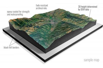
• Raised-relief 3D Height Determined by DEM data
• Fade Resistant Archival Inks
• Epoxy Coated for Strength and Waterproofing
• Ready to Hang with Pre-Installed Hardware (optional)
• Extraordinary 3D Accuracy
• Black Felt Borders
Enrich your office decor or home with a 3D Satellite Raised Relief Map. These raised relief maps are not flat. They are three-dimensional, with the height being determined by Digital Elevation Model (DEM) data. Many people struggle with reading 2D satellite maps, but everyone understands 3D raised relief maps. The realism is phenomenal.
This 3D satellite raised relief map is built by combining satellite imagery data from Google Earth, bounding box coordinates from USGS, and DEM data. 3D Printing and 3D CNC routers are used to fabricate the models which make the satellite models extremely accurate. These models are strong - they are coated with epoxy, then finished with a sealer providing a weatherproof matt-finish. These are not meant to be used in direct sunlight.
Aberdeen, Indiana- Map Components- Imagery: Satellite of Aberdeen, Indiana. Bounding Box: Footprint of Aberdeen, Indiana at Longitude/Latitude Coordinates (-85 x -84.875 x 39 x 38.875).
Acton, Indiana- Map Components- Imagery: Satellite of Acton, Indiana. Bounding Box: Footprint of Acton, Indiana at Longitude/Latitude Coordinates (-86 x -85.875 x 39.75 x 39.625).
Adams, Indiana- Map Components- Imagery: Satellite of Adams, Indiana. Bounding Box: Footprint of Adams, Indiana at Longitude/Latitude Coordinates (-85.625 x -85.5 x 39.5 x 39.375).
Akron, Indiana- Map Components- Imagery: Satellite of Akron, Indiana. Bounding Box: Footprint of Akron, Indiana at Longitude/Latitude Coordinates (-86.125 x -86 x 41.125 x 41).
Alamo, Indiana- Map Components- Imagery: Satellite of Alamo, Indiana. Bounding Box: Footprint of Alamo, Indiana at Longitude/Latitude Coordinates (-87.125 x -87 x 40 x 39.875).
Albion, Indiana- Map Components- Imagery: Satellite of Albion, Indiana. Bounding Box: Footprint of Albion, Indiana at Longitude/Latitude Coordinates (-85.5 x -85.375 x 41.5 x 41.375).
Alexandria, Indiana- Map Components- Imagery: Satellite of Alexandria, Indiana. Bounding Box: Footprint of Alexandria, Indiana at Longitude/Latitude Coordinates (-85.75 x -85.625 x 40.375 x 40.25).
Alfordsville, Indiana- Map Components- Imagery: Satellite of Alfordsville, Indiana. Bounding Box: Footprint of Alfordsville, Indiana at Longitude/Latitude Coordinates (-87 x -86.875 x 38.625 x 38.5).
Allens Creek, Indiana- Map Components- Imagery: Satellite of Allens Creek, Indiana. Bounding Box: Footprint of Allens Creek, Indiana at Longitude/Latitude Coordinates (-86.5 x -86.375 x 39.125 x 39).
Alpine, Indiana- Map Components- Imagery: Satellite of Alpine, Indiana. Bounding Box: Footprint of Alpine, Indiana at Longitude/Latitude Coordinates (-85.25 x -85.125 x 39.625 x 39.5).
Alton, Indiana- Map Components- Imagery: Satellite of Alton, Indiana. Bounding Box: Footprint of Alton, Indiana at Longitude/Latitude Coordinates (-86.5 x -86.375 x 38.125 x 38).
Ambia, Indiana- Map Components- Imagery: Satellite of Ambia, Indiana. Bounding Box: Footprint of Ambia, Indiana at Longitude/Latitude Coordinates (-87.625 x -87.5 x 40.5 x 40.375).
Amboy, Indiana- Map Components- Imagery: Satellite of Amboy, Indiana. Bounding Box: Footprint of Amboy, Indiana at Longitude/Latitude Coordinates (-86 x -85.875 x 40.625 x 40.5).
Anderson North, Indiana- Map Components- Imagery: Satellite of Anderson North, Indiana. Bounding Box: Footprint of Anderson North, Indiana at Longitude/Latitude Coordinates (-85.75 x -85.625 x 40.25 x 40.125).
Anderson South, Indiana- Map Components- Imagery: Satellite of Anderson South, Indiana. Bounding Box: Footprint of Anderson South, Indiana at Longitude/Latitude Coordinates (-85.75 x -85.625 x 40.125 x 40).
Andrews, Indiana- Map Components- Imagery: Satellite of Andrews, Indiana. Bounding Box: Footprint of Andrews, Indiana at Longitude/Latitude Coordinates (-85.625 x -85.5 x 40.875 x 40.75).
Angola East, Indiana- Map Components- Imagery: Satellite of Angola East, Indiana. Bounding Box: Footprint of Angola East, Indiana at Longitude/Latitude Coordinates (-85 x -84.875 x 41.75 x 41.625).
Angola West, Indiana- Map Components- Imagery: Satellite of Angola West, Indiana. Bounding Box: Footprint of Angola West, Indiana at Longitude/Latitude Coordinates (-85.125 x -85 x 41.75 x 41.625).
Anoka, Indiana- Map Components- Imagery: Satellite of Anoka, Indiana. Bounding Box: Footprint of Anoka, Indiana at Longitude/Latitude Coordinates (-86.375 x -86.25 x 40.75 x 40.625).
Arcadia, Indiana- Map Components- Imagery: Satellite of Arcadia, Indiana. Bounding Box: Footprint of Arcadia, Indiana at Longitude/Latitude Coordinates (-86.125 x -86 x 40.25 x 40.125).
Arcola, Indiana- Map Components- Imagery: Satellite of Arcola, Indiana. Bounding Box: Footprint of Arcola, Indiana at Longitude/Latitude Coordinates (-85.375 x -85.25 x 41.125 x 41).
Argos, Indiana- Map Components- Imagery: Satellite of Argos, Indiana. Bounding Box: Footprint of Argos, Indiana at Longitude/Latitude Coordinates (-86.25 x -86.125 x 41.25 x 41.125).
Arney, Indiana- Map Components- Imagery: Satellite of Arney, Indiana. Bounding Box: Footprint of Arney, Indiana at Longitude/Latitude Coordinates (-87 x -86.875 x 39.25 x 39.125).
Ashley, Indiana- Map Components- Imagery: Satellite of Ashley, Indiana. Bounding Box: Footprint of Ashley, Indiana at Longitude/Latitude Coordinates (-85.125 x -85 x 41.625 x 41.5).
Attica, Indiana- Map Components- Imagery: Satellite of Attica, Indiana. Bounding Box: Footprint of Attica, Indiana at Longitude/Latitude Coordinates (-87.25 x -87.125 x 40.375 x 40.25).
Atwood, Indiana- Map Components- Imagery: Satellite of Atwood, Indiana. Bounding Box: Footprint of Atwood, Indiana at Longitude/Latitude Coordinates (-86 x -85.875 x 41.375 x 41.25).
Auburn, Indiana- Map Components- Imagery: Satellite of Auburn, Indiana. Bounding Box: Footprint of Auburn, Indiana at Longitude/Latitude Coordinates (-85.125 x -85 x 41.375 x 41.25).
Augusta, Indiana- Map Components- Imagery: Satellite of Augusta, Indiana. Bounding Box: Footprint of Augusta, Indiana at Longitude/Latitude Coordinates (-87.25 x -87.125 x 38.375 x 38.25).
Aurora, Indiana- Map Components- Imagery: Satellite of Aurora, Indiana. Bounding Box: Footprint of Aurora, Indiana at Longitude/Latitude Coordinates (-85 x -84.875 x 39.125 x 39).
Azalia, Indiana- Map Components- Imagery: Satellite of Azalia, Indiana. Bounding Box: Footprint of Azalia, Indiana at Longitude/Latitude Coordinates (-85.875 x -85.75 x 39.125 x 39).
Bargersville, Indiana- Map Components- Imagery: Satellite of Bargersville, Indiana. Bounding Box: Footprint of Bargersville, Indiana at Longitude/Latitude Coordinates (-86.25 x -86.125 x 39.625 x 39.5).
Bartlettsville, Indiana- Map Components- Imagery: Satellite of Bartlettsville, Indiana. Bounding Box: Footprint of Bartlettsville, Indiana at Longitude/Latitude Coordinates (-86.5 x -86.375 x 39 x 38.875).
Bass Lake, Indiana- Map Components- Imagery: Satellite of Bass Lake, Indiana. Bounding Box: Footprint of Bass Lake, Indiana at Longitude/Latitude Coordinates (-86.625 x -86.5 x 41.25 x 41.125).
Batesville, Indiana- Map Components- Imagery: Satellite of Batesville, Indiana. Bounding Box: Footprint of Batesville, Indiana at Longitude/Latitude Coordinates (-85.25 x -85.125 x 39.375 x 39.25).
Beanblossom, Indiana- Map Components- Imagery: Satellite of Beanblossom, Indiana. Bounding Box: Footprint of Beanblossom, Indiana at Longitude/Latitude Coordinates (-86.25 x -86.125 x 39.375 x 39.25).
Bear Branch, Indiana- Map Components- Imagery: Satellite of Bear Branch, Indiana. Bounding Box: Footprint of Bear Branch, Indiana at Longitude/Latitude Coordinates (-85.125 x -85 x 39 x 38.875).
Becks Mill, Indiana- Map Components- Imagery: Satellite of Becks Mill, Indiana. Bounding Box: Footprint of Becks Mill, Indiana at Longitude/Latitude Coordinates (-86.25 x -86.125 x 38.625 x 38.5).
Bedford East, Indiana- Map Components- Imagery: Satellite of Bedford East, Indiana. Bounding Box: Footprint of Bedford East, Indiana at Longitude/Latitude Coordinates (-86.5 x -86.375 x 38.875 x 38.75).
Bedford West, Indiana- Map Components- Imagery: Satellite of Bedford West, Indiana. Bounding Box: Footprint of Bedford West, Indiana at Longitude/Latitude Coordinates (-86.625 x -86.5 x 38.875 x 38.75).
Beech Grove, Indiana- Map Components- Imagery: Satellite of Beech Grove, Indiana. Bounding Box: Footprint of Beech Grove, Indiana at Longitude/Latitude Coordinates (-86.125 x -86 x 39.75 x 39.625).
Beechwood, Indiana- Map Components- Imagery: Satellite of Beechwood, Indiana. Bounding Box: Footprint of Beechwood, Indiana at Longitude/Latitude Coordinates (-86.5 x -86.375 x 38.25 x 38.125).
Bellmore, Indiana- Map Components- Imagery: Satellite of Bellmore, Indiana. Bounding Box: Footprint of Bellmore, Indiana at Longitude/Latitude Coordinates (-87.125 x -87 x 39.875 x 39.75).
Belmont, Indiana- Map Components- Imagery: Satellite of Belmont, Indiana. Bounding Box: Footprint of Belmont, Indiana at Longitude/Latitude Coordinates (-86.375 x -86.25 x 39.25 x 39.125).
Bennington, Indiana- Map Components- Imagery: Satellite of Bennington, Indiana. Bounding Box: Footprint of Bennington, Indiana at Longitude/Latitude Coordinates (-85.25 x -85.125 x 38.875 x 38.75).
Berne, Indiana- Map Components- Imagery: Satellite of Berne, Indiana. Bounding Box: Footprint of Berne, Indiana at Longitude/Latitude Coordinates (-85 x -84.875 x 40.75 x 40.625).
Bethlehem, Indiana- Map Components- Imagery: Satellite of Bethlehem, Indiana. Bounding Box: Footprint of Bethlehem, Indiana at Longitude/Latitude Coordinates (-85.5 x -85.375 x 38.625 x 38.5).
Bicknell, Indiana- Map Components- Imagery: Satellite of Bicknell, Indiana. Bounding Box: Footprint of Bicknell, Indiana at Longitude/Latitude Coordinates (-87.375 x -87.25 x 38.875 x 38.75).
Bippus, Indiana- Map Components- Imagery: Satellite of Bippus, Indiana. Bounding Box: Footprint of Bippus, Indiana at Longitude/Latitude Coordinates (-85.625 x -85.5 x 41 x 40.875).
Birdseye, Indiana- Map Components- Imagery: Satellite of Birdseye, Indiana. Bounding Box: Footprint of Birdseye, Indiana at Longitude/Latitude Coordinates (-86.75 x -86.625 x 38.375 x 38.25).
Blaine, Indiana- Map Components- Imagery: Satellite of Blaine, Indiana. Bounding Box: Footprint of Blaine, Indiana at Longitude/Latitude Coordinates (-85.125 x -85 x 40.5 x 40.375).
Blocher, Indiana- Map Components- Imagery: Satellite of Blocher, Indiana. Bounding Box: Footprint of Blocher, Indiana at Longitude/Latitude Coordinates (-85.75 x -85.625 x 38.75 x 38.625).
Bloomfield, Indiana- Map Components- Imagery: Satellite of Bloomfield, Indiana. Bounding Box: Footprint of Bloomfield, Indiana at Longitude/Latitude Coordinates (-87 x -86.875 x 39.125 x 39).
Bloomington, Indiana- Map Components- Imagery: Satellite of Bloomington, Indiana. Bounding Box: Footprint of Bloomington, Indiana at Longitude/Latitude Coordinates (-86.625 x -86.5 x 39.25 x 39.125).
Bluffton, Indiana- Map Components- Imagery: Satellite of Bluffton, Indiana. Bounding Box: Footprint of Bluffton, Indiana at Longitude/Latitude Coordinates (-85.25 x -85.125 x 40.75 x 40.625).
Boggstown, Indiana- Map Components- Imagery: Satellite of Boggstown, Indiana. Bounding Box: Footprint of Boggstown, Indiana at Longitude/Latitude Coordinates (-86 x -85.875 x 39.625 x 39.5).
Boonville, Indiana- Map Components- Imagery: Satellite of Boonville, Indiana. Bounding Box: Footprint of Boonville, Indiana at Longitude/Latitude Coordinates (-87.375 x -87.25 x 38.125 x 38).
Borden, Indiana- Map Components- Imagery: Satellite of Borden, Indiana. Bounding Box: Footprint of Borden, Indiana at Longitude/Latitude Coordinates (-86 x -85.875 x 38.5 x 38.375).
Boswell, Indiana- Map Components- Imagery: Satellite of Boswell, Indiana. Bounding Box: Footprint of Boswell, Indiana at Longitude/Latitude Coordinates (-87.5 x -87.375 x 40.625 x 40.5).
Bourbon, Indiana- Map Components- Imagery: Satellite of Bourbon, Indiana. Bounding Box: Footprint of Bourbon, Indiana at Longitude/Latitude Coordinates (-86.125 x -86 x 41.375 x 41.25).
Branchville, Indiana- Map Components- Imagery: Satellite of Branchville, Indiana. Bounding Box: Footprint of Branchville, Indiana at Longitude/Latitude Coordinates (-86.625 x -86.5 x 38.25 x 38.125).
Brazil East, Indiana- Map Components- Imagery: Satellite of Brazil East, Indiana. Bounding Box: Footprint of Brazil East, Indiana at Longitude/Latitude Coordinates (-87.125 x -87 x 39.625 x 39.5).
Brazil West, Indiana- Map Components- Imagery: Satellite of Brazil West, Indiana. Bounding Box: Footprint of Brazil West, Indiana at Longitude/Latitude Coordinates (-87.25 x -87.125 x 39.625 x 39.5).
Bremen, Indiana- Map Components- Imagery: Satellite of Bremen, Indiana. Bounding Box: Footprint of Bremen, Indiana at Longitude/Latitude Coordinates (-86.25 x -86.125 x 41.5 x 41.375).
Bridgeport, Indiana- Map Components- Imagery: Satellite of Bridgeport, Indiana. Bounding Box: Footprint of Bridgeport, Indiana at Longitude/Latitude Coordinates (-86.375 x -86.25 x 39.75 x 39.625).
Bristol, Indiana- Map Components- Imagery: Satellite of Bristol, Indiana. Bounding Box: Footprint of Bristol, Indiana at Longitude/Latitude Coordinates (-85.875 x -85.75 x 41.75 x 41.625).
Bristow, Indiana- Map Components- Imagery: Satellite of Bristow, Indiana. Bounding Box: Footprint of Bristow, Indiana at Longitude/Latitude Coordinates (-86.75 x -86.625 x 38.25 x 38.125).
Brookston, Indiana- Map Components- Imagery: Satellite of Brookston, Indiana. Bounding Box: Footprint of Brookston, Indiana at Longitude/Latitude Coordinates (-86.875 x -86.75 x 40.625 x 40.5).
Brookston NW, Indiana- Map Components- Imagery: Satellite of Brookston NW, Indiana. Bounding Box: Footprint of Brookston NW, Indiana at Longitude/Latitude Coordinates (-87 x -86.875 x 40.75 x 40.625).
Brookston SW, Indiana- Map Components- Imagery: Satellite of Brookston SW, Indiana. Bounding Box: Footprint of Brookston SW, Indiana at Longitude/Latitude Coordinates (-87 x -86.875 x 40.625 x 40.5).
Brookville, Indiana- Map Components- Imagery: Satellite of Brookville, Indiana. Bounding Box: Footprint of Brookville, Indiana at Longitude/Latitude Coordinates (-85.125 x -85 x 39.5 x 39.375).
Brownsburg, Indiana- Map Components- Imagery: Satellite of Brownsburg, Indiana. Bounding Box: Footprint of Brownsburg, Indiana at Longitude/Latitude Coordinates (-86.5 x -86.375 x 39.875 x 39.75).
Brownstown, Indiana- Map Components- Imagery: Satellite of Brownstown, Indiana. Bounding Box: Footprint of Brownstown, Indiana at Longitude/Latitude Coordinates (-86.125 x -86 x 39 x 38.875).
Brownsville, Indiana- Map Components- Imagery: Satellite of Brownsville, Indiana. Bounding Box: Footprint of Brownsville, Indiana at Longitude/Latitude Coordinates (-85.125 x -85 x 39.75 x 39.625).
Bucktown, Indiana- Map Components- Imagery: Satellite of Bucktown, Indiana. Bounding Box: Footprint of Bucktown, Indiana at Longitude/Latitude Coordinates (-87.375 x -87.25 x 39 x 38.875).
Buffalo, Indiana- Map Components- Imagery: Satellite of Buffalo, Indiana. Bounding Box: Footprint of Buffalo, Indiana at Longitude/Latitude Coordinates (-86.75 x -86.625 x 41 x 40.875).
Bunker Hill, Indiana- Map Components- Imagery: Satellite of Bunker Hill, Indiana. Bounding Box: Footprint of Bunker Hill, Indiana at Longitude/Latitude Coordinates (-86.125 x -86 x 40.75 x 40.625).
Burket, Indiana- Map Components- Imagery: Satellite of Burket, Indiana. Bounding Box: Footprint of Burket, Indiana at Longitude/Latitude Coordinates (-86 x -85.875 x 41.25 x 41.125).
Burlington, Indiana- Map Components- Imagery: Satellite of Burlington, Indiana. Bounding Box: Footprint of Burlington, Indiana at Longitude/Latitude Coordinates (-86.5 x -86.375 x 40.5 x 40.375).
Burnettsville, Indiana- Map Components- Imagery: Satellite of Burnettsville, Indiana. Bounding Box: Footprint of Burnettsville, Indiana at Longitude/Latitude Coordinates (-86.625 x -86.5 x 40.875 x 40.75).
Burrows, Indiana- Map Components- Imagery: Satellite of Burrows, Indiana. Bounding Box: Footprint of Burrows, Indiana at Longitude/Latitude Coordinates (-86.625 x -86.5 x 40.75 x 40.625).
Butler East, Indiana- Map Components- Imagery: Satellite of Butler East, Indiana. Bounding Box: Footprint of Butler East, Indiana at Longitude/Latitude Coordinates (-84.875 x -84.75 x 41.5 x 41.375).
Butler West, Indiana- Map Components- Imagery: Satellite of Butler West, Indiana. Bounding Box: Footprint of Butler West, Indiana at Longitude/Latitude Coordinates (-85 x -84.875 x 41.5 x 41.375).
Butlerville, Indiana- Map Components- Imagery: Satellite of Butlerville, Indiana. Bounding Box: Footprint of Butlerville, Indiana at Longitude/Latitude Coordinates (-85.625 x -85.5 x 39.125 x 39).
Caborn, Indiana- Map Components- Imagery: Satellite of Caborn, Indiana. Bounding Box: Footprint of Caborn, Indiana at Longitude/Latitude Coordinates (-87.875 x -87.75 x 38 x 37.875).
Cambridge City, Indiana- Map Components- Imagery: Satellite of Cambridge City, Indiana. Bounding Box: Footprint of Cambridge City, Indiana at Longitude/Latitude Coordinates (-85.25 x -85.125 x 39.875 x 39.75).
Campbellsburg, Indiana- Map Components- Imagery: Satellite of Campbellsburg, Indiana. Bounding Box: Footprint of Campbellsburg, Indiana at Longitude/Latitude Coordinates (-86.375 x -86.25 x 38.75 x 38.625).
Canaan, Indiana- Map Components- Imagery: Satellite of Canaan, Indiana. Bounding Box: Footprint of Canaan, Indiana at Longitude/Latitude Coordinates (-85.375 x -85.25 x 38.875 x 38.75).
Cannelton, Indiana- Map Components- Imagery: Satellite of Cannelton, Indiana. Bounding Box: Footprint of Cannelton, Indiana at Longitude/Latitude Coordinates (-86.75 x -86.625 x 38 x 37.875).
Carlisle, Indiana- Map Components- Imagery: Satellite of Carlisle, Indiana. Bounding Box: Footprint of Carlisle, Indiana at Longitude/Latitude Coordinates (-87.5 x -87.375 x 39 x 38.875).
Carlos, Indiana- Map Components- Imagery: Satellite of Carlos, Indiana. Bounding Box: Footprint of Carlos, Indiana at Longitude/Latitude Coordinates (-85.125 x -85 x 40.125 x 40).
Carmel, Indiana- Map Components- Imagery: Satellite of Carmel, Indiana. Bounding Box: Footprint of Carmel, Indiana at Longitude/Latitude Coordinates (-86.25 x -86.125 x 40 x 39.875).
Carthage, Indiana- Map Components- Imagery: Satellite of Carthage, Indiana. Bounding Box: Footprint of Carthage, Indiana at Longitude/Latitude Coordinates (-85.625 x -85.5 x 39.75 x 39.625).
Cataract, Indiana- Map Components- Imagery: Satellite of Cataract, Indiana. Bounding Box: Footprint of Cataract, Indiana at Longitude/Latitude Coordinates (-86.875 x -86.75 x 39.5 x 39.375).
Catlin, Indiana- Map Components- Imagery: Satellite of Catlin, Indiana. Bounding Box: Footprint of Catlin, Indiana at Longitude/Latitude Coordinates (-87.25 x -87.125 x 39.75 x 39.625).
Cedar Grove, Indiana- Map Components- Imagery: Satellite of Cedar Grove, Indiana. Bounding Box: Footprint of Cedar Grove, Indiana at Longitude/Latitude Coordinates (-85 x -84.875 x 39.375 x 39.25).
Cedarville, Indiana- Map Components- Imagery: Satellite of Cedarville, Indiana. Bounding Box: Footprint of Cedarville, Indiana at Longitude/Latitude Coordinates (-85.125 x -85 x 41.25 x 41.125).
Center Point, Indiana- Map Components- Imagery: Satellite of Center Point, Indiana. Bounding Box: Footprint of Center Point, Indiana at Longitude/Latitude Coordinates (-87.125 x -87 x 39.5 x 39.375).
Charlestown, Indiana- Map Components- Imagery: Satellite of Charlestown, Indiana. Bounding Box: Footprint of Charlestown, Indiana at Longitude/Latitude Coordinates (-85.75 x -85.625 x 38.5 x 38.375).
Chatterton, Indiana- Map Components- Imagery: Satellite of Chatterton, Indiana. Bounding Box: Footprint of Chatterton, Indiana at Longitude/Latitude Coordinates (-87.25 x -87.125 x 40.5 x 40.375).
Chesterton, Indiana- Map Components- Imagery: Satellite of Chesterton, Indiana. Bounding Box: Footprint of Chesterton, Indiana at Longitude/Latitude Coordinates (-87.125 x -87 x 41.625 x 41.5).
Chestnut Ridge, Indiana- Map Components- Imagery: Satellite of Chestnut Ridge, Indiana. Bounding Box: Footprint of Chestnut Ridge, Indiana at Longitude/Latitude Coordinates (-85.875 x -85.75 x 39 x 38.875).
Chrisney, Indiana- Map Components- Imagery: Satellite of Chrisney, Indiana. Bounding Box: Footprint of Chrisney, Indiana at Longitude/Latitude Coordinates (-87.125 x -87 x 38.125 x 38).
Churubusco, Indiana- Map Components- Imagery: Satellite of Churubusco, Indiana. Bounding Box: Footprint of Churubusco, Indiana at Longitude/Latitude Coordinates (-85.375 x -85.25 x 41.25 x 41.125).
Clarksburg, Indiana- Map Components- Imagery: Satellite of Clarksburg, Indiana. Bounding Box: Footprint of Clarksburg, Indiana at Longitude/Latitude Coordinates (-85.375 x -85.25 x 39.5 x 39.375).
Clay City, Indiana- Map Components- Imagery: Satellite of Clay City, Indiana. Bounding Box: Footprint of Clay City, Indiana at Longitude/Latitude Coordinates (-87.125 x -87 x 39.375 x 39.25).
Clayton, Indiana- Map Components- Imagery: Satellite of Clayton, Indiana. Bounding Box: Footprint of Clayton, Indiana at Longitude/Latitude Coordinates (-86.625 x -86.5 x 39.75 x 39.625).
Clear Creek, Indiana- Map Components- Imagery: Satellite of Clear Creek, Indiana. Bounding Box: Footprint of Clear Creek, Indiana at Longitude/Latitude Coordinates (-86.625 x -86.5 x 39.125 x 39).
Clear Lake, Indiana- Map Components- Imagery: Satellite of Clear Lake, Indiana. Bounding Box: Footprint of Clear Lake, Indiana at Longitude/Latitude Coordinates (-84.875 x -84.75 x 41.75 x 41.625).
Clermont, Indiana- Map Components- Imagery: Satellite of Clermont, Indiana. Bounding Box: Footprint of Clermont, Indiana at Longitude/Latitude Coordinates (-86.375 x -86.25 x 39.875 x 39.75).
Cleveland, Indiana- Map Components- Imagery: Satellite of Cleveland, Indiana. Bounding Box: Footprint of Cleveland, Indiana at Longitude/Latitude Coordinates (-85.75 x -85.625 x 39.875 x 39.75).
Clifty Falls, Indiana- Map Components- Imagery: Satellite of Clifty Falls, Indiana. Bounding Box: Footprint of Clifty Falls, Indiana at Longitude/Latitude Coordinates (-85.5 x -85.375 x 38.875 x 38.75).
Clinton, Indiana- Map Components- Imagery: Satellite of Clinton, Indiana. Bounding Box: Footprint of Clinton, Indiana at Longitude/Latitude Coordinates (-87.5 x -87.375 x 39.75 x 39.625).
Clinton Falls, Indiana- Map Components- Imagery: Satellite of Clinton Falls, Indiana. Bounding Box: Footprint of Clinton Falls, Indiana at Longitude/Latitude Coordinates (-87 x -86.875 x 39.75 x 39.625).
Cloverdale, Indiana- Map Components- Imagery: Satellite of Cloverdale, Indiana. Bounding Box: Footprint of Cloverdale, Indiana at Longitude/Latitude Coordinates (-86.875 x -86.75 x 39.625 x 39.5).
Clymers, Indiana- Map Components- Imagery: Satellite of Clymers, Indiana. Bounding Box: Footprint of Clymers, Indiana at Longitude/Latitude Coordinates (-86.5 x -86.375 x 40.75 x 40.625).
Coal City, Indiana- Map Components- Imagery: Satellite of Coal City, Indiana. Bounding Box: Footprint of Coal City, Indiana at Longitude/Latitude Coordinates (-87.125 x -87 x 39.25 x 39.125).
Coatesville, Indiana- Map Components- Imagery: Satellite of Coatesville, Indiana. Bounding Box: Footprint of Coatesville, Indiana at Longitude/Latitude Coordinates (-86.75 x -86.625 x 39.75 x 39.625).
Colfax, Indiana- Map Components- Imagery: Satellite of Colfax, Indiana. Bounding Box: Footprint of Colfax, Indiana at Longitude/Latitude Coordinates (-86.75 x -86.625 x 40.25 x 40.125).
Columbia City, Indiana- Map Components- Imagery: Satellite of Columbia City, Indiana. Bounding Box: Footprint of Columbia City, Indiana at Longitude/Latitude Coordinates (-85.5 x -85.375 x 41.25 x 41.125).
Columbus, Indiana- Map Components- Imagery: Satellite of Columbus, Indiana. Bounding Box: Footprint of Columbus, Indiana at Longitude/Latitude Coordinates (-86 x -85.875 x 39.25 x 39.125).
Connersville, Indiana- Map Components- Imagery: Satellite of Connersville, Indiana. Bounding Box: Footprint of Connersville, Indiana at Longitude/Latitude Coordinates (-85.25 x -85.125 x 39.75 x 39.625).
Cope, Indiana- Map Components- Imagery: Satellite of Cope, Indiana. Bounding Box: Footprint of Cope, Indiana at Longitude/Latitude Coordinates (-86.375 x -86.25 x 39.5 x 39.375).
Corunna, Indiana- Map Components- Imagery: Satellite of Corunna, Indiana. Bounding Box: Footprint of Corunna, Indiana at Longitude/Latitude Coordinates (-85.25 x -85.125 x 41.5 x 41.375).
Corydon East, Indiana- Map Components- Imagery: Satellite of Corydon East, Indiana. Bounding Box: Footprint of Corydon East, Indiana at Longitude/Latitude Coordinates (-86.125 x -86 x 38.25 x 38.125).
Corydon West, Indiana- Map Components- Imagery: Satellite of Corydon West, Indiana. Bounding Box: Footprint of Corydon West, Indiana at Longitude/Latitude Coordinates (-86.25 x -86.125 x 38.25 x 38.125).
Covington, Indiana- Map Components- Imagery: Satellite of Covington, Indiana. Bounding Box: Footprint of Covington, Indiana at Longitude/Latitude Coordinates (-87.5 x -87.375 x 40.25 x 40.125).
Crandall, Indiana- Map Components- Imagery: Satellite of Crandall, Indiana. Bounding Box: Footprint of Crandall, Indiana at Longitude/Latitude Coordinates (-86.125 x -86 x 38.375 x 38.25).
Crawfordsville, Indiana- Map Components- Imagery: Satellite of Crawfordsville, Indiana. Bounding Box: Footprint of Crawfordsville, Indiana at Longitude/Latitude Coordinates (-87 x -86.875 x 40.125 x 40).
Cross Plains, Indiana- Map Components- Imagery: Satellite of Cross Plains, Indiana. Bounding Box: Footprint of Cross Plains, Indiana at Longitude/Latitude Coordinates (-85.25 x -85.125 x 39 x 38.875).
Crothersville, Indiana- Map Components- Imagery: Satellite of Crothersville, Indiana. Bounding Box: Footprint of Crothersville, Indiana at Longitude/Latitude Coordinates (-85.875 x -85.75 x 38.875 x 38.75).
Crown Point, Indiana- Map Components- Imagery: Satellite of Crown Point, Indiana. Bounding Box: Footprint of Crown Point, Indiana at Longitude/Latitude Coordinates (-87.375 x -87.25 x 41.5 x 41.375).
Culver, Indiana- Map Components- Imagery: Satellite of Culver, Indiana. Bounding Box: Footprint of Culver, Indiana at Longitude/Latitude Coordinates (-86.5 x -86.375 x 41.25 x 41.125).
Cumberland, Indiana- Map Components- Imagery: Satellite of Cumberland, Indiana. Bounding Box: Footprint of Cumberland, Indiana at Longitude/Latitude Coordinates (-86 x -85.875 x 39.875 x 39.75).
Cuzco, Indiana- Map Components- Imagery: Satellite of Cuzco, Indiana. Bounding Box: Footprint of Cuzco, Indiana at Longitude/Latitude Coordinates (-86.75 x -86.625 x 38.5 x 38.375).
Cynthiana, Indiana- Map Components- Imagery: Satellite of Cynthiana, Indiana. Bounding Box: Footprint of Cynthiana, Indiana at Longitude/Latitude Coordinates (-87.75 x -87.625 x 38.25 x 38.125).
Dale, Indiana- Map Components- Imagery: Satellite of Dale, Indiana. Bounding Box: Footprint of Dale, Indiana at Longitude/Latitude Coordinates (-87 x -86.875 x 38.25 x 38.125).
Dana, Indiana- Map Components- Imagery: Satellite of Dana, Indiana. Bounding Box: Footprint of Dana, Indiana at Longitude/Latitude Coordinates (-87.5 x -87.375 x 39.875 x 39.75).
Danville, Indiana- Map Components- Imagery: Satellite of Danville, Indiana. Bounding Box: Footprint of Danville, Indiana at Longitude/Latitude Coordinates (-86.625 x -86.5 x 39.875 x 39.75).
Darlington, Indiana- Map Components- Imagery: Satellite of Darlington, Indiana. Bounding Box: Footprint of Darlington, Indiana at Longitude/Latitude Coordinates (-86.875 x -86.75 x 40.125 x 40).
Daylight, Indiana- Map Components- Imagery: Satellite of Daylight, Indiana. Bounding Box: Footprint of Daylight, Indiana at Longitude/Latitude Coordinates (-87.5 x -87.375 x 38.125 x 38).
De Gonia Springs, Indiana- Map Components- Imagery: Satellite of De Gonia Springs, Indiana. Bounding Box: Footprint of De Gonia Springs, Indiana at Longitude/Latitude Coordinates (-87.25 x -87.125 x 38.125 x 38).
Decatur, Indiana- Map Components- Imagery: Satellite of Decatur, Indiana. Bounding Box: Footprint of Decatur, Indiana at Longitude/Latitude Coordinates (-85 x -84.875 x 40.875 x 40.75).
Decker, Indiana- Map Components- Imagery: Satellite of Decker, Indiana. Bounding Box: Footprint of Decker, Indiana at Longitude/Latitude Coordinates (-87.625 x -87.5 x 38.625 x 38.5).
Deedsville, Indiana- Map Components- Imagery: Satellite of Deedsville, Indiana. Bounding Box: Footprint of Deedsville, Indiana at Longitude/Latitude Coordinates (-86.125 x -86 x 41 x 40.875).
Deer Creek, Indiana- Map Components- Imagery: Satellite of Deer Creek, Indiana. Bounding Box: Footprint of Deer Creek, Indiana at Longitude/Latitude Coordinates (-86.5 x -86.375 x 40.625 x 40.5).
Deerfield, Indiana- Map Components- Imagery: Satellite of Deerfield, Indiana. Bounding Box: Footprint of Deerfield, Indiana at Longitude/Latitude Coordinates (-85 x -84.875 x 40.375 x 40.25).
Delphi, Indiana- Map Components- Imagery: Satellite of Delphi, Indiana. Bounding Box: Footprint of Delphi, Indiana at Longitude/Latitude Coordinates (-86.75 x -86.625 x 40.625 x 40.5).
DeMotte, Indiana- Map Components- Imagery: Satellite of DeMotte, Indiana. Bounding Box: Footprint of DeMotte, Indiana at Longitude/Latitude Coordinates (-87.25 x -87.125 x 41.25 x 41.125).
Denham, Indiana- Map Components- Imagery: Satellite of Denham, Indiana. Bounding Box: Footprint of Denham, Indiana at Longitude/Latitude Coordinates (-86.75 x -86.625 x 41.25 x 41.125).
Depauw, Indiana- Map Components- Imagery: Satellite of Depauw, Indiana. Bounding Box: Footprint of Depauw, Indiana at Longitude/Latitude Coordinates (-86.25 x -86.125 x 38.375 x 38.25).
Deputy, Indiana- Map Components- Imagery: Satellite of Deputy, Indiana. Bounding Box: Footprint of Deputy, Indiana at Longitude/Latitude Coordinates (-85.75 x -85.625 x 38.875 x 38.75).
Derby, Indiana- Map Components- Imagery: Satellite of Derby, Indiana. Bounding Box: Footprint of Derby, Indiana at Longitude/Latitude Coordinates (-86.625 x -86.5 x 38.125 x 38).
Dillsboro, Indiana- Map Components- Imagery: Satellite of Dillsboro, Indiana. Bounding Box: Footprint of Dillsboro, Indiana at Longitude/Latitude Coordinates (-85.125 x -85 x 39.125 x 39).
Dixon, Indiana- Map Components- Imagery: Satellite of Dixon, Indiana. Bounding Box: Footprint of Dixon, Indiana at Longitude/Latitude Coordinates (-84.875 x -84.75 x 41 x 40.875).
Domestic, Indiana- Map Components- Imagery: Satellite of Domestic, Indiana. Bounding Box: Footprint of Domestic, Indiana at Longitude/Latitude Coordinates (-85.125 x -85 x 40.625 x 40.5).
Donaldson, Indiana- Map Components- Imagery: Satellite of Donaldson, Indiana. Bounding Box: Footprint of Donaldson, Indiana at Longitude/Latitude Coordinates (-86.5 x -86.375 x 41.375 x 41.25).
Dubois, Indiana- Map Components- Imagery: Satellite of Dubois, Indiana. Bounding Box: Footprint of Dubois, Indiana at Longitude/Latitude Coordinates (-86.875 x -86.75 x 38.5 x 38.375).
Dugger, Indiana- Map Components- Imagery: Satellite of Dugger, Indiana. Bounding Box: Footprint of Dugger, Indiana at Longitude/Latitude Coordinates (-87.375 x -87.25 x 39.125 x 39).
Dune Acres, Indiana- Map Components- Imagery: Satellite of Dune Acres, Indiana. Bounding Box: Footprint of Dune Acres, Indiana at Longitude/Latitude Coordinates (-87.125 x -87 x 41.75 x 41.625).
Dunreith, Indiana- Map Components- Imagery: Satellite of Dunreith, Indiana. Bounding Box: Footprint of Dunreith, Indiana at Longitude/Latitude Coordinates (-85.5 x -85.375 x 39.875 x 39.75).
Dyer, Indiana- Map Components- Imagery: Satellite of Dyer, Indiana. Bounding Box: Footprint of Dyer, Indiana at Longitude/Latitude Coordinates (-87.625 x -87.5 x 41.5 x 41.375).
Earl Park, Indiana- Map Components- Imagery: Satellite of Earl Park, Indiana. Bounding Box: Footprint of Earl Park, Indiana at Longitude/Latitude Coordinates (-87.5 x -87.375 x 40.75 x 40.625).
East Mount Carmel, Indiana- Map Components- Imagery: Satellite of East Mount Carmel, Indiana. Bounding Box: Footprint of East Mount Carmel, Indiana at Longitude/Latitude Coordinates (-87.75 x -87.625 x 38.5 x 38.375).
Eaton, Indiana- Map Components- Imagery: Satellite of Eaton, Indiana. Bounding Box: Footprint of Eaton, Indiana at Longitude/Latitude Coordinates (-85.375 x -85.25 x 40.375 x 40.25).
Edinburgh, Indiana- Map Components- Imagery: Satellite of Edinburgh, Indiana. Bounding Box: Footprint of Edinburgh, Indiana at Longitude/Latitude Coordinates (-86 x -85.875 x 39.375 x 39.25).
Ege, Indiana- Map Components- Imagery: Satellite of Ege, Indiana. Bounding Box: Footprint of Ege, Indiana at Longitude/Latitude Coordinates (-85.375 x -85.25 x 41.375 x 41.25).
Elberfeld, Indiana- Map Components- Imagery: Satellite of Elberfeld, Indiana. Bounding Box: Footprint of Elberfeld, Indiana at Longitude/Latitude Coordinates (-87.5 x -87.375 x 38.25 x 38.125).
Elizabethtown, Indiana- Map Components- Imagery: Satellite of Elizabethtown, Indiana. Bounding Box: Footprint of Elizabethtown, Indiana at Longitude/Latitude Coordinates (-85.875 x -85.75 x 39.25 x 39.125).
Elkhart, Indiana- Map Components- Imagery: Satellite of Elkhart, Indiana. Bounding Box: Footprint of Elkhart, Indiana at Longitude/Latitude Coordinates (-86 x -85.875 x 41.75 x 41.625).
Elkinsville, Indiana- Map Components- Imagery: Satellite of Elkinsville, Indiana. Bounding Box: Footprint of Elkinsville, Indiana at Longitude/Latitude Coordinates (-86.375 x -86.25 x 39.125 x 39).
Elwood, Indiana- Map Components- Imagery: Satellite of Elwood, Indiana. Bounding Box: Footprint of Elwood, Indiana at Longitude/Latitude Coordinates (-85.875 x -85.75 x 40.375 x 40.25).
Eminence, Indiana- Map Components- Imagery: Satellite of Eminence, Indiana. Bounding Box: Footprint of Eminence, Indiana at Longitude/Latitude Coordinates (-86.75 x -86.625 x 39.625 x 39.5).
English, Indiana- Map Components- Imagery: Satellite of English, Indiana. Bounding Box: Footprint of English, Indiana at Longitude/Latitude Coordinates (-86.5 x -86.375 x 38.375 x 38.25).
English Lake, Indiana- Map Components- Imagery: Satellite of English Lake, Indiana. Bounding Box: Footprint of English Lake, Indiana at Longitude/Latitude Coordinates (-86.875 x -86.75 x 41.375 x 41.25).
Enos, Indiana- Map Components- Imagery: Satellite of Enos, Indiana. Bounding Box: Footprint of Enos, Indiana at Longitude/Latitude Coordinates (-87.5 x -87.375 x 41.125 x 41).
Epsom, Indiana- Map Components- Imagery: Satellite of Epsom, Indiana. Bounding Box: Footprint of Epsom, Indiana at Longitude/Latitude Coordinates (-87.125 x -87 x 38.875 x 38.75).
Evansville North, Indiana- Map Components- Imagery: Satellite of Evansville North, Indiana. Bounding Box: Footprint of Evansville North, Indiana at Longitude/Latitude Coordinates (-87.625 x -87.5 x 38.125 x 38).
Evansville South, Indiana- Map Components- Imagery: Satellite of Evansville South, Indiana. Bounding Box: Footprint of Evansville South, Indiana at Longitude/Latitude Coordinates (-87.625 x -87.5 x 38 x 37.875).
Everton, Indiana- Map Components- Imagery: Satellite of Everton, Indiana. Bounding Box: Footprint of Everton, Indiana at Longitude/Latitude Coordinates (-85.125 x -85 x 39.625 x 39.5).
Fair Oaks, Indiana- Map Components- Imagery: Satellite of Fair Oaks, Indiana. Bounding Box: Footprint of Fair Oaks, Indiana at Longitude/Latitude Coordinates (-87.375 x -87.25 x 41.125 x 41).
Fairbanks, Indiana- Map Components- Imagery: Satellite of Fairbanks, Indiana. Bounding Box: Footprint of Fairbanks, Indiana at Longitude/Latitude Coordinates (-87.625 x -87.5 x 39.25 x 39.125).
Fairmount, Indiana- Map Components- Imagery: Satellite of Fairmount, Indiana. Bounding Box: Footprint of Fairmount, Indiana at Longitude/Latitude Coordinates (-85.75 x -85.625 x 40.5 x 40.375).
Falmouth, Indiana- Map Components- Imagery: Satellite of Falmouth, Indiana. Bounding Box: Footprint of Falmouth, Indiana at Longitude/Latitude Coordinates (-85.375 x -85.25 x 39.75 x 39.625).
Farmland, Indiana- Map Components- Imagery: Satellite of Farmland, Indiana. Bounding Box: Footprint of Farmland, Indiana at Longitude/Latitude Coordinates (-85.25 x -85.125 x 40.25 x 40.125).
Fayette, Indiana- Map Components- Imagery: Satellite of Fayette, Indiana. Bounding Box: Footprint of Fayette, Indiana at Longitude/Latitude Coordinates (-86.5 x -86.375 x 40 x 39.875).
Fishers, Indiana- Map Components- Imagery: Satellite of Fishers, Indiana. Bounding Box: Footprint of Fishers, Indiana at Longitude/Latitude Coordinates (-86.125 x -86 x 40 x 39.875).
Flora, Indiana- Map Components- Imagery: Satellite of Flora, Indiana. Bounding Box: Footprint of Flora, Indiana at Longitude/Latitude Coordinates (-86.625 x -86.5 x 40.625 x 40.5).
Florence, Indiana- Map Components- Imagery: Satellite of Florence, Indiana. Bounding Box: Footprint of Florence, Indiana at Longitude/Latitude Coordinates (-85 x -84.875 x 38.875 x 38.75).
Folsomville, Indiana- Map Components- Imagery: Satellite of Folsomville, Indiana. Bounding Box: Footprint of Folsomville, Indiana at Longitude/Latitude Coordinates (-87.25 x -87.125 x 38.25 x 38.125).
Foraker, Indiana- Map Components- Imagery: Satellite of Foraker, Indiana. Bounding Box: Footprint of Foraker, Indiana at Longitude/Latitude Coordinates (-86 x -85.875 x 41.625 x 41.5).
Forest Hill, Indiana- Map Components- Imagery: Satellite of Forest Hill, Indiana. Bounding Box: Footprint of Forest Hill, Indiana at Longitude/Latitude Coordinates (-85.625 x -85.5 x 39.375 x 39.25).
Fort Wayne East, Indiana- Map Components- Imagery: Satellite of Fort Wayne East, Indiana. Bounding Box: Footprint of Fort Wayne East, Indiana at Longitude/Latitude Coordinates (-85.125 x -85 x 41.125 x 41).
Fort Wayne West, Indiana- Map Components- Imagery: Satellite of Fort Wayne West, Indiana. Bounding Box: Footprint of Fort Wayne West, Indiana at Longitude/Latitude Coordinates (-85.25 x -85.125 x 41.125 x 41).
Fountain City, Indiana- Map Components- Imagery: Satellite of Fountain City, Indiana. Bounding Box: Footprint of Fountain City, Indiana at Longitude/Latitude Coordinates (-85 x -84.875 x 40 x 39.875).
Fountaintown, Indiana- Map Components- Imagery: Satellite of Fountaintown, Indiana. Bounding Box: Footprint of Fountaintown, Indiana at Longitude/Latitude Coordinates (-85.875 x -85.75 x 39.75 x 39.625).
Fowler, Indiana- Map Components- Imagery: Satellite of Fowler, Indiana. Bounding Box: Footprint of Fowler, Indiana at Longitude/Latitude Coordinates (-87.375 x -87.25 x 40.625 x 40.5).
Francesville, Indiana- Map Components- Imagery: Satellite of Francesville, Indiana. Bounding Box: Footprint of Francesville, Indiana at Longitude/Latitude Coordinates (-87 x -86.875 x 41 x 40.875).
Francisco, Indiana- Map Components- Imagery: Satellite of Francisco, Indiana. Bounding Box: Footprint of Francisco, Indiana at Longitude/Latitude Coordinates (-87.5 x -87.375 x 38.375 x 38.25).
Frankfort, Indiana- Map Components- Imagery: Satellite of Frankfort, Indiana. Bounding Box: Footprint of Frankfort, Indiana at Longitude/Latitude Coordinates (-86.625 x -86.5 x 40.375 x 40.25).
Franklin, Indiana- Map Components- Imagery: Satellite of Franklin, Indiana. Bounding Box: Footprint of Franklin, Indiana at Longitude/Latitude Coordinates (-86.125 x -86 x 39.5 x 39.375).
Frankton, Indiana- Map Components- Imagery: Satellite of Frankton, Indiana. Bounding Box: Footprint of Frankton, Indiana at Longitude/Latitude Coordinates (-85.875 x -85.75 x 40.25 x 40.125).
Fredericksburg, Indiana- Map Components- Imagery: Satellite of Fredericksburg, Indiana. Bounding Box: Footprint of Fredericksburg, Indiana at Longitude/Latitude Coordinates (-86.25 x -86.125 x 38.5 x 38.375).
Freedom, Indiana- Map Components- Imagery: Satellite of Freedom, Indiana. Bounding Box: Footprint of Freedom, Indiana at Longitude/Latitude Coordinates (-86.875 x -86.75 x 39.25 x 39.125).
French Lick, Indiana- Map Components- Imagery: Satellite of French Lick, Indiana. Bounding Box: Footprint of French Lick, Indiana at Longitude/Latitude Coordinates (-86.625 x -86.5 x 38.625 x 38.5).
Fritchton, Indiana- Map Components- Imagery: Satellite of Fritchton, Indiana. Bounding Box: Footprint of Fritchton, Indiana at Longitude/Latitude Coordinates (-87.5 x -87.375 x 38.75 x 38.625).
Fulda, Indiana- Map Components- Imagery: Satellite of Fulda, Indiana. Bounding Box: Footprint of Fulda, Indiana at Longitude/Latitude Coordinates (-86.875 x -86.75 x 38.125 x 38).
Fulton, Indiana- Map Components- Imagery: Satellite of Fulton, Indiana. Bounding Box: Footprint of Fulton, Indiana at Longitude/Latitude Coordinates (-86.375 x -86.25 x 41 x 40.875).
Galveston, Indiana- Map Components- Imagery: Satellite of Galveston, Indiana. Bounding Box: Footprint of Galveston, Indiana at Longitude/Latitude Coordinates (-86.25 x -86.125 x 40.625 x 40.5).
Garrett, Indiana- Map Components- Imagery: Satellite of Garrett, Indiana. Bounding Box: Footprint of Garrett, Indiana at Longitude/Latitude Coordinates (-85.25 x -85.125 x 41.375 x 41.25).
Gary, Indiana- Map Components- Imagery: Satellite of Gary, Indiana. Bounding Box: Footprint of Gary, Indiana at Longitude/Latitude Coordinates (-87.375 x -87.25 x 41.625 x 41.5).
Gary OE N, Indiana- Map Components- Imagery: Satellite of Gary OE N, Indiana. Bounding Box: Footprint of Gary OE N, Indiana at Longitude/Latitude Coordinates (-87.375 x -87.25 x 41.75 x 41.625).
Gas City, Indiana- Map Components- Imagery: Satellite of Gas City, Indiana. Bounding Box: Footprint of Gas City, Indiana at Longitude/Latitude Coordinates (-85.625 x -85.5 x 40.5 x 40.375).
Gaston, Indiana- Map Components- Imagery: Satellite of Gaston, Indiana. Bounding Box: Footprint of Gaston, Indiana at Longitude/Latitude Coordinates (-85.625 x -85.5 x 40.375 x 40.25).
Gatchel, Indiana- Map Components- Imagery: Satellite of Gatchel, Indiana. Bounding Box: Footprint of Gatchel, Indiana at Longitude/Latitude Coordinates (-86.75 x -86.625 x 38.125 x 38).
Geneva, Indiana- Map Components- Imagery: Satellite of Geneva, Indiana. Bounding Box: Footprint of Geneva, Indiana at Longitude/Latitude Coordinates (-85 x -84.875 x 40.625 x 40.5).
Georgetown, Indiana- Map Components- Imagery: Satellite of Georgetown, Indiana. Bounding Box: Footprint of Georgetown, Indiana at Longitude/Latitude Coordinates (-86 x -85.875 x 38.375 x 38.25).
Georgia, Indiana- Map Components- Imagery: Satellite of Georgia, Indiana. Bounding Box: Footprint of Georgia, Indiana at Longitude/Latitude Coordinates (-86.625 x -86.5 x 38.75 x 38.625).
Gifford, Indiana- Map Components- Imagery: Satellite of Gifford, Indiana. Bounding Box: Footprint of Gifford, Indiana at Longitude/Latitude Coordinates (-87.125 x -87 x 41.125 x 41).
Gilman, Indiana- Map Components- Imagery: Satellite of Gilman, Indiana. Bounding Box: Footprint of Gilman, Indiana at Longitude/Latitude Coordinates (-85.625 x -85.5 x 40.25 x 40.125).
Glendale, Indiana- Map Components- Imagery: Satellite of Glendale, Indiana. Bounding Box: Footprint of Glendale, Indiana at Longitude/Latitude Coordinates (-87.125 x -87 x 38.625 x 38.5).
Goodland, Indiana- Map Components- Imagery: Satellite of Goodland, Indiana. Bounding Box: Footprint of Goodland, Indiana at Longitude/Latitude Coordinates (-87.375 x -87.25 x 40.875 x 40.75).
Goshen, Indiana- Map Components- Imagery: Satellite of Goshen, Indiana. Bounding Box: Footprint of Goshen, Indiana at Longitude/Latitude Coordinates (-85.875 x -85.75 x 41.625 x 41.5).
Gosport, Indiana- Map Components- Imagery: Satellite of Gosport, Indiana. Bounding Box: Footprint of Gosport, Indiana at Longitude/Latitude Coordinates (-86.75 x -86.625 x 39.375 x 39.25).
Grabill, Indiana- Map Components- Imagery: Satellite of Grabill, Indiana. Bounding Box: Footprint of Grabill, Indiana at Longitude/Latitude Coordinates (-85 x -84.875 x 41.25 x 41.125).
Grammer, Indiana- Map Components- Imagery: Satellite of Grammer, Indiana. Bounding Box: Footprint of Grammer, Indiana at Longitude/Latitude Coordinates (-85.75 x -85.625 x 39.25 x 39.125).
Grass Creek, Indiana- Map Components- Imagery: Satellite of Grass Creek, Indiana. Bounding Box: Footprint of Grass Creek, Indiana at Longitude/Latitude Coordinates (-86.5 x -86.375 x 41 x 40.875).
Greenbrier, Indiana- Map Components- Imagery: Satellite of Greenbrier, Indiana. Bounding Box: Footprint of Greenbrier, Indiana at Longitude/Latitude Coordinates (-86.625 x -86.5 x 38.5 x 38.375).
Greencastle, Indiana- Map Components- Imagery: Satellite of Greencastle, Indiana. Bounding Box: Footprint of Greencastle, Indiana at Longitude/Latitude Coordinates (-86.875 x -86.75 x 39.75 x 39.625).
Greenfield, Indiana- Map Components- Imagery: Satellite of Greenfield, Indiana. Bounding Box: Footprint of Greenfield, Indiana at Longitude/Latitude Coordinates (-85.875 x -85.75 x 39.875 x 39.75).
Greens Fork, Indiana- Map Components- Imagery: Satellite of Greens Fork, Indiana. Bounding Box: Footprint of Greens Fork, Indiana at Longitude/Latitude Coordinates (-85.125 x -85 x 40 x 39.875).
Greensburg, Indiana- Map Components- Imagery: Satellite of Greensburg, Indiana. Bounding Box: Footprint of Greensburg, Indiana at Longitude/Latitude Coordinates (-85.5 x -85.375 x 39.375 x 39.25).
Greentown, Indiana- Map Components- Imagery: Satellite of Greentown, Indiana. Bounding Box: Footprint of Greentown, Indiana at Longitude/Latitude Coordinates (-86 x -85.875 x 40.5 x 40.375).
Greenwood, Indiana- Map Components- Imagery: Satellite of Greenwood, Indiana. Bounding Box: Footprint of Greenwood, Indiana at Longitude/Latitude Coordinates (-86.125 x -86 x 39.625 x 39.5).
Guilford, Indiana- Map Components- Imagery: Satellite of Guilford, Indiana. Bounding Box: Footprint of Guilford, Indiana at Longitude/Latitude Coordinates (-85 x -84.875 x 39.25 x 39.125).
Hagerstown, Indiana- Map Components- Imagery: Satellite of Hagerstown, Indiana. Bounding Box: Footprint of Hagerstown, Indiana at Longitude/Latitude Coordinates (-85.25 x -85.125 x 40 x 39.875).
Hall, Indiana- Map Components- Imagery: Satellite of Hall, Indiana. Bounding Box: Footprint of Hall, Indiana at Longitude/Latitude Coordinates (-86.625 x -86.5 x 39.625 x 39.5).
Hamilton, Indiana- Map Components- Imagery: Satellite of Hamilton, Indiana. Bounding Box: Footprint of Hamilton, Indiana at Longitude/Latitude Coordinates (-85 x -84.875 x 41.625 x 41.5).
Hamlet, Indiana- Map Components- Imagery: Satellite of Hamlet, Indiana. Bounding Box: Footprint of Hamlet, Indiana at Longitude/Latitude Coordinates (-86.625 x -86.5 x 41.5 x 41.375).
Hanna, Indiana- Map Components- Imagery: Satellite of Hanna, Indiana. Bounding Box: Footprint of Hanna, Indiana at Longitude/Latitude Coordinates (-86.875 x -86.75 x 41.5 x 41.375).
Hardinsburg, Indiana- Map Components- Imagery: Satellite of Hardinsburg, Indiana. Bounding Box: Footprint of Hardinsburg, Indiana at Longitude/Latitude Coordinates (-86.375 x -86.25 x 38.5 x 38.375).
Hartford City East, Indiana- Map Components- Imagery: Satellite of Hartford City East, Indiana. Bounding Box: Footprint of Hartford City East, Indiana at Longitude/Latitude Coordinates (-85.375 x -85.25 x 40.5 x 40.375).
Hartford City West, Indiana- Map Components- Imagery: Satellite of Hartford City West, Indiana. Bounding Box: Footprint of Hartford City West, Indiana at Longitude/Latitude Coordinates (-85.5 x -85.375 x 40.5 x 40.375).
Hartsville, Indiana- Map Components- Imagery: Satellite of Hartsville, Indiana. Bounding Box: Footprint of Hartsville, Indiana at Longitude/Latitude Coordinates (-85.75 x -85.625 x 39.375 x 39.25).
Haubstadt, Indiana- Map Components- Imagery: Satellite of Haubstadt, Indiana. Bounding Box: Footprint of Haubstadt, Indiana at Longitude/Latitude Coordinates (-87.625 x -87.5 x 38.25 x 38.125).
Hayden, Indiana- Map Components- Imagery: Satellite of Hayden, Indiana. Bounding Box: Footprint of Hayden, Indiana at Longitude/Latitude Coordinates (-85.75 x -85.625 x 39 x 38.875).
Hazelrigg, Indiana- Map Components- Imagery: Satellite of Hazelrigg, Indiana. Bounding Box: Footprint of Hazelrigg, Indiana at Longitude/Latitude Coordinates (-86.625 x -86.5 x 40.125 x 40).
Hebron, Indiana- Map Components- Imagery: Satellite of Hebron, Indiana. Bounding Box: Footprint of Hebron, Indiana at Longitude/Latitude Coordinates (-87.25 x -87.125 x 41.375 x 41.25).
Henryville, Indiana- Map Components- Imagery: Satellite of Henryville, Indiana. Bounding Box: Footprint of Henryville, Indiana at Longitude/Latitude Coordinates (-85.875 x -85.75 x 38.625 x 38.5).
Highland, Indiana- Map Components- Imagery: Satellite of Highland, Indiana. Bounding Box: Footprint of Highland, Indiana at Longitude/Latitude Coordinates (-87.5 x -87.375 x 41.625 x 41.5).
Hillham, Indiana- Map Components- Imagery: Satellite of Hillham, Indiana. Bounding Box: Footprint of Hillham, Indiana at Longitude/Latitude Coordinates (-86.75 x -86.625 x 38.625 x 38.5).
Hillisburg, Indiana- Map Components- Imagery: Satellite of Hillisburg, Indiana. Bounding Box: Footprint of Hillisburg, Indiana at Longitude/Latitude Coordinates (-86.375 x -86.25 x 40.375 x 40.25).
Hillsboro, Indiana- Map Components- Imagery: Satellite of Hillsboro, Indiana. Bounding Box: Footprint of Hillsboro, Indiana at Longitude/Latitude Coordinates (-87.25 x -87.125 x 40.125 x 40).
Hindustan, Indiana- Map Components- Imagery: Satellite of Hindustan, Indiana. Bounding Box: Footprint of Hindustan, Indiana at Longitude/Latitude Coordinates (-86.5 x -86.375 x 39.375 x 39.25).
Hoagland, Indiana- Map Components- Imagery: Satellite of Hoagland, Indiana. Bounding Box: Footprint of Hoagland, Indiana at Longitude/Latitude Coordinates (-85 x -84.875 x 41 x 40.875).
Holland, Indiana- Map Components- Imagery: Satellite of Holland, Indiana. Bounding Box: Footprint of Holland, Indiana at Longitude/Latitude Coordinates (-87.125 x -87 x 38.25 x 38.125).
Holton, Indiana- Map Components- Imagery: Satellite of Holton, Indiana. Bounding Box: Footprint of Holton, Indiana at Longitude/Latitude Coordinates (-85.5 x -85.375 x 39.125 x 39).
Hope, Indiana- Map Components- Imagery: Satellite of Hope, Indiana. Bounding Box: Footprint of Hope, Indiana at Longitude/Latitude Coordinates (-85.875 x -85.75 x 39.375 x 39.25).
Huntertown, Indiana- Map Components- Imagery: Satellite of Huntertown, Indiana. Bounding Box: Footprint of Huntertown, Indiana at Longitude/Latitude Coordinates (-85.25 x -85.125 x 41.25 x 41.125).
Huntingburg, Indiana- Map Components- Imagery: Satellite of Huntingburg, Indiana. Bounding Box: Footprint of Huntingburg, Indiana at Longitude/Latitude Coordinates (-87 x -86.875 x 38.375 x 38.25).
Huntington, Indiana- Map Components- Imagery: Satellite of Huntington, Indiana. Bounding Box: Footprint of Huntington, Indiana at Longitude/Latitude Coordinates (-85.5 x -85.375 x 41 x 40.875).
Huron, Indiana- Map Components- Imagery: Satellite of Huron, Indiana. Bounding Box: Footprint of Huron, Indiana at Longitude/Latitude Coordinates (-86.75 x -86.625 x 38.75 x 38.625).
Hutton, Indiana- Map Components- Imagery: Satellite of Hutton, Indiana. Bounding Box: Footprint of Hutton, Indiana at Longitude/Latitude Coordinates (-87.625 x -87.5 x 39.375 x 39.25).
Hymera, Indiana- Map Components- Imagery: Satellite of Hymera, Indiana. Bounding Box: Footprint of Hymera, Indiana at Longitude/Latitude Coordinates (-87.375 x -87.25 x 39.25 x 39.125).
Idaville, Indiana- Map Components- Imagery: Satellite of Idaville, Indiana. Bounding Box: Footprint of Idaville, Indiana at Longitude/Latitude Coordinates (-86.75 x -86.625 x 40.875 x 40.75).
Indian Springs, Indiana- Map Components- Imagery: Satellite of Indian Springs, Indiana. Bounding Box: Footprint of Indian Springs, Indiana at Longitude/Latitude Coordinates (-86.875 x -86.75 x 38.875 x 38.75).
Indianapolis East, Indiana- Map Components- Imagery: Satellite of Indianapolis East, Indiana. Bounding Box: Footprint of Indianapolis East, Indiana at Longitude/Latitude Coordinates (-86.125 x -86 x 39.875 x 39.75).
Indianapolis West, Indiana- Map Components- Imagery: Satellite of Indianapolis West, Indiana. Bounding Box: Footprint of Indianapolis West, Indiana at Longitude/Latitude Coordinates (-86.25 x -86.125 x 39.875 x 39.75).
Ingalls, Indiana- Map Components- Imagery: Satellite of Ingalls, Indiana. Bounding Box: Footprint of Ingalls, Indiana at Longitude/Latitude Coordinates (-85.875 x -85.75 x 40 x 39.875).
Inwood, Indiana- Map Components- Imagery: Satellite of Inwood, Indiana. Bounding Box: Footprint of Inwood, Indiana at Longitude/Latitude Coordinates (-86.25 x -86.125 x 41.375 x 41.25).
Iona, Indiana- Map Components- Imagery: Satellite of Iona, Indiana. Bounding Box: Footprint of Iona, Indiana at Longitude/Latitude Coordinates (-87.5 x -87.375 x 38.625 x 38.5).
Jacksonburg, Indiana- Map Components- Imagery: Satellite of Jacksonburg, Indiana. Bounding Box: Footprint of Jacksonburg, Indiana at Longitude/Latitude Coordinates (-85.125 x -85 x 39.875 x 39.75).
Jasonville, Indiana- Map Components- Imagery: Satellite of Jasonville, Indiana. Bounding Box: Footprint of Jasonville, Indiana at Longitude/Latitude Coordinates (-87.25 x -87.125 x 39.25 x 39.125).
Jasper, Indiana- Map Components- Imagery: Satellite of Jasper, Indiana. Bounding Box: Footprint of Jasper, Indiana at Longitude/Latitude Coordinates (-87 x -86.875 x 38.5 x 38.375).
Jeffersonville, Indiana- Map Components- Imagery: Satellite of Jeffersonville, Indiana. Bounding Box: Footprint of Jeffersonville, Indiana at Longitude/Latitude Coordinates (-85.75 x -85.625 x 38.375 x 38.25).
Jonesville, Indiana- Map Components- Imagery: Satellite of Jonesville, Indiana. Bounding Box: Footprint of Jonesville, Indiana at Longitude/Latitude Coordinates (-86 x -85.875 x 39.125 x 39).
Kasson, Indiana- Map Components- Imagery: Satellite of Kasson, Indiana. Bounding Box: Footprint of Kasson, Indiana at Longitude/Latitude Coordinates (-87.75 x -87.625 x 38.125 x 38).
Kempton, Indiana- Map Components- Imagery: Satellite of Kempton, Indiana. Bounding Box: Footprint of Kempton, Indiana at Longitude/Latitude Coordinates (-86.25 x -86.125 x 40.375 x 40.25).
Kendallville, Indiana- Map Components- Imagery: Satellite of Kendallville, Indiana. Bounding Box: Footprint of Kendallville, Indiana at Longitude/Latitude Coordinates (-85.375 x -85.25 x 41.5 x 41.375).
Kent, Indiana- Map Components- Imagery: Satellite of Kent, Indiana. Bounding Box: Footprint of Kent, Indiana at Longitude/Latitude Coordinates (-85.625 x -85.5 x 38.75 x 38.625).
Kentland, Indiana- Map Components- Imagery: Satellite of Kentland, Indiana. Bounding Box: Footprint of Kentland, Indiana at Longitude/Latitude Coordinates (-87.5 x -87.375 x 40.875 x 40.75).
Kewanna, Indiana- Map Components- Imagery: Satellite of Kewanna, Indiana. Bounding Box: Footprint of Kewanna, Indiana at Longitude/Latitude Coordinates (-86.5 x -86.375 x 41.125 x 41).
Kingman, Indiana- Map Components- Imagery: Satellite of Kingman, Indiana. Bounding Box: Footprint of Kingman, Indiana at Longitude/Latitude Coordinates (-87.375 x -87.25 x 40 x 39.875).
Kingsford Heights, Indiana- Map Components- Imagery: Satellite of Kingsford Heights, Indiana. Bounding Box: Footprint of Kingsford Heights, Indiana at Longitude/Latitude Coordinates (-86.75 x -86.625 x 41.5 x 41.375).
Kirklin, Indiana- Map Components- Imagery: Satellite of Kirklin, Indiana. Bounding Box: Footprint of Kirklin, Indiana at Longitude/Latitude Coordinates (-86.375 x -86.25 x 40.25 x 40.125).
Kirkpatrick, Indiana- Map Components- Imagery: Satellite of Kirkpatrick, Indiana. Bounding Box: Footprint of Kirkpatrick, Indiana at Longitude/Latitude Coordinates (-86.875 x -86.75 x 40.25 x 40.125).
Knightstown, Indiana- Map Components- Imagery: Satellite of Knightstown, Indiana. Bounding Box: Footprint of Knightstown, Indiana at Longitude/Latitude Coordinates (-85.625 x -85.5 x 39.875 x 39.75).
Knox East, Indiana- Map Components- Imagery: Satellite of Knox East, Indiana. Bounding Box: Footprint of Knox East, Indiana at Longitude/Latitude Coordinates (-86.625 x -86.5 x 41.375 x 41.25).
Knox West, Indiana- Map Components- Imagery: Satellite of Knox West, Indiana. Bounding Box: Footprint of Knox West, Indiana at Longitude/Latitude Coordinates (-86.75 x -86.625 x 41.375 x 41.25).
Kokomo East, Indiana- Map Components- Imagery: Satellite of Kokomo East, Indiana. Bounding Box: Footprint of Kokomo East, Indiana at Longitude/Latitude Coordinates (-86.125 x -86 x 40.5 x 40.375).
Kokomo West, Indiana- Map Components- Imagery: Satellite of Kokomo West, Indiana. Bounding Box: Footprint of Kokomo West, Indiana at Longitude/Latitude Coordinates (-86.25 x -86.125 x 40.5 x 40.375).
Koleen, Indiana- Map Components- Imagery: Satellite of Koleen, Indiana. Bounding Box: Footprint of Koleen, Indiana at Longitude/Latitude Coordinates (-86.875 x -86.75 x 39 x 38.875).
Kossuth, Indiana- Map Components- Imagery: Satellite of Kossuth, Indiana. Bounding Box: Footprint of Kossuth, Indiana at Longitude/Latitude Coordinates (-86.125 x -86 x 38.75 x 38.625).
Kouts, Indiana- Map Components- Imagery: Satellite of Kouts, Indiana. Bounding Box: Footprint of Kouts, Indiana at Longitude/Latitude Coordinates (-87.125 x -87 x 41.375 x 41.25).
Kurtz, Indiana- Map Components- Imagery: Satellite of Kurtz, Indiana. Bounding Box: Footprint of Kurtz, Indiana at Longitude/Latitude Coordinates (-86.25 x -86.125 x 39 x 38.875).
La Crosse, Indiana- Map Components- Imagery: Satellite of La Crosse, Indiana. Bounding Box: Footprint of La Crosse, Indiana at Longitude/Latitude Coordinates (-87 x -86.875 x 41.375 x 41.25).
La Fontaine, Indiana- Map Components- Imagery: Satellite of La Fontaine, Indiana. Bounding Box: Footprint of La Fontaine, Indiana at Longitude/Latitude Coordinates (-85.75 x -85.625 x 40.75 x 40.625).
La Paz, Indiana- Map Components- Imagery: Satellite of La Paz, Indiana. Bounding Box: Footprint of La Paz, Indiana at Longitude/Latitude Coordinates (-86.375 x -86.25 x 41.5 x 41.375).
Laconia, Indiana- Map Components- Imagery: Satellite of Laconia, Indiana. Bounding Box: Footprint of Laconia, Indiana at Longitude/Latitude Coordinates (-86.125 x -86 x 38.125 x 38).
Ladoga, Indiana- Map Components- Imagery: Satellite of Ladoga, Indiana. Bounding Box: Footprint of Ladoga, Indiana at Longitude/Latitude Coordinates (-86.875 x -86.75 x 40 x 39.875).
Lafayette East, Indiana- Map Components- Imagery: Satellite of Lafayette East, Indiana. Bounding Box: Footprint of Lafayette East, Indiana at Longitude/Latitude Coordinates (-86.875 x -86.75 x 40.5 x 40.375).
Lafayette West, Indiana- Map Components- Imagery: Satellite of Lafayette West, Indiana. Bounding Box: Footprint of Lafayette West, Indiana at Longitude/Latitude Coordinates (-87 x -86.875 x 40.5 x 40.375).
Lagrange, Indiana- Map Components- Imagery: Satellite of Lagrange, Indiana. Bounding Box: Footprint of Lagrange, Indiana at Longitude/Latitude Coordinates (-85.5 x -85.375 x 41.75 x 41.625).
Lagro, Indiana- Map Components- Imagery: Satellite of Lagro, Indiana. Bounding Box: Footprint of Lagro, Indiana at Longitude/Latitude Coordinates (-85.75 x -85.625 x 40.875 x 40.75).
Lake Wawasee, Indiana- Map Components- Imagery: Satellite of Lake Wawasee, Indiana. Bounding Box: Footprint of Lake Wawasee, Indiana at Longitude/Latitude Coordinates (-85.75 x -85.625 x 41.5 x 41.375).
Lakeville, Indiana- Map Components- Imagery: Satellite of Lakeville, Indiana. Bounding Box: Footprint of Lakeville, Indiana at Longitude/Latitude Coordinates (-86.375 x -86.25 x 41.625 x 41.5).
Lanesville, Indiana- Map Components- Imagery: Satellite of Lanesville, Indiana. Bounding Box: Footprint of Lanesville, Indiana at Longitude/Latitude Coordinates (-86 x -85.875 x 38.25 x 38.125).
Lapel, Indiana- Map Components- Imagery: Satellite of Lapel, Indiana. Bounding Box: Footprint of Lapel, Indiana at Longitude/Latitude Coordinates (-85.875 x -85.75 x 40.125 x 40).
LaPorte East, Indiana- Map Components- Imagery: Satellite of LaPorte East, Indiana. Bounding Box: Footprint of LaPorte East, Indiana at Longitude/Latitude Coordinates (-86.75 x -86.625 x 41.625 x 41.5).
LaPorte West, Indiana- Map Components- Imagery: Satellite of LaPorte West, Indiana. Bounding Box: Footprint of LaPorte West, Indiana at Longitude/Latitude Coordinates (-86.875 x -86.75 x 41.625 x 41.5).
Laud, Indiana- Map Components- Imagery: Satellite of Laud, Indiana. Bounding Box: Footprint of Laud, Indiana at Longitude/Latitude Coordinates (-85.5 x -85.375 x 41.125 x 41).
Lawrenceburg, Indiana- Map Components- Imagery: Satellite of Lawrenceburg, Indiana. Bounding Box: Footprint of Lawrenceburg, Indiana at Longitude/Latitude Coordinates (-84.875 x -84.75 x 39.125 x 39).
Leavenworth, Indiana- Map Components- Imagery: Satellite of Leavenworth, Indiana. Bounding Box: Footprint of Leavenworth, Indiana at Longitude/Latitude Coordinates (-86.375 x -86.25 x 38.25 x 38.125).
Lebanon, Indiana- Map Components- Imagery: Satellite of Lebanon, Indiana. Bounding Box: Footprint of Lebanon, Indiana at Longitude/Latitude Coordinates (-86.5 x -86.375 x 40.125 x 40).
Leesburg, Indiana- Map Components- Imagery: Satellite of Leesburg, Indiana. Bounding Box: Footprint of Leesburg, Indiana at Longitude/Latitude Coordinates (-85.875 x -85.75 x 41.375 x 41.25).
Leroy, Indiana- Map Components- Imagery: Satellite of Leroy, Indiana. Bounding Box: Footprint of Leroy, Indiana at Longitude/Latitude Coordinates (-87.375 x -87.25 x 41.375 x 41.25).
Lewis, Indiana- Map Components- Imagery: Satellite of Lewis, Indiana. Bounding Box: Footprint of Lewis, Indiana at Longitude/Latitude Coordinates (-87.375 x -87.25 x 39.375 x 39.25).
Lewis Creek, Indiana- Map Components- Imagery: Satellite of Lewis Creek, Indiana. Bounding Box: Footprint of Lewis Creek, Indiana at Longitude/Latitude Coordinates (-85.875 x -85.75 x 39.5 x 39.375).
Lewisville, Indiana- Map Components- Imagery: Satellite of Lewisville, Indiana. Bounding Box: Footprint of Lewisville, Indiana at Longitude/Latitude Coordinates (-85.375 x -85.25 x 39.875 x 39.75).
Liberty, Indiana- Map Components- Imagery: Satellite of Liberty, Indiana. Bounding Box: Footprint of Liberty, Indiana at Longitude/Latitude Coordinates (-85 x -84.875 x 39.75 x 39.625).
Liberty Center, Indiana- Map Components- Imagery: Satellite of Liberty Center, Indiana. Bounding Box: Footprint of Liberty Center, Indiana at Longitude/Latitude Coordinates (-85.375 x -85.25 x 40.75 x 40.625).
Ligonier, Indiana- Map Components- Imagery: Satellite of Ligonier, Indiana. Bounding Box: Footprint of Ligonier, Indiana at Longitude/Latitude Coordinates (-85.625 x -85.5 x 41.5 x 41.375).
Linden, Indiana- Map Components- Imagery: Satellite of Linden, Indiana. Bounding Box: Footprint of Linden, Indiana at Longitude/Latitude Coordinates (-87 x -86.875 x 40.25 x 40.125).
Linn Grove, Indiana- Map Components- Imagery: Satellite of Linn Grove, Indiana. Bounding Box: Footprint of Linn Grove, Indiana at Longitude/Latitude Coordinates (-85.125 x -85 x 40.75 x 40.625).
Linton, Indiana- Map Components- Imagery: Satellite of Linton, Indiana. Bounding Box: Footprint of Linton, Indiana at Longitude/Latitude Coordinates (-87.25 x -87.125 x 39.125 x 39).
Little York, Indiana- Map Components- Imagery: Satellite of Little York, Indiana. Bounding Box: Footprint of Little York, Indiana at Longitude/Latitude Coordinates (-86 x -85.875 x 38.75 x 38.625).
Livonia, Indiana- Map Components- Imagery: Satellite of Livonia, Indiana. Bounding Box: Footprint of Livonia, Indiana at Longitude/Latitude Coordinates (-86.375 x -86.25 x 38.625 x 38.5).
Lizton, Indiana- Map Components- Imagery: Satellite of Lizton, Indiana. Bounding Box: Footprint of Lizton, Indiana at Longitude/Latitude Coordinates (-86.625 x -86.5 x 40 x 39.875).
Logansport, Indiana- Map Components- Imagery: Satellite of Logansport, Indiana. Bounding Box: Footprint of Logansport, Indiana at Longitude/Latitude Coordinates (-86.375 x -86.25 x 40.875 x 40.75).
Loogootee, Indiana- Map Components- Imagery: Satellite of Loogootee, Indiana. Bounding Box: Footprint of Loogootee, Indiana at Longitude/Latitude Coordinates (-87 x -86.875 x 38.75 x 38.625).
Lorane, Indiana- Map Components- Imagery: Satellite of Lorane, Indiana. Bounding Box: Footprint of Lorane, Indiana at Longitude/Latitude Coordinates (-85.625 x -85.5 x 41.25 x 41.125).
Lowell, Indiana- Map Components- Imagery: Satellite of Lowell, Indiana. Bounding Box: Footprint of Lowell, Indiana at Longitude/Latitude Coordinates (-87.5 x -87.375 x 41.375 x 41.25).
Lucerne, Indiana- Map Components- Imagery: Satellite of Lucerne, Indiana. Bounding Box: Footprint of Lucerne, Indiana at Longitude/Latitude Coordinates (-86.5 x -86.375 x 40.875 x 40.75).
Lydick, Indiana- Map Components- Imagery: Satellite of Lydick, Indiana. Bounding Box: Footprint of Lydick, Indiana at Longitude/Latitude Coordinates (-86.5 x -86.375 x 41.75 x 41.625).
Lynn, Indiana- Map Components- Imagery: Satellite of Lynn, Indiana. Bounding Box: Footprint of Lynn, Indiana at Longitude/Latitude Coordinates (-85 x -84.875 x 40.125 x 40).
Lynnville, Indiana- Map Components- Imagery: Satellite of Lynnville, Indiana. Bounding Box: Footprint of Lynnville, Indiana at Longitude/Latitude Coordinates (-87.375 x -87.25 x 38.25 x 38.125).
Lyons, Indiana- Map Components- Imagery: Satellite of Lyons, Indiana. Bounding Box: Footprint of Lyons, Indiana at Longitude/Latitude Coordinates (-87.125 x -87 x 39 x 38.875).
Macy, Indiana- Map Components- Imagery: Satellite of Macy, Indiana. Bounding Box: Footprint of Macy, Indiana at Longitude/Latitude Coordinates (-86.25 x -86.125 x 41 x 40.875).
Madison East, Indiana- Map Components- Imagery: Satellite of Madison East, Indiana. Bounding Box: Footprint of Madison East, Indiana at Longitude/Latitude Coordinates (-85.375 x -85.25 x 38.75 x 38.625).
Madison West, Indiana- Map Components- Imagery: Satellite of Madison West, Indiana. Bounding Box: Footprint of Madison West, Indiana at Longitude/Latitude Coordinates (-85.5 x -85.375 x 38.75 x 38.625).
Majenica, Indiana- Map Components- Imagery: Satellite of Majenica, Indiana. Bounding Box: Footprint of Majenica, Indiana at Longitude/Latitude Coordinates (-85.5 x -85.375 x 40.875 x 40.75).
Manilla, Indiana- Map Components- Imagery: Satellite of Manilla, Indiana. Bounding Box: Footprint of Manilla, Indiana at Longitude/Latitude Coordinates (-85.625 x -85.5 x 39.625 x 39.5).
Mansfield, Indiana- Map Components- Imagery: Satellite of Mansfield, Indiana. Bounding Box: Footprint of Mansfield, Indiana at Longitude/Latitude Coordinates (-87.125 x -87 x 39.75 x 39.625).
Maples, Indiana- Map Components- Imagery: Satellite of Maples, Indiana. Bounding Box: Footprint of Maples, Indiana at Longitude/Latitude Coordinates (-85 x -84.875 x 41.125 x 41).
Marietta, Indiana- Map Components- Imagery: Satellite of Marietta, Indiana. Bounding Box: Footprint of Marietta, Indiana at Longitude/Latitude Coordinates (-86 x -85.875 x 39.5 x 39.375).
Marion, Indiana- Map Components- Imagery: Satellite of Marion, Indiana. Bounding Box: Footprint of Marion, Indiana at Longitude/Latitude Coordinates (-85.75 x -85.625 x 40.625 x 40.5).
Markle, Indiana- Map Components- Imagery: Satellite of Markle, Indiana. Bounding Box: Footprint of Markle, Indiana at Longitude/Latitude Coordinates (-85.375 x -85.25 x 40.875 x 40.75).
Martinsville, Indiana- Map Components- Imagery: Satellite of Martinsville, Indiana. Bounding Box: Footprint of Martinsville, Indiana at Longitude/Latitude Coordinates (-86.5 x -86.375 x 39.5 x 39.375).
Mauckport, Indiana- Map Components- Imagery: Satellite of Mauckport, Indiana. Bounding Box: Footprint of Mauckport, Indiana at Longitude/Latitude Coordinates (-86.25 x -86.125 x 38.125 x 38).
Maxville, Indiana- Map Components- Imagery: Satellite of Maxville, Indiana. Bounding Box: Footprint of Maxville, Indiana at Longitude/Latitude Coordinates (-85.125 x -85 x 40.25 x 40.125).
Mays, Indiana- Map Components- Imagery: Satellite of Mays, Indiana. Bounding Box: Footprint of Mays, Indiana at Longitude/Latitude Coordinates (-85.5 x -85.375 x 39.75 x 39.625).
Maywood, Indiana- Map Components- Imagery: Satellite of Maywood, Indiana. Bounding Box: Footprint of Maywood, Indiana at Longitude/Latitude Coordinates (-86.25 x -86.125 x 39.75 x 39.625).
McCordsville, Indiana- Map Components- Imagery: Satellite of McCordsville, Indiana. Bounding Box: Footprint of McCordsville, Indiana at Longitude/Latitude Coordinates (-86 x -85.875 x 40 x 39.875).
McCoysburg, Indiana- Map Components- Imagery: Satellite of McCoysburg, Indiana. Bounding Box: Footprint of McCoysburg, Indiana at Longitude/Latitude Coordinates (-87.125 x -87 x 41 x 40.875).
Mecca, Indiana- Map Components- Imagery: Satellite of Mecca, Indiana. Bounding Box: Footprint of Mecca, Indiana at Longitude/Latitude Coordinates (-87.375 x -87.25 x 39.75 x 39.625).
Mechanicsburg, Indiana- Map Components- Imagery: Satellite of Mechanicsburg, Indiana. Bounding Box: Footprint of Mechanicsburg, Indiana at Longitude/Latitude Coordinates (-86.5 x -86.375 x 40.25 x 40.125).
Medaryville, Indiana- Map Components- Imagery: Satellite of Medaryville, Indiana. Bounding Box: Footprint of Medaryville, Indiana at Longitude/Latitude Coordinates (-87 x -86.875 x 41.125 x 41).
Medora, Indiana- Map Components- Imagery: Satellite of Medora, Indiana. Bounding Box: Footprint of Medora, Indiana at Longitude/Latitude Coordinates (-86.25 x -86.125 x 38.875 x 38.75).
Mellott, Indiana- Map Components- Imagery: Satellite of Mellott, Indiana. Bounding Box: Footprint of Mellott, Indiana at Longitude/Latitude Coordinates (-87.25 x -87.125 x 40.25 x 40.125).
Mentone, Indiana- Map Components- Imagery: Satellite of Mentone, Indiana. Bounding Box: Footprint of Mentone, Indiana at Longitude/Latitude Coordinates (-86.125 x -86 x 41.25 x 41.125).
Merom, Indiana- Map Components- Imagery: Satellite of Merom, Indiana. Bounding Box: Footprint of Merom, Indiana at Longitude/Latitude Coordinates (-87.625 x -87.5 x 39.125 x 39).
Merriam, Indiana- Map Components- Imagery: Satellite of Merriam, Indiana. Bounding Box: Footprint of Merriam, Indiana at Longitude/Latitude Coordinates (-85.5 x -85.375 x 41.375 x 41.25).
Metamora, Indiana- Map Components- Imagery: Satellite of Metamora, Indiana. Bounding Box: Footprint of Metamora, Indiana at Longitude/Latitude Coordinates (-85.25 x -85.125 x 39.5 x 39.375).
Miami, Indiana- Map Components- Imagery: Satellite of Miami, Indiana. Bounding Box: Footprint of Miami, Indiana at Longitude/Latitude Coordinates (-86.125 x -86 x 40.625 x 40.5).
Michigan City East, Indiana- Map Components- Imagery: Satellite of Michigan City East, Indiana. Bounding Box: Footprint of Michigan City East, Indiana at Longitude/Latitude Coordinates (-86.875 x -86.75 x 41.75 x 41.625).
Michigan City West, Indiana- Map Components- Imagery: Satellite of Michigan City West, Indiana. Bounding Box: Footprint of Michigan City West, Indiana at Longitude/Latitude Coordinates (-87 x -86.875 x 41.75 x 41.625).
Michigantown, Indiana- Map Components- Imagery: Satellite of Michigantown, Indiana. Bounding Box: Footprint of Michigantown, Indiana at Longitude/Latitude Coordinates (-86.5 x -86.375 x 40.375 x 40.25).
Middlebury, Indiana- Map Components- Imagery: Satellite of Middlebury, Indiana. Bounding Box: Footprint of Middlebury, Indiana at Longitude/Latitude Coordinates (-85.75 x -85.625 x 41.75 x 41.625).
Middletown, Indiana- Map Components- Imagery: Satellite of Middletown, Indiana. Bounding Box: Footprint of Middletown, Indiana at Longitude/Latitude Coordinates (-85.625 x -85.5 x 40.125 x 40).
Milan, Indiana- Map Components- Imagery: Satellite of Milan, Indiana. Bounding Box: Footprint of Milan, Indiana at Longitude/Latitude Coordinates (-85.25 x -85.125 x 39.125 x 39).
Milford, Indiana- Map Components- Imagery: Satellite of Milford, Indiana. Bounding Box: Footprint of Milford, Indiana at Longitude/Latitude Coordinates (-85.875 x -85.75 x 41.5 x 41.375).
Millersburg, Indiana- Map Components- Imagery: Satellite of Millersburg, Indiana. Bounding Box: Footprint of Millersburg, Indiana at Longitude/Latitude Coordinates (-85.75 x -85.625 x 41.625 x 41.5).
Millhousen, Indiana- Map Components- Imagery: Satellite of Millhousen, Indiana. Bounding Box: Footprint of Millhousen, Indiana at Longitude/Latitude Coordinates (-85.5 x -85.375 x 39.25 x 39.125).
Milltown, Indiana- Map Components- Imagery: Satellite of Milltown, Indiana. Bounding Box: Footprint of Milltown, Indiana at Longitude/Latitude Coordinates (-86.375 x -86.25 x 38.375 x 38.25).
Milroy, Indiana- Map Components- Imagery: Satellite of Milroy, Indiana. Bounding Box: Footprint of Milroy, Indiana at Longitude/Latitude Coordinates (-85.5 x -85.375 x 39.5 x 39.375).
Mitchell, Indiana- Map Components- Imagery: Satellite of Mitchell, Indiana. Bounding Box: Footprint of Mitchell, Indiana at Longitude/Latitude Coordinates (-86.5 x -86.375 x 38.75 x 38.625).
Modesto, Indiana- Map Components- Imagery: Satellite of Modesto, Indiana. Bounding Box: Footprint of Modesto, Indiana at Longitude/Latitude Coordinates (-86.625 x -86.5 x 39.375 x 39.25).
Modoc, Indiana- Map Components- Imagery: Satellite of Modoc, Indiana. Bounding Box: Footprint of Modoc, Indiana at Longitude/Latitude Coordinates (-85.25 x -85.125 x 40.125 x 40).
Mongo, Indiana- Map Components- Imagery: Satellite of Mongo, Indiana. Bounding Box: Footprint of Mongo, Indiana at Longitude/Latitude Coordinates (-85.375 x -85.25 x 41.75 x 41.625).
Monon, Indiana- Map Components- Imagery: Satellite of Monon, Indiana. Bounding Box: Footprint of Monon, Indiana at Longitude/Latitude Coordinates (-87 x -86.875 x 40.875 x 40.75).
Monon NE, Indiana- Map Components- Imagery: Satellite of Monon NE, Indiana. Bounding Box: Footprint of Monon NE, Indiana at Longitude/Latitude Coordinates (-86.875 x -86.75 x 41 x 40.875).
Monroe City, Indiana- Map Components- Imagery: Satellite of Monroe City, Indiana. Bounding Box: Footprint of Monroe City, Indiana at Longitude/Latitude Coordinates (-87.375 x -87.25 x 38.625 x 38.5).
Montezuma, Indiana- Map Components- Imagery: Satellite of Montezuma, Indiana. Bounding Box: Footprint of Montezuma, Indiana at Longitude/Latitude Coordinates (-87.375 x -87.25 x 39.875 x 39.75).
Montgomery, Indiana- Map Components- Imagery: Satellite of Montgomery, Indiana. Bounding Box: Footprint of Montgomery, Indiana at Longitude/Latitude Coordinates (-87.125 x -87 x 38.75 x 38.625).
Monticello North, Indiana- Map Components- Imagery: Satellite of Monticello North, Indiana. Bounding Box: Footprint of Monticello North, Indiana at Longitude/Latitude Coordinates (-86.875 x -86.75 x 40.875 x 40.75).
Monticello South, Indiana- Map Components- Imagery: Satellite of Monticello South, Indiana. Bounding Box: Footprint of Monticello South, Indiana at Longitude/Latitude Coordinates (-86.875 x -86.75 x 40.75 x 40.625).
Montpelier, Indiana- Map Components- Imagery: Satellite of Montpelier, Indiana. Bounding Box: Footprint of Montpelier, Indiana at Longitude/Latitude Coordinates (-85.375 x -85.25 x 40.625 x 40.5).
Mooresville East, Indiana- Map Components- Imagery: Satellite of Mooresville East, Indiana. Bounding Box: Footprint of Mooresville East, Indiana at Longitude/Latitude Coordinates (-86.375 x -86.25 x 39.625 x 39.5).
Mooresville West, Indiana- Map Components- Imagery: Satellite of Mooresville West, Indiana. Bounding Box: Footprint of Mooresville West, Indiana at Longitude/Latitude Coordinates (-86.5 x -86.375 x 39.625 x 39.5).
Morgantown, Indiana- Map Components- Imagery: Satellite of Morgantown, Indiana. Bounding Box: Footprint of Morgantown, Indiana at Longitude/Latitude Coordinates (-86.375 x -86.25 x 39.375 x 39.25).
Morocco, Indiana- Map Components- Imagery: Satellite of Morocco, Indiana. Bounding Box: Footprint of Morocco, Indiana at Longitude/Latitude Coordinates (-87.5 x -87.375 x 41 x 40.875).
Morristown, Indiana- Map Components- Imagery: Satellite of Morristown, Indiana. Bounding Box: Footprint of Morristown, Indiana at Longitude/Latitude Coordinates (-85.75 x -85.625 x 39.75 x 39.625).
Mount Ayr, Indiana- Map Components- Imagery: Satellite of Mount Ayr, Indiana. Bounding Box: Footprint of Mount Ayr, Indiana at Longitude/Latitude Coordinates (-87.375 x -87.25 x 41 x 40.875).
Mount Etna, Indiana- Map Components- Imagery: Satellite of Mount Etna, Indiana. Bounding Box: Footprint of Mount Etna, Indiana at Longitude/Latitude Coordinates (-85.625 x -85.5 x 40.75 x 40.625).
Mount Gilboa, Indiana- Map Components- Imagery: Satellite of Mount Gilboa, Indiana. Bounding Box: Footprint of Mount Gilboa, Indiana at Longitude/Latitude Coordinates (-87.25 x -87.125 x 40.75 x 40.625).
Mount Pleasant, Indiana- Map Components- Imagery: Satellite of Mount Pleasant, Indiana. Bounding Box: Footprint of Mount Pleasant, Indiana at Longitude/Latitude Coordinates (-85.375 x -85.25 x 40.125 x 40).
Mount Vernon, Indiana- Map Components- Imagery: Satellite of Mount Vernon, Indiana. Bounding Box: Footprint of Mount Vernon, Indiana at Longitude/Latitude Coordinates (-88 x -87.875 x 38 x 37.875).
Mulberry, Indiana- Map Components- Imagery: Satellite of Mulberry, Indiana. Bounding Box: Footprint of Mulberry, Indiana at Longitude/Latitude Coordinates (-86.75 x -86.625 x 40.375 x 40.25).
Muncie East, Indiana- Map Components- Imagery: Satellite of Muncie East, Indiana. Bounding Box: Footprint of Muncie East, Indiana at Longitude/Latitude Coordinates (-85.375 x -85.25 x 40.25 x 40.125).
Muncie West, Indiana- Map Components- Imagery: Satellite of Muncie West, Indiana. Bounding Box: Footprint of Muncie West, Indiana at Longitude/Latitude Coordinates (-85.5 x -85.375 x 40.25 x 40.125).
Nappanee East, Indiana- Map Components- Imagery: Satellite of Nappanee East, Indiana. Bounding Box: Footprint of Nappanee East, Indiana at Longitude/Latitude Coordinates (-86 x -85.875 x 41.5 x 41.375).
Nappanee West, Indiana- Map Components- Imagery: Satellite of Nappanee West, Indiana. Bounding Box: Footprint of Nappanee West, Indiana at Longitude/Latitude Coordinates (-86.125 x -86 x 41.5 x 41.375).
Nashville, Indiana- Map Components- Imagery: Satellite of Nashville, Indiana. Bounding Box: Footprint of Nashville, Indiana at Longitude/Latitude Coordinates (-86.25 x -86.125 x 39.25 x 39.125).
New Albany, Indiana- Map Components- Imagery: Satellite of New Albany, Indiana. Bounding Box: Footprint of New Albany, Indiana at Longitude/Latitude Coordinates (-85.875 x -85.75 x 38.375 x 38.25).
New Amsterdam, Indiana- Map Components- Imagery: Satellite of New Amsterdam, Indiana. Bounding Box: Footprint of New Amsterdam, Indiana at Longitude/Latitude Coordinates (-86.375 x -86.25 x 38.125 x 38).
New Bellsville, Indiana- Map Components- Imagery: Satellite of New Bellsville, Indiana. Bounding Box: Footprint of New Bellsville, Indiana at Longitude/Latitude Coordinates (-86.125 x -86 x 39.25 x 39.125).
New Carlisle, Indiana- Map Components- Imagery: Satellite of New Carlisle, Indiana. Bounding Box: Footprint of New Carlisle, Indiana at Longitude/Latitude Coordinates (-86.625 x -86.5 x 41.75 x 41.625).
New Castle East, Indiana- Map Components- Imagery: Satellite of New Castle East, Indiana. Bounding Box: Footprint of New Castle East, Indiana at Longitude/Latitude Coordinates (-85.375 x -85.25 x 40 x 39.875).
New Castle West, Indiana- Map Components- Imagery: Satellite of New Castle West, Indiana. Bounding Box: Footprint of New Castle West, Indiana at Longitude/Latitude Coordinates (-85.5 x -85.375 x 40 x 39.875).
New Corydon, Indiana- Map Components- Imagery: Satellite of New Corydon, Indiana. Bounding Box: Footprint of New Corydon, Indiana at Longitude/Latitude Coordinates (-84.875 x -84.75 x 40.625 x 40.5).
New Fairfield, Indiana- Map Components- Imagery: Satellite of New Fairfield, Indiana. Bounding Box: Footprint of New Fairfield, Indiana at Longitude/Latitude Coordinates (-85 x -84.875 x 39.625 x 39.5).
New Goshen, Indiana- Map Components- Imagery: Satellite of New Goshen, Indiana. Bounding Box: Footprint of New Goshen, Indiana at Longitude/Latitude Coordinates (-87.5 x -87.375 x 39.625 x 39.5).
New Harmony, Indiana- Map Components- Imagery: Satellite of New Harmony, Indiana. Bounding Box: Footprint of New Harmony, Indiana at Longitude/Latitude Coordinates (-88 x -87.875 x 38.25 x 38.125).
New Market, Indiana- Map Components- Imagery: Satellite of New Market, Indiana. Bounding Box: Footprint of New Market, Indiana at Longitude/Latitude Coordinates (-87 x -86.875 x 40 x 39.875).
New Point, Indiana- Map Components- Imagery: Satellite of New Point, Indiana. Bounding Box: Footprint of New Point, Indiana at Longitude/Latitude Coordinates (-85.375 x -85.25 x 39.375 x 39.25).
New Ross, Indiana- Map Components- Imagery: Satellite of New Ross, Indiana. Bounding Box: Footprint of New Ross, Indiana at Longitude/Latitude Coordinates (-86.75 x -86.625 x 40 x 39.875).
New Salem, Indiana- Map Components- Imagery: Satellite of New Salem, Indiana. Bounding Box: Footprint of New Salem, Indiana at Longitude/Latitude Coordinates (-85.375 x -85.25 x 39.625 x 39.5).
New Washington, Indiana- Map Components- Imagery: Satellite of New Washington, Indiana. Bounding Box: Footprint of New Washington, Indiana at Longitude/Latitude Coordinates (-85.625 x -85.5 x 38.625 x 38.5).
Newburgh, Indiana- Map Components- Imagery: Satellite of Newburgh, Indiana. Bounding Box: Footprint of Newburgh, Indiana at Longitude/Latitude Coordinates (-87.5 x -87.375 x 38 x 37.875).
Newport, Indiana- Map Components- Imagery: Satellite of Newport, Indiana. Bounding Box: Footprint of Newport, Indiana at Longitude/Latitude Coordinates (-87.5 x -87.375 x 40 x 39.875).
Nineveh, Indiana- Map Components- Imagery: Satellite of Nineveh, Indiana. Bounding Box: Footprint of Nineveh, Indiana at Longitude/Latitude Coordinates (-86.125 x -86 x 39.375 x 39.25).
Noblesville, Indiana- Map Components- Imagery: Satellite of Noblesville, Indiana. Bounding Box: Footprint of Noblesville, Indiana at Longitude/Latitude Coordinates (-86.125 x -86 x 40.125 x 40).
Norman, Indiana- Map Components- Imagery: Satellite of Norman, Indiana. Bounding Box: Footprint of Norman, Indiana at Longitude/Latitude Coordinates (-86.375 x -86.25 x 39 x 38.875).
North Judson, Indiana- Map Components- Imagery: Satellite of North Judson, Indiana. Bounding Box: Footprint of North Judson, Indiana at Longitude/Latitude Coordinates (-86.875 x -86.75 x 41.25 x 41.125).
North Judson SE, Indiana- Map Components- Imagery: Satellite of North Judson SE, Indiana. Bounding Box: Footprint of North Judson SE, Indiana at Longitude/Latitude Coordinates (-86.875 x -86.75 x 41.125 x 41).
North Liberty, Indiana- Map Components- Imagery: Satellite of North Liberty, Indiana. Bounding Box: Footprint of North Liberty, Indiana at Longitude/Latitude Coordinates (-86.5 x -86.375 x 41.625 x 41.5).
North Manchester North, Indiana- Map Components- Imagery: Satellite of North Manchester North, Indiana. Bounding Box: Footprint of North Manchester North, Indiana at Longitude/Latitude Coordinates (-85.875 x -85.75 x 41.125 x 41).
North Manchester South, Indiana- Map Components- Imagery: Satellite of North Manchester South, Indiana. Bounding Box: Footprint of North Manchester South, Indiana at Longitude/Latitude Coordinates (-85.875 x -85.75 x 41 x 40.875).
North Salem, Indiana- Map Components- Imagery: Satellite of North Salem, Indiana. Bounding Box: Footprint of North Salem, Indiana at Longitude/Latitude Coordinates (-86.75 x -86.625 x 39.875 x 39.75).
North Vernon, Indiana- Map Components- Imagery: Satellite of North Vernon, Indiana. Bounding Box: Footprint of North Vernon, Indiana at Longitude/Latitude Coordinates (-85.75 x -85.625 x 39.125 x 39).
North Webster, Indiana- Map Components- Imagery: Satellite of North Webster, Indiana. Bounding Box: Footprint of North Webster, Indiana at Longitude/Latitude Coordinates (-85.75 x -85.625 x 41.375 x 41.25).
Oakland City, Indiana- Map Components- Imagery: Satellite of Oakland City, Indiana. Bounding Box: Footprint of Oakland City, Indiana at Longitude/Latitude Coordinates (-87.375 x -87.25 x 38.375 x 38.25).
Oaktown, Indiana- Map Components- Imagery: Satellite of Oaktown, Indiana. Bounding Box: Footprint of Oaktown, Indiana at Longitude/Latitude Coordinates (-87.5 x -87.375 x 38.875 x 38.75).
Odon, Indiana- Map Components- Imagery: Satellite of Odon, Indiana. Bounding Box: Footprint of Odon, Indiana at Longitude/Latitude Coordinates (-87 x -86.875 x 38.875 x 38.75).
Ogden Dunes, Indiana- Map Components- Imagery: Satellite of Ogden Dunes, Indiana. Bounding Box: Footprint of Ogden Dunes, Indiana at Longitude/Latitude Coordinates (-87.25 x -87.125 x 41.75 x 41.625).
Oliver Lake, Indiana- Map Components- Imagery: Satellite of Oliver Lake, Indiana. Bounding Box: Footprint of Oliver Lake, Indiana at Longitude/Latitude Coordinates (-85.5 x -85.375 x 41.625 x 41.5).
Omega, Indiana- Map Components- Imagery: Satellite of Omega, Indiana. Bounding Box: Footprint of Omega, Indiana at Longitude/Latitude Coordinates (-86 x -85.875 x 40.25 x 40.125).
Onward, Indiana- Map Components- Imagery: Satellite of Onward, Indiana. Bounding Box: Footprint of Onward, Indiana at Longitude/Latitude Coordinates (-86.25 x -86.125 x 40.75 x 40.625).
Oolitic, Indiana- Map Components- Imagery: Satellite of Oolitic, Indiana. Bounding Box: Footprint of Oolitic, Indiana at Longitude/Latitude Coordinates (-86.625 x -86.5 x 39 x 38.875).
Orland, Indiana- Map Components- Imagery: Satellite of Orland, Indiana. Bounding Box: Footprint of Orland, Indiana at Longitude/Latitude Coordinates (-85.25 x -85.125 x 41.75 x 41.625).
Ormas, Indiana- Map Components- Imagery: Satellite of Ormas, Indiana. Bounding Box: Footprint of Ormas, Indiana at Longitude/Latitude Coordinates (-85.625 x -85.5 x 41.375 x 41.25).
Osceola, Indiana- Map Components- Imagery: Satellite of Osceola, Indiana. Bounding Box: Footprint of Osceola, Indiana at Longitude/Latitude Coordinates (-86.125 x -86 x 41.75 x 41.625).
Osgood, Indiana- Map Components- Imagery: Satellite of Osgood, Indiana. Bounding Box: Footprint of Osgood, Indiana at Longitude/Latitude Coordinates (-85.375 x -85.25 x 39.25 x 39.125).
Ossian, Indiana- Map Components- Imagery: Satellite of Ossian, Indiana. Bounding Box: Footprint of Ossian, Indiana at Longitude/Latitude Coordinates (-85.25 x -85.125 x 41 x 40.875).
Otisco, Indiana- Map Components- Imagery: Satellite of Otisco, Indiana. Bounding Box: Footprint of Otisco, Indiana at Longitude/Latitude Coordinates (-85.75 x -85.625 x 38.625 x 38.5).
Otterbein, Indiana- Map Components- Imagery: Satellite of Otterbein, Indiana. Bounding Box: Footprint of Otterbein, Indiana at Longitude/Latitude Coordinates (-87.125 x -87 x 40.5 x 40.375).
Otwell, Indiana- Map Components- Imagery: Satellite of Otwell, Indiana. Bounding Box: Footprint of Otwell, Indiana at Longitude/Latitude Coordinates (-87.125 x -87 x 38.5 x 38.375).
Owen, Indiana- Map Components- Imagery: Satellite of Owen, Indiana. Bounding Box: Footprint of Owen, Indiana at Longitude/Latitude Coordinates (-85.625 x -85.5 x 38.5 x 38.375).
Owensburg, Indiana- Map Components- Imagery: Satellite of Owensburg, Indiana. Bounding Box: Footprint of Owensburg, Indiana at Longitude/Latitude Coordinates (-86.75 x -86.625 x 39 x 38.875).
Owensville, Indiana- Map Components- Imagery: Satellite of Owensville, Indiana. Bounding Box: Footprint of Owensville, Indiana at Longitude/Latitude Coordinates (-87.75 x -87.625 x 38.375 x 38.25).
Palmer, Indiana- Map Components- Imagery: Satellite of Palmer, Indiana. Bounding Box: Footprint of Palmer, Indiana at Longitude/Latitude Coordinates (-87.25 x -87.125 x 41.5 x 41.375).
Palmyra, Indiana- Map Components- Imagery: Satellite of Palmyra, Indiana. Bounding Box: Footprint of Palmyra, Indiana at Longitude/Latitude Coordinates (-86.125 x -86 x 38.5 x 38.375).
Paoli, Indiana- Map Components- Imagery: Satellite of Paoli, Indiana. Bounding Box: Footprint of Paoli, Indiana at Longitude/Latitude Coordinates (-86.5 x -86.375 x 38.625 x 38.5).
Paragon, Indiana- Map Components- Imagery: Satellite of Paragon, Indiana. Bounding Box: Footprint of Paragon, Indiana at Longitude/Latitude Coordinates (-86.625 x -86.5 x 39.5 x 39.375).
Parr, Indiana- Map Components- Imagery: Satellite of Parr, Indiana. Bounding Box: Footprint of Parr, Indiana at Longitude/Latitude Coordinates (-87.25 x -87.125 x 41.125 x 41).
Patoka, Indiana- Map Components- Imagery: Satellite of Patoka, Indiana. Bounding Box: Footprint of Patoka, Indiana at Longitude/Latitude Coordinates (-87.625 x -87.5 x 38.5 x 38.375).
Patricksburg, Indiana- Map Components- Imagery: Satellite of Patricksburg, Indiana. Bounding Box: Footprint of Patricksburg, Indiana at Longitude/Latitude Coordinates (-87 x -86.875 x 39.375 x 39.25).
Patriot, Indiana- Map Components- Imagery: Satellite of Patriot, Indiana. Bounding Box: Footprint of Patriot, Indiana at Longitude/Latitude Coordinates (-84.875 x -84.75 x 38.875 x 38.75).
Pendleton, Indiana- Map Components- Imagery: Satellite of Pendleton, Indiana. Bounding Box: Footprint of Pendleton, Indiana at Longitude/Latitude Coordinates (-85.75 x -85.625 x 40 x 39.875).
Pennville, Indiana- Map Components- Imagery: Satellite of Pennville, Indiana. Bounding Box: Footprint of Pennville, Indiana at Longitude/Latitude Coordinates (-85.25 x -85.125 x 40.5 x 40.375).
Peoria, Indiana- Map Components- Imagery: Satellite of Peoria, Indiana. Bounding Box: Footprint of Peoria, Indiana at Longitude/Latitude Coordinates (-86 x -85.875 x 40.75 x 40.625).
Perrysville, Indiana- Map Components- Imagery: Satellite of Perrysville, Indiana. Bounding Box: Footprint of Perrysville, Indiana at Longitude/Latitude Coordinates (-87.5 x -87.375 x 40.125 x 40).
Pershing, Indiana- Map Components- Imagery: Satellite of Pershing, Indiana. Bounding Box: Footprint of Pershing, Indiana at Longitude/Latitude Coordinates (-86.375 x -86.25 x 41.125 x 41).
Peru, Indiana- Map Components- Imagery: Satellite of Peru, Indiana. Bounding Box: Footprint of Peru, Indiana at Longitude/Latitude Coordinates (-86.125 x -86 x 40.875 x 40.75).
Petersburg, Indiana- Map Components- Imagery: Satellite of Petersburg, Indiana. Bounding Box: Footprint of Petersburg, Indiana at Longitude/Latitude Coordinates (-87.375 x -87.25 x 38.5 x 38.375).
Petroleum, Indiana- Map Components- Imagery: Satellite of Petroleum, Indiana. Bounding Box: Footprint of Petroleum, Indiana at Longitude/Latitude Coordinates (-85.25 x -85.125 x 40.625 x 40.5).
Pierceton, Indiana- Map Components- Imagery: Satellite of Pierceton, Indiana. Bounding Box: Footprint of Pierceton, Indiana at Longitude/Latitude Coordinates (-85.75 x -85.625 x 41.25 x 41.125).
Pierceville, Indiana- Map Components- Imagery: Satellite of Pierceville, Indiana. Bounding Box: Footprint of Pierceville, Indiana at Longitude/Latitude Coordinates (-85.25 x -85.125 x 39.25 x 39.125).
Pimento, Indiana- Map Components- Imagery: Satellite of Pimento, Indiana. Bounding Box: Footprint of Pimento, Indiana at Longitude/Latitude Coordinates (-87.5 x -87.375 x 39.375 x 39.25).
Pine Village, Indiana- Map Components- Imagery: Satellite of Pine Village, Indiana. Bounding Box: Footprint of Pine Village, Indiana at Longitude/Latitude Coordinates (-87.375 x -87.25 x 40.5 x 40.375).
Plainfield, Indiana- Map Components- Imagery: Satellite of Plainfield, Indiana. Bounding Box: Footprint of Plainfield, Indiana at Longitude/Latitude Coordinates (-86.5 x -86.375 x 39.75 x 39.625).
Plainville, Indiana- Map Components- Imagery: Satellite of Plainville, Indiana. Bounding Box: Footprint of Plainville, Indiana at Longitude/Latitude Coordinates (-87.25 x -87.125 x 38.875 x 38.75).
Plymouth, Indiana- Map Components- Imagery: Satellite of Plymouth, Indiana. Bounding Box: Footprint of Plymouth, Indiana at Longitude/Latitude Coordinates (-86.375 x -86.25 x 41.375 x 41.25).
Poe, Indiana- Map Components- Imagery: Satellite of Poe, Indiana. Bounding Box: Footprint of Poe, Indiana at Longitude/Latitude Coordinates (-85.125 x -85 x 41 x 40.875).
Point Isabel, Indiana- Map Components- Imagery: Satellite of Point Isabel, Indiana. Bounding Box: Footprint of Point Isabel, Indiana at Longitude/Latitude Coordinates (-85.875 x -85.75 x 40.5 x 40.375).
Poland, Indiana- Map Components- Imagery: Satellite of Poland, Indiana. Bounding Box: Footprint of Poland, Indiana at Longitude/Latitude Coordinates (-87 x -86.875 x 39.5 x 39.375).
Portage, Indiana- Map Components- Imagery: Satellite of Portage, Indiana. Bounding Box: Footprint of Portage, Indiana at Longitude/Latitude Coordinates (-87.25 x -87.125 x 41.625 x 41.5).
Portland, Indiana- Map Components- Imagery: Satellite of Portland, Indiana. Bounding Box: Footprint of Portland, Indiana at Longitude/Latitude Coordinates (-85 x -84.875 x 40.5 x 40.375).
Poseyville, Indiana- Map Components- Imagery: Satellite of Poseyville, Indiana. Bounding Box: Footprint of Poseyville, Indiana at Longitude/Latitude Coordinates (-87.875 x -87.75 x 38.25 x 38.125).
Preble, Indiana- Map Components- Imagery: Satellite of Preble, Indiana. Bounding Box: Footprint of Preble, Indiana at Longitude/Latitude Coordinates (-85.125 x -85 x 40.875 x 40.75).
Princeton, Indiana- Map Components- Imagery: Satellite of Princeton, Indiana. Bounding Box: Footprint of Princeton, Indiana at Longitude/Latitude Coordinates (-87.625 x -87.5 x 38.375 x 38.25).
Pyrmont, Indiana- Map Components- Imagery: Satellite of Pyrmont, Indiana. Bounding Box: Footprint of Pyrmont, Indiana at Longitude/Latitude Coordinates (-86.75 x -86.625 x 40.5 x 40.375).
Quincy, Indiana- Map Components- Imagery: Satellite of Quincy, Indiana. Bounding Box: Footprint of Quincy, Indiana at Longitude/Latitude Coordinates (-86.75 x -86.625 x 39.5 x 39.375).
Rays Crossing, Indiana- Map Components- Imagery: Satellite of Rays Crossing, Indiana. Bounding Box: Footprint of Rays Crossing, Indiana at Longitude/Latitude Coordinates (-85.75 x -85.625 x 39.625 x 39.5).
Redkey, Indiana- Map Components- Imagery: Satellite of Redkey, Indiana. Bounding Box: Footprint of Redkey, Indiana at Longitude/Latitude Coordinates (-85.25 x -85.125 x 40.375 x 40.25).
Reelsville, Indiana- Map Components- Imagery: Satellite of Reelsville, Indiana. Bounding Box: Footprint of Reelsville, Indiana at Longitude/Latitude Coordinates (-87 x -86.875 x 39.625 x 39.5).
Remington, Indiana- Map Components- Imagery: Satellite of Remington, Indiana. Bounding Box: Footprint of Remington, Indiana at Longitude/Latitude Coordinates (-87.25 x -87.125 x 40.875 x 40.75).
Rensselaer, Indiana- Map Components- Imagery: Satellite of Rensselaer, Indiana. Bounding Box: Footprint of Rensselaer, Indiana at Longitude/Latitude Coordinates (-87.25 x -87.125 x 41 x 40.875).
Rexville, Indiana- Map Components- Imagery: Satellite of Rexville, Indiana. Bounding Box: Footprint of Rexville, Indiana at Longitude/Latitude Coordinates (-85.375 x -85.25 x 39 x 38.875).
Richland City, Indiana- Map Components- Imagery: Satellite of Richland City, Indiana. Bounding Box: Footprint of Richland City, Indiana at Longitude/Latitude Coordinates (-87.25 x -87.125 x 38 x 37.875).
Richmond, Indiana- Map Components- Imagery: Satellite of Richmond, Indiana. Bounding Box: Footprint of Richmond, Indiana at Longitude/Latitude Coordinates (-85 x -84.875 x 39.875 x 39.75).
Richvalley, Indiana- Map Components- Imagery: Satellite of Richvalley, Indiana. Bounding Box: Footprint of Richvalley, Indiana at Longitude/Latitude Coordinates (-86 x -85.875 x 40.875 x 40.75).
Ridgeville, Indiana- Map Components- Imagery: Satellite of Ridgeville, Indiana. Bounding Box: Footprint of Ridgeville, Indiana at Longitude/Latitude Coordinates (-85.125 x -85 x 40.375 x 40.25).
Ripley, Indiana- Map Components- Imagery: Satellite of Ripley, Indiana. Bounding Box: Footprint of Ripley, Indiana at Longitude/Latitude Coordinates (-86.75 x -86.625 x 41.125 x 41).
Rising Sun, Indiana- Map Components- Imagery: Satellite of Rising Sun, Indiana. Bounding Box: Footprint of Rising Sun, Indiana at Longitude/Latitude Coordinates (-84.875 x -84.75 x 39 x 38.875).
Riverwood, Indiana- Map Components- Imagery: Satellite of Riverwood, Indiana. Bounding Box: Footprint of Riverwood, Indiana at Longitude/Latitude Coordinates (-86 x -85.875 x 40.125 x 40).
Roachdale, Indiana- Map Components- Imagery: Satellite of Roachdale, Indiana. Bounding Box: Footprint of Roachdale, Indiana at Longitude/Latitude Coordinates (-86.875 x -86.75 x 39.875 x 39.75).
Roann, Indiana- Map Components- Imagery: Satellite of Roann, Indiana. Bounding Box: Footprint of Roann, Indiana at Longitude/Latitude Coordinates (-86 x -85.875 x 41 x 40.875).
Rochester, Indiana- Map Components- Imagery: Satellite of Rochester, Indiana. Bounding Box: Footprint of Rochester, Indiana at Longitude/Latitude Coordinates (-86.25 x -86.125 x 41.125 x 41).
Rockport, Indiana- Map Components- Imagery: Satellite of Rockport, Indiana. Bounding Box: Footprint of Rockport, Indiana at Longitude/Latitude Coordinates (-87.125 x -87 x 38 x 37.875).
Rockville, Indiana- Map Components- Imagery: Satellite of Rockville, Indiana. Bounding Box: Footprint of Rockville, Indiana at Longitude/Latitude Coordinates (-87.25 x -87.125 x 39.875 x 39.75).
Roll, Indiana- Map Components- Imagery: Satellite of Roll, Indiana. Bounding Box: Footprint of Roll, Indiana at Longitude/Latitude Coordinates (-85.5 x -85.375 x 40.625 x 40.5).
Rome, Indiana- Map Components- Imagery: Satellite of Rome, Indiana. Bounding Box: Footprint of Rome, Indiana at Longitude/Latitude Coordinates (-86.625 x -86.5 x 38 x 37.875).
Romney, Indiana- Map Components- Imagery: Satellite of Romney, Indiana. Bounding Box: Footprint of Romney, Indiana at Longitude/Latitude Coordinates (-87 x -86.875 x 40.375 x 40.25).
Rosedale, Indiana- Map Components- Imagery: Satellite of Rosedale, Indiana. Bounding Box: Footprint of Rosedale, Indiana at Longitude/Latitude Coordinates (-87.375 x -87.25 x 39.625 x 39.5).
Rosston, Indiana- Map Components- Imagery: Satellite of Rosston, Indiana. Bounding Box: Footprint of Rosston, Indiana at Longitude/Latitude Coordinates (-86.375 x -86.25 x 40.125 x 40).
Rossville, Indiana- Map Components- Imagery: Satellite of Rossville, Indiana. Bounding Box: Footprint of Rossville, Indiana at Longitude/Latitude Coordinates (-86.625 x -86.5 x 40.5 x 40.375).
Round Grove, Indiana- Map Components- Imagery: Satellite of Round Grove, Indiana. Bounding Box: Footprint of Round Grove, Indiana at Longitude/Latitude Coordinates (-87.125 x -87 x 40.625 x 40.5).
Rushville, Indiana- Map Components- Imagery: Satellite of Rushville, Indiana. Bounding Box: Footprint of Rushville, Indiana at Longitude/Latitude Coordinates (-85.5 x -85.375 x 39.625 x 39.5).
Rusk, Indiana- Map Components- Imagery: Satellite of Rusk, Indiana. Bounding Box: Footprint of Rusk, Indiana at Longitude/Latitude Coordinates (-86.875 x -86.75 x 38.625 x 38.5).
Russellville, Indiana- Map Components- Imagery: Satellite of Russellville, Indiana. Bounding Box: Footprint of Russellville, Indiana at Longitude/Latitude Coordinates (-87 x -86.875 x 39.875 x 39.75).
Russiaville, Indiana- Map Components- Imagery: Satellite of Russiaville, Indiana. Bounding Box: Footprint of Russiaville, Indiana at Longitude/Latitude Coordinates (-86.375 x -86.25 x 40.5 x 40.375).
Rutland, Indiana- Map Components- Imagery: Satellite of Rutland, Indiana. Bounding Box: Footprint of Rutland, Indiana at Longitude/Latitude Coordinates (-86.375 x -86.25 x 41.25 x 41.125).
Saint Anthony, Indiana- Map Components- Imagery: Satellite of Saint Anthony, Indiana. Bounding Box: Footprint of Saint Anthony, Indiana at Longitude/Latitude Coordinates (-86.875 x -86.75 x 38.375 x 38.25).
Saint Bernice, Indiana- Map Components- Imagery: Satellite of Saint Bernice, Indiana. Bounding Box: Footprint of Saint Bernice, Indiana at Longitude/Latitude Coordinates (-87.625 x -87.5 x 39.75 x 39.625).
Saint Joe, Indiana- Map Components- Imagery: Satellite of Saint Joe, Indiana. Bounding Box: Footprint of Saint Joe, Indiana at Longitude/Latitude Coordinates (-85 x -84.875 x 41.375 x 41.25).
Saint John, Indiana- Map Components- Imagery: Satellite of Saint John, Indiana. Bounding Box: Footprint of Saint John, Indiana at Longitude/Latitude Coordinates (-87.5 x -87.375 x 41.5 x 41.375).
Saint Meinrad, Indiana- Map Components- Imagery: Satellite of Saint Meinrad, Indiana. Bounding Box: Footprint of Saint Meinrad, Indiana at Longitude/Latitude Coordinates (-86.875 x -86.75 x 38.25 x 38.125).
Salem, Indiana- Map Components- Imagery: Satellite of Salem, Indiana. Bounding Box: Footprint of Salem, Indiana at Longitude/Latitude Coordinates (-86.125 x -86 x 38.625 x 38.5).
Saline City, Indiana- Map Components- Imagery: Satellite of Saline City, Indiana. Bounding Box: Footprint of Saline City, Indiana at Longitude/Latitude Coordinates (-87.25 x -87.125 x 39.375 x 39.25).
San Jacinto, Indiana- Map Components- Imagery: Satellite of San Jacinto, Indiana. Bounding Box: Footprint of San Jacinto, Indiana at Longitude/Latitude Coordinates (-85.5 x -85.375 x 39 x 38.875).
San Pierre, Indiana- Map Components- Imagery: Satellite of San Pierre, Indiana. Bounding Box: Footprint of San Pierre, Indiana at Longitude/Latitude Coordinates (-87 x -86.875 x 41.25 x 41.125).
Sandborn, Indiana- Map Components- Imagery: Satellite of Sandborn, Indiana. Bounding Box: Footprint of Sandborn, Indiana at Longitude/Latitude Coordinates (-87.25 x -87.125 x 39 x 38.875).
Sandford, Indiana- Map Components- Imagery: Satellite of Sandford, Indiana. Bounding Box: Footprint of Sandford, Indiana at Longitude/Latitude Coordinates (-87.625 x -87.5 x 39.625 x 39.5).
Sandy Hook, Indiana- Map Components- Imagery: Satellite of Sandy Hook, Indiana. Bounding Box: Footprint of Sandy Hook, Indiana at Longitude/Latitude Coordinates (-87.25 x -87.125 x 38.625 x 38.5).
Santa Claus, Indiana- Map Components- Imagery: Satellite of Santa Claus, Indiana. Bounding Box: Footprint of Santa Claus, Indiana at Longitude/Latitude Coordinates (-87 x -86.875 x 38.125 x 38).
Schneider, Indiana- Map Components- Imagery: Satellite of Schneider, Indiana. Bounding Box: Footprint of Schneider, Indiana at Longitude/Latitude Coordinates (-87.5 x -87.375 x 41.25 x 41.125).
Scotland, Indiana- Map Components- Imagery: Satellite of Scotland, Indiana. Bounding Box: Footprint of Scotland, Indiana at Longitude/Latitude Coordinates (-87 x -86.875 x 39 x 38.875).
Scottsburg, Indiana- Map Components- Imagery: Satellite of Scottsburg, Indiana. Bounding Box: Footprint of Scottsburg, Indiana at Longitude/Latitude Coordinates (-85.875 x -85.75 x 38.75 x 38.625).
Seelyville, Indiana- Map Components- Imagery: Satellite of Seelyville, Indiana. Bounding Box: Footprint of Seelyville, Indiana at Longitude/Latitude Coordinates (-87.375 x -87.25 x 39.5 x 39.375).
Servia, Indiana- Map Components- Imagery: Satellite of Servia, Indiana. Bounding Box: Footprint of Servia, Indiana at Longitude/Latitude Coordinates (-85.75 x -85.625 x 41 x 40.875).
Seymour, Indiana- Map Components- Imagery: Satellite of Seymour, Indiana. Bounding Box: Footprint of Seymour, Indiana at Longitude/Latitude Coordinates (-86 x -85.875 x 39 x 38.875).
Shannondale, Indiana- Map Components- Imagery: Satellite of Shannondale, Indiana. Bounding Box: Footprint of Shannondale, Indiana at Longitude/Latitude Coordinates (-86.75 x -86.625 x 40.125 x 40).
Shelburn, Indiana- Map Components- Imagery: Satellite of Shelburn, Indiana. Bounding Box: Footprint of Shelburn, Indiana at Longitude/Latitude Coordinates (-87.5 x -87.375 x 39.25 x 39.125).
Shelby, Indiana- Map Components- Imagery: Satellite of Shelby, Indiana. Bounding Box: Footprint of Shelby, Indiana at Longitude/Latitude Coordinates (-87.375 x -87.25 x 41.25 x 41.125).
Shelbyville, Indiana- Map Components- Imagery: Satellite of Shelbyville, Indiana. Bounding Box: Footprint of Shelbyville, Indiana at Longitude/Latitude Coordinates (-85.875 x -85.75 x 39.625 x 39.5).
Sheridan, Indiana- Map Components- Imagery: Satellite of Sheridan, Indiana. Bounding Box: Footprint of Sheridan, Indiana at Longitude/Latitude Coordinates (-86.25 x -86.125 x 40.25 x 40.125).
Shipshewana, Indiana- Map Components- Imagery: Satellite of Shipshewana, Indiana. Bounding Box: Footprint of Shipshewana, Indiana at Longitude/Latitude Coordinates (-85.625 x -85.5 x 41.75 x 41.625).
Shirley, Indiana- Map Components- Imagery: Satellite of Shirley, Indiana. Bounding Box: Footprint of Shirley, Indiana at Longitude/Latitude Coordinates (-85.625 x -85.5 x 40 x 39.875).
Shoals, Indiana- Map Components- Imagery: Satellite of Shoals, Indiana. Bounding Box: Footprint of Shoals, Indiana at Longitude/Latitude Coordinates (-86.875 x -86.75 x 38.75 x 38.625).
Silver Lake, Indiana- Map Components- Imagery: Satellite of Silver Lake, Indiana. Bounding Box: Footprint of Silver Lake, Indiana at Longitude/Latitude Coordinates (-86 x -85.875 x 41.125 x 41).
Smedley, Indiana- Map Components- Imagery: Satellite of Smedley, Indiana. Bounding Box: Footprint of Smedley, Indiana at Longitude/Latitude Coordinates (-86.25 x -86.125 x 38.75 x 38.625).
Solitude, Indiana- Map Components- Imagery: Satellite of Solitude, Indiana. Bounding Box: Footprint of Solitude, Indiana at Longitude/Latitude Coordinates (-88 x -87.875 x 38.125 x 38).
Solsberry, Indiana- Map Components- Imagery: Satellite of Solsberry, Indiana. Bounding Box: Footprint of Solsberry, Indiana at Longitude/Latitude Coordinates (-86.875 x -86.75 x 39.125 x 39).
Somerset, Indiana- Map Components- Imagery: Satellite of Somerset, Indiana. Bounding Box: Footprint of Somerset, Indiana at Longitude/Latitude Coordinates (-85.875 x -85.75 x 40.75 x 40.625).
South Bend East, Indiana- Map Components- Imagery: Satellite of South Bend East, Indiana. Bounding Box: Footprint of South Bend East, Indiana at Longitude/Latitude Coordinates (-86.25 x -86.125 x 41.75 x 41.625).
South Bend West, Indiana- Map Components- Imagery: Satellite of South Bend West, Indiana. Bounding Box: Footprint of South Bend West, Indiana at Longitude/Latitude Coordinates (-86.375 x -86.25 x 41.75 x 41.625).
South Boston, Indiana- Map Components- Imagery: Satellite of South Boston, Indiana. Bounding Box: Footprint of South Boston, Indiana at Longitude/Latitude Coordinates (-86 x -85.875 x 38.625 x 38.5).
South Whitley East, Indiana- Map Components- Imagery: Satellite of South Whitley East, Indiana. Bounding Box: Footprint of South Whitley East, Indiana at Longitude/Latitude Coordinates (-85.625 x -85.5 x 41.125 x 41).
South Whitley West, Indiana- Map Components- Imagery: Satellite of South Whitley West, Indiana. Bounding Box: Footprint of South Whitley West, Indiana at Longitude/Latitude Coordinates (-85.75 x -85.625 x 41.125 x 41).
Spades, Indiana- Map Components- Imagery: Satellite of Spades, Indiana. Bounding Box: Footprint of Spades, Indiana at Longitude/Latitude Coordinates (-85.125 x -85 x 39.375 x 39.25).
Spartanburg, Indiana- Map Components- Imagery: Satellite of Spartanburg, Indiana. Bounding Box: Footprint of Spartanburg, Indiana at Longitude/Latitude Coordinates (-84.875 x -84.75 x 40.125 x 40).
Speed, Indiana- Map Components- Imagery: Satellite of Speed, Indiana. Bounding Box: Footprint of Speed, Indiana at Longitude/Latitude Coordinates (-85.875 x -85.75 x 38.5 x 38.375).
Spencer, Indiana- Map Components- Imagery: Satellite of Spencer, Indiana. Bounding Box: Footprint of Spencer, Indiana at Longitude/Latitude Coordinates (-86.875 x -86.75 x 39.375 x 39.25).
Springville, Indiana- Map Components- Imagery: Satellite of Springville, Indiana. Bounding Box: Footprint of Springville, Indiana at Longitude/Latitude Coordinates (-86.75 x -86.625 x 41.75 x 41.625).
Stanford, Indiana- Map Components- Imagery: Satellite of Stanford, Indiana. Bounding Box: Footprint of Stanford, Indiana at Longitude/Latitude Coordinates (-86.75 x -86.625 x 39.125 x 39).
Star City, Indiana- Map Components- Imagery: Satellite of Star City, Indiana. Bounding Box: Footprint of Star City, Indiana at Longitude/Latitude Coordinates (-86.625 x -86.5 x 41 x 40.875).
Staunton, Indiana- Map Components- Imagery: Satellite of Staunton, Indiana. Bounding Box: Footprint of Staunton, Indiana at Longitude/Latitude Coordinates (-87.25 x -87.125 x 39.5 x 39.375).
Stillwell, Indiana- Map Components- Imagery: Satellite of Stillwell, Indiana. Bounding Box: Footprint of Stillwell, Indiana at Longitude/Latitude Coordinates (-86.625 x -86.5 x 41.625 x 41.5).
Stockwell, Indiana- Map Components- Imagery: Satellite of Stockwell, Indiana. Bounding Box: Footprint of Stockwell, Indiana at Longitude/Latitude Coordinates (-86.875 x -86.75 x 40.375 x 40.25).
Stone Bluff, Indiana- Map Components- Imagery: Satellite of Stone Bluff, Indiana. Bounding Box: Footprint of Stone Bluff, Indiana at Longitude/Latitude Coordinates (-87.375 x -87.25 x 40.25 x 40.125).
Story, Indiana- Map Components- Imagery: Satellite of Story, Indiana. Bounding Box: Footprint of Story, Indiana at Longitude/Latitude Coordinates (-86.25 x -86.125 x 39.125 x 39).
Stroh, Indiana- Map Components- Imagery: Satellite of Stroh, Indiana. Bounding Box: Footprint of Stroh, Indiana at Longitude/Latitude Coordinates (-85.25 x -85.125 x 41.625 x 41.5).
Sullivan, Indiana- Map Components- Imagery: Satellite of Sullivan, Indiana. Bounding Box: Footprint of Sullivan, Indiana at Longitude/Latitude Coordinates (-87.5 x -87.375 x 39.125 x 39).
Sulphur Springs, Indiana- Map Components- Imagery: Satellite of Sulphur Springs, Indiana. Bounding Box: Footprint of Sulphur Springs, Indiana at Longitude/Latitude Coordinates (-85.5 x -85.375 x 40.125 x 40).
Sunman, Indiana- Map Components- Imagery: Satellite of Sunman, Indiana. Bounding Box: Footprint of Sunman, Indiana at Longitude/Latitude Coordinates (-85.125 x -85 x 39.25 x 39.125).
Sweetser, Indiana- Map Components- Imagery: Satellite of Sweetser, Indiana. Bounding Box: Footprint of Sweetser, Indiana at Longitude/Latitude Coordinates (-85.875 x -85.75 x 40.625 x 40.5).
Switz City, Indiana- Map Components- Imagery: Satellite of Switz City, Indiana. Bounding Box: Footprint of Switz City, Indiana at Longitude/Latitude Coordinates (-87.125 x -87 x 39.125 x 39).
Tab, Indiana- Map Components- Imagery: Satellite of Tab, Indiana. Bounding Box: Footprint of Tab, Indiana at Longitude/Latitude Coordinates (-87.5 x -87.375 x 40.5 x 40.375).
Tampico, Indiana- Map Components- Imagery: Satellite of Tampico, Indiana. Bounding Box: Footprint of Tampico, Indiana at Longitude/Latitude Coordinates (-86 x -85.875 x 38.875 x 38.75).
Taswell, Indiana- Map Components- Imagery: Satellite of Taswell, Indiana. Bounding Box: Footprint of Taswell, Indiana at Longitude/Latitude Coordinates (-86.625 x -86.5 x 38.375 x 38.25).
Tell City, Indiana- Map Components- Imagery: Satellite of Tell City, Indiana. Bounding Box: Footprint of Tell City, Indiana at Longitude/Latitude Coordinates (-86.875 x -86.75 x 38 x 37.875).
Templeton, Indiana- Map Components- Imagery: Satellite of Templeton, Indiana. Bounding Box: Footprint of Templeton, Indiana at Longitude/Latitude Coordinates (-87.25 x -87.125 x 40.625 x 40.5).
Templeton NE, Indiana- Map Components- Imagery: Satellite of Templeton NE, Indiana. Bounding Box: Footprint of Templeton NE, Indiana at Longitude/Latitude Coordinates (-87.125 x -87 x 40.75 x 40.625).
Terre Haute, Indiana- Map Components- Imagery: Satellite of Terre Haute, Indiana. Bounding Box: Footprint of Terre Haute, Indiana at Longitude/Latitude Coordinates (-87.5 x -87.375 x 39.5 x 39.375).
Thorntown, Indiana- Map Components- Imagery: Satellite of Thorntown, Indiana. Bounding Box: Footprint of Thorntown, Indiana at Longitude/Latitude Coordinates (-86.625 x -86.5 x 40.25 x 40.125).
Tipton, Indiana- Map Components- Imagery: Satellite of Tipton, Indiana. Bounding Box: Footprint of Tipton, Indiana at Longitude/Latitude Coordinates (-86.125 x -86 x 40.375 x 40.25).
Topeka, Indiana- Map Components- Imagery: Satellite of Topeka, Indiana. Bounding Box: Footprint of Topeka, Indiana at Longitude/Latitude Coordinates (-85.625 x -85.5 x 41.625 x 41.5).
Trafalgar, Indiana- Map Components- Imagery: Satellite of Trafalgar, Indiana. Bounding Box: Footprint of Trafalgar, Indiana at Longitude/Latitude Coordinates (-86.25 x -86.125 x 39.5 x 39.375).
Tunnelton, Indiana- Map Components- Imagery: Satellite of Tunnelton, Indiana. Bounding Box: Footprint of Tunnelton, Indiana at Longitude/Latitude Coordinates (-86.375 x -86.25 x 38.875 x 38.75).
Twelve Mile, Indiana- Map Components- Imagery: Satellite of Twelve Mile, Indiana. Bounding Box: Footprint of Twelve Mile, Indiana at Longitude/Latitude Coordinates (-86.25 x -86.125 x 40.875 x 40.75).
Union, Indiana- Map Components- Imagery: Satellite of Union, Indiana. Bounding Box: Footprint of Union, Indiana at Longitude/Latitude Coordinates (-87.5 x -87.375 x 38.5 x 38.375).
Union City, Indiana- Map Components- Imagery: Satellite of Union City, Indiana. Bounding Box: Footprint of Union City, Indiana at Longitude/Latitude Coordinates (-84.875 x -84.75 x 40.25 x 40.125).
Uniondale, Indiana- Map Components- Imagery: Satellite of Uniondale, Indiana. Bounding Box: Footprint of Uniondale, Indiana at Longitude/Latitude Coordinates (-85.25 x -85.125 x 40.875 x 40.75).
Unionville, Indiana- Map Components- Imagery: Satellite of Unionville, Indiana. Bounding Box: Footprint of Unionville, Indiana at Longitude/Latitude Coordinates (-86.5 x -86.375 x 39.25 x 39.125).
Valeene, Indiana- Map Components- Imagery: Satellite of Valeene, Indiana. Bounding Box: Footprint of Valeene, Indiana at Longitude/Latitude Coordinates (-86.5 x -86.375 x 38.5 x 38.375).
Vallonia, Indiana- Map Components- Imagery: Satellite of Vallonia, Indiana. Bounding Box: Footprint of Vallonia, Indiana at Longitude/Latitude Coordinates (-86.125 x -86 x 38.875 x 38.75).
Valparaiso, Indiana- Map Components- Imagery: Satellite of Valparaiso, Indiana. Bounding Box: Footprint of Valparaiso, Indiana at Longitude/Latitude Coordinates (-87.125 x -87 x 41.5 x 41.375).
Van Buren, Indiana- Map Components- Imagery: Satellite of Van Buren, Indiana. Bounding Box: Footprint of Van Buren, Indiana at Longitude/Latitude Coordinates (-85.625 x -85.5 x 40.625 x 40.5).
Veedersburg, Indiana- Map Components- Imagery: Satellite of Veedersburg, Indiana. Bounding Box: Footprint of Veedersburg, Indiana at Longitude/Latitude Coordinates (-87.375 x -87.25 x 40.125 x 40).
Velpen, Indiana- Map Components- Imagery: Satellite of Velpen, Indiana. Bounding Box: Footprint of Velpen, Indiana at Longitude/Latitude Coordinates (-87.125 x -87 x 38.375 x 38.25).
Vernon, Indiana- Map Components- Imagery: Satellite of Vernon, Indiana. Bounding Box: Footprint of Vernon, Indiana at Longitude/Latitude Coordinates (-85.625 x -85.5 x 39 x 38.875).
Versailles, Indiana- Map Components- Imagery: Satellite of Versailles, Indiana. Bounding Box: Footprint of Versailles, Indiana at Longitude/Latitude Coordinates (-85.375 x -85.25 x 39.125 x 39).
Vevay North, Indiana- Map Components- Imagery: Satellite of Vevay North, Indiana. Bounding Box: Footprint of Vevay North, Indiana at Longitude/Latitude Coordinates (-85.125 x -85 x 38.875 x 38.75).
Vevay South, Indiana- Map Components- Imagery: Satellite of Vevay South, Indiana. Bounding Box: Footprint of Vevay South, Indiana at Longitude/Latitude Coordinates (-85.125 x -85 x 38.75 x 38.625).
Vincennes, Indiana- Map Components- Imagery: Satellite of Vincennes, Indiana. Bounding Box: Footprint of Vincennes, Indiana at Longitude/Latitude Coordinates (-87.625 x -87.5 x 38.75 x 38.625).
Volga, Indiana- Map Components- Imagery: Satellite of Volga, Indiana. Bounding Box: Footprint of Volga, Indiana at Longitude/Latitude Coordinates (-85.625 x -85.5 x 38.875 x 38.75).
Wabash, Indiana- Map Components- Imagery: Satellite of Wabash, Indiana. Bounding Box: Footprint of Wabash, Indiana at Longitude/Latitude Coordinates (-85.875 x -85.75 x 40.875 x 40.75).
Wadena, Indiana- Map Components- Imagery: Satellite of Wadena, Indiana. Bounding Box: Footprint of Wadena, Indiana at Longitude/Latitude Coordinates (-87.375 x -87.25 x 40.75 x 40.625).
Wadesville, Indiana- Map Components- Imagery: Satellite of Wadesville, Indiana. Bounding Box: Footprint of Wadesville, Indiana at Longitude/Latitude Coordinates (-87.875 x -87.75 x 38.125 x 38).
Wakarusa, Indiana- Map Components- Imagery: Satellite of Wakarusa, Indiana. Bounding Box: Footprint of Wakarusa, Indiana at Longitude/Latitude Coordinates (-86.125 x -86 x 41.625 x 41.5).
Waldron, Indiana- Map Components- Imagery: Satellite of Waldron, Indiana. Bounding Box: Footprint of Waldron, Indiana at Longitude/Latitude Coordinates (-85.75 x -85.625 x 39.5 x 39.375).
Walkerton, Indiana- Map Components- Imagery: Satellite of Walkerton, Indiana. Bounding Box: Footprint of Walkerton, Indiana at Longitude/Latitude Coordinates (-86.5 x -86.375 x 41.5 x 41.375).
Wallace, Indiana- Map Components- Imagery: Satellite of Wallace, Indiana. Bounding Box: Footprint of Wallace, Indiana at Longitude/Latitude Coordinates (-87.25 x -87.125 x 40 x 39.875).
Wanatah, Indiana- Map Components- Imagery: Satellite of Wanatah, Indiana. Bounding Box: Footprint of Wanatah, Indiana at Longitude/Latitude Coordinates (-87 x -86.875 x 41.5 x 41.375).
Warren, Indiana- Map Components- Imagery: Satellite of Warren, Indiana. Bounding Box: Footprint of Warren, Indiana at Longitude/Latitude Coordinates (-85.5 x -85.375 x 40.75 x 40.625).
Warsaw, Indiana- Map Components- Imagery: Satellite of Warsaw, Indiana. Bounding Box: Footprint of Warsaw, Indiana at Longitude/Latitude Coordinates (-85.875 x -85.75 x 41.25 x 41.125).
Washington, Indiana- Map Components- Imagery: Satellite of Washington, Indiana. Bounding Box: Footprint of Washington, Indiana at Longitude/Latitude Coordinates (-87.25 x -87.125 x 38.75 x 38.625).
Waterloo, Indiana- Map Components- Imagery: Satellite of Waterloo, Indiana. Bounding Box: Footprint of Waterloo, Indiana at Longitude/Latitude Coordinates (-85.125 x -85 x 41.5 x 41.375).
Waymansville, Indiana- Map Components- Imagery: Satellite of Waymansville, Indiana. Bounding Box: Footprint of Waymansville, Indiana at Longitude/Latitude Coordinates (-86.125 x -86 x 39.125 x 39).
Waynetown, Indiana- Map Components- Imagery: Satellite of Waynetown, Indiana. Bounding Box: Footprint of Waynetown, Indiana at Longitude/Latitude Coordinates (-87.125 x -87 x 40.125 x 40).
West Franklin, Indiana- Map Components- Imagery: Satellite of West Franklin, Indiana. Bounding Box: Footprint of West Franklin, Indiana at Longitude/Latitude Coordinates (-87.75 x -87.625 x 38 x 37.875).
West Lebanon, Indiana- Map Components- Imagery: Satellite of West Lebanon, Indiana. Bounding Box: Footprint of West Lebanon, Indiana at Longitude/Latitude Coordinates (-87.5 x -87.375 x 40.375 x 40.25).
Westfield, Indiana- Map Components- Imagery: Satellite of Westfield, Indiana. Bounding Box: Footprint of Westfield, Indiana at Longitude/Latitude Coordinates (-86.25 x -86.125 x 40.125 x 40).
Westpoint, Indiana- Map Components- Imagery: Satellite of Westpoint, Indiana. Bounding Box: Footprint of Westpoint, Indiana at Longitude/Latitude Coordinates (-87.125 x -87 x 40.375 x 40.25).
Westport, Indiana- Map Components- Imagery: Satellite of Westport, Indiana. Bounding Box: Footprint of Westport, Indiana at Longitude/Latitude Coordinates (-85.625 x -85.5 x 39.25 x 39.125).
Westville, Indiana- Map Components- Imagery: Satellite of Westville, Indiana. Bounding Box: Footprint of Westville, Indiana at Longitude/Latitude Coordinates (-87 x -86.875 x 41.625 x 41.5).
Wheatfield, Indiana- Map Components- Imagery: Satellite of Wheatfield, Indiana. Bounding Box: Footprint of Wheatfield, Indiana at Longitude/Latitude Coordinates (-87.125 x -87 x 41.25 x 41.125).
Wheatland, Indiana- Map Components- Imagery: Satellite of Wheatland, Indiana. Bounding Box: Footprint of Wheatland, Indiana at Longitude/Latitude Coordinates (-87.375 x -87.25 x 38.75 x 38.625).
Wheeling, Indiana- Map Components- Imagery: Satellite of Wheeling, Indiana. Bounding Box: Footprint of Wheeling, Indiana at Longitude/Latitude Coordinates (-85.5 x -85.375 x 40.375 x 40.25).
Whitcomb, Indiana- Map Components- Imagery: Satellite of Whitcomb, Indiana. Bounding Box: Footprint of Whitcomb, Indiana at Longitude/Latitude Coordinates (-85 x -84.875 x 39.5 x 39.375).
Whitehall, Indiana- Map Components- Imagery: Satellite of Whitehall, Indiana. Bounding Box: Footprint of Whitehall, Indiana at Longitude/Latitude Coordinates (-86.75 x -86.625 x 39.25 x 39.125).
Whitewater, Indiana- Map Components- Imagery: Satellite of Whitewater, Indiana. Bounding Box: Footprint of Whitewater, Indiana at Longitude/Latitude Coordinates (-84.875 x -84.75 x 40 x 39.875).
Whiting, Indiana- Map Components- Imagery: Satellite of Whiting, Indiana. Bounding Box: Footprint of Whiting, Indiana at Longitude/Latitude Coordinates (-87.5 x -87.375 x 41.75 x 41.625).
Williams, Indiana- Map Components- Imagery: Satellite of Williams, Indiana. Bounding Box: Footprint of Williams, Indiana at Longitude/Latitude Coordinates (-86.75 x -86.625 x 38.875 x 38.75).
Williamsport, Indiana- Map Components- Imagery: Satellite of Williamsport, Indiana. Bounding Box: Footprint of Williamsport, Indiana at Longitude/Latitude Coordinates (-87.375 x -87.25 x 40.375 x 40.25).
Winamac, Indiana- Map Components- Imagery: Satellite of Winamac, Indiana. Bounding Box: Footprint of Winamac, Indiana at Longitude/Latitude Coordinates (-86.625 x -86.5 x 41.125 x 41).
Winchester, Indiana- Map Components- Imagery: Satellite of Winchester, Indiana. Bounding Box: Footprint of Winchester, Indiana at Longitude/Latitude Coordinates (-85 x -84.875 x 40.25 x 40.125).
Windfall, Indiana- Map Components- Imagery: Satellite of Windfall, Indiana. Bounding Box: Footprint of Windfall, Indiana at Longitude/Latitude Coordinates (-86 x -85.875 x 40.375 x 40.25).
Wingate, Indiana- Map Components- Imagery: Satellite of Wingate, Indiana. Bounding Box: Footprint of Wingate, Indiana at Longitude/Latitude Coordinates (-87.125 x -87 x 40.25 x 40.125).
Winslow, Indiana- Map Components- Imagery: Satellite of Winslow, Indiana. Bounding Box: Footprint of Winslow, Indiana at Longitude/Latitude Coordinates (-87.25 x -87.125 x 38.5 x 38.375).
Wolcott, Indiana- Map Components- Imagery: Satellite of Wolcott, Indiana. Bounding Box: Footprint of Wolcott, Indiana at Longitude/Latitude Coordinates (-87.125 x -87 x 40.875 x 40.75).
Wolcottville, Indiana- Map Components- Imagery: Satellite of Wolcottville, Indiana. Bounding Box: Footprint of Wolcottville, Indiana at Longitude/Latitude Coordinates (-85.375 x -85.25 x 41.625 x 41.5).
Woodburn North, Indiana- Map Components- Imagery: Satellite of Woodburn North, Indiana. Bounding Box: Footprint of Woodburn North, Indiana at Longitude/Latitude Coordinates (-84.875 x -84.75 x 41.25 x 41.125).
Woodburn South, Indiana- Map Components- Imagery: Satellite of Woodburn South, Indiana. Bounding Box: Footprint of Woodburn South, Indiana at Longitude/Latitude Coordinates (-84.875 x -84.75 x 41.125 x 41).
Wyatt, Indiana- Map Components- Imagery: Satellite of Wyatt, Indiana. Bounding Box: Footprint of Wyatt, Indiana at Longitude/Latitude Coordinates (-86.25 x -86.125 x 41.625 x 41.5).
Yankeetown, Indiana- Map Components- Imagery: Satellite of Yankeetown, Indiana. Bounding Box: Footprint of Yankeetown, Indiana at Longitude/Latitude Coordinates (-87.375 x -87.25 x 38 x 37.875).
Yeoman, Indiana- Map Components- Imagery: Satellite of Yeoman, Indiana. Bounding Box: Footprint of Yeoman, Indiana at Longitude/Latitude Coordinates (-86.75 x -86.625 x 40.75 x 40.625).
Young America, Indiana- Map Components- Imagery: Satellite of Young America, Indiana. Bounding Box: Footprint of Young America, Indiana at Longitude/Latitude Coordinates (-86.375 x -86.25 x 40.625 x 40.5).
Zanesville, Indiana- Map Components- Imagery: Satellite of Zanesville, Indiana. Bounding Box: Footprint of Zanesville, Indiana at Longitude/Latitude Coordinates (-85.375 x -85.25 x 41 x 40.875).
Zionsville, Indiana- Map Components- Imagery: Satellite of Zionsville, Indiana. Bounding Box: Footprint of Zionsville, Indiana at Longitude/Latitude Coordinates (-86.375 x -86.25 x 40 x 39.875).
For large or custom orders, please contact us at 385-206-8700 or email at sales@whiteclouds.com
Superior Quality, Crafted By Hand
Our gallery 3D raised relief satellite maps are each crafted by hand. They are professional 3D maps meant to compliment any room.
Our archival inks prevent fading, to preserve as much fine detail as possible over time. A matt finish sealer is applied to the satellite model to provide a waterproof barrier. Black felt matting is applied to the sides of the raised relief model to create a superior looking map. With a choice of a tabletop or wall-hanging model, both are fabricated using materials that provide a quality feel.
Our materials are gallery quality. 3D raised relief models are built with high quality, UV-resistant, environmentally-friendly, fade-resistant, latex archival inks. Our archival inks prevent fading to preserve as much fine detail as possible over time.
Construction:
Built to last with a rugged composite core of 3D printed plastic and a double coated 2-part epoxy hardener. This core is mounted to a 5/8" engineered wood composite of Medium Density Fiberboard (MDF) that is wrapped in vinyl for easy cleaning. The model is extremely strong and very accurate. Finishing of the model is done with a special sealer providing a weatherproof, stain-resistant matt-finish. A flocking is applied to all edges to give a high-end museum quality finish.
Museum-quality edges

Remarkably Strong: Watch a 1-ton truck drive over our topography models
We create our 3D models to scale as accurately as are the original imagery and digital elevation files.
Printers and Ink
We have the latest HP Latex printers and archival ink to produce consistent and quality results. The inks are environment-friendly and reduce fading for up to 200 years according to HP.
If you purchased the tabletop model, there is no installation. For the wall hanging model, hardware comes installed on the 3D raised relief map/topography. The type of hanger depends on the size of the art-piece. It may be a sawtooth hanger or a pre-installed cable bracket system for larger 3D raised relief maps.
Installation is as easy as placing 1 or 2 screws/nails into the wall and then laying the cable or hanger over them. Lastly, tilt the 3D raised relief model until it is level.
Stainless steel cable hangers for larger raised relief models

Sawtooth hangers for smaller raised relief models

WhiteClouds is located in Ogden, Utah. All products are manufactured and shipped from our facilities. Various shipping methods will be used depending on the size of the product and the size of the order. Your shipment will be delivered by standard shipping carriers. Smaller packages will be delivered by USPS or FedEx. Larger and oversize packages will be delivered by UPS Freight or LTL carriers (motor cargo). Shipments may be divided up and delivered in multiple packages. When the package has been shipped, you will receive an email from us with tracking information.
For special shipping considerations, please contact us at 385-206-8700 or email at sales@whiteclouds.com
ORDER CANCELLATION: At WhiteClouds, we have a great team that works hard to fabricate and complete your order by hand, with the highest degree of quality. Once you place your order, our team begins the process of creating your unique canvas wrap.
To cancel your order, you must contact us within 24 hours of placing your order by calling 1-385-206-8700 or email us at support@whiteclouds.com.
Any cancellation requests after the 24-hour period will not be accepted.
DAMAGED ITEMS: Even though WhiteClouds takes great care in preparing items for shipment, occasionally there is damage during shipping. If you receive your order and it is damaged or broken, we will gladly replace your items.
If you receive the wrong canvas, we will gladly replace it at no extra cost to you!
Please report the damage within 24 hours of receiving the item(s) by contacting us at 1-385-206-8700 or email us at support@whiteclouds.com and we will send you a replacement.
To view our Return Policy and Satisfaction Guarantee, click here.
SATISFACTION GUARANTEE: We want you to be 100% satisfied with your purchase so we offer a 30-day money back guarantee. If you don't like your canvas, simply ship it back to us as per our instructions and we will provide you with a full refund.
Contact us at 1-385-206-8700 or email us at support@whiteclouds.com and we will instruct you on how to return your purchase.
Please note that we do not cover the cost of return shipping, it is the responsibility of the customer to cover return shipping costs.
To view our Return Policy and Satisfaction Guarantee, click here.
How long does it take to fabricate a satellite raised relief map? Each satellite map is carefully crafted by hand and usually takes 7 - 10 days.
Can WhiteClouds ship to multiple locations? Yes, there may be additional shipping and handling charges. Please contact us to discuss options.
What is the warranty? Whiteclouds satellite map models are warranted against defects in material and workmanship for 3 full years from the date of shipment. Misuse, neglect or alteration of product is not covered under this warranty. To view our Return Policy and Satisfaction Guarantee, click here.
What if I want a different size satellite map model? We can fabricate custom sizes for our satellite maps. please look at our fabrication services at https://www.whiteclouds.com, call us at 1-385-206-8700, or email us at sales@whiteclouds.com.
What types of organizations are WhiteClouds customers? We work with customers all over the world in many industries, including many Fortune 500 organizations. See some of our customers here.
Do you have a question we didn‘t answer? Don't hesitate to contact us at 1-385-206-8700 or email us at support@whiteclouds.com.