


To view satellite imagery and bounding box footprint of individual city/location maps, click below on specific links

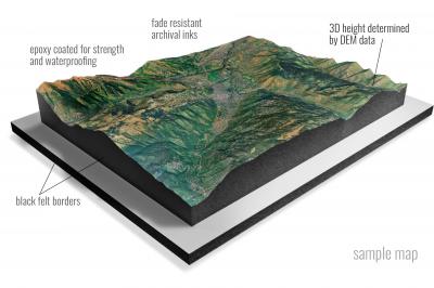
• Raised-relief 3D Height Determined by DEM data
• Fade Resistant Archival Inks
• Epoxy Coated for Strength and Waterproofing
• Ready to Hang with Pre-Installed Hardware (optional)
• Extraordinary 3D Accuracy
• Black Felt Borders
Enrich your office decor or home with a 3D Satellite Raised Relief Map. These raised relief maps are not flat. They are three-dimensional, with the height being determined by Digital Elevation Model (DEM) data. Many people struggle with reading 2D satellite maps, but everyone understands 3D raised relief maps. The realism is phenomenal.
This 3D satellite raised relief map is built by combining satellite imagery data from Google Earth, bounding box coordinates from USGS, and DEM data. 3D Printing and 3D CNC routers are used to fabricate the models which make the satellite models extremely accurate. These models are strong - they are coated with epoxy, then finished with a sealer providing a weatherproof matt-finish. These are not meant to be used in direct sunlight.
Ada, Minnesota- Map Components- Imagery: Satellite of Ada, Minnesota. Bounding Box: Footprint of Ada, Minnesota at Longitude/Latitude Coordinates (-96.625 x -96.5 x 47.375 x 47.25).
Ada NW, Minnesota- Map Components- Imagery: Satellite of Ada NW, Minnesota. Bounding Box: Footprint of Ada NW, Minnesota at Longitude/Latitude Coordinates (-96.75 x -96.625 x 47.5 x 47.375).
Adams, Minnesota- Map Components- Imagery: Satellite of Adams, Minnesota. Bounding Box: Footprint of Adams, Minnesota at Longitude/Latitude Coordinates (-92.75 x -92.625 x 43.625 x 43.5).
Adolph, Minnesota- Map Components- Imagery: Satellite of Adolph, Minnesota. Bounding Box: Footprint of Adolph, Minnesota at Longitude/Latitude Coordinates (-92.375 x -92.25 x 46.875 x 46.75).
Adrian, Minnesota- Map Components- Imagery: Satellite of Adrian, Minnesota. Bounding Box: Footprint of Adrian, Minnesota at Longitude/Latitude Coordinates (-96 x -95.875 x 43.75 x 43.625).
Adrian NE, Minnesota- Map Components- Imagery: Satellite of Adrian NE, Minnesota. Bounding Box: Footprint of Adrian NE, Minnesota at Longitude/Latitude Coordinates (-95.875 x -95.75 x 43.75 x 43.625).
Adrian SW, Minnesota- Map Components- Imagery: Satellite of Adrian SW, Minnesota. Bounding Box: Footprint of Adrian SW, Minnesota at Longitude/Latitude Coordinates (-96 x -95.875 x 43.625 x 43.5).
Aitkin, Minnesota- Map Components- Imagery: Satellite of Aitkin, Minnesota. Bounding Box: Footprint of Aitkin, Minnesota at Longitude/Latitude Coordinates (-93.75 x -93.625 x 46.625 x 46.5).
Akeley, Minnesota- Map Components- Imagery: Satellite of Akeley, Minnesota. Bounding Box: Footprint of Akeley, Minnesota at Longitude/Latitude Coordinates (-94.75 x -94.625 x 47.125 x 47).
Albany, Minnesota- Map Components- Imagery: Satellite of Albany, Minnesota. Bounding Box: Footprint of Albany, Minnesota at Longitude/Latitude Coordinates (-94.625 x -94.5 x 45.75 x 45.625).
Albert Lea East, Minnesota- Map Components- Imagery: Satellite of Albert Lea East, Minnesota. Bounding Box: Footprint of Albert Lea East, Minnesota at Longitude/Latitude Coordinates (-93.375 x -93.25 x 43.75 x 43.625).
Albert Lea West, Minnesota- Map Components- Imagery: Satellite of Albert Lea West, Minnesota. Bounding Box: Footprint of Albert Lea West, Minnesota at Longitude/Latitude Coordinates (-93.5 x -93.375 x 43.75 x 43.625).
Alberta, Minnesota- Map Components- Imagery: Satellite of Alberta, Minnesota. Bounding Box: Footprint of Alberta, Minnesota at Longitude/Latitude Coordinates (-96.125 x -96 x 45.625 x 45.5).
Albion Center, Minnesota- Map Components- Imagery: Satellite of Albion Center, Minnesota. Bounding Box: Footprint of Albion Center, Minnesota at Longitude/Latitude Coordinates (-94.125 x -94 x 45.25 x 45.125).
Alborn, Minnesota- Map Components- Imagery: Satellite of Alborn, Minnesota. Bounding Box: Footprint of Alborn, Minnesota at Longitude/Latitude Coordinates (-92.625 x -92.5 x 47 x 46.875).
Alden, Minnesota- Map Components- Imagery: Satellite of Alden, Minnesota. Bounding Box: Footprint of Alden, Minnesota at Longitude/Latitude Coordinates (-93.625 x -93.5 x 43.75 x 43.625).
Aldrich North, Minnesota- Map Components- Imagery: Satellite of Aldrich North, Minnesota. Bounding Box: Footprint of Aldrich North, Minnesota at Longitude/Latitude Coordinates (-95 x -94.875 x 46.5 x 46.375).
Aldrich South, Minnesota- Map Components- Imagery: Satellite of Aldrich South, Minnesota. Bounding Box: Footprint of Aldrich South, Minnesota at Longitude/Latitude Coordinates (-95 x -94.875 x 46.375 x 46.25).
Alexandria East, Minnesota- Map Components- Imagery: Satellite of Alexandria East, Minnesota. Bounding Box: Footprint of Alexandria East, Minnesota at Longitude/Latitude Coordinates (-95.375 x -95.25 x 46 x 45.875).
Alexandria West, Minnesota- Map Components- Imagery: Satellite of Alexandria West, Minnesota. Bounding Box: Footprint of Alexandria West, Minnesota at Longitude/Latitude Coordinates (-95.5 x -95.375 x 46 x 45.875).
Alice Lake, Minnesota- Map Components- Imagery: Satellite of Alice Lake, Minnesota. Bounding Box: Footprint of Alice Lake, Minnesota at Longitude/Latitude Coordinates (-91.25 x -91.125 x 48 x 47.875).
Alida, Minnesota- Map Components- Imagery: Satellite of Alida, Minnesota. Bounding Box: Footprint of Alida, Minnesota at Longitude/Latitude Coordinates (-95.25 x -95.125 x 47.5 x 47.375).
Allen, Minnesota- Map Components- Imagery: Satellite of Allen, Minnesota. Bounding Box: Footprint of Allen, Minnesota at Longitude/Latitude Coordinates (-92.125 x -92 x 47.625 x 47.5).
Alpha, Minnesota- Map Components- Imagery: Satellite of Alpha, Minnesota. Bounding Box: Footprint of Alpha, Minnesota at Longitude/Latitude Coordinates (-94.875 x -94.75 x 43.75 x 43.625).
Altura, Minnesota- Map Components- Imagery: Satellite of Altura, Minnesota. Bounding Box: Footprint of Altura, Minnesota at Longitude/Latitude Coordinates (-92 x -91.875 x 44.125 x 44).
Alvarado, Minnesota- Map Components- Imagery: Satellite of Alvarado, Minnesota. Bounding Box: Footprint of Alvarado, Minnesota at Longitude/Latitude Coordinates (-97 x -96.875 x 48.25 x 48.125).
Alvwood, Minnesota- Map Components- Imagery: Satellite of Alvwood, Minnesota. Bounding Box: Footprint of Alvwood, Minnesota at Longitude/Latitude Coordinates (-94.375 x -94.25 x 47.75 x 47.625).
Amboy, Minnesota- Map Components- Imagery: Satellite of Amboy, Minnesota. Bounding Box: Footprint of Amboy, Minnesota at Longitude/Latitude Coordinates (-94.25 x -94.125 x 44 x 43.875).
Amiret, Minnesota- Map Components- Imagery: Satellite of Amiret, Minnesota. Bounding Box: Footprint of Amiret, Minnesota at Longitude/Latitude Coordinates (-95.75 x -95.625 x 44.375 x 44.25).
Anchor Hill, Minnesota- Map Components- Imagery: Satellite of Anchor Hill, Minnesota. Bounding Box: Footprint of Anchor Hill, Minnesota at Longitude/Latitude Coordinates (-95.375 x -95.25 x 47.25 x 47.125).
Anderson Lake, Minnesota- Map Components- Imagery: Satellite of Anderson Lake, Minnesota. Bounding Box: Footprint of Anderson Lake, Minnesota at Longitude/Latitude Coordinates (-93.5 x -93.375 x 47.75 x 47.625).
Andrusia Lake, Minnesota- Map Components- Imagery: Satellite of Andrusia Lake, Minnesota. Bounding Box: Footprint of Andrusia Lake, Minnesota at Longitude/Latitude Coordinates (-94.75 x -94.625 x 47.5 x 47.375).
Angle Inlet, Minnesota- Map Components- Imagery: Satellite of Angle Inlet, Minnesota. Bounding Box: Footprint of Angle Inlet, Minnesota at Longitude/Latitude Coordinates (-95.125 x -95 x 49.375 x 49.25).
Angle Inlet SW, Minnesota- Map Components- Imagery: Satellite of Angle Inlet SW, Minnesota. Bounding Box: Footprint of Angle Inlet SW, Minnesota at Longitude/Latitude Coordinates (-95.25 x -95.125 x 49.375 x 49.25).
Angle Inlet SW OE N, Minnesota- Map Components- Imagery: Satellite of Angle Inlet SW OE N, Minnesota. Bounding Box: Footprint of Angle Inlet SW OE N, Minnesota at Longitude/Latitude Coordinates (-95.25 x -95.125 x 49.5 x 49.375).
Angleworm Lake, Minnesota- Map Components- Imagery: Satellite of Angleworm Lake, Minnesota. Bounding Box: Footprint of Angleworm Lake, Minnesota at Longitude/Latitude Coordinates (-92 x -91.875 x 48.125 x 48).
Angus, Minnesota- Map Components- Imagery: Satellite of Angus, Minnesota. Bounding Box: Footprint of Angus, Minnesota at Longitude/Latitude Coordinates (-96.75 x -96.625 x 48.125 x 48).
Angus SE, Minnesota- Map Components- Imagery: Satellite of Angus SE, Minnesota. Bounding Box: Footprint of Angus SE, Minnesota at Longitude/Latitude Coordinates (-96.625 x -96.5 x 48.125 x 48).
Ann Lake, Minnesota- Map Components- Imagery: Satellite of Ann Lake, Minnesota. Bounding Box: Footprint of Ann Lake, Minnesota at Longitude/Latitude Coordinates (-93.5 x -93.375 x 46 x 45.875).
Annandale, Minnesota- Map Components- Imagery: Satellite of Annandale, Minnesota. Bounding Box: Footprint of Annandale, Minnesota at Longitude/Latitude Coordinates (-94.125 x -94 x 45.375 x 45.25).
Anoka, Minnesota- Map Components- Imagery: Satellite of Anoka, Minnesota. Bounding Box: Footprint of Anoka, Minnesota at Longitude/Latitude Coordinates (-93.5 x -93.375 x 45.25 x 45.125).
Anthony, Minnesota- Map Components- Imagery: Satellite of Anthony, Minnesota. Bounding Box: Footprint of Anthony, Minnesota at Longitude/Latitude Coordinates (-96.75 x -96.625 x 47.375 x 47.25).
Appleton, Minnesota- Map Components- Imagery: Satellite of Appleton, Minnesota. Bounding Box: Footprint of Appleton, Minnesota at Longitude/Latitude Coordinates (-96.125 x -96 x 45.25 x 45.125).
Arco, Minnesota- Map Components- Imagery: Satellite of Arco, Minnesota. Bounding Box: Footprint of Arco, Minnesota at Longitude/Latitude Coordinates (-96.25 x -96.125 x 44.5 x 44.375).
Arendahl, Minnesota- Map Components- Imagery: Satellite of Arendahl, Minnesota. Bounding Box: Footprint of Arendahl, Minnesota at Longitude/Latitude Coordinates (-92 x -91.875 x 43.875 x 43.75).
Argyle, Minnesota- Map Components- Imagery: Satellite of Argyle, Minnesota. Bounding Box: Footprint of Argyle, Minnesota at Longitude/Latitude Coordinates (-96.875 x -96.75 x 48.375 x 48.25).
Arlington, Minnesota- Map Components- Imagery: Satellite of Arlington, Minnesota. Bounding Box: Footprint of Arlington, Minnesota at Longitude/Latitude Coordinates (-94.125 x -94 x 44.625 x 44.5).
Arnold, Minnesota- Map Components- Imagery: Satellite of Arnold, Minnesota. Bounding Box: Footprint of Arnold, Minnesota at Longitude/Latitude Coordinates (-92.125 x -92 x 47 x 46.875).
Arthyde, Minnesota- Map Components- Imagery: Satellite of Arthyde, Minnesota. Bounding Box: Footprint of Arthyde, Minnesota at Longitude/Latitude Coordinates (-93.125 x -93 x 46.375 x 46.25).
Artichoke Lake, Minnesota- Map Components- Imagery: Satellite of Artichoke Lake, Minnesota. Bounding Box: Footprint of Artichoke Lake, Minnesota at Longitude/Latitude Coordinates (-96.25 x -96.125 x 45.375 x 45.25).
Artichoke Lake NW, Minnesota- Map Components- Imagery: Satellite of Artichoke Lake NW, Minnesota. Bounding Box: Footprint of Artichoke Lake NW, Minnesota at Longitude/Latitude Coordinates (-96.25 x -96.125 x 45.5 x 45.375).
Asbury, Minnesota- Map Components- Imagery: Satellite of Asbury, Minnesota. Bounding Box: Footprint of Asbury, Minnesota at Longitude/Latitude Coordinates (-95.625 x -95.5 x 45 x 44.875).
Ash Creek, Minnesota- Map Components- Imagery: Satellite of Ash Creek, Minnesota. Bounding Box: Footprint of Ash Creek, Minnesota at Longitude/Latitude Coordinates (-96.25 x -96.125 x 43.625 x 43.5).
Ash Lake, Minnesota- Map Components- Imagery: Satellite of Ash Lake, Minnesota. Bounding Box: Footprint of Ash Lake, Minnesota at Longitude/Latitude Coordinates (-93 x -92.875 x 48.25 x 48.125).
Ash River NE, Minnesota- Map Components- Imagery: Satellite of Ash River NE, Minnesota. Bounding Box: Footprint of Ash River NE, Minnesota at Longitude/Latitude Coordinates (-92.875 x -92.75 x 48.5 x 48.375).
Ash River SE, Minnesota- Map Components- Imagery: Satellite of Ash River SE, Minnesota. Bounding Box: Footprint of Ash River SE, Minnesota at Longitude/Latitude Coordinates (-92.875 x -92.75 x 48.375 x 48.25).
Ash River SW, Minnesota- Map Components- Imagery: Satellite of Ash River SW, Minnesota. Bounding Box: Footprint of Ash River SW, Minnesota at Longitude/Latitude Coordinates (-93 x -92.875 x 48.375 x 48.25).
Ashby, Minnesota- Map Components- Imagery: Satellite of Ashby, Minnesota. Bounding Box: Footprint of Ashby, Minnesota at Longitude/Latitude Coordinates (-95.875 x -95.75 x 46.125 x 46).
Askov Lookout Tower, Minnesota- Map Components- Imagery: Satellite of Askov Lookout Tower, Minnesota. Bounding Box: Footprint of Askov Lookout Tower, Minnesota at Longitude/Latitude Coordinates (-92.75 x -92.625 x 46.25 x 46.125).
Astrid Lake, Minnesota- Map Components- Imagery: Satellite of Astrid Lake, Minnesota. Bounding Box: Footprint of Astrid Lake, Minnesota at Longitude/Latitude Coordinates (-92.375 x -92.25 x 48.125 x 48).
Atkinson, Minnesota- Map Components- Imagery: Satellite of Atkinson, Minnesota. Bounding Box: Footprint of Atkinson, Minnesota at Longitude/Latitude Coordinates (-92.625 x -92.5 x 46.625 x 46.5).
Atwater, Minnesota- Map Components- Imagery: Satellite of Atwater, Minnesota. Bounding Box: Footprint of Atwater, Minnesota at Longitude/Latitude Coordinates (-94.875 x -94.75 x 45.25 x 45.125).
Audubon, Minnesota- Map Components- Imagery: Satellite of Audubon, Minnesota. Bounding Box: Footprint of Audubon, Minnesota at Longitude/Latitude Coordinates (-96 x -95.875 x 46.875 x 46.75).
Aure, Minnesota- Map Components- Imagery: Satellite of Aure, Minnesota. Bounding Box: Footprint of Aure, Minnesota at Longitude/Latitude Coordinates (-95.125 x -95 x 47.75 x 47.625).
Aurora, Minnesota- Map Components- Imagery: Satellite of Aurora, Minnesota. Bounding Box: Footprint of Aurora, Minnesota at Longitude/Latitude Coordinates (-92.25 x -92.125 x 47.625 x 47.5).
Austin East, Minnesota- Map Components- Imagery: Satellite of Austin East, Minnesota. Bounding Box: Footprint of Austin East, Minnesota at Longitude/Latitude Coordinates (-93 x -92.875 x 43.75 x 43.625).
Austin West, Minnesota- Map Components- Imagery: Satellite of Austin West, Minnesota. Bounding Box: Footprint of Austin West, Minnesota at Longitude/Latitude Coordinates (-93.125 x -93 x 43.75 x 43.625).
Automba, Minnesota- Map Components- Imagery: Satellite of Automba, Minnesota. Bounding Box: Footprint of Automba, Minnesota at Longitude/Latitude Coordinates (-93.125 x -93 x 46.625 x 46.5).
Avoca, Minnesota- Map Components- Imagery: Satellite of Avoca, Minnesota. Bounding Box: Footprint of Avoca, Minnesota at Longitude/Latitude Coordinates (-95.75 x -95.625 x 44 x 43.875).
Avon, Minnesota- Map Components- Imagery: Satellite of Avon, Minnesota. Bounding Box: Footprint of Avon, Minnesota at Longitude/Latitude Coordinates (-94.5 x -94.375 x 45.625 x 45.5).
Babbitt, Minnesota- Map Components- Imagery: Satellite of Babbitt, Minnesota. Bounding Box: Footprint of Babbitt, Minnesota at Longitude/Latitude Coordinates (-92 x -91.875 x 47.75 x 47.625).
Babbitt NE, Minnesota- Map Components- Imagery: Satellite of Babbitt NE, Minnesota. Bounding Box: Footprint of Babbitt NE, Minnesota at Longitude/Latitude Coordinates (-91.875 x -91.75 x 47.75 x 47.625).
Babbitt SE, Minnesota- Map Components- Imagery: Satellite of Babbitt SE, Minnesota. Bounding Box: Footprint of Babbitt SE, Minnesota at Longitude/Latitude Coordinates (-91.875 x -91.75 x 47.625 x 47.5).
Babbitt SW, Minnesota- Map Components- Imagery: Satellite of Babbitt SW, Minnesota. Bounding Box: Footprint of Babbitt SW, Minnesota at Longitude/Latitude Coordinates (-92 x -91.875 x 47.625 x 47.5).
Backus, Minnesota- Map Components- Imagery: Satellite of Backus, Minnesota. Bounding Box: Footprint of Backus, Minnesota at Longitude/Latitude Coordinates (-94.625 x -94.5 x 46.875 x 46.75).
Badger, Minnesota- Map Components- Imagery: Satellite of Badger, Minnesota. Bounding Box: Footprint of Badger, Minnesota at Longitude/Latitude Coordinates (-96.125 x -96 x 48.875 x 48.75).
Badger NE, Minnesota- Map Components- Imagery: Satellite of Badger NE, Minnesota. Bounding Box: Footprint of Badger NE, Minnesota at Longitude/Latitude Coordinates (-96.125 x -96 x 49 x 48.875).
Badger NE OE N, Minnesota- Map Components- Imagery: Satellite of Badger NE OE N, Minnesota. Bounding Box: Footprint of Badger NE OE N, Minnesota at Longitude/Latitude Coordinates (-96.125 x -96 x 49.125 x 49).
Badger NW, Minnesota- Map Components- Imagery: Satellite of Badger NW, Minnesota. Bounding Box: Footprint of Badger NW, Minnesota at Longitude/Latitude Coordinates (-96.25 x -96.125 x 49 x 48.875).
Bagley, Minnesota- Map Components- Imagery: Satellite of Bagley, Minnesota. Bounding Box: Footprint of Bagley, Minnesota at Longitude/Latitude Coordinates (-95.5 x -95.375 x 47.625 x 47.5).
Bagley Lake, Minnesota- Map Components- Imagery: Satellite of Bagley Lake, Minnesota. Bounding Box: Footprint of Bagley Lake, Minnesota at Longitude/Latitude Coordinates (-95.25 x -95.125 x 47.875 x 47.75).
Bagley Lake OE N, Minnesota- Map Components- Imagery: Satellite of Bagley Lake OE N, Minnesota. Bounding Box: Footprint of Bagley Lake OE N, Minnesota at Longitude/Latitude Coordinates (-95.25 x -95.125 x 48 x 47.875).
Bailey Lake, Minnesota- Map Components- Imagery: Satellite of Bailey Lake, Minnesota. Bounding Box: Footprint of Bailey Lake, Minnesota at Longitude/Latitude Coordinates (-95.5 x -95.375 x 48 x 47.875).
Bain, Minnesota- Map Components- Imagery: Satellite of Bain, Minnesota. Bounding Box: Footprint of Bain, Minnesota at Longitude/Latitude Coordinates (-93.625 x -93.5 x 46.875 x 46.75).
Baker, Minnesota- Map Components- Imagery: Satellite of Baker, Minnesota. Bounding Box: Footprint of Baker, Minnesota at Longitude/Latitude Coordinates (-96.625 x -96.5 x 46.75 x 46.625).
Balaton, Minnesota- Map Components- Imagery: Satellite of Balaton, Minnesota. Bounding Box: Footprint of Balaton, Minnesota at Longitude/Latitude Coordinates (-95.875 x -95.75 x 44.25 x 44.125).
Balaton SW, Minnesota- Map Components- Imagery: Satellite of Balaton SW, Minnesota. Bounding Box: Footprint of Balaton SW, Minnesota at Longitude/Latitude Coordinates (-96 x -95.875 x 44.125 x 44).
Ball Bluff, Minnesota- Map Components- Imagery: Satellite of Ball Bluff, Minnesota. Bounding Box: Footprint of Ball Bluff, Minnesota at Longitude/Latitude Coordinates (-93.375 x -93.25 x 47 x 46.875).
Ball Club, Minnesota- Map Components- Imagery: Satellite of Ball Club, Minnesota. Bounding Box: Footprint of Ball Club, Minnesota at Longitude/Latitude Coordinates (-94 x -93.875 x 47.375 x 47.25).
Balsam, Minnesota- Map Components- Imagery: Satellite of Balsam, Minnesota. Bounding Box: Footprint of Balsam, Minnesota at Longitude/Latitude Coordinates (-93.25 x -93.125 x 46.875 x 46.75).
Balsam Lake, Minnesota- Map Components- Imagery: Satellite of Balsam Lake, Minnesota. Bounding Box: Footprint of Balsam Lake, Minnesota at Longitude/Latitude Coordinates (-93.5 x -93.375 x 47.625 x 47.5).
Barnesville, Minnesota- Map Components- Imagery: Satellite of Barnesville, Minnesota. Bounding Box: Footprint of Barnesville, Minnesota at Longitude/Latitude Coordinates (-96.5 x -96.375 x 46.75 x 46.625).
Barnesville SW, Minnesota- Map Components- Imagery: Satellite of Barnesville SW, Minnesota. Bounding Box: Footprint of Barnesville SW, Minnesota at Longitude/Latitude Coordinates (-96.5 x -96.375 x 46.625 x 46.5).
Barnum, Minnesota- Map Components- Imagery: Satellite of Barnum, Minnesota. Bounding Box: Footprint of Barnum, Minnesota at Longitude/Latitude Coordinates (-92.75 x -92.625 x 46.625 x 46.5).
Barrs Lake, Minnesota- Map Components- Imagery: Satellite of Barrs Lake, Minnesota. Bounding Box: Footprint of Barrs Lake, Minnesota at Longitude/Latitude Coordinates (-92 x -91.875 x 47.125 x 47).
Barry, Minnesota- Map Components- Imagery: Satellite of Barry, Minnesota. Bounding Box: Footprint of Barry, Minnesota at Longitude/Latitude Coordinates (-96.625 x -96.5 x 45.625 x 45.5).
Bass Creek, Minnesota- Map Components- Imagery: Satellite of Bass Creek, Minnesota. Bounding Box: Footprint of Bass Creek, Minnesota at Longitude/Latitude Coordinates (-92.875 x -92.75 x 45.875 x 45.75).
Basswood Lake East, Minnesota- Map Components- Imagery: Satellite of Basswood Lake East, Minnesota. Bounding Box: Footprint of Basswood Lake East, Minnesota at Longitude/Latitude Coordinates (-91.625 x -91.5 x 48.125 x 48).
Basswood Lake West, Minnesota- Map Components- Imagery: Satellite of Basswood Lake West, Minnesota. Bounding Box: Footprint of Basswood Lake West, Minnesota at Longitude/Latitude Coordinates (-91.75 x -91.625 x 48.125 x 48).
Battle Lake, Minnesota- Map Components- Imagery: Satellite of Battle Lake, Minnesota. Bounding Box: Footprint of Battle Lake, Minnesota at Longitude/Latitude Coordinates (-95.75 x -95.625 x 46.375 x 46.25).
Baudette, Minnesota- Map Components- Imagery: Satellite of Baudette, Minnesota. Bounding Box: Footprint of Baudette, Minnesota at Longitude/Latitude Coordinates (-94.625 x -94.5 x 48.75 x 48.625).
Baudette SE, Minnesota- Map Components- Imagery: Satellite of Baudette SE, Minnesota. Bounding Box: Footprint of Baudette SE, Minnesota at Longitude/Latitude Coordinates (-94.625 x -94.5 x 48.625 x 48.5).
Baudette SW, Minnesota- Map Components- Imagery: Satellite of Baudette SW, Minnesota. Bounding Box: Footprint of Baudette SW, Minnesota at Longitude/Latitude Coordinates (-94.75 x -94.625 x 48.625 x 48.5).
Baxter, Minnesota- Map Components- Imagery: Satellite of Baxter, Minnesota. Bounding Box: Footprint of Baxter, Minnesota at Longitude/Latitude Coordinates (-94.375 x -94.25 x 46.375 x 46.25).
Bay Lake, Minnesota- Map Components- Imagery: Satellite of Bay Lake, Minnesota. Bounding Box: Footprint of Bay Lake, Minnesota at Longitude/Latitude Coordinates (-93.875 x -93.75 x 46.5 x 46.375).
Bear Island, Minnesota- Map Components- Imagery: Satellite of Bear Island, Minnesota. Bounding Box: Footprint of Bear Island, Minnesota at Longitude/Latitude Coordinates (-92 x -91.875 x 47.875 x 47.75).
Bear River, Minnesota- Map Components- Imagery: Satellite of Bear River, Minnesota. Bounding Box: Footprint of Bear River, Minnesota at Longitude/Latitude Coordinates (-93.125 x -93 x 47.875 x 47.75).
Beardsley, Minnesota- Map Components- Imagery: Satellite of Beardsley, Minnesota. Bounding Box: Footprint of Beardsley, Minnesota at Longitude/Latitude Coordinates (-96.75 x -96.625 x 45.625 x 45.5).
Beardsley NE, Minnesota- Map Components- Imagery: Satellite of Beardsley NE, Minnesota. Bounding Box: Footprint of Beardsley NE, Minnesota at Longitude/Latitude Coordinates (-96.625 x -96.5 x 45.75 x 45.625).
Beardsley NW, Minnesota- Map Components- Imagery: Satellite of Beardsley NW, Minnesota. Bounding Box: Footprint of Beardsley NW, Minnesota at Longitude/Latitude Coordinates (-96.75 x -96.625 x 45.75 x 45.625).
Beauford, Minnesota- Map Components- Imagery: Satellite of Beauford, Minnesota. Bounding Box: Footprint of Beauford, Minnesota at Longitude/Latitude Coordinates (-94 x -93.875 x 44.125 x 44).
Beaulieu, Minnesota- Map Components- Imagery: Satellite of Beaulieu, Minnesota. Bounding Box: Footprint of Beaulieu, Minnesota at Longitude/Latitude Coordinates (-95.875 x -95.75 x 47.375 x 47.25).
Beaver, Minnesota- Map Components- Imagery: Satellite of Beaver, Minnesota. Bounding Box: Footprint of Beaver, Minnesota at Longitude/Latitude Coordinates (-92.125 x -92 x 44.25 x 44.125).
Bechyn, Minnesota- Map Components- Imagery: Satellite of Bechyn, Minnesota. Bounding Box: Footprint of Bechyn, Minnesota at Longitude/Latitude Coordinates (-95.125 x -95 x 44.75 x 44.625).
Becker, Minnesota- Map Components- Imagery: Satellite of Becker, Minnesota. Bounding Box: Footprint of Becker, Minnesota at Longitude/Latitude Coordinates (-93.875 x -93.75 x 45.5 x 45.375).
Bejou, Minnesota- Map Components- Imagery: Satellite of Bejou, Minnesota. Bounding Box: Footprint of Bejou, Minnesota at Longitude/Latitude Coordinates (-96 x -95.875 x 47.5 x 47.375).
Belgrade, Minnesota- Map Components- Imagery: Satellite of Belgrade, Minnesota. Bounding Box: Footprint of Belgrade, Minnesota at Longitude/Latitude Coordinates (-95.125 x -95 x 45.5 x 45.375).
Belle Plaine North, Minnesota- Map Components- Imagery: Satellite of Belle Plaine North, Minnesota. Bounding Box: Footprint of Belle Plaine North, Minnesota at Longitude/Latitude Coordinates (-93.875 x -93.75 x 44.75 x 44.625).
Belle Plaine South, Minnesota- Map Components- Imagery: Satellite of Belle Plaine South, Minnesota. Bounding Box: Footprint of Belle Plaine South, Minnesota at Longitude/Latitude Coordinates (-93.875 x -93.75 x 44.625 x 44.5).
Belle Prairie, Minnesota- Map Components- Imagery: Satellite of Belle Prairie, Minnesota. Bounding Box: Footprint of Belle Prairie, Minnesota at Longitude/Latitude Coordinates (-94.375 x -94.25 x 46.125 x 46).
Belle Prairie NW, Minnesota- Map Components- Imagery: Satellite of Belle Prairie NW, Minnesota. Bounding Box: Footprint of Belle Prairie NW, Minnesota at Longitude/Latitude Coordinates (-94.5 x -94.375 x 46.25 x 46.125).
Bellingham, Minnesota- Map Components- Imagery: Satellite of Bellingham, Minnesota. Bounding Box: Footprint of Bellingham, Minnesota at Longitude/Latitude Coordinates (-96.375 x -96.25 x 45.25 x 45.125).
Beltrami, Minnesota- Map Components- Imagery: Satellite of Beltrami, Minnesota. Bounding Box: Footprint of Beltrami, Minnesota at Longitude/Latitude Coordinates (-96.625 x -96.5 x 47.625 x 47.5).
Beltrami SW, Minnesota- Map Components- Imagery: Satellite of Beltrami SW, Minnesota. Bounding Box: Footprint of Beltrami SW, Minnesota at Longitude/Latitude Coordinates (-96.75 x -96.625 x 47.625 x 47.5).
Belview, Minnesota- Map Components- Imagery: Satellite of Belview, Minnesota. Bounding Box: Footprint of Belview, Minnesota at Longitude/Latitude Coordinates (-95.375 x -95.25 x 44.625 x 44.5).
Bemidji East, Minnesota- Map Components- Imagery: Satellite of Bemidji East, Minnesota. Bounding Box: Footprint of Bemidji East, Minnesota at Longitude/Latitude Coordinates (-94.875 x -94.75 x 47.5 x 47.375).
Bemidji West, Minnesota- Map Components- Imagery: Satellite of Bemidji West, Minnesota. Bounding Box: Footprint of Bemidji West, Minnesota at Longitude/Latitude Coordinates (-95 x -94.875 x 47.5 x 47.375).
Bena, Minnesota- Map Components- Imagery: Satellite of Bena, Minnesota. Bounding Box: Footprint of Bena, Minnesota at Longitude/Latitude Coordinates (-94.25 x -94.125 x 47.375 x 47.25).
Bena NW, Minnesota- Map Components- Imagery: Satellite of Bena NW, Minnesota. Bounding Box: Footprint of Bena NW, Minnesota at Longitude/Latitude Coordinates (-94.25 x -94.125 x 47.5 x 47.375).
Benedict, Minnesota- Map Components- Imagery: Satellite of Benedict, Minnesota. Bounding Box: Footprint of Benedict, Minnesota at Longitude/Latitude Coordinates (-94.75 x -94.625 x 47.25 x 47.125).
Benson, Minnesota- Map Components- Imagery: Satellite of Benson, Minnesota. Bounding Box: Footprint of Benson, Minnesota at Longitude/Latitude Coordinates (-95.625 x -95.5 x 45.375 x 45.25).
Bergen, Minnesota- Map Components- Imagery: Satellite of Bergen, Minnesota. Bounding Box: Footprint of Bergen, Minnesota at Longitude/Latitude Coordinates (-95 x -94.875 x 43.875 x 43.75).
Bernadotte, Minnesota- Map Components- Imagery: Satellite of Bernadotte, Minnesota. Bounding Box: Footprint of Bernadotte, Minnesota at Longitude/Latitude Coordinates (-94.375 x -94.25 x 44.5 x 44.375).
Berner, Minnesota- Map Components- Imagery: Satellite of Berner, Minnesota. Bounding Box: Footprint of Berner, Minnesota at Longitude/Latitude Coordinates (-95.5 x -95.375 x 47.875 x 47.75).
Berner NE, Minnesota- Map Components- Imagery: Satellite of Berner NE, Minnesota. Bounding Box: Footprint of Berner NE, Minnesota at Longitude/Latitude Coordinates (-95.375 x -95.25 x 48 x 47.875).
Beroun, Minnesota- Map Components- Imagery: Satellite of Beroun, Minnesota. Bounding Box: Footprint of Beroun, Minnesota at Longitude/Latitude Coordinates (-93 x -92.875 x 46 x 45.875).
Bertha, Minnesota- Map Components- Imagery: Satellite of Bertha, Minnesota. Bounding Box: Footprint of Bertha, Minnesota at Longitude/Latitude Coordinates (-95.125 x -95 x 46.375 x 46.25).
Beth Lake, Minnesota- Map Components- Imagery: Satellite of Beth Lake, Minnesota. Bounding Box: Footprint of Beth Lake, Minnesota at Longitude/Latitude Coordinates (-91 x -90.875 x 47.875 x 47.75).
Big Basswood Lake, Minnesota- Map Components- Imagery: Satellite of Big Basswood Lake, Minnesota. Bounding Box: Footprint of Big Basswood Lake, Minnesota at Longitude/Latitude Coordinates (-95.375 x -95.25 x 47.125 x 47).
Big Bend City, Minnesota- Map Components- Imagery: Satellite of Big Bend City, Minnesota. Bounding Box: Footprint of Big Bend City, Minnesota at Longitude/Latitude Coordinates (-95.875 x -95.75 x 45.25 x 45.125).
Big Cormorant Lake, Minnesota- Map Components- Imagery: Satellite of Big Cormorant Lake, Minnesota. Bounding Box: Footprint of Big Cormorant Lake, Minnesota at Longitude/Latitude Coordinates (-96.125 x -96 x 46.875 x 46.75).
Big Falls, Minnesota- Map Components- Imagery: Satellite of Big Falls, Minnesota. Bounding Box: Footprint of Big Falls, Minnesota at Longitude/Latitude Coordinates (-93.875 x -93.75 x 48.25 x 48.125).
Big Falls NW, Minnesota- Map Components- Imagery: Satellite of Big Falls NW, Minnesota. Bounding Box: Footprint of Big Falls NW, Minnesota at Longitude/Latitude Coordinates (-94 x -93.875 x 48.25 x 48.125).
Big Falls SE, Minnesota- Map Components- Imagery: Satellite of Big Falls SE, Minnesota. Bounding Box: Footprint of Big Falls SE, Minnesota at Longitude/Latitude Coordinates (-93.875 x -93.75 x 48.125 x 48).
Big Lake, Minnesota- Map Components- Imagery: Satellite of Big Lake, Minnesota. Bounding Box: Footprint of Big Lake, Minnesota at Longitude/Latitude Coordinates (-93.75 x -93.625 x 45.375 x 45.25).
Big Rush Lake, Minnesota- Map Components- Imagery: Satellite of Big Rush Lake, Minnesota. Bounding Box: Footprint of Big Rush Lake, Minnesota at Longitude/Latitude Coordinates (-95.5 x -95.375 x 47.125 x 47).
Big Slough, Minnesota- Map Components- Imagery: Satellite of Big Slough, Minnesota. Bounding Box: Footprint of Big Slough, Minnesota at Longitude/Latitude Coordinates (-96.375 x -96.25 x 46.75 x 46.625).
Big Stone Lake East, Minnesota- Map Components- Imagery: Satellite of Big Stone Lake East, Minnesota. Bounding Box: Footprint of Big Stone Lake East, Minnesota at Longitude/Latitude Coordinates (-96.625 x -96.5 x 45.5 x 45.375).
Big Stone Lake West, Minnesota- Map Components- Imagery: Satellite of Big Stone Lake West, Minnesota. Bounding Box: Footprint of Big Stone Lake West, Minnesota at Longitude/Latitude Coordinates (-96.75 x -96.625 x 45.5 x 45.375).
Big Thunder Peak, Minnesota- Map Components- Imagery: Satellite of Big Thunder Peak, Minnesota. Bounding Box: Footprint of Big Thunder Peak, Minnesota at Longitude/Latitude Coordinates (-93.75 x -93.625 x 47.125 x 47).
Big Woods, Minnesota- Map Components- Imagery: Satellite of Big Woods, Minnesota. Bounding Box: Footprint of Big Woods, Minnesota at Longitude/Latitude Coordinates (-97.125 x -97 x 48.375 x 48.25).
Big Woods NE, Minnesota- Map Components- Imagery: Satellite of Big Woods NE, Minnesota. Bounding Box: Footprint of Big Woods NE, Minnesota at Longitude/Latitude Coordinates (-97.125 x -97 x 48.5 x 48.375).
Bigelow, Minnesota- Map Components- Imagery: Satellite of Bigelow, Minnesota. Bounding Box: Footprint of Bigelow, Minnesota at Longitude/Latitude Coordinates (-95.75 x -95.625 x 43.625 x 43.5).
Bigfork, Minnesota- Map Components- Imagery: Satellite of Bigfork, Minnesota. Bounding Box: Footprint of Bigfork, Minnesota at Longitude/Latitude Coordinates (-93.75 x -93.625 x 47.75 x 47.625).
Bingham Lake, Minnesota- Map Components- Imagery: Satellite of Bingham Lake, Minnesota. Bounding Box: Footprint of Bingham Lake, Minnesota at Longitude/Latitude Coordinates (-95.125 x -95 x 44 x 43.875).
Birchdale, Minnesota- Map Components- Imagery: Satellite of Birchdale, Minnesota. Bounding Box: Footprint of Birchdale, Minnesota at Longitude/Latitude Coordinates (-94.125 x -94 x 48.75 x 48.625).
Birchdale SE, Minnesota- Map Components- Imagery: Satellite of Birchdale SE, Minnesota. Bounding Box: Footprint of Birchdale SE, Minnesota at Longitude/Latitude Coordinates (-94.125 x -94 x 48.625 x 48.5).
Birchdale SW, Minnesota- Map Components- Imagery: Satellite of Birchdale SW, Minnesota. Bounding Box: Footprint of Birchdale SW, Minnesota at Longitude/Latitude Coordinates (-94.25 x -94.125 x 48.625 x 48.5).
Bird Lake, Minnesota- Map Components- Imagery: Satellite of Bird Lake, Minnesota. Bounding Box: Footprint of Bird Lake, Minnesota at Longitude/Latitude Coordinates (-92.125 x -92 x 47.5 x 47.375).
Biscay, Minnesota- Map Components- Imagery: Satellite of Biscay, Minnesota. Bounding Box: Footprint of Biscay, Minnesota at Longitude/Latitude Coordinates (-94.375 x -94.25 x 44.875 x 44.75).
Biwabik, Minnesota- Map Components- Imagery: Satellite of Biwabik, Minnesota. Bounding Box: Footprint of Biwabik, Minnesota at Longitude/Latitude Coordinates (-92.375 x -92.25 x 47.625 x 47.5).
Biwabik NE, Minnesota- Map Components- Imagery: Satellite of Biwabik NE, Minnesota. Bounding Box: Footprint of Biwabik NE, Minnesota at Longitude/Latitude Coordinates (-92.375 x -92.25 x 47.75 x 47.625).
Biwabik NW, Minnesota- Map Components- Imagery: Satellite of Biwabik NW, Minnesota. Bounding Box: Footprint of Biwabik NW, Minnesota at Longitude/Latitude Coordinates (-92.5 x -92.375 x 47.75 x 47.625).
Bixby, Minnesota- Map Components- Imagery: Satellite of Bixby, Minnesota. Bounding Box: Footprint of Bixby, Minnesota at Longitude/Latitude Coordinates (-93.125 x -93 x 44 x 43.875).
Blackduck, Minnesota- Map Components- Imagery: Satellite of Blackduck, Minnesota. Bounding Box: Footprint of Blackduck, Minnesota at Longitude/Latitude Coordinates (-94.625 x -94.5 x 47.75 x 47.625).
Blind Pig Island, Minnesota- Map Components- Imagery: Satellite of Blind Pig Island, Minnesota. Bounding Box: Footprint of Blind Pig Island, Minnesota at Longitude/Latitude Coordinates (-92.625 x -92.5 x 48.5 x 48.375).
Blomkest, Minnesota- Map Components- Imagery: Satellite of Blomkest, Minnesota. Bounding Box: Footprint of Blomkest, Minnesota at Longitude/Latitude Coordinates (-95.125 x -95 x 45 x 44.875).
Blooming Prairie, Minnesota- Map Components- Imagery: Satellite of Blooming Prairie, Minnesota. Bounding Box: Footprint of Blooming Prairie, Minnesota at Longitude/Latitude Coordinates (-93.125 x -93 x 43.875 x 43.75).
Bloomington, Minnesota- Map Components- Imagery: Satellite of Bloomington, Minnesota. Bounding Box: Footprint of Bloomington, Minnesota at Longitude/Latitude Coordinates (-93.375 x -93.25 x 44.875 x 44.75).
Blue Earth, Minnesota- Map Components- Imagery: Satellite of Blue Earth, Minnesota. Bounding Box: Footprint of Blue Earth, Minnesota at Longitude/Latitude Coordinates (-94.125 x -94 x 43.75 x 43.625).
Blue Grass, Minnesota- Map Components- Imagery: Satellite of Blue Grass, Minnesota. Bounding Box: Footprint of Blue Grass, Minnesota at Longitude/Latitude Coordinates (-95.125 x -95 x 46.625 x 46.5).
Bock, Minnesota- Map Components- Imagery: Satellite of Bock, Minnesota. Bounding Box: Footprint of Bock, Minnesota at Longitude/Latitude Coordinates (-93.625 x -93.5 x 45.875 x 45.75).
Bogberry Lake, Minnesota- Map Components- Imagery: Satellite of Bogberry Lake, Minnesota. Bounding Box: Footprint of Bogberry Lake, Minnesota at Longitude/Latitude Coordinates (-91.75 x -91.625 x 47.875 x 47.75).
Boisberg, Minnesota- Map Components- Imagery: Satellite of Boisberg, Minnesota. Bounding Box: Footprint of Boisberg, Minnesota at Longitude/Latitude Coordinates (-96.625 x -96.5 x 46 x 45.875).
Boise Lake, Minnesota- Map Components- Imagery: Satellite of Boise Lake, Minnesota. Bounding Box: Footprint of Boise Lake, Minnesota at Longitude/Latitude Coordinates (-95 x -94.875 x 44.375 x 44.25).
Bootleg Lake, Minnesota- Map Components- Imagery: Satellite of Bootleg Lake, Minnesota. Bounding Box: Footprint of Bootleg Lake, Minnesota at Longitude/Latitude Coordinates (-92.25 x -92.125 x 48.125 x 48).
Borden Lake, Minnesota- Map Components- Imagery: Satellite of Borden Lake, Minnesota. Bounding Box: Footprint of Borden Lake, Minnesota at Longitude/Latitude Coordinates (-94.625 x -94.5 x 47.875 x 47.75).
Border, Minnesota- Map Components- Imagery: Satellite of Border, Minnesota. Bounding Box: Footprint of Border, Minnesota at Longitude/Latitude Coordinates (-94.375 x -94.25 x 48.75 x 48.625).
Borup, Minnesota- Map Components- Imagery: Satellite of Borup, Minnesota. Bounding Box: Footprint of Borup, Minnesota at Longitude/Latitude Coordinates (-96.625 x -96.5 x 47.25 x 47.125).
Boulder Lake Reservoir, Minnesota- Map Components- Imagery: Satellite of Boulder Lake Reservoir, Minnesota. Bounding Box: Footprint of Boulder Lake Reservoir, Minnesota at Longitude/Latitude Coordinates (-92.25 x -92.125 x 47.125 x 47).
Boulder Lake Reservoir NE, Minnesota- Map Components- Imagery: Satellite of Boulder Lake Reservoir NE, Minnesota. Bounding Box: Footprint of Boulder Lake Reservoir NE, Minnesota at Longitude/Latitude Coordinates (-92.125 x -92 x 47.25 x 47.125).
Bovey, Minnesota- Map Components- Imagery: Satellite of Bovey, Minnesota. Bounding Box: Footprint of Bovey, Minnesota at Longitude/Latitude Coordinates (-93.5 x -93.375 x 47.375 x 47.25).
Bowlus, Minnesota- Map Components- Imagery: Satellite of Bowlus, Minnesota. Bounding Box: Footprint of Bowlus, Minnesota at Longitude/Latitude Coordinates (-94.5 x -94.375 x 45.875 x 45.75).
Bowstring Lake, Minnesota- Map Components- Imagery: Satellite of Bowstring Lake, Minnesota. Bounding Box: Footprint of Bowstring Lake, Minnesota at Longitude/Latitude Coordinates (-94 x -93.875 x 47.625 x 47.5).
Boy River, Minnesota- Map Components- Imagery: Satellite of Boy River, Minnesota. Bounding Box: Footprint of Boy River, Minnesota at Longitude/Latitude Coordinates (-94.125 x -94 x 47.25 x 47.125).
Boyd, Minnesota- Map Components- Imagery: Satellite of Boyd, Minnesota. Bounding Box: Footprint of Boyd, Minnesota at Longitude/Latitude Coordinates (-96 x -95.875 x 44.875 x 44.75).
Bradford, Minnesota- Map Components- Imagery: Satellite of Bradford, Minnesota. Bounding Box: Footprint of Bradford, Minnesota at Longitude/Latitude Coordinates (-93.375 x -93.25 x 45.625 x 45.5).
Braham, Minnesota- Map Components- Imagery: Satellite of Braham, Minnesota. Bounding Box: Footprint of Braham, Minnesota at Longitude/Latitude Coordinates (-93.25 x -93.125 x 45.75 x 45.625).
Brainerd, Minnesota- Map Components- Imagery: Satellite of Brainerd, Minnesota. Bounding Box: Footprint of Brainerd, Minnesota at Longitude/Latitude Coordinates (-94.25 x -94.125 x 46.375 x 46.25).
Brandon, Minnesota- Map Components- Imagery: Satellite of Brandon, Minnesota. Bounding Box: Footprint of Brandon, Minnesota at Longitude/Latitude Coordinates (-95.625 x -95.5 x 46 x 45.875).
Bratsberg, Minnesota- Map Components- Imagery: Satellite of Bratsberg, Minnesota. Bounding Box: Footprint of Bratsberg, Minnesota at Longitude/Latitude Coordinates (-91.875 x -91.75 x 43.75 x 43.625).
Brewster, Minnesota- Map Components- Imagery: Satellite of Brewster, Minnesota. Bounding Box: Footprint of Brewster, Minnesota at Longitude/Latitude Coordinates (-95.5 x -95.375 x 43.75 x 43.625).
Bricelyn, Minnesota- Map Components- Imagery: Satellite of Bricelyn, Minnesota. Bounding Box: Footprint of Bricelyn, Minnesota at Longitude/Latitude Coordinates (-93.875 x -93.75 x 43.625 x 43.5).
Brimson, Minnesota- Map Components- Imagery: Satellite of Brimson, Minnesota. Bounding Box: Footprint of Brimson, Minnesota at Longitude/Latitude Coordinates (-91.875 x -91.75 x 47.375 x 47.25).
Britt, Minnesota- Map Components- Imagery: Satellite of Britt, Minnesota. Bounding Box: Footprint of Britt, Minnesota at Longitude/Latitude Coordinates (-92.625 x -92.5 x 47.75 x 47.625).
Brook Park, Minnesota- Map Components- Imagery: Satellite of Brook Park, Minnesota. Bounding Box: Footprint of Brook Park, Minnesota at Longitude/Latitude Coordinates (-93.125 x -93 x 46 x 45.875).
Brooks, Minnesota- Map Components- Imagery: Satellite of Brooks, Minnesota. Bounding Box: Footprint of Brooks, Minnesota at Longitude/Latitude Coordinates (-96.125 x -96 x 47.875 x 47.75).
Brookston, Minnesota- Map Components- Imagery: Satellite of Brookston, Minnesota. Bounding Box: Footprint of Brookston, Minnesota at Longitude/Latitude Coordinates (-92.625 x -92.5 x 46.875 x 46.75).
Brookston NW, Minnesota- Map Components- Imagery: Satellite of Brookston NW, Minnesota. Bounding Box: Footprint of Brookston NW, Minnesota at Longitude/Latitude Coordinates (-92.75 x -92.625 x 47 x 46.875).
Browerville, Minnesota- Map Components- Imagery: Satellite of Browerville, Minnesota. Bounding Box: Footprint of Browerville, Minnesota at Longitude/Latitude Coordinates (-94.875 x -94.75 x 46.125 x 46).
Browerville NE, Minnesota- Map Components- Imagery: Satellite of Browerville NE, Minnesota. Bounding Box: Footprint of Browerville NE, Minnesota at Longitude/Latitude Coordinates (-94.875 x -94.75 x 46.25 x 46.125).
Browerville SW, Minnesota- Map Components- Imagery: Satellite of Browerville SW, Minnesota. Bounding Box: Footprint of Browerville SW, Minnesota at Longitude/Latitude Coordinates (-95 x -94.875 x 46.125 x 46).
Browns Valley, Minnesota- Map Components- Imagery: Satellite of Browns Valley, Minnesota. Bounding Box: Footprint of Browns Valley, Minnesota at Longitude/Latitude Coordinates (-96.875 x -96.75 x 45.625 x 45.5).
Brownsdale, Minnesota- Map Components- Imagery: Satellite of Brownsdale, Minnesota. Bounding Box: Footprint of Brownsdale, Minnesota at Longitude/Latitude Coordinates (-92.875 x -92.75 x 43.75 x 43.625).
Brownsville, Minnesota- Map Components- Imagery: Satellite of Brownsville, Minnesota. Bounding Box: Footprint of Brownsville, Minnesota at Longitude/Latitude Coordinates (-91.375 x -91.25 x 43.75 x 43.625).
Brownton, Minnesota- Map Components- Imagery: Satellite of Brownton, Minnesota. Bounding Box: Footprint of Brownton, Minnesota at Longitude/Latitude Coordinates (-94.375 x -94.25 x 44.75 x 44.625).
Brule Lake, Minnesota- Map Components- Imagery: Satellite of Brule Lake, Minnesota. Bounding Box: Footprint of Brule Lake, Minnesota at Longitude/Latitude Coordinates (-90.75 x -90.625 x 48 x 47.875).
Bruno, Minnesota- Map Components- Imagery: Satellite of Bruno, Minnesota. Bounding Box: Footprint of Bruno, Minnesota at Longitude/Latitude Coordinates (-92.75 x -92.625 x 46.375 x 46.25).
Brush Creek, Minnesota- Map Components- Imagery: Satellite of Brush Creek, Minnesota. Bounding Box: Footprint of Brush Creek, Minnesota at Longitude/Latitude Coordinates (-93.875 x -93.75 x 43.75 x 43.625).
Buffalo Bay NE, Minnesota- Map Components- Imagery: Satellite of Buffalo Bay NE, Minnesota. Bounding Box: Footprint of Buffalo Bay NE, Minnesota at Longitude/Latitude Coordinates (-95.125 x -95 x 49.25 x 49.125).
Buffalo Bay NW, Minnesota- Map Components- Imagery: Satellite of Buffalo Bay NW, Minnesota. Bounding Box: Footprint of Buffalo Bay NW, Minnesota at Longitude/Latitude Coordinates (-95.25 x -95.125 x 49.25 x 49.125).
Buffalo East, Minnesota- Map Components- Imagery: Satellite of Buffalo East, Minnesota. Bounding Box: Footprint of Buffalo East, Minnesota at Longitude/Latitude Coordinates (-93.875 x -93.75 x 45.25 x 45.125).
Buffalo Lake, Minnesota- Map Components- Imagery: Satellite of Buffalo Lake, Minnesota. Bounding Box: Footprint of Buffalo Lake, Minnesota at Longitude/Latitude Coordinates (-94.625 x -94.5 x 44.75 x 44.625).
Buffalo West, Minnesota- Map Components- Imagery: Satellite of Buffalo West, Minnesota. Bounding Box: Footprint of Buffalo West, Minnesota at Longitude/Latitude Coordinates (-94 x -93.875 x 45.25 x 45.125).
Buhl, Minnesota- Map Components- Imagery: Satellite of Buhl, Minnesota. Bounding Box: Footprint of Buhl, Minnesota at Longitude/Latitude Coordinates (-92.875 x -92.75 x 47.5 x 47.375).
Bungo Creek, Minnesota- Map Components- Imagery: Satellite of Bungo Creek, Minnesota. Bounding Box: Footprint of Bungo Creek, Minnesota at Longitude/Latitude Coordinates (-94.625 x -94.5 x 46.75 x 46.625).
Burgen Lake, Minnesota- Map Components- Imagery: Satellite of Burgen Lake, Minnesota. Bounding Box: Footprint of Burgen Lake, Minnesota at Longitude/Latitude Coordinates (-94.875 x -94.75 x 46.75 x 46.625).
Burtrum, Minnesota- Map Components- Imagery: Satellite of Burtrum, Minnesota. Bounding Box: Footprint of Burtrum, Minnesota at Longitude/Latitude Coordinates (-94.75 x -94.625 x 45.875 x 45.75).
Butler, Minnesota- Map Components- Imagery: Satellite of Butler, Minnesota. Bounding Box: Footprint of Butler, Minnesota at Longitude/Latitude Coordinates (-95.375 x -95.25 x 46.75 x 46.625).
Butterfield, Minnesota- Map Components- Imagery: Satellite of Butterfield, Minnesota. Bounding Box: Footprint of Butterfield, Minnesota at Longitude/Latitude Coordinates (-94.875 x -94.75 x 44 x 43.875).
Buyck, Minnesota- Map Components- Imagery: Satellite of Buyck, Minnesota. Bounding Box: Footprint of Buyck, Minnesota at Longitude/Latitude Coordinates (-92.625 x -92.5 x 48.125 x 48).
Bygland, Minnesota- Map Components- Imagery: Satellite of Bygland, Minnesota. Bounding Box: Footprint of Bygland, Minnesota at Longitude/Latitude Coordinates (-97 x -96.875 x 47.875 x 47.75).
Byron, Minnesota- Map Components- Imagery: Satellite of Byron, Minnesota. Bounding Box: Footprint of Byron, Minnesota at Longitude/Latitude Coordinates (-92.75 x -92.625 x 44.125 x 44).
Cabin Lake, Minnesota- Map Components- Imagery: Satellite of Cabin Lake, Minnesota. Bounding Box: Footprint of Cabin Lake, Minnesota at Longitude/Latitude Coordinates (-91.25 x -91.125 x 47.625 x 47.5).
Cable, Minnesota- Map Components- Imagery: Satellite of Cable, Minnesota. Bounding Box: Footprint of Cable, Minnesota at Longitude/Latitude Coordinates (-94.125 x -94 x 45.625 x 45.5).
Cahill Lake, Minnesota- Map Components- Imagery: Satellite of Cahill Lake, Minnesota. Bounding Box: Footprint of Cahill Lake, Minnesota at Longitude/Latitude Coordinates (-95.5 x -95.375 x 48.125 x 48).
Caledonia, Minnesota- Map Components- Imagery: Satellite of Caledonia, Minnesota. Bounding Box: Footprint of Caledonia, Minnesota at Longitude/Latitude Coordinates (-91.5 x -91.375 x 43.75 x 43.625).
Callaway, Minnesota- Map Components- Imagery: Satellite of Callaway, Minnesota. Bounding Box: Footprint of Callaway, Minnesota at Longitude/Latitude Coordinates (-96 x -95.875 x 47 x 46.875).
Calumet, Minnesota- Map Components- Imagery: Satellite of Calumet, Minnesota. Bounding Box: Footprint of Calumet, Minnesota at Longitude/Latitude Coordinates (-93.375 x -93.25 x 47.375 x 47.25).
Cambria, Minnesota- Map Components- Imagery: Satellite of Cambria, Minnesota. Bounding Box: Footprint of Cambria, Minnesota at Longitude/Latitude Coordinates (-94.375 x -94.25 x 44.25 x 44.125).
Cambridge, Minnesota- Map Components- Imagery: Satellite of Cambridge, Minnesota. Bounding Box: Footprint of Cambridge, Minnesota at Longitude/Latitude Coordinates (-93.25 x -93.125 x 45.625 x 45.5).
Campbell, Minnesota- Map Components- Imagery: Satellite of Campbell, Minnesota. Bounding Box: Footprint of Campbell, Minnesota at Longitude/Latitude Coordinates (-96.5 x -96.375 x 46.125 x 46).
Campbell NE, Minnesota- Map Components- Imagery: Satellite of Campbell NE, Minnesota. Bounding Box: Footprint of Campbell NE, Minnesota at Longitude/Latitude Coordinates (-96.375 x -96.25 x 46.25 x 46.125).
Canby, Minnesota- Map Components- Imagery: Satellite of Canby, Minnesota. Bounding Box: Footprint of Canby, Minnesota at Longitude/Latitude Coordinates (-96.375 x -96.25 x 44.75 x 44.625).
Canby NW, Minnesota- Map Components- Imagery: Satellite of Canby NW, Minnesota. Bounding Box: Footprint of Canby NW, Minnesota at Longitude/Latitude Coordinates (-96.5 x -96.375 x 44.75 x 44.625).
Canby SE, Minnesota- Map Components- Imagery: Satellite of Canby SE, Minnesota. Bounding Box: Footprint of Canby SE, Minnesota at Longitude/Latitude Coordinates (-96.375 x -96.25 x 44.625 x 44.5).
Cannon City, Minnesota- Map Components- Imagery: Satellite of Cannon City, Minnesota. Bounding Box: Footprint of Cannon City, Minnesota at Longitude/Latitude Coordinates (-93.25 x -93.125 x 44.375 x 44.25).
Cannon Falls, Minnesota- Map Components- Imagery: Satellite of Cannon Falls, Minnesota. Bounding Box: Footprint of Cannon Falls, Minnesota at Longitude/Latitude Coordinates (-93 x -92.875 x 44.625 x 44.5).
Canton, Minnesota- Map Components- Imagery: Satellite of Canton, Minnesota. Bounding Box: Footprint of Canton, Minnesota at Longitude/Latitude Coordinates (-92 x -91.875 x 43.625 x 43.5).
Canyon, Minnesota- Map Components- Imagery: Satellite of Canyon, Minnesota. Bounding Box: Footprint of Canyon, Minnesota at Longitude/Latitude Coordinates (-92.5 x -92.375 x 47.125 x 47).
Caribou, Minnesota- Map Components- Imagery: Satellite of Caribou, Minnesota. Bounding Box: Footprint of Caribou, Minnesota at Longitude/Latitude Coordinates (-96.5 x -96.375 x 49 x 48.875).
Caribou NE, Minnesota- Map Components- Imagery: Satellite of Caribou NE, Minnesota. Bounding Box: Footprint of Caribou NE, Minnesota at Longitude/Latitude Coordinates (-96.375 x -96.25 x 49 x 48.875).
Caribou NE OE N, Minnesota- Map Components- Imagery: Satellite of Caribou NE OE N, Minnesota. Bounding Box: Footprint of Caribou NE OE N, Minnesota at Longitude/Latitude Coordinates (-96.375 x -96.25 x 49.125 x 49).
Caribou OE N, Minnesota- Map Components- Imagery: Satellite of Caribou OE N, Minnesota. Bounding Box: Footprint of Caribou OE N, Minnesota at Longitude/Latitude Coordinates (-96.5 x -96.375 x 49.125 x 49).
Carlisle, Minnesota- Map Components- Imagery: Satellite of Carlisle, Minnesota. Bounding Box: Footprint of Carlisle, Minnesota at Longitude/Latitude Coordinates (-96.25 x -96.125 x 46.375 x 46.25).
Carmel, Minnesota- Map Components- Imagery: Satellite of Carmel, Minnesota. Bounding Box: Footprint of Carmel, Minnesota at Longitude/Latitude Coordinates (-95.5 x -95.375 x 48.375 x 48.25).
Casco, Minnesota- Map Components- Imagery: Satellite of Casco, Minnesota. Bounding Box: Footprint of Casco, Minnesota at Longitude/Latitude Coordinates (-92.75 x -92.625 x 47.375 x 47.25).
Casino, Minnesota- Map Components- Imagery: Satellite of Casino, Minnesota. Bounding Box: Footprint of Casino, Minnesota at Longitude/Latitude Coordinates (-94.625 x -94.5 x 46.5 x 46.375).
Cass Lake, Minnesota- Map Components- Imagery: Satellite of Cass Lake, Minnesota. Bounding Box: Footprint of Cass Lake, Minnesota at Longitude/Latitude Coordinates (-94.625 x -94.5 x 47.5 x 47.375).
Castle Danger, Minnesota- Map Components- Imagery: Satellite of Castle Danger, Minnesota. Bounding Box: Footprint of Castle Danger, Minnesota at Longitude/Latitude Coordinates (-91.625 x -91.5 x 47.125 x 47).
Castle Rock, Minnesota- Map Components- Imagery: Satellite of Castle Rock, Minnesota. Bounding Box: Footprint of Castle Rock, Minnesota at Longitude/Latitude Coordinates (-93.25 x -93.125 x 44.625 x 44.5).
Cedar, Minnesota- Map Components- Imagery: Satellite of Cedar, Minnesota. Bounding Box: Footprint of Cedar, Minnesota at Longitude/Latitude Coordinates (-93.375 x -93.25 x 45.375 x 45.25).
Cedar Lake, Minnesota- Map Components- Imagery: Satellite of Cedar Lake, Minnesota. Bounding Box: Footprint of Cedar Lake, Minnesota at Longitude/Latitude Coordinates (-92.875 x -92.75 x 46 x 45.875).
Cedar Mills, Minnesota- Map Components- Imagery: Satellite of Cedar Mills, Minnesota. Bounding Box: Footprint of Cedar Mills, Minnesota at Longitude/Latitude Coordinates (-94.625 x -94.5 x 45 x 44.875).
Centerville, Minnesota- Map Components- Imagery: Satellite of Centerville, Minnesota. Bounding Box: Footprint of Centerville, Minnesota at Longitude/Latitude Coordinates (-93.125 x -93 x 45.25 x 45.125).
Central Lakes, Minnesota- Map Components- Imagery: Satellite of Central Lakes, Minnesota. Bounding Box: Footprint of Central Lakes, Minnesota at Longitude/Latitude Coordinates (-92.5 x -92.375 x 47.375 x 47.25).
Cerro Gordo, Minnesota- Map Components- Imagery: Satellite of Cerro Gordo, Minnesota. Bounding Box: Footprint of Cerro Gordo, Minnesota at Longitude/Latitude Coordinates (-96.125 x -96 x 45.125 x 45).
Ceylon, Minnesota- Map Components- Imagery: Satellite of Ceylon, Minnesota. Bounding Box: Footprint of Ceylon, Minnesota at Longitude/Latitude Coordinates (-94.75 x -94.625 x 43.625 x 43.5).
Chad Lake, Minnesota- Map Components- Imagery: Satellite of Chad Lake, Minnesota. Bounding Box: Footprint of Chad Lake, Minnesota at Longitude/Latitude Coordinates (-92.25 x -92.125 x 48 x 47.875).
Chandler, Minnesota- Map Components- Imagery: Satellite of Chandler, Minnesota. Bounding Box: Footprint of Chandler, Minnesota at Longitude/Latitude Coordinates (-96 x -95.875 x 44 x 43.875).
Charlesville, Minnesota- Map Components- Imagery: Satellite of Charlesville, Minnesota. Bounding Box: Footprint of Charlesville, Minnesota at Longitude/Latitude Coordinates (-96.375 x -96.25 x 46 x 45.875).
Chase Brook, Minnesota- Map Components- Imagery: Satellite of Chase Brook, Minnesota. Bounding Box: Footprint of Chase Brook, Minnesota at Longitude/Latitude Coordinates (-94.75 x -94.625 x 48.5 x 48.375).
Chase Brook NE, Minnesota- Map Components- Imagery: Satellite of Chase Brook NE, Minnesota. Bounding Box: Footprint of Chase Brook NE, Minnesota at Longitude/Latitude Coordinates (-94.625 x -94.5 x 48.5 x 48.375).
Chase Brook SW, Minnesota- Map Components- Imagery: Satellite of Chase Brook SW, Minnesota. Bounding Box: Footprint of Chase Brook SW, Minnesota at Longitude/Latitude Coordinates (-94.75 x -94.625 x 48.375 x 48.25).
Chatfield, Minnesota- Map Components- Imagery: Satellite of Chatfield, Minnesota. Bounding Box: Footprint of Chatfield, Minnesota at Longitude/Latitude Coordinates (-92.25 x -92.125 x 43.875 x 43.75).
Cherokee Lake, Minnesota- Map Components- Imagery: Satellite of Cherokee Lake, Minnesota. Bounding Box: Footprint of Cherokee Lake, Minnesota at Longitude/Latitude Coordinates (-90.875 x -90.75 x 48 x 47.875).
Cherry Grove, Minnesota- Map Components- Imagery: Satellite of Cherry Grove, Minnesota. Bounding Box: Footprint of Cherry Grove, Minnesota at Longitude/Latitude Coordinates (-92.375 x -92.25 x 43.625 x 43.5).
Chester, Minnesota- Map Components- Imagery: Satellite of Chester, Minnesota. Bounding Box: Footprint of Chester, Minnesota at Longitude/Latitude Coordinates (-92.375 x -92.25 x 44.125 x 44).
Chokio, Minnesota- Map Components- Imagery: Satellite of Chokio, Minnesota. Bounding Box: Footprint of Chokio, Minnesota at Longitude/Latitude Coordinates (-96.25 x -96.125 x 45.625 x 45.5).
Chokio NW, Minnesota- Map Components- Imagery: Satellite of Chokio NW, Minnesota. Bounding Box: Footprint of Chokio NW, Minnesota at Longitude/Latitude Coordinates (-96.25 x -96.125 x 45.75 x 45.625).
Churchill, Minnesota- Map Components- Imagery: Satellite of Churchill, Minnesota. Bounding Box: Footprint of Churchill, Minnesota at Longitude/Latitude Coordinates (-94.75 x -94.625 x 44.875 x 44.75).
Circle Pines, Minnesota- Map Components- Imagery: Satellite of Circle Pines, Minnesota. Bounding Box: Footprint of Circle Pines, Minnesota at Longitude/Latitude Coordinates (-93.25 x -93.125 x 45.25 x 45.125).
Clara City, Minnesota- Map Components- Imagery: Satellite of Clara City, Minnesota. Bounding Box: Footprint of Clara City, Minnesota at Longitude/Latitude Coordinates (-95.375 x -95.25 x 45 x 44.875).
Claremont, Minnesota- Map Components- Imagery: Satellite of Claremont, Minnesota. Bounding Box: Footprint of Claremont, Minnesota at Longitude/Latitude Coordinates (-93 x -92.875 x 44.125 x 44).
Clarissa, Minnesota- Map Components- Imagery: Satellite of Clarissa, Minnesota. Bounding Box: Footprint of Clarissa, Minnesota at Longitude/Latitude Coordinates (-95 x -94.875 x 46.25 x 46.125).
Clarkfield, Minnesota- Map Components- Imagery: Satellite of Clarkfield, Minnesota. Bounding Box: Footprint of Clarkfield, Minnesota at Longitude/Latitude Coordinates (-95.875 x -95.75 x 44.875 x 44.75).
Clarkfield NE, Minnesota- Map Components- Imagery: Satellite of Clarkfield NE, Minnesota. Bounding Box: Footprint of Clarkfield NE, Minnesota at Longitude/Latitude Coordinates (-95.875 x -95.75 x 45 x 44.875).
Clear Lake, Minnesota- Map Components- Imagery: Satellite of Clear Lake, Minnesota. Bounding Box: Footprint of Clear Lake, Minnesota at Longitude/Latitude Coordinates (-94 x -93.875 x 45.5 x 45.375).
Clearbrook, Minnesota- Map Components- Imagery: Satellite of Clearbrook, Minnesota. Bounding Box: Footprint of Clearbrook, Minnesota at Longitude/Latitude Coordinates (-95.5 x -95.375 x 47.75 x 47.625).
Clearwater, Minnesota- Map Components- Imagery: Satellite of Clearwater, Minnesota. Bounding Box: Footprint of Clearwater, Minnesota at Longitude/Latitude Coordinates (-94.125 x -94 x 45.5 x 45.375).
Clements, Minnesota- Map Components- Imagery: Satellite of Clements, Minnesota. Bounding Box: Footprint of Clements, Minnesota at Longitude/Latitude Coordinates (-95.125 x -95 x 44.5 x 44.375).
Clements SE, Minnesota- Map Components- Imagery: Satellite of Clements SE, Minnesota. Bounding Box: Footprint of Clements SE, Minnesota at Longitude/Latitude Coordinates (-95.125 x -95 x 44.375 x 44.25).
Clementson, Minnesota- Map Components- Imagery: Satellite of Clementson, Minnesota. Bounding Box: Footprint of Clementson, Minnesota at Longitude/Latitude Coordinates (-94.5 x -94.375 x 48.75 x 48.625).
Clementson SE, Minnesota- Map Components- Imagery: Satellite of Clementson SE, Minnesota. Bounding Box: Footprint of Clementson SE, Minnesota at Longitude/Latitude Coordinates (-94.375 x -94.25 x 48.625 x 48.5).
Clementson SW, Minnesota- Map Components- Imagery: Satellite of Clementson SW, Minnesota. Bounding Box: Footprint of Clementson SW, Minnesota at Longitude/Latitude Coordinates (-94.5 x -94.375 x 48.625 x 48.5).
Cleveland, Minnesota- Map Components- Imagery: Satellite of Cleveland, Minnesota. Bounding Box: Footprint of Cleveland, Minnesota at Longitude/Latitude Coordinates (-93.875 x -93.75 x 44.375 x 44.25).
Climax, Minnesota- Map Components- Imagery: Satellite of Climax, Minnesota. Bounding Box: Footprint of Climax, Minnesota at Longitude/Latitude Coordinates (-96.875 x -96.75 x 47.625 x 47.5).
Clinton, Minnesota- Map Components- Imagery: Satellite of Clinton, Minnesota. Bounding Box: Footprint of Clinton, Minnesota at Longitude/Latitude Coordinates (-96.5 x -96.375 x 45.5 x 45.375).
Clontarf North, Minnesota- Map Components- Imagery: Satellite of Clontarf North, Minnesota. Bounding Box: Footprint of Clontarf North, Minnesota at Longitude/Latitude Coordinates (-95.75 x -95.625 x 45.5 x 45.375).
Clontarf South, Minnesota- Map Components- Imagery: Satellite of Clontarf South, Minnesota. Bounding Box: Footprint of Clontarf South, Minnesota at Longitude/Latitude Coordinates (-95.75 x -95.625 x 45.375 x 45.25).
Cloquet, Minnesota- Map Components- Imagery: Satellite of Cloquet, Minnesota. Bounding Box: Footprint of Cloquet, Minnesota at Longitude/Latitude Coordinates (-92.5 x -92.375 x 46.75 x 46.625).
Cloquet Lake, Minnesota- Map Components- Imagery: Satellite of Cloquet Lake, Minnesota. Bounding Box: Footprint of Cloquet Lake, Minnesota at Longitude/Latitude Coordinates (-91.5 x -91.375 x 47.5 x 47.375).
Clotho, Minnesota- Map Components- Imagery: Satellite of Clotho, Minnesota. Bounding Box: Footprint of Clotho, Minnesota at Longitude/Latitude Coordinates (-95.125 x -95 x 46.125 x 46).
Cloverdale, Minnesota- Map Components- Imagery: Satellite of Cloverdale, Minnesota. Bounding Box: Footprint of Cloverdale, Minnesota at Longitude/Latitude Coordinates (-92.75 x -92.625 x 46.125 x 46).
Cloverton, Minnesota- Map Components- Imagery: Satellite of Cloverton, Minnesota. Bounding Box: Footprint of Cloverton, Minnesota at Longitude/Latitude Coordinates (-92.375 x -92.25 x 46.25 x 46.125).
Clubhouse Lake, Minnesota- Map Components- Imagery: Satellite of Clubhouse Lake, Minnesota. Bounding Box: Footprint of Clubhouse Lake, Minnesota at Longitude/Latitude Coordinates (-93.625 x -93.5 x 47.625 x 47.5).
Coates, Minnesota- Map Components- Imagery: Satellite of Coates, Minnesota. Bounding Box: Footprint of Coates, Minnesota at Longitude/Latitude Coordinates (-93.125 x -93 x 44.75 x 44.625).
Coddington Lake, Minnesota- Map Components- Imagery: Satellite of Coddington Lake, Minnesota. Bounding Box: Footprint of Coddington Lake, Minnesota at Longitude/Latitude Coordinates (-94.125 x -94 x 47.875 x 47.75).
Cohasset East, Minnesota- Map Components- Imagery: Satellite of Cohasset East, Minnesota. Bounding Box: Footprint of Cohasset East, Minnesota at Longitude/Latitude Coordinates (-93.625 x -93.5 x 47.375 x 47.25).
Cohasset West, Minnesota- Map Components- Imagery: Satellite of Cohasset West, Minnesota. Bounding Box: Footprint of Cohasset West, Minnesota at Longitude/Latitude Coordinates (-93.75 x -93.625 x 47.375 x 47.25).
Cokato, Minnesota- Map Components- Imagery: Satellite of Cokato, Minnesota. Bounding Box: Footprint of Cokato, Minnesota at Longitude/Latitude Coordinates (-94.25 x -94.125 x 45.125 x 45).
Cold Spring, Minnesota- Map Components- Imagery: Satellite of Cold Spring, Minnesota. Bounding Box: Footprint of Cold Spring, Minnesota at Longitude/Latitude Coordinates (-94.5 x -94.375 x 45.5 x 45.375).
Coleman Island, Minnesota- Map Components- Imagery: Satellite of Coleman Island, Minnesota. Bounding Box: Footprint of Coleman Island, Minnesota at Longitude/Latitude Coordinates (-92.125 x -92 x 48.375 x 48.25).
Comfrey, Minnesota- Map Components- Imagery: Satellite of Comfrey, Minnesota. Bounding Box: Footprint of Comfrey, Minnesota at Longitude/Latitude Coordinates (-95 x -94.875 x 44.125 x 44).
Comstock, Minnesota- Map Components- Imagery: Satellite of Comstock, Minnesota. Bounding Box: Footprint of Comstock, Minnesota at Longitude/Latitude Coordinates (-96.75 x -96.625 x 46.75 x 46.625).
Comstock Lake, Minnesota- Map Components- Imagery: Satellite of Comstock Lake, Minnesota. Bounding Box: Footprint of Comstock Lake, Minnesota at Longitude/Latitude Coordinates (-92.25 x -92.125 x 47.25 x 47.125).
Concord, Minnesota- Map Components- Imagery: Satellite of Concord, Minnesota. Bounding Box: Footprint of Concord, Minnesota at Longitude/Latitude Coordinates (-92.875 x -92.75 x 44.25 x 44.125).
Conger, Minnesota- Map Components- Imagery: Satellite of Conger, Minnesota. Bounding Box: Footprint of Conger, Minnesota at Longitude/Latitude Coordinates (-93.625 x -93.5 x 43.625 x 43.5).
Conners Island, Minnesota- Map Components- Imagery: Satellite of Conners Island, Minnesota. Bounding Box: Footprint of Conners Island, Minnesota at Longitude/Latitude Coordinates (-90.875 x -90.75 x 48.25 x 48.125).
Cook, Minnesota- Map Components- Imagery: Satellite of Cook, Minnesota. Bounding Box: Footprint of Cook, Minnesota at Longitude/Latitude Coordinates (-92.75 x -92.625 x 47.875 x 47.75).
Coon Lake, Minnesota- Map Components- Imagery: Satellite of Coon Lake, Minnesota. Bounding Box: Footprint of Coon Lake, Minnesota at Longitude/Latitude Coordinates (-93.625 x -93.5 x 47.75 x 47.625).
Coon Lake Beach, Minnesota- Map Components- Imagery: Satellite of Coon Lake Beach, Minnesota. Bounding Box: Footprint of Coon Lake Beach, Minnesota at Longitude/Latitude Coordinates (-93.25 x -93.125 x 45.375 x 45.25).
Coon Rapids, Minnesota- Map Components- Imagery: Satellite of Coon Rapids, Minnesota. Bounding Box: Footprint of Coon Rapids, Minnesota at Longitude/Latitude Coordinates (-93.375 x -93.25 x 45.25 x 45.125).
Cordova, Minnesota- Map Components- Imagery: Satellite of Cordova, Minnesota. Bounding Box: Footprint of Cordova, Minnesota at Longitude/Latitude Coordinates (-93.75 x -93.625 x 44.375 x 44.25).
Cormorant, Minnesota- Map Components- Imagery: Satellite of Cormorant, Minnesota. Bounding Box: Footprint of Cormorant, Minnesota at Longitude/Latitude Coordinates (-96.125 x -96 x 46.75 x 46.625).
Correll, Minnesota- Map Components- Imagery: Satellite of Correll, Minnesota. Bounding Box: Footprint of Correll, Minnesota at Longitude/Latitude Coordinates (-96.25 x -96.125 x 45.25 x 45.125).
Cosmos, Minnesota- Map Components- Imagery: Satellite of Cosmos, Minnesota. Bounding Box: Footprint of Cosmos, Minnesota at Longitude/Latitude Coordinates (-94.75 x -94.625 x 45 x 44.875).
Cotton, Minnesota- Map Components- Imagery: Satellite of Cotton, Minnesota. Bounding Box: Footprint of Cotton, Minnesota at Longitude/Latitude Coordinates (-92.5 x -92.375 x 47.25 x 47.125).
Cottonwood, Minnesota- Map Components- Imagery: Satellite of Cottonwood, Minnesota. Bounding Box: Footprint of Cottonwood, Minnesota at Longitude/Latitude Coordinates (-95.75 x -95.625 x 44.625 x 44.5).
Courtland, Minnesota- Map Components- Imagery: Satellite of Courtland, Minnesota. Bounding Box: Footprint of Courtland, Minnesota at Longitude/Latitude Coordinates (-94.375 x -94.25 x 44.375 x 44.25).
Crab Lake, Minnesota- Map Components- Imagery: Satellite of Crab Lake, Minnesota. Bounding Box: Footprint of Crab Lake, Minnesota at Longitude/Latitude Coordinates (-92.125 x -92 x 48 x 47.875).
Craigville, Minnesota- Map Components- Imagery: Satellite of Craigville, Minnesota. Bounding Box: Footprint of Craigville, Minnesota at Longitude/Latitude Coordinates (-93.625 x -93.5 x 48 x 47.875).
Cramer, Minnesota- Map Components- Imagery: Satellite of Cramer, Minnesota. Bounding Box: Footprint of Cramer, Minnesota at Longitude/Latitude Coordinates (-91.125 x -91 x 47.625 x 47.5).
Cranberry Bay, Minnesota- Map Components- Imagery: Satellite of Cranberry Bay, Minnesota. Bounding Box: Footprint of Cranberry Bay, Minnesota at Longitude/Latitude Coordinates (-93.125 x -93 x 48.625 x 48.5).
Cranberry Bay OE N, Minnesota- Map Components- Imagery: Satellite of Cranberry Bay OE N, Minnesota. Bounding Box: Footprint of Cranberry Bay OE N, Minnesota at Longitude/Latitude Coordinates (-93.125 x -93 x 48.75 x 48.625).
Crane Lake, Minnesota- Map Components- Imagery: Satellite of Crane Lake, Minnesota. Bounding Box: Footprint of Crane Lake, Minnesota at Longitude/Latitude Coordinates (-92.5 x -92.375 x 48.375 x 48.25).
Crocodile Lake, Minnesota- Map Components- Imagery: Satellite of Crocodile Lake, Minnesota. Bounding Box: Footprint of Crocodile Lake, Minnesota at Longitude/Latitude Coordinates (-90.375 x -90.25 x 48.125 x 48).
Cromwell East, Minnesota- Map Components- Imagery: Satellite of Cromwell East, Minnesota. Bounding Box: Footprint of Cromwell East, Minnesota at Longitude/Latitude Coordinates (-92.875 x -92.75 x 46.75 x 46.625).
Cromwell SE, Minnesota- Map Components- Imagery: Satellite of Cromwell SE, Minnesota. Bounding Box: Footprint of Cromwell SE, Minnesota at Longitude/Latitude Coordinates (-92.875 x -92.75 x 46.625 x 46.5).
Cromwell West, Minnesota- Map Components- Imagery: Satellite of Cromwell West, Minnesota. Bounding Box: Footprint of Cromwell West, Minnesota at Longitude/Latitude Coordinates (-93 x -92.875 x 46.75 x 46.625).
Crookston, Minnesota- Map Components- Imagery: Satellite of Crookston, Minnesota. Bounding Box: Footprint of Crookston, Minnesota at Longitude/Latitude Coordinates (-96.625 x -96.5 x 47.875 x 47.75).
Crookston NE, Minnesota- Map Components- Imagery: Satellite of Crookston NE, Minnesota. Bounding Box: Footprint of Crookston NE, Minnesota at Longitude/Latitude Coordinates (-96.625 x -96.5 x 48 x 47.875).
Crookston SW, Minnesota- Map Components- Imagery: Satellite of Crookston SW, Minnesota. Bounding Box: Footprint of Crookston SW, Minnesota at Longitude/Latitude Coordinates (-96.75 x -96.625 x 47.875 x 47.75).
Crosby, Minnesota- Map Components- Imagery: Satellite of Crosby, Minnesota. Bounding Box: Footprint of Crosby, Minnesota at Longitude/Latitude Coordinates (-94 x -93.875 x 46.5 x 46.375).
Cross Lake, Minnesota- Map Components- Imagery: Satellite of Cross Lake, Minnesota. Bounding Box: Footprint of Cross Lake, Minnesota at Longitude/Latitude Coordinates (-94.125 x -94 x 46.75 x 46.625).
Crown, Minnesota- Map Components- Imagery: Satellite of Crown, Minnesota. Bounding Box: Footprint of Crown, Minnesota at Longitude/Latitude Coordinates (-93.5 x -93.375 x 45.5 x 45.375).
Crystal Lake, Minnesota- Map Components- Imagery: Satellite of Crystal Lake, Minnesota. Bounding Box: Footprint of Crystal Lake, Minnesota at Longitude/Latitude Coordinates (-94.75 x -94.625 x 47 x 46.875).
Current Lake, Minnesota- Map Components- Imagery: Satellite of Current Lake, Minnesota. Bounding Box: Footprint of Current Lake, Minnesota at Longitude/Latitude Coordinates (-96 x -95.875 x 44.25 x 44.125).
Currie, Minnesota- Map Components- Imagery: Satellite of Currie, Minnesota. Bounding Box: Footprint of Currie, Minnesota at Longitude/Latitude Coordinates (-95.75 x -95.625 x 44.125 x 44).
Cushing, Minnesota- Map Components- Imagery: Satellite of Cushing, Minnesota. Bounding Box: Footprint of Cushing, Minnesota at Longitude/Latitude Coordinates (-94.625 x -94.5 x 46.25 x 46.125).
Cuyuna, Minnesota- Map Components- Imagery: Satellite of Cuyuna, Minnesota. Bounding Box: Footprint of Cuyuna, Minnesota at Longitude/Latitude Coordinates (-94 x -93.875 x 46.625 x 46.5).
Cyrus, Minnesota- Map Components- Imagery: Satellite of Cyrus, Minnesota. Bounding Box: Footprint of Cyrus, Minnesota at Longitude/Latitude Coordinates (-95.75 x -95.625 x 45.625 x 45.5).
Dalbo, Minnesota- Map Components- Imagery: Satellite of Dalbo, Minnesota. Bounding Box: Footprint of Dalbo, Minnesota at Longitude/Latitude Coordinates (-93.5 x -93.375 x 45.75 x 45.625).
Dale, Minnesota- Map Components- Imagery: Satellite of Dale, Minnesota. Bounding Box: Footprint of Dale, Minnesota at Longitude/Latitude Coordinates (-96.25 x -96.125 x 47 x 46.875).
Daley Bay, Minnesota- Map Components- Imagery: Satellite of Daley Bay, Minnesota. Bounding Box: Footprint of Daley Bay, Minnesota at Longitude/Latitude Coordinates (-93 x -92.875 x 48.5 x 48.375).
Dalton, Minnesota- Map Components- Imagery: Satellite of Dalton, Minnesota. Bounding Box: Footprint of Dalton, Minnesota at Longitude/Latitude Coordinates (-96 x -95.875 x 46.25 x 46.125).
Danube, Minnesota- Map Components- Imagery: Satellite of Danube, Minnesota. Bounding Box: Footprint of Danube, Minnesota at Longitude/Latitude Coordinates (-95.125 x -95 x 44.875 x 44.75).
Danvers, Minnesota- Map Components- Imagery: Satellite of Danvers, Minnesota. Bounding Box: Footprint of Danvers, Minnesota at Longitude/Latitude Coordinates (-95.875 x -95.75 x 45.375 x 45.25).
Darfur, Minnesota- Map Components- Imagery: Satellite of Darfur, Minnesota. Bounding Box: Footprint of Darfur, Minnesota at Longitude/Latitude Coordinates (-94.875 x -94.75 x 44.125 x 44).
Dark Lake, Minnesota- Map Components- Imagery: Satellite of Dark Lake, Minnesota. Bounding Box: Footprint of Dark Lake, Minnesota at Longitude/Latitude Coordinates (-92.875 x -92.75 x 47.75 x 47.625).
Darwin, Minnesota- Map Components- Imagery: Satellite of Darwin, Minnesota. Bounding Box: Footprint of Darwin, Minnesota at Longitude/Latitude Coordinates (-94.5 x -94.375 x 45.125 x 45).
Dassel, Minnesota- Map Components- Imagery: Satellite of Dassel, Minnesota. Bounding Box: Footprint of Dassel, Minnesota at Longitude/Latitude Coordinates (-94.375 x -94.25 x 45.125 x 45).
Dawson, Minnesota- Map Components- Imagery: Satellite of Dawson, Minnesota. Bounding Box: Footprint of Dawson, Minnesota at Longitude/Latitude Coordinates (-96.125 x -96 x 45 x 44.875).
Dawson NW, Minnesota- Map Components- Imagery: Satellite of Dawson NW, Minnesota. Bounding Box: Footprint of Dawson NW, Minnesota at Longitude/Latitude Coordinates (-96.25 x -96.125 x 45 x 44.875).
Dawson SW, Minnesota- Map Components- Imagery: Satellite of Dawson SW, Minnesota. Bounding Box: Footprint of Dawson SW, Minnesota at Longitude/Latitude Coordinates (-96.25 x -96.125 x 44.875 x 44.75).
Dayton Hollow Dam, Minnesota- Map Components- Imagery: Satellite of Dayton Hollow Dam, Minnesota. Bounding Box: Footprint of Dayton Hollow Dam, Minnesota at Longitude/Latitude Coordinates (-96.125 x -96 x 46.25 x 46.125).
De Graff, Minnesota- Map Components- Imagery: Satellite of De Graff, Minnesota. Bounding Box: Footprint of De Graff, Minnesota at Longitude/Latitude Coordinates (-95.5 x -95.375 x 45.375 x 45.25).
De Graff SE, Minnesota- Map Components- Imagery: Satellite of De Graff SE, Minnesota. Bounding Box: Footprint of De Graff SE, Minnesota at Longitude/Latitude Coordinates (-95.375 x -95.25 x 45.375 x 45.25).
Dead Coon Lake, Minnesota- Map Components- Imagery: Satellite of Dead Coon Lake, Minnesota. Bounding Box: Footprint of Dead Coon Lake, Minnesota at Longitude/Latitude Coordinates (-96.125 x -96 x 44.375 x 44.25).
Debs, Minnesota- Map Components- Imagery: Satellite of Debs, Minnesota. Bounding Box: Footprint of Debs, Minnesota at Longitude/Latitude Coordinates (-95.25 x -95.125 x 47.75 x 47.625).
Decker Lake, Minnesota- Map Components- Imagery: Satellite of Decker Lake, Minnesota. Bounding Box: Footprint of Decker Lake, Minnesota at Longitude/Latitude Coordinates (-94.5 x -94.375 x 47.75 x 47.625).
Deer Creek, Minnesota- Map Components- Imagery: Satellite of Deer Creek, Minnesota. Bounding Box: Footprint of Deer Creek, Minnesota at Longitude/Latitude Coordinates (-95.375 x -95.25 x 46.5 x 46.375).
Deer Lake East, Minnesota- Map Components- Imagery: Satellite of Deer Lake East, Minnesota. Bounding Box: Footprint of Deer Lake East, Minnesota at Longitude/Latitude Coordinates (-93.375 x -93.25 x 47.875 x 47.75).
Deer Lake NE, Minnesota- Map Components- Imagery: Satellite of Deer Lake NE, Minnesota. Bounding Box: Footprint of Deer Lake NE, Minnesota at Longitude/Latitude Coordinates (-93.375 x -93.25 x 48 x 47.875).
Deer Lake NW, Minnesota- Map Components- Imagery: Satellite of Deer Lake NW, Minnesota. Bounding Box: Footprint of Deer Lake NW, Minnesota at Longitude/Latitude Coordinates (-93.5 x -93.375 x 48 x 47.875).
Deer Lake West, Minnesota- Map Components- Imagery: Satellite of Deer Lake West, Minnesota. Bounding Box: Footprint of Deer Lake West, Minnesota at Longitude/Latitude Coordinates (-93.5 x -93.375 x 47.875 x 47.75).
Deer River, Minnesota- Map Components- Imagery: Satellite of Deer River, Minnesota. Bounding Box: Footprint of Deer River, Minnesota at Longitude/Latitude Coordinates (-93.875 x -93.75 x 47.375 x 47.25).
Deer River NE, Minnesota- Map Components- Imagery: Satellite of Deer River NE, Minnesota. Bounding Box: Footprint of Deer River NE, Minnesota at Longitude/Latitude Coordinates (-93.875 x -93.75 x 47.5 x 47.375).
Deer Yard Lake, Minnesota- Map Components- Imagery: Satellite of Deer Yard Lake, Minnesota. Bounding Box: Footprint of Deer Yard Lake, Minnesota at Longitude/Latitude Coordinates (-90.625 x -90.5 x 47.75 x 47.625).
Delano, Minnesota- Map Components- Imagery: Satellite of Delano, Minnesota. Bounding Box: Footprint of Delano, Minnesota at Longitude/Latitude Coordinates (-93.875 x -93.75 x 45.125 x 45).
Delavan, Minnesota- Map Components- Imagery: Satellite of Delavan, Minnesota. Bounding Box: Footprint of Delavan, Minnesota at Longitude/Latitude Coordinates (-94.125 x -94 x 43.875 x 43.75).
Delhi, Minnesota- Map Components- Imagery: Satellite of Delhi, Minnesota. Bounding Box: Footprint of Delhi, Minnesota at Longitude/Latitude Coordinates (-95.25 x -95.125 x 44.625 x 44.5).
Denham, Minnesota- Map Components- Imagery: Satellite of Denham, Minnesota. Bounding Box: Footprint of Denham, Minnesota at Longitude/Latitude Coordinates (-93 x -92.875 x 46.375 x 46.25).
Dennison, Minnesota- Map Components- Imagery: Satellite of Dennison, Minnesota. Bounding Box: Footprint of Dennison, Minnesota at Longitude/Latitude Coordinates (-93.125 x -93 x 44.5 x 44.375).
Dent, Minnesota- Map Components- Imagery: Satellite of Dent, Minnesota. Bounding Box: Footprint of Dent, Minnesota at Longitude/Latitude Coordinates (-95.75 x -95.625 x 46.625 x 46.5).
Detroit Lakes, Minnesota- Map Components- Imagery: Satellite of Detroit Lakes, Minnesota. Bounding Box: Footprint of Detroit Lakes, Minnesota at Longitude/Latitude Coordinates (-95.875 x -95.75 x 46.875 x 46.75).
Devil Track Lake, Minnesota- Map Components- Imagery: Satellite of Devil Track Lake, Minnesota. Bounding Box: Footprint of Devil Track Lake, Minnesota at Longitude/Latitude Coordinates (-90.5 x -90.375 x 47.875 x 47.75).
Devlin, Minnesota- Map Components- Imagery: Satellite of Devlin, Minnesota. Bounding Box: Footprint of Devlin, Minnesota at Longitude/Latitude Coordinates (-93.75 x -93.625 x 48.625 x 48.5).
Dewey Lake, Minnesota- Map Components- Imagery: Satellite of Dewey Lake, Minnesota. Bounding Box: Footprint of Dewey Lake, Minnesota at Longitude/Latitude Coordinates (-93 x -92.875 x 47.625 x 47.5).
Dewey Lake NW, Minnesota- Map Components- Imagery: Satellite of Dewey Lake NW, Minnesota. Bounding Box: Footprint of Dewey Lake NW, Minnesota at Longitude/Latitude Coordinates (-93 x -92.875 x 47.75 x 47.625).
Dewey Lake SE, Minnesota- Map Components- Imagery: Satellite of Dewey Lake SE, Minnesota. Bounding Box: Footprint of Dewey Lake SE, Minnesota at Longitude/Latitude Coordinates (-92.875 x -92.75 x 47.625 x 47.5).
Dexter, Minnesota- Map Components- Imagery: Satellite of Dexter, Minnesota. Bounding Box: Footprint of Dexter, Minnesota at Longitude/Latitude Coordinates (-92.75 x -92.625 x 43.75 x 43.625).
Dilworth, Minnesota- Map Components- Imagery: Satellite of Dilworth, Minnesota. Bounding Box: Footprint of Dilworth, Minnesota at Longitude/Latitude Coordinates (-96.75 x -96.625 x 47 x 46.875).
Dismal Swamp, Minnesota- Map Components- Imagery: Satellite of Dismal Swamp, Minnesota. Bounding Box: Footprint of Dismal Swamp, Minnesota at Longitude/Latitude Coordinates (-96.375 x -96.25 x 45.5 x 45.375).
Dixon Lake, Minnesota- Map Components- Imagery: Satellite of Dixon Lake, Minnesota. Bounding Box: Footprint of Dixon Lake, Minnesota at Longitude/Latitude Coordinates (-94.375 x -94.25 x 47.625 x 47.5).
Dodge Center, Minnesota- Map Components- Imagery: Satellite of Dodge Center, Minnesota. Bounding Box: Footprint of Dodge Center, Minnesota at Longitude/Latitude Coordinates (-92.875 x -92.75 x 44.125 x 44).
Donaldson, Minnesota- Map Components- Imagery: Satellite of Donaldson, Minnesota. Bounding Box: Footprint of Donaldson, Minnesota at Longitude/Latitude Coordinates (-97 x -96.875 x 48.625 x 48.5).
Donnelly, Minnesota- Map Components- Imagery: Satellite of Donnelly, Minnesota. Bounding Box: Footprint of Donnelly, Minnesota at Longitude/Latitude Coordinates (-96.125 x -96 x 45.75 x 45.625).
Dora Lake, Minnesota- Map Components- Imagery: Satellite of Dora Lake, Minnesota. Bounding Box: Footprint of Dora Lake, Minnesota at Longitude/Latitude Coordinates (-94.125 x -94 x 47.75 x 47.625).
Doran, Minnesota- Map Components- Imagery: Satellite of Doran, Minnesota. Bounding Box: Footprint of Doran, Minnesota at Longitude/Latitude Coordinates (-96.5 x -96.375 x 46.25 x 46.125).
Dorothy, Minnesota- Map Components- Imagery: Satellite of Dorothy, Minnesota. Bounding Box: Footprint of Dorothy, Minnesota at Longitude/Latitude Coordinates (-96.5 x -96.375 x 48 x 47.875).
Dorset, Minnesota- Map Components- Imagery: Satellite of Dorset, Minnesota. Bounding Box: Footprint of Dorset, Minnesota at Longitude/Latitude Coordinates (-95 x -94.875 x 47 x 46.875).
Douglas, Minnesota- Map Components- Imagery: Satellite of Douglas, Minnesota. Bounding Box: Footprint of Douglas, Minnesota at Longitude/Latitude Coordinates (-92.625 x -92.5 x 44.125 x 44).
Dovray, Minnesota- Map Components- Imagery: Satellite of Dovray, Minnesota. Bounding Box: Footprint of Dovray, Minnesota at Longitude/Latitude Coordinates (-95.625 x -95.5 x 44.125 x 44).
Downer, Minnesota- Map Components- Imagery: Satellite of Downer, Minnesota. Bounding Box: Footprint of Downer, Minnesota at Longitude/Latitude Coordinates (-96.5 x -96.375 x 46.875 x 46.75).
Doyle Lake, Minnesota- Map Components- Imagery: Satellite of Doyle Lake, Minnesota. Bounding Box: Footprint of Doyle Lake, Minnesota at Longitude/Latitude Coordinates (-91.375 x -91.25 x 47.5 x 47.375).
Drayton SE, Minnesota- Map Components- Imagery: Satellite of Drayton SE, Minnesota. Bounding Box: Footprint of Drayton SE, Minnesota at Longitude/Latitude Coordinates (-97.125 x -97 x 48.625 x 48.5).
Dry Wood Lake, Minnesota- Map Components- Imagery: Satellite of Dry Wood Lake, Minnesota. Bounding Box: Footprint of Dry Wood Lake, Minnesota at Longitude/Latitude Coordinates (-96.125 x -96 x 45.5 x 45.375).
Dudley, Minnesota- Map Components- Imagery: Satellite of Dudley, Minnesota. Bounding Box: Footprint of Dudley, Minnesota at Longitude/Latitude Coordinates (-95.75 x -95.625 x 44.5 x 44.375).
Duelm, Minnesota- Map Components- Imagery: Satellite of Duelm, Minnesota. Bounding Box: Footprint of Duelm, Minnesota at Longitude/Latitude Coordinates (-94 x -93.875 x 45.625 x 45.5).
Dugdale, Minnesota- Map Components- Imagery: Satellite of Dugdale, Minnesota. Bounding Box: Footprint of Dugdale, Minnesota at Longitude/Latitude Coordinates (-96.375 x -96.25 x 47.75 x 47.625).
Duluth, Minnesota- Map Components- Imagery: Satellite of Duluth, Minnesota. Bounding Box: Footprint of Duluth, Minnesota at Longitude/Latitude Coordinates (-92.125 x -92 x 46.875 x 46.75).
Duluth Heights, Minnesota- Map Components- Imagery: Satellite of Duluth Heights, Minnesota. Bounding Box: Footprint of Duluth Heights, Minnesota at Longitude/Latitude Coordinates (-92.25 x -92.125 x 46.875 x 46.75).
Dumont, Minnesota- Map Components- Imagery: Satellite of Dumont, Minnesota. Bounding Box: Footprint of Dumont, Minnesota at Longitude/Latitude Coordinates (-96.5 x -96.375 x 45.75 x 45.625).
Dunbar Lake, Minnesota- Map Components- Imagery: Satellite of Dunbar Lake, Minnesota. Bounding Box: Footprint of Dunbar Lake, Minnesota at Longitude/Latitude Coordinates (-94.25 x -94.125 x 47.75 x 47.625).
Dundee, Minnesota- Map Components- Imagery: Satellite of Dundee, Minnesota. Bounding Box: Footprint of Dundee, Minnesota at Longitude/Latitude Coordinates (-95.5 x -95.375 x 43.875 x 43.75).
Dunnell, Minnesota- Map Components- Imagery: Satellite of Dunnell, Minnesota. Bounding Box: Footprint of Dunnell, Minnesota at Longitude/Latitude Coordinates (-94.875 x -94.75 x 43.625 x 43.5).
Dutton Lake, Minnesota- Map Components- Imagery: Satellite of Dutton Lake, Minnesota. Bounding Box: Footprint of Dutton Lake, Minnesota at Longitude/Latitude Coordinates (-91.25 x -91.125 x 48.25 x 48.125).
Duxbury, Minnesota- Map Components- Imagery: Satellite of Duxbury, Minnesota. Bounding Box: Footprint of Duxbury, Minnesota at Longitude/Latitude Coordinates (-92.625 x -92.5 x 46.25 x 46.125).
Eagle Bend, Minnesota- Map Components- Imagery: Satellite of Eagle Bend, Minnesota. Bounding Box: Footprint of Eagle Bend, Minnesota at Longitude/Latitude Coordinates (-95.125 x -95 x 46.25 x 46.125).
Eagle Bend NW, Minnesota- Map Components- Imagery: Satellite of Eagle Bend NW, Minnesota. Bounding Box: Footprint of Eagle Bend NW, Minnesota at Longitude/Latitude Coordinates (-95.25 x -95.125 x 46.25 x 46.125).
Eagle Lake, Minnesota- Map Components- Imagery: Satellite of Eagle Lake, Minnesota. Bounding Box: Footprint of Eagle Lake, Minnesota at Longitude/Latitude Coordinates (-95.75 x -95.625 x 46.25 x 46.125).
Eagle Mountain, Minnesota- Map Components- Imagery: Satellite of Eagle Mountain, Minnesota. Bounding Box: Footprint of Eagle Mountain, Minnesota at Longitude/Latitude Coordinates (-90.625 x -90.5 x 48 x 47.875).
Eagles Nest, Minnesota- Map Components- Imagery: Satellite of Eagles Nest, Minnesota. Bounding Box: Footprint of Eagles Nest, Minnesota at Longitude/Latitude Coordinates (-92.125 x -92 x 47.875 x 47.75).
East Chain, Minnesota- Map Components- Imagery: Satellite of East Chain, Minnesota. Bounding Box: Footprint of East Chain, Minnesota at Longitude/Latitude Coordinates (-94.375 x -94.25 x 43.625 x 43.5).
East Crooked Lake, Minnesota- Map Components- Imagery: Satellite of East Crooked Lake, Minnesota. Bounding Box: Footprint of East Crooked Lake, Minnesota at Longitude/Latitude Coordinates (-94.875 x -94.75 x 47.125 x 47).
Easton, Minnesota- Map Components- Imagery: Satellite of Easton, Minnesota. Bounding Box: Footprint of Easton, Minnesota at Longitude/Latitude Coordinates (-94 x -93.875 x 43.875 x 43.75).
Ebro, Minnesota- Map Components- Imagery: Satellite of Ebro, Minnesota. Bounding Box: Footprint of Ebro, Minnesota at Longitude/Latitude Coordinates (-95.625 x -95.5 x 47.5 x 47.375).
Ebro NW, Minnesota- Map Components- Imagery: Satellite of Ebro NW, Minnesota. Bounding Box: Footprint of Ebro NW, Minnesota at Longitude/Latitude Coordinates (-95.75 x -95.625 x 47.5 x 47.375).
Echo, Minnesota- Map Components- Imagery: Satellite of Echo, Minnesota. Bounding Box: Footprint of Echo, Minnesota at Longitude/Latitude Coordinates (-95.5 x -95.375 x 44.625 x 44.5).
Echo Lake, Minnesota- Map Components- Imagery: Satellite of Echo Lake, Minnesota. Bounding Box: Footprint of Echo Lake, Minnesota at Longitude/Latitude Coordinates (-92.5 x -92.375 x 48.25 x 48.125).
Eden Prairie, Minnesota- Map Components- Imagery: Satellite of Eden Prairie, Minnesota. Bounding Box: Footprint of Eden Prairie, Minnesota at Longitude/Latitude Coordinates (-93.5 x -93.375 x 44.875 x 44.75).
Eden Valley, Minnesota- Map Components- Imagery: Satellite of Eden Valley, Minnesota. Bounding Box: Footprint of Eden Valley, Minnesota at Longitude/Latitude Coordinates (-94.625 x -94.5 x 45.375 x 45.25).
Edgerton NE, Minnesota- Map Components- Imagery: Satellite of Edgerton NE, Minnesota. Bounding Box: Footprint of Edgerton NE, Minnesota at Longitude/Latitude Coordinates (-96.125 x -96 x 44 x 43.875).
Edgerton North, Minnesota- Map Components- Imagery: Satellite of Edgerton North, Minnesota. Bounding Box: Footprint of Edgerton North, Minnesota at Longitude/Latitude Coordinates (-96.25 x -96.125 x 44 x 43.875).
Edgerton South, Minnesota- Map Components- Imagery: Satellite of Edgerton South, Minnesota. Bounding Box: Footprint of Edgerton South, Minnesota at Longitude/Latitude Coordinates (-96.25 x -96.125 x 43.875 x 43.75).
Edna Lake, Minnesota- Map Components- Imagery: Satellite of Edna Lake, Minnesota. Bounding Box: Footprint of Edna Lake, Minnesota at Longitude/Latitude Coordinates (-93.875 x -93.75 x 46.875 x 46.75).
Effie, Minnesota- Map Components- Imagery: Satellite of Effie, Minnesota. Bounding Box: Footprint of Effie, Minnesota at Longitude/Latitude Coordinates (-93.75 x -93.625 x 47.875 x 47.75).
Effie NW, Minnesota- Map Components- Imagery: Satellite of Effie NW, Minnesota. Bounding Box: Footprint of Effie NW, Minnesota at Longitude/Latitude Coordinates (-93.75 x -93.625 x 48 x 47.875).
Effie SE, Minnesota- Map Components- Imagery: Satellite of Effie SE, Minnesota. Bounding Box: Footprint of Effie SE, Minnesota at Longitude/Latitude Coordinates (-93.625 x -93.5 x 47.875 x 47.75).
Eitzen, Minnesota- Map Components- Imagery: Satellite of Eitzen, Minnesota. Bounding Box: Footprint of Eitzen, Minnesota at Longitude/Latitude Coordinates (-91.5 x -91.375 x 43.625 x 43.5).
Elba, Minnesota- Map Components- Imagery: Satellite of Elba, Minnesota. Bounding Box: Footprint of Elba, Minnesota at Longitude/Latitude Coordinates (-92.125 x -92 x 44.125 x 44).
Elbow Lake, Minnesota- Map Components- Imagery: Satellite of Elbow Lake, Minnesota. Bounding Box: Footprint of Elbow Lake, Minnesota at Longitude/Latitude Coordinates (-96 x -95.875 x 46 x 45.875).
Eldred, Minnesota- Map Components- Imagery: Satellite of Eldred, Minnesota. Bounding Box: Footprint of Eldred, Minnesota at Longitude/Latitude Coordinates (-96.875 x -96.75 x 47.75 x 47.625).
Elephant Lake, Minnesota- Map Components- Imagery: Satellite of Elephant Lake, Minnesota. Bounding Box: Footprint of Elephant Lake, Minnesota at Longitude/Latitude Coordinates (-92.75 x -92.625 x 48.25 x 48.125).
Elizabeth, Minnesota- Map Components- Imagery: Satellite of Elizabeth, Minnesota. Bounding Box: Footprint of Elizabeth, Minnesota at Longitude/Latitude Coordinates (-96.25 x -96.125 x 46.5 x 46.375).
Elk River, Minnesota- Map Components- Imagery: Satellite of Elk River, Minnesota. Bounding Box: Footprint of Elk River, Minnesota at Longitude/Latitude Coordinates (-93.625 x -93.5 x 45.375 x 45.25).
Elkton SW, Minnesota- Map Components- Imagery: Satellite of Elkton SW, Minnesota. Bounding Box: Footprint of Elkton SW, Minnesota at Longitude/Latitude Coordinates (-96.5 x -96.375 x 44.125 x 44).
Ellendale, Minnesota- Map Components- Imagery: Satellite of Ellendale, Minnesota. Bounding Box: Footprint of Ellendale, Minnesota at Longitude/Latitude Coordinates (-93.375 x -93.25 x 43.875 x 43.75).
Ellerth, Minnesota- Map Components- Imagery: Satellite of Ellerth, Minnesota. Bounding Box: Footprint of Ellerth, Minnesota at Longitude/Latitude Coordinates (-96.5 x -96.375 x 48.375 x 48.25).
Ellsworth, Minnesota- Map Components- Imagery: Satellite of Ellsworth, Minnesota. Bounding Box: Footprint of Ellsworth, Minnesota at Longitude/Latitude Coordinates (-96.125 x -96 x 43.625 x 43.5).
Elmer, Minnesota- Map Components- Imagery: Satellite of Elmer, Minnesota. Bounding Box: Footprint of Elmer, Minnesota at Longitude/Latitude Coordinates (-92.875 x -92.75 x 47.125 x 47).
Elmore, Minnesota- Map Components- Imagery: Satellite of Elmore, Minnesota. Bounding Box: Footprint of Elmore, Minnesota at Longitude/Latitude Coordinates (-94.125 x -94 x 43.625 x 43.5).
Elmwood Island, Minnesota- Map Components- Imagery: Satellite of Elmwood Island, Minnesota. Bounding Box: Footprint of Elmwood Island, Minnesota at Longitude/Latitude Coordinates (-94.25 x -94.125 x 47.875 x 47.75).
Elrosa, Minnesota- Map Components- Imagery: Satellite of Elrosa, Minnesota. Bounding Box: Footprint of Elrosa, Minnesota at Longitude/Latitude Coordinates (-95 x -94.875 x 45.625 x 45.5).
Ely, Minnesota- Map Components- Imagery: Satellite of Ely, Minnesota. Bounding Box: Footprint of Ely, Minnesota at Longitude/Latitude Coordinates (-91.875 x -91.75 x 48 x 47.875).
Elysian, Minnesota- Map Components- Imagery: Satellite of Elysian, Minnesota. Bounding Box: Footprint of Elysian, Minnesota at Longitude/Latitude Coordinates (-93.75 x -93.625 x 44.25 x 44.125).
Embarrass, Minnesota- Map Components- Imagery: Satellite of Embarrass, Minnesota. Bounding Box: Footprint of Embarrass, Minnesota at Longitude/Latitude Coordinates (-92.25 x -92.125 x 47.75 x 47.625).
Emily, Minnesota- Map Components- Imagery: Satellite of Emily, Minnesota. Bounding Box: Footprint of Emily, Minnesota at Longitude/Latitude Coordinates (-94 x -93.875 x 46.75 x 46.625).
Emmons, Minnesota- Map Components- Imagery: Satellite of Emmons, Minnesota. Bounding Box: Footprint of Emmons, Minnesota at Longitude/Latitude Coordinates (-93.5 x -93.375 x 43.625 x 43.5).
Enok, Minnesota- Map Components- Imagery: Satellite of Enok, Minnesota. Bounding Box: Footprint of Enok, Minnesota at Longitude/Latitude Coordinates (-96.875 x -96.75 x 48.75 x 48.625).
Ensign Lake East, Minnesota- Map Components- Imagery: Satellite of Ensign Lake East, Minnesota. Bounding Box: Footprint of Ensign Lake East, Minnesota at Longitude/Latitude Coordinates (-91.375 x -91.25 x 48.125 x 48).
Ensign Lake West, Minnesota- Map Components- Imagery: Satellite of Ensign Lake West, Minnesota. Bounding Box: Footprint of Ensign Lake West, Minnesota at Longitude/Latitude Coordinates (-91.5 x -91.375 x 48.125 x 48).
Erdahl, Minnesota- Map Components- Imagery: Satellite of Erdahl, Minnesota. Bounding Box: Footprint of Erdahl, Minnesota at Longitude/Latitude Coordinates (-95.875 x -95.75 x 46 x 45.875).
Erhard, Minnesota- Map Components- Imagery: Satellite of Erhard, Minnesota. Bounding Box: Footprint of Erhard, Minnesota at Longitude/Latitude Coordinates (-96.125 x -96 x 46.5 x 46.375).
Ericsburg, Minnesota- Map Components- Imagery: Satellite of Ericsburg, Minnesota. Bounding Box: Footprint of Ericsburg, Minnesota at Longitude/Latitude Coordinates (-93.375 x -93.25 x 48.5 x 48.375).
Ericsburg NW, Minnesota- Map Components- Imagery: Satellite of Ericsburg NW, Minnesota. Bounding Box: Footprint of Ericsburg NW, Minnesota at Longitude/Latitude Coordinates (-93.5 x -93.375 x 48.5 x 48.375).
Ericsburg SE, Minnesota- Map Components- Imagery: Satellite of Ericsburg SE, Minnesota. Bounding Box: Footprint of Ericsburg SE, Minnesota at Longitude/Latitude Coordinates (-93.375 x -93.25 x 48.375 x 48.25).
Ericsburg SW, Minnesota- Map Components- Imagery: Satellite of Ericsburg SW, Minnesota. Bounding Box: Footprint of Ericsburg SW, Minnesota at Longitude/Latitude Coordinates (-93.5 x -93.375 x 48.375 x 48.25).
Erie, Minnesota- Map Components- Imagery: Satellite of Erie, Minnesota. Bounding Box: Footprint of Erie, Minnesota at Longitude/Latitude Coordinates (-95.75 x -95.625 x 48.125 x 48).
Erie NE, Minnesota- Map Components- Imagery: Satellite of Erie NE, Minnesota. Bounding Box: Footprint of Erie NE, Minnesota at Longitude/Latitude Coordinates (-95.625 x -95.5 x 48.25 x 48.125).
Erie NW, Minnesota- Map Components- Imagery: Satellite of Erie NW, Minnesota. Bounding Box: Footprint of Erie NW, Minnesota at Longitude/Latitude Coordinates (-95.75 x -95.625 x 48.25 x 48.125).
Erskine, Minnesota- Map Components- Imagery: Satellite of Erskine, Minnesota. Bounding Box: Footprint of Erskine, Minnesota at Longitude/Latitude Coordinates (-96.125 x -96 x 47.75 x 47.625).
Esko, Minnesota- Map Components- Imagery: Satellite of Esko, Minnesota. Bounding Box: Footprint of Esko, Minnesota at Longitude/Latitude Coordinates (-92.375 x -92.25 x 46.75 x 46.625).
Esquagamah Lake, Minnesota- Map Components- Imagery: Satellite of Esquagamah Lake, Minnesota. Bounding Box: Footprint of Esquagamah Lake, Minnesota at Longitude/Latitude Coordinates (-93.75 x -93.625 x 46.75 x 46.625).
Essig, Minnesota- Map Components- Imagery: Satellite of Essig, Minnesota. Bounding Box: Footprint of Essig, Minnesota at Longitude/Latitude Coordinates (-94.625 x -94.5 x 44.375 x 44.25).
Ester Lake, Minnesota- Map Components- Imagery: Satellite of Ester Lake, Minnesota. Bounding Box: Footprint of Ester Lake, Minnesota at Longitude/Latitude Coordinates (-91.125 x -91 x 48.25 x 48.125).
Euclid, Minnesota- Map Components- Imagery: Satellite of Euclid, Minnesota. Bounding Box: Footprint of Euclid, Minnesota at Longitude/Latitude Coordinates (-96.75 x -96.625 x 48 x 47.875).
Evan, Minnesota- Map Components- Imagery: Satellite of Evan, Minnesota. Bounding Box: Footprint of Evan, Minnesota at Longitude/Latitude Coordinates (-94.875 x -94.75 x 44.375 x 44.25).
Evansville, Minnesota- Map Components- Imagery: Satellite of Evansville, Minnesota. Bounding Box: Footprint of Evansville, Minnesota at Longitude/Latitude Coordinates (-95.75 x -95.625 x 46.125 x 46).
Eveleth, Minnesota- Map Components- Imagery: Satellite of Eveleth, Minnesota. Bounding Box: Footprint of Eveleth, Minnesota at Longitude/Latitude Coordinates (-92.625 x -92.5 x 47.5 x 47.375).
Everdell, Minnesota- Map Components- Imagery: Satellite of Everdell, Minnesota. Bounding Box: Footprint of Everdell, Minnesota at Longitude/Latitude Coordinates (-96.5 x -96.375 x 46.375 x 46.25).
Evergreen, Minnesota- Map Components- Imagery: Satellite of Evergreen, Minnesota. Bounding Box: Footprint of Evergreen, Minnesota at Longitude/Latitude Coordinates (-95.5 x -95.375 x 46.875 x 46.75).
Excelsior, Minnesota- Map Components- Imagery: Satellite of Excelsior, Minnesota. Bounding Box: Footprint of Excelsior, Minnesota at Longitude/Latitude Coordinates (-93.625 x -93.5 x 45 x 44.875).
Eyota, Minnesota- Map Components- Imagery: Satellite of Eyota, Minnesota. Bounding Box: Footprint of Eyota, Minnesota at Longitude/Latitude Coordinates (-92.25 x -92.125 x 44 x 43.875).
Fairbanks, Minnesota- Map Components- Imagery: Satellite of Fairbanks, Minnesota. Bounding Box: Footprint of Fairbanks, Minnesota at Longitude/Latitude Coordinates (-92 x -91.875 x 47.375 x 47.25).
Fairfax, Minnesota- Map Components- Imagery: Satellite of Fairfax, Minnesota. Bounding Box: Footprint of Fairfax, Minnesota at Longitude/Latitude Coordinates (-94.75 x -94.625 x 44.625 x 44.5).
Fairland, Minnesota- Map Components- Imagery: Satellite of Fairland, Minnesota. Bounding Box: Footprint of Fairland, Minnesota at Longitude/Latitude Coordinates (-94.25 x -94.125 x 48.5 x 48.375).
Fairland NE, Minnesota- Map Components- Imagery: Satellite of Fairland NE, Minnesota. Bounding Box: Footprint of Fairland NE, Minnesota at Longitude/Latitude Coordinates (-94.125 x -94 x 48.5 x 48.375).
Fairmont, Minnesota- Map Components- Imagery: Satellite of Fairmont, Minnesota. Bounding Box: Footprint of Fairmont, Minnesota at Longitude/Latitude Coordinates (-94.5 x -94.375 x 43.75 x 43.625).
Faith, Minnesota- Map Components- Imagery: Satellite of Faith, Minnesota. Bounding Box: Footprint of Faith, Minnesota at Longitude/Latitude Coordinates (-96.125 x -96 x 47.375 x 47.25).
Faith NE, Minnesota- Map Components- Imagery: Satellite of Faith NE, Minnesota. Bounding Box: Footprint of Faith NE, Minnesota at Longitude/Latitude Coordinates (-96.125 x -96 x 47.5 x 47.375).
Faribault, Minnesota- Map Components- Imagery: Satellite of Faribault, Minnesota. Bounding Box: Footprint of Faribault, Minnesota at Longitude/Latitude Coordinates (-93.375 x -93.25 x 44.375 x 44.25).
Farm Lake, Minnesota- Map Components- Imagery: Satellite of Farm Lake, Minnesota. Bounding Box: Footprint of Farm Lake, Minnesota at Longitude/Latitude Coordinates (-91.75 x -91.625 x 48 x 47.875).
Farming, Minnesota- Map Components- Imagery: Satellite of Farming, Minnesota. Bounding Box: Footprint of Farming, Minnesota at Longitude/Latitude Coordinates (-94.625 x -94.5 x 45.625 x 45.5).
Farmington, Minnesota- Map Components- Imagery: Satellite of Farmington, Minnesota. Bounding Box: Footprint of Farmington, Minnesota at Longitude/Latitude Coordinates (-93.25 x -93.125 x 44.75 x 44.625).
Farquhar Peak, Minnesota- Map Components- Imagery: Satellite of Farquhar Peak, Minnesota. Bounding Box: Footprint of Farquhar Peak, Minnesota at Longitude/Latitude Coordinates (-90 x -89.875 x 48 x 47.875).
Farwell, Minnesota- Map Components- Imagery: Satellite of Farwell, Minnesota. Bounding Box: Footprint of Farwell, Minnesota at Longitude/Latitude Coordinates (-95.625 x -95.5 x 45.875 x 45.75).
Federal Dam, Minnesota- Map Components- Imagery: Satellite of Federal Dam, Minnesota. Bounding Box: Footprint of Federal Dam, Minnesota at Longitude/Latitude Coordinates (-94.25 x -94.125 x 47.25 x 47.125).
Felton, Minnesota- Map Components- Imagery: Satellite of Felton, Minnesota. Bounding Box: Footprint of Felton, Minnesota at Longitude/Latitude Coordinates (-96.625 x -96.5 x 47.125 x 47).
Felton NW, Minnesota- Map Components- Imagery: Satellite of Felton NW, Minnesota. Bounding Box: Footprint of Felton NW, Minnesota at Longitude/Latitude Coordinates (-96.75 x -96.625 x 47.25 x 47.125).
Felton SW, Minnesota- Map Components- Imagery: Satellite of Felton SW, Minnesota. Bounding Box: Footprint of Felton SW, Minnesota at Longitude/Latitude Coordinates (-96.75 x -96.625 x 47.125 x 47).
Fergus Falls, Minnesota- Map Components- Imagery: Satellite of Fergus Falls, Minnesota. Bounding Box: Footprint of Fergus Falls, Minnesota at Longitude/Latitude Coordinates (-96.125 x -96 x 46.375 x 46.25).
Fertile, Minnesota- Map Components- Imagery: Satellite of Fertile, Minnesota. Bounding Box: Footprint of Fertile, Minnesota at Longitude/Latitude Coordinates (-96.375 x -96.25 x 47.625 x 47.5).
Finland, Minnesota- Map Components- Imagery: Satellite of Finland, Minnesota. Bounding Box: Footprint of Finland, Minnesota at Longitude/Latitude Coordinates (-91.25 x -91.125 x 47.5 x 47.375).
Finlayson, Minnesota- Map Components- Imagery: Satellite of Finlayson, Minnesota. Bounding Box: Footprint of Finlayson, Minnesota at Longitude/Latitude Coordinates (-93 x -92.875 x 46.25 x 46.125).
First Crow Wing Lake, Minnesota- Map Components- Imagery: Satellite of First Crow Wing Lake, Minnesota. Bounding Box: Footprint of First Crow Wing Lake, Minnesota at Longitude/Latitude Coordinates (-94.875 x -94.75 x 46.875 x 46.75).
Fisher, Minnesota- Map Components- Imagery: Satellite of Fisher, Minnesota. Bounding Box: Footprint of Fisher, Minnesota at Longitude/Latitude Coordinates (-96.875 x -96.75 x 47.875 x 47.75).
Flag Island, Minnesota- Map Components- Imagery: Satellite of Flag Island, Minnesota. Bounding Box: Footprint of Flag Island, Minnesota at Longitude/Latitude Coordinates (-95 x -94.875 x 49.375 x 49.25).
Flaming, Minnesota- Map Components- Imagery: Satellite of Flaming, Minnesota. Bounding Box: Footprint of Flaming, Minnesota at Longitude/Latitude Coordinates (-96.375 x -96.25 x 47.5 x 47.375).
Flat Lake, Minnesota- Map Components- Imagery: Satellite of Flat Lake, Minnesota. Bounding Box: Footprint of Flat Lake, Minnesota at Longitude/Latitude Coordinates (-95.75 x -95.625 x 47 x 46.875).
Flensburg, Minnesota- Map Components- Imagery: Satellite of Flensburg, Minnesota. Bounding Box: Footprint of Flensburg, Minnesota at Longitude/Latitude Coordinates (-94.625 x -94.5 x 46 x 45.875).
Flom, Minnesota- Map Components- Imagery: Satellite of Flom, Minnesota. Bounding Box: Footprint of Flom, Minnesota at Longitude/Latitude Coordinates (-96.25 x -96.125 x 47.25 x 47.125).
Flom NE, Minnesota- Map Components- Imagery: Satellite of Flom NE, Minnesota. Bounding Box: Footprint of Flom NE, Minnesota at Longitude/Latitude Coordinates (-96.125 x -96 x 47.25 x 47.125).
Flom SE, Minnesota- Map Components- Imagery: Satellite of Flom SE, Minnesota. Bounding Box: Footprint of Flom SE, Minnesota at Longitude/Latitude Coordinates (-96.125 x -96 x 47.125 x 47).
Floodwood, Minnesota- Map Components- Imagery: Satellite of Floodwood, Minnesota. Bounding Box: Footprint of Floodwood, Minnesota at Longitude/Latitude Coordinates (-93 x -92.875 x 47 x 46.875).
Floodwood Lake, Minnesota- Map Components- Imagery: Satellite of Floodwood Lake, Minnesota. Bounding Box: Footprint of Floodwood Lake, Minnesota at Longitude/Latitude Coordinates (-93.125 x -93 x 47.25 x 47.125).
Florian, Minnesota- Map Components- Imagery: Satellite of Florian, Minnesota. Bounding Box: Footprint of Florian, Minnesota at Longitude/Latitude Coordinates (-96.75 x -96.625 x 48.5 x 48.375).
Florian NE, Minnesota- Map Components- Imagery: Satellite of Florian NE, Minnesota. Bounding Box: Footprint of Florian NE, Minnesota at Longitude/Latitude Coordinates (-96.625 x -96.5 x 48.5 x 48.375).
Florian SE, Minnesota- Map Components- Imagery: Satellite of Florian SE, Minnesota. Bounding Box: Footprint of Florian SE, Minnesota at Longitude/Latitude Coordinates (-96.625 x -96.5 x 48.375 x 48.25).
Florian SW, Minnesota- Map Components- Imagery: Satellite of Florian SW, Minnesota. Bounding Box: Footprint of Florian SW, Minnesota at Longitude/Latitude Coordinates (-96.75 x -96.625 x 48.375 x 48.25).
Foley, Minnesota- Map Components- Imagery: Satellite of Foley, Minnesota. Bounding Box: Footprint of Foley, Minnesota at Longitude/Latitude Coordinates (-94 x -93.875 x 45.75 x 45.625).
Forada, Minnesota- Map Components- Imagery: Satellite of Forada, Minnesota. Bounding Box: Footprint of Forada, Minnesota at Longitude/Latitude Coordinates (-95.375 x -95.25 x 45.875 x 45.75).
Forest City, Minnesota- Map Components- Imagery: Satellite of Forest City, Minnesota. Bounding Box: Footprint of Forest City, Minnesota at Longitude/Latitude Coordinates (-94.5 x -94.375 x 45.25 x 45.125).
Forest Lake, Minnesota- Map Components- Imagery: Satellite of Forest Lake, Minnesota. Bounding Box: Footprint of Forest Lake, Minnesota at Longitude/Latitude Coordinates (-93 x -92.875 x 45.375 x 45.25).
Foreston, Minnesota- Map Components- Imagery: Satellite of Foreston, Minnesota. Bounding Box: Footprint of Foreston, Minnesota at Longitude/Latitude Coordinates (-93.75 x -93.625 x 45.75 x 45.625).
Fort Ripley, Minnesota- Map Components- Imagery: Satellite of Fort Ripley, Minnesota. Bounding Box: Footprint of Fort Ripley, Minnesota at Longitude/Latitude Coordinates (-94.375 x -94.25 x 46.25 x 46.125).
Fosston East, Minnesota- Map Components- Imagery: Satellite of Fosston East, Minnesota. Bounding Box: Footprint of Fosston East, Minnesota at Longitude/Latitude Coordinates (-95.75 x -95.625 x 47.625 x 47.5).
Fosston SE, Minnesota- Map Components- Imagery: Satellite of Fosston SE, Minnesota. Bounding Box: Footprint of Fosston SE, Minnesota at Longitude/Latitude Coordinates (-95.625 x -95.5 x 47.625 x 47.5).
Fosston West, Minnesota- Map Components- Imagery: Satellite of Fosston West, Minnesota. Bounding Box: Footprint of Fosston West, Minnesota at Longitude/Latitude Coordinates (-95.875 x -95.75 x 47.625 x 47.5).
Fountain, Minnesota- Map Components- Imagery: Satellite of Fountain, Minnesota. Bounding Box: Footprint of Fountain, Minnesota at Longitude/Latitude Coordinates (-92.25 x -92.125 x 43.75 x 43.625).
Four Town, Minnesota- Map Components- Imagery: Satellite of Four Town, Minnesota. Bounding Box: Footprint of Four Town, Minnesota at Longitude/Latitude Coordinates (-95.375 x -95.25 x 48.375 x 48.25).
Four Town NW, Minnesota- Map Components- Imagery: Satellite of Four Town NW, Minnesota. Bounding Box: Footprint of Four Town NW, Minnesota at Longitude/Latitude Coordinates (-95.5 x -95.375 x 48.5 x 48.375).
Fourmile Lake, Minnesota- Map Components- Imagery: Satellite of Fourmile Lake, Minnesota. Bounding Box: Footprint of Fourmile Lake, Minnesota at Longitude/Latitude Coordinates (-96 x -95.875 x 46.125 x 46).
Fourtown Lake, Minnesota- Map Components- Imagery: Satellite of Fourtown Lake, Minnesota. Bounding Box: Footprint of Fourtown Lake, Minnesota at Longitude/Latitude Coordinates (-91.875 x -91.75 x 48.125 x 48).
Fox, Minnesota- Map Components- Imagery: Satellite of Fox, Minnesota. Bounding Box: Footprint of Fox, Minnesota at Longitude/Latitude Coordinates (-96 x -95.875 x 48.875 x 48.75).
Foxhome, Minnesota- Map Components- Imagery: Satellite of Foxhome, Minnesota. Bounding Box: Footprint of Foxhome, Minnesota at Longitude/Latitude Coordinates (-96.375 x -96.25 x 46.375 x 46.25).
Frazee, Minnesota- Map Components- Imagery: Satellite of Frazee, Minnesota. Bounding Box: Footprint of Frazee, Minnesota at Longitude/Latitude Coordinates (-95.75 x -95.625 x 46.75 x 46.625).
Fredenberg, Minnesota- Map Components- Imagery: Satellite of Fredenberg, Minnesota. Bounding Box: Footprint of Fredenberg, Minnesota at Longitude/Latitude Coordinates (-92.25 x -92.125 x 47 x 46.875).
Freeborn, Minnesota- Map Components- Imagery: Satellite of Freeborn, Minnesota. Bounding Box: Footprint of Freeborn, Minnesota at Longitude/Latitude Coordinates (-93.625 x -93.5 x 43.875 x 43.75).
Freedhem, Minnesota- Map Components- Imagery: Satellite of Freedhem, Minnesota. Bounding Box: Footprint of Freedhem, Minnesota at Longitude/Latitude Coordinates (-94.25 x -94.125 x 46.125 x 46).
Freeport, Minnesota- Map Components- Imagery: Satellite of Freeport, Minnesota. Bounding Box: Footprint of Freeport, Minnesota at Longitude/Latitude Coordinates (-94.75 x -94.625 x 45.75 x 45.625).
French Lake, Minnesota- Map Components- Imagery: Satellite of French Lake, Minnesota. Bounding Box: Footprint of French Lake, Minnesota at Longitude/Latitude Coordinates (-94.25 x -94.125 x 45.25 x 45.125).
French River, Minnesota- Map Components- Imagery: Satellite of French River, Minnesota. Bounding Box: Footprint of French River, Minnesota at Longitude/Latitude Coordinates (-92 x -91.875 x 47 x 46.875).
Friday Bay, Minnesota- Map Components- Imagery: Satellite of Friday Bay, Minnesota. Bounding Box: Footprint of Friday Bay, Minnesota at Longitude/Latitude Coordinates (-91.875 x -91.75 x 48.25 x 48.125).
Frogner, Minnesota- Map Components- Imagery: Satellite of Frogner, Minnesota. Bounding Box: Footprint of Frogner, Minnesota at Longitude/Latitude Coordinates (-92.375 x -92.25 x 46.625 x 46.5).
Frontenac Lake, Minnesota- Map Components- Imagery: Satellite of Frontenac Lake, Minnesota. Bounding Box: Footprint of Frontenac Lake, Minnesota at Longitude/Latitude Coordinates (-95 x -94.875 x 47.375 x 47.25).
Frost, Minnesota- Map Components- Imagery: Satellite of Frost, Minnesota. Bounding Box: Footprint of Frost, Minnesota at Longitude/Latitude Coordinates (-94 x -93.875 x 43.625 x 43.5).
Fulda, Minnesota- Map Components- Imagery: Satellite of Fulda, Minnesota. Bounding Box: Footprint of Fulda, Minnesota at Longitude/Latitude Coordinates (-95.625 x -95.5 x 43.875 x 43.75).
Fulda SW, Minnesota- Map Components- Imagery: Satellite of Fulda SW, Minnesota. Bounding Box: Footprint of Fulda SW, Minnesota at Longitude/Latitude Coordinates (-95.75 x -95.625 x 43.875 x 43.75).
Funkley, Minnesota- Map Components- Imagery: Satellite of Funkley, Minnesota. Bounding Box: Footprint of Funkley, Minnesota at Longitude/Latitude Coordinates (-94.5 x -94.375 x 47.875 x 47.75).
Gabbro Lake, Minnesota- Map Components- Imagery: Satellite of Gabbro Lake, Minnesota. Bounding Box: Footprint of Gabbro Lake, Minnesota at Longitude/Latitude Coordinates (-91.625 x -91.5 x 47.875 x 47.75).
Garden Island East, Minnesota- Map Components- Imagery: Satellite of Garden Island East, Minnesota. Bounding Box: Footprint of Garden Island East, Minnesota at Longitude/Latitude Coordinates (-94.875 x -94.75 x 49.25 x 49.125).
Garden Island East OE S, Minnesota- Map Components- Imagery: Satellite of Garden Island East OE S, Minnesota. Bounding Box: Footprint of Garden Island East OE S, Minnesota at Longitude/Latitude Coordinates (-94.875 x -94.75 x 49.125 x 49).
Garden Island West, Minnesota- Map Components- Imagery: Satellite of Garden Island West, Minnesota. Bounding Box: Footprint of Garden Island West, Minnesota at Longitude/Latitude Coordinates (-95 x -94.875 x 49.25 x 49.125).
Garrison, Minnesota- Map Components- Imagery: Satellite of Garrison, Minnesota. Bounding Box: Footprint of Garrison, Minnesota at Longitude/Latitude Coordinates (-93.875 x -93.75 x 46.375 x 46.25).
Gary NW, Minnesota- Map Components- Imagery: Satellite of Gary NW, Minnesota. Bounding Box: Footprint of Gary NW, Minnesota at Longitude/Latitude Coordinates (-96.5 x -96.375 x 45 x 44.875).
Gary SE, Minnesota- Map Components- Imagery: Satellite of Gary SE, Minnesota. Bounding Box: Footprint of Gary SE, Minnesota at Longitude/Latitude Coordinates (-96.375 x -96.25 x 44.875 x 44.75).
Gates Corner, Minnesota- Map Components- Imagery: Satellite of Gates Corner, Minnesota. Bounding Box: Footprint of Gates Corner, Minnesota at Longitude/Latitude Coordinates (-95.375 x -95.25 x 48.5 x 48.375).
Gatzke, Minnesota- Map Components- Imagery: Satellite of Gatzke, Minnesota. Bounding Box: Footprint of Gatzke, Minnesota at Longitude/Latitude Coordinates (-95.875 x -95.75 x 48.5 x 48.375).
Gatzke NW, Minnesota- Map Components- Imagery: Satellite of Gatzke NW, Minnesota. Bounding Box: Footprint of Gatzke NW, Minnesota at Longitude/Latitude Coordinates (-96 x -95.875 x 48.5 x 48.375).
Gatzke SE, Minnesota- Map Components- Imagery: Satellite of Gatzke SE, Minnesota. Bounding Box: Footprint of Gatzke SE, Minnesota at Longitude/Latitude Coordinates (-95.875 x -95.75 x 48.375 x 48.25).
Gatzke SW, Minnesota- Map Components- Imagery: Satellite of Gatzke SW, Minnesota. Bounding Box: Footprint of Gatzke SW, Minnesota at Longitude/Latitude Coordinates (-96 x -95.875 x 48.375 x 48.25).
Gaylord, Minnesota- Map Components- Imagery: Satellite of Gaylord, Minnesota. Bounding Box: Footprint of Gaylord, Minnesota at Longitude/Latitude Coordinates (-94.25 x -94.125 x 44.625 x 44.5).
Gentilly, Minnesota- Map Components- Imagery: Satellite of Gentilly, Minnesota. Bounding Box: Footprint of Gentilly, Minnesota at Longitude/Latitude Coordinates (-96.5 x -96.375 x 47.875 x 47.75).
Georgetown, Minnesota- Map Components- Imagery: Satellite of Georgetown, Minnesota. Bounding Box: Footprint of Georgetown, Minnesota at Longitude/Latitude Coordinates (-96.875 x -96.75 x 47.125 x 47).
Georgeville, Minnesota- Map Components- Imagery: Satellite of Georgeville, Minnesota. Bounding Box: Footprint of Georgeville, Minnesota at Longitude/Latitude Coordinates (-95 x -94.875 x 45.5 x 45.375).
Gheen, Minnesota- Map Components- Imagery: Satellite of Gheen, Minnesota. Bounding Box: Footprint of Gheen, Minnesota at Longitude/Latitude Coordinates (-92.875 x -92.75 x 48 x 47.875).
Gheen NW, Minnesota- Map Components- Imagery: Satellite of Gheen NW, Minnesota. Bounding Box: Footprint of Gheen NW, Minnesota at Longitude/Latitude Coordinates (-93 x -92.875 x 48 x 47.875).
Giant Pine Campground, Minnesota- Map Components- Imagery: Satellite of Giant Pine Campground, Minnesota. Bounding Box: Footprint of Giant Pine Campground, Minnesota at Longitude/Latitude Coordinates (-94.125 x -94 x 48.375 x 48.25).
Gibbon, Minnesota- Map Components- Imagery: Satellite of Gibbon, Minnesota. Bounding Box: Footprint of Gibbon, Minnesota at Longitude/Latitude Coordinates (-94.625 x -94.5 x 44.625 x 44.5).
Giese, Minnesota- Map Components- Imagery: Satellite of Giese, Minnesota. Bounding Box: Footprint of Giese, Minnesota at Longitude/Latitude Coordinates (-93.125 x -93 x 46.25 x 46.125).
Gilbert, Minnesota- Map Components- Imagery: Satellite of Gilbert, Minnesota. Bounding Box: Footprint of Gilbert, Minnesota at Longitude/Latitude Coordinates (-92.5 x -92.375 x 47.5 x 47.375).
Gillis Lake, Minnesota- Map Components- Imagery: Satellite of Gillis Lake, Minnesota. Bounding Box: Footprint of Gillis Lake, Minnesota at Longitude/Latitude Coordinates (-91 x -90.875 x 48.125 x 48).
Gimiwan Lake, Minnesota- Map Components- Imagery: Satellite of Gimiwan Lake, Minnesota. Bounding Box: Footprint of Gimiwan Lake, Minnesota at Longitude/Latitude Coordinates (-95.375 x -95.25 x 48.125 x 48).
Gimmer Lake, Minnesota- Map Components- Imagery: Satellite of Gimmer Lake, Minnesota. Bounding Box: Footprint of Gimmer Lake, Minnesota at Longitude/Latitude Coordinates (-94.5 x -94.375 x 47.625 x 47.5).
Girard, Minnesota- Map Components- Imagery: Satellite of Girard, Minnesota. Bounding Box: Footprint of Girard, Minnesota at Longitude/Latitude Coordinates (-96.75 x -96.625 x 47.75 x 47.625).
Gislason Lake, Minnesota- Map Components- Imagery: Satellite of Gislason Lake, Minnesota. Bounding Box: Footprint of Gislason Lake, Minnesota at Longitude/Latitude Coordinates (-96.125 x -96 x 44.5 x 44.375).
Glen, Minnesota- Map Components- Imagery: Satellite of Glen, Minnesota. Bounding Box: Footprint of Glen, Minnesota at Longitude/Latitude Coordinates (-93.625 x -93.5 x 46.5 x 46.375).
Glencoe, Minnesota- Map Components- Imagery: Satellite of Glencoe, Minnesota. Bounding Box: Footprint of Glencoe, Minnesota at Longitude/Latitude Coordinates (-94.25 x -94.125 x 44.875 x 44.75).
Glenville, Minnesota- Map Components- Imagery: Satellite of Glenville, Minnesota. Bounding Box: Footprint of Glenville, Minnesota at Longitude/Latitude Coordinates (-93.375 x -93.25 x 43.625 x 43.5).
Glenwood, Minnesota- Map Components- Imagery: Satellite of Glenwood, Minnesota. Bounding Box: Footprint of Glenwood, Minnesota at Longitude/Latitude Coordinates (-95.5 x -95.375 x 45.75 x 45.625).
Glyndon North, Minnesota- Map Components- Imagery: Satellite of Glyndon North, Minnesota. Bounding Box: Footprint of Glyndon North, Minnesota at Longitude/Latitude Coordinates (-96.625 x -96.5 x 47 x 46.875).
Glyndon South, Minnesota- Map Components- Imagery: Satellite of Glyndon South, Minnesota. Bounding Box: Footprint of Glyndon South, Minnesota at Longitude/Latitude Coordinates (-96.625 x -96.5 x 46.875 x 46.75).
Godahl, Minnesota- Map Components- Imagery: Satellite of Godahl, Minnesota. Bounding Box: Footprint of Godahl, Minnesota at Longitude/Latitude Coordinates (-94.75 x -94.625 x 44.125 x 44).
Gonvick, Minnesota- Map Components- Imagery: Satellite of Gonvick, Minnesota. Bounding Box: Footprint of Gonvick, Minnesota at Longitude/Latitude Coordinates (-95.625 x -95.5 x 47.75 x 47.625).
Good Harbor Bay, Minnesota- Map Components- Imagery: Satellite of Good Harbor Bay, Minnesota. Bounding Box: Footprint of Good Harbor Bay, Minnesota at Longitude/Latitude Coordinates (-90.5 x -90.375 x 47.75 x 47.625).
Good Harbor Bay OE E, Minnesota- Map Components- Imagery: Satellite of Good Harbor Bay OE E, Minnesota. Bounding Box: Footprint of Good Harbor Bay OE E, Minnesota at Longitude/Latitude Coordinates (-90.375 x -90.25 x 47.75 x 47.625).
Good Lake, Minnesota- Map Components- Imagery: Satellite of Good Lake, Minnesota. Bounding Box: Footprint of Good Lake, Minnesota at Longitude/Latitude Coordinates (-95.625 x -95.5 x 48.125 x 48).
Good Thunder, Minnesota- Map Components- Imagery: Satellite of Good Thunder, Minnesota. Bounding Box: Footprint of Good Thunder, Minnesota at Longitude/Latitude Coordinates (-94.125 x -94 x 44.125 x 44).
Goodhue East, Minnesota- Map Components- Imagery: Satellite of Goodhue East, Minnesota. Bounding Box: Footprint of Goodhue East, Minnesota at Longitude/Latitude Coordinates (-92.625 x -92.5 x 44.5 x 44.375).
Goodhue West, Minnesota- Map Components- Imagery: Satellite of Goodhue West, Minnesota. Bounding Box: Footprint of Goodhue West, Minnesota at Longitude/Latitude Coordinates (-92.75 x -92.625 x 44.5 x 44.375).
Goodland, Minnesota- Map Components- Imagery: Satellite of Goodland, Minnesota. Bounding Box: Footprint of Goodland, Minnesota at Longitude/Latitude Coordinates (-93.25 x -93.125 x 47.25 x 47.125).
Goodridge, Minnesota- Map Components- Imagery: Satellite of Goodridge, Minnesota. Bounding Box: Footprint of Goodridge, Minnesota at Longitude/Latitude Coordinates (-95.875 x -95.75 x 48.25 x 48.125).
Goodridge SW, Minnesota- Map Components- Imagery: Satellite of Goodridge SW, Minnesota. Bounding Box: Footprint of Goodridge SW, Minnesota at Longitude/Latitude Coordinates (-96 x -95.875 x 48.125 x 48).
Goose Lake, Minnesota- Map Components- Imagery: Satellite of Goose Lake, Minnesota. Bounding Box: Footprint of Goose Lake, Minnesota at Longitude/Latitude Coordinates (-94 x -93.875 x 47.25 x 47.125).
Gowan, Minnesota- Map Components- Imagery: Satellite of Gowan, Minnesota. Bounding Box: Footprint of Gowan, Minnesota at Longitude/Latitude Coordinates (-92.875 x -92.75 x 46.875 x 46.75).
Gracelock, Minnesota- Map Components- Imagery: Satellite of Gracelock, Minnesota. Bounding Box: Footprint of Gracelock, Minnesota at Longitude/Latitude Coordinates (-95.625 x -95.5 x 45.125 x 45).
Gracelock NE, Minnesota- Map Components- Imagery: Satellite of Gracelock NE, Minnesota. Bounding Box: Footprint of Gracelock NE, Minnesota at Longitude/Latitude Coordinates (-95.625 x -95.5 x 45.25 x 45.125).
Gracelock NW, Minnesota- Map Components- Imagery: Satellite of Gracelock NW, Minnesota. Bounding Box: Footprint of Gracelock NW, Minnesota at Longitude/Latitude Coordinates (-95.75 x -95.625 x 45.25 x 45.125).
Gracelock SW, Minnesota- Map Components- Imagery: Satellite of Gracelock SW, Minnesota. Bounding Box: Footprint of Gracelock SW, Minnesota at Longitude/Latitude Coordinates (-95.75 x -95.625 x 45.125 x 45).
Graceton, Minnesota- Map Components- Imagery: Satellite of Graceton, Minnesota. Bounding Box: Footprint of Graceton, Minnesota at Longitude/Latitude Coordinates (-94.875 x -94.75 x 48.75 x 48.625).
Graceton NW, Minnesota- Map Components- Imagery: Satellite of Graceton NW, Minnesota. Bounding Box: Footprint of Graceton NW, Minnesota at Longitude/Latitude Coordinates (-95 x -94.875 x 48.75 x 48.625).
Graceton SE, Minnesota- Map Components- Imagery: Satellite of Graceton SE, Minnesota. Bounding Box: Footprint of Graceton SE, Minnesota at Longitude/Latitude Coordinates (-94.875 x -94.75 x 48.625 x 48.5).
Graceton SW, Minnesota- Map Components- Imagery: Satellite of Graceton SW, Minnesota. Bounding Box: Footprint of Graceton SW, Minnesota at Longitude/Latitude Coordinates (-95 x -94.875 x 48.625 x 48.5).
Graceville, Minnesota- Map Components- Imagery: Satellite of Graceville, Minnesota. Bounding Box: Footprint of Graceville, Minnesota at Longitude/Latitude Coordinates (-96.5 x -96.375 x 45.625 x 45.5).
Graceville NE, Minnesota- Map Components- Imagery: Satellite of Graceville NE, Minnesota. Bounding Box: Footprint of Graceville NE, Minnesota at Longitude/Latitude Coordinates (-96.375 x -96.25 x 45.75 x 45.625).
Graff, Minnesota- Map Components- Imagery: Satellite of Graff, Minnesota. Bounding Box: Footprint of Graff, Minnesota at Longitude/Latitude Coordinates (-94.625 x -94.5 x 46.625 x 46.5).
Granada, Minnesota- Map Components- Imagery: Satellite of Granada, Minnesota. Bounding Box: Footprint of Granada, Minnesota at Longitude/Latitude Coordinates (-94.375 x -94.25 x 43.75 x 43.625).
Grand Marais, Minnesota- Map Components- Imagery: Satellite of Grand Marais, Minnesota. Bounding Box: Footprint of Grand Marais, Minnesota at Longitude/Latitude Coordinates (-90.375 x -90.25 x 47.875 x 47.75).
Grand Meadow, Minnesota- Map Components- Imagery: Satellite of Grand Meadow, Minnesota. Bounding Box: Footprint of Grand Meadow, Minnesota at Longitude/Latitude Coordinates (-92.625 x -92.5 x 43.75 x 43.625).
Grand Portage, Minnesota- Map Components- Imagery: Satellite of Grand Portage, Minnesota. Bounding Box: Footprint of Grand Portage, Minnesota at Longitude/Latitude Coordinates (-89.75 x -89.625 x 48 x 47.875).
Grand Portage OE N, Minnesota- Map Components- Imagery: Satellite of Grand Portage OE N, Minnesota. Bounding Box: Footprint of Grand Portage OE N, Minnesota at Longitude/Latitude Coordinates (-89.75 x -89.625 x 48.125 x 48).
Grand Rapids, Minnesota- Map Components- Imagery: Satellite of Grand Rapids, Minnesota. Bounding Box: Footprint of Grand Rapids, Minnesota at Longitude/Latitude Coordinates (-93.625 x -93.5 x 47.25 x 47.125).
Granite Falls, Minnesota- Map Components- Imagery: Satellite of Granite Falls, Minnesota. Bounding Box: Footprint of Granite Falls, Minnesota at Longitude/Latitude Coordinates (-95.625 x -95.5 x 44.875 x 44.75).
Grant Lake, Minnesota- Map Components- Imagery: Satellite of Grant Lake, Minnesota. Bounding Box: Footprint of Grant Lake, Minnesota at Longitude/Latitude Coordinates (-95.125 x -95 x 47.5 x 47.375).
Grasston, Minnesota- Map Components- Imagery: Satellite of Grasston, Minnesota. Bounding Box: Footprint of Grasston, Minnesota at Longitude/Latitude Coordinates (-93.25 x -93.125 x 45.875 x 45.75).
Grave Lake, Minnesota- Map Components- Imagery: Satellite of Grave Lake, Minnesota. Bounding Box: Footprint of Grave Lake, Minnesota at Longitude/Latitude Coordinates (-94 x -93.875 x 46.375 x 46.25).
Green Isle, Minnesota- Map Components- Imagery: Satellite of Green Isle, Minnesota. Bounding Box: Footprint of Green Isle, Minnesota at Longitude/Latitude Coordinates (-94.125 x -94 x 44.75 x 44.625).
Green Valley, Minnesota- Map Components- Imagery: Satellite of Green Valley, Minnesota. Bounding Box: Footprint of Green Valley, Minnesota at Longitude/Latitude Coordinates (-95.875 x -95.75 x 44.625 x 44.5).
Greenbush, Minnesota- Map Components- Imagery: Satellite of Greenbush, Minnesota. Bounding Box: Footprint of Greenbush, Minnesota at Longitude/Latitude Coordinates (-96.25 x -96.125 x 48.75 x 48.625).
Greenbush NE, Minnesota- Map Components- Imagery: Satellite of Greenbush NE, Minnesota. Bounding Box: Footprint of Greenbush NE, Minnesota at Longitude/Latitude Coordinates (-96.125 x -96 x 48.75 x 48.625).
Greenbush SE, Minnesota- Map Components- Imagery: Satellite of Greenbush SE, Minnesota. Bounding Box: Footprint of Greenbush SE, Minnesota at Longitude/Latitude Coordinates (-96.125 x -96 x 48.625 x 48.5).
Greenleafton, Minnesota- Map Components- Imagery: Satellite of Greenleafton, Minnesota. Bounding Box: Footprint of Greenleafton, Minnesota at Longitude/Latitude Coordinates (-92.25 x -92.125 x 43.625 x 43.5).
Greenview, Minnesota- Map Components- Imagery: Satellite of Greenview, Minnesota. Bounding Box: Footprint of Greenview, Minnesota at Longitude/Latitude Coordinates (-96.625 x -96.5 x 47.75 x 47.625).
Greenwald, Minnesota- Map Components- Imagery: Satellite of Greenwald, Minnesota. Bounding Box: Footprint of Greenwald, Minnesota at Longitude/Latitude Coordinates (-94.875 x -94.75 x 45.625 x 45.5).
Greenwood Lake East, Minnesota- Map Components- Imagery: Satellite of Greenwood Lake East, Minnesota. Bounding Box: Footprint of Greenwood Lake East, Minnesota at Longitude/Latitude Coordinates (-91.625 x -91.5 x 47.625 x 47.5).
Greenwood Lake West, Minnesota- Map Components- Imagery: Satellite of Greenwood Lake West, Minnesota. Bounding Box: Footprint of Greenwood Lake West, Minnesota at Longitude/Latitude Coordinates (-91.75 x -91.625 x 47.625 x 47.5).
Grove City, Minnesota- Map Components- Imagery: Satellite of Grove City, Minnesota. Bounding Box: Footprint of Grove City, Minnesota at Longitude/Latitude Coordinates (-94.75 x -94.625 x 45.25 x 45.125).
Grygla, Minnesota- Map Components- Imagery: Satellite of Grygla, Minnesota. Bounding Box: Footprint of Grygla, Minnesota at Longitude/Latitude Coordinates (-95.625 x -95.5 x 48.375 x 48.25).
Grygla NE, Minnesota- Map Components- Imagery: Satellite of Grygla NE, Minnesota. Bounding Box: Footprint of Grygla NE, Minnesota at Longitude/Latitude Coordinates (-95.625 x -95.5 x 48.5 x 48.375).
Grygla SW, Minnesota- Map Components- Imagery: Satellite of Grygla SW, Minnesota. Bounding Box: Footprint of Grygla SW, Minnesota at Longitude/Latitude Coordinates (-95.75 x -95.625 x 48.375 x 48.25).
Gull Lake, Minnesota- Map Components- Imagery: Satellite of Gull Lake, Minnesota. Bounding Box: Footprint of Gull Lake, Minnesota at Longitude/Latitude Coordinates (-94.375 x -94.25 x 46.5 x 46.375).
Gully, Minnesota- Map Components- Imagery: Satellite of Gully, Minnesota. Bounding Box: Footprint of Gully, Minnesota at Longitude/Latitude Coordinates (-95.625 x -95.5 x 47.875 x 47.75).
Gully NE, Minnesota- Map Components- Imagery: Satellite of Gully NE, Minnesota. Bounding Box: Footprint of Gully NE, Minnesota at Longitude/Latitude Coordinates (-95.625 x -95.5 x 48 x 47.875).
Gully NW, Minnesota- Map Components- Imagery: Satellite of Gully NW, Minnesota. Bounding Box: Footprint of Gully NW, Minnesota at Longitude/Latitude Coordinates (-95.75 x -95.625 x 48 x 47.875).
Gunflint Lake, Minnesota- Map Components- Imagery: Satellite of Gunflint Lake, Minnesota. Bounding Box: Footprint of Gunflint Lake, Minnesota at Longitude/Latitude Coordinates (-90.75 x -90.625 x 48.125 x 48).
Gurneau Lake, Minnesota- Map Components- Imagery: Satellite of Gurneau Lake, Minnesota. Bounding Box: Footprint of Gurneau Lake, Minnesota at Longitude/Latitude Coordinates (-95.375 x -95.25 x 47.875 x 47.75).
Guthrie, Minnesota- Map Components- Imagery: Satellite of Guthrie, Minnesota. Bounding Box: Footprint of Guthrie, Minnesota at Longitude/Latitude Coordinates (-94.875 x -94.75 x 47.375 x 47.25).
Hackensack, Minnesota- Map Components- Imagery: Satellite of Hackensack, Minnesota. Bounding Box: Footprint of Hackensack, Minnesota at Longitude/Latitude Coordinates (-94.625 x -94.5 x 47 x 46.875).
Hadley, Minnesota- Map Components- Imagery: Satellite of Hadley, Minnesota. Bounding Box: Footprint of Hadley, Minnesota at Longitude/Latitude Coordinates (-95.875 x -95.75 x 44.125 x 44).
Haley, Minnesota- Map Components- Imagery: Satellite of Haley, Minnesota. Bounding Box: Footprint of Haley, Minnesota at Longitude/Latitude Coordinates (-92.75 x -92.625 x 48 x 47.875).
Hallock, Minnesota- Map Components- Imagery: Satellite of Hallock, Minnesota. Bounding Box: Footprint of Hallock, Minnesota at Longitude/Latitude Coordinates (-97 x -96.875 x 48.875 x 48.75).
Hallock NE, Minnesota- Map Components- Imagery: Satellite of Hallock NE, Minnesota. Bounding Box: Footprint of Hallock NE, Minnesota at Longitude/Latitude Coordinates (-96.875 x -96.75 x 49 x 48.875).
Hallock NE OE N, Minnesota- Map Components- Imagery: Satellite of Hallock NE OE N, Minnesota. Bounding Box: Footprint of Hallock NE OE N, Minnesota at Longitude/Latitude Coordinates (-96.875 x -96.75 x 49.125 x 49).
Halma, Minnesota- Map Components- Imagery: Satellite of Halma, Minnesota. Bounding Box: Footprint of Halma, Minnesota at Longitude/Latitude Coordinates (-96.625 x -96.5 x 48.75 x 48.625).
Halstad, Minnesota- Map Components- Imagery: Satellite of Halstad, Minnesota. Bounding Box: Footprint of Halstad, Minnesota at Longitude/Latitude Coordinates (-96.875 x -96.75 x 47.375 x 47.25).
Halverson Lake, Minnesota- Map Components- Imagery: Satellite of Halverson Lake, Minnesota. Bounding Box: Footprint of Halverson Lake, Minnesota at Longitude/Latitude Coordinates (-96.25 x -96.125 x 47.625 x 47.5).
Hamburg, Minnesota- Map Components- Imagery: Satellite of Hamburg, Minnesota. Bounding Box: Footprint of Hamburg, Minnesota at Longitude/Latitude Coordinates (-94 x -93.875 x 44.75 x 44.625).
Hamel, Minnesota- Map Components- Imagery: Satellite of Hamel, Minnesota. Bounding Box: Footprint of Hamel, Minnesota at Longitude/Latitude Coordinates (-93.625 x -93.5 x 45.125 x 45).
Hancock, Minnesota- Map Components- Imagery: Satellite of Hancock, Minnesota. Bounding Box: Footprint of Hancock, Minnesota at Longitude/Latitude Coordinates (-95.875 x -95.75 x 45.5 x 45.375).
Hancock NW, Minnesota- Map Components- Imagery: Satellite of Hancock NW, Minnesota. Bounding Box: Footprint of Hancock NW, Minnesota at Longitude/Latitude Coordinates (-96 x -95.875 x 45.5 x 45.375).
Hancock SW, Minnesota- Map Components- Imagery: Satellite of Hancock SW, Minnesota. Bounding Box: Footprint of Hancock SW, Minnesota at Longitude/Latitude Coordinates (-96 x -95.875 x 45.375 x 45.25).
Hanging Horn Lake, Minnesota- Map Components- Imagery: Satellite of Hanging Horn Lake, Minnesota. Bounding Box: Footprint of Hanging Horn Lake, Minnesota at Longitude/Latitude Coordinates (-92.75 x -92.625 x 46.5 x 46.375).
Hanska, Minnesota- Map Components- Imagery: Satellite of Hanska, Minnesota. Bounding Box: Footprint of Hanska, Minnesota at Longitude/Latitude Coordinates (-94.5 x -94.375 x 44.25 x 44.125).
Harder Lake, Minnesota- Map Components- Imagery: Satellite of Harder Lake, Minnesota. Bounding Box: Footprint of Harder Lake, Minnesota at Longitude/Latitude Coordinates (-95.25 x -95.125 x 44 x 43.875).
Harmony, Minnesota- Map Components- Imagery: Satellite of Harmony, Minnesota. Bounding Box: Footprint of Harmony, Minnesota at Longitude/Latitude Coordinates (-92.125 x -92 x 43.625 x 43.5).
Harold, Minnesota- Map Components- Imagery: Satellite of Harold, Minnesota. Bounding Box: Footprint of Harold, Minnesota at Longitude/Latitude Coordinates (-96.5 x -96.375 x 47.75 x 47.625).
Harris Lake, Minnesota- Map Components- Imagery: Satellite of Harris Lake, Minnesota. Bounding Box: Footprint of Harris Lake, Minnesota at Longitude/Latitude Coordinates (-92.125 x -92 x 47.375 x 47.25).
Hartland, Minnesota- Map Components- Imagery: Satellite of Hartland, Minnesota. Bounding Box: Footprint of Hartland, Minnesota at Longitude/Latitude Coordinates (-93.5 x -93.375 x 43.875 x 43.75).
Hartley Lake, Minnesota- Map Components- Imagery: Satellite of Hartley Lake, Minnesota. Bounding Box: Footprint of Hartley Lake, Minnesota at Longitude/Latitude Coordinates (-93.375 x -93.25 x 47.625 x 47.5).
Hassman, Minnesota- Map Components- Imagery: Satellite of Hassman, Minnesota. Bounding Box: Footprint of Hassman, Minnesota at Longitude/Latitude Coordinates (-93.625 x -93.5 x 46.625 x 46.5).
Hastings, Minnesota- Map Components- Imagery: Satellite of Hastings, Minnesota. Bounding Box: Footprint of Hastings, Minnesota at Longitude/Latitude Coordinates (-92.875 x -92.75 x 44.75 x 44.625).
Haug, Minnesota- Map Components- Imagery: Satellite of Haug, Minnesota. Bounding Box: Footprint of Haug, Minnesota at Longitude/Latitude Coordinates (-96.25 x -96.125 x 48.875 x 48.75).
Hawick, Minnesota- Map Components- Imagery: Satellite of Hawick, Minnesota. Bounding Box: Footprint of Hawick, Minnesota at Longitude/Latitude Coordinates (-94.875 x -94.75 x 45.375 x 45.25).
Hawley, Minnesota- Map Components- Imagery: Satellite of Hawley, Minnesota. Bounding Box: Footprint of Hawley, Minnesota at Longitude/Latitude Coordinates (-96.375 x -96.25 x 47 x 46.875).
Hawley NW, Minnesota- Map Components- Imagery: Satellite of Hawley NW, Minnesota. Bounding Box: Footprint of Hawley NW, Minnesota at Longitude/Latitude Coordinates (-96.5 x -96.375 x 47 x 46.875).
Hawley SE, Minnesota- Map Components- Imagery: Satellite of Hawley SE, Minnesota. Bounding Box: Footprint of Hawley SE, Minnesota at Longitude/Latitude Coordinates (-96.375 x -96.25 x 46.875 x 46.75).
Haydenville, Minnesota- Map Components- Imagery: Satellite of Haydenville, Minnesota. Bounding Box: Footprint of Haydenville, Minnesota at Longitude/Latitude Coordinates (-96.375 x -96.25 x 45.125 x 45).
Hayfield, Minnesota- Map Components- Imagery: Satellite of Hayfield, Minnesota. Bounding Box: Footprint of Hayfield, Minnesota at Longitude/Latitude Coordinates (-92.875 x -92.75 x 44 x 43.875).
Hayfield NW, Minnesota- Map Components- Imagery: Satellite of Hayfield NW, Minnesota. Bounding Box: Footprint of Hayfield NW, Minnesota at Longitude/Latitude Coordinates (-93 x -92.875 x 44 x 43.875).
Hayward, Minnesota- Map Components- Imagery: Satellite of Hayward, Minnesota. Bounding Box: Footprint of Hayward, Minnesota at Longitude/Latitude Coordinates (-93.25 x -93.125 x 43.75 x 43.625).
Hazel, Minnesota- Map Components- Imagery: Satellite of Hazel, Minnesota. Bounding Box: Footprint of Hazel, Minnesota at Longitude/Latitude Coordinates (-96.125 x -96 x 48.125 x 48).
Hazel Run, Minnesota- Map Components- Imagery: Satellite of Hazel Run, Minnesota. Bounding Box: Footprint of Hazel Run, Minnesota at Longitude/Latitude Coordinates (-95.75 x -95.625 x 44.875 x 44.75).
Head of Rapid River, Minnesota- Map Components- Imagery: Satellite of Head of Rapid River, Minnesota. Bounding Box: Footprint of Head of Rapid River, Minnesota at Longitude/Latitude Coordinates (-95.25 x -95.125 x 48.375 x 48.25).
Heart Lake, Minnesota- Map Components- Imagery: Satellite of Heart Lake, Minnesota. Bounding Box: Footprint of Heart Lake, Minnesota at Longitude/Latitude Coordinates (-95.375 x -95.25 x 47.375 x 47.25).
Heatwole, Minnesota- Map Components- Imagery: Satellite of Heatwole, Minnesota. Bounding Box: Footprint of Heatwole, Minnesota at Longitude/Latitude Coordinates (-94.5 x -94.375 x 44.875 x 44.75).
Hector, Minnesota- Map Components- Imagery: Satellite of Hector, Minnesota. Bounding Box: Footprint of Hector, Minnesota at Longitude/Latitude Coordinates (-94.75 x -94.625 x 44.75 x 44.625).
Height of Land Lake, Minnesota- Map Components- Imagery: Satellite of Height of Land Lake, Minnesota. Bounding Box: Footprint of Height of Land Lake, Minnesota at Longitude/Latitude Coordinates (-95.625 x -95.5 x 47 x 46.875).
Heikkila Creek, Minnesota- Map Components- Imagery: Satellite of Heikkila Creek, Minnesota. Bounding Box: Footprint of Heikkila Creek, Minnesota at Longitude/Latitude Coordinates (-93 x -92.875 x 46.625 x 46.5).
Heilberger Lake, Minnesota- Map Components- Imagery: Satellite of Heilberger Lake, Minnesota. Bounding Box: Footprint of Heilberger Lake, Minnesota at Longitude/Latitude Coordinates (-96 x -95.875 x 46.5 x 46.375).
Heinola, Minnesota- Map Components- Imagery: Satellite of Heinola, Minnesota. Bounding Box: Footprint of Heinola, Minnesota at Longitude/Latitude Coordinates (-95.5 x -95.375 x 46.5 x 46.375).
Henderson, Minnesota- Map Components- Imagery: Satellite of Henderson, Minnesota. Bounding Box: Footprint of Henderson, Minnesota at Longitude/Latitude Coordinates (-94 x -93.875 x 44.625 x 44.5).
Hendricks, Minnesota- Map Components- Imagery: Satellite of Hendricks, Minnesota. Bounding Box: Footprint of Hendricks, Minnesota at Longitude/Latitude Coordinates (-96.5 x -96.375 x 44.625 x 44.5).
Henning, Minnesota- Map Components- Imagery: Satellite of Henning, Minnesota. Bounding Box: Footprint of Henning, Minnesota at Longitude/Latitude Coordinates (-95.5 x -95.375 x 46.375 x 46.25).
Henning SE, Minnesota- Map Components- Imagery: Satellite of Henning SE, Minnesota. Bounding Box: Footprint of Henning SE, Minnesota at Longitude/Latitude Coordinates (-95.375 x -95.25 x 46.375 x 46.25).
Henriette, Minnesota- Map Components- Imagery: Satellite of Henriette, Minnesota. Bounding Box: Footprint of Henriette, Minnesota at Longitude/Latitude Coordinates (-93.125 x -93 x 45.875 x 45.75).
Herman, Minnesota- Map Components- Imagery: Satellite of Herman, Minnesota. Bounding Box: Footprint of Herman, Minnesota at Longitude/Latitude Coordinates (-96.25 x -96.125 x 45.875 x 45.75).
Herman NW, Minnesota- Map Components- Imagery: Satellite of Herman NW, Minnesota. Bounding Box: Footprint of Herman NW, Minnesota at Longitude/Latitude Coordinates (-96.25 x -96.125 x 46 x 45.875).
Heron Lake, Minnesota- Map Components- Imagery: Satellite of Heron Lake, Minnesota. Bounding Box: Footprint of Heron Lake, Minnesota at Longitude/Latitude Coordinates (-95.375 x -95.25 x 43.875 x 43.75).
Heron Lake NE, Minnesota- Map Components- Imagery: Satellite of Heron Lake NE, Minnesota. Bounding Box: Footprint of Heron Lake NE, Minnesota at Longitude/Latitude Coordinates (-95.375 x -95.25 x 44 x 43.875).
Heron Lake NW, Minnesota- Map Components- Imagery: Satellite of Heron Lake NW, Minnesota. Bounding Box: Footprint of Heron Lake NW, Minnesota at Longitude/Latitude Coordinates (-95.5 x -95.375 x 44 x 43.875).
Hibbing, Minnesota- Map Components- Imagery: Satellite of Hibbing, Minnesota. Bounding Box: Footprint of Hibbing, Minnesota at Longitude/Latitude Coordinates (-93 x -92.875 x 47.5 x 47.375).
High Forest, Minnesota- Map Components- Imagery: Satellite of High Forest, Minnesota. Bounding Box: Footprint of High Forest, Minnesota at Longitude/Latitude Coordinates (-92.625 x -92.5 x 43.875 x 43.75).
High Forest SW, Minnesota- Map Components- Imagery: Satellite of High Forest SW, Minnesota. Bounding Box: Footprint of High Forest SW, Minnesota at Longitude/Latitude Coordinates (-92.75 x -92.625 x 43.875 x 43.75).
High Landing, Minnesota- Map Components- Imagery: Satellite of High Landing, Minnesota. Bounding Box: Footprint of High Landing, Minnesota at Longitude/Latitude Coordinates (-95.875 x -95.75 x 48.125 x 48).
Highland, Minnesota- Map Components- Imagery: Satellite of Highland, Minnesota. Bounding Box: Footprint of Highland, Minnesota at Longitude/Latitude Coordinates (-91.75 x -91.625 x 47.25 x 47.125).
Hill City, Minnesota- Map Components- Imagery: Satellite of Hill City, Minnesota. Bounding Box: Footprint of Hill City, Minnesota at Longitude/Latitude Coordinates (-93.625 x -93.5 x 47 x 46.875).
Hill Siding, Minnesota- Map Components- Imagery: Satellite of Hill Siding, Minnesota. Bounding Box: Footprint of Hill Siding, Minnesota at Longitude/Latitude Coordinates (-97.125 x -97 x 48.875 x 48.75).
Hillman, Minnesota- Map Components- Imagery: Satellite of Hillman, Minnesota. Bounding Box: Footprint of Hillman, Minnesota at Longitude/Latitude Coordinates (-94 x -93.875 x 46.125 x 46).
Hillman SE, Minnesota- Map Components- Imagery: Satellite of Hillman SE, Minnesota. Bounding Box: Footprint of Hillman SE, Minnesota at Longitude/Latitude Coordinates (-93.875 x -93.75 x 46.125 x 46).
Hills, Minnesota- Map Components- Imagery: Satellite of Hills, Minnesota. Bounding Box: Footprint of Hills, Minnesota at Longitude/Latitude Coordinates (-96.375 x -96.25 x 43.625 x 43.5).
Hills NE, Minnesota- Map Components- Imagery: Satellite of Hills NE, Minnesota. Bounding Box: Footprint of Hills NE, Minnesota at Longitude/Latitude Coordinates (-96.375 x -96.25 x 43.75 x 43.625).
Hilman Lake, Minnesota- Map Components- Imagery: Satellite of Hilman Lake, Minnesota. Bounding Box: Footprint of Hilman Lake, Minnesota at Longitude/Latitude Coordinates (-94.875 x -94.75 x 48.375 x 48.25).
Hinckley, Minnesota- Map Components- Imagery: Satellite of Hinckley, Minnesota. Bounding Box: Footprint of Hinckley, Minnesota at Longitude/Latitude Coordinates (-93 x -92.875 x 46.125 x 46).
Hoffman, Minnesota- Map Components- Imagery: Satellite of Hoffman, Minnesota. Bounding Box: Footprint of Hoffman, Minnesota at Longitude/Latitude Coordinates (-95.875 x -95.75 x 45.875 x 45.75).
Holdingford, Minnesota- Map Components- Imagery: Satellite of Holdingford, Minnesota. Bounding Box: Footprint of Holdingford, Minnesota at Longitude/Latitude Coordinates (-94.5 x -94.375 x 45.75 x 45.625).
Holland, Minnesota- Map Components- Imagery: Satellite of Holland, Minnesota. Bounding Box: Footprint of Holland, Minnesota at Longitude/Latitude Coordinates (-96.25 x -96.125 x 44.125 x 44).
Hollandale, Minnesota- Map Components- Imagery: Satellite of Hollandale, Minnesota. Bounding Box: Footprint of Hollandale, Minnesota at Longitude/Latitude Coordinates (-93.25 x -93.125 x 43.875 x 43.75).
Holt, Minnesota- Map Components- Imagery: Satellite of Holt, Minnesota. Bounding Box: Footprint of Holt, Minnesota at Longitude/Latitude Coordinates (-96.25 x -96.125 x 48.375 x 48.25).
Holyoke, Minnesota- Map Components- Imagery: Satellite of Holyoke, Minnesota. Bounding Box: Footprint of Holyoke, Minnesota at Longitude/Latitude Coordinates (-92.5 x -92.375 x 46.5 x 46.375).
Holyoke SW, Minnesota- Map Components- Imagery: Satellite of Holyoke SW, Minnesota. Bounding Box: Footprint of Holyoke SW, Minnesota at Longitude/Latitude Coordinates (-92.5 x -92.375 x 46.375 x 46.25).
Honeymoon Mountain, Minnesota- Map Components- Imagery: Satellite of Honeymoon Mountain, Minnesota. Bounding Box: Footprint of Honeymoon Mountain, Minnesota at Longitude/Latitude Coordinates (-90.875 x -90.75 x 47.75 x 47.625).
Hope, Minnesota- Map Components- Imagery: Satellite of Hope, Minnesota. Bounding Box: Footprint of Hope, Minnesota at Longitude/Latitude Coordinates (-93.375 x -93.25 x 44 x 43.875).
Hopkins, Minnesota- Map Components- Imagery: Satellite of Hopkins, Minnesota. Bounding Box: Footprint of Hopkins, Minnesota at Longitude/Latitude Coordinates (-93.5 x -93.375 x 45 x 44.875).
Horsehead Lake, Minnesota- Map Components- Imagery: Satellite of Horsehead Lake, Minnesota. Bounding Box: Footprint of Horsehead Lake, Minnesota at Longitude/Latitude Coordinates (-93.375 x -93.25 x 47.75 x 47.625).
Houston, Minnesota- Map Components- Imagery: Satellite of Houston, Minnesota. Bounding Box: Footprint of Houston, Minnesota at Longitude/Latitude Coordinates (-91.625 x -91.5 x 43.875 x 43.75).
Hovland, Minnesota- Map Components- Imagery: Satellite of Hovland, Minnesota. Bounding Box: Footprint of Hovland, Minnesota at Longitude/Latitude Coordinates (-90 x -89.875 x 47.875 x 47.75).
Howard Lake, Minnesota- Map Components- Imagery: Satellite of Howard Lake, Minnesota. Bounding Box: Footprint of Howard Lake, Minnesota at Longitude/Latitude Coordinates (-94.125 x -94 x 45.125 x 45).
Hugo, Minnesota- Map Components- Imagery: Satellite of Hugo, Minnesota. Bounding Box: Footprint of Hugo, Minnesota at Longitude/Latitude Coordinates (-93 x -92.875 x 45.25 x 45.125).
Humboldt, Minnesota- Map Components- Imagery: Satellite of Humboldt, Minnesota. Bounding Box: Footprint of Humboldt, Minnesota at Longitude/Latitude Coordinates (-97.125 x -97 x 49 x 48.875).
Humboldt OE N, Minnesota- Map Components- Imagery: Satellite of Humboldt OE N, Minnesota. Bounding Box: Footprint of Humboldt OE N, Minnesota at Longitude/Latitude Coordinates (-97.125 x -97 x 49.125 x 49).
Hungry Jack Lake, Minnesota- Map Components- Imagery: Satellite of Hungry Jack Lake, Minnesota. Bounding Box: Footprint of Hungry Jack Lake, Minnesota at Longitude/Latitude Coordinates (-90.5 x -90.375 x 48.125 x 48).
Huntersville, Minnesota- Map Components- Imagery: Satellite of Huntersville, Minnesota. Bounding Box: Footprint of Huntersville, Minnesota at Longitude/Latitude Coordinates (-95 x -94.875 x 46.875 x 46.75).
Huntley, Minnesota- Map Components- Imagery: Satellite of Huntley, Minnesota. Bounding Box: Footprint of Huntley, Minnesota at Longitude/Latitude Coordinates (-94.25 x -94.125 x 43.75 x 43.625).
Hutchinson East, Minnesota- Map Components- Imagery: Satellite of Hutchinson East, Minnesota. Bounding Box: Footprint of Hutchinson East, Minnesota at Longitude/Latitude Coordinates (-94.375 x -94.25 x 45 x 44.875).
Hutchinson West, Minnesota- Map Components- Imagery: Satellite of Hutchinson West, Minnesota. Bounding Box: Footprint of Hutchinson West, Minnesota at Longitude/Latitude Coordinates (-94.5 x -94.375 x 45 x 44.875).
Idington, Minnesota- Map Components- Imagery: Satellite of Idington, Minnesota. Bounding Box: Footprint of Idington, Minnesota at Longitude/Latitude Coordinates (-92.75 x -92.625 x 47.75 x 47.625).
Illgen City, Minnesota- Map Components- Imagery: Satellite of Illgen City, Minnesota. Bounding Box: Footprint of Illgen City, Minnesota at Longitude/Latitude Coordinates (-91.25 x -91.125 x 47.375 x 47.25).
Independence, Minnesota- Map Components- Imagery: Satellite of Independence, Minnesota. Bounding Box: Footprint of Independence, Minnesota at Longitude/Latitude Coordinates (-92.5 x -92.375 x 47 x 46.875).
Inspiration Peak, Minnesota- Map Components- Imagery: Satellite of Inspiration Peak, Minnesota. Bounding Box: Footprint of Inspiration Peak, Minnesota at Longitude/Latitude Coordinates (-95.625 x -95.5 x 46.25 x 46.125).
International Falls, Minnesota- Map Components- Imagery: Satellite of International Falls, Minnesota. Bounding Box: Footprint of International Falls, Minnesota at Longitude/Latitude Coordinates (-93.5 x -93.375 x 48.625 x 48.5).
Inver Grove Heights, Minnesota- Map Components- Imagery: Satellite of Inver Grove Heights, Minnesota. Bounding Box: Footprint of Inver Grove Heights, Minnesota at Longitude/Latitude Coordinates (-93.125 x -93 x 44.875 x 44.75).
Iron Hub, Minnesota- Map Components- Imagery: Satellite of Iron Hub, Minnesota. Bounding Box: Footprint of Iron Hub, Minnesota at Longitude/Latitude Coordinates (-93.875 x -93.75 x 46.625 x 46.5).
Iron Lake, Minnesota- Map Components- Imagery: Satellite of Iron Lake, Minnesota. Bounding Box: Footprint of Iron Lake, Minnesota at Longitude/Latitude Coordinates (-92 x -91.875 x 48.25 x 48.125).
Iron Lake OE N, Minnesota- Map Components- Imagery: Satellite of Iron Lake OE N, Minnesota. Bounding Box: Footprint of Iron Lake OE N, Minnesota at Longitude/Latitude Coordinates (-92 x -91.875 x 48.375 x 48.25).
Isaac Lake, Minnesota- Map Components- Imagery: Satellite of Isaac Lake, Minnesota. Bounding Box: Footprint of Isaac Lake, Minnesota at Longitude/Latitude Coordinates (-92.125 x -92 x 47.75 x 47.625).
Isabella, Minnesota- Map Components- Imagery: Satellite of Isabella, Minnesota. Bounding Box: Footprint of Isabella, Minnesota at Longitude/Latitude Coordinates (-91.375 x -91.25 x 47.625 x 47.5).
Isabella Lake, Minnesota- Map Components- Imagery: Satellite of Isabella Lake, Minnesota. Bounding Box: Footprint of Isabella Lake, Minnesota at Longitude/Latitude Coordinates (-91.375 x -91.25 x 47.875 x 47.75).
Isabella Station, Minnesota- Map Components- Imagery: Satellite of Isabella Station, Minnesota. Bounding Box: Footprint of Isabella Station, Minnesota at Longitude/Latitude Coordinates (-91.5 x -91.375 x 47.625 x 47.5).
Isanti, Minnesota- Map Components- Imagery: Satellite of Isanti, Minnesota. Bounding Box: Footprint of Isanti, Minnesota at Longitude/Latitude Coordinates (-93.25 x -93.125 x 45.5 x 45.375).
Island, Minnesota- Map Components- Imagery: Satellite of Island, Minnesota. Bounding Box: Footprint of Island, Minnesota at Longitude/Latitude Coordinates (-93.125 x -93 x 47 x 46.875).
Island View, Minnesota- Map Components- Imagery: Satellite of Island View, Minnesota. Bounding Box: Footprint of Island View, Minnesota at Longitude/Latitude Coordinates (-93.25 x -93.125 x 48.625 x 48.5).
Island View OE N, Minnesota- Map Components- Imagery: Satellite of Island View OE N, Minnesota. Bounding Box: Footprint of Island View OE N, Minnesota at Longitude/Latitude Coordinates (-93.25 x -93.125 x 48.75 x 48.625).
Isle, Minnesota- Map Components- Imagery: Satellite of Isle, Minnesota. Bounding Box: Footprint of Isle, Minnesota at Longitude/Latitude Coordinates (-93.5 x -93.375 x 46.25 x 46.125).
Isle SW, Minnesota- Map Components- Imagery: Satellite of Isle SW, Minnesota. Bounding Box: Footprint of Isle SW, Minnesota at Longitude/Latitude Coordinates (-93.5 x -93.375 x 46.125 x 46).
Iverson, Minnesota- Map Components- Imagery: Satellite of Iverson, Minnesota. Bounding Box: Footprint of Iverson, Minnesota at Longitude/Latitude Coordinates (-92.625 x -92.5 x 46.75 x 46.625).
Iverson Lake, Minnesota- Map Components- Imagery: Satellite of Iverson Lake, Minnesota. Bounding Box: Footprint of Iverson Lake, Minnesota at Longitude/Latitude Coordinates (-95.375 x -95.25 x 44.75 x 44.625).
Jack Lake, Minnesota- Map Components- Imagery: Satellite of Jack Lake, Minnesota. Bounding Box: Footprint of Jack Lake, Minnesota at Longitude/Latitude Coordinates (-94.5 x -94.375 x 47.125 x 47).
Jackfish Lake, Minnesota- Map Components- Imagery: Satellite of Jackfish Lake, Minnesota. Bounding Box: Footprint of Jackfish Lake, Minnesota at Longitude/Latitude Coordinates (-91.75 x -91.625 x 48.25 x 48.125).
Jackson, Minnesota- Map Components- Imagery: Satellite of Jackson, Minnesota. Bounding Box: Footprint of Jackson, Minnesota at Longitude/Latitude Coordinates (-95 x -94.875 x 43.625 x 43.5).
Jackson NW, Minnesota- Map Components- Imagery: Satellite of Jackson NW, Minnesota. Bounding Box: Footprint of Jackson NW, Minnesota at Longitude/Latitude Coordinates (-95 x -94.875 x 43.75 x 43.625).
Jacobson, Minnesota- Map Components- Imagery: Satellite of Jacobson, Minnesota. Bounding Box: Footprint of Jacobson, Minnesota at Longitude/Latitude Coordinates (-93.375 x -93.25 x 47.125 x 47).
Janesville, Minnesota- Map Components- Imagery: Satellite of Janesville, Minnesota. Bounding Box: Footprint of Janesville, Minnesota at Longitude/Latitude Coordinates (-93.75 x -93.625 x 44.125 x 44).
Jasper, Minnesota- Map Components- Imagery: Satellite of Jasper, Minnesota. Bounding Box: Footprint of Jasper, Minnesota at Longitude/Latitude Coordinates (-96.5 x -96.375 x 43.875 x 43.75).
Jasper NW, Minnesota- Map Components- Imagery: Satellite of Jasper NW, Minnesota. Bounding Box: Footprint of Jasper NW, Minnesota at Longitude/Latitude Coordinates (-96.5 x -96.375 x 44 x 43.875).
Jasper SE, Minnesota- Map Components- Imagery: Satellite of Jasper SE, Minnesota. Bounding Box: Footprint of Jasper SE, Minnesota at Longitude/Latitude Coordinates (-96.375 x -96.25 x 43.875 x 43.75).
Jeffers, Minnesota- Map Components- Imagery: Satellite of Jeffers, Minnesota. Bounding Box: Footprint of Jeffers, Minnesota at Longitude/Latitude Coordinates (-95.25 x -95.125 x 44.125 x 44).
Jelle, Minnesota- Map Components- Imagery: Satellite of Jelle, Minnesota. Bounding Box: Footprint of Jelle, Minnesota at Longitude/Latitude Coordinates (-95.5 x -95.375 x 48.25 x 48.125).
Jelle NE, Minnesota- Map Components- Imagery: Satellite of Jelle NE, Minnesota. Bounding Box: Footprint of Jelle NE, Minnesota at Longitude/Latitude Coordinates (-95.375 x -95.25 x 48.25 x 48.125).
Jenkins, Minnesota- Map Components- Imagery: Satellite of Jenkins, Minnesota. Bounding Box: Footprint of Jenkins, Minnesota at Longitude/Latitude Coordinates (-94.375 x -94.25 x 46.75 x 46.625).
Jessie Lake, Minnesota- Map Components- Imagery: Satellite of Jessie Lake, Minnesota. Bounding Box: Footprint of Jessie Lake, Minnesota at Longitude/Latitude Coordinates (-93.875 x -93.75 x 47.625 x 47.5).
Johnson, Minnesota- Map Components- Imagery: Satellite of Johnson, Minnesota. Bounding Box: Footprint of Johnson, Minnesota at Longitude/Latitude Coordinates (-96.375 x -96.25 x 45.625 x 45.5).
Johnson Lake, Minnesota- Map Components- Imagery: Satellite of Johnson Lake, Minnesota. Bounding Box: Footprint of Johnson Lake, Minnesota at Longitude/Latitude Coordinates (-92.625 x -92.5 x 48.375 x 48.25).
Johnson Landing, Minnesota- Map Components- Imagery: Satellite of Johnson Landing, Minnesota. Bounding Box: Footprint of Johnson Landing, Minnesota at Longitude/Latitude Coordinates (-93.75 x -93.625 x 48.125 x 48).
Johnson Landing NE, Minnesota- Map Components- Imagery: Satellite of Johnson Landing NE, Minnesota. Bounding Box: Footprint of Johnson Landing NE, Minnesota at Longitude/Latitude Coordinates (-93.625 x -93.5 x 48.25 x 48.125).
Johnson Landing NW, Minnesota- Map Components- Imagery: Satellite of Johnson Landing NW, Minnesota. Bounding Box: Footprint of Johnson Landing NW, Minnesota at Longitude/Latitude Coordinates (-93.75 x -93.625 x 48.25 x 48.125).
Johnson Landing SE, Minnesota- Map Components- Imagery: Satellite of Johnson Landing SE, Minnesota. Bounding Box: Footprint of Johnson Landing SE, Minnesota at Longitude/Latitude Coordinates (-93.625 x -93.5 x 48.125 x 48).
Jordan East, Minnesota- Map Components- Imagery: Satellite of Jordan East, Minnesota. Bounding Box: Footprint of Jordan East, Minnesota at Longitude/Latitude Coordinates (-93.625 x -93.5 x 44.75 x 44.625).
Jordan West, Minnesota- Map Components- Imagery: Satellite of Jordan West, Minnesota. Bounding Box: Footprint of Jordan West, Minnesota at Longitude/Latitude Coordinates (-93.75 x -93.625 x 44.75 x 44.625).
Judson, Minnesota- Map Components- Imagery: Satellite of Judson, Minnesota. Bounding Box: Footprint of Judson, Minnesota at Longitude/Latitude Coordinates (-94.25 x -94.125 x 44.25 x 44.125).
Juneberry Ridge, Minnesota- Map Components- Imagery: Satellite of Juneberry Ridge, Minnesota. Bounding Box: Footprint of Juneberry Ridge, Minnesota at Longitude/Latitude Coordinates (-96.5 x -96.375 x 48.875 x 48.75).
Kabetogama, Minnesota- Map Components- Imagery: Satellite of Kabetogama, Minnesota. Bounding Box: Footprint of Kabetogama, Minnesota at Longitude/Latitude Coordinates (-93.125 x -93 x 48.5 x 48.375).
Kabustasa Lake, Minnesota- Map Components- Imagery: Satellite of Kabustasa Lake, Minnesota. Bounding Box: Footprint of Kabustasa Lake, Minnesota at Longitude/Latitude Coordinates (-92.625 x -92.5 x 48.25 x 48.125).
Kadunce River, Minnesota- Map Components- Imagery: Satellite of Kadunce River, Minnesota. Bounding Box: Footprint of Kadunce River, Minnesota at Longitude/Latitude Coordinates (-90.25 x -90.125 x 47.875 x 47.75).
Kane Lake, Minnesota- Map Components- Imagery: Satellite of Kane Lake, Minnesota. Bounding Box: Footprint of Kane Lake, Minnesota at Longitude/Latitude Coordinates (-91.75 x -91.625 x 47.375 x 47.25).
Kangas Bay, Minnesota- Map Components- Imagery: Satellite of Kangas Bay, Minnesota. Bounding Box: Footprint of Kangas Bay, Minnesota at Longitude/Latitude Coordinates (-91.875 x -91.75 x 47.875 x 47.75).
Karlstad, Minnesota- Map Components- Imagery: Satellite of Karlstad, Minnesota. Bounding Box: Footprint of Karlstad, Minnesota at Longitude/Latitude Coordinates (-96.625 x -96.5 x 48.625 x 48.5).
Karlstad SW, Minnesota- Map Components- Imagery: Satellite of Karlstad SW, Minnesota. Bounding Box: Footprint of Karlstad SW, Minnesota at Longitude/Latitude Coordinates (-96.75 x -96.625 x 48.625 x 48.5).
Kawishiwi Lake, Minnesota- Map Components- Imagery: Satellite of Kawishiwi Lake, Minnesota. Bounding Box: Footprint of Kawishiwi Lake, Minnesota at Longitude/Latitude Coordinates (-91.125 x -91 x 47.875 x 47.75).
Keewatin, Minnesota- Map Components- Imagery: Satellite of Keewatin, Minnesota. Bounding Box: Footprint of Keewatin, Minnesota at Longitude/Latitude Coordinates (-93.125 x -93 x 47.5 x 47.375).
Kekekabic Lake, Minnesota- Map Components- Imagery: Satellite of Kekekabic Lake, Minnesota. Bounding Box: Footprint of Kekekabic Lake, Minnesota at Longitude/Latitude Coordinates (-91.25 x -91.125 x 48.125 x 48).
Kelliher, Minnesota- Map Components- Imagery: Satellite of Kelliher, Minnesota. Bounding Box: Footprint of Kelliher, Minnesota at Longitude/Latitude Coordinates (-94.5 x -94.375 x 48 x 47.875).
Kelsey, Minnesota- Map Components- Imagery: Satellite of Kelsey, Minnesota. Bounding Box: Footprint of Kelsey, Minnesota at Longitude/Latitude Coordinates (-92.625 x -92.5 x 47.25 x 47.125).
Kelso Mountain, Minnesota- Map Components- Imagery: Satellite of Kelso Mountain, Minnesota. Bounding Box: Footprint of Kelso Mountain, Minnesota at Longitude/Latitude Coordinates (-91 x -90.875 x 48 x 47.875).
Kempton Bay, Minnesota- Map Components- Imagery: Satellite of Kempton Bay, Minnesota. Bounding Box: Footprint of Kempton Bay, Minnesota at Longitude/Latitude Coordinates (-92.875 x -92.75 x 48.625 x 48.5).
Kennedy, Minnesota- Map Components- Imagery: Satellite of Kennedy, Minnesota. Bounding Box: Footprint of Kennedy, Minnesota at Longitude/Latitude Coordinates (-97 x -96.875 x 48.75 x 48.625).
Kennedy SE, Minnesota- Map Components- Imagery: Satellite of Kennedy SE, Minnesota. Bounding Box: Footprint of Kennedy SE, Minnesota at Longitude/Latitude Coordinates (-96.875 x -96.75 x 48.625 x 48.5).
Kenneth, Minnesota- Map Components- Imagery: Satellite of Kenneth, Minnesota. Bounding Box: Footprint of Kenneth, Minnesota at Longitude/Latitude Coordinates (-96.125 x -96 x 43.875 x 43.75).
Kensington, Minnesota- Map Components- Imagery: Satellite of Kensington, Minnesota. Bounding Box: Footprint of Kensington, Minnesota at Longitude/Latitude Coordinates (-95.75 x -95.625 x 45.875 x 45.75).
Kenyon, Minnesota- Map Components- Imagery: Satellite of Kenyon, Minnesota. Bounding Box: Footprint of Kenyon, Minnesota at Longitude/Latitude Coordinates (-93 x -92.875 x 44.375 x 44.25).
Kerkhoven, Minnesota- Map Components- Imagery: Satellite of Kerkhoven, Minnesota. Bounding Box: Footprint of Kerkhoven, Minnesota at Longitude/Latitude Coordinates (-95.375 x -95.25 x 45.25 x 45.125).
Kerkhoven SE, Minnesota- Map Components- Imagery: Satellite of Kerkhoven SE, Minnesota. Bounding Box: Footprint of Kerkhoven SE, Minnesota at Longitude/Latitude Coordinates (-95.375 x -95.25 x 45.125 x 45).
Kerkhoven SW, Minnesota- Map Components- Imagery: Satellite of Kerkhoven SW, Minnesota. Bounding Box: Footprint of Kerkhoven SW, Minnesota at Longitude/Latitude Coordinates (-95.5 x -95.375 x 45.125 x 45).
Kerrick, Minnesota- Map Components- Imagery: Satellite of Kerrick, Minnesota. Bounding Box: Footprint of Kerrick, Minnesota at Longitude/Latitude Coordinates (-92.625 x -92.5 x 46.375 x 46.25).
Kettle Falls, Minnesota- Map Components- Imagery: Satellite of Kettle Falls, Minnesota. Bounding Box: Footprint of Kettle Falls, Minnesota at Longitude/Latitude Coordinates (-92.75 x -92.625 x 48.625 x 48.5).
Kettle River, Minnesota- Map Components- Imagery: Satellite of Kettle River, Minnesota. Bounding Box: Footprint of Kettle River, Minnesota at Longitude/Latitude Coordinates (-93 x -92.875 x 46.5 x 46.375).
Key West, Minnesota- Map Components- Imagery: Satellite of Key West, Minnesota. Bounding Box: Footprint of Key West, Minnesota at Longitude/Latitude Coordinates (-96.875 x -96.75 x 48 x 47.875).
Kiester, Minnesota- Map Components- Imagery: Satellite of Kiester, Minnesota. Bounding Box: Footprint of Kiester, Minnesota at Longitude/Latitude Coordinates (-93.75 x -93.625 x 43.625 x 43.5).
Kilkenny, Minnesota- Map Components- Imagery: Satellite of Kilkenny, Minnesota. Bounding Box: Footprint of Kilkenny, Minnesota at Longitude/Latitude Coordinates (-93.625 x -93.5 x 44.375 x 44.25).
Kimball, Minnesota- Map Components- Imagery: Satellite of Kimball, Minnesota. Bounding Box: Footprint of Kimball, Minnesota at Longitude/Latitude Coordinates (-94.375 x -94.25 x 45.375 x 45.25).
Kimberly, Minnesota- Map Components- Imagery: Satellite of Kimberly, Minnesota. Bounding Box: Footprint of Kimberly, Minnesota at Longitude/Latitude Coordinates (-93.5 x -93.375 x 46.625 x 46.5).
King Lake, Minnesota- Map Components- Imagery: Satellite of King Lake, Minnesota. Bounding Box: Footprint of King Lake, Minnesota at Longitude/Latitude Coordinates (-91.875 x -91.75 x 47.25 x 47.125).
Kingston, Minnesota- Map Components- Imagery: Satellite of Kingston, Minnesota. Bounding Box: Footprint of Kingston, Minnesota at Longitude/Latitude Coordinates (-94.375 x -94.25 x 45.25 x 45.125).
Kinney, Minnesota- Map Components- Imagery: Satellite of Kinney, Minnesota. Bounding Box: Footprint of Kinney, Minnesota at Longitude/Latitude Coordinates (-92.75 x -92.625 x 47.625 x 47.5).
Kirk, Minnesota- Map Components- Imagery: Satellite of Kirk, Minnesota. Bounding Box: Footprint of Kirk, Minnesota at Longitude/Latitude Coordinates (-92.75 x -92.625 x 47.5 x 47.375).
Knife River, Minnesota- Map Components- Imagery: Satellite of Knife River, Minnesota. Bounding Box: Footprint of Knife River, Minnesota at Longitude/Latitude Coordinates (-91.875 x -91.75 x 47 x 46.875).
Kroschel, Minnesota- Map Components- Imagery: Satellite of Kroschel, Minnesota. Bounding Box: Footprint of Kroschel, Minnesota at Longitude/Latitude Coordinates (-93.125 x -93 x 46.125 x 46).
Kroschel NW, Minnesota- Map Components- Imagery: Satellite of Kroschel NW, Minnesota. Bounding Box: Footprint of Kroschel NW, Minnesota at Longitude/Latitude Coordinates (-93.25 x -93.125 x 46.25 x 46.125).
La Crescent, Minnesota- Map Components- Imagery: Satellite of La Crescent, Minnesota. Bounding Box: Footprint of La Crescent, Minnesota at Longitude/Latitude Coordinates (-91.375 x -91.25 x 43.875 x 43.75).
La Prairie, Minnesota- Map Components- Imagery: Satellite of La Prairie, Minnesota. Bounding Box: Footprint of La Prairie, Minnesota at Longitude/Latitude Coordinates (-93.5 x -93.375 x 47.25 x 47.125).
La Salle, Minnesota- Map Components- Imagery: Satellite of La Salle, Minnesota. Bounding Box: Footprint of La Salle, Minnesota at Longitude/Latitude Coordinates (-94.625 x -94.5 x 44.125 x 44).
La Salle Lake, Minnesota- Map Components- Imagery: Satellite of La Salle Lake, Minnesota. Bounding Box: Footprint of La Salle Lake, Minnesota at Longitude/Latitude Coordinates (-95.25 x -95.125 x 47.375 x 47.25).
Lafayette, Minnesota- Map Components- Imagery: Satellite of Lafayette, Minnesota. Bounding Box: Footprint of Lafayette, Minnesota at Longitude/Latitude Coordinates (-94.5 x -94.375 x 44.5 x 44.375).
Lake Ada, Minnesota- Map Components- Imagery: Satellite of Lake Ada, Minnesota. Bounding Box: Footprint of Lake Ada, Minnesota at Longitude/Latitude Coordinates (-94.375 x -94.25 x 46.875 x 46.75).
Lake Agnes, Minnesota- Map Components- Imagery: Satellite of Lake Agnes, Minnesota. Bounding Box: Footprint of Lake Agnes, Minnesota at Longitude/Latitude Coordinates (-92.125 x -92 x 48.25 x 48.125).
Lake Allie, Minnesota- Map Components- Imagery: Satellite of Lake Allie, Minnesota. Bounding Box: Footprint of Lake Allie, Minnesota at Longitude/Latitude Coordinates (-94.625 x -94.5 x 44.875 x 44.75).
Lake Beauty, Minnesota- Map Components- Imagery: Satellite of Lake Beauty, Minnesota. Bounding Box: Footprint of Lake Beauty, Minnesota at Longitude/Latitude Coordinates (-94.75 x -94.625 x 46.125 x 46).
Lake Benton, Minnesota- Map Components- Imagery: Satellite of Lake Benton, Minnesota. Bounding Box: Footprint of Lake Benton, Minnesota at Longitude/Latitude Coordinates (-96.375 x -96.25 x 44.375 x 44.25).
Lake Benton NE, Minnesota- Map Components- Imagery: Satellite of Lake Benton NE, Minnesota. Bounding Box: Footprint of Lake Benton NE, Minnesota at Longitude/Latitude Coordinates (-96.375 x -96.25 x 44.5 x 44.375).
Lake Benton NW, Minnesota- Map Components- Imagery: Satellite of Lake Benton NW, Minnesota. Bounding Box: Footprint of Lake Benton NW, Minnesota at Longitude/Latitude Coordinates (-96.5 x -96.375 x 44.5 x 44.375).
Lake Benton SW, Minnesota- Map Components- Imagery: Satellite of Lake Benton SW, Minnesota. Bounding Box: Footprint of Lake Benton SW, Minnesota at Longitude/Latitude Coordinates (-96.5 x -96.375 x 44.375 x 44.25).
Lake Bronson, Minnesota- Map Components- Imagery: Satellite of Lake Bronson, Minnesota. Bounding Box: Footprint of Lake Bronson, Minnesota at Longitude/Latitude Coordinates (-96.75 x -96.625 x 48.75 x 48.625).
Lake City, Minnesota- Map Components- Imagery: Satellite of Lake City, Minnesota. Bounding Box: Footprint of Lake City, Minnesota at Longitude/Latitude Coordinates (-92.375 x -92.25 x 44.5 x 44.375).
Lake City NW, Minnesota- Map Components- Imagery: Satellite of Lake City NW, Minnesota. Bounding Box: Footprint of Lake City NW, Minnesota at Longitude/Latitude Coordinates (-92.5 x -92.375 x 44.5 x 44.375).
Lake Clayton, Minnesota- Map Components- Imagery: Satellite of Lake Clayton, Minnesota. Bounding Box: Footprint of Lake Clayton, Minnesota at Longitude/Latitude Coordinates (-92.75 x -92.625 x 46 x 45.875).
Lake Crystal, Minnesota- Map Components- Imagery: Satellite of Lake Crystal, Minnesota. Bounding Box: Footprint of Lake Crystal, Minnesota at Longitude/Latitude Coordinates (-94.25 x -94.125 x 44.125 x 44).
Lake Elizabeth, Minnesota- Map Components- Imagery: Satellite of Lake Elizabeth, Minnesota. Bounding Box: Footprint of Lake Elizabeth, Minnesota at Longitude/Latitude Coordinates (-94.875 x -94.75 x 45.125 x 45).
Lake Elmo, Minnesota- Map Components- Imagery: Satellite of Lake Elmo, Minnesota. Bounding Box: Footprint of Lake Elmo, Minnesota at Longitude/Latitude Coordinates (-93 x -92.875 x 45 x 44.875).
Lake Franklin, Minnesota- Map Components- Imagery: Satellite of Lake Franklin, Minnesota. Bounding Box: Footprint of Lake Franklin, Minnesota at Longitude/Latitude Coordinates (-96 x -95.875 x 46.75 x 46.625).
Lake Fremont, Minnesota- Map Components- Imagery: Satellite of Lake Fremont, Minnesota. Bounding Box: Footprint of Lake Fremont, Minnesota at Longitude/Latitude Coordinates (-93.625 x -93.5 x 45.5 x 45.375).
Lake George, Minnesota- Map Components- Imagery: Satellite of Lake George, Minnesota. Bounding Box: Footprint of Lake George, Minnesota at Longitude/Latitude Coordinates (-95 x -94.875 x 47.25 x 47.125).
Lake Hanska East, Minnesota- Map Components- Imagery: Satellite of Lake Hanska East, Minnesota. Bounding Box: Footprint of Lake Hanska East, Minnesota at Longitude/Latitude Coordinates (-94.625 x -94.5 x 44.25 x 44.125).
Lake Hanska West, Minnesota- Map Components- Imagery: Satellite of Lake Hanska West, Minnesota. Bounding Box: Footprint of Lake Hanska West, Minnesota at Longitude/Latitude Coordinates (-94.75 x -94.625 x 44.25 x 44.125).
Lake Hassel, Minnesota- Map Components- Imagery: Satellite of Lake Hassel, Minnesota. Bounding Box: Footprint of Lake Hassel, Minnesota at Longitude/Latitude Coordinates (-95.625 x -95.5 x 45.5 x 45.375).
Lake Hattie, Minnesota- Map Components- Imagery: Satellite of Lake Hattie, Minnesota. Bounding Box: Footprint of Lake Hattie, Minnesota at Longitude/Latitude Coordinates (-95.125 x -95 x 47.375 x 47.25).
Lake Henry, Minnesota- Map Components- Imagery: Satellite of Lake Henry, Minnesota. Bounding Box: Footprint of Lake Henry, Minnesota at Longitude/Latitude Coordinates (-94.875 x -94.75 x 45.5 x 45.375).
Lake Insula, Minnesota- Map Components- Imagery: Satellite of Lake Insula, Minnesota. Bounding Box: Footprint of Lake Insula, Minnesota at Longitude/Latitude Coordinates (-91.375 x -91.25 x 48 x 47.875).
Lake Itasca, Minnesota- Map Components- Imagery: Satellite of Lake Itasca, Minnesota. Bounding Box: Footprint of Lake Itasca, Minnesota at Longitude/Latitude Coordinates (-95.25 x -95.125 x 47.25 x 47.125).
Lake Jeanette, Minnesota- Map Components- Imagery: Satellite of Lake Jeanette, Minnesota. Bounding Box: Footprint of Lake Jeanette, Minnesota at Longitude/Latitude Coordinates (-92.375 x -92.25 x 48.25 x 48.125).
Lake Johanna, Minnesota- Map Components- Imagery: Satellite of Lake Johanna, Minnesota. Bounding Box: Footprint of Lake Johanna, Minnesota at Longitude/Latitude Coordinates (-95.25 x -95.125 x 45.5 x 45.375).
Lake Koronis, Minnesota- Map Components- Imagery: Satellite of Lake Koronis, Minnesota. Bounding Box: Footprint of Lake Koronis, Minnesota at Longitude/Latitude Coordinates (-94.75 x -94.625 x 45.375 x 45.25).
Lake Lida, Minnesota- Map Components- Imagery: Satellite of Lake Lida, Minnesota. Bounding Box: Footprint of Lake Lida, Minnesota at Longitude/Latitude Coordinates (-96 x -95.875 x 46.625 x 46.5).
Lake Lillian, Minnesota- Map Components- Imagery: Satellite of Lake Lillian, Minnesota. Bounding Box: Footprint of Lake Lillian, Minnesota at Longitude/Latitude Coordinates (-95 x -94.875 x 45 x 44.875).
Lake Mary, Minnesota- Map Components- Imagery: Satellite of Lake Mary, Minnesota. Bounding Box: Footprint of Lake Mary, Minnesota at Longitude/Latitude Coordinates (-95.5 x -95.375 x 45.875 x 45.75).
Lake Miltona East, Minnesota- Map Components- Imagery: Satellite of Lake Miltona East, Minnesota. Bounding Box: Footprint of Lake Miltona East, Minnesota at Longitude/Latitude Coordinates (-95.375 x -95.25 x 46.125 x 46).
Lake Miltona West, Minnesota- Map Components- Imagery: Satellite of Lake Miltona West, Minnesota. Bounding Box: Footprint of Lake Miltona West, Minnesota at Longitude/Latitude Coordinates (-95.5 x -95.375 x 46.125 x 46).
Lake Minnewaska, Minnesota- Map Components- Imagery: Satellite of Lake Minnewaska, Minnesota. Bounding Box: Footprint of Lake Minnewaska, Minnesota at Longitude/Latitude Coordinates (-95.5 x -95.375 x 45.625 x 45.5).
Lake Olaf, Minnesota- Map Components- Imagery: Satellite of Lake Olaf, Minnesota. Bounding Box: Footprint of Lake Olaf, Minnesota at Longitude/Latitude Coordinates (-96.25 x -96.125 x 46.625 x 46.5).
Lake Oliver, Minnesota- Map Components- Imagery: Satellite of Lake Oliver, Minnesota. Bounding Box: Footprint of Lake Oliver, Minnesota at Longitude/Latitude Coordinates (-96.125 x -96 x 45.375 x 45.25).
Lake Osakis East, Minnesota- Map Components- Imagery: Satellite of Lake Osakis East, Minnesota. Bounding Box: Footprint of Lake Osakis East, Minnesota at Longitude/Latitude Coordinates (-95.125 x -95 x 46 x 45.875).
Lake Osakis West, Minnesota- Map Components- Imagery: Satellite of Lake Osakis West, Minnesota. Bounding Box: Footprint of Lake Osakis West, Minnesota at Longitude/Latitude Coordinates (-95.25 x -95.125 x 46 x 45.875).
Lake Park, Minnesota- Map Components- Imagery: Satellite of Lake Park, Minnesota. Bounding Box: Footprint of Lake Park, Minnesota at Longitude/Latitude Coordinates (-96.125 x -96 x 47 x 46.875).
Lake Park SW, Minnesota- Map Components- Imagery: Satellite of Lake Park SW, Minnesota. Bounding Box: Footprint of Lake Park SW, Minnesota at Longitude/Latitude Coordinates (-96.25 x -96.125 x 46.875 x 46.75).
Lake Polly, Minnesota- Map Components- Imagery: Satellite of Lake Polly, Minnesota. Bounding Box: Footprint of Lake Polly, Minnesota at Longitude/Latitude Coordinates (-91.125 x -91 x 48 x 47.875).
Lake Simon, Minnesota- Map Components- Imagery: Satellite of Lake Simon, Minnesota. Bounding Box: Footprint of Lake Simon, Minnesota at Longitude/Latitude Coordinates (-95.375 x -95.25 x 45.5 x 45.375).
Lakefield, Minnesota- Map Components- Imagery: Satellite of Lakefield, Minnesota. Bounding Box: Footprint of Lakefield, Minnesota at Longitude/Latitude Coordinates (-95.25 x -95.125 x 43.75 x 43.625).
Lakefield NE, Minnesota- Map Components- Imagery: Satellite of Lakefield NE, Minnesota. Bounding Box: Footprint of Lakefield NE, Minnesota at Longitude/Latitude Coordinates (-95.125 x -95 x 43.75 x 43.625).
Lakefield SE, Minnesota- Map Components- Imagery: Satellite of Lakefield SE, Minnesota. Bounding Box: Footprint of Lakefield SE, Minnesota at Longitude/Latitude Coordinates (-95.125 x -95 x 43.625 x 43.5).
Lakefield SW, Minnesota- Map Components- Imagery: Satellite of Lakefield SW, Minnesota. Bounding Box: Footprint of Lakefield SW, Minnesota at Longitude/Latitude Coordinates (-95.25 x -95.125 x 43.625 x 43.5).
Lakewood, Minnesota- Map Components- Imagery: Satellite of Lakewood, Minnesota. Bounding Box: Footprint of Lakewood, Minnesota at Longitude/Latitude Coordinates (-92 x -91.875 x 46.875 x 46.75).
Lamberton, Minnesota- Map Components- Imagery: Satellite of Lamberton, Minnesota. Bounding Box: Footprint of Lamberton, Minnesota at Longitude/Latitude Coordinates (-95.375 x -95.25 x 44.25 x 44.125).
Lancaster, Minnesota- Map Components- Imagery: Satellite of Lancaster, Minnesota. Bounding Box: Footprint of Lancaster, Minnesota at Longitude/Latitude Coordinates (-96.875 x -96.75 x 48.875 x 48.75).
Lanesboro, Minnesota- Map Components- Imagery: Satellite of Lanesboro, Minnesota. Bounding Box: Footprint of Lanesboro, Minnesota at Longitude/Latitude Coordinates (-92 x -91.875 x 43.75 x 43.625).
Lapond Lake, Minnesota- Map Components- Imagery: Satellite of Lapond Lake, Minnesota. Bounding Box: Footprint of Lapond Lake, Minnesota at Longitude/Latitude Coordinates (-92.125 x -92 x 48.125 x 48).
Laporte, Minnesota- Map Components- Imagery: Satellite of Laporte, Minnesota. Bounding Box: Footprint of Laporte, Minnesota at Longitude/Latitude Coordinates (-94.875 x -94.75 x 47.25 x 47.125).
Lastrup, Minnesota- Map Components- Imagery: Satellite of Lastrup, Minnesota. Bounding Box: Footprint of Lastrup, Minnesota at Longitude/Latitude Coordinates (-94.125 x -94 x 46.125 x 46).
Lastrup NW, Minnesota- Map Components- Imagery: Satellite of Lastrup NW, Minnesota. Bounding Box: Footprint of Lastrup NW, Minnesota at Longitude/Latitude Coordinates (-94.25 x -94.125 x 46.25 x 46.125).
Laura Lake, Minnesota- Map Components- Imagery: Satellite of Laura Lake, Minnesota. Bounding Box: Footprint of Laura Lake, Minnesota at Longitude/Latitude Coordinates (-94.125 x -94 x 47 x 46.875).
Lawler, Minnesota- Map Components- Imagery: Satellite of Lawler, Minnesota. Bounding Box: Footprint of Lawler, Minnesota at Longitude/Latitude Coordinates (-93.25 x -93.125 x 46.625 x 46.5).
Lawndale, Minnesota- Map Components- Imagery: Satellite of Lawndale, Minnesota. Bounding Box: Footprint of Lawndale, Minnesota at Longitude/Latitude Coordinates (-96.375 x -96.25 x 46.625 x 46.5).
Lawrence Lake East, Minnesota- Map Components- Imagery: Satellite of Lawrence Lake East, Minnesota. Bounding Box: Footprint of Lawrence Lake East, Minnesota at Longitude/Latitude Coordinates (-93.375 x -93.25 x 47.5 x 47.375).
Lawrence Lake West, Minnesota- Map Components- Imagery: Satellite of Lawrence Lake West, Minnesota. Bounding Box: Footprint of Lawrence Lake West, Minnesota at Longitude/Latitude Coordinates (-93.5 x -93.375 x 47.5 x 47.375).
Le Center, Minnesota- Map Components- Imagery: Satellite of Le Center, Minnesota. Bounding Box: Footprint of Le Center, Minnesota at Longitude/Latitude Coordinates (-93.75 x -93.625 x 44.5 x 44.375).
Le Roy, Minnesota- Map Components- Imagery: Satellite of Le Roy, Minnesota. Bounding Box: Footprint of Le Roy, Minnesota at Longitude/Latitude Coordinates (-92.625 x -92.5 x 43.625 x 43.5).
Le Sueur, Minnesota- Map Components- Imagery: Satellite of Le Sueur, Minnesota. Bounding Box: Footprint of Le Sueur, Minnesota at Longitude/Latitude Coordinates (-94 x -93.875 x 44.5 x 44.375).
Leader, Minnesota- Map Components- Imagery: Satellite of Leader, Minnesota. Bounding Box: Footprint of Leader, Minnesota at Longitude/Latitude Coordinates (-94.75 x -94.625 x 46.625 x 46.5).
Leavenworth, Minnesota- Map Components- Imagery: Satellite of Leavenworth, Minnesota. Bounding Box: Footprint of Leavenworth, Minnesota at Longitude/Latitude Coordinates (-94.875 x -94.75 x 44.25 x 44.125).
Legler Lake, Minnesota- Map Components- Imagery: Satellite of Legler Lake, Minnesota. Bounding Box: Footprint of Legler Lake, Minnesota at Longitude/Latitude Coordinates (-91.625 x -91.5 x 47.375 x 47.25).
Leo, Minnesota- Map Components- Imagery: Satellite of Leo, Minnesota. Bounding Box: Footprint of Leo, Minnesota at Longitude/Latitude Coordinates (-96.375 x -96.25 x 48.875 x 48.75).
Leonard, Minnesota- Map Components- Imagery: Satellite of Leonard, Minnesota. Bounding Box: Footprint of Leonard, Minnesota at Longitude/Latitude Coordinates (-95.375 x -95.25 x 47.75 x 47.625).
Lewiston, Minnesota- Map Components- Imagery: Satellite of Lewiston, Minnesota. Bounding Box: Footprint of Lewiston, Minnesota at Longitude/Latitude Coordinates (-91.875 x -91.75 x 44 x 43.875).
Lewisville, Minnesota- Map Components- Imagery: Satellite of Lewisville, Minnesota. Bounding Box: Footprint of Lewisville, Minnesota at Longitude/Latitude Coordinates (-94.5 x -94.375 x 44 x 43.875).
Libby, Minnesota- Map Components- Imagery: Satellite of Libby, Minnesota. Bounding Box: Footprint of Libby, Minnesota at Longitude/Latitude Coordinates (-93.375 x -93.25 x 46.875 x 46.75).
Lima Mountain, Minnesota- Map Components- Imagery: Satellite of Lima Mountain, Minnesota. Bounding Box: Footprint of Lima Mountain, Minnesota at Longitude/Latitude Coordinates (-90.5 x -90.375 x 48 x 47.875).
Lime Creek, Minnesota- Map Components- Imagery: Satellite of Lime Creek, Minnesota. Bounding Box: Footprint of Lime Creek, Minnesota at Longitude/Latitude Coordinates (-95.625 x -95.5 x 44 x 43.875).
Lincoln, Minnesota- Map Components- Imagery: Satellite of Lincoln, Minnesota. Bounding Box: Footprint of Lincoln, Minnesota at Longitude/Latitude Coordinates (-94.75 x -94.625 x 46.25 x 46.125).
Linden Grove, Minnesota- Map Components- Imagery: Satellite of Linden Grove, Minnesota. Bounding Box: Footprint of Linden Grove, Minnesota at Longitude/Latitude Coordinates (-92.875 x -92.75 x 47.875 x 47.75).
Lindford, Minnesota- Map Components- Imagery: Satellite of Lindford, Minnesota. Bounding Box: Footprint of Lindford, Minnesota at Longitude/Latitude Coordinates (-93.875 x -93.75 x 48.5 x 48.375).
Lindford NW, Minnesota- Map Components- Imagery: Satellite of Lindford NW, Minnesota. Bounding Box: Footprint of Lindford NW, Minnesota at Longitude/Latitude Coordinates (-94 x -93.875 x 48.5 x 48.375).
Lindford SE, Minnesota- Map Components- Imagery: Satellite of Lindford SE, Minnesota. Bounding Box: Footprint of Lindford SE, Minnesota at Longitude/Latitude Coordinates (-93.875 x -93.75 x 48.375 x 48.25).
Lindford SW, Minnesota- Map Components- Imagery: Satellite of Lindford SW, Minnesota. Bounding Box: Footprint of Lindford SW, Minnesota at Longitude/Latitude Coordinates (-94 x -93.875 x 48.375 x 48.25).
Lindstrom, Minnesota- Map Components- Imagery: Satellite of Lindstrom, Minnesota. Bounding Box: Footprint of Lindstrom, Minnesota at Longitude/Latitude Coordinates (-92.875 x -92.75 x 45.5 x 45.375).
Linwood, Minnesota- Map Components- Imagery: Satellite of Linwood, Minnesota. Bounding Box: Footprint of Linwood, Minnesota at Longitude/Latitude Coordinates (-93.125 x -93 x 45.375 x 45.25).
Litchfield North, Minnesota- Map Components- Imagery: Satellite of Litchfield North, Minnesota. Bounding Box: Footprint of Litchfield North, Minnesota at Longitude/Latitude Coordinates (-94.625 x -94.5 x 45.25 x 45.125).
Litchfield South, Minnesota- Map Components- Imagery: Satellite of Litchfield South, Minnesota. Bounding Box: Footprint of Litchfield South, Minnesota at Longitude/Latitude Coordinates (-94.625 x -94.5 x 45.125 x 45).
Little Ball Club Lake, Minnesota- Map Components- Imagery: Satellite of Little Ball Club Lake, Minnesota. Bounding Box: Footprint of Little Ball Club Lake, Minnesota at Longitude/Latitude Coordinates (-94 x -93.875 x 47.5 x 47.375).
Little Bowstring Lake, Minnesota- Map Components- Imagery: Satellite of Little Bowstring Lake, Minnesota. Bounding Box: Footprint of Little Bowstring Lake, Minnesota at Longitude/Latitude Coordinates (-93.75 x -93.625 x 47.5 x 47.375).
Little Chicago, Minnesota- Map Components- Imagery: Satellite of Little Chicago, Minnesota. Bounding Box: Footprint of Little Chicago, Minnesota at Longitude/Latitude Coordinates (-93.375 x -93.25 x 44.5 x 44.375).
Little Falls East, Minnesota- Map Components- Imagery: Satellite of Little Falls East, Minnesota. Bounding Box: Footprint of Little Falls East, Minnesota at Longitude/Latitude Coordinates (-94.375 x -94.25 x 46 x 45.875).
Little Falls West, Minnesota- Map Components- Imagery: Satellite of Little Falls West, Minnesota. Bounding Box: Footprint of Little Falls West, Minnesota at Longitude/Latitude Coordinates (-94.5 x -94.375 x 46 x 45.875).
Little Kandiyohi Lake, Minnesota- Map Components- Imagery: Satellite of Little Kandiyohi Lake, Minnesota. Bounding Box: Footprint of Little Kandiyohi Lake, Minnesota at Longitude/Latitude Coordinates (-95 x -94.875 x 45.125 x 45).
Little Marais, Minnesota- Map Components- Imagery: Satellite of Little Marais, Minnesota. Bounding Box: Footprint of Little Marais, Minnesota at Longitude/Latitude Coordinates (-91.125 x -91 x 47.5 x 47.375).
Little Marais OE E, Minnesota- Map Components- Imagery: Satellite of Little Marais OE E, Minnesota. Bounding Box: Footprint of Little Marais OE E, Minnesota at Longitude/Latitude Coordinates (-91 x -90.875 x 47.5 x 47.375).
Little Pine Lake, Minnesota- Map Components- Imagery: Satellite of Little Pine Lake, Minnesota. Bounding Box: Footprint of Little Pine Lake, Minnesota at Longitude/Latitude Coordinates (-95.625 x -95.5 x 46.75 x 46.625).
Little Prairie Lake, Minnesota- Map Components- Imagery: Satellite of Little Prairie Lake, Minnesota. Bounding Box: Footprint of Little Prairie Lake, Minnesota at Longitude/Latitude Coordinates (-93.125 x -93 x 46.875 x 46.75).
Little Rock, Minnesota- Map Components- Imagery: Satellite of Little Rock, Minnesota. Bounding Box: Footprint of Little Rock, Minnesota at Longitude/Latitude Coordinates (-94.125 x -94 x 45.875 x 45.75).
Little Rock Lake, Minnesota- Map Components- Imagery: Satellite of Little Rock Lake, Minnesota. Bounding Box: Footprint of Little Rock Lake, Minnesota at Longitude/Latitude Coordinates (-94.25 x -94.125 x 45.75 x 45.625).
Little Swan, Minnesota- Map Components- Imagery: Satellite of Little Swan, Minnesota. Bounding Box: Footprint of Little Swan, Minnesota at Longitude/Latitude Coordinates (-92.875 x -92.75 x 47.375 x 47.25).
Little Winnibigoshish Lake, Minnesota- Map Components- Imagery: Satellite of Little Winnibigoshish Lake, Minnesota. Bounding Box: Footprint of Little Winnibigoshish Lake, Minnesota at Longitude/Latitude Coordinates (-94.125 x -94 x 47.5 x 47.375).
Littlefork, Minnesota- Map Components- Imagery: Satellite of Littlefork, Minnesota. Bounding Box: Footprint of Littlefork, Minnesota at Longitude/Latitude Coordinates (-93.625 x -93.5 x 48.5 x 48.375).
Littlefork NW, Minnesota- Map Components- Imagery: Satellite of Littlefork NW, Minnesota. Bounding Box: Footprint of Littlefork NW, Minnesota at Longitude/Latitude Coordinates (-93.75 x -93.625 x 48.5 x 48.375).
Littlefork SE, Minnesota- Map Components- Imagery: Satellite of Littlefork SE, Minnesota. Bounding Box: Footprint of Littlefork SE, Minnesota at Longitude/Latitude Coordinates (-93.625 x -93.5 x 48.375 x 48.25).
Littlefork SW, Minnesota- Map Components- Imagery: Satellite of Littlefork SW, Minnesota. Bounding Box: Footprint of Littlefork SW, Minnesota at Longitude/Latitude Coordinates (-93.75 x -93.625 x 48.375 x 48.25).
Lockhart, Minnesota- Map Components- Imagery: Satellite of Lockhart, Minnesota. Bounding Box: Footprint of Lockhart, Minnesota at Longitude/Latitude Coordinates (-96.625 x -96.5 x 47.5 x 47.375).
Loman, Minnesota- Map Components- Imagery: Satellite of Loman, Minnesota. Bounding Box: Footprint of Loman, Minnesota at Longitude/Latitude Coordinates (-93.875 x -93.75 x 48.625 x 48.5).
Loman OE N, Minnesota- Map Components- Imagery: Satellite of Loman OE N, Minnesota. Bounding Box: Footprint of Loman OE N, Minnesota at Longitude/Latitude Coordinates (-93.875 x -93.75 x 48.75 x 48.625).
London, Minnesota- Map Components- Imagery: Satellite of London, Minnesota. Bounding Box: Footprint of London, Minnesota at Longitude/Latitude Coordinates (-93.125 x -93 x 43.625 x 43.5).
Lone Tree Lake, Minnesota- Map Components- Imagery: Satellite of Lone Tree Lake, Minnesota. Bounding Box: Footprint of Lone Tree Lake, Minnesota at Longitude/Latitude Coordinates (-95.5 x -95.375 x 44.75 x 44.625).
Long Island Lake, Minnesota- Map Components- Imagery: Satellite of Long Island Lake, Minnesota. Bounding Box: Footprint of Long Island Lake, Minnesota at Longitude/Latitude Coordinates (-90.875 x -90.75 x 48.125 x 48).
Long Lost Lake, Minnesota- Map Components- Imagery: Satellite of Long Lost Lake, Minnesota. Bounding Box: Footprint of Long Lost Lake, Minnesota at Longitude/Latitude Coordinates (-95.5 x -95.375 x 47.25 x 47.125).
Long Prairie, Minnesota- Map Components- Imagery: Satellite of Long Prairie, Minnesota. Bounding Box: Footprint of Long Prairie, Minnesota at Longitude/Latitude Coordinates (-94.875 x -94.75 x 46 x 45.875).
Longville, Minnesota- Map Components- Imagery: Satellite of Longville, Minnesota. Bounding Box: Footprint of Longville, Minnesota at Longitude/Latitude Coordinates (-94.25 x -94.125 x 47 x 46.875).
Lonsdale, Minnesota- Map Components- Imagery: Satellite of Lonsdale, Minnesota. Bounding Box: Footprint of Lonsdale, Minnesota at Longitude/Latitude Coordinates (-93.5 x -93.375 x 44.5 x 44.375).
Lost Lake, Minnesota- Map Components- Imagery: Satellite of Lost Lake, Minnesota. Bounding Box: Footprint of Lost Lake, Minnesota at Longitude/Latitude Coordinates (-92.5 x -92.375 x 47.875 x 47.75).
Lower Whitefish Lake, Minnesota- Map Components- Imagery: Satellite of Lower Whitefish Lake, Minnesota. Bounding Box: Footprint of Lower Whitefish Lake, Minnesota at Longitude/Latitude Coordinates (-94.25 x -94.125 x 46.75 x 46.625).
Lowry, Minnesota- Map Components- Imagery: Satellite of Lowry, Minnesota. Bounding Box: Footprint of Lowry, Minnesota at Longitude/Latitude Coordinates (-95.625 x -95.5 x 45.75 x 45.625).
Lucan, Minnesota- Map Components- Imagery: Satellite of Lucan, Minnesota. Bounding Box: Footprint of Lucan, Minnesota at Longitude/Latitude Coordinates (-95.5 x -95.375 x 44.5 x 44.375).
Ludlow Lookout Tower, Minnesota- Map Components- Imagery: Satellite of Ludlow Lookout Tower, Minnesota. Bounding Box: Footprint of Ludlow Lookout Tower, Minnesota at Longitude/Latitude Coordinates (-94.625 x -94.5 x 48.375 x 48.25).
Lutsen, Minnesota- Map Components- Imagery: Satellite of Lutsen, Minnesota. Bounding Box: Footprint of Lutsen, Minnesota at Longitude/Latitude Coordinates (-90.75 x -90.625 x 47.75 x 47.625).
Lutsen OE S, Minnesota- Map Components- Imagery: Satellite of Lutsen OE S, Minnesota. Bounding Box: Footprint of Lutsen OE S, Minnesota at Longitude/Latitude Coordinates (-90.75 x -90.625 x 47.625 x 47.5).
Luverne, Minnesota- Map Components- Imagery: Satellite of Luverne, Minnesota. Bounding Box: Footprint of Luverne, Minnesota at Longitude/Latitude Coordinates (-96.25 x -96.125 x 43.75 x 43.625).
Lyle, Minnesota- Map Components- Imagery: Satellite of Lyle, Minnesota. Bounding Box: Footprint of Lyle, Minnesota at Longitude/Latitude Coordinates (-93 x -92.875 x 43.625 x 43.5).
Lynd, Minnesota- Map Components- Imagery: Satellite of Lynd, Minnesota. Bounding Box: Footprint of Lynd, Minnesota at Longitude/Latitude Coordinates (-96 x -95.875 x 44.5 x 44.375).
Mabel, Minnesota- Map Components- Imagery: Satellite of Mabel, Minnesota. Bounding Box: Footprint of Mabel, Minnesota at Longitude/Latitude Coordinates (-91.875 x -91.75 x 43.625 x 43.5).
Madelia, Minnesota- Map Components- Imagery: Satellite of Madelia, Minnesota. Bounding Box: Footprint of Madelia, Minnesota at Longitude/Latitude Coordinates (-94.5 x -94.375 x 44.125 x 44).
Madison, Minnesota- Map Components- Imagery: Satellite of Madison, Minnesota. Bounding Box: Footprint of Madison, Minnesota at Longitude/Latitude Coordinates (-96.25 x -96.125 x 45.125 x 45).
Madison Lake, Minnesota- Map Components- Imagery: Satellite of Madison Lake, Minnesota. Bounding Box: Footprint of Madison Lake, Minnesota at Longitude/Latitude Coordinates (-93.875 x -93.75 x 44.25 x 44.125).
Magnolia, Minnesota- Map Components- Imagery: Satellite of Magnolia, Minnesota. Bounding Box: Footprint of Magnolia, Minnesota at Longitude/Latitude Coordinates (-96.125 x -96 x 43.75 x 43.625).
Mahnomen, Minnesota- Map Components- Imagery: Satellite of Mahnomen, Minnesota. Bounding Box: Footprint of Mahnomen, Minnesota at Longitude/Latitude Coordinates (-96 x -95.875 x 47.375 x 47.25).
Mahnomen NE, Minnesota- Map Components- Imagery: Satellite of Mahnomen NE, Minnesota. Bounding Box: Footprint of Mahnomen NE, Minnesota at Longitude/Latitude Coordinates (-95.875 x -95.75 x 47.5 x 47.375).
Makinen, Minnesota- Map Components- Imagery: Satellite of Makinen, Minnesota. Bounding Box: Footprint of Makinen, Minnesota at Longitude/Latitude Coordinates (-92.375 x -92.25 x 47.375 x 47.25).
Mallory, Minnesota- Map Components- Imagery: Satellite of Mallory, Minnesota. Bounding Box: Footprint of Mallory, Minnesota at Longitude/Latitude Coordinates (-97 x -96.875 x 48 x 47.875).
Malmo, Minnesota- Map Components- Imagery: Satellite of Malmo, Minnesota. Bounding Box: Footprint of Malmo, Minnesota at Longitude/Latitude Coordinates (-93.625 x -93.5 x 46.375 x 46.25).
Malung, Minnesota- Map Components- Imagery: Satellite of Malung, Minnesota. Bounding Box: Footprint of Malung, Minnesota at Longitude/Latitude Coordinates (-95.75 x -95.625 x 48.875 x 48.75).
Manitou, Minnesota- Map Components- Imagery: Satellite of Manitou, Minnesota. Bounding Box: Footprint of Manitou, Minnesota at Longitude/Latitude Coordinates (-94 x -93.875 x 48.625 x 48.5).
Manitou OE N, Minnesota- Map Components- Imagery: Satellite of Manitou OE N, Minnesota. Bounding Box: Footprint of Manitou OE N, Minnesota at Longitude/Latitude Coordinates (-94 x -93.875 x 48.75 x 48.625).
Mankato East, Minnesota- Map Components- Imagery: Satellite of Mankato East, Minnesota. Bounding Box: Footprint of Mankato East, Minnesota at Longitude/Latitude Coordinates (-94 x -93.875 x 44.25 x 44.125).
Mankato West, Minnesota- Map Components- Imagery: Satellite of Mankato West, Minnesota. Bounding Box: Footprint of Mankato West, Minnesota at Longitude/Latitude Coordinates (-94.125 x -94 x 44.25 x 44.125).
Manomin Creek, Minnesota- Map Components- Imagery: Satellite of Manomin Creek, Minnesota. Bounding Box: Footprint of Manomin Creek, Minnesota at Longitude/Latitude Coordinates (-95.125 x -95 x 48.25 x 48.125).
Manomin Creek SE, Minnesota- Map Components- Imagery: Satellite of Manomin Creek SE, Minnesota. Bounding Box: Footprint of Manomin Creek SE, Minnesota at Longitude/Latitude Coordinates (-95.125 x -95 x 48.125 x 48).
Mantrap Lake, Minnesota- Map Components- Imagery: Satellite of Mantrap Lake, Minnesota. Bounding Box: Footprint of Mantrap Lake, Minnesota at Longitude/Latitude Coordinates (-95 x -94.875 x 47.125 x 47).
Many Point Lake, Minnesota- Map Components- Imagery: Satellite of Many Point Lake, Minnesota. Bounding Box: Footprint of Many Point Lake, Minnesota at Longitude/Latitude Coordinates (-95.625 x -95.5 x 47.125 x 47).
Mapleton, Minnesota- Map Components- Imagery: Satellite of Mapleton, Minnesota. Bounding Box: Footprint of Mapleton, Minnesota at Longitude/Latitude Coordinates (-94 x -93.875 x 44 x 43.875).
Mapleton NE, Minnesota- Map Components- Imagery: Satellite of Mapleton NE, Minnesota. Bounding Box: Footprint of Mapleton NE, Minnesota at Longitude/Latitude Coordinates (-93.875 x -93.75 x 44 x 43.875).
Marcell, Minnesota- Map Components- Imagery: Satellite of Marcell, Minnesota. Bounding Box: Footprint of Marcell, Minnesota at Longitude/Latitude Coordinates (-93.75 x -93.625 x 47.625 x 47.5).
Marcoux Corners, Minnesota- Map Components- Imagery: Satellite of Marcoux Corners, Minnesota. Bounding Box: Footprint of Marcoux Corners, Minnesota at Longitude/Latitude Coordinates (-96.375 x -96.25 x 47.875 x 47.75).
Margie, Minnesota- Map Components- Imagery: Satellite of Margie, Minnesota. Bounding Box: Footprint of Margie, Minnesota at Longitude/Latitude Coordinates (-94 x -93.875 x 48.125 x 48).
Marietta, Minnesota- Map Components- Imagery: Satellite of Marietta, Minnesota. Bounding Box: Footprint of Marietta, Minnesota at Longitude/Latitude Coordinates (-96.5 x -96.375 x 45.125 x 45).
Marine on St. Croix, Minnesota- Map Components- Imagery: Satellite of Marine on St. Croix, Minnesota. Bounding Box: Footprint of Marine on St. Croix, Minnesota at Longitude/Latitude Coordinates (-92.875 x -92.75 x 45.25 x 45.125).
Marion, Minnesota- Map Components- Imagery: Satellite of Marion, Minnesota. Bounding Box: Footprint of Marion, Minnesota at Longitude/Latitude Coordinates (-92.375 x -92.25 x 44 x 43.875).
Marion Lake, Minnesota- Map Components- Imagery: Satellite of Marion Lake, Minnesota. Bounding Box: Footprint of Marion Lake, Minnesota at Longitude/Latitude Coordinates (-92.75 x -92.625 x 48.375 x 48.25).
Mark Lake, Minnesota- Map Components- Imagery: Satellite of Mark Lake, Minnesota. Bounding Box: Footprint of Mark Lake, Minnesota at Longitude/Latitude Coordinates (-90.625 x -90.5 x 47.875 x 47.75).
Marr Island, Minnesota- Map Components- Imagery: Satellite of Marr Island, Minnesota. Bounding Box: Footprint of Marr Island, Minnesota at Longitude/Latitude Coordinates (-90.125 x -90 x 47.875 x 47.75).
Marshall, Minnesota- Map Components- Imagery: Satellite of Marshall, Minnesota. Bounding Box: Footprint of Marshall, Minnesota at Longitude/Latitude Coordinates (-95.875 x -95.75 x 44.5 x 44.375).
Marshall SE, Minnesota- Map Components- Imagery: Satellite of Marshall SE, Minnesota. Bounding Box: Footprint of Marshall SE, Minnesota at Longitude/Latitude Coordinates (-95.875 x -95.75 x 44.375 x 44.25).
Martin Lake, Minnesota- Map Components- Imagery: Satellite of Martin Lake, Minnesota. Bounding Box: Footprint of Martin Lake, Minnesota at Longitude/Latitude Coordinates (-92.75 x -92.625 x 46.875 x 46.75).
Matawan, Minnesota- Map Components- Imagery: Satellite of Matawan, Minnesota. Bounding Box: Footprint of Matawan, Minnesota at Longitude/Latitude Coordinates (-93.75 x -93.625 x 43.875 x 43.75).
Mattson, Minnesota- Map Components- Imagery: Satellite of Mattson, Minnesota. Bounding Box: Footprint of Mattson, Minnesota at Longitude/Latitude Coordinates (-97.125 x -97 x 48.75 x 48.625).
Mavie, Minnesota- Map Components- Imagery: Satellite of Mavie, Minnesota. Bounding Box: Footprint of Mavie, Minnesota at Longitude/Latitude Coordinates (-96 x -95.875 x 48.25 x 48.125).
Max, Minnesota- Map Components- Imagery: Satellite of Max, Minnesota. Bounding Box: Footprint of Max, Minnesota at Longitude/Latitude Coordinates (-94.125 x -94 x 47.625 x 47.5).
Mayer, Minnesota- Map Components- Imagery: Satellite of Mayer, Minnesota. Bounding Box: Footprint of Mayer, Minnesota at Longitude/Latitude Coordinates (-94 x -93.875 x 45 x 44.875).
Mayhew, Minnesota- Map Components- Imagery: Satellite of Mayhew, Minnesota. Bounding Box: Footprint of Mayhew, Minnesota at Longitude/Latitude Coordinates (-94.125 x -94 x 45.75 x 45.625).
Maynard, Minnesota- Map Components- Imagery: Satellite of Maynard, Minnesota. Bounding Box: Footprint of Maynard, Minnesota at Longitude/Latitude Coordinates (-95.5 x -95.375 x 45 x 44.875).
Mazeppa, Minnesota- Map Components- Imagery: Satellite of Mazeppa, Minnesota. Bounding Box: Footprint of Mazeppa, Minnesota at Longitude/Latitude Coordinates (-92.625 x -92.5 x 44.375 x 44.25).
McCarthy Creek, Minnesota- Map Components- Imagery: Satellite of McCarthy Creek, Minnesota. Bounding Box: Footprint of McCarthy Creek, Minnesota at Longitude/Latitude Coordinates (-91.875 x -91.75 x 47.125 x 47).
McCarty River, Minnesota- Map Components- Imagery: Satellite of McCarty River, Minnesota. Bounding Box: Footprint of McCarty River, Minnesota at Longitude/Latitude Coordinates (-92.875 x -92.75 x 47 x 46.875).
McGrath, Minnesota- Map Components- Imagery: Satellite of McGrath, Minnesota. Bounding Box: Footprint of McGrath, Minnesota at Longitude/Latitude Coordinates (-93.375 x -93.25 x 46.25 x 46.125).
McGregor, Minnesota- Map Components- Imagery: Satellite of McGregor, Minnesota. Bounding Box: Footprint of McGregor, Minnesota at Longitude/Latitude Coordinates (-93.375 x -93.25 x 46.625 x 46.5).
McIntosh, Minnesota- Map Components- Imagery: Satellite of McIntosh, Minnesota. Bounding Box: Footprint of McIntosh, Minnesota at Longitude/Latitude Coordinates (-96 x -95.875 x 47.75 x 47.625).
McIntosh NE, Minnesota- Map Components- Imagery: Satellite of McIntosh NE, Minnesota. Bounding Box: Footprint of McIntosh NE, Minnesota at Longitude/Latitude Coordinates (-95.875 x -95.75 x 47.75 x 47.625).
McKinley, Minnesota- Map Components- Imagery: Satellite of McKinley, Minnesota. Bounding Box: Footprint of McKinley, Minnesota at Longitude/Latitude Coordinates (-92.5 x -92.375 x 47.625 x 47.5).
Meadow Brook, Minnesota- Map Components- Imagery: Satellite of Meadow Brook, Minnesota. Bounding Box: Footprint of Meadow Brook, Minnesota at Longitude/Latitude Coordinates (-93 x -92.875 x 47.875 x 47.75).
Meadowlands, Minnesota- Map Components- Imagery: Satellite of Meadowlands, Minnesota. Bounding Box: Footprint of Meadowlands, Minnesota at Longitude/Latitude Coordinates (-92.75 x -92.625 x 47.125 x 47).
Meadowlands NW, Minnesota- Map Components- Imagery: Satellite of Meadowlands NW, Minnesota. Bounding Box: Footprint of Meadowlands NW, Minnesota at Longitude/Latitude Coordinates (-92.75 x -92.625 x 47.25 x 47.125).
Medford East, Minnesota- Map Components- Imagery: Satellite of Medford East, Minnesota. Bounding Box: Footprint of Medford East, Minnesota at Longitude/Latitude Coordinates (-93.25 x -93.125 x 44.25 x 44.125).
Medford West, Minnesota- Map Components- Imagery: Satellite of Medford West, Minnesota. Bounding Box: Footprint of Medford West, Minnesota at Longitude/Latitude Coordinates (-93.375 x -93.25 x 44.25 x 44.125).
Melrose, Minnesota- Map Components- Imagery: Satellite of Melrose, Minnesota. Bounding Box: Footprint of Melrose, Minnesota at Longitude/Latitude Coordinates (-94.875 x -94.75 x 45.75 x 45.625).
Melvin, Minnesota- Map Components- Imagery: Satellite of Melvin, Minnesota. Bounding Box: Footprint of Melvin, Minnesota at Longitude/Latitude Coordinates (-96.5 x -96.375 x 47.625 x 47.5).
Menahga, Minnesota- Map Components- Imagery: Satellite of Menahga, Minnesota. Bounding Box: Footprint of Menahga, Minnesota at Longitude/Latitude Coordinates (-95.125 x -95 x 46.875 x 46.75).
Mentor, Minnesota- Map Components- Imagery: Satellite of Mentor, Minnesota. Bounding Box: Footprint of Mentor, Minnesota at Longitude/Latitude Coordinates (-96.25 x -96.125 x 47.75 x 47.625).
Meriden, Minnesota- Map Components- Imagery: Satellite of Meriden, Minnesota. Bounding Box: Footprint of Meriden, Minnesota at Longitude/Latitude Coordinates (-93.5 x -93.375 x 44.125 x 44).
Merrifield, Minnesota- Map Components- Imagery: Satellite of Merrifield, Minnesota. Bounding Box: Footprint of Merrifield, Minnesota at Longitude/Latitude Coordinates (-94.25 x -94.125 x 46.5 x 46.375).
Middle River, Minnesota- Map Components- Imagery: Satellite of Middle River, Minnesota. Bounding Box: Footprint of Middle River, Minnesota at Longitude/Latitude Coordinates (-96.25 x -96.125 x 48.5 x 48.375).
Middle River NE, Minnesota- Map Components- Imagery: Satellite of Middle River NE, Minnesota. Bounding Box: Footprint of Middle River NE, Minnesota at Longitude/Latitude Coordinates (-96.125 x -96 x 48.5 x 48.375).
Middle River SE, Minnesota- Map Components- Imagery: Satellite of Middle River SE, Minnesota. Bounding Box: Footprint of Middle River SE, Minnesota at Longitude/Latitude Coordinates (-96.125 x -96 x 48.375 x 48.25).
Miesville, Minnesota- Map Components- Imagery: Satellite of Miesville, Minnesota. Bounding Box: Footprint of Miesville, Minnesota at Longitude/Latitude Coordinates (-92.875 x -92.75 x 44.625 x 44.5).
Milaca, Minnesota- Map Components- Imagery: Satellite of Milaca, Minnesota. Bounding Box: Footprint of Milaca, Minnesota at Longitude/Latitude Coordinates (-93.75 x -93.625 x 45.875 x 45.75).
Milaca NE, Minnesota- Map Components- Imagery: Satellite of Milaca NE, Minnesota. Bounding Box: Footprint of Milaca NE, Minnesota at Longitude/Latitude Coordinates (-93.625 x -93.5 x 46 x 45.875).
Milan, Minnesota- Map Components- Imagery: Satellite of Milan, Minnesota. Bounding Box: Footprint of Milan, Minnesota at Longitude/Latitude Coordinates (-96 x -95.875 x 45.125 x 45).
Milan NW, Minnesota- Map Components- Imagery: Satellite of Milan NW, Minnesota. Bounding Box: Footprint of Milan NW, Minnesota at Longitude/Latitude Coordinates (-96 x -95.875 x 45.25 x 45.125).
Mildred, Minnesota- Map Components- Imagery: Satellite of Mildred, Minnesota. Bounding Box: Footprint of Mildred, Minnesota at Longitude/Latitude Coordinates (-94.5 x -94.375 x 46.875 x 46.75).
Millerville, Minnesota- Map Components- Imagery: Satellite of Millerville, Minnesota. Bounding Box: Footprint of Millerville, Minnesota at Longitude/Latitude Coordinates (-95.625 x -95.5 x 46.125 x 46).
Millville, Minnesota- Map Components- Imagery: Satellite of Millville, Minnesota. Bounding Box: Footprint of Millville, Minnesota at Longitude/Latitude Coordinates (-92.375 x -92.25 x 44.25 x 44.125).
Milroy, Minnesota- Map Components- Imagery: Satellite of Milroy, Minnesota. Bounding Box: Footprint of Milroy, Minnesota at Longitude/Latitude Coordinates (-95.625 x -95.5 x 44.5 x 44.375).
Milroy SE, Minnesota- Map Components- Imagery: Satellite of Milroy SE, Minnesota. Bounding Box: Footprint of Milroy SE, Minnesota at Longitude/Latitude Coordinates (-95.625 x -95.5 x 44.375 x 44.25).
Mineral Center, Minnesota- Map Components- Imagery: Satellite of Mineral Center, Minnesota. Bounding Box: Footprint of Mineral Center, Minnesota at Longitude/Latitude Coordinates (-89.875 x -89.75 x 48 x 47.875).
Mineral Center OE S, Minnesota- Map Components- Imagery: Satellite of Mineral Center OE S, Minnesota. Bounding Box: Footprint of Mineral Center OE S, Minnesota at Longitude/Latitude Coordinates (-89.875 x -89.75 x 47.875 x 47.75).
Minneapolis North, Minnesota- Map Components- Imagery: Satellite of Minneapolis North, Minnesota. Bounding Box: Footprint of Minneapolis North, Minnesota at Longitude/Latitude Coordinates (-93.375 x -93.25 x 45.125 x 45).
Minneapolis South, Minnesota- Map Components- Imagery: Satellite of Minneapolis South, Minnesota. Bounding Box: Footprint of Minneapolis South, Minnesota at Longitude/Latitude Coordinates (-93.375 x -93.25 x 45 x 44.875).
Minneota, Minnesota- Map Components- Imagery: Satellite of Minneota, Minnesota. Bounding Box: Footprint of Minneota, Minnesota at Longitude/Latitude Coordinates (-96 x -95.875 x 44.625 x 44.5).
Minneota NW, Minnesota- Map Components- Imagery: Satellite of Minneota NW, Minnesota. Bounding Box: Footprint of Minneota NW, Minnesota at Longitude/Latitude Coordinates (-96 x -95.875 x 44.75 x 44.625).
Minnesota Falls, Minnesota- Map Components- Imagery: Satellite of Minnesota Falls, Minnesota. Bounding Box: Footprint of Minnesota Falls, Minnesota at Longitude/Latitude Coordinates (-95.5 x -95.375 x 44.875 x 44.75).
Minnesota Lake, Minnesota- Map Components- Imagery: Satellite of Minnesota Lake, Minnesota. Bounding Box: Footprint of Minnesota Lake, Minnesota at Longitude/Latitude Coordinates (-93.875 x -93.75 x 43.875 x 43.75).
Minnewawa, Minnesota- Map Components- Imagery: Satellite of Minnewawa, Minnesota. Bounding Box: Footprint of Minnewawa, Minnesota at Longitude/Latitude Coordinates (-93.375 x -93.25 x 46.75 x 46.625).
Mitawan Lake, Minnesota- Map Components- Imagery: Satellite of Mitawan Lake, Minnesota. Bounding Box: Footprint of Mitawan Lake, Minnesota at Longitude/Latitude Coordinates (-91.5 x -91.375 x 47.75 x 47.625).
Mitchell Lake, Minnesota- Map Components- Imagery: Satellite of Mitchell Lake, Minnesota. Bounding Box: Footprint of Mitchell Lake, Minnesota at Longitude/Latitude Coordinates (-94.125 x -94 x 46.875 x 46.75).
Mizpah, Minnesota- Map Components- Imagery: Satellite of Mizpah, Minnesota. Bounding Box: Footprint of Mizpah, Minnesota at Longitude/Latitude Coordinates (-94.25 x -94.125 x 48 x 47.875).
Mizpah NE, Minnesota- Map Components- Imagery: Satellite of Mizpah NE, Minnesota. Bounding Box: Footprint of Mizpah NE, Minnesota at Longitude/Latitude Coordinates (-94.125 x -94 x 48 x 47.875).
Moland, Minnesota- Map Components- Imagery: Satellite of Moland, Minnesota. Bounding Box: Footprint of Moland, Minnesota at Longitude/Latitude Coordinates (-93.125 x -93 x 44.25 x 44.125).
Montevideo, Minnesota- Map Components- Imagery: Satellite of Montevideo, Minnesota. Bounding Box: Footprint of Montevideo, Minnesota at Longitude/Latitude Coordinates (-95.75 x -95.625 x 45 x 44.875).
Montgomery, Minnesota- Map Components- Imagery: Satellite of Montgomery, Minnesota. Bounding Box: Footprint of Montgomery, Minnesota at Longitude/Latitude Coordinates (-93.625 x -93.5 x 44.5 x 44.375).
Monticello, Minnesota- Map Components- Imagery: Satellite of Monticello, Minnesota. Bounding Box: Footprint of Monticello, Minnesota at Longitude/Latitude Coordinates (-93.875 x -93.75 x 45.375 x 45.25).
Moose Lake, Minnesota- Map Components- Imagery: Satellite of Moose Lake, Minnesota. Bounding Box: Footprint of Moose Lake, Minnesota at Longitude/Latitude Coordinates (-92.875 x -92.75 x 46.5 x 46.375).
Mora North, Minnesota- Map Components- Imagery: Satellite of Mora North, Minnesota. Bounding Box: Footprint of Mora North, Minnesota at Longitude/Latitude Coordinates (-93.375 x -93.25 x 46 x 45.875).
Mora South, Minnesota- Map Components- Imagery: Satellite of Mora South, Minnesota. Bounding Box: Footprint of Mora South, Minnesota at Longitude/Latitude Coordinates (-93.375 x -93.25 x 45.875 x 45.75).
Morgan, Minnesota- Map Components- Imagery: Satellite of Morgan, Minnesota. Bounding Box: Footprint of Morgan, Minnesota at Longitude/Latitude Coordinates (-95 x -94.875 x 44.5 x 44.375).
Morgan NE, Minnesota- Map Components- Imagery: Satellite of Morgan NE, Minnesota. Bounding Box: Footprint of Morgan NE, Minnesota at Longitude/Latitude Coordinates (-94.875 x -94.75 x 44.5 x 44.375).
Morris, Minnesota- Map Components- Imagery: Satellite of Morris, Minnesota. Bounding Box: Footprint of Morris, Minnesota at Longitude/Latitude Coordinates (-96 x -95.875 x 45.625 x 45.5).
Morristown, Minnesota- Map Components- Imagery: Satellite of Morristown, Minnesota. Bounding Box: Footprint of Morristown, Minnesota at Longitude/Latitude Coordinates (-93.5 x -93.375 x 44.25 x 44.125).
Morton, Minnesota- Map Components- Imagery: Satellite of Morton, Minnesota. Bounding Box: Footprint of Morton, Minnesota at Longitude/Latitude Coordinates (-95 x -94.875 x 44.625 x 44.5).
Morton NE, Minnesota- Map Components- Imagery: Satellite of Morton NE, Minnesota. Bounding Box: Footprint of Morton NE, Minnesota at Longitude/Latitude Coordinates (-94.875 x -94.75 x 44.75 x 44.625).
Morton NW, Minnesota- Map Components- Imagery: Satellite of Morton NW, Minnesota. Bounding Box: Footprint of Morton NW, Minnesota at Longitude/Latitude Coordinates (-95 x -94.875 x 44.75 x 44.625).
Morton SE, Minnesota- Map Components- Imagery: Satellite of Morton SE, Minnesota. Bounding Box: Footprint of Morton SE, Minnesota at Longitude/Latitude Coordinates (-94.875 x -94.75 x 44.625 x 44.5).
Mosquito Creek, Minnesota- Map Components- Imagery: Satellite of Mosquito Creek, Minnesota. Bounding Box: Footprint of Mosquito Creek, Minnesota at Longitude/Latitude Coordinates (-95.25 x -95.125 x 48.125 x 48).
Motley, Minnesota- Map Components- Imagery: Satellite of Motley, Minnesota. Bounding Box: Footprint of Motley, Minnesota at Longitude/Latitude Coordinates (-94.75 x -94.625 x 46.375 x 46.25).
Motley NW, Minnesota- Map Components- Imagery: Satellite of Motley NW, Minnesota. Bounding Box: Footprint of Motley NW, Minnesota at Longitude/Latitude Coordinates (-94.75 x -94.625 x 46.5 x 46.375).
Motley SE, Minnesota- Map Components- Imagery: Satellite of Motley SE, Minnesota. Bounding Box: Footprint of Motley SE, Minnesota at Longitude/Latitude Coordinates (-94.625 x -94.5 x 46.375 x 46.25).
Mound, Minnesota- Map Components- Imagery: Satellite of Mound, Minnesota. Bounding Box: Footprint of Mound, Minnesota at Longitude/Latitude Coordinates (-93.75 x -93.625 x 45 x 44.875).
Mound Prairie, Minnesota- Map Components- Imagery: Satellite of Mound Prairie, Minnesota. Bounding Box: Footprint of Mound Prairie, Minnesota at Longitude/Latitude Coordinates (-91.5 x -91.375 x 43.875 x 43.75).
Mount Tom, Minnesota- Map Components- Imagery: Satellite of Mount Tom, Minnesota. Bounding Box: Footprint of Mount Tom, Minnesota at Longitude/Latitude Coordinates (-95.125 x -95 x 45.375 x 45.25).
Mount Weber, Minnesota- Map Components- Imagery: Satellite of Mount Weber, Minnesota. Bounding Box: Footprint of Mount Weber, Minnesota at Longitude/Latitude Coordinates (-91.75 x -91.625 x 47.5 x 47.375).
Mount Wickham, Minnesota- Map Components- Imagery: Satellite of Mount Wickham, Minnesota. Bounding Box: Footprint of Mount Wickham, Minnesota at Longitude/Latitude Coordinates (-96.375 x -96.25 x 45 x 44.875).
Mountain Ash Lake, Minnesota- Map Components- Imagery: Satellite of Mountain Ash Lake, Minnesota. Bounding Box: Footprint of Mountain Ash Lake, Minnesota at Longitude/Latitude Coordinates (-93.625 x -93.5 x 47.125 x 47).
Mountain Lake, Minnesota- Map Components- Imagery: Satellite of Mountain Lake, Minnesota. Bounding Box: Footprint of Mountain Lake, Minnesota at Longitude/Latitude Coordinates (-95 x -94.875 x 44 x 43.875).
Mountain Lake SE, Minnesota- Map Components- Imagery: Satellite of Mountain Lake SE, Minnesota. Bounding Box: Footprint of Mountain Lake SE, Minnesota at Longitude/Latitude Coordinates (-94.875 x -94.75 x 43.875 x 43.75).
Mulligan Lake, Minnesota- Map Components- Imagery: Satellite of Mulligan Lake, Minnesota. Bounding Box: Footprint of Mulligan Lake, Minnesota at Longitude/Latitude Coordinates (-95.375 x -95.25 x 48.625 x 48.5).
Mulligan Lake NE, Minnesota- Map Components- Imagery: Satellite of Mulligan Lake NE, Minnesota. Bounding Box: Footprint of Mulligan Lake NE, Minnesota at Longitude/Latitude Coordinates (-95.375 x -95.25 x 48.75 x 48.625).
Mulligan Lake NW, Minnesota- Map Components- Imagery: Satellite of Mulligan Lake NW, Minnesota. Bounding Box: Footprint of Mulligan Lake NW, Minnesota at Longitude/Latitude Coordinates (-95.5 x -95.375 x 48.75 x 48.625).
Mulligan Lake SW, Minnesota- Map Components- Imagery: Satellite of Mulligan Lake SW, Minnesota. Bounding Box: Footprint of Mulligan Lake SW, Minnesota at Longitude/Latitude Coordinates (-95.5 x -95.375 x 48.625 x 48.5).
Munker Island, Minnesota- Map Components- Imagery: Satellite of Munker Island, Minnesota. Bounding Box: Footprint of Munker Island, Minnesota at Longitude/Latitude Coordinates (-91 x -90.875 x 48.25 x 48.125).
Murdock, Minnesota- Map Components- Imagery: Satellite of Murdock, Minnesota. Bounding Box: Footprint of Murdock, Minnesota at Longitude/Latitude Coordinates (-95.5 x -95.375 x 45.25 x 45.125).
Myrtle, Minnesota- Map Components- Imagery: Satellite of Myrtle, Minnesota. Bounding Box: Footprint of Myrtle, Minnesota at Longitude/Latitude Coordinates (-93.25 x -93.125 x 43.625 x 43.5).
Myrtle Lake, Minnesota- Map Components- Imagery: Satellite of Myrtle Lake, Minnesota. Bounding Box: Footprint of Myrtle Lake, Minnesota at Longitude/Latitude Coordinates (-92.75 x -92.625 x 48.125 x 48).
Namakan Island, Minnesota- Map Components- Imagery: Satellite of Namakan Island, Minnesota. Bounding Box: Footprint of Namakan Island, Minnesota at Longitude/Latitude Coordinates (-92.75 x -92.625 x 48.5 x 48.375).
Nashwauk, Minnesota- Map Components- Imagery: Satellite of Nashwauk, Minnesota. Bounding Box: Footprint of Nashwauk, Minnesota at Longitude/Latitude Coordinates (-93.25 x -93.125 x 47.5 x 47.375).
Nebish, Minnesota- Map Components- Imagery: Satellite of Nebish, Minnesota. Bounding Box: Footprint of Nebish, Minnesota at Longitude/Latitude Coordinates (-94.875 x -94.75 x 47.875 x 47.75).
Nelson Slough, Minnesota- Map Components- Imagery: Satellite of Nelson Slough, Minnesota. Bounding Box: Footprint of Nelson Slough, Minnesota at Longitude/Latitude Coordinates (-96.375 x -96.25 x 48.5 x 48.375).
Nerstrand, Minnesota- Map Components- Imagery: Satellite of Nerstrand, Minnesota. Bounding Box: Footprint of Nerstrand, Minnesota at Longitude/Latitude Coordinates (-93.125 x -93 x 44.375 x 44.25).
Nett Lake, Minnesota- Map Components- Imagery: Satellite of Nett Lake, Minnesota. Bounding Box: Footprint of Nett Lake, Minnesota at Longitude/Latitude Coordinates (-93.125 x -93 x 48.125 x 48).
Nett Lake NE, Minnesota- Map Components- Imagery: Satellite of Nett Lake NE, Minnesota. Bounding Box: Footprint of Nett Lake NE, Minnesota at Longitude/Latitude Coordinates (-93.125 x -93 x 48.25 x 48.125).
Nett Lake NW, Minnesota- Map Components- Imagery: Satellite of Nett Lake NW, Minnesota. Bounding Box: Footprint of Nett Lake NW, Minnesota at Longitude/Latitude Coordinates (-93.25 x -93.125 x 48.25 x 48.125).
Nett Lake River East, Minnesota- Map Components- Imagery: Satellite of Nett Lake River East, Minnesota. Bounding Box: Footprint of Nett Lake River East, Minnesota at Longitude/Latitude Coordinates (-93.375 x -93.25 x 48.25 x 48.125).
Nett Lake River SE, Minnesota- Map Components- Imagery: Satellite of Nett Lake River SE, Minnesota. Bounding Box: Footprint of Nett Lake River SE, Minnesota at Longitude/Latitude Coordinates (-93.375 x -93.25 x 48.125 x 48).
Nett Lake River SW, Minnesota- Map Components- Imagery: Satellite of Nett Lake River SW, Minnesota. Bounding Box: Footprint of Nett Lake River SW, Minnesota at Longitude/Latitude Coordinates (-93.5 x -93.375 x 48.125 x 48).
Nett Lake River West, Minnesota- Map Components- Imagery: Satellite of Nett Lake River West, Minnesota. Bounding Box: Footprint of Nett Lake River West, Minnesota at Longitude/Latitude Coordinates (-93.5 x -93.375 x 48.25 x 48.125).
Nett Lake SW, Minnesota- Map Components- Imagery: Satellite of Nett Lake SW, Minnesota. Bounding Box: Footprint of Nett Lake SW, Minnesota at Longitude/Latitude Coordinates (-93.25 x -93.125 x 48.125 x 48).
Nevis, Minnesota- Map Components- Imagery: Satellite of Nevis, Minnesota. Bounding Box: Footprint of Nevis, Minnesota at Longitude/Latitude Coordinates (-94.875 x -94.75 x 47 x 46.875).
New Auburn, Minnesota- Map Components- Imagery: Satellite of New Auburn, Minnesota. Bounding Box: Footprint of New Auburn, Minnesota at Longitude/Latitude Coordinates (-94.25 x -94.125 x 44.75 x 44.625).
New Brighton, Minnesota- Map Components- Imagery: Satellite of New Brighton, Minnesota. Bounding Box: Footprint of New Brighton, Minnesota at Longitude/Latitude Coordinates (-93.25 x -93.125 x 45.125 x 45).
New London, Minnesota- Map Components- Imagery: Satellite of New London, Minnesota. Bounding Box: Footprint of New London, Minnesota at Longitude/Latitude Coordinates (-95 x -94.875 x 45.375 x 45.25).
New Market, Minnesota- Map Components- Imagery: Satellite of New Market, Minnesota. Bounding Box: Footprint of New Market, Minnesota at Longitude/Latitude Coordinates (-93.375 x -93.25 x 44.625 x 44.5).
New Prague, Minnesota- Map Components- Imagery: Satellite of New Prague, Minnesota. Bounding Box: Footprint of New Prague, Minnesota at Longitude/Latitude Coordinates (-93.625 x -93.5 x 44.625 x 44.5).
New Richland, Minnesota- Map Components- Imagery: Satellite of New Richland, Minnesota. Bounding Box: Footprint of New Richland, Minnesota at Longitude/Latitude Coordinates (-93.5 x -93.375 x 44 x 43.875).
New Sweden, Minnesota- Map Components- Imagery: Satellite of New Sweden, Minnesota. Bounding Box: Footprint of New Sweden, Minnesota at Longitude/Latitude Coordinates (-94.25 x -94.125 x 44.5 x 44.375).
New Ulm, Minnesota- Map Components- Imagery: Satellite of New Ulm, Minnesota. Bounding Box: Footprint of New Ulm, Minnesota at Longitude/Latitude Coordinates (-94.5 x -94.375 x 44.375 x 44.25).
New York Mills East, Minnesota- Map Components- Imagery: Satellite of New York Mills East, Minnesota. Bounding Box: Footprint of New York Mills East, Minnesota at Longitude/Latitude Coordinates (-95.375 x -95.25 x 46.625 x 46.5).
New York Mills NW, Minnesota- Map Components- Imagery: Satellite of New York Mills NW, Minnesota. Bounding Box: Footprint of New York Mills NW, Minnesota at Longitude/Latitude Coordinates (-95.5 x -95.375 x 46.75 x 46.625).
New York Mills West, Minnesota- Map Components- Imagery: Satellite of New York Mills West, Minnesota. Bounding Box: Footprint of New York Mills West, Minnesota at Longitude/Latitude Coordinates (-95.5 x -95.375 x 46.625 x 46.5).
Newfolden, Minnesota- Map Components- Imagery: Satellite of Newfolden, Minnesota. Bounding Box: Footprint of Newfolden, Minnesota at Longitude/Latitude Coordinates (-96.375 x -96.25 x 48.375 x 48.25).
Nickerson, Minnesota- Map Components- Imagery: Satellite of Nickerson, Minnesota. Bounding Box: Footprint of Nickerson, Minnesota at Longitude/Latitude Coordinates (-92.625 x -92.5 x 46.5 x 46.375).
Nicollet, Minnesota- Map Components- Imagery: Satellite of Nicollet, Minnesota. Bounding Box: Footprint of Nicollet, Minnesota at Longitude/Latitude Coordinates (-94.25 x -94.125 x 44.375 x 44.25).
Niemackl Lakes, Minnesota- Map Components- Imagery: Satellite of Niemackl Lakes, Minnesota. Bounding Box: Footprint of Niemackl Lakes, Minnesota at Longitude/Latitude Coordinates (-96.125 x -96 x 45.875 x 45.75).
Nimrod, Minnesota- Map Components- Imagery: Satellite of Nimrod, Minnesota. Bounding Box: Footprint of Nimrod, Minnesota at Longitude/Latitude Coordinates (-95 x -94.875 x 46.75 x 46.625).
Nimrod SW, Minnesota- Map Components- Imagery: Satellite of Nimrod SW, Minnesota. Bounding Box: Footprint of Nimrod SW, Minnesota at Longitude/Latitude Coordinates (-95 x -94.875 x 46.625 x 46.5).
Nisswa, Minnesota- Map Components- Imagery: Satellite of Nisswa, Minnesota. Bounding Box: Footprint of Nisswa, Minnesota at Longitude/Latitude Coordinates (-94.375 x -94.25 x 46.625 x 46.5).
Norman Lake, Minnesota- Map Components- Imagery: Satellite of Norman Lake, Minnesota. Bounding Box: Footprint of Norman Lake, Minnesota at Longitude/Latitude Coordinates (-94.5 x -94.375 x 48.25 x 48.125).
Norman Lake NE, Minnesota- Map Components- Imagery: Satellite of Norman Lake NE, Minnesota. Bounding Box: Footprint of Norman Lake NE, Minnesota at Longitude/Latitude Coordinates (-94.375 x -94.25 x 48.25 x 48.125).
Norman Lake SE, Minnesota- Map Components- Imagery: Satellite of Norman Lake SE, Minnesota. Bounding Box: Footprint of Norman Lake SE, Minnesota at Longitude/Latitude Coordinates (-94.375 x -94.25 x 48.125 x 48).
Norman Lake SW, Minnesota- Map Components- Imagery: Satellite of Norman Lake SW, Minnesota. Bounding Box: Footprint of Norman Lake SW, Minnesota at Longitude/Latitude Coordinates (-94.5 x -94.375 x 48.125 x 48).
Normania, Minnesota- Map Components- Imagery: Satellite of Normania, Minnesota. Bounding Box: Footprint of Normania, Minnesota at Longitude/Latitude Coordinates (-95.875 x -95.75 x 44.75 x 44.625).
Norseland, Minnesota- Map Components- Imagery: Satellite of Norseland, Minnesota. Bounding Box: Footprint of Norseland, Minnesota at Longitude/Latitude Coordinates (-94.125 x -94 x 44.5 x 44.375).
North Branch, Minnesota- Map Components- Imagery: Satellite of North Branch, Minnesota. Bounding Box: Footprint of North Branch, Minnesota at Longitude/Latitude Coordinates (-93 x -92.875 x 45.625 x 45.5).
North Star, Minnesota- Map Components- Imagery: Satellite of North Star, Minnesota. Bounding Box: Footprint of North Star, Minnesota at Longitude/Latitude Coordinates (-94.125 x -94 x 44.375 x 44.25).
North Twin Lake, Minnesota- Map Components- Imagery: Satellite of North Twin Lake, Minnesota. Bounding Box: Footprint of North Twin Lake, Minnesota at Longitude/Latitude Coordinates (-95.75 x -95.625 x 47.375 x 47.25).
Northern Light Lake, Minnesota- Map Components- Imagery: Satellite of Northern Light Lake, Minnesota. Bounding Box: Footprint of Northern Light Lake, Minnesota at Longitude/Latitude Coordinates (-90.25 x -90.125 x 48 x 47.875).
Northfield, Minnesota- Map Components- Imagery: Satellite of Northfield, Minnesota. Bounding Box: Footprint of Northfield, Minnesota at Longitude/Latitude Coordinates (-93.25 x -93.125 x 44.5 x 44.375).
Northome North, Minnesota- Map Components- Imagery: Satellite of Northome North, Minnesota. Bounding Box: Footprint of Northome North, Minnesota at Longitude/Latitude Coordinates (-94.375 x -94.25 x 48 x 47.875).
Northome South, Minnesota- Map Components- Imagery: Satellite of Northome South, Minnesota. Bounding Box: Footprint of Northome South, Minnesota at Longitude/Latitude Coordinates (-94.375 x -94.25 x 47.875 x 47.75).
Norwegian Bay, Minnesota- Map Components- Imagery: Satellite of Norwegian Bay, Minnesota. Bounding Box: Footprint of Norwegian Bay, Minnesota at Longitude/Latitude Coordinates (-92.625 x -92.5 x 48 x 47.875).
Norwood, Minnesota- Map Components- Imagery: Satellite of Norwood, Minnesota. Bounding Box: Footprint of Norwood, Minnesota at Longitude/Latitude Coordinates (-94 x -93.875 x 44.875 x 44.75).
Nowthen, Minnesota- Map Components- Imagery: Satellite of Nowthen, Minnesota. Bounding Box: Footprint of Nowthen, Minnesota at Longitude/Latitude Coordinates (-93.5 x -93.375 x 45.375 x 45.25).
Nushka Lake, Minnesota- Map Components- Imagery: Satellite of Nushka Lake, Minnesota. Bounding Box: Footprint of Nushka Lake, Minnesota at Longitude/Latitude Coordinates (-94.125 x -94 x 47.375 x 47.25).
Oak Island, Minnesota- Map Components- Imagery: Satellite of Oak Island, Minnesota. Bounding Box: Footprint of Oak Island, Minnesota at Longitude/Latitude Coordinates (-94.875 x -94.75 x 49.375 x 49.25).
Oaks Corner, Minnesota- Map Components- Imagery: Satellite of Oaks Corner, Minnesota. Bounding Box: Footprint of Oaks Corner, Minnesota at Longitude/Latitude Coordinates (-95 x -94.875 x 48.5 x 48.375).
Oaks Corner NE, Minnesota- Map Components- Imagery: Satellite of Oaks Corner NE, Minnesota. Bounding Box: Footprint of Oaks Corner NE, Minnesota at Longitude/Latitude Coordinates (-94.875 x -94.75 x 48.5 x 48.375).
Oaks Corner SW, Minnesota- Map Components- Imagery: Satellite of Oaks Corner SW, Minnesota. Bounding Box: Footprint of Oaks Corner SW, Minnesota at Longitude/Latitude Coordinates (-95 x -94.875 x 48.375 x 48.25).
O'Brien Lookout Tower, Minnesota- Map Components- Imagery: Satellite of O'Brien Lookout Tower, Minnesota. Bounding Box: Footprint of O'Brien Lookout Tower, Minnesota at Longitude/Latitude Coordinates (-94.75 x -94.625 x 47.875 x 47.75).
Odessa, Minnesota- Map Components- Imagery: Satellite of Odessa, Minnesota. Bounding Box: Footprint of Odessa, Minnesota at Longitude/Latitude Coordinates (-96.375 x -96.25 x 45.375 x 45.25).
Ogema, Minnesota- Map Components- Imagery: Satellite of Ogema, Minnesota. Bounding Box: Footprint of Ogema, Minnesota at Longitude/Latitude Coordinates (-96 x -95.875 x 47.125 x 47).
Ogema NE, Minnesota- Map Components- Imagery: Satellite of Ogema NE, Minnesota. Bounding Box: Footprint of Ogema NE, Minnesota at Longitude/Latitude Coordinates (-95.875 x -95.75 x 47.25 x 47.125).
Ogilvie, Minnesota- Map Components- Imagery: Satellite of Ogilvie, Minnesota. Bounding Box: Footprint of Ogilvie, Minnesota at Longitude/Latitude Coordinates (-93.5 x -93.375 x 45.875 x 45.75).
Ogishkemuncie Lake, Minnesota- Map Components- Imagery: Satellite of Ogishkemuncie Lake, Minnesota. Bounding Box: Footprint of Ogishkemuncie Lake, Minnesota at Longitude/Latitude Coordinates (-91.125 x -91 x 48.125 x 48).
Ojibway Lake, Minnesota- Map Components- Imagery: Satellite of Ojibway Lake, Minnesota. Bounding Box: Footprint of Ojibway Lake, Minnesota at Longitude/Latitude Coordinates (-91.625 x -91.5 x 48 x 47.875).
Okabena, Minnesota- Map Components- Imagery: Satellite of Okabena, Minnesota. Bounding Box: Footprint of Okabena, Minnesota at Longitude/Latitude Coordinates (-95.375 x -95.25 x 43.75 x 43.625).
Oklee, Minnesota- Map Components- Imagery: Satellite of Oklee, Minnesota. Bounding Box: Footprint of Oklee, Minnesota at Longitude/Latitude Coordinates (-95.875 x -95.75 x 47.875 x 47.75).
Oklee NW, Minnesota- Map Components- Imagery: Satellite of Oklee NW, Minnesota. Bounding Box: Footprint of Oklee NW, Minnesota at Longitude/Latitude Coordinates (-96 x -95.875 x 48 x 47.875).
Oklee SW, Minnesota- Map Components- Imagery: Satellite of Oklee SW, Minnesota. Bounding Box: Footprint of Oklee SW, Minnesota at Longitude/Latitude Coordinates (-96 x -95.875 x 47.875 x 47.75).
O'Leary Lake, Minnesota- Map Components- Imagery: Satellite of O'Leary Lake, Minnesota. Bounding Box: Footprint of O'Leary Lake, Minnesota at Longitude/Latitude Coordinates (-93.25 x -93.125 x 47.625 x 47.5).
Olga, Minnesota- Map Components- Imagery: Satellite of Olga, Minnesota. Bounding Box: Footprint of Olga, Minnesota at Longitude/Latitude Coordinates (-95.75 x -95.625 x 47.75 x 47.625).
Olivia, Minnesota- Map Components- Imagery: Satellite of Olivia, Minnesota. Bounding Box: Footprint of Olivia, Minnesota at Longitude/Latitude Coordinates (-95 x -94.875 x 44.875 x 44.75).
Olivia SE, Minnesota- Map Components- Imagery: Satellite of Olivia SE, Minnesota. Bounding Box: Footprint of Olivia SE, Minnesota at Longitude/Latitude Coordinates (-94.875 x -94.75 x 44.875 x 44.75).
Onamia, Minnesota- Map Components- Imagery: Satellite of Onamia, Minnesota. Bounding Box: Footprint of Onamia, Minnesota at Longitude/Latitude Coordinates (-93.75 x -93.625 x 46.125 x 46).
Onamia NW, Minnesota- Map Components- Imagery: Satellite of Onamia NW, Minnesota. Bounding Box: Footprint of Onamia NW, Minnesota at Longitude/Latitude Coordinates (-93.75 x -93.625 x 46.25 x 46.125).
Orchard Lake, Minnesota- Map Components- Imagery: Satellite of Orchard Lake, Minnesota. Bounding Box: Footprint of Orchard Lake, Minnesota at Longitude/Latitude Coordinates (-93.375 x -93.25 x 44.75 x 44.625).
Orleans, Minnesota- Map Components- Imagery: Satellite of Orleans, Minnesota. Bounding Box: Footprint of Orleans, Minnesota at Longitude/Latitude Coordinates (-97 x -96.875 x 49 x 48.875).
Orleans OE N, Minnesota- Map Components- Imagery: Satellite of Orleans OE N, Minnesota. Bounding Box: Footprint of Orleans OE N, Minnesota at Longitude/Latitude Coordinates (-97 x -96.875 x 49.125 x 49).
Oronoco, Minnesota- Map Components- Imagery: Satellite of Oronoco, Minnesota. Bounding Box: Footprint of Oronoco, Minnesota at Longitude/Latitude Coordinates (-92.625 x -92.5 x 44.25 x 44.125).
Orr, Minnesota- Map Components- Imagery: Satellite of Orr, Minnesota. Bounding Box: Footprint of Orr, Minnesota at Longitude/Latitude Coordinates (-92.875 x -92.75 x 48.125 x 48).
Orr NE, Minnesota- Map Components- Imagery: Satellite of Orr NE, Minnesota. Bounding Box: Footprint of Orr NE, Minnesota at Longitude/Latitude Coordinates (-92.875 x -92.75 x 48.25 x 48.125).
Orr SW, Minnesota- Map Components- Imagery: Satellite of Orr SW, Minnesota. Bounding Box: Footprint of Orr SW, Minnesota at Longitude/Latitude Coordinates (-93 x -92.875 x 48.125 x 48).
Orrock, Minnesota- Map Components- Imagery: Satellite of Orrock, Minnesota. Bounding Box: Footprint of Orrock, Minnesota at Longitude/Latitude Coordinates (-93.75 x -93.625 x 45.5 x 45.375).
Ortonville, Minnesota- Map Components- Imagery: Satellite of Ortonville, Minnesota. Bounding Box: Footprint of Ortonville, Minnesota at Longitude/Latitude Coordinates (-96.5 x -96.375 x 45.375 x 45.25).
Orwell Lake, Minnesota- Map Components- Imagery: Satellite of Orwell Lake, Minnesota. Bounding Box: Footprint of Orwell Lake, Minnesota at Longitude/Latitude Coordinates (-96.25 x -96.125 x 46.25 x 46.125).
Osage, Minnesota- Map Components- Imagery: Satellite of Osage, Minnesota. Bounding Box: Footprint of Osage, Minnesota at Longitude/Latitude Coordinates (-95.375 x -95.25 x 47 x 46.875).
Osakis, Minnesota- Map Components- Imagery: Satellite of Osakis, Minnesota. Bounding Box: Footprint of Osakis, Minnesota at Longitude/Latitude Coordinates (-95.25 x -95.125 x 45.875 x 45.75).
Oshawa, Minnesota- Map Components- Imagery: Satellite of Oshawa, Minnesota. Bounding Box: Footprint of Oshawa, Minnesota at Longitude/Latitude Coordinates (-94.75 x -94.625 x 46.875 x 46.75).
Oslo, Minnesota- Map Components- Imagery: Satellite of Oslo, Minnesota. Bounding Box: Footprint of Oslo, Minnesota at Longitude/Latitude Coordinates (-97.25 x -97.125 x 48.25 x 48.125).
Oslo NE, Minnesota- Map Components- Imagery: Satellite of Oslo NE, Minnesota. Bounding Box: Footprint of Oslo NE, Minnesota at Longitude/Latitude Coordinates (-97.125 x -97 x 48.25 x 48.125).
Oslo SE, Minnesota- Map Components- Imagery: Satellite of Oslo SE, Minnesota. Bounding Box: Footprint of Oslo SE, Minnesota at Longitude/Latitude Coordinates (-97.125 x -97 x 48.125 x 48).
Osseo, Minnesota- Map Components- Imagery: Satellite of Osseo, Minnesota. Bounding Box: Footprint of Osseo, Minnesota at Longitude/Latitude Coordinates (-93.5 x -93.375 x 45.125 x 45).
Ostrander, Minnesota- Map Components- Imagery: Satellite of Ostrander, Minnesota. Bounding Box: Footprint of Ostrander, Minnesota at Longitude/Latitude Coordinates (-92.5 x -92.375 x 43.625 x 43.5).
Otisco, Minnesota- Map Components- Imagery: Satellite of Otisco, Minnesota. Bounding Box: Footprint of Otisco, Minnesota at Longitude/Latitude Coordinates (-93.625 x -93.5 x 44 x 43.875).
Ottertail, Minnesota- Map Components- Imagery: Satellite of Ottertail, Minnesota. Bounding Box: Footprint of Ottertail, Minnesota at Longitude/Latitude Coordinates (-95.625 x -95.5 x 46.5 x 46.375).
Ottertail Point, Minnesota- Map Components- Imagery: Satellite of Ottertail Point, Minnesota. Bounding Box: Footprint of Ottertail Point, Minnesota at Longitude/Latitude Coordinates (-94.5 x -94.375 x 47.25 x 47.125).
Owatonna, Minnesota- Map Components- Imagery: Satellite of Owatonna, Minnesota. Bounding Box: Footprint of Owatonna, Minnesota at Longitude/Latitude Coordinates (-93.25 x -93.125 x 44.125 x 44).
Owatonna SE, Minnesota- Map Components- Imagery: Satellite of Owatonna SE, Minnesota. Bounding Box: Footprint of Owatonna SE, Minnesota at Longitude/Latitude Coordinates (-93.125 x -93 x 44.125 x 44).
Ox Creek, Minnesota- Map Components- Imagery: Satellite of Ox Creek, Minnesota. Bounding Box: Footprint of Ox Creek, Minnesota at Longitude/Latitude Coordinates (-92.5 x -92.375 x 46.25 x 46.125).
Oylen, Minnesota- Map Components- Imagery: Satellite of Oylen, Minnesota. Bounding Box: Footprint of Oylen, Minnesota at Longitude/Latitude Coordinates (-94.875 x -94.75 x 46.625 x 46.5).
Oza Tanka Lakebed, Minnesota- Map Components- Imagery: Satellite of Oza Tanka Lakebed, Minnesota. Bounding Box: Footprint of Oza Tanka Lakebed, Minnesota at Longitude/Latitude Coordinates (-94 x -93.875 x 43.75 x 43.625).
Padua, Minnesota- Map Components- Imagery: Satellite of Padua, Minnesota. Bounding Box: Footprint of Padua, Minnesota at Longitude/Latitude Coordinates (-95.125 x -95 x 45.625 x 45.5).
Page, Minnesota- Map Components- Imagery: Satellite of Page, Minnesota. Bounding Box: Footprint of Page, Minnesota at Longitude/Latitude Coordinates (-93.75 x -93.625 x 46 x 45.875).
Page Lake, Minnesota- Map Components- Imagery: Satellite of Page Lake, Minnesota. Bounding Box: Footprint of Page Lake, Minnesota at Longitude/Latitude Coordinates (-95.875 x -95.75 x 45.625 x 45.5).
Palisade, Minnesota- Map Components- Imagery: Satellite of Palisade, Minnesota. Bounding Box: Footprint of Palisade, Minnesota at Longitude/Latitude Coordinates (-93.5 x -93.375 x 46.75 x 46.625).
Palo, Minnesota- Map Components- Imagery: Satellite of Palo, Minnesota. Bounding Box: Footprint of Palo, Minnesota at Longitude/Latitude Coordinates (-92.375 x -92.25 x 47.5 x 47.375).
Park Rapids, Minnesota- Map Components- Imagery: Satellite of Park Rapids, Minnesota. Bounding Box: Footprint of Park Rapids, Minnesota at Longitude/Latitude Coordinates (-95.125 x -95 x 47 x 46.875).
Park Rapids NW, Minnesota- Map Components- Imagery: Satellite of Park Rapids NW, Minnesota. Bounding Box: Footprint of Park Rapids NW, Minnesota at Longitude/Latitude Coordinates (-95.25 x -95.125 x 47 x 46.875).
Park Rapids SW, Minnesota- Map Components- Imagery: Satellite of Park Rapids SW, Minnesota. Bounding Box: Footprint of Park Rapids SW, Minnesota at Longitude/Latitude Coordinates (-95.25 x -95.125 x 46.875 x 46.75).
Parkers Prairie, Minnesota- Map Components- Imagery: Satellite of Parkers Prairie, Minnesota. Bounding Box: Footprint of Parkers Prairie, Minnesota at Longitude/Latitude Coordinates (-95.375 x -95.25 x 46.25 x 46.125).
Parkers Prairie NW, Minnesota- Map Components- Imagery: Satellite of Parkers Prairie NW, Minnesota. Bounding Box: Footprint of Parkers Prairie NW, Minnesota at Longitude/Latitude Coordinates (-95.5 x -95.375 x 46.25 x 46.125).
Patchen Lake, Minnesota- Map Components- Imagery: Satellite of Patchen Lake, Minnesota. Bounding Box: Footprint of Patchen Lake, Minnesota at Longitude/Latitude Coordinates (-96 x -95.875 x 45.875 x 45.75).
Payne, Minnesota- Map Components- Imagery: Satellite of Payne, Minnesota. Bounding Box: Footprint of Payne, Minnesota at Longitude/Latitude Coordinates (-92.625 x -92.5 x 47.125 x 47).
Paynesville, Minnesota- Map Components- Imagery: Satellite of Paynesville, Minnesota. Bounding Box: Footprint of Paynesville, Minnesota at Longitude/Latitude Coordinates (-94.75 x -94.625 x 45.5 x 45.375).
Pelan, Minnesota- Map Components- Imagery: Satellite of Pelan, Minnesota. Bounding Box: Footprint of Pelan, Minnesota at Longitude/Latitude Coordinates (-96.5 x -96.375 x 48.75 x 48.625).
Pelan NE, Minnesota- Map Components- Imagery: Satellite of Pelan NE, Minnesota. Bounding Box: Footprint of Pelan NE, Minnesota at Longitude/Latitude Coordinates (-96.375 x -96.25 x 48.75 x 48.625).
Pelan SE, Minnesota- Map Components- Imagery: Satellite of Pelan SE, Minnesota. Bounding Box: Footprint of Pelan SE, Minnesota at Longitude/Latitude Coordinates (-96.375 x -96.25 x 48.625 x 48.5).
Pelican Lake, Minnesota- Map Components- Imagery: Satellite of Pelican Lake, Minnesota. Bounding Box: Footprint of Pelican Lake, Minnesota at Longitude/Latitude Coordinates (-94.25 x -94.125 x 46.625 x 46.5).
Pelican Rapids, Minnesota- Map Components- Imagery: Satellite of Pelican Rapids, Minnesota. Bounding Box: Footprint of Pelican Rapids, Minnesota at Longitude/Latitude Coordinates (-96.125 x -96 x 46.625 x 46.5).
Pelland, Minnesota- Map Components- Imagery: Satellite of Pelland, Minnesota. Bounding Box: Footprint of Pelland, Minnesota at Longitude/Latitude Coordinates (-93.625 x -93.5 x 48.625 x 48.5).
Pengilly, Minnesota- Map Components- Imagery: Satellite of Pengilly, Minnesota. Bounding Box: Footprint of Pengilly, Minnesota at Longitude/Latitude Coordinates (-93.25 x -93.125 x 47.375 x 47.25).
Pennington, Minnesota- Map Components- Imagery: Satellite of Pennington, Minnesota. Bounding Box: Footprint of Pennington, Minnesota at Longitude/Latitude Coordinates (-94.5 x -94.375 x 47.5 x 47.375).
Pennock, Minnesota- Map Components- Imagery: Satellite of Pennock, Minnesota. Bounding Box: Footprint of Pennock, Minnesota at Longitude/Latitude Coordinates (-95.25 x -95.125 x 45.25 x 45.125).
Pequaywan Lake, Minnesota- Map Components- Imagery: Satellite of Pequaywan Lake, Minnesota. Bounding Box: Footprint of Pequaywan Lake, Minnesota at Longitude/Latitude Coordinates (-92 x -91.875 x 47.25 x 47.125).
Perent Lake, Minnesota- Map Components- Imagery: Satellite of Perent Lake, Minnesota. Bounding Box: Footprint of Perent Lake, Minnesota at Longitude/Latitude Coordinates (-91.25 x -91.125 x 47.875 x 47.75).
Perham, Minnesota- Map Components- Imagery: Satellite of Perham, Minnesota. Bounding Box: Footprint of Perham, Minnesota at Longitude/Latitude Coordinates (-95.625 x -95.5 x 46.625 x 46.5).
Perley, Minnesota- Map Components- Imagery: Satellite of Perley, Minnesota. Bounding Box: Footprint of Perley, Minnesota at Longitude/Latitude Coordinates (-96.875 x -96.75 x 47.25 x 47.125).
Perth, Minnesota- Map Components- Imagery: Satellite of Perth, Minnesota. Bounding Box: Footprint of Perth, Minnesota at Longitude/Latitude Coordinates (-94.375 x -94.25 x 44.125 x 44).
Peterson Lake, Minnesota- Map Components- Imagery: Satellite of Peterson Lake, Minnesota. Bounding Box: Footprint of Peterson Lake, Minnesota at Longitude/Latitude Coordinates (-95 x -94.875 x 47.625 x 47.5).
Phelps, Minnesota- Map Components- Imagery: Satellite of Phelps, Minnesota. Bounding Box: Footprint of Phelps, Minnesota at Longitude/Latitude Coordinates (-95.875 x -95.75 x 46.5 x 46.375).
Picket Lake, Minnesota- Map Components- Imagery: Satellite of Picket Lake, Minnesota. Bounding Box: Footprint of Picket Lake, Minnesota at Longitude/Latitude Coordinates (-92.5 x -92.375 x 48.125 x 48).
Pickwick, Minnesota- Map Components- Imagery: Satellite of Pickwick, Minnesota. Bounding Box: Footprint of Pickwick, Minnesota at Longitude/Latitude Coordinates (-91.5 x -91.375 x 44 x 43.875).
Pierz, Minnesota- Map Components- Imagery: Satellite of Pierz, Minnesota. Bounding Box: Footprint of Pierz, Minnesota at Longitude/Latitude Coordinates (-94.125 x -94 x 46 x 45.875).
Pierz Lake, Minnesota- Map Components- Imagery: Satellite of Pierz Lake, Minnesota. Bounding Box: Footprint of Pierz Lake, Minnesota at Longitude/Latitude Coordinates (-94.25 x -94.125 x 46 x 45.875).
Pigeon Dam Lake, Minnesota- Map Components- Imagery: Satellite of Pigeon Dam Lake, Minnesota. Bounding Box: Footprint of Pigeon Dam Lake, Minnesota at Longitude/Latitude Coordinates (-94.25 x -94.125 x 47.625 x 47.5).
Pigeon Point, Minnesota- Map Components- Imagery: Satellite of Pigeon Point, Minnesota. Bounding Box: Footprint of Pigeon Point, Minnesota at Longitude/Latitude Coordinates (-89.625 x -89.5 x 48 x 47.875).
Pigeon Point OE E, Minnesota- Map Components- Imagery: Satellite of Pigeon Point OE E, Minnesota. Bounding Box: Footprint of Pigeon Point OE E, Minnesota at Longitude/Latitude Coordinates (-89.5 x -89.375 x 48 x 47.875).
Pigeon Point OE N, Minnesota- Map Components- Imagery: Satellite of Pigeon Point OE N, Minnesota. Bounding Box: Footprint of Pigeon Point OE N, Minnesota at Longitude/Latitude Coordinates (-89.625 x -89.5 x 48.125 x 48).
Pigeon Point OE NE, Minnesota- Map Components- Imagery: Satellite of Pigeon Point OE NE, Minnesota. Bounding Box: Footprint of Pigeon Point OE NE, Minnesota at Longitude/Latitude Coordinates (-89.5 x -89.375 x 48.125 x 48).
Pike Bay, Minnesota- Map Components- Imagery: Satellite of Pike Bay, Minnesota. Bounding Box: Footprint of Pike Bay, Minnesota at Longitude/Latitude Coordinates (-94.625 x -94.5 x 47.375 x 47.25).
Pillager, Minnesota- Map Components- Imagery: Satellite of Pillager, Minnesota. Bounding Box: Footprint of Pillager, Minnesota at Longitude/Latitude Coordinates (-94.5 x -94.375 x 46.375 x 46.25).
Pilot Grove, Minnesota- Map Components- Imagery: Satellite of Pilot Grove, Minnesota. Bounding Box: Footprint of Pilot Grove, Minnesota at Longitude/Latitude Coordinates (-94.25 x -94.125 x 43.625 x 43.5).
Pilot Mound, Minnesota- Map Components- Imagery: Satellite of Pilot Mound, Minnesota. Bounding Box: Footprint of Pilot Mound, Minnesota at Longitude/Latitude Coordinates (-92.125 x -92 x 43.875 x 43.75).
Pimushe Lake, Minnesota- Map Components- Imagery: Satellite of Pimushe Lake, Minnesota. Bounding Box: Footprint of Pimushe Lake, Minnesota at Longitude/Latitude Coordinates (-94.625 x -94.5 x 47.625 x 47.5).
Pine City, Minnesota- Map Components- Imagery: Satellite of Pine City, Minnesota. Bounding Box: Footprint of Pine City, Minnesota at Longitude/Latitude Coordinates (-93 x -92.875 x 45.875 x 45.75).
Pine Island, Minnesota- Map Components- Imagery: Satellite of Pine Island, Minnesota. Bounding Box: Footprint of Pine Island, Minnesota at Longitude/Latitude Coordinates (-92.75 x -92.625 x 44.25 x 44.125).
Pine Island Lookout Tower, Minnesota- Map Components- Imagery: Satellite of Pine Island Lookout Tower, Minnesota. Bounding Box: Footprint of Pine Island Lookout Tower, Minnesota at Longitude/Latitude Coordinates (-94.25 x -94.125 x 48.375 x 48.25).
Pine Lake East, Minnesota- Map Components- Imagery: Satellite of Pine Lake East, Minnesota. Bounding Box: Footprint of Pine Lake East, Minnesota at Longitude/Latitude Coordinates (-90.125 x -90 x 48.125 x 48).
Pine Lake West, Minnesota- Map Components- Imagery: Satellite of Pine Lake West, Minnesota. Bounding Box: Footprint of Pine Lake West, Minnesota at Longitude/Latitude Coordinates (-90.25 x -90.125 x 48.125 x 48).
Pine Mountain, Minnesota- Map Components- Imagery: Satellite of Pine Mountain, Minnesota. Bounding Box: Footprint of Pine Mountain, Minnesota at Longitude/Latitude Coordinates (-90.375 x -90.25 x 48 x 47.875).
Pine River, Minnesota- Map Components- Imagery: Satellite of Pine River, Minnesota. Bounding Box: Footprint of Pine River, Minnesota at Longitude/Latitude Coordinates (-94.5 x -94.375 x 46.75 x 46.625).
Pine River SW, Minnesota- Map Components- Imagery: Satellite of Pine River SW, Minnesota. Bounding Box: Footprint of Pine River SW, Minnesota at Longitude/Latitude Coordinates (-94.5 x -94.375 x 46.625 x 46.5).
Pinecreek, Minnesota- Map Components- Imagery: Satellite of Pinecreek, Minnesota. Bounding Box: Footprint of Pinecreek, Minnesota at Longitude/Latitude Coordinates (-96 x -95.875 x 49 x 48.875).
Pinecreek OE N, Minnesota- Map Components- Imagery: Satellite of Pinecreek OE N, Minnesota. Bounding Box: Footprint of Pinecreek OE N, Minnesota at Longitude/Latitude Coordinates (-96 x -95.875 x 49.125 x 49).
Pipestone North, Minnesota- Map Components- Imagery: Satellite of Pipestone North, Minnesota. Bounding Box: Footprint of Pipestone North, Minnesota at Longitude/Latitude Coordinates (-96.375 x -96.25 x 44.125 x 44).
Pipestone South, Minnesota- Map Components- Imagery: Satellite of Pipestone South, Minnesota. Bounding Box: Footprint of Pipestone South, Minnesota at Longitude/Latitude Coordinates (-96.375 x -96.25 x 44 x 43.875).
Pitt, Minnesota- Map Components- Imagery: Satellite of Pitt, Minnesota. Bounding Box: Footprint of Pitt, Minnesota at Longitude/Latitude Coordinates (-94.75 x -94.625 x 48.75 x 48.625).
Plainview, Minnesota- Map Components- Imagery: Satellite of Plainview, Minnesota. Bounding Box: Footprint of Plainview, Minnesota at Longitude/Latitude Coordinates (-92.25 x -92.125 x 44.25 x 44.125).
Plainview SW, Minnesota- Map Components- Imagery: Satellite of Plainview SW, Minnesota. Bounding Box: Footprint of Plainview SW, Minnesota at Longitude/Latitude Coordinates (-92.25 x -92.125 x 44.125 x 44).
Plato, Minnesota- Map Components- Imagery: Satellite of Plato, Minnesota. Bounding Box: Footprint of Plato, Minnesota at Longitude/Latitude Coordinates (-94.125 x -94 x 44.875 x 44.75).
Platte Lake, Minnesota- Map Components- Imagery: Satellite of Platte Lake, Minnesota. Bounding Box: Footprint of Platte Lake, Minnesota at Longitude/Latitude Coordinates (-94 x -93.875 x 46.25 x 46.125).
Plummer, Minnesota- Map Components- Imagery: Satellite of Plummer, Minnesota. Bounding Box: Footprint of Plummer, Minnesota at Longitude/Latitude Coordinates (-96.125 x -96 x 48 x 47.875).
Plummer NW, Minnesota- Map Components- Imagery: Satellite of Plummer NW, Minnesota. Bounding Box: Footprint of Plummer NW, Minnesota at Longitude/Latitude Coordinates (-96.25 x -96.125 x 48 x 47.875).
Pomme De Terre Lakes, Minnesota- Map Components- Imagery: Satellite of Pomme De Terre Lakes, Minnesota. Bounding Box: Footprint of Pomme De Terre Lakes, Minnesota at Longitude/Latitude Coordinates (-95.875 x -95.75 x 45.75 x 45.625).
Pomroy, Minnesota- Map Components- Imagery: Satellite of Pomroy, Minnesota. Bounding Box: Footprint of Pomroy, Minnesota at Longitude/Latitude Coordinates (-94 x -93.875 x 47.875 x 47.75).
Pomroy Lake, Minnesota- Map Components- Imagery: Satellite of Pomroy Lake, Minnesota. Bounding Box: Footprint of Pomroy Lake, Minnesota at Longitude/Latitude Coordinates (-93.25 x -93.125 x 46.125 x 46).
Ponemah, Minnesota- Map Components- Imagery: Satellite of Ponemah, Minnesota. Bounding Box: Footprint of Ponemah, Minnesota at Longitude/Latitude Coordinates (-95 x -94.875 x 48.125 x 48).
Ponemah NE, Minnesota- Map Components- Imagery: Satellite of Ponemah NE, Minnesota. Bounding Box: Footprint of Ponemah NE, Minnesota at Longitude/Latitude Coordinates (-94.875 x -94.75 x 48.25 x 48.125).
Ponemah NW, Minnesota- Map Components- Imagery: Satellite of Ponemah NW, Minnesota. Bounding Box: Footprint of Ponemah NW, Minnesota at Longitude/Latitude Coordinates (-95 x -94.875 x 48.25 x 48.125).
Ponsford, Minnesota- Map Components- Imagery: Satellite of Ponsford, Minnesota. Bounding Box: Footprint of Ponsford, Minnesota at Longitude/Latitude Coordinates (-95.5 x -95.375 x 47 x 46.875).
Portage Lake, Minnesota- Map Components- Imagery: Satellite of Portage Lake, Minnesota. Bounding Box: Footprint of Portage Lake, Minnesota at Longitude/Latitude Coordinates (-94.375 x -94.25 x 47.375 x 47.25).
Porter, Minnesota- Map Components- Imagery: Satellite of Porter, Minnesota. Bounding Box: Footprint of Porter, Minnesota at Longitude/Latitude Coordinates (-96.25 x -96.125 x 44.75 x 44.625).
Porter SW, Minnesota- Map Components- Imagery: Satellite of Porter SW, Minnesota. Bounding Box: Footprint of Porter SW, Minnesota at Longitude/Latitude Coordinates (-96.25 x -96.125 x 44.625 x 44.5).
Prairie Lake, Minnesota- Map Components- Imagery: Satellite of Prairie Lake, Minnesota. Bounding Box: Footprint of Prairie Lake, Minnesota at Longitude/Latitude Coordinates (-93 x -92.875 x 46.875 x 46.75).
Preston, Minnesota- Map Components- Imagery: Satellite of Preston, Minnesota. Bounding Box: Footprint of Preston, Minnesota at Longitude/Latitude Coordinates (-92.125 x -92 x 43.75 x 43.625).
Princeton, Minnesota- Map Components- Imagery: Satellite of Princeton, Minnesota. Bounding Box: Footprint of Princeton, Minnesota at Longitude/Latitude Coordinates (-93.625 x -93.5 x 45.625 x 45.5).
Princeton NE, Minnesota- Map Components- Imagery: Satellite of Princeton NE, Minnesota. Bounding Box: Footprint of Princeton NE, Minnesota at Longitude/Latitude Coordinates (-93.625 x -93.5 x 45.75 x 45.625).
Princeton SW, Minnesota- Map Components- Imagery: Satellite of Princeton SW, Minnesota. Bounding Box: Footprint of Princeton SW, Minnesota at Longitude/Latitude Coordinates (-93.75 x -93.625 x 45.625 x 45.5).
Prinsburg, Minnesota- Map Components- Imagery: Satellite of Prinsburg, Minnesota. Bounding Box: Footprint of Prinsburg, Minnesota at Longitude/Latitude Coordinates (-95.25 x -95.125 x 45 x 44.875).
Prior Lake, Minnesota- Map Components- Imagery: Satellite of Prior Lake, Minnesota. Bounding Box: Footprint of Prior Lake, Minnesota at Longitude/Latitude Coordinates (-93.5 x -93.375 x 44.75 x 44.625).
Providence, Minnesota- Map Components- Imagery: Satellite of Providence, Minnesota. Bounding Box: Footprint of Providence, Minnesota at Longitude/Latitude Coordinates (-96.125 x -96 x 44.875 x 44.75).
Puposky Lake, Minnesota- Map Components- Imagery: Satellite of Puposky Lake, Minnesota. Bounding Box: Footprint of Puposky Lake, Minnesota at Longitude/Latitude Coordinates (-95 x -94.875 x 47.75 x 47.625).
Quadga Lake, Minnesota- Map Components- Imagery: Satellite of Quadga Lake, Minnesota. Bounding Box: Footprint of Quadga Lake, Minnesota at Longitude/Latitude Coordinates (-91.5 x -91.375 x 47.875 x 47.75).
Quam Lake, Minnesota- Map Components- Imagery: Satellite of Quam Lake, Minnesota. Bounding Box: Footprint of Quam Lake, Minnesota at Longitude/Latitude Coordinates (-95.75 x -95.625 x 46 x 45.875).
Quamba, Minnesota- Map Components- Imagery: Satellite of Quamba, Minnesota. Bounding Box: Footprint of Quamba, Minnesota at Longitude/Latitude Coordinates (-93.25 x -93.125 x 46 x 45.875).
Rabey, Minnesota- Map Components- Imagery: Satellite of Rabey, Minnesota. Bounding Box: Footprint of Rabey, Minnesota at Longitude/Latitude Coordinates (-93.5 x -93.375 x 47 x 46.875).
Radium, Minnesota- Map Components- Imagery: Satellite of Radium, Minnesota. Bounding Box: Footprint of Radium, Minnesota at Longitude/Latitude Coordinates (-96.625 x -96.5 x 48.25 x 48.125).
Ramey, Minnesota- Map Components- Imagery: Satellite of Ramey, Minnesota. Bounding Box: Footprint of Ramey, Minnesota at Longitude/Latitude Coordinates (-94 x -93.875 x 45.875 x 45.75).
Ramey NE, Minnesota- Map Components- Imagery: Satellite of Ramey NE, Minnesota. Bounding Box: Footprint of Ramey NE, Minnesota at Longitude/Latitude Coordinates (-93.875 x -93.75 x 46 x 45.875).
Ramey NW, Minnesota- Map Components- Imagery: Satellite of Ramey NW, Minnesota. Bounding Box: Footprint of Ramey NW, Minnesota at Longitude/Latitude Coordinates (-94 x -93.875 x 46 x 45.875).
Randall East, Minnesota- Map Components- Imagery: Satellite of Randall East, Minnesota. Bounding Box: Footprint of Randall East, Minnesota at Longitude/Latitude Coordinates (-94.5 x -94.375 x 46.125 x 46).
Randall West, Minnesota- Map Components- Imagery: Satellite of Randall West, Minnesota. Bounding Box: Footprint of Randall West, Minnesota at Longitude/Latitude Coordinates (-94.625 x -94.5 x 46.125 x 46).
Randen Ridge, Minnesota- Map Components- Imagery: Satellite of Randen Ridge, Minnesota. Bounding Box: Footprint of Randen Ridge, Minnesota at Longitude/Latitude Coordinates (-95.75 x -95.625 x 48.5 x 48.375).
Randolph, Minnesota- Map Components- Imagery: Satellite of Randolph, Minnesota. Bounding Box: Footprint of Randolph, Minnesota at Longitude/Latitude Coordinates (-93.125 x -93 x 44.625 x 44.5).
Ranier, Minnesota- Map Components- Imagery: Satellite of Ranier, Minnesota. Bounding Box: Footprint of Ranier, Minnesota at Longitude/Latitude Coordinates (-93.375 x -93.25 x 48.625 x 48.5).
Ranier OE N, Minnesota- Map Components- Imagery: Satellite of Ranier OE N, Minnesota. Bounding Box: Footprint of Ranier OE N, Minnesota at Longitude/Latitude Coordinates (-93.375 x -93.25 x 48.75 x 48.625).
Ranum, Minnesota- Map Components- Imagery: Satellite of Ranum, Minnesota. Bounding Box: Footprint of Ranum, Minnesota at Longitude/Latitude Coordinates (-96.25 x -96.125 x 47.5 x 47.375).
Rauch, Minnesota- Map Components- Imagery: Satellite of Rauch, Minnesota. Bounding Box: Footprint of Rauch, Minnesota at Longitude/Latitude Coordinates (-93.25 x -93.125 x 48 x 47.875).
Raven Lake, Minnesota- Map Components- Imagery: Satellite of Raven Lake, Minnesota. Bounding Box: Footprint of Raven Lake, Minnesota at Longitude/Latitude Coordinates (-94.375 x -94.25 x 47.5 x 47.375).
Ray, Minnesota- Map Components- Imagery: Satellite of Ray, Minnesota. Bounding Box: Footprint of Ray, Minnesota at Longitude/Latitude Coordinates (-93.25 x -93.125 x 48.5 x 48.375).
Ray SE, Minnesota- Map Components- Imagery: Satellite of Ray SE, Minnesota. Bounding Box: Footprint of Ray SE, Minnesota at Longitude/Latitude Coordinates (-93.125 x -93 x 48.375 x 48.25).
Ray SW, Minnesota- Map Components- Imagery: Satellite of Ray SW, Minnesota. Bounding Box: Footprint of Ray SW, Minnesota at Longitude/Latitude Coordinates (-93.25 x -93.125 x 48.375 x 48.25).
Raymond, Minnesota- Map Components- Imagery: Satellite of Raymond, Minnesota. Bounding Box: Footprint of Raymond, Minnesota at Longitude/Latitude Coordinates (-95.25 x -95.125 x 45.125 x 45).
Raymond Lake, Minnesota- Map Components- Imagery: Satellite of Raymond Lake, Minnesota. Bounding Box: Footprint of Raymond Lake, Minnesota at Longitude/Latitude Coordinates (-95.125 x -95 x 45.75 x 45.625).
Reading, Minnesota- Map Components- Imagery: Satellite of Reading, Minnesota. Bounding Box: Footprint of Reading, Minnesota at Longitude/Latitude Coordinates (-95.75 x -95.625 x 43.75 x 43.625).
Red Lake, Minnesota- Map Components- Imagery: Satellite of Red Lake, Minnesota. Bounding Box: Footprint of Red Lake, Minnesota at Longitude/Latitude Coordinates (-95.125 x -95 x 47.875 x 47.75).
Red Lake Falls, Minnesota- Map Components- Imagery: Satellite of Red Lake Falls, Minnesota. Bounding Box: Footprint of Red Lake Falls, Minnesota at Longitude/Latitude Coordinates (-96.375 x -96.25 x 48 x 47.875).
Red Lake OE N, Minnesota- Map Components- Imagery: Satellite of Red Lake OE N, Minnesota. Bounding Box: Footprint of Red Lake OE N, Minnesota at Longitude/Latitude Coordinates (-95.125 x -95 x 48 x 47.875).
Red Wing, Minnesota- Map Components- Imagery: Satellite of Red Wing, Minnesota. Bounding Box: Footprint of Red Wing, Minnesota at Longitude/Latitude Coordinates (-92.625 x -92.5 x 44.625 x 44.5).
Redby, Minnesota- Map Components- Imagery: Satellite of Redby, Minnesota. Bounding Box: Footprint of Redby, Minnesota at Longitude/Latitude Coordinates (-95 x -94.875 x 47.875 x 47.75).
Redby NE, Minnesota- Map Components- Imagery: Satellite of Redby NE, Minnesota. Bounding Box: Footprint of Redby NE, Minnesota at Longitude/Latitude Coordinates (-94.875 x -94.75 x 48 x 47.875).
Redby OE N, Minnesota- Map Components- Imagery: Satellite of Redby OE N, Minnesota. Bounding Box: Footprint of Redby OE N, Minnesota at Longitude/Latitude Coordinates (-95 x -94.875 x 48 x 47.875).
Redwood Falls, Minnesota- Map Components- Imagery: Satellite of Redwood Falls, Minnesota. Bounding Box: Footprint of Redwood Falls, Minnesota at Longitude/Latitude Coordinates (-95.125 x -95 x 44.625 x 44.5).
Remer, Minnesota- Map Components- Imagery: Satellite of Remer, Minnesota. Bounding Box: Footprint of Remer, Minnesota at Longitude/Latitude Coordinates (-94 x -93.875 x 47.125 x 47).
Reno, Minnesota- Map Components- Imagery: Satellite of Reno, Minnesota. Bounding Box: Footprint of Reno, Minnesota at Longitude/Latitude Coordinates (-91.375 x -91.25 x 43.625 x 43.5).
Renville, Minnesota- Map Components- Imagery: Satellite of Renville, Minnesota. Bounding Box: Footprint of Renville, Minnesota at Longitude/Latitude Coordinates (-95.25 x -95.125 x 44.875 x 44.75).
Rice, Minnesota- Map Components- Imagery: Satellite of Rice, Minnesota. Bounding Box: Footprint of Rice, Minnesota at Longitude/Latitude Coordinates (-94.25 x -94.125 x 45.875 x 45.75).
Richmond, Minnesota- Map Components- Imagery: Satellite of Richmond, Minnesota. Bounding Box: Footprint of Richmond, Minnesota at Longitude/Latitude Coordinates (-94.625 x -94.5 x 45.5 x 45.375).
Richwood, Minnesota- Map Components- Imagery: Satellite of Richwood, Minnesota. Bounding Box: Footprint of Richwood, Minnesota at Longitude/Latitude Coordinates (-95.875 x -95.75 x 47 x 46.875).
Ridge, Minnesota- Map Components- Imagery: Satellite of Ridge, Minnesota. Bounding Box: Footprint of Ridge, Minnesota at Longitude/Latitude Coordinates (-94.125 x -94 x 48.125 x 48).
Ridge NE, Minnesota- Map Components- Imagery: Satellite of Ridge NE, Minnesota. Bounding Box: Footprint of Ridge NE, Minnesota at Longitude/Latitude Coordinates (-94.125 x -94 x 48.25 x 48.125).
Ridge NW, Minnesota- Map Components- Imagery: Satellite of Ridge NW, Minnesota. Bounding Box: Footprint of Ridge NW, Minnesota at Longitude/Latitude Coordinates (-94.25 x -94.125 x 48.25 x 48.125).
Ridge SW, Minnesota- Map Components- Imagery: Satellite of Ridge SW, Minnesota. Bounding Box: Footprint of Ridge SW, Minnesota at Longitude/Latitude Coordinates (-94.25 x -94.125 x 48.125 x 48).
Riley, Minnesota- Map Components- Imagery: Satellite of Riley, Minnesota. Bounding Box: Footprint of Riley, Minnesota at Longitude/Latitude Coordinates (-93 x -92.875 x 47.375 x 47.25).
Riverton, Minnesota- Map Components- Imagery: Satellite of Riverton, Minnesota. Bounding Box: Footprint of Riverton, Minnesota at Longitude/Latitude Coordinates (-94.125 x -94 x 46.5 x 46.375).
Roan, Minnesota- Map Components- Imagery: Satellite of Roan, Minnesota. Bounding Box: Footprint of Roan, Minnesota at Longitude/Latitude Coordinates (-96.75 x -96.625 x 48.25 x 48.125).
Rochert, Minnesota- Map Components- Imagery: Satellite of Rochert, Minnesota. Bounding Box: Footprint of Rochert, Minnesota at Longitude/Latitude Coordinates (-95.75 x -95.625 x 46.875 x 46.75).
Rochester, Minnesota- Map Components- Imagery: Satellite of Rochester, Minnesota. Bounding Box: Footprint of Rochester, Minnesota at Longitude/Latitude Coordinates (-92.5 x -92.375 x 44.125 x 44).
Rock Dell, Minnesota- Map Components- Imagery: Satellite of Rock Dell, Minnesota. Bounding Box: Footprint of Rock Dell, Minnesota at Longitude/Latitude Coordinates (-92.75 x -92.625 x 44 x 43.875).
Rockford, Minnesota- Map Components- Imagery: Satellite of Rockford, Minnesota. Bounding Box: Footprint of Rockford, Minnesota at Longitude/Latitude Coordinates (-93.75 x -93.625 x 45.125 x 45).
Rockville, Minnesota- Map Components- Imagery: Satellite of Rockville, Minnesota. Bounding Box: Footprint of Rockville, Minnesota at Longitude/Latitude Coordinates (-94.375 x -94.25 x 45.5 x 45.375).
Rogers, Minnesota- Map Components- Imagery: Satellite of Rogers, Minnesota. Bounding Box: Footprint of Rogers, Minnesota at Longitude/Latitude Coordinates (-93.625 x -93.5 x 45.25 x 45.125).
Roland, Minnesota- Map Components- Imagery: Satellite of Roland, Minnesota. Bounding Box: Footprint of Roland, Minnesota at Longitude/Latitude Coordinates (-95.875 x -95.75 x 48 x 47.875).
Rollag, Minnesota- Map Components- Imagery: Satellite of Rollag, Minnesota. Bounding Box: Footprint of Rollag, Minnesota at Longitude/Latitude Coordinates (-96.25 x -96.125 x 46.75 x 46.625).
Rollingstone, Minnesota- Map Components- Imagery: Satellite of Rollingstone, Minnesota. Bounding Box: Footprint of Rollingstone, Minnesota at Longitude/Latitude Coordinates (-91.875 x -91.75 x 44.125 x 44).
Ronald, Minnesota- Map Components- Imagery: Satellite of Ronald, Minnesota. Bounding Box: Footprint of Ronald, Minnesota at Longitude/Latitude Coordinates (-93.125 x -93 x 46.5 x 46.375).
Ronneby, Minnesota- Map Components- Imagery: Satellite of Ronneby, Minnesota. Bounding Box: Footprint of Ronneby, Minnesota at Longitude/Latitude Coordinates (-93.875 x -93.75 x 45.75 x 45.625).
Roosevelt, Minnesota- Map Components- Imagery: Satellite of Roosevelt, Minnesota. Bounding Box: Footprint of Roosevelt, Minnesota at Longitude/Latitude Coordinates (-95.125 x -95 x 48.875 x 48.75).
Roosevelt Lake, Minnesota- Map Components- Imagery: Satellite of Roosevelt Lake, Minnesota. Bounding Box: Footprint of Roosevelt Lake, Minnesota at Longitude/Latitude Coordinates (-94 x -93.875 x 46.875 x 46.75).
Roosevelt NE, Minnesota- Map Components- Imagery: Satellite of Roosevelt NE, Minnesota. Bounding Box: Footprint of Roosevelt NE, Minnesota at Longitude/Latitude Coordinates (-95.125 x -95 x 49 x 48.875).
Roosevelt NW, Minnesota- Map Components- Imagery: Satellite of Roosevelt NW, Minnesota. Bounding Box: Footprint of Roosevelt NW, Minnesota at Longitude/Latitude Coordinates (-95.25 x -95.125 x 49 x 48.875).
Rose City, Minnesota- Map Components- Imagery: Satellite of Rose City, Minnesota. Bounding Box: Footprint of Rose City, Minnesota at Longitude/Latitude Coordinates (-95.25 x -95.125 x 46.125 x 46).
Rose Creek, Minnesota- Map Components- Imagery: Satellite of Rose Creek, Minnesota. Bounding Box: Footprint of Rose Creek, Minnesota at Longitude/Latitude Coordinates (-92.875 x -92.75 x 43.625 x 43.5).
Roseau, Minnesota- Map Components- Imagery: Satellite of Roseau, Minnesota. Bounding Box: Footprint of Roseau, Minnesota at Longitude/Latitude Coordinates (-95.875 x -95.75 x 48.875 x 48.75).
Roseau NE, Minnesota- Map Components- Imagery: Satellite of Roseau NE, Minnesota. Bounding Box: Footprint of Roseau NE, Minnesota at Longitude/Latitude Coordinates (-95.875 x -95.75 x 49 x 48.875).
Rosen, Minnesota- Map Components- Imagery: Satellite of Rosen, Minnesota. Bounding Box: Footprint of Rosen, Minnesota at Longitude/Latitude Coordinates (-96.5 x -96.375 x 45.25 x 45.125).
Rosendale, Minnesota- Map Components- Imagery: Satellite of Rosendale, Minnesota. Bounding Box: Footprint of Rosendale, Minnesota at Longitude/Latitude Coordinates (-94.75 x -94.625 x 45.125 x 45).
Rosewood, Minnesota- Map Components- Imagery: Satellite of Rosewood, Minnesota. Bounding Box: Footprint of Rosewood, Minnesota at Longitude/Latitude Coordinates (-96.375 x -96.25 x 48.25 x 48.125).
Ross Lake, Minnesota- Map Components- Imagery: Satellite of Ross Lake, Minnesota. Bounding Box: Footprint of Ross Lake, Minnesota at Longitude/Latitude Coordinates (-93.875 x -93.75 x 46.75 x 46.625).
Rothsay, Minnesota- Map Components- Imagery: Satellite of Rothsay, Minnesota. Bounding Box: Footprint of Rothsay, Minnesota at Longitude/Latitude Coordinates (-96.375 x -96.25 x 46.5 x 46.375).
Rothsay NW, Minnesota- Map Components- Imagery: Satellite of Rothsay NW, Minnesota. Bounding Box: Footprint of Rothsay NW, Minnesota at Longitude/Latitude Coordinates (-96.5 x -96.375 x 46.5 x 46.375).
Round Lake, Minnesota- Map Components- Imagery: Satellite of Round Lake, Minnesota. Bounding Box: Footprint of Round Lake, Minnesota at Longitude/Latitude Coordinates (-95.5 x -95.375 x 43.625 x 43.5).
Round Prairie, Minnesota- Map Components- Imagery: Satellite of Round Prairie, Minnesota. Bounding Box: Footprint of Round Prairie, Minnesota at Longitude/Latitude Coordinates (-95 x -94.875 x 46 x 45.875).
Rowena, Minnesota- Map Components- Imagery: Satellite of Rowena, Minnesota. Bounding Box: Footprint of Rowena, Minnesota at Longitude/Latitude Coordinates (-95.25 x -95.125 x 44.5 x 44.375).
Roy Lake, Minnesota- Map Components- Imagery: Satellite of Roy Lake, Minnesota. Bounding Box: Footprint of Roy Lake, Minnesota at Longitude/Latitude Coordinates (-95.625 x -95.5 x 47.375 x 47.25).
Royalton, Minnesota- Map Components- Imagery: Satellite of Royalton, Minnesota. Bounding Box: Footprint of Royalton, Minnesota at Longitude/Latitude Coordinates (-94.375 x -94.25 x 45.875 x 45.75).
Rum River, Minnesota- Map Components- Imagery: Satellite of Rum River, Minnesota. Bounding Box: Footprint of Rum River, Minnesota at Longitude/Latitude Coordinates (-93.875 x -93.75 x 45.875 x 45.75).
Rush City, Minnesota- Map Components- Imagery: Satellite of Rush City, Minnesota. Bounding Box: Footprint of Rush City, Minnesota at Longitude/Latitude Coordinates (-93 x -92.875 x 45.75 x 45.625).
Rush Lake, Minnesota- Map Components- Imagery: Satellite of Rush Lake, Minnesota. Bounding Box: Footprint of Rush Lake, Minnesota at Longitude/Latitude Coordinates (-93.125 x -93 x 45.75 x 45.625).
Rushford East, Minnesota- Map Components- Imagery: Satellite of Rushford East, Minnesota. Bounding Box: Footprint of Rushford East, Minnesota at Longitude/Latitude Coordinates (-91.75 x -91.625 x 43.875 x 43.75).
Rushford West, Minnesota- Map Components- Imagery: Satellite of Rushford West, Minnesota. Bounding Box: Footprint of Rushford West, Minnesota at Longitude/Latitude Coordinates (-91.875 x -91.75 x 43.875 x 43.75).
Rushmore, Minnesota- Map Components- Imagery: Satellite of Rushmore, Minnesota. Bounding Box: Footprint of Rushmore, Minnesota at Longitude/Latitude Coordinates (-95.875 x -95.75 x 43.625 x 43.5).
Russell, Minnesota- Map Components- Imagery: Satellite of Russell, Minnesota. Bounding Box: Footprint of Russell, Minnesota at Longitude/Latitude Coordinates (-96 x -95.875 x 44.375 x 44.25).
Ruthton, Minnesota- Map Components- Imagery: Satellite of Ruthton, Minnesota. Bounding Box: Footprint of Ruthton, Minnesota at Longitude/Latitude Coordinates (-96.125 x -96 x 44.25 x 44.125).
Ruthton NW, Minnesota- Map Components- Imagery: Satellite of Ruthton NW, Minnesota. Bounding Box: Footprint of Ruthton NW, Minnesota at Longitude/Latitude Coordinates (-96.25 x -96.125 x 44.25 x 44.125).
Sabin, Minnesota- Map Components- Imagery: Satellite of Sabin, Minnesota. Bounding Box: Footprint of Sabin, Minnesota at Longitude/Latitude Coordinates (-96.75 x -96.625 x 46.875 x 46.75).
Saco, Minnesota- Map Components- Imagery: Satellite of Saco, Minnesota. Bounding Box: Footprint of Saco, Minnesota at Longitude/Latitude Coordinates (-93.375 x -93.25 x 44.125 x 44).
Sacred Heart, Minnesota- Map Components- Imagery: Satellite of Sacred Heart, Minnesota. Bounding Box: Footprint of Sacred Heart, Minnesota at Longitude/Latitude Coordinates (-95.375 x -95.25 x 44.875 x 44.75).
Saginaw, Minnesota- Map Components- Imagery: Satellite of Saginaw, Minnesota. Bounding Box: Footprint of Saginaw, Minnesota at Longitude/Latitude Coordinates (-92.5 x -92.375 x 46.875 x 46.75).
Saint Augusta, Minnesota- Map Components- Imagery: Satellite of Saint Augusta, Minnesota. Bounding Box: Footprint of Saint Augusta, Minnesota at Longitude/Latitude Coordinates (-94.25 x -94.125 x 45.5 x 45.375).
Saint Charles, Minnesota- Map Components- Imagery: Satellite of Saint Charles, Minnesota. Bounding Box: Footprint of Saint Charles, Minnesota at Longitude/Latitude Coordinates (-92.125 x -92 x 44 x 43.875).
Saint Clair, Minnesota- Map Components- Imagery: Satellite of Saint Clair, Minnesota. Bounding Box: Footprint of Saint Clair, Minnesota at Longitude/Latitude Coordinates (-93.875 x -93.75 x 44.125 x 44).
Saint Cloud, Minnesota- Map Components- Imagery: Satellite of Saint Cloud, Minnesota. Bounding Box: Footprint of Saint Cloud, Minnesota at Longitude/Latitude Coordinates (-94.25 x -94.125 x 45.625 x 45.5).
Saint Francis, Minnesota- Map Components- Imagery: Satellite of Saint Francis, Minnesota. Bounding Box: Footprint of Saint Francis, Minnesota at Longitude/Latitude Coordinates (-93.375 x -93.25 x 45.5 x 45.375).
Saint George, Minnesota- Map Components- Imagery: Satellite of Saint George, Minnesota. Bounding Box: Footprint of Saint George, Minnesota at Longitude/Latitude Coordinates (-94.625 x -94.5 x 44.5 x 44.375).
Saint James East, Minnesota- Map Components- Imagery: Satellite of Saint James East, Minnesota. Bounding Box: Footprint of Saint James East, Minnesota at Longitude/Latitude Coordinates (-94.625 x -94.5 x 44 x 43.875).
Saint James SE, Minnesota- Map Components- Imagery: Satellite of Saint James SE, Minnesota. Bounding Box: Footprint of Saint James SE, Minnesota at Longitude/Latitude Coordinates (-94.625 x -94.5 x 43.875 x 43.75).
Saint James West, Minnesota- Map Components- Imagery: Satellite of Saint James West, Minnesota. Bounding Box: Footprint of Saint James West, Minnesota at Longitude/Latitude Coordinates (-94.75 x -94.625 x 44 x 43.875).
Saint Joseph, Minnesota- Map Components- Imagery: Satellite of Saint Joseph, Minnesota. Bounding Box: Footprint of Saint Joseph, Minnesota at Longitude/Latitude Coordinates (-94.375 x -94.25 x 45.625 x 45.5).
Saint Leo, Minnesota- Map Components- Imagery: Satellite of Saint Leo, Minnesota. Bounding Box: Footprint of Saint Leo, Minnesota at Longitude/Latitude Coordinates (-96.125 x -96 x 44.75 x 44.625).
Saint Martin, Minnesota- Map Components- Imagery: Satellite of Saint Martin, Minnesota. Bounding Box: Footprint of Saint Martin, Minnesota at Longitude/Latitude Coordinates (-94.75 x -94.625 x 45.625 x 45.5).
Saint Michael, Minnesota- Map Components- Imagery: Satellite of Saint Michael, Minnesota. Bounding Box: Footprint of Saint Michael, Minnesota at Longitude/Latitude Coordinates (-93.75 x -93.625 x 45.25 x 45.125).
Saint Paul East, Minnesota- Map Components- Imagery: Satellite of Saint Paul East, Minnesota. Bounding Box: Footprint of Saint Paul East, Minnesota at Longitude/Latitude Coordinates (-93.125 x -93 x 45 x 44.875).
Saint Paul Park, Minnesota- Map Components- Imagery: Satellite of Saint Paul Park, Minnesota. Bounding Box: Footprint of Saint Paul Park, Minnesota at Longitude/Latitude Coordinates (-93 x -92.875 x 44.875 x 44.75).
Saint Paul SW, Minnesota- Map Components- Imagery: Satellite of Saint Paul SW, Minnesota. Bounding Box: Footprint of Saint Paul SW, Minnesota at Longitude/Latitude Coordinates (-93.25 x -93.125 x 44.875 x 44.75).
Saint Paul West, Minnesota- Map Components- Imagery: Satellite of Saint Paul West, Minnesota. Bounding Box: Footprint of Saint Paul West, Minnesota at Longitude/Latitude Coordinates (-93.25 x -93.125 x 45 x 44.875).
Saint Peter, Minnesota- Map Components- Imagery: Satellite of Saint Peter, Minnesota. Bounding Box: Footprint of Saint Peter, Minnesota at Longitude/Latitude Coordinates (-94 x -93.875 x 44.375 x 44.25).
Saint Stephen, Minnesota- Map Components- Imagery: Satellite of Saint Stephen, Minnesota. Bounding Box: Footprint of Saint Stephen, Minnesota at Longitude/Latitude Coordinates (-94.375 x -94.25 x 45.75 x 45.625).
Saint Thomas, Minnesota- Map Components- Imagery: Satellite of Saint Thomas, Minnesota. Bounding Box: Footprint of Saint Thomas, Minnesota at Longitude/Latitude Coordinates (-93.875 x -93.75 x 44.5 x 44.375).
Salem Corners, Minnesota- Map Components- Imagery: Satellite of Salem Corners, Minnesota. Bounding Box: Footprint of Salem Corners, Minnesota at Longitude/Latitude Coordinates (-92.625 x -92.5 x 44 x 43.875).
Salol, Minnesota- Map Components- Imagery: Satellite of Salol, Minnesota. Bounding Box: Footprint of Salol, Minnesota at Longitude/Latitude Coordinates (-95.625 x -95.5 x 48.875 x 48.75).
Salol NE, Minnesota- Map Components- Imagery: Satellite of Salol NE, Minnesota. Bounding Box: Footprint of Salol NE, Minnesota at Longitude/Latitude Coordinates (-95.625 x -95.5 x 49 x 48.875).
Salol NW, Minnesota- Map Components- Imagery: Satellite of Salol NW, Minnesota. Bounding Box: Footprint of Salol NW, Minnesota at Longitude/Latitude Coordinates (-95.75 x -95.625 x 49 x 48.875).
Sanborn, Minnesota- Map Components- Imagery: Satellite of Sanborn, Minnesota. Bounding Box: Footprint of Sanborn, Minnesota at Longitude/Latitude Coordinates (-95.25 x -95.125 x 44.25 x 44.125).
Sanborn NE, Minnesota- Map Components- Imagery: Satellite of Sanborn NE, Minnesota. Bounding Box: Footprint of Sanborn NE, Minnesota at Longitude/Latitude Coordinates (-95.125 x -95 x 44.25 x 44.125).
Sanborn SE, Minnesota- Map Components- Imagery: Satellite of Sanborn SE, Minnesota. Bounding Box: Footprint of Sanborn SE, Minnesota at Longitude/Latitude Coordinates (-95.125 x -95 x 44.125 x 44).
Sanders Lake, Minnesota- Map Components- Imagery: Satellite of Sanders Lake, Minnesota. Bounding Box: Footprint of Sanders Lake, Minnesota at Longitude/Latitude Coordinates (-93.5 x -93.375 x 46.875 x 46.75).
Sandstone North, Minnesota- Map Components- Imagery: Satellite of Sandstone North, Minnesota. Bounding Box: Footprint of Sandstone North, Minnesota at Longitude/Latitude Coordinates (-92.875 x -92.75 x 46.25 x 46.125).
Sandstone South, Minnesota- Map Components- Imagery: Satellite of Sandstone South, Minnesota. Bounding Box: Footprint of Sandstone South, Minnesota at Longitude/Latitude Coordinates (-92.875 x -92.75 x 46.125 x 46).
Santiago, Minnesota- Map Components- Imagery: Satellite of Santiago, Minnesota. Bounding Box: Footprint of Santiago, Minnesota at Longitude/Latitude Coordinates (-93.875 x -93.75 x 45.625 x 45.5).
Sargeant, Minnesota- Map Components- Imagery: Satellite of Sargeant, Minnesota. Bounding Box: Footprint of Sargeant, Minnesota at Longitude/Latitude Coordinates (-92.875 x -92.75 x 43.875 x 43.75).
Sassas Creek, Minnesota- Map Components- Imagery: Satellite of Sassas Creek, Minnesota. Bounding Box: Footprint of Sassas Creek, Minnesota at Longitude/Latitude Coordinates (-92.625 x -92.5 x 47.875 x 47.75).
Sauk Centre, Minnesota- Map Components- Imagery: Satellite of Sauk Centre, Minnesota. Bounding Box: Footprint of Sauk Centre, Minnesota at Longitude/Latitude Coordinates (-95 x -94.875 x 45.75 x 45.625).
Sauk Lake, Minnesota- Map Components- Imagery: Satellite of Sauk Lake, Minnesota. Bounding Box: Footprint of Sauk Lake, Minnesota at Longitude/Latitude Coordinates (-95 x -94.875 x 45.875 x 45.75).
Saum, Minnesota- Map Components- Imagery: Satellite of Saum, Minnesota. Bounding Box: Footprint of Saum, Minnesota at Longitude/Latitude Coordinates (-94.75 x -94.625 x 48 x 47.875).
Saum NE, Minnesota- Map Components- Imagery: Satellite of Saum NE, Minnesota. Bounding Box: Footprint of Saum NE, Minnesota at Longitude/Latitude Coordinates (-94.625 x -94.5 x 48 x 47.875).
Sawbill Camp, Minnesota- Map Components- Imagery: Satellite of Sawbill Camp, Minnesota. Bounding Box: Footprint of Sawbill Camp, Minnesota at Longitude/Latitude Coordinates (-90.875 x -90.75 x 47.875 x 47.75).
Sawbill Landing, Minnesota- Map Components- Imagery: Satellite of Sawbill Landing, Minnesota. Bounding Box: Footprint of Sawbill Landing, Minnesota at Longitude/Latitude Coordinates (-91.375 x -91.25 x 47.75 x 47.625).
Sawyer, Minnesota- Map Components- Imagery: Satellite of Sawyer, Minnesota. Bounding Box: Footprint of Sawyer, Minnesota at Longitude/Latitude Coordinates (-92.75 x -92.625 x 46.75 x 46.625).
Scandia, Minnesota- Map Components- Imagery: Satellite of Scandia, Minnesota. Bounding Box: Footprint of Scandia, Minnesota at Longitude/Latitude Coordinates (-92.875 x -92.75 x 45.375 x 45.25).
School Grove Lake, Minnesota- Map Components- Imagery: Satellite of School Grove Lake, Minnesota. Bounding Box: Footprint of School Grove Lake, Minnesota at Longitude/Latitude Coordinates (-95.625 x -95.5 x 44.625 x 44.5).
Schoolcraft Lake, Minnesota- Map Components- Imagery: Satellite of Schoolcraft Lake, Minnesota. Bounding Box: Footprint of Schoolcraft Lake, Minnesota at Longitude/Latitude Coordinates (-95.125 x -95 x 47.25 x 47.125).
Schroeder, Minnesota- Map Components- Imagery: Satellite of Schroeder, Minnesota. Bounding Box: Footprint of Schroeder, Minnesota at Longitude/Latitude Coordinates (-91 x -90.875 x 47.625 x 47.5).
Sebeka, Minnesota- Map Components- Imagery: Satellite of Sebeka, Minnesota. Bounding Box: Footprint of Sebeka, Minnesota at Longitude/Latitude Coordinates (-95.125 x -95 x 46.75 x 46.625).
Sebeka NW, Minnesota- Map Components- Imagery: Satellite of Sebeka NW, Minnesota. Bounding Box: Footprint of Sebeka NW, Minnesota at Longitude/Latitude Coordinates (-95.25 x -95.125 x 46.75 x 46.625).
Sebeka SW, Minnesota- Map Components- Imagery: Satellite of Sebeka SW, Minnesota. Bounding Box: Footprint of Sebeka SW, Minnesota at Longitude/Latitude Coordinates (-95.25 x -95.125 x 46.625 x 46.5).
Sedan, Minnesota- Map Components- Imagery: Satellite of Sedan, Minnesota. Bounding Box: Footprint of Sedan, Minnesota at Longitude/Latitude Coordinates (-95.25 x -95.125 x 45.625 x 45.5).
Shagawa Lake, Minnesota- Map Components- Imagery: Satellite of Shagawa Lake, Minnesota. Bounding Box: Footprint of Shagawa Lake, Minnesota at Longitude/Latitude Coordinates (-92 x -91.875 x 48 x 47.875).
Shakopee, Minnesota- Map Components- Imagery: Satellite of Shakopee, Minnesota. Bounding Box: Footprint of Shakopee, Minnesota at Longitude/Latitude Coordinates (-93.625 x -93.5 x 44.875 x 44.75).
Shaw, Minnesota- Map Components- Imagery: Satellite of Shaw, Minnesota. Bounding Box: Footprint of Shaw, Minnesota at Longitude/Latitude Coordinates (-92.375 x -92.25 x 47.125 x 47).
Sheldon, Minnesota- Map Components- Imagery: Satellite of Sheldon, Minnesota. Bounding Box: Footprint of Sheldon, Minnesota at Longitude/Latitude Coordinates (-91.625 x -91.5 x 43.75 x 43.625).
Shell Lake, Minnesota- Map Components- Imagery: Satellite of Shell Lake, Minnesota. Bounding Box: Footprint of Shell Lake, Minnesota at Longitude/Latitude Coordinates (-92.25 x -92.125 x 48.25 x 48.125).
Shelly, Minnesota- Map Components- Imagery: Satellite of Shelly, Minnesota. Bounding Box: Footprint of Shelly, Minnesota at Longitude/Latitude Coordinates (-96.875 x -96.75 x 47.5 x 47.375).
Shephard, Minnesota- Map Components- Imagery: Satellite of Shephard, Minnesota. Bounding Box: Footprint of Shephard, Minnesota at Longitude/Latitude Coordinates (-94.125 x -94 x 46.25 x 46.125).
Sherburn, Minnesota- Map Components- Imagery: Satellite of Sherburn, Minnesota. Bounding Box: Footprint of Sherburn, Minnesota at Longitude/Latitude Coordinates (-94.75 x -94.625 x 43.75 x 43.625).
Sherry Lake, Minnesota- Map Components- Imagery: Satellite of Sherry Lake, Minnesota. Bounding Box: Footprint of Sherry Lake, Minnesota at Longitude/Latitude Coordinates (-93.25 x -93.125 x 47.75 x 47.625).
Shevlin, Minnesota- Map Components- Imagery: Satellite of Shevlin, Minnesota. Bounding Box: Footprint of Shevlin, Minnesota at Longitude/Latitude Coordinates (-95.375 x -95.25 x 47.625 x 47.5).
Shieldsville, Minnesota- Map Components- Imagery: Satellite of Shieldsville, Minnesota. Bounding Box: Footprint of Shieldsville, Minnesota at Longitude/Latitude Coordinates (-93.5 x -93.375 x 44.375 x 44.25).
Shilling Dam, Minnesota- Map Components- Imagery: Satellite of Shilling Dam, Minnesota. Bounding Box: Footprint of Shilling Dam, Minnesota at Longitude/Latitude Coordinates (-95.125 x -95 x 48.375 x 48.25).
Shilling Dam NE, Minnesota- Map Components- Imagery: Satellite of Shilling Dam NE, Minnesota. Bounding Box: Footprint of Shilling Dam NE, Minnesota at Longitude/Latitude Coordinates (-95.125 x -95 x 48.5 x 48.375).
Shilling Dam NW, Minnesota- Map Components- Imagery: Satellite of Shilling Dam NW, Minnesota. Bounding Box: Footprint of Shilling Dam NW, Minnesota at Longitude/Latitude Coordinates (-95.25 x -95.125 x 48.5 x 48.375).
Shingle Mill Lake, Minnesota- Map Components- Imagery: Satellite of Shingle Mill Lake, Minnesota. Bounding Box: Footprint of Shingle Mill Lake, Minnesota at Longitude/Latitude Coordinates (-93.875 x -93.75 x 47.125 x 47).
Shotley, Minnesota- Map Components- Imagery: Satellite of Shotley, Minnesota. Bounding Box: Footprint of Shotley, Minnesota at Longitude/Latitude Coordinates (-94.75 x -94.625 x 48.125 x 48).
Shotley Brook, Minnesota- Map Components- Imagery: Satellite of Shotley Brook, Minnesota. Bounding Box: Footprint of Shotley Brook, Minnesota at Longitude/Latitude Coordinates (-94.625 x -94.5 x 48.125 x 48).
Shovel Lake, Minnesota- Map Components- Imagery: Satellite of Shovel Lake, Minnesota. Bounding Box: Footprint of Shovel Lake, Minnesota at Longitude/Latitude Coordinates (-93.875 x -93.75 x 47 x 46.875).
Side Lake, Minnesota- Map Components- Imagery: Satellite of Side Lake, Minnesota. Bounding Box: Footprint of Side Lake, Minnesota at Longitude/Latitude Coordinates (-93.125 x -93 x 47.75 x 47.625).
Silica, Minnesota- Map Components- Imagery: Satellite of Silica, Minnesota. Bounding Box: Footprint of Silica, Minnesota at Longitude/Latitude Coordinates (-93.125 x -93 x 47.375 x 47.25).
Silver Bay, Minnesota- Map Components- Imagery: Satellite of Silver Bay, Minnesota. Bounding Box: Footprint of Silver Bay, Minnesota at Longitude/Latitude Coordinates (-91.375 x -91.25 x 47.375 x 47.25).
Silver Bay SW, Minnesota- Map Components- Imagery: Satellite of Silver Bay SW, Minnesota. Bounding Box: Footprint of Silver Bay SW, Minnesota at Longitude/Latitude Coordinates (-91.5 x -91.375 x 47.375 x 47.25).
Silver Creek, Minnesota- Map Components- Imagery: Satellite of Silver Creek, Minnesota. Bounding Box: Footprint of Silver Creek, Minnesota at Longitude/Latitude Coordinates (-94 x -93.875 x 45.375 x 45.25).
Silver Island Lake, Minnesota- Map Components- Imagery: Satellite of Silver Island Lake, Minnesota. Bounding Box: Footprint of Silver Island Lake, Minnesota at Longitude/Latitude Coordinates (-91.25 x -91.125 x 47.75 x 47.625).
Silver Lake, Minnesota- Map Components- Imagery: Satellite of Silver Lake, Minnesota. Bounding Box: Footprint of Silver Lake, Minnesota at Longitude/Latitude Coordinates (-94.25 x -94.125 x 45 x 44.875).
Silverdale, Minnesota- Map Components- Imagery: Satellite of Silverdale, Minnesota. Bounding Box: Footprint of Silverdale, Minnesota at Longitude/Latitude Coordinates (-93.125 x -93 x 48 x 47.875).
Simpson, Minnesota- Map Components- Imagery: Satellite of Simpson, Minnesota. Bounding Box: Footprint of Simpson, Minnesota at Longitude/Latitude Coordinates (-92.5 x -92.375 x 44 x 43.875).
Sioux Pine Island, Minnesota- Map Components- Imagery: Satellite of Sioux Pine Island, Minnesota. Bounding Box: Footprint of Sioux Pine Island, Minnesota at Longitude/Latitude Coordinates (-92.375 x -92.25 x 48 x 47.875).
Sioux Valley, Minnesota- Map Components- Imagery: Satellite of Sioux Valley, Minnesota. Bounding Box: Footprint of Sioux Valley, Minnesota at Longitude/Latitude Coordinates (-95.375 x -95.25 x 43.625 x 43.5).
Siseebakwet Lake, Minnesota- Map Components- Imagery: Satellite of Siseebakwet Lake, Minnesota. Bounding Box: Footprint of Siseebakwet Lake, Minnesota at Longitude/Latitude Coordinates (-93.75 x -93.625 x 47.25 x 47.125).
Skibo, Minnesota- Map Components- Imagery: Satellite of Skibo, Minnesota. Bounding Box: Footprint of Skibo, Minnesota at Longitude/Latitude Coordinates (-92 x -91.875 x 47.5 x 47.375).
Skime, Minnesota- Map Components- Imagery: Satellite of Skime, Minnesota. Bounding Box: Footprint of Skime, Minnesota at Longitude/Latitude Coordinates (-95.625 x -95.5 x 48.625 x 48.5).
Skull Lake, Minnesota- Map Components- Imagery: Satellite of Skull Lake, Minnesota. Bounding Box: Footprint of Skull Lake, Minnesota at Longitude/Latitude Coordinates (-96.75 x -96.625 x 49 x 48.875).
Skull Lake NE, Minnesota- Map Components- Imagery: Satellite of Skull Lake NE, Minnesota. Bounding Box: Footprint of Skull Lake NE, Minnesota at Longitude/Latitude Coordinates (-96.625 x -96.5 x 49 x 48.875).
Skull Lake NE OE N, Minnesota- Map Components- Imagery: Satellite of Skull Lake NE OE N, Minnesota. Bounding Box: Footprint of Skull Lake NE OE N, Minnesota at Longitude/Latitude Coordinates (-96.625 x -96.5 x 49.125 x 49).
Skull Lake OE N, Minnesota- Map Components- Imagery: Satellite of Skull Lake OE N, Minnesota. Bounding Box: Footprint of Skull Lake OE N, Minnesota at Longitude/Latitude Coordinates (-96.75 x -96.625 x 49.125 x 49).
Skull Lake SE, Minnesota- Map Components- Imagery: Satellite of Skull Lake SE, Minnesota. Bounding Box: Footprint of Skull Lake SE, Minnesota at Longitude/Latitude Coordinates (-96.625 x -96.5 x 48.875 x 48.75).
Skull Lake SW, Minnesota- Map Components- Imagery: Satellite of Skull Lake SW, Minnesota. Bounding Box: Footprint of Skull Lake SW, Minnesota at Longitude/Latitude Coordinates (-96.75 x -96.625 x 48.875 x 48.75).
Skunk Lake, Minnesota- Map Components- Imagery: Satellite of Skunk Lake, Minnesota. Bounding Box: Footprint of Skunk Lake, Minnesota at Longitude/Latitude Coordinates (-95.125 x -95 x 47.125 x 47).
Slate Lake East, Minnesota- Map Components- Imagery: Satellite of Slate Lake East, Minnesota. Bounding Box: Footprint of Slate Lake East, Minnesota at Longitude/Latitude Coordinates (-91.625 x -91.5 x 47.75 x 47.625).
Slate Lake West, Minnesota- Map Components- Imagery: Satellite of Slate Lake West, Minnesota. Bounding Box: Footprint of Slate Lake West, Minnesota at Longitude/Latitude Coordinates (-91.75 x -91.625 x 47.75 x 47.625).
Slayton, Minnesota- Map Components- Imagery: Satellite of Slayton, Minnesota. Bounding Box: Footprint of Slayton, Minnesota at Longitude/Latitude Coordinates (-95.875 x -95.75 x 44 x 43.875).
Slayton SW, Minnesota- Map Components- Imagery: Satellite of Slayton SW, Minnesota. Bounding Box: Footprint of Slayton SW, Minnesota at Longitude/Latitude Coordinates (-96 x -95.875 x 43.875 x 43.75).
Sleepy Eye, Minnesota- Map Components- Imagery: Satellite of Sleepy Eye, Minnesota. Bounding Box: Footprint of Sleepy Eye, Minnesota at Longitude/Latitude Coordinates (-94.75 x -94.625 x 44.375 x 44.25).
Sleepy Eye NW, Minnesota- Map Components- Imagery: Satellite of Sleepy Eye NW, Minnesota. Bounding Box: Footprint of Sleepy Eye NW, Minnesota at Longitude/Latitude Coordinates (-94.75 x -94.625 x 44.5 x 44.375).
Snider Lake, Minnesota- Map Components- Imagery: Satellite of Snider Lake, Minnesota. Bounding Box: Footprint of Snider Lake, Minnesota at Longitude/Latitude Coordinates (-95.75 x -95.625 x 47.25 x 47.125).
Snow Bay, Minnesota- Map Components- Imagery: Satellite of Snow Bay, Minnesota. Bounding Box: Footprint of Snow Bay, Minnesota at Longitude/Latitude Coordinates (-92.375 x -92.25 x 48.375 x 48.25).
Snowbank Lake, Minnesota- Map Components- Imagery: Satellite of Snowbank Lake, Minnesota. Bounding Box: Footprint of Snowbank Lake, Minnesota at Longitude/Latitude Coordinates (-91.5 x -91.375 x 48 x 47.875).
Sogn, Minnesota- Map Components- Imagery: Satellite of Sogn, Minnesota. Bounding Box: Footprint of Sogn, Minnesota at Longitude/Latitude Coordinates (-93 x -92.875 x 44.5 x 44.375).
Solana, Minnesota- Map Components- Imagery: Satellite of Solana, Minnesota. Bounding Box: Footprint of Solana, Minnesota at Longitude/Latitude Coordinates (-93.25 x -93.125 x 46.375 x 46.25).
Soldier Point, Minnesota- Map Components- Imagery: Satellite of Soldier Point, Minnesota. Bounding Box: Footprint of Soldier Point, Minnesota at Longitude/Latitude Coordinates (-93 x -92.875 x 48.625 x 48.5).
Soldier Point OE N, Minnesota- Map Components- Imagery: Satellite of Soldier Point OE N, Minnesota. Bounding Box: Footprint of Soldier Point OE N, Minnesota at Longitude/Latitude Coordinates (-93 x -92.875 x 48.75 x 48.625).
Solomon Lake, Minnesota- Map Components- Imagery: Satellite of Solomon Lake, Minnesota. Bounding Box: Footprint of Solomon Lake, Minnesota at Longitude/Latitude Coordinates (-95.125 x -95 x 45.25 x 45.125).
Solway, Minnesota- Map Components- Imagery: Satellite of Solway, Minnesota. Bounding Box: Footprint of Solway, Minnesota at Longitude/Latitude Coordinates (-95.25 x -95.125 x 47.625 x 47.5).
Soudan, Minnesota- Map Components- Imagery: Satellite of Soudan, Minnesota. Bounding Box: Footprint of Soudan, Minnesota at Longitude/Latitude Coordinates (-92.25 x -92.125 x 47.875 x 47.75).
South Fowl Lake, Minnesota- Map Components- Imagery: Satellite of South Fowl Lake, Minnesota. Bounding Box: Footprint of South Fowl Lake, Minnesota at Longitude/Latitude Coordinates (-90 x -89.875 x 48.125 x 48).
South Haven, Minnesota- Map Components- Imagery: Satellite of South Haven, Minnesota. Bounding Box: Footprint of South Haven, Minnesota at Longitude/Latitude Coordinates (-94.25 x -94.125 x 45.375 x 45.25).
South Lake, Minnesota- Map Components- Imagery: Satellite of South Lake, Minnesota. Bounding Box: Footprint of South Lake, Minnesota at Longitude/Latitude Coordinates (-90.625 x -90.5 x 48.125 x 48).
South Long Lake, Minnesota- Map Components- Imagery: Satellite of South Long Lake, Minnesota. Bounding Box: Footprint of South Long Lake, Minnesota at Longitude/Latitude Coordinates (-94.125 x -94 x 46.375 x 46.25).
South of Wahpeton, Minnesota- Map Components- Imagery: Satellite of South of Wahpeton, Minnesota. Bounding Box: Footprint of South of Wahpeton, Minnesota at Longitude/Latitude Coordinates (-96.625 x -96.5 x 46.25 x 46.125).
Spicer, Minnesota- Map Components- Imagery: Satellite of Spicer, Minnesota. Bounding Box: Footprint of Spicer, Minnesota at Longitude/Latitude Coordinates (-95 x -94.875 x 45.25 x 45.125).
Spider Lake, Minnesota- Map Components- Imagery: Satellite of Spider Lake, Minnesota. Bounding Box: Footprint of Spider Lake, Minnesota at Longitude/Latitude Coordinates (-94.75 x -94.625 x 46.75 x 46.625).
Spirit Lake, Minnesota- Map Components- Imagery: Satellite of Spirit Lake, Minnesota. Bounding Box: Footprint of Spirit Lake, Minnesota at Longitude/Latitude Coordinates (-93.75 x -93.625 x 46.5 x 46.375).
Split Hand Lake, Minnesota- Map Components- Imagery: Satellite of Split Hand Lake, Minnesota. Bounding Box: Footprint of Split Hand Lake, Minnesota at Longitude/Latitude Coordinates (-93.5 x -93.375 x 47.125 x 47).
Split Rock Lake, Minnesota- Map Components- Imagery: Satellite of Split Rock Lake, Minnesota. Bounding Box: Footprint of Split Rock Lake, Minnesota at Longitude/Latitude Coordinates (-93.25 x -93.125 x 46.5 x 46.375).
Split Rock Point, Minnesota- Map Components- Imagery: Satellite of Split Rock Point, Minnesota. Bounding Box: Footprint of Split Rock Point, Minnesota at Longitude/Latitude Coordinates (-91.5 x -91.375 x 47.25 x 47.125).
Split Rock Point NE, Minnesota- Map Components- Imagery: Satellite of Split Rock Point NE, Minnesota. Bounding Box: Footprint of Split Rock Point NE, Minnesota at Longitude/Latitude Coordinates (-91.375 x -91.25 x 47.25 x 47.125).
Split Rock Point OE S, Minnesota- Map Components- Imagery: Satellite of Split Rock Point OE S, Minnesota. Bounding Box: Footprint of Split Rock Point OE S, Minnesota at Longitude/Latitude Coordinates (-91.5 x -91.375 x 47.125 x 47).
Spring Grove, Minnesota- Map Components- Imagery: Satellite of Spring Grove, Minnesota. Bounding Box: Footprint of Spring Grove, Minnesota at Longitude/Latitude Coordinates (-91.75 x -91.625 x 43.625 x 43.5).
Spring Lake, Minnesota- Map Components- Imagery: Satellite of Spring Lake, Minnesota. Bounding Box: Footprint of Spring Lake, Minnesota at Longitude/Latitude Coordinates (-93.875 x -93.75 x 47.75 x 47.625).
Spring Valley, Minnesota- Map Components- Imagery: Satellite of Spring Valley, Minnesota. Bounding Box: Footprint of Spring Valley, Minnesota at Longitude/Latitude Coordinates (-92.5 x -92.375 x 43.75 x 43.625).
Springfield, Minnesota- Map Components- Imagery: Satellite of Springfield, Minnesota. Bounding Box: Footprint of Springfield, Minnesota at Longitude/Latitude Coordinates (-95 x -94.875 x 44.25 x 44.125).
Springvale, Minnesota- Map Components- Imagery: Satellite of Springvale, Minnesota. Bounding Box: Footprint of Springvale, Minnesota at Longitude/Latitude Coordinates (-93.375 x -93.25 x 45.75 x 45.625).
Stacy, Minnesota- Map Components- Imagery: Satellite of Stacy, Minnesota. Bounding Box: Footprint of Stacy, Minnesota at Longitude/Latitude Coordinates (-93 x -92.875 x 45.5 x 45.375).
Stalker Lake, Minnesota- Map Components- Imagery: Satellite of Stalker Lake, Minnesota. Bounding Box: Footprint of Stalker Lake, Minnesota at Longitude/Latitude Coordinates (-95.875 x -95.75 x 46.25 x 46.125).
Staples, Minnesota- Map Components- Imagery: Satellite of Staples, Minnesota. Bounding Box: Footprint of Staples, Minnesota at Longitude/Latitude Coordinates (-94.875 x -94.75 x 46.375 x 46.25).
Staples NE, Minnesota- Map Components- Imagery: Satellite of Staples NE, Minnesota. Bounding Box: Footprint of Staples NE, Minnesota at Longitude/Latitude Coordinates (-94.875 x -94.75 x 46.5 x 46.375).
Star Lake, Minnesota- Map Components- Imagery: Satellite of Star Lake, Minnesota. Bounding Box: Footprint of Star Lake, Minnesota at Longitude/Latitude Coordinates (-95.875 x -95.75 x 46.625 x 46.5).
Starbuck, Minnesota- Map Components- Imagery: Satellite of Starbuck, Minnesota. Bounding Box: Footprint of Starbuck, Minnesota at Longitude/Latitude Coordinates (-95.625 x -95.5 x 45.625 x 45.5).
Starbuck NW, Minnesota- Map Components- Imagery: Satellite of Starbuck NW, Minnesota. Bounding Box: Footprint of Starbuck NW, Minnesota at Longitude/Latitude Coordinates (-95.75 x -95.625 x 45.75 x 45.625).
Stark, Minnesota- Map Components- Imagery: Satellite of Stark, Minnesota. Bounding Box: Footprint of Stark, Minnesota at Longitude/Latitude Coordinates (-93.125 x -93 x 45.625 x 45.5).
Steamboat Bay, Minnesota- Map Components- Imagery: Satellite of Steamboat Bay, Minnesota. Bounding Box: Footprint of Steamboat Bay, Minnesota at Longitude/Latitude Coordinates (-94.625 x -94.5 x 47.25 x 47.125).
Steamboat Lake, Minnesota- Map Components- Imagery: Satellite of Steamboat Lake, Minnesota. Bounding Box: Footprint of Steamboat Lake, Minnesota at Longitude/Latitude Coordinates (-94.75 x -94.625 x 47.375 x 47.25).
Steele Center, Minnesota- Map Components- Imagery: Satellite of Steele Center, Minnesota. Bounding Box: Footprint of Steele Center, Minnesota at Longitude/Latitude Coordinates (-93.25 x -93.125 x 44 x 43.875).
Stephen East, Minnesota- Map Components- Imagery: Satellite of Stephen East, Minnesota. Bounding Box: Footprint of Stephen East, Minnesota at Longitude/Latitude Coordinates (-96.875 x -96.75 x 48.5 x 48.375).
Stephen SW, Minnesota- Map Components- Imagery: Satellite of Stephen SW, Minnesota. Bounding Box: Footprint of Stephen SW, Minnesota at Longitude/Latitude Coordinates (-97 x -96.875 x 48.375 x 48.25).
Stephen West, Minnesota- Map Components- Imagery: Satellite of Stephen West, Minnesota. Bounding Box: Footprint of Stephen West, Minnesota at Longitude/Latitude Coordinates (-97 x -96.875 x 48.5 x 48.375).
Sterling Center, Minnesota- Map Components- Imagery: Satellite of Sterling Center, Minnesota. Bounding Box: Footprint of Sterling Center, Minnesota at Longitude/Latitude Coordinates (-94.125 x -94 x 44 x 43.875).
Stewart, Minnesota- Map Components- Imagery: Satellite of Stewart, Minnesota. Bounding Box: Footprint of Stewart, Minnesota at Longitude/Latitude Coordinates (-94.5 x -94.375 x 44.75 x 44.625).
Stewart Lake, Minnesota- Map Components- Imagery: Satellite of Stewart Lake, Minnesota. Bounding Box: Footprint of Stewart Lake, Minnesota at Longitude/Latitude Coordinates (-94.25 x -94.125 x 46.875 x 46.75).
Stewartville, Minnesota- Map Components- Imagery: Satellite of Stewartville, Minnesota. Bounding Box: Footprint of Stewartville, Minnesota at Longitude/Latitude Coordinates (-92.5 x -92.375 x 43.875 x 43.75).
Stillwater, Minnesota- Map Components- Imagery: Satellite of Stillwater, Minnesota. Bounding Box: Footprint of Stillwater, Minnesota at Longitude/Latitude Coordinates (-92.875 x -92.75 x 45.125 x 45).
Stingy Lake, Minnesota- Map Components- Imagery: Satellite of Stingy Lake, Minnesota. Bounding Box: Footprint of Stingy Lake, Minnesota at Longitude/Latitude Coordinates (-93.125 x -93 x 47.625 x 47.5).
Stony Lake, Minnesota- Map Components- Imagery: Satellite of Stony Lake, Minnesota. Bounding Box: Footprint of Stony Lake, Minnesota at Longitude/Latitude Coordinates (-96.25 x -96.125 x 46.125 x 46).
Storden, Minnesota- Map Components- Imagery: Satellite of Storden, Minnesota. Bounding Box: Footprint of Storden, Minnesota at Longitude/Latitude Coordinates (-95.375 x -95.25 x 44.125 x 44).
Strandquist, Minnesota- Map Components- Imagery: Satellite of Strandquist, Minnesota. Bounding Box: Footprint of Strandquist, Minnesota at Longitude/Latitude Coordinates (-96.5 x -96.375 x 48.5 x 48.375).
Strathcona, Minnesota- Map Components- Imagery: Satellite of Strathcona, Minnesota. Bounding Box: Footprint of Strathcona, Minnesota at Longitude/Latitude Coordinates (-96.25 x -96.125 x 48.625 x 48.5).
Stratton, Minnesota- Map Components- Imagery: Satellite of Stratton, Minnesota. Bounding Box: Footprint of Stratton, Minnesota at Longitude/Latitude Coordinates (-94.25 x -94.125 x 48.75 x 48.625).
Strawberry Lake, Minnesota- Map Components- Imagery: Satellite of Strawberry Lake, Minnesota. Bounding Box: Footprint of Strawberry Lake, Minnesota at Longitude/Latitude Coordinates (-95.75 x -95.625 x 47.125 x 47).
Sucker Creek, Minnesota- Map Components- Imagery: Satellite of Sucker Creek, Minnesota. Bounding Box: Footprint of Sucker Creek, Minnesota at Longitude/Latitude Coordinates (-94.875 x -94.75 x 48.125 x 48).
Sucker Lakes, Minnesota- Map Components- Imagery: Satellite of Sucker Lakes, Minnesota. Bounding Box: Footprint of Sucker Lakes, Minnesota at Longitude/Latitude Coordinates (-94.5 x -94.375 x 47.375 x 47.25).
Sugar Lake, Minnesota- Map Components- Imagery: Satellite of Sugar Lake, Minnesota. Bounding Box: Footprint of Sugar Lake, Minnesota at Longitude/Latitude Coordinates (-93.875 x -93.75 x 47.25 x 47.125).
Sugar Point, Minnesota- Map Components- Imagery: Satellite of Sugar Point, Minnesota. Bounding Box: Footprint of Sugar Point, Minnesota at Longitude/Latitude Coordinates (-94.375 x -94.25 x 47.25 x 47.125).
Sunburg, Minnesota- Map Components- Imagery: Satellite of Sunburg, Minnesota. Bounding Box: Footprint of Sunburg, Minnesota at Longitude/Latitude Coordinates (-95.25 x -95.125 x 45.375 x 45.25).
Sunrise, Minnesota- Map Components- Imagery: Satellite of Sunrise, Minnesota. Bounding Box: Footprint of Sunrise, Minnesota at Longitude/Latitude Coordinates (-92.875 x -92.75 x 45.625 x 45.5).
Swan River, Minnesota- Map Components- Imagery: Satellite of Swan River, Minnesota. Bounding Box: Footprint of Swan River, Minnesota at Longitude/Latitude Coordinates (-93.25 x -93.125 x 47.125 x 47).
Swansons Bay, Minnesota- Map Components- Imagery: Satellite of Swansons Bay, Minnesota. Bounding Box: Footprint of Swansons Bay, Minnesota at Longitude/Latitude Coordinates (-92.5 x -92.375 x 48.5 x 48.375).
Swanville, Minnesota- Map Components- Imagery: Satellite of Swanville, Minnesota. Bounding Box: Footprint of Swanville, Minnesota at Longitude/Latitude Coordinates (-94.75 x -94.625 x 46 x 45.875).
Swatara, Minnesota- Map Components- Imagery: Satellite of Swatara, Minnesota. Bounding Box: Footprint of Swatara, Minnesota at Longitude/Latitude Coordinates (-93.75 x -93.625 x 47 x 46.875).
Swift, Minnesota- Map Components- Imagery: Satellite of Swift, Minnesota. Bounding Box: Footprint of Swift, Minnesota at Longitude/Latitude Coordinates (-95.25 x -95.125 x 48.875 x 48.75).
Swift Falls, Minnesota- Map Components- Imagery: Satellite of Swift Falls, Minnesota. Bounding Box: Footprint of Swift Falls, Minnesota at Longitude/Latitude Coordinates (-95.5 x -95.375 x 45.5 x 45.375).
Syre, Minnesota- Map Components- Imagery: Satellite of Syre, Minnesota. Bounding Box: Footprint of Syre, Minnesota at Longitude/Latitude Coordinates (-96.375 x -96.25 x 47.25 x 47.125).
Tabor, Minnesota- Map Components- Imagery: Satellite of Tabor, Minnesota. Bounding Box: Footprint of Tabor, Minnesota at Longitude/Latitude Coordinates (-96.875 x -96.75 x 48.125 x 48).
Tait Lake, Minnesota- Map Components- Imagery: Satellite of Tait Lake, Minnesota. Bounding Box: Footprint of Tait Lake, Minnesota at Longitude/Latitude Coordinates (-90.75 x -90.625 x 47.875 x 47.75).
Takucmich Lake, Minnesota- Map Components- Imagery: Satellite of Takucmich Lake, Minnesota. Bounding Box: Footprint of Takucmich Lake, Minnesota at Longitude/Latitude Coordinates (-92.25 x -92.125 x 48.375 x 48.25).
Tamarack, Minnesota- Map Components- Imagery: Satellite of Tamarack, Minnesota. Bounding Box: Footprint of Tamarack, Minnesota at Longitude/Latitude Coordinates (-93.25 x -93.125 x 46.75 x 46.625).
Taunton, Minnesota- Map Components- Imagery: Satellite of Taunton, Minnesota. Bounding Box: Footprint of Taunton, Minnesota at Longitude/Latitude Coordinates (-96.125 x -96 x 44.625 x 44.5).
Tenmile Lake, Minnesota- Map Components- Imagery: Satellite of Tenmile Lake, Minnesota. Bounding Box: Footprint of Tenmile Lake, Minnesota at Longitude/Latitude Coordinates (-96 x -95.875 x 45 x 44.875).
Tenstrike, Minnesota- Map Components- Imagery: Satellite of Tenstrike, Minnesota. Bounding Box: Footprint of Tenstrike, Minnesota at Longitude/Latitude Coordinates (-94.75 x -94.625 x 47.75 x 47.625).
Terrace, Minnesota- Map Components- Imagery: Satellite of Terrace, Minnesota. Bounding Box: Footprint of Terrace, Minnesota at Longitude/Latitude Coordinates (-95.375 x -95.25 x 45.625 x 45.5).
Terrebonne, Minnesota- Map Components- Imagery: Satellite of Terrebonne, Minnesota. Bounding Box: Footprint of Terrebonne, Minnesota at Longitude/Latitude Coordinates (-96.25 x -96.125 x 47.875 x 47.75).
The Cascades, Minnesota- Map Components- Imagery: Satellite of The Cascades, Minnesota. Bounding Box: Footprint of The Cascades, Minnesota at Longitude/Latitude Coordinates (-89.875 x -89.75 x 48.125 x 48).
The Pines, Minnesota- Map Components- Imagery: Satellite of The Pines, Minnesota. Bounding Box: Footprint of The Pines, Minnesota at Longitude/Latitude Coordinates (-94.5 x -94.375 x 48.5 x 48.375).
Theilman, Minnesota- Map Components- Imagery: Satellite of Theilman, Minnesota. Bounding Box: Footprint of Theilman, Minnesota at Longitude/Latitude Coordinates (-92.25 x -92.125 x 44.375 x 44.25).
Thief Lake, Minnesota- Map Components- Imagery: Satellite of Thief Lake, Minnesota. Bounding Box: Footprint of Thief Lake, Minnesota at Longitude/Latitude Coordinates (-96 x -95.875 x 48.625 x 48.5).
Thief Lake NE, Minnesota- Map Components- Imagery: Satellite of Thief Lake NE, Minnesota. Bounding Box: Footprint of Thief Lake NE, Minnesota at Longitude/Latitude Coordinates (-95.875 x -95.75 x 48.75 x 48.625).
Thief Lake NW, Minnesota- Map Components- Imagery: Satellite of Thief Lake NW, Minnesota. Bounding Box: Footprint of Thief Lake NW, Minnesota at Longitude/Latitude Coordinates (-96 x -95.875 x 48.75 x 48.625).
Thief Lake SE, Minnesota- Map Components- Imagery: Satellite of Thief Lake SE, Minnesota. Bounding Box: Footprint of Thief Lake SE, Minnesota at Longitude/Latitude Coordinates (-95.875 x -95.75 x 48.625 x 48.5).
Thief River Falls, Minnesota- Map Components- Imagery: Satellite of Thief River Falls, Minnesota. Bounding Box: Footprint of Thief River Falls, Minnesota at Longitude/Latitude Coordinates (-96.25 x -96.125 x 48.125 x 48).
Thief River Falls NE, Minnesota- Map Components- Imagery: Satellite of Thief River Falls NE, Minnesota. Bounding Box: Footprint of Thief River Falls NE, Minnesota at Longitude/Latitude Coordinates (-96.125 x -96 x 48.25 x 48.125).
Thief River Falls NW, Minnesota- Map Components- Imagery: Satellite of Thief River Falls NW, Minnesota. Bounding Box: Footprint of Thief River Falls NW, Minnesota at Longitude/Latitude Coordinates (-96.25 x -96.125 x 48.25 x 48.125).
Thompson Lake, Minnesota- Map Components- Imagery: Satellite of Thompson Lake, Minnesota. Bounding Box: Footprint of Thompson Lake, Minnesota at Longitude/Latitude Coordinates (-92.125 x -92 x 47.125 x 47).
Thor, Minnesota- Map Components- Imagery: Satellite of Thor, Minnesota. Bounding Box: Footprint of Thor, Minnesota at Longitude/Latitude Coordinates (-93.5 x -93.375 x 46.5 x 46.375).
Thor NE, Minnesota- Map Components- Imagery: Satellite of Thor NE, Minnesota. Bounding Box: Footprint of Thor NE, Minnesota at Longitude/Latitude Coordinates (-93.375 x -93.25 x 46.5 x 46.375).
Thor SE, Minnesota- Map Components- Imagery: Satellite of Thor SE, Minnesota. Bounding Box: Footprint of Thor SE, Minnesota at Longitude/Latitude Coordinates (-93.375 x -93.25 x 46.375 x 46.25).
Thor SW, Minnesota- Map Components- Imagery: Satellite of Thor SW, Minnesota. Bounding Box: Footprint of Thor SW, Minnesota at Longitude/Latitude Coordinates (-93.5 x -93.375 x 46.375 x 46.25).
Thorhult, Minnesota- Map Components- Imagery: Satellite of Thorhult, Minnesota. Bounding Box: Footprint of Thorhult, Minnesota at Longitude/Latitude Coordinates (-95.25 x -95.125 x 48.25 x 48.125).
Thorpe, Minnesota- Map Components- Imagery: Satellite of Thorpe, Minnesota. Bounding Box: Footprint of Thorpe, Minnesota at Longitude/Latitude Coordinates (-94.875 x -94.75 x 45 x 44.875).
Thunder Lake, Minnesota- Map Components- Imagery: Satellite of Thunder Lake, Minnesota. Bounding Box: Footprint of Thunder Lake, Minnesota at Longitude/Latitude Coordinates (-94 x -93.875 x 47 x 46.875).
Tilde Lake, Minnesota- Map Components- Imagery: Satellite of Tilde Lake, Minnesota. Bounding Box: Footprint of Tilde Lake, Minnesota at Longitude/Latitude Coordinates (-96.25 x -96.125 x 47.125 x 47).
Tintah, Minnesota- Map Components- Imagery: Satellite of Tintah, Minnesota. Bounding Box: Footprint of Tintah, Minnesota at Longitude/Latitude Coordinates (-96.375 x -96.25 x 46.125 x 46).
Toad Mountain, Minnesota- Map Components- Imagery: Satellite of Toad Mountain, Minnesota. Bounding Box: Footprint of Toad Mountain, Minnesota at Longitude/Latitude Coordinates (-95.625 x -95.5 x 46.875 x 46.75).
Tobique, Minnesota- Map Components- Imagery: Satellite of Tobique, Minnesota. Bounding Box: Footprint of Tobique, Minnesota at Longitude/Latitude Coordinates (-94.125 x -94 x 47.125 x 47).
Tofte, Minnesota- Map Components- Imagery: Satellite of Tofte, Minnesota. Bounding Box: Footprint of Tofte, Minnesota at Longitude/Latitude Coordinates (-90.875 x -90.75 x 47.625 x 47.5).
Togo, Minnesota- Map Components- Imagery: Satellite of Togo, Minnesota. Bounding Box: Footprint of Togo, Minnesota at Longitude/Latitude Coordinates (-93.25 x -93.125 x 47.875 x 47.75).
Toimi, Minnesota- Map Components- Imagery: Satellite of Toimi, Minnesota. Bounding Box: Footprint of Toimi, Minnesota at Longitude/Latitude Coordinates (-91.875 x -91.75 x 47.5 x 47.375).
Toivola, Minnesota- Map Components- Imagery: Satellite of Toivola, Minnesota. Bounding Box: Footprint of Toivola, Minnesota at Longitude/Latitude Coordinates (-92.875 x -92.75 x 47.25 x 47.125).
Toivola SW, Minnesota- Map Components- Imagery: Satellite of Toivola SW, Minnesota. Bounding Box: Footprint of Toivola SW, Minnesota at Longitude/Latitude Coordinates (-93 x -92.875 x 47.125 x 47).
Tom Lake, Minnesota- Map Components- Imagery: Satellite of Tom Lake, Minnesota. Bounding Box: Footprint of Tom Lake, Minnesota at Longitude/Latitude Coordinates (-90.125 x -90 x 48 x 47.875).
Toohey Lake, Minnesota- Map Components- Imagery: Satellite of Toohey Lake, Minnesota. Bounding Box: Footprint of Toohey Lake, Minnesota at Longitude/Latitude Coordinates (-91 x -90.875 x 47.75 x 47.625).
Tower, Minnesota- Map Components- Imagery: Satellite of Tower, Minnesota. Bounding Box: Footprint of Tower, Minnesota at Longitude/Latitude Coordinates (-92.375 x -92.25 x 47.875 x 47.75).
Town Line Lake, Minnesota- Map Components- Imagery: Satellite of Town Line Lake, Minnesota. Bounding Box: Footprint of Town Line Lake, Minnesota at Longitude/Latitude Coordinates (-94.25 x -94.125 x 47.125 x 47).
Tracy East, Minnesota- Map Components- Imagery: Satellite of Tracy East, Minnesota. Bounding Box: Footprint of Tracy East, Minnesota at Longitude/Latitude Coordinates (-95.625 x -95.5 x 44.25 x 44.125).
Tracy West, Minnesota- Map Components- Imagery: Satellite of Tracy West, Minnesota. Bounding Box: Footprint of Tracy West, Minnesota at Longitude/Latitude Coordinates (-95.75 x -95.625 x 44.25 x 44.125).
Trail, Minnesota- Map Components- Imagery: Satellite of Trail, Minnesota. Bounding Box: Footprint of Trail, Minnesota at Longitude/Latitude Coordinates (-95.75 x -95.625 x 47.875 x 47.75).
Trimont, Minnesota- Map Components- Imagery: Satellite of Trimont, Minnesota. Bounding Box: Footprint of Trimont, Minnesota at Longitude/Latitude Coordinates (-94.75 x -94.625 x 43.875 x 43.75).
Trisko Lake, Minnesota- Map Components- Imagery: Satellite of Trisko Lake, Minnesota. Bounding Box: Footprint of Trisko Lake, Minnesota at Longitude/Latitude Coordinates (-96.125 x -96 x 46 x 45.875).
Trommald, Minnesota- Map Components- Imagery: Satellite of Trommald, Minnesota. Bounding Box: Footprint of Trommald, Minnesota at Longitude/Latitude Coordinates (-94.125 x -94 x 46.625 x 46.5).
Truman, Minnesota- Map Components- Imagery: Satellite of Truman, Minnesota. Bounding Box: Footprint of Truman, Minnesota at Longitude/Latitude Coordinates (-94.5 x -94.375 x 43.875 x 43.75).
Truman SE, Minnesota- Map Components- Imagery: Satellite of Truman SE, Minnesota. Bounding Box: Footprint of Truman SE, Minnesota at Longitude/Latitude Coordinates (-94.375 x -94.25 x 43.875 x 43.75).
Tulaby Lake, Minnesota- Map Components- Imagery: Satellite of Tulaby Lake, Minnesota. Bounding Box: Footprint of Tulaby Lake, Minnesota at Longitude/Latitude Coordinates (-95.625 x -95.5 x 47.25 x 47.125).
Turpela Lake, Minnesota- Map Components- Imagery: Satellite of Turpela Lake, Minnesota. Bounding Box: Footprint of Turpela Lake, Minnesota at Longitude/Latitude Coordinates (-92.25 x -92.125 x 47.5 x 47.375).
Turtle River, Minnesota- Map Components- Imagery: Satellite of Turtle River, Minnesota. Bounding Box: Footprint of Turtle River, Minnesota at Longitude/Latitude Coordinates (-94.875 x -94.75 x 47.625 x 47.5).
Turtle River Lake, Minnesota- Map Components- Imagery: Satellite of Turtle River Lake, Minnesota. Bounding Box: Footprint of Turtle River Lake, Minnesota at Longitude/Latitude Coordinates (-94.75 x -94.625 x 47.625 x 47.5).
Twig, Minnesota- Map Components- Imagery: Satellite of Twig, Minnesota. Bounding Box: Footprint of Twig, Minnesota at Longitude/Latitude Coordinates (-92.375 x -92.25 x 47 x 46.875).
Twin Valley, Minnesota- Map Components- Imagery: Satellite of Twin Valley, Minnesota. Bounding Box: Footprint of Twin Valley, Minnesota at Longitude/Latitude Coordinates (-96.375 x -96.25 x 47.375 x 47.25).
Twin Valley NW, Minnesota- Map Components- Imagery: Satellite of Twin Valley NW, Minnesota. Bounding Box: Footprint of Twin Valley NW, Minnesota at Longitude/Latitude Coordinates (-96.5 x -96.375 x 47.5 x 47.375).
Twin Valley SW, Minnesota- Map Components- Imagery: Satellite of Twin Valley SW, Minnesota. Bounding Box: Footprint of Twin Valley SW, Minnesota at Longitude/Latitude Coordinates (-96.5 x -96.375 x 47.375 x 47.25).
Twistal Swamp, Minnesota- Map Components- Imagery: Satellite of Twistal Swamp, Minnesota. Bounding Box: Footprint of Twistal Swamp, Minnesota at Longitude/Latitude Coordinates (-96.5 x -96.375 x 48.625 x 48.5).
Two Harbors, Minnesota- Map Components- Imagery: Satellite of Two Harbors, Minnesota. Bounding Box: Footprint of Two Harbors, Minnesota at Longitude/Latitude Coordinates (-91.75 x -91.625 x 47.125 x 47).
Two Harbors NE, Minnesota- Map Components- Imagery: Satellite of Two Harbors NE, Minnesota. Bounding Box: Footprint of Two Harbors NE, Minnesota at Longitude/Latitude Coordinates (-91.625 x -91.5 x 47.25 x 47.125).
Two Harbors OE S, Minnesota- Map Components- Imagery: Satellite of Two Harbors OE S, Minnesota. Bounding Box: Footprint of Two Harbors OE S, Minnesota at Longitude/Latitude Coordinates (-91.75 x -91.625 x 47 x 46.875).
Two Inlets, Minnesota- Map Components- Imagery: Satellite of Two Inlets, Minnesota. Bounding Box: Footprint of Two Inlets, Minnesota at Longitude/Latitude Coordinates (-95.25 x -95.125 x 47.125 x 47).
Tyler, Minnesota- Map Components- Imagery: Satellite of Tyler, Minnesota. Bounding Box: Footprint of Tyler, Minnesota at Longitude/Latitude Coordinates (-96.25 x -96.125 x 44.375 x 44.25).
Typo Lake, Minnesota- Map Components- Imagery: Satellite of Typo Lake, Minnesota. Bounding Box: Footprint of Typo Lake, Minnesota at Longitude/Latitude Coordinates (-93.125 x -93 x 45.5 x 45.375).
Ulen, Minnesota- Map Components- Imagery: Satellite of Ulen, Minnesota. Bounding Box: Footprint of Ulen, Minnesota at Longitude/Latitude Coordinates (-96.375 x -96.25 x 47.125 x 47).
Ulen NW, Minnesota- Map Components- Imagery: Satellite of Ulen NW, Minnesota. Bounding Box: Footprint of Ulen NW, Minnesota at Longitude/Latitude Coordinates (-96.5 x -96.375 x 47.25 x 47.125).
Ulen SW, Minnesota- Map Components- Imagery: Satellite of Ulen SW, Minnesota. Bounding Box: Footprint of Ulen SW, Minnesota at Longitude/Latitude Coordinates (-96.5 x -96.375 x 47.125 x 47).
Underwood, Minnesota- Map Components- Imagery: Satellite of Underwood, Minnesota. Bounding Box: Footprint of Underwood, Minnesota at Longitude/Latitude Coordinates (-95.875 x -95.75 x 46.375 x 46.25).
Union Hill, Minnesota- Map Components- Imagery: Satellite of Union Hill, Minnesota. Bounding Box: Footprint of Union Hill, Minnesota at Longitude/Latitude Coordinates (-93.75 x -93.625 x 44.625 x 44.5).
Union Lake, Minnesota- Map Components- Imagery: Satellite of Union Lake, Minnesota. Bounding Box: Footprint of Union Lake, Minnesota at Longitude/Latitude Coordinates (-96.125 x -96 x 47.625 x 47.5).
Upper Rice Lake, Minnesota- Map Components- Imagery: Satellite of Upper Rice Lake, Minnesota. Bounding Box: Footprint of Upper Rice Lake, Minnesota at Longitude/Latitude Coordinates (-95.375 x -95.25 x 47.5 x 47.375).
Upsala, Minnesota- Map Components- Imagery: Satellite of Upsala, Minnesota. Bounding Box: Footprint of Upsala, Minnesota at Longitude/Latitude Coordinates (-94.625 x -94.5 x 45.875 x 45.75).
Upstead Lake, Minnesota- Map Components- Imagery: Satellite of Upstead Lake, Minnesota. Bounding Box: Footprint of Upstead Lake, Minnesota at Longitude/Latitude Coordinates (-93 x -92.875 x 47.25 x 47.125).
Utica, Minnesota- Map Components- Imagery: Satellite of Utica, Minnesota. Bounding Box: Footprint of Utica, Minnesota at Longitude/Latitude Coordinates (-92 x -91.875 x 44 x 43.875).
Vanduse Lake, Minnesota- Map Components- Imagery: Satellite of Vanduse Lake, Minnesota. Bounding Box: Footprint of Vanduse Lake, Minnesota at Longitude/Latitude Coordinates (-93.25 x -93.125 x 47 x 46.875).
Verdi, Minnesota- Map Components- Imagery: Satellite of Verdi, Minnesota. Bounding Box: Footprint of Verdi, Minnesota at Longitude/Latitude Coordinates (-96.375 x -96.25 x 44.25 x 44.125).
Vergas, Minnesota- Map Components- Imagery: Satellite of Vergas, Minnesota. Bounding Box: Footprint of Vergas, Minnesota at Longitude/Latitude Coordinates (-95.875 x -95.75 x 46.75 x 46.625).
Vermilion Dam, Minnesota- Map Components- Imagery: Satellite of Vermilion Dam, Minnesota. Bounding Box: Footprint of Vermilion Dam, Minnesota at Longitude/Latitude Coordinates (-92.5 x -92.375 x 48 x 47.875).
Vermillion, Minnesota- Map Components- Imagery: Satellite of Vermillion, Minnesota. Bounding Box: Footprint of Vermillion, Minnesota at Longitude/Latitude Coordinates (-93 x -92.875 x 44.75 x 44.625).
Verndale, Minnesota- Map Components- Imagery: Satellite of Verndale, Minnesota. Bounding Box: Footprint of Verndale, Minnesota at Longitude/Latitude Coordinates (-95.125 x -95 x 46.5 x 46.375).
Veseli, Minnesota- Map Components- Imagery: Satellite of Veseli, Minnesota. Bounding Box: Footprint of Veseli, Minnesota at Longitude/Latitude Coordinates (-93.5 x -93.375 x 44.625 x 44.5).
Vicksburg, Minnesota- Map Components- Imagery: Satellite of Vicksburg, Minnesota. Bounding Box: Footprint of Vicksburg, Minnesota at Longitude/Latitude Coordinates (-95.25 x -95.125 x 44.75 x 44.625).
Victoria, Minnesota- Map Components- Imagery: Satellite of Victoria, Minnesota. Bounding Box: Footprint of Victoria, Minnesota at Longitude/Latitude Coordinates (-93.75 x -93.625 x 44.875 x 44.75).
Viking, Minnesota- Map Components- Imagery: Satellite of Viking, Minnesota. Bounding Box: Footprint of Viking, Minnesota at Longitude/Latitude Coordinates (-96.5 x -96.375 x 48.25 x 48.125).
Viking SE, Minnesota- Map Components- Imagery: Satellite of Viking SE, Minnesota. Bounding Box: Footprint of Viking SE, Minnesota at Longitude/Latitude Coordinates (-96.375 x -96.25 x 48.125 x 48).
Viking SW, Minnesota- Map Components- Imagery: Satellite of Viking SW, Minnesota. Bounding Box: Footprint of Viking SW, Minnesota at Longitude/Latitude Coordinates (-96.5 x -96.375 x 48.125 x 48).
Villard, Minnesota- Map Components- Imagery: Satellite of Villard, Minnesota. Bounding Box: Footprint of Villard, Minnesota at Longitude/Latitude Coordinates (-95.375 x -95.25 x 45.75 x 45.625).
Vineland, Minnesota- Map Components- Imagery: Satellite of Vineland, Minnesota. Bounding Box: Footprint of Vineland, Minnesota at Longitude/Latitude Coordinates (-93.875 x -93.75 x 46.25 x 46.125).
Vining, Minnesota- Map Components- Imagery: Satellite of Vining, Minnesota. Bounding Box: Footprint of Vining, Minnesota at Longitude/Latitude Coordinates (-95.625 x -95.5 x 46.375 x 46.25).
Virginia, Minnesota- Map Components- Imagery: Satellite of Virginia, Minnesota. Bounding Box: Footprint of Virginia, Minnesota at Longitude/Latitude Coordinates (-92.625 x -92.5 x 47.625 x 47.5).
Wabana Lake, Minnesota- Map Components- Imagery: Satellite of Wabana Lake, Minnesota. Bounding Box: Footprint of Wabana Lake, Minnesota at Longitude/Latitude Coordinates (-93.625 x -93.5 x 47.5 x 47.375).
Wabasha North, Minnesota- Map Components- Imagery: Satellite of Wabasha North, Minnesota. Bounding Box: Footprint of Wabasha North, Minnesota at Longitude/Latitude Coordinates (-92.125 x -92 x 44.5 x 44.375).
Wabasha South, Minnesota- Map Components- Imagery: Satellite of Wabasha South, Minnesota. Bounding Box: Footprint of Wabasha South, Minnesota at Longitude/Latitude Coordinates (-92.125 x -92 x 44.375 x 44.25).
Wabasso, Minnesota- Map Components- Imagery: Satellite of Wabasso, Minnesota. Bounding Box: Footprint of Wabasso, Minnesota at Longitude/Latitude Coordinates (-95.375 x -95.25 x 44.5 x 44.375).
Wabasso SE, Minnesota- Map Components- Imagery: Satellite of Wabasso SE, Minnesota. Bounding Box: Footprint of Wabasso SE, Minnesota at Longitude/Latitude Coordinates (-95.375 x -95.25 x 44.375 x 44.25).
Wabasso SW, Minnesota- Map Components- Imagery: Satellite of Wabasso SW, Minnesota. Bounding Box: Footprint of Wabasso SW, Minnesota at Longitude/Latitude Coordinates (-95.5 x -95.375 x 44.375 x 44.25).
Waconia, Minnesota- Map Components- Imagery: Satellite of Waconia, Minnesota. Bounding Box: Footprint of Waconia, Minnesota at Longitude/Latitude Coordinates (-93.875 x -93.75 x 44.875 x 44.75).
Wadena, Minnesota- Map Components- Imagery: Satellite of Wadena, Minnesota. Bounding Box: Footprint of Wadena, Minnesota at Longitude/Latitude Coordinates (-95.25 x -95.125 x 46.5 x 46.375).
Wahkon North, Minnesota- Map Components- Imagery: Satellite of Wahkon North, Minnesota. Bounding Box: Footprint of Wahkon North, Minnesota at Longitude/Latitude Coordinates (-93.625 x -93.5 x 46.25 x 46.125).
Wahkon South, Minnesota- Map Components- Imagery: Satellite of Wahkon South, Minnesota. Bounding Box: Footprint of Wahkon South, Minnesota at Longitude/Latitude Coordinates (-93.625 x -93.5 x 46.125 x 46).
Wahpeton NE, Minnesota- Map Components- Imagery: Satellite of Wahpeton NE, Minnesota. Bounding Box: Footprint of Wahpeton NE, Minnesota at Longitude/Latitude Coordinates (-96.625 x -96.5 x 46.5 x 46.375).
Waldorf, Minnesota- Map Components- Imagery: Satellite of Waldorf, Minnesota. Bounding Box: Footprint of Waldorf, Minnesota at Longitude/Latitude Coordinates (-93.75 x -93.625 x 44 x 43.875).
Walker, Minnesota- Map Components- Imagery: Satellite of Walker, Minnesota. Bounding Box: Footprint of Walker, Minnesota at Longitude/Latitude Coordinates (-94.625 x -94.5 x 47.125 x 47).
Walker Lake, Minnesota- Map Components- Imagery: Satellite of Walker Lake, Minnesota. Bounding Box: Footprint of Walker Lake, Minnesota at Longitude/Latitude Coordinates (-95.75 x -95.625 x 46.5 x 46.375).
Wall Lake, Minnesota- Map Components- Imagery: Satellite of Wall Lake, Minnesota. Bounding Box: Footprint of Wall Lake, Minnesota at Longitude/Latitude Coordinates (-96 x -95.875 x 46.375 x 46.25).
Walnut Grove, Minnesota- Map Components- Imagery: Satellite of Walnut Grove, Minnesota. Bounding Box: Footprint of Walnut Grove, Minnesota at Longitude/Latitude Coordinates (-95.5 x -95.375 x 44.25 x 44.125).
Waltham, Minnesota- Map Components- Imagery: Satellite of Waltham, Minnesota. Bounding Box: Footprint of Waltham, Minnesota at Longitude/Latitude Coordinates (-93 x -92.875 x 43.875 x 43.75).
Wanamingo, Minnesota- Map Components- Imagery: Satellite of Wanamingo, Minnesota. Bounding Box: Footprint of Wanamingo, Minnesota at Longitude/Latitude Coordinates (-92.875 x -92.75 x 44.375 x 44.25).
Wanda, Minnesota- Map Components- Imagery: Satellite of Wanda, Minnesota. Bounding Box: Footprint of Wanda, Minnesota at Longitude/Latitude Coordinates (-95.25 x -95.125 x 44.375 x 44.25).
Wannaska, Minnesota- Map Components- Imagery: Satellite of Wannaska, Minnesota. Bounding Box: Footprint of Wannaska, Minnesota at Longitude/Latitude Coordinates (-95.75 x -95.625 x 48.75 x 48.625).
Wannaska NE, Minnesota- Map Components- Imagery: Satellite of Wannaska NE, Minnesota. Bounding Box: Footprint of Wannaska NE, Minnesota at Longitude/Latitude Coordinates (-95.625 x -95.5 x 48.75 x 48.625).
Wannaska SW, Minnesota- Map Components- Imagery: Satellite of Wannaska SW, Minnesota. Bounding Box: Footprint of Wannaska SW, Minnesota at Longitude/Latitude Coordinates (-95.75 x -95.625 x 48.625 x 48.5).
Warba, Minnesota- Map Components- Imagery: Satellite of Warba, Minnesota. Bounding Box: Footprint of Warba, Minnesota at Longitude/Latitude Coordinates (-93.375 x -93.25 x 47.25 x 47.125).
Ward Springs, Minnesota- Map Components- Imagery: Satellite of Ward Springs, Minnesota. Bounding Box: Footprint of Ward Springs, Minnesota at Longitude/Latitude Coordinates (-94.875 x -94.75 x 45.875 x 45.75).
Warman, Minnesota- Map Components- Imagery: Satellite of Warman, Minnesota. Bounding Box: Footprint of Warman, Minnesota at Longitude/Latitude Coordinates (-93.375 x -93.25 x 46.125 x 46).
Warren, Minnesota- Map Components- Imagery: Satellite of Warren, Minnesota. Bounding Box: Footprint of Warren, Minnesota at Longitude/Latitude Coordinates (-96.875 x -96.75 x 48.25 x 48.125).
Warren SW, Minnesota- Map Components- Imagery: Satellite of Warren SW, Minnesota. Bounding Box: Footprint of Warren SW, Minnesota at Longitude/Latitude Coordinates (-97 x -96.875 x 48.125 x 48).
Warroad, Minnesota- Map Components- Imagery: Satellite of Warroad, Minnesota. Bounding Box: Footprint of Warroad, Minnesota at Longitude/Latitude Coordinates (-95.375 x -95.25 x 49 x 48.875).
Warroad NW, Minnesota- Map Components- Imagery: Satellite of Warroad NW, Minnesota. Bounding Box: Footprint of Warroad NW, Minnesota at Longitude/Latitude Coordinates (-95.5 x -95.375 x 49 x 48.875).
Warroad SE, Minnesota- Map Components- Imagery: Satellite of Warroad SE, Minnesota. Bounding Box: Footprint of Warroad SE, Minnesota at Longitude/Latitude Coordinates (-95.375 x -95.25 x 48.875 x 48.75).
Warroad SW, Minnesota- Map Components- Imagery: Satellite of Warroad SW, Minnesota. Bounding Box: Footprint of Warroad SW, Minnesota at Longitude/Latitude Coordinates (-95.5 x -95.375 x 48.875 x 48.75).
Waseca, Minnesota- Map Components- Imagery: Satellite of Waseca, Minnesota. Bounding Box: Footprint of Waseca, Minnesota at Longitude/Latitude Coordinates (-93.625 x -93.5 x 44.125 x 44).
Washington, Minnesota- Map Components- Imagery: Satellite of Washington, Minnesota. Bounding Box: Footprint of Washington, Minnesota at Longitude/Latitude Coordinates (-92.375 x -92.25 x 43.875 x 43.75).
Waskish, Minnesota- Map Components- Imagery: Satellite of Waskish, Minnesota. Bounding Box: Footprint of Waskish, Minnesota at Longitude/Latitude Coordinates (-94.625 x -94.5 x 48.25 x 48.125).
Waskish NW, Minnesota- Map Components- Imagery: Satellite of Waskish NW, Minnesota. Bounding Box: Footprint of Waskish NW, Minnesota at Longitude/Latitude Coordinates (-94.75 x -94.625 x 48.25 x 48.125).
Watertown, Minnesota- Map Components- Imagery: Satellite of Watertown, Minnesota. Bounding Box: Footprint of Watertown, Minnesota at Longitude/Latitude Coordinates (-93.875 x -93.75 x 45 x 44.875).
Waterville, Minnesota- Map Components- Imagery: Satellite of Waterville, Minnesota. Bounding Box: Footprint of Waterville, Minnesota at Longitude/Latitude Coordinates (-93.625 x -93.5 x 44.25 x 44.125).
Watkins, Minnesota- Map Components- Imagery: Satellite of Watkins, Minnesota. Bounding Box: Footprint of Watkins, Minnesota at Longitude/Latitude Coordinates (-94.5 x -94.375 x 45.375 x 45.25).
Watson, Minnesota- Map Components- Imagery: Satellite of Watson, Minnesota. Bounding Box: Footprint of Watson, Minnesota at Longitude/Latitude Coordinates (-95.875 x -95.75 x 45.125 x 45).
Waubun, Minnesota- Map Components- Imagery: Satellite of Waubun, Minnesota. Bounding Box: Footprint of Waubun, Minnesota at Longitude/Latitude Coordinates (-96 x -95.875 x 47.25 x 47.125).
Waukenabo, Minnesota- Map Components- Imagery: Satellite of Waukenabo, Minnesota. Bounding Box: Footprint of Waukenabo, Minnesota at Longitude/Latitude Coordinates (-93.625 x -93.5 x 46.75 x 46.625).
Waukon, Minnesota- Map Components- Imagery: Satellite of Waukon, Minnesota. Bounding Box: Footprint of Waukon, Minnesota at Longitude/Latitude Coordinates (-96.25 x -96.125 x 47.375 x 47.25).
Waverly, Minnesota- Map Components- Imagery: Satellite of Waverly, Minnesota. Bounding Box: Footprint of Waverly, Minnesota at Longitude/Latitude Coordinates (-94 x -93.875 x 45.125 x 45).
Wawina, Minnesota- Map Components- Imagery: Satellite of Wawina, Minnesota. Bounding Box: Footprint of Wawina, Minnesota at Longitude/Latitude Coordinates (-93.125 x -93 x 47.125 x 47).
Wayland, Minnesota- Map Components- Imagery: Satellite of Wayland, Minnesota. Bounding Box: Footprint of Wayland, Minnesota at Longitude/Latitude Coordinates (-94.375 x -94.25 x 48.5 x 48.375).
Wayland SE, Minnesota- Map Components- Imagery: Satellite of Wayland SE, Minnesota. Bounding Box: Footprint of Wayland SE, Minnesota at Longitude/Latitude Coordinates (-94.375 x -94.25 x 48.375 x 48.25).
Wayland SW, Minnesota- Map Components- Imagery: Satellite of Wayland SW, Minnesota. Bounding Box: Footprint of Wayland SW, Minnesota at Longitude/Latitude Coordinates (-94.5 x -94.375 x 48.375 x 48.25).
Wealthwood, Minnesota- Map Components- Imagery: Satellite of Wealthwood, Minnesota. Bounding Box: Footprint of Wealthwood, Minnesota at Longitude/Latitude Coordinates (-93.75 x -93.625 x 46.375 x 46.25).
Weaver, Minnesota- Map Components- Imagery: Satellite of Weaver, Minnesota. Bounding Box: Footprint of Weaver, Minnesota at Longitude/Latitude Coordinates (-92 x -91.875 x 44.25 x 44.125).
Webb Lake, Minnesota- Map Components- Imagery: Satellite of Webb Lake, Minnesota. Bounding Box: Footprint of Webb Lake, Minnesota at Longitude/Latitude Coordinates (-94.5 x -94.375 x 47 x 46.875).
Welch, Minnesota- Map Components- Imagery: Satellite of Welch, Minnesota. Bounding Box: Footprint of Welch, Minnesota at Longitude/Latitude Coordinates (-92.75 x -92.625 x 44.625 x 44.5).
Welcome, Minnesota- Map Components- Imagery: Satellite of Welcome, Minnesota. Bounding Box: Footprint of Welcome, Minnesota at Longitude/Latitude Coordinates (-94.625 x -94.5 x 43.75 x 43.625).
Wells, Minnesota- Map Components- Imagery: Satellite of Wells, Minnesota. Bounding Box: Footprint of Wells, Minnesota at Longitude/Latitude Coordinates (-93.75 x -93.625 x 43.75 x 43.625).
Wendell, Minnesota- Map Components- Imagery: Satellite of Wendell, Minnesota. Bounding Box: Footprint of Wendell, Minnesota at Longitude/Latitude Coordinates (-96.125 x -96 x 46.125 x 46).
West Albany, Minnesota- Map Components- Imagery: Satellite of West Albany, Minnesota. Bounding Box: Footprint of West Albany, Minnesota at Longitude/Latitude Coordinates (-92.375 x -92.25 x 44.375 x 44.25).
West Concord, Minnesota- Map Components- Imagery: Satellite of West Concord, Minnesota. Bounding Box: Footprint of West Concord, Minnesota at Longitude/Latitude Coordinates (-93 x -92.875 x 44.25 x 44.125).
West Duluth, Minnesota- Map Components- Imagery: Satellite of West Duluth, Minnesota. Bounding Box: Footprint of West Duluth, Minnesota at Longitude/Latitude Coordinates (-92.25 x -92.125 x 46.75 x 46.625).
West Union, Minnesota- Map Components- Imagery: Satellite of West Union, Minnesota. Bounding Box: Footprint of West Union, Minnesota at Longitude/Latitude Coordinates (-95.125 x -95 x 45.875 x 45.75).
Westbrook, Minnesota- Map Components- Imagery: Satellite of Westbrook, Minnesota. Bounding Box: Footprint of Westbrook, Minnesota at Longitude/Latitude Coordinates (-95.5 x -95.375 x 44.125 x 44).
Westport, Minnesota- Map Components- Imagery: Satellite of Westport, Minnesota. Bounding Box: Footprint of Westport, Minnesota at Longitude/Latitude Coordinates (-95.25 x -95.125 x 45.75 x 45.625).
Wheaton East, Minnesota- Map Components- Imagery: Satellite of Wheaton East, Minnesota. Bounding Box: Footprint of Wheaton East, Minnesota at Longitude/Latitude Coordinates (-96.5 x -96.375 x 45.875 x 45.75).
Wheaton NW, Minnesota- Map Components- Imagery: Satellite of Wheaton NW, Minnesota. Bounding Box: Footprint of Wheaton NW, Minnesota at Longitude/Latitude Coordinates (-96.5 x -96.375 x 46 x 45.875).
Wheaton SE, Minnesota- Map Components- Imagery: Satellite of Wheaton SE, Minnesota. Bounding Box: Footprint of Wheaton SE, Minnesota at Longitude/Latitude Coordinates (-96.375 x -96.25 x 45.875 x 45.75).
Wheaton West, Minnesota- Map Components- Imagery: Satellite of Wheaton West, Minnesota. Bounding Box: Footprint of Wheaton West, Minnesota at Longitude/Latitude Coordinates (-96.625 x -96.5 x 45.875 x 45.75).
Wheelers Point, Minnesota- Map Components- Imagery: Satellite of Wheelers Point, Minnesota. Bounding Box: Footprint of Wheelers Point, Minnesota at Longitude/Latitude Coordinates (-94.75 x -94.625 x 48.875 x 48.75).
Wheelers Point OE N, Minnesota- Map Components- Imagery: Satellite of Wheelers Point OE N, Minnesota. Bounding Box: Footprint of Wheelers Point OE N, Minnesota at Longitude/Latitude Coordinates (-94.75 x -94.625 x 49 x 48.875).
Whipholt, Minnesota- Map Components- Imagery: Satellite of Whipholt, Minnesota. Bounding Box: Footprint of Whipholt, Minnesota at Longitude/Latitude Coordinates (-94.375 x -94.25 x 47.125 x 47).
White Bear Lake East, Minnesota- Map Components- Imagery: Satellite of White Bear Lake East, Minnesota. Bounding Box: Footprint of White Bear Lake East, Minnesota at Longitude/Latitude Coordinates (-93 x -92.875 x 45.125 x 45).
White Bear Lake West, Minnesota- Map Components- Imagery: Satellite of White Bear Lake West, Minnesota. Bounding Box: Footprint of White Bear Lake West, Minnesota at Longitude/Latitude Coordinates (-93.125 x -93 x 45.125 x 45).
White Earth, Minnesota- Map Components- Imagery: Satellite of White Earth, Minnesota. Bounding Box: Footprint of White Earth, Minnesota at Longitude/Latitude Coordinates (-95.875 x -95.75 x 47.125 x 47).
White Elk Lake, Minnesota- Map Components- Imagery: Satellite of White Elk Lake, Minnesota. Bounding Box: Footprint of White Elk Lake, Minnesota at Longitude/Latitude Coordinates (-93.75 x -93.625 x 46.875 x 46.75).
White Fish Lake, Minnesota- Map Components- Imagery: Satellite of White Fish Lake, Minnesota. Bounding Box: Footprint of White Fish Lake, Minnesota at Longitude/Latitude Coordinates (-94.875 x -94.75 x 47.75 x 47.625).
White Rock, Minnesota- Map Components- Imagery: Satellite of White Rock, Minnesota. Bounding Box: Footprint of White Rock, Minnesota at Longitude/Latitude Coordinates (-92.875 x -92.75 x 44.5 x 44.375).
Whiteface, Minnesota- Map Components- Imagery: Satellite of Whiteface, Minnesota. Bounding Box: Footprint of Whiteface, Minnesota at Longitude/Latitude Coordinates (-92.375 x -92.25 x 47.25 x 47.125).
Whiteface Reservoir, Minnesota- Map Components- Imagery: Satellite of Whiteface Reservoir, Minnesota. Bounding Box: Footprint of Whiteface Reservoir, Minnesota at Longitude/Latitude Coordinates (-92.25 x -92.125 x 47.375 x 47.25).
Whyte, Minnesota- Map Components- Imagery: Satellite of Whyte, Minnesota. Bounding Box: Footprint of Whyte, Minnesota at Longitude/Latitude Coordinates (-91.625 x -91.5 x 47.5 x 47.375).
Wilbert, Minnesota- Map Components- Imagery: Satellite of Wilbert, Minnesota. Bounding Box: Footprint of Wilbert, Minnesota at Longitude/Latitude Coordinates (-94.625 x -94.5 x 43.625 x 43.5).
Wilbur Lake, Minnesota- Map Components- Imagery: Satellite of Wilbur Lake, Minnesota. Bounding Box: Footprint of Wilbur Lake, Minnesota at Longitude/Latitude Coordinates (-92.625 x -92.5 x 46.125 x 46).
Wilder, Minnesota- Map Components- Imagery: Satellite of Wilder, Minnesota. Bounding Box: Footprint of Wilder, Minnesota at Longitude/Latitude Coordinates (-95.25 x -95.125 x 43.875 x 43.75).
Wildwood, Minnesota- Map Components- Imagery: Satellite of Wildwood, Minnesota. Bounding Box: Footprint of Wildwood, Minnesota at Longitude/Latitude Coordinates (-94 x -93.875 x 48 x 47.875).
Wildwood NE, Minnesota- Map Components- Imagery: Satellite of Wildwood NE, Minnesota. Bounding Box: Footprint of Wildwood NE, Minnesota at Longitude/Latitude Coordinates (-93.875 x -93.75 x 48 x 47.875).
Wildwood SE, Minnesota- Map Components- Imagery: Satellite of Wildwood SE, Minnesota. Bounding Box: Footprint of Wildwood SE, Minnesota at Longitude/Latitude Coordinates (-93.875 x -93.75 x 47.875 x 47.75).
Williams, Minnesota- Map Components- Imagery: Satellite of Williams, Minnesota. Bounding Box: Footprint of Williams, Minnesota at Longitude/Latitude Coordinates (-95 x -94.875 x 48.875 x 48.75).
Williams NW, Minnesota- Map Components- Imagery: Satellite of Williams NW, Minnesota. Bounding Box: Footprint of Williams NW, Minnesota at Longitude/Latitude Coordinates (-95 x -94.875 x 49 x 48.875).
Williams NW OE E, Minnesota- Map Components- Imagery: Satellite of Williams NW OE E, Minnesota. Bounding Box: Footprint of Williams NW OE E, Minnesota at Longitude/Latitude Coordinates (-94.875 x -94.75 x 49 x 48.875).
Williams SE, Minnesota- Map Components- Imagery: Satellite of Williams SE, Minnesota. Bounding Box: Footprint of Williams SE, Minnesota at Longitude/Latitude Coordinates (-94.875 x -94.75 x 48.875 x 48.75).
Willmar, Minnesota- Map Components- Imagery: Satellite of Willmar, Minnesota. Bounding Box: Footprint of Willmar, Minnesota at Longitude/Latitude Coordinates (-95.125 x -95 x 45.125 x 45).
Willmert Lake, Minnesota- Map Components- Imagery: Satellite of Willmert Lake, Minnesota. Bounding Box: Footprint of Willmert Lake, Minnesota at Longitude/Latitude Coordinates (-94.5 x -94.375 x 43.625 x 43.5).
Willow Creek, Minnesota- Map Components- Imagery: Satellite of Willow Creek, Minnesota. Bounding Box: Footprint of Willow Creek, Minnesota at Longitude/Latitude Coordinates (-94.375 x -94.25 x 44 x 43.875).
Willow River, Minnesota- Map Components- Imagery: Satellite of Willow River, Minnesota. Bounding Box: Footprint of Willow River, Minnesota at Longitude/Latitude Coordinates (-92.875 x -92.75 x 46.375 x 46.25).
Wilmington, Minnesota- Map Components- Imagery: Satellite of Wilmington, Minnesota. Bounding Box: Footprint of Wilmington, Minnesota at Longitude/Latitude Coordinates (-91.625 x -91.5 x 43.625 x 43.5).
Wilmont, Minnesota- Map Components- Imagery: Satellite of Wilmont, Minnesota. Bounding Box: Footprint of Wilmont, Minnesota at Longitude/Latitude Coordinates (-95.875 x -95.75 x 43.875 x 43.75).
Wilson, Minnesota- Map Components- Imagery: Satellite of Wilson, Minnesota. Bounding Box: Footprint of Wilson, Minnesota at Longitude/Latitude Coordinates (-91.75 x -91.625 x 44 x 43.875).
Wilson Bay, Minnesota- Map Components- Imagery: Satellite of Wilson Bay, Minnesota. Bounding Box: Footprint of Wilson Bay, Minnesota at Longitude/Latitude Coordinates (-94.5 x -94.375 x 46.5 x 46.375).
Wilson Lake, Minnesota- Map Components- Imagery: Satellite of Wilson Lake, Minnesota. Bounding Box: Footprint of Wilson Lake, Minnesota at Longitude/Latitude Coordinates (-91.125 x -91 x 47.75 x 47.625).
Wilton, Minnesota- Map Components- Imagery: Satellite of Wilton, Minnesota. Bounding Box: Footprint of Wilton, Minnesota at Longitude/Latitude Coordinates (-95.125 x -95 x 47.625 x 47.5).
Windom, Minnesota- Map Components- Imagery: Satellite of Windom, Minnesota. Bounding Box: Footprint of Windom, Minnesota at Longitude/Latitude Coordinates (-95.125 x -95 x 43.875 x 43.75).
Winger, Minnesota- Map Components- Imagery: Satellite of Winger, Minnesota. Bounding Box: Footprint of Winger, Minnesota at Longitude/Latitude Coordinates (-96 x -95.875 x 47.625 x 47.5).
Winnebago, Minnesota- Map Components- Imagery: Satellite of Winnebago, Minnesota. Bounding Box: Footprint of Winnebago, Minnesota at Longitude/Latitude Coordinates (-94.25 x -94.125 x 43.875 x 43.75).
Winona East, Minnesota- Map Components- Imagery: Satellite of Winona East, Minnesota. Bounding Box: Footprint of Winona East, Minnesota at Longitude/Latitude Coordinates (-91.625 x -91.5 x 44.125 x 44).
Winona West, Minnesota- Map Components- Imagery: Satellite of Winona West, Minnesota. Bounding Box: Footprint of Winona West, Minnesota at Longitude/Latitude Coordinates (-91.75 x -91.625 x 44.125 x 44).
Winsted, Minnesota- Map Components- Imagery: Satellite of Winsted, Minnesota. Bounding Box: Footprint of Winsted, Minnesota at Longitude/Latitude Coordinates (-94.125 x -94 x 45 x 44.875).
Winter Road Lake, Minnesota- Map Components- Imagery: Satellite of Winter Road Lake, Minnesota. Bounding Box: Footprint of Winter Road Lake, Minnesota at Longitude/Latitude Coordinates (-95.125 x -95 x 48.75 x 48.625).
Winter Road Lake NW, Minnesota- Map Components- Imagery: Satellite of Winter Road Lake NW, Minnesota. Bounding Box: Footprint of Winter Road Lake NW, Minnesota at Longitude/Latitude Coordinates (-95.25 x -95.125 x 48.75 x 48.625).
Winter Road Lake SE, Minnesota- Map Components- Imagery: Satellite of Winter Road Lake SE, Minnesota. Bounding Box: Footprint of Winter Road Lake SE, Minnesota at Longitude/Latitude Coordinates (-95.125 x -95 x 48.625 x 48.5).
Winter Road Lake SW, Minnesota- Map Components- Imagery: Satellite of Winter Road Lake SW, Minnesota. Bounding Box: Footprint of Winter Road Lake SW, Minnesota at Longitude/Latitude Coordinates (-95.25 x -95.125 x 48.625 x 48.5).
Wintermute Lake, Minnesota- Map Components- Imagery: Satellite of Wintermute Lake, Minnesota. Bounding Box: Footprint of Wintermute Lake, Minnesota at Longitude/Latitude Coordinates (-96 x -95.875 x 45.75 x 45.625).
Winthrop, Minnesota- Map Components- Imagery: Satellite of Winthrop, Minnesota. Bounding Box: Footprint of Winthrop, Minnesota at Longitude/Latitude Coordinates (-94.375 x -94.25 x 44.625 x 44.5).
Winthrop SW, Minnesota- Map Components- Imagery: Satellite of Winthrop SW, Minnesota. Bounding Box: Footprint of Winthrop SW, Minnesota at Longitude/Latitude Coordinates (-94.5 x -94.375 x 44.625 x 44.5).
Wirt, Minnesota- Map Components- Imagery: Satellite of Wirt, Minnesota. Bounding Box: Footprint of Wirt, Minnesota at Longitude/Latitude Coordinates (-94 x -93.875 x 47.75 x 47.625).
Witoka, Minnesota- Map Components- Imagery: Satellite of Witoka, Minnesota. Bounding Box: Footprint of Witoka, Minnesota at Longitude/Latitude Coordinates (-91.625 x -91.5 x 44 x 43.875).
Wolf Lake, Minnesota- Map Components- Imagery: Satellite of Wolf Lake, Minnesota. Bounding Box: Footprint of Wolf Lake, Minnesota at Longitude/Latitude Coordinates (-95.375 x -95.25 x 46.875 x 46.75).
Wolverton, Minnesota- Map Components- Imagery: Satellite of Wolverton, Minnesota. Bounding Box: Footprint of Wolverton, Minnesota at Longitude/Latitude Coordinates (-96.75 x -96.625 x 46.625 x 46.5).
Wolverton SE, Minnesota- Map Components- Imagery: Satellite of Wolverton SE, Minnesota. Bounding Box: Footprint of Wolverton SE, Minnesota at Longitude/Latitude Coordinates (-96.625 x -96.5 x 46.625 x 46.5).
Woman Lake, Minnesota- Map Components- Imagery: Satellite of Woman Lake, Minnesota. Bounding Box: Footprint of Woman Lake, Minnesota at Longitude/Latitude Coordinates (-94.375 x -94.25 x 47 x 46.875).
Wood Lake, Minnesota- Map Components- Imagery: Satellite of Wood Lake, Minnesota. Bounding Box: Footprint of Wood Lake, Minnesota at Longitude/Latitude Coordinates (-95.625 x -95.5 x 44.75 x 44.625).
Wood Lake NW, Minnesota- Map Components- Imagery: Satellite of Wood Lake NW, Minnesota. Bounding Box: Footprint of Wood Lake NW, Minnesota at Longitude/Latitude Coordinates (-95.75 x -95.625 x 44.75 x 44.625).
Woodstock, Minnesota- Map Components- Imagery: Satellite of Woodstock, Minnesota. Bounding Box: Footprint of Woodstock, Minnesota at Longitude/Latitude Coordinates (-96.125 x -96 x 44.125 x 44).
Worthington North, Minnesota- Map Components- Imagery: Satellite of Worthington North, Minnesota. Bounding Box: Footprint of Worthington North, Minnesota at Longitude/Latitude Coordinates (-95.625 x -95.5 x 43.75 x 43.625).
Worthington South, Minnesota- Map Components- Imagery: Satellite of Worthington South, Minnesota. Bounding Box: Footprint of Worthington South, Minnesota at Longitude/Latitude Coordinates (-95.625 x -95.5 x 43.625 x 43.5).
Wrenshall, Minnesota- Map Components- Imagery: Satellite of Wrenshall, Minnesota. Bounding Box: Footprint of Wrenshall, Minnesota at Longitude/Latitude Coordinates (-92.5 x -92.375 x 46.625 x 46.5).
Wright, Minnesota- Map Components- Imagery: Satellite of Wright, Minnesota. Bounding Box: Footprint of Wright, Minnesota at Longitude/Latitude Coordinates (-93.125 x -93 x 46.75 x 46.625).
Wrightstown, Minnesota- Map Components- Imagery: Satellite of Wrightstown, Minnesota. Bounding Box: Footprint of Wrightstown, Minnesota at Longitude/Latitude Coordinates (-95.25 x -95.125 x 46.375 x 46.25).
Wyanett, Minnesota- Map Components- Imagery: Satellite of Wyanett, Minnesota. Bounding Box: Footprint of Wyanett, Minnesota at Longitude/Latitude Coordinates (-93.5 x -93.375 x 45.625 x 45.5).
Wykoff, Minnesota- Map Components- Imagery: Satellite of Wykoff, Minnesota. Bounding Box: Footprint of Wykoff, Minnesota at Longitude/Latitude Coordinates (-92.375 x -92.25 x 43.75 x 43.625).
Yucatan, Minnesota- Map Components- Imagery: Satellite of Yucatan, Minnesota. Bounding Box: Footprint of Yucatan, Minnesota at Longitude/Latitude Coordinates (-91.75 x -91.625 x 43.75 x 43.625).
Zerkel, Minnesota- Map Components- Imagery: Satellite of Zerkel, Minnesota. Bounding Box: Footprint of Zerkel, Minnesota at Longitude/Latitude Coordinates (-95.5 x -95.375 x 47.375 x 47.25).
Zerkel NW, Minnesota- Map Components- Imagery: Satellite of Zerkel NW, Minnesota. Bounding Box: Footprint of Zerkel NW, Minnesota at Longitude/Latitude Coordinates (-95.5 x -95.375 x 47.5 x 47.375).
Zim, Minnesota- Map Components- Imagery: Satellite of Zim, Minnesota. Bounding Box: Footprint of Zim, Minnesota at Longitude/Latitude Coordinates (-92.625 x -92.5 x 47.375 x 47.25).
Zumbro Falls, Minnesota- Map Components- Imagery: Satellite of Zumbro Falls, Minnesota. Bounding Box: Footprint of Zumbro Falls, Minnesota at Longitude/Latitude Coordinates (-92.5 x -92.375 x 44.375 x 44.25).
Zumbro Lake, Minnesota- Map Components- Imagery: Satellite of Zumbro Lake, Minnesota. Bounding Box: Footprint of Zumbro Lake, Minnesota at Longitude/Latitude Coordinates (-92.5 x -92.375 x 44.25 x 44.125).
Zumbrota, Minnesota- Map Components- Imagery: Satellite of Zumbrota, Minnesota. Bounding Box: Footprint of Zumbrota, Minnesota at Longitude/Latitude Coordinates (-92.75 x -92.625 x 44.375 x 44.25).
For large or custom orders, please contact us at 385-206-8700 or email at sales@whiteclouds.com
Superior Quality, Crafted By Hand
Our gallery 3D raised relief satellite maps are each crafted by hand. They are professional 3D maps meant to compliment any room.
Our archival inks prevent fading, to preserve as much fine detail as possible over time. A matt finish sealer is applied to the satellite model to provide a waterproof barrier. Black felt matting is applied to the sides of the raised relief model to create a superior looking map. With a choice of a tabletop or wall-hanging model, both are fabricated using materials that provide a quality feel.
Our materials are gallery quality. 3D raised relief models are built with high quality, UV-resistant, environmentally-friendly, fade-resistant, latex archival inks. Our archival inks prevent fading to preserve as much fine detail as possible over time.
Construction:
Built to last with a rugged composite core of 3D printed plastic and a double coated 2-part epoxy hardener. This core is mounted to a 5/8" engineered wood composite of Medium Density Fiberboard (MDF) that is wrapped in vinyl for easy cleaning. The model is extremely strong and very accurate. Finishing of the model is done with a special sealer providing a weatherproof, stain-resistant matt-finish. A flocking is applied to all edges to give a high-end museum quality finish.
Museum-quality edges

Remarkably Strong: Watch a 1-ton truck drive over our topography models
We create our 3D models to scale as accurately as are the original imagery and digital elevation files.
Printers and Ink
We have the latest HP Latex printers and archival ink to produce consistent and quality results. The inks are environment-friendly and reduce fading for up to 200 years according to HP.
If you purchased the tabletop model, there is no installation. For the wall hanging model, hardware comes installed on the 3D raised relief map/topography. The type of hanger depends on the size of the art-piece. It may be a sawtooth hanger or a pre-installed cable bracket system for larger 3D raised relief maps.
Installation is as easy as placing 1 or 2 screws/nails into the wall and then laying the cable or hanger over them. Lastly, tilt the 3D raised relief model until it is level.
Stainless steel cable hangers for larger raised relief models

Sawtooth hangers for smaller raised relief models

WhiteClouds is located in Ogden, Utah. All products are manufactured and shipped from our facilities. Various shipping methods will be used depending on the size of the product and the size of the order. Your shipment will be delivered by standard shipping carriers. Smaller packages will be delivered by USPS or FedEx. Larger and oversize packages will be delivered by UPS Freight or LTL carriers (motor cargo). Shipments may be divided up and delivered in multiple packages. When the package has been shipped, you will receive an email from us with tracking information.
For special shipping considerations, please contact us at 385-206-8700 or email at sales@whiteclouds.com
ORDER CANCELLATION: At WhiteClouds, we have a great team that works hard to fabricate and complete your order by hand, with the highest degree of quality. Once you place your order, our team begins the process of creating your unique canvas wrap.
To cancel your order, you must contact us within 24 hours of placing your order by calling 1-385-206-8700 or email us at support@whiteclouds.com.
Any cancellation requests after the 24-hour period will not be accepted.
DAMAGED ITEMS: Even though WhiteClouds takes great care in preparing items for shipment, occasionally there is damage during shipping. If you receive your order and it is damaged or broken, we will gladly replace your items.
If you receive the wrong canvas, we will gladly replace it at no extra cost to you!
Please report the damage within 24 hours of receiving the item(s) by contacting us at 1-385-206-8700 or email us at support@whiteclouds.com and we will send you a replacement.
To view our Return Policy and Satisfaction Guarantee, click here.
SATISFACTION GUARANTEE: We want you to be 100% satisfied with your purchase so we offer a 30-day money back guarantee. If you don't like your canvas, simply ship it back to us as per our instructions and we will provide you with a full refund.
Contact us at 1-385-206-8700 or email us at support@whiteclouds.com and we will instruct you on how to return your purchase.
Please note that we do not cover the cost of return shipping, it is the responsibility of the customer to cover return shipping costs.
To view our Return Policy and Satisfaction Guarantee, click here.
How long does it take to fabricate a satellite raised relief map? Each satellite map is carefully crafted by hand and usually takes 7 - 10 days.
Can WhiteClouds ship to multiple locations? Yes, there may be additional shipping and handling charges. Please contact us to discuss options.
What is the warranty? Whiteclouds satellite map models are warranted against defects in material and workmanship for 3 full years from the date of shipment. Misuse, neglect or alteration of product is not covered under this warranty. To view our Return Policy and Satisfaction Guarantee, click here.
What if I want a different size satellite map model? We can fabricate custom sizes for our satellite maps. please look at our fabrication services at https://www.whiteclouds.com, call us at 1-385-206-8700, or email us at sales@whiteclouds.com.
What types of organizations are WhiteClouds customers? We work with customers all over the world in many industries, including many Fortune 500 organizations. See some of our customers here.
Do you have a question we didn‘t answer? Don't hesitate to contact us at 1-385-206-8700 or email us at support@whiteclouds.com.