


To view satellite imagery and bounding box footprint of individual city/location maps, click below on specific links

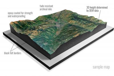
• Raised-relief 3D Height Determined by DEM data
• Fade Resistant Archival Inks
• Epoxy Coated for Strength and Waterproofing
• Ready to Hang with Pre-Installed Hardware (optional)
• Extraordinary 3D Accuracy
• Black Felt Borders
Enrich your office decor or home with a 3D Satellite Raised Relief Map. These raised relief maps are not flat. They are three-dimensional, with the height being determined by Digital Elevation Model (DEM) data. Many people struggle with reading 2D satellite maps, but everyone understands 3D raised relief maps. The realism is phenomenal.
This 3D satellite raised relief map is built by combining satellite imagery data from Google Earth, bounding box coordinates from USGS, and DEM data. 3D Printing and 3D CNC routers are used to fabricate the models which make the satellite models extremely accurate. These models are strong - they are coated with epoxy, then finished with a sealer providing a weatherproof matt-finish. These are not meant to be used in direct sunlight.
Achille, Oklahoma- Map Components- Imagery: Satellite of Achille, Oklahoma. Bounding Box: Footprint of Achille, Oklahoma at Longitude/Latitude Coordinates (-96.5 x -96.375 x 33.875 x 33.75).
Ada, Oklahoma- Map Components- Imagery: Satellite of Ada, Oklahoma. Bounding Box: Footprint of Ada, Oklahoma at Longitude/Latitude Coordinates (-96.75 x -96.625 x 34.875 x 34.75).
Adair, Oklahoma- Map Components- Imagery: Satellite of Adair, Oklahoma. Bounding Box: Footprint of Adair, Oklahoma at Longitude/Latitude Coordinates (-95.375 x -95.25 x 36.5 x 36.375).
Adams, Oklahoma- Map Components- Imagery: Satellite of Adams, Oklahoma. Bounding Box: Footprint of Adams, Oklahoma at Longitude/Latitude Coordinates (-101.125 x -101 x 36.875 x 36.75).
Adamson, Oklahoma- Map Components- Imagery: Satellite of Adamson, Oklahoma. Bounding Box: Footprint of Adamson, Oklahoma at Longitude/Latitude Coordinates (-95.625 x -95.5 x 35 x 34.875).
Adel, Oklahoma- Map Components- Imagery: Satellite of Adel, Oklahoma. Bounding Box: Footprint of Adel, Oklahoma at Longitude/Latitude Coordinates (-95.625 x -95.5 x 34.625 x 34.5).
Afton, Oklahoma- Map Components- Imagery: Satellite of Afton, Oklahoma. Bounding Box: Footprint of Afton, Oklahoma at Longitude/Latitude Coordinates (-95 x -94.875 x 36.75 x 36.625).
Afton NE, Oklahoma- Map Components- Imagery: Satellite of Afton NE, Oklahoma. Bounding Box: Footprint of Afton NE, Oklahoma at Longitude/Latitude Coordinates (-94.875 x -94.75 x 36.75 x 36.625).
Ahloso, Oklahoma- Map Components- Imagery: Satellite of Ahloso, Oklahoma. Bounding Box: Footprint of Ahloso, Oklahoma at Longitude/Latitude Coordinates (-96.75 x -96.625 x 34.75 x 34.625).
Alabaster Caverns, Oklahoma- Map Components- Imagery: Satellite of Alabaster Caverns, Oklahoma. Bounding Box: Footprint of Alabaster Caverns, Oklahoma at Longitude/Latitude Coordinates (-99.25 x -99.125 x 36.75 x 36.625).
Albion, Oklahoma- Map Components- Imagery: Satellite of Albion, Oklahoma. Bounding Box: Footprint of Albion, Oklahoma at Longitude/Latitude Coordinates (-95.125 x -95 x 34.75 x 34.625).
Albion SE, Oklahoma- Map Components- Imagery: Satellite of Albion SE, Oklahoma. Bounding Box: Footprint of Albion SE, Oklahoma at Longitude/Latitude Coordinates (-95.125 x -95 x 34.625 x 34.5).
Albion SW, Oklahoma- Map Components- Imagery: Satellite of Albion SW, Oklahoma. Bounding Box: Footprint of Albion SW, Oklahoma at Longitude/Latitude Coordinates (-95.25 x -95.125 x 34.625 x 34.5).
Alden, Oklahoma- Map Components- Imagery: Satellite of Alden, Oklahoma. Bounding Box: Footprint of Alden, Oklahoma at Longitude/Latitude Coordinates (-98.625 x -98.5 x 35 x 34.875).
Aledo, Oklahoma- Map Components- Imagery: Satellite of Aledo, Oklahoma. Bounding Box: Footprint of Aledo, Oklahoma at Longitude/Latitude Coordinates (-99.125 x -99 x 35.875 x 35.75).
Aledo NE, Oklahoma- Map Components- Imagery: Satellite of Aledo NE, Oklahoma. Bounding Box: Footprint of Aledo NE, Oklahoma at Longitude/Latitude Coordinates (-99.125 x -99 x 36 x 35.875).
Alex, Oklahoma- Map Components- Imagery: Satellite of Alex, Oklahoma. Bounding Box: Footprint of Alex, Oklahoma at Longitude/Latitude Coordinates (-97.875 x -97.75 x 35 x 34.875).
Alfalfa, Oklahoma- Map Components- Imagery: Satellite of Alfalfa, Oklahoma. Bounding Box: Footprint of Alfalfa, Oklahoma at Longitude/Latitude Coordinates (-98.625 x -98.5 x 35.25 x 35.125).
Alikchi, Oklahoma- Map Components- Imagery: Satellite of Alikchi, Oklahoma. Bounding Box: Footprint of Alikchi, Oklahoma at Longitude/Latitude Coordinates (-95.125 x -95 x 34.25 x 34.125).
Allen, Oklahoma- Map Components- Imagery: Satellite of Allen, Oklahoma. Bounding Box: Footprint of Allen, Oklahoma at Longitude/Latitude Coordinates (-96.5 x -96.375 x 35 x 34.875).
Altus, Oklahoma- Map Components- Imagery: Satellite of Altus, Oklahoma. Bounding Box: Footprint of Altus, Oklahoma at Longitude/Latitude Coordinates (-99.375 x -99.25 x 34.75 x 34.625).
Altus SE, Oklahoma- Map Components- Imagery: Satellite of Altus SE, Oklahoma. Bounding Box: Footprint of Altus SE, Oklahoma at Longitude/Latitude Coordinates (-99.375 x -99.25 x 34.625 x 34.5).
Alva, Oklahoma- Map Components- Imagery: Satellite of Alva, Oklahoma. Bounding Box: Footprint of Alva, Oklahoma at Longitude/Latitude Coordinates (-98.75 x -98.625 x 36.875 x 36.75).
Alva NW, Oklahoma- Map Components- Imagery: Satellite of Alva NW, Oklahoma. Bounding Box: Footprint of Alva NW, Oklahoma at Longitude/Latitude Coordinates (-98.75 x -98.625 x 37 x 36.875).
Alva SE, Oklahoma- Map Components- Imagery: Satellite of Alva SE, Oklahoma. Bounding Box: Footprint of Alva SE, Oklahoma at Longitude/Latitude Coordinates (-98.625 x -98.5 x 36.875 x 36.75).
American Horse Lake, Oklahoma- Map Components- Imagery: Satellite of American Horse Lake, Oklahoma. Bounding Box: Footprint of American Horse Lake, Oklahoma at Longitude/Latitude Coordinates (-98.625 x -98.5 x 35.75 x 35.625).
Ames, Oklahoma- Map Components- Imagery: Satellite of Ames, Oklahoma. Bounding Box: Footprint of Ames, Oklahoma at Longitude/Latitude Coordinates (-98.25 x -98.125 x 36.25 x 36.125).
Amorita, Oklahoma- Map Components- Imagery: Satellite of Amorita, Oklahoma. Bounding Box: Footprint of Amorita, Oklahoma at Longitude/Latitude Coordinates (-98.375 x -98.25 x 37 x 36.875).
Anadarko East, Oklahoma- Map Components- Imagery: Satellite of Anadarko East, Oklahoma. Bounding Box: Footprint of Anadarko East, Oklahoma at Longitude/Latitude Coordinates (-98.25 x -98.125 x 35.125 x 35).
Anadarko NE, Oklahoma- Map Components- Imagery: Satellite of Anadarko NE, Oklahoma. Bounding Box: Footprint of Anadarko NE, Oklahoma at Longitude/Latitude Coordinates (-98.125 x -98 x 35.25 x 35.125).
Anadarko NW, Oklahoma- Map Components- Imagery: Satellite of Anadarko NW, Oklahoma. Bounding Box: Footprint of Anadarko NW, Oklahoma at Longitude/Latitude Coordinates (-98.25 x -98.125 x 35.25 x 35.125).
Anadarko West, Oklahoma- Map Components- Imagery: Satellite of Anadarko West, Oklahoma. Bounding Box: Footprint of Anadarko West, Oklahoma at Longitude/Latitude Coordinates (-98.375 x -98.25 x 35.125 x 35).
Antelope Hills, Oklahoma- Map Components- Imagery: Satellite of Antelope Hills, Oklahoma. Bounding Box: Footprint of Antelope Hills, Oklahoma at Longitude/Latitude Coordinates (-100 x -99.875 x 36 x 35.875).
Antelope Hills NE, Oklahoma- Map Components- Imagery: Satellite of Antelope Hills NE, Oklahoma. Bounding Box: Footprint of Antelope Hills NE, Oklahoma at Longitude/Latitude Coordinates (-99.875 x -99.75 x 36 x 35.875).
Anthon, Oklahoma- Map Components- Imagery: Satellite of Anthon, Oklahoma. Bounding Box: Footprint of Anthon, Oklahoma at Longitude/Latitude Coordinates (-99.125 x -99 x 35.75 x 35.625).
Antlers East, Oklahoma- Map Components- Imagery: Satellite of Antlers East, Oklahoma. Bounding Box: Footprint of Antlers East, Oklahoma at Longitude/Latitude Coordinates (-95.625 x -95.5 x 34.25 x 34.125).
Antlers West, Oklahoma- Map Components- Imagery: Satellite of Antlers West, Oklahoma. Bounding Box: Footprint of Antlers West, Oklahoma at Longitude/Latitude Coordinates (-95.75 x -95.625 x 34.25 x 34.125).
Apache, Oklahoma- Map Components- Imagery: Satellite of Apache, Oklahoma. Bounding Box: Footprint of Apache, Oklahoma at Longitude/Latitude Coordinates (-98.375 x -98.25 x 35 x 34.875).
Arbuckle Hill, Oklahoma- Map Components- Imagery: Satellite of Arbuckle Hill, Oklahoma. Bounding Box: Footprint of Arbuckle Hill, Oklahoma at Longitude/Latitude Coordinates (-98.375 x -98.25 x 34.75 x 34.625).
Arcadia, Oklahoma- Map Components- Imagery: Satellite of Arcadia, Oklahoma. Bounding Box: Footprint of Arcadia, Oklahoma at Longitude/Latitude Coordinates (-97.375 x -97.25 x 35.75 x 35.625).
Ardmore East, Oklahoma- Map Components- Imagery: Satellite of Ardmore East, Oklahoma. Bounding Box: Footprint of Ardmore East, Oklahoma at Longitude/Latitude Coordinates (-97.125 x -97 x 34.25 x 34.125).
Ardmore West, Oklahoma- Map Components- Imagery: Satellite of Ardmore West, Oklahoma. Bounding Box: Footprint of Ardmore West, Oklahoma at Longitude/Latitude Coordinates (-97.25 x -97.125 x 34.25 x 34.125).
Arlington, Oklahoma- Map Components- Imagery: Satellite of Arlington, Oklahoma. Bounding Box: Footprint of Arlington, Oklahoma at Longitude/Latitude Coordinates (-96.75 x -96.625 x 35.625 x 35.5).
Arnett, Oklahoma- Map Components- Imagery: Satellite of Arnett, Oklahoma. Bounding Box: Footprint of Arnett, Oklahoma at Longitude/Latitude Coordinates (-99.875 x -99.75 x 36.25 x 36.125).
Arnett SE, Oklahoma- Map Components- Imagery: Satellite of Arnett SE, Oklahoma. Bounding Box: Footprint of Arnett SE, Oklahoma at Longitude/Latitude Coordinates (-99.875 x -99.75 x 36.125 x 36).
Arnett SW, Oklahoma- Map Components- Imagery: Satellite of Arnett SW, Oklahoma. Bounding Box: Footprint of Arnett SW, Oklahoma at Longitude/Latitude Coordinates (-100 x -99.875 x 36.125 x 36).
Asher, Oklahoma- Map Components- Imagery: Satellite of Asher, Oklahoma. Bounding Box: Footprint of Asher, Oklahoma at Longitude/Latitude Coordinates (-97 x -96.875 x 35 x 34.875).
Ashland, Oklahoma- Map Components- Imagery: Satellite of Ashland, Oklahoma. Bounding Box: Footprint of Ashland, Oklahoma at Longitude/Latitude Coordinates (-96.125 x -96 x 34.875 x 34.75).
Augar Creek, Oklahoma- Map Components- Imagery: Satellite of Augar Creek, Oklahoma. Bounding Box: Footprint of Augar Creek, Oklahoma at Longitude/Latitude Coordinates (-98.875 x -98.75 x 34.25 x 34.125).
Autograph Cliff, Oklahoma- Map Components- Imagery: Satellite of Autograph Cliff, Oklahoma. Bounding Box: Footprint of Autograph Cliff, Oklahoma at Longitude/Latitude Coordinates (-102.75 x -102.625 x 36.875 x 36.75).
Autograph Cliff NW, Oklahoma- Map Components- Imagery: Satellite of Autograph Cliff NW, Oklahoma. Bounding Box: Footprint of Autograph Cliff NW, Oklahoma at Longitude/Latitude Coordinates (-102.75 x -102.625 x 37 x 36.875).
Avant, Oklahoma- Map Components- Imagery: Satellite of Avant, Oklahoma. Bounding Box: Footprint of Avant, Oklahoma at Longitude/Latitude Coordinates (-96.125 x -96 x 36.5 x 36.375).
Avant NW, Oklahoma- Map Components- Imagery: Satellite of Avant NW, Oklahoma. Bounding Box: Footprint of Avant NW, Oklahoma at Longitude/Latitude Coordinates (-96.25 x -96.125 x 36.5 x 36.375).
Avant SE, Oklahoma- Map Components- Imagery: Satellite of Avant SE, Oklahoma. Bounding Box: Footprint of Avant SE, Oklahoma at Longitude/Latitude Coordinates (-96.125 x -96 x 36.375 x 36.25).
Avant SW, Oklahoma- Map Components- Imagery: Satellite of Avant SW, Oklahoma. Bounding Box: Footprint of Avant SW, Oklahoma at Longitude/Latitude Coordinates (-96.25 x -96.125 x 36.375 x 36.25).
Avard, Oklahoma- Map Components- Imagery: Satellite of Avard, Oklahoma. Bounding Box: Footprint of Avard, Oklahoma at Longitude/Latitude Coordinates (-98.875 x -98.75 x 36.75 x 36.625).
Aydelotte, Oklahoma- Map Components- Imagery: Satellite of Aydelotte, Oklahoma. Bounding Box: Footprint of Aydelotte, Oklahoma at Longitude/Latitude Coordinates (-97 x -96.875 x 35.5 x 35.375).
Babbs, Oklahoma- Map Components- Imagery: Satellite of Babbs, Oklahoma. Bounding Box: Footprint of Babbs, Oklahoma at Longitude/Latitude Coordinates (-99.125 x -99 x 35 x 34.875).
Baconrind Creek, Oklahoma- Map Components- Imagery: Satellite of Baconrind Creek, Oklahoma. Bounding Box: Footprint of Baconrind Creek, Oklahoma at Longitude/Latitude Coordinates (-96.625 x -96.5 x 36.75 x 36.625).
Baker Lake, Oklahoma- Map Components- Imagery: Satellite of Baker Lake, Oklahoma. Bounding Box: Footprint of Baker Lake, Oklahoma at Longitude/Latitude Coordinates (-99.625 x -99.5 x 35.5 x 35.375).
Baker Mountain, Oklahoma- Map Components- Imagery: Satellite of Baker Mountain, Oklahoma. Bounding Box: Footprint of Baker Mountain, Oklahoma at Longitude/Latitude Coordinates (-95.25 x -95.125 x 34.875 x 34.75).
Balko, Oklahoma- Map Components- Imagery: Satellite of Balko, Oklahoma. Bounding Box: Footprint of Balko, Oklahoma at Longitude/Latitude Coordinates (-100.75 x -100.625 x 36.75 x 36.625).
Balko NE, Oklahoma- Map Components- Imagery: Satellite of Balko NE, Oklahoma. Bounding Box: Footprint of Balko NE, Oklahoma at Longitude/Latitude Coordinates (-100.625 x -100.5 x 36.75 x 36.625).
Balko SW, Oklahoma- Map Components- Imagery: Satellite of Balko SW, Oklahoma. Bounding Box: Footprint of Balko SW, Oklahoma at Longitude/Latitude Coordinates (-100.75 x -100.625 x 36.625 x 36.5).
Bally Mountain, Oklahoma- Map Components- Imagery: Satellite of Bally Mountain, Oklahoma. Bounding Box: Footprint of Bally Mountain, Oklahoma at Longitude/Latitude Coordinates (-98.75 x -98.625 x 35 x 34.875).
Barnsdall, Oklahoma- Map Components- Imagery: Satellite of Barnsdall, Oklahoma. Bounding Box: Footprint of Barnsdall, Oklahoma at Longitude/Latitude Coordinates (-96.25 x -96.125 x 36.625 x 36.5).
Barr, Oklahoma- Map Components- Imagery: Satellite of Barr, Oklahoma. Bounding Box: Footprint of Barr, Oklahoma at Longitude/Latitude Coordinates (-98.125 x -98 x 36.25 x 36.125).
Bartlesville North, Oklahoma- Map Components- Imagery: Satellite of Bartlesville North, Oklahoma. Bounding Box: Footprint of Bartlesville North, Oklahoma at Longitude/Latitude Coordinates (-96 x -95.875 x 36.875 x 36.75).
Bartlesville SE, Oklahoma- Map Components- Imagery: Satellite of Bartlesville SE, Oklahoma. Bounding Box: Footprint of Bartlesville SE, Oklahoma at Longitude/Latitude Coordinates (-95.875 x -95.75 x 36.625 x 36.5).
Bartlesville South, Oklahoma- Map Components- Imagery: Satellite of Bartlesville South, Oklahoma. Bounding Box: Footprint of Bartlesville South, Oklahoma at Longitude/Latitude Coordinates (-96 x -95.875 x 36.75 x 36.625).
Battiest, Oklahoma- Map Components- Imagery: Satellite of Battiest, Oklahoma. Bounding Box: Footprint of Battiest, Oklahoma at Longitude/Latitude Coordinates (-95 x -94.875 x 34.5 x 34.375).
Bear Mountain, Oklahoma- Map Components- Imagery: Satellite of Bear Mountain, Oklahoma. Bounding Box: Footprint of Bear Mountain, Oklahoma at Longitude/Latitude Coordinates (-95 x -94.875 x 34.25 x 34.125).
Beaver, Oklahoma- Map Components- Imagery: Satellite of Beaver, Oklahoma. Bounding Box: Footprint of Beaver, Oklahoma at Longitude/Latitude Coordinates (-100.625 x -100.5 x 36.875 x 36.75).
Beaver NW, Oklahoma- Map Components- Imagery: Satellite of Beaver NW, Oklahoma. Bounding Box: Footprint of Beaver NW, Oklahoma at Longitude/Latitude Coordinates (-100.75 x -100.625 x 37 x 36.875).
Beggs, Oklahoma- Map Components- Imagery: Satellite of Beggs, Oklahoma. Bounding Box: Footprint of Beggs, Oklahoma at Longitude/Latitude Coordinates (-96.125 x -96 x 35.75 x 35.625).
Beland, Oklahoma- Map Components- Imagery: Satellite of Beland, Oklahoma. Bounding Box: Footprint of Beland, Oklahoma at Longitude/Latitude Coordinates (-95.625 x -95.5 x 35.75 x 35.625).
Bellvue, Oklahoma- Map Components- Imagery: Satellite of Bellvue, Oklahoma. Bounding Box: Footprint of Bellvue, Oklahoma at Longitude/Latitude Coordinates (-96.5 x -96.375 x 36 x 35.875).
Belva, Oklahoma- Map Components- Imagery: Satellite of Belva, Oklahoma. Bounding Box: Footprint of Belva, Oklahoma at Longitude/Latitude Coordinates (-99 x -98.875 x 36.5 x 36.375).
Bennington North, Oklahoma- Map Components- Imagery: Satellite of Bennington North, Oklahoma. Bounding Box: Footprint of Bennington North, Oklahoma at Longitude/Latitude Coordinates (-96.125 x -96 x 34.125 x 34).
Bennington South, Oklahoma- Map Components- Imagery: Satellite of Bennington South, Oklahoma. Bounding Box: Footprint of Bennington South, Oklahoma at Longitude/Latitude Coordinates (-96.125 x -96 x 34 x 33.875).
Bentley, Oklahoma- Map Components- Imagery: Satellite of Bentley, Oklahoma. Bounding Box: Footprint of Bentley, Oklahoma at Longitude/Latitude Coordinates (-96.125 x -96 x 34.25 x 34.125).
Berlin, Oklahoma- Map Components- Imagery: Satellite of Berlin, Oklahoma. Bounding Box: Footprint of Berlin, Oklahoma at Longitude/Latitude Coordinates (-99.75 x -99.625 x 35.5 x 35.375).
Bernice, Oklahoma- Map Components- Imagery: Satellite of Bernice, Oklahoma. Bounding Box: Footprint of Bernice, Oklahoma at Longitude/Latitude Coordinates (-95 x -94.875 x 36.625 x 36.5).
Bessie, Oklahoma- Map Components- Imagery: Satellite of Bessie, Oklahoma. Bounding Box: Footprint of Bessie, Oklahoma at Longitude/Latitude Coordinates (-99 x -98.875 x 35.5 x 35.375).
Bethany, Oklahoma- Map Components- Imagery: Satellite of Bethany, Oklahoma. Bounding Box: Footprint of Bethany, Oklahoma at Longitude/Latitude Coordinates (-97.75 x -97.625 x 35.625 x 35.5).
Bethany NE, Oklahoma- Map Components- Imagery: Satellite of Bethany NE, Oklahoma. Bounding Box: Footprint of Bethany NE, Oklahoma at Longitude/Latitude Coordinates (-97.625 x -97.5 x 35.75 x 35.625).
Bethel, Oklahoma- Map Components- Imagery: Satellite of Bethel, Oklahoma. Bounding Box: Footprint of Bethel, Oklahoma at Longitude/Latitude Coordinates (-94.875 x -94.75 x 34.375 x 34.25).
Big Cabin, Oklahoma- Map Components- Imagery: Satellite of Big Cabin, Oklahoma. Bounding Box: Footprint of Big Cabin, Oklahoma at Longitude/Latitude Coordinates (-95.25 x -95.125 x 36.625 x 36.5).
Big Cedar, Oklahoma- Map Components- Imagery: Satellite of Big Cedar, Oklahoma. Bounding Box: Footprint of Big Cedar, Oklahoma at Longitude/Latitude Coordinates (-94.75 x -94.625 x 34.75 x 34.625).
Big Hudson Creek, Oklahoma- Map Components- Imagery: Satellite of Big Hudson Creek, Oklahoma. Bounding Box: Footprint of Big Hudson Creek, Oklahoma at Longitude/Latitude Coordinates (-94.625 x -94.5 x 34.375 x 34.25).
Big Kiowa Creek, Oklahoma- Map Components- Imagery: Satellite of Big Kiowa Creek, Oklahoma. Bounding Box: Footprint of Big Kiowa Creek, Oklahoma at Longitude/Latitude Coordinates (-99.5 x -99.375 x 35.625 x 35.5).
Big Round Mountain, Oklahoma- Map Components- Imagery: Satellite of Big Round Mountain, Oklahoma. Bounding Box: Footprint of Big Round Mountain, Oklahoma at Longitude/Latitude Coordinates (-94.625 x -94.5 x 35.75 x 35.625).
Billings, Oklahoma- Map Components- Imagery: Satellite of Billings, Oklahoma. Bounding Box: Footprint of Billings, Oklahoma at Longitude/Latitude Coordinates (-97.5 x -97.375 x 36.625 x 36.5).
Binger, Oklahoma- Map Components- Imagery: Satellite of Binger, Oklahoma. Bounding Box: Footprint of Binger, Oklahoma at Longitude/Latitude Coordinates (-98.375 x -98.25 x 35.375 x 35.25).
Bison, Oklahoma- Map Components- Imagery: Satellite of Bison, Oklahoma. Bounding Box: Footprint of Bison, Oklahoma at Longitude/Latitude Coordinates (-98 x -97.875 x 36.25 x 36.125).
Bixby, Oklahoma- Map Components- Imagery: Satellite of Bixby, Oklahoma. Bounding Box: Footprint of Bixby, Oklahoma at Longitude/Latitude Coordinates (-96 x -95.875 x 36 x 35.875).
Black Bear, Oklahoma- Map Components- Imagery: Satellite of Black Bear, Oklahoma. Bounding Box: Footprint of Black Bear, Oklahoma at Longitude/Latitude Coordinates (-97.25 x -97.125 x 36.375 x 36.25).
Blackburn, Oklahoma- Map Components- Imagery: Satellite of Blackburn, Oklahoma. Bounding Box: Footprint of Blackburn, Oklahoma at Longitude/Latitude Coordinates (-96.625 x -96.5 x 36.375 x 36.25).
Blackgum, Oklahoma- Map Components- Imagery: Satellite of Blackgum, Oklahoma. Bounding Box: Footprint of Blackgum, Oklahoma at Longitude/Latitude Coordinates (-95 x -94.875 x 35.625 x 35.5).
Blackjack Ridge, Oklahoma- Map Components- Imagery: Satellite of Blackjack Ridge, Oklahoma. Bounding Box: Footprint of Blackjack Ridge, Oklahoma at Longitude/Latitude Coordinates (-95 x -94.875 x 34.875 x 34.75).
Blackwell, Oklahoma- Map Components- Imagery: Satellite of Blackwell, Oklahoma. Bounding Box: Footprint of Blackwell, Oklahoma at Longitude/Latitude Coordinates (-97.375 x -97.25 x 36.875 x 36.75).
Blackwell NW, Oklahoma- Map Components- Imagery: Satellite of Blackwell NW, Oklahoma. Bounding Box: Footprint of Blackwell NW, Oklahoma at Longitude/Latitude Coordinates (-97.5 x -97.375 x 37 x 36.875).
Blair, Oklahoma- Map Components- Imagery: Satellite of Blair, Oklahoma. Bounding Box: Footprint of Blair, Oklahoma at Longitude/Latitude Coordinates (-99.375 x -99.25 x 34.875 x 34.75).
Blanchard, Oklahoma- Map Components- Imagery: Satellite of Blanchard, Oklahoma. Bounding Box: Footprint of Blanchard, Oklahoma at Longitude/Latitude Coordinates (-97.75 x -97.625 x 35.25 x 35.125).
Blocker, Oklahoma- Map Components- Imagery: Satellite of Blocker, Oklahoma. Bounding Box: Footprint of Blocker, Oklahoma at Longitude/Latitude Coordinates (-95.625 x -95.5 x 35.125 x 35).
Blue, Oklahoma- Map Components- Imagery: Satellite of Blue, Oklahoma. Bounding Box: Footprint of Blue, Oklahoma at Longitude/Latitude Coordinates (-96.25 x -96.125 x 34 x 33.875).
Blue Mound, Oklahoma- Map Components- Imagery: Satellite of Blue Mound, Oklahoma. Bounding Box: Footprint of Blue Mound, Oklahoma at Longitude/Latitude Coordinates (-95.875 x -95.75 x 36.875 x 36.75).
Bluestem Lake, Oklahoma- Map Components- Imagery: Satellite of Bluestem Lake, Oklahoma. Bounding Box: Footprint of Bluestem Lake, Oklahoma at Longitude/Latitude Coordinates (-96.5 x -96.375 x 36.75 x 36.625).
Bluff, Oklahoma- Map Components- Imagery: Satellite of Bluff, Oklahoma. Bounding Box: Footprint of Bluff, Oklahoma at Longitude/Latitude Coordinates (-95.75 x -95.625 x 34 x 33.875).
Boggy Depot, Oklahoma- Map Components- Imagery: Satellite of Boggy Depot, Oklahoma. Bounding Box: Footprint of Boggy Depot, Oklahoma at Longitude/Latitude Coordinates (-96.375 x -96.25 x 34.375 x 34.25).
Boise City, Oklahoma- Map Components- Imagery: Satellite of Boise City, Oklahoma. Bounding Box: Footprint of Boise City, Oklahoma at Longitude/Latitude Coordinates (-102.625 x -102.5 x 36.75 x 36.625).
Boise City NW, Oklahoma- Map Components- Imagery: Satellite of Boise City NW, Oklahoma. Bounding Box: Footprint of Boise City NW, Oklahoma at Longitude/Latitude Coordinates (-102.75 x -102.625 x 36.75 x 36.625).
Boise City SE, Oklahoma- Map Components- Imagery: Satellite of Boise City SE, Oklahoma. Bounding Box: Footprint of Boise City SE, Oklahoma at Longitude/Latitude Coordinates (-102.625 x -102.5 x 36.625 x 36.5).
Boise City SW, Oklahoma- Map Components- Imagery: Satellite of Boise City SW, Oklahoma. Bounding Box: Footprint of Boise City SW, Oklahoma at Longitude/Latitude Coordinates (-102.75 x -102.625 x 36.625 x 36.5).
Bokchito, Oklahoma- Map Components- Imagery: Satellite of Bokchito, Oklahoma. Bounding Box: Footprint of Bokchito, Oklahoma at Longitude/Latitude Coordinates (-96.25 x -96.125 x 34.125 x 34).
Bokhoma, Oklahoma- Map Components- Imagery: Satellite of Bokhoma, Oklahoma. Bounding Box: Footprint of Bokhoma, Oklahoma at Longitude/Latitude Coordinates (-94.625 x -94.5 x 33.875 x 33.75).
Bokoshe, Oklahoma- Map Components- Imagery: Satellite of Bokoshe, Oklahoma. Bounding Box: Footprint of Bokoshe, Oklahoma at Longitude/Latitude Coordinates (-94.875 x -94.75 x 35.25 x 35.125).
Boley, Oklahoma- Map Components- Imagery: Satellite of Boley, Oklahoma. Bounding Box: Footprint of Boley, Oklahoma at Longitude/Latitude Coordinates (-96.5 x -96.375 x 35.5 x 35.375).
Boone, Oklahoma- Map Components- Imagery: Satellite of Boone, Oklahoma. Bounding Box: Footprint of Boone, Oklahoma at Longitude/Latitude Coordinates (-98.5 x -98.375 x 35 x 34.875).
Boswell, Oklahoma- Map Components- Imagery: Satellite of Boswell, Oklahoma. Bounding Box: Footprint of Boswell, Oklahoma at Longitude/Latitude Coordinates (-95.875 x -95.75 x 34.125 x 34).
Boswell NW, Oklahoma- Map Components- Imagery: Satellite of Boswell NW, Oklahoma. Bounding Box: Footprint of Boswell NW, Oklahoma at Longitude/Latitude Coordinates (-96 x -95.875 x 34.25 x 34.125).
Boswell SW, Oklahoma- Map Components- Imagery: Satellite of Boswell SW, Oklahoma. Bounding Box: Footprint of Boswell SW, Oklahoma at Longitude/Latitude Coordinates (-96 x -95.875 x 34.125 x 34).
Bowring, Oklahoma- Map Components- Imagery: Satellite of Bowring, Oklahoma. Bounding Box: Footprint of Bowring, Oklahoma at Longitude/Latitude Coordinates (-96.125 x -96 x 37 x 36.875).
Bowring SE, Oklahoma- Map Components- Imagery: Satellite of Bowring SE, Oklahoma. Bounding Box: Footprint of Bowring SE, Oklahoma at Longitude/Latitude Coordinates (-96.125 x -96 x 36.875 x 36.75).
Boyd, Oklahoma- Map Components- Imagery: Satellite of Boyd, Oklahoma. Bounding Box: Footprint of Boyd, Oklahoma at Longitude/Latitude Coordinates (-100.875 x -100.75 x 36.75 x 36.625).
Boynton, Oklahoma- Map Components- Imagery: Satellite of Boynton, Oklahoma. Bounding Box: Footprint of Boynton, Oklahoma at Longitude/Latitude Coordinates (-95.75 x -95.625 x 35.75 x 35.625).
Bradley, Oklahoma- Map Components- Imagery: Satellite of Bradley, Oklahoma. Bounding Box: Footprint of Bradley, Oklahoma at Longitude/Latitude Coordinates (-97.75 x -97.625 x 35 x 34.875).
Braggs, Oklahoma- Map Components- Imagery: Satellite of Braggs, Oklahoma. Bounding Box: Footprint of Braggs, Oklahoma at Longitude/Latitude Coordinates (-95.25 x -95.125 x 35.75 x 35.625).
Braman, Oklahoma- Map Components- Imagery: Satellite of Braman, Oklahoma. Bounding Box: Footprint of Braman, Oklahoma at Longitude/Latitude Coordinates (-97.375 x -97.25 x 37 x 36.875).
Bray, Oklahoma- Map Components- Imagery: Satellite of Bray, Oklahoma. Bounding Box: Footprint of Bray, Oklahoma at Longitude/Latitude Coordinates (-97.875 x -97.75 x 34.75 x 34.625).
Breckinridge, Oklahoma- Map Components- Imagery: Satellite of Breckinridge, Oklahoma. Bounding Box: Footprint of Breckinridge, Oklahoma at Longitude/Latitude Coordinates (-97.75 x -97.625 x 36.5 x 36.375).
Bridge Creek, Oklahoma- Map Components- Imagery: Satellite of Bridge Creek, Oklahoma. Bounding Box: Footprint of Bridge Creek, Oklahoma at Longitude/Latitude Coordinates (-97.625 x -97.5 x 36.125 x 36).
Bridgeport, Oklahoma- Map Components- Imagery: Satellite of Bridgeport, Oklahoma. Bounding Box: Footprint of Bridgeport, Oklahoma at Longitude/Latitude Coordinates (-98.5 x -98.375 x 35.625 x 35.5).
Bristow, Oklahoma- Map Components- Imagery: Satellite of Bristow, Oklahoma. Bounding Box: Footprint of Bristow, Oklahoma at Longitude/Latitude Coordinates (-96.5 x -96.375 x 35.875 x 35.75).
Britton, Oklahoma- Map Components- Imagery: Satellite of Britton, Oklahoma. Bounding Box: Footprint of Britton, Oklahoma at Longitude/Latitude Coordinates (-97.625 x -97.5 x 35.625 x 35.5).
Broken Arrow, Oklahoma- Map Components- Imagery: Satellite of Broken Arrow, Oklahoma. Bounding Box: Footprint of Broken Arrow, Oklahoma at Longitude/Latitude Coordinates (-95.875 x -95.75 x 36.125 x 36).
Broken Bow, Oklahoma- Map Components- Imagery: Satellite of Broken Bow, Oklahoma. Bounding Box: Footprint of Broken Bow, Oklahoma at Longitude/Latitude Coordinates (-94.75 x -94.625 x 34.125 x 34).
Brooksville, Oklahoma- Map Components- Imagery: Satellite of Brooksville, Oklahoma. Bounding Box: Footprint of Brooksville, Oklahoma at Longitude/Latitude Coordinates (-97 x -96.875 x 35.25 x 35.125).
Bruno, Oklahoma- Map Components- Imagery: Satellite of Bruno, Oklahoma. Bounding Box: Footprint of Bruno, Oklahoma at Longitude/Latitude Coordinates (-96.125 x -96 x 34.375 x 34.25).
Brushy, Oklahoma- Map Components- Imagery: Satellite of Brushy, Oklahoma. Bounding Box: Footprint of Brushy, Oklahoma at Longitude/Latitude Coordinates (-94.75 x -94.625 x 35.625 x 35.5).
Bryans Corner, Oklahoma- Map Components- Imagery: Satellite of Bryans Corner, Oklahoma. Bounding Box: Footprint of Bryans Corner, Oklahoma at Longitude/Latitude Coordinates (-100.875 x -100.75 x 36.625 x 36.5).
Bryans Corner SW, Oklahoma- Map Components- Imagery: Satellite of Bryans Corner SW, Oklahoma. Bounding Box: Footprint of Bryans Corner SW, Oklahoma at Longitude/Latitude Coordinates (-101 x -100.875 x 36.625 x 36.5).
Buffalo, Oklahoma- Map Components- Imagery: Satellite of Buffalo, Oklahoma. Bounding Box: Footprint of Buffalo, Oklahoma at Longitude/Latitude Coordinates (-99.75 x -99.625 x 36.875 x 36.75).
Buffalo NE, Oklahoma- Map Components- Imagery: Satellite of Buffalo NE, Oklahoma. Bounding Box: Footprint of Buffalo NE, Oklahoma at Longitude/Latitude Coordinates (-99.625 x -99.5 x 37 x 36.875).
Buffalo NW, Oklahoma- Map Components- Imagery: Satellite of Buffalo NW, Oklahoma. Bounding Box: Footprint of Buffalo NW, Oklahoma at Longitude/Latitude Coordinates (-99.75 x -99.625 x 37 x 36.875).
Buffalo SE, Oklahoma- Map Components- Imagery: Satellite of Buffalo SE, Oklahoma. Bounding Box: Footprint of Buffalo SE, Oklahoma at Longitude/Latitude Coordinates (-99.625 x -99.5 x 36.875 x 36.75).
Bug Creek, Oklahoma- Map Components- Imagery: Satellite of Bug Creek, Oklahoma. Bounding Box: Footprint of Bug Creek, Oklahoma at Longitude/Latitude Coordinates (-96.625 x -96.5 x 36.5 x 36.375).
Bull Creek, Oklahoma- Map Components- Imagery: Satellite of Bull Creek, Oklahoma. Bounding Box: Footprint of Bull Creek, Oklahoma at Longitude/Latitude Coordinates (-100 x -99.875 x 35.125 x 35).
Bunch, Oklahoma- Map Components- Imagery: Satellite of Bunch, Oklahoma. Bounding Box: Footprint of Bunch, Oklahoma at Longitude/Latitude Coordinates (-94.875 x -94.75 x 35.75 x 35.625).
Burbank, Oklahoma- Map Components- Imagery: Satellite of Burbank, Oklahoma. Bounding Box: Footprint of Burbank, Oklahoma at Longitude/Latitude Coordinates (-96.75 x -96.625 x 36.75 x 36.625).
Burlington, Oklahoma- Map Components- Imagery: Satellite of Burlington, Oklahoma. Bounding Box: Footprint of Burlington, Oklahoma at Longitude/Latitude Coordinates (-98.5 x -98.375 x 37 x 36.875).
Burneyville, Oklahoma- Map Components- Imagery: Satellite of Burneyville, Oklahoma. Bounding Box: Footprint of Burneyville, Oklahoma at Longitude/Latitude Coordinates (-97.375 x -97.25 x 34 x 33.875).
Bushyhead, Oklahoma- Map Components- Imagery: Satellite of Bushyhead, Oklahoma. Bounding Box: Footprint of Bushyhead, Oklahoma at Longitude/Latitude Coordinates (-95.5 x -95.375 x 36.5 x 36.375).
Butler, Oklahoma- Map Components- Imagery: Satellite of Butler, Oklahoma. Bounding Box: Footprint of Butler, Oklahoma at Longitude/Latitude Coordinates (-99.25 x -99.125 x 35.75 x 35.625).
Byars, Oklahoma- Map Components- Imagery: Satellite of Byars, Oklahoma. Bounding Box: Footprint of Byars, Oklahoma at Longitude/Latitude Coordinates (-97.125 x -97 x 34.875 x 34.75).
Byars SW, Oklahoma- Map Components- Imagery: Satellite of Byars SW, Oklahoma. Bounding Box: Footprint of Byars SW, Oklahoma at Longitude/Latitude Coordinates (-97.25 x -97.125 x 34.875 x 34.75).
Caddo North, Oklahoma- Map Components- Imagery: Satellite of Caddo North, Oklahoma. Bounding Box: Footprint of Caddo North, Oklahoma at Longitude/Latitude Coordinates (-96.375 x -96.25 x 34.25 x 34.125).
Caddo NW, Oklahoma- Map Components- Imagery: Satellite of Caddo NW, Oklahoma. Bounding Box: Footprint of Caddo NW, Oklahoma at Longitude/Latitude Coordinates (-96.5 x -96.375 x 34.25 x 34.125).
Caddo South, Oklahoma- Map Components- Imagery: Satellite of Caddo South, Oklahoma. Bounding Box: Footprint of Caddo South, Oklahoma at Longitude/Latitude Coordinates (-96.375 x -96.25 x 34.125 x 34).
Calvin East, Oklahoma- Map Components- Imagery: Satellite of Calvin East, Oklahoma. Bounding Box: Footprint of Calvin East, Oklahoma at Longitude/Latitude Coordinates (-96.25 x -96.125 x 35 x 34.875).
Calvin West, Oklahoma- Map Components- Imagery: Satellite of Calvin West, Oklahoma. Bounding Box: Footprint of Calvin West, Oklahoma at Longitude/Latitude Coordinates (-96.375 x -96.25 x 35 x 34.875).
Camargo, Oklahoma- Map Components- Imagery: Satellite of Camargo, Oklahoma. Bounding Box: Footprint of Camargo, Oklahoma at Longitude/Latitude Coordinates (-99.375 x -99.25 x 36.125 x 36).
Cambridge, Oklahoma- Map Components- Imagery: Satellite of Cambridge, Oklahoma. Bounding Box: Footprint of Cambridge, Oklahoma at Longitude/Latitude Coordinates (-99.25 x -99.125 x 35.125 x 35).
Canadian, Oklahoma- Map Components- Imagery: Satellite of Canadian, Oklahoma. Bounding Box: Footprint of Canadian, Oklahoma at Longitude/Latitude Coordinates (-95.75 x -95.625 x 35.25 x 35.125).
Caney, Oklahoma- Map Components- Imagery: Satellite of Caney, Oklahoma. Bounding Box: Footprint of Caney, Oklahoma at Longitude/Latitude Coordinates (-96.25 x -96.125 x 34.25 x 34.125).
Caney Mountain, Oklahoma- Map Components- Imagery: Satellite of Caney Mountain, Oklahoma. Bounding Box: Footprint of Caney Mountain, Oklahoma at Longitude/Latitude Coordinates (-95.25 x -95.125 x 34.375 x 34.25).
Canton, Oklahoma- Map Components- Imagery: Satellite of Canton, Oklahoma. Bounding Box: Footprint of Canton, Oklahoma at Longitude/Latitude Coordinates (-98.625 x -98.5 x 36.125 x 36).
Canton NW, Oklahoma- Map Components- Imagery: Satellite of Canton NW, Oklahoma. Bounding Box: Footprint of Canton NW, Oklahoma at Longitude/Latitude Coordinates (-98.75 x -98.625 x 36.25 x 36.125).
Canton SW, Oklahoma- Map Components- Imagery: Satellite of Canton SW, Oklahoma. Bounding Box: Footprint of Canton SW, Oklahoma at Longitude/Latitude Coordinates (-98.75 x -98.625 x 36.125 x 36).
Canute, Oklahoma- Map Components- Imagery: Satellite of Canute, Oklahoma. Bounding Box: Footprint of Canute, Oklahoma at Longitude/Latitude Coordinates (-99.375 x -99.25 x 35.5 x 35.375).
Capron, Oklahoma- Map Components- Imagery: Satellite of Capron, Oklahoma. Bounding Box: Footprint of Capron, Oklahoma at Longitude/Latitude Coordinates (-98.625 x -98.5 x 37 x 36.875).
Carmen, Oklahoma- Map Components- Imagery: Satellite of Carmen, Oklahoma. Bounding Box: Footprint of Carmen, Oklahoma at Longitude/Latitude Coordinates (-98.5 x -98.375 x 36.625 x 36.5).
Carnegie, Oklahoma- Map Components- Imagery: Satellite of Carnegie, Oklahoma. Bounding Box: Footprint of Carnegie, Oklahoma at Longitude/Latitude Coordinates (-98.625 x -98.5 x 35.125 x 35).
Carney, Oklahoma- Map Components- Imagery: Satellite of Carney, Oklahoma. Bounding Box: Footprint of Carney, Oklahoma at Longitude/Latitude Coordinates (-97.125 x -97 x 35.875 x 35.75).
Carpenter, Oklahoma- Map Components- Imagery: Satellite of Carpenter, Oklahoma. Bounding Box: Footprint of Carpenter, Oklahoma at Longitude/Latitude Coordinates (-99.375 x -99.25 x 35.625 x 35.5).
Carson, Oklahoma- Map Components- Imagery: Satellite of Carson, Oklahoma. Bounding Box: Footprint of Carson, Oklahoma at Longitude/Latitude Coordinates (-96.125 x -96 x 35.25 x 35.125).
Carter East, Oklahoma- Map Components- Imagery: Satellite of Carter East, Oklahoma. Bounding Box: Footprint of Carter East, Oklahoma at Longitude/Latitude Coordinates (-99.5 x -99.375 x 35.25 x 35.125).
Carter West, Oklahoma- Map Components- Imagery: Satellite of Carter West, Oklahoma. Bounding Box: Footprint of Carter West, Oklahoma at Longitude/Latitude Coordinates (-99.625 x -99.5 x 35.25 x 35.125).
Casey, Oklahoma- Map Components- Imagery: Satellite of Casey, Oklahoma. Bounding Box: Footprint of Casey, Oklahoma at Longitude/Latitude Coordinates (-96.75 x -96.625 x 36.375 x 36.25).
Cashion, Oklahoma- Map Components- Imagery: Satellite of Cashion, Oklahoma. Bounding Box: Footprint of Cashion, Oklahoma at Longitude/Latitude Coordinates (-97.75 x -97.625 x 35.875 x 35.75).
Catoosa, Oklahoma- Map Components- Imagery: Satellite of Catoosa, Oklahoma. Bounding Box: Footprint of Catoosa, Oklahoma at Longitude/Latitude Coordinates (-95.75 x -95.625 x 36.25 x 36.125).
Catoosa SE, Oklahoma- Map Components- Imagery: Satellite of Catoosa SE, Oklahoma. Bounding Box: Footprint of Catoosa SE, Oklahoma at Longitude/Latitude Coordinates (-95.625 x -95.5 x 36.125 x 36).
Cayuga, Oklahoma- Map Components- Imagery: Satellite of Cayuga, Oklahoma. Bounding Box: Footprint of Cayuga, Oklahoma at Longitude/Latitude Coordinates (-94.75 x -94.625 x 36.75 x 36.625).
Cedar Crest, Oklahoma- Map Components- Imagery: Satellite of Cedar Crest, Oklahoma. Bounding Box: Footprint of Cedar Crest, Oklahoma at Longitude/Latitude Coordinates (-95.25 x -95.125 x 36.125 x 36).
Cedardale, Oklahoma- Map Components- Imagery: Satellite of Cedardale, Oklahoma. Bounding Box: Footprint of Cedardale, Oklahoma at Longitude/Latitude Coordinates (-99 x -98.875 x 36.375 x 36.25).
Centrahoma, Oklahoma- Map Components- Imagery: Satellite of Centrahoma, Oklahoma. Bounding Box: Footprint of Centrahoma, Oklahoma at Longitude/Latitude Coordinates (-96.375 x -96.25 x 34.625 x 34.5).
Centralia, Oklahoma- Map Components- Imagery: Satellite of Centralia, Oklahoma. Bounding Box: Footprint of Centralia, Oklahoma at Longitude/Latitude Coordinates (-95.375 x -95.25 x 36.875 x 36.75).
Ceres, Oklahoma- Map Components- Imagery: Satellite of Ceres, Oklahoma. Bounding Box: Footprint of Ceres, Oklahoma at Longitude/Latitude Coordinates (-97.375 x -97.25 x 36.5 x 36.375).
Chance, Oklahoma- Map Components- Imagery: Satellite of Chance, Oklahoma. Bounding Box: Footprint of Chance, Oklahoma at Longitude/Latitude Coordinates (-94.75 x -94.625 x 36.125 x 36).
Chandler, Oklahoma- Map Components- Imagery: Satellite of Chandler, Oklahoma. Bounding Box: Footprint of Chandler, Oklahoma at Longitude/Latitude Coordinates (-97 x -96.875 x 35.75 x 35.625).
Charley Creek East, Oklahoma- Map Components- Imagery: Satellite of Charley Creek East, Oklahoma. Bounding Box: Footprint of Charley Creek East, Oklahoma at Longitude/Latitude Coordinates (-96.875 x -96.75 x 36.75 x 36.625).
Charley Creek West, Oklahoma- Map Components- Imagery: Satellite of Charley Creek West, Oklahoma. Bounding Box: Footprint of Charley Creek West, Oklahoma at Longitude/Latitude Coordinates (-97 x -96.875 x 36.75 x 36.625).
Chattanooga, Oklahoma- Map Components- Imagery: Satellite of Chattanooga, Oklahoma. Bounding Box: Footprint of Chattanooga, Oklahoma at Longitude/Latitude Coordinates (-98.75 x -98.625 x 34.5 x 34.375).
Chattanooga SW, Oklahoma- Map Components- Imagery: Satellite of Chattanooga SW, Oklahoma. Bounding Box: Footprint of Chattanooga SW, Oklahoma at Longitude/Latitude Coordinates (-98.75 x -98.625 x 34.375 x 34.25).
Checotah, Oklahoma- Map Components- Imagery: Satellite of Checotah, Oklahoma. Bounding Box: Footprint of Checotah, Oklahoma at Longitude/Latitude Coordinates (-95.625 x -95.5 x 35.5 x 35.375).
Chelsea, Oklahoma- Map Components- Imagery: Satellite of Chelsea, Oklahoma. Bounding Box: Footprint of Chelsea, Oklahoma at Longitude/Latitude Coordinates (-95.5 x -95.375 x 36.625 x 36.5).
Chelsea NW, Oklahoma- Map Components- Imagery: Satellite of Chelsea NW, Oklahoma. Bounding Box: Footprint of Chelsea NW, Oklahoma at Longitude/Latitude Coordinates (-95.5 x -95.375 x 36.75 x 36.625).
Cherokee North, Oklahoma- Map Components- Imagery: Satellite of Cherokee North, Oklahoma. Bounding Box: Footprint of Cherokee North, Oklahoma at Longitude/Latitude Coordinates (-98.375 x -98.25 x 36.875 x 36.75).
Cherokee South, Oklahoma- Map Components- Imagery: Satellite of Cherokee South, Oklahoma. Bounding Box: Footprint of Cherokee South, Oklahoma at Longitude/Latitude Coordinates (-98.375 x -98.25 x 36.75 x 36.625).
Chewey, Oklahoma- Map Components- Imagery: Satellite of Chewey, Oklahoma. Bounding Box: Footprint of Chewey, Oklahoma at Longitude/Latitude Coordinates (-94.875 x -94.75 x 36.125 x 36).
Cheyenne, Oklahoma- Map Components- Imagery: Satellite of Cheyenne, Oklahoma. Bounding Box: Footprint of Cheyenne, Oklahoma at Longitude/Latitude Coordinates (-99.75 x -99.625 x 35.625 x 35.5).
Cheyenne NW, Oklahoma- Map Components- Imagery: Satellite of Cheyenne NW, Oklahoma. Bounding Box: Footprint of Cheyenne NW, Oklahoma at Longitude/Latitude Coordinates (-99.75 x -99.625 x 35.75 x 35.625).
Chickasha, Oklahoma- Map Components- Imagery: Satellite of Chickasha, Oklahoma. Bounding Box: Footprint of Chickasha, Oklahoma at Longitude/Latitude Coordinates (-98 x -97.875 x 35.125 x 35).
Chickasha NE, Oklahoma- Map Components- Imagery: Satellite of Chickasha NE, Oklahoma. Bounding Box: Footprint of Chickasha NE, Oklahoma at Longitude/Latitude Coordinates (-97.875 x -97.75 x 35.25 x 35.125).
Childers, Oklahoma- Map Components- Imagery: Satellite of Childers, Oklahoma. Bounding Box: Footprint of Childers, Oklahoma at Longitude/Latitude Coordinates (-95.625 x -95.5 x 36.875 x 36.75).
Chloeta, Oklahoma- Map Components- Imagery: Satellite of Chloeta, Oklahoma. Bounding Box: Footprint of Chloeta, Oklahoma at Longitude/Latitude Coordinates (-95 x -94.875 x 36.5 x 36.375).
Choctaw, Oklahoma- Map Components- Imagery: Satellite of Choctaw, Oklahoma. Bounding Box: Footprint of Choctaw, Oklahoma at Longitude/Latitude Coordinates (-97.375 x -97.25 x 35.5 x 35.375).
Chouteau, Oklahoma- Map Components- Imagery: Satellite of Chouteau, Oklahoma. Bounding Box: Footprint of Chouteau, Oklahoma at Longitude/Latitude Coordinates (-95.375 x -95.25 x 36.25 x 36.125).
Chouteau NW, Oklahoma- Map Components- Imagery: Satellite of Chouteau NW, Oklahoma. Bounding Box: Footprint of Chouteau NW, Oklahoma at Longitude/Latitude Coordinates (-95.5 x -95.375 x 36.25 x 36.125).
Christie, Oklahoma- Map Components- Imagery: Satellite of Christie, Oklahoma. Bounding Box: Footprint of Christie, Oklahoma at Longitude/Latitude Coordinates (-94.75 x -94.625 x 36 x 35.875).
Claremore, Oklahoma- Map Components- Imagery: Satellite of Claremore, Oklahoma. Bounding Box: Footprint of Claremore, Oklahoma at Longitude/Latitude Coordinates (-95.625 x -95.5 x 36.375 x 36.25).
Clayton, Oklahoma- Map Components- Imagery: Satellite of Clayton, Oklahoma. Bounding Box: Footprint of Clayton, Oklahoma at Longitude/Latitude Coordinates (-95.375 x -95.25 x 34.625 x 34.5).
Clear Creek, Oklahoma- Map Components- Imagery: Satellite of Clear Creek, Oklahoma. Bounding Box: Footprint of Clear Creek, Oklahoma at Longitude/Latitude Coordinates (-97.375 x -97.25 x 36.125 x 36).
Clear Lake, Oklahoma- Map Components- Imagery: Satellite of Clear Lake, Oklahoma. Bounding Box: Footprint of Clear Lake, Oklahoma at Longitude/Latitude Coordinates (-100.375 x -100.25 x 36.75 x 36.625).
Clear Lake NW, Oklahoma- Map Components- Imagery: Satellite of Clear Lake NW, Oklahoma. Bounding Box: Footprint of Clear Lake NW, Oklahoma at Longitude/Latitude Coordinates (-100.5 x -100.375 x 36.75 x 36.625).
Clear Lake SE, Oklahoma- Map Components- Imagery: Satellite of Clear Lake SE, Oklahoma. Bounding Box: Footprint of Clear Lake SE, Oklahoma at Longitude/Latitude Coordinates (-100.375 x -100.25 x 36.625 x 36.5).
Clear Lake SW, Oklahoma- Map Components- Imagery: Satellite of Clear Lake SW, Oklahoma. Bounding Box: Footprint of Clear Lake SW, Oklahoma at Longitude/Latitude Coordinates (-100.5 x -100.375 x 36.625 x 36.5).
Clearview, Oklahoma- Map Components- Imagery: Satellite of Clearview, Oklahoma. Bounding Box: Footprint of Clearview, Oklahoma at Longitude/Latitude Coordinates (-96.25 x -96.125 x 35.5 x 35.375).
Clebit, Oklahoma- Map Components- Imagery: Satellite of Clebit, Oklahoma. Bounding Box: Footprint of Clebit, Oklahoma at Longitude/Latitude Coordinates (-95.125 x -95 x 34.5 x 34.375).
Cleo Springs, Oklahoma- Map Components- Imagery: Satellite of Cleo Springs, Oklahoma. Bounding Box: Footprint of Cleo Springs, Oklahoma at Longitude/Latitude Coordinates (-98.5 x -98.375 x 36.5 x 36.375).
Cleveland, Oklahoma- Map Components- Imagery: Satellite of Cleveland, Oklahoma. Bounding Box: Footprint of Cleveland, Oklahoma at Longitude/Latitude Coordinates (-96.5 x -96.375 x 36.375 x 36.25).
Clinton, Oklahoma- Map Components- Imagery: Satellite of Clinton, Oklahoma. Bounding Box: Footprint of Clinton, Oklahoma at Longitude/Latitude Coordinates (-99 x -98.875 x 35.625 x 35.5).
Clinton NE, Oklahoma- Map Components- Imagery: Satellite of Clinton NE, Oklahoma. Bounding Box: Footprint of Clinton NE, Oklahoma at Longitude/Latitude Coordinates (-98.875 x -98.75 x 35.75 x 35.625).
Cloud Chief, Oklahoma- Map Components- Imagery: Satellite of Cloud Chief, Oklahoma. Bounding Box: Footprint of Cloud Chief, Oklahoma at Longitude/Latitude Coordinates (-98.875 x -98.75 x 35.375 x 35.25).
Cloudy, Oklahoma- Map Components- Imagery: Satellite of Cloudy, Oklahoma. Bounding Box: Footprint of Cloudy, Oklahoma at Longitude/Latitude Coordinates (-95.375 x -95.25 x 34.375 x 34.25).
Coalgate, Oklahoma- Map Components- Imagery: Satellite of Coalgate, Oklahoma. Bounding Box: Footprint of Coalgate, Oklahoma at Longitude/Latitude Coordinates (-96.25 x -96.125 x 34.625 x 34.5).
Coalgate SE, Oklahoma- Map Components- Imagery: Satellite of Coalgate SE, Oklahoma. Bounding Box: Footprint of Coalgate SE, Oklahoma at Longitude/Latitude Coordinates (-96.125 x -96 x 34.625 x 34.5).
Cogar, Oklahoma- Map Components- Imagery: Satellite of Cogar, Oklahoma. Bounding Box: Footprint of Cogar, Oklahoma at Longitude/Latitude Coordinates (-98.25 x -98.125 x 35.375 x 35.25).
Cogar NE, Oklahoma- Map Components- Imagery: Satellite of Cogar NE, Oklahoma. Bounding Box: Footprint of Cogar NE, Oklahoma at Longitude/Latitude Coordinates (-98.125 x -98 x 35.5 x 35.375).
Cogar NW, Oklahoma- Map Components- Imagery: Satellite of Cogar NW, Oklahoma. Bounding Box: Footprint of Cogar NW, Oklahoma at Longitude/Latitude Coordinates (-98.25 x -98.125 x 35.5 x 35.375).
Cogar SE, Oklahoma- Map Components- Imagery: Satellite of Cogar SE, Oklahoma. Bounding Box: Footprint of Cogar SE, Oklahoma at Longitude/Latitude Coordinates (-98.125 x -98 x 35.375 x 35.25).
Colcord, Oklahoma- Map Components- Imagery: Satellite of Colcord, Oklahoma. Bounding Box: Footprint of Colcord, Oklahoma at Longitude/Latitude Coordinates (-94.75 x -94.625 x 36.375 x 36.25).
Cole, Oklahoma- Map Components- Imagery: Satellite of Cole, Oklahoma. Bounding Box: Footprint of Cole, Oklahoma at Longitude/Latitude Coordinates (-97.625 x -97.5 x 35.125 x 35).
Collinsville, Oklahoma- Map Components- Imagery: Satellite of Collinsville, Oklahoma. Bounding Box: Footprint of Collinsville, Oklahoma at Longitude/Latitude Coordinates (-95.875 x -95.75 x 36.375 x 36.25).
Collinsville NE, Oklahoma- Map Components- Imagery: Satellite of Collinsville NE, Oklahoma. Bounding Box: Footprint of Collinsville NE, Oklahoma at Longitude/Latitude Coordinates (-95.875 x -95.75 x 36.5 x 36.375).
Colony, Oklahoma- Map Components- Imagery: Satellite of Colony, Oklahoma. Bounding Box: Footprint of Colony, Oklahoma at Longitude/Latitude Coordinates (-98.75 x -98.625 x 35.375 x 35.25).
Comanche, Oklahoma- Map Components- Imagery: Satellite of Comanche, Oklahoma. Bounding Box: Footprint of Comanche, Oklahoma at Longitude/Latitude Coordinates (-98 x -97.875 x 34.375 x 34.25).
Comanche SE, Oklahoma- Map Components- Imagery: Satellite of Comanche SE, Oklahoma. Bounding Box: Footprint of Comanche SE, Oklahoma at Longitude/Latitude Coordinates (-97.875 x -97.75 x 34.375 x 34.25).
Concharty Mountain, Oklahoma- Map Components- Imagery: Satellite of Concharty Mountain, Oklahoma. Bounding Box: Footprint of Concharty Mountain, Oklahoma at Longitude/Latitude Coordinates (-95.875 x -95.75 x 35.875 x 35.75).
Connerville, Oklahoma- Map Components- Imagery: Satellite of Connerville, Oklahoma. Bounding Box: Footprint of Connerville, Oklahoma at Longitude/Latitude Coordinates (-96.75 x -96.625 x 34.5 x 34.375).
Connerville NE, Oklahoma- Map Components- Imagery: Satellite of Connerville NE, Oklahoma. Bounding Box: Footprint of Connerville NE, Oklahoma at Longitude/Latitude Coordinates (-96.625 x -96.5 x 34.5 x 34.375).
Connerville SE, Oklahoma- Map Components- Imagery: Satellite of Connerville SE, Oklahoma. Bounding Box: Footprint of Connerville SE, Oklahoma at Longitude/Latitude Coordinates (-96.625 x -96.5 x 34.375 x 34.25).
Conrad, Oklahoma- Map Components- Imagery: Satellite of Conrad, Oklahoma. Bounding Box: Footprint of Conrad, Oklahoma at Longitude/Latitude Coordinates (-102.375 x -102.25 x 36.625 x 36.5).
Conrad NW, Oklahoma- Map Components- Imagery: Satellite of Conrad NW, Oklahoma. Bounding Box: Footprint of Conrad NW, Oklahoma at Longitude/Latitude Coordinates (-102.5 x -102.375 x 36.75 x 36.625).
Conrad SW, Oklahoma- Map Components- Imagery: Satellite of Conrad SW, Oklahoma. Bounding Box: Footprint of Conrad SW, Oklahoma at Longitude/Latitude Coordinates (-102.5 x -102.375 x 36.625 x 36.5).
Cookietown, Oklahoma- Map Components- Imagery: Satellite of Cookietown, Oklahoma. Bounding Box: Footprint of Cookietown, Oklahoma at Longitude/Latitude Coordinates (-98.5 x -98.375 x 34.375 x 34.25).
Cookson, Oklahoma- Map Components- Imagery: Satellite of Cookson, Oklahoma. Bounding Box: Footprint of Cookson, Oklahoma at Longitude/Latitude Coordinates (-95 x -94.875 x 35.75 x 35.625).
Cooperton, Oklahoma- Map Components- Imagery: Satellite of Cooperton, Oklahoma. Bounding Box: Footprint of Cooperton, Oklahoma at Longitude/Latitude Coordinates (-98.875 x -98.75 x 34.875 x 34.75).
Copan, Oklahoma- Map Components- Imagery: Satellite of Copan, Oklahoma. Bounding Box: Footprint of Copan, Oklahoma at Longitude/Latitude Coordinates (-96 x -95.875 x 37 x 36.875).
Cordell, Oklahoma- Map Components- Imagery: Satellite of Cordell, Oklahoma. Bounding Box: Footprint of Cordell, Oklahoma at Longitude/Latitude Coordinates (-99 x -98.875 x 35.375 x 35.25).
Corn, Oklahoma- Map Components- Imagery: Satellite of Corn, Oklahoma. Bounding Box: Footprint of Corn, Oklahoma at Longitude/Latitude Coordinates (-98.875 x -98.75 x 35.5 x 35.375).
Corum, Oklahoma- Map Components- Imagery: Satellite of Corum, Oklahoma. Bounding Box: Footprint of Corum, Oklahoma at Longitude/Latitude Coordinates (-98.125 x -98 x 34.375 x 34.25).
Cottonwood Creek, Oklahoma- Map Components- Imagery: Satellite of Cottonwood Creek, Oklahoma. Bounding Box: Footprint of Cottonwood Creek, Oklahoma at Longitude/Latitude Coordinates (-97.625 x -97.5 x 34.375 x 34.25).
Council Hill, Oklahoma- Map Components- Imagery: Satellite of Council Hill, Oklahoma. Bounding Box: Footprint of Council Hill, Oklahoma at Longitude/Latitude Coordinates (-95.75 x -95.625 x 35.625 x 35.5).
Counts, Oklahoma- Map Components- Imagery: Satellite of Counts, Oklahoma. Bounding Box: Footprint of Counts, Oklahoma at Longitude/Latitude Coordinates (-95.625 x -95.5 x 34.75 x 34.625).
Covington, Oklahoma- Map Components- Imagery: Satellite of Covington, Oklahoma. Bounding Box: Footprint of Covington, Oklahoma at Longitude/Latitude Coordinates (-97.625 x -97.5 x 36.375 x 36.25).
Cowboy Springs, Oklahoma- Map Components- Imagery: Satellite of Cowboy Springs, Oklahoma. Bounding Box: Footprint of Cowboy Springs, Oklahoma at Longitude/Latitude Coordinates (-99 x -98.875 x 34.25 x 34.125).
Cowden, Oklahoma- Map Components- Imagery: Satellite of Cowden, Oklahoma. Bounding Box: Footprint of Cowden, Oklahoma at Longitude/Latitude Coordinates (-98.75 x -98.625 x 35.25 x 35.125).
Coweta, Oklahoma- Map Components- Imagery: Satellite of Coweta, Oklahoma. Bounding Box: Footprint of Coweta, Oklahoma at Longitude/Latitude Coordinates (-95.75 x -95.625 x 36 x 35.875).
Cox City, Oklahoma- Map Components- Imagery: Satellite of Cox City, Oklahoma. Bounding Box: Footprint of Cox City, Oklahoma at Longitude/Latitude Coordinates (-97.75 x -97.625 x 34.75 x 34.625).
Coyle, Oklahoma- Map Components- Imagery: Satellite of Coyle, Oklahoma. Bounding Box: Footprint of Coyle, Oklahoma at Longitude/Latitude Coordinates (-97.25 x -97.125 x 36 x 35.875).
Crawford, Oklahoma- Map Components- Imagery: Satellite of Crawford, Oklahoma. Bounding Box: Footprint of Crawford, Oklahoma at Longitude/Latitude Coordinates (-99.875 x -99.75 x 35.875 x 35.75).
Crescent, Oklahoma- Map Components- Imagery: Satellite of Crescent, Oklahoma. Bounding Box: Footprint of Crescent, Oklahoma at Longitude/Latitude Coordinates (-97.625 x -97.5 x 36 x 35.875).
Crescent NW, Oklahoma- Map Components- Imagery: Satellite of Crescent NW, Oklahoma. Bounding Box: Footprint of Crescent NW, Oklahoma at Longitude/Latitude Coordinates (-97.75 x -97.625 x 36 x 35.875).
Criner, Oklahoma- Map Components- Imagery: Satellite of Criner, Oklahoma. Bounding Box: Footprint of Criner, Oklahoma at Longitude/Latitude Coordinates (-97.625 x -97.5 x 35 x 34.875).
Cromwell, Oklahoma- Map Components- Imagery: Satellite of Cromwell, Oklahoma. Bounding Box: Footprint of Cromwell, Oklahoma at Longitude/Latitude Coordinates (-96.5 x -96.375 x 35.375 x 35.25).
Crowder, Oklahoma- Map Components- Imagery: Satellite of Crowder, Oklahoma. Bounding Box: Footprint of Crowder, Oklahoma at Longitude/Latitude Coordinates (-95.75 x -95.625 x 35.125 x 35).
Crowder Lake, Oklahoma- Map Components- Imagery: Satellite of Crowder Lake, Oklahoma. Bounding Box: Footprint of Crowder Lake, Oklahoma at Longitude/Latitude Coordinates (-98.75 x -98.625 x 35.5 x 35.375).
Cushing, Oklahoma- Map Components- Imagery: Satellite of Cushing, Oklahoma. Bounding Box: Footprint of Cushing, Oklahoma at Longitude/Latitude Coordinates (-96.875 x -96.75 x 36 x 35.875).
Custer City, Oklahoma- Map Components- Imagery: Satellite of Custer City, Oklahoma. Bounding Box: Footprint of Custer City, Oklahoma at Longitude/Latitude Coordinates (-99 x -98.875 x 35.75 x 35.625).
Cyril, Oklahoma- Map Components- Imagery: Satellite of Cyril, Oklahoma. Bounding Box: Footprint of Cyril, Oklahoma at Longitude/Latitude Coordinates (-98.25 x -98.125 x 35 x 34.875).
Dacoma, Oklahoma- Map Components- Imagery: Satellite of Dacoma, Oklahoma. Bounding Box: Footprint of Dacoma, Oklahoma at Longitude/Latitude Coordinates (-98.625 x -98.5 x 36.75 x 36.625).
Dacoma SE, Oklahoma- Map Components- Imagery: Satellite of Dacoma SE, Oklahoma. Bounding Box: Footprint of Dacoma SE, Oklahoma at Longitude/Latitude Coordinates (-98.625 x -98.5 x 36.625 x 36.5).
Dacoma SW, Oklahoma- Map Components- Imagery: Satellite of Dacoma SW, Oklahoma. Bounding Box: Footprint of Dacoma SW, Oklahoma at Longitude/Latitude Coordinates (-98.75 x -98.625 x 36.625 x 36.5).
Daisy, Oklahoma- Map Components- Imagery: Satellite of Daisy, Oklahoma. Bounding Box: Footprint of Daisy, Oklahoma at Longitude/Latitude Coordinates (-95.75 x -95.625 x 34.625 x 34.5).
Damon, Oklahoma- Map Components- Imagery: Satellite of Damon, Oklahoma. Bounding Box: Footprint of Damon, Oklahoma at Longitude/Latitude Coordinates (-95.375 x -95.25 x 34.875 x 34.75).
Darwin, Oklahoma- Map Components- Imagery: Satellite of Darwin, Oklahoma. Bounding Box: Footprint of Darwin, Oklahoma at Longitude/Latitude Coordinates (-95.875 x -95.75 x 34.25 x 34.125).
Davenport, Oklahoma- Map Components- Imagery: Satellite of Davenport, Oklahoma. Bounding Box: Footprint of Davenport, Oklahoma at Longitude/Latitude Coordinates (-96.875 x -96.75 x 35.75 x 35.625).
Davidson, Oklahoma- Map Components- Imagery: Satellite of Davidson, Oklahoma. Bounding Box: Footprint of Davidson, Oklahoma at Longitude/Latitude Coordinates (-99.125 x -99 x 34.25 x 34.125).
Davis, Oklahoma- Map Components- Imagery: Satellite of Davis, Oklahoma. Bounding Box: Footprint of Davis, Oklahoma at Longitude/Latitude Coordinates (-97.125 x -97 x 34.625 x 34.5).
Deer Creek, Oklahoma- Map Components- Imagery: Satellite of Deer Creek, Oklahoma. Bounding Box: Footprint of Deer Creek, Oklahoma at Longitude/Latitude Coordinates (-97.625 x -97.5 x 36.875 x 36.75).
Delaware, Oklahoma- Map Components- Imagery: Satellite of Delaware, Oklahoma. Bounding Box: Footprint of Delaware, Oklahoma at Longitude/Latitude Coordinates (-95.75 x -95.625 x 36.875 x 36.75).
Delhi, Oklahoma- Map Components- Imagery: Satellite of Delhi, Oklahoma. Bounding Box: Footprint of Delhi, Oklahoma at Longitude/Latitude Coordinates (-99.75 x -99.625 x 35.25 x 35.125).
Dempsey, Oklahoma- Map Components- Imagery: Satellite of Dempsey, Oklahoma. Bounding Box: Footprint of Dempsey, Oklahoma at Longitude/Latitude Coordinates (-99.875 x -99.75 x 35.625 x 35.5).
Denton, Oklahoma- Map Components- Imagery: Satellite of Denton, Oklahoma. Bounding Box: Footprint of Denton, Oklahoma at Longitude/Latitude Coordinates (-98.125 x -98 x 34.75 x 34.625).
Denver, Oklahoma- Map Components- Imagery: Satellite of Denver, Oklahoma. Bounding Box: Footprint of Denver, Oklahoma at Longitude/Latitude Coordinates (-97.375 x -97.25 x 35.25 x 35.125).
Depew, Oklahoma- Map Components- Imagery: Satellite of Depew, Oklahoma. Bounding Box: Footprint of Depew, Oklahoma at Longitude/Latitude Coordinates (-96.625 x -96.5 x 35.875 x 35.75).
Devol, Oklahoma- Map Components- Imagery: Satellite of Devol, Oklahoma. Bounding Box: Footprint of Devol, Oklahoma at Longitude/Latitude Coordinates (-98.625 x -98.5 x 34.25 x 34.125).
Dibble, Oklahoma- Map Components- Imagery: Satellite of Dibble, Oklahoma. Bounding Box: Footprint of Dibble, Oklahoma at Longitude/Latitude Coordinates (-97.75 x -97.625 x 35.125 x 35).
Dill City, Oklahoma- Map Components- Imagery: Satellite of Dill City, Oklahoma. Bounding Box: Footprint of Dill City, Oklahoma at Longitude/Latitude Coordinates (-99.25 x -99.125 x 35.375 x 35.25).
Dill City NE, Oklahoma- Map Components- Imagery: Satellite of Dill City NE, Oklahoma. Bounding Box: Footprint of Dill City NE, Oklahoma at Longitude/Latitude Coordinates (-99.125 x -99 x 35.5 x 35.375).
Dill City SE, Oklahoma- Map Components- Imagery: Satellite of Dill City SE, Oklahoma. Bounding Box: Footprint of Dill City SE, Oklahoma at Longitude/Latitude Coordinates (-99.125 x -99 x 35.375 x 35.25).
Dodge, Oklahoma- Map Components- Imagery: Satellite of Dodge, Oklahoma. Bounding Box: Footprint of Dodge, Oklahoma at Longitude/Latitude Coordinates (-94.75 x -94.625 x 36.625 x 36.5).
Doga Creek, Oklahoma- Map Components- Imagery: Satellite of Doga Creek, Oklahoma. Bounding Box: Footprint of Doga Creek, Oklahoma at Longitude/Latitude Coordinates (-96.875 x -96.75 x 36.625 x 36.5).
Dougherty, Oklahoma- Map Components- Imagery: Satellite of Dougherty, Oklahoma. Bounding Box: Footprint of Dougherty, Oklahoma at Longitude/Latitude Coordinates (-97.125 x -97 x 34.5 x 34.375).
Dover, Oklahoma- Map Components- Imagery: Satellite of Dover, Oklahoma. Bounding Box: Footprint of Dover, Oklahoma at Longitude/Latitude Coordinates (-98 x -97.875 x 36 x 35.875).
Doxey, Oklahoma- Map Components- Imagery: Satellite of Doxey, Oklahoma. Bounding Box: Footprint of Doxey, Oklahoma at Longitude/Latitude Coordinates (-99.625 x -99.5 x 35.375 x 35.25).
Drummond, Oklahoma- Map Components- Imagery: Satellite of Drummond, Oklahoma. Bounding Box: Footprint of Drummond, Oklahoma at Longitude/Latitude Coordinates (-98.125 x -98 x 36.375 x 36.25).
Drumright, Oklahoma- Map Components- Imagery: Satellite of Drumright, Oklahoma. Bounding Box: Footprint of Drumright, Oklahoma at Longitude/Latitude Coordinates (-96.625 x -96.5 x 36 x 35.875).
Duke, Oklahoma- Map Components- Imagery: Satellite of Duke, Oklahoma. Bounding Box: Footprint of Duke, Oklahoma at Longitude/Latitude Coordinates (-99.625 x -99.5 x 34.75 x 34.625).
Duke SW, Oklahoma- Map Components- Imagery: Satellite of Duke SW, Oklahoma. Bounding Box: Footprint of Duke SW, Oklahoma at Longitude/Latitude Coordinates (-99.75 x -99.625 x 34.625 x 34.5).
Dunbar, Oklahoma- Map Components- Imagery: Satellite of Dunbar, Oklahoma. Bounding Box: Footprint of Dunbar, Oklahoma at Longitude/Latitude Coordinates (-95.625 x -95.5 x 34.5 x 34.375).
Duncan North, Oklahoma- Map Components- Imagery: Satellite of Duncan North, Oklahoma. Bounding Box: Footprint of Duncan North, Oklahoma at Longitude/Latitude Coordinates (-98 x -97.875 x 34.625 x 34.5).
Duncan South, Oklahoma- Map Components- Imagery: Satellite of Duncan South, Oklahoma. Bounding Box: Footprint of Duncan South, Oklahoma at Longitude/Latitude Coordinates (-98 x -97.875 x 34.5 x 34.375).
Durant North, Oklahoma- Map Components- Imagery: Satellite of Durant North, Oklahoma. Bounding Box: Footprint of Durant North, Oklahoma at Longitude/Latitude Coordinates (-96.5 x -96.375 x 34.125 x 34).
Durant South, Oklahoma- Map Components- Imagery: Satellite of Durant South, Oklahoma. Bounding Box: Footprint of Durant South, Oklahoma at Longitude/Latitude Coordinates (-96.5 x -96.375 x 34 x 33.875).
Durham, Oklahoma- Map Components- Imagery: Satellite of Durham, Oklahoma. Bounding Box: Footprint of Durham, Oklahoma at Longitude/Latitude Coordinates (-100 x -99.875 x 35.875 x 35.75).
Dustin, Oklahoma- Map Components- Imagery: Satellite of Dustin, Oklahoma. Bounding Box: Footprint of Dustin, Oklahoma at Longitude/Latitude Coordinates (-96.125 x -96 x 35.375 x 35.25).
Eagle City, Oklahoma- Map Components- Imagery: Satellite of Eagle City, Oklahoma. Bounding Box: Footprint of Eagle City, Oklahoma at Longitude/Latitude Coordinates (-98.625 x -98.5 x 36 x 35.875).
Eagletown, Oklahoma- Map Components- Imagery: Satellite of Eagletown, Oklahoma. Bounding Box: Footprint of Eagletown, Oklahoma at Longitude/Latitude Coordinates (-94.625 x -94.5 x 34.125 x 34).
Eakly, Oklahoma- Map Components- Imagery: Satellite of Eakly, Oklahoma. Bounding Box: Footprint of Eakly, Oklahoma at Longitude/Latitude Coordinates (-98.625 x -98.5 x 35.375 x 35.25).
Eakly NE, Oklahoma- Map Components- Imagery: Satellite of Eakly NE, Oklahoma. Bounding Box: Footprint of Eakly NE, Oklahoma at Longitude/Latitude Coordinates (-98.625 x -98.5 x 35.5 x 35.375).
Earlsboro, Oklahoma- Map Components- Imagery: Satellite of Earlsboro, Oklahoma. Bounding Box: Footprint of Earlsboro, Oklahoma at Longitude/Latitude Coordinates (-96.875 x -96.75 x 35.375 x 35.25).
Eason, Oklahoma- Map Components- Imagery: Satellite of Eason, Oklahoma. Bounding Box: Footprint of Eason, Oklahoma at Longitude/Latitude Coordinates (-97.25 x -97.125 x 35.125 x 35).
East Roaring Creek, Oklahoma- Map Components- Imagery: Satellite of East Roaring Creek, Oklahoma. Bounding Box: Footprint of East Roaring Creek, Oklahoma at Longitude/Latitude Coordinates (-97.875 x -97.75 x 34.875 x 34.75).
Eddy, Oklahoma- Map Components- Imagery: Satellite of Eddy, Oklahoma. Bounding Box: Footprint of Eddy, Oklahoma at Longitude/Latitude Coordinates (-97.5 x -97.375 x 36.75 x 36.625).
Edith, Oklahoma- Map Components- Imagery: Satellite of Edith, Oklahoma. Bounding Box: Footprint of Edith, Oklahoma at Longitude/Latitude Coordinates (-99.25 x -99.125 x 36.875 x 36.75).
Edmond, Oklahoma- Map Components- Imagery: Satellite of Edmond, Oklahoma. Bounding Box: Footprint of Edmond, Oklahoma at Longitude/Latitude Coordinates (-97.5 x -97.375 x 35.75 x 35.625).
El Reno, Oklahoma- Map Components- Imagery: Satellite of El Reno, Oklahoma. Bounding Box: Footprint of El Reno, Oklahoma at Longitude/Latitude Coordinates (-98 x -97.875 x 35.625 x 35.5).
El Reno NE, Oklahoma- Map Components- Imagery: Satellite of El Reno NE, Oklahoma. Bounding Box: Footprint of El Reno NE, Oklahoma at Longitude/Latitude Coordinates (-97.875 x -97.75 x 35.75 x 35.625).
Eldorado, Oklahoma- Map Components- Imagery: Satellite of Eldorado, Oklahoma. Bounding Box: Footprint of Eldorado, Oklahoma at Longitude/Latitude Coordinates (-99.75 x -99.625 x 34.5 x 34.375).
Elgin, Oklahoma- Map Components- Imagery: Satellite of Elgin, Oklahoma. Bounding Box: Footprint of Elgin, Oklahoma at Longitude/Latitude Coordinates (-98.375 x -98.25 x 34.875 x 34.75).
Elk City, Oklahoma- Map Components- Imagery: Satellite of Elk City, Oklahoma. Bounding Box: Footprint of Elk City, Oklahoma at Longitude/Latitude Coordinates (-99.5 x -99.375 x 35.5 x 35.375).
Elk City SE, Oklahoma- Map Components- Imagery: Satellite of Elk City SE, Oklahoma. Bounding Box: Footprint of Elk City SE, Oklahoma at Longitude/Latitude Coordinates (-99.375 x -99.25 x 35.375 x 35.25).
Elliott, Oklahoma- Map Components- Imagery: Satellite of Elliott, Oklahoma. Bounding Box: Footprint of Elliott, Oklahoma at Longitude/Latitude Coordinates (-95.75 x -95.625 x 37 x 36.875).
Elmer, Oklahoma- Map Components- Imagery: Satellite of Elmer, Oklahoma. Bounding Box: Footprint of Elmer, Oklahoma at Longitude/Latitude Coordinates (-99.375 x -99.25 x 34.5 x 34.375).
Elmore City NE, Oklahoma- Map Components- Imagery: Satellite of Elmore City NE, Oklahoma. Bounding Box: Footprint of Elmore City NE, Oklahoma at Longitude/Latitude Coordinates (-97.375 x -97.25 x 34.75 x 34.625).
Elmore City North, Oklahoma- Map Components- Imagery: Satellite of Elmore City North, Oklahoma. Bounding Box: Footprint of Elmore City North, Oklahoma at Longitude/Latitude Coordinates (-97.5 x -97.375 x 34.75 x 34.625).
Elmore City South, Oklahoma- Map Components- Imagery: Satellite of Elmore City South, Oklahoma. Bounding Box: Footprint of Elmore City South, Oklahoma at Longitude/Latitude Coordinates (-97.5 x -97.375 x 34.625 x 34.5).
Elmwood, Oklahoma- Map Components- Imagery: Satellite of Elmwood, Oklahoma. Bounding Box: Footprint of Elmwood, Oklahoma at Longitude/Latitude Coordinates (-100.625 x -100.5 x 36.625 x 36.5).
Empire City, Oklahoma- Map Components- Imagery: Satellite of Empire City, Oklahoma. Bounding Box: Footprint of Empire City, Oklahoma at Longitude/Latitude Coordinates (-98.125 x -98 x 34.5 x 34.375).
Enid East, Oklahoma- Map Components- Imagery: Satellite of Enid East, Oklahoma. Bounding Box: Footprint of Enid East, Oklahoma at Longitude/Latitude Coordinates (-97.875 x -97.75 x 36.5 x 36.375).
Enid SE, Oklahoma- Map Components- Imagery: Satellite of Enid SE, Oklahoma. Bounding Box: Footprint of Enid SE, Oklahoma at Longitude/Latitude Coordinates (-97.875 x -97.75 x 36.375 x 36.25).
Enid West, Oklahoma- Map Components- Imagery: Satellite of Enid West, Oklahoma. Bounding Box: Footprint of Enid West, Oklahoma at Longitude/Latitude Coordinates (-98 x -97.875 x 36.5 x 36.375).
Enterprise, Oklahoma- Map Components- Imagery: Satellite of Enterprise, Oklahoma. Bounding Box: Footprint of Enterprise, Oklahoma at Longitude/Latitude Coordinates (-95.5 x -95.375 x 35.25 x 35.125).
Erick, Oklahoma- Map Components- Imagery: Satellite of Erick, Oklahoma. Bounding Box: Footprint of Erick, Oklahoma at Longitude/Latitude Coordinates (-99.875 x -99.75 x 35.25 x 35.125).
Estella, Oklahoma- Map Components- Imagery: Satellite of Estella, Oklahoma. Bounding Box: Footprint of Estella, Oklahoma at Longitude/Latitude Coordinates (-95.375 x -95.25 x 36.75 x 36.625).
Eufaula, Oklahoma- Map Components- Imagery: Satellite of Eufaula, Oklahoma. Bounding Box: Footprint of Eufaula, Oklahoma at Longitude/Latitude Coordinates (-95.625 x -95.5 x 35.375 x 35.25).
Eva, Oklahoma- Map Components- Imagery: Satellite of Eva, Oklahoma. Bounding Box: Footprint of Eva, Oklahoma at Longitude/Latitude Coordinates (-102 x -101.875 x 36.875 x 36.75).
Eva NE, Oklahoma- Map Components- Imagery: Satellite of Eva NE, Oklahoma. Bounding Box: Footprint of Eva NE, Oklahoma at Longitude/Latitude Coordinates (-101.875 x -101.75 x 37 x 36.875).
Eva SE, Oklahoma- Map Components- Imagery: Satellite of Eva SE, Oklahoma. Bounding Box: Footprint of Eva SE, Oklahoma at Longitude/Latitude Coordinates (-101.875 x -101.75 x 36.875 x 36.75).
Fairfax, Oklahoma- Map Components- Imagery: Satellite of Fairfax, Oklahoma. Bounding Box: Footprint of Fairfax, Oklahoma at Longitude/Latitude Coordinates (-96.75 x -96.625 x 36.625 x 36.5).
Fairmont, Oklahoma- Map Components- Imagery: Satellite of Fairmont, Oklahoma. Bounding Box: Footprint of Fairmont, Oklahoma at Longitude/Latitude Coordinates (-97.75 x -97.625 x 36.375 x 36.25).
Fairvalley, Oklahoma- Map Components- Imagery: Satellite of Fairvalley, Oklahoma. Bounding Box: Footprint of Fairvalley, Oklahoma at Longitude/Latitude Coordinates (-99.125 x -99 x 36.75 x 36.625).
Fairvalley SE, Oklahoma- Map Components- Imagery: Satellite of Fairvalley SE, Oklahoma. Bounding Box: Footprint of Fairvalley SE, Oklahoma at Longitude/Latitude Coordinates (-99.125 x -99 x 36.625 x 36.5).
Fairvalley SW, Oklahoma- Map Components- Imagery: Satellite of Fairvalley SW, Oklahoma. Bounding Box: Footprint of Fairvalley SW, Oklahoma at Longitude/Latitude Coordinates (-99.25 x -99.125 x 36.625 x 36.5).
Fairview, Oklahoma- Map Components- Imagery: Satellite of Fairview, Oklahoma. Bounding Box: Footprint of Fairview, Oklahoma at Longitude/Latitude Coordinates (-98.5 x -98.375 x 36.375 x 36.25).
Fairview NE, Oklahoma- Map Components- Imagery: Satellite of Fairview NE, Oklahoma. Bounding Box: Footprint of Fairview NE, Oklahoma at Longitude/Latitude Coordinates (-98.375 x -98.25 x 36.5 x 36.375).
Fairview SE, Oklahoma- Map Components- Imagery: Satellite of Fairview SE, Oklahoma. Bounding Box: Footprint of Fairview SE, Oklahoma at Longitude/Latitude Coordinates (-98.375 x -98.25 x 36.375 x 36.25).
Fargo, Oklahoma- Map Components- Imagery: Satellite of Fargo, Oklahoma. Bounding Box: Footprint of Fargo, Oklahoma at Longitude/Latitude Coordinates (-99.625 x -99.5 x 36.5 x 36.375).
Fargo NW, Oklahoma- Map Components- Imagery: Satellite of Fargo NW, Oklahoma. Bounding Box: Footprint of Fargo NW, Oklahoma at Longitude/Latitude Coordinates (-99.75 x -99.625 x 36.5 x 36.375).
Fargo SE, Oklahoma- Map Components- Imagery: Satellite of Fargo SE, Oklahoma. Bounding Box: Footprint of Fargo SE, Oklahoma at Longitude/Latitude Coordinates (-99.625 x -99.5 x 36.375 x 36.25).
Fargo SW, Oklahoma- Map Components- Imagery: Satellite of Fargo SW, Oklahoma. Bounding Box: Footprint of Fargo SW, Oklahoma at Longitude/Latitude Coordinates (-99.75 x -99.625 x 36.375 x 36.25).
Farris, Oklahoma- Map Components- Imagery: Satellite of Farris, Oklahoma. Bounding Box: Footprint of Farris, Oklahoma at Longitude/Latitude Coordinates (-95.875 x -95.75 x 34.375 x 34.25).
Faxon, Oklahoma- Map Components- Imagery: Satellite of Faxon, Oklahoma. Bounding Box: Footprint of Faxon, Oklahoma at Longitude/Latitude Coordinates (-98.625 x -98.5 x 34.5 x 34.375).
Fay, Oklahoma- Map Components- Imagery: Satellite of Fay, Oklahoma. Bounding Box: Footprint of Fay, Oklahoma at Longitude/Latitude Coordinates (-98.75 x -98.625 x 35.875 x 35.75).
Featherston, Oklahoma- Map Components- Imagery: Satellite of Featherston, Oklahoma. Bounding Box: Footprint of Featherston, Oklahoma at Longitude/Latitude Coordinates (-95.5 x -95.375 x 35.125 x 35).
Felt, Oklahoma- Map Components- Imagery: Satellite of Felt, Oklahoma. Bounding Box: Footprint of Felt, Oklahoma at Longitude/Latitude Coordinates (-102.875 x -102.75 x 36.625 x 36.5).
Felt NE, Oklahoma- Map Components- Imagery: Satellite of Felt NE, Oklahoma. Bounding Box: Footprint of Felt NE, Oklahoma at Longitude/Latitude Coordinates (-102.875 x -102.75 x 36.75 x 36.625).
Felt SW, Oklahoma- Map Components- Imagery: Satellite of Felt SW, Oklahoma. Bounding Box: Footprint of Felt SW, Oklahoma at Longitude/Latitude Coordinates (-103 x -102.875 x 36.625 x 36.5).
Finley, Oklahoma- Map Components- Imagery: Satellite of Finley, Oklahoma. Bounding Box: Footprint of Finley, Oklahoma at Longitude/Latitude Coordinates (-95.5 x -95.375 x 34.375 x 34.25).
Fittstown, Oklahoma- Map Components- Imagery: Satellite of Fittstown, Oklahoma. Bounding Box: Footprint of Fittstown, Oklahoma at Longitude/Latitude Coordinates (-96.75 x -96.625 x 34.625 x 34.5).
Flagg Springs, Oklahoma- Map Components- Imagery: Satellite of Flagg Springs, Oklahoma. Bounding Box: Footprint of Flagg Springs, Oklahoma at Longitude/Latitude Coordinates (-102.625 x -102.5 x 36.875 x 36.75).
Fleetwood, Oklahoma- Map Components- Imagery: Satellite of Fleetwood, Oklahoma. Bounding Box: Footprint of Fleetwood, Oklahoma at Longitude/Latitude Coordinates (-97.875 x -97.75 x 34 x 33.875).
Fletcher, Oklahoma- Map Components- Imagery: Satellite of Fletcher, Oklahoma. Bounding Box: Footprint of Fletcher, Oklahoma at Longitude/Latitude Coordinates (-98.25 x -98.125 x 34.875 x 34.75).
Floris, Oklahoma- Map Components- Imagery: Satellite of Floris, Oklahoma. Bounding Box: Footprint of Floris, Oklahoma at Longitude/Latitude Coordinates (-100.75 x -100.625 x 36.875 x 36.75).
Flying Creek, Oklahoma- Map Components- Imagery: Satellite of Flying Creek, Oklahoma. Bounding Box: Footprint of Flying Creek, Oklahoma at Longitude/Latitude Coordinates (-99.5 x -99.375 x 36 x 35.875).
Foraker North, Oklahoma- Map Components- Imagery: Satellite of Foraker North, Oklahoma. Bounding Box: Footprint of Foraker North, Oklahoma at Longitude/Latitude Coordinates (-96.625 x -96.5 x 37 x 36.875).
Foraker South, Oklahoma- Map Components- Imagery: Satellite of Foraker South, Oklahoma. Bounding Box: Footprint of Foraker South, Oklahoma at Longitude/Latitude Coordinates (-96.625 x -96.5 x 36.875 x 36.75).
Forgan, Oklahoma- Map Components- Imagery: Satellite of Forgan, Oklahoma. Bounding Box: Footprint of Forgan, Oklahoma at Longitude/Latitude Coordinates (-100.625 x -100.5 x 37 x 36.875).
Fort Cobb, Oklahoma- Map Components- Imagery: Satellite of Fort Cobb, Oklahoma. Bounding Box: Footprint of Fort Cobb, Oklahoma at Longitude/Latitude Coordinates (-98.5 x -98.375 x 35.125 x 35).
Fort Cobb Dam, Oklahoma- Map Components- Imagery: Satellite of Fort Cobb Dam, Oklahoma. Bounding Box: Footprint of Fort Cobb Dam, Oklahoma at Longitude/Latitude Coordinates (-98.5 x -98.375 x 35.25 x 35.125).
Fort Coffee, Oklahoma- Map Components- Imagery: Satellite of Fort Coffee, Oklahoma. Bounding Box: Footprint of Fort Coffee, Oklahoma at Longitude/Latitude Coordinates (-94.625 x -94.5 x 35.375 x 35.25).
Fort Gibson Dam, Oklahoma- Map Components- Imagery: Satellite of Fort Gibson Dam, Oklahoma. Bounding Box: Footprint of Fort Gibson Dam, Oklahoma at Longitude/Latitude Coordinates (-95.25 x -95.125 x 35.875 x 35.75).
Fort Reno, Oklahoma- Map Components- Imagery: Satellite of Fort Reno, Oklahoma. Bounding Box: Footprint of Fort Reno, Oklahoma at Longitude/Latitude Coordinates (-98.125 x -98 x 35.625 x 35.5).
Fort Reno NE, Oklahoma- Map Components- Imagery: Satellite of Fort Reno NE, Oklahoma. Bounding Box: Footprint of Fort Reno NE, Oklahoma at Longitude/Latitude Coordinates (-98.125 x -98 x 35.75 x 35.625).
Fort Reno SW, Oklahoma- Map Components- Imagery: Satellite of Fort Reno SW, Oklahoma. Bounding Box: Footprint of Fort Reno SW, Oklahoma at Longitude/Latitude Coordinates (-98.25 x -98.125 x 35.625 x 35.5).
Fort Sill, Oklahoma- Map Components- Imagery: Satellite of Fort Sill, Oklahoma. Bounding Box: Footprint of Fort Sill, Oklahoma at Longitude/Latitude Coordinates (-98.5 x -98.375 x 34.75 x 34.625).
Fort Supply, Oklahoma- Map Components- Imagery: Satellite of Fort Supply, Oklahoma. Bounding Box: Footprint of Fort Supply, Oklahoma at Longitude/Latitude Coordinates (-99.625 x -99.5 x 36.625 x 36.5).
Fort Supply NE, Oklahoma- Map Components- Imagery: Satellite of Fort Supply NE, Oklahoma. Bounding Box: Footprint of Fort Supply NE, Oklahoma at Longitude/Latitude Coordinates (-99.625 x -99.5 x 36.75 x 36.625).
Fort Supply NW, Oklahoma- Map Components- Imagery: Satellite of Fort Supply NW, Oklahoma. Bounding Box: Footprint of Fort Supply NW, Oklahoma at Longitude/Latitude Coordinates (-99.75 x -99.625 x 36.75 x 36.625).
Fort Towson, Oklahoma- Map Components- Imagery: Satellite of Fort Towson, Oklahoma. Bounding Box: Footprint of Fort Towson, Oklahoma at Longitude/Latitude Coordinates (-95.375 x -95.25 x 34.125 x 34).
Foss, Oklahoma- Map Components- Imagery: Satellite of Foss, Oklahoma. Bounding Box: Footprint of Foss, Oklahoma at Longitude/Latitude Coordinates (-99.25 x -99.125 x 35.5 x 35.375).
Foss Dam, Oklahoma- Map Components- Imagery: Satellite of Foss Dam, Oklahoma. Bounding Box: Footprint of Foss Dam, Oklahoma at Longitude/Latitude Coordinates (-99.25 x -99.125 x 35.625 x 35.5).
Fox, Oklahoma- Map Components- Imagery: Satellite of Fox, Oklahoma. Bounding Box: Footprint of Fox, Oklahoma at Longitude/Latitude Coordinates (-97.5 x -97.375 x 34.375 x 34.25).
Fox NE, Oklahoma- Map Components- Imagery: Satellite of Fox NE, Oklahoma. Bounding Box: Footprint of Fox NE, Oklahoma at Longitude/Latitude Coordinates (-97.375 x -97.25 x 34.5 x 34.375).
Foyil, Oklahoma- Map Components- Imagery: Satellite of Foyil, Oklahoma. Bounding Box: Footprint of Foyil, Oklahoma at Longitude/Latitude Coordinates (-95.625 x -95.5 x 36.5 x 36.375).
Francis, Oklahoma- Map Components- Imagery: Satellite of Francis, Oklahoma. Bounding Box: Footprint of Francis, Oklahoma at Longitude/Latitude Coordinates (-96.625 x -96.5 x 34.875 x 34.75).
Franklin, Oklahoma- Map Components- Imagery: Satellite of Franklin, Oklahoma. Bounding Box: Footprint of Franklin, Oklahoma at Longitude/Latitude Coordinates (-97.375 x -97.25 x 35.375 x 35.25).
Frederick, Oklahoma- Map Components- Imagery: Satellite of Frederick, Oklahoma. Bounding Box: Footprint of Frederick, Oklahoma at Longitude/Latitude Coordinates (-99.125 x -99 x 34.5 x 34.375).
Frederick SE, Oklahoma- Map Components- Imagery: Satellite of Frederick SE, Oklahoma. Bounding Box: Footprint of Frederick SE, Oklahoma at Longitude/Latitude Coordinates (-99.125 x -99 x 34.375 x 34.25).
Frederick SW, Oklahoma- Map Components- Imagery: Satellite of Frederick SW, Oklahoma. Bounding Box: Footprint of Frederick SW, Oklahoma at Longitude/Latitude Coordinates (-99.25 x -99.125 x 34.375 x 34.25).
Freedom, Oklahoma- Map Components- Imagery: Satellite of Freedom, Oklahoma. Bounding Box: Footprint of Freedom, Oklahoma at Longitude/Latitude Coordinates (-99.125 x -99 x 36.875 x 36.75).
Freedom NE, Oklahoma- Map Components- Imagery: Satellite of Freedom NE, Oklahoma. Bounding Box: Footprint of Freedom NE, Oklahoma at Longitude/Latitude Coordinates (-99.125 x -99 x 37 x 36.875).
Freedom NW, Oklahoma- Map Components- Imagery: Satellite of Freedom NW, Oklahoma. Bounding Box: Footprint of Freedom NW, Oklahoma at Longitude/Latitude Coordinates (-99.25 x -99.125 x 37 x 36.875).
Frogville, Oklahoma- Map Components- Imagery: Satellite of Frogville, Oklahoma. Bounding Box: Footprint of Frogville, Oklahoma at Longitude/Latitude Coordinates (-95.375 x -95.25 x 34 x 33.875).
Gage, Oklahoma- Map Components- Imagery: Satellite of Gage, Oklahoma. Bounding Box: Footprint of Gage, Oklahoma at Longitude/Latitude Coordinates (-99.875 x -99.75 x 36.375 x 36.25).
Gans, Oklahoma- Map Components- Imagery: Satellite of Gans, Oklahoma. Bounding Box: Footprint of Gans, Oklahoma at Longitude/Latitude Coordinates (-94.75 x -94.625 x 35.5 x 35.375).
Garber, Oklahoma- Map Components- Imagery: Satellite of Garber, Oklahoma. Bounding Box: Footprint of Garber, Oklahoma at Longitude/Latitude Coordinates (-97.625 x -97.5 x 36.5 x 36.375).
Garvin, Oklahoma- Map Components- Imagery: Satellite of Garvin, Oklahoma. Bounding Box: Footprint of Garvin, Oklahoma at Longitude/Latitude Coordinates (-95 x -94.875 x 34 x 33.875).
Gate, Oklahoma- Map Components- Imagery: Satellite of Gate, Oklahoma. Bounding Box: Footprint of Gate, Oklahoma at Longitude/Latitude Coordinates (-100.125 x -100 x 36.875 x 36.75).
Gate NE, Oklahoma- Map Components- Imagery: Satellite of Gate NE, Oklahoma. Bounding Box: Footprint of Gate NE, Oklahoma at Longitude/Latitude Coordinates (-100.125 x -100 x 37 x 36.875).
Gate NW, Oklahoma- Map Components- Imagery: Satellite of Gate NW, Oklahoma. Bounding Box: Footprint of Gate NW, Oklahoma at Longitude/Latitude Coordinates (-100.25 x -100.125 x 37 x 36.875).
Geary North, Oklahoma- Map Components- Imagery: Satellite of Geary North, Oklahoma. Bounding Box: Footprint of Geary North, Oklahoma at Longitude/Latitude Coordinates (-98.375 x -98.25 x 35.75 x 35.625).
Geary South, Oklahoma- Map Components- Imagery: Satellite of Geary South, Oklahoma. Bounding Box: Footprint of Geary South, Oklahoma at Longitude/Latitude Coordinates (-98.375 x -98.25 x 35.625 x 35.5).
Gene Autry, Oklahoma- Map Components- Imagery: Satellite of Gene Autry, Oklahoma. Bounding Box: Footprint of Gene Autry, Oklahoma at Longitude/Latitude Coordinates (-97.125 x -97 x 34.375 x 34.25).
Geronimo, Oklahoma- Map Components- Imagery: Satellite of Geronimo, Oklahoma. Bounding Box: Footprint of Geronimo, Oklahoma at Longitude/Latitude Coordinates (-98.5 x -98.375 x 34.5 x 34.375).
Gerty, Oklahoma- Map Components- Imagery: Satellite of Gerty, Oklahoma. Bounding Box: Footprint of Gerty, Oklahoma at Longitude/Latitude Coordinates (-96.375 x -96.25 x 34.875 x 34.75).
Glass Mountains, Oklahoma- Map Components- Imagery: Satellite of Glass Mountains, Oklahoma. Bounding Box: Footprint of Glass Mountains, Oklahoma at Longitude/Latitude Coordinates (-98.625 x -98.5 x 36.375 x 36.25).
Glass Mountains NE, Oklahoma- Map Components- Imagery: Satellite of Glass Mountains NE, Oklahoma. Bounding Box: Footprint of Glass Mountains NE, Oklahoma at Longitude/Latitude Coordinates (-98.625 x -98.5 x 36.5 x 36.375).
Glass Mountains NW, Oklahoma- Map Components- Imagery: Satellite of Glass Mountains NW, Oklahoma. Bounding Box: Footprint of Glass Mountains NW, Oklahoma at Longitude/Latitude Coordinates (-98.75 x -98.625 x 36.5 x 36.375).
Glass Mountains SW, Oklahoma- Map Components- Imagery: Satellite of Glass Mountains SW, Oklahoma. Bounding Box: Footprint of Glass Mountains SW, Oklahoma at Longitude/Latitude Coordinates (-98.75 x -98.625 x 36.375 x 36.25).
Glen Mountains, Oklahoma- Map Components- Imagery: Satellite of Glen Mountains, Oklahoma. Bounding Box: Footprint of Glen Mountains, Oklahoma at Longitude/Latitude Coordinates (-99 x -98.875 x 34.875 x 34.75).
Glencoe, Oklahoma- Map Components- Imagery: Satellite of Glencoe, Oklahoma. Bounding Box: Footprint of Glencoe, Oklahoma at Longitude/Latitude Coordinates (-97 x -96.875 x 36.25 x 36.125).
Golden, Oklahoma- Map Components- Imagery: Satellite of Golden, Oklahoma. Bounding Box: Footprint of Golden, Oklahoma at Longitude/Latitude Coordinates (-95 x -94.875 x 34.125 x 34).
Goltry, Oklahoma- Map Components- Imagery: Satellite of Goltry, Oklahoma. Bounding Box: Footprint of Goltry, Oklahoma at Longitude/Latitude Coordinates (-98.25 x -98.125 x 36.625 x 36.5).
Goodwater, Oklahoma- Map Components- Imagery: Satellite of Goodwater, Oklahoma. Bounding Box: Footprint of Goodwater, Oklahoma at Longitude/Latitude Coordinates (-94.625 x -94.5 x 34 x 33.875).
Goodwell, Oklahoma- Map Components- Imagery: Satellite of Goodwell, Oklahoma. Bounding Box: Footprint of Goodwell, Oklahoma at Longitude/Latitude Coordinates (-101.75 x -101.625 x 36.625 x 36.5).
Goodwell NE, Oklahoma- Map Components- Imagery: Satellite of Goodwell NE, Oklahoma. Bounding Box: Footprint of Goodwell NE, Oklahoma at Longitude/Latitude Coordinates (-101.625 x -101.5 x 36.75 x 36.625).
Goodwell NW, Oklahoma- Map Components- Imagery: Satellite of Goodwell NW, Oklahoma. Bounding Box: Footprint of Goodwell NW, Oklahoma at Longitude/Latitude Coordinates (-101.75 x -101.625 x 36.75 x 36.625).
Goodwell SE, Oklahoma- Map Components- Imagery: Satellite of Goodwell SE, Oklahoma. Bounding Box: Footprint of Goodwell SE, Oklahoma at Longitude/Latitude Coordinates (-101.625 x -101.5 x 36.625 x 36.5).
Goodwin, Oklahoma- Map Components- Imagery: Satellite of Goodwin, Oklahoma. Bounding Box: Footprint of Goodwin, Oklahoma at Longitude/Latitude Coordinates (-100 x -99.875 x 36.25 x 36.125).
Gore, Oklahoma- Map Components- Imagery: Satellite of Gore, Oklahoma. Bounding Box: Footprint of Gore, Oklahoma at Longitude/Latitude Coordinates (-95.125 x -95 x 35.625 x 35.5).
Gotebo East, Oklahoma- Map Components- Imagery: Satellite of Gotebo East, Oklahoma. Bounding Box: Footprint of Gotebo East, Oklahoma at Longitude/Latitude Coordinates (-98.875 x -98.75 x 35.125 x 35).
Gotebo NW, Oklahoma- Map Components- Imagery: Satellite of Gotebo NW, Oklahoma. Bounding Box: Footprint of Gotebo NW, Oklahoma at Longitude/Latitude Coordinates (-99 x -98.875 x 35.25 x 35.125).
Gotebo West, Oklahoma- Map Components- Imagery: Satellite of Gotebo West, Oklahoma. Bounding Box: Footprint of Gotebo West, Oklahoma at Longitude/Latitude Coordinates (-99 x -98.875 x 35.125 x 35).
Gould, Oklahoma- Map Components- Imagery: Satellite of Gould, Oklahoma. Bounding Box: Footprint of Gould, Oklahoma at Longitude/Latitude Coordinates (-99.875 x -99.75 x 34.75 x 34.625).
Gowen, Oklahoma- Map Components- Imagery: Satellite of Gowen, Oklahoma. Bounding Box: Footprint of Gowen, Oklahoma at Longitude/Latitude Coordinates (-95.5 x -95.375 x 35 x 34.875).
Gracemont, Oklahoma- Map Components- Imagery: Satellite of Gracemont, Oklahoma. Bounding Box: Footprint of Gracemont, Oklahoma at Longitude/Latitude Coordinates (-98.375 x -98.25 x 35.25 x 35.125).
Grady, Oklahoma- Map Components- Imagery: Satellite of Grady, Oklahoma. Bounding Box: Footprint of Grady, Oklahoma at Longitude/Latitude Coordinates (-97.75 x -97.625 x 34.125 x 34).
Grainola, Oklahoma- Map Components- Imagery: Satellite of Grainola, Oklahoma. Bounding Box: Footprint of Grainola, Oklahoma at Longitude/Latitude Coordinates (-96.75 x -96.625 x 37 x 36.875).
Grandfield, Oklahoma- Map Components- Imagery: Satellite of Grandfield, Oklahoma. Bounding Box: Footprint of Grandfield, Oklahoma at Longitude/Latitude Coordinates (-98.75 x -98.625 x 34.25 x 34.125).
Granite, Oklahoma- Map Components- Imagery: Satellite of Granite, Oklahoma. Bounding Box: Footprint of Granite, Oklahoma at Longitude/Latitude Coordinates (-99.5 x -99.375 x 35 x 34.875).
Grant, Oklahoma- Map Components- Imagery: Satellite of Grant, Oklahoma. Bounding Box: Footprint of Grant, Oklahoma at Longitude/Latitude Coordinates (-95.625 x -95.5 x 34 x 33.875).
Greasy, Oklahoma- Map Components- Imagery: Satellite of Greasy, Oklahoma. Bounding Box: Footprint of Greasy, Oklahoma at Longitude/Latitude Coordinates (-94.75 x -94.625 x 35.75 x 35.625).
Greenfield, Oklahoma- Map Components- Imagery: Satellite of Greenfield, Oklahoma. Bounding Box: Footprint of Greenfield, Oklahoma at Longitude/Latitude Coordinates (-98.5 x -98.375 x 35.75 x 35.625).
Griggs, Oklahoma- Map Components- Imagery: Satellite of Griggs, Oklahoma. Bounding Box: Footprint of Griggs, Oklahoma at Longitude/Latitude Coordinates (-102.125 x -102 x 36.625 x 36.5).
Griggs NE, Oklahoma- Map Components- Imagery: Satellite of Griggs NE, Oklahoma. Bounding Box: Footprint of Griggs NE, Oklahoma at Longitude/Latitude Coordinates (-102.125 x -102 x 36.75 x 36.625).
Griggs NW, Oklahoma- Map Components- Imagery: Satellite of Griggs NW, Oklahoma. Bounding Box: Footprint of Griggs NW, Oklahoma at Longitude/Latitude Coordinates (-102.25 x -102.125 x 36.75 x 36.625).
Griggs SW, Oklahoma- Map Components- Imagery: Satellite of Griggs SW, Oklahoma. Bounding Box: Footprint of Griggs SW, Oklahoma at Longitude/Latitude Coordinates (-102.25 x -102.125 x 36.625 x 36.5).
Grimes, Oklahoma- Map Components- Imagery: Satellite of Grimes, Oklahoma. Bounding Box: Footprint of Grimes, Oklahoma at Longitude/Latitude Coordinates (-99.875 x -99.75 x 35.5 x 35.375).
Grove, Oklahoma- Map Components- Imagery: Satellite of Grove, Oklahoma. Bounding Box: Footprint of Grove, Oklahoma at Longitude/Latitude Coordinates (-94.875 x -94.75 x 36.625 x 36.5).
Guthrie North, Oklahoma- Map Components- Imagery: Satellite of Guthrie North, Oklahoma. Bounding Box: Footprint of Guthrie North, Oklahoma at Longitude/Latitude Coordinates (-97.5 x -97.375 x 36 x 35.875).
Guthrie SE, Oklahoma- Map Components- Imagery: Satellite of Guthrie SE, Oklahoma. Bounding Box: Footprint of Guthrie SE, Oklahoma at Longitude/Latitude Coordinates (-97.375 x -97.25 x 35.875 x 35.75).
Guthrie South, Oklahoma- Map Components- Imagery: Satellite of Guthrie South, Oklahoma. Bounding Box: Footprint of Guthrie South, Oklahoma at Longitude/Latitude Coordinates (-97.5 x -97.375 x 35.875 x 35.75).
Guymon, Oklahoma- Map Components- Imagery: Satellite of Guymon, Oklahoma. Bounding Box: Footprint of Guymon, Oklahoma at Longitude/Latitude Coordinates (-101.5 x -101.375 x 36.75 x 36.625).
Guymon NE, Oklahoma- Map Components- Imagery: Satellite of Guymon NE, Oklahoma. Bounding Box: Footprint of Guymon NE, Oklahoma at Longitude/Latitude Coordinates (-101.375 x -101.25 x 36.75 x 36.625).
Guymon SE, Oklahoma- Map Components- Imagery: Satellite of Guymon SE, Oklahoma. Bounding Box: Footprint of Guymon SE, Oklahoma at Longitude/Latitude Coordinates (-101.375 x -101.25 x 36.625 x 36.5).
Guymon SW, Oklahoma- Map Components- Imagery: Satellite of Guymon SW, Oklahoma. Bounding Box: Footprint of Guymon SW, Oklahoma at Longitude/Latitude Coordinates (-101.5 x -101.375 x 36.625 x 36.5).
Gypsy, Oklahoma- Map Components- Imagery: Satellite of Gypsy, Oklahoma. Bounding Box: Footprint of Gypsy, Oklahoma at Longitude/Latitude Coordinates (-96.5 x -96.375 x 35.75 x 35.625).
Hackberry Flat, Oklahoma- Map Components- Imagery: Satellite of Hackberry Flat, Oklahoma. Bounding Box: Footprint of Hackberry Flat, Oklahoma at Longitude/Latitude Coordinates (-99 x -98.875 x 34.375 x 34.25).
Hammon, Oklahoma- Map Components- Imagery: Satellite of Hammon, Oklahoma. Bounding Box: Footprint of Hammon, Oklahoma at Longitude/Latitude Coordinates (-99.5 x -99.375 x 35.75 x 35.625).
Hanna, Oklahoma- Map Components- Imagery: Satellite of Hanna, Oklahoma. Bounding Box: Footprint of Hanna, Oklahoma at Longitude/Latitude Coordinates (-96 x -95.875 x 35.25 x 35.125).
Happy Hollow, Oklahoma- Map Components- Imagery: Satellite of Happy Hollow, Oklahoma. Bounding Box: Footprint of Happy Hollow, Oklahoma at Longitude/Latitude Coordinates (-96.5 x -96.375 x 36.625 x 36.5).
Harden City, Oklahoma- Map Components- Imagery: Satellite of Harden City, Oklahoma. Bounding Box: Footprint of Harden City, Oklahoma at Longitude/Latitude Coordinates (-96.625 x -96.5 x 34.625 x 34.5).
Hardesty, Oklahoma- Map Components- Imagery: Satellite of Hardesty, Oklahoma. Bounding Box: Footprint of Hardesty, Oklahoma at Longitude/Latitude Coordinates (-101.25 x -101.125 x 36.625 x 36.5).
Hardesty NE, Oklahoma- Map Components- Imagery: Satellite of Hardesty NE, Oklahoma. Bounding Box: Footprint of Hardesty NE, Oklahoma at Longitude/Latitude Coordinates (-101.125 x -101 x 36.75 x 36.625).
Hardesty SE, Oklahoma- Map Components- Imagery: Satellite of Hardesty SE, Oklahoma. Bounding Box: Footprint of Hardesty SE, Oklahoma at Longitude/Latitude Coordinates (-101.125 x -101 x 36.625 x 36.5).
Hardy, Oklahoma- Map Components- Imagery: Satellite of Hardy, Oklahoma. Bounding Box: Footprint of Hardy, Oklahoma at Longitude/Latitude Coordinates (-96.875 x -96.75 x 37 x 36.875).
Harmon, Oklahoma- Map Components- Imagery: Satellite of Harmon, Oklahoma. Bounding Box: Footprint of Harmon, Oklahoma at Longitude/Latitude Coordinates (-99.625 x -99.5 x 36.25 x 36.125).
Harmon NW, Oklahoma- Map Components- Imagery: Satellite of Harmon NW, Oklahoma. Bounding Box: Footprint of Harmon NW, Oklahoma at Longitude/Latitude Coordinates (-99.75 x -99.625 x 36.25 x 36.125).
Harmon SE, Oklahoma- Map Components- Imagery: Satellite of Harmon SE, Oklahoma. Bounding Box: Footprint of Harmon SE, Oklahoma at Longitude/Latitude Coordinates (-99.625 x -99.5 x 36.125 x 36).
Harmon SW, Oklahoma- Map Components- Imagery: Satellite of Harmon SW, Oklahoma. Bounding Box: Footprint of Harmon SW, Oklahoma at Longitude/Latitude Coordinates (-99.75 x -99.625 x 36.125 x 36).
Harrah, Oklahoma- Map Components- Imagery: Satellite of Harrah, Oklahoma. Bounding Box: Footprint of Harrah, Oklahoma at Longitude/Latitude Coordinates (-97.25 x -97.125 x 35.5 x 35.375).
Harrisburg, Oklahoma- Map Components- Imagery: Satellite of Harrisburg, Oklahoma. Bounding Box: Footprint of Harrisburg, Oklahoma at Longitude/Latitude Coordinates (-97.875 x -97.75 x 34.5 x 34.375).
Hart, Oklahoma- Map Components- Imagery: Satellite of Hart, Oklahoma. Bounding Box: Footprint of Hart, Oklahoma at Longitude/Latitude Coordinates (-97 x -96.875 x 34.75 x 34.625).
Hartshorne, Oklahoma- Map Components- Imagery: Satellite of Hartshorne, Oklahoma. Bounding Box: Footprint of Hartshorne, Oklahoma at Longitude/Latitude Coordinates (-95.625 x -95.5 x 34.875 x 34.75).
Hartshorne SW, Oklahoma- Map Components- Imagery: Satellite of Hartshorne SW, Oklahoma. Bounding Box: Footprint of Hartshorne SW, Oklahoma at Longitude/Latitude Coordinates (-95.75 x -95.625 x 34.875 x 34.75).
Haskell, Oklahoma- Map Components- Imagery: Satellite of Haskell, Oklahoma. Bounding Box: Footprint of Haskell, Oklahoma at Longitude/Latitude Coordinates (-95.75 x -95.625 x 35.875 x 35.75).
Haworth, Oklahoma- Map Components- Imagery: Satellite of Haworth, Oklahoma. Bounding Box: Footprint of Haworth, Oklahoma at Longitude/Latitude Coordinates (-94.75 x -94.625 x 33.875 x 33.75).
Hayrick Mound, Oklahoma- Map Components- Imagery: Satellite of Hayrick Mound, Oklahoma. Bounding Box: Footprint of Hayrick Mound, Oklahoma at Longitude/Latitude Coordinates (-95.5 x -95.375 x 37 x 36.875).
Haywood, Oklahoma- Map Components- Imagery: Satellite of Haywood, Oklahoma. Bounding Box: Footprint of Haywood, Oklahoma at Longitude/Latitude Coordinates (-96 x -95.875 x 35 x 34.875).
Headrick, Oklahoma- Map Components- Imagery: Satellite of Headrick, Oklahoma. Bounding Box: Footprint of Headrick, Oklahoma at Longitude/Latitude Coordinates (-99.25 x -99.125 x 34.75 x 34.625).
Healdton, Oklahoma- Map Components- Imagery: Satellite of Healdton, Oklahoma. Bounding Box: Footprint of Healdton, Oklahoma at Longitude/Latitude Coordinates (-97.5 x -97.375 x 34.25 x 34.125).
Healdton SE, Oklahoma- Map Components- Imagery: Satellite of Healdton SE, Oklahoma. Bounding Box: Footprint of Healdton SE, Oklahoma at Longitude/Latitude Coordinates (-97.375 x -97.25 x 34.125 x 34).
Healdton SW, Oklahoma- Map Components- Imagery: Satellite of Healdton SW, Oklahoma. Bounding Box: Footprint of Healdton SW, Oklahoma at Longitude/Latitude Coordinates (-97.5 x -97.375 x 34.125 x 34).
Heavener, Oklahoma- Map Components- Imagery: Satellite of Heavener, Oklahoma. Bounding Box: Footprint of Heavener, Oklahoma at Longitude/Latitude Coordinates (-94.625 x -94.5 x 35 x 34.875).
Hee Creek, Oklahoma- Map Components- Imagery: Satellite of Hee Creek, Oklahoma. Bounding Box: Footprint of Hee Creek, Oklahoma at Longitude/Latitude Coordinates (-94.75 x -94.625 x 34.375 x 34.25).
Helena, Oklahoma- Map Components- Imagery: Satellite of Helena, Oklahoma. Bounding Box: Footprint of Helena, Oklahoma at Longitude/Latitude Coordinates (-98.375 x -98.25 x 36.625 x 36.5).
Hennepin, Oklahoma- Map Components- Imagery: Satellite of Hennepin, Oklahoma. Bounding Box: Footprint of Hennepin, Oklahoma at Longitude/Latitude Coordinates (-97.375 x -97.25 x 34.625 x 34.5).
Hennessey, Oklahoma- Map Components- Imagery: Satellite of Hennessey, Oklahoma. Bounding Box: Footprint of Hennessey, Oklahoma at Longitude/Latitude Coordinates (-98 x -97.875 x 36.125 x 36).
Henryetta, Oklahoma- Map Components- Imagery: Satellite of Henryetta, Oklahoma. Bounding Box: Footprint of Henryetta, Oklahoma at Longitude/Latitude Coordinates (-96 x -95.875 x 35.5 x 35.375).
Henryetta SW, Oklahoma- Map Components- Imagery: Satellite of Henryetta SW, Oklahoma. Bounding Box: Footprint of Henryetta SW, Oklahoma at Longitude/Latitude Coordinates (-96 x -95.875 x 35.375 x 35.25).
Herd, Oklahoma- Map Components- Imagery: Satellite of Herd, Oklahoma. Bounding Box: Footprint of Herd, Oklahoma at Longitude/Latitude Coordinates (-96.25 x -96.125 x 36.875 x 36.75).
Herring, Oklahoma- Map Components- Imagery: Satellite of Herring, Oklahoma. Bounding Box: Footprint of Herring, Oklahoma at Longitude/Latitude Coordinates (-99.625 x -99.5 x 35.625 x 35.5).
Hester, Oklahoma- Map Components- Imagery: Satellite of Hester, Oklahoma. Bounding Box: Footprint of Hester, Oklahoma at Longitude/Latitude Coordinates (-99.5 x -99.375 x 34.875 x 34.75).
Heyburn Reservoir, Oklahoma- Map Components- Imagery: Satellite of Heyburn Reservoir, Oklahoma. Bounding Box: Footprint of Heyburn Reservoir, Oklahoma at Longitude/Latitude Coordinates (-96.375 x -96.25 x 36 x 35.875).
Higgins, Oklahoma- Map Components- Imagery: Satellite of Higgins, Oklahoma. Bounding Box: Footprint of Higgins, Oklahoma at Longitude/Latitude Coordinates (-95.5 x -95.375 x 34.875 x 34.75).
Hillsdale, Oklahoma- Map Components- Imagery: Satellite of Hillsdale, Oklahoma. Bounding Box: Footprint of Hillsdale, Oklahoma at Longitude/Latitude Coordinates (-98 x -97.875 x 36.625 x 36.5).
Hinton, Oklahoma- Map Components- Imagery: Satellite of Hinton, Oklahoma. Bounding Box: Footprint of Hinton, Oklahoma at Longitude/Latitude Coordinates (-98.375 x -98.25 x 35.5 x 35.375).
Hitchcock, Oklahoma- Map Components- Imagery: Satellite of Hitchcock, Oklahoma. Bounding Box: Footprint of Hitchcock, Oklahoma at Longitude/Latitude Coordinates (-98.375 x -98.25 x 36 x 35.875).
Hobart, Oklahoma- Map Components- Imagery: Satellite of Hobart, Oklahoma. Bounding Box: Footprint of Hobart, Oklahoma at Longitude/Latitude Coordinates (-99.125 x -99 x 35.125 x 35).
Hocker, Oklahoma- Map Components- Imagery: Satellite of Hocker, Oklahoma. Bounding Box: Footprint of Hocker, Oklahoma at Longitude/Latitude Coordinates (-99.5 x -99.375 x 35.375 x 35.25).
Hodgen, Oklahoma- Map Components- Imagery: Satellite of Hodgen, Oklahoma. Bounding Box: Footprint of Hodgen, Oklahoma at Longitude/Latitude Coordinates (-94.75 x -94.625 x 34.875 x 34.75).
Hoffman, Oklahoma- Map Components- Imagery: Satellite of Hoffman, Oklahoma. Bounding Box: Footprint of Hoffman, Oklahoma at Longitude/Latitude Coordinates (-95.875 x -95.75 x 35.5 x 35.375).
Holdenville, Oklahoma- Map Components- Imagery: Satellite of Holdenville, Oklahoma. Bounding Box: Footprint of Holdenville, Oklahoma at Longitude/Latitude Coordinates (-96.5 x -96.375 x 35.125 x 35).
Hollis, Oklahoma- Map Components- Imagery: Satellite of Hollis, Oklahoma. Bounding Box: Footprint of Hollis, Oklahoma at Longitude/Latitude Coordinates (-100 x -99.875 x 34.75 x 34.625).
Hollis SW, Oklahoma- Map Components- Imagery: Satellite of Hollis SW, Oklahoma. Bounding Box: Footprint of Hollis SW, Oklahoma at Longitude/Latitude Coordinates (-100 x -99.875 x 34.625 x 34.5).
Hollister, Oklahoma- Map Components- Imagery: Satellite of Hollister, Oklahoma. Bounding Box: Footprint of Hollister, Oklahoma at Longitude/Latitude Coordinates (-98.875 x -98.75 x 34.375 x 34.25).
Hollister NE, Oklahoma- Map Components- Imagery: Satellite of Hollister NE, Oklahoma. Bounding Box: Footprint of Hollister NE, Oklahoma at Longitude/Latitude Coordinates (-98.875 x -98.75 x 34.5 x 34.375).
Hollister NW, Oklahoma- Map Components- Imagery: Satellite of Hollister NW, Oklahoma. Bounding Box: Footprint of Hollister NW, Oklahoma at Longitude/Latitude Coordinates (-99 x -98.875 x 34.5 x 34.375).
Hollow, Oklahoma- Map Components- Imagery: Satellite of Hollow, Oklahoma. Bounding Box: Footprint of Hollow, Oklahoma at Longitude/Latitude Coordinates (-95.375 x -95.25 x 37 x 36.875).
Holt Mountain, Oklahoma- Map Components- Imagery: Satellite of Holt Mountain, Oklahoma. Bounding Box: Footprint of Holt Mountain, Oklahoma at Longitude/Latitude Coordinates (-95.25 x -95.125 x 35.5 x 35.375).
Homestead, Oklahoma- Map Components- Imagery: Satellite of Homestead, Oklahoma. Bounding Box: Footprint of Homestead, Oklahoma at Longitude/Latitude Coordinates (-98.5 x -98.375 x 36.25 x 36.125).
Hominy, Oklahoma- Map Components- Imagery: Satellite of Hominy, Oklahoma. Bounding Box: Footprint of Hominy, Oklahoma at Longitude/Latitude Coordinates (-96.5 x -96.375 x 36.5 x 36.375).
Hominy NE, Oklahoma- Map Components- Imagery: Satellite of Hominy NE, Oklahoma. Bounding Box: Footprint of Hominy NE, Oklahoma at Longitude/Latitude Coordinates (-96.375 x -96.25 x 36.5 x 36.375).
Honobia, Oklahoma- Map Components- Imagery: Satellite of Honobia, Oklahoma. Bounding Box: Footprint of Honobia, Oklahoma at Longitude/Latitude Coordinates (-95 x -94.875 x 34.625 x 34.5).
Hontubby, Oklahoma- Map Components- Imagery: Satellite of Hontubby, Oklahoma. Bounding Box: Footprint of Hontubby, Oklahoma at Longitude/Latitude Coordinates (-94.625 x -94.5 x 34.875 x 34.75).
Hooker, Oklahoma- Map Components- Imagery: Satellite of Hooker, Oklahoma. Bounding Box: Footprint of Hooker, Oklahoma at Longitude/Latitude Coordinates (-101.25 x -101.125 x 36.875 x 36.75).
Hooker NW, Oklahoma- Map Components- Imagery: Satellite of Hooker NW, Oklahoma. Bounding Box: Footprint of Hooker NW, Oklahoma at Longitude/Latitude Coordinates (-101.25 x -101.125 x 37 x 36.875).
Hooper, Oklahoma- Map Components- Imagery: Satellite of Hooper, Oklahoma. Bounding Box: Footprint of Hooper, Oklahoma at Longitude/Latitude Coordinates (-98.25 x -98.125 x 34.25 x 34.125).
Hope, Oklahoma- Map Components- Imagery: Satellite of Hope, Oklahoma. Bounding Box: Footprint of Hope, Oklahoma at Longitude/Latitude Coordinates (-97.875 x -97.75 x 34.625 x 34.5).
Hopeton, Oklahoma- Map Components- Imagery: Satellite of Hopeton, Oklahoma. Bounding Box: Footprint of Hopeton, Oklahoma at Longitude/Latitude Coordinates (-98.75 x -98.625 x 36.75 x 36.625).
Hopkins, Oklahoma- Map Components- Imagery: Satellite of Hopkins, Oklahoma. Bounding Box: Footprint of Hopkins, Oklahoma at Longitude/Latitude Coordinates (-102.125 x -102 x 36.875 x 36.75).
Horseshoe Lake, Oklahoma- Map Components- Imagery: Satellite of Horseshoe Lake, Oklahoma. Bounding Box: Footprint of Horseshoe Lake, Oklahoma at Longitude/Latitude Coordinates (-97.25 x -97.125 x 35.625 x 35.5).
Hough, Oklahoma- Map Components- Imagery: Satellite of Hough, Oklahoma. Bounding Box: Footprint of Hough, Oklahoma at Longitude/Latitude Coordinates (-101.625 x -101.5 x 36.875 x 36.75).
Hough NE, Oklahoma- Map Components- Imagery: Satellite of Hough NE, Oklahoma. Bounding Box: Footprint of Hough NE, Oklahoma at Longitude/Latitude Coordinates (-101.625 x -101.5 x 37 x 36.875).
Hough NW, Oklahoma- Map Components- Imagery: Satellite of Hough NW, Oklahoma. Bounding Box: Footprint of Hough NW, Oklahoma at Longitude/Latitude Coordinates (-101.75 x -101.625 x 37 x 36.875).
Hough SW, Oklahoma- Map Components- Imagery: Satellite of Hough SW, Oklahoma. Bounding Box: Footprint of Hough SW, Oklahoma at Longitude/Latitude Coordinates (-101.75 x -101.625 x 36.875 x 36.75).
Hucmac, Oklahoma- Map Components- Imagery: Satellite of Hucmac, Oklahoma. Bounding Box: Footprint of Hucmac, Oklahoma at Longitude/Latitude Coordinates (-98.875 x -98.75 x 36.125 x 36).
Hugo, Oklahoma- Map Components- Imagery: Satellite of Hugo, Oklahoma. Bounding Box: Footprint of Hugo, Oklahoma at Longitude/Latitude Coordinates (-95.625 x -95.5 x 34.125 x 34).
Hugo Dam, Oklahoma- Map Components- Imagery: Satellite of Hugo Dam, Oklahoma. Bounding Box: Footprint of Hugo Dam, Oklahoma at Longitude/Latitude Coordinates (-95.5 x -95.375 x 34.125 x 34).
Hulbert, Oklahoma- Map Components- Imagery: Satellite of Hulbert, Oklahoma. Bounding Box: Footprint of Hulbert, Oklahoma at Longitude/Latitude Coordinates (-95.25 x -95.125 x 36 x 35.875).
Hunter, Oklahoma- Map Components- Imagery: Satellite of Hunter, Oklahoma. Bounding Box: Footprint of Hunter, Oklahoma at Longitude/Latitude Coordinates (-97.75 x -97.625 x 36.625 x 36.5).
Hydro, Oklahoma- Map Components- Imagery: Satellite of Hydro, Oklahoma. Bounding Box: Footprint of Hydro, Oklahoma at Longitude/Latitude Coordinates (-98.625 x -98.5 x 35.625 x 35.5).
Idabel, Oklahoma- Map Components- Imagery: Satellite of Idabel, Oklahoma. Bounding Box: Footprint of Idabel, Oklahoma at Longitude/Latitude Coordinates (-94.875 x -94.75 x 34 x 33.875).
Idabel SE, Oklahoma- Map Components- Imagery: Satellite of Idabel SE, Oklahoma. Bounding Box: Footprint of Idabel SE, Oklahoma at Longitude/Latitude Coordinates (-94.875 x -94.75 x 33.875 x 33.75).
Indiahoma, Oklahoma- Map Components- Imagery: Satellite of Indiahoma, Oklahoma. Bounding Box: Footprint of Indiahoma, Oklahoma at Longitude/Latitude Coordinates (-98.875 x -98.75 x 34.625 x 34.5).
Indianapolis, Oklahoma- Map Components- Imagery: Satellite of Indianapolis, Oklahoma. Bounding Box: Footprint of Indianapolis, Oklahoma at Longitude/Latitude Coordinates (-98.875 x -98.75 x 35.625 x 35.5).
Indianola, Oklahoma- Map Components- Imagery: Satellite of Indianola, Oklahoma. Bounding Box: Footprint of Indianola, Oklahoma at Longitude/Latitude Coordinates (-95.875 x -95.75 x 35.25 x 35.125).
Ingersoll, Oklahoma- Map Components- Imagery: Satellite of Ingersoll, Oklahoma. Bounding Box: Footprint of Ingersoll, Oklahoma at Longitude/Latitude Coordinates (-98.5 x -98.375 x 36.875 x 36.75).
Inola, Oklahoma- Map Components- Imagery: Satellite of Inola, Oklahoma. Bounding Box: Footprint of Inola, Oklahoma at Longitude/Latitude Coordinates (-95.625 x -95.5 x 36.25 x 36.125).
Irving, Oklahoma- Map Components- Imagery: Satellite of Irving, Oklahoma. Bounding Box: Footprint of Irving, Oklahoma at Longitude/Latitude Coordinates (-98.125 x -98 x 34.125 x 34).
Isabella, Oklahoma- Map Components- Imagery: Satellite of Isabella, Oklahoma. Bounding Box: Footprint of Isabella, Oklahoma at Longitude/Latitude Coordinates (-98.375 x -98.25 x 36.25 x 36.125).
Jay, Oklahoma- Map Components- Imagery: Satellite of Jay, Oklahoma. Bounding Box: Footprint of Jay, Oklahoma at Longitude/Latitude Coordinates (-94.875 x -94.75 x 36.5 x 36.375).
Jenks, Oklahoma- Map Components- Imagery: Satellite of Jenks, Oklahoma. Bounding Box: Footprint of Jenks, Oklahoma at Longitude/Latitude Coordinates (-96 x -95.875 x 36.125 x 36).
Jennings, Oklahoma- Map Components- Imagery: Satellite of Jennings, Oklahoma. Bounding Box: Footprint of Jennings, Oklahoma at Longitude/Latitude Coordinates (-96.625 x -96.5 x 36.25 x 36.125).
Jet, Oklahoma- Map Components- Imagery: Satellite of Jet, Oklahoma. Bounding Box: Footprint of Jet, Oklahoma at Longitude/Latitude Coordinates (-98.25 x -98.125 x 36.75 x 36.625).
Jet SE, Oklahoma- Map Components- Imagery: Satellite of Jet SE, Oklahoma. Bounding Box: Footprint of Jet SE, Oklahoma at Longitude/Latitude Coordinates (-98.125 x -98 x 36.625 x 36.5).
Jones, Oklahoma- Map Components- Imagery: Satellite of Jones, Oklahoma. Bounding Box: Footprint of Jones, Oklahoma at Longitude/Latitude Coordinates (-97.375 x -97.25 x 35.625 x 35.5).
Joy, Oklahoma- Map Components- Imagery: Satellite of Joy, Oklahoma. Bounding Box: Footprint of Joy, Oklahoma at Longitude/Latitude Coordinates (-97.25 x -97.125 x 34.625 x 34.5).
Jumbo, Oklahoma- Map Components- Imagery: Satellite of Jumbo, Oklahoma. Bounding Box: Footprint of Jumbo, Oklahoma at Longitude/Latitude Coordinates (-95.75 x -95.625 x 34.5 x 34.375).
Kansas, Oklahoma- Map Components- Imagery: Satellite of Kansas, Oklahoma. Bounding Box: Footprint of Kansas, Oklahoma at Longitude/Latitude Coordinates (-94.875 x -94.75 x 36.25 x 36.125).
Kaw City, Oklahoma- Map Components- Imagery: Satellite of Kaw City, Oklahoma. Bounding Box: Footprint of Kaw City, Oklahoma at Longitude/Latitude Coordinates (-96.875 x -96.75 x 36.875 x 36.75).
Kaw City NW, Oklahoma- Map Components- Imagery: Satellite of Kaw City NW, Oklahoma. Bounding Box: Footprint of Kaw City NW, Oklahoma at Longitude/Latitude Coordinates (-97 x -96.875 x 37 x 36.875).
Keefton, Oklahoma- Map Components- Imagery: Satellite of Keefton, Oklahoma. Bounding Box: Footprint of Keefton, Oklahoma at Longitude/Latitude Coordinates (-95.375 x -95.25 x 35.625 x 35.5).
Kellyville, Oklahoma- Map Components- Imagery: Satellite of Kellyville, Oklahoma. Bounding Box: Footprint of Kellyville, Oklahoma at Longitude/Latitude Coordinates (-96.25 x -96.125 x 36 x 35.875).
Kemp, Oklahoma- Map Components- Imagery: Satellite of Kemp, Oklahoma. Bounding Box: Footprint of Kemp, Oklahoma at Longitude/Latitude Coordinates (-96.375 x -96.25 x 33.875 x 33.75).
Kendrick, Oklahoma- Map Components- Imagery: Satellite of Kendrick, Oklahoma. Bounding Box: Footprint of Kendrick, Oklahoma at Longitude/Latitude Coordinates (-96.875 x -96.75 x 35.875 x 35.75).
Kenton, Oklahoma- Map Components- Imagery: Satellite of Kenton, Oklahoma. Bounding Box: Footprint of Kenton, Oklahoma at Longitude/Latitude Coordinates (-103 x -102.875 x 37 x 36.875).
Kenton NE, Oklahoma- Map Components- Imagery: Satellite of Kenton NE, Oklahoma. Bounding Box: Footprint of Kenton NE, Oklahoma at Longitude/Latitude Coordinates (-102.875 x -102.75 x 37 x 36.875).
Kenton SE, Oklahoma- Map Components- Imagery: Satellite of Kenton SE, Oklahoma. Bounding Box: Footprint of Kenton SE, Oklahoma at Longitude/Latitude Coordinates (-102.875 x -102.75 x 36.875 x 36.75).
Kenton SW, Oklahoma- Map Components- Imagery: Satellite of Kenton SW, Oklahoma. Bounding Box: Footprint of Kenton SW, Oklahoma at Longitude/Latitude Coordinates (-103 x -102.875 x 36.875 x 36.75).
Keota, Oklahoma- Map Components- Imagery: Satellite of Keota, Oklahoma. Bounding Box: Footprint of Keota, Oklahoma at Longitude/Latitude Coordinates (-95 x -94.875 x 35.375 x 35.25).
Ketchum, Oklahoma- Map Components- Imagery: Satellite of Ketchum, Oklahoma. Bounding Box: Footprint of Ketchum, Oklahoma at Longitude/Latitude Coordinates (-95.125 x -95 x 36.625 x 36.5).
Keyes East, Oklahoma- Map Components- Imagery: Satellite of Keyes East, Oklahoma. Bounding Box: Footprint of Keyes East, Oklahoma at Longitude/Latitude Coordinates (-102.25 x -102.125 x 36.875 x 36.75).
Keyes NE, Oklahoma- Map Components- Imagery: Satellite of Keyes NE, Oklahoma. Bounding Box: Footprint of Keyes NE, Oklahoma at Longitude/Latitude Coordinates (-102.375 x -102.25 x 37 x 36.875).
Keyes NW, Oklahoma- Map Components- Imagery: Satellite of Keyes NW, Oklahoma. Bounding Box: Footprint of Keyes NW, Oklahoma at Longitude/Latitude Coordinates (-102.5 x -102.375 x 37 x 36.875).
Keyes SW, Oklahoma- Map Components- Imagery: Satellite of Keyes SW, Oklahoma. Bounding Box: Footprint of Keyes SW, Oklahoma at Longitude/Latitude Coordinates (-102.5 x -102.375 x 36.875 x 36.75).
Keyes West, Oklahoma- Map Components- Imagery: Satellite of Keyes West, Oklahoma. Bounding Box: Footprint of Keyes West, Oklahoma at Longitude/Latitude Coordinates (-102.375 x -102.25 x 36.875 x 36.75).
Keystone Dam, Oklahoma- Map Components- Imagery: Satellite of Keystone Dam, Oklahoma. Bounding Box: Footprint of Keystone Dam, Oklahoma at Longitude/Latitude Coordinates (-96.375 x -96.25 x 36.25 x 36.125).
Kiamichi, Oklahoma- Map Components- Imagery: Satellite of Kiamichi, Oklahoma. Bounding Box: Footprint of Kiamichi, Oklahoma at Longitude/Latitude Coordinates (-95.25 x -95.125 x 34.75 x 34.625).
Kiefer SW, Oklahoma- Map Components- Imagery: Satellite of Kiefer SW, Oklahoma. Bounding Box: Footprint of Kiefer SW, Oklahoma at Longitude/Latitude Coordinates (-96.25 x -96.125 x 35.875 x 35.75).
Kildare, Oklahoma- Map Components- Imagery: Satellite of Kildare, Oklahoma. Bounding Box: Footprint of Kildare, Oklahoma at Longitude/Latitude Coordinates (-97.125 x -97 x 36.875 x 36.75).
Kingfisher, Oklahoma- Map Components- Imagery: Satellite of Kingfisher, Oklahoma. Bounding Box: Footprint of Kingfisher, Oklahoma at Longitude/Latitude Coordinates (-98 x -97.875 x 35.875 x 35.75).
Kingfisher NE, Oklahoma- Map Components- Imagery: Satellite of Kingfisher NE, Oklahoma. Bounding Box: Footprint of Kingfisher NE, Oklahoma at Longitude/Latitude Coordinates (-97.875 x -97.75 x 36 x 35.875).
Kingfisher SE, Oklahoma- Map Components- Imagery: Satellite of Kingfisher SE, Oklahoma. Bounding Box: Footprint of Kingfisher SE, Oklahoma at Longitude/Latitude Coordinates (-97.875 x -97.75 x 35.875 x 35.75).
Kingston North, Oklahoma- Map Components- Imagery: Satellite of Kingston North, Oklahoma. Bounding Box: Footprint of Kingston North, Oklahoma at Longitude/Latitude Coordinates (-96.75 x -96.625 x 34.125 x 34).
Kingston South, Oklahoma- Map Components- Imagery: Satellite of Kingston South, Oklahoma. Bounding Box: Footprint of Kingston South, Oklahoma at Longitude/Latitude Coordinates (-96.75 x -96.625 x 34 x 33.875).
Kinta, Oklahoma- Map Components- Imagery: Satellite of Kinta, Oklahoma. Bounding Box: Footprint of Kinta, Oklahoma at Longitude/Latitude Coordinates (-95.25 x -95.125 x 35.125 x 35).
Kiowa, Oklahoma- Map Components- Imagery: Satellite of Kiowa, Oklahoma. Bounding Box: Footprint of Kiowa, Oklahoma at Longitude/Latitude Coordinates (-96 x -95.875 x 34.75 x 34.625).
Knowles, Oklahoma- Map Components- Imagery: Satellite of Knowles, Oklahoma. Bounding Box: Footprint of Knowles, Oklahoma at Longitude/Latitude Coordinates (-100.25 x -100.125 x 36.875 x 36.75).
Konawa, Oklahoma- Map Components- Imagery: Satellite of Konawa, Oklahoma. Bounding Box: Footprint of Konawa, Oklahoma at Longitude/Latitude Coordinates (-96.875 x -96.75 x 35 x 34.875).
Kosoma, Oklahoma- Map Components- Imagery: Satellite of Kosoma, Oklahoma. Bounding Box: Footprint of Kosoma, Oklahoma at Longitude/Latitude Coordinates (-95.625 x -95.5 x 34.375 x 34.25).
Krebs, Oklahoma- Map Components- Imagery: Satellite of Krebs, Oklahoma. Bounding Box: Footprint of Krebs, Oklahoma at Longitude/Latitude Coordinates (-95.75 x -95.625 x 35 x 34.875).
Kremlin, Oklahoma- Map Components- Imagery: Satellite of Kremlin, Oklahoma. Bounding Box: Footprint of Kremlin, Oklahoma at Longitude/Latitude Coordinates (-97.875 x -97.75 x 36.625 x 36.5).
Lacey, Oklahoma- Map Components- Imagery: Satellite of Lacey, Oklahoma. Bounding Box: Footprint of Lacey, Oklahoma at Longitude/Latitude Coordinates (-98.125 x -98 x 36.125 x 36).
Lafayette, Oklahoma- Map Components- Imagery: Satellite of Lafayette, Oklahoma. Bounding Box: Footprint of Lafayette, Oklahoma at Longitude/Latitude Coordinates (-95.125 x -95 x 35.25 x 35.125).
Lahoma, Oklahoma- Map Components- Imagery: Satellite of Lahoma, Oklahoma. Bounding Box: Footprint of Lahoma, Oklahoma at Longitude/Latitude Coordinates (-98.125 x -98 x 36.5 x 36.375).
Lake Altus, Oklahoma- Map Components- Imagery: Satellite of Lake Altus, Oklahoma. Bounding Box: Footprint of Lake Altus, Oklahoma at Longitude/Latitude Coordinates (-99.375 x -99.25 x 35 x 34.875).
Lake Boren, Oklahoma- Map Components- Imagery: Satellite of Lake Boren, Oklahoma. Bounding Box: Footprint of Lake Boren, Oklahoma at Longitude/Latitude Coordinates (-96.125 x -96 x 35.875 x 35.75).
Lake Carl Blackwell, Oklahoma- Map Components- Imagery: Satellite of Lake Carl Blackwell, Oklahoma. Bounding Box: Footprint of Lake Carl Blackwell, Oklahoma at Longitude/Latitude Coordinates (-97.25 x -97.125 x 36.25 x 36.125).
Lake Creek, Oklahoma- Map Components- Imagery: Satellite of Lake Creek, Oklahoma. Bounding Box: Footprint of Lake Creek, Oklahoma at Longitude/Latitude Coordinates (-99.5 x -99.375 x 35.125 x 35).
Lake Eucha East, Oklahoma- Map Components- Imagery: Satellite of Lake Eucha East, Oklahoma. Bounding Box: Footprint of Lake Eucha East, Oklahoma at Longitude/Latitude Coordinates (-94.875 x -94.75 x 36.375 x 36.25).
Lake Eucha West, Oklahoma- Map Components- Imagery: Satellite of Lake Eucha West, Oklahoma. Bounding Box: Footprint of Lake Eucha West, Oklahoma at Longitude/Latitude Coordinates (-95 x -94.875 x 36.375 x 36.25).
Lake Fuqua, Oklahoma- Map Components- Imagery: Satellite of Lake Fuqua, Oklahoma. Bounding Box: Footprint of Lake Fuqua, Oklahoma at Longitude/Latitude Coordinates (-97.75 x -97.625 x 34.625 x 34.5).
Lake Holdenville, Oklahoma- Map Components- Imagery: Satellite of Lake Holdenville, Oklahoma. Bounding Box: Footprint of Lake Holdenville, Oklahoma at Longitude/Latitude Coordinates (-96.375 x -96.25 x 35.125 x 35).
Lake McAlester, Oklahoma- Map Components- Imagery: Satellite of Lake McAlester, Oklahoma. Bounding Box: Footprint of Lake McAlester, Oklahoma at Longitude/Latitude Coordinates (-95.875 x -95.75 x 35.125 x 35).
Lake Murray, Oklahoma- Map Components- Imagery: Satellite of Lake Murray, Oklahoma. Bounding Box: Footprint of Lake Murray, Oklahoma at Longitude/Latitude Coordinates (-97.125 x -97 x 34.125 x 34).
Lake Sahoma, Oklahoma- Map Components- Imagery: Satellite of Lake Sahoma, Oklahoma. Bounding Box: Footprint of Lake Sahoma, Oklahoma at Longitude/Latitude Coordinates (-96.25 x -96.125 x 36.125 x 36).
Lake Valley, Oklahoma- Map Components- Imagery: Satellite of Lake Valley, Oklahoma. Bounding Box: Footprint of Lake Valley, Oklahoma at Longitude/Latitude Coordinates (-98.875 x -98.75 x 35.25 x 35.125).
Lake West, Oklahoma- Map Components- Imagery: Satellite of Lake West, Oklahoma. Bounding Box: Footprint of Lake West, Oklahoma at Longitude/Latitude Coordinates (-96 x -95.875 x 34 x 33.875).
Lamar, Oklahoma- Map Components- Imagery: Satellite of Lamar, Oklahoma. Bounding Box: Footprint of Lamar, Oklahoma at Longitude/Latitude Coordinates (-96.25 x -96.125 x 35.125 x 35).
Lambert, Oklahoma- Map Components- Imagery: Satellite of Lambert, Oklahoma. Bounding Box: Footprint of Lambert, Oklahoma at Longitude/Latitude Coordinates (-98.5 x -98.375 x 36.75 x 36.625).
Lamont, Oklahoma- Map Components- Imagery: Satellite of Lamont, Oklahoma. Bounding Box: Footprint of Lamont, Oklahoma at Longitude/Latitude Coordinates (-97.625 x -97.5 x 36.75 x 36.625).
Lamont NW, Oklahoma- Map Components- Imagery: Satellite of Lamont NW, Oklahoma. Bounding Box: Footprint of Lamont NW, Oklahoma at Longitude/Latitude Coordinates (-97.75 x -97.625 x 36.75 x 36.625).
Lamont SE, Oklahoma- Map Components- Imagery: Satellite of Lamont SE, Oklahoma. Bounding Box: Footprint of Lamont SE, Oklahoma at Longitude/Latitude Coordinates (-97.625 x -97.5 x 36.625 x 36.5).
Lane, Oklahoma- Map Components- Imagery: Satellite of Lane, Oklahoma. Bounding Box: Footprint of Lane, Oklahoma at Longitude/Latitude Coordinates (-96 x -95.875 x 34.375 x 34.25).
Lane NE, Oklahoma- Map Components- Imagery: Satellite of Lane NE, Oklahoma. Bounding Box: Footprint of Lane NE, Oklahoma at Longitude/Latitude Coordinates (-95.875 x -95.75 x 34.5 x 34.375).
Lane NW, Oklahoma- Map Components- Imagery: Satellite of Lane NW, Oklahoma. Bounding Box: Footprint of Lane NW, Oklahoma at Longitude/Latitude Coordinates (-96 x -95.875 x 34.5 x 34.375).
Langston, Oklahoma- Map Components- Imagery: Satellite of Langston, Oklahoma. Bounding Box: Footprint of Langston, Oklahoma at Longitude/Latitude Coordinates (-97.375 x -97.25 x 36 x 35.875).
Laverne, Oklahoma- Map Components- Imagery: Satellite of Laverne, Oklahoma. Bounding Box: Footprint of Laverne, Oklahoma at Longitude/Latitude Coordinates (-100 x -99.875 x 36.75 x 36.625).
Laverne NE, Oklahoma- Map Components- Imagery: Satellite of Laverne NE, Oklahoma. Bounding Box: Footprint of Laverne NE, Oklahoma at Longitude/Latitude Coordinates (-99.875 x -99.75 x 36.75 x 36.625).
Laverne SW, Oklahoma- Map Components- Imagery: Satellite of Laverne SW, Oklahoma. Bounding Box: Footprint of Laverne SW, Oklahoma at Longitude/Latitude Coordinates (-100 x -99.875 x 36.625 x 36.5).
Laverty, Oklahoma- Map Components- Imagery: Satellite of Laverty, Oklahoma. Bounding Box: Footprint of Laverty, Oklahoma at Longitude/Latitude Coordinates (-98.125 x -98 x 35 x 34.875).
Lawton, Oklahoma- Map Components- Imagery: Satellite of Lawton, Oklahoma. Bounding Box: Footprint of Lawton, Oklahoma at Longitude/Latitude Coordinates (-98.5 x -98.375 x 34.625 x 34.5).
Leach, Oklahoma- Map Components- Imagery: Satellite of Leach, Oklahoma. Bounding Box: Footprint of Leach, Oklahoma at Longitude/Latitude Coordinates (-95 x -94.875 x 36.25 x 36.125).
Lebanon, Oklahoma- Map Components- Imagery: Satellite of Lebanon, Oklahoma. Bounding Box: Footprint of Lebanon, Oklahoma at Longitude/Latitude Coordinates (-97 x -96.875 x 34 x 33.875).
Leedey, Oklahoma- Map Components- Imagery: Satellite of Leedey, Oklahoma. Bounding Box: Footprint of Leedey, Oklahoma at Longitude/Latitude Coordinates (-99.375 x -99.25 x 35.875 x 35.75).
Leedey SW, Oklahoma- Map Components- Imagery: Satellite of Leedey SW, Oklahoma. Bounding Box: Footprint of Leedey SW, Oklahoma at Longitude/Latitude Coordinates (-99.5 x -99.375 x 35.875 x 35.75).
Leflore, Oklahoma- Map Components- Imagery: Satellite of Leflore, Oklahoma. Bounding Box: Footprint of Leflore, Oklahoma at Longitude/Latitude Coordinates (-95 x -94.875 x 35 x 34.875).
Leflore SE, Oklahoma- Map Components- Imagery: Satellite of Leflore SE, Oklahoma. Bounding Box: Footprint of Leflore SE, Oklahoma at Longitude/Latitude Coordinates (-94.875 x -94.75 x 34.875 x 34.75).
Lehigh, Oklahoma- Map Components- Imagery: Satellite of Lehigh, Oklahoma. Bounding Box: Footprint of Lehigh, Oklahoma at Longitude/Latitude Coordinates (-96.25 x -96.125 x 34.5 x 34.375).
Lela, Oklahoma- Map Components- Imagery: Satellite of Lela, Oklahoma. Bounding Box: Footprint of Lela, Oklahoma at Longitude/Latitude Coordinates (-97 x -96.875 x 36.375 x 36.25).
Lenora, Oklahoma- Map Components- Imagery: Satellite of Lenora, Oklahoma. Bounding Box: Footprint of Lenora, Oklahoma at Longitude/Latitude Coordinates (-99.125 x -99 x 36.125 x 36).
Leon North, Oklahoma- Map Components- Imagery: Satellite of Leon North, Oklahoma. Bounding Box: Footprint of Leon North, Oklahoma at Longitude/Latitude Coordinates (-97.5 x -97.375 x 34 x 33.875).
Leon South, Oklahoma- Map Components- Imagery: Satellite of Leon South, Oklahoma. Bounding Box: Footprint of Leon South, Oklahoma at Longitude/Latitude Coordinates (-97.5 x -97.375 x 33.875 x 33.75).
Leonard, Oklahoma- Map Components- Imagery: Satellite of Leonard, Oklahoma. Bounding Box: Footprint of Leonard, Oklahoma at Longitude/Latitude Coordinates (-95.875 x -95.75 x 36 x 35.875).
Lequire, Oklahoma- Map Components- Imagery: Satellite of Lequire, Oklahoma. Bounding Box: Footprint of Lequire, Oklahoma at Longitude/Latitude Coordinates (-95.125 x -95 x 35.125 x 35).
Letitia, Oklahoma- Map Components- Imagery: Satellite of Letitia, Oklahoma. Bounding Box: Footprint of Letitia, Oklahoma at Longitude/Latitude Coordinates (-98.25 x -98.125 x 34.625 x 34.5).
Limestone Gap, Oklahoma- Map Components- Imagery: Satellite of Limestone Gap, Oklahoma. Bounding Box: Footprint of Limestone Gap, Oklahoma at Longitude/Latitude Coordinates (-96 x -95.875 x 34.625 x 34.5).
Lindsay, Oklahoma- Map Components- Imagery: Satellite of Lindsay, Oklahoma. Bounding Box: Footprint of Lindsay, Oklahoma at Longitude/Latitude Coordinates (-97.625 x -97.5 x 34.875 x 34.75).
Lindsay SW, Oklahoma- Map Components- Imagery: Satellite of Lindsay SW, Oklahoma. Bounding Box: Footprint of Lindsay SW, Oklahoma at Longitude/Latitude Coordinates (-97.75 x -97.625 x 34.875 x 34.75).
Little Axe, Oklahoma- Map Components- Imagery: Satellite of Little Axe, Oklahoma. Bounding Box: Footprint of Little Axe, Oklahoma at Longitude/Latitude Coordinates (-97.25 x -97.125 x 35.25 x 35.125).
Little City, Oklahoma- Map Components- Imagery: Satellite of Little City, Oklahoma. Bounding Box: Footprint of Little City, Oklahoma at Longitude/Latitude Coordinates (-96.625 x -96.5 x 34.125 x 34).
Little Ponderosa, Oklahoma- Map Components- Imagery: Satellite of Little Ponderosa, Oklahoma. Bounding Box: Footprint of Little Ponderosa, Oklahoma at Longitude/Latitude Coordinates (-101 x -100.875 x 37 x 36.875).
Loco, Oklahoma- Map Components- Imagery: Satellite of Loco, Oklahoma. Bounding Box: Footprint of Loco, Oklahoma at Longitude/Latitude Coordinates (-97.75 x -97.625 x 34.375 x 34.25).
Locust Grove, Oklahoma- Map Components- Imagery: Satellite of Locust Grove, Oklahoma. Bounding Box: Footprint of Locust Grove, Oklahoma at Longitude/Latitude Coordinates (-95.25 x -95.125 x 36.25 x 36.125).
Logan, Oklahoma- Map Components- Imagery: Satellite of Logan, Oklahoma. Bounding Box: Footprint of Logan, Oklahoma at Longitude/Latitude Coordinates (-100.25 x -100.125 x 36.625 x 36.5).
Logan NE, Oklahoma- Map Components- Imagery: Satellite of Logan NE, Oklahoma. Bounding Box: Footprint of Logan NE, Oklahoma at Longitude/Latitude Coordinates (-100.125 x -100 x 36.75 x 36.625).
Logan NW, Oklahoma- Map Components- Imagery: Satellite of Logan NW, Oklahoma. Bounding Box: Footprint of Logan NW, Oklahoma at Longitude/Latitude Coordinates (-100.25 x -100.125 x 36.75 x 36.625).
Lone Grove, Oklahoma- Map Components- Imagery: Satellite of Lone Grove, Oklahoma. Bounding Box: Footprint of Lone Grove, Oklahoma at Longitude/Latitude Coordinates (-97.375 x -97.25 x 34.25 x 34.125).
Lone Wolf, Oklahoma- Map Components- Imagery: Satellite of Lone Wolf, Oklahoma. Bounding Box: Footprint of Lone Wolf, Oklahoma at Longitude/Latitude Coordinates (-99.25 x -99.125 x 35 x 34.875).
Long Mountain, Oklahoma- Map Components- Imagery: Satellite of Long Mountain, Oklahoma. Bounding Box: Footprint of Long Mountain, Oklahoma at Longitude/Latitude Coordinates (-99.125 x -99 x 34.75 x 34.625).
Longdale, Oklahoma- Map Components- Imagery: Satellite of Longdale, Oklahoma. Bounding Box: Footprint of Longdale, Oklahoma at Longitude/Latitude Coordinates (-98.625 x -98.5 x 36.25 x 36.125).
Longtown, Oklahoma- Map Components- Imagery: Satellite of Longtown, Oklahoma. Bounding Box: Footprint of Longtown, Oklahoma at Longitude/Latitude Coordinates (-95.625 x -95.5 x 35.25 x 35.125).
Lookout, Oklahoma- Map Components- Imagery: Satellite of Lookout, Oklahoma. Bounding Box: Footprint of Lookout, Oklahoma at Longitude/Latitude Coordinates (-99.375 x -99.25 x 37 x 36.875).
Louis, Oklahoma- Map Components- Imagery: Satellite of Louis, Oklahoma. Bounding Box: Footprint of Louis, Oklahoma at Longitude/Latitude Coordinates (-99.875 x -99.75 x 34.625 x 34.5).
Lovell, Oklahoma- Map Components- Imagery: Satellite of Lovell, Oklahoma. Bounding Box: Footprint of Lovell, Oklahoma at Longitude/Latitude Coordinates (-97.75 x -97.625 x 36.125 x 36).
Loving, Oklahoma- Map Components- Imagery: Satellite of Loving, Oklahoma. Bounding Box: Footprint of Loving, Oklahoma at Longitude/Latitude Coordinates (-94.5 x -94.375 x 34.875 x 34.75).
Loyal, Oklahoma- Map Components- Imagery: Satellite of Loyal, Oklahoma. Bounding Box: Footprint of Loyal, Oklahoma at Longitude/Latitude Coordinates (-98.125 x -98 x 36 x 35.875).
Loyal NW, Oklahoma- Map Components- Imagery: Satellite of Loyal NW, Oklahoma. Bounding Box: Footprint of Loyal NW, Oklahoma at Longitude/Latitude Coordinates (-98.25 x -98.125 x 36 x 35.875).
Loyal SE, Oklahoma- Map Components- Imagery: Satellite of Loyal SE, Oklahoma. Bounding Box: Footprint of Loyal SE, Oklahoma at Longitude/Latitude Coordinates (-98.125 x -98 x 35.875 x 35.75).
Lucien, Oklahoma- Map Components- Imagery: Satellite of Lucien, Oklahoma. Bounding Box: Footprint of Lucien, Oklahoma at Longitude/Latitude Coordinates (-97.5 x -97.375 x 36.375 x 36.25).
Lucy Creek, Oklahoma- Map Components- Imagery: Satellite of Lucy Creek, Oklahoma. Bounding Box: Footprint of Lucy Creek, Oklahoma at Longitude/Latitude Coordinates (-96.625 x -96.5 x 36.625 x 36.5).
Ludlow, Oklahoma- Map Components- Imagery: Satellite of Ludlow, Oklahoma. Bounding Box: Footprint of Ludlow, Oklahoma at Longitude/Latitude Coordinates (-94.875 x -94.75 x 34.625 x 34.5).
Lula, Oklahoma- Map Components- Imagery: Satellite of Lula, Oklahoma. Bounding Box: Footprint of Lula, Oklahoma at Longitude/Latitude Coordinates (-96.5 x -96.375 x 34.75 x 34.625).
Luther, Oklahoma- Map Components- Imagery: Satellite of Luther, Oklahoma. Bounding Box: Footprint of Luther, Oklahoma at Longitude/Latitude Coordinates (-97.25 x -97.125 x 35.75 x 35.625).
Luther SE, Oklahoma- Map Components- Imagery: Satellite of Luther SE, Oklahoma. Bounding Box: Footprint of Luther SE, Oklahoma at Longitude/Latitude Coordinates (-97.125 x -97 x 35.625 x 35.5).
Lynn Mountain, Oklahoma- Map Components- Imagery: Satellite of Lynn Mountain, Oklahoma. Bounding Box: Footprint of Lynn Mountain, Oklahoma at Longitude/Latitude Coordinates (-94.625 x -94.5 x 34.625 x 34.5).
Mackie, Oklahoma- Map Components- Imagery: Satellite of Mackie, Oklahoma. Bounding Box: Footprint of Mackie, Oklahoma at Longitude/Latitude Coordinates (-99.875 x -99.75 x 35.75 x 35.625).
Macomb, Oklahoma- Map Components- Imagery: Satellite of Macomb, Oklahoma. Bounding Box: Footprint of Macomb, Oklahoma at Longitude/Latitude Coordinates (-97.125 x -97 x 35.25 x 35.125).
Madge, Oklahoma- Map Components- Imagery: Satellite of Madge, Oklahoma. Bounding Box: Footprint of Madge, Oklahoma at Longitude/Latitude Coordinates (-100 x -99.875 x 35 x 34.875).
Madill, Oklahoma- Map Components- Imagery: Satellite of Madill, Oklahoma. Bounding Box: Footprint of Madill, Oklahoma at Longitude/Latitude Coordinates (-96.875 x -96.75 x 34.125 x 34).
Manchester, Oklahoma- Map Components- Imagery: Satellite of Manchester, Oklahoma. Bounding Box: Footprint of Manchester, Oklahoma at Longitude/Latitude Coordinates (-98.125 x -98 x 37 x 36.875).
Manchester NW, Oklahoma- Map Components- Imagery: Satellite of Manchester NW, Oklahoma. Bounding Box: Footprint of Manchester NW, Oklahoma at Longitude/Latitude Coordinates (-98.25 x -98.125 x 37 x 36.875).
Manchester SW, Oklahoma- Map Components- Imagery: Satellite of Manchester SW, Oklahoma. Bounding Box: Footprint of Manchester SW, Oklahoma at Longitude/Latitude Coordinates (-98.25 x -98.125 x 36.875 x 36.75).
Mangum North, Oklahoma- Map Components- Imagery: Satellite of Mangum North, Oklahoma. Bounding Box: Footprint of Mangum North, Oklahoma at Longitude/Latitude Coordinates (-99.625 x -99.5 x 35 x 34.875).
Mangum South, Oklahoma- Map Components- Imagery: Satellite of Mangum South, Oklahoma. Bounding Box: Footprint of Mangum South, Oklahoma at Longitude/Latitude Coordinates (-99.625 x -99.5 x 34.875 x 34.75).
Manitou, Oklahoma- Map Components- Imagery: Satellite of Manitou, Oklahoma. Bounding Box: Footprint of Manitou, Oklahoma at Longitude/Latitude Coordinates (-99 x -98.875 x 34.625 x 34.5).
Mannford SE, Oklahoma- Map Components- Imagery: Satellite of Mannford SE, Oklahoma. Bounding Box: Footprint of Mannford SE, Oklahoma at Longitude/Latitude Coordinates (-96.375 x -96.25 x 36.125 x 36).
Mannsville, Oklahoma- Map Components- Imagery: Satellite of Mannsville, Oklahoma. Bounding Box: Footprint of Mannsville, Oklahoma at Longitude/Latitude Coordinates (-97 x -96.875 x 34.25 x 34.125).
Maramec, Oklahoma- Map Components- Imagery: Satellite of Maramec, Oklahoma. Bounding Box: Footprint of Maramec, Oklahoma at Longitude/Latitude Coordinates (-96.75 x -96.625 x 36.25 x 36.125).
Marble City, Oklahoma- Map Components- Imagery: Satellite of Marble City, Oklahoma. Bounding Box: Footprint of Marble City, Oklahoma at Longitude/Latitude Coordinates (-94.875 x -94.75 x 35.625 x 35.5).
Marietta East, Oklahoma- Map Components- Imagery: Satellite of Marietta East, Oklahoma. Bounding Box: Footprint of Marietta East, Oklahoma at Longitude/Latitude Coordinates (-97.125 x -97 x 34 x 33.875).
Marietta West, Oklahoma- Map Components- Imagery: Satellite of Marietta West, Oklahoma. Bounding Box: Footprint of Marietta West, Oklahoma at Longitude/Latitude Coordinates (-97.25 x -97.125 x 34 x 33.875).
Marland, Oklahoma- Map Components- Imagery: Satellite of Marland, Oklahoma. Bounding Box: Footprint of Marland, Oklahoma at Longitude/Latitude Coordinates (-97.25 x -97.125 x 36.625 x 36.5).
Marlow, Oklahoma- Map Components- Imagery: Satellite of Marlow, Oklahoma. Bounding Box: Footprint of Marlow, Oklahoma at Longitude/Latitude Coordinates (-98 x -97.875 x 34.75 x 34.625).
Marshall East, Oklahoma- Map Components- Imagery: Satellite of Marshall East, Oklahoma. Bounding Box: Footprint of Marshall East, Oklahoma at Longitude/Latitude Coordinates (-97.625 x -97.5 x 36.25 x 36.125).
Marshall West, Oklahoma- Map Components- Imagery: Satellite of Marshall West, Oklahoma. Bounding Box: Footprint of Marshall West, Oklahoma at Longitude/Latitude Coordinates (-97.75 x -97.625 x 36.25 x 36.125).
Martha, Oklahoma- Map Components- Imagery: Satellite of Martha, Oklahoma. Bounding Box: Footprint of Martha, Oklahoma at Longitude/Latitude Coordinates (-99.5 x -99.375 x 34.75 x 34.625).
Masham, Oklahoma- Map Components- Imagery: Satellite of Masham, Oklahoma. Bounding Box: Footprint of Masham, Oklahoma at Longitude/Latitude Coordinates (-96.875 x -96.75 x 36.5 x 36.375).
Mason, Oklahoma- Map Components- Imagery: Satellite of Mason, Oklahoma. Bounding Box: Footprint of Mason, Oklahoma at Longitude/Latitude Coordinates (-96.375 x -96.25 x 35.625 x 35.5).
Maud, Oklahoma- Map Components- Imagery: Satellite of Maud, Oklahoma. Bounding Box: Footprint of Maud, Oklahoma at Longitude/Latitude Coordinates (-96.875 x -96.75 x 35.25 x 35.125).
May East, Oklahoma- Map Components- Imagery: Satellite of May East, Oklahoma. Bounding Box: Footprint of May East, Oklahoma at Longitude/Latitude Coordinates (-99.75 x -99.625 x 36.625 x 36.5).
May West, Oklahoma- Map Components- Imagery: Satellite of May West, Oklahoma. Bounding Box: Footprint of May West, Oklahoma at Longitude/Latitude Coordinates (-99.875 x -99.75 x 36.625 x 36.5).
Mayfield, Oklahoma- Map Components- Imagery: Satellite of Mayfield, Oklahoma. Bounding Box: Footprint of Mayfield, Oklahoma at Longitude/Latitude Coordinates (-100 x -99.875 x 35.375 x 35.25).
Maysville, Oklahoma- Map Components- Imagery: Satellite of Maysville, Oklahoma. Bounding Box: Footprint of Maysville, Oklahoma at Longitude/Latitude Coordinates (-97.5 x -97.375 x 34.875 x 34.75).
McAlester, Oklahoma- Map Components- Imagery: Satellite of McAlester, Oklahoma. Bounding Box: Footprint of McAlester, Oklahoma at Longitude/Latitude Coordinates (-95.875 x -95.75 x 35 x 34.875).
McAlester SW, Oklahoma- Map Components- Imagery: Satellite of McAlester SW, Oklahoma. Bounding Box: Footprint of McAlester SW, Oklahoma at Longitude/Latitude Coordinates (-96 x -95.875 x 34.875 x 34.75).
McClure, Oklahoma- Map Components- Imagery: Satellite of McClure, Oklahoma. Bounding Box: Footprint of McClure, Oklahoma at Longitude/Latitude Coordinates (-99.375 x -99.25 x 35.75 x 35.625).
McCurtain, Oklahoma- Map Components- Imagery: Satellite of McCurtain, Oklahoma. Bounding Box: Footprint of McCurtain, Oklahoma at Longitude/Latitude Coordinates (-95 x -94.875 x 35.25 x 35.125).
McCurtain SW, Oklahoma- Map Components- Imagery: Satellite of McCurtain SW, Oklahoma. Bounding Box: Footprint of McCurtain SW, Oklahoma at Longitude/Latitude Coordinates (-95 x -94.875 x 35.125 x 35).
McKnight, Oklahoma- Map Components- Imagery: Satellite of McKnight, Oklahoma. Bounding Box: Footprint of McKnight, Oklahoma at Longitude/Latitude Coordinates (-100 x -99.875 x 34.875 x 34.75).
McLoud, Oklahoma- Map Components- Imagery: Satellite of McLoud, Oklahoma. Bounding Box: Footprint of McLoud, Oklahoma at Longitude/Latitude Coordinates (-97.125 x -97 x 35.5 x 35.375).
McMillan, Oklahoma- Map Components- Imagery: Satellite of McMillan, Oklahoma. Bounding Box: Footprint of McMillan, Oklahoma at Longitude/Latitude Coordinates (-97 x -96.875 x 34.125 x 34).
McQueen, Oklahoma- Map Components- Imagery: Satellite of McQueen, Oklahoma. Bounding Box: Footprint of McQueen, Oklahoma at Longitude/Latitude Coordinates (-99.75 x -99.625 x 34.75 x 34.625).
Medford, Oklahoma- Map Components- Imagery: Satellite of Medford, Oklahoma. Bounding Box: Footprint of Medford, Oklahoma at Longitude/Latitude Coordinates (-97.75 x -97.625 x 36.875 x 36.75).
Medford NE, Oklahoma- Map Components- Imagery: Satellite of Medford NE, Oklahoma. Bounding Box: Footprint of Medford NE, Oklahoma at Longitude/Latitude Coordinates (-97.625 x -97.5 x 37 x 36.875).
Meeker, Oklahoma- Map Components- Imagery: Satellite of Meeker, Oklahoma. Bounding Box: Footprint of Meeker, Oklahoma at Longitude/Latitude Coordinates (-97 x -96.875 x 35.625 x 35.5).
Meers, Oklahoma- Map Components- Imagery: Satellite of Meers, Oklahoma. Bounding Box: Footprint of Meers, Oklahoma at Longitude/Latitude Coordinates (-98.625 x -98.5 x 34.875 x 34.75).
Meridian, Oklahoma- Map Components- Imagery: Satellite of Meridian, Oklahoma. Bounding Box: Footprint of Meridian, Oklahoma at Longitude/Latitude Coordinates (-97.25 x -97.125 x 35.875 x 35.75).
Miami NW, Oklahoma- Map Components- Imagery: Satellite of Miami NW, Oklahoma. Bounding Box: Footprint of Miami NW, Oklahoma at Longitude/Latitude Coordinates (-95 x -94.875 x 37 x 36.875).
Miami SE, Oklahoma- Map Components- Imagery: Satellite of Miami SE, Oklahoma. Bounding Box: Footprint of Miami SE, Oklahoma at Longitude/Latitude Coordinates (-94.875 x -94.75 x 36.875 x 36.75).
Miami SW, Oklahoma- Map Components- Imagery: Satellite of Miami SW, Oklahoma. Bounding Box: Footprint of Miami SW, Oklahoma at Longitude/Latitude Coordinates (-95 x -94.875 x 36.875 x 36.75).
Midwest City, Oklahoma- Map Components- Imagery: Satellite of Midwest City, Oklahoma. Bounding Box: Footprint of Midwest City, Oklahoma at Longitude/Latitude Coordinates (-97.5 x -97.375 x 35.5 x 35.375).
Milburn, Oklahoma- Map Components- Imagery: Satellite of Milburn, Oklahoma. Bounding Box: Footprint of Milburn, Oklahoma at Longitude/Latitude Coordinates (-96.625 x -96.5 x 34.25 x 34.125).
Mill Creek, Oklahoma- Map Components- Imagery: Satellite of Mill Creek, Oklahoma. Bounding Box: Footprint of Mill Creek, Oklahoma at Longitude/Latitude Coordinates (-96.875 x -96.75 x 34.5 x 34.375).
Millerton, Oklahoma- Map Components- Imagery: Satellite of Millerton, Oklahoma. Bounding Box: Footprint of Millerton, Oklahoma at Longitude/Latitude Coordinates (-95.125 x -95 x 34 x 33.875).
Milo, Oklahoma- Map Components- Imagery: Satellite of Milo, Oklahoma. Bounding Box: Footprint of Milo, Oklahoma at Longitude/Latitude Coordinates (-97.375 x -97.25 x 34.375 x 34.25).
Minco, Oklahoma- Map Components- Imagery: Satellite of Minco, Oklahoma. Bounding Box: Footprint of Minco, Oklahoma at Longitude/Latitude Coordinates (-98 x -97.875 x 35.375 x 35.25).
Minco NE, Oklahoma- Map Components- Imagery: Satellite of Minco NE, Oklahoma. Bounding Box: Footprint of Minco NE, Oklahoma at Longitude/Latitude Coordinates (-97.875 x -97.75 x 35.5 x 35.375).
Mingo, Oklahoma- Map Components- Imagery: Satellite of Mingo, Oklahoma. Bounding Box: Footprint of Mingo, Oklahoma at Longitude/Latitude Coordinates (-95.875 x -95.75 x 36.25 x 36.125).
Minnow Creek, Oklahoma- Map Components- Imagery: Satellite of Minnow Creek, Oklahoma. Bounding Box: Footprint of Minnow Creek, Oklahoma at Longitude/Latitude Coordinates (-99.875 x -99.75 x 35.125 x 35).
Mocane, Oklahoma- Map Components- Imagery: Satellite of Mocane, Oklahoma. Bounding Box: Footprint of Mocane, Oklahoma at Longitude/Latitude Coordinates (-100.375 x -100.25 x 37 x 36.875).
Mocane NW, Oklahoma- Map Components- Imagery: Satellite of Mocane NW, Oklahoma. Bounding Box: Footprint of Mocane NW, Oklahoma at Longitude/Latitude Coordinates (-100.5 x -100.375 x 37 x 36.875).
Mocane SE, Oklahoma- Map Components- Imagery: Satellite of Mocane SE, Oklahoma. Bounding Box: Footprint of Mocane SE, Oklahoma at Longitude/Latitude Coordinates (-100.375 x -100.25 x 36.875 x 36.75).
Mocane SW, Oklahoma- Map Components- Imagery: Satellite of Mocane SW, Oklahoma. Bounding Box: Footprint of Mocane SW, Oklahoma at Longitude/Latitude Coordinates (-100.5 x -100.375 x 36.875 x 36.75).
Moodys, Oklahoma- Map Components- Imagery: Satellite of Moodys, Oklahoma. Bounding Box: Footprint of Moodys, Oklahoma at Longitude/Latitude Coordinates (-95 x -94.875 x 36.125 x 36).
Moore, Oklahoma- Map Components- Imagery: Satellite of Moore, Oklahoma. Bounding Box: Footprint of Moore, Oklahoma at Longitude/Latitude Coordinates (-97.5 x -97.375 x 35.375 x 35.25).
Mooreland, Oklahoma- Map Components- Imagery: Satellite of Mooreland, Oklahoma. Bounding Box: Footprint of Mooreland, Oklahoma at Longitude/Latitude Coordinates (-99.25 x -99.125 x 36.5 x 36.375).
Mooreland SE, Oklahoma- Map Components- Imagery: Satellite of Mooreland SE, Oklahoma. Bounding Box: Footprint of Mooreland SE, Oklahoma at Longitude/Latitude Coordinates (-99.125 x -99 x 36.375 x 36.25).
Mooreland SW, Oklahoma- Map Components- Imagery: Satellite of Mooreland SW, Oklahoma. Bounding Box: Footprint of Mooreland SW, Oklahoma at Longitude/Latitude Coordinates (-99.25 x -99.125 x 36.375 x 36.25).
Morris, Oklahoma- Map Components- Imagery: Satellite of Morris, Oklahoma. Bounding Box: Footprint of Morris, Oklahoma at Longitude/Latitude Coordinates (-95.875 x -95.75 x 35.625 x 35.5).
Morrison, Oklahoma- Map Components- Imagery: Satellite of Morrison, Oklahoma. Bounding Box: Footprint of Morrison, Oklahoma at Longitude/Latitude Coordinates (-97.125 x -97 x 36.375 x 36.25).
Morrison NE, Oklahoma- Map Components- Imagery: Satellite of Morrison NE, Oklahoma. Bounding Box: Footprint of Morrison NE, Oklahoma at Longitude/Latitude Coordinates (-97.125 x -97 x 36.5 x 36.375).
Mount Scott, Oklahoma- Map Components- Imagery: Satellite of Mount Scott, Oklahoma. Bounding Box: Footprint of Mount Scott, Oklahoma at Longitude/Latitude Coordinates (-98.625 x -98.5 x 34.75 x 34.625).
Moyers, Oklahoma- Map Components- Imagery: Satellite of Moyers, Oklahoma. Bounding Box: Footprint of Moyers, Oklahoma at Longitude/Latitude Coordinates (-95.75 x -95.625 x 34.375 x 34.25).
Muldrow, Oklahoma- Map Components- Imagery: Satellite of Muldrow, Oklahoma. Bounding Box: Footprint of Muldrow, Oklahoma at Longitude/Latitude Coordinates (-94.625 x -94.5 x 35.5 x 35.375).
Muldrow SW, Oklahoma- Map Components- Imagery: Satellite of Muldrow SW, Oklahoma. Bounding Box: Footprint of Muldrow SW, Oklahoma at Longitude/Latitude Coordinates (-94.75 x -94.625 x 35.375 x 35.25).
Mulhall, Oklahoma- Map Components- Imagery: Satellite of Mulhall, Oklahoma. Bounding Box: Footprint of Mulhall, Oklahoma at Longitude/Latitude Coordinates (-97.5 x -97.375 x 36.125 x 36).
Muse, Oklahoma- Map Components- Imagery: Satellite of Muse, Oklahoma. Bounding Box: Footprint of Muse, Oklahoma at Longitude/Latitude Coordinates (-94.875 x -94.75 x 34.75 x 34.625).
Mustang, Oklahoma- Map Components- Imagery: Satellite of Mustang, Oklahoma. Bounding Box: Footprint of Mustang, Oklahoma at Longitude/Latitude Coordinates (-97.75 x -97.625 x 35.5 x 35.375).
Mutual, Oklahoma- Map Components- Imagery: Satellite of Mutual, Oklahoma. Bounding Box: Footprint of Mutual, Oklahoma at Longitude/Latitude Coordinates (-99.25 x -99.125 x 36.25 x 36.125).
Mutual NE, Oklahoma- Map Components- Imagery: Satellite of Mutual NE, Oklahoma. Bounding Box: Footprint of Mutual NE, Oklahoma at Longitude/Latitude Coordinates (-99.125 x -99 x 36.25 x 36.125).
Mutual SW, Oklahoma- Map Components- Imagery: Satellite of Mutual SW, Oklahoma. Bounding Box: Footprint of Mutual SW, Oklahoma at Longitude/Latitude Coordinates (-99.25 x -99.125 x 36.125 x 36).
Nanos, Oklahoma- Map Components- Imagery: Satellite of Nanos, Oklahoma. Bounding Box: Footprint of Nanos, Oklahoma at Longitude/Latitude Coordinates (-96.375 x -96.25 x 36.875 x 36.75).
Nardin, Oklahoma- Map Components- Imagery: Satellite of Nardin, Oklahoma. Bounding Box: Footprint of Nardin, Oklahoma at Longitude/Latitude Coordinates (-97.5 x -97.375 x 36.875 x 36.75).
Nash, Oklahoma- Map Components- Imagery: Satellite of Nash, Oklahoma. Bounding Box: Footprint of Nash, Oklahoma at Longitude/Latitude Coordinates (-98.125 x -98 x 36.75 x 36.625).
Nashoba, Oklahoma- Map Components- Imagery: Satellite of Nashoba, Oklahoma. Bounding Box: Footprint of Nashoba, Oklahoma at Longitude/Latitude Coordinates (-95.25 x -95.125 x 34.5 x 34.375).
Navina, Oklahoma- Map Components- Imagery: Satellite of Navina, Oklahoma. Bounding Box: Footprint of Navina, Oklahoma at Longitude/Latitude Coordinates (-97.625 x -97.5 x 35.875 x 35.75).
Nebo, Oklahoma- Map Components- Imagery: Satellite of Nebo, Oklahoma. Bounding Box: Footprint of Nebo, Oklahoma at Longitude/Latitude Coordinates (-97 x -96.875 x 34.375 x 34.25).
Nelagoney, Oklahoma- Map Components- Imagery: Satellite of Nelagoney, Oklahoma. Bounding Box: Footprint of Nelagoney, Oklahoma at Longitude/Latitude Coordinates (-96.25 x -96.125 x 36.75 x 36.625).
Nellie, Oklahoma- Map Components- Imagery: Satellite of Nellie, Oklahoma. Bounding Box: Footprint of Nellie, Oklahoma at Longitude/Latitude Coordinates (-98.125 x -98 x 34.625 x 34.5).
Neodesha, Oklahoma- Map Components- Imagery: Satellite of Neodesha, Oklahoma. Bounding Box: Footprint of Neodesha, Oklahoma at Longitude/Latitude Coordinates (-95.5 x -95.375 x 36.125 x 36).
New Oberlin, Oklahoma- Map Components- Imagery: Satellite of New Oberlin, Oklahoma. Bounding Box: Footprint of New Oberlin, Oklahoma at Longitude/Latitude Coordinates (-95.875 x -95.75 x 34 x 33.875).
New Prue, Oklahoma- Map Components- Imagery: Satellite of New Prue, Oklahoma. Bounding Box: Footprint of New Prue, Oklahoma at Longitude/Latitude Coordinates (-96.375 x -96.25 x 36.375 x 36.25).
Newby, Oklahoma- Map Components- Imagery: Satellite of Newby, Oklahoma. Bounding Box: Footprint of Newby, Oklahoma at Longitude/Latitude Coordinates (-96.375 x -96.25 x 35.75 x 35.625).
Newcastle, Oklahoma- Map Components- Imagery: Satellite of Newcastle, Oklahoma. Bounding Box: Footprint of Newcastle, Oklahoma at Longitude/Latitude Coordinates (-97.625 x -97.5 x 35.25 x 35.125).
Newkirk, Oklahoma- Map Components- Imagery: Satellite of Newkirk, Oklahoma. Bounding Box: Footprint of Newkirk, Oklahoma at Longitude/Latitude Coordinates (-97.125 x -97 x 37 x 36.875).
Newkirk SW, Oklahoma- Map Components- Imagery: Satellite of Newkirk SW, Oklahoma. Bounding Box: Footprint of Newkirk SW, Oklahoma at Longitude/Latitude Coordinates (-97.25 x -97.125 x 36.875 x 36.75).
Nicut, Oklahoma- Map Components- Imagery: Satellite of Nicut, Oklahoma. Bounding Box: Footprint of Nicut, Oklahoma at Longitude/Latitude Coordinates (-94.625 x -94.5 x 35.625 x 35.5).
Ninemile Creek, Oklahoma- Map Components- Imagery: Satellite of Ninemile Creek, Oklahoma. Bounding Box: Footprint of Ninemile Creek, Oklahoma at Longitude/Latitude Coordinates (-98.375 x -98.25 x 34.625 x 34.5).
Ninnekah, Oklahoma- Map Components- Imagery: Satellite of Ninnekah, Oklahoma. Bounding Box: Footprint of Ninnekah, Oklahoma at Longitude/Latitude Coordinates (-98 x -97.875 x 35 x 34.875).
Non, Oklahoma- Map Components- Imagery: Satellite of Non, Oklahoma. Bounding Box: Footprint of Non, Oklahoma at Longitude/Latitude Coordinates (-96.25 x -96.125 x 34.875 x 34.75).
Norman, Oklahoma- Map Components- Imagery: Satellite of Norman, Oklahoma. Bounding Box: Footprint of Norman, Oklahoma at Longitude/Latitude Coordinates (-97.5 x -97.375 x 35.25 x 35.125).
North Village, Oklahoma- Map Components- Imagery: Satellite of North Village, Oklahoma. Bounding Box: Footprint of North Village, Oklahoma at Longitude/Latitude Coordinates (-96.75 x -96.625 x 36 x 35.875).
Northeast Muskogee, Oklahoma- Map Components- Imagery: Satellite of Northeast Muskogee, Oklahoma. Bounding Box: Footprint of Northeast Muskogee, Oklahoma at Longitude/Latitude Coordinates (-95.375 x -95.25 x 35.875 x 35.75).
Northwest Muskogee, Oklahoma- Map Components- Imagery: Satellite of Northwest Muskogee, Oklahoma. Bounding Box: Footprint of Northwest Muskogee, Oklahoma at Longitude/Latitude Coordinates (-95.5 x -95.375 x 35.875 x 35.75).
Nowata East, Oklahoma- Map Components- Imagery: Satellite of Nowata East, Oklahoma. Bounding Box: Footprint of Nowata East, Oklahoma at Longitude/Latitude Coordinates (-95.625 x -95.5 x 36.75 x 36.625).
Nowata West, Oklahoma- Map Components- Imagery: Satellite of Nowata West, Oklahoma. Bounding Box: Footprint of Nowata West, Oklahoma at Longitude/Latitude Coordinates (-95.75 x -95.625 x 36.75 x 36.625).
Nuyaka, Oklahoma- Map Components- Imagery: Satellite of Nuyaka, Oklahoma. Bounding Box: Footprint of Nuyaka, Oklahoma at Longitude/Latitude Coordinates (-96.25 x -96.125 x 35.75 x 35.625).
Oakwood, Oklahoma- Map Components- Imagery: Satellite of Oakwood, Oklahoma. Bounding Box: Footprint of Oakwood, Oklahoma at Longitude/Latitude Coordinates (-98.75 x -98.625 x 36 x 35.875).
Oakwood SE, Oklahoma- Map Components- Imagery: Satellite of Oakwood SE, Oklahoma. Bounding Box: Footprint of Oakwood SE, Oklahoma at Longitude/Latitude Coordinates (-98.625 x -98.5 x 35.875 x 35.75).
Octavia, Oklahoma- Map Components- Imagery: Satellite of Octavia, Oklahoma. Bounding Box: Footprint of Octavia, Oklahoma at Longitude/Latitude Coordinates (-94.75 x -94.625 x 34.625 x 34.5).
Odetta, Oklahoma- Map Components- Imagery: Satellite of Odetta, Oklahoma. Bounding Box: Footprint of Odetta, Oklahoma at Longitude/Latitude Coordinates (-98.875 x -98.75 x 34.75 x 34.625).
Oglesby, Oklahoma- Map Components- Imagery: Satellite of Oglesby, Oklahoma. Bounding Box: Footprint of Oglesby, Oklahoma at Longitude/Latitude Coordinates (-95.875 x -95.75 x 36.75 x 36.625).
Oilton, Oklahoma- Map Components- Imagery: Satellite of Oilton, Oklahoma. Bounding Box: Footprint of Oilton, Oklahoma at Longitude/Latitude Coordinates (-96.625 x -96.5 x 36.125 x 36).
Okarche, Oklahoma- Map Components- Imagery: Satellite of Okarche, Oklahoma. Bounding Box: Footprint of Okarche, Oklahoma at Longitude/Latitude Coordinates (-98 x -97.875 x 35.75 x 35.625).
Okeene, Oklahoma- Map Components- Imagery: Satellite of Okeene, Oklahoma. Bounding Box: Footprint of Okeene, Oklahoma at Longitude/Latitude Coordinates (-98.375 x -98.25 x 36.125 x 36).
Okemah, Oklahoma- Map Components- Imagery: Satellite of Okemah, Oklahoma. Bounding Box: Footprint of Okemah, Oklahoma at Longitude/Latitude Coordinates (-96.375 x -96.25 x 35.5 x 35.375).
Okemah SE, Oklahoma- Map Components- Imagery: Satellite of Okemah SE, Oklahoma. Bounding Box: Footprint of Okemah SE, Oklahoma at Longitude/Latitude Coordinates (-96.375 x -96.25 x 35.375 x 35.25).
Okfuskee, Oklahoma- Map Components- Imagery: Satellite of Okfuskee, Oklahoma. Bounding Box: Footprint of Okfuskee, Oklahoma at Longitude/Latitude Coordinates (-96.25 x -96.125 x 35.625 x 35.5).
Oklahoma City, Oklahoma- Map Components- Imagery: Satellite of Oklahoma City, Oklahoma. Bounding Box: Footprint of Oklahoma City, Oklahoma at Longitude/Latitude Coordinates (-97.625 x -97.5 x 35.5 x 35.375).
Oklahoma City SE, Oklahoma- Map Components- Imagery: Satellite of Oklahoma City SE, Oklahoma. Bounding Box: Footprint of Oklahoma City SE, Oklahoma at Longitude/Latitude Coordinates (-97.625 x -97.5 x 35.375 x 35.25).
Oklahoma City SW, Oklahoma- Map Components- Imagery: Satellite of Oklahoma City SW, Oklahoma. Bounding Box: Footprint of Oklahoma City SW, Oklahoma at Longitude/Latitude Coordinates (-97.75 x -97.625 x 35.375 x 35.25).
Okmulgee Lake, Oklahoma- Map Components- Imagery: Satellite of Okmulgee Lake, Oklahoma. Bounding Box: Footprint of Okmulgee Lake, Oklahoma at Longitude/Latitude Coordinates (-96.125 x -96 x 35.625 x 35.5).
Okmulgee NE, Oklahoma- Map Components- Imagery: Satellite of Okmulgee NE, Oklahoma. Bounding Box: Footprint of Okmulgee NE, Oklahoma at Longitude/Latitude Coordinates (-95.875 x -95.75 x 35.75 x 35.625).
Okmulgee North, Oklahoma- Map Components- Imagery: Satellite of Okmulgee North, Oklahoma. Bounding Box: Footprint of Okmulgee North, Oklahoma at Longitude/Latitude Coordinates (-96 x -95.875 x 35.75 x 35.625).
Okmulgee South, Oklahoma- Map Components- Imagery: Satellite of Okmulgee South, Oklahoma. Bounding Box: Footprint of Okmulgee South, Oklahoma at Longitude/Latitude Coordinates (-96 x -95.875 x 35.625 x 35.5).
Oktaha, Oklahoma- Map Components- Imagery: Satellite of Oktaha, Oklahoma. Bounding Box: Footprint of Oktaha, Oklahoma at Longitude/Latitude Coordinates (-95.5 x -95.375 x 35.625 x 35.5).
Old Glory Mountain, Oklahoma- Map Components- Imagery: Satellite of Old Glory Mountain, Oklahoma. Bounding Box: Footprint of Old Glory Mountain, Oklahoma at Longitude/Latitude Coordinates (-94.875 x -94.75 x 34.25 x 34.125).
Olive, Oklahoma- Map Components- Imagery: Satellite of Olive, Oklahoma. Bounding Box: Footprint of Olive, Oklahoma at Longitude/Latitude Coordinates (-96.5 x -96.375 x 36.125 x 36).
Olney, Oklahoma- Map Components- Imagery: Satellite of Olney, Oklahoma. Bounding Box: Footprint of Olney, Oklahoma at Longitude/Latitude Coordinates (-96.375 x -96.25 x 34.5 x 34.375).
Olustee, Oklahoma- Map Components- Imagery: Satellite of Olustee, Oklahoma. Bounding Box: Footprint of Olustee, Oklahoma at Longitude/Latitude Coordinates (-99.5 x -99.375 x 34.625 x 34.5).
Omega, Oklahoma- Map Components- Imagery: Satellite of Omega, Oklahoma. Bounding Box: Footprint of Omega, Oklahoma at Longitude/Latitude Coordinates (-98.25 x -98.125 x 35.875 x 35.75).
Oneta, Oklahoma- Map Components- Imagery: Satellite of Oneta, Oklahoma. Bounding Box: Footprint of Oneta, Oklahoma at Longitude/Latitude Coordinates (-95.75 x -95.625 x 36.125 x 36).
Oologah, Oklahoma- Map Components- Imagery: Satellite of Oologah, Oklahoma. Bounding Box: Footprint of Oologah, Oklahoma at Longitude/Latitude Coordinates (-95.75 x -95.625 x 36.5 x 36.375).
Optima, Oklahoma- Map Components- Imagery: Satellite of Optima, Oklahoma. Bounding Box: Footprint of Optima, Oklahoma at Longitude/Latitude Coordinates (-101.375 x -101.25 x 36.875 x 36.75).
Optima Dam, Oklahoma- Map Components- Imagery: Satellite of Optima Dam, Oklahoma. Bounding Box: Footprint of Optima Dam, Oklahoma at Longitude/Latitude Coordinates (-101.25 x -101.125 x 36.75 x 36.625).
Orion, Oklahoma- Map Components- Imagery: Satellite of Orion, Oklahoma. Bounding Box: Footprint of Orion, Oklahoma at Longitude/Latitude Coordinates (-98.875 x -98.75 x 36.25 x 36.125).
Orlando East, Oklahoma- Map Components- Imagery: Satellite of Orlando East, Oklahoma. Bounding Box: Footprint of Orlando East, Oklahoma at Longitude/Latitude Coordinates (-97.375 x -97.25 x 36.25 x 36.125).
Orlando West, Oklahoma- Map Components- Imagery: Satellite of Orlando West, Oklahoma. Bounding Box: Footprint of Orlando West, Oklahoma at Longitude/Latitude Coordinates (-97.5 x -97.375 x 36.25 x 36.125).
Orr, Oklahoma- Map Components- Imagery: Satellite of Orr, Oklahoma. Bounding Box: Footprint of Orr, Oklahoma at Longitude/Latitude Coordinates (-97.625 x -97.5 x 34.125 x 34).
Osage Hills, Oklahoma- Map Components- Imagery: Satellite of Osage Hills, Oklahoma. Bounding Box: Footprint of Osage Hills, Oklahoma at Longitude/Latitude Coordinates (-95.5 x -95.375 x 36.375 x 36.25).
Overbrook, Oklahoma- Map Components- Imagery: Satellite of Overbrook, Oklahoma. Bounding Box: Footprint of Overbrook, Oklahoma at Longitude/Latitude Coordinates (-97.25 x -97.125 x 34.125 x 34).
Paden, Oklahoma- Map Components- Imagery: Satellite of Paden, Oklahoma. Bounding Box: Footprint of Paden, Oklahoma at Longitude/Latitude Coordinates (-96.625 x -96.5 x 35.625 x 35.5).
Page, Oklahoma- Map Components- Imagery: Satellite of Page, Oklahoma. Bounding Box: Footprint of Page, Oklahoma at Longitude/Latitude Coordinates (-94.625 x -94.5 x 34.75 x 34.625).
Panama, Oklahoma- Map Components- Imagery: Satellite of Panama, Oklahoma. Bounding Box: Footprint of Panama, Oklahoma at Longitude/Latitude Coordinates (-94.75 x -94.625 x 35.25 x 35.125).
Panola, Oklahoma- Map Components- Imagery: Satellite of Panola, Oklahoma. Bounding Box: Footprint of Panola, Oklahoma at Longitude/Latitude Coordinates (-95.25 x -95.125 x 35 x 34.875).
Paoli, Oklahoma- Map Components- Imagery: Satellite of Paoli, Oklahoma. Bounding Box: Footprint of Paoli, Oklahoma at Longitude/Latitude Coordinates (-97.375 x -97.25 x 34.875 x 34.75).
Parallel, Oklahoma- Map Components- Imagery: Satellite of Parallel, Oklahoma. Bounding Box: Footprint of Parallel, Oklahoma at Longitude/Latitude Coordinates (-98.875 x -98.75 x 36 x 35.875).
Park Hill, Oklahoma- Map Components- Imagery: Satellite of Park Hill, Oklahoma. Bounding Box: Footprint of Park Hill, Oklahoma at Longitude/Latitude Coordinates (-95 x -94.875 x 35.875 x 35.75).
Parker, Oklahoma- Map Components- Imagery: Satellite of Parker, Oklahoma. Bounding Box: Footprint of Parker, Oklahoma at Longitude/Latitude Coordinates (-96.25 x -96.125 x 34.75 x 34.625).
Parvin, Oklahoma- Map Components- Imagery: Satellite of Parvin, Oklahoma. Bounding Box: Footprint of Parvin, Oklahoma at Longitude/Latitude Coordinates (-98.25 x -98.125 x 36.125 x 36).
Pauls Valley, Oklahoma- Map Components- Imagery: Satellite of Pauls Valley, Oklahoma. Bounding Box: Footprint of Pauls Valley, Oklahoma at Longitude/Latitude Coordinates (-97.25 x -97.125 x 34.75 x 34.625).
Pauls Valley NE, Oklahoma- Map Components- Imagery: Satellite of Pauls Valley NE, Oklahoma. Bounding Box: Footprint of Pauls Valley NE, Oklahoma at Longitude/Latitude Coordinates (-97.125 x -97 x 34.75 x 34.625).
Pawhuska, Oklahoma- Map Components- Imagery: Satellite of Pawhuska, Oklahoma. Bounding Box: Footprint of Pawhuska, Oklahoma at Longitude/Latitude Coordinates (-96.375 x -96.25 x 36.75 x 36.625).
Pawnee, Oklahoma- Map Components- Imagery: Satellite of Pawnee, Oklahoma. Bounding Box: Footprint of Pawnee, Oklahoma at Longitude/Latitude Coordinates (-96.875 x -96.75 x 36.375 x 36.25).
Pearson, Oklahoma- Map Components- Imagery: Satellite of Pearson, Oklahoma. Bounding Box: Footprint of Pearson, Oklahoma at Longitude/Latitude Coordinates (-97 x -96.875 x 35.125 x 35).
Pearsonia, Oklahoma- Map Components- Imagery: Satellite of Pearsonia, Oklahoma. Bounding Box: Footprint of Pearsonia, Oklahoma at Longitude/Latitude Coordinates (-96.5 x -96.375 x 36.875 x 36.75).
Pearsonia NE, Oklahoma- Map Components- Imagery: Satellite of Pearsonia NE, Oklahoma. Bounding Box: Footprint of Pearsonia NE, Oklahoma at Longitude/Latitude Coordinates (-96.375 x -96.25 x 37 x 36.875).
Pearsonia NW, Oklahoma- Map Components- Imagery: Satellite of Pearsonia NW, Oklahoma. Bounding Box: Footprint of Pearsonia NW, Oklahoma at Longitude/Latitude Coordinates (-96.5 x -96.375 x 37 x 36.875).
Peckham, Oklahoma- Map Components- Imagery: Satellite of Peckham, Oklahoma. Bounding Box: Footprint of Peckham, Oklahoma at Longitude/Latitude Coordinates (-97.25 x -97.125 x 37 x 36.875).
Peggs, Oklahoma- Map Components- Imagery: Satellite of Peggs, Oklahoma. Bounding Box: Footprint of Peggs, Oklahoma at Longitude/Latitude Coordinates (-95.125 x -95 x 36.125 x 36).
Peoria, Oklahoma- Map Components- Imagery: Satellite of Peoria, Oklahoma. Bounding Box: Footprint of Peoria, Oklahoma at Longitude/Latitude Coordinates (-94.75 x -94.625 x 37 x 36.875).
Perkins, Oklahoma- Map Components- Imagery: Satellite of Perkins, Oklahoma. Bounding Box: Footprint of Perkins, Oklahoma at Longitude/Latitude Coordinates (-97.125 x -97 x 36 x 35.875).
Pernell, Oklahoma- Map Components- Imagery: Satellite of Pernell, Oklahoma. Bounding Box: Footprint of Pernell, Oklahoma at Longitude/Latitude Coordinates (-97.625 x -97.5 x 34.625 x 34.5).
Perry, Oklahoma- Map Components- Imagery: Satellite of Perry, Oklahoma. Bounding Box: Footprint of Perry, Oklahoma at Longitude/Latitude Coordinates (-97.375 x -97.25 x 36.375 x 36.25).
Perry NW, Oklahoma- Map Components- Imagery: Satellite of Perry NW, Oklahoma. Bounding Box: Footprint of Perry NW, Oklahoma at Longitude/Latitude Coordinates (-97.5 x -97.375 x 36.5 x 36.375).
Pharoah, Oklahoma- Map Components- Imagery: Satellite of Pharoah, Oklahoma. Bounding Box: Footprint of Pharoah, Oklahoma at Longitude/Latitude Coordinates (-96.125 x -96 x 35.5 x 35.375).
Phroso, Oklahoma- Map Components- Imagery: Satellite of Phroso, Oklahoma. Bounding Box: Footprint of Phroso, Oklahoma at Longitude/Latitude Coordinates (-98.875 x -98.75 x 36.375 x 36.25).
Picher, Oklahoma- Map Components- Imagery: Satellite of Picher, Oklahoma. Bounding Box: Footprint of Picher, Oklahoma at Longitude/Latitude Coordinates (-94.875 x -94.75 x 37 x 36.875).
Piedmont, Oklahoma- Map Components- Imagery: Satellite of Piedmont, Oklahoma. Bounding Box: Footprint of Piedmont, Oklahoma at Longitude/Latitude Coordinates (-97.75 x -97.625 x 35.75 x 35.625).
Pierce, Oklahoma- Map Components- Imagery: Satellite of Pierce, Oklahoma. Bounding Box: Footprint of Pierce, Oklahoma at Longitude/Latitude Coordinates (-95.75 x -95.625 x 35.5 x 35.375).
Pittsburg, Oklahoma- Map Components- Imagery: Satellite of Pittsburg, Oklahoma. Bounding Box: Footprint of Pittsburg, Oklahoma at Longitude/Latitude Coordinates (-95.875 x -95.75 x 34.75 x 34.625).
Plainview, Oklahoma- Map Components- Imagery: Satellite of Plainview, Oklahoma. Bounding Box: Footprint of Plainview, Oklahoma at Longitude/Latitude Coordinates (-99.75 x -99.625 x 35.125 x 35).
Platter, Oklahoma- Map Components- Imagery: Satellite of Platter, Oklahoma. Bounding Box: Footprint of Platter, Oklahoma at Longitude/Latitude Coordinates (-96.625 x -96.5 x 34 x 33.875).
Pocasset, Oklahoma- Map Components- Imagery: Satellite of Pocasset, Oklahoma. Bounding Box: Footprint of Pocasset, Oklahoma at Longitude/Latitude Coordinates (-98 x -97.875 x 35.25 x 35.125).
Ponca City, Oklahoma- Map Components- Imagery: Satellite of Ponca City, Oklahoma. Bounding Box: Footprint of Ponca City, Oklahoma at Longitude/Latitude Coordinates (-97.125 x -97 x 36.75 x 36.625).
Ponca City NW, Oklahoma- Map Components- Imagery: Satellite of Ponca City NW, Oklahoma. Bounding Box: Footprint of Ponca City NW, Oklahoma at Longitude/Latitude Coordinates (-97.25 x -97.125 x 36.75 x 36.625).
Ponca City SE, Oklahoma- Map Components- Imagery: Satellite of Ponca City SE, Oklahoma. Bounding Box: Footprint of Ponca City SE, Oklahoma at Longitude/Latitude Coordinates (-97.125 x -97 x 36.625 x 36.5).
Pond Creek, Oklahoma- Map Components- Imagery: Satellite of Pond Creek, Oklahoma. Bounding Box: Footprint of Pond Creek, Oklahoma at Longitude/Latitude Coordinates (-97.875 x -97.75 x 36.75 x 36.625).
Pond Creek NW, Oklahoma- Map Components- Imagery: Satellite of Pond Creek NW, Oklahoma. Bounding Box: Footprint of Pond Creek NW, Oklahoma at Longitude/Latitude Coordinates (-98 x -97.875 x 36.75 x 36.625).
Porcupine Butte, Oklahoma- Map Components- Imagery: Satellite of Porcupine Butte, Oklahoma. Bounding Box: Footprint of Porcupine Butte, Oklahoma at Longitude/Latitude Coordinates (-98.25 x -98.125 x 35.75 x 35.625).
Porum, Oklahoma- Map Components- Imagery: Satellite of Porum, Oklahoma. Bounding Box: Footprint of Porum, Oklahoma at Longitude/Latitude Coordinates (-95.375 x -95.25 x 35.375 x 35.25).
Post Oak Creek, Oklahoma- Map Components- Imagery: Satellite of Post Oak Creek, Oklahoma. Bounding Box: Footprint of Post Oak Creek, Oklahoma at Longitude/Latitude Coordinates (-98.75 x -98.625 x 34.625 x 34.5).
Potato Peaks, Oklahoma- Map Components- Imagery: Satellite of Potato Peaks, Oklahoma. Bounding Box: Footprint of Potato Peaks, Oklahoma at Longitude/Latitude Coordinates (-94.875 x -94.75 x 35.125 x 35).
Poteau East, Oklahoma- Map Components- Imagery: Satellite of Poteau East, Oklahoma. Bounding Box: Footprint of Poteau East, Oklahoma at Longitude/Latitude Coordinates (-94.625 x -94.5 x 35.125 x 35).
Poteau West, Oklahoma- Map Components- Imagery: Satellite of Poteau West, Oklahoma. Bounding Box: Footprint of Poteau West, Oklahoma at Longitude/Latitude Coordinates (-94.75 x -94.625 x 35.125 x 35).
Prague, Oklahoma- Map Components- Imagery: Satellite of Prague, Oklahoma. Bounding Box: Footprint of Prague, Oklahoma at Longitude/Latitude Coordinates (-96.75 x -96.625 x 35.5 x 35.375).
Prague NE, Oklahoma- Map Components- Imagery: Satellite of Prague NE, Oklahoma. Bounding Box: Footprint of Prague NE, Oklahoma at Longitude/Latitude Coordinates (-96.625 x -96.5 x 35.5 x 35.375).
Prague SE, Oklahoma- Map Components- Imagery: Satellite of Prague SE, Oklahoma. Bounding Box: Footprint of Prague SE, Oklahoma at Longitude/Latitude Coordinates (-96.625 x -96.5 x 35.375 x 35.25).
Prague SW, Oklahoma- Map Components- Imagery: Satellite of Prague SW, Oklahoma. Bounding Box: Footprint of Prague SW, Oklahoma at Longitude/Latitude Coordinates (-96.75 x -96.625 x 35.375 x 35.25).
Prairie Hill, Oklahoma- Map Components- Imagery: Satellite of Prairie Hill, Oklahoma. Bounding Box: Footprint of Prairie Hill, Oklahoma at Longitude/Latitude Coordinates (-99.625 x -99.5 x 34.625 x 34.5).
Prentiss, Oklahoma- Map Components- Imagery: Satellite of Prentiss, Oklahoma. Bounding Box: Footprint of Prentiss, Oklahoma at Longitude/Latitude Coordinates (-99.875 x -99.75 x 35.375 x 35.25).
Prettyhair Creek, Oklahoma- Map Components- Imagery: Satellite of Prettyhair Creek, Oklahoma. Bounding Box: Footprint of Prettyhair Creek, Oklahoma at Longitude/Latitude Coordinates (-97 x -96.875 x 36.625 x 36.5).
Proctor, Oklahoma- Map Components- Imagery: Satellite of Proctor, Oklahoma. Bounding Box: Footprint of Proctor, Oklahoma at Longitude/Latitude Coordinates (-94.875 x -94.75 x 36 x 35.875).
Pryor, Oklahoma- Map Components- Imagery: Satellite of Pryor, Oklahoma. Bounding Box: Footprint of Pryor, Oklahoma at Longitude/Latitude Coordinates (-95.375 x -95.25 x 36.375 x 36.25).
Purcell, Oklahoma- Map Components- Imagery: Satellite of Purcell, Oklahoma. Bounding Box: Footprint of Purcell, Oklahoma at Longitude/Latitude Coordinates (-97.375 x -97.25 x 35.125 x 35).
Purdy, Oklahoma- Map Components- Imagery: Satellite of Purdy, Oklahoma. Bounding Box: Footprint of Purdy, Oklahoma at Longitude/Latitude Coordinates (-97.625 x -97.5 x 34.75 x 34.625).
Putnam, Oklahoma- Map Components- Imagery: Satellite of Putnam, Oklahoma. Bounding Box: Footprint of Putnam, Oklahoma at Longitude/Latitude Coordinates (-99 x -98.875 x 35.875 x 35.75).
Putnam NW, Oklahoma- Map Components- Imagery: Satellite of Putnam NW, Oklahoma. Bounding Box: Footprint of Putnam NW, Oklahoma at Longitude/Latitude Coordinates (-99 x -98.875 x 36 x 35.875).
Pyramid Corners, Oklahoma- Map Components- Imagery: Satellite of Pyramid Corners, Oklahoma. Bounding Box: Footprint of Pyramid Corners, Oklahoma at Longitude/Latitude Coordinates (-95.25 x -95.125 x 36.875 x 36.75).
Qualls, Oklahoma- Map Components- Imagery: Satellite of Qualls, Oklahoma. Bounding Box: Footprint of Qualls, Oklahoma at Longitude/Latitude Coordinates (-95.125 x -95 x 35.75 x 35.625).
Quanah Mountain, Oklahoma- Map Components- Imagery: Satellite of Quanah Mountain, Oklahoma. Bounding Box: Footprint of Quanah Mountain, Oklahoma at Longitude/Latitude Coordinates (-98.75 x -98.625 x 34.75 x 34.625).
Quanah NE, Oklahoma- Map Components- Imagery: Satellite of Quanah NE, Oklahoma. Bounding Box: Footprint of Quanah NE, Oklahoma at Longitude/Latitude Coordinates (-99.625 x -99.5 x 34.5 x 34.375).
Quinlan, Oklahoma- Map Components- Imagery: Satellite of Quinlan, Oklahoma. Bounding Box: Footprint of Quinlan, Oklahoma at Longitude/Latitude Coordinates (-99.125 x -99 x 36.5 x 36.375).
Quinton North, Oklahoma- Map Components- Imagery: Satellite of Quinton North, Oklahoma. Bounding Box: Footprint of Quinton North, Oklahoma at Longitude/Latitude Coordinates (-95.375 x -95.25 x 35.25 x 35.125).
Quinton South, Oklahoma- Map Components- Imagery: Satellite of Quinton South, Oklahoma. Bounding Box: Footprint of Quinton South, Oklahoma at Longitude/Latitude Coordinates (-95.375 x -95.25 x 35.125 x 35).
Raiford, Oklahoma- Map Components- Imagery: Satellite of Raiford, Oklahoma. Bounding Box: Footprint of Raiford, Oklahoma at Longitude/Latitude Coordinates (-95.875 x -95.75 x 35.375 x 35.25).
Rainy Mountain Creek, Oklahoma- Map Components- Imagery: Satellite of Rainy Mountain Creek, Oklahoma. Bounding Box: Footprint of Rainy Mountain Creek, Oklahoma at Longitude/Latitude Coordinates (-99 x -98.875 x 35 x 34.875).
Ramona, Oklahoma- Map Components- Imagery: Satellite of Ramona, Oklahoma. Bounding Box: Footprint of Ramona, Oklahoma at Longitude/Latitude Coordinates (-96 x -95.875 x 36.625 x 36.5).
Randlett, Oklahoma- Map Components- Imagery: Satellite of Randlett, Oklahoma. Bounding Box: Footprint of Randlett, Oklahoma at Longitude/Latitude Coordinates (-98.5 x -98.375 x 34.25 x 34.125).
Ratliff City, Oklahoma- Map Components- Imagery: Satellite of Ratliff City, Oklahoma. Bounding Box: Footprint of Ratliff City, Oklahoma at Longitude/Latitude Coordinates (-97.625 x -97.5 x 34.5 x 34.375).
Rattan, Oklahoma- Map Components- Imagery: Satellite of Rattan, Oklahoma. Bounding Box: Footprint of Rattan, Oklahoma at Longitude/Latitude Coordinates (-95.5 x -95.375 x 34.25 x 34.125).
Ravia, Oklahoma- Map Components- Imagery: Satellite of Ravia, Oklahoma. Bounding Box: Footprint of Ravia, Oklahoma at Longitude/Latitude Coordinates (-96.875 x -96.75 x 34.25 x 34.125).
Razor Blade Mesa, Oklahoma- Map Components- Imagery: Satellite of Razor Blade Mesa, Oklahoma. Bounding Box: Footprint of Razor Blade Mesa, Oklahoma at Longitude/Latitude Coordinates (-102.625 x -102.5 x 37 x 36.875).
Reagan, Oklahoma- Map Components- Imagery: Satellite of Reagan, Oklahoma. Bounding Box: Footprint of Reagan, Oklahoma at Longitude/Latitude Coordinates (-96.75 x -96.625 x 34.375 x 34.25).
Red Bird, Oklahoma- Map Components- Imagery: Satellite of Red Bird, Oklahoma. Bounding Box: Footprint of Red Bird, Oklahoma at Longitude/Latitude Coordinates (-95.625 x -95.5 x 36 x 35.875).
Red Horse Creek, Oklahoma- Map Components- Imagery: Satellite of Red Horse Creek, Oklahoma. Bounding Box: Footprint of Red Horse Creek, Oklahoma at Longitude/Latitude Coordinates (-101 x -100.875 x 36.75 x 36.625).
Red Oak, Oklahoma- Map Components- Imagery: Satellite of Red Oak, Oklahoma. Bounding Box: Footprint of Red Oak, Oklahoma at Longitude/Latitude Coordinates (-95.125 x -95 x 35 x 34.875).
Red Rock, Oklahoma- Map Components- Imagery: Satellite of Red Rock, Oklahoma. Bounding Box: Footprint of Red Rock, Oklahoma at Longitude/Latitude Coordinates (-97.25 x -97.125 x 36.5 x 36.375).
Redden, Oklahoma- Map Components- Imagery: Satellite of Redden, Oklahoma. Bounding Box: Footprint of Redden, Oklahoma at Longitude/Latitude Coordinates (-95.875 x -95.75 x 34.625 x 34.5).
Reed, Oklahoma- Map Components- Imagery: Satellite of Reed, Oklahoma. Bounding Box: Footprint of Reed, Oklahoma at Longitude/Latitude Coordinates (-99.75 x -99.625 x 35 x 34.875).
Renfrow, Oklahoma- Map Components- Imagery: Satellite of Renfrow, Oklahoma. Bounding Box: Footprint of Renfrow, Oklahoma at Longitude/Latitude Coordinates (-97.75 x -97.625 x 37 x 36.875).
Retrop, Oklahoma- Map Components- Imagery: Satellite of Retrop, Oklahoma. Bounding Box: Footprint of Retrop, Oklahoma at Longitude/Latitude Coordinates (-99.375 x -99.25 x 35.25 x 35.125).
Retrop SE, Oklahoma- Map Components- Imagery: Satellite of Retrop SE, Oklahoma. Bounding Box: Footprint of Retrop SE, Oklahoma at Longitude/Latitude Coordinates (-99.375 x -99.25 x 35.125 x 35).
Reydon, Oklahoma- Map Components- Imagery: Satellite of Reydon, Oklahoma. Bounding Box: Footprint of Reydon, Oklahoma at Longitude/Latitude Coordinates (-100 x -99.875 x 35.75 x 35.625).
Reydon SW, Oklahoma- Map Components- Imagery: Satellite of Reydon SW, Oklahoma. Bounding Box: Footprint of Reydon SW, Oklahoma at Longitude/Latitude Coordinates (-100 x -99.875 x 35.625 x 35.5).
Rhea, Oklahoma- Map Components- Imagery: Satellite of Rhea, Oklahoma. Bounding Box: Footprint of Rhea, Oklahoma at Longitude/Latitude Coordinates (-99.25 x -99.125 x 35.875 x 35.75).
Richards Spur, Oklahoma- Map Components- Imagery: Satellite of Richards Spur, Oklahoma. Bounding Box: Footprint of Richards Spur, Oklahoma at Longitude/Latitude Coordinates (-98.5 x -98.375 x 34.875 x 34.75).
Richland, Oklahoma- Map Components- Imagery: Satellite of Richland, Oklahoma. Bounding Box: Footprint of Richland, Oklahoma at Longitude/Latitude Coordinates (-97.875 x -97.75 x 35.625 x 35.5).
Ringling, Oklahoma- Map Components- Imagery: Satellite of Ringling, Oklahoma. Bounding Box: Footprint of Ringling, Oklahoma at Longitude/Latitude Coordinates (-97.625 x -97.5 x 34.25 x 34.125).
Ringling NW, Oklahoma- Map Components- Imagery: Satellite of Ringling NW, Oklahoma. Bounding Box: Footprint of Ringling NW, Oklahoma at Longitude/Latitude Coordinates (-97.75 x -97.625 x 34.25 x 34.125).
Ringwood, Oklahoma- Map Components- Imagery: Satellite of Ringwood, Oklahoma. Bounding Box: Footprint of Ringwood, Oklahoma at Longitude/Latitude Coordinates (-98.25 x -98.125 x 36.5 x 36.375).
Ringwood SW, Oklahoma- Map Components- Imagery: Satellite of Ringwood SW, Oklahoma. Bounding Box: Footprint of Ringwood SW, Oklahoma at Longitude/Latitude Coordinates (-98.25 x -98.125 x 36.375 x 36.25).
Ripley, Oklahoma- Map Components- Imagery: Satellite of Ripley, Oklahoma. Bounding Box: Footprint of Ripley, Oklahoma at Longitude/Latitude Coordinates (-97 x -96.875 x 36.125 x 36).
Ritts Junction, Oklahoma- Map Components- Imagery: Satellite of Ritts Junction, Oklahoma. Bounding Box: Footprint of Ritts Junction, Oklahoma at Longitude/Latitude Coordinates (-96.625 x -96.5 x 35.75 x 35.625).
Robert S Kerr Dam, Oklahoma- Map Components- Imagery: Satellite of Robert S Kerr Dam, Oklahoma. Bounding Box: Footprint of Robert S Kerr Dam, Oklahoma at Longitude/Latitude Coordinates (-94.875 x -94.75 x 35.375 x 35.25).
Roberta, Oklahoma- Map Components- Imagery: Satellite of Roberta, Oklahoma. Bounding Box: Footprint of Roberta, Oklahoma at Longitude/Latitude Coordinates (-96.375 x -96.25 x 34 x 33.875).
Rock Mary, Oklahoma- Map Components- Imagery: Satellite of Rock Mary, Oklahoma. Bounding Box: Footprint of Rock Mary, Oklahoma at Longitude/Latitude Coordinates (-98.5 x -98.375 x 35.5 x 35.375).
Rocky, Oklahoma- Map Components- Imagery: Satellite of Rocky, Oklahoma. Bounding Box: Footprint of Rocky, Oklahoma at Longitude/Latitude Coordinates (-99.125 x -99 x 35.25 x 35.125).
Rocky Creek, Oklahoma- Map Components- Imagery: Satellite of Rocky Creek, Oklahoma. Bounding Box: Footprint of Rocky Creek, Oklahoma at Longitude/Latitude Coordinates (-95 x -94.875 x 34.375 x 34.25).
Rocky Ford, Oklahoma- Map Components- Imagery: Satellite of Rocky Ford, Oklahoma. Bounding Box: Footprint of Rocky Ford, Oklahoma at Longitude/Latitude Coordinates (-98.125 x -98 x 34.875 x 34.75).
Rocky Point, Oklahoma- Map Components- Imagery: Satellite of Rocky Point, Oklahoma. Bounding Box: Footprint of Rocky Point, Oklahoma at Longitude/Latitude Coordinates (-95.375 x -95.25 x 36.125 x 36).
Roff North, Oklahoma- Map Components- Imagery: Satellite of Roff North, Oklahoma. Bounding Box: Footprint of Roff North, Oklahoma at Longitude/Latitude Coordinates (-96.875 x -96.75 x 34.75 x 34.625).
Roff South, Oklahoma- Map Components- Imagery: Satellite of Roff South, Oklahoma. Bounding Box: Footprint of Roff South, Oklahoma at Longitude/Latitude Coordinates (-96.875 x -96.75 x 34.625 x 34.5).
Roll, Oklahoma- Map Components- Imagery: Satellite of Roll, Oklahoma. Bounding Box: Footprint of Roll, Oklahoma at Longitude/Latitude Coordinates (-99.75 x -99.625 x 35.875 x 35.75).
Roll NE, Oklahoma- Map Components- Imagery: Satellite of Roll NE, Oklahoma. Bounding Box: Footprint of Roll NE, Oklahoma at Longitude/Latitude Coordinates (-99.625 x -99.5 x 36 x 35.875).
Roll NW, Oklahoma- Map Components- Imagery: Satellite of Roll NW, Oklahoma. Bounding Box: Footprint of Roll NW, Oklahoma at Longitude/Latitude Coordinates (-99.75 x -99.625 x 36 x 35.875).
Roll SE, Oklahoma- Map Components- Imagery: Satellite of Roll SE, Oklahoma. Bounding Box: Footprint of Roll SE, Oklahoma at Longitude/Latitude Coordinates (-99.625 x -99.5 x 35.875 x 35.75).
Roosevelt, Oklahoma- Map Components- Imagery: Satellite of Roosevelt, Oklahoma. Bounding Box: Footprint of Roosevelt, Oklahoma at Longitude/Latitude Coordinates (-99.125 x -99 x 34.875 x 34.75).
Rose, Oklahoma- Map Components- Imagery: Satellite of Rose, Oklahoma. Bounding Box: Footprint of Rose, Oklahoma at Longitude/Latitude Coordinates (-95.125 x -95 x 36.25 x 36.125).
Rosedale, Oklahoma- Map Components- Imagery: Satellite of Rosedale, Oklahoma. Bounding Box: Footprint of Rosedale, Oklahoma at Longitude/Latitude Coordinates (-97.25 x -97.125 x 35 x 34.875).
Rosston, Oklahoma- Map Components- Imagery: Satellite of Rosston, Oklahoma. Bounding Box: Footprint of Rosston, Oklahoma at Longitude/Latitude Coordinates (-100 x -99.875 x 36.875 x 36.75).
Rosston NE, Oklahoma- Map Components- Imagery: Satellite of Rosston NE, Oklahoma. Bounding Box: Footprint of Rosston NE, Oklahoma at Longitude/Latitude Coordinates (-99.875 x -99.75 x 37 x 36.875).
Rosston NW, Oklahoma- Map Components- Imagery: Satellite of Rosston NW, Oklahoma. Bounding Box: Footprint of Rosston NW, Oklahoma at Longitude/Latitude Coordinates (-100 x -99.875 x 37 x 36.875).
Rosston SE, Oklahoma- Map Components- Imagery: Satellite of Rosston SE, Oklahoma. Bounding Box: Footprint of Rosston SE, Oklahoma at Longitude/Latitude Coordinates (-99.875 x -99.75 x 36.875 x 36.75).
Rough Creek, Oklahoma- Map Components- Imagery: Satellite of Rough Creek, Oklahoma. Bounding Box: Footprint of Rough Creek, Oklahoma at Longitude/Latitude Coordinates (-98.875 x -98.75 x 35.875 x 35.75).
Rush Springs, Oklahoma- Map Components- Imagery: Satellite of Rush Springs, Oklahoma. Bounding Box: Footprint of Rush Springs, Oklahoma at Longitude/Latitude Coordinates (-98 x -97.875 x 34.875 x 34.75).
Russell, Oklahoma- Map Components- Imagery: Satellite of Russell, Oklahoma. Bounding Box: Footprint of Russell, Oklahoma at Longitude/Latitude Coordinates (-99.75 x -99.625 x 34.875 x 34.75).
Ryan, Oklahoma- Map Components- Imagery: Satellite of Ryan, Oklahoma. Bounding Box: Footprint of Ryan, Oklahoma at Longitude/Latitude Coordinates (-98 x -97.875 x 34.125 x 34).
Ryan NE, Oklahoma- Map Components- Imagery: Satellite of Ryan NE, Oklahoma. Bounding Box: Footprint of Ryan NE, Oklahoma at Longitude/Latitude Coordinates (-97.875 x -97.75 x 34.25 x 34.125).
Ryan SE, Oklahoma- Map Components- Imagery: Satellite of Ryan SE, Oklahoma. Bounding Box: Footprint of Ryan SE, Oklahoma at Longitude/Latitude Coordinates (-97.875 x -97.75 x 34.125 x 34).
Saddle Mountain, Oklahoma- Map Components- Imagery: Satellite of Saddle Mountain, Oklahoma. Bounding Box: Footprint of Saddle Mountain, Oklahoma at Longitude/Latitude Coordinates (-98.75 x -98.625 x 34.875 x 34.75).
Sageeyah, Oklahoma- Map Components- Imagery: Satellite of Sageeyah, Oklahoma. Bounding Box: Footprint of Sageeyah, Oklahoma at Longitude/Latitude Coordinates (-95.75 x -95.625 x 36.375 x 36.25).
Saint Louis, Oklahoma- Map Components- Imagery: Satellite of Saint Louis, Oklahoma. Bounding Box: Footprint of Saint Louis, Oklahoma at Longitude/Latitude Coordinates (-96.875 x -96.75 x 35.125 x 35).
Salina, Oklahoma- Map Components- Imagery: Satellite of Salina, Oklahoma. Bounding Box: Footprint of Salina, Oklahoma at Longitude/Latitude Coordinates (-95.25 x -95.125 x 36.375 x 36.25).
Salina SE, Oklahoma- Map Components- Imagery: Satellite of Salina SE, Oklahoma. Bounding Box: Footprint of Salina SE, Oklahoma at Longitude/Latitude Coordinates (-95.125 x -95 x 36.375 x 36.25).
Sallisaw, Oklahoma- Map Components- Imagery: Satellite of Sallisaw, Oklahoma. Bounding Box: Footprint of Sallisaw, Oklahoma at Longitude/Latitude Coordinates (-94.875 x -94.75 x 35.5 x 35.375).
Sampsel Lake, Oklahoma- Map Components- Imagery: Satellite of Sampsel Lake, Oklahoma. Bounding Box: Footprint of Sampsel Lake, Oklahoma at Longitude/Latitude Coordinates (-102.375 x -102.25 x 36.75 x 36.625).
Sand Creek, Oklahoma- Map Components- Imagery: Satellite of Sand Creek, Oklahoma. Bounding Box: Footprint of Sand Creek, Oklahoma at Longitude/Latitude Coordinates (-98.125 x -98 x 36.875 x 36.75).
Sand Springs, Oklahoma- Map Components- Imagery: Satellite of Sand Springs, Oklahoma. Bounding Box: Footprint of Sand Springs, Oklahoma at Longitude/Latitude Coordinates (-96.125 x -96 x 36.25 x 36.125).
Sanders, Oklahoma- Map Components- Imagery: Satellite of Sanders, Oklahoma. Bounding Box: Footprint of Sanders, Oklahoma at Longitude/Latitude Coordinates (-95.5 x -95.375 x 36.875 x 36.75).
Sans Bois, Oklahoma- Map Components- Imagery: Satellite of Sans Bois, Oklahoma. Bounding Box: Footprint of Sans Bois, Oklahoma at Longitude/Latitude Coordinates (-95.25 x -95.125 x 35.25 x 35.125).
Sapulpa North, Oklahoma- Map Components- Imagery: Satellite of Sapulpa North, Oklahoma. Bounding Box: Footprint of Sapulpa North, Oklahoma at Longitude/Latitude Coordinates (-96.125 x -96 x 36.125 x 36).
Sapulpa South, Oklahoma- Map Components- Imagery: Satellite of Sapulpa South, Oklahoma. Bounding Box: Footprint of Sapulpa South, Oklahoma at Longitude/Latitude Coordinates (-96.125 x -96 x 36 x 35.875).
Sardis, Oklahoma- Map Components- Imagery: Satellite of Sardis, Oklahoma. Bounding Box: Footprint of Sardis, Oklahoma at Longitude/Latitude Coordinates (-95.5 x -95.375 x 34.75 x 34.625).
Sasakwa, Oklahoma- Map Components- Imagery: Satellite of Sasakwa, Oklahoma. Bounding Box: Footprint of Sasakwa, Oklahoma at Longitude/Latitude Coordinates (-96.625 x -96.5 x 35 x 34.875).
Savanna, Oklahoma- Map Components- Imagery: Satellite of Savanna, Oklahoma. Bounding Box: Footprint of Savanna, Oklahoma at Longitude/Latitude Coordinates (-95.875 x -95.75 x 34.875 x 34.75).
Sayre, Oklahoma- Map Components- Imagery: Satellite of Sayre, Oklahoma. Bounding Box: Footprint of Sayre, Oklahoma at Longitude/Latitude Coordinates (-99.75 x -99.625 x 35.375 x 35.25).
Scipio, Oklahoma- Map Components- Imagery: Satellite of Scipio, Oklahoma. Bounding Box: Footprint of Scipio, Oklahoma at Longitude/Latitude Coordinates (-96 x -95.875 x 35.125 x 35).
Seiling, Oklahoma- Map Components- Imagery: Satellite of Seiling, Oklahoma. Bounding Box: Footprint of Seiling, Oklahoma at Longitude/Latitude Coordinates (-99 x -98.875 x 36.25 x 36.125).
Selman, Oklahoma- Map Components- Imagery: Satellite of Selman, Oklahoma. Bounding Box: Footprint of Selman, Oklahoma at Longitude/Latitude Coordinates (-99.5 x -99.375 x 36.875 x 36.75).
Selman NW, Oklahoma- Map Components- Imagery: Satellite of Selman NW, Oklahoma. Bounding Box: Footprint of Selman NW, Oklahoma at Longitude/Latitude Coordinates (-99.5 x -99.375 x 37 x 36.875).
Selman SE, Oklahoma- Map Components- Imagery: Satellite of Selman SE, Oklahoma. Bounding Box: Footprint of Selman SE, Oklahoma at Longitude/Latitude Coordinates (-99.375 x -99.25 x 36.875 x 36.75).
Seminole, Oklahoma- Map Components- Imagery: Satellite of Seminole, Oklahoma. Bounding Box: Footprint of Seminole, Oklahoma at Longitude/Latitude Coordinates (-96.75 x -96.625 x 35.25 x 35.125).
Sentinel, Oklahoma- Map Components- Imagery: Satellite of Sentinel, Oklahoma. Bounding Box: Footprint of Sentinel, Oklahoma at Longitude/Latitude Coordinates (-99.25 x -99.125 x 35.25 x 35.125).
Sharon, Oklahoma- Map Components- Imagery: Satellite of Sharon, Oklahoma. Bounding Box: Footprint of Sharon, Oklahoma at Longitude/Latitude Coordinates (-99.375 x -99.25 x 36.375 x 36.25).
Shattuck, Oklahoma- Map Components- Imagery: Satellite of Shattuck, Oklahoma. Bounding Box: Footprint of Shattuck, Oklahoma at Longitude/Latitude Coordinates (-100 x -99.875 x 36.375 x 36.25).
Shattuck NE, Oklahoma- Map Components- Imagery: Satellite of Shattuck NE, Oklahoma. Bounding Box: Footprint of Shattuck NE, Oklahoma at Longitude/Latitude Coordinates (-99.875 x -99.75 x 36.5 x 36.375).
Shattuck NW, Oklahoma- Map Components- Imagery: Satellite of Shattuck NW, Oklahoma. Bounding Box: Footprint of Shattuck NW, Oklahoma at Longitude/Latitude Coordinates (-100 x -99.875 x 36.5 x 36.375).
Shawnee, Oklahoma- Map Components- Imagery: Satellite of Shawnee, Oklahoma. Bounding Box: Footprint of Shawnee, Oklahoma at Longitude/Latitude Coordinates (-97 x -96.875 x 35.375 x 35.25).
Shawnee NE, Oklahoma- Map Components- Imagery: Satellite of Shawnee NE, Oklahoma. Bounding Box: Footprint of Shawnee NE, Oklahoma at Longitude/Latitude Coordinates (-96.875 x -96.75 x 35.5 x 35.375).
Shawnee Reservoir, Oklahoma- Map Components- Imagery: Satellite of Shawnee Reservoir, Oklahoma. Bounding Box: Footprint of Shawnee Reservoir, Oklahoma at Longitude/Latitude Coordinates (-97.125 x -97 x 35.375 x 35.25).
Shay, Oklahoma- Map Components- Imagery: Satellite of Shay, Oklahoma. Bounding Box: Footprint of Shay, Oklahoma at Longitude/Latitude Coordinates (-96.875 x -96.75 x 34 x 33.875).
Shidler, Oklahoma- Map Components- Imagery: Satellite of Shidler, Oklahoma. Bounding Box: Footprint of Shidler, Oklahoma at Longitude/Latitude Coordinates (-96.75 x -96.625 x 36.875 x 36.75).
Shoals, Oklahoma- Map Components- Imagery: Satellite of Shoals, Oklahoma. Bounding Box: Footprint of Shoals, Oklahoma at Longitude/Latitude Coordinates (-95.5 x -95.375 x 34 x 33.875).
Shrewder, Oklahoma- Map Components- Imagery: Satellite of Shrewder, Oklahoma. Bounding Box: Footprint of Shrewder, Oklahoma at Longitude/Latitude Coordinates (-99.875 x -99.75 x 34.875 x 34.75).
Shults, Oklahoma- Map Components- Imagery: Satellite of Shults, Oklahoma. Bounding Box: Footprint of Shults, Oklahoma at Longitude/Latitude Coordinates (-94.75 x -94.625 x 34 x 33.875).
Sickles, Oklahoma- Map Components- Imagery: Satellite of Sickles, Oklahoma. Bounding Box: Footprint of Sickles, Oklahoma at Longitude/Latitude Coordinates (-98.5 x -98.375 x 35.375 x 35.25).
Signal Mountain, Oklahoma- Map Components- Imagery: Satellite of Signal Mountain, Oklahoma. Bounding Box: Footprint of Signal Mountain, Oklahoma at Longitude/Latitude Coordinates (-95.125 x -95 x 34.375 x 34.25).
Siloam Springs NW, Oklahoma- Map Components- Imagery: Satellite of Siloam Springs NW, Oklahoma. Bounding Box: Footprint of Siloam Springs NW, Oklahoma at Longitude/Latitude Coordinates (-94.75 x -94.625 x 36.25 x 36.125).
Skedee, Oklahoma- Map Components- Imagery: Satellite of Skedee, Oklahoma. Bounding Box: Footprint of Skedee, Oklahoma at Longitude/Latitude Coordinates (-96.75 x -96.625 x 36.5 x 36.375).
Slapout, Oklahoma- Map Components- Imagery: Satellite of Slapout, Oklahoma. Bounding Box: Footprint of Slapout, Oklahoma at Longitude/Latitude Coordinates (-100.125 x -100 x 36.625 x 36.5).
Sleeping Bear Creek, Oklahoma- Map Components- Imagery: Satellite of Sleeping Bear Creek, Oklahoma. Bounding Box: Footprint of Sleeping Bear Creek, Oklahoma at Longitude/Latitude Coordinates (-99.375 x -99.25 x 36.75 x 36.625).
Sleeping Bear Creek NW, Oklahoma- Map Components- Imagery: Satellite of Sleeping Bear Creek NW, Oklahoma. Bounding Box: Footprint of Sleeping Bear Creek NW, Oklahoma at Longitude/Latitude Coordinates (-99.5 x -99.375 x 36.75 x 36.625).
Sleeping Bear Creek SE, Oklahoma- Map Components- Imagery: Satellite of Sleeping Bear Creek SE, Oklahoma. Bounding Box: Footprint of Sleeping Bear Creek SE, Oklahoma at Longitude/Latitude Coordinates (-99.375 x -99.25 x 36.625 x 36.5).
Sleeping Bear Creek SW, Oklahoma- Map Components- Imagery: Satellite of Sleeping Bear Creek SW, Oklahoma. Bounding Box: Footprint of Sleeping Bear Creek SW, Oklahoma at Longitude/Latitude Coordinates (-99.5 x -99.375 x 36.625 x 36.5).
Slick, Oklahoma- Map Components- Imagery: Satellite of Slick, Oklahoma. Bounding Box: Footprint of Slick, Oklahoma at Longitude/Latitude Coordinates (-96.375 x -96.25 x 35.875 x 35.75).
Smithville, Oklahoma- Map Components- Imagery: Satellite of Smithville, Oklahoma. Bounding Box: Footprint of Smithville, Oklahoma at Longitude/Latitude Coordinates (-94.75 x -94.625 x 34.5 x 34.375).
Snow, Oklahoma- Map Components- Imagery: Satellite of Snow, Oklahoma. Bounding Box: Footprint of Snow, Oklahoma at Longitude/Latitude Coordinates (-95.5 x -95.375 x 34.5 x 34.375).
Snyder, Oklahoma- Map Components- Imagery: Satellite of Snyder, Oklahoma. Bounding Box: Footprint of Snyder, Oklahoma at Longitude/Latitude Coordinates (-99 x -98.875 x 34.75 x 34.625).
Sobol, Oklahoma- Map Components- Imagery: Satellite of Sobol, Oklahoma. Bounding Box: Footprint of Sobol, Oklahoma at Longitude/Latitude Coordinates (-95.25 x -95.125 x 34.25 x 34.125).
Soper, Oklahoma- Map Components- Imagery: Satellite of Soper, Oklahoma. Bounding Box: Footprint of Soper, Oklahoma at Longitude/Latitude Coordinates (-95.75 x -95.625 x 34.125 x 34).
South Coffeyville, Oklahoma- Map Components- Imagery: Satellite of South Coffeyville, Oklahoma. Bounding Box: Footprint of South Coffeyville, Oklahoma at Longitude/Latitude Coordinates (-95.625 x -95.5 x 37 x 36.875).
Southard, Oklahoma- Map Components- Imagery: Satellite of Southard, Oklahoma. Bounding Box: Footprint of Southard, Oklahoma at Longitude/Latitude Coordinates (-98.5 x -98.375 x 36.125 x 36).
Southeast Muskogee, Oklahoma- Map Components- Imagery: Satellite of Southeast Muskogee, Oklahoma. Bounding Box: Footprint of Southeast Muskogee, Oklahoma at Longitude/Latitude Coordinates (-95.375 x -95.25 x 35.75 x 35.625).
Southwest Muskogee, Oklahoma- Map Components- Imagery: Satellite of Southwest Muskogee, Oklahoma. Bounding Box: Footprint of Southwest Muskogee, Oklahoma at Longitude/Latitude Coordinates (-95.5 x -95.375 x 35.75 x 35.625).
Spanish Peak, Oklahoma- Map Components- Imagery: Satellite of Spanish Peak, Oklahoma. Bounding Box: Footprint of Spanish Peak, Oklahoma at Longitude/Latitude Coordinates (-96 x -95.875 x 35.875 x 35.75).
Sparks, Oklahoma- Map Components- Imagery: Satellite of Sparks, Oklahoma. Bounding Box: Footprint of Sparks, Oklahoma at Longitude/Latitude Coordinates (-96.875 x -96.75 x 35.625 x 35.5).
Spavinaw, Oklahoma- Map Components- Imagery: Satellite of Spavinaw, Oklahoma. Bounding Box: Footprint of Spavinaw, Oklahoma at Longitude/Latitude Coordinates (-95.125 x -95 x 36.5 x 36.375).
Spencer, Oklahoma- Map Components- Imagery: Satellite of Spencer, Oklahoma. Bounding Box: Footprint of Spencer, Oklahoma at Longitude/Latitude Coordinates (-97.5 x -97.375 x 35.625 x 35.5).
Spencerville, Oklahoma- Map Components- Imagery: Satellite of Spencerville, Oklahoma. Bounding Box: Footprint of Spencerville, Oklahoma at Longitude/Latitude Coordinates (-95.375 x -95.25 x 34.25 x 34.125).
Sperry, Oklahoma- Map Components- Imagery: Satellite of Sperry, Oklahoma. Bounding Box: Footprint of Sperry, Oklahoma at Longitude/Latitude Coordinates (-96 x -95.875 x 36.375 x 36.25).
Spiro, Oklahoma- Map Components- Imagery: Satellite of Spiro, Oklahoma. Bounding Box: Footprint of Spiro, Oklahoma at Longitude/Latitude Coordinates (-94.625 x -94.5 x 35.25 x 35.125).
Springer, Oklahoma- Map Components- Imagery: Satellite of Springer, Oklahoma. Bounding Box: Footprint of Springer, Oklahoma at Longitude/Latitude Coordinates (-97.25 x -97.125 x 34.375 x 34.25).
Stafford, Oklahoma- Map Components- Imagery: Satellite of Stafford, Oklahoma. Bounding Box: Footprint of Stafford, Oklahoma at Longitude/Latitude Coordinates (-99.125 x -99 x 35.625 x 35.5).
Stanley, Oklahoma- Map Components- Imagery: Satellite of Stanley, Oklahoma. Bounding Box: Footprint of Stanley, Oklahoma at Longitude/Latitude Coordinates (-95.5 x -95.375 x 34.625 x 34.5).
Stealy, Oklahoma- Map Components- Imagery: Satellite of Stealy, Oklahoma. Bounding Box: Footprint of Stealy, Oklahoma at Longitude/Latitude Coordinates (-97.5 x -97.375 x 35 x 34.875).
Steedman, Oklahoma- Map Components- Imagery: Satellite of Steedman, Oklahoma. Bounding Box: Footprint of Steedman, Oklahoma at Longitude/Latitude Coordinates (-96.5 x -96.375 x 34.875 x 34.75).
Steel Junction, Oklahoma- Map Components- Imagery: Satellite of Steel Junction, Oklahoma. Bounding Box: Footprint of Steel Junction, Oklahoma at Longitude/Latitude Coordinates (-94.875 x -94.75 x 34.125 x 34).
Steinerts Lake, Oklahoma- Map Components- Imagery: Satellite of Steinerts Lake, Oklahoma. Bounding Box: Footprint of Steinerts Lake, Oklahoma at Longitude/Latitude Coordinates (-97.875 x -97.75 x 36.25 x 36.125).
Stella, Oklahoma- Map Components- Imagery: Satellite of Stella, Oklahoma. Bounding Box: Footprint of Stella, Oklahoma at Longitude/Latitude Coordinates (-97.25 x -97.125 x 35.375 x 35.25).
Stephens Gap, Oklahoma- Map Components- Imagery: Satellite of Stephens Gap, Oklahoma. Bounding Box: Footprint of Stephens Gap, Oklahoma at Longitude/Latitude Coordinates (-94.75 x -94.625 x 34.25 x 34.125).
Sterling, Oklahoma- Map Components- Imagery: Satellite of Sterling, Oklahoma. Bounding Box: Footprint of Sterling, Oklahoma at Longitude/Latitude Coordinates (-98.25 x -98.125 x 34.75 x 34.625).
Stidham, Oklahoma- Map Components- Imagery: Satellite of Stidham, Oklahoma. Bounding Box: Footprint of Stidham, Oklahoma at Longitude/Latitude Coordinates (-95.75 x -95.625 x 35.375 x 35.25).
Stigler East, Oklahoma- Map Components- Imagery: Satellite of Stigler East, Oklahoma. Bounding Box: Footprint of Stigler East, Oklahoma at Longitude/Latitude Coordinates (-95.125 x -95 x 35.375 x 35.25).
Stigler NE, Oklahoma- Map Components- Imagery: Satellite of Stigler NE, Oklahoma. Bounding Box: Footprint of Stigler NE, Oklahoma at Longitude/Latitude Coordinates (-95.125 x -95 x 35.5 x 35.375).
Stigler West, Oklahoma- Map Components- Imagery: Satellite of Stigler West, Oklahoma. Bounding Box: Footprint of Stigler West, Oklahoma at Longitude/Latitude Coordinates (-95.25 x -95.125 x 35.375 x 35.25).
Stillwater North, Oklahoma- Map Components- Imagery: Satellite of Stillwater North, Oklahoma. Bounding Box: Footprint of Stillwater North, Oklahoma at Longitude/Latitude Coordinates (-97.125 x -97 x 36.25 x 36.125).
Stillwater South, Oklahoma- Map Components- Imagery: Satellite of Stillwater South, Oklahoma. Bounding Box: Footprint of Stillwater South, Oklahoma at Longitude/Latitude Coordinates (-97.125 x -97 x 36.125 x 36).
Stillwater SW, Oklahoma- Map Components- Imagery: Satellite of Stillwater SW, Oklahoma. Bounding Box: Footprint of Stillwater SW, Oklahoma at Longitude/Latitude Coordinates (-97.25 x -97.125 x 36.125 x 36).
Stilwell East, Oklahoma- Map Components- Imagery: Satellite of Stilwell East, Oklahoma. Bounding Box: Footprint of Stilwell East, Oklahoma at Longitude/Latitude Coordinates (-94.625 x -94.5 x 35.875 x 35.75).
Stilwell West, Oklahoma- Map Components- Imagery: Satellite of Stilwell West, Oklahoma. Bounding Box: Footprint of Stilwell West, Oklahoma at Longitude/Latitude Coordinates (-94.75 x -94.625 x 35.875 x 35.75).
Stinking Creek, Oklahoma- Map Components- Imagery: Satellite of Stinking Creek, Oklahoma. Bounding Box: Footprint of Stinking Creek, Oklahoma at Longitude/Latitude Coordinates (-98.75 x -98.625 x 35.125 x 35).
Stonewall, Oklahoma- Map Components- Imagery: Satellite of Stonewall, Oklahoma. Bounding Box: Footprint of Stonewall, Oklahoma at Longitude/Latitude Coordinates (-96.625 x -96.5 x 34.75 x 34.625).
Straight, Oklahoma- Map Components- Imagery: Satellite of Straight, Oklahoma. Bounding Box: Footprint of Straight, Oklahoma at Longitude/Latitude Coordinates (-101.5 x -101.375 x 37 x 36.875).
Straight NE, Oklahoma- Map Components- Imagery: Satellite of Straight NE, Oklahoma. Bounding Box: Footprint of Straight NE, Oklahoma at Longitude/Latitude Coordinates (-101.375 x -101.25 x 37 x 36.875).
Straight SW, Oklahoma- Map Components- Imagery: Satellite of Straight SW, Oklahoma. Bounding Box: Footprint of Straight SW, Oklahoma at Longitude/Latitude Coordinates (-101.5 x -101.375 x 36.875 x 36.75).
Strang, Oklahoma- Map Components- Imagery: Satellite of Strang, Oklahoma. Bounding Box: Footprint of Strang, Oklahoma at Longitude/Latitude Coordinates (-95.25 x -95.125 x 36.5 x 36.375).
Stratford, Oklahoma- Map Components- Imagery: Satellite of Stratford, Oklahoma. Bounding Box: Footprint of Stratford, Oklahoma at Longitude/Latitude Coordinates (-97 x -96.875 x 34.875 x 34.75).
Stringtown, Oklahoma- Map Components- Imagery: Satellite of Stringtown, Oklahoma. Bounding Box: Footprint of Stringtown, Oklahoma at Longitude/Latitude Coordinates (-96.125 x -96 x 34.5 x 34.375).
Strong City, Oklahoma- Map Components- Imagery: Satellite of Strong City, Oklahoma. Bounding Box: Footprint of Strong City, Oklahoma at Longitude/Latitude Coordinates (-99.625 x -99.5 x 35.75 x 35.625).
Stroud North, Oklahoma- Map Components- Imagery: Satellite of Stroud North, Oklahoma. Bounding Box: Footprint of Stroud North, Oklahoma at Longitude/Latitude Coordinates (-96.75 x -96.625 x 35.875 x 35.75).
Stroud South, Oklahoma- Map Components- Imagery: Satellite of Stroud South, Oklahoma. Bounding Box: Footprint of Stroud South, Oklahoma at Longitude/Latitude Coordinates (-96.75 x -96.625 x 35.75 x 35.625).
Stuart, Oklahoma- Map Components- Imagery: Satellite of Stuart, Oklahoma. Bounding Box: Footprint of Stuart, Oklahoma at Longitude/Latitude Coordinates (-96.125 x -96 x 35 x 34.875).
Sturgis, Oklahoma- Map Components- Imagery: Satellite of Sturgis, Oklahoma. Bounding Box: Footprint of Sturgis, Oklahoma at Longitude/Latitude Coordinates (-102.125 x -102 x 37 x 36.875).
Sturgis NW, Oklahoma- Map Components- Imagery: Satellite of Sturgis NW, Oklahoma. Bounding Box: Footprint of Sturgis NW, Oklahoma at Longitude/Latitude Coordinates (-102.25 x -102.125 x 37 x 36.875).
Sulphur North, Oklahoma- Map Components- Imagery: Satellite of Sulphur North, Oklahoma. Bounding Box: Footprint of Sulphur North, Oklahoma at Longitude/Latitude Coordinates (-97 x -96.875 x 34.625 x 34.5).
Sulphur South, Oklahoma- Map Components- Imagery: Satellite of Sulphur South, Oklahoma. Bounding Box: Footprint of Sulphur South, Oklahoma at Longitude/Latitude Coordinates (-97 x -96.875 x 34.5 x 34.375).
Summerfield, Oklahoma- Map Components- Imagery: Satellite of Summerfield, Oklahoma. Bounding Box: Footprint of Summerfield, Oklahoma at Longitude/Latitude Coordinates (-94.875 x -94.75 x 35 x 34.875).
Sweetwater, Oklahoma- Map Components- Imagery: Satellite of Sweetwater, Oklahoma. Bounding Box: Footprint of Sweetwater, Oklahoma at Longitude/Latitude Coordinates (-100 x -99.875 x 35.5 x 35.375).
Swink, Oklahoma- Map Components- Imagery: Satellite of Swink, Oklahoma. Bounding Box: Footprint of Swink, Oklahoma at Longitude/Latitude Coordinates (-95.25 x -95.125 x 34.125 x 34).
Sycamore, Oklahoma- Map Components- Imagery: Satellite of Sycamore, Oklahoma. Bounding Box: Footprint of Sycamore, Oklahoma at Longitude/Latitude Coordinates (-94.75 x -94.625 x 36.5 x 36.375).
Tabler, Oklahoma- Map Components- Imagery: Satellite of Tabler, Oklahoma. Bounding Box: Footprint of Tabler, Oklahoma at Longitude/Latitude Coordinates (-97.875 x -97.75 x 35.125 x 35).
Tablerville, Oklahoma- Map Components- Imagery: Satellite of Tablerville, Oklahoma. Bounding Box: Footprint of Tablerville, Oklahoma at Longitude/Latitude Coordinates (-94.625 x -94.5 x 34.25 x 34.125).
Taft, Oklahoma- Map Components- Imagery: Satellite of Taft, Oklahoma. Bounding Box: Footprint of Taft, Oklahoma at Longitude/Latitude Coordinates (-95.625 x -95.5 x 35.875 x 35.75).
Tahlequah, Oklahoma- Map Components- Imagery: Satellite of Tahlequah, Oklahoma. Bounding Box: Footprint of Tahlequah, Oklahoma at Longitude/Latitude Coordinates (-95 x -94.875 x 36 x 35.875).
Tailholt, Oklahoma- Map Components- Imagery: Satellite of Tailholt, Oklahoma. Bounding Box: Footprint of Tailholt, Oklahoma at Longitude/Latitude Coordinates (-94.875 x -94.75 x 35.875 x 35.75).
Talala, Oklahoma- Map Components- Imagery: Satellite of Talala, Oklahoma. Bounding Box: Footprint of Talala, Oklahoma at Longitude/Latitude Coordinates (-95.75 x -95.625 x 36.625 x 36.5).
Talihina, Oklahoma- Map Components- Imagery: Satellite of Talihina, Oklahoma. Bounding Box: Footprint of Talihina, Oklahoma at Longitude/Latitude Coordinates (-95.125 x -95 x 34.875 x 34.75).
Taloga, Oklahoma- Map Components- Imagery: Satellite of Taloga, Oklahoma. Bounding Box: Footprint of Taloga, Oklahoma at Longitude/Latitude Coordinates (-99 x -98.875 x 36.125 x 36).
Tate Mountain, Oklahoma- Map Components- Imagery: Satellite of Tate Mountain, Oklahoma. Bounding Box: Footprint of Tate Mountain, Oklahoma at Longitude/Latitude Coordinates (-96.625 x -96.5 x 35.125 x 35).
Tatums, Oklahoma- Map Components- Imagery: Satellite of Tatums, Oklahoma. Bounding Box: Footprint of Tatums, Oklahoma at Longitude/Latitude Coordinates (-97.5 x -97.375 x 34.5 x 34.375).
Taupa, Oklahoma- Map Components- Imagery: Satellite of Taupa, Oklahoma. Bounding Box: Footprint of Taupa, Oklahoma at Longitude/Latitude Coordinates (-98.625 x -98.5 x 34.625 x 34.5).
Taylor, Oklahoma- Map Components- Imagery: Satellite of Taylor, Oklahoma. Bounding Box: Footprint of Taylor, Oklahoma at Longitude/Latitude Coordinates (-98.375 x -98.25 x 34.25 x 34.125).
Tegarden, Oklahoma- Map Components- Imagery: Satellite of Tegarden, Oklahoma. Bounding Box: Footprint of Tegarden, Oklahoma at Longitude/Latitude Coordinates (-99 x -98.875 x 36.875 x 36.75).
Tegarden NE, Oklahoma- Map Components- Imagery: Satellite of Tegarden NE, Oklahoma. Bounding Box: Footprint of Tegarden NE, Oklahoma at Longitude/Latitude Coordinates (-98.875 x -98.75 x 37 x 36.875).
Tegarden NW, Oklahoma- Map Components- Imagery: Satellite of Tegarden NW, Oklahoma. Bounding Box: Footprint of Tegarden NW, Oklahoma at Longitude/Latitude Coordinates (-99 x -98.875 x 37 x 36.875).
Tegarden SE, Oklahoma- Map Components- Imagery: Satellite of Tegarden SE, Oklahoma. Bounding Box: Footprint of Tegarden SE, Oklahoma at Longitude/Latitude Coordinates (-98.875 x -98.75 x 36.875 x 36.75).
Temple, Oklahoma- Map Components- Imagery: Satellite of Temple, Oklahoma. Bounding Box: Footprint of Temple, Oklahoma at Longitude/Latitude Coordinates (-98.25 x -98.125 x 34.375 x 34.25).
Temple NW, Oklahoma- Map Components- Imagery: Satellite of Temple NW, Oklahoma. Bounding Box: Footprint of Temple NW, Oklahoma at Longitude/Latitude Coordinates (-98.25 x -98.125 x 34.5 x 34.375).
Terlton, Oklahoma- Map Components- Imagery: Satellite of Terlton, Oklahoma. Bounding Box: Footprint of Terlton, Oklahoma at Longitude/Latitude Coordinates (-96.5 x -96.375 x 36.25 x 36.125).
Terral, Oklahoma- Map Components- Imagery: Satellite of Terral, Oklahoma. Bounding Box: Footprint of Terral, Oklahoma at Longitude/Latitude Coordinates (-98 x -97.875 x 34 x 33.875).
Texanna, Oklahoma- Map Components- Imagery: Satellite of Texanna, Oklahoma. Bounding Box: Footprint of Texanna, Oklahoma at Longitude/Latitude Coordinates (-95.5 x -95.375 x 35.375 x 35.25).
Texhoma NE, Oklahoma- Map Components- Imagery: Satellite of Texhoma NE, Oklahoma. Bounding Box: Footprint of Texhoma NE, Oklahoma at Longitude/Latitude Coordinates (-101.875 x -101.75 x 36.75 x 36.625).
Texhoma North, Oklahoma- Map Components- Imagery: Satellite of Texhoma North, Oklahoma. Bounding Box: Footprint of Texhoma North, Oklahoma at Longitude/Latitude Coordinates (-101.875 x -101.75 x 36.625 x 36.5).
Texhoma NW, Oklahoma- Map Components- Imagery: Satellite of Texhoma NW, Oklahoma. Bounding Box: Footprint of Texhoma NW, Oklahoma at Longitude/Latitude Coordinates (-102 x -101.875 x 36.75 x 36.625).
Texhoma SW, Oklahoma- Map Components- Imagery: Satellite of Texhoma SW, Oklahoma. Bounding Box: Footprint of Texhoma SW, Oklahoma at Longitude/Latitude Coordinates (-102 x -101.875 x 36.625 x 36.5).
Texola, Oklahoma- Map Components- Imagery: Satellite of Texola, Oklahoma. Bounding Box: Footprint of Texola, Oklahoma at Longitude/Latitude Coordinates (-100 x -99.875 x 35.25 x 35.125).
Thackerville, Oklahoma- Map Components- Imagery: Satellite of Thackerville, Oklahoma. Bounding Box: Footprint of Thackerville, Oklahoma at Longitude/Latitude Coordinates (-97.25 x -97.125 x 33.875 x 33.75).
Thompson Corner, Oklahoma- Map Components- Imagery: Satellite of Thompson Corner, Oklahoma. Bounding Box: Footprint of Thompson Corner, Oklahoma at Longitude/Latitude Coordinates (-95.125 x -95 x 36 x 35.875).
Ti, Oklahoma- Map Components- Imagery: Satellite of Ti, Oklahoma. Bounding Box: Footprint of Ti, Oklahoma at Longitude/Latitude Coordinates (-95.75 x -95.625 x 34.75 x 34.625).
Tipton, Oklahoma- Map Components- Imagery: Satellite of Tipton, Oklahoma. Bounding Box: Footprint of Tipton, Oklahoma at Longitude/Latitude Coordinates (-99.25 x -99.125 x 34.625 x 34.5).
Tipton SE, Oklahoma- Map Components- Imagery: Satellite of Tipton SE, Oklahoma. Bounding Box: Footprint of Tipton SE, Oklahoma at Longitude/Latitude Coordinates (-99.125 x -99 x 34.625 x 34.5).
Tishomingo, Oklahoma- Map Components- Imagery: Satellite of Tishomingo, Oklahoma. Bounding Box: Footprint of Tishomingo, Oklahoma at Longitude/Latitude Coordinates (-96.75 x -96.625 x 34.25 x 34.125).
Togo, Oklahoma- Map Components- Imagery: Satellite of Togo, Oklahoma. Bounding Box: Footprint of Togo, Oklahoma at Longitude/Latitude Coordinates (-98.875 x -98.75 x 36.5 x 36.375).
Tom, Oklahoma- Map Components- Imagery: Satellite of Tom, Oklahoma. Bounding Box: Footprint of Tom, Oklahoma at Longitude/Latitude Coordinates (-94.625 x -94.5 x 33.75 x 33.625).
Tonkawa, Oklahoma- Map Components- Imagery: Satellite of Tonkawa, Oklahoma. Bounding Box: Footprint of Tonkawa, Oklahoma at Longitude/Latitude Coordinates (-97.375 x -97.25 x 36.75 x 36.625).
Tonkawa SE, Oklahoma- Map Components- Imagery: Satellite of Tonkawa SE, Oklahoma. Bounding Box: Footprint of Tonkawa SE, Oklahoma at Longitude/Latitude Coordinates (-97.375 x -97.25 x 36.625 x 36.5).
Trail, Oklahoma- Map Components- Imagery: Satellite of Trail, Oklahoma. Bounding Box: Footprint of Trail, Oklahoma at Longitude/Latitude Coordinates (-99.375 x -99.25 x 36 x 35.875).
Tribbey, Oklahoma- Map Components- Imagery: Satellite of Tribbey, Oklahoma. Bounding Box: Footprint of Tribbey, Oklahoma at Longitude/Latitude Coordinates (-97.125 x -97 x 35.125 x 35).
Troy, Oklahoma- Map Components- Imagery: Satellite of Troy, Oklahoma. Bounding Box: Footprint of Troy, Oklahoma at Longitude/Latitude Coordinates (-96.875 x -96.75 x 34.375 x 34.25).
Tryon North, Oklahoma- Map Components- Imagery: Satellite of Tryon North, Oklahoma. Bounding Box: Footprint of Tryon North, Oklahoma at Longitude/Latitude Coordinates (-97 x -96.875 x 36 x 35.875).
Tryon South, Oklahoma- Map Components- Imagery: Satellite of Tryon South, Oklahoma. Bounding Box: Footprint of Tryon South, Oklahoma at Longitude/Latitude Coordinates (-97 x -96.875 x 35.875 x 35.75).
Tulsa, Oklahoma- Map Components- Imagery: Satellite of Tulsa, Oklahoma. Bounding Box: Footprint of Tulsa, Oklahoma at Longitude/Latitude Coordinates (-96 x -95.875 x 36.25 x 36.125).
Tupelo, Oklahoma- Map Components- Imagery: Satellite of Tupelo, Oklahoma. Bounding Box: Footprint of Tupelo, Oklahoma at Longitude/Latitude Coordinates (-96.5 x -96.375 x 34.625 x 34.5).
Tupelo NE, Oklahoma- Map Components- Imagery: Satellite of Tupelo NE, Oklahoma. Bounding Box: Footprint of Tupelo NE, Oklahoma at Longitude/Latitude Coordinates (-96.375 x -96.25 x 34.75 x 34.625).
Turner Falls, Oklahoma- Map Components- Imagery: Satellite of Turner Falls, Oklahoma. Bounding Box: Footprint of Turner Falls, Oklahoma at Longitude/Latitude Coordinates (-97.25 x -97.125 x 34.5 x 34.375).
Turpin East, Oklahoma- Map Components- Imagery: Satellite of Turpin East, Oklahoma. Bounding Box: Footprint of Turpin East, Oklahoma at Longitude/Latitude Coordinates (-100.875 x -100.75 x 36.875 x 36.75).
Turpin NE, Oklahoma- Map Components- Imagery: Satellite of Turpin NE, Oklahoma. Bounding Box: Footprint of Turpin NE, Oklahoma at Longitude/Latitude Coordinates (-100.875 x -100.75 x 37 x 36.875).
Turpin West, Oklahoma- Map Components- Imagery: Satellite of Turpin West, Oklahoma. Bounding Box: Footprint of Turpin West, Oklahoma at Longitude/Latitude Coordinates (-101 x -100.875 x 36.875 x 36.75).
Tushka, Oklahoma- Map Components- Imagery: Satellite of Tushka, Oklahoma. Bounding Box: Footprint of Tushka, Oklahoma at Longitude/Latitude Coordinates (-96.25 x -96.125 x 34.375 x 34.25).
Tuttle, Oklahoma- Map Components- Imagery: Satellite of Tuttle, Oklahoma. Bounding Box: Footprint of Tuttle, Oklahoma at Longitude/Latitude Coordinates (-97.875 x -97.75 x 35.375 x 35.25).
Twin Mounds, Oklahoma- Map Components- Imagery: Satellite of Twin Mounds, Oklahoma. Bounding Box: Footprint of Twin Mounds, Oklahoma at Longitude/Latitude Coordinates (-96.875 x -96.75 x 36.125 x 36).
Tyrone, Oklahoma- Map Components- Imagery: Satellite of Tyrone, Oklahoma. Bounding Box: Footprint of Tyrone, Oklahoma at Longitude/Latitude Coordinates (-101.125 x -101 x 37 x 36.875).
Unap Mountain, Oklahoma- Map Components- Imagery: Satellite of Unap Mountain, Oklahoma. Bounding Box: Footprint of Unap Mountain, Oklahoma at Longitude/Latitude Coordinates (-98.875 x -98.75 x 35 x 34.875).
Uncas, Oklahoma- Map Components- Imagery: Satellite of Uncas, Oklahoma. Bounding Box: Footprint of Uncas, Oklahoma at Longitude/Latitude Coordinates (-97 x -96.875 x 36.875 x 36.75).
Union, Oklahoma- Map Components- Imagery: Satellite of Union, Oklahoma. Bounding Box: Footprint of Union, Oklahoma at Longitude/Latitude Coordinates (-97.875 x -97.75 x 36.125 x 36).
Union City, Oklahoma- Map Components- Imagery: Satellite of Union City, Oklahoma. Bounding Box: Footprint of Union City, Oklahoma at Longitude/Latitude Coordinates (-98 x -97.875 x 35.5 x 35.375).
Vamoosa, Oklahoma- Map Components- Imagery: Satellite of Vamoosa, Oklahoma. Bounding Box: Footprint of Vamoosa, Oklahoma at Longitude/Latitude Coordinates (-96.75 x -96.625 x 35 x 34.875).
Vanoss, Oklahoma- Map Components- Imagery: Satellite of Vanoss, Oklahoma. Bounding Box: Footprint of Vanoss, Oklahoma at Longitude/Latitude Coordinates (-96.875 x -96.75 x 34.875 x 34.75).
Velma, Oklahoma- Map Components- Imagery: Satellite of Velma, Oklahoma. Bounding Box: Footprint of Velma, Oklahoma at Longitude/Latitude Coordinates (-97.75 x -97.625 x 34.5 x 34.375).
Vera, Oklahoma- Map Components- Imagery: Satellite of Vera, Oklahoma. Bounding Box: Footprint of Vera, Oklahoma at Longitude/Latitude Coordinates (-96 x -95.875 x 36.5 x 36.375).
Verden, Oklahoma- Map Components- Imagery: Satellite of Verden, Oklahoma. Bounding Box: Footprint of Verden, Oklahoma at Longitude/Latitude Coordinates (-98.125 x -98 x 35.125 x 35).
Vian, Oklahoma- Map Components- Imagery: Satellite of Vian, Oklahoma. Bounding Box: Footprint of Vian, Oklahoma at Longitude/Latitude Coordinates (-95 x -94.875 x 35.5 x 35.375).
Vici, Oklahoma- Map Components- Imagery: Satellite of Vici, Oklahoma. Bounding Box: Footprint of Vici, Oklahoma at Longitude/Latitude Coordinates (-99.375 x -99.25 x 36.25 x 36.125).
Vici NW, Oklahoma- Map Components- Imagery: Satellite of Vici NW, Oklahoma. Bounding Box: Footprint of Vici NW, Oklahoma at Longitude/Latitude Coordinates (-99.5 x -99.375 x 36.25 x 36.125).
Vici SW, Oklahoma- Map Components- Imagery: Satellite of Vici SW, Oklahoma. Bounding Box: Footprint of Vici SW, Oklahoma at Longitude/Latitude Coordinates (-99.5 x -99.375 x 36.125 x 36).
Vinita, Oklahoma- Map Components- Imagery: Satellite of Vinita, Oklahoma. Bounding Box: Footprint of Vinita, Oklahoma at Longitude/Latitude Coordinates (-95.25 x -95.125 x 36.75 x 36.625).
Vinita NE, Oklahoma- Map Components- Imagery: Satellite of Vinita NE, Oklahoma. Bounding Box: Footprint of Vinita NE, Oklahoma at Longitude/Latitude Coordinates (-95.125 x -95 x 36.75 x 36.625).
Vinson, Oklahoma- Map Components- Imagery: Satellite of Vinson, Oklahoma. Bounding Box: Footprint of Vinson, Oklahoma at Longitude/Latitude Coordinates (-99.875 x -99.75 x 35 x 34.875).
Wagoner East, Oklahoma- Map Components- Imagery: Satellite of Wagoner East, Oklahoma. Bounding Box: Footprint of Wagoner East, Oklahoma at Longitude/Latitude Coordinates (-95.375 x -95.25 x 36 x 35.875).
Wagoner West, Oklahoma- Map Components- Imagery: Satellite of Wagoner West, Oklahoma. Bounding Box: Footprint of Wagoner West, Oklahoma at Longitude/Latitude Coordinates (-95.5 x -95.375 x 36 x 35.875).
Wainwright, Oklahoma- Map Components- Imagery: Satellite of Wainwright, Oklahoma. Bounding Box: Footprint of Wainwright, Oklahoma at Longitude/Latitude Coordinates (-95.625 x -95.5 x 35.625 x 35.5).
Wakita, Oklahoma- Map Components- Imagery: Satellite of Wakita, Oklahoma. Bounding Box: Footprint of Wakita, Oklahoma at Longitude/Latitude Coordinates (-98 x -97.875 x 37 x 36.875).
Wakita NE, Oklahoma- Map Components- Imagery: Satellite of Wakita NE, Oklahoma. Bounding Box: Footprint of Wakita NE, Oklahoma at Longitude/Latitude Coordinates (-97.875 x -97.75 x 37 x 36.875).
Wakita SE, Oklahoma- Map Components- Imagery: Satellite of Wakita SE, Oklahoma. Bounding Box: Footprint of Wakita SE, Oklahoma at Longitude/Latitude Coordinates (-97.875 x -97.75 x 36.875 x 36.75).
Wakita SW, Oklahoma- Map Components- Imagery: Satellite of Wakita SW, Oklahoma. Bounding Box: Footprint of Wakita SW, Oklahoma at Longitude/Latitude Coordinates (-98 x -97.875 x 36.875 x 36.75).
Walters, Oklahoma- Map Components- Imagery: Satellite of Walters, Oklahoma. Bounding Box: Footprint of Walters, Oklahoma at Longitude/Latitude Coordinates (-98.375 x -98.25 x 34.375 x 34.25).
Walters NE, Oklahoma- Map Components- Imagery: Satellite of Walters NE, Oklahoma. Bounding Box: Footprint of Walters NE, Oklahoma at Longitude/Latitude Coordinates (-98.375 x -98.25 x 34.5 x 34.375).
Wanette, Oklahoma- Map Components- Imagery: Satellite of Wanette, Oklahoma. Bounding Box: Footprint of Wanette, Oklahoma at Longitude/Latitude Coordinates (-97.125 x -97 x 35 x 34.875).
Wann, Oklahoma- Map Components- Imagery: Satellite of Wann, Oklahoma. Bounding Box: Footprint of Wann, Oklahoma at Longitude/Latitude Coordinates (-95.875 x -95.75 x 37 x 36.875).
Wapanucka North, Oklahoma- Map Components- Imagery: Satellite of Wapanucka North, Oklahoma. Bounding Box: Footprint of Wapanucka North, Oklahoma at Longitude/Latitude Coordinates (-96.5 x -96.375 x 34.5 x 34.375).
Wapanucka South, Oklahoma- Map Components- Imagery: Satellite of Wapanucka South, Oklahoma. Bounding Box: Footprint of Wapanucka South, Oklahoma at Longitude/Latitude Coordinates (-96.5 x -96.375 x 34.375 x 34.25).
Wardville, Oklahoma- Map Components- Imagery: Satellite of Wardville, Oklahoma. Bounding Box: Footprint of Wardville, Oklahoma at Longitude/Latitude Coordinates (-96.125 x -96 x 34.75 x 34.625).
Warner, Oklahoma- Map Components- Imagery: Satellite of Warner, Oklahoma. Bounding Box: Footprint of Warner, Oklahoma at Longitude/Latitude Coordinates (-95.375 x -95.25 x 35.5 x 35.375).
Warner NW, Oklahoma- Map Components- Imagery: Satellite of Warner NW, Oklahoma. Bounding Box: Footprint of Warner NW, Oklahoma at Longitude/Latitude Coordinates (-95.5 x -95.375 x 35.5 x 35.375).
Warren, Oklahoma- Map Components- Imagery: Satellite of Warren, Oklahoma. Bounding Box: Footprint of Warren, Oklahoma at Longitude/Latitude Coordinates (-99.25 x -99.125 x 34.875 x 34.75).
Washington, Oklahoma- Map Components- Imagery: Satellite of Washington, Oklahoma. Bounding Box: Footprint of Washington, Oklahoma at Longitude/Latitude Coordinates (-97.5 x -97.375 x 35.125 x 35).
Watchorn, Oklahoma- Map Components- Imagery: Satellite of Watchorn, Oklahoma. Bounding Box: Footprint of Watchorn, Oklahoma at Longitude/Latitude Coordinates (-97 x -96.875 x 36.5 x 36.375).
Watonga, Oklahoma- Map Components- Imagery: Satellite of Watonga, Oklahoma. Bounding Box: Footprint of Watonga, Oklahoma at Longitude/Latitude Coordinates (-98.5 x -98.375 x 35.875 x 35.75).
Watonga Lake, Oklahoma- Map Components- Imagery: Satellite of Watonga Lake, Oklahoma. Bounding Box: Footprint of Watonga Lake, Oklahoma at Longitude/Latitude Coordinates (-98.5 x -98.375 x 36 x 35.875).
Watonga SE, Oklahoma- Map Components- Imagery: Satellite of Watonga SE, Oklahoma. Bounding Box: Footprint of Watonga SE, Oklahoma at Longitude/Latitude Coordinates (-98.375 x -98.25 x 35.875 x 35.75).
Watson, Oklahoma- Map Components- Imagery: Satellite of Watson, Oklahoma. Bounding Box: Footprint of Watson, Oklahoma at Longitude/Latitude Coordinates (-94.625 x -94.5 x 34.5 x 34.375).
Watts, Oklahoma- Map Components- Imagery: Satellite of Watts, Oklahoma. Bounding Box: Footprint of Watts, Oklahoma at Longitude/Latitude Coordinates (-94.625 x -94.5 x 36.125 x 36).
Waukomis, Oklahoma- Map Components- Imagery: Satellite of Waukomis, Oklahoma. Bounding Box: Footprint of Waukomis, Oklahoma at Longitude/Latitude Coordinates (-98 x -97.875 x 36.375 x 36.25).
Waurika East, Oklahoma- Map Components- Imagery: Satellite of Waurika East, Oklahoma. Bounding Box: Footprint of Waurika East, Oklahoma at Longitude/Latitude Coordinates (-98 x -97.875 x 34.25 x 34.125).
Waurika West, Oklahoma- Map Components- Imagery: Satellite of Waurika West, Oklahoma. Bounding Box: Footprint of Waurika West, Oklahoma at Longitude/Latitude Coordinates (-98.125 x -98 x 34.25 x 34.125).
Wayne, Oklahoma- Map Components- Imagery: Satellite of Wayne, Oklahoma. Bounding Box: Footprint of Wayne, Oklahoma at Longitude/Latitude Coordinates (-97.375 x -97.25 x 35 x 34.875).
Waynoka East, Oklahoma- Map Components- Imagery: Satellite of Waynoka East, Oklahoma. Bounding Box: Footprint of Waynoka East, Oklahoma at Longitude/Latitude Coordinates (-98.875 x -98.75 x 36.625 x 36.5).
Waynoka NW, Oklahoma- Map Components- Imagery: Satellite of Waynoka NW, Oklahoma. Bounding Box: Footprint of Waynoka NW, Oklahoma at Longitude/Latitude Coordinates (-99 x -98.875 x 36.75 x 36.625).
Waynoka West, Oklahoma- Map Components- Imagery: Satellite of Waynoka West, Oklahoma. Bounding Box: Footprint of Waynoka West, Oklahoma at Longitude/Latitude Coordinates (-99 x -98.875 x 36.625 x 36.5).
Weatherford, Oklahoma- Map Components- Imagery: Satellite of Weatherford, Oklahoma. Bounding Box: Footprint of Weatherford, Oklahoma at Longitude/Latitude Coordinates (-98.75 x -98.625 x 35.625 x 35.5).
Weatherford NW, Oklahoma- Map Components- Imagery: Satellite of Weatherford NW, Oklahoma. Bounding Box: Footprint of Weatherford NW, Oklahoma at Longitude/Latitude Coordinates (-98.75 x -98.625 x 35.75 x 35.625).
Webb, Oklahoma- Map Components- Imagery: Satellite of Webb, Oklahoma. Bounding Box: Footprint of Webb, Oklahoma at Longitude/Latitude Coordinates (-99.25 x -99.125 x 36 x 35.875).
Webbers Falls, Oklahoma- Map Components- Imagery: Satellite of Webbers Falls, Oklahoma. Bounding Box: Footprint of Webbers Falls, Oklahoma at Longitude/Latitude Coordinates (-95.25 x -95.125 x 35.625 x 35.5).
Wekiwa, Oklahoma- Map Components- Imagery: Satellite of Wekiwa, Oklahoma. Bounding Box: Footprint of Wekiwa, Oklahoma at Longitude/Latitude Coordinates (-96.25 x -96.125 x 36.25 x 36.125).
Welch North, Oklahoma- Map Components- Imagery: Satellite of Welch North, Oklahoma. Bounding Box: Footprint of Welch North, Oklahoma at Longitude/Latitude Coordinates (-95.125 x -95 x 37 x 36.875).
Welch NW, Oklahoma- Map Components- Imagery: Satellite of Welch NW, Oklahoma. Bounding Box: Footprint of Welch NW, Oklahoma at Longitude/Latitude Coordinates (-95.25 x -95.125 x 37 x 36.875).
Welch South, Oklahoma- Map Components- Imagery: Satellite of Welch South, Oklahoma. Bounding Box: Footprint of Welch South, Oklahoma at Longitude/Latitude Coordinates (-95.125 x -95 x 36.875 x 36.75).
Weleetka, Oklahoma- Map Components- Imagery: Satellite of Weleetka, Oklahoma. Bounding Box: Footprint of Weleetka, Oklahoma at Longitude/Latitude Coordinates (-96.25 x -96.125 x 35.375 x 35.25).
Wellston, Oklahoma- Map Components- Imagery: Satellite of Wellston, Oklahoma. Bounding Box: Footprint of Wellston, Oklahoma at Longitude/Latitude Coordinates (-97.125 x -97 x 35.75 x 35.625).
Welty, Oklahoma- Map Components- Imagery: Satellite of Welty, Oklahoma. Bounding Box: Footprint of Welty, Oklahoma at Longitude/Latitude Coordinates (-96.5 x -96.375 x 35.625 x 35.5).
West Point, Oklahoma- Map Components- Imagery: Satellite of West Point, Oklahoma. Bounding Box: Footprint of West Point, Oklahoma at Longitude/Latitude Coordinates (-96.875 x -96.75 x 36.25 x 36.125).
Westville, Oklahoma- Map Components- Imagery: Satellite of Westville, Oklahoma. Bounding Box: Footprint of Westville, Oklahoma at Longitude/Latitude Coordinates (-94.625 x -94.5 x 36 x 35.875).
Wetumka, Oklahoma- Map Components- Imagery: Satellite of Wetumka, Oklahoma. Bounding Box: Footprint of Wetumka, Oklahoma at Longitude/Latitude Coordinates (-96.25 x -96.125 x 35.25 x 35.125).
Wetumka SE, Oklahoma- Map Components- Imagery: Satellite of Wetumka SE, Oklahoma. Bounding Box: Footprint of Wetumka SE, Oklahoma at Longitude/Latitude Coordinates (-96.125 x -96 x 35.125 x 35).
Wewoka East, Oklahoma- Map Components- Imagery: Satellite of Wewoka East, Oklahoma. Bounding Box: Footprint of Wewoka East, Oklahoma at Longitude/Latitude Coordinates (-96.5 x -96.375 x 35.25 x 35.125).
Wewoka West, Oklahoma- Map Components- Imagery: Satellite of Wewoka West, Oklahoma. Bounding Box: Footprint of Wewoka West, Oklahoma at Longitude/Latitude Coordinates (-96.625 x -96.5 x 35.25 x 35.125).
Wheeless, Oklahoma- Map Components- Imagery: Satellite of Wheeless, Oklahoma. Bounding Box: Footprint of Wheeless, Oklahoma at Longitude/Latitude Coordinates (-103 x -102.875 x 36.75 x 36.625).
Whippoorwill, Oklahoma- Map Components- Imagery: Satellite of Whippoorwill, Oklahoma. Bounding Box: Footprint of Whippoorwill, Oklahoma at Longitude/Latitude Coordinates (-96.25 x -96.125 x 37 x 36.875).
White Lake, Oklahoma- Map Components- Imagery: Satellite of White Lake, Oklahoma. Bounding Box: Footprint of White Lake, Oklahoma at Longitude/Latitude Coordinates (-99.25 x -99.125 x 34.5 x 34.375).
White Oak, Oklahoma- Map Components- Imagery: Satellite of White Oak, Oklahoma. Bounding Box: Footprint of White Oak, Oklahoma at Longitude/Latitude Coordinates (-95.375 x -95.25 x 36.625 x 36.5).
White Rock Mountain, Oklahoma- Map Components- Imagery: Satellite of White Rock Mountain, Oklahoma. Bounding Box: Footprint of White Rock Mountain, Oklahoma at Longitude/Latitude Coordinates (-94.875 x -94.75 x 34.5 x 34.375).
Whites Lake, Oklahoma- Map Components- Imagery: Satellite of Whites Lake, Oklahoma. Bounding Box: Footprint of Whites Lake, Oklahoma at Longitude/Latitude Coordinates (-98.625 x -98.5 x 34.375 x 34.25).
Whitesboro, Oklahoma- Map Components- Imagery: Satellite of Whitesboro, Oklahoma. Bounding Box: Footprint of Whitesboro, Oklahoma at Longitude/Latitude Coordinates (-95 x -94.875 x 34.75 x 34.625).
Wilburton, Oklahoma- Map Components- Imagery: Satellite of Wilburton, Oklahoma. Bounding Box: Footprint of Wilburton, Oklahoma at Longitude/Latitude Coordinates (-95.375 x -95.25 x 35 x 34.875).
Wildhorse Mountain, Oklahoma- Map Components- Imagery: Satellite of Wildhorse Mountain, Oklahoma. Bounding Box: Footprint of Wildhorse Mountain, Oklahoma at Longitude/Latitude Coordinates (-95.375 x -95.25 x 34.5 x 34.375).
Willow, Oklahoma- Map Components- Imagery: Satellite of Willow, Oklahoma. Bounding Box: Footprint of Willow, Oklahoma at Longitude/Latitude Coordinates (-99.625 x -99.5 x 35.125 x 35).
Winganon, Oklahoma- Map Components- Imagery: Satellite of Winganon, Oklahoma. Bounding Box: Footprint of Winganon, Oklahoma at Longitude/Latitude Coordinates (-95.625 x -95.5 x 36.625 x 36.5).
Wister, Oklahoma- Map Components- Imagery: Satellite of Wister, Oklahoma. Bounding Box: Footprint of Wister, Oklahoma at Longitude/Latitude Coordinates (-94.75 x -94.625 x 35 x 34.875).
Wolco, Oklahoma- Map Components- Imagery: Satellite of Wolco, Oklahoma. Bounding Box: Footprint of Wolco, Oklahoma at Longitude/Latitude Coordinates (-96.125 x -96 x 36.625 x 36.5).
Wolf, Oklahoma- Map Components- Imagery: Satellite of Wolf, Oklahoma. Bounding Box: Footprint of Wolf, Oklahoma at Longitude/Latitude Coordinates (-96.75 x -96.625 x 35.125 x 35).
Woodward, Oklahoma- Map Components- Imagery: Satellite of Woodward, Oklahoma. Bounding Box: Footprint of Woodward, Oklahoma at Longitude/Latitude Coordinates (-99.5 x -99.375 x 36.5 x 36.375).
Woodward NE, Oklahoma- Map Components- Imagery: Satellite of Woodward NE, Oklahoma. Bounding Box: Footprint of Woodward NE, Oklahoma at Longitude/Latitude Coordinates (-99.375 x -99.25 x 36.5 x 36.375).
Woodward SW, Oklahoma- Map Components- Imagery: Satellite of Woodward SW, Oklahoma. Bounding Box: Footprint of Woodward SW, Oklahoma at Longitude/Latitude Coordinates (-99.5 x -99.375 x 36.375 x 36.25).
Woolaroc, Oklahoma- Map Components- Imagery: Satellite of Woolaroc, Oklahoma. Bounding Box: Footprint of Woolaroc, Oklahoma at Longitude/Latitude Coordinates (-96.125 x -96 x 36.75 x 36.625).
Wright City, Oklahoma- Map Components- Imagery: Satellite of Wright City, Oklahoma. Bounding Box: Footprint of Wright City, Oklahoma at Longitude/Latitude Coordinates (-95.125 x -95 x 34.125 x 34).
Wyandotte, Oklahoma- Map Components- Imagery: Satellite of Wyandotte, Oklahoma. Bounding Box: Footprint of Wyandotte, Oklahoma at Longitude/Latitude Coordinates (-94.75 x -94.625 x 36.875 x 36.75).
Wynona, Oklahoma- Map Components- Imagery: Satellite of Wynona, Oklahoma. Bounding Box: Footprint of Wynona, Oklahoma at Longitude/Latitude Coordinates (-96.375 x -96.25 x 36.625 x 36.5).
Yale, Oklahoma- Map Components- Imagery: Satellite of Yale, Oklahoma. Bounding Box: Footprint of Yale, Oklahoma at Longitude/Latitude Coordinates (-96.75 x -96.625 x 36.125 x 36).
Yanush, Oklahoma- Map Components- Imagery: Satellite of Yanush, Oklahoma. Bounding Box: Footprint of Yanush, Oklahoma at Longitude/Latitude Coordinates (-95.375 x -95.25 x 34.75 x 34.625).
Yeager, Oklahoma- Map Components- Imagery: Satellite of Yeager, Oklahoma. Bounding Box: Footprint of Yeager, Oklahoma at Longitude/Latitude Coordinates (-96.375 x -96.25 x 35.25 x 35.125).
Yuba, Oklahoma- Map Components- Imagery: Satellite of Yuba, Oklahoma. Bounding Box: Footprint of Yuba, Oklahoma at Longitude/Latitude Coordinates (-96.25 x -96.125 x 33.875 x 33.75).
Zafra, Oklahoma- Map Components- Imagery: Satellite of Zafra, Oklahoma. Bounding Box: Footprint of Zafra, Oklahoma at Longitude/Latitude Coordinates (-94.5 x -94.375 x 34.625 x 34.5).
Zeb, Oklahoma- Map Components- Imagery: Satellite of Zeb, Oklahoma. Bounding Box: Footprint of Zeb, Oklahoma at Longitude/Latitude Coordinates (-95.125 x -95 x 35.875 x 35.75).
For large or custom orders, please contact us at 385-206-8700 or email at sales@whiteclouds.com
Superior Quality, Crafted By Hand
Our gallery 3D raised relief satellite maps are each crafted by hand. They are professional 3D maps meant to compliment any room.
Our archival inks prevent fading, to preserve as much fine detail as possible over time. A matt finish sealer is applied to the satellite model to provide a waterproof barrier. Black felt matting is applied to the sides of the raised relief model to create a superior looking map. With a choice of a tabletop or wall-hanging model, both are fabricated using materials that provide a quality feel.
Our materials are gallery quality. 3D raised relief models are built with high quality, UV-resistant, environmentally-friendly, fade-resistant, latex archival inks. Our archival inks prevent fading to preserve as much fine detail as possible over time.
Construction:
Built to last with a rugged composite core of 3D printed plastic and a double coated 2-part epoxy hardener. This core is mounted to a 5/8" engineered wood composite of Medium Density Fiberboard (MDF) that is wrapped in vinyl for easy cleaning. The model is extremely strong and very accurate. Finishing of the model is done with a special sealer providing a weatherproof, stain-resistant matt-finish. A flocking is applied to all edges to give a high-end museum quality finish.
Museum-quality edges

Remarkably Strong: Watch a 1-ton truck drive over our topography models
We create our 3D models to scale as accurately as are the original imagery and digital elevation files.
Printers and Ink
We have the latest HP Latex printers and archival ink to produce consistent and quality results. The inks are environment-friendly and reduce fading for up to 200 years according to HP.
If you purchased the tabletop model, there is no installation. For the wall hanging model, hardware comes installed on the 3D raised relief map/topography. The type of hanger depends on the size of the art-piece. It may be a sawtooth hanger or a pre-installed cable bracket system for larger 3D raised relief maps.
Installation is as easy as placing 1 or 2 screws/nails into the wall and then laying the cable or hanger over them. Lastly, tilt the 3D raised relief model until it is level.
Stainless steel cable hangers for larger raised relief models

Sawtooth hangers for smaller raised relief models

WhiteClouds is located in Ogden, Utah. All products are manufactured and shipped from our facilities. Various shipping methods will be used depending on the size of the product and the size of the order. Your shipment will be delivered by standard shipping carriers. Smaller packages will be delivered by USPS or FedEx. Larger and oversize packages will be delivered by UPS Freight or LTL carriers (motor cargo). Shipments may be divided up and delivered in multiple packages. When the package has been shipped, you will receive an email from us with tracking information.
For special shipping considerations, please contact us at 385-206-8700 or email at sales@whiteclouds.com
ORDER CANCELLATION: At WhiteClouds, we have a great team that works hard to fabricate and complete your order by hand, with the highest degree of quality. Once you place your order, our team begins the process of creating your unique canvas wrap.
To cancel your order, you must contact us within 24 hours of placing your order by calling 1-385-206-8700 or email us at support@whiteclouds.com.
Any cancellation requests after the 24-hour period will not be accepted.
DAMAGED ITEMS: Even though WhiteClouds takes great care in preparing items for shipment, occasionally there is damage during shipping. If you receive your order and it is damaged or broken, we will gladly replace your items.
If you receive the wrong canvas, we will gladly replace it at no extra cost to you!
Please report the damage within 24 hours of receiving the item(s) by contacting us at 1-385-206-8700 or email us at support@whiteclouds.com and we will send you a replacement.
To view our Return Policy and Satisfaction Guarantee, click here.
SATISFACTION GUARANTEE: We want you to be 100% satisfied with your purchase so we offer a 30-day money back guarantee. If you don't like your canvas, simply ship it back to us as per our instructions and we will provide you with a full refund.
Contact us at 1-385-206-8700 or email us at support@whiteclouds.com and we will instruct you on how to return your purchase.
Please note that we do not cover the cost of return shipping, it is the responsibility of the customer to cover return shipping costs.
To view our Return Policy and Satisfaction Guarantee, click here.
How long does it take to fabricate a satellite raised relief map? Each satellite map is carefully crafted by hand and usually takes 7 - 10 days.
Can WhiteClouds ship to multiple locations? Yes, there may be additional shipping and handling charges. Please contact us to discuss options.
What is the warranty? Whiteclouds satellite map models are warranted against defects in material and workmanship for 3 full years from the date of shipment. Misuse, neglect or alteration of product is not covered under this warranty. To view our Return Policy and Satisfaction Guarantee, click here.
What if I want a different size satellite map model? We can fabricate custom sizes for our satellite maps. please look at our fabrication services at https://www.whiteclouds.com, call us at 1-385-206-8700, or email us at sales@whiteclouds.com.
What types of organizations are WhiteClouds customers? We work with customers all over the world in many industries, including many Fortune 500 organizations. See some of our customers here.
Do you have a question we didn‘t answer? Don't hesitate to contact us at 1-385-206-8700 or email us at support@whiteclouds.com.